Embed Size (px)
Citation preview
United StatesDepartment ofAgriculture
NaturalResourcesConservationService
In cooperation withUnited States Departmentof the Interior, Bureau ofLand Management;University of Idaho,College of Agriculture; andIdaho Soil ConservationCommission
Soil Survey ofFranklin CountyArea, Idaho


General Soil Map
The general soil map, which is a color map, shows the survey area divided intogroups of associated soils called general soil map units. This map is useful in planningthe use and management of large areas.
To find information about your area of interest, locate that area on the map, identifythe name of the map unit in the area on the color-coded map legend, then refer to thesection General Soil Map Units for a general description of the soils in your area.
Detailed Soil Maps
The detailed soil maps can be useful in planning the use and management of smallareas.
To find information about your area of interest, locate that area on the Index to MapSheets. Note the number of the map sheet and turn to that sheet.
Locate your area of interest on the map sheet. Note the map unit symbols that arein that area. Turn to the Contents, which lists the map units by symbol and name andshows the page where each map unit is described.
The Contents shows which table has data on a specific land use for each detailedsoil map unit. Also see the Contents for sections of this publication that may addressyour specific needs.
i
How To Use This Soil Survey

ii
Additional information about the Nation’s natural resources is available onlinefrom the Natural Resources Conservation Service at http://www.nrcs.usda.gov.
National Cooperative Soil Survey
This soil survey is a publication of the National Cooperative Soil Survey, a jointeffort of the United States Department of Agriculture and other Federal agencies, Stateagencies including the Agricultural Experiment Stations, and local agencies. TheNatural Resources Conservation Service (formerly the Soil Conservation Service) hasleadership for the Federal part of the National Cooperative Soil Survey.
Major fieldwork for this soil survey was completed in 1994. Soil names anddescriptions were approved in 1997. Unless otherwise indicated, statements in thispublication refer to conditions in the survey area in 1994. This survey was madecooperatively by the Natural Resources Conservation Service; the United StatesDepartment of the Interior, Bureau of Land Management; the University of Idaho,College of Agriculture; and the Idaho Soil Conservation Commission. The survey ispart of the technical assistance furnished to the Franklin Soil and Water ConservationDistrict.
Soil maps in this survey may be copied without permission. Enlargement of thesemaps, however, could cause misunderstanding of the detail of mapping. If enlarged,maps do not show the small areas of contrasting soils that could have been shown ata larger scale.
Nondiscrimination Statement
The U.S. Department of Agriculture (USDA) prohibits discrimination in all itsprograms and activities on the basis of race, color, national origin, age, disability, andwhere applicable, sex, marital status, familial status, parental status, religion, sexualorientation, genetic information, political beliefs, reprisal, or because all or a part of anindividual’s income is derived from any public assistance program. (Not all prohibitedbases apply to all programs.) Persons with disabilities who require alternative meansfor communication of program information (Braille, large print, audiotape, etc.) shouldcontact USDA’s TARGET Center at (202) 720-2600 (voice and TDD). To file acomplaint of discrimination, write to USDA, Director, Office of Civil Rights, 1400Independence Avenue, S.W., Washington, D.C. 20250-9410 or call (800) 795-3272(voice) or (202) 720-6382 (TDD). USDA is an equal opportunity provider andemployer.
Cover Caption
View looking southwest along the Oneida Narrows Reservoir. Dranburn-Robincomplex, 15 to 45 percent slopes, is on the north-facing slope in the foreground.Bergquist-Softback complex, 25 to 65 percent slopes, is on the west-facing slopes atthe left. Bergquist-Vitale complex, 15 to 60 percent slopes, is in the background.

iii
ContentsHow To Use This Soil Survey ...................................................................................... iForeword ..................................................................................................................... xiGeneral Nature of the Survey Area .............................................................................. 1
History and Development ........................................................................................ 1Natural Resources ................................................................................................... 3Agriculture................................................................................................................ 3Climate ..................................................................................................................... 4
How This Survey Was Made ........................................................................................ 4General Soil Map Units .............................................................................................. 7
Soils on Low Terraces and Flood Plains.................................................................. 71. Lando-Battle Creek-Trenton ......................................................................... 72. Windernot-Delish-Lewnot ............................................................................. 83. Picabo-Thatcherflats-Bear Lake ................................................................... 8
Soils on Medium to High Terraces ......................................................................... 104. Welby-Kidman-Preston ............................................................................... 105. Parleys-Ant Flat-Winwell ............................................................................. 106. Oxford-Ant Flat-Banida ................................................................................117. Wheelon-Collinston-Winwell ....................................................................... 12
Soils on Mountains, Hills, and Fan Remnants ....................................................... 128. Yeates Hollow-Vitale-Northwater ................................................................ 139. Yeates Hollow-Manila-Softback .................................................................. 1310. Manila-Lanoak-Broadhead ....................................................................... 1411. Wormcreek-Lonigan-Manila ...................................................................... 1412. Cloudless-Hades ...................................................................................... 15
Detailed Soil Map Units ........................................................................................... 171—Airport silty clay loam, 0 to 3 percent slopes ................................................... 192—Ant Flat silty clay loam, 0 to 2 percent slopes .................................................. 203—Ant Flat silty clay loam, 2 to 4 percent slopes .................................................. 214—Ant Flat silty clay loam, 4 to 12 percent slopes ................................................ 225—Ant Flat-Oxford complex, 4 to 12 percent slopes ............................................. 236—Ant Flat-Oxford complex, 12 to 20 percent slopes ........................................... 247—Arbone loam, 0 to 4 percent slopes ................................................................. 268—Banida silty clay loam, 0 to 2 percent slopes ................................................... 279—Banida silty clay loam, 2 to 4 percent slopes ................................................... 2810—Battle Creek silty clay loam, 0 to 2 percent slopes ........................................ 2911—Battle Creek silty clay loam, 2 to 4 percent slopes ........................................ 3012—Battle Creek silty clay loam, 4 to 8 percent slopes ........................................ 3113—Bear Lake-Chesbrook-Picabo complex, 0 to 2 percent slopes ...................... 3214—Bear Lake-Downata complex, 0 to 1 percent slopes ..................................... 3415—Bear Lake-Downata-Thatcherflats complex, 0 to 1 percent slopes ............... 3616—Bear Lake-Lago complex, 0 to 2 percent slopes ........................................... 3817—Bearhollow-Brifox-Iphil complex, 20 to 35 percent slopes ............................. 3918—Bergquist-Rubble land complex, 50 to 75 percent slopes ............................. 42

Soil Survey of Franklin County Area, Idaho
iv
19—Bergquist-Softback complex, 25 to 65 percent slopes................................... 4320—Bergquist-Vitale complex, 15 to 60 percent slopes ........................................ 4421—Bothwell silt loam, 4 to 12 percent slopes ...................................................... 4622—Bothwell silt loam, 12 to 30 percent slopes .................................................... 4723—Bothwell-Hades-Justesen complex, 6 to 25 percent slopes .......................... 4824—Bothwell-Thatcher complex, 4 to 8 percent slopes ........................................ 5025—Brifox-Huffman complex, 4 to 12 percent slopes ........................................... 5126—Brifox-Huffman complex, 12 to 30 percent slopes ......................................... 5327—Brifox-Niter complex, 4 to 12 percent slopes ................................................. 5528—Brifox-Niter complex, 12 to 25 percent slopes ............................................... 5629—Brifox-Niter complex, 25 to 35 percent slopes ............................................... 5830—Broadhead-Hades-Yago complex, 4 to 20 percent slopes ............................ 5931—Broadhead-Yago complex, 12 to 20 percent slopes ...................................... 6132—Camelback-Lonigan complex, 20 to 50 percent slopes ................................. 6333—Camelback-Valmar-Hades complex, 20 to 30 percent slopes ....................... 6534—Cedarhill very gravelly silt loam, 12 to 20 percent slopes .............................. 6735—Cedarhill-Hades-Ricrest complex, 20 to 50 percent slopes ........................... 6836—Cedarhill-Hondoho-Ridgecrest complex, 20 to 50 percent slopes ................ 7037—Chesbrook-Bear Lake complex, 0 to 2 percent slopes .................................. 7238—Cloudless-Hades complex, 4 to 12 percent slopes ....................................... 7439—Cloudless-Hades-Howcan complex, 12 to 20 percent slopes ....................... 7540—Copenhagen-Lonigan-Manila association, 12 to 50 percent slopes .............. 7741—Delish-Cachecan-Stinkcreek complex, 0 to 2 percent slopes........................ 7942—Downata silt loam, 0 to 1 percent slopes ....................................................... 8243—Dranburn-Robin complex, 15 to 45 percent slopes ....................................... 8344—Enochville silt loam, 0 to 1 percent slopes ..................................................... 8545—Foxol-Vitale complex, 20 to 55 percent slopes .............................................. 8646—Hades-Camelback-Hondoho complex, 30 to 60 percent slopes ................... 8747—Hades-Lanoak-Camelback complex, 20 to 50 percent slopes ...................... 9048—Haploxerolls-Xerorthents complex, 20 to 60 percent slopes ......................... 9249—Hendricks silt loam, 6 to 10 percent slopes ................................................... 9350—Holmes gravelly silt loam, 0 to 2 percent slopes ............................................ 9451—Hondee gravelly loam, 1 to 4 percent slopes ................................................. 9552—Hondee gravelly loam, 4 to 12 percent slopes............................................... 9653—Hondoho-Hades complex, 4 to 12 percent slopes ......................................... 9754—Hondoho-Ricrest complex, 4 to 20 percent slopes ........................................ 9955—Hondoho-Sprollow-Hades complex, 12 to 50 percent slopes ...................... 10156—Hondoho-Vitale complex, 20 to 50 percent slopes ...................................... 10357—Huffman silt loam, 0 to 4 percent slopes ...................................................... 10458—Huffman silt loam, 4 to 12 percent slopes .................................................... 10559—Huffman-Dirtyhead complex, 4 to 12 percent slopes ................................... 10660—Huffman-Harroun-Lanoak complex, 2 to 12 percent slopes ........................ 10861—Huffman-Wursten complex, 4 to 12 percent slopes ......................................11062—Iphil-Lonigan complex, 8 to 20 percent slopes ............................................. 11163—Ireland-Polumar complex, 25 to 55 percent slopes ......................................11364—Kabear-Staberg-Copenhagen complex, 4 to 12 percent slopes ...................11465—Kabear-Staberg-Copenhagen complex, 12 to 30 percent slopes .................11766—Kearns silt loam, 0 to 2 percent slopes .........................................................11967—Kearnsar-Battle Creek complex, 0 to 4 percent slopes ............................... 12068—Kidman fine sandy loam, 0 to 2 percent slopes ........................................... 12169—Kidman fine sandy loam, 2 to 4 percent slopes ........................................... 12270—Kidman fine sandy loam, 20 to 40 percent slopes ....................................... 12371—Kidman fine sandy loam, wet, 0 to 2 percent slopes ................................... 12472—Kidman-Sterling complex, 0 to 2 percent slopes.......................................... 125

Soil Survey of Franklin County Area, Idaho
v
73—Lando silt loam, 0 to 4 percent slopes ......................................................... 12774—Lanoak silt loam, 0 to 4 percent slopes ....................................................... 12875—Lanoak silt loam, 4 to 12 percent slopes ..................................................... 12976—Lanoak-Broadhead complex, 12 to 30 percent slopes ................................ 13077—Lanoak-Broadhead-Hades complex, 25 to 50 percent slopes..................... 13178—Lanoak-Hades complex, 6 to 20 percent slopes ......................................... 13379—Lanoak-Thatcher complex, 12 to 30 percent slopes .................................... 13580—Layton loamy fine sand, 0 to 2 percent slopes ............................................ 13781—Layton sandy loam, 0 to 2 percent slopes ................................................... 13882—Lizdale very stony loam, 30 to 60 percent slopes ........................................ 13983—Lizdale-Searla complex, 12 to 30 percent slopes ........................................ 14084—Logan silty clay loam, 0 to 3 percent slopes ................................................ 14185—Lonigan-Lizdale association, 6 to 40 percent slopes ................................... 14286—Lonigan-Ricrest association, 50 to 80 percent slopes ................................. 14487—Manila silt loam, 0 to 4 percent slopes ......................................................... 14588—Manila silt loam, 4 to 12 percent slopes ....................................................... 14689—Manila silt loam, 12 to 30 percent slopes ..................................................... 14790—Manila-Bancroft complex, 6 to 15 percent slopes ........................................ 14891—Manila-Broadhead complex, 4 to 12 percent slopes ................................... 15092—Manila-Broadhead complex, 12 to 30 percent slopes ................................. 15293—Manila-Lonigan complex, 6 to 40 percent slopes ........................................ 15394—Manila-Yeates Hollow complex, 6 to 20 percent slopes .............................. 15595—Maplecreek fine sandy loam, 0 to 2 percent slopes .................................... 15696—Maplecreek-Layton complex, 0 to 2 percent slopes .................................... 15797—Merkley-Lago-Bear Lake complex, 0 to 2 percent slopes ........................... 15998—Moonlight-Camelback association, 30 to 60 percent slopes ....................... 16199—Niter-Brifox complex, 1 to 4 percent slopes ................................................. 163100—Northwater-Foxol-Vitale complex, 50 to 80 percent slopes ....................... 164101—Northwater-Povey complex, 10 to 30 percent slopes ................................ 166102—Northwater-Povey complex, 30 to 60 percent slopes ................................ 168103—Nyman-Lonigan-Copenhagen complex, 30 to 60 percent slopes ............. 170104—Oxford-Banida complex, 2 to 4 percent slopes .......................................... 172105—Oxford-Banida complex, 4 to 12 percent slopes ........................................ 173106—Oxford-Banida complex, 12 to 30 percent slopes ...................................... 175107—Oxford-Gullied land complex, 20 to 50 percent slopes .............................. 177108—Parkay-Povey complex, 30 to 60 percent slopes....................................... 178109—Parleys silt loam, 0 to 4 percent slopes ..................................................... 180110—Parleys silt loam, 4 to 8 percent slopes ..................................................... 181111—Parleys silt loam, wet, 0 to 2 percent slopes .............................................. 182112—Pavohroo-Sedgway-Toponce complex, 20 to 50 percent slopes ............... 183113—Picabo-Thatcherflats complex, 0 to 1 percent slopes ................................ 185114—Pits, gravel .................................................................................................. 187115—Pollynot gravelly loam, 4 to 12 percent slopes ........................................... 187116—Pollynot silt loam, 0 to 2 percent slopes ..................................................... 188117—Pollynot silt loam, 2 to 4 percent slopes ..................................................... 189118—Pollynot silt loam, 4 to 20 percent slopes ................................................... 190119—Polumar-Ireland complex, 30 to 60 percent slopes .................................... 191120—Polumar-Sprollow-Ireland complex, 40 to 70 percent slopes .................... 193121—Povey-Hades-Hondoho complex, 10 to 50 percent slopes ....................... 195122—Povey-Parkay complex, 30 to 60 percent slopes....................................... 197123—Preston fine sand, 0 to 2 percent slopes ................................................... 199124—Preston fine sand, 2 to 6 percent slopes ................................................... 200125—Preston loamy sand, 6 to 30 percent slopes .............................................. 201126—Preston-Xerorthents complex, 35 to 60 percent slopes ............................. 202

Soil Survey of Franklin County Area, Idaho
vi
127—Ricrest gravelly silt loam, 4 to 12 percent slopes....................................... 204128—Sanyon-Staberg-Kabear complex, 20 to 50 percent slopes ...................... 205129—Smidale very channery silt loam, 30 to 60 percent slopes ........................ 207130—Smidale-Staberg complex, 20 to 60 percent slopes .................................. 208131—Sprollow-Hondoho complex, 30 to 60 percent slopes ............................... 210132—Sprollow-Hymas complex, 30 to 60 percent slopes ....................................211133—Sterling gravelly loam, 0 to 4 percent slopes ............................................. 213134—Sterling gravelly loam, 4 to 10 percent slopes ........................................... 214135—Sterling gravelly loam, 10 to 20 percent slopes ......................................... 215136—Sterling very gravelly loam, 20 to 60 percent slopes ................................. 216137—Sterling-Parleys complex, 0 to 6 percent slopes ........................................ 217138—Thatcher-Bearhollow complex, 6 to 20 percent slopes .............................. 218139—Toponce-Broadhead association, 6 to 30 percent slopes .......................... 220140—Trenton-Battle Creek complex, 0 to 2 percent slopes ................................ 221141—Trenton-Battle Creek complex, cool, 0 to 2 percent slopes ....................... 223142—Trenton-Parleys complex, 0 to 2 percent slopes ....................................... 225143—Valmar-Camelback-Hades complex, 30 to 60 percent slopes ................... 226144—Vitale-Bergquist-Rock outcrop complex, 30 to 60 percent slopes ............. 228145—Vitale-Yeates Hollow-Northwater complex, 12 to 40 percent slopes ......... 230146—Welby silt loam, 0 to 2 percent slopes ....................................................... 232147—Welby silt loam, 2 to 4 percent slopes ....................................................... 233148—Welby silt loam, wet, 0 to 2 percent slopes ................................................ 234149—Wheelon-Collinston complex, 4 to 12 percent slopes ................................ 235150—Wheelon-Collinston complex, 12 to 20 percent slopes .............................. 237151—Wheelon-Collinston complex, 20 to 60 percent slopes .............................. 238152—Windernot-Lewnot-Stinkcreek complex, 0 to 2 percent slopes .................. 240153—Winn silt loam, 0 to 3 percent slopes ......................................................... 242154—Winwell silty clay loam, 0 to 2 percent slopes ............................................ 243155—Winwell-Collinston complex, 2 to 8 percent slopes ................................... 244156—Wormcreek-Copenhagen complex, 15 to 55 percent slopes ..................... 245157—Wormcreek-Lonigan complex, 15 to 55 percent slopes ............................ 247158—Wursten-Dirtyhead complex, 12 to 30 percent slopes ............................... 249159—Xerochrepts-Wormcreek-Xerorthents complex, 20 to 70 percent slopes .. 250160—Xerorthents, 30 to 60 percent slopes ......................................................... 252161—Yeates Hollow extremely stony loam, 12 to 35 percent slopes.................. 253162—Yeates Hollow-Manila-Softback complex, 12 to 40 percent slopes ........... 254163—Yeates Hollow-Vitale complex, 25 to 50 percent slopes ............................ 257164—Water .......................................................................................................... 259
Use and Management of the Soils ........................................................................ 261Interpretive Ratings ............................................................................................. 261
Rating Class Terms ......................................................................................... 261Numerical Ratings ........................................................................................... 261
Crops and Pasture ............................................................................................... 262Yields per Acre ................................................................................................ 264Land Capability Classification ......................................................................... 264Prime Farmland ............................................................................................... 265
Rangeland ........................................................................................................... 267Range Condition .............................................................................................. 267Rangeland Management ................................................................................. 268
Forest Land Management and Productivity ......................................................... 270Windbreaks and Environmental Plantings ........................................................... 270Recreation ........................................................................................................... 271Wildlife Habitat ..................................................................................................... 272Engineering.......................................................................................................... 276

Soil Survey of Franklin County Area, Idaho
vii
Building Site Development .............................................................................. 277Sanitary Facilities ............................................................................................ 278Agricultural Waste Management ..................................................................... 281Construction Materials ..................................................................................... 283Water Management ......................................................................................... 285
Soil Properties ........................................................................................................ 287Engineering Index Properties .............................................................................. 287Physical Properties .............................................................................................. 288Chemical Properties ............................................................................................ 290Water Features .................................................................................................... 290Soil Features ........................................................................................................ 292
Classification of the Soils ..................................................................................... 293Taxonomic Units and Their Morphology .................................................................. 294
Airport Series ....................................................................................................... 294Ant Flat Series ..................................................................................................... 295Arbone Series ...................................................................................................... 297Bancroft Series .................................................................................................... 299Banida Series ...................................................................................................... 301Battle Creek Series .............................................................................................. 303Bear Lake Series ................................................................................................. 306Bearhollow Series ................................................................................................ 307Bergquist Series .................................................................................................. 309Bothwell Series .................................................................................................... 310Brifox Series ........................................................................................................ 312Broadhead Taxadjunct ......................................................................................... 314Cachecan Series ................................................................................................. 315Camelback Series ............................................................................................... 318Cedarhill Series ................................................................................................... 319Chesbrook Series ................................................................................................ 321Cloudless Series .................................................................................................. 323Collinston Series .................................................................................................. 325Copenhagen Series ............................................................................................. 327Delish Series ........................................................................................................ 328Dirtyhead Series .................................................................................................. 331Downata Series ................................................................................................... 332Dranburn Series .................................................................................................. 334Enochville Series ................................................................................................. 336Foxol Series ......................................................................................................... 338Hades Series ....................................................................................................... 340Haploxerolls ......................................................................................................... 341Harroun Taxadjunct.............................................................................................. 342Hendricks Series ................................................................................................. 344Holmes Series ..................................................................................................... 346Hondee Series ..................................................................................................... 348Hondoho Series ................................................................................................... 350Howcan Series..................................................................................................... 352Huffman Series .................................................................................................... 353Hymas Series ...................................................................................................... 355Iphil Series ........................................................................................................... 356Ireland Series....................................................................................................... 358Justesen Series ................................................................................................... 360Kabear Series ...................................................................................................... 362Kearns Series ...................................................................................................... 363Kearnsar Series ................................................................................................... 365

Soil Survey of Franklin County Area, Idaho
viii
Kidman Series ..................................................................................................... 367Lago Series.......................................................................................................... 368Lando Series........................................................................................................ 370Lanoak Series ...................................................................................................... 373Layton Taxadjunct ................................................................................................ 374Lewnot Series ...................................................................................................... 376Lizdale Series ...................................................................................................... 378Logan Series........................................................................................................ 380Lonigan Series ..................................................................................................... 382Manila Series ....................................................................................................... 383Maplecreek Series ............................................................................................... 385Merkley Series ..................................................................................................... 387Moonlight Series .................................................................................................. 389Niter Series .......................................................................................................... 391Northwater Series ................................................................................................ 393Nyman Series ...................................................................................................... 395Oxford Series ....................................................................................................... 397Parkay Series ...................................................................................................... 399Parleys Series...................................................................................................... 401Pavohroo Series .................................................................................................. 403Picabo Series....................................................................................................... 405Pollynot Series ..................................................................................................... 407Polumar Series .................................................................................................... 409Povey Series ........................................................................................................ 412Preston Series ..................................................................................................... 414Ricrest Series ...................................................................................................... 415Ridgecrest Taxadjunct ......................................................................................... 416Robin Series ........................................................................................................ 418Sanyon Series ..................................................................................................... 419Searla Series ....................................................................................................... 421Sedgway Series ................................................................................................... 423Smidale Series ..................................................................................................... 425Softback Series .................................................................................................... 427Sprollow Series .................................................................................................... 429Staberg Series ..................................................................................................... 431Sterling Series...................................................................................................... 432Stinkcreek Series ................................................................................................. 433Thatcher Series ................................................................................................... 435Thatcherflats Series ............................................................................................. 437Toponce Series .................................................................................................... 439Trenton Series ..................................................................................................... 441Valmar Series ...................................................................................................... 443Vitale Series ......................................................................................................... 445Welby Series ........................................................................................................ 446Wheelon Series ................................................................................................... 448Windernot Series ................................................................................................. 450Winn Series ......................................................................................................... 452Winwell Series ..................................................................................................... 453Wormcreek Series ............................................................................................... 455Wursten Series .................................................................................................... 458Xerochrepts ......................................................................................................... 460Xerorthents .......................................................................................................... 461Yago Series ......................................................................................................... 463Yeates Hollow Series ........................................................................................... 465

Soil Survey of Franklin County Area, Idaho
ix
Formation of the Soils ........................................................................................... 469Parent Material .................................................................................................... 469Climate ................................................................................................................. 470Living Organisms ................................................................................................. 471Relief .................................................................................................................... 472Time ..................................................................................................................... 473
References .............................................................................................................. 475Glossary .................................................................................................................. 477Tables ...................................................................................................................... 493
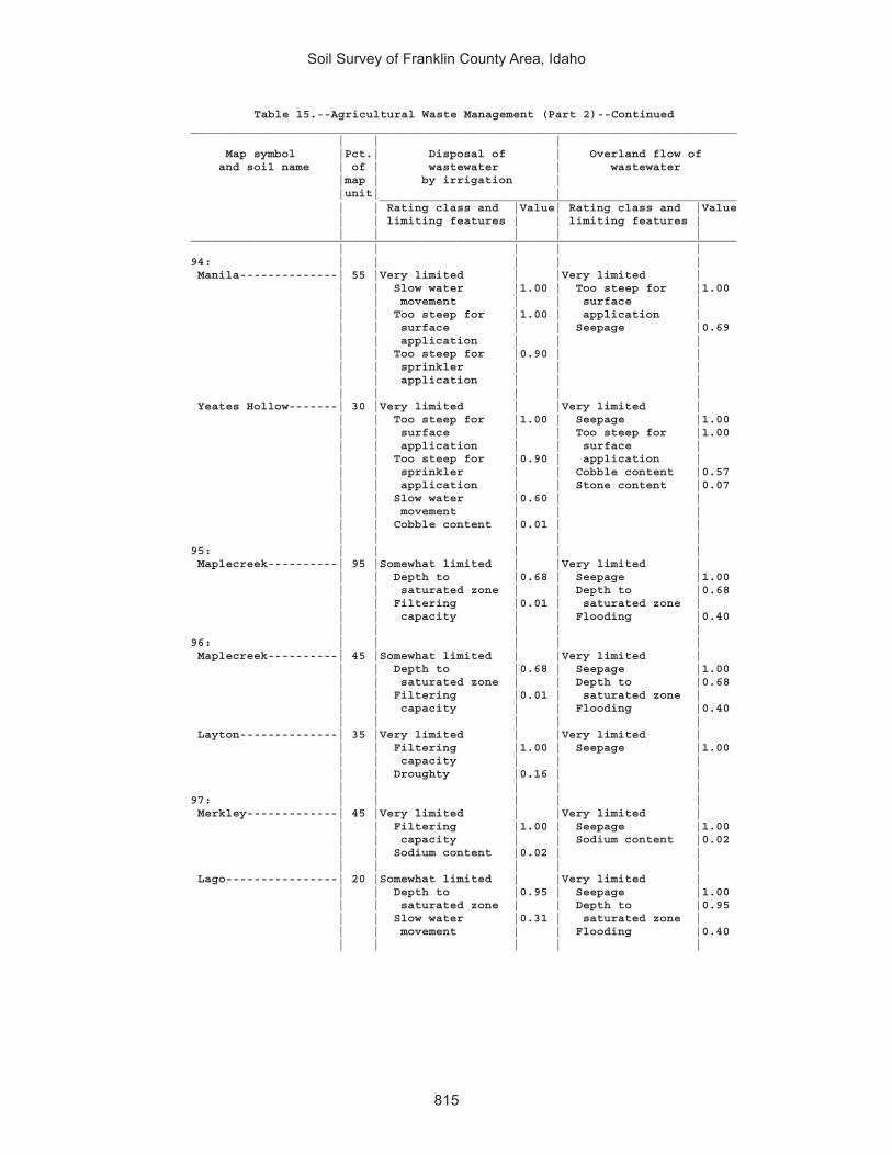
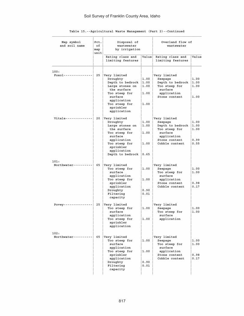
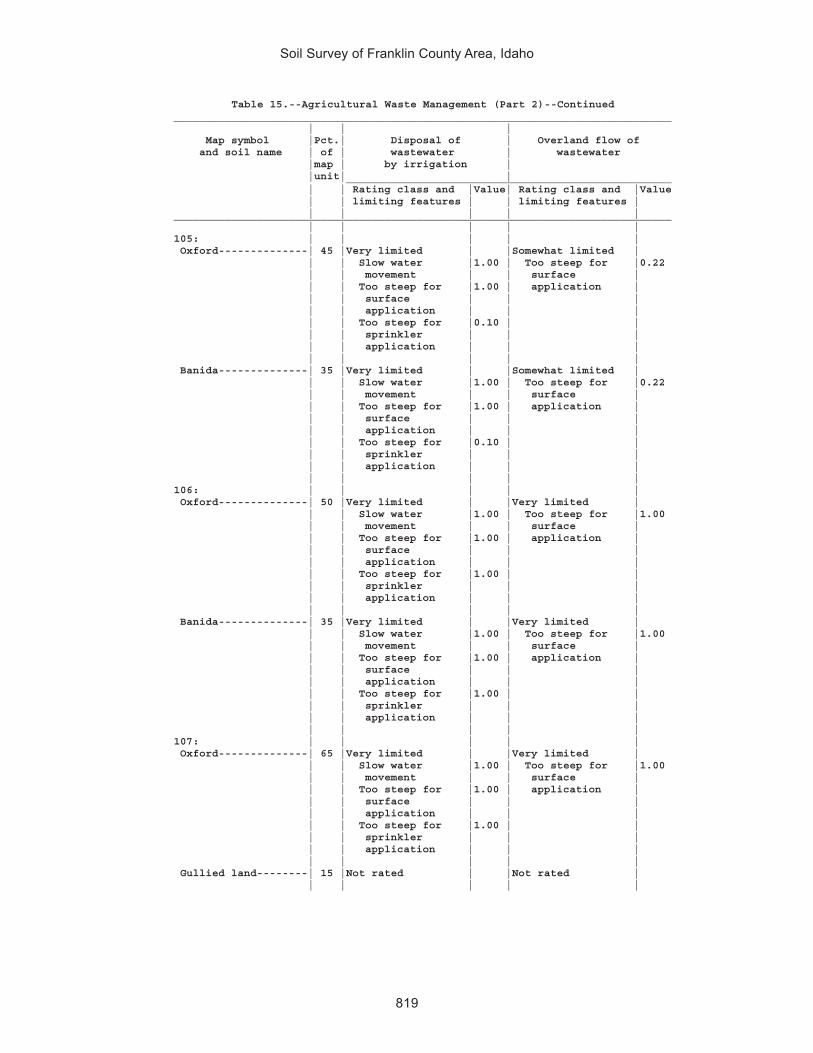
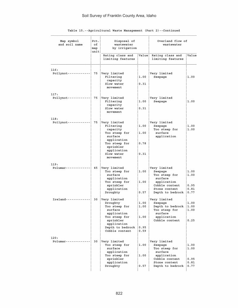
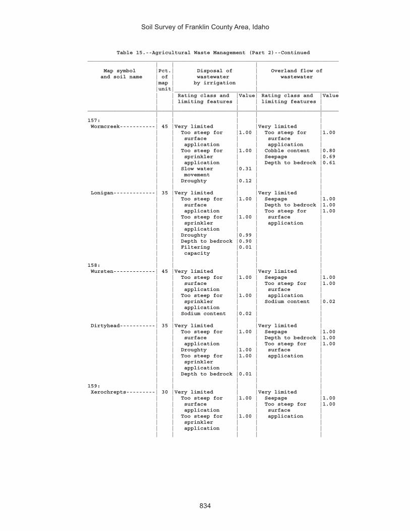
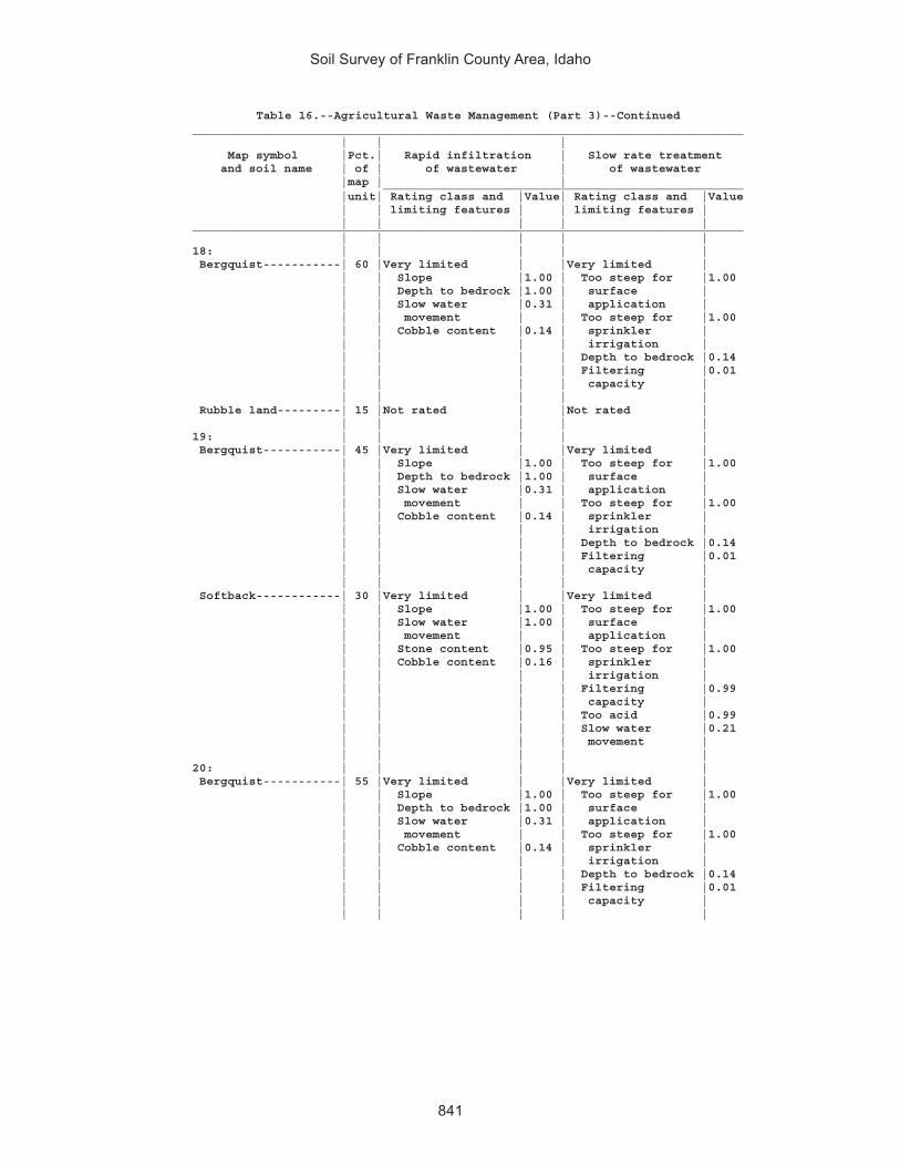
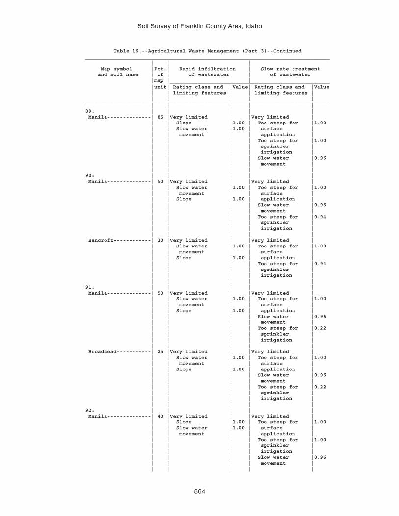
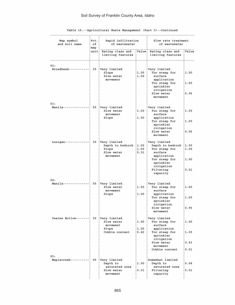
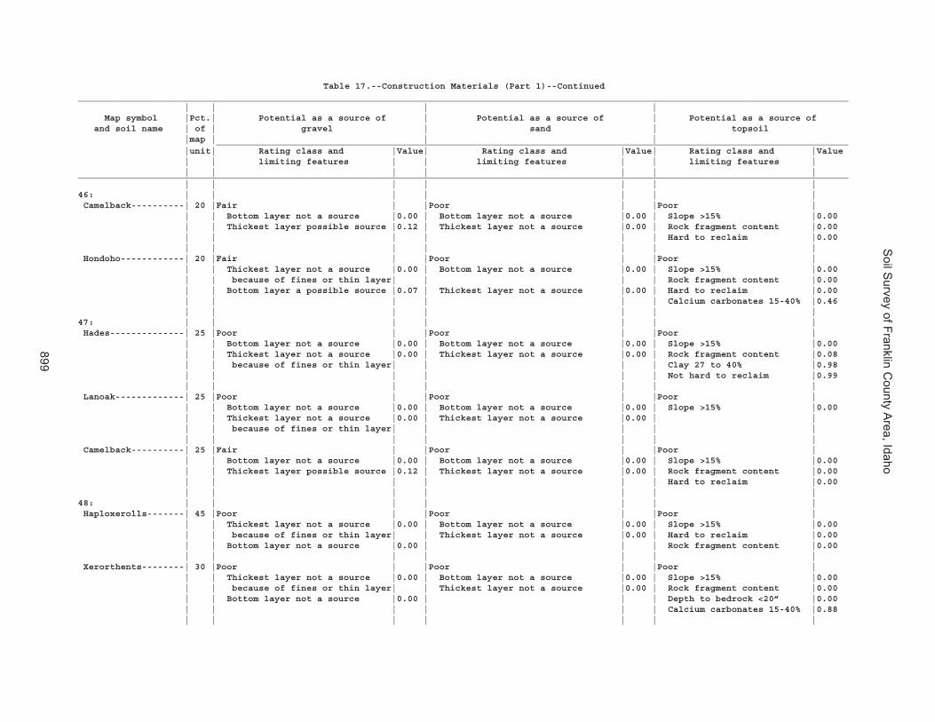
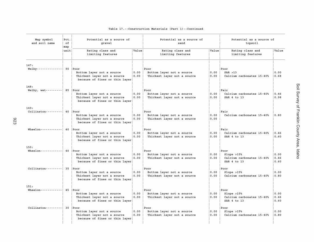
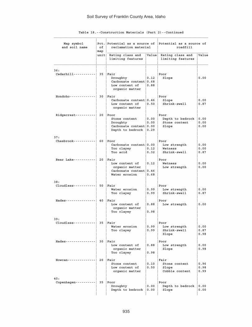
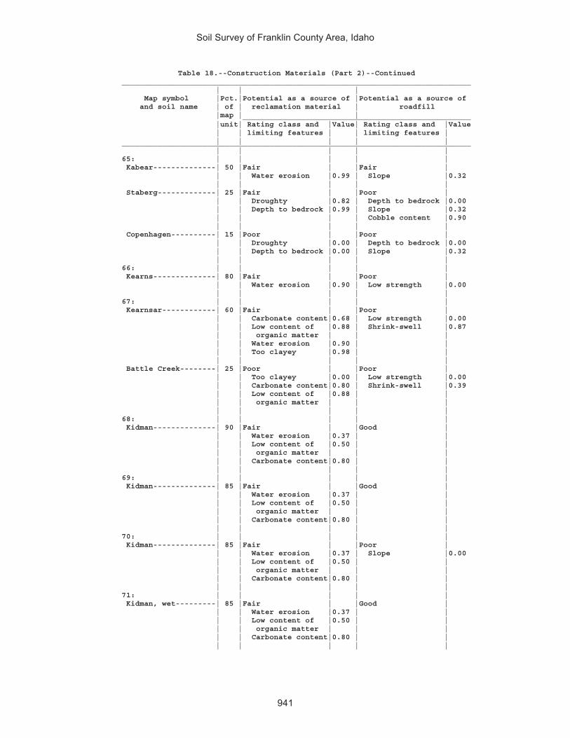
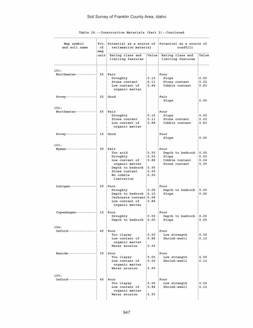
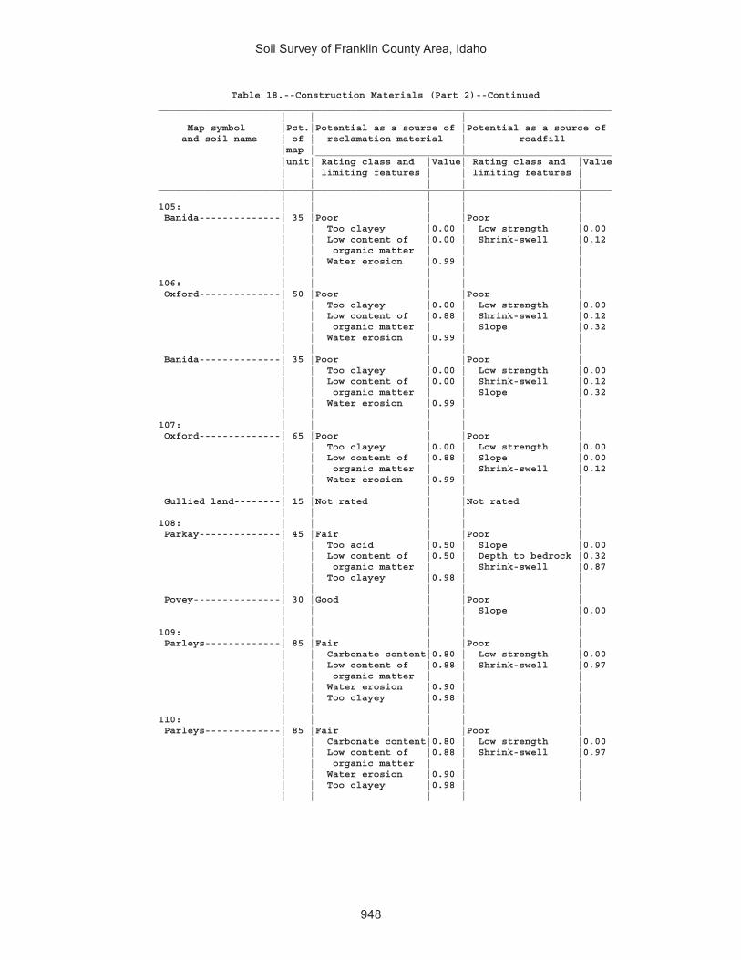
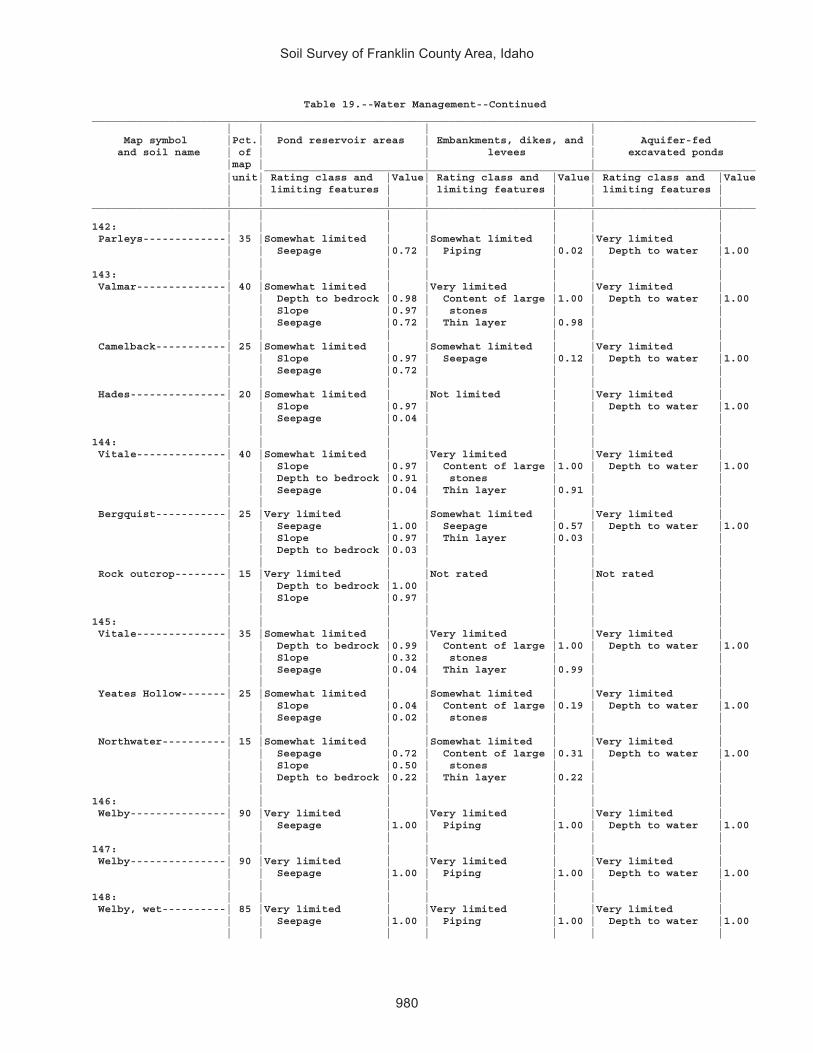
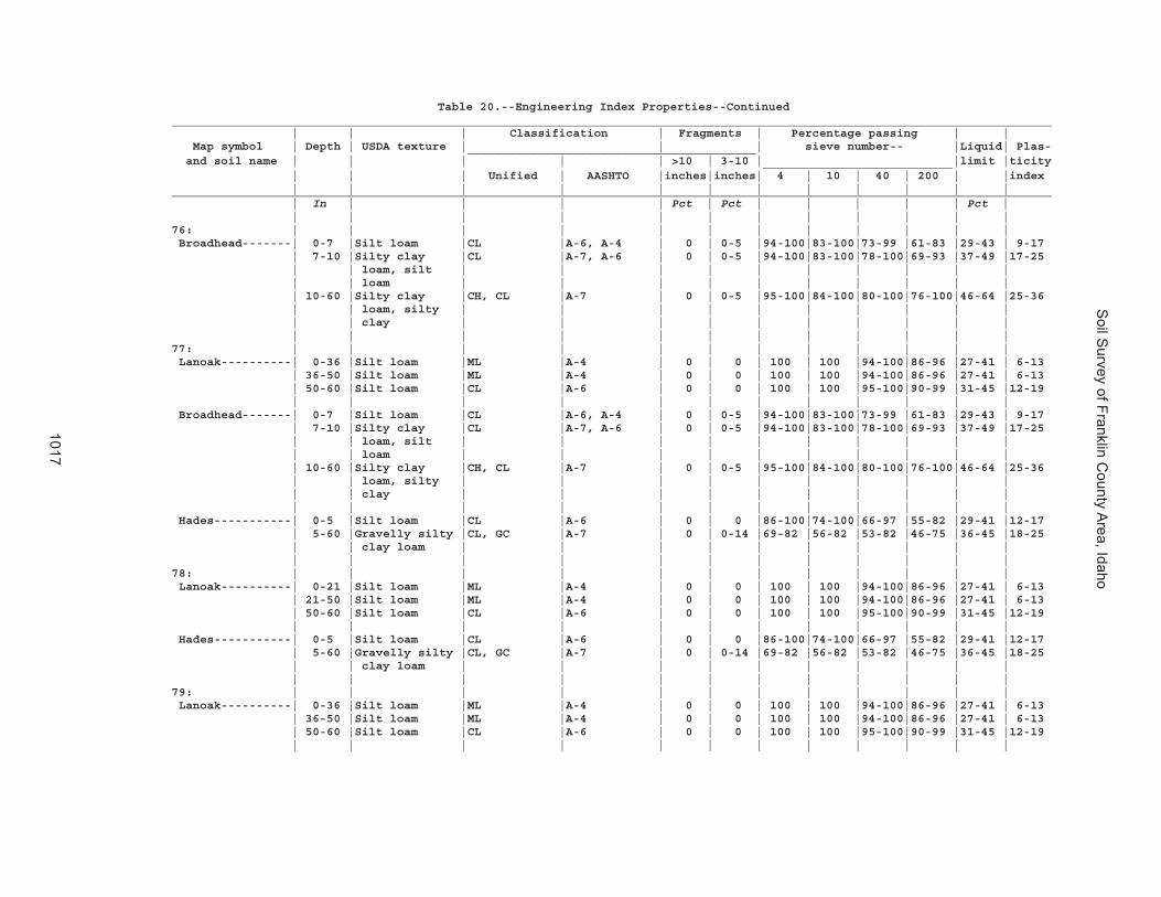
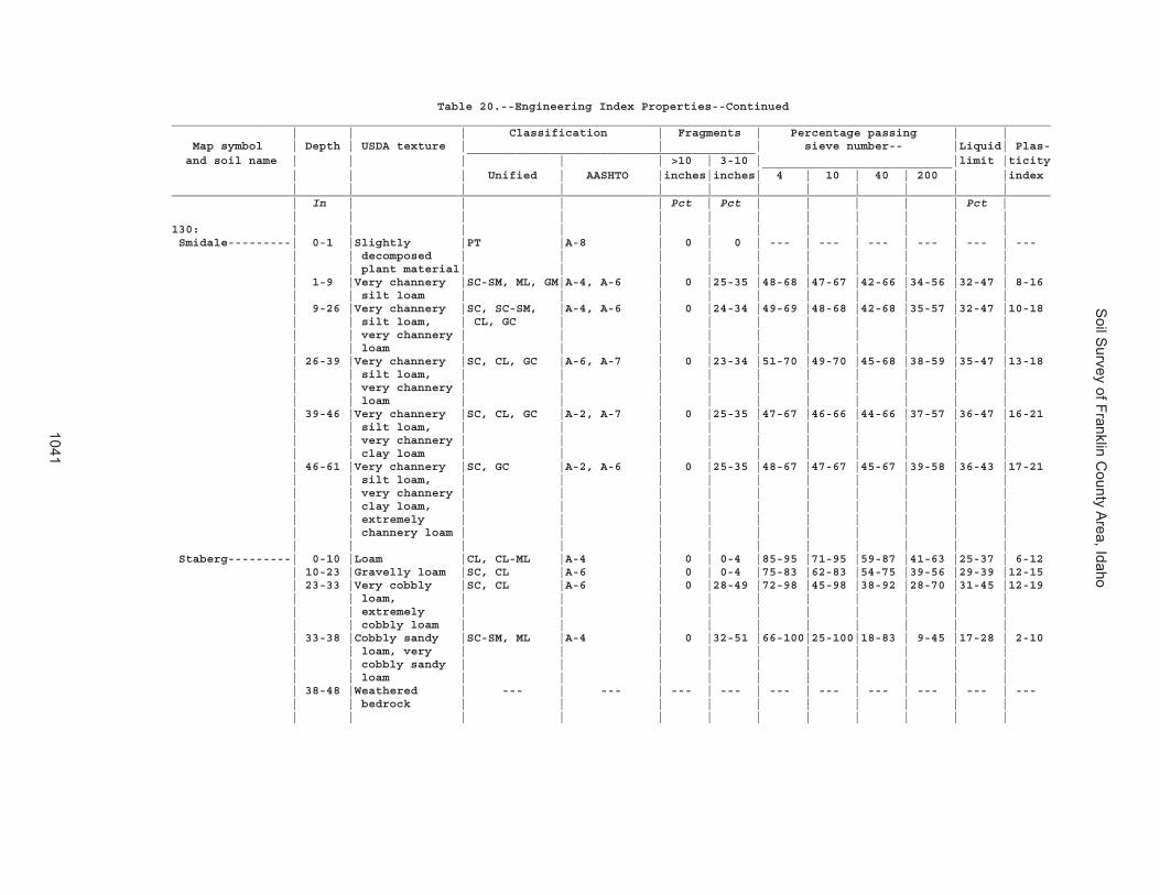
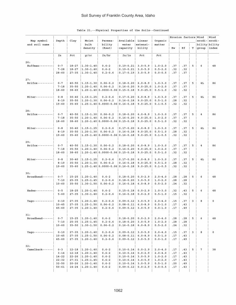
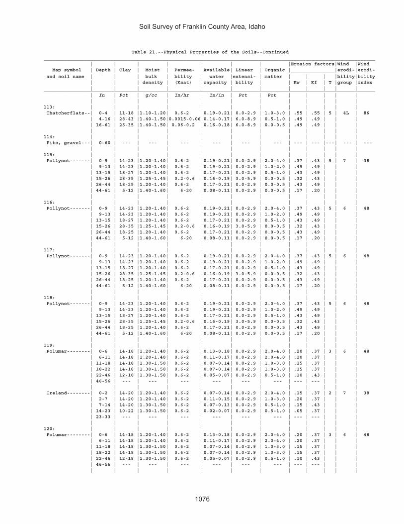
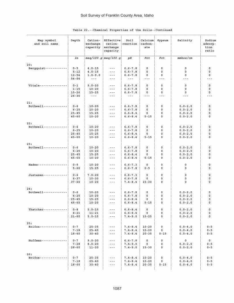
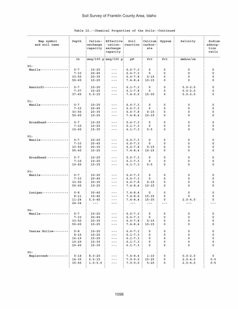
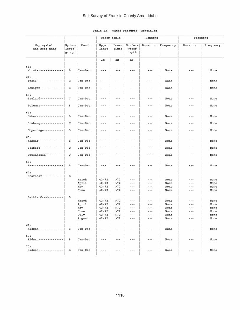
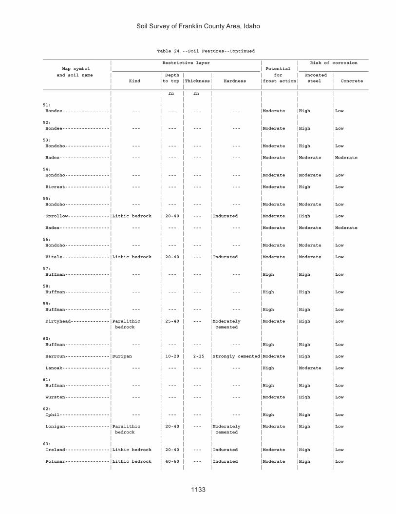
Table 1.—Temperature and Precipitation ............................................................ 494Table 2.—Freeze Dates in Spring and Fall .......................................................... 495Table 3.—Growing Season .................................................................................. 495Table 4.—Acreage and Proportionate Extent of the Soils ................................... 496Table 5.—Land Capability and Yields per Acre of Crops and Pasture ................ 499Table 6.—Rangeland Productivity and Characteristic Plant Communities .......... 517Table 7.—Windbreaks and Environmental Plantings .......................................... 563Table 8.—Recreational Development (Part 1) ..................................................... 583Table 9.—Recreational Development (Part 2) ..................................................... 610Table 10.—Building Site Development (Part 1) ................................................... 634Table 11.—Building Site Development (Part 2) ................................................... 659Table 12.—Sanitary Facilities (Part 1) ................................................................. 692Table 13.—Sanitary Facilities (Part 2) ................................................................. 726Table 14.—Agricultural Waste Management (Part 1) .......................................... 754Table 15.—Agricultural Waste Management (Part 2) .......................................... 786Table 16.—Agricultural Waste Management (Part 3) .......................................... 837Table 17.—Construction Materials (Part 1) ......................................................... 887Table 18.—Construction Materials (Part 2) ......................................................... 928Table 19.— Water Management .......................................................................... 960Table 20.—Engineering Index Properties ............................................................ 984Table 21.—Physical Properties of the Soils ....................................................... 1058Table 22.—Chemical Properties of the Soils ..................................................... 1084Table 23.—Water Features ................................................................................. 1111Table 24.—Soil Features ....................................................................................1129Table 25.—Taxonomic Classification of the Soils ...............................................1142
Issued 2008


xi
This soil survey contains information that affects land use planning in this surveyarea. It contains predictions of soil behavior for selected land uses. The survey alsohighlights soil limitations, improvements needed to overcome the limitations, and theimpact of selected land uses on the environment.
This soil survey is designed for many different users. Farmers, ranchers, foresters,and agronomists can use it to evaluate the potential of the soil and the managementneeded for maximum food and fiber production. Planners, community officials,engineers, developers, builders, and home buyers can use the survey to plan landuse, select sites for construction, and identify special practices needed to ensureproper performance. Conservationists, teachers, students, and specialists inrecreation, wildlife management, waste disposal, and pollution control can use thesurvey to help them understand, protect, and enhance the environment.
Various land use regulations of Federal, State, and local governments may imposespecial restrictions on land use or land treatment. The information in this report isintended to identify soil properties that are used in making various land use or landtreatment decisions. Statements made in this report are intended to help the landusers identify and reduce the effects of soil limitations on various land uses. Thelandowner or user is responsible for identifying and complying with existing laws andregulations.
Great differences in soil properties can occur within short distances. Some soilsare seasonally wet or subject to flooding. Some are shallow to bedrock. Some are toounstable to be used as a foundation for buildings or roads. A high water table makesa soil poorly suited to basements or underground installations.
These and many other soil properties that affect land use are described in this soilsurvey. Broad areas of soils are shown on the general soil map. The location of eachsoil is shown on the detailed soil maps. Each soil in the survey area is described.Information on specific uses is given for each soil. Help in using this publication andadditional information are available at the local office of the Natural ResourcesConservation Service or the Cooperative Extension Service.
Richard SimsState ConservationistNatural Resources Conservation Service
Foreword


1
FRANKLIN COUNTY AREA is in the southeastern part of Idaho, at the northern end ofCache Valley (fig. 1). It includes all areas of Franklin County, except for the part in theCaribou National Forest. The total area is 305,600 acres, or about 478 square miles.Nearly 60 percent of the population in Franklin County comes from rural areas. Thecounty had a population of 9,232 in 1990. In that year, Preston, the county seat, hada population of about 3,700.
The survey area consists mainly of north-south trending valleys bounded on thewest by the Bannock and Malad Ranges, on the east by the Bear River Range of theWasatch Front, and on the north by the Portneuf Range. The area is drained by theBear River and its tributaries. The Bear River flows from the northeast through MoundValley and Oneida Narrows and to the south through Cache Valley into Utah.
The highest elevation in the survey area, about 7,960 feet above sea level, is onThatcher Hill, in the Portneuf Range. The lowest, about 4,435 feet, is in the southernpart of the survey area, where the Bear River leaves Franklin County.
General Nature of the Survey AreaThis section gives general information about the survey area. It describes history
and development, natural resources, agriculture, and climate.
History and Development
Cache Valley, originally named Willow Valley, was given its present name by themountain men who used the valley to hide the furs taken from the Bear River and itstributaries. Captain John Weber, Jim Bridger, William Sublette, and a party from the
By Shawn McVey and Francis R. (Bob) Kukachka, NaturalResources Conservation Service
Fieldwork by Shawn McVey, Rulon Winward, Francis R. (Bob)Kukachka, Ray Grow, Grant Butler, Ken Adams, Larry Laing, MikePeterson, and Charlie McCarver, Natural Resources ConservationService, and Warren Archer, Leland Sasser, and Rich Datto, IdahoSoil Conservation Commission
United States Department of Agriculture, Natural ResourcesConservation Service,in cooperation withUnited States Department of the Interior, Bureau of LandManagement; University of Idaho, College of Agriculture; andthe Idaho Soil Conservation Commission
Soil Survey ofFranklin County Area, Idaho

Soil Survey of Franklin County Area, Idaho
2
Rocky Mountain Fur Company entered the valley in the fall of 1824. They made thevalley their winter headquarters, probably in an area along the Cub River. Men fromthe Hudson Bay and Missouri Fur Companies came to the valley for beaver. WarrenAngus Ferris, from the American Fur Company, described Cache Valley as one of themost beautiful valleys of the Rocky Mountain Range.
The Native Americans of Cache Valley were hunters who ranged over a large areain search of food. Almost all of the Native Americans around the area were of theShoshoni or Bannock Tribes. Later, other tribes either lived permanently in the valleyor considered it their hunting grounds. At the time of the Battle of Bear River in 1863,there were hundreds of Native Americans in the valley. Many of them lived in thenorthern part of the survey area.
Figure 1.—Location of Franklin County Area in Idaho.

Soil Survey of Franklin County Area, Idaho
3
The town of Franklin is the first permanent town in Idaho. A small number ofMormon pioneer families arrived by covered wagon and settled at the current site ofFranklin on April 14, 1860. They all moved their wagons close together for protection,removed the wagon boxes (which they used for homes), and used the wagon gearsto haul logs from the canyons to build their homes. They formed these homes into asquare fort to protect themselves from local tribes. In the years that followed, otherearly settlements, such as Oxford, Weston, and Dayton, were established. By 1890,Preston was becoming the dominant location for settlers within northern CacheValley.
Idaho’s first reported irrigation took place in 1860 with water from Spring Creek,near the town of Franklin. Later, many other irrigation canals were developed, makingwater available to many areas.
In January 1913, Franklin County was officially established and separated fromOneida County. In 1946, the Oxford and Thatcher areas were annexed and thepresent county boundaries were established.
Natural Resources
Soil and water are the most important natural resources in the survey area. TheBear River, which runs northeast to south through the county, is the largest drainageon the North American continent that does not reach the ocean (Randolph, 1978).Among the marketable products derived from the soil are small grains, hay, fruits andvegetables, and sand and gravel.
Water in the survey area is used primarily for domestic purposes, livestock, andirrigation. Springs and deep wells supply most of the water used for domesticpurposes throughout the county. Perennial streams, springs, and wells provideadequate supplies of water for livestock in most parts of the survey area. Irrigationwater in the valley is supplied by more than a dozen reservoirs developed for waterstorage. Water is diverted from major streams to irrigate small acreages in and alongthe adjacent bottom land.
Water also is used to generate electricity on Mink Creek, the Glendale Reservoir,and the Oneida Narrows Reservoir. Geothermal springs along the Bear River havegiven rise to recreational development and the potential for aquaculture andgreenhouse specialty crops.
The mountains in the area offer many opportunities for recreation. Hunting, fishing,boating, and camping are the dominant recreational activities during the warmermonths. Snow sports of all kinds are popular in winter.
Most mining activity in the county is for sand, gravel, and limestone. In the past,manganese, barite, specularite, and pyrite mines were worked.
Agriculture
The farming and livestock industries in the survey area have flourished since thecoming of the railroad. The first settlers quickly discovered the favorable combinationof climate and fertile soil in the area. They began to plow up the sagebrush and plantcrops. With the development of the tractor and bigger and better machinery,especially after World War II, large acreages of rangeland were converted tocropland. The acreage of nonirrigated and irrigated cropland is nearly equal in thesurvey area. Over 70 percent of the farmers irrigate their cropland (Idaho Departmentof Commerce, 1992). The irrigated areas are primarily on the valley floors.
About 67 percent of the agricultural income in the survey area is derived from thesale of livestock, poultry, and dairy products. The sale of dairy products is the largestsingle source of income. Crops account for 33 percent of the agricultural income.Wheat, barley, alfalfa, and some safflower and canola are the dominant crops grown

Soil Survey of Franklin County Area, Idaho
4
in the nonirrigated areas. Alfalfa, barley, and wheat are the major crops grown in theirrigated areas. A small irrigated acreage is used for silage corn or green beans.Small areas are used for meadow hay southeast of Oxford, along the Oxford Slough,and along the Bear River bottoms. Some vegetable and fruit crops are grown for localcanneries. Most of the farms and ranches in the area have combined farming andlivestock operations.
Most of the nonirrigated cropland in the survey area is gently sloping to moderatelysteep. As early as 1930, farmers took note of erosion and siltation along streams asland was converted from rangeland to cropland. They realized the need for soil andwater conservation measures and practices to control the effects of soil erosion. As aresult, on December 17, 1947, the Franklin Soil and Water Conservation District wasestablished.
There are more than 700 farms in the county, and the average farm size is nearly400 acres (Idaho Department of Commerce, 1992).
Climate
Table 1 gives data on temperature and precipitation for the survey area asrecorded at Preston, Idaho, in the period 1966 to 1990. Table 2 shows probable datesof the first freeze in fall and the last freeze in spring. Table 3 provides data on lengthof the growing season.
In winter, the average temperature is 23 degrees F and the average daily minimumtemperature is 13 degrees. The lowest temperature on record, which occurred onDecember 23, 1990, is -31 degrees. In summer, the average temperature is 66degrees and the average daily maximum temperature is 83 degrees. The highestrecorded temperature, which occurred on July 10, 1985, is 101 degrees.
Growing degree days are shown in table 1. They are equivalent to “heat units.”During the month, growing degree days accumulate by the amount that the averagetemperature each day exceeds a base temperature (40 degrees F). The normalmonthly accumulation is used to schedule single or successive plantings of a cropbetween the last freeze in spring and the first freeze in fall.
The total annual precipitation is about 16 inches. Of this, 8.2 inches, or 51 percent,usually falls in April through September. The growing season for most crops fallswithin this period. In 2 years out of 10, the rainfall in April through September is lessthan 2.8 inches. The heaviest 1-day rainfall during the period of record was 2.2inches on September 28, 1986. Thunderstorms occur on about 24 days each year,and most occur in July.
The average seasonal snowfall is about 35.1 inches. The greatest snow depth atany one time during the period of record was 35 inches.
The average relative humidity in midafternoon is about 44 percent. Humidity ishigher at night, and the average at dawn is about 72 percent. The sun shines 79percent of the time possible in summer and 44 percent in winter. The prevailing windis from the southwest. Average windspeed is highest, 11.7 miles per hour, in April.
How This Survey Was MadeThis survey was made to provide information about the soils and miscellaneous
areas in the survey area. The information includes a description of the soils andmiscellaneous areas and their location and a discussion of their suitability, limitations,and management for specified uses. Soil scientists observed the steepness, length,and shape of the slopes; the general pattern of drainage; the kinds of crops andnative plants; and the kinds of bedrock. They dug many holes to study the soil profile,which is the sequence of natural layers, or horizons, in a soil. The profile extends

Soil Survey of Franklin County Area, Idaho
5
from the surface down into the unconsolidated material in which the soil formed. Theunconsolidated material is devoid of roots and other living organisms and has notbeen changed by other biological activity.
The soils and miscellaneous areas in the survey area occur in an orderly patternthat is related to the geology, landforms, relief, climate, and natural vegetation of thearea. Each kind of soil and miscellaneous area is associated with a particular kind oflandform or with a segment of the landform. By observing the soils and miscellaneousareas in the survey area and relating their position to specific segments of thelandform, a soil scientist develops a concept or model of how they were formed.Thus, during mapping, this model enables the soil scientist to predict with aconsiderable degree of accuracy the kind of soil or miscellaneous area at a specificlocation on the landscape.
Commonly, individual soils on the landscape merge into one another as theircharacteristics gradually change. To construct an accurate soil map, however, soilscientists must determine the boundaries between the soils. They can observe only alimited number of soil profiles. Nevertheless, these observations, supplemented by anunderstanding of the soil-vegetation-landscape relationship, are sufficient to verifypredictions of the kinds of soil in an area and to determine the boundaries.
Soil scientists recorded the characteristics of the soil profiles that they studied.They noted soil color, texture, size and shape of soil aggregates, kind and amount ofrock fragments, distribution of plant roots, reaction, and other features that enablethem to identify soils. After describing the soils in the survey area and determiningtheir properties, the soil scientists assigned the soils to taxonomic classes (units).Taxonomic classes are concepts. Each taxonomic class has a set of soilcharacteristics with precisely defined limits. The classes are used as a basis forcomparison to classify soils systematically. Soil taxonomy, the system of taxonomicclassification used in the United States, is based mainly on the kind and character ofsoil properties and the arrangement of horizons within the profile. After the soilscientists classified and named the soils in the survey area, they compared theindividual soils with similar soils in the same taxonomic class in other areas so thatthey could confirm data and assemble additional data based on experience andresearch.
While a soil survey is in progress, samples of some of the soils in the areagenerally are collected for laboratory analyses and for engineering tests. Soilscientists interpret the data from these analyses and tests as well as the field-observed characteristics and the soil properties to determine the expected behaviorof the soils under different uses. Interpretations for all of the soils are field testedthrough observation of the soils in different uses and under different levels ofmanagement. Some interpretations are modified to fit local conditions, and some newinterpretations are developed to meet local needs. Data are assembled from othersources, such as research information, production records, and field experience ofspecialists. For example, data on crop yields under defined levels of management areassembled from farm records and from field or plot experiments on the same kinds ofsoil.
Predictions about soil behavior are based not only on soil properties but also onsuch variables as climate and biological activity. Soil conditions are predictable overlong periods of time, but they are not predictable from year to year. For example, soilscientists can predict with a fairly high degree of accuracy that a given soil will have ahigh water table within certain depths in most years, but they cannot predict that ahigh water table will always be at a specific level in the soil on a specific date.
After soil scientists located and identified the significant natural bodies of soil in thesurvey area, they drew the boundaries of these bodies on aerial photographs andidentified each as a specific map unit. Aerial photographs show trees, buildings,fields, roads, and rivers, all of which help in locating boundaries accurately.

Soil Survey of Franklin County Area, Idaho
6
This survey area was mapped at two levels of detail. At the more detailed level,map units are narrowly defined and boundaries were plotted and verified at closelyspaced intervals. At the less detailed level, map units are broadly defined andboundaries were plotted and verified at wider intervals. The detail of mapping wasselected to meet the anticipated long-term use of the survey.

7
The general soil map in this publication shows broad areas that have a distinctivepattern of soils, relief, and drainage. Each map unit on the general soil map is aunique natural landscape. Typically, it consists of one or more major soils ormiscellaneous areas and some minor soils or miscellaneous areas. It is named forthe major soils or miscellaneous areas. The components of one map unit can occur inanother but in a different pattern.
The general soil map can be used to compare the suitability of large areas forgeneral land uses. Areas of suitable soils can be identified on the map. Likewise,areas where the soils are not suitable can be identified.
Because of its small scale, the map is not suitable for planning the management ofa farm or field or for selecting a site for a road or building or other structure. The soilsin any one map unit differ from place to place in slope, depth, drainage, and othercharacteristics that affect management.
Some of the boundaries on the general soil map of the survey area do not matchthose on the maps of adjacent survey areas, and some of the soil names anddescriptions do not fully agree. Differences result mainly from improvements in theclassification of soils, particularly modifications or refinements in soil series concepts.Some differences result from variations in the intensity of mapping or in the extent ofthe soils in the survey areas.
Soils on Low Terraces and Flood PlainsThis group consists of three map units. It makes up about 12 percent of the survey
area. The soils in this group are on stream terraces, lake terraces, and flood plainsalong the Bear River and the Cub River. They formed in alluvium and lacustrinedeposits derived from mixed sources.
1. Lando-Battle Creek-Trenton
Very deep, nearly level to gently sloping, somewhat poorly drained and moderatelywell drained, silty and clayey soils (fig. 2)
Percentage of survey area: 7
Landform:Lando—stream terracesBattle Creek—lake terracesTrenton—lake terraces
Elevation: 4,400 to 5,200 feetFrost-free period: 100 to 130 daysMean annual precipitation: 14 to 18 inches
Minor components: Parleys, Kidman, and Maplecreek soils
General Soil Map Units

Soil Survey of Franklin County Area, Idaho
8
Current uses: Cropland, hayland, pasture, and building site development
2. Windernot-Delish-Lewnot
Very deep, nearly level, moderately well drained to poorly drained, sandy and loamysoils (fig. 3)
Percentage of survey area: 2
Landform:Windernot—stream terracesDelish—stream terracesLewnot—stream terraces
Elevation: 4,400 to 5,100 feetFrost-free period: 100 to 130 daysMean annual precipitation: 14 to 16 inches
Minor components: Cachecan, Stinkcreek, and Battle Creek soils
Current uses: Cropland, hayland, pasture, and rangeland
3. Picabo-Thatcherflats-Bear Lake
Very deep, nearly level, somewhat poorly drained and poorly drained, silty and clayeysoils (fig. 4)
Percentage of survey area: 3
Landform:Picabo—stream terraces and flood plainsThatcherflats—stream terracesBear Lake—flood plains
Elevation: 4,600 to 5,100 feetFrost-free period: 80 to 100 days
Figure 2.—Typical pattern of soils and underlying material in general soil map units 1 (Lando-BattleCreek-Trenton) and 10 (Manila-Lanoak-Broadhead).

Soil Survey of Soil Survey of Franklin County Area, Idaho
9
Mean annual precipitation: 14 to 16 inches
Minor components: Downata, Merkley, and Lago soils
Current uses: Cropland, hayland, pasture, and rangeland
Figure 3.—Typical pattern of soils and underlying material in general soil map units 2 (Windernot-Delish-Lewnot) and 6 (Oxford-Ant Flat-Banida).
Figure 4.—Typical pattern of soils and underlying material in general soil map units 3 (Picabo-Thatcherflats-Bear Lake) and 12 (Cloudless-Hades).

Soil Survey of Franklin County Area, Idaho
10
Soils on Medium to High TerracesThis group consists of four map units. It makes up about 36 percent of the survey
area. The soils in this group are on lake terraces, stream terraces, and hills of ancientLake Bonneville. They formed in alluvium and lacustrine deposits derived from mixedsources.
4. Welby-Kidman-Preston
Very deep, nearly level to very steep, well drained to excessively drained, loamy andsandy soils (fig. 5)
Percentage of survey area: 8
Landform:Welby—lake terracesKidman—stream terraces and lake terracesPreston—dunes
Elevation: 4,400 to 5,100 feetFrost-free period: 110 to 135 daysMean annual precipitation: 13 to 17 inches
Minor components: Maplecreek, Layton, and Parleys soils
Current uses: Cropland, hayland, pasture, rangeland, and building site development
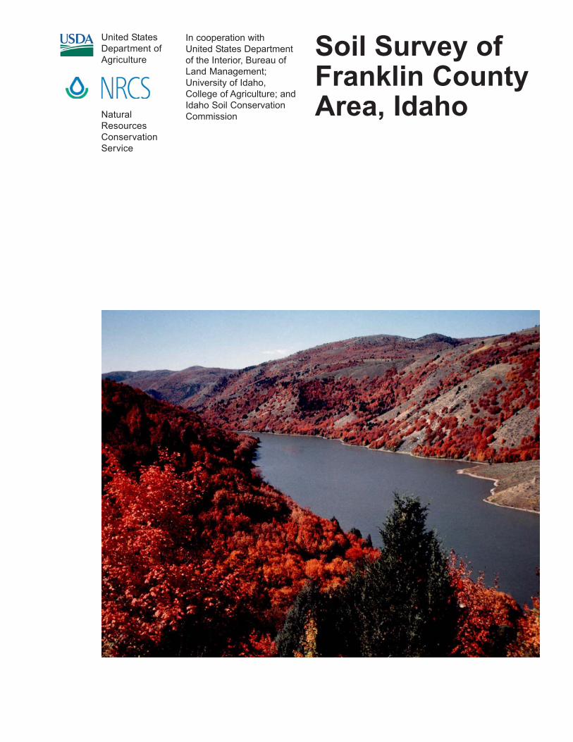
5. Parleys-Ant Flat-Winwell
Very deep, nearly level to moderately steep, well drained and moderately welldrained, clayey and silty soils (fig. 6)
Percentage of survey area: 6
Figure 5.—Typical pattern of soils and underlying material in general soil map unit 4 (Welby-Kidman-Preston).
Soil Survey of Soil Survey of Franklin County Area, Idaho
11
Landform:Parleys—lake terracesAnt Flat—lake terracesWinwell—lake terraces
Elevation: 4,400 to 5,500 feetFrost-free period: 90 to 130 daysMean annual precipitation: 14 to 17 inches
Minor components: Trenton, Kidman, and Welby soils
Current uses: Cropland, hayland, pasture, and building site development
6. Oxford-Ant Flat-Banida
Very deep, nearly level to steep, well drained and moderately well drained, clayeysoils (fig. 3)
Percentage of survey area: 15
Landform:Oxford—lake terracesAnt Flat—lake terracesBanida—lake terraces
Elevation: 4,700 to 5,500 feetFrost-free period: 90 to 120 daysMean annual precipitation: 14 to 18 inches
Minor components: Manila, Brifox, and Hades soils
Current uses: Cropland, hayland, and building site development
Figure 6.—Typical pattern of soils and underlying material in general soil map units 5 (Parleys-AntFlat-Winwell) and 7 (Wheelon-Collinston-Winwell).

Soil Survey of Franklin County Area, Idaho
12
7. Wheelon-Collinston-Winwell
Very deep, nearly level to very steep, well drained, silty and clayey soils (fig. 6)
Percentage of survey area: 7
Landform:Wheelon—lake terracesCollinston—lake terracesWinwell—lake terraces
Elevation: 4,500 to 5,200 feetFrost-free period: 110 to 130 daysMean annual precipitation: 14 to 16 inches
Minor components: Parleys, Dirtyhead, and Huffman soils
Current uses: Cropland (fig. 7), hayland, and building site development
Soils on Mountains, Hills, and Fan RemnantsThis group consists of five map units. It makes up about 52 percent of the survey
area, including 1 percent bodies of water (lakes, ponds, and other areas that arecovered with deep water for most of the year). The soils in this group are on mountainslopes, hillslopes, and fan remnants of the Bear River Range of the WasatchMountains. They formed in alluvium, colluvium, and residuum derived from mixedmetasedimentary and igneous rocks and somewhat influenced by loess.
Figure 7.—An area of summer fallow in the Wheelon-Collinston-Winwell general soil map unit.Detailed map unit 158 (Wursten-Dirtyhead complex, 12 to 30 percent slopes) is on the hills tothe left. Detailed map unit 93 (Manila-Lonigan complex, 6 to 40 percent slopes) is on the slopesin the middle ground. The mountains in the background are part of the Malad Range in theCaribou National Forest.

Soil Survey of Soil Survey of Franklin County Area, Idaho
13
8. Yeates Hollow-Vitale-Northwater
Very deep to moderately deep, steep and very steep, well drained, gravelly andloamy soils (fig. 8)
Percentage of survey area: 13
Landform:Yeates Hollow—mountain slopes and hillslopesVitale—mountain slopes, mountain summits, and hillslopesNorthwater—mountain slopes
Elevation: 5,000 to 8,000 feetFrost-free period: 30 to 95 daysMean annual precipitation: 15 to 30 inches
Minor components: Dranburn, Ireland, and Povey soils
Current uses: Rangeland and forest land
9. Yeates Hollow-Manila-Softback
Very deep, moderately steep and steep, well drained, gravelly and clayey soils (fig. 8)
Percentage of survey area: 12
Landform:Yeates Hollow—mountain slopes and hillslopesManila—mountain slopes, hillslopes, and fan remnantsSoftback—mountain slopes and hillslopes
Elevation: 4,800 to 6,600 feetFrost-free period: 60 to 95 days
Figure 8.—Typical pattern of soils and underlying material in general soil map units 8 (YeatesHollow-Vitale-Northwater) and 9 (Yeates Hollow-Manila-Softback).

Soil Survey of Franklin County Area, Idaho
14
Mean annual precipitation: 15 to 20 inches
Minor components: Foxol, Vitale, and Parkay soils
Current uses: Rangeland, forest land, and building site development
10. Manila-Lanoak-Broadhead
Very deep, nearly level to steep, well drained, clayey and silty soils (fig. 2)
Percentage of survey area: 6
Landform:Manila—mountain slopes, hillslopes, and fan remnantsLanoak—mountain slopes and hillslopesBroadhead—mountain slopes and hillslopes
Elevation: 4,800 to 6,900 feetFrost-free period: 55 to 100 daysMean annual precipitation: 14 to 20 inches
Minor components: Lizdale, Hondoho, and Hades soils
Current uses: Cropland, hayland, pasture, rangeland, and building site development
11. Wormcreek-Lonigan-Manila
Moderately deep and very deep, moderately steep to very steep, well drained,gravelly, ashy, and clayey soils (fig. 9)
Percentage of survey area: 18
Figure 9.—Typical pattern of soils and underlying material in general soil map unit 11 (Wormcreek-Lonigan-Manila).

Soil Survey of Soil Survey of Franklin County Area, Idaho
15
Landform:Wormcreek—mountain slopesLonigan—mountains slopes and hillslopesManila—mountain slopes, hillslopes, and fan remnants
Elevation: 4,600 to 6,600 feetFrost-free period: 60 to 110 daysMean annual precipitation: 13 to 20 inches
Minor components: Yeates Hollow, Broadhead, and Copenhagen soils
Current uses: Cropland, hayland, pasture, rangeland, and building site development
12. Cloudless-Hades
Very deep, gently sloping to moderately steep, well drained, loamy soils (fig. 4)
Percentage of survey area: 2
Landform:Cloudless—fan remnantsHades—mountain slopes, hillslopes, and fan remnants
Elevation: 4,800 to 6.700 feetFrost-free period: 60 to 100 daysMean annual precipitation: 14 to 20 inches
Minor components: Ant Flat, Lanoak, and Yeates Hollow soils
Current uses: Cropland, hayland, rangeland, and building site development


17
The map units delineated on the detailed soil maps in this survey represent thesoils or miscellaneous areas in the survey area. The map unit descriptions in thissection, along with the maps, can be used to determine the suitability and potential ofa unit for specific uses. They also can be used to plan the management needed forthose uses.
A map unit delineation on a soil map represents an area dominated by one or moremajor kinds of soil or miscellaneous areas. A map unit is identified and namedaccording to the taxonomic classification of the dominant soils. Within a taxonomicclass there are precisely defined limits for the properties of the soils. On thelandscape, however, the soils are natural phenomena, and they have thecharacteristic variability of all natural phenomena. Thus, the range of some observedproperties may extend beyond the limits defined for a taxonomic class. Areas of soilsof a single taxonomic class rarely, if ever, can be mapped without including areas ofother taxonomic classes. Consequently, every map unit is made up of the soils ormiscellaneous areas for which it is named and some minor components that belongto taxonomic classes other than those of the major soils.
Most minor soils have properties similar to those of the dominant soil or soils in themap unit, and thus they do not affect use and management. These are callednoncontrasting, or similar, components. They may or may not be mentioned in aparticular map unit description. Other minor components, however, have propertiesand behavioral characteristics divergent enough to affect use or to require differentmanagement. These are called contrasting, or dissimilar, components. They generallyare in small areas and could not be mapped separately because of the scale used.Some small areas of strongly contrasting soils or miscellaneous areas are identifiedby a special symbol on the maps. The contrasting components are mentioned in themap unit descriptions. A few areas of minor components may not have beenobserved, and consequently they are not mentioned in the descriptions, especiallywhere the pattern was so complex that it was impractical to make enoughobservations to identify all the soils and miscellaneous areas on the landscape.
The presence of minor components in a map unit in no way diminishes theusefulness or accuracy of the data. The objective of mapping is not to delineate puretaxonomic classes but rather to separate the landscape into landforms or landformsegments that have similar use and management requirements. The delineation ofsuch segments on the map provides sufficient information for the development ofresource plans. If intensive use of small areas is planned, however, onsiteinvestigation is needed to define and locate the soils and miscellaneous areas.
An identifying symbol precedes the map unit name in the map unit descriptions.Each description includes general facts about the unit and gives the principalproperties and qualities to be considered in planning for specific uses.
Soils that have profiles that are almost alike make up a soil series. Except fordifferences in texture of the surface layer, all the soils of a series have major horizonsthat are similar in composition, thickness, and arrangement.
Soils of one series can differ in texture of the surface layer, slope, stoniness,salinity, degree of erosion, and other characteristics that affect their use. On the basis
Detailed Soil Map Units

Soil Survey of Franklin County Area, Idaho
18
of such differences, a soil series is divided into soil phases. Most of the areas shownon the detailed soil maps are phases of soil series. The name of a soil phasecommonly indicates a feature that affects use or management. For example, Parleyssilt loam, wet, 0 to 2 percent slopes, is a phase of the Parleys series.
Some map units are made up of two or more major soils or miscellaneous areas.These map units are complexes or associations.
A complex consists of two or more soils or miscellaneous areas in such an intricatepattern or in such small areas that they cannot be shown separately on the maps.The pattern and proportion of the soils or miscellaneous areas are somewhat similarin all areas. Vitale-Bergquist-Rock outcrop complex, 30 to 60 percent slopes, is anexample.
An association is made up of two or more geographically associated soils ormiscellaneous areas that are shown as one unit on the maps. Because of present oranticipated uses of the map units in the survey area, it was not considered practicalor necessary to map the soils or miscellaneous areas separately. The pattern andrelative proportion of the soils or miscellaneous areas are somewhat similar. Lonigan-Ricrest association, 50 to 80 percent slopes, is an example.
This survey includes miscellaneous areas. Such areas have little or no soilmaterial and support little or no vegetation. Pits, gravel, is an example.
Table 4 gives the acreage and proportionate extent of each map unit. Other tablesgive properties of the soils and the limitations, capabilities, and potentials for manyuses. The Glossary defines many of the terms used in describing the soils ormiscellaneous areas.
In the map unit descriptions that follow, a semitabular format is used. In this formatthe major headings are centered in the column (for example, Map Unit Setting). Theyidentify the information grouped directly below them. Introducing each item ofinformation under the centered heading is a term or phrase (for example, GeneralLandscape) that identifies or describes the information. Many of the centeredheadings and introductory terms are self-explanatory; however, some of them needfurther explanation and are defined in the Glossary. Explanations of the headings andintroductory phrases are provided in the following paragraphs, generally in the orderin which they are used in the map unit descriptions.
Map Unit Setting is given for the entire map unit. This section identifies the generallandscape in which the map unit is located. The landscape positions given for theentire map unit generally are broader than those given for each component. TheMLRA, or major land resource area, is listed next. The MLRA is a broad ecologicalarea with characteristic climate, topography, vegetation, water resources, soils, andland use (USDA, 1981).
Map Unit Composition is given for the major components (soils or miscellaneousareas) identified in the name of the map unit as well as for the minor components.Dissimilar minor components are inextensive soils or miscellaneous areas that differin use and management from the soils or miscellaneous areas for which the map unitis named. As explained above, minor components can either be similar or dissimilar.In the composition section, a single percentage is provided for a named soil and itssimilar soils because their use and management are similar.
Characteristics of the major components are given after the composition section.These include items of component setting, such as landform, slope shape, andaspect. Component properties and qualities give information on parent material,slope, depth to a restrictive feature, drainage class, available water capacity, andother important properties of the soil. Also provided are important interpretive groups,including land capability classifications and ecological site names and numbers. Abrief typical profile description is given with horizons, horizon depth, and texture.

Soil Survey of Franklin County Area, Idaho
19
Dissimilar Minor Components are identified after the characteristics of the majorsoils are described. The extent of each minor component in the unit is indicated.
The heading Major Uses follows the description of dissimilar minor components.
1—Airport silty clay loam, 0 to 3 percent slopesMap Unit Setting
General landscape: ValleysMajor land resource area (MLRA): 28AElevation: 4,440 to 4,460 feetMean annual precipitation: 14 to 17 inchesMean annual air temperature: 45 to 47 degrees FFrost-free period: 120 to 140 days
Map Unit CompositionAirport and similar soils—80 percentDissimilar minor components—20 percent
Characteristics of the Airport SoilSetting
Landform: Stream terracesDown-slope shape: LinearAcross-slope shape: LinearRepresentative aspect: SouthwestRange in aspect: All aspects
Properties and qualitiesParent material: Calcareous, silty alluviumSlope: 0 to 3 percentRestrictive feature: None within a depth of 60 inchesDrainage class: Poorly drainedCapacity of the most limiting layer to transmit water (Ksat): Moderately lowFlooding: RarePonding: NoneSeasonal high water table (minimum depth): About 24 to 36 inchesSalinity (maximum): Strongly saline (about 18.0 mmhos/cm)Sodicity (maximum): Sodium adsorption ratio of about 28.0Available water capacity (entire profile): High (about 10.2 inches)
Interpretive groupsLand capability subclass (nonirrigated): 6wLand capability subclass (irrigated): 4wEcological site: Semiwet Saline Meadow (R028AY001ID)
Typical profileA—0 to 4 inches; silty clay loamBtn—4 to 16 inches; silty clay loamBk—16 to 60 inches; silty clay loam
Dissimilar Minor Components• Sandy and loamy, stratified soils—5 percent of the map unit• Delish soils on convex slopes—5 percent of the map unit• Cachecan soils on concave slopes—5 percent of the map unit• Stinkcreek soils—5 percent of the map unit

Soil Survey of Franklin County Area, Idaho
20
Major UsesPasture and rangeland
2—Ant Flat silty clay loam, 0 to 2 percent slopesMap Unit Setting
General landscape: Lake plainsMajor land resource area (MLRA): 28AElevation: 4,700 to 5,000 feetMean annual precipitation: 14 to 17 inchesMean annual air temperature: 41 to 45 degrees FFrost-free period: 90 to 120 days
Map Unit CompositionAnt Flat and similar soils—85 percentDissimilar minor components—15 percent
Characteristics of the Ant Flat SoilSetting
Landform: Lake plains and lake terracesDown-slope shape: LinearAcross-slope shape: LinearRepresentative aspect: SouthwestRange in aspect: All aspects
Properties and qualitiesParent material: Mixed alluviumSlope: 0 to 2 percentRestrictive feature: None within a depth of 60 inchesDrainage class: Well drainedCapacity of the most limiting layer to transmit water (Ksat): Moderately lowFlooding: NonePonding: NoneSeasonal high water table (minimum depth): More than 72 inchesSalinity (maximum): Nonsaline (about 1.0 mmho/cm)Sodicity (maximum): Sodium adsorption ratio of about 3.0Available water capacity (entire profile): High (about 11.3 inches)
Interpretive groupsLand capability subclass (nonirrigated): 3sLand capability subclass (irrigated): 3s
Typical profileAp—0 to 8 inches; silty clay loamBt—8 to 24 inches; clayBk1—24 to 42 inches; clayBk2—42 to 60 inches; silty clay loam
Dissimilar Minor Components• Aquolls—5 percent of the map unit• Banida soils on convex slopes—5 percent of the map unit• Soils that have a thin dark surface layer—2 percent of the map unit• Soils that are calcareous throughout—2 percent of the map unit• Soils that have less than 35 percent clay in the subsoil—1 percent of the map unit

Soil Survey of Franklin County Area, Idaho
21
Major UsesIrrigated and nonirrigated cropland, hayland, and building site development
3—Ant Flat silty clay loam, 2 to 4 percent slopesMap Unit Setting
General landscape: Lake plainsMajor land resource area (MLRA): 28AElevation: 4,700 to 5,100 feetMean annual precipitation: 14 to 17 inchesMean annual air temperature: 41 to 45 degrees FFrost-free period: 90 to 120 days
Map Unit CompositionAnt Flat and similar soils—85 percentDissimilar minor components—15 percent
Characteristics of the Ant Flat SoilSetting
Landform: Lake plains and lake terracesDown-slope shape: LinearAcross-slope shape: LinearRepresentative aspect: SouthwestRange in aspect: All aspects
Properties and qualitiesParent material: Mixed alluviumSlope: 2 to 4 percentRestrictive feature: None within a depth of 60 inchesDrainage class: Well drainedCapacity of the most limiting layer to transmit water (Ksat): Moderately lowFlooding: NonePonding: NoneSeasonal high water table (minimum depth): More than 72 inchesSalinity (maximum): Nonsaline (about 1.0 mmho/cm)Sodicity (maximum): Sodium adsorption ratio of about 3.0Available water capacity (entire profile): High (about 11.3 inches)
Interpretive groupsLand capability subclass (nonirrigated): 3eLand capability subclass (irrigated): 3e
Typical profileAp—0 to 8 inches; silty clay loamBt—8 to 24 inches; clayBk1—24 to 42 inches; clayBk2—42 to 60 inches; silty clay loam
Dissimilar Minor Components• Banida soils on convex slopes and narrow ridges—10 percent of the map unit• Pollynot soils on convex slopes—3 percent of the map unit• Oxford soils on convex slopes—2 percent of the map unit

Soil Survey of Franklin County Area, Idaho
22
Major UsesIrrigated and nonirrigated cropland, hayland, and building site development
4—Ant Flat silty clay loam, 4 to 12 percent slopesMap Unit Setting
General landscape: Lake plainsMajor land resource area (MLRA): 28AElevation: 4,800 to 5,500 feetMean annual precipitation: 14 to 17 inchesMean annual air temperature: 41 to 45 degrees FFrost-free period: 90 to 120 days
Map Unit CompositionAnt Flat and similar soils—90 percentDissimilar minor components—10 percent
Characteristics of the Ant Flat SoilSetting
Landform: Lake terracesDown-slope shape: LinearAcross-slope shape: LinearRepresentative aspect: SoutheastRange in aspect: All aspects
Properties and qualitiesParent material: Mixed alluviumSlope: 4 to 12 percentRestrictive feature: None within a depth of 60 inchesDrainage class: Well drainedCapacity of the most limiting layer to transmit water (Ksat): Moderately lowFlooding: NonePonding: NoneSeasonal high water table (minimum depth): More than 72 inchesSalinity (maximum): Nonsaline (about 1.0 mmho/cm)Sodicity (maximum): Sodium adsorption ratio of about 3.0Available water capacity (entire profile): High (about 11.3 inches)
Interpretive groupsLand capability subclass (nonirrigated): 3eLand capability subclass (irrigated): 3e
Typical profileAp—0 to 8 inches; silty clay loamBt—8 to 24 inches; clayBk1—24 to 42 inches; clayBk2—42 to 60 inches; silty clay loam
Dissimilar Minor Components• Cloudless soils that have slopes of 6 to 12 percent—10 percent of the map unit
Major UsesIrrigated and nonirrigated cropland and hayland
Soil Survey of Franklin County Area, Idaho
23
5—Ant Flat-Oxford complex, 4 to 12 percent slopesMap Unit Setting
General landscape: Lake plainsMajor land resource area (MLRA): 28AElevation: 4,800 to 5,200 feetMean annual precipitation: 15 to 17 inchesMean annual air temperature: 42 to 45 degrees FFrost-free period: 90 to 105 days
Map Unit CompositionAnt Flat and similar soils—65 percentOxford and similar soils—25 percentDissimilar minor components—10 percent
Characteristics of the Ant Flat SoilSetting
Landform: Lake terracesDown-slope shape: LinearAcross-slope shape: LinearRepresentative aspect: WestRange in aspect: All aspects
Properties and qualitiesParent material: Mixed alluviumSlope: 4 to 8 percentRestrictive feature: None within a depth of 60 inchesDrainage class: Well drainedCapacity of the most limiting layer to transmit water (Ksat): Moderately lowFlooding: NonePonding: NoneSeasonal high water table (minimum depth): More than 72 inchesSalinity (maximum): Nonsaline (about 1.0 mmho/cm)Sodicity (maximum): Sodium adsorption ratio of about 3.0Available water capacity (entire profile): High (about 11.3 inches)
Interpretive groupsLand capability subclass (nonirrigated): 3eLand capability subclass (irrigated): 3e
Typical profileAp—0 to 8 inches; silty clay loamBt—8 to 24 inches; clayBk1—24 to 42 inches; clayBk2—42 to 60 inches; silty clay loam
Characteristics of the Oxford SoilSetting
Landform: Lake terracesDown-slope shape: LinearAcross-slope shape: LinearRepresentative aspect: WestRange in aspect: All aspects
Properties and qualitiesParent material: Lacustrine deposits

Soil Survey of Franklin County Area, Idaho
24
Slope: 6 to 12 percentRestrictive feature: None within a depth of 60 inchesDrainage class: Moderately well drainedCapacity of the most limiting layer to transmit water (Ksat): Very lowFlooding: NonePonding: NoneSeasonal high water table (minimum depth): More than 72 inchesSalinity (maximum): Very slightly saline (about 3.0 mmhos/cm)Sodicity (maximum): Sodium adsorption ratio of about 3.0Available water capacity (entire profile): High (about 9.4 inches)
Interpretive groupsLand capability subclass (nonirrigated): 3eLand capability subclass (irrigated): 4e
Typical profileAp—0 to 5 inches; silty clayBw—5 to 26 inches; silty clayBky—26 to 63 inches; clay
Dissimilar Minor Components• Soils that have slopes of less than 4 percent or more than 12 percent—5 percent of
the map unit• Cloudless soils that have slopes of 6 to 12 percent—5 percent of the map unit
Major UsesIrrigated and nonirrigated cropland and hayland
6—Ant Flat-Oxford complex, 12 to 20 percent slopesMap Unit Setting
General landscape: Lake plainsMajor land resource area (MLRA): 28AElevation: 4,800 to 5,000 feetMean annual precipitation: 15 to 17 inchesMean annual air temperature: 42 to 45 degrees FFrost-free period: 90 to 105 days
Map Unit CompositionAnt Flat and similar soils—50 percentOxford and similar soils—35 percentDissimilar minor components—15 percent
Characteristics of the Ant Flat SoilSetting
Landform: Lake terracesDown-slope shape: ConcaveAcross-slope shape: LinearRepresentative aspect: SouthwestRange in aspect: Southeast to northwest (clockwise)
Properties and qualitiesParent material: Mixed alluviumSlope: 12 to 20 percent

Soil Survey of Franklin County Area, Idaho
25
Restrictive feature: None within a depth of 60 inchesDrainage class: Well drainedCapacity of the most limiting layer to transmit water (Ksat): Moderately lowFlooding: NonePonding: NoneSeasonal high water table (minimum depth): More than 72 inchesSalinity (maximum): Nonsaline (about 1.0 mmho/cm)Sodicity (maximum): Sodium adsorption ratio of about 3.0Available water capacity (entire profile): High (about 11.3 inches)
Interpretive groupsLand capability subclass (nonirrigated): 4e
Typical profileAp—0 to 8 inches; silty clay loamBt—8 to 24 inches; clayBk1—24 to 42 inches; clayBk2—42 to 60 inches; silty clay loam
Characteristics of the Oxford SoilSetting
Landform: Lake terracesDown-slope shape: LinearAcross-slope shape: LinearRepresentative aspect: SouthwestRange in aspect: Southeast to northwest (clockwise)
Properties and qualitiesParent material: Lacustrine depositsSlope: 12 to 20 percentRestrictive feature: None within a depth of 60 inchesDrainage class: Moderately well drainedCapacity of the most limiting layer to transmit water (Ksat): Very lowFlooding: NonePonding: NoneSeasonal high water table (minimum depth): More than 72 inchesSalinity (maximum): Very slightly saline (about 3.0 mmhos/cm)Sodicity (maximum): Sodium adsorption ratio of about 3.0Available water capacity (entire profile): High (about 9.4 inches)
Interpretive groupsLand capability subclass (nonirrigated): 4e
Typical profileAp—0 to 5 inches; silty clayBw—5 to 26 inches; silty clayBky—26 to 63 inches; clay
Dissimilar Minor Components• Winwell soils on concave slopes—10 percent of the map unit• Soils that have slopes of less than 12 percent or more than 20 percent—5 percent
of the map unit
Major UsesNonirrigated cropland and hayland (fig. 10)

Soil Survey of Franklin County Area, Idaho
26
7—Arbone loam, 0 to 4 percent slopesMap Unit Setting
General landscape: Alluvial plainsMajor land resource area (MLRA): 13Elevation: 4,900 to 5,100 feetMean annual precipitation: 12 to 16 inchesMean annual air temperature: 41 to 43 degrees FFrost-free period: 90 to 100 days
Map Unit CompositionArbone and similar soils—80 percentDissimilar minor components—20 percent
Characteristics of the Arbone SoilSetting
Landform: Fan remnantsDown-slope shape: LinearAcross-slope shape: LinearRepresentative aspect: EastRange in aspect: All aspects
Properties and qualitiesParent material: Mixed alluviumSlope: 0 to 4 percent
Figure 10.—Hayland in an area of Ant Flat-Oxford complex, 12 to 20 percent slopes, near LamontReservoir. Sterling and Cedarhill soils are on the hills past the reservoir. The Wasatch Rangeof the Cache National Forest is in the background.
Soil Survey of Franklin County Area, Idaho
27
Restrictive feature: None within a depth of 60 inchesDrainage class: Well drainedCapacity of the most limiting layer to transmit water (Ksat): Moderately highFlooding: NonePonding: NoneSeasonal high water table (minimum depth): More than 72 inchesSalinity (maximum): Nonsaline (about 1.0 mmho/cm)Sodicity (maximum): NonsodicAvailable water capacity (entire profile): High (about 9.0 inches)
Interpretive groupsLand capability subclass (nonirrigated): 3cLand capability subclass (irrigated): 3e
Typical profileAp—0 to 8 inches; loamBw—8 to 21 inches; loamBk—21 to 60 inches; fine sandy loam
Dissimilar Minor Components• Oxford soils on convex slopes—10 percent of the map unit• Huffman soils on linear slopes—5 percent of the map unit• Lanoak soils on concave slopes—5 percent of the map unit
Major UsesIrrigated and nonirrigated cropland and hayland
8—Banida silty clay loam, 0 to 2 percent slopesMap Unit Setting
General landscape: Lake plainsMajor land resource area (MLRA): 28AElevation: 4,700 to 5,200 feetMean annual precipitation: 15 to 18 inchesMean annual air temperature: 42 to 45 degrees FFrost-free period: 90 to 110 days
Map Unit CompositionBanida and similar soils—85 percentDissimilar minor components—15 percent
Characteristics of the Banida SoilSetting
Landform: Lake terracesDown-slope shape: LinearAcross-slope shape: LinearRepresentative aspect: SouthwestRange in aspect: All aspects
Properties and qualitiesParent material: Lacustrine depositsSlope: 0 to 2 percentRestrictive feature: None within a depth of 60 inchesDrainage class: Moderately well drainedCapacity of the most limiting layer to transmit water (Ksat): Very low

Soil Survey of Franklin County Area, Idaho
28
Flooding: NonePonding: NoneSeasonal high water table (minimum depth): More than 72 inchesSalinity (maximum): Very slightly saline (about 3.0 mmhos/cm)Sodicity (maximum): Sodium adsorption ratio of about 3.0Available water capacity (entire profile): High (about 9.7 inches)
Interpretive groupsLand capability subclass (nonirrigated): 3sLand capability subclass (irrigated): 3s
Typical profileAp—0 to 6 inches; silty clay loamBw1—6 to 22 inches; silty clayBw2—22 to 35 inches; silty clayBk—35 to 64 inches; silty clay
Dissimilar Minor Components• Ant Flat soils on concave slopes and in depressions—10 percent of the map unit• Oxford soils on convex slopes and narrow ridges—5 percent of the map unit
Major UsesIrrigated and nonirrigated cropland, hayland, and building site development
9—Banida silty clay loam, 2 to 4 percent slopesMap Unit Setting
General landscape: Lake plainsMajor land resource area (MLRA): 28AElevation: 4,700 to 5,200 feetMean annual precipitation: 15 to 18 inchesMean annual air temperature: 42 to 45 degrees FFrost-free period: 90 to 110 days
Map Unit CompositionBanida and similar soils—80 percentDissimilar minor components—20 percent
Characteristics of the Banida SoilSetting
Landform: Lake terracesDown-slope shape: LinearAcross-slope shape: LinearRepresentative aspect: SouthwestRange in aspect: All aspects
Properties and qualitiesParent material: Lacustrine depositsSlope: 2 to 4 percentRestrictive feature: None within a depth of 60 inchesDrainage class: Moderately well drainedCapacity of the most limiting layer to transmit water (Ksat): Very lowFlooding: NonePonding: NoneSeasonal high water table (minimum depth): More than 72 inches

Soil Survey of Franklin County Area, Idaho
29
Salinity (maximum): Very slightly saline (about 3.0 mmhos/cm)Sodicity (maximum): Sodium adsorption ratio of about 3.0Available water capacity (entire profile): High (about 9.7 inches)
Interpretive groupsLand capability subclass (nonirrigated): 3eLand capability subclass (irrigated): 3e
Typical profileAp—0 to 6 inches; silty clay loamBw1—6 to 22 inches; silty clayBw2—22 to 35 inches; silty clayBk—35 to 64 inches; silty clay
Dissimilar Minor Components• Oxford soils on convex slopes—10 percent of the map unit• Ant Flat soils on concave slopes and in depressions—10 percent of the map unit
Major UsesIrrigated and nonirrigated cropland and hayland
10—Battle Creek silty clay loam, 0 to 2 percent slopesMap Unit Setting
General landscape: Lake plainsMajor land resource area (MLRA): 28AElevation: 4,400 to 4,700 feetMean annual precipitation: 15 to 17 inchesMean annual air temperature: 45 to 47 degrees FFrost-free period: 120 to 130 days
Map Unit CompositionBattle Creek and similar soils—85 percentDissimilar minor components—15 percent
Characteristics of the Battle Creek SoilSetting
Landform: Lake terracesDown-slope shape: LinearAcross-slope shape: LinearRepresentative aspect: SouthRange in aspect: All aspects
Properties and qualitiesParent material: Lacustrine depositsSlope: 0 to 2 percentRestrictive feature: None within a depth of 60 inchesDrainage class: Moderately well drainedCapacity of the most limiting layer to transmit water (Ksat): Very lowFlooding: NonePonding: NoneSeasonal high water table (minimum depth): About 42 to 72 inchesSalinity (maximum): Nonsaline (about 1.0 mmho/cm)Sodicity (maximum): Sodium adsorption ratio of about 5.0Available water capacity (entire profile): High (about 10.7 inches)

Soil Survey of Franklin County Area, Idaho
30
Interpretive groupsLand capability subclass (nonirrigated): 3sLand capability subclass (irrigated): 3s
Typical profileAp—0 to 8 inches; silty clay loamAB—8 to 11 inches; silty clayBt—11 to 19 inches; silty clayBtk—19 to 40 inches; silty clayBk—40 to 60 inches; silty clay
Dissimilar Minor Components• Somewhat poorly drained soils—10 percent of the map unit• Aquolls—5 percent of the map unit
Major UsesIrrigated and nonirrigated cropland, hayland, pasture, and building site development
11—Battle Creek silty clay loam, 2 to 4 percent slopesMap Unit Setting
General landscape: Lake plainsMajor land resource area (MLRA): 28AElevation: 4,400 to 4,700 feetMean annual precipitation: 15 to 17 inchesMean annual air temperature: 45 to 47 degrees FFrost-free period: 120 to 130 days
Map Unit CompositionBattle Creek and similar soils—85 percentDissimilar minor components—15 percent
Characteristics of the Battle Creek SoilSetting
Landform: Lake terracesDown-slope shape: LinearAcross-slope shape: LinearRepresentative aspect: SoutheastRange in aspect: All aspects
Properties and qualitiesParent material: Lacustrine depositsSlope: 2 to 4 percentRestrictive feature: None within a depth of 60 inchesDrainage class: Moderately well drainedCapacity of the most limiting layer to transmit water (Ksat): Very lowFlooding: NonePonding: NoneSeasonal high water table (minimum depth): About 42 to 72 inchesSalinity (maximum): Nonsaline (about 1.0 mmho/cm)Sodicity (maximum): Sodium adsorption ratio of about 5.0Available water capacity (entire profile): High (about 10.7 inches)
Interpretive groupsLand capability subclass (nonirrigated): 3e

Soil Survey of Franklin County Area, Idaho
31
Land capability subclass (irrigated): 3e
Typical profileAp—0 to 8 inches; silty clay loamAB—8 to 11 inches; silty clayBt—11 to 19 inches; silty clayBtk—19 to 40 inches; silty clayBk—40 to 60 inches; silty clay
Dissimilar Minor Components• Poorly drained soils—10 percent of the map unit• Trenton soils in depressions—5 percent of the map unit
Major UsesIrrigated and nonirrigated cropland, hayland, pasture, and building site development
12—Battle Creek silty clay loam, 4 to 8 percent slopesMap Unit Setting
General landscape: Lake plainsMajor land resource area (MLRA): 28AElevation: 4,400 to 4,700 feetMean annual precipitation: 15 to 17 inchesMean annual air temperature: 45 to 47 degrees FFrost-free period: 120 to 130 days
Map Unit CompositionBattle Creek and similar soils—95 percentDissimilar minor components—5 percent
Characteristics of the Battle Creek SoilSetting
Landform: Lake terracesDown-slope shape: LinearAcross-slope shape: LinearRepresentative aspect: WestRange in aspect: All aspects
Properties and qualitiesParent material: Lacustrine depositsSlope: 4 to 8 percentRestrictive feature: None within a depth of 60 inchesDrainage class: Well drainedCapacity of the most limiting layer to transmit water (Ksat): Very lowFlooding: NonePonding: NoneSeasonal high water table (minimum depth): More than 72 inchesSalinity (maximum): Nonsaline (about 1.0 mmho/cm)Sodicity (maximum): Sodium adsorption ratio of about 5.0Available water capacity (entire profile): High (about 10.7 inches)
Interpretive groupsLand capability subclass (nonirrigated): 3eLand capability subclass (irrigated): 3e

Soil Survey of Franklin County Area, Idaho
32
Typical profileAp—0 to 8 inches; silty clay loamAB—8 to 11 inches; silty clayBt—11 to 19 inches; silty clayBtk—19 to 40 inches; silty clayBk—40 to 60 inches; silty clay
Dissimilar Minor Components• Somewhat poorly drained soils—3 percent of the map unit• Soils that have slopes of less than 4 percent or more than 8 percent—2 percent of
the map unit
Major UsesIrrigated and nonirrigated cropland, hayland, and pasture
13—Bear Lake-Chesbrook-Picabo complex, 0 to 2 percentslopes
Map Unit SettingGeneral landscape: PlainsMajor land resource area (MLRA): 13Elevation: 4,900 to 5,100 feetMean annual precipitation: 15 to 16 inchesMean annual air temperature: 42 to 45 degrees FFrost-free period: 80 to 95 days
Map Unit CompositionBear Lake and similar soils—40 percentChesbrook and similar soils—30 percentPicabo and similar soils—15 percentDissimilar minor components—15 percent
Characteristics of the Bear Lake SoilSetting
Landform: Flood plainsDown-slope shape: LinearAcross-slope shape: LinearRepresentative aspect: NorthRange in aspect: All aspects
Properties and qualitiesParent material: Mixed alluviumSlope: 0 to 2 percentRestrictive feature: None within a depth of 60 inchesDrainage class: Poorly drainedCapacity of the most limiting layer to transmit water (Ksat): Moderately highFlooding: OccasionalPonding: OccasionalSeasonal high water table (minimum depth): About 0 inchesSalinity (maximum): Nonsaline (about 1.0 mmho/cm)Sodicity (maximum): Sodium adsorption ratio of about 1.0Available water capacity (entire profile): Moderate (about 8.6 inches)

Soil Survey of Franklin County Area, Idaho
33
Interpretive groupsLand capability subclass (nonirrigated): 5wLand capability subclass (irrigated): 5wEcological site: Wet Meadow (R013XY038ID)
Typical profileA—0 to 11 inches; silty clay loamBkg1—11 to 20 inches; silty clay loamBkg2—20 to 26 inches; silty clay loamBkg3—26 to 60 inches; silty clay loam
Characteristics of the Chesbrook SoilSetting
Landform: Flood plainsDown-slope shape: LinearAcross-slope shape: LinearRepresentative aspect: NorthRange in aspect: All aspects
Properties and qualitiesParent material: Silty alluviumSlope: 0 to 2 percentRestrictive feature: None within a depth of 60 inchesDrainage class: Poorly drainedCapacity of the most limiting layer to transmit water (Ksat): Moderately highFlooding: RarePonding: NoneSeasonal high water table (minimum depth): About 6 to 18 inchesSalinity (maximum): Nonsaline (about 1.0 mmho/cm)Sodicity (maximum): Sodium adsorption ratio of about 2.0Available water capacity (entire profile): Very high (about 12.9 inches)
Interpretive groupsLand capability subclass (nonirrigated): 5wLand capability subclass (irrigated): 5wEcological site: Wet Meadow (R013XY038ID)
Typical profileOi—0 to 2 inches; slightly decomposed plant materialAkg—2 to 20 inches; silty clay loamBkg—20 to 48 inches; silty clay loamCkg—48 to 62 inches; silty clay loam
Characteristics of the Picabo SoilSetting
Landform: Stream terracesDown-slope shape: LinearAcross-slope shape: LinearRepresentative aspect: NorthRange in aspect: All aspects
Properties and qualitiesParent material: Mixed alluviumSlope: 0 to 2 percentRestrictive feature: None within a depth of 60 inchesDrainage class: Somewhat poorly drained

Soil Survey of Franklin County Area, Idaho
34
Capacity of the most limiting layer to transmit water (Ksat): Moderately highFlooding: RarePonding: NoneSeasonal high water table (minimum depth): About 24 to 48 inchesSalinity (maximum): Very slightly saline (about 3.0 mmhos/cm)Sodicity (maximum): Sodium adsorption ratio of about 19.0Available water capacity (entire profile): Very high (about 13.0 inches)
Interpretive groupsLand capability subclass (nonirrigated): 3wLand capability subclass (irrigated): 3wEcological site: Semiwet Meadow (R028AY029ID)
Typical profileAk—0 to 4 inches; silt loamABk—4 to 16 inches; silt loamBk1—16 to 45 inches; silt loamBk2—45 to 51 inches; silt loamBkg—51 to 65 inches; silt loam
Dissimilar Minor Components• Iphil soils on convex slopes and the higher stream terraces—5 percent of the map
unit• Merkley soil on convex slopes—5 percent of the map unit• Lago soils on slightly convex slopes—5 percent of the map unit
Major UsesPasture and rangeland
14—Bear Lake-Downata complex, 0 to 1 percent slopesMap Unit Setting
General landscape: PlainsMajor land resource area (MLRA): 28AElevation: 4,700 to 4,800 feetMean annual precipitation: 14 to 16 inchesMean annual air temperature: 42 to 45 degrees FFrost-free period: 80 to 90 days
Map Unit CompositionBear Lake and similar soils—50 percentDownata and similar soils—35 percentDissimilar minor components—15 percent
Characteristics of the Bear Lake SoilSetting
Landform: Flood plainsDown-slope shape: LinearAcross-slope shape: LinearRepresentative aspect: NorthRange in aspect: All aspects
Properties and qualitiesParent material: Mixed alluvium

Soil Survey of Franklin County Area, Idaho
35
Slope: 0 to 1 percentRestrictive feature: None within a depth of 60 inchesDrainage class: Poorly drainedCapacity of the most limiting layer to transmit water (Ksat): Moderately highFlooding: FrequentPonding: NoneSeasonal high water table (minimum depth): About 0 to 18 inchesSalinity (maximum): Nonsaline (about 1.0 mmho/cm)Sodicity (maximum): Sodium adsorption ratio of about 1.0Available water capacity (entire profile): Moderate (about 8.6 inches)
Interpretive groupsLand capability subclass (nonirrigated): 5wLand capability subclass (irrigated): 5wEcological site: Wet Meadow (R028AY028ID)
Typical profileA—0 to 11 inches; silty clay loamBkg1—11 to 20 inches; silty clay loamBkg2—20 to 26 inches; silty clay loamBkg3—26 to 60 inches; silty clay loam
Characteristics of the Downata SoilSetting
Landform: Flood plainsDown-slope shape: LinearAcross-slope shape: LinearRepresentative aspect: NorthRange in aspect: All aspects
Properties and qualitiesParent material: Silty alluviumSlope: 0 to 1 percentRestrictive feature: None within a depth of 60 inchesDrainage class: Very poorly drainedCapacity of the most limiting layer to transmit water (Ksat): Moderately highFlooding: FrequentPonding: FrequentSeasonal high water table (minimum depth): About 0 inchesSalinity (maximum): Very slightly saline (about 2.0 mmhos/cm)Sodicity (maximum): Sodium adsorption ratio of about 3.0Available water capacity (entire profile): Very high (about 12.4 inches)
Interpretive groupsLand capability subclass (nonirrigated): 5wLand capability subclass (irrigated): 5wEcological site: Marsh Scac/tyla (R028AY030ID)
Typical profileOi—0 to 1 inch; slightly decomposed plant materialAg—1 to 12 inches; silt loam2Bgb—12 to 59 inches; silty clay loam2Cgb—59 to 63 inches; silt loam
Dissimilar Minor Components• Picabo soils on the slightly higher convex slopes—10 percent of the map unit

Soil Survey of Franklin County Area, Idaho
36
• Thatcherflats soils on the slightly higher concave slopes—5 percent of the map unit
Major UsesPasture and rangeland
15—Bear Lake-Downata-Thatcherflats complex, 0 to 1percent slopes
Map Unit SettingGeneral landscape: PlainsMajor land resource area (MLRA): 28AElevation: 4,700 to 4,800 feetMean annual precipitation: 14 to 16 inchesMean annual air temperature: 42 to 45 degrees FFrost-free period: 80 to 90 days
Map Unit CompositionBear Lake and similar soils—50 percentDownata and similar soils—25 percentThatcherflats and similar soils—20 percentDissimilar minor components—5 percent
Characteristics of the Bear Lake SoilSetting
Landform: Flood plainsDown-slope shape: LinearAcross-slope shape: LinearRepresentative aspect: NorthRange in aspect: All aspects
Properties and qualitiesParent material: Mixed alluviumSlope: 0 to 1 percentRestrictive feature: None within a depth of 60 inchesDrainage class: Poorly drainedCapacity of the most limiting layer to transmit water (Ksat): Moderately highFlooding: FrequentPonding: NoneSeasonal high water table (minimum depth): About 0 to 18 inchesSalinity (maximum): Nonsaline (about 1.0 mmho/cm)Sodicity (maximum): Sodium adsorption ratio of about 1.0Available water capacity (entire profile): Moderate (about 8.6 inches)
Interpretive groupsLand capability subclass (nonirrigated): 5wLand capability subclass (irrigated): 5wEcological site: Wet Meadow (R028AY028ID)
Typical profileA—0 to 11 inches; silty clay loamBkg1—11 to 20 inches; silty clay loamBkg2—20 to 26 inches; silty clay loamBkg3—26 to 60 inches; silty clay loam

Soil Survey of Franklin County Area, Idaho
37
Characteristics of the Downata SoilSetting
Landform: Flood plainsDown-slope shape: LinearAcross-slope shape: LinearRepresentative aspect: NorthRange in aspect: All aspects
Properties and qualitiesParent material: Silty alluviumSlope: 0 to 1 percentRestrictive feature: None within a depth of 60 inchesDrainage class: Very poorly drainedCapacity of the most limiting layer to transmit water (Ksat): Moderately highFlooding: FrequentPonding: FrequentSeasonal high water table (minimum depth): About 0 to 0 inchesSalinity (maximum): Very slightly saline (about 2.0 mmhos/cm)Sodicity (maximum): Sodium adsorption ratio of about 3.0Available water capacity (entire profile): Very high (about 12.4 inches)
Interpretive groupsLand capability subclass (nonirrigated): 5wLand capability subclass (irrigated): 5wEcological site: Marsh Scac/tyla (R028AY030ID)
Typical profileOi—0 to 1 inch; slightly decomposed plant materialAg—1 to 12 inches; silt loam2Bgb—12 to 59 inches; silty clay loam2Cgb—59 to 63 inches; silt loam
Characteristics of the Thatcherflats SoilSetting
Landform: Stream terracesDown-slope shape: LinearAcross-slope shape: LinearRepresentative aspect: NorthRange in aspect: All aspects
Properties and qualitiesParent material: Silty alluviumSlope: 0 to 1 percentRestrictive feature: None within a depth of 60 inchesDrainage class: Somewhat poorly drainedCapacity of the most limiting layer to transmit water (Ksat): Very lowFlooding: RarePonding: NoneSeasonal high water table (minimum depth): About 36 to 48 inchesSalinity (maximum): Slightly saline (about 6.0 mmhos/cm)Sodicity (maximum): Sodium adsorption ratio of about 83.0Available water capacity (entire profile): High (about 10.4 inches)
Interpretive groupsLand capability subclass (nonirrigated): 4sLand capability subclass (irrigated): 4s

Soil Survey of Franklin County Area, Idaho
38
Ecological site: Alkali Flats 8-12 Save4/elel5 (R028AY011ID)
Typical profileA—0 to 4 inches; silt loamBtn—4 to 16 inches; silty clay loamBtkn—16 to 61 inches; silty clay loam
Dissimilar Minor Components• Picabo soils on the slightly higher convex slopes—5 percent of the map unit
Major UsesPasture and rangeland
16—Bear Lake-Lago complex, 0 to 2 percent slopesMap Unit Setting
General landscape: PlainsMajor land resource area (MLRA): 13Elevation: 4,900 to 5,100 feetMean annual precipitation: 14 to 16 inchesMean annual air temperature: 41 to 45 degrees FFrost-free period: 80 to 100 days
Map Unit CompositionBear Lake and similar soils—65 percentLago and similar soils—30 percentDissimilar minor components—5 percent
Characteristics of the Bear Lake SoilSetting
Landform: Flood plainsDown-slope shape: LinearAcross-slope shape: LinearRepresentative aspect: NorthRange in aspect: All aspects
Properties and qualitiesParent material: Mixed alluviumSlope: 0 to 2 percentRestrictive feature: None within a depth of 60 inchesDrainage class: Poorly drainedCapacity of the most limiting layer to transmit water (Ksat): Moderately highFlooding: OccasionalPonding: NoneSeasonal high water table (minimum depth): About 0 to 18 inchesSalinity (maximum): Nonsaline (about 1.0 mmho/cm)Sodicity (maximum): Sodium adsorption ratio of about 1.0Available water capacity (entire profile): Moderate (about 8.6 inches)
Interpretive groupsLand capability subclass (nonirrigated): 5wLand capability subclass (irrigated): 5wEcological site: Wet Meadow (R013XY038ID)

Soil Survey of Franklin County Area, Idaho
39
Typical profileA—0 to 11 inches; silty clay loamBkg1—11 to 20 inches; silty clay loamBkg2—20 to 26 inches; silty clay loamBkg3—26 to 60 inches; silty clay loam
Characteristics of the Lago SoilSetting
Landform: Stream terracesDown-slope shape: LinearAcross-slope shape: LinearRepresentative aspect: NorthRange in aspect: All aspects
Properties and qualitiesParent material: Silty alluviumSlope: 0 to 2 percentRestrictive feature: None within a depth of 60 inchesDrainage class: Somewhat poorly drainedCapacity of the most limiting layer to transmit water (Ksat): Moderately highFlooding: RarePonding: NoneSeasonal high water table (minimum depth): About 18 to 36 inchesSalinity (maximum): NonsalineSodicity (maximum): Sodium adsorption ratio of about 3.0Available water capacity (entire profile): High (about 10.5 inches)
Interpretive groupsLand capability subclass (nonirrigated): 4wLand capability subclass (irrigated): 4wEcological site: Semiwet Meadow (R013XY039ID)
Typical profileA—0 to 9 inches; silt loamBk—9 to 16 inches; silt loamBkg—16 to 45 inches; silt loamCg—45 to 60 inches; sandy loam
Dissimilar Minor Components• Soils that are on concave slopes and have 5 to 15 percent gravel—2 percent of the
map unit• Moderately well drained soils—2 percent of the map unit• Picabo soils on convex slopes on stream terraces—1 percent of the map unit
Major UsesHayland, pasture, and rangeland
17—Bearhollow-Brifox-Iphil complex, 20 to 35 percentslopes
Map Unit SettingGeneral landscape: HillsMajor land resource area (MLRA): 13Elevation: 5,400 to 5,600 feet

Soil Survey of Franklin County Area, Idaho
40
Mean annual precipitation: 14 to 16 inchesMean annual air temperature: 42 to 44 degrees FFrost-free period: 80 to 90 days
Map Unit CompositionBearhollow and similar soils—30 percentBrifox and similar soils—25 percentIphil and similar soils—20 percentDissimilar minor components—25 percent
Characteristics of the Bearhollow SoilSetting
Landform: HillslopesDown-slope shape: ConvexAcross-slope shape: LinearRepresentative aspect: WestRange in aspect: South to northwest (clockwise)
Properties and qualitiesParent material: Mixed alluviumSlope: 20 to 35 percentRestrictive feature: None within a depth of 60 inchesDrainage class: Well drainedCapacity of the most limiting layer to transmit water (Ksat): Moderately highFlooding: NonePonding: NoneSeasonal high water table (minimum depth): More than 72 inchesSalinity (maximum): NonsalineSodicity (maximum): Sodium adsorption ratio of about 7.0Available water capacity (entire profile): Moderate (about 7.8 inches)
Interpretive groupsLand capability subclass (nonirrigated): 6eEcological site: Loamy 13-16 Artv/pssp6 (R013XY001ID)
Typical profileAp—0 to 4 inches; gravelly loamA—4 to 9 inches; gravelly loamBk1—9 to 22 inches; gravelly loamBk2—22 to 43 inches; gravelly loamBk3—43 to 60 inches; gravelly loam
Characteristics of the Brifox SoilSetting
Landform: HillslopesDown-slope shape: LinearAcross-slope shape: LinearRepresentative aspect: WestRange in aspect: South to northwest (clockwise)
Properties and qualitiesParent material:Slope: 20 to 35 percentRestrictive feature: None within a depth of 60 inchesDrainage class: Moderately well drained

Soil Survey of Franklin County Area, Idaho
41
Capacity of the most limiting layer to transmit water (Ksat): Very lowFlooding: NonePonding: NoneSeasonal high water table (minimum depth): More than 72 inchesSalinity (maximum): Very slightly saline (about 2.0 mmhos/cm)Sodicity (maximum): Sodium adsorption ratio of about 3.0Available water capacity (entire profile): High (about 10.4 inches)
Interpretive groupsLand capability subclass (nonirrigated): 6eEcological site: Loamy 13-16 Artv/pssp6 (R013XY001ID)
Typical profileAp—0 to 7 inches; silty clayBss—7 to 18 inches; silty clayBkss—18 to 60 inches; silty clay
Characteristics of the Iphil SoilSetting
Landform: HillslopesDown-slope shape: ConcaveAcross-slope shape: LinearRepresentative aspect: WestRange in aspect: South to northwest (clockwise)
Properties and qualitiesParent material: Silty alluviumSlope: 20 to 30 percentRestrictive feature: None within a depth of 60 inchesDrainage class: Well drainedCapacity of the most limiting layer to transmit water (Ksat): Moderately highFlooding: NonePonding: NoneSeasonal high water table (minimum depth): More than 72 inchesSalinity (maximum): Nonsaline (about 1.0 mmho/cm)Sodicity (maximum): Sodium adsorption ratio of about 10.0Available water capacity (entire profile): High (about 12.0 inches)
Interpretive groupsLand capability subclass (nonirrigated): 6eEcological site: Loamy 13-16 Artv/pssp6 (R013XY001ID)
Typical profileAp—0 to 8 inches; silt loamAB—8 to 15 inches; silt loamBk—15 to 60 inches; silt loam
Dissimilar Minor Components• Soils that have less than 18 percent clay in the subsoil—10 percent of the map unit• Cedarhill soils on steep south-facing slopes—10 percent of the map unit• Lanoak soils on concave slopes—5 percent of the map unit
Major UsesNonirrigated cropland, hayland, and rangeland

Soil Survey of Franklin County Area, Idaho
42
18—Bergquist-Rubble land complex, 50 to 75 percentslopes
Map Unit SettingGeneral landscape: MountainsMajor land resource area (MLRA): 13Elevation: 5,200 to 5,800 feetMean annual precipitation: 16 to 18 inchesMean annual air temperature: 42 to 46 degrees FFrost-free period: 60 to 90 days
Map Unit CompositionBergquist and similar soils—60 percentRubble land—15 percentDissimilar minor components—25 percent
Characteristics of the Bergquist SoilSetting
Landform: Mountain slopesDown-slope shape: ConcaveAcross-slope shape: LinearRepresentative aspect: EastRange in aspect: Northeast to east (clockwise)
Properties and qualitiesParent material: Mixed colluvium and residuumSlope: 50 to 75 percentDepth to a restrictive feature: 40 to 60 inches to lithic bedrockDrainage class: Well drainedCapacity of the most limiting layer to transmit water (Ksat): HighFlooding: NonePonding: NoneSeasonal high water table (minimum depth): More than 72 inchesSalinity (maximum): NonsalineSodicity (maximum): NonsodicAvailable water capacity (entire profile): Low (about 3.5 inches)
Interpretive groupsLand capability subclass (nonirrigated): 7eEcological site: Steep Slopes 12-16 Artv/pssp6 (R013XY008ID)
Typical profileA—0 to 5 inches; very gravelly loamBw—5 to 12 inches; very gravelly loamC—12 to 54 inches; extremely gravelly sandy loamR—54 to 64 inches; unweathered bedrock
Characteristics of the Rubble LandRubble land occurs as scree slopes made up dominantly of cobbles, stones, and
boulders. These slopes support little, if any, vegetation.
Dissimilar Minor Components• Soils that have slopes of less than 50 percent—10 percent of the map unit• Foxol soils on convex slopes and on ridges—10 percent of the map unit• Valmar soils on concave slopes—5 percent of the map unit

Soil Survey of Franklin County Area, Idaho
43
Major UseRangeland
19—Bergquist-Softback complex, 25 to 65 percent slopesMap Unit Setting
General landscape: MountainsMajor land resource area (MLRA): 13Elevation: 4,900 to 6,600 feetMean annual precipitation: 16 to 18 inchesMean annual air temperature: 42 to 44 degrees FFrost-free period: 60 to 90 days
Map Unit CompositionBergquist and similar soils—45 percentSoftback and similar soils—30 percentDissimilar minor components—25 percent
Characteristics of the Bergquist SoilSetting
Landform: Mountain slopesDown-slope shape: ConcaveAcross-slope shape: ConcaveRepresentative aspect: EastRange in aspect: North to south (clockwise)
Properties and qualitiesParent material: Mixed colluvium and residuumSlope: 25 to 65 percentDepth to a restrictive feature: 40 to 60 inches to lithic bedrockDrainage class: Well drainedCapacity of the most limiting layer to transmit water (Ksat): HighFlooding: NonePonding: NoneSeasonal high water table (minimum depth): More than 72 inchesSalinity (maximum): NonsalineSodicity (maximum): NonsodicAvailable water capacity (entire profile): Low (about 3.5 inches)
Interpretive groupsLand capability subclass (nonirrigated): 7eEcological site: Mountain Loam 18-22 Acsag2/artrv/pssp6 (R047XY009ID)
Typical profileA—0 to 5 inches; very gravelly loamBw—5 to 12 inches; very gravelly loamC—12 to 54 inches; extremely gravelly sandy loamR—54 to 64 inches; unweathered bedrock
Characteristics of the Softback SoilSetting
Landform: Mountain slopesDown-slope shape: ConvexAcross-slope shape: Convex

Soil Survey of Franklin County Area, Idaho
44
Representative aspect: EastRange in aspect: North to south (clockwise)
Properties and qualitiesParent material: Mixed colluviumSlope: 25 to 65 percentRestrictive feature: None within a depth of 60 inchesDrainage class: Well drainedCapacity of the most limiting layer to transmit water (Ksat): Moderately highFlooding: NonePonding: NoneSeasonal high water table (minimum depth): More than 72 inchesSalinity (maximum): NonsalineSodicity (maximum): NonsodicAvailable water capacity (entire profile): Moderate (about 6.6 inches)
Interpretive groupsLand capability subclass (nonirrigated): 7sEcological site: Mountain Loam 18-22 Acsag2/artrv/pssp6 (R047XY009ID)
Typical profileOi—0 to 1 inch; slightly decomposed plant materialA1—1 to 4 inches; gravelly silt loamA2—4 to 10 inches; gravelly silt loamA3—10 to 24 inches; very cobbly silt loamBt1—24 to 30 inches; very gravelly silt loamBt2—30 to 39 inches; extremely gravelly clay loamBt3—39 to 63 inches; extremely gravelly silty clay loam
Dissimilar Minor Components• Wet soils—5 percent of the map unit• Vitale soils on shoulders—5 percent of the map unit• Foxol soils on the summits of ridges and on shoulders—5 percent of the map unit• Camelback soils on concave, east-facing slopes—5 percent of the map unit• Hades soils on concave, east-facing slopes—3 percent of the map unit• Rock outcrop—2 percent of the map unit
Major UseRangeland
20—Bergquist-Vitale complex, 15 to 60 percent slopesMap Unit Setting
General landscape: MountainsMajor land resource area (MLRA): 13Elevation: 5,100 to 5,900 feetMean annual precipitation: 16 to 18 inchesMean annual air temperature: 42 to 44 degrees FFrost-free period: 60 to 90 days
Map Unit CompositionBergquist and similar soils—55 percentVitale and similar soils—25 percentDissimilar minor components—20 percent

Soil Survey of Franklin County Area, Idaho
45
Characteristics of the Bergquist SoilSetting
Landform: Mountain slopesDown-slope shape: ConcaveAcross-slope shape: ConcaveRepresentative aspect: SoutheastRange in aspect: Northeast to southwest (clockwise)
Properties and qualitiesParent material: Mixed colluvium and residuumSlope: 15 to 60 percentDepth to a restrictive feature: 40 to 60 inches to lithic bedrockDrainage class: Well drainedCapacity of the most limiting layer to transmit water (Ksat): HighFlooding: NonePonding: NoneSeasonal high water table (minimum depth): More than 72 inchesSalinity (maximum): NonsalineSodicity (maximum): NonsodicAvailable water capacity (entire profile): Low (about 3.5 inches)
Interpretive groupsLand capability subclass (nonirrigated): 6eEcological site: Mountain Loam 18-22 Acsag2/artrv/pssp6 (R047XY009ID)
Typical profileA—0 to 5 inches; very gravelly loamBw—5 to 12 inches; very gravelly loamC—12 to 54 inches; extremely gravelly sandy loamR—54 to 64 inches; unweathered bedrock
Characteristics of the Vitale SoilSetting
Landform: Mountain slopesGeomorphic position (two-dimensional): Backslopes and summitsDown-slope shape: LinearAcross-slope shape: LinearRepresentative aspect: SoutheastRange in aspect: Northeast to southwest (clockwise)
Properties and qualitiesParent material: Mixed colluvium and residuumSlope: 15 to 60 percentDepth to a restrictive feature: 20 to 40 inches to lithic bedrockDrainage class: Well drainedCapacity of the most limiting layer to transmit water (Ksat): Moderately highFlooding: NonePonding: NoneSeasonal high water table (minimum depth): More than 72 inchesSalinity (maximum): NonsalineSodicity (maximum): NonsodicAvailable water capacity (entire profile): Very low (about 1.8 inches)
Interpretive groupsLand capability subclass (nonirrigated): 6sEcological site: Gravelly Loam 16-22 Artv/pssp6 (R013XY007ID)

Soil Survey of Franklin County Area, Idaho
46
Typical profileA1—0 to 1 inch; extremely stony loamA2—1 to 15 inches; very cobbly loamBt—15 to 26 inches; extremely cobbly clay loamR—26 to 36 inches; unweathered bedrock
Dissimilar Minor Components• Wet soils—5 percent of the map unit• Soils that have slopes of less than 15 percent or more than 60 percent—5 percent
of the map unit• Rock outcrop—5 percent of the map unit• Foxol soils on the summits of ridges—3 percent of the map unit• Softback soils on north-facing, concave slopes—2 percent of the map unit
Major UseRangeland
21—Bothwell silt loam, 4 to 12 percent slopesMap Unit Setting
General landscape: Alluvial plainsMajor land resource area (MLRA): 13Elevation: 5,100 to 5,600 feetMean annual precipitation: 15 to 20 inchesMean annual air temperature: 42 to 45 degrees FFrost-free period: 80 to 100 days
Map Unit CompositionBothwell and similar soils—80 percentDissimilar minor components—20 percent
Characteristics of the Bothwell SoilSetting
Landform: Fan remnantsDown-slope shape: LinearAcross-slope shape: LinearRepresentative aspect: NorthRange in aspect: All aspects
Properties and qualitiesParent material: Silty alluvium and loessSlope: 4 to 12 percentRestrictive feature: None within a depth of 60 inchesDrainage class: Well drainedCapacity of the most limiting layer to transmit water (Ksat): Moderately highFlooding: NonePonding: NoneSeasonal high water table (minimum depth): More than 72 inchesSalinity (maximum): Nonsaline (about 1.0 mmho/cm)Sodicity (maximum): NonsodicAvailable water capacity (entire profile): High (about 12.0 inches)
Interpretive groupsLand capability subclass (nonirrigated): 3e

Soil Survey of Franklin County Area, Idaho
47
Typical profileAp—0 to 6 inches; silt loamBt1—6 to 25 inches; silt loamBt2—25 to 45 inches; silty clay loamBC—45 to 60 inches; silt loam
Dissimilar Minor Components• Manila soils on linear, north- and east-facing slopes—10 percent of the map unit• Lanoak soils on concave slopes—10 percent of the map unit
Major UsesNonirrigated cropland and hayland
22—Bothwell silt loam, 12 to 30 percent slopesMap Unit Setting
General landscape: HillsMajor land resource area (MLRA): 13Elevation: 5,200 to 5,600 feetMean annual precipitation: 15 to 20 inchesMean annual air temperature: 42 to 45 degrees FFrost-free period: 80 to 100 days
Map Unit CompositionBothwell and similar soils—80 percentDissimilar minor components—20 percent
Characteristics of the Bothwell SoilSetting
Landform: HillslopesDown-slope shape: LinearAcross-slope shape: LinearRepresentative aspect: NorthRange in aspect: All aspects
Properties and qualitiesParent material: Silty alluvium and loessSlope: 12 to 30 percentRestrictive feature: None within a depth of 60 inchesDrainage class: Well drainedCapacity of the most limiting layer to transmit water (Ksat): Moderately highFlooding: NonePonding: NoneSeasonal high water table (minimum depth): More than 72 inchesSalinity (maximum): Nonsaline (about 1.0 mmho/cm)Sodicity (maximum): NonsodicAvailable water capacity (entire profile): High (about 12.0 inches)
Interpretive groupsLand capability subclass (nonirrigated): 4e
Typical profileAp—0 to 6 inches; silt loamBt1—6 to 25 inches; silt loamBt2—25 to 45 inches; silty clay loam

Soil Survey of Franklin County Area, Idaho
48
BC—45 to 60 inches; silt loam
Dissimilar Minor Components• Manila soils on linear, north- and east-facing slopes—10 percent of the map unit• Lanoak soils on concave slopes—5 percent of the map unit• Kabear soils on linear slopes—5 percent of the map unit
Major UsesNonirrigated cropland and hayland
23—Bothwell-Hades-Justesen complex, 6 to 25 percentslopes
Map Unit SettingGeneral landscape: HillsMajor land resource area (MLRA): 13Elevation: 5,000 to 6,000 feetMean annual precipitation: 15 to 20 inchesMean annual air temperature: 42 to 45 degrees FFrost-free period: 60 to 90 days
Map Unit CompositionBothwell and similar soils—35 percentHades and similar soils—30 percentJustesen and similar soils—20 percentDissimilar minor components—15 percent
Characteristics of the Bothwell SoilSetting
Landform: HillslopesDown-slope shape: ConcaveAcross-slope shape: LinearRepresentative aspect: SouthRange in aspect: East to west (clockwise)
Properties and qualitiesParent material: Silty alluvium and loessSlope: 6 to 25 percentRestrictive feature: None within a depth of 60 inchesDrainage class: Well drainedCapacity of the most limiting layer to transmit water (Ksat): Moderately highFlooding: NonePonding: NoneSeasonal high water table (minimum depth): More than 72 inchesSalinity (maximum): Nonsaline (about 1.0 mmho/cm)Sodicity (maximum): NonsodicAvailable water capacity (entire profile): High (about 12.0 inches)
Interpretive groupsLand capability subclass (nonirrigated): 4eEcological site: Loamy 13-16 Artv/pssp6 (R013XY001ID)
Typical profileAp—0 to 6 inches; silt loam

Soil Survey of Franklin County Area, Idaho
49
Bt1—6 to 25 inches; silt loamBt2—25 to 45 inches; silty clay loamBC—45 to 60 inches; silt loam
Characteristics of the Hades SoilSetting
Landform: HillslopesDown-slope shape: ConcaveAcross-slope shape: LinearRepresentative aspect: SouthRange in aspect: East to west (clockwise)
Properties and qualitiesParent material: Mixed alluvium, colluvium, and residuumSlope: 6 to 25 percentRestrictive feature: None within a depth of 60 inchesDrainage class: Well drainedCapacity of the most limiting layer to transmit water (Ksat): Moderately highFlooding: NonePonding: NoneSeasonal high water table (minimum depth): More than 72 inchesSalinity (maximum): NonsalineSodicity (maximum): NonsodicAvailable water capacity (entire profile): High (about 10.2 inches)
Interpretive groupsLand capability subclass (nonirrigated): 4eEcological site: Loamy 13-16 Artv/pssp6 (R013XY001ID)
Typical profileAp—0 to 5 inches; silt loamBt—5 to 60 inches; gravelly silty clay loam
Characteristics of the Justesen SoilSetting
Landform: HillslopesGeomorphic position (two-dimensional): Backslopes and summitsDown-slope shape: LinearAcross-slope shape: LinearRepresentative aspect: SouthRange in aspect: East to west (clockwise)
Properties and qualitiesParent material: Mixed alluviumSlope: 6 to 25 percentRestrictive feature: None within a depth of 60 inchesDrainage class: Well drainedCapacity of the most limiting layer to transmit water (Ksat): Moderately highFlooding: NonePonding: NoneSeasonal high water table (minimum depth): More than 72 inchesSalinity (maximum): NonsalineSodicity (maximum): NonsodicAvailable water capacity (entire profile): High (about 11.0 inches)
Interpretive groupsLand capability subclass (nonirrigated): 4e

Soil Survey of Franklin County Area, Idaho
50
Ecological site: Loamy 13-16 Artv/pssp6 (R013XY001ID)
Typical profileAp—0 to 6 inches; silt loamBt—6 to 37 inches; silty clay loamBk—37 to 60 inches; silt loam
Dissimilar Minor Components• Hondoho soils on convex slopes and on ridges—10 percent of the map unit• Yeates Hollow soils on convex, south-facing slopes—2 percent of the map unit• Huffman soils on concave, north- and east-facing slopes—2 percent of the map unit• Vitale soils on footslopes—1 percent of the map unit
Major UsesNonirrigated cropland and rangeland
24—Bothwell-Thatcher complex, 4 to 8 percent slopesMap Unit Setting
General landscape: HillsMajor land resource area (MLRA): 28AElevation: 5,200 to 5,600 feetMean annual precipitation: 15 to 20 inchesMean annual air temperature: 42 to 45 degrees FFrost-free period: 80 to 100 days
Map Unit CompositionBothwell and similar soils—40 percentThatcher and similar soils—35 percentDissimilar minor components—25 percent
Characteristics of the Bothwell SoilSetting
Landform: HillslopesDown-slope shape: LinearAcross-slope shape: LinearRepresentative aspect: WestRange in aspect: All aspects
Properties and qualitiesParent material: Silty alluvium and loessSlope: 4 to 8 percentRestrictive feature: None within a depth of 60 inchesDrainage class: Well drainedCapacity of the most limiting layer to transmit water (Ksat): Moderately highFlooding: NonePonding: NoneSeasonal high water table (minimum depth): More than 72 inchesSalinity (maximum): Nonsaline (about 1.0 mmho/cm)Sodicity (maximum): NonsodicAvailable water capacity (entire profile): High (about 12.0 inches)
Interpretive groupsLand capability subclass (nonirrigated): 3e

Soil Survey of Franklin County Area, Idaho
51
Typical profileAp—0 to 6 inches; silt loamBt1—6 to 25 inches; silt loamBt2—25 to 45 inches; silty clay loamBC—45 to 60 inches; silt loam
Characteristics of the Thatcher SoilSetting
Landform: HillslopesDown-slope shape: LinearAcross-slope shape: LinearRepresentative aspect: WestRange in aspect: All aspects
Properties and qualitiesParent material: Mixed alluvium and lacustrine depositsSlope: 4 to 8 percentRestrictive feature: None within a depth of 60 inchesDrainage class: Well drainedCapacity of the most limiting layer to transmit water (Ksat): Moderately highFlooding: NonePonding: NoneSeasonal high water table (minimum depth): More than 72 inchesSalinity (maximum): Nonsaline (about 1.0 mmho/cm)Sodicity (maximum): NonsodicAvailable water capacity (entire profile): High (about 9.1 inches)
Interpretive groupsLand capability subclass (nonirrigated): 4e
Typical profileAp—0 to 8 inches; loamBt—8 to 21 inches; silty clay loamBk—21 to 60 inches; silt loam
Dissimilar Minor Components• Soils that are moderately deep to a cemented layer—10 percent of the map unit• Vitale soils on north-facing slopes—5 percent of the map unit• Harroun soils on convex, south-facing slopes—5 percent of the map unit• Cedarhill soils on south-facing slopes and shoulders—5 percent of the map unit
Major UseNonirrigated cropland (fig. 11)
25—Brifox-Huffman complex, 4 to 12 percent slopesMap Unit Setting
General landscape: Lake plainsMajor land resource area (MLRA): 13Elevation: 4,900 to 5,500 feetMean annual precipitation: 14 to 17 inchesMean annual air temperature: 42 to 44 degrees FFrost-free period: 85 to 100 days

Soil Survey of Franklin County Area, Idaho
52
Map Unit CompositionBrifox and similar soils—40 percentHuffman and similar soils—35 percentDissimilar minor components—25 percent
Characteristics of the Brifox SoilSetting
Landform: Lake terracesDown-slope shape: ConvexAcross-slope shape: LinearRepresentative aspect: WestRange in aspect: All aspects
Properties and qualitiesParent material:Slope: 4 to 12 percentRestrictive feature: None within a depth of 60 inchesDrainage class: Moderately well drainedCapacity of the most limiting layer to transmit water (Ksat): Very lowFlooding: NonePonding: NoneSeasonal high water table (minimum depth): More than 72 inchesSalinity (maximum): Very slightly saline (about 2.0 mmhos/cm)Sodicity (maximum): Sodium adsorption ratio of about 3.0Available water capacity (entire profile): High (about 10.4 inches)
Interpretive groupsLand capability subclass (nonirrigated): 3e
Typical profileAp—0 to 7 inches; silty clay
Figure 11.—Constructed terraces in an area of Bothwell-Thatcher complex, 4 to 8 percent slopes.

Soil Survey of Franklin County Area, Idaho
53
Bss—7 to 18 inches; silty clayBkss—18 to 60 inches; silty clay
Characteristics of the Huffman SoilSetting
Landform: Lake terracesDown-slope shape: LinearAcross-slope shape: LinearRepresentative aspect: WestRange in aspect: All aspects
Properties and qualitiesParent material: Silty alluviumSlope: 4 to 12 percentRestrictive feature: None within a depth of 60 inchesDrainage class: Well drainedCapacity of the most limiting layer to transmit water (Ksat): Moderately highFlooding: NonePonding: NoneSeasonal high water table (minimum depth): More than 72 inchesSalinity (maximum): Nonsaline (about 1.0 mmho/cm)Sodicity (maximum): Sodium adsorption ratio of about 3.0Available water capacity (entire profile): High (about 11.3 inches)
Interpretive groupsLand capability subclass (nonirrigated): 3e
Typical profileAp—0 to 7 inches; silt loamBw—7 to 28 inches; silt loamBk—28 to 60 inches; silty clay loam
Dissimilar Minor Components• Soils that are calcareous throughout—10 percent of the map unit• Broadhead soils on concave slopes—10 percent of the map unit• Ricrest soils in depressions—3 percent of the map unit• Niter soils on linear or concave slopes—2 percent of the map unit
Major UsesNonirrigated cropland, hayland, and pasture
26—Brifox-Huffman complex, 12 to 30 percent slopesMap Unit Setting
General landscape: Lake plainsMajor land resource area (MLRA): 13Elevation: 4,900 to 5,500 feetMean annual precipitation: 14 to 17 inchesMean annual air temperature: 42 to 44 degrees FFrost-free period: 85 to 100 days
Map Unit CompositionBrifox and similar soils—40 percentHuffman and similar soils—35 percentDissimilar minor components—25 percent

Soil Survey of Franklin County Area, Idaho
54
Characteristics of the Brifox SoilSetting
Landform: Lake terracesDown-slope shape: LinearAcross-slope shape: LinearRepresentative aspect: NorthRange in aspect: All aspects
Properties and qualitiesParent material:Slope: 12 to 30 percentRestrictive feature: None within a depth of 60 inchesDrainage class: Moderately well drainedCapacity of the most limiting layer to transmit water (Ksat): Very lowFlooding: NonePonding: NoneSeasonal high water table (minimum depth): More than 72 inchesSalinity (maximum): Very slightly saline (about 2.0 mmhos/cm)Sodicity (maximum): Sodium adsorption ratio of about 3.0Available water capacity (entire profile): High (about 10.4 inches)
Interpretive groupsLand capability subclass (nonirrigated): 4eEcological site: Loamy 13-16 Artv/pssp6 (R013XY001ID)
Typical profileAp—0 to 7 inches; silty clayBss—7 to 18 inches; silty clayBkss—18 to 60 inches; silty clay
Characteristics of the Huffman SoilSetting
Landform: Lake terracesDown-slope shape: ConcaveAcross-slope shape: LinearRepresentative aspect: NorthRange in aspect: All aspects
Properties and qualitiesParent material: Silty alluviumSlope: 12 to 30 percentRestrictive feature: None within a depth of 60 inchesDrainage class: Well drainedCapacity of the most limiting layer to transmit water (Ksat): Moderately highFlooding: NonePonding: NoneSeasonal high water table (minimum depth): More than 72 inchesSalinity (maximum): Nonsaline (about 1.0 mmho/cm)Sodicity (maximum): Sodium adsorption ratio of about 3.0Available water capacity (entire profile): High (about 11.3 inches)
Interpretive groupsLand capability subclass (nonirrigated): 4eEcological site: Loamy 16-22 Artv/pssp6 16-22" (R013XY005ID)
Typical profileAp—0 to 7 inches; silt loam

Soil Survey of Franklin County Area, Idaho
55
Bw—7 to 28 inches; silt loamBk—28 to 60 inches; silty clay loam
Dissimilar Minor Components• Broadhead soils on concave slopes—10 percent of the map unit• Soils that are calcareous throughout—10 percent of the map unit• Ricrest soils in depressions—3 percent of the map unit• Niter soils on linear or concave slopes—2 percent of the map unit
Major UsesNonirrigated cropland, hayland, pasture, and rangeland
27—Brifox-Niter complex, 4 to 12 percent slopesMap Unit Setting
General landscape: HillsMajor land resource area (MLRA): 13Elevation: 5,000 to 5,400 feetMean annual precipitation: 14 to 17 inchesMean annual air temperature: 42 to 44 degrees FFrost-free period: 80 to 100 days
Map Unit CompositionBrifox and similar soils—55 percentNiter and similar soils—25 percentDissimilar minor components—20 percent
Characteristics of the Brifox SoilSetting
Landform: HillslopesDown-slope shape: LinearAcross-slope shape: LinearRepresentative aspect: EastRange in aspect: All aspects
Properties and qualitiesParent material: Lacustrine depositsSlope: 4 to 12 percentRestrictive feature: None within a depth of 60 inchesDrainage class: Moderately well drainedCapacity of the most limiting layer to transmit water (Ksat): Very lowFlooding: NonePonding: NoneSeasonal high water table (minimum depth): More than 72 inchesSalinity (maximum): Very slightly saline (about 2.0 mmhos/cm)Sodicity (maximum): Sodium adsorption ratio of about 3.0Available water capacity (entire profile): High (about 10.4 inches)
Interpretive groupsLand capability subclass (nonirrigated): 3eLand capability subclass (irrigated): 4e
Typical profileAp—0 to 7 inches; silty clayBss—7 to 18 inches; silty clay

Soil Survey of Franklin County Area, Idaho
56
Bkss—18 to 60 inches; silty clay
Characteristics of the Niter SoilSetting
Landform: HillslopesDown-slope shape: ConcaveAcross-slope shape: LinearRepresentative aspect: EastRange in aspect: All aspects
Properties and qualitiesParent material: Lacustrine depositsSlope: 4 to 12 percentRestrictive feature: None within a depth of 60 inchesDrainage class: Moderately well drainedCapacity of the most limiting layer to transmit water (Ksat): Very lowFlooding: NonePonding: NoneSeasonal high water table (minimum depth): More than 72 inchesSalinity (maximum): Nonsaline (about 1.0 mmho/cm)Sodicity (maximum): Sodium adsorption ratio of about 3.0Available water capacity (entire profile): High (about 10.3 inches)
Interpretive groupsLand capability subclass (nonirrigated): 3eLand capability subclass (irrigated): 4e
Typical profileAp—0 to 8 inches; silty clay loamBss—8 to 19 inches; silty clay loamBkss—19 to 60 inches; silty clay
Dissimilar Minor Components• Lanoak soils on concave slopes—10 percent of the map unit• Soils that have slopes of less than 4 percent or more than 12 percent—5 percent of
the map unit• Iphil soils on convex slopes—5 percent of the map unit
Major UsesIrrigated and nonirrigated cropland and hayland
28—Brifox-Niter complex, 12 to 25 percent slopesMap Unit Setting
General landscape: HillsMajor land resource area (MLRA): 13Elevation: 5,000 to 5,400 feetMean annual precipitation: 14 to 17 inchesMean annual air temperature: 42 to 44 degrees FFrost-free period: 80 to 100 days
Map Unit CompositionBrifox and similar soils—65 percentNiter and similar soils—20 percentDissimilar minor components—15 percent

Soil Survey of Franklin County Area, Idaho
57
Characteristics of the Brifox SoilSetting
Landform: HillslopesDown-slope shape: LinearAcross-slope shape: LinearRepresentative aspect: NorthwestRange in aspect: West to north (clockwise)
Properties and qualitiesParent material: Lacustrine depositsSlope: 12 to 25 percentRestrictive feature: None within a depth of 60 inchesDrainage class: Moderately well drainedCapacity of the most limiting layer to transmit water (Ksat): Very lowFlooding: NonePonding: NoneSeasonal high water table (minimum depth): More than 72 inchesSalinity (maximum): Very slightly saline (about 2.0 mmhos/cm)Sodicity (maximum): Sodium adsorption ratio of about 3.0Available water capacity (entire profile): High (about 10.4 inches)
Interpretive groupsLand capability subclass (nonirrigated): 4eLand capability subclass (irrigated): 6e
Typical profileAp—0 to 7 inches; silty clayBss—7 to 18 inches; silty clayBkss—18 to 60 inches; silty clay
Characteristics of the Niter SoilSetting
Landform: HillslopesDown-slope shape: ConcaveAcross-slope shape: LinearRepresentative aspect: NorthwestRange in aspect: West to north (clockwise)
Properties and qualitiesParent material: Lacustrine depositsSlope: 12 to 25 percentRestrictive feature: None within a depth of 60 inchesDrainage class: Moderately well drainedCapacity of the most limiting layer to transmit water (Ksat): Very lowFlooding: NonePonding: NoneSeasonal high water table (minimum depth): More than 72 inchesSalinity (maximum): Nonsaline (about 1.0 mmho/cm)Sodicity (maximum): Sodium adsorption ratio of about 3.0Available water capacity (entire profile): High (about 10.3 inches)
Interpretive groupsLand capability subclass (nonirrigated): 4eLand capability subclass (irrigated): 6e
Typical profileAp—0 to 8 inches; silty clay loam

Soil Survey of Franklin County Area, Idaho
58
Bss—8 to 19 inches; silty clay loamBkss—19 to 60 inches; silty clay
Dissimilar Minor Components• Soils that are calcareous throughout—5 percent of the map unit• Iphil soils on concave, north-facing slopes—5 percent of the map unit• Soils that have slopes of less than 12 percent or more than 25 percent—3 percent
of the map unit• Soils that are on concave slopes and have a thick dark surface layer—2 percent of
the map unit
Major UsesIrrigated and nonirrigated cropland and hayland
29—Brifox-Niter complex, 25 to 35 percent slopesMap Unit Setting
General landscape: HillsMajor land resource area (MLRA): 13Elevation: 5,000 to 5,400 feetMean annual precipitation: 14 to 17 inchesMean annual air temperature: 42 to 44 degrees FFrost-free period: 80 to 100 days
Map Unit CompositionBrifox and similar soils—55 percentNiter and similar soils—25 percentDissimilar minor components—20 percent
Characteristics of the Brifox SoilSetting
Landform: HillslopesDown-slope shape: LinearAcross-slope shape: LinearRepresentative aspect: EastRange in aspect: North to south (clockwise)
Properties and qualitiesParent material: Lacustrine depositsSlope: 25 to 35 percentRestrictive feature: None within a depth of 60 inchesDrainage class: Moderately well drainedCapacity of the most limiting layer to transmit water (Ksat): Very lowFlooding: NonePonding: NoneSeasonal high water table (minimum depth): More than 72 inchesSalinity (maximum): Very slightly saline (about 2.0 mmhos/cm)Sodicity (maximum): Sodium adsorption ratio of about 3.0Available water capacity (entire profile): High (about 10.4 inches)
Interpretive groupsLand capability subclass (nonirrigated): 6eLand capability subclass (irrigated): 6eEcological site: Loamy 13-16 Artv/pssp6 (R013XY001ID)

Soil Survey of Franklin County Area, Idaho
59
Typical profileAp—0 to 7 inches; silty clayBss—7 to 18 inches; silty clayBkss—18 to 60 inches; silty clay
Characteristics of the Niter SoilSetting
Landform: HillslopesDown-slope shape: ConcaveAcross-slope shape: LinearRepresentative aspect: EastRange in aspect: North to south (clockwise)
Properties and qualitiesParent material: Lacustrine depositsSlope: 25 to 35 percentRestrictive feature: None within a depth of 60 inchesDrainage class: Moderately well drainedCapacity of the most limiting layer to transmit water (Ksat): Very lowFlooding: NonePonding: NoneSeasonal high water table (minimum depth): More than 72 inchesSalinity (maximum): Nonsaline (about 1.0 mmho/cm)Sodicity (maximum): Sodium adsorption ratio of about 3.0Available water capacity (entire profile): High (about 10.3 inches)
Interpretive groupsLand capability subclass (nonirrigated): 6eLand capability subclass (irrigated): 6eEcological site: Loamy 13-16 Artv/pssp6 (R013XY001ID)
Typical profileAp—0 to 8 inches; silty clay loamBss—8 to 19 inches; silty clay loamBkss—19 to 60 inches; silty clay
Dissimilar Minor Components• Soils that have slopes of less than 25 percent or more than 35 percent—10 percent
of the map unit• Iphil soils on convex or linear slopes—10 percent of the map unit
Major UsesIrrigated and nonirrigated cropland, hayland, and rangeland
30—Broadhead-Hades-Yago complex, 4 to 20 percentslopes
Map Unit SettingGeneral landscape: MountainsMajor land resource area (MLRA): 13Elevation: 6,400 to 6,700 feetMean annual precipitation: 18 to 22 inchesMean annual air temperature: 41 to 44 degrees FFrost-free period: 60 to 80 days

Soil Survey of Franklin County Area, Idaho
60
Map Unit CompositionBroadhead and similar soils—30 percentHades and similar soils—25 percentYago and similar soils—25 percentDissimilar minor components—20 percent
Characteristics of the Broadhead SoilSetting
Landform: Mountain slopesDown-slope shape: LinearAcross-slope shape: LinearRepresentative aspect: SouthwestRange in aspect: Southeast to west (clockwise)
Properties and qualitiesParent material: Mixed alluvium and colluviumSlope: 4 to 20 percentRestrictive feature: None within a depth of 60 inchesDrainage class: Well drainedCapacity of the most limiting layer to transmit water (Ksat): Moderately lowFlooding: NonePonding: NoneSeasonal high water table (minimum depth): More than 72 inchesSalinity (maximum): NonsalineSodicity (maximum): NonsodicAvailable water capacity (entire profile): High (about 10.4 inches)
Interpretive groupsLand capability subclass (nonirrigated): 4eEcological site: Loamy 16-22 Artv/pssp6 16-22" (R013XY005ID)
Typical profileAp—0 to 7 inches; silt loamBt1—7 to 10 inches; silty clay loamBt2—10 to 60 inches; silty clay loam
Characteristics of the Hades SoilSetting
Landform: Mountain slopesDown-slope shape: ConvexAcross-slope shape: LinearRepresentative aspect: SouthwestRange in aspect: Southeast to west (clockwise)
Properties and qualitiesParent material: Mixed alluvium, colluvium, and residuumSlope: 4 to 20 percentRestrictive feature: None within a depth of 60 inchesDrainage class: Well drainedCapacity of the most limiting layer to transmit water (Ksat): Moderately highFlooding: NonePonding: NoneSeasonal high water table (minimum depth): More than 72 inchesSalinity (maximum): NonsalineSodicity (maximum): NonsodicAvailable water capacity (entire profile): High (about 10.2 inches)

Soil Survey of Franklin County Area, Idaho
61
Interpretive groupsLand capability subclass (nonirrigated): 4eEcological site: Loamy 16-22 Artv/pssp6 16-22" (R013XY005ID)
Typical profileAp—0 to 5 inches; silt loamBt—5 to 60 inches; gravelly silty clay loam
Characteristics of the Yago SoilSetting
Landform: Mountain slopesDown-slope shape: ConcaveAcross-slope shape: LinearRepresentative aspect: SouthwestRange in aspect: Southeast to west (clockwise)
Properties and qualitiesParent material: Mixed alluvium and colluviumSlope: 4 to 20 percentRestrictive feature: None within a depth of 60 inchesDrainage class: Well drainedCapacity of the most limiting layer to transmit water (Ksat): Moderately lowFlooding: NonePonding: NoneSeasonal high water table (minimum depth): More than 72 inchesSalinity (maximum): NonsalineSodicity (maximum): Sodium adsorption ratio of about 1.0Available water capacity (entire profile): Moderate (about 6.2 inches)
Interpretive groupsLand capability subclass (nonirrigated): 7sEcological site: Stony Loam 16-22 Artv/pssp6 (R013XY019ID)
Typical profileA—0 to 10 inches; extremely stony silty clay loamBt—10 to 45 inches; extremely stony clay loamBk—45 to 60 inches; extremely stony silty clay loam
Dissimilar Minor Components• Wet soils—5 percent of the map unit• Soils that have slopes of less than 4 percent or more than 20 percent—5 percent of
the map unit• Camelback soils on convex slopes—5 percent of the map unit• Sedgway soils on linear slopes—3 percent of the map unit• Toponce soils on north-facing slopes—2 percent of the map unit
Major UseRangeland
31—Broadhead-Yago complex, 12 to 20 percent slopesMap Unit Setting
General landscape: MountainsMajor land resource area (MLRA): 13Elevation: 5,760 to 6,040 feet

Soil Survey of Franklin County Area, Idaho
62
Mean annual precipitation: 18 to 22 inchesMean annual air temperature: 41 to 44 degrees FFrost-free period: 60 to 80 days
Map Unit CompositionBroadhead and similar soils—40 percentYago and similar soils—35 percentDissimilar minor components—25 percent
Characteristics of the Broadhead SoilSetting
Landform: Mountain slopesDown-slope shape: LinearAcross-slope shape: LinearRepresentative aspect: SouthRange in aspect: East to southwest (clockwise)
Properties and qualitiesParent material: Mixed alluvium and colluviumSlope: 12 to 20 percentRestrictive feature: None within a depth of 60 inchesDrainage class: Well drainedCapacity of the most limiting layer to transmit water (Ksat): Moderately lowFlooding: NonePonding: NoneSeasonal high water table (minimum depth): More than 72 inchesSalinity (maximum): NonsalineSodicity (maximum): NonsodicAvailable water capacity (entire profile): High (about 10.4 inches)
Interpretive groupsLand capability subclass (nonirrigated): 4eEcological site: Loamy 16-22 Artv/pssp6 16-22" (R013XY005ID)
Typical profileAp—0 to 7 inches; silt loamBt1—7 to 10 inches; silty clay loamBt2—10 to 60 inches; silty clay loam
Characteristics of the Yago SoilSetting
Landform: Mountain slopesDown-slope shape: LinearAcross-slope shape: ConvexRepresentative aspect: SouthRange in aspect: East to southwest (clockwise)
Properties and qualitiesParent material: Mixed alluvium and colluviumSlope: 12 to 20 percentRestrictive feature: None within a depth of 60 inchesDrainage class: Well drainedCapacity of the most limiting layer to transmit water (Ksat): Moderately lowFlooding: NonePonding: NoneSeasonal high water table (minimum depth): More than 72 inches

Soil Survey of Franklin County Area, Idaho
63
Salinity (maximum): NonsalineSodicity (maximum): Sodium adsorption ratio of about 1.0Available water capacity (entire profile): Moderate (about 6.2 inches)
Interpretive groupsLand capability subclass (nonirrigated): 7sEcological site: Stony Loam 16-22 Artv/pssp6 (R013XY019ID)
Typical profileA—0 to 10 inches; extremely stony silty clay loamBt—10 to 45 inches; extremely stony clay loamBk—45 to 60 inches; extremely stony silty clay loam
Dissimilar Minor Components• Soils that have a high shrink-swell potential in the surface layer—5 percent of the
map unit• Hades soils on concave, north- and east-facing slopes—5 percent of the map unit• Soils underlain by ashy tuff—5 percent of the map unit• Camelback soils on convex, north- and east-facing slopes—5 percent of the map
unit• Toponce soils on north-facing slopes—3 percent of the map unit• Bancroft soils on concave slopes—2 percent of the map unit
Major UseRangeland
32—Camelback-Lonigan complex, 20 to 50 percent slopesMap Unit Setting
General landscape: HillsMajor land resource area (MLRA): 13Elevation: 5,200 to 6,000 feetMean annual precipitation: 16 to 17 inchesMean annual air temperature: 42 to 45 degrees FFrost-free period: 70 to 95 days
Map Unit CompositionCamelback and similar soils—55 percentLonigan and similar soils—25 percentDissimilar minor components—20 percent
Characteristics of the Camelback SoilSetting
Landform: HillslopesDown-slope shape: ConvexAcross-slope shape: ConcaveRepresentative aspect: NorthwestRange in aspect: Southwest to northeast (clockwise)
Properties and qualitiesParent material: Mixed alluvium, colluvium, and residuumSlope: 20 to 50 percentRestrictive feature: None within a depth of 60 inchesDrainage class: Well drainedCapacity of the most limiting layer to transmit water (Ksat): Moderately high

Soil Survey of Franklin County Area, Idaho
64
Flooding: NonePonding: NoneSeasonal high water table (minimum depth): More than 72 inchesSalinity (maximum): NonsalineSodicity (maximum): NonsodicAvailable water capacity (entire profile): Moderate (about 7.2 inches)
Interpretive groupsLand capability subclass (nonirrigated): 6eEcological site: Loamy 13-16 Artv/pssp6 (R013XY001ID)
Typical profileA1—0 to 3 inches; very gravelly silt loamA2—3 to 14 inches; very gravelly silt loamBt1—14 to 22 inches; very gravelly silt loamBt2—22 to 32 inches; very gravelly silty clay loamBt3—32 to 50 inches; very gravelly silt loamBC—50 to 61 inches; very gravelly loam
Characteristics of the Lonigan SoilSetting
Landform: HillslopesDown-slope shape: ConvexAcross-slope shape: ConvexRepresentative aspect: NorthwestRange in aspect: Southwest to northeast (clockwise)
Properties and qualitiesParent material: Volcanic ash, alluvium, and residuum weathered from tuffSlope: 20 to 50 percentDepth to a restrictive feature: 20 to 40 inches to paralithic bedrockDrainage class: Well drainedCapacity of the most limiting layer to transmit water (Ksat): HighFlooding: NonePonding: NoneSeasonal high water table (minimum depth): More than 72 inchesSalinity (maximum): Very slightly saline (about 3.0 mmhos/cm)Sodicity (maximum): NonsodicAvailable water capacity (entire profile): Low (about 3.1 inches)
Interpretive groupsLand capability subclass (nonirrigated): 7eEcological site: Gravelly Loam 16-22 Artv/pssp6 (R013XY007ID)
Typical profileA—0 to 8 inches; gravelly silt loamBw—8 to 11 inches; very gravelly silt loamBk—11 to 24 inches; very gravelly silt loamCr—24 to 34 inches; weathered bedrock
Dissimilar Minor Components• Wormcreek soils on concave slopes—5 percent of the map unit• Staberg soils on linear or convex slopes—5 percent of the map unit• Nyman soils on concave, north-facing slopes—5 percent of the map unit• Soils that have slopes of less than 20 percent or more than 50 percent—3 percent
of the map unit

Soil Survey of Franklin County Area, Idaho
65
• Rock outcrop—2 percent of the map unit
Major UseRangeland
33—Camelback-Valmar-Hades complex, 20 to 30 percentslopes
Map Unit SettingGeneral landscape: MountainsMajor land resource area (MLRA): 13Elevation: 5,200 to 5,500 feetMean annual precipitation: 16 to 20 inchesMean annual air temperature: 41 to 43 degrees FFrost-free period: 60 to 90 days
Map Unit CompositionCamelback and similar soils—40 percentValmar and similar soils—20 percentHades and similar soils—20 percentDissimilar minor components—20 percent
Characteristics of the Camelback SoilSetting
Landform: Mountain slopesDown-slope shape: LinearAcross-slope shape: LinearRepresentative aspect: EastRange in aspect: Northeast to east (clockwise)
Properties and qualitiesParent material: Mixed alluvium, colluvium, and residuumSlope: 20 to 30 percentRestrictive feature: None within a depth of 60 inchesDrainage class: Well drainedCapacity of the most limiting layer to transmit water (Ksat): Moderately highFlooding: NonePonding: NoneSeasonal high water table (minimum depth): More than 72 inchesSalinity (maximum): NonsalineSodicity (maximum): NonsodicAvailable water capacity (entire profile): Moderate (about 7.2 inches)
Interpretive groupsLand capability subclass (nonirrigated): 6eEcological site: Steep Slope 16-22 Artv/pssp6 (R013XY003ID)
Typical profileA1—0 to 3 inches; very gravelly silt loamA2—3 to 14 inches; very gravelly silt loamBt1—14 to 22 inches; very gravelly silt loamBt2—22 to 32 inches; very gravelly silty clay loamBt3—32 to 50 inches; very gravelly silt loamBC—50 to 61 inches; very gravelly loam

Soil Survey of Franklin County Area, Idaho
66
Characteristics of the Valmar SoilSetting
Landform: Mountain slopesGeomorphic position (two-dimensional): Shoulders and summitsDown-slope shape: ConcaveAcross-slope shape: LinearRepresentative aspect: EastRange in aspect: Northeast to east (clockwise)
Properties and qualitiesParent material: Mixed alluvium, colluvium, and residuumSlope: 20 to 30 percentDepth to a restrictive feature: 20 to 40 inches to lithic bedrockDrainage class: Well drainedCapacity of the most limiting layer to transmit water (Ksat): Moderately highFlooding: NonePonding: NoneSeasonal high water table (minimum depth): More than 72 inchesSalinity (maximum): NonsalineSodicity (maximum): NonsodicAvailable water capacity (entire profile): Very low (about 2.8 inches)
Interpretive groupsLand capability subclass (nonirrigated): 6eEcological site: Steep Slope 16-22 Artv/pssp6 (R013XY003ID)
Typical profileA—0 to 9 inches; very cobbly silt loamBt—9 to 14 inches; very cobbly silt loamBw—14 to 24 inches; extremely stony silt loamR—24 to 34 inches; unweathered bedrock
Characteristics of the Hades SoilSetting
Landform: Mountain slopesDown-slope shape: ConcaveAcross-slope shape: ConcaveRepresentative aspect: EastRange in aspect: Northeast to east (clockwise)
Properties and qualitiesParent material: Mixed alluvium, colluvium, and residuumSlope: 20 to 30 percentRestrictive feature: None within a depth of 60 inchesDrainage class: Well drainedCapacity of the most limiting layer to transmit water (Ksat): Moderately highFlooding: NonePonding: NoneSeasonal high water table (minimum depth): More than 72 inchesSalinity (maximum): NonsalineSodicity (maximum): NonsodicAvailable water capacity (entire profile): High (about 10.2 inches)
Interpretive groupsLand capability subclass (nonirrigated): 6eEcological site: Steep Slope 16-22 Artv/pssp6 (R013XY003ID)
Soil Survey of Franklin County Area, Idaho
67
Typical profileAp—0 to 5 inches; silt loamBt—5 to 60 inches; gravelly silty clay loam
Dissimilar Minor Components• Moonlight soils on concave, north- and east-facing slopes—10 percent of the map
unit• Huffman soils on toeslopes—5 percent of the map unit• Soils that have slopes of less than 20 percent or more than 30 percent—3 percent
of the map unit• Rock outcrop—2 percent of the map unit
Major UseRangeland
34—Cedarhill very gravelly silt loam, 12 to 20 percentslopes
Map Unit SettingGeneral landscape: MountainsMajor land resource area (MLRA): 13Elevation: 4,900 to 5,200 feetMean annual precipitation: 13 to 16 inchesMean annual air temperature: 41 to 44 degrees FFrost-free period: 70 to 100 days
Map Unit CompositionCedarhill and similar soils—90 percentDissimilar minor components—10 percent
Characteristics of the Cedarhill SoilSetting
Landform: Mountain slopesDown-slope shape: LinearAcross-slope shape: LinearRepresentative aspect: SouthwestRange in aspect: Southeast to west (clockwise)
Properties and qualitiesParent material: Mixed alluviumSlope: 12 to 20 percentRestrictive feature: None within a depth of 60 inchesDrainage class: Well drainedCapacity of the most limiting layer to transmit water (Ksat): Moderately highFlooding: NonePonding: NoneSeasonal high water table (minimum depth): More than 72 inchesSalinity (maximum): NonsalineSodicity (maximum): NonsodicAvailable water capacity (entire profile): Low (about 3.7 inches)
Interpretive groupsLand capability subclass (nonirrigated): 4eEcological site: Gravelly Loam 12-16 Artrt/pssp6 (R028AY008ID)

Soil Survey of Franklin County Area, Idaho
68
Typical profileAp—0 to 8 inches; very gravelly silt loamABk—8 to 17 inches; very gravelly loamBk—17 to 60 inches; very gravelly silt loam
Dissimilar Minor Components• Soils that have slopes of less than 12 percent or more than 20 percent—5 percent
of the map unit• Wursten soils that have slopes of less than 12 percent—3 percent of the map unit• Iphil soils on convex slopes—2 percent of the map unit
Major UsesNonirrigated cropland, hayland, and rangeland
35—Cedarhill-Hades-Ricrest complex, 20 to 50 percentslopes
Map Unit SettingGeneral landscape: MountainsMajor land resource area (MLRA): 13Elevation: 5,700 to 5,900 feetMean annual precipitation: 15 to 20 inchesMean annual air temperature: 41 to 43 degrees FFrost-free period: 70 to 100 days
Map Unit CompositionCedarhill and similar soils—40 percentHades and similar soils—25 percentRicrest and similar soils—20 percentDissimilar minor components—15 percent
Characteristics of the Cedarhill SoilSetting
Landform: Mountain slopesDown-slope shape: LinearAcross-slope shape: LinearRepresentative aspect: SouthwestRange in aspect: Southeast to west (clockwise)
Properties and qualitiesParent material: Mixed alluviumSlope: 20 to 50 percentRestrictive feature: None within a depth of 60 inchesDrainage class: Well drainedCapacity of the most limiting layer to transmit water (Ksat): Moderately highFlooding: NonePonding: NoneSeasonal high water table (minimum depth): More than 72 inchesSalinity (maximum): NonsalineSodicity (maximum): NonsodicAvailable water capacity (entire profile): Low (about 3.7 inches)
Interpretive groupsLand capability subclass (nonirrigated): 6e

Soil Survey of Franklin County Area, Idaho
69
Ecological site: Steep Slopes 12-16 Artv/pssp6 (R013XY008ID)
Typical profileAp—0 to 8 inches; very gravelly silt loamABk—8 to 17 inches; very gravelly loamBk—17 to 60 inches; very gravelly silt loam
Characteristics of the Hades SoilSetting
Landform: Mountain slopesDown-slope shape: ConcaveAcross-slope shape: LinearRepresentative aspect: SouthwestRange in aspect: Southeast to west (clockwise)
Properties and qualitiesParent material: Mixed alluvium, colluvium, and residuumSlope: 20 to 50 percentRestrictive feature: None within a depth of 60 inchesDrainage class: Well drainedCapacity of the most limiting layer to transmit water (Ksat): Moderately highFlooding: NonePonding: NoneSeasonal high water table (minimum depth): More than 72 inchesSalinity (maximum): NonsalineSodicity (maximum): NonsodicAvailable water capacity (entire profile): High (about 10.2 inches)
Interpretive groupsLand capability subclass (nonirrigated): 7eEcological site: Steep Slope 16-22 Artv/pssp6 (R013XY003ID)
Typical profileAp—0 to 5 inches; silt loamBt—5 to 60 inches; gravelly silty clay loam
Characteristics of the Ricrest SoilSetting
Landform: Mountain slopesGeomorphic position (two-dimensional): FootslopesDown-slope shape: LinearAcross-slope shape: ConcaveRepresentative aspect: SouthwestRange in aspect: Southeast to west (clockwise)
Properties and qualitiesParent material: Mixed alluvium and colluviumSlope: 20 to 50 percentRestrictive feature: None within a depth of 60 inchesDrainage class: Well drainedCapacity of the most limiting layer to transmit water (Ksat): Moderately highFlooding: NonePonding: NoneSeasonal high water table (minimum depth): More than 72 inchesSalinity (maximum): Nonsaline (about 1.0 mmho/cm)Sodicity (maximum): NonsodicAvailable water capacity (entire profile): High (about 9.9 inches)

Soil Survey of Franklin County Area, Idaho
70
Interpretive groupsLand capability subclass (nonirrigated): 7eEcological site: Steep Slope 16-22 Artv/pssp6 (R013XY003ID)
Typical profileAp—0 to 6 inches; gravelly silt loamBw—6 to 20 inches; gravelly silt loamBk—20 to 60 inches; gravelly silt loam
Dissimilar Minor Components• Moonlight soils on concave, north- and east-facing slopes—5 percent of the map
unit• Manila soils on concave, south- and west-facing slopes—5 percent of the map unit• Soils that have slopes of less than 20 percent or more than 50 percent—2 percent
of the map unit• Rock outcrop on shoulders—1 percent of the map unit• Ridgecrest soils on convex, south-facing slopes—1 percent of the map unit• Huffman soils on convex slopes—1 percent of the map unit
Major UseRangeland
36—Cedarhill-Hondoho-Ridgecrest complex, 20 to 50percent slopes
Map Unit SettingGeneral landscape: MountainsMajor land resource area (MLRA): 13Elevation: 5,300 to 6,300 feetMean annual precipitation: 15 to 18 inchesMean annual air temperature: 41 to 44 degrees FFrost-free period: 70 to 80 days
Map Unit CompositionCedarhill and similar soils—35 percentHondoho and similar soils—30 percentRidgecrest and similar soils—20 percentDissimilar minor components—15 percent
Characteristics of the Cedarhill SoilSetting
Landform: Mountain slopesDown-slope shape: ConvexAcross-slope shape: ConvexRepresentative aspect: WestRange in aspect: South to north (clockwise)
Properties and qualitiesParent material: Mixed alluviumSlope: 20 to 50 percentRestrictive feature: None within a depth of 60 inchesDrainage class: Well drainedCapacity of the most limiting layer to transmit water (Ksat): Moderately highFlooding: None

Soil Survey of Franklin County Area, Idaho
71
Ponding: NoneSeasonal high water table (minimum depth): More than 72 inchesSalinity (maximum): NonsalineSodicity (maximum): NonsodicAvailable water capacity (entire profile): Low (about 3.7 inches)
Interpretive groupsLand capability subclass (nonirrigated): 6eEcological site: Steep Slopes 12-16 Artv/pssp6 (R013XY008ID)
Typical profileAp—0 to 8 inches; very gravelly silt loamABk—8 to 17 inches; very gravelly loamBk—17 to 60 inches; very gravelly silt loam
Characteristics of the Hondoho SoilSetting
Landform: Mountain slopesDown-slope shape: ConcaveAcross-slope shape: ConcaveRepresentative aspect: WestRange in aspect: South to north (clockwise)
Properties and qualitiesParent material: Mixed alluviumSlope: 20 to 50 percentRestrictive feature: None within a depth of 60 inchesDrainage class: Well drainedCapacity of the most limiting layer to transmit water (Ksat): Moderately highFlooding: NonePonding: NoneSeasonal high water table (minimum depth): More than 72 inchesSalinity (maximum): NonsalineSodicity (maximum): NonsodicAvailable water capacity (entire profile): Moderate (about 6.7 inches)
Interpretive groupsLand capability subclass (nonirrigated): 7eEcological site: Steep Slopes 12-16 Artv/pssp6 (R013XY008ID)
Typical profileA—0 to 3 inches; stony silt loamBw—3 to 19 inches; very gravelly silt loamBk—19 to 60 inches; very gravelly loam
Characteristics of the Ridgecrest SoilSetting
Landform: Mountain slopesGeomorphic position (two-dimensional): SummitsDown-slope shape: ConvexAcross-slope shape: ConvexRepresentative aspect: WestRange in aspect: South to north (clockwise)
Properties and qualitiesParent material: Alluvium and colluvium derived from limestoneSlope: 20 to 50 percent

Soil Survey of Franklin County Area, Idaho
72
Depth to a restrictive feature: 20 to 40 inches to lithic bedrockDrainage class: Well drainedCapacity of the most limiting layer to transmit water (Ksat): Moderately highFlooding: NonePonding: NoneSeasonal high water table (minimum depth): More than 72 inchesSalinity (maximum): Nonsaline (about 1.0 mmho/cm)Sodicity (maximum): NonsodicAvailable water capacity (entire profile): Very low (about 2.2 inches)
Interpretive groupsLand capability subclass (nonirrigated): 7sEcological site: Steep Stony 12-16 Artv/pssp6 (R013XY026ID)
Typical profileA—0 to 14 inches; extremely stony silt loamBk—14 to 27 inches; extremely stony silt loamR—27 to 37 inches; unweathered bedrock
Dissimilar Minor Components• Rock outcrop on shoulders—5 percent of the map unit• Huffman soils on footslopes—5 percent of the map unit• Soils that have slopes of less than 20 percent or more than 50 percent—2 percent
of the map unit• Manila soils on concave slopes—2 percent of the map unit• Soils that are shallow to bedrock—1 percent of the map unit
Major UseRangeland
37—Chesbrook-Bear Lake complex, 0 to 2 percent slopesMap Unit Setting
General landscape: PlainsMajor land resource area (MLRA): 13Elevation: 4,900 to 5,100 feetMean annual precipitation: 14 to 16 inchesMean annual air temperature: 41 to 45 degrees FFrost-free period: 85 to 95 days
Map Unit CompositionChesbrook and similar soils—60 percentBear Lake and similar soils—20 percentDissimilar minor components—20 percent
Characteristics of the Chesbrook SoilSetting
Landform: Flood plainsDown-slope shape: LinearAcross-slope shape: LinearRepresentative aspect: NorthRange in aspect: All aspects
Properties and qualitiesParent material: Silty alluvium

Soil Survey of Franklin County Area, Idaho
73
Slope: 0 to 2 percentRestrictive feature: None within a depth of 60 inchesDrainage class: Poorly drainedCapacity of the most limiting layer to transmit water (Ksat): Moderately highFlooding: RarePonding: NoneSeasonal high water table (minimum depth): About 6 to 18 inchesSalinity (maximum): Nonsaline (about 1.0 mmho/cm)Sodicity (maximum): Sodium adsorption ratio of about 2.0Available water capacity (entire profile): Very high (about 12.9 inches)
Interpretive groupsLand capability subclass (nonirrigated): 5wLand capability subclass (irrigated): 5wEcological site: Wet Meadow (R013XY038ID)
Typical profileOi—0 to 2 inches; slightly decomposed plant materialAkg—2 to 20 inches; silty clay loamBkg—20 to 48 inches; silty clay loamCkg—48 to 62 inches; silty clay loam
Characteristics of the Bear Lake SoilSetting
Landform: Flood plainsDown-slope shape: ConcaveAcross-slope shape: LinearRepresentative aspect: NorthRange in aspect: All aspects
Properties and qualitiesParent material: Mixed alluviumSlope: 0 to 2 percentRestrictive feature: None within a depth of 60 inchesDrainage class: Poorly drainedCapacity of the most limiting layer to transmit water (Ksat): Moderately highFlooding: OccasionalPonding: NoneSeasonal high water table (minimum depth): About 0 to 18 inchesSalinity (maximum): Nonsaline (about 1.0 mmho/cm)Sodicity (maximum): Sodium adsorption ratio of about 1.0Available water capacity (entire profile): Moderate (about 8.6 inches)
Interpretive groupsLand capability subclass (nonirrigated): 5wLand capability subclass (irrigated): 5wEcological site: Wet Meadow (R013XY038ID)
Typical profileA—0 to 11 inches; silty clay loamBkg1—11 to 20 inches; silty clay loamBkg2—20 to 26 inches; silty clay loamBkg3—26 to 60 inches; silty clay loam
Dissimilar Minor Components• Moderately well drained soils in slightly elevated areas—10 percent of the map unit• Lago soils in slightly convex, elevated areas—10 percent of the map unit

Soil Survey of Franklin County Area, Idaho
74
Major UsesHayland, pasture, and rangeland
38—Cloudless-Hades complex, 4 to 12 percent slopesMap Unit Setting
General landscape: Alluvial plainsMajor land resource area (MLRA): 13Elevation: 5,000 to 5,600 feetMean annual precipitation: 15 to 18 inchesMean annual air temperature: 41 to 45 degrees FFrost-free period: 85 to 95 days
Map Unit CompositionCloudless and similar soils—50 percentHades and similar soils—40 percentDissimilar minor components—10 percent
Characteristics of the Cloudless SoilSetting
Landform: Fan remnantsDown-slope shape: LinearAcross-slope shape: LinearRepresentative aspect: NortheastRange in aspect: All aspects
Properties and qualitiesParent material: Mixed alluviumSlope: 4 to 12 percentRestrictive feature: None within a depth of 60 inchesDrainage class: Well drainedCapacity of the most limiting layer to transmit water (Ksat): Moderately highFlooding: NonePonding: NoneSeasonal high water table (minimum depth): More than 72 inchesSalinity (maximum): NonsalineSodicity (maximum): NonsodicAvailable water capacity (entire profile): High (about 11.2 inches)
Interpretive groupsLand capability subclass (nonirrigated): 3e
Typical profileAp—0 to 6 inches; silt loamBt1—6 to 15 inches; silt loamBt2—15 to 21 inches; silty clay loamBt3—21 to 60 inches; gravelly silty clay loam
Characteristics of the Hades SoilSetting
Landform: Fan remnantsDown-slope shape: LinearAcross-slope shape: LinearRepresentative aspect: Northeast

Soil Survey of Franklin County Area, Idaho
75
Range in aspect: All aspects
Properties and qualitiesParent material: Mixed alluvium, colluvium, and residuumSlope: 4 to 12 percentRestrictive feature: None within a depth of 60 inchesDrainage class: Well drainedCapacity of the most limiting layer to transmit water (Ksat): Moderately highFlooding: NonePonding: NoneSeasonal high water table (minimum depth): More than 72 inchesSalinity (maximum): NonsalineSodicity (maximum): NonsodicAvailable water capacity (entire profile): High (about 10.2 inches)
Interpretive groupsLand capability subclass (nonirrigated): 4e
Typical profileAp—0 to 5 inches; silt loamBt—5 to 60 inches; gravelly silty clay loam
Dissimilar Minor Components• Howcan soils on linear or convex slopes—5 percent of the map unit• Justesen soils on linear slopes—3 percent of the map unit• Ant Flat soils on concave slopes—2 percent of the map unit
Major UsesNonirrigated cropland, hayland, and building site development
39—Cloudless-Hades-Howcan complex, 12 to 20 percentslopes
Map Unit SettingGeneral landscape: Alluvial plainsMajor land resource area (MLRA): 13Elevation: 4,800 to 5,800 feetMean annual precipitation: 14 to 18 inchesMean annual air temperature: 41 to 45 degrees FFrost-free period: 80 to 90 days
Map Unit CompositionCloudless and similar soils—35 percentHades and similar soils—30 percentHowcan and similar soils—20 percentDissimilar minor components—15 percent
Characteristics of the Cloudless SoilSetting
Landform: Fan remnantsDown-slope shape: LinearAcross-slope shape: LinearRepresentative aspect: EastRange in aspect: North to southeast (clockwise)

Soil Survey of Franklin County Area, Idaho
76
Properties and qualitiesParent material: Mixed alluviumSlope: 12 to 20 percentRestrictive feature: None within a depth of 60 inchesDrainage class: Well drainedCapacity of the most limiting layer to transmit water (Ksat): Moderately highFlooding: NonePonding: NoneSeasonal high water table (minimum depth): More than 72 inchesSalinity (maximum): NonsalineSodicity (maximum): NonsodicAvailable water capacity (entire profile): High (about 11.2 inches)
Interpretive groupsLand capability subclass (nonirrigated): 4eEcological site: Loamy 12-16 Artrt/pssp6 (R013XY032ID)
Typical profileAp—0 to 6 inches; silt loamBt1—6 to 15 inches; silt loamBt2—15 to 21 inches; silty clay loamBt3—21 to 60 inches; gravelly silty clay loam
Characteristics of the Hades SoilSetting
Landform: Fan remnantsDown-slope shape: ConcaveAcross-slope shape: LinearRepresentative aspect: EastRange in aspect: North to southeast (clockwise)
Properties and qualitiesParent material: Mixed alluvium, colluvium, and residuumSlope: 12 to 20 percentRestrictive feature: None within a depth of 60 inchesDrainage class: Well drainedCapacity of the most limiting layer to transmit water (Ksat): Moderately highFlooding: NonePonding: NoneSeasonal high water table (minimum depth): More than 72 inchesSalinity (maximum): NonsalineSodicity (maximum): NonsodicAvailable water capacity (entire profile): High (about 10.2 inches)
Interpretive groupsLand capability subclass (nonirrigated): 4eEcological site: Loamy 12-16 Artrt/pssp6 (R013XY032ID)
Typical profileAp—0 to 5 inches; silt loamBt—5 to 60 inches; gravelly silty clay loam
Characteristics of the Howcan SoilSetting
Landform: Fan remnantsDown-slope shape: LinearAcross-slope shape: Linear

Soil Survey of Franklin County Area, Idaho
77
Representative aspect: EastRange in aspect: North to southeast (clockwise)
Properties and qualitiesParent material: Mixed alluviumSlope: 12 to 20 percentRestrictive feature: None within a depth of 60 inchesDrainage class: Well drainedCapacity of the most limiting layer to transmit water (Ksat): Moderately highFlooding: NonePonding: NoneSeasonal high water table (minimum depth): More than 72 inchesSalinity (maximum): NonsalineSodicity (maximum): NonsodicAvailable water capacity (entire profile): Moderate (about 6.5 inches)
Interpretive groupsLand capability subclass (nonirrigated): 4eEcological site: Loamy 12-16 Artrt/pssp6 (R013XY032ID)
Typical profileA—0 to 8 inches; very gravelly loamBt1—8 to 25 inches; very gravelly loamBt2—25 to 36 inches; very cobbly loamBC—36 to 60 inches; very stony loam
Dissimilar Minor Components• Justesen soils on linear slopes—10 percent of the map unit• Ant Flat soils on concave slopes—5 percent of the map unit
Major UsesNonirrigated cropland, hayland, and rangeland
40—Copenhagen-Lonigan-Manila association, 12 to 50percent slopes
Map Unit SettingGeneral landscape: MountainsMajor land resource area (MLRA): 13Elevation: 4,900 to 6,200 feetMean annual precipitation: 15 to 18 inchesMean annual air temperature: 42 to 45 degrees FFrost-free period: 70 to 95 days
Map Unit CompositionCopenhagen and similar soils—35 percentLonigan and similar soils—30 percentManila and similar soils—20 percentDissimilar minor components—15 percent
Characteristics of the Copenhagen SoilSetting
Landform: Mountain slopesDown-slope shape: Convex

Soil Survey of Franklin County Area, Idaho
78
Across-slope shape: ConvexRepresentative aspect: SoutheastRange in aspect: Northeast to southwest (clockwise)
Properties and qualitiesParent material: Volcanic ash, alluvium, and residuum weathered from tuffSlope: 12 to 50 percentDepth to a restrictive feature: 10 to 20 inches to lithic bedrockDrainage class: Well drainedCapacity of the most limiting layer to transmit water (Ksat): Moderately highFlooding: NonePonding: NoneSeasonal high water table (minimum depth): More than 72 inchesSalinity (maximum): NonsalineSodicity (maximum): NonsodicAvailable water capacity (entire profile): Very low (about 1.2 inches)
Interpretive groupsLand capability subclass (nonirrigated): 7eEcological site: Ashy Loam 13-16 Artv/pssp6 (R013XY009ID)
Typical profileA—0 to 7 inches; very channery loamBw—7 to 13 inches; very channery loamR—13 to 23 inches; unweathered bedrock
Characteristics of the Lonigan SoilSetting
Landform: Mountain slopesDown-slope shape: ConcaveAcross-slope shape: ConcaveRepresentative aspect: SoutheastRange in aspect: Northeast to southwest (clockwise)
Properties and qualitiesParent material: Volcanic ash, alluvium, and residuum weathered from tuffSlope: 12 to 50 percentDepth to a restrictive feature: 20 to 40 inches to paralithic bedrockDrainage class: Well drainedCapacity of the most limiting layer to transmit water (Ksat): HighFlooding: NonePonding: NoneSeasonal high water table (minimum depth): More than 72 inchesSalinity (maximum): Very slightly saline (about 3.0 mmhos/cm)Sodicity (maximum): NonsodicAvailable water capacity (entire profile): Low (about 3.1 inches)
Interpretive groupsLand capability subclass (nonirrigated): 6eEcological site: Ashy Loam 13-16 Artv/pssp6 (R013XY009ID)
Typical profileA—0 to 8 inches; gravelly silt loamBw—8 to 11 inches; very gravelly silt loamBk—11 to 24 inches; very gravelly silt loam

Soil Survey of Franklin County Area, Idaho
79
Cr—24 to 34 inches; weathered bedrock
Characteristics of the Manila SoilSetting
Landform: Mountain slopesDown-slope shape: ConcaveAcross-slope shape: ConcaveRepresentative aspect: SoutheastRange in aspect: Northeast to southwest (clockwise)
Properties and qualitiesParent material: Mixed alluviumSlope: 12 to 50 percentRestrictive feature: None within a depth of 60 inchesDrainage class: Well drainedCapacity of the most limiting layer to transmit water (Ksat): Moderately lowFlooding: NonePonding: NoneSeasonal high water table (minimum depth): More than 72 inchesSalinity (maximum): NonsalineSodicity (maximum): NonsodicAvailable water capacity (entire profile): High (about 10.4 inches)
Interpretive groupsLand capability subclass (nonirrigated): 6eEcological site: Loamy 16-22 Artv/pssp6 16-22" (R013XY005ID)
Typical profileAp—0 to 7 inches; silt loamBt1—7 to 33 inches; silty clay loamBt2—33 to 50 inches; cobbly clay loamBk—50 to 60 inches; gravelly loam
Dissimilar Minor Components• Bergquist soils on convex slopes—4 percent of the map unit• Soils that have more than 35 percent rock fragments—3 percent of the map unit• Rock outcrop on shoulders—3 percent of the map unit• Parkay soils on northeast-facing slopes—3 percent of the map unit• Wet soils—2 percent of the map unit
Major UseRangeland
41—Delish-Cachecan-Stinkcreek complex, 0 to 2 percentslopes
Map Unit SettingGeneral landscape: ValleysMajor land resource area (MLRA): 28AElevation: 4,400 to 4,900 feetMean annual precipitation: 14 to 16 inchesMean annual air temperature: 47 to 49 degrees FFrost-free period: 100 to 130 days

Soil Survey of Franklin County Area, Idaho
80
Map Unit CompositionDelish and similar soils—40 percentCachecan and similar soils—25 percentStinkcreek and similar soils—15 percentDissimilar minor components—20 percent
Characteristics of the Delish SoilSetting
Landform: Stream terracesDown-slope shape: LinearAcross-slope shape: LinearRepresentative aspect: NorthRange in aspect: All aspects
Properties and qualitiesParent material: Mixed alluviumSlope: 0 to 2 percentRestrictive feature: None within a depth of 60 inchesDrainage class: Somewhat poorly drainedCapacity of the most limiting layer to transmit water (Ksat): Moderately highFlooding: RarePonding: NoneSeasonal high water table (minimum depth): About 18 to 30 inchesSalinity (maximum): Slightly saline (about 5.0 mmhos/cm)Sodicity (maximum): Sodium adsorption ratio of about 3.0Available water capacity (entire profile): High (about 11.4 inches)
Interpretive groupsLand capability subclass (nonirrigated): 3wLand capability subclass (irrigated): 3wEcological site: Semiwet Meadow (R028AY029ID)
Typical profileA—0 to 3 inches; fine sandy loamBw—3 to 7 inches; fine sandy loamC—7 to 61 inches; silt loam
Characteristics of the Cachecan SoilSetting
Landform: Stream terracesDown-slope shape: LinearAcross-slope shape: LinearRepresentative aspect: NorthRange in aspect: All aspects
Properties and qualitiesParent material: Mixed alluviumSlope: 0 to 2 percentRestrictive feature: None within a depth of 60 inchesDrainage class: Somewhat poorly drainedCapacity of the most limiting layer to transmit water (Ksat): Moderately highFlooding: RarePonding: NoneSeasonal high water table (minimum depth): About 30 to 42 inches

Soil Survey of Franklin County Area, Idaho
81
Salinity (maximum): Very slightly saline (about 3.0 mmhos/cm)Sodicity (maximum): Sodium adsorption ratio of about 9.0Available water capacity (entire profile): High (about 11.8 inches)
Interpretive groupsLand capability subclass (nonirrigated): 3wLand capability subclass (irrigated): 3wEcological site: Semiwet Meadow (R028AY029ID)
Typical profileA—0 to 5 inches; silt loamBw—5 to 20 inches; silt loamBg—20 to 37 inches; silty clay loamCg—37 to 61 inches; silty clay loam
Characteristics of the Stinkcreek SoilSetting
Landform: Stream terracesDown-slope shape: ConcaveAcross-slope shape: LinearRepresentative aspect: NorthRange in aspect: All aspects
Properties and qualitiesParent material: Mixed alluviumSlope: 0 to 2 percentRestrictive feature: None within a depth of 60 inchesDrainage class: Poorly drainedCapacity of the most limiting layer to transmit water (Ksat): Moderately highFlooding: RarePonding: NoneSeasonal high water table (minimum depth): About 0 to 18 inchesSalinity (maximum): Very slightly saline (about 3.0 mmhos/cm)Sodicity (maximum): Sodium adsorption ratio of about 22.0Available water capacity (entire profile): Low (about 5.1 inches)
Interpretive groupsLand capability subclass (nonirrigated): 5wLand capability subclass (irrigated): 5wEcological site: Wet Meadow (R028AY028ID)
Typical profileA—0 to 11 inches; silty clay loamBk—11 to 21 inches; silty clay loam2C1—21 to 40 inches; very gravelly loamy sand2C2—40 to 60 inches; extremely gravelly sand
Dissimilar Minor Components• Sandy soils on convex slopes—10 percent of the map unit• Stratified, loamy and sandy soils—5 percent of the map unit• Airport soils on linear slopes—5 percent of the map unit
Major UsesHayland, pasture, and rangeland

Soil Survey of Franklin County Area, Idaho
82
42—Downata silt loam, 0 to 1 percent slopesMap Unit Setting
General landscape: ValleysMajor land resource area (MLRA): 13Elevation: 4,700 to 4,900 feetMean annual precipitation: 14 to 16 inchesMean annual air temperature: 42 to 45 degrees FFrost-free period: 80 to 90 days
Map Unit CompositionDownata and similar soils—80 percentDissimilar minor components—20 percent
Characteristics of the Downata SoilSetting
Landform: Stream terracesDown-slope shape: LinearAcross-slope shape: LinearRepresentative aspect: SouthRange in aspect: All aspects
Properties and qualitiesParent material: Silty alluviumSlope: 0 to 1 percentRestrictive feature: None within a depth of 60 inchesDrainage class: Very poorly drainedCapacity of the most limiting layer to transmit water (Ksat): Moderately highFlooding: FrequentPonding: FrequentSeasonal high water table (minimum depth): About 0 inchesSalinity (maximum): Very slightly saline (about 2.0 mmhos/cm)Sodicity (maximum): Sodium adsorption ratio of about 3.0Available water capacity (entire profile): Very high (about 12.4 inches)
Interpretive groupsLand capability subclass (nonirrigated): 5wLand capability subclass (irrigated): 5wEcological site: Marsh Scac/tyla (R028AY030ID)
Typical profileOi—0 to 1 inch; slightly decomposed plant materialAg—1 to 12 inches; silt loam2Bgb—12 to 59 inches; silty clay loam2Cgb—59 to 63 inches; silt loam
Dissimilar Minor Components• Bear Lake soils—10 percent of the map unit• Soils that have gravel and cobbles throughout—5 percent of the map unit• Soils that have more than 35 percent clay in the subsoil—5 percent of the map unit
Major UsesPasture and rangeland

Soil Survey of Franklin County Area, Idaho
83
43—Dranburn-Robin complex, 15 to 45 percent slopesMap Unit Setting
General landscape: Mountains (fig. 12)Major land resource area (MLRA): 13 and 47Elevation: 5,400 to 7,000 feetMean annual precipitation: 17 to 22 inchesMean annual air temperature: 37 to 41 degrees FFrost-free period: 50 to 70 days
Map Unit CompositionDranburn and similar soils—45 percentRobin and similar soils—35 percentDissimilar minor components—20 percent
Characteristics of the Dranburn SoilSetting
Landform: Mountain slopesDown-slope shape: ConcaveAcross-slope shape: LinearRepresentative aspect: NorthRange in aspect: West to east (clockwise)
Figure 12.—Dranburn-Robin complex, 15 to 45 percent slopes, in the area of trees in theforeground. Manila-Broadhead complex, 12 to 30 percent slopes, is on the farmed fields to theright. Ireland-Polumar complex, 25 to 55 percent slopes, is to the left, adjoining the WasatchRange of the Cache National Forest in the background.

Soil Survey of Franklin County Area, Idaho
84
Properties and qualitiesParent material: Mixed alluviumSlope: 15 to 45 percentRestrictive feature: None within a depth of 60 inchesDrainage class: Well drainedCapacity of the most limiting layer to transmit water (Ksat): Moderately highFlooding: NonePonding: NoneSeasonal high water table (minimum depth): More than 72 inchesSalinity (maximum): NonsalineSodicity (maximum): NonsodicAvailable water capacity (entire profile): High (about 10.1 inches)
Interpretive groupsLand capability subclass (nonirrigated): 6eEcological site: Loamy Mountain Slopes 16-22 Acgl/brca5 (R013XY020ID)
Typical profileOi—0 to 1 inch; slightly decomposed plant materialA—1 to 17 inches; silt loamAB—17 to 22 inches; silty clay loamBt—22 to 48 inches; gravelly silty clay loamBC—48 to 61 inches; silty clay loam
Characteristics of the Robin SoilSetting
Landform: Mountain slopesDown-slope shape: ConcaveAcross-slope shape: ConcaveRepresentative aspect: NorthRange in aspect: West to east (clockwise)
Properties and qualitiesParent material: LoessSlope: 15 to 45 percentRestrictive feature: None within a depth of 60 inchesDrainage class: Well drainedCapacity of the most limiting layer to transmit water (Ksat): Moderately highFlooding: NonePonding: NoneSeasonal high water table (minimum depth): More than 72 inchesSalinity (maximum): NonsalineSodicity (maximum): NonsodicAvailable water capacity (entire profile): High (about 12.0 inches)
Interpretive groupsLand capability subclass (nonirrigated): 6eEcological site: High Mountain Loam 25-35 Acsag2/phma5/brca5 (R047XY010ID)
Typical profileA1—0 to 2 inches; silt loamA2—2 to 23 inches; silt loamBA—23 to 27 inches; silt loamBt—27 to 60 inches; silty clay loam
Dissimilar Minor Components• Parkay soils on concave slopes—5 percent of the map unit

Soil Survey of Franklin County Area, Idaho
85
• Wet soils—5 percent of the map unit• Vitale soils on convex slopes—3 percent of the map unit• Povey soils on convex slopes—3 percent of the map unit• Northwater soils on steep, concave slopes—2 percent of the map unit• Soils that have slopes of less than 15 percent or more than 45 percent—2 percent
of the map unit
Major UsesRangeland and building site development
44—Enochville silt loam, 0 to 1 percent slopesMap Unit Setting
General landscape: ValleysMajor land resource area (MLRA): 13Elevation: 5,760 to 5,900 feetMean annual precipitation: 16 to 20 inchesMean annual air temperature: 40 to 42 degrees FFrost-free period: 50 to 65 days
Map Unit CompositionEnochville and similar soils—75 percentDissimilar minor components—25 percent
Characteristics of the Enochville SoilSetting
Landform: Stream terracesDown-slope shape: ConcaveAcross-slope shape: LinearRepresentative aspect: SouthwestRange in aspect: All aspects
Properties and qualitiesParent material: Mixed alluviumSlope: 0 to 1 percentRestrictive feature: None within a depth of 60 inchesDrainage class: Poorly drainedCapacity of the most limiting layer to transmit water (Ksat): Moderately highFlooding: FrequentPonding: NoneSeasonal high water table (minimum depth): About 12 to 24 inchesSalinity (maximum): Nonsaline (about 1.0 mmho/cm)Sodicity (maximum): NonsodicAvailable water capacity (entire profile): Moderate (about 8.5 inches)
Interpretive groupsLand capability subclass (nonirrigated): 5wEcological site: Semiwet Meadow (R013XY039ID)
Typical profileA—0 to 12 inches; silt loamCg—12 to 43 inches; silt loam2Cg—43 to 60 inches; very gravelly sandy loam

Soil Survey of Franklin County Area, Idaho
86
Dissimilar Minor Components• Soils that have a water table at or near the surface—10 percent of the map unit• Poorly drained soils that have more than 35 percent rock fragments—10 percent of
the map unit• Soils that have slopes of more than 1 percent—2 percent of the map unit• Holmes soils on terrace risers—2 percent of the map unit• Poorly drained soils that have a clayey subsoil—1 percent of the map unit
Major UseRangeland
45—Foxol-Vitale complex, 20 to 55 percent slopesMap Unit Setting
General landscape: MountainsMajor land resource area (MLRA): 13Elevation: 5,500 to 7,300 feetMean annual precipitation: 19 to 25 inchesMean annual air temperature: 40 to 43 degrees FFrost-free period: 60 to 70 days
Map Unit CompositionFoxol and similar soils—45 percentVitale and similar soils—30 percentDissimilar minor components—25 percent
Characteristics of the Foxol SoilSetting
Landform: Mountain slopesDown-slope shape: ConvexAcross-slope shape: ConvexRepresentative aspect: SoutheastRange in aspect: Northeast to southwest (clockwise)
Properties and qualitiesParent material: Colluvium and residuum derived from quartziteSlope: 20 to 55 percentDepth to a restrictive feature: 14 to 20 inches to lithic bedrockDrainage class: Well drainedCapacity of the most limiting layer to transmit water (Ksat): Moderately highFlooding: NonePonding: NoneSeasonal high water table (minimum depth): More than 72 inchesSalinity (maximum): NonsalineSodicity (maximum): NonsodicAvailable water capacity (entire profile): Very low (about 1.3 inches)
Interpretive groupsLand capability subclass (nonirrigated): 7sEcological site: Shallow Stony 12-16 Arar8/pssp6 (R013XY014ID)
Typical profileA1—0 to 3 inches; very stony loamA2—3 to 9 inches; very stony loam

Soil Survey of Franklin County Area, Idaho
87
Bw—9 to 17 inches; extremely stony loamR—17 to 27 inches; unweathered bedrock
Characteristics of the Vitale SoilSetting
Landform: Mountain slopesDown-slope shape: ConcaveAcross-slope shape: ConcaveRepresentative aspect: SoutheastRange in aspect: Northeast to southwest (clockwise)
Properties and qualitiesParent material: Mixed colluvium and residuumSlope: 20 to 55 percentDepth to a restrictive feature: 20 to 40 inches to lithic bedrockDrainage class: Well drainedCapacity of the most limiting layer to transmit water (Ksat): Moderately highFlooding: NonePonding: NoneSeasonal high water table (minimum depth): More than 72 inchesSalinity (maximum): NonsalineSodicity (maximum): NonsodicAvailable water capacity (entire profile): Very low (about 1.8 inches)
Interpretive groupsLand capability subclass (nonirrigated): 6sEcological site: Gravelly Loam 16-22 Artv/pssp6 (R013XY007ID)
Typical profileA1—0 to 1 inch; extremely stony loamA2—1 to 15 inches; very cobbly loamBt—15 to 26 inches; extremely cobbly clay loamR—26 to 36 inches; unweathered bedrock
Dissimilar Minor Components• Povey soils on concave slopes—10 percent of the map unit• Soils that have slopes of less than 20 percent or more than 55 percent—5 percent
of the map unit• Rock outcrop on shoulders—5 percent of the map unit• Dranburn soils on north-facing slopes—5 percent of the map unit
Major UseRangeland
46—Hades-Camelback-Hondoho complex, 30 to 60percent slopes
Map Unit SettingGeneral landscape: MountainsMajor land resource area (MLRA): 13Elevation: 5,000 to 6,300 feetMean annual precipitation: 15 to 20 inchesMean annual air temperature: 40 to 43 degrees FFrost-free period: 60 to 90 days

Soil Survey of Franklin County Area, Idaho
88
Map Unit CompositionHades and similar soils—35 percentCamelback and similar soils—20 percentHondoho and similar soils—20 percentDissimilar minor components—25 percent
Characteristics of the Hades SoilSetting
Landform: Mountain slopesDown-slope shape: ConcaveAcross-slope shape: ConcaveRepresentative aspect: SoutheastRange in aspect: Northeast to southwest (clockwise)
Properties and qualitiesParent material: Mixed alluvium, colluvium, and residuumSlope: 30 to 60 percentRestrictive feature: None within a depth of 60 inchesDrainage class: Well drainedCapacity of the most limiting layer to transmit water (Ksat): Moderately highFlooding: NonePonding: NoneSeasonal high water table (minimum depth): More than 72 inchesSalinity (maximum): NonsalineSodicity (maximum): NonsodicAvailable water capacity (entire profile): High (about 10.2 inches)
Interpretive groupsLand capability subclass (nonirrigated): 4eEcological site: Steep Slope 16-22 Artv/pssp6 (R013XY003ID)
Typical profileAp—0 to 5 inches; silt loamBt—5 to 60 inches; gravelly silty clay loam
Characteristics of the Hondoho SoilSetting
Landform: Mountain slopesDown-slope shape: ConvexAcross-slope shape: ConvexRepresentative aspect: SoutheastRange in aspect: Northeast to southwest (clockwise)
Properties and qualitiesParent material: Mixed alluviumSlope: 30 to 60 percentRestrictive feature: None within a depth of 60 inchesDrainage class: Well drainedCapacity of the most limiting layer to transmit water (Ksat): Moderately highFlooding: NonePonding: NoneSeasonal high water table (minimum depth): More than 72 inchesSalinity (maximum): NonsalineSodicity (maximum): Nonsodic

Soil Survey of Franklin County Area, Idaho
89
Available water capacity (entire profile): Moderate (about 6.7 inches)
Interpretive groupsLand capability subclass (nonirrigated): 7eEcological site: Steep Slopes 12-16 Artv/pssp6 (R013XY008ID)
Typical profileA—0 to 3 inches; stony silt loamBw—3 to 19 inches; very gravelly silt loamBk—19 to 60 inches; very gravelly loam
Characteristics of the Camelback SoilSetting
Landform: Mountain slopesDown-slope shape: ConvexAcross-slope shape: ConvexRepresentative aspect: SoutheastRange in aspect: Northeast to southwest (clockwise)
Properties and qualitiesParent material: Mixed alluvium, colluvium, and residuumSlope: 30 to 60 percentRestrictive feature: None within a depth of 60 inchesDrainage class: Well drainedCapacity of the most limiting layer to transmit water (Ksat): Moderately highFlooding: NonePonding: NoneSeasonal high water table (minimum depth): More than 72 inchesSalinity (maximum): NonsalineSodicity (maximum): NonsodicAvailable water capacity (entire profile): Moderate (about 7.2 inches)
Interpretive groupsLand capability subclass (nonirrigated): 7eEcological site: Steep Slope 16-22 Artv/pssp6 (R013XY003ID)
Typical profileA1—0 to 3 inches; very gravelly silt loamA2—3 to 14 inches; very gravelly silt loamBt1—14 to 22 inches; very gravelly silt loamBt2—22 to 32 inches; very gravelly silty clay loamBt3—32 to 50 inches; very gravelly silt loamBC—50 to 61 inches; very gravelly loam
Dissimilar Minor Components• Manila soils on linear or convex slopes—5 percent of the map unit• Broadhead soils on concave slopes—5 percent of the map unit• Cedarhill soils on convex, south-facing slopes—5 percent of the map unit• Ridgecrest soils on convex, south- and west-facing slopes—5 percent of the map
unit• Rock outcrop on shoulders—3 percent of the map unit• Soils that are somewhat poorly drained—2 percent of the map unit
Major UseRangeland

Soil Survey of Franklin County Area, Idaho
90
47—Hades-Lanoak-Camelback complex, 20 to 50 percentslopes
Map Unit SettingGeneral landscape: Hills and mountainsMajor land resource area (MLRA): 13Elevation: 5,900 to 6,000 feetMean annual precipitation: 15 to 20 inchesMean annual air temperature: 40 to 43 degrees FFrost-free period: 60 to 90 days
Map Unit CompositionHades and similar soils—25 percentLanoak and similar soils—25 percentCamelback and similar soils—25 percentDissimilar minor components—25 percent
Characteristics of the Hades SoilSetting
Landform: Mountain slopesDown-slope shape: ConcaveAcross-slope shape: ConcaveRepresentative aspect: NorthRange in aspect: Northwest to northeast (clockwise)
Properties and qualitiesParent material: Mixed alluvium, colluvium, and residuumSlope: 20 to 40 percentRestrictive feature: None within a depth of 60 inchesDrainage class: Well drainedCapacity of the most limiting layer to transmit water (Ksat): Moderately highFlooding: NonePonding: NoneSeasonal high water table (minimum depth): More than 72 inchesSalinity (maximum): NonsalineSodicity (maximum): NonsodicAvailable water capacity (entire profile): High (about 10.2 inches)
Interpretive groupsLand capability subclass (nonirrigated): 7eEcological site: Steep Slope 16-22 Artv/pssp6 (R013XY003ID)
Typical profileAp—0 to 5 inches; silt loamBt—5 to 60 inches; gravelly silty clay loam
Characteristics of the Lanoak SoilSetting
Landform: Hillslopes and mountain slopesGeomorphic position (two-dimensional): FootslopesDown-slope shape: LinearAcross-slope shape: LinearRepresentative aspect: North

Soil Survey of Franklin County Area, Idaho
91
Range in aspect: Northwest to northeast (clockwise)
Properties and qualitiesParent material: Silty alluviumSlope: 20 to 50 percentRestrictive feature: None within a depth of 60 inchesDrainage class: Well drainedCapacity of the most limiting layer to transmit water (Ksat): Moderately highFlooding: NonePonding: NoneSeasonal high water table (minimum depth): More than 72 inchesSalinity (maximum): NonsalineSodicity (maximum): NonsodicAvailable water capacity (entire profile): High (about 12.0 inches)
Interpretive groupsLand capability subclass (nonirrigated): 7eEcological site: Steep Slope 16-22 Artv/pssp6 (R013XY003ID)
Typical profileA—0 to 21 inches; silt loamBt—21 to 50 inches; silt loamBk—50 to 60 inches; silt loam
Characteristics of the Camelback SoilSetting
Landform: Mountain slopesDown-slope shape: ConvexAcross-slope shape: LinearRepresentative aspect: NorthRange in aspect: Northwest to northeast (clockwise)
Properties and qualitiesParent material: Mixed alluvium, colluvium, and residuumSlope: 20 to 50 percentRestrictive feature: None within a depth of 60 inchesDrainage class: Well drainedCapacity of the most limiting layer to transmit water (Ksat): Moderately highFlooding: NonePonding: NoneSeasonal high water table (minimum depth): More than 72 inchesSalinity (maximum): NonsalineSodicity (maximum): NonsodicAvailable water capacity (entire profile): Moderate (about 7.2 inches)
Interpretive groupsLand capability subclass (nonirrigated): 7eEcological site: Steep Slope 16-22 Artv/pssp6 (R013XY003ID)
Typical profileA1—0 to 3 inches; very gravelly silt loamA2—3 to 14 inches; very gravelly silt loamBt1—14 to 22 inches; very gravelly silt loamBt2—22 to 32 inches; very gravelly silty clay loamBt3—32 to 50 inches; very gravelly silt loamBC—50 to 61 inches; very gravelly loam

Soil Survey of Franklin County Area, Idaho
92
Dissimilar Minor Components• Soils that have a mean annual soil temperature of less than 43 degrees F—5
percent of the map unit• Soils that are moderately well drained or somewhat poorly drained—5 percent of
the map unit• Rock outcrop on shoulders—5 percent of the map unit• Cedarhill soils on convex, south- and west-facing slopes—5 percent of the map unit• Soils that have slopes of less than 20 percent or more than 50 percent—3 percent
of the map unit• Valmar soils on convex slopes—2 percent of the map unit
Major UseRangeland
48—Haploxerolls-Xerorthents complex, 20 to 60 percentslopes
Map Unit SettingGeneral landscape: Lake plainsMajor land resource area (MLRA): 13Elevation: 4,500 to 4,700 feetMean annual precipitation: 15 to 17 inchesMean annual air temperature: 45 to 48 degrees FFrost-free period: 110 to 120 days
Map Unit CompositionHaploxerolls and similar soils—45 percentXerorthents and similar soils—30 percentDissimilar minor components—25 percent
Characteristics of the HaploxerollsSetting
Landform: Lake terracesDown-slope shape: LinearAcross-slope shape: LinearRepresentative aspect: EastRange in aspect: North to southeast (clockwise)
Properties and qualitiesParent material: Lacustrine depositsSlope: 20 to 60 percentRestrictive feature: None within a depth of 60 inchesDrainage class: Well drainedCapacity of the most limiting layer to transmit water (Ksat): Moderately highFlooding: NonePonding: NoneSeasonal high water table (minimum depth): More than 72 inchesSalinity (maximum): NonsalineSodicity (maximum): Sodium adsorption ratio of about 3.0Available water capacity (entire profile): Low (about 3.2 inches)
Interpretive groupsLand capability subclass (nonirrigated): 6s

Soil Survey of Franklin County Area, Idaho
93
Ecological site: Steep Slope 12-16 Artrt/pssp6 (R028AY032ID)
Typical profileA—0 to 6 inches; silt loamBw—6 to 17 inches; gravelly loamBk—17 to 60 inches; stratified gravelly loamy sand to very gravelly loam
Characteristics of the XerorthentsSetting
Landform: Lake terracesDown-slope shape: LinearAcross-slope shape: LinearRepresentative aspect: EastRange in aspect: North to southeast (clockwise)
Properties and qualitiesParent material: Mixed colluvium and residuumSlope: 30 to 60 percentDepth to a restrictive feature: 10 to 60 inches to paralithic bedrockDrainage class: Somewhat excessively drainedCapacity of the most limiting layer to transmit water (Ksat): Moderately highFlooding: NonePonding: NoneSeasonal high water table (minimum depth): More than 72 inchesSalinity (maximum): Nonsaline (about 1.0 mmho/cm)Sodicity (maximum): Sodium adsorption ratio of about 2.0Available water capacity (entire profile): Very low (about 1.1 inches)
Interpretive groupsLand capability subclass (nonirrigated): 7eEcological site: Steep Slopes 12-16 Artv/pssp6 (R013XY008ID)
Typical profileA—0 to 3 inches; gravelly loamC—3 to 11 inches; extremely channery loamCr—11 to 21 inches; weathered bedrock
Dissimilar Minor Components• Soils that have more than 35 percent clay in the subsoil—10 percent of the map
unit• Soils that are somewhat poorly drained or poorly drained—5 percent of the map
unit• Sterling soils on convex, south-facing slopes—3 percent of the map unit• Layton soils on concave slopes—3 percent of the map unit• Vitale soils on shoulders—2 percent of the map unit• Preston soils on linear or convex slopes—2 percent of the map unit
Major UseRangeland
49—Hendricks silt loam, 6 to 10 percent slopesMap Unit Setting
General landscape: Lake plainsMajor land resource area (MLRA): 28A

Soil Survey of Franklin County Area, Idaho
94
Elevation: 5,100 to 5,200 feetMean annual precipitation: 16 to 18 inchesMean annual air temperature: 44 to 45 degrees FFrost-free period: 120 to 125 days
Map Unit CompositionHendricks and similar soils—90 percentDissimilar minor components—10 percent
Characteristics of the Hendricks SoilSetting
Landform: Lake terracesDown-slope shape: LinearAcross-slope shape: LinearRepresentative aspect: SoutheastRange in aspect: All aspects
Properties and qualitiesParent material: Mixed alluviumSlope: 6 to 10 percentRestrictive feature: None within a depth of 60 inchesDrainage class: Well drainedCapacity of the most limiting layer to transmit water (Ksat): Moderately highFlooding: NonePonding: NoneSeasonal high water table (minimum depth): More than 72 inchesSalinity (maximum): Nonsaline (about 1.0 mmho/cm)Sodicity (maximum): NonsodicAvailable water capacity (entire profile): High (about 11.2 inches)
Interpretive groupsLand capability subclass (nonirrigated): 3eLand capability subclass (irrigated): 3e
Typical profileAp—0 to 5 inches; silt loamBw—5 to 15 inches; silt loamBt—15 to 66 inches; silty clay loam
Dissimilar Minor Components• Soils that have slopes of less than 6 percent or more than 10 percent—5 percent of
the map unit• Sterling soils—5 percent of the map unit
Major UsesIrrigated cropland and hayland
50—Holmes gravelly silt loam, 0 to 2 percent slopesMap Unit Setting
General landscape: ValleysMajor land resource area (MLRA): 13Elevation: 4,900 to 5,100 feetMean annual precipitation: 14 to 16 inchesMean annual air temperature: 41 to 43 degrees F

Soil Survey of Franklin County Area, Idaho
95
Frost-free period: 85 to 95 days
Map Unit CompositionHolmes and similar soils—90 percentDissimilar minor components—10 percent
Characteristics of the Holmes SoilSetting
Landform: Stream terracesDown-slope shape: ConcaveAcross-slope shape: LinearRepresentative aspect: SouthRange in aspect: All aspects
Properties and qualitiesParent material: Mixed alluviumSlope: 0 to 2 percentRestrictive feature: None within a depth of 60 inchesDrainage class: Well drainedCapacity of the most limiting layer to transmit water (Ksat): Moderately highFlooding: RarePonding: NoneSeasonal high water table (minimum depth): More than 72 inchesSalinity (maximum): NonsalineSodicity (maximum): NonsodicAvailable water capacity (entire profile): Low (about 4.0 inches)
Interpretive groupsLand capability subclass (nonirrigated): 3cLand capability subclass (irrigated): 3cEcological site: Riverbottom (R028AY020ID)
Typical profileA—0 to 4 inches; gravelly silt loamBt—4 to 20 inches; very gravelly loam2Cq—20 to 61 inches; extremely gravelly coarse sand
Dissimilar Minor Components• Soils that have a seasonal high water table at a depth of 24 to 40 inches—5
percent of the map unit• Soils that have slopes of more than 2 percent—3 percent of the map unit• Soils that have more clay and less than 35 percent rock fragments—2 percent of
the map unit
Major UsesHayland, pasture, and rangeland
51—Hondee gravelly loam, 1 to 4 percent slopesMap Unit Setting
General landscape: Lake plainsMajor land resource area (MLRA): 28AElevation: 4,700 to 5,800 feetMean annual precipitation: 15 to 17 inchesMean annual air temperature: 45 to 48 degrees F

Soil Survey of Franklin County Area, Idaho
96
Frost-free period: 110 to 125 days
Map Unit CompositionHondee and similar soils—85 percentDissimilar minor components—15 percent
Characteristics of the Hondee SoilSetting
Landform: Lake terracesDown-slope shape: LinearAcross-slope shape: LinearRepresentative aspect: EastRange in aspect: All aspects
Properties and qualitiesParent material: Mixed alluviumSlope: 1 to 4 percentRestrictive feature: None within a depth of 60 inchesDrainage class: Well drainedCapacity of the most limiting layer to transmit water (Ksat): Moderately highFlooding: NonePonding: NoneSeasonal high water table (minimum depth): More than 72 inchesSalinity (maximum): Nonsaline (about 1.0 mmho/cm)Sodicity (maximum): Sodium adsorption ratio of about 3.0Available water capacity (entire profile): Low (about 4.9 inches)
Interpretive groupsLand capability subclass (nonirrigated): 2cLand capability subclass (irrigated): 2sEcological site: Loamy 11-13 Artrt/pssp6 (R028AY024ID)
Typical profileAp—0 to 6 inches; gravelly loamAB—6 to 16 inches; gravelly loamBk1—16 to 19 inches; very gravelly loamBk2—19 to 39 inches; very gravelly sandy loam2Bk3—39 to 60 inches; very gravelly loamy coarse sand
Dissimilar Minor Components• Soils on linear or slightly concave slopes—10 percent of the map unit• Soils that have a seasonal high water table at a depth of 40 to 60 inches—5
percent of the map unit
Major UsesIrrigated and nonirrigated cropland, hayland, pasture, and rangeland
52—Hondee gravelly loam, 4 to 12 percent slopesMap Unit Setting
General landscape: Lake plainsMajor land resource area (MLRA): 28AElevation: 4,700 to 5,800 feetMean annual precipitation: 15 to 17 inchesMean annual air temperature: 45 to 48 degrees F

Soil Survey of Franklin County Area, Idaho
97
Frost-free period: 110 to 125 days
Map Unit CompositionHondee and similar soils—75 percentDissimilar minor components—25 percent
Characteristics of the Hondee SoilSetting
Landform: Lake terracesDown-slope shape: LinearAcross-slope shape: LinearRepresentative aspect: NortheastRange in aspect: All aspects
Properties and qualitiesParent material: Mixed alluviumSlope: 4 to 12 percentRestrictive feature: None within a depth of 60 inchesDrainage class: Well drainedCapacity of the most limiting layer to transmit water (Ksat): Moderately highFlooding: NonePonding: NoneSeasonal high water table (minimum depth): More than 72 inchesSalinity (maximum): Nonsaline (about 1.0 mmho/cm)Sodicity (maximum): Sodium adsorption ratio of about 3.0Available water capacity (entire profile): Low (about 4.9 inches)
Interpretive groupsLand capability subclass (nonirrigated): 3eEcological site: Loamy 11-13 Artrt/pssp6 (R028AY024ID)
Typical profileAp—0 to 6 inches; gravelly loamAB—6 to 16 inches; gravelly loamBk1—16 to 19 inches; very gravelly loamBk2—19 to 39 inches; very gravelly sandy loam2Bk3—39 to 60 inches; very gravelly loamy coarse sand
Dissimilar Minor Components• Soils that have less than 35 percent rock fragments—10 percent of the map unit• Sterling soils on convex slopes—5 percent of the map unit• Soils that have slopes of less than 4 percent or more than 12 percent—3 percent of
the map unit• Collinston soils on the upper slopes—3 percent of the map unit• Winwell soils near toeslopes—2 percent of the map unit• Vitale soils on convex slopes—2 percent of the map unit
Major UsesNonirrigated cropland and rangeland
53—Hondoho-Hades complex, 4 to 12 percent slopesMap Unit Setting
General landscape: MountainsMajor land resource area (MLRA): 13
Soil Survey of Franklin County Area, Idaho
98
Elevation: 4,800 to 5,200 feetMean annual precipitation: 15 to 18 inchesMean annual air temperature: 40 to 43 degrees FFrost-free period: 60 to 90 days
Map Unit CompositionHondoho and similar soils—50 percentHades and similar soils—30 percentDissimilar minor components—20 percent
Characteristics of the Hondoho SoilSetting
Landform: Mountain slopesDown-slope shape: LinearAcross-slope shape: LinearRepresentative aspect: NorthRange in aspect: All aspects
Properties and qualitiesParent material: Mixed alluviumSlope: 4 to 12 percentRestrictive feature: None within a depth of 60 inchesDrainage class: Well drainedCapacity of the most limiting layer to transmit water (Ksat): Moderately highFlooding: NonePonding: NoneSeasonal high water table (minimum depth): More than 72 inchesSalinity (maximum): NonsalineSodicity (maximum): NonsodicAvailable water capacity (entire profile): Moderate (about 6.7 inches)
Interpretive groupsLand capability subclass (nonirrigated): 4eEcological site: Loamy 13-16 Artv/pssp6 (R013XY001ID)
Typical profileA—0 to 3 inches; stony silt loamBw—3 to 19 inches; very gravelly silt loamBk—19 to 60 inches; very gravelly loam
Characteristics of the Hades SoilSetting
Landform: Mountain slopesDown-slope shape: LinearAcross-slope shape: LinearRepresentative aspect: NorthRange in aspect: All aspects
Properties and qualitiesParent material: Mixed alluvium, colluvium, and residuumSlope: 4 to 12 percentRestrictive feature: None within a depth of 60 inchesDrainage class: Well drainedCapacity of the most limiting layer to transmit water (Ksat): Moderately highFlooding: None

Soil Survey of Franklin County Area, Idaho
99
Ponding: NoneSeasonal high water table (minimum depth): More than 72 inchesSalinity (maximum): NonsalineSodicity (maximum): NonsodicAvailable water capacity (entire profile): High (about 10.2 inches)
Interpretive groupsLand capability subclass (nonirrigated): 4eEcological site: Loamy 16-22 Artv/pssp6 16-22" (R013XY005ID)
Typical profileAp—0 to 5 inches; silt loamBt—5 to 60 inches; gravelly silty clay loam
Dissimilar Minor Components• Oxford soils on convex slopes—5 percent of the map unit• Cedarhill soils on convex, south- and west-facing slopes—5 percent of the map unit• Camelback soils on convex slopes—5 percent of the map unit• Soils that have slopes of less than 4 percent or more than 12 percent—3 percent of
the map unit• Bancroft soils on concave slopes—2 percent of the map unit
Major UsesNonirrigated cropland, hayland, and rangeland
54—Hondoho-Ricrest complex, 4 to 20 percent slopesMap Unit Setting
General landscape: MountainsMajor land resource area (MLRA): 13Elevation: 4,600 to 5,600 feetMean annual precipitation: 15 to 18 inchesMean annual air temperature: 40 to 44 degrees FFrost-free period: 70 to 100 days
Map Unit CompositionHondoho and similar soils—50 percentRicrest and similar soils—40 percentDissimilar minor components—10 percent
Characteristics of the Hondoho SoilSetting
Landform: Mountain slopesDown-slope shape: ConcaveAcross-slope shape: LinearRepresentative aspect: SouthwestRange in aspect: All aspects
Properties and qualitiesParent material: Mixed alluviumSlope: 4 to 20 percentRestrictive feature: None within a depth of 60 inchesDrainage class: Well drained

Soil Survey of Franklin County Area, Idaho
100
Capacity of the most limiting layer to transmit water (Ksat): Moderately highFlooding: NonePonding: NoneSeasonal high water table (minimum depth): More than 72 inchesSalinity (maximum): NonsalineSodicity (maximum): NonsodicAvailable water capacity (entire profile): Moderate (about 6.7 inches)
Interpretive groupsLand capability subclass (nonirrigated): 3eLand capability subclass (irrigated): 4eEcological site: Loamy 12-16 Artrt/pssp6 (R013XY032ID)
Typical profileA—0 to 3 inches; stony silt loamBw—3 to 19 inches; very gravelly silt loamBk—19 to 60 inches; very gravelly loam
Characteristics of the Ricrest SoilSetting
Landform: HillslopesDown-slope shape: ConcaveAcross-slope shape: ConcaveRepresentative aspect: SouthwestRange in aspect: All aspects
Properties and qualitiesParent material: Mixed alluvium and colluviumSlope: 4 to 12 percentRestrictive feature: None within a depth of 60 inchesDrainage class: Well drainedCapacity of the most limiting layer to transmit water (Ksat): Moderately highFlooding: NonePonding: NoneSeasonal high water table (minimum depth): More than 72 inchesSalinity (maximum): Nonsaline (about 1.0 mmho/cm)Sodicity (maximum): NonsodicAvailable water capacity (entire profile): High (about 9.9 inches)
Interpretive groupsLand capability subclass (nonirrigated): 3eLand capability subclass (irrigated): 3eEcological site: Loamy 12-16 Artrt/pssp6 (R013XY032ID)
Typical profileAp—0 to 6 inches; gravelly silt loamBw—6 to 20 inches; gravelly silt loamBk—20 to 60 inches; gravelly silt loam
Dissimilar Minor Components• Soils that have slopes of less than 4 percent or more than 20 percent—10 percent
of the map unit
Major UsesIrrigated and nonirrigated cropland, hayland, pasture, and rangeland

Soil Survey of Franklin County Area, Idaho
101
55—Hondoho-Sprollow-Hades complex, 12 to 50 percentslopes
Map Unit SettingGeneral landscape: MountainsMajor land resource area (MLRA): 13Elevation: 5,200 to 6,500 feetMean annual precipitation: 15 to 16 inchesMean annual air temperature: 40 to 43 degrees FFrost-free period: 60 to 90 days
Map Unit CompositionHondoho and similar soils—35 percentSprollow and similar soils—30 percentHades and similar soils—20 percentDissimilar minor components—15 percent
Characteristics of the Hondoho SoilSetting
Landform: Mountain slopesDown-slope shape: LinearAcross-slope shape: ConvexRepresentative aspect: SouthwestRange in aspect: Southeast to northwest (clockwise)
Properties and qualitiesParent material: Mixed alluviumSlope: 12 to 50 percentRestrictive feature: None within a depth of 60 inchesDrainage class: Well drainedCapacity of the most limiting layer to transmit water (Ksat): Moderately highFlooding: NonePonding: NoneSeasonal high water table (minimum depth): More than 72 inchesSalinity (maximum): NonsalineSodicity (maximum): NonsodicAvailable water capacity (entire profile): Moderate (about 6.7 inches)
Interpretive groupsLand capability subclass (nonirrigated): 6eEcological site: Steep Slopes 12-16 Artv/pssp6 (R013XY008ID)
Typical profileA—0 to 3 inches; stony silt loamBw—3 to 19 inches; very gravelly silt loamBk—19 to 60 inches; very gravelly loam
Characteristics of the Sprollow SoilSetting
Landform: Mountain slopesDown-slope shape: ConvexAcross-slope shape: ConvexRepresentative aspect: SouthwestRange in aspect: Southeast to northwest (clockwise)

Soil Survey of Franklin County Area, Idaho
102
Properties and qualitiesParent material: Alluvium and residuum derived from limestoneSlope: 20 to 50 percentDepth to a restrictive feature: 20 to 40 inches to lithic bedrockDrainage class: Well drainedCapacity of the most limiting layer to transmit water (Ksat): Moderately highFlooding: NonePonding: NoneSeasonal high water table (minimum depth): More than 72 inchesSalinity (maximum): Nonsaline (about 1.0 mmho/cm)Sodicity (maximum): Sodium adsorption ratio of about 3.0Available water capacity (entire profile): Low (about 5.0 inches)
Interpretive groupsLand capability subclass (nonirrigated): 7sEcological site: Gravelly Loam 16-22 Artv/pssp6 (R013XY007ID)
Typical profileA—0 to 3 inches; gravelly silt loamBw—3 to 14 inches; gravelly silt loamBk—14 to 39 inches; very cobbly silt loamR—39 to 49 inches; unweathered bedrock
Characteristics of the Hades SoilSetting
Landform: Mountain slopesDown-slope shape: ConcaveAcross-slope shape: ConcaveRepresentative aspect: SouthwestRange in aspect: Southeast to northwest (clockwise)
Properties and qualitiesParent material: Mixed alluvium, colluvium, and residuumSlope: 12 to 25 percentRestrictive feature: None within a depth of 60 inchesDrainage class: Well drainedCapacity of the most limiting layer to transmit water (Ksat): Moderately highFlooding: NonePonding: NoneSeasonal high water table (minimum depth): More than 72 inchesSalinity (maximum): NonsalineSodicity (maximum): NonsodicAvailable water capacity (entire profile): High (about 10.2 inches)
Interpretive groupsLand capability subclass (nonirrigated): 4eEcological site: Loamy 13-16 Artv/pssp6 (R013XY001ID)
Typical profileAp—0 to 5 inches; silt loamBt—5 to 60 inches; gravelly silty clay loam
Dissimilar Minor Components• Rock outcrop on shoulders—5 percent of the map unit• Lizdale soils on convex slopes—5 percent of the map unit• Hymas soils on convex slopes—5 percent of the map unit

Soil Survey of Franklin County Area, Idaho
103
Major UseRangeland
56—Hondoho-Vitale complex, 20 to 50 percent slopesMap Unit Setting
General landscape: MountainsMajor land resource area (MLRA): 28AElevation: 5,600 to 6,200 feetMean annual precipitation: 15 to 18 inchesMean annual air temperature: 40 to 44 degrees FFrost-free period: 60 to 95 days
Map Unit CompositionHondoho and similar soils—45 percentVitale and similar soils—30 percentDissimilar minor components—25 percent
Characteristics of the Hondoho SoilSetting
Landform: Mountain slopesDown-slope shape: LinearAcross-slope shape: LinearRepresentative aspect: NorthRange in aspect: All aspects
Properties and qualitiesParent material: Mixed alluviumSlope: 20 to 50 percentRestrictive feature: None within a depth of 60 inchesDrainage class: Well drainedCapacity of the most limiting layer to transmit water (Ksat): Moderately highFlooding: NonePonding: NoneSeasonal high water table (minimum depth): More than 72 inchesSalinity (maximum): NonsalineSodicity (maximum): NonsodicAvailable water capacity (entire profile): Moderate (about 6.7 inches)
Interpretive groupsLand capability subclass (nonirrigated): 6eEcological site: Steep Slopes 12-16 Artv/pssp6 (R013XY008ID)
Typical profileA—0 to 3 inches; stony silt loamBw—3 to 19 inches; very gravelly silt loamBk—19 to 60 inches; very gravelly loam
Characteristics of the Vitale SoilSetting
Landform: HillslopesDown-slope shape: ConvexAcross-slope shape: LinearRepresentative aspect: North

Soil Survey of Franklin County Area, Idaho
104
Range in aspect: All aspects
Properties and qualitiesParent material: Mixed colluvium and residuumSlope: 20 to 50 percentDepth to a restrictive feature: 20 to 40 inches to lithic bedrockDrainage class: Well drainedCapacity of the most limiting layer to transmit water (Ksat): Moderately highFlooding: NonePonding: NoneSeasonal high water table (minimum depth): More than 72 inchesSalinity (maximum): NonsalineSodicity (maximum): NonsodicAvailable water capacity (entire profile): Very low (about 1.8 inches)
Interpretive groupsLand capability subclass (nonirrigated): 6sEcological site: Steep Slope 16-22 Artv/pssp6 (R013XY003ID)
Typical profileA1—0 to 1 inch; extremely stony loamA2—1 to 15 inches; very cobbly loamBt—15 to 26 inches; extremely cobbly clay loamR—26 to 36 inches; unweathered bedrock
Dissimilar Minor Components• Hades soils on concave slopes—10 percent of the map unit• Yeates Hollow soils on convex slopes—5 percent of the map unit• Ricrest soils on concave slopes—5 percent of the map unit• Soils that have slopes of less than 20 percent or more than 50 percent—3 percent
of the map unit• Ireland soils on convex slopes—2 percent of the map unit
Major UseRangeland
57—Huffman silt loam, 0 to 4 percent slopesMap Unit Setting
General landscape: Lake plainsMajor land resource area (MLRA): 13Elevation: 4,900 to 5,500 feetMean annual precipitation: 14 to 18 inchesMean annual air temperature: 40 to 43 degrees FFrost-free period: 85 to 100 days
Map Unit CompositionHuffman and similar soils—80 percentDissimilar minor components—20 percent
Characteristics of the Huffman SoilSetting
Landform: Lake terracesDown-slope shape: Linear

Soil Survey of Franklin County Area, Idaho
105
Across-slope shape: LinearRepresentative aspect: NorthRange in aspect: All aspects
Properties and qualitiesParent material: Silty alluviumSlope: 0 to 4 percentRestrictive feature: None within a depth of 60 inchesDrainage class: Well drainedCapacity of the most limiting layer to transmit water (Ksat): Moderately highFlooding: NonePonding: NoneSeasonal high water table (minimum depth): More than 72 inchesSalinity (maximum): Nonsaline (about 1.0 mmho/cm)Sodicity (maximum): Sodium adsorption ratio of about 3.0Available water capacity (entire profile): High (about 11.3 inches)
Interpretive groupsLand capability subclass (nonirrigated): 3e
Typical profileAp—0 to 7 inches; silt loamBw—7 to 28 inches; silt loamBk—28 to 60 inches; silty clay loam
Dissimilar Minor Components• Brifox soils on convex slopes—10 percent of the map unit• Niter soils on concave slopes—5 percent of the map unit• Lanoak soils on concave slopes—5 percent of the map unit
Major UseNonirrigated cropland
58—Huffman silt loam, 4 to 12 percent slopesMap Unit Setting
General landscape: Lake plainsMajor land resource area (MLRA): 13Elevation: 4,900 to 5,500 feetMean annual precipitation: 14 to 18 inchesMean annual air temperature: 40 to 43 degrees FFrost-free period: 85 to 100 days
Map Unit CompositionHuffman and similar soils—80 percentDissimilar minor components—20 percent
Characteristics of the Huffman SoilSetting
Landform: Lake terracesDown-slope shape: LinearAcross-slope shape: LinearRepresentative aspect: SouthRange in aspect: All aspects

Soil Survey of Franklin County Area, Idaho
106
Properties and qualitiesParent material: Silty alluviumSlope: 4 to 12 percentRestrictive feature: None within a depth of 60 inchesDrainage class: Well drainedCapacity of the most limiting layer to transmit water (Ksat): Moderately highFlooding: NonePonding: NoneSeasonal high water table (minimum depth): More than 72 inchesSalinity (maximum): Nonsaline (about 1.0 mmho/cm)Sodicity (maximum): Sodium adsorption ratio of about 3.0Available water capacity (entire profile): High (about 11.3 inches)
Interpretive groupsLand capability subclass (nonirrigated): 3e
Typical profileAp—0 to 7 inches; silt loamBw—7 to 28 inches; silt loamBk—28 to 60 inches; silty clay loam
Dissimilar Minor Components• Brifox soils on convex slopes—10 percent of the map unit• Lanoak soils on concave slopes—5 percent of the map unit• Niter soils on concave slopes—5 percent of the map unit
Major UseNonirrigated cropland
59—Huffman-Dirtyhead complex, 4 to 12 percent slopesMap Unit Setting
General landscape: HillsMajor land resource area (MLRA): 28AElevation: 4,900 to 5,500 feetMean annual precipitation: 14 to 18 inchesMean annual air temperature: 41 to 43 degrees FFrost-free period: 70 to 90 days
Map Unit CompositionHuffman and similar soils—45 percentDirtyhead and similar soils—30 percentDissimilar minor components—25 percent
Characteristics of the Huffman SoilSetting
Landform: HillslopesDown-slope shape: LinearAcross-slope shape: LinearRepresentative aspect: NortheastRange in aspect: All aspects
Properties and qualitiesParent material: Silty alluviumSlope: 4 to 12 percent

Soil Survey of Franklin County Area, Idaho
107
Restrictive feature: None within a depth of 60 inchesDrainage class: Well drainedCapacity of the most limiting layer to transmit water (Ksat): Moderately highFlooding: NonePonding: NoneSeasonal high water table (minimum depth): More than 72 inchesSalinity (maximum): Nonsaline (about 1.0 mmho/cm)Sodicity (maximum): Sodium adsorption ratio of about 3.0Available water capacity (entire profile): High (about 11.3 inches)
Interpretive groupsLand capability subclass (nonirrigated): 3e
Typical profileAp—0 to 7 inches; silt loamBw—7 to 28 inches; silt loamBk—28 to 60 inches; silty clay loam
Characteristics of the Dirtyhead SoilSetting
Landform: HillslopesDown-slope shape: LinearAcross-slope shape: ConvexRepresentative aspect: NortheastRange in aspect: All aspects
Properties and qualitiesParent material: Mixed alluvium and residuumSlope: 4 to 12 percentDepth to a restrictive feature: 25 to 40 inches to paralithic bedrockDrainage class: Well drainedCapacity of the most limiting layer to transmit water (Ksat): Moderately highFlooding: NonePonding: NoneSeasonal high water table (minimum depth): More than 72 inchesSalinity (maximum): NonsalineSodicity (maximum): NonsodicAvailable water capacity (entire profile): Very low (about 2.8 inches)
Interpretive groupsLand capability subclass (nonirrigated): 3e
Typical profileA—0 to 6 inches; very gravelly loamBk—6 to 38 inches; very gravelly sandy loamCr—38 to 48 inches; weathered bedrock
Dissimilar Minor Components• Lanoak soils on convex slopes—10 percent of the map unit• Harroun soils on concave slopes—10 percent of the map unit• Ant Flat soils on convex slopes—5 percent of the map unit
Major UseNonirrigated cropland

Soil Survey of Franklin County Area, Idaho
108
60—Huffman-Harroun-Lanoak complex, 2 to 12 percentslopes
Map Unit SettingGeneral landscape: HillsMajor land resource area (MLRA): 28AElevation: 5,300 to 5,500 feetMean annual precipitation: 14 to 18 inchesMean annual air temperature: 41 to 45 degrees FFrost-free period: 85 to 100 days
Map Unit CompositionHuffman and similar soils—35 percentHarroun and similar soils—30 percentLanoak and similar soils—25 percentDissimilar minor components—10 percent
Characteristics of the Huffman SoilSetting
Landform: HillslopesDown-slope shape: LinearAcross-slope shape: LinearRepresentative aspect: SoutheastRange in aspect: All aspects
Properties and qualitiesParent material: Silty alluviumSlope: 4 to 8 percentRestrictive feature: None within a depth of 60 inchesDrainage class: Well drainedCapacity of the most limiting layer to transmit water (Ksat): Moderately highFlooding: NonePonding: NoneSeasonal high water table (minimum depth): More than 72 inchesSalinity (maximum): Nonsaline (about 1.0 mmho/cm)Sodicity (maximum): Sodium adsorption ratio of about 3.0Available water capacity (entire profile): High (about 11.3 inches)
Interpretive groupsLand capability subclass (nonirrigated): 3e
Typical profileAp—0 to 7 inches; silt loamBw—7 to 28 inches; silt loamBk—28 to 60 inches; silty clay loam
Characteristics of the Harroun SoilSetting
Landform: HillslopesDown-slope shape: LinearAcross-slope shape: ConvexRepresentative aspect: SoutheastRange in aspect: All aspects

Soil Survey of Franklin County Area, Idaho
109
Properties and qualitiesParent material: Mixed alluviumSlope: 4 to 12 percentDepth to a restrictive feature: 10 to 20 inches to a duripanDrainage class: Well drainedCapacity of the most limiting layer to transmit water (Ksat): Moderately highFlooding: NonePonding: NoneSeasonal high water table (minimum depth): More than 72 inchesSalinity (maximum): Very slightly saline (about 3.0 mmhos/cm)Sodicity (maximum): Sodium adsorption ratio of about 3.0Available water capacity (entire profile): Very low (about 1.9 inches)
Interpretive groupsLand capability subclass (nonirrigated): 7e
Typical profileA—0 to 7 inches; very gravelly loamBk—7 to 15 inches; very gravelly loamBkqm—15 to 28 inches; cemented materialC—28 to 60 inches; very gravelly sandy loam
Characteristics of the Lanoak SoilSetting
Landform: Hillslopes and mountain slopesGeomorphic position (two-dimensional): FootslopesDown-slope shape: LinearAcross-slope shape: LinearRepresentative aspect: SoutheastRange in aspect: All aspects
Properties and qualitiesParent material: Silty alluviumSlope: 2 to 6 percentRestrictive feature: None within a depth of 60 inchesDrainage class: Well drainedCapacity of the most limiting layer to transmit water (Ksat): Moderately highFlooding: NonePonding: NoneSeasonal high water table (minimum depth): More than 72 inchesSalinity (maximum): NonsalineSodicity (maximum): NonsodicAvailable water capacity (entire profile): High (about 12.0 inches)
Interpretive groupsLand capability subclass (nonirrigated): 3e
Typical profileA—0 to 36 inches; silt loamBt—36 to 50 inches; silt loamBk—50 to 60 inches; silt loam
Dissimilar Minor Components• Soils that are calcareous throughout and have more than 18 percent clay—10
percent of the map unit

Soil Survey of Franklin County Area, Idaho
110
Major UseNonirrigated cropland
61—Huffman-Wursten complex, 4 to 12 percent slopesMap Unit Setting
General landscape: Lake plainsMajor land resource area (MLRA): 28AElevation: 4,900 to 5,500 feetMean annual precipitation: 14 to 18 inchesMean annual air temperature: 42 to 45 degrees FFrost-free period: 85 to 100 days
Map Unit CompositionHuffman and similar soils—45 percentWursten and similar soils—35 percentDissimilar minor components—20 percent
Characteristics of the Huffman SoilSetting
Landform: Lake terracesDown-slope shape: LinearAcross-slope shape: LinearRepresentative aspect: SouthwestRange in aspect: All aspects
Properties and qualitiesParent material: Silty alluviumSlope: 4 to 12 percentRestrictive feature: None within a depth of 60 inchesDrainage class: Well drainedCapacity of the most limiting layer to transmit water (Ksat): Moderately highFlooding: NonePonding: NoneSeasonal high water table (minimum depth): More than 72 inchesSalinity (maximum): Nonsaline (about 1.0 mmho/cm)Sodicity (maximum): Sodium adsorption ratio of about 3.0Available water capacity (entire profile): High (about 11.3 inches)
Interpretive groupsLand capability subclass (nonirrigated): 3eEcological site: Loamy 13-16 Artv/pssp6 (R013XY001ID)
Typical profileAp—0 to 7 inches; silt loamBw—7 to 28 inches; silt loamBk—28 to 60 inches; silty clay loam
Characteristics of the Wursten SoilSetting
Landform: Lake terracesDown-slope shape: LinearAcross-slope shape: LinearRepresentative aspect: Southwest

Soil Survey of Franklin County Area, Idaho
111
Range in aspect: All aspects
Properties and qualitiesParent material: Mixed alluviumSlope: 4 to 12 percentRestrictive feature: None within a depth of 60 inchesDrainage class: Well drainedCapacity of the most limiting layer to transmit water (Ksat): Moderately highFlooding: NonePonding: NoneSeasonal high water table (minimum depth): More than 72 inchesSalinity (maximum): NonsalineSodicity (maximum): Sodium adsorption ratio of about 9.0Available water capacity (entire profile): High (about 9.1 inches)
Interpretive groupsLand capability subclass (nonirrigated): 3eEcological site: Loamy 12-16 Artrt/pssp6 (R013XY032ID)
Typical profileA—0 to 5 inches; loamBk1—5 to 17 inches; loamBk2—17 to 31 inches; loamBk3—31 to 60 inches; gravelly loam
Dissimilar Minor Components• Soils that have slopes of less than 4 percent or more than 12 percent—10 percent
of the map unit• Hondoho soils on slightly concave slopes—5 percent of the map unit• Arbone soils on linear or slightly convex slopes—5 percent of the map unit
Major UsesNonirrigated cropland and rangeland
62—Iphil-Lonigan complex, 8 to 20 percent slopesMap Unit Setting
General landscape: HillsMajor land resource area (MLRA): 13Elevation: 4,600 to 5,500 feetMean annual precipitation: 14 to 16 inchesMean annual air temperature: 42 to 45 degrees FFrost-free period: 80 to 100 days
Map Unit CompositionIphil and similar soils—60 percentLonigan and similar soils—20 percentDissimilar minor components—20 percent
Characteristics of the Iphil SoilSetting
Landform: HillslopesDown-slope shape: ConcaveAcross-slope shape: LinearRepresentative aspect: South

Soil Survey of Franklin County Area, Idaho
112
Range in aspect: East to west (clockwise)
Properties and qualitiesParent material: Silty alluviumSlope: 8 to 20 percentRestrictive feature: None within a depth of 60 inchesDrainage class: Well drainedCapacity of the most limiting layer to transmit water (Ksat): Moderately highFlooding: NonePonding: NoneSeasonal high water table (minimum depth): More than 72 inchesSalinity (maximum): Nonsaline (about 1.0 mmho/cm)Sodicity (maximum): Sodium adsorption ratio of about 10.0Available water capacity (entire profile): High (about 12.0 inches)
Interpretive groupsLand capability subclass (nonirrigated): 4eEcological site: Loamy 13-16 Artv/pssp6 (R013XY001ID)
Typical profileAp—0 to 8 inches; silt loamAB—8 to 15 inches; silt loamBk—15 to 60 inches; silt loam
Characteristics of the Lonigan SoilSetting
Landform: HillslopesDown-slope shape: LinearAcross-slope shape: LinearRepresentative aspect: SouthRange in aspect: East to west (clockwise)
Properties and qualitiesParent material: Volcanic ash, alluvium, and residuum weathered from tuffSlope: 8 to 20 percentDepth to a restrictive feature: 20 to 40 inches to paralithic bedrockDrainage class: Well drainedCapacity of the most limiting layer to transmit water (Ksat): HighFlooding: NonePonding: NoneSeasonal high water table (minimum depth): More than 72 inchesSalinity (maximum): Very slightly saline (about 3.0 mmhos/cm)Sodicity (maximum): NonsodicAvailable water capacity (entire profile): Low (about 3.1 inches)
Interpretive groupsLand capability subclass (nonirrigated): 3eEcological site: Gravelly Loam 16-22 Artv/pssp6 (R013XY007ID)
Typical profileA—0 to 8 inches; gravelly silt loamBw—8 to 11 inches; very gravelly silt loamBk—11 to 24 inches; very gravelly silt loamCr—24 to 34 inches; weathered bedrock
Dissimilar Minor Components• Copenhagen soils on ridges—10 percent of the map unit

Soil Survey of Franklin County Area, Idaho
113
• Manila soils on concave slopes—5 percent of the map unit• Ant Flat soils on linear slopes—3 percent of the map unit• Downata soils—2 percent of the map unit
Major UsesNonirrigated cropland, hayland, pasture, and rangeland
63—Ireland-Polumar complex, 25 to 55 percent slopesMap Unit Setting
General landscape: MountainsMajor land resource area (MLRA): 13Elevation: 5,500 to 6,400 feetMean annual precipitation: 16 to 18 inchesMean annual air temperature: 40 to 45 degrees FFrost-free period: 60 to 85 days
Map Unit CompositionIreland and similar soils—50 percentPolumar and similar soils—25 percentDissimilar minor components—25 percent
Characteristics of the Ireland SoilSetting
Landform: Mountain slopesDown-slope shape: ConvexAcross-slope shape: ConvexRepresentative aspect: WestRange in aspect: South to northwest (clockwise)
Properties and qualitiesParent material: Mixed alluviumSlope: 25 to 55 percentDepth to a restrictive feature: 20 to 40 inches to lithic bedrockDrainage class: Well drainedCapacity of the most limiting layer to transmit water (Ksat): Moderately highFlooding: NonePonding: NoneSeasonal high water table (minimum depth): More than 72 inchesSalinity (maximum): NonsalineSodicity (maximum): Sodium adsorption ratio of about 3.0Available water capacity (entire profile): Very low (about 2.0 inches)
Interpretive groupsLand capability subclass (nonirrigated): 7sEcological site: Steep Slope 16-22 Artv/pssp6 (R013XY003ID)
Typical profileA1—0 to 2 inches; very cobbly loamA2—2 to 7 inches; gravelly loamBk1—7 to 14 inches; very gravelly loamBk2—14 to 23 inches; extremely cobbly sandy loamR—23 to 33 inches; unweathered bedrock

Soil Survey of Franklin County Area, Idaho
114
Characteristics of the Polumar SoilSetting
Landform: Mountain slopesDown-slope shape: LinearAcross-slope shape: ConvexRepresentative aspect: WestRange in aspect: South to northwest (clockwise)
Properties and qualitiesParent material: Colluvium and residuum derived from limestoneSlope: 25 to 55 percentDepth to a restrictive feature: 40 to 60 inches to lithic bedrockDrainage class: Well drainedCapacity of the most limiting layer to transmit water (Ksat): Moderately highFlooding: NonePonding: NoneSeasonal high water table (minimum depth): More than 72 inchesSalinity (maximum): NonsalineSodicity (maximum): Sodium adsorption ratio of about 1.0Available water capacity (entire profile): Low (about 4.3 inches)
Interpretive groupsLand capability subclass (nonirrigated): 7sEcological site: Steep Slope 16-22 Artv/pssp6 (R013XY003ID)
Typical profileA1—0 to 6 inches; gravelly silt loamA2—6 to 11 inches; gravelly silt loamA3—11 to 18 inches; very cobbly silt loamBk—18 to 22 inches; very cobbly silt loamBkq—22 to 46 inches; extremely cobbly loamR—46 to 56 inches; unweathered bedrock
Dissimilar Minor Components• Hondoho soils on concave slopes at the lower elevations—10 percent of the map
unit• Softback soils on concave slopes—3 percent of the map unit• Sprollow soils on convex slopes—3 percent of the map unit• Sanyon soils on convex, northeast-facing slopes—3 percent of the map unit• Rock outcrop on shoulders—3 percent of the map unit• Parkay soils on concave, north- and east-facing slopes—3 percent of the map unit
Major UseRangeland
64—Kabear-Staberg-Copenhagen complex, 4 to 12percent slopes
Map Unit SettingGeneral landscape: HillsMajor land resource area (MLRA): 13Elevation: 5,000 to 5,600 feetMean annual precipitation: 16 to 19 inches

Soil Survey of Franklin County Area, Idaho
115
Mean annual air temperature: 42 to 45 degrees FFrost-free period: 80 to 100 days
Map Unit CompositionKabear and similar soils—50 percentStaberg and similar soils—25 percentCopenhagen and similar soils—15 percentDissimilar minor components—10 percent
Characteristics of the Kabear SoilSetting
Landform: HillslopesDown-slope shape: ConcaveAcross-slope shape: ConcaveRepresentative aspect: SouthwestRange in aspect: All aspects
Properties and qualitiesParent material: Mixed alluviumSlope: 4 to 12 percentRestrictive feature: None within a depth of 60 inchesDrainage class: Well drainedCapacity of the most limiting layer to transmit water (Ksat): Moderately highFlooding: NonePonding: NoneSeasonal high water table (minimum depth): More than 72 inchesSalinity (maximum): Nonsaline (about 1.0 mmho/cm)Sodicity (maximum): NonsodicAvailable water capacity (entire profile): Moderate (about 8.4 inches)
Interpretive groupsLand capability subclass (nonirrigated): 3eEcological site: Loamy 16-22 Artv/pssp6 16-22" (R013XY005ID)
Typical profileAp—0 to 9 inches; very fine sandy loamBw—9 to 45 inches; fine sandy loamC—45 to 60 inches; fine sandy loam
Characteristics of the Staberg SoilSetting
Landform: HillslopesDown-slope shape: ConcaveAcross-slope shape: LinearRepresentative aspect: SouthwestRange in aspect: All aspects
Properties and qualitiesParent material: Alluvium, colluvium, and residuum derived from shaleSlope: 4 to 12 percentDepth to a restrictive feature: 20 to 40 inches to paralithic bedrockDrainage class: Well drainedCapacity of the most limiting layer to transmit water (Ksat): Moderately highFlooding: NonePonding: None

Soil Survey of Franklin County Area, Idaho
116
Seasonal high water table (minimum depth): More than 72 inchesSalinity (maximum): NonsalineSodicity (maximum): NonsodicAvailable water capacity (entire profile): Low (about 5.0 inches)
Interpretive groupsLand capability subclass (nonirrigated): 3eEcological site: Loamy 16-22 Artv/pssp6 16-22" (R013XY005ID)
Typical profileAp—0 to 10 inches; loamBA—10 to 23 inches; gravelly loamBt—23 to 33 inches; very cobbly loamC—33 to 38 inches; very cobbly sandy loamCr—38 to 48 inches; weathered bedrock
Characteristics of the Copenhagen SoilSetting
Landform: HillslopesDown-slope shape: LinearAcross-slope shape: LinearRepresentative aspect: SouthwestRange in aspect: All aspects
Properties and qualitiesParent material: Volcanic ash, alluvium, and residuum weathered from tuffSlope: 4 to 12 percentDepth to a restrictive feature: 10 to 20 inches to lithic bedrockDrainage class: Well drainedCapacity of the most limiting layer to transmit water (Ksat): Moderately highFlooding: NonePonding: NoneSeasonal high water table (minimum depth): More than 72 inchesSalinity (maximum): NonsalineSodicity (maximum): NonsodicAvailable water capacity (entire profile): Very low (about 1.2 inches)
Interpretive groupsLand capability subclass (nonirrigated): 7eEcological site: Ashy Loam 13-16 Artv/pssp6 (R013XY009ID)
Typical profileA—0 to 7 inches; very channery loamBw—7 to 13 inches; very channery loamR—13 to 23 inches; unweathered bedrock
Dissimilar Minor Components• Soils that are very deep and have more than 10 percent gravel—5 percent of the
map unit• Soils that have slopes of less than 4 percent or more than 12 percent—3 percent of
the map unit• Rock outcrop on shoulders—2 percent of the map unit
Major UsesNonirrigated cropland, hayland, pasture, and rangeland

Soil Survey of Franklin County Area, Idaho
117
65—Kabear-Staberg-Copenhagen complex, 12 to 30percent slopes
Map Unit SettingGeneral landscape: HillsMajor land resource area (MLRA): 13Elevation: 5,000 to 5,600 feetMean annual precipitation: 16 to 20 inchesMean annual air temperature: 42 to 45 degrees FFrost-free period: 80 to 100 days
Map Unit CompositionKabear and similar soils—50 percentStaberg and similar soils—25 percentCopenhagen and similar soils—15 percentDissimilar minor components—10 percent
Characteristics of the Kabear SoilSetting
Landform: HillslopesDown-slope shape: ConcaveAcross-slope shape: LinearRepresentative aspect: WestRange in aspect: South to north (clockwise)
Properties and qualitiesParent material: Mixed alluviumSlope: 12 to 30 percentRestrictive feature: None within a depth of 60 inchesDrainage class: Well drainedCapacity of the most limiting layer to transmit water (Ksat): Moderately highFlooding: NonePonding: NoneSeasonal high water table (minimum depth): More than 72 inchesSalinity (maximum): Nonsaline (about 1.0 mmho/cm)Sodicity (maximum): NonsodicAvailable water capacity (entire profile): Moderate (about 8.4 inches)
Interpretive groupsLand capability subclass (nonirrigated): 4eEcological site: Loamy 16-22 Artv/pssp6 16-22" (R013XY005ID)
Typical profileAp—0 to 9 inches; very fine sandy loamBw—9 to 45 inches; fine sandy loamC—45 to 60 inches; fine sandy loam
Characteristics of the Staberg SoilSetting
Landform: HillslopesDown-slope shape: LinearAcross-slope shape: ConcaveRepresentative aspect: WestRange in aspect: South to north (clockwise)

Soil Survey of Franklin County Area, Idaho
118
Properties and qualitiesParent material: Alluvium, colluvium, and residuum derived from shaleSlope: 12 to 30 percentDepth to a restrictive feature: 20 to 40 inches to paralithic bedrockDrainage class: Well drainedCapacity of the most limiting layer to transmit water (Ksat): Moderately highFlooding: NonePonding: NoneSeasonal high water table (minimum depth): More than 72 inchesSalinity (maximum): NonsalineSodicity (maximum): NonsodicAvailable water capacity (entire profile): Low (about 5.0 inches)
Interpretive groupsLand capability subclass (nonirrigated): 4eEcological site: Loamy 16-22 Artv/pssp6 16-22" (R013XY005ID)
Typical profileAp—0 to 10 inches; loamBA—10 to 23 inches; gravelly loamBt—23 to 33 inches; very cobbly loamC—33 to 38 inches; very cobbly sandy loamCr—38 to 48 inches; weathered bedrock
Characteristics of the Copenhagen SoilSetting
Landform: HillslopesDown-slope shape: LinearAcross-slope shape: LinearRepresentative aspect: WestRange in aspect: South to north (clockwise)
Properties and qualitiesParent material: Volcanic ash, alluvium, and residuum weathered from tuffSlope: 12 to 30 percentDepth to a restrictive feature: 10 to 20 inches to lithic bedrockDrainage class: Well drainedCapacity of the most limiting layer to transmit water (Ksat): Moderately highFlooding: NonePonding: NoneSeasonal high water table (minimum depth): More than 72 inchesSalinity (maximum): NonsalineSodicity (maximum): NonsodicAvailable water capacity (entire profile): Very low (about 1.2 inches)
Interpretive groupsLand capability subclass (nonirrigated): 7eEcological site: Ashy Loam 13-16 Artv/pssp6 (R013XY009ID)
Typical profileA—0 to 7 inches; very channery loamBw—7 to 13 inches; very channery loamR—13 to 23 inches; unweathered bedrock
Dissimilar Minor Components• Soils that are very deep and have more than 10 percent gravel—5 percent of the
map unit

Soil Survey of Franklin County Area, Idaho
119
• Soils that have slopes of less than 12 percent or more than 30 percent—3 percentof the map unit
• Rock outcrop on shoulders—2 percent of the map unit
Major UsesNonirrigated cropland, hayland, pasture, and rangeland
66—Kearns silt loam, 0 to 2 percent slopesMap Unit Setting
General landscape: Lake plainsMajor land resource area (MLRA): 28AElevation: 4,500 to 4,600 feetMean annual precipitation: 14 to 16 inchesMean annual air temperature: 47 to 49 degrees FFrost-free period: 100 to 130 days
Map Unit CompositionKearns and similar soils—80 percentDissimilar minor components—20 percent
Characteristics of the Kearns SoilSetting
Landform: Lake terracesDown-slope shape: LinearAcross-slope shape: LinearRepresentative aspect: EastRange in aspect: All aspects
Properties and qualitiesParent material: Lacustrine depositsSlope: 0 to 2 percentRestrictive feature: None within a depth of 60 inchesDrainage class: Well drainedCapacity of the most limiting layer to transmit water (Ksat): Moderately highFlooding: NonePonding: NoneSeasonal high water table (minimum depth): More than 72 inchesSalinity (maximum): Nonsaline (about 1.0 mmho/cm)Sodicity (maximum): Sodium adsorption ratio of about 3.0Available water capacity (entire profile): High (about 12.0 inches)
Interpretive groupsLand capability subclass (nonirrigated): 3cLand capability subclass (irrigated): 2c
Typical profileA—0 to 16 inches; silt loamBk—16 to 38 inches; silt loamC—38 to 60 inches; silt loam
Dissimilar Minor Components• Welby soils on convex, south-facing slopes—10 percent of the map unit• Parleys soils on concave slopes—5 percent of the map unit• Kidman soils on linear or convex slopes—5 percent of the map unit

Soil Survey of Franklin County Area, Idaho
120
Major UsesIrrigated cropland, hayland, and pasture
67—Kearnsar-Battle Creek complex, 0 to 4 percent slopesMap Unit Setting
General landscape: Lake plainsMajor land resource area (MLRA): 28AElevation: 4,400 to 4,800 feetMean annual precipitation: 14 to 17 inchesMean annual air temperature: 45 to 48 degrees FFrost-free period: 120 to 130 days
Map Unit CompositionKearnsar and similar soils—60 percentBattle Creek and similar soils—25 percentDissimilar minor components—15 percent
Characteristics of the Kearnsar SoilSetting
Landform: Lake terracesDown-slope shape: LinearAcross-slope shape: LinearRepresentative aspect: SouthRange in aspect: All aspects
Properties and qualitiesParent material: Lacustrine depositsSlope: 0 to 4 percentRestrictive feature: None within a depth of 60 inchesDrainage class: Moderately well drainedCapacity of the most limiting layer to transmit water (Ksat): Moderately highFlooding: NonePonding: NoneSeasonal high water table (minimum depth): About 42 to 72 inchesSalinity (maximum): Nonsaline (about 1.0 mmho/cm)Sodicity (maximum): Sodium adsorption ratio of about 3.0Available water capacity (entire profile): High (about 12.0 inches)
Interpretive groupsLand capability subclass (nonirrigated): 3cLand capability subclass (irrigated): 2c
Typical profileAp—0 to 9 inches; silt loamA—9 to 23 inches; silty clay loamBk1—23 to 27 inches; silty clay loamBk2—27 to 45 inches; silt loamBk3—45 to 60 inches; silt loam
Characteristics of the Battle Creek SoilSetting
Landform: Lake terracesDown-slope shape: Linear

Soil Survey of Franklin County Area, Idaho
121
Across-slope shape: LinearRepresentative aspect: SouthRange in aspect: All aspects
Properties and qualitiesParent material: Lacustrine depositsSlope: 0 to 4 percentRestrictive feature: None within a depth of 60 inchesDrainage class: Moderately well drainedCapacity of the most limiting layer to transmit water (Ksat): Very lowFlooding: NonePonding: NoneSeasonal high water table (minimum depth): About 42 to 72 inchesSalinity (maximum): Nonsaline (about 1.0 mmho/cm)Sodicity (maximum): Sodium adsorption ratio of about 5.0Available water capacity (entire profile): High (about 10.7 inches)
Interpretive groupsLand capability subclass (nonirrigated): 3eLand capability subclass (irrigated): 3e
Typical profileAp—0 to 8 inches; silty clay loamAB—8 to 11 inches; silty clayBt—11 to 19 inches; silty clayBtk—19 to 40 inches; silty clayBk—40 to 60 inches; silty clay
Dissimilar Minor Components• Trenton soils on concave slopes—5 percent of the map unit• Parleys soils on convex slopes—5 percent of the map unit• Kearns soils on convex slopes—5 percent of the map unit
Major UsesIrrigated cropland, hayland, pasture, and building site development
68—Kidman fine sandy loam, 0 to 2 percent slopesMap Unit Setting
General landscape: Lake plainsMajor land resource area (MLRA): 28AElevation: 4,500 to 5,100 feetMean annual precipitation: 14 to 17 inchesMean annual air temperature: 45 to 47 degrees FFrost-free period: 110 to 135 days
Map Unit CompositionKidman and similar soils—90 percentDissimilar minor components—10 percent
Characteristics of the Kidman SoilSetting
Landform: Lake terracesDown-slope shape: LinearAcross-slope shape: Linear

Soil Survey of Franklin County Area, Idaho
122
Representative aspect: SoutheastRange in aspect: All aspects
Properties and qualitiesParent material: Lacustrine depositsSlope: 0 to 2 percentRestrictive feature: None within a depth of 60 inchesDrainage class: Well drainedCapacity of the most limiting layer to transmit water (Ksat): Moderately highFlooding: NonePonding: NoneSeasonal high water table (minimum depth): More than 72 inchesSalinity (maximum): NonsalineSodicity (maximum): Sodium adsorption ratio of about 4.0Available water capacity (entire profile): Moderate (about 8.9 inches)
Interpretive groupsLand capability subclass (nonirrigated): 3cLand capability subclass (irrigated): 2c
Typical profileAp—0 to 12 inches; fine sandy loamBw—12 to 25 inches; fine sandy loamBk—25 to 44 inches; very fine sandy loamBCk—44 to 60 inches; very fine sandy loam
Dissimilar Minor Components• Preston soils on convex slopes—5 percent of the map unit• Soils that have a clayey subsoil at a depth of 28 to 60 inches—3 percent of the map
unit• Soils that have a gravelly subsoil at a depth of 28 to 60 inches—2 percent of the
map unit
Major UsesIrrigated cropland, hayland, pasture, and building site development
69—Kidman fine sandy loam, 2 to 4 percent slopesMap Unit Setting
General landscape: Lake plainsMajor land resource area (MLRA): 28AElevation: 4,500 to 5,000 feetMean annual precipitation: 14 to 17 inchesMean annual air temperature: 45 to 47 degrees FFrost-free period: 119 to 135 days
Map Unit CompositionKidman and similar soils—85 percentDissimilar minor components—15 percent
Characteristics of the Kidman SoilSetting
Landform: Lake terracesDown-slope shape: LinearAcross-slope shape: Linear

Soil Survey of Franklin County Area, Idaho
123
Representative aspect: SouthRange in aspect: All aspects
Properties and qualitiesParent material: Lacustrine depositsSlope: 2 to 4 percentRestrictive feature: None within a depth of 60 inchesDrainage class: Well drainedCapacity of the most limiting layer to transmit water (Ksat): Moderately highFlooding: NonePonding: NoneSeasonal high water table (minimum depth): More than 72 inchesSalinity (maximum): NonsalineSodicity (maximum): Sodium adsorption ratio of about 4.0Available water capacity (entire profile): Moderate (about 8.9 inches)
Interpretive groupsLand capability subclass (nonirrigated): 3eLand capability subclass (irrigated): 2e
Typical profileAp—0 to 12 inches; fine sandy loamBw—12 to 25 inches; fine sandy loamBk—25 to 44 inches; very fine sandy loamBCk—44 to 60 inches; very fine sandy loam
Dissimilar Minor Components• Parleys soils on concave slopes—5 percent of the map unit• Collinston soils on linear or convex slopes—5 percent of the map unit• Preston soils on convex slopes—3 percent of the map unit• Soils that are calcareous throughout—2 percent of the map unit
Major UsesIrrigated cropland, hayland, pasture, and building site development
70—Kidman fine sandy loam, 20 to 40 percent slopesMap Unit Setting
General landscape: Lake plainsMajor land resource area (MLRA): 28AElevation: 4,600 to 4,800 feetMean annual precipitation: 14 to 17 inchesMean annual air temperature: 45 to 47 degrees FFrost-free period: 110 to 135 days
Map Unit CompositionKidman and similar soils—85 percentDissimilar minor components—15 percent
Characteristics of the Kidman SoilSetting
Landform: Lake terracesDown-slope shape: LinearAcross-slope shape: LinearRepresentative aspect: Southwest

Soil Survey of Franklin County Area, Idaho
124
Range in aspect: Southeast to west (clockwise)
Properties and qualitiesParent material: Lacustrine depositsSlope: 20 to 40 percentRestrictive feature: None within a depth of 60 inchesDrainage class: Well drainedCapacity of the most limiting layer to transmit water (Ksat): Moderately highFlooding: NonePonding: NoneSeasonal high water table (minimum depth): More than 72 inchesSalinity (maximum): NonsalineSodicity (maximum): Sodium adsorption ratio of about 4.0Available water capacity (entire profile): Moderate (about 8.9 inches)
Interpretive groupsLand capability subclass (nonirrigated): 6eLand capability subclass (irrigated): 6eEcological site: Loamy 11-13 Artrt/pssp6 (R028AY024ID)
Typical profileAp—0 to 12 inches; fine sandy loamBw—12 to 25 inches; fine sandy loamBk—25 to 44 inches; very fine sandy loamBCk—44 to 60 inches; very fine sandy loam
Dissimilar Minor Components• Soils that have a high water table within 18 inches of the surface—5 percent of the
map unit• Preston soils on dunes—5 percent of the map unit• Parleys soils on linear or concave slopes—3 percent of the map unit• Collinston soils on linear or convex slopes—2 percent of the map unit
Major UsesPasture and rangeland
71—Kidman fine sandy loam, wet, 0 to 2 percent slopesMap Unit Setting
General landscape: Lake plainsMajor land resource area (MLRA): 28AElevation: 4,400 to 5,100 feetMean annual precipitation: 14 to 17 inchesMean annual air temperature: 45 to 47 degrees FFrost-free period: 110 to 135 days
Map Unit CompositionKidman and similar soils—85 percentDissimilar minor components—15 percent
Characteristics of the Kidman, wet SoilSetting
Landform: Lake terracesDown-slope shape: Linear

Soil Survey of Franklin County Area, Idaho
125
Across-slope shape: LinearRepresentative aspect: SouthRange in aspect: All aspects
Properties and qualitiesParent material: Lacustrine depositsSlope: 0 to 2 percentRestrictive feature: None within a depth of 60 inchesDrainage class: Moderately well drainedCapacity of the most limiting layer to transmit water (Ksat): Moderately highFlooding: NonePonding: NoneSeasonal high water table (minimum depth): About 42 to 72 inchesSalinity (maximum): NonsalineSodicity (maximum): Sodium adsorption ratio of about 4.0Available water capacity (entire profile): Moderate (about 8.9 inches)
Interpretive groupsLand capability subclass (nonirrigated): 3cLand capability subclass (irrigated): 2c
Typical profileAp—0 to 12 inches; fine sandy loamBw—12 to 25 inches; fine sandy loamBk—25 to 44 inches; very fine sandy loamBCk—44 to 60 inches; very fine sandy loam
Dissimilar Minor Components• Layton soils on convex slopes—5 percent of the map unit• Soils that have a clayey subsoil at a depth of 28 to 60 inches—3 percent of the map
unit• Maplecreek soils on concave slopes—3 percent of the map unit• Soils that have a gravelly subsoil at a depth of 28 to 60 inches—2 percent of the
map unit• Soils that have a high water table within a depth of 12 inches—2 percent of the map
unit
Major UsesIrrigated and nonirrigated cropland, hayland, pasture, and building site development
72—Kidman-Sterling complex, 0 to 2 percent slopesMap Unit Setting
General landscape: ValleysMajor land resource area (MLRA): 28AElevation: 4,500 to 4,700 feetMean annual precipitation: 14 to 17 inchesMean annual air temperature: 45 to 47 degrees FFrost-free period: 110 to 135 days
Map Unit CompositionKidman and similar soils—45 percentSterling and similar soils—30 percentDissimilar minor components—25 percent

Soil Survey of Franklin County Area, Idaho
126
Characteristics of the Kidman SoilSetting
Landform: Stream terracesDown-slope shape: LinearAcross-slope shape: LinearRepresentative aspect: SouthRange in aspect: All aspects
Properties and qualitiesParent material: Lacustrine depositsSlope: 0 to 2 percentRestrictive feature: None within a depth of 60 inchesDrainage class: Well drainedCapacity of the most limiting layer to transmit water (Ksat): Moderately highFlooding: NonePonding: NoneSeasonal high water table (minimum depth): More than 72 inchesSalinity (maximum): NonsalineSodicity (maximum): Sodium adsorption ratio of about 4.0Available water capacity (entire profile): Moderate (about 8.9 inches)
Interpretive groupsLand capability subclass (nonirrigated): 3cLand capability subclass (irrigated): 2c
Typical profileAp—0 to 12 inches; fine sandy loamBw—12 to 25 inches; fine sandy loamBk—25 to 44 inches; very fine sandy loamBCk—44 to 60 inches; very fine sandy loam
Characteristics of the Sterling SoilSetting
Landform: Stream terracesDown-slope shape: LinearAcross-slope shape: LinearRepresentative aspect: SouthRange in aspect: All aspects
Properties and qualitiesParent material: Alluvium derived from limestoneSlope: 0 to 2 percentRestrictive feature: None within a depth of 60 inchesDrainage class: Well drainedCapacity of the most limiting layer to transmit water (Ksat): Moderately highFlooding: NonePonding: NoneSeasonal high water table (minimum depth): More than 72 inchesSalinity (maximum): NonsalineSodicity (maximum): Sodium adsorption ratio of about 3.0Available water capacity (entire profile): Low (about 5.8 inches)
Interpretive groupsLand capability subclass (nonirrigated): 2sLand capability subclass (irrigated): 2s

Soil Survey of Franklin County Area, Idaho
127
Typical profileA—0 to 8 inches; gravelly loamBk—8 to 66 inches; very gravelly loam
Dissimilar Minor Components• Welby soils on convex slopes—10 percent of the map unit• Soils that have a dark surface layer that is 20 to 30 inches thick—10 percent of the
map unit• Hondee soils in old channels—5 percent of the map unit
Major UsesIrrigated cropland, hayland, and pasture
73—Lando silt loam, 0 to 4 percent slopesMap Unit Setting
General landscape: ValleysMajor land resource area (MLRA): 28AElevation: 4,500 to 5,200 feetMean annual precipitation: 14 to 18 inchesMean annual air temperature: 45 to 48 degrees FFrost-free period: 100 to 130 days
Map Unit CompositionLando and similar soils—75 percentDissimilar minor components—25 percent
Characteristics of the Lando SoilSetting
Landform: Stream terracesDown-slope shape: LinearAcross-slope shape: LinearRepresentative aspect: SouthRange in aspect: All aspects
Properties and qualitiesParent material: Silty alluviumSlope: 0 to 4 percentRestrictive feature: None within a depth of 60 inchesDrainage class: Somewhat poorly drainedCapacity of the most limiting layer to transmit water (Ksat): Moderately lowFlooding: NonePonding: NoneSeasonal high water table (minimum depth): About 24 to 48 inchesSalinity (maximum): Nonsaline (about 1.0 mmho/cm)Sodicity (maximum): Sodium adsorption ratio of about 4.0Available water capacity (entire profile): High (about 12.0 inches)
Interpretive groupsLand capability subclass (nonirrigated): 3cLand capability subclass (irrigated): 2e
Typical profileAp—0 to 5 inches; silt loamAB—5 to 14 inches; silty clay loam

Soil Survey of Franklin County Area, Idaho
128
Bk—14 to 33 inches; silty clay loamBkg—33 to 60 inches; silty clay loam
Dissimilar Minor Components• Soils that have more than 10 percent gravel in the subsoil—10 percent of the map
unit• Soils that are on concave slopes and are poorly drained—5 percent of the map unit• Soils that have more than 35 percent clay in the subsoil—5 percent of the map unit• Soils that have light colored surface horizons—5 percent of the map unit
Major UsesIrrigated cropland, hayland, and pasture
74—Lanoak silt loam, 0 to 4 percent slopesMap Unit Setting
General landscape: Hills and mountainsMajor land resource area (MLRA): 13Elevation: 5,300 to 5,500 feetMean annual precipitation: 15 to 18 inchesMean annual air temperature: 41 to 45 degrees FFrost-free period: 75 to 100 days
Map Unit CompositionLanoak and similar soils—75 percentDissimilar minor components—25 percent
Characteristics of the Lanoak SoilSetting
Landform: Hillslopes and mountain slopesGeomorphic position (two-dimensional): FootslopesDown-slope shape: LinearAcross-slope shape: LinearRepresentative aspect: NorthRange in aspect: All aspects
Properties and qualitiesParent material: Silty alluviumSlope: 0 to 4 percentRestrictive feature: None within a depth of 60 inchesDrainage class: Well drainedCapacity of the most limiting layer to transmit water (Ksat): Moderately highFlooding: NonePonding: NoneSeasonal high water table (minimum depth): More than 72 inchesSalinity (maximum): NonsalineSodicity (maximum): NonsodicAvailable water capacity (entire profile): High (about 12.0 inches)
Interpretive groupsLand capability subclass (nonirrigated): 3cLand capability subclass (irrigated): 3c
Typical profileA—0 to 36 inches; silt loam

Soil Survey of Franklin County Area, Idaho
129
Bt—36 to 50 inches; silt loamBk—50 to 60 inches; silt loam
Dissimilar Minor Components• Huffman soils on slightly convex slopes in draws—10 percent of the map unit• Soils that have slopes of more than 4 percent—5 percent of the map unit• Arbone soils on linear or convex slopes—5 percent of the map unit• Downata soils—5 percent of the map unit
Major UsesIrrigated and nonirrigated cropland, hayland, and pasture
75—Lanoak silt loam, 4 to 12 percent slopesMap Unit Setting
General landscape: Hills and mountainsMajor land resource area (MLRA): 13Elevation: 5,300 to 5,500 feetMean annual precipitation: 15 to 18 inchesMean annual air temperature: 41 to 45 degrees FFrost-free period: 75 to 100 days
Map Unit CompositionLanoak and similar soils—75 percentDissimilar minor components—25 percent
Characteristics of the Lanoak SoilSetting
Landform: Hillslopes and mountain slopesGeomorphic position (two-dimensional): FootslopesDown-slope shape: LinearAcross-slope shape: LinearRepresentative aspect: NortheastRange in aspect: All aspects
Properties and qualitiesParent material: Silty alluviumSlope: 4 to 12 percentRestrictive feature: None within a depth of 60 inchesDrainage class: Well drainedCapacity of the most limiting layer to transmit water (Ksat): Moderately highFlooding: NonePonding: NoneSeasonal high water table (minimum depth): More than 72 inchesSalinity (maximum): NonsalineSodicity (maximum): NonsodicAvailable water capacity (entire profile): High (about 12.0 inches)
Interpretive groupsLand capability subclass (nonirrigated): 3eLand capability subclass (irrigated): 4eEcological site: Loamy 16-22 Artv/pssp6 16-22" (R013XY005ID)
Typical profileA—0 to 36 inches; silt loam

Soil Survey of Franklin County Area, Idaho
130
Bt—36 to 50 inches; silt loamBk—50 to 60 inches; silt loam
Dissimilar Minor Components• Huffman soils on slightly convex slopes in draws—10 percent of the map unit• Cedarhill soils on footslopes—10 percent of the map unit• Soils that have slopes of less than 4 percent or more than 12 percent—5 percent of
the map unit
Major UsesIrrigated and nonirrigated cropland, hayland, pasture, and rangeland
76—Lanoak-Broadhead complex, 12 to 30 percent slopesMap Unit Setting
General landscape: Hills and mountainsMajor land resource area (MLRA): 13Elevation: 5,100 to 5,500 feetMean annual precipitation: 15 to 18 inchesMean annual air temperature: 41 to 44 degrees FFrost-free period: 75 to 100 days
Map Unit CompositionLanoak and similar soils—45 percentBroadhead and similar soils—40 percentDissimilar minor components—15 percent
Characteristics of the Lanoak SoilSetting
Landform: Hillslopes and mountain slopesGeomorphic position (two-dimensional): FootslopesDown-slope shape: LinearAcross-slope shape: LinearRepresentative aspect: NorthwestRange in aspect: Southwest to northeast (clockwise)
Properties and qualitiesParent material: Silty alluviumSlope: 12 to 30 percentRestrictive feature: None within a depth of 60 inchesDrainage class: Well drainedCapacity of the most limiting layer to transmit water (Ksat): Moderately highFlooding: NonePonding: NoneSeasonal high water table (minimum depth): More than 72 inchesSalinity (maximum): NonsalineSodicity (maximum): NonsodicAvailable water capacity (entire profile): High (about 12.0 inches)
Interpretive groupsLand capability subclass (nonirrigated): 4eEcological site: Loamy 16-22 Artv/pssp6 16-22" (R013XY005ID)

Soil Survey of Franklin County Area, Idaho
131
Typical profileA—0 to 36 inches; silt loamBt—36 to 50 inches; silt loamBk—50 to 60 inches; silt loam
Characteristics of the Broadhead SoilSetting
Landform: HillslopesDown-slope shape: ConcaveAcross-slope shape: LinearRepresentative aspect: NorthwestRange in aspect: Southwest to northeast (clockwise)
Properties and qualitiesParent material: Mixed alluvium and colluviumSlope: 12 to 30 percentRestrictive feature: None within a depth of 60 inchesDrainage class: Well drainedCapacity of the most limiting layer to transmit water (Ksat): Moderately lowFlooding: NonePonding: NoneSeasonal high water table (minimum depth): More than 72 inchesSalinity (maximum): NonsalineSodicity (maximum): NonsodicAvailable water capacity (entire profile): High (about 10.4 inches)
Interpretive groupsLand capability subclass (nonirrigated): 4eEcological site: Loamy 16-22 Artv/pssp6 16-22" (R013XY005ID)
Typical profileAp—0 to 7 inches; silt loamBt1—7 to 10 inches; silty clay loamBt2—10 to 60 inches; silty clay loam
Dissimilar Minor Components• Yeates Hollow soils on concave slopes—5 percent of the map unit• Soils that have slopes of less than 12 percent or more than 30 percent—5 percent
of the map unit• Brifox soils on convex summits and on ridges—5 percent of the map unit
Major UsesNonirrigated cropland and rangeland
77—Lanoak-Broadhead-Hades complex, 25 to 50 percentslopes
Map Unit SettingGeneral landscape: Hills and mountainsMajor land resource area (MLRA): 13Elevation: 5,100 to 5,900 feetMean annual precipitation: 15 to 18 inchesMean annual air temperature: 41 to 44 degrees FFrost-free period: 60 to 90 days

Soil Survey of Franklin County Area, Idaho
132
Map Unit CompositionLanoak and similar soils—35 percentBroadhead and similar soils—30 percentHades and similar soils—15 percentDissimilar minor components—20 percent
Characteristics of the Lanoak SoilSetting
Landform: Hillslopes and mountain slopesGeomorphic position (two-dimensional): FootslopesDown-slope shape: ConvexAcross-slope shape: ConvexRepresentative aspect: NorthwestRange in aspect: Southwest to north (clockwise)
Properties and qualitiesParent material: Silty alluviumSlope: 25 to 50 percentRestrictive feature: None within a depth of 60 inchesDrainage class: Well drainedCapacity of the most limiting layer to transmit water (Ksat): Moderately highFlooding: NonePonding: NoneSeasonal high water table (minimum depth): More than 72 inchesSalinity (maximum): NonsalineSodicity (maximum): NonsodicAvailable water capacity (entire profile): High (about 12.0 inches)
Interpretive groupsLand capability subclass (nonirrigated): 7eEcological site: Steep Slope 16-22 Artv/pssp6 (R013XY003ID)
Typical profileA—0 to 36 inches; silt loamBt—36 to 50 inches; silt loamBk—50 to 60 inches; silt loam
Characteristics of the Broadhead SoilSetting
Landform: HillslopesDown-slope shape: ConvexAcross-slope shape: ConvexRepresentative aspect: NorthwestRange in aspect: Southwest to north (clockwise)
Properties and qualitiesParent material: Mixed alluvium and colluviumSlope: 25 to 50 percentRestrictive feature: None within a depth of 60 inchesDrainage class: Well drainedCapacity of the most limiting layer to transmit water (Ksat): Moderately lowFlooding: NonePonding: NoneSeasonal high water table (minimum depth): More than 72 inchesSalinity (maximum): Nonsaline

Soil Survey of Franklin County Area, Idaho
133
Sodicity (maximum): NonsodicAvailable water capacity (entire profile): High (about 10.4 inches)
Interpretive groupsLand capability subclass (nonirrigated): 7eEcological site: Steep Slope 16-22 Artv/pssp6 (R013XY003ID)
Typical profileAp—0 to 7 inches; silt loamBt1—7 to 10 inches; silty clay loamBt2—10 to 60 inches; silty clay loam
Characteristics of the Hades SoilSetting
Landform: HillslopesDown-slope shape: ConcaveAcross-slope shape: ConcaveRepresentative aspect: NorthwestRange in aspect: Southwest to north (clockwise)
Properties and qualitiesParent material: Mixed alluvium, colluvium, and residuumSlope: 35 to 50 percentRestrictive feature: None within a depth of 60 inchesDrainage class: Well drainedCapacity of the most limiting layer to transmit water (Ksat): Moderately highFlooding: NonePonding: NoneSeasonal high water table (minimum depth): More than 72 inchesSalinity (maximum): NonsalineSodicity (maximum): NonsodicAvailable water capacity (entire profile): High (about 10.2 inches)
Interpretive groupsLand capability subclass (nonirrigated): 7eEcological site: Steep Slope 16-22 Artv/pssp6 (R013XY003ID)
Typical profileAp—0 to 5 inches; silt loamBt—5 to 60 inches; gravelly silty clay loam
Dissimilar Minor Components• Soils that have more than 15 percent fine sand and coarser sand—10 percent of
the map unit• Aquolls in depressions—5 percent of the map unit• Brifox soils on convex slopes—5 percent of the map unit
Major UseRangeland
78—Lanoak-Hades complex, 6 to 20 percent slopesMap Unit Setting
General landscape: Hills and mountainsMajor land resource area (MLRA): 28AElevation: 5,500 to 6,500 feet

Soil Survey of Franklin County Area, Idaho
134
Mean annual precipitation: 15 to 18 inchesMean annual air temperature: 41 to 43 degrees FFrost-free period: 60 to 90 days
Map Unit CompositionLanoak and similar soils—40 percentHades and similar soils—35 percentDissimilar minor components—25 percent
Characteristics of the Lanoak SoilSetting
Landform: Hillslopes and mountain slopesGeomorphic position (two-dimensional): FootslopesDown-slope shape: LinearAcross-slope shape: LinearRepresentative aspect: SouthRange in aspect: Southeast to southwest (clockwise)
Properties and qualitiesParent material: Silty alluviumSlope: 6 to 20 percentRestrictive feature: None within a depth of 60 inchesDrainage class: Well drainedCapacity of the most limiting layer to transmit water (Ksat): Moderately highFlooding: NonePonding: NoneSeasonal high water table (minimum depth): More than 72 inchesSalinity (maximum): NonsalineSodicity (maximum): NonsodicAvailable water capacity (entire profile): High (about 12.0 inches)
Interpretive groupsLand capability subclass (nonirrigated): 3eEcological site: Loamy 16-22 Artv/pssp6 16-22" (R013XY005ID)
Typical profileA—0 to 21 inches; silt loamBt—21 to 50 inches; silt loamBk—50 to 60 inches; silt loam
Characteristics of the Hades SoilSetting
Landform: HillslopesDown-slope shape: LinearAcross-slope shape: LinearRepresentative aspect: SouthRange in aspect: Southeast to southwest (clockwise)
Properties and qualitiesParent material: Mixed alluvium, colluvium, and residuumSlope: 6 to 20 percentRestrictive feature: None within a depth of 60 inchesDrainage class: Well drainedCapacity of the most limiting layer to transmit water (Ksat): Moderately highFlooding: NonePonding: None

Soil Survey of Franklin County Area, Idaho
135
Seasonal high water table (minimum depth): More than 72 inchesSalinity (maximum): NonsalineSodicity (maximum): NonsodicAvailable water capacity (entire profile): High (about 10.2 inches)
Interpretive groupsLand capability subclass (nonirrigated): 4eEcological site: Loamy 16-22 Artv/pssp6 16-22" (R013XY005ID)
Typical profileAp—0 to 5 inches; silt loamBt—5 to 60 inches; gravelly silty clay loam
Dissimilar Minor Components• Soils that have a mean annual soil temperature of less than 43 degrees F—5
percent of the map unit• Valmar soils on ridges—5 percent of the map unit• Moonlight soils on north- and east-facing slopes—5 percent of the map unit• Camelback soils on convex slopes—5 percent of the map unit• Soils that have slopes of less than 6 percent or more than 20 percent—3 percent of
the map unit• Cedarhill soils on convex, south- and west-facing slopes—2 percent of the map unit
Major UsesNonirrigated cropland and rangeland
79—Lanoak-Thatcher complex, 12 to 30 percent slopesMap Unit Setting
General landscape: Hills and mountainsMajor land resource area (MLRA): 13Elevation: 4,900 to 5,600 feetMean annual precipitation: 15 to 18 inchesMean annual air temperature: 42 to 45 degrees FFrost-free period: 80 to 100 days
Map Unit CompositionLanoak and similar soils—60 percentThatcher and similar soils—25 percentDissimilar minor components—15 percent
Characteristics of the Lanoak SoilSetting
Landform: Hillslopes and mountain slopesGeomorphic position (two-dimensional): FootslopesDown-slope shape: LinearAcross-slope shape: ConcaveRepresentative aspect: EastRange in aspect: North to southeast (clockwise)
Properties and qualitiesParent material: Silty alluviumSlope: 12 to 30 percentRestrictive feature: None within a depth of 60 inches

Soil Survey of Franklin County Area, Idaho
136
Drainage class: Well drainedCapacity of the most limiting layer to transmit water (Ksat): Moderately highFlooding: NonePonding: NoneSeasonal high water table (minimum depth): More than 72 inchesSalinity (maximum): NonsalineSodicity (maximum): NonsodicAvailable water capacity (entire profile): High (about 12.0 inches)
Interpretive groupsLand capability subclass (nonirrigated): 4eEcological site: Loamy 16-22 Artv/pssp6 16-22" (R013XY005ID)
Typical profileA—0 to 36 inches; silt loamBt—36 to 50 inches; silt loamBk—50 to 60 inches; silt loam
Characteristics of the Thatcher SoilSetting
Landform: HillslopesDown-slope shape: ConcaveAcross-slope shape: ConcaveRepresentative aspect: EastRange in aspect: North to southeast (clockwise)
Properties and qualitiesParent material: Mixed alluvium and lacustrine depositsSlope: 12 to 30 percentRestrictive feature: None within a depth of 60 inchesDrainage class: Well drainedCapacity of the most limiting layer to transmit water (Ksat): Moderately highFlooding: NonePonding: NoneSeasonal high water table (minimum depth): More than 72 inchesSalinity (maximum): Nonsaline (about 1.0 mmho/cm)Sodicity (maximum): NonsodicAvailable water capacity (entire profile): High (about 9.1 inches)
Interpretive groupsLand capability subclass (nonirrigated): 6eEcological site: Steep Slopes 12-16 Artv/pssp6 (R013XY008ID)
Typical profileAp—0 to 8 inches; loamBt—8 to 21 inches; silty clay loamBk—21 to 60 inches; silt loam
Dissimilar Minor Components• Soils that have slopes of less than 12 percent or more than 30 percent—5 percent
of the map unit• Iphil soils on ridges and shoulders—5 percent of the map unit• Arbone soils on ridges and shoulders—5 percent of the map unit
Major UsesNonirrigated cropland and rangeland

Soil Survey of Franklin County Area, Idaho
137
80—Layton loamy fine sand, 0 to 2 percent slopesMap Unit Setting
General landscape: Lake plainsMajor land resource area (MLRA): 28AElevation: 4,400 to 4,700 feetMean annual precipitation: 15 to 17 inchesMean annual air temperature: 45 to 47 degrees FFrost-free period: 120 to 130 days
Map Unit CompositionLayton and similar soils—85 percentDissimilar minor components—15 percent
Characteristics of the Layton SoilSetting
Landform: Lake terracesDown-slope shape: LinearAcross-slope shape: LinearRepresentative aspect: NorthRange in aspect: All aspects
Properties and qualitiesParent material: Lacustrine depositsSlope: 0 to 2 percentRestrictive feature: None within a depth of 60 inchesDrainage class: Moderately well drainedCapacity of the most limiting layer to transmit water (Ksat): HighFlooding: NonePonding: NoneSeasonal high water table (minimum depth): About 42 to 60 inchesSalinity (maximum): NonsalineSodicity (maximum): NonsodicAvailable water capacity (entire profile): Low (about 5.1 inches)
Interpretive groupsLand capability subclass (nonirrigated): 3eLand capability subclass (irrigated): 3e
Typical profileAp—0 to 13 inches; loamy fine sandA—13 to 19 inches; loamy fine sandBk—19 to 34 inches; loamy sandC—34 to 64 inches; loamy sand
Dissimilar Minor Components• Kearns soils—5 percent of the map unit• Preston soils on backslopes and footslopes—3 percent of the map unit• Kidman soils on convex slopes and narrow ridges—3 percent of the map unit• Wet soils—2 percent of the map unit• Maplecreek soils on concave slopes—2 percent of the map unit
Major UsesIrrigated and nonirrigated cropland, hayland, and pasture

Soil Survey of Franklin County Area, Idaho
138
81—Layton sandy loam, 0 to 2 percent slopesMap Unit Setting
General landscape: Lake plainsMajor land resource area (MLRA): 28AElevation: 4,400 to 4,900 feetMean annual precipitation: 15 to 17 inchesMean annual air temperature: 45 to 47 degrees FFrost-free period: 120 to 130 days
Map Unit CompositionLayton and similar soils—80 percentDissimilar minor components—20 percent
Characteristics of the Layton SoilSetting
Landform: Lake terracesDown-slope shape: LinearAcross-slope shape: LinearRepresentative aspect: NorthRange in aspect: All aspects
Properties and qualitiesParent material: Lacustrine depositsSlope: 0 to 2 percentRestrictive feature: None within a depth of 60 inchesDrainage class: Moderately well drainedCapacity of the most limiting layer to transmit water (Ksat): HighFlooding: NonePonding: NoneSeasonal high water table (minimum depth): About 42 to 60 inchesSalinity (maximum): NonsalineSodicity (maximum): NonsodicAvailable water capacity (entire profile): Low (about 5.1 inches)
Interpretive groupsLand capability subclass (nonirrigated): 3sLand capability subclass (irrigated): 3s
Typical profileAp—0 to 13 inches; loamy fine sandA—13 to 19 inches; loamy fine sandBk—19 to 34 inches; loamy sandC—34 to 64 inches; loamy sand
Dissimilar Minor Components• Preston soils on terrace risers—5 percent of the map unit• Kidman soils on convex slopes—5 percent of the map unit• Battle Creek soils—5 percent of the map unit• Maplecreek soils on concave slopes—3 percent of the map unit• Wet soils—2 percent of the map unit
Major UsesIrrigated and nonirrigated cropland, hayland, and pasture
Soil Survey of Franklin County Area, Idaho
139
82—Lizdale very stony loam, 30 to 60 percent slopesMap Unit Setting
General landscape: HillsMajor land resource area (MLRA): 13 and 47Elevation: 5,000 to 5,800 feetMean annual precipitation: 15 to 17 inchesMean annual air temperature: 41 to 44 degrees FFrost-free period: 65 to 90 days
Map Unit CompositionLizdale and similar soils—80 percentDissimilar minor components—20 percent
Characteristics of the Lizdale SoilSetting
Landform: HillslopesDown-slope shape: ConvexAcross-slope shape: ConvexRepresentative aspect: SouthwestRange in aspect: Southeast to northwest (clockwise)
Properties and qualitiesParent material: Mixed alluviumSlope: 30 to 60 percentRestrictive feature: None within a depth of 60 inchesDrainage class: Well drainedCapacity of the most limiting layer to transmit water (Ksat): Moderately highFlooding: NonePonding: NoneSeasonal high water table (minimum depth): More than 72 inchesSalinity (maximum): NonsalineSodicity (maximum): Sodium adsorption ratio of about 3.0Available water capacity (entire profile): Moderate (about 6.6 inches)
Interpretive groupsLand capability subclass (nonirrigated): 7sEcological site: Gravelly South Slope 12-16 Artv/pssp6 (R013XY012ID)
Typical profileAk—0 to 6 inches; very stony loamABk—6 to 13 inches; very gravelly silt loamBk1—13 to 52 inches; very gravelly sandy loamBk2—52 to 64 inches; gravelly sandy loamBk3—64 to 76 inches; extremely gravelly sandy loam
Dissimilar Minor Components• Yeates Hollow soils on concave, north-facing slopes—5 percent of the map unit• Sprollow soils on convex slopes and on ridges—5 percent of the map unit• Soils that have slopes of less than 30 percent or more than 60 percent—5 percent
of the map unit• Hondoho soils on concave slopes—5 percent of the map unit
Major UseRangeland

Soil Survey of Franklin County Area, Idaho
140
83—Lizdale-Searla complex, 12 to 30 percent slopesMap Unit Setting
General landscape: Alluvial plainsMajor land resource area (MLRA): 13Elevation: 5,200 to 6,000 feetMean annual precipitation: 14 to 16 inchesMean annual air temperature: 42 to 44 degrees FFrost-free period: 65 to 90 days
Map Unit CompositionLizdale and similar soils—55 percentSearla and similar soils—35 percentDissimilar minor components—10 percent
Characteristics of the Lizdale SoilSetting
Landform: Fan remnantsDown-slope shape: ConvexAcross-slope shape: ConvexRepresentative aspect: SouthRange in aspect: East to west (clockwise)
Properties and qualitiesParent material: Mixed alluviumSlope: 12 to 30 percentRestrictive feature: None within a depth of 60 inchesDrainage class: Well drainedCapacity of the most limiting layer to transmit water (Ksat): Moderately highFlooding: NonePonding: NoneSeasonal high water table (minimum depth): More than 72 inchesSalinity (maximum): NonsalineSodicity (maximum): Sodium adsorption ratio of about 3.0Available water capacity (entire profile): Moderate (about 6.6 inches)
Interpretive groupsLand capability subclass (nonirrigated): 4eEcological site: Gravelly Loam 16-22 Artv/pssp6 (R013XY007ID)
Typical profileAk—0 to 6 inches; very stony loamABk—6 to 13 inches; very gravelly silt loamBk1—13 to 52 inches; very gravelly sandy loamBk2—52 to 64 inches; gravelly sandy loamBk3—64 to 76 inches; extremely gravelly sandy loam
Characteristics of the Searla SoilSetting
Landform: Fan remnantsDown-slope shape: LinearAcross-slope shape: LinearRepresentative aspect: SouthRange in aspect: East to west (clockwise)

Soil Survey of Franklin County Area, Idaho
141
Properties and qualitiesParent material: Mixed alluvium and colluviumSlope: 12 to 30 percentRestrictive feature: None within a depth of 60 inchesDrainage class: Well drainedCapacity of the most limiting layer to transmit water (Ksat): Moderately highFlooding: NonePonding: NoneSeasonal high water table (minimum depth): More than 72 inchesSalinity (maximum): Nonsaline (about 1.0 mmho/cm)Sodicity (maximum): Sodium adsorption ratio of about 3.0Available water capacity (entire profile): Low (about 5.5 inches)
Interpretive groupsLand capability subclass (nonirrigated): 4eEcological site: Gravelly Loam 16-22 Artv/pssp6 (R013XY007ID)
Typical profileA—0 to 9 inches; gravelly loamBt—9 to 28 inches; very gravelly clay loamBk—28 to 60 inches; extremely gravelly sandy loam
Dissimilar Minor Components• Harroun soils on convex slopes—5 percent of the map unit• Soils that have slopes of less than 12 percent or more than 30 percent—3 percent
of the map unit• Soils that have less than 35 percent rock fragments in the subsoil—2 percent of the
map unit
Major UseRangeland
84—Logan silty clay loam, 0 to 3 percent slopesMap Unit Setting
General landscape: ValleysMajor land resource area (MLRA): 28AElevation: 4,400 to 4,500 feetMean annual precipitation: 15 to 17 inchesMean annual air temperature: 46 to 48 degrees FFrost-free period: 120 to 140 days
Map Unit CompositionLogan and similar soils—90 percentDissimilar minor components—10 percent
Characteristics of the Logan SoilSetting
Landform: Stream terracesDown-slope shape: LinearAcross-slope shape: LinearRepresentative aspect: NorthRange in aspect: All aspects
Soil Survey of Franklin County Area, Idaho
142
Properties and qualitiesParent material: Mixed alluviumSlope: 0 to 3 percentRestrictive feature: None within a depth of 60 inchesDrainage class: Poorly drainedCapacity of the most limiting layer to transmit water (Ksat): Moderately lowFlooding: RarePonding: NoneSeasonal high water table (minimum depth): About 0 to 12 inchesSalinity (maximum): Very slightly saline (about 2.0 mmhos/cm)Sodicity (maximum): Sodium adsorption ratio of about 9.0Available water capacity (entire profile): High (about 11.7 inches)
Interpretive groupsLand capability subclass (nonirrigated): 5wLand capability subclass (irrigated): 5wEcological site: Wet Meadow (R028AY028ID)
Typical profileOe—0 to 2 inches; moderately decomposed plant materialA—2 to 15 inches; silty clay loamBkg—15 to 28 inches; silty clay loamCg1—28 to 47 inches; silty clay loamCg2—47 to 62 inches; silty clay loam
Dissimilar Minor Components• Somewhat poorly drained soils that have a water table below a depth of 18
inches—5 percent of the map unit• Stratified, sandy and loamy soils—5 percent of the map unit
Major UsesHayland and rangeland
85—Lonigan-Lizdale association, 6 to 40 percent slopesMap Unit Setting
General landscape: MountainsMajor land resource area (MLRA): 13Elevation: 4,800 to 5,500 feetMean annual precipitation: 14 to 18 inchesMean annual air temperature: 42 to 44 degrees FFrost-free period: 70 to 95 days
Map Unit CompositionLonigan and similar soils—40 percentLizdale and similar soils—40 percentDissimilar minor components—20 percent
Characteristics of the Lonigan SoilSetting
Landform: Mountain slopesDown-slope shape: Convex

Soil Survey of Franklin County Area, Idaho
143
Across-slope shape: ConvexRepresentative aspect: NorthRange in aspect: All aspects
Properties and qualitiesParent material: Volcanic ash, alluvium, and residuum weathered from tuffSlope: 12 to 40 percentDepth to a restrictive feature: 20 to 40 inches to paralithic bedrockDrainage class: Well drainedCapacity of the most limiting layer to transmit water (Ksat): HighFlooding: NonePonding: NoneSeasonal high water table (minimum depth): More than 72 inchesSalinity (maximum): Very slightly saline (about 3.0 mmhos/cm)Sodicity (maximum): NonsodicAvailable water capacity (entire profile): Low (about 3.1 inches)
Interpretive groupsLand capability subclass (nonirrigated): 6eEcological site: Ashy Loam 13-16 Artv/pssp6 (R013XY009ID)
Typical profileA—0 to 8 inches; gravelly silt loamBw—8 to 11 inches; very gravelly silt loamBk—11 to 24 inches; very gravelly silt loamCr—24 to 34 inches; weathered bedrock
Characteristics of the Lizdale SoilSetting
Landform: Mountain slopesDown-slope shape: ConcaveAcross-slope shape: ConcaveRepresentative aspect: NorthRange in aspect: All aspects
Properties and qualitiesParent material: Mixed alluviumSlope: 6 to 30 percentRestrictive feature: None within a depth of 60 inchesDrainage class: Well drainedCapacity of the most limiting layer to transmit water (Ksat): Moderately highFlooding: NonePonding: NoneSeasonal high water table (minimum depth): More than 72 inchesSalinity (maximum): NonsalineSodicity (maximum): Sodium adsorption ratio of about 3.0Available water capacity (entire profile): Moderate (about 6.6 inches)
Interpretive groupsLand capability subclass (nonirrigated): 3eEcological site: Loamy 16-22 Artv/pssp6 16-22" (R013XY005ID)
Typical profileAk—0 to 6 inches; very stony loamABk—6 to 13 inches; very gravelly silt loamBk1—13 to 52 inches; very gravelly sandy loam

Soil Survey of Franklin County Area, Idaho
144
Bk2—52 to 64 inches; gravelly sandy loamBk3—64 to 76 inches; extremely gravelly sandy loam
Dissimilar Minor Components• Soils that have slopes of less than 6 percent or more than 40 percent—5 percent of
the map unit• Pavohroo soils on north-facing slopes—5 percent of the map unit• Manila soils on linear, lower slopes—5 percent of the map unit• Copenhagen soils on backslopes and footslopes—5 percent of the map unit
Major UseRangeland
86—Lonigan-Ricrest association, 50 to 80 percent slopesMap Unit Setting
General landscape: MountainsMajor land resource area (MLRA): 13Elevation: 4,600 to 6,100 feetMean annual precipitation: 16 to 18 inchesMean annual air temperature: 42 to 45 degrees FFrost-free period: 70 to 90 days
Map Unit CompositionLonigan and similar soils—45 percentRicrest and similar soils—30 percentDissimilar minor components—25 percent
Characteristics of the Lonigan SoilSetting
Landform: Mountain slopesDown-slope shape: ConvexAcross-slope shape: ConvexRepresentative aspect: SouthRange in aspect: East to west (clockwise)
Properties and qualitiesParent material: Volcanic ash, alluvium, and residuum weathered from tuffSlope: 50 to 80 percentDepth to a restrictive feature: 20 to 40 inches to paralithic bedrockDrainage class: Well drainedCapacity of the most limiting layer to transmit water (Ksat): HighFlooding: NonePonding: NoneSeasonal high water table (minimum depth): More than 72 inchesSalinity (maximum): Very slightly saline (about 3.0 mmhos/cm)Sodicity (maximum): NonsodicAvailable water capacity (entire profile): Low (about 3.1 inches)
Interpretive groupsLand capability subclass (nonirrigated): 7eEcological site: Steep Slope 16-22 Artv/pssp6 (R013XY003ID)

Soil Survey of Franklin County Area, Idaho
145
Typical profileA—0 to 8 inches; gravelly silt loamBw—8 to 11 inches; very gravelly silt loamBk—11 to 24 inches; very gravelly silt loamCr—24 to 34 inches; weathered bedrock
Characteristics of the Ricrest SoilSetting
Landform: Mountain slopesDown-slope shape: ConcaveAcross-slope shape: ConcaveRepresentative aspect: SouthRange in aspect: East to west (clockwise)
Properties and qualitiesParent material: Mixed alluvium and colluviumSlope: 50 to 80 percentRestrictive feature: None within a depth of 60 inchesDrainage class: Well drainedCapacity of the most limiting layer to transmit water (Ksat): Moderately highFlooding: NonePonding: NoneSeasonal high water table (minimum depth): More than 72 inchesSalinity (maximum): Nonsaline (about 1.0 mmho/cm)Sodicity (maximum): NonsodicAvailable water capacity (entire profile): High (about 9.9 inches)
Interpretive groupsLand capability subclass (nonirrigated): 7eEcological site: Steep Slope 16-22 Artv/pssp6 (R013XY003ID)
Typical profileAp—0 to 6 inches; gravelly silt loamBw—6 to 20 inches; gravelly silt loamBk—20 to 60 inches; gravelly silt loam
Dissimilar Minor Components• Soils that have slopes of less than 50 percent or more than 80 percent—5 percent
of the map unit• Rock outcrop on shoulders—5 percent of the map unit• Parkay soils on concave, north-facing slopes—5 percent of the map unit• Copenhagen soils on convex slopes—5 percent of the map unit• Bergquist soils on north-facing slopes—5 percent of the map unit
Major UseRangeland
87—Manila silt loam, 0 to 4 percent slopesMap Unit Setting
General landscape: Alluvial plainsMajor land resource area (MLRA): 13Elevation: 4,800 to 5,900 feet

Soil Survey of Franklin County Area, Idaho
146
Mean annual precipitation: 15 to 19 inchesMean annual air temperature: 41 to 44 degrees FFrost-free period: 70 to 90 days
Map Unit CompositionManila and similar soils—85 percentDissimilar minor components—15 percent
Characteristics of the Manila SoilSetting
Landform: Fan remnantsDown-slope shape: LinearAcross-slope shape: LinearRepresentative aspect: NorthwestRange in aspect: All aspects
Properties and qualitiesParent material: Mixed alluviumSlope: 0 to 4 percentRestrictive feature: None within a depth of 60 inchesDrainage class: Well drainedCapacity of the most limiting layer to transmit water (Ksat): Moderately lowFlooding: NonePonding: NoneSeasonal high water table (minimum depth): More than 72 inchesSalinity (maximum): NonsalineSodicity (maximum): NonsodicAvailable water capacity (entire profile): High (about 10.4 inches)
Interpretive groupsLand capability subclass (nonirrigated): 3e
Typical profileAp—0 to 7 inches; silt loamBt1—7 to 33 inches; silty clay loamBt2—33 to 50 inches; cobbly clay loamBk—50 to 60 inches; gravelly loam
Dissimilar Minor Components• Broadhead soils on concave, north-facing slopes—10 percent of the map unit• Yeates Hollow soils on convex slopes near draws and ridges—5 percent of the map
unit
Major UseNonirrigated cropland
88—Manila silt loam, 4 to 12 percent slopesMap Unit Setting
General landscape: HillsMajor land resource area (MLRA): 13Elevation: 5,100 to 5,500 feetMean annual precipitation: 16 to 19 inchesMean annual air temperature: 41 to 44 degrees FFrost-free period: 70 to 90 days

Soil Survey of Franklin County Area, Idaho
147
Map Unit CompositionManila and similar soils—80 percentDissimilar minor components—20 percent
Characteristics of the Manila SoilSetting
Landform: HillslopesDown-slope shape: LinearAcross-slope shape: LinearRepresentative aspect: EastRange in aspect: All aspects
Properties and qualitiesParent material: Mixed alluviumSlope: 4 to 12 percentRestrictive feature: None within a depth of 60 inchesDrainage class: Well drainedCapacity of the most limiting layer to transmit water (Ksat): Moderately lowFlooding: NonePonding: NoneSeasonal high water table (minimum depth): More than 72 inchesSalinity (maximum): NonsalineSodicity (maximum): NonsodicAvailable water capacity (entire profile): High (about 10.4 inches)
Interpretive groupsLand capability subclass (nonirrigated): 3eLand capability subclass (irrigated): 3eEcological site: Loamy 16-22 Artv/pssp6 16-22" (R013XY005ID)
Typical profileAp—0 to 7 inches; silt loamBt1—7 to 33 inches; silty clay loamBt2—33 to 50 inches; cobbly clay loamBk—50 to 60 inches; gravelly loam
Dissimilar Minor Components• Oxford soils on slightly concave slopes and in depressions—10 percent of the map
unit• Broadhead soils on concave, north-facing slopes—5 percent of the map unit• Soils that have slopes of less than 4 percent or more than 12 percent—3 percent of
the map unit• Pollynot soils on linear or convex, south-facing slopes—2 percent of the map unit
Major UsesIrrigated and nonirrigated cropland, hayland, rangeland, and building site
development
89—Manila silt loam, 12 to 30 percent slopesMap Unit Setting
General landscape: HillsMajor land resource area (MLRA): 13Elevation: 4,900 to 5,900 feet

Soil Survey of Franklin County Area, Idaho
148
Mean annual precipitation: 15 to 19 inchesMean annual air temperature: 41 to 44 degrees FFrost-free period: 70 to 90 days
Map Unit CompositionManila and similar soils—85 percentDissimilar minor components—15 percent
Characteristics of the Manila SoilSetting
Landform: HillslopesDown-slope shape: LinearAcross-slope shape: LinearRepresentative aspect: NortheastRange in aspect: Northwest to southeast (clockwise)
Properties and qualitiesParent material: Mixed alluviumSlope: 12 to 30 percentRestrictive feature: None within a depth of 60 inchesDrainage class: Well drainedCapacity of the most limiting layer to transmit water (Ksat): Moderately lowFlooding: NonePonding: NoneSeasonal high water table (minimum depth): More than 72 inchesSalinity (maximum): NonsalineSodicity (maximum): NonsodicAvailable water capacity (entire profile): High (about 10.4 inches)
Interpretive groupsLand capability subclass (nonirrigated): 4eEcological site: Loamy 16-22 Artv/pssp6 16-22" (R013XY005ID)
Typical profileAp—0 to 7 inches; silt loamBt1—7 to 33 inches; silty clay loamBt2—33 to 50 inches; cobbly clay loamBk—50 to 60 inches; gravelly loam
Dissimilar Minor Components• Yeates Hollow soils on convex slopes near draws and ridges—10 percent of the
map unit• Broadhead soils on concave, north-facing slopes—5 percent of the map unit
Major UsesNonirrigated cropland and rangeland
90—Manila-Bancroft complex, 6 to 15 percent slopesMap Unit Setting
General landscape: HillsMajor land resource area (MLRA): 13Elevation: 5,000 to 6,000 feetMean annual precipitation: 15 to 19 inches
Soil Survey of Franklin County Area, Idaho
149
Mean annual air temperature: 42 to 44 degrees FFrost-free period: 70 to 80 days
Map Unit CompositionManila and similar soils—50 percentBancroft and similar soils—30 percentDissimilar minor components—20 percent
Characteristics of the Manila SoilSetting
Landform: HillslopesDown-slope shape: ConcaveAcross-slope shape: LinearRepresentative aspect: SouthRange in aspect: All aspects
Properties and qualitiesParent material: Mixed alluviumSlope: 6 to 15 percentRestrictive feature: None within a depth of 60 inchesDrainage class: Well drainedCapacity of the most limiting layer to transmit water (Ksat): Moderately lowFlooding: NonePonding: NoneSeasonal high water table (minimum depth): More than 72 inchesSalinity (maximum): NonsalineSodicity (maximum): NonsodicAvailable water capacity (entire profile): High (about 10.4 inches)
Interpretive groupsLand capability subclass (nonirrigated): 3eEcological site: Loamy 16-22 Artv/pssp6 16-22" (R013XY005ID)
Typical profileAp—0 to 7 inches; silt loamBt1—7 to 33 inches; silty clay loamBt2—33 to 50 inches; cobbly clay loamBk—50 to 60 inches; gravelly loam
Characteristics of the Bancroft SoilSetting
Landform: HillslopesDown-slope shape: LinearAcross-slope shape: ConcaveRepresentative aspect: SouthRange in aspect: All aspects
Properties and qualitiesParent material: LoessSlope: 6 to 15 percentRestrictive feature: None within a depth of 60 inchesDrainage class: Well drainedCapacity of the most limiting layer to transmit water (Ksat): Moderately highFlooding: NonePonding: NoneSeasonal high water table (minimum depth): More than 72 inches

Soil Survey of Franklin County Area, Idaho
150
Salinity (maximum): Nonsaline (about 1.0 mmho/cm)Sodicity (maximum): NonsodicAvailable water capacity (entire profile): High (about 12.0 inches)
Interpretive groupsLand capability subclass (nonirrigated): 3eEcological site: Loamy 13-16 Artv/pssp6 (R013XY001ID)
Typical profileAp—0 to 7 inches; silt loamBt—7 to 37 inches; silty clay loamBk—37 to 60 inches; silt loam
Dissimilar Minor Components• Yago soils on convex slopes and on ridges—5 percent of the map unit• Iphil soils on ridges—5 percent of the map unit• Broadhead soils on concave slopes and on north-facing slopes—5 percent of the
map unit• Soils that have slopes of less than 6 percent or more than 15 percent—2 percent of
the map unit• Cedarhill soils on convex, south- and west-facing slopes—2 percent of the map unit• Hades soils on concave slopes—1 percent of the map unit
Major UsesNonirrigated cropland and rangeland
91—Manila-Broadhead complex, 4 to 12 percent slopesMap Unit Setting
General landscape: HillsMajor land resource area (MLRA): 13 and 47Elevation: 5,000 to 5,800 feetMean annual precipitation: 15 to 19 inchesMean annual air temperature: 41 to 44 degrees FFrost-free period: 70 to 90 days
Map Unit CompositionManila and similar soils—50 percentBroadhead and similar soils—25 percentDissimilar minor components—25 percent
Characteristics of the Manila SoilSetting
Landform: HillslopesDown-slope shape: LinearAcross-slope shape: LinearRepresentative aspect: NorthRange in aspect: All aspects
Properties and qualitiesParent material: Mixed alluviumSlope: 4 to 12 percentRestrictive feature: None within a depth of 60 inchesDrainage class: Well drainedCapacity of the most limiting layer to transmit water (Ksat): Moderately low

Soil Survey of Franklin County Area, Idaho
151
Flooding: NonePonding: NoneSeasonal high water table (minimum depth): More than 72 inchesSalinity (maximum): NonsalineSodicity (maximum): NonsodicAvailable water capacity (entire profile): High (about 10.4 inches)
Interpretive groupsLand capability subclass (nonirrigated): 3e
Typical profileAp—0 to 7 inches; silt loamBt1—7 to 33 inches; silty clay loamBt2—33 to 50 inches; cobbly clay loamBk—50 to 60 inches; gravelly loam
Characteristics of the Broadhead SoilSetting
Landform: HillslopesDown-slope shape: ConcaveAcross-slope shape: LinearRepresentative aspect: NorthRange in aspect: All aspects
Properties and qualitiesParent material: Mixed alluvium and colluviumSlope: 4 to 12 percentRestrictive feature: None within a depth of 60 inchesDrainage class: Well drainedCapacity of the most limiting layer to transmit water (Ksat): Moderately lowFlooding: NonePonding: NoneSeasonal high water table (minimum depth): More than 72 inchesSalinity (maximum): NonsalineSodicity (maximum): NonsodicAvailable water capacity (entire profile): High (about 10.4 inches)
Interpretive groupsLand capability subclass (nonirrigated): 3e
Typical profileAp—0 to 7 inches; silt loamBt1—7 to 10 inches; silty clay loamBt2—10 to 60 inches; silty clay loam
Dissimilar Minor Components• Yeates Hollow soils on linear slopes—10 percent of the map unit• Thatcher soils on south-facing slopes—5 percent of the map unit• Oxford soils on concave slopes and on east-facing slopes—5 percent of the map
unit• Poorly drained soils that have a water table within a depth of 18 inches—3 percent
of the map unit• Huffman soils on convex, south-facing slopes—2 percent of the map unit
Major UsesNonirrigated cropland and building site development

Soil Survey of Franklin County Area, Idaho
152
92—Manila-Broadhead complex, 12 to 30 percent slopesMap Unit Setting
General landscape: HillsMajor land resource area (MLRA): 13 and 47Elevation: 5,000 to 5,900 feetMean annual precipitation: 15 to 19 inchesMean annual air temperature: 41 to 44 degrees FFrost-free period: 70 to 90 days
Map Unit CompositionManila and similar soils—40 percentBroadhead and similar soils—35 percentDissimilar minor components—25 percent
Characteristics of the Manila SoilSetting
Landform: HillslopesDown-slope shape: LinearAcross-slope shape: LinearRepresentative aspect: NorthRange in aspect: All aspects
Properties and qualitiesParent material: Mixed alluviumSlope: 12 to 30 percentRestrictive feature: None within a depth of 60 inchesDrainage class: Well drainedCapacity of the most limiting layer to transmit water (Ksat): Moderately lowFlooding: NonePonding: NoneSeasonal high water table (minimum depth): More than 72 inchesSalinity (maximum): NonsalineSodicity (maximum): NonsodicAvailable water capacity (entire profile): High (about 10.4 inches)
Interpretive groupsLand capability subclass (nonirrigated): 4eEcological site: Loamy 16-22 Artv/pssp6 16-22" (R013XY005ID)
Typical profileAp—0 to 7 inches; silt loamBt1—7 to 33 inches; silty clay loamBt2—33 to 50 inches; cobbly clay loamBk—50 to 60 inches; gravelly loam
Characteristics of the Broadhead SoilSetting
Landform: HillslopesDown-slope shape: ConcaveAcross-slope shape: LinearRepresentative aspect: NorthRange in aspect: All aspects

Soil Survey of Franklin County Area, Idaho
153
Properties and qualitiesParent material: Mixed alluvium and colluviumSlope: 12 to 30 percentRestrictive feature: None within a depth of 60 inchesDrainage class: Well drainedCapacity of the most limiting layer to transmit water (Ksat): Moderately lowFlooding: NonePonding: NoneSeasonal high water table (minimum depth): More than 72 inchesSalinity (maximum): NonsalineSodicity (maximum): NonsodicAvailable water capacity (entire profile): High (about 10.4 inches)
Interpretive groupsLand capability subclass (nonirrigated): 4eEcological site: Loamy 16-22 Artv/pssp6 16-22" (R013XY005ID)
Typical profileAp—0 to 7 inches; silt loamBt1—7 to 10 inches; silty clay loamBt2—10 to 60 inches; silty clay loam
Dissimilar Minor Components• Yeates Hollow soils on convex slopes near draws and ridges—10 percent of the
map unit• Lanoak soils on concave slopes—5 percent of the map unit• Hades soils on linear or concave slopes—3 percent of the map unit• Cedarhill soils on footslopes and summits—3 percent of the map unit• Wursten soils on west-facing slopes—2 percent of the map unit• Iphil soils on convex slopes—2 percent of the map unit
Major UsesNonirrigated cropland, hayland, and rangeland
93—Manila-Lonigan complex, 6 to 40 percent slopesMap Unit Setting
General landscape: MountainsMajor land resource area (MLRA): 13Elevation: 5,200 to 5,900 feetMean annual precipitation: 15 to 19 inchesMean annual air temperature: 41 to 44 degrees FFrost-free period: 70 to 90 days
Map Unit CompositionManila and similar soils—50 percentLonigan and similar soils—30 percentDissimilar minor components—20 percent
Characteristics of the Manila SoilSetting
Landform: Mountain slopesDown-slope shape: ConcaveAcross-slope shape: Linear

Soil Survey of Franklin County Area, Idaho
154
Representative aspect: EastRange in aspect: North to southeast (clockwise)
Properties and qualitiesParent material: Mixed alluviumSlope: 6 to 40 percentRestrictive feature: None within a depth of 60 inchesDrainage class: Well drainedCapacity of the most limiting layer to transmit water (Ksat): Moderately lowFlooding: NonePonding: NoneSeasonal high water table (minimum depth): More than 72 inchesSalinity (maximum): NonsalineSodicity (maximum): NonsodicAvailable water capacity (entire profile): High (about 10.4 inches)
Interpretive groupsLand capability subclass (nonirrigated): 4eEcological site: Loamy 16-22 Artv/pssp6 16-22" (R013XY005ID)
Typical profileAp—0 to 7 inches; silt loamBt1—7 to 33 inches; silty clay loamBt2—33 to 50 inches; cobbly clay loamBk—50 to 60 inches; gravelly loam
Characteristics of the Lonigan SoilSetting
Landform: Mountain slopesDown-slope shape: LinearAcross-slope shape: LinearRepresentative aspect: EastRange in aspect: North to southeast (clockwise)
Properties and qualitiesParent material: Volcanic ash, alluvium, and residuum weathered from tuffSlope: 6 to 40 percentDepth to a restrictive feature: 20 to 40 inches to paralithic bedrockDrainage class: Well drainedCapacity of the most limiting layer to transmit water (Ksat): HighFlooding: NonePonding: NoneSeasonal high water table (minimum depth): More than 72 inchesSalinity (maximum): Very slightly saline (about 3.0 mmhos/cm)Sodicity (maximum): NonsodicAvailable water capacity (entire profile): Low (about 3.1 inches)
Interpretive groupsLand capability subclass (nonirrigated): 4eEcological site: Ashy Loam 13-16 Artv/pssp6 (R013XY009ID)
Typical profileA—0 to 8 inches; gravelly silt loamBw—8 to 11 inches; very gravelly silt loamBk—11 to 24 inches; very gravelly silt loamCr—24 to 34 inches; weathered bedrock

Soil Survey of Franklin County Area, Idaho
155
Dissimilar Minor Components• Broadhead soils on concave slopes—10 percent of the map unit• Copenhagen soils on the shoulders of ridges—5 percent of the map unit• Bergquist soils on concave slopes—5 percent of the map unit
Major UseRangeland
94—Manila-Yeates Hollow complex, 6 to 20 percentslopes
Map Unit SettingGeneral landscape: HillsMajor land resource area (MLRA): 13Elevation: 5,000 to 6,000 feetMean annual precipitation: 16 to 18 inchesMean annual air temperature: 41 to 44 degrees FFrost-free period: 70 to 90 days
Map Unit CompositionManila and similar soils—55 percentYeates Hollow and similar soils—30 percentDissimilar minor components—15 percent
Characteristics of the Manila SoilSetting
Landform: HillslopesDown-slope shape: LinearAcross-slope shape: LinearRepresentative aspect: NorthRange in aspect: Northwest to northeast (clockwise)
Properties and qualitiesParent material: Mixed alluviumSlope: 6 to 20 percentRestrictive feature: None within a depth of 60 inchesDrainage class: Well drainedCapacity of the most limiting layer to transmit water (Ksat): Moderately lowFlooding: NonePonding: NoneSeasonal high water table (minimum depth): More than 72 inchesSalinity (maximum): NonsalineSodicity (maximum): NonsodicAvailable water capacity (entire profile): High (about 10.4 inches)
Interpretive groupsLand capability subclass (nonirrigated): 3eEcological site: Loamy 16-22 Artv/pssp6 16-22" (R013XY005ID)
Typical profileAp—0 to 7 inches; silt loamBt1—7 to 33 inches; silty clay loamBt2—33 to 50 inches; cobbly clay loamBk—50 to 60 inches; gravelly loam

Soil Survey of Franklin County Area, Idaho
156
Characteristics of the Yeates Hollow SoilSetting
Landform: HillslopesDown-slope shape: LinearAcross-slope shape: LinearRepresentative aspect: NorthRange in aspect: Northwest to northeast (clockwise)
Properties and qualitiesParent material: Mixed alluvium, colluvium, and residuumSlope: 6 to 20 percentRestrictive feature: None within a depth of 60 inchesDrainage class: Moderately well drainedCapacity of the most limiting layer to transmit water (Ksat): Moderately lowFlooding: NonePonding: NoneSeasonal high water table (minimum depth): More than 72 inchesSalinity (maximum): NonsalineSodicity (maximum): NonsodicAvailable water capacity (entire profile): Moderate (about 6.5 inches)
Interpretive groupsLand capability subclass (nonirrigated): 4eEcological site: Stony Loam 16-22 Artv/pssp6 (R013XY019ID)
Typical profileA—0 to 8 inches; cobbly silt loamBA—8 to 16 inches; extremely cobbly loamBt1—16 to 19 inches; extremely cobbly clay loamBt2—19 to 29 inches; very cobbly clayBt3—29 to 60 inches; very gravelly clay loam
Dissimilar Minor Components• Broadhead soils on concave slopes—10 percent of the map unit• Staberg soils on convex slopes—5 percent of the map unit
Major UsesNonirrigated cropland, hayland, rangeland, and building site development
95—Maplecreek fine sandy loam, 0 to 2 percent slopesMap Unit Setting
General landscape: Lake plainsMajor land resource area (MLRA): 28AElevation: 4,500 to 4,800 feetMean annual precipitation: 14 to 16 inchesMean annual air temperature: 45 to 47 degrees FFrost-free period: 110 to 130 days
Map Unit CompositionMaplecreek and similar soils—95 percentDissimilar minor components—5 percent

Soil Survey of Franklin County Area, Idaho
157
Characteristics of the Maplecreek SoilSetting
Landform: Lake terracesDown-slope shape: LinearAcross-slope shape: LinearRepresentative aspect: SouthRange in aspect: East to southwest (clockwise)
Properties and qualitiesParent material: Mixed alluviumSlope: 0 to 2 percentRestrictive feature: None within a depth of 60 inchesDrainage class: Somewhat poorly drainedCapacity of the most limiting layer to transmit water (Ksat): HighFlooding: RarePonding: NoneSeasonal high water table (minimum depth): About 24 to 42 inchesSalinity (maximum): Very slightly saline (about 3.0 mmhos/cm)Sodicity (maximum): Sodium adsorption ratio of about 3.0Available water capacity (entire profile): Moderate (about 7.5 inches)
Interpretive groupsLand capability subclass (nonirrigated): 3wLand capability subclass (irrigated): 3w
Typical profileA—0 to 14 inches; fine sandy loamBk—14 to 35 inches; fine sandy loamC—35 to 60 inches; loamy fine sand
Dissimilar Minor Components• Layton soils—2 percent of the map unit• Lando soils on convex slopes—2 percent of the map unit• Soils that have a seasonal high water table within a depth of 12 inches—1 percent
of the map unit
Major UsesIrrigated cropland, hayland, and pasture
96—Maplecreek-Layton complex, 0 to 2 percent slopesMap Unit Setting
General landscape: Lake plainsMajor land resource area (MLRA): 28AElevation: 4,400 to 4,900 feetMean annual precipitation: 14 to 17 inchesMean annual air temperature: 45 to 47 degrees FFrost-free period: 120 to 130 days
Map Unit CompositionMaplecreek and similar soils—45 percentLayton and similar soils—35 percentDissimilar minor components—20 percent

Soil Survey of Franklin County Area, Idaho
158
Characteristics of the Maplecreek SoilSetting
Landform: Lake terracesDown-slope shape: LinearAcross-slope shape: LinearRepresentative aspect: NorthRange in aspect: All aspects
Properties and qualitiesParent material: Mixed alluviumSlope: 0 to 2 percentRestrictive feature: None within a depth of 60 inchesDrainage class: Somewhat poorly drainedCapacity of the most limiting layer to transmit water (Ksat): HighFlooding: RarePonding: NoneSeasonal high water table (minimum depth): About 24 to 42 inchesSalinity (maximum): Very slightly saline (about 3.0 mmhos/cm)Sodicity (maximum): Sodium adsorption ratio of about 3.0Available water capacity (entire profile): Moderate (about 7.5 inches)
Interpretive groupsLand capability subclass (nonirrigated): 3wLand capability subclass (irrigated): 3w
Typical profileA—0 to 14 inches; fine sandy loamBk—14 to 35 inches; fine sandy loamC—35 to 60 inches; loamy fine sand
Characteristics of the Layton SoilSetting
Landform: Lake terracesDown-slope shape: LinearAcross-slope shape: LinearRepresentative aspect: NorthRange in aspect: All aspects
Properties and qualitiesParent material: Lacustrine depositsSlope: 0 to 2 percentRestrictive feature: None within a depth of 60 inchesDrainage class: Moderately well drainedCapacity of the most limiting layer to transmit water (Ksat): HighFlooding: NonePonding: NoneSeasonal high water table (minimum depth): About 42 to 60 inchesSalinity (maximum): NonsalineSodicity (maximum): NonsodicAvailable water capacity (entire profile): Low (about 5.1 inches)
Interpretive groupsLand capability subclass (nonirrigated): 3eLand capability subclass (irrigated): 3e
Typical profileAp—0 to 13 inches; loamy fine sand
Soil Survey of Franklin County Area, Idaho
159
A—13 to 19 inches; loamy fine sandBk—19 to 34 inches; loamy sandC—34 to 64 inches; loamy sand
Dissimilar Minor Components• Kidman soils on linear slopes—10 percent of the map unit• Battle Creek soils on the higher linear or convex slopes—5 percent of the map unit• Preston soils on terrace risers—3 percent of the map unit• Soils that have a seasonal high water table within a depth of 12 inches—2 percent
of the map unit
Major UsesIrrigated and nonirrigated cropland, hayland, and pasture
97—Merkley-Lago-Bear Lake complex, 0 to 2 percentslopes
Map Unit SettingGeneral landscape: ValleysMajor land resource area (MLRA): 13Elevation: 4,600 to 5,100 feetMean annual precipitation: 14 to 16 inchesMean annual air temperature: 41 to 43 degrees FFrost-free period: 80 to 100 days
Map Unit CompositionMerkley and similar soils—45 percentLago and similar soils—20 percentBear Lake and similar soils—15 percentDissimilar minor components—20 percent
Characteristics of the Merkley SoilSetting
Landform: Stream terracesDown-slope shape: LinearAcross-slope shape: LinearRepresentative aspect: NorthRange in aspect: All aspects
Properties and qualitiesParent material: Mixed alluvium and loessSlope: 0 to 2 percentRestrictive feature: None within a depth of 60 inchesDrainage class: Moderately well drainedCapacity of the most limiting layer to transmit water (Ksat): Moderately highFlooding: NonePonding: NoneSeasonal high water table (minimum depth): About 48 to 72 inchesSalinity (maximum): Very slightly saline (about 3.0 mmhos/cm)Sodicity (maximum): Sodium adsorption ratio of about 4.0Available water capacity (entire profile): High (about 9.2 inches)
Interpretive groupsLand capability subclass (nonirrigated): 3c

Soil Survey of Franklin County Area, Idaho
160
Land capability subclass (irrigated): 3cEcological site: Loamy Bottom 12-16 Artrt/leci4-Agrop (R013XY045ID)
Typical profileA—0 to 5 inches; silt loamBk1—5 to 31 inches; loamBk2—31 to 50 inches; fine sandy loam2C—50 to 61 inches; very gravelly loamy sand
Characteristics of the Lago SoilSetting
Landform: Stream terracesDown-slope shape: LinearAcross-slope shape: LinearRepresentative aspect: NorthRange in aspect: All aspects
Properties and qualitiesParent material: Silty alluviumSlope: 0 to 2 percentRestrictive feature: None within a depth of 60 inchesDrainage class: Somewhat poorly drainedCapacity of the most limiting layer to transmit water (Ksat): Moderately highFlooding: RarePonding: NoneSeasonal high water table (minimum depth): About 18 to 36 inchesSalinity (maximum): NonsalineSodicity (maximum): Sodium adsorption ratio of about 3.0Available water capacity (entire profile): High (about 10.5 inches)
Interpretive groupsLand capability subclass (nonirrigated): 4wLand capability subclass (irrigated): 4wEcological site: Semiwet Meadow (R013XY039ID)
Typical profileA—0 to 9 inches; silt loamBk—9 to 16 inches; silt loamBkg—16 to 45 inches; silt loamCg—45 to 60 inches; sandy loam
Characteristics of the Bear Lake SoilSetting
Landform: Flood plainsDown-slope shape: ConcaveAcross-slope shape: LinearRepresentative aspect: NorthRange in aspect: All aspects
Properties and qualitiesParent material: Mixed alluviumSlope: 0 to 2 percentRestrictive feature: None within a depth of 60 inchesDrainage class: Poorly drainedCapacity of the most limiting layer to transmit water (Ksat): Moderately high

Soil Survey of Franklin County Area, Idaho
161
Flooding: OccasionalPonding: NoneSeasonal high water table (minimum depth): About 0 to 18 inchesSalinity (maximum): Nonsaline (about 1.0 mmho/cm)Sodicity (maximum): Sodium adsorption ratio of about 1.0Available water capacity (entire profile): Moderate (about 8.6 inches)
Interpretive groupsLand capability subclass (nonirrigated): 5wLand capability subclass (irrigated): 5wEcological site: Wet Meadow (R028AY028ID)
Typical profileA—0 to 11 inches; silty clay loamBkg1—11 to 20 inches; silty clay loamBkg2—20 to 26 inches; silty clay loamBkg3—26 to 60 inches; silty clay loam
Dissimilar Minor Components• Soils that have travertine bedrock at a depth of 15 to 35 inches—5 percent
of the map unit• Picabo soils on linear or convex slopes—5 percent of the map unit• Thatcherflats soils on concave slopes—5 percent of the map unit• Soils in areas where the mean annual air temperature is more than 47
degrees F—3 percent of the map unit• Downata soils—2 percent of the map unit
Major UsesIrrigated and nonirrigated cropland, hayland, pasture, and rangeland
98—Moonlight-Camelback association, 30 to 60 percentslopes
Map Unit SettingGeneral landscape: MountainsMajor land resource area (MLRA): 47Elevation: 5,400 to 6,300 feetMean annual precipitation: 16 to 20 inchesMean annual air temperature: 37 to 43 degrees FFrost-free period: 40 to 90 days
Map Unit CompositionMoonlight and similar soils—40 percentCamelback and similar soils—35 percentDissimilar minor components—25 percent
Characteristics of the Moonlight SoilSetting
Landform: Mountain slopesDown-slope shape: ConcaveAcross-slope shape: ConcaveRepresentative aspect: WestRange in aspect: South to north (clockwise)

Soil Survey of Franklin County Area, Idaho
162
Properties and qualitiesParent material: Mixed alluvium and colluviumSlope: 30 to 60 percentRestrictive feature: None within a depth of 60 inchesDrainage class: Well drainedCapacity of the most limiting layer to transmit water (Ksat): Moderately highFlooding: NonePonding: NoneSeasonal high water table (minimum depth): More than 72 inchesSalinity (maximum): NonsalineSodicity (maximum): NonsodicAvailable water capacity (entire profile): Very high (about 12.9 inches)
Interpretive groupsLand capability subclass (nonirrigated): 7eEcological site: Loamy Mountain Slopes 16-22 Acgl/brca5 (R013XY020ID)
Typical profileOi—0 to 1 inch; slightly decomposed plant materialOe—1 to 2 inches; moderately decomposed plant materialA—2 to 26 inches; silt loamBw—26 to 62 inches; silt loam
Characteristics of the Camelback SoilSetting
Landform: Mountain slopesDown-slope shape: LinearAcross-slope shape: ConvexRepresentative aspect: WestRange in aspect: South to north (clockwise)
Properties and qualitiesParent material: Mixed alluvium, colluvium, and residuumSlope: 30 to 60 percentRestrictive feature: None within a depth of 60 inchesDrainage class: Well drainedCapacity of the most limiting layer to transmit water (Ksat): Moderately highFlooding: NonePonding: NoneSeasonal high water table (minimum depth): More than 72 inchesSalinity (maximum): NonsalineSodicity (maximum): NonsodicAvailable water capacity (entire profile): Moderate (about 7.2 inches)
Interpretive groupsLand capability subclass (nonirrigated): 7eEcological site: Steep Slope 16-22 Artv/pssp6 (R013XY003ID)
Typical profileA1—0 to 3 inches; very gravelly silt loamA2—3 to 14 inches; very gravelly silt loamBt1—14 to 22 inches; very gravelly silt loamBt2—22 to 32 inches; very gravelly silty clay loamBt3—32 to 50 inches; very gravelly silt loamBC—50 to 61 inches; very gravelly loam

Soil Survey of Franklin County Area, Idaho
163
Dissimilar Minor Components• Soils that have a seasonal high water table within a depth of 60 inches—10 percent
of the map unit• Soils that have slopes of less than 30 percent—5 percent of the map unit• Rock outcrop and talus on shoulders—5 percent of the map unit• Pavohroo soils on concave slopes—5 percent of the map unit
Major UseRangeland
99—Niter-Brifox complex, 1 to 4 percent slopesMap Unit Setting
General landscape: HillsMajor land resource area (MLRA): 13Elevation: 5,000 to 5,200 feetMean annual precipitation: 14 to 17 inchesMean annual air temperature: 42 to 44 degrees FFrost-free period: 80 to 100 days
Map Unit CompositionNiter and similar soils—60 percentBrifox and similar soils—20 percentDissimilar minor components—20 percent
Characteristics of the Niter SoilSetting
Landform: HillslopesDown-slope shape: ConvexAcross-slope shape: LinearRepresentative aspect: NorthRange in aspect: All aspects
Properties and qualitiesParent material: Lacustrine depositsSlope: 1 to 4 percentRestrictive feature: None within a depth of 60 inchesDrainage class: Moderately well drainedCapacity of the most limiting layer to transmit water (Ksat): Very lowFlooding: NonePonding: NoneSeasonal high water table (minimum depth): More than 72 inchesSalinity (maximum): Nonsaline (about 1.0 mmho/cm)Sodicity (maximum): Sodium adsorption ratio of about 3.0Available water capacity (entire profile): High (about 10.3 inches)
Interpretive groupsLand capability subclass (nonirrigated): 3cLand capability subclass (irrigated): 3e
Typical profileAp—0 to 8 inches; silty clay loamBss—8 to 19 inches; silty clay loamBkss—19 to 60 inches; silty clay

Soil Survey of Franklin County Area, Idaho
164
Characteristics of the Brifox SoilSetting
Landform: HillslopesDown-slope shape: LinearAcross-slope shape: LinearRepresentative aspect: NorthRange in aspect: All aspects
Properties and qualitiesParent material:Slope: 1 to 4 percentRestrictive feature: None within a depth of 60 inchesDrainage class: Moderately well drainedCapacity of the most limiting layer to transmit water (Ksat): Very lowFlooding: NonePonding: NoneSeasonal high water table (minimum depth): More than 72 inchesSalinity (maximum): Very slightly saline (about 2.0 mmhos/cm)Sodicity (maximum): Sodium adsorption ratio of about 3.0Available water capacity (entire profile): High (about 10.4 inches)
Interpretive groupsLand capability subclass (nonirrigated): 3cLand capability subclass (irrigated): 3e
Typical profileAp—0 to 7 inches; silty clayBss—7 to 18 inches; silty clayBkss—18 to 60 inches; silty clay
Dissimilar Minor Components• Soils that have slopes of more than 4 percent—10 percent of the map unit• Lanoak soils on concave slopes—5 percent of the map unit• Thatcher soils on concave slopes—3 percent of the map unit• Aquerts—2 percent of the map unit
Major UsesIrrigated cropland and hayland
100—Northwater-Foxol-Vitale complex, 50 to 80 percentslopes
Map Unit SettingGeneral landscape: MountainsMajor land resource area (MLRA): 13Elevation: 5,600 to 6,800 feetMean annual precipitation: 18 to 25 inchesMean annual air temperature: 36 to 43 degrees FFrost-free period: 30 to 70 days
Map Unit CompositionNorthwater and similar soils—35 percentFoxol and similar soils—25 percentVitale and similar soils—20 percent

Soil Survey of Franklin County Area, Idaho
165
Dissimilar minor components—20 percent
Characteristics of the Northwater SoilSetting
Landform: Mountain slopesDown-slope shape: ConcaveAcross-slope shape: ConcaveRepresentative aspect: NortheastRange in aspect: North to east (clockwise)
Properties and qualitiesParent material: Mixed colluvium and residuumSlope: 60 to 80 percentDepth to a restrictive feature: 40 to 60 inches to lithic bedrockDrainage class: Well drainedCapacity of the most limiting layer to transmit water (Ksat): Moderately highFlooding: NonePonding: NoneSeasonal high water table (minimum depth): More than 72 inchesSalinity (maximum): NonsalineSodicity (maximum): NonsodicAvailable water capacity (entire profile): Low (about 3.6 inches)
Interpretive groupsLand capability subclass (nonirrigated): 7eEcological site: Mountain Loam 18-22 Acsag2/artrv/pssp6 (R047XY009ID)
Typical profileA—0 to 12 inches; gravelly very fine sandy loamBt—12 to 28 inches; extremely gravelly loamBC—28 to 46 inches; extremely gravelly loamR—46 to 56 inches; unweathered bedrock
Characteristics of the Foxol SoilSetting
Landform: Mountain slopesGeomorphic position (two-dimensional): Summits and shouldersDown-slope shape: ConvexAcross-slope shape: ConvexRepresentative aspect: NortheastRange in aspect: North to east (clockwise)
Properties and qualitiesParent material: Colluvium and residuum derived from quartziteSlope: 60 to 80 percentDepth to a restrictive feature: 14 to 20 inches to lithic bedrockDrainage class: Well drainedCapacity of the most limiting layer to transmit water (Ksat): Moderately highFlooding: NonePonding: NoneSeasonal high water table (minimum depth): More than 72 inchesSalinity (maximum): NonsalineSodicity (maximum): NonsodicAvailable water capacity (entire profile): Very low (about 1.3 inches)
Interpretive groupsLand capability subclass (nonirrigated): 7s

Soil Survey of Franklin County Area, Idaho
166
Ecological site: Shallow Stony 12-16 Arar8/pssp6 (R013XY014ID)
Typical profileA1—0 to 3 inches; very stony loamA2—3 to 9 inches; very stony loamBw—9 to 17 inches; extremely stony loamR—17 to 27 inches; unweathered bedrock
Characteristics of the Vitale SoilSetting
Landform: Mountain slopesDown-slope shape: ConcaveAcross-slope shape: LinearRepresentative aspect: NortheastRange in aspect: North to east (clockwise)
Properties and qualitiesParent material: Mixed colluvium and residuumSlope: 50 to 75 percentDepth to a restrictive feature: 20 to 40 inches to lithic bedrockDrainage class: Well drainedCapacity of the most limiting layer to transmit water (Ksat): Moderately highFlooding: NonePonding: NoneSeasonal high water table (minimum depth): More than 72 inchesSalinity (maximum): NonsalineSodicity (maximum): NonsodicAvailable water capacity (entire profile): Very low (about 1.8 inches)
Interpretive groupsLand capability subclass (nonirrigated): 7eEcological site: Steep Slope 16-22 Artv/pssp6 (R013XY003ID)
Typical profileA1—0 to 1 inch; extremely stony loamA2—1 to 15 inches; very cobbly loamBt—15 to 26 inches; extremely cobbly clay loamR—26 to 36 inches; unweathered bedrock
Dissimilar Minor Components• Rock outcrop—10 percent of the map unit• Soils that have slopes of less than 50 percent or more than 80 percent—5 percent
of the map unit• Soils that are on south-facing slopes and have more than 35 percent clay in the
subsoil—5 percent of the map unit
Major UseRangeland
101—Northwater-Povey complex, 10 to 30 percent slopesMap Unit Setting
General landscape: MountainsMajor land resource area (MLRA): 13Elevation: 6,000 to 7,960 feet

Soil Survey of Franklin County Area, Idaho
167
Mean annual precipitation: 20 to 30 inchesMean annual air temperature: 36 to 40 degrees FFrost-free period: 30 to 60 days
Map Unit CompositionNorthwater and similar soils—65 percentPovey and similar soils—25 percentDissimilar minor components—10 percent
Characteristics of the Northwater SoilSetting
Landform: Mountain slopesDown-slope shape: LinearAcross-slope shape: LinearRepresentative aspect: NortheastRange in aspect: Northwest to southeast (clockwise)
Properties and qualitiesParent material: Mixed colluvium and residuumSlope: 20 to 30 percentRestrictive feature: None within a depth of 60 inchesDrainage class: Well drainedCapacity of the most limiting layer to transmit water (Ksat): Moderately highFlooding: NonePonding: NoneSeasonal high water table (minimum depth): More than 72 inchesSalinity (maximum): NonsalineSodicity (maximum): NonsodicAvailable water capacity (entire profile): Low (about 3.6 inches)
Interpretive groupsLand capability subclass (nonirrigated): 4eEcological site: Mountain Loamy 22+ Psmeg/syor2 (R013XY017ID)
Typical profileA—0 to 12 inches; gravelly very fine sandy loamBt—12 to 28 inches; extremely gravelly loamBC—28 to 46 inches; extremely gravelly loamR—46 to 56 inches; unweathered bedrock
Characteristics of the Povey SoilSetting
Landform: Mountain slopesDown-slope shape: ConcaveAcross-slope shape: ConcaveRepresentative aspect: NortheastRange in aspect: Northwest to southeast (clockwise)
Properties and qualitiesParent material: Mixed alluvium and colluviumSlope: 10 to 30 percentRestrictive feature: None within a depth of 60 inchesDrainage class: Well drainedCapacity of the most limiting layer to transmit water (Ksat): Moderately highFlooding: NonePonding: None

Soil Survey of Franklin County Area, Idaho
168
Seasonal high water table (minimum depth): More than 72 inchesSalinity (maximum): NonsalineSodicity (maximum): NonsodicAvailable water capacity (entire profile): Moderate (about 6.1 inches)
Interpretive groupsLand capability subclass (nonirrigated): 6eEcological site: Steep Slope 16-22 Artv/pssp6 (R013XY003ID)
Typical profileA—0 to 17 inches; gravelly silt loamBw—17 to 38 inches; very cobbly loamC—38 to 60 inches; extremely gravelly sandy loam
Dissimilar Minor Components• Parkay soils on concave slopes—3 percent of the map unit• Dranburn soils on concave slopes—3 percent of the map unit• Wet soils—2 percent of the map unit• Soils that have slopes of less than 10 percent or more than 30 percent—2 percent
of the map unit
Major UsesRangeland and forest land
102—Northwater-Povey complex, 30 to 60 percent slopesMap Unit Setting
General landscape: MountainsMajor land resource area (MLRA): 13 and 47Elevation: 5,900 to 7,700 feetMean annual precipitation: 20 to 30 inchesMean annual air temperature: 36 to 40 degrees FFrost-free period: 30 to 60 days
Map Unit CompositionNorthwater and similar soils—65 percentPovey and similar soils—15 percentDissimilar minor components—20 percent
Characteristics of the Northwater SoilSetting
Landform: Mountain slopesDown-slope shape: ConcaveAcross-slope shape: ConcaveRepresentative aspect: NorthRange in aspect: West to northeast (clockwise)
Properties and qualitiesParent material: Mixed colluvium and residuumSlope: 30 to 60 percentRestrictive feature: None within a depth of 60 inchesDrainage class: Well drainedCapacity of the most limiting layer to transmit water (Ksat): Moderately highFlooding: None

Soil Survey of Franklin County Area, Idaho
169
Ponding: NoneSeasonal high water table (minimum depth): More than 72 inchesSalinity (maximum): NonsalineSodicity (maximum): NonsodicAvailable water capacity (entire profile): Low (about 3.6 inches)
Interpretive groupsLand capability subclass (nonirrigated): 7eEcological site: Mountain Loamy 22+ Psmeg/syor2 (R013XY017ID)
Typical profileA—0 to 12 inches; gravelly very fine sandy loamBt—12 to 28 inches; extremely gravelly loamBC—28 to 46 inches; extremely gravelly loamR—46 to 56 inches; unweathered bedrock
Characteristics of the Povey SoilSetting
Landform: Mountain slopesGeomorphic position (two-dimensional): Summits and backslopesDown-slope shape: ConvexAcross-slope shape: ConvexRepresentative aspect: NorthRange in aspect: West to northeast (clockwise)
Properties and qualitiesParent material: Mixed alluvium and colluviumSlope: 30 to 60 percentRestrictive feature: None within a depth of 60 inchesDrainage class: Well drainedCapacity of the most limiting layer to transmit water (Ksat): Moderately highFlooding: NonePonding: NoneSeasonal high water table (minimum depth): More than 72 inchesSalinity (maximum): NonsalineSodicity (maximum): NonsodicAvailable water capacity (entire profile): Moderate (about 6.1 inches)
Interpretive groupsLand capability subclass (nonirrigated): 7eEcological site: Mountain Loam 18-22 Acsag2/artrv/pssp6 (R047XY009ID)
Typical profileA—0 to 17 inches; gravelly silt loamBw—17 to 38 inches; very cobbly loamC—38 to 60 inches; extremely gravelly sandy loam
Dissimilar Minor Components• Polumar soils on toeslopes—10 percent of the map unit• Poorly drained soils near seeps and in drainageways—5 percent of the map unit• Soils that have slopes of less than 30 percent or more than 60 percent—3 percent
of the map unit• Rock outcrop on shoulders—2 percent of the map unit
Major UsesRangeland and forest land

Soil Survey of Franklin County Area, Idaho
170
103—Nyman-Lonigan-Copenhagen complex, 30 to 60percent slopes
Map Unit SettingGeneral landscape: MountainsMajor land resource area (MLRA): 13Elevation: 5,300 to 6,100 feetMean annual precipitation: 15 to 20 inchesMean annual air temperature: 39 to 45 degrees FFrost-free period: 60 to 95 days
Map Unit CompositionNyman and similar soils—50 percentLonigan and similar soils—20 percentCopenhagen and similar soils—15 percentDissimilar minor components—15 percent
Characteristics of the Nyman SoilSetting
Landform: Mountain slopesDown-slope shape: ConcaveAcross-slope shape: ConcaveRepresentative aspect: NorthRange in aspect: West to east (clockwise)
Properties and qualitiesParent material: Residuum weathered from tuffSlope: 30 to 60 percentDepth to a restrictive feature: 20 to 40 inches to lithic bedrockDrainage class: Well drainedCapacity of the most limiting layer to transmit water (Ksat): Moderately highFlooding: NonePonding: NoneSeasonal high water table (minimum depth): More than 72 inchesSalinity (maximum): NonsalineSodicity (maximum): NonsodicAvailable water capacity (entire profile): Low (about 4.5 inches)
Interpretive groupsLand capability subclass (nonirrigated): 7eEcological site: High Mountain Loam 25-35 Acsag2/phma5/brca5 (R047XY010ID)
Typical profileOi—0 to 1 inch; slightly decomposed plant materialA1—1 to 6 inches; channery silt loamA2—6 to 12 inches; channery loamA3—12 to 20 inches; channery loamBw1—20 to 25 inches; very channery loamBw2—25 to 36 inches; very channery loamR—36 to 46 inches; unweathered bedrock
Characteristics of the Lonigan SoilSetting
Landform: Mountain slopesDown-slope shape: Linear

Soil Survey of Franklin County Area, Idaho
171
Across-slope shape: ConvexRepresentative aspect: NorthRange in aspect: West to east (clockwise)
Properties and qualitiesParent material: Volcanic ash, alluvium, and residuum weathered from tuffSlope: 30 to 55 percentDepth to a restrictive feature: 20 to 40 inches to paralithic bedrockDrainage class: Well drainedCapacity of the most limiting layer to transmit water (Ksat): HighFlooding: NonePonding: NoneSeasonal high water table (minimum depth): More than 72 inchesSalinity (maximum): Very slightly saline (about 3.0 mmhos/cm)Sodicity (maximum): NonsodicAvailable water capacity (entire profile): Low (about 3.1 inches)
Interpretive groupsLand capability subclass (nonirrigated): 7eEcological site: Gravelly Loam 16-22 Artv/pssp6 (R013XY007ID)
Typical profileA—0 to 8 inches; gravelly silt loamBw—8 to 11 inches; very gravelly silt loamBk—11 to 24 inches; very gravelly silt loamCr—24 to 34 inches; weathered bedrock
Characteristics of the Copenhagen SoilSetting
Landform: Mountain slopesDown-slope shape: LinearAcross-slope shape: ConcaveRepresentative aspect: NorthRange in aspect: West to east (clockwise)
Properties and qualitiesParent material: Volcanic ash, alluvium, and residuum weathered from tuffSlope: 30 to 55 percentDepth to a restrictive feature: 10 to 20 inches to lithic bedrockDrainage class: Well drainedCapacity of the most limiting layer to transmit water (Ksat): Moderately highFlooding: NonePonding: NoneSeasonal high water table (minimum depth): More than 72 inchesSalinity (maximum): NonsalineSodicity (maximum): NonsodicAvailable water capacity (entire profile): Very low (about 1.2 inches)
Interpretive groupsLand capability subclass (nonirrigated): 7eEcological site: Ashy Loam 13-16 Artv/pssp6 (R013XY009ID)
Typical profileA—0 to 7 inches; very channery loamBw—7 to 13 inches; very channery loamR—13 to 23 inches; unweathered bedrock

Soil Survey of Franklin County Area, Idaho
172
Dissimilar Minor Components• Wet soils near seeps—5 percent of the map unit• Soils that have slopes of less than 30 percent or more than 60 percent—3 percent
of the map unit• Smidale soils on concave slopes—3 percent of the map unit• Wormcreek soils on concave slopes—2 percent of the map unit• Rock outcrop on shoulders—2 percent of the map unit
Major UseRangeland
104—Oxford-Banida complex, 2 to 4 percent slopesMap Unit Setting
General landscape: Lake plainsMajor land resource area (MLRA): 28AElevation: 4,700 to 5,200 feetMean annual precipitation: 15 to 18 inchesMean annual air temperature: 42 to 45 degrees FFrost-free period: 90 to 105 days
Map Unit CompositionOxford and similar soils—45 percentBanida and similar soils—35 percentDissimilar minor components—20 percent
Characteristics of the Oxford SoilSetting
Landform: Lake terracesDown-slope shape: LinearAcross-slope shape: LinearRepresentative aspect: SouthwestRange in aspect: All aspects
Properties and qualitiesParent material: Lacustrine depositsSlope: 2 to 4 percentRestrictive feature: None within a depth of 60 inchesDrainage class: Moderately well drainedCapacity of the most limiting layer to transmit water (Ksat): Very lowFlooding: NonePonding: NoneSeasonal high water table (minimum depth): More than 72 inchesSalinity (maximum): Very slightly saline (about 3.0 mmhos/cm)Sodicity (maximum): Sodium adsorption ratio of about 3.0Available water capacity (entire profile): High (about 9.4 inches)
Interpretive groupsLand capability subclass (nonirrigated): 3eLand capability subclass (irrigated): 3e
Typical profileAp—0 to 5 inches; silty clayBw—5 to 26 inches; silty clay

Soil Survey of Franklin County Area, Idaho
173
Bky—26 to 63 inches; clay
Characteristics of the Banida SoilSetting
Landform: Lake terracesDown-slope shape: ConcaveAcross-slope shape: LinearRepresentative aspect: SouthwestRange in aspect: All aspects
Properties and qualitiesParent material: Lacustrine depositsSlope: 2 to 4 percentRestrictive feature: None within a depth of 60 inchesDrainage class: Moderately well drainedCapacity of the most limiting layer to transmit water (Ksat): Very lowFlooding: NonePonding: NoneSeasonal high water table (minimum depth): More than 72 inchesSalinity (maximum): Very slightly saline (about 3.0 mmhos/cm)Sodicity (maximum): Sodium adsorption ratio of about 3.0Available water capacity (entire profile): High (about 9.7 inches)
Interpretive groupsLand capability subclass (nonirrigated): 3eLand capability subclass (irrigated): 3e
Typical profileAp—0 to 6 inches; silty clay loamBw1—6 to 22 inches; silty clayBw2—22 to 35 inches; silty clayBk—35 to 64 inches; silty clay
Dissimilar Minor Components• Soils that have slopes of less than 2 percent or more than 4 percent—10 percent of
the map unit• Pollynot soils on convex slopes—5 percent of the map unit• Ant Flat soils on linear or convex slopes—5 percent of the map unit
Major UsesIrrigated and nonirrigated cropland and hayland
105—Oxford-Banida complex, 4 to 12 percent slopesMap Unit Setting
General landscape: Lake plainsMajor land resource area (MLRA): 28AElevation: 4,700 to 5,200 feetMean annual precipitation: 15 to 18 inchesMean annual air temperature: 42 to 45 degrees FFrost-free period: 90 to 105 days
Map Unit CompositionOxford and similar soils—45 percentBanida and similar soils—35 percent

Soil Survey of Franklin County Area, Idaho
174
Dissimilar minor components—20 percent
Characteristics of the Oxford SoilSetting
Landform: Lake terracesDown-slope shape: LinearAcross-slope shape: LinearRepresentative aspect: SouthRange in aspect: All aspects
Properties and qualitiesParent material: Lacustrine depositsSlope: 4 to 12 percentRestrictive feature: None within a depth of 60 inchesDrainage class: Moderately well drainedCapacity of the most limiting layer to transmit water (Ksat): Very lowFlooding: NonePonding: NoneSeasonal high water table (minimum depth): More than 72 inchesSalinity (maximum): Very slightly saline (about 3.0 mmhos/cm)Sodicity (maximum): Sodium adsorption ratio of about 3.0Available water capacity (entire profile): High (about 9.4 inches)
Interpretive groupsLand capability subclass (nonirrigated): 3e
Typical profileAp—0 to 5 inches; silty clayBw—5 to 26 inches; silty clayBky—26 to 63 inches; clay
Characteristics of the Banida SoilSetting
Landform: Lake terracesDown-slope shape: ConcaveAcross-slope shape: LinearRepresentative aspect: SouthRange in aspect: All aspects
Properties and qualitiesParent material: Lacustrine depositsSlope: 4 to 12 percentRestrictive feature: None within a depth of 60 inchesDrainage class: Moderately well drainedCapacity of the most limiting layer to transmit water (Ksat): Very lowFlooding: NonePonding: NoneSeasonal high water table (minimum depth): More than 72 inchesSalinity (maximum): Very slightly saline (about 3.0 mmhos/cm)Sodicity (maximum): Sodium adsorption ratio of about 3.0Available water capacity (entire profile): High (about 9.7 inches)
Interpretive groupsLand capability subclass (nonirrigated): 3e
Typical profileAp—0 to 6 inches; silty clay loam

Soil Survey of Franklin County Area, Idaho
175
Bw1—6 to 22 inches; silty clayBw2—22 to 35 inches; silty clayBk—35 to 64 inches; silty clay
Dissimilar Minor Components• Soils that have slopes of less than 4 percent or more than 12 percent—10 percent
of the map unit• Ant Flat soils on linear or convex slopes—5 percent of the map unit• Pollynot soils on convex slopes—5 percent of the map unit
Major UsesNonirrigated cropland (fig. 13) and hayland
106—Oxford-Banida complex, 12 to 30 percent slopesMap Unit Setting
General landscape: Lake plainsMajor land resource area (MLRA): 28AElevation: 4,700 to 5,200 feetMean annual precipitation: 15 to 18 inchesMean annual air temperature: 42 to 45 degrees FFrost-free period: 90 to 105 days
Map Unit CompositionOxford and similar soils—50 percent
Figure 13.—Wheat growing on Oxford-Banida complex, 4 to 12 percent slopes, in the foreground.Oxford-Banida complex, 12 to 30 percent slopes, is on the rolling hills in the middle of photo.The snow-capped mountains in the background are in the Bannock Range of the CaribouNational Forest.

Soil Survey of Franklin County Area, Idaho
176
Banida and similar soils—35 percentDissimilar minor components—15 percent
Characteristics of the Oxford SoilSetting
Landform: Lake terracesDown-slope shape: LinearAcross-slope shape: LinearRepresentative aspect: SouthwestRange in aspect: Southeast to northwest (clockwise)
Properties and qualitiesParent material: Lacustrine depositsSlope: 12 to 30 percentRestrictive feature: None within a depth of 60 inchesDrainage class: Moderately well drainedCapacity of the most limiting layer to transmit water (Ksat): Very lowFlooding: NonePonding: NoneSeasonal high water table (minimum depth): More than 72 inchesSalinity (maximum): Very slightly saline (about 3.0 mmhos/cm)Sodicity (maximum): Sodium adsorption ratio of about 3.0Available water capacity (entire profile): High (about 9.4 inches)
Interpretive groupsLand capability subclass (nonirrigated): 4eEcological site: Steep Slope 12-16 Artrt/pssp6 (R028AY032ID)
Typical profileAp—0 to 5 inches; silty clayBw—5 to 26 inches; silty clayBky—26 to 63 inches; clay
Characteristics of the Banida SoilSetting
Landform: Lake terracesDown-slope shape: ConcaveAcross-slope shape: LinearRepresentative aspect: SouthwestRange in aspect: Southeast to northwest (clockwise)
Properties and qualitiesParent material: Lacustrine depositsSlope: 12 to 30 percentRestrictive feature: None within a depth of 60 inchesDrainage class: Moderately well drainedCapacity of the most limiting layer to transmit water (Ksat): Very lowFlooding: NonePonding: NoneSeasonal high water table (minimum depth): More than 72 inchesSalinity (maximum): Very slightly saline (about 3.0 mmhos/cm)Sodicity (maximum): Sodium adsorption ratio of about 3.0Available water capacity (entire profile): High (about 9.7 inches)
Interpretive groupsLand capability subclass (nonirrigated): 4eEcological site: Steep Slope 12-16 Artrt/pssp6 (R028AY032ID)

Soil Survey of Franklin County Area, Idaho
177
Typical profileAp—0 to 6 inches; silty clay loamBw1—6 to 22 inches; silty clayBw2—22 to 35 inches; silty clayBk—35 to 64 inches; silty clay
Dissimilar Minor Components• Soils that have slopes of less than 12 percent or more than 30 percent—5 percent
of the map unit• Broadhead soils in draws—5 percent of the map unit• Ant Flat soils on concave slopes—3 percent of the map unit• Collinston soils on toeslopes—2 percent of the map unit
Major UsesNonirrigated cropland, hayland, and rangeland
107—Oxford-Gullied land complex, 20 to 50 percentslopes
Map Unit SettingGeneral landscape: ValleysMajor land resource area (MLRA): 28AElevation: 4,700 to 5,200 feetMean annual precipitation: 15 to 18 inchesMean annual air temperature: 42 to 45 degrees FFrost-free period: 90 to 105 days
Map Unit CompositionOxford and similar soils—65 percentGullied land—15 percentDissimilar minor components—20 percent
Characteristics of the Oxford SoilSetting
Landform: Lake terracesDown-slope shape: LinearAcross-slope shape: LinearRepresentative aspect: SouthRange in aspect: East to west (clockwise)
Properties and qualitiesParent material: Lacustrine depositsSlope: 20 to 50 percentRestrictive feature: None within a depth of 60 inchesDrainage class: Moderately well drainedCapacity of the most limiting layer to transmit water (Ksat): Very lowFlooding: NonePonding: NoneSeasonal high water table (minimum depth): More than 72 inchesSalinity (maximum): Very slightly saline (about 3.0 mmhos/cm)Sodicity (maximum): Sodium adsorption ratio of about 3.0Available water capacity (entire profile): High (about 9.4 inches)

Soil Survey of Franklin County Area, Idaho
178
Interpretive groupsLand capability subclass (nonirrigated): 7eEcological site: Steep Slope 12-16 Artrt/pssp6 (R028AY032ID)
Typical profileAp—0 to 5 inches; silty clayBw—5 to 26 inches; silty clayBky—26 to 63 inches; clay
Characteristics of the Gullied LandThis miscellaneous land type occurs on lake terraces in the Riverdale area, north
of Preston. It is characterized by an intricate network of eroding slopes and gulliesthat range from 5 to 20 feet in depth. Gullied land is in areas of very silty soils thatformed in mixed lacustrine deposits. Most areas of this land support little or novegetation. Small areas support basin big sagebrush, rabbitbrush, and wheatgrasses.Seeps support willows, Russian olive, and cottonwood trees.
Typical profileH1—0 to 60 inches; stratified loam to silty clay loam
Dissimilar Minor Components• Wet soils near seeps—5 percent of the map unit• Preston soils on linear slopes—5 percent of the map unit• Pollynot soils on toeslopes—5 percent of the map unit• Banida soils on concave, north-facing slopes—5 percent of the map unit
Major UseRangeland
108—Parkay-Povey complex, 30 to 60 percent slopesMap Unit Setting
General landscape: MountainsMajor land resource area (MLRA): 13Elevation: 6,000 to 7,200 feetMean annual precipitation: 18 to 26 inchesMean annual air temperature: 37 to 40 degrees FFrost-free period: 30 to 60 days
Map Unit CompositionParkay and similar soils—45 percentPovey and similar soils—30 percentDissimilar minor components—25 percent
Characteristics of the Parkay SoilSetting
Landform: Mountain slopesDown-slope shape: ConcaveAcross-slope shape: ConcaveRepresentative aspect: NortheastRange in aspect: Northwest to east (clockwise)
Properties and qualitiesParent material: Mixed alluvium and colluviumSlope: 30 to 60 percent

Soil Survey of Franklin County Area, Idaho
179
Depth to a restrictive feature: 40 to 60 inches to lithic bedrockDrainage class: Well drainedCapacity of the most limiting layer to transmit water (Ksat): Moderately highFlooding: NonePonding: NoneSeasonal high water table (minimum depth): More than 72 inchesSalinity (maximum): NonsalineSodicity (maximum): NonsodicAvailable water capacity (entire profile): Moderate (about 6.1 inches)
Interpretive groupsLand capability subclass (nonirrigated): 7eEcological site: High Mountain Loam 25-35 Acsag2/phma5/brca5 (R047XY010ID)
Typical profileOi—0 to 1 inch; slightly decomposed plant materialA1—1 to 3 inches; gravelly silt loamA2—3 to 12 inches; gravelly silt loamAB—12 to 21 inches; very gravelly silt loamBt1—21 to 29 inches; very gravelly loamBt2—29 to 47 inches; very gravelly clay loamR—47 to 57 inches; unweathered bedrock
Characteristics of the Povey SoilSetting
Landform: Mountain slopesDown-slope shape: ConvexAcross-slope shape: ConvexRepresentative aspect: NortheastRange in aspect: Northwest to east (clockwise)
Properties and qualitiesParent material: Mixed alluvium and colluviumSlope: 30 to 60 percentRestrictive feature: None within a depth of 60 inchesDrainage class: Well drainedCapacity of the most limiting layer to transmit water (Ksat): Moderately highFlooding: NonePonding: NoneSeasonal high water table (minimum depth): More than 72 inchesSalinity (maximum): NonsalineSodicity (maximum): NonsodicAvailable water capacity (entire profile): Moderate (about 6.1 inches)
Interpretive groupsLand capability subclass (nonirrigated): 7eEcological site: Steep Slope 16-22 Artv/pssp6 (R013XY003ID)
Typical profileA—0 to 17 inches; gravelly silt loamBw—17 to 38 inches; very cobbly loamC—38 to 60 inches; extremely gravelly sandy loam
Dissimilar Minor Components• Soils that have slopes of less than 30 percent or more than 60 percent—5 percent
of the map unit• Poorly drained soils near seeps and drainageways—5 percent of the map unit

Soil Survey of Franklin County Area, Idaho
180
• Rock outcrop on shoulders—5 percent of the map unit• Polumar soils on convex slopes—5 percent of the map unit• Northwater soils on concave slopes—5 percent of the map unit
Major UseRangeland
109—Parleys silt loam, 0 to 4 percent slopesMap Unit Setting
General landscape: Lake plainsMajor land resource area (MLRA): 28AElevation: 4,400 to 4,700 feetMean annual precipitation: 14 to 17 inchesMean annual air temperature: 45 to 47 degrees FFrost-free period: 100 to 130 days
Map Unit CompositionParleys and similar soils—85 percentDissimilar minor components—15 percent
Characteristics of the Parleys SoilSetting
Landform: Lake terracesDown-slope shape: LinearAcross-slope shape: LinearRepresentative aspect: EastRange in aspect: All aspects
Properties and qualitiesParent material: Silty alluviumSlope: 0 to 4 percentRestrictive feature: None within a depth of 60 inchesDrainage class: Well drainedCapacity of the most limiting layer to transmit water (Ksat): Moderately highFlooding: NonePonding: NoneSeasonal high water table (minimum depth): More than 72 inchesSalinity (maximum): NonsalineSodicity (maximum): Sodium adsorption ratio of about 2.0Available water capacity (entire profile): High (about 12.0 inches)
Interpretive groupsLand capability subclass (nonirrigated): 3eLand capability subclass (irrigated): 2e
Typical profileAp—0 to 4 inches; silt loamA—4 to 13 inches; silt loamBt—13 to 18 inches; silty clay loamBk1—18 to 35 inches; silty clay loamBk2—35 to 50 inches; silty clay loamC—50 to 60 inches; silt loam

Soil Survey of Franklin County Area, Idaho
181
Dissimilar Minor Components• Winwell soils in depressions—5 percent of the map unit• Trenton soils in depressions and draws—5 percent of the map unit• Pollynot soils on convex slopes—5 percent of the map unit
Major UsesIrrigated and nonirrigated cropland, hayland, pasture, and building site development
110—Parleys silt loam, 4 to 8 percent slopesMap Unit Setting
General landscape: Lake plainsMajor land resource area (MLRA): 28AElevation: 4,400 to 4,700 feetMean annual precipitation: 14 to 17 inchesMean annual air temperature: 45 to 47 degrees FFrost-free period: 100 to 130 days
Map Unit CompositionParleys and similar soils—85 percentDissimilar minor components—15 percent
Characteristics of the Parleys SoilSetting
Landform: Lake terracesDown-slope shape: LinearAcross-slope shape: LinearRepresentative aspect: NorthRange in aspect: All aspects
Properties and qualitiesParent material: Silty alluviumSlope: 4 to 8 percentRestrictive feature: None within a depth of 60 inchesDrainage class: Well drainedCapacity of the most limiting layer to transmit water (Ksat): Moderately highFlooding: NonePonding: NoneSeasonal high water table (minimum depth): More than 72 inchesSalinity (maximum): NonsalineSodicity (maximum): Sodium adsorption ratio of about 2.0Available water capacity (entire profile): High (about 12.0 inches)
Interpretive groupsLand capability subclass (nonirrigated): 3eLand capability subclass (irrigated): 3e
Typical profileAp—0 to 4 inches; silt loamA—4 to 13 inches; silt loamBt—13 to 18 inches; silty clay loamBk1—18 to 35 inches; silty clay loamBk2—35 to 50 inches; silty clay loamC—50 to 60 inches; silt loam

Soil Survey of Franklin County Area, Idaho
182
Dissimilar Minor Components• Wheelon soils on convex slopes—10 percent of the map unit• Winwell soils in depressions—5 percent of the map unit
Major UsesIrrigated and nonirrigated cropland, hayland, and pasture
111—Parleys silt loam, wet, 0 to 2 percent slopesMap Unit Setting
General landscape: Lake plainsMajor land resource area (MLRA): 28AElevation: 4,400 to 5,000 feetMean annual precipitation: 14 to 17 inchesMean annual air temperature: 45 to 47 degrees FFrost-free period: 100 to 130 days
Map Unit CompositionParleys and similar soils—90 percentDissimilar minor components—10 percent
Characteristics of the Parleys, wet SoilSetting
Landform: Lake terracesDown-slope shape: LinearAcross-slope shape: LinearRepresentative aspect: NorthRange in aspect: All aspects
Properties and qualitiesParent material: Silty alluviumSlope: 0 to 2 percentRestrictive feature: None within a depth of 60 inchesDrainage class: Moderately well drainedCapacity of the most limiting layer to transmit water (Ksat): Moderately highFlooding: RarePonding: NoneSeasonal high water table (minimum depth): About 48 to 72 inchesSalinity (maximum): NonsalineSodicity (maximum): Sodium adsorption ratio of about 2.0Available water capacity (entire profile): High (about 12.0 inches)
Interpretive groupsLand capability subclass (nonirrigated): 3cLand capability subclass (irrigated): 2c
Typical profileAp—0 to 4 inches; silt loamA—4 to 13 inches; silt loamBt—13 to 18 inches; silty clay loamBk1—18 to 35 inches; silty clay loamBk2—35 to 50 inches; silty clay loamC—50 to 60 inches; silt loam

Soil Survey of Franklin County Area, Idaho
183
Dissimilar Minor Components• Welby soils on convex slopes—5 percent of the map unit• Ant Flat soils on linear slopes—5 percent of the map unit
Major UsesIrrigated and nonirrigated cropland, hayland, and pasture
112—Pavohroo-Sedgway-Toponce complex, 20 to 50percent slopes
Map Unit SettingGeneral landscape: MountainsMajor land resource area (MLRA): 13Elevation: 6,000 to 6,900 feetMean annual precipitation: 25 to 28 inchesMean annual air temperature: 37 to 39 degrees FFrost-free period: 30 to 50 days
Map Unit CompositionPavohroo and similar soils—30 percentSedgway and similar soils—30 percentToponce and similar soils—20 percentDissimilar minor components—20 percent
Characteristics of the Pavohroo SoilSetting
Landform: Mountain slopesDown-slope shape: LinearAcross-slope shape: LinearRepresentative aspect: WestRange in aspect: South to north (clockwise)
Properties and qualitiesParent material: Mixed alluvium and colluviumSlope: 20 to 50 percentRestrictive feature: None within a depth of 60 inchesDrainage class: Well drainedCapacity of the most limiting layer to transmit water (Ksat): Moderately highFlooding: NonePonding: NoneSeasonal high water table (minimum depth): More than 72 inchesSalinity (maximum): Nonsaline (about 1.0 mmho/cm)Sodicity (maximum): NonsodicAvailable water capacity (entire profile): High (about 10.8 inches)
Interpretive groupsLand capability subclass (nonirrigated): 7eEcological site: Mountain Loamy 22+ Psmeg/syor2 (R013XY017ID)
Typical profileOi—0 to 1 inch; slightly decomposed plant materialOe—1 to 3 inches; moderately decomposed plant materialA1—3 to 6 inches; silt loam

Soil Survey of Franklin County Area, Idaho
184
A2—6 to 29 inches; silt loamBw—29 to 63 inches; stony loam
Characteristics of the Sedgway SoilSetting
Landform: Mountain slopesDown-slope shape: ConvexAcross-slope shape: ConvexRepresentative aspect: WestRange in aspect: South to north (clockwise)
Properties and qualitiesParent material: Mixed alluvium and colluviumSlope: 20 to 50 percentRestrictive feature: None within a depth of 60 inchesDrainage class: Well drainedCapacity of the most limiting layer to transmit water (Ksat): Moderately highFlooding: NonePonding: NoneSeasonal high water table (minimum depth): More than 72 inchesSalinity (maximum): NonsalineSodicity (maximum): NonsodicAvailable water capacity (entire profile): Moderate (about 6.7 inches)
Interpretive groupsLand capability subclass (nonirrigated): 7eEcological site: Mountain Loamy 22+ Psmeg/syor2 (R013XY017ID)
Typical profileOi—0 to 1 inch; slightly decomposed plant materialOe—1 to 2 inches; moderately decomposed plant materialA1—2 to 7 inches; gravelly silt loamA2—7 to 23 inches; very cobbly loamBt—23 to 62 inches; very cobbly clay loam
Characteristics of the Toponce SoilSetting
Landform: Mountain slopesDown-slope shape: ConvexAcross-slope shape: ConvexRepresentative aspect: WestRange in aspect: South to north (clockwise)
Properties and qualitiesParent material: Mixed alluviumSlope: 20 to 30 percentRestrictive feature: None within a depth of 60 inchesDrainage class: Well drainedCapacity of the most limiting layer to transmit water (Ksat): Moderately lowFlooding: NonePonding: NoneSeasonal high water table (minimum depth): More than 72 inchesSalinity (maximum): NonsalineSodicity (maximum): NonsodicAvailable water capacity (entire profile): High (about 10.6 inches)

Soil Survey of Franklin County Area, Idaho
185
Interpretive groupsLand capability subclass (nonirrigated): 6eEcological site: Moist Mountain Loam 20+ Potr5 (R013XY016ID)
Typical profileA1—0 to 3 inches; silt loamA2—3 to 14 inches; silty clay loamBt—14 to 60 inches; clay
Dissimilar Minor Components• Aquolls—5 percent of the map unit• Camelback soils on south- and west-facing slopes—5 percent of the map unit• Vitale soils on linear or convex slopes—5 percent of the map unit• Soils that have slopes of less than 20 percent or more than 50 percent—3 percent
of the map unit• Rock outcrop on shoulders—2 percent of the map unit
Major UseForest land
113—Picabo-Thatcherflats complex, 0 to 1 percent slopesMap Unit Setting
General landscape: Valleys and plainsMajor land resource area (MLRA): 28AElevation: 4,700 to 4,800 feetMean annual precipitation: 14 to 16 inchesMean annual air temperature: 43 to 45 degrees FFrost-free period: 80 to 90 days
Map Unit CompositionPicabo and similar soils—45 percentThatcherflats and similar soils—30 percentDissimilar minor components—25 percent
Characteristics of the Picabo SoilSetting
Landform: Flood plains and stream terracesDown-slope shape: LinearAcross-slope shape: LinearRepresentative aspect: NorthRange in aspect: All aspects
Properties and qualitiesParent material: Mixed alluviumSlope: 0 to 1 percentRestrictive feature: None within a depth of 60 inchesDrainage class: Somewhat poorly drainedCapacity of the most limiting layer to transmit water (Ksat): Moderately highFlooding: RarePonding: NoneSeasonal high water table (minimum depth): About 24 to 48 inches

Soil Survey of Franklin County Area, Idaho
186
Salinity (maximum): Very slightly saline (about 3.0 mmhos/cm)Sodicity (maximum): Sodium adsorption ratio of about 19.0Available water capacity (entire profile): Very high (about 13.0 inches)
Interpretive groupsLand capability subclass (nonirrigated): 3wLand capability subclass (irrigated): 3wEcological site: Semiwet Saline Meadow (R028AY001ID)
Typical profileAk—0 to 4 inches; silt loamABk—4 to 16 inches; silt loamBk1—16 to 45 inches; silt loamBk2—45 to 51 inches; silt loamBkg—51 to 65 inches; silt loam
Characteristics of the Thatcherflats SoilSetting
Landform: Stream terracesDown-slope shape: LinearAcross-slope shape: LinearRepresentative aspect: NorthRange in aspect: All aspects
Properties and qualitiesParent material: Silty alluviumSlope: 0 to 1 percentRestrictive feature: None within a depth of 60 inchesDrainage class: Somewhat poorly drainedCapacity of the most limiting layer to transmit water (Ksat): Very lowFlooding: RarePonding: NoneSeasonal high water table (minimum depth): About 36 to 48 inchesSalinity (maximum): Slightly saline (about 6.0 mmhos/cm)Sodicity (maximum): Sodium adsorption ratio of about 83.0Available water capacity (entire profile): High (about 10.4 inches)
Interpretive groupsLand capability subclass (nonirrigated): 4sLand capability subclass (irrigated): 4sEcological site: Alkali Flats 8-12 Save4/elel5 (R028AY011ID)
Typical profileA—0 to 4 inches; silt loamBtn—4 to 16 inches; silty clay loamBtkn—16 to 61 inches; silty clay loam
Dissimilar Minor Components• Downata soils—10 percent of the map unit• Bear Lake soils—10 percent of the map unit• Parleys soils on high terraces—5 percent of the map unit
Major UsesIrrigated cropland, pasture, and rangeland

Soil Survey of Franklin County Area, Idaho
187
114—Pits, gravel
Map Unit CompositionPits, gravel—100 percent
Characteristics of Pits, GravelThese are open excavations in which the soil and part of the underlying sand,
gravel, and cobbles have been removed. This unit is generally on terraces created bythe ancient Bonneville Flood. The underlying material supports very little, if any,vegetation.
Typical profileH1—0 to 60 inches; gravel, cobbles
115—Pollynot gravelly loam, 4 to 12 percent slopesMap Unit Setting
General landscape: Lake plainsMajor land resource area (MLRA): 28AElevation: 4,600 to 5,100 feetMean annual precipitation: 15 to 17 inchesMean annual air temperature: 45 to 47 degrees FFrost-free period: 100 to 120 days
Map Unit CompositionPollynot and similar soils—75 percentDissimilar minor components—25 percent
Characteristics of the Pollynot SoilSetting
Landform: Lake terracesDown-slope shape: LinearAcross-slope shape: LinearRepresentative aspect: SouthwestRange in aspect: All aspects
Properties and qualitiesParent material: Mixed alluviumSlope: 4 to 12 percentRestrictive feature: None within a depth of 60 inchesDrainage class: Well drainedCapacity of the most limiting layer to transmit water (Ksat): Moderately highFlooding: NonePonding: NoneSeasonal high water table (minimum depth): More than 72 inchesSalinity (maximum): NonsalineSodicity (maximum): Sodium adsorption ratio of about 7.0Available water capacity (entire profile): High (about 10.1 inches)
Interpretive groupsLand capability subclass (nonirrigated): 4e
Typical profileA1—0 to 9 inches; silt loam

Soil Survey of Franklin County Area, Idaho
188
A2—9 to 13 inches; silt loamAB—13 to 15 inches; silt loamBt—15 to 26 inches; silty clay loamBk—26 to 44 inches; silt loam2C—44 to 61 inches; loamy fine sand
Dissimilar Minor Components• Cloudless soils on linear or convex slopes—10 percent of the map unit• Ant Flat soils on linear slopes—5 percent• Soils that have slopes of less than 4 percent or more than 12 percent—5 percent of
the map unit• Hades soils on concave slopes—5 percent of the map unit
Major UseNonirrigated cropland
116—Pollynot silt loam, 0 to 2 percent slopesMap Unit Setting
General landscape: Lake plainsMajor land resource area (MLRA): 28AElevation: 4,700 to 5,000 feetMean annual precipitation: 15 to 17 inchesMean annual air temperature: 45 to 47 degrees FFrost-free period: 100 to 120 days
Map Unit CompositionPollynot and similar soils—75 percentDissimilar minor components—25 percent
Characteristics of the Pollynot SoilSetting
Landform: Lake terracesDown-slope shape: LinearAcross-slope shape: LinearRepresentative aspect: NorthRange in aspect: All aspects
Properties and qualitiesParent material: Mixed alluviumSlope: 0 to 2 percentRestrictive feature: None within a depth of 60 inchesDrainage class: Well drainedCapacity of the most limiting layer to transmit water (Ksat): Moderately highFlooding: NonePonding: NoneSeasonal high water table (minimum depth): More than 72 inchesSalinity (maximum): NonsalineSodicity (maximum): Sodium adsorption ratio of about 7.0Available water capacity (entire profile): High (about 10.1 inches)
Interpretive groupsLand capability subclass (nonirrigated): 3cLand capability subclass (irrigated): 2c

Soil Survey of Franklin County Area, Idaho
189
Typical profileA1—0 to 9 inches; silt loamA2—9 to 13 inches; silt loamAB—13 to 15 inches; silt loamBt—15 to 26 inches; silty clay loamBk—26 to 44 inches; silt loam2C—44 to 61 inches; loamy fine sand
Dissimilar Minor Components• Banida soils on slightly convex slopes—10 percent of the map unit• Ant Flat soils on concave slopes—10 percent of the map unit• Broadhead soils in depressions—5 percent of the map unit
Major UsesIrrigated and nonirrigated cropland and hayland
117—Pollynot silt loam, 2 to 4 percent slopesMap Unit Setting
General landscape: Lake plainsMajor land resource area (MLRA): 28AElevation: 4,700 to 5,000 feetMean annual precipitation: 15 to 17 inchesMean annual air temperature: 45 to 47 degrees FFrost-free period: 100 to 120 days
Map Unit CompositionPollynot and similar soils—75 percentDissimilar minor components—25 percent
Characteristics of the Pollynot SoilSetting
Landform: Lake terracesDown-slope shape: LinearAcross-slope shape: LinearRepresentative aspect: SoutheastRange in aspect: All aspects
Properties and qualitiesParent material: Mixed alluviumSlope: 2 to 4 percentRestrictive feature: None within a depth of 60 inchesDrainage class: Well drainedCapacity of the most limiting layer to transmit water (Ksat): Moderately highFlooding: NonePonding: NoneSeasonal high water table (minimum depth): More than 72 inchesSalinity (maximum): NonsalineSodicity (maximum): Sodium adsorption ratio of about 7.0Available water capacity (entire profile): High (about 10.1 inches)
Interpretive groupsLand capability subclass (nonirrigated): 3cLand capability subclass (irrigated): 3e

Soil Survey of Franklin County Area, Idaho
190
Typical profileA1—0 to 9 inches; silt loamA2—9 to 13 inches; silt loamAB—13 to 15 inches; silt loamBt—15 to 26 inches; silty clay loamBk—26 to 44 inches; silt loam2C—44 to 61 inches; loamy fine sand
Dissimilar Minor Components• Ant Flat soils on concave slopes—10 percent of the map unit• Oxford soils on convex slopes—5 percent of the map unit• Broadhead soils in depressions—5 percent of the map unit• Banida soils on convex slopes—5 percent of the map unit
Major UsesIrrigated and nonirrigated cropland and hayland
118—Pollynot silt loam, 4 to 20 percent slopesMap Unit Setting
General landscape: Lake plainsMajor land resource area (MLRA): 28AElevation: 4,700 to 5,100 feetMean annual precipitation: 15 to 17 inchesMean annual air temperature: 45 to 47 degrees FFrost-free period: 100 to 120 days
Map Unit CompositionPollynot and similar soils—75 percentDissimilar minor components—25 percent
Characteristics of the Pollynot SoilSetting
Landform: Lake terracesDown-slope shape: LinearAcross-slope shape: LinearRepresentative aspect: NortheastRange in aspect: Northwest to southeast (clockwise)
Properties and qualitiesParent material: Mixed alluviumSlope: 4 to 20 percentRestrictive feature: None within a depth of 60 inchesDrainage class: Well drainedCapacity of the most limiting layer to transmit water (Ksat): Moderately highFlooding: NonePonding: NoneSeasonal high water table (minimum depth): More than 72 inchesSalinity (maximum): NonsalineSodicity (maximum): Sodium adsorption ratio of about 7.0Available water capacity (entire profile): High (about 10.1 inches)
Interpretive groupsLand capability subclass (nonirrigated): 4e

Soil Survey of Franklin County Area, Idaho
191
Typical profileA1—0 to 9 inches; silt loamA2—9 to 13 inches; silt loamAB—13 to 15 inches; silt loamBt—15 to 26 inches; silty clay loamBk—26 to 44 inches; silt loam2C—44 to 61 inches; loamy fine sand
Dissimilar Minor Components• Ant Flat soils on concave slopes—10 percent of the map unit• Banida soils on convex slopes—5 percent of the map unit• Broadhead soils in depressions—5 percent of the map unit• Oxford soils on convex slopes—5 percent of the map unit
Major UseNonirrigated cropland
119—Polumar-Ireland complex, 30 to 60 percent slopesMap Unit Setting
General landscape: MountainsMajor land resource area (MLRA): 47 and 13Elevation: 5,700 to 6,400 feetMean annual precipitation: 17 to 20 inchesMean annual air temperature: 40 to 45 degrees FFrost-free period: 60 to 85 days
Map Unit CompositionPolumar and similar soils—45 percentIreland and similar soils—30 percentDissimilar minor components—25 percent
Characteristics of the Polumar SoilSetting
Landform: Mountain slopesDown-slope shape: ConcaveAcross-slope shape: ConcaveRepresentative aspect: NorthwestRange in aspect: Southwest to northeast (clockwise)
Properties and qualitiesParent material: Colluvium and residuum derived from limestoneSlope: 30 to 60 percentDepth to a restrictive feature: 40 to 60 inches to lithic bedrockDrainage class: Well drainedCapacity of the most limiting layer to transmit water (Ksat): Moderately highFlooding: NonePonding: NoneSeasonal high water table (minimum depth): More than 72 inchesSalinity (maximum): NonsalineSodicity (maximum): Sodium adsorption ratio of about 1.0Available water capacity (entire profile): Low (about 4.3 inches)

Soil Survey of Franklin County Area, Idaho
192
Interpretive groupsLand capability subclass (nonirrigated): 7sEcological site: Mountain Loam 18-22 Acsag2/artrv/pssp6 (R047XY009ID)
Typical profileA1—0 to 6 inches; gravelly silt loamA2—6 to 11 inches; gravelly silt loamA3—11 to 18 inches; very cobbly silt loamBk—18 to 22 inches; very cobbly silt loamBkq—22 to 46 inches; extremely cobbly loamR—46 to 56 inches; unweathered bedrock
Characteristics of the Ireland SoilSetting
Landform: Mountain slopesDown-slope shape: ConvexAcross-slope shape: ConvexRepresentative aspect: NorthwestRange in aspect: Southwest to northeast (clockwise)
Properties and qualitiesParent material: Mixed alluviumSlope: 30 to 60 percentDepth to a restrictive feature: 20 to 40 inches to lithic bedrockDrainage class: Well drainedCapacity of the most limiting layer to transmit water (Ksat): Moderately highFlooding: NonePonding: NoneSeasonal high water table (minimum depth): More than 72 inchesSalinity (maximum): NonsalineSodicity (maximum): Sodium adsorption ratio of about 3.0Available water capacity (entire profile): Very low (about 2.0 inches)
Interpretive groupsLand capability subclass (nonirrigated): 7sEcological site: Steep Slope 16-22 Artv/pssp6 (R013XY003ID)
Typical profileA1—0 to 2 inches; very cobbly loamA2—2 to 7 inches; gravelly loamBk1—7 to 14 inches; very gravelly loamBk2—14 to 23 inches; extremely cobbly sandy loamR—23 to 33 inches; unweathered bedrock
Dissimilar Minor Components• Ricrest soils on concave slopes—10 percent of the map unit• Parkay soils on concave, north-facing slopes—5 percent of the map unit• Hondoho soils on convex slopes—5 percent of the map unit• Soils that have slopes of less than 30 percent or more than 60 percent—2 percent
of the map unit• Robin soils on concave slopes—2 percent of the map unit• Rock outcrop on shoulders—1 percent of the map unit
Major UseRangeland

Soil Survey of Franklin County Area, Idaho
193
120—Polumar-Sprollow-Ireland complex, 40 to 70 percentslopes
Map Unit SettingGeneral landscape: MountainsMajor land resource area (MLRA): 13Elevation: 5,600 to 6,700 feetMean annual precipitation: 16 to 20 inchesMean annual air temperature: 40 to 45 degrees FFrost-free period: 60 to 85 days
Map Unit CompositionPolumar and similar soils—30 percentSprollow and similar soils—30 percentIreland and similar soils—20 percentDissimilar minor components—20 percent
Characteristics of the Polumar SoilSetting
Landform: Mountain slopesDown-slope shape: ConvexAcross-slope shape: ConvexRepresentative aspect: NortheastRange in aspect: Northwest to southeast (clockwise)
Properties and qualitiesParent material: Colluvium and residuum derived from limestoneSlope: 40 to 70 percentDepth to a restrictive feature: 40 to 60 inches to lithic bedrockDrainage class: Well drainedCapacity of the most limiting layer to transmit water (Ksat): Moderately highFlooding: NonePonding: NoneSeasonal high water table (minimum depth): More than 72 inchesSalinity (maximum): NonsalineSodicity (maximum): Sodium adsorption ratio of about 1.0Available water capacity (entire profile): Low (about 4.3 inches)
Interpretive groupsLand capability subclass (nonirrigated): 7sEcological site: Mountain Loam 18-22 Acsag2/artrv/pssp6 (R047XY009ID)
Typical profileA1—0 to 6 inches; gravelly silt loamA2—6 to 11 inches; gravelly silt loamA3—11 to 18 inches; very cobbly silt loamBk—18 to 22 inches; very cobbly silt loamBkq—22 to 46 inches; extremely cobbly loamR—46 to 56 inches; unweathered bedrock
Characteristics of the Sprollow SoilSetting
Landform: Mountain slopesDown-slope shape: ConvexAcross-slope shape: Convex

Soil Survey of Franklin County Area, Idaho
194
Representative aspect: NortheastRange in aspect: Northwest to southeast (clockwise)
Properties and qualitiesParent material: Alluvium and residuum derived from limestoneSlope: 40 to 70 percentDepth to a restrictive feature: 20 to 40 inches to lithic bedrockDrainage class: Well drainedCapacity of the most limiting layer to transmit water (Ksat): Moderately highFlooding: NonePonding: NoneSeasonal high water table (minimum depth): More than 72 inchesSalinity (maximum): Nonsaline (about 1.0 mmho/cm)Sodicity (maximum): Sodium adsorption ratio of about 3.0Available water capacity (entire profile): Low (about 5.0 inches)
Interpretive groupsLand capability subclass (nonirrigated): 7sEcological site: Steep Slope 16-22 Artv/pssp6 (R013XY003ID)
Typical profileA—0 to 3 inches; gravelly silt loamBw—3 to 14 inches; gravelly silt loamBk—14 to 39 inches; very cobbly silt loamR—39 to 49 inches; unweathered bedrock
Characteristics of the Ireland SoilSetting
Landform: Mountain slopesDown-slope shape: ConcaveAcross-slope shape: ConcaveRepresentative aspect: NortheastRange in aspect: Northwest to southeast (clockwise)
Properties and qualitiesParent material: Mixed alluviumSlope: 40 to 70 percentDepth to a restrictive feature: 20 to 40 inches to lithic bedrockDrainage class: Well drainedCapacity of the most limiting layer to transmit water (Ksat): Moderately highFlooding: NonePonding: NoneSeasonal high water table (minimum depth): More than 72 inchesSalinity (maximum): NonsalineSodicity (maximum): Sodium adsorption ratio of about 3.0Available water capacity (entire profile): Very low (about 2.0 inches)
Interpretive groupsLand capability subclass (nonirrigated): 7sEcological site: Steep Slope 16-22 Artv/pssp6 (R013XY003ID)
Typical profileA1—0 to 2 inches; very cobbly loamA2—2 to 7 inches; gravelly loamBk1—7 to 14 inches; very gravelly loamBk2—14 to 23 inches; extremely cobbly sandy loamR—23 to 33 inches; unweathered bedrock

Soil Survey of Franklin County Area, Idaho
195
Dissimilar Minor Components• Northwater soils on concave, north-facing slopes—5 percent of the map unit• Hondoho soils on linear or slightly convex slopes—5 percent of the map unit• Soils that have slopes of less than 40 percent or more than 70 percent—3 percent
of the map unit• Rock outcrop on shoulders—3 percent of the map unit• Parkay soils on concave, north-facing slopes—2 percent of the map unit• Hymas soils on ridges—2 percent of the map unit
Major UseRangeland
121—Povey-Hades-Hondoho complex, 10 to 50 percentslopes
Map Unit SettingGeneral landscape: MountainsMajor land resource area (MLRA): 13Elevation: 5,700 to 6,200 feetMean annual precipitation: 16 to 20 inchesMean annual air temperature: 37 to 43 degrees FFrost-free period: 30 to 90 days
Map Unit CompositionPovey and similar soils—35 percentHades and similar soils—30 percentHondoho and similar soils—15 percentDissimilar minor components—20 percent
Characteristics of the Povey SoilSetting
Landform: Mountain slopesDown-slope shape: ConcaveAcross-slope shape: ConcaveRepresentative aspect: NorthwestRange in aspect: Southwest to northeast (clockwise)
Properties and qualitiesParent material: Mixed alluvium and colluviumSlope: 10 to 50 percentRestrictive feature: None within a depth of 60 inchesDrainage class: Well drainedCapacity of the most limiting layer to transmit water (Ksat): Moderately highFlooding: NonePonding: NoneSeasonal high water table (minimum depth): More than 72 inchesSalinity (maximum): NonsalineSodicity (maximum): NonsodicAvailable water capacity (entire profile): Moderate (about 6.1 inches)
Interpretive groupsLand capability subclass (nonirrigated): 6eEcological site: Mountain Loam 18-22 Acsag2/artrv/pssp6 (R047XY009ID)

Soil Survey of Franklin County Area, Idaho
196
Typical profileA—0 to 17 inches; gravelly silt loamBw—17 to 38 inches; very cobbly loamC—38 to 60 inches; extremely gravelly sandy loam
Characteristics of the Hades SoilSetting
Landform: Mountain slopesDown-slope shape: ConcaveAcross-slope shape: LinearRepresentative aspect: NorthwestRange in aspect: Southwest to northeast (clockwise)
Properties and qualitiesParent material: Mixed alluvium, colluvium, and residuumSlope: 10 to 50 percentRestrictive feature: None within a depth of 60 inchesDrainage class: Well drainedCapacity of the most limiting layer to transmit water (Ksat): Moderately highFlooding: NonePonding: NoneSeasonal high water table (minimum depth): More than 72 inchesSalinity (maximum): NonsalineSodicity (maximum): NonsodicAvailable water capacity (entire profile): High (about 10.2 inches)
Interpretive groupsLand capability subclass (nonirrigated): 6eEcological site: Steep Slopes 12-16 Artv/pssp6 (R013XY008ID)
Typical profileAp—0 to 5 inches; silt loamBt—5 to 60 inches; gravelly silty clay loam
Characteristics of the Hondoho SoilSetting
Landform: Mountain slopesDown-slope shape: LinearAcross-slope shape: LinearRepresentative aspect: NorthwestRange in aspect: Southwest to northeast (clockwise)
Properties and qualitiesParent material: Mixed alluviumSlope: 10 to 50 percentRestrictive feature: None within a depth of 60 inchesDrainage class: Well drainedCapacity of the most limiting layer to transmit water (Ksat): Moderately highFlooding: NonePonding: NoneSeasonal high water table (minimum depth): More than 72 inchesSalinity (maximum): NonsalineSodicity (maximum): NonsodicAvailable water capacity (entire profile): Moderate (about 6.7 inches)

Soil Survey of Franklin County Area, Idaho
197
Interpretive groupsLand capability subclass (nonirrigated): 6eEcological site: Steep Slopes 12-16 Artv/pssp6 (R013XY008ID)
Typical profileA—0 to 3 inches; stony silt loamBw—3 to 19 inches; very gravelly silt loamBk—19 to 60 inches; very gravelly loam
Dissimilar Minor Components• Poorly drained soils near seeps and in drainageways—5 percent of the map unit• Rock outcrop on shoulders—5 percent of the map unit• Ireland soils on convex, east- and southeast-facing slopes—5 percent of the map
unit• Hymas soils on concave, north-facing slopes—5 percent of the map unit
Major UseRangeland
122—Povey-Parkay complex, 30 to 60 percent slopesMap Unit Setting
General landscape: MountainsMajor land resource area (MLRA): 13 and 47Elevation: 6,000 to 7,500 feetMean annual precipitation: 18 to 26 inchesMean annual air temperature: 37 to 40 degrees FFrost-free period: 30 to 60 days
Map Unit CompositionPovey and similar soils—45 percentParkay and similar soils—30 percentDissimilar minor components—25 percent
Characteristics of the Povey SoilSetting
Landform: Mountain slopesDown-slope shape: LinearAcross-slope shape: LinearRepresentative aspect: EastRange in aspect: North to southeast (clockwise)
Properties and qualitiesParent material: Mixed alluvium and colluviumSlope: 30 to 60 percentRestrictive feature: None within a depth of 60 inchesDrainage class: Well drainedCapacity of the most limiting layer to transmit water (Ksat): Moderately highFlooding: NonePonding: NoneSeasonal high water table (minimum depth): More than 72 inchesSalinity (maximum): NonsalineSodicity (maximum): Nonsodic

Soil Survey of Franklin County Area, Idaho
198
Available water capacity (entire profile): Moderate (about 6.1 inches)
Interpretive groupsLand capability subclass (nonirrigated): 7eEcological site: Steep Slope 16-22 Artv/pssp6 (R013XY003ID)
Typical profileA—0 to 17 inches; gravelly silt loamBw—17 to 38 inches; very cobbly loamC—38 to 60 inches; extremely gravelly sandy loam
Characteristics of the Parkay SoilSetting
Landform: Mountain slopesDown-slope shape: ConcaveAcross-slope shape: ConcaveRepresentative aspect: NorthwestRange in aspect: Southwest to northeast (clockwise)
Properties and qualitiesParent material: Mixed alluvium and colluviumSlope: 30 to 60 percentDepth to a restrictive feature: 40 to 60 inches to lithic bedrockDrainage class: Well drainedCapacity of the most limiting layer to transmit water (Ksat): Moderately highFlooding: NonePonding: NoneSeasonal high water table (minimum depth): More than 72 inchesSalinity (maximum): NonsalineSodicity (maximum): NonsodicAvailable water capacity (entire profile): Moderate (about 6.1 inches)
Interpretive groupsLand capability subclass (nonirrigated): 7eEcological site: High Mountain Loam 25-35 Acsag2/phma5/brca5 (R047XY010ID)
Typical profileOi—0 to 1 inch; slightly decomposed plant materialA1—1 to 3 inches; gravelly silt loamA2—3 to 12 inches; gravelly silt loamAB—12 to 21 inches; very gravelly silt loamBt1—21 to 29 inches; very gravelly loamBt2—29 to 47 inches; very gravelly clay loamR—47 to 57 inches; unweathered bedrock
Dissimilar Minor Components• Ireland soils on convex, east- and southeast-facing slopes—10 percent of the map
unit• Rock outcrop on shoulders—5 percent of the map unit• Hondoho soils on concave slopes—5 percent of the map unit• Hymas soils on concave, north-facing slopes—3 percent of the map unit• Poorly drained soils near seeps and in drainageways—2 percent of the map unit
Major UseRangeland

Soil Survey of Franklin County Area, Idaho
199
123—Preston fine sand, 0 to 2 percent slopesMap Unit Setting
General landscape: PlainsMajor land resource area (MLRA): 28AElevation: 4,500 to 4,800 feetMean annual precipitation: 13 to 16 inchesMean annual air temperature: 46 to 48 degrees FFrost-free period: 120 to 130 days
Map Unit CompositionPreston and similar soils—90 percentDissimilar minor components—10 percent
Characteristics of the Preston SoilSetting
Landform: DunesDown-slope shape: LinearAcross-slope shape: LinearRepresentative aspect: SouthRange in aspect: All aspects
Properties and qualitiesParent material: Sandy eolian materialSlope: 0 to 2 percentRestrictive feature: None within a depth of 60 inchesDrainage class: Excessively drainedCapacity of the most limiting layer to transmit water (Ksat): HighFlooding: NonePonding: NoneSeasonal high water table (minimum depth): More than 72 inchesSalinity (maximum): NonsalineSodicity (maximum): Sodium adsorption ratio of about 1.0Available water capacity (entire profile): Low (about 4.9 inches)
Interpretive groupsLand capability subclass (nonirrigated): 4sLand capability subclass (irrigated): 4sEcological site: Sand 12-16 Putr2/achy (R028AY009ID)
Typical profileAp—0 to 8 inches; fine sandA—8 to 15 inches; fine sandC—15 to 65 inches; loamy fine sand
Dissimilar Minor Components• Soils that have slopes of more than 2 percent—5 percent of the map unit• Soils that are on concave slopes and are noncalcareous—5 percent of the map unit
Major UsesIrrigated and nonirrigated cropland, hayland, pasture, rangeland, and building site
development

Soil Survey of Franklin County Area, Idaho
200
124—Preston fine sand, 2 to 6 percent slopesMap Unit Setting
General landscape: PlainsMajor land resource area (MLRA): 28AElevation: 4,500 to 4,800 feetMean annual precipitation: 13 to 16 inchesMean annual air temperature: 46 to 48 degrees FFrost-free period: 120 to 130 days
Map Unit CompositionPreston and similar soils—90 percentDissimilar minor components—10 percent
Characteristics of the Preston SoilSetting
Landform: DunesDown-slope shape: LinearAcross-slope shape: LinearRepresentative aspect: SouthRange in aspect: All aspects
Properties and qualitiesParent material: Sandy eolian materialSlope: 2 to 6 percentRestrictive feature: None within a depth of 60 inchesDrainage class: Excessively drainedCapacity of the most limiting layer to transmit water (Ksat): HighFlooding: NonePonding: NoneSeasonal high water table (minimum depth): More than 72 inchesSalinity (maximum): NonsalineSodicity (maximum): Sodium adsorption ratio of about 1.0Available water capacity (entire profile): Low (about 4.9 inches)
Interpretive groupsLand capability subclass (nonirrigated): 4sLand capability subclass (irrigated): 4eEcological site: Sand 12-16 Putr2/achy (R028AY009ID)
Typical profileAp—0 to 8 inches; fine sandA—8 to 15 inches; fine sandC—15 to 65 inches; loamy fine sand
Dissimilar Minor Components• Soils that are on concave slopes and are noncalcareous—5 percent of the map unit• Soils that have slopes of less than 2 percent or more than 6 percent—5 percent of
the map unit
Major UsesIrrigated and nonirrigated cropland, hayland, pasture, rangeland (fig. 14), and
building site development

Soil Survey of Franklin County Area, Idaho
201
125—Preston loamy sand, 6 to 30 percent slopesMap Unit Setting
General landscape: ValleysMajor land resource area (MLRA): 28AElevation: 4,500 to 4,800 feetMean annual precipitation: 13 to 16 inchesMean annual air temperature: 46 to 48 degrees FFrost-free period: 120 to 130 days
Map Unit CompositionPreston and similar soils—85 percentDissimilar minor components—15 percent
Characteristics of the Preston SoilSetting
Landform: DunesDown-slope shape: LinearAcross-slope shape: LinearRepresentative aspect: SouthwestRange in aspect: Southeast to northwest (clockwise)
Properties and qualitiesParent material: Sandy eolian materialSlope: 6 to 30 percentRestrictive feature: None within a depth of 60 inches
Figure 14.—Rangeland in an area of Preston fine sand, 2 to 6 percent slopes.
Soil Survey of Franklin County Area, Idaho
202
Drainage class: Excessively drainedCapacity of the most limiting layer to transmit water (Ksat): HighFlooding: NonePonding: NoneSeasonal high water table (minimum depth): More than 72 inchesSalinity (maximum): NonsalineSodicity (maximum): Sodium adsorption ratio of about 1.0Available water capacity (entire profile): Low (about 4.9 inches)
Interpretive groupsLand capability subclass (nonirrigated): 4eLand capability subclass (irrigated): 6eEcological site: Sand 12-16 Putr2/achy (R028AY009ID)
Typical profileAp—0 to 8 inches; fine sandA—8 to 15 inches; fine sandC—15 to 65 inches; loamy fine sand
Dissimilar Minor Components• Soils that have slopes of less than 6 percent or more than 30 percent—5 percent of
the map unit• Soils that are noncalcareous—5 percent of the map unit• Soils that are on convex slopes and are calcareous throughout—3 percent of the
map unit• Poorly drained soils near seeps—2 percent of the map unit
Major UsesNonirrigated cropland, hayland, pasture, and rangeland
126—Preston-Xerorthents complex, 35 to 60 percentslopes
Map Unit SettingGeneral landscape: ValleysMajor land resource area (MLRA): 28AElevation: 4,500 to 4,800 feetMean annual precipitation: 13 to 16 inchesMean annual air temperature: 46 to 48 degrees FFrost-free period: 120 to 130 days
Map Unit CompositionPreston and similar soils—55 percentXerorthents and similar soils—20 percentDissimilar minor components—25 percent
Characteristics of the Preston SoilSetting
Landform: Dunes on hillslopesDown-slope shape: LinearAcross-slope shape: LinearRepresentative aspect: SoutheastRange in aspect: Northeast to southwest (clockwise)

Soil Survey of Franklin County Area, Idaho
203
Properties and qualitiesParent material: Sandy eolian materialSlope: 35 to 60 percentRestrictive feature: None within a depth of 60 inchesDrainage class: Excessively drainedCapacity of the most limiting layer to transmit water (Ksat): HighFlooding: NonePonding: NoneSeasonal high water table (minimum depth): More than 72 inchesSalinity (maximum): NonsalineSodicity (maximum): Sodium adsorption ratio of about 1.0Available water capacity (entire profile): Low (about 4.9 inches)
Interpretive groupsLand capability subclass (nonirrigated): 7eEcological site: Sand 12-16 Putr2/achy (R028AY009ID)
Typical profileAp—0 to 8 inches; fine sandA—8 to 15 inches; fine sandC—15 to 65 inches; loamy fine sand
Characteristics of the XerorthentsSetting
Landform: HillslopesDown-slope shape: ConcaveAcross-slope shape: LinearRepresentative aspect: SoutheastRange in aspect: Northeast to southwest (clockwise)
Properties and qualitiesParent material: Mixed colluvium and residuumSlope: 35 to 60 percentDepth to a restrictive feature: 10 to 60 inches to paralithic bedrockDrainage class: Somewhat excessively drainedCapacity of the most limiting layer to transmit water (Ksat): Moderately highFlooding: NonePonding: NoneSeasonal high water table (minimum depth): More than 72 inchesSalinity (maximum): Nonsaline (about 1.0 mmho/cm)Sodicity (maximum): Sodium adsorption ratio of about 2.0Available water capacity (entire profile): Very low (about 1.1 inches)
Interpretive groupsLand capability subclass (nonirrigated): 7eEcological site: Steep Slopes 12-16 Artv/pssp6 (R013XY008ID)
Typical profileA—0 to 3 inches; gravelly loamC—3 to 11 inches; extremely channery loamCr—11 to 21 inches; weathered bedrock
Dissimilar Minor Components• Soils that are on concave slopes and are noncalcareous—10 percent of the map
unit• Layton soils near seeps—5 percent of the map unit• Hondee soils on convex, north-facing slopes—5 percent of the map unit

Soil Survey of Franklin County Area, Idaho
204
• Poorly drained soils near seeps—3 percent of the map unit• Soils that are on convex slopes and are calcareous throughout—2 percent of the
map unit
Major UsesPasture and rangeland
127—Ricrest gravelly silt loam, 4 to 12 percent slopesMap Unit Setting
General landscape: Lake plainsMajor land resource area (MLRA): 13Elevation: 4,700 to 5,000 feetMean annual precipitation: 16 to 20 inchesMean annual air temperature: 42 to 46 degrees FFrost-free period: 70 to 100 days
Map Unit CompositionRicrest and similar soils—90 percentDissimilar minor components—10 percent
Characteristics of the Ricrest SoilSetting
Landform: Lake terracesDown-slope shape: LinearAcross-slope shape: LinearRepresentative aspect: WestRange in aspect: All aspects
Properties and qualitiesParent material: Mixed alluvium and colluviumSlope: 4 to 12 percentRestrictive feature: None within a depth of 60 inchesDrainage class: Well drainedCapacity of the most limiting layer to transmit water (Ksat): Moderately highFlooding: NonePonding: NoneSeasonal high water table (minimum depth): More than 72 inchesSalinity (maximum): Nonsaline (about 1.0 mmho/cm)Sodicity (maximum): NonsodicAvailable water capacity (entire profile): High (about 9.9 inches)
Interpretive groupsLand capability subclass (nonirrigated): 3e
Typical profileAp—0 to 6 inches; gravelly silt loamBw—6 to 20 inches; gravelly silt loamBk—20 to 60 inches; gravelly silt loam
Dissimilar Minor Components• Winwell soils on concave slopes—5 percent of the map unit• Soils that have more than 35 percent rock fragments throughout—5 percent of the
map unit

Soil Survey of Franklin County Area, Idaho
205
Major UseNonirrigated cropland
128—Sanyon-Staberg-Kabear complex, 20 to 50 percentslopes
Map Unit SettingGeneral landscape: HillsMajor land resource area (MLRA): 13Elevation: 5,000 to 5,600 feetMean annual precipitation: 16 to 17 inchesMean annual air temperature: 41 to 44 degrees FFrost-free period: 70 to 90 days
Map Unit CompositionSanyon and similar soils—30 percentStaberg and similar soils—30 percentKabear and similar soils—20 percentDissimilar minor components—20 percent
Characteristics of the Sanyon SoilSetting
Landform: HillslopesDown-slope shape: ConvexAcross-slope shape: ConvexRepresentative aspect: NorthRange in aspect: All aspects
Properties and qualitiesParent material: Alluvium, colluvium, and residuum derived from tuffSlope: 20 to 50 percentDepth to a restrictive feature: 10 to 20 inches to lithic bedrockDrainage class: Well drainedCapacity of the most limiting layer to transmit water (Ksat): Moderately highFlooding: NonePonding: NoneSeasonal high water table (minimum depth): More than 72 inchesSalinity (maximum): NonsalineSodicity (maximum): NonsodicAvailable water capacity (entire profile): Very low (about 1.5 inches)
Interpretive groupsLand capability subclass (nonirrigated): 7eEcological site: Ashy Loam 13-16 Artv/pssp6 (R013XY009ID)
Typical profileA—0 to 5 inches; very gravelly loamBk—5 to 17 inches; extremely gravelly loamR—17 to 27 inches; unweathered bedrock
Characteristics of the Staberg SoilSetting
Landform: HillslopesDown-slope shape: Linear

Soil Survey of Franklin County Area, Idaho
206
Across-slope shape: ConvexRepresentative aspect: NorthRange in aspect: All aspects
Properties and qualitiesParent material: Alluvium, colluvium, and residuum derived from shaleSlope: 20 to 50 percentDepth to a restrictive feature: 20 to 40 inches to paralithic bedrockDrainage class: Well drainedCapacity of the most limiting layer to transmit water (Ksat): Moderately highFlooding: NonePonding: NoneSeasonal high water table (minimum depth): More than 72 inchesSalinity (maximum): NonsalineSodicity (maximum): NonsodicAvailable water capacity (entire profile): Low (about 5.0 inches)
Interpretive groupsLand capability subclass (nonirrigated): 7eEcological site: Loamy 16-22 Artv/pssp6 16-22" (R013XY005ID)
Typical profileAp—0 to 10 inches; loamBA—10 to 23 inches; gravelly loamBt—23 to 33 inches; very cobbly loamC—33 to 38 inches; very cobbly sandy loamCr—38 to 48 inches; weathered bedrock
Characteristics of the Kabear SoilSetting
Landform: HillslopesDown-slope shape: ConcaveAcross-slope shape: ConcaveRepresentative aspect: NorthRange in aspect: All aspects
Properties and qualitiesParent material: Mixed alluviumSlope: 20 to 50 percentRestrictive feature: None within a depth of 60 inchesDrainage class: Well drainedCapacity of the most limiting layer to transmit water (Ksat): Moderately highFlooding: NonePonding: NoneSeasonal high water table (minimum depth): More than 72 inchesSalinity (maximum): Nonsaline (about 1.0 mmho/cm)Sodicity (maximum): NonsodicAvailable water capacity (entire profile): Moderate (about 8.4 inches)
Interpretive groupsLand capability subclass (nonirrigated): 7eEcological site: Steep Slope 16-22 Artv/pssp6 (R013XY003ID)
Typical profileAp—0 to 9 inches; very fine sandy loamBw—9 to 45 inches; fine sandy loamC—45 to 60 inches; fine sandy loam

Soil Survey of Franklin County Area, Idaho
207
Dissimilar Minor Components• Shallow soils that are on ridges and have a surface layer of very stony loam—10
percent of the map unit• Soils that have slopes of less than 20 percent or more than 50 percent—5 percent
of the map unit• Moderately deep soils that have a surface layer of very stony loam—5 percent of
the map unit
Major UsesNonirrigated cropland and rangeland
129—Smidale very channery silt loam, 30 to 60 percentslopes
Map Unit SettingGeneral landscape: MountainsMajor land resource area (MLRA): 13Elevation: 5,000 to 6,000 feetMean annual precipitation: 16 to 19 inchesMean annual air temperature: 41 to 45 degrees FFrost-free period: 70 to 95 days
Map Unit CompositionSmidale and similar soils—85 percentDissimilar minor components—15 percent
Characteristics of the Smidale SoilSetting
Landform: Mountain slopesDown-slope shape: ConcaveAcross-slope shape: ConcaveRepresentative aspect: NortheastRange in aspect: Northwest to east (clockwise)
Properties and qualitiesParent material: Colluvium derived from shaleSlope: 30 to 60 percentRestrictive feature: None within a depth of 60 inchesDrainage class: Well drainedCapacity of the most limiting layer to transmit water (Ksat): Moderately highFlooding: NonePonding: NoneSeasonal high water table (minimum depth): More than 72 inchesSalinity (maximum): NonsalineSodicity (maximum): NonsodicAvailable water capacity (entire profile): Moderate (about 7.0 inches)
Interpretive groupsLand capability subclass (nonirrigated): 7eEcological site: Mountain Loam 18-22 Acsag2/artrv/pssp6 (R047XY009ID)
Typical profileOi—0 to 1 inch; slightly decomposed plant material

Soil Survey of Franklin County Area, Idaho
208
A—1 to 9 inches; very channery silt loamBw1—9 to 26 inches; very channery silt loamBw2—26 to 39 inches; very channery silt loamBw3—39 to 46 inches; very channery silt loamBw4—46 to 61 inches; very channery silt loam
Dissimilar Minor Components• Sanyon soils on convex slopes and the summits of ridges—5 percent of the map
unit• Nyman soils near the summits of ridges—5 percent of the map unit• Soils that have slopes of less than 30 percent or more than 60 percent—3 percent
of the map unit• Staberg soils on linear slopes—2 percent of the map unit
Major UseRangeland
130—Smidale-Staberg complex, 20 to 60 percent slopesMap Unit Setting
General landscape: MountainsMajor land resource area (MLRA): 13Elevation: 4,600 to 6,000 feetMean annual precipitation: 16 to 19 inchesMean annual air temperature: 41 to 45 degrees FFrost-free period: 70 to 95 days
Map Unit CompositionSmidale and similar soils—45 percentStaberg and similar soils—40 percentDissimilar minor components—15 percent
Characteristics of the Smidale SoilSetting
Landform: Mountain slopesDown-slope shape: ConcaveAcross-slope shape: ConcaveRepresentative aspect: NorthRange in aspect: West to east (clockwise)
Properties and qualitiesParent material: Colluvium derived from shaleSlope: 20 to 60 percentRestrictive feature: None within a depth of 60 inchesDrainage class: Well drainedCapacity of the most limiting layer to transmit water (Ksat): Moderately highFlooding: NonePonding: NoneSeasonal high water table (minimum depth): More than 72 inchesSalinity (maximum): NonsalineSodicity (maximum): NonsodicAvailable water capacity (entire profile): Moderate (about 7.0 inches)

Soil Survey of Franklin County Area, Idaho
209
Interpretive groupsLand capability subclass (nonirrigated): 7eEcological site: Mountain Loam 18-22 Acsag2/artrv/pssp6 (R047XY009ID)
Typical profileOi—0 to 1 inch; slightly decomposed plant materialA—1 to 9 inches; very channery silt loamBw1—9 to 26 inches; very channery silt loamBw2—26 to 39 inches; very channery silt loamBw3—39 to 46 inches; very channery silt loamBw4—46 to 61 inches; very channery silt loam
Characteristics of the Staberg SoilSetting
Landform: Mountain slopesDown-slope shape: ConvexAcross-slope shape: ConvexRepresentative aspect: NorthRange in aspect: West to east (clockwise)
Properties and qualitiesParent material: Alluvium, colluvium, and residuum derived from shaleSlope: 20 to 50 percentDepth to a restrictive feature: 20 to 40 inches to paralithic bedrockDrainage class: Well drainedCapacity of the most limiting layer to transmit water (Ksat): Moderately highFlooding: NonePonding: NoneSeasonal high water table (minimum depth): More than 72 inchesSalinity (maximum): NonsalineSodicity (maximum): NonsodicAvailable water capacity (entire profile): Low (about 5.0 inches)
Interpretive groupsLand capability subclass (nonirrigated): 6eEcological site: Loamy 16-22 Artv/pssp6 16-22" (R013XY005ID)
Typical profileAp—0 to 10 inches; loamBA—10 to 23 inches; gravelly loamBt—23 to 33 inches; very cobbly loamC—33 to 38 inches; very cobbly sandy loamCr—38 to 48 inches; weathered bedrock
Dissimilar Minor Components• Sanyon soils on convex slopes and the summits of ridges—5 percent of the map
unit• Nyman soils near the summits of ridges—5 percent of the map unit• Soils that have slopes of less than 20 percent or more than 60 percent—3 percent
of the map unit• Softback soils on linear or convex slopes—2 percent of the map unit
Major UseRangeland

Soil Survey of Franklin County Area, Idaho
210
131—Sprollow-Hondoho complex, 30 to 60 percent slopesMap Unit Setting
General landscape: MountainsMajor land resource area (MLRA): 13Elevation: 5,100 to 6,700 feetMean annual precipitation: 15 to 18 inchesMean annual air temperature: 40 to 44 degrees FFrost-free period: 60 to 95 days
Map Unit CompositionSprollow and similar soils—45 percentHondoho and similar soils—35 percentDissimilar minor components—20 percent
Characteristics of the Sprollow SoilSetting
Landform: Mountain slopesDown-slope shape: ConvexAcross-slope shape: ConvexRepresentative aspect: SouthRange in aspect: East to west (clockwise)
Properties and qualitiesParent material: Alluvium and residuum derived from limestoneSlope: 30 to 60 percentDepth to a restrictive feature: 20 to 40 inches to lithic bedrockDrainage class: Well drainedCapacity of the most limiting layer to transmit water (Ksat): Moderately highFlooding: NonePonding: NoneSeasonal high water table (minimum depth): More than 72 inchesSalinity (maximum): Nonsaline (about 1.0 mmho/cm)Sodicity (maximum): Sodium adsorption ratio of about 3.0Available water capacity (entire profile): Low (about 5.0 inches)
Interpretive groupsLand capability subclass (nonirrigated): 7sEcological site: Steep Slopes 12-16 Artv/pssp6 (R013XY008ID)
Typical profileA—0 to 3 inches; gravelly silt loamBw—3 to 14 inches; gravelly silt loamBk—14 to 39 inches; very cobbly silt loamR—39 to 49 inches; unweathered bedrock
Characteristics of the Hondoho SoilSetting
Landform: Mountain slopesDown-slope shape: ConcaveAcross-slope shape: LinearRepresentative aspect: SouthRange in aspect: East to west (clockwise)

Soil Survey of Franklin County Area, Idaho
211
Properties and qualitiesParent material: Mixed alluviumSlope: 30 to 60 percentRestrictive feature: None within a depth of 60 inchesDrainage class: Well drainedCapacity of the most limiting layer to transmit water (Ksat): Moderately highFlooding: NonePonding: NoneSeasonal high water table (minimum depth): More than 72 inchesSalinity (maximum): NonsalineSodicity (maximum): NonsodicAvailable water capacity (entire profile): Moderate (about 6.7 inches)
Interpretive groupsLand capability subclass (nonirrigated): 7eEcological site: Steep Slopes 12-16 Artv/pssp6 (R013XY008ID)
Typical profileA—0 to 3 inches; stony silt loamBw—3 to 19 inches; very gravelly silt loamBk—19 to 60 inches; very gravelly loam
Dissimilar Minor Components• Hymas soils on convex slopes—5 percent of the map unit• Hades soils on concave slopes—5 percent of the map unit• Bergquist soils on concave slopes—5 percent of the map unit• Parkay soils on concave, north-facing slopes—2 percent of the map unit• Ireland soils on convex slopes—2 percent of the map unit• Rock outcrop on shoulders—1 percent of the map unit
Major UseRangeland
132—Sprollow-Hymas complex, 30 to 60 percent slopesMap Unit Setting
General landscape: MountainsMajor land resource area (MLRA): 13Elevation: 5,200 to 6,300 feetMean annual precipitation: 14 to 16 inchesMean annual air temperature: 41 to 43 degrees FFrost-free period: 65 to 85 days
Map Unit CompositionSprollow and similar soils—40 percentHymas and similar soils—35 percentDissimilar minor components—25 percent
Characteristics of the Sprollow SoilSetting
Landform: Mountain slopesDown-slope shape: ConvexAcross-slope shape: ConvexRepresentative aspect: South

Soil Survey of Franklin County Area, Idaho
212
Range in aspect: East to west (clockwise)
Properties and qualitiesParent material: Alluvium and residuum derived from limestoneSlope: 30 to 60 percentDepth to a restrictive feature: 20 to 40 inches to lithic bedrockDrainage class: Well drainedCapacity of the most limiting layer to transmit water (Ksat): Moderately highFlooding: NonePonding: NoneSeasonal high water table (minimum depth): More than 72 inchesSalinity (maximum): Nonsaline (about 1.0 mmho/cm)Sodicity (maximum): Sodium adsorption ratio of about 3.0Available water capacity (entire profile): Low (about 5.0 inches)
Interpretive groupsLand capability subclass (nonirrigated): 7sEcological site: Gravelly Loam 16-22 Artv/pssp6 (R013XY007ID)
Typical profileA—0 to 3 inches; gravelly silt loamBw—3 to 14 inches; gravelly silt loamBk—14 to 39 inches; very cobbly silt loamR—39 to 49 inches; unweathered bedrock
Characteristics of the Hymas SoilSetting
Landform: Mountain slopesGeomorphic position (two-dimensional): Summits and backslopesDown-slope shape: ConvexAcross-slope shape: ConvexRepresentative aspect: SouthRange in aspect: East to west (clockwise)
Properties and qualitiesParent material: Alluvium and colluvium derived from limestoneSlope: 30 to 60 percentDepth to a restrictive feature: 10 to 20 inches to lithic bedrockDrainage class: Well drainedCapacity of the most limiting layer to transmit water (Ksat): Moderately highFlooding: NonePonding: NoneSeasonal high water table (minimum depth): More than 72 inchesSalinity (maximum): Nonsaline (about 1.0 mmho/cm)Sodicity (maximum): Sodium adsorption ratio of about 3.0Available water capacity (entire profile): Very low (about 1.9 inches)
Interpretive groupsLand capability subclass (nonirrigated): 7sEcological site: Shallow Stony 12-16 Arar8/pssp6 (R013XY014ID)
Typical profileA1—0 to 3 inches; very gravelly silt loamA2—3 to 14 inches; very gravelly silt loamBw—14 to 17 inches; extremely cobbly loamR—17 to 27 inches; unweathered bedrock

Soil Survey of Franklin County Area, Idaho
213
Dissimilar Minor Components• Lizdale soils on concave or linear, south-facing slopes—5 percent of the map unit• Hondoho soils on concave, north-facing slopes—5 percent of the map unit• Hades soils on concave slopes—5 percent of the map unit• Arbone soils on convex slopes—5 percent of the map unit• Ireland soils on convex slopes—3 percent of the map unit• Rock outcrop on shoulders—2 percent of the map unit
Major UseRangeland
133—Sterling gravelly loam, 0 to 4 percent slopesMap Unit Setting
General landscape: Alluvial plains and valleysMajor land resource area (MLRA): 28AElevation: 4,500 to 5,000 feetMean annual precipitation: 14 to 16 inchesMean annual air temperature: 46 to 48 degrees FFrost-free period: 110 to 130 days
Map Unit CompositionSterling and similar soils—85 percentDissimilar minor components—15 percent
Characteristics of the Sterling SoilSetting
Landform: Stream terraces and fan remnantsDown-slope shape: LinearAcross-slope shape: LinearRepresentative aspect: EastRange in aspect: All aspects
Properties and qualitiesParent material: Alluvium derived from limestoneSlope: 0 to 4 percentRestrictive feature: None within a depth of 60 inchesDrainage class: Well drainedCapacity of the most limiting layer to transmit water (Ksat): Moderately highFlooding: NonePonding: NoneSeasonal high water table (minimum depth): More than 72 inchesSalinity (maximum): NonsalineSodicity (maximum): Sodium adsorption ratio of about 3.0Available water capacity (entire profile): Low (about 5.8 inches)
Interpretive groupsLand capability subclass (nonirrigated): 2eLand capability subclass (irrigated): 2eEcological site: Gravelly Loam 12-16 Artrt/pssp6 (R028AY008ID)
Typical profileA—0 to 8 inches; gravelly loamBk—8 to 66 inches; very gravelly loam

Soil Survey of Franklin County Area, Idaho
214
Dissimilar Minor Components• Soils that have less than 35 percent rock fragments throughout—10 percent of the
map unit• Parleys soils on concave slopes—5 percent of the map unit
Major UsesIrrigated and nonirrigated cropland, hayland, pasture, rangeland, and building site
development
134—Sterling gravelly loam, 4 to 10 percent slopesMap Unit Setting
General landscape: Lake plainsMajor land resource area (MLRA): 28AElevation: 4,500 to 5,000 feetMean annual precipitation: 14 to 16 inchesMean annual air temperature: 46 to 48 degrees FFrost-free period: 110 to 130 days
Map Unit CompositionSterling and similar soils—85 percentDissimilar minor components—15 percent
Characteristics of the Sterling SoilSetting
Landform: Lake terracesDown-slope shape: LinearAcross-slope shape: LinearRepresentative aspect: SouthwestRange in aspect: All aspects
Properties and qualitiesParent material: Alluvium derived from limestoneSlope: 4 to 10 percentRestrictive feature: None within a depth of 60 inchesDrainage class: Well drainedCapacity of the most limiting layer to transmit water (Ksat): Moderately highFlooding: NonePonding: NoneSeasonal high water table (minimum depth): More than 72 inchesSalinity (maximum): NonsalineSodicity (maximum): Sodium adsorption ratio of about 3.0Available water capacity (entire profile): Low (about 5.8 inches)
Interpretive groupsLand capability subclass (nonirrigated): 2eLand capability subclass (irrigated): 3eEcological site: Gravelly Loam 12-16 Artrt/pssp6 (R028AY008ID)
Typical profileA—0 to 8 inches; gravelly loamBk—8 to 66 inches; very gravelly loam

Soil Survey of Franklin County Area, Idaho
215
Dissimilar Minor Components• Soils that have slopes of less than 4 percent or more than 10 percent—5 percent of
the map unit• Soils that have less than 35 percent rock fragments throughout—5 percent of the
map unit• Xerorthents on backslopes—3 percent of the map unit• Parleys soils on concave slopes—2 percent of the map unit
Major UsesIrrigated and nonirrigated cropland, hayland, pasture, and rangeland
135—Sterling gravelly loam, 10 to 20 percent slopesMap Unit Setting
General landscape: Lake plainsMajor land resource area (MLRA): 28AElevation: 5,100 to 5,200 feetMean annual precipitation: 14 to 16 inchesMean annual air temperature: 46 to 48 degrees FFrost-free period: 110 to 130 days
Map Unit CompositionSterling and similar soils—90 percentDissimilar minor components—10 percent
Characteristics of the Sterling SoilSetting
Landform: Lake terracesDown-slope shape: ConcaveAcross-slope shape: LinearRepresentative aspect: SouthwestRange in aspect: Southeast to northwest (clockwise)
Properties and qualitiesParent material: Alluvium derived from limestoneSlope: 10 to 20 percentRestrictive feature: None within a depth of 60 inchesDrainage class: Somewhat excessively drainedCapacity of the most limiting layer to transmit water (Ksat): Moderately highFlooding: NonePonding: NoneSeasonal high water table (minimum depth): More than 72 inchesSalinity (maximum): NonsalineSodicity (maximum): Sodium adsorption ratio of about 3.0Available water capacity (entire profile): Low (about 5.8 inches)
Interpretive groupsLand capability subclass (nonirrigated): 6sEcological site: Gravelly Loam 12-16 Artrt/pssp6 (R028AY008ID)
Typical profileA—0 to 8 inches; gravelly loamBk—8 to 66 inches; very gravelly loam

Soil Survey of Franklin County Area, Idaho
216
Dissimilar Minor Components• Soils that have slopes of less than 10 percent or more than 20 percent—5 percent
of the map unit• Soils that have less than 35 percent rock fragments throughout—5 percent of the
map unit
Major UsesNonirrigated cropland and rangeland
136—Sterling very gravelly loam, 20 to 60 percent slopesMap Unit Setting
General landscape: Alluvial plainsMajor land resource area (MLRA): 28AElevation: 4,500 to 5,200 feetMean annual precipitation: 14 to 16 inchesMean annual air temperature: 46 to 48 degrees FFrost-free period: 110 to 130 days
Map Unit CompositionSterling and similar soils—85 percentDissimilar minor components—15 percent
Characteristics of the Sterling SoilSetting
Landform: Fan remnantsDown-slope shape: LinearAcross-slope shape: LinearRepresentative aspect: SoutheastRange in aspect: Northeast to southwest (clockwise)
Properties and qualitiesParent material: Alluvium derived from limestoneSlope: 20 to 60 percentRestrictive feature: None within a depth of 60 inchesDrainage class: Well drainedCapacity of the most limiting layer to transmit water (Ksat): Moderately highFlooding: NonePonding: NoneSeasonal high water table (minimum depth): More than 72 inchesSalinity (maximum): NonsalineSodicity (maximum): Sodium adsorption ratio of about 3.0Available water capacity (entire profile): Low (about 5.8 inches)
Interpretive groupsLand capability subclass (nonirrigated): 7eEcological site: Gravelly Loam 12-16 Artrt/pssp6 (R028AY008ID)
Typical profileA—0 to 8 inches; gravelly loamBk—8 to 66 inches; very gravelly loam

Soil Survey of Franklin County Area, Idaho
217
Dissimilar Minor Components• Soils that have slopes of less than 20 percent or more than 60 percent—10 percent
of the map unit• Soils that have less than 35 percent rock fragments throughout—5 percent of the
map unit
Major UseRangeland
137—Sterling-Parleys complex, 0 to 6 percent slopesMap Unit Setting
General landscape: Lake plainsMajor land resource area (MLRA): 28AElevation: 4,400 to 5,000 feetMean annual precipitation: 14 to 16 inchesMean annual air temperature: 46 to 48 degrees FFrost-free period: 110 to 130 days
Map Unit CompositionSterling and similar soils—50 percentParleys and similar soils—30 percentDissimilar minor components—20 percent
Characteristics of the Sterling SoilSetting
Landform: Lake terracesDown-slope shape: LinearAcross-slope shape: LinearRepresentative aspect: NortheastRange in aspect: All aspects
Properties and qualitiesParent material: Alluvium derived from limestoneSlope: 0 to 6 percentRestrictive feature: None within a depth of 60 inchesDrainage class: Well drainedCapacity of the most limiting layer to transmit water (Ksat): Moderately highFlooding: NonePonding: NoneSeasonal high water table (minimum depth): More than 72 inchesSalinity (maximum): NonsalineSodicity (maximum): Sodium adsorption ratio of about 3.0Available water capacity (entire profile): Low (about 5.8 inches)
Interpretive groupsLand capability subclass (nonirrigated): 2eLand capability subclass (irrigated): 2e
Typical profileA—0 to 8 inches; gravelly loamBk—8 to 66 inches; very gravelly loam

Soil Survey of Franklin County Area, Idaho
218
Characteristics of the Parleys SoilSetting
Landform: Lake terracesDown-slope shape: LinearAcross-slope shape: LinearRepresentative aspect: NortheastRange in aspect: All aspects
Properties and qualitiesParent material: Silty alluviumSlope: 0 to 6 percentRestrictive feature: None within a depth of 60 inchesDrainage class: Well drainedCapacity of the most limiting layer to transmit water (Ksat): Moderately highFlooding: NonePonding: NoneSeasonal high water table (minimum depth): More than 72 inchesSalinity (maximum): NonsalineSodicity (maximum): Sodium adsorption ratio of about 2.0Available water capacity (entire profile): High (about 12.0 inches)
Interpretive groupsLand capability subclass (nonirrigated): 3eLand capability subclass (irrigated): 2e
Typical profileAp—0 to 4 inches; silt loamA—4 to 13 inches; silt loamBt—13 to 18 inches; silty clay loamBk1—18 to 35 inches; silty clay loamBk2—35 to 50 inches; silty clay loamC—50 to 60 inches; silt loam
Dissimilar Minor Components• Wursten soils on linear or convex slopes—10 percent of the map unit• Kidman soils on linear slopes—10 percent of the map unit
Major UsesIrrigated and nonirrigated cropland, hayland, pasture, and building site development
138—Thatcher-Bearhollow complex, 6 to 20 percentslopes
Map Unit SettingGeneral landscape: HillsMajor land resource area (MLRA): 13Elevation: 5,200 to 5,600 feetMean annual precipitation: 13 to 16 inchesMean annual air temperature: 42 to 45 degrees FFrost-free period: 80 to 100 days
Map Unit CompositionThatcher and similar soils—45 percent

Soil Survey of Franklin County Area, Idaho
219
Bearhollow and similar soils—35 percentDissimilar minor components—20 percent
Characteristics of the Thatcher SoilSetting
Landform: HillslopesDown-slope shape: ConcaveAcross-slope shape: LinearRepresentative aspect: NortheastRange in aspect: Northwest to southeast (clockwise)
Properties and qualitiesParent material: Mixed alluvium and lacustrine depositsSlope: 6 to 20 percentRestrictive feature: None within a depth of 60 inchesDrainage class: Well drainedCapacity of the most limiting layer to transmit water (Ksat): Moderately highFlooding: NonePonding: NoneSeasonal high water table (minimum depth): More than 72 inchesSalinity (maximum): Nonsaline (about 1.0 mmho/cm)Sodicity (maximum): NonsodicAvailable water capacity (entire profile): High (about 10.2 inches)
Interpretive groupsLand capability subclass (nonirrigated): 6e
Typical profileAp—0 to 8 inches; loamBt—8 to 29 inches; silty clay loamBk1—29 to 58 inches; silt loamBk2—58 to 60 inches; silt loam
Characteristics of the Bearhollow SoilSetting
Landform: HillslopesDown-slope shape: LinearAcross-slope shape: LinearRepresentative aspect: NortheastRange in aspect: Northwest to southeast (clockwise)
Properties and qualitiesParent material: Mixed alluviumSlope: 6 to 20 percentRestrictive feature: None within a depth of 60 inchesDrainage class: Well drainedCapacity of the most limiting layer to transmit water (Ksat): Moderately highFlooding: NonePonding: NoneSeasonal high water table (minimum depth): More than 72 inchesSalinity (maximum): NonsalineSodicity (maximum): Sodium adsorption ratio of about 7.0Available water capacity (entire profile): Moderate (about 7.8 inches)
Interpretive groupsLand capability subclass (nonirrigated): 6e

Soil Survey of Franklin County Area, Idaho
220
Typical profileAp—0 to 4 inches; gravelly loamA—4 to 9 inches; gravelly loamBk1—9 to 22 inches; gravelly loamBk2—22 to 43 inches; gravelly loamBk3—43 to 60 inches; gravelly loam
Dissimilar Minor Components• Soils that are moderately deep to a duripan and are on west-facing slopes—5
percent of the map unit• Searla soils on the north-facing backslopes of ravines—5 percent of the map unit• Harroun soils on convex, south-facing slopes—5 percent of the map unit• Cedarhill soils on south-facing slopes and shoulders—5 percent of the map unit
Major UseNonirrigated cropland
139—Toponce-Broadhead association, 6 to 30 percentslopes
Map Unit SettingGeneral landscape: HillsMajor land resource area (MLRA): 13Elevation: 6,200 to 6,900 feetMean annual precipitation: 18 to 28 inchesMean annual air temperature: 37 to 44 degrees FFrost-free period: 40 to 95 days
Map Unit CompositionToponce and similar soils—50 percentBroadhead and similar soils—30 percentDissimilar minor components—20 percent
Characteristics of the Toponce SoilSetting
Landform: HillslopesDown-slope shape: LinearAcross-slope shape: ConcaveRepresentative aspect: WestRange in aspect: South to north (clockwise)
Properties and qualitiesParent material: Mixed alluviumSlope: 6 to 30 percentRestrictive feature: None within a depth of 60 inchesDrainage class: Well drainedCapacity of the most limiting layer to transmit water (Ksat): Moderately lowFlooding: NonePonding: NoneSeasonal high water table (minimum depth): More than 72 inchesSalinity (maximum): NonsalineSodicity (maximum): NonsodicAvailable water capacity (entire profile): High (about 10.6 inches)

Soil Survey of Franklin County Area, Idaho
221
Interpretive groupsLand capability subclass (nonirrigated): 4eEcological site: Moist Mountain Loam 20+ Potr5 (R013XY016ID)
Typical profileA1—0 to 3 inches; silt loamA2—3 to 14 inches; silty clay loamBt—14 to 60 inches; clay
Characteristics of the Broadhead SoilSetting
Landform: HillslopesDown-slope shape: LinearAcross-slope shape: LinearRepresentative aspect: WestRange in aspect: South to north (clockwise)
Properties and qualitiesParent material: Mixed alluvium and colluviumSlope: 6 to 30 percentRestrictive feature: None within a depth of 60 inchesDrainage class: Well drainedCapacity of the most limiting layer to transmit water (Ksat): Moderately lowFlooding: NonePonding: NoneSeasonal high water table (minimum depth): More than 72 inchesSalinity (maximum): NonsalineSodicity (maximum): NonsodicAvailable water capacity (entire profile): High (about 10.4 inches)
Interpretive groupsLand capability subclass (nonirrigated): 4eEcological site: Loamy 16-22 Artv/pssp6 16-22" (R013XY005ID)
Typical profileAp—0 to 7 inches; silt loamBt1—7 to 10 inches; silty clay loamBt2—10 to 60 inches; silty clay loam
Dissimilar Minor Components• Yago soils on concave slopes—10 percent of the map unit• Hades soils on toeslopes—5 percent of the map unit• Sedgway soils on north-facing slopes—5 percent of the map unit
Major UsesNonirrigated cropland and rangeland
140—Trenton-Battle Creek complex, 0 to 2 percent slopesMap Unit Setting
General landscape: Lake plainsMajor land resource area (MLRA): 28AElevation: 4,400 to 4,800 feetMean annual precipitation: 15 to 16 inches

Soil Survey of Franklin County Area, Idaho
222
Mean annual air temperature: 46 to 49 degrees FFrost-free period: 120 to 130 days
Map Unit CompositionTrenton and similar soils—50 percentBattle Creek and similar soils—40 percentDissimilar minor components—10 percent
Characteristics of the Trenton SoilSetting
Landform: Lake terracesDown-slope shape: LinearAcross-slope shape: LinearRepresentative aspect: SouthRange in aspect: All aspects
Properties and qualitiesParent material: Lacustrine depositsSlope: 0 to 2 percentRestrictive feature: None within a depth of 60 inchesDrainage class: Somewhat poorly drainedCapacity of the most limiting layer to transmit water (Ksat): Moderately lowFlooding: NonePonding: NoneSeasonal high water table (minimum depth): About 30 to 42 inchesSalinity (maximum): Slightly saline (about 5.0 mmhos/cm)Sodicity (maximum): Sodium adsorption ratio of about 29.0Available water capacity (entire profile): High (about 11.3 inches)
Interpretive groupsLand capability subclass (nonirrigated): 3sLand capability subclass (irrigated): 3s
Typical profileAp—0 to 8 inches; silty clay loamBtn—8 to 32 inches; silty clay loamBk—32 to 46 inches; silty clayC—46 to 60 inches; silty clay
Characteristics of the Battle Creek SoilSetting
Landform: Lake terracesDown-slope shape: LinearAcross-slope shape: LinearRepresentative aspect: SouthRange in aspect: All aspects
Properties and qualitiesParent material: Lacustrine depositsSlope: 0 to 2 percentRestrictive feature: None within a depth of 60 inchesDrainage class: Moderately well drainedCapacity of the most limiting layer to transmit water (Ksat): Very lowFlooding: NonePonding: NoneSeasonal high water table (minimum depth): About 42 to 72 inches

Soil Survey of Franklin County Area, Idaho
223
Salinity (maximum): Nonsaline (about 1.0 mmho/cm)Sodicity (maximum): Sodium adsorption ratio of about 5.0Available water capacity (entire profile): High (about 10.7 inches)
Interpretive groupsLand capability subclass (nonirrigated): 3sLand capability subclass (irrigated): 3s
Typical profileAp—0 to 8 inches; silty clay loamAB—8 to 11 inches; silty clayBt—11 to 19 inches; silty clayBtk—19 to 40 inches; silty clayBk—40 to 60 inches; silty clay
Dissimilar Minor Components• Seasonally ponded, poorly drained or very poorly drained soils—5 percent of the
map unit• Soils that are on concave slopes and are strongly alkaline—5 percent of the map
unit
Major UsesIrrigated cropland, hayland, and pasture
141—Trenton-Battle Creek complex, cool, 0 to 2 percentslopes
Map Unit SettingGeneral landscape: Lake plainsMajor land resource area (MLRA): 28AElevation: 4,400 to 4,800 feetMean annual precipitation: 15 to 16 inchesMean annual air temperature: 46 to 49 degrees FFrost-free period: 120 to 130 days
Map Unit CompositionTrenton and similar soils—50 percentBattle Creek and similar soils—40 percentDissimilar minor components—10 percent
Characteristics of the Trenton, Cool, SoilSetting
Landform: Lake terracesDown-slope shape: LinearAcross-slope shape: LinearRepresentative aspect: WestRange in aspect: All aspects
Properties and qualitiesParent material: Lacustrine depositsSlope: 0 to 2 percentRestrictive feature: None within a depth of 60 inchesDrainage class: Somewhat poorly drainedCapacity of the most limiting layer to transmit water (Ksat): Moderately low

Soil Survey of Franklin County Area, Idaho
224
Flooding: NonePonding: NoneSeasonal high water table (minimum depth): About 30 to 42 inchesSalinity (maximum): Slightly saline (about 5.0 mmhos/cm)Sodicity (maximum): Sodium adsorption ratio of about 29.0Available water capacity (entire profile): High (about 11.3 inches)
Interpretive groupsLand capability subclass (nonirrigated): 3sLand capability subclass (irrigated): 3s
Typical profileAp—0 to 8 inches; silty clay loamBtn—8 to 32 inches; silty clay loamBk—32 to 46 inches; silty clayC—46 to 60 inches; silty clay
Characteristics of the Battle Creek, Cool, SoilSetting
Landform: Lake terracesDown-slope shape: LinearAcross-slope shape: LinearRepresentative aspect: WestRange in aspect: All aspects
Properties and qualitiesParent material: Lacustrine depositsSlope: 0 to 2 percentRestrictive feature: None within a depth of 60 inchesDrainage class: Moderately well drainedCapacity of the most limiting layer to transmit water (Ksat): Very lowFlooding: NonePonding: NoneSeasonal high water table (minimum depth): About 42 to 72 inchesSalinity (maximum): Nonsaline (about 1.0 mmho/cm)Sodicity (maximum): Sodium adsorption ratio of about 5.0Available water capacity (entire profile): High (about 10.7 inches)
Interpretive groupsLand capability subclass (nonirrigated): 3sLand capability subclass (irrigated): 3s
Typical profileAp—0 to 8 inches; silty clay loamAB—8 to 11 inches; silty clayBt—11 to 19 inches; silty clayBtk—19 to 40 inches; silty clayBk—40 to 60 inches; silty clay
Dissimilar Minor Components• Aquolls—5 percent of the map unit• Soils that are on concave slopes and are strongly alkaline—5 percent of the map
unit
Major UsesIrrigated cropland, hayland, and pasture

Soil Survey of Franklin County Area, Idaho
225
142—Trenton-Parleys complex, 0 to 2 percent slopesMap Unit Setting
General landscape: Lake plainsMajor land resource area (MLRA): 28AElevation: 4,500 to 4,800 feetMean annual precipitation: 14 to 16 inchesMean annual air temperature: 47 to 49 degrees FFrost-free period: 120 to 130 days
Map Unit CompositionTrenton and similar soils—45 percentParleys and similar soils—35 percentDissimilar minor components—20 percent
Characteristics of the Trenton SoilSetting
Landform: Lake terracesDown-slope shape: LinearAcross-slope shape: LinearRepresentative aspect: SouthRange in aspect: All aspects
Properties and qualitiesParent material: Lacustrine depositsSlope: 0 to 2 percentRestrictive feature: None within a depth of 60 inchesDrainage class: Somewhat poorly drainedCapacity of the most limiting layer to transmit water (Ksat): Moderately lowFlooding: NonePonding: NoneSeasonal high water table (minimum depth): About 30 to 42 inchesSalinity (maximum): Slightly saline (about 5.0 mmhos/cm)Sodicity (maximum): Sodium adsorption ratio of about 29.0Available water capacity (entire profile): High (about 11.3 inches)
Interpretive groupsLand capability subclass (nonirrigated): 3sLand capability subclass (irrigated): 3s
Typical profileAp—0 to 8 inches; silty clay loamBtn—8 to 32 inches; silty clay loamBk—32 to 46 inches; silty clayC—46 to 60 inches; silty clay
Characteristics of the Parleys SoilSetting
Landform: Lake terracesDown-slope shape: LinearAcross-slope shape: LinearRepresentative aspect: SouthRange in aspect: All aspects
Properties and qualitiesParent material: Silty alluvium

Soil Survey of Franklin County Area, Idaho
226
Slope: 0 to 2 percentRestrictive feature: None within a depth of 60 inchesDrainage class: Moderately well drainedCapacity of the most limiting layer to transmit water (Ksat): Moderately highFlooding: RarePonding: NoneSeasonal high water table (minimum depth): About 48 to 72 inchesSalinity (maximum): NonsalineSodicity (maximum): Sodium adsorption ratio of about 2.0Available water capacity (entire profile): High (about 12.0 inches)
Interpretive groupsLand capability subclass (nonirrigated): 3cLand capability subclass (irrigated): 2c
Typical profileAp—0 to 4 inches; silt loamA—4 to 13 inches; silt loamBt—13 to 18 inches; silty clay loamBk1—18 to 35 inches; silty clay loamBk2—35 to 50 inches; silty clay loamC—50 to 60 inches; silt loam
Dissimilar Minor Components• Aquolls—5 percent of the map unit• Soils that have slopes of more than 2 percent—5 percent of the map unit• Soils that are on concave slopes and are strongly alkaline—5 percent of the map
unit• Battle Creek soils—5 percent of the map unit
Major UsesIrrigated cropland, hayland, and pasture
143—Valmar-Camelback-Hades complex, 30 to 60 percentslopes
Map Unit SettingGeneral landscape: MountainsMajor land resource area (MLRA): 13Elevation: 6,500 to 6,700 feetMean annual precipitation: 15 to 20 inchesMean annual air temperature: 40 to 43 degrees FFrost-free period: 60 to 90 days
Map Unit CompositionValmar and similar soils—40 percentCamelback and similar soils—25 percentHades and similar soils—20 percentDissimilar minor components—15 percent
Characteristics of the Valmar SoilSetting
Landform: Mountain slopesDown-slope shape: Linear

Soil Survey of Franklin County Area, Idaho
227
Across-slope shape: LinearRepresentative aspect: SouthRange in aspect: East to west (clockwise)
Properties and qualitiesParent material: Mixed alluvium, colluvium, and residuumSlope: 30 to 60 percentDepth to a restrictive feature: 20 to 40 inches to lithic bedrockDrainage class: Well drainedCapacity of the most limiting layer to transmit water (Ksat): Moderately highFlooding: NonePonding: NoneSeasonal high water table (minimum depth): More than 72 inchesSalinity (maximum): NonsalineSodicity (maximum): NonsodicAvailable water capacity (entire profile): Very low (about 2.8 inches)
Interpretive groupsLand capability subclass (nonirrigated): 7eEcological site: Steep Slope 16-22 Artv/pssp6 (R013XY003ID)
Typical profileA—0 to 9 inches; very cobbly silt loamBt—9 to 14 inches; very cobbly silt loamBw—14 to 24 inches; extremely stony silt loamR—24 to 34 inches; unweathered bedrock
Characteristics of the Camelback SoilSetting
Landform: Mountain slopesDown-slope shape: LinearAcross-slope shape: ConvexRepresentative aspect: SouthRange in aspect: East to west (clockwise)
Properties and qualitiesParent material: Mixed alluvium, colluvium, and residuumSlope: 30 to 60 percentRestrictive feature: None within a depth of 60 inchesDrainage class: Well drainedCapacity of the most limiting layer to transmit water (Ksat): Moderately highFlooding: NonePonding: NoneSeasonal high water table (minimum depth): More than 72 inchesSalinity (maximum): NonsalineSodicity (maximum): NonsodicAvailable water capacity (entire profile): Moderate (about 7.2 inches)
Interpretive groupsLand capability subclass (nonirrigated): 7eEcological site: Steep Slope 16-22 Artv/pssp6 (R013XY003ID)
Typical profileA1—0 to 3 inches; very gravelly silt loamA2—3 to 14 inches; very gravelly silt loamBt1—14 to 22 inches; very gravelly silt loamBt2—22 to 32 inches; very gravelly silty clay loam

Soil Survey of Franklin County Area, Idaho
228
Bt3—32 to 50 inches; very gravelly silt loamBC—50 to 61 inches; very gravelly loam
Characteristics of the Hades SoilSetting
Landform: Mountain slopesDown-slope shape: ConvexAcross-slope shape: ConvexRepresentative aspect: SouthRange in aspect: East to west (clockwise)
Properties and qualitiesParent material: Mixed alluvium, colluvium, and residuumSlope: 30 to 60 percentRestrictive feature: None within a depth of 60 inchesDrainage class: Well drainedCapacity of the most limiting layer to transmit water (Ksat): Moderately highFlooding: NonePonding: NoneSeasonal high water table (minimum depth): More than 72 inchesSalinity (maximum): NonsalineSodicity (maximum): NonsodicAvailable water capacity (entire profile): High (about 10.2 inches)
Interpretive groupsLand capability subclass (nonirrigated): 7eEcological site: Steep Slope 16-22 Artv/pssp6 (R013XY003ID)
Typical profileAp—0 to 5 inches; silt loamBt—5 to 60 inches; gravelly silty clay loam
Dissimilar Minor Components• Shallow soils on the summits of ridges—5 percent of the map unit• Soils that have less than 18 percent clay in the subsoil—5 percent of the map unit• Soils that have slopes of less than 30 percent or more than 60 percent—2 percent
of the map unit• Cedarhill soils on south-facing slopes—2 percent of the map unit• Rock outcrop on shoulders—1 percent of the map unit
Major UseRangeland
144—Vitale-Bergquist-Rock outcrop complex, 30 to 60percent slopes
Map Unit SettingGeneral landscape: MountainsMajor land resource area (MLRA): 47 and 13Elevation: 5,300 to 6,300 feetMean annual precipitation: 16 to 18 inchesMean annual air temperature: 42 to 46 degrees FFrost-free period: 60 to 90 days

Soil Survey of Franklin County Area, Idaho
229
Map Unit CompositionVitale and similar soils—40 percentBergquist and similar soils—25 percentRock outcrop—15 percent of the map unitDissimilar minor components—20 percent
Characteristics of the Vitale SoilSetting
Landform: Mountain slopesDown-slope shape: ConvexAcross-slope shape: ConvexRepresentative aspect: NorthRange in aspect: All aspects
Properties and qualitiesParent material: Mixed colluvium and residuumSlope: 30 to 60 percentDepth to a restrictive feature: 20 to 40 inches to lithic bedrockDrainage class: Well drainedCapacity of the most limiting layer to transmit water (Ksat): Moderately highFlooding: NonePonding: NoneSeasonal high water table (minimum depth): More than 72 inchesSalinity (maximum): NonsalineSodicity (maximum): NonsodicAvailable water capacity (entire profile): Very low (about 1.8 inches)
Interpretive groupsLand capability subclass (nonirrigated): 7eEcological site: Gravelly Loam 16-22 Artv/pssp6 (R013XY007ID)
Typical profileA1—0 to 1 inch; extremely stony loamA2—1 to 15 inches; very cobbly loamBt—15 to 26 inches; extremely cobbly clay loamR—26 to 36 inches; unweathered bedrock
Characteristics of the Bergquist SoilSetting
Landform: Mountain slopesDown-slope shape: LinearAcross-slope shape: ConvexRepresentative aspect: NorthRange in aspect: All aspects
Properties and qualitiesParent material: Mixed colluvium and residuumSlope: 30 to 60 percentDepth to a restrictive feature: 40 to 60 inches to lithic bedrockDrainage class: Well drainedCapacity of the most limiting layer to transmit water (Ksat): HighFlooding: NonePonding: NoneSeasonal high water table (minimum depth): More than 72 inchesSalinity (maximum): Nonsaline
Soil Survey of Franklin County Area, Idaho
230
Sodicity (maximum): NonsodicAvailable water capacity (entire profile): Low (about 3.5 inches)
Interpretive groupsLand capability subclass (nonirrigated): 7eEcological site: Steep Slope 16-22 Artv/pssp6 (R013XY003ID)
Typical profileA—0 to 5 inches; very gravelly loamBw—5 to 12 inches; very gravelly loamC—12 to 54 inches; extremely gravelly sandy loamR—54 to 64 inches; unweathered bedrock
Characteristics of the Rock OutcropRock outcrop is a miscellaneous land type consisting of broad bands of exposed
bedrock on ridgetops and shoulder slopes.
Typical profileR—0 to 60 inches; unweathered bedrock
Dissimilar Minor Components• Soils that have slopes of less than 30 percent or more than 60 percent—5 percent
of the map unit• Softback soils on concave slopes—5 percent of the map unit• Soils that have more than 35 percent clay in the subsoil—5 percent of the map unit• Foxol soils on ridges—5 percent of the map unit
Major UseRangeland
145—Vitale-Yeates Hollow-Northwater complex, 12 to 40percent slopes
Map Unit SettingGeneral landscape: MountainsMajor land resource area (MLRA): 47 and 13Elevation: 5,400 to 6,500 feetMean annual precipitation: 18 to 30 inchesMean annual air temperature: 36 to 43 degrees FFrost-free period: 30 to 80 days
Map Unit CompositionVitale and similar soils—35 percentYeates Hollow and similar soils—25 percentNorthwater and similar soils—15 percentDissimilar minor components—25 percent
Characteristics of the Vitale SoilSetting
Landform: Mountain slopesDown-slope shape: ConvexAcross-slope shape: Convex

Soil Survey of Franklin County Area, Idaho
231
Representative aspect: NorthRange in aspect: All aspects
Properties and qualitiesParent material: Mixed colluvium and residuumSlope: 12 to 40 percentDepth to a restrictive feature: 20 to 40 inches to lithic bedrockDrainage class: Well drainedCapacity of the most limiting layer to transmit water (Ksat): Moderately highFlooding: NonePonding: NoneSeasonal high water table (minimum depth): More than 72 inchesSalinity (maximum): NonsalineSodicity (maximum): NonsodicAvailable water capacity (entire profile): Very low (about 1.4 inches)
Interpretive groupsLand capability subclass (nonirrigated): 7sEcological site: Gravelly Loam 16-22 Artv/pssp6 (R013XY007ID)
Typical profileA1—0 to 1 inch; extremely stony loamA2—1 to 15 inches; very cobbly loamBt—15 to 26 inches; extremely cobbly clay loamR—26 to 36 inches; unweathered bedrock
Characteristics of the Yeates Hollow SoilSetting
Landform: Mountain slopesDown-slope shape: LinearAcross-slope shape: ConvexRepresentative aspect: NorthRange in aspect: All aspects
Properties and qualitiesParent material: Mixed alluvium, colluvium, and residuumSlope: 12 to 20 percentRestrictive feature: None within a depth of 60 inchesDrainage class: Well drainedCapacity of the most limiting layer to transmit water (Ksat): Moderately lowFlooding: NonePonding: NoneSeasonal high water table (minimum depth): More than 72 inchesSalinity (maximum): NonsalineSodicity (maximum): NonsodicAvailable water capacity (entire profile): Moderate (about 6.5 inches)
Interpretive groupsLand capability subclass (nonirrigated): 4eEcological site: Stony Loam 16-22 Artv/pssp6 (R013XY019ID)
Typical profileA—0 to 8 inches; cobbly silt loamBA—8 to 16 inches; extremely cobbly loamBt1—16 to 19 inches; extremely cobbly clay loam

Soil Survey of Franklin County Area, Idaho
232
Bt2—19 to 29 inches; very cobbly clayBt3—29 to 60 inches; very gravelly clay loam
Characteristics of the Northwater SoilSetting
Landform: Mountain slopesDown-slope shape: ConcaveAcross-slope shape: ConcaveRepresentative aspect: NorthRange in aspect: All aspects
Properties and qualitiesParent material: Mixed colluvium and residuumSlope: 20 to 40 percentDepth to a restrictive feature: 40 to 60 inches to lithic bedrockDrainage class: Well drainedCapacity of the most limiting layer to transmit water (Ksat): Moderately highFlooding: NonePonding: NoneSeasonal high water table (minimum depth): More than 72 inchesSalinity (maximum): NonsalineSodicity (maximum): NonsodicAvailable water capacity (entire profile): Low (about 3.6 inches)
Interpretive groupsLand capability subclass (nonirrigated): 6eEcological site: Mountain Loam 18-22 Acsag2/artrv/pssp6 (R047XY009ID)
Typical profileA—0 to 12 inches; gravelly very fine sandy loamBt—12 to 28 inches; extremely gravelly loamBC—28 to 46 inches; extremely gravelly loamR—46 to 56 inches; unweathered bedrock
Dissimilar Minor Components• Manila soils on concave slopes—10 percent of the map unit• Rock outcrop—5 percent of the map unit• Foxol soils on ridges—5 percent of the map unit• Soils that have slopes of less than 12 percent or more than 40 percent—3 percent
of the map unit• Soils that are near seeps and are poorly drained—2 percent of the map unit
Major UseRangeland
146—Welby silt loam, 0 to 2 percent slopesMap Unit Setting
General landscape: Lake plainsMajor land resource area (MLRA): 28AElevation: 4,700 to 5,100 feetMean annual precipitation: 14 to 16 inchesMean annual air temperature: 47 to 49 degrees FFrost-free period: 110 to 130 days

Soil Survey of Franklin County Area, Idaho
233
Map Unit CompositionWelby and similar soils—90 percentDissimilar minor components—10 percent
Characteristics of the Welby SoilSetting
Landform: Lake terracesDown-slope shape: LinearAcross-slope shape: LinearRepresentative aspect: SoutheastRange in aspect: All aspects
Properties and qualitiesParent material: Lacustrine depositsSlope: 0 to 2 percentRestrictive feature: None within a depth of 60 inchesDrainage class: Well drainedCapacity of the most limiting layer to transmit water (Ksat): Moderately highFlooding: NonePonding: NoneSeasonal high water table (minimum depth): More than 72 inchesSalinity (maximum): Nonsaline (about 1.0 mmho/cm)Sodicity (maximum): Sodium adsorption ratio of about 13.0Available water capacity (entire profile): High (about 10.8 inches)
Interpretive groupsLand capability subclass (nonirrigated): 3cLand capability subclass (irrigated): 2c
Typical profileA—0 to 12 inches; silt loamBk—12 to 40 inches; silt loamC—40 to 60 inches; fine sandy loam
Dissimilar Minor Components• Trenton soils in depressions—5 percent of the map unit• Maplecreek soils on slightly concave slopes—5 percent of the map unit
Major UsesIrrigated and nonirrigated cropland, hayland, pasture, and building site development
147—Welby silt loam, 2 to 4 percent slopesMap Unit Setting
General landscape: Lake plainsMajor land resource area (MLRA): 28AElevation: 4,700 to 5,100 feetMean annual precipitation: 14 to 16 inchesMean annual air temperature: 47 to 49 degrees FFrost-free period: 110 to 130 days
Map Unit CompositionWelby and similar soils—90 percentDissimilar minor components—10 percent

Soil Survey of Franklin County Area, Idaho
234
Characteristics of the Welby SoilSetting
Landform: Lake terracesDown-slope shape: LinearAcross-slope shape: LinearRepresentative aspect: SouthRange in aspect: All aspects
Properties and qualitiesParent material: Lacustrine depositsSlope: 2 to 4 percentRestrictive feature: None within a depth of 60 inchesDrainage class: Well drainedCapacity of the most limiting layer to transmit water (Ksat): Moderately highFlooding: NonePonding: NoneSeasonal high water table (minimum depth): More than 72 inchesSalinity (maximum): Nonsaline (about 1.0 mmho/cm)Sodicity (maximum): Sodium adsorption ratio of about 13.0Available water capacity (entire profile): High (about 10.8 inches)
Interpretive groupsLand capability subclass (nonirrigated): 3cLand capability subclass (irrigated): 2c
Typical profileA—0 to 12 inches; silt loamBk—12 to 40 inches; silt loamC—40 to 60 inches; fine sandy loam
Dissimilar Minor Components• Maplecreek soils on slightly concave slopes—5 percent of the map unit• Trenton soils in depressions—5 percent of the map unit
Major UsesIrrigated and nonirrigated cropland, hayland, pasture, and building site development
148—Welby silt loam, wet, 0 to 2 percent slopesMap Unit Setting
General landscape: Lake plainsMajor land resource area (MLRA): 28AElevation: 4,400 to 5,100 feetMean annual precipitation: 14 to 16 inchesMean annual air temperature: 47 to 49 degrees FFrost-free period: 110 to 130 days
Map Unit CompositionWelby and similar soils—85 percentDissimilar minor components—15 percent
Characteristics of the Welby SoilSetting
Landform: Lake terraces

Soil Survey of Franklin County Area, Idaho
235
Down-slope shape: LinearAcross-slope shape: LinearRepresentative aspect: SouthRange in aspect: All aspects
Properties and qualitiesParent material: Lacustrine depositsSlope: 0 to 2 percentRestrictive feature: None within a depth of 60 inchesDrainage class: Moderately well drainedCapacity of the most limiting layer to transmit water (Ksat): Moderately highFlooding: NonePonding: NoneSeasonal high water table (minimum depth): About 48 to 72 inchesSalinity (maximum): Nonsaline (about 1.0 mmho/cm)Sodicity (maximum): Sodium adsorption ratio of about 5.0Available water capacity (entire profile): High (about 10.4 inches)
Interpretive groupsLand capability subclass (nonirrigated): 3cLand capability subclass (irrigated): 2c
Typical profileA—0 to 12 inches; silt loamBk—12 to 40 inches; silt loamC—40 to 60 inches; fine sandy loam
Dissimilar Minor Components• Maplecreek soils on slightly concave slopes—5 percent of the map unit• Trenton soils in depressions—5 percent of the map unit• Soils that are near seeps and are poorly drained—5 percent of the map unit
Major UsesIrrigated and nonirrigated cropland, hayland, pasture, and building site development
149—Wheelon-Collinston complex, 4 to 12 percent slopesMap Unit Setting
General landscape: Lake plainsMajor land resource area (MLRA): 28AElevation: 4,800 to 5,200 feetMean annual precipitation: 14 to 16 inchesMean annual air temperature: 45 to 48 degrees FFrost-free period: 110 to 130 days
Map Unit CompositionWheelon and similar soils—40 percentCollinston and similar soils—40 percentDissimilar minor components—20 percent
Characteristics of the Wheelon SoilSetting
Landform: Lake terracesDown-slope shape: LinearAcross-slope shape: Linear

Soil Survey of Franklin County Area, Idaho
236
Representative aspect: EastRange in aspect: All aspects
Properties and qualitiesParent material: Lacustrine depositsSlope: 4 to 12 percentRestrictive feature: None within a depth of 60 inchesDrainage class: Well drainedCapacity of the most limiting layer to transmit water (Ksat): Moderately highFlooding: NonePonding: NoneSeasonal high water table (minimum depth): More than 72 inchesSalinity (maximum): Nonsaline (about 1.0 mmho/cm)Sodicity (maximum): Sodium adsorption ratio of about 8.0Available water capacity (entire profile): High (about 12.0 inches)
Interpretive groupsLand capability subclass (nonirrigated): 3e
Typical profileAp—0 to 6 inches; silt loamBk—6 to 60 inches; silt loam
Characteristics of the Collinston SoilSetting
Landform: Lake terracesDown-slope shape: LinearAcross-slope shape: LinearRepresentative aspect: EastRange in aspect: All aspects
Properties and qualitiesParent material: Silty alluvium and lacustrine depositsSlope: 4 to 12 percentRestrictive feature: None within a depth of 60 inchesDrainage class: Well drainedCapacity of the most limiting layer to transmit water (Ksat): Moderately highFlooding: NonePonding: NoneSeasonal high water table (minimum depth): More than 72 inchesSalinity (maximum): Nonsaline (about 1.0 mmho/cm)Sodicity (maximum): Sodium adsorption ratio of about 3.0Available water capacity (entire profile): High (about 12.0 inches)
Interpretive groupsLand capability subclass (nonirrigated): 4e
Typical profileAp—0 to 8 inches; silt loamBk1—8 to 12 inches; silt loamBk2—12 to 60 inches; silt loam
Dissimilar Minor Components• Winwell soils on linear slopes at the lower elevations—10 percent of the map unit• Huffman soils on convex slopes—5 percent of the map unit• Soils that have slopes of less than 4 percent or more than 12 percent—3 percent of
the map unit

Soil Survey of Franklin County Area, Idaho
237
• Parleys soils on linear or concave slopes—2 percent of the map unit
Major UseNonirrigated cropland
150—Wheelon-Collinston complex, 12 to 20 percentslopes
Map Unit SettingGeneral landscape: Lake plainsMajor land resource area (MLRA): 28AElevation: 4,900 to 5,200 feetMean annual precipitation: 14 to 16 inchesMean annual air temperature: 45 to 48 degrees FFrost-free period: 110 to 130 days
Map Unit CompositionWheelon and similar soils—40 percentCollinston and similar soils—35 percentDissimilar minor components—25 percent
Characteristics of the Wheelon SoilSetting
Landform: Lake terracesDown-slope shape: LinearAcross-slope shape: LinearRepresentative aspect: EastRange in aspect: North to south (clockwise)
Properties and qualitiesParent material: Lacustrine depositsSlope: 12 to 20 percentRestrictive feature: None within a depth of 60 inchesDrainage class: Well drainedCapacity of the most limiting layer to transmit water (Ksat): Moderately highFlooding: NonePonding: NoneSeasonal high water table (minimum depth): More than 72 inchesSalinity (maximum): Nonsaline (about 1.0 mmho/cm)Sodicity (maximum): Sodium adsorption ratio of about 8.0Available water capacity (entire profile): High (about 12.0 inches)
Interpretive groupsLand capability subclass (nonirrigated): 4e
Typical profileAp—0 to 6 inches; silt loamBk—6 to 60 inches; silt loam
Characteristics of the Collinston SoilSetting
Landform: Lake terracesDown-slope shape: ConcaveAcross-slope shape: Linear
Soil Survey of Franklin County Area, Idaho
238
Representative aspect: EastRange in aspect: North to south (clockwise)
Properties and qualitiesParent material: Silty alluvium and lacustrine depositsSlope: 12 to 20 percentRestrictive feature: None within a depth of 60 inchesDrainage class: Well drainedCapacity of the most limiting layer to transmit water (Ksat): Moderately highFlooding: NonePonding: NoneSeasonal high water table (minimum depth): More than 72 inchesSalinity (maximum): Nonsaline (about 1.0 mmho/cm)Sodicity (maximum): Sodium adsorption ratio of about 3.0Available water capacity (entire profile): High (about 12.0 inches)
Interpretive groupsLand capability subclass (nonirrigated): 4e
Typical profileAp—0 to 8 inches; silt loamBk1—8 to 12 inches; silt loamBk2—12 to 60 inches; silt loam
Dissimilar Minor Components• Soils that have high hydraulic conductivity and that are calcareous—10 percent of
the map unit• Huffman soils on convex slopes—10 percent of the map unit• Soils that are on terrace risers and are moderately deep to bedrock—5 percent of
the map unit
Major UseNonirrigated cropland
151—Wheelon-Collinston complex, 20 to 60 percentslopes
Map Unit SettingGeneral landscape: Lake plainsMajor land resource area (MLRA): 28AElevation: 4,800 to 5,200 feetMean annual precipitation: 14 to 16 inchesMean annual air temperature: 45 to 48 degrees FFrost-free period: 110 to 130 days
Map Unit CompositionWheelon and similar soils—45 percentCollinston and similar soils—30 percentDissimilar minor components—25 percent
Characteristics of the Wheelon SoilSetting
Landform: Lake terracesDown-slope shape: Convex

Soil Survey of Franklin County Area, Idaho
239
Across-slope shape: ConvexRepresentative aspect: SouthwestRange in aspect: Southeast to northwest (clockwise)
Properties and qualitiesParent material: Lacustrine depositsSlope: 20 to 60 percentRestrictive feature: None within a depth of 60 inchesDrainage class: Well drainedCapacity of the most limiting layer to transmit water (Ksat): Moderately highFlooding: NonePonding: NoneSeasonal high water table (minimum depth): More than 72 inchesSalinity (maximum): Nonsaline (about 1.0 mmho/cm)Sodicity (maximum): Sodium adsorption ratio of about 8.0Available water capacity (entire profile): High (about 12.0 inches)
Interpretive groupsLand capability subclass (nonirrigated): 7eEcological site: Steep Slope 12-16 Artrt/pssp6 (R028AY032ID)
Typical profileAp—0 to 6 inches; silt loamBk—6 to 60 inches; silt loam
Characteristics of the Collinston SoilSetting
Landform: Lake terracesDown-slope shape: LinearAcross-slope shape: LinearRepresentative aspect: SouthwestRange in aspect: Southeast to northwest (clockwise)
Properties and qualitiesParent material: Silty alluvium and lacustrine depositsSlope: 20 to 60 percentRestrictive feature: None within a depth of 60 inchesDrainage class: Well drainedCapacity of the most limiting layer to transmit water (Ksat): Moderately highFlooding: NonePonding: NoneSeasonal high water table (minimum depth): More than 72 inchesSalinity (maximum): Nonsaline (about 1.0 mmho/cm)Sodicity (maximum): Sodium adsorption ratio of about 3.0Available water capacity (entire profile): High (about 12.0 inches)
Interpretive groupsLand capability subclass (nonirrigated): 7eEcological site: Steep Slope 12-16 Artrt/pssp6 (R028AY032ID)
Typical profileAp—0 to 8 inches; silt loamBk1—8 to 12 inches; silt loamBk2—12 to 60 inches; silt loam
Dissimilar Minor Components• Sandy soils on narrow interfluves—10 percent of the map unit

Soil Survey of Franklin County Area, Idaho
240
• Lanoak soils on concave slopes—10 percent of the map unit• Oxford soils on convex slopes at the higher elevations—5 percent of the map unit
Major UseRangeland
152—Windernot-Lewnot-Stinkcreek complex, 0 to 2percent slopes
Map Unit SettingGeneral landscape: ValleysMajor land resource area (MLRA): 28AElevation: 4,400 to 5,100 feetMean annual precipitation: 14 to 16 inchesMean annual air temperature: 45 to 48 degrees FFrost-free period: 100 to 130 days
Map Unit CompositionWindernot and similar soils—40 percentLewnot and similar soils—20 percentStinkcreek and similar soils—15 percentDissimilar minor components—25 percent
Characteristics of the Windernot SoilSetting
Landform: Stream terracesDown-slope shape: LinearAcross-slope shape: LinearRepresentative aspect: SouthwestRange in aspect: All aspects
Properties and qualitiesParent material: Mixed alluviumSlope: 0 to 2 percentRestrictive feature: None within a depth of 60 inchesDrainage class: Moderately well drainedCapacity of the most limiting layer to transmit water (Ksat): HighFlooding: RarePonding: NoneSeasonal high water table (minimum depth): About 54 to 72 inchesSalinity (maximum): Nonsaline (about 1.0 mmho/cm)Sodicity (maximum): Sodium adsorption ratio of about 1.0Available water capacity (entire profile): Low (about 3.1 inches)
Interpretive groupsLand capability subclass (nonirrigated): 3sLand capability subclass (irrigated): 3sEcological site: Loamy 11-13 Artrt/pssp6 (R028AY024ID)
Typical profileA1—0 to 6 inches; gravelly sandy loamA2—6 to 18 inches; gravelly sandy loamBk—18 to 23 inches; very gravelly sandy loam2Ck—23 to 60 inches; extremely gravelly sand

Soil Survey of Franklin County Area, Idaho
241
Characteristics of the Lewnot SoilSetting
Landform: Stream terracesDown-slope shape: LinearAcross-slope shape: LinearRepresentative aspect: SouthwestRange in aspect: All aspects
Properties and qualitiesParent material: Mixed alluviumSlope: 0 to 2 percentRestrictive feature: None within a depth of 60 inchesDrainage class: Somewhat poorly drainedCapacity of the most limiting layer to transmit water (Ksat): Moderately highFlooding: RarePonding: NoneSeasonal high water table (minimum depth): About 24 to 42 inchesSalinity (maximum): Very slightly saline (about 3.0 mmhos/cm)Sodicity (maximum): Sodium adsorption ratio of about 3.0Available water capacity (entire profile): Moderate (about 6.7 inches)
Interpretive groupsLand capability subclass (nonirrigated): 3wLand capability subclass (irrigated): 3wEcological site: Semiwet Meadow (R028AY029ID)
Typical profileAp—0 to 10 inches; fine sandy loamBw—10 to 38 inches; stratified fine sandy loam to loam to silt loam2C—38 to 60 inches; very gravelly loamy sand
Characteristics of the Stinkcreek SoilSetting
Landform: Stream terraces and flood plainsDown-slope shape: ConcaveAcross-slope shape: LinearRepresentative aspect: SouthwestRange in aspect: All aspects
Properties and qualitiesParent material: Mixed alluviumSlope: 0 to 2 percentRestrictive feature: None within a depth of 60 inchesDrainage class: Poorly drainedCapacity of the most limiting layer to transmit water (Ksat): Moderately highFlooding: RarePonding: NoneSeasonal high water table (minimum depth): About 0 to 18 inchesSalinity (maximum): Very slightly saline (about 3.0 mmhos/cm)Sodicity (maximum): Sodium adsorption ratio of about 22.0Available water capacity (entire profile): Low (about 5.1 inches)
Interpretive groupsLand capability subclass (nonirrigated): 5wLand capability subclass (irrigated): 5wEcological site: Wet Meadow (R028AY028ID)

Soil Survey of Franklin County Area, Idaho
242
Typical profileA—0 to 11 inches; silty clay loamBk—11 to 21 inches; silty clay loam2C1—21 to 40 inches; very gravelly loamy sand2C2—40 to 60 inches; extremely gravelly sand
Dissimilar Minor Components• Soils that have less than 35 percent rock fragments throughout—10 percent of the
map unit• Kidman soils on terrace risers—5 percent of the map unit• Soils that are near seeps and are poorly drained—3 percent of the map unit• Lando soils on concave slopes—3 percent of the map unit• Parley soils on toeslopes below terrace risers—2 percent of the map unit• Layton soils on slightly convex slopes on the higher terraces—2 percent of the map
unit
Major UsesIrrigated cropland, hayland, pasture, and rangeland
153—Winn silt loam, 0 to 3 percent slopesMap Unit Setting
General landscape: ValleysMajor land resource area (MLRA): 28AElevation: 5,100 to 5,200 feetMean annual precipitation: 15 to 17 inchesMean annual air temperature: 45 to 46 degrees FFrost-free period: 120 to 130 days
Map Unit CompositionWinn and similar soils—90 percentDissimilar minor components—10 percent
Characteristics of the Winn SoilSetting
Landform: Stream terracesDown-slope shape: LinearAcross-slope shape: LinearRepresentative aspect: SouthRange in aspect: All aspects
Properties and qualitiesParent material: Mixed alluviumSlope: 0 to 3 percentRestrictive feature: None within a depth of 60 inchesDrainage class: Somewhat poorly drainedCapacity of the most limiting layer to transmit water (Ksat): Moderately highFlooding: RarePonding: NoneSeasonal high water table (minimum depth): About 30 to 42 inchesSalinity (maximum): Nonsaline (about 1.0 mmho/cm)Sodicity (maximum): NonsodicAvailable water capacity (entire profile): High (about 10.4 inches)

Soil Survey of Franklin County Area, Idaho
243
Interpretive groupsLand capability subclass (nonirrigated): 3wLand capability subclass (irrigated): 3w
Typical profileA—0 to 13 inches; silt loamC—13 to 60 inches; loam
Dissimilar Minor Components• Poorly drained soils that have a water table within a depth of 18 inches—5 percent
of the map unit• Soils that are on convex slopes and have more than 10 percent gravel—5 percent
of the map unit
Major UseIrrigated cropland
154—Winwell silty clay loam, 0 to 2 percent slopesMap Unit Setting
General landscape: Lake plainsMajor land resource area (MLRA): 28AElevation: 4,700 to 5,100 feetMean annual precipitation: 15 to 16 inchesMean annual air temperature: 45 to 48 degrees FFrost-free period: 115 to 130 days
Map Unit CompositionWinwell and similar soils—80 percentDissimilar minor components—20 percent
Characteristics of the Winwell SoilSetting
Landform: Lake terracesDown-slope shape: LinearAcross-slope shape: LinearRepresentative aspect: EastRange in aspect: All aspects
Properties and qualitiesParent material: Lacustrine depositsSlope: 0 to 2 percentRestrictive feature: None within a depth of 60 inchesDrainage class: Well drainedCapacity of the most limiting layer to transmit water (Ksat): Moderately lowFlooding: NonePonding: NoneSeasonal high water table (minimum depth): More than 72 inchesSalinity (maximum): Nonsaline (about 1.0 mmho/cm)Sodicity (maximum): Sodium adsorption ratio of about 5.0Available water capacity (entire profile): High (about 11.3 inches)
Interpretive groupsLand capability subclass (nonirrigated): 2cLand capability subclass (irrigated): 2c

Soil Survey of Franklin County Area, Idaho
244
Typical profileAp—0 to 10 inches; silty clay loamBt—10 to 22 inches; silty clayBtk—22 to 30 inches; silty clayBk—30 to 51 inches; silty clay loamC—51 to 60 inches; silt loam
Dissimilar Minor Components• Soils that have a very gravelly horizon in the subsoil—10 percent of the map unit• Parleys soils on linear or concave slopes—5 percent of the map unit• Soils that have slopes of more than 2 percent—3 percent of the map unit• Soils that are in depressions and are strongly alkaline—2 percent of the map unit
Major UsesIrrigated and nonirrigated cropland, hayland, and building site development
155—Winwell-Collinston complex, 2 to 8 percent slopesMap Unit Setting
General landscape: Lake plainsMajor land resource area (MLRA): 28AElevation: 4,500 to 5,100 feetMean annual precipitation: 14 to 16 inchesMean annual air temperature: 45 to 48 degrees FFrost-free period: 115 to 130 days
Map Unit CompositionWinwell and similar soils—45 percentCollinston and similar soils—35 percentDissimilar minor components—20 percent
Characteristics of the Winwell SoilSetting
Landform: Lake terracesDown-slope shape: LinearAcross-slope shape: LinearRepresentative aspect: EastRange in aspect: All aspects
Properties and qualitiesParent material: Lacustrine depositsSlope: 2 to 8 percentRestrictive feature: None within a depth of 60 inchesDrainage class: Well drainedCapacity of the most limiting layer to transmit water (Ksat): Moderately lowFlooding: NonePonding: NoneSeasonal high water table (minimum depth): More than 72 inchesSalinity (maximum): Nonsaline (about 1.0 mmho/cm)Sodicity (maximum): Sodium adsorption ratio of about 5.0Available water capacity (entire profile): High (about 11.3 inches)
Interpretive groupsLand capability subclass (nonirrigated): 2e

Soil Survey of Franklin County Area, Idaho
245
Land capability subclass (irrigated): 3e
Typical profileAp—0 to 10 inches; silty clay loamBt—10 to 22 inches; silty clayBtk—22 to 30 inches; silty clayBk—30 to 51 inches; silty clay loamC—51 to 60 inches; silt loam
Characteristics of the Collinston SoilSetting
Landform: Lake terracesDown-slope shape: LinearAcross-slope shape: LinearRepresentative aspect: EastRange in aspect: All aspects
Properties and qualitiesParent material: Silty alluvium and lacustrine depositsSlope: 2 to 8 percentRestrictive feature: None within a depth of 60 inchesDrainage class: Well drainedCapacity of the most limiting layer to transmit water (Ksat): Moderately highFlooding: NonePonding: NoneSeasonal high water table (minimum depth): More than 72 inchesSalinity (maximum): Nonsaline (about 1.0 mmho/cm)Sodicity (maximum): Sodium adsorption ratio of about 3.0Available water capacity (entire profile): High (about 12.0 inches)
Interpretive groupsLand capability subclass (nonirrigated): 3eLand capability subclass (irrigated): 3e
Typical profileAp—0 to 8 inches; silt loamBk1—8 to 12 inches; silt loamBk2—12 to 60 inches; silt loam
Dissimilar Minor Components• Wheelon soils on convex slopes—10 percent of the map unit• Parleys soils on all aspects—5 percent of the map unit• Soils that have slopes of less than 2 percent or more than 8 percent—3 percent of
the map unit• Deep soils underlain by consolidated lacustrine deposits—2 percent of the map unit
Major UsesIrrigated and nonirrigated cropland and hayland
156—Wormcreek-Copenhagen complex, 15 to 55 percentslopes
Map Unit SettingGeneral landscape: MountainsMajor land resource area (MLRA): 13

Soil Survey of Franklin County Area, Idaho
246
Elevation: 4,800 to 6,500 feetMean annual precipitation: 15 to 18 inchesMean annual air temperature: 43 to 45 degrees FFrost-free period: 70 to 95 days
Map Unit CompositionWormcreek and similar soils—50 percentCopenhagen and similar soils—30 percentDissimilar minor components—20 percent
Characteristics of the Wormcreek SoilSetting
Landform: Mountain slopesDown-slope shape: ConvexAcross-slope shape: ConvexRepresentative aspect: SoutheastRange in aspect: Northeast to southwest (clockwise)
Properties and qualitiesParent material: Volcanic ash and alluvium, colluvium, and residuum derived from
tuffSlope: 15 to 55 percentDepth to a restrictive feature: 40 to 60 inches to paralithic bedrockDrainage class: Well drainedCapacity of the most limiting layer to transmit water (Ksat): Moderately highFlooding: NonePonding: NoneSeasonal high water table (minimum depth): More than 72 inchesSalinity (maximum): NonsalineSodicity (maximum): NonsodicAvailable water capacity (entire profile): Low (about 5.2 inches)
Interpretive groupsLand capability subclass (nonirrigated): 6eEcological site: Ashy Loam 13-16 Artv/pssp6 (R013XY009ID)
Typical profileA—0 to 9 inches; gravelly clay loamBk1—9 to 22 inches; very gravelly clay loamBk2—22 to 48 inches; extremely cobbly loamCr—48 to 58 inches; weathered bedrock
Characteristics of the Copenhagen SoilSetting
Landform: Mountain slopesDown-slope shape: ConcaveAcross-slope shape: ConcaveRepresentative aspect: SoutheastRange in aspect: Northeast to southwest (clockwise)
Properties and qualitiesParent material: Volcanic ash, alluvium, and residuum weathered from tuffSlope: 15 to 55 percentDepth to a restrictive feature: 10 to 20 inches to lithic bedrockDrainage class: Well drainedCapacity of the most limiting layer to transmit water (Ksat): Moderately high

Soil Survey of Franklin County Area, Idaho
247
Flooding: NonePonding: NoneSeasonal high water table (minimum depth): More than 72 inchesSalinity (maximum): NonsalineSodicity (maximum): NonsodicAvailable water capacity (entire profile): Very low (about 1.2 inches)
Interpretive groupsLand capability subclass (nonirrigated): 7eEcological site: Ashy Loam 13-16 Artv/pssp6 (R013XY009ID)
Typical profileA—0 to 7 inches; very channery loamBw—7 to 13 inches; very channery loamR—13 to 23 inches; unweathered bedrock
Dissimilar Minor Components• Soils that are on convex slopes and do not have a thick dark surface horizon—10
percent of the map unit• Moderately deep soils on convex slopes—10 percent of the map unit
Major UseRangeland
157—Wormcreek-Lonigan complex, 15 to 55 percentslopes
Map Unit SettingGeneral landscape: MountainsMajor land resource area (MLRA): 13Elevation: 4,800 to 6,500 feetMean annual precipitation: 14 to 18 inchesMean annual air temperature: 43 to 45 degrees FFrost-free period: 70 to 95 days
Map Unit CompositionWormcreek and similar soils—45 percentLonigan and similar soils—35 percentDissimilar minor components—20 percent
Characteristics of the Wormcreek SoilSetting
Landform: Mountain slopesDown-slope shape: LinearAcross-slope shape: ConvexRepresentative aspect: SouthRange in aspect: East to west (clockwise)
Properties and qualitiesParent material: Volcanic ash and alluvium, colluvium, and residuum derived from
tuffSlope: 20 to 55 percentDepth to a restrictive feature: 40 to 60 inches to paralithic bedrockDrainage class: Well drained

Soil Survey of Franklin County Area, Idaho
248
Capacity of the most limiting layer to transmit water (Ksat): Moderately highFlooding: NonePonding: NoneSeasonal high water table (minimum depth): More than 72 inchesSalinity (maximum): NonsalineSodicity (maximum): NonsodicAvailable water capacity (entire profile): Low (about 5.2 inches)
Interpretive groupsLand capability subclass (nonirrigated): 6eEcological site: Ashy Loam 13-16 Artv/pssp6 (R013XY009ID)
Typical profileA—0 to 9 inches; gravelly clay loamBk1—9 to 22 inches; very gravelly clay loamBk2—22 to 48 inches; extremely cobbly loamCr—48 to 58 inches; weathered bedrock
Characteristics of the Lonigan SoilSetting
Landform: Mountain slopesDown-slope shape: ConvexAcross-slope shape: ConvexRepresentative aspect: SouthRange in aspect: East to west (clockwise)
Properties and qualitiesParent material: Volcanic ash, alluvium, and residuum weathered from tuffSlope: 15 to 50 percentDepth to a restrictive feature: 20 to 40 inches to paralithic bedrockDrainage class: Well drainedCapacity of the most limiting layer to transmit water (Ksat): HighFlooding: NonePonding: NoneSeasonal high water table (minimum depth): More than 72 inchesSalinity (maximum): Very slightly saline (about 3.0 mmhos/cm)Sodicity (maximum): NonsodicAvailable water capacity (entire profile): Low (about 3.1 inches)
Interpretive groupsLand capability subclass (nonirrigated): 6eEcological site: Gravelly Loam 16-22 Artv/pssp6 (R013XY007ID)
Typical profileA—0 to 8 inches; gravelly silt loamBw—8 to 11 inches; very gravelly silt loamBk—11 to 24 inches; very gravelly silt loamCr—24 to 34 inches; weathered bedrock
Dissimilar Minor Components• Moderately deep soils on convex slopes—10 percent of the map unit• Soils that have slopes of less than 15 percent or more than 55 percent—5 percent
of the map unit• Badland on shoulders—5 percent of the map unit
Major UsesNonirrigated cropland and rangeland
Soil Survey of Franklin County Area, Idaho
249
158—Wursten-Dirtyhead complex, 12 to 30 percent slopesMap Unit Setting
General landscape: HillsMajor land resource area (MLRA): 28AElevation: 4,600 to 5,000 feetMean annual precipitation: 14 to 18 inchesMean annual air temperature: 42 to 45 degrees FFrost-free period: 70 to 90 days
Map Unit CompositionWursten and similar soils—45 percentDirtyhead and similar soils—35 percentDissimilar minor components—20 percent
Characteristics of the Wursten SoilSetting
Landform: HillslopesDown-slope shape: ConvexAcross-slope shape: ConvexRepresentative aspect: EastRange in aspect: North to south (clockwise)
Properties and qualitiesParent material: Mixed alluviumSlope: 12 to 30 percentRestrictive feature: None within a depth of 60 inchesDrainage class: Well drainedCapacity of the most limiting layer to transmit water (Ksat): Moderately highFlooding: NonePonding: NoneSeasonal high water table (minimum depth): More than 72 inchesSalinity (maximum): NonsalineSodicity (maximum): Sodium adsorption ratio of about 9.0Available water capacity (entire profile): High (about 9.1 inches)
Interpretive groupsLand capability subclass (nonirrigated): 4eEcological site: Loamy 11-13 Artrt/pssp6 (R028AY024ID)
Typical profileA—0 to 5 inches; loamBk1—5 to 17 inches; loamBk2—17 to 31 inches; loamBk3—31 to 60 inches; gravelly loam
Characteristics of the Dirtyhead SoilSetting
Landform: HillslopesDown-slope shape: LinearAcross-slope shape: LinearRepresentative aspect: EastRange in aspect: North to south (clockwise)

Soil Survey of Franklin County Area, Idaho
250
Properties and qualitiesParent material: Mixed alluvium and residuumSlope: 12 to 30 percentDepth to a restrictive feature: 25 to 40 inches to paralithic bedrockDrainage class: Well drainedCapacity of the most limiting layer to transmit water (Ksat): Moderately highFlooding: NonePonding: NoneSeasonal high water table (minimum depth): More than 72 inchesSalinity (maximum): NonsalineSodicity (maximum): NonsodicAvailable water capacity (entire profile): Very low (about 2.8 inches)
Interpretive groupsLand capability subclass (nonirrigated): 4eEcological site: Shallow Loamy 8-12 Arno4/pssp6 (R028AY013ID)
Typical profileA—0 to 6 inches; very gravelly loamBk—6 to 38 inches; very gravelly sandy loamCr—38 to 48 inches; weathered bedrock
Dissimilar Minor Components• Hondoho soils on linear or slightly concave slopes—10 percent of the map unit• Soils that have slopes of less than 12 percent or more than 30 percent—5 percent
of the map unit• Ricrest soils on linear or slightly convex slopes—5 percent of the map unit
Major UseRangeland
159—Xerochrepts-Wormcreek-Xerorthents complex, 20 to70 percent slopes
Map Unit SettingGeneral landscape: MountainsMajor land resource area (MLRA): 13Elevation: 4,800 to 5,900 feetMean annual precipitation: 13 to 16 inchesMean annual air temperature: 43 to 47 degrees FFrost-free period: 80 to 110 days
Map Unit CompositionXerochrepts and similar soils—30 percentWormcreek and similar soils—25 percentXerorthents and similar soils—20 percentDissimilar minor components—25 percent
Characteristics of the XerochreptsSetting
Landform: Mountain slopesDown-slope shape: LinearAcross-slope shape: Convex

Soil Survey of Franklin County Area, Idaho
251
Representative aspect: SouthRange in aspect: East to west (clockwise)
Properties and qualitiesParent material: Mixed colluvium and residuumSlope: 20 to 40 percentRestrictive feature: None within a depth of 60 inchesDrainage class: Well drainedCapacity of the most limiting layer to transmit water (Ksat): Moderately highFlooding: NonePonding: NoneSeasonal high water table (minimum depth): More than 72 inchesSalinity (maximum): NonsalineSodicity (maximum): Sodium adsorption ratio of about 3.0Available water capacity (entire profile): Moderate (about 8.1 inches)
Interpretive groupsLand capability subclass (nonirrigated): 6eEcological site: Juniper Breaks 13-16 Juos/pssp6 (R028AY027ID)
Typical profileA—0 to 8 inches; silt loamBA—8 to 14 inches; silt loamBw—14 to 26 inches; silt loamBk—26 to 60 inches; silt loam
Characteristics of the Wormcreek SoilSetting
Landform: Mountain slopesDown-slope shape: ConcaveAcross-slope shape: LinearRepresentative aspect: SouthRange in aspect: East to west (clockwise)
Properties and qualitiesParent material: Volcanic ash and alluvium, colluvium, and residuum derived from
tuffSlope: 20 to 60 percentDepth to a restrictive feature: 40 to 60 inches to paralithic bedrockDrainage class: Well drainedCapacity of the most limiting layer to transmit water (Ksat): Moderately highFlooding: NonePonding: NoneSeasonal high water table (minimum depth): More than 72 inchesSalinity (maximum): NonsalineSodicity (maximum): NonsodicAvailable water capacity (entire profile): Low (about 5.2 inches)
Interpretive groupsLand capability subclass (nonirrigated): 7eEcological site: Ashy Loam 13-16 Artv/pssp6 (R013XY009ID)
Typical profileA—0 to 9 inches; gravelly clay loamBk1—9 to 22 inches; very gravelly clay loamBk2—22 to 48 inches; extremely cobbly loamCr—48 to 58 inches; weathered bedrock

Soil Survey of Franklin County Area, Idaho
252
Characteristics of the XerorthentsSetting
Landform: Mountain slopesDown-slope shape: ConvexAcross-slope shape: ConvexRepresentative aspect: SouthRange in aspect: East to west (clockwise)
Properties and qualitiesParent material: Mixed colluvium and residuumSlope: 30 to 70 percentDepth to a restrictive feature: 10 to 60 inches to paralithic bedrockDrainage class: Somewhat excessively drainedCapacity of the most limiting layer to transmit water (Ksat): Moderately highFlooding: NonePonding: NoneSeasonal high water table (minimum depth): More than 72 inchesSalinity (maximum): Nonsaline (about 1.0 mmho/cm)Sodicity (maximum): Sodium adsorption ratio of about 2.0Available water capacity (entire profile): Very low (about 1.1 inches)
Interpretive groupsLand capability subclass (nonirrigated): 7eEcological site: Juniper Breaks 13-16 Juos/pssp6 (R028AY027ID)
Typical profileA—0 to 3 inches; gravelly loamC—3 to 11 inches; extremely channery loamCr—11 to 21 inches; weathered bedrock
Dissimilar Minor Components• Soils that have slopes of less than 20 percent or more than 70 percent—7 percent
of the map unit• Lanoak soils on north-facing slopes—5 percent of the map unit• Copenhagen soils on south-facing slopes—5 percent of the map unit• Broadhead soils on concave, north-facing slopes—5 percent of the map unit• Rock outcrop on shoulders—3 percent of the map unit
Major UseRangeland
160—Xerorthents, 30 to 60 percent slopesMap Unit Setting
General landscape: HillsMajor land resource area (MLRA): 13Elevation: 5,200 to 5,800 feetMean annual precipitation: 15 to 17 inchesMean annual air temperature: 41 to 47 degrees FFrost-free period: 80 to 110 days
Map Unit CompositionXerorthents and similar soils—75 percentDissimilar minor components—25 percent

Soil Survey of Franklin County Area, Idaho
253
Characteristics of the XerorthentsSetting
Landform: HillslopesDown-slope shape: ConvexAcross-slope shape: ConvexRepresentative aspect: WestRange in aspect: South to northwest (clockwise)
Properties and qualitiesParent material: Mixed colluvium and residuumSlope: 30 to 60 percentDepth to a restrictive feature: 10 to 60 inches to paralithic bedrockDrainage class: Somewhat excessively drainedCapacity of the most limiting layer to transmit water (Ksat): Moderately highFlooding: NonePonding: NoneSeasonal high water table (minimum depth): More than 72 inchesSalinity (maximum): Nonsaline (about 1.0 mmho/cm)Sodicity (maximum): Sodium adsorption ratio of about 2.0Available water capacity (entire profile): Very low (about 1.1 inches)
Interpretive groupsLand capability subclass (nonirrigated): 7eEcological site: Steep Slopes 12-16 Artv/pssp6 (R013XY008ID)
Typical profileA—0 to 3 inches; gravelly loamC—3 to 11 inches; extremely channery loamCr—11 to 21 inches; weathered bedrock
Dissimilar Minor Components• Soils that have slopes of less than 30 percent or more than 60 percent—5 percent
of the map unit• Oxford soils on convex slopes—5 percent of the map unit• Hondoho soils on toeslopes—5 percent of the map unit• Brifox soils on convex slopes—5 percent of the map unit• Broadhead soils on concave, north-facing slopes—3 percent of the map unit• Huffman soils on concave slopes—2 percent of the map unit
Major UseRangeland
161—Yeates Hollow extremely stony loam, 12 to 35percent slopes
Map Unit SettingGeneral landscape: MountainsMajor land resource area (MLRA): 47 and 13Elevation: 5,200 to 6,200 feetMean annual precipitation: 16 to 20 inchesMean annual air temperature: 40 to 45 degrees FFrost-free period: 60 to 90 days

Soil Survey of Franklin County Area, Idaho
254
Map Unit CompositionYeates Hollow and similar soils—85 percentDissimilar minor components—15 percent
Characteristics of the Yeates Hollow SoilSetting
Landform: Mountain slopesDown-slope shape: LinearAcross-slope shape: LinearRepresentative aspect: SouthwestRange in aspect: Southeast to northwest (clockwise)
Properties and qualitiesParent material: Mixed alluvium, colluvium, and residuumSlope: 12 to 35 percentRestrictive feature: None within a depth of 60 inchesDrainage class: Moderately well drainedCapacity of the most limiting layer to transmit water (Ksat): Moderately lowFlooding: NonePonding: NoneSeasonal high water table (minimum depth): More than 72 inchesSalinity (maximum): NonsalineSodicity (maximum): NonsodicAvailable water capacity (entire profile): Moderate (about 6.5 inches)
Interpretive groupsLand capability subclass (nonirrigated): 7sEcological site: Stony Loam 16-22 Artv/pssp6 (R013XY019ID)
Typical profileA—0 to 8 inches; cobbly silt loamBA—8 to 16 inches; extremely cobbly loamBt1—16 to 19 inches; extremely cobbly clay loamBt2—19 to 29 inches; very cobbly clayBt3—29 to 60 inches; very gravelly clay loam
Dissimilar Minor Components• Soils that have slopes of less than 12 percent or more than 35 percent—5 percent
of the map unit• Softback soils on concave slopes—5 percent of the map unit• Manila soils on convex slopes—5 percent of the map unit
Major UseRangeland
162—Yeates Hollow-Manila-Softback complex, 12 to 40percent slopes
Map Unit SettingGeneral landscape: HillsMajor land resource area (MLRA): 13 and 47Elevation: 5,200 to 6,600 feetMean annual precipitation: 16 to 19 inches

Soil Survey of Franklin County Area, Idaho
255
Mean annual air temperature: 41 to 44 degrees FFrost-free period: 60 to 90 days
Map Unit CompositionYeates Hollow and similar soils—40 percentManila and similar soils—25 percentSoftback and similar soils—15 percentDissimilar minor components—20 percent
Characteristics of the Yeates Hollow SoilSetting
Landform: HillslopesDown-slope shape: LinearAcross-slope shape: LinearRepresentative aspect: SouthRange in aspect: East to west (clockwise)
Properties and qualitiesParent material: Mixed alluvium, colluvium, and residuumSlope: 12 to 40 percentRestrictive feature: None within a depth of 60 inchesDrainage class: Moderately well drainedCapacity of the most limiting layer to transmit water (Ksat): Moderately lowFlooding: NonePonding: NoneSeasonal high water table (minimum depth): More than 72 inchesSalinity (maximum): NonsalineSodicity (maximum): NonsodicAvailable water capacity (entire profile): Moderate (about 6.5 inches)
Interpretive groupsLand capability subclass (nonirrigated): 4eEcological site: Stony Loam 16-22 Artv/pssp6 (R013XY019ID)
Typical profileA—0 to 8 inches; cobbly silt loamBA—8 to 16 inches; extremely cobbly loamBt1—16 to 19 inches; extremely cobbly clay loamBt2—19 to 29 inches; very cobbly clayBt3—29 to 60 inches; very gravelly clay loam
Characteristics of the Manila SoilSetting
Landform: HillslopesDown-slope shape: LinearAcross-slope shape: ConvexRepresentative aspect: SouthRange in aspect: East to west (clockwise)
Properties and qualitiesParent material: Mixed alluviumSlope: 12 to 30 percentRestrictive feature: None within a depth of 60 inchesDrainage class: Well drainedCapacity of the most limiting layer to transmit water (Ksat): Moderately lowFlooding: None

Soil Survey of Franklin County Area, Idaho
256
Ponding: NoneSeasonal high water table (minimum depth): More than 72 inchesSalinity (maximum): NonsalineSodicity (maximum): NonsodicAvailable water capacity (entire profile): High (about 10.4 inches)
Interpretive groupsLand capability subclass (nonirrigated): 4eEcological site: Loamy 16-22 Artv/pssp6 16-22" (R013XY005ID)
Typical profileAp—0 to 7 inches; silt loamBt1—7 to 33 inches; silty clay loamBt2—33 to 50 inches; cobbly clay loamBk—50 to 60 inches; gravelly loam
Characteristics of the Softback SoilSetting
Landform: HillslopesDown-slope shape: LinearAcross-slope shape: ConcaveRepresentative aspect: SouthRange in aspect: East to west (clockwise)
Properties and qualitiesParent material: Mixed colluviumSlope: 12 to 40 percentRestrictive feature: None within a depth of 60 inchesDrainage class: Well drainedCapacity of the most limiting layer to transmit water (Ksat): Moderately highFlooding: NonePonding: NoneSeasonal high water table (minimum depth): More than 72 inchesSalinity (maximum): NonsalineSodicity (maximum): NonsodicAvailable water capacity (entire profile): Moderate (about 6.6 inches)
Interpretive groupsLand capability subclass (nonirrigated): 6sEcological site: Mountain Loam 18-22 Acsag2/artrv/pssp6 (R047XY009ID)
Typical profileOi—0 to 1 inch; slightly decomposed plant materialA1—1 to 4 inches; gravelly silt loamA2—4 to 10 inches; gravelly silt loamA3—10 to 24 inches; very cobbly silt loamBt1—24 to 30 inches; very gravelly silt loamBt2—30 to 39 inches; extremely gravelly clay loamBt3—39 to 63 inches; extremely gravelly silty clay loam
Dissimilar Minor Components• Vitale soils on convex slopes—5 percent of the map unit• Lanoak soils in draws—5 percent of the map unit• Hades soils on concave slopes—5 percent of the map unit• Soils that have slopes of less than 12 percent or more than 40 percent—3 percent
of the map unit• Soils that are near seeps and are poorly drained—2 percent of the map unit

Soil Survey of Franklin County Area, Idaho
257
Major UsesRangeland and building site development
163—Yeates Hollow-Vitale complex, 25 to 50 percentslopes
Map Unit SettingGeneral landscape: Mountains (fig. 15)Major land resource area (MLRA): 13 and 47Elevation: 5,400 to 6,400 feetMean annual precipitation: 16 to 20 inchesMean annual air temperature: 40 to 43 degrees FFrost-free period: 60 to 90 days
Map Unit CompositionYeates Hollow and similar soils—45 percentVitale and similar soils—35 percentDissimilar minor components—20 percent
Characteristics of the Yeates Hollow SoilSetting
Landform: Mountain slopesDown-slope shape: LinearAcross-slope shape: ConvexRepresentative aspect: SouthRange in aspect: East to west (clockwise)
Properties and qualitiesParent material: Mixed alluvium, colluvium, and residuumSlope: 25 to 50 percentRestrictive feature: None within a depth of 60 inchesDrainage class: Moderately well drainedCapacity of the most limiting layer to transmit water (Ksat): Moderately lowFlooding: NonePonding: NoneSeasonal high water table (minimum depth): More than 72 inchesSalinity (maximum): NonsalineSodicity (maximum): NonsodicAvailable water capacity (entire profile): Moderate (about 6.5 inches)
Interpretive groupsLand capability subclass (nonirrigated): 7sEcological site: Stony Loam 16-22 Artv/pssp6 (R013XY019ID)
Typical profileA—0 to 8 inches; cobbly silt loamBA—8 to 16 inches; extremely cobbly loamBt1—16 to 19 inches; extremely cobbly clay loamBt2—19 to 29 inches; very cobbly clayBt3—29 to 60 inches; very gravelly clay loam
Characteristics of the Vitale SoilSetting
Landform: Mountain slopes

Soil Survey of Franklin County Area, Idaho
258
Geomorphic position (two-dimensional): Summits and backslopesDown-slope shape: ConvexAcross-slope shape: ConvexRepresentative aspect: SouthRange in aspect: East to west (clockwise)
Properties and qualitiesParent material: Mixed colluvium and residuumSlope: 25 to 50 percentDepth to a restrictive feature: 20 to 40 inches to lithic bedrockDrainage class: Well drainedCapacity of the most limiting layer to transmit water (Ksat): Moderately highFlooding: NonePonding: NoneSeasonal high water table (minimum depth): More than 72 inchesSalinity (maximum): NonsalineSodicity (maximum): NonsodicAvailable water capacity (entire profile): Very low (about 1.8 inches)
Interpretive groupsLand capability subclass (nonirrigated): 7sEcological site: Gravelly Loam 16-22 Artv/pssp6 (R013XY007ID)
Typical profileA1—0 to 1 inch; extremely stony loam
Figure 15.—An area of Yeates Hollow-Vitale complex, 25 to 50 percent slopes. Vitale extremelystony loam is in the foreground and background. Yeates Hollow cobbly silt loam is in thesaddle in the middle of photo.
Soil Survey of Franklin County Area, Idaho
259
A2—1 to 15 inches; very cobbly loamBt—15 to 26 inches; extremely cobbly clay loamR—26 to 36 inches; unweathered bedrock
Dissimilar Minor Components• Rock outcrop—5 percent of the map unit• Manila soils on concave slopes—5 percent of the map unit• Lanoak soils on north-facing slopes that support maple trees—5 percent of the map
unit• Dranburn soils on north-facing slopes that support maple trees—5 percent of the
map unit
Major UseRangeland
164—WaterThis map unit consists of areas that are covered by water most of the year.


261
This soil survey is an inventory and evaluation of the soils in the survey area. It canbe used to adjust land uses to the limitations and potentials of natural resources andthe environment. Also, it can help to prevent soil-related failures in land uses.
In preparing a soil survey, soil scientists, conservationists, engineers, and otherscollect extensive field data about the nature and behavioral characteristics of thesoils. They collect data on erosion, droughtiness, flooding, and other factors thataffect various soil uses and management. Field experience and collected data on soilproperties and performance are used as a basis in predicting soil behavior.
Information in this section can be used to plan the use and management of soilsfor crops and pasture; as rangeland; as sites for buildings, sanitary facilities,highways and other transportation systems, and parks and other recreationalfacilities; and for agricultural waste management. It can be used to identify thepotentials and limitations of each soil for specific land uses and to help preventconstruction failures caused by unfavorable soil properties.
Planners and others using soil survey information can evaluate the effect ofspecific land uses on productivity and on the environment in all or part of the surveyarea. The survey can help planners to maintain or create a land use pattern inharmony with the natural soil.
Contractors can use this survey to locate sources of sand and gravel, roadfill,reclamation material, and topsoil. They can use it to identify areas where bedrock,wetness, or very firm soil layers can cause difficulty in excavation.
Health officials, highway officials, engineers, and others may also find this surveyuseful. The survey can help them plan the safe disposal of wastes and locate sites forpavements, sidewalks, campgrounds, playgrounds, lawns, and trees and shrubs.
Interpretive RatingsThe interpretive tables in this survey rate the soils in the survey area for various
uses. Many of the tables identify the limitations that affect specified uses and indicatethe severity of those limitations. The ratings in these tables are both verbal andnumerical.
Rating Class Terms
Rating classes are expressed in the tables in terms that indicate the extent towhich the soils are limited by all of the soil features that affect a specified use or interms that indicate the potential of the soils for the use. Terms for limitation classesare not limited, somewhat limited, and very limited. Terms indicating potential aregood, fair, and poor.
Numerical Ratings
Numerical ratings in the tables indicate the relative severity of individual limitations.The ratings are shown as decimal fractions ranging from 0.00 to 1.00. They indicate
Use and Management of the Soils

Soil Survey of Franklin County Area, Idaho
262
gradations between the point at which a soil feature has the greatest negative impacton the use and the point at which the soil feature is not a limitation. The limitationsappear in order from the most limiting to the least limiting. Thus, if more than onelimitation is identified, the most severe limitation is listed first and the least severe oneis listed last.
Crops and PastureShawn McVey, soil scientist, and David Curtis, district conservationist, helped prepare this section.
General management needed for crops and pasture is suggested in this section.The estimated yields of the main crops and pasture plants are listed, the system ofland capability classification used by the Natural Resources Conservation Service isexplained, and prime farmland is described.
Planners of management systems for individual fields or farms should consider thedetailed information given in the description of each soil under the heading “DetailedSoil Map Units.” Specific information can be obtained from the local office of theNatural Resources Conservation Service or the Cooperative Extension Service.
The survey area has about 175,000 acres of cropland, hayland, or pasture. Of thisacreage, approximately 75,000 acres is nonirrigated cropland, 70,000 acres isirrigated cropland, and 30,000 acres is hayland or pasture. The climate in the areaand the slope of the cultivated soils dictate what varieties of crops can be grown. Thesoils are generally grouped into five major slope categories—0 to 2 percent, 2 to 4percent, 4 to 12 percent, 12 to 20 percent, and more than 20 percent.
The irrigated soils occur almost exclusively in areas where slopes are 0 to 12percent. The major crops grown in the irrigated areas are alfalfa, barley, and wheat.The large dairy industry in the survey area strongly influences the extent of alfalfaand barley production. The cropping sequence on irrigated farms is generally 2 or 3years of small grains and 5 to 7 years of alfalfa. Shortages of precipitation occur in 5out of 10 years. Because of the storage capacity of area reservoirs, shortages ofirrigation water occur in 3 out of 10 years. Applications of irrigation water should beadjusted to the available water capacity, water intake rate, and depth of the soil andthe needs of the crop. Yields for irrigated small grains of 85 bushels per acre arecommon.
In irrigated areas proper management includes not only conservation croppingsequences and crop residue management but also irrigation water management andnutrient and pesticide management. These practices help to ensure that sedimentand the associated nutrients and pesticides are not creating undesirable offsiteeffects.
A small acreage of irrigated soils is used for silage corn or green beans. There is apotential market for fresh vegetables and truck crops because of the proximity of thesurvey area to other communities. Fruits and vegetables are grown on a limitedacreage in the area. They include apples, cabbage, carrots, cucumbers, grapes, redand russet potatoes, and sweet corn.
Approximately 9,000 acres of hayland or pasture is subirrigated. Most of thisacreage is in riparian areas along the Bear and Cub Rivers and in the Oxford Slougharea. Because of seasonal high water tables and the hazard of flooding, these areasare not used for annual crops, such as small grains. They are commonly used forlivestock wintering and wild hay production. The management of these areas shouldinclude irrigation water management as well as nutrient and pesticide management.In the areas used for livestock grazing, appropriate watering facilities and fencing areneeded to minimize the impacts of livestock on the associated riparian zones. Typicalsoils in these areas are those of the Bear Lake, Delish, and Downata series.
Nonirrigated crops are grown on all of the slope groups. They include wheat,barley and alfalfa, and some safflower and canola. Typical nonirrigated cropping

Soil Survey of Franklin County Area, Idaho
263
sequences include wheat-fallow and wheat-barley-fallow. Annual cropping isbecoming increasingly popular, especially in the areas of higher precipitation. Undergood management, annual yields of nonirrigated cereal grain average 35 bushels peracre. Loss of surface soil to sheet and rill erosion is a serious problem onnonirrigated cropland. Productivity is reduced as the surface soil is lost and part ofthe less productive subsoil becomes incorporated into the plow layer. Erosion causedby concentrated flow creates deep gullies on moderate to steep slopes and is aconsiderable hazard affecting the operation of farm machinery. The most seriouserosion occurs in early spring, when the snow accumulated in winter rapidly meltsand the meltwater runs off the surface, causing catastrophic erosion rates that canapproach 35 tons of sediment per acre. Soil that is eroded from cropland andtransported to streams reduces the quality of water for municipal and recreation usesand for fish and wildlife and reduces the storage capacity of irrigation reservoirs.
Erosion-control measures on all of the slope groups should include a conservationcropping sequence that maintains a sufficient cover of plants or crop residue toadequately protect the surface and reduce erosion losses to levels that do not reducethe productive capability of the soils. Including grasses and legumes in the croprotation help to control erosion and maintain soil fertility and tilth. Soils with good tilthgenerally have granular structure, are porous, and have a high rate of waterinfiltration. Minimum tillage and no-till practices minimize soil compaction and help tomaintain soil tilth.
Maintaining a cover of crop residue on the surface at planting time, especially onWheelon, Collinston, and similar soils, increases the rate of water infiltration, helps todissipate the energy of high-intensity rainstorms, and reduces the runoff rate and thehazard of erosion.
Terraces and diversions reduce the length of slopes and thus help to preventexcessive runoff and erosion. They are most practical on very deep, well drainedsoils that have long, uniform slopes of as much as 14 percent. Where concentratedflows have created gullies, water- and sediment-control structures or grassedwaterways can help to prevent further gullying, ensuring that more valuable croplandis not lost. Ant Flat, Banida, Collinston, Lanoak, Oxford, and Wheelon soils aresuitable for terraces and diversions. Other suitable erosion-control practices include,contour farming, cross-slope farming, and stripcropping. Information about the designof erosion-control measures is available in local offices of the Natural ResourcesConservation Service.
The Bear River Range to the east of the survey area traps and collects nearly halfof the annual precipitation in the form of snow. The subsequent snowmelt thenbecomes the source of most of the available irrigation water. Surface irrigationmethods are used on about 15 percent of the irrigated acreage, and sprinklerirrigation is used on 85 percent. The water resources in the survey area have beenwidely developed in the past. Franklin County has more than a dozen reservoirs,including Foster, Glendale, and Twin Lakes.
The Mink Creek drainage, on the eastern side of the county, is of specialsignificance because it has a large number of dairies in a confined watershed area.Because of steep slopes and limited areas of cropland, waste disposal can create apotential water-quality problem.
Most of the soils used as cropland in the survey area have a surface layer of siltloam, silty clay loam, or loam. This layer is moderately low in content of organicmatter, unlike the surface layer in Bear Lake, Downata, and other wetland soils.Regular additions of crop residue and manure can help to maintain or increase thecontent of organic matter, improve soil structure and fertility, and increase theavailable water capacity and the rate of water infiltration.
Grain, hay and pasture crops respond well to applications of fertilizer. Barley,wheat, and pasture grasses respond well to applications of nitrogen, phosphorus,

Soil Survey of Franklin County Area, Idaho
264
and sulfur. Legumes respond well to applications of phosphorus and sulfur. Morefertilizer should be applied on irrigated soils than on nonirrigated soils.
On all soils, the addition of fertilizer should be based on the results of soil tests, theneeds of the crop, and the expected level of yields. A good fertilization program isessential for high crop production.
In areas used for pasture, proper grazing is essential for the production of high-quality forage, stand survival, and erosion control. It helps plants to maintain sufficientand generally vigorous top growth during the growing season. Brush control isessential in many areas, and weed control generally is needed. Rotation grazing andrenovation also are important management practices.
Yields per Acre
The average yields per acre that can be expected of the principal crops under ahigh level of management are shown in table 5. In any given year, yields may behigher or lower than those indicated in the table because of variations in rainfall andother climatic factors. The land capability classification of map units in the surveyarea also is shown in the table.
The yields are based mainly on the experience and records of farmers,conservationists, and extension agents. Available yield data from nearby counties andresults of field trials and demonstrations also are considered.
The management needed to obtain the indicated yields of the various cropsdepends on the kind of soil and the crop. Management can include drainage, erosioncontrol, and protection from flooding; the proper planting and seeding rates; suitablehigh-yielding crop varieties; appropriate and timely tillage; control of weeds, plantdiseases, and harmful insects; favorable soil reaction and optimum levels of nitrogen,phosphorus, potassium, and trace elements for each crop; effective use of cropresidue, barnyard manure, and green manure crops; and harvesting that ensures thesmallest possible loss.
For yields of irrigated crops, it is assumed that the irrigation system is adapted tothe soils and to the crops grown, that good-quality irrigation water is uniformly appliedas needed, and that tillage is kept to a minimum.
The estimated yields reflect the productive capacity of each soil for each of theprincipal crops. Yields are likely to increase as new production technology isdeveloped. The productivity of a given soil compared with that of other soils, however,is not likely to change.
Pasture yield estimates commonly are indicated in animal unit months (AUMs). Ananimal unit month is the amount of forage required by one mature cow ofapproximately 1,000 pounds weight, with or without a calf, for 30 days. The localoffice of the Natural Resources Conservation Service or of the Cooperative ExtensionService can provide information about forage yields.
Crops other than those shown in table 5 are grown in the survey area, butestimated yields are not listed because the acreage of such crops is small. The localoffice of the Natural Resources Conservation Service or of the Cooperative ExtensionService can provide information about the management and productivity of the soilsfor those crops.
Land Capability Classification
Land capability classification shows, in a general way, the suitability of soils formost kinds of field crops. Crops that require special management are excluded. Thesoils are grouped according to their limitations for field crops, the risk of damage ifthey are used for crops, and the way they respond to management. The criteria used

Soil Survey of Franklin County Area, Idaho
265
in grouping the soils do not include major and generally expensive landforming thatwould change slope, depth, or other characteristics of the soils, nor do they includepossible but unlikely major reclamation projects. Capability classification is not asubstitute for interpretations designed to show suitability and limitations of groups ofsoils for rangeland, for forestland, or for engineering purposes.
In the capability system, soils are generally grouped at three levels—capabilityclass, subclass, and unit (USDA, 1961). Only class and subclass are used in thissurvey.
Capability classes, the broadest groups, are designated by the numbers 1 through8. The numbers indicate progressively greater limitations and narrower choices forpractical use. The classes are defined as follows:
Class 1 soils have slight limitations that restrict their use.Class 2 soils have moderate limitations that restrict the choice of plants or that
require moderate conservation practices.Class 3 soils have severe limitations that restrict the choice of plants or that require
special conservation practices, or both.Class 4 soils have very severe limitations that restrict the choice of plants or that
require very careful management, or both.Class 5 soils are subject to little or no erosion but have other limitations,
impractical to remove, that restrict their use mainly to pasture, rangeland, forestland,or wildlife habitat.
Class 6 soils have severe limitations that make them generally unsuitable forcultivation and that restrict their use mainly to pasture, rangeland, forestland, orwildlife habitat.
Class 7 soils have very severe limitations that make them unsuitable for cultivationand that restrict their use mainly to grazing, forestland, or wildlife habitat.
Class 8 soils and miscellaneous areas have limitations that preclude commercialplant production and that restrict their use to recreational purposes, wildlife habitat,watershed, or esthetic purposes.
Capability subclasses are soil groups within one class. They are designated byadding a small letter, e, w, s, or c, to the class numeral, for example, 2e. The letter eshows that the main hazard is the risk of erosion unless close-growing plant cover ismaintained; w shows that water in or on the soil interferes with plant growth orcultivation (in some soils the wetness can be partly corrected by artificial drainage); sshows that the soil is limited mainly because it is shallow, droughty, or stony; and c,used in only some parts of the United States, shows that the chief limitation is climatethat is very cold or very dry.
In class 1 there are no subclasses because the soils of this class have fewlimitations. Class 5 contains only the subclasses indicated by w, s, or c because thesoils in class 5 are subject to little or no erosion. They have other limitations thatrestrict their use to pasture, rangeland, forestland, wildlife habitat, or recreation.
The capability classification of map units in this survey area is given in the section“Detailed Soil Map Units” and in table 5.
Prime Farmland
Prime farmland is one of several kinds of important farmland defined by the U.S.Department of Agriculture. It is of major importance in meeting the Nation’s short- andlong-range needs for food and fiber. Because the supply of high-quality farmland islimited, the U.S. Department of Agriculture recognizes that responsible levels ofgovernment, as well as individuals, should encourage and facilitate the wise use ofour Nation’s prime farmland.
Prime farmland, as defined by the U.S. Department of Agriculture, is land that hasthe best combination of physical and chemical characteristics for producing food,

Soil Survey of Franklin County Area, Idaho
266
feed, forage, fiber, and oilseed crops and is available for these uses. It could becultivated land, pastureland, forestland, or other land, but it is not urban or built-upland or water areas. The soil qualities, growing season, and moisture supply arethose needed for the soil to economically produce sustained high yields of cropswhen proper management, including water management, and acceptable farmingmethods are applied. In general, prime farmland has an adequate and dependablesupply of moisture from precipitation or irrigation, a favorable temperature andgrowing season, acceptable acidity or alkalinity, an acceptable salt and sodiumcontent, and few or no rocks. It is permeable to water and air. It is not excessivelyerodible or saturated with water for long periods, and it either is not frequently floodedduring the growing season or is protected from flooding. Slope ranges mainly from 0to 6 percent. More detailed information about the criteria for prime farmland isavailable at the local office of the Natural Resources Conservation Service.
A recent trend in land use in some parts of the survey area has been the loss ofsome prime farmland to industrial and urban uses. The loss of prime farmland toother uses puts pressure on marginal lands, which generally are more erodible,droughty, and less productive and cannot be easily cultivated.
The map units in the survey area that are considered prime farmland are listed inthis section. Only the soils considered prime farmland are listed. Urban land or built-up areas of the soils listed are not considered prime farmland. This list does notconstitute a recommendation for a particular land use. On some soils included in thelist, measures that overcome a hazard or limitation, such as flooding anddroughtiness, are needed. Onsite evaluation is needed to determine whether or notthe hazard or limitation has been overcome by corrective measures. The extent ofeach listed map unit is shown in table 4. The location is shown on the detailed soilmaps. The soil qualities that affect use and management are described under theheading “Detailed Soil Map Units.”
The map units that meet the requirements for prime farmland are:
2 Ant Flat silty clay loam, 0 to 2 percent slopes3 Ant Flat silty clay loam, 2 to 4 percent slopes7 Arbone loam, 0 to 4 percent slopes10 Battle Creek silty clay loam, 0 to 2 percent slopes11 Battle Creek silty clay loam, 2 to 4 percent slopes50 Holmes gravelly silt loam, 0 to 2 percent slopes51 Hondee gravelly loam, 1 to 4 percent slopes57 Huffman silt loam, 0 to 4 percent slopes66 Kearns silt loam, 0 to 2 percent slopes68 Kidman fine sandy loam, 0 to 2 percent slopes69 Kidman fine sandy loam, 2 to 4 percent slopes71 Kidman fine sandy loam, wet, 0 to 2 percent slopes72 Kidman-Sterling complex, 0 to 2 percent slopes (where irrigated)73 Lando silt loam, 0 to 4 percent slopes74 Lanoak silt loam, 0 to 4 percent slopes80 Layton loamy fine sand, 0 to 2 percent slopes (where irrigated)81 Layton sandy loam, 0 to 2 percent slopes87 Manila silt loam, 0 to 4 percent slopes95 Maplecreek fine sandy loam, 0 to 2 percent slopes97 Merkley-Lago-Bear Lake complex, 0 to 2 percent slopes (where protected
from flooding or not frequently flooded during the growing season)109 Parleys silt loam, 0 to 4 percent slopes110 Parleys silt loam, 4 to 8 percent slopes111 Parleys silt loam, wet, 0 to 2 percent slopes116 Pollynot silt loam, 0 to 2 percent slopes117 Pollynot silt loam, 2 to 4 percent slopes

Soil Survey of Franklin County Area, Idaho
267
123 Preston fine sand, 0 to 2 percent slopes (where irrigated)124 Preston fine sand, 2 to 6 percent slopes (where irrigated)133 Sterling gravelly loam, 0 to 4 percent slopes137 Sterling-Parleys complex, 0 to 6 percent slopes146 Welby silt loam, 0 to 2 percent slopes147 Welby silt loam, 2 to 4 percent slopes148 Welby silt loam, wet, 0 to 2 percent slopes154 Winwell silty clay loam, 0 to 2 percent slopes
RangelandScott Engle, district conservationist, helped prepare this section.
Rangeland makes up about 105,500 acres, or nearly 35 percent of the land, in thesurvey area. Approximately 15 percent of the rangeland is administered by theBureau of Land Management, 15 percent is administered by the State, and 70percent is privately owned. A National Forest, which is not included in the surveyarea, makes up 20 percent of the acreage in Franklin County and includes largeareas of rangeland.
The most important livestock industry in Franklin County is dairying. Most dairiesare confinement operations with no livestock on pasture or only dry stock and youngstock on pasture.
The most common livestock operation on the rangeland is the raising of beefcattle. Cow-calf operations are the most numerous. Many cow-calf operators use theNational Forest ranges for summer pasture. Private range is used for spring-fallpasture or spring-summer-fall pasture.
A few range sheep operations use private or State-owned ranges for spring-fallpasture or National Forest ranges for summer pasture. Farm sheep flocks useirrigated, subirrigated, or dryland pastures for summer feed.
Most of the grazing occurs on native range. The range is used primarily for grazingby domestic livestock; however, it also is used as wildlife habitat, for recreation, andfor watershed, and it has esthetic value.
Range Condition
Range condition is based on a comparison of the present plant community with thepotential natural plant community on a particular range site. The more closely theexisting community resembles the natural community, the better the range condition.
Abnormal disturbances that change the natural plant community include repeatedoveruse by livestock, excessive burning, erosion, and plowing. Grazing animalsselect the most palatable plants. These plants will eventually die if they arecontinually grazed. A very severe disturbance can completely destroy the naturalcommunity. Under these conditions, the less desirable plants, such as annuals andweedlike plants, can invade. If the plant community has not deteriorated significantly,it eventually can return to dominantly natural plants if proper grazing management isapplied.
Four range condition classes show the degree of deterioration of the natural plantcommunity. An area of rangeland is in excellent condition if more than 75 percent ofthe present plant community is the same as the natural plant community. It is in goodcondition if the natural plants make up 51 to 75 percent of the present plantcommunity, in fair condition if those plants make up 26 to 50 percent, and in poorcondition if they make up 25 percent or less.
Knowledge of the rangeland ecological site and condition is necessary as a basisfor planning and applying the management needed to maintain or improve thedesired plant community for selected uses. Such information is needed to determine

Soil Survey of Franklin County Area, Idaho
268
management objectives, proper grazing systems and stocking rates, suitable wildlifemanagement practices, the potential for recreational uses, and the condition ofwatersheds.
In areas that have similar climate and topography, differences in the kind andamount of rangeland or forest understory vegetation are closely related to the kind ofsoil. Effective management is based on the relationship between the soils andvegetation and water.
Table 6 shows, for each soil that supports vegetation suitable for grazing, theecological site; the total annual production of vegetation in favorable, normal, andunfavorable years; the characteristic vegetation; and the average percentage of eachspecies. An explanation of the column headings in table 6 follows.
An ecological site is the product of all the environmental factors responsible for itsdevelopment. It has characteristic soils that have developed over time throughout thesoil development process; a characteristic hydrology, particularly infiltration andrunoff, that has developed over time; and a characteristic plant community (kind andamount of vegetation). The hydrology of the site is influenced by development of thesoil and plant community. The vegetation, soils, and hydrology are all interrelated.Each is influenced by the others and influences the development of the others. Theplant community on an ecological site is typified by an association of species thatdiffers from that of other ecological sites in the kind and/or proportion of species or intotal production. Descriptions of ecological sites are provided in the Field OfficeTechnical Guide, which is available in local offices of the Natural ResourcesConservation Service.
Total dry-weight production is the amount of vegetation that can be expected togrow annually in a well managed area that is supporting the potential natural plantcommunity. It includes all vegetation, whether or not it is palatable to grazing animals.It includes the current year’s growth of leaves, twigs, and fruits of woody plants. Itdoes not include the increase in stem diameter of trees and shrubs. It is expressed inpounds per acre of air-dry vegetation for favorable, normal, and unfavorable years. Ina favorable year, the amount and distribution of precipitation and the temperaturesmake growing conditions substantially better than average. In a normal year, growingconditions are about average. In an unfavorable year, growing conditions are wellbelow average, generally because of low available soil moisture. Yields are adjustedto a common percent of air-dry moisture content.
Characteristic vegetation—the grasses, forbs, and shrubs that make up most ofthe potential natural plant community on each soil—is listed by common name. Underrangeland composition, the expected percentage of the total annual production isgiven for each species making up the characteristic vegetation. The amount that canbe used as forage depends on the kinds of grazing animals and on the grazingseason.
Rangeland Management
Rangeland management requires knowledge of the kinds of soil and of thepotential natural plant community. It also requires an evaluation of the present rangecondition.
The objective in rangeland management is to control grazing so that the plantsgrowing on a site are about the same in kind and amount as the potential naturalplant community for that site. Such management generally results in the optimumproduction of vegetation, reduction of the extent of the less desirable species,conservation of water, and control of erosion. Sometimes, however, a range conditionsomewhat below the potential meets grazing needs, provides wildlife habitat, andprotects soil and water resources.

Soil Survey of Franklin County Area, Idaho
269
Grazing management is the most important part of any rangeland managementprogram. Proper grazing use, timely deferment of grazing, and planned rotationgrazing systems are key practices. The experience of ranchers and research haveshown that if no more than one-half of the current year’s growth is grazed, a plantcommunity in good or excellent condition can be maintained and one in fair conditioncan be improved. The remaining one-half enables plants to make and store food forregrowth and root development. As a result, the desirable plants remain healthy andare not replaced by less desirable grasses and weeds. Also, the plant cover protectsthe soil from water erosion and soil blowing, improves tilth, increases the rate ofwater infiltration, and helps to control runoff.
Certain practices commonly are needed to obtain a uniform distribution of grazing.These include developing livestock watering facilities, fencing, properly locating saltand mineral supplements, constructing livestock trails in steeply sloping areas, andriding or herding.
Various kinds of grazing systems can be used in range management. No singlegrazing system is best under all conditions. The grazing system should increase thequantity and improve the quality of the range vegetation, should meet the needs ofthe individual operator, and should be designed according to the topography, the typeof grazing animals, and the resource management objectives.
Special improvement practices are needed in areas where management practicesdo not achieve the desired results or where recovery is too slow under foragemanagement alone. These include range seeding, brush management, waterspreading, prescribed burning, and mechanical treatment.
Some soils are suited to mechanical treatment for range improvement. On othersoils, however, only proper grazing management can improve the range. Many soilsin capability classes 1 through 4 are suited to such practices as seeding, mechanicalbrush and weed control, and water spreading. Those in capability classes 7 and 8,however, are not suitable for these practices. Many soils in capability classes 1through 4 are suited to tillage for seedbed preparation before native or introducedforage species are seeded. Soils in capability class 6 may be suited to limited surfacedisturbance, such as scarification, for the purpose of seeding and as a means ofincreasing the rate of water infiltration for seed germination.
Where feasible, mechanical renovation practices, such as shallow chiseling, canhelp to speed recovery of the desired plants. These practices open up the surfaceand thus allow the absorption of more moisture and production of the more desirableplants. Mechanical renovation, brush management, and timely deferment of grazingallow recovery of the desired plants.
Seeding may be needed in areas where the less desirable plants are dominant. Aclean, firm seedbed should be prepared, suitable species should be selected forseeding, and rest periods should be long enough to allow the new plants to becomeestablished.
Special improvement practices can be effective only if the management systemhelps to keep the desirable plants healthy.
Franklin County has a range problem that is uncommon in most of Idaho. Bigtoothmaple increases in density on the sites where it occurs and then invades adjacentecological sites. It forms dense thickets that intercept most of the light and water andthus hamper the growth of other vegetation. The invasion of bigtooth maple hasvirtually eliminated forage production in some areas and threatens many other areas.
There are several theories on the cause of maple invasion. These includeovergrazing, lack of fire, and livestock damage to the roots, which causes sprouting.Northern Utah ranges also have the problem of maple invasion. The range of bigtoothmaple extends slightly north and west of Franklin County. In Idaho, this invasionappears to be most common Franklin County.

Soil Survey of Franklin County Area, Idaho
270
Forest Land Management and ProductivityThis survey area has about 3,500 acres of forest land. This acreage is only about 1
percent of the total acreage in the survey area. Three forested soils were identifiedand mapped during the survey process. These are the Northwater, Pavohroo, andSedgway soils.
The forested soils are on mountain foothills. They are transitional between thelower rangeland and brush fields on the drier landscapes and the more traditionalforests at the wetter and higher elevations in the survey area. The areas of extensiveforest land in the county are within the jurisdiction of the U.S. Forest Service and arenot included in this survey area.
The forests in this survey area begin on favorable soils and aspects nearelevations of 5,800 feet. They extend to the elevations of 8,000 feet, where theyborder lands in the adjacent National Forests. Douglas-fir is the most commoncommercial timber species throughout the entire range of forested soils within thesurvey area. A very limited acreage of forested soils in the area supports subalpine firand lodgepole pine.
The forested soils are generally classified in the Douglas-fir/ninebark or Douglas-fir/mountain maple habitat type. The U.S. Forest Service publication “Forest HabitatTypes of Eastern Idaho-Western Wyoming” (Steele, 1983) provides additionalinformation about the ecology, silviculture, and management of the forest resourcesin the survey area.
The forests in the survey area, especially those at the lower elevations, arecharacterized by sparse stand densities, low basal areas, and low or moderatepotential production levels. The site index productivity values of the forested soilsrange from 48 to 53 (Brickell, 1968), according to data shown for the defined foresthabitat types of these soils (Steele, 1983, p. 117). Yield estimations were not madebecause of the scarcity of sample data for the forested soils in the survey area.
Natural regeneration can occur in small openings on these soils. Brushcompetition is often severe, however, and can limit seedling establishment andsurvivability, as well as the total wood production of the stand. The dominant brushspecies include aspen, mountain maple, ninebark, common snowberry, and mountainsweet-root. These soils can revert to perpetual serial brush stands if the overstory ofmature Douglas-fir is removed and if natural regeneration and establishment ofDouglas-fir seedlings are retarded by the resulting increased brush competition. Inthese cases, forests stands can be reestablished only through hand planting alongwith adequate site preparation.
The steeper slopes limit the type and use of timber-harvesting equipment. Thesoils on these slopes are valuable for wildlife resources, for watershed protection,and for esthetic enjoyment and recreation. Some forest stands can provide firewood.
Windbreaks and Environmental PlantingsWindbreaks protect livestock, buildings, yards, fruit trees, gardens, and cropland
from wind and snow; help to keep snow on fields; and provide food and cover forwildlife. Field windbreaks are narrow plantings made at right angles to the prevailingwind and at specific intervals across the field. The interval depends on the erodibilityof the soil.
Environmental plantings help to beautify and screen houses and other buildingsand to abate noise. The plants, mostly evergreen shrubs and trees, are closelyspaced. To ensure plant survival, a healthy planting stock of suitable species shouldbe planted properly on a well prepared site and maintained in good condition.
Table 7 shows the height that locally grown trees and shrubs are expected toreach in 20 years on various soils. The estimates in table 7 are based on

Soil Survey of Franklin County Area, Idaho
271
measurements and observation of established plantings that have been givenadequate care. They can be used as a guide in planning windbreaks and screens.Additional information on planning windbreaks and screens and planting and caringfor trees and shrubs can be obtained from the local office of the Natural ResourcesConservation Service or of the Cooperative Extension Service or from a commercialnursery.
RecreationThe soils of the survey area are rated in tables 8 and 9 according to limitations that
affect their suitability for recreation. The ratings are both verbal and numerical. Ratingclass terms indicate the extent to which the soils are limited by all of the soil featuresthat affect the recreational uses. Not limited indicates that the soil has features thatare very favorable for the specified use. Good performance and very lowmaintenance can be expected. Somewhat limited indicates that the soil has featuresthat are moderately favorable for the specified use. The limitations can be overcomeor minimized by special planning, design, or installation. Fair performance andmoderate maintenance can be expected. Very limited indicates that the soil has oneor more features that are unfavorable for the specified use. The limitations generallycannot be overcome without major soil reclamation, special design, or expensiveinstallation procedures. Poor performance and high maintenance can be expected.
Numerical ratings in the tables indicate the severity of individual limitations. Theratings are shown as decimal fractions ranging from 0.01 to 1.00. They indicategradations between the point at which a soil feature has the greatest negative impacton the use (1.00) and the point at which the soil feature is not a limitation (0.00).
The ratings in the tables are based on restrictive soil features, such as wetness,slope, and texture of the surface layer. Susceptibility to flooding is considered. Notconsidered in the ratings, but important in evaluating a site, are the location andaccessibility of the area, the size and shape of the area and its scenic quality,vegetation, access to water, potential water impoundment sites, and access to publicsewer lines. The capacity of the soil to absorb septic tank effluent and the ability ofthe soil to support vegetation also are important. Soils that are subject to flooding arelimited for recreational uses by the duration and intensity of flooding and the seasonwhen flooding occurs. In planning recreational facilities, onsite assessment of theheight, duration, intensity, and frequency of flooding is essential.
The information in tables 8 and 9 can be supplemented by other information in thissurvey, for example, interpretations for building site development, constructionmaterials, sanitary facilities, and water management.
Camp areas require site preparation, such as shaping and leveling the tent andparking areas, stabilizing roads and intensively used areas, and installing sanitaryfacilities and utility lines. Camp areas are subject to heavy foot traffic and somevehicular traffic. The ratings are based on the soil properties that affect the ease ofdeveloping camp areas and the performance of the areas after development. Slope,stoniness, and depth to bedrock or a cemented pan are the main concerns affectingthe development of camp areas. The soil properties that affect the performance of theareas after development are those that influence trafficability and promote the growthof vegetation, especially in heavily used areas. For good trafficability, the surface ofcamp areas should absorb rainfall readily, remain firm under heavy foot traffic, andnot be dusty when dry. The soil properties that influence trafficability are texture of thesurface layer, depth to a water table, ponding, flooding, permeability, and largestones. The soil properties that affect the growth of plants are depth to bedrock or acemented pan, permeability, and toxic substances in the soil.
Picnic areas are subject to heavy foot traffic. Most vehicular traffic is confined toaccess roads and parking areas. The ratings are based on the soil properties that

Soil Survey of Franklin County Area, Idaho
272
affect the ease of developing picnic areas and that influence trafficability and thegrowth of vegetation after development. Slope and stoniness are the main concernsaffecting the development of picnic areas. For good trafficability, the surface of picnicareas should absorb rainfall readily, remain firm under heavy foot traffic, and not bedusty when dry. The soil properties that influence trafficability are texture of thesurface layer, depth to a water table, ponding, flooding, permeability, and largestones. The soil properties that affect the growth of plants are depth to bedrock or acemented pan, permeability, and toxic substances in the soil.
Playgrounds require soils that are nearly level, are free of stones, and canwithstand intensive foot traffic. The ratings are based on the soil properties that affectthe ease of developing playgrounds and that influence trafficability and the growth ofvegetation after development. Slope and stoniness are the main concerns affectingthe development of playgrounds. For good trafficability, the surface of theplaygrounds should absorb rainfall readily, remain firm under heavy foot traffic, andnot be dusty when dry. The soil properties that influence trafficability are texture of thesurface layer, depth to a water table, ponding, flooding, permeability, and largestones. The soil properties that affect the growth of plants are depth to bedrock or acemented pan, permeability, and toxic substances in the soil.
Paths and trails for hiking and horseback riding should require little or no slopemodification through cutting and filling. The ratings are based on the soil propertiesthat affect trafficability and erodibility. These properties are stoniness, depth to awater table, ponding, flooding, slope, and texture of the surface layer.
Off-road motorcycle trails require little or no site preparation. They are not coveredwith surfacing material or vegetation. Considerable compaction of the soil material islikely. The ratings are based on the soil properties that influence erodibility,trafficability, dustiness, and the ease of revegetation. These properties are stoniness,slope, depth to a water table, ponding, flooding, and texture of the surface layer.
Golf fairways are subject to heavy foot traffic and some light vehicular traffic.Cutting or filling may be required. Irrigation is not considered in the ratings. Theratings are based on the soil properties that affect plant growth and trafficability aftervegetation is established. The properties that affect plant growth are reaction; depthto a water table; ponding; depth to bedrock or a cemented pan; the available watercapacity in the upper 40 inches; the content of salts, sodium, or calcium carbonate;and sulfidic materials. The properties that affect trafficability are flooding, depth to awater table, ponding, slope, stoniness, and the amount of sand, clay, or organicmatter in the surface layer. The suitability of the soil for traps, tees, roughs, andgreens is not considered in the ratings.
Wildlife HabitatPrepared by Ronald Gill, biologist, Natural Resources Conservation Service.
Soils affect the kind and amount of vegetation that is available to wildlife as foodand cover. They also affect the construction of water impoundments and otherpractices. The kind and abundance of wildlife depend largely on the amount anddistribution of food, cover, and water. If the soils have potential for habitatdevelopment, wildlife habitat can be created or improved by planting appropriatevegetation, properly managing the existing plant cover, and fostering the naturalestablishment of desirable plants.
The wildlife resources in this survey area are largely determined by the suitabilityof the habitat, which includes the supply of food, the amount of cover, and the amountof available water. Habitats differ in their capacity to provide these essentialingredients. Some deficiencies in habitat result from the characteristics of the soils,while others are the result of poor management. Good management practices are

Soil Survey of Franklin County Area, Idaho
273
needed to improve the habitat for wildlife. They should be integrated with other usesof the soils.
The following paragraphs relate the general soil map units in the survey area to theexpected occurrences of certain wildlife species. Wildlife in an area is typically relatedto the current vegetation. The vegetation is closely related to the soil and thecapability of the soil to produce herbaceous and woody vegetation.
The survey area supports a variety of game and nongame fish and wildlife species.Mammals, birds, amphibians, reptiles, and fish all use the area for certain liferequisites. Migratory wildlife species, mainly avian species, seasonally visit thesurvey area.
The wide array of wildlife species in the survey area is possible because of a widevariety of habitats. Mountains, hills, flood plains, and water bodies and theirassociated topography, soils, precipitation, and land uses, provide a diverse habitat inthe area.
Several habitat types are common across many of the general soil map units in thesurvey area. With only a few exceptions, these different units host many of the samewildlife species.
Habitats at the higher elevations have juniper, sagebrush, quaking aspen, andsmaller amounts of pine, spruce, and fir. Shrubby vegetation includes serviceberry,snowberry, sagebrush, mountain mahogany, and antelope bitterbrush in thesemountainous areas.
Intermediate elevations support sagebrush, antelope bitterbrush, rabbitbrush, andwheatgrasses. Springs and wet meadows are in scattered areas. The flood plainalong the Bear River provides the largest wet meadows. Riparian zones occur aslinear ribbons, frequently extending through two or more general soil map units. Thevegetation associated with these areas includes willow, cottonwood, dogwood, alder,sedges, rushes, and water-loving grasses.
Ungulates
The ungulates in the survey area include mule deer, elk, and moose. Mule deeroccur throughout the area. Their range extends from the foothills and mountainousareas in the summer to the lower foothills and bottom lands in the winter. Mule deerpopulations are dependent on available winter and summer habitat. Quaking aspen isa major component of the mule deer habitat in the survey area. Mountain brushcommunities made up of juniper, sagebrush, antelope bitterbrush, rabbitbrush,snowberry, and quaking aspen are common in areas of summer habitat for muledeer. Summer range for mule deer is typically associated with general soil map units3, 6, 7, 8, 9, 10, and 11.
Winter range is a critical component of mute deer habitat in the area. Juniper,mountain maple, mountain mahogany, and quaking aspen are common cover typesin areas of winter range. Grasses, maple, quaking aspen, and antelope bitterbrushprovide important winter forage. Depredation and mortalities are common duringsevere winters. Winter range is typically on south-facing slopes at the lowerelevations in general soil map units 3, 6, 8, and 9.
The elk population in the survey area is estimated to be 200 to 300. It isincreasing. It is highest in the north-central part and the southeast corner of thesurvey area. These areas correlate with general soil map units 6, 8, and 9. They arecharacterized by rolling hills and mountains that typically support juniper, mountainmahogany, quaking aspen, sagebrush, rabbitbrush, and bluebunch wheatgrass.Limited available winter cover may restrict the elk population.
Moose are in the northern parts of the survey area. They are associated withCottonwood, Williams, Mink, and Strawberry Creeks and may occur in areas along

Soil Survey of Franklin County Area, Idaho
274
several other creeks. They prefer shrubby mixed coniferous and deciduous forests,especially those near water bodies. They are common in areas of general soil mapunits 6, 8, 9, and 11 in the immediate vicinity of lakes and riparian areas, where food,such as willows and submerged vegetation, is available. The survey area has anestimated 30 to 40 moose.
Avians
Common upland game birds in the survey area include pheasant, gray partridge,mourning dove, sage grouse, sharp-tailed grouse, blue grouse, and ruffed grouse.Wild turkeys were introduced in the Riverdale area during the winter of 1963 andduring several periods since then in an attempt to build their numbers.
The birds associated with agricultural areas are pheasant and gray partridge and,to a lesser extent, sharp-tailed grouse. Pheasant and gray partridge are associatedwith areas of general soil map units 1, 2, 3, 4, 5, 6, and 7. These areas are typicallyfarmed and provide limited habitat for these species. Winter habitat is associated withwoody vegetation in the same general map units and also in riparian areas of generalsoil map units 2 and 3. Pheasant and partridge populations are dependent onundisturbed nesting and enough woody vegetation for the birds to survive harshwinters.
Sharp-tailed grouse occur in the north-central part of the survey area, in areas ofgeneral soil map units 6, 8, 9, and 11. They use grasslands mixed with brushy cover(sagebrush, antelope bitterbrush, and serviceberry) during the summer months. Inareas of cropland, they feed on seeds and cultivated grains in late summer and in fall.Brush species provide food in late fall and in winter and are an extremely importantcomponent of the habitat for sharp-tail grouse during severe winters.
Sage grouse densities are highest in the north-central and western parts of thesurvey area. Areas of general soil map units 6, 7, 8, 9, and 11 provide limitedseasonal habitat for the sage grouse. These areas are typically characterized by avegetative community dominated by sagebrush, grasses, and forbs. The sage grousemigrate from summer to winter ranges, both of which are dominated by sagebrush.Forbs are important for brood rearing. Because of its reliance on sagebrush-grassdominated communities, this species is extremely vulnerable to land usemanagement practices that disrupt these communities.
Ruffed grouse and blue grouse inhabit the forested areas in the mountains. Thesespecies occur in areas of general soil map units 8, 9, 10, and 11. The southeasternpart of the survey area has the highest concentrations of ruffed grouse, in areasalong Sugar and Maple Creeks. Ruffed grouse are typically associated with riparianareas dominated by stands of quaking aspen. Blue grouse are typically associatedwith fir and pine stands at the higher elevations.
Waterfowl are concentrated along streams, rivers, and reservoirs. The waterfowlspecies in the survey area include Canada geese, mallard, gadwall, teal, redhead,and merganser. Other waterfowl species may be evident during migration periods.The main concentrations of waterfowl occur in areas of general soil map units 2, 3,and 4. General soil map unit 3 provides the most available habitat. The manyreservoirs provide limited habitat. Poor nesting and brood-rearing cover limit thewaterfowl population in the survey area.
Sandhill cranes, white-faced ibis, blue herons, long-billed curlew, egrets, pelicans,and cormorants are typically associated with the reservoirs and river systemsthroughout the survey area.
Raptors occur throughout the survey area and inhabit all of the general soil mapunits. Golden eagles, bald eagles, red-tailed hawks, northern harrier, kestrel, Coopershawks, sharp-shined hawks, and goshawks have been known to use the survey area.

Soil Survey of Franklin County Area, Idaho
275
The survey area has many species of nongame birds, including kingfishers,woodpeckers, larks, swallows, magpies, crows, chickadees, wrens, thrashers,thrushes, flycatchers, starlings, vireos, warblers, finches, blackbirds, tanagers, andsparrows. The riparian areas have the greatest concentrations of these species. Poormanagement of these areas may restrict the diversity of vegetative communities andthus limit the population of these birds.
Amphibians and Reptiles
Amphibians include salamanders, frogs, and toads. They require water or a dampsubstrate to complete their life cycle. In contrast, reptiles are adapted to a completelyterrestrial life cycle.
The soils associated with water features, wetlands, or wet meadows providehabitat for amphibians. Hydric soils that are ponded are most likely to provide habitatfor amphibians. Downata, Bear Lake, and Chesbrook soils and small areas of wetsoils that occur as minor components in several map units in the survey area supportamphibians.
The only salamander in the area is the tiger salamander. The tiger salamanderscollected in the area are olive gray with a few scattered black spots. Seldom seen inthe daytime, they are most likely encountered at night or during rainy periods of theday. The salamanders inhabit ponds, including those formed by irrigation runoff. Theyare often sold as fish bait, and the chance for accidental or deliberate introduction ofthe species is high.
The most common frog in the survey area is the leopard frog, which occurs in avariety of moist habitats, including areas influenced by irrigation. The frogs hibernatein ponds or other aquatic areas, becoming active when the water temperaturereaches 10 degrees C. The striped chorus frog lives in damp grassy areas and iscommon in irrigated lawns. It breeds in areas of temporary or permanent water inditches, ponds, and the shallow backwaters of lakes and streams. The survey areahas few other frogs or toads. The western toad and Woodhouse’s toad may occur inthe area.
Reptiles in the survey area include lizards and snakes. The area has no turtles. Anoccasional turtle may be discovered, but it is likely to be a former pet that has beenreleased.
The survey area has several species of lizards. The most common one is thesagebrush lizard. This species lives on the ground and is noted for its fast retreat.
The best known reptile, and the only species of rattlesnake in the survey area, isthe western rattlesnake. In this survey area, the recognized subspecies is the GreatBasin rattlesnake. The rattlesnakes in the area occupy a wider range of habitat andelevations than any other reptile. In the fall, they den in unshaded, rocky areas onsouth-facing slopes. The Great Basin rattlesnake can hibernate for 210 days.
Gopher snakes also occur in the survey area. They are common in most habitats.They avoid only dense forests and high mountains. They are abundant in dry areasadjacent to farms. Other snakes in the survey area include racer, ringnecked snake,western terrestrial garter snake, and common garter snake.
Furbearers
Furbearers, such as otter, beaver, mink, raccoon, skunk, bobcat, mountain lion,coyote, weasel, badger, and muskrat, are associated with most of the general soilmap units in the survey area. The highest concentrations are typically in riparianareas adjacent to rivers, creeks, and reservoirs.

Soil Survey of Franklin County Area, Idaho
276
Fisheries
The fisheries in the survey area are associated with the creeks, the reservoirs, andthe Bear River. Oneida Narrows Reservoir, on the mainstem of the Bear River, isoperated for power production. The other reservoirs, located on creeks and canals,were built primarily for storage of irrigation water. The most popular fishing reservoirsin the area are Twin Lakes, Glendale, Condie, Foster, Johnson, Lamont, and OneidaNarrows. Stream fishing occurs in the part of the Bear River below the Oneida Damand on tributaries, such as Mink Creek.
The survey area has a wide range of game fish. Walleye and yellow perch are thegame fish in the Oneida Narrows Reservoir. All other reservoirs have annuallystocked rainbow trout. The population of walleyes and rainbow trout is maintained byannual stocking. Most of the irrigation reservoirs have largemouth bass, bluegill, andyellow perch. The game fish in the streams include rainbow, brown brook, cutthroattrout, and mountain whitefish. Cutthroat trout and mountain whitefish are native. Allother game fish are introduced.
The Oneida Narrows Reservoir has several nongame species, including carp andsuckers. The only irrigation storage reservoir with a significant population of nongamefish is Twin Lakes, which has an abundant carp population.
The fisheries throughout the survey area are limited by land and watermanagement. Reservoir fishing is excellent, especially in years when the amount ofprecipitation is adequate to ensure sufficient pool depth and dissolved oxygenthrough the winter and cool temperatures in summer. Stream fisheries are severelylimited by land and water management. Damage to habitat, dewatering of spawningstreams, migration barriers, and losses of juveniles into diversion ditches haveresulted in major declines in the population of native species.
Threatened and Endangered Species
The peregrine falcon is the only endangered species in this survey area. Peregrinefalcons once nested on cliffs near Oxford. They have been observed in the surveyarea, but there have been no recent observations.
EngineeringThis section provides information for planning land uses related to urban
development and to water management. Soils are rated for various uses, and themost limiting features are identified. Ratings are given for building site development,sanitary facilities, agricultural waste management, construction materials, and watermanagement. The ratings are based on observed performance of the soils and on thedata in the tables described under the heading “Soil Properties.”
Information in this section is intended for land use planning, for evaluating land usealternatives, and for planning site investigations prior to design and construction. Theinformation, however, has limitations. For example, estimates and other datagenerally apply only to that part of the soil between the surface and a depth of 5 to 7feet. Because of the map scale, small areas of different soils may be included withinthe mapped areas of a specific soil.
The information is not site specific and does not eliminate the need for onsiteinvestigation of the soils or for testing and analysis by personnel experienced in thedesign and construction of engineering works.
Government ordinances and regulations that restrict certain land uses or imposespecific design criteria were not considered in preparing the information in thissection. Local ordinances and regulations should be considered in planning, in siteselection, and in design.

Soil Survey of Franklin County Area, Idaho
277
Soil properties, site features, and observed performance were considered indetermining the ratings in this section. During the fieldwork for this soil survey,determinations were made about particle-size distribution, liquid limit, plasticity index,soil reaction, depth to bedrock, hardness of bedrock within 5 to 7 feet of the surface,soil wetness, depth to a water table, ponding, slope, likelihood of flooding, natural soilstructure aggregation, and soil density. Data were collected about kinds of clayminerals, mineralogy of the sand and silt fractions, and the kinds of adsorbed cations.Estimates were made for erodibility, permeability, corrosivity, shrink-swell potential,available water capacity, and other behavioral characteristics affecting engineeringuses.
This information can be used to evaluate the potential of areas for residential,commercial, and industrial uses; make preliminary estimates of constructionconditions; evaluate alternative routes for roads, streets, highways, pipelines, andunderground cables; evaluate alternative sites for sanitary landfills, septic tankabsorption fields, and sewage lagoons; plan detailed onsite investigations of soils andgeology; locate potential sources of gravel, sand, roadfill, reclamation material, andtopsoil; plan structures for soil and water conservation; and predict performance ofproposed small structures and pavements by comparing the performance of existingsimilar structures on the same or similar soils.
The information in the tables, along with the soil maps, the soil descriptions, andother data provided in this survey, can be used to make additional interpretations.
Some of the terms used in this soil survey have a special meaning in soil scienceand are defined in the Glossary.
Building Site Development
Soil properties influence the development of building sites, including the selectionof the site, the design of the structure, construction, performance after construction,and maintenance. Tables 10 and 11 show the degree and kind of soil limitations thataffect dwellings with and without basements, small commercial buildings, local roadsand streets, shallow excavations, and lawns and landscaping.
The ratings in the tables are both verbal and numerical. Rating class terms indicatethe extent to which the soils are limited by all of the soil features that affect buildingsite development. Not limited indicates that the soil has features that are veryfavorable for the specified use. Good performance and very low maintenance can beexpected. Somewhat limited indicates that the soil has features that are moderatelyfavorable for the specified use. The limitations can be overcome or minimized byspecial planning, design, or installation. Fair performance and moderate maintenancecan be expected. Very limited indicates that the soil has one or more features that areunfavorable for the specified use. The limitations generally cannot be overcomewithout major soil reclamation, special design, or expensive installation procedures.Poor performance and high maintenance can be expected.
Numerical ratings in the tables indicate the severity of individual limitations. Theratings are shown as decimal fractions ranging from 0.01 to 1.00. They indicategradations between the point at which a soil feature has the greatest negative impacton the use (1.00) and the point at which the soil feature is not a limitation (0.00).
Dwellings are single-family houses of three stories or less. For dwellings withoutbasements, the foundation is assumed to consist of spread footings of reinforcedconcrete built on undisturbed soil at a depth of 2 feet or at the depth of maximumfrost penetration, whichever is deeper. For dwellings with basements, the foundationis assumed to consist of spread footings of reinforced concrete built on undisturbedsoil at a depth of about 7 feet. The ratings for dwellings are based on the soilproperties that affect the capacity of the soil to support a load without movement andon the properties that affect excavation and construction costs. The properties that

Soil Survey of Franklin County Area, Idaho
278
affect the load-supporting capacity include depth to a water table, ponding, flooding,subsidence, linear extensibility (shrink-swell potential), and compressibility.Compressibility is inferred from the Unified classification. The properties that affectthe ease and amount of excavation include depth to a water table, ponding, flooding,slope, depth to bedrock or a cemented pan, hardness of bedrock or a cemented pan,and the amount and size of rock fragments.
Small commercial buildings are structures that are less than three stories high anddo not have basements. The foundation is assumed to consist of spread footings ofreinforced concrete built on undisturbed soil at a depth of 2 feet or at the depth ofmaximum frost penetration, whichever is deeper. The ratings are based on the soilproperties that affect the capacity of the soil to support a load without movement andon the properties that affect excavation and construction costs. The properties thataffect the load-supporting capacity include depth to a water table, ponding, flooding,subsidence, linear extensibility (shrink-swell potential), and compressibility (which isinferred from the Unified classification). The properties that affect the ease andamount of excavation include flooding, depth to a water table, ponding, slope, depthto bedrock or a cemented pan, hardness of bedrock or a cemented pan, and theamount and size of rock fragments.
Local roads and streets have an all-weather surface and carry automobile and lighttruck traffic all year. They have a subgrade of cut or fill soil material; a base of gravel,crushed rock, or soil material stabilized by lime or cement; and a surface of flexiblematerial (asphalt), rigid material (concrete), or gravel with a binder. The ratings arebased on the soil properties that affect the ease of excavation and grading and thetraffic-supporting capacity. The properties that affect the ease of excavation andgrading are depth to bedrock or a cemented pan, hardness of bedrock or a cementedpan, depth to a water table, ponding, flooding, the amount of large stones, and slope.The properties that affect the traffic-supporting capacity are soil strength (as inferredfrom the AASHTO group index number), subsidence, linear extensibility (shrink-swellpotential), the potential for frost action, depth to a water table, and ponding.
Shallow excavations are trenches or holes dug to a maximum depth of 5 or 6 feetfor graves, utility lines, open ditches, or other purposes. The ratings are based on thesoil properties that influence the ease of digging and the resistance to sloughing.Depth to bedrock or a cemented pan, hardness of bedrock or a cemented pan, theamount of large stones, and dense layers influence the ease of digging, filling, andcompacting. Depth to the seasonal high water table, flooding, and ponding mayrestrict the period when excavations can be made. Slope influences the ease of usingmachinery. Soil texture, depth to the water table, and linear extensibility (shrink-swellpotential) influence the resistance to sloughing.
Lawns and landscaping require soils on which turf and ornamental trees andshrubs can be established and maintained. Irrigation is not considered in the ratings.The ratings are based on the soil properties that affect plant growth and trafficabilityafter vegetation is established. The properties that affect plant growth are reaction;depth to a water table; ponding; depth to bedrock or a cemented pan; the availablewater capacity in the upper 40 inches; the content of salts, sodium, or calciumcarbonate; and sulfidic materials. The properties that affect trafficability are flooding,depth to a water table, ponding, slope, stoniness, and the amount of sand, clay, ororganic matter in the surface layer.
Sanitary Facilities
Tables 12 and 13 show the degree and kind of soil limitations that affect septic tankabsorption fields, sewage lagoons, sanitary landfills, and daily cover for landfill. Theratings are both verbal and numerical. Rating class terms indicate the extent to which

Soil Survey of Franklin County Area, Idaho
279
the soils are limited by all of the soil features that affect these uses. Not limitedindicates that the soil has features that are very favorable for the specified use. Goodperformance and very low maintenance can be expected. Somewhat limited indicatesthat the soil has features that are moderately favorable for the specified use. Thelimitations can be overcome or minimized by special planning, design, or installation.Fair performance and moderate maintenance can be expected. Very limited indicatesthat the soil has one or more features that are unfavorable for the specified use. Thelimitations generally cannot be overcome without major soil reclamation, specialdesign, or expensive installation procedures. Poor performance and highmaintenance can be expected.
Numerical ratings in the tables indicate the severity of individual limitations. Theratings are shown as decimal fractions ranging from 0.01 to 1.00. They indicategradations between the point at which a soil feature has the greatest negative impacton the use (1.00) and the point at which the soil feature is not a limitation (0.00).
Septic tank absorption fields are areas in which effluent from a septic tank isdistributed into the soil through subsurface tiles or perforated pipe. Only that part ofthe soil between depths of 24 and 60 inches is evaluated. The ratings are based onthe soil properties that affect absorption of the effluent, construction and maintenanceof the system, and public health. Permeability, depth to a water table, ponding, depthto bedrock or a cemented pan, and flooding affect absorption of the effluent. Stonesand boulders, ice, and bedrock or a cemented pan interfere with installation.Subsidence interferes with installation and maintenance. Excessive slope may causelateral seepage and surfacing of the effluent in downslope areas.
Some soils are underlain by loose sand and gravel or fractured bedrock at a depthof less than 4 feet below the distribution lines. In these soils the absorption field maynot adequately filter the effluent, particularly when the system is new. As a result, theground water may become contaminated.
Sewage lagoons are shallow ponds constructed to hold sewage while aerobicbacteria decompose the solid and liquid wastes. Lagoons should have a nearly levelfloor surrounded by cut slopes or embankments of compacted soil. Nearly impervioussoil material for the lagoon floor and sides is required to minimize seepage andcontamination of ground water. Considered in the ratings are slope, permeability,depth to a water table, ponding, depth to bedrock or a cemented pan, flooding, largestones, and content of organic matter.
Soil permeability is a critical property affecting the suitability for sewage lagoons.Most porous soils eventually become sealed when they are used as sites for sewagelagoons. Until sealing occurs, however, the hazard of pollution is severe. Soils thathave a permeability rate of more than 2 inches per hour are too porous for the properfunctioning of sewage lagoons. In these soils, seepage of the effluent can result incontamination of the ground water. Ground-water contamination is also a hazard iffractured bedrock is within a depth of 40 inches, if the water table is high enough toraise the level of sewage in the lagoon, or if floodwater overtops the lagoon.
A high content of organic matter is detrimental to proper functioning of the lagoonbecause it inhibits aerobic activity. Slope, bedrock, and cemented pans can causeconstruction problems, and large stones can hinder compaction of the lagoon floor. Ifthe lagoon is to be uniformly deep throughout, the slope must be gentle enough andthe soil material must be thick enough over bedrock or a cemented pan to make landsmoothing practical.
A trench sanitary landfill is an area where solid waste is placed in successivelayers in an excavated trench. The waste is spread, compacted, and covered dailywith a thin layer of soil excavated at the site. When the trench is full, a final cover ofsoil material at least 2 feet thick is placed over the landfill. The ratings in the table arebased on the soil properties that affect the risk of pollution, the ease of excavation,

Soil Survey of Franklin County Area, Idaho
280
trafficability, and revegetation. These properties include permeability, depth tobedrock or a cemented pan, depth to a water table, ponding, slope, flooding, texture,stones and boulders, highly organic layers, soil reaction, and content of salts andsodium. Unless otherwise stated, the ratings apply only to that part of the soil within adepth of about 6 feet. For deeper trenches, onsite investigation may be needed.
Hard, nonrippable bedrock, creviced bedrock, or highly permeable strata in ordirectly below the proposed trench bottom can affect the ease of excavation and thehazard of ground-water pollution. Slope affects construction of the trenches and themovement of surface water around the landfill. It also affects the construction andperformance of roads in areas of the landfill.
Soil texture and consistence affect the ease with which the trench is dug and theease with which the soil can be used as daily or final cover. They determine theworkability of the soil when dry and when wet. Soils that are plastic and sticky whenwet are difficult to excavate, grade, or compact and are difficult to place as auniformly thick cover over a layer of refuse.
The soil material used as the final cover for a trench landfill should be suitable forplants. It should not have excess sodium or salts and should not be too acid. Thesurface layer generally has the best workability, the highest content of organic matter,and the best potential for plants. Material from the surface layer should be stockpiledfor use as the final cover.
In an area sanitary landfill, solid waste is placed in successive layers on thesurface of the soil. The waste is spread, compacted, and covered daily with a thinlayer of soil from a source away from the site. A final cover of soil material at least 2feet thick is placed over the completed landfill. The ratings in the table are based onthe soil properties that affect trafficability and the risk of pollution. These propertiesinclude flooding, permeability, depth to a water table, ponding, slope, and depth tobedrock or a cemented pan.
Flooding is a serious problem because it can result in pollution in areasdownstream from the landfill. If permeability is too rapid or if fractured bedrock, afractured cemented pan, or the water table is close to the surface, the leachate cancontaminate the water supply. Slope is a consideration because of the extra gradingrequired to maintain roads in the steeper areas of the landfill. Also, leachate may flowalong the surface of the soils in the steeper areas and cause difficult seepageproblems.
Daily cover for landfill is the soil material that is used to cover compacted solidwaste in an area sanitary landfill. The soil material is obtained offsite, transported tothe landfill, and spread over the waste. The ratings in the table also apply to the finalcover for a landfill. They are based on the soil properties that affect workability, theease of digging, and the ease of moving and spreading the material over the refusedaily during wet and dry periods. These properties include soil texture, depth to awater table, ponding, rock fragments, slope, depth to bedrock or a cemented pan,reaction, and content of salts, sodium, or lime.
Loamy or silty soils that are free of large stones and excess gravel are the bestcover for a landfill. Clayey soils may be sticky and difficult to spread; sandy soils aresubject to wind erosion.
Slope affects the ease of excavation and of moving the cover material. Also, it caninfluence runoff, erosion, and reclamation of the borrow area.
After soil material has been removed, the soil material remaining in the borrowarea must be thick enough over bedrock, a cemented pan, or the water table topermit revegetation. The soil material used as the final cover for a landfill should besuitable for plants. It should not have excess sodium, salts, or lime and should not betoo acid.

Soil Survey of Franklin County Area, Idaho
281
Agricultural Waste Management
Soil properties are important considerations in areas where soils are used as sitesfor the treatment and disposal of organic waste and wastewater. Selection of soilswith properties that favor waste management can help to prevent environmentaldamage.
Tables 14, 15, and 16 show the degree and kind of soil limitations affecting thetreatment of agricultural waste, including municipal and food-processing wastewaterand effluent from lagoons or storage ponds. Municipal wastewater is the wastestream from a municipality. It contains domestic waste and may contain industrialwaste. It may have received primary or secondary treatment. It is rarely untreatedsewage. Food-processing wastewater results from the preparation of fruits,vegetables, milk, cheese, and meats for public consumption. In places it is high incontent of sodium and chloride. In the context of these tables, the effluent in lagoonsand storage ponds is from facilities used to treat or store food-processing wastewateror domestic or animal waste. Domestic and food-processing wastewater is verydilute, and the effluent from the facilities that treat or store it commonly is very low incontent of carbonaceous and nitrogenous material; the content of nitrogen commonlyranges from 10 to 30 milligrams per liter. The wastewater from animal wastetreatment lagoons or storage ponds, however, has much higher concentrations ofthese materials, mainly because the manure has not been diluted as much as thedomestic waste. The content of nitrogen in this wastewater generally ranges from 50to 2,000 milligrams per liter. When wastewater is applied, checks should be made toensure that nitrogen, heavy metals, and salts are not added in excessive amounts.
The ratings in the tables are for waste management systems that not only disposeof and treat organic waste or wastewater but also are beneficial to crops (applicationof manure and food-processing waste, application of sewage sludge, and disposal ofwastewater by irrigation) and for waste management systems that are designed onlyfor the purpose of wastewater disposal and treatment (overland flow of wastewater,rapid infiltration of wastewater, and slow rate treatment of wastewater).
The ratings are both verbal and numerical. Rating class terms indicate the extentto which the soils are limited by all of the soil features that affect agricultural wastemanagement. Not limited indicates that the soil has features that are very favorablefor the specified use. Good performance and very low maintenance can be expected.Somewhat limited indicates that the soil has features that are moderately favorablefor the specified use. The limitations can be overcome or minimized by specialplanning, design, or installation. Fair performance and moderate maintenance can beexpected. Very limited indicates that the soil has one or more features that areunfavorable for the specified use. The limitations generally cannot be overcomewithout major soil reclamation, special design, or expensive installation procedures.Poor performance and high maintenance can be expected.
Numerical ratings in the tables indicate the severity of individual limitations. Theratings are shown as decimal fractions ranging from 0.01 to 1.00. They indicategradations between the point at which a soil feature has the greatest negative impacton the use (1.00) and the point at which the soil feature is not a limitation (0.00).
Application of manure and food-processing waste not only disposes of wastematerial but also can improve crop production by increasing the supply of nutrients inthe soils where the material is applied. Manure is the excrement of livestock andpoultry, and food-processing waste is damaged fruit and vegetables and the peelings,stems, leaves, pits, and soil particles removed in food preparation. The manure andfood-processing waste are either solid, slurry, or liquid. Their nitrogen content varies.A high content of nitrogen limits the application rate. Toxic or otherwise dangerouswastes, such as those mixed with the lye used in food processing, are not consideredin the ratings.

Soil Survey of Franklin County Area, Idaho
282
The ratings are based on the soil properties that affect absorption, plant growth,microbial activity, erodibility, the rate at which the waste is applied, and the method bywhich the waste is applied. The properties that affect absorption include permeability,depth to a water table, ponding, the sodium adsorption ratio, depth to bedrock or acemented pan, and available water capacity. The properties that affect plant growthand microbial activity include reaction, the sodium adsorption ratio, salinity, and bulkdensity. The wind erodibility group, the soil erodibility factor K, and slope areconsidered in estimating the likelihood that wind erosion or water erosion willtransport the waste material from the application site. Stones, cobbles, a water table,ponding, and flooding can hinder the application of waste. Permanently frozen soilsare unsuitable for waste treatment.
Application of sewage sludge not only disposes of waste material but also canimprove crop production by increasing the supply of nutrients in the soils where thematerial is applied. In the context of this table, sewage sludge is the residual productof the treatment of municipal sewage. The solid component consists mainly of cellmass, primarily bacteria cells that developed during secondary treatment and haveincorporated soluble organics into their own bodies. The sludge has small amounts ofsand, silt, and other solid debris. The content of nitrogen varies. Some sludge hasconstituents that are toxic to plants or hazardous to the food chain, such as heavymetals and exotic organic compounds, and should be analyzed chemically prior touse.
The content of water in the sludge ranges from about 98 percent to less than 40percent. The sludge is considered liquid if it is more than about 90 percent water,slurry if it is about 50 to 90 percent water, and solid if it is less than about 50 percentwater.
The ratings in the table are based on the soil properties that affect absorption,plant growth, microbial activity, erodibility, the rate at which the sludge is applied, andthe method by which the sludge is applied. The properties that affect absorption,plant growth, and microbial activity include permeability, depth to a water table,ponding, the sodium adsorption ratio, depth to bedrock or a cemented pan, availablewater capacity, reaction, salinity, and bulk density. The wind erodibility group, the soilerodibility factor K, and slope are considered in estimating the likelihood that winderosion or water erosion will transport the waste material from the application site.Stones, cobbles, a water table, ponding, and flooding can hinder the application ofsludge. Permanently frozen soils are unsuitable for waste treatment.
Disposal of wastewater by irrigation not only disposes of municipal wastewater andwastewater from food-processing plants, lagoons, and storage ponds but also canimprove crop production by increasing the amount of water available to crops. Theratings in the table are based on the soil properties that affect the design,construction, management, and performance of the irrigation system. The propertiesthat affect design and management include the sodium adsorption ratio, depth to awater table, ponding, available water capacity, permeability, slope, and flooding. Theproperties that affect construction include stones, cobbles, depth to bedrock or acemented pan, depth to a water table, and ponding. The properties that affectperformance include depth to bedrock or a cemented pan, bulk density, the sodiumadsorption ratio, salinity, reaction, and the cation-exchange capacity, which is used toestimate the capacity of a soil to adsorb heavy metals. Permanently frozen soils arenot suitable for disposal of wastewater by irrigation.
Overland flow of wastewater is a process in which wastewater is applied to theupper reaches of sloped land and allowed to flow across vegetated surfaces,sometimes called terraces, to runoff-collection ditches. The length of the rungenerally is 150 to 300 feet. The application rate ranges from 2.5 to 16.0 inches perweek. It commonly exceeds the rate needed for irrigation of cropland. Thewastewater leaves solids and nutrients on the vegetated surfaces as it flows

Soil Survey of Franklin County Area, Idaho
283
downslope in a thin film. Most of the water reaches the collection ditch, some is lostthrough evapotranspiration, and a small amount may percolate to the ground water.
The ratings in the table are based on the soil properties that affect absorption,plant growth, microbial activity, and the design and construction of the system.Reaction and the cation-exchange capacity affect absorption. Reaction, salinity, andthe sodium adsorption ratio affect plant growth and microbial activity. Slope,permeability, depth to a water table, ponding, flooding, depth to bedrock or acemented pan, stones, and cobbles affect design and construction. Permanentlyfrozen soils are unsuitable for waste treatment.
Rapid infiltration of wastewater is a process in which wastewater applied in a levelbasin at a rate of 4 to 120 inches per week percolates through the soil. Thewastewater may eventually reach the ground water. The application rate commonlyexceeds the rate needed for irrigation of cropland. Vegetation is not a necessary partof the treatment; hence, the basins may or may not be vegetated. The thickness ofthe soil material needed for proper treatment of the wastewater is more than 72inches. As a result, geologic and hydrologic investigation is needed to ensure properdesign and performance and to determine the risk of ground-water pollution.
The ratings in the table are based on the soil properties that affect the risk ofpollution and the design, construction, and performance of the system. Depth to awater table, ponding, flooding, and depth to bedrock or a cemented pan affect the riskof pollution and the design and construction of the system. Slope, stones, andcobbles also affect design and construction. Permeability and reaction affectperformance. Permanently frozen soils are unsuitable for waste treatment.
Slow rate treatment of wastewater is a process in which wastewater is applied toland at a rate normally between 0.5 inch and 4.0 inches per week. The applicationrate commonly exceeds the rate needed for irrigation of cropland. The appliedwastewater is treated as it moves through the soil. Much of the treated water maypercolate to the ground water, and some enters the atmosphere throughevapotranspiration. The applied water generally is not allowed to run off the surface.Waterlogging is prevented either through control of the application rate or through theuse of tile drains, or both.
The ratings in the table are based on the soil properties that affect absorption,plant growth, microbial activity, erodibility, and the application of waste. Theproperties that affect absorption include the sodium adsorption ratio, depth to a watertable, ponding, available water capacity, permeability, depth to bedrock or acemented pan, reaction, the cation-exchange capacity, and slope. Reaction, thesodium adsorption ratio, salinity, and bulk density affect plant growth and microbialactivity. The wind erodibility group, the soil erodibility factor K, and slope areconsidered in estimating the likelihood of wind erosion or water erosion. Stones,cobbles, a water table, ponding, and flooding can hinder the application of waste.Permanently frozen soils are unsuitable for waste treatment.
Construction Materials
Tables 17 and 18 give information about the soils as potential sources of gravel,sand, topsoil, reclamation material, and roadfill. Normal compaction, minorprocessing, and other standard construction practices are assumed.
Sand and gravel are natural aggregates suitable for commercial use with aminimum of processing. They are used in many kinds of construction. Specificationsfor each use vary widely. In table 17, only the likelihood of finding material in suitablequantity is evaluated. The suitability of the material for specific purposes is notevaluated, nor are factors that affect excavation of the material. The properties usedto evaluate the soil as a source of sand or gravel are gradation of grain sizes (asindicated by the Unified classification of the soil), the thickness of suitable material,

Soil Survey of Franklin County Area, Idaho
284
and the content of rock fragments. If the bottom layer of the soil contains sand orgravel, the soil is considered a likely source regardless of thickness. The assumptionis that the sand or gravel layer below the depth of observation exceeds the minimumthickness.
The soils are rated good, fair, or poor as potential sources of sand and gravel. Arating of good or fair means that the source material is likely to be in or below the soil.The bottom layer and the thickest layer of the soils are assigned numerical ratings.These ratings indicate the likelihood that the layer is a source of sand or gravel. Thenumber 0.00 indicates that the layer is an unlikely source. A number between 0.00and 1.00 indicates the degree to which the layer is a likely source.
The soils are rated good, fair, or poor as potential sources of topsoil, reclamationmaterial, and roadfill. The features that limit the soils as sources of these materialsare specified in the tables. The numerical ratings given after the specified featuresindicate the degree to which the features limit the soils as sources of topsoil,reclamation material, or roadfill. The lower the number, the greater the limitation.
Topsoil is used to cover an area so that vegetation can be established andmaintained. The upper 40 inches of a soil is evaluated for use as topsoil. Alsoevaluated is the reclamation potential of the borrow area. The ratings are based onthe soil properties that affect plant growth; the ease of excavating, loading, andspreading the material; and reclamation of the borrow area. Toxic substances, soilreaction, and the properties that are inferred from soil texture, such as available watercapacity and fertility, affect plant growth. The ease of excavating, loading, andspreading is affected by rock fragments, slope, depth to a water table, soil texture,and thickness of suitable material. Reclamation of the borrow area is affected byslope, depth to a water table, rock fragments, depth to bedrock or a cemented pan,and toxic material.
The surface layer of most soils is generally preferred for topsoil because of itsorganic matter content. Organic matter greatly increases the absorption and retentionof moisture and nutrients for plant growth.
Reclamation material is used in areas that have been drastically disturbed bysurface mining or similar activities. When these areas are reclaimed, layers of soilmaterial or unconsolidated geological material, or both, are replaced in a verticalsequence. The reconstructed soil favors plant growth. The ratings in the table do notapply to quarries and other mined areas that require an offsite source ofreconstruction material. The ratings are based on the soil properties that affecterosion and stability of the surface and the productive potential of the reconstructedsoil. These properties include the content of sodium, salts, and calcium carbonate;reaction; available water capacity; erodibility; texture; content of rock fragments; andcontent of organic matter and other features that affect fertility.
Roadfill is soil material that is excavated in one place and used in roadembankments in another place. In this table, the soils are rated as a source of roadfillfor low embankments, generally less than 6 feet high and less exacting in design thanhigher embankments.
The ratings are for the whole soil, from the surface to a depth of about 5 feet. It isassumed that soil layers will be mixed when the soil material is excavated andspread.
The ratings are based on the amount of suitable material and on soil propertiesthat affect the ease of excavation and the performance of the material after it is inplace. The thickness of the suitable material is a major consideration. The ease ofexcavation is affected by large stones, depth to a water table, and slope. How wellthe soil performs in place after it has been compacted and drained is determined byits strength (as inferred from the AASHTO classification of the soil) and linearextensibility (shrink-swell potential).

Soil Survey of Franklin County Area, Idaho
285
Water Management
Table 19 gives information on the soil properties and site features that affect watermanagement. The degree and kind of soil limitations are given for pond reservoirareas; embankments, dikes, and levees; and aquifer-fed excavated ponds. Theratings are both verbal and numerical. Rating class terms indicate the extent to whichthe soils are limited by all of the soil features that affect these uses. Not limitedindicates that the soil has features that are very favorable for the specified use. Goodperformance and very low maintenance can be expected. Somewhat limited indicatesthat the soil has features that are moderately favorable for the specified use. Thelimitations can be overcome or minimized by special planning, design, or installation.Fair performance and moderate maintenance can be expected. Very limited indicatesthat the soil has one or more features that are unfavorable for the specified use. Thelimitations generally cannot be overcome without major soil reclamation, specialdesign, or expensive installation procedures. Poor performance and highmaintenance can be expected.
Numerical ratings in the tables indicate the severity of individual limitations. Theratings are shown as decimal fractions ranging from 0.01 to 1.00. They indicategradations between the point at which a soil feature has the greatest negative impacton the use (1.00) and the point at which the soil feature is not a limitation (0.00).
Pond reservoir areas hold water behind a dam or embankment. Soils best suitedto this use have low seepage potential in the upper 60 inches. The seepage potentialis determined by the permeability of the soil and the depth to fractured bedrock orother permeable material. Excessive slope can affect the storage capacity of thereservoir area.
Embankments, dikes, and levees are raised structures of soil material, generallyless than 20 feet high, constructed to impound water or to protect land againstoverflow. Embankments that have zoned construction (core and shell) are notconsidered. In this table, the soils are rated as a source of material for embankmentfill. The ratings apply to the soil material below the surface layer to a depth of about 5feet. It is assumed that soil layers will be uniformly mixed and compacted duringconstruction.
The ratings do not indicate the ability of the natural soil to support an embankment.Soil properties to a depth even greater than the height of the embankment can affectperformance and safety of the embankment. Generally, deeper onsite investigation isneeded to determine these properties.
Soil material in embankments must be resistant to seepage, piping, and erosionand have favorable compaction characteristics. Unfavorable features include lessthan 5 feet of suitable material and a high content of stones or boulders, organicmatter, or salts or sodium. A high water table affects the amount of usable material. Italso affects trafficability.
Aquifer-fed excavated ponds are pits or dugouts that extend to a ground-wateraquifer or to a depth below a permanent water table. Excluded are ponds that are fedonly by surface runoff and embankment ponds that impound water 3 feet or moreabove the original surface. Excavated ponds are affected by depth to a permanentwater table, permeability of the aquifer, and quality of the water as inferred from thesalinity of the soil. Depth to bedrock and the content of large stones affect the ease ofexcavation.


287
Data relating to soil properties are collected during the course of the soil survey.Soil properties are ascertained by field examination of the soils and by laboratory
index testing of some benchmark soils. Established standard procedures arefollowed. During the survey, many shallow borings are made and examined to identifyand classify the soils and to delineate them on the soil maps. Samples are taken fromsome typical profiles and tested in the laboratory to determine particle-sizedistribution, plasticity, and compaction characteristics.
Estimates of soil properties are based on field examinations, on laboratory tests ofsamples from the survey area, and on laboratory tests of samples of similar soils innearby areas. Tests verify field observations, verify properties that cannot beestimated accurately by field observation, and help to characterize key soils.
The estimates of soil properties are shown in tables. They include engineeringindex properties, physical and chemical properties, and pertinent soil and waterfeatures.
Engineering Index PropertiesTable 20 gives the engineering classifications and the range of index properties for
the layers of each soil in the survey area.Depth to the upper and lower boundaries of each layer is indicated.Texture is given in the standard terms used by the U.S. Department of Agriculture.
These terms are defined according to percentages of sand, silt, and clay in thefraction of the soil that is less than 2 millimeters in diameter. “Loam,” for example, issoil that is 7 to 27 percent clay, 28 to 50 percent silt, and less than 52 percent sand. Ifthe content of particles coarser than sand is 15 percent or more, an appropriatemodifier is added, for example, “gravelly.” Textural terms are defined in the Glossary.
Classification of the soils is determined according to the Unified soil classificationsystem (ASTM, 2001) and the system adopted by the American Association of StateHighway and Transportation Officials (AASHTO, 2000).
The Unified system classifies soils according to properties that affect their use asconstruction material. Soils are classified according to particle-size distribution of thefraction less than 3 inches in diameter and according to plasticity index, liquid limit,and organic matter content. Sandy and gravelly soils are identified as GW, GP, GM,GC, SW, SP, SM, and SC; silty and clayey soils as ML, CL, OL, MH, CH, and OH;and highly organic soils as PT. Soils exhibiting engineering properties of two groupscan have a dual classification, for example, CL-ML.
The AASHTO system classifies soils according to those properties that affectroadway construction and maintenance. In this system, the fraction of a mineral soilthat is less than 3 inches in diameter is classified in one of seven groups from A-1through A-7 on the basis of particle-size distribution, liquid limit, and plasticity index.Soils in group A-1 are coarse grained and low in content of fines (silt and clay). At theother extreme, soils in group A-7 are fine grained. Highly organic soils are classifiedin group A-8 on the basis of visual inspection.
Soil Properties

Soil Survey of Franklin County Area, Idaho
288
If laboratory data are available, the A-1, A-2, and A-7 groups are further classifiedas A-1-a, A-1-b, A-2-4, A-2-5, A-2-6, A-2-7, A-7-5, or A-7-6. As an additionalrefinement, the suitability of a soil as subgrade material can be indicated by a groupindex number. Group index numbers range from 0 for the best subgrade material to20 or higher for the poorest.
Rock fragments larger than 10 inches in diameter and 3 to 10 inches in diameterare indicated as a percentage of the total soil on a dry-weight basis. The percentagesare estimates determined mainly by converting volume percentage in the field toweight percentage.
Percentage (of soil particles) passing designated sieves is the percentage of thesoil fraction less than 3 inches in diameter based on an ovendry weight. The sieves,numbers 4, 10, 40, and 200 (USA Standard Series), have openings of 4.76, 2.00,0.420, and 0.074 millimeters, respectively. Estimates are based on laboratory tests ofsoils sampled in the survey area and in nearby areas and on estimates made in thefield.
Liquid limit and plasticity index (Atterberg limits) indicate the plasticitycharacteristics of a soil. The estimates are based on test data from the survey area orfrom nearby areas and on field examination.
The estimates of particle-size distribution, liquid limit, and plasticity index aregenerally rounded to the nearest 5 percent. Thus, if the ranges of gradation andAtterberg limits extend a marginal amount (1 or 2 percentage points) acrossclassification boundaries, the classification in the marginal zone is generally omittedin the table.
Physical PropertiesTable 21 shows estimates of some physical characteristics and features that affect
soil behavior. These estimates are given for the layers of each soil in the survey area.The estimates are based on field observations and on test data for these and similarsoils.
Depth to the upper and lower boundaries of each layer is indicated.Clay as a soil separate consists of mineral soil particles that are less than 0.002
millimeter in diameter. In table 21, the estimated clay content of each soil layer isgiven as a percentage, by weight, of the soil material that is less than 2 millimeters indiameter.
The amount and kind of clay affect the fertility and physical condition of the soiland the ability of the soil to adsorb cations and to retain moisture. They influenceshrink-swell potential, permeability, plasticity, the ease of soil dispersion, and othersoil properties. The amount and kind of clay in a soil also affect tillage andearthmoving operations.
Moist bulk density is the weight of soil (ovendry) per unit volume. Volume ismeasured when the soil is at field moisture capacity, that is, the moisture content at1/3- or 1/10-bar (33kPa or 10kPa) moisture tension. Weight is determined after the soilis dried at 105 degrees C. In the table, the estimated moist bulk density of each soilhorizon is expressed in grams per cubic centimeter of soil material that is less than 2millimeters in diameter. Bulk density data are used to compute shrink-swell potential,available water capacity, total pore space, and other soil properties. The moist bulkdensity of a soil indicates the pore space available for water and roots. Depending onsoil texture, a bulk density of more than 1.4 can restrict water storage and rootpenetration. Moist bulk density is influenced by texture, kind of clay, content oforganic matter, and soil structure.
Permeability (Ksat) refers to the ability of a soil to transmit water or air. The term“permeability,” as used in soil surveys, indicates saturated hydraulic conductivity(Ksat). The estimates in the table indicate the rate of water movement, in inches per

Soil Survey of Franklin County Area, Idaho
289
hour, when the soil is saturated. They are based on soil characteristics observed inthe field, particularly structure, porosity, and texture. Permeability is considered in thedesign of soil drainage systems and septic tank absorption fields.
Available water capacity refers to the quantity of water that the soil is capable ofstoring for use by plants. The capacity for water storage is given in inches of waterper inch of soil for each soil layer. The capacity varies, depending on soil propertiesthat affect retention of water. The most important properties are the content of organicmatter, soil texture, bulk density, and soil structure. Available water capacity is animportant factor in the choice of plants or crops to be grown and in the design andmanagement of irrigation systems. Available water capacity is not an estimate of thequantity of water actually available to plants at any given time.
Linear extensibility refers to the change in length of an unconfined clod asmoisture content is decreased from a moist to a dry state. It is an expression of thevolume change between the water content of the clod at 1/3- or 1/10-bar tension (33kPaor 10kPa tension) and oven dryness. The volume change is reported in the table aspercent change for the whole soil. Volume change is influenced by the amount andtype of clay minerals in the soil.
Linear extensibility is used to determine the shrink-swell potential of soils. Theshrink-swell potential is low if the soil has a linear extensibility of less than 3 percent;moderate if 3 to 6 percent; high if 6 to 9 percent; and very high if more than 9 percent.If the linear extensibility is more than 3, shrinking and swelling can cause damage tobuildings, roads, and other structures and to plant roots. Special design commonly isneeded.
Organic matter is the plant and animal residue in the soil at various stages ofdecomposition. In table 21, the estimated content of organic matter is expressed as apercentage, by weight, of the soil material that is less than 2 millimeters in diameter.
The content of organic matter in a soil can be maintained by returning crop residueto the soil. Organic matter has a positive effect on available water capacity, waterinfiltration, soil organism activity, and tilth. It is a source of nitrogen and othernutrients for crops and soil organisms.
Erosion factors are shown in table 21 as the K factor (Kw and Kf) and the T factor.Erosion factor K indicates the susceptibility of a soil to sheet and rill erosion by water.Factor K is one of several factors used in the Universal Soil Loss Equation (USLE)and the Revised Universal Soil Loss Equation (RUSLE) to predict the average annualrate of soil loss by sheet and rill erosion in tons per acre per year. The estimates arebased primarily on percentage of silt, sand, and organic matter and on soil structureand permeability. Values of K range from 0.02 to 0.69. Other factors being equal, thehigher the value, the more susceptible the soil is to sheet and rill erosion by water.
Erosion factor Kw indicates the erodibility of the whole soil. The estimates aremodified by the presence of rock fragments.
Erosion factor Kf indicates the erodibility of the fine-earth fraction, or the materialless than 2 millimeters in size.
Erosion factor T is an estimate of the maximum average annual rate of soil erosionby wind or water that can occur without affecting crop productivity over a sustainedperiod. The rate is in tons per acre per year.
Wind erodibility groups are made up of soils that have similar properties affectingtheir susceptibility to wind erosion in cultivated areas. The soils assigned to group 1are the most susceptible to wind erosion, and those assigned to group 8 are the leastsusceptible. The groups are described in the “National Soil Survey Handbook”(USDA, NRCS).
Wind erodibility index is a numerical value indicating the susceptibility of soil towind erosion, or the tons per acre per year that can be expected to be lost to winderosion. There is a close correlation between wind erosion and the texture of thesurface layer, the size and durability of surface clods, rock fragments, organic matter,

Soil Survey of Franklin County Area, Idaho
290
and a calcareous reaction. Soil moisture and frozen soil layers also influence winderosion.
Chemical PropertiesTable 22 shows estimates of some chemical characteristics and features that affect
soil behavior. These estimates are given for the layers of each soil in the survey area.The estimates are based on field observations and on test data for these and similarsoils.
Depth to the upper and lower boundaries of each layer is indicated.Cation-exchange capacity is the total amount of extractable bases that can be held
by the soil, expressed in terms of milliequivalents per 100 grams of soil at neutrality(pH 7.0) or at some other stated pH value. Soils having a low cation-exchangecapacity hold fewer cations and may require more frequent applications of fertilizerthan soils having a high cation-exchange capacity. The ability to retain cationsreduces the hazard of ground-water pollution.
Effective cation-exchange capacity refers to the sum of extractable bases plusaluminum expressed in terms of milliequivalents per 100 grams of soil. It isdetermined for soils that have pH of less than 5.5.
Soil reaction is a measure of acidity or alkalinity. The pH of each soil horizon isbased on many field tests. For many soils, values have been verified by laboratoryanalyses. Soil reaction is important in selecting crops and other plants, in evaluatingsoil amendments for fertility and stabilization, and in determining the risk of corrosion.
Calcium carbonate equivalent is the percent of carbonates, by weight, in thefraction of the soil less than 2 millimeters in size. The availability of plant nutrients isinfluenced by the amount of carbonates in the soil. Incorporating nitrogen fertilizerinto calcareous soils helps to prevent nitrite accumulation and ammonium-Nvolatilization.
Gypsum is expressed as a percent, by weight, of hydrated calcium sulfates in thefraction of the soil less than 20 millimeters in size. Gypsum is partially soluble inwater. Soils that have a high content of gypsum may collapse if the gypsum isremoved by percolating water.
Salinity is a measure of soluble salts in the soil at saturation. It is expressed as theelectrical conductivity of the saturation extract, in millimhos per centimeter at 25degrees C. Estimates are based on field and laboratory measurements atrepresentative sites of nonirrigated soils. The salinity of irrigated soils is affected bythe quality of the irrigation water and by the frequency of water application. Hence,the salinity of soils in individual fields can differ greatly from the value given in thetable. Salinity affects the suitability of a soil for crop production, the stability of soil ifused as construction material, and the potential of the soil to corrode metal andconcrete.
Sodium adsorption ratio (SAR) is a measure of the amount of sodium (Na) relativeto calcium (Ca) and magnesium (Mg) in the water extract from saturated soil paste. Itis the ratio of the Na concentration divided by the square root of one-half of the Ca +Mg concentration. Soils that have SAR values of 13 or more may be characterized byan increased dispersion of organic matter and clay particles, reduced permeabilityand aeration, and a general degradation of soil structure.
Water FeaturesTable 23 gives estimates of various water features. The estimates are used in land
use planning that involves engineering considerations.Hydrologic soil groups are based on estimates of runoff potential. Soils are
assigned to one of four groups according to the rate of water infiltration when the

Soil Survey of Franklin County Area, Idaho
291
soils are not protected by vegetation, are thoroughly wet, and receive precipitationfrom long-duration storms.
The four hydrologic soil groups are:Group A. Soils having a high infiltration rate (low runoff potential) when
thoroughly wet. These consist mainly of deep, well drained to excessively drainedsands or gravelly sands. These soils have a high rate of water transmission.
Group B. Soils having a moderate infiltration rate when thoroughly wet. Theseconsist chiefly of moderately deep or deep, moderately well drained or well drainedsoils that have moderately fine texture to moderately coarse texture. These soils havea moderate rate of water transmission.
Group C. Soils having a slow infiltration rate when thoroughly wet. These consistchiefly of soils having a layer that impedes the downward movement of water or soilsof moderately fine texture or fine texture. These soils have a slow rate of watertransmission.
Group D. Soils having a very slow infiltration rate (high runoff potential) whenthoroughly wet. These consist chiefly of clays that have a high shrink-swell potential,soils that have a high water table, soils that have a claypan or clay layer at or nearthe surface, and soils that are shallow over nearly impervious material. These soilshave a very slow rate of water transmission.
The months in the table indicate the portion of the year in which the feature is mostlikely to be a concern.
Water table refers to a saturated zone in the soil. Table 23 indicates, by month,depth to the top (upper limit) and base (lower limit) of the saturated zone in mostyears. Estimates of the upper and lower limits are based mainly on observations ofthe water table at selected sites and on evidence of a saturated zone, namely grayishcolors or mottles (redoximorphic features) in the soil. A saturated zone that lasts forless than a month is not considered a water table.
Ponding is standing water in a closed depression. Unless a drainage system isinstalled, the water is removed only by percolation, transpiration, or evaporation.Table 23 indicates surface water depth and the duration and frequency of ponding.Duration is expressed as very brief if less than 2 days, brief if 2 to 7 days, long if 7 to30 days, and very long if more than 30 days. Frequency is expressed as none, rare,occasional, and frequent. None means that ponding is not probable; rare that it isunlikely but possible under unusual weather conditions (the chance of ponding isnearly 0 percent to 5 percent in any year); occasional that it occurs, on the average,once or less in 2 years (the chance of ponding is 5 to 50 percent in any year); andfrequent that it occurs, on the average, more than once in 2 years (the chance ofponding is more than 50 percent in any year).
Flooding is the temporary inundation of an area caused by overflowing streams, byrunoff from adjacent slopes, or by tides. Water standing for short periods after rainfallor snowmelt is not considered flooding, and water standing in swamps and marshesis considered ponding rather than flooding.
Duration and frequency are estimated. Duration is expressed as extremely brief if0.1 hour to 4 hours, very brief if 4 hours to 2 days, brief if 2 to 7 days, long if 7 to 30days, and very long if more than 30 days. Frequency is expressed as none, very rare,rare, occasional, frequent, and very frequent. None means that flooding is notprobable; very rare that it is very unlikely but possible under extremely unusualweather conditions (the chance of flooding is less than 1 percent in any year); rarethat it is unlikely but possible under unusual weather conditions (the chance offlooding is 1 to 5 percent in any year); occasional that it occurs infrequently undernormal weather conditions (the chance of flooding is 5 to 50 percent in any year);frequent that it is likely to occur often under normal weather conditions (the chance offlooding is more than 50 percent in any year but is less than 50 percent in all monthsin any year); and very frequent that it is likely to occur very often under normal

Soil Survey of Franklin County Area, Idaho
292
weather conditions (the chance of flooding is more than 50 percent in all months ofany year).
The information is based on evidence in the soil profile, namely thin strata ofgravel, sand, silt, or clay deposited by floodwater; irregular decrease in organicmatter content with increasing depth; and little or no horizon development.
Also considered are local information about the extent and levels of flooding andthe relation of each soil on the landscape to historic floods. Information on the extentof flooding based on soil data is less specific than that provided by detailedengineering surveys that delineate flood-prone areas at specific flood frequencylevels.
Soil FeaturesTable 24 gives estimates of various soil features. The estimates are used in land
use planning that involves engineering considerations.A restrictive layer is a nearly continuous layer that has one or more physical,
chemical, or thermal properties that significantly impede the movement of water andair through the soil or that restrict roots or otherwise provide an unfavorable rootenvironment. Examples are bedrock, cemented layers, dense layers, and frozenlayers. The table indicates the hardness and thickness of the restrictive layer, both ofwhich significantly affect the ease of excavation. Depth to top is the vertical distancefrom the soil surface to the upper boundary of the restrictive layer.
Potential for frost action is the likelihood of upward or lateral expansion of the soilcaused by the formation of segregated ice lenses (frost heave) and the subsequentcollapse of the soil and loss of strength on thawing. Frost action occurs whenmoisture moves into the freezing zone of the soil. Temperature, texture, density,permeability, content of organic matter, and depth to the water table are the mostimportant factors considered in evaluating the potential for frost action. It is assumedthat the soil is not insulated by vegetation or snow and is not artificially drained. Siltyand highly structured, clayey soils that have a high water table in winter are the mostsusceptible to frost action. Well drained, very gravelly, or very sandy soils are theleast susceptible. Frost heave and low soil strength during thawing cause damage topavements and other rigid structures.
Risk of corrosion pertains to potential soil-induced electrochemical or chemicalaction that corrodes or weakens uncoated steel or concrete. The rate of corrosion ofuncoated steel is related to such factors as soil moisture, particle-size distribution,acidity, and electrical conductivity of the soil. The rate of corrosion of concrete isbased mainly on the sulfate and sodium content, texture, moisture content, andacidity of the soil. Special site examination and design may be needed if thecombination of factors results in a severe hazard of corrosion. The steel or concretein installations that intersect soil boundaries or soil layers is more susceptible tocorrosion than the steel or concrete in installations that are entirely within one kind ofsoil or within one soil layer.
For uncoated steel, the risk of corrosion, expressed as low, moderate, or high, isbased on soil drainage class, total acidity, electrical resistivity near field capacity, andelectrical conductivity of the saturation extract.
For concrete, the risk of corrosion also is expressed as low, moderate, or high. It isbased on soil texture, acidity, and amount of sulfates in the saturation extract.

293
Classification of the SoilsThe system of soil classification used by the National Cooperative Soil Survey has
six categories (USDA, 1975). Beginning with the broadest, these categories are theorder, suborder, great group, subgroup, family, and series. Classification is based onsoil properties observed in the field or inferred from those observations or fromlaboratory measurements. Table 25 shows the classification of the soils in the surveyarea. The categories are defined in the following paragraphs.
ORDER. Eleven soil orders are recognized. The differences among orders reflectthe dominant soil-forming processes and the degree of soil formation. Each order isidentified by a word ending in sol. An example is Mollisol.
SUBORDER. Each order is divided into suborders primarily on the basis ofproperties that influence soil genesis and are important to plant growth or propertiesthat reflect the most important variables within the orders. The last syllable in thename of a suborder indicates the order. An example is Xeroll (Xer, meaning dry, plusoll, from Mollisol).
GREAT GROUP. Each suborder is divided into great groups on the basis of closesimilarities in kind, arrangement, and degree of development of pedogenic horizons;soil moisture and temperature regimes; type of saturation; and base status. Eachgreat group is identified by the name of a suborder and by a prefix that indicates aproperty of the soil. An example is Argixerolls (Argi, meaning presence of an argillichorizon, plus xeroll, the suborder of the Mollisols that has a xeric moisture regime oran aridic moisture regime that borders on xeric).
SUBGROUP. Each great group has a typic subgroup. Other subgroups areintergrades or extragrades. The typic subgroup is the central concept of the greatgroup; it is not necessarily the most extensive. Intergrades are transitions to otherorders, suborders, or great groups. Extragrades have some properties that are notrepresentative of the great group but do not indicate transitions to any othertaxonomic class. Each subgroup is identified by one or more adjectives preceding thename of the great group. The adjective Pachic identifies the extragrade subgroup thathas a thick, dark epipedon with no evidence of new material at the surface. Anexample is Pachic Argixerolls.
FAMILY. Families are established within a subgroup on the basis of physical andchemical properties and other characteristics that affect management. Generally, theproperties are those of horizons below plow depth where there is much biologicalactivity. Among the properties and characteristics considered are particle-size class,mineralogy class, soil temperature regime, soil depth, and reaction class. A familyname consists of the name of a subgroup preceded by terms that indicate soilproperties. An example is fine-loamy, mixed, frigid Pachic Argixerolls.
SERIES. The series consists of soils within a family that have horizons similar incolor, texture, structure, reaction, consistence, mineral and chemical composition,and arrangement in the profile. An example of a soil with the taxonomic classificationgiven above is the Hades series.

Soil Survey of Franklin County Area, Idaho
294
Taxonomic Units and Their MorphologyIn this section, each major taxonomic unit recognized in the survey area is
described. These taxonomic units are soil series, taxadjuncts to soil series, andhigher category soils. Characteristics of the soil and the material in which it formedare identified for each series. A pedon, a small three-dimensional area of soil, that istypical of the series in the survey area is described. The detailed description of eachsoil horizon follows standards in the “Soil Survey Manual” (Soil Survey Division Staff,1993). Many of the technical terms used in the descriptions are defined in “SoilTaxonomy” (USDA, 1975) and in “Keys to Soil Taxonomy” (Soil Survey Staff, 1994).Unless otherwise indicated, colors in the descriptions are for dry soil. Following thepedon description is the range of important characteristics of the soils in the series.
The map units of each taxonomic unit are described in the section “Detailed SoilMap Units.”
Airport SeriesDepth class: Very deepDrainage class: Poorly drainedCapacity of the most limiting layer to transmit water (Ksat): Moderately lowLandscape: ValleysLandform: Stream terracesParent material: Calcareous, silty alluviumSlope: 0 to 3 percentElevation: 4,440 to 4,460 feetMean annual precipitation: 14 to 17 inchesMean annual air temperature: 45 to 47 degrees FFrost-free period: 120 to 140 days
Taxonomic classification: Fine-silty, mixed, mesic Aquic Natrixerolls
Typical Pedon
Airport silty clay loam, 0 to 3 percent slopes; in adjacent Cache County, Utah; about400 feet south and 1,100 feet west of the northeast corner of sec. 6, T. 12 N., R. 1 E.
A—0 to 4 inches; gray (10YR 5/1) silty clay loam, very dark gray (10YR 3/1) moist;weak thin and medium platy structure; slightly hard, friable, moderately sticky,moderately plastic; many fine roots; common fine pores; strongly effervescent;slightly alkaline (pH 7.7); clear smooth boundary.
Btn—4 to 11 inches; gray (10YR 5/1) silty clay loam, very dark gray (10YR 3/1) moist;moderate medium prismatic structure parting to moderate medium subangularblocky; very hard, firm, very sticky, very plastic; common fine roots; many finepores; continuous clay films on faces of peds; slightly effervescent; moderatelyalkaline (pH 8.0); clear smooth boundary.
Btkn—11 to 16 inches; light brownish gray (2.5Y 6/2) silty clay loam, grayish brown(2.5Y 5/2) moist; weak medium prismatic structure; very hard, firm, moderatelysticky, moderately plastic; few fine roots; many fine pores; clay films lining pores;strongly effervescent; very strongly alkaline (pH 9.2); clear smooth boundary.
Bk1—16 to 25 inches; light gray (2.5Y 7/2) silty clay loam, light brownish gray (2.5Y6/2) moist; massive; extremely hard, firm, moderately sticky, moderately plastic;many fine pores; violently effervescent; very strongly alkaline (pH 9.7); clearsmooth boundary.
Bk2—25 to 60 inches; light gray (10YR 7/2) silty clay loam, light brownish gray (10YR6/2) moist; massive; hard, firm, moderately sticky, moderately plastic; many finepores; common medium distinct brownish yellow (10YR 6/6) irregularly shaped

Soil Survey of Franklin County Area, Idaho
295
masses of iron accumulation; violently effervescent; very strongly alkaline (pH9.9).
Range in Characteristics
Depth to a restrictive feature: More than 60 inches
Diagnostic featuresThickness of the mollic epipedon—10 to 14 inchesDepth to a natric horizon—4 to 12 inches
Water featuresSeasonal high water table: Month(s)—April, May, June, July, August, and
September; depth—2.0 to 3.0 feetFlooding: Month(s)—February, March, April, and May; frequency—rare
A horizonHue—10YR or 2.5YValue—4 or 5 dry, 2 or 3 moistChroma—1 or 2 dry or moistContent of organic matter—1 to 3 percentTexture of the fraction less than 2 millimeters in size—silty clay loamContent of clay—27 to 35 percentCalcium carbonate equivalent—5 to 25 percentSodium adsorption ratio—5 to 15Electrical conductivity (mmhos/cm)—4 to 32Reaction—pH of 7.4 to 8.4
Btn and Btkn horizonsHue—10YR or 2.5YValue—4 to 6 dry, 3 to 5 moistChroma—1 to 3 dry or moistContent of organic matter—0.5 to 2 percentTexture of the fraction less than 2 millimeters in size—silty clay loamContent of clay—27 to 35 percentCalcium carbonate equivalent—25 to 40 percentSodium adsorption ratio—15 to 40Electrical conductivity (mmhos/cm)—4 to 32Reaction—pH of 8.5 to 9.0
Bk horizonsHue—10YR or 2.5YValue—5 to 8 dry or moistChroma—2 or 3 dry or moistContent of organic matter—0.5 to 2 percentTexture of the fraction less than 2 millimeters in size—silty clay loamContent of clay—27 to 35 percentCalcium carbonate equivalent—25 to 40 percentSodium adsorption ratio—15 to 40Electrical conductivity (mmhos/cm)—4 to 32Reaction—pH of 8.5 to 9.0
Ant Flat SeriesDepth class: Very deepDrainage class: Well drainedCapacity of the most limiting layer to transmit water (Ksat): Moderately low
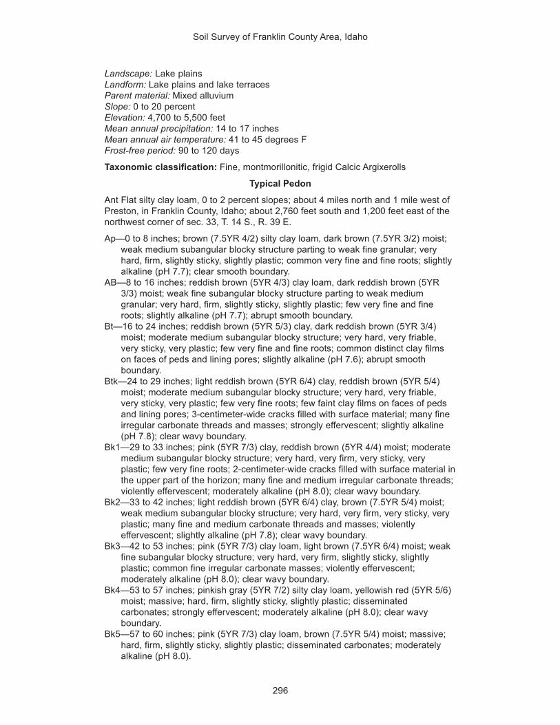
Soil Survey of Franklin County Area, Idaho
296
Landscape: Lake plainsLandform: Lake plains and lake terracesParent material: Mixed alluviumSlope: 0 to 20 percentElevation: 4,700 to 5,500 feetMean annual precipitation: 14 to 17 inchesMean annual air temperature: 41 to 45 degrees FFrost-free period: 90 to 120 days
Taxonomic classification: Fine, montmorillonitic, frigid Calcic Argixerolls
Typical Pedon
Ant Flat silty clay loam, 0 to 2 percent slopes; about 4 miles north and 1 mile west ofPreston, in Franklin County, Idaho; about 2,760 feet south and 1,200 feet east of thenorthwest corner of sec. 33, T. 14 S., R. 39 E.
Ap—0 to 8 inches; brown (7.5YR 4/2) silty clay loam, dark brown (7.5YR 3/2) moist;weak medium subangular blocky structure parting to weak fine granular; veryhard, firm, slightly sticky, slightly plastic; common very fine and fine roots; slightlyalkaline (pH 7.7); clear smooth boundary.
AB—8 to 16 inches; reddish brown (5YR 4/3) clay loam, dark reddish brown (5YR3/3) moist; weak fine subangular blocky structure parting to weak mediumgranular; very hard, firm, slightly sticky, slightly plastic; few very fine and fineroots; slightly alkaline (pH 7.7); abrupt smooth boundary.
Bt—16 to 24 inches; reddish brown (5YR 5/3) clay, dark reddish brown (5YR 3/4)moist; moderate medium subangular blocky structure; very hard, very friable,very sticky, very plastic; few very fine and fine roots; common distinct clay filmson faces of peds and lining pores; slightly alkaline (pH 7.6); abrupt smoothboundary.
Btk—24 to 29 inches; light reddish brown (5YR 6/4) clay, reddish brown (5YR 5/4)moist; moderate medium subangular blocky structure; very hard, very friable,very sticky, very plastic; few very fine roots; few faint clay films on faces of pedsand lining pores; 3-centimeter-wide cracks filled with surface material; many fineirregular carbonate threads and masses; strongly effervescent; slightly alkaline(pH 7.8); clear wavy boundary.
Bk1—29 to 33 inches; pink (5YR 7/3) clay, reddish brown (5YR 4/4) moist; moderatemedium subangular blocky structure; very hard, very firm, very sticky, veryplastic; few very fine roots; 2-centimeter-wide cracks filled with surface material inthe upper part of the horizon; many fine and medium irregular carbonate threads;violently effervescent; moderately alkaline (pH 8.0); clear wavy boundary.
Bk2—33 to 42 inches; light reddish brown (5YR 6/4) clay, brown (7.5YR 5/4) moist;weak medium subangular blocky structure; very hard, very firm, very sticky, veryplastic; many fine and medium carbonate threads and masses; violentlyeffervescent; slightly alkaline (pH 7.8); clear wavy boundary.
Bk3—42 to 53 inches; pink (5YR 7/3) clay loam, light brown (7.5YR 6/4) moist; weakfine subangular blocky structure; very hard, very firm, slightly sticky, slightlyplastic; common fine irregular carbonate masses; violently effervescent;moderately alkaline (pH 8.0); clear wavy boundary.
Bk4—53 to 57 inches; pinkish gray (5YR 7/2) silty clay loam, yellowish red (5YR 5/6)moist; massive; hard, firm, slightly sticky, slightly plastic; disseminatedcarbonates; strongly effervescent; moderately alkaline (pH 8.0); clear wavyboundary.
Bk5—57 to 60 inches; pink (5YR 7/3) clay loam, brown (7.5YR 5/4) moist; massive;hard, firm, slightly sticky, slightly plastic; disseminated carbonates; moderatelyalkaline (pH 8.0).

Soil Survey of Franklin County Area, Idaho
297
Range in Characteristics
Depth to a restrictive feature: More than 60 inches
Diagnostic featuresThickness of the mollic epipedon—10 to 18 inchesDepth to an argillic horizon—5 to 16 inchesDepth to a calcic horizon—18 to 30 inches
Ap horizonHue—7.5YR or 5YRValue—3 or 4 dry, 2 or 3 moistChroma—2 or 3 dry or moistContent of organic matter—2 to 4 percentTexture of the fraction less than 2 millimeters in size—silty clay loamContent of clay—27 to 35 percentContent of rock fragments—0 to 3 percent gravelElectrical conductivity (mmhos/cm)—0 to 2Reaction—pH of 6.6 to 7.8
AB and Bt horizonsHue—7.5YR or 5YRValue—4 to 6 dry, 3 to 5 moistChroma—3 to 6 dry or moistContent of organic matter—1 to 2 percentTexture of the fraction less than 2 millimeters in size—clay loam or clayContent of clay—35 to 55 percentContent of rock fragments—0 to 3 percent gravelCalcium carbonate equivalent—0 to 3 percentElectrical conductivity (mmhos/cm)—0 to 2Reaction—pH of 6.6 to 7.8
Btk and Bk horizonsHue—7.5YR or 5YRValue—6 or 7 dry, 4 to 6 moistChroma—2 to 4 dry, 4 to 6 moistContent of organic matter—0.5 to 2 percentTexture of the fraction less than 2 millimeters in size—silty clay loam, clay loam,
or clayContent of clay—27 to 55 percentContent of rock fragments—0 to 3 percent gravelCalcium carbonate equivalent—15 to 35 percentSodium adsorption ratio—0 to 5Electrical conductivity (mmhos/cm)—0 to 2Reaction—pH of 7.4 to 9.0
Arbone SeriesDepth class: Very deepDrainage class: Well drainedCapacity of the most limiting layer to transmit water (Ksat): Moderately highLandscape: Alluvial plainsLandform: Fan remnantsParent material: Mixed alluviumSlope: 0 to 4 percentElevation: 4,900 to 5,100 feet

Soil Survey of Franklin County Area, Idaho
298
Mean annual precipitation: 12 to 16 inchesMean annual air temperature: 41 to 43 degrees FFrost-free period: 90 to 100 days
Taxonomic classification: Coarse-loamy, mixed, frigid Calcic Haploxerolls
Typical Pedon
Arbone loam, 0 to 4 percent slopes; about 1 mile west and 1 mile south of Thatcher,in Franklin County, Idaho; about 1,350 feet south and 300 feet west of the northeastcorner of sec. 11, T. 12 S., R. 40 E.
Ap—0 to 8 inches; grayish brown (10YR 5/2) loam, very dark grayish brown (10YR3/2) moist; weak fine granular structure; slightly hard, very friable, slightly sticky,slightly plastic; many very fine and fine roots; common fine tubular pores; slightlyalkaline (pH 7.5); clear wavy boundary.
A—8 to 12 inches; brown (10YR 5/3) loam, dark brown (10YR 3/3) moist; moderatefine subangular blocky structure; slightly hard, friable, slightly sticky, slightlyplastic; common very fine and fine roots; common fine tubular pores;disseminated carbonates; slightly effervescent; slightly alkaline (pH 7.6); gradualwavy boundary.
Bw—12 to 21 inches; yellowish brown (10YR 5/4) loam, dark yellowish brown (10YR3/4) moist; moderate medium subangular blocky structure; slightly hard, friable,slightly sticky, slightly plastic; few fine roots; few fine tubular pores; slightlyalkaline (pH 7.8); gradual wavy boundary.
Bk1—21 to 32 inches; pale brown (10YR 6/3) silt loam, brown (10YR 5/3) moist;weak fine subangular blocky structure; slightly hard, friable, slightly sticky, slightlyplastic; few fine roots; few fine tubular pores; disseminated carbonates; stronglyeffervescent; moderately alkaline (pH 8.1); gradual wavy boundary.
Bk2—32 to 60 inches; very pale brown (10YR 7/4) fine sandy loam, yellowish brown(10YR 5/4) moist; massive; slightly hard, very friable, nonsticky, slightly plastic;few very fine roots; few very fine tubular pores; disseminated carbonates;strongly effervescent; moderately alkaline (pH 8.2).
Range in Characteristics
Depth to a restrictive feature: More than 60 inches
Diagnostic featuresThickness of the mollic epipedon—10 to 19 inchesDepth to a calcic horizon—12 to 25 inches
Ap and A horizonsHue—10YRValue—4 or 5 dry, 2 or 3 moistChroma—2 or 3 dry or moistContent of organic matter—1 to 3 percentTexture of the fraction less than 2 millimeters in size—loamContent of clay—13 to 18 percentContent of rock fragments—0 to 12 percent gravelReaction—pH of 7.4 to 8.4
Bw horizonHue—10YRValue—4 or 5 dry, 2 or 3 moistChroma—2 to 4 dry or moistContent of organic matter—1 to 3 percentTexture of the fraction less than 2 millimeters in size—loam or silt loamContent of clay—13 to 18 percent

Soil Survey of Franklin County Area, Idaho
299
Content of rock fragments—0 to 15 percent gravelElectrical conductivity (mmhos/cm)—0 to 2Reaction—pH of 7.4 to 8.4
Bk horizonsHue—10YRValue—5 to 8 dry, 4 to 6 moistChroma—2 to 4 dry or moistContent of organic matter—0.0 to 1 percentTexture of the fraction less than 2 millimeters in size—fine sandy loam or silt loamContent of clay—8 to 18 percentContent of rock fragments—0 to 18 percent gravelCalcium carbonate equivalent—15 to 30 percentElectrical conductivity (mmhos/cm)—0 to 2Reaction—pH of 7.4 to 8.4
Bancroft SeriesDepth class: Very deepDrainage class: Well drainedCapacity of the most limiting layer to transmit water (Ksat): Moderately highLandscape: HillsLandform: HillslopesParent material: LoessSlope: 6 to 15 percentElevation: 5,000 to 6,000 feetMean annual precipitation: 15 to 19 inchesMean annual air temperature: 42 to 44 degrees FFrost-free period: 70 to 80 days
Taxonomic classification: Fine-silty, mixed, frigid Calcic Argixerolls
Typical Pedon
Bancroft silt loam, in an area of Manila-Bancroft complex, 6 to 15 percent slopes;about 3 miles north and 1 mile west of the town of Swan Lake, in Bannock County,Idaho; about 447 feet north and 1,115 feet west of the southeast corner of sec. 21, T.10 S., R. 38 E.
Ap—0 to 7 inches; brown (10YR 5/3) silt loam, very dark grayish brown (10YR 3/2)moist; weak medium and coarse subangular blocky structure parting to weak finegranular; hard, very friable, slightly sticky, slightly plastic; many very fine roots;many very fine irregular and common very fine tubular pores; slightly acid (pH6.2); abrupt smooth boundary.
Bt1—7 to 17 inches; brown (10YR 5/3) silty clay loam, very dark grayish brown(10YR 3/2) moist; moderate coarse subangular blocky structure parting to weakfine subangular blocky; extremely hard, friable, moderately sticky, moderatelyplastic; common very fine roots; many very fine and few fine and medium tubularpores; many faint clay films on faces of peds and lining pores; slightly acid (pH6.4); gradual wavy boundary.
Bt2—17 to 23 inches; yellowish brown (10YR 5/4) silty clay loam, dark yellowishbrown (10YR 3/4) moist; moderate coarse angular blocky structure parting tomoderate medium angular blocky; extremely hard, friable, moderately sticky,moderately plastic; few very fine roots; many very fine and few fine and mediumtubular pores; many distinct clay films on faces of peds and lining pores; neutral(pH 6.7); gradual wavy boundary.

Soil Survey of Franklin County Area, Idaho
300
Bt3—23 to 37 inches; yellowish brown (10YR 5/4) silty clay loam, dark yellowishbrown (10YR 4/4) moist; weak coarse angular blocky structure parting tomoderate fine and medium angular blocky; extremely hard, firm, moderatelysticky, moderately plastic; few very fine roots; many very fine tubular pores; manyfaint clay films on faces of peds and lining pores; about 5 percent hard cicadakrotovinas; neutral (pH 7.1); abrupt wavy boundary.
Btk—37 to 41 inches; light yellowish brown (10YR 6/4) silt loam, dark yellowish brown(10YR 4/4) moist; weak coarse angular blocky structure parting to weak mediumsubangular blocky; extremely hard, firm, slightly sticky, slightly plastic; few veryfine roots; many very fine and few fine tubular pores; common faint clay films onfaces of peds and lining pores; slightly effervescent; slightly alkaline (pH 7.4);clear smooth boundary.
Bk1—41 to 58 inches; very pale brown (10YR 7/3) silt loam, yellowish brown (10YR5/4) moist; massive; extremely hard, firm, slightly sticky, slightly plastic; manyvery fine and common fine tubular pores; many fine carbonate threads; violentlyeffervescent; moderately alkaline (pH 7.9); gradual wavy boundary.
Bk2—58 to 60 inches; pale brown (10YR 6/3) silt loam, dark yellowish brown (10YR4/4) moist; massive; hard, firm, slightly sticky, slightly plastic; many very fine andcommon fine tubular pores; common fine carbonate threads; stronglyeffervescent; slightly alkaline (pH 7.8).
Range in Characteristics
Depth to a restrictive feature: More than 60 inches
Diagnostic featuresThickness of the mollic epipedon—10 to 19 inchesDepth to an argillic horizon—7 to 20 inchesDepth to a calcic horizon—19 to 41 inches
Ap horizonHue—10YRValue—4 or 5 dry, 2 or 3 moistChroma—2 or 3 dry or moistContent of organic matter—2 to 3 percentTexture of the fraction less than 2 millimeters in size—silt loamContent of clay—15 to 20 percentElectrical conductivity (mmhos/cm)—0 to 2Reaction—pH of 6.1 to 7.3
Bt horizonsHue—10YRValue—5 or 6 dry, 3 or 4 moistChroma—2 to 4 dry or moistContent of organic matter—0.5 to 2 percentTexture of the fraction less than 2 millimeters in size—silt loam or silty clay loamContent of clay—18 to 32 percentElectrical conductivity (mmhos/cm)—0 to 2Reaction—pH of 6.1 to 7.8
Btk and Bk horizonsHue—10YRValue—6 or 7 dry, 4 or 5 moistChroma—3 or 4 dry or moistContent of organic matter—0.5 to 1 percentTexture of the fraction less than 2 millimeters in size—silt loam

Soil Survey of Franklin County Area, Idaho
301
Content of clay—10 to 20 percentCalcium carbonate equivalent—15 to 30 percentElectrical conductivity (mmhos/cm)—0 to 2Reaction—pH of 7.4 to 9.0
Banida SeriesDepth class: Very deepDrainage class: Moderately well drainedCapacity of the most limiting layer to transmit water (Ksat): Very lowLandscape: Lake plainsLandform: Lake terracesParent material: Lacustrine depositsSlope: 0 to 30 percentElevation: 4,700 to 5,200 feetMean annual precipitation: 15 to 18 inchesMean annual air temperature: 42 to 45 degrees FFrost-free period: 90 to 110 days
Taxonomic classification: Fine, montmorillonitic, frigid Vertic Xerochrepts
Typical Pedon
Banida silty clay loam, 0 to 2 percent slopes (fig. 16); about 8.5 miles northeast ofPreston, in Franklin County, Idaho; about 1,800 feet north and 1,800 feet west of thesoutheast corner of sec. 12, T. 14 S., R. 39 E.
Ap—0 to 6 inches; brown (7.5YR 5/2) silty clay loam, dark brown (7.5YR 3/2) moist;moderate medium granular structure; slightly hard, firm, moderately sticky,moderately plastic; common very fine and fine and few coarse roots; slightlyalkaline (pH 7.8); clear smooth boundary.
AB—6 to 9 inches; brown (7.5YR 5/2) silty clay, dark reddish gray (5YR 4/2) moist;moderate fine and medium subangular blocky structure; hard, firm, moderatelysticky, moderately plastic; common very fine and fine and few coarse roots;slightly alkaline (pH 7.8); abrupt smooth boundary.
Bw1—9 to 22 inches; reddish brown (5YR 4/3) silty clay, dark reddish brown (5YR3/4) moist; weak medium prismatic structure parting to strong fine angular blocky;very hard, very firm, very sticky, very plastic; few fine roots; common 1-to-1.5-centimeter-wide vertical cracks filled with brown (7.5YR 5/2) surface material;moderately alkaline (pH 7.9); clear wavy boundary.
Bw2—22 to 29 inches; reddish brown (5YR 5/3) silty clay, reddish brown (5YR 4/4)moist; moderate medium subangular blocky structure; very hard, very firm, verysticky, very plastic; few very fine roots; common 1-to-2.5-centimeter-wide verticalcracks filled with brown (7.5YR 5/2) surface material; slightly effervescent;moderately alkaline (pH 8.0); gradual wavy boundary.
Bw3—29 to 35 inches; reddish brown (5YR 5/3) silty clay, reddish brown (5YR 4/4)moist; moderate medium subangular blocky structure parting to moderate fineangular blocky; very hard, very firm, very sticky, very plastic; few very fine roots;common 1-to-4-centimeter-wide vertical cracks filled with brown (7.5YR 5/2)surface material; disseminated carbonates; slightly effervescent; moderatelyalkaline (pH 8.1); clear smooth boundary.
Bk1—35 to 40 inches; light reddish brown (5YR 6/4) silty clay, reddish brown (5YR5/4) moist; moderate fine prismatic structure parting to moderate fine subangularblocky; very hard, very firm, very sticky, very plastic; few very fine roots; few fine

Soil Survey of Franklin County Area, Idaho
302
carbonate threads; disseminated carbonates; strongly effervescent; moderatelyalkaline (pH 8.2); clear smooth boundary.
Bk2—40 to 64 inches; light brown (7.5YR 6/4) silty clay, reddish brown (5YR 5/4)moist; massive; hard, firm, very sticky, very plastic; few fine distinct strong brown(7.5YR 5/6) irregularly shaped masses of iron accumulation; disseminatedcarbonates; strongly effervescent; moderately alkaline (pH 8.4).
Figure 16.—Typical profile of Banida silty clay loam, 0 to 2 percent slopes. The scale is indecimeters.

Soil Survey of Franklin County Area, Idaho
303
Range in Characteristics
Depth to a restrictive feature: More than 60 inches
Diagnostic featureDepth to secondary carbonates—20 to 36 inches
Ap horizonHue—7.5YRValue—4 or 5 dry, 3 or 4 moistChroma—2 or 3 dry or moistContent of organic matter—1 to 2 percentTexture of the fraction less than 2 millimeters in size—silty clay loamContent of clay—32 to 39 percentContent of rock fragments—0 to 3 percent gravelElectrical conductivity (mmhos/cm)—0 to 2Reaction—pH of 7.4 to 8.4
AB and Bw horizonsHue—7.5YR or 5YRValue—4 to 6 dry, 3 to 5 moistChroma—2 to 4 dry or moistContent of organic matter—0.0 to 2 percentTexture of the fraction less than 2 millimeters in size—silty clay or clayContent of clay—40 to 55 percentCalcium carbonate equivalent—0 to 15 percentContent of gypsum—0 to 5 percentElectrical conductivity (mmhos/cm)—0 to 2Reaction—pH of 7.4 to 8.4
Bk horizonsHue—7.5YR or 5YRValue—5 or 6 dry, 4 or 5 moistChroma—3 or 4 dry or moistContent of organic matter—0.0 percentTexture of the fraction less than 2 millimeters in size—silty clay or clayContent of clay—40 to 55 percentCalcium carbonate equivalent—5 to 15 percentSodium adsorption ratio—0 to 5Electrical conductivity (mmhos/cm)—2 to 4Reaction—pH of 7.4 to 8.4
Battle Creek SeriesDepth class: Very deepDrainage class: Moderately well drained or well drainedCapacity of the most limiting layer to transmit water (Ksat): Very lowLandscape: Lake plainsLandform: Lake terracesParent material: Lacustrine depositsSlope: 0 to 8 percentElevation: 4,400 to 4,800 feetMean annual precipitation: 14 to 17 inchesMean annual air temperature: 45 to 49 degrees FFrost-free period: 120 to 130 days
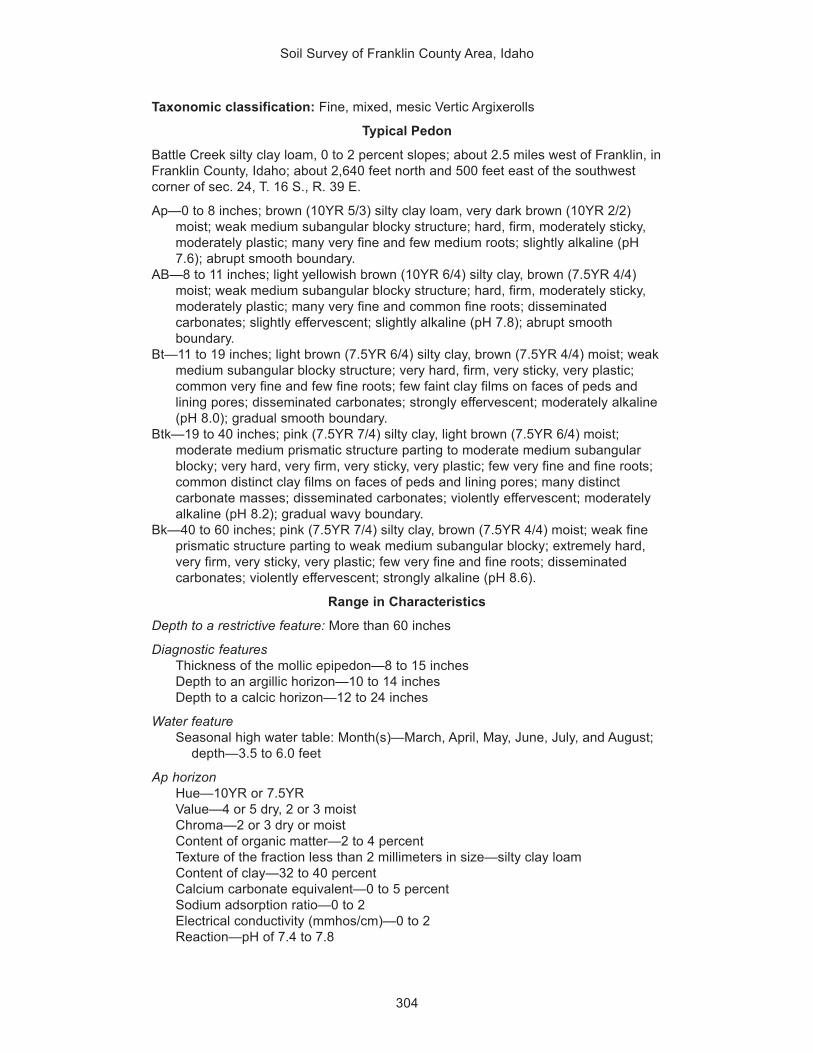
Soil Survey of Franklin County Area, Idaho
304
Taxonomic classification: Fine, mixed, mesic Vertic Argixerolls
Typical Pedon
Battle Creek silty clay loam, 0 to 2 percent slopes; about 2.5 miles west of Franklin, inFranklin County, Idaho; about 2,640 feet north and 500 feet east of the southwestcorner of sec. 24, T. 16 S., R. 39 E.
Ap—0 to 8 inches; brown (10YR 5/3) silty clay loam, very dark brown (10YR 2/2)moist; weak medium subangular blocky structure; hard, firm, moderately sticky,moderately plastic; many very fine and few medium roots; slightly alkaline (pH7.6); abrupt smooth boundary.
AB—8 to 11 inches; light yellowish brown (10YR 6/4) silty clay, brown (7.5YR 4/4)moist; weak medium subangular blocky structure; hard, firm, moderately sticky,moderately plastic; many very fine and common fine roots; disseminatedcarbonates; slightly effervescent; slightly alkaline (pH 7.8); abrupt smoothboundary.
Bt—11 to 19 inches; light brown (7.5YR 6/4) silty clay, brown (7.5YR 4/4) moist; weakmedium subangular blocky structure; very hard, firm, very sticky, very plastic;common very fine and few fine roots; few faint clay films on faces of peds andlining pores; disseminated carbonates; strongly effervescent; moderately alkaline(pH 8.0); gradual smooth boundary.
Btk—19 to 40 inches; pink (7.5YR 7/4) silty clay, light brown (7.5YR 6/4) moist;moderate medium prismatic structure parting to moderate medium subangularblocky; very hard, very firm, very sticky, very plastic; few very fine and fine roots;common distinct clay films on faces of peds and lining pores; many distinctcarbonate masses; disseminated carbonates; violently effervescent; moderatelyalkaline (pH 8.2); gradual wavy boundary.
Bk—40 to 60 inches; pink (7.5YR 7/4) silty clay, brown (7.5YR 4/4) moist; weak fineprismatic structure parting to weak medium subangular blocky; extremely hard,very firm, very sticky, very plastic; few very fine and fine roots; disseminatedcarbonates; violently effervescent; strongly alkaline (pH 8.6).
Range in Characteristics
Depth to a restrictive feature: More than 60 inches
Diagnostic featuresThickness of the mollic epipedon—8 to 15 inchesDepth to an argillic horizon—10 to 14 inchesDepth to a calcic horizon—12 to 24 inches
Water featureSeasonal high water table: Month(s)—March, April, May, June, July, and August;
depth—3.5 to 6.0 feet
Ap horizonHue—10YR or 7.5YRValue—4 or 5 dry, 2 or 3 moistChroma—2 or 3 dry or moistContent of organic matter—2 to 4 percentTexture of the fraction less than 2 millimeters in size—silty clay loamContent of clay—32 to 40 percentCalcium carbonate equivalent—0 to 5 percentSodium adsorption ratio—0 to 2Electrical conductivity (mmhos/cm)—0 to 2Reaction—pH of 7.4 to 7.8

Soil Survey of Franklin County Area, Idaho
305
AB horizonHue—10YR or 7.5YRValue—5 to 7 dry, 4 to 6 moistChroma—3 or 4 dry or moistContent of organic matter—2 to 3 percentTexture of the fraction less than 2 millimeters in size—silty clay loam or silty clayContent of clay—32 to 45 percentCalcium carbonate equivalent—0 to 5 percentSodium adsorption ratio—0 to 2Electrical conductivity (mmhos/cm)—0 to 2Reaction—pH of 7.4 to 8.4
Bt horizonHue—10YR or 7.5YRValue—5 to 7 dry, 4 to 6 moistChroma—3 or 4 dry or moistContent of organic matter—0.5 to 1 percentTexture of the fraction less than 2 millimeters in size—silty clay or clayContent of clay—40 to 60 percentCalcium carbonate equivalent—0 to 5 percentSodium adsorption ratio—0 to 2Electrical conductivity (mmhos/cm)—0 to 2Reaction—pH of 7.9 to 8.4
Btk horizonHue—10YR or 7.5YRValue—5 to 7 dry, 4 to 6 moistChroma—2 to 4 dry or moistContent of organic matter—0.5 to 1 percentTexture of the fraction less than 2 millimeters in size—silty clay or clayContent of clay—40 to 60 percentCalcium carbonate equivalent—15 to 30 percentSodium adsorption ratio—0 to 2Electrical conductivity (mmhos/cm)—0 to 2Reaction—pH of 7.9 to 8.4
Bk horizonHue—10YR or 7.5YRValue—5 to 7 dry, 4 to 6 moistChroma—2 to 4 dry or moistContent of organic matter—0.0 to 0.5 percentTexture of the fraction less than 2 millimeters in size—silty clay loam or silty clayContent of clay—35 to 55 percentCalcium carbonate equivalent—15 to 30 percentSodium adsorption ratio—2 to 8Electrical conductivity (mmhos/cm)—0 to 2Reaction—pH of 7.9 to 9.0
Taxadjunct Feature
The Battle Creek soil in map unit 141 (Trenton-Battle Creek complex, cool, 0 to 2percent slopes) is a taxadjunct to the series because it has a frigid soil temperatureregime. This difference, however, does not affect the use and management of thesoil.

Soil Survey of Franklin County Area, Idaho
306
Bear Lake SeriesDepth class: Very deepDrainage class: Poorly drainedCapacity of the most limiting layer to transmit water (Ksat): Moderately highLandscape: PlainsLandform: Flood plainsParent material: Mixed alluviumSlope: 0 to 2 percentElevation: 4,600 to 5,100 feetMean annual precipitation: 14 to 16 inchesMean annual air temperature: 41 to 45 degrees FFrost-free period: 80 to 100 days
Taxonomic classification: Fine-silty, frigid Typic Calciaquolls
Typical Pedon
Bear Lake silty clay loam, in an area of Bear Lake-Downata complex, 0 to 1 percentslopes; about 1.5 miles east of Oxford, in Franklin County, Idaho; about 2,500 feetsouth and 2,300 feet east of the northwest corner of sec. 26, T. 13 S., R. 38 E.
A—0 to 11 inches; very dark gray (10YR 3/1) silty clay loam, black (10YR 2/1) moist;weak fine subangular blocky structure parting to moderate fine granular; hard,friable, moderately sticky, moderately plastic; many very fine and fine roots;disseminated carbonates; strongly effervescent; slightly alkaline (pH 7.6); clearsmooth boundary.
Bkg1—11 to 20 inches; gray (10YR 6/1) silty clay loam, dark gray (10YR 4/1) moist;weak fine subangular blocky structure; slightly hard, very friable, moderatelysticky, moderately plastic; many very fine and common fine roots; few hardcarbonate nodules; disseminated carbonates (40 percent calcium carbonateequivalent); strongly effervescent; strongly alkaline (pH 8.6); clear wavyboundary.
Bkg2—20 to 26 inches; light gray (10YR 7/1) silty clay loam, gray (10YR 6/1) andlight gray (2.5Y 7/2) moist; massive; slightly hard, very friable, moderately sticky,moderately plastic; common very fine and fine roots; common fine prominent paleolive (5Y 6/4) irregularly shaped masses of iron accumulation; 20 percent, byvolume, hard carbonate nodules; disseminated carbonates (30 percent calciumcarbonate equivalent); strongly effervescent; strongly alkaline (pH 8.8); gradualwavy boundary.
Bkg3—26 to 60 inches; light gray (2.5Y 7/1) silty clay loam, gray (N 6/0) and olivegray (5Y 5/2) crushed and moist; massive; slightly hard, very friable, moderatelysticky, moderately plastic; common very fine and few fine roots; common mediumprominent light olive brown (2.5Y 5/4) and common fine faint pale olive (5Y 6/4)irregularly shaped masses of iron accumulation; less than 5 percent, by volume,hard carbonate nodules; disseminated carbonates (30 percent calcium carbonateequivalent); slightly effervescent; moderately alkaline (pH 8.2).
Range in Characteristics
Depth to a restrictive feature: More than 60 inches
Diagnostic featuresThickness of the mollic epipedon—9 to 22 inchesDepth to a calcic horizon—6 to 16 inchesAquic conditions

Soil Survey of Franklin County Area, Idaho
307
Water featuresSeasonal high water table: Month(s)—February, March, April, May, June, and
July; depth—0.0 to 1.5 feetPonding: Month(s)—February, March, April, May, June, and July; frequency—
occasional; duration—brief; depth—0.0 to 0.5 footFlooding: Month(s)—January, February, March, April, May, and June;
frequency—frequent or occasional; duration—brief
A horizonHue—10YR, 2.5Y, or NValue—2 to 5 dry, 2 or 3 moistChroma—0 to 2 dry or moistContent of organic matter—3 to 7 percentTexture of the fraction less than 2 millimeters in size—silty clay loamContent of clay—28 to 34 percentCalcium carbonate equivalent—15 to 35 percentSodium adsorption ratio—0 to 2Electrical conductivity (mmhos/cm)—0 to 2Reaction—pH of 7.4 to 8.4
Bkg1 horizonHue—10YR, 2.5Y, 5Y, or NValue—5 to 8 dry, 4 to 7 moistChroma—0 to 2 dry or moistContent of organic matter—1 to 3 percentTexture of the fraction less than 2 millimeters in size—silty clay loamContent of clay—28 to 34 percentCalcium carbonate equivalent—15 to 40 percentSodium adsorption ratio—0 to 2Electrical conductivity (mmhos/cm)—0 to 2Reaction—pH of 7.9 to 8.4
Bkg2 and Bkg3 horizonsHue—10YR, 2.5Y, 5Y, or NValue—5 to 8 dry, 4 to 7 moistChroma—0 to 2 dry or moistContent of organic matter—0.0 to 0.5 percentTexture of the fraction less than 2 millimeters in size—silt loam or silty clay loamContent of clay—15 to 34 percentCalcium carbonate equivalent—0 to 35 percentSodium adsorption ratio—0 to 2Electrical conductivity (mmhos/cm)—0 to 2Reaction—pH of 7.4 to 8.4
Bearhollow SeriesDepth class: Very deepDrainage class: Well drainedCapacity of the most limiting layer to transmit water (Ksat): Moderately highLandscape: HillsLandform: HillslopesParent material: Mixed alluviumSlope: 6 to 35 percentElevation: 5,200 to 5,600 feetMean annual precipitation: 13 to 16 inches

Soil Survey of Franklin County Area, Idaho
308
Mean annual air temperature: 42 to 45 degrees FFrost-free period: 80 to 100 days
Taxonomic classification: Coarse-loamy, mixed, frigid Calcixerollic Xerochrepts
Typical Pedon
Bearhollow gravelly loam, in an area of Thatcher-Bearhollow complex, 6 to 20percent slopes; about 1 mile south and 5 miles west of Weston, in Franklin County,Idaho; about 1,600 feet south and 500 feet west of the northeast corner of sec. 30, T.16 S., R. 38 E.
Ap—0 to 4 inches; pale brown (10YR 6/3) gravelly loam, brown (10YR 4/3) moist;weak fine granular structure; soft, very friable, slightly sticky, slightly plastic; manyvery fine and fine roots; many very fine and fine tubular pores; disseminatedcarbonates; slightly effervescent; 30 percent gravel; moderately alkaline (pH 8.0);abrupt smooth boundary.
A—4 to 9 inches; pale brown (10YR 6/3) gravelly loam, brown (10YR 4/3) moist;weak fine subangular blocky structure; slightly hard, friable, slightly sticky, slightlyplastic; common very fine and fine roots; many very fine and fine tubular pores;disseminated carbonates; strongly effervescent; 25 percent gravel; moderatelyalkaline (pH 8.2); clear wavy boundary.
Bk1—9 to 22 inches; very pale brown (10YR 7/3) gravelly loam, brown (10YR 5/3)moist; weak coarse subangular blocky structure; slightly hard, friable, slightlysticky, slightly plastic; few very fine and fine roots; common very fine tubularpores; disseminated carbonates; violently effervescent; 25 percent gravel;moderately alkaline (pH 8.4); clear wavy boundary.
Bk2—22 to 43 inches; very pale brown (10YR 8/3) gravelly loam, very pale brown(10YR 7/3) moist; massive; slightly hard, friable, slightly sticky, nonplastic; fewvery fine roots; common very fine and fine tubular pores; disseminatedcarbonates; violently effervescent; 30 percent gravel; strongly alkaline (pH 8.6);gradual wavy boundary.
Bk3—43 to 60 inches; light gray (2.5Y 7/2) gravelly loam, light brownish gray (2.5Y6/2) moist; massive; slightly hard, friable, slightly sticky, nonplastic; common veryfine and fine tubular pores; disseminated carbonates; violently effervescent; 25percent gravel; strongly alkaline (pH 8.6).
Range in Characteristics
Depth to a restrictive feature: More than 60 inches
Diagnostic featuresThickness of the ochric epipedon—4 to 9 inchesDepth to a calcic horizon—4 to 9 inches
Ap and A horizonsHue—10YRValue—5 to 7 dry, 4 or 5 moistChroma—2 to 4 dry or moistContent of organic matter—0.5 to 2 percentTexture of the fraction less than 2 millimeters in size—loamContent of clay—13 to 18 percentContent of rock fragments—9 to 34 percent gravelCalcium carbonate equivalent—5 to 15 percentSodium adsorption ratio—0 to 5Reaction—pH of 7.9 to 8.4
Bk horizonsHue—10YR or 2.5Y

Soil Survey of Franklin County Area, Idaho
309
Value—6 to 8 dry, 5 to 7 moistChroma—2 or 3 dry or moistContent of organic matter—0.0 to 0.5 percentTexture of the fraction less than 2 millimeters in size—loamContent of clay—10 to 16 percentContent of rock fragments—9 to 34 percent gravelCalcium carbonate equivalent—10 to 25 percentSodium adsorption ratio—0 to 13Reaction—pH of 7.9 to 9.0
Bergquist SeriesDepth class: DeepDrainage class: Well drainedCapacity of the most limiting layer to transmit water (Ksat): HighLandscape: MountainsLandform: Mountain slopesParent material: Mixed colluvium and residuumSlope: 15 to 75 percentElevation: 4,900 to 6,600 feetMean annual precipitation: 16 to 18 inchesMean annual air temperature: 42 to 46 degrees FFrost-free period: 60 to 90 days
Taxonomic classification: Loamy-skeletal, mixed, frigid Typic Haploxerolls
Typical Pedon
Bergquist very gravelly loam, in an area of Bergquist-Softback complex, 25 to 65percent slopes; about 4 miles northwest of the Oneida Narrows Dam, in FranklinCounty, Idaho; about 1,400 feet north and 700 feet east of the southwest corner ofsec. 28, T. 12 S., R. 40 E.
A—0 to 5 inches; grayish brown (10YR 5/2) very gravelly loam, dark brown (10YR3/3) moist; moderate very fine and fine granular structure; soft, very friable,slightly sticky, slightly plastic; common very fine to medium and few coarse roots;35 percent gravel and 5 percent cobbles; neutral (pH 7.3); abrupt wavy boundary.
Bw—5 to 12 inches; brown (10YR 5/3) very gravelly loam, dark brown (10YR 3/3)moist; weak very fine and fine subangular blocky structure; slightly hard, friable,slightly sticky, slightly plastic; common very fine to medium and few coarse roots;35 percent gravel and 15 percent cobbles; neutral (pH 7.3); clear wavy boundary.
C1—12 to 25 inches; reddish yellow (7.5YR 6/6) extremely gravelly sandy loam,brown (7.5YR 5/4) moist; massive; soft, very friable, nonsticky, nonplastic;common very fine and few fine to coarse roots; 50 percent gravel and 20 percentcobbles; neutral (pH 7.3); clear wavy boundary.
C2—25 to 54 inches; reddish yellow (7.5YR 6/6) extremely gravelly sandy loam,strong brown (7.5YR 5/6) moist; massive; soft, very friable, nonsticky, nonplastic;few very fine to coarse roots; 60 percent gravel and 20 percent cobbles; neutral(pH 7.2); clear wavy boundary.
R—54 inches; quartzite.
Range in Characteristics
Depth to a restrictive feature: 40 to 60 inches to lithic bedrock
Diagnostic featureThickness of the mollic epipedon—10 to 19 inches

Soil Survey of Franklin County Area, Idaho
310
A horizonHue—10YRValue—3 to 5 dry, 2 or 3 moistChroma—1 to 3 dry or moistContent of organic matter—1 to 3 percentTexture of the fraction less than 2 millimeters in size—loamContent of clay—7 to 18 percentContent of rock fragments—25 to 45 percent gravel, 0 to 10 percent cobblesReaction—pH of 6.6 to 7.8
Bw horizonHue—10YR or 7.5YRValue—3 to 5 dry, 2 or 3 moistChroma—3 or 4 dry or moistContent of organic matter—1 to 3 percentTexture of the fraction less than 2 millimeters in size—loam or sandy loamContent of clay—5 to 18 percentContent of rock fragments—35 to 55 percent gravel, 10 to 20 percent cobblesReaction—pH of 6.6 to 7.8
C horizonsHue—10YR or 7.5YRValue—6 or 7 dry, 4 or 5 moistChroma—4 to 6 dry or moistContent of organic matter—0.0 to 1 percentTexture of the fraction less than 2 millimeters in size—sandy loamContent of clay—3 to 12 percentContent of rock fragments—28 to 73 percent gravel, 6 to 25 percent cobblesReaction—pH of 6.6 to 7.8
Bothwell SeriesDepth class: Very deepDrainage class: Well drainedCapacity of the most limiting layer to transmit water (Ksat): Moderately highLandscape: Alluvial plains and hillsLandform: Fan remnants and hillslopesParent material: Silty alluvium and loessSlope: 4 to 30 percentElevation: 5,000 to 6,000 feetMean annual precipitation: 15 to 20 inchesMean annual air temperature: 42 to 45 degrees FFrost-free period: 60 to 100 days
Taxonomic classification: Fine-silty, mixed, frigid Pachic Argixerolls
Typical Pedon
Bothwell silt loam, 4 to 12 percent slopes; about 4 miles north and 6 miles east ofPreston, in Franklin County, Idaho; about 1,800 feet south and 1,000 feet west of thenortheast corner of sec. 35, T. 14 S., R. 40 E.
Ap—0 to 6 inches; dark grayish brown (10YR 4/2) silt loam, black (10YR 2/1) moist;weak very fine, fine, and medium subangular blocky structure; slightly hard,friable, slightly sticky, slightly plastic; common very fine and fine and few mediumroots; common very fine and fine and few medium tubular pores; 2 percentgravel; neutral (pH 7.0); clear wavy boundary.

Soil Survey of Franklin County Area, Idaho
311
BA—6 to 13 inches; dark grayish brown (10YR 4/2) silt loam, black (10YR 2/1) moist;weak coarse subangular blocky structure; hard, friable, slightly sticky, slightlyplastic; common very fine and fine roots; common very fine to medium tubularpores; 1 percent gravel; neutral (pH 7.0); gradual wavy boundary.
Bt1—13 to 25 inches; dark grayish brown (10YR 4/2) silt loam, black (10YR 2/1)moist; moderate fine subangular blocky structure; hard, friable, moderately sticky,moderately plastic; common very fine and fine roots; common very fine tomedium tubular and few coarse vesicular pores; common faint clay films on facesof peds and lining pores; 1 percent gravel; neutral (pH 7.2); gradual wavyboundary.
Bt2—25 to 36 inches; brown (10YR 5/3) silty clay loam, dark brown (10YR 3/3) moist;moderate fine and medium subangular blocky structure; slightly hard, friable,moderately sticky, moderately plastic; few very fine roots; common very fine tomedium tubular and few coarse vesicular pores; common distinct clay films onfaces of peds and lining pores; 2 percent gravel; neutral (pH 7.2); clear wavyboundary.
Bt3—36 to 45 inches; pale brown (10YR 6/3) silty clay loam, brown (10YR 4/3) moist;weak fine and medium prismatic structure; slightly hard, friable, moderatelysticky, moderately plastic; few very fine roots; common very fine and fine tubularpores; many distinct clay films on faces of peds and lining pores; 1 percentgravel; neutral (pH 7.2); gradual wavy boundary.
BC—45 to 60 inches; pale brown (10YR 6/3) silt loam, dark grayish brown (10YR 4/2)moist; weak fine prismatic structure; slightly hard, friable, slightly sticky, slightlyplastic; few very fine roots; common very fine and fine tubular pores; 3 percentgravel; neutral (pH 7.0).
Range in Characteristics
Depth to a restrictive feature: More than 60 inches
Diagnostic featuresThickness of the mollic epipedon—20 to 45 inchesDepth to an argillic horizon—6 to 12 inches
Ap horizonHue—10YRValue—4 or 5 dry, 2 or 3 moistChroma—1 to 3 dry or moistContent of organic matter—3 to 4 percentTexture of the fraction less than 2 millimeters in size—silt loamContent of clay—16 to 22 percentContent of rock fragments—0 to 3 percent gravelElectrical conductivity (mmhos/cm)—0 to 2Reaction—pH of 6.6 to 7.8
BA and Bt1 horizonsHue—10YRValue—4 to 7 dry, 2 to 4 moistChroma—1 to 3 dry or moistContent of organic matter—1 to 3 percentTexture of the fraction less than 2 millimeters in size—silt loam or silty clay loamContent of clay—22 to 35 percentContent of rock fragments—0 to 3 percent gravelElectrical conductivity (mmhos/cm)—0 to 2Reaction—pH of 6.6 to 7.8

Soil Survey of Franklin County Area, Idaho
312
Bt2 and Bt3 horizonsHue—10YRValue—4 to 7 dry, 2 to 4 moistChroma—1 to 3 dry or moistContent of organic matter—0.5 to 2 percentTexture of the fraction less than 2 millimeters in size—silty clay loamContent of clay—28 to 35 percentContent of rock fragments—0 to 3 percent gravelElectrical conductivity (mmhos/cm)—0 to 2Reaction—pH of 6.6 to 8.4
BC horizonHue—10YRValue—4 to 7 dry, 3 or 4 moistChroma—2 to 4 dry or moistContent of organic matter—0.5 to 1 percentTexture of the fraction less than 2 millimeters in size—silt loam or silty clay loamContent of clay—18 to 35 percentContent of rock fragments—0 to 6 percent gravelCalcium carbonate equivalent—5 to 15 percentElectrical conductivity (mmhos/cm)—0 to 2Reaction—pH of 6.6 to 8.4
Brifox SeriesDepth class: Very deepDrainage class: Moderately well drainedCapacity of the most limiting layer to transmit water (Ksat): Very lowLandscape: Hills and lake plainsLandform: Hillslopes and lake terracesParent material: Lacustrine depositsSlope: 1 to 35 percentElevation: 4,900 to 5,600 feetMean annual precipitation: 14 to 17 inchesMean annual air temperature: 42 to 44 degrees FFrost-free period: 80 to 100 days
Taxonomic classification: Fine, montmorillonitic, frigid Chromic Calcixererts
Typical Pedon
Brifox silty clay, in an area of Brifox-Huffman complex, 12 to 30 percent slopes; about3 miles west of Thatcher, in Franklin County, Idaho; about 2,000 feet south and 1,300feet west of the northeast corner of sec. 3, T. 12 S., R. 40 E.
Ap—0 to 7 inches; light brownish gray (2.5Y 6/2) silty clay, dark grayish brown (2.5Y4/2) moist; weak fine subangular blocky structure; slightly hard, friable, verysticky, moderately plastic; common very fine and few fine roots; disseminatedcarbonates (13 percent calcium carbonate equivalent); strongly effervescent;slightly alkaline (pH 7.6); clear wavy boundary.
Bw—7 to 12 inches; light brownish gray (2.5Y 6/2) silty clay, dark grayish brown (2.5Y4/2) moist; moderate fine subangular blocky structure; hard, firm, very sticky,moderately plastic; common very fine roots; few fine carbonate masses andthreads; disseminated carbonates (14 percent calcium carbonate equivalent);violently effervescent; slightly alkaline (pH 7.8); clear wavy boundary.

Soil Survey of Franklin County Area, Idaho
313
Bss—12 to 18 inches; light brownish gray (2.5Y 6/2) silty clay, dark grayish brown(2.5Y 4/2) moist; moderate fine prismatic structure; hard, firm, very sticky,moderately plastic; few very fine roots; few very fine irregular pores; fewintersecting slickensides; few fine carbonate masses and threads (14 percentcalcium carbonate equivalent); violently effervescent; slightly alkaline (pH 7.8);gradual wavy boundary.
Bkss1—18 to 28 inches; light gray (2.5Y 7/2) silty clay, grayish brown (2.5Y 5/2)moist; weak fine prismatic structure; hard, firm, very sticky, moderately plastic;few very fine roots; few very fine irregular pores; few intersecting slickensides;common fine carbonate masses and threads; disseminated carbonates (19percent calcium carbonate equivalent); violently effervescent; slightly alkaline (pH7.8); gradual wavy boundary.
Bkss2—28 to 55 inches; light gray (2.5Y 7/2) silty clay, dark grayish brown (2.5Y 4/2)moist; weak fine prismatic structure; hard, firm, very sticky, moderately plastic;few intersecting slickensides; common fine carbonate masses and threads;disseminated carbonates (14 percent calcium carbonate equivalent); violentlyeffervescent; moderately alkaline (pH 8.0); gradual wavy boundary.
Bk—55 to 60 inches; light gray (2.5Y 7/2) silty clay, grayish brown (2.5Y 5/2) moist;moderate fine subangular blocky structure; hard, firm, very sticky, moderatelyplastic; common fine carbonate masses and threads; disseminated carbonates(14 percent calcium carbonate equivalent); violently effervescent; moderatelyalkaline (pH 8.0).
Range in Characteristics
Depth to a restrictive feature: More than 60 inches
Diagnostic featureDepth to a calcic horizon—12 to 30 inches
Ap horizonHue—10YR or 2.5YValue—5 or 6 dry, 3 to 5 moistChroma—2 or 3 dry or moistContent of organic matter—1 to 3 percentTexture of the fraction less than 2 millimeters in size—silty clayContent of clay—40 to 50 percentCalcium carbonate equivalent—10 to 20 percentSodium adsorption ratio—0 to 5Electrical conductivity (mmhos/cm)—0 to 4Reaction—pH of 7.4 to 8.4
Bw and Bss horizonsHue—10YR or 2.5YValue—5 to 8 dry, 4 or 5 moistChroma—2 or 3 dry or moistContent of organic matter—1 to 2 percentTexture of the fraction less than 2 millimeters in size—silty clay loam or silty clayContent of clay—35 to 50 percentCalcium carbonate equivalent—10 to 20 percentSodium adsorption ratio—0 to 5Electrical conductivity (mmhos/cm)—0 to 4Reaction—pH of 7.4 to 8.4
Bkss and Bk horizonsHue—10YR or 2.5YValue—5 to 7 dry, 4 to 6 moist
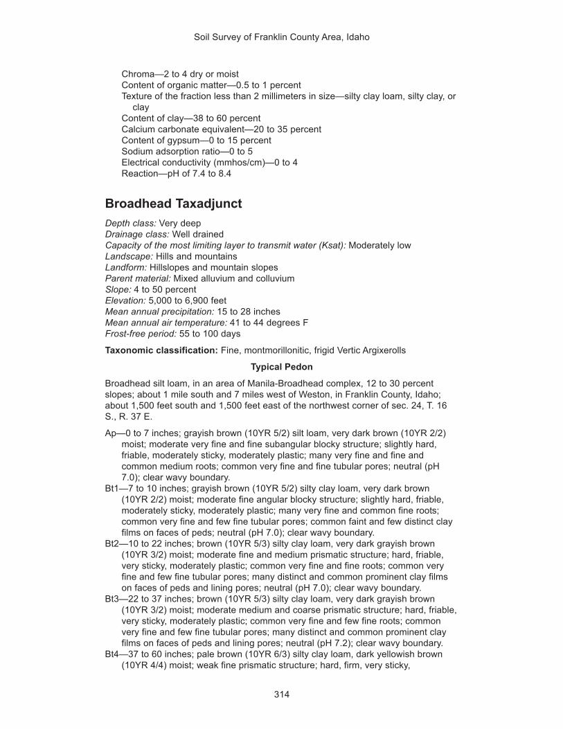
Soil Survey of Franklin County Area, Idaho
314
Chroma—2 to 4 dry or moistContent of organic matter—0.5 to 1 percentTexture of the fraction less than 2 millimeters in size—silty clay loam, silty clay, or
clayContent of clay—38 to 60 percentCalcium carbonate equivalent—20 to 35 percentContent of gypsum—0 to 15 percentSodium adsorption ratio—0 to 5Electrical conductivity (mmhos/cm)—0 to 4Reaction—pH of 7.4 to 8.4
Broadhead TaxadjunctDepth class: Very deepDrainage class: Well drainedCapacity of the most limiting layer to transmit water (Ksat): Moderately lowLandscape: Hills and mountainsLandform: Hillslopes and mountain slopesParent material: Mixed alluvium and colluviumSlope: 4 to 50 percentElevation: 5,000 to 6,900 feetMean annual precipitation: 15 to 28 inchesMean annual air temperature: 41 to 44 degrees FFrost-free period: 55 to 100 days
Taxonomic classification: Fine, montmorillonitic, frigid Vertic Argixerolls
Typical Pedon
Broadhead silt loam, in an area of Manila-Broadhead complex, 12 to 30 percentslopes; about 1 mile south and 7 miles west of Weston, in Franklin County, Idaho;about 1,500 feet south and 1,500 feet east of the northwest corner of sec. 24, T. 16S., R. 37 E.
Ap—0 to 7 inches; grayish brown (10YR 5/2) silt loam, very dark brown (10YR 2/2)moist; moderate very fine and fine subangular blocky structure; slightly hard,friable, moderately sticky, moderately plastic; many very fine and fine andcommon medium roots; common very fine and fine tubular pores; neutral (pH7.0); clear wavy boundary.
Bt1—7 to 10 inches; grayish brown (10YR 5/2) silty clay loam, very dark brown(10YR 2/2) moist; moderate fine angular blocky structure; slightly hard, friable,moderately sticky, moderately plastic; many very fine and common fine roots;common very fine and few fine tubular pores; common faint and few distinct clayfilms on faces of peds; neutral (pH 7.0); clear wavy boundary.
Bt2—10 to 22 inches; brown (10YR 5/3) silty clay loam, very dark grayish brown(10YR 3/2) moist; moderate fine and medium prismatic structure; hard, friable,very sticky, moderately plastic; common very fine and fine roots; common veryfine and few fine tubular pores; many distinct and common prominent clay filmson faces of peds and lining pores; neutral (pH 7.0); clear wavy boundary.
Bt3—22 to 37 inches; brown (10YR 5/3) silty clay loam, very dark grayish brown(10YR 3/2) moist; moderate medium and coarse prismatic structure; hard, friable,very sticky, moderately plastic; common very fine and few fine roots; commonvery fine and few fine tubular pores; many distinct and common prominent clayfilms on faces of peds and lining pores; neutral (pH 7.2); clear wavy boundary.
Bt4—37 to 60 inches; pale brown (10YR 6/3) silty clay loam, dark yellowish brown(10YR 4/4) moist; weak fine prismatic structure; hard, firm, very sticky,

Soil Survey of Franklin County Area, Idaho
315
moderately plastic; common very fine roots; common very fine tubular pores;common faint and few distinct clay films on faces of peds and lining pores;neutral (pH 7.2).
Range in Characteristics
Depth to a restrictive feature: More than 60 inches
Diagnostic featuresThickness of the mollic epipedon—20 to 40 inchesDepth to an argillic horizon—6 to 15 inches
Ap horizonHue—10YRValue—3 to 5 dry, 2 or 3 moistChroma—2 or 3 dry or moistContent of organic matter—2 to 4 percentTexture of the fraction less than 2 millimeters in size—silt loamContent of clay—15 to 25 percentContent of rock fragments—0 to 9 percent gravel, 0 to 3 percent cobblesReaction—pH of 5.6 to 7.3
Bt1 horizonHue—10YR or 7.5YRValue—4 to 6 dry, 2 or 3 moistChroma—2 or 3 dry or moistContent of organic matter—1 to 2 percentTexture of the fraction less than 2 millimeters in size—silt loam or silty clay loamContent of clay—25 to 35 percentContent of rock fragments—0 to 9 percent gravel, 0 to 3 percent cobblesReaction—pH of 6.1 to 7.3
Bt2, Bt3, and Bt4 horizonsHue—10YR or 7.5YRValue—4 to 6 dry, 2 to 4 moistChroma—2 to 4 dry or moistContent of organic matter—0.5 to 2 percentTexture of the fraction less than 2 millimeters in size—silty clay loam or silty clayContent of clay—35 to 50 percentContent of rock fragments—0 to 9 percent gravel, 0 to 3 percent cobblesCalcium carbonate equivalent—0 to 5 percentReaction—pH of 6.1 to 7.3
Taxadjunct Feature
The Broadhead soils in this survey area are taxadjuncts because the linearextensibility and shrink-swell potential are higher than is defined as the range for theseries. These differences, however, do not affect the use and management of thesoils for rangeland or cropland.
Cachecan SeriesDepth class: Very deepDrainage class: Somewhat poorly drainedCapacity of the most limiting layer to transmit water (Ksat): Moderately highLandscape: ValleysLandform: Stream terracesParent material: Mixed alluvium

Soil Survey of Franklin County Area, Idaho
316
Slope: 0 to 2 percentElevation: 4,400 to 4,900 feetMean annual precipitation: 14 to 16 inchesMean annual air temperature: 47 to 49 degrees FFrost-free period: 100 to 130 days
Taxonomic classification: Fine-silty, mixed, mesic Fluventic Xerochrepts
Typical Pedon
Cachecan silt loam, in an area of Delish-Cachecan-Stinkcreek complex, 0 to 2percent slopes; about 2.75 miles west of Fairview, in Franklin County, Idaho; about1,200 feet south and 1,800 feet east of the northwest corner of sec. 29, T. 16 S., R.39 E.
A—0 to 5 inches; grayish brown (10YR 5/2) silt loam, dark grayish brown (10YR 4/2)moist; weak thin platy structure parting to moderate very fine and fine granular;slightly hard, very friable, slightly sticky, slightly plastic; few very fine and fine andcommon medium roots; few very fine and common fine irregular and tubularpores; disseminated carbonates (5 percent calcium carbonate equivalent);slightly effervescent; moderately alkaline (pH 8.1); abrupt wavy boundary.
Bw1—5 to 12 inches; light brownish gray (10YR 6/2) fine sandy loam, dark grayishbrown (10YR 4/2) moist; weak fine and medium subangular blocky structure;slightly hard, very friable, nonsticky, nonplastic; common very fine and fine andfew medium roots; few very fine and common fine irregular and tubular pores;few fine distinct yellowish brown (10YR 5/6) masses of iron accumulation that arerelict redoximorphic features; disseminated carbonates (5 percent calciumcarbonate equivalent); 2 percent gravel; strongly effervescent; moderatelyalkaline (pH 8.2); clear wavy boundary.
Bw2—12 to 20 inches; pale brown (10YR 6/3) silt loam, brown (10YR 5/3) moist;weak thick platy structure parting to moderate medium and coarse subangularblocky; slightly hard, friable, slightly sticky, slightly plastic; common very fine andfew fine and medium roots; common very fine and few fine tubular pores; few finedistinct yellowish brown (10YR 5/6) masses of iron accumulation that are relictredoximorphic features; disseminated carbonates (12 percent calcium carbonateequivalent); violently effervescent; strongly alkaline (pH 8.5); abrupt wavyboundary.
Bg—20 to 37 inches; gray (10YR 6/1) silty clay loam, dark gray (10YR 4/1) moist;moderate coarse prismatic structure; very hard, friable, moderately sticky,moderately plastic; common very fine and few fine and medium roots; commonvery fine and few fine tubular pores; common medium faint very dark gray (10YR3/1) irregularly shaped iron depletions that are concentrated in the lower part ofthe horizon, below a depth of 30 inches; disseminated carbonates (10 percentcalcium carbonate equivalent); strongly effervescent; moderately alkaline (pH8.4); gradual wavy boundary.
Cg—37 to 61 inches; light gray (10YR 7/1) silty clay loam, dark gray (10YR 4/1)moist; massive; very hard, firm, moderately sticky, moderately plastic; commonvery fine and few fine roots; few very fine tubular pores; common medium faintvery dark gray (10YR 3/1) irregularly shaped iron depletions; disseminatedcarbonates (15 percent calcium carbonate equivalent); slightly effervescent;common crushed snail shell fragments; strongly alkaline (pH 8.6).
Range in Characteristics
Depth to a restrictive feature: More than 60 inches
Diagnostic featuresDepth to the base of a cambic horizon—12 to 25 inches

Soil Survey of Franklin County Area, Idaho
317
Irregular decrease in content of organic carbonDepth to iron depletions—20 to 36 inches
Water featuresSeasonal high water table: Month(s)—January, February, March, April, May, and
June; depth—2.5 to 3.5 feetFlooding: Month(s)—February, March, April, and May; frequency—rare
A horizonHue—10YRValue—5 or 6 dry, 3 or 4 moistChroma—1 or 2 dry or moistContent of organic matter—1 to 3 percentTexture of the fraction less than 2 millimeters in size—silt loamContent of clay—12 to 18 percentContent of rock fragments—0 to 6 percent gravelCalcium carbonate equivalent—1 to 15 percentSodium adsorption ratio—0 to 13Electrical conductivity (mmhos/cm)—0 to 2Reaction—pH of 7.9 to 9.0
Bw horizonsHue—10YR or 2.5YValue—6 or 7 dry, 4 or 5 moistChroma—2 or 3 dry or moistContent of organic matter—0.5 to 2 percentTexture of the fraction less than 2 millimeters in size—fine sandy loam or silt loamContent of clay—5 to 20 percentContent of rock fragments—0 to 6 percent gravelCalcium carbonate equivalent—1 to 15 percentSodium adsorption ratio—5 to 13Electrical conductivity (mmhos/cm)—0 to 2Reaction—pH of 7.9 to 9.0
Bg horizonHue—10YR or 2.5YValue—6 or 7 dry, 4 or 5 moistChroma—1 or 2 dry or moistContent of organic matter—0.5 to 1 percentTexture of the fraction less than 2 millimeters in size—silt loam or silty clay loamContent of clay—25 to 32 percentContent of rock fragments—0 to 6 percent gravelCalcium carbonate equivalent—5 to 15 percentSodium adsorption ratio—5 to 13Electrical conductivity (mmhos/cm)—2 to 4Reaction—pH of 7.9 to 9.0
Cg horizonHue—10YR or 2.5YValue—6 or 7 dry, 4 or 5 moistChroma—1 or 2 dry or moistContent of organic matter—0.0 to 0.5 percentTexture of the fraction less than 2 millimeters in size—silty clay loamContent of clay—32 to 40 percentContent of rock fragments—0 to 6 percent gravelCalcium carbonate equivalent—5 to 20 percentSodium adsorption ratio—5 to 13

Soil Survey of Franklin County Area, Idaho
318
Electrical conductivity (mmhos/cm)—0 to 2Reaction—pH of 8.5 to 9.0
Camelback SeriesDepth class: Very deepDrainage class: Well drainedCapacity of the most limiting layer to transmit water (Ksat): Moderately highLandscape: Hills and mountainsLandform: Hillslopes and mountain slopesParent material: Mixed alluvium, colluvium, and residuumSlope: 20 to 60 percentElevation: 5,000 to 6,700 feetMean annual precipitation: 15 to 20 inchesMean annual air temperature: 40 to 45 degrees FFrost-free period: 60 to 95 days
Taxonomic classification: Loamy-skeletal, mixed, frigid Pachic Argixerolls
Typical Pedon
Camelback very gravelly silt loam, in an area of Camelback-Lonigan complex, 20 to50 percent slopes; about 3 miles east of Preston, in Franklin County, Idaho; about950 feet south and 2,900 feet east of the northwest corner of sec. 16, T. 15 S., R. 40E.
A1—0 to 3 inches; dark grayish brown (10YR 4/2) very gravelly silt loam, very darkbrown (10YR 2/2) moist; moderate fine and medium granular structure; slightlyhard, friable, nonsticky, nonplastic; common very fine roots; common very fineand few fine irregular pores; 40 percent gravel; slightly alkaline (pH 7.6); clearsmooth boundary.
A2—3 to 14 inches; grayish brown (10YR 5/2) very gravelly silt loam, very darkgrayish brown (10YR 3/2) moist; moderate fine and medium granular structure;slightly hard, friable, slightly sticky, slightly plastic; common very fine roots;common very fine and few fine irregular pores; 40 percent gravel; slightly alkaline(pH 7.7); clear smooth boundary.
Bt1—14 to 22 inches; grayish brown (10YR 5/2) very gravelly silt loam, very darkgrayish brown (10YR 3/2) moist; moderate fine and medium subangular blockystructure; hard, friable, slightly sticky, slightly plastic; common very fine roots; fewvery fine and fine tubular pores; few faint clay bridges; 40 percent gravel; slightlyalkaline (pH 7.6); abrupt wavy boundary.
Bt2—22 to 32 inches; brown (10YR 5/3) very gravelly silty clay loam, dark brown(10YR 3/3) moist; moderate fine and medium subangular blocky structure; hard,friable, moderately sticky, moderately plastic; few very fine roots; few very fineand fine tubular pores; few faint clay films on faces of peds and lining pores; 40percent gravel; slightly alkaline (pH 7.7); clear wavy boundary.
Bt3—32 to 50 inches; yellowish brown (10YR 5/6) very gravelly silt loam, brown(10YR 4/3) moist; moderate fine and medium subangular blocky structure; hard,friable, slightly sticky, slightly plastic; few very fine roots; few very fine and finetubular pores; few faint clay films on faces of peds and lining pores; 40 percentgravel; slightly alkaline (pH 7.8); clear wavy boundary.
BC—50 to 61 inches; light yellowish brown (10YR 6/4) very gravelly loam, darkyellowish brown (10YR 4/4) moist; weak fine and medium subangular blockystructure; slightly hard, very friable, slightly sticky, slightly plastic; few very fine

Soil Survey of Franklin County Area, Idaho
319
roots; few very fine tubular and irregular pores; 35 percent gravel; slightly alkaline(pH 7.8).
Range in Characteristics
Depth to a restrictive feature: More than 60 inches
Diagnostic featuresThickness of the mollic epipedon—20 to 35 inchesDepth to an argillic horizon—10 to 35 inches
A horizonsHue—10YRValue—4 or 5 dry, 2 or 3 moistChroma—1 to 3 dry or moistContent of organic matter—2 to 4 percentTexture of the fraction less than 2 millimeters in size—silt loamContent of clay—12 to 18 percentContent of rock fragments—21 to 57 percent gravelReaction—pH of 7.4 to 7.8
Bt horizonsHue—10YRValue—5 or 6 dry, 3 or 4 moistChroma—2 to 6 dry or moistContent of organic matter—0.5 to 2 percentTexture of the fraction less than 2 millimeters in size—silt loam or silty clay loamContent of clay—20 to 31 percentContent of rock fragments—21 to 57 percent gravelReaction—pH of 7.4 to 7.8
BC horizonHue—10YRValue—5 or 6 dry, 4 or 5 moistChroma—4 to 6 dry or moistContent of organic matter—0.0 to 0.5 percentTexture of the fraction less than 2 millimeters in size—loamContent of clay—14 to 24 percentContent of rock fragments—21 to 47 percent gravelReaction—pH of 7.4 to 7.8
Cedarhill SeriesDepth class: Very deepDrainage class: Well drainedCapacity of the most limiting layer to transmit water (Ksat): Moderately highLandscape: MountainsLandform: Mountain slopesParent material: Mixed alluviumSlope: 12 to 50 percentElevation: 4,900 to 6,300 feetMean annual precipitation: 13 to 20 inchesMean annual air temperature: 41 to 44 degrees FFrost-free period: 70 to 100 days
Taxonomic classification: Loamy-skeletal, mixed, frigid Typic Calcixerolls

Soil Survey of Franklin County Area, Idaho
320
Typical Pedon
Cedarhill very gravelly silt loam, 12 to 20 percent slopes; about 1 mile north and 3miles east of Preston, in Franklin County, Idaho; about 900 feet south and 1,200 feeteast of the northwest corner of sec. 17, T. 15 S., R. 40 E.
Ap—0 to 8 inches; brown (10YR 5/3) very gravelly silt loam, dark brown (10YR 3/3)moist; weak fine granular structure; slightly hard, very friable, slightly sticky,slightly plastic; common very fine roots; many fine vesicular pores; disseminatedcarbonates; strongly effervescent; 45 percent gravel; slightly alkaline (pH 7.8);abrupt smooth boundary.
ABk—8 to 17 inches; brown (10YR 5/3) very gravelly loam, dark brown (10YR 3/3)moist; weak fine subangular blocky structure; slightly hard, friable, slightly sticky,slightly plastic; common very fine roots; many fine tubular pores; disseminatedcarbonates; strongly effervescent; 40 percent gravel; moderately alkaline (pH7.9); gradual smooth boundary.
Bk1—17 to 28 inches; pale brown (10YR 6/3) very gravelly silt loam, brown (10YR4/3) moist; massive; slightly hard, friable, slightly sticky, slightly plastic; few fineroots; few fine tubular pores; disseminated carbonates; violently effervescent; 40percent gravel; moderately alkaline (pH 8.1); gradual smooth boundary.
Bk2—28 to 60 inches; very pale brown (10YR 7/3) very gravelly silt loam, brown(10YR 5/3) moist; massive; slightly hard, friable, slightly sticky, slightly plastic; fewvery fine roots; disseminated carbonates; violently effervescent; 40 percentgravel; moderately alkaline (pH 8.2).
Range in Characteristics
Depth to a restrictive feature: More than 60 inches
Diagnostic featuresThickness of the mollic epipedon—9 to 17 inchesDepth to a calcic horizon—7 to 12 inches
Ap horizonHue—10YRValue—4 or 5 dry, 2 or 3 moistChroma—2 or 3 dry or moistContent of organic matter—1 to 3 percentTexture of the fraction less than 2 millimeters in size—silt loamContent of clay—10 to 16 percentContent of rock fragments—20 to 45 percent gravel, 0 to 11 percent cobblesCalcium carbonate equivalent—10 to 15 percentReaction—pH of 7.4 to 7.8
ABk horizonHue—10YRValue—4 or 5 dry, 2 or 3 moistChroma—2 or 3 dry or moistContent of organic matter—1 to 2 percentTexture of the fraction less than 2 millimeters in size—loam or silt loamContent of clay—10 to 17 percentContent of rock fragments—7 to 51 percent gravel, 0 to 11 percent cobblesCalcium carbonate equivalent—15 to 35 percentReaction—pH of 7.4 to 8.4
Bk horizonsHue—10YRValue—6 to 8 dry, 3 to 8 moist

Soil Survey of Franklin County Area, Idaho
321
Chroma—2 to 4 dry or moistContent of organic matter—0.5 to 1 percentTexture of the fraction less than 2 millimeters in size—silt loam or loamContent of clay—10 to 17 percentContent of rock fragments—22 to 54 percent gravel, 0 to 25 percent cobblesCalcium carbonate equivalent—15 to 35 percentReaction—pH of 7.9 to 8.4
Chesbrook SeriesDepth class: Very deepDrainage class: Poorly drainedCapacity of the most limiting layer to transmit water (Ksat): Moderately highLandscape: PlainsLandform: Flood plainsParent material: Silty alluviumSlope: 0 to 2 percentElevation: 4,900 to 5,100 feetMean annual precipitation: 14 to 16 inchesMean annual air temperature: 41 to 45 degrees FFrost-free period: 80 to 95 days
Taxonomic classification: Fine-silty, frigid Typic Calciaquolls
Typical Pedon
Chesbrook silty clay loam; in adjacent Caribou County, Idaho; about 700 feet northand 1,200 feet east of the southwest corner of sec. 29, T. 6 S., R. 39 E.
Oi—0 to 2 inches; slightly decomposed plant material.Akg1—2 to 13 inches; light brownish gray (10YR 6/2) silty clay loam, very dark gray
(10YR 3/1) moist; weak coarse subangular blocky structure parting to moderatemedium subangular blocky; slightly hard, very friable, moderately sticky,moderately plastic; common very fine and fine roots; common very fine tubularpores; violently effervescent (34 percent calcium carbonate equivalent);moderately alkaline (pH 8.3); gradual smooth boundary.
Akg2—13 to 20 inches; light brownish gray (10YR 6/2) silty clay loam, very dark gray(10YR 3/1) moist; weak medium subangular blocky structure parting to strongvery fine granular; slightly hard, very friable, moderately sticky, moderatelyplastic; common very fine and fine roots; many very fine tubular pores; many lightgray (10YR 7/2) iron depletions; violently effervescent (37 percent calciumcarbonate equivalent); moderately alkaline (pH 8.3); gradual wavy boundary.
Bkg1—20 to 31 inches; light brownish gray (10YR 6/2) silty clay loam, very dark gray(10YR 3/1) moist; weak coarse subangular blocky structure parting to weakmedium subangular blocky; slightly hard, very friable, moderately sticky,moderately plastic; common very fine and few fine roots; many very fine tubularpores; many light gray (10YR 7/2) iron depletions; strongly effervescent (47percent calcium carbonate equivalent); moderately alkaline (pH 8.3); gradualwavy boundary.
Bkg2—31 to 36 inches; light brownish gray (10YR 6/2) silty clay loam, dark gray(10YR 4/1) moist; massive; soft, very friable, slightly sticky, slightly plastic; fewvery fine and fine roots; many very fine tubular pores; many light gray (10YR 7/2)iron depletions; strongly effervescent (75 percent calcium carbonate equivalent);strongly alkaline (pH 8.5); gradual wavy boundary.
Bkg3—36 to 48 inches; light gray (2.5Y 7/2) silty clay loam, light brownish gray (2.5Y6/2) moist; massive; hard, very friable, moderately sticky, moderately plastic; few

Soil Survey of Franklin County Area, Idaho
322
very fine and fine roots; many very fine and few fine tubular pores; few prominentyellow (2.5Y 7/6) masses of iron accumulation; strongly effervescent (47 percentcalcium carbonate equivalent); moderately alkaline (pH 8.4); clear wavyboundary.
Ckg1—48 to 56 inches; white (5Y 8/1) silty clay loam, light brownish gray (2.5Y 6/2)moist; massive; hard, very friable, moderately sticky, moderately plastic; few veryfine and fine roots; common very fine and few fine tubular pores; few fine oliveyellow (2.5Y 6/6) masses of iron accumulation; 2 percent snail shells; 25 percent5/8- by 1/4-inch lime nodules; strongly effervescent (40 percent calcium carbonateequivalent); 3 percent gravel; strongly alkaline (pH 8.6); clear smooth boundary.
Ckg2—56 to 62 inches; pale yellow (5Y 8/3) silt loam, olive (5Y 5/3) moist; massive;hard, very friable, slightly sticky, slightly plastic; few very fine and fine roots;common very fine tubular pores; common fine olive yellow (2.5Y 6/6) and few finelight olive brown (2.5Y 5/4) masses of iron accumulation; 30 percent 5/8- by 1/4-inch lime nodules; slightly effervescent (25 percent calcium carbonateequivalent); moderately alkaline (pH 8.4).
Range in Characteristics
Depth to a restrictive feature: More than 60 inches
Diagnostic featuresThickness of the mollic epipedon—10 to 30 inchesDepth to a calcic horizon—11 to 24 inchesDepth to redoximorphic features—6 to 18 inchesAquic conditions
Water featuresSeasonal high water table: Month(s)—February, March, April, May, June, and
July; depth—0.5 foot to 1.5 feetFlooding: Month(s)—February, March, April, and May; frequency—rare
Oi horizonContent of organic matter—60 to 95 percentTexture—slightly decomposed plant materialContent of clay—0 to 25 percentReaction—pH of 4.5 to 5.5
Akg horizonsHue—10YR or 2.5YValue—4 to 6 dry, 2 or 3 moistChroma—1 or 2 dry or moistContent of organic matter—3 to 5 percentTexture of the fraction less than 2 millimeters in size—silty clay loamContent of clay—27 to 35 percentContent of rock fragments—0 to 3 percent gravelCalcium carbonate equivalent—25 to 40 percentSodium adsorption ratio—0 to 3Electrical conductivity (mmhos/cm)—0 to 2Reaction—pH of 7.9 to 9.0
Bkg horizonsHue—10YR or 2.5YValue—6 or 7 dry, 3 to 6 moistChroma—1 or 2 dry or moistContent of organic matter—1 to 4 percentTexture of the fraction less than 2 millimeters in size—silty clay loam

Soil Survey of Franklin County Area, Idaho
323
Content of clay—35 to 40 percentContent of rock fragments—0 to 3 percent gravelCalcium carbonate equivalent—40 to 75 percentSodium adsorption ratio—0 to 3Electrical conductivity (mmhos/cm)—0 to 2Reaction—pH of 7.9 to 9.0
Ckg horizonsHue—10YR, 2.5Y, 5Y, or NValue—6 to 8 dry, 4 to 6 moistChroma—1 to 3 dry, 0 to 3 moistContent of organic matter—0.0 to 0.5 percentTexture of the fraction less than 2 millimeters in size—silt loam or silty clay loamContent of clay—20 to 32 percentContent of rock fragments—0 to 6 percent gravelCalcium carbonate equivalent—25 to 40 percentSodium adsorption ratio—0 to 3Electrical conductivity (mmhos/cm)—0 to 2Reaction—pH of 7.9 to 9.0
Cloudless SeriesDepth class: Very deepDrainage class: Well drainedCapacity of the most limiting layer to transmit water (Ksat): Moderately highLandscape: Alluvial plainsLandform: Fan remnantsParent material: Mixed alluviumSlope: 4 to 20 percentElevation: 4,800 to 5,800 feetMean annual precipitation: 14 to 18 inchesMean annual air temperature: 41 to 45 degrees FFrost-free period: 80 to 95 days
Taxonomic classification: Fine-loamy, mixed, frigid Typic Argixerolls
Typical Pedon
Cloudless silt loam, in an area of Cloudless-Hades-Howcan complex, 12 to 20percent slopes; about 3 miles west of Oxford, in Franklin County, Idaho; about 2,380feet north and 2,500 feet east of the southwest corner of sec. 19, T. 13 S., R. 38 E.
Ap—0 to 6 inches; dark grayish brown (10YR 4/2) silt loam, very dark brown (10YR2/2) moist; moderate fine subangular blocky structure; slightly hard, very friable,slightly sticky, slightly plastic; common fine and few medium roots; common fineirregular and tubular pores; neutral (pH 7.0); gradual smooth boundary.
AB—6 to 9 inches; dark grayish brown (10YR 4/2) silt loam, very dark brown (10YR2/2) moist; moderate fine subangular blocky structure; slightly hard, very friable,slightly sticky, slightly plastic; common fine and few medium roots; many fineirregular and common fine tubular pores; neutral (pH 7.1); clear smoothboundary.
Bt1—9 to 15 inches; grayish brown (10YR 5/2) silt loam, dark brown (10YR 3/3)moist; strong fine subangular blocky structure; hard, friable, slightly sticky, slightlyplastic; common fine and few medium roots; common fine tubular pores; commondistinct clay films on faces of peds and lining pores; 5 percent gravel; neutral (pH7.0); gradual smooth boundary.

Soil Survey of Franklin County Area, Idaho
324
Bt2—15 to 21 inches; yellowish brown (10YR 5/4) silty clay loam, brown (10YR 4/3)moist; strong medium subangular blocky structure; hard, very friable, slightlysticky, slightly plastic; common fine and medium roots; common fine tubularpores; many prominent clay films on faces of peds and lining pores; 10 percentgravel; neutral (pH 7.2); gradual smooth boundary.
Bt3—21 to 29 inches; light yellowish brown (10YR 6/4) gravelly silty clay loam, brown(10YR 4/3) moist; strong fine subangular blocky structure; hard, very friable,slightly sticky, slightly plastic; few fine and medium roots; few fine tubular pores;many prominent clay films on faces of peds and lining pores; 20 percent gravel;neutral (pH 7.2); gradual smooth boundary.
Bt4—29 to 44 inches; light yellowish brown (10YR 6/4) gravelly silty clay loam, brown(10YR 4/3) moist; strong fine subangular blocky structure; hard, friable,moderately sticky, moderately plastic; few fine and medium roots; few mediumtubular pores; many distinct clay films on faces of peds and lining pores; 20percent gravel; neutral (pH 7.2); clear smooth boundary.
Bt5—44 to 60 inches; pale brown (10YR 6/3) gravelly silty clay loam, brown (10YR4/3) moist; moderate fine subangular blocky structure; hard, very friable,moderately sticky, moderately plastic; few fine roots; few fine tubular pores; fewfaint clay films on faces of peds; 25 percent gravel; neutral (pH 7.2).
Range in Characteristics
Depth to a restrictive feature: More than 60 inches
Diagnostic featuresThickness of the mollic epipedon—10 to 18 inchesDepth to an argillic horizon—6 to 18 inches
Ap horizonHue—10YRValue—4 or 5 dry, 2 or 3 moistChroma—2 or 3 dry or moistContent of organic matter—2 to 4 percentTexture of the fraction less than 2 millimeters in size—silt loamContent of clay—12 to 22 percentContent of rock fragments—0 to 9 percent gravelReaction—pH of 6.1 to 7.3
AB and Bt1 horizonsHue—10YRValue—4 or 5 dry, 2 or 3 moistChroma—2 or 3 dry or moistContent of organic matter—1 to 3 percentTexture of the fraction less than 2 millimeters in size—silt loamContent of clay—16 to 27 percentContent of rock fragments—0 to 15 percent gravelReaction—pH of 6.1 to 7.3
Bt2 horizonHue—10YRValue—4 to 6 dry, 3 or 4 moistChroma—2 to 4 dry, 2 or 3 moistContent of organic matter—1 to 3 percentTexture of the fraction less than 2 millimeters in size—silty clay loamContent of clay—27 to 32 percentContent of rock fragments—0 to 15 percent gravelReaction—pH of 6.1 to 7.3

Soil Survey of Franklin County Area, Idaho
325
Bt3, Bt4, and Bt5 horizonsHue—10YRValue—4 to 6 dry, 3 or 4 moistChroma—2 to 4 dry, 2 or 3 moistContent of organic matter—1 to 2 percentTexture of the fraction less than 2 millimeters in size—silty clay loamContent of clay—27 to 34 percentContent of rock fragments—10 to 31 percent gravelCalcium carbonate equivalent—0 to 5 percentReaction—pH of 6.1 to 7.3
Collinston SeriesDepth class: Very deepDrainage class: Well drainedCapacity of the most limiting layer to transmit water (Ksat): Moderately highLandscape: Lake plainsLandform: Lake terracesParent material: Silty alluvium and lacustrine depositsSlope: 2 to 60 percentElevation: 4,500 to 5,200 feetMean annual precipitation: 14 to 16 inchesMean annual air temperature: 45 to 48 degrees FFrost-free period: 110 to 130 days
Taxonomic classification: Fine-silty, mixed, mesic Typic Calcixerolls
Typical Pedon
Collinston silt loam, in an area of Wheelon-Collinston complex, 4 to 12 percentslopes; about 2 miles northwest of Weston, in Franklin County, Idaho; about 100 feetnorth and 1,800 feet west of the southeast corner of sec. 3, T. 16 S., R. 38 E.
Ap—0 to 8 inches; brown (10YR 5/3) silt loam, very dark grayish brown (10YR 3/2)moist; weak very fine subangular blocky structure; slightly hard, very friable,slightly sticky, moderately plastic; many very fine and fine and few medium andcoarse roots; many very fine and fine tubular pores; disseminated carbonates;strongly effervescent; slightly alkaline (pH 7.6); clear wavy boundary.
Bk1—8 to 12 inches; brown (10YR 5/3) silt loam, dark brown (10YR 3/3) moist;moderate fine subangular blocky structure; hard, friable, moderately sticky,moderately plastic; common very fine and fine and few medium and coarse roots;many very fine and few fine tubular pores; carbonates segregated in few fineirregular masses and threads; disseminated carbonates; strongly effervescent;slightly alkaline (pH 7.6); clear wavy boundary.
Bk2—12 to 20 inches; light gray (10YR 7/2) silt loam, brown (10YR 5/3) moist;moderate fine subangular blocky structure; slightly hard, friable, slightly sticky,moderately plastic; common very fine and few fine and medium roots; commonvery fine and few fine tubular pores; carbonates segregated in many fine irregularmasses and threads; disseminated carbonates; violently effervescent; slightlyalkaline (pH 7.8); gradual wavy boundary.
Bk3—20 to 29 inches; light gray (10YR 7/2) silt loam, brown (10YR 5/3) moist;moderate fine subangular blocky structure; slightly hard, friable, slightly sticky,moderately plastic; few very fine to medium roots; common very fine and few finetubular pores; carbonates segregated in many fine irregular masses and threads;disseminated carbonates; violently effervescent; moderately alkaline (pH 8.0);gradual wavy boundary.

Soil Survey of Franklin County Area, Idaho
326
Bk4—29 to 48 inches; light gray (10YR 7/2) silt loam, olive (5Y 5/3) moist; weak finesubangular blocky structure; slightly hard, friable, slightly sticky, moderatelyplastic; few very fine to medium roots; common very fine and few fine tubularpores; common fine prominent yellowish brown (10YR 5/6) irregularly shapedmasses of iron accumulation that are relict redoximorphic features; carbonatessegregated in many fine irregular masses and threads; disseminated carbonates;violently effervescent; moderately alkaline (pH 8.2); gradual wavy boundary.
C—48 to 60 inches; light gray (10YR 7/2) silt loam, grayish brown (2.5Y 5/2) moist;massive; slightly hard, friable, slightly sticky, moderately plastic; common veryfine tubular pores; disseminated carbonates; violently effervescent; moderatelyalkaline (pH 8.4).
Range in Characteristics
Depth to a restrictive feature: More than 60 inches
Diagnostic featuresThickness of the mollic epipedon—9 to 20 inchesDepth to a calcic horizon—8 to 13 inches
Ap horizonHue—10YR or 2.5YValue—4 or 5 dry, 2 or 3 moistChroma—1 to 3 dry or moistContent of organic matter—1 to 4 percentTexture of the fraction less than 2 millimeters in size—silt loamContent of clay—18 to 22 percentContent of rock fragments—0 to 3 percent gravelCalcium carbonate equivalent—10 to 20 percentSodium adsorption ratio—0 to 5Reaction—pH of 7.4 to 9.0
Bk1 horizonHue—10YR, 2.5Y, or 5YValue—5 to 8 dry, 3 to 6 moistChroma—2 or 3 dry or moistContent of organic matter—1 to 3 percentTexture of the fraction less than 2 millimeters in size—silt loam or silty clay loamContent of clay—18 to 30 percentContent of rock fragments—0 to 3 percent gravelCalcium carbonate equivalent—30 to 40 percentSodium adsorption ratio—0 to 5Electrical conductivity (mmhos/cm)—0 to 2Reaction—pH of 7.4 to 9.0
Bk2, Bk3, and Bk4 horizonsHue—10YR, 2.5Y, or 5YValue—5 to 8 dry, 3 to 6 moistChroma—2 or 3 dry or moistContent of organic matter—0.5 to 1 percentTexture of the fraction less than 2 millimeters in size—silt loam or silty clay loamContent of clay—18 to 30 percentContent of rock fragments—0 to 3 percent gravelCalcium carbonate equivalent—15 to 30 percentSodium adsorption ratio—0 to 5Electrical conductivity (mmhos/cm)—0 to 2Reaction—pH of 7.4 to 9.0

Soil Survey of Franklin County Area, Idaho
327
C horizonHue—10YR, 2.5Y, or 5YValue—7 or 8 dry, 5 to 7 moistChroma—2 or 3 dry or moistContent of organic matter—0.0 to 0.5 percentTexture of the fraction less than 2 millimeters in size—silt loam or silty clay loamContent of clay—18 to 30 percentContent of rock fragments—0 to 3 percent gravelCalcium carbonate equivalent—10 to 20 percentSodium adsorption ratio—0 to 5Electrical conductivity (mmhos/cm)—0 to 2Reaction—pH of 7.4 to 9.0
Copenhagen SeriesDepth class: ShallowDrainage class: Well drainedCapacity of the most limiting layer to transmit water (Ksat): Moderately highLandscape: Hills and mountainsLandform: Hillslopes and mountain slopesParent material: Alluvium and residuum weathered from tuffSlope: 4 to 55 percentElevation: 4,800 to 6,500 feetMean annual precipitation: 15 to 20 inchesMean annual air temperature: 42 to 45 degrees FFrost-free period: 70 to 100 days
Taxonomic classification: Ashy-skeletal, frigid Lithic Haploxerolls
Typical Pedon
Copenhagen very channery loam, in an area of Nyman-Lonigan-Copenhagencomplex, 30 to 60 percent slopes; about 3 miles northeast of Preston, in FranklinCounty, Idaho; about 4,550 north and 1,600 feet west of the southeast corner of sec.16, T. 15 S., R. 40 E.
A1—0 to 3 inches; very dark grayish brown (10YR 3/2) very channery loam, very darkbrown (10YR 2/2) moist; moderate fine and medium granular structure; soft, veryfriable, nonsticky, nonplastic; common very fine and fine roots; common very fineand fine tubular pores; disseminated carbonates; slightly effervescent; 20 percentgravel and 25 percent channers; slightly alkaline (pH 7.6); clear smoothboundary.
A2—3 to 7 inches; very dark grayish brown (10YR 3/2) very channery loam, very darkbrown (10YR 2/2) moist; moderate fine and medium granular structure; soft, veryfriable, nonsticky, nonplastic; common very fine and fine roots; common very fineand fine tubular pores; disseminated carbonates; slightly effervescent; 15 percentgravel and 20 percent channers; slightly alkaline (pH 7.6); clear wavy boundary.
Bw—7 to 13 inches; grayish brown (10YR 5/2) very channery loam, very dark grayishbrown (10YR 3/2) moist; moderate fine subangular blocky structure; slightly hard,friable, slightly sticky, slightly plastic; common very fine and fine roots; commonvery fine and fine tubular pores; disseminated carbonates; strongly effervescent;15 percent gravel and 30 percent channers; slightly alkaline (pH 7.8); clear wavyboundary.
R—13 inches; tuff.

Soil Survey of Franklin County Area, Idaho
328
Range in Characteristics
Depth to a restrictive feature: 10 to 20 inches to lithic bedrock
Diagnostic featuresThickness of the mollic epipedon—7 to 16 inchesContent of volcanic glass—70 to 90 percent
A horizonsHue—10YRValue—3 to 5 dry, 2 or 3 moistChroma—1 or 2 dry or moistContent of organic matter—1 to 2 percentTexture of the fraction less than 2 millimeters in size—loamContent of clay—18 to 24 percentContent of rock fragments—15 to 57 percent gravel, 15 to 30 percent channersCalcium carbonate equivalent—0 to 5 percentReaction—pH of 6.6 to 7.8Bulk density—0.80 to 1.00Oxalate-extractable Al plus one-half Fe—0.14 to 0.17 percentPhosphorus retention—15 to 25 percent15-bar water retention, dry—15 to 25 percent
Bw horizonHue—10YR or 2.5YValue—4 to 6 dry, 3 or 4 moistChroma—2 or 3 dry or moistContent of organic matter—0.5 to 2 percentTexture of the fraction less than 2 millimeters in size—loamContent of clay—18 to 24 percentContent of rock fragments—15 to 59 percent gravel, 15 to 30 percent channersCalcium carbonate equivalent—0 to 5 percentReaction—pH of 6.6 to 7.8Bulk density—1.20 to 1.40Oxalate-extractable Al plus one-half Fe—0.04 to 0.12 percentPhosphorus retention—30 to 80 percent15-bar water retention, dry—10 to 25 percent
Delish SeriesDepth class: Very deepDrainage class: Somewhat poorly drainedCapacity of the most limiting layer to transmit water (Ksat): Moderately highLandscape: ValleysLandform: Stream terracesParent material: Mixed alluviumSlope: 0 to 2 percentElevation: 4,400 to 4,900 feetMean annual precipitation: 14 to 16 inchesMean annual air temperature: 47 to 49 degrees FFrost-free period: 100 to 130 days
Taxonomic classification: Coarse-loamy, mixed (calcareous), mesic OxyaquicXerofluvents

Soil Survey of Franklin County Area, Idaho
329
Typical Pedon
Delish fine sandy loam, in an area of Delish-Cachecan-Stinkcreek complex, 0 to 2percent slopes; about 2 miles west of Fairview, in Franklin County, Idaho; about 100feet south and 1,800 feet west of the northeast corner of sec. 29, T. 16 S., R. 39 E.
A—0 to 3 inches; grayish brown (10YR 5/2) fine sandy loam, very dark grayish brown(10YR 3/2) moist; moderate fine subangular blocky structure; slightly hard, veryfriable, nonsticky, nonplastic; few very fine roots; few very fine irregular pores;disseminated carbonates (10 percent calcium carbonate equivalent); stronglyeffervescent; moderately alkaline (pH 8.0); abrupt wavy boundary.
Bw—3 to 7 inches; pale brown (10YR 6/3) fine sandy loam, dark grayish brown(10YR 4/2) moist; moderate fine and medium subangular blocky structure; soft,very friable, nonsticky, nonplastic; few very fine roots; few very fine irregularpores; disseminated carbonates (2 percent calcium carbonate equivalent);strongly effervescent; moderately alkaline (pH 8.0); abrupt wavy boundary.
C1—7 to 10 inches; pale brown (10YR 6/3) fine sandy loam, brown (10YR 4/3) moist;moderate thick platy structure; soft, very friable, nonsticky, nonplastic; commonvery fine and few fine roots; common very fine irregular and common very fine tocoarse tubular pores; disseminated carbonates (2 percent calcium carbonateequivalent); slightly effervescent; moderately alkaline (pH 8.0); abrupt wavyboundary.
C2—10 to 13 inches; pale brown (10YR 6/3) loam, brown (10YR 5/3) moist; moderatethick platy structure; slightly hard, very friable, nonsticky, nonplastic; commonvery fine and few fine roots; few very fine and fine irregular and tubular pores; fewfine faint yellowish brown (10YR 5/4) irregularly shaped masses of ironaccumulation that are relict redoximorphic features; disseminated carbonates (2percent calcium carbonate equivalent); strongly effervescent; strongly alkaline(pH 8.8); abrupt wavy boundary.
Bwb1—13 to 15 inches; pale brown (10YR 6/3) fine sandy loam, brown (10YR 4/3)moist; weak fine and medium subangular blocky structure; soft, very friable,nonsticky, nonplastic; few very fine roots; common very fine irregular pores; fewfine faint yellowish brown (10YR 5/4) irregularly shaped masses of ironaccumulation that are relict redoximorphic features; disseminated carbonates (4percent calcium carbonate equivalent); strongly effervescent; strongly alkaline(pH 8.8); abrupt smooth boundary.
Bwb2—15 to 32 inches; light brownish gray (10YR 6/2) loam, dark grayish brown(10YR 4/2) moist; moderate medium and coarse subangular blocky structure;soft, very friable, slightly sticky, slightly plastic; common very fine and few fineroots; common very fine and few fine and medium tubular pores; few fine distinctyellowish brown (10YR 5/4) irregularly shaped masses of iron accumulation;disseminated carbonates (7 percent calcium carbonate equivalent); stronglyeffervescent; strongly alkaline (pH 8.6); clear wavy boundary.
C´1—32 to 56 inches; pale brown (10YR 6/3) silt loam, dark grayish brown (10YR4/2) moist; massive; slightly hard, very friable, slightly sticky, slightly plastic; fewvery fine roots; common very fine tubular pores; common fine and mediumprominent strong brown (7.5YR 4/6) irregularly shaped masses of ironaccumulation; disseminated carbonates (7 percent calcium carbonateequivalent); strongly effervescent; moderately alkaline (pH 8.3); clear wavyboundary.
C´2—56 to 61 inches; pale brown (10YR 6/3) silt loam, grayish brown (10YR 5/2)moist; massive; slightly hard, very friable, slightly sticky, slightly plastic; few veryfine roots; common very fine tubular pores; few fine prominent strong brown

Soil Survey of Franklin County Area, Idaho
330
(7.5YR 4/6) irregularly shaped masses of iron accumulation; disseminatedcarbonates (10 percent calcium carbonate equivalent); strongly effervescent;moderately alkaline (pH 8.4).
Range in Characteristics
Depth to a restrictive feature: More than 60 inches
Diagnostic featuresIrregular decrease in content of organic carbonDepth to redoximorphic features—10 to 22 inches
Water featuresSeasonal high water table: Month(s)—January, February, March, April, May, and
June; depth—1.5 to 2.5 feetFlooding: Month(s)—February, March, April, and May; frequency—rare
A horizonHue—10YRValue—4 or 5 dry, 3 or 4 moistChroma—2 or 3 dry or moistContent of organic matter—2 to 4 percentTexture of the fraction less than 2 millimeters in size—fine sandy loamContent of clay—6 to 15 percentCalcium carbonate equivalent—10 to 15 percentSodium adsorption ratio—0 to 5Electrical conductivity (mmhos/cm)—2 to 8Reaction—pH of 7.9 to 8.4
Bw and Bwb horizonsHue—10YR or 2.5YValue—6 or 7 dry, 4 to 6 moistChroma—2 or 3 dry or moistContent of organic matter—1 to 2 percentTexture of the fraction less than 2 millimeters in size—fine sandy loam, silt loam,
or loamContent of clay—8 to 15 percentCalcium carbonate equivalent—5 to 15 percentSodium adsorption ratio—0 to 5Electrical conductivity (mmhos/cm)—0 to 2Reaction—pH of 7.9 to 9.0
C and C´ horizonsHue—10YR or 2.5YValue—6 or 7 dry, 4 to 6 moistChroma—2 or 3 dry or moistContent of organic matter—0.0 to 0.5 percentTexture of the fraction less than 2 millimeters in size—fine sandy loam, silt loam,
or loamContent of clay—15 to 25 percentCalcium carbonate equivalent—5 to 15 percentSodium adsorption ratio—0 to 5Electrical conductivity (mmhos/cm)—0 to 2Reaction—pH of 7.9 to 9.0

Soil Survey of Franklin County Area, Idaho
331
Dirtyhead SeriesDepth class: Moderately deepDrainage class: Well drainedCapacity of the most limiting layer to transmit water (Ksat): Moderately highLandscape: HillsLandform: HillslopesParent material: Mixed alluvium and residuumSlope: 4 to 30 percentElevation: 4,600 to 5,500 feetMean annual precipitation: 14 to 18 inchesMean annual air temperature: 41 to 45 degrees FFrost-free period: 70 to 90 days
Taxonomic classification: Loamy-skeletal, mixed, frigid Calcixerollic Xerochrepts
Typical Pedon
Dirtyhead very gravelly loam, in an area of Huffman-Dirtyhead complex, 4 to 12percent slopes; about 6 miles northwest of Weston, in Franklin County, Idaho; about1,900 feet north and 400 feet west of the southeast corner of sec. 12, T. 16 S., R. 37E.
A—0 to 6 inches; light brownish gray (10YR 6/2) very gravelly loam, dark grayishbrown (10YR 4/2) moist; weak very fine granular structure; soft, friable, nonsticky,nonplastic; common very fine to medium roots; common very fine tubular pores;strongly effervescent (15 percent calcium carbonate equivalent); 40 percentgravel; slightly alkaline (pH 7.8); clear wavy boundary.
Bk1—6 to 16 inches; light brownish gray (10YR 6/2) very gravelly loam, grayishbrown (10YR 5/2) moist; weak very fine subangular blocky structure; soft, friable,nonsticky, nonplastic; common very fine to medium roots; few very fine tubularpores; strongly effervescent (20 percent calcium carbonate equivalent); 45percent gravel; moderately alkaline (pH 8.0); clear smooth boundary.
Bk2—16 to 26 inches; light gray (10YR 7/2) very gravelly sandy loam, pale brown(10YR 6/3) moist; massive; slightly hard, friable, nonsticky, nonplastic; few veryfine and fine roots; common very fine tubular pores; violently effervescent (25percent calcium carbonate equivalent); 55 percent gravel; moderately alkaline(pH 8.0); clear wavy boundary.
Bk3—26 to 38 inches; light gray (10YR 7/2) very gravelly sandy loam, brown (10YR5/3) moist; massive; slightly hard, friable, nonsticky, nonplastic; few very finetubular pores; violently effervescent (20 percent calcium carbonate equivalent);60 percent gravel; moderately alkaline (pH 8.2).
Cr—38 inches; calcareous sandstone.
Range in Characteristics
Depth to a restrictive feature: 25 to 40 inches to paralithic bedrock
Diagnostic featureDepth to a calcic horizon—5 to 12 inches
A horizonHue—10YRValue—5 to 7 dry, 4 or 5 moistChroma—2 or 3 dry or moistContent of organic matter—1 to 3 percentTexture of the fraction less than 2 millimeters in size—loamContent of clay—10 to 18 percent

Soil Survey of Franklin County Area, Idaho
332
Content of rock fragments—26 to 51 percent gravelCalcium carbonate equivalent—10 to 25 percentReaction—pH of 7.4 to 8.4
Bk horizonsHue—10YR or 2.5YValue—6 or 7 dry, 5 or 6 moistChroma—2 or 3 dry or moistContent of organic matter—0.5 to 1 percentTexture of the fraction less than 2 millimeters in size—loam or sandy loamContent of clay—10 to 18 percentContent of rock fragments—34 to 60 percent gravelCalcium carbonate equivalent—15 to 35 percentReaction—pH of 7.4 to 8.4
Downata SeriesDepth class: Very deepDrainage class: Very poorly drainedCapacity of the most limiting layer to transmit water (Ksat): Moderately highLandscape: Plains and valleysLandform: Flood plains and stream terracesParent material: Silty alluviumSlope: 0 to 1 percentElevation: 4,700 to 4,900 feetMean annual precipitation: 14 to 16 inchesMean annual air temperature: 42 to 45 degrees FFrost-free period: 80 to 90 days
Taxonomic classification: Fine-silty, mixed (calcareous), frigid Cumulic Endoaquolls
Typical Pedon
Downata silt loam, in an area of Bear Lake-Downata-Thatcherflats complex, 0 to 1percent slopes; about 0.5 mile east and 0.5 mile south of Oxford, in Franklin County,Idaho; about 450 feet south and 850 feet east of the northwest corner of sec. 34, T.13 S., R. 38 E.
Oi—0 to 1 inch; slightly decomposed plant material.Ag—1 to 7 inches; gray (10YR 5/1) silt loam, very dark grayish brown (10YR 3/2)
moist; moderate fine subangular blocky structure parting to strong fine granular;soft, very friable, slightly sticky, slightly plastic; many very fine and fine andcommon medium roots; many very fine tubular pores; disseminated carbonates;strongly effervescent; moderately alkaline (pH 8.0); abrupt smooth boundary.
Bg—7 to 12 inches; black (10YR 2/1) silt loam, black (10YR 2/1) moist; strong finesubangular blocky structure; very hard, friable, slightly sticky, slightly plastic;many very fine and fine and common medium roots; common very fine tubularpores; disseminated carbonates (1 percent calcium carbonate equivalent);slightly effervescent; moderately alkaline (pH 7.9); clear wavy boundary.
2Agb—12 to 22 inches; grayish brown (10YR 5/2) silty clay loam, very dark gray(10YR 3/1) moist; moderate medium subangular blocky structure; slightly hard,friable, moderately sticky, moderately plastic; common very fine and fine and fewmedium roots; common very fine tubular pores; disseminated carbonates;violently effervescent; moderately alkaline (pH 8.0); clear wavy boundary.
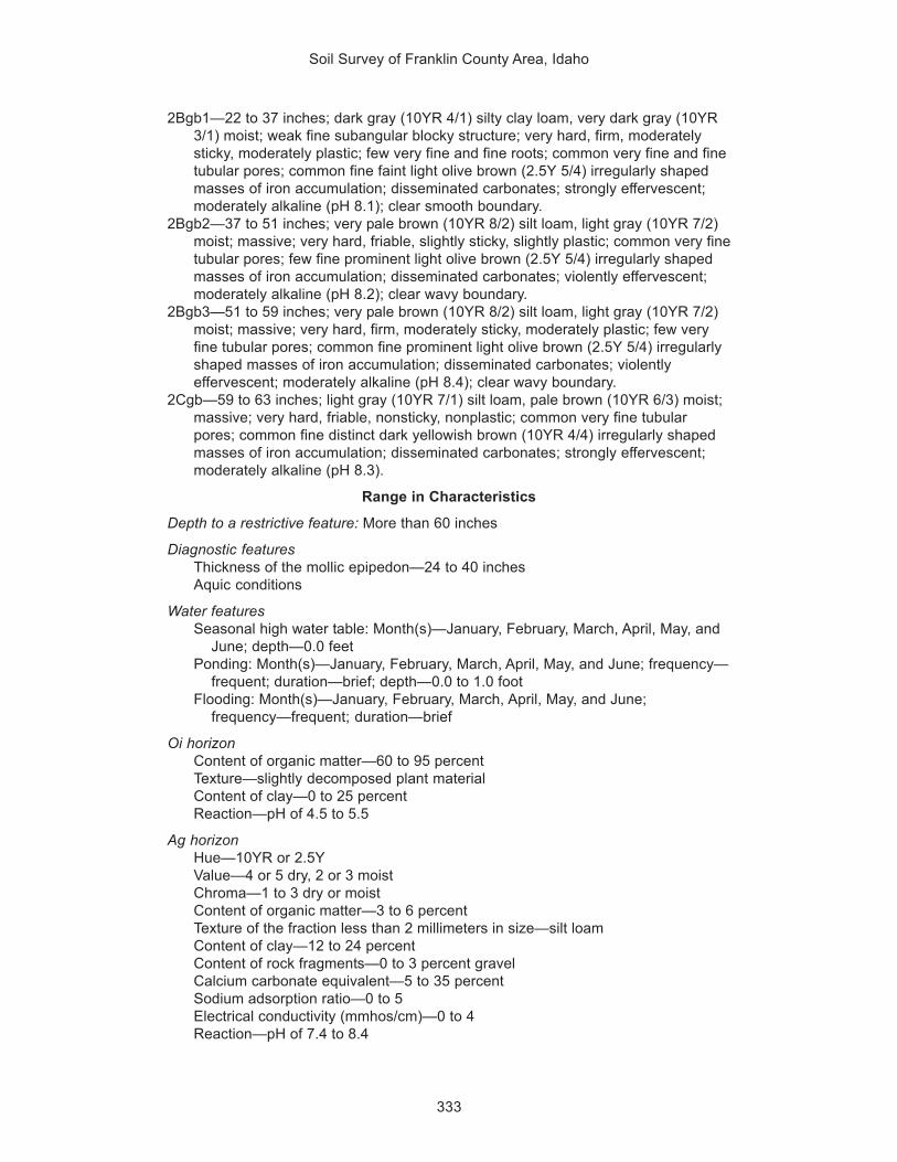
Soil Survey of Franklin County Area, Idaho
333
2Bgb1—22 to 37 inches; dark gray (10YR 4/1) silty clay loam, very dark gray (10YR3/1) moist; weak fine subangular blocky structure; very hard, firm, moderatelysticky, moderately plastic; few very fine and fine roots; common very fine and finetubular pores; common fine faint light olive brown (2.5Y 5/4) irregularly shapedmasses of iron accumulation; disseminated carbonates; strongly effervescent;moderately alkaline (pH 8.1); clear smooth boundary.
2Bgb2—37 to 51 inches; very pale brown (10YR 8/2) silt loam, light gray (10YR 7/2)moist; massive; very hard, friable, slightly sticky, slightly plastic; common very finetubular pores; few fine prominent light olive brown (2.5Y 5/4) irregularly shapedmasses of iron accumulation; disseminated carbonates; violently effervescent;moderately alkaline (pH 8.2); clear wavy boundary.
2Bgb3—51 to 59 inches; very pale brown (10YR 8/2) silt loam, light gray (10YR 7/2)moist; massive; very hard, firm, moderately sticky, moderately plastic; few veryfine tubular pores; common fine prominent light olive brown (2.5Y 5/4) irregularlyshaped masses of iron accumulation; disseminated carbonates; violentlyeffervescent; moderately alkaline (pH 8.4); clear wavy boundary.
2Cgb—59 to 63 inches; light gray (10YR 7/1) silt loam, pale brown (10YR 6/3) moist;massive; very hard, friable, nonsticky, nonplastic; common very fine tubularpores; common fine distinct dark yellowish brown (10YR 4/4) irregularly shapedmasses of iron accumulation; disseminated carbonates; strongly effervescent;moderately alkaline (pH 8.3).
Range in Characteristics
Depth to a restrictive feature: More than 60 inches
Diagnostic featuresThickness of the mollic epipedon—24 to 40 inchesAquic conditions
Water featuresSeasonal high water table: Month(s)—January, February, March, April, May, and
June; depth—0.0 feetPonding: Month(s)—January, February, March, April, May, and June; frequency—
frequent; duration—brief; depth—0.0 to 1.0 footFlooding: Month(s)—January, February, March, April, May, and June;
frequency—frequent; duration—brief
Oi horizonContent of organic matter—60 to 95 percentTexture—slightly decomposed plant materialContent of clay—0 to 25 percentReaction—pH of 4.5 to 5.5
Ag horizonHue—10YR or 2.5YValue—4 or 5 dry, 2 or 3 moistChroma—1 to 3 dry or moistContent of organic matter—3 to 6 percentTexture of the fraction less than 2 millimeters in size—silt loamContent of clay—12 to 24 percentContent of rock fragments—0 to 3 percent gravelCalcium carbonate equivalent—5 to 35 percentSodium adsorption ratio—0 to 5Electrical conductivity (mmhos/cm)—0 to 4Reaction—pH of 7.4 to 8.4

Soil Survey of Franklin County Area, Idaho
334
Bg horizonHue—10YR or 2.5YValue—2 to 5 dry, 2 or 3 moistChroma—1 to 3 dry or moistContent of organic matter—2 to 4 percentTexture of the fraction less than 2 millimeters in size—silt loamContent of clay—12 to 24 percentContent of rock fragments—0 to 3 percent gravelCalcium carbonate equivalent—5 to 35 percentSodium adsorption ratio—0 to 5Electrical conductivity (mmhos/cm)—0 to 4Reaction—pH of 7.4 to 8.4
2Agb and 2Bgb1 horizonsHue—10YR or 2.5YValue—4 or 5 dry, 2 or 3 moistChroma—1 or 2 dry or moistContent of organic matter—1 to 3 percentTexture of the fraction less than 2 millimeters in size—silty clay loamContent of clay—28 to 34 percentContent of rock fragments—0 to 3 percent gravelCalcium carbonate equivalent—15 to 40 percentSodium adsorption ratio—0 to 5Electrical conductivity (mmhos/cm)—0 to 4Reaction—pH of 7.4 to 8.4
2Bgb2, 2Bgb3, and 2Cgb horizonsHue—10YR or 2.5YValue—6 to 8 dry, 4 to 7 moistChroma—1 to 3 dry or moistContent of organic matter—0.5 to 2 percentTexture of the fraction less than 2 millimeters in size—silt loamContent of clay—18 to 27 percentContent of rock fragments—0 to 3 percent gravelCalcium carbonate equivalent—0 to 45 percentSodium adsorption ratio—0 to 5Electrical conductivity (mmhos/cm)—0 to 2Reaction—pH of 7.4 to 8.4
Dranburn SeriesDepth class: Very deepDrainage class: Well drainedCapacity of the most limiting layer to transmit water (Ksat): Moderately highLandscape: MountainsLandform: Mountain slopesParent material: Mixed alluviumSlope: 15 to 45 percentElevation: 5,400 to 7,000 feetMean annual precipitation: 17 to 22 inchesMean annual air temperature: 37 to 41 degrees FFrost-free period: 50 to 70 days
Taxonomic classification: Fine-loamy, mixed Argic Pachic Cryoborolls

Soil Survey of Franklin County Area, Idaho
335
Typical Pedon
Dranburn silt loam, in an area of Dranburn-Robin complex, 15 to 45 percent slopes;about 3 miles northwest of Treasureton, in Franklin County, Idaho; about 1,000 feetnorth and 2,100 feet east of the southwest corner of sec. 36, T. 12 S., R. 39 E.
Oi—0 to 1 inch; slightly decomposed plant material.A1—1 to 10 inches; dark grayish brown (10YR 4/2) silt loam, very dark brown (10YR
2/2) moist; weak medium subangular blocky structure parting to weak finegranular; very hard, friable, slightly sticky, slightly plastic; many very fine tomedium and common coarse roots; many very fine and fine tubular and irregularpores; neutral (pH 6.7); clear smooth boundary.
A2—10 to 17 inches; dark grayish brown (10YR 4/2) silt loam, very dark brown (10YR2/2) moist; moderate medium subangular blocky structure; hard, friable, slightlysticky, slightly plastic; many very fine to medium and common coarse roots; manyvery fine and fine tubular pores; 5 percent gravel and 2 percent cobbles; slightlyacid (pH 6.5); clear smooth boundary.
AB—17 to 22 inches; brown (10YR 5/3) silty clay loam, dark brown (10YR 3/3) moist;moderate medium subangular blocky structure; hard, firm, slightly sticky, slightlyplastic; common very fine and fine and few medium and coarse roots; many veryfine and fine tubular pores; 5 percent gravel; slightly acid (pH 6.4); clear wavyboundary.
Bt1—22 to 28 inches; yellowish brown (10YR 5/4) silty clay loam, dark brown (10YR3/3) moist; moderate fine subangular blocky structure; very hard, firm, slightlysticky, slightly plastic; common very fine and fine and few medium and coarseroots; many very fine and fine tubular pores; few faint clay films on faces of pedsand lining pores; 10 percent gravel; slightly acid (pH 6.3); clear wavy boundary.
Bt2—28 to 43 inches; light yellowish brown (10YR 6/4) gravelly silty clay loam,yellowish brown (10YR 5/4) moist; moderate medium subangular blockystructure; very hard, very firm, moderately sticky, moderately plastic; few very fineto medium roots; common very fine tubular pores; common distinct clay films onfaces of peds and lining pores; 20 percent gravel; slightly acid (pH 6.2); gradualwavy boundary.
Bt3—43 to 48 inches; brownish yellow (10YR 6/6) gravelly silty clay loam, yellowishbrown (10YR 5/4) moist; moderate fine subangular blocky structure; very hard,very firm, moderately sticky, moderately plastic; few very fine and fine roots;common very fine tubular pores; few faint clay films on faces of peds and liningpores; 15 percent gravel; slightly acid (pH 6.2); clear wavy boundary.
BC—48 to 61 inches; brownish yellow (10YR 6/6) silty clay loam, yellowish brown(10YR 5/4) moist; weak fine subangular blocky structure; very hard, very firm,moderately sticky, moderately plastic; common very fine tubular pores; 10percent gravel; slightly acid (pH 6.2).
Range in Characteristics
Depth to a restrictive feature: More than 60 inches
Diagnostic featuresThickness of the mollic epipedon—20 to 30 inchesDepth to an argillic horizon—16 to 23 inches
Oi horizonContent of organic matter—60 to 95 percentTexture—slightly decomposed plant materialContent of clay—0 to 25 percentReaction—pH of 4.5 to 5.5

Soil Survey of Franklin County Area, Idaho
336
A1 and A2 horizonsHue—10YR or 7.5YRValue—3 to 5 dry, 2 or 3 moistChroma—1 to 3 dry or moistContent of organic matter—3 to 5 percentTexture of the fraction less than 2 millimeters in size—silt loamContent of clay—18 to 24 percentContent of rock fragments—0 to 6 percent gravel, 0 to 5 percent cobblesReaction—pH of 6.1 to 7.3
AB horizonHue—10YR or 7.5YRValue—3 to 5 dry, 2 or 3 moistChroma—1 to 3 dry or moistContent of organic matter—2 to 4 percentTexture of the fraction less than 2 millimeters in size—silt loam or silty clay loamContent of clay—24 to 32 percentContent of rock fragments—0 to 9 percent gravel, 0 to 6 percent cobblesReaction—pH of 6.1 to 7.3
Bt horizonsHue—10YR or 7.5YRValue—5 or 6 dry, 3 to 5 moistChroma—3 to 6 dry or moistContent of organic matter—1 to 2 percentTexture of the fraction less than 2 millimeters in size—silty clay loamContent of clay—28 to 35 percentContent of rock fragments—5 to 22 percent gravelReaction—pH of 6.1 to 7.3
BC horizonHue—10YR or 7.5YRValue—5 or 6 dry, 3 to 5 moistChroma—3 to 6 dry or moistContent of organic matter—0.5 to 1 percentTexture of the fraction less than 2 millimeters in size—silty clay loamContent of clay—28 to 35 percentContent of rock fragments—5 to 22 percent gravelReaction—pH of 6.1 to 7.3
Enochville SeriesDepth class: Very deepDrainage class: Poorly drainedCapacity of the most limiting layer to transmit water (Ksat): Moderately highLandscape: ValleysLandform: Low stream terracesParent material: Mixed alluviumSlope: 0 to 1 percentElevation: 5,760 to 5,900 feetMean annual precipitation: 16 to 20 inchesMean annual air temperature: 40 to 42 degrees FFrost-free period: 50 to 65 days
Taxonomic classification: Fine-silty, mixed Cumulic Cryaquolls

Soil Survey of Franklin County Area, Idaho
337
Typical Pedon
Enochville silt loam, 0 to 1 percent slopes; about 3 miles southeast of CottonwoodPeak, in adjacent Bannock County, Idaho; about 60 feet north and 100 feet east ofthe southwest corner of sec. 16, T. 12 S., R. 39 E.
A1—0 to 2 inches; very dark grayish brown (10YR 3/2) silt loam, very dark brown(10YR 2/2) moist; strong medium granular structure; hard, friable, slightly sticky,slightly plastic; many very fine and fine and common medium roots; few very finetubular and many very fine irregular pores; neutral (pH 6.9); abrupt wavyboundary.
A2—2 to 12 inches; very dark grayish brown (10YR 3/2) silt loam, very dark brown(10YR 2/2) moist; moderate medium and coarse subangular blocky structureparting to moderate fine and medium granular; hard, friable, slightly sticky, slightlyplastic; many very fine and common fine and medium roots; many very finetubular pores; neutral (pH 7.0); clear smooth boundary.
Bg—12 to 20 inches; dark grayish brown (2.5Y 4/2) silty clay loam, very dark grayishbrown (2.5Y 3/2) moist; moderate coarse prismatic structure parting to moderatefine and medium subangular blocky; extremely hard, firm, moderately sticky,moderately plastic; common very fine and few fine and medium roots; many veryfine tubular pores; slightly alkaline (pH 7.4); abrupt smooth boundary.
Cg1—20 to 27 inches; grayish brown (2.5Y 5/2) silt loam, very dark grayish brown(2.5Y 3/2) moist; massive; extremely hard, friable, slightly sticky, slightly plastic;common very fine and fine and few medium roots; many very fine tubular pores;many medium prominent yellowish brown (10YR 5/8 dry and 10YR 5/6 moist)masses of iron accumulation; few fine round iron concretions; slightly alkaline (pH7.7); abrupt wavy boundary.
Cg2—27 to 43 inches; grayish brown (2.5Y 5/2) silt loam, very dark grayish brown(2.5Y 3/2) moist; massive; extremely hard, friable, slightly sticky, slightly plastic;many very fine, common fine, and few medium roots; many very fine tubularpores; many medium prominent masses of iron accumulation, yellowish brown(10YR 5/8) dry and dark yellowish brown (10YR 3/6) moist; moderately alkaline(pH 8.1); abrupt wavy boundary.
2Cg3—43 to 50 inches; pale olive (5Y 6/3) very gravelly sandy loam, olive (5Y 4/3)moist; massive; hard, friable, slightly sticky, slightly plastic; many very fine,common fine, and few medium roots; many very fine irregular and common finetubular pores; common medium prominent masses of iron accumulation,brownish yellow (10YR 6/6) dry and dark yellowish brown (10YR 4/6) moist; 20percent gravel, 10 percent cobbles, and 5 percent stones; moderately alkaline(pH 8.2); abrupt wavy boundary.
2Cg4—50 to 60 inches; pale yellow (2.5Y 7/4) extremely gravelly sandy loam, lightolive brown (2.5Y 5/4) moist; massive; hard, friable, slightly sticky, slightly plastic;few very fine roots; many very fine irregular pores; common medium prominentmasses of iron accumulation, yellowish brown (10YR 5/6) dry and dark yellowishbrown (10YR 4/6) moist; 40 percent gravel, 25 percent cobbles, and 5 percentstones; slightly alkaline (pH 7.6).
Range in Characteristics
Depth to a restrictive feature: More than 60 inches
Diagnostic featuresThickness of the mollic epipedon—20 to 43 inchesAquic conditions

Soil Survey of Franklin County Area, Idaho
338
Water featuresSeasonal high water table: Month(s)—April, May, and June; depth—1.0 to 2.0
feetFlooding: Month(s)—February, March, April, May, and June; frequency—frequent;
duration—brief
A horizonsHue—10YR, 2.5Y, or NValue—3 to 5 dry, 1 or 2 moistChroma—0 to 2 dry or moistContent of organic matter—4 to 6 percentTexture of the fraction less than 2 millimeters in size—silt loamContent of clay—15 to 25 percentContent of rock fragments—0 to 6 percent gravelReaction—pH of 6.1 to 7.3
Bg horizonHue—10YR, 2.5Y, 5Y, or NValue—3 to 6 dry, 2 or 3 moistChroma—0 to 2 dry or moistTexture of the fraction less than 2 millimeters in size—silty clay loamContent of clay—27 to 35 percentContent of rock fragments—0 to 6 percent gravelReaction—pH of 6.1 to 7.3
Cg horizonsHue—10YR, 2.5Y, 5Y, or NValue—3 to 6 dry, 2 or 3 moistChroma—0 to 2 dry or moistContent of organic matter—1 to 4 percentTexture of the fraction less than 2 millimeters in size—silt loam or silty clay loamContent of clay—20 to 35 percentContent of rock fragments—0 to 6 percent gravelReaction—pH of 6.6 to 8.4
2Cg horizonsHue—10YR, 2.5Y, or 5YValue—6 or 7 dry, 5 or 6 moistChroma—3 or 4 dry or moistContent of organic matter—0.0 to 0.5 percentTexture of the fraction less than 2 millimeters in size—sandy loamContent of clay—13 to 18 percentContent of rock fragments—8 to 40 percent gravel, 5 to 25 percent cobbles, 0 to
8 percent stonesElectrical conductivity (mmhos/cm)—0 to 2Reaction—pH of 6.6 to 8.4
Foxol SeriesDepth class: ShallowDrainage class: Well drainedCapacity of the most limiting layer to transmit water (Ksat): Moderately highLandscape: MountainsLandform: Mountain slopesParent material: Colluvium and residuum derived from quartziteSlope: 20 to 80 percent

Soil Survey of Franklin County Area, Idaho
339
Elevation: 5,500 to 7,300 feetMean annual precipitation: 18 to 25 inchesMean annual air temperature: 40 to 43 degrees FFrost-free period: 60 to 70 days
Taxonomic classification: Loamy-skeletal, mixed, frigid Lithic Haploxerolls
Typical Pedon
Foxol very stony loam, in an area of Foxol-Vitale complex, 20 to 55 percent slopes;about 2 miles east of Thatcher, in Franklin County, Idaho; about 900 feet north and1,320 feet east of the southwest corner of sec. 4, T. 12 S., R. 41 E.
A1—0 to 3 inches; dark grayish brown (10YR 4/2) very stony loam, very dark brown(10YR 2/2) moist; weak fine subangular blocky structure parting to weak finegranular; slightly hard, friable, slightly sticky, slightly plastic; many very fine andfew fine and medium roots; 10 percent gravel, 15 percent cobbles, and 20percent stones; slightly acid (pH 6.5); clear wavy boundary.
A2—3 to 9 inches; brown (10YR 4/3) very stony loam, very dark grayish brown (10YR3/2) moist; weak fine subangular blocky structure parting to weak fine granular;soft, very friable, slightly sticky, slightly plastic; many very fine and few fine andmedium roots; 15 percent gravel, 20 percent cobbles, and 20 percent stones;slightly acid (pH 6.3); clear wavy boundary.
Bw—9 to 17 inches; brown (7.5YR 5/3) extremely stony loam, brown (7.5YR 4/2)moist; weak fine and medium subangular blocky structure; slightly hard, friable,slightly sticky, slightly plastic; common very fine and few fine and medium roots;15 percent gravel, 20 percent cobbles, and 40 percent stones; slightly acid (pH6.1); abrupt irregular boundary.
R—17 inches; quartzite
Range in Characteristics
Depth to a restrictive feature: 14 to 20 inches to lithic bedrock
Diagnostic featureThickness of the mollic epipedon—7 to 12 inches
A horizonsHue—10YR or 7.5YRValue—4 or 5 dry, 2 or 3 moistChroma—2 or 3 dry or moistContent of organic matter—2 to 4 percentTexture of the fraction less than 2 millimeters in size—loamContent of clay—18 to 24 percentContent of rock fragments—1 to 17 percent gravel, 11 to 20 percent cobbles, 17
to 28 percent stonesReaction—pH of 6.1 to 7.3
Bw horizonHue—7.5YRValue—3 to 5 dry or moistChroma—3 or 4 dry, 2 to 4 moistContent of organic matter—1 to 2 percentTexture of the fraction less than 2 millimeters in size—loamContent of clay—18 to 27 percentContent of rock fragments—0 to 15 percent gravel, 17 to 23 percent cobbles, 28
to 45 percent stonesReaction—pH of 5.6 to 6.5

Soil Survey of Franklin County Area, Idaho
340
Hades SeriesDepth class: Very deepDrainage class: Well drainedCapacity of the most limiting layer to transmit water (Ksat): Moderately highLandscape: Alluvial plains, hills, and mountainsLandform: Fan remnants, hillslopes, and mountain slopesParent material: Mixed alluvium, colluvium, and residuumSlope: 4 to 60 percentElevation: 4,800 to 6,700 feetMean annual precipitation: 14 to 22 inchesMean annual air temperature: 40 to 45 degrees FFrost-free period: 60 to 100 days
Taxonomic classification: Fine-loamy, mixed, frigid Pachic Argixerolls
Typical Pedon
Hades silt loam, in an area of Bothwell-Hades-Justesen complex, 6 to 25 percentslopes; about 5 miles south of Thatcher, in Franklin County, Idaho; about 105 feetnorth and 2,600 feet west of the southeast corner of sec. 19, T. 13 S., R. 40 E.
Ap—0 to 5 inches; grayish brown (10YR 5/2) silt loam, very dark brown (10YR 2/2)moist; weak fine subangular blocky structure; hard, very friable, slightly sticky,slightly plastic; few fine roots; many fine irregular pores; 5 percent gravel; neutral(pH 7.0); gradual smooth boundary.
AB—5 to 11 inches; grayish brown (10YR 5/2) silt loam, very dark grayish brown(10YR 3/2) moist; moderate fine subangular blocky structure; hard, friable,slightly sticky, slightly plastic; few fine roots; common fine irregular pores; 10percent gravel; neutral (pH 7.2); clear smooth boundary.
Bt1—11 to 23 inches; brown (10YR 5/3) gravelly silty clay loam, dark brown (10YR3/3) moist; strong fine subangular blocky structure; hard, friable, moderatelysticky, moderately plastic; few fine roots; few fine tubular pores; many distinct clayfilms on faces of peds and lining pores; 15 percent gravel; neutral (pH 7.2);gradual smooth boundary.
Bt2—23 to 37 inches; yellowish brown (10YR 5/4) gravelly silty clay loam, darkyellowish brown (10YR 3/4) moist; strong fine subangular blocky structure; hard,friable, moderately sticky, moderately plastic; few fine roots; few fine tubularpores; many distinct clay films on faces of peds and lining pores; 15 percentgravel; neutral (pH 7.3); clear smooth boundary.
Bt3—37 to 60 inches; light yellowish brown (10YR 6/4) gravelly silty clay loam, darkyellowish brown (10YR 3/4) moist; strong fine subangular blocky structure; hard,friable, moderately sticky, moderately plastic; few fine roots; few fine tubularpores; many distinct clay films on faces of peds and lining pores; 15 percentgravel; slightly alkaline (pH 7.4).
Range in Characteristics
Depth to a restrictive feature: More than 60 inches
Diagnostic featuresThickness of the mollic epipedon—20 to 50 inchesDepth to an argillic horizon—11 to 38 inches
Ap and AB horizonsHue—10YRValue—4 or 5 dry, 2 or 3 moistChroma—2 or 3 dry or moist

Soil Survey of Franklin County Area, Idaho
341
Content of organic matter—1 to 3 percentTexture of the fraction less than 2 millimeters in size—silt loamContent of clay—18 to 25 percentContent of rock fragments—0 to 15 percent gravelReaction—pH of 6.6 to 7.3
Bt horizonsHue—10YRValue—4 to 6 dry, 3 or 4 moistChroma—2 to 4 dry or moistContent of organic matter—0.5 to 1 percentTexture of the fraction less than 2 millimeters in size—silty clay loamContent of clay—27 to 35 percentContent of rock fragments—10 to 26 percent gravel, 0 to 10 percent cobblesCalcium carbonate equivalent—0 to 5 percentReaction—pH of 6.6 to 7.8
HaploxerollsDepth class: Very deepDrainage class: Well drainedCapacity of the most limiting layer to transmit water (Ksat): Moderately highLandscape: Lake plainsLandform: Lake terracesParent material: Lacustrine depositsSlope: 20 to 60 percentElevation: 4,500 to 4,700 feetMean annual precipitation: 15 to 17 inchesMean annual air temperature: 45 to 48 degrees FFrost-free period: 110 to 120 days
Taxonomic classification: Haploxerolls
Typical Pedon
Haploxerolls silt loam, in an area of Haploxerolls-Xerorthents complex, 20 to 60percent slopes; about 2 miles northwest of Preston, in Franklin County, Idaho; about3,100 feet north and 700 feet east of the southwest corner of sec. 17, T. 15 S., R. 39E.
A—0 to 6 inches; dark grayish brown (10YR 4/2) silt loam, very dark brown (10YR2/2) moist; weak fine and medium granular structure; soft, very friable, slightlysticky, slightly plastic; many very fine and fine and few medium and coarse roots;common very fine and fine tubular pores; 10 percent gravel; slightly alkaline (pH7.8); clear wavy boundary.
Bw—6 to 17 inches; brown (10YR 5/3) gravelly loam, dark brown (10YR 3/3) moist;weak very fine subangular blocky structure; soft, very friable, slightly sticky,slightly plastic; many very fine and fine and few medium and coarse roots;common very fine and fine tubular pores; 20 percent gravel; slightly alkaline (pH7.8); clear wavy boundary.
Bk—17 to 39 inches; very pale brown (10YR 7/3) very gravelly loam, brown (10YR5/3) moist; weak fine subangular blocky structure; slightly hard, friable, slightlysticky, slightly plastic; many very fine, common fine, and few medium and coarseroots; many very fine and few fine tubular pores; few fine irregularly shapedcarbonate threads; slightly effervescent; 40 percent gravel and 5 percent cobbles;moderately alkaline (pH 8.2); gradual wavy boundary.

Soil Survey of Franklin County Area, Idaho
342
BC—39 to 60 inches; very pale brown (10YR 7/4) gravelly loamy sand, brown (10YR4/3) moist; weak fine subangular blocky structure; slightly hard, friable, nonsticky,nonplastic; common very fine and few fine roots; common very fine and few finetubular pores; slightly effervescent; disseminated carbonates; 30 percent gravel;moderately alkaline (pH 8.2).
Range in Characteristics
Depth to a restrictive feature: More than 60 inches
Diagnostic featuresThickness of the mollic epipedon—8 to 60 inchesDepth to secondary carbonates—15 to 24 inches
A horizonHue—10YRValue—4 or 5 dry, 2 or 3 moistChroma—2 or 3 dry or moistContent of organic matter—2 to 5 percentTexture of the fraction less than 2 millimeters in size—silt loamContent of clay—5 to 25 percentContent of rock fragments—0 to 77 percent gravelReaction—pH of 6.6 to 7.8
Bw horizonHue—10YRValue—5 to 7 dry, 3 to 5 moistChroma—2 to 4 dry or moistContent of organic matter—1 to 3 percentTexture of the fraction less than 2 millimeters in size—loam or sandy loamContent of clay—5 to 25 percentContent of rock fragments—2 to 77 percent gravelCalcium carbonate equivalent—0 to 20 percentSodium adsorption ratio—0 to 5Reaction—pH of 6.6 to 8.4
Bk and BC horizonsHue—10YRValue—5 to 7 dry, 4 to 6 moistChroma—3 or 4 dry or moistContent of organic matter—0.0 to 2 percentTexture of the fraction less than 2 millimeters in size—loam or loamy sandContent of clay—1 to 27 percentContent of rock fragments—2 to 77 percent gravel, 0 to 28 percent cobblesCalcium carbonate equivalent—0 to 30 percentSodium adsorption ratio—0 to 5Reaction—pH of 7.4 to 9.0
Harroun TaxadjunctDepth class: ShallowDrainage class: Well drainedCapacity of the most limiting layer to transmit water (Ksat): Moderately highLandscape: HillsLandform: HillslopesParent material: Mixed alluviumSlope: 4 to 12 percent

Soil Survey of Franklin County Area, Idaho
343
Elevation: 5,300 to 5,500 feetMean annual precipitation: 14 to 18 inchesMean annual air temperature: 41 to 45 degrees FFrost-free period: 85 to 100 days
Taxonomic classification: Loamy-skeletal, mixed, frigid, shallow Typic Durixerolls
Typical Pedon
Harroun very gravelly loam, in an area of Huffman-Harroun-Lanoak complex, 2 to 12percent slopes; about 6 miles southwest of Weston, in Franklin County, Idaho; about1,500 feet north and 300 feet east of the southwest corner of sec. 24, T. 16 S., R. 37E.
A—0 to 7 inches; light brownish gray (10YR 6/2) very gravelly loam, very dark grayishbrown (10YR 3/2) moist; moderate medium subangular blocky structure; slightlyhard, very friable, nonsticky, nonplastic; many very fine and fine roots; many veryfine to medium tubular pores; disseminated carbonates (25 percent calciumcarbonate equivalent); strongly effervescent; 25 percent gravel, 10 percentcobbles, and 1 percent stones; moderately alkaline (pH 8.4); clear smoothboundary.
Bk—7 to 15 inches; pale brown (10YR 6/3) very gravelly loam, brown (10YR 4/3)moist; moderate medium subangular blocky structure; slightly hard, very friable,nonsticky, nonplastic; many very fine and few fine roots; many very fine and finetubular pores; disseminated carbonates (30 percent calcium carbonateequivalent); strongly effervescent; 30 percent gravel, 15 percent cobbles, and 1percent stones; moderately alkaline (pH 8.4); abrupt smooth boundary.
Bkqm—15 to 28 inches; strongly cemented material; 65 percent indurated laminae inthe upper part; abrupt wavy boundary.
C1—28 to 41 inches; very pale brown (10YR 8/3) extremely gravelly sandy loam, lightyellowish brown (10YR 6/4) moist; massive; soft, very friable, nonsticky,nonplastic; many very fine irregular pores; disseminated carbonates (10 percentcalcium carbonate equivalent); violently effervescent; 50 percent gravel and 20percent cobbles; strongly alkaline (pH 8.6); clear wavy boundary.
C2—41 to 60 inches; very pale brown (10YR 7/3) very gravelly sandy loam, yellowishbrown (10YR 5/4) moist; massive; soft, very friable, nonsticky, nonplastic; manyvery fine irregular pores; disseminated carbonates (15 percent calcium carbonateequivalent); violently effervescent; 30 percent gravel and 10 percent cobbles;strongly alkaline (pH 8.6).
Range in Characteristics
Depth to a restrictive feature: 10 to 20 inches to a duripan
Diagnostic featuresThickness of the mollic epipedon—7 to 12 inchesDepth to a calcic horizon—7 to 12 inches
A horizonHue—10YRValue—5 or 6 dry, 3 or 4 moistChroma—2 or 3 dry or moistContent of organic matter—1 to 3 percentTexture of the fraction less than 2 millimeters in size—loamContent of clay—7 to 15 percentContent of rock fragments—11 to 33 percent gravel, 3 to 10 percent cobbles, 0 to
3 percent stonesCalcium carbonate equivalent—20 to 30 percent
Soil Survey of Franklin County Area, Idaho
344
Electrical conductivity (mmhos/cm)—0 to 2Reaction—pH of 7.4 to 8.4
Bk horizonHue—10YRValue—6 or 7 dry, 3 to 6 moistChroma—2 or 3 dry or moistContent of organic matter—1 to 3 percentTexture of the fraction less than 2 millimeters in size—loamContent of clay—7 to 15 percentContent of rock fragments—10 to 45 percent gravel, 9 to 15 percent cobbles, 0 to
3 percent stonesCalcium carbonate equivalent—25 to 35 percentElectrical conductivity (mmhos/cm)—2 to 4Reaction—pH of 7.4 to 8.4
Bkqm horizonCemented material
C horizonsHue—10YRValue—6 to 8 dry, 4 to 6 moistChroma—3 or 4 dry or moistContent of organic matter—0.5 to 1 percentTexture of the fraction less than 2 millimeters in size—sandy loamContent of clay—5 to 15 percentContent of rock fragments—18 to 55 percent gravel, 9 to 20 percent cobblesCalcium carbonate equivalent—5 to 15 percentSodium adsorption ratio—0 to 5Electrical conductivity (mmhos/cm)—2 to 4Reaction—pH of 7.9 to 9.0
Taxadjunct Feature
These soils are taxadjuncts to the series because they have a mollic epipedon.This difference, however, does not significantly affect the use and management of thesoils.
Hendricks SeriesDepth class: Very deepDrainage class: Well drainedCapacity of the most limiting layer to transmit water (Ksat): Moderately highLandscape: Lake plainsLandform: Lake terracesParent material: Mixed alluviumSlope: 6 to 10 percentElevation: 5,100 to 5,200 feetMean annual precipitation: 16 to 18 inchesMean annual air temperature: 44 to 45 degrees FFrost-free period: 120 to 125 days
Taxonomic classification: Fine-silty, mixed, mesic Pachic Argixerolls
Typical Pedon
Hendricks silt loam, 6 to 10 percent slopes; in adjacent Cache County, Utah; about 50feet south and 900 feet east of the northwest corner of sec. 1, T. 13 N., R. 1 E.

Soil Survey of Franklin County Area, Idaho
345
Ap—0 to 5 inches; dark grayish brown (10YR 4/2) silt loam, very dark brown (10YR2/2) moist; moderate medium granular structure parting to moderate finegranular; slightly hard, friable, slightly sticky, moderately plastic; common fineroots; common fine pores; neutral (pH 6.8); abrupt smooth boundary.
AB—5 to 15 inches; dark grayish brown (10YR 4/2) silt loam, very dark brown (10YR2/2) moist; moderate medium subangular blocky structure; slightly hard, friable,slightly sticky, moderately plastic; common fine roots; common fine and mediumand few coarse pores; slightly acid (pH 6.4); clear smooth boundary.
Bt1—15 to 27 inches; brown (10YR 4/3) silty clay loam, dark brown (10YR 3/3) moist;weak medium prismatic structure parting to moderate medium subangular blocky;hard, firm, moderately sticky, moderately plastic; common fine roots; many fineand few medium pores; few distinct clay films on faces of peds and lining pores;slightly acid (pH 6.2); clear wavy boundary.
Bt2—27 to 48 inches; yellowish brown (10YR 5/4) silty clay loam, brown (7.5YR 4/3)moist; weak medium prismatic structure parting to moderate medium subangularblocky; hard, firm, moderately sticky, moderately plastic; few fine roots; many finepores; few prominent clay films on faces of peds and lining pores; slightly acid(pH 6.4); clear smooth boundary.
Bt3—48 to 66 inches; brown (7.5YR 5/4) silty clay loam, brown (7.5YR 4/3) moist;weak fine and medium subangular blocky structure; hard, firm, moderately sticky,moderately plastic; few fine roots; common fine and few medium pores; commonprominent clay films on faces of peds and lining pores; slightly acid (pH 6.3).
Range in Characteristics
Depth to a restrictive feature: More than 60 inches
Diagnostic featuresThickness of the mollic epipedon—20 to 40 inchesDepth to an argillic horizon—8 to 19 inches
Ap horizonHue—10YRValue—3 to 5 dry, 2 or 3 moistChroma—1 or 2 dry or moistContent of organic matter—2 to 4 percentTexture of the fraction less than 2 millimeters in size—silt loamContent of clay—20 to 25 percentContent of rock fragments—0 to 3 percent gravelElectrical conductivity (mmhos/cm)—0 to 2Reaction—pH of 6.1 to 7.3
AB horizonHue—10YRValue—3 to 5 dry, 2 or 3 moistChroma—2 or 3 dry or moistContent of organic matter—2 to 4 percentTexture of the fraction less than 2 millimeters in size—silt loamContent of clay—20 to 25 percentContent of rock fragments—0 to 3 percent gravelElectrical conductivity (mmhos/cm)—0 to 2Reaction—pH of 6.1 to 7.3
Bt horizonsHue—10YR or 7.5YRValue—4 to 6 dry, 3 or 4 moistChroma—2 to 4 dry or moist

Soil Survey of Franklin County Area, Idaho
346
Content of organic matter—1 to 2 percentTexture of the fraction less than 2 millimeters in size—silty clay loamContent of clay—27 to 35 percentContent of rock fragments—0 to 3 percent gravelElectrical conductivity (mmhos/cm)—0 to 2Reaction—pH of 6.1 to 7.3
Holmes SeriesDepth class: Very deepDrainage class: Well drainedCapacity of the most limiting layer to transmit water (Ksat): Moderately highLandscape: ValleysLandform: Stream terracesParent material: Mixed alluviumSlope: 0 to 2 percentElevation: 4,900 to 5,100 feetMean annual precipitation: 14 to 16 inchesMean annual air temperature: 41 to 43 degrees FFrost-free period: 85 to 95 days
Taxonomic classification: Loamy-skeletal, mixed, frigid Typic Argixerolls
Typical Pedon
Holmes gravelly silt loam, 0 to 2 percent slopes; about 6 miles south of Thatcher, inFranklin County, Idaho; about 1,900 feet north and 450 feet east of the southwestcorner of sec. 36, T. 12 S., R. 40 E.
A—0 to 4 inches; grayish brown (10YR 5/2) gravelly silt loam, very dark grayishbrown (10YR 3/2) moist; moderate very thick platy structure parting to moderatemedium platy; slightly hard, very friable, slightly sticky, slightly plastic; commonvery fine and few fine roots; few very fine tubular and irregular and few finetubular pores; 15 percent gravel and 2 percent cobbles; slightly alkaline (pH 7.4);abrupt smooth boundary.
ABt—4 to 11 inches; grayish brown (10YR 5/2) gravelly silt loam, very dark grayishbrown (10YR 3/2) moist; weak thick platy structure parting to moderate fine andmedium subangular blocky; slightly hard, very friable, slightly sticky, slightlyplastic; common very fine and few fine and medium roots; common very fine andfine tubular pores; few faint clay films on faces of peds and lining pores; 25percent gravel and 5 percent cobbles; slightly alkaline (pH 7.4); clear smoothboundary.
Bt1—11 to 14 inches; brown (10YR 5/3) very gravelly loam, dark brown (10YR 3/3)moist; moderate fine and medium subangular blocky structure; slightly hard,friable, slightly sticky, slightly plastic; few very fine to medium roots; common veryfine tubular pores; few distinct clay films on faces of peds and lining pores; 25percent gravel, 10 percent cobbles, and 1 percent stones; slightly alkaline (pH7.4); abrupt wavy boundary.
Bt2—14 to 20 inches; yellowish brown (10YR 5/4) very gravelly loam, brown (10YR4/3) moist; moderate fine and medium subangular blocky structure; slightly hard,friable, slightly sticky, slightly plastic; few very fine to medium roots; common veryfine irregular pores; few distinct clay films on faces of peds and lining pores; 25percent gravel (10 percent fine gravel), 15 percent cobbles, and 1 percentstones; slightly alkaline (pH 7.4); clear wavy boundary.

Soil Survey of Franklin County Area, Idaho
347
2Cq1—20 to 43 inches; brown (7.5YR 4/3) very gravelly loamy coarse sand, darkbrown (7.5YR 3/3) moist; single grain; loose, nonsticky, nonplastic; few very fineto medium roots; common very fine irregular pores; thin silica coatings on thebottom of 20 percent of rock fragments; 30 percent gravel (10 percent finegravel), 15 percent cobbles, and 5 percent stones; slightly alkaline (pH 7.8);diffuse irregular boundary.
2Cq2—43 to 61 inches; brown (7.5YR 5/4) extremely gravelly coarse sand, brown(7.5YR 4/3) moist; single grain; loose, nonsticky, nonplastic; few very fine tomedium roots; common very fine and few fine irregular pores; thin silica coatingson the bottom of 40 percent of rock fragments; 35 percent gravel (10 percent finegravel), 25 percent cobbles, and 20 percent stones; slightly alkaline (pH 7.8).
Range in Characteristics
Depth to a restrictive feature: More than 60 inches
Diagnostic featuresThickness of the mollic epipedon—10 to 16 inchesDepth to an argillic horizon—2 to 19 inches
Water featureFlooding: Month(s)—February, March, April, and May; frequency—rare
A horizonHue—10YRValue—4 or 5 dry, 2 or 3 moistChroma—2 or 3 dry or moistContent of organic matter—2 to 4 percentTexture of the fraction less than 2 millimeters in size—silt loamContent of clay—17 to 22 percentContent of rock fragments—10 to 32 percent gravel, 1 to 6 percent cobblesReaction—pH of 6.6 to 7.8
ABt and Bt horizonsHue—10YR or 7.5YRValue—4 to 6 dry, 3 or 4 moistChroma—2 to 4 dry or moistContent of organic matter—0.5 to 2 percentTexture of the fraction less than 2 millimeters in size—loamContent of clay—18 to 26 percentContent of rock fragments—9 to 48 percent gravel, 5 to 20 percent cobbles, 0 to
3 percent stonesReaction—pH of 6.6 to 7.8
2Cq horizonsHue—10YR or 7.5YRValue—4 or 5 dry, 3 or 4 moistChroma—3 or 4 dry or moistContent of organic matter—0.0 to 0.5 percentTexture of the fraction less than 2 millimeters in size—loamy coarse sand or
coarse sandContent of clay—1 to 6 percentContent of rock fragments—6 to 47 percent gravel, 9 to 30 percent cobbles, 3 to
30 percent stonesReaction—pH of 7.4 to 7.8
Soil Survey of Franklin County Area, Idaho
348
Hondee SeriesDepth class: Very deepDrainage class: Well drainedCapacity of the most limiting layer to transmit water (Ksat): Moderately highLandscape: Lake plainsLandform: Lake terracesParent material: Mixed alluviumSlope: 1 to 12 percentElevation: 4,700 to 5,800 feetMean annual precipitation: 15 to 17 inchesMean annual air temperature: 45 to 48 degrees FFrost-free period: 110 to 125 days
Taxonomic classification: Loamy-skeletal, mixed, mesic Calcic Haploxerolls
Typical Pedon
Hondee gravelly loam, 1 to 4 percent slopes; about 0.5 mile south of Weston, inFranklin County, Idaho; about 1,240 feet south and 1,650 feet west of the northeastcorner of sec. 23, T. 16 S., R. 38 E.
Ap—0 to 6 inches; dark grayish brown (10YR 4/2) gravelly loam, very dark brown(10YR 2/2) moist; moderate medium and coarse subangular blocky structure;slightly hard, friable, slightly sticky, slightly plastic; common very fine and fineroots; few very fine and fine tubular pores; 30 percent gravel; slightly alkaline (pH7.6); clear wavy boundary.
AB—6 to 16 inches; dark grayish brown (10YR 4/2) gravelly loam, very dark brown(10YR 2/2) moist; moderate fine subangular blocky structure; slightly hard,friable, slightly sticky, slightly plastic; common very fine and fine roots; commonvery fine and few fine tubular pores; 20 percent gravel; slightly alkaline (pH 7.6);gradual wavy boundary.
Bk1—16 to 19 inches; grayish brown (10YR 5/2) very gravelly loam, very darkgrayish brown (10YR 3/2) moist; moderate very fine and fine subangular blockystructure; slightly hard, friable, slightly sticky, slightly plastic; common very fineand fine roots; common very fine and fine tubular pores; 1-to-2-millimeter-thickcarbonate coatings on the bottom of pebbles; disseminated carbonates; slightlyeffervescent; 40 percent gravel; slightly alkaline (pH 7.8); abrupt wavy boundary.
Bk2—19 to 22 inches; light gray (10YR 7/2) very gravelly sandy loam, grayish brown(10YR 5/2) moist; massive; slightly hard, friable, slightly sticky, nonplastic; fewvery fine roots; common very fine tubular pores; 1-to-3-millimeter-thick carbonatecoatings on the bottom of pebbles; disseminated carbonates; violentlyeffervescent; 45 percent gravel and 5 percent cobbles; moderately alkaline (pH8.4); gradual wavy boundary.
Bk3—22 to 39 inches; very pale brown (10YR 8/2) extremely gravelly coarse sandyloam, brown (10YR 5/3) moist; massive; soft, friable, nonsticky, nonplastic; fewvery fine roots; common very fine tubular pores; 1-millimeter-thick carbonatecoatings on the bottom of rock fragments; disseminated carbonates; violentlyeffervescent; 65 percent gravel and 5 percent cobbles; moderately alkaline (pH8.4); gradual wavy boundary.
2Bk4—39 to 60 inches; multicolored very gravelly loamy coarse sand; single grain;loose, nonsticky, nonplastic; common very fine tubular pores; common mediumprominent yellowish brown (10YR 5/8) masses of iron accumulation that are relictredoximorphic features; 1-millimeter-thick carbonate coatings on the bottom of

Soil Survey of Franklin County Area, Idaho
349
rock fragments; disseminated carbonates; strongly effervescent; 30 percentgravel and 5 percent cobbles; moderately alkaline (pH 8.2).
Range in Characteristics
Depth to a restrictive feature: More than 60 inches
Diagnostic featuresThickness of the mollic epipedon—10 to 19 inchesDepth to a calcic horizon—10 to 20 inches
Ap horizonHue—10YRValue—4 or 5 dry, 2 or 3 moistChroma—2 or 3 dry or moistContent of organic matter—2 to 4 percentTexture of the fraction less than 2 millimeters in size—loamContent of clay—12 to 17 percentContent of rock fragments—16 to 32 percent gravel, 0 to 3 percent cobblesReaction—pH of 7.4 to 8.4
AB horizonHue—10YRValue—4 or 5 dry, 2 or 3 moistChroma—2 or 3 dry or moistContent of organic matter—1 to 3 percentTexture of the fraction less than 2 millimeters in size—loamContent of clay—8 to 18 percentContent of rock fragments—13 to 29 percent gravel, 0 to 3 percent cobblesReaction—pH of 7.4 to 8.4
Bk horizonsHue—10YRValue—4 to 8 dry, 3 to 5 moistChroma—2 to 4 dry or moistContent of organic matter—0.0 to 1 percentTexture of the fraction less than 2 millimeters in size—loam, sandy loam, or
coarse sandy loamContent of clay—5 to 18 percentContent of rock fragments—24 to 65 percent gravel, 0 to 3 percent cobblesCalcium carbonate equivalent—5 to 35 percentReaction—pH of 7.4 to 8.4
2Bk horizonHue—multicoloredValue—4 to 8 dry, 3 to 5 moistChroma—2 to 4 dry or moistContent of organic matter—0.0 to 1 percentTexture of the fraction less than 2 millimeters in size—loamy coarse sandContent of clay—2 to 6 percentContent of rock fragments—23 to 43 percent gravel, 3 to 6 percent cobblesCalcium carbonate equivalent—10 to 30 percentSodium adsorption ratio—0 to 5Electrical conductivity (mmhos/cm)—0 to 2Reaction—pH of 7.4 to 8.4

Soil Survey of Franklin County Area, Idaho
350
Hondoho SeriesDepth class: Very deepDrainage class: Well drainedCapacity of the most limiting layer to transmit water (Ksat): Moderately highLandscape: MountainsLandform: Mountain slopesParent material: Mixed alluviumSlope: 4 to 60 percentElevation: 4,600 to 6,700 feetMean annual precipitation: 15 to 20 inchesMean annual air temperature: 40 to 44 degrees FFrost-free period: 60 to 100 days
Taxonomic classification: Loamy-skeletal, mixed, frigid Calcic Haploxerolls
Typical Pedon
Hondoho stony silt loam, in an area of Sprollow-Hondoho complex, 30 to 60 percentslopes; about 2 miles east of Treasureton Reservoir, in Franklin County, Idaho; about800 feet north and 1,900 feet west of the southeast corner of sec. 5, T. 14 S., R. 40 E.
A1—0 to 3 inches; dark grayish brown (10YR 4/2) stony silt loam, very dark gray(10YR 3/1) moist; strong very fine and fine granular structure; slightly hard, veryfriable, slightly sticky, slightly plastic; many very fine and common medium roots;many very fine irregular pores; 15 percent gravel and 10 percent stones; slightlyalkaline (pH 7.6); clear wavy boundary.
A2—3 to 11 inches; dark grayish brown (10YR 4/2) gravelly silt loam, very dark gray(10YR 3/1) moist; moderate fine and medium subangular blocky structure partingto strong fine granular; slightly hard, very friable, slightly sticky, slightly plastic;common very fine to medium roots; many very fine and common fine and mediumirregular pores; 25 percent gravel and 5 percent cobbles; slightly alkaline (pH7.6); clear wavy boundary.
Bw—11 to 19 inches; pale brown (10YR 6/3) very gravelly silt loam, brown (10YR 4/3)moist; moderate fine and medium subangular blocky structure; hard, very friable,slightly sticky, slightly plastic; few very fine roots; many very fine and commonmedium and coarse irregular pores; disseminated carbonates; carbonatecoatings on the bottom of rock fragments (10 percent calcium carbonateequivalent); strongly effervescent; 30 percent gravel and 5 percent cobbles;moderately alkaline (pH 8.0); gradual wavy boundary.
Bk1—19 to 28 inches; light yellowish brown (10YR 6/4) very gravelly loam, yellowishbrown (10YR 5/4) moist; moderate fine and medium subangular blocky structure;hard, friable, moderately sticky, moderately plastic; few very fine and fine roots;many very fine and few fine and medium tubular pores; disseminated carbonates;common fine irregularly shaped carbonate masses and threads (35 percentcalcium carbonate equivalent); violently effervescent; 45 percent gravel and 10percent cobbles; moderately alkaline (pH 8.0); gradual wavy boundary.
Bk2—28 to 45 inches; light yellowish brown (10YR 6/4) very gravelly loam, yellowishbrown (10YR 5/4) moist; massive; hard, very friable, moderately sticky,moderately plastic; few very fine roots; many very fine and few fine and mediumtubular pores; disseminated carbonates; many fine and medium irregularlyshaped carbonate masses and threads; carbonate coatings on the bottom of rockfragments (40 percent calcium carbonate equivalent); violently effervescent; 50percent gravel and 5 percent cobbles; moderately alkaline (pH 8.0); gradual wavyboundary.

Soil Survey of Franklin County Area, Idaho
351
Bk3—45 to 60 inches; light yellowish brown (10YR 6/4) very gravelly loam, yellowishbrown (10YR 5/6) moist; massive; hard, very friable, slightly sticky, slightly plastic;few very fine roots; many very fine and few fine and medium tubular pores;disseminated carbonates; many fine and medium irregularly shaped carbonatemasses and threads; carbonate coatings on the bottom of rock fragments (40percent calcium carbonate equivalent); violently effervescent; 50 percent graveland 5 percent cobbles; moderately alkaline (pH 8.0).
Range in Characteristics
Depth to a restrictive feature: More than 60 inches
Diagnostic featuresThickness of the mollic epipedon—10 to 15 inchesDepth to a calcic horizon—8 to 15 inches
A1 horizonHue—10YRValue—4 or 5 dry, 2 or 3 moistChroma—2 or 3 dry, 1 to 3 moistContent of organic matter—2 to 3 percentTexture of the fraction less than 2 millimeters in size—silt loamContent of clay—18 to 25 percentContent of rock fragments—4 to 25 percent gravel, 0 to 10 percent cobbles, 5 to
65 percent stonesReaction—pH of 7.4 to 7.8
A2 horizonHue—10YRValue—4 or 5 dry, 2 or 3 moistChroma—2 or 3 dry, 1 to 3 moistContent of organic matter—2 to 3 percentTexture of the fraction less than 2 millimeters in size—silt loamContent of clay—18 to 25 percentContent of rock fragments—4 to 25 percent gravel, 0 to 10 percent cobbles, 5 to
65 percent stonesReaction—pH of 7.4 to 7.8
Bw horizonHue—10YRValue—4 to 6 dry or moistChroma—3 or 4 dry or moistContent of organic matter—1 to 3 percentTexture of the fraction less than 2 millimeters in size—silt loamContent of clay—15 to 25 percentContent of rock fragments—13 to 57 percent gravel, 0 to 10 percent cobblesCalcium carbonate equivalent—5 to 30 percentReaction—pH of 7.4 to 8.4
Bk horizonsHue—10YRValue—6 or 7 dry, 4 to 6 moistChroma—3 to 6 dry or moistContent of organic matter—0.0 to 1 percentTexture of the fraction less than 2 millimeters in size—loam or silt loamContent of clay—18 to 26 percentContent of rock fragments—11 to 55 percent gravel, 3 to 25 percent cobbles

Soil Survey of Franklin County Area, Idaho
352
Calcium carbonate equivalent—15 to 40 percentReaction—pH of 7.4 to 8.4
Howcan SeriesDepth class: Very deepDrainage class: Well drainedCapacity of the most limiting layer to transmit water (Ksat): Moderately highLandscape: Alluvial plainsLandform: Fan remnantsParent material: Mixed alluviumSlope: 12 to 20 percentElevation: 4,800 to 5,800 feetMean annual precipitation: 14 to 18 inchesMean annual air temperature: 41 to 45 degrees FFrost-free period: 80 to 90 days
Taxonomic classification: Loamy-skeletal, mixed, frigid Typic Argixerolls
Typical Pedon
Howcan very gravelly loam, in an area of Cloudless-Hades-Howcan complex, 12 to20 percent slopes; about 2 miles south of Oxford, in Franklin County, Idaho; about200 feet north and 650 feet west of the southeast corner of sec. 5, T. 14 S., R. 38 E.
A1—0 to 8 inches; dark grayish brown (10YR 4/2) very gravelly loam, very darkbrown (10YR 2/2) moist; moderate medium granular structure; slightly hard, veryfriable, slightly sticky, nonplastic; many very fine and fine and few medium roots;many very fine and fine and common medium tubular pores; 30 percent graveland 5 percent stones; neutral (pH 6.6); clear smooth boundary.
A2—8 to 14 inches; dark grayish brown (10YR 4/2) very gravelly loam, very darkbrown (10YR 2/2) moist; moderate fine subangular blocky structure; slightly hard,friable, slightly sticky, nonplastic; many very fine and fine and few medium roots;many very fine and fine and common medium tubular pores; 35 percent gravel;neutral (pH 6.6); clear wavy boundary.
Bt1—14 to 25 inches; yellowish brown (10YR 5/4) very gravelly loam, dark yellowishbrown (10YR 3/4) moist; moderate medium subangular blocky structure; slightlyhard, friable, slightly sticky, slightly plastic; common very fine and few fine roots;common very fine and fine tubular pores; many prominent clay films on faces ofpeds and lining pores; 25 percent gravel and 10 percent cobbles; neutral (pH6.8); gradual wavy boundary.
Bt2—25 to 36 inches; light olive brown (2.5Y 5/4) very cobbly loam, olive brown (2.5Y4/4) moist; weak medium subangular blocky structure; slightly hard, friable,slightly sticky, slightly plastic; common very fine and few fine roots; common veryfine and fine tubular pores; common prominent clay films on faces of peds andlining pores; 20 percent gravel, 20 percent cobbles, and 5 percent stones; neutral(pH 6.8); gradual wavy boundary.
BC—36 to 60 inches; light yellowish brown (2.5Y 6/4) very stony loam, olive brown(2.5Y 4/4) moist; weak medium subangular blocky structure; slightly hard, friable,slightly sticky, nonplastic; few very fine roots; few very fine tubular pores; 20percent gravel, 15 percent cobbles, and 20 percent stones; neutral (pH 6.8).
Range in Characteristics
Depth to a restrictive feature: More than 60 inches
Soil Survey of Franklin County Area, Idaho
353
Diagnostic featuresThickness of the mollic epipedon—10 to 18 inchesDepth to an argillic horizon—10 to 20 inches
A horizonsHue—10YRValue—3 to 5 dry, 2 or 3 moistChroma—2 or 3 dry or moistContent of organic matter—2 to 4 percentTexture of the fraction less than 2 millimeters in size—loamContent of clay—8 to 15 percentContent of rock fragments—23 to 38 percent gravel, 0 to 6 percent stonesReaction—pH of 6.6 to 7.3
Bt horizonsHue—10YR or 2.5YValue—4 or 5 dry, 3 or 4 moistChroma—3 or 4 dry or moistContent of organic matter—2 to 4 percentTexture of the fraction less than 2 millimeters in size—loamContent of clay—18 to 26 percentContent of rock fragments—19 to 40 percent gravel, 0 to 25 percent cobbles, 0 to
6 percent stonesReaction—pH of 6.6 to 7.3
BC horizonHue—10YR or 2.5YValue—5 or 6 dry, 4 or 5 moistChroma—3 to 5 dry or moistContent of organic matter—0.0 to 1 percentTexture of the fraction less than 2 millimeters in size—loamContent of clay—10 to 21 percentContent of rock fragments—10 to 26 percent gravel, 14 to 17 percent cobbles, 6
to 23 percent stonesReaction—pH of 6.6 to 7.3
Huffman SeriesDepth class: Very deepDrainage class: Well drainedCapacity of the most limiting layer to transmit water (Ksat): Moderately highLandscape: Hills and lake plainsLandform: Hillslopes and lake terracesParent material: Silty alluviumSlope: 0 to 30 percentElevation: 4,900 to 5,500 feetMean annual precipitation: 14 to 18 inchesMean annual air temperature: 40 to 45 degrees FFrost-free period: 70 to 100 days
Taxonomic classification: Fine-silty, mixed, frigid Calcic Haploxerolls
Typical Pedon
Huffman silt loam, 0 to 4 percent slopes; about 0.75 mile north of Thatcher, inFranklin County, Idaho; about 1,300 feet north and 1,200 feet west of the southeastcorner of sec. 36, T. 11 S., R. 40 E.

Soil Survey of Franklin County Area, Idaho
354
Ap1—0 to 7 inches; brown (10YR 4/3) silt loam, dark brown (10YR 3/3) moist;moderate fine granular structure; slightly hard, very friable, slightly sticky, slightlyplastic; common very fine roots; many very fine irregular and common fineirregular and tubular pores; slightly alkaline (pH 7.8); abrupt smooth boundary.
Ap2—7 to 12 inches; brown (10YR 4/3) silt loam, dark brown (10YR 3/3) moist;moderate medium and thick platy structure; hard, friable, slightly sticky, slightlyplastic; many very fine roots; many very fine irregular pores; slightly alkaline (pH7.8); abrupt smooth boundary.
Bw1—12 to 17 inches; brown (10YR 4/3) silt loam, dark brown (7.5YR 3/2) moist;moderate very fine subangular blocky structure; hard, very friable, slightly sticky,slightly plastic; common very fine roots; many very fine irregular and few finetubular pores; slightly alkaline (pH 7.8); gradual smooth boundary.
Bw2—17 to 28 inches; brown (7.5YR 5/4) silt loam, brown (7.5YR 4/4) moist;moderate fine subangular blocky structure; hard, firm, moderately sticky,moderately plastic; common very fine roots; common very fine and fine irregularpores; moderately alkaline (pH 8.0); clear smooth boundary.
Bk1—28 to 37 inches; pink (7.5YR 7/4) silty clay loam, brown (7.5YR 5/4) moist;moderate fine subangular blocky structure; hard, firm, moderately sticky,moderately plastic; common very fine roots; common very fine irregular pores;common fine carbonate masses and threads; disseminated carbonates (20percent calcium carbonate equivalent); violently effervescent; strongly alkaline(pH 8.6); abrupt smooth boundary.
Bk2—37 to 60 inches; pink (7.5YR 7/4) silty clay loam, brown (7.5YR 5/4) moist;layers that are light reddish brown (2.5YR 6/4) dry and reddish brown (2.5YR 5/4)moist; moderate thin and medium platy structure; hard, firm, moderately sticky,moderately plastic; few very fine roots; common very fine and fine irregular andtubular pores; common fine carbonate masses and threads; disseminatedcarbonates (25 percent calcium carbonate equivalent); violently effervescent;strongly alkaline (pH 8.6).
Range in Characteristics
Depth to a restrictive feature: More than 60 inches
Diagnostic featuresThickness of the mollic epipedon—9 to 20 inchesDepth to a calcic horizon—15 to 30 inches
Ap horizonsHue—10YRValue—4 or 5 dry, 2 or 3 moistChroma—2 or 3 dry or moistContent of organic matter—1 to 2 percentTexture of the fraction less than 2 millimeters in size—silt loamContent of clay—18 to 27 percentReaction—pH of 6.6 to 7.8
Bw horizonsHue—10YR or 7.5YRValue—4 to 6 dry, 3 or 4 moistChroma—2 to 4 dry or moistContent of organic matter—0.5 to 2 percentTexture of the fraction less than 2 millimeters in size—loam or silt loamContent of clay—18 to 27 percentSodium adsorption ratio—0 to 5Electrical conductivity (mmhos/cm)—0 to 2Reaction—pH of 7.4 to 9.0

Soil Survey of Franklin County Area, Idaho
355
Bk horizonsHue—10YR, 7.5YR, 5YR, or 2.5YRValue—6 to 8 dry, 5 or 6 moistChroma—3 or 4 dry or moistContent of organic matter—0.0 to 0.5 percentTexture of the fraction less than 2 millimeters in size—silty clay loamContent of clay—27 to 35 percentCalcium carbonate equivalent—15 to 30 percentSodium adsorption ratio—0 to 5Electrical conductivity (mmhos/cm)—0 to 2Reaction—pH of 7.4 to 9.0
Hymas SeriesDepth class: ShallowDrainage class: Well drainedCapacity of the most limiting layer to transmit water (Ksat): Moderately highLandscape: MountainsLandform: Mountain slopesParent material: Alluvium and colluvium derived from limestoneSlope: 30 to 60 percentElevation: 5,200 to 6,300 feetMean annual precipitation: 14 to 16 inchesMean annual air temperature: 41 to 43 degrees FFrost-free period: 65 to 85 days
Taxonomic classification: Loamy-skeletal, carbonatic, frigid Lithic Haploxerolls
Typical Pedon
Hymas very gravelly silt loam, in an area of Sprollow-Hymas complex, 30 to 60percent slopes; about 1.25 miles south-southeast of Mapleton, in Franklin County,Idaho; about 1,250 feet south and 600 feet east of the northwest corner of sec. 1, T.16 S., R. 40 E.
A1—0 to 3 inches; grayish brown (10YR 5/2) very gravelly silt loam, dark brown(10YR 3/3) moist; moderate thick platy structure parting to moderate very fineand fine granular; slightly hard, friable, slightly sticky, slightly plastic; commonvery fine to medium roots; common very fine tubular and irregular pores;disseminated carbonates (40 percent calcium carbonate equivalent); slightlyeffervescent; 35 percent gravel, 5 percent cobbles, and 1 percent stones;moderately alkaline (pH 8.0); clear smooth boundary.
A2—3 to 14 inches; brown (10YR 5/3) very gravelly silt loam, dark brown (10YR 3/3)moist; moderate fine and medium subangular blocky structure; slightly hard,friable, slightly sticky, slightly plastic; common very fine to medium roots; commonvery fine tubular and irregular pores; disseminated carbonates (45 percentcalcium carbonate equivalent); strongly effervescent; 30 percent gravel, 10percent cobbles, and 5 percent stones; moderately alkaline (pH 8.2); gradualwavy boundary.
Bw—14 to 17 inches; pale brown (10YR 6/3) extremely cobbly loam, dark brown(10YR 3/3) moist; weak fine and medium subangular blocky structure; slightlyhard, friable, slightly sticky, slightly plastic; few very fine roots; common very fineand fine tubular and few very fine irregular pores; disseminated carbonates (50percent calcium carbonate equivalent); strongly effervescent; 10 percent gravel,

Soil Survey of Franklin County Area, Idaho
356
35 percent cobbles, and 25 percent stones; moderately alkaline (pH 8.2); abruptwavy boundary.
R—17 inches; limestone.
Range in Characteristics
Depth to a restrictive feature: 10 to 20 inches to lithic bedrock
Diagnostic featureThickness of the mollic epipedon—7 to 14 inches
A1 horizonHue—10YR or 2.5YValue—4 or 5 dry, 2 or 3 moistChroma—2 or 3 dry or moistContent of organic matter—2 to 3 percentTexture of the fraction less than 2 millimeters in size—silt loamContent of clay—10 to 15 percentContent of rock fragments—5 to 40 percent gravel, 3 to 25 percent cobbles, 0 to
6 percent stonesCalcium carbonate equivalent—5 to 15 percentReaction—pH of 6.6 to 8.4
A2 horizonHue—10YR or 2.5YValue—4 or 5 dry, 2 or 3 moistChroma—2 or 3 dry or moistContent of organic matter—1 to 2 percentTexture of the fraction less than 2 millimeters in size—silt loam or loamContent of clay—10 to 18 percentContent of rock fragments—5 to 54 percent gravel, 3 to 28 percent cobbles, 0 to
6 percent stonesCalcium carbonate equivalent—10 to 45 percentReaction—pH of 7.4 to 8.4
Bw horizonHue—10YR or 2.5YValue—6 or 7 dry, 3 to 5 moistChroma—2 or 3 dry or moistContent of organic matter—0.5 to 1 percentTexture of the fraction less than 2 millimeters in size—loamContent of clay—10 to 18 percentContent of rock fragments—0 to 44 percent gravel, 6 to 37 percent cobbles, 0 to
25 percent stonesCalcium carbonate equivalent—40 to 50 percentSodium adsorption ratio—0 to 5Electrical conductivity (mmhos/cm)—0 to 2Reaction—pH of 7.4 to 9.0
Iphil SeriesDepth class: Very deepDrainage class: Well drainedCapacity of the most limiting layer to transmit water (Ksat): Moderately highLandscape: HillsLandform: Hillslopes

Soil Survey of Franklin County Area, Idaho
357
Parent material: Silty alluviumSlope: 8 to 30 percentElevation: 4,600 to 5,600 feetMean annual precipitation: 14 to 16 inchesMean annual air temperature: 42 to 45 degrees FFrost-free period: 80 to 100 days
Taxonomic classification: Coarse-silty, mixed, frigid Typic Calcixerolls
Typical Pedon
Iphil silt loam, in an area of Iphil-Lonigan complex, 8 to 20 percent slopes; about 7miles east of Preston, in Franklin County, Idaho; about 2,200 feet south and 2,300feet west of the northeast corner of sec. 24, T. 15 S., R. 40 E.
Ap—0 to 8 inches; grayish brown (10YR 5/2) silt loam, very dark grayish brown(10YR 3/2) moist; moderate fine granular structure; slightly hard, very friable,slightly sticky, slightly plastic; many very fine and fine and few medium roots;many very fine irregular and tubular pores; disseminated carbonates (5 percentcalcium carbonate equivalent); slightly effervescent; slightly alkaline (pH 7.8);abrupt smooth boundary.
AB—8 to 15 inches; brown (10YR 5/3) silt loam, dark brown (10YR 3/3) moist;moderate medium subangular blocky structure; slightly hard, friable, slightlysticky, slightly plastic; common very fine and few fine roots; few very fine tubularpores; disseminated carbonates (5 percent calcium carbonate equivalent);strongly effervescent; moderately alkaline (pH 8.2); clear smooth boundary.
Bk1—15 to 22 inches; pale brown (10YR 6/3) silt loam, dark grayish brown (10YR4/2) moist; moderate fine subangular blocky structure; slightly hard, friable,slightly sticky, slightly plastic; few very fine and fine roots; common very finetubular pores; disseminated carbonates (15 percent calcium carbonateequivalent); violently effervescent; strongly alkaline (pH 8.6); gradual smoothboundary.
Bk2—22 to 31 inches; light brownish gray (10YR 6/2) silt loam, dark grayish brown(10YR 4/2) moist; moderate fine subangular blocky structure; slightly hard, veryfriable, slightly sticky, slightly plastic; few very fine roots; few very fine tubularpores; 5 percent, by volume, cicada krotovinas; disseminated carbonates (20percent calcium carbonate equivalent); violently effervescent; strongly alkaline(pH 8.8); clear smooth boundary.
Bk3—31 to 40 inches; very pale brown (10YR 7/3) silt loam, brown (10YR 5/3) moist;moderate fine subangular blocky structure; slightly hard, very friable, slightlysticky, slightly plastic; few very fine roots; few very fine tubular pores; 10 percent,by volume, cicada krotovinas; disseminated carbonates (20 percent calciumcarbonate equivalent); violently effervescent; strongly alkaline (pH 8.8); clearsmooth boundary.
Bk4—40 to 60 inches; very pale brown (10YR 7/3) silt loam, pale brown (10YR 6/3)moist; massive; slightly hard, very friable, slightly sticky, slightly plastic; few finetubular pores; 20 percent, by volume, cicada krotovinas; disseminatedcarbonates (10 percent calcium carbonate equivalent); violently effervescent;strongly alkaline (pH 8.8).
Range in Characteristics
Depth to a restrictive feature: More than 60 inches
Diagnostic featuresThickness of the mollic epipedon—7 to 16 inchesDepth to a calcic horizon—7 to 16 inches

Soil Survey of Franklin County Area, Idaho
358
Ap horizonHue—10YRValue—4 or 5 dry, 2 or 3 moistChroma—2 or 3 dry or moistContent of organic matter—1 to 3 percentTexture of the fraction less than 2 millimeters in size—silt loamContent of clay—7 to 18 percentContent of rock fragments—0 to 6 percent gravelCalcium carbonate equivalent—5 to 15 percentElectrical conductivity (mmhos/cm)—0 to 2Reaction—pH of 7.4 to 9.0
AB horizonHue—10YRValue—4 or 5 dry, 2 or 3 moistChroma—2 or 3 dry or moistContent of organic matter—1 to 2 percentTexture of the fraction less than 2 millimeters in size—silt loamContent of clay—10 to 18 percentContent of rock fragments—0 to 6 percent gravelCalcium carbonate equivalent—10 to 15 percentSodium adsorption ratio—0 to 8Electrical conductivity (mmhos/cm)—0 to 2Reaction—pH of 7.4 to 9.0
Bk horizonsHue—10YRValue—6 to 8 dry, 4 to 6 moistChroma—2 to 4 dry or moistContent of organic matter—0.5 to 1 percentTexture of the fraction less than 2 millimeters in size—loam or silt loamContent of clay—12 to 18 percentContent of rock fragments—0 to 6 percent gravelCalcium carbonate equivalent—15 to 35 percentSodium adsorption ratio—5 to 15Electrical conductivity (mmhos/cm)—0 to 2Reaction—pH of 7.4 to 9.0
Ireland SeriesDepth class: Moderately deepDrainage class: Well drainedCapacity of the most limiting layer to transmit water (Ksat): Moderately highLandscape: MountainsLandform: Mountain slopesParent material: Mixed alluviumSlope: 25 to 70 percentElevation: 5,500 to 6,700 feetMean annual precipitation: 16 to 20 inchesMean annual air temperature: 41 to 45 degrees FFrost-free period: 65 to 85 days
Taxonomic classification: Loamy-skeletal, mixed, frigid Calcic Haploxerolls

Soil Survey of Franklin County Area, Idaho
359
Typical Pedon
Ireland very cobbly loam, in an area of Ireland-Polumar complex, 25 to 55 percentslopes; about 3 miles southeast of Thatcher, in Franklin County, Idaho; about 1,100feet south and 2,550 feet west of the northeast corner of sec. 16, T. 12 S., R. 41 E.
A1—0 to 2 inches; brown (10YR 5/3) very cobbly loam, very dark grayish brown(10YR 3/2) moist; moderate medium and coarse subangular blocky structureparting to moderate fine granular; slightly hard, very friable, slightly sticky, slightlyplastic; many very fine roots; many very fine tubular and common very fineirregular pores; 30 percent gravel and 20 percent cobbles; slightly alkaline (pH7.8); clear smooth boundary.
A2—2 to 7 inches; brown (10YR 5/3) gravelly loam, dark brown (10YR 3/3) moist;moderate fine and medium subangular blocky structure parting to moderate veryfine granular; slightly hard, very friable, slightly sticky, slightly plastic; many veryfine roots; many very fine tubular pores; 25 percent gravel; slightly alkaline (pH7.8); clear wavy boundary.
Bk1—7 to 14 inches; brown (10YR 5/3) very gravelly loam, dark brown (10YR 3/3)moist; moderate fine and medium subangular blocky structure; slightly hard, veryfriable, slightly sticky, slightly plastic; common very fine roots; many very finetubular pores; disseminated carbonates; few fine irregularly shaped carbonatemasses (5 percent calcium carbonate equivalent); slightly effervescent; 35percent gravel and 15 percent cobbles; slightly alkaline (pH 7.8); clear wavyboundary.
Bk2—14 to 17 inches; brown (10YR 5/3) extremely cobbly loam, dark brown (10YR3/3) moist; moderate medium and coarse subangular blocky structure parting tomoderate fine subangular blocky; soft, very friable, slightly sticky, slightly plastic;common very fine roots; many very fine tubular pores; disseminated carbonates(10 percent calcium carbonate equivalent); slightly effervescent; 10 percentgravel, 50 percent cobbles, and 15 percent stones; slightly alkaline (pH 7.8);clear wavy boundary.
Bk3—17 to 23 inches; pale brown (10YR 6/3) extremely cobbly sandy loam, brown(10YR 4/3) moist; massive; soft, very friable, nonsticky, nonplastic; common veryfine roots; common very fine tubular and many very fine irregular pores;disseminated carbonates (10 percent calcium carbonate equivalent); carbonatecoatings on the sides and tops of rock fragments; calcite crystals present in thehorizon; violently effervescent; 15 percent gravel and 65 percent cobbles;moderately alkaline (pH 8.0); clear wavy boundary.
R—23 inches; limestone.
Range in Characteristics
Depth to a restrictive feature: 20 to 40 inches to lithic bedrock
Diagnostic featuresThickness of the mollic epipedon—10 to 20 inchesDepth to a calcic horizon—7 to 17 inches
A1 horizonHue—10YRValue—4 or 5 dry, 2 or 3 moistChroma—2 or 3 dry or moistContent of organic matter—2 to 4 percentTexture of the fraction less than 2 millimeters in size—loamContent of clay—14 to 20 percentContent of rock fragments—12 to 36 percent gravel, 14 to 20 percent cobblesReaction—pH of 7.4 to 8.4

Soil Survey of Franklin County Area, Idaho
360
A2 horizonHue—10YRValue—4 or 5 dry, 2 or 3 moistChroma—2 or 3 dry or moistContent of organic matter—1 to 3 percentTexture of the fraction less than 2 millimeters in size—loamContent of clay—14 to 20 percentContent of rock fragments—8 to 43 percent gravel, 0 to 3 percent cobblesReaction—pH of 7.4 to 8.4
Bk1 horizonHue—10YR or 7.5YRValue—5 to 7 dry, 3 to 5 moistChroma—2 to 4 dry or moistContent of organic matter—0.5 to 1 percentTexture of the fraction less than 2 millimeters in size—silt loam or loamContent of clay—14 to 20 percentContent of rock fragments—6 to 57 percent gravel, 6 to 25 percent cobblesCalcium carbonate equivalent—1 to 10 percentReaction—pH of 7.4 to 8.4
Bk2 and Bk3 horizonsHue—10YR or 7.5YRValue—5 to 7 dry, 3 to 5 moistChroma—2 to 4 dry or moistContent of organic matter—0.5 to 1 percentTexture of the fraction less than 2 millimeters in size—sandy loam or loamContent of clay—10 to 22 percentContent of rock fragments—0 to 41 percent gravel, 20 to 65 percent cobbles, 0 to
31 percent stonesCalcium carbonate equivalent—10 to 35 percentSodium adsorption ratio—0 to 5Reaction—pH of 7.9 to 8.4
Justesen SeriesDepth class: Very deepDrainage class: Well drainedCapacity of the most limiting layer to transmit water (Ksat): Moderately highLandscape: HillsLandform: HillslopesParent material: Mixed alluviumSlope: 6 to 25 percentElevation: 5,000 to 6,000 feetMean annual precipitation: 15 to 20 inchesMean annual air temperature: 42 to 45 degrees FFrost-free period: 60 to 90 days
Taxonomic classification: Fine-loamy, mixed, frigid Calcic Argixerolls
Typical Pedon
Justesen silt loam, in an area of Bothwell-Hades-Justesen complex, 6 to 25 percentslopes; about 0.5 mile south of Thatcher, in Franklin County, Idaho; about 1,550 feetnorth and 1,300 feet west of the southeast corner of sec. 25, T. 13 S., R. 39 E.

Soil Survey of Franklin County Area, Idaho
361
Ap—0 to 6 inches; dark grayish brown (10YR 4/2) silt loam, very dark grayish brown(10YR 3/2) moist; moderate very fine, fine, and medium granular structure;slightly hard, friable, slightly sticky, slightly plastic; common very fine and fineroots; common very fine to medium tubular pores; 1 percent gravel; neutral (pH7.2); abrupt smooth boundary.
Bt1—6 to 16 inches; brown (10YR 5/3) silty clay loam, dark brown (10YR 3/3) moist;moderate very fine prismatic structure parting to moderate very fine and finesubangular blocky; hard, firm, moderately sticky, moderately plastic; commonvery fine and fine roots; many very fine and fine tubular pores; common faint clayfilms on faces of peds and lining pores; 1 percent gravel; neutral (pH 6.8); clearsmooth boundary.
Bt2—16 to 26 inches; yellowish brown (10YR 5/4) silt loam, brown (10YR 4/3) moist;moderate fine prismatic structure parting to moderate fine and medium angularblocky; hard, firm, moderately sticky, moderately plastic; common very fine andfine roots; many fine and few very fine tubular pores; many faint clay films onfaces of peds and lining pores; 5 percent gravel and 5 percent cobbles; neutral(pH 7.0); clear smooth boundary.
Bt3—26 to 37 inches; brown (7.5YR 5/4) silty clay loam, dark yellowish brown (10YR4/4) moist; moderate medium prismatic structure; hard, firm, moderately sticky,moderately plastic; few very fine roots; common very fine and fine tubular pores;many distinct clay films on faces of peds and lining pores; 5 percent gravel;slightly alkaline (pH 7.4); clear smooth boundary.
Btk—37 to 46 inches; light yellowish brown (10YR 6/4) silt loam, dark yellowish brown(10YR 4/4) moist; massive; hard, firm, moderately sticky, moderately plastic; fewvery fine roots; few very fine tubular pores; few faint clay films on faces of peds; 3percent gravel and 10 percent cobbles; slightly alkaline (pH 7.4); clear smoothboundary.
Bk—46 to 60 inches; very pale brown (10YR 7/4) silt loam, brown (10YR 4/3) moist;massive; hard, friable, slightly sticky, slightly plastic; few very fine tubular pores;common fine distinct strong brown (7.5YR 5/6) irregularly shaped relict masses ofiron accumulation; many fine carbonate filaments; disseminated carbonates;violently effervescent; 5 percent gravel; slightly alkaline (pH 7.8).
Range in Characteristics
Depth to a restrictive feature: More than 60 inches
Diagnostic featuresThickness of the mollic epipedon—14 to 19 inchesDepth to an argillic horizon—4 to 12 inchesDepth to a calcic horizon—24 to 43 inches
Ap horizonHue—10YRValue—4 or 5 dry, 2 or 3 moistChroma—2 or 3 dry or moistContent of organic matter—2 to 4 percentTexture of the fraction less than 2 millimeters in size—silt loamContent of clay—12 to 20 percentContent of rock fragments—0 to 3 percent gravelReaction—pH of 6.6 to 7.3
Bt horizonsHue—10YR or 7.5YRValue—4 to 6 dry, 3 to 5 moistChroma—2 to 4 dry or moistContent of organic matter—1 to 3 percent

Soil Survey of Franklin County Area, Idaho
362
Texture of the fraction less than 2 millimeters in size—silt loam or silty clay loamContent of clay—24 to 34 percentContent of rock fragments—0 to 10 percent gravel, 0 to 6 percent cobblesReaction—pH of 6.6 to 7.8
Btk and Bk horizonsHue—10YRValue—6 to 8 dry, 4 or 5 moistChroma—3 or 4 dry or moistContent of organic matter—1 to 3 percentTexture of the fraction less than 2 millimeters in size—silt loamContent of clay—20 to 27 percentContent of rock fragments—0 to 10 percent gravel, 0 to 10 percent cobblesCalcium carbonate equivalent—15 to 30 percentReaction—pH of 7.4 to 8.4
Kabear SeriesDepth class: Very deepDrainage class: Well drainedCapacity of the most limiting layer to transmit water (Ksat): Moderately highLandscape: HillsLandform: HillslopesParent material: Mixed alluviumSlope: 4 to 50 percentElevation: 5,000 to 5,600 feetMean annual precipitation: 16 to 20 inchesMean annual air temperature: 41 to 45 degrees FFrost-free period: 70 to 100 days
Taxonomic classification: Coarse-loamy, mixed, frigid Pachic Haploxerolls
Typical Pedon
Kabear very fine sandy loam, in an area of Kabear-Staberg-Copenhagen complex, 12to 30 percent slopes; about 8 miles northeast of Preston, in Franklin County, Idaho;about 1,400 feet south and 800 feet west of the northeast corner of sec. 26, T. 14 S.,R. 40 E.
Ap—0 to 9 inches; dark grayish brown (10YR 4/2) very fine sandy loam, very darkbrown (10YR 2/2) moist; weak fine granular structure; slightly hard, very friable,slightly sticky, nonplastic; many very fine and fine and few medium roots;common very fine tubular and irregular pores; neutral (pH 7.0); clear wavyboundary.
Bw1—9 to 17 inches; grayish brown (10YR 5/2) fine sandy loam, very dark grayishbrown (10YR 3/2) moist; weak fine subangular blocky structure; slightly hard,very friable, slightly sticky, nonplastic; many very fine, common fine, and fewmedium roots; common very fine tubular and irregular pores; neutral (pH 7.0);clear wavy boundary.
Bw2—17 to 25 inches; brown (10YR 5/3) sandy loam, dark brown (10YR 3/3) moist;weak fine subangular blocky structure; slightly hard, very friable, slightly sticky,nonplastic; common very fine and fine and few medium roots; common very finetubular and irregular pores; 10 percent very weakly cemented nodules 5 to 10millimeters in diameter; neutral (pH 7.0); gradual wavy boundary.
Bw3—25 to 45 inches; pale brown (10YR 6/3) loam, brown (10YR 4/3) moist; weakvery fine and fine subangular blocky structure; slightly hard, very friable, slightly

Soil Survey of Franklin County Area, Idaho
363
sticky, slightly plastic; common very fine and fine and few medium roots; commonvery fine tubular and irregular pores; neutral (pH 7.0); gradual wavy boundary.
C—45 to 60 inches; pale brown (10YR 6/3) fine sandy loam, brown (10YR 4/3) moist;massive; soft, very friable, slightly sticky, nonplastic; common very fine and fineand few medium roots; common very fine tubular and irregular pores; neutral (pH7.2).
Range in Characteristics
Depth to a restrictive feature: More than 60 inches
Diagnostic featureThickness of the mollic epipedon—20 to 45 inches
Ap horizonHue—10YRValue—4 or 5 dry, 2 or 3 moistChroma—2 or 3 dry or moistContent of organic matter—2 to 4 percentTexture of the fraction less than 2 millimeters in size—very fine sandy loamContent of clay—4 to 14 percentContent of rock fragments—0 to 6 percent gravelElectrical conductivity (mmhos/cm)—0 to 2Reaction—pH of 6.6 to 7.8
Bw horizonsHue—10YRValue—5 or 6 dry, 3 or 4 moistChroma—2 to 4 dry or moistContent of organic matter—1 to 3 percentTexture of the fraction less than 2 millimeters in size—fine sandy loam, sandy
loam, or loamContent of clay—4 to 17 percentContent of rock fragments—0 to 6 percent gravelElectrical conductivity (mmhos/cm)—0 to 2Reaction—pH of 6.6 to 7.8
C horizonHue—10YRValue—6 or 7 dry, 4 or 5 moistChroma—2 or 3 dry or moistContent of organic matter—1 to 2 percentTexture of the fraction less than 2 millimeters in size—fine sandy loam or loamy
fine sandContent of clay—3 to 10 percentContent of rock fragments—0 to 6 percent gravelElectrical conductivity (mmhos/cm)—0 to 2Reaction—pH of 6.6 to 7.8
Kearns SeriesDepth class: Very deepDrainage class: Well drainedCapacity of the most limiting layer to transmit water (Ksat): Moderately highLandscape: Lake plainsLandform: Lake terracesParent material: Lacustrine deposits

Soil Survey of Franklin County Area, Idaho
364
Slope: 0 to 2 percentElevation: 4,500 to 4,600 feetMean annual precipitation: 14 to 16 inchesMean annual air temperature: 47 to 49 degrees FFrost-free period: 100 to 130 days
Taxonomic classification: Fine-silty, mixed, mesic Calcic Haploxerolls
Typical Pedon
Kearns silt loam, 0 to 2 percent slopes; about 3 miles south of Twin Lakes Reservoir,in Franklin County, Idaho; about 450 feet south and 1,700 feet east of the northwestcorner of sec. 1, T. 15 S., R. 38 E.
Ap—0 to 8 inches; brown (10YR 5/3) silt loam, dark brown (10YR 3/3) moist;moderate fine subangular blocky structure; slightly hard, friable, slightly sticky,slightly plastic; common very fine and fine roots; many very fine irregular andtubular pores; moderately alkaline (pH 8.0); clear smooth boundary.
A—8 to 16 inches; brown (10YR 5/3) silt loam, dark brown (10YR 3/3) moist;moderate fine subangular blocky structure; slightly hard, friable, slightly sticky,slightly plastic; common very fine and fine roots; common fine tubular pores;moderately alkaline (pH 8.0); clear smooth boundary.
Bk1—16 to 25 inches; very pale brown (10YR 7/3) silt loam, brown (10YR 5/3) moist;strong thin platy structure; hard, firm, slightly sticky, slightly plastic; few very fineand fine roots; common fine tubular pores; disseminated carbonates; violentlyeffervescent; moderately alkaline (pH 8.4); gradual smooth boundary.
Bk2—25 to 38 inches; very pale brown (10YR 7/3) silt loam, yellowish brown (10YR5/4) moist; moderate medium subangular blocky structure; hard, firm, slightlysticky, slightly plastic; few very fine and fine roots; few fine tubular pores;disseminated carbonates; common medium carbonate veins; violentlyeffervescent; moderately alkaline (pH 8.4); gradual smooth boundary.
BC—38 to 50 inches; pale brown (10YR 6/3) very fine sandy loam, yellowish brown(10YR 5/4) moist; weak medium subangular blocky structure; slightly hard,friable, slightly sticky, nonplastic; few very fine and fine roots; few fine tubularpores; disseminated carbonates; violently effervescent; moderately alkaline (pH8.4); gradual smooth boundary.
C—50 to 60 inches; pale brown (10YR 6/3) silt loam, yellowish brown (10YR 5/4)moist; weak medium subangular blocky structure; slightly hard, very friable,slightly sticky, nonplastic; disseminated carbonates; violently effervescent;moderately alkaline (pH 8.4).
Range in Characteristics
Depth to a restrictive feature: More than 60 inches
Diagnostic featuresThickness of the mollic epipedon—7 to 18 inchesDepth to secondary carbonates—14 to 25 inches
Ap and A horizonsHue—10YRValue—4 or 5 dry, 2 or 3 moistChroma—2 or 3 dry or moistContent of organic matter—2 to 4 percentTexture of the fraction less than 2 millimeters in size—silt loamContent of clay—16 to 24 percentReaction—pH of 7.4 to 8.4

Soil Survey of Franklin County Area, Idaho
365
Bk horizonsHue—10YRValue—5 to 7 dry, 3 to 6 moistChroma—2 to 4 dry or moistContent of organic matter—1 to 3 percentTexture of the fraction less than 2 millimeters in size—silt loamContent of clay—18 to 26 percentCalcium carbonate equivalent—0 to 5 percentReaction—pH of 7.4 to 8.4
BC and C horizonsHue—10YRValue—6 or 7 dry, 5 or 6 moistChroma—2 to 4 dry or moistContent of organic matter—0.5 to 1 percentTexture of the fraction less than 2 millimeters in size—silt loam or very fine sandy
loamContent of clay—15 to 19 percentCalcium carbonate equivalent—5 to 25 percentSodium adsorption ratio—0 to 5Electrical conductivity (mmhos/cm)—0 to 2Reaction—pH of 7.9 to 9.0
Kearnsar SeriesDepth class: Very deepDrainage class: Moderately well drainedCapacity of the most limiting layer to transmit water (Ksat): Moderately highLandscape: Lake plainsLandform: Lake terracesParent material: Lacustrine depositsSlope: 0 to 4 percentElevation: 4,400 to 4,800 feetMean annual precipitation: 14 to 17 inchesMean annual air temperature: 45 to 48 degrees FFrost-free period: 120 to 130 days
Taxonomic classification: Fine-silty, mixed, mesic Pachic Calcixerolls
Typical Pedon
Kearnsar silt loam, in an area of Kearnsar-Battle Creek complex, 0 to 4 percentslopes; about 1.5 miles north of Franklin, in Franklin County, Idaho; about 1,200 feetsouth and 10 feet east of the northwest corner of sec. 16, T. 16 S., R. 40 E.
Ap—0 to 9 inches; grayish brown (10YR 5/2) silt loam, very dark grayish brown(10YR 3/2) moist; moderate fine and medium granular structure; soft, friable,slightly sticky, slightly plastic; few very fine and fine roots; common very fine andfine tubular pores; slightly effervescent; moderately alkaline (pH 8.0); clear wavyboundary.
A—9 to 23 inches; grayish brown (10YR 5/2) silty clay loam, very dark grayish brown(10YR 3/2) moist; moderate medium subangular blocky structure; soft, friable,slightly sticky, slightly plastic; few very fine roots; common very fine and finetubular pores; slightly effervescent; moderately alkaline (pH 8.0); clear wavyboundary.

Soil Survey of Franklin County Area, Idaho
366
Bk1—23 to 27 inches; light brownish gray (10YR 6/2) silty clay loam, dark grayishbrown (10YR 4/2) moist; moderate fine and medium subangular blocky structure;slightly hard, friable, moderately sticky, moderately plastic; few very fine roots;common very fine and fine tubular pores; disseminated carbonates; few fineirregularly shaped carbonate masses; strongly effervescent; moderately alkaline(pH 8.2); clear wavy boundary.
Bk2—27 to 45 inches; very pale brown (10YR 8/3) silt loam, very pale brown (10YR7/3) moist; weak fine subangular blocky structure; slightly hard, friable, slightlysticky, slightly plastic; few very fine roots; few very fine tubular pores;disseminated carbonates; few fine irregularly shaped carbonate masses; violentlyeffervescent; strongly alkaline (pH 8.6); clear wavy boundary.
Bk3—45 to 60 inches; light gray (2.5Y 7/2) silt loam, light brownish gray (2.5Y 6/2)moist; weak very fine subangular blocky structure; hard, friable, slightly sticky,slightly plastic; many prominent strong brown (7.5YR 5/6) irregularly shapedmasses of iron accumulation; disseminated carbonates; violently effervescent;moderately alkaline (pH 8.4).
Range in Characteristics
Depth to a restrictive feature: More than 60 inches
Diagnostic featuresThickness of the mollic epipedon—20 to 27 inchesDepth to a calcic horizon—14 to 25 inchesDepth to redoximorphic features—40 to 60 inches
Water featureSeasonal high water table: Month(s)—March, April, May, and June; depth—3.5 to
6.0 feet
Ap horizonHue—10YRValue—4 or 5 dry, 2 or 3 moistChroma—2 or 3 dry, 1 to 3 moistContent of organic matter—2 to 4 percentTexture of the fraction less than 2 millimeters in size—silt loamContent of clay—18 to 25 percentCalcium carbonate equivalent—1 to 10 percentReaction—pH of 7.9 to 8.4
A horizonHue—10YRValue—4 or 5 dry, 2 or 3 moistChroma—2 or 3 dry, 1 to 3 moistContent of organic matter—1 to 3 percentTexture of the fraction less than 2 millimeters in size—silty clay loamContent of clay—27 to 35 percentCalcium carbonate equivalent—5 to 15 percentReaction—pH of 7.9 to 8.4
Bk horizonsHue—10YR or 2.5YValue—5 to 8 dry, 4 to 7 moistChroma—2 or 3 dry or moistContent of organic matter—0.0 to 1 percentTexture of the fraction less than 2 millimeters in size—silt loam or silty clay loamContent of clay—24 to 35 percentCalcium carbonate equivalent—10 to 35 percent

Soil Survey of Franklin County Area, Idaho
367
Sodium adsorption ratio—0 to 5Electrical conductivity (mmhos/cm)—0 to 2Reaction—pH of 7.9 to 9.0
Kidman SeriesDepth class: Very deepDrainage class: Well drained or moderately well drainedCapacity of the most limiting layer to transmit water (Ksat): Moderately highLandscape: Lake plains and valleysLandform: Lake terraces and stream terracesParent material: Lacustrine depositsSlope: 0 to 40 percentElevation: 4,400 to 5,100 feetMean annual precipitation: 14 to 17 inchesMean annual air temperature: 45 to 47 degrees FFrost-free period: 110 to 135 days
Taxonomic classification: Coarse-loamy, mixed, mesic Calcic Haploxerolls
Typical Pedon
Kidman fine sandy loam, 0 to 2 percent slopes; about 1 mile south and 2 miles westof Preston, in Franklin County, Idaho; about 2,300 feet north and 2,300 feet west ofthe southeast corner of sec. 31, T. 15 S., R. 39 E.
Ap—0 to 12 inches; brown (10YR 5/3) fine sandy loam, very dark grayish brown(10YR 3/2) moist; weak medium granular structure; soft, very friable, slightlysticky, nonplastic; many very fine and fine and few medium roots; many fineirregular pores; slightly alkaline (pH 7.8); clear smooth boundary.
Bw—12 to 25 inches; pale brown (10YR 6/3) fine sandy loam, brown (10YR 4/3)moist; weak medium subangular blocky structure; slightly hard, very friable,slightly sticky, nonplastic; common very fine and fine and few medium roots;many fine irregular pores; moderately alkaline (pH 8.4); clear smooth boundary.
Bk—25 to 44 inches; very pale brown (10YR 7/3) very fine sandy loam, brown (10YR5/3) moist; weak medium subangular blocky structure; slightly hard, very friable,nonsticky, nonplastic; few very fine to medium roots; few fine irregular and tubularpores; disseminated carbonates; violently effervescent; moderately alkaline (pH8.4); clear smooth boundary.
BCk—44 to 60 inches; very pale brown (10YR 7/3) very fine sandy loam, yellowishbrown (10YR 5/4) moist; massive; slightly hard, very friable, nonsticky, nonplastic;few very fine roots; few fine irregular and tubular pores; common medium faintpale brown (10YR 6/3) irregularly shaped masses of iron accumulation;disseminated carbonates; strongly effervescent; moderately alkaline (pH 8.4).
Range in Characteristics
Depth to a restrictive feature: More than 60 inches
Diagnostic featuresThickness of the mollic epipedon—10 to 18 inchesDepth to a calcic horizon—20 to 40 inches
Water featureSeasonal high water table (where the soil is moderately well drained):
Month(s)—January through December; depth—3.5 to 6.0 feet

Soil Survey of Franklin County Area, Idaho
368
Ap horizonHue—10YRValue—4 or 5 dry, 2 or 3 moistChroma—2 or 3 dry or moistContent of organic matter—2 to 4 percentTexture of the fraction less than 2 millimeters in size—fine sandy loamContent of clay—7 to 15 percentContent of rock fragments—0 to 6 percent gravelReaction—pH of 7.4 to 7.8
Bw horizonHue—10YR or 7.5YRValue—4 to 6 dry, 3 or 4 moistChroma—2 to 4 dry or moistContent of organic matter—0.5 to 2 percentTexture of the fraction less than 2 millimeters in size—fine sandy loam, very fine
sandy loam, or loamContent of clay—6 to 18 percentContent of rock fragments—0 to 6 percent gravelSodium adsorption ratio—0 to 3Reaction—pH of 7.4 to 8.4
Bk horizonHue—10YR, 7.5YR, or 2.5YValue—6 to 8 dry, 4 to 6 moistChroma—2 to 4 dry, 3 or 4 moistContent of organic matter—0.0 to 1 percentTexture of the fraction less than 2 millimeters in size—loam, fine sandy loam, or
very fine sandy loamContent of clay—5 to 15 percentContent of rock fragments—0 to 6 percent gravelCalcium carbonate equivalent—15 to 30 percentSodium adsorption ratio—0 to 3Reaction—pH of 7.9 to 8.4
BCk horizonHue—10YR, 7.5YR, or 2.5YValue—6 to 8 dry, 4 to 6 moistChroma—2 to 4 dry, 3 or 4 moistContent of organic matter—0.0 to 0.5 percentTexture of the fraction less than 2 millimeters in size—fine sandy loam or very
fine sandy loamContent of clay—5 to 15 percentContent of rock fragments—0 to 6 percent gravelCalcium carbonate equivalent—15 to 30 percentSodium adsorption ratio—0 to 8Reaction—pH of 7.9 to 9.0
Lago SeriesDepth class: Very deepDrainage class: Somewhat poorly drainedCapacity of the most limiting layer to transmit water (Ksat): Moderately highLandscape: Valleys

Soil Survey of Franklin County Area, Idaho
369
Landform: Stream terracesParent material: Silty alluviumSlope: 0 to 2 percentElevation: 4,600 to 5,100 feetMean annual precipitation: 14 to 16 inchesMean annual air temperature: 41 to 45 degrees FFrost-free period: 80 to 100 days
Taxonomic classification: Fine-silty, mixed, frigid Aquic Calcixerolls
Typical Pedon
Lago silt loam, in an area of Merkley-Lago-Bear Lake complex, 0 to 2 percent slopes;about 0.5 mile northwest of Thatcher, in Franklin County, Idaho; about 260 feet southand 1,375 feet east of the northwest corner of sec. 1, T. 12 S., R. 40 E.
A—0 to 9 inches; grayish brown (10YR 5/2) silt loam, very dark grayish brown (10YR3/2) moist; moderate medium subangular blocky structure parting to moderatevery fine subangular blocky; slightly hard, friable, moderately sticky, moderatelyplastic; many very fine and few fine roots; common very fine tubular and irregularpores; disseminated carbonates; strongly effervescent; strongly alkaline (pH 8.8);gradual smooth boundary.
Bk—9 to 16 inches; grayish brown (10YR 5/2) silt loam, dark grayish brown (10YR4/2) moist; strong very fine subangular blocky structure; slightly hard, friable,moderately sticky, moderately plastic; many very fine roots; common fine tubularpores; common fine irregularly shaped soft carbonate masses and filaments;strongly effervescent; strongly alkaline (pH 8.8); clear smooth boundary.
Bkg1—16 to 27 inches; gray (10YR 5/1) silt loam, very dark gray (10YR 3/1) moist;weak medium prismatic structure parting to weak very fine subangular blocky;hard, firm, moderately sticky, moderately plastic; many very fine roots; many veryfine tubular pores; common fine distinct dark yellowish brown (10YR 4/4 moist)and common fine prominent yellowish brown (10YR 5/6 moist) masses of ironaccumulation; disseminated carbonates; strongly effervescent; strongly alkaline(pH 8.8); gradual smooth boundary.
Bkg2—27 to 35 inches; light gray (10YR 7/2) silt loam, grayish brown (10YR 5/2)moist; moderate very fine subangular blocky structure; hard, firm, moderatelysticky, moderately plastic; common very fine roots; many very fine tubular pores;common fine distinct dark yellowish brown (10YR 4/4 moist) and common fineprominent yellowish brown (10YR 5/6 moist) masses of iron accumulation;disseminated carbonates; strongly effervescent; strongly alkaline (pH 8.8); clearsmooth boundary.
Bkg3—35 to 45 inches; light gray (10YR 7/2) silt loam, light brownish gray (10YR 6/2)moist; massive; very hard, firm, moderately sticky, moderately plastic; few veryfine roots; disseminated carbonates; strongly effervescent; strongly alkaline (pH8.6); clear smooth boundary.
Cg—45 to 60 inches; light gray (10YR 7/2) sandy loam, light brownish gray (10YR6/2) moist; massive; very hard, firm, slightly sticky, nonplastic; few very fine roots;disseminated carbonates; strongly effervescent; moderately alkaline (pH 8.4).
Range in Characteristics
Depth to a restrictive feature: More than 60 inches
Diagnostic featuresThickness of the mollic epipedon—8 to 19 inchesDepth to a calcic horizon—8 to 19 inchesDepth to redoximorphic features—15 to 29 inches

Soil Survey of Franklin County Area, Idaho
370
Water featuresSeasonal high water table: Month(s)—February, March, April, May, June, July,
and August; depth—1.5 to 3.0 feetFlooding: Month(s)—February, March, April, and May; frequency—rare
A horizonHue—10YR or 2.5YValue—4 or 5 dry, 2 or 3 moistChroma—1 to 3 dry or moistContent of organic matter—3 to 4 percentTexture of the fraction less than 2 millimeters in size—silt loamContent of clay—18 to 26 percentCalcium carbonate equivalent—10 to 30 percentSodium adsorption ratio—0 to 5Reaction—pH of 7.9 to 9.0
Bk horizonHue—10YR or 2.5YValue—5 to 7 dry, 3 to 6 moistChroma—1 to 4 dry or moistContent of organic matter—1 to 3 percentTexture of the fraction less than 2 millimeters in size—silt loamContent of clay—18 to 26 percentCalcium carbonate equivalent—15 to 40 percentSodium adsorption ratio—0 to 5Reaction—pH of 7.9 to 9.0
Bkg horizonsHue—10YR or 2.5YValue—5 to 7 dry, 3 to 6 moistChroma—1 to 4 dry or moistContent of organic matter—0.0 to 0.5 percentTexture of the fraction less than 2 millimeters in size—silt loam or silty clay loamContent of clay—22 to 35 percentCalcium carbonate equivalent—15 to 40 percentSodium adsorption ratio—0 to 5Reaction—pH of 7.9 to 9.0
Cg horizonHue—10YR or 2.5YValue—6 or 7 dry or moistChroma—1 or 2 dry or moistContent of organic matter—0.0 to 0.5 percentTexture of the fraction less than 2 millimeters in size—silt loam, fine sandy loam,
or sandy loamContent of clay—10 to 26 percentCalcium carbonate equivalent—5 to 40 percentSodium adsorption ratio—0 to 5Reaction—pH of 7.9 to 9.0
Lando SeriesDepth class: Very deepDrainage class: Somewhat poorly drainedCapacity of the most limiting layer to transmit water (Ksat): Moderately lowLandscape: Valleys

Soil Survey of Franklin County Area, Idaho
371
Landform: Stream terracesParent material: Silty alluviumSlope: 0 to 4 percentElevation: 4,500 to 5,200 feetMean annual precipitation: 14 to 18 inchesMean annual air temperature: 45 to 48 degrees FFrost-free period: 100 to 130 days
Taxonomic classification: Fine-silty, mixed, mesic Pachic Calcixerolls
Typical Pedon
Lando silt loam, 0 to 4 percent slopes; about 4 miles west of Weston, in FranklinCounty, Idaho; about 50 feet north and 2,350 feet east of the southwest corner of sec.5, T. 16 S., R. 38 E.
Ap—0 to 5 inches; dark gray (10YR 4/1) silt loam, very dark brown (10YR 2/2) moist;weak thick platy structure; slightly hard, friable, moderately sticky, slightly plastic;many very fine and fine and few medium roots; common very fine and fine tubularpores; disseminated carbonates; strongly effervescent; 1 percent gravel; slightlyalkaline (pH 7.8); clear smooth boundary.
AB—5 to 14 inches; dark gray (10YR 4/1) silty clay loam, very dark brown (10YR 2/2)moist; moderate very fine and fine subangular blocky structure; hard, friable,moderately sticky, moderately plastic; common very fine and fine and fewmedium roots; common very fine tubular pores; disseminated carbonates; slightlyeffervescent; slightly alkaline (pH 7.6); gradual wavy boundary.
Bk1—14 to 23 inches; gray (10YR 5/1) silty clay loam, very dark gray (10YR 3/1)moist; moderate very fine and fine subangular blocky structure; hard, friable,moderately sticky, moderately plastic; common very fine and few fine roots;common very fine tubular pores; few fine carbonate filaments and masses;disseminated carbonates; strongly effervescent; slightly alkaline (pH 7.6); gradualwavy boundary.
Bk2—23 to 33 inches; gray (10YR 5/1) silty clay loam, very dark gray (10YR 3/1)moist; moderate very fine and fine subangular blocky structure; hard, friable,moderately sticky, moderately plastic; common very fine and few fine roots;common very fine and few fine and medium tubular pores; common finecarbonate filaments and masses; disseminated carbonates; stronglyeffervescent; slightly alkaline (pH 7.8); gradual wavy boundary.
Bkg1—33 to 50 inches; gray (5Y 6/1) silty clay loam, very dark gray (5Y 3/1) moist;weak fine subangular blocky structure; hard, friable, moderately sticky,moderately plastic; few very fine and fine roots; common very fine and few finetubular pores; many fine and medium carbonate filaments and masses;disseminated carbonates; violently effervescent; slightly alkaline (pH 7.8); gradualwavy boundary.
Bkg2—50 to 60 inches; gray (5Y 6/1) silty clay loam, dark gray (5Y 4/1) moist; weakfine subangular blocky structure; hard, friable, moderately sticky, moderatelyplastic; few very fine roots; common very fine and few fine tubular pores; few fineprominent light olive brown (2.5Y 5/4) masses of iron accumulation; common fineand medium carbonate filaments and masses; disseminated carbonates; violentlyeffervescent; moderately alkaline (pH 8.0).
Range in Characteristics
Depth to a restrictive feature: More than 60 inches
Diagnostic featuresThickness of the mollic epipedon—30 to 60 inchesDepth to a calcic horizon—9 to 16 inches

Soil Survey of Franklin County Area, Idaho
372
Water featureSeasonal high water table: Month(s)—February, March, and April; depth—2.0 to
4.0 feet
Ap horizonHue—10YRValue—3 to 5 dry, 2 or 3 moistChroma—1 to 3 dry or moistContent of organic matter—2 to 3 percentTexture of the fraction less than 2 millimeters in size—silt loamContent of clay—18 to 26 percentContent of rock fragments—0 to 6 percent gravelCalcium carbonate equivalent—5 to 10 percentSodium adsorption ratio—0 to 8Reaction—pH of 7.4 to 7.8
AB horizonHue—10YRValue—3 to 5 dry, 2 or 3 moistChroma—1 to 3 dry or moistContent of organic matter—1 to 2 percentTexture of the fraction less than 2 millimeters in size—silt loam or silty clay loamContent of clay—18 to 35 percentContent of rock fragments—0 to 6 percent gravelCalcium carbonate equivalent—10 to 20 percentSodium adsorption ratio—0 to 8Reaction—pH of 7.4 to 8.4
Bk horizonsHue—10YRValue—4 or 5 dry, 3 or 4 moistChroma—1 or 2 dry or moistContent of organic matter—1 to 2 percentTexture of the fraction less than 2 millimeters in size—silty clay loamContent of clay—27 to 35 percentContent of rock fragments—0 to 6 percent gravelCalcium carbonate equivalent—15 to 30 percentSodium adsorption ratio—0 to 8Electrical conductivity (mmhos/cm)—0 to 2Reaction—pH of 7.4 to 8.4
Bkg horizonsHue—2.5Y or 5YValue—4 to 6 dry, 3 or 4 moistChroma—1 to 3 dry or moistContent of organic matter—0.0 to 2 percentTexture of the fraction less than 2 millimeters in size—silty clay loamContent of clay—27 to 40 percentContent of rock fragments—0 to 6 percent gravelCalcium carbonate equivalent—15 to 30 percentSodium adsorption ratio—0 to 8Electrical conductivity (mmhos/cm)—0 to 2Reaction—pH of 7.9 to 8.4

Soil Survey of Franklin County Area, Idaho
373
Lanoak SeriesDepth class: Very deepDrainage class: Well drainedCapacity of the most limiting layer to transmit water (Ksat): Moderately highLandscape: Hills and mountainsLandform: Hillslopes and mountain slopesParent material: Silty alluviumSlope: 0 to 50 percentElevation: 4,900 to 6,500 feetMean annual precipitation: 14 to 20 inchesMean annual air temperature: 40 to 45 degrees FFrost-free period: 60 to 100 days
Taxonomic classification: Fine-silty, mixed, frigid Pachic Haploxerolls
Typical Pedon
Lanoak silt loam, in an area of Lanoak-Broadhead complex, 12 to 30 percent slopes;about 4 miles south of Mink Creek Church, in Franklin County, Idaho; about 2,500feet south and 1,400 feet east of the northwest corner of sec. 23, T. 14 S., R. 40 E.
Ap—0 to 5 inches; dark grayish brown (10YR 4/2) silt loam, very dark gray (10YR3/1) moist; weak fine and medium subangular blocky structure; slightly hard, veryfriable, slightly sticky, slightly plastic; many very fine and common fine roots;common very fine and fine and few medium tubular pores; slightly alkaline (pH7.4); clear wavy boundary.
A—5 to 21 inches; dark grayish brown (10YR 4/2) silt loam, very dark gray (10YR3/1) moist; weak fine subangular blocky structure; slightly hard, very friable,slightly sticky, slightly plastic; common very fine and fine roots; common very fineand fine and few medium tubular pores; slightly alkaline (pH 7.4); gradual wavyboundary.
Bt1—21 to 36 inches; grayish brown (10YR 5/2) silt loam, very dark grayish brown(10YR 3/2) moist; weak fine subangular blocky structure; slightly hard, veryfriable, slightly sticky, slightly plastic; common very fine and fine roots; commonvery fine and fine and few medium tubular pores; few faint clay films on faces ofpeds; slightly alkaline (pH 7.4); gradual wavy boundary.
Bt2—36 to 50 inches; light brownish gray (10YR 6/2) silt loam, brown (10YR 4/3)moist; weak medium subangular blocky structure; slightly hard, very friable,slightly sticky, slightly plastic; few very fine roots; common very fine and finetubular pores; few faint clay films on faces of peds and lining pores; slightlyalkaline (pH 7.6); clear wavy boundary.
Bk—50 to 60 inches; light brownish gray (10YR 6/2) silt loam, dark grayish brown(10YR 4/2) moist; massive; slightly hard, very friable, slightly sticky, slightlyplastic; common very fine tubular pores; disseminated carbonates; stronglyeffervescent; moderately alkaline (pH 8.0).
Range in Characteristics
Depth to a restrictive feature: More than 60 inches
Diagnostic featuresThickness of the mollic epipedon—20 to 38 inchesDepth to a cambic horizon—26 to 40 inchesDepth to carbonates—44 to 60 inches
Ap and A horizonsHue—10YR

Soil Survey of Franklin County Area, Idaho
374
Value—3 or 4 dry, 1 to 3 moistChroma—1 or 2 dry or moistContent of organic matter—3 to 5 percentTexture of the fraction less than 2 millimeters in size—silt loamContent of clay—10 to 20 percentReaction—pH of 6.1 to 7.8
Bt horizonsHue—10YRValue—5 or 6 dry, 2 to 4 moistChroma—2 or 3 dry or moistContent of organic matter—3 to 5 percentTexture of the fraction less than 2 millimeters in size—silt loamContent of clay—10 to 20 percentReaction—pH of 6.1 to 7.8
Bk horizonHue—10YRValue—6 or 7 dry, 4 or 5 moistChroma—2 or 3 dry or moistContent of organic matter—1 to 3 percentTexture of the fraction less than 2 millimeters in size—silt loamContent of clay—18 to 27 percentCalcium carbonate equivalent—0 to 15 percentReaction—pH of 6.6 to 8.4
Layton TaxadjunctDepth class: Very deepDrainage class: Moderately well drainedCapacity of the most limiting layer to transmit water (Ksat): HighLandscape: Lake plainsLandform: Lake terracesParent material: Lacustrine depositsSlope: 0 to 2 percentElevation: 4,400 to 4,900 feetMean annual precipitation: 14 to 17 inchesMean annual air temperature: 45 to 47 degrees FFrost-free period: 120 to 130 days
Taxonomic classification: Sandy, mixed, mesic Typic Calcixerolls
Typical Pedon
Layton loamy fine sand, 0 to 2 percent slopes; about 1 mile south and 1 mile east ofWeston, in Franklin County, Idaho; about 50 feet north and 500 feet east of thesouthwest corner of sec. 19, T. 16 S., R. 39 E.
Ap—0 to 13 inches; brown (10YR 5/3) loamy fine sand, very dark grayish brown(10YR 3/2) moist; weak fine granular structure; slightly hard, very friable,nonsticky, nonplastic; common very fine and few fine roots; many very fineinterstitial pores; slightly alkaline (pH 7.7); clear smooth boundary.
A—13 to 19 inches; grayish brown (10YR 5/2) loamy fine sand, dark brown (10YR3/3) moist; weak fine granular structure; slightly hard, very friable, nonsticky,nonplastic; many very fine and few fine roots; common fine interstitial pores;

Soil Survey of Franklin County Area, Idaho
375
disseminated lime; slightly effervescent; slightly alkaline (pH 7.8); clear wavyboundary.
Bk1—19 to 23 inches; brown (10YR 5/3) loamy sand, brown (10YR 4/3) moist; weakfine granular structure; soft, very friable, nonsticky, nonplastic; few very fine andfine roots; common fine interstitial pores; few fine carbonate veins; disseminatedcarbonates; strongly effervescent; slightly alkaline (pH 7.8); clear wavy boundary.
Bk2—23 to 34 inches; yellowish brown (10YR 5/4) loamy sand, brown (10YR 4/3)moist; single grain; loose, nonsticky, nonplastic; few very fine and fine roots; fewfine tubular and interstitial pores; few medium faint light brownish gray (10YR 6/2)iron depletions; few fine carbonate veins in old root channels; disseminatedcarbonates; violently effervescent; slightly alkaline (pH 7.8); gradual wavyboundary.
C—34 to 64 inches; light yellowish brown (10YR 6/4) loamy sand, brown (10YR 4/3)moist; single grain; loose, nonsticky, nonplastic; neutral (pH 7.0).
Range in Characteristics
Depth to a restrictive feature: More than 60 inches
Diagnostic featuresThickness of the mollic epipedon—12 to 19 inchesDepth to a calcic horizon—19 to 40 inchesDepth to redoximorphic features—20 to 40 inches
Water featureSeasonal high water table: Month(s)—April, May, and June; depth—3.5 to 5.0
feet
Ap and A horizonsHue—10YRValue—4 or 5 dry, 2 or 3 moistChroma—2 or 3 dry or moistContent of organic matter—2 to 4 percentTexture of the fraction less than 2 millimeters in size—loamy fine sandContent of clay—3 to 12 percentCalcium carbonate equivalent—0 to 5 percentReaction—pH of 6.6 to 7.8
Bk horizonsHue—10YRValue—5 or 6 dry, 3 or 4 moistChroma—3 or 4 dry or moistContent of organic matter—0.0 to 1 percentTexture of the fraction less than 2 millimeters in size—loamy sandContent of clay—3 to 10 percentCalcium carbonate equivalent—5 to 20 percentReaction—pH of 7.4 to 8.4
C horizonHue—10YRValue—6 or 7 dry, 4 or 5 moistChroma—3 or 4 dry or moistContent of organic matter—0.0 to 1 percentTexture of the fraction less than 2 millimeters in size—loamy sandContent of clay—3 to 10 percentCalcium carbonate equivalent—0 to 10 percentReaction—pH of 6.6 to 8.4

Soil Survey of Franklin County Area, Idaho
376
Taxadjunct Feature
These soils are taxadjuncts to the series because they have a calcic horizon. Thisdifference, however, does not significantly affect the use and management of thesoils.
Lewnot SeriesDepth class: Very deepDrainage class: Somewhat poorly drainedCapacity of the most limiting layer to transmit water (Ksat): Moderately highLandscape: ValleysLandform: Stream terracesParent material: Mixed alluviumSlope: 0 to 2 percentElevation: 4,400 to 5,100 feetMean annual precipitation: 14 to 16 inchesMean annual air temperature: 45 to 48 degrees FFrost-free period: 100 to 130 days
Taxonomic classification: Coarse-loamy over sandy or sandy-skeletal, mixed,mesic Aquic Xerochrepts
Typical Pedon
Lewnot fine sandy loam, in an area of Windernot-Lewnot-Stinkcreek complex, 0 to 2percent slopes; about 1 mile south of Squaw Hot Springs, in Franklin County, Idaho;about 2,000 feet south and 2,450 feet east of the northwest corner of sec. 20, T. 15S., R. 39 E.
Ap1—0 to 3 inches; pale brown (10YR 6/3) fine sandy loam, dark grayish brown(10YR 4/2) moist; weak thin platy structure parting to moderate fine granular; soft,very friable, nonsticky, nonplastic; common very fine and fine roots; few very fineirregular and tubular pores; disseminated carbonates (5 percent calciumcarbonate equivalent); strongly effervescent; moderately alkaline (pH 8.1); abruptsmooth boundary.
Ap2—3 to 10 inches; pale brown (10YR 6/3) fine sandy loam, dark grayish brown(10YR 4/2) moist; moderate thick platy structure parting to moderate fine andmedium subangular blocky; slightly hard, very friable, nonsticky, nonplastic;common very fine and fine roots; few very fine irregular pores; disseminatedcarbonates (5 percent calcium carbonate equivalent); strongly effervescent;moderately alkaline (pH 8.1); clear smooth boundary.
Bw1—10 to 14 inches; pale brown (10YR 6/3) loam, dark grayish brown (10YR 4/2)moist; moderate medium and coarse subangular blocky structure; slightly hard,very friable, slightly sticky, slightly plastic; common very fine and few fine roots;few very fine and fine tubular pores; disseminated carbonates (5 percent calciumcarbonate equivalent); strongly effervescent; moderately alkaline (pH 8.2); abruptwavy boundary.
Bw2—14 to 20 inches; light brownish gray (10YR 6/2) silt loam, grayish brown (10YR5/2) moist; moderate medium and coarse subangular blocky structure; hard,friable, slightly sticky, slightly plastic; common very fine and few fine roots;common very fine and few fine tubular pores; common fine distinct yellowishbrown (10YR 5/6) masses of iron accumulation; disseminated carbonates (10percent calcium carbonate equivalent); strongly effervescent; strongly alkaline(pH 8.6); clear wavy boundary.

Soil Survey of Franklin County Area, Idaho
377
C1—20 to 38 inches; light gray (10YR 7/2) very fine sandy loam, grayish brown(10YR 5/2) moist; massive; hard, friable, slightly sticky, slightly plastic; few veryfine roots; common very fine and few fine tubular pores; few fine faint lightbrownish gray (10YR 6/2) masses of iron depletion and few fine distinct yellowishbrown (10YR 5/4) masses of iron accumulation; disseminated carbonates (10percent calcium carbonate equivalent); strongly effervescent; strongly alkaline(pH 8.8); abrupt wavy boundary.
2C2—38 to 61 inches; very pale brown (10YR 7/3) very gravelly loamy sand, lightbrownish gray (10YR 6/2) moist; single grain; loose; few very fine roots; commonvery fine and few fine irregular pores; disseminated carbonates (2 percentcalcium carbonate equivalent); slightly effervescent; 45 percent gravel and 5percent cobbles; moderately alkaline (pH 8.4).
Range in Characteristics
Depth to a restrictive feature: More than 60 inches
Diagnostic featuresDepth to a cambic horizon—8 to 14 inchesDepth to redoximorphic features—14 to 30 inches
Water featuresSeasonal high water table: Month(s)—January, February, March, April, May, and
June; depth—2.0 to 3.5 feetFlooding: Month(s)—February, March, April, and May; frequency—rare
Ap horizonsHue—10YRValue—5 to 7 dry, 3 or 4 moistChroma—2 or 3 dry or moistContent of organic matter—0.5 to 1 percentTexture of the fraction less than 2 millimeters in size—fine sandy loamContent of clay—5 to 15 percentCalcium carbonate equivalent—5 to 10 percentElectrical conductivity (mmhos/cm)—0 to 2Reaction—pH of 7.9 to 8.4
Bw and C1 horizonsHue—10YRValue—6 or 7 dry, 4 to 6 moistChroma—2 to 4 dry or moistContent of organic matter—0.0 to 0.5 percentTexture of the fraction less than 2 millimeters in size—coarsely stratified fine
sandy loam to silt loam, averaging very fine sandy loam or loamContent of clay—10 to 25 percentCalcium carbonate equivalent—5 to 10 percentSodium adsorption ratio—0 to 5Electrical conductivity (mmhos/cm)—2 to 4Reaction—pH of 7.9 to 9.0
2C2 horizonHue—10YRValue—6 or 7 dry, 4 to 6 moistChroma—2 to 4 dry or moistContent of organic matter—0.0 to 0.5 percentTexture of the fraction less than 2 millimeters in size—loamy sandContent of clay—3 to 5 percentContent of rock fragments—0 to 80 percent gravel, 0 to 5 percent cobbles

Soil Survey of Franklin County Area, Idaho
378
Calcium carbonate equivalent—1 to 10 percentSodium adsorption ratio—0 to 5Electrical conductivity (mmhos/cm)—2 to 4Reaction—pH of 7.9 to 9.0
Lizdale SeriesDepth class: Very deepDrainage class: Well drainedCapacity of the most limiting layer to transmit water (Ksat): Moderately highLandscape: Alluvial plains, hills, and mountainsLandform: Fan remnants, hillslopes, and mountain slopesParent material: Mixed alluviumSlope: 6 to 60 percentElevation: 4,800 to 6,000 feetMean annual precipitation: 14 to 18 inchesMean annual air temperature: 41 to 44 degrees FFrost-free period: 65 to 95 days
Taxonomic classification: Loamy-skeletal, carbonatic, frigid Typic Calcixerolls
Typical Pedon
Lizdale very stony loam, 30 to 60 percent slopes; about 1 mile west of the town ofMink Creek, in Franklin County, Idaho; about 1,500 feet north and 2,200 feet west ofthe southeast corner of sec. 1, T. 14 S., R. 40 E.
Ak—0 to 6 inches; grayish brown (10YR 5/2) very stony loam, very dark grayishbrown (10YR 3/2) moist; moderate very thick platy structure parting to strong veryfine granular; slightly hard, very friable, slightly sticky, slightly plastic; commonvery fine to medium roots; many very fine and common fine tubular pores;disseminated carbonates; few fine irregularly shaped carbonate masses (10percent calcium carbonate equivalent); slightly effervescent; 15 percent gravel, 5percent cobbles, and 20 percent stones; moderately alkaline (pH 8.2); clear wavyboundary.
ABk—6 to 13 inches; grayish brown (10YR 5/2) very gravelly silt loam, dark brown(10YR 3/3) moist; weak medium and coarse subangular blocky structure partingto strong very fine and fine granular; slightly hard, very friable, slightly sticky,slightly plastic; common very fine to coarse roots; many very fine and commonfine and medium tubular pores; disseminated carbonates; few fine irregularlyshaped carbonate masses (35 percent calcium carbonate equivalent); slightlyeffervescent; 30 percent gravel and 10 percent cobbles; moderately alkaline (pH8.4); abrupt wavy boundary.
Bk1—13 to 27 inches; very pale brown (10YR 8/3) very gravelly loam, light yellowishbrown (2.5Y 6/3) moist; massive; slightly hard, very friable, slightly sticky, slightlyplastic; common very fine and fine roots; common very fine and few fine tubularpores; disseminated carbonates; many medium irregularly shaped carbonatefilaments and masses; carbonate coatings on all surfaces of rock fragments (50percent calcium carbonate equivalent); violently effervescent; 35 percent gravel,10 percent cobbles, and 5 percent stones; moderately alkaline (pH 8.4); gradualwavy boundary.
Bk2—27 to 52 inches; very pale brown (10YR 8/3) very gravelly sandy loam, lightyellowish brown (2.5Y 6/3) moist; massive; slightly hard, very friable, slightlysticky, slightly plastic; common very fine and fine roots; common very fine andfew fine tubular pores; disseminated carbonates; many medium irregularlyshaped carbonate filaments and masses; carbonate coatings on all surfaces of

Soil Survey of Franklin County Area, Idaho
379
rock fragments (65 percent calcium carbonate equivalent); violently effervescent;30 percent gravel, 15 percent cobbles, and 5 percent stones; moderately alkaline(pH 8.4); abrupt smooth boundary.
Bk3—52 to 64 inches; pale yellow (2.5Y 7/3) gravelly sandy loam, light olive brown(2.5Y 5/3) moist; massive; slightly hard, very friable, slightly sticky, nonplastic;common very fine roots; common very fine irregular and tubular pores;disseminated carbonates; many fine and medium irregularly shaped carbonatefilaments and masses (45 percent calcium carbonate equivalent); violentlyeffervescent; 20 percent gravel and 5 percent cobbles; moderately alkaline (pH8.2); clear smooth boundary.
Bk4—64 to 76 inches; pale yellow (2.5Y 7/3) extremely gravelly sandy loam, lightyellowish brown (2.5Y 6/3) moist; massive; slightly hard, very friable, slightlysticky, nonplastic; few very fine roots; common very fine tubular pores;disseminated carbonates; many fine and medium irregularly shaped carbonatefilaments and masses (40 percent calcium carbonate equivalent); violentlyeffervescent; 55 percent gravel and 10 percent cobbles; moderately alkaline (pH8.2).
Range in Characteristics
Depth to a restrictive feature: More than 60 inches
Diagnostic featuresThickness of the mollic epipedon—7 to 16 inchesDepth to a calcic horizon—5 to 15 inches
Ak horizonHue—10YRValue—4 or 5 dry, 2 or 3 moistChroma—2 or 3 dry or moistContent of organic matter—2 to 4 percentTexture of the fraction less than 2 millimeters in size—loamContent of clay—14 to 20 percentContent of rock fragments—5 to 18 percent gravel, 3 to 17 percent cobbles, 11 to
20 percent stonesCalcium carbonate equivalent—10 to 20 percentSodium adsorption ratio—0 to 5Reaction—pH of 7.9 to 8.4
ABk horizonHue—10YRValue—4 or 5 dry, 2 or 3 moistChroma—2 or 3 dry or moistContent of organic matter—1 to 3 percentTexture of the fraction less than 2 millimeters in size—silt loamContent of clay—14 to 20 percentContent of rock fragments—12 to 41 percent gravel, 6 to 17 percent cobblesCalcium carbonate equivalent—25 to 40 percentSodium adsorption ratio—0 to 5Reaction—pH of 7.9 to 9.0
Bk1 and Bk2 horizonsHue—10YR or 2.5YValue—6 to 8 dry, 4 to 7 moistChroma—2 to 4 dry or moistContent of organic matter—0.0 to 0.5 percentTexture of the fraction less than 2 millimeters in size—loam or sandy loam

Soil Survey of Franklin County Area, Idaho
380
Content of clay—5 to 17 percentContent of rock fragments—10 to 41 percent gravel, 8 to 17 percent cobbles, 0 to
6 percent stonesCalcium carbonate equivalent—40 to 70 percentSodium adsorption ratio—0 to 5Reaction—pH of 7.9 to 9.0
Bk3 horizonHue—10YR or 2.5YValue—6 to 8 dry, 4 to 7 moistChroma—2 to 4 dry or moistContent of organic matter—0.0 to 0.5 percentTexture of the fraction less than 2 millimeters in size—sandy loamContent of clay—5 to 12 percentContent of rock fragments—10 to 37 percent gravel, 0 to 6 percent cobblesCalcium carbonate equivalent—40 to 60 percentSodium adsorption ratio—0 to 5Reaction—pH of 7.9 to 9.0
Bk4 horizonHue—10YR or 2.5YValue—6 to 8 dry, 4 to 7 moistChroma—2 to 4 dry or moistContent of organic matter—0.0 to 0.5 percentTexture of the fraction less than 2 millimeters in size—sandy loamContent of clay—5 to 15 percentContent of rock fragments—50 to 80 percent gravel, 0 to 36 percent cobblesCalcium carbonate equivalent—35 to 60 percentSodium adsorption ratio—0 to 5Reaction—pH of 7.9 to 9.0
Logan SeriesDepth class: Very deepDrainage class: Poorly drainedCapacity of the most limiting layer to transmit water (Ksat): Moderately lowLandscape: ValleysLandform: Stream terracesParent material: Mixed alluviumSlope: 0 to 3 percentElevation: 4,400 to 4,500 feetMean annual precipitation: 15 to 17 inchesMean annual air temperature: 46 to 48 degrees FFrost-free period: 120 to 140 days
Taxonomic classification: Fine-silty, mesic Typic Calciaquolls
Typical Pedon
Logan silty clay loam, 0 to 3 percent slopes; in adjacent Cache County, Utah; about1,100 feet south and 500 feet east of the northwest corner of NE1/4 sec. 16, T. 11 N.,R. 1 E.
Oe—0 to 2 inches; moderately decomposed plant material; abrupt smooth boundary.A—2 to 15 inches; very dark gray (10YR 3/1) silty clay loam, black (10YR 2/1) moist;
moderate medium granular structure; slightly hard, friable, moderately sticky,

Soil Survey of Franklin County Area, Idaho
381
moderately plastic; many fine to coarse roots; common fine pores; stronglyeffervescent; moderately alkaline (pH 8.2); gradual smooth boundary.
Bkg—15 to 28 inches; light brownish gray (2.5Y 6/2) silty clay loam, dark gray (2.5Y4/1) moist; massive; hard, firm, moderately sticky, moderately plastic; commonfine and few medium roots; many fine and medium pores; violently effervescent;moderately alkaline (pH 8.4); clear smooth boundary.
Cg1—28 to 47 inches; light gray (5Y 7/1) silty clay loam, gray (5Y 6/1) moist;massive; extremely hard, very firm, very sticky, very plastic; few fine and mediumroots; common fine pores; strongly effervescent; strongly alkaline (pH 8.8);gradual wavy boundary.
Cg2—47 to 62 inches; light gray (5Y 7/1) silty clay loam, gray (5Y 6/1) moist;massive; extremely hard, very firm, very sticky, very plastic; few fine and mediumroots; common fine pores; common medium distinct zones of iron depletion,grayish brown (10YR 5/2) moist; strongly effervescent; strongly alkaline (pH 8.8).
Range in Characteristics
Depth to a restrictive feature: More than 60 inches
Diagnostic featuresThickness of the mollic epipedon—10 to 16 inchesDepth to a calcic horizon—10 to 16 inchesDepth to redoximorphic features—more than 20 inchesAquic conditions
Water featuresSeasonal high water table: Month(s)—May, June, July, August, and September;
depth—0.0 to 1.0 footFlooding: Month(s)—January through December; frequency—rare
Oe horizonContent of organic matter—60 to 95 percentTexture—moderately decomposed plant materialContent of clay—0 to 25 percentReaction—pH of 4.5 to 5.5
A horizonHue—10YRValue—3 to 5 dry, 1 or 2 moistChroma—1 to 3 dry or moistContent of organic matter—4 to 8 percentTexture of the fraction less than 2 millimeters in size—silty clay loamContent of clay—27 to 36 percentCalcium carbonate equivalent—10 to 20 percentSodium adsorption ratio—0 to 3Electrical conductivity (mmhos/cm)—0 to 4Reaction—pH of 7.9 to 8.4
Bkg horizonHue—2.5Y, 5Y, or NValue—5 to 7 dry, 4 to 6 moistChroma—0 to 2 dry or moistContent of organic matter—0.5 to 1 percentTexture of the fraction less than 2 millimeters in size—silty clay loamContent of clay—27 to 40 percentCalcium carbonate equivalent—20 to 45 percent

Soil Survey of Franklin County Area, Idaho
382
Sodium adsorption ratio—0 to 8Electrical conductivity (mmhos/cm)—0 to 4Reaction—pH of 7.9 to 9.0
Cg horizonsHue—2.5Y, 5Y, or NValue—5 to 8 dry, 4 to 7 moistChroma—0 to 2 dry or moistContent of organic matter—0.0 to 0.5 percentTexture of the fraction less than 2 millimeters in size—silty clay loamContent of clay—27 to 40 percentCalcium carbonate equivalent—20 to 45 percentSodium adsorption ratio—5 to 13Electrical conductivity (mmhos/cm)—0 to 4Reaction—pH of 8.5 to 9.0
Lonigan SeriesDepth class: Moderately deepDrainage class: Well drainedCapacity of the most limiting layer to transmit water (Ksat): HighLandscape: Hills and mountainsLandform: Hillslopes and mountain slopesParent material: Alluvium and residuum weathered from ashy tuffSlope: 6 to 80 percentElevation: 4,600 to 6,500 feetMean annual precipitation: 14 to 20 inchesMean annual air temperature: 41 to 45 degrees FFrost-free period: 70 to 100 days
Taxonomic classification: Ashy-skeletal, frigid Vitrandic Haploxerolls
Typical Pedon
Lonigan gravelly silt loam, in an area of Iphil-Lonigan complex, 8 to 20 percentslopes; about 5 miles northeast of Preston, in Franklin County, Idaho; about 1,200feet south and 400 feet east of the northwest corner of sec. 14, T. 15 S., R. 40 E.
A—0 to 8 inches; grayish brown (10YR 5/2) gravelly silt loam, very dark grayishbrown (10YR 3/2) moist; weak very fine granular structure; soft, very friable,slightly sticky, slightly plastic; many very fine and fine and few medium roots; fewfine tubular pores; 25 percent gravel; slightly alkaline (pH 7.6); clear wavyboundary.
Bw—8 to 11 inches; brown (10YR 5/3) very gravelly silt loam, very dark grayishbrown (10YR 3/2) moist; weak medium subangular blocky structure; soft, veryfriable, slightly sticky, slightly plastic; many very fine and fine roots; common finetubular pores; 35 percent gravel; slightly alkaline (pH 7.8); clear wavy boundary.
Bk—11 to 24 inches; pale brown (10YR 6/3) very gravelly silt loam, brown (10YR 4/3)moist; weak medium subangular blocky structure; soft, very friable, slightly sticky,slightly plastic; few very fine and fine roots; many very fine and few fine tubularpores; carbonates segregated in masses and on the bottom of rock fragments;strongly effervescent; 45 percent gravel; moderately alkaline (pH 8.0); clear wavyboundary.
Cr—24 inches; tuff.

Soil Survey of Franklin County Area, Idaho
383
Range in Characteristics
Depth to a restrictive feature: 20 to 40 inches to paralithic bedrock
Diagnostic featuresThickness of the mollic epipedon—7 to 15 inchesDepth to a calcic horizon—8 to 18 inchesContent of volcanic glass—50 to 80 percent
A horizonHue—10YRValue—3 to 5 dry, 2 or 3 moistChroma—2 or 3 dry or moistContent of organic matter—1 to 2 percentTexture of the fraction less than 2 millimeters in size—silt loamContent of clay—5 to 18 percentContent of rock fragments—13 to 37 percent gravel, 0 to 6 percent cobblesReaction—pH of 7.4 to 8.4
Bw horizonHue—10YR or 2.5YValue—3 to 7 dry, 2 to 6 moistChroma—2 or 3 dry or moistContent of organic matter—0.5 to 1 percentTexture of the fraction less than 2 millimeters in size—silt loam or loamContent of clay—10 to 18 percentContent of rock fragments—20 to 51 percent gravel, 0 to 6 percent cobblesCalcium carbonate equivalent—15 to 35 percentReaction—pH of 7.4 to 8.4
Bk horizonHue—10YR, 2.5Y, or NValue—6 to 8 dry, 4 to 7 moistChroma—0 to 4 dry or moistContent of organic matter—0.5 to 1 percentTexture of the fraction less than 2 millimeters in size—loam or silt loamContent of clay—10 to 22 percentContent of rock fragments—10 to 48 percent gravel, 0 to 23 percent cobblesCalcium carbonate equivalent—15 to 35 percentElectrical conductivity (mmhos/cm)—2 to 4Reaction—pH of 7.4 to 8.4
Manila SeriesDepth class: Very deepDrainage class: Well drainedCapacity of the most limiting layer to transmit water (Ksat): Moderately lowLandscape: Alluvial plains, hills, and mountainsLandform: Fan remnants, hillslopes, and mountain slopesParent material: Mixed alluviumSlope: 0 to 50 percentElevation: 4,800 to 6,600 feetMean annual precipitation: 15 to 19 inchesMean annual air temperature: 41 to 45 degrees FFrost-free period: 60 to 95 days
Taxonomic classification: Fine, montmorillonitic, frigid Typic Argixerolls

Soil Survey of Franklin County Area, Idaho
384
Typical Pedon
Manila silt loam, in an area of Manila-Yeates Hollow complex, 6 to 20 percent slopes;about 5 miles north and 2.5 miles east of Preston, in Franklin County, Idaho; about500 feet south and 600 feet west of the northeast corner of sec. 35, T. 14 S., R. 40 E.
Ap—0 to 7 inches; dark grayish brown (10YR 4/2) silt loam, very dark brown (10YR2/2) moist; weak thin and medium platy structure; slightly hard, very friable,slightly sticky, slightly plastic; many very fine and fine and few medium roots;many very fine and few fine tubular pores; 2 percent gravel; neutral (pH 7.0);clear wavy boundary.
BA—7 to 12 inches; brown (10YR 5/3) silty clay loam, very dark grayish brown (10YR3/2) moist; moderate very fine and fine angular blocky structure; hard, friable,moderately sticky, moderately plastic; many very fine and fine and few mediumroots; many very fine and common fine tubular pores; 2 percent gravel; neutral(pH 7.0); clear wavy boundary.
Bt1—12 to 17 inches; brown (10YR 5/3) silty clay loam, dark brown (10YR 3/3) moist;moderate very fine and fine angular blocky structure; hard, firm, very sticky, veryplastic; common very fine and fine roots; common very fine and fine tubularpores; common distinct clay films on faces of peds and lining pores; 2 percentgravel; neutral (pH 7.0); clear wavy boundary.
Bt2—17 to 33 inches; yellowish brown (10YR 5/4) silty clay loam, dark yellowishbrown (10YR 3/4) moist; strong medium and coarse prismatic structure; hard,firm, very sticky, very plastic; common very fine and few fine roots concentratedon faces of prisms; common very fine tubular pores; common fine distinct verydark grayish brown (10YR 3/2) organic stains on faces of prisms; manyprominent clay films on faces of peds and lining pores; 5 percent gravel, 1percent cobbles, and 1 percent stones; neutral (pH 7.2); gradual wavy boundary.
Bt3—33 to 50 inches; yellowish brown (10YR 5/4) cobbly clay loam, dark yellowishbrown (10YR 4/4) moist; strong medium and coarse prismatic structure; hard,firm, very sticky, very plastic; few very fine and fine roots concentrated on faces ofprisms; common very fine tubular pores; common fine distinct very dark grayishbrown (10YR 3/2) organic stains on faces of prisms; many prominent clay filmson faces of peds and lining pores; 5 percent gravel, 8 percent cobbles, and 2percent stones; neutral (pH 7.3); gradual wavy boundary.
Bk—50 to 60 inches; very pale brown (10YR 8/3) gravelly loam, very pale brown(10YR 7/3) moist; massive; slightly hard, very friable, moderately sticky,moderately plastic; few very fine tubular pores; many fine and medium carbonatenodules and filaments; disseminated carbonates; violently effervescent; 10percent gravel, 4 percent cobbles, and 1 percent stones; moderately alkaline (pH8.2).
Range in Characteristics
Depth to a restrictive feature: More than 60 inches
Diagnostic featuresThickness of the mollic epipedon—10 to 20 inchesDepth to an argillic horizon—5 to 18 inchesDepth to secondary carbonates—more than 45 inches
Ap horizonHue—10YRValue—4 or 5 dry, 2 or 3 moistChroma—2 or 3 dry or moistContent of organic matter—2 to 4 percentTexture of the fraction less than 2 millimeters in size—silt loam

Soil Survey of Franklin County Area, Idaho
385
Content of clay—18 to 27 percentContent of rock fragments—0 to 6 percent gravelReaction—pH of 6.6 to 7.3
BA, Bt1, and Bt2 horizonsHue—10YR or 7.5YRValue—4 or 5 dry, 2 to 4 moistChroma—2 to 4 dry or moistContent of organic matter—2 to 4 percentTexture of the fraction less than 2 millimeters in size—silty clay loamContent of clay—32 to 40 percentContent of rock fragments—0 to 6 percent gravel, 0 to 5 percent cobbles, 0 to 5
percent stonesReaction—pH of 6.6 to 7.3
Bt3 horizonHue—10YR or 7.5YRValue—4 or 5 dry, 2 to 4 moistChroma—3 or 4 dry or moistContent of organic matter—1 to 3 percentTexture of the fraction less than 2 millimeters in size—clay loamContent of clay—27 to 40 percentContent of rock fragments—2 to 12 percent gravel, 0 to 10 percent cobbles, 0 to
5 percent stonesCalcium carbonate equivalent—0 to 15 percentReaction—pH of 6.6 to 7.8
Bk horizonHue—10YR or 7.5YRValue—6 to 8 dry, 5 to 7 moistChroma—3 or 4 dry or moistContent of organic matter—0.5 to 2 percentTexture of the fraction less than 2 millimeters in size—loam, silty clay loam, or
clay loamContent of clay—18 to 35 percentContent of rock fragments—3 to 16 percent gravel, 3 to 6 percent cobbles, 0 to 5
percent stonesCalcium carbonate equivalent—10 to 15 percentReaction—pH of 7.4 to 8.4
Maplecreek SeriesDepth class: Very deepDrainage class: Somewhat poorly drainedCapacity of the most limiting layer to transmit water (Ksat): HighLandscape: Lake plainsLandform: Lake terracesParent material: Mixed alluviumSlope: 0 to 2 percentElevation: 4,400 to 4,900 feetMean annual precipitation: 14 to 17 inchesMean annual air temperature: 45 to 47 degrees FFrost-free period: 110 to 130 days
Taxonomic classification: Coarse-loamy, mixed, mesic Oxyaquic Calcixerolls

Soil Survey of Franklin County Area, Idaho
386
Typical Pedon
Maplecreek fine sandy loam, 0 to 2 percent slopes; about 1.5 miles south of Preston,in Franklin County, Idaho; about 300 feet north and 200 feet west of the southeastcorner of sec. 35, T. 15 S., R. 39 E.
Ap—0 to 5 inches; brown (10YR 5/3) fine sandy loam, very dark grayish brown (10YR3/2) moist; weak fine granular structure; slightly hard, very friable, slightly sticky,slightly plastic; many very fine and fine and few medium roots; common fineirregular pores; disseminated carbonates; slightly effervescent; moderatelyalkaline (pH 8.4); clear smooth boundary.
A—5 to 14 inches; grayish brown (10YR 5/2) fine sandy loam, very dark grayishbrown (10YR 3/2) moist; weak fine subangular blocky structure; slightly hard,very friable, slightly sticky, slightly plastic; common very fine and fine and fewmedium roots; common fine tubular pores; disseminated carbonates; slightlyeffervescent; moderately alkaline (pH 8.4); clear smooth boundary.
Bk1—14 to 23 inches; yellowish brown (10YR 5/4) fine sandy loam, dark yellowishbrown (10YR 3/4) moist; moderate medium subangular blocky structure; slightlyhard, very friable, slightly sticky, slightly plastic; common very fine and fine roots;common fine tubular pores; few fine carbonate masses; strongly effervescent;strongly alkaline (pH 8.6); gradual wavy boundary.
Bk2—23 to 27 inches; very pale brown (10YR 7/3) fine sandy loam, light brown(7.5YR 6/4) moist; weak fine subangular blocky structure; slightly hard, veryfriable, slightly sticky, slightly plastic; few very fine and fine roots; few fine tubularand irregular pores; many medium and coarse carbonate masses; violentlyeffervescent; strongly alkaline (pH 8.6); gradual smooth boundary.
Bk3—27 to 35 inches; very pale brown (10YR 7/3) fine sandy loam, pinkish gray(7.5YR 6/2) moist; massive; slightly hard, very friable, slightly sticky, slightlyplastic; few very fine roots; few very fine tubular pores; many medium and coarsecarbonate masses; violently effervescent; strongly alkaline (pH 8.6); gradualsmooth boundary.
C—35 to 60 inches; very pale brown (10YR 7/3) loamy fine sand, brown (10YR 5/3)moist; massive; soft, very friable, nonsticky, nonplastic; common mediumprominent brown (7.5YR 4/4) masses of iron accumulation; disseminatedcarbonates; violently effervescent; strongly alkaline (pH 8.6).
Range in Characteristics
Depth to a restrictive feature: More than 60 inches
Diagnostic featuresThickness of the mollic epipedon—12 to 16 inchesDepth to a calcic horizon—12 to 16 inches
Water featuresSeasonal high water table: Month(s)—January, February, March, April, May,
June, and July; depth—2.0 to 3.5 feetFlooding: Month(s)—February, March, April, and May; frequency—rare
Ap and A horizonsHue—10YRValue—4 or 5 dry, 2 or 3 moistChroma—2 or 3 dry or moistContent of organic matter—2 to 4 percentTexture of the fraction less than 2 millimeters in size—fine sandy loamContent of clay—10 to 18 percentCalcium carbonate equivalent—1 to 10 percentElectrical conductivity (mmhos/cm)—0 to 2

Soil Survey of Franklin County Area, Idaho
387
Reaction—pH of 7.4 to 8.4
Bk horizonsHue—10YR or 7.5YRValue—5 to 7 dry, 3 to 6 moistChroma—2 to 4 dry or moistContent of organic matter—0.5 to 2 percentTexture of the fraction less than 2 millimeters in size—fine sandy loamContent of clay—10 to 18 percentCalcium carbonate equivalent—15 to 25 percentSodium adsorption ratio—0 to 5Electrical conductivity (mmhos/cm)—2 to 4Reaction—pH of 7.9 to 9.0
C horizonHue—10YRValue—6 or 7 dry, 5 or 6 moistChroma—2 to 4 dry or moistContent of organic matter—0.0 to 0.5 percentTexture of the fraction less than 2 millimeters in size—loamy fine sand or fine
sandy loamContent of clay—5 to 10 percentCalcium carbonate equivalent—5 to 20 percentSodium adsorption ratio—0 to 5Electrical conductivity (mmhos/cm)—2 to 4Reaction—pH of 7.9 to 9.0
Merkley SeriesDepth class: Very deepDrainage class: Moderately well drainedCapacity of the most limiting layer to transmit water (Ksat): Moderately highLandscape: ValleysLandform: Stream terracesParent material: Mixed alluvium and loessSlope: 0 to 2 percentElevation: 4,600 to 5,100 feetMean annual precipitation: 14 to 16 inchesMean annual air temperature: 41 to 43 degrees FFrost-free period: 80 to 100 days
Taxonomic classification: Coarse-silty, mixed, frigid Typic Calcixerolls
Typical Pedon
Merkley silt loam, in an area of Merkley-Lago-Bear Lake complex, 0 to 2 percentslopes; about 1.5 miles south of Thatcher, in Franklin County, Idaho; about 1,500 feetsouth and 1,850 feet west of the northeast corner of sec. 13, T. 12 S., R. 40 E.
A—0 to 5 inches; brown (10YR 5/3) silt loam, dark brown (10YR 3/3) moist; weakvery fine subangular blocky structure; soft, very friable, slightly sticky, slightlyplastic; many very fine and fine roots; common very fine irregular and tubularpores; disseminated carbonates; strongly effervescent; 5 percent gravel;moderately alkaline (pH 7.9); clear wavy boundary.
Bk1—5 to 12 inches; brown (10YR 5/3) silt loam, dark brown (10YR 3/3) moist; weakvery fine subangular blocky structure; slightly hard, very friable, slightly sticky,slightly plastic; many very fine and common fine roots; common very fine and few

Soil Survey of Franklin County Area, Idaho
388
fine tubular pores; common fine irregularly shaped carbonate masses andfilaments; strongly effervescent; 5 percent fine gravel; moderately alkaline (pH8.2); clear wavy boundary.
Bk2—12 to 19 inches; light brownish gray (10YR 6/2) loam, dark yellowish brown(10YR 4/4) moist; weak very fine subangular blocky structure; slightly hard, veryfriable, slightly sticky, nonplastic; many very fine and common fine roots; commonvery fine and fine tubular and irregular pores; common fine irregularly shapedcarbonate masses and filaments; strongly effervescent; moderately alkaline (pH8.2); gradual wavy boundary.
Bk3—19 to 31 inches; pale brown (10YR 6/3) loam, dark yellowish brown (10YR 4/4)moist; weak very fine subangular blocky structure; slightly hard, very friable,slightly sticky, slightly plastic; many very fine and common fine roots; commonvery fine and few fine tubular and few very fine irregular pores; 20 percent cicadakrotovinas filled with material from the A horizon; few fine irregularly shapedcarbonate masses and filaments; violently effervescent; moderately alkaline (pH8.4); gradual wavy boundary.
Bk4—31 to 50 inches; pale brown (10YR 6/3) fine sandy loam, dark yellowish brown(10YR 4/4) moist; massive; hard, very friable, nonsticky, nonplastic; common veryfine and fine roots; common very fine tubular pores; 20 percent cicada krotovinasfilled with material from the A horizon; few fine irregularly shaped carbonatemasses and filaments; strongly effervescent; 5 percent gravel; strongly alkaline(pH 8.6); clear wavy boundary.
2C—50 to 61 inches; very pale brown (10YR 7/3) very gravelly loamy sand, darkyellowish brown (10YR 4/4) moist; single grain; loose, nonsticky, nonplastic;common very fine and few fine roots; many very fine and common fine irregularpores; disseminated carbonates; strongly effervescent; 50 percent gravel;strongly alkaline (pH 8.8).
Range in Characteristics
Depth to a restrictive feature: More than 60 inches
Diagnostic featuresThickness of the mollic epipedon—7 to 16 inchesDepth to a calcic horizon—5 to 14 inches
Water featureSeasonal high water table: Month(s)—February, March, April, May, June, and
July; depth—4.0 to 6.0 feet
A horizonHue—10YRValue—4 or 5 dry, 2 or 3 moistChroma—1 to 3 dry or moistContent of organic matter—2 to 4 percentTexture of the fraction less than 2 millimeters in size—silt loamContent of clay—12 to 22 percentContent of rock fragments—0 to 6 percent gravelCalcium carbonate equivalent—0 to 10 percentElectrical conductivity (mmhos/cm)—0 to 2Reaction—pH of 7.9 to 8.4
Bk1, Bk2, and Bk3 horizonsHue—10YRValue—5 to 7 dry, 3 to 6 moistChroma—2 to 4 dry or moistContent of organic matter—0.0 to 0.5 percent

Soil Survey of Franklin County Area, Idaho
389
Texture of the fraction less than 2 millimeters in size—silt loam or loamContent of clay—10 to 17 percentContent of rock fragments—0 to 6 percent gravelCalcium carbonate equivalent—10 to 30 percentSodium adsorption ratio—0 to 8Electrical conductivity (mmhos/cm)—2 to 4Reaction—pH of 7.9 to 9.0
Bk4 horizonHue—10YRValue—6 or 7 dry, 4 or 5 moistChroma—3 or 4 dry or moistContent of organic matter—0.0 to 0.5 percentTexture of the fraction less than 2 millimeters in size—sandy loam or fine sandy
loamContent of clay—3 to 12 percentContent of rock fragments—0 to 6 percent gravelCalcium carbonate equivalent—0 to 10 percentSodium adsorption ratio—0 to 8Electrical conductivity (mmhos/cm)—2 to 4Reaction—pH of 7.9 to 9.0
2C horizonHue—10YRValue—6 or 7 dry, 4 to 6 moistChroma—1 to 4 dry or moistContent of organic matter—0.0 to 0.5 percentTexture of the fraction less than 2 millimeters in size—loamy sandContent of clay—1 to 5 percentContent of rock fragments—0 to 65 percent gravelCalcium carbonate equivalent—0 to 10 percentSodium adsorption ratio—0 to 8Electrical conductivity (mmhos/cm)—2 to 4Reaction—pH of 7.9 to 9.0
Moonlight SeriesDepth class: Very deepDrainage class: Well drainedCapacity of the most limiting layer to transmit water (Ksat): Moderately highLandscape: MountainsLandform: Mountain slopesParent material: Mixed alluvium and colluviumSlope: 30 to 60 percentElevation: 5,400 to 6,300 feetMean annual precipitation: 16 to 20 inchesMean annual air temperature: 37 to 40 degrees FFrost-free period: 40 to 60 days
Taxonomic classification: Coarse-loamy, mixed Pachic Cryoborolls
Typical Pedon
Moonlight silt loam, in an area of Moonlight-Camelback complex, 30 to 60 percentslopes; about 6 miles east of Pocatello, in adjacent Bannock County, Idaho; about365 feet south and 650 feet west of the northeast corner of sec. 23, T. 6 S., R. 35 E.

Soil Survey of Franklin County Area, Idaho
390
Oi—0 to 1 inch; slightly decomposed plant material.Oe—1 to 2 inches; moderately decomposed plant material.A1—2 to 5 inches; very dark grayish brown (10YR 3/2) silt loam, very dark brown
(10YR 2/2) moist; weak fine granular structure; soft, very friable, slightly sticky,slightly plastic; many very fine and fine and common medium and coarse roots;many very fine irregular pores; 10 percent gravel; neutral (pH 6.8); clear smoothboundary.
A2—5 to 11 inches; dark grayish brown (10YR 4/2) silt loam, very dark brown (10YR2/2) moist; weak medium and coarse subangular blocky structure; soft, veryfriable, slightly sticky, slightly plastic; common very fine to medium and fewcoarse roots; many very fine irregular pores; 10 percent gravel; neutral (pH 6.8);clear smooth boundary.
A3—11 to 26 inches; brown (10YR 4/3) silt loam, very dark brown (10YR 2/2) moist;weak medium and coarse subangular blocky structure; soft, very friable, slightlysticky, slightly plastic; common very fine and fine and few medium roots; manyvery fine irregular and common fine and medium tubular pores; 10 percentgravel; neutral (pH 6.7); gradual smooth boundary.
Bw1—26 to 41 inches; brown (10YR 5/3) silt loam, very dark grayish brown (10YR3/2) moist; weak medium and coarse subangular blocky structure; slightly hard,friable, slightly sticky, slightly plastic; common very fine and fine and few mediumroots; common very fine and few fine tubular pores; 10 percent gravel; neutral(pH 6.7); clear smooth boundary.
Bw2—41 to 56 inches; light yellowish brown (10YR 6/4) silt loam, dark yellowishbrown (10YR 4/4) moist; weak medium and coarse subangular blocky structure;slightly hard, friable, slightly sticky, slightly plastic; few very fine to medium roots;common very fine and few fine tubular pores; 10 percent gravel; neutral (pH 6.7);clear smooth boundary.
Bw3—56 to 62 inches; light yellowish brown (10YR 6/4) silt loam, brown (10YR 4/3)moist; weak medium and coarse subangular blocky structure; slightly hard,friable, slightly sticky, slightly plastic; few very fine to medium roots; many veryfine tubular pores; 5 percent gravel; neutral (pH 6.9).
Range in Characteristics
Depth to a restrictive feature: More than 60 inches
Diagnostic featureThickness of the mollic epipedon—30 to 45 inches
Oi horizonContent of organic matter—60 to 95 percentTexture—slightly decomposed plant materialContent of clay—0 to 25 percentReaction—pH of 4.5 to 5.5
Oe horizonContent of organic matter—60 to 95 percentTexture—moderately decomposed plant materialContent of clay—0 to 25 percentReaction—pH of 4.5 to 5.5
A horizonsHue—10YRValue—3 to 5 dry, 2 or 3 moistChroma—1 to 3 dry or moistContent of organic matter—4 to 6 percentTexture of the fraction less than 2 millimeters in size—silt loam

Soil Survey of Franklin County Area, Idaho
391
Content of clay—12 to 18 percentContent of rock fragments—5 to 15 percent gravelReaction—pH of 5.6 to 7.3
Bw horizonsHue—10YRValue—4 to 6 dry, 2 to 4 moistChroma—2 to 4 dry or moistContent of organic matter—1 to 2 percentTexture of the fraction less than 2 millimeters in size—silt loamContent of clay—12 to 18 percentContent of rock fragments—5 to 15 percent gravelReaction—pH of 5.6 to 7.3
Niter SeriesDepth class: Very deepDrainage class: Moderately well drainedCapacity of the most limiting layer to transmit water (Ksat): Very lowLandscape: HillsLandform: Hillslopes and lake terracesParent material: Lacustrine depositsSlope: 1 to 35 percentElevation: 5,000 to 5,400 feetMean annual precipitation: 14 to 17 inchesMean annual air temperature: 42 to 44 degrees FFrost-free period: 80 to 100 days
Taxonomic classification: Fine, montmorillonitic, frigid Typic Calcixererts
Typical Pedon
Niter silty clay loam; about 1 mile northeast of Thatcher in adjacent Caribou County,Idaho; about 650 feet north and 1,025 feet west of the southeast corner of sec. 31, T.11 S., R. 41 E.
Ap1—0 to 4 inches; grayish brown (2.5Y 5/2) silty clay loam, very dark grayish brown(2.5Y 3/2) moist; weak thick and very thick platy structure parting to strong veryfine and fine granular; soft, very friable, moderately sticky, slightly plastic; fewvery fine and fine and common medium roots; many very fine and fine irregularpores; strongly effervescent; moderately alkaline (pH 8.1); abrupt smoothboundary.
Ap2—4 to 8 inches; grayish brown (2.5Y 5/2) silty clay loam, very dark grayish brown(2.5Y 3/2) moist; moderate medium and coarse subangular blocky structureparting to moderate fine and medium subangular blocky; slightly hard, veryfriable, moderately sticky, slightly plastic; few very fine and fine and commonmedium roots; common very fine and few fine tubular pores; stronglyeffervescent; moderately alkaline (pH 8.1); abrupt smooth boundary.
Bw—8 to 12 inches; grayish brown (2.5Y 5/2) silty clay loam, very dark grayish brown(2.5Y 3/2) moist; moderate medium and coarse subangular blocky structureparting to moderate very fine and fine angular blocky; slightly hard, very friable,moderately sticky, slightly plastic; few very fine and fine and common mediumroots; common very fine and few fine tubular pores; cracks 0.5 inch to 1.5 incheswide and about 1.5 feet apart; strongly effervescent; moderately alkaline (pH 7.9);abrupt smooth boundary.

Soil Survey of Franklin County Area, Idaho
392
Bss—12 to 19 inches; light brownish gray (2.5Y 6/2) silty clay loam, grayish brown(2.5Y 5/2) moist; moderate medium and coarse subangular blocky structureparting to moderate very fine and fine angular blocky; hard, friable, moderatelysticky, moderately plastic; few very fine and fine and common medium roots; fewvery fine tubular pores; cracks 0.5 inch to 1.5 inches wide and about 1.5 feetapart; few intersecting slickensides; strongly effervescent; moderately alkaline(pH 7.9); clear smooth boundary.
Bkss1—19 to 30 inches; light gray (2.5Y 7/2) silty clay loam, grayish brown (2.5Y 5/2)moist; moderate medium and coarse subangular blocky structure parting tomoderate fine and medium subangular blocky; hard, friable, moderately sticky,moderately plastic; few very fine and fine roots; few very fine tubular pores;common wedge-shaped peds inclined at 20 to 40 degrees; cracks 0.5 to 1 inchwide and about 1.5 feet apart; few intersecting slickensides; 10 percent hard(friable when moist) cicada nodules; common fine irregularly shaped carbonatefilaments; strongly effervescent; moderately alkaline (pH 8.2); clear smoothboundary.
Bkss2—30 to 40 inches; pale yellow (5Y 8/2) silty clay, olive (5Y 5/3) moist; moderatemedium and coarse subangular blocky structure parting to moderate fine andmedium angular blocky; slightly hard, very friable, moderately sticky, moderatelyplastic; few very fine and fine roots; common very fine tubular pores; few wedge-shaped peds inclined at 20 to 40 degrees; cracks 0.25 to 0.75 inch wide andabout 1.5 feet apart; few intersecting slickensides; 10 percent hard (friable whenmoist) cicada nodules; many fine and medium irregularly shaped carbonatefilaments; violently effervescent; moderately alkaline (pH 8.4); gradual smoothboundary.
Bkss3—40 to 60 inches; pale yellow (5Y 7/3) silty clay, olive (5Y 5/3) moist; weakmedium prismatic structure parting to moderate fine and medium angular blocky;hard, firm, moderately sticky, moderately plastic; few very fine roots; few very finetubular pores; few wedge-shaped peds inclined at 20 to 40 degrees; fewintersecting slickensides; few fine irregularly shaped carbonate filaments;violently effervescent; moderately alkaline (pH 8.4).
Range in Characteristics
Depth to a restrictive feature: More than 60 inches
Diagnostic featuresThickness of the mollic epipedon—10 to 20 inchesDepth to a calcic horizon—12 to 37 inches
Ap horizonsHue—10YR or 2.5YValue—4 or 5 dry, 2 or 3 moistChroma—1 to 3 dry or moistContent of organic matter—1 to 3 percentTexture of the fraction less than 2 millimeters in size—silty clay loamContent of clay—30 to 40 percentCalcium carbonate equivalent—10 to 20 percentReaction—pH of 7.4 to 8.4
Bw and Bss horizonsHue—10YR, 2.5Y, or 5YValue—5 or 6 dry, 3 to 5 moistChroma—1 to 4 dry or moistContent of organic matter—0.5 to 1 percentTexture of the fraction less than 2 millimeters in size—silty clay loam or silty clayContent of clay—35 to 50 percent

Soil Survey of Franklin County Area, Idaho
393
Calcium carbonate equivalent—20 to 25 percentReaction—pH of 7.4 to 8.4
Bkss horizonsHue—10YR, 2.5Y, or 5YValue—6 to 8 dry, 4 to 6 moistChroma—2 to 4 dry or moistContent of organic matter—0.10 to 0.50 percentTexture of the fraction less than 2 millimeters in size—silty clay loam, silty clay, or
clayContent of clay—35 to 60 percentCalcium carbonate equivalent—20 to 25 percentContent of gypsum—0 to 5 percentSodium adsorption ratio—0 to 5Electrical conductivity (mmhos/cm)—0 to 2Reaction—pH of 7.4 to 8.4
Northwater SeriesDepth class: Deep or very deepDrainage class: Well drainedCapacity of the most limiting layer to transmit water (Ksat): Moderately highLandscape: MountainsLandform: Mountain slopesParent material: Mixed colluvium and residuumSlope: 20 to 80 percentElevation: 5,400 to 8,000 feetMean annual precipitation: 18 to 30 inchesMean annual air temperature: 36 to 40 degrees FFrost-free period: 30 to 60 days
Taxonomic classification: Loamy-skeletal, mixed Cryic Pachic Paleborolls
Typical Pedon
Northwater gravelly silt loam, in an area of Northwater-Povey complex, 30 to 60percent slopes; Franklin County, Idaho; about 4 miles north of the town of MinkCreek, Idaho; about 1,100 feet north and 750 feet east of the southwest corner ofsec. 16, T. 13 S., R. 41 E.
A1—0 to 2 inches; dark brown (7.5YR 3/2) gravelly silt loam, black (10YR 2/1) moist;strong very fine and fine granular structure; soft, very friable, slightly sticky,slightly plastic; common very fine roots; many very fine irregular pores; 20percent gravel; neutral (pH 7.0); clear smooth boundary.
A2—2 to 12 inches; dark brown (7.5YR 3/2) gravelly silt loam, black (10YR 2/1)moist; moderate medium and coarse subangular blocky structure parting tomoderate fine granular; soft, very friable, slightly sticky, slightly plastic; commonvery fine and coarse and few fine roots; many very fine, few fine, and commonmedium tubular pores; 20 percent gravel; neutral (pH 6.6); clear irregularboundary.
A3—12 to 27 inches; dark brown (7.5YR 3/2) extremely cobbly silt loam, black (10YR2/1) moist; moderate fine and medium subangular blocky structure; slightly hard,very friable, slightly sticky, slightly plastic; common very fine, fine, and coarseroots; many very fine and common fine tubular pores; 15 percent gravel, 35percent cobbles, and 20 percent stones; neutral (pH 6.6); gradual irregularboundary.

Soil Survey of Franklin County Area, Idaho
394
Bt1—27 to 33 inches; brown (10YR 5/3) extremely cobbly loam, very dark grayishbrown (10YR 3/2) moist; moderate fine subangular blocky structure parting tomoderate fine granular; slightly hard, very friable, slightly sticky, slightly plastic;common very fine and coarse and few fine roots; many very fine and commonfine tubular pores; few faint clay films on faces of peds and lining pores; 30percent gravel, 20 percent cobbles, and 15 percent stones; neutral (pH 6.6); clearirregular boundary.
Bt2—33 to 43 inches; brown (10YR 5/3) extremely cobbly loam, very dark grayishbrown (10YR 3/2) moist; moderate fine subangular blocky structure parting tomoderate fine granular; slightly hard, very friable, slightly sticky, moderatelyplastic; common very fine and coarse and few fine roots; many very fine and fewfine and medium tubular pores; few faint clay films on faces of peds and liningpores; 30 percent gravel, 35 percent cobbles, and 10 percent stones; neutral (pH6.6); clear irregular boundary.
BC1—43 to 52 inches; light yellowish brown (10YR 6/4) extremely cobbly loam,brown (10YR 4/3) moist; moderate fine and medium subangular blocky structure;slightly hard, very friable, slightly sticky, slightly plastic; few very fine and fineroots; many very fine and few fine and medium tubular pores; 25 percent gravel,25 percent cobbles, and 10 percent stones; neutral (pH 6.6); clear irregularboundary.
BC2—52 to 60 inches; light yellowish brown (10YR 6/4) extremely stony loam, brown(10YR 4/3) moist; moderate fine and medium subangular blocky structure; slightlyhard, very friable, slightly sticky, nonplastic; few very fine and common mediumand coarse roots; many very fine tubular pores; 25 percent gravel, 15 percentcobbles, and 30 percent stones; neutral (pH 6.6).
Range in Characteristics
Depth to a restrictive feature: 40 to 70 inches to lithic bedrock
Diagnostic featuresThickness of the mollic epipedon—20 to 45 inchesDepth to an argillic horizon—24 to 37 inches
A1 and A2 horizonsHue—10YR or 7.5YRValue—3 or 4 dry, 2 or 3 moistChroma—2 or 3 dry, 1 to 3 moistContent of organic matter—3 to 5 percentTexture of the fraction less than 2 millimeters in size—silt loamContent of clay—5 to 18 percentContent of rock fragments—8 to 45 percent gravel, 0 to 6 percent cobblesSodium adsorption ratio—0 to 5Reaction—pH of 6.6 to 7.3
A3 horizonHue—10YR or 7.5YRValue—3 to 7 dry, 2 to 5 moistChroma—2 or 3 dry, 1 to 3 moistContent of organic matter—2 to 4 percentTexture of the fraction less than 2 millimeters in size—silt loam or loamContent of clay—14 to 18 percentContent of rock fragments—0 to 28 percent gravel, 20 to 40 percent cobbles, 5 to
30 percent stonesSodium adsorption ratio—0 to 5Reaction—pH of 6.6 to 7.3

Soil Survey of Franklin County Area, Idaho
395
Bt horizonsHue—10YR or 7.5YRValue—5 to 7 dry, 3 to 6 moistChroma—3 or 4 dry, 2 to 6 moistContent of organic matter—1 to 4 percentTexture of the fraction less than 2 millimeters in size—loam or clay loamContent of clay—10 to 34 percentContent of rock fragments—4 to 40 percent gravel, 0 to 37 percent cobbles, 5 to
30 percent stonesSodium adsorption ratio—0 to 5Reaction—pH of 6.1 to 7.3
BC horizonsHue—10YR or 7.5YRValue—5 to 7 dry, 3 to 6 moistChroma—3 or 4 dry, 2 to 6 moistContent of organic matter—0.5 to 1 percentTexture of the fraction less than 2 millimeters in size—loamContent of clay—12 to 26 percentContent of rock fragments—20 to 38 percent gravel, 12 to 34 percent cobbles, 5
to 30 percent stonesSodium adsorption ratio—0 to 5Reaction—pH of 6.1 to 7.3
Nyman SeriesDepth class: Moderately deepDrainage class: Well drainedCapacity of the most limiting layer to transmit water (Ksat): Moderately highLandscape: MountainsLandform: Mountain slopesParent material: Residuum weathered from tuffSlope: 30 to 60 percentElevation: 5,300 to 6,100 feetMean annual precipitation: 15 to 20 inchesMean annual air temperature: 39 to 42 degrees FFrost-free period: 60 to 80 days
Taxonomic classification: Ashy-skeletal Vitrandic Cryoborolls
Typical Pedon
Nyman channery silt loam, in an area of Nyman-Lonigan-Copenhagen complex, 30 to60 percent slopes; about 3 miles east-northeast of Preston, in Franklin County, Idaho;about 4,500 feet north and 1,900 feet west of the southeast corner of sec. 16, T. 15S., R. 40 E.
Oi—0 to 1 inch; slightly decomposed plant material.A1—1 to 6 inches; black (10YR 2/1) channery silt loam, black (7.5YR 2.5/1) moist;
moderate medium and coarse subangular blocky structure parting to moderatefine subangular blocky; slightly hard, very friable, nonsticky, nonplastic; manyvery fine to very coarse roots; common very fine and fine tubular and irregularpores; 20 percent channers; slightly alkaline (pH 7.6); abrupt irregular boundary.
A2—6 to 12 inches; very dark gray (10YR 3/1) channery loam, black (7.5YR 2.5/1)moist; moderate fine and medium subangular blocky structure; slightly hard, veryfriable, nonsticky, nonplastic; many very fine to very coarse roots; common very

Soil Survey of Franklin County Area, Idaho
396
fine and fine tubular and irregular pores; 15 percent channers; slightly alkaline(pH 7.4); clear wavy boundary.
A3—12 to 20 inches; brown (7.5YR 4/2) very channery loam, dark brown (7.5YR 3/2)moist; moderate fine and medium subangular blocky structure; slightly hard, veryfriable, nonsticky, nonplastic; common fine to coarse roots; common very fine tocoarse tubular pores; 25 percent channers and 10 percent flagstones; neutral(pH 7.3); abrupt wavy boundary.
Bw1—20 to 25 inches; brown (7.5YR 5/2) very channery loam, brown (7.5YR 4/2)moist; weak medium subangular blocky structure; slightly hard, very friable,slightly sticky, slightly plastic; common very fine and few fine and medium roots;common very fine and few fine and medium tubular pores; 35 percent channersand 10 percent flagstones; neutral (pH 7.2); gradual wavy boundary.
Bw2—25 to 36 inches; brown (7.5YR 5/2) very channery loam, brown (7.5YR 4/2)moist; weak fine subangular blocky structure; slightly hard, very friable, nonsticky,nonplastic; few very fine and fine roots; many very fine irregular pores; 40 percentchanners and 10 percent flagstones; neutral (pH 7.2); abrupt irregular boundary.
R—36 inches; tuff.
Range in Characteristics
Depth to a restrictive feature: 20 to 40 inches to lithic bedrock
Diagnostic featuresThickness of the mollic epipedon—16 to 23 inchesContent of volcanic glass—50 to 65 percent
Oi horizonContent of organic matter—60 to 95 percentTexture—slightly decomposed plant materialContent of clay—0 to 25 percentReaction—pH of 4.5 to 5.5
A1 horizonHue—10YR, 7.5YR, or NValue—2 to 5 dry, 2 or 3 moistChroma—0 to 3 dry or moistContent of organic matter—3 to 5 percentTexture of the fraction less than 2 millimeters in size—silt loamContent of clay—8 to 16 percentContent of rock fragments—11 to 34 percent channersReaction—pH of 7.4 to 7.8Oxalate-extractable Al plus one-half Fe—0.14 to 0.17 percentPhosphorus retention—15 to 25 percent15-bar water retention, dry—15 to 25 percent
A2 and A3 horizonsHue—10YR, 7.5YR, or NValue—2 to 5 dry, 2 or 3 moistChroma—0 to 3 dry or moistContent of organic matter—1 to 4 percentTexture of the fraction less than 2 millimeters in size—loam or silt loamContent of clay—8 to 16 percentContent of rock fragments—9 to 58 percent channers, 0 to 17 percent flagstonesReaction—pH of 6.6 to 7.8Oxalate-extractable Al plus one-half Fe—0.14 to 0.17 percentPhosphorus retention—15 to 25 percent

Soil Survey of Franklin County Area, Idaho
397
15-bar water retention, dry—15 to 25 percent
Bw horizonsHue—10YR or 7.5YRValue—5 or 6 dry, 3 or 4 moistChroma—2 or 3 dry or moistContent of organic matter—0.5 to 2 percentTexture of the fraction less than 2 millimeters in size—loamContent of clay—8 to 16 percentContent of rock fragments—25 to 60 percent channers, 6 to 14 percent
flagstonesReaction—pH of 6.6 to 7.8Oxalate-extractable Al plus one-half Fe—0.04 to 0.12 percentPhosphorus retention—30 to 80 percent15-bar water retention, dry—10 to 25 percent
Oxford SeriesDepth class: Very deepDrainage class: Moderately well drainedCapacity of the most limiting layer to transmit water (Ksat): Very lowLandscape: Lake plains and valleysLandform: Lake terracesParent material: Lacustrine depositsSlope: 2 to 50 percentElevation: 4,700 to 5,200 feetMean annual precipitation: 15 to 18 inchesMean annual air temperature: 42 to 45 degrees FFrost-free period: 90 to 105 days
Taxonomic classification: Fine, montmorillonitic, frigid Vertic Xerochrepts
Typical Pedon
Oxford silty clay, in an area of Oxford-Banida complex, 4 to 12 percent slopes; about2.5 miles southeast of Banida, in Franklin County, Idaho; about 600 feet south and2,400 feet east of the northwest corner of sec. 18, T. 14 S., R. 39 E.
Ap—0 to 5 inches; reddish brown (5YR 5/3) silty clay, reddish brown (5YR 4/3) moist;weak fine subangular blocky structure parting to moderate fine granular; soft,friable, moderately sticky, moderately plastic; few very fine and fine roots;disseminated carbonates; slightly effervescent; slightly alkaline (pH 7.8); clearsmooth boundary.
AB—5 to 11 inches; reddish brown (5YR 5/3) silty clay, reddish brown (5YR 4/3)moist; weak medium subangular blocky structure parting to moderate mediumgranular; hard, firm, very sticky, very plastic; few very fine and fine roots; few0.25-to-0.5-inch-wide vertical cracks filled with surface material; disseminatedcarbonates; slightly effervescent; slightly alkaline (pH 7.8); clear wavy boundary.
Bw1—11 to 16 inches; light reddish brown (5YR 6/3) silty clay, reddish brown (5YR4/4) moist; strong fine subangular blocky structure; very hard, very firm, verysticky, very plastic; few very fine and fine roots; common 0.25-to-0.5-inch-widevertical cracks filled with surface material; disseminated carbonates; slightlyeffervescent; moderately alkaline (pH 7.9); clear smooth boundary.
Bw2—16 to 26 inches; light reddish brown (5YR 6/3) silty clay, reddish brown (5YR4/4) moist; strong fine subangular blocky structure parting to moderate fineangular blocky; extremely hard, very firm, very sticky, very plastic; few very fine

Soil Survey of Franklin County Area, Idaho
398
roots; common 0.25-to-1-inch-wide vertical cracks filled with surface material;disseminated carbonates; slightly effervescent; moderately alkaline (pH 8.1);clear smooth boundary.
Bky1—26 to 38 inches; light reddish brown (5YR 6/3) clay, reddish brown (5YR 4/4)moist; moderate fine and medium angular blocky structure; extremely hard, veryfirm, very sticky, very plastic; few fine distinct red (2.5YR 4/6) masses of ironaccumulation that are relict redoximorphic features; common 0.25-to-1.12-inch-wide vertical cracks filled with surface material; large pressure faces with verydark gray (5YR 3/1) organic stains; disseminated carbonates; 4 percent gypsum;strongly effervescent; moderately alkaline (pH 8.4); clear wavy boundary.
Bky2—38 to 47 inches; light reddish brown (5YR 6/3) clay, reddish brown (5YR 4/4)moist; strong medium angular blocky structure; extremely hard, very firm, verysticky, very plastic; few fine prominent red (2.5YR 4/6) masses of ironaccumulation that are relict redoximorphic features; common 0.25-to-1.12-inch-wide vertical cracks filled with surface material and extending to a depth of 44inches; cracks and pressure faces with black (5YR 2.5/1) and very dark gray(5YR 3/1) organic stains; disseminated carbonates; 6 percent gypsum; stronglyeffervescent; moderately alkaline (pH 8.2); clear wavy boundary.
By—47 to 63 inches; pinkish gray (5YR 7/2) silty clay, reddish brown (5YR 5/3) moist;massive; extremely hard, very firm, very sticky, very plastic; common mediumdistinct dark reddish brown (2.5YR 3/4) masses of iron accumulation that arerelict redoximorphic features; few very dark gray (5YR 3/1) organic stains alongpressure faces; common fine gypsum crystals in veins; disseminated carbonates;3 percent gypsum; strongly effervescent in the matrix; moderately alkaline (pH8.0).
Range in Characteristics
Depth to a restrictive feature: More than 60 inches
Diagnostic featureDepth to the base of a cambic horizon—15 to 45 inches
Ap and AB horizonsHue—7.5YR or 5YRValue—5 or 6 dry, 4 or 5 moistChroma—3 or 4 dry or moistContent of organic matter—1 to 2 percentTexture of the fraction less than 2 millimeters in size—silty clayContent of clay—40 to 45 percentCalcium carbonate equivalent—1 to 15 percentReaction—pH of 7.4 to 8.4
Bw horizonsHue—7.5YR or 5YRValue—5 or 6 dry, 4 or 5 moistChroma—3 to 6 dry or moistContent of organic matter—0.0 percentTexture of the fraction less than 2 millimeters in size—silty clay or clayContent of clay—40 to 55 percentCalcium carbonate equivalent—0 to 5 percentElectrical conductivity (mmhos/cm)—0 to 2Reaction—pH of 7.4 to 8.4
Bky and By horizonsHue—7.5YR or 5YRValue—5 to 7 dry, 3 to 5 moist

Soil Survey of Franklin County Area, Idaho
399
Chroma—2 to 5 dry or moistContent of organic matter—0.5 to 1 percentTexture of the fraction less than 2 millimeters in size—silty clay or clayContent of clay—40 to 65 percentCalcium carbonate equivalent—1 to 15 percentContent of gypsum—1 to 10 percentSodium adsorption ratio—0 to 5Electrical conductivity (mmhos/cm)—2 to 4Reaction—pH of 7.4 to 8.4
Parkay SeriesDepth class: DeepDrainage class: Well drainedCapacity of the most limiting layer to transmit water (Ksat): Moderately highLandscape: MountainsLandform: Mountain slopesParent material: Mixed alluvium and colluviumSlope: 30 to 60 percentElevation: 6,000 to 7500 feetMean annual precipitation: 18 to 26 inchesMean annual air temperature: 37 to 40 degrees FFrost-free period: 30 to 60 days
Taxonomic classification: Loamy-skeletal, mixed Argic Pachic Cryoborolls
Typical Pedon
Parkay gravelly silt loam, in an area of Povey-Parkay complex, 30 to 60 percentslopes; about 2 miles west-southwest of Clifton, in Franklin County, Idaho; about 700feet north and 1,800 feet east of the southwest corner of sec. 17, T. 14 S., R. 38 E.
Oi—0 to 1 inch; slightly decomposed plant material.A1—1 to 3 inches; dark grayish brown (10YR 4/2) gravelly silt loam, black (10YR 2/1)
moist; moderate coarse and very coarse granular structure; slightly hard, veryfriable, slightly sticky, slightly plastic; few very fine roots; common very fine andfew fine irregular pores; 30 percent gravel; neutral (pH 7.1); clear smoothboundary.
A2—3 to 12 inches; dark grayish brown (10YR 4/2) gravelly silt loam, very darkbrown (10YR 2/2) moist; moderate medium and coarse granular structure; slightlyhard, very friable, slightly sticky, slightly plastic; many very fine and few fine roots;common very fine and few fine tubular pores; 25 percent gravel and 2 percentcobbles; neutral (pH 7.2); clear wavy boundary.
AB—12 to 21 inches; dark grayish brown (10YR 4/2) very gravelly silt loam, very darkbrown (10YR 2/2) moist; moderate fine and medium subangular blocky structure;slightly hard, very friable, slightly sticky, slightly plastic; common very fine tocoarse roots; common very fine and few fine tubular pores; 30 percent gravel and10 percent cobbles; neutral (pH 7.3); clear wavy boundary.
Bt1—21 to 29 inches; brown (10YR 5/3) very gravelly loam, dark brown (10YR 3/3)moist; moderate medium and coarse subangular blocky structure parting tomoderate fine subangular blocky; hard, friable, slightly sticky, slightly plastic;common very fine to medium roots; common very fine tubular pores; few faintclay films on faces of peds; 20 percent gravel and 15 percent cobbles; neutral(pH 7.3); clear wavy boundary.
Bt2—29 to 42 inches; yellowish brown (10YR 5/4) very gravelly clay loam, darkyellowish brown (10YR 4/4) moist; moderate medium and coarse subangular

Soil Survey of Franklin County Area, Idaho
400
blocky structure parting to moderate fine subangular blocky; hard, firm,moderately sticky, moderately plastic; common very fine and few fine andmedium roots; common very fine and few fine tubular and irregular pores; 35percent gravel and 2 percent cobbles; neutral (pH 7.3); clear wavy boundary.
Bt3—42 to 47 inches; yellowish brown (10YR 5/4) very gravelly clay loam, darkyellowish brown (10YR 4/4) moist; moderate medium subangular blocky structureparting to moderate fine subangular blocky; hard, firm, moderately sticky,moderately plastic; few very fine and fine roots; common very fine and few finetubular and irregular pores; 30 percent gravel and 5 percent cobbles; neutral (pH7.2); abrupt irregular boundary.
R—47 inches; bedrock.
Range in Characteristics
Depth to a restrictive feature: 40 to 60 inches to lithic bedrock
Diagnostic featuresThickness of the mollic epipedon—20 to 35 inchesDepth to an argillic horizon—8 to 21 inches
Oi horizonContent of organic matter—60 to 95 percentTexture—slightly decomposed plant materialContent of clay—0 to 25 percentReaction—pH of 4.5 to 5.5
A1 horizonHue—10YRValue—4 or 5 dry, 2 or 3 moistChroma—1 to 3 dry or moistContent of organic matter—3 to 6 percentTexture of the fraction less than 2 millimeters in size—silt loamContent of clay—14 to 20 percentContent of rock fragments—9 to 37 percent gravelReaction—pH of 6.6 to 7.3
A2 horizonHue—10YRValue—4 or 5 dry, 2 or 3 moistChroma—1 to 3 dry or moistContent of organic matter—2 to 4 percentTexture of the fraction less than 2 millimeters in size—silt loamContent of clay—18 to 25 percentContent of rock fragments—8 to 43 percent gravel, 0 to 3 percent cobblesReaction—pH of 6.6 to 7.3
AB horizonHue—10YRValue—4 or 5 dry, 2 or 3 moistChroma—1 to 3 dry or moistContent of organic matter—2 to 4 percentTexture of the fraction less than 2 millimeters in size—silt loamContent of clay—18 to 25 percentContent of rock fragments—17 to 41 percent gravel, 6 to 14 percent cobblesReaction—pH of 6.6 to 7.8
Bt1 horizonHue—10YR or 7.5YR

Soil Survey of Franklin County Area, Idaho
401
Value—4 to 6 dry, 3 or 4 moistChroma—3 or 4 dry or moistContent of organic matter—1 to 3 percentTexture of the fraction less than 2 millimeters in size—loamContent of clay—22 to 27 percentContent of rock fragments—16 to 41 percent gravel, 6 to 17 percent cobblesReaction—pH of 6.6 to 7.8
Bt2 and Bt3 horizonsHue—10YR or 7.5YRValue—4 to 6 dry, 3 or 4 moistChroma—3 or 4 dry or moistContent of organic matter—0.0 to 1 percentTexture of the fraction less than 2 millimeters in size—clay loamContent of clay—27 to 35 percentContent of rock fragments—17 to 41 percent gravel, 0 to 14 percent cobblesReaction—pH of 6.6 to 7.8
Parleys SeriesDepth class: Very deepDrainage class: Well drainedDrainage class: Moderately well drainedCapacity of the most limiting layer to transmit water (Ksat): Moderately highLandscape: Lake plainsLandform: Lake terracesParent material: Silty alluviumSlope: 0 to 8 percentElevation: 4,400 to 5,000 feetMean annual precipitation: 14 to 17 inchesMean annual air temperature: 45 to 49 degrees FFrost-free period: 100 to 130 days
Taxonomic classification: Fine-silty, mixed, mesic Calcic Argixerolls
Typical Pedon
Parleys silt loam, 0 to 4 percent slopes; about 6 miles west of Preston, in FranklinCounty, Idaho; about 2,400 feet north and 2,360 feet east of the southwest corner ofsec. 23, T. 15 S., R. 38 E.
Ap—0 to 4 inches; grayish brown (10YR 5/2) silt loam, very dark grayish brown(10YR 3/2) moist; weak fine granular structure; hard, friable, slightly sticky,slightly plastic; many very fine and fine roots; common fine tubular pores; slightlyalkaline (pH 7.4); gradual smooth boundary.
A—4 to 13 inches; grayish brown (10YR 5/2) silt loam, very dark grayish brown(10YR 3/2) moist; weak fine subangular blocky structure; hard, friable, slightlysticky, slightly plastic; common very fine and few fine roots; common very fineand fine tubular pores; slightly alkaline (pH 7.6); clear smooth boundary.
Bt—13 to 18 inches; brown (10YR 5/3) silty clay loam, very dark grayish brown(10YR 3/2) moist; moderate medium subangular blocky structure; very hard, veryfirm, moderately sticky, moderately plastic; few very fine roots; few very finetubular pores; few faint clay films on faces of peds; slightly alkaline (pH 7.6); clearsmooth boundary.
Bk1—18 to 35 inches; very pale brown (10YR 8/2) silty clay loam, very pale brown(10YR 7/3) moist; moderate fine subangular blocky structure; hard, friable,

Soil Survey of Franklin County Area, Idaho
402
moderately sticky, moderately plastic; few very fine and fine roots; disseminatedcarbonates; violently effervescent; slightly alkaline (pH 7.8); clear wavy boundary.
Bk2—35 to 50 inches; light gray (10YR 7/2) silty clay loam, pale brown (10YR 6/3)moist; weak fine subangular blocky structure; hard, friable, moderately sticky,moderately plastic; few very fine tubular pores; disseminated carbonates;violently effervescent; moderately alkaline (pH 8.0); clear wavy boundary.
C—50 to 60 inches; very pale brown (10YR 7/3) silt loam, brown (10YR 5/3) moist;massive; slightly hard, very friable, slightly sticky, slightly plastic; few distinctstrong brown (7.5YR 5/6) irregularly shaped masses of iron accumulation that areredoximorphic features; disseminated carbonates; violently effervescent;moderately alkaline (pH 8.0).
Range in Characteristics
Depth to a restrictive feature: More than 60 inches
Diagnostic featuresThickness of the mollic epipedon—10 to 20 inchesDepth to an argillic horizon—6 to 24 inchesDepth to a calcic horizon—18 to 40 inches
Water featureSeasonal high water table: Month(s)—January through December; depth—4.0 to
6.0 feet
Ap and A horizonsHue—10YRValue—4 or 5 dry, 2 or 3 moistChroma—2 or 3 dry or moistContent of organic matter—1 to 4 percentTexture of the fraction less than 2 millimeters in size—silt loamContent of clay—16 to 26 percentContent of rock fragments—0 to 6 percent gravelReaction—pH of 6.6 to 7.8
Bt horizonHue—10YRValue—4 or 5 dry, 3 or 4 moistChroma—2 or 3 dry or moistContent of organic matter—0.5 to 2 percentTexture of the fraction less than 2 millimeters in size—silty clay loamContent of clay—27 to 35 percentContent of rock fragments—0 to 6 percent gravelReaction—pH of 7.4 to 7.8
Bk horizonsHue—10YR or 7.5YRValue—7 or 8 dry, 6 or 7 moistChroma—2 to 4 dry or moistContent of organic matter—0.0 to 1 percentTexture of the fraction less than 2 millimeters in size—silty clay loamContent of clay—27 to 35 percentContent of rock fragments—0 to 6 percent gravelCalcium carbonate equivalent—10 to 30 percentSodium adsorption ratio—0 to 3Reaction—pH of 7.4 to 8.4

Soil Survey of Franklin County Area, Idaho
403
C horizonHue—10YR or 7.5YRValue—7 or 8 dry, 5 or 6 moistChroma—2 to 4 dry or moistContent of organic matter—0.0 to 0.5 percentTexture of the fraction less than 2 millimeters in size—silt loamContent of clay—16 to 26 percentContent of rock fragments—0 to 6 percent gravelCalcium carbonate equivalent—10 to 30 percentSodium adsorption ratio—0 to 3Reaction—pH of 7.9 to 8.4
Remarks
The Parleys soil in map unit 111 (Parleys silt loam, wet, 0 to 2 percent slopes) issubject to rare flooding in February, March, April, and May.
Pavohroo SeriesDepth class: Very deepDrainage class: Well drainedCapacity of the most limiting layer to transmit water (Ksat): Moderately highLandscape: MountainsLandform: Mountain slopesParent material: Mixed alluvium and colluviumSlope: 20 to 50 percentElevation: 6,000 to 6,900 feetMean annual precipitation: 25 to 28 inchesMean annual air temperature: 37 to 39 degrees FFrost-free period: 30 to 50 days
Taxonomic classification: Fine-loamy, mixed Pachic Cryoborolls
Typical Pedon
Pavohroo silt loam; about 6 miles east of Pocatello, in adjacent Bannock County,Idaho; about 2,480 feet north and 420 feet west of the southeast corner of sec. 25, T.6 S., R. 35 E.
Oi—0 to 1 inch; slightly decomposed plant material.Oe—1 to 3 inches; moderately decomposed plant material.A1—3 to 6 inches; dark grayish brown (10YR 4/2) silt loam, very dark brown (10YR
2/2) moist; weak fine granular structure; soft, very friable, slightly sticky, slightlyplastic; many very fine and fine, common medium, and few coarse roots; manyvery fine irregular pores; 10 percent gravel; neutral (pH 6.9); abrupt smoothboundary.
A2—6 to 13 inches; dark grayish brown (10YR 4/2) silt loam, very dark brown (10YR2/2) moist; weak fine and medium subangular blocky structure parting to weakfine granular; soft, very friable, slightly sticky, slightly plastic; many very fine andfine, common medium, and few coarse roots; many very fine irregular pores; 10percent gravel; neutral (pH 6.9); clear smooth boundary.
A3—13 to 20 inches; dark grayish brown (10YR 4/2) silt loam, very dark brown (10YR2/2) moist; weak coarse subangular blocky structure parting to weak fine andmedium subangular blocky; soft, very friable, slightly sticky, slightly plastic; manyvery fine and fine, common medium, and few coarse roots; common very finetubular pores; 10 percent gravel; neutral (pH 6.8); clear wavy boundary.

Soil Survey of Franklin County Area, Idaho
404
A4—20 to 29 inches; dark grayish brown (10YR 4/2) silt loam, very dark brown (10YR2/2) moist; weak coarse subangular blocky structure parting to weak fine andmedium subangular blocky; soft, very friable, slightly sticky, slightly plastic; manyvery fine and fine and few medium and coarse roots; many very fine and few finetubular pores; 5 percent gravel and 5 percent cobbles; neutral (pH 6.9); abruptirregular boundary.
Bw—29 to 63 inches; pale brown (10YR 6/3) stony loam, brown (10YR 4/3) moist;weak fine and medium subangular blocky structure; soft, very friable, slightlysticky, slightly plastic; common very fine and few fine and medium roots; manyvery fine tubular pores; 10 percent gravel, 10 percent cobbles, and 5 percentstones; neutral (pH 7.3).
Range in Characteristics
Depth to a restrictive feature: More than 60 inches
Diagnostic featureThickness of the mollic epipedon—20 to 30 inches
Oi horizonContent of organic matter—60 to 95 percentTexture—slightly decomposed plant materialContent of clay—0 to 25 percentReaction—pH of 4.5 to 5.5
Oe horizonContent of organic matter—60 to 95 percentTexture—moderately decomposed plant materialContent of clay—0 to 25 percentReaction—pH of 4.5 to 5.5
A1 horizonHue—10YRValue—3 to 5 dry, 1 to 3 moistChroma—1 to 3 dry or moistContent of organic matter—4 to 8 percentTexture of the fraction less than 2 millimeters in size—silt loamContent of clay—8 to 17 percentContent of rock fragments—3 to 12 percent gravelReaction—pH of 6.1 to 7.3
A2, A3, and A4 horizonsHue—10YRValue—3 to 5 dry, 1 to 3 moistChroma—1 to 3 dry or moistContent of organic matter—1 to 3 percentTexture of the fraction less than 2 millimeters in size—silt loamContent of clay—18 to 25 percentContent of rock fragments—3 to 12 percent gravel, 0 to 6 percent cobblesReaction—pH of 6.1 to 7.3
Bw horizonHue—10YR or 2.5YValue—3 to 6 dry, 3 or 4 moistChroma—2 to 4 dry or moistContent of organic matter—0.5 to 1 percentTexture of the fraction less than 2 millimeters in size—loamContent of clay—18 to 25 percent

Soil Survey of Franklin County Area, Idaho
405
Content of rock fragments—2 to 26 percent gravel, 0 to 12 percent cobbles, 0 to10 percent stones
Calcium carbonate equivalent—0 to 5 percentElectrical conductivity (mmhos/cm)—0 to 2Reaction—pH of 6.6 to 8.4
Picabo SeriesDepth class: Very deepDrainage class: Somewhat poorly drainedCapacity of the most limiting layer to transmit water (Ksat): Moderately highLandscape: Plains and valleysLandform: Flood plains and stream terracesParent material: Mixed alluviumSlope: 0 to 2 percentElevation: 4,700 to 5,100 feetMean annual precipitation: 14 to 16 inchesMean annual air temperature: 42 to 45 degrees FFrost-free period: 80 to 95 days
Taxonomic classification: Coarse-silty, carbonatic, frigid Oxyaquic Calcixerolls
Typical Pedon
Picabo silt loam, in an area of Picabo-Thatcherflats complex, 0 to 1 percent slopes;about 0.5 mile east and 0.5 mile south of Oxford, in Franklin County, Idaho; about 500feet south and 1,050 feet east of the northwest corner of sec. 34, T. 13 S., R. 38 E.
Ak—0 to 4 inches; grayish brown (10YR 5/2) silt loam, very dark grayish brown(10YR 3/2) moist; moderate fine granular structure; soft, friable, slightly sticky,slightly plastic; many very fine and fine and common medium roots; many veryfine tubular pores; disseminated carbonates (45 percent calcium carbonateequivalent); strongly effervescent; strongly alkaline (pH 8.9); clear smoothboundary.
ABk—4 to 16 inches; grayish brown (10YR 5/2) silt loam, very dark grayish brown(10YR 3/2) moist; moderate fine granular structure parting to weak finesubangular blocky; soft, friable, slightly sticky, slightly plastic; many very fine andfine and common medium roots; many very fine tubular pores; disseminatedcarbonates (50 percent calcium carbonate equivalent); strongly effervescent;moderately alkaline (pH 8.4); clear wavy boundary.
Bk1—16 to 34 inches; light gray (10YR 7/2) silt loam, light brownish gray (10YR 6/2)moist; moderate fine subangular blocky structure; soft, friable, slightly sticky,nonplastic; many very fine and few fine roots; many very fine tubular pores;common fine carbonate masses (55 percent calcium carbonate equivalent);strongly effervescent; moderately alkaline (pH 8.1); clear wavy boundary.
Bk2—34 to 45 inches; gray (10YR 6/1) silt loam, gray (10YR 5/1) moist; weakmedium subangular blocky structure; slightly hard, friable, nonsticky, nonplastic;common very fine and few fine roots; many very fine tubular pores; few finedistinct light yellowish brown (10YR 6/4) masses of iron accumulation; commonfine carbonate masses (65 percent calcium carbonate equivalent); violentlyeffervescent; slightly alkaline (pH 7.8); gradual wavy boundary.
Bk3—45 to 51 inches; light brownish gray (10YR 6/2) silt loam, dark grayish brown(10YR 4/2) moist; massive; hard, friable, slightly sticky, slightly plastic; few veryfine and fine roots; common very fine tubular pores; few fine distinct lightyellowish brown (10YR 6/4) masses of iron accumulation; few fine carbonate

Soil Survey of Franklin County Area, Idaho
406
masses (25 percent calcium carbonate equivalent); violently effervescent;moderately alkaline (pH 7.9); clear smooth boundary.
Bkg1—51 to 58 inches; light olive gray (5Y 6/2) silt loam, olive gray (5Y 5/2) moist;massive; very hard, firm, moderately sticky, moderately plastic; few very fineroots; few very fine tubular pores; many fine prominent yellowish brown (10YR5/6) masses of iron accumulation; 10 percent hard nodules; few fine carbonatemasses (25 percent calcium carbonate equivalent); violently effervescent;moderately alkaline (pH 7.9); clear wavy boundary.
Bkg2—58 to 65 inches; very pale brown (10YR 8/2) silt loam, light gray (10YR 7/2)moist; massive; hard, friable, slightly sticky, slightly plastic; common very finetubular pores; common fine distinct yellowish brown (10YR 5/6) masses of ironaccumulation; 10 percent hard nodules; few fine carbonate masses (30 percentcalcium carbonate equivalent); violently effervescent; moderately alkaline (pH8.0).
Range in Characteristics
Depth to a restrictive feature: More than 60 inches
Diagnostic featuresThickness of the mollic epipedon—10 to 18 inchesDepth to a calcic horizon—5 to 16 inchesDepth to nodules—45 to 55 inches
Water featuresSeasonal high water table: Month(s)—February, March, April, May, June, and
July; depth—2.0 to 4.0 feetFlooding: Month(s)—February, March, April, and May; frequency—rare
Ak and ABk horizonsHue—10YR or 2.5YValue—5 or 6 dry, 3 to 5 moistChroma—1 to 3 dry or moistContent of organic matter—1 to 5 percentTexture of the fraction less than 2 millimeters in size—silt loamContent of clay—10 to 18 percentCalcium carbonate equivalent—20 to 55 percentSodium adsorption ratio—13 to 25Electrical conductivity (mmhos/cm)—2 to 4Reaction—pH of 7.9 to 9.0
Bk1 and Bk2 horizonsHue—10YR or 2.5YValue—6 or 7 dry, 4 to 6 moistChroma—1 or 2 dry or moistContent of organic matter—0.0 to 1 percentTexture of the fraction less than 2 millimeters in size—silt loamContent of clay—10 to 18 percentCalcium carbonate equivalent—40 to 70 percentSodium adsorption ratio—1 to 8Electrical conductivity (mmhos/cm)—0 to 4Reaction—pH of 7.9 to 8.4
Bk3 horizonHue—10YR or 2.5YValue—6 or 7 dry, 4 to 6 moistChroma—1 or 2 dry or moistContent of organic matter—0.0 to 0.5 percent

Soil Survey of Franklin County Area, Idaho
407
Texture of the fraction less than 2 millimeters in size—silt loamContent of clay—10 to 18 percentCalcium carbonate equivalent—20 to 40 percentSodium adsorption ratio—0 to 8Electrical conductivity (mmhos/cm)—0 to 4Reaction—pH of 7.9 to 8.4
Bkg horizonsHue—10YR or 5YValue—6 to 8 dry, 4 to 7 moistChroma—1 or 2 dry or moistContent of organic matter—0.0 to 0.5 percentTexture of the fraction less than 2 millimeters in size—silt loamContent of clay—10 to 15 percentCalcium carbonate equivalent—15 to 40 percentCalcium carbonate nodules, gravel size: 5 to 15 percentSodium adsorption ratio—0 to 8Electrical conductivity (mmhos/cm)—0 to 4Reaction—pH of 7.9 to 8.4
Pollynot SeriesDepth class: Very deepDrainage class: Well drainedCapacity of the most limiting layer to transmit water (Ksat): Moderately highLandscape: Lake plainsLandform: Lake terracesParent material: Mixed alluviumSlope: 0 to 20 percentElevation: 4,600 to 5,100 feetMean annual precipitation: 15 to 17 inchesMean annual air temperature: 45 to 47 degrees FFrost-free period: 100 to 120 days
Taxonomic classification: Fine-loamy, mixed, mesic Calcic Argixerolls
Typical Pedon
Pollynot silt loam, 0 to 2 percent slopes; about 4 miles north and 3 miles east ofPreston, in Franklin County, Idaho; about 50 feet south and 1,500 feet west of thenortheast corner of sec. 30, T. 14 S., R. 40 E.
A1—0 to 9 inches; brown (7.5YR 4/2) silt loam, dark brown (7.5YR 3/2) moist; weakfine granular structure; soft, very friable, slightly sticky, slightly plastic; commonvery fine and few fine roots; many very fine and fine irregular pores; 3 percentgravel; moderately alkaline (pH 8.0); abrupt smooth boundary.
A2—9 to 13 inches; brown (7.5YR 4/2) silt loam, dark brown (7.5YR 3/2) moist; weakfine subangular blocky structure; slightly hard, very friable, slightly sticky, slightlyplastic; common very fine and few fine roots; many very fine and fine tubularpores; disseminated carbonates; slightly effervescent; 5 percent gravel; slightlyalkaline (pH 7.8); clear smooth boundary.
AB—13 to 15 inches; brown (7.5YR 5/2) silt loam, brown (7.5YR 4/2) moist; moderatefine subangular blocky structure; hard, very friable, slightly sticky, slightly plastic;few very fine and fine roots; common fine tubular pores; disseminatedcarbonates; slightly effervescent; 12 percent gravel; slightly alkaline (pH 7.6);clear wavy boundary.
Soil Survey of Franklin County Area, Idaho
408
Bt—15 to 26 inches; reddish brown (5YR 5/3) silty clay loam, reddish brown (5YR4/3) moist; weak fine prismatic structure parting to moderate medium subangularblocky; hard, friable, moderately sticky, moderately plastic; few very fine and fineroots; few fine tubular pores; common faint clay films on faces of peds and fewdistinct clay films lining pores; 13 percent gravel; slightly alkaline (pH 7.4); clearsmooth boundary.
Bk—26 to 32 inches; pink (7.5YR 7/4) silt loam, light brown (7.5YR 6/4) moist; weakmedium subangular blocky structure; hard, friable, slightly sticky, slightly plastic;few very fine roots; few fine tubular pores; disseminated carbonates; stronglyeffervescent; 2 percent gravel; moderately alkaline (pH 8.0); clear wavyboundary.
C1—32 to 44 inches; pink (7.5YR 7/4) silt loam, brown (7.5YR 5/4) moist; massive;hard, friable, slightly sticky, slightly plastic; disseminated carbonates; violentlyeffervescent; strongly alkaline (pH 8.6); clear smooth boundary.
2C2—44 to 61 inches; pink (7.5YR 7/4) loamy fine sand, brown (7.5YR 5/4) moist;massive; soft, very friable, nonsticky, nonplastic; disseminated carbonates;violently effervescent; strongly alkaline (pH 8.6).
Range in Characteristics
Depth to a restrictive feature: More than 60 inches
Diagnostic featuresThickness of the mollic epipedon—9 to 17 inchesDepth to an argillic horizon—10 to 19 inchesDepth to a calcic horizon—20 to 40 inches
A horizonsHue—10YR or 7.5YRValue—4 or 5 dry, 2 or 3 moistChroma—2 or 3 dry or moistContent of organic matter—1 to 4 percentTexture of the fraction less than 2 millimeters in size—silt loamContent of clay—14 to 23 percentContent of rock fragments—0 to 6 percent gravelReaction—pH of 7.4 to 8.4
AB horizonHue—10YR or 7.5YRValue—4 or 5 dry, 3 or 4 moistChroma—2 or 3 dry or moistContent of organic matter—0.5 to 1 percentTexture of the fraction less than 2 millimeters in size—silt loamContent of clay—18 to 27 percentContent of rock fragments—0 to 17 percent gravelReaction—pH of 7.9 to 8.4
Bt horizonHue—10YR, 7.5YR, or 5YRValue—4 or 5 dry or moistChroma—3 or 4 dry or moistContent of organic matter—0.0 to 0.5 percentTexture of the fraction less than 2 millimeters in size—silty clay loamContent of clay—28 to 35 percentContent of rock fragments—0 to 17 percent gravelReaction—pH of 7.9 to 8.4

Soil Survey of Franklin County Area, Idaho
409
Bk and C1 horizonsHue—10YR or 7.5YRValue—6 or 7 dry, 4 to 6 moistChroma—3 or 4 dry or moistContent of organic matter—0.0 to 0.5 percentTexture of the fraction less than 2 millimeters in size—silt loamContent of clay—18 to 25 percentContent of rock fragments—0 to 17 percent gravelCalcium carbonate equivalent—15 to 25 percentSodium adsorption ratio—1 to 13Reaction—pH of 7.9 to 9.0
2C horizonHue—10YR or 7.5YRValue—6 or 7 dry, 4 or 5 moistChroma—3 or 4 dry or moistContent of organic matter—0.0 to 0.5 percentTexture of the fraction less than 2 millimeters in size—loamy fine sandContent of clay—5 to 12 percentCalcium carbonate equivalent—10 to 15 percentSodium adsorption ratio—1 to 13Reaction—pH of 7.9 to 9.0
Polumar SeriesDepth class: DeepDrainage class: Well drainedCapacity of the most limiting layer to transmit water (Ksat): Moderately highLandscape: MountainsLandform: Mountain slopesParent material: Colluvium and residuum derived from limestoneSlope: 25 to 70 percentElevation: 5,500 to 6,700 feetMean annual precipitation: 16 to 20 inchesMean annual air temperature: 40 to 43 degrees FFrost-free period: 60 to 75 days
Taxonomic classification: Loamy-skeletal, mixed Calcic Pachic Cryoborolls
Typical Pedon
Polumar gravelly silt loam (fig. 17), in an area of Polumar-Ireland complex, 30 to 60percent slopes; about 3 miles southeast of Thatcher, in Franklin County, Idaho; about650 feet north and 2,450 feet west of the southeast corner of sec. 9, T. 12 S., R. 41 E.
A1—0 to 6 inches; dark grayish brown (10YR 4/2) gravelly silt loam, very dark brown(10YR 2/2) moist; moderate medium and coarse granular structure; slightly hard,friable, slightly sticky, slightly plastic; many very fine and common fine to coarseroots; many very fine and few fine irregular pores; 25 percent gravel and 5percent cobbles; slightly alkaline (pH 7.6); clear smooth boundary.
A2—6 to 11 inches; grayish brown (10YR 5/2) gravelly silt loam, very dark grayishbrown (10YR 3/2) moist; moderate fine and medium subangular blocky structure;slightly hard, friable, slightly sticky, slightly plastic; common very fine to coarseroots; common very fine and few fine tubular and common very fine irregularpores; 15 percent gravel and 5 percent cobbles; slightly alkaline (pH 7.8); clearirregular boundary.

Soil Survey of Franklin County Area, Idaho
410
A3—11 to 18 inches; grayish brown (10YR 5/2) very cobbly silt loam, very darkgrayish brown (10YR 3/2) moist; moderate fine and medium subangular blockystructure; slightly hard, friable, slightly sticky, slightly plastic; common very fine tocoarse roots; common very fine irregular and few very fine and fine tubular pores;15 percent gravel, 35 percent cobbles, and 5 percent stones; slightly alkaline (pH7.8); clear wavy boundary.
Bk—18 to 22 inches; brown (10YR 5/3) very cobbly silt loam, dark brown (10YR 3/3)moist; moderate fine and medium subangular blocky structure; slightly hard,
Figure 17.—Typical profile of Polumar gravelly silt loam, in an area of Polumar-Ireland complex, 30to 60 percent slopes. The scale is in feet.

Soil Survey of Franklin County Area, Idaho
411
friable, slightly sticky, slightly plastic; common very fine to medium roots; commonvery fine and few fine tubular pores; disseminated carbonates; few fine irregularlyshaped carbonate masses (10 percent calcium carbonate equivalent); slightlyeffervescent; 10 percent gravel, 35 percent cobbles, and 10 percent stones;moderately alkaline (pH 8.0); abrupt wavy boundary.
Bkq1—22 to 28 inches; pale brown (10YR 6/3) extremely cobbly loam, brown (10YR4/3) moist; moderate fine and medium subangular blocky structure; slightly hard,friable, slightly sticky, slightly plastic; common very fine and fine and few mediumroots; common very fine irregular and few fine tubular pores; disseminatedcarbonates; common fine irregularly shaped carbonate masses (20 percentcalcium carbonate equivalent); carbonate coatings on the bottom of rockfragments; silica coatings on a few rock fragments; strongly effervescent; 10percent gravel, 35 percent cobbles, and 15 percent stones; moderately alkaline(pH 8.2); gradual irregular boundary.
Bkq2—28 to 46 inches; light brownish gray (10YR 6/2) extremely cobbly loam, darkgrayish brown (10YR 4/2) moist; weak medium and coarse subangular blockystructure; soft, very friable, slightly sticky, slightly plastic; common very fine tocoarse roots; common very fine irregular and few fine tubular pores;disseminated carbonates; common fine irregularly shaped carbonate masses (25percent calcium carbonate equivalent); carbonate coatings on the bottom of rockfragments; silica coatings on a few rock fragments; violently effervescent; 10percent gravel, 30 percent cobbles, and 20 percent stones; moderately alkaline(pH 8.2); abrupt irregular boundary.
R—46 inches; limestone.
Range in Characteristics
Depth to a restrictive feature: 40 to 60 inches to lithic bedrock
Diagnostic featuresThickness of the mollic epipedon—18 to 35 inchesDepth to a calcic horizon—15 to 25 inches
A1 and A2 horizonsHue—10YRValue—4 or 5 dry, 2 or 3 moistChroma—2 or 3 dry or moistContent of organic matter—2 to 4 percentTexture of the fraction less than 2 millimeters in size—silt loamContent of clay—14 to 18 percentContent of rock fragments—2 to 30 percent gravel, 2 to 23 percent cobblesReaction—pH of 7.4 to 8.4
A3 horizonHue—10YRValue—4 or 5 dry, 2 or 3 moistChroma—2 or 3 dry or moistContent of organic matter—1 to 3 percentTexture of the fraction less than 2 millimeters in size—silt loam or loamContent of clay—14 to 18 percentContent of rock fragments—1 to 18 percent gravel, 25 to 38 percent cobbles, 3 to
11 percent stonesReaction—pH of 7.4 to 8.4
Bk horizonHue—10YR or 7.5YRValue—5 to 7 dry, 3 to 5 moist

Soil Survey of Franklin County Area, Idaho
412
Chroma—2 or 3 dry, 2 to 4 moistContent of organic matter—1 to 3 percentTexture of the fraction less than 2 millimeters in size—silt loam or loamContent of clay—14 to 18 percentContent of rock fragments—1 to 16 percent gravel, 25 to 38 percent cobbles, 3 to
11 percent stonesCalcium carbonate equivalent—1 to 15 percentReaction—pH of 7.9 to 8.4
Bkq horizonsHue—10YR or 7.5YRValue—5 to 7 dry, 3 to 5 moistChroma—2 or 3 dry, 2 to 4 moistContent of organic matter—0.5 to 1 percentTexture of the fraction less than 2 millimeters in size—loamContent of clay—12 to 18 percentContent of rock fragments—1 to 17 percent gravel, 25 to 38 percent cobbles, 11
to 20 percent stonesCalcium carbonate equivalent—15 to 30 percentSodium adsorption ratio—0 to 2Reaction—pH of 7.9 to 8.4
Povey SeriesDepth class: Very deepDrainage class: Well drainedCapacity of the most limiting layer to transmit water (Ksat): Moderately highLandscape: MountainsLandform: Mountain slopesParent material: Mixed alluvium and colluviumSlope: 10 to 60 percentElevation: 5,700 to 8,000 feetMean annual precipitation: 16 to 30 inchesMean annual air temperature: 36 to 41 degrees FFrost-free period: 30 to 60 days
Taxonomic classification: Loamy-skeletal, mixed Pachic Cryoborolls
Typical Pedon
Povey gravelly silt loam, in an area of Parkay-Povey complex, 30 to 60 percentslopes; about 6 miles northwest of Cleveland, in Franklin County, Idaho; about 700feet south and 1,100 feet west of the northeast corner of sec. 24, T. 12 S., R. 39 E.
A1—0 to 6 inches; brown (10YR 4/3) gravelly silt loam, very dark brown (10YR 2/2)moist; strong fine and medium granular structure; slightly hard, friable, slightlysticky, slightly plastic; common very fine to medium and few coarse roots; manyvery fine and few fine irregular pores; 15 percent gravel and 1 percent cobbles;neutral (pH 7.3); abrupt wavy boundary.
A2—6 to 17 inches; brown (10YR 4/3) gravelly silt loam, very dark grayish brown(10YR 3/2) moist; weak fine and medium subangular blocky structure; soft, veryfriable, slightly sticky, slightly plastic; common very fine and medium and few fineand coarse roots; common very fine and few fine tubular and common very fineirregular pores; 15 percent gravel and 1 percent cobbles; neutral (pH 7.2); abruptwavy boundary.

Soil Survey of Franklin County Area, Idaho
413
Bw1—17 to 28 inches; yellowish brown (10YR 5/4) very cobbly loam, dark brown(7.5YR 3/4) moist; weak fine and medium subangular blocky structure; slightlyhard, friable, slightly sticky, slightly plastic; common very fine and medium andfew fine and coarse roots; common very fine and few fine tubular pores; 20percent gravel and 30 percent cobbles; neutral (pH 7.0); abrupt wavy boundary.
Bw2—28 to 38 inches; light brown (7.5YR 6/4) extremely gravelly loam, brown(7.5YR 4/4) moist; weak fine and medium subangular blocky structure; soft, veryfriable, slightly sticky, slightly plastic; common very fine and few fine and coarseroots; common very fine irregular and few fine tubular pores; 50 percent gravel,10 percent cobbles, and 1 percent stones; slightly acid (pH 6.2); abrupt wavyboundary.
C—38 to 60 inches; pink (7.5YR 7/4) extremely gravelly sandy loam, brown (7.5YR5/4) moist; massive; slightly hard, very friable, slightly sticky, slightly plastic; fewvery fine, fine, and coarse roots; common very fine irregular and few fine tubularpores; 55 percent gravel, 15 percent cobbles, and 1 percent stones; neutral (pH6.8).
Range in Characteristics
Depth to a restrictive feature: More than 60 inches
Diagnostic featuresThickness of the mollic epipedon—17 to 44 inchesDepth to the base of a cambic horizon—27 to 54 inches
A horizonsHue—10YRValue—4 or 5 dry, 2 or 3 moistChroma—2 or 3 dry or moistContent of organic matter—3 to 5 percentTexture of the fraction less than 2 millimeters in size—silt loamContent of clay—10 to 18 percentContent of rock fragments—8 to 31 percent gravel, 0 to 3 percent cobblesReaction—pH of 6.6 to 7.8
Bw horizonsHue—10YR or 7.5YRValue—4 to 6 dry, 3 or 4 moistChroma—2 to 4 dry or moistContent of organic matter—2 to 6 percentTexture of the fraction less than 2 millimeters in size—loam or sandy loamContent of clay—10 to 20 percentContent of rock fragments—15 to 51 percent gravel, 0 to 30 percent cobbles, 0 to
3 percent stonesReaction—pH of 6.1 to 7.3
C horizonHue—10YR or 7.5YRValue—5 to 7 dry, 4 or 5 moistChroma—2 to 4 dry or moistContent of organic matter—0.5 to 2 percentTexture of the fraction less than 2 millimeters in size—sandy loam or loamContent of clay—8 to 18 percentContent of rock fragments—8 to 71 percent gravel, 6 to 25 percent cobbles, 0 to
14 percent stonesReaction—pH of 6.1 to 7.3

Soil Survey of Franklin County Area, Idaho
414
Preston SeriesDepth class: Very deepDrainage class: Excessively drainedCapacity of the most limiting layer to transmit water (Ksat): HighLandscape: Plains and valleysLandform: DunesParent material: Sandy eolian materialSlope: 0 to 60 percentElevation: 4,500 to 4,800 feetMean annual precipitation: 13 to 16 inchesMean annual air temperature: 46 to 48 degrees FFrost-free period: 120 to 130 days
Taxonomic classification: Mixed, mesic Typic Xeropsamments
Typical Pedon
Preston fine sand, 0 to 2 percent slopes; about 2 miles south and 1 mile west ofPreston, in Franklin County, Idaho; about 200 feet south and 200 feet east of thenorthwest corner of sec. 34, T. 15 S., R. 39 E.
Ap—0 to 8 inches; brown (10YR 5/3) fine sand, dark brown (10YR 3/3) moist; singlegrain; loose; common fine and few very fine roots; slightly alkaline (pH 7.6); clearwavy boundary.
A—8 to 15 inches; brown (10YR 4/3) fine sand, dark brown (10YR 3/3) moist; singlegrain; loose; common fine and few very fine roots; slightly alkaline (pH 7.6); clearwavy boundary.
C—15 to 65 inches; brown (7.5YR 5/4) loamy fine sand, brown (7.5YR 4/4) moist;single grain; loose; slightly alkaline (pH 7.8).
Range in Characteristics
Depth to a restrictive feature: More than 60 inches
Diagnostic featureThickness of the ochric epipedon—6 to 15 inches
Ap and A horizonsHue—10YRValue—4 or 6 dry, 3 to 5 moistChroma—2 or 3 dry or moistContent of organic matter—0.0 to 1 percentTexture of the fraction less than 2 millimeters in size—fine sandContent of clay—1 to 5 percentCalcium carbonate equivalent—0 to 1 percentReaction—pH of 7.4 to 7.8
C horizonHue—10YR or 7.5YRValue—5 or 6 dry, 4 or 5 moistChroma—3 or 4 dry or moistContent of organic matter—0.0 to 0.5 percentTexture of the fraction less than 2 millimeters in size—sand, loamy fine sand, or
fine sandContent of clay—3 to 10 percentCalcium carbonate equivalent—0 to 10 percentSodium adsorption ratio—0 to 2Reaction—pH of 7.4 to 8.4
Soil Survey of Franklin County Area, Idaho
415
Ricrest SeriesDepth class: Very deepDrainage class: Well drainedCapacity of the most limiting layer to transmit water (Ksat): Moderately highLandscape: Hills, lake plains, and mountainsLandform: Hillslopes, lake terraces, and mountain slopesParent material: Mixed alluvium and colluviumSlope: 4 to 80 percentElevation: 4,600 to 6,100 feetMean annual precipitation: 15 to 20 inchesMean annual air temperature: 40 to 46 degrees FFrost-free period: 70 to 100 days
Taxonomic classification: Fine-loamy, mixed, frigid Calcic Pachic Haploxerolls
Typical Pedon
Ricrest gravelly silt loam, in an area of Hondoho-Ricrest complex, 4 to 20 percentslopes; about 1 mile south and 4 miles east of Thatcher, in Franklin County, Idaho;about 1,600 feet south and 2,250 feet west of the northeast corner of sec. 1, T. 14 S.,R. 39 E.
Ap—0 to 6 inches; dark grayish brown (10YR 4/2) gravelly silt loam, very dark grayishbrown (10YR 3/2) moist; weak thin and medium platy structure; slightly hard,friable, slightly sticky, slightly plastic; common very fine to medium roots; manyvery fine and fine tubular pores; 25 percent gravel; slightly alkaline (pH 7.4); clearsmooth boundary.
Bw—6 to 20 inches; dark brown (10YR 3/3) gravelly silt loam, very dark grayishbrown (10YR 3/2) moist; weak fine and medium subangular blocky structure;slightly hard, friable, slightly sticky, slightly plastic; common very fine to mediumroots; many very fine tubular pores; 15 percent gravel; slightly alkaline (pH 7.4);clear wavy boundary.
Bk1—20 to 25 inches; brown (10YR 4/3) gravelly silt loam, dark brown (10YR 3/3)moist; weak fine and medium subangular blocky structure; slightly hard, friable,slightly sticky, slightly plastic; common very fine to medium roots; many very finetubular pores; disseminated carbonates; strongly effervescent; 20 percent gravel;slightly alkaline (pH 7.6); clear wavy boundary.
Bk2—25 to 31 inches; brown (10YR 4/3) gravelly silt loam, dark brown (10YR 3/3)moist; weak fine and medium subangular blocky structure; soft, friable, slightlysticky, slightly plastic; common very fine to medium roots; many very fine tubularpores; disseminated carbonates; strongly effervescent; 20 percent gravel; slightlyalkaline (pH 7.8); clear smooth boundary.
Bk3—31 to 45 inches; pale brown (10YR 6/3) gravelly silt loam, dark yellowish brown(10YR 4/4) moist; massive; hard, friable, slightly sticky, nonplastic; common veryfine roots; common fine tubular pores; disseminated carbonates; carbonatecoatings on the bottom of pebbles; strongly effervescent; 20 percent gravel;moderately alkaline (pH 8.2); clear smooth boundary.
Bk4—45 to 60 inches; yellowish brown (10YR 5/4) gravelly loam, brown (10YR 4/3)moist; massive; hard, firm, moderately sticky, slightly plastic; common very fineroots; common very fine tubular pores; disseminated carbonates; carbonatecoatings on the bottom of pebbles; strongly effervescent; 10 percent gravel and 5percent cobbles; slightly alkaline (pH 7.8).
Range in Characteristics
Depth to a restrictive feature: More than 60 inches

Soil Survey of Franklin County Area, Idaho
416
Diagnostic featuresThickness of the mollic epipedon—20 to 35 inchesDepth to a calcic horizon—12 to 30 inches
Ap horizonHue—10YRValue—3 or 4 dry, 2 or 3 moistChroma—2 or 3 dry or moistContent of organic matter—2 to 5 percentTexture of the fraction less than 2 millimeters in size—silt loamContent of clay—14 to 25 percentContent of rock fragments—13 to 32 percent gravelCalcium carbonate equivalent—0 to 5 percentReaction—pH of 7.4 to 8.4
Bw horizonHue—10YRValue—3 to 5 dry, 2 or 3 moistChroma—2 or 3 dry or moistContent of organic matter—1 to 4 percentTexture of the fraction less than 2 millimeters in size—silt loam or clay loamContent of clay—14 to 32 percentContent of rock fragments—13 to 32 percent gravelCalcium carbonate equivalent—5 to 15 percentReaction—pH of 7.4 to 8.4
Bk horizonsHue—10YRValue—4 to 6 dry, 3 or 4 moistChroma—2 to 4 dry or moistContent of organic matter—0.0 to 3 percentTexture of the fraction less than 2 millimeters in size—silt loam, loam, or clay
loamContent of clay—5 to 30 percentContent of rock fragments—5 to 51 percent gravel, 0 to 6 percent cobblesCalcium carbonate equivalent—15 to 40 percentElectrical conductivity (mmhos/cm)—0 to 2Reaction—pH of 7.4 to 8.4
Taxadjunct Feature
The Ricrest soil in map unit 127 (Ricrest gravelly silt loam, 4 to 12 percent slopes)is a taxadjunct to the series because its soil temperature regime is mesic. Thisdifference, however, does not affect the use and management of the soil.
Ridgecrest TaxadjunctDepth class: Moderately deepDrainage class: Well drainedCapacity of the most limiting layer to transmit water (Ksat): Moderately highLandscape: MountainsLandform: Mountain slopesParent material: Alluvium and colluvium derived from limestoneSlope: 20 to 50 percentElevation: 5,300 to 6,300 feetMean annual precipitation: 15 to 18 inches

Soil Survey of Franklin County Area, Idaho
417
Mean annual air temperature: 41 to 44 degrees FFrost-free period: 70 to 80 days
Taxonomic classification: Loamy-skeletal, carbonatic, frigid Typic Calcixerolls
Typical Pedon
Ridgecrest extremely stony silt loam, in an area of Cedarhill-Hondoho-Ridgecrestcomplex, 20 to 50 percent slopes; about 6 miles northwest of Hawkins Reservoir, inadjacent Bannock County, Idaho; about 140 feet north and 1,855 feet west of thesoutheast corner of sec. 32, T. 9 S., R. 35 E.
Ak1—0 to 4 inches; dark grayish brown (10YR 4/2) extremely stony silt loam, verydark brown (10YR 2/2) moist; weak fine granular structure; soft, very friable,slightly sticky, slightly plastic; many very fine and common fine roots; many veryfine irregular pores; thick carbonate coatings on the bottom of rock fragments;slightly effervescent; 30 percent gravel, 20 percent cobbles, and 20 percentstones; slightly alkaline (pH 7.6); clear wavy boundary.
Ak2—4 to 14 inches; brown (10YR 5/3) extremely stony silt loam, dark brown (10YR3/3) moist; weak fine subangular blocky structure; slightly hard, very friable,slightly sticky, slightly plastic; common very fine and few fine roots; many veryfine irregular pores; thick carbonate coatings on the bottom of rock fragments;strongly effervescent; 30 percent gravel, 10 percent cobbles, and 25 percentstones; slightly alkaline (pH 7.6); clear irregular boundary.
Bk1—14 to 19 inches; pale brown (10YR 6/3) extremely stony silt loam, brown (10YR4/3) moist; weak medium subangular blocky structure; slightly hard, very friable,slightly sticky, slightly plastic; common very fine and few fine roots; many veryfine irregular pores; thick carbonate coatings on the bottom of rock fragments;violently effervescent; 10 percent gravel, 15 percent cobbles, and 45 percentstones; slightly alkaline (pH 7.5); gradual irregular boundary.
Bk2—19 to 27 inches; pale brown (10YR 6/3) extremely stony silt loam, brown (10YR4/3) moist; massive; slightly hard, very friable, slightly sticky, slightly plastic;common very fine and few fine roots that follow the wide cracks in the weatheredand fractured limestone; many very fine irregular pores; thick carbonate coatingson the bottom of rock fragments; violently effervescent; 10 percent gravel, 20percent cobbles, and 55 percent stones; slightly alkaline (pH 7.5); abrupt irregularboundary.
R—27 inches; limestone.
Range in Characteristics
Depth to a restrictive feature: 20 to 40 inches to lithic bedrock
Diagnostic featuresThickness of the mollic epipedon—7 to 16 inchesDepth to a calcic horizon—7 to 16 inches
Ak horizonsHue—10YRValue—4 or 5 dry, 2 or 3 moistChroma—2 or 3 dry or moistContent of organic matter—2 to 4 percentTexture of the fraction less than 2 millimeters in size—silt loamContent of clay—8 to 18 percentContent of rock fragments—10 to 30 percent gravel, 6 to 20 percent cobbles, 11
to 25 percent stonesCalcium carbonate equivalent—10 to 40 percentReaction—pH of 7.4 to 8.4

Soil Survey of Franklin County Area, Idaho
418
Bk horizonsHue—10YR or 2.5YValue—5 to 8 dry, 3 to 6 moistChroma—2 to 4 dry or moistContent of organic matter—0.5 to 1 percentTexture of the fraction less than 2 millimeters in size—loam or silt loamContent of clay—8 to 18 percentContent of rock fragments—5 to 19 percent gravel, 9 to 25 percent cobbles, 25 to
65 percent stonesCalcium carbonate equivalent—40 to 70 percentElectrical conductivity (mmhos/cm)—0 to 2Reaction—pH of 7.4 to 8.4
Taxadjunct Feature
These soils are taxadjuncts to the series because they have a calcic horizon. Thisdifference, however, does not significantly affect the use and management of thesoils.
Robin SeriesDepth class: Very deepDrainage class: Well drainedCapacity of the most limiting layer to transmit water (Ksat): Moderately highLandscape: MountainsLandform: Mountain slopesParent material: LoessSlope: 15 to 45 percentElevation: 5,400 to 7,000 feetMean annual precipitation: 17 to 22 inchesMean annual air temperature: 37 to 41 degrees FFrost-free period: 50 to 70 days
Taxonomic classification: Fine-silty, mixed Cryic Pachic Paleborolls
Typical Pedon
Robin silt loam, in an area of Dranburn-Robin complex, 15 to 45 percent slopes;about 3.5 miles northeast of the town of Mink Creek, in Franklin County, Idaho; about600 feet north and 550 feet west of the southeast corner of sec. 21, T. 13 S., R. 41 E.
A1—0 to 2 inches; dark brown (10YR 3/3) silt loam, very dark brown (10YR 2/2)moist; strong fine granular structure; soft, very friable, slightly sticky, slightlyplastic; many very fine roots; many very fine irregular pores; neutral (pH 7.2);abrupt smooth boundary.
A2—2 to 12 inches; dark brown (10YR 3/3) silt loam, very dark brown (10YR 2/2)moist; strong fine granular structure; soft, very friable, slightly sticky, slightlyplastic; common very fine roots; many very fine tubular pores; neutral (pH 7.0);clear smooth boundary.
A3—12 to 23 inches; dark brown (10YR 3/3) silt loam, very dark brown (10YR 2/2)moist; moderate medium and coarse subangular blocky structure parting tomoderate fine granular; soft, very friable, slightly sticky, slightly plastic; commonvery fine roots; many very fine tubular pores; neutral (pH 7.1); clear wavyboundary.
BA—23 to 27 inches; brown (10YR 4/3) silt loam, very dark grayish brown (10YR 3/2)moist; moderate medium and coarse subangular blocky structure; slightly hard,
Soil Survey of Franklin County Area, Idaho
419
very friable, slightly sticky, slightly plastic; common very fine roots; many very finetubular pores; neutral (pH 7.1); clear wavy boundary.
Bt—27 to 60 inches; yellowish brown (10YR 5/4) silty clay loam, brown (10YR 4/3)moist; moderate medium and coarse subangular blocky structure; hard, friable,moderately sticky, moderately plastic; common very fine roots; common very finetubular pores; common distinct clay films on faces of peds and lining pores;neutral (pH 7.2).
Range in Characteristics
Depth to a restrictive feature: More than 60 inches
Diagnostic featuresThickness of the mollic epipedon—24 to 32 inchesDepth to an argillic horizon—21 to 45 inches
A1 horizonHue—10YRValue—3 to 5 dry, 2 or 3 moistChroma—1 to 3 dry or moistContent of organic matter—3 to 6 percentTexture of the fraction less than 2 millimeters in size—silt loamContent of clay—16 to 20 percentReaction—pH of 6.6 to 7.3
A2 and A3 horizonsHue—10YRValue—3 to 5 dry, 2 or 3 moistChroma—1 to 3 dry or moistContent of organic matter—2 to 4 percentTexture of the fraction less than 2 millimeters in size—silt loamContent of clay—20 to 24 percentReaction—pH of 6.6 to 7.3
BA horizonHue—10YR or 7.5YRValue—4 to 6 dry, 3 or 4 moistChroma—2 to 4 dry or moistContent of organic matter—1 to 3 percentTexture of the fraction less than 2 millimeters in size—silt loamContent of clay—20 to 24 percentReaction—pH of 6.6 to 7.3
Bt horizonHue—10YR or 7.5YRValue—5 or 6 dry, 3 or 4 moistChroma—3 or 4 dry or moistContent of organic matter—0.0 to 1 percentTexture of the fraction less than 2 millimeters in size—silt loam or silty clay loamContent of clay—25 to 35 percentReaction—pH of 6.6 to 7.3
Sanyon SeriesDepth class: ShallowDrainage class: Well drainedCapacity of the most limiting layer to transmit water (Ksat): Moderately high

Soil Survey of Franklin County Area, Idaho
420
Landscape: HillsLandform: HillslopesParent material: Alluvium, colluvium, and residuum derived from tuffSlope: 20 to 50 percentElevation: 5,000 to 5,600 feetMean annual precipitation: 16 to 17 inchesMean annual air temperature: 41 to 44 degrees FFrost-free period: 70 to 90 days
Taxonomic classification: Ashy-skeletal, frigid, shallow Vitrandic Calcixerolls
Typical Pedon
Sanyon very gravelly loam, in an area of Sanyon-Staberg-Kabear complex, 20 to 50percent slopes; about 2 miles south of the town of Mink Creek, in Franklin County,Idaho; about 1,700 feet south and 100 feet west of the northeast corner of sec. 23, T.14 S., R. 40 E.
A—0 to 5 inches; grayish brown (10YR 5/2) very gravelly loam, very dark grayishbrown (10YR 3/2) moist; weak very fine and fine subangular blocky structure;slightly hard, very friable, slightly sticky, slightly plastic; many very fine andcommon fine and medium roots; common very fine and few fine tubular pores;disseminated carbonates; strongly effervescent; 35 percent gravel; moderatelyalkaline (pH 8.2); clear wavy boundary.
Bk1—5 to 11 inches; brown (10YR 5/3) very gravelly loam, dark brown (10YR 3/3)moist; weak fine subangular blocky structure; slightly hard, very friable, slightlysticky, slightly plastic; many very fine and common fine and medium roots;common very fine and few fine tubular pores; carbonate coatings on the bottomof rock fragments; violently effervescent; 35 percent gravel and 10 percentcobbles; moderately alkaline (pH 8.2); clear wavy boundary.
Bk2—11 to 17 inches; light brownish gray (10YR 6/2) extremely gravelly loam, darkyellowish brown (10YR 4/4) moist; weak fine subangular blocky structure; slightlyhard, very friable, slightly sticky, slightly plastic; common very fine and few fineroots; few very fine and fine tubular pores; carbonate coatings on the bottom ofrock fragments; violently effervescent; 30 percent gravel, 20 percent channers,and 15 percent cobbles; moderately alkaline (pH 8.4); clear wavy boundary.
Cr—17 inches; tuff.
Range in Characteristics
Depth to a restrictive feature: 10 to 20 inches to paralithic bedrock
Diagnostic featuresThickness of the mollic epipedon—8 to 15 inchesDepth to a calcic horizon—3 to 8 inchesContent of volcanic glass—70 to 90 percent
A horizonHue—10YRValue—4 or 5 dry, 2 or 3 moistChroma—2 or 3 dry or moistContent of organic matter—1 to 3 percentTexture of the fraction less than 2 millimeters in size—loamContent of clay—10 to 18 percentContent of rock fragments—19 to 40 percent gravel, 0 to 11 percent cobblesCalcium carbonate equivalent—5 to 15 percentReaction—pH of 7.9 to 8.4Bulk density—0.80 to 1.00

Soil Survey of Franklin County Area, Idaho
421
Oxalate-extractable Al plus one-half Fe—0.14 to 0.17 percentPhosphorus retention—15 to 25 percent15-bar water retention, dry—15 to 25 percent
Bk horizonsHue—10YRValue—5 or 6 dry, 3 or 4 moistChroma—2 to 4 dry or moistContent of organic matter—0.5 to 1 percentTexture of the fraction less than 2 millimeters in size—loamContent of clay—10 to 18 percentContent of rock fragments—18 to 35 percent gravel, 10 to 40 percent cobbles, 0
to 25 percent channersCalcium carbonate equivalent—10 to 20 percentReaction—pH of 7.9 to 8.4Bulk density—1.20 to 1.40Oxalate-extractable Al plus one-half Fe—0.04 to 0.12 percentPhosphorus retention—30 to 80 percent15-bar water retention, dry—10 to 25 percent
Searla SeriesDepth class: Very deepDrainage class: Well drainedCapacity of the most limiting layer to transmit water (Ksat): Moderately highLandscape: Alluvial plainsLandform: Fan remnantsParent material: Mixed alluvium and colluviumSlope: 12 to 30 percentElevation: 5,200 to 6,000 feetMean annual precipitation: 14 to 16 inchesMean annual air temperature: 42 to 44 degrees FFrost-free period: 65 to 90 days
Taxonomic classification: Loamy-skeletal, mixed, frigid Calcic Argixerolls
Typical Pedon
Searla gravelly loam, in an area of Lizdale-Searla complex, 12 to 30 percent slopes;about 4 miles west of Weston, in Franklin County, Idaho; about 650 feet north and1,825 feet east of the southwest corner of sec. 30, T. 16 S., R. 38 E.
A—0 to 3 inches; dark grayish brown (10YR 4/2) gravelly loam, very dark grayishbrown (10YR 3/2) moist; moderate fine granular structure; slightly hard, veryfriable, slightly sticky, slightly plastic; many very fine and common fine roots;many very fine and fine irregular pores; 25 percent gravel; slightly alkaline (pH7.6); clear smooth boundary.
AB—3 to 9 inches; dark grayish brown (10YR 4/2) gravelly loam, very dark grayishbrown (10YR 3/2) moist; moderate fine and medium subangular blocky structure;slightly hard, friable, slightly sticky, slightly plastic; common very fine and fineroots; many very fine and few fine tubular pores; few faint clay films on faces ofpeds and lining pores; 20 percent gravel; slightly alkaline (pH 7.6); clear wavyboundary.
Bt1—9 to 15 inches; dark yellowish brown (10YR 4/4) very gravelly clay loam, darkbrown (7.5YR 3/4) moist; moderate fine and medium subangular blocky structure;hard, firm, moderately sticky, moderately plastic; common very fine and few fine

Soil Survey of Franklin County Area, Idaho
422
roots; many very fine and few fine tubular pores; many prominent clay films onfaces of peds and lining pores; 30 percent gravel and 10 percent cobbles; slightlyalkaline (pH 7.8); gradual wavy boundary.
Bt2—15 to 28 inches; yellowish brown (10YR 5/4) very gravelly clay loam, brown(7.5YR 4/4) moist; weak fine and medium subangular blocky structure; hard, firm,moderately sticky, moderately plastic; common very fine and few fine roots; manyvery fine and few fine tubular pores; many prominent clay films on faces of pedsand lining pores; 40 percent gravel and 10 percent cobbles; moderately alkaline(pH 7.9); abrupt wavy boundary.
Bk—28 to 60 inches; pale yellow (2.5Y 8/2) extremely gravelly sandy loam, paleyellow (2.5Y 7/3) moist; massive; slightly hard, very friable, nonsticky, nonplastic;few very fine and fine roots; many very fine and few fine irregular pores;disseminated carbonates; few fine irregularly shaped carbonate filaments;strongly effervescent; 60 percent gravel and 10 percent cobbles; moderatelyalkaline (pH 8.2).
Range in Characteristics
Depth to a restrictive feature: More than 60 inches
Diagnostic featuresThickness of the mollic epipedon—9 to 16 inchesDepth to an argillic horizon—5 to 14 inchesDepth to a calcic horizon—12 to 30 inches
A and AB horizonsHue—10YRValue—4 or 5 dry, 2 or 3 moistChroma—2 or 3 dry or moistContent of organic matter—2 to 4 percentTexture of the fraction less than 2 millimeters in size—loamContent of clay—12 to 20 percentContent of rock fragments—7 to 32 percent gravel, 0 to 9 percent cobblesReaction—pH of 6.6 to 7.8
Bt horizonsHue—10YR or 7.5YRValue—4 or 5 dry, 3 or 4 moistChroma—3 or 4 dry or moistContent of organic matter—0.5 to 1 percentTexture of the fraction less than 2 millimeters in size—sandy clay loam or clay
loamContent of clay—27 to 35 percentContent of rock fragments—14 to 49 percent gravel, 3 to 12 percent cobblesReaction—pH of 6.6 to 7.8
Bk horizonHue—10YR or 2.5YValue—7 or 8 dry, 6 or 7 moistChroma—2 or 3 dry, 3 or 4 moistContent of organic matter—0.0 to 0.5 percentTexture of the fraction less than 2 millimeters in size—sandy loam or loamContent of clay—5 to 22 percentContent of rock fragments—0 to 66 percent gravel, 5 to 20 percent cobblesCalcium carbonate equivalent—1 to 15 percentSodium adsorption ratio—0 to 5
Soil Survey of Franklin County Area, Idaho
423
Electrical conductivity (mmhos/cm)—0 to 2Reaction—pH of 7.4 to 8.4
Sedgway SeriesDepth class: Very deepDrainage class: Well drainedCapacity of the most limiting layer to transmit water (Ksat): Moderately highLandscape: MountainsLandform: Mountain slopesParent material: Mixed alluvium and colluviumSlope: 20 to 50 percentElevation: 6,000 to 6,900 feetMean annual precipitation: 25 to 28 inchesMean annual air temperature: 37 to 39 degrees FFrost-free period: 30 to 50 days
Taxonomic classification: Loamy-skeletal, mixed Boralfic Cryoborolls
Typical Pedon
Sedgway gravelly silt loam; about 5.5 miles southeast of Arimo, in adjacent BannockCounty, Idaho; about 100 feet north and 945 feet west of the southeast corner of sec.19, T. 10 S., R. 38 E.
Oi—0 to 1 inch; slightly decomposed plant material.Oe—1 to 2 inches; moderately decomposed plant material.A1—2 to 7 inches; very dark grayish brown (10YR 3/2) gravelly silt loam, black (10YR
2/1) moist; weak coarse subangular blocky structure parting to weak finesubangular blocky; soft, very friable, slightly sticky, slightly plastic; many very fineand fine and common medium and coarse roots; many very fine tubular andcommon very fine irregular pores; 15 percent gravel and 5 percent cobbles;moderately acid (pH 5.7); abrupt smooth boundary.
A2—7 to 14 inches; dark grayish brown (10YR 4/2) very cobbly silt loam, very darkbrown (10YR 2/2) moist; weak medium and coarse subangular blocky structureparting to weak fine subangular blocky; soft, very friable, slightly sticky, slightlyplastic; common very fine and fine and few medium roots; many very fine tubularand few very fine irregular pores; 15 percent gravel, 20 percent cobbles, and 10percent stones; moderately acid (pH 5.7); clear smooth boundary.
E—14 to 23 inches; pale brown (10YR 6/3) very cobbly loam, brown (10YR 4/3)moist; weak medium and coarse subangular blocky structure; slightly hard,friable, slightly sticky, slightly plastic; common coarse and few very fine tomedium roots; common very fine tubular pores; 15 percent gravel, 30 percentcobbles, and 10 percent stones; moderately acid (pH 6.0); clear wavy boundary.
Bt/E—23 to 29 inches; 80 percent yellowish brown (10YR 5/4) very cobbly clay loam,dark yellowish brown (10YR 3/4) moist, and 20 percent pale brown (10YR 6/3)very cobbly clay loam, dark yellowish brown (10YR 4/4) moist; moderate mediumand coarse angular blocky structure; hard, firm, very sticky, very plastic; commoncoarse and few very fine to medium roots; common very fine and few fine tubularpores; common distinct clay films on faces of peds and lining pores; E materialoccurring in pockets and as skeletans on the faces of peds; 20 percent gravel, 25percent cobbles, and 10 percent stones; moderately acid (pH 6.0); gradual wavyboundary.
Bt1—29 to 34 inches; yellowish brown (10YR 5/4) very cobbly clay loam, darkyellowish brown (10YR 3/4) moist; moderate medium and coarse angular blockystructure; hard, firm, very sticky, very plastic; few very fine to medium roots;

Soil Survey of Franklin County Area, Idaho
424
common very fine tubular pores; many distinct clay films on faces of peds andlining pores; 20 percent gravel, 25 percent cobbles, and 10 percent stones;slightly acid (pH 6.3); gradual wavy boundary.
Bt2—34 to 62 inches; yellowish brown (10YR 5/4) very cobbly clay loam, darkyellowish brown (10YR 4/4) moist; moderate medium angular blocky structure;hard, firm, moderately sticky, moderately plastic; few very fine to medium roots;common very fine tubular pores; many distinct clay films on faces of peds andlining pores; 15 percent gravel, 25 percent cobbles, and 10 percent stones;slightly acid (pH 6.3).
Range in Characteristics
Depth to a restrictive feature: More than 60 inches
Diagnostic featuresThickness of the mollic epipedon—10 to 16 inchesDepth to an argillic horizon—12 to 30 inches
Oi horizonContent of organic matter—60 to 95 percentTexture—slightly decomposed plant materialContent of clay—0 to 25 percentReaction—pH of 4.5 to 5.5
Oe horizonContent of organic matter—60 to 95 percentTexture—moderately decomposed plant materialContent of clay—0 to 25 percentReaction—pH of 4.5 to 5.5
A1 horizonHue—10YRValue—3 or 4 dry, 2 or 3 moistChroma—1 to 3 dry or moistContent of organic matter—2 to 4 percentTexture of the fraction less than 2 millimeters in size—silt loamContent of clay—15 to 25 percentContent of rock fragments—10 to 20 percent gravel, 0 to 6 percent cobblesReaction—pH of 5.6 to 6.5
A2 horizonHue—10YRValue—3 or 4 dry, 2 or 3 moistChroma—1 to 3 dry or moistContent of organic matter—0.5 to 2 percentTexture of the fraction less than 2 millimeters in size—silt loam or loamContent of clay—15 to 25 percentContent of rock fragments—3 to 22 percent gravel, 17 to 28 percent cobbles, 3 to
12 percent stonesReaction—pH of 5.6 to 6.5
E horizonHue—10YRValue—6 or 7 dry, 3 to 5 moistChroma—3 or 4 dry or moistContent of organic matter—0.0 to 1 percentTexture of the fraction less than 2 millimeters in size—sandy loam, loam, or silt
loam

Soil Survey of Franklin County Area, Idaho
425
Content of clay—15 to 25 percentContent of rock fragments—5 to 27 percent gravel, 17 to 28 percent cobbles, 3 to
12 percent stonesReaction—pH of 5.6 to 6.5
Bt/E and Bt horizonsHue—10YRValue—5 to 7 dry, 3 or 4 moistChroma—3 to 6 dry or moistContent of organic matter—0.0 to 1 percentTexture of the fraction less than 2 millimeters in size—clay loam or silty clay loamContent of clay—27 to 34 percentContent of rock fragments—5 to 27 percent gravel, 17 to 28 percent cobbles, 3 to
12 percent stonesReaction—pH of 5.6 to 6.5
Smidale SeriesDepth class: Very deepDrainage class: Well drainedCapacity of the most limiting layer to transmit water (Ksat): Moderately highLandscape: MountainsLandform: Mountain slopesParent material: Colluvium derived from shaleSlope: 20 to 60 percentElevation: 4,600 to 6,000 feetMean annual precipitation: 16 to 19 inchesMean annual air temperature: 41 to 45 degrees FFrost-free period: 70 to 95 days
Taxonomic classification: Loamy-skeletal, mixed, frigid Pachic Haploxerolls
Typical Pedon
Smidale very channery silt loam, in an area of Smidale-Staberg complex, 20 to 60percent slopes; about 6.5 miles northeast of Preston, in Franklin County, Idaho; about1,800 feet south and 150 feet east of the northwest corner of sec. 28, T. 14 S., R. 40E.
Oi—0 to 1 inch; slightly decomposed plant material.A1—1 to 3 inches; very dark grayish brown (10YR 3/2) very channery silt loam, black
(10YR 2/1) moist; strong very fine and fine granular structure; soft, very friable,slightly sticky, slightly plastic; common very fine roots; many very fine irregularpores; 35 percent channers (80 percent of which are less than 5 millimetersacross); slightly acid (pH 6.5); clear smooth boundary.
A2—3 to 9 inches; very dark grayish brown (10YR 3/2) very channery silt loam, black(10YR 2/1) moist; strong very fine and fine granular structure; soft, very friable,slightly sticky, slightly plastic; common very fine roots; common very fine tubularand irregular and common fine tubular pores; 35 percent channers (80 percent ofwhich are less than 5 millimeters across); neutral (pH 6.6); clear smoothboundary.
Bw1—9 to 26 inches; very dark grayish brown (10YR 3/2) very channery silt loam,black (10YR 2/1) moist; moderate fine and medium subangular blocky structure;slightly hard, very friable, slightly sticky, slightly plastic; common very fine andmedium roots; common very fine and fine tubular pores; 40 percent channers (80

Soil Survey of Franklin County Area, Idaho
426
percent of which are less than 5 millimeters across); neutral (pH 6.8); clearsmooth boundary.
Bw2—26 to 39 inches; very dark grayish brown (10YR 3/2) very channery silt loam,black (10YR 2/1) moist; moderate fine and medium subangular blocky structure;slightly hard, very friable, slightly sticky, slightly plastic; common very fine andmedium roots; common very fine and fine tubular pores; 45 percent channers (80percent of which are less than 5 millimeters across); neutral (pH 6.8); gradualwavy boundary.
Bw3—39 to 46 inches; very dark grayish brown (10YR 3/2) very channery silt loam,black (10YR 2/1) moist; moderate fine and medium subangular blocky structure;slightly hard, very friable, slightly sticky, moderately plastic; common very fine andmedium roots; common very fine and few fine tubular pores; 45 percent channers(80 percent of which are less than 5 millimeters across); neutral (pH 7.1); gradualwavy boundary.
Bw4—46 to 61 inches; very dark grayish brown (10YR 3/2) very channery silt loam,black (10YR 2/1) moist; moderate medium and coarse subangular blockystructure; hard, very friable, moderately sticky, moderately plastic; common veryfine and medium and few coarse roots; common very fine and few fine tubularpores; 50 percent channers (80 percent of which are less than 5 millimetersacross); neutral (pH 7.1).
Range in Characteristics
Depth to a restrictive feature: More than 60 inches
Diagnostic featureThickness of the mollic epipedon—more than 50 inches
Oi horizonContent of organic matter—60 to 95 percentTexture—slightly decomposed plant materialContent of clay—0 to 25 percentReaction—pH of 4.5 to 5.5
A horizonsHue—10YRValue—3 to 5 dry, 2 or 3 moistChroma—1 or 2 dry or moistContent of organic matter—4 to 6 percentTexture of the fraction less than 2 millimeters in size—silt loamContent of clay—14 to 24 percentContent of rock fragments—30 to 50 percent channersReaction—pH of 6.1 to 7.3
Bw1 and Bw2 horizonsHue—10YRValue—3 to 5 dry, 2 or 3 moistChroma—2 or 3 dry, 1 to 3 moistContent of organic matter—3 to 5 percentTexture of the fraction less than 2 millimeters in size—loam or silt loamContent of clay—16 to 27 percentContent of rock fragments—30 to 50 percent channersReaction—pH of 6.6 to 7.3
Bw3 and Bw4 horizonsHue—10YRValue—3 to 5 dry, 2 or 3 moistChroma—2 or 3 dry, 1 to 3 moist

Soil Survey of Franklin County Area, Idaho
427
Content of organic matter—1 to 4 percentTexture of the fraction less than 2 millimeters in size—loam, silt loam, or clay
loamContent of clay—24 to 30 percentContent of rock fragments—35 to 55 percent channersReaction—pH of 6.6 to 7.3
Softback SeriesDepth class: Very deepDrainage class: Well drainedCapacity of the most limiting layer to transmit water (Ksat): Moderately highLandscape: Hills and mountainsLandform: Hillslopes and mountain slopesParent material: Mixed colluviumSlope: 12 to 65 percentElevation: 4,900 to 6,600 feetMean annual precipitation: 16 to 19 inchesMean annual air temperature: 41 to 44 degrees FFrost-free period: 60 to 90 days
Taxonomic classification: Loamy-skeletal, mixed, frigid Pachic Argixerolls
Typical Pedon
Softback gravelly silt loam, in an area of Bergquist-Softback complex, 25 to 65percent slopes; about 1 mile north of the Oneida Narrows Reservoir Dam, in FranklinCounty, Idaho; about 1,050 feet south and 1,350 feet east of the northwest corner ofsec. 24, T. 13 S., R. 40 E.
Oi—0 to 1 inch; slightly decomposed plant material; abrupt smooth boundary.A1—1 to 4 inches; very dark gray (10YR 3/1) gravelly silt loam, black (10YR 2/1)
moist; strong fine granular structure; soft, very friable, slightly sticky, slightlyplastic; many very fine and few fine roots; common very fine irregular and tubularpores; 20 percent gravel; neutral (pH 7.2); clear wavy boundary.
A2—4 to 10 inches; very dark gray (10YR 3/1) gravelly silt loam, black (10YR 2/1)moist; moderate fine and medium subangular blocky structure parting to weakfine granular; soft, very friable, slightly sticky, slightly plastic; common very fineand few fine roots; many very fine and few fine tubular pores; 20 percent gravel;slightly acid (pH 6.2); clear wavy boundary.
A3—10 to 24 inches; very dark gray (10YR 3/1) very cobbly silt loam, black (10YR2/1) moist; moderate fine and medium subangular blocky structure parting tomoderate very fine subangular blocky; soft, very friable, slightly sticky, slightlyplastic; common very fine and medium and few fine roots; many very fine and fewfine tubular pores; 15 percent gravel, 25 percent cobbles, and 15 percent stones;slightly acid (pH 6.2); clear wavy boundary.
Bt1—24 to 30 inches; brown (7.5YR 5/3) very gravelly silt loam, brown (10YR 4/3)moist; moderate very fine and fine subangular blocky structure; slightly hard, veryfriable, moderately sticky, moderately plastic; common very fine roots; many veryfine and few fine tubular pores; few faint clay films on faces of peds and liningpores; 30 percent gravel and 20 percent cobbles; slightly acid (pH 6.2); clearwavy boundary.
Bt2—30 to 39 inches; brown (7.5YR 5/3) very gravelly clay loam, brown (7.5YR 4/3)moist; moderate fine and medium subangular blocky structure; slightly hard, veryfriable, moderately sticky, moderately plastic; common very fine and few fineroots; many very fine and few fine tubular and common very fine irregular pores;

Soil Survey of Franklin County Area, Idaho
428
common distinct clay films on faces of peds and lining pores; 30 percent graveland 15 percent cobbles; neutral (pH 6.9); gradual wavy boundary.
Bt3—39 to 63 inches; light brown (7.5YR 6/3) extremely gravelly silty clay loam,brown (7.5YR 4/3) moist; moderate medium and coarse subangular blockystructure parting to strong very fine and fine subangular blocky; hard, friable,moderately sticky, very plastic; common very fine and few fine roots; many veryfine and few fine tubular and common very fine irregular pores; common distinctclay films on faces of peds and lining pores; 35 percent gravel, 20 percentcobbles, and 15 percent stones; neutral (pH 6.9).
Range in Characteristics
Depth to a restrictive feature: More than 60 inches
Diagnostic featuresThickness of the mollic epipedon—20 to 26 inchesDepth to an argillic horizon—20 to 26 inches
Oi horizonContent of organic matter—60 to 95 percentTexture—slightly decomposed plant materialContent of clay—0 to 25 percentReaction—pH of 4.5 to 5.5
A1 and A2 horizonsHue—10YR or 7.5YRValue—3 to 5 dry, 2 or 3 moistChroma—1 to 3 dry or moistContent of organic matter—2 to 4 percentTexture of the fraction less than 2 millimeters in size—silt loamContent of clay—12 to 18 percentContent of rock fragments—6 to 31 percent gravelReaction—pH of 6.1 to 7.3
A3 horizonHue—10YR or 7.5YRValue—3 to 5 dry, 2 or 3 moistChroma—1 to 3 dry or moistContent of organic matter—1 to 3 percentTexture of the fraction less than 2 millimeters in size—silt loamContent of clay—14 to 25 percentContent of rock fragments—6 to 28 percent gravel, 6 to 28 percent cobbles, 0 to
17 percent stonesReaction—pH of 6.1 to 7.3
Bt1 horizonHue—10YR or 7.5YRValue—4 to 6 dry, 3 to 5 moistChroma—2 to 6 dry or moistContent of organic matter—0.5 to 1 percentTexture of the fraction less than 2 millimeters in size—silt loamContent of clay—20 to 27 percentContent of rock fragments—14 to 41 percent gravel, 6 to 23 percent cobbles, 0 to
6 percent stonesReaction—pH of 6.1 to 7.3
Bt2 and Bt3 horizonsHue—10YR or 7.5YR

Soil Survey of Franklin County Area, Idaho
429
Value—4 to 6 dry, 3 to 5 moistChroma—2 to 6 dry or moistContent of organic matter—0.0 to 1 percentTexture of the fraction less than 2 millimeters in size—silty clay loam or clay loamContent of clay—27 to 35 percentContent of rock fragments—13 to 44 percent gravel, 6 to 20 percent cobbles, 0 to
17 percent stonesReaction—pH of 6.1 to 7.3
Sprollow SeriesDepth class: Moderately deepDrainage class: Well drainedCapacity of the most limiting layer to transmit water (Ksat): Moderately highLandscape: MountainsLandform: Mountain slopesParent material: Alluvium and residuum derived from limestoneSlope: 20 to 70 percentElevation: 5,100 to 6,700 feetMean annual precipitation: 14 to 20 inchesMean annual air temperature: 40 to 45 degrees FFrost-free period: 60 to 95 days
Taxonomic classification: Loamy-skeletal, carbonatic, frigid CalcixerollicXerochrepts
Typical Pedon
Sprollow gravelly silt loam, in an area of Sprollow-Hondoho complex, 30 to 60 percentslopes; about 3 miles east of Thatcher, in Franklin County, Idaho; about 2,250 feetnorth and 1,200 feet west of the southeast corner of sec. 8, T. 12 S., R. 41 E.
A—0 to 3 inches; light brownish gray (10YR 6/2) gravelly silt loam, dark grayishbrown (10YR 4/2) moist; moderate thick platy structure parting to moderate fineand medium subangular blocky; soft, very friable, slightly sticky, slightly plastic;common very fine and fine and few medium roots; common very fine and few fineirregular pores; disseminated carbonates (35 percent calcium carbonateequivalent); strongly effervescent; 25 percent gravel, 5 percent cobbles, and 2percent stones; moderately alkaline (pH 8.1); abrupt smooth boundary.
ABk—3 to 14 inches; light brownish gray (10YR 6/2) gravelly silt loam, grayish brown(10YR 5/2) moist; moderate fine and medium subangular blocky structure; soft,very friable, slightly sticky, slightly plastic; common very fine to medium roots;common very fine irregular pores; disseminated carbonates; few fine irregularlyshaped carbonate masses (30 percent calcium carbonate equivalent); violentlyeffervescent; 25 percent gravel, 3 percent cobbles, and 2 percent stones;moderately alkaline (pH 8.2); clear wavy boundary.
Bk1—14 to 27 inches; light gray (10YR 7/2) very cobbly silt loam, grayish brown(10YR 5/2) moist; moderate medium and coarse subangular blocky structure;slightly hard, very friable, slightly sticky, slightly plastic; many very fine and fewfine and medium roots; common very fine and few fine and medium tubular andirregular pores; disseminated carbonates; few fine irregularly shaped carbonatemasses and filaments (50 percent calcium carbonate equivalent); violentlyeffervescent; 10 percent gravel, 35 percent cobbles, and 10 percent stones;moderately alkaline (pH 8.4); gradual wavy boundary.

Soil Survey of Franklin County Area, Idaho
430
Bk2—27 to 39 inches; light brownish gray (10YR 6/2) very cobbly silt loam, grayishbrown (10YR 5/2) moist; weak medium and coarse subangular blocky structure;soft, very friable, slightly sticky, slightly plastic; common very fine and few fineroots; common very fine irregular pores; disseminated carbonates; common fineand medium irregularly shaped carbonate masses; (40 percent calciumcarbonate equivalent); violently effervescent; 15 percent gravel, 20 percentcobbles, and 5 percent stones; moderately alkaline (pH 8.4); abrupt irregularboundary.
R—39 inches; limestone.
Range in Characteristics
Depth to a restrictive feature: 20 to 40 inches to lithic bedrock
Diagnostic featureDepth to a calcic horizon—7 to 15 inches
A horizonHue—10YRValue—5 or 6 dry, 3 or 4 moistChroma—2 or 3 dry or moistContent of organic matter—1 to 3 percentTexture of the fraction less than 2 millimeters in size—silt loamContent of clay—12 to 17 percentContent of rock fragments—7 to 41 percent gravel, 0 to 6 percent cobbles, 0 to 6
percent stonesCalcium carbonate equivalent—10 to 40 percentReaction—pH of 7.4 to 8.4
ABk horizonHue—10YRValue—5 to 7 dry or moistChroma—2 or 3 dry or moistContent of organic matter—0.5 to 2 percentTexture of the fraction less than 2 millimeters in size—silt loamContent of clay—12 to 17 percentContent of rock fragments—7 to 41 percent gravel, 0 to 6 percent cobbles, 1 to 3
percent stonesCalcium carbonate equivalent—20 to 45 percentSodium adsorption ratio—0 to 5Reaction—pH of 7.9 to 8.4
Bk horizonsHue—10YRValue—6 to 8 dry, 4 to 6 moistChroma—2 or 3 dry or moistContent of organic matter—0.5 to 1 percentTexture of the fraction less than 2 millimeters in size—silt loamContent of clay—10 to 17 percentContent of rock fragments—1 to 17 percent gravel, 20 to 38 percent cobbles, 5 to
14 percent stonesCalcium carbonate equivalent—40 to 75 percentSodium adsorption ratio—0 to 5Electrical conductivity (mmhos/cm)—0 to 2Reaction—pH of 7.9 to 9.0

Soil Survey of Franklin County Area, Idaho
431
Staberg SeriesDepth class: Moderately deepDrainage class: Well drainedCapacity of the most limiting layer to transmit water (Ksat): Moderately highLandscape: Hills and mountainsLandform: Hillslopes and mountain slopesParent material: Alluvium, colluvium, and residuum derived from shaleSlope: 4 to 50 percentElevation: 4,600 to 6,000 feetMean annual precipitation: 16 to 20 inchesMean annual air temperature: 41 to 45 degrees FFrost-free period: 70 to 100 days
Taxonomic classification: Loamy-skeletal, mixed, frigid Pachic Argixerolls
Typical Pedon
Staberg loam, in an area of Kabear-Staberg-Copenhagen complex, 4 to 12 percentslopes; about 3 miles south and 3 miles west of the town of Mink Creek, in FranklinCounty, Idaho; about 800 feet north and 1,100 feet east of the southwest corner ofsec. 25, T. 14 S., R. 40 E.
Ap—0 to 10 inches; dark grayish brown (10YR 4/2) loam, very dark brown (10YR 2/2)moist; weak very fine and fine subangular blocky structure; slightly hard, friable,slightly sticky, slightly plastic; many very fine and fine and common medium roots;many very fine irregular and tubular pores; 10 percent gravel; slightly acid (pH6.4); clear wavy boundary.
BA—10 to 23 inches; dark grayish brown (10YR 4/2) gravelly loam, very dark brown(10YR 2/2) moist; weak fine subangular blocky structure; slightly hard, friable,slightly sticky, slightly plastic; common very fine to medium roots; many very fineirregular and tubular pores; 15 percent gravel; neutral (pH 6.6); clear wavyboundary.
Bt—23 to 33 inches; brown (10YR 5/3) very cobbly loam, dark brown (10YR 3/3)moist; moderate fine subangular blocky structure; slightly hard, friable, slightlysticky, moderately plastic; few very fine to medium roots; common very fineirregular pores; common faint clay films on faces of peds and lining pores; 5percent gravel and 35 percent cobbles; neutral (pH 6.6); clear wavy boundary.
C—33 to 38 inches; very pale brown (10YR 7/3) very cobbly sandy loam, olive brown(2.5Y 4/4) moist; massive; hard, friable, nonsticky, nonplastic; few very fine tomedium roots; common very fine irregular pores; 35 percent cobbles; neutral (pH6.8); abrupt wavy boundary.
Cr—38 inches; tuffaceous shale.
Range in Characteristics
Depth to a restrictive feature: 20 to 40 inches to paralithic bedrock
Diagnostic featuresThickness of the mollic epipedon—20 to 40 inchesDepth to an argillic horizon—14 to 25 inches
Ap horizonHue—10YRValue—4 or 5 dry, 2 or 3 moistChroma—2 or 3 dry or moistContent of organic matter—2 to 4 percentTexture of the fraction less than 2 millimeters in size—loam

Soil Survey of Franklin County Area, Idaho
432
Content of clay—10 to 18 percentContent of rock fragments—3 to 18 percent gravel, 0 to 3 percent cobblesReaction—pH of 6.6 to 7.3
BA horizonHue—10YRValue—4 or 5 dry, 2 or 3 moistChroma—2 or 3 dry or moistContent of organic matter—1 to 3 percentTexture of the fraction less than 2 millimeters in size—loamContent of clay—18 to 22 percentContent of rock fragments—10 to 24 percent gravel, 0 to 3 percent cobblesReaction—pH of 6.6 to 7.3
Bt horizonHue—10YRValue—4 or 5 dry, 3 or 4 moistChroma—2 or 3 dry or moistContent of organic matter—1 to 3 percentTexture of the fraction less than 2 millimeters in size—loamContent of clay—18 to 27 percentContent of rock fragments—1 to 24 percent gravel, 17 to 38 percent cobblesReaction—pH of 6.6 to 7.8
C horizonHue—10YR or 2.5YValue—6 or 7 dry, 4 or 5 moistChroma—3 or 4 dry or moistContent of organic matter—0.5 to 1 percentTexture of the fraction less than 2 millimeters in size—sandy loamContent of clay—5 to 15 percentContent of rock fragments—0 to 33 percent gravel, 20 to 45 percent cobblesReaction—pH of 6.6 to 7.8
Sterling SeriesDepth class: Very deepDrainage class: Well drainedDrainage class: Somewhat excessively drainedCapacity of the most limiting layer to transmit water (Ksat): Moderately highLandscape: Alluvial plains, lake plains, and valleysLandform: Fan remnants, lake terraces, and stream terracesParent material: Alluvium derived from limestoneSlope: 0 to 60 percentElevation: 4,400 to 5,200 feetMean annual precipitation: 14 to 17 inchesMean annual air temperature: 45 to 48 degrees FFrost-free period: 110 to 135 days
Taxonomic classification: Loamy-skeletal, mixed, mesic Typic Calcixerolls
Typical Pedon
Sterling gravelly loam, 0 to 4 percent slopes; about 1 mile south of Weston, inFranklin County, Idaho; about 1,100 feet south and 2,000 feet west of the northeastcorner of sec. 14, T. 16 S., R. 38 E.
Soil Survey of Franklin County Area, Idaho
433
Ap—0 to 8 inches; grayish brown (10YR 5/2) gravelly loam, very dark grayish brown(10YR 3/2) moist; weak very fine granular structure; soft, very friable, nonsticky,nonplastic; many very fine, common fine, and few medium and coarse roots;disseminated carbonates; slightly effervescent; 25 percent gravel; slightly alkaline(pH 7.7); abrupt smooth boundary.
Bk1—8 to 18 inches; brown (10YR 5/3) very gravelly loam, dark brown (10YR 3/3)moist; weak fine subangular blocky structure; slightly hard, very friable, slightlysticky, nonplastic; common very fine and fine and few medium and coarse roots;disseminated carbonates; violently effervescent; 35 percent gravel; slightlyalkaline (pH 7.8); clear wavy boundary.
Bk2—18 to 26 inches; very pale brown (10YR 7/3) very gravelly loam, brown (10YR4/3) moist; weak very fine subangular blocky structure; slightly hard, friable,nonsticky, nonplastic; common very fine and few fine and medium roots;disseminated carbonates; violently effervescent; 35 percent gravel; moderatelyalkaline (pH 7.9); clear wavy boundary.
Bk3—26 to 66 inches; very pale brown (10YR 7/3) very gravelly loam, brown (10YR5/3) moist; massive; soft, very friable, nonsticky, nonplastic; disseminatedcarbonates; violently effervescent; 55 percent gravel; moderately alkaline (pH8.0).
Range in Characteristics
Depth to a restrictive feature: More than 60 inches
Diagnostic featuresThickness of the mollic epipedon—10 to 18 inchesDepth to a calcic horizon—7 to 13 inches
Ap horizonHue—10YRValue—3 to 5 dry, 2 or 3 moistChroma—2 or 3 dry or moistContent of organic matter—2 to 4 percentTexture of the fraction less than 2 millimeters in size—loamContent of clay—10 to 20 percentContent of rock fragments—0 to 43 percent gravelCalcium carbonate equivalent—5 to 15 percentSodium adsorption ratio—0 to 5Reaction—pH of 7.4 to 8.4
Bk horizonsHue—10YR or 2.5YValue—5 to 7 dry, 3 to 6 moistChroma—2 to 4 dry or moistContent of organic matter—0.5 to 3 percentTexture of the fraction less than 2 millimeters in size—loamContent of clay—10 to 22 percentContent of rock fragments—15 to 73 percent gravelCalcium carbonate equivalent—10 to 40 percentSodium adsorption ratio—0 to 5Reaction—pH of 7.4 to 8.4
Stinkcreek SeriesDepth class: Very deepDrainage class: Poorly drained

Soil Survey of Franklin County Area, Idaho
434
Capacity of the most limiting layer to transmit water (Ksat): Moderately highLandscape: Plains and valleysLandform: Flood plains and stream terracesParent material: Mixed alluviumSlope: 0 to 2 percentElevation: 4,400 to 5,100 feetMean annual precipitation: 14 to 16 inchesMean annual air temperature: 45 to 49 degrees FFrost-free period: 100 to 130 days
Taxonomic classification: Fine-silty over sandy or sandy-skeletal, mesic AericCalciaquolls
Typical Pedon
Stinkcreek silty clay loam, in an area of Windernot-Lewnot-Stinkcreek complex, 0 to 2percent slopes; about 0.3 mile northwest of Franklin City, in Franklin County, Idaho;about 2,600 feet north and 1,950 feet west of the southeast corner of sec. 20, T. 16S., R. 40 E.
A—0 to 11 inches; very dark gray (10YR 3/1) silty clay loam, black (10YR 2/1) moist;moderate medium subangular blocky structure; hard, friable, moderately sticky,moderately plastic; many very fine to medium roots; few fine tubular pores;disseminated carbonates; slightly effervescent; very strongly alkaline (pH 9.4);clear smooth boundary.
Bk—11 to 21 inches; light gray (10YR 7/2) silty clay loam, grayish brown (10YR 5/2)moist; moderate medium subangular blocky structure; hard, friable, moderatelysticky, moderately plastic; common fine roots; few fine tubular pores; few fine andmedium faint brown (10YR 5/3) masses of iron accumulation; disseminatedcarbonates; violently effervescent; very strongly alkaline (pH 9.2); abrupt wavyboundary.
2C1—21 to 40 inches; light gray (10YR 7/2) very gravelly loamy sand, grayish brown(10YR 5/2) moist; single grain; loose, nonsticky, nonplastic; few very fine roots;few fine faint brown (10YR 5/3) masses of iron accumulation; disseminatedcarbonates; strongly effervescent; 50 percent gravel; moderately alkaline (pH8.2); gradual wavy boundary.
2C2—40 to 60 inches; light gray (10YR 7/2) extremely gravelly sand, grayish brown(10YR 5/2) moist; single grain; loose, nonsticky, nonplastic; few very fine roots;disseminated carbonates; strongly effervescent; 75 percent gravel; moderatelyalkaline (pH 8.2).
Range in Characteristics
Depth to a restrictive feature: More than 60 inches
Diagnostic featuresThickness of the mollic epipedon—10 to 18 inchesDepth to a calcic horizon—10 to 16 inchesDepth to redoximorphic features—10 to 16 inchesAquic conditions
Water featuresSeasonal high water table: Month(s)—February, March, April, May, and June;
depth—0.0 to 1.5 feetFlooding: Month(s)—February, March, April, and May; frequency—rare
A horizonHue—10YRValue—3 to 5 dry, 2 or 3 moist

Soil Survey of Franklin County Area, Idaho
435
Chroma—1 or 2 dry or moistContent of organic matter—3 to 5 percentTexture of the fraction less than 2 millimeters in size—silty clay loamContent of clay—27 to 35 percentContent of rock fragments—0 to 6 percent gravelCalcium carbonate equivalent—5 to 15 percentSodium adsorption ratio—13 to 30Electrical conductivity (mmhos/cm)—2 to 4Reaction—pH of 9.1 to 11.0
Bk horizonHue—10YR, 2.5Y, or 5YValue—5 to 7 dry, 4 or 5 moistChroma—2 or 3 dry or moist (2 or more where hue is 2.5Y or yellower and faint
redoximorphic features occur; 3 where hue is 2.5Y or yellower and distinct orprominent redoximorphic features occur)
Content of organic matter—1 to 3 percentTexture of the fraction less than 2 millimeters in size—silt loam or silty clay loamContent of clay—18 to 35 percentContent of rock fragments—0 to 6 percent gravelCalcium carbonate equivalent—15 to 25 percentSodium adsorption ratio—13 to 30Electrical conductivity (mmhos/cm)—2 to 4Reaction—pH of 9.1 to 11.0
2C1 horizonHue—10YR or 2.5YValue—6 or 7 dry, 3 to 5 moistChroma—2 or 3 dry or moistContent of organic matter—0.5 to 2 percentTexture of the fraction less than 2 millimeters in size—loamy sandContent of clay—1 to 5 percentContent of rock fragments—50 to 85 percent gravelCalcium carbonate equivalent—10 to 20 percentSodium adsorption ratio—0 to 13Electrical conductivity (mmhos/cm)—0 to 2Reaction—pH of 7.9 to 11.0
2C2 horizonHue—10YR or 2.5YValue—6 or 7 dry, 3 to 5 moistChroma—2 or 3 dry or moistContent of organic matter—0.0 to 0.5 percentTexture of the fraction less than 2 millimeters in size—sandContent of clay—1 to 3 percentContent of rock fragments—50 to 85 percent gravelCalcium carbonate equivalent—1 to 15 percentSodium adsorption ratio—0 to 13Electrical conductivity (mmhos/cm)—0 to 2Reaction—pH of 7.9 to 11.0
Thatcher SeriesDepth class: Very deepDrainage class: Well drained

Soil Survey of Franklin County Area, Idaho
436
Capacity of the most limiting layer to transmit water (Ksat): Moderately highLandscape: HillsLandform: HillslopesParent material: Mixed alluvium and lacustrine depositsSlope: 4 to 30 percentElevation: 4,900 to 5,600 feetMean annual precipitation: 13 to 20 inchesMean annual air temperature: 42 to 45 degrees FFrost-free period: 80 to 100 days
Taxonomic classification: Fine-silty, mixed, frigid Calcic Argixerolls
Typical Pedon
Thatcher loam, in an area of Thatcher-Bearhollow complex, 6 to 20 percent slopes;about 1 mile south and 5 miles west of Weston, in Franklin County, Idaho; about 325feet south and 2,550 feet west of the northeast corner of sec. 19, T. 16 S., R. 38 E.
Ap—0 to 8 inches; grayish brown (10YR 5/2) loam, very dark grayish brown (10YR3/2) moist; moderate very fine and fine subangular blocky structure; soft, veryfriable, slightly sticky, slightly plastic; many very fine and fine and commonmedium roots; common very fine tubular pores; disseminated carbonates; slightlyeffervescent; neutral (pH 7.1); 10 percent gravel; clear irregular boundary.
Bt1—8 to 12 inches; brown (10YR 5/3) silty clay loam, dark brown (10YR 3/3) moist;moderate fine subangular blocky structure; slightly hard, friable, moderatelysticky, moderately plastic; common very fine and fine roots; common very finetubular pores; common faint clay films on faces of peds; 2 percent gravel; neutral(pH 7.1); clear wavy boundary.
Bt2—12 to 21 inches; pale brown (10YR 6/3) silty clay loam, brown (10YR 4/3) moist;weak fine prismatic structure parting to moderate very fine and fine subangularblocky; slightly hard, friable, moderately sticky, moderately plastic; common veryfine and few fine roots; common very fine and few fine tubular pores; commonfaint and few distinct clay films on faces of peds and lining pores; 2 percentgravel; neutral (pH 7.1); gradual wavy boundary.
Bk1—21 to 29 inches; pale brown (10YR 6/3) silt loam, brown (10YR 4/3) moist;moderate fine subangular blocky structure; slightly hard, friable, slightly sticky,moderately plastic; common very fine roots; common very fine and fine tubularpores; disseminated carbonates; strongly effervescent; 2 percent gravel; slightlyalkaline (pH 7.4); gradual wavy boundary.
Bk2—29 to 58 inches; very pale brown (10YR 7/3) silt loam, brown (10YR 5/3) moist;weak fine subangular blocky structure; slightly hard, friable, slightly sticky,moderately plastic; common very fine roots; common very fine and few finetubular pores; disseminated carbonates; violently effervescent; 1 percent gravel;moderately alkaline (pH 7.9); gradual wavy boundary.
Bk3—58 to 60 inches; very pale brown (10YR 7/3) loam, brown (10YR 5/3) moist;massive; slightly hard, friable, nonsticky, nonplastic; common very fine and finetubular pores; disseminated carbonates; strongly effervescent; moderatelyalkaline (pH 7.9).
Range in Characteristics
Depth to a restrictive feature: More than 60 inches
Diagnostic featuresThickness of the mollic epipedon—10 to 16 inchesDepth to an argillic horizon—8 to 19 inchesDepth to a calcic horizon—20 to 35 inches
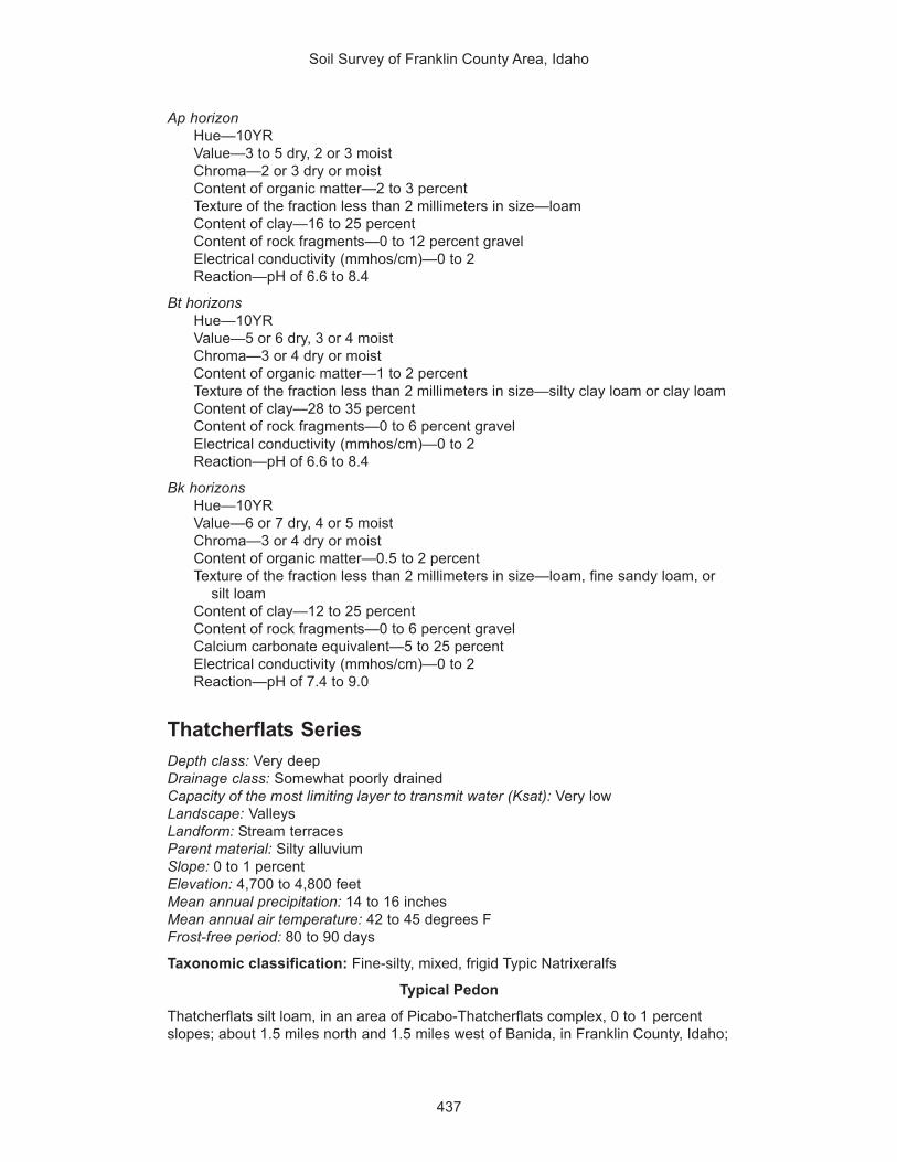
Soil Survey of Franklin County Area, Idaho
437
Ap horizonHue—10YRValue—3 to 5 dry, 2 or 3 moistChroma—2 or 3 dry or moistContent of organic matter—2 to 3 percentTexture of the fraction less than 2 millimeters in size—loamContent of clay—16 to 25 percentContent of rock fragments—0 to 12 percent gravelElectrical conductivity (mmhos/cm)—0 to 2Reaction—pH of 6.6 to 8.4
Bt horizonsHue—10YRValue—5 or 6 dry, 3 or 4 moistChroma—3 or 4 dry or moistContent of organic matter—1 to 2 percentTexture of the fraction less than 2 millimeters in size—silty clay loam or clay loamContent of clay—28 to 35 percentContent of rock fragments—0 to 6 percent gravelElectrical conductivity (mmhos/cm)—0 to 2Reaction—pH of 6.6 to 8.4
Bk horizonsHue—10YRValue—6 or 7 dry, 4 or 5 moistChroma—3 or 4 dry or moistContent of organic matter—0.5 to 2 percentTexture of the fraction less than 2 millimeters in size—loam, fine sandy loam, or
silt loamContent of clay—12 to 25 percentContent of rock fragments—0 to 6 percent gravelCalcium carbonate equivalent—5 to 25 percentElectrical conductivity (mmhos/cm)—0 to 2Reaction—pH of 7.4 to 9.0
Thatcherflats SeriesDepth class: Very deepDrainage class: Somewhat poorly drainedCapacity of the most limiting layer to transmit water (Ksat): Very lowLandscape: ValleysLandform: Stream terracesParent material: Silty alluviumSlope: 0 to 1 percentElevation: 4,700 to 4,800 feetMean annual precipitation: 14 to 16 inchesMean annual air temperature: 42 to 45 degrees FFrost-free period: 80 to 90 days
Taxonomic classification: Fine-silty, mixed, frigid Typic Natrixeralfs
Typical Pedon
Thatcherflats silt loam, in an area of Picabo-Thatcherflats complex, 0 to 1 percentslopes; about 1.5 miles north and 1.5 miles west of Banida, in Franklin County, Idaho;

Soil Survey of Franklin County Area, Idaho
438
about 150 feet south and 500 feet east of the northwest corner of sec. 36, T. 13 S., R.38 E.
A—0 to 4 inches; light brownish gray (10YR 6/2) silt loam, grayish brown (10YR 5/2)moist; strong very thick platy structure parting to moderate thin platy; slightlyhard, very friable, slightly sticky, slightly plastic; few very fine and fine andcommon medium and coarse roots; common very fine and few fine irregularpores; disseminated carbonates; strongly effervescent; strongly alkaline (pH 8.5);abrupt wavy boundary.
Btn—4 to 16 inches; pale brown (10YR 6/3) silty clay loam, grayish brown (10YR 5/2)moist; strong medium and coarse columnar structure parting to moderate fineand medium angular blocky; hard, friable, moderately sticky, moderately plastic;common very fine, medium, and coarse and few fine roots; few very fine tubularpores; common medium prominent clay films on faces of peds and lining pores;disseminated carbonates; slightly effervescent; very strongly alkaline (pH 9.3);clear wavy boundary.
Btkny—16 to 20 inches; light brownish gray (10YR 6/2) silty clay loam, gray (10YR5/1) moist; moderate fine and medium prismatic structure parting to moderatefine angular blocky; hard, firm, moderately sticky, moderately plastic; few very fineand fine roots; common very fine tubular pores; very dark grayish brown (10YR3/2) organic staining on the top and some vertical faces of peds; commonmedium prominent clay films on faces of peds and lining pores; common fineseams of granular gypsum; few fine irregularly shaped carbonate filaments andmasses; strongly effervescent; strongly alkaline (pH 8.5); clear wavy boundary.
Btkn—20 to 36 inches; gray (10YR 6/1) silty clay loam, dark gray (10YR 4/1) moist;weak medium prismatic structure parting to moderate fine and mediumsubangular blocky; hard, firm, moderately sticky, moderately plastic; few very fineroots; common very fine and few fine tubular pores; very dark grayish brown(10YR 3/2) organic staining on the top and some vertical faces of peds; commonmedium distinct clay films on faces of peds and lining pores; few fine irregularlyshaped carbonate filaments and masses; strongly effervescent; strongly alkaline(pH 8.5); gradual irregular boundary.
Bkn1—36 to 45 inches; very pale brown (10YR 7/3) silty clay loam, pale brown (10YR6/3) moist; massive; hard, firm, moderately sticky, moderately plastic; few veryfine roots; common very fine tubular pores; few fine distinct very dark gray (10YR3/1) iron-manganese concretions; few fine distinct dark yellowish brown (10YR4/6) irregularly shaped masses of iron accumulation; few fine irregularly shapedcarbonate filaments and masses; strongly effervescent; strongly alkaline (pH 8.5);clear smooth boundary.
Bkn2—45 to 61 inches; very pale brown (10YR 7/3) silty clay loam, light yellowishbrown (10YR 6/4) moist; massive; hard, firm, moderately sticky, moderatelyplastic; common very fine tubular pores; few fine distinct very dark gray (10YR3/1) zones of iron depletion and few fine distinct irregularly shaped yellowishbrown (10YR 5/6) masses of iron accumulation; few fine irregularly shapedcarbonate filaments; slightly effervescent; strongly alkaline (pH 8.5).
Range in Characteristics
Depth to a restrictive feature: More than 60 inches
Diagnostic featureDepth to a natric horizon—2 to 7 inches
Water featuresSeasonal high water table: Month(s)—March, April, May, June, and July; depth—
3.0 to 4.0 feet

Soil Survey of Franklin County Area, Idaho
439
Flooding: Month(s)—February, March, April, and May; frequency—rare
A horizonHue—10YRValue—6 or 7 dry, 3 to 5 moistChroma—2 or dry or moistContent of organic matter—1 to 3 percentTexture of the fraction less than 2 millimeters in size—silt loamContent of clay—11 to 18 percentCalcium carbonate equivalent—0 to 5 percentSodium adsorption ratio—5 to 15Electrical conductivity (mmhos/cm)—0 to 2Reaction—pH of 7.9 to 9.0
Btn horizonHue—10YRValue—5 or 6 dry, 4 to 6 moistChroma—2 or 3 dry or moistContent of organic matter—0.5 to 1 percentTexture of the fraction less than 2 millimeters in size—silty clay loam or silty clayContent of clay—28 to 43 percentCalcium carbonate equivalent—0 to 5 percentSodium adsorption ratio—20 to 30Electrical conductivity (mmhos/cm)—2 to 4Reaction—pH of 8.5 to 9.0
Btkny, Bknb, and Bkn horizonsHue—10YRValue—6 to 8 dry, 4 to 6 moistChroma—1 to 4 dry or moistContent of organic matter—0.0 to 0.5 percentTexture of the fraction less than 2 millimeters in size—silt loam or silty clay loamContent of clay—25 to 35 percentCalcium carbonate equivalent—5 to 25 percentContent of gypsum—0 to 5 percentSodium adsorption ratio—45 to 120Electrical conductivity (mmhos/cm)—4 to 8Reaction—pH of 8.5 to 9.0
Toponce SeriesDepth class: Very deepDrainage class: Well drainedCapacity of the most limiting layer to transmit water (Ksat): Moderately lowLandscape: Hills and mountainsLandform: Hillslopes and mountain slopesParent material: Mixed alluviumSlope: 6 to 30 percentElevation: 6,000 to 6,900 feetMean annual precipitation: 18 to 28 inchesMean annual air temperature: 37 to 39 degrees FFrost-free period: 30 to 50 days
Taxonomic classification: Fine, montmorillonitic Argic Vertic Cryoborolls

Soil Survey of Franklin County Area, Idaho
440
Typical Pedon
Toponce silt loam, in an area of Toponce-Broadhead association, 6 to 30 percentslopes; about 2 miles northeast of Cottonwood Peak, in adjacent Bannock County,Idaho; about 300 feet north and 2,450 feet east of the southwest corner of sec. 29, T.11 S., R. 39 E.
A1—0 to 3 inches; dark grayish brown (10YR 4/2) silt loam, very dark brown (10YR2/2) moist; moderate fine granular structure; soft, friable, slightly sticky, slightlyplastic; many very fine and fine roots; many very fine irregular pores; 10 percentgravel; slightly acid (pH 6.3); clear smooth boundary.
A2—3 to 14 inches; dark grayish brown (10YR 4/2) silty clay loam, very dark brown(10YR 2/2) moist; strong very fine, fine, and medium subangular blocky structure;hard, firm, moderately sticky, moderately plastic; many very fine and fine and fewmedium roots; many very fine tubular and irregular pores; 5 percent gravel;slightly acid (pH 6.3); clear smooth boundary.
Bt1—14 to 21 inches; brown (10YR 4/3) silty clay loam, very dark grayish brown(10YR 3/2) moist; strong very fine and fine subangular blocky structure; hard,firm, moderately sticky, moderately plastic; common very fine and fine and fewmedium roots; common very fine tubular and few irregular pores; few faint clayfilms on faces of peds and lining pores; 5 percent gravel; moderately acid (pH5.8); clear smooth boundary.
Bt2—21 to 28 inches; brown (10YR 5/3) silty clay, dark yellowish brown (10YR 4/4)moist; moderate medium prismatic structure parting to strong medium angularblocky; very hard, very firm, moderately sticky, moderately plastic; common veryfine and few fine and medium roots, mostly along faces of peds and in cracks;common very fine tubular pores; many distinct clay films on faces of peds andlining pores; 5 percent gravel; moderately acid (pH 5.8); clear smooth boundary.
Bt3—28 to 60 inches; brown (10YR 5/3) clay, dark yellowish brown (10YR 4/4) moist;moderate coarse prismatic structure; extremely hard, extremely firm, very sticky,very plastic; few very fine to medium roots along faces of peds and in cracks;common very fine tubular pores; many distinct clay films on faces of peds andlining pores; 2 percent gravel; moderately acid (pH 5.9).
Range in Characteristics
Depth to a restrictive feature: More than 60 inches
Diagnostic featuresThickness of the mollic epipedon—18 to 25 inchesDepth to an argillic horizon—8 to 18 inches
A1 horizonHue—10YRValue—4 or 5 dry, 2 or 3 moistChroma—1 to 3 dry or moistContent of organic matter—4 to 6 percentTexture of the fraction less than 2 millimeters in size—silt loamContent of clay—15 to 25 percentContent of rock fragments—0 to 12 percent gravelReaction—pH of 5.6 to 6.5
A2 horizonHue—10YRValue—4 or 5 dry, 2 or 3 moistChroma—1 to 3 dry or moistContent of organic matter—2 to 4 percent

Soil Survey of Franklin County Area, Idaho
441
Texture of the fraction less than 2 millimeters in size—silt loam or silty clay loamContent of clay—20 to 30 percentContent of rock fragments—0 to 12 percent gravelReaction—pH of 5.6 to 6.5
Bt horizonsHue—10YRValue—4 to 6 dry, 2 to 4 moistChroma—2 to 4 dry or moistContent of organic matter—0.5 to 2 percentTexture of the fraction less than 2 millimeters in size—silty clay loam, silty clay, or
clayContent of clay—35 to 60 percentContent of rock fragments—0 to 12 percent gravelReaction—pH of 5.6 to 6.5
Trenton SeriesDepth class: Very deepDrainage class: Somewhat poorly drainedCapacity of the most limiting layer to transmit water (Ksat): Moderately lowLandscape: Lake plainsLandform: Lake terracesParent material: Lacustrine depositsSlope: 0 to 2 percentElevation: 4,400 to 4,800 feetMean annual precipitation: 14 to 16 inchesMean annual air temperature: 46 to 49 degrees FFrost-free period: 120 to 130 days
Taxonomic classification: Fine, mixed, mesic Typic Natrixerolls
Typical Pedon
Trenton silty clay loam, in an area of Trenton-Battle Creek complex, 0 to 2 percentslopes; about 4 miles south and 2 miles east of Preston, in Franklin County, Idaho;about 1,200 feet south and 1,700 feet east of the northwest corner of sec. 24, T. 16S., R. 39 E.
Ap—0 to 8 inches; grayish brown (10YR 5/2) silty clay loam, very dark grayish brown(10YR 3/2) moist; moderate fine granular structure; slightly hard, friable,moderately sticky, moderately plastic; few very fine and fine roots; few very fineand fine tubular pores; disseminated carbonates; slightly effervescent; slightlyalkaline (pH 7.8); abrupt smooth boundary.
Btn1—8 to 12 inches; dark grayish brown (10YR 4/2) silty clay loam, very darkgrayish brown (10YR 3/2) moist; moderate fine and medium subangular blockystructure; hard, friable, moderately sticky, moderately plastic; few very fine andfine roots; common very fine and fine tubular pores; few faint clay films on facesof peds; disseminated carbonates; slightly effervescent; moderately alkaline (pH8.2); clear wavy boundary.
Btn2—12 to 21 inches; brown (10YR 5/3) silty clay, brown (10YR 4/3) moist; strongfine prismatic structure parting to strong fine subangular blocky; very hard, veryfirm, very sticky, very plastic; few very fine and fine roots; few very fine tubularpores; few prominent clay films on faces of peds and lining pores; disseminatedcarbonates; strongly effervescent; strongly alkaline (pH 8.8); clear wavyboundary.

Soil Survey of Franklin County Area, Idaho
442
Btkn—21 to 32 inches; brown (7.5YR 5/4) silty clay, brown (7.5YR 4/2) moist;moderate medium and coarse subangular blocky structure; very hard, very firm,very sticky, very plastic; few very fine roots; few very fine tubular pores; commonprominent clay films on faces of peds and few prominent clay films lining pores;disseminated carbonates; violently effervescent; strongly alkaline (pH 8.6); clearwavy boundary.
Bk—32 to 46 inches; brown (7.5YR 5/4) silty clay, brown (7.5YR 4/4) moist; weakmedium subangular blocky structure; very hard, very firm, very sticky, veryplastic; few very fine tubular pores; common fine faint strong brown (7.5YR 5/6)irregularly shaped masses of iron accumulation; disseminated carbonates;violently effervescent; strongly alkaline (pH 8.6); clear smooth boundary.
C—46 to 61 inches; light brown (7.5YR 6/4) silty clay, brown (7.5YR 5/4) moist;massive; very hard, very firm, very sticky, very plastic; many medium prominentlight gray (2.5Y 7/2) irregularly shaped zones of iron depletion and many mediumprominent strong brown (7.5YR 5/6) irregularly shaped masses of ironaccumulation; disseminated carbonates; violently effervescent; strongly alkaline(pH 8.5).
Range in Characteristics
Depth to a restrictive feature: More than 60 inches
Diagnostic featuresThickness of the mollic epipedon—10 to 20 inchesDepth to a natric horizon—4 to 10 inches
Water featureSeasonal high water table: Month(s)—March, April, May, June, July, and August;
depth—2.5 to 3.5 feet
Ap horizonHue—10YR or 7.5YRValue—4 or 5 dry, 3 or 4 moistChroma—2 or 3 dry or moistContent of organic matter—2 to 3 percentTexture of the fraction less than 2 millimeters in size—silty clay loamContent of clay—30 to 35 percentCalcium carbonate equivalent—5 to 15 percentElectrical conductivity (mmhos/cm)—0 to 2Reaction—pH of 7.4 to 8.4
Btn horizonsHue—10YR or 7.5YRValue—4 or 5 dry, 3 to 5 moistChroma—2 to 4 dry or moistContent of organic matter—2 to 3 percentTexture of the fraction less than 2 millimeters in size—silty clay loamContent of clay—30 to 35 percentCalcium carbonate equivalent—5 to 15 percentElectrical conductivity (mmhos/cm)—0 to 2Reaction—pH of 7.4 to 8.4
Btkn and Bk horizonsHue—10YR or 7.5YRValue—4 or 5 dry, 3 to 5 moistChroma—2 to 4 dry or moist

Soil Survey of Franklin County Area, Idaho
443
Content of organic matter—0.5 to 2 percentTexture of the fraction less than 2 millimeters in size—silty clay loam or silty clayContent of clay—35 to 50 percentCalcium carbonate equivalent—5 to 25 percentSodium adsorption ratio—13 to 45Electrical conductivity (mmhos/cm)—2 to 8Reaction—pH of 7.4 to 9.0
C horizonHue—10YR or 7.5YRValue—5 to 7 dry, 4 to 6 moistChroma—3 or 4 dry or moistContent of organic matter—0.5 to 1 percentTexture of the fraction less than 2 millimeters in size—silty clayContent of clay—35 to 50 percentCalcium carbonate equivalent—15 to 35 percentSodium adsorption ratio—5 to 12Electrical conductivity (mmhos/cm)—2 to 8Reaction—pH of 8.5 to 9.0
Taxadjunct Feature
The Trenton soil in map unit 141 (Trenton-Battle Creek complex, cool, 0 to 2percent slopes) is a taxadjunct to the series because it has a frigid soil temperatureregime. This difference, however, does not affect the use and management of thesoil.
Valmar SeriesDepth class: Moderately deepDrainage class: Well drainedCapacity of the most limiting layer to transmit water (Ksat): Moderately highLandscape: MountainsLandform: Mountain slopesParent material: Mixed alluvium, colluvium, and residuumSlope: 20 to 60 percentElevation: 5,200 to 6,700 feetMean annual precipitation: 15 to 20 inchesMean annual air temperature: 40 to 43 degrees FFrost-free period: 60 to 90 days
Taxonomic classification: Loamy-skeletal, mixed, frigid Typic Argixerolls
Typical Pedon
Valmar very cobbly silt loam, in an area of Valmar-Camelback-Hades complex, 30 to60 percent slopes; about 1.5 miles southwest of Pocatello, in adjacent BannockCounty, Idaho; about 630 feet south and 2,055 feet east of the northwest corner ofsec. 4, T. 7 S., R. 34 E.
A1—0 to 4 inches; brown (10YR 4/3) very cobbly silt loam, very dark grayish brown(10YR 3/2) moist; weak fine subangular blocky structure parting to weak finegranular; soft, very friable, slightly sticky, slightly plastic; many very fine and fewfine roots; many very fine irregular pores; 15 percent gravel, 20 percent cobbles,and 5 percent stones; neutral (pH 7.3); clear smooth boundary.

Soil Survey of Franklin County Area, Idaho
444
A2—4 to 9 inches; brown (10YR 5/3) very cobbly silt loam, dark brown (10YR 3/3)moist; weak fine subangular blocky structure parting to weak fine granular; soft,very friable, slightly sticky, slightly plastic; many very fine and few fine roots;many very fine irregular pores; 20 percent gravel, 25 percent cobbles, and 5percent stones; neutral (pH 7.3); clear smooth boundary.
Bt—9 to 14 inches; yellowish brown (10YR 5/4) very cobbly silt loam, brown (10YR4/3) moist; moderate fine and medium subangular blocky structure; slightly hard,friable, slightly sticky, slightly plastic; common very fine and few fine roots; manyvery fine irregular and few very fine tubular pores; few faint clay films on faces ofpeds and lining pores; 20 percent gravel, 25 percent cobbles, and 5 percentstones; slightly alkaline (pH 7.6); abrupt irregular boundary.
BC—14 to 24 inches; yellowish brown (10YR 5/4) extremely stony silt loam, brown(10YR 4/3) moist; moderate fine and medium subangular blocky structure; slightlyhard, friable, slightly sticky, slightly plastic; few very fine and fine roots; few veryfine tubular pores; 5 percent gravel, 5 percent cobbles, and 75 percent stones;slightly alkaline (pH 7.7); abrupt irregular boundary.
R—24 inches; quartzite.
Range in Characteristics
Depth to a restrictive feature: 20 to 40 inches to lithic bedrock
Diagnostic featuresThickness of the mollic epipedon—9 to 16 inchesDepth to an argillic horizon—7 to 22 inches
A horizonsHue—10YRValue—4 or 5 dry, 2 or 3 moistChroma—2 or 3 dry or moistContent of organic matter—2 to 4 percentTexture of the fraction less than 2 millimeters in size—silt loamContent of clay—13 to 20 percentContent of rock fragments—6 to 28 percent gravel, 17 to 25 percent cobbles, 0 to
6 percent stonesReaction—pH of 6.1 to 7.3
Bt horizonHue—10YRValue—4 to 6 dry, 2 to 4 moistChroma—2 to 4 dry or moistContent of organic matter—0.5 to 2 percentTexture of the fraction less than 2 millimeters in size—silt loamContent of clay—20 to 27 percentContent of rock fragments—2 to 22 percent gravel, 17 to 25 percent cobbles, 0 to
6 percent stonesReaction—pH of 6.6 to 7.8
BC horizonHue—10YRValue—4 to 6 dry, 2 to 4 moistChroma—2 to 4 dry or moistContent of organic matter—0.5 to 1 percentTexture of the fraction less than 2 millimeters in size—silt loamContent of clay—20 to 27 percentContent of rock fragments—0 to 24 percent gravel, 3 to 23 percent cobbles, 50 to
85 percent stones

Soil Survey of Franklin County Area, Idaho
445
Reaction—pH of 6.6 to 7.8
Vitale SeriesDepth class: Moderately deepDrainage class: Well drainedCapacity of the most limiting layer to transmit water (Ksat): Moderately highLandscape: Hills and mountainsLandform: Hillslopes and mountain slopesParent material: Mixed colluvium and residuumSlope: 12 to 75 percentElevation: 5,100 to 7,300 feetMean annual precipitation: 15 to 30 inchesMean annual air temperature: 40 to 46 degrees FFrost-free period: 60 to 95 days
Taxonomic classification: Loamy-skeletal, mixed, frigid Typic Argixerolls
Typical Pedon
Vitale extremely stony loam, in an area of Yeates Hollow-Vitale complex, 25 to 50percent slopes; about 3.5 miles north of the town of Mink Creek, in Franklin County,Idaho; about 2,400 feet south and 1,500 feet east of the northwest corner of sec. 17,T. 13 S., R. 41 E.
A1—0 to 1 inch; brown (10YR 5/3) extremely stony loam, very dark grayish brown(10YR 3/2) moist; strong thick platy structure; slightly hard, very friable, slightlysticky, slightly plastic; common very fine roots; many very fine vesicular pores; 15percent gravel, 15 percent cobbles, and 35 percent stones; slightly alkaline (pH7.5); abrupt wavy boundary.
A2—1 to 5 inches; brown (10YR 5/3) extremely cobbly loam, dark brown (10YR 3/3)moist; moderate fine and medium subangular blocky structure parting to strongvery fine granular; slightly hard, very friable, slightly sticky, slightly plastic;common very fine and few fine roots; many very fine irregular and common veryfine tubular pores; 15 percent gravel, 40 percent cobbles, and 5 percent stones;slightly alkaline (pH 7.4); clear wavy boundary.
AB—5 to 15 inches; brown (10YR 5/3) very cobbly loam, dark brown (10YR 3/3)moist; moderate fine and medium subangular blocky structure parting to strongvery fine granular; slightly hard, friable, moderately sticky, moderately plastic;common very fine to medium roots; common very fine irregular and many veryfine tubular pores; 20 percent gravel, 30 percent cobbles, and 5 percent stones;slightly alkaline (pH 7.4); clear wavy boundary.
Bt1—15 to 22 inches; light yellowish brown (10YR 6/4) extremely cobbly clay loam,dark brown (10YR 3/3) moist; moderate medium and coarse subangular blockystructure; hard, friable, moderately sticky, moderately plastic; common very fineto medium roots; many very fine tubular pores; common distinct clay films onfaces of peds and lining pores; 20 percent gravel, 25 percent cobbles, and 20percent stones; slightly alkaline (pH 7.4); clear wavy boundary.
Bt2—22 to 26 inches; light yellowish brown (10YR 6/4) extremely stony clay loam,brown (10YR 4/3) moist; moderate medium and coarse subangular blockystructure; hard, friable, moderately sticky, moderately plastic; few very fine tomedium roots; many very fine tubular pores; common distinct clay films on facesof peds and lining pores; 15 percent gravel, 20 percent cobbles, and 35 percentstones; slightly alkaline (pH 7.4); abrupt wavy boundary.
R—26 inches; quartzite.

Soil Survey of Franklin County Area, Idaho
446
Range in Characteristics
Depth to a restrictive feature: 20 to 40 inches to lithic bedrock
Diagnostic featuresThickness of the mollic epipedon—7 to 16 inchesDepth to an argillic horizon—3 to 15 inches
A1 horizonHue—10YR or 7.5YRValue—4 or 5 dry, 2 or 3 moistChroma—2 or 3 dry or moistContent of organic matter—2 to 4 percentTexture of the fraction less than 2 millimeters in size—loamContent of clay—12 to 20 percentContent of rock fragments—4 to 23 percent gravel, 6 to 20 percent cobbles, 11 to
38 percent stonesReaction—pH of 6.6 to 7.8
A2 and AB horizonsHue—10YR or 7.5YRValue—4 or 5 dry, 2 or 3 moistChroma—2 or 3 dry or moistContent of organic matter—1 to 3 percentTexture of the fraction less than 2 millimeters in size—loamContent of clay—18 to 27 percentContent of rock fragments—10 to 25 percent gravel, 20 to 41 percent cobbles, 3
to 31 percent stonesReaction—pH of 6.6 to 7.8
Bt horizonsHue—10YR or 7.5YRValue—4 to 6 dry, 3 or 4 moistChroma—3 or 4 dry, 3 to 6 moistContent of organic matter—0.5 to 1 percentTexture of the fraction less than 2 millimeters in size—loam or clay loamContent of clay—25 to 35 percentContent of rock fragments—0 to 24 percent gravel, 20 to 37 percent cobbles, 6 to
31 percent stonesReaction—pH of 6.6 to 7.8
Welby SeriesDepth class: Very deepDrainage class: Well drained or moderately well drainedCapacity of the most limiting layer to transmit water (Ksat): Moderately highLandscape: Lake plainsLandform: Lake terracesParent material: Lacustrine depositsSlope: 0 to 4 percentElevation: 4,400 to 5,100 feetMean annual precipitation: 14 to 16 inchesMean annual air temperature: 47 to 49 degrees FFrost-free period: 110 to 130 days
Taxonomic classification: Coarse-silty, mixed, mesic Typic Calcixerolls

Soil Survey of Franklin County Area, Idaho
447
Typical Pedon
Welby silt loam, wet, 0 to 2 percent slopes; about 0.5 mile south of Preston, inFranklin County, Idaho; about 2,650 feet south and 1,350 feet west of the northeastcorner of sec. 27, T. 15 S., R. 39 E.
Ap—0 to 6 inches; dark grayish brown (10YR 4/2) silt loam, very dark grayish brown(10YR 3/2) moist; strong thin platy structure; slightly hard, very friable, slightlysticky, slightly plastic; many very fine and few fine roots; common fine tubularpores; disseminated carbonates; slightly effervescent; moderately alkaline (pH8.4); clear smooth boundary.
A—6 to 12 inches; dark grayish brown (10YR 4/2) silt loam, very dark grayish brown(10YR 3/2) moist; strong coarse subangular blocky structure; hard, friable, slightlysticky, slightly plastic; few fine roots; common fine tubular pores; disseminatedcarbonates; slightly effervescent; moderately alkaline (pH 8.4); gradual smoothboundary.
Bk1—12 to 18 inches; very pale brown (10YR 7/3) silt loam, brown (10YR 5/3) moist;weak fine granular structure; hard, friable, slightly sticky, slightly plastic; commonfine roots; few fine tubular pores; disseminated carbonates; few fine irregularlyshaped carbonate seams and filaments; violently effervescent; moderatelyalkaline (pH 8.4); clear smooth boundary.
Bk2—18 to 28 inches; very pale brown (10YR 7/4) silt loam, brown (10YR 4/3) moist;moderate fine subangular blocky structure; slightly hard, friable, slightly sticky,slightly plastic; few fine roots; few fine tubular pores; disseminated carbonates;few fine irregularly shaped carbonate seams and filaments; strongly effervescent;moderately alkaline (pH 8.4); gradual smooth boundary.
Bk3—28 to 40 inches; very pale brown (10YR 7/4) loam, brown (10YR 4/3) moist;massive; slightly hard, very friable, slightly sticky, slightly plastic; few fine roots;few fine tubular pores; disseminated carbonates; few fine irregularly shapedcarbonate seams and filaments; strongly effervescent; strongly alkaline (pH 8.5);gradual smooth boundary.
C—40 to 60 inches; light yellowish brown (10YR 6/4) fine sandy loam, brown (10YR4/3) moist; massive; slightly hard, very friable, slightly sticky, slightly plastic;disseminated carbonates; strongly effervescent; strongly alkaline (pH 8.5).
Range in Characteristics
Depth to a restrictive feature: More than 60 inches
Diagnostic featuresThickness of the mollic epipedon—7 to 19 inchesDepth to a calcic horizon—6 to 17 inches
Water featureSeasonal high water table: Month(s)—January through December; depth—4.0 to
6.0 feet
Ap and A horizonsHue—10YRValue—4 or 5 dry, 2 or 3 moistChroma—2 or 3 dry or moistContent of organic matter—2 to 4 percentTexture of the fraction less than 2 millimeters in size—silt loamContent of clay—8 to 18 percentCalcium carbonate equivalent—1 to 20 percentSodium adsorption ratio—0 to 15Electrical conductivity (mmhos/cm)—0 to 2Reaction—pH of 7.9 to 9.0

Soil Survey of Franklin County Area, Idaho
448
Bk horizonsHue—10YRValue—6 to 8 dry, 4 to 6 moistChroma—2 to 4 dry or moistContent of organic matter—0.5 to 3 percentTexture of the fraction less than 2 millimeters in size—silt loam, loam, or very fine
sandy loamContent of clay—10 to 18 percentCalcium carbonate equivalent—15 to 40 percentSodium adsorption ratio—0 to 20Electrical conductivity (mmhos/cm)—0 to 2Reaction—pH of 7.9 to 9.0
C horizonHue—10YRValue—6 to 8 dry, 4 to 6 moistChroma—2 to 4 dry or moistContent of organic matter—0.0 to 1 percentTexture of the fraction less than 2 millimeters in size—fine sandy loam or very
fine sandy loamContent of clay—5 to 18 percentCalcium carbonate equivalent—10 to 35 percentSodium adsorption ratio—0 to 20Electrical conductivity (mmhos/cm)—0 to 2Reaction—pH of 7.9 to 9.0
Remarks
The Welby soil in map unit 148 (Welby silt loam, wet, 0 to 2 percent slopes) ismoderately well drained and has an apparent water table. Thus, it is outside therange of the official series. This difference, however, does not significantly affect useand management of the soil for cropland.
Wheelon SeriesDepth class: Very deepDrainage class: Well drainedCapacity of the most limiting layer to transmit water (Ksat): Moderately highLandscape: Lake plainsLandform: Lake terracesParent material: Lacustrine depositsSlope: 4 to 60 percentElevation: 4,800 to 5,200 feetMean annual precipitation: 14 to 16 inchesMean annual air temperature: 45 to 48 degrees FFrost-free period: 110 to 130 days
Taxonomic classification: Fine-silty, mixed, mesic Calcixerollic Xerochrepts
Typical Pedon
Wheelon silt loam, in an area of Wheelon-Collinston complex, 4 to 12 percent slopes;about 1 mile north of Dayton, in Franklin County, Idaho; about 1,500 feet north and1,800 feet east of the southwest corner of sec. 10, T. 15 S., R. 38 E.
Ap—0 to 6 inches; light brownish gray (10YR 6/2) silt loam, very dark grayish brown(10YR 3/2) moist; weak fine granular structure; slightly hard, very friable,

Soil Survey of Franklin County Area, Idaho
449
moderately sticky, slightly plastic; many very fine and common fine roots;common very fine and fine tubular and irregular pores; disseminated carbonates(12 percent calcium carbonate equivalent); strongly effervescent; 1 percentgravel; slightly alkaline (pH 7.8); clear smooth boundary.
Bk1—6 to 17 inches; light gray (10YR 7/2) silt loam, brown (10YR 5/3) moist;moderate very fine and fine subangular blocky structure; slightly hard, friable,moderately sticky, moderately plastic; common very fine and few fine roots;common very fine tubular pores; 10 percent very weakly cemented nodules 5 to10 millimeters in size; disseminated carbonates (34 percent calcium carbonateequivalent); violently effervescent; 1 percent gravel; moderately alkaline (pH 8.0);gradual wavy boundary.
Bk2—17 to 33 inches; light gray (10YR 7/2) silt loam, olive (5Y 5/3) moist; moderatefine angular blocky structure; hard, friable, slightly sticky, slightly plastic; few veryfine roots; common very fine and few fine tubular pores; common fine prominentstrong brown (7.5YR 5/6) masses of iron accumulation that are relictredoximorphic features; 8 percent very weakly cemented nodules 5 to 10millimeters in size; disseminated carbonates; common fine irregularly shapedcarbonate masses and filaments (32 percent calcium carbonate equivalent);violently effervescent; 1 percent gravel; moderately alkaline (pH 8.2); gradualwavy boundary.
Bk3—33 to 53 inches; light gray (10YR 7/2) silt loam, olive (5Y 5/3) moist; moderatefine angular blocky structure; hard, friable, slightly sticky, slightly plastic; few veryfine roots; common very fine and few fine tubular pores; common fine prominentstrong brown (7.5YR 5/6) masses of iron accumulation that are relictredoximorphic features; 5 percent very weakly cemented nodules 5 to 10millimeters in size; disseminated carbonates; common fine irregularly shapedcarbonate masses and filaments (23 percent calcium carbonate equivalent);violently effervescent; 1 percent gravel; moderately alkaline (pH 8.2); gradualwavy boundary.
BCk—53 to 60 inches; light gray (10YR 7/2) silt loam, olive (5Y 5/3) moist; massive;hard, friable, slightly sticky, slightly plastic; few very fine and fine tubular pores;common fine prominent strong brown (7.5YR 5/6) masses of iron accumulationthat are relict redoximorphic features; disseminated carbonates; common fineirregularly shaped carbonate masses and filaments (21 percent calciumcarbonate equivalent); violently effervescent; 1 percent gravel; moderatelyalkaline (pH 8.4).
Range in Characteristics
Depth to a restrictive feature: More than 60 inches
Diagnostic featureDepth to a calcic horizon—4 to 16 inches
Ap horizonHue—10YR or 2.5YValue—6 or 7 dry, 3 to 7 moistChroma—1 to 3 dry or moistContent of organic matter—1 to 3 percentTexture of the fraction less than 2 millimeters in size—silt loamContent of clay—18 to 27 percentContent of rock fragments—0 to 3 percent gravelCalcium carbonate equivalent—12 to 20 percentElectrical conductivity (mmhos/cm)—0 to 2Reaction—pH of 7.4 to 8.4

Soil Survey of Franklin County Area, Idaho
450
Bk and BCk horizonsHue—10YR, 2.5Y, or 5YValue—7 or 8 dry, 5 to 7 moistChroma—2 or 3 dry or moistContent of organic matter—0.5 to 1 percentTexture of the fraction less than 2 millimeters in size—silt loam or silty clay loamContent of clay—24 to 34 percentContent of rock fragments—0 to 3 percent gravelCalcium carbonate equivalent—20 to 35 percentSodium adsorption ratio—0 to 15Electrical conductivity (mmhos/cm)—0 to 2Reaction—pH of 7.9 to 9.0
Windernot SeriesDepth class: Very deepDrainage class: Moderately well drainedCapacity of the most limiting layer to transmit water (Ksat): HighLandscape: ValleysLandform: Stream terracesParent material: Mixed alluviumSlope: 0 to 2 percentElevation: 4,400 to 5,100 feetMean annual precipitation: 14 to 16 inchesMean annual air temperature: 45 to 48 degrees FFrost-free period: 100 to 130 days
Taxonomic classification: Sandy-skeletal, mixed, mesic Pachic Calcixerolls
Typical Pedon
Windernot gravelly sandy loam, in an area of Windernot-Lewnot-Stinkcreek complex,0 to 2 percent slopes; about 2 miles northwest of Preston, in Franklin County, Idaho;about 1,900 feet north and 2,400 feet west of the southeast corner of sec. 17, T. 15S., R. 39 E.
A1—0 to 6 inches; grayish brown (10YR 5/2) gravelly sandy loam, very dark grayishbrown (10YR 3/2) moist; moderate medium and coarse subangular blockystructure; slightly hard, very friable, slightly sticky, slightly plastic; many very fineand few fine roots; common very fine tubular and irregular pores; disseminatedcarbonates (8 percent calcium carbonate equivalent); violently effervescent; 25percent gravel; strongly alkaline (pH 8.5); abrupt wavy boundary.
A2—6 to 18 inches; grayish brown (10YR 5/2) gravelly sandy loam, very dark grayishbrown (10YR 3/2) moist; moderate medium and coarse subangular blockystructure; slightly hard, very friable, slightly sticky, slightly plastic; common veryfine and few fine roots; common very fine and few fine tubular and irregularpores; disseminated carbonates (10 percent calcium carbonate equivalent);violently effervescent; 25 percent gravel; moderately alkaline (pH 8.4); abruptwavy boundary.
Bk—18 to 23 inches; grayish brown (10YR 5/2) very gravelly sandy loam, very darkgrayish brown (10YR 3/2) moist; moderate fine and medium subangular blockystructure; slightly hard, very friable, slightly sticky, slightly plastic; common veryfine and few fine roots; common very fine irregular and few fine tubular pores;disseminated carbonates (15 percent calcium carbonate equivalent); violentlyeffervescent; 40 percent gravel; moderately alkaline (pH 8.4); clear wavyboundary.

Soil Survey of Franklin County Area, Idaho
451
2Ck—23 to 60 inches; light brownish gray (10YR 6/2) extremely gravelly sand, verydark grayish brown (10YR 3/2) moist; single grain; loose, nonsticky, nonplastic;common very fine and few fine roots; common very fine irregular and few veryfine tubular pores; disseminated carbonates (10 percent calcium carbonateequivalent); strongly effervescent; 75 percent gravel; moderately alkaline (pH8.4).
Range in Characteristics
Depth to a restrictive feature: More than 60 inches
Diagnostic featuresThickness of the mollic epipedon—20 to 35 inchesDepth to a calcic horizon—16 to 24 inches
Water featuresSeasonal high water table: Month(s)—March, April, May, and June; depth—4.5 to
6.0 feetFlooding: Month(s)—February, March, April, and May; frequency—rare
A horizonsHue—10YRValue—4 or 5 dry, 2 or 3 moistChroma—2 or 3 dry or moistContent of organic matter—2 to 4 percentTexture of the fraction less than 2 millimeters in size—sandy loamContent of clay—5 to 15 percentContent of rock fragments—9 to 37 percent gravelCalcium carbonate equivalent—5 to 20 percentSodium adsorption ratio—0 to 2Electrical conductivity (mmhos/cm)—0 to 2Reaction—pH of 7.9 to 9.0
Bk horizonHue—10YRValue—5 to 7 dry, 3 or 4 moistChroma—2 or 3 dry or moistContent of organic matter—1 to 3 percentTexture of the fraction less than 2 millimeters in size—sandy loamContent of clay—5 to 15 percentContent of rock fragments—23 to 45 percent gravelCalcium carbonate equivalent—15 to 25 percentSodium adsorption ratio—0 to 2Electrical conductivity (mmhos/cm)—0 to 2Reaction—pH of 7.9 to 9.0
2Ck horizonHue—10YRValue—6 or 7 dry, 3 to 5 moistChroma—2 to 4 dry or moistContent of organic matter—0.0 to 1 percentTexture of the fraction less than 2 millimeters in size—sand or loamy sandContent of clay—1 to 5 percentContent of rock fragments—26 to 85 percent gravelCalcium carbonate equivalent—5 to 20 percentSodium adsorption ratio—0 to 2Electrical conductivity (mmhos/cm)—0 to 2Reaction—pH of 7.9 to 9.0

Soil Survey of Franklin County Area, Idaho
452
Winn SeriesDepth class: Very deepDrainage class: Somewhat poorly drainedCapacity of the most limiting layer to transmit water (Ksat): Moderately highLandscape: ValleysLandform: Stream terracesParent material: Mixed alluviumSlope: 0 to 3 percentElevation: 5,100 to 5,200 feetMean annual precipitation: 15 to 17 inchesMean annual air temperature: 45 to 46 degrees FFrost-free period: 120 to 130 days
Taxonomic classification: Fine-loamy, mixed, mesic Cumulic Haploxerolls
Typical Pedon
Winn silt loam, 0 to 3 percent slopes; about 2 miles northeast of Wellsville, inadjacent Cache County, Utah; about 1,500 feet north and 800 feet west of thesoutheast corner of sec. 23, T. 11 N., R. 1 W.
Ap—0 to 6 inches; dark gray (10YR 4/1) silt loam, very dark gray (10YR 3/1) moist;weak medium granular structure; slightly hard, friable, slightly sticky, slightlyplastic; many fine and medium roots; few fine pores; strongly effervescent;slightly alkaline (pH 7.4); clear smooth boundary.
A1—6 to 13 inches; dark gray (10YR 4/1) loam, very dark gray (10YR 3/1) moist;weak medium subangular blocky structure; hard, friable, slightly sticky, slightlyplastic; many fine and medium roots; common medium pores; slightlyeffervescent; slightly alkaline (pH 7.4); clear wavy boundary.
A2—13 to 18 inches; gray (2.5Y 5/1) loam, very dark gray (2.5Y 3/1) moist; weak finesubangular blocky structure; slightly hard, friable, slightly sticky, slightly plastic;many fine roots; common coarse pores; strongly effervescent; slightly alkaline(pH 7.4); clear smooth boundary.
A3—18 to 40 inches; grayish brown (10YR 5/2) loam, very dark gray (2.5Y 3/1) moist;weak fine subangular blocky structure; slightly hard, friable, slightly sticky, slightlyplastic; few fine and coarse roots; common coarse pores; common fine distinctyellowish brown (10YR 5/8) irregularly shaped masses of iron accumulation;strongly effervescent; slightly alkaline (pH 7.7); clear smooth boundary.
C—40 to 60 inches; dark gray (2.5Y 4/1) silt loam, very dark gray (2.5Y 3/1) moist;massive; hard, friable, slightly sticky, slightly plastic; many fine and medium roots;common fine pores; many medium prominent yellowish brown (10YR 5/8)irregularly shaped masses of iron accumulation; slightly effervescent; slightlyalkaline (pH 7.6).
Range in Characteristics
Depth to a restrictive feature: More than 60 inches
Diagnostic featuresThickness of the mollic epipedon—24 to 60 inchesDepth to redoximorphic features—more than 16 inches
Water featuresSeasonal high water table: Month(s)—April, May, June, July, August, and
September; depth—2.5 to 3.5 feet

Soil Survey of Franklin County Area, Idaho
453
Flooding: Month(s)—February, March, April, and May; frequency—rare
Ap horizonHue—10YR or NValue—3 or 4 dry, 2 or 3 moistChroma—0 to 2 dry or moistContent of organic matter—5 to 7 percentTexture of the fraction less than 2 millimeters in size—silt loamContent of clay—18 to 20 percentContent of rock fragments—0 to 6 percent gravelCalcium carbonate equivalent—1 to 10 percentElectrical conductivity (mmhos/cm)—0 to 2Reaction—pH of 7.4 to 8.4
A1 horizonHue—10YR or NValue—3 or 4 dry, 2 or 3 moistChroma—0 to 2 dry or moistContent of organic matter—3 to 5 percentTexture of the fraction less than 2 millimeters in size—loamContent of clay—18 to 25 percentContent of rock fragments—0 to 6 percent gravelCalcium carbonate equivalent—1 to 10 percentElectrical conductivity (mmhos/cm)—0 to 2Reaction—pH of 7.4 to 8.4
A2, A3, and C horizonsHue—10YR, 2.5Y, or NValue—4 to 6 dry, 2 to 4 moistChroma—0 to 2 dry or moistContent of organic matter—1 to 2 percentTexture of the fraction less than 2 millimeters in size—loam, silt loam, or very fine
sandy loamContent of clay—18 to 20 percentContent of rock fragments—0 to 6 percent gravelCalcium carbonate equivalent—1 to 10 percentElectrical conductivity (mmhos/cm)—0 to 2Reaction—pH of 7.4 to 8.4
Winwell SeriesDepth class: Very deepDrainage class: Well drainedCapacity of the most limiting layer to transmit water (Ksat): Moderately lowLandscape: Lake plainsLandform: Lake terracesParent material: Lacustrine depositsSlope: 0 to 8 percentElevation: 4,500 to 5,100 feetMean annual precipitation: 14 to 16 inchesMean annual air temperature: 45 to 48 degrees FFrost-free period: 115 to 130 days
Taxonomic classification: Fine, mixed, mesic Calcic Pachic Argixerolls

Soil Survey of Franklin County Area, Idaho
454
Typical Pedon
Winwell silty clay loam, in an area of Winwell-Collinston complex, 2 to 8 percentslopes; about 1 mile north of Dayton, in Franklin County, Idaho; about 1,550 feetnorth and 1,000 feet east of the southwest corner of sec. 10, T. 15 S., R. 38 E.
Ap1—0 to 3 inches; gray (10YR 5/1) silty clay loam, very dark grayish brown (10YR3/2) moist; moderate thin platy structure; slightly hard, very friable, slightly sticky,slightly plastic; common fine and few medium and coarse roots; common veryfine and fine and few medium tubular pores; slightly alkaline (pH 7.8); abruptsmooth boundary.
Ap2—3 to 10 inches; grayish brown (10YR 5/2) silty clay loam, very dark grayishbrown (10YR 3/2) moist; moderate medium subangular blocky structure; hard,very friable, slightly sticky, slightly plastic; few very fine to medium roots; commonvery fine and fine tubular pores; moderately alkaline (pH 8.1); abrupt smoothboundary.
Bt1—10 to 15 inches; grayish brown (10YR 5/2) silty clay, very dark grayish brown(10YR 3/2) moist; strong fine subangular blocky structure; very hard, friable,moderately sticky, moderately plastic; few very fine roots; few very fine and finetubular pores; common distinct clay films on faces of peds; moderately alkaline(pH 7.9); clear smooth boundary.
Bt2—15 to 22 inches; dark grayish brown (10YR 4/2) silty clay, very dark grayishbrown (10YR 3/2) moist; strong coarse prismatic structure; very hard, friable,moderately sticky, moderately plastic; common fine roots; common fine tubularpores; many prominent clay films on faces of peds and lining pores; moderatelyalkaline (pH 7.9); abrupt wavy boundary.
Btk—22 to 30 inches; very pale brown (10YR 7/3) silty clay, light yellowish brown(2.5Y 6/4) moist; strong medium subangular blocky structure; very hard, friable,moderately sticky, moderately plastic; few very fine roots; common fine tubularpores; many distinct clay films on faces of peds and lining pores; disseminatedcarbonates; violently effervescent (9 percent calcium carbonate equivalent);moderately alkaline (pH 8.3); clear wavy boundary.
Bk—30 to 51 inches; very pale brown (10YR 8/2) silty clay loam, light gray (2.5Y 7/2)moist; moderate fine subangular blocky structure; very hard, friable, slightlysticky, slightly plastic; common fine tubular pores; common fine irregularly shapedcarbonate masses and seams; violently effervescent (38 percent calciumcarbonate equivalent); strongly alkaline (pH 8.6); gradual smooth boundary.
C—51 to 60 inches; very pale brown (10YR 8/2) silt loam, light olive brown (2.5Y 5/4)moist; massive; hard, friable, slightly sticky, slightly plastic; few fine tubular pores;few fine irregularly shaped carbonate filaments; violently effervescent (26 percentcalcium carbonate equivalent); strongly alkaline (pH 8.8).
Range in Characteristics
Depth to a restrictive feature: More than 60 inches
Diagnostic featuresThickness of the mollic epipedon—20 to 30 inchesDepth to an argillic horizon—8 to 12 inchesDepth to a calcic horizon—25 to 40 inches
Ap horizonsHue—10YRValue—4 or 5 dry, 2 or 3 moistChroma—1 to 3 dry, 2 or 3 moistContent of organic matter—2 to 4 percentTexture of the fraction less than 2 millimeters in size—silty clay loam

Soil Survey of Franklin County Area, Idaho
455
Content of clay—27 to 32 percentSodium adsorption ratio—0 to 2Electrical conductivity (mmhos/cm)—0 to 2Reaction—pH of 7.4 to 8.4
Bt horizonsHue—10YRValue—4 or 5 dry, 2 or 3 moistChroma—2 or 3 dry or moistContent of organic matter—1 to 2 percentTexture of the fraction less than 2 millimeters in size—silty clay loam or silty clayContent of clay—38 to 50 percentSodium adsorption ratio—0 to 2Electrical conductivity (mmhos/cm)—0 to 2Reaction—pH of 7.4 to 8.4
Btk horizonHue—10YR or 2.5YValue—5 to 7 dry, 5 or 6 moistChroma—2 to 4 dry or moistContent of organic matter—0.5 to 1 percentTexture of the fraction less than 2 millimeters in size—silty clayContent of clay—40 to 50 percentCalcium carbonate equivalent—1 to 15 percentSodium adsorption ratio—0 to 2Electrical conductivity (mmhos/cm)—0 to 2Reaction—pH of 7.9 to 8.4
Bk horizonHue—10YR or 2.5YValue—6 to 8 dry, 5 to 7 moistChroma—2 or 3 dry or moistContent of organic matter—0.0 to 0.5 percentTexture of the fraction less than 2 millimeters in size—silty clay loamContent of clay—27 to 35 percentCalcium carbonate equivalent—20 to 40 percentSodium adsorption ratio—1 to 8Electrical conductivity (mmhos/cm)—0 to 2Reaction—pH of 8.5 to 9.0
C horizonHue—10YR or 2.5YValue—7 or 8 dry, 5 to 7 moistChroma—2 to 4 dry or moistContent of organic matter—0.0 to 0.5 percentTexture of the fraction less than 2 millimeters in size—silt loamContent of clay—18 to 26 percentCalcium carbonate equivalent—15 to 35 percentSodium adsorption ratio—1 to 8Electrical conductivity (mmhos/cm)—0 to 2Reaction—pH of 8.5 to 9.0
Wormcreek SeriesDepth class: DeepDrainage class: Well drained

Soil Survey of Franklin County Area, Idaho
456
Capacity of the most limiting layer to transmit water (Ksat): Moderately highLandscape: MountainsLandform: Mountain slopesParent material: Volcanic ash, alluvium, colluvium, and residuum derived from tuffSlope: 15 to 60 percentElevation: 4,800 to 6,500 feetMean annual precipitation: 13 to 18 inchesMean annual air temperature: 43 to 47 degrees FFrost-free period: 70 to 110 days
Taxonomic classification: Ashy-skeletal, frigid Vitrandic Calcixerolls
Typical Pedon
Wormcreek gravelly clay loam, in an area of Wormcreek-Lonigan complex, 15 to 55percent slopes; about 5 miles east and 4 miles north of Preston, in Franklin County,Idaho; about 2,000 feet south and 500 feet east of the northwest corner of sec. 33, T.14 S., R. 40 E.
A1—0 to 4 inches; dark grayish brown (10YR 4/2) gravelly clay loam, very darkgrayish brown (10YR 3/2) moist; weak fine granular structure; soft, very friable,slightly sticky, slightly plastic; many very fine and fine and few medium andcoarse roots; many very fine irregular and many very fine tubular pores;disseminated carbonates (1 percent calcium carbonate equivalent); slightlyeffervescent; 25 percent gravel and 5 percent cobbles; slightly alkaline (pH 7.8);clear smooth boundary.
A2—4 to 9 inches; grayish brown (10YR 5/2) gravelly clay loam, dark brown (10YR3/3) moist; weak fine granular structure; soft, very friable, slightly sticky, slightlyplastic; many very fine and fine and few medium and coarse roots; many very fineand fine and few medium tubular pores; disseminated carbonates (3 percentcalcium carbonate equivalent); slightly effervescent; 25 percent gravel and 5percent cobbles; moderately alkaline (pH 8.1); clear smooth boundary.
Bk1—9 to 15 inches; light yellowish brown (10YR 6/4) very gravelly clay loam, brown(7.5YR 5/4) moist; moderate fine and medium angular blocky structure; hard,very friable, slightly sticky, slightly plastic; many very fine and fine and fewmedium and coarse roots; many very fine and fine and common medium tubularpores; disseminated carbonates (23 percent calcium carbonate equivalent);strongly effervescent; 35 percent gravel and 10 percent cobbles; moderatelyalkaline (pH 8.3); clear wavy boundary.
Bk2—15 to 22 inches; very pale brown (10YR 8/2) very cobbly clay loam, lightyellowish brown (10YR 6/4) moist; massive; soft, very friable, slightly sticky,slightly plastic; many very fine, common fine, and few medium roots; many veryfine and fine irregular pores; thin patchy carbonate coatings on the bottom of rockfragments (31 percent calcium carbonate equivalent); violently effervescent; 25percent gravel and 25 percent cobbles; moderately alkaline (pH 8.3); clear wavyboundary.
Bk3—22 to 31 inches; very pale brown (10YR 8/2) very cobbly loam, very pale brown(10YR 7/4) moist; massive; soft, very friable, slightly sticky, slightly plastic; fewvery fine to medium roots; many very fine and fine irregular pores; many thickcarbonate coatings on the bottom of rock fragments (30 percent calciumcarbonate equivalent); violently effervescent; 25 percent gravel and 30 percentcobbles; moderately alkaline (pH 8.3); clear wavy boundary.
Bk4—31 to 41 inches; very pale brown (10YR 8/3) extremely cobbly loam, lightyellowish brown (10YR 6/4) moist; massive; soft, very friable, slightly sticky,slightly plastic; few very fine to medium roots; many very fine and fine irregularpores; disseminated carbonates (27 percent calcium carbonate equivalent);

Soil Survey of Franklin County Area, Idaho
457
strongly effervescent; 25 percent gravel, 40 percent cobbles, and 5 percentstones; strongly alkaline (pH 8.5); clear wavy boundary.
BC—41 to 48 inches; very pale brown (10YR 8/3) extremely cobbly loam, brownishyellow (10YR 6/6) moist; massive; soft, very friable, slightly sticky, slightly plastic;few very fine to medium roots; many very fine and fine irregular pores;disseminated carbonates (17 percent calcium carbonate equivalent); stronglyeffervescent; 30 percent gravel, 35 percent cobbles, and 5 percent stones;strongly alkaline (pH 8.9); clear smooth boundary.
Cr—48 inches; tuff.
Range in Characteristics
Depth to a restrictive feature: 40 to 60 inches to paralithic bedrock
Diagnostic featuresThickness of the mollic epipedon—7 to 16 inchesDepth to a calcic horizon—7 to 16 inchesContent of volcanic glass—50 to 65 percent
A horizonsHue—10YRValue—3 to 5 dry, 2 or 3 moistChroma—2 or 3 dry or moistContent of organic matter—2 to 4 percentTexture of the fraction less than 2 millimeters in size—clay loamContent of clay—27 to 35 percentContent of rock fragments—10 to 38 percent gravel, 3 to 6 percent cobblesCalcium carbonate equivalent—1 to 5 percentReaction—pH of 7.4 to 8.4Bulk density—1.10 to 1.30Oxalate-extractable Al plus one-half Fe—0.14 to 0.17 percentPhosphorus retention—15 to 25 percent15-bar water retention, dry—15 to 25 percent
Bk1 and Bk2 horizonsHue—10YR or 7.5YRValue—5 to 8 dry, 5 to 7 moistChroma—2 to 6 dry or moistContent of organic matter—1 to 3 percentTexture of the fraction less than 2 millimeters in size—clay loamContent of clay—27 to 35 percentContent of rock fragments—11 to 41 percent gravel, 9 to 25 percent cobblesCalcium carbonate equivalent—20 to 35 percentReaction—pH of 7.9 to 8.4Bulk density—1.00 to 1.20Oxalate-extractable Al plus one-half Fe—0.04 to 0.12 percentPhosphorus retention—30 to 80 percent15-bar water retention, dry—10 to 25 percent
Bk3, Bk4, and BC horizonsHue—10YR or 7.5YRValue—5 to 8 dry, 5 to 7 moistChroma—2 to 6 dry or moistContent of organic matter—0.5 to 1 percentTexture of the fraction less than 2 millimeters in size—loamContent of clay—14 to 18 percent

Soil Survey of Franklin County Area, Idaho
458
Content of rock fragments—7 to 35 percent gravel, 25 to 44 percent cobbles, 0 to6 percent stones
Calcium carbonate equivalent—15 to 30 percentReaction—pH of 7.9 to 9.0Bulk density—1.00 to 1.20Oxalate-extractable Al plus one-half Fe—0.04 to 0.12 percentPhosphorus retention—30 to 80 percent15-bar water retention, dry—10 to 25 percent
Wursten SeriesDepth class: Very deepDrainage class: Well drainedCapacity of the most limiting layer to transmit water (Ksat): Moderately highLandscape: Hills and lake plainsLandform: Hillslopes and lake terracesParent material: Mixed alluviumSlope: 4 to 30 percentElevation: 4,600 to 5,500 feetMean annual precipitation: 14 to 18 inchesMean annual air temperature: 42 to 45 degrees FFrost-free period: 70 to 100 days
Taxonomic classification: Coarse-loamy, mixed, frigid Typic Calcixerolls
Typical Pedon
Wursten loam, in an area of Huffman-Wursten complex, 4 to 12 percent slopes; about2 miles northwest of Weston, in Franklin County, Idaho; about 1,800 feet south and1,850 feet west of the northeast corner of sec. 30, T. 15 S., R. 38 E.
A—0 to 5 inches; brown (10YR 5/3) loam, dark brown (10YR 3/3) moist; weak veryfine subangular blocky structure; soft, very friable, slightly sticky, slightly plastic;many very fine and fine roots; common very fine tubular and irregular pores;disseminated carbonates; strongly effervescent; 5 percent gravel; moderatelyalkaline (pH 7.9); clear wavy boundary.
Bk1—5 to 17 inches; brown (10YR 5/3) loam, dark brown (10YR 3/3) moist; weakvery fine subangular blocky structure; slightly hard, very friable, slightly sticky,slightly plastic; many very fine and fine roots; common very fine and few finetubular and irregular pores; common fine irregularly shaped carbonate filaments;strongly effervescent; 10 percent gravel; moderately alkaline (pH 8.2); clear wavyboundary.
Bk2—17 to 19 inches; light brownish gray (10YR 6/2) loam, dark yellowish brown(10YR 4/4) moist; weak fine subangular blocky structure; slightly hard, veryfriable, nonsticky, nonplastic; many very fine and common fine roots; commonvery fine and fine tubular and irregular pores; common fine irregularly shapedcarbonate filaments; strongly effervescent; 10 percent gravel; moderately alkaline(pH 8.2); gradual wavy boundary.
Bk3—19 to 31 inches; pale brown (10YR 6/3) loam, dark yellowish brown (10YR 4/4)moist; weak fine subangular blocky structure; slightly hard, very friable, slightlysticky, slightly plastic; many very fine and common fine roots; common very fineand fine tubular and irregular pores; few fine irregularly shaped carbonatefilaments; strongly effervescent; 10 percent gravel; moderately alkaline (pH 8.4);gradual wavy boundary.
Bk4—31 to 60 inches; pale brown (10YR 6/3) gravelly loam, brown (10YR 4/3) moist;massive; hard, very friable, nonsticky, nonplastic; common very fine and fine

Soil Survey of Franklin County Area, Idaho
459
roots; common very fine and fine tubular pores; disseminated carbonates;strongly effervescent; 15 percent gravel; strongly alkaline (pH 8.6).
Range in Characteristics
Depth to a restrictive feature: More than 60 inches
Diagnostic featuresThickness of the mollic epipedon—8 to 18 inchesDepth to a calcic horizon—4 to 18 inches
A horizonHue—10YRValue—4 or 5 dry, 2 or 3 moistChroma—2 or 3 dry or moistContent of organic matter—2 to 4 percentTexture of the fraction less than 2 millimeters in size—loamContent of clay—12 to 17 percentContent of rock fragments—0 to 12 percent gravelCalcium carbonate equivalent—5 to 15 percentReaction—pH of 7.4 to 8.4
Bk1 horizonHue—10YRValue—5 to 8 dry, 3 to 7 moistChroma—2 to 4 dry or moistContent of organic matter—1 to 2 percentTexture of the fraction less than 2 millimeters in size—loamContent of clay—12 to 20 percentContent of rock fragments—0 to 12 percent gravelCalcium carbonate equivalent—15 to 30 percentReaction—pH of 7.9 to 8.4
Bk2 and Bk3 horizonsHue—10YRValue—5 to 8 dry, 3 to 7 moistChroma—2 to 4 dry or moistContent of organic matter—0.0 to 0.5 percentTexture of the fraction less than 2 millimeters in size—loamContent of clay—12 to 16 percentContent of rock fragments—0 to 12 percent gravelCalcium carbonate equivalent—15 to 30 percentSodium adsorption ratio—0 to 8Reaction—pH of 7.9 to 9.0
Bk4 horizonHue—10YRValue—5 to 8 dry, 3 to 7 moistChroma—2 to 4 dry or moistContent of organic matter—0.0 to 0.5 percentTexture of the fraction less than 2 millimeters in size—loam or fine sandy loamContent of clay—10 to 16 percentContent of rock fragments—5 to 40 percent gravel, 0 to 3 percent cobblesCalcium carbonate equivalent—10 to 30 percentSodium adsorption ratio—5 to 13Reaction—pH of 7.9 to 9.0

Soil Survey of Franklin County Area, Idaho
460
XerochreptsDepth class: Very deepDrainage class: Well drainedCapacity of the most limiting layer to transmit water (Ksat): Moderately highLandscape: MountainsLandform: Mountain slopesParent material: Mixed colluvium and residuumSlope: 20 to 40 percentElevation: 4,800 to 5,900 feetMean annual precipitation: 13 to 16 inchesMean annual air temperature: 43 to 47 degrees FFrost-free period: 80 to 110 days
Taxonomic classification: Xerochrepts
Typical Pedon
Xerochrepts silt loam, in an area of Xerochrepts-Wormcreek-Xerorthents complex, 20to 70 percent slopes; about 2 miles northwest of Dayton, in Franklin County, Idaho;about 2,250 feet south and 100 feet east of the northwest corner of sec. 10, T. 15 S.,R. 38 E.
A1—0 to 3 inches; grayish brown (10YR 5/2) silt loam, very dark grayish brown(10YR 3/2) moist; weak fine granular structure; soft, very friable, slightly sticky,slightly plastic; many very fine and fine and few medium and coarse roots;common very fine and fine tubular pores; disseminated carbonates; stronglyeffervescent; moderately alkaline (pH 8.0); clear wavy boundary.
A2—3 to 8 inches; grayish brown (10YR 5/2) silt loam, dark grayish brown (10YR 4/2)moist; weak very fine subangular blocky structure; soft, very friable, slightly sticky,slightly plastic; many very fine and fine and few medium and coarse roots;common very fine and fine tubular pores; disseminated carbonates; stronglyeffervescent; 2 percent gravel; moderately alkaline (pH 8.0); clear wavyboundary.
BA—8 to 14 inches; light gray (10YR 7/2) silt loam, brown (10YR 5/3) moist; weakfine subangular blocky structure; slightly hard, friable, slightly sticky, slightlyplastic; many very fine, common fine, and few medium and coarse roots; manyvery fine and few fine tubular pores; disseminated carbonates; stronglyeffervescent; 20 percent weakly cemented cicada nodules; 2 percent gravel;moderately alkaline (pH 8.2); gradual wavy boundary.
Bw—14 to 26 inches; light gray (10YR 7/2) silt loam, brown (10YR 5/3) moist; weakfine subangular blocky structure; slightly hard, friable, slightly sticky, slightlyplastic; common very fine and few fine roots; common very fine and few finetubular pores; disseminated carbonates; strongly effervescent; 20 percent weaklycemented cicada nodules; 5 percent gravel; moderately alkaline (pH 8.2); clearwavy boundary.
Bk—26 to 46 inches; white (5Y 8/1) silt loam, pale olive (5Y 6/3) moist; massive;slightly hard, friable, slightly sticky, slightly plastic; few very fine to coarse roots;common very fine tubular pores; few fine prominent yellowish brown (10YR 5/6)masses of iron accumulation that are relict redoximorphic features; many fineirregularly shaped carbonate filaments and masses; violently effervescent; 5percent gravel; moderately alkaline (pH 8.2); gradual wavy boundary.
BCk—46 to 60 inches; white (5Y 8/1) silt loam, pale olive (5Y 6/3) moist; massive;slightly hard, friable, slightly sticky, slightly plastic; few very fine to coarse roots;common very fine tubular pores; few fine prominent yellowish brown (10YR 5/6)

Soil Survey of Franklin County Area, Idaho
461
masses of iron accumulation that are relict redoximorphic features; common fineand medium irregularly shaped carbonate filaments and masses; violentlyeffervescent; moderately alkaline (pH 8.2).
Range in Characteristics
Depth to a restrictive feature: More than 60 inches
Diagnostic featureDepth to horizons with secondary carbonates—20 to 30 inches
A horizonsHue—10YRValue—5 to 7 dry, 3 or 4 moistChroma—2 to 4 dry or moistContent of organic matter—1 to 2 percentTexture of the fraction less than 2 millimeters in size—silt loamContent of clay—14 to 25 percentContent of rock fragments—0 to 45 percent gravelCalcium carbonate equivalent—1 to 40 percentSodium adsorption ratio—0 to 5Reaction—pH of 7.9 to 9.0
BA and Bw horizonsHue—10YR or 2.5YValue—5 to 8 dry, 4 to 6 moistChroma—2 to 4 dry or moistContent of organic matter—0.0 to 1 percentTexture of the fraction less than 2 millimeters in size—silt loam, loam, or clay
loamContent of clay—10 to 30 percentContent of rock fragments—0 to 59 percent gravelCalcium carbonate equivalent—1 to 40 percentSodium adsorption ratio—0 to 5Reaction—pH of 7.9 to 9.0
Bk and BCk horizonsHue—10YR, 2.5Y, or 5YValue—5 to 8 dry, 4 to 6 moistChroma—1 to 3 dry or moistContent of organic matter—0.0 to 0.5 percentTexture of the fraction less than 2 millimeters in size—silt loam or loamContent of clay—10 to 27 percentContent of rock fragments—0 to 59 percent gravelCalcium carbonate equivalent—1 to 40 percentSodium adsorption ratio—0 to 5Reaction—pH of 7.9 to 9.0
XerorthentsDepth class: Shallow to deepDrainage class: Somewhat excessively drainedCapacity of the most limiting layer to transmit water (Ksat): Moderately highLandscape: Hills, lake plains, mountains, and valleysLandform: Hillslopes, lake terraces, and mountain slopes
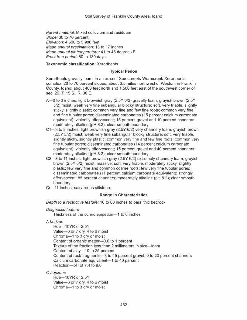
Soil Survey of Franklin County Area, Idaho
462
Parent material: Mixed colluvium and residuumSlope: 30 to 70 percentElevation: 4,500 to 5,900 feetMean annual precipitation: 13 to 17 inchesMean annual air temperature: 41 to 48 degrees FFrost-free period: 80 to 130 days
Taxonomic classification: Xerorthents
Typical Pedon
Xerorthents gravelly loam, in an area of Xerochrepts-Wormcreek-Xerorthentscomplex, 20 to 70 percent slopes; about 3.5 miles northwest of Weston, in FranklinCounty, Idaho; about 400 feet north and 1,500 feet east of the southwest corner ofsec. 29, T. 15 S., R. 38 E.
A—0 to 3 inches; light brownish gray (2.5Y 6/2) gravelly loam, grayish brown (2.5Y5/2) moist; weak very fine subangular blocky structure; soft, very friable, slightlysticky, slightly plastic; common very fine and few fine roots; common very fineand fine tubular pores; disseminated carbonates (15 percent calcium carbonateequivalent); violently effervescent; 15 percent gravel and 10 percent channers;moderately alkaline (pH 8.2); clear smooth boundary.
C1—3 to 8 inches; light brownish gray (2.5Y 6/2) very channery loam, grayish brown(2.5Y 5/2) moist; weak very fine subangular blocky structure; soft, very friable,slightly sticky, slightly plastic; common very fine and few fine roots; common veryfine tubular pores; disseminated carbonates (14 percent calcium carbonateequivalent); violently effervescent; 15 percent gravel and 40 percent channers;moderately alkaline (pH 8.2); clear smooth boundary.
C2—8 to 11 inches; light brownish gray (2.5Y 6/2) extremely channery loam, grayishbrown (2.5Y 5/2) moist; massive; soft, very friable, moderately sticky, slightlyplastic; few very fine and common coarse roots; few very fine tubular pores;disseminated carbonates (11 percent calcium carbonate equivalent); stronglyeffervescent; 85 percent channers; moderately alkaline (pH 8.2); clear smoothboundary.
Cr—11 inches; calcareous siltstone.
Range in Characteristics
Depth to a restrictive feature: 10 to 60 inches to paralithic bedrock
Diagnostic featureThickness of the ochric epipedon—1 to 6 inches
A horizonHue—10YR or 2.5YValue—6 or 7 dry, 4 to 6 moistChroma—1 to 3 dry or moistContent of organic matter—0.0 to 1 percentTexture of the fraction less than 2 millimeters in size—loamContent of clay—10 to 25 percentContent of rock fragments—3 to 45 percent gravel, 0 to 20 percent channersCalcium carbonate equivalent—1 to 40 percentReaction—pH of 7.4 to 9.0
C horizonsHue—10YR or 2.5YValue—6 or 7 dry, 4 to 6 moistChroma—1 to 3 dry or moist

Soil Survey of Franklin County Area, Idaho
463
Content of organic matter—0.0 to 1 percentTexture of the fraction less than 2 millimeters in size—loamContent of clay—10 to 25 percentContent of rock fragments—0 to 70 percent gravel, 35 to 85 percent channersCalcium carbonate equivalent—1 to 40 percentSodium adsorption ratio—0 to 3Electrical conductivity (mmhos/cm)—0 to 2Reaction—pH of 7.4 to 9.0
Yago SeriesDepth class: Very deepDrainage class: Well drainedCapacity of the most limiting layer to transmit water (Ksat): Moderately lowLandscape: MountainsLandform: Mountain slopesParent material: Mixed alluvium and colluviumSlope: 4 to 20 percentElevation: 5,760 to 6,700 feetMean annual precipitation: 18 to 22 inchesMean annual air temperature: 41 to 44 degrees FFrost-free period: 60 to 80 days
Taxonomic classification: Clayey-skeletal, montmorillonitic, frigid Typic Argixerolls
Typical Pedon
Yago extremely stony silty clay loam, in an area of Broadhead-Yago complex, 12 to20 percent slopes; about 3 miles northeast of Lava Hot Springs, in adjacent BannockCounty, Idaho; about 860 feet south and 900 feet west of the northeast corner of sec.24, T. 9 S., R. 38 E.
A—0 to 10 inches; dark grayish brown (10YR 4/2) extremely stony silty clay loam,very dark grayish brown (10YR 3/2) moist; moderate fine and medium subangularblocky structure; hard, firm, moderately sticky, moderately plastic; common veryfine to medium and few coarse roots; many very fine irregular pores along thefaces of peds and common very fine and fine tubular pores; 10 percent gravel, 30percent cobbles, and 20 percent stones; slightly acid (pH 6.5); abrupt irregularboundary.
Bt1—10 to 16 inches; brown (7.5YR 5/4) extremely stony clay loam, brown (7.5YR4/4) moist; moderate fine and medium angular blocky structure; very hard, veryfirm, very sticky, very plastic; common very fine and fine roots; common very fineirregular pores along the faces of peds and common very fine and fine tubularpores; 10 percent gravel, 20 percent cobbles, and 30 percent stones; slightly acid(pH 6.5); gradual irregular boundary.
Bt2—16 to 37 inches; brown (7.5YR 5/4) extremely stony clay loam, brown (7.5YR4/4) moist; moderate medium and coarse angular blocky structure; extremelyhard, very firm, very sticky, very plastic; common very fine and few fine roots;common very fine irregular pores along the faces of peds and few very finetubular pores; many distinct clay films on faces of peds and lining pores; 10percent gravel, 20 percent cobbles, and 30 percent stones; neutral (pH 6.7);abrupt irregular boundary.
Btk—37 to 45 inches; light brown (7.5YR 6/4) extremely stony clay loam, brown(7.5YR 5/4) moist; moderate medium and coarse angular blocky structure;

Soil Survey of Franklin County Area, Idaho
464
extremely hard, very firm, very sticky, very plastic; common very fine roots;common very fine irregular pores along the faces of peds and few very finetubular pores; common distinct clay films on faces of peds and lining pores;common thin carbonate coatings on faces of peds; 10 percent gravel, 20 percentcobbles, and 30 percent stones; neutral (pH 7.2); clear wavy boundary.
Bk—45 to 60 inches; reddish yellow (7.5YR 6/6) extremely stony silty clay loam,strong brown (7.5YR 5/6) moist; massive; slightly hard, friable, moderately sticky,slightly plastic; few very fine and fine roots; few very fine tubular pores; many finerounded iron and manganese concretions; strongly effervescent; 10 percentgravel, 20 percent cobbles, and 30 percent stones; slightly alkaline (pH 7.4).
Range in Characteristics
Depth to a restrictive feature: More than 60 inches
Diagnostic featuresThickness of the mollic epipedon—10 to 20 inchesDepth to an argillic horizon—8 to 14 inchesDepth to secondary carbonates—more than 36 inches
A horizonHue—10YR or 7.5YRValue—3 to 5 dry, 2 or 3 moistChroma—2 or 3 dry or moistContent of organic matter—2 to 4 percentTexture of the fraction less than 2 millimeters in size—silty clay loamContent of clay—27 to 35 percentContent of rock fragments—2 to 15 percent gravel, 14 to 40 percent cobbles, 14
to 25 percent stonesReaction—pH of 5.6 to 6.5
Bt horizonsHue—7.5YR or 5YRValue—4 to 6 dry, 3 or 4 moistChroma—4 to 6 dry or moistContent of organic matter—0.5 to 1 percentTexture of the fraction less than 2 millimeters in size—clay loam, silty clay loam,
clayContent of clay—35 to 50 percentContent of rock fragments—4 to 19 percent gravel, 9 to 23 percent cobbles, 17 to
33 percent stonesCalcium carbonate equivalent—0 to 5 percentReaction—pH of 6.1 to 7.3
Btk and Bk horizonsHue—7.5YR or 5YRValue—4 to 6 dry or moistChroma—4 to 6 dry or moistContent of organic matter—0.0 to 1 percentTexture of the fraction less than 2 millimeters in size—silty clay loam or clay loamContent of clay—27 to 35 percentContent of rock fragments—4 to 19 percent gravel, 9 to 23 percent cobbles, 17 to
33 percent stonesCalcium carbonate equivalent—1 to 10 percentSodium adsorption ratio—0 to 2Reaction—pH of 6.6 to 7.8

Soil Survey of Franklin County Area, Idaho
465
Yeates Hollow SeriesDepth class: Very deepDrainage class: Well drainedCapacity of the most limiting layer to transmit water (Ksat): Moderately lowLandscape: Hills and mountainsLandform: Hillslopes and mountain slopesParent material: Mixed alluvium, colluvium, and residuumSlope: 6 to 50 percentElevation: 5,000 to 6,600 feetMean annual precipitation: 16 to 30 inchesMean annual air temperature: 40 to 45 degrees FFrost-free period: 60 to 90 days
Taxonomic classification: Clayey-skeletal, montmorillonitic, frigid Typic Argixerolls
Typical Pedon
Yeates Hollow cobbly silt loam, in an area of Yeates Hollow-Manila-Softback complex,12 to 40 percent slopes; about 4 miles west and 4 miles south of Thatcher, in FranklinCounty, Idaho; about 1,200 feet south and 2,600 feet east of the northwest corner ofsec. 28, T. 12 S., R. 40 E.
A—0 to 8 inches; dark grayish brown (10YR 4/2) cobbly silt loam, very dark grayishbrown (10YR 3/2) moist; weak very fine granular structure; slightly hard, veryfriable, slightly sticky, slightly plastic; many very fine and common fine to coarseroots; many very fine irregular and common very fine tubular pores; 10 percentgravel and 10 percent cobbles; neutral (pH 7.0); abrupt smooth boundary.
BA—8 to 16 inches; dark grayish brown (10YR 4/2) extremely cobbly loam, darkbrown (7.5YR 3/2) moist; moderate very fine, fine, and medium subangularblocky structure; slightly hard, friable, slightly sticky, moderately plastic; commonvery fine and few fine to coarse roots; common very fine and few fine tubularpores; 15 percent gravel, 35 percent cobbles, and 15 percent stones; slightly acid(pH 6.5); clear wavy boundary.
Bt1—16 to 19 inches; brown (7.5YR 4/2) extremely cobbly clay loam, dark brown(7.5YR 3/2) moist; moderate very fine, fine, and medium angular blocky structure;hard, firm, moderately sticky, moderately plastic; common very fine and few fineto coarse roots; common very fine tubular pores; common distinct clay films onfaces of peds and lining pores; 15 percent gravel, 30 percent cobbles, and 15percent stones; slightly acid (pH 6.5); abrupt wavy boundary.
Bt2—19 to 29 inches; brown (7.5YR 5/4) very cobbly clay, brown (7.5YR 4/4) moist;strong fine, medium, and coarse angular blocky structure; very hard, firm, verysticky, very plastic; few very fine to coarse roots; common very fine tubular pores;many prominent clay films on faces of peds and lining pores; common fine faintstrong brown (7.5YR 5/6) irregularly shaped masses of iron accumulation that arerelict redoximorphic features; common distinct manganese concretions; 15percent gravel, 15 percent cobbles, and 5 percent stones; slightly acid (pH 6.2);abrupt wavy boundary.
Bt3—29 to 60 inches; light brown (7.5YR 6/4) very gravelly clay loam, brown (7.5YR4/4) moist; moderate fine, medium, and coarse subangular blocky structure; hard,firm, moderately sticky, moderately plastic; few very fine to medium roots;common very fine irregular and tubular pores; common distinct clay films onfaces of peds and lining pores; common fine and medium distinct reddish yellow(7.5YR 6/8) irregularly shaped masses of iron accumulation that are relictredoximorphic features; 30 percent gravel and 15 percent cobbles; slightly acid(pH 6.1).

Soil Survey of Franklin County Area, Idaho
466
Range in Characteristics
Depth to a restrictive feature: More than 60 inches
Diagnostic featuresThickness of the mollic epipedon—11 to 19 inchesDepth to an argillic horizon—8 to 16 inches
A horizonHue—10YR or 7.5YRValue—3 to 5 dry, 2 or 3 moistChroma—2 or 3 dry or moistContent of organic matter—2 to 4 percentTexture of the fraction less than 2 millimeters in size—silt loamContent of clay—16 to 20 percentContent of rock fragments—2 to 16 percent gravel, 9 to 20 percent cobblesReaction—pH of 6.6 to 7.3
BA horizonHue—10YR or 7.5YRValue—4 or 5 dry, 2 or 3 moistChroma—2 or 3 dry or moistContent of organic matter—1 to 2 percentTexture of the fraction less than 2 millimeters in size—loamContent of clay—20 to 27 percentContent of rock fragments—2 to 17 percent gravel, 34 to 40 percent cobbles, 6 to
15 percent stonesReaction—pH of 6.1 to 7.3
Bt1 horizonHue—10YR or 7.5YRValue—4 to 7 dry, 3 to 6 moistChroma—2 to 4 dry or moistContent of organic matter—1 to 2 percentTexture of the fraction less than 2 millimeters in size—clay loamContent of clay—28 to 35 percentContent of rock fragments—0 to 28 percent gravel, 23 to 34 percent cobbles, 6 to
31 percent stonesReaction—pH of 6.1 to 7.3
Bt2 horizonHue—10YR or 7.5YRValue—4 to 7 dry, 3 to 6 moistChroma—2 to 4 dry or moistContent of organic matter—0.5 to 1 percentTexture of the fraction less than 2 millimeters in size—clay loam or clayContent of clay—35 to 50 percentContent of rock fragments—1 to 17 percent gravel, 13 to 37 percent cobbles, 0 to
11 percent stonesReaction—pH of 6.1 to 7.3
Bt3 horizonHue—10YR or 7.5YRValue—4 to 7 dry, 3 to 6 moistChroma—2 to 4 dry or moistContent of organic matter—0.0 to 1 percentTexture of the fraction less than 2 millimeters in size—clay loam or clayContent of clay—35 to 50 percent

Soil Survey of Franklin County Area, Idaho
467
Content of rock fragments—0 to 52 percent gravel, 6 to 17 percent cobblesReaction—pH of 6.1 to 7.3
Remarks
The Yeates Hollow soils in this survey area are very deep and are thus outside thedepth range of the official series. This difference, however, does not significantlyaffect use and management of the soils for rangeland.


469
Shawn McVey, soil scientist, and Terril Kay Stevenson, geologist, Natural Resources ConservationService, helped prepare this section.
This section defines soil and relates the factors of soil formation to the soils in thissurvey area.
Soil is a natural body, or a collection of natural bodies, on the earth’s surface thatcontains living matter and supports or is capable of supporting plants. Its upper limit isair or shallow water. At its margins, soil grades to deep water or to areas of bare rock.At its lower limit, it grades to bedrock or to earthy materials virtually devoid of roots,animals, or marks of other biologic activity (USDA, 1975; Soil Survey Staff, 1994).Soil is a dynamic medium forming a living shell of varying thickness over the rockycrust of the earth.
Soil is the result of the interaction of five soil-forming factors (Birkeland, 1984;Jenny, 1941). These factors determine the unique properties and characteristics of asoil at any given location. The five soil-forming factors are: (1) the type andmineralogical composition of the parent material; (2) the different climates that the soilhas been exposed to; (3) the living organisms on and in the soil; (4) the relief, or layof the land; and (5) the length of time that these development forces have acted uponthe soil. The interrelationship of these factors is very complex, and it is difficult toisolate the effects of any one factor. Also, the effect of the factors varies from place toplace. The interaction of the factors ultimately determines the kind of soil that forms.The term “pedogenesis” (soil genesis) commonly refers is to the process of soilformation.
Parent MaterialThe dominant kinds of parent material in the survey area are alluvium and
lacustrine deposits influenced by loess. Of lesser extent are sandy eolian material,residuum, and colluvium. All of the parent materials are derived from various geologicdeposits and bedrock formations.
The most recent deposits are alluvium and eolian fine sands in the Quaternary Siltof the Lake Bonneville Group (Piper, 1924). Gravel strata of this formation occur inareas of alluvial fans and toeslopes on most of the valley sides, especially in theDayton and Clifton area, and on the lower slopes of the mountain ranges (Randolph,1978). The oldest alluvial deposits of the Lake Bonneville Group form the parentmaterial for the soils above the Lake Thatcher and Bonneville Terraces. Theseancient shorelines are especially evident in Mound and Gentile Valleys. The reddishsediments of ancient Lake Bonneville were deposited at elevations of less than 5,200feet about 16,000 to 32,000 years ago. The older, light colored deposits of LakeThatcher extend to an elevation of about 5,400 feet.
The late Tertiary Salt Lake Group consists of tuffaceous rocks and sediments,which generally are on the intermediate and lower slopes above the elevation of theBonneville Terrace (about 5,200 feet), especially on the east face of the Malad Range(Skipp and others, 1980). Bedrock in the mountain ranges consists almost exclusively
Formation of the Soils

Soil Survey of Franklin County Area, Idaho
470
of hard, fractured Upper Paleozoic sedimentary rocks (Ross and Forrester, 1958).The oldest rocks in the survey area are on Oxford Peak, in the Bannock Range.These are Precambrian rocks that are mainly quartzite, argillite, and amphibolite.Soils in the mountainous parts of the survey area vary greatly because of manybedrock lithologies, different slopes and aspects, and different weathering rates.
The formations made up of limestone, calcareous siltstone, and dolomite havecontributed carbonates to most of the soils in the survey area. Another source ofcarbonates is loess carried by the prevailing southwesterly winds, which erodecalcareous lacustrine deposits. Iphil soils are an example of soils influenced bycalcareous loess. Some soils in the mountains formed in the absence of carbonates.They are well developed, have a high content of clay, and/or have a thick, darksurface horizon. Examples of the soils with these properties are Northwater,Softback, and Yeates Hollow soils.
In the southwestern and eastern parts of the survey area, the bedrock geology isdominated by Tertiary volcanic rocks. These rocks formed from volcanic debrisdeposited in ancient pyroclastic flows (Skipp and others, 1980). The soils associatedwith the volcanic rocks formed dominantly in alluvium and residuum that is high incontent of volcanic glass, which is inherited from the local rocks. Copenhagen,Lonigan, Nyman, and Wormcreek soils are dominant in these parts of the surveyarea.
The intermediate terraces and valleys in the survey area have soils with varyingdegrees of development. Elevations range from 4,400 to 5,800 feet. Slopes arenearly level to steep. The soils are dominantly very deep, calcareous, and welldrained and have a dark surface horizon. Huffman, Kidman, Parleys, and Welby soilsare notable in that they all have carbonates. Most commonly, carbonates are leachedfrom the surface downward and accumulate in the lower horizons. These soils occurin Cache, Gentile, and Mound Valleys. Soils at the level of the Bonneville Terracehave gravelly textures because wave action eroded rock outcrops at the edge of theancient lake. Hondoho, Hondee, and Sterling soils are dominant on the BonnevilleTerrace in the eastern and northern parts of Cache Valley.
Some of the soils between elevations of 4,400 and 5,800 feet formed on floodplains and stream terraces bordered by meandering stream channels. Cachecan,Delish, Downata, and Lando soils are examples. They formed in stratified alluviumthat was deposited by floodwater during years of high precipitation. The dominantsoils on flood plains and stream terraces in Mound Valley are Bear Lake, Downata,Lago, and Merkley soils. These soils are characterized by a high content of organicmatter in the surface horizon and carbonates in some part of the profile.
The parent materials in Cache Valley are somewhat similar to those in MoundValley. Cache Valley is a lakebed in which lacustrine and fluvial processes haveinfluenced the parent materials. The lakebed has been dissected by stream action ofthe Bear River and other streams. The soils in Mound Valley differ from the soils inCache Valley mainly in the content of clay and sodium in the subsoil. In Cache Valley,clay is in abundance and sodium occurs at low or moderate levels in the subsoil.Most of the clay and sodium is inherited from the lacustrine deposits. Additionally,applied irrigation water may contribute to the sodium levels in Thatcherflats andTrenton soils. Other common soils in this area are Airport, Ant Flat, Banida, andOxford soils.
ClimateClimate has a strong influence on soil formation. Temperature and precipitation
influence the rate at which parent material weathers. The vegetation that providesorganic matter for soil development is dependent on temperature and precipitation.

Soil Survey of Franklin County Area, Idaho
471
The climate in this survey area is characterized by cool, wet winters and warm, drysummers. The driest and warmest soils are in the southwestern part of the surveyarea, near Weston. These soils receive about 13 inches of precipitation annually. Incontrast, the wettest and coldest soils are in the high mountains, where the annualprecipitation is about 35 to 40 inches. The mean annual air temperature ranges fromabout 48 degrees F in the warmest areas to about 37 degrees F in the coldest areas.
Soil formation in the drier parts of the survey area is relatively slow because of ascarcity of available water for pedogenic processes. The result of the dominantprocess is a relatively high amount of carbonates and salts that remain or accumulatein the soils as ground water evaporates. The main soils in the drier areas are those ofthe Airport, Kidman, Layton, and Welby series.
Soils at elevations of about 5,200 to 6,200 feet have different properties becauseof an increase in precipitation and cooler temperatures. These soils are characterizedby darker surface horizons and lighter colored subsoils with differing amounts ofcarbonates. The darker surface colors are the result of an increase in the content oforganic matter. The lighter subsoil colors occur because carbonates are leached tolower depths in the profile. The dominant soils in this intermediate climatic zone arethose of the Kearns, Parleys, and Thatcher series. The mean annual precipitation inthis zone ranges from 14 to 17 inches. The mean annual air temperature ranges from42 to 46 degrees F.
Soils at an elevation of more than 6,200 feet commonly receive 16 or more inchesof precipitation annually. This additional moisture has leached carbonates to a depthof 18 inches or more in most of the soils. A high content of organic matter in thesesoils is evidenced by dark surface horizons. On Northwater and other soils, thevegetation is abundant because of cool, moist conditions on north-facing slopes.Depending on the landscape position and kind of parent material, a few of the soils,for example, Manila and Broadhead soils, have B horizons with a high content of clay.These argillic horizons form because water percolating through the profile results inthe downward movement and concentration of clay in the B horizons.
Living OrganismsSoil formation is greatly influenced by plant and animal activity. Organic matter,
acidity, and bulk density are the soil characteristics most quickly influenced by thekinds of plants and animals.
The type of vegetation growing on a given soil is dependent on two main factors.The first of these is the amount and quality of the water available to plants, and thesecond is the number of frost-free days.
Near Weston, the natural conditions favor the growth of drought-tolerantvegetation. They limit the density and variety of grasses that can grow. Consequently,the soils receive very little organic matter and are light colored throughout. Thedominant soils in the southwestern part of Cache Valley are Wheelon soils on convexslopes and Collinston soils on concave slopes. The vegetation in this area is basinbig sagebrush, needlegrass, and Indian ricegrass.
In the northern part of Cache Valley, the amount of annual precipitation is higherand the vegetation is more productive. Consequently, the soils have a darker surfacehorizon. The dominant soils are those of the Ant Flat, Parleys, and Winwell series.The grasses are primarily wheatgrasses and bluegrasses. The shrubs are antelopebitterbrush and basin big sagebrush. The plant communities in this area also havesignificant amounts of forbs, primarily arrowleaf balsamroot.
Soils above the level of the Bonneville Terrace formed under conditions that favorthe growth of grasses, forbs, and shrubs. Several species of bluegrass andwheatgrass and many forbs and shrubs contribute significant amounts of organic

Soil Survey of Franklin County Area, Idaho
472
matter to these soils. Hades, Lanoak, and Softback are examples of the soils in thisarea. Microbial activity is the highest in these soils. Rodent and earthworm activitycauses mixing in the soil profile. The mixing improves tilth and fertility. At the highestelevations, between 6,200 and 8,000 feet, the plant communities include conifers onconcave slopes and on north- and east-facing slopes.
ReliefRelief in the survey area is primarily a function of mountain-building activities and
geologic erosion. Relief affects microclimate, drainage, and surface runoff. Thegeneral landscapes of the survey area are plains, lake plains, alluvial plains(piedmont slopes), hills, and mountains. The major landforms within these generallandscapes are lake terraces, fan remnants, dunes, stream terraces, flood plains,hillslopes, and mountain slopes.
The soils on lake plains have slopes of 0 to 4 percent. At elevations of about 4,600feet and lower, the soils commonly are somewhat poorly drained or poorly drainedand have slopes of 0 to 2 percent. Soils at slightly higher elevations are betterdrained and in some areas are on steeper slopes. The water table on the lake plainsis fed by the surrounding area’s ground water tables, which are perched on top ofimpermeable, stratified lake sediments. These sediments are commonly 10 to 20 feetbelow the surface.
From the lowest point on the lake plains to the highest shoreline of ancient LakeBonneville is a vertical distance of about 700 feet. The highest shoreline is marked bysteeper slopes where wave action has etched a horizontal strandline across themountains. This strandline is visible today as the nearly continuous BonnevilleTerrace, which follows the contour of that ancient shoreline. The soils that formed inthe swash zone consist of calcareous silts and rock fragments. They are mapped asCedarhill and Sterling soils. On the highest stream terrace along the Bear River inCache Valley, the alluvial, lacustrine and eolian deposits are sands and sandy loamsand have been mapped as Kidman, Layton, Maplecreek, and Preston soils.
When ancient Lake Bonneville breached a natural barrier at Red Rock Pass,directly north of the survey area, the water level dropped in a relatively short periodand then stabilized at a lower level named the Provo. A second, lower strandlineoccurs where wave action again formed the nearly continuous Provo Terrace. Thevertical distance from the Bonneville Terrace to the Provo Terrace is about 300 feet.
The soils between the level of Cache Valley and the Bonneville Terrace are onnearly level to gently rolling terraces. In the southern part of the survey area, thelandscape is dominated by lake plains. Near the mountains, the landscape graduallychanges to gently rolling alluvial plains (piedmont slopes) and hills. Perennial streamshave cut channels in these areas and have carried sediment from the gently rollingplains and hills. The dominant soils are those of the Ant Flat, Banida, Oxford, andWheelon series. While ancient Lake Bonneville was receding, stream processesoccurred on the emerging lake plain and deposited sandy alluvium. In places,prevailing winds have since reworked these deposits, forming dunes. Preston soilsare on the dunes.
Soils above the level of the Bonneville Terrace are primarily on mountainlandforms. These mountains are oriented north to south in three separate ranges—the Bannock and Malad Ranges on the west and the Bear River Range on the east.The soils on mountains vary greatly with aspect and landform position. The soils onsummits and shoulders generally are shallow and very stony, the soils on backslopesand footslopes are moderately deep to very deep and vary in content of rockfragments, and the soils on toeslopes are very deep and loamy. The dominantmountain soils are those of the Manila, Softback, Vitale, and Yeates Hollow series.
Soil Survey of Franklin County Area, Idaho
473
TimeThe degree of profile development in a soil is a function of how long the parent
material is exposed to the other factors of soil formation. The relative age of a soil ina given area is shown by the degree of development in the soil horizons. If all factorsare the same, except for time, two soils may show significant differences in thecontent of organic matter in the surface horizon, the content of clay in the subsoil,and the depth to soluble minerals, such as calcium carbonate.
The youngest soils in the survey area are Preston soils, which formed in Recentdeposits of sandy eolian material. These soils have very little organic matter, minimalsubsoil development, and little evidence of leaching.
Many of the alluvial soils are old enough to have developed a well expressedtopsoil and subsoil. At elevations below 5,200 feet, soils developed after QuaternaryLake Bonneville receded. Above that elevation, the age of the alluvial soils andsurficial deposits ranges from that of Pleistocene fan remnants on piedmont slopes tothat of Recent deposits on the toeslopes and footslopes of mountains.
Most of the soils below the Bonneville Terrace are of two types. The first type ischaracterized by a dark topsoil, weak subsoil development, and carbonatesthroughout the profile or directly below the subsoil. The dominant soils of this type arethose of the Kearns, Kidman, and Lando series. The second type is characterized bya dark topsoil, strong subsoil development, and a high content of clay. The dominantsoils of this type are those of the Battle Creek, Parleys, and Trenton series.
Some of the older soils in the survey area are on the backslopes of steep mountainslopes. Manila and Vitale soils have been developing for more than 16,000 years.Generally, these soils have a high content of organic matter. In the soils on ridgesand steep slopes, the horizons high in content of organic matter are somewhateroded and may be very thin. Other old soils in the survey area, such as Northwaterand Yeates Hollow soils, are in concave areas on north- and east-facing slopeswhere material being moved downslope during spring runoff accumulates anddevelops with time. A high content of large rock fragments in the soils on mountainlandscapes helps to stabilize the surface and allows soil formation to outpacegeologic erosion. Soils on landforms of a similar age but with minimal developmentare the ashy soils in the southwestern and eastern parts of the survey area. Lonigan,Nyman, and Wormcreek soils, for example, have significant amounts of silica-richvolcanic ash and have fewer large rock fragments on the surface than the Northwaterand Yeates Hollow soils. The accelerated erosion rate on the steep, erodible slopesappears to be the main reason that these ashy soils are much less developed thanother soils on landforms of comparable age.


475
American Association of State Highway and Transportation Officials (AASHTO). 2000.Standard specifications for transportation materials and methods of sampling andtesting. 20th edition, 2 volumes.
American Society for Testing and Materials (ASTM). 2001. Standard classification ofsoils for engineering purposes. ASTM Standard D 2487-00.
Birkeland, Peter W. 1984. Soils and geomorphology. 2nd edition.
Brickell, James E. 1968. A method for constructing site index curves frommeasurements of tree age and height—its application to inland Douglas-fir.USDA, Forest Service, Intermountain Forest and Range Experiment StationResearch Paper INT-47.
Idaho Department of Commerce, Economic Development Division. 1992. Countyprofiles of Idaho.
Jenny, Hans. 1941. Factors of soil formation.
Piper, A.M. 1924. Possibility of petroleum in Power and Oneida Counties, Idaho.Idaho Bureau of Mines and Geology (I.G.S.), Moscow, Pamphlet 12.
Randolph, R. 1978. Outline of the geologic history and stratigraphy of the Bear LakePlanning Unit.
Ross, C.P., and J.D. Forrester. 1958. Outline of the geology of Idaho. Idaho Bureau ofMines and Geology (I.G.S.), Moscow, Bulletin 15.
Skipp, B., W.J. Sando, and W.E. Hall. 1980. The Mississippian and Pennsylvainian(Carboniferous) Systems in the United States—Idaho. Idaho Bureau of Mines andGeology (I.G.S.), Moscow, Reprint 1.
Soil Survey Division Staff. 1993. Soil survey manual. Soil Conservation Service. U.S.Department of Agriculture Handbook 18.
Soil Survey Staff. 1994. Keys to soil taxonomy. 6th edition. U.S. Department ofAgriculture, Natural Resources Conservation Service.
Steele, R. 1983. Forest habitat types of eastern Idaho-western Wyoming. USDA,Forest Service, General Technical Report INT 144, Ogden, Utah.
United States Department of Agriculture, Natural Resources Conservation Service.National soil survey handbook, title 430-VI. http://soils.usda.gov/technical/
United States Department of Agriculture, Soil Conservation Service. 1961. Landcapability classification. U.S. Department of Agriculture Handbook 210.
United States Department of Agriculture, Soil Conservation Service. 1975. Soiltaxonomy: A basic system of soil classification for making and interpreting soilsurveys. U.S. Department of Agriculture Handbook 436.
References

Soil Survey of Franklin County Area, Idaho
476
United States Department of Agriculture, Soil Conservation Service. 1981. Landresource regions and major land resource areas of the United States. U.S.Department of Agriculture Handbook 296.

477
Aggregate, soil. Many fine particles held in a single mass or cluster. Natural soilaggregates, such as granules, blocks, or prisms, are called peds. Clods areaggregates produced by tillage or logging.
Alkali (sodic) soil. A soil having so high a degree of alkalinity (pH 8.5 or higher) orso high a percentage of exchangeable sodium (15 percent or more of the totalexchangeable bases), or both, that plant growth is restricted.
Alluvial fan. The fanlike deposit of a stream where it issues from a canyon upon aplain (piedmont slope) or of a tributary stream near or at its junction with its mainstream.
Alluvium. Material, such as sand, silt, or clay, deposited on land by streams.Animal unit month (AUM). The amount of forage required by one mature cow of
approximately 1,000 pounds weight, with or without a calf, for 1 month.Aquic conditions. Current soil wetness characterized by saturation, reduction, and
redoximorphic features.Argillic horizon. A subsoil horizon characterized by an accumulation of illuvial clay.Aspect. The direction in which a slope faces.Association, soil. A group of soils or miscellaneous areas geographically associated
in a characteristic repeating pattern and defined and delineated as a single mapunit.
Available water capacity (available moisture capacity). The capacity of soils tohold water available for use by most plants. It is commonly defined as thedifference between the amount of soil water at field moisture capacity and theamount at wilting point. It is commonly expressed as inches of water per inch ofsoil. The capacity, in inches, in a 60-inch profile or to a limiting layer is expressedas:
Very low .............................................................. 0 to 3Low ...................................................................... 3 to 6Moderate ............................................................. 6 to 9High ................................................................... 9 to 12Very high ................................................ more than 12
Backslope. The position that forms the steepest and generally linear, middle portionof a hillslope. In profile, backslopes are commonly bounded by a convex shoulderabove and a concave footslope below.
Basal area. The area of a cross section of a tree trunk, generally referring to thesection at breast height and measured outside the bark. It is a measure of standdensity, commonly expressed in square feet. Basal area per acre is the sum ofbasal areas of the individual trees on an acre.
Base saturation. The degree to which material having cation-exchange properties issaturated with exchangeable bases (sum of Ca, Mg, Na, and K), expressed as apercentage of the total cation-exchange capacity.
Bedrock. The solid rock that underlies the soil and other unconsolidated material orthat is exposed at the surface.
Boulders. Rock fragments larger than 2 feet (60 centimeters) in diameter.
Glossary

Soil Survey of Franklin County Area, Idaho
478
Brush management. Use of mechanical, chemical, or biological methods to makeconditions favorable for reseeding or to reduce or eliminate competition fromwoody vegetation and thus allow understory grasses and forbs to recover. Brushmanagement increases forage production and thus reduces the hazard oferosion. It can improve the habitat for some species of wildlife.
Butte. An isolated small mountain or hill with steep or precipitous sides and a topvariously flat, rounded, or pointed that may be a residual mass isolated byerosion or an exposed volcanic neck.
Calcareous soil. A soil containing enough calcium carbonate (commonly combinedwith magnesium carbonate) to effervesce visibly when treated with cold, dilutehydrochloric acid.
California bearing ratio (CBR). The load-supporting capacity of a soil as comparedto that of standard crushed limestone, expressed as a ratio. First standardized inCalifornia. A soil having a CBR of 16 supports 16 percent of the load that wouldbe supported by standard crushed limestone, per unit area, with the same degreeof distortion.
Canyon. A long, deep, narrow, very steep sided valley with high, precipitous walls inan area of high local relief.
Capillary water. Water held as a film around soil particles and in tiny spacesbetween particles. Surface tension is the adhesive force that holds capillary waterin the soil.
Cation. An ion carrying a positive charge of electricity. The common soil cations arecalcium, potassium, magnesium, sodium, and hydrogen.
Cation-exchange capacity. The total amount of exchangeable cations that can beheld by the soil, expressed in terms of milliequivalents per 100 grams of soil atneutrality (pH 7.0) or at some other stated pH value. The term, as applied to soils,is synonymous with base-exchange capacity but is more precise in meaning.
Channery soil material. Soil material that has, by volume, 15 to 35 percent thin, flatfragments of sandstone, shale, slate, limestone, or schist as much as 6 inches(15 centimeters) along the longest axis. A single piece is called a channer.
Chemical treatment. Control of unwanted vegetation through the use of chemicals.Chiseling. Tillage with an implement having one or more soil-penetrating points that
shatter or loosen hard, compacted layers to a depth below normal plow depth.Clay. As a soil separate, the mineral soil particles less than 0.002 millimeter in
diameter. As a soil textural class, soil material that is 40 percent or more clay,less than 45 percent sand, and less than 40 percent silt.
Clay film. A thin coating of oriented clay on the surface of a soil aggregate or liningpores or root channels. Synonyms: clay coating, clay skin.
Claypan. A slowly permeable soil horizon that contains much more clay than thehorizons above it. A claypan is commonly hard when dry and plastic or stiff whenwet.
Climax plant community. The stabilized plant community on a particular site. Theplant cover reproduces itself and does not change so long as the environmentremains the same.
Coarse textured soil. Sand or loamy sand.Cobble (or cobblestone). A rounded or partly rounded fragment of rock 3 to 10
inches (7.6 to 25 centimeters) in diameter.Cobbly soil material. Material that has 15 to 35 percent, by volume, rounded or
partially rounded rock fragments 3 to 10 inches (7.6 to 25 centimeters) indiameter. Very cobbly soil material has 35 to 60 percent of these rock fragments,and extremely cobbly soil material has more than 60 percent.
COLE (coefficient of linear extensibility). See Linear extensibility.Colluvium. Soil material or rock fragments, or both, moved by creep, slide, or local
wash and deposited at the base of steep slopes.

Soil Survey of Franklin County Area, Idaho
479
Complex, soil. A map unit of two or more kinds of soil or miscellaneous areas insuch an intricate pattern or so small in area that it is not practical to map themseparately at the selected scale of mapping. The pattern and proportion of thesoils or miscellaneous areas are somewhat similar in all areas.
Concretions. Cemented bodies with crude internal symmetry organized around apoint, a line, or a plane. They typically take the form of concentric layers visible tothe naked eye. Calcium carbonate, iron oxide, and manganese oxide arecommon compounds making up concretions. If formed in place, concretions ofiron oxide or manganese oxide are generally considered a type of redoximorphicconcentration.
Conglomerate. A coarse grained, clastic rock composed of rounded or subangularrock fragments more than 2 millimeters in diameter. It commonly has a matrix ofsand and finer textured material. Conglomerate is the consolidated equivalent ofgravel.
Conservation cropping system. Growing crops in combination with needed culturaland management practices. In a good conservation cropping system, the soil-improving crops and practices more than offset the effects of the soil-depletingcrops and practices. Cropping systems are needed on all tilled soils. Soil-improving practices in a conservation cropping system include the use ofrotations that contain grasses and legumes and the return of crop residue to thesoil. Other practices include the use of green manure crops of grasses andlegumes, proper tillage, adequate fertilization, and weed and pest control.
Conservation tillage. A tillage system that does not invert the soil and that leaves aprotective amount of crop residue on the surface throughout the year.
Consistence, soil. Refers to the degree of cohesion and adhesion of soil materialand its resistance to deformation when ruptured. Consistence includes resistanceof soil material to rupture and to penetration; plasticity, toughness, and stickinessof puddled soil material; and the manner in which the soil material behaves whensubject to compression. Terms describing consistence are defined in the “SoilSurvey Manual.”
Contour stripcropping. Growing crops in strips that follow the contour. Strips ofgrass or close-growing crops are alternated with strips of clean-tilled crops orsummer fallow.
Control section. The part of the soil on which classification is based. The thicknessvaries among different kinds of soil, but for many it is that part of the soil profilebetween depths of 10 inches and 40 or 80 inches.
Corrosion. Soil-induced electrochemical or chemical action that dissolves orweakens concrete or uncoated steel.
Cover crop. A close-growing crop grown primarily to improve and protect the soilbetween periods of regular crop production, or a crop grown between trees andvines in orchards and vineyards.
Crop residue management. Returning crop residue to the soil, which helps tomaintain soil structure, organic matter content, and fertility and helps to controlerosion.
Cropping system. Growing crops according to a planned system of rotation andmanagement practices.
Cross-slope farming. Deliberately conducting farming operations on slopingfarmland in such a way that tillage is across the general slope.
Cutbanks cave (in tables). The walls of excavations tend to cave in or slough.Decreasers. The most heavily grazed climax range plants. Because they are the
most palatable, they are the first to be destroyed by overgrazing.Deferred grazing. Postponing grazing or resting grazing land for a prescribed period.

Soil Survey of Franklin County Area, Idaho
480
Dense layer (in tables). A very firm, massive layer that has a bulk density of morethan 1.8 grams per cubic centimeter. Such a layer affects the ease of digging andcan affect filling and compacting.
Depression. Any relatively sunken part of the earth’s surface, especially a low-lyingarea surrounded by higher ground.
Depth, soil. Generally, the thickness of the soil over bedrock. Very deep soils aremore than 60 inches deep over bedrock; deep soils, 40 to 60 inches; moderatelydeep, 20 to 40 inches; shallow, 10 to 20 inches; and very shallow, less than 10inches.
Diversion (or diversion terrace). A ridge of earth, generally a terrace, built to protectdownslope areas by diverting runoff from its natural course.
Divided-slope farming. A form of field stripcropping in which crops are grown in asystematic arrangement of two strips, or bands, across the slope to reduce thehazard of water erosion. One strip is in a close-growing crop that providesprotection from erosion, and the other strip is in a crop that provides lessprotection from erosion. This practice is used where slopes are not long enoughto permit a full stripcropping pattern to be used.
Drainage class (natural). Refers to the frequency and duration of wet periods underconditions similar to those under which the soil formed. Alterations of the waterregime by human activities, either through drainage or irrigation, are not aconsideration unless they have significantly changed the morphology of the soil.Seven classes of natural soil drainage are recognized—excessively drained,somewhat excessively drained, well drained, moderately well drained, somewhatpoorly drained, poorly drained, and very poorly drained. These classes aredefined in the “Soil Survey Manual.”
Drainage, surface. Runoff, or surface flow of water, from an area.Draw. A small stream valley that generally is more open and has broader bottom land
than a ravine or gulch.Duff. A generally firm organic layer on the surface of mineral soils. It consists of fallen
plant material that is in the process of decomposition and includes everythingfrom the litter on the surface to underlying pure humus.
Dune. A low mound, ridge, bank, or hill of loose, windblown, subaerially deposited,granular material (generally sand). Dunes either are barren and capable ofmovement from place to place or are covered and stabilized with vegetation.They retain their characteristic shape.
Ecological site. An area where climate, soil, and relief are sufficiently uniform toproduce a distinct natural plant community. An ecological site is the product of allthe environmental factors responsible for its development. It is typified by anassociation of species that differ from those on other ecological sites in kindand/or proportion of species or in total production.
Eluviation. The movement of material in true solution or colloidal suspension fromone place to another within the soil. Soil horizons that have lost material througheluviation are eluvial; those that have received material are illuvial.
Endosaturation. A type of saturation of the soil in which all horizons between theupper boundary of saturation and a depth of 2 meters are saturated.
Eolian soil material. Earthy parent material accumulated through wind action;commonly refers to sandy material in dunes or to loess in blankets on thesurface.
Episaturation. A type of saturation indicating a perched water table in a soil in whichsaturated layers are underlain by one or more unsaturated layers within 2 metersof the surface.
Erosion. The wearing away of the land surface by water, wind, ice, or other geologicagents and by such processes as gravitational creep.

Soil Survey of Franklin County Area, Idaho
481
Erosion (geologic). Erosion caused by geologic processes acting over longgeologic periods and resulting in the wearing away of mountains and the buildingup of such landscape features as flood plains and coastal plains. Synonym:natural erosion.Erosion (accelerated). Erosion much more rapid than geologic erosion, mainly asa result of human or animal activities or of a catastrophe in nature, such as a fire,that exposes the surface.
Escarpment. A relatively continuous and steep slope or cliff breaking the generalcontinuity of more gently sloping land surfaces and resulting from erosion orfaulting. Synonym: scarp.
Fallow. Cropland left idle in order to restore productivity through accumulation ofmoisture. Summer fallow is common in regions of limited rainfall where cerealgrain is grown. The soil is tilled for at least one growing season for weed controland decomposition of plant residue.
Fan remnant. A relict alluvial fan, no longer a site of active deposition, incised byyounger and lower alluvial surfaces.
Fertility, soil. The quality that enables a soil to provide plant nutrients, in adequateamounts and in proper balance, for the growth of specified plants when light,moisture, temperature, tilth, and other growth factors are favorable.
Field moisture capacity. The moisture content of a soil, expressed as a percentageof the ovendry weight, after the gravitational, or free, water has drained away; thefield moisture content 2 or 3 days after a soaking rain; also called normal fieldcapacity, normal moisture capacity, or capillary capacity.
Fine textured soil. Sandy clay, silty clay, or clay.First bottom. The normal flood plain of a stream, subject to frequent or occasional
flooding.Flaggy soil material. Material that has, by volume, 15 to 35 percent flagstones. Very
flaggy soil material has 35 to 60 percent flagstones, and extremely flaggy soilmaterial has more than 60 percent flagstones.
Flagstone. A thin fragment of sandstone, limestone, slate, shale, or (rarely) schist 6to 15 inches (15 to 38 centimeters) long.
Flood plain. A nearly level alluvial plain that borders a stream and is subject toflooding unless protected artificially.
Fluvial. Of or pertaining to rivers; produced by river action, as a fluvial plain.Foothill. A steeply sloping upland that has relief of as much as 1,000 feet (300
meters) and fringes a mountain range or high-plateau escarpment.Footslope. The position that forms the inner, gently inclined surface at the base of a
hillslope. In profile, footslopes are commonly concave. A footslope is a transitionzone between upslope sites of erosion and transport (shoulders and backslopes)and downslope sites of deposition (toeslopes).
Forb. Any herbaceous plant not a grass or a sedge.Genesis, soil. The mode of origin of the soil. Refers especially to the processes or
soil-forming factors responsible for the formation of the solum, or true soil, fromthe unconsolidated parent material.
Gleyed soil. Soil that formed under poor drainage, resulting in the reduction of ironand other elements in the profile and in gray colors.
Grassed waterway. A natural or constructed waterway, typically broad and shallow,seeded to grass as protection against erosion. Conducts surface water awayfrom cropland.
Gravel. Rounded or angular fragments of rock as much as 3 inches (2 millimeters to7.6 centimeters) in diameter. An individual piece is a pebble.
Gravelly soil material. Material that has 15 to 35 percent, by volume, rounded orangular rock fragments, not prominently flattened, as much as 3 inches (7.6centimeters) in diameter.

Soil Survey of Franklin County Area, Idaho
482
Green manure crop (agronomy). A soil-improving crop grown to be plowed under inan early stage of maturity or soon after maturity.
Ground water. Water filling all the unblocked pores of the material below the watertable.
Gully. A miniature valley with steep sides cut by running water and through whichwater ordinarily runs only after rainfall. The distinction between a gully and a rill isone of depth. A gully generally is an obstacle to farm machinery and is too deepto be obliterated by ordinary tillage; a rill is of lesser depth and can be smoothedover by ordinary tillage.
Habitat types. Land areas that are capable of producing similar plant communities atthe climax ecological stage (the culminating stage in forest succession) for thesite.
Hard bedrock. Bedrock that cannot be excavated except by blasting or by the use ofspecial equipment that is not commonly used in construction.
Hard to reclaim (in tables). Reclamation is difficult after the removal of soil forconstruction and other uses. Revegetation and erosion control are extremelydifficult.
Hardpan. A hardened or cemented soil horizon, or layer. The soil material is sandy,loamy, or clayey and is cemented by iron oxide, silica, calcium carbonate, orother substance.
High-residue crops. Such crops as small grain and corn used for grain. If properlymanaged, residue from these crops can be used to control erosion until the nextcrop in the rotation is established. These crops return large amounts of organicmatter to the soil.
Hill. A natural elevation of the land surface, rising as much as 1,000 feet abovesurrounding lowlands, commonly of limited summit area and having a welldefined outline; hillsides generally have slopes of more than 15 percent. Thedistinction between a hill and a mountain is arbitrary and is dependent on localusage.
Horizon, soil. A layer of soil, approximately parallel to the surface, having distinctcharacteristics produced by soil-forming processes. In the identification of soilhorizons, an uppercase letter represents the major horizons. Numbers orlowercase letters that follow represent subdivisions of the major horizons. Anexplanation of the subdivisions is given in the “Soil Survey Manual.” The majorhorizons of mineral soil are as follows:O horizon.—An organic layer of fresh and decaying plant residue.A horizon.—The mineral horizon at or near the surface in which an accumulationof humified organic matter is mixed with the mineral material. Also, a plowedsurface horizon, most of which was originally part of a B horizon.E horizon.—The mineral horizon in which the main feature is loss of silicate clay,iron, aluminum, or some combination of these.B horizon.—The mineral horizon below an A horizon. The B horizon is in part alayer of transition from the overlying A to the underlying C horizon. The B horizonalso has distinctive characteristics, such as (1) accumulation of clay,sesquioxides, humus, or a combination of these; (2) prismatic or blocky structure;(3) redder or browner colors than those in the A horizon; or (4) a combination ofthese.C horizon.—The mineral horizon or layer, excluding indurated bedrock, that islittle affected by soil-forming processes and does not have the properties typicalof the overlying soil material. The material of a C horizon may be either like orunlike that in which the solum formed. If the material is known to differ from that inthe solum, an Arabic numeral, commonly a 2, precedes the letter C.Cr layer.—Soft, consolidated bedrock beneath the soil.

Soil Survey of Franklin County Area, Idaho
483
R layer.—Consolidated bedrock beneath the soil. The bedrock commonlyunderlies a C horizon, but it can be directly below an A or a B horizon.
Humus. The well decomposed, more or less stable part of the organic matter inmineral soils.
Hydrologic soil groups. Refers to soils grouped according to their runoff potential.The soil properties that influence this potential are those that affect the minimumrate of water infiltration on a bare soil during periods after prolonged wettingwhen the soil is not frozen. These properties are depth to a seasonal high watertable, the infiltration rate and permeability after prolonged wetting, and depth to avery slowly permeable layer. The slope and the kind of plant cover are notconsidered but are separate factors in predicting runoff.
Igneous rock. Rock formed by solidification from a molten or partially molten state.Major varieties include plutonic and volcanic rock. Examples are andesite, basalt,and granite.
Illuviation. The movement of soil material from one horizon to another in the soilprofile. Generally, material is removed from an upper horizon and deposited in alower horizon.
Impervious soil. A soil through which water, air, or roots penetrate slowly or not atall. No soil is absolutely impervious to air and water all the time.
Increasers. Species in the climax vegetation that increase in amount as the moredesirable plants are reduced by close grazing. Increasers commonly are theshorter plants and the less palatable to livestock.
Infiltration. The downward entry of water into the immediate surface of soil or othermaterial, as contrasted with percolation, which is movement of water through soillayers or material.
Infiltration rate. The rate at which water penetrates the surface of the soil at anygiven instant, usually expressed in inches per hour. The rate can be limited by theinfiltration capacity of the soil or the rate at which water is applied at the surface.
Intake rate. The average rate of water entering the soil under irrigation. Most soilshave a fast initial rate; the rate decreases with application time. Therefore, intakerate for design purposes is not a constant but is a variable depending on the netirrigation application.
Interfluve. An elevated area between two drainageways that sheds water to thosedrainageways.
Intermittent stream. A stream, or reach of a stream, that flows for prolonged periodsonly when it receives ground-water discharge or long, continued contributionsfrom melting snow or other surface and shallow subsurface sources.
Invaders. On range, plants that encroach into an area and grow after the climaxvegetation has been reduced by grazing. Generally, plants invade followingdisturbance of the surface.
Iron depletions. Low-chroma zones having a low content of iron and manganeseoxide because of chemical reduction and removal, but having a clay contentsimilar to that of the adjacent matrix. A type of redoximorphic depletion.
Irrigation. Application of water to soils to assist in production of crops. Methods ofirrigation are:Basin.—Water is applied rapidly to nearly level plains surrounded by levees ordikes.Border.—Water is applied at the upper end of a strip in which the lateral flow ofwater is controlled by small earth ridges called border dikes, or borders.Controlled flooding.—Water is released at intervals from closely spaced fieldditches and distributed uniformly over the field.Corrugation.—Water is applied to small, closely spaced furrows or ditches infields of close-growing crops or in orchards so that it flows in only one direction.Drip (or trickle).—Water is applied slowly and under low pressure to the surface

Soil Survey of Franklin County Area, Idaho
484
of the soil or into the soil through such applicators as emitters, porous tubing, orperforated pipe.Furrow.—Water is applied in small ditches made by cultivation implements.Furrows are used for tree and row crops.Sprinkler.—Water is sprayed over the soil surface through pipes or nozzles froma pressure system.
Ksat. Saturated hydraulic conductivity. (Also see Permeability.) Terms describingclasses of saturated hydraulic conductivity, measured in inches per hour, are asfollows:
Very low ................................ less than 0.001417 inchLow ..................................... 0.001417 to 0.01417 inchModerately low ....................... 0.01417 to 0.1417 inchModerately high .............. 0.1417 inch to 1.417 inchesHigh ........................................... 1.417 to 14.17 inchesVery high ............................... more than 14.17 inches
Lacustrine deposit. Material deposited in lake water and exposed when the waterlevel is lowered or the elevation of the land is raised.
Lake plain. A nearly level surface marking the floor of an extinct lake filled by wellsorted, generally fine textured, stratified deposits.
Large stones (in tables). Rock fragments 3 inches (7.6 centimeters) or more across.Large stones adversely affect the specified use of the soil.
Leaching. The removal of soluble material from soil or other material by percolatingwater.
Linear extensibility. Refers to the change in length of an unconfined clod asmoisture content is decreased from a moist to a dry state. Linear extensibility isused to determine the shrink-swell potential of soils. It is an expression of thevolume change between the water content of the clod at 1/3- or 1/10-bar tension(33kPa or 10kPa tension) and oven dryness. Volume change is influenced by theamount and type of clay minerals in the soil. The volume change is the percentchange for the whole soil. If it is expressed as a fraction, the resulting value isCOLE, coefficient of linear extensibility.
Liquid limit. The moisture content at which the soil passes from a plastic to a liquidstate.
Loam. Soil material that is 7 to 27 percent clay particles, 28 to 50 percent siltparticles, and less than 52 percent sand particles.
Loess. Fine grained material, dominantly of silt-sized particles, deposited by wind.Low strength. The soil is not strong enough to support loads.Low-residue crops. Such crops as corn used for silage, peas, beans, and potatoes.
Residue from these crops is not adequate to control erosion until the next crop inthe rotation is established. These crops return little organic matter to the soil.
Masses. Concentrations of substances in the soil matrix that do not have a clearlydefined boundary with the surrounding soil material and cannot be removed as adiscrete unit. Common compounds making up masses are calcium carbonate,gypsum or other soluble salts, iron oxide, and manganese oxide. Massesconsisting of iron oxide or manganese oxide generally are considered a type ofredoximorphic concentration.
Mechanical treatment. Use of mechanical equipment for seeding, brushmanagement, and other management practices.
Medium textured soil. Very fine sandy loam, loam, silt loam, or silt.Metamorphic rock. Rock of any origin altered in mineralogical composition, chemical
composition, or structure by heat, pressure, and movement. Nearly all such rocksare crystalline.
Mineral soil. Soil that is mainly mineral material and low in content of organicmaterial. Its bulk density is more than that of organic soil.

Soil Survey of Franklin County Area, Idaho
485
Minimum tillage. Only the tillage essential to crop production and prevention of soildamage.
Miscellaneous area. An area that has little or no natural soil and supports little or novegetation.
Moderately coarse textured soil. Coarse sandy loam, sandy loam, or fine sandyloam.
Moderately fine textured soil. Clay loam, sandy clay loam, or silty clay loam.Mollic epipedon. A thick, dark, humus-rich surface horizon (or horizons) that has
high base saturation and pedogenic soil structure. It may include the upper partof the subsoil.
Morphology, soil. The physical makeup of the soil, including the texture, structure,porosity, consistence, color, and other physical, mineral, and biological propertiesof the various horizons, and the thickness and arrangement of those horizons inthe soil profile.
Mottling, soil. Irregular spots of different colors that vary in number and size.Descriptive terms are as follows: abundance—few, common, and many; size—fine, medium, and coarse; and contrast—faint, distinct, and prominent. The sizemeasurements are of the diameter along the greatest dimension. Fine indicatesless than 5 millimeters (about 0.2 inch); medium, from 5 to 15 millimeters (about0.2 to 0.6 inch); and coarse, more than 15 millimeters (about 0.6 inch).
Mountain. A natural elevation of the land surface, rising more than 1,000 feet abovesurrounding lowlands, commonly of restricted summit area (relative to a plateau)and generally having steep sides. A mountain can occur as a single, isolatedmass or in a group forming a chain or range.
Mountain slope. A part of a mountain between the summit and the foot.Munsell notation. A designation of color by degrees of three simple variables—hue,
value, and chroma. For example, a notation of 10YR 6/4 is a color with hue of10YR, value of 6, and chroma of 4.
Natric horizon. A special kind of argillic horizon that contains enough exchangeablesodium to have an adverse effect on the physical condition of the subsoil.
Natural regeneration. The establishment of tree seedlings through natural seeding.Neutral soil. A soil having a pH value of 6.6 to 7.3. (See Reaction, soil.)Nodules. Cemented bodies lacking visible internal structure. Calcium carbonate, iron
oxide, and manganese oxide are common compounds making up nodules. Ifformed in place, nodules of iron oxide or manganese oxide are considered typesof redoximorphic concentrations.
Nutrient, plant. Any element taken in by a plant essential to its growth. Plantnutrients are mainly nitrogen, phosphorus, potassium, calcium, magnesium,sulfur, iron, manganese, copper, boron, and zinc obtained from the soil andcarbon, hydrogen, and oxygen obtained from the air and water.
Organic matter. Plant and animal residue in the soil in various stages ofdecomposition.
Paleozoic. The era of geologic time following the Precambrian and preceding theMesozoic (from approximately 570 to 243 million years ago).
Pan. A compact, dense layer in a soil that impedes the movement of water and thegrowth of roots. For example, hardpan, duripan, claypan, plowpan, and trafficpan.
Parent material. The unconsolidated organic and mineral material in which soilforms.
Ped. An individual natural soil aggregate, such as a granule, a prism, or a block.Pedon. The smallest volume that can be called “a soil.” A pedon is three dimensional
and large enough to permit study of all horizons. Its area ranges from about 10 to100 square feet (1 square meter to 10 square meters), depending on thevariability of the soil.

Soil Survey of Franklin County Area, Idaho
486
Percolation. The movement of water through the soil.Permeability. The quality of the soil that enables water or air to move downward
through the profile. The rate at which a saturated soil transmits water is acceptedas a measure of this quality. In soil physics, the rate is referred to as “saturatedhydraulic conductivity (Ksat),” which is defined in the “Soil Survey Manual.” In linewith conventional usage in the engineering profession and with traditional usagein published soil surveys, this rate of flow continues to be expressed as“permeability.” Terms describing permeability, measured in inches per hour, areas follows:
Impermeable ............................. less than 0.0015 inchVery slow ...................................... 0.0015 to 0.06 inchSlow .................................................... 0.06 to 0.2 inchModerately slow .................................... 0.2 to 0.6 inchModerate ................................... 0.6 inch to 2.0 inchesModerately rapid ............................... 2.0 to 6.0 inchesRapid .................................................. 6.0 to 20 inchesVery rapid ................................... more than 20 inches
pH value. A numerical designation of acidity and alkalinity in soil. (See Reaction,soil.)
Phase, soil. A subdivision of a soil series based on features that affect its use andmanagement, such as slope, stoniness, and flooding.
Piedmont slope. The dominant gentle slope at the foot of a mountain. Piedmontslopes grade to basin-floor depressions with alluvial and temporary lake plains orto surfaces associated with through drainage.
Piping (in tables). Formation of subsurface tunnels or pipelike cavities by watermoving through the soil.
Plastic limit. The moisture content at which a soil changes from semisolid to plastic.Plasticity index. The numerical difference between the liquid limit and the plastic
limit; the range of moisture content within which the soil remains plastic.Playa. The generally dry and nearly level lake plain that occupies the lowest parts of
closed depressional areas, such as those on intermontane basin floors.Temporary flooding occurs primarily in response to precipitation and runoff.
Pleistocene. The first epoch of the Quaternary Period of geologic time, following theTertiary Pliocene and preceding the Holocene (from approximately 2 million to 10thousand years ago).
Plowpan. A compacted layer formed in the soil directly below the plowed layer.Ponding. Standing water on soils in closed depressions. Unless the soils are
artificially drained, the water can be removed only by percolation orevapotranspiration.
Poorly graded. Refers to a coarse grained soil or soil material consisting mainly ofparticles of nearly the same size. Because there is little difference in size of theparticles, density can be increased only slightly by compaction.
Potential native plant community. See Climax plant community.Potential rooting depth (effective rooting depth). Depth to which roots could
penetrate if the content of moisture in the soil were adequate. The soil has noproperties restricting the penetration of roots to this depth.
Precambrian. All geologic time before the beginning of the Paleozoic (prior to 570million years ago).
Prescribed burning. Deliberately burning an area for specific managementpurposes, under the appropriate conditions of weather and soil moisture and atthe proper time of day.
Productivity, soil. The capability of a soil for producing a specified plant or sequenceof plants under specific management.

Soil Survey of Franklin County Area, Idaho
487
Profile, soil. A vertical section of the soil extending through all its horizons and intothe parent material.
Proper grazing use. Grazing at an intensity that maintains enough cover to protectthe soil and maintain or improve the quantity and quality of the desirablevegetation. This practice increases the vigor and reproduction capacity of the keyplants and promotes the accumulation of litter and mulch necessary to conservesoil and water.
Quaternary. The second period of the Cenozoic Era of geologic time, extending fromthe end of the Tertiary Period (about 2 million years ago) to the present andcomprising two epochs, the Pleistocene (Ice Age) and Holocene (Recent).
Range condition. The present composition of the plant community on a range site inrelation to the potential natural plant community for that site. Range condition isexpressed as excellent, good, fair, or poor on the basis of how much the presentplant community has departed from the potential.
Range site. An area of rangeland where climate, soil, and relief are sufficientlyuniform to produce a distinct natural plant community. A range site is the productof all the environmental factors responsible for its development. It is typified by anassociation of species that differ from those on other range sites in kind orproportion of species or total production.
Rangeland. Land on which the potential natural vegetation is predominantly grasses,grasslike plants, forbs, or shrubs suitable for grazing or browsing. It includesnatural grasslands, savannas, many wetlands, some deserts, tundras, and areasthat support certain forb and shrub communities.
Reaction, soil. A measure of acidity or alkalinity of a soil, expressed in pH values. Asoil that tests to pH 7.0 is described as precisely neutral in reaction because it isneither acid nor alkaline. The degrees of acidity or alkalinity, expressed as pHvalues, are:
Ultra acid ................................................. less than 3.5Extremely acid .............................................. 3.5 to 4.4Very strongly acid .........................................4.5 to 5.0Strongly acid ................................................. 5.1 to 5.5Moderately acid ............................................5.6 to 6.0Slightly acid ................................................... 6.1 to 6.5Neutral .......................................................... 6.6 to 7.3Slightly alkaline ............................................. 7.4 to 7.8Moderately alkaline ......................................7.9 to 8.4Strongly alkaline ........................................... 8.5 to 9.0Very strongly alkaline .......................... 9.1 and higher
Redoximorphic concentrations. Nodules, concretions, soft masses, pore linings,and other features resulting from the accumulation of iron or manganese oxide.An indication of chemical reduction and oxidation resulting from saturation.
Redoximorphic depletions. Low-chroma zones from which iron and manganeseoxide or a combination of iron and manganese oxide and clay has been removed.These zones are indications of the chemical reduction of iron resulting fromsaturation.
Redoximorphic features. Redoximorphic concentrations, redoximorphic depletions,reduced matrices, a positive reaction to alpha,alpha-dipyridyl, and other featuresindicating the chemical reduction and oxidation of iron and manganesecompounds resulting from saturation.
Reduced matrix. A soil matrix that has low chroma in situ because of chemicallyreduced iron (Fe II). The chemical reduction results from nearly continuouswetness. The matrix undergoes a change in hue or chroma within 30 minutesafter exposure to air as the iron is oxidized (Fe III). A type of redoximorphicfeature.

Soil Survey of Franklin County Area, Idaho
488
Regolith. The unconsolidated mantle of weathered rock and soil material on theearth’s surface; the loose earth material above the solid rock.
Relief. The elevations or inequalities of a land surface, considered collectively.Residuum (residual soil material). Unconsolidated, weathered or partly weathered
mineral material that accumulated as consolidated rock disintegrated in place.Rill. A steep-sided channel resulting from accelerated erosion. A rill generally is a few
inches deep and not wide enough to be an obstacle to farm machinery.Road cut. A sloping surface produced by mechanical means during road
construction. It is commonly on the uphill side of the road.Rock fragments. Rock or mineral fragments having a diameter of 2 millimeters or
more; for example, pebbles, cobbles, stones, and boulders.Root zone. The part of the soil that can be penetrated by plant roots.Runoff. The precipitation discharged into stream channels from an area. The water
that flows off the surface of the land without sinking into the soil is called surfacerunoff. Water that enters the soil before reaching surface streams is calledground-water runoff or seepage flow from ground water.
Saline soil. A soil containing soluble salts in an amount that impairs growth of plants.A saline soil does not contain excess exchangeable sodium.
Sand. As a soil separate, individual rock or mineral fragments from 0.05 millimeter to2.0 millimeters in diameter. Most sand grains consist of quartz. As a soil texturalclass, a soil that is 85 percent or more sand and not more than 10 percent clay.
Sandstone. Sedimentary rock containing dominantly sand-sized particles.Saturated hydraulic conductivity. See Ksat.Saturation. Wetness characterized by zero or positive pressure of the soil water.
Under conditions of saturation, the water will flow from the soil matrix into anunlined auger hole.
Second bottom. The first terrace above the normal flood plain (or first bottom) of ariver.
Sedimentary rock. Rock made up of particles deposited from suspension in water.The chief kinds of sedimentary rock are conglomerate, formed from gravel;sandstone, formed from sand; shale, formed from clay; and limestone, formedfrom soft masses of calcium carbonate. There are many intermediate types.Some wind-deposited sand is consolidated into sandstone.
Seral. A phase (or successional stage) of ecological development toward a moremature or climax community.
Series, soil. A group of soils that have profiles that are almost alike, except fordifferences in texture of the surface layer. All the soils of a series have horizonsthat are similar in composition, thickness, and arrangement.
Shale. Sedimentary rock formed by the hardening of a clay deposit.Sheet erosion. The removal of a fairly uniform layer of soil material from the land
surface by the action of rainfall and surface runoff.Shoulder. The position that forms the uppermost inclined surface near the top of a
hillslope. It is a transition from backslope to summit. The surface is dominantlyconvex in profile and erosional in origin.
Shrink-swell (in tables). The shrinking of soil when dry and the swelling when wet.Shrinking and swelling can damage roads, dams, building foundations, and otherstructures. It can also damage plant roots.
Silica. A combination of silicon and oxygen. The mineral form is called quartz.Silt. As a soil separate, individual mineral particles that range in diameter from the
upper limit of clay (0.002 millimeter) to the lower limit of very fine sand (0.05millimeter). As a soil textural class, soil that is 80 percent or more silt and lessthan 12 percent clay.
Siltstone. Sedimentary rock made up of dominantly silt-sized particles.

Soil Survey of Franklin County Area, Idaho
489
Similar soils. Soils that share limits of diagnostic criteria, behave and perform in asimilar manner, and have similar conservation needs or managementrequirements for the major land uses in the survey area.
Site index. A designation of the quality of a forest site based on the height of thedominant stand at an arbitrarily chosen age. For example, if the average heightattained by dominant and codominant trees in a fully stocked stand at the age of50 years is 75 feet, the site index is 75.
Site preparation. Preparing an area of land for forest establishment.Slickensides. Polished and grooved surfaces produced by one mass sliding past
another. In soils, slickensides may occur at the bases of slip surfaces on thesteeper slopes; on faces of blocks, prisms, and columns; and in swelling clayeysoils, where there is marked change in moisture content.
Slope. The inclination of the land surface from the horizontal. Percentage of slope isthe vertical distance divided by horizontal distance, then multiplied by 100. Thus,a slope of 20 percent is a drop of 20 feet in 100 feet of horizontal distance. In thissurvey, classes for simple slopes are as follows:
Nearly level ........................................... 0 to 2 percentGently sloping ....................................... 2 to 4 percentModerately sloping ............................. 4 to 12 percentStrongly sloping ................................ 12 to 20 percentModerately steep .............................. 20 to 30 percentSteep ................................................. 30 to 60 percentVery steep ................................ 60 percent and higher
Slow refill (in tables). The slow filling of ponds, resulting from restricted permeabilityin the soil.
Sodic (alkali) soil. A soil having so high a degree of alkalinity (pH 8.5 or higher) or sohigh a percentage of exchangeable sodium (15 percent or more of the totalexchangeable bases), or both, that plant growth is restricted.
Sodium adsorption ratio (SAR). A measure of the amount of sodium (Na) relative tocalcium (Ca) and magnesium (Mg) in the water extract from saturated soil paste.It is the ratio of the Na concentration divided by the square root of one-half of theCa + Mg concentration.
Soft bedrock. Bedrock that can be excavated with trenching machines, backhoes,small rippers, and other equipment commonly used in construction.
Soil. A natural, three-dimensional body at the earth’s surface. It is capable ofsupporting plants and has properties resulting from the integrated effect ofclimate and living matter acting on earthy parent material, as conditioned by reliefover periods of time.
Soil separates. Mineral particles less than 2 millimeters in equivalent diameter andranging between specified size limits. The names and sizes, in millimeters, ofseparates recognized in the United States are as follows:
Very coarse sand .......................................... 2.0 to 1.0Coarse sand ................................................. 1.0 to 0.5Medium sand ............................................. 0.5 to 0.25Fine sand ................................................. 0.25 to 0.10Very fine sand .......................................... 0.10 to 0.05Silt .......................................................... 0.05 to 0.002Clay ..................................................... less than 0.002
Solum. The upper part of a soil profile, above the C horizon, in which the processesof soil formation are active. The solum in soil consists of the A, E, and B horizons.Generally, the characteristics of the material in these horizons are unlike those ofthe material below the solum. The living roots and plant and animal activities arelargely confined to the solum.

Soil Survey of Franklin County Area, Idaho
490
Stand density. The quantity of trees per unit of area, usually expressed as trees peracre. Stocking is a closely related term that describes the number of trees (orbasal area or volume) per unit area (usually acre) in a forest stand compared witha desired level for optimum growth and management.
Stones. Rock fragments 10 to 24 inches (25 to 60 centimeters) in diameter ifrounded or 15 to 24 inches (38 to 60 centimeters) in length if flat.
Stony. Refers to a soil containing stones in numbers that interfere with or preventtillage.
Strandline. A former shoreline now elevated above the present water level.Stream terrace. One of a series of platforms in a stream valley, flanking and more or
less parallel to the stream channel, originally formed near the level of the stream,and representing the dissected remnants of an abandoned flood plain,streambed, or valley floor produced during a former stage of erosion anddeposition. Older and higher stream terraces have a relatively flat summit surface(tread), built by stream deposition, and a steep descending slope (riser), gradedto a lower base level of erosion.
Stripcropping. Growing crops in a systematic arrangement of strips or bands thatprovide vegetative barriers to wind erosion and water erosion.
Structure, soil. The arrangement of primary soil particles into compound particles oraggregates. The principal forms of soil structure are—platy (laminated), prismatic(vertical axis of aggregates longer than horizontal), columnar (prisms withrounded tops), blocky (angular or subangular), and granular. Structureless soilsare either single grain (each grain by itself, as in dune sand) or massive (theparticles adhering without any regular cleavage, as in many hardpans).
Stubble mulch. Stubble or other crop residue left on the soil or partly worked into thesoil. It protects the soil from wind erosion and water erosion after harvest, duringpreparation of a seedbed for the next crop, and during the early growing period ofthe new crop.
Subsoil. Technically, the B horizon; roughly, the part of the solum below plow depth.Subsoiling. Tilling a soil below normal plow depth, ordinarily to shatter a hardpan or
claypan.Substratum. The part of the soil below the solum.Subsurface layer. Any surface soil horizon (A, E, AB, or EB) below the surface layer.Succession. A term given for changes in the plant community of a given area.Summer fallow. The tillage of uncropped land during the summer to control weeds
and allow storage of moisture in the soil for the growth of a later crop. A practicecommon in semiarid regions, where annual precipitation is not enough to producea crop every year. Summer fallow is frequently practiced before planting wintergrain.
Summit. The topographically highest position of a hillslope. It has a nearly level(planar or only slightly convex) surface.
Surface layer. The soil ordinarily moved in tillage, or its equivalent in uncultivatedsoil, ranging in depth from 4 to 10 inches (10 to 25 centimeters). Frequentlydesignated as the “plow layer,” or the “Ap horizon.”
Surface soil. The A, E, AB, and EB horizons, considered collectively. It includes allsubdivisions of these horizons.
Taxadjuncts. Soils that cannot be classified in a series recognized in theclassification system. Such soils are named for a series they strongly resembleand are designated as taxadjuncts to that series because they differ in ways toosmall to be of consequence in interpreting their use and behavior. Soils arerecognized as taxadjuncts only when one or more of their characteristics areslightly outside the range defined for the family of the series for which the soilsare named.

Soil Survey of Franklin County Area, Idaho
491
Terrace. An embankment, or ridge, constructed across sloping soils on the contour orat a slight angle to the contour. The terrace intercepts surface runoff so that watersoaks into the soil or flows slowly to a prepared outlet. A terrace in a fieldgenerally is built so that the field can be farmed. A terrace intended mainly fordrainage has a deep channel that is maintained in permanent sod.
Terrace (geologic). An old alluvial plain, ordinarily flat or undulating, bordering a river,a lake, or the sea.
Tertiary. The first period of the Cenozoic Era of geologic time (from approximately 65to 2 million years ago).
Texture, soil. The relative proportions of sand, silt, and clay particles in a mass ofsoil. The basic textural classes, in order of increasing proportion of fine particles,are sand, loamy sand, sandy loam, loam, silt loam, silt, sandy clay loam, clayloam, silty clay loam, sandy clay, silty clay, and clay. The sand, loamy sand, andsandy loam classes may be further divided by specifying “coarse,” “fine,” or “veryfine.”
Thin layer (in tables). Otherwise suitable soil material that is too thin for the specifieduse.
Tilth, soil. The physical condition of the soil as related to tillage, seedbedpreparation, seedling emergence, and root penetration.
Toeslope. The position that forms the gently inclined surface at the base of ahillslope. Toeslopes in profile are commonly gentle and linear and areconstructional surfaces forming the lower part of a hillslope continuum thatgrades to valley or closed-depression floors.
Topsoil. The upper part of the soil, which is the most favorable material for plantgrowth. It is ordinarily rich in organic matter and is used to topdress roadbanks,lawns, and land affected by mining.
Tuff. A compacted deposit that is 50 percent or more volcanic ash and dust.Upland. Land at a higher elevation, in general, than the alluvial plain or stream
terrace; land above the lowlands along streams.Volcanic rock. Igneous rock derived from deep-seated molten matter (magma)
emplaced on the earth’s surface.Weathering. All physical and chemical changes produced in rocks or other deposits
at or near the earth’s surface by atmospheric agents. These changes result indisintegration and decomposition of the material.
Well graded. Refers to soil material consisting of coarse grained particles that arewell distributed over a wide range in size or diameter. Such soil normally can beeasily increased in density and bearing properties by compaction. Contrasts withpoorly graded soil.


493
Tables
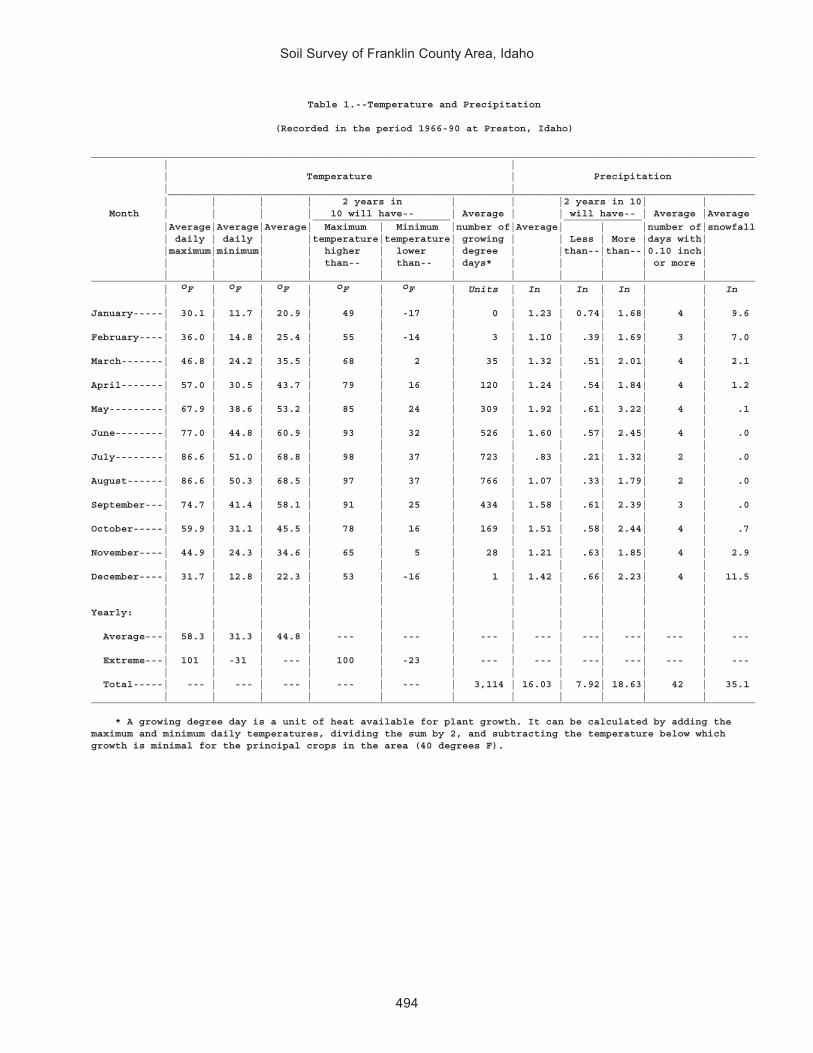
Soil Survey of Franklin County Area, Idaho
494
Table 1.--Temperature and Precipitation
(Recorded in the period 1966-90 at Preston, Idaho)
_______________________________________________________________________________________________________________ | | | Temperature | Precipitation | | ____________________________________________________________________________________________ | | | | 2 years in | | |2 years in 10| | Month | | | | 10 will have-- | Average | | will have-- | Average |Average _______________________ _____________ |Average|Average|Average| Maximum | Minimum |number of|Average| | |number of|snowfall | daily | daily | |temperature|temperature| growing | | Less | More |days with| |maximum|minimum| | higher | lower | degree | |than--|than--|0.10 inch| | | | | than-- | than-- | days* | | | | or more | | | | | | | | | | | |_______________________________________________________________________________________________________________
| oF | oF | oF | oF | oF | Units | In | In | In | | In | | | | | | | | | | |January-----| 30.1 | 11.7 | 20.9 | 49 | -17 | 0 | 1.23 | 0.74| 1.68| 4 | 9.6 | | | | | | | | | | |February----| 36.0 | 14.8 | 25.4 | 55 | -14 | 3 | 1.10 | .39| 1.69| 3 | 7.0 | | | | | | | | | | |March-------| 46.8 | 24.2 | 35.5 | 68 | 2 | 35 | 1.32 | .51| 2.01| 4 | 2.1 | | | | | | | | | | |April-------| 57.0 | 30.5 | 43.7 | 79 | 16 | 120 | 1.24 | .54| 1.84| 4 | 1.2 | | | | | | | | | | |May---------| 67.9 | 38.6 | 53.2 | 85 | 24 | 309 | 1.92 | .61| 3.22| 4 | .1 | | | | | | | | | | |June--------| 77.0 | 44.8 | 60.9 | 93 | 32 | 526 | 1.60 | .57| 2.45| 4 | .0 | | | | | | | | | | |July--------| 86.6 | 51.0 | 68.8 | 98 | 37 | 723 | .83 | .21| 1.32| 2 | .0 | | | | | | | | | | |August------| 86.6 | 50.3 | 68.5 | 97 | 37 | 766 | 1.07 | .33| 1.79| 2 | .0 | | | | | | | | | | |September---| 74.7 | 41.4 | 58.1 | 91 | 25 | 434 | 1.58 | .61| 2.39| 3 | .0 | | | | | | | | | | |October-----| 59.9 | 31.1 | 45.5 | 78 | 16 | 169 | 1.51 | .58| 2.44| 4 | .7 | | | | | | | | | | |November----| 44.9 | 24.3 | 34.6 | 65 | 5 | 28 | 1.21 | .63| 1.85| 4 | 2.9 | | | | | | | | | | |December----| 31.7 | 12.8 | 22.3 | 53 | -16 | 1 | 1.42 | .66| 2.23| 4 | 11.5 | | | | | | | | | | | | | | | | | | | | | |Yearly: | | | | | | | | | | | | | | | | | | | | | | Average---| 58.3 | 31.3 | 44.8 | --- | --- | --- | --- | ---| ---| --- | --- | | | | | | | | | | | Extreme---| 101 | -31 | --- | 100 | -23 | --- | --- | ---| ---| --- | --- | | | | | | | | | | | Total-----| --- | --- | --- | --- | --- | 3,114 | 16.03 | 7.92| 18.63| 42 | 35.1 | | | | | | | | | | |_______________________________________________________________________________________________________________
* A growing degree day is a unit of heat available for plant growth. It can be calculated by adding themaximum and minimum daily temperatures, dividing the sum by 2, and subtracting the temperature below whichgrowth is minimal for the principal crops in the area (40 degrees F).

Soil Survey of Franklin County Area, Idaho
495
Table 2.--Freeze Dates in Spring and Fall
(Recorded in the period 1966-1990 at Preston, Idaho)
_____________________________________________________________ | | Temperature | __________________________________________ Probability | | | | 24 oF | 28 oF | 32 oF | or lower | or lower | or lower | | |_____________________________________________________________ | | |Last freezing | | | temperature | | | in spring: | | | | | | 1 year in 10 | | | later than-----| May 8 | May 27 | June 23 | | | 2 years in 10 | | | later than-----| May 3 | May 21 | June 13 | | | 5 years in 10 | | | later than-----| April 23 | May 10 | May 27 | | |First freezing | | | temperature | | | in fall: | | | | | | 1 year in 10 | | | earlier than---| Sept. 26 | Sept. 18 | Sept. 13 | | | 2 years in 10 | | | earlier than---| Oct. 1 | Sept. 22 | Sept. 16 | | | 5 years in 10 | | | earlier than---| Oct. 11 | Sept. 30 | Sept. 22 | | |_____________________________________________________________
Table 3.--Growing Season
(Recorded in the period 1966-1990 at Preston, Idaho)
____________________________________________________ | | Daily minimum temperature | during growing season | _____________________________________ Probability | | | | Higher | Higher | Higher | than | than | than | 24 oF | 28 oF | 32 oF | | |____________________________________________________ | Days | Days | Days | | |9 years in 10 | 132 | 112 | 83 | | |8 years in 10 | 140 | 120 | 94 | | |5 years in 10 | 157 | 134 | 113 | | |2 years in 10 | 173 | 148 | 132 | | |1 year in 10 | 182 | 155 | 142 | | |____________________________________________________

Soil Survey of Franklin County Area, Idaho
496
Table 4.--Acreage and Proportionate Extent of the Soils_______________________________________________________________________________________________________ | | | Map | Soil name | Acres |Percentsymbol | | | | | |_______________________________________________________________________________________________________ | | |1 |Airport silty clay loam, 0 to 3 percent slopes---------------------------| 17 | *2 |Ant Flat silty clay loam, 0 to 2 percent slopes--------------------------| 5,694 | 1.93 |Ant Flat silty clay loam, 2 to 4 percent slopes--------------------------| 2,588 | 0.84 |Ant Flat silty clay loam, 4 to 12 percent slopes-------------------------| 975 | 0.35 |Ant Flat-Oxford complex, 4 to 12 percent slopes--------------------------| 222 | *6 |Ant Flat-Oxford complex, 12 to 20 percent slopes-------------------------| 774 | 0.37 |Arbone loam, 0 to 4 percent slopes---------------------------------------| 270 | *8 |Banida silty clay loam, 0 to 2 percent slopes----------------------------| 980 | 0.39 |Banida silty clay loam, 2 to 4 percent slopes----------------------------| 2,093 | 0.710 |Battle Creek silty clay loam, 0 to 2 percent slopes----------------------| 4,775 | 1.611 |Battle Creek silty clay loam, 2 to 4 percent slopes----------------------| 742 | 0.212 |Battle Creek silty clay loam, 4 to 8 percent slopes----------------------| 1,114 | 0.413 |Bear Lake-Chesbrook-Picabo complex, 0 to 2 percent slopes----------------| 43 | *14 |Bear Lake-Downata complex, 0 to 1 percent slopes-------------------------| 1,446 | 0.515 |Bear Lake-Downata-Thatcherflats complex, 0 to 1 percent slopes-----------| 1,423 | 0.516 |Bear Lake-Lago complex, 0 to 2 percent slopes----------------------------| 653 | 0.217 |Bearhollow-Brifox-Iphil complex, 20 to 35 percent slopes-----------------| 96 | *18 |Bergquist-Rubble land complex, 50 to 75 percent slopes-------------------| 314 | 0.119 |Bergquist-Softback complex, 25 to 65 percent slopes----------------------| 5,592 | 1.820 |Bergquist-Vitale complex, 15 to 60 percent slopes------------------------| 2,801 | 0.921 |Bothwell silt loam, 4 to 12 percent slopes-------------------------------| 777 | 0.322 |Bothwell silt loam, 12 to 30 percent slopes------------------------------| 1,736 | 0.623 |Bothwell-Hades-Justesen complex, 6 to 25 percent slopes------------------| 3,040 | 1.024 |Bothwell-Thatcher complex, 4 to 8 percent slopes-------------------------| 495 | 0.225 |Brifox-Huffman complex, 4 to 12 percent slopes---------------------------| 711 | 0.226 |Brifox-Huffman complex, 12 to 30 percent slopes--------------------------| 3,033 | 1.027 |Brifox-Niter complex, 4 to 12 percent slopes-----------------------------| 7 | *28 |Brifox-Niter complex, 12 to 25 percent slopes----------------------------| 32 | *29 |Brifox-Niter complex, 25 to 35 percent slopes----------------------------| 202 | *30 |Broadhead-Hades-Yago complex, 4 to 20 percent slopes---------------------| 48 | *31 |Broadhead-Yago complex, 12 to 20 percent slopes--------------------------| 25 | *32 |Camelback-Lonigan complex, 20 to 50 percent slopes-----------------------| 48 | *33 |Camelback-Valmar-Hades complex, 20 to 30 percent slopes------------------| 82 | *34 |Cedarhill very gravelly silt loam, 12 to 20 percent slopes---------------| 1,502 | 0.535 |Cedarhill-Hades-Ricrest complex, 20 to 50 percent slopes-----------------| 48 | *36 |Cedarhill-Hondoho-Ridgecrest complex, 20 to 50 percent slopes------------| 517 | 0.237 |Chesbrook-Bear Lake complex, 0 to 2 percent slopes-----------------------| 97 | *38 |Cloudless-Hades complex, 4 to 12 percent slopes--------------------------| 2,662 | 0.939 |Cloudless-Hades-Howcan complex, 12 to 20 percent slopes------------------| 3,582 | 1.240 |Copenhagen-Lonigan-Manila association, 12 to 50 percent slopes-----------| 2,129 | 0.741 |Delish-Cachecan-Stinkcreek complex, 0 to 2 percent slopes----------------| 2,117 | 0.742 |Downata silt loam, 0 to 1 percent slopes---------------------------------| 326 | 0.143 |Dranburn-Robin complex, 15 to 45 percent slopes--------------------------| 2,899 | 0.944 |Enochville silt loam, 0 to 1 percent slopes------------------------------| 50 | *45 |Foxol-Vitale complex, 20 to 55 percent slopes----------------------------| 3,981 | 1.346 |Hades-Camelback-Hondoho complex, 30 to 60 percent slopes-----------------| 421 | 0.147 |Hades-Lanoak-Camelback complex, 20 to 50 percent slopes------------------| 38 | *48 |Haploxerolls-Xerorthents complex, 20 to 60 percent slopes----------------| 1,100 | 0.449 |Hendricks silt loam, 6 to 10 percent slopes------------------------------| 99 | *50 |Holmes gravelly silt loam, 0 to 2 percent slopes-------------------------| 1,012 | 0.351 |Hondee gravelly loam, 1 to 4 percent slopes------------------------------| 1,897 | 0.652 |Hondee gravelly loam, 4 to 12 percent slopes-----------------------------| 1,745 | 0.653 |Hondoho-Hades complex, 4 to 12 percent slopes----------------------------| 29 | *54 |Hondoho-Ricrest complex, 4 to 20 percent slopes--------------------------| 1,149 | 0.455 |Hondoho-Sprollow-Hades complex, 12 to 50 percent slopes------------------| 5,128 | 1.756 |Hondoho-Vitale complex, 20 to 50 percent slopes--------------------------| 1,062 | 0.357 |Huffman silt loam, 0 to 4 percent slopes---------------------------------| 642 | 0.258 |Huffman silt loam, 4 to 12 percent slopes--------------------------------| 666 | 0.259 |Huffman-Dirtyhead complex, 4 to 12 percent slopes------------------------| 1,367 | 0.460 |Huffman-Harroun-Lanoak complex, 2 to 12 percent slopes-------------------| 457 | 0.161 |Huffman-Wursten complex, 4 to 12 percent slopes--------------------------| 546 | 0.262 |Iphil-Lonigan complex, 8 to 20 percent slopes----------------------------| 1,733 | 0.6 | | |
* See footnote at end of table.

Soil Survey of Franklin County Area, Idaho
497
Table 4.--Acreage and Proportionate Extent of the Soils--Continued_______________________________________________________________________________________________________ | | | Map | Soil name | Acres |Percentsymbol | | | | | |_______________________________________________________________________________________________________ | | |63 |Ireland-Polumar complex, 25 to 55 percent slopes-------------------------| 4,179 | 1.464 |Kabear-Staberg-Copenhagen complex, 4 to 12 percent slopes----------------| 222 | *65 |Kabear-Staberg-Copenhagen complex, 12 to 30 percent slopes---------------| 564 | 0.266 |Kearns silt loam, 0 to 2 percent slopes----------------------------------| 823 | 0.367 |Kearnsar-Battle Creek complex, 0 to 4 percent slopes---------------------| 886 | 0.368 |Kidman fine sandy loam, 0 to 2 percent slopes----------------------------| 5,204 | 1.769 |Kidman fine sandy loam, 2 to 4 percent slopes----------------------------| 2,053 | 0.770 |Kidman fine sandy loam, 20 to 40 percent slopes--------------------------| 1,714 | 0.671 |Kidman fine sandy loam, wet, 0 to 2 percent slopes-----------------------| 1,283 | 0.472 |Kidman-Sterling complex, 0 to 2 percent slopes---------------------------| 598 | 0.273 |Lando silt loam, 0 to 4 percent slopes-----------------------------------| 3,436 | 1.174 |Lanoak silt loam, 0 to 4 percent slopes----------------------------------| 2,413 | 0.875 |Lanoak silt loam, 4 to 12 percent slopes---------------------------------| 1,402 | 0.576 |Lanoak-Broadhead complex, 12 to 30 percent slopes------------------------| 4,044 | 1.377 |Lanoak-Broadhead-Hades complex, 25 to 50 percent slopes------------------| 2,495 | 0.878 |Lanoak-Hades complex, 6 to 20 percent slopes-----------------------------| 295 | *79 |Lanoak-Thatcher complex, 12 to 30 percent slopes-------------------------| 1,347 | 0.480 |Layton loamy fine sand, 0 to 2 percent slopes----------------------------| 514 | 0.281 |Layton sandy loam, 0 to 2 percent slopes---------------------------------| 1,259 | 0.482 |Lizdale very stony loam, 30 to 60 percent slopes-------------------------| 3,100 | 1.083 |Lizdale-Searla complex, 12 to 30 percent slopes--------------------------| 2,513 | 0.884 |Logan silty clay loam, 0 to 3 percent slopes-----------------------------| 156 | *85 |Lonigan-Lizdale association, 6 to 40 percent slopes----------------------| 523 | 0.286 |Lonigan-Ricrest association, 50 to 80 percent slopes---------------------| 1,408 | 0.587 |Manila silt loam, 0 to 4 percent slopes----------------------------------| 388 | 0.188 |Manila silt loam, 4 to 12 percent slopes---------------------------------| 717 | 0.289 |Manila silt loam, 12 to 30 percent slopes--------------------------------| 1,342 | 0.490 |Manila-Bancroft complex, 6 to 15 percent slopes--------------------------| 26 | *91 |Manila-Broadhead complex, 4 to 12 percent slopes-------------------------| 6,418 | 2.192 |Manila-Broadhead complex, 12 to 30 percent slopes------------------------| 9,193 | 3.093 |Manila-Lonigan complex, 6 to 40 percent slopes---------------------------| 751 | 0.294 |Manila-Yeates Hollow complex, 6 to 20 percent slopes---------------------| 1,871 | 0.695 |Maplecreek fine sandy loam, 0 to 2 percent slopes------------------------| 745 | 0.296 |Maplecreek-Layton complex, 0 to 2 percent slopes-------------------------| 2,029 | 0.797 |Merkley-Lago-Bear Lake complex, 0 to 2 percent slopes--------------------| 1,221 | 0.498 |Moonlight-Camelback association, 30 to 60 percent slopes-----------------| 664 | 0.299 |Niter-Brifox complex, 1 to 4 percent slopes------------------------------| 14 | *100 |Northwater-Foxol-Vitale complex, 50 to 80 percent slopes-----------------| 665 | 0.2101 |Northwater-Povey complex, 10 to 30 percent slopes------------------------| 1,625 | 0.5102 |Northwater-Povey complex, 30 to 60 percent slopes------------------------| 3,078 | 1.0103 |Nyman-Lonigan-Copenhagen complex, 30 to 60 percent slopes----------------| 2,338 | 0.8104 |Oxford-Banida complex, 2 to 4 percent slopes-----------------------------| 1,871 | 0.6105 |Oxford-Banida complex, 4 to 12 percent slopes----------------------------| 6,222 | 2.0106 |Oxford-Banida complex, 12 to 30 percent slopes---------------------------| 10,152 | 3.3107 |Oxford-Gullied land complex, 20 to 50 percent slopes---------------------| 2,683 | 0.9108 |Parkay-Povey complex, 30 to 60 percent slopes----------------------------| 1,326 | 0.4109 |Parleys silt loam, 0 to 4 percent slopes---------------------------------| 8,755 | 2.9110 |Parleys silt loam, 4 to 8 percent slopes---------------------------------| 218 | *111 |Parleys silt loam, wet, 0 to 2 percent slopes----------------------------| 2,494 | 0.8112 |Pavohroo-Sedgway-Toponce complex, 20 to 50 percent slopes----------------| 310 | 0.1113 |Picabo-Thatcherflats complex, 0 to 1 percent slopes----------------------| 3,130 | 1.0114 |Pits, gravel-------------------------------------------------------------| 260 | *115 |Pollynot gravelly loam, 4 to 12 percent slopes---------------------------| 986 | 0.3116 |Pollynot silt loam, 0 to 2 percent slopes--------------------------------| 1,496 | 0.5117 |Pollynot silt loam, 2 to 4 percent slopes--------------------------------| 1,446 | 0.5118 |Pollynot silt loam, 4 to 20 percent slopes-------------------------------| 893 | 0.3119 |Polumar-Ireland complex, 30 to 60 percent slopes-------------------------| 3,220 | 1.1120 |Polumar-Sprollow-Ireland complex, 40 to 70 percent slopes----------------| 894 | 0.3121 |Povey-Hades-Hondoho complex, 10 to 50 percent slopes---------------------| 1,309 | 0.4122 |Povey-Parkay complex, 30 to 60 percent slopes----------------------------| 2,074 | 0.7123 |Preston fine sand, 0 to 2 percent slopes---------------------------------| 1,520 | 0.5124 |Preston fine sand, 2 to 6 percent slopes---------------------------------| 1,621 | 0.5 | | |
* See footnote at end of table.

Soil Survey of Franklin County Area, Idaho
498
Table 4.--Acreage and Proportionate Extent of the Soils--Continued_______________________________________________________________________________________________________ | | | Map | Soil name | Acres |Percentsymbol | | | | | |_______________________________________________________________________________________________________ | | |125 |Preston loamy sand, 6 to 30 percent slopes-------------------------------| 2,169 | 0.7126 |Preston-Xerorthents complex, 35 to 60 percent slopes---------------------| 1,723 | 0.6127 |Ricrest gravelly silt loam, 4 to 12 percent slopes-----------------------| 419 | 0.1128 |Sanyon-Staberg-Kabear complex, 20 to 50 percent slopes-------------------| 3,331 | 1.1129 |Smidale very channery silt loam, 30 to 60 percent slopes-----------------| 761 | 0.2130 |Smidale-Staberg complex, 20 to 60 percent slopes-------------------------| 1,102 | 0.4131 |Sprollow-Hondoho complex, 30 to 60 percent slopes------------------------| 2,471 | 0.8132 |Sprollow-Hymas complex, 30 to 60 percent slopes--------------------------| 2,216 | 0.7133 |Sterling gravelly loam, 0 to 4 percent slopes----------------------------| 894 | 0.3134 |Sterling gravelly loam, 4 to 10 percent slopes---------------------------| 1,449 | 0.5135 |Sterling gravelly loam, 10 to 20 percent slopes--------------------------| 149 | *136 |Sterling very gravelly loam, 20 to 60 percent slopes---------------------| 1,273 | 0.4137 |Sterling-Parleys complex, 0 to 6 percent slopes--------------------------| 308 | 0.1138 |Thatcher-Bearhollow complex, 6 to 20 percent slopes----------------------| 633 | 0.2139 |Toponce-Broadhead association, 6 to 30 percent slopes--------------------| 207 | *140 |Trenton-Battle Creek complex, 0 to 2 percent slopes----------------------| 2,380 | 0.8141 |Trenton-Battle Creek complex, cool, 0 to 2 percent slopes----------------| 1,538 | 0.5142 |Trenton-Parleys complex, 0 to 2 percent slopes---------------------------| 657 | 0.2143 |Valmar-Camelback-Hades complex, 30 to 60 percent slopes------------------| 393 | 0.1144 |Vitale-Bergquist-Rock outcrop complex, 30 to 60 percent slopes-----------| 3,780 | 1.2145 |Vitale-Yeates Hollow-Northwater complex, 12 to 40 percent slopes---------| 4,898 | 1.6146 |Welby silt loam, 0 to 2 percent slopes-----------------------------------| 1,221 | 0.4147 |Welby silt loam, 2 to 4 percent slopes-----------------------------------| 160 | *148 |Welby silt loam, wet, 0 to 2 percent slopes------------------------------| 838 | 0.3149 |Wheelon-Collinston complex, 4 to 12 percent slopes-----------------------| 6,751 | 2.2150 |Wheelon-Collinston complex, 12 to 20 percent slopes----------------------| 3,922 | 1.3151 |Wheelon-Collinston complex, 20 to 60 percent slopes----------------------| 1,311 | 0.4152 |Windernot-Lewnot-Stinkcreek complex, 0 to 2 percent slopes---------------| 5,001 | 1.6153 |Winn silt loam, 0 to 3 percent slopes------------------------------------| 38 | *154 |Winwell silty clay loam, 0 to 2 percent slopes---------------------------| 3,518 | 1.2155 |Winwell-Collinston complex, 2 to 8 percent slopes------------------------| 2,044 | 0.7156 |Wormcreek-Copenhagen complex, 15 to 55 percent slopes--------------------| 940 | 0.3157 |Wormcreek-Lonigan complex, 15 to 55 percent slopes-----------------------| 2,313 | 0.8158 |Wursten-Dirtyhead complex, 12 to 30 percent slopes-----------------------| 835 | 0.3159 |Xerochrepts-Wormcreek-Xerorthents complex, 20 to 70 percent slopes-------| 3,511 | 1.1160 |Xerorthents, 30 to 60 percent slopes-------------------------------------| 1,152 | 0.4161 |Yeates Hollow extremely stony loam, 12 to 35 percent slopes--------------| 1,407 | 0.5162 |Yeates Hollow-Manila-Softback complex, 12 to 40 percent slopes-----------| 21,361 | 7.0163 |Yeates Hollow-Vitale complex, 25 to 50 percent slopes--------------------| 3,757 | 1.2164 |Water--------------------------------------------------------------------| 2,524 | 0.8 | |____________|________ | Total---------------------------------------------------------------| 305,600 | 100.0 | | |_______________________________________________________________________________________________________
* Less than 0.1 percent.

Soil S
urvey of Franklin County A
rea, Idaho
499
Table 5.--Land Capability and Yields per Acre of Crops and Pasture
(Yields in the "N" columns are for nonirrigated areas; those in the "I" columns are for irrigated areas. Yields are those that can be expected under a high level of management. Absence of a yield indicates that the soil is not suited to the crop or the crop generally is not grown on the soil.)
_________________________________________________________________________________________________________________________________ | Land | | | | | Map symbol | capability | Alfalfa hay | Barley | Grass-legume hay | Pasture | Wheat and soil name | | | | | | _________________________________________________________________________________________________________________ | N | I | N | I | N | I | N | I | N | I | N | I | | | | | | | | | | | |_________________________________________________________________________________________________________________________________ | | | Tons | Tons | Bu | Bu | Tons | Tons | AUM | AUM | Bu | Bu | | | | | | | | | | | |1: | | | | | | | | | | | | Airport-------| 6w | 4w | --- | --- | --- | --- | --- | --- | 0.75 | 2.00 | --- | --- | | | | | | | | | | | |2: | | | | | | | | | | | | Ant Flat------| 3s | 3s | 1.50 | 4.00 | 40.00 | 85.00 | --- | --- | --- | --- | 35.00 | 50.00 | | | | | | | | | | | |3: | | | | | | | | | | | | Ant Flat------| 3e | 3e | 1.50 | 3.50 | 35.00 | 80.00 | --- | --- | --- | --- | 30.00 | 45.00 | | | | | | | | | | | |4: | | | | | | | | | | | | Ant Flat------| 3e | 3e | 1.25 | 3.50 | 30.00 | 80.00 | 1.00 | 3.00 | --- | --- | 25.00 | 40.00 | | | | | | | | | | | |5: | | | | | | | | | | | | Ant Flat------| 3e | 3e | 1.50 | 3.50 | 35.00 | 80.00 | 1.00 | 3.00 | --- | --- | 30.00 | 45.00 | | | | | | | | | | | | Oxford--------| 3e | 4e | 1.50 | 3.50 | 30.00 | 65.00 | 1.00 | 3.00 | --- | --- | 25.00 | 65.00 | | | | | | | | | | | |6: | | | | | | | | | | | | Ant Flat------| 4e | --- | 1.00 | --- | 25.00 | --- | 1.00 | --- | --- | --- | 20.00 | --- | | | | | | | | | | | | Oxford--------| 4e | --- | 1.00 | --- | 25.00 | --- | 1.00 | --- | --- | --- | 20.00 | --- | | | | | | | | | | | |7: | | | | | | | | | | | | Arbone--------| 3c | 3e | 1.50 | 4.50 | 30.00 | 40.00 | --- | --- | --- | --- | 30.00 | 40.00 | | | | | | | | | | | |8: | | | | | | | | | | | | Banida--------| 3s | 3s | 1.50 | 3.50 | 40.00 | 80.00 | --- | --- | --- | --- | 35.00 | 70.00 | | | | | | | | | | | |9: | | | | | | | | | | | | Banida--------| 3e | 3e | 1.50 | 2.50 | 35.00 | 80.00 | 1.50 | 3.50 | --- | --- | 30.00 | 70.00 | | | | | | | | | | | |10: | | | | | | | | | | | | Battle Creek--| 3s | 3s | 1.50 | 4.00 | 45.00 | 85.00 | 1.50 | 4.00 | 1.50 | 4.00 | 40.00 | 75.00 | | | | | | | | | | | |11: | | | | | | | | | | | | Battle Creek--| 3e | 3e | 1.50 | 4.00 | 45.00 | 85.00 | 1.50 | 4.00 | 1.50 | 4.00 | 40.00 | 70.00 | | | | | | | | | | | |12: | | | | | | | | | | | | Battle Creek--| 3e | 3e | 1.50 | 4.00 | 45.00 | 85.00 | 1.50 | 4.00 | 1.50 | 4.00 | 40.00 | 70.00 | | | | | | | | | | | |

Soil S
urvey of Franklin County A
rea, Idaho
500
Table 5.--Land Capability and Yields per Acre of Crops and Pasture--Continued_________________________________________________________________________________________________________________________________ | Land | | | | | Map symbol | capability | Alfalfa hay | Barley | Grass-legume hay | Pasture | Wheat and soil name | | | | | | _________________________________________________________________________________________________________________ | N | I | N | I | N | I | N | I | N | I | N | I | | | | | | | | | | | |_________________________________________________________________________________________________________________________________ | | | Tons | Tons | Bu | Bu | Tons | Tons | AUM | AUM | Bu | Bu | | | | | | | | | | | |13: | | | | | | | | | | | | Bear Lake-----| 5w | 5w | --- | --- | --- | --- | --- | --- | 4.00 | 5.00 | --- | --- | | | | | | | | | | | | Chesbrook-----| 5w | 5w | --- | --- | --- | --- | --- | --- | 4.50 | 6.00 | --- | --- | | | | | | | | | | | | Picabo--------| 3w | 3w | --- | --- | --- | --- | --- | --- | 2.00 | 5.00 | --- | --- | | | | | | | | | | | |14: | | | | | | | | | | | | Bear Lake-----| 5w | 5w | --- | --- | --- | --- | --- | --- | 7.00 | 10.00 | --- | --- | | | | | | | | | | | | Downata-------| 5w | 5w | --- | --- | --- | --- | --- | --- | 7.50 | 10.00 | --- | --- | | | | | | | | | | | |15: | | | | | | | | | | | | Bear Lake-----| 5w | 5w | --- | --- | --- | --- | --- | --- | 7.00 | 10.00 | --- | --- | | | | | | | | | | | | Downata-------| 5w | 5w | --- | --- | --- | --- | --- | --- | 7.50 | 10.00 | --- | --- | | | | | | | | | | | | Thatcherflats | 4s | 4s | --- | --- | --- | --- | --- | --- | 1.00 | 2.00 | --- | --- | | | | | | | | | | | |16: | | | | | | | | | | | | Bear Lake-----| 5w | 5w | 2.00 | 4.00 | --- | --- | 3.00 | 4.00 | 4.50 | 6.00 | --- | --- | | | | | | | | | | | | Lago----------| 4w | 4w | 1.50 | 4.00 | --- | --- | 2.50 | 4.00 | 4.00 | 5.50 | --- | --- | | | | | | | | | | | |17: | | | | | | | | | | | | Bearhollow----| 6e | --- | 1.50 | --- | 20.00 | --- | --- | --- | --- | --- | 20.00 | --- | | | | | | | | | | | | Brifox--------| 6e | --- | 0.50 | --- | 25.00 | --- | --- | --- | --- | --- | 20.00 | --- | | | | | | | | | | | | Iphil---------| 6e | --- | 1.50 | --- | 20.00 | --- | --- | --- | --- | --- | 20.00 | --- | | | | | | | | | | | |18: | | | | | | | | | | | | Bergquist-----| 7e | --- | --- | --- | --- | --- | --- | --- | --- | --- | --- | --- | | | | | | | | | | | | Rubble land. | | | | | | | | | | | | | | | | | | | | | | | |19: | | | | | | | | | | | | Bergquist-----| 7e | --- | --- | --- | --- | --- | --- | --- | --- | --- | --- | --- | | | | | | | | | | | | Softback------| 7s | --- | --- | --- | --- | --- | --- | --- | --- | --- | --- | --- | | | | | | | | | | | |20: | | | | | | | | | | | | Bergquist-----| 6e | --- | --- | --- | --- | --- | --- | --- | --- | --- | --- | --- | | | | | | | | | | | | Vitale--------| 6s | --- | --- | --- | --- | --- | --- | --- | --- | --- | --- | --- | | | | | | | | | | | |

Soil S
urvey of Franklin County A
rea, Idaho
501
Table 5.--Land Capability and Yields per Acre of Crops and Pasture--Continued_________________________________________________________________________________________________________________________________ | Land | | | | | Map symbol | capability | Alfalfa hay | Barley | Grass-legume hay | Pasture | Wheat and soil name | | | | | | _________________________________________________________________________________________________________________ | N | I | N | I | N | I | N | I | N | I | N | I | | | | | | | | | | | |_________________________________________________________________________________________________________________________________ | | | Tons | Tons | Bu | Bu | Tons | Tons | AUM | AUM | Bu | Bu | | | | | | | | | | | |21: | | | | | | | | | | | | Bothwell------| 3e | --- | 1.80 | --- | 55.00 | --- | 1.50 | --- | --- | --- | 45.00 | --- | | | | | | | | | | | |22: | | | | | | | | | | | | Bothwell------| 4e | --- | 1.00 | --- | 50.00 | --- | 1.00 | --- | --- | --- | 40.00 | --- | | | | | | | | | | | |23: | | | | | | | | | | | | Bothwell------| 4e | --- | --- | --- | 50.00 | --- | --- | --- | --- | --- | 40.00 | --- | | | | | | | | | | | | Hades---------| 4e | --- | --- | --- | 30.00 | --- | --- | --- | --- | --- | 30.00 | --- | | | | | | | | | | | | Justesen------| 4e | --- | --- | --- | 35.00 | --- | --- | --- | --- | --- | 30.00 | --- | | | | | | | | | | | |24: | | | | | | | | | | | | Bothwell------| 3e | --- | --- | --- | 55.00 | --- | --- | --- | --- | --- | 45.00 | --- | | | | | | | | | | | | Thatcher------| 4e | --- | --- | --- | 35.00 | --- | --- | --- | --- | --- | 30.00 | --- | | | | | | | | | | | |25: | | | | | | | | | | | | Brifox--------| 3e | --- | 1.00 | --- | 30.00 | --- | 1.00 | --- | 1.00 | --- | 25.00 | --- | | | | | | | | | | | | Huffman-------| 3e | --- | 1.50 | --- | 35.00 | --- | 2.00 | --- | 2.00 | --- | 27.00 | --- | | | | | | | | | | | |26: | | | | | | | | | | | | Brifox--------| 4e | --- | 1.00 | --- | 30.00 | --- | 1.00 | --- | 1.00 | --- | 25.00 | --- | | | | | | | | | | | | Huffman-------| 4e | --- | 0.50 | --- | 20.00 | --- | 1.00 | --- | 1.00 | --- | 15.00 | --- | | | | | | | | | | | |27: | | | | | | | | | | | | Brifox--------| 3e | 4e | 1.00 | 3.50 | 30.00 | 60.00 | --- | --- | --- | --- | 25.00 | 55.00 | | | | | | | | | | | | Niter---------| 3e | 4e | 1.00 | 3.50 | 30.00 | 60.00 | --- | --- | --- | --- | 25.00 | 55.00 | | | | | | | | | | | |28: | | | | | | | | | | | | Brifox--------| 4e | 6e | 1.00 | 2.50 | 30.00 | 60.00 | --- | --- | --- | --- | 25.00 | 55.00 | | | | | | | | | | | | Niter---------| 4e | 6e | 0.75 | 2.50 | 30.00 | 60.00 | --- | --- | --- | --- | 25.00 | 55.00 | | | | | | | | | | | |29: | | | | | | | | | | | | Brifox--------| 6e | 6e | 0.50 | 1.50 | 25.00 | 55.00 | --- | --- | --- | --- | 20.00 | 50.00 | | | | | | | | | | | | Niter---------| 6e | 6e | 0.50 | 1.50 | 25.00 | 55.00 | --- | --- | --- | --- | 20.00 | 50.00 | | | | | | | | | | | |

Soil S
urvey of Franklin County A
rea, Idaho
502
Table 5.--Land Capability and Yields per Acre of Crops and Pasture--Continued_________________________________________________________________________________________________________________________________ | Land | | | | | Map symbol | capability | Alfalfa hay | Barley | Grass-legume hay | Pasture | Wheat and soil name | | | | | | _________________________________________________________________________________________________________________ | N | I | N | I | N | I | N | I | N | I | N | I | | | | | | | | | | | |_________________________________________________________________________________________________________________________________ | | | Tons | Tons | Bu | Bu | Tons | Tons | AUM | AUM | Bu | Bu | | | | | | | | | | | |30: | | | | | | | | | | | | Broadhead-----| 4e | --- | --- | --- | --- | --- | --- | --- | --- | --- | --- | --- | | | | | | | | | | | | Hades---------| 4e | --- | --- | --- | --- | --- | --- | --- | --- | --- | --- | --- | | | | | | | | | | | | Yago----------| 7s | --- | --- | --- | --- | --- | --- | --- | --- | --- | --- | --- | | | | | | | | | | | |31: | | | | | | | | | | | | Broadhead-----| 4e | --- | --- | --- | --- | --- | --- | --- | --- | --- | --- | --- | | | | | | | | | | | | Yago----------| 7s | --- | --- | --- | --- | --- | --- | --- | --- | --- | --- | --- | | | | | | | | | | | |32: | | | | | | | | | | | | Camelback-----| 6e | --- | --- | --- | --- | --- | --- | --- | --- | --- | --- | --- | | | | | | | | | | | | Lonigan-------| 7e | --- | --- | --- | --- | --- | --- | --- | --- | --- | --- | --- | | | | | | | | | | | |33: | | | | | | | | | | | | Camelback-----| 6e | --- | --- | --- | --- | --- | --- | --- | --- | --- | --- | --- | | | | | | | | | | | | Hades---------| 6e | --- | --- | --- | --- | --- | --- | --- | --- | --- | --- | --- | | | | | | | | | | | | Valmar--------| 6e | --- | --- | --- | --- | --- | --- | --- | --- | --- | --- | --- | | | | | | | | | | | |34: | | | | | | | | | | | | Cedarhill-----| 4e | --- | 1.50 | --- | 30.00 | --- | 1.00 | --- | --- | --- | 25.00 | --- | | | | | | | | | | | |35: | | | | | | | | | | | | Cedarhill-----| 6e | --- | --- | --- | --- | --- | --- | --- | --- | --- | --- | --- | | | | | | | | | | | | Hades---------| 7e | --- | --- | --- | --- | --- | --- | --- | --- | --- | --- | --- | | | | | | | | | | | | Ricrest-------| 7e | --- | --- | --- | --- | --- | --- | --- | --- | --- | --- | --- | | | | | | | | | | | |36: | | | | | | | | | | | | Cedarhill-----| 6e | --- | --- | --- | --- | --- | --- | --- | --- | --- | --- | --- | | | | | | | | | | | | Hondoho-------| 7e | --- | --- | --- | --- | --- | --- | --- | --- | --- | --- | --- | | | | | | | | | | | | Ridgecrest----| 7s | --- | --- | --- | --- | --- | --- | --- | --- | --- | --- | --- | | | | | | | | | | | |37: | | | | | | | | | | | | Chesbrook-----| 5w | 5w | --- | --- | --- | --- | 3.00 | 4.00 | 4.50 | 6.00 | --- | --- | | | | | | | | | | | | Bear Lake-----| 5w | 5w | --- | --- | --- | --- | 3.00 | 4.00 | 4.50 | 6.00 | --- | --- | | | | | | | | | | | |

Soil S
urvey of Franklin County A
rea, Idaho
503
Table 5.--Land Capability and Yields per Acre of Crops and Pasture--Continued_________________________________________________________________________________________________________________________________ | Land | | | | | Map symbol | capability | Alfalfa hay | Barley | Grass-legume hay | Pasture | Wheat and soil name | | | | | | _________________________________________________________________________________________________________________ | N | I | N | I | N | I | N | I | N | I | N | I | | | | | | | | | | | |_________________________________________________________________________________________________________________________________ | | | Tons | Tons | Bu | Bu | Tons | Tons | AUM | AUM | Bu | Bu | | | | | | | | | | | |38: | | | | | | | | | | | | Cloudless-----| 3e | --- | 1.50 | --- | 30.00 | --- | 1.50 | --- | --- | --- | 25.00 | --- | | | | | | | | | | | | Hades---------| 4e | --- | 1.50 | --- | 30.00 | --- | 1.50 | --- | --- | --- | 30.00 | --- | | | | | | | | | | | |39: | | | | | | | | | | | | Cloudless-----| 4e | --- | 1.50 | --- | 30.00 | --- | 1.50 | --- | --- | --- | 25.00 | --- | | | | | | | | | | | | Hades---------| 4e | --- | 1.50 | --- | 30.00 | --- | 1.50 | --- | --- | --- | 30.00 | --- | | | | | | | | | | | | Howcan--------| 4e | --- | 1.00 | --- | 30.00 | --- | 1.00 | --- | --- | --- | 25.00 | --- | | | | | | | | | | | |40: | | | | | | | | | | | | Copenhagen----| 7e | --- | --- | --- | --- | --- | --- | --- | --- | --- | --- | --- | | | | | | | | | | | | Lonigan-------| 6e | --- | --- | --- | --- | --- | --- | --- | --- | --- | --- | --- | | | | | | | | | | | | Manila--------| 6e | --- | --- | --- | --- | --- | --- | --- | --- | --- | --- | --- | | | | | | | | | | | |41: | | | | | | | | | | | | Delish--------| 3w | 3w | --- | --- | --- | --- | 2.00 | 5.00 | 2.50 | 5.00 | --- | --- | | | | | | | | | | | | Cachecan------| 3w | 3w | --- | --- | --- | --- | 1.50 | 4.50 | 1.50 | 5.00 | --- | --- | | | | | | | | | | | | Stinkcreek----| 5w | 5w | --- | --- | --- | --- | 2.00 | 3.50 | 4.50 | 6.00 | --- | --- | | | | | | | | | | | |42: | | | | | | | | | | | | Downata-------| 5w | 5w | --- | --- | --- | --- | --- | --- | 7.50 | 10.00 | --- | --- | | | | | | | | | | | |43: | | | | | | | | | | | | Dranburn------| 6e | --- | --- | --- | --- | --- | --- | --- | --- | --- | --- | --- | | | | | | | | | | | | Robin---------| 6e | --- | --- | --- | --- | --- | --- | --- | --- | --- | --- | --- | | | | | | | | | | | |44: | | | | | | | | | | | | Enochville----| 5w | --- | --- | --- | --- | --- | --- | --- | --- | --- | --- | --- | | | | | | | | | | | |45: | | | | | | | | | | | | Foxol---------| 7s | --- | --- | --- | --- | --- | --- | --- | --- | --- | --- | --- | | | | | | | | | | | | Vitale--------| 6s | --- | --- | --- | --- | --- | --- | --- | --- | --- | --- | --- | | | | | | | | | | | |

Soil S
urvey of Franklin County A
rea, Idaho
504
Table 5.--Land Capability and Yields per Acre of Crops and Pasture--Continued_________________________________________________________________________________________________________________________________ | Land | | | | | Map symbol | capability | Alfalfa hay | Barley | Grass-legume hay | Pasture | Wheat and soil name | | | | | | _________________________________________________________________________________________________________________ | N | I | N | I | N | I | N | I | N | I | N | I | | | | | | | | | | | |_________________________________________________________________________________________________________________________________ | | | Tons | Tons | Bu | Bu | Tons | Tons | AUM | AUM | Bu | Bu | | | | | | | | | | | |46: | | | | | | | | | | | | Hades---------| 4e | --- | --- | --- | --- | --- | --- | --- | --- | --- | --- | --- | | | | | | | | | | | | Camelback-----| 7e | --- | --- | --- | --- | --- | --- | --- | --- | --- | --- | --- | | | | | | | | | | | | Hondoho-------| 7e | --- | --- | --- | --- | --- | --- | --- | --- | --- | --- | --- | | | | | | | | | | | |47: | | | | | | | | | | | | Hades---------| 7e | --- | --- | --- | --- | --- | --- | --- | --- | --- | --- | --- | | | | | | | | | | | | Lanoak--------| 7e | --- | --- | --- | --- | --- | --- | --- | --- | --- | --- | --- | | | | | | | | | | | | Camelback-----| 7e | --- | --- | --- | --- | --- | --- | --- | --- | --- | --- | --- | | | | | | | | | | | |48: | | | | | | | | | | | | Haploxerolls--| 6s | --- | --- | --- | --- | --- | --- | --- | --- | --- | --- | --- | | | | | | | | | | | | Xerorthents---| 7e | --- | --- | --- | --- | --- | --- | --- | --- | --- | --- | --- | | | | | | | | | | | |49: | | | | | | | | | | | | Hendricks-----| 3e | 3e | --- | 5.00 | --- | 75.00 | --- | --- | --- | --- | --- | 35.00 | | | | | | | | | | | |50: | | | | | | | | | | | | Holmes--------| 3c | 3c | --- | --- | --- | --- | 1.00 | 3.50 | 1.00 | 4.00 | --- | --- | | | | | | | | | | | |51: | | | | | | | | | | | | Hondee--------| 2c | 2s | 1.00 | 3.50 | 35.00 | 70.00 | 1.00 | 3.00 | 1.00 | 2.50 | 25.00 | 65.00 | | | | | | | | | | | |52: | | | | | | | | | | | | Hondee--------| 3e | --- | --- | --- | 35.00 | --- | --- | --- | --- | --- | 25.00 | --- | | | | | | | | | | | |53: | | | | | | | | | | | | Hondoho-------| 4e | --- | 1.50 | --- | 20.00 | --- | --- | --- | --- | --- | 17.00 | --- | | | | | | | | | | | | Hades---------| 4e | --- | 1.50 | --- | 30.00 | --- | --- | --- | --- | --- | 30.00 | --- | | | | | | | | | | | |54: | | | | | | | | | | | | Hondoho-------| 3e | 4e | 1.00 | 3.50 | 35.00 | 90.00 | 1.50 | 3.50 | 2.00 | 3.50 | 30.00 | 75.00 | | | | | | | | | | | | Ricrest-------| 3e | 3e | 1.00 | 3.50 | 40.00 | 65.00 | 1.00 | 3.50 | 1.50 | 4.00 | 35.00 | 60.00 | | | | | | | | | | | |

Soil S
urvey of Franklin County A
rea, Idaho
505
Table 5.--Land Capability and Yields per Acre of Crops and Pasture--Continued_________________________________________________________________________________________________________________________________ | Land | | | | | Map symbol | capability | Alfalfa hay | Barley | Grass-legume hay | Pasture | Wheat and soil name | | | | | | _________________________________________________________________________________________________________________ | N | I | N | I | N | I | N | I | N | I | N | I | | | | | | | | | | | |_________________________________________________________________________________________________________________________________ | | | Tons | Tons | Bu | Bu | Tons | Tons | AUM | AUM | Bu | Bu | | | | | | | | | | | |55: | | | | | | | | | | | | Hondoho-------| 6e | --- | --- | --- | --- | --- | --- | --- | --- | --- | --- | --- | | | | | | | | | | | | Sprollow------| 7s | --- | --- | --- | --- | --- | --- | --- | --- | --- | --- | --- | | | | | | | | | | | | Hades---------| 4e | --- | --- | --- | --- | --- | --- | --- | --- | --- | --- | --- | | | | | | | | | | | |56: | | | | | | | | | | | | Hondoho-------| 6e | --- | --- | --- | --- | --- | --- | --- | --- | --- | --- | --- | | | | | | | | | | | | Vitale--------| 6s | --- | --- | --- | --- | --- | --- | --- | --- | --- | --- | --- | | | | | | | | | | | |57: | | | | | | | | | | | | Huffman-------| 3e | --- | --- | --- | 40.00 | --- | --- | --- | --- | --- | 40.00 | --- | | | | | | | | | | | |58: | | | | | | | | | | | | Huffman-------| 3e | --- | --- | --- | 35.00 | --- | --- | --- | --- | --- | 27.00 | --- | | | | | | | | | | | |59: | | | | | | | | | | | | Huffman-------| 3e | --- | --- | --- | 35.00 | --- | --- | --- | --- | --- | 27.00 | --- | | | | | | | | | | | | Dirtyhead-----| 3e | --- | --- | --- | 35.00 | --- | --- | --- | --- | --- | 27.00 | --- | | | | | | | | | | | |60: | | | | | | | | | | | | Huffman-------| 3e | --- | --- | --- | 35.00 | --- | --- | --- | --- | --- | 27.00 | --- | | | | | | | | | | | | Harroun-------| 7e | --- | --- | --- | 20.00 | --- | --- | --- | --- | --- | 10.00 | --- | | | | | | | | | | | | Lanoak--------| 3e | --- | --- | --- | 45.00 | --- | --- | --- | --- | --- | 38.00 | --- | | | | | | | | | | | |61: | | | | | | | | | | | | Huffman-------| 3e | --- | --- | --- | 35.00 | --- | --- | --- | --- | --- | 27.00 | --- | | | | | | | | | | | | Wursten-------| 3e | --- | --- | --- | 30.00 | --- | --- | --- | --- | --- | 25.00 | --- | | | | | | | | | | | |62: | | | | | | | | | | | | Iphil---------| 4e | --- | 2.00 | --- | 30.00 | --- | 1.50 | --- | 1.00 | --- | 25.00 | --- | | | | | | | | | | | | Lonigan-------| 3e | --- | 1.50 | --- | 35.00 | --- | 1.50 | --- | 1.00 | --- | 30.00 | --- | | | | | | | | | | | |63: | | | | | | | | | | | | Ireland-------| 7s | --- | --- | --- | --- | --- | --- | --- | --- | --- | --- | --- | | | | | | | | | | | | Polumar-------| 7s | --- | --- | --- | --- | --- | --- | --- | --- | --- | --- | --- | | | | | | | | | | | |

Soil S
urvey of Franklin County A
rea, Idaho
506
Table 5.--Land Capability and Yields per Acre of Crops and Pasture--Continued_________________________________________________________________________________________________________________________________ | Land | | | | | Map symbol | capability | Alfalfa hay | Barley | Grass-legume hay | Pasture | Wheat and soil name | | | | | | _________________________________________________________________________________________________________________ | N | I | N | I | N | I | N | I | N | I | N | I | | | | | | | | | | | |_________________________________________________________________________________________________________________________________ | | | Tons | Tons | Bu | Bu | Tons | Tons | AUM | AUM | Bu | Bu | | | | | | | | | | | |64: | | | | | | | | | | | | Kabear--------| 3e | --- | 2.00 | --- | 35.00 | --- | 2.00 | --- | 1.50 | --- | 40.00 | --- | | | | | | | | | | | | Staberg-------| 3e | --- | 1.00 | --- | 40.00 | --- | 1.00 | --- | 1.00 | --- | 40.00 | --- | | | | | | | | | | | | Copenhagen----| 7e | --- | 1.00 | --- | 40.00 | --- | 1.00 | --- | 1.00 | --- | 40.00 | --- | | | | | | | | | | | |65: | | | | | | | | | | | | Kabear--------| 4e | --- | 1.50 | --- | 30.00 | --- | 1.50 | --- | 1.00 | --- | 35.00 | --- | | | | | | | | | | | | Staberg-------| 4e | --- | 1.00 | --- | 40.00 | --- | 1.00 | --- | 1.00 | --- | 40.00 | --- | | | | | | | | | | | | Copenhagen----| 7e | --- | 1.00 | --- | 40.00 | --- | 1.00 | --- | 1.00 | --- | 40.00 | --- | | | | | | | | | | | |66: | | | | | | | | | | | | Kearns--------| 3c | 2c | --- | 4.00 | --- | 70.00 | --- | 4.00 | --- | 3.00 | --- | 55.00 | | | | | | | | | | | |67: | | | | | | | | | | | | Kearnsar------| 3c | 2c | --- | 4.00 | --- | 90.00 | --- | 4.00 | --- | 4.50 | --- | 80.00 | | | | | | | | | | | | Battle Creek--| 3e | 3e | --- | 4.00 | --- | 85.00 | --- | 4.00 | --- | 4.00 | --- | 70.00 | | | | | | | | | | | |68: | | | | | | | | | | | | Kidman--------| 3c | 2c | --- | 6.00 | --- | 100.00 | --- | 5.50 | --- | 5.00 | --- | 85.00 | | | | | | | | | | | |69: | | | | | | | | | | | | Kidman--------| 3e | 2e | --- | 5.50 | --- | 100.00 | --- | 5.50 | --- | 5.00 | --- | 85.00 | | | | | | | | | | | |70: | | | | | | | | | | | | Kidman--------| 6e | 6e | --- | --- | --- | --- | --- | --- | 0.50 | 3.00 | --- | --- | | | | | | | | | | | |71: | | | | | | | | | | | | Kidman, wet---| 3c | 2c | 1.25 | 5.50 | 40.00 | 100.00 | 1.50 | 3.50 | 1.00 | 5.00 | 35.00 | 90.00 | | | | | | | | | | | |72: | | | | | | | | | | | | Kidman--------| 3c | 2c | --- | 6.00 | --- | 100.00 | --- | 5.50 | --- | 5.00 | --- | 85.00 | | | | | | | | | | | | Sterling------| 2s | 2s | --- | 2.75 | --- | 65.00 | --- | 3.50 | --- | 3.00 | --- | 60.00 | | | | | | | | | | | |73: | | | | | | | | | | | | Lando---------| 3c | 2e | --- | 4.00 | --- | 70.00 | --- | 5.00 | --- | 9.00 | --- | 65.00 | | | | | | | | | | | |74: | | | | | | | | | | | | Lanoak--------| 3c | 3c | 2.00 | 4.50 | 45.00 | 90.00 | 2.00 | 4.50 | 1.50 | 4.00 | 38.00 | 80.00 | | | | | | | | | | | |

Soil S
urvey of Franklin County A
rea, Idaho
507
Table 5.--Land Capability and Yields per Acre of Crops and Pasture--Continued_________________________________________________________________________________________________________________________________ | Land | | | | | Map symbol | capability | Alfalfa hay | Barley | Grass-legume hay | Pasture | Wheat and soil name | | | | | | _________________________________________________________________________________________________________________ | N | I | N | I | N | I | N | I | N | I | N | I | | | | | | | | | | | |_________________________________________________________________________________________________________________________________ | | | Tons | Tons | Bu | Bu | Tons | Tons | AUM | AUM | Bu | Bu | | | | | | | | | | | |75: | | | | | | | | | | | | Lanoak--------| 3e | 4e | 2.00 | 4.00 | 45.00 | 90.00 | 2.00 | 4.00 | 1.50 | 4.00 | 38.00 | 80.00 | | | | | | | | | | | |76: | | | | | | | | | | | | Lanoak--------| 4e | --- | --- | --- | 42.00 | --- | --- | --- | --- | --- | 35.00 | --- | | | | | | | | | | | | Broadhead-----| 4e | --- | --- | --- | 33.00 | --- | --- | --- | --- | --- | 28.00 | --- | | | | | | | | | | | |77: | | | | | | | | | | | | Lanoak--------| 7e | --- | --- | --- | --- | --- | --- | --- | --- | --- | --- | --- | | | | | | | | | | | | Broadhead-----| 7e | --- | --- | --- | --- | --- | --- | --- | --- | --- | --- | --- | | | | | | | | | | | | Hades---------| 7e | --- | --- | --- | --- | --- | --- | --- | --- | --- | --- | --- | | | | | | | | | | | |78: | | | | | | | | | | | | Lanoak--------| 3e | --- | --- | --- | 45.00 | --- | --- | --- | --- | --- | 38.00 | --- | | | | | | | | | | | | Hades---------| 4e | --- | --- | --- | 30.00 | --- | --- | --- | --- | --- | 30.00 | --- | | | | | | | | | | | |79: | | | | | | | | | | | | Lanoak--------| 4e | --- | --- | --- | 42.00 | --- | --- | --- | --- | --- | 35.00 | --- | | | | | | | | | | | | Thatcher------| 6e | --- | --- | --- | 30.00 | --- | --- | --- | --- | --- | 25.00 | --- | | | | | | | | | | | |80: | | | | | | | | | | | | Layton--------| 3e | 3e | 1.00 | 4.50 | 20.00 | 75.00 | 1.00 | 5.00 | 1.00 | 5.00 | 20.00 | 70.00 | | | | | | | | | | | |81: | | | | | | | | | | | | Layton--------| 3s | 3s | 1.00 | 4.50 | 30.00 | 85.00 | 1.50 | 5.00 | 1.00 | 5.00 | 25.00 | 80.00 | | | | | | | | | | | |82: | | | | | | | | | | | | Lizdale-------| 7s | --- | --- | --- | --- | --- | --- | --- | --- | --- | --- | --- | | | | | | | | | | | |83: | | | | | | | | | | | | Lizdale-------| 4e | --- | --- | --- | --- | --- | --- | --- | --- | --- | --- | --- | | | | | | | | | | | | Searla--------| 4e | --- | --- | --- | --- | --- | --- | --- | --- | --- | --- | --- | | | | | | | | | | | |84: | | | | | | | | | | | | Logan---------| 5w | 5w | 3.00 | 4.00 | --- | --- | --- | --- | --- | --- | --- | --- | | | | | | | | | | | |

Soil S
urvey of Franklin County A
rea, Idaho
508
Table 5.--Land Capability and Yields per Acre of Crops and Pasture--Continued_________________________________________________________________________________________________________________________________ | Land | | | | | Map symbol | capability | Alfalfa hay | Barley | Grass-legume hay | Pasture | Wheat and soil name | | | | | | _________________________________________________________________________________________________________________ | N | I | N | I | N | I | N | I | N | I | N | I | | | | | | | | | | | |_________________________________________________________________________________________________________________________________ | | | Tons | Tons | Bu | Bu | Tons | Tons | AUM | AUM | Bu | Bu | | | | | | | | | | | |85: | | | | | | | | | | | | Lonigan-------| 6e | --- | --- | --- | --- | --- | --- | --- | --- | --- | --- | --- | | | | | | | | | | | | Lizdale-------| 3e | --- | --- | --- | --- | --- | --- | --- | --- | --- | --- | --- | | | | | | | | | | | |86: | | | | | | | | | | | | Lonigan-------| 7e | --- | --- | --- | --- | --- | --- | --- | --- | --- | --- | --- | | | | | | | | | | | | Ricrest-------| 7e | --- | --- | --- | --- | --- | --- | --- | --- | --- | --- | --- | | | | | | | | | | | |87: | | | | | | | | | | | | Manila--------| 3e | --- | --- | --- | 40.00 | --- | --- | --- | --- | --- | 35.00 | --- | | | | | | | | | | | |88: | | | | | | | | | | | | Manila--------| 3e | 3e | 1.00 | 3.50 | 40.00 | 90.00 | 1.00 | 4.00 | --- | --- | 40.00 | 85.00 | | | | | | | | | | | |89: | | | | | | | | | | | | Manila--------| 4e | --- | --- | --- | 35.00 | --- | --- | --- | --- | --- | 30.00 | --- | | | | | | | | | | | |90: | | | | | | | | | | | | Manila--------| 3e | --- | --- | --- | 40.00 | --- | --- | --- | --- | --- | 35.00 | --- | | | | | | | | | | | | Bancroft------| 3e | --- | --- | --- | 35.00 | --- | --- | --- | --- | --- | 30.00 | --- | | | | | | | | | | | |91: | | | | | | | | | | | | Manila--------| 3e | --- | --- | --- | 40.00 | --- | --- | --- | --- | --- | 35.00 | --- | | | | | | | | | | | | Broadhead-----| 3e | --- | --- | --- | 33.00 | --- | --- | --- | --- | --- | 28.00 | --- | | | | | | | | | | | |92: | | | | | | | | | | | | Manila--------| 4e | --- | --- | --- | 35.00 | --- | --- | --- | --- | --- | 30.00 | --- | | | | | | | | | | | | Broadhead-----| 4e | --- | --- | --- | 33.00 | --- | --- | --- | --- | --- | 28.00 | --- | | | | | | | | | | | |93: | | | | | | | | | | | | Manila--------| 4e | --- | --- | --- | --- | --- | --- | --- | --- | --- | --- | --- | | | | | | | | | | | | Lonigan-------| 4e | --- | --- | --- | --- | --- | --- | --- | --- | --- | --- | --- | | | | | | | | | | | |94: | | | | | | | | | | | | Manila--------| 3e | --- | 1.00 | --- | 40.00 | --- | 1.00 | --- | --- | --- | 40.00 | --- | | | | | | | | | | | | Yeates Hollow | 4e | --- | 1.00 | --- | 40.00 | --- | 1.00 | --- | --- | --- | 40.00 | --- | | | | | | | | | | | |

Soil S
urvey of Franklin County A
rea, Idaho
509
Table 5.--Land Capability and Yields per Acre of Crops and Pasture--Continued_________________________________________________________________________________________________________________________________ | Land | | | | | Map symbol | capability | Alfalfa hay | Barley | Grass-legume hay | Pasture | Wheat and soil name | | | | | | _________________________________________________________________________________________________________________ | N | I | N | I | N | I | N | I | N | I | N | I | | | | | | | | | | | |_________________________________________________________________________________________________________________________________ | | | Tons | Tons | Bu | Bu | Tons | Tons | AUM | AUM | Bu | Bu | | | | | | | | | | | |95: | | | | | | | | | | | | Maplecreek----| 3w | 3w | 1.50 | 4.00 | 30.00 | 75.00 | 2.00 | 5.00 | 2.00 | 6.00 | 25.00 | 70.00 | | | | | | | | | | | |96: | | | | | | | | | | | | Maplecreek----| 3w | 3w | 1.50 | 4.00 | 30.00 | 75.00 | 2.00 | 5.00 | 2.00 | 6.00 | 25.00 | 70.00 | | | | | | | | | | | | Layton--------| 3e | 3e | 1.00 | 4.50 | 20.00 | 75.00 | 1.00 | 5.00 | 1.00 | 5.00 | 20.00 | 70.00 | | | | | | | | | | | |97: | | | | | | | | | | | | Merkley-------| 3c | 3c | 1.50 | 4.00 | 40.00 | 60.00 | 1.50 | 4.00 | 1.00 | 6.00 | 35.00 | 50.00 | | | | | | | | | | | | Lago----------| 4w | 4w | 1.50 | 4.00 | 40.00 | 55.00 | 2.50 | 4.00 | 4.00 | 5.50 | 35.00 | 45.00 | | | | | | | | | | | | Bear Lake-----| 5w | 5w | 1.50 | 4.00 | 40.00 | 55.00 | 3.00 | 4.00 | 4.50 | 6.00 | 35.00 | 45.00 | | | | | | | | | | | |98: | | | | | | | | | | | | Moonlight-----| 7e | --- | --- | --- | --- | --- | --- | --- | --- | --- | --- | --- | | | | | | | | | | | | Camelback-----| 7e | --- | --- | --- | --- | --- | --- | --- | --- | --- | --- | --- | | | | | | | | | | | |99: | | | | | | | | | | | | Niter---------| 3c | 3e | --- | 4.50 | --- | 70.00 | --- | --- | --- | --- | --- | 65.00 | | | | | | | | | | | | Brifox--------| 3c | 3e | --- | 4.50 | --- | 70.00 | --- | --- | --- | --- | --- | 65.00 | | | | | | | | | | | |100: | | | | | | | | | | | | Northwater----| 7e | --- | --- | --- | --- | --- | --- | --- | --- | --- | --- | --- | | | | | | | | | | | | Foxol---------| 7s | --- | --- | --- | --- | --- | --- | --- | --- | --- | --- | --- | | | | | | | | | | | | Vitale--------| 7e | --- | --- | --- | --- | --- | --- | --- | --- | --- | --- | --- | | | | | | | | | | | |101: | | | | | | | | | | | | Northwater----| 4e | --- | --- | --- | --- | --- | --- | --- | --- | --- | --- | --- | | | | | | | | | | | | Povey---------| 6e | --- | --- | --- | --- | --- | --- | --- | --- | --- | --- | --- | | | | | | | | | | | |102: | | | | | | | | | | | | Northwater----| 7e | --- | --- | --- | --- | --- | --- | --- | --- | --- | --- | --- | | | | | | | | | | | | Povey---------| 7e | --- | --- | --- | --- | --- | --- | --- | --- | --- | --- | --- | | | | | | | | | | | |
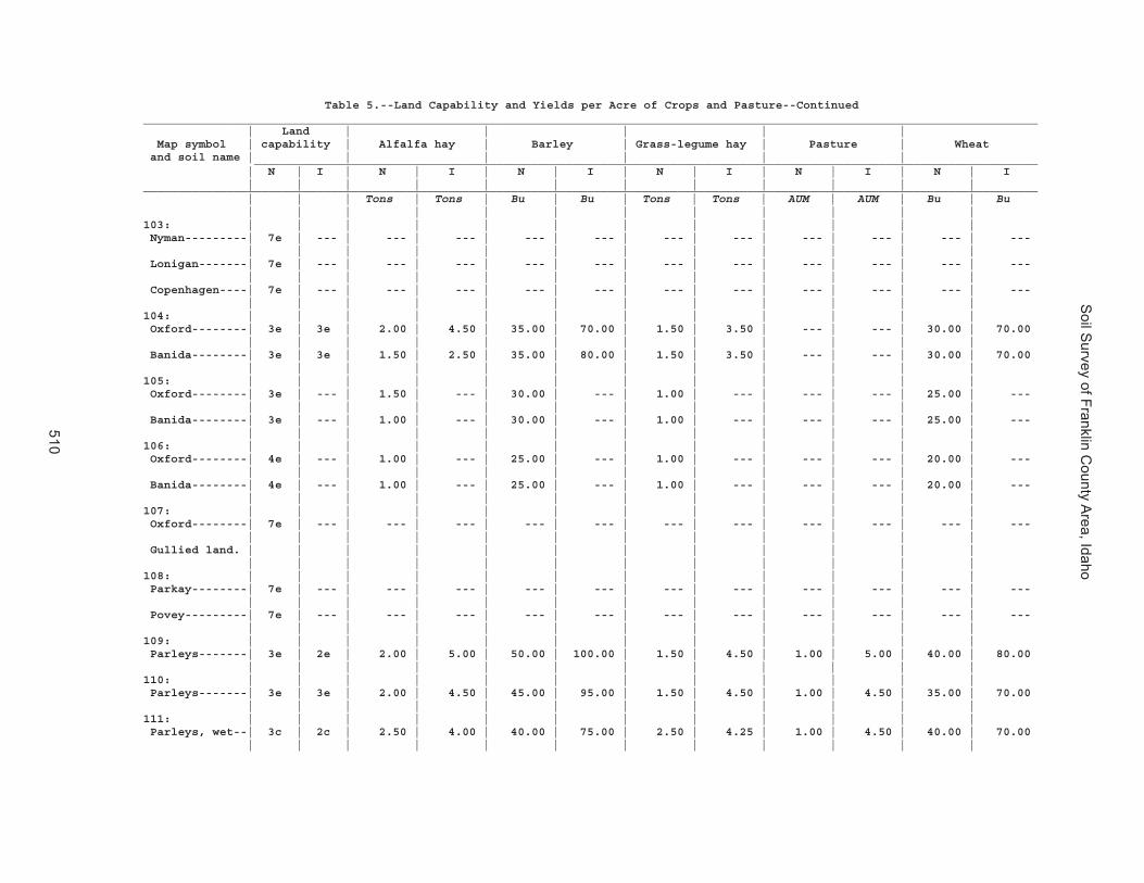
Soil S
urvey of Franklin County A
rea, Idaho
510
Table 5.--Land Capability and Yields per Acre of Crops and Pasture--Continued_________________________________________________________________________________________________________________________________ | Land | | | | | Map symbol | capability | Alfalfa hay | Barley | Grass-legume hay | Pasture | Wheat and soil name | | | | | | _________________________________________________________________________________________________________________ | N | I | N | I | N | I | N | I | N | I | N | I | | | | | | | | | | | |_________________________________________________________________________________________________________________________________ | | | Tons | Tons | Bu | Bu | Tons | Tons | AUM | AUM | Bu | Bu | | | | | | | | | | | |103: | | | | | | | | | | | | Nyman---------| 7e | --- | --- | --- | --- | --- | --- | --- | --- | --- | --- | --- | | | | | | | | | | | | Lonigan-------| 7e | --- | --- | --- | --- | --- | --- | --- | --- | --- | --- | --- | | | | | | | | | | | | Copenhagen----| 7e | --- | --- | --- | --- | --- | --- | --- | --- | --- | --- | --- | | | | | | | | | | | |104: | | | | | | | | | | | | Oxford--------| 3e | 3e | 2.00 | 4.50 | 35.00 | 70.00 | 1.50 | 3.50 | --- | --- | 30.00 | 70.00 | | | | | | | | | | | | Banida--------| 3e | 3e | 1.50 | 2.50 | 35.00 | 80.00 | 1.50 | 3.50 | --- | --- | 30.00 | 70.00 | | | | | | | | | | | |105: | | | | | | | | | | | | Oxford--------| 3e | --- | 1.50 | --- | 30.00 | --- | 1.00 | --- | --- | --- | 25.00 | --- | | | | | | | | | | | | Banida--------| 3e | --- | 1.00 | --- | 30.00 | --- | 1.00 | --- | --- | --- | 25.00 | --- | | | | | | | | | | | |106: | | | | | | | | | | | | Oxford--------| 4e | --- | 1.00 | --- | 25.00 | --- | 1.00 | --- | --- | --- | 20.00 | --- | | | | | | | | | | | | Banida--------| 4e | --- | 1.00 | --- | 25.00 | --- | 1.00 | --- | --- | --- | 20.00 | --- | | | | | | | | | | | |107: | | | | | | | | | | | | Oxford--------| 7e | --- | --- | --- | --- | --- | --- | --- | --- | --- | --- | --- | | | | | | | | | | | | Gullied land. | | | | | | | | | | | | | | | | | | | | | | | |108: | | | | | | | | | | | | Parkay--------| 7e | --- | --- | --- | --- | --- | --- | --- | --- | --- | --- | --- | | | | | | | | | | | | Povey---------| 7e | --- | --- | --- | --- | --- | --- | --- | --- | --- | --- | --- | | | | | | | | | | | |109: | | | | | | | | | | | | Parleys-------| 3e | 2e | 2.00 | 5.00 | 50.00 | 100.00 | 1.50 | 4.50 | 1.00 | 5.00 | 40.00 | 80.00 | | | | | | | | | | | |110: | | | | | | | | | | | | Parleys-------| 3e | 3e | 2.00 | 4.50 | 45.00 | 95.00 | 1.50 | 4.50 | 1.00 | 4.50 | 35.00 | 70.00 | | | | | | | | | | | |111: | | | | | | | | | | | | Parleys, wet--| 3c | 2c | 2.50 | 4.00 | 40.00 | 75.00 | 2.50 | 4.25 | 1.00 | 4.50 | 40.00 | 70.00 | | | | | | | | | | | |

Soil S
urvey of Franklin County A
rea, Idaho
511
Table 5.--Land Capability and Yields per Acre of Crops and Pasture--Continued_________________________________________________________________________________________________________________________________ | Land | | | | | Map symbol | capability | Alfalfa hay | Barley | Grass-legume hay | Pasture | Wheat and soil name | | | | | | _________________________________________________________________________________________________________________ | N | I | N | I | N | I | N | I | N | I | N | I | | | | | | | | | | | |_________________________________________________________________________________________________________________________________ | | | Tons | Tons | Bu | Bu | Tons | Tons | AUM | AUM | Bu | Bu | | | | | | | | | | | |112: | | | | | | | | | | | | Pavohroo------| 7e | --- | --- | --- | --- | --- | --- | --- | --- | --- | --- | --- | | | | | | | | | | | | Sedgway-------| 7e | --- | --- | --- | --- | --- | --- | --- | --- | --- | --- | --- | | | | | | | | | | | | Toponce-------| 6e | --- | --- | --- | --- | --- | --- | --- | --- | --- | --- | --- | | | | | | | | | | | |113: | | | | | | | | | | | | Picabo--------| 3w | 3w | --- | --- | --- | 65.00 | --- | --- | 2.00 | 5.00 | --- | 55.00 | | | | | | | | | | | | Thatcherflats | 4s | 4s | --- | --- | --- | 20.00 | --- | --- | 1.00 | 2.00 | --- | 15.00 | | | | | | | | | | | |114: | | | | | | | | | | | | Pits, gravel. | | | | | | | | | | | | | | | | | | | | | | | |115: | | | | | | | | | | | | Pollynot------| 4e | --- | --- | --- | 35.00 | --- | --- | --- | --- | --- | 30.00 | --- | | | | | | | | | | | |116: | | | | | | | | | | | | Pollynot------| 3c | 2c | 2.00 | 6.00 | 45.00 | 100.00 | --- | --- | --- | --- | 40.00 | 85.00 | | | | | | | | | | | |117: | | | | | | | | | | | | Pollynot------| 3c | 3e | 2.00 | 6.00 | 45.00 | 100.00 | --- | --- | --- | --- | 40.00 | 80.00 | | | | | | | | | | | |118: | | | | | | | | | | | | Pollynot------| 4e | --- | --- | --- | 35.00 | --- | --- | --- | --- | --- | 30.00 | --- | | | | | | | | | | | |119: | | | | | | | | | | | | Polumar-------| 7s | --- | --- | --- | --- | --- | --- | --- | --- | --- | --- | --- | | | | | | | | | | | | Ireland-------| 7s | --- | --- | --- | --- | --- | --- | --- | --- | --- | --- | --- | | | | | | | | | | | |120: | | | | | | | | | | | | Polumar-------| 7s | --- | --- | --- | --- | --- | --- | --- | --- | --- | --- | --- | | | | | | | | | | | | Sprollow------| 7s | --- | --- | --- | --- | --- | --- | --- | --- | --- | --- | --- | | | | | | | | | | | | Ireland-------| 7s | --- | --- | --- | --- | --- | --- | --- | --- | --- | --- | --- | | | | | | | | | | | |121: | | | | | | | | | | | | Povey---------| 6e | --- | --- | --- | --- | --- | --- | --- | --- | --- | --- | --- | | | | | | | | | | | | Hades---------| 6e | --- | --- | --- | --- | --- | --- | --- | --- | --- | --- | --- | | | | | | | | | | | | Hondoho-------| 6e | --- | --- | --- | --- | --- | --- | --- | --- | --- | --- | --- | | | | | | | | | | | |

Soil S
urvey of Franklin County A
rea, Idaho
512
Table 5.--Land Capability and Yields per Acre of Crops and Pasture--Continued_________________________________________________________________________________________________________________________________ | Land | | | | | Map symbol | capability | Alfalfa hay | Barley | Grass-legume hay | Pasture | Wheat and soil name | | | | | | _________________________________________________________________________________________________________________ | N | I | N | I | N | I | N | I | N | I | N | I | | | | | | | | | | | |_________________________________________________________________________________________________________________________________ | | | Tons | Tons | Bu | Bu | Tons | Tons | AUM | AUM | Bu | Bu | | | | | | | | | | | |122: | | | | | | | | | | | | Povey---------| 7e | --- | --- | --- | --- | --- | --- | --- | --- | --- | --- | --- | | | | | | | | | | | | Parkay--------| 7e | --- | --- | --- | --- | --- | --- | --- | --- | --- | --- | --- | | | | | | | | | | | |123: | | | | | | | | | | | | Preston-------| 4s | 4s | 0.50 | 3.50 | 20.00 | 85.00 | 0.75 | 3.75 | 0.75 | 4.50 | 15.00 | 70.00 | | | | | | | | | | | |124: | | | | | | | | | | | | Preston-------| 4s | 4e | 0.50 | 3.50 | 15.00 | 75.00 | 0.75 | 3.75 | 0.75 | 4.50 | 10.00 | 60.00 | | | | | | | | | | | |125: | | | | | | | | | | | | Preston-------| 4e | 6e | 0.50 | 3.50 | 10.00 | 70.00 | 0.50 | 3.25 | 0.50 | 3.50 | 5.00 | 55.00 | | | | | | | | | | | |126: | | | | | | | | | | | | Preston-------| 7e | --- | --- | --- | --- | --- | --- | --- | 0.50 | --- | --- | --- | | | | | | | | | | | | Xerorthents---| 7e | --- | --- | --- | --- | --- | --- | --- | 0.50 | --- | --- | --- | | | | | | | | | | | |127: | | | | | | | | | | | | Ricrest-------| 3e | --- | --- | --- | 40.00 | --- | --- | --- | --- | --- | 35.00 | --- | | | | | | | | | | | |128: | | | | | | | | | | | | Sanyon--------| 7e | --- | --- | --- | 15.00 | --- | --- | --- | --- | --- | 10.00 | --- | | | | | | | | | | | | Staberg-------| 7e | --- | --- | --- | 25.00 | --- | --- | --- | --- | --- | 20.00 | --- | | | | | | | | | | | | Kabear--------| 7e | --- | --- | --- | 25.00 | --- | --- | --- | --- | --- | 20.00 | --- | | | | | | | | | | | |129: | | | | | | | | | | | | Smidale-------| 7e | --- | --- | --- | --- | --- | --- | --- | --- | --- | --- | --- | | | | | | | | | | | |130: | | | | | | | | | | | | Smidale-------| 7e | --- | --- | --- | --- | --- | --- | --- | --- | --- | --- | --- | | | | | | | | | | | | Staberg-------| 6e | --- | --- | --- | --- | --- | --- | --- | --- | --- | --- | --- | | | | | | | | | | | |131: | | | | | | | | | | | | Sprollow------| 7s | --- | --- | --- | --- | --- | --- | --- | --- | --- | --- | --- | | | | | | | | | | | | Hondoho-------| 7e | --- | --- | --- | --- | --- | --- | --- | --- | --- | --- | --- | | | | | | | | | | | |132: | | | | | | | | | | | | Sprollow------| 7s | --- | --- | --- | --- | --- | --- | --- | --- | --- | --- | --- | | | | | | | | | | | | Hymas---------| 7s | --- | --- | --- | --- | --- | --- | --- | --- | --- | --- | --- | | | | | | | | | | | |

Soil S
urvey of Franklin County A
rea, Idaho
513
Table 5.--Land Capability and Yields per Acre of Crops and Pasture--Continued_________________________________________________________________________________________________________________________________ | Land | | | | | Map symbol | capability | Alfalfa hay | Barley | Grass-legume hay | Pasture | Wheat and soil name | | | | | | _________________________________________________________________________________________________________________ | N | I | N | I | N | I | N | I | N | I | N | I | | | | | | | | | | | |_________________________________________________________________________________________________________________________________ | | | Tons | Tons | Bu | Bu | Tons | Tons | AUM | AUM | Bu | Bu | | | | | | | | | | | |133: | | | | | | | | | | | | Sterling------| 2e | 2e | 1.00 | 2.75 | 30.00 | 65.00 | --- | --- | 1.00 | 3.50 | 30.00 | 60.00 | | | | | | | | | | | |134: | | | | | | | | | | | | Sterling------| 2e | 3e | 1.00 | 2.50 | 20.00 | 50.00 | --- | --- | 0.75 | 2.50 | 20.00 | 50.00 | | | | | | | | | | | |135: | | | | | | | | | | | | Sterling------| 6s | --- | --- | --- | 20.00 | --- | --- | --- | --- | --- | 20.00 | --- | | | | | | | | | | | |136: | | | | | | | | | | | | Sterling------| 7e | --- | --- | --- | --- | --- | --- | --- | --- | --- | --- | --- | | | | | | | | | | | |137: | | | | | | | | | | | | Sterling------| 2e | 2e | 1.00 | 2.75 | 30.00 | 65.00 | --- | --- | 1.00 | 5.00 | 30.00 | 60.00 | | | | | | | | | | | | Parleys-------| 3e | 2e | 1.00 | 5.00 | 50.00 | 100.00 | --- | --- | 1.00 | 5.00 | 40.00 | 80.00 | | | | | | | | | | | |138: | | | | | | | | | | | | Thatcher------| 6e | --- | --- | --- | 30.00 | --- | --- | --- | --- | --- | 25.00 | --- | | | | | | | | | | | | Bearhollow----| 6e | --- | --- | --- | 30.00 | --- | --- | --- | --- | --- | 25.00 | --- | | | | | | | | | | | |139: | | | | | | | | | | | | Toponce-------| 4e | --- | --- | --- | 30.00 | --- | --- | --- | --- | --- | 25.00 | --- | | | | | | | | | | | | Broadhead-----| 4e | --- | --- | --- | 33.00 | --- | --- | --- | --- | --- | 28.00 | --- | | | | | | | | | | | |140: | | | | | | | | | | | | Trenton-------| 3s | 3s | 1.00 | 3.50 | --- | 60.00 | 1.25 | 4.00 | 1.25 | 3.50 | --- | 55.00 | | | | | | | | | | | | Battle Creek--| 3s | 3s | 1.00 | 4.00 | --- | 85.00 | 1.50 | 4.00 | 1.50 | 4.00 | --- | 75.00 | | | | | | | | | | | |141: | | | | | | | | | | | | Trenton, cool | 3s | 3s | 1.00 | 3.50 | --- | 60.00 | 1.25 | 4.00 | 1.25 | 3.50 | --- | 55.00 | | | | | | | | | | | | Battle Creek, | | | | | | | | | | | | cool---------| 3s | 3s | 1.00 | 4.00 | --- | 85.00 | 1.50 | 4.00 | 1.50 | 4.00 | --- | 75.00 | | | | | | | | | | | |142: | | | | | | | | | | | | Trenton-------| 3s | 3s | 1.00 | 3.50 | --- | 60.00 | 1.25 | 4.00 | 1.25 | 3.50 | --- | 55.00 | | | | | | | | | | | | Parleys-------| 3c | 2c | 2.50 | 4.00 | --- | 75.00 | 2.50 | 4.25 | 1.50 | 4.00 | --- | 70.00 | | | | | | | | | | | |

Soil S
urvey of Franklin County A
rea, Idaho
514
Table 5.--Land Capability and Yields per Acre of Crops and Pasture--Continued_________________________________________________________________________________________________________________________________ | Land | | | | | Map symbol | capability | Alfalfa hay | Barley | Grass-legume hay | Pasture | Wheat and soil name | | | | | | _________________________________________________________________________________________________________________ | N | I | N | I | N | I | N | I | N | I | N | I | | | | | | | | | | | |_________________________________________________________________________________________________________________________________ | | | Tons | Tons | Bu | Bu | Tons | Tons | AUM | AUM | Bu | Bu | | | | | | | | | | | |143: | | | | | | | | | | | | Valmar--------| 7e | --- | --- | --- | --- | --- | --- | --- | --- | --- | --- | --- | | | | | | | | | | | | Camelback-----| 7e | --- | --- | --- | --- | --- | --- | --- | --- | --- | --- | --- | | | | | | | | | | | | Hades---------| 7e | --- | --- | --- | --- | --- | --- | --- | --- | --- | --- | --- | | | | | | | | | | | |144: | | | | | | | | | | | | Vitale--------| 7e | --- | --- | --- | --- | --- | --- | --- | --- | --- | --- | --- | | | | | | | | | | | | Bergquist-----| 7e | --- | --- | --- | --- | --- | --- | --- | --- | --- | --- | --- | | | | | | | | | | | | Rock outcrop. | | | | | | | | | | | | | | | | | | | | | | | |145: | | | | | | | | | | | | Vitale--------| 7s | --- | --- | --- | --- | --- | --- | --- | --- | --- | --- | --- | | | | | | | | | | | | Yeates Hollow | 4e | --- | --- | --- | --- | --- | --- | --- | --- | --- | --- | --- | | | | | | | | | | | | Northwater----| 6e | --- | --- | --- | --- | --- | --- | --- | --- | --- | --- | --- | | | | | | | | | | | |146: | | | | | | | | | | | | Welby---------| 3c | 2c | 2.00 | 4.00 | 35.00 | 80.00 | 2.00 | 4.50 | 1.50 | 4.50 | 30.00 | 70.00 | | | | | | | | | | | |147: | | | | | | | | | | | | Welby---------| 3c | 2c | 2.00 | 4.00 | 35.00 | 80.00 | 2.00 | 4.50 | 1.50 | 4.50 | 30.00 | 70.00 | | | | | | | | | | | |148: | | | | | | | | | | | | Welby, wet----| 3c | 2c | 1.50 | 4.00 | 35.00 | 75.00 | 2.00 | 4.50 | 1.00 | 4.50 | 30.00 | 65.00 | | | | | | | | | | | |149: | | | | | | | | | | | | Collinston----| 4e | --- | --- | --- | 35.00 | --- | --- | --- | --- | --- | 30.00 | --- | | | | | | | | | | | | Wheelon-------| 3e | --- | --- | --- | 25.00 | --- | --- | --- | --- | --- | 25.00 | --- | | | | | | | | | | | |150: | | | | | | | | | | | | Wheelon-------| 4e | --- | --- | --- | 15.00 | --- | --- | --- | --- | --- | 15.00 | --- | | | | | | | | | | | | Collinston----| 4e | --- | --- | --- | 35.00 | --- | --- | --- | --- | --- | 30.00 | --- | | | | | | | | | | | |151: | | | | | | | | | | | | Wheelon-------| 7e | --- | --- | --- | --- | --- | --- | --- | --- | --- | --- | --- | | | | | | | | | | | | Collinston----| 7e | --- | --- | --- | --- | --- | --- | --- | --- | --- | --- | --- | | | | | | | | | | | |

Soil S
urvey of Franklin County A
rea, Idaho
515
Table 5.--Land Capability and Yields per Acre of Crops and Pasture--Continued_________________________________________________________________________________________________________________________________ | Land | | | | | Map symbol | capability | Alfalfa hay | Barley | Grass-legume hay | Pasture | Wheat and soil name | | | | | | _________________________________________________________________________________________________________________ | N | I | N | I | N | I | N | I | N | I | N | I | | | | | | | | | | | |_________________________________________________________________________________________________________________________________ | | | Tons | Tons | Bu | Bu | Tons | Tons | AUM | AUM | Bu | Bu | | | | | | | | | | | |152: | | | | | | | | | | | | Windernot-----| 3s | 3s | 1.50 | 4.00 | --- | 95.00 | 1.50 | 3.50 | 2.00 | 4.00 | --- | 75.00 | | | | | | | | | | | | Lewnot--------| 3w | 3w | 1.50 | 4.00 | --- | 90.00 | 1.50 | 3.00 | 3.00 | 7.00 | --- | 80.00 | | | | | | | | | | | | Stinkcreek----| 5w | 5w | 1.00 | 3.50 | --- | 60.00 | 2.00 | 3.50 | 4.50 | 6.00 | --- | 50.00 | | | | | | | | | | | |153: | | | | | | | | | | | | Winn----------| 3w | 3w | --- | --- | --- | 70.00 | --- | --- | --- | --- | --- | 60.00 | | | | | | | | | | | |154: | | | | | | | | | | | | Winwell-------| 2c | 2c | 2.00 | 5.50 | 50.00 | 110.00 | --- | --- | --- | --- | 45.00 | 95.00 | | | | | | | | | | | |155: | | | | | | | | | | | | Winwell-------| 2e | 3e | 2.00 | 5.00 | 45.00 | 100.00 | --- | --- | --- | --- | 40.00 | 90.00 | | | | | | | | | | | | Collinston----| 3e | 3e | 2.00 | 5.00 | 35.00 | 90.00 | --- | --- | --- | --- | 30.00 | 80.00 | | | | | | | | | | | |156: | | | | | | | | | | | | Wormcreek-----| 6e | --- | --- | --- | --- | --- | --- | --- | --- | --- | --- | --- | | | | | | | | | | | | Copenhagen----| 7e | --- | --- | --- | --- | --- | --- | --- | --- | --- | --- | --- | | | | | | | | | | | |157: | | | | | | | | | | | | Wormcreek-----| 6e | --- | --- | --- | 25.00 | --- | --- | --- | --- | --- | 20.00 | --- | | | | | | | | | | | | Lonigan-------| 6e | --- | --- | --- | 25.00 | --- | --- | --- | --- | --- | 20.00 | --- | | | | | | | | | | | |158: | | | | | | | | | | | | Wursten-------| 4e | --- | --- | --- | --- | --- | --- | --- | --- | --- | --- | --- | | | | | | | | | | | | Dirtyhead-----| 4e | --- | --- | --- | --- | --- | --- | --- | --- | --- | --- | --- | | | | | | | | | | | |159: | | | | | | | | | | | | Xerochrepts---| 6e | --- | --- | --- | --- | --- | --- | --- | --- | --- | --- | --- | | | | | | | | | | | | Wormcreek-----| 7e | --- | --- | --- | --- | --- | --- | --- | --- | --- | --- | --- | | | | | | | | | | | | Xerorthents---| 7e | --- | --- | --- | --- | --- | --- | --- | --- | --- | --- | --- | | | | | | | | | | | |160: | | | | | | | | | | | | Xerorthents---| 7e | --- | --- | --- | --- | --- | --- | --- | --- | --- | --- | --- | | | | | | | | | | | |161: | | | | | | | | | | | | Yeates Hollow | 7s | --- | --- | --- | --- | --- | --- | --- | --- | --- | --- | --- | | | | | | | | | | | |

Soil S
urvey of Franklin County A
rea, Idaho
516
Table 5.--Land Capability and Yields per Acre of Crops and Pasture--Continued_________________________________________________________________________________________________________________________________ | Land | | | | | Map symbol | capability | Alfalfa hay | Barley | Grass-legume hay | Pasture | Wheat and soil name | | | | | | _________________________________________________________________________________________________________________ | N | I | N | I | N | I | N | I | N | I | N | I | | | | | | | | | | | |_________________________________________________________________________________________________________________________________ | | | Tons | Tons | Bu | Bu | Tons | Tons | AUM | AUM | Bu | Bu | | | | | | | | | | | |162: | | | | | | | | | | | | Yeates Hollow | 4e | --- | --- | --- | --- | --- | --- | --- | --- | --- | --- | --- | | | | | | | | | | | | Manila--------| 4e | --- | --- | --- | --- | --- | --- | --- | --- | --- | --- | --- | | | | | | | | | | | | Softback------| 6s | --- | --- | --- | --- | --- | --- | --- | --- | --- | --- | --- | | | | | | | | | | | |163: | | | | | | | | | | | | Yeates Hollow | 7s | --- | --- | --- | --- | --- | --- | --- | --- | --- | --- | --- | | | | | | | | | | | | Vitale--------| 7s | --- | --- | --- | --- | --- | --- | --- | --- | --- | --- | --- | | | | | | | | | | | |164: | | | | | | | | | | | | Water. | | | | | | | | | | | | | | | | | | | | | | | |_________________________________________________________________________________________________________________________________

Soil S
urvey of Franklin County A
rea, Idaho
517
Table 6.--Rangeland Productivity and Characteristic Plant Communities
(Only the soils that support rangeland vegetation suitable for grazing are rated.)
_____________________________________________________________________________________________________________________________________ | | Total dry-weight production | | Map symbol | Ecological site |___________________________________| Characteristic vegetation | Rangeland and soil name | | Favorable | Normal |Unfavorable| | composition | | year | year | year | | | | | | | |_____________________________________________________________________________________________________________________________________ | | Lb/acre | Lb/acre | Lb/acre | | Pct | | | | | |1: | | | | | | Airport-----------------|Semiwet Saline Meadow | 2,500 | 1,750 | 1,000 |Alkali sacaton-----------------| 20 | (R028AY001ID) | | | |Inland saltgrass---------------| 20 | | | | |Black greasewood---------------| 5 | | | | |Miscellaneous perennial forbs--| 5 | | | | |Miscellaneous perennial grasses| 5 | | | | |Miscellaneous shrubs-----------| 5 | | | | |Rush---------------------------| 5 | | | | | |13: | | | | | | Bear Lake---------------|Wet Meadow (R013XY038ID) | 4,500 | 3,600 | 3,000 |Tufted hairgrass---------------| 20 | | | | |Kentucky bluegrass-------------| 5 | | | | |Cinquefoil---------------------| 5 | | | | |Clover-------------------------| 5 | | | | |Miscellaneous perennial forbs--| 5 | | | | |Miscellaneous perennial grasses| 5 | | | | |Miscellaneous shrubs-----------| 5 | | | | | | Chesbrook---------------|Wet Meadow (R013XY038ID) | 4,500 | 3,600 | 3,000 |Tufted hairgrass---------------| 20 | | | | |Cinquefoil---------------------| 5 | | | | |Clover-------------------------| 5 | | | | |Miscellaneous perennial forbs--| 5 | | | | |Miscellaneous perennial grasses| 5 | | | | | | Picabo------------------|Semiwet Meadow | 3,000 | 2,200 | 1,400 |Tufted hairgrass---------------| 15 | (R028AY029ID) | | | |Slender wheatgrass-------------| 10 | | | | |Baltic rush--------------------| 5 | | | | |Cinquefoil---------------------| 5 | | | | |Clover-------------------------| 5 | | | | |Shrubby cinquefoil-------------| 5 | | | | | |14: | | | | | | Bear Lake---------------|Wet Meadow (R028AY028ID) | 4,500 | 3,600 | 3,000 |Tufted hairgrass---------------| 20 | | | | |Kentucky bluegrass-------------| 5 | | | | |Cinquefoil---------------------| 5 | | | | |Clover-------------------------| 5 | | | | |Miscellaneous perennial forbs--| 5 | | | | |Miscellaneous perennial grasses| 5 | | | | |Miscellaneous shrubs-----------| 5 | | | | | | Downata-----------------|Marsh Scac/tyla | 5,300 | 4,500 | 3,800 |Broadleaf cattail--------------| 45 | (R028AY030ID) | | | |Hardstem bulrush---------------| 45 | | | | | |

Soil S
urvey of Franklin County A
rea, Idaho
518
Table 6.--Rangeland Productivity and Characteristic Plant Communities--Continued_____________________________________________________________________________________________________________________________________ | | Total dry-weight production | | Map symbol | Ecological site |___________________________________| Characteristic vegetation | Rangeland and soil name | | Favorable | Normal |Unfavorable| | composition | | year | year | year | | | | | | | |_____________________________________________________________________________________________________________________________________ | | Lb/acre | Lb/acre | Lb/acre | | Pct | | | | | |15: | | | | | | Bear Lake---------------|Wet Meadow (R028AY028ID) | 4,500 | 3,600 | 3,000 |Tufted hairgrass---------------| 20 | | | | |Kentucky bluegrass-------------| 5 | | | | |Cinquefoil---------------------| 5 | | | | |Clover-------------------------| 5 | | | | |Miscellaneous perennial forbs--| 5 | | | | |Miscellaneous perennial grasses| 5 | | | | |Miscellaneous shrubs-----------| 5 | | | | | | Downata-----------------|Marsh Scac/tyla | 5,300 | 4,500 | 3,800 |Broadleaf cattail--------------| 45 | (R028AY030ID) | | | |Hardstem bulrush---------------| 45 | | | | | | Thatcherflats-----------|Alkali Flats 8-12 | 500 | 300 | 100 |Bottlebrush squirreltail-------| 40 | Save4/elel5 | | | |Black greasewood---------------| 30 | (R028AY011ID) | | | |Gardner saltbush---------------| 5 | | | | |Miscellaneous perennial forbs--| 5 | | | | |Miscellaneous perennial grasses| 5 | | | | |Miscellaneous shrubs-----------| 5 | | | | | |16: | | | | | | Bear Lake---------------|Wet Meadow (R013XY038ID) | 4,500 | 3,600 | 3,000 |Tufted hairgrass---------------| 20 | | | | |Kentucky bluegrass-------------| 5 | | | | |Cinquefoil---------------------| 5 | | | | |Clover-------------------------| 5 | | | | |Miscellaneous perennial forbs--| 5 | | | | |Miscellaneous perennial grasses| 5 | | | | |Miscellaneous shrubs-----------| 5 | | | | | | Lago--------------------|Semiwet Meadow | 3,400 | 2,600 | 2,000 |Slender wheatgrass-------------| 20 | (R013XY039ID) | | | |Tufted hairgrass---------------| 15 | | | | |Baltic rush--------------------| 5 | | | | |Cinquefoil---------------------| 5 | | | | |Fowl bluegrass-----------------| 5 | | | | | |17: | | | | | | Bearhollow--------------|Loamy 13-16 Artrv/pssp6 | 1,600 | 1,300 | 900 |Bluebunch wheatgrass-----------| 20 | (R013XY001ID) | | | |Mountain big sagebrush---------| 20 | | | | |Miscellaneous perennial grasses| 15 | | | | |Miscellaneous perennial forbs--| 10 | | | | |Prairie junegrass--------------| 10 | | | | |Common snowberry---------------| 5 | | | | |Geranium-----------------------| 5 | | | | |Miscellaneous shrubs-----------| 5 | | | | |Rabbitbrush--------------------| 5 | | | | | |

Soil S
urvey of Franklin County A
rea, Idaho
519
Table 6.--Rangeland Productivity and Characteristic Plant Communities--Continued_____________________________________________________________________________________________________________________________________ | | Total dry-weight production | | Map symbol | Ecological site |___________________________________| Characteristic vegetation | Rangeland and soil name | | Favorable | Normal |Unfavorable| | composition | | year | year | year | | | | | | | |_____________________________________________________________________________________________________________________________________ | | Lb/acre | Lb/acre | Lb/acre | | Pct | | | | | |17: | | | | | | Brifox------------------|Loamy 13-16 Artrv/pssp6 | 1,600 | 1,300 | 900 |Bluebunch wheatgrass-----------| 25 | (R013XY001ID) | | | |Mountain big sagebrush---------| 20 | | | | |Miscellaneous perennial grasses| 15 | | | | |Miscellaneous perennial forbs--| 10 | | | | |Prairie junegrass--------------| 10 | | | | |Common snowberry---------------| 5 | | | | |Geranium-----------------------| 5 | | | | |Miscellaneous shrubs-----------| 5 | | | | |Rabbitbrush--------------------| 5 | | | | | | Iphil-------------------|Loamy 13-16 Artrv/pssp6 | 1,800 | 1,200 | 800 |Bluebunch wheatgrass-----------| 30 | (R013XY001ID) | | | |Mountain big sagebrush---------| 10 | | | | |Antelope bitterbrush-----------| 5 | | | | |Arrowleaf balsamroot-----------| 5 | | | | |Longleaf hawksbeard------------| 5 | | | | |Prairie junegrass--------------| 5 | | | | |Slender wheatgrass-------------| 5 | | | | |Snowberry----------------------| 5 | | | | |Western yarrow-----------------| 5 | | | | | |18: | | | | | | Bergquist---------------|Steep Slopes 12-16 | 1,500 | 1,100 | 550 |Bluebunch wheatgrass-----------| 25 | Artrv/pssp6 | | | |Mountain big sagebrush---------| 20 | (R013XY008ID) | | | |Miscellaneous perennial grasses| 20 | | | | |Miscellaneous perennial forbs--| 10 | | | | |Miscellaneous shrubs-----------| 10 | | | | |Nevada bluegrass---------------| 5 | | | | |Antelope bitterbrush-----------| 5 | | | | |Arrowleaf balsamroot-----------| 5 | | | | | | | | | | | |19: | | | | | | Bergquist---------------|Mountain Loam 18-22 | 2,100 | 1,900 | 1,600 |Bigtooth maple-----------------| 10 | Acsag2/artrv/pssp6 | | | |Bluebunch wheatgrass-----------| 10 | (R047XY009ID) | | | |Mountain big sagebrush---------| 10 | | | | |Miscellaneous perennial forbs--| 10 | | | | |Miscellaneous perennial grasses| 10 | | | | |Miscellaneous shrubs-----------| 10 | | | | |Nevada bluegrass---------------| 5 | | | | |Common chokecherry-------------| 5 | | | | |Snowberry----------------------| 5 | | | | | |

Soil S
urvey of Franklin County A
rea, Idaho
520
Table 6.--Rangeland Productivity and Characteristic Plant Communities--Continued_____________________________________________________________________________________________________________________________________ | | Total dry-weight production | | Map symbol | Ecological site |___________________________________| Characteristic vegetation | Rangeland and soil name | | Favorable | Normal |Unfavorable| | composition | | year | year | year | | | | | | | |_____________________________________________________________________________________________________________________________________ | | Lb/acre | Lb/acre | Lb/acre | | Pct | | | | | |19: | | | | | | Softback----------------|Mountain Loam 18-22 | 3,100 | 2,700 | 2,400 |Bigtooth maple-----------------| 10 | Acsag2/artrv/pssp6 | | | |Bluebunch wheatgrass-----------| 10 | (R047XY009ID) | | | |Mountain big sagebrush---------| 10 | | | | |Miscellaneous perennial forbs--| 10 | | | | |Miscellaneous shrubs-----------| 10 | | | | |Rocky Mountain juniper---------| 5 | | | | |Common chokecherry-------------| 5 | | | | |Miscellaneous perennial grasses| 5 | | | | | |20: | | | | | | Bergquist---------------|Mountain Loam 18-22 | 2,100 | 1,900 | 1,600 |Bigtooth maple-----------------| 10 | Acsag2/artrv/pssp6 | | | |Bluebunch wheatgrass-----------| 10 | (R047XY009ID) | | | |Mountain big sagebrush---------| 10 | | | | |Miscellaneous perennial forbs--| 10 | | | | |Miscellaneous perennial grasses| 10 | | | | |Miscellaneous shrubs-----------| 10 | | | | |Nevada bluegrass---------------| 5 | | | | |Common chokecherry-------------| 5 | | | | |Snowberry----------------------| 5 | | | | | | Vitale------------------|Gravelly Loam 16-22 | 1,100 | 800 | 500 |Bluebunch wheatgrass-----------| 30 | Artrv/pssp6 | | | |Mountain big sagebrush---------| 10 | (R013XY007ID) | | | |Nevada bluegrass---------------| 5 | | | | |Arrowleaf balsamroot-----------| 5 | | | | |Cutleaf balsamroot-------------| 5 | | | | |Western wheatgrass-------------| 5 | | | | |Antelope bitterbrush-----------| 2 | | | | | |23: | | | | | | Bothwell----------------|Loamy 13-16 Artrv/pssp6 | 1,500 | 1,200 | 900 |Bluebunch wheatgrass-----------| 35 | (R013XY001ID) | | | |Arrowleaf balsamroot-----------| 10 | | | | |Mountain big sagebrush---------| 10 | | | | |Antelope bitterbrush-----------| 5 | | | | |Miscellaneous perennial forbs--| 5 | | | | |Miscellaneous perennial grasses| 5 | | | | |Miscellaneous shrubs-----------| 5 | | | | |Prairie junegrass--------------| 5 | | | | |Slender wheatgrass-------------| 5 | | | | |Snowberry----------------------| 5 | | | | |Sticky geranium----------------| 5 | | | | | |

Soil S
urvey of Franklin County A
rea, Idaho
521
Table 6.--Rangeland Productivity and Characteristic Plant Communities--Continued_____________________________________________________________________________________________________________________________________ | | Total dry-weight production | | Map symbol | Ecological site |___________________________________| Characteristic vegetation | Rangeland and soil name | | Favorable | Normal |Unfavorable| | composition | | year | year | year | | | | | | | |_____________________________________________________________________________________________________________________________________ | | Lb/acre | Lb/acre | Lb/acre | | Pct | | | | | |23: | | | | | | Hades-------------------|Loamy 13-16 Artrv/pssp6 | 1,800 | 1,200 | 800 |Bluebunch wheatgrass-----------| 35 | (R013XY001ID) | | | |Mountain big sagebrush---------| 10 | | | | |Nevada bluegrass---------------| 5 | | | | |Antelope bitterbrush-----------| 5 | | | | |Arrowleaf balsamroot-----------| 5 | | | | |Miscellaneous perennial forbs--| 5 | | | | |Miscellaneous perennial grasses| 5 | | | | |Miscellaneous shrubs-----------| 5 | | | | |Slender wheatgrass-------------| 5 | | | | | | Justesen----------------|Loamy 13-16 Artrv/pssp6 | 1,900 | 1,400 | 700 |Bluebunch wheatgrass-----------| 35 | (R013XY001ID) | | | |Mountain big sagebrush---------| 10 | | | | |Antelope bitterbrush-----------| 5 | | | | |Arrowleaf balsamroot-----------| 5 | | | | |Prairie junegrass--------------| 5 | | | | |Slender wheatgrass-------------| 5 | | | | |Snowberry----------------------| 5 | | | | | |26: | | | | | | Brifox------------------|Loamy 13-16 Artrv/pssp6 | 1,600 | 1,300 | 900 |Bluebunch wheatgrass-----------| 25 | (R013XY001ID) | | | |Mountain big sagebrush---------| 20 | | | | |Miscellaneous perennial grasses| 15 | | | | |Miscellaneous perennial forbs--| 10 | | | | |Prairie junegrass--------------| 10 | | | | |Common snowberry---------------| 5 | | | | |Geranium-----------------------| 5 | | | | |Miscellaneous shrubs-----------| 5 | | | | |Rabbitbrush--------------------| 5 | | | | | | Huffman-----------------|Loamy 16-22 Artrv/pssp6 | 2,100 | 1,700 | 1,300 |Bluebunch wheatgrass-----------| 40 | 16-22" (R013XY005ID) | | | |Miscellaneous perennial grasses| 15 | | | | |Columbia needlegrass-----------| 10 | | | | |Arrowleaf balsamroot-----------| 5 | | | | |Geranium-----------------------| 5 | | | | |Mountain big sagebrush---------| 5 | | | | |Miscellaneous perennial forbs--| 5 | | | | |Miscellaneous shrubs-----------| 5 | | | | |Prairie junegrass--------------| 5 | | | | |Slender wheatgrass-------------| 5 | | | | | |

Soil S
urvey of Franklin County A
rea, Idaho
522
Table 6.--Rangeland Productivity and Characteristic Plant Communities--Continued_____________________________________________________________________________________________________________________________________ | | Total dry-weight production | | Map symbol | Ecological site |___________________________________| Characteristic vegetation | Rangeland and soil name | | Favorable | Normal |Unfavorable| | composition | | year | year | year | | | | | | | |_____________________________________________________________________________________________________________________________________ | | Lb/acre | Lb/acre | Lb/acre | | Pct | | | | | |29: | | | | | | Brifox------------------|Loamy 13-16 Artrv/pssp6 | 1,600 | 1,300 | 900 |Bluebunch wheatgrass-----------| 25 | (R013XY001ID) | | | |Mountain big sagebrush---------| 20 | | | | |Miscellaneous perennial grasses| 15 | | | | |Miscellaneous perennial forbs--| 10 | | | | |Prairie junegrass--------------| 10 | | | | |Common snowberry---------------| 5 | | | | |Geranium-----------------------| 5 | | | | |Miscellaneous shrubs-----------| 5 | | | | |Rabbitbrush--------------------| 5 | | | | | | Niter-------------------|Loamy 13-16 Artrv/pssp6 | 1,700 | 1,500 | 1,100 |Bluebunch wheatgrass-----------| 25 | (R013XY001ID) | | | |Mountain big sagebrush---------| 20 | | | | |Miscellaneous perennial grasses| 15 | | | | |Miscellaneous perennial forbs--| 10 | | | | |Prairie junegrass--------------| 10 | | | | |Common snowberry---------------| 5 | | | | |Geranium-----------------------| 5 | | | | |Miscellaneous shrubs-----------| 5 | | | | |Rabbitbrush--------------------| 5 | | | | | |30: | | | | | | Broadhead---------------|Loamy 16-22 Artrv/pssp6 | 2,400 | 2,000 | 1,400 |Bluebunch wheatgrass-----------| 40 | 16-22" (R013XY005ID) | | | |Miscellaneous perennial grasses| 15 | | | | |Columbia needlegrass-----------| 10 | | | | |Arrowleaf balsamroot-----------| 5 | | | | |Geranium-----------------------| 5 | | | | |Mountain big sagebrush---------| 5 | | | | |Miscellaneous perennial forbs--| 5 | | | | |Miscellaneous shrubs-----------| 5 | | | | |Prairie junegrass--------------| 5 | | | | |Slender wheatgrass-------------| 5 | | | | | | Hades-------------------|Loamy 16-22 Artrv/pssp6 | 2,400 | 2,000 | 1,400 |Bluebunch wheatgrass-----------| 35 | 16-22" (R013XY005ID) | | | |Mountain big sagebrush---------| 10 | | | | |Nevada bluegrass---------------| 5 | | | | |Antelope bitterbrush-----------| 5 | | | | |Arrowleaf balsamroot-----------| 5 | | | | |Miscellaneous perennial forbs--| 5 | | | | |Miscellaneous perennial grasses| 5 | | | | |Miscellaneous shrubs-----------| 5 | | | | |Slender wheatgrass-------------| 5 | | | | | |

Soil S
urvey of Franklin County A
rea, Idaho
523
Table 6.--Rangeland Productivity and Characteristic Plant Communities--Continued_____________________________________________________________________________________________________________________________________ | | Total dry-weight production | | Map symbol | Ecological site |___________________________________| Characteristic vegetation | Rangeland and soil name | | Favorable | Normal |Unfavorable| | composition | | year | year | year | | | | | | | |_____________________________________________________________________________________________________________________________________ | | Lb/acre | Lb/acre | Lb/acre | | Pct | | | | | |30: | | | | | | Yago--------------------|Stony Loam 16-22 | 1,800 | 1,100 | 600 |Bluebunch wheatgrass-----------| 35 | Artrv/pssp6 | | | |Miscellaneous perennial forbs--| 15 | (R013XY019ID) | | | |Columbia needlegrass-----------| 5 | | | | |Antelope bitterbrush-----------| 5 | | | | |Arrowleaf balsamroot-----------| 5 | | | | |Mountain big sagebrush---------| 5 | | | | |Mountain brome-----------------| 5 | | | | |Miscellaneous perennial grasses| 5 | | | | |Miscellaneous shrubs-----------| 5 | | | | |Slender wheatgrass-------------| 5 | | | | |Western snowberry--------------| 5 | | | | | |31: | | | | | | Broadhead---------------|Loamy 16-22 Artrv/pssp6 | 2,400 | 2,000 | 1,400 |Bluebunch wheatgrass-----------| 40 | 16-22" (R013XY005ID) | | | |Miscellaneous perennial grasses| 15 | | | | |Columbia needlegrass-----------| 10 | | | | |Arrowleaf balsamroot-----------| 5 | | | | |Geranium-----------------------| 5 | | | | |Mountain big sagebrush---------| 5 | | | | |Miscellaneous perennial forbs--| 5 | | | | |Miscellaneous shrubs-----------| 5 | | | | |Prairie junegrass--------------| 5 | | | | |Slender wheatgrass-------------| 5 | | | | | | Yago--------------------|Stony Loam 16-22 | 1,800 | 1,100 | 600 |Bluebunch wheatgrass-----------| 35 | Artrv/pssp6 | | | |Miscellaneous perennial forbs--| 15 | (R013XY019ID) | | | |Columbia needlegrass-----------| 5 | | | | |Antelope bitterbrush-----------| 5 | | | | |Arrowleaf balsamroot-----------| 5 | | | | |Mountain big sagebrush---------| 5 | | | | |Mountain brome-----------------| 5 | | | | |Miscellaneous perennial grasses| 5 | | | | |Miscellaneous shrubs-----------| 5 | | | | |Slender wheatgrass-------------| 5 | | | | |Western snowberry--------------| 5 | | | | | |32: | | | | | | Camelback---------------|Loamy 13-16 Artrv/pssp6 | 1,800 | 1,200 | 800 |Bluebunch wheatgrass-----------| 30 | (R013XY001ID) | | | |Mountain big sagebrush---------| 20 | | | | |Prairie junegrass--------------| 10 | | | | |Antelope bitterbrush-----------| 5 | | | | |Arrowleaf balsamroot-----------| 5 | | | | |Helianthella-------------------| 5 | | | | |Western wheatgrass-------------| 5 | | | | | |

Soil S
urvey of Franklin County A
rea, Idaho
524
Table 6.--Rangeland Productivity and Characteristic Plant Communities--Continued_____________________________________________________________________________________________________________________________________ | | Total dry-weight production | | Map symbol | Ecological site |___________________________________| Characteristic vegetation | Rangeland and soil name | | Favorable | Normal |Unfavorable| | composition | | year | year | year | | | | | | | |_____________________________________________________________________________________________________________________________________ | | Lb/acre | Lb/acre | Lb/acre | | Pct | | | | | |32: | | | | | | Lonigan-----------------|Gravelly Loam 16-22 | 1,100 | 800 | 500 |Bluebunch wheatgrass-----------| 30 | Artrv/pssp6 | | | |Mountain big sagebrush---------| 20 | (R013XY007ID) | | | |Western wheatgrass-------------| 10 | | | | |Nevada bluegrass---------------| 5 | | | | |Antelope bitterbrush-----------| 5 | | | | |Arrowleaf balsamroot-----------| 5 | | | | |Cutleaf balsamroot-------------| 5 | | | | |Longleaf hawksbeard------------| 5 | | | | | |33: | | | | | | Camelback---------------|Steep Slope 16-22 | 2,000 | 1,500 | 900 |Bluebunch wheatgrass-----------| 25 | Artrv/pssp6 | | | |Mountain big sagebrush---------| 10 | (R013XY003ID) | | | |Miscellaneous perennial forbs--| 10 | | | | |Miscellaneous perennial grasses| 10 | | | | |Kentucky bluegrass-------------| 5 | | | | |Nevada bluegrass---------------| 5 | | | | |Antelope bitterbrush-----------| 5 | | | | |Arrowleaf balsamroot-----------| 5 | | | | |Cutleaf balsamroot-------------| 5 | | | | |Miscellaneous shrubs-----------| 5 | | | | |Slender wheatgrass-------------| 5 | | | | |Western snowberry--------------| 5 | | | | | | Hades-------------------|Steep Slope 16-22 | 1,800 | 1,200 | 800 |Bluebunch wheatgrass-----------| 35 | Artrv/pssp6 | | | |Mountain big sagebrush---------| 10 | (R013XY003ID) | | | |Nevada bluegrass---------------| 5 | | | | |Antelope bitterbrush-----------| 5 | | | | |Arrowleaf balsamroot-----------| 5 | | | | |Miscellaneous perennial forbs--| 5 | | | | |Miscellaneous perennial grasses| 5 | | | | |Miscellaneous shrubs-----------| 5 | | | | |Slender wheatgrass-------------| 5 | | | | | | Valmar------------------|Stony Loam 16-22 | 2,000 | 1,500 | 900 |Bluebunch wheatgrass-----------| 20 | Artrv/pssp6 | | | |Mountain big sagebrush---------| 15 | (R013XY019ID) | | | |Miscellaneous perennial grasses| 15 | | | | |Nevada bluegrass---------------| 5 | | | | |Antelope bitterbrush-----------| 5 | | | | |Arrowleaf balsamroot-----------| 5 | | | | |Longleaf hawksbeard------------| 5 | | | | |Lupine-------------------------| 5 | | | | |Miscellaneous perennial forbs--| 5 | | | | |Miscellaneous shrubs-----------| 5 | | | | |Slender wheatgrass-------------| 5 | | | | |Western snowberry--------------| 5 | | | | | |

Soil S
urvey of Franklin County A
rea, Idaho
525
Table 6.--Rangeland Productivity and Characteristic Plant Communities--Continued_____________________________________________________________________________________________________________________________________ | | Total dry-weight production | | Map symbol | Ecological site |___________________________________| Characteristic vegetation | Rangeland and soil name | | Favorable | Normal |Unfavorable| | composition | | year | year | year | | | | | | | |_____________________________________________________________________________________________________________________________________ | | Lb/acre | Lb/acre | Lb/acre | | Pct | | | | | |34: | | | | | | Cedarhill---------------|Gravelly Loam 12-16 | 1,100 | 800 | 500 |Bluebunch wheatgrass-----------| 35 | Artrt/pssp6 | | | |Mountain big sagebrush---------| 10 | (R028AY008ID) | | | |Western wheatgrass-------------| 10 | | | | |Nevada bluegrass---------------| 5 | | | | |Nevada bluegrass---------------| 5 | | | | |Arrowleaf balsamroot-----------| 5 | | | | |Aster--------------------------| 5 | | | | |Cutleaf balsamroot-------------| 5 | | | | |Prairie junegrass--------------| 5 | | | | | |35: | | | | | | Cedarhill---------------|Steep Slopes 12-16 | 1,500 | 1,100 | 600 |Bluebunch wheatgrass-----------| 25 | Artrv/pssp6 | | | |Mountain big sagebrush---------| 20 | (R013XY008ID) | | | |Miscellaneous perennial grasses| 10 | | | | |Miscellaneous shrubs-----------| 10 | | | | |Nevada bluegrass---------------| 5 | | | | |Antelope bitterbrush-----------| 5 | | | | |Arrowleaf balsamroot-----------| 5 | | | | |Miscellaneous perennial forbs--| 5 | | | | |Slender wheatgrass-------------| 5 | | | | |Western wheatgrass-------------| 5 | | | | | | Hades-------------------|Steep Slope 16-22 | 1,800 | 1,200 | 800 |Bluebunch wheatgrass-----------| 35 | Artrv/pssp6 | | | |Mountain big sagebrush---------| 10 | (R013XY003ID) | | | |Nevada bluegrass---------------| 5 | | | | |Antelope bitterbrush-----------| 5 | | | | |Arrowleaf balsamroot-----------| 5 | | | | |Miscellaneous perennial forbs--| 5 | | | | |Miscellaneous perennial grasses| 5 | | | | |Miscellaneous shrubs-----------| 5 | | | | |Slender wheatgrass-------------| 5 | | | | | | Ricrest-----------------|Steep Slope 16-22 | 2,000 | 1,300 | 850 |Bluebunch wheatgrass-----------| 25 | Artrv/pssp6 | | | |Mountain big sagebrush---------| 15 | (R013XY003ID) | | | |Idaho fescue-------------------| 10 | | | | |Miscellaneous perennial grasses| 10 | | | | |Western snowberry--------------| 10 | | | | |Nevada bluegrass---------------| 5 | | | | |Mountain brome-----------------| 5 | | | | |Miscellaneous perennial forbs--| 5 | | | | |Miscellaneous shrubs-----------| 5 | | | | |Sticky geranium----------------| 5 | | | | | |

Soil S
urvey of Franklin County A
rea, Idaho
526
Table 6.--Rangeland Productivity and Characteristic Plant Communities--Continued_____________________________________________________________________________________________________________________________________ | | Total dry-weight production | | Map symbol | Ecological site |___________________________________| Characteristic vegetation | Rangeland and soil name | | Favorable | Normal |Unfavorable| | composition | | year | year | year | | | | | | | |_____________________________________________________________________________________________________________________________________ | | Lb/acre | Lb/acre | Lb/acre | | Pct | | | | | |36: | | | | | | Cedarhill---------------|Steep Slopes 12-16 | 1,500 | 1,100 | 600 |Bluebunch wheatgrass-----------| 25 | Artrv/pssp6 | | | |Mountain big sagebrush---------| 20 | (R013XY008ID) | | | |Miscellaneous perennial grasses| 10 | | | | |Miscellaneous shrubs-----------| 10 | | | | |Nevada bluegrass---------------| 5 | | | | |Antelope bitterbrush-----------| 5 | | | | |Arrowleaf balsamroot-----------| 5 | | | | |Miscellaneous perennial forbs--| 5 | | | | |Slender wheatgrass-------------| 5 | | | | |Western wheatgrass-------------| 5 | | | | | | Hondoho-----------------|Steep Slopes 12-16 | 1,500 | 1,100 | 600 |Bluebunch wheatgrass-----------| 30 | Artrv/pssp6 | | | |Mountain big sagebrush---------| 10 | (R013XY008ID) | | | |Miscellaneous perennial grasses| 10 | | | | |Miscellaneous shrubs-----------| 10 | | | | |Antelope bitterbrush-----------| 5 | | | | |Arrowleaf balsamroot-----------| 5 | | | | |Longleaf hawksbeard------------| 5 | | | | |Miscellaneous perennial forbs--| 5 | | | | |Prairie junegrass--------------| 5 | | | | | | Ridgecrest--------------|Steep Stony 12-16 | 1,400 | 1,100 | 750 |Bluebunch wheatgrass-----------| 15 | Artrv/pssp6 | | | |Mountain big sagebrush---------| 10 | (R013XY026ID) | | | |Miscellaneous shrubs-----------| 10 | | | | |Idaho fescue-------------------| 5 | | | | |Antelope bitterbrush-----------| 5 | | | | |Lupine-------------------------| 5 | | | | |Needlegrass--------------------| 5 | | | | |Miscellaneous perennial forbs--| 5 | | | | |Miscellaneous perennial grasses| 5 | | | | |Slender wheatgrass-------------| 5 | | | | |Sticky geranium----------------| 5 | | | | |Western snowberry--------------| 5 | | | | | |37: | | | | | | Chesbrook---------------|Wet Meadow (R013XY038ID) | 4,500 | 3,600 | 3,000 |Tufted hairgrass---------------| 20 | | | | |Cinquefoil---------------------| 5 | | | | |Clover-------------------------| 5 | | | | |Miscellaneous perennial forbs--| 5 | | | | |Miscellaneous perennial grasses| 5 | | | | | |

Soil S
urvey of Franklin County A
rea, Idaho
527
Table 6.--Rangeland Productivity and Characteristic Plant Communities--Continued_____________________________________________________________________________________________________________________________________ | | Total dry-weight production | | Map symbol | Ecological site |___________________________________| Characteristic vegetation | Rangeland and soil name | | Favorable | Normal |Unfavorable| | composition | | year | year | year | | | | | | | |_____________________________________________________________________________________________________________________________________ | | Lb/acre | Lb/acre | Lb/acre | | Pct | | | | | |37: | | | | | | Bear Lake---------------|Wet Meadow (R013XY038ID) | 4,500 | 3,600 | 3,000 |Tufted hairgrass---------------| 20 | | | | |Kentucky bluegrass-------------| 5 | | | | |Cinquefoil---------------------| 5 | | | | |Clover-------------------------| 5 | | | | |Miscellaneous perennial forbs--| 5 | | | | |Miscellaneous perennial grasses| 5 | | | | |Miscellaneous shrubs-----------| 5 | | | | | |39: | | | | | | Cloudless---------------|Loamy 12-16 Artrt/pssp6 | 1,800 | 1,200 | 800 |Bluebunch wheatgrass-----------| 35 | (R013XY032ID) | | | |Basin big sagebrush------------| 15 | | | | |Antelope bitterbrush-----------| 5 | | | | |Arrowleaf balsamroot-----------| 5 | | | | |Helianthella-------------------| 5 | | | | |Miscellaneous perennial grasses| 5 | | | | | | Hades-------------------|Loamy 12-16 Artrt/pssp6 | 1,800 | 1,200 | 800 |Bluebunch wheatgrass-----------| 35 | (R013XY032ID) | | | |Basin big sagebrush------------| 15 | | | | |Antelope bitterbrush-----------| 5 | | | | |Arrowleaf balsamroot-----------| 5 | | | | |Helianthella-------------------| 5 | | | | |Miscellaneous perennial grasses| 5 | | | | | | Howcan------------------|Loamy 12-16 Artrt/pssp6 | 1,800 | 1,200 | 800 |Bluebunch wheatgrass-----------| 35 | (R013XY032ID) | | | |Basin big sagebrush------------| 15 | | | | |Kentucky bluegrass-------------| 5 | | | | |Nevada bluegrass---------------| 5 | | | | |Arrowleaf balsamroot-----------| 5 | | | | |Snowberry----------------------| 5 | | | | | |40: | | | | | | Copenhagen--------------|Ashy Loam 13-16 | 850 | 650 | 350 |Bluebunch wheatgrass-----------| 30 | Artrv/pssp6 | | | |Mountain big sagebrush---------| 20 | (R013XY009ID) | | | |Nevada bluegrass---------------| 5 | | | | |Antelope bitterbrush-----------| 5 | | | | |Arrowleaf balsamroot-----------| 5 | | | | |Green rabbitbrush--------------| 5 | | | | |Longleaf hawksbeard------------| 5 | | | | | | Lonigan-----------------|Ashy Loam 13-16 | 1,400 | 1,000 | 500 |Bluebunch wheatgrass-----------| 25 | Artrv/pssp6 | | | |Mountain big sagebrush---------| 20 | (R013XY009ID) | | | |Arrowleaf balsamroot-----------| 10 | | | | |Antelope bitterbrush-----------| 5 | | | | | |

Soil S
urvey of Franklin County A
rea, Idaho
528
Table 6.--Rangeland Productivity and Characteristic Plant Communities--Continued_____________________________________________________________________________________________________________________________________ | | Total dry-weight production | | Map symbol | Ecological site |___________________________________| Characteristic vegetation | Rangeland and soil name | | Favorable | Normal |Unfavorable| | composition | | year | year | year | | | | | | | |_____________________________________________________________________________________________________________________________________ | | Lb/acre | Lb/acre | Lb/acre | | Pct | | | | | |40: | | | | | | Manila------------------|Loamy 16-22 Artrv/pssp6 | 2,200 | 1,700 | 1,000 |Bluebunch wheatgrass-----------| 30 | 16-22" (R013XY005ID) | | | |Mountain big sagebrush---------| 10 | | | | |Columbia needlegrass-----------| 5 | | | | |Nevada bluegrass---------------| 5 | | | | |Antelope bitterbrush-----------| 5 | | | | |Arrowleaf balsamroot-----------| 5 | | | | |Prairie junegrass--------------| 5 | | | | |Slender wheatgrass-------------| 5 | | | | |Sticky geranium----------------| 5 | | | | | |41: | | | | | | Delish------------------|Semiwet Meadow | 4,000 | 2,250 | 1,500 |Slender wheatgrass-------------| 20 | (R028AY029ID) | | | |Clover-------------------------| 10 | | | | |Tufted hairgrass---------------| 10 | | | | |Kentucky bluegrass-------------| 5 | | | | |Cinquefoil---------------------| 5 | | | | |Western wheatgrass-------------| 5 | | | | | | Cachecan----------------|Semiwet Meadow | 4,000 | 2,250 | 1,600 |Slender wheatgrass-------------| 20 | (R028AY029ID) | | | |Tufted hairgrass---------------| 10 | | | | |Kentucky bluegrass-------------| 5 | | | | |Cinquefoil---------------------| 5 | | | | |Clover-------------------------| 5 | | | | |Shrubby cinquefoil-------------| 5 | | | | |Western wheatgrass-------------| 5 | | | | |Willow-------------------------| 5 | | | | | | Stinkcreek--------------|Wet Meadow (R028AY028ID) | 4,500 | 3,600 | 2,500 |Tufted hairgrass---------------| 20 | | | | |Cinquefoil---------------------| 5 | | | | |Clover-------------------------| 5 | | | | | |42: | | | | | | Downata-----------------|Marsh Scac/tyla | 5,300 | 4,500 | 3,800 |Broadleaf cattail--------------| 45 | (R028AY030ID) | | | |Hardstem bulrush---------------| 45 | | | | | |43: | | | | | | Dranburn----------------|Loamy Mountain Slopes 16-| 2,500 | 1,800 | 1,000 |Rocky Mountain maple-----------| 15 | 22 Acgl/brca5 | | | |Quaking aspen------------------| 15 | (R013XY020ID) | | | |Common chokecherry-------------| 10 | | | | |Mountain brome-----------------| 10 | | | | |Miscellaneous perennial forbs--| 10 | | | | |Miscellaneous shrubs-----------| 10 | | | | |Blue wildrye-------------------| 5 | | | | |Miscellaneous perennial grasses| 5 | | | | |Sticky geranium----------------| 5 | | | | | |

Soil S
urvey of Franklin County A
rea, Idaho
529
Table 6.--Rangeland Productivity and Characteristic Plant Communities--Continued_____________________________________________________________________________________________________________________________________ | | Total dry-weight production | | Map symbol | Ecological site |___________________________________| Characteristic vegetation | Rangeland and soil name | | Favorable | Normal |Unfavorable| | composition | | year | year | year | | | | | | | |_____________________________________________________________________________________________________________________________________ | | Lb/acre | Lb/acre | Lb/acre | | Pct | | | | | |43: | | | | | | Robin-------------------|High Mountain Loam 25-35 | 3,100 | 2,700 | 2,400 |Bigtooth maple-----------------| 25 | Acsag2/phma5/brca5 | | | |Mallow ninebark----------------| 10 | (R047XY010ID) | | | |Miscellaneous perennial forbs--| 10 | | | | |Whortleleaf snowberry----------| 10 | | | | |Miscellaneous perennial grasses| 5 | | | | |Miscellaneous shrubs-----------| 5 | | | | | |44: | | | | | | Enochville--------------|Semiwet Meadow | 3,500 | 2,300 | 1,500 |Slender wheatgrass-------------| 15 | (R013XY039ID) | | | |Miscellaneous perennial forbs--| 10 | | | | |Kentucky bluegrass-------------| 5 | | | | |Nevada bluegrass---------------| 5 | | | | |Bluebunch wheatgrass-----------| 5 | | | | |Clover-------------------------| 5 | | | | |Miscellaneous perennial grasses| 5 | | | | |Miscellaneous shrubs-----------| 5 | | | | |Western wheatgrass-------------| 5 | | | | |Willow-------------------------| 5 | | | | | |45: | | | | | | Foxol-------------------|Shallow Stony 12-16 | 1,000 | 600 | 300 |Bluebunch wheatgrass-----------| 35 | Arar8/pssp6 | | | |Nevada bluegrass---------------| 10 | (R013XY014ID) | | | |Black sagebrush----------------| 10 | | | | |Low sagebrush------------------| 10 | | | | |Arrowleaf balsamroot-----------| 5 | | | | |Bottlebrush squirreltail-------| 5 | | | | |Dwarf green rabbitbrush--------| 5 | | | | |Longleaf hawksbeard------------| 5 | | | | |Snowberry----------------------| 5 | | | | | | Vitale------------------|Gravelly Loam 16-22 | 1,100 | 800 | 500 |Bluebunch wheatgrass-----------| 30 | Artrv/pssp6 | | | |Mountain big sagebrush---------| 20 | (R013XY007ID) | | | |Nevada bluegrass---------------| 5 | | | | |Arrowleaf balsamroot-----------| 5 | | | | |Cutleaf balsamroot-------------| 5 | | | | |Western wheatgrass-------------| 5 | | | | |Antelope bitterbrush-----------| 2 | | | | | |

Soil S
urvey of Franklin County A
rea, Idaho
530
Table 6.--Rangeland Productivity and Characteristic Plant Communities--Continued_____________________________________________________________________________________________________________________________________ | | Total dry-weight production | | Map symbol | Ecological site |___________________________________| Characteristic vegetation | Rangeland and soil name | | Favorable | Normal |Unfavorable| | composition | | year | year | year | | | | | | | |_____________________________________________________________________________________________________________________________________ | | Lb/acre | Lb/acre | Lb/acre | | Pct | | | | | |46: | | | | | | Hades-------------------|Steep Slope 16-22 | 2,000 | 1,500 | 900 |Bluebunch wheatgrass-----------| 35 | Artrv/pssp6 | | | |Mountain big sagebrush---------| 10 | (R013XY003ID) | | | |Nevada bluegrass---------------| 5 | | | | |Antelope bitterbrush-----------| 5 | | | | |Arrowleaf balsamroot-----------| 5 | | | | |Miscellaneous perennial forbs--| 5 | | | | |Miscellaneous perennial grasses| 5 | | | | |Miscellaneous shrubs-----------| 5 | | | | |Slender wheatgrass-------------| 5 | | | | | | Camelback---------------|Steep Slope 16-22 | 2,000 | 1,500 | 900 |Bluebunch wheatgrass-----------| 25 | Artrv/pssp6 | | | |Mountain big sagebrush---------| 10 | (R013XY003ID) | | | |Miscellaneous perennial forbs--| 10 | | | | |Miscellaneous perennial grasses| 10 | | | | |Kentucky bluegrass-------------| 5 | | | | |Nevada bluegrass---------------| 5 | | | | |Antelope bitterbrush-----------| 5 | | | | |Arrowleaf balsamroot-----------| 5 | | | | |Cutleaf balsamroot-------------| 5 | | | | |Miscellaneous shrubs-----------| 5 | | | | |Slender wheatgrass-------------| 5 | | | | |Western snowberry--------------| 5 | | | | | | Hondoho-----------------|Steep Slopes 12-16 | 1,500 | 1,100 | 600 |Bluebunch wheatgrass-----------| 30 | Artrv/pssp6 | | | |Mountain big sagebrush---------| 10 | (R013XY008ID) | | | |Miscellaneous perennial grasses| 10 | | | | |Miscellaneous shrubs-----------| 10 | | | | |Antelope bitterbrush-----------| 5 | | | | |Arrowleaf balsamroot-----------| 5 | | | | |Longleaf hawksbeard------------| 5 | | | | |Miscellaneous perennial forbs--| 5 | | | | |Prairie junegrass--------------| 5 | | | | | |47: | | | | | | Hades-------------------|Steep Slope 16-22 | 2,000 | 1,500 | 900 |Bluebunch wheatgrass-----------| 35 | Artrv/pssp6 | | | |Mountain big sagebrush---------| 10 | (R013XY003ID) | | | |Nevada bluegrass---------------| 5 | | | | |Antelope bitterbrush-----------| 5 | | | | |Arrowleaf balsamroot-----------| 5 | | | | |Miscellaneous perennial forbs--| 5 | | | | |Miscellaneous perennial grasses| 5 | | | | |Miscellaneous shrubs-----------| 5 | | | | |Slender wheatgrass-------------| 5 | | | | | |

Soil S
urvey of Franklin County A
rea, Idaho
531
Table 6.--Rangeland Productivity and Characteristic Plant Communities--Continued_____________________________________________________________________________________________________________________________________ | | Total dry-weight production | | Map symbol | Ecological site |___________________________________| Characteristic vegetation | Rangeland and soil name | | Favorable | Normal |Unfavorable| | composition | | year | year | year | | | | | | | |_____________________________________________________________________________________________________________________________________ | | Lb/acre | Lb/acre | Lb/acre | | Pct | | | | | |47: | | | | | | Lanoak------------------|Steep Slope 16-22 | 2,000 | 1,500 | 900 |Bluebunch wheatgrass-----------| 25 | Artrv/pssp6 | | | |Miscellaneous perennial grasses| 20 | (R013XY003ID) | | | |Mountain big sagebrush---------| 10 | | | | |Miscellaneous perennial forbs--| 10 | | | | |Western snowberry--------------| 10 | | | | |Nevada bluegrass---------------| 5 | | | | |Antelope bitterbrush-----------| 5 | | | | |Arrowleaf balsamroot-----------| 5 | | | | |Cutleaf balsamroot-------------| 5 | | | | |Sticky geranium----------------| 5 | | | | | | Camelback---------------|Steep Slope 16-22 | 2,000 | 1,500 | 900 |Bluebunch wheatgrass-----------| 25 | Artrv/pssp6 | | | |Mountain big sagebrush---------| 10 | (R013XY003ID) | | | |Miscellaneous perennial forbs--| 10 | | | | |Miscellaneous perennial grasses| 10 | | | | |Kentucky bluegrass-------------| 5 | | | | |Nevada bluegrass---------------| 5 | | | | |Antelope bitterbrush-----------| 5 | | | | |Arrowleaf balsamroot-----------| 5 | | | | |Cutleaf balsamroot-------------| 5 | | | | |Miscellaneous shrubs-----------| 5 | | | | |Slender wheatgrass-------------| 5 | | | | |Western snowberry--------------| 5 | | | | | |48: | | | | | | Haploxerolls------------|Steep Slope 12-16 | 1,350 | 1,000 | 450 |Basin big sagebrush------------| 20 | Artrt/pssp6 | | | |Bluebunch wheatgrass-----------| 20 | (R028AY032ID) | | | |Idaho fescue-------------------| 5 | | | | |Nevada bluegrass---------------| 5 | | | | |Arrowleaf balsamroot-----------| 5 | | | | |Longleaf hawksbeard------------| 5 | | | | | | Xerorthents-------------|Steep Slopes 12-16 | 1,500 | 1,100 | 550 |Bluebunch wheatgrass-----------| 20 | Artrv/pssp6 | | | |Mountain big sagebrush---------| 20 | (R013XY008ID) | | | |Nevada bluegrass---------------| 5 | | | | |Longleaf hawksbeard------------| 5 | | | | |Sticky geranium----------------| 5 | | | | |Thickspike wheatgrass----------| 5 | | | | | |

Soil S
urvey of Franklin County A
rea, Idaho
532
Table 6.--Rangeland Productivity and Characteristic Plant Communities--Continued_____________________________________________________________________________________________________________________________________ | | Total dry-weight production | | Map symbol | Ecological site |___________________________________| Characteristic vegetation | Rangeland and soil name | | Favorable | Normal |Unfavorable| | composition | | year | year | year | | | | | | | |_____________________________________________________________________________________________________________________________________ | | Lb/acre | Lb/acre | Lb/acre | | Pct | | | | | |50: | | | | | | Holmes------------------|Riverbottom (R028AY020ID)| 2,000 | 1,500 | 1,200 |Cottonwood---------------------| 15 | | | | |Willow-------------------------| 15 | | | | |Bluebunch wheatgrass-----------| 10 | | | | |Miscellaneous perennial forbs--| 5 | | | | |Miscellaneous perennial grasses| 5 | | | | |Miscellaneous shrubs-----------| 5 | | | | | |51: | | | | | | Hondee------------------|Loamy 11-13 Artrt/pssp6 | 1,600 | 1,000 | 700 |Bluebunch wheatgrass-----------| 45 | (R028AY024ID) | | | |Basin big sagebrush------------| 20 | | | | |Nevada bluegrass---------------| 5 | | | | |Antelope bitterbrush-----------| 5 | | | | |Arrowleaf balsamroot-----------| 5 | | | | |Miscellaneous perennial forbs--| 5 | | | | |Miscellaneous perennial grasses| 5 | | | | | |52: | | | | | | Hondee------------------|Loamy 11-13 Artrt/pssp6 | 1,600 | 1,000 | 700 |Bluebunch wheatgrass-----------| 45 | (R028AY024ID) | | | |Basin big sagebrush------------| 20 | | | | |Nevada bluegrass---------------| 5 | | | | |Antelope bitterbrush-----------| 5 | | | | |Arrowleaf balsamroot-----------| 5 | | | | |Miscellaneous perennial forbs--| 5 | | | | |Miscellaneous perennial grasses| 5 | | | | | |53: | | | | | | Hondoho-----------------|Stony Loam 13-16 | 1,800 | 1,200 | 800 |Bluebunch wheatgrass-----------| 30 | Artrv/pssp6 13-16" | | | |Mountain big sagebrush---------| 10 | (R013XY002ID) | | | |Miscellaneous perennial grasses| 10 | | | | |Antelope bitterbrush-----------| 5 | | | | |Arrowleaf balsamroot-----------| 5 | | | | |Lupine-------------------------| 5 | | | | |Miscellaneous perennial forbs--| 5 | | | | |Miscellaneous shrubs-----------| 5 | | | | |Prairie junegrass--------------| 5 | | | | | | Hades-------------------|Loamy 16-22 Artrv/pssp6 | 2,400 | 2,000 | 1,400 |Bluebunch wheatgrass-----------| 35 | 16-22" (R013XY005ID) | | | |Mountain big sagebrush---------| 10 | | | | |Nevada bluegrass---------------| 5 | | | | |Antelope bitterbrush-----------| 5 | | | | |Arrowleaf balsamroot-----------| 5 | | | | |Miscellaneous perennial forbs--| 5 | | | | |Miscellaneous perennial grasses| 5 | | | | |Miscellaneous shrubs-----------| 5 | | | | |Slender wheatgrass-------------| 5 | | | | | |
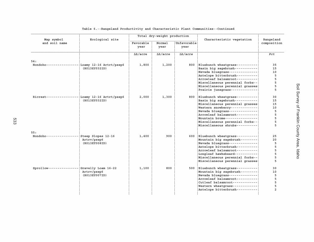
Soil S
urvey of Franklin County A
rea, Idaho
533
Table 6.--Rangeland Productivity and Characteristic Plant Communities--Continued_____________________________________________________________________________________________________________________________________ | | Total dry-weight production | | Map symbol | Ecological site |___________________________________| Characteristic vegetation | Rangeland and soil name | | Favorable | Normal |Unfavorable| | composition | | year | year | year | | | | | | | |_____________________________________________________________________________________________________________________________________ | | Lb/acre | Lb/acre | Lb/acre | | Pct | | | | | |54: | | | | | | Hondoho-----------------|Loamy 12-16 Artrt/pssp6 | 1,800 | 1,200 | 800 |Bluebunch wheatgrass-----------| 35 | (R013XY032ID) | | | |Basin big sagebrush------------| 15 | | | | |Nevada bluegrass---------------| 10 | | | | |Antelope bitterbrush-----------| 5 | | | | |Arrowleaf balsamroot-----------| 5 | | | | |Miscellaneous perennial forbs--| 5 | | | | |Miscellaneous perennial grasses| 5 | | | | |Prairie junegrass--------------| 5 | | | | | | Ricrest-----------------|Loamy 12-16 Artrt/pssp6 | 2,000 | 1,300 | 800 |Bluebunch wheatgrass-----------| 30 | (R013XY032ID) | | | |Basin big sagebrush------------| 15 | | | | |Miscellaneous perennial grasses| 15 | | | | |Western snowberry--------------| 10 | | | | |Nevada bluegrass---------------| 5 | | | | |Arrowleaf balsamroot-----------| 5 | | | | |Mountain brome-----------------| 5 | | | | |Miscellaneous perennial forbs--| 5 | | | | |Miscellaneous shrubs-----------| 5 | | | | | |55: | | | | | | Hondoho-----------------|Steep Slopes 12-16 | 1,400 | 900 | 600 |Bluebunch wheatgrass-----------| 25 | Artrv/pssp6 | | | |Mountain big sagebrush---------| 20 | (R013XY008ID) | | | |Nevada bluegrass---------------| 5 | | | | |Antelope bitterbrush-----------| 5 | | | | |Arrowleaf balsamroot-----------| 5 | | | | |Longleaf hawksbeard------------| 5 | | | | |Miscellaneous perennial forbs--| 5 | | | | |Miscellaneous perennial grasses| 5 | | | | | | Sprollow----------------|Gravelly Loam 16-22 | 1,100 | 800 | 500 |Bluebunch wheatgrass-----------| 30 | Artrv/pssp6 | | | |Mountain big sagebrush---------| 10 | (R013XY007ID) | | | |Nevada bluegrass---------------| 5 | | | | |Arrowleaf balsamroot-----------| 5 | | | | |Cutleaf balsamroot-------------| 5 | | | | |Western wheatgrass-------------| 5 | | | | |Antelope bitterbrush-----------| 2 | | | | | |

Soil S
urvey of Franklin County A
rea, Idaho
534
Table 6.--Rangeland Productivity and Characteristic Plant Communities--Continued_____________________________________________________________________________________________________________________________________ | | Total dry-weight production | | Map symbol | Ecological site |___________________________________| Characteristic vegetation | Rangeland and soil name | | Favorable | Normal |Unfavorable| | composition | | year | year | year | | | | | | | |_____________________________________________________________________________________________________________________________________ | | Lb/acre | Lb/acre | Lb/acre | | Pct | | | | | |55: | | | | | | Hades-------------------|Loamy 13-16 Artrv/pssp6 | 1,800 | 1,200 | 800 |Bluebunch wheatgrass-----------| 35 | (R013XY001ID) | | | |Mountain big sagebrush---------| 10 | | | | |Nevada bluegrass---------------| 5 | | | | |Antelope bitterbrush-----------| 5 | | | | |Arrowleaf balsamroot-----------| 5 | | | | |Miscellaneous perennial forbs--| 5 | | | | |Miscellaneous perennial grasses| 5 | | | | |Miscellaneous shrubs-----------| 5 | | | | |Slender wheatgrass-------------| 5 | | | | | |56: | | | | | | Hondoho-----------------|Steep Slopes 12-16 | 1,400 | 900 | 600 |Bluebunch wheatgrass-----------| 25 | Artrv/pssp6 | | | |Mountain big sagebrush---------| 20 | (R013XY008ID) | | | |Nevada bluegrass---------------| 5 | | | | |Antelope bitterbrush-----------| 5 | | | | |Arrowleaf balsamroot-----------| 5 | | | | |Longleaf hawksbeard------------| 5 | | | | |Miscellaneous perennial forbs--| 5 | | | | |Miscellaneous perennial grasses| 5 | | | | | | Vitale------------------|Steep Slope 16-22 | 2,000 | 1,500 | 800 |Bluebunch wheatgrass-----------| 20 | Artrv/pssp6 | | | |Mountain big sagebrush---------| 10 | (R013XY003ID) | | | |Nevada bluegrass---------------| 5 | | | | |Arrowleaf balsamroot-----------| 5 | | | | |Cutleaf balsamroot-------------| 5 | | | | |Snowberry----------------------| 5 | | | | |Longleaf hawksbeard------------| 2 | | | | |Slender wheatgrass-------------| 2 | | | | |Sticky geranium----------------| 2 | | | | |Western wheatgrass-------------| 2 | | | | |Antelope bitterbrush-----------| 0 | | | | | |61: | | | | | | Huffman-----------------|Loamy 13-16 Artrv/pssp6 | 1,600 | 1,100 | 800 |Bluebunch wheatgrass-----------| 25 | (R013XY001ID) | | | |Mountain big sagebrush---------| 20 | | | | |Miscellaneous perennial grasses| 15 | | | | |Miscellaneous perennial forbs--| 10 | | | | |Prairie junegrass--------------| 10 | | | | |Common snowberry---------------| 5 | | | | |Geranium-----------------------| 5 | | | | |Miscellaneous shrubs-----------| 5 | | | | |Rabbitbrush--------------------| 5 | | | | | |

Soil S
urvey of Franklin County A
rea, Idaho
535
Table 6.--Rangeland Productivity and Characteristic Plant Communities--Continued_____________________________________________________________________________________________________________________________________ | | Total dry-weight production | | Map symbol | Ecological site |___________________________________| Characteristic vegetation | Rangeland and soil name | | Favorable | Normal |Unfavorable| |composition | | year | year | year | | | | | | | |_____________________________________________________________________________________________________________________________________ | | Lb/acre | Lb/acre | Lb/acre | | Pct | | | | | |61: | | | | | | Wursten-----------------|Loamy 12-16 Artrt/pssp6 | 1,800 | 1,200 | 800 |Bluebunch wheatgrass-----------| 35 | (R013XY032ID) | | | |Basin big sagebrush------------| 20 | | | | |Prairie junegrass--------------| 10 | | | | |Antelope bitterbrush-----------| 5 | | | | |Arrowleaf balsamroot-----------| 5 | | | | |Helianthella-------------------| 5 | | | | |Longleaf hawksbeard------------| 5 | | | | | |62: | | | | | | Iphil-------------------|Loamy 13-16 Artrv/pssp6 | 1,800 | 1,200 | 800 |Bluebunch wheatgrass-----------| 30 | (R013XY001ID) | | | |Mountain big sagebrush---------| 20 | | | | |Arrowleaf balsamroot-----------| 10 | | | | |Antelope bitterbrush-----------| 5 | | | | |Longleaf hawksbeard------------| 5 | | | | |Prairie junegrass--------------| 5 | | | | |Slender wheatgrass-------------| 5 | | | | |Snowberry----------------------| 5 | | | | |Western yarrow-----------------| 5 | | | | | | Lonigan-----------------|Gravelly Loam 16-22 | 1,100 | 800 | 500 |Bluebunch wheatgrass-----------| 30 | Artrv/pssp6 | | | |Mountain big sagebrush---------| 20 | (R013XY007ID) | | | |Western wheatgrass-------------| 10 | | | | |Nevada bluegrass---------------| 5 | | | | |Antelope bitterbrush-----------| 5 | | | | |Arrowleaf balsamroot-----------| 5 | | | | |Cutleaf balsamroot-------------| 5 | | | | |Longleaf hawksbeard------------| 5 | | | | | |63: | | | | | | Ireland-----------------|Steep Slope 16-22 | 2,000 | 1,500 | 800 |Bluebunch wheatgrass-----------| 20 | Artrv/pssp6 | | | |Mountain big sagebrush---------| 10 | (R013XY003ID) | | | |Nevada bluegrass---------------| 5 | | | | |Snowberry----------------------| 5 | | | | |Longleaf hawksbeard------------| 2 | | | | |Slender wheatgrass-------------| 2 | | | | |Sticky geranium----------------| 2 | | | | |Western wheatgrass-------------| 2 | | | | | |

Soil S
urvey of Franklin County A
rea, Idaho
536
Table 6.--Rangeland Productivity and Characteristic Plant Communities--Continued_____________________________________________________________________________________________________________________________________ | | Total dry-weight production | | Map symbol | Ecological site |___________________________________| Characteristic vegetation | Rangeland and soil name | | Favorable | Normal |Unfavorable| | composition | | year | year | year | | | | | | | |_____________________________________________________________________________________________________________________________________ | | Lb/acre | Lb/acre | Lb/acre | | Pct | | | | | |63: | | | | | | Polumar-----------------|Steep Slope 16-22 | 2,000 | 1,500 | 850 |Bluebunch wheatgrass-----------| 25 | Artrv/pssp6 | | | |Mountain big sagebrush---------| 15 | (R013XY003ID) | | | |Snowberry----------------------| 10 | | | | |Nevada bluegrass---------------| 5 | | | | |Common chokecherry-------------| 5 | | | | |Longleaf hawksbeard------------| 5 | | | | |Miscellaneous perennial forbs--| 5 | | | | |Miscellaneous perennial grasses| 5 | | | | |Miscellaneous shrubs-----------| 5 | | | | |Sticky geranium----------------| 5 | | | | |Western wheatgrass-------------| 5 | | | | | |64: | | | | | | Kabear------------------|Loamy 16-22 Artrv/pssp6 | 2,400 | 2,000 | 1,400 |Bluebunch wheatgrass-----------| 30 | 16-22" (R013XY005ID) | | | |Mountain big sagebrush---------| 10 | | | | |Slender wheatgrass-------------| 10 | | | | |Columbia needlegrass-----------| 5 | | | | |Antelope bitterbrush-----------| 5 | | | | |Arrowleaf balsamroot-----------| 5 | | | | |Cutleaf balsamroot-------------| 5 | | | | |Mountain brome-----------------| 5 | | | | |Snowberry----------------------| 5 | | | | | | Staberg-----------------|Loamy 16-22 Artrv/pssp6 | 2,400 | 2,000 | 1,400 |Bluebunch wheatgrass-----------| 35 | 16-22" (R013XY005ID) | | | |Mountain big sagebrush---------| 10 | | | | |Nevada bluegrass---------------| 5 | | | | |Antelope bitterbrush-----------| 5 | | | | |Arrowleaf balsamroot-----------| 5 | | | | |Miscellaneous perennial forbs--| 5 | | | | |Miscellaneous perennial grasses| 5 | | | | |Miscellaneous shrubs-----------| 5 | | | | |Whortleleaf snowberry----------| 5 | | | | | | Copenhagen--------------|Ashy Loam 13-16 | 850 | 650 | 350 |Bluebunch wheatgrass-----------| 30 | Artrv/pssp6 | | | |Mountain big sagebrush---------| 20 | (R013XY009ID) | | | |Nevada bluegrass---------------| 5 | | | | |Antelope bitterbrush-----------| 5 | | | | |Arrowleaf balsamroot-----------| 5 | | | | |Green rabbitbrush--------------| 5 | | | | |Longleaf hawksbeard------------| 5 | | | | | |

Soil S
urvey of Franklin County A
rea, Idaho
537
Table 6.--Rangeland Productivity and Characteristic Plant Communities--Continued_____________________________________________________________________________________________________________________________________ | | Total dry-weight production | | Map symbol | Ecological site |___________________________________| Characteristic vegetation | Rangeland and soil name | | Favorable | Normal |Unfavorable| | composition | | year | year | year | | | | | | | |_____________________________________________________________________________________________________________________________________ | | Lb/acre | Lb/acre | Lb/acre | | Pct | | | | | |65: | | | | | | Kabear------------------|Loamy 16-22 Artrv/pssp6 | 2,400 | 2,000 | 1,400 |Bluebunch wheatgrass-----------| 30 | 16-22" (R013XY005ID) | | | |Mountain big sagebrush---------| 10 | | | | |Slender wheatgrass-------------| 10 | | | | |Columbia needlegrass-----------| 5 | | | | |Antelope bitterbrush-----------| 5 | | | | |Arrowleaf balsamroot-----------| 5 | | | | |Cutleaf balsamroot-------------| 5 | | | | |Mountain brome-----------------| 5 | | | | |Snowberry----------------------| 5 | | | | | | Staberg-----------------|Loamy 16-22 Artrv/pssp6 | 2,400 | 2,000 | 1,400 |Bluebunch wheatgrass-----------| 35 | 16-22" (R013XY005ID) | | | |Mountain big sagebrush---------| 10 | | | | |Nevada bluegrass---------------| 5 | | | | |Antelope bitterbrush-----------| 5 | | | | |Arrowleaf balsamroot-----------| 5 | | | | |Miscellaneous perennial forbs--| 5 | | | | |Miscellaneous perennial grasses| 5 | | | | |Miscellaneous shrubs-----------| 5 | | | | |Whortleleaf snowberry----------| 5 | | | | | | Copenhagen--------------|Ashy Loam 13-16 | 850 | 650 | 350 |Bluebunch wheatgrass-----------| 30 | Artrv/pssp6 | | | |Mountain big sagebrush---------| 20 | (R013XY009ID) | | | |Nevada bluegrass---------------| 5 | | | | |Antelope bitterbrush-----------| 5 | | | | |Arrowleaf balsamroot-----------| 5 | | | | |Green rabbitbrush--------------| 5 | | | | |Longleaf hawksbeard------------| 5 | | | | | |70: | | | | | | Kidman------------------|Loamy 11-13 Artrt/pssp6 | 1,600 | 900 | 700 |Bluebunch wheatgrass-----------| 40 | (R028AY024ID) | | | |Basin big sagebrush------------| 20 | | | | |Arrowleaf balsamroot-----------| 5 | | | | |Bottlebrush squirreltail-------| 5 | | | | |Longleaf hawksbeard------------| 5 | | | | | |

Soil S
urvey of Franklin County A
rea, Idaho
538
Table 6.--Rangeland Productivity and Characteristic Plant Communities--Continued_____________________________________________________________________________________________________________________________________ | | Total dry-weight production | | Map symbol | Ecological site |___________________________________| Characteristic vegetation | Rangeland and soil name | | Favorable | Normal |Unfavorable| | composition | | year | year | year | | | | | | | |_____________________________________________________________________________________________________________________________________ | | Lb/acre | Lb/acre | Lb/acre | | Pct | | | | | |75: | | | | | | Lanoak------------------|Loamy 16-22 Artrv/pssp6 | 2,500 | 1,600 | 1,000 |Bluebunch wheatgrass-----------| 30 | 16-22" (R013XY005ID) | | | |Idaho fescue-------------------| 10 | | | | |Mountain big sagebrush---------| 10 | | | | |Columbia needlegrass-----------| 5 | | | | |Antelope bitterbrush-----------| 5 | | | | |Arrowleaf balsamroot-----------| 5 | | | | |Miscellaneous perennial forbs--| 5 | | | | |Miscellaneous perennial grasses| 5 | | | | |Prairie junegrass--------------| 5 | | | | |Sticky geranium----------------| 5 | | | | |Western snowberry--------------| 5 | | | | | |76: | | | | | | Lanoak------------------|Loamy 16-22 Artrv/pssp6 | 2,500 | 1,600 | 1,000 |Bluebunch wheatgrass-----------| 30 | 16-22" (R013XY005ID) | | | |Idaho fescue-------------------| 10 | | | | |Mountain big sagebrush---------| 10 | | | | |Columbia needlegrass-----------| 5 | | | | |Antelope bitterbrush-----------| 5 | | | | |Arrowleaf balsamroot-----------| 5 | | | | |Miscellaneous perennial forbs--| 5 | | | | |Miscellaneous perennial grasses| 5 | | | | |Prairie junegrass--------------| 5 | | | | |Sticky geranium----------------| 5 | | | | |Western snowberry--------------| 5 | | | | | | Broadhead---------------|Loamy 16-22 Artrv/pssp6 | 2,400 | 2,000 | 1,400 |Bluebunch wheatgrass-----------| 40 | 16-22" (R013XY005ID) | | | |Miscellaneous perennial grasses| 15 | | | | |Columbia needlegrass-----------| 10 | | | | |Arrowleaf balsamroot-----------| 5 | | | | |Geranium-----------------------| 5 | | | | |Mountain big sagebrush---------| 5 | | | | |Miscellaneous perennial forbs--| 5 | | | | |Miscellaneous shrubs-----------| 5 | | | | |Prairie junegrass--------------| 5 | | | | |Slender wheatgrass-------------| 5 | | | | | |77: | | | | | | Lanoak------------------|Steep Slope 16-22 | 2,000 | 1,500 | 900 |Bluebunch wheatgrass-----------| 25 | Artrv/pssp6 | | | |Miscellaneous perennial grasses| 20 | (R013XY003ID) | | | |Mountain big sagebrush---------| 15 | | | | |Miscellaneous perennial forbs--| 10 | | | | |Western snowberry--------------| 10 | | | | |Antelope bitterbrush-----------| 5 | | | | |Arrowleaf balsamroot-----------| 5 | | | | |Sticky geranium----------------| 5 | | | | | |
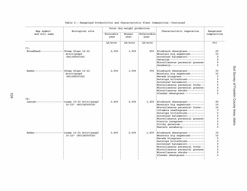
Soil S
urvey of Franklin County A
rea, Idaho
539
Table 6.--Rangeland Productivity and Characteristic Plant Communities--Continued_____________________________________________________________________________________________________________________________________ | | Total dry-weight production | | Map symbol | Ecological site |___________________________________| Characteristic vegetation | Rangeland and soil name | | Favorable | Normal |Unfavorable| | composition | | year | year | year | | | | | | | |_____________________________________________________________________________________________________________________________________ | | Lb/acre | Lb/acre | Lb/acre | | Pct | | | | | |77: | | | | | | Broadhead---------------|Steep Slope 16-22 | 2,000 | 1,500 | 850 |Bluebunch wheatgrass-----------| 25 | Artrv/pssp6 | | | |Mountain big sagebrush---------| 15 | (R013XY003ID) | | | |Arrowleaf balsamroot-----------| 5 | | | | |Geranium-----------------------| 5 | | | | |Miscellaneous perennial grasses| 5 | | | | |Snowberry----------------------| 5 | | | | | | Hades-------------------|Steep Slope 16-22 | 2,000 | 1,500 | 900 |Bluebunch wheatgrass-----------| 35 | Artrv/pssp6 | | | |Mountain big sagebrush---------| 10 | (R013XY003ID) | | | |Nevada bluegrass---------------| 5 | | | | |Antelope bitterbrush-----------| 5 | | | | |Arrowleaf balsamroot-----------| 5 | | | | |Miscellaneous perennial forbs--| 5 | | | | |Miscellaneous perennial grasses| 5 | | | | |Miscellaneous shrubs-----------| 5 | | | | |Slender wheatgrass-------------| 5 | | | | | |78: | | | | | | Lanoak------------------|Loamy 16-22 Artrv/pssp6 | 2,400 | 2,000 | 1,400 |Bluebunch wheatgrass-----------| 45 | 16-22" (R013XY005ID) | | | |Mountain big sagebrush---------| 10 | | | | |Miscellaneous perennial forbs--| 10 | | | | |Columbia needlegrass-----------| 5 | | | | |Antelope bitterbrush-----------| 5 | | | | |Arrowleaf balsamroot-----------| 5 | | | | |Miscellaneous perennial grasses| 5 | | | | |Prairie junegrass--------------| 5 | | | | |Sticky geranium----------------| 5 | | | | |Western snowberry--------------| 5 | | | | | | Hades-------------------|Loamy 16-22 Artrv/pssp6 | 2,400 | 2,000 | 1,400 |Bluebunch wheatgrass-----------| 35 | 16-22" (R013XY005ID) | | | |Mountain big sagebrush---------| 10 | | | | |Nevada bluegrass---------------| 5 | | | | |Antelope bitterbrush-----------| 5 | | | | |Arrowleaf balsamroot-----------| 5 | | | | |Miscellaneous perennial forbs--| 5 | | | | |Miscellaneous perennial grasses| 5 | | | | |Miscellaneous shrubs-----------| 5 | | | | |Slender wheatgrass-------------| 5 | | | | | |

Soil S
urvey of Franklin County A
rea, Idaho
540
Table 6.--Rangeland Productivity and Characteristic Plant Communities--Continued_____________________________________________________________________________________________________________________________________ | | Total dry-weight production | | Map symbol | Ecological site |___________________________________| Characteristic vegetation | Rangeland and soil name | | Favorable | Normal |Unfavorable| | composition | | year | year | year | | | | | | | |_____________________________________________________________________________________________________________________________________ | | Lb/acre | Lb/acre | Lb/acre | | Pct | | | | | |79: | | | | | | Lanoak------------------|Loamy 16-22 Artrv/pssp6 | 2,500 | 1,600 | 1,000 |Bluebunch wheatgrass-----------| 30 | 16-22" (R013XY005ID) | | | |Idaho fescue-------------------| 10 | | | | |Mountain big sagebrush---------| 10 | | | | |Columbia needlegrass-----------| 5 | | | | |Antelope bitterbrush-----------| 5 | | | | |Arrowleaf balsamroot-----------| 5 | | | | |Miscellaneous perennial forbs--| 5 | | | | |Miscellaneous perennial grasses| 5 | | | | |Prairie junegrass--------------| 5 | | | | |Sticky geranium----------------| 5 | | | | |Western snowberry--------------| 5 | | | | | | Thatcher----------------|Steep Slopes 12-16 | 1,500 | 1,100 | 600 |Bluebunch wheatgrass-----------| 25 | Artrv/pssp6 | | | |Mountain big sagebrush---------| 25 | (R013XY008ID) | | | |Sticky geranium----------------| 25 | | | | |Nevada bluegrass---------------| 5 | | | | |Longleaf hawksbeard------------| 5 | | | | |Miscellaneous perennial forbs--| 5 | | | | |Miscellaneous perennial grasses| 5 | | | | |Miscellaneous shrubs-----------| 5 | | | | | |82: | | | | | | Lizdale-----------------|Gravelly South Slope 12- | 1,500 | 1,000 | 600 |Bluebunch wheatgrass-----------| 40 | 16 Artrv/pssp6 | | | |Mountain big sagebrush---------| 15 | (R013XY012ID) | | | |Nevada bluegrass---------------| 5 | | | | |Antelope bitterbrush-----------| 5 | | | | |Arrowleaf balsamroot-----------| 5 | | | | |Bottlebrush squirreltail-------| 1 | | | | | |83: | | | | | | Lizdale-----------------|Gravelly Loam 16-22 | 1,100 | 800 | 500 |Bluebunch wheatgrass-----------| 30 | Artrv/pssp6 | | | |Mountain big sagebrush---------| 10 | (R013XY007ID) | | | |Nevada bluegrass---------------| 5 | | | | |Arrowleaf balsamroot-----------| 5 | | | | |Cutleaf balsamroot-------------| 5 | | | | |Western wheatgrass-------------| 5 | | | | |Antelope bitterbrush-----------| 2 | | | | | |

Soil S
urvey of Franklin County A
rea, Idaho
541
Table 6.--Rangeland Productivity and Characteristic Plant Communities--Continued_____________________________________________________________________________________________________________________________________ | | Total dry-weight production | | Map symbol | Ecological site |___________________________________| Characteristic vegetation | Rangeland and soil name | | Favorable | Normal |Unfavorable| | composition | | year | year | year | | | | | | | |_____________________________________________________________________________________________________________________________________ | | Lb/acre | Lb/acre | Lb/acre | | Pct | | | | | |83: | | | | | | Searla------------------|Gravelly Loam 16-22 | 1,100 | 900 | 600 |Bluebunch wheatgrass-----------| 35 | Artrv/pssp6 | | | |Mountain big sagebrush---------| 20 | (R013XY007ID) | | | |Arrowleaf balsamroot-----------| 10 | | | | |Nevada bluegrass---------------| 5 | | | | |Antelope bitterbrush-----------| 5 | | | | |Longleaf hawksbeard------------| 5 | | | | |Miscellaneous perennial forbs--| 5 | | | | |Miscellaneous perennial grasses| 584: | | | | | | Logan-------------------|Wet Meadow (R028AY028ID) | 4,500 | 3,000 | 2,500 |Tufted hairgrass---------------| 20 | | | | |Cinquefoil---------------------| 5 | | | | |Clover-------------------------| 5 | | | | | |85: | | | | | | Lonigan-----------------|Ashy Loam 13-16 | 1,400 | 1,000 | 500 |Bluebunch wheatgrass-----------| 25 | Artrv/pssp6 | | | |Mountain big sagebrush---------| 20 | (R013XY009ID) | | | |Nevada bluegrass---------------| 5 | | | | |Antelope bitterbrush-----------| 5 | | | | |Arrowleaf balsamroot-----------| 5 | | | | | | Lizdale-----------------|Stony Loam 16-22 | 2,600 | 2,000 | 1,000 |Bluebunch wheatgrass-----------| 35 | Artrv/pssp6 | | | |Arrowleaf balsamroot-----------| 10 | (R013XY019ID) | | | |Mountain big sagebrush---------| 10 | | | | |Utah snowberry-----------------| 5 | | | | |Antelope bitterbrush-----------| 5 | | | | |Slender wheatgrass-------------| 5 | | | | | |86: | | | | | | Lonigan-----------------|Steep Slope 16-22 | 1,900 | 1,400 | 700 |Bluebunch wheatgrass-----------| 30 | Artrv/pssp6 | | | |Mountain big sagebrush---------| 20 | (R013XY003ID) | | | |Nevada bluegrass---------------| 5 | | | | |Longleaf hawksbeard------------| 5 | | | | |Slender wheatgrass-------------| 5 | | | | |Sticky geranium----------------| 5 | | | | |Western wheatgrass-------------| 5 | | | | | |

Soil S
urvey of Franklin County A
rea, Idaho
542
Table 6.--Rangeland Productivity and Characteristic Plant Communities--Continued_____________________________________________________________________________________________________________________________________ | | Total dry-weight production | | Map symbol | Ecological site |___________________________________| Characteristic vegetation | Rangeland and soil name | | Favorable | Normal |Unfavorable| | composition | | year | year | year | | | | | | | |_____________________________________________________________________________________________________________________________________ | | Lb/acre | Lb/acre | Lb/acre | | Pct | | | | | |86: | | | | | | Ricrest-----------------|Steep Slope 16-22 | 2,000 | 1,300 | 800 |Bluebunch wheatgrass-----------| 30 | Artrv/pssp6 | | | |Mountain big sagebrush---------| 15 | (R013XY003ID) | | | |Miscellaneous perennial grasses| 15 | | | | |Western snowberry--------------| 10 | | | | |Nevada bluegrass---------------| 5 | | | | |Arrowleaf balsamroot-----------| 5 | | | | |Mountain brome-----------------| 5 | | | | |Miscellaneous perennial forbs--| 5 | | | | |Miscellaneous shrubs-----------| 5 | | | | | |88: | | | | | | Manila------------------|Loamy 16-22 Artrv/pssp6 | 2,400 | 2,000 | 1,400 |Bluebunch wheatgrass-----------| 35 | 16-22" (R013XY005ID) | | | |Mountain big sagebrush---------| 10 | | | | |Columbia needlegrass-----------| 5 | | | | |Utah snowberry-----------------| 5 | | | | |Antelope bitterbrush-----------| 5 | | | | |Arrowleaf balsamroot-----------| 5 | | | | |Slender wheatgrass-------------| 5 | | | | |Sticky geranium----------------| 5 | | | | | |89: | | | | | | Manila------------------|Loamy 16-22 Artrv/pssp6 | 2,600 | 2,000 | 1,200 |Bluebunch wheatgrass-----------| 40 | 16-22" (R013XY005ID) | | | |Mountain big sagebrush---------| 10 | | | | |Columbia needlegrass-----------| 5 | | | | |Nevada bluegrass---------------| 5 | | | | |Antelope bitterbrush-----------| 5 | | | | |Arrowleaf balsamroot-----------| 5 | | | | |Prairie junegrass--------------| 5 | | | | |Slender wheatgrass-------------| 5 | | | | |Sticky geranium----------------| 5 | | | | | |90: | | | | | | Manila------------------|Loamy 16-22 Artrv/pssp6 | 2,600 | 2,000 | 1,200 |Bluebunch wheatgrass-----------| 40 | 16-22" (R013XY005ID) | | | |Mountain big sagebrush---------| 10 | | | | |Columbia needlegrass-----------| 5 | | | | |Nevada bluegrass---------------| 5 | | | | |Antelope bitterbrush-----------| 5 | | | | |Arrowleaf balsamroot-----------| 5 | | | | |Prairie junegrass--------------| 5 | | | | |Slender wheatgrass-------------| 5 | | | | |Sticky geranium----------------| 5 | | | | | |

Soil S
urvey of Franklin County A
rea, Idaho
543
Table 6.--Rangeland Productivity and Characteristic Plant Communities--Continued_____________________________________________________________________________________________________________________________________ | | Total dry-weight production | | Map symbol | Ecological site |___________________________________| Characteristic vegetation | Rangeland and soil name | | Favorable | Normal |Unfavorable| | composition | | year | year | year | | | | | | | |_____________________________________________________________________________________________________________________________________ | | Lb/acre | Lb/acre | Lb/acre | | Pct | | | | | |90: | | | | | | Bancroft----------------|Loamy 13-16 Artrv/pssp6 | 1,800 | 1,200 | 800 |Bluebunch wheatgrass-----------| 35 | (R013XY001ID) | | | |Miscellaneous perennial grasses| 15 | | | | |Arrowleaf balsamroot-----------| 10 | | | | |Mountain big sagebrush---------| 10 | | | | |Nevada bluegrass---------------| 5 | | | | |Miscellaneous perennial forbs--| 5 | | | | |Miscellaneous shrubs-----------| 5 | | | | |Prairie junegrass--------------| 5 | | | | |Slender wheatgrass-------------| 5 | | | | | |92: | | | | | | Manila------------------|Loamy 16-22 Artrv/pssp6 | 2,600 | 2,000 | 1,200 |Bluebunch wheatgrass-----------| 40 | 16-22" (R013XY005ID) | | | |Mountain big sagebrush---------| 10 | | | | |Columbia needlegrass-----------| 5 | | | | |Nevada bluegrass---------------| 5 | | | | |Antelope bitterbrush-----------| 5 | | | | |Arrowleaf balsamroot-----------| 5 | | | | |Prairie junegrass--------------| 5 | | | | |Slender wheatgrass-------------| 5 | | | | |Sticky geranium----------------| 5 | | | | | | Broadhead---------------|Loamy 16-22 Artrv/pssp6 | 2,400 | 2,000 | 1,400 |Bluebunch wheatgrass-----------| 40 | 16-22" (R013XY005ID) | | | |Miscellaneous perennial grasses| 15 | | | | |Columbia needlegrass-----------| 10 | | | | |Arrowleaf balsamroot-----------| 5 | | | | |Geranium-----------------------| 5 | | | | |Mountain big sagebrush---------| 5 | | | | |Miscellaneous perennial forbs--| 5 | | | | |Miscellaneous shrubs-----------| 5 | | | | |Prairie junegrass--------------| 5 | | | | |Slender wheatgrass-------------| 5 | | | | | |93: | | | | | | Manila------------------|Loamy 16-22 Artrv/pssp6 | 2,600 | 2,000 | 1,200 |Bluebunch wheatgrass-----------| 40 | 16-22" (R013XY005ID) | | | |Mountain big sagebrush---------| 10 | | | | |Columbia needlegrass-----------| 5 | | | | |Nevada bluegrass---------------| 5 | | | | |Antelope bitterbrush-----------| 5 | | | | |Arrowleaf balsamroot-----------| 5 | | | | |Prairie junegrass--------------| 5 | | | | |Slender wheatgrass-------------| 5 | | | | |Sticky geranium----------------| 5 | | | | | |

Soil S
urvey of Franklin County A
rea, Idaho
544
Table 6.--Rangeland Productivity and Characteristic Plant Communities--Continued_____________________________________________________________________________________________________________________________________ | | Total dry-weight production | | Map symbol | Ecological site |___________________________________| Characteristic vegetation | Rangeland and soil name | | Favorable | Normal |Unfavorable| | composition | | year | year | year | | | | | | | |_____________________________________________________________________________________________________________________________________ | | Lb/acre | Lb/acre | Lb/acre | | Pct | | | | | |93: | | | | | | Lonigan-----------------|Ashy Loam 13-16 | 1,400 | 1,000 | 500 |Bluebunch wheatgrass-----------| 25 | Artrv/pssp6 | | | |Mountain big sagebrush---------| 20 | (R013XY009ID) | | | |Arrowleaf balsamroot-----------| 10 | | | | |Antelope bitterbrush-----------| 5 | | | | | |94: | | | | | | Manila------------------|Loamy 16-22 Artrv/pssp6 | 2,400 | 2,000 | 1,400 |Bluebunch wheatgrass-----------| 35 | 16-22" (R013XY005ID) | | | |Mountain big sagebrush---------| 10 | | | | |Columbia needlegrass-----------| 5 | | | | |Utah snowberry-----------------| 5 | | | | |Antelope bitterbrush-----------| 5 | | | | |Arrowleaf balsamroot-----------| 5 | | | | |Slender wheatgrass-------------| 5 | | | | |Sticky geranium----------------| 5 | | | | | | Yeates Hollow-----------|Stony Loam 16-22 | 1,800 | 1,100 | 600 |Bluebunch wheatgrass-----------| 40 | Artrv/pssp6 | | | |Columbia needlegrass-----------| 5 | (R013XY019ID) | | | |Antelope bitterbrush-----------| 5 | | | | |Cutleaf balsamroot-------------| 5 | | | | |Geranium-----------------------| 5 | | | | |Mountain big sagebrush---------| 5 | | | | |Slender wheatgrass-------------| 5 | | | | | |97: | | | | | | Merkley-----------------|Loamy Bottom 12-16 | 1,800 | 1,500 | 1,200 |Basin big sagebrush------------| 20 | Artrt/leci4-Agrop | | | |Thickspike wheatgrass----------| 15 | (R013XY045ID) | | | |Bluebunch wheatgrass-----------| 10 | | | | |Arrowleaf balsamroot-----------| 5 | | | | |Green rabbitbrush--------------| 5 | | | | |Longleaf hawksbeard------------| 5 | | | | |Miscellaneous shrubs-----------| 5 | | | | |Western wheatgrass-------------| 5 | | | | | | Lago--------------------|Semiwet Meadow | 3,400 | 2,600 | 2,000 |Slender wheatgrass-------------| 20 | (R013XY039ID) | | | |Tufted hairgrass---------------| 15 | | | | |Baltic rush--------------------| 5 | | | | |Cinquefoil---------------------| 5 | | | | |Fowl bluegrass-----------------| 5 | | | | | |

Soil S
urvey of Franklin County A
rea, Idaho
545
Table 6.--Rangeland Productivity and Characteristic Plant Communities--Continued_____________________________________________________________________________________________________________________________________ | | Total dry-weight production | | Map symbol | Ecological site |___________________________________| Characteristic vegetation | Rangeland and soil name | | Favorable | Normal |Unfavorable| | composition | | year | year | year | | | | | | | |_____________________________________________________________________________________________________________________________________ | | Lb/acre | Lb/acre | Lb/acre | | Pct | | | | | |97: | | | | | | Bear Lake---------------|Wet Meadow (R028AY028ID) | 4,500 | 3,600 | 3,000 |Tufted hairgrass---------------| 20 | | | | |Kentucky bluegrass-------------| 5 | | | | |Cinquefoil---------------------| 5 | | | | |Clover-------------------------| 5 | | | | |Miscellaneous perennial forbs--| 5 | | | | |Miscellaneous perennial grasses| 5 | | | | |Miscellaneous shrubs-----------| 5 | | | | | |98: | | | | | | Moonlight---------------|Loamy Mountain Slopes 16-| 2,500 | 1,800 | 1,000 |Rocky Mountain maple-----------| 15 | 22 Acgl/brca5 | | | |Quaking aspen------------------| 15 | (R013XY020ID) | | | |Common chokecherry-------------| 10 | | | | |Mountain brome-----------------| 10 | | | | |Miscellaneous perennial forbs--| 10 | | | | |Miscellaneous shrubs-----------| 10 | | | | |Blue wildrye-------------------| 5 | | | | |Miscellaneous perennial grasses| 5 | | | | |Sticky geranium----------------| 5 | | | | | | Camelback---------------|Steep Slope 16-22 | 2,000 | 1,500 | 900 |Bluebunch wheatgrass-----------| 25 | Artrv/pssp6 | | | |Mountain big sagebrush---------| 10 | (R013XY003ID) | | | |Miscellaneous perennial forbs--| 10 | | | | |Miscellaneous perennial grasses| 10 | | | | |Kentucky bluegrass-------------| 5 | | | | |Nevada bluegrass---------------| 5 | | | | |Antelope bitterbrush-----------| 5 | | | | |Arrowleaf balsamroot-----------| 5 | | | | |Cutleaf balsamroot-------------| 5 | | | | |Miscellaneous shrubs-----------| 5 | | | | |Slender wheatgrass-------------| 5 | | | | |Western snowberry--------------| 5 | | | | | |100: | | | | | | Northwater--------------|Mountain Loam 18-22 | 2,100 | 1,800 | 1,600 |Bigtooth maple-----------------| 10 | Acsag2/artrv/pssp6 | | | |Mountain big sagebrush---------| 10 | (R047XY009ID) | | | |Miscellaneous perennial forbs--| 10 | | | | |Miscellaneous shrubs-----------| 10 | | | | |Nevada bluegrass---------------| 5 | | | | |Rocky Mountain juniper---------| 5 | | | | |Common chokecherry-------------| 5 | | | | |Miscellaneous perennial grasses| 5 | | | | |Snowberry----------------------| 5 | | | | |Western wheatgrass-------------| 5 | | | | | |

Soil S
urvey of Franklin County A
rea, Idaho
546
Table 6.--Rangeland Productivity and Characteristic Plant Communities--Continued_____________________________________________________________________________________________________________________________________ | | Total dry-weight production | | Map symbol | Ecological site |___________________________________| Characteristic vegetation | Rangeland and soil name | | Favorable | Normal |Unfavorable| | composition | | year | year | year | | | | | | | |_____________________________________________________________________________________________________________________________________ | | Lb/acre | Lb/acre | Lb/acre | | Pct | | | | | |100: | | | | | | Foxol-------------------|Shallow Stony 12-16 | 1,000 | 600 | 300 |Bluebunch wheatgrass-----------| 35 | Arar8/pssp6 | | | |Nevada bluegrass---------------| 10 | (R013XY014ID) | | | |Black sagebrush----------------| 10 | | | | |Low sagebrush------------------| 10 | | | | |Arrowleaf balsamroot-----------| 5 | | | | |Bottlebrush squirreltail-------| 5 | | | | |Dwarf green rabbitbrush--------| 5 | | | | |Longleaf hawksbeard------------| 5 | | | | |Snowberry----------------------| 5 | | | | | | Vitale------------------|Steep Slope 16-22 | 2,000 | 1,500 | 850 |Bluebunch wheatgrass-----------| 25 | Artrv/pssp6 | | | |Mountain big sagebrush---------| 15 | (R013XY003ID) | | | |Nevada bluegrass---------------| 5 | | | | |Arrowleaf balsamroot-----------| 5 | | | | |Longleaf hawksbeard------------| 5 | | | | |Lupine-------------------------| 5 | | | | |Miscellaneous perennial forbs--| 5 | | | | |Miscellaneous perennial grasses| 5 | | | | |Miscellaneous shrubs-----------| 5 | | | | | |101: | | | | | | Northwater--------------|Mountain Loamy 22+ | 500 | 350 | 150 |Whortleleaf snowberry----------| 20 | Psmeg/syor2 | | | |Oregongrape--------------------| 10 | (R013XY017ID) | | | |Boxleaf myrtle-----------------| 10 | | | | |Currant------------------------| 10 | | | | |Mallow ninebark----------------| 10 | | | | |Bearded wheatgrass-------------| 5 | | | | |Strawberry---------------------| 5 | | | | | | Povey-------------------|Steep Slope 16-22 | 2,400 | 1,800 | 900 |Bluebunch wheatgrass-----------| 25 | Artrv/pssp6 | | | |Mountain big sagebrush---------| 15 | (R013XY003ID) | | | |Slender wheatgrass-------------| 10 | | | | |Columbia needlegrass-----------| 5 | | | | |Arrowleaf balsamroot-----------| 5 | | | | |Snowberry----------------------| 5 | | | | | |102: | | | | | | Northwater--------------|Mountain Loamy 22+ | 500 | 350 | 150 |Whortleleaf snowberry----------| 20 | Psmeg/syor2 | | | |Oregongrape--------------------| 10 | (R013XY017ID) | | | |Boxleaf myrtle-----------------| 10 | | | | |Currant------------------------| 10 | | | | |Mallow ninebark----------------| 10 | | | | |Bearded wheatgrass-------------| 5 | | | | |Strawberry---------------------| 5 | | | | | |

Soil S
urvey of Franklin County A
rea, Idaho
547
Table 6.--Rangeland Productivity and Characteristic Plant Communities--Continued_____________________________________________________________________________________________________________________________________ | | Total dry-weight production | | Map symbol | Ecological site |___________________________________| Characteristic vegetation | Rangeland and soil name | | Favorable | Normal |Unfavorable| | composition | | year | year | year | | | | | | | |_____________________________________________________________________________________________________________________________________ | | Lb/acre | Lb/acre | Lb/acre | | Pct | | | | | |102: | | | | | | Povey-------------------|Mountain Loam 18-22 | 2,100 | 1,800 | 1,600 |Bigtooth maple-----------------| 10 | Acsag2/artrv/pssp6 | | | |Bluebunch wheatgrass-----------| 10 | (R047XY009ID) | | | |Mountain big sagebrush---------| 10 | | | | |Miscellaneous perennial forbs--| 10 | | | | |Miscellaneous shrubs-----------| 10 | | | | |Rocky Mountain juniper---------| 5 | | | | |Common chokecherry-------------| 5 | | | | |Cutleaf balsamroot-------------| 5 | | | | |Miscellaneous perennial grasses| 5 | | | | | |103: | | | | | | Nyman-------------------|High Mountain Loam 25-35 | 3,100 | 2,700 | 2,400 |Bigtooth maple-----------------| 25 | Acsag2/phma5/brca5 | | | |Mallow ninebark----------------| 10 | (R047XY010ID) | | | |Miscellaneous perennial forbs--| 10 | | | | |Whortleleaf snowberry----------| 10 | | | | |Miscellaneous perennial grasses| 5 | | | | |Miscellaneous shrubs-----------| 5 | | | | | | Lonigan-----------------|Gravelly Loam 16-22 | 1,100 | 800 | 500 |Bluebunch wheatgrass-----------| 30 | Artrv/pssp6 | | | |Mountain big sagebrush---------| 20 | (R013XY007ID) | | | |Western wheatgrass-------------| 10 | | | | |Nevada bluegrass---------------| 5 | | | | |Antelope bitterbrush-----------| 5 | | | | |Arrowleaf balsamroot-----------| 5 | | | | |Longleaf hawksbeard------------| 5 | | | | | | Copenhagen--------------|Ashy Loam 13-16 | 1,200 | 800 | 400 |Bluebunch wheatgrass-----------| 30 | Artrv/pssp6 | | | |Mountain big sagebrush---------| 20 | (R013XY009ID) | | | |Nevada bluegrass---------------| 5 | | | | |Antelope bitterbrush-----------| 5 | | | | |Arrowleaf balsamroot-----------| 5 | | | | |Green rabbitbrush--------------| 5 | | | | |Longleaf hawksbeard------------| 5 | | | | | |106: | | | | | | Oxford------------------|Steep Slope 12-16 | 1,800 | 1,200 | 800 |Bluebunch wheatgrass-----------| 35 | Artrt/pssp6 | | | |Basin big sagebrush------------| 15 | (R028AY032ID) | | | |Antelope bitterbrush-----------| 5 | | | | |Arrowleaf balsamroot-----------| 5 | | | | |Western wheatgrass-------------| 5 | | | | | |

Soil S
urvey of Franklin County A
rea, Idaho
548
Table 6.--Rangeland Productivity and Characteristic Plant Communities--Continued_____________________________________________________________________________________________________________________________________ | | Total dry-weight production | | Map symbol | Ecological site |___________________________________| Characteristic vegetation | Rangeland and soil name | | Favorable | Normal |Unfavorable| | composition | | year | year | year | | | | | | | |_____________________________________________________________________________________________________________________________________ | | Lb/acre | Lb/acre | Lb/acre | | Pct | | | | | |106: | | | | | | Banida------------------|Steep Slope 12-16 | 1,600 | 1,000 | 800 |Bluebunch wheatgrass-----------| 35 | Artrt/pssp6 | | | |Basin big sagebrush------------| 20 | (R028AY032ID) | | | |Antelope bitterbrush-----------| 5 | | | | |Arrowleaf balsamroot-----------| 5 | | | | |Western wheatgrass-------------| 5107: | | | | | | Oxford------------------|Steep Slope 12-16 | 1,800 | 1,200 | 800 |Bluebunch wheatgrass-----------| 35 | Artrt/pssp6 | | | |Basin big sagebrush------------| 20 | (R028AY032ID) | | | |Antelope bitterbrush-----------| 5 | | | | |Arrowleaf balsamroot-----------| 5 | | | | |Western wheatgrass-------------| 5 | | | | | |108: | | | | | | Parkay------------------|High Mountain Loam 25-35 | 3,100 | 2,700 | 2,400 |Bigtooth maple-----------------| 25 | Acsag2/phma5/brca5 | | | |Mallow ninebark----------------| 10 | (R047XY010ID) | | | |Miscellaneous perennial forbs--| 10 | | | | |Whortleleaf snowberry----------| 10 | | | | |Miscellaneous perennial grasses| 5 | | | | |Miscellaneous shrubs-----------| 5 | | | | | | Povey-------------------|Steep Slope 16-22 | 2,400 | 1,800 | 900 |Bluebunch wheatgrass-----------| 25 | Artrv/pssp6 | | | |Mountain big sagebrush---------| 15 | (R013XY003ID) | | | |Slender wheatgrass-------------| 10 | | | | |Columbia needlegrass-----------| 5 | | | | |Arrowleaf balsamroot-----------| 5 | | | | |Snowberry----------------------| 5 | | | | | |112: | | | | | | Pavohroo----------------|Mountain Loamy 22+ | 500 | 350 | 150 |Whortleleaf snowberry----------| 20 | Psmeg/syor2 | | | |Miscellaneous perennial forbs--| 10 | (R013XY017ID) | | | |Oregongrape--------------------| 5 | | | | |Woods' rose--------------------| 5 | | | | |Bearded wheatgrass-------------| 5 | | | | |Blue wildrye-------------------| 5 | | | | |Boxleaf myrtle-----------------| 5 | | | | |Miscellaneous perennial grasses| 5 | | | | |Miscellaneous shrubs-----------| 5 | | | | |Sticky geranium----------------| 5 | | | | |Western meadowrue--------------| 5 | | | | | |

Soil S
urvey of Franklin County A
rea, Idaho
549
Table 6.--Rangeland Productivity and Characteristic Plant Communities--Continued_____________________________________________________________________________________________________________________________________ | | Total dry-weight production | | Map symbol | Ecological site |___________________________________| Characteristic vegetation | Rangeland and soil name | | Favorable | Normal |Unfavorable| | composition | | year | year | year | | | | | | | |_____________________________________________________________________________________________________________________________________ | | Lb/acre | Lb/acre | Lb/acre | | Pct | | | | | |112: | | | | | | Sedgway-----------------|Mountain Loamy 22+ | 500 | 350 | 150 |Whortleleaf snowberry----------| 20 | Psmeg/syor2 | | | |Miscellaneous perennial forbs--| 10 | (R013XY017ID) | | | |Oregongrape--------------------| 5 | | | | |Bearded wheatgrass-------------| 5 | | | | |Blue wildrye-------------------| 5 | | | | |Miscellaneous perennial grasses| 5 | | | | |Miscellaneous shrubs-----------| 5 | | | | | | Toponce-----------------|Moist Mountain Loam 20+ | 2,500 | 1,500 | 900 |Pinegrass----------------------| 40 | Potr5 (R013XY016ID) | | | |Mountain brome-----------------| 10 | | | | |Miscellaneous perennial forbs--| 10 | | | | |Miscellaneous perennial grasses| 10 | | | | |Elk sedge----------------------| 4 | | | | |Quaking aspen------------------| 3 | | | | |Sticky geranium----------------| 3 | | | | |Common snowberry---------------| 2 | | | | |Mountain big sagebrush---------| 2 | | | | | |113: | | | | | | Picabo------------------|Semiwet Saline Meadow | 2,500 | 1,750 | 1,000 |Saltgrass----------------------| 20 | (R028AY001ID) | | | |Alkali sacaton-----------------| 15 | | | | |Black greasewood---------------| 5 | | | | |Miscellaneous perennial grasses| 5 | | | | |Tufted hairgrass---------------| 5 | | | | | | Thatcherflats-----------|Alkali Flats 8-12 | 500 | 300 | 100 |Bottlebrush squirreltail-------| 40 | Save4/elel5 | | | |Black greasewood---------------| 30 | (R028AY011ID) | | | |Gardner saltbush---------------| 5 | | | | |Miscellaneous perennial forbs--| 5 | | | | |Miscellaneous perennial grasses| 5 | | | | |Miscellaneous shrubs-----------| 5 | | | | | |119: | | | | | | Polumar-----------------|Mountain Loam 18-22 | 2,100 | 1,800 | 1,600 |Bigtooth maple-----------------| 10 | Acsag2/artrv/pssp6 | | | |Bluebunch wheatgrass-----------| 10 | (R047XY009ID) | | | |Mountain big sagebrush---------| 10 | | | | |Miscellaneous perennial forbs--| 10 | | | | |Miscellaneous shrubs-----------| 10 | | | | |Nevada bluegrass---------------| 5 | | | | |Rocky Mountain juniper---------| 5 | | | | |Common chokecherry-------------| 5 | | | | |Miscellaneous perennial grasses| 5 | | | | |Snowberry----------------------| 5 | | | | |Western wheatgrass-------------| 5 | | | | | |

Soil S
urvey of Franklin County A
rea, Idaho
550
Table 6.--Rangeland Productivity and Characteristic Plant Communities--Continued_____________________________________________________________________________________________________________________________________ | | Total dry-weight production | | Map symbol | Ecological site |___________________________________| Characteristic vegetation | Rangeland and soil name | | Favorable | Normal |Unfavorable| | composition | | year | year | year | | | | | | | |_____________________________________________________________________________________________________________________________________ | | Lb/acre | Lb/acre | Lb/acre | | Pct | | | | | |119: | | | | | | Ireland-----------------|Steep Slope 16-22 | 2,000 | 1,500 | 800 |Bluebunch wheatgrass-----------| 20 | Artrv/pssp6 | | | |Mountain big sagebrush---------| 10 | (R013XY003ID) | | | |Nevada bluegrass---------------| 5 | | | | |Snowberry----------------------| 5 | | | | |Longleaf hawksbeard------------| 2 | | | | |Slender wheatgrass-------------| 2 | | | | |Sticky geranium----------------| 2 | | | | |Western wheatgrass-------------| 2 | | | | | |120: | | | | | | Polumar-----------------|Mountain Loam 18-22 | 2,100 | 1,800 | 1,600 |Bigtooth maple-----------------| 10 | Acsag2/artrv/pssp6 | | | |Bluebunch wheatgrass-----------| 10 | (R047XY009ID) | | | |Mountain big sagebrush---------| 10 | | | | |Miscellaneous perennial forbs--| 10 | | | | |Miscellaneous shrubs-----------| 10 | | | | |Nevada bluegrass---------------| 5 | | | | |Rocky Mountain juniper---------| 5 | | | | |Common chokecherry-------------| 5 | | | | |Miscellaneous perennial grasses| 5 | | | | |Snowberry----------------------| 5 | | | | |Western wheatgrass-------------| 5 | | | | | | Sprollow----------------|Steep Slope 16-22 | 2,000 | 1,500 | 800 |Bluebunch wheatgrass-----------| 20 | Artrv/pssp6 | | | |Mountain big sagebrush---------| 10 | (R013XY003ID) | | | |Nevada bluegrass---------------| 5 | | | | |Arrowleaf balsamroot-----------| 5 | | | | |Cutleaf balsamroot-------------| 5 | | | | |Snowberry----------------------| 5 | | | | |Longleaf hawksbeard------------| 2 | | | | |Slender wheatgrass-------------| 2 | | | | |Sticky geranium----------------| 2 | | | | |Western wheatgrass-------------| 2 | | | | |Antelope bitterbrush-----------| 0 | | | | | | Ireland-----------------|Steep Slope 16-22 | 2,000 | 1,500 | 800 |Bluebunch wheatgrass-----------| 20 | Artrv/pssp6 | | | |Mountain big sagebrush---------| 10 | (R013XY003ID) | | | |Nevada bluegrass---------------| 5 | | | | |Snowberry----------------------| 5 | | | | |Longleaf hawksbeard------------| 2 | | | | |Slender wheatgrass-------------| 2 | | | | |Sticky geranium----------------| 2 | | | | |Western wheatgrass-------------| 2 | | | | | |

Soil S
urvey of Franklin County A
rea, Idaho
551
Table 6.--Rangeland Productivity and Characteristic Plant Communities--Continued_____________________________________________________________________________________________________________________________________ | | Total dry-weight production | | Map symbol | Ecological site |___________________________________| Characteristic vegetation | Rangeland and soil name | | Favorable | Normal |Unfavorable| | composition | | year | year | year | | | | | | | |_____________________________________________________________________________________________________________________________________ | | Lb/acre | Lb/acre | Lb/acre | | Pct | | | | | |121: | | | | | | Povey-------------------|Mountain Loam 18-22 | 2,100 | 1,800 | 1,600 |Bigtooth maple-----------------| 10 | Acsag2/artrv/pssp6 | | | |Bluebunch wheatgrass-----------| 10 | (R047XY009ID) | | | |Mountain big sagebrush---------| 10 | | | | |Miscellaneous perennial forbs--| 10 | | | | |Miscellaneous shrubs-----------| 10 | | | | |Rocky Mountain juniper---------| 5 | | | | |Common chokecherry-------------| 5 | | | | |Miscellaneous perennial grasses| 5 | | | | | | Hades-------------------|Steep Slopes 12-16 | 1,500 | 1,100 | 600 |Bluebunch wheatgrass-----------| 35 | Artrv/pssp6 | | | |Mountain big sagebrush---------| 10 | (R013XY008ID) | | | |Nevada bluegrass---------------| 5 | | | | |Antelope bitterbrush-----------| 5 | | | | |Arrowleaf balsamroot-----------| 5 | | | | |Miscellaneous perennial forbs--| 5 | | | | |Miscellaneous perennial grasses| 5 | | | | |Miscellaneous shrubs-----------| 5 | | | | |Slender wheatgrass-------------| 5 | | | | | | Hondoho-----------------|Steep Slopes 12-16 | 1,400 | 900 | 600 |Bluebunch wheatgrass-----------| 25 | Artrv/pssp6 | | | |Mountain big sagebrush---------| 20 | (R013XY008ID) | | | |Nevada bluegrass---------------| 5 | | | | |Antelope bitterbrush-----------| 5 | | | | |Arrowleaf balsamroot-----------| 5 | | | | |Longleaf hawksbeard------------| 5 | | | | |Miscellaneous perennial forbs--| 5 | | | | |Miscellaneous perennial grasses| 5 | | | | | |122: | | | | | | Povey-------------------|Steep Slope 16-22 | 2,400 | 1,800 | 900 |Bluebunch wheatgrass-----------| 25 | Artrv/pssp6 | | | |Mountain big sagebrush---------| 15 | (R013XY003ID) | | | |Slender wheatgrass-------------| 10 | | | | |Columbia needlegrass-----------| 5 | | | | |Arrowleaf balsamroot-----------| 5 | | | | |Snowberry----------------------| 5 | | | | | | Parkay------------------|High Mountain Loam 25-35 | 3,100 | 2,700 | 2,400 |Bigtooth maple-----------------| 25 | Acsag2/phma5/brca5 | | | |Mallow ninebark----------------| 10 | (R047XY010ID) | | | |Miscellaneous perennial forbs--| 10 | | | | |Whortleleaf snowberry----------| 10 | | | | |Miscellaneous perennial grasses| 5 | | | | |Miscellaneous shrubs-----------| 5 | | | | | |

Soil S
urvey of Franklin County A
rea, Idaho
552
Table 6.--Rangeland Productivity and Characteristic Plant Communities--Continued_____________________________________________________________________________________________________________________________________ | | Total dry-weight production | | Map symbol | Ecological site |___________________________________| Characteristic vegetation | Rangeland and soil name | | Favorable | Normal |Unfavorable| | composition | | year | year | year | | | | | | | |_____________________________________________________________________________________________________________________________________ | | Lb/acre | Lb/acre | Lb/acre | | Pct | | | | | |123: | | | | | | Preston-----------------|Sand 12-16 Putr2/achy | 1,400 | 900 | 700 |Basin big sagebrush------------| 10 | (R028AY009ID) | | | |Needleandthread----------------| 10 | | | | |Antelope bitterbrush-----------| 5 | | | | |Lupine-------------------------| 5 | | | | |Muttongrass--------------------| 5 | | | | |Miscellaneous shrubs-----------| 5 | | | | |Rabbitbrush--------------------| 5 | | | | |Sand dropseed------------------| 5 | | | | |Western wheatgrass-------------| 5 | | | | | |124: | | | | | | Preston-----------------|Sand 12-16 Putr2/achy | 1,400 | 900 | 700 |Basin big sagebrush------------| 10 | (R028AY009ID) | | | |Needleandthread----------------| 10 | | | | |Antelope bitterbrush-----------| 5 | | | | |Lupine-------------------------| 5 | | | | |Muttongrass--------------------| 5 | | | | |Miscellaneous shrubs-----------| 5 | | | | |Rabbitbrush--------------------| 5 | | | | |Sand dropseed------------------| 5 | | | | |Western wheatgrass-------------| 5 | | | | | |125: | | | | | | Preston-----------------|Sand 12-16 Putr2/achy | 1,400 | 900 | 700 |Basin big sagebrush------------| 10 | (R028AY009ID) | | | |Needleandthread----------------| 10 | | | | |Antelope bitterbrush-----------| 5 | | | | |Lupine-------------------------| 5 | | | | |Muttongrass--------------------| 5 | | | | |Miscellaneous shrubs-----------| 5 | | | | |Rabbitbrush--------------------| 5 | | | | |Sand dropseed------------------| 5 | | | | |Western wheatgrass-------------| 5 | | | | | |126: | | | | | | Preston-----------------|Sand 12-16 Putr2/achy | 1,400 | 900 | 700 |Basin big sagebrush------------| 10 | (R028AY009ID) | | | |Needleandthread----------------| 10 | | | | |Antelope bitterbrush-----------| 5 | | | | |Lupine-------------------------| 5 | | | | |Muttongrass--------------------| 5 | | | | |Miscellaneous shrubs-----------| 5 | | | | |Rabbitbrush--------------------| 5 | | | | |Sand dropseed------------------| 5 | | | | |Western wheatgrass-------------| 5 | | | | | |

Soil S
urvey of Franklin County A
rea, Idaho
553
Table 6.--Rangeland Productivity and Characteristic Plant Communities--Continued_____________________________________________________________________________________________________________________________________ | | Total dry-weight production | | Map symbol | Ecological site |___________________________________| Characteristic vegetation | Rangeland and soil name | | Favorable | Normal |Unfavorable| | composition | | year | year | year | | | | | | | |_____________________________________________________________________________________________________________________________________ | | Lb/acre | Lb/acre | Lb/acre | | Pct | | | | | |126: | | | | | | Xerorthents-------------|Steep Slopes 12-16 | 700 | 500 | 250 |Bluebunch wheatgrass-----------| 20 | Artrv/pssp6 | | | |Mountain big sagebrush---------| 10 | (R013XY008ID) | | | |Utah juniper-------------------| 5 | | | | |Antelope bitterbrush-----------| 5 | | | | |Arrowleaf balsamroot-----------| 5 | | | | |Green rabbitbrush--------------| 5 | | | | |Needleandthread----------------| 5 | | | | |Thickspike wheatgrass----------| 5 | | | | | |128: | | | | | | Sanyon------------------|Ashy Loam 13-16 | 1,000 | 600 | 300 |Bluebunch wheatgrass-----------| 25 | Artrv/pssp6 | | | |Mountain big sagebrush---------| 20 | (R013XY009ID) | | | |Arrowleaf balsamroot-----------| 10 | | | | |Antelope bitterbrush-----------| 5 | | | | |Needleandthread----------------| 5 | | | | | | Staberg-----------------|Loamy 16-22 Artrv/pssp6 | 2,400 | 2,000 | 1,400 |Bluebunch wheatgrass-----------| 35 | 16-22" (R013XY005ID) | | | |Mountain big sagebrush---------| 10 | | | | |Nevada bluegrass---------------| 5 | | | | |Antelope bitterbrush-----------| 5 | | | | |Arrowleaf balsamroot-----------| 5 | | | | |Miscellaneous perennial forbs--| 5 | | | | |Miscellaneous perennial grasses| 5 | | | | |Miscellaneous shrubs-----------| 5 | | | | |Whortleleaf snowberry----------| 5 | | | | | | Kabear------------------|Steep Slope 16-22 | 2,200 | 1,800 | 1,400 |Bluebunch wheatgrass-----------| 25 | Artrv/pssp6 | | | |Mountain big sagebrush---------| 20 | (R013XY003ID) | | | |Snowberry----------------------| 10 | | | | |Longleaf hawksbeard------------| 5 | | | | |Mountain brome-----------------| 5 | | | | |Slender wheatgrass-------------| 5 | | | | |Sticky geranium----------------| 5 | | | | |Western wheatgrass-------------| 5 | | | | | |129: | | | | | | Smidale-----------------|Mountain Loam 18-22 | 2,100 | 1,800 | 1,600 |Bigtooth maple-----------------| 10 | Acsag2/artrv/pssp6 | | | |Bluebunch wheatgrass-----------| 10 | (R047XY009ID) | | | |Mountain big sagebrush---------| 10 | | | | |Miscellaneous perennial forbs--| 10 | | | | |Miscellaneous shrubs-----------| 10 | | | | |Rocky Mountain juniper---------| 5 | | | | |Common chokecherry-------------| 5 | | | | |Miscellaneous perennial grasses| 5 | | | | | |

Soil S
urvey of Franklin County A
rea, Idaho
554
Table 6.--Rangeland Productivity and Characteristic Plant Communities--Continued_____________________________________________________________________________________________________________________________________ | | Total dry-weight production | | Map symbol | Ecological site |___________________________________| Characteristic vegetation | Rangeland and soil name | | Favorable | Normal |Unfavorable| | composition | | year | year | year | | | | | | | |_____________________________________________________________________________________________________________________________________ | | Lb/acre | Lb/acre | Lb/acre | | Pct | | | | | |130: | | | | | | Smidale-----------------|Mountain Loam 18-22 | 2,100 | 1,800 | 1,600 |Bigtooth maple-----------------| 10 | Acsag2/artrv/pssp6 | | | |Bluebunch wheatgrass-----------| 10 | (R047XY009ID) | | | |Mountain big sagebrush---------| 10 | | | | |Miscellaneous perennial forbs--| 10 | | | | |Miscellaneous shrubs-----------| 10 | | | | |Rocky Mountain juniper---------| 5 | | | | |Common chokecherry-------------| 5 | | | | |Miscellaneous perennial grasses| 5 | | | | | | Staberg-----------------|Loamy 16-22 Artrv/pssp6 | 2,200 | 1,800 | 1,200 |Bluebunch wheatgrass-----------| 35 | 16-22" (R013XY005ID) | | | |Mountain big sagebrush---------| 10 | | | | |Columbia needlegrass-----------| 5 | | | | |Antelope bitterbrush-----------| 5 | | | | |Arrowleaf balsamroot-----------| 5 | | | | |Cutleaf balsamroot-------------| 5 | | | | |Slender wheatgrass-------------| 5 | | | | |Snowberry----------------------| 5 | | | | | |131: | | | | | | Sprollow----------------|Steep Slopes 12-16 | 1,500 | 1,100 | 550 |Bluebunch wheatgrass-----------| 20 | Artrv/pssp6 | | | |Mountain big sagebrush---------| 20 | (R013XY008ID) | | | |Nevada bluegrass---------------| 5 | | | | |Arrowleaf balsamroot-----------| 5 | | | | |Cutleaf balsamroot-------------| 5 | | | | |Sticky geranium----------------| 3 | | | | |Longleaf hawksbeard------------| 2 | | | | |Slender wheatgrass-------------| 2 | | | | |Thickspike wheatgrass----------| 2 | | | | |Western wheatgrass-------------| 2 | | | | | | Hondoho-----------------|Steep Slopes 12-16 | 1,400 | 900 | 600 |Bluebunch wheatgrass-----------| 25 | Artrv/pssp6 | | | |Mountain big sagebrush---------| 20 | (R013XY008ID) | | | |Nevada bluegrass---------------| 5 | | | | |Antelope bitterbrush-----------| 5 | | | | |Arrowleaf balsamroot-----------| 5 | | | | |Longleaf hawksbeard------------| 5 | | | | |Miscellaneous perennial forbs--| 5 | | | | |Miscellaneous perennial grasses| 5 | | | | | |

Soil S
urvey of Franklin County A
rea, Idaho
555
Table 6.--Rangeland Productivity and Characteristic Plant Communities--Continued_____________________________________________________________________________________________________________________________________ | | Total dry-weight production | | Map symbol | Ecological site |___________________________________| Characteristic vegetation | Rangeland and soil name | | Favorable | Normal |Unfavorable| | composition | | year | year | year | | | | | | | |_____________________________________________________________________________________________________________________________________ | | Lb/acre | Lb/acre | Lb/acre | | Pct | | | | | |132: | | | | | | Sprollow----------------|Gravelly Loam 16-22 | 1,100 | 800 | 500 |Bluebunch wheatgrass-----------| 30 | Artrv/pssp6 | | | |Mountain big sagebrush---------| 10 | (R013XY007ID) | | | |Nevada bluegrass---------------| 5 | | | | |Arrowleaf balsamroot-----------| 5 | | | | |Cutleaf balsamroot-------------| 5 | | | | |Western wheatgrass-------------| 5 | | | | |Antelope bitterbrush-----------| 2 | | | | | | Hymas-------------------|Shallow Stony 12-16 | 1,000 | 600 | 300 |Bluebunch wheatgrass-----------| 35 | Arar8/pssp6 | | | |Basin big sagebrush------------| 15 | (R013XY014ID) | | | |Low sagebrush------------------| 10 | | | | |Antelope bitterbrush-----------| 5 | | | | |Arrowleaf balsamroot-----------| 5 | | | | |Longleaf hawksbeard------------| 5 | | | | |Spiny phlox--------------------| 5 | | | | | |133: | | | | | | Sterling----------------|Gravelly Loam 12-16 | 1,400 | 1,000 | 500 |Bluebunch wheatgrass-----------| 50 | Artrt/pssp6 | | | |Nevada bluegrass---------------| 15 | (R028AY008ID) | | | |Basin big sagebrush------------| 10 | | | | |Antelope bitterbrush-----------| 5 | | | | | |134: | | | | | | Sterling----------------|Gravelly Loam 12-16 | 1,400 | 1,000 | 500 |Bluebunch wheatgrass-----------| 50 | Artrt/pssp6 | | | |Nevada bluegrass---------------| 15 | (R028AY008ID) | | | |Basin big sagebrush------------| 10 | | | | |Antelope bitterbrush-----------| 5 | | | | | |135: | | | | | | Sterling----------------|Gravelly Loam 12-16 | 1,400 | 1,000 | 500 |Bluebunch wheatgrass-----------| 50 | Artrt/pssp6 | | | |Nevada bluegrass---------------| 15 | (R028AY008ID) | | | |Threetip sagebrush-------------| 10 | | | | |Antelope bitterbrush-----------| 5 | | | | | |136: | | | | | | Sterling----------------|Gravelly Loam 12-16 | 1,400 | 1,000 | 500 |Bluebunch wheatgrass-----------| 50 | Artrt/pssp6 | | | |Nevada bluegrass---------------| 15 | (R028AY008ID) | | | |Basin big sagebrush------------| 10 | | | | |Antelope bitterbrush-----------| 5 | | | | | |

Soil S
urvey of Franklin County A
rea, Idaho
556
Table 6.--Rangeland Productivity and Characteristic Plant Communities--Continued_____________________________________________________________________________________________________________________________________ | | Total dry-weight production | | Map symbol | Ecological site |___________________________________| Characteristic vegetation | Rangeland and soil name | | Favorable | Normal |Unfavorable| | composition | | year | year | year | | | | | | | |_____________________________________________________________________________________________________________________________________ | | Lb/acre | Lb/acre | Lb/acre | | Pct | | | | | |139: | | | | | | Toponce-----------------|Moist Mountain Loam 20+ | 2,500 | 1,500 | 900 |Pinegrass----------------------| 40 | Potr5 (R013XY016ID) | | | |Mountain brome-----------------| 10 | | | | |Miscellaneous perennial forbs--| 10 | | | | |Miscellaneous perennial grasses| 10 | | | | |Elk sedge----------------------| 4 | | | | |Quaking aspen------------------| 3 | | | | |Sticky geranium----------------| 3 | | | | |Common snowberry---------------| 2 | | | | |Mountain big sagebrush---------| 2 | | | | | | Broadhead---------------|Loamy 16-22 Artrv/pssp6 | 2,400 | 2,000 | 1,400 |Bluebunch wheatgrass-----------| 40 | 16-22" (R013XY005ID) | | | |Miscellaneous perennial grasses| 15 | | | | |Columbia needlegrass-----------| 10 | | | | |Arrowleaf balsamroot-----------| 5 | | | | |Geranium-----------------------| 5 | | | | |Mountain big sagebrush---------| 5 | | | | |Miscellaneous perennial forbs--| 5 | | | | |Miscellaneous shrubs-----------| 5 | | | | |Prairie junegrass--------------| 5 | | | | |Slender wheatgrass-------------| 5 | | | | | |143: | | | | | | Valmar------------------|Steep Slope 16-22 | 2,000 | 1,500 | 900 |Bluebunch wheatgrass-----------| 20 | Artrv/pssp6 | | | |Mountain big sagebrush---------| 15 | (R013XY003ID) | | | |Miscellaneous perennial grasses| 15 | | | | |Nevada bluegrass---------------| 10 | | | | |Antelope bitterbrush-----------| 5 | | | | |Arrowleaf balsamroot-----------| 5 | | | | |Longleaf hawksbeard------------| 5 | | | | |Lupine-------------------------| 5 | | | | |Miscellaneous perennial forbs--| 5 | | | | |Miscellaneous shrubs-----------| 5 | | | | |Slender wheatgrass-------------| 5 | | | | |Western snowberry--------------| 5 | | | | | |

Soil S
urvey of Franklin County A
rea, Idaho
557
Table 6.--Rangeland Productivity and Characteristic Plant Communities--Continued_____________________________________________________________________________________________________________________________________ | | Total dry-weight production | | Map symbol | Ecological site |___________________________________| Characteristic vegetation | Rangeland and soil name | | Favorable | Normal |Unfavorable| | composition | | year | year | year | | | | | | | |_____________________________________________________________________________________________________________________________________ | | Lb/acre | Lb/acre | Lb/acre | | Pct | | | | | |143: | | | | | | Camelback---------------|Steep Slope 16-22 | 2,000 | 1,500 | 900 |Bluebunch wheatgrass-----------| 25 | Artrv/pssp6 | | | |Mountain big sagebrush---------| 10 | (R013XY003ID) | | | |Miscellaneous perennial forbs--| 10 | | | | |Miscellaneous perennial grasses| 10 | | | | |Kentucky bluegrass-------------| 5 | | | | |Nevada bluegrass---------------| 5 | | | | |Antelope bitterbrush-----------| 5 | | | | |Arrowleaf balsamroot-----------| 5 | | | | |Cutleaf balsamroot-------------| 5 | | | | |Miscellaneous shrubs-----------| 5 | | | | |Slender wheatgrass-------------| 5 | | | | |Western snowberry--------------| 5 | | | | | | Hades-------------------|Steep Slope 16-22 | 2,000 | 1,500 | 900 |Bluebunch wheatgrass-----------| 35 | Artrv/pssp6 | | | |Mountain big sagebrush---------| 10 | (R013XY003ID) | | | |Nevada bluegrass---------------| 5 | | | | |Antelope bitterbrush-----------| 5 | | | | |Arrowleaf balsamroot-----------| 5 | | | | |Miscellaneous perennial forbs--| 5 | | | | |Miscellaneous perennial grasses| 5 | | | | |Miscellaneous shrubs-----------| 5 | | | | |Slender wheatgrass-------------| 5 | | | | | |144: | | | | | | Vitale------------------|Gravelly Loam 16-22 | 2,000 | 1,500 | 850 |Bluebunch wheatgrass-----------| 25 | Artrv/pssp6 | | | |Mountain big sagebrush---------| 15 | (R013XY007ID) | | | |Nevada bluegrass---------------| 5 | | | | |Arrowleaf balsamroot-----------| 5 | | | | |Longleaf hawksbeard------------| 5 | | | | |Lupine-------------------------| 5 | | | | |Miscellaneous perennial forbs--| 5 | | | | |Miscellaneous perennial grasses| 5 | | | | |Miscellaneous shrubs-----------| 5 | | | | | | Bergquist---------------|Steep Slope 16-22 | 1,900 | 1,400 | 700 |Bluebunch wheatgrass-----------| 25 | Artrv/pssp6 | | | |Miscellaneous perennial grasses| 20 | (R013XY003ID) | | | |Mountain big sagebrush---------| 15 | | | | |Miscellaneous perennial forbs--| 10 | | | | |Miscellaneous shrubs-----------| 10 | | | | |Nevada bluegrass---------------| 5 | | | | |Antelope bitterbrush-----------| 5 | | | | |Arrowleaf balsamroot-----------| 5 | | | | |Snowberry----------------------| 5 | | | | | |

Soil S
urvey of Franklin County A
rea, Idaho
558
Table 6.--Rangeland Productivity and Characteristic Plant Communities--Continued_____________________________________________________________________________________________________________________________________ | | Total dry-weight production | | Map symbol | Ecological site |___________________________________| Characteristic vegetation | Rangeland and soil name | | Favorable | Normal |Unfavorable| | composition | | year | year | year | | | | | | | |_____________________________________________________________________________________________________________________________________ | | Lb/acre | Lb/acre | Lb/acre | | Pct | | | | | |145: | | | | | | Vitale------------------|Gravelly Loam 16-22 | 1,100 | 800 | 500 |Bluebunch wheatgrass-----------| 30 | Artrv/pssp6 | | | |Mountain big sagebrush---------| 10 | (R013XY007ID) | | | |Nevada bluegrass---------------| 5 | | | | |Arrowleaf balsamroot-----------| 5 | | | | |Cutleaf balsamroot-------------| 5 | | | | |Western wheatgrass-------------| 5 | | | | |Antelope bitterbrush-----------| 2 | | | | | | Yeates Hollow-----------|Stony Loam 16-22 | 1,800 | 1,100 | 600 |Bluebunch wheatgrass-----------| 40 | Artrv/pssp6 | | | |Columbia needlegrass-----------| 5 | (R013XY019ID) | | | |Antelope bitterbrush-----------| 5 | | | | |Cutleaf balsamroot-------------| 5 | | | | |Geranium-----------------------| 5 | | | | |Mountain big sagebrush---------| 5 | | | | |Slender wheatgrass-------------| 5 | | | | | | Northwater--------------|Mountain Loam 18-22 | 2,100 | 1,800 | 1,600 |Bigtooth maple-----------------| 10 | Acsag2/artrv/pssp6 | | | |Mountain big sagebrush---------| 10 | (R047XY009ID) | | | |Miscellaneous perennial forbs--| 10 | | | | |Miscellaneous shrubs-----------| 10 | | | | |Nevada bluegrass---------------| 5 | | | | |Rocky Mountain juniper---------| 5 | | | | |Common chokecherry-------------| 5 | | | | |Miscellaneous perennial grasses| 5 | | | | |Snowberry----------------------| 5 | | | | |Western wheatgrass-------------| 5 | | | | | |151: | | | | | | Wheelon-----------------|Steep Slope 12-16 | 1,800 | 1,200 | 800 |Bluebunch wheatgrass-----------| 35 | Artrt/pssp6 | | | |Basin big sagebrush------------| 15 | (R028AY032ID) | | | |Prairie junegrass--------------| 10 | | | | |Nevada bluegrass---------------| 5 | | | | |Antelope bitterbrush-----------| 5 | | | | |Western wheatgrass-------------| 5 | | | | | | Collinston--------------|Steep Slope 12-16 | 1,800 | 1,200 | 800 |Bluebunch wheatgrass-----------| 35 | Artrt/pssp6 | | | |Basin big sagebrush------------| 15 | (R028AY032ID) | | | |Prairie junegrass--------------| 10 | | | | |Nevada bluegrass---------------| 5 | | | | |Antelope bitterbrush-----------| 5 | | | | |Western wheatgrass-------------| 5 | | | | | |

Soil S
urvey of Franklin County A
rea, Idaho
559
Table 6.--Rangeland Productivity and Characteristic Plant Communities--Continued_____________________________________________________________________________________________________________________________________ | | Total dry-weight production | | Map symbol | Ecological site |___________________________________| Characteristic vegetation | Rangeland and soil name | | Favorable | Normal |Unfavorable| | composition | | year | year | year | | | | | | | |_____________________________________________________________________________________________________________________________________ | | Lb/acre | Lb/acre | Lb/acre | | Pct | | | | | |152: | | | | | | Windernot---------------|Loamy 11-13 Artrt/pssp6 | 1,600 | 900 | 700 |Bluebunch wheatgrass-----------| 40 | (R028AY024ID) | | | |Basin big sagebrush------------| 15 | | | | |Arrowleaf balsamroot-----------| 5 | | | | |Miscellaneous perennial forbs--| 5 | | | | | | Lewnot------------------|Semiwet Meadow | 2,800 | 2,200 | 1,900 |Slender wheatgrass-------------| 20 | (R028AY029ID) | | | |Tufted hairgrass---------------| 10 | | | | |Kentucky bluegrass-------------| 5 | | | | |Cinquefoil---------------------| 5 | | | | |Clover-------------------------| 5 | | | | |Shrubby cinquefoil-------------| 5 | | | | |Western wheatgrass-------------| 5 | | | | |Willow-------------------------| 5 | | | | | | Stinkcreek--------------|Wet Meadow (R028AY028ID) | 4,500 | 3,600 | 2,500 |Tufted hairgrass---------------| 20 | | | | |Cinquefoil---------------------| 5 | | | | |Clover-------------------------| 5 | | | | | |156: | | | | | | Wormcreek---------------|Ashy Loam 13-16 | 1,300 | 800 | 400 |Bluebunch wheatgrass-----------| 20 | Artrv/pssp6 | | | |Arrowleaf balsamroot-----------| 10 | (R013XY009ID) | | | |Mountain big sagebrush---------| 10 | | | | |Antelope bitterbrush-----------| 5 | | | | |Needleandthread----------------| 5 | | | | | | Copenhagen--------------|Ashy Loam 13-16 | 850 | 650 | 350 |Bluebunch wheatgrass-----------| 30 | Artrv/pssp6 | | | |Mountain big sagebrush---------| 20 | (R013XY009ID) | | | |Nevada bluegrass---------------| 5 | | | | |Antelope bitterbrush-----------| 5 | | | | |Arrowleaf balsamroot-----------| 5 | | | | |Green rabbitbrush--------------| 5 | | | | |Longleaf hawksbeard------------| 5 | | | | | |157: | | | | | | Wormcreek---------------|Ashy Loam 13-16 | 1,300 | 800 | 400 |Bluebunch wheatgrass-----------| 20 | Artrv/pssp6 | | | |Arrowleaf balsamroot-----------| 10 | (R013XY009ID) | | | |Mountain big sagebrush---------| 10 | | | | |Antelope bitterbrush-----------| 5 | | | | |Needleandthread----------------| 5 | | | | | |

Soil S
urvey of Franklin County A
rea, Idaho
560
Table 6.--Rangeland Productivity and Characteristic Plant Communities--Continued_____________________________________________________________________________________________________________________________________ | | Total dry-weight production | | Map symbol | Ecological site |___________________________________| Characteristic vegetation | Rangeland and soil name | | Favorable | Normal |Unfavorable| | composition | | year | year | year | | | | | | | |_____________________________________________________________________________________________________________________________________ | | Lb/acre | Lb/acre | Lb/acre | | Pct | | | | | |157: | | | | | | Lonigan-----------------|Gravelly Loam 16-22 | 1,100 | 800 | 500 |Bluebunch wheatgrass-----------| 30 | Artrv/pssp6 | | | |Mountain big sagebrush---------| 20 | (R013XY007ID) | | | |Western wheatgrass-------------| 10 | | | | |Nevada bluegrass---------------| 5 | | | | |Antelope bitterbrush-----------| 5 | | | | |Arrowleaf balsamroot-----------| 5 | | | | |Cutleaf balsamroot-------------| 5 | | | | |Longleaf hawksbeard------------| 5 | | | | | |158: | | | | | | Wursten-----------------|Loamy 11-13 Artrt/pssp6 | 1,400 | 700 | 500 |Bluebunch wheatgrass-----------| 40 | (R028AY024ID) | | | |Basin big sagebrush------------| 20 | | | | |Antelope bitterbrush-----------| 5 | | | | |Longleaf hawksbeard------------| 5 | | | | |Prairie junegrass--------------| 5 | | | | | | Dirtyhead---------------|Shallow Loamy 8-12 | 1,800 | 1,200 | 800 |Bluebunch wheatgrass-----------| 35 | Arno4/pssp6 | | | |Basin big sagebrush------------| 15 | (R028AY013ID) | | | |Prairie junegrass--------------| 10 | | | | |Nevada bluegrass---------------| 5 | | | | |Antelope bitterbrush-----------| 5 | | | | |Arrowleaf balsamroot-----------| 5 | | | | |Western wheatgrass-------------| 5 | | | | | |159: | | | | | | Xerochrepts-------------|Juniper Breaks 13-16 | 700 | 500 | 250 |Bluebunch wheatgrass-----------| 25 | Juos/pssp6 (R028AY027ID)| | | |Mountain big sagebrush---------| 20 | | | | |Utah juniper-------------------| 15 | | | | |Arrowleaf balsamroot-----------| 5 | | | | |Thickspike wheatgrass----------| 5 | | | | | | Wormcreek---------------|Ashy Loam 13-16 | 1,300 | 800 | 400 |Bluebunch wheatgrass-----------| 20 | Artrv/pssp6 | | | |Arrowleaf balsamroot-----------| 10 | (R013XY009ID) | | | |Mountain big sagebrush---------| 10 | | | | |Antelope bitterbrush-----------| 5 | | | | |Needleandthread----------------| 5 | | | | | | Xerorthents-------------|Juniper Breaks 13-16 | 700 | 500 | 250 |Bluebunch wheatgrass-----------| 20 | Juos/pssp6 (R028AY027ID)| | | |Mountain big sagebrush---------| 10 | | | | |Utah juniper-------------------| 5 | | | | |Antelope bitterbrush-----------| 5 | | | | |Arrowleaf balsamroot-----------| 5 | | | | |Green rabbitbrush--------------| 5 | | | | |Needleandthread----------------| 5 | | | | |Thickspike wheatgrass----------| 5 | | | | | |

Soil S
urvey of Franklin County A
rea, Idaho
561
Table 6.--Rangeland Productivity and Characteristic Plant Communities--Continued_____________________________________________________________________________________________________________________________________ | | Total dry-weight production | | Map symbol | Ecological site |___________________________________| Characteristic vegetation | Rangeland and soil name | | Favorable | Normal |Unfavorable| | composition | | year | year | year | | | | | | | |_____________________________________________________________________________________________________________________________________ | | Lb/acre | Lb/acre | Lb/acre | | Pct | | | | | |160: | | | | | | Xerorthents-------------|Steep Slopes 12-16 | 1,500 | 1,100 | 550 |Bluebunch wheatgrass-----------| 20 | Artrv/pssp6 | | | |Mountain big sagebrush---------| 20 | (R013XY008ID) | | | |Nevada bluegrass---------------| 5 | | | | |Longleaf hawksbeard------------| 5 | | | | |Sticky geranium----------------| 5 | | | | |Thickspike wheatgrass----------| 5 | | | | | |161: | | | | | | Yeates Hollow-----------|Stony Loam 16-22 | 1,800 | 1,100 | 600 |Bluebunch wheatgrass-----------| 40 | Artrv/pssp6 | | | |Columbia needlegrass-----------| 5 | (R013XY019ID) | | | |Antelope bitterbrush-----------| 5 | | | | |Cutleaf balsamroot-------------| 5 | | | | |Geranium-----------------------| 5 | | | | |Mountain big sagebrush---------| 5 | | | | |Slender wheatgrass-------------| 5 | | | | | |162: | | | | | | Yeates Hollow-----------|Stony Loam 16-22 | 1,800 | 1,100 | 600 |Bluebunch wheatgrass-----------| 40 | Artrv/pssp6 | | | |Columbia needlegrass-----------| 5 | (R013XY019ID) | | | |Antelope bitterbrush-----------| 5 | | | | |Cutleaf balsamroot-------------| 5 | | | | |Geranium-----------------------| 5 | | | | |Mountain big sagebrush---------| 5 | | | | |Slender wheatgrass-------------| 5 | | | | | | Manila------------------|Loamy 16-22 Artrv/pssp6 | 2,600 | 2,000 | 1,200 |Bluebunch wheatgrass-----------| 40 | 16-22" (R013XY005ID) | | | |Mountain big sagebrush---------| 10 | | | | |Columbia needlegrass-----------| 5 | | | | |Nevada bluegrass---------------| 5 | | | | |Antelope bitterbrush-----------| 5 | | | | |Arrowleaf balsamroot-----------| 5 | | | | |Prairie junegrass--------------| 5 | | | | |Slender wheatgrass-------------| 5 | | | | |Sticky geranium----------------| 5 | | | | | | Softback----------------|Mountain Loam 18-22 | 2,100 | 1,800 | 1,600 |Bigtooth maple-----------------| 10 | Acsag2/artrv/pssp6 | | | |Bluebunch wheatgrass-----------| 10 | (R047XY009ID) | | | |Mountain big sagebrush---------| 10 | | | | |Miscellaneous perennial forbs--| 10 | | | | |Miscellaneous shrubs-----------| 10 | | | | |Rocky Mountain juniper---------| 5 | | | | |Common chokecherry-------------| 5 | | | | |Miscellaneous perennial grasses| 5 | | | | | |

Soil S
urvey of Franklin County A
rea, Idaho
562
Table 6.--Rangeland Productivity and Characteristic Plant Communities--Continued_____________________________________________________________________________________________________________________________________ | | Total dry-weight production | | Map symbol | Ecological site |___________________________________| Characteristic vegetation | Rangeland and soil name | | Favorable | Normal |Unfavorable| | composition | | year | year | year | | | | | | | |_____________________________________________________________________________________________________________________________________ | | Lb/acre | Lb/acre | Lb/acre | | Pct | | | | | |163: | | | | | | Yeates Hollow-----------|Stony Loam 16-22 | 1,800 | 1,100 | 600 |Bluebunch wheatgrass-----------| 40 | Artrv/pssp6 | | | |Columbia needlegrass-----------| 5 | (R013XY019ID) | | | |Antelope bitterbrush-----------| 5 | | | | |Cutleaf balsamroot-------------| 5 | | | | |Geranium-----------------------| 5 | | | | |Mountain big sagebrush---------| 5 | | | | |Slender wheatgrass-------------| 5 | | | | | | Vitale------------------|Gravelly Loam 16-22 | 1,100 | 800 | 500 |Bluebunch wheatgrass-----------| 30 | Artrv/pssp6 | | | |Mountain big sagebrush---------| 10 | (R013XY007ID) | | | |Nevada bluegrass---------------| 5 | | | | |Arrowleaf balsamroot-----------| 5 | | | | |Cutleaf balsamroot-------------| 5 | | | | |Western wheatgrass-------------| 5 | | | | |Antelope bitterbrush-----------| 2 | | | | | |_____________________________________________________________________________________________________________________________________

Soil S
urvey of Franklin County A
rea, Idaho
563
Table 7.--Windbreaks and Environmental Plantings
(Absence of an entry indicates that trees generally do not grow to the given height on the soil.)
__________________________________________________________________________________________________________________________________ | Trees having predicted 20-year average height, in feet, of-- Map symbol |________________________________________________________________________________________________________ and soil name | <8 | 8-15 | 16-25 | 26-35 | >35 | | | | |__________________________________________________________________________________________________________________________________ | | | | |2: | | | | | Ant Flat----------------|Amur honeysuckle, | --- |Austrian pine, black|Siberian elm |Idahybrid poplar | common lilac, | | locust, blue | | | skunkbush sumac | | spruce, green ash, | | | | | ponderosa pine, | | | | | Scotch pine | | | | | | |3: | | | | | Ant Flat----------------|Amur honeysuckle, | --- |Austrian pine, black|Siberian elm |Idahybrid poplar | common lilac, | | locust, blue | | | skunkbush sumac | | spruce, green ash, | | | | | ponderosa pine, | | | | | Scotch pine | | | | | | |4: | | | | | Ant Flat----------------|Amur honeysuckle, | --- |Austrian pine, black|Siberian elm |Idahybrid poplar | common lilac, | | locust, blue | | | skunkbush sumac | | spruce, green ash, | | | | | ponderosa pine, | | | | | Scotch pine | | | | | | |5: | | | | | Ant Flat----------------|Amur honeysuckle, | --- |Austrian pine, black|Siberian elm |Idahybrid poplar | common lilac, | | locust, blue | | | skunkbush sumac | | spruce, green ash, | | | | | ponderosa pine, | | | | | Scotch pine | | | | | | | Oxford. | | | | | | | | | |6: | | | | | Ant Flat----------------|Amur honeysuckle, | --- |Austrian pine, black|Siberian elm |Idahybrid poplar | common lilac, | | locust, blue | | | skunkbush sumac | | spruce, green ash, | | | | | ponderosa pine, | | | | | Scotch pine | | | | | | | Oxford. | | | | | | | | | |7: | | | | | Arbone------------------| --- |Amur honeysuckle, |Black locust, |Austrian pine, blue |Redosier dogwood, | | skunkbush sumac | eastern redcedar | spruce, golden | Siberian elm | | | | willow, green ash, | | | | | Rocky Mountain | | | | | juniper | | | | | |

Soil S
urvey of Franklin County A
rea, Idaho
564
Table 7.--Windbreaks and Environmental Plantings--Continued__________________________________________________________________________________________________________________________________ | Trees having predicted 20-year average height, in feet, of-- Map symbol |________________________________________________________________________________________________________ and soil name | <8 | 8-15 | 16-25 | 26-35 | >35 | | | | |__________________________________________________________________________________________________________________________________ | | | | |10: | | | | | Battle Creek------------|Common lilac, silver| --- |Golden willow, green|Siberian elm |Redosier dogwood | buffaloberry | | ash | | | | | | |11: | | | | | Battle Creek------------|Common lilac, silver| --- |Golden willow, green|Siberian elm |Redosier dogwood | buffaloberry | | ash | | | | | | |12: | | | | | Battle Creek------------|Common lilac, |Rocky Mountain |Scotch pine |Golden willow, | --- | Nanking cherry | juniper | | honeylocust | | | | | |13: | | | | | Bear Lake. | | | | | | | | | | Chesbrook. | | | | | | | | | | Picabo------------------|Amur honeysuckle, |Black locust, | --- | --- | --- | common lilac, | eastern redcedar, | | | | skunkbush sumac | green ash, Rocky | | | | | Mountain juniper | | | | | | | |15: | | | | | Bear Lake. | | | | | | | | | | Downata. | | | | | | | | | | Thatcherflats-----------|Common lilac, silver|Siberian elm | --- | --- |Redosier dogwood | buffaloberry, | | | | | skunkbush sumac | | | | | | | | |17: | | | | | Bearhollow--------------| | | | | | | | | | Brifox------------------|Amur honeysuckle, |Black locust, blue |Siberian elm | --- | --- | Austrian pine, | spruce, green ash, | | | | common lilac, Rocky| ponderosa pine | | | | Mountain juniper, | | | | | Russian olive, | | | | | skunkbush sumac | | | | | | | | | Iphil. | | | | | | | | | |21: | | | | | Bothwell----------------|American plum, |Eastern redcedar, |Austrian pine, black|Siberian elm | --- | common lilac | Siberian crabapple | locust, blue | | | | | spruce, green ash, | | | | | ponderosa pine | | | | | | |

Soil S
urvey of Franklin County A
rea, Idaho
565
Table 7.--Windbreaks and Environmental Plantings--Continued__________________________________________________________________________________________________________________________________ | Trees having predicted 20-year average height, in feet, of-- Map symbol |________________________________________________________________________________________________________ and soil name | <8 | 8-15 | 16-25 | 26-35 | >35 | | | | |__________________________________________________________________________________________________________________________________ | | | | |22: | | | | | Bothwell----------------|American plum, |Eastern redcedar, |Austrian pine, black|Siberian elm | --- | common lilac | Siberian crabapple | locust, blue | | | | | spruce, green ash, | | | | | ponderosa pine | | | | | | |23: | | | | | Bothwell----------------|American plum, |Eastern redcedar, |Austrian pine, black|Siberian elm | --- | common lilac | Siberian crabapple | locust, blue | | | | | spruce, green ash, | | | | | ponderosa pine | | | | | | | Hades-------------------|American plum, |Eastern redcedar, |Austrian pine, black| --- | --- | skunkbush sumac | Russian olive, | locust, green ash, | | | | Siberian crabapple | ponderosa pine, | | | | | Scotch pine | | | | | | | Justesen----------------|Common lilac, |Rocky Mountain |Blue spruce, Scotch |Golden willow, | --- | Nanking cherry, | juniper | pine | honeylocust, | | Tatarian | | | Russian olive | | honeysuckle | | | | | | | | |24: | | | | | Bothwell----------------|American plum, |Eastern redcedar, |Austrian pine, black|Siberian elm | --- | common lilac | Siberian crabapple | locust, blue | | | | | spruce, green ash, | | | | | ponderosa pine | | | | | | | Thatcher----------------|American plum, |Rocky Mountain |Austrian pine, black|Siberian elm | --- | common lilac, | juniper | locust, blue | | | skunkbush sumac | | spruce, green ash, | | | | | ponderosa pine, | | | | | Scotch pine | | | | | | |25: | | | | | Brifox------------------|Amur honeysuckle, |Black locust, blue |Siberian elm | --- | --- | Austrian pine, | spruce, green ash, | | | | common lilac, Rocky| ponderosa pine | | | | Mountain juniper, | | | | | Russian olive, | | | | | skunkbush sumac | | | | | | | | | Huffman-----------------|American plum, |Eastern redcedar, |Austrian pine, black|Siberian elm | --- | skunkbush sumac, | Rocky Mountain | locust, green ash, | | | Tatarian | juniper, Russian | Scotch pine | | | honeysuckle | olive | | | | | | | |

Soil S
urvey of Franklin County A
rea, Idaho
566
Table 7.--Windbreaks and Environmental Plantings--Continued__________________________________________________________________________________________________________________________________ | Trees having predicted 20-year average height, in feet, of-- Map symbol |________________________________________________________________________________________________________ and soil name | <8 | 8-15 | 16-25 | 26-35 | >35 | | | | |__________________________________________________________________________________________________________________________________ | | | | |26: | | | | | Brifox------------------|Amur honeysuckle, |Black locust, blue |Siberian elm | --- | --- | Austrian pine, | spruce, green ash, | | | | common lilac, Rocky| ponderosa pine | | | | Mountain juniper, | | | | | Russian olive, | | | | | skunkbush sumac | | | | | | | | | Huffman-----------------|American plum, |Eastern redcedar, |Austrian pine, black|Siberian elm | --- | skunkbush sumac, | Rocky Mountain | locust, green ash, | | | Tatarian | juniper, Russian | Scotch pine | | | honeysuckle | olive | | | | | | | |27: | | | | | Brifox------------------|Amur honeysuckle, |Black locust, blue |Siberian elm | --- | --- | Austrian pine, | spruce, green ash, | | | | common lilac, Rocky| ponderosa pine | | | | Mountain juniper, | | | | | Russian olive, | | | | | skunkbush sumac | | | | | | | | | Niter-------------------|Amur honeysuckle, |Rocky Mountain |Austrian pine, black|Siberian elm |Lombardy poplar | common lilac, | juniper | locust, blue | | | skunkbush sumac | | spruce, green ash, | | | | | Scotch pine | | | | | | |28: | | | | | Brifox------------------|Amur honeysuckle, |Black locust, blue |Siberian elm | --- | --- | Austrian pine, | spruce, green ash, | | | | common lilac, Rocky| ponderosa pine | | | | Mountain juniper, | | | | | Russian olive, | | | | | skunkbush sumac | | | | | | | | | Niter-------------------|Amur honeysuckle, |Rocky Mountain |Austrian pine, black|Siberian elm |Lombardy poplar | common lilac, | juniper | locust, blue | | | skunkbush sumac | | spruce, green ash, | | | | | Scotch pine | | | | | | |30: | | | | | Broadhead. | | | | | | | | | | Hades-------------------|American plum, |Eastern redcedar, |Austrian pine, black| --- | --- | skunkbush sumac | Russian olive, | locust, green ash, | | | | Siberian crabapple | ponderosa pine, | | | | | Scotch pine | | | | | | | Yago. | | | | | | | | | |

Soil S
urvey of Franklin County A
rea, Idaho
567
Table 7.--Windbreaks and Environmental Plantings--Continued__________________________________________________________________________________________________________________________________ | Trees having predicted 20-year average height, in feet, of-- Map symbol |________________________________________________________________________________________________________ and soil name | <8 | 8-15 | 16-25 | 26-35 | >35 | | | | |__________________________________________________________________________________________________________________________________ | | | | |33: | | | | | Camelback. | | | | | | | | | | Hades-------------------|American plum, |Eastern redcedar, |Austrian pine, black| --- | --- | skunkbush sumac | Russian olive, | locust, green ash, | | | | Siberian crabapple | ponderosa pine, | | | | | Scotch pine | | | | | | | Valmar. | | | | | | | | | |34: | | | | | Cedarhill---------------|Common lilac, Rocky |Austrian pine, black|Siberian elm | --- | --- | Mountain juniper, | locust, blue | | | | silver | spruce, green ash, | | | | buffaloberry, | honeylocust, | | | | skunkbush sumac | ponderosa pine | | | | | | | |35: | | | | | Cedarhill. | | | | | | | | | | Hades-------------------|American plum, |Eastern redcedar, |Austrian pine, black| --- | --- | skunkbush sumac | Russian olive, | locust, green ash, | | | | Siberian crabapple | ponderosa pine, | | | | | Scotch pine | | | | | | | Ricrest. | | | | | | | | | |38: | | | | | Cloudless---------------|American plum, |Eastern redcedar, |Austrian pine, black|Siberian elm | --- | skunkbush sumac | Siberian crabapple | locust, green ash, | | | | | ponderosa pine, | | | | | Scotch pine | | | | | | | Hades-------------------|American plum, |Eastern redcedar, |Austrian pine, black| --- | --- | skunkbush sumac | Russian olive, | locust, green ash, | | | | Siberian crabapple | ponderosa pine, | | | | | Scotch pine | | | | | | |39: | | | | | Cloudless---------------|American plum, |Eastern redcedar, |Austrian pine, black|Siberian elm | --- | skunkbush sumac | Siberian crabapple | locust, green ash, | | | | | ponderosa pine, | | | | | Scotch pine | | | | | | | Hades-------------------|American plum, |Eastern redcedar, |Austrian pine, black| --- | --- | skunkbush sumac | Russian olive, | locust, green ash, | | | | Siberian crabapple | ponderosa pine, | | | | | Scotch pine | | | | | | |

Soil S
urvey of Franklin County A
rea, Idaho
568
Table 7.--Windbreaks and Environmental Plantings--Continued__________________________________________________________________________________________________________________________________ | Trees having predicted 20-year average height, in feet, of-- Map symbol |________________________________________________________________________________________________________ and soil name | <8 | 8-15 | 16-25 | 26-35 | >35 | | | | |__________________________________________________________________________________________________________________________________ | | | | |39: | | | | | Howcan------------------|Common lilac, silver| --- |Austrian pine, black|Siberian elm | --- | buffaloberry, | | locust, blue | | | skunkbush sumac | | spruce, green ash, | | | | | honeylocust, | | | | | ponderosa pine, | | | | | Rocky Mountain | | | | | juniper | | | | | | |41: | | | | | Delish------------------|Common lilac, | --- |Austrian pine, |Plains cottonwood |Redosier dogwood | skunkbush sumac | | golden willow, | | | | | green ash | | | | | | | Cachecan----------------|Amur honeysuckle, |Black locust, |Austrian pine, green| --- | --- | common lilac | eastern redcedar, | ash, Scotch pine | | | | Rocky Mountain | | | | | juniper, Russian | | | | | olive, Siberian | | | | | crabapple | | | | | | | | Stinkcreek. | | | | | | | | | | | | | | |46: | | | | | Hades-------------------|American plum, |Eastern redcedar, |Austrian pine, black| --- | --- | skunkbush sumac | Russian olive, | locust, green ash, | | | | Siberian crabapple | ponderosa pine, | | | | | Scotch pine | | | | | | | Camelback. | | | | | | | | | | Hondoho. | | | | | | | | | |47: | | | | | Hades-------------------|American plum, |Eastern redcedar, |Austrian pine, black| --- | --- | skunkbush sumac | Russian olive, | locust, green ash, | | | | Siberian crabapple | ponderosa pine, | | | | | Scotch pine | | | | | | | Lanoak. | | | | | | | | | | Camelback. | | | | | | | | | |

Soil S
urvey of Franklin County A
rea, Idaho
569
Table 7.--Windbreaks and Environmental Plantings--Continued__________________________________________________________________________________________________________________________________ | Trees having predicted 20-year average height, in feet, of-- Map symbol |________________________________________________________________________________________________________ and soil name | <8 | 8-15 | 16-25 | 26-35 | >35 | | | | |__________________________________________________________________________________________________________________________________ | | | | |49: | | | | | Hendricks---------------| --- |American plum, | --- |Austrian pine, blue |Golden willow, | | common lilac, | | spruce, eastern | Siberian elm | | skunkbush sumac | | redcedar, green | | | | | ash, ponderosa pine| | | | | |50: | | | | | Holmes------------------| --- | --- |Cottonwood | --- | --- | | | | |51: | | | | | Hondee------------------|Common lilac |Austrian pine, black|Green ash |Honeylocust | --- | | locust, ponderosa | | | | | pine | | | | | | | |52: | | | | | Hondee------------------|Common lilac |Austrian pine, black|Green ash |Honeylocust | --- | | locust, ponderosa | | | | | pine | | | | | | | |53: | | | | | Hondoho-----------------|Common lilac, silver|Austrian pine, black| --- | --- | --- | buffaloberry, | locust, blue | | | | skunkbush sumac | spruce, green ash, | | | | | honeylocust, | | | | | ponderosa pine, | | | | | Rocky Mountain | | | | | juniper, Siberian | | | | | elm | | | | | | | | Hades-------------------|American plum, |Eastern redcedar, |Austrian pine, black| --- | --- | skunkbush sumac | Russian olive, | locust, green ash, | | | | Siberian crabapple | ponderosa pine, | | | | | Scotch pine | | | | | | |54: | | | | | Hondoho-----------------|Common lilac, Rocky |Austrian pine, black|Siberian elm | --- | --- | Mountain juniper, | locust, blue | | | | silver | spruce, green ash, | | | | buffaloberry, | honeylocust, | | | | skunkbush sumac | ponderosa pine | | | | | | | | Ricrest-----------------|American plum, |Rocky Mountain |Austrian pine, black|Siberian elm | --- | common lilac, | juniper | locust, blue | | | skunkbush sumac | | spruce, green ash, | | | | | ponderosa pine, | | | | | Scotch pine | | | | | | |

Soil S
urvey of Franklin County A
rea, Idaho
570
Table 7.--Windbreaks and Environmental Plantings--Continued__________________________________________________________________________________________________________________________________ | Trees having predicted 20-year average height, in feet, of-- Map symbol |________________________________________________________________________________________________________ and soil name | <8 | 8-15 | 16-25 | 26-35 | >35 | | | | |__________________________________________________________________________________________________________________________________ | | | | |55: | | | | | Hondoho. | | | | | | | | | | Sprollow. | | | | | | | | | | Hades-------------------|American plum, |Eastern redcedar, |Austrian pine, black| --- | --- | skunkbush sumac | Russian olive, | locust, green ash, | | | | Siberian crabapple | ponderosa pine, | | | | | Scotch pine | | | | | | |57: | | | | | Huffman-----------------|American plum, |Eastern redcedar, |Austrian pine, black|Siberian elm | --- | skunkbush sumac, | Rocky Mountain | locust, green ash, | | | Tatarian | juniper, Russian | Scotch pine | | | honeysuckle | olive | | | | | | | |58: | | | | | Huffman-----------------|American plum, |Eastern redcedar, |Austrian pine, black|Siberian elm | --- | skunkbush sumac, | Rocky Mountain | locust, green ash, | | | Tatarian | juniper, Russian | Scotch pine | | | honeysuckle | olive | | | | | | | |59: | | | | | Huffman-----------------|American plum, |Eastern redcedar, |Austrian pine, black|Siberian elm | --- | skunkbush sumac, | Rocky Mountain | locust, green ash, | | | Tatarian | juniper, Russian | Scotch pine | | | honeysuckle | olive | | | | | | | | Dirtyhead. | | | | | | | | | |60: | | | | | Huffman-----------------|American plum, |Eastern redcedar, |Austrian pine, black|Siberian elm | --- | skunkbush sumac, | Rocky Mountain | locust, green ash, | | | Tatarian | juniper, Russian | Scotch pine | | | honeysuckle | olive | | | | | | | | Harroun. | | | | | | | | | | Lanoak------------------| --- |American plum, | --- |Austrian pine, black|Golden willow, | | common lilac, | | locust, blue | Lombardy poplar | | skunkbush sumac | | spruce, eastern | | | | | redcedar, green | | | | | ash, Scotch pine | | | | | |

Soil S
urvey of Franklin County A
rea, Idaho
571
Table 7.--Windbreaks and Environmental Plantings--Continued__________________________________________________________________________________________________________________________________ | Trees having predicted 20-year average height, in feet, of-- Map symbol |________________________________________________________________________________________________________ and soil name | <8 | 8-15 | 16-25 | 26-35 | >35 | | | | |__________________________________________________________________________________________________________________________________ | | | | |61: | | | | | Huffman-----------------|American plum, |Eastern redcedar, |Austrian pine, black|Siberian elm | --- | skunkbush sumac, | Rocky Mountain | locust, green ash, | | | Tatarian | juniper, Russian | Scotch pine | | | honeysuckle | olive | | | | | | | | Wursten. | | | | | | | | | |62: | | | | | Iphil-------------------| --- |Amur honeysuckle, |Black locust, |Austrian pine, blue |Idahybrid poplar | | common lilac, | eastern redcedar, | spruce, golden | | | silver buffaloberry| Rocky Mountain | willow, green ash | | | | juniper | | | | | | | Lonigan-----------------|Amur honeysuckle, | --- |Black locust, |Siberian elm | --- | common lilac, | | eastern redcedar, | | | skunkbush sumac | | green ash, Rocky | | | | | Mountain juniper | | | | | | |64: | | | | | Kabear------------------| --- |American plum, |Eastern redcedar |Austrian pine, black|Golden willow, | | common lilac, | | locust, blue | Lombardy poplar | | skunkbush sumac | | spruce, green ash, | | | | | ponderosa pine | | | | | | Staberg-----------------|Amur honeysuckle, |Austrian pine, black|Chinese elm, | --- | --- | common lilac, Rocky| locust, blue | Siberian elm | | | Mountain juniper | spruce, green ash, | | | | | Scotch pine | | | | | | | | Copenhagen. | | | | | | | | | |65: | | | | | Kabear------------------| --- |American plum, |Eastern redcedar |Austrian pine, black|Golden willow, | | common lilac, | | locust, blue | Lombardy poplar | | skunkbush sumac | | spruce, green ash, | | | | | ponderosa pine | | | | | | Staberg. | | | | | | | | | | Copenhagen. | | | | | | | | | |66: | | | | | Kearns------------------| --- |American plum, |Eastern redcedar |Austrian pine, black|Golden willow, | | common lilac, | | locust, blue | Lombardy poplar | | skunkbush sumac | | spruce, green ash, | | | | | ponderosa pine | | | | | |

Soil S
urvey of Franklin County A
rea, Idaho
572
Table 7.--Windbreaks and Environmental Plantings--Continued__________________________________________________________________________________________________________________________________ | Trees having predicted 20-year average height, in feet, of-- Map symbol |________________________________________________________________________________________________________ and soil name | <8 | 8-15 | 16-25 | 26-35 | >35 | | | | |__________________________________________________________________________________________________________________________________ | | | | |67: | | | | | Kearnsar----------------|Common lilac, | --- |Austrian pine, black|Blue spruce, golden |Idahybrid poplar | skunkbush sumac | | locust, eastern | willow, green ash | | | | redcedar, ponderosa| | | | | pine | | | | | | | Battle Creek------------|Common lilac, silver| --- |Golden willow, green|Siberian elm |Redosier dogwood | buffaloberry | | ash | | | | | | |68: | | | | | Kidman------------------| --- |American plum, | --- |Austrian pine, black|Golden willow, | | common lilac, | | locust, blue | Siberian elm | | skunkbush sumac | | spruce, eastern | | | | | redcedar, Lombardy | | | | | poplar, ponderosa | | | | | pine | | | | | |69: | | | | | Kidman------------------| --- |American plum, | --- |Austrian pine, black|Golden willow, | | common lilac, | | locust, blue | Siberian elm | | skunkbush sumac | | spruce, eastern | | | | | redcedar, Lombardy | | | | | poplar, ponderosa | | | | | pine | | | | | |71: | | | | | Kidman, wet-------------| --- |American plum, | --- |Austrian pine, black|Golden willow, | | common lilac, | | locust, eastern | Siberian elm | | skunkbush sumac | | redcedar, Lombardy | | | | | poplar, ponderosa | | | | | pine | | | | | |72: | | | | | Kidman------------------| --- |American plum, | --- |Austrian pine, black|Golden willow, | | common lilac, | | locust, blue | Siberian elm | | skunkbush sumac | | spruce, eastern | | | | | redcedar, Lombardy | | | | | poplar, ponderosa | | | | | pine | | | | | | Sterling----------------|Common lilac, silver|Austrian pine, black|Siberian elm | --- | --- | buffaloberry, | locust, blue | | | | skunkbush sumac | spruce, green ash, | | | | | honeylocust, | | | | | ponderosa pine, | | | | | Scotch pine | | | | | | | |

Soil S
urvey of Franklin County A
rea, Idaho
573
Table 7.--Windbreaks and Environmental Plantings--Continued__________________________________________________________________________________________________________________________________ | Trees having predicted 20-year average height, in feet, of-- Map symbol |________________________________________________________________________________________________________ and soil name | <8 | 8-15 | 16-25 | 26-35 | >35 | | | | |__________________________________________________________________________________________________________________________________ | | | | |73: | | | | | Lando-------------------|Common lilac, | --- |Austrian pine, black|Blue spruce, golden |Idahybrid poplar | skunkbush sumac | | locust, eastern | willow, green ash | | | | redcedar, ponderosa| | | | | pine | | | | | | |74: | | | | | Lanoak------------------| --- |American plum, | --- |Austrian pine, black|Golden willow, | | common lilac, | | locust, blue | Lombardy poplar | | skunkbush sumac | | spruce, eastern | | | | | redcedar, green | | | | | ash, Scotch pine | | | | | |75: | | | | | Lanoak------------------| --- |American plum, | --- |Austrian pine, black|Golden willow, | | common lilac, | | locust, blue | Lombardy poplar | | skunkbush sumac | | spruce, eastern | | | | | redcedar, green | | | | | ash, Scotch pine | | | | | |76: | | | | | Lanoak------------------| --- |American plum, | --- |Austrian pine, black|Golden willow, | | common lilac, | | locust, blue | Lombardy poplar | | skunkbush sumac | | spruce, eastern | | | | | redcedar, green | | | | | ash, Scotch pine | | | | | | Broadhead. | | | | | | | | | |77: | | | | | Lanoak. | | | | | | | | | | Broadhead. | | | | | | | | | | Hades-------------------|American plum, |Eastern redcedar, |Austrian pine, black| --- | --- | skunkbush sumac | Russian olive, | locust, green ash, | | | | Siberian crabapple | ponderosa pine, | | | | | Scotch pine | | | | | | |78: | | | | | Lanoak------------------| --- |American plum, | --- |Austrian pine, black|Golden willow, | | common lilac, | | locust, blue | Lombardy poplar | | skunkbush sumac | | spruce, eastern | | | | | redcedar, green | | | | | ash, Scotch pine | | | | | | | | | | |

Soil S
urvey of Franklin County A
rea, Idaho
574
Table 7.--Windbreaks and Environmental Plantings--Continued__________________________________________________________________________________________________________________________________ | Trees having predicted 20-year average height, in feet, of-- Map symbol |________________________________________________________________________________________________________ and soil name | <8 | 8-15 | 16-25 | 26-35 | >35 | | | | |__________________________________________________________________________________________________________________________________ | | | | |78: | | | | | Hades-------------------|American plum, |Eastern redcedar, |Austrian pine, black| --- | --- | skunkbush sumac | Russian olive, | locust, green ash, | | | | Siberian crabapple | ponderosa pine, | | | | | Scotch pine | | | | | | |79: | | | | | Lanoak------------------| --- |American plum, | --- |Austrian pine, black|Golden willow, | | common lilac, | | locust, blue | Lombardy poplar | | skunkbush sumac | | spruce, eastern | | | | | redcedar, green | | | | | ash, Scotch pine | | | | | | Thatcher. | | | | | | | | | |87: | | | | | Manila------------------|Amur honeysuckle, | --- |Austrian pine, black|Siberian elm |Lombardy poplar | common lilac, | | locust, eastern | | | skunkbush sumac | | redcedar, green | | | | | ash, Rocky Mountain| | | | | juniper, Scotch | | | | | pine | | | | | | |88: | | | | | Manila------------------|Amur honeysuckle, | --- |Austrian pine, black|Siberian elm |Lombardy poplar | common lilac, | | locust, eastern | | | skunkbush sumac | | redcedar, green | | | | | ash, Rocky Mountain| | | | | juniper, Scotch | | | | | pine | | | | | | |89: | | | | | Manila------------------|Amur honeysuckle, | --- |Austrian pine, black|Siberian elm |Lombardy poplar | common lilac, | | locust, eastern | | | skunkbush sumac | | redcedar, green | | | | | ash, Rocky Mountain| | | | | juniper, Scotch | | | | | pine | | | | | | |90: | | | | | Manila. | | | | | | | | | | Bancroft----------------|European privet, |Rocky Mountain |Blue spruce, Norway |Golden willow, | --- | Nanking cherry | juniper | spruce, Scotch pine| idahybrid poplar, | | | | | Russian olive | | | | | |

Soil S
urvey of Franklin County A
rea, Idaho
575
Table 7.--Windbreaks and Environmental Plantings--Continued__________________________________________________________________________________________________________________________________ | Trees having predicted 20-year average height, in feet, of-- Map symbol |________________________________________________________________________________________________________ and soil name | <8 | 8-15 | 16-25 | 26-35 | >35 | | | | |__________________________________________________________________________________________________________________________________ | | | | |91: | | | | | Manila------------------|Amur honeysuckle, | --- |Austrian pine, black|Siberian elm |Lombardy poplar | common lilac, | | locust, eastern | | | skunkbush sumac | | redcedar, green | | | | | ash, Rocky Mountain| | | | | juniper, Scotch | | | | | pine | | | | | | | Broadhead. | | | | | | | | | |92: | | | | | Manila------------------|Amur honeysuckle, | --- |Austrian pine, black|Siberian elm |Lombardy poplar | common lilac, | | locust, eastern | | | skunkbush sumac | | redcedar, green | | | | | ash, Rocky Mountain| | | | | juniper, Scotch | | | | | pine | | | | | | | Broadhead. | | | | | | | | | |94: | | | | | Manila------------------|Amur honeysuckle, | --- |Austrian pine, black|Siberian elm |Lombardy poplar | common lilac, | | locust, eastern | | | skunkbush sumac | | redcedar, green | | | | | ash, Rocky Mountain| | | | | juniper, Scotch | | | | | pine | | | | | | | Yeates Hollow-----------|Amur honeysuckle, |Black locust, green |Siberian elm | --- | --- | Austrian pine, | ash, ponderosa | | | | common lilac, | pine, Rocky | | | | Nanking cherry, | Mountain juniper, | | | | skunkbush sumac | Scotch pine | | | | | | | |95: | | | | | Maplecreek--------------|Common lilac, | --- |Austrian pine, black|Blue spruce, golden |Idahybrid poplar, | skunkbush sumac | | locust, eastern | willow, green ash | redosier dogwood | | | redcedar, Rocky | | | | | Mountain juniper | | | | | | |96: | | | | | Maplecreek--------------|Common lilac, | --- |Austrian pine, black|Blue spruce, golden |Idahybrid poplar, | skunkbush sumac | | locust, eastern | willow, green ash | redosier dogwood | | | redcedar, Rocky | | | | | Mountain juniper | | | | | | | Layton. | | | | | | | | | |
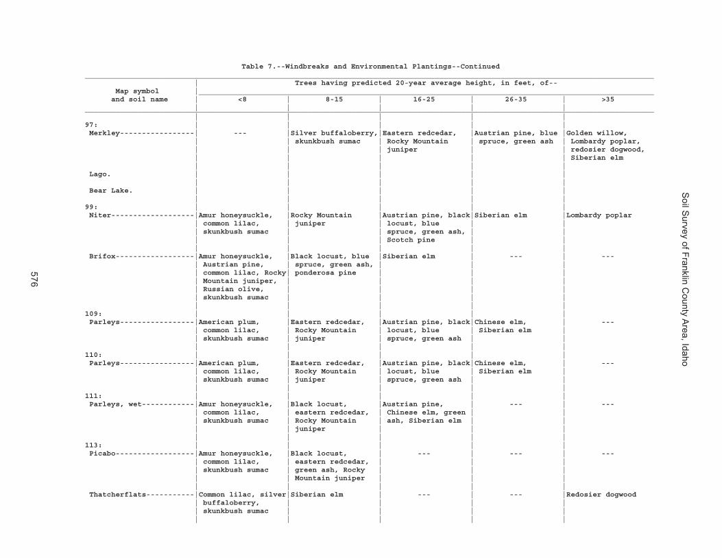
Soil S
urvey of Franklin County A
rea, Idaho
576
Table 7.--Windbreaks and Environmental Plantings--Continued__________________________________________________________________________________________________________________________________ | Trees having predicted 20-year average height, in feet, of-- Map symbol |________________________________________________________________________________________________________ and soil name | <8 | 8-15 | 16-25 | 26-35 | >35 | | | | |__________________________________________________________________________________________________________________________________ | | | | |97: | | | | | Merkley-----------------| --- |Silver buffaloberry,|Eastern redcedar, |Austrian pine, blue |Golden willow, | | skunkbush sumac | Rocky Mountain | spruce, green ash | Lombardy poplar, | | | juniper | | redosier dogwood, | | | | | Siberian elm | | | | | Lago. | | | | | | | | | | Bear Lake. | | | | | | | | | |99: | | | | | Niter-------------------|Amur honeysuckle, |Rocky Mountain |Austrian pine, black|Siberian elm |Lombardy poplar | common lilac, | juniper | locust, blue | | | skunkbush sumac | | spruce, green ash, | | | | | Scotch pine | | | | | | | Brifox------------------|Amur honeysuckle, |Black locust, blue |Siberian elm | --- | --- | Austrian pine, | spruce, green ash, | | | | common lilac, Rocky| ponderosa pine | | | | Mountain juniper, | | | | | Russian olive, | | | | | skunkbush sumac | | | | | | | | |109: | | | | | Parleys-----------------|American plum, |Eastern redcedar, |Austrian pine, black|Chinese elm, | --- | common lilac, | Rocky Mountain | locust, blue | Siberian elm | | skunkbush sumac | juniper | spruce, green ash | | | | | | |110: | | | | | Parleys-----------------|American plum, |Eastern redcedar, |Austrian pine, black|Chinese elm, | --- | common lilac, | Rocky Mountain | locust, blue | Siberian elm | | skunkbush sumac | juniper | spruce, green ash | | | | | | |111: | | | | | Parleys, wet------------|Amur honeysuckle, |Black locust, |Austrian pine, | --- | --- | common lilac, | eastern redcedar, | Chinese elm, green | | | skunkbush sumac | Rocky Mountain | ash, Siberian elm | | | | juniper | | | | | | | |113: | | | | | Picabo------------------|Amur honeysuckle, |Black locust, | --- | --- | --- | common lilac, | eastern redcedar, | | | | skunkbush sumac | green ash, Rocky | | | | | Mountain juniper | | | | | | | | Thatcherflats-----------|Common lilac, silver|Siberian elm | --- | --- |Redosier dogwood | buffaloberry, | | | | | skunkbush sumac | | | | | | | | |

Soil S
urvey of Franklin County A
rea, Idaho
577
Table 7.--Windbreaks and Environmental Plantings--Continued__________________________________________________________________________________________________________________________________ | Trees having predicted 20-year average height, in feet, of-- Map symbol |________________________________________________________________________________________________________ and soil name | <8 | 8-15 | 16-25 | 26-35 | >35 | | | | |__________________________________________________________________________________________________________________________________ | | | | |115: | | | | | Pollynot----------------|American plum, |Black locust, Rocky |Austrian pine, blue | --- | --- | common lilac, | Mountain juniper | spruce, Chinese | | | skunkbush sumac | | elm, green ash, | | | | | Scotch pine, | | | | | Siberian elm | | | | | | |116: | | | | | Pollynot----------------|American plum, |Rocky Mountain |Austrian pine, black|Chinese elm, | --- | common lilac, | juniper | locust, blue | Siberian elm | | skunkbush sumac | | spruce, green ash, | | | | | Scotch pine | | | | | | |117: | | | | | Pollynot----------------|American plum, |Rocky Mountain |Austrian pine, black|Chinese elm, | --- | common lilac, | juniper | locust, blue | Siberian elm | | skunkbush sumac | | spruce, green ash, | | | | | Scotch pine | | | | | | |118: | | | | | Pollynot----------------|American plum, |Rocky Mountain |Austrian pine, black|Chinese elm, | --- | common lilac, | juniper | locust, blue | Siberian elm | | skunkbush sumac | | spruce, green ash, | | | | | Scotch pine | | | | | | |121: | | | | | Povey. | | | | | | | | | | Hades-------------------|American plum, |Eastern redcedar, |Austrian pine, black| --- | --- | skunkbush sumac | Russian olive, | locust, green ash, | | | | Siberian crabapple | ponderosa pine, | | | | | Scotch pine | | | | | | | Hondoho. | | | | | | | | | |127: | | | | | Ricrest-----------------|American plum, |Rocky Mountain |Austrian pine, black|Siberian elm | --- | common lilac, | juniper | locust, blue | | | skunkbush sumac | | spruce, green ash, | | | | | ponderosa pine, | | | | | Scotch pine | | | | | | |

Soil S
urvey of Franklin County A
rea, Idaho
578
Table 7.--Windbreaks and Environmental Plantings--Continued__________________________________________________________________________________________________________________________________ | Trees having predicted 20-year average height, in feet, of-- Map symbol |________________________________________________________________________________________________________ and soil name | <8 | 8-15 | 16-25 | 26-35 | >35 | | | | |__________________________________________________________________________________________________________________________________ | | | | |133: | | | | | Sterling----------------|Common lilac, silver|Austrian pine, black|Siberian elm | --- | --- | buffaloberry, | locust, blue | | | | skunkbush sumac | spruce, green ash, | | | | | honeylocust, | | | | | ponderosa pine, | | | | | Scotch pine | | | | | | | |134: | | | | | Sterling----------------|Common lilac, silver|Austrian pine, black|Siberian elm | --- | --- | buffaloberry, | locust, blue | | | | skunkbush sumac | spruce, green ash, | | | | | honeylocust, | | | | | ponderosa pine, | | | | | Scotch pine | | | | | | | |137: | | | | | Sterling----------------|Common lilac, silver|Austrian pine, black|Siberian elm | --- | --- | buffaloberry, | locust, blue | | | | skunkbush sumac | spruce, green ash, | | | | | honeylocust, | | | | | ponderosa pine, | | | | | Scotch pine | | | | | | | | Parleys-----------------|American plum, |Eastern redcedar, |Austrian pine, black|Chinese elm, | --- | common lilac, | Rocky Mountain | locust, blue | Siberian elm | | skunkbush sumac | juniper | spruce, green ash | | | | | | |138: | | | | | Thatcher----------------|American plum, |Rocky Mountain |Austrian pine, black|Siberian elm | --- | common lilac, | juniper | locust, blue | | | skunkbush sumac | | spruce, green ash, | | | | | ponderosa pine, | | | | | Scotch pine | | | | | | | Bearhollow. | | | | | | | | | |140: | | | | | Trenton-----------------|Common lilac, silver| --- |Siberian elm | --- |Redosier dogwood | buffaloberry, | | | | | skunkbush sumac | | | | | | | | | Battle Creek------------|Common lilac, silver| --- |Golden willow, green|Siberian elm |Redosier dogwood | buffaloberry | | ash | | | | | | |

Soil S
urvey of Franklin County A
rea, Idaho
579
Table 7.--Windbreaks and Environmental Plantings--Continued__________________________________________________________________________________________________________________________________ | Trees having predicted 20-year average height, in feet, of-- Map symbol |________________________________________________________________________________________________________ and soil name | <8 | 8-15 | 16-25 | 26-35 | >35 | | | | |__________________________________________________________________________________________________________________________________ | | | | |141: | | | | | Trenton, cool-----------|Common lilac, silver| --- |Siberian elm | --- |Redosier dogwood | buffaloberry, | | | | | skunkbush sumac | | | | | | | | | Battle Creek, cool------|Common lilac, silver| --- |Golden willow, green|Siberian elm |Redosier dogwood | buffaloberry | | ash | | | | | | |142: | | | | | Trenton-----------------|Common lilac, silver| --- |Siberian elm | --- |Redosier dogwood | buffaloberry, | | | | | skunkbush sumac | | | | | | | | | Parleys-----------------|Amur honeysuckle, |Black locust, |Austrian pine, | --- | --- | common lilac, | eastern redcedar, | Chinese elm, green | | | skunkbush sumac | Rocky Mountain | ash, Siberian elm | | | | juniper | | | | | | | |143: | | | | | Valmar. | | | | | | | | | | Camelback. | | | | | | | | | | Hades-------------------|American plum, |Eastern redcedar, |Austrian pine, black| --- | --- | skunkbush sumac | Russian olive, | locust, green ash, | | | | Siberian crabapple | ponderosa pine, | | | | | Scotch pine | | | | | | |146: | | | | | Welby-------------------|Silver buffaloberry,|Black locust, |Austrian pine, blue | --- | --- | skunkbush sumac | eastern redcedar, | spruce, green ash, | | | | Rocky Mountain | Siberian elm | | | | juniper | | | | | | | |147: | | | | | Welby-------------------|Silver buffaloberry,|Black locust, |Austrian pine, blue | --- | --- | skunkbush sumac | eastern redcedar, | spruce, green ash, | | | | Rocky Mountain | Siberian elm | | | | juniper | | | | | | | |148: | | | | | Welby, wet--------------|Silver buffaloberry,|Black locust, |Austrian pine, blue | --- | --- | skunkbush sumac | eastern redcedar, | spruce, green ash, | | | | Rocky Mountain | Siberian elm | | | | juniper | | | | | | | |

Soil S
urvey of Franklin County A
rea, Idaho
580
Table 7.--Windbreaks and Environmental Plantings--Continued__________________________________________________________________________________________________________________________________ | Trees having predicted 20-year average height, in feet, of-- Map symbol |________________________________________________________________________________________________________ and soil name | <8 | 8-15 | 16-25 | 26-35 | >35 | | | | |__________________________________________________________________________________________________________________________________ | | | | |149: | | | | | Collinston--------------|Amur honeysuckle |Black locust, |Austrian pine, blue | --- | --- | | eastern redcedar, | spruce, green ash, | | | | Rocky Mountain | Siberian elm | | | | juniper, Russian | | | | | olive | | | | | | | | Wheelon-----------------|Silver buffaloberry,|Austrian pine, black|Siberian elm | --- | --- | skunkbush sumac | locust, blue | | | | | spruce, eastern | | | | | redcedar, green | | | | | ash, Rocky Mountain| | | | | juniper | | | | | | | |150: | | | | | Wheelon-----------------|Silver buffaloberry,|Austrian pine, black|Siberian elm | --- | --- | skunkbush sumac | locust, blue | | | | | spruce, eastern | | | | | redcedar, green | | | | | ash, Rocky Mountain| | | | | juniper | | | | | | | | Collinston--------------|Amur honeysuckle |Black locust, |Austrian pine, blue | --- | --- | | eastern redcedar, | spruce, green ash, | | | | Rocky Mountain | Siberian elm | | | | juniper, Russian | | | | | olive | | | | | | | |151: | | | | | Wheelon. | | | | | | | | | | Collinston--------------|Amur honeysuckle |Black locust, |Austrian pine, blue | --- | --- | | eastern redcedar, | spruce, green ash, | | | | Rocky Mountain | Siberian elm | | | | juniper, Russian | | | | | olive | | | | | | | |152: | | | | | Windernot---------------|Amur honeysuckle, |Austrian pine, black|Siberian elm | --- | --- | common lilac, | locust, blue | | | | eastern redcedar, | spruce, green ash | | | | Rocky Mountain | | | | | juniper, skunkbush | | | | | sumac | | | | | | | | | | | | | |

Soil S
urvey of Franklin County A
rea, Idaho
581
Table 7.--Windbreaks and Environmental Plantings--Continued__________________________________________________________________________________________________________________________________ | Trees having predicted 20-year average height, in feet, of-- Map symbol |________________________________________________________________________________________________________ and soil name | <8 | 8-15 | 16-25 | 26-35 | >35 | | | | |__________________________________________________________________________________________________________________________________ | | | | |152: | | | | | Lewnot------------------|Amur honeysuckle, | --- |Austrian pine, black|Blue spruce, golden |Idahybrid poplar, | common lilac | | locust, eastern | willow, green ash | redosier dogwood | | | redcedar, Rocky | | | | | Mountain juniper | | | | | | | Stinkcreek. | | | | | | | | | |153: | | | | | Winn--------------------|Amur honeysuckle, |Austrian pine, black| --- | --- | --- | common lilac, | locust, blue | | | | skunkbush sumac | spruce, green ash, | | | | | ponderosa pine, | | | | | Rocky Mountain | | | | | juniper, Scotch | | | | | pine, Siberian | | | | | crabapple | | | | | | | |154: | | | | | Winwell-----------------|Amur honeysuckle, |Black locust, |Siberian elm | --- | --- | Austrian pine, | ponderosa pine, | | | | common lilac, Rocky| Scotch pine | | | | Mountain juniper, | | | | | skunkbush sumac | | | | | | | | |155: | | | | | Winwell-----------------|Amur honeysuckle, |Black locust, |Siberian elm | --- | --- | Austrian pine, | ponderosa pine, | | | | common lilac, Rocky| Scotch pine | | | | Mountain juniper, | | | | | skunkbush sumac | | | | | | | | | Collinston--------------|Amur honeysuckle |Black locust, |Austrian pine, blue | --- | --- | | eastern redcedar, | spruce, green ash, | | | | Rocky Mountain | Siberian elm | | | | juniper, Russian | | | | | olive | | | | | | | |162: | | | | | Yeates Hollow-----------|Amur honeysuckle, |Black locust, green |Siberian elm | --- | --- | Austrian pine, | ash, ponderosa | | | | common lilac, | pine, Rocky | | | | Nanking cherry, | Mountain juniper, | | | | skunkbush sumac | Scotch pine | | | | | | | |

Soil S
urvey of Franklin County A
rea, Idaho
582
Table 7.--Windbreaks and Environmental Plantings--Continued__________________________________________________________________________________________________________________________________ | Trees having predicted 20-year average height, in feet, of-- Map symbol |________________________________________________________________________________________________________ and soil name | <8 | 8-15 | 16-25 | 26-35 | >35 | | | | |__________________________________________________________________________________________________________________________________ | | | | |162: | | | | | Manila------------------|Amur honeysuckle, | --- |Austrian pine, black|Siberian elm |Lombardy poplar | common lilac, | | locust, eastern | | | skunkbush sumac | | redcedar, green | | | | | ash, Rocky Mountain| | | | | juniper, Scotch | | | | | pine | | | | | | | Softback. | | | | | | | | | |__________________________________________________________________________________________________________________________________

Soil Survey of Franklin County Area, Idaho
583
Table 8.--Recreational Development (Part 1)
(The information in this table indicates the dominant soil condition but does not eliminate the need for onsite investigation. The numbers in the value columns range from 0.01 to 1.00. The larger the value, the greater the limitation. See text for further explanation of ratings in this table.)
________________________________________________________________________________________________________ | | | | Map symbol |Pct.| Camp areas | Picnic areas | Playgrounds and soil name | of | | | |map | | | |unit| | | | | | | _____________________________________________________________________________ | | Rating class and |Value| Rating class and |Value| Rating class and |Value | | limiting features | | limiting features | | limiting features | | | | | | | |________________________________________________________________________________________________________ | | | | | | |1: | | | | | | | Airport-------------| 80 |Very limited | |Very limited | |Very limited | | | Sodium content |1.00 | Sodium content |1.00 | Sodium content |1.00 | | Flooding |1.00 | Salinity |1.00 | Salinity |1.00 | | Salinity |1.00 | Slow water |0.41 | Slow water |0.41 | | Slow water |0.41 | movement | | movement | | | movement | | | | | | | | | | | |2: | | | | | | | Ant Flat------------| 85 |Somewhat limited | |Somewhat limited | |Somewhat limited | | | Slow water |0.41 | Slow water |0.41 | Slow water |0.41 | | movement | | movement | | movement | | | | | | | |3: | | | | | | | Ant Flat------------| 85 |Somewhat limited | |Somewhat limited | |Somewhat limited | | | Slow water |0.41 | Slow water |0.41 | Slow water |0.41 | | movement | | movement | | movement | | | | | | | Slope |0.12 | | | | | | |4: | | | | | | | Ant Flat------------| 90 |Somewhat limited | |Somewhat limited | |Very limited | | | Slow water |0.41 | Slow water |0.41 | Slope |1.00 | | movement | | movement | | Slow water |0.41 | | Slope |0.01 | Slope |0.01 | movement | | | | | | | |5: | | | | | | | Ant Flat------------| 65 |Somewhat limited | |Somewhat limited | |Very limited | | | Slow water |0.41 | Slow water |0.41 | Slope |1.00 | | movement | | movement | | Slow water |0.41 | | | | | | movement | | | | | | | | Oxford--------------| 25 |Somewhat limited | |Somewhat limited | |Very limited | | | Too clayey |0.50 | Too clayey |0.50 | Slope |1.00 | | Slow water |0.45 | Slow water |0.45 | Too clayey |0.50 | | movement | | movement | | Slow water |0.45 | | Slope |0.04 | Slope |0.04 | movement | | | | | | | |6: | | | | | | | Ant Flat------------| 50 |Very limited | |Very limited | |Very limited | | | Slope |1.00 | Slope |1.00 | Slope |1.00 | | Slow water |0.41 | Slow water |0.41 | Slow water |0.41 | | movement | | movement | | movement | | | | | | | | Oxford--------------| 35 |Very limited | |Very limited | |Very limited | | | Slope |1.00 | Slope |1.00 | Slope |1.00 | | Too clayey |0.50 | Too clayey |0.50 | Too clayey |0.50 | | Slow water |0.45 | Slow water |0.45 | Slow water |0.45 | | movement | | movement | | movement | | | | | | | |7: | | | | | | | Arbone--------------| 80 |Not limited | |Not limited | |Not limited | | | | | | | |

Soil Survey of Franklin County Area, Idaho
584
Table 8.--Recreational Development (Part 1)--Continued________________________________________________________________________________________________________ | | | | Map symbol |Pct.| Camp areas | Picnic areas | Playgrounds and soil name | of | | | |map | | | |unit| | | | | | | _____________________________________________________________________________ | | Rating class and |Value| Rating class and |Value| Rating class and |Value | | limiting features | | limiting features | | limiting features | | | | | | | |________________________________________________________________________________________________________ | | | | | | |8: | | | | | | | Banida--------------| 85 |Somewhat limited | |Somewhat limited | |Somewhat limited | | | Slow water |0.45 | Slow water |0.45 | Slow water |0.45 | | movement | | movement | | movement | | | | | | | |9: | | | | | | | Banida--------------| 80 |Somewhat limited | |Somewhat limited | |Somewhat limited | | | Slow water |0.45 | Slow water |0.45 | Slow water |0.45 | | movement | | movement | | movement | | | | | | | Slope |0.12 | | | | | | |10: | | | | | | | Battle Creek--------| 85 |Somewhat limited | |Somewhat limited | |Somewhat limited | | | Slow water |0.45 | Slow water |0.45 | Slow water |0.45 | | movement | | movement | | movement | | | | | | | |11: | | | | | | | Battle Creek--------| 85 |Somewhat limited | |Somewhat limited | |Somewhat limited | | | Slow water |0.45 | Slow water |0.45 | Slow water |0.45 | | movement | | movement | | movement | | | | | | | Slope |0.12 | | | | | | |12: | | | | | | | Battle Creek--------| 95 |Somewhat limited | |Somewhat limited | |Very limited | | | Slow water |0.45 | Slow water |0.45 | Slope |1.00 | | movement | | movement | | Slow water |0.45 | | | | | | movement | | | | | | | |13: | | | | | | | Bear Lake-----------| 40 |Very limited | |Very limited | |Very limited | | | Depth to |1.00 | Depth to |1.00 | Depth to |1.00 | | saturated zone | | saturated zone | | saturated zone | | | Flooding |1.00 | Ponding |1.00 | Ponding |1.00 | | Ponding |1.00 | Slow water |0.21 | Flooding |0.60 | | Slow water |0.21 | movement | | Slow water |0.21 | | movement | | | | movement | | | | | | | | Chesbrook-----------| 30 |Very limited | |Very limited | |Very limited | | | Depth to |1.00 | Depth to |0.99 | Depth to |1.00 | | saturated zone | | saturated zone | | saturated zone | | | Flooding |1.00 | Slow water |0.21 | Slow water |0.21 | | Slow water |0.21 | movement | | movement | | | movement | | | | | | | | | | | | Picabo--------------| 15 |Very limited | |Very limited | |Very limited | | | Sodium content |1.00 | Sodium content |1.00 | Sodium content |1.00 | | Flooding |1.00 | | | | | | | | | | |14: | | | | | | | Bear Lake-----------| 50 |Very limited | |Very limited | |Very limited | | | Depth to |1.00 | Depth to |1.00 | Depth to |1.00 | | saturated zone | | saturated zone | | saturated zone | | | Flooding |1.00 | Flooding |0.40 | Flooding |1.00 | | Slow water |0.21 | Slow water |0.21 | Slow water |0.21 | | movement | | movement | | movement | | | | | | | |

Soil Survey of Franklin County Area, Idaho
585
Table 8.--Recreational Development (Part 1)--Continued________________________________________________________________________________________________________ | | | | Map symbol |Pct.| Camp areas | Picnic areas | Playgrounds and soil name | of | | | |map | | | |unit| | | | | | | _____________________________________________________________________________ | | Rating class and |Value| Rating class and |Value| Rating class and |Value | | limiting features | | limiting features | | limiting features | | | | | | | |________________________________________________________________________________________________________ | | | | | | |14: | | | | | | | Downata-------------| 35 |Very limited | |Very limited | |Very limited | | | Depth to |1.00 | Depth to |1.00 | Depth to |1.00 | | saturated zone | | saturated zone | | saturated zone | | | Flooding |1.00 | Ponding |1.00 | Flooding |1.00 | | Ponding |1.00 | Flooding |0.40 | Ponding |1.00 | | Slow water |0.21 | Slow water |0.21 | Slow water |0.21 | | movement | | movement | | movement | | | | | | | |15: | | | | | | | Bear Lake-----------| 50 |Very limited | |Very limited | |Very limited | | | Depth to |1.00 | Depth to |1.00 | Depth to |1.00 | | saturated zone | | saturated zone | | saturated zone | | | Flooding |1.00 | Flooding |0.40 | Flooding |1.00 | | Slow water |0.21 | Slow water |0.21 | Slow water |0.21 | | movement | | movement | | movement | | | | | | | | Downata-------------| 25 |Very limited | |Very limited | |Very limited | | | Depth to |1.00 | Depth to |1.00 | Depth to |1.00 | | saturated zone | | saturated zone | | saturated zone | | | Flooding |1.00 | Ponding |1.00 | Flooding |1.00 | | Ponding |1.00 | Flooding |0.40 | Ponding |1.00 | | Slow water |0.21 | Slow water |0.21 | Slow water |0.21 | | movement | | movement | | movement | | | | | | | | Thatcherflats-------| 20 |Very limited | |Very limited | |Very limited | | | Sodium content |1.00 | Sodium content |1.00 | Sodium content |1.00 | | Flooding |1.00 | Slow water |0.45 | Slow water |0.45 | | Slow water |0.45 | movement | | movement | | | movement | | | | | | | | | | | |16: | | | | | | | Bear Lake-----------| 65 |Very limited | |Very limited | |Very limited | | | Depth to |1.00 | Depth to |1.00 | Depth to |1.00 | | saturated zone | | saturated zone | | saturated zone | | | Flooding |1.00 | Slow water |0.21 | Flooding |0.60 | | Slow water |0.21 | movement | | Slow water |0.21 | | movement | | | | movement | | | | | | | | Lago----------------| 30 |Very limited | |Somewhat limited | |Somewhat limited | | | Flooding |1.00 | Depth to |0.03 | Depth to |0.07 | | Depth to |0.07 | saturated zone | | saturated zone | | | saturated zone | | | | | | | | | | | |17: | | | | | | | Bearhollow----------| 30 |Very limited | |Very limited | |Very limited | | | Slope |1.00 | Slope |1.00 | Slope |1.00 | | Gravel content |0.97 | Gravel content |0.97 | Gravel content |1.00 | | Dusty |0.50 | Dusty |0.50 | Dusty |0.50 | | | | | | | Brifox--------------| 25 |Very limited | |Very limited | |Very limited | | | Slope |1.00 | Slope |1.00 | Slope |1.00 | | Too clayey |0.50 | Too clayey |0.50 | Too clayey |0.50 | | Slow water |0.45 | Slow water |0.45 | Slow water |0.45 | | movement | | movement | | movement | | | | | | | | Iphil---------------| 20 |Very limited | |Very limited | |Very limited | | | Slope |1.00 | Slope |1.00 | Slope |1.00 | | | | | | |

Soil Survey of Franklin County Area, Idaho
586
Table 8.--Recreational Development (Part 1)--Continued________________________________________________________________________________________________________ | | | | Map symbol |Pct.| Camp areas | Picnic areas | Playgrounds and soil name | of | | | |map | | | |unit| | | | | | | _____________________________________________________________________________ | | Rating class and |Value| Rating class and |Value| Rating class and |Value | | limiting features | | limiting features | | limiting features | | | | | | | |________________________________________________________________________________________________________ | | | | | | |18: | | | | | | | Bergquist-----------| 60 |Very limited | |Very limited | |Very limited | | | Slope |1.00 | Slope |1.00 | Gravel content |1.00 | | Gravel content |1.00 | Gravel content |1.00 | Slope |1.00 | | | | | | | Rubble land---------| 15 |Not rated | |Not rated | |Not rated | | | | | | | |19: | | | | | | | Bergquist-----------| 45 |Very limited | |Very limited | |Very limited | | | Slope |1.00 | Slope |1.00 | Gravel content |1.00 | | Gravel content |1.00 | Gravel content |1.00 | Slope |1.00 | | | | | | | Softback------------| 30 |Very limited | |Very limited | |Very limited | | | Slope |1.00 | Slope |1.00 | Slope |1.00 | | | | | | |20: | | | | | | | Bergquist-----------| 55 |Very limited | |Very limited | |Very limited | | | Slope |1.00 | Slope |1.00 | Gravel content |1.00 | | Gravel content |1.00 | Gravel content |1.00 | Slope |1.00 | | | | | | | Vitale--------------| 25 |Very limited | |Very limited | |Very limited | | | Slope |1.00 | Slope |1.00 | Slope |1.00 | | Content of large |0.82 | Content of large |0.82 | Content of large |0.82 | | stones | | stones | | stones | | | | | | | Gravel content |0.66 | | | | | | Depth to bedrock |0.65 | | | | | | |21: | | | | | | | Bothwell------------| 80 |Somewhat limited | |Somewhat limited | |Very limited | | | Slope |0.01 | Slope |0.01 | Slope |1.00 | | | | | | |22: | | | | | | | Bothwell------------| 80 |Very limited | |Very limited | |Very limited | | | Slope |1.00 | Slope |1.00 | Slope |1.00 | | | | | | |23: | | | | | | | Bothwell------------| 35 |Very limited | |Very limited | |Very limited | | | Slope |1.00 | Slope |1.00 | Slope |1.00 | | | | | | | Hades---------------| 30 |Very limited | |Very limited | |Very limited | | | Slope |1.00 | Slope |1.00 | Slope |1.00 | | | | | | Gravel content |0.08 | | | | | | | Justesen------------| 20 |Very limited | |Very limited | |Very limited | | | Slope |1.00 | Slope |1.00 | Slope |1.00 | | | | | | |24: | | | | | | | Bothwell------------| 40 |Not limited | |Not limited | |Very limited | | | | | | | Slope |1.00 | | | | | | | Thatcher------------| 35 |Not limited | |Not limited | |Very limited | | | | | | | Slope |1.00 | | | | | | Gravel content |0.44 | | | | | | |

Soil Survey of Franklin County Area, Idaho
587
Table 8.--Recreational Development (Part 1)--Continued________________________________________________________________________________________________________ | | | | Map symbol |Pct.| Camp areas | Picnic areas | Playgrounds and soil name | of | | | |map | | | |unit| | | | | | | _____________________________________________________________________________ | | Rating class and |Value| Rating class and |Value| Rating class and |Value | | limiting features | | limiting features | | limiting features | | | | | | | |________________________________________________________________________________________________________ | | | | | | |25: | | | | | | | Brifox--------------| 40 |Somewhat limited | |Somewhat limited | |Very limited | | | Too clayey |0.50 | Too clayey |0.50 | Slope |1.00 | | Slow water |0.45 | Slow water |0.45 | Too clayey |0.50 | | movement | | movement | | Slow water |0.45 | | Slope |0.01 | Slope |0.01 | movement | | | | | | | | Huffman-------------| 35 |Somewhat limited | |Somewhat limited | |Very limited | | | Slope |0.01 | Slope |0.01 | Slope |1.00 | | | | | | |26: | | | | | | | Brifox--------------| 40 |Very limited | |Very limited | |Very limited | | | Slope |1.00 | Slope |1.00 | Slope |1.00 | | Too clayey |0.50 | Too clayey |0.50 | Too clayey |0.50 | | Slow water |0.45 | Slow water |0.45 | Slow water |0.45 | | movement | | movement | | movement | | | | | | | | Huffman-------------| 35 |Very limited | |Very limited | |Very limited | | | Slope |1.00 | Slope |1.00 | Slope |1.00 | | | | | | |27: | | | | | | | Brifox--------------| 55 |Somewhat limited | |Somewhat limited | |Very limited | | | Too clayey |0.50 | Too clayey |0.50 | Slope |1.00 | | Slow water |0.45 | Slow water |0.45 | Too clayey |0.50 | | movement | | movement | | Slow water |0.45 | | Slope |0.01 | Slope |0.01 | movement | | | | | | | | Niter---------------| 25 |Somewhat limited | |Somewhat limited | |Very limited | | | Slow water |0.45 | Slow water |0.45 | Slope |1.00 | | movement | | movement | | Slow water |0.45 | | Slope |0.01 | Slope |0.01 | movement | | | | | | | |28: | | | | | | | Brifox--------------| 65 |Very limited | |Very limited | |Very limited | | | Slope |1.00 | Slope |1.00 | Slope |1.00 | | Too clayey |0.50 | Too clayey |0.50 | Too clayey |0.50 | | Slow water |0.45 | Slow water |0.45 | Slow water |0.45 | | movement | | movement | | movement | | | | | | | | Niter---------------| 20 |Very limited | |Very limited | |Very limited | | | Slope |1.00 | Slope |1.00 | Slope |1.00 | | Slow water |0.45 | Slow water |0.45 | Slow water |0.45 | | movement | | movement | | movement | | | | | | | |29: | | | | | | | Brifox--------------| 55 |Very limited | |Very limited | |Very limited | | | Slope |1.00 | Slope |1.00 | Slope |1.00 | | Too clayey |0.50 | Too clayey |0.50 | Too clayey |0.50 | | Slow water |0.45 | Slow water |0.45 | Slow water |0.45 | | movement | | movement | | movement | | | | | | | | Niter---------------| 25 |Very limited | |Very limited | |Very limited | | | Slope |1.00 | Slope |1.00 | Slope |1.00 | | Slow water |0.45 | Slow water |0.45 | Slow water |0.45 | | movement | | movement | | movement | | | | | | | |

Soil Survey of Franklin County Area, Idaho
588
Table 8.--Recreational Development (Part 1)--Continued________________________________________________________________________________________________________ | | | | Map symbol |Pct.| Camp areas | Picnic areas | Playgrounds and soil name | of | | | |map | | | |unit| | | | | | | _____________________________________________________________________________ | | Rating class and |Value| Rating class and |Value| Rating class and |Value | | limiting features | | limiting features | | limiting features | | | | | | | |________________________________________________________________________________________________________ | | | | | | |30: | | | | | | | Broadhead-----------| 30 |Somewhat limited | |Somewhat limited | |Very limited | | | Slope |0.63 | Slope |0.63 | Slope |1.00 | | Slow water |0.41 | Slow water |0.41 | Slow water |0.41 | | movement | | movement | | movement | | | | | | | | Hades---------------| 25 |Somewhat limited | |Somewhat limited | |Very limited | | | Slope |0.63 | Slope |0.63 | Slope |1.00 | | | | | | Gravel content |0.08 | | | | | | | Yago----------------| 25 |Somewhat limited | |Somewhat limited | |Very limited | | | Content of large |0.86 | Content of large |0.86 | Slope |1.00 | | stones | | stones | | Content of large |0.86 | | Slope |0.63 | Slope |0.63 | stones | | | Slow water |0.41 | Slow water |0.41 | Slow water |0.41 | | movement | | movement | | movement | | | | | | | Gravel content |0.08 | | | | | | |31: | | | | | | | Broadhead-----------| 40 |Very limited | |Very limited | |Very limited | | | Slope |1.00 | Slope |1.00 | Slope |1.00 | | Slow water |0.41 | Slow water |0.41 | Slow water |0.41 | | movement | | movement | | movement | | | | | | | | Yago----------------| 35 |Very limited | |Very limited | |Very limited | | | Slope |1.00 | Slope |1.00 | Slope |1.00 | | Content of large |0.86 | Content of large |0.86 | Content of large |0.86 | | stones | | stones | | stones | | | Slow water |0.41 | Slow water |0.41 | Slow water |0.41 | | movement | | movement | | movement | | | | | | | Gravel content |0.08 | | | | | | |32: | | | | | | | Camelback-----------| 55 |Very limited | |Very limited | |Very limited | | | Slope |1.00 | Slope |1.00 | Gravel content |1.00 | | Gravel content |1.00 | Gravel content |1.00 | Slope |1.00 | | | | | | | Lonigan-------------| 25 |Very limited | |Very limited | |Very limited | | | Slope |1.00 | Slope |1.00 | Gravel content |1.00 | | Gravel content |0.97 | Gravel content |0.97 | Slope |1.00 | | | | | | Depth to bedrock |0.90 | | | | | | |33: | | | | | | | Camelback-----------| 40 |Very limited | |Very limited | |Very limited | | | Slope |1.00 | Slope |1.00 | Gravel content |1.00 | | Gravel content |1.00 | Gravel content |1.00 | Slope |1.00 | | | | | | | Hades---------------| 20 |Very limited | |Very limited | |Very limited | | | Slope |1.00 | Slope |1.00 | Slope |1.00 | | | | | | Gravel content |0.08 | | | | | | | Valmar--------------| 20 |Very limited | |Very limited | |Very limited | | | Slope |1.00 | Slope |1.00 | Slope |1.00 | | Content of large |0.08 | Content of large |0.08 | Gravel content |0.93 | | stones | | stones | | Depth to bedrock |0.90 | | | | | | Content of large |0.08 | | | | | | stones | | | | | | | |

Soil Survey of Franklin County Area, Idaho
589
Table 8.--Recreational Development (Part 1)--Continued________________________________________________________________________________________________________ | | | | Map symbol |Pct.| Camp areas | Picnic areas | Playgrounds and soil name | of | | | |map | | | |unit| | | | | | | _____________________________________________________________________________ | | Rating class and |Value| Rating class and |Value| Rating class and |Value | | limiting features | | limiting features | | limiting features | | | | | | | |________________________________________________________________________________________________________ | | | | | | |34: | | | | | | | Cedarhill-----------| 90 |Very limited | |Very limited | |Very limited | | | Slope |1.00 | Slope |1.00 | Gravel content |1.00 | | Gravel content |1.00 | Gravel content |1.00 | Slope |1.00 | | | | | | |35: | | | | | | | Cedarhill-----------| 40 |Very limited | |Very limited | |Very limited | | | Slope |1.00 | Slope |1.00 | Gravel content |1.00 | | Gravel content |1.00 | Gravel content |1.00 | Slope |1.00 | | | | | | | Hades---------------| 25 |Very limited | |Very limited | |Very limited | | | Slope |1.00 | Slope |1.00 | Slope |1.00 | | | | | | Gravel content |0.08 | | | | | | | Ricrest-------------| 20 |Very limited | |Very limited | |Very limited | | | Slope |1.00 | Slope |1.00 | Slope |1.00 | | Gravel content |0.61 | Gravel content |0.61 | Gravel content |1.00 | | | | | | |36: | | | | | | | Cedarhill-----------| 35 |Very limited | |Very limited | |Very limited | | | Slope |1.00 | Slope |1.00 | Gravel content |1.00 | | Gravel content |1.00 | Gravel content |1.00 | Slope |1.00 | | | | | | | Hondoho-------------| 30 |Very limited | |Very limited | |Very limited | | | Slope |1.00 | Slope |1.00 | Slope |1.00 | | Gravel content |0.12 | Gravel content |0.12 | Gravel content |1.00 | | | | | | | Ridgecrest----------| 20 |Very limited | |Very limited | |Very limited | | | Slope |1.00 | Slope |1.00 | Slope |1.00 | | Gravel content |0.37 | Gravel content |0.37 | Gravel content |1.00 | | Content of large |0.29 | Content of large |0.29 | Depth to bedrock |0.71 | | stones | | stones | | Content of large |0.29 | | | | | | stones | | | | | | | |37: | | | | | | | Chesbrook-----------| 60 |Very limited | |Very limited | |Very limited | | | Depth to |1.00 | Depth to |0.99 | Depth to |1.00 | | saturated zone | | saturated zone | | saturated zone | | | Flooding |1.00 | Slow water |0.21 | Slow water |0.21 | | Slow water |0.21 | movement | | movement | | | movement | | | | | | | | | | | | Bear Lake-----------| 20 |Very limited | |Very limited | |Very limited | | | Depth to |1.00 | Depth to |1.00 | Depth to |1.00 | | saturated zone | | saturated zone | | saturated zone | | | Flooding |1.00 | Slow water |0.21 | Flooding |0.60 | | Slow water |0.21 | movement | | Slow water |0.21 | | movement | | | | movement | | | | | | | |38: | | | | | | | Cloudless-----------| 50 |Somewhat limited | |Somewhat limited | |Very limited | | | Slope |0.01 | Slope |0.01 | Slope |1.00 | | | | | | | Hades---------------| 40 |Somewhat limited | |Somewhat limited | |Very limited | | | Slope |0.01 | Slope |0.01 | Slope |1.00 | | | | | | Gravel content |0.08 | | | | | | |

Soil Survey of Franklin County Area, Idaho
590
Table 8.--Recreational Development (Part 1)--Continued________________________________________________________________________________________________________ | | | | Map symbol |Pct.| Camp areas | Picnic areas | Playgrounds and soil name | of | | | |map | | | |unit| | | | | | | _____________________________________________________________________________ | | Rating class and |Value| Rating class and |Value| Rating class and |Value | | limiting features | | limiting features | | limiting features | | | | | | | |________________________________________________________________________________________________________ | | | | | | |39: | | | | | | | Cloudless-----------| 35 |Very limited | |Very limited | |Very limited | | | Slope |1.00 | Slope |1.00 | Slope |1.00 | | | | | | | Hades---------------| 30 |Very limited | |Very limited | |Very limited | | | Slope |1.00 | Slope |1.00 | Slope |1.00 | | | | | | Gravel content |0.08 | | | | | | | Howcan--------------| 20 |Very limited | |Very limited | |Very limited | | | Slope |1.00 | Slope |1.00 | Gravel content |1.00 | | Gravel content |0.91 | Gravel content |0.91 | Slope |1.00 | | | | | | |40: | | | | | | | Copenhagen----------| 35 |Very limited | |Very limited | |Very limited | | | Depth to bedrock |1.00 | Depth to bedrock |1.00 | Gravel content |1.00 | | Slope |1.00 | Slope |1.00 | Slope |1.00 | | Gravel content |0.98 | Gravel content |0.98 | Depth to bedrock |1.00 | | | | | | | Lonigan-------------| 30 |Very limited | |Very limited | |Very limited | | | Slope |1.00 | Slope |1.00 | Gravel content |1.00 | | Gravel content |0.97 | Gravel content |0.97 | Slope |1.00 | | | | | | Depth to bedrock |0.20 | | | | | | | Manila--------------| 20 |Very limited | |Very limited | |Very limited | | | Slope |1.00 | Slope |1.00 | Slope |1.00 | | Slow water |0.41 | Slow water |0.41 | Slow water |0.41 | | movement | | movement | | movement | | | | | | | |41: | | | | | | | Delish--------------| 40 |Very limited | |Somewhat limited | |Somewhat limited | | | Flooding |1.00 | Depth to |0.19 | Depth to |0.39 | | Depth to |0.39 | saturated zone | | saturated zone | | | saturated zone | | Salinity |0.13 | Salinity |0.13 | | Salinity |0.13 | | | | | | | | | | | Cachecan------------| 25 |Very limited | |Somewhat limited | |Somewhat limited | | | Flooding |1.00 | Dusty |0.50 | Dusty |0.50 | | Dusty |0.50 | | | | | | | | | | | Stinkcreek----------| 15 |Very limited | |Very limited | |Very limited | | | Depth to |1.00 | Depth to |1.00 | Depth to |1.00 | | saturated zone | | saturated zone | | saturated zone | | | Sodium content |1.00 | Sodium content |1.00 | Sodium content |1.00 | | Flooding |1.00 | Slow water |0.21 | Slow water |0.21 | | Slow water |0.21 | movement | | movement | | | movement | | | | | | | | | | | |42: | | | | | | | Downata-------------| 80 |Very limited | |Very limited | |Very limited | | | Depth to |1.00 | Depth to |1.00 | Depth to |1.00 | | saturated zone | | saturated zone | | saturated zone | | | Flooding |1.00 | Ponding |1.00 | Flooding |1.00 | | Ponding |1.00 | Flooding |0.40 | Ponding |1.00 | | Slow water |0.21 | Slow water |0.21 | Slow water |0.21 | | movement | | movement | | movement | | | | | | | |

Soil Survey of Franklin County Area, Idaho
591
Table 8.--Recreational Development (Part 1)--Continued________________________________________________________________________________________________________ | | | | Map symbol |Pct.| Camp areas | Picnic areas | Playgrounds and soil name | of | | | |map | | | |unit| | | | | | | _____________________________________________________________________________ | | Rating class and |Value| Rating class and |Value| Rating class and |Value | | limiting features | | limiting features | | limiting features | | | | | | | |________________________________________________________________________________________________________ | | | | | | |43: | | | | | | | Dranburn------------| 45 |Very limited | |Very limited | |Very limited | | | Slope |1.00 | Slope |1.00 | Slope |1.00 | | Slow water |0.21 | Slow water |0.21 | Slow water |0.21 | | movement | | movement | | movement | | | | | | | | Robin---------------| 35 |Very limited | |Very limited | |Very limited | | | Slope |1.00 | Slope |1.00 | Slope |1.00 | | | | | | |44: | | | | | | | Enochville----------| 75 |Very limited | |Somewhat limited | |Very limited | | | Flooding |1.00 | Depth to |0.75 | Flooding |1.00 | | Depth to |0.98 | saturated zone | | Depth to |0.98 | | saturated zone | | Flooding |0.40 | saturated zone | | | Slow water |0.21 | Slow water |0.21 | Slow water |0.21 | | movement | | movement | | movement | | | | | | | |45: | | | | | | | Foxol---------------| 45 |Very limited | |Very limited | |Very limited | | | Slope |1.00 | Slope |1.00 | Slope |1.00 | | Depth to bedrock |1.00 | Depth to bedrock |1.00 | Depth to bedrock |1.00 | | Content of large |0.46 | Content of large |0.46 | Gravel content |0.55 | | stones | | stones | | Content of large |0.46 | | | | | | stones | | | | | | | | Vitale--------------| 30 |Very limited | |Very limited | |Very limited | | | Slope |1.00 | Slope |1.00 | Slope |1.00 | | Content of large |0.82 | Content of large |0.82 | Content of large |0.82 | | stones | | stones | | stones | | | | | | | Gravel content |0.66 | | | | | | Depth to bedrock |0.65 | | | | | | |46: | | | | | | | Hades---------------| 35 |Very limited | |Very limited | |Very limited | | | Slope |1.00 | Slope |1.00 | Slope |1.00 | | | | | | Gravel content |0.08 | | | | | | | Camelback-----------| 20 |Very limited | |Very limited | |Very limited | | | Slope |1.00 | Slope |1.00 | Gravel content |1.00 | | Gravel content |1.00 | Gravel content |1.00 | Slope |1.00 | | | | | | | Hondoho-------------| 20 |Very limited | |Very limited | |Very limited | | | Slope |1.00 | Slope |1.00 | Slope |1.00 | | Gravel content |0.12 | Gravel content |0.12 | Gravel content |1.00 | | | | | | |47: | | | | | | | Hades---------------| 25 |Very limited | |Very limited | |Very limited | | | Slope |1.00 | Slope |1.00 | Slope |1.00 | | | | | | Gravel content |0.08 | | | | | | | Lanoak--------------| 25 |Very limited | |Very limited | |Very limited | | | Slope |1.00 | Slope |1.00 | Slope |1.00 | | | | | | | Camelback-----------| 25 |Very limited | |Very limited | |Very limited | | | Slope |1.00 | Slope |1.00 | Gravel content |1.00 | | Gravel content |1.00 | Gravel content |1.00 | Slope |1.00 | | | | | | |

Soil Survey of Franklin County Area, Idaho
592
Table 8.--Recreational Development (Part 1)--Continued________________________________________________________________________________________________________ | | | | Map symbol |Pct.| Camp areas | Picnic areas | Playgrounds and soil name | of | | | |map | | | |unit| | | | | | | _____________________________________________________________________________ | | Rating class and |Value| Rating class and |Value| Rating class and |Value | | limiting features | | limiting features | | limiting features | | | | | | | |________________________________________________________________________________________________________ | | | | | | |48: | | | | | | | Haploxerolls--------| 45 |Very limited | |Very limited | |Very limited | | | Slope |1.00 | Slope |1.00 | Slope |1.00 | | | | | | Gravel content |0.44 | | | | | | | Xerorthents---------| 30 |Very limited | |Very limited | |Very limited | | | Slope |1.00 | Slope |1.00 | Slope |1.00 | | Depth to bedrock |1.00 | Depth to bedrock |1.00 | Depth to bedrock |1.00 | | Dusty |0.50 | Dusty |0.50 | Gravel content |1.00 | | Gravel content |0.21 | Gravel content |0.21 | Dusty |0.50 | | | | | | |49: | | | | | | | Hendricks-----------| 90 |Somewhat limited | |Somewhat limited | |Very limited | | | Slope |0.01 | Slope |0.01 | Slope |1.00 | | | | | | |50: | | | | | | | Holmes--------------| 90 |Very limited | |Somewhat limited | |Very limited | | | Flooding |1.00 | Gravel content |0.01 | Gravel content |1.00 | | Gravel content |0.01 | | | | | | | | | | |51: | | | | | | | Hondee--------------| 85 |Somewhat limited | |Somewhat limited | |Very limited | | | Gravel content |0.97 | Gravel content |0.97 | Gravel content |1.00 | | | | | | Slope |0.12 | | | | | | |52: | | | | | | | Hondee--------------| 75 |Somewhat limited | |Somewhat limited | |Very limited | | | Gravel content |0.97 | Gravel content |0.97 | Gravel content |1.00 | | Slope |0.01 | Slope |0.01 | Slope |1.00 | | | | | | |53: | | | | | | | Hondoho-------------| 50 |Somewhat limited | |Somewhat limited | |Very limited | | | Gravel content |0.12 | Gravel content |0.12 | Slope |1.00 | | Slope |0.01 | Slope |0.01 | Gravel content |1.00 | | | | | | | Hades---------------| 30 |Somewhat limited | |Somewhat limited | |Very limited | | | Slope |0.01 | Slope |0.01 | Slope |1.00 | | | | | | Gravel content |0.08 | | | | | | |54: | | | | | | | Hondoho-------------| 50 |Somewhat limited | |Somewhat limited | |Very limited | | | Slope |0.63 | Slope |0.63 | Slope |1.00 | | Gravel content |0.12 | Gravel content |0.12 | Gravel content |1.00 | | | | | | | Ricrest-------------| 40 |Somewhat limited | |Somewhat limited | |Very limited | | | Gravel content |0.61 | Gravel content |0.61 | Gravel content |1.00 | | Slope |0.01 | Slope |0.01 | Slope |1.00 | | | | | | |55: | | | | | | | Hondoho-------------| 35 |Very limited | |Very limited | |Very limited | | | Slope |1.00 | Slope |1.00 | Slope |1.00 | | Gravel content |0.12 | Gravel content |0.12 | Gravel content |1.00 | | | | | | | Sprollow------------| 30 |Very limited | |Very limited | |Very limited | | | Slope |1.00 | Slope |1.00 | Slope |1.00 | | Gravel content |0.59 | Gravel content |0.59 | Gravel content |1.00 | | Dusty |0.50 | Dusty |0.50 | Dusty |0.50 | | | | | | Depth to bedrock |0.01 | | | | | | |

Soil Survey of Franklin County Area, Idaho
593
Table 8.--Recreational Development (Part 1)--Continued________________________________________________________________________________________________________ | | | | Map symbol |Pct.| Camp areas | Picnic areas | Playgrounds and soil name | of | | | |map | | | |unit| | | | | | | _____________________________________________________________________________ | | Rating class and |Value| Rating class and |Value| Rating class and |Value | | limiting features | | limiting features | | limiting features | | | | | | | |________________________________________________________________________________________________________ | | | | | | |55: | | | | | | | Hades---------------| 20 |Very limited | |Very limited | |Very limited | | | Slope |1.00 | Slope |1.00 | Slope |1.00 | | | | | | Gravel content |0.08 | | | | | | |56: | | | | | | | Hondoho-------------| 45 |Very limited | |Very limited | |Very limited | | | Slope |1.00 | Slope |1.00 | Slope |1.00 | | Gravel content |0.12 | Gravel content |0.12 | Gravel content |1.00 | | | | | | | Vitale--------------| 30 |Very limited | |Very limited | |Very limited | | | Slope |1.00 | Slope |1.00 | Slope |1.00 | | Content of large |0.82 | Content of large |0.82 | Content of large |0.82 | | stones | | stones | | stones | | | | | | | Gravel content |0.66 | | | | | | Depth to bedrock |0.65 | | | | | | |57: | | | | | | | Huffman-------------| 80 |Not limited | |Not limited | |Not limited | | | | | | | |58: | | | | | | | Huffman-------------| 80 |Somewhat limited | |Somewhat limited | |Very limited | | | Slope |0.01 | Slope |0.01 | Slope |1.00 | | | | | | |59: | | | | | | | Huffman-------------| 45 |Somewhat limited | |Somewhat limited | |Very limited | | | Slope |0.01 | Slope |0.01 | Slope |1.00 | | | | | | | Dirtyhead-----------| 30 |Very limited | |Very limited | |Very limited | | | Gravel content |1.00 | Gravel content |1.00 | Gravel content |1.00 | | Dusty |0.50 | Dusty |0.50 | Slope |1.00 | | Slope |0.01 | Slope |0.01 | Dusty |0.50 | | | | | | Depth to bedrock |0.01 | | | | | | |60: | | | | | | | Huffman-------------| 35 |Not limited | |Not limited | |Very limited | | | | | | | Slope |1.00 | | | | | | | Harroun-------------| 30 |Very limited | |Very limited | |Very limited | | | Depth to cemented|1.00 | Depth to cemented|1.00 | Depth to cemented|1.00 | | pan | | pan | | pan | | | Gravel content |0.42 | Gravel content |0.42 | Slope |1.00 | | Slope |0.01 | Slope |0.01 | Gravel content |1.00 | | | | | | | Lanoak--------------| 25 |Not limited | |Not limited | |Somewhat limited | | | | | | | Slope |0.50 | | | | | | |61: | | | | | | | Huffman-------------| 45 |Somewhat limited | |Somewhat limited | |Very limited | | | Slope |0.01 | Slope |0.01 | Slope |1.00 | | | | | | | Wursten-------------| 35 |Somewhat limited | |Somewhat limited | |Very limited | | | Slope |0.01 | Slope |0.01 | Slope |1.00 | | | | | | |62: | | | | | | | Iphil---------------| 60 |Somewhat limited | |Somewhat limited | |Very limited | | | Slope |0.96 | Slope |0.96 | Slope |1.00 | | | | | | |

Soil Survey of Franklin County Area, Idaho
594
Table 8.--Recreational Development (Part 1)--Continued________________________________________________________________________________________________________ | | | | Map symbol |Pct.| Camp areas | Picnic areas | Playgrounds and soil name | of | | | |map | | | |unit| | | | | | | _____________________________________________________________________________ | | Rating class and |Value| Rating class and |Value| Rating class and |Value | | limiting features | | limiting features | | limiting features | | | | | | | |________________________________________________________________________________________________________ | | | | | | |62: | | | | | | | Lonigan-------------| 20 |Somewhat limited | |Somewhat limited | |Very limited | | | Gravel content |0.97 | Gravel content |0.97 | Gravel content |1.00 | | Slope |0.96 | Slope |0.96 | Slope |1.00 | | | | | | Depth to bedrock |0.90 | | | | | | |63: | | | | | | | Ireland-------------| 50 |Very limited | |Very limited | |Very limited | | | Slope |1.00 | Slope |1.00 | Slope |1.00 | | Gravel content |0.72 | Gravel content |0.72 | Gravel content |1.00 | | Content of large |0.01 | Content of large |0.01 | Depth to bedrock |0.95 | | stones | | stones | | Content of large |0.01 | | | | | | stones | | | | | | | | Polumar-------------| 25 |Very limited | |Very limited | |Very limited | | | Slope |1.00 | Slope |1.00 | Slope |1.00 | | Gravel content |0.61 | Gravel content |0.61 | Gravel content |1.00 | | | | | | |64: | | | | | | | Kabear--------------| 50 |Somewhat limited | |Somewhat limited | |Very limited | | | Slope |0.01 | Slope |0.01 | Slope |1.00 | | | | | | | Staberg-------------| 25 |Somewhat limited | |Somewhat limited | |Very limited | | | Slope |0.01 | Slope |0.01 | Slope |1.00 | | | | | | Gravel content |0.44 | | | | | | Depth to bedrock |0.01 | | | | | | | Copenhagen----------| 15 |Very limited | |Very limited | |Very limited | | | Depth to bedrock |1.00 | Depth to bedrock |1.00 | Gravel content |1.00 | | Gravel content |0.98 | Gravel content |0.98 | Depth to bedrock |1.00 | | Slope |0.01 | Slope |0.01 | Slope |1.00 | | | | | | |65: | | | | | | | Kabear--------------| 50 |Very limited | |Very limited | |Very limited | | | Slope |1.00 | Slope |1.00 | Slope |1.00 | | | | | | | Staberg-------------| 25 |Very limited | |Very limited | |Very limited | | | Slope |1.00 | Slope |1.00 | Slope |1.00 | | | | | | Gravel content |0.44 | | | | | | Depth to bedrock |0.01 | | | | | | | Copenhagen----------| 15 |Very limited | |Very limited | |Very limited | | | Depth to bedrock |1.00 | Depth to bedrock |1.00 | Gravel content |1.00 | | Slope |1.00 | Slope |1.00 | Slope |1.00 | | Gravel content |0.98 | Gravel content |0.98 | Depth to bedrock |1.00 | | | | | | |66: | | | | | | | Kearns--------------| 80 |Not limited | |Not limited | |Not limited | | | | | | | |67: | | | | | | | Kearnsar------------| 60 |Not limited | |Not limited | |Not limited | | | | | | | | Battle Creek--------| 25 |Somewhat limited | |Somewhat limited | |Somewhat limited | | | Slow water |0.45 | Slow water |0.45 | Slow water |0.45 | | movement | | movement | | movement | | | | | | | |68: | | | | | | | Kidman--------------| 90 |Not limited | |Not limited | |Not limited | | | | | | | |

Soil Survey of Franklin County Area, Idaho
595
Table 8.--Recreational Development (Part 1)--Continued________________________________________________________________________________________________________ | | | | Map symbol |Pct.| Camp areas | Picnic areas | Playgrounds and soil name | of | | | |map | | | |unit| | | | | | | _____________________________________________________________________________ | | Rating class and |Value| Rating class and |Value| Rating class and |Value | | limiting features | | limiting features | | limiting features | | | | | | | |________________________________________________________________________________________________________ | | | | | | |69: | | | | | | | Kidman--------------| 85 |Not limited | |Not limited | |Somewhat limited | | | | | | | Slope |0.12 | | | | | | |70: | | | | | | | Kidman--------------| 85 |Very limited | |Very limited | |Very limited | | | Slope |1.00 | Slope |1.00 | Slope |1.00 | | | | | | |71: | | | | | | | Kidman, wet---------| 85 |Not limited | |Not limited | |Not limited | | | | | | | |72: | | | | | | | Kidman--------------| 45 |Not limited | |Not limited | |Not limited | | | | | | | | Sterling------------| 30 |Somewhat limited | |Somewhat limited | |Very limited | | | Gravel content |0.68 | Gravel content |0.68 | Gravel content |1.00 | | | | | | |73: | | | | | | | Lando---------------| 75 |Somewhat limited | |Somewhat limited | |Somewhat limited | | | Slow water |0.41 | Slow water |0.41 | Slow water |0.41 | | movement | | movement | | movement | | | | | | | |74: | | | | | | | Lanoak--------------| 75 |Not limited | |Not limited | |Not limited | | | | | | | |75: | | | | | | | Lanoak--------------| 75 |Somewhat limited | |Somewhat limited | |Very limited | | | Slope |0.01 | Slope |0.01 | Slope |1.00 | | | | | | |76: | | | | | | | Lanoak--------------| 45 |Very limited | |Very limited | |Very limited | | | Slope |1.00 | Slope |1.00 | Slope |1.00 | | | | | | | Broadhead-----------| 40 |Very limited | |Very limited | |Very limited | | | Slope |1.00 | Slope |1.00 | Slope |1.00 | | Slow water |0.41 | Slow water |0.41 | Slow water |0.41 | | movement | | movement | | movement | | | | | | | |77: | | | | | | | Lanoak--------------| 35 |Very limited | |Very limited | |Very limited | | | Slope |1.00 | Slope |1.00 | Slope |1.00 | | | | | | | Broadhead-----------| 30 |Very limited | |Very limited | |Very limited | | | Slope |1.00 | Slope |1.00 | Slope |1.00 | | Slow water |0.41 | Slow water |0.41 | Slow water |0.41 | | movement | | movement | | movement | | | | | | | | Hades---------------| 15 |Very limited | |Very limited | |Very limited | | | Slope |1.00 | Slope |1.00 | Slope |1.00 | | | | | | Gravel content |0.08 | | | | | | |78: | | | | | | | Lanoak--------------| 40 |Somewhat limited | |Somewhat limited | |Very limited | | | Slope |0.84 | Slope |0.84 | Slope |1.00 | | | | | | | Hades---------------| 35 |Somewhat limited | |Somewhat limited | |Very limited | | | Slope |0.84 | Slope |0.84 | Slope |1.00 | | | | | | Gravel content |0.08 | | | | | | |
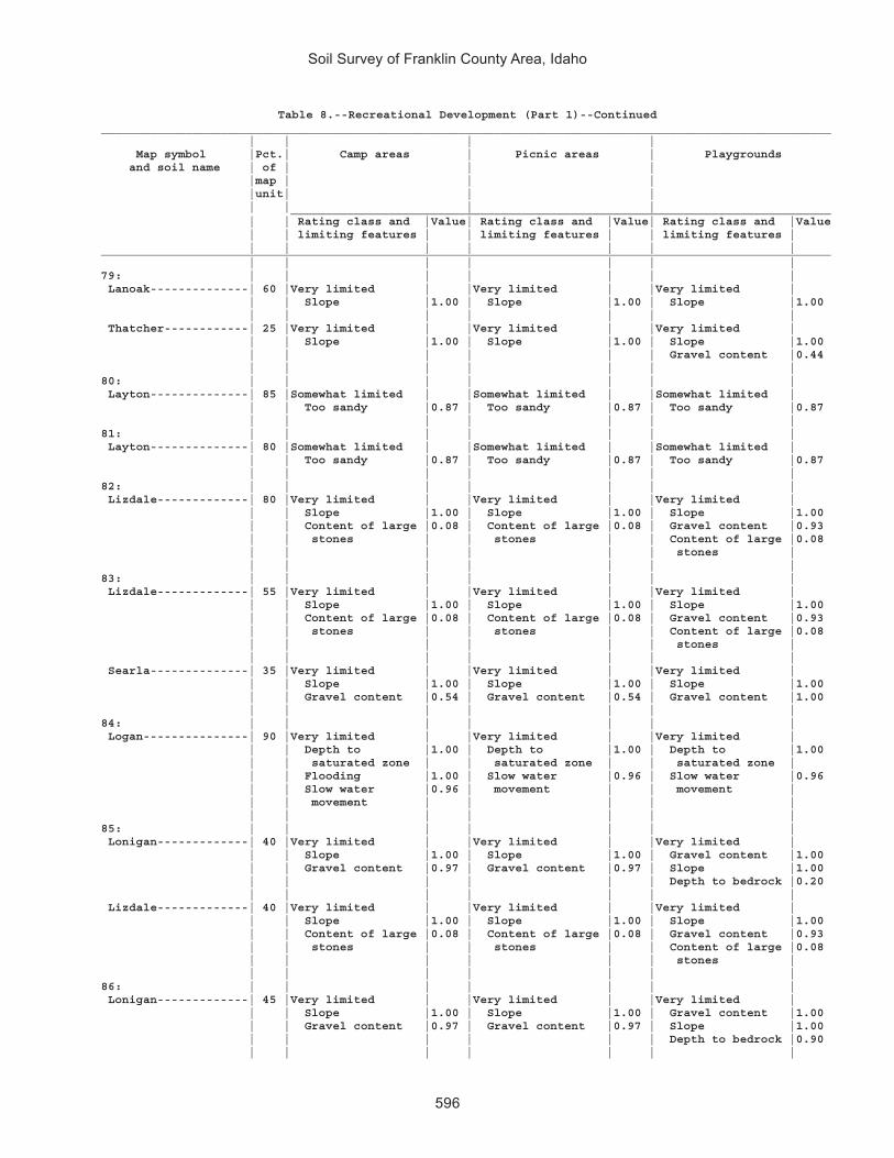
Soil Survey of Franklin County Area, Idaho
596
Table 8.--Recreational Development (Part 1)--Continued________________________________________________________________________________________________________ | | | | Map symbol |Pct.| Camp areas | Picnic areas | Playgrounds and soil name | of | | | |map | | | |unit| | | | | | | _____________________________________________________________________________ | | Rating class and |Value| Rating class and |Value| Rating class and |Value | | limiting features | | limiting features | | limiting features | | | | | | | |________________________________________________________________________________________________________ | | | | | | |79: | | | | | | | Lanoak--------------| 60 |Very limited | |Very limited | |Very limited | | | Slope |1.00 | Slope |1.00 | Slope |1.00 | | | | | | | Thatcher------------| 25 |Very limited | |Very limited | |Very limited | | | Slope |1.00 | Slope |1.00 | Slope |1.00 | | | | | | Gravel content |0.44 | | | | | | |80: | | | | | | | Layton--------------| 85 |Somewhat limited | |Somewhat limited | |Somewhat limited | | | Too sandy |0.87 | Too sandy |0.87 | Too sandy |0.87 | | | | | | |81: | | | | | | | Layton--------------| 80 |Somewhat limited | |Somewhat limited | |Somewhat limited | | | Too sandy |0.87 | Too sandy |0.87 | Too sandy |0.87 | | | | | | |82: | | | | | | | Lizdale-------------| 80 |Very limited | |Very limited | |Very limited | | | Slope |1.00 | Slope |1.00 | Slope |1.00 | | Content of large |0.08 | Content of large |0.08 | Gravel content |0.93 | | stones | | stones | | Content of large |0.08 | | | | | | stones | | | | | | | |83: | | | | | | | Lizdale-------------| 55 |Very limited | |Very limited | |Very limited | | | Slope |1.00 | Slope |1.00 | Slope |1.00 | | Content of large |0.08 | Content of large |0.08 | Gravel content |0.93 | | stones | | stones | | Content of large |0.08 | | | | | | stones | | | | | | | | Searla--------------| 35 |Very limited | |Very limited | |Very limited | | | Slope |1.00 | Slope |1.00 | Slope |1.00 | | Gravel content |0.54 | Gravel content |0.54 | Gravel content |1.00 | | | | | | |84: | | | | | | | Logan---------------| 90 |Very limited | |Very limited | |Very limited | | | Depth to |1.00 | Depth to |1.00 | Depth to |1.00 | | saturated zone | | saturated zone | | saturated zone | | | Flooding |1.00 | Slow water |0.96 | Slow water |0.96 | | Slow water |0.96 | movement | | movement | | | movement | | | | | | | | | | | |85: | | | | | | | Lonigan-------------| 40 |Very limited | |Very limited | |Very limited | | | Slope |1.00 | Slope |1.00 | Gravel content |1.00 | | Gravel content |0.97 | Gravel content |0.97 | Slope |1.00 | | | | | | Depth to bedrock |0.20 | | | | | | | Lizdale-------------| 40 |Very limited | |Very limited | |Very limited | | | Slope |1.00 | Slope |1.00 | Slope |1.00 | | Content of large |0.08 | Content of large |0.08 | Gravel content |0.93 | | stones | | stones | | Content of large |0.08 | | | | | | stones | | | | | | | |86: | | | | | | | Lonigan-------------| 45 |Very limited | |Very limited | |Very limited | | | Slope |1.00 | Slope |1.00 | Gravel content |1.00 | | Gravel content |0.97 | Gravel content |0.97 | Slope |1.00 | | | | | | Depth to bedrock |0.90 | | | | | | |

Soil Survey of Franklin County Area, Idaho
597
Table 8.--Recreational Development (Part 1)--Continued________________________________________________________________________________________________________ | | | | Map symbol |Pct.| Camp areas | Picnic areas | Playgrounds and soil name | of | | | |map | | | |unit| | | | | | | _____________________________________________________________________________ | | Rating class and |Value| Rating class and |Value| Rating class and |Value | | limiting features | | limiting features | | limiting features | | | | | | | |________________________________________________________________________________________________________ | | | | | | |86: | | | | | | | Ricrest-------------| 30 |Very limited | |Very limited | |Very limited | | | Slope |1.00 | Slope |1.00 | Slope |1.00 | | Gravel content |0.61 | Gravel content |0.61 | Gravel content |1.00 | | | | | | |87: | | | | | | | Manila--------------| 85 |Somewhat limited | |Somewhat limited | |Somewhat limited | | | Slow water |0.41 | Slow water |0.41 | Slow water |0.41 | | movement | | movement | | movement | | | | | | | |88: | | | | | | | Manila--------------| 80 |Somewhat limited | |Somewhat limited | |Very limited | | | Slow water |0.41 | Slow water |0.41 | Slope |1.00 | | movement | | movement | | Slow water |0.41 | | Slope |0.01 | Slope |0.01 | movement | | | | | | | |89: | | | | | | | Manila--------------| 85 |Very limited | |Very limited | |Very limited | | | Slope |1.00 | Slope |1.00 | Slope |1.00 | | Slow water |0.41 | Slow water |0.41 | Slow water |0.41 | | movement | | movement | | movement | | | | | | | |90: | | | | | | | Manila--------------| 50 |Somewhat limited | |Somewhat limited | |Very limited | | | Slow water |0.41 | Slow water |0.41 | Slope |1.00 | | movement | | movement | | Slow water |0.41 | | Slope |0.37 | Slope |0.37 | movement | | | | | | | | Bancroft------------| 30 |Somewhat limited | |Somewhat limited | |Very limited | | | Slope |0.37 | Slope |0.37 | Slope |1.00 | | | | | | |91: | | | | | | | Manila--------------| 50 |Somewhat limited | |Somewhat limited | |Very limited | | | Slow water |0.41 | Slow water |0.41 | Slope |1.00 | | movement | | movement | | Slow water |0.41 | | Slope |0.01 | Slope |0.01 | movement | | | | | | | | Broadhead-----------| 25 |Somewhat limited | |Somewhat limited | |Very limited | | | Slow water |0.41 | Slow water |0.41 | Slope |1.00 | | movement | | movement | | Slow water |0.41 | | Slope |0.01 | Slope |0.01 | movement | | | | | | | |92: | | | | | | | Manila--------------| 40 |Very limited | |Very limited | |Very limited | | | Slope |1.00 | Slope |1.00 | Slope |1.00 | | Slow water |0.41 | Slow water |0.41 | Slow water |0.41 | | movement | | movement | | movement | | | | | | | | Broadhead-----------| 35 |Very limited | |Very limited | |Very limited | | | Slope |1.00 | Slope |1.00 | Slope |1.00 | | Slow water |0.41 | Slow water |0.41 | Slow water |0.41 | | movement | | movement | | movement | | | | | | | |

Soil Survey of Franklin County Area, Idaho
598
Table 8.--Recreational Development (Part 1)--Continued________________________________________________________________________________________________________ | | | | Map symbol |Pct.| Camp areas | Picnic areas | Playgrounds and soil name | of | | | |map | | | |unit| | | | | | | _____________________________________________________________________________ | | Rating class and |Value| Rating class and |Value| Rating class and |Value | | limiting features | | limiting features | | limiting features | | | | | | | |________________________________________________________________________________________________________ | | | | | | |93: | | | | | | | Manila--------------| 50 |Very limited | |Very limited | |Very limited | | | Slope |1.00 | Slope |1.00 | Slope |1.00 | | Slow water |0.41 | Slow water |0.41 | Slow water |0.41 | | movement | | movement | | movement | | | | | | | | Lonigan-------------| 30 |Very limited | |Very limited | |Very limited | | | Slope |1.00 | Slope |1.00 | Gravel content |1.00 | | Gravel content |0.97 | Gravel content |0.97 | Slope |1.00 | | | | | | Depth to bedrock |0.20 | | | | | | |94: | | | | | | | Manila--------------| 55 |Somewhat limited | |Somewhat limited | |Very limited | | | Slope |0.84 | Slope |0.84 | Slope |1.00 | | Slow water |0.41 | Slow water |0.41 | Slow water |0.41 | | movement | | movement | | movement | | | | | | | | Yeates Hollow-------| 30 |Somewhat limited | |Somewhat limited | |Very limited | | | Slope |0.84 | Slope |0.84 | Slope |1.00 | | | | | | Gravel content |0.41 | | | | | | |95: | | | | | | | Maplecreek----------| 95 |Very limited | |Not limited | |Not limited | | | Flooding |1.00 | | | | | | | | | | |96: | | | | | | | Maplecreek----------| 45 |Very limited | |Not limited | |Not limited | | | Flooding |1.00 | | | | | | | | | | | Layton--------------| 35 |Somewhat limited | |Somewhat limited | |Somewhat limited | | | Too sandy |0.87 | Too sandy |0.87 | Too sandy |0.87 | | | | | | |97: | | | | | | | Merkley-------------| 45 |Not limited | |Not limited | |Not limited | | | | | | | | Lago----------------| 20 |Very limited | |Somewhat limited | |Somewhat limited | | | Flooding |1.00 | Depth to |0.03 | Depth to |0.07 | | Depth to |0.07 | saturated zone | | saturated zone | | | saturated zone | | | | | | | | | | | | Bear Lake-----------| 15 |Very limited | |Very limited | |Very limited | | | Depth to |1.00 | Depth to |1.00 | Depth to |1.00 | | saturated zone | | saturated zone | | saturated zone | | | Flooding |1.00 | Slow water |0.21 | Flooding |0.60 | | Slow water |0.21 | movement | | Slow water |0.21 | | movement | | | | movement | | | | | | | |98: | | | | | | | Moonlight-----------| 40 |Very limited | |Very limited | |Very limited | | | Slope |1.00 | Slope |1.00 | Slope |1.00 | | | | | | | Camelback-----------| 35 |Very limited | |Very limited | |Very limited | | | Slope |1.00 | Slope |1.00 | Gravel content |1.00 | | Gravel content |1.00 | Gravel content |1.00 | Slope |1.00 | | | | | | |

Soil Survey of Franklin County Area, Idaho
599
Table 8.--Recreational Development (Part 1)--Continued________________________________________________________________________________________________________ | | | | Map symbol |Pct.| Camp areas | Picnic areas | Playgrounds and soil name | of | | | |map | | | |unit| | | | | | | _____________________________________________________________________________ | | Rating class and |Value| Rating class and |Value| Rating class and |Value | | limiting features | | limiting features | | limiting features | | | | | | | |________________________________________________________________________________________________________ | | | | | | |99: | | | | | | | Niter---------------| 60 |Somewhat limited | |Somewhat limited | |Somewhat limited | | | Slow water |0.45 | Slow water |0.45 | Slow water |0.45 | | movement | | movement | | movement | | | | | | | Slope |0.12 | | | | | | | Brifox--------------| 20 |Somewhat limited | |Somewhat limited | |Somewhat limited | | | Too clayey |0.50 | Too clayey |0.50 | Too clayey |0.50 | | Slow water |0.45 | Slow water |0.45 | Slow water |0.45 | | movement | | movement | | movement | | | | | | | Slope |0.12 | | | | | | |100: | | | | | | | Northwater----------| 35 |Very limited | |Very limited | |Very limited | | | Slope |1.00 | Slope |1.00 | Slope |1.00 | | Gravel content |0.26 | Gravel content |0.26 | Gravel content |1.00 | | | | | | | Foxol---------------| 25 |Very limited | |Very limited | |Very limited | | | Slope |1.00 | Slope |1.00 | Slope |1.00 | | Depth to bedrock |1.00 | Depth to bedrock |1.00 | Depth to bedrock |1.00 | | Content of large |0.46 | Content of large |0.46 | Gravel content |0.55 | | stones | | stones | | Content of large |0.46 | | | | | | stones | | | | | | | | Vitale--------------| 20 |Very limited | |Very limited | |Very limited | | | Slope |1.00 | Slope |1.00 | Slope |1.00 | | Content of large |0.82 | Content of large |0.82 | Content of large |0.82 | | stones | | stones | | stones | | | | | | | Gravel content |0.66 | | | | | | Depth to bedrock |0.65 | | | | | | |101: | | | | | | | Northwater----------| 65 |Very limited | |Very limited | |Very limited | | | Slope |1.00 | Slope |1.00 | Slope |1.00 | | Gravel content |0.26 | Gravel content |0.26 | Gravel content |1.00 | | | | | | | Povey---------------| 25 |Very limited | |Very limited | |Very limited | | | Slope |1.00 | Slope |1.00 | Slope |1.00 | | Gravel content |0.01 | Gravel content |0.01 | Gravel content |1.00 | | | | | | |102: | | | | | | | Northwater----------| 65 |Very limited | |Very limited | |Very limited | | | Slope |1.00 | Slope |1.00 | Slope |1.00 | | Gravel content |0.26 | Gravel content |0.26 | Gravel content |1.00 | | | | | | | Povey---------------| 15 |Very limited | |Very limited | |Very limited | | | Slope |1.00 | Slope |1.00 | Slope |1.00 | | Gravel content |0.01 | Gravel content |0.01 | Gravel content |1.00 | | | | | | |103: | | | | | | | Nyman---------------| 50 |Very limited | |Very limited | |Very limited | | | Slope |1.00 | Slope |1.00 | Slope |1.00 | | | | | | Depth to bedrock |0.05 | | | | | | | Lonigan-------------| 20 |Very limited | |Very limited | |Very limited | | | Slope |1.00 | Slope |1.00 | Gravel content |1.00 | | Gravel content |0.97 | Gravel content |0.97 | Slope |1.00 | | | | | | Depth to bedrock |0.90 | | | | | | |

Soil Survey of Franklin County Area, Idaho
600
Table 8.--Recreational Development (Part 1)--Continued________________________________________________________________________________________________________ | | | | Map symbol |Pct.| Camp areas | Picnic areas | Playgrounds and soil name | of | | | |map | | | |unit| | | | | | | _____________________________________________________________________________ | | Rating class and |Value| Rating class and |Value| Rating class and |Value | | limiting features | | limiting features | | limiting features | | | | | | | |________________________________________________________________________________________________________ | | | | | | |103: | | | | | | | Copenhagen----------| 15 |Very limited | |Very limited | |Very limited | | | Slope |1.00 | Slope |1.00 | Gravel content |1.00 | | Depth to bedrock |1.00 | Depth to bedrock |1.00 | Slope |1.00 | | Gravel content |0.98 | Gravel content |0.98 | Depth to bedrock |1.00 | | | | | | |104: | | | | | | | Oxford--------------| 45 |Somewhat limited | |Somewhat limited | |Somewhat limited | | | Too clayey |0.50 | Too clayey |0.50 | Too clayey |0.50 | | Slow water |0.45 | Slow water |0.45 | Slow water |0.45 | | movement | | movement | | movement | | | | | | | Slope |0.12 | | | | | | | Banida--------------| 35 |Somewhat limited | |Somewhat limited | |Somewhat limited | | | Slow water |0.45 | Slow water |0.45 | Slow water |0.45 | | movement | | movement | | movement | | | | | | | Slope |0.12 | | | | | | |105: | | | | | | | Oxford--------------| 45 |Somewhat limited | |Somewhat limited | |Very limited | | | Too clayey |0.50 | Too clayey |0.50 | Slope |1.00 | | Slow water |0.45 | Slow water |0.45 | Too clayey |0.50 | | movement | | movement | | Slow water |0.45 | | Slope |0.01 | Slope |0.01 | movement | | | | | | | | Banida--------------| 35 |Somewhat limited | |Somewhat limited | |Very limited | | | Slow water |0.45 | Slow water |0.45 | Slope |1.00 | | movement | | movement | | Slow water |0.45 | | Slope |0.01 | Slope |0.01 | movement | | | | | | | |106: | | | | | | | Oxford--------------| 50 |Very limited | |Very limited | |Very limited | | | Slope |1.00 | Slope |1.00 | Slope |1.00 | | Too clayey |0.50 | Too clayey |0.50 | Too clayey |0.50 | | Slow water |0.45 | Slow water |0.45 | Slow water |0.45 | | movement | | movement | | movement | | | | | | | | Banida--------------| 35 |Very limited | |Very limited | |Very limited | | | Slope |1.00 | Slope |1.00 | Slope |1.00 | | Slow water |0.45 | Slow water |0.45 | Slow water |0.45 | | movement | | movement | | movement | | | | | | | |107: | | | | | | | Oxford--------------| 65 |Very limited | |Very limited | |Very limited | | | Slope |1.00 | Slope |1.00 | Slope |1.00 | | Too clayey |0.50 | Too clayey |0.50 | Too clayey |0.50 | | Slow water |0.45 | Slow water |0.45 | Slow water |0.45 | | movement | | movement | | movement | | | | | | | | Gullied land--------| 15 |Not rated | |Not rated | |Not rated | | | | | | | |108: | | | | | | | Parkay--------------| 45 |Very limited | |Very limited | |Very limited | | | Slope |1.00 | Slope |1.00 | Slope |1.00 | | Slow water |0.21 | Slow water |0.21 | Slow water |0.21 | | movement | | movement | | movement | | | | | | | |

Soil Survey of Franklin County Area, Idaho
601
Table 8.--Recreational Development (Part 1)--Continued________________________________________________________________________________________________________ | | | | Map symbol |Pct.| Camp areas | Picnic areas | Playgrounds and soil name | of | | | |map | | | |unit| | | | | | | _____________________________________________________________________________ | | Rating class and |Value| Rating class and |Value| Rating class and |Value | | limiting features | | limiting features | | limiting features | | | | | | | |________________________________________________________________________________________________________ | | | | | | |108: | | | | | | | Povey---------------| 30 |Very limited | |Very limited | |Very limited | | | Slope |1.00 | Slope |1.00 | Slope |1.00 | | Gravel content |0.01 | Gravel content |0.01 | Gravel content |1.00 | | | | | | |109: | | | | | | | Parleys-------------| 85 |Not limited | |Not limited | |Not limited | | | | | | | |110: | | | | | | | Parleys-------------| 85 |Not limited | |Not limited | |Very limited | | | | | | | Slope |1.00 | | | | | | |111: | | | | | | | Parleys, wet--------| 90 |Very limited | |Not limited | |Not limited | | | Flooding |1.00 | | | | | | | | | | |112: | | | | | | | Pavohroo------------| 30 |Very limited | |Very limited | |Very limited | | | Slope |1.00 | Slope |1.00 | Slope |1.00 | | | | | | | Sedgway-------------| 30 |Very limited | |Very limited | |Very limited | | | Slope |1.00 | Slope |1.00 | Slope |1.00 | | Slow water |0.21 | Slow water |0.21 | Slow water |0.21 | | movement | | movement | | movement | | | | | | | | Toponce-------------| 20 |Very limited | |Very limited | |Very limited | | | Slope |1.00 | Slope |1.00 | Slope |1.00 | | Slow water |0.96 | Slow water |0.96 | Slow water |0.96 | | movement | | movement | | movement | | | | | | | Gravel content |0.56 | | | | | | |113: | | | | | | | Picabo--------------| 45 |Very limited | |Very limited | |Very limited | | | Sodium content |1.00 | Sodium content |1.00 | Sodium content |1.00 | | Flooding |1.00 | | | | | | | | | | | Thatcherflats-------| 30 |Very limited | |Very limited | |Very limited | | | Sodium content |1.00 | Sodium content |1.00 | Sodium content |1.00 | | Flooding |1.00 | Slow water |0.45 | Slow water |0.45 | | Slow water |0.45 | movement | | movement | | | movement | | | | | | | | | | | |114: | | | | | | | Pits, gravel--------|100 |Not rated | |Not rated | |Not rated | | | | | | | |115: | | | | | | | Pollynot------------| 75 |Somewhat limited | |Somewhat limited | |Very limited | | | Slope |0.01 | Slope |0.01 | Slope |1.00 | | | | | | |116: | | | | | | | Pollynot------------| 75 |Not limited | |Not limited | |Not limited | | | | | | | |117: | | | | | | | Pollynot------------| 75 |Not limited | |Not limited | |Somewhat limited | | | | | | | Slope |0.12 | | | | | | |118: | | | | | | | Pollynot------------| 75 |Somewhat limited | |Somewhat limited | |Very limited | | | Slope |0.63 | Slope |0.63 | Slope |1.00 | | | | | | |

Soil Survey of Franklin County Area, Idaho
602
Table 8.--Recreational Development (Part 1)--Continued________________________________________________________________________________________________________ | | | | Map symbol |Pct.| Camp areas | Picnic areas | Playgrounds and soil name | of | | | |map | | | |unit| | | | | | | _____________________________________________________________________________ | | Rating class and |Value| Rating class and |Value| Rating class and |Value | | limiting features | | limiting features | | limiting features | | | | | | | |________________________________________________________________________________________________________ | | | | | | |119: | | | | | | | Polumar-------------| 45 |Very limited | |Very limited | |Very limited | | | Slope |1.00 | Slope |1.00 | Slope |1.00 | | Gravel content |0.61 | Gravel content |0.61 | Gravel content |1.00 | | | | | | | Ireland-------------| 30 |Very limited | |Very limited | |Very limited | | | Slope |1.00 | Slope |1.00 | Slope |1.00 | | Gravel content |0.72 | Gravel content |0.72 | Gravel content |1.00 | | Content of large |0.01 | Content of large |0.01 | Depth to bedrock |0.95 | | stones | | stones | | Content of large |0.01 | | | | | | stones | | | | | | | |120: | | | | | | | Polumar-------------| 30 |Very limited | |Very limited | |Very limited | | | Slope |1.00 | Slope |1.00 | Slope |1.00 | | Gravel content |0.61 | Gravel content |0.61 | Gravel content |1.00 | | | | | | | Sprollow------------| 30 |Very limited | |Very limited | |Very limited | | | Slope |1.00 | Slope |1.00 | Slope |1.00 | | Gravel content |0.59 | Gravel content |0.59 | Gravel content |1.00 | | Dusty |0.50 | Dusty |0.50 | Dusty |0.50 | | | | | | Depth to bedrock |0.01 | | | | | | | Ireland-------------| 20 |Very limited | |Very limited | |Very limited | | | Slope |1.00 | Slope |1.00 | Slope |1.00 | | Gravel content |0.72 | Gravel content |0.72 | Gravel content |1.00 | | Content of large |0.01 | Content of large |0.01 | Depth to bedrock |0.95 | | stones | | stones | | Content of large |0.01 | | | | | | stones | | | | | | | |121: | | | | | | | Povey---------------| 35 |Very limited | |Very limited | |Very limited | | | Slope |1.00 | Slope |1.00 | Slope |1.00 | | Gravel content |0.01 | Gravel content |0.01 | Gravel content |1.00 | | | | | | | Hades---------------| 30 |Very limited | |Very limited | |Very limited | | | Slope |1.00 | Slope |1.00 | Slope |1.00 | | | | | | Gravel content |0.08 | | | | | | | Hondoho-------------| 15 |Very limited | |Very limited | |Very limited | | | Slope |1.00 | Slope |1.00 | Slope |1.00 | | Gravel content |0.12 | Gravel content |0.12 | Gravel content |1.00 | | | | | | |122: | | | | | | | Povey---------------| 45 |Very limited | |Very limited | |Very limited | | | Slope |1.00 | Slope |1.00 | Slope |1.00 | | Gravel content |0.01 | Gravel content |0.01 | Gravel content |1.00 | | | | | | | Parkay--------------| 30 |Very limited | |Very limited | |Very limited | | | Slope |1.00 | Slope |1.00 | Slope |1.00 | | Slow water |0.21 | Slow water |0.21 | Slow water |0.21 | | movement | | movement | | movement | | | | | | | |123: | | | | | | | Preston-------------| 90 |Very limited | |Very limited | |Very limited | | | Too sandy |1.00 | Too sandy |1.00 | Too sandy |1.00 | | | | | | |

Soil Survey of Franklin County Area, Idaho
603
Table 8.--Recreational Development (Part 1)--Continued________________________________________________________________________________________________________ | | | | Map symbol |Pct.| Camp areas | Picnic areas | Playgrounds and soil name | of | | | |map | | | |unit| | | | | | | _____________________________________________________________________________ | | Rating class and |Value| Rating class and |Value| Rating class and |Value | | limiting features | | limiting features | | limiting features | | | | | | | |________________________________________________________________________________________________________ | | | | | | |124: | | | | | | | Preston-------------| 90 |Very limited | |Very limited | |Very limited | | | Too sandy |1.00 | Too sandy |1.00 | Too sandy |1.00 | | | | | | Slope |0.50 | | | | | | |125: | | | | | | | Preston-------------| 85 |Very limited | |Very limited | |Very limited | | | Too sandy |1.00 | Too sandy |1.00 | Slope |1.00 | | Slope |1.00 | Slope |1.00 | Too sandy |1.00 | | | | | | |126: | | | | | | | Preston-------------| 55 |Very limited | |Very limited | |Very limited | | | Slope |1.00 | Too sandy |1.00 | Slope |1.00 | | Too sandy |1.00 | Slope |1.00 | Too sandy |1.00 | | | | | | | Xerorthents---------| 20 |Very limited | |Very limited | |Very limited | | | Slope |1.00 | Slope |1.00 | Slope |1.00 | | Depth to bedrock |1.00 | Depth to bedrock |1.00 | Depth to bedrock |1.00 | | Dusty |0.50 | Dusty |0.50 | Gravel content |1.00 | | Gravel content |0.21 | Gravel content |0.21 | Dusty |0.50 | | | | | | |127: | | | | | | | Ricrest-------------| 90 |Somewhat limited | |Somewhat limited | |Very limited | | | Gravel content |0.61 | Gravel content |0.61 | Gravel content |1.00 | | Slope |0.01 | Slope |0.01 | Slope |1.00 | | | | | | |128: | | | | | | | Sanyon--------------| 30 |Very limited | |Very limited | |Very limited | | | Slope |1.00 | Slope |1.00 | Gravel content |1.00 | | Depth to bedrock |1.00 | Depth to bedrock |1.00 | Slope |1.00 | | Gravel content |1.00 | Gravel content |1.00 | Depth to bedrock |1.00 | | | | | | | Staberg-------------| 30 |Very limited | |Very limited | |Very limited | | | Slope |1.00 | Slope |1.00 | Slope |1.00 | | | | | | Gravel content |0.44 | | | | | | Depth to bedrock |0.01 | | | | | | | Kabear--------------| 20 |Very limited | |Very limited | |Very limited | | | Slope |1.00 | Slope |1.00 | Slope |1.00 | | | | | | |129: | | | | | | | Smidale-------------| 85 |Very limited | |Very limited | |Very limited | | | Slope |1.00 | Slope |1.00 | Slope |1.00 | | | | | | |130: | | | | | | | Smidale-------------| 45 |Very limited | |Very limited | |Very limited | | | Slope |1.00 | Slope |1.00 | Slope |1.00 | | | | | | | Staberg-------------| 40 |Very limited | |Very limited | |Very limited | | | Slope |1.00 | Slope |1.00 | Slope |1.00 | | | | | | Gravel content |0.44 | | | | | | Depth to bedrock |0.01 | | | | | | |131: | | | | | | | Sprollow------------| 45 |Very limited | |Very limited | |Very limited | | | Slope |1.00 | Slope |1.00 | Slope |1.00 | | Gravel content |0.59 | Gravel content |0.59 | Gravel content |1.00 | | Dusty |0.50 | Dusty |0.50 | Dusty |0.50 | | | | | | Depth to bedrock |0.01 | | | | | | |

Soil Survey of Franklin County Area, Idaho
604
Table 8.--Recreational Development (Part 1)--Continued________________________________________________________________________________________________________ | | | | Map symbol |Pct.| Camp areas | Picnic areas | Playgrounds and soil name | of | | | |map | | | |unit| | | | | | | _____________________________________________________________________________ | | Rating class and |Value| Rating class and |Value| Rating class and |Value | | limiting features | | limiting features | | limiting features | | | | | | | |________________________________________________________________________________________________________ | | | | | | |131: | | | | | | | Hondoho-------------| 35 |Very limited | |Very limited | |Very limited | | | Slope |1.00 | Slope |1.00 | Slope |1.00 | | Gravel content |0.12 | Gravel content |0.12 | Gravel content |1.00 | | | | | | |132: | | | | | | | Sprollow------------| 40 |Very limited | |Very limited | |Very limited | | | Slope |1.00 | Slope |1.00 | Slope |1.00 | | Gravel content |0.59 | Gravel content |0.59 | Gravel content |1.00 | | Dusty |0.50 | Dusty |0.50 | Dusty |0.50 | | | | | | Depth to bedrock |0.01 | | | | | | | Hymas---------------| 35 |Very limited | |Very limited | |Very limited | | | Slope |1.00 | Slope |1.00 | Slope |1.00 | | Depth to bedrock |1.00 | Depth to bedrock |1.00 | Depth to bedrock |1.00 | | Gravel content |1.00 | Gravel content |1.00 | Gravel content |1.00 | | | | | | |133: | | | | | | | Sterling------------| 85 |Somewhat limited | |Somewhat limited | |Very limited | | | Gravel content |0.68 | Gravel content |0.68 | Gravel content |1.00 | | | | | | |134: | | | | | | | Sterling------------| 85 |Somewhat limited | |Somewhat limited | |Very limited | | | Gravel content |0.68 | Gravel content |0.68 | Slope |1.00 | | | | | | Gravel content |1.00 | | | | | | |135: | | | | | | | Sterling------------| 90 |Very limited | |Very limited | |Very limited | | | Slope |1.00 | Slope |1.00 | Slope |1.00 | | Gravel content |0.68 | Gravel content |0.68 | Gravel content |1.00 | | | | | | |136: | | | | | | | Sterling------------| 85 |Very limited | |Very limited | |Very limited | | | Slope |1.00 | Slope |1.00 | Slope |1.00 | | Gravel content |0.68 | Gravel content |0.68 | Gravel content |1.00 | | | | | | |137: | | | | | | | Sterling------------| 50 |Somewhat limited | |Somewhat limited | |Very limited | | | Gravel content |0.68 | Gravel content |0.68 | Gravel content |1.00 | | | | | | Slope |0.12 | | | | | | | Parleys-------------| 30 |Not limited | |Not limited | |Somewhat limited | | | | | | | Slope |0.12 | | | | | | |138: | | | | | | | Thatcher------------| 45 |Somewhat limited | |Somewhat limited | |Very limited | | | Slope |0.84 | Slope |0.84 | Slope |1.00 | | | | | | Gravel content |0.44 | | | | | | | Bearhollow----------| 35 |Somewhat limited | |Somewhat limited | |Very limited | | | Gravel content |0.97 | Gravel content |0.97 | Slope |1.00 | | Slope |0.84 | Slope |0.84 | Gravel content |1.00 | | Dusty |0.50 | Dusty |0.50 | Dusty |0.50 | | | | | | |

Soil Survey of Franklin County Area, Idaho
605
Table 8.--Recreational Development (Part 1)--Continued________________________________________________________________________________________________________ | | | | Map symbol |Pct.| Camp areas | Picnic areas | Playgrounds and soil name | of | | | |map | | | |unit| | | | | | | _____________________________________________________________________________ | | Rating class and |Value| Rating class and |Value| Rating class and |Value | | limiting features | | limiting features | | limiting features | | | | | | | |________________________________________________________________________________________________________ | | | | | | |139: | | | | | | | Toponce-------------| 50 |Very limited | |Very limited | |Very limited | | | Slope |1.00 | Slope |1.00 | Slope |1.00 | | Slow water |0.96 | Slow water |0.96 | Slow water |0.96 | | movement | | movement | | movement | | | | | | | Gravel content |0.56 | | | | | | | Broadhead-----------| 30 |Very limited | |Very limited | |Very limited | | | Slope |1.00 | Slope |1.00 | Slope |1.00 | | Slow water |0.41 | Slow water |0.41 | Slow water |0.41 | | movement | | movement | | movement | | | | | | | |140: | | | | | | | Trenton-------------| 50 |Very limited | |Very limited | |Very limited | | | Sodium content |1.00 | Sodium content |1.00 | Sodium content |1.00 | | Slow water |0.41 | Slow water |0.41 | Slow water |0.41 | | movement | | movement | | movement | | | | | | | | Battle Creek--------| 40 |Somewhat limited | |Somewhat limited | |Somewhat limited | | | Slow water |0.45 | Slow water |0.45 | Slow water |0.45 | | movement | | movement | | movement | | | | | | | |141: | | | | | | | Trenton, cool-------| 50 |Very limited | |Very limited | |Very limited | | | Sodium content |1.00 | Sodium content |1.00 | Sodium content |1.00 | | Slow water |0.41 | Slow water |0.41 | Slow water |0.41 | | movement | | movement | | movement | | | | | | | | Battle Creek, cool--| 40 |Somewhat limited | |Somewhat limited | |Somewhat limited | | | Slow water |0.45 | Slow water |0.45 | Slow water |0.45 | | movement | | movement | | movement | | | | | | | |142: | | | | | | | Trenton-------------| 45 |Very limited | |Very limited | |Very limited | | | Sodium content |1.00 | Sodium content |1.00 | Sodium content |1.00 | | Slow water |0.41 | Slow water |0.41 | Slow water |0.41 | | movement | | movement | | movement | | | | | | | | Parleys-------------| 35 |Very limited | |Not limited | |Not limited | | | Flooding |1.00 | | | | | | | | | | |143: | | | | | | | Valmar--------------| 40 |Very limited | |Very limited | |Very limited | | | Slope |1.00 | Slope |1.00 | Slope |1.00 | | Content of large |0.08 | Content of large |0.08 | Gravel content |0.93 | | stones | | stones | | Depth to bedrock |0.90 | | | | | | Content of large |0.08 | | | | | | stones | | | | | | | | Camelback-----------| 25 |Very limited | |Very limited | |Very limited | | | Slope |1.00 | Slope |1.00 | Gravel content |1.00 | | Gravel content |1.00 | Gravel content |1.00 | Slope |1.00 | | | | | | | Hades---------------| 20 |Very limited | |Very limited | |Very limited | | | Slope |1.00 | Slope |1.00 | Slope |1.00 | | | | | | Gravel content |0.08 | | | | | | |

Soil Survey of Franklin County Area, Idaho
606
Table 8.--Recreational Development (Part 1)--Continued________________________________________________________________________________________________________ | | | | Map symbol |Pct.| Camp areas | Picnic areas | Playgrounds and soil name | of | | | |map | | | |unit| | | | | | | _____________________________________________________________________________ | | Rating class and |Value| Rating class and |Value| Rating class and |Value | | limiting features | | limiting features | | limiting features | | | | | | | |________________________________________________________________________________________________________ | | | | | | |144: | | | | | | | Vitale--------------| 40 |Very limited | |Very limited | |Very limited | | | Slope |1.00 | Slope |1.00 | Slope |1.00 | | Content of large |0.82 | Content of large |0.82 | Content of large |0.82 | | stones | | stones | | stones | | | | | | | Gravel content |0.66 | | | | | | Depth to bedrock |0.65 | | | | | | | Bergquist-----------| 25 |Very limited | |Very limited | |Very limited | | | Slope |1.00 | Slope |1.00 | Gravel content |1.00 | | Gravel content |1.00 | Gravel content |1.00 | Slope |1.00 | | | | | | | Rock outcrop--------| 15 |Not rated | |Not rated | |Not rated | | | | | | | |145: | | | | | | | Vitale--------------| 35 |Very limited | |Very limited | |Very limited | | | Slope |1.00 | Slope |1.00 | Slope |1.00 | | Content of large |0.82 | Content of large |0.82 | Depth to bedrock |0.99 | | stones | | stones | | Content of large |0.82 | | | | | | stones | | | | | | | Gravel content |0.66 | | | | | | | Yeates Hollow-------| 25 |Very limited | |Very limited | |Very limited | | | Slope |1.00 | Slope |1.00 | Slope |1.00 | | | | | | Gravel content |0.41 | | | | | | | Northwater----------| 15 |Very limited | |Very limited | |Very limited | | | Slope |1.00 | Slope |1.00 | Slope |1.00 | | Gravel content |0.26 | Gravel content |0.26 | Gravel content |1.00 | | | | | | |146: | | | | | | | Welby---------------| 90 |Very limited | |Very limited | |Very limited | | | Sodium content |1.00 | Sodium content |1.00 | Sodium content |1.00 | | | | | | |147: | | | | | | | Welby---------------| 90 |Very limited | |Very limited | |Very limited | | | Sodium content |1.00 | Sodium content |1.00 | Sodium content |1.00 | | | | | | Slope |0.12 | | | | | | |148: | | | | | | | Welby, wet----------| 85 |Not limited | |Not limited | |Not limited | | | | | | | |149: | | | | | | | Collinston----------| 40 |Somewhat limited | |Somewhat limited | |Very limited | | | Slope |0.01 | Slope |0.01 | Slope |1.00 | | | | | | | Wheelon-------------| 40 |Somewhat limited | |Somewhat limited | |Very limited | | | Dusty |0.50 | Dusty |0.50 | Slope |1.00 | | Slope |0.01 | Slope |0.01 | Dusty |0.50 | | | | | | |150: | | | | | | | Wheelon-------------| 40 |Very limited | |Very limited | |Very limited | | | Slope |1.00 | Slope |1.00 | Slope |1.00 | | Dusty |0.50 | Dusty |0.50 | Dusty |0.50 | | | | | | | Collinston----------| 35 |Very limited | |Very limited | |Very limited | | | Slope |1.00 | Slope |1.00 | Slope |1.00 | | | | | | |

Soil Survey of Franklin County Area, Idaho
607
Table 8.--Recreational Development (Part 1)--Continued________________________________________________________________________________________________________ | | | | Map symbol |Pct.| Camp areas | Picnic areas | Playgrounds and soil name | of | | | |map | | | |unit| | | | | | | _____________________________________________________________________________ | | Rating class and |Value| Rating class and |Value| Rating class and |Value | | limiting features | | limiting features | | limiting features | | | | | | | |________________________________________________________________________________________________________ | | | | | | |151: | | | | | | | Wheelon-------------| 45 |Very limited | |Very limited | |Very limited | | | Slope |1.00 | Slope |1.00 | Slope |1.00 | | Dusty |0.50 | Dusty |0.50 | Dusty |0.50 | | | | | | | Collinston----------| 30 |Very limited | |Very limited | |Very limited | | | Slope |1.00 | Slope |1.00 | Slope |1.00 | | | | | | |152: | | | | | | | Windernot-----------| 40 |Very limited | |Somewhat limited | |Very limited | | | Flooding |1.00 | Gravel content |0.68 | Gravel content |1.00 | | Gravel content |0.68 | | | | | | | | | | | Lewnot--------------| 20 |Very limited | |Not limited | |Not limited | | | Flooding |1.00 | | | | | | | | | | | Stinkcreek----------| 15 |Very limited | |Very limited | |Very limited | | | Depth to |1.00 | Depth to |1.00 | Depth to |1.00 | | saturated zone | | saturated zone | | saturated zone | | | Sodium content |1.00 | Sodium content |1.00 | Sodium content |1.00 | | Flooding |1.00 | Slow water |0.21 | Slow water |0.21 | | Slow water |0.21 | movement | | movement | | | movement | | | | | | | | | | | |153: | | | | | | | Winn----------------| 90 |Very limited | |Not limited | |Not limited | | | Flooding |1.00 | | | | | | | | | | |154: | | | | | | | Winwell-------------| 80 |Somewhat limited | |Somewhat limited | |Somewhat limited | | | Slow water |0.41 | Slow water |0.41 | Slow water |0.41 | | movement | | movement | | movement | | | | | | | |155: | | | | | | | Winwell-------------| 45 |Somewhat limited | |Somewhat limited | |Somewhat limited | | | Slow water |0.41 | Slow water |0.41 | Slope |0.88 | | movement | | movement | | Slow water |0.41 | | | | | | movement | | | | | | | | Collinston----------| 35 |Not limited | |Not limited | |Somewhat limited | | | | | | | Slope |0.88 | | | | | | |156: | | | | | | | Wormcreek-----------| 50 |Very limited | |Very limited | |Very limited | | | Slope |1.00 | Slope |1.00 | Slope |1.00 | | Gravel content |0.71 | Gravel content |0.71 | Gravel content |1.00 | | | | | | | Copenhagen----------| 30 |Very limited | |Very limited | |Very limited | | | Slope |1.00 | Slope |1.00 | Gravel content |1.00 | | Depth to bedrock |1.00 | Depth to bedrock |1.00 | Slope |1.00 | | Gravel content |0.98 | Gravel content |0.98 | Depth to bedrock |1.00 | | | | | | |157: | | | | | | | Wormcreek-----------| 45 |Very limited | |Very limited | |Very limited | | | Slope |1.00 | Slope |1.00 | Slope |1.00 | | Gravel content |0.71 | Gravel content |0.71 | Gravel content |1.00 | | | | | | |

Soil Survey of Franklin County Area, Idaho
608
Table 8.--Recreational Development (Part 1)--Continued________________________________________________________________________________________________________ | | | | Map symbol |Pct.| Camp areas | Picnic areas | Playgrounds and soil name | of | | | |map | | | |unit| | | | | | | _____________________________________________________________________________ | | Rating class and |Value| Rating class and |Value| Rating class and |Value | | limiting features | | limiting features | | limiting features | | | | | | | |________________________________________________________________________________________________________ | | | | | | |157: | | | | | | | Lonigan-------------| 35 |Very limited | |Very limited | |Very limited | | | Slope |1.00 | Slope |1.00 | Gravel content |1.00 | | Gravel content |0.97 | Gravel content |0.97 | Slope |1.00 | | | | | | Depth to bedrock |0.90 | | | | | | |158: | | | | | | | Wursten-------------| 45 |Very limited | |Very limited | |Very limited | | | Slope |1.00 | Slope |1.00 | Slope |1.00 | | | | | | | Dirtyhead-----------| 35 |Very limited | |Very limited | |Very limited | | | Slope |1.00 | Slope |1.00 | Gravel content |1.00 | | Gravel content |1.00 | Gravel content |1.00 | Slope |1.00 | | Dusty |0.50 | Dusty |0.50 | Dusty |0.50 | | | | | | Depth to bedrock |0.01 | | | | | | |159: | | | | | | | Xerochrepts---------| 30 |Very limited | |Very limited | |Very limited | | | Slope |1.00 | Slope |1.00 | Slope |1.00 | | Dusty |0.50 | Dusty |0.50 | Dusty |0.50 | | | | | | | Wormcreek-----------| 25 |Very limited | |Very limited | |Very limited | | | Slope |1.00 | Slope |1.00 | Slope |1.00 | | Gravel content |0.71 | Gravel content |0.71 | Gravel content |1.00 | | | | | | | Xerorthents---------| 20 |Very limited | |Very limited | |Very limited | | | Slope |1.00 | Slope |1.00 | Slope |1.00 | | Depth to bedrock |1.00 | Depth to bedrock |1.00 | Depth to bedrock |1.00 | | Dusty |0.50 | Dusty |0.50 | Gravel content |1.00 | | Gravel content |0.21 | Gravel content |0.21 | Dusty |0.50 | | | | | | |160: | | | | | | | Xerorthents---------| 75 |Very limited | |Very limited | |Very limited | | | Slope |1.00 | Slope |1.00 | Slope |1.00 | | Depth to bedrock |1.00 | Depth to bedrock |1.00 | Depth to bedrock |1.00 | | Dusty |0.50 | Dusty |0.50 | Gravel content |1.00 | | Gravel content |0.21 | Gravel content |0.21 | Dusty |0.50 | | | | | | |161: | | | | | | | Yeates Hollow-------| 85 |Very limited | |Very limited | |Very limited | | | Slope |1.00 | Slope |1.00 | Slope |1.00 | | | | | | Gravel content |0.41 | | | | | | |162: | | | | | | | Yeates Hollow-------| 40 |Very limited | |Very limited | |Very limited | | | Slope |1.00 | Slope |1.00 | Slope |1.00 | | | | | | Gravel content |0.41 | | | | | | | Manila--------------| 25 |Very limited | |Very limited | |Very limited | | | Slope |1.00 | Slope |1.00 | Slope |1.00 | | Slow water |0.41 | Slow water |0.41 | Slow water |0.41 | | movement | | movement | | movement | | | | | | | | Softback------------| 15 |Very limited | |Very limited | |Very limited | | | Slope |1.00 | Slope |1.00 | Slope |1.00 | | | | | | |

Soil Survey of Franklin County Area, Idaho
609
Table 8.--Recreational Development (Part 1)--Continued________________________________________________________________________________________________________ | | | | Map symbol |Pct.| Camp areas | Picnic areas | Playgrounds and soil name | of | | | |map | | | |unit| | | | | | | _____________________________________________________________________________ | | Rating class and |Value| Rating class and |Value| Rating class and |Value | | limiting features | | limiting features | | limiting features | | | | | | | |________________________________________________________________________________________________________ | | | | | | |163: | | | | | | | Yeates Hollow-------| 45 |Very limited | |Very limited | |Very limited | | | Slope |1.00 | Slope |1.00 | Slope |1.00 | | | | | | Gravel content |0.41 | | | | | | | Vitale--------------| 35 |Very limited | |Very limited | |Very limited | | | Slope |1.00 | Slope |1.00 | Slope |1.00 | | Content of large |0.82 | Content of large |0.82 | Content of large |0.82 | | stones | | stones | | stones | | | | | | | Depth to bedrock |0.80 | | | | | | Gravel content |0.66 | | | | | | |164: | | | | | | | Water---------------|100 |Not rated | |Not rated | |Not rated | | | | | | | |________________________________________________________________________________________________________

Soil Survey of Franklin County Area, Idaho
610
Table 9.--Recreational Development (Part 2)
(The information in this table indicates the dominant soil condition but does not eliminate the need for onsite investigation. The numbers in the value columns range from 0.01 to 1.00. The larger the value, the greater the limitation. See text for further explanation of ratings in this table.)
________________________________________________________________________________________________________ | | | | Map symbol |Pct.| Paths and trails | Off-road | Golf fairways and soil name | of | | motorcycle trails | | map| | | _____________________________________________________________________________ |unit| Rating class and |Value| Rating class and |Value| Rating class and |Value | | limiting features | | limiting features | | limiting features | | | | | | | |________________________________________________________________________________________________________ | | | | | | |1: | | | | | | | Airport-------------| 80 |Not limited | |Not limited | |Very limited | | | | | | | Sodium content |1.00 | | | | | | Salinity |1.00 | | | | | | |2: | | | | | | | Ant Flat------------| 85 |Not limited | |Not limited | |Not limited | | | | | | | |3: | | | | | | | Ant Flat------------| 85 |Not limited | |Not limited | |Not limited | | | | | | | |4: | | | | | | | Ant Flat------------| 90 |Not limited | |Not limited | |Somewhat limited | | | | | | | Slope |0.01 | | | | | | |5: | | | | | | | Ant Flat------------| 65 |Not limited | |Not limited | |Not limited | | | | | | | | Oxford--------------| 25 |Somewhat limited | |Somewhat limited | |Very limited | | | Too clayey |0.50 | Too clayey |0.50 | Too clayey |1.00 | | | | | | Slope |0.04 | | | | | | |6: | | | | | | | Ant Flat------------| 50 |Very limited | |Very limited | |Very limited | | | Water erosion |1.00 | Water erosion |1.00 | Slope |1.00 | | Slope |0.02 | | | | | | | | | | | Oxford--------------| 35 |Somewhat limited | |Somewhat limited | |Very limited | | | Too clayey |0.50 | Too clayey |0.50 | Slope |1.00 | | Slope |0.02 | | | Too clayey |1.00 | | | | | | |7: | | | | | | | Arbone--------------| 80 |Not limited | |Not limited | |Not limited | | | | | | | |8: | | | | | | | Banida--------------| 85 |Not limited | |Not limited | |Not limited | | | | | | | |9: | | | | | | | Banida--------------| 80 |Not limited | |Not limited | |Not limited | | | | | | | |10: | | | | | | | Battle Creek--------| 85 |Not limited | |Not limited | |Not limited | | | | | | | |11: | | | | | | | Battle Creek--------| 85 |Not limited | |Not limited | |Not limited | | | | | | | |12: | | | | | | | Battle Creek--------| 95 |Not limited | |Not limited | |Not limited | | | | | | | |13: | | | | | | | Bear Lake-----------| 40 |Very limited | |Very limited | |Very limited | | | Depth to |1.00 | Depth to |1.00 | Depth to |1.00 | | saturated zone | | saturated zone | | saturated zone | | | Ponding |1.00 | Ponding |1.00 | Ponding |1.00 | | | | | | Flooding |0.60 | | | | | | |

Soil Survey of Franklin County Area, Idaho
611
Table 9.--Recreational Development (Part 2)--Continued________________________________________________________________________________________________________ | | | | Map symbol |Pct.| Paths and trails | Off-road | Golf fairways and soil name | of | | motorcycle trails | | map| | | _____________________________________________________________________________ |unit| Rating class and |Value| Rating class and |Value| Rating class and |Value | | limiting features | | limiting features | | limiting features | | | | | | | |________________________________________________________________________________________________________ | | | | | | |13: | | | | | | | Chesbrook-----------| 30 |Somewhat limited | |Somewhat limited | |Very limited | | | Depth to |0.99 | Depth to |0.99 | Carbonate content|1.00 | | saturated zone | | saturated zone | | Depth to |0.99 | | | | | | saturated zone | | | | | | | | Picabo--------------| 15 |Not limited | |Not limited | |Very limited | | | | | | | Sodium content |1.00 | | | | | | Carbonate content|1.00 | | | | | | |14: | | | | | | | Bear Lake-----------| 50 |Very limited | |Very limited | |Very limited | | | Depth to |1.00 | Depth to |1.00 | Flooding |1.00 | | saturated zone | | saturated zone | | Depth to |1.00 | | Flooding |0.40 | Flooding |0.40 | saturated zone | | | | | | | | Downata-------------| 35 |Very limited | |Very limited | |Very limited | | | Depth to |1.00 | Depth to |1.00 | Flooding |1.00 | | saturated zone | | saturated zone | | Depth to |1.00 | | Ponding |1.00 | Ponding |1.00 | saturated zone | | | Flooding |0.40 | Flooding |0.40 | Ponding |1.00 | | | | | | |15: | | | | | | | Bear Lake-----------| 50 |Very limited | |Very limited | |Very limited | | | Depth to |1.00 | Depth to |1.00 | Flooding |1.00 | | saturated zone | | saturated zone | | Depth to |1.00 | | Flooding |0.40 | Flooding |0.40 | saturated zone | | | | | | | | Downata-------------| 25 |Very limited | |Very limited | |Very limited | | | Depth to |1.00 | Depth to |1.00 | Flooding |1.00 | | saturated zone | | saturated zone | | Depth to |1.00 | | Ponding |1.00 | Ponding |1.00 | saturated zone | | | Flooding |0.40 | Flooding |0.40 | Ponding |1.00 | | | | | | | Thatcherflats-------| 20 |Not limited | |Not limited | |Very limited | | | | | | | Sodium content |1.00 | | | | | | |16: | | | | | | | Bear Lake-----------| 65 |Very limited | |Very limited | |Very limited | | | Depth to |1.00 | Depth to |1.00 | Depth to |1.00 | | saturated zone | | saturated zone | | saturated zone | | | | | | | Flooding |0.60 | | | | | | | Lago----------------| 30 |Not limited | |Not limited | |Somewhat limited | | | | | | | Depth to |0.03 | | | | | | saturated zone | | | | | | | |17: | | | | | | | Bearhollow----------| 30 |Very limited | |Somewhat limited | |Very limited | | | Slope |1.00 | Dusty |0.50 | Slope |1.00 | | Dusty |0.50 | Slope |0.08 | Gravel content |0.97 | | | | | | | Brifox--------------| 25 |Very limited | |Very limited | |Very limited | | | Water erosion |1.00 | Water erosion |1.00 | Slope |1.00 | | Slope |1.00 | Too clayey |0.50 | Too clayey |1.00 | | Too clayey |0.50 | Slope |0.08 | | | | | | | | | Iphil---------------| 20 |Very limited | |Very limited | |Very limited | | | Water erosion |1.00 | Water erosion |1.00 | Slope |1.00 | | Slope |1.00 | | | | | | | | | | |

Soil Survey of Franklin County Area, Idaho
612
Table 9.--Recreational Development (Part 2)--Continued________________________________________________________________________________________________________ | | | | Map symbol |Pct.| Paths and trails | Off-road | Golf fairways and soil name | of | | motorcycle trails | | map| | | _____________________________________________________________________________ |unit| Rating class and |Value| Rating class and |Value| Rating class and |Value | | limiting features | | limiting features | | limiting features | | | | | | | |________________________________________________________________________________________________________ | | | | | | |18: | | | | | | | Bergquist-----------| 60 |Very limited | |Very limited | |Very limited | | | Slope |1.00 | Slope |1.00 | Slope |1.00 | | | | | | Gravel content |1.00 | | | | | | Droughty |0.80 | | | | | | Content of large |0.01 | | | | | | stones | | | | | | | | Rubble land---------| 15 |Not rated | |Not rated | |Not rated | | | | | | | |19: | | | | | | | Bergquist-----------| 45 |Very limited | |Very limited | |Very limited | | | Slope |1.00 | Slope |1.00 | Slope |1.00 | | | | | | Gravel content |1.00 | | | | | | Droughty |0.80 | | | | | | Content of large |0.01 | | | | | | stones | | | | | | | | Softback------------| 30 |Very limited | |Very limited | |Very limited | | | Slope |1.00 | Slope |1.00 | Slope |1.00 | | | | | | |20: | | | | | | | Bergquist-----------| 55 |Very limited | |Somewhat limited | |Very limited | | | Slope |1.00 | Slope |0.96 | Slope |1.00 | | | | | | Gravel content |1.00 | | | | | | Droughty |0.80 | | | | | | Content of large |0.01 | | | | | | stones | | | | | | | | Vitale--------------| 25 |Very limited | |Somewhat limited | |Very limited | | | Slope |1.00 | Slope |0.96 | Slope |1.00 | | Content of large |0.82 | Content of large |0.82 | Droughty |1.00 | | stones | | stones | | Content of large |1.00 | | | | | | stones | | | | | | | Depth to bedrock |0.65 | | | | | | |21: | | | | | | | Bothwell------------| 80 |Not limited | |Not limited | |Somewhat limited | | | | | | | Slope |0.01 | | | | | | |22: | | | | | | | Bothwell------------| 80 |Very limited | |Very limited | |Very limited | | | Water erosion |1.00 | Water erosion |1.00 | Slope |1.00 | | Slope |0.68 | | | | | | | | | | |23: | | | | | | | Bothwell------------| 35 |Very limited | |Very limited | |Very limited | | | Water erosion |1.00 | Water erosion |1.00 | Slope |1.00 | | Slope |0.02 | | | | | | | | | | | Hades---------------| 30 |Somewhat limited | |Not limited | |Very limited | | | Slope |0.02 | | | Slope |1.00 | | | | | | | Justesen------------| 20 |Very limited | |Very limited | |Very limited | | | Water erosion |1.00 | Water erosion |1.00 | Slope |1.00 | | Slope |0.02 | | | | | | | | | | |24: | | | | | | | Bothwell------------| 40 |Not limited | |Not limited | |Not limited | | | | | | | | Thatcher------------| 35 |Not limited | |Not limited | |Not limited | | | | | | | |

Soil Survey of Franklin County Area, Idaho
613
Table 9.--Recreational Development (Part 2)--Continued________________________________________________________________________________________________________ | | | | Map symbol |Pct.| Paths and trails | Off-road | Golf fairways and soil name | of | | motorcycle trails | | map| | | _____________________________________________________________________________ |unit| Rating class and |Value| Rating class and |Value| Rating class and |Value | | limiting features | | limiting features | | limiting features | | | | | | | |________________________________________________________________________________________________________ | | | | | | |25: | | | | | | | Brifox--------------| 40 |Somewhat limited | |Somewhat limited | |Very limited | | | Too clayey |0.50 | Too clayey |0.50 | Too clayey |1.00 | | | | | | Slope |0.01 | | | | | | | Huffman-------------| 35 |Not limited | |Not limited | |Somewhat limited | | | | | | | Slope |0.01 | | | | | | |26: | | | | | | | Brifox--------------| 40 |Very limited | |Very limited | |Very limited | | | Water erosion |1.00 | Water erosion |1.00 | Slope |1.00 | | Slope |0.68 | Too clayey |0.50 | Too clayey |1.00 | | Too clayey |0.50 | | | | | | | | | | | Huffman-------------| 35 |Very limited | |Very limited | |Very limited | | | Water erosion |1.00 | Water erosion |1.00 | Slope |1.00 | | Slope |0.68 | | | | | | | | | | |27: | | | | | | | Brifox--------------| 55 |Somewhat limited | |Somewhat limited | |Very limited | | | Too clayey |0.50 | Too clayey |0.50 | Too clayey |1.00 | | | | | | Slope |0.01 | | | | | | | Niter---------------| 25 |Not limited | |Not limited | |Somewhat limited | | | | | | | Slope |0.01 | | | | | | |28: | | | | | | | Brifox--------------| 65 |Very limited | |Very limited | |Very limited | | | Water erosion |1.00 | Water erosion |1.00 | Slope |1.00 | | Too clayey |0.50 | Too clayey |0.50 | Too clayey |1.00 | | Slope |0.32 | | | | | | | | | | | Niter---------------| 20 |Very limited | |Very limited | |Very limited | | | Water erosion |1.00 | Water erosion |1.00 | Slope |1.00 | | Slope |0.32 | | | | | | | | | | |29: | | | | | | | Brifox--------------| 55 |Very limited | |Very limited | |Very limited | | | Slope |1.00 | Water erosion |1.00 | Slope |1.00 | | Water erosion |1.00 | Too clayey |0.50 | Too clayey |1.00 | | Too clayey |0.50 | Slope |0.22 | | | | | | | | | Niter---------------| 25 |Very limited | |Very limited | |Very limited | | | Slope |1.00 | Water erosion |1.00 | Slope |1.00 | | Water erosion |1.00 | Slope |0.22 | | | | | | | | |30: | | | | | | | Broadhead-----------| 30 |Not limited | |Not limited | |Somewhat limited | | | | | | | Slope |0.63 | | | | | | | Hades---------------| 25 |Not limited | |Not limited | |Somewhat limited | | | | | | | Slope |0.63 | | | | | | | Yago----------------| 25 |Somewhat limited | |Somewhat limited | |Very limited | | | Content of large |0.86 | Content of large |0.86 | Content of large |1.00 | | stones | | stones | | stones | | | | | | | Slope |0.63 | | | | | | |31: | | | | | | | Broadhead-----------| 40 |Somewhat limited | |Not limited | |Very limited | | | Slope |0.02 | | | Slope |1.00 | | | | | | |

Soil Survey of Franklin County Area, Idaho
614
Table 9.--Recreational Development (Part 2)--Continued________________________________________________________________________________________________________ | | | | Map symbol |Pct.| Paths and trails | Off-road | Golf fairways and soil name | of | | motorcycle trails | | map| | | _____________________________________________________________________________ |unit| Rating class and |Value| Rating class and |Value| Rating class and |Value | | limiting features | | limiting features | | limiting features | | | | | | | |________________________________________________________________________________________________________ | | | | | | |31: | | | | | | | Yago----------------| 35 |Somewhat limited | |Somewhat limited | |Very limited | | | Content of large |0.86 | Content of large |0.86 | Content of large |1.00 | | stones | | stones | | stones | | | Slope |0.02 | | | Slope |1.00 | | | | | | |32: | | | | | | | Camelback-----------| 55 |Very limited | |Somewhat limited | |Very limited | | | Slope |1.00 | Slope |0.78 | Slope |1.00 | | | | | | Gravel content |1.00 | | | | | | | Lonigan-------------| 25 |Very limited | |Somewhat limited | |Very limited | | | Slope |1.00 | Slope |0.78 | Slope |1.00 | | | | | | Gravel content |0.97 | | | | | | Depth to bedrock |0.90 | | | | | | Droughty |0.42 | | | | | | |33: | | | | | | | Camelback-----------| 40 |Very limited | |Not limited | |Very limited | | | Slope |1.00 | | | Slope |1.00 | | | | | | Gravel content |1.00 | | | | | | | Hades---------------| 20 |Very limited | |Not limited | |Very limited | | | Slope |1.00 | | | Slope |1.00 | | | | | | | Valmar--------------| 20 |Very limited | |Somewhat limited | |Very limited | | | Slope |1.00 | Content of large |0.08 | Slope |1.00 | | Content of large |0.08 | stones | | Content of large |1.00 | | stones | | | | stones | | | | | | | Depth to bedrock |0.90 | | | | | | Droughty |0.63 | | | | | | |34: | | | | | | | Cedarhill-----------| 90 |Somewhat limited | |Not limited | |Very limited | | | Slope |0.02 | | | Slope |1.00 | | | | | | Gravel content |1.00 | | | | | | Droughty |0.61 | | | | | | |35: | | | | | | | Cedarhill-----------| 40 |Very limited | |Somewhat limited | |Very limited | | | Slope |1.00 | Slope |0.78 | Slope |1.00 | | | | | | Gravel content |1.00 | | | | | | Droughty |0.61 | | | | | | | Hades---------------| 25 |Very limited | |Somewhat limited | |Very limited | | | Slope |1.00 | Slope |0.78 | Slope |1.00 | | | | | | | Ricrest-------------| 20 |Very limited | |Somewhat limited | |Very limited | | | Slope |1.00 | Slope |0.78 | Slope |1.00 | | | | | | Gravel content |0.61 | | | | | | |36: | | | | | | | Cedarhill-----------| 35 |Very limited | |Somewhat limited | |Very limited | | | Slope |1.00 | Slope |0.78 | Slope |1.00 | | | | | | Gravel content |1.00 | | | | | | Droughty |0.61 | | | | | | |

Soil Survey of Franklin County Area, Idaho
615
Table 9.--Recreational Development (Part 2)--Continued________________________________________________________________________________________________________ | | | | Map symbol |Pct.| Paths and trails | Off-road | Golf fairways and soil name | of | | motorcycle trails | | map| | | _____________________________________________________________________________ |unit| Rating class and |Value| Rating class and |Value| Rating class and |Value | | limiting features | | limiting features | | limiting features | | | | | | | |________________________________________________________________________________________________________ | | | | | | |36: | | | | | | | Hondoho-------------| 30 |Very limited | |Somewhat limited | |Very limited | | | Slope |1.00 | Slope |0.78 | Slope |1.00 | | | | | | Content of large |0.38 | | | | | | stones | | | | | | | Gravel content |0.12 | | | | | | | Ridgecrest----------| 20 |Very limited | |Somewhat limited | |Very limited | | | Slope |1.00 | Slope |0.78 | Slope |1.00 | | Content of large |0.29 | Content of large |0.29 | Content of large |1.00 | | stones | | stones | | stones | | | | | | | Carbonate content|1.00 | | | | | | Droughty |0.98 | | | | | | Depth to bedrock |0.71 | | | | | | |37: | | | | | | | Chesbrook-----------| 60 |Somewhat limited | |Somewhat limited | |Very limited | | | Depth to |0.99 | Depth to |0.99 | Carbonate content|1.00 | | saturated zone | | saturated zone | | Depth to |0.99 | | | | | | saturated zone | | | | | | | | Bear Lake-----------| 20 |Very limited | |Very limited | |Very limited | | | Depth to |1.00 | Depth to |1.00 | Depth to |1.00 | | saturated zone | | saturated zone | | saturated zone | | | | | | | Flooding |0.60 | | | | | | |38: | | | | | | | Cloudless-----------| 50 |Not limited | |Not limited | |Somewhat limited | | | | | | | Slope |0.01 | | | | | | | Hades---------------| 40 |Not limited | |Not limited | |Somewhat limited | | | | | | | Slope |0.01 | | | | | | |39: | | | | | | | Cloudless-----------| 35 |Very limited | |Very limited | |Very limited | | | Water erosion |1.00 | Water erosion |1.00 | Slope |1.00 | | Slope |0.02 | | | | | | | | | | | Hades---------------| 30 |Somewhat limited | |Not limited | |Very limited | | | Slope |0.02 | | | Slope |1.00 | | | | | | | Howcan--------------| 20 |Somewhat limited | |Not limited | |Very limited | | | Slope |0.02 | | | Slope |1.00 | | | | | | Gravel content |0.91 | | | | | | Content of large |0.01 | | | | | | stones | | | | | | | |40: | | | | | | | Copenhagen----------| 35 |Very limited | |Somewhat limited | |Very limited | | | Slope |1.00 | Slope |0.32 | Depth to bedrock |1.00 | | | | | | Droughty |1.00 | | | | | | Slope |1.00 | | | | | | Gravel content |0.98 | | | | | | Content of large |0.61 | | | | | | stones | | | | | | | |

Soil Survey of Franklin County Area, Idaho
616
Table 9.--Recreational Development (Part 2)--Continued________________________________________________________________________________________________________ | | | | Map symbol |Pct.| Paths and trails | Off-road | Golf fairways and soil name | of | | motorcycle trails | | map| | | _____________________________________________________________________________ |unit| Rating class and |Value| Rating class and |Value| Rating class and |Value | | limiting features | | limiting features | | limiting features | | | | | | | |________________________________________________________________________________________________________ | | | | | | |40: | | | | | | | Lonigan-------------| 30 |Very limited | |Somewhat limited | |Very limited | | | Slope |1.00 | Slope |0.32 | Slope |1.00 | | | | | | Gravel content |0.97 | | | | | | Droughty |0.42 | | | | | | Depth to bedrock |0.20 | | | | | | | Manila--------------| 20 |Very limited | |Very limited | |Very limited | | | Water erosion |1.00 | Water erosion |1.00 | Slope |1.00 | | Slope |1.00 | Slope |0.32 | | | | | | | | |41: | | | | | | | Delish--------------| 40 |Not limited | |Not limited | |Somewhat limited | | | | | | | Depth to |0.19 | | | | | | saturated zone | | | | | | | Salinity |0.13 | | | | | | | Cachecan------------| 25 |Somewhat limited | |Somewhat limited | |Not limited | | | Dusty |0.50 | Dusty |0.50 | | | | | | | | | Stinkcreek----------| 15 |Very limited | |Very limited | |Very limited | | | Depth to |1.00 | Depth to |1.00 | Sodium content |1.00 | | saturated zone | | saturated zone | | Depth to |1.00 | | | | | | saturated zone | | | | | | | |42: | | | | | | | Downata-------------| 80 |Very limited | |Very limited | |Very limited | | | Depth to |1.00 | Depth to |1.00 | Flooding |1.00 | | saturated zone | | saturated zone | | Depth to |1.00 | | Ponding |1.00 | Ponding |1.00 | saturated zone | | | Flooding |0.40 | Flooding |0.40 | Ponding |1.00 | | | | | | |43: | | | | | | | Dranburn------------| 45 |Very limited | |Very limited | |Very limited | | | Water erosion |1.00 | Water erosion |1.00 | Slope |1.00 | | Slope |1.00 | Slope |0.22 | | | | | | | | | Robin---------------| 35 |Very limited | |Very limited | |Very limited | | | Water erosion |1.00 | Water erosion |1.00 | Slope |1.00 | | Slope |1.00 | Slope |0.22 | | | | | | | | |44: | | | | | | | Enochville----------| 75 |Somewhat limited | |Somewhat limited | |Very limited | | | Depth to |0.44 | Depth to |0.44 | Flooding |1.00 | | saturated zone | | saturated zone | | Depth to |0.75 | | Flooding |0.40 | Flooding |0.40 | saturated zone | | | | | | | |45: | | | | | | | Foxol---------------| 45 |Very limited | |Somewhat limited | |Very limited | | | Slope |1.00 | Slope |0.96 | Depth to bedrock |1.00 | | Content of large |0.46 | Content of large |0.46 | Slope |1.00 | | stones | | stones | | Content of large |1.00 | | | | | | stones | | | | | | | Droughty |1.00 | | | | | | |

Soil Survey of Franklin County Area, Idaho
617
Table 9.--Recreational Development (Part 2)--Continued________________________________________________________________________________________________________ | | | | Map symbol |Pct.| Paths and trails | Off-road | Golf fairways and soil name | of | | motorcycle trails | | map| | | _____________________________________________________________________________ |unit| Rating class and |Value| Rating class and |Value| Rating class and |Value | | limiting features | | limiting features | | limiting features | | | | | | | |________________________________________________________________________________________________________ | | | | | | |45: | | | | | | | Vitale--------------| 30 |Very limited | |Somewhat limited | |Very limited | | | Slope |1.00 | Slope |0.96 | Slope |1.00 | | Content of large |0.82 | Content of large |0.82 | Droughty |1.00 | | stones | | stones | | Content of large |1.00 | | | | | | stones | | | | | | | Depth to bedrock |0.65 | | | | | | |46: | | | | | | | Hades---------------| 35 |Very limited | |Very limited | |Very limited | | | Slope |1.00 | Slope |1.00 | Slope |1.00 | | | | | | | Camelback-----------| 20 |Very limited | |Very limited | |Very limited | | | Slope |1.00 | Slope |1.00 | Slope |1.00 | | | | | | Gravel content |1.00 | | | | | | | Hondoho-------------| 20 |Very limited | |Very limited | |Very limited | | | Slope |1.00 | Slope |1.00 | Slope |1.00 | | | | | | Content of large |0.38 | | | | | | stones | | | | | | | Gravel content |0.12 | | | | | | |47: | | | | | | | Hades---------------| 25 |Very limited | |Somewhat limited | |Very limited | | | Slope |1.00 | Slope |0.78 | Slope |1.00 | | | | | | | Lanoak--------------| 25 |Very limited | |Very limited | |Very limited | | | Water erosion |1.00 | Water erosion |1.00 | Slope |1.00 | | Slope |1.00 | Slope |0.78 | | | | | | | | | Camelback-----------| 25 |Very limited | |Somewhat limited | |Very limited | | | Slope |1.00 | Slope |0.78 | Slope |1.00 | | | | | | Gravel content |1.00 | | | | | | |48: | | | | | | | Haploxerolls--------| 45 |Very limited | |Very limited | |Very limited | | | Slope |1.00 | Slope |1.00 | Slope |1.00 | | | | | | Droughty |0.99 | | | | | | | Xerorthents---------| 30 |Very limited | |Very limited | |Very limited | | | Slope |1.00 | Slope |1.00 | Depth to bedrock |1.00 | | Dusty |0.50 | Dusty |0.50 | Slope |1.00 | | | | | | Droughty |1.00 | | | | | | Gravel content |0.21 | | | | | | Content of large |0.03 | | | | | | stones | | | | | | | |49: | | | | | | | Hendricks-----------| 90 |Not limited | |Not limited | |Somewhat limited | | | | | | | Slope |0.01 | | | | | | |50: | | | | | | | Holmes--------------| 90 |Not limited | |Not limited | |Somewhat limited | | | | | | | Droughty |0.35 | | | | | | Gravel content |0.01 | | | | | | |51: | | | | | | | Hondee--------------| 85 |Not limited | |Not limited | |Somewhat limited | | | | | | | Gravel content |0.97 | | | | | | |

Soil Survey of Franklin County Area, Idaho
618
Table 9.--Recreational Development (Part 2)--Continued________________________________________________________________________________________________________ | | | | Map symbol |Pct.| Paths and trails | Off-road | Golf fairways and soil name | of | | motorcycle trails | | map| | | _____________________________________________________________________________ |unit| Rating class and |Value| Rating class and |Value| Rating class and |Value | | limiting features | | limiting features | | limiting features | | | | | | | |________________________________________________________________________________________________________ | | | | | | |52: | | | | | | | Hondee--------------| 75 |Not limited | |Not limited | |Somewhat limited | | | | | | | Gravel content |0.97 | | | | | | Slope |0.01 | | | | | | |53: | | | | | | | Hondoho-------------| 50 |Not limited | |Not limited | |Somewhat limited | | | | | | | Content of large |0.38 | | | | | | stones | | | | | | | Gravel content |0.12 | | | | | | Slope |0.01 | | | | | | | Hades---------------| 30 |Not limited | |Not limited | |Somewhat limited | | | | | | | Slope |0.01 | | | | | | |54: | | | | | | | Hondoho-------------| 50 |Not limited | |Not limited | |Somewhat limited | | | | | | | Slope |0.63 | | | | | | Content of large |0.38 | | | | | | stones | | | | | | | Gravel content |0.12 | | | | | | | Ricrest-------------| 40 |Not limited | |Not limited | |Somewhat limited | | | | | | | Gravel content |0.61 | | | | | | Slope |0.01 | | | | | | |55: | | | | | | | Hondoho-------------| 35 |Very limited | |Somewhat limited | |Very limited | | | Slope |1.00 | Slope |0.32 | Slope |1.00 | | | | | | Content of large |0.38 | | | | | | stones | | | | | | | Gravel content |0.12 | | | | | | | Sprollow------------| 30 |Very limited | |Somewhat limited | |Very limited | | | Slope |1.00 | Slope |0.78 | Slope |1.00 | | Dusty |0.50 | Dusty |0.50 | Carbonate content|1.00 | | | | | | Gravel content |0.59 | | | | | | Content of large |0.08 | | | | | | stones | | | | | | | Depth to bedrock |0.01 | | | | | | | Hades---------------| 20 |Somewhat limited | |Not limited | |Very limited | | | Slope |0.32 | | | Slope |1.00 | | | | | | |56: | | | | | | | Hondoho-------------| 45 |Very limited | |Somewhat limited | |Very limited | | | Slope |1.00 | Slope |0.78 | Slope |1.00 | | | | | | Content of large |0.38 | | | | | | stones | | | | | | | Gravel content |0.12 | | | | | | | Vitale--------------| 30 |Very limited | |Somewhat limited | |Very limited | | | Slope |1.00 | Content of large |0.82 | Slope |1.00 | | Content of large |0.82 | stones | | Droughty |1.00 | | stones | | Slope |0.78 | Content of large |1.00 | | | | | | stones | | | | | | | Depth to bedrock |0.65 | | | | | | |57: | | | | | | | Huffman-------------| 80 |Not limited | |Not limited | |Not limited | | | | | | | |

Soil Survey of Franklin County Area, Idaho
619
Table 9.--Recreational Development (Part 2)--Continued________________________________________________________________________________________________________ | | | | Map symbol |Pct.| Paths and trails | Off-road | Golf fairways and soil name | of | | motorcycle trails | | map| | | _____________________________________________________________________________ |unit| Rating class and |Value| Rating class and |Value| Rating class and |Value | | limiting features | | limiting features | | limiting features | | | | | | | |________________________________________________________________________________________________________ | | | | | | |58: | | | | | | | Huffman-------------| 80 |Not limited | |Not limited | |Somewhat limited | | | | | | | Slope |0.01 | | | | | | |59: | | | | | | | Huffman-------------| 45 |Not limited | |Not limited | |Somewhat limited | | | | | | | Slope |0.01 | | | | | | | Dirtyhead-----------| 30 |Somewhat limited | |Somewhat limited | |Very limited | | | Dusty |0.50 | Dusty |0.50 | Gravel content |1.00 | | | | | | Droughty |0.66 | | | | | | Depth to bedrock |0.01 | | | | | | Slope |0.01 | | | | | | |60: | | | | | | | Huffman-------------| 35 |Not limited | |Not limited | |Not limited | | | | | | | | Harroun-------------| 30 |Not limited | |Not limited | |Very limited | | | | | | | Depth to cemented|1.00 | | | | | | pan | | | | | | | Droughty |1.00 | | | | | | Gravel content |0.42 | | | | | | Content of large |0.32 | | | | | | stones | | | | | | | Slope |0.01 | | | | | | | Lanoak--------------| 25 |Not limited | |Not limited | |Not limited | | | | | | | |61: | | | | | | | Huffman-------------| 45 |Not limited | |Not limited | |Somewhat limited | | | | | | | Slope |0.01 | | | | | | | Wursten-------------| 35 |Not limited | |Not limited | |Somewhat limited | | | | | | | Slope |0.01 | | | | | | |62: | | | | | | | Iphil---------------| 60 |Very limited | |Very limited | |Somewhat limited | | | Water erosion |1.00 | Water erosion |1.00 | Slope |0.96 | | | | | | | Lonigan-------------| 20 |Not limited | |Not limited | |Somewhat limited | | | | | | | Gravel content |0.97 | | | | | | Slope |0.96 | | | | | | Depth to bedrock |0.90 | | | | | | Droughty |0.42 | | | | | | |63: | | | | | | | Ireland-------------| 50 |Very limited | |Very limited | |Very limited | | | Slope |1.00 | Slope |1.00 | Slope |1.00 | | Content of large |0.01 | Content of large |0.01 | Droughty |0.99 | | stones | | stones | | Depth to bedrock |0.95 | | | | | | Content of large |0.95 | | | | | | stones | | | | | | | Gravel content |0.72 | | | | | | | Polumar-------------| 25 |Very limited | |Very limited | |Very limited | | | Slope |1.00 | Slope |1.00 | Slope |1.00 | | | | | | Gravel content |0.61 | | | | | | Content of large |0.01 | | | | | | stones | | | | | | | Droughty |0.01 | | | | | | |

Soil Survey of Franklin County Area, Idaho
620
Table 9.--Recreational Development (Part 2)--Continued________________________________________________________________________________________________________ | | | | Map symbol |Pct.| Paths and trails | Off-road | Golf fairways and soil name | of | | motorcycle trails | | map| | | _____________________________________________________________________________ |unit| Rating class and |Value| Rating class and |Value| Rating class and |Value | | limiting features | | limiting features | | limiting features | | | | | | | |________________________________________________________________________________________________________ | | | | | | |64: | | | | | | | Kabear--------------| 50 |Not limited | |Not limited | |Somewhat limited | | | | | | | Slope |0.01 | | | | | | | Staberg-------------| 25 |Not limited | |Not limited | |Somewhat limited | | | | | | | Depth to bedrock |0.01 | | | | | | Slope |0.01 | | | | | | | Copenhagen----------| 15 |Not limited | |Not limited | |Very limited | | | | | | | Depth to bedrock |1.00 | | | | | | Droughty |1.00 | | | | | | Gravel content |0.98 | | | | | | Content of large |0.61 | | | | | | stones | | | | | | | Slope |0.01 | | | | | | |65: | | | | | | | Kabear--------------| 50 |Very limited | |Very limited | |Very limited | | | Water erosion |1.00 | Water erosion |1.00 | Slope |1.00 | | Slope |0.68 | | | | | | | | | | | Staberg-------------| 25 |Somewhat limited | |Not limited | |Very limited | | | Slope |0.68 | | | Slope |1.00 | | | | | | Depth to bedrock |0.01 | | | | | | | Copenhagen----------| 15 |Somewhat limited | |Not limited | |Very limited | | | Slope |0.68 | | | Depth to bedrock |1.00 | | | | | | Droughty |1.00 | | | | | | Slope |1.00 | | | | | | Gravel content |0.98 | | | | | | Content of large |0.61 | | | | | | stones | | | | | | | |66: | | | | | | | Kearns--------------| 80 |Not limited | |Not limited | |Not limited | | | | | | | |67: | | | | | | | Kearnsar------------| 60 |Not limited | |Not limited | |Not limited | | | | | | | | Battle Creek--------| 25 |Not limited | |Not limited | |Not limited | | | | | | | |68: | | | | | | | Kidman--------------| 90 |Not limited | |Not limited | |Not limited | | | | | | | |69: | | | | | | | Kidman--------------| 85 |Not limited | |Not limited | |Not limited | | | | | | | |70: | | | | | | | Kidman--------------| 85 |Very limited | |Somewhat limited | |Very limited | | | Slope |1.00 | Slope |0.22 | Slope |1.00 | | | | | | |71: | | | | | | | Kidman, wet---------| 85 |Not limited | |Not limited | |Not limited | | | | | | | |72: | | | | | | | Kidman--------------| 45 |Not limited | |Not limited | |Not limited | | | | | | | | Sterling------------| 30 |Not limited | |Not limited | |Somewhat limited | | | | | | | Gravel content |0.68 | | | | | | Droughty |0.04 | | | | | | |

Soil Survey of Franklin County Area, Idaho
621
Table 9.--Recreational Development (Part 2)--Continued________________________________________________________________________________________________________ | | | | Map symbol |Pct.| Paths and trails | Off-road | Golf fairways and soil name | of | | motorcycle trails | | map| | | _____________________________________________________________________________ |unit| Rating class and |Value| Rating class and |Value| Rating class and |Value | | limiting features | | limiting features | | limiting features | | | | | | | |________________________________________________________________________________________________________ | | | | | | |73: | | | | | | | Lando---------------| 75 |Not limited | |Not limited | |Not limited | | | | | | | |74: | | | | | | | Lanoak--------------| 75 |Not limited | |Not limited | |Not limited | | | | | | | |75: | | | | | | | Lanoak--------------| 75 |Not limited | |Not limited | |Somewhat limited | | | | | | | Slope |0.01 | | | | | | |76: | | | | | | | Lanoak--------------| 45 |Very limited | |Very limited | |Very limited | | | Water erosion |1.00 | Water erosion |1.00 | Slope |1.00 | | Slope |0.68 | | | | | | | | | | | Broadhead-----------| 40 |Somewhat limited | |Not limited | |Very limited | | | Slope |0.68 | | | Slope |1.00 | | | | | | |77: | | | | | | | Lanoak--------------| 35 |Very limited | |Very limited | |Very limited | | | Slope |1.00 | Water erosion |1.00 | Slope |1.00 | | Water erosion |1.00 | Slope |0.96 | | | | | | | | | Broadhead-----------| 30 |Very limited | |Somewhat limited | |Very limited | | | Slope |1.00 | Slope |0.96 | Slope |1.00 | | | | | | | Hades---------------| 15 |Very limited | |Very limited | |Very limited | | | Slope |1.00 | Slope |1.00 | Slope |1.00 | | | | | | |78: | | | | | | | Lanoak--------------| 40 |Very limited | |Very limited | |Somewhat limited | | | Water erosion |1.00 | Water erosion |1.00 | Slope |0.84 | | | | | | | Hades---------------| 35 |Not limited | |Not limited | |Somewhat limited | | | | | | | Slope |0.84 | | | | | | |79: | | | | | | | Lanoak--------------| 60 |Very limited | |Very limited | |Very limited | | | Water erosion |1.00 | Water erosion |1.00 | Slope |1.00 | | Slope |0.68 | | | | | | | | | | | Thatcher------------| 25 |Somewhat limited | |Not limited | |Very limited | | | Slope |0.68 | | | Slope |1.00 | | | | | | |80: | | | | | | | Layton--------------| 85 |Somewhat limited | |Somewhat limited | |Somewhat limited | | | Too sandy |0.87 | Too sandy |0.87 | Droughty |0.21 | | | | | | |81: | | | | | | | Layton--------------| 80 |Somewhat limited | |Somewhat limited | |Somewhat limited | | | Too sandy |0.87 | Too sandy |0.87 | Droughty |0.21 | | | | | | |82: | | | | | | | Lizdale-------------| 80 |Very limited | |Very limited | |Very limited | | | Slope |1.00 | Slope |1.00 | Slope |1.00 | | Content of large |0.08 | Content of large |0.08 | Content of large |1.00 | | stones | | stones | | stones | | | | | | | Carbonate content|1.00 | | | | | | Droughty |0.01 | | | | | | |

Soil Survey of Franklin County Area, Idaho
622
Table 9.--Recreational Development (Part 2)--Continued________________________________________________________________________________________________________ | | | | Map symbol |Pct.| Paths and trails | Off-road | Golf fairways and soil name | of | | motorcycle trails | | map| | | _____________________________________________________________________________ |unit| Rating class and |Value| Rating class and |Value| Rating class and |Value | | limiting features | | limiting features | | limiting features | | | | | | | |________________________________________________________________________________________________________ | | | | | | |83: | | | | | | | Lizdale-------------| 55 |Somewhat limited | |Somewhat limited | |Very limited | | | Slope |0.68 | Content of large |0.08 | Content of large |1.00 | | Content of large |0.08 | stones | | stones | | | stones | | | | Slope |1.00 | | | | | | Carbonate content|1.00 | | | | | | Droughty |0.01 | | | | | | | Searla--------------| 35 |Somewhat limited | |Not limited | |Very limited | | | Slope |0.68 | | | Slope |1.00 | | | | | | Gravel content |0.54 | | | | | | |84: | | | | | | | Logan---------------| 90 |Very limited | |Very limited | |Very limited | | | Depth to |1.00 | Depth to |1.00 | Depth to |1.00 | | saturated zone | | saturated zone | | saturated zone | | | | | | | |85: | | | | | | | Lonigan-------------| 40 |Very limited | |Somewhat limited | |Very limited | | | Slope |1.00 | Slope |0.01 | Slope |1.00 | | | | | | Gravel content |0.97 | | | | | | Droughty |0.42 | | | | | | Depth to bedrock |0.20 | | | | | | | Lizdale-------------| 40 |Somewhat limited | |Somewhat limited | |Very limited | | | Slope |0.18 | Content of large |0.08 | Content of large |1.00 | | Content of large |0.08 | stones | | stones | | | stones | | | | Slope |1.00 | | | | | | Carbonate content|1.00 | | | | | | Droughty |0.01 | | | | | | |86: | | | | | | | Lonigan-------------| 45 |Very limited | |Very limited | |Very limited | | | Slope |1.00 | Slope |1.00 | Slope |1.00 | | | | | | Gravel content |0.97 | | | | | | Depth to bedrock |0.90 | | | | | | Droughty |0.42 | | | | | | | Ricrest-------------| 30 |Very limited | |Very limited | |Very limited | | | Slope |1.00 | Slope |1.00 | Slope |1.00 | | | | | | Gravel content |0.61 | | | | | | |87: | | | | | | | Manila--------------| 85 |Not limited | |Not limited | |Not limited | | | | | | | |88: | | | | | | | Manila--------------| 80 |Not limited | |Not limited | |Somewhat limited | | | | | | | Slope |0.01 | | | | | | |89: | | | | | | | Manila--------------| 85 |Very limited | |Very limited | |Very limited | | | Water erosion |1.00 | Water erosion |1.00 | Slope |1.00 | | Slope |0.68 | | | | | | | | | | |90: | | | | | | | Manila--------------| 50 |Very limited | |Very limited | |Somewhat limited | | | Water erosion |1.00 | Water erosion |1.00 | Slope |0.37 | | | | | | | Bancroft------------| 30 |Very limited | |Very limited | |Somewhat limited | | | Water erosion |1.00 | Water erosion |1.00 | Slope |0.37 | | | | | | |

Soil Survey of Franklin County Area, Idaho
623
Table 9.--Recreational Development (Part 2)--Continued________________________________________________________________________________________________________ | | | | Map symbol |Pct.| Paths and trails | Off-road | Golf fairways and soil name | of | | motorcycle trails | | map| | | _____________________________________________________________________________ |unit| Rating class and |Value| Rating class and |Value| Rating class and |Value | | limiting features | | limiting features | | limiting features | | | | | | | |________________________________________________________________________________________________________ | | | | | | |91: | | | | | | | Manila--------------| 50 |Not limited | |Not limited | |Somewhat limited | | | | | | | Slope |0.01 | | | | | | | Broadhead-----------| 25 |Not limited | |Not limited | |Somewhat limited | | | | | | | Slope |0.01 | | | | | | |92: | | | | | | | Manila--------------| 40 |Very limited | |Very limited | |Very limited | | | Water erosion |1.00 | Water erosion |1.00 | Slope |1.00 | | Slope |0.68 | | | | | | | | | | | Broadhead-----------| 35 |Somewhat limited | |Not limited | |Very limited | | | Slope |0.68 | | | Slope |1.00 | | | | | | |93: | | | | | | | Manila--------------| 50 |Very limited | |Very limited | |Very limited | | | Water erosion |1.00 | Water erosion |1.00 | Slope |1.00 | | Slope |0.92 | | | | | | | | | | | Lonigan-------------| 30 |Somewhat limited | |Not limited | |Very limited | | | Slope |0.92 | | | Slope |1.00 | | | | | | Gravel content |0.97 | | | | | | Droughty |0.42 | | | | | | Depth to bedrock |0.20 | | | | | | |94: | | | | | | | Manila--------------| 55 |Very limited | |Very limited | |Somewhat limited | | | Water erosion |1.00 | Water erosion |1.00 | Slope |0.84 | | | | | | | Yeates Hollow-------| 30 |Not limited | |Not limited | |Somewhat limited | | | | | | | Slope |0.84 | | | | | | Content of large |0.38 | | | | | | stones | | | | | | | |95: | | | | | | | Maplecreek----------| 95 |Not limited | |Not limited | |Not limited | | | | | | | |96: | | | | | | | Maplecreek----------| 45 |Not limited | |Not limited | |Not limited | | | | | | | | Layton--------------| 35 |Somewhat limited | |Somewhat limited | |Somewhat limited | | | Too sandy |0.87 | Too sandy |0.87 | Droughty |0.21 | | | | | | |97: | | | | | | | Merkley-------------| 45 |Not limited | |Not limited | |Not limited | | | | | | | | Lago----------------| 20 |Not limited | |Not limited | |Somewhat limited | | | | | | | Depth to |0.03 | | | | | | saturated zone | | | | | | | | Bear Lake-----------| 15 |Very limited | |Very limited | |Very limited | | | Depth to |1.00 | Depth to |1.00 | Depth to |1.00 | | saturated zone | | saturated zone | | saturated zone | | | | | | | Flooding |0.60 | | | | | | |98: | | | | | | | Moonlight-----------| 40 |Very limited | |Very limited | |Very limited | | | Slope |1.00 | Slope |1.00 | Slope |1.00 | | | | | | |

Soil Survey of Franklin County Area, Idaho
624
Table 9.--Recreational Development (Part 2)--Continued________________________________________________________________________________________________________ | | | | Map symbol |Pct.| Paths and trails | Off-road | Golf fairways and soil name | of | | motorcycle trails | | map| | | _____________________________________________________________________________ |unit| Rating class and |Value| Rating class and |Value| Rating class and |Value | | limiting features | | limiting features | | limiting features | | | | | | | |________________________________________________________________________________________________________ | | | | | | |98: | | | | | | | Camelback-----------| 35 |Very limited | |Very limited | |Very limited | | | Slope |1.00 | Slope |1.00 | Slope |1.00 | | | | | | Gravel content |1.00 | | | | | | |99: | | | | | | | Niter---------------| 60 |Not limited | |Not limited | |Not limited | | | | | | | | Brifox--------------| 20 |Somewhat limited | |Somewhat limited | |Very limited | | | Too clayey |0.50 | Too clayey |0.50 | Too clayey |1.00 | | | | | | |100: | | | | | | | Northwater----------| 35 |Very limited | |Very limited | |Very limited | | | Slope |1.00 | Slope |1.00 | Slope |1.00 | | | | | | Droughty |0.30 | | | | | | Gravel content |0.26 | | | | | | | Foxol---------------| 25 |Very limited | |Very limited | |Very limited | | | Slope |1.00 | Slope |1.00 | Depth to bedrock |1.00 | | Content of large |0.46 | Content of large |0.46 | Slope |1.00 | | stones | | stones | | Content of large |1.00 | | | | | | stones | | | | | | | Droughty |1.00 | | | | | | | Vitale--------------| 20 |Very limited | |Very limited | |Very limited | | | Slope |1.00 | Slope |1.00 | Slope |1.00 | | Content of large |0.82 | Content of large |0.82 | Droughty |1.00 | | stones | | stones | | Content of large |1.00 | | | | | | stones | | | | | | | Depth to bedrock |0.65 | | | | | | |101: | | | | | | | Northwater----------| 65 |Very limited | |Not limited | |Very limited | | | Slope |1.00 | | | Slope |1.00 | | | | | | Droughty |0.30 | | | | | | Gravel content |0.26 | | | | | | | Povey---------------| 25 |Somewhat limited | |Not limited | |Very limited | | | Slope |0.50 | | | Slope |1.00 | | | | | | Gravel content |0.01 | | | | | | |102: | | | | | | | Northwater----------| 65 |Very limited | |Very limited | |Very limited | | | Slope |1.00 | Slope |1.00 | Slope |1.00 | | | | | | Droughty |0.30 | | | | | | Gravel content |0.26 | | | | | | | Povey---------------| 15 |Very limited | |Very limited | |Very limited | | | Slope |1.00 | Slope |1.00 | Slope |1.00 | | | | | | Gravel content |0.01 | | | | | | |103: | | | | | | | Nyman---------------| 50 |Very limited | |Very limited | |Very limited | | | Slope |1.00 | Slope |1.00 | Slope |1.00 | | | | | | Depth to bedrock |0.05 | | | | | | |

Soil Survey of Franklin County Area, Idaho
625
Table 9.--Recreational Development (Part 2)--Continued________________________________________________________________________________________________________ | | | | Map symbol |Pct.| Paths and trails | Off-road | Golf fairways and soil name | of | | motorcycle trails | | map| | | _____________________________________________________________________________ |unit| Rating class and |Value| Rating class and |Value| Rating class and |Value | | limiting features | | limiting features | | limiting features | | | | | | | |________________________________________________________________________________________________________ | | | | | | |103: | | | | | | | Lonigan-------------| 20 |Very limited | |Very limited | |Very limited | | | Slope |1.00 | Slope |1.00 | Slope |1.00 | | | | | | Gravel content |0.97 | | | | | | Depth to bedrock |0.90 | | | | | | Droughty |0.42 | | | | | | | Copenhagen----------| 15 |Very limited | |Very limited | |Very limited | | | Slope |1.00 | Slope |1.00 | Depth to bedrock |1.00 | | | | | | Slope |1.00 | | | | | | Droughty |1.00 | | | | | | Gravel content |0.98 | | | | | | Content of large |0.61 | | | | | | stones | | | | | | | |104: | | | | | | | Oxford--------------| 45 |Somewhat limited | |Somewhat limited | |Very limited | | | Too clayey |0.50 | Too clayey |0.50 | Too clayey |1.00 | | | | | | | Banida--------------| 35 |Not limited | |Not limited | |Not limited | | | | | | | |105: | | | | | | | Oxford--------------| 45 |Somewhat limited | |Somewhat limited | |Very limited | | | Too clayey |0.50 | Too clayey |0.50 | Too clayey |1.00 | | | | | | Slope |0.01 | | | | | | | Banida--------------| 35 |Not limited | |Not limited | |Somewhat limited | | | | | | | Slope |0.01 | | | | | | |106: | | | | | | | Oxford--------------| 50 |Somewhat limited | |Somewhat limited | |Very limited | | | Slope |0.68 | Too clayey |0.50 | Slope |1.00 | | Too clayey |0.50 | | | Too clayey |1.00 | | | | | | | Banida--------------| 35 |Somewhat limited | |Not limited | |Very limited | | | Slope |0.68 | | | Slope |1.00 | | | | | | |107: | | | | | | | Oxford--------------| 65 |Very limited | |Somewhat limited | |Very limited | | | Slope |1.00 | Slope |0.78 | Slope |1.00 | | Too clayey |0.50 | Too clayey |0.50 | Too clayey |1.00 | | | | | | | Gullied land--------| 15 |Not rated | |Not rated | |Not rated | | | | | | | |108: | | | | | | | Parkay--------------| 45 |Very limited | |Very limited | |Very limited | | | Slope |1.00 | Slope |1.00 | Slope |1.00 | | | | | | | Povey---------------| 30 |Very limited | |Very limited | |Very limited | | | Slope |1.00 | Slope |1.00 | Slope |1.00 | | | | | | Gravel content |0.01 | | | | | | |109: | | | | | | | Parleys-------------| 85 |Not limited | |Not limited | |Not limited | | | | | | | |110: | | | | | | | Parleys-------------| 85 |Not limited | |Not limited | |Not limited | | | | | | | |111: | | | | | | | Parleys, wet--------| 90 |Not limited | |Not limited | |Not limited | | | | | | | |

Soil Survey of Franklin County Area, Idaho
626
Table 9.--Recreational Development (Part 2)--Continued________________________________________________________________________________________________________ | | | | Map symbol |Pct.| Paths and trails | Off-road | Golf fairways and soil name | of | | motorcycle trails | | map| | | _____________________________________________________________________________ |unit| Rating class and |Value| Rating class and |Value| Rating class and |Value | | limiting features | | limiting features | | limiting features | | | | | | | |________________________________________________________________________________________________________ | | | | | | |112: | | | | | | | Pavohroo------------| 30 |Very limited | |Somewhat limited | |Very limited | | | Slope |1.00 | Slope |0.78 | Slope |1.00 | | | | | | | Sedgway-------------| 30 |Very limited | |Very limited | |Very limited | | | Water erosion |1.00 | Water erosion |1.00 | Slope |1.00 | | Slope |1.00 | Slope |0.78 | | | | | | | | | Toponce-------------| 20 |Very limited | |Very limited | |Very limited | | | Water erosion |1.00 | Water erosion |1.00 | Slope |1.00 | | Slope |1.00 | | | | | | | | | | |113: | | | | | | | Picabo--------------| 45 |Not limited | |Not limited | |Very limited | | | | | | | Sodium content |1.00 | | | | | | Carbonate content|1.00 | | | | | | | Thatcherflats-------| 30 |Not limited | |Not limited | |Very limited | | | | | | | Sodium content |1.00 | | | | | | |114: | | | | | | | Pits, gravel--------|100 |Not rated | |Not rated | |Not rated | | | | | | | |115: | | | | | | | Pollynot------------| 75 |Not limited | |Not limited | |Somewhat limited | | | | | | | Slope |0.01 | | | | | | |116: | | | | | | | Pollynot------------| 75 |Not limited | |Not limited | |Not limited | | | | | | | |117: | | | | | | | Pollynot------------| 75 |Not limited | |Not limited | |Not limited | | | | | | | |118: | | | | | | | Pollynot------------| 75 |Very limited | |Very limited | |Somewhat limited | | | Water erosion |1.00 | Water erosion |1.00 | Slope |0.63 | | | | | | |119: | | | | | | | Polumar-------------| 45 |Very limited | |Very limited | |Very limited | | | Slope |1.00 | Slope |1.00 | Slope |1.00 | | | | | | Gravel content |0.61 | | | | | | Content of large |0.01 | | | | | | stones | | | | | | | Droughty |0.01 | | | | | | | Ireland-------------| 30 |Very limited | |Very limited | |Very limited | | | Slope |1.00 | Slope |1.00 | Slope |1.00 | | Content of large |0.01 | Content of large |0.01 | Droughty |0.99 | | stones | | stones | | Depth to bedrock |0.95 | | | | | | Content of large |0.95 | | | | | | stones | | | | | | | Gravel content |0.72 | | | | | | |120: | | | | | | | Polumar-------------| 30 |Very limited | |Very limited | |Very limited | | | Slope |1.00 | Slope |1.00 | Slope |1.00 | | | | | | Gravel content |0.61 | | | | | | Content of large |0.01 | | | | | | stones | | | | | | | Droughty |0.01 | | | | | | |

Soil Survey of Franklin County Area, Idaho
627
Table 9.--Recreational Development (Part 2)--Continued________________________________________________________________________________________________________ | | | | Map symbol |Pct.| Paths and trails | Off-road | Golf fairways and soil name | of | | motorcycle trails | | map| | | _____________________________________________________________________________ |unit| Rating class and |Value| Rating class and |Value| Rating class and |Value | | limiting features | | limiting features | | limiting features | | | | | | | |________________________________________________________________________________________________________ | | | | | | |120: | | | | | | | Sprollow------------| 30 |Very limited | |Very limited | |Very limited | | | Slope |1.00 | Slope |1.00 | Slope |1.00 | | Dusty |0.50 | Dusty |0.50 | Carbonate content|1.00 | | | | | | Gravel content |0.59 | | | | | | Content of large |0.08 | | | | | | stones | | | | | | | Depth to bedrock |0.01 | | | | | | | Ireland-------------| 20 |Very limited | |Very limited | |Very limited | | | Slope |1.00 | Slope |1.00 | Slope |1.00 | | Content of large |0.01 | Content of large |0.01 | Droughty |0.99 | | stones | | stones | | Depth to bedrock |0.95 | | | | | | Content of large |0.95 | | | | | | stones | | | | | | | Gravel content |0.72 | | | | | | |121: | | | | | | | Povey---------------| 35 |Very limited | |Somewhat limited | |Very limited | | | Slope |1.00 | Slope |0.22 | Slope |1.00 | | | | | | Gravel content |0.01 | | | | | | | Hades---------------| 30 |Very limited | |Somewhat limited | |Very limited | | | Slope |1.00 | Slope |0.22 | Slope |1.00 | | | | | | | Hondoho-------------| 15 |Very limited | |Somewhat limited | |Very limited | | | Slope |1.00 | Slope |0.22 | Slope |1.00 | | | | | | Content of large |0.38 | | | | | | stones | | | | | | | Gravel content |0.12 | | | | | | |122: | | | | | | | Povey---------------| 45 |Very limited | |Very limited | |Very limited | | | Slope |1.00 | Slope |1.00 | Slope |1.00 | | | | | | Gravel content |0.01 | | | | | | | Parkay--------------| 30 |Very limited | |Very limited | |Very limited | | | Slope |1.00 | Slope |1.00 | Slope |1.00 | | | | | | |123: | | | | | | | Preston-------------| 90 |Very limited | |Very limited | |Somewhat limited | | | Too sandy |1.00 | Too sandy |1.00 | Droughty |0.61 | | | | | | |124: | | | | | | | Preston-------------| 90 |Very limited | |Very limited | |Somewhat limited | | | Too sandy |1.00 | Too sandy |1.00 | Droughty |0.61 | | | | | | |125: | | | | | | | Preston-------------| 85 |Very limited | |Very limited | |Very limited | | | Too sandy |1.00 | Too sandy |1.00 | Slope |1.00 | | Slope |0.18 | | | Droughty |0.61 | | | | | | |126: | | | | | | | Preston-------------| 55 |Very limited | |Very limited | |Very limited | | | Slope |1.00 | Too sandy |1.00 | Slope |1.00 | | Too sandy |1.00 | Slope |1.00 | Droughty |0.61 | | | | | | |
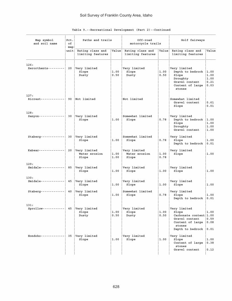
Soil Survey of Franklin County Area, Idaho
628
Table 9.--Recreational Development (Part 2)--Continued________________________________________________________________________________________________________ | | | | Map symbol |Pct.| Paths and trails | Off-road | Golf fairways and soil name | of | | motorcycle trails | | map| | | _____________________________________________________________________________ |unit| Rating class and |Value| Rating class and |Value| Rating class and |Value | | limiting features | | limiting features | | limiting features | | | | | | | |________________________________________________________________________________________________________ | | | | | | |126: | | | | | | | Xerorthents---------| 20 |Very limited | |Very limited | |Very limited | | | Slope |1.00 | Slope |1.00 | Depth to bedrock |1.00 | | Dusty |0.50 | Dusty |0.50 | Slope |1.00 | | | | | | Droughty |1.00 | | | | | | Gravel content |0.21 | | | | | | Content of large |0.03 | | | | | | stones | | | | | | | |127: | | | | | | | Ricrest-------------| 90 |Not limited | |Not limited | |Somewhat limited | | | | | | | Gravel content |0.61 | | | | | | Slope |0.01 | | | | | | |128: | | | | | | | Sanyon--------------| 30 |Very limited | |Somewhat limited | |Very limited | | | Slope |1.00 | Slope |0.78 | Depth to bedrock |1.00 | | | | | | Slope |1.00 | | | | | | Droughty |1.00 | | | | | | Gravel content |1.00 | | | | | | | Staberg-------------| 30 |Very limited | |Somewhat limited | |Very limited | | | Slope |1.00 | Slope |0.78 | Slope |1.00 | | | | | | Depth to bedrock |0.01 | | | | | | | Kabear--------------| 20 |Very limited | |Very limited | |Very limited | | | Water erosion |1.00 | Water erosion |1.00 | Slope |1.00 | | Slope |1.00 | Slope |0.78 | | | | | | | | |129: | | | | | | | Smidale-------------| 85 |Very limited | |Very limited | |Very limited | | | Slope |1.00 | Slope |1.00 | Slope |1.00 | | | | | | |130: | | | | | | | Smidale-------------| 45 |Very limited | |Very limited | |Very limited | | | Slope |1.00 | Slope |1.00 | Slope |1.00 | | | | | | | Staberg-------------| 40 |Very limited | |Somewhat limited | |Very limited | | | Slope |1.00 | Slope |0.78 | Slope |1.00 | | | | | | Depth to bedrock |0.01 | | | | | | |131: | | | | | | | Sprollow------------| 45 |Very limited | |Very limited | |Very limited | | | Slope |1.00 | Slope |1.00 | Slope |1.00 | | Dusty |0.50 | Dusty |0.50 | Carbonate content|1.00 | | | | | | Gravel content |0.59 | | | | | | Content of large |0.08 | | | | | | stones | | | | | | | Depth to bedrock |0.01 | | | | | | | Hondoho-------------| 35 |Very limited | |Very limited | |Very limited | | | Slope |1.00 | Slope |1.00 | Slope |1.00 | | | | | | Content of large |0.38 | | | | | | stones | | | | | | | Gravel content |0.12 | | | | | | |

Soil Survey of Franklin County Area, Idaho
629
Table 9.--Recreational Development (Part 2)--Continued________________________________________________________________________________________________________ | | | | Map symbol |Pct.| Paths and trails | Off-road | Golf fairways and soil name | of | | motorcycle trails | | map| | | _____________________________________________________________________________ |unit| Rating class and |Value| Rating class and |Value| Rating class and |Value | | limiting features | | limiting features | | limiting features | | | | | | | |________________________________________________________________________________________________________ | | | | | | |132: | | | | | | | Sprollow------------| 40 |Very limited | |Very limited | |Very limited | | | Slope |1.00 | Slope |1.00 | Slope |1.00 | | Dusty |0.50 | Dusty |0.50 | Carbonate content|1.00 | | | | | | Gravel content |0.59 | | | | | | Content of large |0.08 | | | | | | stones | | | | | | | Depth to bedrock |0.01 | | | | | | | Hymas---------------| 35 |Very limited | |Very limited | |Very limited | | | Slope |1.00 | Slope |1.00 | Depth to bedrock |1.00 | | | | | | Slope |1.00 | | | | | | Droughty |1.00 | | | | | | Gravel content |1.00 | | | | | | Carbonate content|1.00 | | | | | | |133: | | | | | | | Sterling------------| 85 |Not limited | |Not limited | |Somewhat limited | | | | | | | Gravel content |0.68 | | | | | | Droughty |0.04 | | | | | | |134: | | | | | | | Sterling------------| 85 |Not limited | |Not limited | |Somewhat limited | | | | | | | Gravel content |0.68 | | | | | | Droughty |0.04 | | | | | | |135: | | | | | | | Sterling------------| 90 |Not limited | |Not limited | |Very limited | | | | | | | Slope |1.00 | | | | | | Gravel content |0.68 | | | | | | Droughty |0.04 | | | | | | |136: | | | | | | | Sterling------------| 85 |Very limited | |Very limited | |Very limited | | | Slope |1.00 | Slope |1.00 | Slope |1.00 | | | | | | Gravel content |0.68 | | | | | | Droughty |0.04 | | | | | | |137: | | | | | | | Sterling------------| 50 |Not limited | |Not limited | |Somewhat limited | | | | | | | Gravel content |0.68 | | | | | | Droughty |0.04 | | | | | | | Parleys-------------| 30 |Not limited | |Not limited | |Not limited | | | | | | | |138: | | | | | | | Thatcher------------| 45 |Not limited | |Not limited | |Somewhat limited | | | | | | | Slope |0.84 | | | | | | | Bearhollow----------| 35 |Somewhat limited | |Somewhat limited | |Somewhat limited | | | Dusty |0.50 | Dusty |0.50 | Gravel content |0.97 | | | | | | Slope |0.84 | | | | | | |139: | | | | | | | Toponce-------------| 50 |Very limited | |Very limited | |Very limited | | | Water erosion |1.00 | Water erosion |1.00 | Slope |1.00 | | Slope |0.18 | | | | | | | | | | | Broadhead-----------| 30 |Somewhat limited | |Not limited | |Very limited | | | Slope |0.18 | | | Slope |1.00 | | | | | | |

Soil Survey of Franklin County Area, Idaho
630
Table 9.--Recreational Development (Part 2)--Continued________________________________________________________________________________________________________ | | | | Map symbol |Pct.| Paths and trails | Off-road | Golf fairways and soil name | of | | motorcycle trails | | map| | | _____________________________________________________________________________ |unit| Rating class and |Value| Rating class and |Value| Rating class and |Value | | limiting features | | limiting features | | limiting features | | | | | | | |________________________________________________________________________________________________________ | | | | | | |140: | | | | | | | Trenton-------------| 50 |Not limited | |Not limited | |Very limited | | | | | | | Sodium content |1.00 | | | | | | | Battle Creek--------| 40 |Not limited | |Not limited | |Not limited | | | | | | | |141: | | | | | | | Trenton, cool-------| 50 |Not limited | |Not limited | |Very limited | | | | | | | Sodium content |1.00 | | | | | | | Battle Creek, cool--| 40 |Not limited | |Not limited | |Not limited | | | | | | | |142: | | | | | | | Trenton-------------| 45 |Not limited | |Not limited | |Very limited | | | | | | | Sodium content |1.00 | | | | | | | Parleys-------------| 35 |Not limited | |Not limited | |Not limited | | | | | | | |143: | | | | | | | Valmar--------------| 40 |Very limited | |Very limited | |Very limited | | | Slope |1.00 | Slope |1.00 | Slope |1.00 | | Content of large |0.08 | Content of large |0.08 | Content of large |1.00 | | stones | | stones | | stones | | | | | | | Depth to bedrock |0.90 | | | | | | Droughty |0.63 | | | | | | | Camelback-----------| 25 |Very limited | |Very limited | |Very limited | | | Slope |1.00 | Slope |1.00 | Slope |1.00 | | | | | | Gravel content |1.00 | | | | | | | Hades---------------| 20 |Very limited | |Very limited | |Very limited | | | Slope |1.00 | Slope |1.00 | Slope |1.00 | | | | | | |144: | | | | | | | Vitale--------------| 40 |Very limited | |Very limited | |Very limited | | | Slope |1.00 | Slope |1.00 | Slope |1.00 | | Content of large |0.82 | Content of large |0.82 | Droughty |1.00 | | stones | | stones | | Content of large |1.00 | | | | | | stones | | | | | | | Depth to bedrock |0.65 | | | | | | | Bergquist-----------| 25 |Very limited | |Very limited | |Very limited | | | Slope |1.00 | Slope |1.00 | Slope |1.00 | | | | | | Gravel content |1.00 | | | | | | Droughty |0.80 | | | | | | Content of large |0.01 | | | | | | stones | | | | | | | | Rock outcrop--------| 15 |Not rated | |Not rated | |Not rated | | | | | | | |145: | | | | | | | Vitale--------------| 35 |Very limited | |Somewhat limited | |Very limited | | | Slope |1.00 | Content of large |0.82 | Droughty |1.00 | | Content of large | | stones | | Content of large |1.00 | | stones |0.82 | Slope |0.01 | stones | | | | | | | Slope |1.00 | | | | | | Depth to bedrock |0.99 | | | | | | |

Soil Survey of Franklin County Area, Idaho
631
Table 9.--Recreational Development (Part 2)--Continued________________________________________________________________________________________________________ | | | | Map symbol |Pct.| Paths and trails | Off-road | Golf fairways and soil name | of | | motorcycle trails | | map| | | _____________________________________________________________________________ |unit| Rating class and |Value| Rating class and |Value| Rating class and |Value | | limiting features | | limiting features | | limiting features | | | | | | | |________________________________________________________________________________________________________ | | | | | | |145: | | | | | | | Yeates Hollow-------| 25 |Somewhat limited | |Not limited | |Very limited | | | Slope |0.02 | | | Slope |1.00 | | | | | | Content of large |0.38 | | | | | | stones | | | | | | | | Northwater----------| 15 |Very limited | |Somewhat limited | |Very limited | | | Slope |1.00 | Slope |0.22 | Slope |1.00 | | | | | | Droughty |0.30 | | | | | | Gravel content |0.26 | | | | | | |146: | | | | | | | Welby---------------| 90 |Not limited | |Not limited | |Very limited | | | | | | | Sodium content |1.00 | | | | | | |147: | | | | | | | Welby---------------| 90 |Not limited | |Not limited | |Very limited | | | | | | | Sodium content |1.00 | | | | | | |148: | | | | | | | Welby, wet----------| 85 |Not limited | |Not limited | |Not limited | | | | | | | |149: | | | | | | | Collinston----------| 40 |Not limited | |Not limited | |Somewhat limited | | | | | | | Slope |0.01 | | | | | | | Wheelon-------------| 40 |Somewhat limited | |Somewhat limited | |Somewhat limited | | | Dusty |0.50 | Dusty |0.50 | Slope |0.01 | | | | | | |150: | | | | | | | Wheelon-------------| 40 |Very limited | |Very limited | |Very limited | | | Water erosion |1.00 | Water erosion |1.00 | Slope |1.00 | | Dusty |0.50 | Dusty |0.50 | | | | Slope |0.02 | | | | | | | | | | | Collinston----------| 35 |Very limited | |Very limited | |Very limited | | | Water erosion |1.00 | Water erosion |1.00 | Slope |1.00 | | Slope |0.02 | | | | | | | | | | |151: | | | | | | | Wheelon-------------| 45 |Very limited | |Very limited | |Very limited | | | Water erosion |1.00 | Water erosion |1.00 | Slope |1.00 | | Slope |1.00 | Slope |1.00 | | | | Dusty |0.50 | Dusty |0.50 | | | | | | | | | Collinston----------| 30 |Very limited | |Very limited | |Very limited | | | Water erosion |1.00 | Water erosion |1.00 | Slope |1.00 | | Slope |1.00 | Slope |1.00 | | | | | | | | |152: | | | | | | | Windernot-----------| 40 |Not limited | |Not limited | |Somewhat limited | | | | | | | Droughty |0.88 | | | | | | Gravel content |0.68 | | | | | | | Lewnot--------------| 20 |Not limited | |Not limited | |Not limited | | | | | | | | Stinkcreek----------| 15 |Very limited | |Very limited | |Very limited | | | Depth to |1.00 | Depth to |1.00 | Sodium content |1.00 | | saturated zone | | saturated zone | | Depth to |1.00 | | | | | | saturated zone | | | | | | | |

Soil Survey of Franklin County Area, Idaho
632
Table 9.--Recreational Development (Part 2)--Continued________________________________________________________________________________________________________ | | | | Map symbol |Pct.| Paths and trails | Off-road | Golf fairways and soil name | of | | motorcycle trails | | map| | | _____________________________________________________________________________ |unit| Rating class and |Value| Rating class and |Value| Rating class and |Value | | limiting features | | limiting features | | limiting features | | | | | | | |________________________________________________________________________________________________________ | | | | | | |153: | | | | | | | Winn----------------| 90 |Not limited | |Not limited | |Not limited | | | | | | | |154: | | | | | | | Winwell-------------| 80 |Not limited | |Not limited | |Not limited | | | | | | | |155: | | | | | | | Winwell-------------| 45 |Not limited | |Not limited | |Not limited | | | | | | | | Collinston----------| 35 |Not limited | |Not limited | |Not limited | | | | | | | |156: | | | | | | | Wormcreek-----------| 50 |Very limited | |Somewhat limited | |Very limited | | | Slope |1.00 | Slope |0.78 | Slope |1.00 | | | | | | Gravel content |0.71 | | | | | | Content of large |0.03 | | | | | | stones | | | | | | | | Copenhagen----------| 30 |Very limited | |Somewhat limited | |Very limited | | | Slope |1.00 | Slope |0.78 | Depth to bedrock |1.00 | | | | | | Slope |1.00 | | | | | | Droughty |1.00 | | | | | | Gravel content |0.98 | | | | | | Content of large |0.61 | | | | | | stones | | | | | | | |157: | | | | | | | Wormcreek-----------| 45 |Very limited | |Somewhat limited | |Very limited | | | Slope |1.00 | Slope |0.96 | Slope |1.00 | | | | | | Gravel content |0.71 | | | | | | Content of large |0.03 | | | | | | stones | | | | | | | | Lonigan-------------| 35 |Very limited | |Somewhat limited | |Very limited | | | Slope |1.00 | Slope |0.56 | Slope |1.00 | | | | | | Gravel content |0.97 | | | | | | Depth to bedrock |0.90 | | | | | | Droughty |0.42 | | | | | | |158: | | | | | | | Wursten-------------| 45 |Somewhat limited | |Not limited | |Very limited | | | Slope |0.68 | | | Slope |1.00 | | | | | | | Dirtyhead-----------| 35 |Somewhat limited | |Somewhat limited | |Very limited | | | Slope |0.68 | Dusty |0.50 | Slope |1.00 | | Dusty |0.50 | | | Gravel content |1.00 | | | | | | Droughty |0.66 | | | | | | Depth to bedrock |0.01 | | | | | | |159: | | | | | | | Xerochrepts---------| 30 |Very limited | |Very limited | |Very limited | | | Water erosion |1.00 | Water erosion |1.00 | Slope |1.00 | | Slope |1.00 | Dusty |0.50 | | | | Dusty |0.50 | Slope |0.22 | | | | | | | | | Wormcreek-----------| 25 |Very limited | |Very limited | |Very limited | | | Slope |1.00 | Slope |1.00 | Slope |1.00 | | | | | | Gravel content |0.71 | | | | | | Content of large |0.03 | | | | | | stones | | | | | | | |

Soil Survey of Franklin County Area, Idaho
633
Table 9.--Recreational Development (Part 2)--Continued________________________________________________________________________________________________________ | | | | Map symbol |Pct.| Paths and trails | Off-road | Golf fairways and soil name | of | | motorcycle trails | | map| | | _____________________________________________________________________________ |unit| Rating class and |Value| Rating class and |Value| Rating class and |Value | | limiting features | | limiting features | | limiting features | | | | | | | |________________________________________________________________________________________________________ | | | | | | |159: | | | | | | | Xerorthents---------| 20 |Very limited | |Very limited | |Very limited | | | Slope |1.00 | Slope |1.00 | Depth to bedrock |1.00 | | Dusty |0.50 | Dusty |0.50 | Slope |1.00 | | | | | | Droughty |1.00 | | | | | | Gravel content |0.21 | | | | | | Content of large |0.03 | | | | | | stones | | | | | | | |160: | | | | | | | Xerorthents---------| 75 |Very limited | |Very limited | |Very limited | | | Slope |1.00 | Slope |1.00 | Depth to bedrock |1.00 | | Dusty |0.50 | Dusty |0.50 | Slope |1.00 | | | | | | Droughty |1.00 | | | | | | Gravel content |0.21 | | | | | | Content of large |0.03 | | | | | | stones | | | | | | | |161: | | | | | | | Yeates Hollow-------| 85 |Somewhat limited | |Not limited | |Very limited | | | Slope |0.98 | | | Slope |1.00 | | | | | | Content of large |0.38 | | | | | | stones | | | | | | | |162: | | | | | | | Yeates Hollow-------| 40 |Very limited | |Somewhat limited | |Very limited | | | Slope |1.00 | Slope |0.01 | Slope |1.00 | | | | | | Content of large |0.38 | | | | | | stones | | | | | | | | Manila--------------| 25 |Very limited | |Very limited | |Very limited | | | Water erosion |1.00 | Water erosion |1.00 | Slope |1.00 | | Slope |0.68 | | | | | | | | | | | Softback------------| 15 |Very limited | |Somewhat limited | |Very limited | | | Slope |1.00 | Slope |0.01 | Slope |1.00 | | | | | | |163: | | | | | | | Yeates Hollow-------| 45 |Very limited | |Somewhat limited | |Very limited | | | Slope |1.00 | Slope |0.96 | Slope |1.00 | | | | | | Content of large |0.38 | | | | | | stones | | | | | | | | Vitale--------------| 35 |Very limited | |Somewhat limited | |Very limited | | | Slope |1.00 | Slope |0.96 | Slope |1.00 | | Content of large |0.82 | Content of large |0.82 | Droughty |1.00 | | stones | | stones | | Content of large |1.00 | | | | | | stones | | | | | | | Depth to bedrock |0.80 | | | | | | |164: | | | | | | | Water---------------|100 |Not rated | |Not rated | |Not rated | | | | | | | |________________________________________________________________________________________________________

Soil Survey of Franklin County Area, Idaho
634
Table 10.--Building Site Development (Part 1)
(The information in this table indicates the dominant soil condition but does not eliminate the need for onsite investigation. The numbers in the value columns range from 0.01 to 1.00. The larger the value, the greater the limitation. See text for further explanation of ratings in this table.)
________________________________________________________________________________________________________ | | | | Map symbol |Pct.| Dwellings without | Dwellings with | Small commercial and soil name | of | basements | basements | buildings |map | | | _____________________________________________________________________________ |unit| Rating class and |Value| Rating class and |Value| Rating class and |Value | | limiting features | | limiting features | | limiting features | | | | | | | |________________________________________________________________________________________________________ | | | | | | |1: | | | | | | | Airport-------------| 80 |Very limited | |Very limited | |Very limited | | | Flooding |1.00 | Flooding |1.00 | Flooding |1.00 | | Shrink-swell |0.50 | Depth to |0.99 | Shrink-swell |0.50 | | | | saturated zone | | | | | | | Shrink-swell |0.50 | | | | | | | | |2: | | | | | | | Ant Flat------------| 85 |Very limited | |Very limited | |Very limited | | | Shrink-swell |1.00 | Shrink-swell |1.00 | Shrink-swell |1.00 | | | | | | |3: | | | | | | | Ant Flat------------| 85 |Very limited | |Very limited | |Very limited | | | Shrink-swell |1.00 | Shrink-swell |1.00 | Shrink-swell |1.00 | | | | | | |4: | | | | | | | Ant Flat------------| 90 |Very limited | |Very limited | |Very limited | | | Shrink-swell |1.00 | Shrink-swell |1.00 | Shrink-swell |1.00 | | Slope |0.01 | Slope |0.01 | Slope |1.00 | | | | | | |5: | | | | | | | Ant Flat------------| 65 |Very limited | |Very limited | |Very limited | | | Shrink-swell |1.00 | Shrink-swell |1.00 | Shrink-swell |1.00 | | | | | | Slope |0.50 | | | | | | | Oxford--------------| 25 |Very limited | |Very limited | |Very limited | | | Shrink-swell |1.00 | Shrink-swell |1.00 | Shrink-swell |1.00 | | Slope |0.04 | Slope |0.04 | Slope |1.00 | | | | | | |6: | | | | | | | Ant Flat------------| 50 |Very limited | |Very limited | |Very limited | | | Shrink-swell |1.00 | Shrink-swell |1.00 | Slope |1.00 | | Slope |1.00 | Slope |1.00 | Shrink-swell |1.00 | | | | | | | Oxford--------------| 35 |Very limited | |Very limited | |Very limited | | | Shrink-swell |1.00 | Shrink-swell |1.00 | Slope |1.00 | | Slope |1.00 | Slope |1.00 | Shrink-swell |1.00 | | | | | | |7: | | | | | | | Arbone--------------| 80 |Not limited | |Not limited | |Not limited | | | | | | | |8: | | | | | | | Banida--------------| 85 |Very limited | |Very limited | |Very limited | | | Shrink-swell |1.00 | Shrink-swell |1.00 | Shrink-swell |1.00 | | | | | | |9: | | | | | | | Banida--------------| 80 |Very limited | |Very limited | |Very limited | | | Shrink-swell |1.00 | Shrink-swell |1.00 | Shrink-swell |1.00 | | | | | | |10: | | | | | | | Battle Creek--------| 85 |Very limited | |Very limited | |Very limited | | | Shrink-swell |1.00 | Shrink-swell |1.00 | Shrink-swell |1.00 | | | | Depth to |0.24 | | | | | | saturated zone | | | | | | | | | |

Soil Survey of Franklin County Area, Idaho
635
Table 10.--Building Site Development (Part 1)--Continued________________________________________________________________________________________________________ | | | | Map symbol |Pct.| Dwellings without | Dwellings with | Small commercial and soil name | of | basements | basements | buildings |map | | | _____________________________________________________________________________ |unit| Rating class and |Value| Rating class and |Value| Rating class and |Value | | limiting features | | limiting features | | limiting features | | | | | | | |________________________________________________________________________________________________________ | | | | | | |11: | | | | | | | Battle Creek--------| 85 |Very limited | |Very limited | |Very limited | | | Shrink-swell |1.00 | Shrink-swell |1.00 | Shrink-swell |1.00 | | | | Depth to |0.24 | | | | | | saturated zone | | | | | | | | | |12: | | | | | | | Battle Creek--------| 95 |Very limited | |Very limited | |Very limited | | | Shrink-swell |1.00 | Shrink-swell |1.00 | Shrink-swell |1.00 | | | | | | Slope |0.50 | | | | | | |13: | | | | | | | Bear Lake-----------| 40 |Very limited | |Very limited | |Very limited | | | Flooding |1.00 | Flooding |1.00 | Flooding |1.00 | | Depth to |1.00 | Depth to |1.00 | Depth to |1.00 | | saturated zone | | saturated zone | | saturated zone | | | Ponding |1.00 | Ponding |1.00 | Ponding |1.00 | | | | | | | Chesbrook-----------| 30 |Very limited | |Very limited | |Very limited | | | Flooding |1.00 | Flooding |1.00 | Flooding |1.00 | | Depth to |1.00 | Depth to |1.00 | Depth to |1.00 | | saturated zone | | saturated zone | | saturated zone | | | Shrink-swell |0.50 | Shrink-swell |0.50 | Shrink-swell |0.50 | | | | | | | Picabo--------------| 15 |Very limited | |Very limited | |Very limited | | | Flooding |1.00 | Flooding |1.00 | Flooding |1.00 | | | | Depth to |0.95 | | | | | | saturated zone | | | | | | | | | |14: | | | | | | | Bear Lake-----------| 50 |Very limited | |Very limited | |Very limited | | | Flooding |1.00 | Flooding |1.00 | Flooding |1.00 | | Depth to |1.00 | Depth to |1.00 | Depth to |1.00 | | saturated zone | | saturated zone | | saturated zone | | | | | | | | Downata-------------| 35 |Very limited | |Very limited | |Very limited | | | Flooding |1.00 | Flooding |1.00 | Flooding |1.00 | | Depth to |1.00 | Depth to |1.00 | Depth to |1.00 | | saturated zone | | saturated zone | | saturated zone | | | Ponding |1.00 | Ponding |1.00 | Ponding |1.00 | | Shrink-swell |0.50 | Shrink-swell |0.50 | Shrink-swell |0.50 | | | | | | |15: | | | | | | | Bear Lake-----------| 50 |Very limited | |Very limited | |Very limited | | | Flooding |1.00 | Flooding |1.00 | Flooding |1.00 | | Depth to |1.00 | Depth to |1.00 | Depth to |1.00 | | saturated zone | | saturated zone | | saturated zone | | | | | | | | Downata-------------| 25 |Very limited | |Very limited | |Very limited | | | Flooding |1.00 | Flooding |1.00 | Flooding |1.00 | | Depth to |1.00 | Depth to |1.00 | Depth to |1.00 | | saturated zone | | saturated zone | | saturated zone | | | Ponding |1.00 | Ponding |1.00 | Ponding |1.00 | | Shrink-swell |0.50 | Shrink-swell |0.50 | Shrink-swell |0.50 | | | | | | | Thatcherflats-------| 20 |Very limited | |Very limited | |Very limited | | | Flooding |1.00 | Flooding |1.00 | Flooding |1.00 | | Shrink-swell |1.00 | Shrink-swell |1.00 | Shrink-swell |1.00 | | | | Depth to |0.82 | | | | | | saturated zone | | | | | | | | | |

Soil Survey of Franklin County Area, Idaho
636
Table 10.--Building Site Development (Part 1)--Continued________________________________________________________________________________________________________ | | | | Map symbol |Pct.| Dwellings without | Dwellings with | Small commercial and soil name | of | basements | basements | buildings |map | | | _____________________________________________________________________________ |unit| Rating class and |Value| Rating class and |Value| Rating class and |Value | | limiting features | | limiting features | | limiting features | | | | | | | |________________________________________________________________________________________________________ | | | | | | |16: | | | | | | | Bear Lake-----------| 65 |Very limited | |Very limited | |Very limited | | | Flooding |1.00 | Flooding |1.00 | Flooding |1.00 | | Depth to |1.00 | Depth to |1.00 | Depth to |1.00 | | saturated zone | | saturated zone | | saturated zone | | | | | | | | Lago----------------| 30 |Very limited | |Very limited | |Very limited | | | Flooding |1.00 | Flooding |1.00 | Flooding |1.00 | | Shrink-swell |0.50 | Depth to |1.00 | Shrink-swell |0.50 | | Depth to |0.07 | saturated zone | | Depth to |0.07 | | saturated zone | | Shrink-swell |0.50 | saturated zone | | | | | | | |17: | | | | | | | Bearhollow----------| 30 |Very limited | |Very limited | |Very limited | | | Slope |1.00 | Slope |1.00 | Slope |1.00 | | | | | | | Brifox--------------| 25 |Very limited | |Very limited | |Very limited | | | Slope |1.00 | Slope |1.00 | Slope |1.00 | | Shrink-swell |1.00 | Shrink-swell |1.00 | Shrink-swell |1.00 | | | | | | | Iphil---------------| 20 |Very limited | |Very limited | |Very limited | | | Slope |1.00 | Slope |1.00 | Slope |1.00 | | | | | | |18: | | | | | | | Bergquist-----------| 60 |Very limited | |Very limited | |Very limited | | | Slope |1.00 | Slope |1.00 | Slope |1.00 | | | | Depth to hard |0.13 | | | | | | bedrock | | | | | | | | | | Rubble land---------| 15 |Not rated | |Not rated | |Not rated | | | | | | | |19: | | | | | | | Bergquist-----------| 45 |Very limited | |Very limited | |Very limited | | | Slope |1.00 | Slope |1.00 | Slope |1.00 | | | | Depth to hard |0.13 | | | | | | bedrock | | | | | | | | | | Softback------------| 30 |Very limited | |Very limited | |Very limited | | | Slope |1.00 | Slope |1.00 | Slope |1.00 | | Content of large |0.12 | Shrink-swell |0.50 | Content of large |0.12 | | stones | | Content of large |0.12 | stones | | | | | stones | | | | | | | | | |20: | | | | | | | Bergquist-----------| 55 |Very limited | |Very limited | |Very limited | | | Slope |1.00 | Slope |1.00 | Slope |1.00 | | | | Depth to hard |0.13 | | | | | | bedrock | | | | | | | | | | Vitale--------------| 25 |Very limited | |Very limited | |Very limited | | | Slope |1.00 | Slope |1.00 | Slope |1.00 | | Content of large |1.00 | Depth to hard |1.00 | Content of large |1.00 | | stones | | bedrock | | stones | | | Depth to hard |0.64 | Content of large |1.00 | Depth to hard |0.64 | | bedrock | | stones | | bedrock | | | Shrink-swell |0.50 | Shrink-swell |0.50 | Shrink-swell |0.50 | | | | | | |21: | | | | | | | Bothwell------------| 80 |Somewhat limited | |Somewhat limited | |Very limited | | | Shrink-swell |0.50 | Shrink-swell |0.50 | Slope |1.00 | | Slope |0.01 | Slope |0.01 | Shrink-swell |0.50 | | | | | | |

Soil Survey of Franklin County Area, Idaho
637
Table 10.--Building Site Development (Part 1)--Continued________________________________________________________________________________________________________ | | | | Map symbol |Pct.| Dwellings without | Dwellings with | Small commercial and soil name | of | basements | basements | buildings |map | | | _____________________________________________________________________________ |unit| Rating class and |Value| Rating class and |Value| Rating class and |Value | | limiting features | | limiting features | | limiting features | | | | | | | |________________________________________________________________________________________________________ | | | | | | |22: | | | | | | | Bothwell------------| 80 |Very limited | |Very limited | |Very limited | | | Slope |1.00 | Slope |1.00 | Slope |1.00 | | Shrink-swell |0.50 | Shrink-swell |0.50 | Shrink-swell |0.50 | | | | | | |23: | | | | | | | Bothwell------------| 35 |Very limited | |Very limited | |Very limited | | | Slope |1.00 | Slope |1.00 | Slope |1.00 | | Shrink-swell |0.50 | Shrink-swell |0.50 | Shrink-swell |0.50 | | | | | | | Hades---------------| 30 |Very limited | |Very limited | |Very limited | | | Slope |1.00 | Slope |1.00 | Slope |1.00 | | | | | | | Justesen------------| 20 |Very limited | |Very limited | |Very limited | | | Slope |1.00 | Slope |1.00 | Slope |1.00 | | Shrink-swell |0.50 | Shrink-swell |0.50 | Shrink-swell |0.50 | | | | | | |24: | | | | | | | Bothwell------------| 40 |Somewhat limited | |Somewhat limited | |Somewhat limited | | | Shrink-swell |0.50 | Shrink-swell |0.50 | Slope |0.50 | | | | | | Shrink-swell |0.50 | | | | | | | Thatcher------------| 35 |Not limited | |Not limited | |Somewhat limited | | | | | | | Slope |0.50 | | | | | | |25: | | | | | | | Brifox--------------| 40 |Very limited | |Very limited | |Very limited | | | Shrink-swell |1.00 | Shrink-swell |1.00 | Shrink-swell |1.00 | | Slope |0.01 | Slope |0.01 | Slope |1.00 | | | | | | | Huffman-------------| 35 |Somewhat limited | |Somewhat limited | |Very limited | | | Shrink-swell |0.50 | Shrink-swell |0.50 | Slope |1.00 | | Slope |0.01 | Slope |0.01 | Shrink-swell |0.50 | | | | | | |26: | | | | | | | Brifox--------------| 40 |Very limited | |Very limited | |Very limited | | | Shrink-swell |1.00 | Shrink-swell |1.00 | Slope |1.00 | | Slope |1.00 | Slope |1.00 | Shrink-swell |1.00 | | | | | | | Huffman-------------| 35 |Very limited | |Very limited | |Very limited | | | Slope |1.00 | Slope |1.00 | Slope |1.00 | | Shrink-swell |0.50 | Shrink-swell |0.50 | Shrink-swell |0.50 | | | | | | |27: | | | | | | | Brifox--------------| 55 |Very limited | |Very limited | |Very limited | | | Shrink-swell |1.00 | Shrink-swell |1.00 | Shrink-swell |1.00 | | Slope |0.01 | Slope |0.01 | Slope |1.00 | | | | | | | Niter---------------| 25 |Very limited | |Very limited | |Very limited | | | Shrink-swell |1.00 | Shrink-swell |1.00 | Shrink-swell |1.00 | | Slope |0.01 | Slope |0.01 | Slope |1.00 | | | | | | |28: | | | | | | | Brifox--------------| 65 |Very limited | |Very limited | |Very limited | | | Shrink-swell |1.00 | Shrink-swell |1.00 | Slope |1.00 | | Slope |1.00 | Slope |1.00 | Shrink-swell |1.00 | | | | | | | Niter---------------| 20 |Very limited | |Very limited | |Very limited | | | Shrink-swell |1.00 | Shrink-swell |1.00 | Slope |1.00 | | Slope |1.00 | Slope |1.00 | Shrink-swell |1.00 | | | | | | |

Soil Survey of Franklin County Area, Idaho
638
Table 10.--Building Site Development (Part 1)--Continued________________________________________________________________________________________________________ | | | | Map symbol |Pct.| Dwellings without | Dwellings with | Small commercial and soil name | of | basements | basements | buildings |map | | | _____________________________________________________________________________ |unit| Rating class and |Value| Rating class and |Value| Rating class and |Value | | limiting features | | limiting features | | limiting features | | | | | | | |________________________________________________________________________________________________________ | | | | | | |29: | | | | | | | Brifox--------------| 55 |Very limited | |Very limited | |Very limited | | | Slope |1.00 | Slope |1.00 | Slope |1.00 | | Shrink-swell |1.00 | Shrink-swell |1.00 | Shrink-swell |1.00 | | | | | | | Niter---------------| 25 |Very limited | |Very limited | |Very limited | | | Slope |1.00 | Slope |1.00 | Slope |1.00 | | Shrink-swell |1.00 | Shrink-swell |1.00 | Shrink-swell |1.00 | | | | | | |30: | | | | | | | Broadhead-----------| 30 |Very limited | |Very limited | |Very limited | | | Shrink-swell |1.00 | Shrink-swell |1.00 | Shrink-swell |1.00 | | Slope |0.63 | Slope |0.63 | Slope |1.00 | | | | | | | Hades---------------| 25 |Somewhat limited | |Somewhat limited | |Very limited | | | Slope |0.63 | Slope |0.63 | Slope |1.00 | | | | | | | Yago----------------| 25 |Very limited | |Very limited | |Very limited | | | Shrink-swell |1.00 | Shrink-swell |1.00 | Shrink-swell |1.00 | | Content of large |1.00 | Content of large |1.00 | Content of large |1.00 | | stones | | stones | | stones | | | Slope |0.63 | Slope |0.63 | Slope |1.00 | | | | | | |31: | | | | | | | Broadhead-----------| 40 |Very limited | |Very limited | |Very limited | | | Shrink-swell |1.00 | Shrink-swell |1.00 | Slope |1.00 | | Slope |1.00 | Slope |1.00 | Shrink-swell |1.00 | | | | | | | Yago----------------| 35 |Very limited | |Very limited | |Very limited | | | Shrink-swell |1.00 | Shrink-swell |1.00 | Slope |1.00 | | Slope |1.00 | Slope |1.00 | Shrink-swell |1.00 | | Content of large |1.00 | Content of large |1.00 | Content of large |1.00 | | stones | | stones | | stones | | | | | | | |32: | | | | | | | Camelback-----------| 55 |Very limited | |Very limited | |Very limited | | | Slope |1.00 | Slope |1.00 | Slope |1.00 | | Shrink-swell |0.50 | Shrink-swell |0.50 | Shrink-swell |0.50 | | | | | | | Lonigan-------------| 25 |Very limited | |Very limited | |Very limited | | | Slope |1.00 | Slope |1.00 | Slope |1.00 | | | | Depth to soft |0.90 | | | | | | bedrock | | | | | | | | | |33: | | | | | | | Camelback-----------| 40 |Very limited | |Very limited | |Very limited | | | Slope |1.00 | Slope |1.00 | Slope |1.00 | | Shrink-swell |0.50 | Shrink-swell |0.50 | Shrink-swell |0.50 | | | | | | | Hades---------------| 20 |Very limited | |Very limited | |Very limited | | | Slope |1.00 | Slope |1.00 | Slope |1.00 | | | | | | | Valmar--------------| 20 |Very limited | |Very limited | |Very limited | | | Slope |1.00 | Slope |1.00 | Slope |1.00 | | Content of large |1.00 | Depth to hard |1.00 | Content of large |1.00 | | stones | | bedrock | | stones | | | Depth to hard |0.90 | Content of large |1.00 | Depth to hard |0.90 | | bedrock | | stones | | bedrock | | | Shrink-swell |0.50 | Shrink-swell |0.50 | Shrink-swell |0.50 | | | | | | |

Soil Survey of Franklin County Area, Idaho
639
Table 10.--Building Site Development (Part 1)--Continued________________________________________________________________________________________________________ | | | | Map symbol |Pct.| Dwellings without | Dwellings with | Small commercial and soil name | of | basements | basements | buildings |map | | | _____________________________________________________________________________ |unit| Rating class and |Value| Rating class and |Value| Rating class and |Value | | limiting features | | limiting features | | limiting features | | | | | | | |________________________________________________________________________________________________________ | | | | | | |34: | | | | | | | Cedarhill-----------| 90 |Very limited | |Very limited | |Very limited | | | Slope |1.00 | Slope |1.00 | Slope |1.00 | | | | | | |35: | | | | | | | Cedarhill-----------| 40 |Very limited | |Very limited | |Very limited | | | Slope |1.00 | Slope |1.00 | Slope |1.00 | | | | | | | Hades---------------| 25 |Very limited | |Very limited | |Very limited | | | Slope |1.00 | Slope |1.00 | Slope |1.00 | | | | | | | Ricrest-------------| 20 |Very limited | |Very limited | |Very limited | | | Slope |1.00 | Slope |1.00 | Slope |1.00 | | Shrink-swell |0.50 | Shrink-swell |0.50 | Shrink-swell |0.50 | | | | | | |36: | | | | | | | Cedarhill-----------| 35 |Very limited | |Very limited | |Very limited | | | Slope |1.00 | Slope |1.00 | Slope |1.00 | | | | | | | Hondoho-------------| 30 |Very limited | |Very limited | |Very limited | | | Slope |1.00 | Slope |1.00 | Slope |1.00 | | Shrink-swell |0.50 | Shrink-swell |0.50 | Shrink-swell |0.50 | | | | | | | Ridgecrest----------| 20 |Very limited | |Very limited | |Very limited | | | Slope |1.00 | Slope |1.00 | Slope |1.00 | | Content of large |1.00 | Depth to hard |1.00 | Content of large |1.00 | | stones | | bedrock | | stones | | | Depth to hard |0.71 | Content of large |1.00 | Depth to hard |0.71 | | bedrock | | stones | | bedrock | | | | | | | |37: | | | | | | | Chesbrook-----------| 60 |Very limited | |Very limited | |Very limited | | | Flooding |1.00 | Flooding |1.00 | Flooding |1.00 | | Depth to |1.00 | Depth to |1.00 | Depth to |1.00 | | saturated zone | | saturated zone | | saturated zone | | | Shrink-swell |0.50 | Shrink-swell |0.50 | Shrink-swell |0.50 | | | | | | | Bear Lake-----------| 20 |Very limited | |Very limited | |Very limited | | | Flooding |1.00 | Flooding |1.00 | Flooding |1.00 | | Depth to |1.00 | Depth to |1.00 | Depth to |1.00 | | saturated zone | | saturated zone | | saturated zone | | | | | | | |38: | | | | | | | Cloudless-----------| 50 |Somewhat limited | |Somewhat limited | |Very limited | | | Shrink-swell |0.50 | Shrink-swell |0.50 | Slope |1.00 | | Slope |0.01 | Slope |0.01 | Shrink-swell |0.50 | | | | | | | Hades---------------| 40 |Somewhat limited | |Somewhat limited | |Very limited | | | Slope |0.01 | Slope |0.01 | Slope |1.00 | | | | | | |39: | | | | | | | Cloudless-----------| 35 |Very limited | |Very limited | |Very limited | | | Slope |1.00 | Slope |1.00 | Slope |1.00 | | Shrink-swell |0.50 | Shrink-swell |0.50 | Shrink-swell |0.50 | | | | | | | Hades---------------| 30 |Very limited | |Very limited | |Very limited | | | Slope |1.00 | Slope |1.00 | Slope |1.00 | | | | | | | Howcan--------------| 20 |Very limited | |Very limited | |Very limited | | | Slope |1.00 | Slope |1.00 | Slope |1.00 | | Shrink-swell |0.50 | | | Shrink-swell |0.50 | | | | | | |

Soil Survey of Franklin County Area, Idaho
640
Table 10.--Building Site Development (Part 1)--Continued________________________________________________________________________________________________________ | | | | Map symbol |Pct.| Dwellings without | Dwellings with | Small commercial and soil name | of | basements | basements | buildings |map | | | _____________________________________________________________________________ |unit| Rating class and |Value| Rating class and |Value| Rating class and |Value | | limiting features | | limiting features | | limiting features | | | | | | | |________________________________________________________________________________________________________ | | | | | | |40: | | | | | | | Copenhagen----------| 35 |Very limited | |Very limited | |Very limited | | | Depth to hard |1.00 | Depth to hard |1.00 | Slope |1.00 | | bedrock | | bedrock | | Depth to hard |1.00 | | Slope |1.00 | Slope |1.00 | bedrock | | | | | | | | Lonigan-------------| 30 |Very limited | |Very limited | |Very limited | | | Slope |1.00 | Slope |1.00 | Slope |1.00 | | | | Depth to soft |0.20 | | | | | | bedrock | | | | | | | | | | Manila--------------| 20 |Very limited | |Very limited | |Very limited | | | Shrink-swell |1.00 | Shrink-swell |1.00 | Slope |1.00 | | Slope |1.00 | Slope |1.00 | Shrink-swell |1.00 | | | | | | |41: | | | | | | | Delish--------------| 40 |Very limited | |Very limited | |Very limited | | | Flooding |1.00 | Flooding |1.00 | Flooding |1.00 | | Depth to |0.39 | Depth to |1.00 | Depth to |0.39 | | saturated zone | | saturated zone | | saturated zone | | | | | | | | Cachecan------------| 25 |Very limited | |Very limited | |Very limited | | | Flooding |1.00 | Flooding |1.00 | Flooding |1.00 | | | | Depth to |0.95 | | | | | | saturated zone | | | | | | | Shrink-swell |0.50 | | | | | | | | | Stinkcreek----------| 15 |Very limited | |Very limited | |Very limited | | | Flooding |1.00 | Flooding |1.00 | Flooding |1.00 | | Depth to |1.00 | Depth to |1.00 | Depth to |1.00 | | saturated zone | | saturated zone | | saturated zone | | | | | | | |42: | | | | | | | Downata-------------| 80 |Very limited | |Very limited | |Very limited | | | Flooding |1.00 | Flooding |1.00 | Flooding |1.00 | | Depth to |1.00 | Depth to |1.00 | Depth to |1.00 | | saturated zone | | saturated zone | | saturated zone | | | Ponding |1.00 | Ponding |1.00 | Ponding |1.00 | | Shrink-swell |0.50 | Shrink-swell |0.50 | Shrink-swell |0.50 | | | | | | |43: | | | | | | | Dranburn------------| 45 |Very limited | |Very limited | |Very limited | | | Slope |1.00 | Slope |1.00 | Slope |1.00 | | Shrink-swell |0.50 | Shrink-swell |0.50 | Shrink-swell |0.50 | | | | | | | Robin---------------| 35 |Very limited | |Very limited | |Very limited | | | Slope |1.00 | Slope |1.00 | Slope |1.00 | | Shrink-swell |0.50 | Shrink-swell |0.50 | Shrink-swell |0.50 | | | | | | |44: | | | | | | | Enochville----------| 75 |Very limited | |Very limited | |Very limited | | | Flooding |1.00 | Flooding |1.00 | Flooding |1.00 | | Depth to |0.98 | Depth to |1.00 | Depth to |0.98 | | saturated zone | | saturated zone | | saturated zone | | | Shrink-swell |0.50 | Shrink-swell |0.50 | Shrink-swell |0.50 | | | | | | |

Soil Survey of Franklin County Area, Idaho
641
Table 10.--Building Site Development (Part 1)--Continued________________________________________________________________________________________________________ | | | | Map symbol |Pct.| Dwellings without | Dwellings with | Small commercial and soil name | of | basements | basements | buildings |map | | | _____________________________________________________________________________ |unit| Rating class and |Value| Rating class and |Value| Rating class and |Value | | limiting features | | limiting features | | limiting features | | | | | | | |________________________________________________________________________________________________________ | | | | | | |45: | | | | | | | Foxol---------------| 45 |Very limited | |Very limited | |Very limited | | | Slope |1.00 | Slope |1.00 | Slope |1.00 | | Depth to hard |1.00 | Depth to hard |1.00 | Depth to hard |1.00 | | bedrock | | bedrock | | bedrock | | | Content of large |1.00 | Content of large |1.00 | Content of large |1.00 | | stones | | stones | | stones | | | | | | | | Vitale--------------| 30 |Very limited | |Very limited | |Very limited | | | Slope |1.00 | Slope |1.00 | Slope |1.00 | | Content of large |1.00 | Depth to hard |1.00 | Content of large |1.00 | | stones | | bedrock | | stones | | | Depth to hard |0.64 | Content of large |1.00 | Depth to hard |0.64 | | bedrock | | stones | | bedrock | | | Shrink-swell |0.50 | Shrink-swell |0.50 | Shrink-swell |0.50 | | | | | | |46: | | | | | | | Hades---------------| 35 |Very limited | |Very limited | |Very limited | | | Slope |1.00 | Slope |1.00 | Slope |1.00 | | | | | | | Camelback-----------| 20 |Very limited | |Very limited | |Very limited | | | Slope |1.00 | Slope |1.00 | Slope |1.00 | | Shrink-swell |0.50 | Shrink-swell |0.50 | Shrink-swell |0.50 | | | | | | | Hondoho-------------| 20 |Very limited | |Very limited | |Very limited | | | Slope |1.00 | Slope |1.00 | Slope |1.00 | | Shrink-swell |0.50 | Shrink-swell |0.50 | Shrink-swell |0.50 | | | | | | |47: | | | | | | | Hades---------------| 25 |Very limited | |Very limited | |Very limited | | | Slope |1.00 | Slope |1.00 | Slope |1.00 | | | | | | | Lanoak--------------| 25 |Very limited | |Very limited | |Very limited | | | Slope |1.00 | Slope |1.00 | Slope |1.00 | | | | | | | Camelback-----------| 25 |Very limited | |Very limited | |Very limited | | | Slope |1.00 | Slope |1.00 | Slope |1.00 | | Shrink-swell |0.50 | Shrink-swell |0.50 | Shrink-swell |0.50 | | | | | | |48: | | | | | | | Haploxerolls--------| 45 |Very limited | |Very limited | |Very limited | | | Slope |1.00 | Slope |1.00 | Slope |1.00 | | | | | | | Xerorthents---------| 30 |Very limited | |Very limited | |Very limited | | | Slope |1.00 | Slope |1.00 | Slope |1.00 | | Depth to soft |0.50 | Depth to soft |1.00 | Depth to soft |1.00 | | bedrock | | bedrock | | bedrock | | | Content of large |0.04 | Content of large |0.04 | Content of large |0.04 | | stones | | stones | | stones | | | | | | | |49: | | | | | | | Hendricks-----------| 90 |Somewhat limited | |Somewhat limited | |Very limited | | | Shrink-swell |0.50 | Shrink-swell |0.50 | Slope |1.00 | | Slope |0.01 | Slope |0.01 | Shrink-swell |0.50 | | | | | | |50: | | | | | | | Holmes--------------| 90 |Very limited | |Very limited | |Very limited | | | Flooding |1.00 | Flooding |1.00 | Flooding |1.00 | | | | | | |51: | | | | | | | Hondee--------------| 85 |Not limited | |Not limited | |Not limited | | | | | | | |

Soil Survey of Franklin County Area, Idaho
642
Table 10.--Building Site Development (Part 1)--Continued________________________________________________________________________________________________________ | | | | Map symbol |Pct.| Dwellings without | Dwellings with | Small commercial and soil name | of | basements | basements | buildings |map | | | _____________________________________________________________________________ |unit| Rating class and |Value| Rating class and |Value| Rating class and |Value | | limiting features | | limiting features | | limiting features | | | | | | | |________________________________________________________________________________________________________ | | | | | | |52: | | | | | | | Hondee--------------| 75 |Somewhat limited | |Somewhat limited | |Very limited | | | Slope |0.01 | Slope |0.01 | Slope |1.00 | | | | | | |53: | | | | | | | Hondoho-------------| 50 |Somewhat limited | |Somewhat limited | |Very limited | | | Shrink-swell |0.50 | Shrink-swell |0.50 | Slope |1.00 | | Slope |0.01 | Slope |0.01 | Shrink-swell |0.50 | | | | | | | Hades---------------| 30 |Somewhat limited | |Somewhat limited | |Very limited | | | Slope |0.01 | Slope |0.01 | Slope |1.00 | | | | | | |54: | | | | | | | Hondoho-------------| 50 |Somewhat limited | |Somewhat limited | |Very limited | | | Slope |0.63 | Slope |0.63 | Slope |1.00 | | Shrink-swell |0.50 | Shrink-swell |0.50 | Shrink-swell |0.50 | | | | | | | Ricrest-------------| 40 |Somewhat limited | |Somewhat limited | |Very limited | | | Shrink-swell |0.50 | Shrink-swell |0.50 | Slope |1.00 | | Slope |0.01 | Slope |0.01 | Shrink-swell |0.50 | | | | | | |55: | | | | | | | Hondoho-------------| 35 |Very limited | |Very limited | |Very limited | | | Slope |1.00 | Slope |1.00 | Slope |1.00 | | Shrink-swell |0.50 | Shrink-swell |0.50 | Shrink-swell |0.50 | | | | | | | Sprollow------------| 30 |Very limited | |Very limited | |Very limited | | | Slope |1.00 | Slope |1.00 | Slope |1.00 | | Content of large |0.26 | Depth to hard |1.00 | Content of large |0.26 | | stones | | bedrock | | stones | | | Depth to hard |0.01 | Content of large |0.26 | Depth to hard |0.01 | | bedrock | | stones | | bedrock | | | | | | | | Hades---------------| 20 |Very limited | |Very limited | |Very limited | | | Slope |1.00 | Slope |1.00 | Slope |1.00 | | | | | | |56: | | | | | | | Hondoho-------------| 45 |Very limited | |Very limited | |Very limited | | | Slope |1.00 | Slope |1.00 | Slope |1.00 | | Shrink-swell |0.50 | Shrink-swell |0.50 | Shrink-swell |0.50 | | | | | | | Vitale--------------| 30 |Very limited | |Very limited | |Very limited | | | Slope |1.00 | Slope |1.00 | Slope |1.00 | | Content of large |1.00 | Depth to hard |1.00 | Content of large |1.00 | | stones | | bedrock | | stones | | | Depth to hard |0.64 | Content of large |1.00 | Depth to hard |0.64 | | bedrock | | stones | | bedrock | | | Shrink-swell |0.50 | Shrink-swell |0.50 | Shrink-swell |0.50 | | | | | | |57: | | | | | | | Huffman-------------| 80 |Somewhat limited | |Somewhat limited | |Somewhat limited | | | Shrink-swell |0.50 | Shrink-swell |0.50 | Shrink-swell |0.50 | | | | | | |58: | | | | | | | Huffman-------------| 80 |Somewhat limited | |Somewhat limited | |Very limited | | | Shrink-swell |0.50 | Shrink-swell |0.50 | Slope |1.00 | | Slope |0.01 | Slope |0.01 | Shrink-swell |0.50 | | | | | | |

Soil Survey of Franklin County Area, Idaho
643
Table 10.--Building Site Development (Part 1)--Continued________________________________________________________________________________________________________ | | | | Map symbol |Pct.| Dwellings without | Dwellings with | Small commercial and soil name | of | basements | basements | buildings |map | | | _____________________________________________________________________________ |unit| Rating class and |Value| Rating class and |Value| Rating class and |Value | | limiting features | | limiting features | | limiting features | | | | | | | |________________________________________________________________________________________________________ | | | | | | |59: | | | | | | | Huffman-------------| 45 |Somewhat limited | |Somewhat limited | |Very limited | | | Shrink-swell |0.50 | Shrink-swell |0.50 | Slope |1.00 | | Slope |0.01 | Slope |0.01 | Shrink-swell |0.50 | | | | | | | Dirtyhead-----------| 30 |Somewhat limited | |Somewhat limited | |Very limited | | | Slope |0.01 | Depth to soft |0.01 | Slope |1.00 | | | | bedrock | | | | | | | Slope |0.01 | | | | | | | | |60: | | | | | | | Huffman-------------| 35 |Somewhat limited | |Somewhat limited | |Somewhat limited | | | Shrink-swell |0.50 | Shrink-swell |0.50 | Slope |0.50 | | | | | | Shrink-swell |0.50 | | | | | | | Harroun-------------| 30 |Somewhat limited | |Very limited | |Very limited | | | Depth to thin |0.50 | Depth to thin |1.00 | Depth to thin |1.00 | | cemented pan | | cemented pan | | cemented pan | | | Slope |0.01 | Slope |0.01 | Slope |1.00 | | | | | | | Lanoak--------------| 25 |Not limited | |Not limited | |Not limited | | | | | | | |61: | | | | | | | Huffman-------------| 45 |Somewhat limited | |Somewhat limited | |Very limited | | | Shrink-swell |0.50 | Shrink-swell |0.50 | Slope |1.00 | | Slope |0.01 | Slope |0.01 | Shrink-swell |0.50 | | | | | | | Wursten-------------| 35 |Somewhat limited | |Somewhat limited | |Very limited | | | Slope |0.01 | Slope |0.01 | Slope |1.00 | | | | | | |62: | | | | | | | Iphil---------------| 60 |Somewhat limited | |Somewhat limited | |Very limited | | | Slope |0.96 | Slope |0.96 | Slope |1.00 | | | | | | | Lonigan-------------| 20 |Somewhat limited | |Somewhat limited | |Very limited | | | Slope |0.96 | Slope |0.96 | Slope |1.00 | | | | Depth to soft |0.90 | | | | | | bedrock | | | | | | | | | |63: | | | | | | | Ireland-------------| 50 |Very limited | |Very limited | |Very limited | | | Slope |1.00 | Slope |1.00 | Slope |1.00 | | Depth to hard |0.95 | Depth to hard |1.00 | Depth to hard |0.95 | | bedrock | | bedrock | | bedrock | | | Content of large |0.52 | Content of large |0.52 | Content of large |0.52 | | stones | | stones | | stones | | | | | | | | Polumar-------------| 25 |Very limited | |Very limited | |Very limited | | | Slope |1.00 | Slope |1.00 | Slope |1.00 | | Content of large |0.88 | Content of large |0.88 | Content of large |0.88 | | stones | | stones | | stones | | | | | Depth to hard |0.77 | | | | | | bedrock | | | | | | | | | |64: | | | | | | | Kabear--------------| 50 |Somewhat limited | |Somewhat limited | |Very limited | | | Slope |0.01 | Slope |0.01 | Slope |1.00 | | | | | | |

Soil Survey of Franklin County Area, Idaho
644
Table 10.--Building Site Development (Part 1)--Continued________________________________________________________________________________________________________ | | | | Map symbol |Pct.| Dwellings without | Dwellings with | Small commercial and soil name | of | basements | basements | buildings |map | | | _____________________________________________________________________________ |unit| Rating class and |Value| Rating class and |Value| Rating class and |Value | | limiting features | | limiting features | | limiting features | | | | | | | |________________________________________________________________________________________________________ | | | | | | |64: | | | | | | | Staberg-------------| 25 |Somewhat limited | |Somewhat limited | |Very limited | | | Slope |0.01 | Depth to soft |0.01 | Slope |1.00 | | | | bedrock | | | | | | | Slope |0.01 | | | | | | | | | Copenhagen----------| 15 |Very limited | |Very limited | |Very limited | | | Depth to hard |1.00 | Depth to hard |1.00 | Depth to hard |1.00 | | bedrock | | bedrock | | bedrock | | | Slope |0.01 | Slope |0.01 | Slope |1.00 | | | | | | |65: | | | | | | | Kabear--------------| 50 |Very limited | |Very limited | |Very limited | | | Slope |1.00 | Slope |1.00 | Slope |1.00 | | | | | | | Staberg-------------| 25 |Very limited | |Very limited | |Very limited | | | Slope |1.00 | Slope |1.00 | Slope |1.00 | | | | Depth to soft |0.01 | | | | | | bedrock | | | | | | | | | | Copenhagen----------| 15 |Very limited | |Very limited | |Very limited | | | Depth to hard |1.00 | Depth to hard |1.00 | Slope |1.00 | | bedrock | | bedrock | | Depth to hard |1.00 | | Slope |1.00 | Slope |1.00 | bedrock | | | | | | | |66: | | | | | | | Kearns--------------| 80 |Somewhat limited | |Somewhat limited | |Somewhat limited | | | Shrink-swell |0.50 | Shrink-swell |0.50 | Shrink-swell |0.50 | | | | | | |67: | | | | | | | Kearnsar------------| 60 |Somewhat limited | |Somewhat limited | |Somewhat limited | | | Shrink-swell |0.50 | Shrink-swell |0.50 | Shrink-swell |0.50 | | | | Depth to |0.24 | | | | | | saturated zone | | | | | | | | | | Battle Creek--------| 25 |Very limited | |Very limited | |Very limited | | | Shrink-swell |1.00 | Shrink-swell |1.00 | Shrink-swell |1.00 | | | | Depth to |0.24 | | | | | | saturated zone | | | | | | | | | |68: | | | | | | | Kidman--------------| 90 |Not limited | |Not limited | |Not limited | | | | | | | |69: | | | | | | | Kidman--------------| 85 |Not limited | |Not limited | |Not limited | | | | | | | |70: | | | | | | | Kidman--------------| 85 |Very limited | |Very limited | |Very limited | | | Slope |1.00 | Slope |1.00 | Slope |1.00 | | | | | | |71: | | | | | | | Kidman, wet---------| 85 |Not limited | |Somewhat limited | |Not limited | | | | | Depth to |0.24 | | | | | | saturated zone | | | | | | | | | |72: | | | | | | | Kidman--------------| 45 |Not limited | |Not limited | |Not limited | | | | | | | | Sterling------------| 30 |Not limited | |Not limited | |Not limited | | | | | | | |

Soil Survey of Franklin County Area, Idaho
645
Table 10.--Building Site Development (Part 1)--Continued________________________________________________________________________________________________________ | | | | Map symbol |Pct.| Dwellings without | Dwellings with | Small commercial and soil name | of | basements | basements | buildings |map | | | _____________________________________________________________________________ |unit| Rating class and |Value| Rating class and |Value| Rating class and |Value | | limiting features | | limiting features | | limiting features | | | | | | | |________________________________________________________________________________________________________ | | | | | | |73: | | | | | | | Lando---------------| 75 |Somewhat limited | |Somewhat limited | |Somewhat limited | | | Shrink-swell |0.50 | Depth to |0.95 | Shrink-swell |0.50 | | | | saturated zone | | | | | | | Shrink-swell |0.50 | | | | | | | | |74: | | | | | | | Lanoak--------------| 75 |Not limited | |Not limited | |Not limited | | | | | | | |75: | | | | | | | Lanoak--------------| 75 |Somewhat limited | |Somewhat limited | |Very limited | | | Slope |0.01 | Slope |0.01 | Slope |1.00 | | | | | | |76: | | | | | | | Lanoak--------------| 45 |Very limited | |Very limited | |Very limited | | | Slope |1.00 | Slope |1.00 | Slope |1.00 | | | | | | | Broadhead-----------| 40 |Very limited | |Very limited | |Very limited | | | Shrink-swell |1.00 | Shrink-swell |1.00 | Slope |1.00 | | Slope |1.00 | Slope |1.00 | Shrink-swell |1.00 | | | | | | |77: | | | | | | | Lanoak--------------| 35 |Very limited | |Very limited | |Very limited | | | Slope |1.00 | Slope |1.00 | Slope |1.00 | | | | | | | Broadhead-----------| 30 |Very limited | |Very limited | |Very limited | | | Slope |1.00 | Slope |1.00 | Slope |1.00 | | Shrink-swell |1.00 | Shrink-swell |1.00 | Shrink-swell |1.00 | | | | | | | Hades---------------| 15 |Very limited | |Very limited | |Very limited | | | Slope |1.00 | Slope |1.00 | Slope |1.00 | | | | | | |78: | | | | | | | Lanoak--------------| 40 |Somewhat limited | |Somewhat limited | |Very limited | | | Slope |0.84 | Slope |0.84 | Slope |1.00 | | | | | | | Hades---------------| 35 |Somewhat limited | |Somewhat limited | |Very limited | | | Slope |0.84 | Slope |0.84 | Slope |1.00 | | | | | | |79: | | | | | | | Lanoak--------------| 60 |Very limited | |Very limited | |Very limited | | | Slope |1.00 | Slope |1.00 | Slope |1.00 | | | | | | | Thatcher------------| 25 |Very limited | |Very limited | |Very limited | | | Slope |1.00 | Slope |1.00 | Slope |1.00 | | | | | | |80: | | | | | | | Layton--------------| 85 |Not limited | |Somewhat limited | |Not limited | | | | | Depth to |0.47 | | | | | | saturated zone | | | | | | | | | |81: | | | | | | | Layton--------------| 80 |Not limited | |Somewhat limited | |Not limited | | | | | Depth to |0.47 | | | | | | saturated zone | | | | | | | | | |82: | | | | | | | Lizdale-------------| 80 |Very limited | |Very limited | |Very limited | | | Slope |1.00 | Slope |1.00 | Slope |1.00 | | | | | | |

Soil Survey of Franklin County Area, Idaho
646
Table 10.--Building Site Development (Part 1)--Continued________________________________________________________________________________________________________ | | | | Map symbol |Pct.| Dwellings without | Dwellings with | Small commercial and soil name | of | basements | basements | buildings |map | | | _____________________________________________________________________________ |unit| Rating class and |Value| Rating class and |Value| Rating class and |Value | | limiting features | | limiting features | | limiting features | | | | | | | |________________________________________________________________________________________________________ | | | | | | |83: | | | | | | | Lizdale-------------| 55 |Very limited | |Very limited | |Very limited | | | Slope |1.00 | Slope |1.00 | Slope |1.00 | | | | | | | Searla--------------| 35 |Very limited | |Very limited | |Very limited | | | Slope |1.00 | Slope |1.00 | Slope |1.00 | | | | | | |84: | | | | | | | Logan---------------| 90 |Very limited | |Very limited | |Very limited | | | Flooding |1.00 | Flooding |1.00 | Flooding |1.00 | | Depth to |1.00 | Depth to |1.00 | Depth to |1.00 | | saturated zone | | saturated zone | | saturated zone | | | Shrink-swell |0.50 | Shrink-swell |0.50 | Shrink-swell |0.50 | | | | | | |85: | | | | | | | Lonigan-------------| 40 |Very limited | |Very limited | |Very limited | | | Slope |1.00 | Slope |1.00 | Slope |1.00 | | | | Depth to soft |0.20 | | | | | | bedrock | | | | | | | | | | Lizdale-------------| 40 |Very limited | |Very limited | |Very limited | | | Slope |1.00 | Slope |1.00 | Slope |1.00 | | | | | | |86: | | | | | | | Lonigan-------------| 45 |Very limited | |Very limited | |Very limited | | | Slope |1.00 | Slope |1.00 | Slope |1.00 | | | | Depth to soft |0.90 | | | | | | bedrock | | | | | | | | | | Ricrest-------------| 30 |Very limited | |Very limited | |Very limited | | | Slope |1.00 | Slope |1.00 | Slope |1.00 | | Shrink-swell |0.50 | Shrink-swell |0.50 | Shrink-swell |0.50 | | | | | | |87: | | | | | | | Manila--------------| 85 |Very limited | |Very limited | |Very limited | | | Shrink-swell |1.00 | Shrink-swell |1.00 | Shrink-swell |1.00 | | | | | | |88: | | | | | | | Manila--------------| 80 |Very limited | |Very limited | |Very limited | | | Shrink-swell |1.00 | Shrink-swell |1.00 | Shrink-swell |1.00 | | Slope |0.01 | Slope |0.01 | Slope |1.00 | | | | | | |89: | | | | | | | Manila--------------| 85 |Very limited | |Very limited | |Very limited | | | Shrink-swell |1.00 | Shrink-swell |1.00 | Slope |1.00 | | Slope |1.00 | Slope |1.00 | Shrink-swell |1.00 | | | | | | |90: | | | | | | | Manila--------------| 50 |Very limited | |Very limited | |Very limited | | | Shrink-swell |1.00 | Shrink-swell |1.00 | Shrink-swell |1.00 | | Slope |0.37 | Slope |0.37 | Slope |1.00 | | | | | | | Bancroft------------| 30 |Somewhat limited | |Somewhat limited | |Very limited | | | Slope |0.37 | Slope |0.37 | Slope |1.00 | | | | | | |91: | | | | | | | Manila--------------| 50 |Very limited | |Very limited | |Very limited | | | Shrink-swell |1.00 | Shrink-swell |1.00 | Shrink-swell |1.00 | | Slope |0.01 | Slope |0.01 | Slope |1.00 | | | | | | |

Soil Survey of Franklin County Area, Idaho
647
Table 10.--Building Site Development (Part 1)--Continued________________________________________________________________________________________________________ | | | | Map symbol |Pct.| Dwellings without | Dwellings with | Small commercial and soil name | of | basements | basements | buildings |map | | | _____________________________________________________________________________ |unit| Rating class and |Value| Rating class and |Value| Rating class and |Value | | limiting features | | limiting features | | limiting features | | | | | | | |________________________________________________________________________________________________________ | | | | | | |91: | | | | | | | Broadhead-----------| 25 |Very limited | |Very limited | |Very limited | | | Shrink-swell |1.00 | Shrink-swell |1.00 | Shrink-swell |1.00 | | Slope |0.01 | Slope |0.01 | Slope |1.00 | | | | | | |92: | | | | | | | Manila--------------| 40 |Very limited | |Very limited | |Very limited | | | Shrink-swell |1.00 | Shrink-swell |1.00 | Slope |1.00 | | Slope |1.00 | Slope |1.00 | Shrink-swell |1.00 | | | | | | | Broadhead-----------| 35 |Very limited | |Very limited | |Very limited | | | Shrink-swell |1.00 | Shrink-swell |1.00 | Slope |1.00 | | Slope |1.00 | Slope |1.00 | Shrink-swell |1.00 | | | | | | |93: | | | | | | | Manila--------------| 50 |Very limited | |Very limited | |Very limited | | | Shrink-swell |1.00 | Shrink-swell |1.00 | Shrink-swell |1.00 | | Slope |1.00 | Slope |1.00 | Slope |1.00 | | | | | | | Lonigan-------------| 30 |Very limited | |Very limited | |Very limited | | | Slope |1.00 | Slope |1.00 | Slope |1.00 | | | | Depth to soft |0.20 | | | | | | bedrock | | | | | | | | | |94: | | | | | | | Manila--------------| 55 |Very limited | |Very limited | |Very limited | | | Shrink-swell |1.00 | Shrink-swell |1.00 | Shrink-swell |1.00 | | Slope |0.84 | Slope |0.84 | Slope |1.00 | | | | | | | Yeates Hollow-------| 30 |Very limited | |Very limited | |Very limited | | | Shrink-swell |1.00 | Shrink-swell |1.00 | Shrink-swell |1.00 | | Slope |0.84 | Slope |0.84 | Slope |1.00 | | Content of large |0.19 | Content of large |0.19 | Content of large |0.19 | | stones | | stones | | stones | | | | | | | |95: | | | | | | | Maplecreek----------| 95 |Very limited | |Very limited | |Very limited | | | Flooding |1.00 | Flooding |1.00 | Flooding |1.00 | | | | Depth to |0.99 | | | | | | saturated zone | | | | | | | | | |96: | | | | | | | Maplecreek----------| 45 |Very limited | |Very limited | |Very limited | | | Flooding |1.00 | Flooding |1.00 | Flooding |1.00 | | | | Depth to |0.99 | | | | | | saturated zone | | | | | | | | | | Layton--------------| 35 |Not limited | |Somewhat limited | |Not limited | | | | | Depth to |0.47 | | | | | | saturated zone | | | | | | | | | |97: | | | | | | | Merkley-------------| 45 |Not limited | |Somewhat limited | |Not limited | | | | | Depth to |0.15 | | | | | | saturated zone | | | | | | | | | | Lago----------------| 20 |Very limited | |Very limited | |Very limited | | | Flooding |1.00 | Flooding |1.00 | Flooding |1.00 | | Shrink-swell |0.50 | Depth to |1.00 | Shrink-swell |0.50 | | Depth to |0.07 | saturated zone | | Depth to |0.07 | | saturated zone | | Shrink-swell |0.50 | saturated zone | | | | | | | |

Soil Survey of Franklin County Area, Idaho
648
Table 10.--Building Site Development (Part 1)--Continued________________________________________________________________________________________________________ | | | | Map symbol |Pct.| Dwellings without | Dwellings with | Small commercial and soil name | of | basements | basements | buildings |map | | | _____________________________________________________________________________ |unit| Rating class and |Value| Rating class and |Value| Rating class and |Value | | limiting features | | limiting features | | limiting features | | | | | | | |________________________________________________________________________________________________________ | | | | | | |97: | | | | | | | Bear Lake-----------| 15 |Very limited | |Very limited | |Very limited | | | Flooding |1.00 | Flooding |1.00 | Flooding |1.00 | | Depth to |1.00 | Depth to |1.00 | Depth to |1.00 | | saturated zone | | saturated zone | | saturated zone | | | | | | | |98: | | | | | | | Moonlight-----------| 40 |Very limited | |Very limited | |Very limited | | | Slope |1.00 | Slope |1.00 | Slope |1.00 | | | | | | | Camelback-----------| 35 |Very limited | |Very limited | |Very limited | | | Slope |1.00 | Slope |1.00 | Slope |1.00 | | Shrink-swell |0.50 | Shrink-swell |0.50 | Shrink-swell |0.50 | | | | | | |99: | | | | | | | Niter---------------| 60 |Very limited | |Very limited | |Very limited | | | Shrink-swell |1.00 | Shrink-swell |1.00 | Shrink-swell |1.00 | | | | | | | Brifox--------------| 20 |Very limited | |Very limited | |Very limited | | | Shrink-swell |1.00 | Shrink-swell |1.00 | Shrink-swell |1.00 | | | | | | |100: | | | | | | | Northwater----------| 35 |Very limited | |Very limited | |Very limited | | | Slope |1.00 | Slope |1.00 | Slope |1.00 | | Content of large |0.31 | Depth to hard |0.77 | Content of large |0.31 | | stones | | bedrock | | stones | | | | | Content of large |0.31 | | | | | | stones | | | | | | | | | | Foxol---------------| 25 |Very limited | |Very limited | |Very limited | | | Slope |1.00 | Slope |1.00 | Slope |1.00 | | Depth to hard |1.00 | Depth to hard |1.00 | Depth to hard |1.00 | | bedrock | | bedrock | | bedrock | | | Content of large |1.00 | Content of large |1.00 | Content of large |1.00 | | stones | | stones | | stones | | | | | | | | Vitale--------------| 20 |Very limited | |Very limited | |Very limited | | | Slope |1.00 | Slope |1.00 | Slope |1.00 | | Content of large |1.00 | Depth to hard |1.00 | Content of large |1.00 | | stones | | bedrock | | stones | | | Depth to hard |0.64 | Content of large |1.00 | Depth to hard |0.64 | | bedrock | | stones | | bedrock | | | Shrink-swell |0.50 | Shrink-swell |0.50 | Shrink-swell |0.50 | | | | | | |101: | | | | | | | Northwater----------| 65 |Very limited | |Very limited | |Very limited | | | Slope |1.00 | Slope |1.00 | Slope |1.00 | | Content of large |0.31 | Content of large |0.31 | Content of large |0.31 | | stones | | stones | | stones | | | | | | | | Povey---------------| 25 |Very limited | |Very limited | |Very limited | | | Slope |1.00 | Slope |1.00 | Slope |1.00 | | | | | | |102: | | | | | | | Northwater----------| 65 |Very limited | |Very limited | |Very limited | | | Slope |1.00 | Slope |1.00 | Slope |1.00 | | Content of large |0.31 | Content of large |0.31 | Content of large |0.31 | | stones | | stones | | stones | | | | | | | | Povey---------------| 15 |Very limited | |Very limited | |Very limited | | | Slope |1.00 | Slope |1.00 | Slope |1.00 | | | | | | |

Soil Survey of Franklin County Area, Idaho
649
Table 10.--Building Site Development (Part 1)--Continued________________________________________________________________________________________________________ | | | | Map symbol |Pct.| Dwellings without | Dwellings with | Small commercial and soil name | of | basements | basements | buildings |map | | | _____________________________________________________________________________ |unit| Rating class and |Value| Rating class and |Value| Rating class and |Value | | limiting features | | limiting features | | limiting features | | | | | | | |________________________________________________________________________________________________________ | | | | | | |103: | | | | | | | Nyman---------------| 50 |Very limited | |Very limited | |Very limited | | | Slope |1.00 | Slope |1.00 | Slope |1.00 | | Content of large |0.13 | Depth to hard |1.00 | Content of large |0.13 | | stones | | bedrock | | stones | | | Depth to hard |0.05 | Content of large |0.13 | Depth to hard |0.05 | | bedrock | | stones | | bedrock | | | | | | | | Lonigan-------------| 20 |Very limited | |Very limited | |Very limited | | | Slope |1.00 | Slope |1.00 | Slope |1.00 | | | | Depth to soft |0.90 | | | | | | bedrock | | | | | | | | | | Copenhagen----------| 15 |Very limited | |Very limited | |Very limited | | | Slope |1.00 | Slope |1.00 | Slope |1.00 | | Depth to hard |1.00 | Depth to hard |1.00 | Depth to hard |1.00 | | bedrock | | bedrock | | bedrock | | | | | | | |104: | | | | | | | Oxford--------------| 45 |Very limited | |Very limited | |Very limited | | | Shrink-swell |1.00 | Shrink-swell |1.00 | Shrink-swell |1.00 | | | | | | | Banida--------------| 35 |Very limited | |Very limited | |Very limited | | | Shrink-swell |1.00 | Shrink-swell |1.00 | Shrink-swell |1.00 | | | | | | |105: | | | | | | | Oxford--------------| 45 |Very limited | |Very limited | |Very limited | | | Shrink-swell |1.00 | Shrink-swell |1.00 | Shrink-swell |1.00 | | Slope |0.01 | Slope |0.01 | Slope |1.00 | | | | | | | Banida--------------| 35 |Very limited | |Very limited | |Very limited | | | Shrink-swell |1.00 | Shrink-swell |1.00 | Shrink-swell |1.00 | | Slope |0.01 | Slope |0.01 | Slope |1.00 | | | | | | |106: | | | | | | | Oxford--------------| 50 |Very limited | |Very limited | |Very limited | | | Shrink-swell |1.00 | Shrink-swell |1.00 | Slope |1.00 | | Slope |1.00 | Slope |1.00 | Shrink-swell |1.00 | | | | | | | Banida--------------| 35 |Very limited | |Very limited | |Very limited | | | Shrink-swell |1.00 | Shrink-swell |1.00 | Slope |1.00 | | Slope |1.00 | Slope |1.00 | Shrink-swell |1.00 | | | | | | |107: | | | | | | | Oxford--------------| 65 |Very limited | |Very limited | |Very limited | | | Slope |1.00 | Slope |1.00 | Slope |1.00 | | Shrink-swell |1.00 | Shrink-swell |1.00 | Shrink-swell |1.00 | | | | | | | Gullied land--------| 15 |Not rated | |Not rated | |Not rated | | | | | | | |108: | | | | | | | Parkay--------------| 45 |Very limited | |Very limited | |Very limited | | | Slope |1.00 | Slope |1.00 | Slope |1.00 | | Shrink-swell |0.50 | Depth to hard |0.68 | Shrink-swell |0.50 | | | | bedrock | | | | | | | Shrink-swell |0.50 | | | | | | | | | Povey---------------| 30 |Very limited | |Very limited | |Very limited | | | Slope |1.00 | Slope |1.00 | Slope |1.00 | | | | | | |

Soil Survey of Franklin County Area, Idaho
650
Table 10.--Building Site Development (Part 1)--Continued________________________________________________________________________________________________________ | | | | Map symbol |Pct.| Dwellings without | Dwellings with | Small commercial and soil name | of | basements | basements | buildings |map | | | _____________________________________________________________________________ |unit| Rating class and |Value| Rating class and |Value| Rating class and |Value | | limiting features | | limiting features | | limiting features | | | | | | | |________________________________________________________________________________________________________ | | | | | | |109: | | | | | | | Parleys-------------| 85 |Somewhat limited | |Somewhat limited | |Somewhat limited | | | Shrink-swell |0.50 | Shrink-swell |0.50 | Shrink-swell |0.50 | | | | | | |110: | | | | | | | Parleys-------------| 85 |Somewhat limited | |Somewhat limited | |Somewhat limited | | | Shrink-swell |0.50 | Shrink-swell |0.50 | Slope |0.50 | | | | | | Shrink-swell |0.50 | | | | | | |111: | | | | | | | Parleys, wet--------| 90 |Very limited | |Very limited | |Very limited | | | Flooding |1.00 | Flooding |1.00 | Flooding |1.00 | | Shrink-swell |0.50 | Shrink-swell |0.50 | Shrink-swell |0.50 | | | | Depth to |0.15 | | | | | | saturated zone | | | | | | | | | |112: | | | | | | | Pavohroo------------| 30 |Very limited | |Very limited | |Very limited | | | Slope |1.00 | Slope |1.00 | Slope |1.00 | | | | | | | Sedgway-------------| 30 |Very limited | |Very limited | |Very limited | | | Slope |1.00 | Slope |1.00 | Slope |1.00 | | Shrink-swell |0.50 | Shrink-swell |0.50 | Shrink-swell |0.50 | | Content of large |0.38 | Content of large |0.38 | Content of large |0.38 | | stones | | stones | | stones | | | | | | | | Toponce-------------| 20 |Very limited | |Very limited | |Very limited | | | Slope |1.00 | Slope |1.00 | Slope |1.00 | | Shrink-swell |1.00 | Shrink-swell |1.00 | Shrink-swell |1.00 | | | | | | |113: | | | | | | | Picabo--------------| 45 |Very limited | |Very limited | |Very limited | | | Flooding |1.00 | Flooding |1.00 | Flooding |1.00 | | | | Depth to |0.95 | | | | | | saturated zone | | | | | | | | | | Thatcherflats-------| 30 |Very limited | |Very limited | |Very limited | | | Flooding |1.00 | Flooding |1.00 | Flooding |1.00 | | Shrink-swell |1.00 | Shrink-swell |1.00 | Shrink-swell |1.00 | | | | Depth to |0.82 | | | | | | saturated zone | | | | | | | | | |114: | | | | | | | Pits, gravel--------|100 |Not rated | |Not rated | |Not rated | | | | | | | |115: | | | | | | | Pollynot------------| 75 |Somewhat limited | |Somewhat limited | |Very limited | | | Slope |0.01 | Slope |0.01 | Slope |1.00 | | | | | | |116: | | | | | | | Pollynot------------| 75 |Not limited | |Not limited | |Not limited | | | | | | | |117: | | | | | | | Pollynot------------| 75 |Not limited | |Not limited | |Not limited | | | | | | | |118: | | | | | | | Pollynot------------| 75 |Somewhat limited | |Somewhat limited | |Very limited | | | Slope |0.63 | Slope |0.63 | Slope |1.00 | | | | | | |

Soil Survey of Franklin County Area, Idaho
651
Table 10.--Building Site Development (Part 1)--Continued________________________________________________________________________________________________________ | | | | Map symbol |Pct.| Dwellings without | Dwellings with | Small commercial and soil name | of | basements | basements | buildings |map | | | _____________________________________________________________________________ |unit| Rating class and |Value| Rating class and |Value| Rating class and |Value | | limiting features | | limiting features | | limiting features | | | | | | | |________________________________________________________________________________________________________ | | | | | | |119: | | | | | | | Polumar-------------| 45 |Very limited | |Very limited | |Very limited | | | Slope |1.00 | Slope |1.00 | Slope |1.00 | | Content of large |0.88 | Content of large |0.88 | Content of large |0.88 | | stones | | stones | | stones | | | | | Depth to hard |0.77 | | | | | | bedrock | | | | | | | | | | Ireland-------------| 30 |Very limited | |Very limited | |Very limited | | | Slope |1.00 | Slope |1.00 | Slope |1.00 | | Depth to hard |0.95 | Depth to hard |1.00 | Depth to hard |0.95 | | bedrock | | bedrock | | bedrock | | | Content of large |0.52 | Content of large |0.52 | Content of large |0.52 | | stones | | stones | | stones | | | | | | | |120: | | | | | | | Polumar-------------| 30 |Very limited | |Very limited | |Very limited | | | Slope |1.00 | Slope |1.00 | Slope |1.00 | | Content of large |0.88 | Content of large |0.88 | Content of large |0.88 | | stones | | stones | | stones | | | | | Depth to hard |0.77 | | | | | | bedrock | | | | | | | | | | Sprollow------------| 30 |Very limited | |Very limited | |Very limited | | | Slope |1.00 | Slope |1.00 | Slope |1.00 | | Content of large |0.26 | Depth to hard |1.00 | Content of large |0.26 | | stones | | bedrock | | stones | | | Depth to hard |0.01 | Content of large |0.26 | Depth to hard |0.01 | | bedrock | | stones | | bedrock | | | | | | | | Ireland-------------| 20 |Very limited | |Very limited | |Very limited | | | Slope |1.00 | Slope |1.00 | Slope |1.00 | | Depth to hard |0.95 | Depth to hard |1.00 | Depth to hard |0.95 | | bedrock | | bedrock | | bedrock | | | Content of large |0.52 | Content of large |0.52 | Content of large |0.52 | | stones | | stones | | stones | | | | | | | |121: | | | | | | | Povey---------------| 35 |Very limited | |Very limited | |Very limited | | | Slope |1.00 | Slope |1.00 | Slope |1.00 | | | | | | | Hades---------------| 30 |Very limited | |Very limited | |Very limited | | | Slope |1.00 | Slope |1.00 | Slope |1.00 | | | | | | | Hondoho-------------| 15 |Very limited | |Very limited | |Very limited | | | Slope |1.00 | Slope |1.00 | Slope |1.00 | | Shrink-swell |0.50 | Shrink-swell |0.50 | Shrink-swell |0.50 | | | | | | |122: | | | | | | | Povey---------------| 45 |Very limited | |Very limited | |Very limited | | | Slope |1.00 | Slope |1.00 | Slope |1.00 | | | | | | | Parkay--------------| 30 |Very limited | |Very limited | |Very limited | | | Slope |1.00 | Slope |1.00 | Slope |1.00 | | Shrink-swell |0.50 | Depth to hard |0.68 | Shrink-swell |0.50 | | | | bedrock | | | | | | | Shrink-swell |0.50 | | | | | | | | |123: | | | | | | | Preston-------------| 90 |Not limited | |Not limited | |Not limited | | | | | | | |

Soil Survey of Franklin County Area, Idaho
652
Table 10.--Building Site Development (Part 1)--Continued________________________________________________________________________________________________________ | | | | Map symbol |Pct.| Dwellings without | Dwellings with | Small commercial and soil name | of | basements | basements | buildings |map | | | _____________________________________________________________________________ |unit| Rating class and |Value| Rating class and |Value| Rating class and |Value | | limiting features | | limiting features | | limiting features | | | | | | | |________________________________________________________________________________________________________ | | | | | | |124: | | | | | | | Preston-------------| 90 |Not limited | |Not limited | |Not limited | | | | | | | |125: | | | | | | | Preston-------------| 85 |Very limited | |Very limited | |Very limited | | | Slope |1.00 | Slope |1.00 | Slope |1.00 | | | | | | |126: | | | | | | | Preston-------------| 55 |Very limited | |Very limited | |Very limited | | | Slope |1.00 | Slope |1.00 | Slope |1.00 | | | | | | | Xerorthents---------| 20 |Very limited | |Very limited | |Very limited | | | Slope |1.00 | Slope |1.00 | Slope |1.00 | | Depth to soft |0.50 | Depth to soft |1.00 | Depth to soft |1.00 | | bedrock | | bedrock | | bedrock | | | Content of large |0.04 | Content of large |0.04 | Content of large |0.04 | | stones | | stones | | stones | | | | | | | |127: | | | | | | | Ricrest-------------| 90 |Somewhat limited | |Somewhat limited | |Very limited | | | Shrink-swell |0.50 | Shrink-swell |0.50 | Slope |1.00 | | Slope |0.01 | Slope |0.01 | Shrink-swell |0.50 | | | | | | |128: | | | | | | | Sanyon--------------| 30 |Very limited | |Very limited | |Very limited | | | Slope |1.00 | Slope |1.00 | Slope |1.00 | | Depth to hard |1.00 | Depth to hard |1.00 | Depth to hard |1.00 | | bedrock | | bedrock | | bedrock | | | | | | | | Staberg-------------| 30 |Very limited | |Very limited | |Very limited | | | Slope |1.00 | Slope |1.00 | Slope |1.00 | | | | Depth to soft |0.01 | | | | | | bedrock | | | | | | | | | | Kabear--------------| 20 |Very limited | |Very limited | |Very limited | | | Slope |1.00 | Slope |1.00 | Slope |1.00 | | | | | | |129: | | | | | | | Smidale-------------| 85 |Very limited | |Very limited | |Very limited | | | Slope |1.00 | Slope |1.00 | Slope |1.00 | | Content of large |0.05 | Content of large |0.05 | Content of large |0.05 | | stones | | stones | | stones | | | | | | | |130: | | | | | | | Smidale-------------| 45 |Very limited | |Very limited | |Very limited | | | Slope |1.00 | Slope |1.00 | Slope |1.00 | | Content of large |0.05 | Content of large |0.05 | Content of large |0.05 | | stones | | stones | | stones | | | | | | | | Staberg-------------| 40 |Very limited | |Very limited | |Very limited | | | Slope |1.00 | Slope |1.00 | Slope |1.00 | | | | Depth to soft |0.01 | | | | | | bedrock | | | | | | | | | |131: | | | | | | | Sprollow------------| 45 |Very limited | |Very limited | |Very limited | | | Slope |1.00 | Slope |1.00 | Slope |1.00 | | Content of large |0.26 | Depth to hard |1.00 | Content of large |0.26 | | stones | | bedrock | | stones | | | Depth to hard |0.01 | Content of large |0.26 | Depth to hard |0.01 | | bedrock | | stones | | bedrock | | | | | | | |

Soil Survey of Franklin County Area, Idaho
653
Table 10.--Building Site Development (Part 1)--Continued________________________________________________________________________________________________________ | | | | Map symbol |Pct.| Dwellings without | Dwellings with | Small commercial and soil name | of | basements | basements | buildings |map | | | _____________________________________________________________________________ |unit| Rating class and |Value| Rating class and |Value| Rating class and |Value | | limiting features | | limiting features | | limiting features | | | | | | | |________________________________________________________________________________________________________ | | | | | | |131: | | | | | | | Hondoho-------------| 35 |Very limited | |Very limited | |Very limited | | | Slope |1.00 | Slope |1.00 | Slope |1.00 | | Shrink-swell |0.50 | Shrink-swell |0.50 | Shrink-swell |0.50 | | | | | | |132: | | | | | | | Sprollow------------| 40 |Very limited | |Very limited | |Very limited | | | Slope |1.00 | Slope |1.00 | Slope |1.00 | | Content of large |0.26 | Depth to hard |1.00 | Content of large |0.26 | | stones | | bedrock | | stones | | | Depth to hard |0.01 | Content of large |0.26 | Depth to hard |0.01 | | bedrock | | stones | | bedrock | | | | | | | | Hymas---------------| 35 |Very limited | |Very limited | |Very limited | | | Slope |1.00 | Slope |1.00 | Slope |1.00 | | Depth to hard |1.00 | Depth to hard |1.00 | Depth to hard |1.00 | | bedrock | | bedrock | | bedrock | | | Content of large |0.01 | Content of large |0.01 | Content of large |0.01 | | stones | | stones | | stones | | | | | | | |133: | | | | | | | Sterling------------| 85 |Not limited | |Not limited | |Not limited | | | | | | | |134: | | | | | | | Sterling------------| 85 |Not limited | |Not limited | |Somewhat limited | | | | | | | Slope |0.88 | | | | | | |135: | | | | | | | Sterling------------| 90 |Very limited | |Very limited | |Very limited | | | Slope |1.00 | Slope |1.00 | Slope |1.00 | | | | | | |136: | | | | | | | Sterling------------| 85 |Very limited | |Very limited | |Very limited | | | Slope |1.00 | Slope |1.00 | Slope |1.00 | | | | | | |137: | | | | | | | Sterling------------| 50 |Not limited | |Not limited | |Not limited | | | | | | | | Parleys-------------| 30 |Somewhat limited | |Somewhat limited | |Somewhat limited | | | Shrink-swell |0.50 | Shrink-swell |0.50 | Shrink-swell |0.50 | | | | | | |138: | | | | | | | Thatcher------------| 45 |Somewhat limited | |Somewhat limited | |Very limited | | | Slope |0.84 | Slope |0.84 | Slope |1.00 | | | | | | | Bearhollow----------| 35 |Somewhat limited | |Somewhat limited | |Very limited | | | Slope |0.84 | Slope |0.84 | Slope |1.00 | | | | | | |139: | | | | | | | Toponce-------------| 50 |Very limited | |Very limited | |Very limited | | | Shrink-swell |1.00 | Shrink-swell |1.00 | Shrink-swell |1.00 | | Slope |1.00 | Slope |1.00 | Slope |1.00 | | | | | | | Broadhead-----------| 30 |Very limited | |Very limited | |Very limited | | | Shrink-swell |1.00 | Shrink-swell |1.00 | Shrink-swell |1.00 | | Slope |1.00 | Slope |1.00 | Slope |1.00 | | | | | | |

Soil Survey of Franklin County Area, Idaho
654
Table 10.--Building Site Development (Part 1)--Continued________________________________________________________________________________________________________ | | | | Map symbol |Pct.| Dwellings without | Dwellings with | Small commercial and soil name | of | basements | basements | buildings |map | | | _____________________________________________________________________________ |unit| Rating class and |Value| Rating class and |Value| Rating class and |Value | | limiting features | | limiting features | | limiting features | | | | | | | |________________________________________________________________________________________________________ | | | | | | |140: | | | | | | | Trenton-------------| 50 |Somewhat limited | |Somewhat limited | |Somewhat limited | | | Shrink-swell |0.50 | Depth to |0.95 | Shrink-swell |0.50 | | | | saturated zone | | | | | | | Shrink-swell |0.50 | | | | | | | | | Battle Creek--------| 40 |Very limited | |Very limited | |Very limited | | | Shrink-swell |1.00 | Shrink-swell |1.00 | Shrink-swell |1.00 | | | | Depth to |0.24 | | | | | | saturated zone | | | | | | | | | |141: | | | | | | | Trenton, cool-------| 50 |Somewhat limited | |Somewhat limited | |Somewhat limited | | | Shrink-swell |0.50 | Depth to |0.95 | Shrink-swell |0.50 | | | | saturated zone | | | | | | | Shrink-swell |0.50 | | | | | | | | | Battle Creek, cool--| 40 |Very limited | |Very limited | |Very limited | | | Shrink-swell |1.00 | Shrink-swell |1.00 | Shrink-swell |1.00 | | | | Depth to |0.24 | | | | | | saturated zone | | | | | | | | | |142: | | | | | | | Trenton-------------| 45 |Somewhat limited | |Somewhat limited | |Somewhat limited | | | Shrink-swell |0.50 | Depth to |0.95 | Shrink-swell |0.50 | | | | saturated zone | | | | | | | Shrink-swell |0.50 | | | | | | | | | Parleys-------------| 35 |Very limited | |Very limited | |Very limited | | | Flooding |1.00 | Flooding |1.00 | Flooding |1.00 | | Shrink-swell |0.50 | Shrink-swell |0.50 | Shrink-swell |0.50 | | | | Depth to |0.15 | | | | | | saturated zone | | | | | | | | | |143: | | | | | | | Valmar--------------| 40 |Very limited | |Very limited | |Very limited | | | Slope |1.00 | Slope |1.00 | Slope |1.00 | | Content of large |1.00 | Depth to hard |1.00 | Content of large |1.00 | | stones | | bedrock | | stones | | | Depth to hard |0.90 | Content of large |1.00 | Depth to hard |0.90 | | bedrock | | stones | | bedrock | | | Shrink-swell |0.50 | Shrink-swell |0.50 | Shrink-swell |0.50 | | | | | | | Camelback-----------| 25 |Very limited | |Very limited | |Very limited | | | Slope |1.00 | Slope |1.00 | Slope |1.00 | | Shrink-swell |0.50 | Shrink-swell |0.50 | Shrink-swell |0.50 | | | | | | | Hades---------------| 20 |Very limited | |Very limited | |Very limited | | | Slope |1.00 | Slope |1.00 | Slope |1.00 | | | | | | |144: | | | | | | | Vitale--------------| 40 |Very limited | |Very limited | |Very limited | | | Slope |1.00 | Slope |1.00 | Slope |1.00 | | Content of large |1.00 | Depth to hard |1.00 | Content of large |1.00 | | stones | | bedrock | | stones | | | Depth to hard |0.64 | Content of large |1.00 | Depth to hard |0.64 | | bedrock | | stones | | bedrock | | | Shrink-swell |0.50 | Shrink-swell |0.50 | Shrink-swell |0.50 | | | | | | |

Soil Survey of Franklin County Area, Idaho
655
Table 10.--Building Site Development (Part 1)--Continued________________________________________________________________________________________________________ | | | | Map symbol |Pct.| Dwellings without | Dwellings with | Small commercial and soil name | of | basements | basements | buildings |map | | | _____________________________________________________________________________ |unit| Rating class and |Value| Rating class and |Value| Rating class and |Value | | limiting features | | limiting features | | limiting features | | | | | | | |________________________________________________________________________________________________________ | | | | | | |144: | | | | | | | Bergquist-----------| 25 |Very limited | |Very limited | |Very limited | | | Slope |1.00 | Slope |1.00 | Slope |1.00 | | | | Depth to hard |0.13 | | | | | | bedrock | | | | | | | | | | Rock outcrop--------| 15 |Not rated | |Not rated | |Not rated | | | | | | | |145: | | | | | | | Vitale--------------| 35 |Very limited | |Very limited | |Very limited | | | Slope |1.00 | Depth to hard |1.00 | Slope |1.00 | | Content of large |1.00 | bedrock | | Content of large |1.00 | | stones | | Slope |1.00 | stones | | | Depth to hard |0.99 | Content of large |1.00 | Depth to hard |0.99 | | bedrock | | stones | | bedrock | | | Shrink-swell |0.50 | Shrink-swell |0.50 | Shrink-swell |0.50 | | | | | | | Yeates Hollow-------| 25 |Very limited | |Very limited | |Very limited | | | Shrink-swell |1.00 | Shrink-swell |1.00 | Slope |1.00 | | Slope |1.00 | Slope |1.00 | Shrink-swell |1.00 | | Content of large |0.19 | Content of large |0.19 | Content of large |0.19 | | stones | | stones | | stones | | | | | | | | Northwater----------| 15 |Very limited | |Very limited | |Very limited | | | Slope |1.00 | Slope |1.00 | Slope |1.00 | | Content of large |0.31 | Depth to hard |0.77 | Content of large |0.31 | | stones | | bedrock | | stones | | | | | Content of large |0.31 | | | | | | stones | | | | | | | | | |146: | | | | | | | Welby---------------| 90 |Not limited | |Not limited | |Not limited | | | | | | | |147: | | | | | | | Welby---------------| 90 |Not limited | |Not limited | |Not limited | | | | | | | |148: | | | | | | | Welby, wet----------| 85 |Not limited | |Somewhat limited | |Not limited | | | | | Depth to |0.15 | | | | | | saturated zone | | | | | | | | | |149: | | | | | | | Collinston----------| 40 |Somewhat limited | |Somewhat limited | |Very limited | | | Shrink-swell |0.50 | Shrink-swell |0.50 | Slope |1.00 | | Slope |0.01 | Slope |0.01 | Shrink-swell |0.50 | | | | | | | Wheelon-------------| 40 |Somewhat limited | |Somewhat limited | |Very limited | | | Shrink-swell |0.50 | Shrink-swell |0.50 | Slope |1.00 | | Slope |0.01 | Slope |0.01 | Shrink-swell |0.50 | | | | | | |150: | | | | | | | Wheelon-------------| 40 |Very limited | |Very limited | |Very limited | | | Slope |1.00 | Slope |1.00 | Slope |1.00 | | Shrink-swell |0.50 | Shrink-swell |0.50 | Shrink-swell |0.50 | | | | | | | Collinston----------| 35 |Very limited | |Very limited | |Very limited | | | Slope |1.00 | Slope |1.00 | Slope |1.00 | | Shrink-swell |0.50 | Shrink-swell |0.50 | Shrink-swell |0.50 | | | | | | |

Soil Survey of Franklin County Area, Idaho
656
Table 10.--Building Site Development (Part 1)--Continued________________________________________________________________________________________________________ | | | | Map symbol |Pct.| Dwellings without | Dwellings with | Small commercial and soil name | of | basements | basements | buildings |map | | | _____________________________________________________________________________ |unit| Rating class and |Value| Rating class and |Value| Rating class and |Value | | limiting features | | limiting features | | limiting features | | | | | | | |________________________________________________________________________________________________________ | | | | | | |151: | | | | | | | Wheelon-------------| 45 |Very limited | |Very limited | |Very limited | | | Slope |1.00 | Slope |1.00 | Slope |1.00 | | Shrink-swell |0.50 | Shrink-swell |0.50 | Shrink-swell |0.50 | | | | | | | Collinston----------| 30 |Very limited | |Very limited | |Very limited | | | Slope |1.00 | Slope |1.00 | Slope |1.00 | | Shrink-swell |0.50 | Shrink-swell |0.50 | Shrink-swell |0.50 | | | | | | |152: | | | | | | | Windernot-----------| 40 |Very limited | |Very limited | |Very limited | | | Flooding |1.00 | Flooding |1.00 | Flooding |1.00 | | | | Depth to |0.08 | | | | | | saturated zone | | | | | | | | | | Lewnot--------------| 20 |Very limited | |Very limited | |Very limited | | | Flooding |1.00 | Flooding |1.00 | Flooding |1.00 | | | | Depth to |0.99 | | | | | | saturated zone | | | | | | | | | | Stinkcreek----------| 15 |Very limited | |Very limited | |Very limited | | | Flooding |1.00 | Flooding |1.00 | Flooding |1.00 | | Depth to |1.00 | Depth to |1.00 | Depth to |1.00 | | saturated zone | | saturated zone | | saturated zone | | | | | | | |153: | | | | | | | Winn----------------| 90 |Very limited | |Very limited | |Very limited | | | Flooding |1.00 | Flooding |1.00 | Flooding |1.00 | | | | Depth to |0.95 | | | | | | saturated zone | | | | | | | | | |154: | | | | | | | Winwell-------------| 80 |Very limited | |Not limited | |Very limited | | | Shrink-swell |1.00 | | | Shrink-swell |1.00 | | | | | | |155: | | | | | | | Winwell-------------| 45 |Very limited | |Not limited | |Very limited | | | Shrink-swell |1.00 | | | Shrink-swell |1.00 | | | | | | Slope |0.12 | | | | | | | Collinston----------| 35 |Somewhat limited | |Somewhat limited | |Somewhat limited | | | Shrink-swell |0.50 | Shrink-swell |0.50 | Shrink-swell |0.50 | | | | | | Slope |0.12 | | | | | | |156: | | | | | | | Wormcreek-----------| 50 |Very limited | |Very limited | |Very limited | | | Slope |1.00 | Slope |1.00 | Slope |1.00 | | Content of large |0.13 | Content of large |0.13 | Content of large |0.13 | | stones | | stones | | stones | | | | | | | | Copenhagen----------| 30 |Very limited | |Very limited | |Very limited | | | Slope |1.00 | Slope |1.00 | Slope |1.00 | | Depth to hard |1.00 | Depth to hard |1.00 | Depth to hard |1.00 | | bedrock | | bedrock | | bedrock | | | | | | | |157: | | | | | | | Wormcreek-----------| 45 |Very limited | |Very limited | |Very limited | | | Slope |1.00 | Slope |1.00 | Slope |1.00 | | Content of large |0.13 | Content of large |0.13 | Content of large |0.13 | | stones | | stones | | stones | | | | | | | |

Soil Survey of Franklin County Area, Idaho
657
Table 10.--Building Site Development (Part 1)--Continued________________________________________________________________________________________________________ | | | | Map symbol |Pct.| Dwellings without | Dwellings with | Small commercial and soil name | of | basements | basements | buildings |map | | | _____________________________________________________________________________ |unit| Rating class and |Value| Rating class and |Value| Rating class and |Value | | limiting features | | limiting features | | limiting features | | | | | | | |________________________________________________________________________________________________________ | | | | | | |157: | | | | | | | Lonigan-------------| 35 |Very limited | |Very limited | |Very limited | | | Slope |1.00 | Slope |1.00 | Slope |1.00 | | | | Depth to soft |0.90 | | | | | | bedrock | | | | | | | | | |158: | | | | | | | Wursten-------------| 45 |Very limited | |Very limited | |Very limited | | | Slope |1.00 | Slope |1.00 | Slope |1.00 | | | | | | | Dirtyhead-----------| 35 |Very limited | |Very limited | |Very limited | | | Slope |1.00 | Slope |1.00 | Slope |1.00 | | | | Depth to soft |0.01 | | | | | | bedrock | | | | | | | | | |159: | | | | | | | Xerochrepts---------| 30 |Very limited | |Very limited | |Very limited | | | Slope |1.00 | Slope |1.00 | Slope |1.00 | | | | | | | Wormcreek-----------| 25 |Very limited | |Very limited | |Very limited | | | Slope |1.00 | Slope |1.00 | Slope |1.00 | | Content of large |0.13 | Content of large |0.13 | Content of large |0.13 | | stones | | stones | | stones | | | | | | | | Xerorthents---------| 20 |Very limited | |Very limited | |Very limited | | | Slope |1.00 | Slope |1.00 | Slope |1.00 | | Depth to soft |0.50 | Depth to soft |1.00 | Depth to soft |1.00 | | bedrock | | bedrock | | bedrock | | | Content of large |0.04 | Content of large |0.04 | Content of large |0.04 | | stones | | stones | | stones | | | | | | | |160: | | | | | | | Xerorthents---------| 75 |Very limited | |Very limited | |Very limited | | | Slope |1.00 | Slope |1.00 | Slope |1.00 | | Depth to soft |0.50 | Depth to soft |1.00 | Depth to soft |1.00 | | bedrock | | bedrock | | bedrock | | | Content of large |0.04 | Content of large |0.04 | Content of large |0.04 | | stones | | stones | | stones | | | | | | | |161: | | | | | | | Yeates Hollow-------| 85 |Very limited | |Very limited | |Very limited | | | Shrink-swell |1.00 | Shrink-swell |1.00 | Slope |1.00 | | Slope |1.00 | Slope |1.00 | Shrink-swell |1.00 | | Content of large |0.19 | Content of large |0.19 | Content of large |0.19 | | stones | | stones | | stones | | | | | | | |162: | | | | | | | Yeates Hollow-------| 40 |Very limited | |Very limited | |Very limited | | | Shrink-swell |1.00 | Shrink-swell |1.00 | Slope |1.00 | | Slope |1.00 | Slope |1.00 | Shrink-swell |1.00 | | Content of large |0.19 | Content of large |0.19 | Content of large |0.19 | | stones | | stones | | stones | | | | | | | | Manila--------------| 25 |Very limited | |Very limited | |Very limited | | | Shrink-swell |1.00 | Shrink-swell |1.00 | Slope |1.00 | | Slope |1.00 | Slope |1.00 | Shrink-swell |1.00 | | | | | | |

Soil Survey of Franklin County Area, Idaho
658
Table 10.--Building Site Development (Part 1)--Continued________________________________________________________________________________________________________ | | | | Map symbol |Pct.| Dwellings without | Dwellings with | Small commercial and soil name | of | basements | basements | buildings |map | | | _____________________________________________________________________________ |unit| Rating class and |Value| Rating class and |Value| Rating class and |Value | | limiting features | | limiting features | | limiting features | | | | | | | |________________________________________________________________________________________________________ | | | | | | |162: | | | | | | | Softback------------| 15 |Very limited | |Very limited | |Very limited | | | Slope |1.00 | Slope |1.00 | Slope |1.00 | | Content of large |0.12 | Shrink-swell |0.50 | Content of large |0.12 | | stones | | Content of large |0.12 | stones | | | | | stones | | | | | | | | | |163: | | | | | | | Yeates Hollow-------| 45 |Very limited | |Very limited | |Very limited | | | Slope |1.00 | Slope |1.00 | Slope |1.00 | | Shrink-swell |1.00 | Shrink-swell |1.00 | Shrink-swell |1.00 | | Content of large |0.19 | Content of large |0.19 | Content of large |0.19 | | stones | | stones | | stones | | | | | | | | Vitale--------------| 35 |Very limited | |Very limited | |Very limited | | | Slope |1.00 | Slope |1.00 | Slope |1.00 | | Content of large |1.00 | Depth to hard |1.00 | Content of large |1.00 | | stones | | bedrock | | stones | | | Depth to hard |0.79 | Content of large |1.00 | Depth to hard |0.79 | | bedrock | | stones | | bedrock | | | Shrink-swell |0.50 | Shrink-swell |0.50 | Shrink-swell |0.50 | | | | | | |164: | | | | | | | Water---------------|100 |Not rated | |Not rated | |Not rated | | | | | | | |________________________________________________________________________________________________________

Soil Survey of Franklin County Area, Idaho
659
Table 11.--Building Site Development (Part 2)
(The information in this table indicates the dominant soil condition but does not eliminate the need for onsite investigation. The numbers in the value columns range from 0.01 to 1.00. The larger the value, the greater the limitation. See text for further explanation of ratings in this table.)
________________________________________________________________________________________________________ | | | | Map symbol |Pct.| Local roads and | Shallow excavations | Lawns and landscaping and soil name | of | streets | | |map | | | _____________________________________________________________________________ |unit| Rating class and |Value| Rating class and |Value| Rating class and |Value | | limiting features | | limiting features | | limiting features | | | | | | | |________________________________________________________________________________________________________ | | | | | | |1: | | | | | | | Airport-------------| 80 |Very limited | |Very limited | |Very limited | | | Frost action |1.00 | Depth to |0.99 | Sodium content |1.00 | | Low strength |1.00 | saturated zone | | Salinity |1.00 | | Shrink-swell |0.50 | Cutbanks cave |0.10 | | | | Flooding |0.40 | | | | | | | | | | |2: | | | | | | | Ant Flat------------| 85 |Very limited | |Somewhat limited | |Not limited | | | Low strength |1.00 | Too clayey |0.12 | | | | Shrink-swell |1.00 | Cutbanks cave |0.10 | | | | Frost action |0.50 | | | | | | | | | | |3: | | | | | | | Ant Flat------------| 85 |Very limited | |Somewhat limited | |Not limited | | | Low strength |1.00 | Too clayey |0.12 | | | | Shrink-swell |1.00 | Cutbanks cave |0.10 | | | | Frost action |0.50 | | | | | | | | | | |4: | | | | | | | Ant Flat------------| 90 |Very limited | |Somewhat limited | |Somewhat limited | | | Low strength |1.00 | Too clayey |0.12 | Slope |0.01 | | Shrink-swell |1.00 | Cutbanks cave |0.10 | | | | Frost action |0.50 | Slope |0.01 | | | | Slope |0.01 | | | | | | | | | | |5: | | | | | | | Ant Flat------------| 65 |Very limited | |Somewhat limited | |Not limited | | | Low strength |1.00 | Too clayey |0.12 | | | | Shrink-swell |1.00 | Cutbanks cave |0.10 | | | | Frost action |0.50 | | | | | | | | | | | Oxford--------------| 25 |Very limited | |Somewhat limited | |Very limited | | | Low strength |1.00 | Too clayey |0.99 | Too clayey |1.00 | | Shrink-swell |1.00 | Cutbanks cave |0.10 | Slope |0.04 | | Frost action |0.50 | Slope |0.04 | | | | Slope |0.04 | | | | | | | | | | |6: | | | | | | | Ant Flat------------| 50 |Very limited | |Very limited | |Very limited | | | Low strength |1.00 | Slope |1.00 | Slope |1.00 | | Shrink-swell |1.00 | Too clayey |0.12 | | | | Slope |1.00 | Cutbanks cave |0.10 | | | | Frost action |0.50 | | | | | | | | | | | Oxford--------------| 35 |Very limited | |Very limited | |Very limited | | | Low strength |1.00 | Slope |1.00 | Slope |1.00 | | Shrink-swell |1.00 | Too clayey |0.99 | Too clayey |1.00 | | Slope |1.00 | Cutbanks cave |0.10 | | | | Frost action |0.50 | | | | | | | | | | |7: | | | | | | | Arbone--------------| 80 |Somewhat limited | |Somewhat limited | |Not limited | | | Frost action |0.50 | Cutbanks cave |0.10 | | | | | | | | |

Soil Survey of Franklin County Area, Idaho
660
Table 11.--Building Site Development (Part 2)--Continued________________________________________________________________________________________________________ | | | | Map symbol |Pct.| Local roads and | Shallow excavations | Lawns and landscaping and soil name | of | streets | | |map | | | _____________________________________________________________________________ |unit| Rating class and |Value| Rating class and |Value| Rating class and |Value | | limiting features | | limiting features | | limiting features | | | | | | | |________________________________________________________________________________________________________ | | | | | | |8: | | | | | | | Banida--------------| 85 |Very limited | |Somewhat limited | |Not limited | | | Low strength |1.00 | Too clayey |0.28 | | | | Shrink-swell |1.00 | Cutbanks cave |0.10 | | | | Frost action |0.50 | | | | | | | | | | |9: | | | | | | | Banida--------------| 80 |Very limited | |Somewhat limited | |Not limited | | | Low strength |1.00 | Too clayey |0.28 | | | | Shrink-swell |1.00 | Cutbanks cave |0.10 | | | | Frost action |0.50 | | | | | | | | | | |10: | | | | | | | Battle Creek--------| 85 |Very limited | |Somewhat limited | |Not limited | | | Frost action |1.00 | Too clayey |0.50 | | | | Low strength |1.00 | Depth to |0.24 | | | | Shrink-swell |1.00 | saturated zone | | | | | | | Cutbanks cave |0.10 | | | | | | | | |11: | | | | | | | Battle Creek--------| 85 |Very limited | |Somewhat limited | |Not limited | | | Frost action |1.00 | Too clayey |0.50 | | | | Low strength |1.00 | Depth to |0.24 | | | | Shrink-swell |1.00 | saturated zone | | | | | | | Cutbanks cave |0.10 | | | | | | | | |12: | | | | | | | Battle Creek--------| 95 |Very limited | |Somewhat limited | |Not limited | | | Low strength |1.00 | Too clayey |0.50 | | | | Shrink-swell |1.00 | Cutbanks cave |0.10 | | | | Frost action |0.50 | | | | | | | | | | |13: | | | | | | | Bear Lake-----------| 40 |Very limited | |Very limited | |Very limited | | | Depth to |1.00 | Depth to |1.00 | Depth to |1.00 | | saturated zone | | saturated zone | | saturated zone | | | Frost action |1.00 | Ponding |1.00 | Ponding |1.00 | | Flooding |1.00 | Flooding |0.60 | Flooding |0.60 | | Low strength |1.00 | Cutbanks cave |0.10 | | | | Ponding |1.00 | | | | | | | | | | | Chesbrook-----------| 30 |Very limited | |Very limited | |Very limited | | | Frost action |1.00 | Depth to |1.00 | Carbonate content|1.00 | | Low strength |1.00 | saturated zone | | Depth to |0.99 | | Depth to |0.99 | Cutbanks cave |0.10 | saturated zone | | | saturated zone | | | | | | | Shrink-swell |0.50 | | | | | | Flooding |0.40 | | | | | | | | | | | Picabo--------------| 15 |Very limited | |Somewhat limited | |Very limited | | | Frost action |1.00 | Depth to |0.95 | Sodium content |1.00 | | Flooding |0.40 | saturated zone | | Carbonate content|1.00 | | Low strength |0.22 | Cutbanks cave |0.10 | | | | | | | | |14: | | | | | | | Bear Lake-----------| 50 |Very limited | |Very limited | |Very limited | | | Depth to |1.00 | Depth to |1.00 | Flooding |1.00 | | saturated zone | | saturated zone | | Depth to |1.00 | | Frost action |1.00 | Flooding |0.80 | saturated zone | | | Flooding |1.00 | Cutbanks cave |0.10 | | | | Low strength |1.00 | | | | | | | | | | |

Soil Survey of Franklin County Area, Idaho
661
Table 11.--Building Site Development (Part 2)--Continued________________________________________________________________________________________________________ | | | | Map symbol |Pct.| Local roads and | Shallow excavations | Lawns and landscaping and soil name | of | streets | | |map | | | _____________________________________________________________________________ |unit| Rating class and |Value| Rating class and |Value| Rating class and |Value | | limiting features | | limiting features | | limiting features | | | | | | | |________________________________________________________________________________________________________ | | | | | | |14: | | | | | | | Downata-------------| 35 |Very limited | |Very limited | |Very limited | | | Depth to |1.00 | Depth to |1.00 | Flooding |1.00 | | saturated zone | | saturated zone | | Depth to |1.00 | | Frost action |1.00 | Ponding |1.00 | saturated zone | | | Flooding |1.00 | Flooding |0.80 | Ponding |1.00 | | Low strength |1.00 | Cutbanks cave |0.10 | | | | Ponding |1.00 | | | | | | | | | | |15: | | | | | | | Bear Lake-----------| 50 |Very limited | |Very limited | |Very limited | | | Depth to |1.00 | Depth to |1.00 | Flooding |1.00 | | saturated zone | | saturated zone | | Depth to |1.00 | | Frost action |1.00 | Flooding |0.80 | saturated zone | | | Flooding |1.00 | Cutbanks cave |0.10 | | | | Low strength |1.00 | | | | | | | | | | | | | | | | | | Downata-------------| 25 |Very limited | |Very limited | |Very limited | | | Depth to |1.00 | Depth to |1.00 | Flooding |1.00 | | saturated zone | | saturated zone | | Depth to |1.00 | | Frost action |1.00 | Ponding |1.00 | saturated zone | | | Flooding |1.00 | Flooding |0.80 | Ponding |1.00 | | Low strength |1.00 | Cutbanks cave |0.10 | | | | Ponding |1.00 | | | | | | | | | | | Thatcherflats-------| 20 |Very limited | |Somewhat limited | |Very limited | | | Frost action |1.00 | Depth to |0.82 | Sodium content |1.00 | | Low strength |1.00 | saturated zone | | | | | Shrink-swell |1.00 | Cutbanks cave |0.10 | | | | Flooding |0.40 | | | | | | | | | | |16: | | | | | | | Bear Lake-----------| 65 |Very limited | |Very limited | |Very limited | | | Depth to |1.00 | Depth to |1.00 | Depth to |1.00 | | saturated zone | | saturated zone | | saturated zone | | | Frost action |1.00 | Flooding |0.60 | Flooding |0.60 | | Flooding |1.00 | Cutbanks cave |0.10 | | | | Low strength |1.00 | | | | | | | | | | | Lago----------------| 30 |Very limited | |Very limited | |Somewhat limited | | | Frost action |1.00 | Depth to |1.00 | Depth to |0.03 | | Low strength |1.00 | saturated zone | | saturated zone | | | Shrink-swell |0.50 | Cutbanks cave |0.10 | | | | Flooding |0.40 | | | | | | Depth to |0.03 | | | | | | saturated zone | | | | | | | | | | | |17: | | | | | | | Bearhollow----------| 30 |Very limited | |Very limited | |Very limited | | | Slope |1.00 | Slope |1.00 | Slope |1.00 | | Frost action |0.50 | Cutbanks cave |1.00 | Gravel content |0.97 | | | | | | | Brifox--------------| 25 |Very limited | |Very limited | |Very limited | | | Shrink-swell |1.00 | Slope |1.00 | Slope |1.00 | | Slope |1.00 | Cutbanks cave |1.00 | Too clayey |1.00 | | Low strength |1.00 | Too clayey |0.41 | | | | Frost action |0.50 | | | | | | | | | | |

Soil Survey of Franklin County Area, Idaho
662
Table 11.--Building Site Development (Part 2)--Continued________________________________________________________________________________________________________ | | | | Map symbol |Pct.| Local roads and | Shallow excavations | Lawns and landscaping and soil name | of | streets | | |map | | | _____________________________________________________________________________ |unit| Rating class and |Value| Rating class and |Value| Rating class and |Value | | limiting features | | limiting features | | limiting features | | | | | | | |________________________________________________________________________________________________________ | | | | | | |17: | | | | | | | Iphil---------------| 20 |Very limited | |Very limited | |Very limited | | | Slope |1.00 | Slope |1.00 | Slope |1.00 | | Frost action |1.00 | Cutbanks cave |0.10 | | | | | | | | |18: | | | | | | | Bergquist-----------| 60 |Very limited | |Very limited | |Very limited | | | Slope |1.00 | Slope |1.00 | Slope |1.00 | | Frost action |0.50 | Cutbanks cave |1.00 | Gravel content |1.00 | | | | Depth to hard |0.13 | Droughty |0.80 | | | | bedrock | | Content of large |0.01 | | | | | | stones | | | | | | | | Rubble land---------| 15 |Not rated | |Not rated | |Not rated | | | | | | | |19: | | | | | | | Bergquist-----------| 45 |Very limited | |Very limited | |Very limited | | | Slope |1.00 | Slope |1.00 | Slope |1.00 | | Frost action |0.50 | Cutbanks cave |1.00 | Gravel content |1.00 | | | | Depth to hard |0.13 | Droughty |0.80 | | | | bedrock | | Content of large |0.01 | | | | | | stones | | | | | | | | Softback------------| 30 |Very limited | |Very limited | |Very limited | | | Slope |1.00 | Slope |1.00 | Slope |1.00 | | Frost action |0.50 | Cutbanks cave |1.00 | | | | Content of large |0.12 | Content of large |0.12 | | | | stones | | stones | | | | | | | | | |20: | | | | | | | Bergquist-----------| 55 |Very limited | |Very limited | |Very limited | | | Slope |1.00 | Slope |1.00 | Slope |1.00 | | Frost action |0.50 | Cutbanks cave |1.00 | Gravel content |1.00 | | | | Depth to hard |0.13 | Droughty |0.80 | | | | bedrock | | Content of large |0.01 | | | | | | stones | | | | | | | | | | | | | | | Vitale--------------| 25 |Very limited | |Very limited | |Very limited | | | Slope |1.00 | Depth to hard |1.00 | Slope |1.00 | | Content of large |1.00 | bedrock | | Droughty |1.00 | | stones | | Slope |1.00 | Content of large |1.00 | | Depth to hard |0.64 | Content of large |1.00 | stones | | | bedrock | | stones | | Depth to bedrock |0.65 | | Shrink-swell |0.50 | Cutbanks cave |0.10 | | | | Frost action |0.50 | | | | | | | | | | |21: | | | | | | | Bothwell------------| 80 |Very limited | |Somewhat limited | |Somewhat limited | | | Frost action |1.00 | Cutbanks cave |0.10 | Slope |0.01 | | Low strength |1.00 | Slope |0.01 | | | | Shrink-swell |0.50 | | | | | | Slope |0.01 | | | | | | | | | | |22: | | | | | | | Bothwell------------| 80 |Very limited | |Very limited | |Very limited | | | Frost action |1.00 | Slope |1.00 | Slope |1.00 | | Low strength |1.00 | Cutbanks cave |0.10 | | | | Slope |1.00 | | | | | | Shrink-swell |0.50 | | | | | | | | | | |

Soil Survey of Franklin County Area, Idaho
663
Table 11.--Building Site Development (Part 2)--Continued________________________________________________________________________________________________________ | | | | Map symbol |Pct.| Local roads and | Shallow excavations | Lawns and landscaping and soil name | of | streets | | |map | | | _____________________________________________________________________________ |unit| Rating class and |Value| Rating class and |Value| Rating class and |Value | | limiting features | | limiting features | | limiting features | | | | | | | |________________________________________________________________________________________________________ | | | | | | |23: | | | | | | | Bothwell------------| 35 |Very limited | |Very limited | |Very limited | | | Frost action |1.00 | Slope |1.00 | Slope |1.00 | | Low strength |1.00 | Cutbanks cave |0.10 | | | | Slope |1.00 | | | | | | Shrink-swell |0.50 | | | | | | | | | | | Hades---------------| 30 |Very limited | |Very limited | |Very limited | | | Slope |1.00 | Cutbanks cave |1.00 | Slope |1.00 | | Low strength |1.00 | Slope |1.00 | | | | Frost action |0.50 | | | | | | | | | | | Justesen------------| 20 |Very limited | |Very limited | |Very limited | | | Low strength |1.00 | Slope |1.00 | Slope |1.00 | | Slope |1.00 | Cutbanks cave |0.10 | | | | Shrink-swell |0.50 | | | | | | Frost action |0.50 | | | | | | | | | | |24: | | | | | | | Bothwell------------| 40 |Very limited | |Somewhat limited | |Not limited | | | Frost action |1.00 | Cutbanks cave |0.10 | | | | Low strength |1.00 | | | | | | Shrink-swell |0.50 | | | | | | | | | | | Thatcher------------| 35 |Very limited | |Somewhat limited | |Not limited | | | Frost action |1.00 | Cutbanks cave |0.10 | | | | Low strength |1.00 | | | | | | | | | | |25: | | | | | | | Brifox--------------| 40 |Very limited | |Very limited | |Very limited | | | Shrink-swell |1.00 | Cutbanks cave |1.00 | Too clayey |1.00 | | Low strength |1.00 | Too clayey |0.41 | Slope |0.01 | | Frost action |0.50 | Slope |0.01 | | | | Slope |0.01 | | | | | | | | | | | Huffman-------------| 35 |Very limited | |Somewhat limited | |Somewhat limited | | | Frost action |1.00 | Cutbanks cave |0.10 | Slope |0.01 | | Low strength |1.00 | Slope |0.01 | | | | Shrink-swell |0.50 | | | | | | Slope |0.01 | | | | | | | | | | |26: | | | | | | | Brifox--------------| 40 |Very limited | |Very limited | |Very limited | | | Shrink-swell |1.00 | Cutbanks cave |1.00 | Slope |1.00 | | Low strength |1.00 | Slope |1.00 | Too clayey |1.00 | | Slope |1.00 | Too clayey |0.41 | | | | Frost action |0.50 | | | | | | | | | | | Huffman-------------| 35 |Very limited | |Very limited | |Very limited | | | Frost action |1.00 | Slope |1.00 | Slope |1.00 | | Low strength |1.00 | Cutbanks cave |0.10 | | | | Slope |1.00 | | | | | | Shrink-swell |0.50 | | | | | | | | | | |27: | | | | | | | Brifox--------------| 55 |Very limited | |Very limited | |Very limited | | | Shrink-swell |1.00 | Cutbanks cave |1.00 | Too clayey |1.00 | | Low strength |1.00 | Too clayey |0.41 | Slope |0.01 | | Frost action |0.50 | Slope |0.01 | | | | Slope |0.01 | | | | | | | | | | |

Soil Survey of Franklin County Area, Idaho
664
Table 11.--Building Site Development (Part 2)--Continued________________________________________________________________________________________________________ | | | | Map symbol |Pct.| Local roads and | Shallow excavations | Lawns and landscaping and soil name | of | streets | | |map | | | _____________________________________________________________________________ |unit| Rating class and |Value| Rating class and |Value| Rating class and |Value | | limiting features | | limiting features | | limiting features | | | | | | | |________________________________________________________________________________________________________ | | | | | | |27: | | | | | | | Niter---------------| 25 |Very limited | |Very limited | |Somewhat limited | | | Shrink-swell |1.00 | Cutbanks cave |1.00 | Slope |0.01 | | Low strength |1.00 | Too clayey |0.15 | | | | Frost action |0.50 | Slope |0.01 | | | | Slope |0.01 | | | | | | | | | | |28: | | | | | | | Brifox--------------| 65 |Very limited | |Very limited | |Very limited | | | Shrink-swell |1.00 | Cutbanks cave |1.00 | Slope |1.00 | | Low strength |1.00 | Slope |1.00 | Too clayey |1.00 | | Slope |1.00 | Too clayey |0.41 | | | | Frost action |0.50 | | | | | | | | | | | Niter---------------| 20 |Very limited | |Very limited | |Very limited | | | Shrink-swell |1.00 | Cutbanks cave |1.00 | Slope |1.00 | | Low strength |1.00 | Slope |1.00 | | | | Slope |1.00 | Too clayey |0.15 | | | | Frost action |0.50 | | | | | | | | | | |29: | | | | | | | Brifox--------------| 55 |Very limited | |Very limited | |Very limited | | | Shrink-swell |1.00 | Slope |1.00 | Slope |1.00 | | Slope |1.00 | Cutbanks cave |1.00 | Too clayey |1.00 | | Low strength |1.00 | Too clayey |0.41 | | | | Frost action |0.50 | | | | | | | | | | | Niter---------------| 25 |Very limited | |Very limited | |Very limited | | | Shrink-swell |1.00 | Slope |1.00 | Slope |1.00 | | Slope |1.00 | Cutbanks cave |1.00 | | | | Low strength |1.00 | Too clayey |0.15 | | | | Frost action |0.50 | | | | | | | | | | |30: | | | | | | | Broadhead-----------| 30 |Very limited | |Somewhat limited | |Somewhat limited | | | Low strength |1.00 | Slope |0.63 | Slope |0.63 | | Shrink-swell |1.00 | Cutbanks cave |0.10 | | | | Slope |0.63 | | | | | | Frost action |0.50 | | | | | | | | | | | Hades---------------| 25 |Very limited | |Very limited | |Somewhat limited | | | Low strength |1.00 | Cutbanks cave |1.00 | Slope |0.63 | | Slope |0.63 | Slope |0.63 | | | | Frost action |0.50 | | | | | | | | | | | Yago----------------| 25 |Very limited | |Very limited | |Very limited | | | Shrink-swell |1.00 | Content of large |1.00 | Content of large |1.00 | | Content of large |1.00 | stones | | stones | | | stones | | Slope |0.63 | Slope |0.63 | | Low strength |1.00 | Cutbanks cave |0.10 | | | | Slope |0.63 | | | | | | Frost action |0.50 | | | | | | | | | | |31: | | | | | | | Broadhead-----------| 40 |Very limited | |Very limited | |Very limited | | | Low strength |1.00 | Slope |1.00 | Slope |1.00 | | Shrink-swell |1.00 | Cutbanks cave |0.10 | | | | Slope |1.00 | | | | | | Frost action |0.50 | | | | | | | | | | |

Soil Survey of Franklin County Area, Idaho
665
Table 11.--Building Site Development (Part 2)--Continued________________________________________________________________________________________________________ | | | | Map symbol |Pct.| Local roads and | Shallow excavations | Lawns and landscaping and soil name | of | streets | | |map | | | _____________________________________________________________________________ |unit| Rating class and |Value| Rating class and |Value| Rating class and |Value | | limiting features | | limiting features | | limiting features | | | | | | | |________________________________________________________________________________________________________ | | | | | | |31: | | | | | | | Yago----------------| 35 |Very limited | |Very limited | |Very limited | | | Shrink-swell |1.00 | Slope |1.00 | Content of large |1.00 | | Slope |1.00 | Content of large |1.00 | stones | | | Content of large |1.00 | stones | | Slope |1.00 | | stones | | Cutbanks cave |0.10 | | | | Low strength |1.00 | | | | | | Frost action |0.50 | | | | | | | | | | | | | | | | | |32: | | | | | | | Camelback-----------| 55 |Very limited | |Very limited | |Very limited | | | Slope |1.00 | Slope |1.00 | Slope |1.00 | | Shrink-swell |0.50 | Cutbanks cave |1.00 | Gravel content |1.00 | | Frost action |0.50 | | | | | | | | | | | Lonigan-------------| 25 |Very limited | |Very limited | |Very limited | | | Slope |1.00 | Slope |1.00 | Slope |1.00 | | Frost action |0.50 | Cutbanks cave |1.00 | Gravel content |0.97 | | | | Depth to soft |0.90 | Depth to bedrock |0.90 | | | | bedrock | | Droughty |0.42 | | | | | | |33: | | | | | | | Camelback-----------| 40 |Very limited | |Very limited | |Very limited | | | Slope |1.00 | Slope |1.00 | Slope |1.00 | | Shrink-swell |0.50 | Cutbanks cave |1.00 | Gravel content |1.00 | | Frost action |0.50 | | | | | | | | | | | Hades---------------| 20 |Very limited | |Very limited | |Very limited | | | Slope |1.00 | Slope |1.00 | Slope |1.00 | | Low strength |1.00 | Cutbanks cave |1.00 | | | | Frost action |0.50 | | | | | | | | | | | Valmar--------------| 20 |Very limited | |Very limited | |Very limited | | | Slope |1.00 | Depth to hard |1.00 | Slope |1.00 | | Content of large |1.00 | bedrock | | Content of large |1.00 | | stones | | Slope |1.00 | stones | | | Depth to hard |0.90 | Content of large |1.00 | Depth to bedrock |0.90 | | bedrock | | stones | | Droughty |0.63 | | Shrink-swell |0.50 | Cutbanks cave |0.10 | | | | Frost action |0.50 | | | | | | | | | | |34: | | | | | | | Cedarhill-----------| 90 |Very limited | |Very limited | |Very limited | | | Slope |1.00 | Cutbanks cave |1.00 | Slope |1.00 | | Frost action |0.50 | Slope |1.00 | Gravel content |1.00 | | | | | | Droughty |0.61 | | | | | | |35: | | | | | | | Cedarhill-----------| 40 |Very limited | |Very limited | |Very limited | | | Slope |1.00 | Slope |1.00 | Slope |1.00 | | Frost action |0.50 | Cutbanks cave |1.00 | Gravel content |1.00 | | | | | | Droughty |0.61 | | | | | | | Hades---------------| 25 |Very limited | |Very limited | |Very limited | | | Slope |1.00 | Slope |1.00 | Slope |1.00 | | Low strength |1.00 | Cutbanks cave |1.00 | | | | Frost action |0.50 | | | | | | | | | | |

Soil Survey of Franklin County Area, Idaho
666
Table 11.--Building Site Development (Part 2)--Continued________________________________________________________________________________________________________ | | | | Map symbol |Pct.| Local roads and | Shallow excavations | Lawns and landscaping and soil name | of | streets | | |map | | | _____________________________________________________________________________ |unit| Rating class and |Value| Rating class and |Value| Rating class and |Value | | limiting features | | limiting features | | limiting features | | | | | | | |________________________________________________________________________________________________________ | | | | | | |35: | | | | | | | Ricrest-------------| 20 |Very limited | |Very limited | |Very limited | | | Slope |1.00 | Slope |1.00 | Slope |1.00 | | Low strength |0.78 | Cutbanks cave |1.00 | Gravel content |0.61 | | Shrink-swell |0.50 | | | | | | Frost action |0.50 | | | | | | | | | | |36: | | | | | | | Cedarhill-----------| 35 |Very limited | |Very limited | |Very limited | | | Slope |1.00 | Slope |1.00 | Slope |1.00 | | Frost action |0.50 | Cutbanks cave |1.00 | Gravel content |1.00 | | | | | | Droughty |0.61 | | | | | | | Hondoho-------------| 30 |Very limited | |Very limited | |Very limited | | | Slope |1.00 | Slope |1.00 | Slope |1.00 | | Shrink-swell |0.50 | Cutbanks cave |1.00 | Content of large |0.38 | | Frost action |0.50 | | | stones | | | | | | | Gravel content |0.12 | | | | | | | Ridgecrest----------| 20 |Very limited | |Very limited | |Very limited | | | Slope |1.00 | Depth to hard |1.00 | Slope |1.00 | | Content of large |1.00 | bedrock | | Content of large |1.00 | | stones | | Slope |1.00 | stones | | | Depth to hard |0.71 | Content of large |1.00 | Carbonate content|1.00 | | bedrock | | stones | | Droughty |0.98 | | Frost action |0.50 | Cutbanks cave |0.10 | Depth to bedrock |0.71 | | | | | | |37: | | | | | | | Chesbrook-----------| 60 |Very limited | |Very limited | |Very limited | | | Frost action |1.00 | Depth to |1.00 | Carbonate content|1.00 | | Low strength |1.00 | saturated zone | | Depth to |0.99 | | Depth to |0.99 | Cutbanks cave |0.10 | saturated zone | | | saturated zone | | | | | | | Shrink-swell |0.50 | | | | | | Flooding |0.40 | | | | | | | | | | | Bear Lake-----------| 20 |Very limited | |Very limited | |Very limited | | | Depth to |1.00 | Depth to |1.00 | Depth to |1.00 | | saturated zone | | saturated zone | | saturated zone | | | Frost action |1.00 | Flooding |0.60 | Flooding |0.60 | | Flooding |1.00 | Cutbanks cave |0.10 | | | | Low strength |1.00 | | | | | | | | | | |38: | | | | | | | Cloudless-----------| 50 |Very limited | |Very limited | |Somewhat limited | | | Low strength |1.00 | Cutbanks cave |1.00 | Slope |0.01 | | Shrink-swell |0.50 | Slope |0.01 | | | | Frost action |0.50 | | | | | | Slope |0.01 | | | | | | | | | | | Hades---------------| 40 |Very limited | |Very limited | |Somewhat limited | | | Low strength |1.00 | Cutbanks cave |1.00 | Slope |0.01 | | Frost action |0.50 | Slope |0.01 | | | | Slope |0.01 | | | | | | | | | | |39: | | | | | | | Cloudless-----------| 35 |Very limited | |Very limited | |Very limited | | | Slope |1.00 | Cutbanks cave |1.00 | Slope |1.00 | | Low strength |1.00 | Slope |1.00 | | | | Shrink-swell |0.50 | | | | | | Frost action |0.50 | | | | | | | | | | |

Soil Survey of Franklin County Area, Idaho
667
Table 11.--Building Site Development (Part 2)--Continued________________________________________________________________________________________________________ | | | | Map symbol |Pct.| Local roads and | Shallow excavations | Lawns and landscaping and soil name | of | streets | | |map | | | _____________________________________________________________________________ |unit| Rating class and |Value| Rating class and |Value| Rating class and |Value | | limiting features | | limiting features | | limiting features | | | | | | | |________________________________________________________________________________________________________ | | | | | | |39: | | | | | | | Hades---------------| 30 |Very limited | |Very limited | |Very limited | | | Slope |1.00 | Cutbanks cave |1.00 | Slope |1.00 | | Low strength |1.00 | Slope |1.00 | | | | Frost action |0.50 | | | | | | | | | | | Howcan--------------| 20 |Very limited | |Very limited | |Very limited | | | Slope |1.00 | Cutbanks cave |1.00 | Slope |1.00 | | Shrink-swell |0.50 | Slope |1.00 | Gravel content |0.91 | | Frost action |0.50 | | | Content of large |0.01 | | | | | | stones | | | | | | | |40: | | | | | | | Copenhagen----------| 35 |Very limited | |Very limited | |Very limited | | | Depth to hard |1.00 | Depth to hard |1.00 | Depth to bedrock |1.00 | | bedrock | | bedrock | | Droughty |1.00 | | Slope |1.00 | Slope |1.00 | Slope |1.00 | | Frost action |0.50 | Cutbanks cave |0.10 | Gravel content |0.98 | | | | | | Content of large |0.61 | | | | | | stones | | | | | | | | Lonigan-------------| 30 |Very limited | |Very limited | |Very limited | | | Slope |1.00 | Cutbanks cave |1.00 | Slope |1.00 | | Frost action |0.50 | Slope |1.00 | Gravel content |0.97 | | | | Depth to soft |0.20 | Droughty |0.42 | | | | bedrock | | Depth to bedrock |0.20 | | | | | | | Manila--------------| 20 |Very limited | |Very limited | |Very limited | | | Low strength |1.00 | Cutbanks cave |1.00 | Slope |1.00 | | Shrink-swell |1.00 | Slope |1.00 | | | | Slope |1.00 | | | | | | Frost action |0.50 | | | | | | | | | | |41: | | | | | | | Delish--------------| 40 |Very limited | |Very limited | |Somewhat limited | | | Frost action |1.00 | Depth to |1.00 | Depth to |0.19 | | Low strength |1.00 | saturated zone | | saturated zone | | | Flooding |0.40 | Cutbanks cave |0.10 | Salinity |0.13 | | Depth to |0.19 | | | | | | saturated zone | | | | | | | | | | | | Cachecan------------| 25 |Very limited | |Somewhat limited | |Not limited | | | Frost action |1.00 | Depth to |0.95 | | | | Low strength |1.00 | saturated zone | | | | | Flooding |0.40 | Cutbanks cave |0.10 | | | | | | | | | Stinkcreek----------| 15 |Very limited | |Very limited | |Very limited | | | Depth to |1.00 | Depth to |1.00 | Sodium content |1.00 | | saturated zone | | saturated zone | | Depth to |1.00 | | Frost action |1.00 | Cutbanks cave |1.00 | saturated zone | | | Flooding |0.40 | | | | | | | | | | |42: | | | | | | | Downata-------------| 80 |Very limited | |Very limited | |Very limited | | | Depth to |1.00 | Depth to |1.00 | Flooding |1.00 | | saturated zone | | saturated zone | | Depth to |1.00 | | Frost action |1.00 | Ponding |1.00 | saturated zone | | | Flooding |1.00 | Flooding |0.80 | Ponding |1.00 | | Low strength |1.00 | Cutbanks cave |0.10 | | | | Ponding |1.00 | | | | | | | | | | |

Soil Survey of Franklin County Area, Idaho
668
Table 11.--Building Site Development (Part 2)--Continued________________________________________________________________________________________________________ | | | | Map symbol |Pct.| Local roads and | Shallow excavations | Lawns and landscaping and soil name | of | streets | | |map | | | _____________________________________________________________________________ |unit| Rating class and |Value| Rating class and |Value| Rating class and |Value | | limiting features | | limiting features | | limiting features | | | | | | | |________________________________________________________________________________________________________ | | | | | | |43: | | | | | | | Dranburn------------| 45 |Very limited | |Very limited | |Very limited | | | Slope |1.00 | Slope |1.00 | Slope |1.00 | | Low strength |1.00 | Cutbanks cave |1.00 | | | | Shrink-swell |0.50 | | | | | | Frost action |0.50 | | | | | | | | | | | Robin---------------| 35 |Very limited | |Very limited | |Very limited | | | Slope |1.00 | Slope |1.00 | Slope |1.00 | | Frost action |1.00 | Cutbanks cave |0.10 | | | | Low strength |1.00 | | | | | | Shrink-swell |0.50 | | | | | | | | | | |44: | | | | | | | Enochville----------| 75 |Very limited | |Very limited | |Very limited | | | Frost action |1.00 | Depth to |1.00 | Flooding |1.00 | | Flooding |1.00 | saturated zone | | Depth to |0.75 | | Low strength |1.00 | Cutbanks cave |1.00 | saturated zone | | | Depth to |0.75 | Flooding |0.80 | | | | saturated zone | | | | | | | Shrink-swell |0.50 | | | | | | | | | | |45: | | | | | | | Foxol---------------| 45 |Very limited | |Very limited | |Very limited | | | Depth to hard |1.00 | Depth to hard |1.00 | Depth to bedrock |1.00 | | bedrock | | bedrock | | Slope |1.00 | | Content of large |1.00 | Content of large |1.00 | Content of large |1.00 | | stones | | stones | | stones | | | Slope |1.00 | Slope |1.00 | Droughty |1.00 | | Frost action |0.50 | Cutbanks cave |0.10 | | | | | | | | | Vitale--------------| 30 |Very limited | |Very limited | |Very limited | | | Slope |1.00 | Depth to hard |1.00 | Slope |1.00 | | Content of large |1.00 | bedrock | | Droughty |1.00 | | stones | | Slope |1.00 | Content of large |1.00 | | Depth to hard |0.64 | Content of large |1.00 | stones | | | bedrock | | stones | | Depth to bedrock |0.65 | | Shrink-swell |0.50 | Cutbanks cave |0.10 | | | | Frost action |0.50 | | | | | | | | | | |46: | | | | | | | Hades---------------| 35 |Very limited | |Very limited | |Very limited | | | Slope |1.00 | Slope |1.00 | Slope |1.00 | | Low strength |1.00 | Cutbanks cave |1.00 | | | | Frost action |0.50 | | | | | | | | | | | Camelback-----------| 20 |Very limited | |Very limited | |Very limited | | | Slope |1.00 | Slope |1.00 | Slope |1.00 | | Shrink-swell |0.50 | Cutbanks cave |1.00 | Gravel content |1.00 | | Frost action |0.50 | | | | | | | | | | | Hondoho-------------| 20 |Very limited | |Very limited | |Very limited | | | Slope |1.00 | Slope |1.00 | Slope |1.00 | | Shrink-swell |0.50 | Cutbanks cave |1.00 | Content of large |0.38 | | Frost action |0.50 | | | stones | | | | | | | Gravel content |0.12 | | | | | | |

Soil Survey of Franklin County Area, Idaho
669
Table 11.--Building Site Development (Part 2)--Continued________________________________________________________________________________________________________ | | | | Map symbol |Pct.| Local roads and | Shallow excavations | Lawns and landscaping and soil name | of | streets | | |map | | | _____________________________________________________________________________ |unit| Rating class and |Value| Rating class and |Value| Rating class and |Value | | limiting features | | limiting features | | limiting features | | | | | | | |________________________________________________________________________________________________________ | | | | | | |47: | | | | | | | Hades---------------| 25 |Very limited | |Very limited | |Very limited | | | Slope |1.00 | Slope |1.00 | Slope |1.00 | | Low strength |1.00 | Cutbanks cave |1.00 | | | | Frost action |0.50 | | | | | | | | | | | Lanoak--------------| 25 |Very limited | |Very limited | |Very limited | | | Slope |1.00 | Slope |1.00 | Slope |1.00 | | Frost action |1.00 | Cutbanks cave |0.10 | | | | Low strength |1.00 | | | | | | | | | | | Camelback-----------| 25 |Very limited | |Very limited | |Very limited | | | Slope |1.00 | Slope |1.00 | Slope |1.00 | | Shrink-swell |0.50 | Cutbanks cave |1.00 | Gravel content |1.00 | | Frost action |0.50 | | | | | | | | | | |48: | | | | | | | Haploxerolls--------| 45 |Very limited | |Very limited | |Very limited | | | Slope |1.00 | Slope |1.00 | Slope |1.00 | | Frost action |0.50 | Cutbanks cave |1.00 | Droughty |0.99 | | | | | | | Xerorthents---------| 30 |Very limited | |Very limited | |Very limited | | | Slope |1.00 | Depth to soft |1.00 | Depth to bedrock |1.00 | | Depth to soft |1.00 | bedrock | | Slope |1.00 | | bedrock | | Slope |1.00 | Droughty |1.00 | | Frost action |0.50 | Cutbanks cave |0.10 | Gravel content |0.21 | | Content of large |0.04 | Content of large |0.04 | Content of large |0.03 | | stones | | stones | | stones | | | | | | | |49: | | | | | | | Hendricks-----------| 90 |Very limited | |Somewhat limited | |Somewhat limited | | | Frost action |1.00 | Cutbanks cave |0.10 | Slope |0.01 | | Low strength |1.00 | Slope |0.01 | | | | Shrink-swell |0.50 | | | | | | Slope |0.01 | | | | | | | | | | |50: | | | | | | | Holmes--------------| 90 |Somewhat limited | |Very limited | |Somewhat limited | | | Frost action |0.50 | Cutbanks cave |1.00 | Droughty |0.35 | | Flooding |0.40 | Dense layer |0.50 | Gravel content |0.01 | | | | | | |51: | | | | | | | Hondee--------------| 85 |Somewhat limited | |Very limited | |Somewhat limited | | | Frost action |0.50 | Cutbanks cave |1.00 | Gravel content |0.97 | | | | | | |52: | | | | | | | Hondee--------------| 75 |Somewhat limited | |Very limited | |Somewhat limited | | | Frost action |0.50 | Cutbanks cave |1.00 | Gravel content |0.97 | | Slope |0.01 | Slope |0.01 | Slope |0.01 | | | | | | |53: | | | | | | | Hondoho-------------| 50 |Somewhat limited | |Very limited | |Somewhat limited | | | Shrink-swell |0.50 | Cutbanks cave |1.00 | Content of large |0.38 | | Frost action |0.50 | Slope |0.01 | stones | | | Slope |0.01 | | | Gravel content |0.12 | | | | | | Slope |0.01 | | | | | | | Hades---------------| 30 |Very limited | |Very limited | |Somewhat limited | | | Low strength |1.00 | Cutbanks cave |1.00 | Slope |0.01 | | Frost action |0.50 | Slope |0.01 | | | | Slope |0.01 | | | | | | | | | | |

Soil Survey of Franklin County Area, Idaho
670
Table 11.--Building Site Development (Part 2)--Continued________________________________________________________________________________________________________ | | | | Map symbol |Pct.| Local roads and | Shallow excavations | Lawns and landscaping and soil name | of | streets | | |map | | | _____________________________________________________________________________ |unit| Rating class and |Value| Rating class and |Value| Rating class and |Value | | limiting features | | limiting features | | limiting features | | | | | | | |________________________________________________________________________________________________________ | | | | | | |54: | | | | | | | Hondoho-------------| 50 |Somewhat limited | |Very limited | |Somewhat limited | | | Slope |0.63 | Cutbanks cave |1.00 | Slope |0.63 | | Shrink-swell |0.50 | Slope |0.63 | Content of large |0.38 | | Frost action |0.50 | | | stones | | | | | | | Gravel content |0.12 | | | | | | | Ricrest-------------| 40 |Somewhat limited | |Very limited | |Somewhat limited | | | Low strength |0.78 | Cutbanks cave |1.00 | Gravel content |0.61 | | Shrink-swell |0.50 | Slope |0.01 | Slope |0.01 | | Frost action |0.50 | | | | | | Slope |0.01 | | | | | | | | | | |55: | | | | | | | Hondoho-------------| 35 |Very limited | |Very limited | |Very limited | | | Slope |1.00 | Cutbanks cave |1.00 | Slope |1.00 | | Shrink-swell |0.50 | Slope |1.00 | Content of large |0.38 | | Frost action |0.50 | | | stones | | | | | | | Gravel content |0.12 | | | | | | | Sprollow------------| 30 |Very limited | |Very limited | |Very limited | | | Slope |1.00 | Depth to hard |1.00 | Slope |1.00 | | Frost action |0.50 | bedrock | | Carbonate content|1.00 | | Content of large |0.26 | Slope |1.00 | Gravel content |0.59 | | stones | | Content of large |0.26 | Content of large |0.08 | | Depth to hard |0.01 | stones | | stones | | | bedrock | | Cutbanks cave |0.10 | Depth to bedrock |0.01 | | | | | | | Hades---------------| 20 |Very limited | |Very limited | |Very limited | | | Slope |1.00 | Cutbanks cave |1.00 | Slope |1.00 | | Low strength |1.00 | Slope |1.00 | | | | Frost action |0.50 | | | | | | | | | | |56: | | | | | | | Hondoho-------------| 45 |Very limited | |Very limited | |Very limited | | | Slope |1.00 | Slope |1.00 | Slope |1.00 | | Shrink-swell |0.50 | Cutbanks cave |1.00 | Content of large |0.38 | | Frost action |0.50 | | | stones | | | | | | | Gravel content |0.12 | | | | | | | Vitale--------------| 30 |Very limited | |Very limited | |Very limited | | | Slope |1.00 | Depth to hard |1.00 | Slope |1.00 | | Content of large |1.00 | bedrock | | | | | stones | | Slope |1.00 | Droughty |1.00 | | Depth to hard |0.64 | Content of large |1.00 | Content of large |1.00 | | bedrock | | stones | | stones | | | Shrink-swell |0.50 | Cutbanks cave |0.10 | Depth to bedrock |0.65 | | Frost action |0.50 | | | | | | | | | | |57: | | | | | | | Huffman-------------| 80 |Very limited | |Somewhat limited | |Not limited | | | Frost action |1.00 | Cutbanks cave |0.10 | | | | Low strength |1.00 | | | | | | Shrink-swell |0.50 | | | | | | | | | | |58: | | | | | | | Huffman-------------| 80 |Very limited | |Somewhat limited | |Somewhat limited | | | Frost action |1.00 | Cutbanks cave |0.10 | Slope |0.01 | | Low strength |1.00 | Slope |0.01 | | | | Shrink-swell |0.50 | | | | | | Slope |0.01 | | | | | | | | | | |

Soil Survey of Franklin County Area, Idaho
671
Table 11.--Building Site Development (Part 2)--Continued________________________________________________________________________________________________________ | | | | Map symbol |Pct.| Local roads and | Shallow excavations | Lawns and landscaping and soil name | of | streets | | |map | | | _____________________________________________________________________________ |unit| Rating class and |Value| Rating class and |Value| Rating class and |Value | | limiting features | | limiting features | | limiting features | | | | | | | |________________________________________________________________________________________________________ | | | | | | |59: | | | | | | | Huffman-------------| 45 |Very limited | |Somewhat limited | |Somewhat limited | | | Frost action |1.00 | Cutbanks cave |0.10 | Slope |0.01 | | Low strength |1.00 | Slope |0.01 | | | | Shrink-swell |0.50 | | | | | | Slope |0.01 | | | | | | | | | | | Dirtyhead-----------| 30 |Somewhat limited | |Very limited | |Very limited | | | Frost action |0.50 | Cutbanks cave |1.00 | Gravel content |1.00 | | Slope |0.01 | Depth to soft |0.01 | Droughty |0.66 | | | | bedrock | | Depth to bedrock |0.01 | | | | Slope |0.01 | Slope |0.01 | | | | | | |60: | | | | | | | Huffman-------------| 35 |Very limited | |Somewhat limited | |Not limited | | | Frost action |1.00 | Cutbanks cave |0.10 | | | | Low strength |1.00 | | | | | | Shrink-swell |0.50 | | | | | | | | | | | Harroun-------------| 30 |Somewhat limited | |Very limited | |Very limited | | | Depth to thin |1.00 | Depth to thin |1.00 | Depth to cemented|1.00 | | cemented pan | | cemented pan | | pan | | | Frost action |0.50 | Cutbanks cave |1.00 | Droughty |1.00 | | Slope |0.01 | Slope |0.01 | Gravel content |0.42 | | | | | | Content of large |0.32 | | | | | | stones | | | | | | | Slope |0.01 | | | | | | | Lanoak--------------| 25 |Very limited | |Somewhat limited | |Not limited | | | Frost action |1.00 | Cutbanks cave |0.10 | | | | Low strength |1.00 | | | | | | | | | | |61: | | | | | | | Huffman-------------| 45 |Very limited | |Somewhat limited | |Somewhat limited | | | Frost action |1.00 | Cutbanks cave |0.10 | Slope |0.01 | | Low strength |1.00 | Slope |0.01 | | | | Shrink-swell |0.50 | | | | | | Slope |0.01 | | | | | | | | | | | Wursten-------------| 35 |Somewhat limited | |Very limited | |Somewhat limited | | | Frost action |0.50 | Cutbanks cave |1.00 | Slope |0.01 | | Slope |0.01 | Slope |0.01 | | | | | | | | |62: | | | | | | | Iphil---------------| 60 |Very limited | |Somewhat limited | |Somewhat limited | | | Frost action |1.00 | Slope |0.96 | Slope |0.96 | | Slope |0.96 | Cutbanks cave |0.10 | | | | | | | | | Lonigan-------------| 20 |Somewhat limited | |Very limited | |Somewhat limited | | | Slope |0.96 | Cutbanks cave |1.00 | Gravel content |0.97 | | Frost action |0.50 | Slope |0.96 | Slope |0.96 | | | | Depth to soft |0.90 | Depth to bedrock |0.90 | | | | bedrock | | Droughty |0.42 | | | | | | |

Soil Survey of Franklin County Area, Idaho
672
Table 11.--Building Site Development (Part 2)--Continued________________________________________________________________________________________________________ | | | | Map symbol |Pct.| Local roads and | Shallow excavations | Lawns and landscaping and soil name | of | streets | | |map | | | _____________________________________________________________________________ |unit| Rating class and |Value| Rating class and |Value| Rating class and |Value | | limiting features | | limiting features | | limiting features | | | | | | | |________________________________________________________________________________________________________ | | | | | | |63: | | | | | | | Ireland-------------| 50 |Very limited | |Very limited | |Very limited | | | Slope |1.00 | Depth to hard |1.00 | Slope |1.00 | | Depth to hard |0.95 | bedrock | | Droughty |0.99 | | bedrock | | Slope |1.00 | Depth to bedrock |0.95 | | Content of large |0.52 | Content of large |0.52 | Content of large |0.95 | | stones | | stones | | stones | | | Frost action |0.50 | Cutbanks cave |0.10 | Gravel content |0.72 | | | | | | | Polumar-------------| 25 |Very limited | |Very limited | |Very limited | | | Slope |1.00 | Slope |1.00 | Slope |1.00 | | Content of large |0.88 | Content of large |0.88 | Gravel content |0.61 | | stones | | stones | | Content of large |0.01 | | Frost action |0.50 | Depth to hard |0.77 | stones | | | | | bedrock | | Droughty |0.01 | | | | Cutbanks cave |0.10 | | | | | | | | |64: | | | | | | | Kabear--------------| 50 |Somewhat limited | |Somewhat limited | |Somewhat limited | | | Frost action |0.50 | Cutbanks cave |0.10 | Slope |0.01 | | Slope |0.01 | Slope |0.01 | | | | | | | | | Staberg-------------| 25 |Somewhat limited | |Very limited | |Somewhat limited | | | Frost action |0.50 | Cutbanks cave |1.00 | Depth to bedrock |0.01 | | Slope |0.01 | Depth to soft |0.01 | Slope |0.01 | | | | bedrock | | | | | | | Slope |0.01 | | | | | | | | | Copenhagen----------| 15 |Very limited | |Very limited | |Very limited | | | Depth to hard |1.00 | Depth to hard |1.00 | Depth to bedrock |1.00 | | bedrock | | bedrock | | Droughty |1.00 | | Frost action |0.50 | Cutbanks cave |0.10 | Gravel content |0.98 | | Slope |0.01 | Slope |0.01 | Content of large |0.61 | | | | | | stones | | | | | | | Slope |0.01 | | | | | | |65: | | | | | | | Kabear--------------| 50 |Very limited | |Very limited | |Very limited | | | Slope |1.00 | Slope |1.00 | Slope |1.00 | | Frost action |0.50 | Cutbanks cave |0.10 | | | | | | | | | Staberg-------------| 25 |Very limited | |Very limited | |Very limited | | | Slope |1.00 | Cutbanks cave |1.00 | Slope |1.00 | | Frost action |0.50 | Slope |1.00 | Depth to bedrock |0.01 | | | | Depth to soft |0.01 | | | | | | bedrock | | | | | | | | | | Copenhagen----------| 15 |Very limited | |Very limited | |Very limited | | | Depth to hard |1.00 | Depth to hard |1.00 | Depth to bedrock |1.00 | | bedrock | | bedrock | | Droughty |1.00 | | Slope |1.00 | Slope |1.00 | Slope |1.00 | | Frost action |0.50 | Cutbanks cave |0.10 | Gravel content |0.98 | | | | | | Content of large |0.61 | | | | | | stones | | | | | | | |66: | | | | | | | Kearns--------------| 80 |Very limited | |Somewhat limited | |Not limited | | | Frost action |1.00 | Cutbanks cave |0.10 | | | | Low strength |1.00 | | | | | | Shrink-swell |0.50 | | | | | | | | | | |
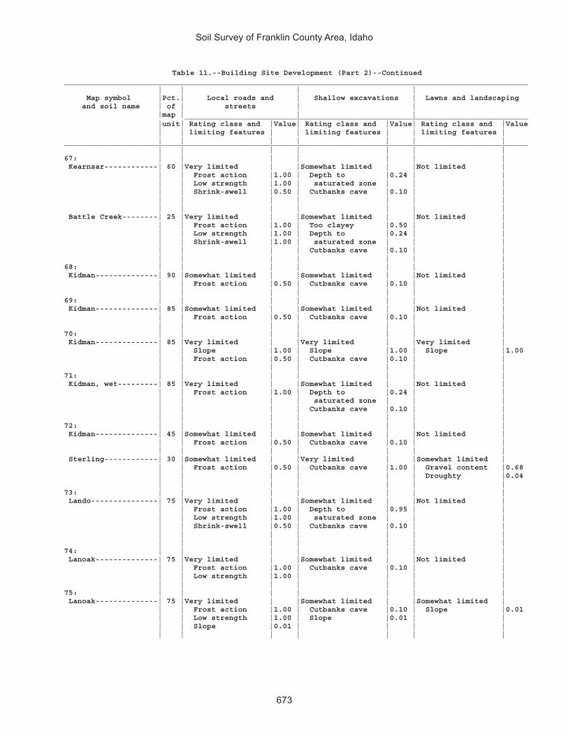
Soil Survey of Franklin County Area, Idaho
673
Table 11.--Building Site Development (Part 2)--Continued________________________________________________________________________________________________________ | | | | Map symbol |Pct.| Local roads and | Shallow excavations | Lawns and landscaping and soil name | of | streets | | |map | | | _____________________________________________________________________________ |unit| Rating class and |Value| Rating class and |Value| Rating class and |Value | | limiting features | | limiting features | | limiting features | | | | | | | |________________________________________________________________________________________________________ | | | | | | |67: | | | | | | | Kearnsar------------| 60 |Very limited | |Somewhat limited | |Not limited | | | Frost action |1.00 | Depth to |0.24 | | | | Low strength |1.00 | saturated zone | | | | | Shrink-swell |0.50 | Cutbanks cave |0.10 | | | | | | | | | | | | | | | | Battle Creek--------| 25 |Very limited | |Somewhat limited | |Not limited | | | Frost action |1.00 | Too clayey |0.50 | | | | Low strength |1.00 | Depth to |0.24 | | | | Shrink-swell |1.00 | saturated zone | | | | | | | Cutbanks cave |0.10 | | | | | | | | |68: | | | | | | | Kidman--------------| 90 |Somewhat limited | |Somewhat limited | |Not limited | | | Frost action |0.50 | Cutbanks cave |0.10 | | | | | | | | |69: | | | | | | | Kidman--------------| 85 |Somewhat limited | |Somewhat limited | |Not limited | | | Frost action |0.50 | Cutbanks cave |0.10 | | | | | | | | |70: | | | | | | | Kidman--------------| 85 |Very limited | |Very limited | |Very limited | | | Slope |1.00 | Slope |1.00 | Slope |1.00 | | Frost action |0.50 | Cutbanks cave |0.10 | | | | | | | | |71: | | | | | | | Kidman, wet---------| 85 |Very limited | |Somewhat limited | |Not limited | | | Frost action |1.00 | Depth to |0.24 | | | | | | saturated zone | | | | | | | Cutbanks cave |0.10 | | | | | | | | |72: | | | | | | | Kidman--------------| 45 |Somewhat limited | |Somewhat limited | |Not limited | | | Frost action |0.50 | Cutbanks cave |0.10 | | | | | | | | | Sterling------------| 30 |Somewhat limited | |Very limited | |Somewhat limited | | | Frost action |0.50 | Cutbanks cave |1.00 | Gravel content |0.68 | | | | | | Droughty |0.04 | | | | | | |73: | | | | | | | Lando---------------| 75 |Very limited | |Somewhat limited | |Not limited | | | Frost action |1.00 | Depth to |0.95 | | | | Low strength |1.00 | saturated zone | | | | | Shrink-swell |0.50 | Cutbanks cave |0.10 | | | | | | | | | | | | | | | |74: | | | | | | | Lanoak--------------| 75 |Very limited | |Somewhat limited | |Not limited | | | Frost action |1.00 | Cutbanks cave |0.10 | | | | Low strength |1.00 | | | | | | | | | | |75: | | | | | | | Lanoak--------------| 75 |Very limited | |Somewhat limited | |Somewhat limited | | | Frost action |1.00 | Cutbanks cave |0.10 | Slope |0.01 | | Low strength |1.00 | Slope |0.01 | | | | Slope |0.01 | | | | | | | | | | |

Soil Survey of Franklin County Area, Idaho
674
Table 11.--Building Site Development (Part 2)--Continued________________________________________________________________________________________________________ | | | | Map symbol |Pct.| Local roads and | Shallow excavations | Lawns and landscaping and soil name | of | streets | | |map | | | _____________________________________________________________________________ |unit| Rating class and |Value| Rating class and |Value| Rating class and |Value | | limiting features | | limiting features | | limiting features | | | | | | | |________________________________________________________________________________________________________ | | | | | | |76: | | | | | | | Lanoak--------------| 45 |Very limited | |Very limited | |Very limited | | | Frost action |1.00 | Slope |1.00 | Slope |1.00 | | Slope |1.00 | Cutbanks cave |0.10 | | | | Low strength |1.00 | | | | | | | | | | | Broadhead-----------| 40 |Very limited | |Very limited | |Very limited | | | Low strength |1.00 | Slope |1.00 | Slope |1.00 | | Shrink-swell |1.00 | Cutbanks cave |0.10 | | | | Slope |1.00 | | | | | | Frost action |0.50 | | | | | | | | | | |77: | | | | | | | Lanoak--------------| 35 |Very limited | |Very limited | |Very limited | | | Slope |1.00 | Slope |1.00 | Slope |1.00 | | Frost action |1.00 | Cutbanks cave |0.10 | | | | Low strength |1.00 | | | | | | | | | | | Broadhead-----------| 30 |Very limited | |Very limited | |Very limited | | | Slope |1.00 | Slope |1.00 | Slope |1.00 | | Low strength |1.00 | Cutbanks cave |0.10 | | | | Shrink-swell |1.00 | | | | | | Frost action |0.50 | | | | | | | | | | | Hades---------------| 15 |Very limited | |Very limited | |Very limited | | | Slope |1.00 | Slope |1.00 | Slope |1.00 | | Low strength |1.00 | Cutbanks cave |1.00 | | | | Frost action |0.50 | | | | | | | | | | |78: | | | | | | | Lanoak--------------| 40 |Very limited | |Somewhat limited | |Somewhat limited | | | Frost action |1.00 | Slope |0.84 | Slope |0.84 | | Low strength |1.00 | Cutbanks cave |0.10 | | | | Slope |0.84 | | | | | | | | | | | Hades---------------| 35 |Very limited | |Very limited | |Somewhat limited | | | Low strength |1.00 | Cutbanks cave |1.00 | Slope |0.84 | | Slope |0.84 | Slope |0.84 | | | | Frost action |0.50 | | | | | | | | | | |79: | | | | | | | Lanoak--------------| 60 |Very limited | |Very limited | |Very limited | | | Frost action |1.00 | Slope |1.00 | Slope |1.00 | | Slope |1.00 | Cutbanks cave |0.10 | | | | Low strength |1.00 | | | | | | | | | | | Thatcher------------| 25 |Very limited | |Very limited | |Very limited | | | Frost action |1.00 | Slope |1.00 | Slope |1.00 | | Slope |1.00 | Cutbanks cave |0.10 | | | | Low strength |1.00 | | | | | | | | | | |80: | | | | | | | Layton--------------| 85 |Not limited | |Very limited | |Somewhat limited | | | | | Cutbanks cave |1.00 | Droughty |0.21 | | | | Depth to |0.47 | | | | | | saturated zone | | | | | | | | | |

Soil Survey of Franklin County Area, Idaho
675
Table 11.--Building Site Development (Part 2)--Continued________________________________________________________________________________________________________ | | | | Map symbol |Pct.| Local roads and | Shallow excavations | Lawns and landscaping and soil name | of | streets | | |map | | | _____________________________________________________________________________ |unit| Rating class and |Value| Rating class and |Value| Rating class and |Value | | limiting features | | limiting features | | limiting features | | | | | | | |________________________________________________________________________________________________________ | | | | | | |81: | | | | | | | Layton--------------| 80 |Not limited | |Very limited | |Somewhat limited | | | | | Cutbanks cave |1.00 | Droughty |0.21 | | | | Depth to |0.47 | | | | | | saturated zone | | | | | | | | | |82: | | | | | | | Lizdale-------------| 80 |Very limited | |Very limited | |Very limited | | | Slope |1.00 | Slope |1.00 | Slope |1.00 | | Frost action |0.50 | Cutbanks cave |1.00 | Content of large |1.00 | | | | | | stones | | | | | | | Carbonate content|1.00 | | | | | | Droughty |0.01 | | | | | | |83: | | | | | | | Lizdale-------------| 55 |Very limited | |Very limited | |Very limited | | | Slope |1.00 | Cutbanks cave |1.00 | Content of large |1.00 | | Frost action |0.50 | Slope |1.00 | stones | | | | | | | Slope |1.00 | | | | | | Carbonate content|1.00 | | | | | | Droughty |0.01 | | | | | | | Searla--------------| 35 |Very limited | |Very limited | |Very limited | | | Slope |1.00 | Cutbanks cave |1.00 | Slope |1.00 | | Frost action |0.50 | Slope |1.00 | Gravel content |0.54 | | | | | | |84: | | | | | | | Logan---------------| 90 |Very limited | |Very limited | |Very limited | | | Depth to |1.00 | Depth to |1.00 | Depth to |1.00 | | saturated zone | | saturated zone | | saturated zone | | | Frost action |1.00 | Cutbanks cave |0.10 | | | | Low strength |1.00 | | | | | | Shrink-swell |0.50 | | | | | | Flooding |0.40 | | | | | | | | | | |85: | | | | | | | Lonigan-------------| 40 |Very limited | |Very limited | |Very limited | | | Slope |1.00 | Cutbanks cave |1.00 | Slope |1.00 | | Frost action |0.50 | Slope |1.00 | Gravel content |0.97 | | | | Depth to soft |0.20 | Droughty |0.42 | | | | bedrock | | Depth to bedrock |0.20 | | | | | | | Lizdale-------------| 40 |Very limited | |Very limited | |Very limited | | | Slope |1.00 | Cutbanks cave |1.00 | Content of large |1.00 | | Frost action |0.50 | Slope |1.00 | stones | | | | | | | Slope |1.00 | | | | | | Carbonate content|1.00 | | | | | | Droughty |0.01 | | | | | | |86: | | | | | | | Lonigan-------------| 45 |Very limited | |Very limited | |Very limited | | | Slope |1.00 | Slope |1.00 | Slope |1.00 | | Frost action |0.50 | Cutbanks cave |1.00 | Gravel content |0.97 | | | | Depth to soft |0.90 | Depth to bedrock |0.90 | | | | bedrock | | Droughty |0.42 | | | | | | | Ricrest-------------| 30 |Very limited | |Very limited | |Very limited | | | Slope |1.00 | Slope |1.00 | Slope |1.00 | | Low strength |0.78 | Cutbanks cave |1.00 | Gravel content |0.61 | | Shrink-swell |0.50 | | | | | | Frost action |0.50 | | | | | | | | | | |

Soil Survey of Franklin County Area, Idaho
676
Table 11.--Building Site Development (Part 2)--Continued________________________________________________________________________________________________________ | | | | Map symbol |Pct.| Local roads and | Shallow excavations | Lawns and landscaping and soil name | of | streets | | |map | | | _____________________________________________________________________________ |unit| Rating class and |Value| Rating class and |Value| Rating class and |Value | | limiting features | | limiting features | | limiting features | | | | | | | |________________________________________________________________________________________________________ | | | | | | |87: | | | | | | | Manila--------------| 85 |Very limited | |Very limited | |Not limited | | | Low strength |1.00 | Cutbanks cave |1.00 | | | | Shrink-swell |1.00 | | | | | | Frost action |0.50 | | | | | | | | | | |88: | | | | | | | Manila--------------| 80 |Very limited | |Very limited | |Somewhat limited | | | Low strength |1.00 | Cutbanks cave |1.00 | Slope |0.01 | | Shrink-swell |1.00 | Slope |0.01 | | | | Frost action |0.50 | | | | | | Slope |0.01 | | | | | | | | | | |89: | | | | | | | Manila--------------| 85 |Very limited | |Very limited | |Very limited | | | Low strength |1.00 | Cutbanks cave |1.00 | Slope |1.00 | | Shrink-swell |1.00 | Slope |1.00 | | | | Slope |1.00 | | | | | | Frost action |0.50 | | | | | | | | | | |90: | | | | | | | Manila--------------| 50 |Very limited | |Very limited | |Somewhat limited | | | Low strength |1.00 | Cutbanks cave |1.00 | Slope |0.37 | | Shrink-swell |1.00 | Slope |0.37 | | | | Frost action |0.50 | | | | | | Slope |0.37 | | | | | | | | | | | Bancroft------------| 30 |Very limited | |Somewhat limited | |Somewhat limited | | | Frost action |1.00 | Slope |0.37 | Slope |0.37 | | Low strength |1.00 | Cutbanks cave |0.10 | | | | Slope |0.37 | | | | | | | | | | |91: | | | | | | | Manila--------------| 50 |Very limited | |Very limited | |Somewhat limited | | | Low strength |1.00 | Cutbanks cave |1.00 | Slope |0.01 | | Shrink-swell |1.00 | Slope |0.01 | | | | Frost action |0.50 | | | | | | Slope |0.01 | | | | | | | | | | | Broadhead-----------| 25 |Very limited | |Somewhat limited | |Somewhat limited | | | Low strength |1.00 | Cutbanks cave |0.10 | Slope |0.01 | | Shrink-swell |1.00 | Slope |0.01 | | | | Frost action |0.50 | | | | | | Slope |0.01 | | | | | | | | | | |92: | | | | | | | Manila--------------| 40 |Very limited | |Very limited | |Very limited | | | Low strength |1.00 | Cutbanks cave |1.00 | Slope |1.00 | | Shrink-swell |1.00 | Slope |1.00 | | | | Slope |1.00 | | | | | | Frost action |0.50 | | | | | | | | | | | Broadhead-----------| 35 |Very limited | |Very limited | |Very limited | | | Low strength |1.00 | Slope |1.00 | Slope |1.00 | | Shrink-swell |1.00 | Cutbanks cave |0.10 | | | | Slope |1.00 | | | | | | Frost action |0.50 | | | | | | | | | | |

Soil Survey of Franklin County Area, Idaho
677
Table 11.--Building Site Development (Part 2)--Continued________________________________________________________________________________________________________ | | | | Map symbol |Pct.| Local roads and | Shallow excavations | Lawns and landscaping and soil name | of | streets | | |map | | | _____________________________________________________________________________ |unit| Rating class and |Value| Rating class and |Value| Rating class and |Value | | limiting features | | limiting features | | limiting features | | | | | | | |________________________________________________________________________________________________________ | | | | | | |93: | | | | | | | Manila--------------| 50 |Very limited | |Very limited | |Very limited | | | Low strength |1.00 | Cutbanks cave |1.00 | Slope |1.00 | | Shrink-swell |1.00 | Slope |1.00 | | | | Slope |1.00 | | | | | | Frost action |0.50 | | | | | | | | | | | Lonigan-------------| 30 |Very limited | |Very limited | |Very limited | | | Slope |1.00 | Cutbanks cave |1.00 | Slope |1.00 | | Frost action |0.50 | Slope |1.00 | Gravel content |0.97 | | | | Depth to soft |0.20 | Droughty |0.42 | | | | bedrock | | Depth to bedrock |0.20 | | | | | | |94: | | | | | | | Manila--------------| 55 |Very limited | |Very limited | |Somewhat limited | | | Low strength |1.00 | Cutbanks cave |1.00 | Slope |0.84 | | Shrink-swell |1.00 | Slope |0.84 | | | | Slope |0.84 | | | | | | Frost action |0.50 | | | | | | | | | | | Yeates Hollow-------| 30 |Very limited | |Very limited | |Somewhat limited | | | Shrink-swell |1.00 | Cutbanks cave |1.00 | Slope |0.84 | | Low strength |1.00 | Slope |0.84 | Content of large |0.38 | | Slope |0.84 | Content of large |0.19 | stones | | | Frost action |0.50 | stones | | | | | Content of large |0.19 | Too clayey |0.03 | | | | stones | | | | | | | | | | | | | | | | | | |95: | | | | | | | Maplecreek----------| 95 |Very limited | |Very limited | |Not limited | | | Frost action |1.00 | Cutbanks cave |1.00 | | | | Flooding |0.40 | Depth to |0.99 | | | | | | saturated zone | | | | | | | | | |96: | | | | | | | Maplecreek----------| 45 |Very limited | |Very limited | |Not limited | | | Frost action |1.00 | Cutbanks cave |1.00 | | | | Flooding |0.40 | Depth to |0.99 | | | | | | saturated zone | | | | | | | | | | Layton--------------| 35 |Not limited | |Very limited | |Somewhat limited | | | | | Cutbanks cave |1.00 | Droughty |0.21 | | | | Depth to |0.47 | | | | | | saturated zone | | | | | | | | | |97: | | | | | | | Merkley-------------| 45 |Very limited | |Very limited | |Not limited | | | Frost action |1.00 | Cutbanks cave |1.00 | | | | | | Dense layer |0.50 | | | | | | Depth to |0.15 | | | | | | saturated zone | | | | | | | | | | Lago----------------| 20 |Very limited | |Very limited | |Somewhat limited | | | Frost action |1.00 | Depth to |1.00 | Depth to |0.03 | | Low strength |1.00 | saturated zone | | saturated zone | | | Shrink-swell |0.50 | Cutbanks cave |0.10 | | | | Flooding |0.40 | | | | | | Depth to |0.03 | | | | | | saturated zone | | | | | | | | | | | |

Soil Survey of Franklin County Area, Idaho
678
Table 11.--Building Site Development (Part 2)--Continued________________________________________________________________________________________________________ | | | | Map symbol |Pct.| Local roads and | Shallow excavations | Lawns and landscaping and soil name | of | streets | | |map | | | _____________________________________________________________________________ |unit| Rating class and |Value| Rating class and |Value| Rating class and |Value | | limiting features | | limiting features | | limiting features | | | | | | | |________________________________________________________________________________________________________ | | | | | | |97: | | | | | | | Bear Lake-----------| 15 |Very limited | |Very limited | |Very limited | | | Depth to |1.00 | Depth to |1.00 | Depth to |1.00 | | saturated zone | | saturated zone | | saturated zone | | | Frost action |1.00 | Flooding |0.60 | Flooding |0.60 | | Flooding |1.00 | Cutbanks cave |0.10 | | | | Low strength |1.00 | | | | | | | | | | |98: | | | | | | | Moonlight-----------| 40 |Very limited | |Very limited | |Very limited | | | Slope |1.00 | Slope |1.00 | Slope |1.00 | | Frost action |1.00 | Cutbanks cave |0.10 | | | | | | | | | Camelback-----------| 35 |Very limited | |Very limited | |Very limited | | | Slope |1.00 | Slope |1.00 | Slope |1.00 | | Shrink-swell |0.50 | Cutbanks cave |1.00 | Gravel content |1.00 | | Frost action |0.50 | | | | | | | | | | |99: | | | | | | | Niter---------------| 60 |Very limited | |Very limited | |Not limited | | | Shrink-swell |1.00 | Cutbanks cave |1.00 | | | | Low strength |1.00 | Too clayey |0.28 | | | | Frost action |0.50 | | | | | | | | | | | Brifox--------------| 20 |Very limited | |Very limited | |Very limited | | | Shrink-swell |1.00 | Cutbanks cave |1.00 | Too clayey |1.00 | | Low strength |1.00 | Too clayey |0.41 | | | | Frost action |0.50 | | | | | | | | | | |100: | | | | | | | Northwater----------| 35 |Very limited | |Very limited | |Very limited | | | Slope |1.00 | Slope |1.00 | Slope |1.00 | | Frost action |0.50 | Cutbanks cave |1.00 | Droughty |0.30 | | Content of large |0.31 | Depth to hard |0.77 | Gravel content |0.26 | | stones | | bedrock | | | | | | | Content of large |0.31 | | | | | | stones | | | | | | | | | | Foxol---------------| 25 |Very limited | |Very limited | |Very limited | | | Depth to hard |1.00 | Depth to hard |1.00 | Depth to bedrock |1.00 | | bedrock | | bedrock | | Slope |1.00 | | Content of large |1.00 | Content of large |1.00 | Content of large |1.00 | | stones | | stones | | stones | | | Slope |1.00 | Slope |1.00 | Droughty |1.00 | | Frost action |0.50 | Cutbanks cave |0.10 | | | | | | | | | Vitale--------------| 20 |Very limited | |Very limited | |Very limited | | | Slope |1.00 | Depth to hard |1.00 | Slope |1.00 | | Content of large |1.00 | bedrock | | Droughty |1.00 | | stones | | Slope |1.00 | Content of large |1.00 | | Depth to hard |0.64 | Content of large |1.00 | stones | | | bedrock | | stones | | Depth to bedrock |0.65 | | Shrink-swell |0.50 | Cutbanks cave |0.10 | | | | Frost action |0.50 | | | | | | | | | | |

Soil Survey of Franklin County Area, Idaho
679
Table 11.--Building Site Development (Part 2)--Continued________________________________________________________________________________________________________ | | | | Map symbol |Pct.| Local roads and | Shallow excavations | Lawns and landscaping and soil name | of | streets | | |map | | | _____________________________________________________________________________ |unit| Rating class and |Value| Rating class and |Value| Rating class and |Value | | limiting features | | limiting features | | limiting features | | | | | | | |________________________________________________________________________________________________________ | | | | | | |101: | | | | | | | Northwater----------| 65 |Very limited | |Very limited | |Very limited | | | Slope |1.00 | Slope |1.00 | Slope |1.00 | | Frost action |0.50 | Cutbanks cave |1.00 | Droughty |0.30 | | Content of large |0.31 | Content of large |0.31 | Gravel content |0.26 | | stones | | stones | | | | | | | | | | Povey---------------| 25 |Very limited | |Very limited | |Very limited | | | Slope |1.00 | Cutbanks cave |1.00 | Slope |1.00 | | Frost action |0.50 | Slope |1.00 | Gravel content |0.01 | | | | | | |102: | | | | | | | Northwater----------| 65 |Very limited | |Very limited | |Very limited | | | Slope |1.00 | Slope |1.00 | Slope |1.00 | | Frost action |0.50 | Cutbanks cave |1.00 | Droughty |0.30 | | Content of large |0.31 | Content of large |0.31 | Gravel content |0.26 | | stones | | stones | | | | | | | | | | Povey---------------| 15 |Very limited | |Very limited | |Very limited | | | Slope |1.00 | Slope |1.00 | Slope |1.00 | | Frost action |0.50 | Cutbanks cave |1.00 | Gravel content |0.01 | | | | | | |103: | | | | | | | Nyman---------------| 50 |Very limited | |Very limited | |Very limited | | | Slope |1.00 | Depth to hard |1.00 | Slope |1.00 | | Frost action |0.50 | bedrock | | Depth to bedrock |0.05 | | Content of large |0.13 | Slope |1.00 | | | | stones | | Content of large |0.13 | | | | Depth to hard |0.05 | stones | | | | | bedrock | | Cutbanks cave |0.10 | | | | | | | | | Lonigan-------------| 20 |Very limited | |Very limited | |Very limited | | | Slope |1.00 | Slope |1.00 | Slope |1.00 | | Frost action |0.50 | Cutbanks cave |1.00 | Gravel content |0.97 | | | | Depth to soft |0.90 | Depth to bedrock |0.90 | | | | bedrock | | Droughty |0.42 | | | | | | | | | | | | | | Copenhagen----------| 15 |Very limited | |Very limited | |Very limited | | | Depth to hard |1.00 | Depth to hard |1.00 | Depth to bedrock |1.00 | | bedrock | | bedrock | | Slope |1.00 | | Slope |1.00 | Slope |1.00 | Droughty |1.00 | | Frost action |0.50 | Cutbanks cave |0.10 | Gravel content |0.98 | | | | | | Content of large |0.61 | | | | | | stones | | | | | | | |104: | | | | | | | Oxford--------------| 45 |Very limited | |Somewhat limited | |Very limited | | | Low strength |1.00 | Too clayey |0.99 | Too clayey |1.00 | | Shrink-swell |1.00 | Cutbanks cave |0.10 | | | | Frost action |0.50 | | | | | | | | | | | Banida--------------| 35 |Very limited | |Somewhat limited | |Not limited | | | Low strength |1.00 | Too clayey |0.28 | | | | Shrink-swell |1.00 | Cutbanks cave |0.10 | | | | Frost action |0.50 | | | | | | | | | | |

Soil Survey of Franklin County Area, Idaho
680
Table 11.--Building Site Development (Part 2)--Continued________________________________________________________________________________________________________ | | | | Map symbol |Pct.| Local roads and | Shallow excavations | Lawns and landscaping and soil name | of | streets | | |map | | | _____________________________________________________________________________ |unit| Rating class and |Value| Rating class and |Value| Rating class and |Value | | limiting features | | limiting features | | limiting features | | | | | | | |________________________________________________________________________________________________________ | | | | | | |105: | | | | | | | Oxford--------------| 45 |Very limited | |Somewhat limited | |Very limited | | | Low strength |1.00 | Too clayey |0.99 | Too clayey |1.00 | | Shrink-swell |1.00 | Cutbanks cave |0.10 | Slope |0.01 | | Frost action |0.50 | Slope |0.01 | | | | Slope |0.01 | | | | | | | | | | | Banida--------------| 35 |Very limited | |Somewhat limited | |Somewhat limited | | | Low strength |1.00 | Too clayey |0.28 | Slope |0.01 | | Shrink-swell |1.00 | Cutbanks cave |0.10 | | | | Frost action |0.50 | Slope |0.01 | | | | Slope |0.01 | | | | | | | | | | |106: | | | | | | | Oxford--------------| 50 |Very limited | |Very limited | |Very limited | | | Low strength |1.00 | Slope |1.00 | Slope |1.00 | | Shrink-swell |1.00 | Too clayey |0.99 | Too clayey |1.00 | | Slope |1.00 | Cutbanks cave |0.10 | | | | Frost action |0.50 | | | | | | | | | | | Banida--------------| 35 |Very limited | |Very limited | |Very limited | | | Low strength |1.00 | Slope |1.00 | Slope |1.00 | | Shrink-swell |1.00 | Too clayey |0.28 | | | | Slope |1.00 | Cutbanks cave |0.10 | | | | Frost action |0.50 | | | | | | | | | | |107: | | | | | | | Oxford--------------| 65 |Very limited | |Very limited | |Very limited | | | Slope |1.00 | Slope |1.00 | Slope |1.00 | | Low strength |1.00 | Too clayey |0.99 | Too clayey |1.00 | | Shrink-swell |1.00 | Cutbanks cave |0.10 | | | | Frost action |0.50 | | | | | | | | | | | Gullied land--------| 15 |Not rated | |Not rated | |Not rated | | | | | | | |108: | | | | | | | Parkay--------------| 45 |Very limited | |Very limited | |Very limited | | | Slope |1.00 | Slope |1.00 | Slope |1.00 | | Shrink-swell |0.50 | Cutbanks cave |1.00 | | | | Frost action |0.50 | Depth to hard |0.68 | | | | | | bedrock | | | | | | | | | | Povey---------------| 30 |Very limited | |Very limited | |Very limited | | | Slope |1.00 | Slope |1.00 | Slope |1.00 | | Frost action |0.50 | Cutbanks cave |1.00 | Gravel content |0.01 | | | | | | |109: | | | | | | | Parleys-------------| 85 |Very limited | |Somewhat limited | |Not limited | | | Frost action |1.00 | Cutbanks cave |0.10 | | | | Low strength |1.00 | | | | | | Shrink-swell |0.50 | | | | | | | | | | |110: | | | | | | | Parleys-------------| 85 |Very limited | |Somewhat limited | |Not limited | | | Frost action |1.00 | Cutbanks cave |0.10 | | | | Low strength |1.00 | | | | | | Shrink-swell |0.50 | | | | | | | | | | |

Soil Survey of Franklin County Area, Idaho
681
Table 11.--Building Site Development (Part 2)--Continued________________________________________________________________________________________________________ | | | | Map symbol |Pct.| Local roads and | Shallow excavations | Lawns and landscaping and soil name | of | streets | | |map | | | _____________________________________________________________________________ |unit| Rating class and |Value| Rating class and |Value| Rating class and |Value | | limiting features | | limiting features | | limiting features | | | | | | | |________________________________________________________________________________________________________ | | | | | | |111: | | | | | | | Parleys, wet--------| 90 |Very limited | |Somewhat limited | |Not limited | | | Frost action |1.00 | Depth to |0.15 | | | | Low strength |1.00 | saturated zone | | | | | Shrink-swell |0.50 | Cutbanks cave |0.10 | | | | Flooding |0.40 | | | | | | | | | | |112: | | | | | | | Pavohroo------------| 30 |Very limited | |Very limited | |Very limited | | | Slope |1.00 | Slope |1.00 | Slope |1.00 | | Low strength |0.78 | Cutbanks cave |0.10 | | | | Frost action |0.50 | | | | | | | | | | | Sedgway-------------| 30 |Very limited | |Very limited | |Very limited | | | Slope |1.00 | Slope |1.00 | Slope |1.00 | | Shrink-swell |0.50 | Content of large |0.38 | | | | Frost action |0.50 | stones | | | | | Content of large |0.38 | Cutbanks cave |0.10 | | | | stones | | | | | | | | | | | | | | | | | | | Toponce-------------| 20 |Very limited | |Very limited | |Very limited | | | Slope |1.00 | Slope |1.00 | Slope |1.00 | | Low strength |1.00 | Too clayey |0.95 | | | | Shrink-swell |1.00 | Cutbanks cave |0.10 | | | | Frost action |0.50 | | | | | | | | | | |113: | | | | | | | Picabo--------------| 45 |Very limited | |Somewhat limited | |Very limited | | | Frost action |1.00 | Depth to |0.95 | Sodium content |1.00 | | Flooding |0.40 | saturated zone | | Carbonate content|1.00 | | Low strength |0.22 | Cutbanks cave |0.10 | | | | | | | | | | | | | | | | Thatcherflats-------| 30 |Very limited | |Somewhat limited | |Very limited | | | Frost action |1.00 | Depth to |0.82 | Sodium content |1.00 | | Low strength |1.00 | saturated zone | | | | | Shrink-swell |1.00 | Cutbanks cave |0.10 | | | | Flooding |0.40 | | | | | | | | | | | | | | | | | |114: | | | | | | | Pits, gravel--------|100 |Not rated | |Not rated | |Not rated | | | | | | | |115: | | | | | | | Pollynot------------| 75 |Very limited | |Very limited | |Somewhat limited | | | Low strength |1.00 | Cutbanks cave |1.00 | Slope |0.01 | | Frost action |0.50 | Slope |0.01 | | | | Slope |0.01 | | | | | | | | | | |116: | | | | | | | Pollynot------------| 75 |Very limited | |Very limited | |Not limited | | | Low strength |1.00 | Cutbanks cave |1.00 | | | | Frost action |0.50 | | | | | | | | | | |117: | | | | | | | Pollynot------------| 75 |Very limited | |Very limited | |Not limited | | | Low strength |1.00 | Cutbanks cave |1.00 | | | | Frost action |0.50 | | | | | | | | | | |

Soil Survey of Franklin County Area, Idaho
682
Table 11.--Building Site Development (Part 2)--Continued________________________________________________________________________________________________________ | | | | Map symbol |Pct.| Local roads and | Shallow excavations | Lawns and landscaping and soil name | of | streets | | |map | | | _____________________________________________________________________________ |unit| Rating class and |Value| Rating class and |Value| Rating class and |Value | | limiting features | | limiting features | | limiting features | | | | | | | |________________________________________________________________________________________________________ | | | | | | |118: | | | | | | | Pollynot------------| 75 |Very limited | |Very limited | |Somewhat limited | | | Low strength |1.00 | Cutbanks cave |1.00 | Slope |0.63 | | Slope |0.63 | Slope |0.63 | | | | Frost action |0.50 | | | | | | | | | | |119: | | | | | | | Polumar-------------| 45 |Very limited | |Very limited | |Very limited | | | Slope |1.00 | Slope |1.00 | Slope |1.00 | | Content of large |0.88 | Content of large |0.88 | Gravel content |0.61 | | stones | | stones | | Content of large |0.01 | | Frost action |0.50 | Depth to hard |0.77 | stones | | | | | bedrock | | Droughty |0.01 | | | | Cutbanks cave |0.10 | | | | | | | | | Ireland-------------| 30 |Very limited | |Very limited | |Very limited | | | Slope |1.00 | Depth to hard |1.00 | Slope |1.00 | | Depth to hard |0.95 | bedrock | | Droughty |0.99 | | bedrock | | Slope |1.00 | Depth to bedrock |0.95 | | Content of large |0.52 | Content of large |0.52 | Content of large |0.95 | | stones | | stones | | stones | | | Frost action |0.50 | Cutbanks cave |0.10 | Gravel content |0.72 | | | | | | |120: | | | | | | | Polumar-------------| 30 |Very limited | |Very limited | |Very limited | | | Slope |1.00 | Slope |1.00 | Slope |1.00 | | Content of large |0.88 | Content of large |0.88 | Gravel content |0.61 | | stones | | stones | | Content of large |0.01 | | Frost action |0.50 | Depth to hard |0.77 | stones | | | | | bedrock | | Droughty |0.01 | | | | Cutbanks cave |0.10 | | | | | | | | | Sprollow------------| 30 |Very limited | |Very limited | |Very limited | | | Slope |1.00 | Depth to hard |1.00 | Slope |1.00 | | Frost action |0.50 | bedrock | | Carbonate content|1.00 | | Content of large |0.26 | Slope |1.00 | Gravel content |0.59 | | stones | | Content of large |0.26 | Content of large |0.08 | | Depth to hard |0.01 | stones | | stones | | | bedrock |0.01 | Cutbanks cave |0.10 | Depth to bedrock |0.01 | | | | | | | Ireland-------------| 20 |Very limited | |Very limited | |Very limited | | | Slope |1.00 | Depth to hard |1.00 | Slope |1.00 | | Depth to hard |0.95 | bedrock | | Droughty |0.99 | | bedrock | | Slope |1.00 | Depth to bedrock |0.95 | | Content of large |0.52 | Content of large |0.52 | Content of large |0.95 | | stones | | stones | | stones | | | Frost action |0.50 | Cutbanks cave |0.10 | Gravel content |0.72 | | | | | | |121: | | | | | | | Povey---------------| 35 |Very limited | |Very limited | |Very limited | | | Slope |1.00 | Cutbanks cave |1.00 | Slope |1.00 | | Frost action |0.50 | Slope |1.00 | Gravel content |0.01 | | | | | | | Hades---------------| 30 |Very limited | |Very limited | |Very limited | | | Slope |1.00 | Cutbanks cave |1.00 | Slope |1.00 | | Low strength |1.00 | Slope |1.00 | | | | Frost action |0.50 | | | | | | | | | | |

Soil Survey of Franklin County Area, Idaho
683
Table 11.--Building Site Development (Part 2)--Continued________________________________________________________________________________________________________ | | | | Map symbol |Pct.| Local roads and | Shallow excavations | Lawns and landscaping and soil name | of | streets | | |map | | | _____________________________________________________________________________ |unit| Rating class and |Value| Rating class and |Value| Rating class and |Value | | limiting features | | limiting features | | limiting features | | | | | | | |________________________________________________________________________________________________________ | | | | | | |121: | | | | | | | Hondoho-------------| 15 |Very limited | |Very limited | |Very limited | | | Slope |1.00 | Cutbanks cave |1.00 | Slope |1.00 | | Shrink-swell |0.50 | Slope |1.00 | Content of large |0.38 | | Frost action |0.50 | | | stones | | | | | | | Gravel content |0.12 | | | | | | |122: | | | | | | | Povey---------------| 45 |Very limited | |Very limited | |Very limited | | | Slope |1.00 | Slope |1.00 | Slope |1.00 | | Frost action |0.50 | Cutbanks cave |1.00 | Gravel content |0.01 | | | | | | | Parkay--------------| 30 |Very limited | |Very limited | |Very limited | | | Slope |1.00 | Slope |1.00 | Slope |1.00 | | Shrink-swell |0.50 | Cutbanks cave |1.00 | | | | Frost action |0.50 | Depth to hard |0.68 | | | | | | bedrock | | | | | | | | | |123: | | | | | | | Preston-------------| 90 |Not limited | |Very limited | |Somewhat limited | | | | | Cutbanks cave |1.00 | Droughty |0.61 | | | | | | |124: | | | | | | | Preston-------------| 90 |Not limited | |Very limited | |Somewhat limited | | | | | Cutbanks cave |1.00 | Droughty |0.61 | | | | | | |125: | | | | | | | Preston-------------| 85 |Very limited | |Very limited | |Very limited | | | Slope |1.00 | Cutbanks cave |1.00 | Slope |1.00 | | | | Slope |1.00 | Droughty |0.61 | | | | | | |126: | | | | | | | Preston-------------| 55 |Very limited | |Very limited | |Very limited | | | Slope |1.00 | Slope |1.00 | Slope |1.00 | | | | Cutbanks cave |1.00 | Droughty |0.61 | | | | | | | Xerorthents---------| 20 |Very limited | |Very limited | |Very limited | | | Slope |1.00 | Depth to soft |1.00 | Depth to bedrock |1.00 | | Depth to soft |1.00 | bedrock | | Slope |1.00 | | bedrock | | Slope |1.00 | Droughty |1.00 | | Frost action |0.50 | Cutbanks cave |0.10 | Gravel content |0.21 | | Content of large |0.04 | Content of large |0.04 | Content of large |0.03 | | stones | | stones | | stones | | | | | | | |127: | | | | | | | Ricrest-------------| 90 |Somewhat limited | |Very limited | |Somewhat limited | | | Low strength |0.78 | Cutbanks cave |1.00 | Gravel content |0.61 | | Shrink-swell |0.50 | Slope |0.01 | Slope |0.01 | | Frost action |0.50 | | | | | | Slope |0.01 | | | | | | | | | | |128: | | | | | | | Sanyon--------------| 30 |Very limited | |Very limited | |Very limited | | | Slope |1.00 | Depth to soft |1.00 | Depth to bedrock |1.00 | | Depth to soft |1.00 | bedrock | | Slope |1.00 | | bedrock | | Slope |1.00 | Droughty |1.00 | | Frost action |0.50 | Cutbanks cave |0.10 | Gravel content |1.00 | | | | | | |

Soil Survey of Franklin County Area, Idaho
684
Table 11.--Building Site Development (Part 2)--Continued________________________________________________________________________________________________________ | | | | Map symbol |Pct.| Local roads and | Shallow excavations | Lawns and landscaping and soil name | of | streets | | |map | | | _____________________________________________________________________________ |unit| Rating class and |Value| Rating class and |Value| Rating class and |Value | | limiting features | | limiting features | | limiting features | | | | | | | |________________________________________________________________________________________________________ | | | | | | |128: | | | | | | | Staberg-------------| 30 |Very limited | |Very limited | |Very limited | | | Slope |1.00 | Slope |1.00 | Slope |1.00 | | Frost action |0.50 | Cutbanks cave |1.00 | Depth to bedrock |0.01 | | | | Depth to soft |0.01 | | | | | | bedrock | | | | | | | | | | Kabear--------------| 20 |Very limited | |Very limited | |Very limited | | | Slope |1.00 | Slope |1.00 | Slope |1.00 | | Frost action |0.50 | Cutbanks cave |0.10 | | | | | | | | |129: | | | | | | | Smidale-------------| 85 |Very limited | |Very limited | |Very limited | | | Slope |1.00 | Slope |1.00 | Slope |1.00 | | Frost action |0.50 | Cutbanks cave |0.10 | | | | Content of large |0.05 | Content of large |0.05 | | | | stones | | stones | | | | | | | | | |130: | | | | | | | Smidale-------------| 45 |Very limited | |Very limited | |Very limited | | | Slope |1.00 | Slope |1.00 | Slope |1.00 | | Frost action |0.50 | Cutbanks cave |0.10 | | | | Content of large |0.05 | Content of large |0.05 | | | | stones | | stones | | | | | | | | | | Staberg-------------| 40 |Very limited | |Very limited | |Very limited | | | Slope |1.00 | Slope |1.00 | Slope |1.00 | | Frost action |0.50 | Cutbanks cave |1.00 | Depth to bedrock |0.01 | | | | Depth to soft |0.01 | | | | | | bedrock | | | | | | | | | |131: | | | | | | | Sprollow------------| 45 |Very limited | |Very limited | |Very limited | | | Slope |1.00 | Depth to hard |1.00 | Slope |1.00 | | Frost action |0.50 | bedrock | | Carbonate content|1.00 | | Content of large |0.26 | Slope |1.00 | Gravel content |0.59 | | stones | | Content of large |0.26 | Content of large |0.08 | | Depth to hard |0.01 | stones | | stones | | | bedrock |0.01 | Cutbanks cave |0.10 | Depth to bedrock |0.01 | | | | | | | Hondoho-------------| 35 |Very limited | |Very limited | |Very limited | | | Slope |1.00 | Slope |1.00 | Slope |1.00 | | Shrink-swell |0.50 | Cutbanks cave |1.00 | Content of large |0.38 | | Frost action |0.50 | | | stones | | | | | | | Gravel content |0.12 | | | | | | |132: | | | | | | | Sprollow------------| 40 |Very limited | |Very limited | |Very limited | | | Slope |1.00 | Depth to hard |1.00 | Slope |1.00 | | Frost action |0.50 | bedrock | | Carbonate content|1.00 | | Content of large |0.26 | Slope |1.00 | Gravel content |0.59 | | stones | | Content of large |0.26 | Content of large |0.08 | | Depth to hard |0.01 | stones | | stones | | | bedrock | | Cutbanks cave |0.10 | Depth to bedrock |0.01 | | | | | | |

Soil Survey of Franklin County Area, Idaho
685
Table 11.--Building Site Development (Part 2)--Continued________________________________________________________________________________________________________ | | | | Map symbol |Pct.| Local roads and | Shallow excavations | Lawns and landscaping and soil name | of | streets | | |map | | | _____________________________________________________________________________ |unit| Rating class and |Value| Rating class and |Value| Rating class and |Value | | limiting features | | limiting features | | limiting features | | | | | | | |________________________________________________________________________________________________________ | | | | | | |132: | | | | | | | Hymas---------------| 35 |Very limited | |Very limited | |Very limited | | | Depth to hard |1.00 | Depth to hard |1.00 | Depth to bedrock |1.00 | | bedrock | | bedrock | | Slope |1.00 | | Slope |1.00 | Slope |1.00 | Droughty |1.00 | | Frost action |0.50 | Cutbanks cave |0.10 | Gravel content |1.00 | | Content of large |0.01 | Content of large |0.01 | Carbonate content|1.00 | | stones | | stones | | | | | | | | | |133: | | | | | | | Sterling------------| 85 |Somewhat limited | |Very limited | |Somewhat limited | | | Frost action |0.50 | Cutbanks cave |1.00 | Gravel content |0.68 | | | | | | Droughty |0.04 | | | | | | |134: | | | | | | | Sterling------------| 85 |Somewhat limited | |Very limited | |Somewhat limited | | | Frost action |0.50 | Cutbanks cave |1.00 | Gravel content |0.68 | | | | | | Droughty |0.04 | | | | | | |135: | | | | | | | Sterling------------| 90 |Very limited | |Very limited | |Very limited | | | Slope |1.00 | Cutbanks cave |1.00 | Slope |1.00 | | Frost action |0.50 | Slope |1.00 | Gravel content |0.68 | | | | | | Droughty |0.04 | | | | | | |136: | | | | | | | Sterling------------| 85 |Very limited | |Very limited | |Very limited | | | Slope |1.00 | Slope |1.00 | Slope |1.00 | | Frost action |0.50 | Cutbanks cave |1.00 | Gravel content |0.68 | | | | | | Droughty |0.04 | | | | | | |137: | | | | | | | Sterling------------| 50 |Somewhat limited | |Very limited | |Somewhat limited | | | Frost action |0.50 | Cutbanks cave |1.00 | Gravel content |0.68 | | | | | | Droughty |0.04 | | | | | | | Parleys-------------| 30 |Very limited | |Somewhat limited | |Not limited | | | Frost action |1.00 | Cutbanks cave |0.10 | | | | Low strength |1.00 | | | | | | Shrink-swell |0.50 | | | | | | | | | | |138: | | | | | | | Thatcher------------| 45 |Very limited | |Somewhat limited | |Somewhat limited | | | Frost action |1.00 | Slope |0.84 | Slope |0.84 | | Low strength |1.00 | Cutbanks cave |0.10 | | | | Slope |0.84 | | | | | | | | | | | Bearhollow----------| 35 |Somewhat limited | |Very limited | |Somewhat limited | | | Slope |0.84 | Cutbanks cave |1.00 | Gravel content |0.97 | | Frost action |0.50 | Slope |0.84 | Slope |0.84 | | | | | | |139: | | | | | | | Toponce-------------| 50 |Very limited | |Very limited | |Very limited | | | Low strength |1.00 | Slope |1.00 | Slope |1.00 | | Shrink-swell |1.00 | Too clayey |0.95 | | | | Slope |1.00 | Cutbanks cave |0.10 | | | | Frost action |0.50 | | | | | | | | | | |

Soil Survey of Franklin County Area, Idaho
686
Table 11.--Building Site Development (Part 2)--Continued________________________________________________________________________________________________________ | | | | Map symbol |Pct.| Local roads and | Shallow excavations | Lawns and landscaping and soil name | of | streets | | |map | | | _____________________________________________________________________________ |unit| Rating class and |Value| Rating class and |Value| Rating class and |Value | | limiting features | | limiting features | | limiting features | | | | | | | |________________________________________________________________________________________________________ | | | | | | |139: | | | | | | | Broadhead-----------| 30 |Very limited | |Very limited | |Very limited | | | Low strength |1.00 | Slope |1.00 | Slope |1.00 | | Shrink-swell |1.00 | Cutbanks cave |0.10 | | | | Slope |1.00 | | | | | | Frost action |0.50 | | | | | | | | | | |140: | | | | | | | Trenton-------------| 50 |Very limited | |Somewhat limited | |Very limited | | | Low strength |1.00 | Depth to |0.95 | Sodium content |1.00 | | Shrink-swell |0.50 | saturated zone | | | | | Frost action |0.50 | Cutbanks cave |0.10 | | | | | | Too clayey |0.03 | | | | | | | | | Battle Creek--------| 40 |Very limited | |Somewhat limited | |Not limited | | | Frost action |1.00 | Too clayey |0.50 | | | | Low strength |1.00 | Depth to |0.24 | | | | Shrink-swell |1.00 | saturated zone | | | | | | | Cutbanks cave |0.10 | | | | | | | | |141: | | | | | | | Trenton, cool-------| 50 |Very limited | |Somewhat limited | |Very limited | | | Low strength |1.00 | Depth to |0.95 | Sodium content |1.00 | | Shrink-swell |0.50 | saturated zone | | | | | Frost action |0.50 | Cutbanks cave |0.10 | | | | | | Too clayey |0.03 | | | | | | | | | Battle Creek, cool--| 40 |Very limited | |Somewhat limited | |Not limited | | | Frost action |1.00 | Too clayey |0.50 | | | | Low strength |1.00 | Depth to |0.24 | | | | Shrink-swell |1.00 | saturated zone | | | | | | | Cutbanks cave |0.10 | | | | | | | | |142: | | | | | | | Trenton-------------| 45 |Very limited | |Somewhat limited | |Very limited | | | Low strength |1.00 | Depth to |0.95 | Sodium content |1.00 | | Shrink-swell |0.50 | saturated zone | | | | | Frost action |0.50 | Cutbanks cave |0.10 | | | | | | Too clayey |0.03 | | | | | | | | | Parleys-------------| 35 |Very limited | |Somewhat limited | |Not limited | | | Frost action |1.00 | Depth to |0.15 | | | | Low strength |1.00 | saturated zone | | | | | Shrink-swell |0.50 | Cutbanks cave |0.10 | | | | Flooding |0.40 | | | | | | | | | | |143: | | | | | | | Valmar--------------| 40 |Very limited | |Very limited | |Very limited | | | Slope |1.00 | Depth to hard |1.00 | Slope |1.00 | | Content of large |1.00 | bedrock | | Content of large |1.00 | | stones | | Slope |1.00 | stones | | | Depth to hard |0.90 | Content of large |1.00 | Depth to bedrock |0.90 | | bedrock | | stones | | Droughty |0.63 | | Shrink-swell |0.50 | Cutbanks cave |0.10 | | | Frost action |0.50 | | | | | | | | | | | Camelback-----------| 25 |Very limited | |Very limited | |Very limited | | | Slope |1.00 | Slope |1.00 | Slope |1.00 | | Shrink-swell |0.50 | Cutbanks cave |1.00 | Gravel content |1.00 | | Frost action |0.50 | | | | | | | | | | |

Soil Survey of Franklin County Area, Idaho
687
Table 11.--Building Site Development (Part 2)--Continued________________________________________________________________________________________________________ | | | | Map symbol |Pct.| Local roads and | Shallow excavations | Lawns and landscaping and soil name | of | streets | | |map | | | _____________________________________________________________________________ |unit| Rating class and |Value| Rating class and |Value| Rating class and |Value | | limiting features | | limiting features | | limiting features | | | | | | | |________________________________________________________________________________________________________ | | | | | | |143: | | | | | | | Hades---------------| 20 |Very limited | |Very limited | |Very limited | | | Slope |1.00 | Slope |1.00 | Slope |1.00 | | Low strength |1.00 | Cutbanks cave |1.00 | | | | Frost action |0.50 | | | | | | | | | | |144: | | | | | | | Vitale--------------| 40 |Very limited | |Very limited | |Very limited | | | Slope |1.00 | Depth to hard |1.00 | Slope |1.00 | | Content of large |1.00 | bedrock | | Droughty |1.00 | | stones | | Slope |1.00 | Content of large |1.00 | | Depth to hard |0.64 | Content of large |1.00 | stones | | | bedrock | | stones | | Depth to bedrock |0.65 | | Shrink-swell |0.50 | Cutbanks cave |0.10 | | | | Frost action |0.50 | | | | | | | | | | | Bergquist-----------| 25 |Very limited | |Very limited | |Very limited | | | Slope |1.00 | Slope |1.00 | Slope |1.00 | | Frost action |0.50 | Cutbanks cave |1.00 | Gravel content |1.00 | | | | Depth to hard |0.13 | Droughty |0.80 | | | | bedrock | | Content of large |0.01 | | | | | | stones | | | | | | | | Rock outcrop--------| 15 |Not rated | |Not rated | |Not rated | | | | | | | |145: | | | | | | | Vitale--------------| 35 |Very limited | |Very limited | |Very limited | | | Slope |1.00 | Depth to hard |1.00 | Droughty |1.00 | | Content of large |1.00 | bedrock | | Content of large |1.00 | | stones | | Slope |1.00 | stones | | | Depth to hard |0.99 | Content of large |1.00 | Slope |1.00 | | bedrock | | stones | | Depth to bedrock |0.99 | | Shrink-swell |0.50 | Cutbanks cave |0.10 | | | | Frost action |0.50 | | | | | | | | | | | Yeates Hollow-------| 25 |Very limited | |Very limited | |Very limited | | | Shrink-swell |1.00 | Cutbanks cave |1.00 | Slope |1.00 | | Slope |1.00 | Slope |1.00 | Content of large |0.38 | | Low strength |1.00 | Content of large |0.19 | stones | | | Frost action |0.50 | stones | | | | | Content of large |0.19 | Too clayey |0.03 | | | | stones | | | | | | | | | | | | | | | | | | | Northwater----------| 15 |Very limited | |Very limited | |Very limited | | | Slope |1.00 | Slope |1.00 | Slope |1.00 | | Frost action |0.50 | Cutbanks cave |1.00 | Droughty |0.30 | | Content of large |0.31 | Depth to hard |0.77 | Gravel content |0.26 | | stones | | bedrock | | | | | | | Content of large |0.31 | | | | | | stones | | | | | | | | | |146: | | | | | | | Welby---------------| 90 |Somewhat limited | |Somewhat limited | |Very limited | | | Low strength |0.78 | Cutbanks cave |0.10 | Sodium content |1.00 | | Frost action |0.50 | | | | | | | | | | |147: | | | | | | | Welby---------------| 90 |Somewhat limited | |Somewhat limited | |Very limited | | | Low strength |0.78 | Cutbanks cave |0.10 | Sodium content |1.00 | | Frost action |0.50 | | | | | | | | | | |

Soil Survey of Franklin County Area, Idaho
688
Table 11.--Building Site Development (Part 2)--Continued________________________________________________________________________________________________________ | | | | Map symbol |Pct.| Local roads and | Shallow excavations | Lawns and landscaping and soil name | of | streets | | |map | | | _____________________________________________________________________________ |unit| Rating class and |Value| Rating class and |Value| Rating class and |Value | | limiting features | | limiting features | | limiting features | | | | | | | |________________________________________________________________________________________________________ | | | | | | |148: | | | | | | | Welby, wet----------| 85 |Very limited | |Somewhat limited | |Not limited | | | Frost action |1.00 | Depth to |0.15 | | | | Low strength |0.78 | saturated zone | | | | | | | Cutbanks cave |0.10 | | | | | | | | |149: | | | | | | | Collinston----------| 40 |Very limited | |Somewhat limited | |Somewhat limited | | | Frost action |1.00 | Cutbanks cave |0.10 | Slope |0.01 | | Low strength |1.00 | Slope |0.01 | | | | Shrink-swell |0.50 | | | | | | Slope |0.01 | | | | | | | | | | | Wheelon-------------| 40 |Very limited | |Somewhat limited | |Somewhat limited | | | Frost action |1.00 | Cutbanks cave |0.10 | Slope |0.01 | | Low strength |1.00 | Slope |0.01 | | | | Shrink-swell |0.50 | | | | | | Slope |0.01 | | | | | | | | | | |150: | | | | | | | Wheelon-------------| 40 |Very limited | |Very limited | |Very limited | | | Frost action |1.00 | Slope |1.00 | Slope |1.00 | | Low strength |1.00 | Cutbanks cave |0.10 | | | | Slope |1.00 | | | | | | Shrink-swell |0.50 | | | | | | | | | | | Collinston----------| 35 |Very limited | |Very limited | |Very limited | | | Frost action |1.00 | Slope |1.00 | Slope |1.00 | | Low strength |1.00 | Cutbanks cave |0.10 | | | | Slope |1.00 | | | | | | Shrink-swell |0.50 | | | | | | | | | | |151: | | | | | | | Wheelon-------------| 45 |Very limited | |Very limited | |Very limited | | | Slope |1.00 | Slope |1.00 | Slope |1.00 | | Frost action |1.00 | Cutbanks cave |0.10 | | | | Low strength |1.00 | | | | | | Shrink-swell |0.50 | | | | | | | | | | | Collinston----------| 30 |Very limited | |Very limited | |Very limited | | | Slope |1.00 | Slope |1.00 | Slope |1.00 | | Frost action |1.00 | Cutbanks cave |0.10 | | | | Low strength |1.00 | | | | | | Shrink-swell |0.50 | | | | | | | | | | |152: | | | | | | | Windernot-----------| 40 |Somewhat limited | |Very limited | |Somewhat limited | | | Flooding |0.40 | Cutbanks cave |1.00 | Droughty |0.88 | | | | Dense layer |0.50 | Gravel content |0.68 | | | | Depth to |0.08 | | | | | | saturated zone | | | | | | | | | | Lewnot--------------| 20 |Somewhat limited | |Very limited | |Not limited | | | Frost action |0.50 | Cutbanks cave |1.00 | | | | Flooding |0.40 | Depth to |0.99 | | | | | | saturated zone | | | | | | | Dense layer |0.50 | | | | | | | | |

Soil Survey of Franklin County Area, Idaho
689
Table 11.--Building Site Development (Part 2)--Continued________________________________________________________________________________________________________ | | | | Map symbol |Pct.| Local roads and | Shallow excavations | Lawns and landscaping and soil name | of | streets | | |map | | | _____________________________________________________________________________ |unit| Rating class and |Value| Rating class and |Value| Rating class and |Value | | limiting features | | limiting features | | limiting features | | | | | | | |________________________________________________________________________________________________________ | | | | | | |152: | | | | | | | Stinkcreek----------| 15 |Very limited | |Very limited | |Very limited | | | Depth to |1.00 | Depth to |1.00 | Sodium content |1.00 | | saturated zone | | saturated zone | | Depth to |1.00 | | Frost action |1.00 | Cutbanks cave |1.00 | saturated zone | | | Flooding |0.40 | | | | | | | | | | |153: | | | | | | | Winn----------------| 90 |Very limited | |Somewhat limited | |Not limited | | | Frost action |1.00 | Depth to |0.95 | | | | Flooding |0.40 | saturated zone | | | | | | | Cutbanks cave |0.10 | | | | | | | | |154: | | | | | | | Winwell-------------| 80 |Very limited | |Somewhat limited | |Not limited | | | Low strength |1.00 | Too clayey |0.12 | | | | Shrink-swell |1.00 | Cutbanks cave |0.10 | | | | Frost action |0.50 | | | | | | | | | | |155: | | | | | | | Winwell-------------| 45 |Very limited | |Somewhat limited | |Not limited | | | Low strength |1.00 | Too clayey |0.12 | | | | Shrink-swell |1.00 | Cutbanks cave |0.10 | | | | Frost action |0.50 | | | | | | | | | | | Collinston----------| 35 |Very limited | |Somewhat limited | |Not limited | | | Frost action |1.00 | Cutbanks cave |0.10 | | | | Low strength |1.00 | | | | | | Shrink-swell |0.50 | | | | | | | | | | |156: | | | | | | | Wormcreek-----------| 50 |Very limited | |Very limited | |Very limited | | | Slope |1.00 | Slope |1.00 | Slope |1.00 | | Frost action |0.50 | Cutbanks cave |1.00 | Gravel content |0.71 | | Content of large |0.13 | Content of large |0.13 | Content of large |0.03 | | stones | | stones | | stones | | | | | | | | Copenhagen----------| 30 |Very limited | |Very limited | |Very limited | | | Depth to hard |1.00 | Depth to hard |1.00 | Depth to bedrock |1.00 | | bedrock | | bedrock | | Slope |1.00 | | Slope |1.00 | Slope |1.00 | Droughty |1.00 | | Frost action |0.50 | Cutbanks cave |0.10 | Gravel content |0.98| | | | | | | Content of large |0.61 | | | | | | stones | | | | | | | |157: | | | | | | | Wormcreek-----------| 45 |Very limited | |Very limited | |Very limited | | | Slope |1.00 | Slope |1.00 | Slope |1.00 | | Frost action |0.50 | Cutbanks cave |1.00 | Gravel content |0.71 | | Content of large |0.13 | Content of large |0.13 | Content of large |0.03 | | stones | | stones | | stones | | | | | | | | Lonigan-------------| 35 |Very limited | |Very limited | |Very limited | | | Slope |1.00 | Slope |1.00 | Slope |1.00 | | Frost action |0.50 | Cutbanks cave |1.00 | Gravel content |0.97 | | | | Depth to soft |0.90 | Depth to bedrock |0.90 | | | | bedrock | | Droughty |0.42 | | | | | | |

Soil Survey of Franklin County Area, Idaho
690
Table 11.--Building Site Development (Part 2)--Continued________________________________________________________________________________________________________ | | | | Map symbol |Pct.| Local roads and | Shallow excavations | Lawns and landscaping and soil name | of | streets | | |map | | | _____________________________________________________________________________ |unit| Rating class and |Value| Rating class and |Value| Rating class and |Value | | limiting features | | limiting features | | limiting features | | | | | | | |________________________________________________________________________________________________________ | | | | | | |158: | | | | | | | Wursten-------------| 45 |Very limited | |Very limited | |Very limited | | | Slope |1.00 | Cutbanks cave |1.00 | Slope |1.00 | | Frost action |0.50 | Slope |1.00 | | | | | | | | | Dirtyhead-----------| 35 |Very limited | |Very limited | |Very limited | | | Slope |1.00 | Cutbanks cave |1.00 | Slope |1.00 | | Frost action |0.50 | Slope |1.00 | Gravel content |1.00 | | | | Depth to soft |0.01 | Droughty |0.66 | | | | bedrock | | Depth to bedrock |0.01 | | | | | | |159: | | | | | | | Xerochrepts---------| 30 |Very limited | |Very limited | |Very limited | | | Slope |1.00 | Slope |1.00 | Slope |1.00 | | Frost action |0.50 | Cutbanks cave |0.10 | | | | Low strength |0.22 | | | | | | | | | | | Wormcreek-----------| 25 |Very limited | |Very limited | |Very limited | | | Slope |1.00 | Slope |1.00 | Slope |1.00 | | Frost action |0.50 | Cutbanks cave |1.00 | Gravel content |0.71 | | Content of large |0.13 | Content of large |0.13 | Content of large |0.03 | | stones | | stones | | stones | | | | | | | | Xerorthents---------| 20 |Very limited | |Very limited | |Very limited | | | Slope |1.00 | Depth to soft |1.00 | Depth to bedrock |1.00 | | Depth to soft |1.00 | bedrock | | Slope |1.00 | | bedrock |1.00 | Slope |1.00 | Droughty |1.00 | | Frost action |0.50 | Cutbanks cave |0.10 | Gravel content |0.21 | | Content of large |0.04 | Content of large |0.04 | Content of large |0.03 | | stones | | stones | | stones | | | | | | | |160: | | | | | | | Xerorthents---------| 75 |Very limited | |Very limited | |Very limited | | | Slope |1.00 | Depth to soft |1.00 | Depth to bedrock |1.00 | | Depth to soft |1.00 | bedrock | | Slope |1.00 | | bedrock | | Slope |1.00 | Droughty |1.00 | | Frost action |0.50 | Cutbanks cave |0.10 | Gravel content |0.21 | | Content of large |0.04 | Content of large |0.04 | Content of large |0.03 | | stones | | stones | | stones | | | | | | | |161: | | | | | | | Yeates Hollow-------| 85 |Very limited | |Very limited | |Very limited | | | Shrink-swell |1.00 | Cutbanks cave |1.00 | Slope |1.00 | | Slope |1.00 | Slope |1.00 | Content of large |0.38 | | Low strength |1.00 | Content of large |0.19 | stones | | | Frost action |0.50 | stones | | | | | Content of large |0.19 | Too clayey |0.03 | | | | stones | | | | | | | | | | | | | | | | | | |162: | | | | | | | Yeates Hollow-------| 40 |Very limited | |Very limited | |Very limited | | | Shrink-swell |1.00 | Cutbanks cave |1.00 | Slope |1.00 | | Slope |1.00 | Slope |1.00 | Content of large |0.38 | | Low strength |1.00 | Content of large |0.19 | stones | | | Frost action |0.50 | stones | | | | | Content of large |0.19 | Too clayey |0.03 | | | | stones | | | | | | | | | | | | | | | | | | |

Soil Survey of Franklin County Area, Idaho
691
Table 11.--Building Site Development (Part 2)--Continued________________________________________________________________________________________________________ | | | | Map symbol |Pct.| Local roads and | Shallow excavations | Lawns and landscaping and soil name | of | streets | | |map | | | _____________________________________________________________________________ |unit| Rating class and |Value| Rating class and |Value| Rating class and |Value | | limiting features | | limiting features | | limiting features | | | | | | | |________________________________________________________________________________________________________ | | | | | | |162: | | | | | | | Manila--------------| 25 |Very limited | |Very limited | |Very limited | | | Low strength |1.00 | Cutbanks cave |1.00 | Slope |1.00 | | Shrink-swell |1.00 | Slope |1.00 | | | | Slope |1.00 | | | | | | Frost action |0.50 | | | | | | | | | | | Softback------------| 15 |Very limited | |Very limited | |Very limited | | | Slope |1.00 | Cutbanks cave |1.00 | Slope |1.00 | | Frost action |0.50 | Slope |1.00 | | | | Content of large |0.12 | Content of large |0.12 | | | | stones | | stones | | | | | | | | | |163: | | | | | | | Yeates Hollow-------| 45 |Very limited | |Very limited | |Very limited | | | Slope |1.00 | Slope |1.00 | Slope |1.00 | | Shrink-swell |1.00 | Cutbanks cave |1.00 | Content of large |0.38 | | Low strength |1.00 | Content of large |0.19 | stones | | | Frost action |0.50 | stones | | | | | Content of large |0.19 | Too clayey |0.03 | | | | stones | | | | | | | | | | | | | | | | | | | Vitale--------------| 35 |Very limited | |Very limited | |Very limited | | | Slope |1.00 | Depth to hard |1.00 | Slope |1.00 | | Content of large |1.00 | bedrock | | Droughty |1.00 | | stones | | Slope |1.00 | Content of large |1.00 | | Depth to hard |0.79 | Content of large |1.00 | stones | | | bedrock | | stones | | Depth to bedrock |0.80 | | Shrink-swell |0.50 | Cutbanks cave |0.10 | | | | Frost action |0.50 | | | | | | | | | | |164: | | | | | | | Water---------------|100 |Not rated | |Not rated | |Not rated | | | | | | | |________________________________________________________________________________________________________

Soil Survey of Franklin County Area, Idaho
692
Table 12.--Sanitary Facilities (Part 1)
(The information in this table indicates the dominant soil condition but does not eliminate the need for onsite investigation. The numbers in the value columns range from 0.01 to 1.00. The larger the value, the greater the limitation. See text for further explanation of ratings in this table.)
______________________________________________________________________________ | | | Map symbol |Pct.| Septic tank | Sewage lagoons and soil name | of | absorption fields | |map | | ___________________________________________________ |unit| Rating class and |Value| Rating class and |Value | | limiting features | | limiting features | | | | | |______________________________________________________________________________ | | | | |1: | | | | | Airport-------------| 80 |Very limited | |Very limited | | | Slow water |1.00 | Depth to |1.00 | | movement | | saturated zone | | | Depth to |1.00 | Flooding |0.40 | | saturated zone | | | | | Flooding |0.40 | | | | | | |2: | | | | | Ant Flat------------| 85 |Very limited | |Not limited | | | Slow water |1.00 | | | | movement | | | | | | | |3: | | | | | Ant Flat------------| 85 |Very limited | |Somewhat limited | | | Slow water |1.00 | Slope |0.08 | | movement | | | | | | | |4: | | | | | Ant Flat------------| 90 |Very limited | |Very limited | | | Slow water |1.00 | Slope |1.00 | | movement | | | | | Slope |0.01 | | | | | | |5: | | | | | Ant Flat------------| 65 |Very limited | |Somewhat limited | | | Slow water |1.00 | Slope |0.92 | | movement | | | | | | | | Oxford--------------| 25 |Very limited | |Very limited | | | Slow water |1.00 | Slope |1.00 | | movement | | | | | Slope |0.04 | | | | | | |6: | | | | | Ant Flat------------| 50 |Very limited | |Very limited | | | Slow water |1.00 | Slope |1.00 | | movement | | | | | Slope |1.00 | | | | | | | Oxford--------------| 35 |Very limited | |Very limited | | | Slow water |1.00 | Slope |1.00 | | movement | | | | | Slope |1.00 | | | | | | |7: | | | | | Arbone--------------| 80 |Very limited | |Very limited | | | Seepage, bottom |1.00 | Seepage |1.00 | | layer | | | | | | | |8: | | | | | Banida--------------| 85 |Very limited | |Not limited | | | Slow water |1.00 | | | | movement | | | | | | | |

Soil Survey of Franklin County Area, Idaho
693
Table 12.--Sanitary Facilities (Part 1)--Continued______________________________________________________________________________ | | | Map symbol |Pct.| Septic tank | Sewage lagoons and soil name | of | absorption fields | |map | | ___________________________________________________ |unit| Rating class and |Value| Rating class and |Value | | limiting features | | limiting features | | | | | |______________________________________________________________________________ | | | | |9: | | | | | Banida--------------| 80 |Very limited | |Somewhat limited | | | Slow water |1.00 | Slope |0.08 | | movement | | | | | | | |10: | | | | | Battle Creek--------| 85 |Very limited | |Somewhat limited | | | Slow water |1.00 | Depth to |0.02 | | movement | | saturated zone | | | Depth to |0.65 | | | | saturated zone | | | | | | | |11: | | | | | Battle Creek--------| 85 |Very limited | |Somewhat limited | | | Slow water |1.00 | Slope |0.08 | | movement | | Depth to |0.02 | | Depth to |0.65 | saturated zone | | | saturated zone | | | | | | | |12: | | | | | Battle Creek--------| 95 |Very limited | |Somewhat limited | | | Slow water |1.00 | Slope |0.92 | | movement | | | | | | | |13: | | | | | Bear Lake-----------| 40 |Very limited | |Very limited | | | Flooding |1.00 | Flooding |1.00 | | Depth to |1.00 | Seepage |1.00 | | saturated zone | | Depth to |1.00 | | Seepage, bottom |1.00 | saturated zone | | | layer | | Ponding |1.00 | | Ponding |1.00 | | | | Slow water |0.72 | | | | movement | | | | | | | | Chesbrook-----------| 30 |Very limited | |Very limited | | | Depth to |1.00 | Depth to |1.00 | | saturated zone | | saturated zone | | | Slow water |1.00 | Seepage |0.53 | | movement | | Flooding |0.40 | | Flooding |0.40 | | | | | | | Picabo--------------| 15 |Very limited | |Very limited | | | Depth to |1.00 | Depth to |1.00 | | saturated zone | | saturated zone | | | Slow water |0.46 | Seepage |0.53 | | movement | | Flooding |0.40 | | Flooding |0.40 | | | | | | |14: | | | | | Bear Lake-----------| 50 |Very limited | |Very limited | | | Flooding |1.00 | Flooding |1.00 | | Depth to |1.00 | Seepage |1.00 | | saturated zone | | Depth to |1.00 | | Seepage, bottom |1.00 | saturated zone | | | layer | | | | | Slow water |0.72 | | | | movement | | | | | | | |

Soil Survey of Franklin County Area, Idaho
694
Table 12.--Sanitary Facilities (Part 1)--Continued______________________________________________________________________________ | | | Map symbol |Pct.| Septic tank | Sewage lagoons and soil name | of | absorption fields | |map | | ___________________________________________________ |unit| Rating class and |Value| Rating class and |Value | | limiting features | | limiting features | | | | | |______________________________________________________________________________ | | | | |14: | | | | | Downata-------------| 35 |Very limited | |Very limited | | | Flooding |1.00 | Flooding |1.00 | | Depth to |1.00 | Depth to |1.00 | | saturated zone | | saturated zone | | | Slow water |1.00 | Ponding |1.00 | | movement | | Seepage |0.53 | | Ponding |1.00 | | | | | | |15: | | | | | Bear Lake-----------| 50 |Very limited | |Very limited | | | Flooding |1.00 | Flooding |1.00 | | Depth to |1.00 | Seepage |1.00 | | saturated zone | | Depth to |1.00 | | Seepage, bottom |1.00 | saturated zone | | | layer | | | | | Slow water |0.72 | | | | movement | | | | | | | | Downata-------------| 25 |Very limited | |Very limited | | | Flooding |1.00 | Flooding |1.00 | | Depth to |1.00 | Depth to |1.00 | | saturated zone | | saturated zone | | | Slow water |1.00 | Ponding |1.00 | | movement | | Seepage |0.53 | | Ponding |1.00 | | | | | | | Thatcherflats-------| 20 |Very limited | |Somewhat limited | | | Slow water |1.00 | Depth to |0.99 | | movement | | saturated zone | | | Depth to |1.00 | Flooding |0.40 | | saturated zone | | | | | Flooding |0.40 | | | | | | |16: | | | | | Bear Lake-----------| 65 |Very limited | |Very limited | | | Flooding |1.00 | Flooding |1.00 | | Depth to |1.00 | Seepage |1.00 | | saturated zone | | Depth to |1.00 | | Seepage, bottom |1.00 | saturated zone | | | layer | | | | | Slow water |0.72 | | | | movement | | | | | | | | Lago----------------| 30 |Very limited | |Very limited | | | Depth to |1.00 | Depth to |1.00 | | saturated zone | | saturated zone | | | Slow water |1.00 | Seepage |1.00 | | movement | | Flooding |0.40 | | Seepage, bottom |1.00 | | | | layer | | | | | Flooding |0.40 | | | | | | |17: | | | | | Bearhollow----------| 30 |Very limited | |Very limited | | | Slope |1.00 | Slope |1.00 | | Slow water |0.46 | Seepage |0.53 | | movement | | | | | | | |

Soil Survey of Franklin County Area, Idaho
695
Table 12.--Sanitary Facilities (Part 1)--Continued______________________________________________________________________________ | | | Map symbol |Pct.| Septic tank | Sewage lagoons and soil name | of | absorption fields | |map | | ___________________________________________________ |unit| Rating class and |Value| Rating class and |Value | | limiting features | | limiting features | | | | | |______________________________________________________________________________ | | | | |17: | | | | | Brifox--------------| 25 |Very limited | |Very limited | | | Slow water |1.00 | Slope |1.00 | | movement | | | | | Slope |1.00 | | | | | | | Iphil---------------| 20 |Very limited | |Very limited | | | Slope |1.00 | Slope |1.00 | | Slow water |0.46 | Seepage |0.53 | | movement | | | | | | | |18: | | | | | Bergquist-----------| 60 |Very limited | |Very limited | | | Slope |1.00 | Slope |1.00 | | Seepage, bottom |1.00 | Seepage |1.00 | | layer | | Depth to hard |0.13 | | Filtering |1.00 | bedrock | | | capacity | | | | | Depth to bedrock |0.59 | | | | | | | Rubble land---------| 15 |Not rated | |Not rated | | | | | |19: | | | | | Bergquist-----------| 45 |Very limited | |Very limited | | | Slope |1.00 | Slope |1.00 | | Seepage, bottom |1.00 | Seepage |1.00 | | layer | | Depth to hard |0.13 | | Filtering |1.00 | bedrock | | | capacity | | | | | Depth to bedrock |0.59 | | | | | | | Softback------------| 30 |Very limited | |Very limited | | | Slope |1.00 | Slope |1.00 | | Slow water |1.00 | Seepage |0.53 | | movement | | Content of large |0.18 | | Content of large |0.12 | stones | | | stones | | | | | | | |20: | | | | | Bergquist-----------| 55 |Very limited | |Very limited | | | Slope |1.00 | Slope |1.00 | | Seepage, bottom |1.00 | Seepage |1.00 | | layer | | Depth to hard |0.13 | | Filtering |1.00 | bedrock | | | capacity | | | | | Depth to bedrock |0.59 | | | | | | | Vitale--------------| 25 |Very limited | |Very limited | | | Depth to bedrock |1.00 | Depth to hard |1.00 | | Slope |1.00 | bedrock | | | Slow water |1.00 | Slope |1.00 | | movement | | Content of large |1.00 | | Content of large |1.00 | stones | | | stones | | Seepage |0.53 | | | | |21: | | | | | Bothwell------------| 80 |Very limited | |Very limited | | | Slow water |1.00 | Slope |1.00 | | movement | | Seepage |0.53 | | Slope |0.01 | | | | | | |

Soil Survey of Franklin County Area, Idaho
696
Table 12.--Sanitary Facilities (Part 1)--Continued______________________________________________________________________________ | | | Map symbol |Pct.| Septic tank | Sewage lagoons and soil name | of | absorption fields | |map | | ___________________________________________________ |unit| Rating class and |Value| Rating class and |Value | | limiting features | | limiting features | | | | | |______________________________________________________________________________ | | | | |22: | | | | | Bothwell------------| 80 |Very limited | |Very limited | | | Slow water |1.00 | Slope |1.00 | | movement | | Seepage |0.53 | | Slope |1.00 | | | | | | |23: | | | | | Bothwell------------| 35 |Very limited | |Very limited | | | Slow water |1.00 | Slope |1.00 | | movement | | Seepage |0.53 | | Slope |1.00 | | | | | | | Hades---------------| 30 |Very limited | |Very limited | | | Slow water |1.00 | Slope |1.00 | | movement | | | | | Slope |1.00 | | | | | | | Justesen------------| 20 |Very limited | |Very limited | | | Slow water |1.00 | Slope |1.00 | | movement | | | | | Slope |1.00 | | | | | | |24: | | | | | Bothwell------------| 40 |Very limited | |Somewhat limited | | | Slow water |1.00 | Slope |0.92 | | movement | | Seepage |0.53 | | | | | Thatcher------------| 35 |Somewhat limited | |Somewhat limited | | | Slow water |0.46 | Slope |0.92 | | movement | | Seepage |0.53 | | | | |25: | | | | | Brifox--------------| 40 |Very limited | |Very limited | | | Slow water |1.00 | Slope |1.00 | | movement | | | | | Slope |0.01 | | | | | | | Huffman-------------| 35 |Very limited | |Very limited | | | Slow water |1.00 | Slope |1.00 | | movement | | Seepage |0.53 | | Slope |0.01 | | | | | | |26: | | | | | Brifox--------------| 40 |Very limited | |Very limited | | | Slow water |1.00 | Slope |1.00 | | movement | | | | | Slope |1.00 | | | | | | | Huffman-------------| 35 |Very limited | |Very limited | | | Slow water |1.00 | Slope |1.00 | | movement | | | | | Slope |1.00 | Seepage |0.53 | | | | |27: | | | | | Brifox--------------| 55 |Very limited | |Very limited | | | Slow water |1.00 | Slope |1.00 | | movement | | | | | Slope |0.01 | | | | | | |

Soil Survey of Franklin County Area, Idaho
697
Table 12.--Sanitary Facilities (Part 1)--Continued______________________________________________________________________________ | | | Map symbol |Pct.| Septic tank | Sewage lagoons and soil name | of | absorption fields | |map | | ___________________________________________________ |unit| Rating class and |Value| Rating class and |Value | | limiting features | | limiting features | | | | | |______________________________________________________________________________ | | | | |27: | | | | | Niter---------------| 25 |Very limited | |Very limited | | | Slow water |1.00 | Slope |1.00 | | movement | | | | | Slope |0.01 | | | | | | |28: | | | | | Brifox--------------| 65 |Very limited | |Very limited | | | Slow water |1.00 | Slope |1.00 | | movement | | | | | Slope |1.00 | | | | | | | Niter---------------| 20 |Very limited | |Very limited | | | Slow water |1.00 | Slope |1.00 | | movement | | | | | Slope |1.00 | | | | | | |29: | | | | | Brifox--------------| 55 |Very limited | |Very limited | | | Slow water |1.00 | Slope |1.00 | | movement | | | | | Slope |1.00 | | | | | | | Niter---------------| 25 |Very limited | |Very limited | | | Slow water |1.00 | Slope |1.00 | | movement | | | | | Slope |1.00 | | | | | | |30: | | | | | Broadhead-----------| 30 |Very limited | |Very limited | | | Slow water |1.00 | Slope |1.00 | | movement | | | | | Slope |0.63 | | | | | | | Hades---------------| 25 |Very limited | |Very limited | | | Slow water |1.00 | Slope |1.00 | | movement | | | | | Slope |0.63 | | | | | | | Yago----------------| 25 |Very limited | |Very limited | | | Slow water |1.00 | Content of large |1.00 | | movement | | stones | | | Content of large |1.00 | Slope |1.00 | | stones | | | | | Slope |0.63 | | | | | | |31: | | | | | Broadhead-----------| 40 |Very limited | |Very limited | | | Slow water |1.00 | Slope |1.00 | | movement | | | | | Slope |1.00 | | | | | | | Yago----------------| 35 |Very limited | |Very limited | | | Slow water |1.00 | Slope |1.00 | | movement | | Content of large |1.00 | | Slope |1.00 | stones | | | Content of large |1.00 | | | | stones | | | | | | | |

Soil Survey of Franklin County Area, Idaho
698
Table 12.--Sanitary Facilities (Part 1)--Continued______________________________________________________________________________ | | | Map symbol |Pct.| Septic tank | Sewage lagoons and soil name | of | absorption fields | |map | | ___________________________________________________ |unit| Rating class and |Value| Rating class and |Value | | limiting features | | limiting features | | | | | |______________________________________________________________________________ | | | | |32: | | | | | Camelback-----------| 55 |Very limited | |Very limited | | | Slope |1.00 | Slope |1.00 | | Slow water |0.46 | Seepage |0.53 | | movement | | | | | | | | Lonigan-------------| 25 |Very limited | |Very limited | | | Depth to bedrock |1.00 | Depth to soft |1.00 | | Slope |1.00 | bedrock | | | Seepage, bottom | | Slope |1.00 | | layer |1.00 | Seepage |1.00 | | | | |33: | | | | | Camelback-----------| 40 |Very limited | |Very limited | | | Slope |1.00 | Slope |1.00 | | Slow water |0.46 | Seepage |0.53 | | movement | | | | | | | | Hades---------------| 20 |Very limited | |Very limited | | | Slope |1.00 | Slope |1.00 | | Slow water |1.00 | | | | movement | | | | | | | | Valmar--------------| 20 |Very limited | |Very limited | | | Depth to bedrock |1.00 | Depth to hard |1.00 | | Slope |1.00 | bedrock | | | Content of large |1.00 | Slope |1.00 | | stones | | Content of large |1.00 | | Slow water | | stones | | | movement |0.46 | Seepage |0.53 | | | | |34: | | | | | Cedarhill-----------| 90 |Very limited | |Very limited | | | Seepage, bottom |1.00 | Slope |1.00 | | layer | | Seepage |1.00 | | Slope |1.00 | | | | | | |35: | | | | | Cedarhill-----------| 40 |Very limited | |Very limited | | | Slope |1.00 | Slope |1.00 | | Seepage, bottom |1.00 | Seepage |1.00 | | layer | | | | | | | | Hades---------------| 25 |Very limited | |Very limited | | | Slope |1.00 | Slope |1.00 | | Slow water |1.00 | | | | movement | | | | | | | | Ricrest-------------| 20 |Very limited | |Very limited | | | Slope |1.00 | Slope |1.00 | | Slow water |0.46 | Seepage |0.53 | | movement | | | | | | | |36: | | | | | Cedarhill-----------| 35 |Very limited | |Very limited | | | Slope |1.00 | Slope |1.00 | | Seepage, bottom |1.00 | Seepage |1.00 | | layer | | | | | | | |

Soil Survey of Franklin County Area, Idaho
699
Table 12.--Sanitary Facilities (Part 1)--Continued______________________________________________________________________________ | | | Map symbol |Pct.| Septic tank | Sewage lagoons and soil name | of | absorption fields | |map | | ___________________________________________________ |unit| Rating class and |Value| Rating class and |Value | | limiting features | | limiting features | | | | | |______________________________________________________________________________ | | | | |36: | | | | | Hondoho-------------| 30 |Very limited | |Very limited | | | Slope |1.00 | Slope |1.00 | | Slow water |0.46 | Seepage |0.53 | | movement | | | | | | | | Ridgecrest----------| 20 |Very limited | |Very limited | | | Depth to bedrock |1.00 | Depth to hard |1.00 | | Slope |1.00 | bedrock | | | Content of large |1.00 | Slope |1.00 | | stones | | Content of large |1.00 | | Slow water |0.46 | stones | | | movement | | Seepage |0.53 | | | | |37: | | | | | Chesbrook-----------| 60 |Very limited | |Very limited | | | Depth to |1.00 | Depth to |1.00 | | saturated zone | | saturated zone | | | Slow water |1.00 | Seepage |0.53 | | movement | | Flooding |0.40 | | Flooding |0.40 | | | | | | | Bear Lake-----------| 20 |Very limited | |Very limited | | | Flooding |1.00 | Flooding |1.00 | | Depth to |1.00 | Seepage |1.00 | | saturated zone | | Depth to | | | Seepage, bottom |1.00 | saturated zone |1.00 | | layer | | | | | Slow water |0.72 | | | | movement | | | | | | | |38: | | | | | Cloudless-----------| 50 |Very limited | |Very limited | | | Slow water |1.00 | Slope |1.00 | | movement | | Seepage |0.53 | | Slope |0.01 | | | | | | | Hades---------------| 40 |Very limited | |Very limited | | | Slow water |1.00 | Slope |1.00 | | movement | | | | | Slope |0.01 | | | | | | |39: | | | | | Cloudless-----------| 35 |Very limited | |Very limited | | | Slow water |1.00 | Slope |1.00 | | movement | | Seepage |0.53 | | Slope |1.00 | | | | | | | Hades---------------| 30 |Very limited | |Very limited | | | Slow water |1.00 | Slope |1.00 | | movement | | | | | Slope |1.00 | | | | | | | Howcan--------------| 20 |Very limited | |Very limited | | | Slope |1.00 | Slope |1.00 | | Slow water |0.46 | Seepage |0.53 | | movement | | | | | | | |

Soil Survey of Franklin County Area, Idaho
700
Table 12.--Sanitary Facilities (Part 1)--Continued______________________________________________________________________________ | | | Map symbol |Pct.| Septic tank | Sewage lagoons and soil name | of | absorption fields | |map | | ___________________________________________________ |unit| Rating class and |Value| Rating class and |Value | | limiting features | | limiting features | | | | | |______________________________________________________________________________ | | | | |40: | | | | | Copenhagen----------| 35 |Very limited | |Very limited | | | Depth to bedrock |1.00 | Depth to hard |1.00 | | Slope |1.00 | bedrock | | | | | Slope |1.00 | | | | Seepage |0.53 | | | | | Lonigan-------------| 30 |Very limited | |Very limited | | | Depth to bedrock |1.00 | Depth to soft |1.00 | | Seepage, bottom |1.00 | bedrock | | | layer | | Slope |1.00 | | Slope |1.00 | Seepage |1.00 | | | | | Manila--------------| 20 |Very limited | |Very limited | | | Slow water |1.00 | Slope |1.00 | | movement | | Seepage |0.53 | | Slope |1.00 | | | | | | |41: | | | | | Delish--------------| 40 |Very limited | |Very limited | | | Depth to |1.00 | Depth to |1.00 | | saturated zone | | saturated zone | | | Slow water |0.46 | Seepage |0.53 | | movement | | Flooding |0.40 | | Flooding |0.40 | | | | | | | Cachecan------------| 25 |Very limited | |Very limited | | | Depth to |1.00 | Depth to |1.00 | | saturated zone | | saturated zone | | | Slow water |1.00 | Seepage |1.00 | | movement | | Flooding |0.40 | | Flooding |0.40 | | | | | | | Stinkcreek----------| 15 |Very limited | |Very limited | | | Depth to |1.00 | Seepage |1.00 | | saturated zone | | Depth to |1.00 | | Filtering |1.00 | saturated zone | | | capacity | | Flooding |0.40 | | Seepage, bottom |1.00 | | | | layer | | | | | Flooding |0.40 | | | | | | |42: | | | | | Downata-------------| 80 |Very limited | |Very limited | | | Flooding |1.00 | Flooding |1.00 | | Depth to |1.00 | Depth to |1.00 | | saturated zone | | saturated zone | | | Slow water |1.00 | Ponding |1.00 | | movement | | Seepage |0.53 | | Ponding |1.00 | | | | | | |43: | | | | | Dranburn------------| 45 |Very limited | |Very limited | | | Slope |1.00 | Slope |1.00 | | Slow water |1.00 | Seepage |0.53 | | movement | | | | | | | | Robin---------------| 35 |Very limited | |Very limited | | | Slope |1.00 | Slope |1.00 | | Slow water |0.72 | Seepage |0.53 | | movement | | | | | | | |

Soil Survey of Franklin County Area, Idaho
701
Table 12.--Sanitary Facilities (Part 1)--Continued______________________________________________________________________________ | | | Map symbol |Pct.| Septic tank | Sewage lagoons and soil name | of | absorption fields | |map | | ___________________________________________________ |unit| Rating class and |Value| Rating class and |Value | | limiting features | | limiting features | | | | | |______________________________________________________________________________ | | | | |44: | | | | | Enochville----------| 75 |Very limited | |Very limited | | | Flooding |1.00 | Flooding |1.00 | | Depth to |1.00 | Seepage |1.00 | | saturated zone | | Depth to |1.00 | | Seepage, bottom |1.00 | saturated zone | | | layer | | | | | Slow water |1.00 | | | | movement | | | | | | | |45: | | | | | Foxol---------------| 45 |Very limited | |Very limited | | | Depth to bedrock |1.00 | Depth to hard |1.00 | | Slope |1.00 | bedrock | | | Content of large |1.00 | Slope |1.00 | | stones | | Content of large |1.00 | | | | stones | | | | | Seepage |0.53 | | | | | Vitale--------------| 30 |Very limited | |Very limited | | | Depth to bedrock |1.00 | Depth to hard |1.00 | | Slope |1.00 | bedrock | | | Slow water |1.00 | Slope |1.00 | | movement | | Content of large |1.00 | | Content of large |1.00 | stones | | | stones | | Seepage |0.53 | | | | |46: | | | | | Hades---------------| 35 |Very limited | |Very limited | | | Slope |1.00 | Slope |1.00 | | Slow water |1.00 | | | | movement | | | | | | | | Camelback-----------| 20 |Very limited | |Very limited | | | Slope |1.00 | Slope |1.00 | | Slow water |0.46 | Seepage |0.53 | | movement | | | | | | | | Hondoho-------------| 20 |Very limited | |Very limited | | | Slope |1.00 | Slope |1.00 | | Slow water |0.46 | Seepage |0.53 | | movement | | | | | | | |47: | | | | | Hades---------------| 25 |Very limited | |Very limited | | | Slope |1.00 | Slope |1.00 | | Slow water |1.00 | | | | movement | | | | | | | | Lanoak--------------| 25 |Very limited | |Very limited | | | Slope |1.00 | Slope |1.00 | | Slow water |0.46 | Seepage |0.53 | | movement | | | | | | | | Camelback-----------| 25 |Very limited | |Very limited | | | Slope |1.00 | Slope |1.00 | | Slow water |0.46 | Seepage |0.53 | | movement | | | | | | | |

Soil Survey of Franklin County Area, Idaho
702
Table 12.--Sanitary Facilities (Part 1)--Continued______________________________________________________________________________ | | | Map symbol |Pct.| Septic tank | Sewage lagoons and soil name | of | absorption fields | |map | | ___________________________________________________ |unit| Rating class and |Value| Rating class and |Value | | limiting features | | limiting features | | | | | |______________________________________________________________________________ | | | | |48: | | | | | Haploxerolls--------| 45 |Very limited | |Very limited | | | Slope |1.00 | Slope |1.00 | | Filtering |1.00 | Seepage |1.00 | | capacity | | | | | Seepage, bottom |1.00 | | | | layer | | | | | | | | Xerorthents---------| 30 |Very limited | |Very limited | | | Depth to bedrock |1.00 | Depth to soft |1.00 | | Slope |1.00 | bedrock | | | Seepage, bottom |1.00 | Slope |1.00 | | layer | | | | | Content of large |0.04 | | | | stones | | | | | | | |49: | | | | | Hendricks-----------| 90 |Very limited | |Very limited | | | Slow water |1.00 | Slope |1.00 | | movement | | Seepage |0.53 | | Slope |0.01 | | | | | | |50: | | | | | Holmes--------------| 90 |Very limited | |Very limited | | | Filtering |1.00 | Seepage |1.00 | | capacity | | Flooding |0.40 | | Seepage, bottom |1.00 | | | | layer | | | | | Flooding |0.40 | | | | | | |51: | | | | | Hondee--------------| 85 |Very limited | |Very limited | | | Seepage, bottom |1.00 | Seepage |1.00 | | layer | | Slope |0.08 | | | | |52: | | | | | Hondee--------------| 75 |Very limited | |Very limited | | | Seepage, bottom |1.00 | Seepage |1.00 | | layer | | Slope |1.00 | | Slope |0.01 | | | | | | |53: | | | | | Hondoho-------------| 50 |Somewhat limited | |Very limited | | | Slow water |0.46 | Slope |1.00 | | movement | | Seepage |0.53 | | Slope |0.01 | | | | | | | Hades---------------| 30 |Very limited | |Very limited | | | Slow water |1.00 | Slope |1.00 | | movement | | | | | Slope |0.01 | | | | | | |54: | | | | | Hondoho-------------| 50 |Somewhat limited | |Very limited | | | Slope |0.63 | Slope |1.00 | | Slow water |0.46 | Seepage |0.53 | | movement | | | | | | | |

Soil Survey of Franklin County Area, Idaho
703
Table 12.--Sanitary Facilities (Part 1)--Continued______________________________________________________________________________ | | | Map symbol |Pct.| Septic tank | Sewage lagoons and soil name | of | absorption fields | |map | | ___________________________________________________ |unit| Rating class and |Value| Rating class and |Value | | limiting features | | limiting features | | | | | |______________________________________________________________________________ | | | | |54: | | | | | Ricrest-------------| 40 |Somewhat limited | |Very limited | | | Slow water |0.46 | Slope |1.00 | | movement | | Seepage |0.53 | | Slope |0.01 | | | | | | |55: | | | | | Hondoho-------------| 35 |Very limited | |Very limited | | | Slope |1.00 | Slope |1.00 | | Slow water |0.46 | Seepage |0.53 | | movement | | | | | | | | Sprollow------------| 30 |Very limited | |Very limited | | | Depth to bedrock |1.00 | Depth to hard |1.00 | | Slope |1.00 | bedrock | | | Slow water |0.46 | Slope |1.00 | | movement | | Seepage |0.53 | | Content of large |0.26 | | | | stones | | | | | | | | Hades---------------| 20 |Very limited | |Very limited | | | Slow water |1.00 | Slope |1.00 | | movement | | | | | Slope |1.00 | | | | | | |56: | | | | | Hondoho-------------| 45 |Very limited | |Very limited | | | Slope |1.00 | Slope |1.00 | | Slow water |0.46 | Seepage |0.53 | | movement | | | | | | | | Vitale--------------| 30 |Very limited | |Very limited | | | Depth to bedrock |1.00 | Depth to hard |1.00 | | Slope |1.00 | bedrock | | | Slow water |1.00 | Slope |1.00 | | movement | | Content of large |1.00 | | Content of large |1.00 | stones | | | stones | | Seepage |0.53 | | | | | | | | | |57: | | | | | Huffman-------------| 80 |Very limited | |Somewhat limited | | | Slow water |1.00 | Seepage |0.53 | | movement | | | | | | | |58: | | | | | Huffman-------------| 80 |Very limited | |Very limited | | | Slow water |1.00 | Slope |1.00 | | movement | | Seepage |0.53 | | Slope |0.01 | | | | | | |59: | | | | | Huffman-------------| 45 |Very limited | |Very limited | | | Slow water |1.00 | Slope |1.00 | | movement | | Seepage |0.53 | | Slope |0.01 | | | | | | |

Soil Survey of Franklin County Area, Idaho
704
Table 12.--Sanitary Facilities (Part 1)--Continued______________________________________________________________________________ | | | Map symbol |Pct.| Septic tank | Sewage lagoons and soil name | of | absorption fields | |map | | ___________________________________________________ |unit| Rating class and |Value| Rating class and |Value | | limiting features | | limiting features | | | | | |______________________________________________________________________________ | | | | |59: | | | | | Dirtyhead-----------| 30 |Very limited | |Very limited | | | Depth to bedrock |1.00 | Depth to soft |1.00 | | Slow water |0.46 | bedrock | | | movement | | Slope |1.00 | | Slope |0.01 | Seepage |0.53 | | | | |60: | | | | | Huffman-------------| 35 |Very limited | |Somewhat limited | | | Slow water |1.00 | Slope |0.92 | | movement | | Seepage |0.53 | | | | | Harroun-------------| 30 |Very limited | |Very limited | | | Depth to cemented|1.00 | Depth to cemented|1.00 | | pan | | pan | | | Seepage, bottom |1.00 | Seepage |1.00 | | layer | | Slope |1.00 | | Slope |0.01 | | | | | | | Lanoak--------------| 25 |Somewhat limited | |Somewhat limited | | | Slow water |0.46 | Seepage |0.53 | | movement | | Slope |0.32 | | | | |61: | | | | | Huffman-------------| 45 |Very limited | |Very limited | | | Slow water |1.00 | Slope |1.00 | | movement | | Seepage |0.53 | | Slope |0.01 | | | | | | | Wursten-------------| 35 |Very limited | |Very limited | | | Seepage, bottom |1.00 | Slope |1.00 | | layer | | Seepage |1.00 | | Slow water |0.46 | | | | movement | | | | | Slope |0.01 | | | | | | |62: | | | | | Iphil---------------| 60 |Somewhat limited | |Very limited | | | Slope |0.96 | Slope |1.00 | | Slow water |0.46 | Seepage |0.53 | | movement | | | | | | | | Lonigan-------------| 20 |Very limited | |Very limited | | | Depth to bedrock |1.00 | Depth to soft |1.00 | | Seepage, bottom |1.00 | bedrock | | | layer | | Slope |1.00 | | Slope |0.96 | Seepage |1.00 | | | | |63: | | | | | Ireland-------------| 50 |Very limited | |Very limited | | | Depth to bedrock |1.00 | Depth to hard |1.00 | | Slope |1.00 | bedrock | | | Content of large |0.52 | Slope |1.00 | | stones | | Content of large |0.88 | | | | stones | | | | | Seepage |0.53 | | | | |

Soil Survey of Franklin County Area, Idaho
705
Table 12.--Sanitary Facilities (Part 1)--Continued______________________________________________________________________________ | | | Map symbol |Pct.| Septic tank | Sewage lagoons and soil name | of | absorption fields | |map | | ___________________________________________________ |unit| Rating class and |Value| Rating class and |Value | | limiting features | | limiting features | | | | | |______________________________________________________________________________ | | | | |63: | | | | | Polumar-------------| 25 |Very limited | |Very limited | | | Slope |1.00 | Slope |1.00 | | Depth to bedrock |0.91 | Depth to hard |0.77 | | Content of large |0.88 | bedrock | | | stones | | Seepage |0.53 | | Slow water |0.46 | Content of large |0.39 | | movement | | stones | | | | | |64: | | | | | Kabear--------------| 50 |Very limited | |Very limited | | | Seepage, bottom |1.00 | Seepage |1.00 | | layer | | Slope |1.00 | | Slow water |0.46 | | | | movement | | | | | Slope |0.01 | | | | | | | Staberg-------------| 25 |Very limited | |Very limited | | | Depth to bedrock |1.00 | Depth to soft |1.00 | | Seepage, bottom |1.00 | bedrock | | | layer | | Seepage |1.00 | | Slow water |0.46 | Slope |1.00 | | movement | | | | | Slope |0.01 | | | | | | | Copenhagen----------| 15 |Very limited | |Very limited | | | Depth to bedrock |1.00 | Depth to hard |1.00 | | Slope |0.01 | bedrock | | | | | Slope |1.00 | | | | Seepage |0.53 | | | | |65: | | | | | Kabear--------------| 50 |Very limited | |Very limited | | | Seepage, bottom |1.00 | Slope |1.00 | | layer | | Seepage |1.00 | | Slope |1.00 | | | | Slow water |0.46 | | | | movement | | | | | | | | Staberg-------------| 25 |Very limited | |Very limited | | | Depth to bedrock |1.00 | Depth to soft |1.00 | | Seepage, bottom |1.00 | bedrock | | | layer | | Slope |1.00 | | Slope |1.00 | Seepage |1.00 | | Slow water |0.46 | | | | movement | | | | | | | | Copenhagen----------| 15 |Very limited | |Very limited | | | Depth to bedrock |1.00 | Depth to hard |1.00 | | Slope |1.00 | bedrock | | | | | Slope |1.00 | | | | Seepage |0.53 | | | | |66: | | | | | Kearns--------------| 80 |Somewhat limited | |Somewhat limited | | | Slow water |0.46 | Seepage |0.53 | | movement | | | | | | | |

Soil Survey of Franklin County Area, Idaho
706
Table 12.--Sanitary Facilities (Part 1)--Continued______________________________________________________________________________ | | | Map symbol |Pct.| Septic tank | Sewage lagoons and soil name | of | absorption fields | |map | | ___________________________________________________ |unit| Rating class and |Value| Rating class and |Value | | limiting features | | limiting features | | | | | |______________________________________________________________________________ | | | | |67: | | | | | Kearnsar------------| 60 |Very limited | |Somewhat limited | | | Slow water |1.00 | Seepage |0.28 | | movement | | Depth to |0.02 | | Depth to |0.65 | saturated zone | | | saturated zone | | | | | | | | Battle Creek--------| 25 |Very limited | |Somewhat limited | | | Slow water |1.00 | Depth to |0.02 | | movement | | saturated zone | | | Depth to |0.65 | | | | saturated zone | | | | | | | |68: | | | | | Kidman--------------| 90 |Somewhat limited | |Somewhat limited | | | Slow water |0.46 | Seepage |0.53 | | movement | | | | | | | |69: | | | | | Kidman--------------| 85 |Somewhat limited | |Somewhat limited | | | Slow water |0.46 | Seepage |0.53 | | movement | | Slope |0.08 | | | | |70: | | | | | Kidman--------------| 85 |Very limited | |Very limited | | | Slope |1.00 | Slope |1.00 | | Slow water |0.46 | Seepage |0.53 | | movement | | | | | | | |71: | | | | | Kidman, wet---------| 85 |Somewhat limited | |Somewhat limited | | | Depth to |0.65 | Seepage |0.53 | | saturated zone | | Depth to |0.02 | | Slow water |0.46 | saturated zone | | | movement | | | | | | | |72: | | | | | Kidman--------------| 45 |Somewhat limited | |Somewhat limited | | | Slow water |0.46 | Seepage |0.53 | | movement | | | | | | | | Sterling------------| 30 |Somewhat limited | |Somewhat limited | | | Slow water |0.46 | Seepage |0.53 | | movement | | | | | | | |73: | | | | | Lando---------------| 75 |Very limited | |Very limited | | | Slow water |1.00 | Depth to |1.00 | | movement | | saturated zone | | | Depth to |1.00 | | | | saturated zone | | | | | | | |74: | | | | | Lanoak--------------| 75 |Somewhat limited | |Somewhat limited | | | Slow water |0.46 | Seepage |0.53 | | movement | | | | | | | |

Soil Survey of Franklin County Area, Idaho
707
Table 12.--Sanitary Facilities (Part 1)--Continued______________________________________________________________________________ | | | Map symbol |Pct.| Septic tank | Sewage lagoons and soil name | of | absorption fields | |map | | ___________________________________________________ |unit| Rating class and |Value| Rating class and |Value | | limiting features | | limiting features | | | | | |______________________________________________________________________________ | | | | |75: | | | | | Lanoak--------------| 75 |Somewhat limited | |Very limited | | | Slow water |0.46 | Slope |1.00 | | movement | | Seepage |0.53 | | Slope |0.01 | | | | | | |76: | | | | | Lanoak--------------| 45 |Very limited | |Very limited | | | Slope |1.00 | Slope |1.00 | | Slow water |0.46 | Seepage |0.53 | | movement | | | | | | | | Broadhead-----------| 40 |Very limited | |Very limited | | | Slow water |1.00 | Slope |1.00 | | movement | | | | | Slope |1.00 | | | | | | |77: | | | | | Lanoak--------------| 35 |Very limited | |Very limited | | | Slope |1.00 | Slope |1.00 | | Slow water |0.46 | Seepage |0.53 | | movement | | | | | | | | Broadhead-----------| 30 |Very limited | |Very limited | | | Slow water |1.00 | Slope |1.00 | | movement | | | | | Slope |1.00 | | | | | | | Hades---------------| 15 |Very limited | |Very limited | | | Slope |1.00 | Slope |1.00 | | Slow water |1.00 | | | | movement | | | | | | | |78: | | | | | Lanoak--------------| 40 |Somewhat limited | |Very limited | | | Slope |0.84 | Slope |1.00 | | Slow water |0.46 | Seepage |0.53 | | movement | | | | | | | | Hades---------------| 35 |Very limited | |Very limited | | | Slow water |1.00 | Slope |1.00 | | movement | | | | | Slope |0.84 | | | | | | |79: | | | | | Lanoak--------------| 60 |Very limited | |Very limited | | | Slope |1.00 | Slope |1.00 | | Slow water |0.46 | Seepage |0.53 | | movement | | | | | | | | Thatcher------------| 25 |Very limited | |Very limited | | | Slope |1.00 | Slope |1.00 | | Slow water |0.46 | Seepage |0.53 | | movement | | | | | | | |

Soil Survey of Franklin County Area, Idaho
708
Table 12.--Sanitary Facilities (Part 1)--Continued______________________________________________________________________________ | | | Map symbol |Pct.| Septic tank | Sewage lagoons and soil name | of | absorption fields | |map | | ___________________________________________________ |unit| Rating class and |Value| Rating class and |Value | | limiting features | | limiting features | | | | | |______________________________________________________________________________ | | | | |80: | | | | | Layton--------------| 85 |Very limited | |Very limited | | | Filtering |1.00 | Seepage |1.00 | | capacity | | Depth to |0.40 | | Seepage, bottom |1.00 | saturated zone | | | layer | | | | | Depth to |0.94 | | | | saturated zone | | | | | | | |81: | | | | | Layton--------------| 80 |Very limited | |Very limited | | | Filtering |1.00 | Seepage |1.00 | | capacity | | Depth to |0.40 | | Seepage, bottom |1.00 | saturated zone | | | layer | | | | | Depth to |0.94 | | | | saturated zone | | | | | | | |82: | | | | | Lizdale-------------| 80 |Very limited | |Very limited | | | Slope |1.00 | Slope |1.00 | | Seepage, bottom |1.00 | Seepage |1.00 | | layer | | Content of large |0.10 | | | | stones | | | | | |83: | | | | | Lizdale-------------| 55 |Very limited | |Very limited | | | Seepage, bottom |1.00 | Slope |1.00 | | layer | | Seepage |1.00 | | Slope |1.00 | Content of large |0.10 | | | | stones | | | | | | | | | | | Searla--------------| 35 |Very limited | |Very limited | | | Slow water |1.00 | Slope |1.00 | | movement | | Seepage |0.53 | | Slope |1.00 | | | | | | |84: | | | | | Logan---------------| 90 |Very limited | |Very limited | | | Slow water |1.00 | Depth to |1.00 | | movement | | saturated zone | | | Depth to |1.00 | Flooding |0.40 | | saturated zone | | | | | Flooding |0.40 | | | | | | |85: | | | | | Lonigan-------------| 40 |Very limited | |Very limited | | | Depth to bedrock |1.00 | Depth to soft |1.00 | | Seepage, bottom |1.00 | bedrock | | | layer | | Slope |1.00 | | Slope |1.00 | Seepage |1.00 | | | | | Lizdale-------------| 40 |Very limited | |Very limited | | | Seepage, bottom |1.00 | Seepage |1.00 | | layer | | Slope |1.00 | | Slope |1.00 | Content of large |0.10 | | | | stones | | | | | |

Soil Survey of Franklin County Area, Idaho
709
Table 12.--Sanitary Facilities (Part 1)--Continued______________________________________________________________________________ | | | Map symbol |Pct.| Septic tank | Sewage lagoons and soil name | of | absorption fields | |map | | ___________________________________________________ |unit| Rating class and |Value| Rating class and |Value | | limiting features | | limiting features | | | | | |______________________________________________________________________________ | | | | |86: | | | | | Lonigan-------------| 45 |Very limited | |Very limited | | | Depth to bedrock |1.00 | Depth to soft |1.00 | | Slope |1.00 | bedrock | | | Seepage, bottom |1.00 | Slope |1.00 | | layer | | Seepage |1.00 | | | | | | | | | | Ricrest-------------| 30 |Very limited | |Very limited | | | Slope |1.00 | Slope |1.00 | | Slow water |0.46 | Seepage |0.53 | | movement | | | | | | | |87: | | | | | Manila--------------| 85 |Very limited | |Somewhat limited | | | Slow water |1.00 | Seepage |0.53 | | movement | | | | | | | |88: | | | | | Manila--------------| 80 |Very limited | |Very limited | | | Slow water |1.00 | Slope |1.00 | | movement | | Seepage |0.53 | | Slope |0.01 | | | | | | |89: | | | | | Manila--------------| 85 |Very limited | |Very limited | | | Slow water |1.00 | Slope |1.00 | | movement | | Seepage |0.53 | | Slope |1.00 | | | | | | |90: | | | | | Manila--------------| 50 |Very limited | |Very limited | | | Slow water |1.00 | Slope |1.00 | | movement | | Seepage |0.53 | | Slope |0.37 | | | | | | | Bancroft------------| 30 |Somewhat limited | |Very limited | | | Slow water |0.46 | Slope |1.00 | | movement | | Seepage |0.53 | | Slope |0.37 | | | | | | |91: | | | | | Manila--------------| 50 |Very limited | |Very limited | | | Slow water |1.00 | Slope |1.00 | | movement | | Seepage |0.53 | | Slope |0.01 | | | | | | | Broadhead-----------| 25 |Very limited | |Very limited | | | Slow water |1.00 | Slope |1.00 | | movement | | | | | Slope |0.01 | | | | | | |92: | | | | | Manila--------------| 40 |Very limited | |Very limited | | | Slow water |1.00 | Slope |1.00 | | movement | | Seepage |0.53 | | Slope |1.00 | | | | | | |

Soil Survey of Franklin County Area, Idaho
710
Table 12.--Sanitary Facilities (Part 1)--Continued______________________________________________________________________________ | | | Map symbol |Pct.| Septic tank | Sewage lagoons and soil name | of | absorption fields | |map | | ___________________________________________________ |unit| Rating class and |Value| Rating class and |Value | | limiting features | | limiting features | | | | | |______________________________________________________________________________ | | | | |92: | | | | | Broadhead-----------| 35 |Very limited | |Very limited | | | Slow water |1.00 | Slope |1.00 | | movement | | | | | Slope |1.00 | | | | | | |93: | | | | | Manila--------------| 50 |Very limited | |Very limited | | | Slow water |1.00 | Slope |1.00 | | movement | | Seepage |0.53 | | Slope |1.00 | | | | | | | Lonigan-------------| 30 |Very limited | |Very limited | | | Depth to bedrock |1.00 | Depth to soft |1.00 | | Seepage, bottom |1.00 | bedrock | | | layer | | Seepage |1.00 | | Slope |1.00 | Slope |1.00 | | | | |94: | | | | | Manila--------------| 55 |Very limited | |Very limited | | | Slow water |1.00 | Slope |1.00 | | movement | | Seepage |0.53 | | Slope |0.84 | | | | | | | Yeates Hollow-------| 30 |Very limited | |Very limited | | | Slow water |1.00 | Content of large |1.00 | | movement | | stones | | | Slope |0.84 | Slope |1.00 | | Content of large |0.19 | Seepage |0.53 | | stones | | | | | | | |95: | | | | | Maplecreek----------| 95 |Very limited | |Very limited | | | Depth to |1.00 | Seepage |1.00 | | saturated zone | | Depth to |1.00 | | Seepage, bottom |1.00 | saturated zone | | | layer | | Flooding |0.40 | | Flooding |0.40 | | | | | | |96: | | | | | Maplecreek----------| 45 |Very limited | |Very limited | | | Depth to |1.00 | Seepage |1.00 | | saturated zone | | Depth to |1.00 | | Seepage, bottom |1.00 | saturated zone | | | layer | | Flooding |0.40 | | Flooding |0.40 | | | | | | | Layton--------------| 35 |Very limited | |Very limited | | | Filtering |1.00 | Seepage |1.00 | | capacity | | Depth to |0.40 | | Seepage, bottom |1.00 | saturated zone | | | layer | | | | | Depth to |0.94 | | | | saturated zone | | | | | | | |

Soil Survey of Franklin County Area, Idaho
711
Table 12.--Sanitary Facilities (Part 1)--Continued______________________________________________________________________________ | | | Map symbol |Pct.| Septic tank | Sewage lagoons and soil name | of | absorption fields | |map | | ___________________________________________________ |unit| Rating class and |Value| Rating class and |Value | | limiting features | | limiting features | | | | | |______________________________________________________________________________ | | | | |97: | | | | | Merkley-------------| 45 |Very limited | |Very limited | | | Seepage, bottom |1.00 | Seepage |1.00 | | layer | | | | | Slow water |0.46 | | | | movement | | | | | Depth to |0.40 | | | | saturated zone | | | | | | | | Lago----------------| 20 |Very limited | |Very limited | | | Depth to |1.00 | Depth to |1.00 | | saturated zone | | saturated zone | | | Slow water |1.00 | Seepage |1.00 | | movement | | Flooding |0.40 | | Seepage, bottom |1.00 | | | | layer | | | | | Flooding |0.40 | | | | | | | Bear Lake-----------| 15 |Very limited | |Very limited | | | Flooding |1.00 | Flooding |1.00 | | Depth to |1.00 | Seepage |1.00 | | saturated zone | | Depth to |1.00 | | Seepage, bottom |1.00 | saturated zone | | | layer | | | | | Slow water |0.72 | | | | movement | | | | | | | |98: | | | | | Moonlight-----------| 40 |Very limited | |Very limited | | | Slope |1.00 | Slope |1.00 | | Slow water |0.46 | Seepage |0.53 | | movement | | | | | | | | Camelback-----------| 35 |Very limited | |Very limited | | | Slope |1.00 | Slope |1.00 | | Slow water |0.46 | Seepage |0.53 | | movement | | | | | | | |99: | | | | | Niter---------------| 60 |Very limited | |Somewhat limited | | | Slow water |1.00 | Slope |0.08 | | movement | | | | | | | | Brifox--------------| 20 |Very limited | |Somewhat limited | | | Slow water |1.00 | Slope |0.08 | | movement | | | | | | | |100: | | | | | Northwater----------| 35 |Very limited | |Very limited | | | Slope |1.00 | Slope |1.00 | | Depth to bedrock |0.91 | Depth to hard |0.77 | | Slow water |0.46 | bedrock | | | movement | | Seepage |0.53 | | Content of large |0.31 | Content of large |0.01 | | stones | | stones | | | | | |

Soil Survey of Franklin County Area, Idaho
712
Table 12.--Sanitary Facilities (Part 1)--Continued______________________________________________________________________________ | | | Map symbol |Pct.| Septic tank | Sewage lagoons and soil name | of | absorption fields | |map | | ___________________________________________________ |unit| Rating class and |Value| Rating class and |Value | | limiting features | | limiting features | | | | | |______________________________________________________________________________ | | | | |100: | | | | | Foxol---------------| 25 |Very limited | |Very limited | | | Depth to bedrock |1.00 | Depth to hard |1.00 | | Slope |1.00 | bedrock | | | Content of large |1.00 | Slope |1.00 | | stones | | Content of large |1.00 | | | | stones | | | | | Seepage |0.53 | | | | | Vitale--------------| 20 |Very limited | |Very limited | | | Depth to bedrock |1.00 | Depth to hard |1.00 | | Slope |1.00 | bedrock | | | Slow water |1.00 | Slope |1.00 | | movement | | Content of large |1.00 | | Content of large |1.00 | stones | | | stones | | Seepage |0.53 | | | | |101: | | | | | Northwater----------| 65 |Very limited | |Very limited | | | Slope |1.00 | Slope |1.00 | | Slow water |0.46 | Seepage |0.53 | | movement | | Content of large |0.01 | | Content of large |0.31 | stones | | | stones | | | | | | | | Povey---------------| 25 |Very limited | |Very limited | | | Slope |1.00 | Slope |1.00 | | Slow water |0.46 | Seepage |0.53 | | movement | | | | | | | |102: | | | | | Northwater----------| 65 |Very limited | |Very limited | | | Slope |1.00 | Slope |1.00 | | Slow water |0.46 | Seepage |0.53 | | movement | | Content of large |0.01 | | Content of large |0.31 | stones | | | stones | | | | | | | | Povey---------------| 15 |Very limited | |Very limited | | | Slope |1.00 | Slope |1.00 | | Slow water |0.46 | Seepage |0.53 | | movement | | | | | | | |103: | | | | | Nyman---------------| 50 |Very limited | |Very limited | | | Depth to bedrock |1.00 | Depth to hard |1.00 | | Slope |1.00 | bedrock | | | Slow water |0.46 | Slope |1.00 | | movement |0.46 | Seepage |0.53 | | Content of large |0.13 | Content of large |0.04 | | stones | | stones | | | | | | Lonigan-------------| 20 |Very limited | |Very limited | | | Depth to bedrock |1.00 | Depth to soft |1.00 | | Slope |1.00 | bedrock | | | Seepage, bottom |1.00 | Slope |1.00 | | layer | | Seepage |1.00 | | | | | | | | | |

Soil Survey of Franklin County Area, Idaho
713
Table 12.--Sanitary Facilities (Part 1)--Continued______________________________________________________________________________ | | | Map symbol |Pct.| Septic tank | Sewage lagoons and soil name | of | absorption fields | |map | | ___________________________________________________ |unit| Rating class and |Value| Rating class and |Value | | limiting features | | limiting features | | | | | |______________________________________________________________________________ | | | | |103: | | | | | Copenhagen----------| 15 |Very limited | |Very limited | | | Depth to bedrock |1.00 | Depth to hard |1.00 | | Slope |1.00 | bedrock | | | | | Slope |1.00 | | | | Seepage |0.53 | | | | |104: | | | | | Oxford--------------| 45 |Very limited | |Somewhat limited | | | Slow water |1.00 | Slope |0.08 | | movement | | | | | | | | Banida--------------| 35 |Very limited | |Somewhat limited | | | Slow water |1.00 | Slope |0.08 | | movement | | | | | | | |105: | | | | | Oxford--------------| 45 |Very limited | |Very limited | | | Slow water |1.00 | Slope |1.00 | | movement | | | | | Slope |0.01 | | | | | | | Banida--------------| 35 |Very limited | |Very limited | | | Slow water |1.00 | Slope |1.00 | | movement | | | | | Slope |0.01 | | | | | | |106: | | | | | Oxford--------------| 50 |Very limited | |Very limited | | | Slow water |1.00 | Slope |1.00 | | movement | | | | | Slope |1.00 | | | | | | | Banida--------------| 35 |Very limited | |Very limited | | | Slow water |1.00 | Slope |1.00 | | movement | | | | | Slope |1.00 | | | | | | |107: | | | | | Oxford--------------| 65 |Very limited | |Very limited | | | Slow water |1.00 | Slope |1.00 | | movement | | | | | Slope |1.00 | | | | | | | Gullied land--------| 15 |Not rated | |Not rated | | | | | |108: | | | | | Parkay--------------| 45 |Very limited | |Very limited | | | Slope |1.00 | Slope |1.00 | | Slow water |1.00 | Depth to hard |0.68 | | movement | | bedrock | | | Depth to bedrock |0.88 | Seepage |0.53 | | | | | Povey---------------| 30 |Very limited | |Very limited | | | Slope |1.00 | Slope |1.00 | | Slow water |0.46 | Seepage |0.53 | | movement | | | | | | | |

Soil Survey of Franklin County Area, Idaho
714
Table 12.--Sanitary Facilities (Part 1)--Continued______________________________________________________________________________ | | | Map symbol |Pct.| Septic tank | Sewage lagoons and soil name | of | absorption fields | |map | | ___________________________________________________ |unit| Rating class and |Value| Rating class and |Value | | limiting features | | limiting features | | | | | |______________________________________________________________________________ | | | | |109: | | | | | Parleys-------------| 85 |Very limited | |Somewhat limited | | | Slow water |1.00 | Seepage |0.53 | | movement | | | | | | | |110: | | | | | Parleys-------------| 85 |Very limited | |Somewhat limited | | | Slow water |1.00 | Slope |0.92 | | movement | | Seepage |0.53 | | | | |111: | | | | | Parleys, wet--------| 90 |Very limited | |Somewhat limited | | | Slow water |1.00 | Seepage |0.53 | | movement | | Flooding |0.40 | | Depth to |0.40 | | | | saturated zone | | | | | Flooding |0.40 | | | | | | |112: | | | | | Pavohroo------------| 30 |Very limited | |Very limited | | | Slope |1.00 | Slope |1.00 | | Slow water |0.46 | Seepage |0.53 | | movement | | | | | | | | Sedgway-------------| 30 |Very limited | |Very limited | | | Slope |1.00 | Slope |1.00 | | Slow water |1.00 | Seepage |0.53 | | movement | | Content of large |0.52 | | Content of large |0.38 | stones | | | stones | | | | | | | | Toponce-------------| 20 |Very limited | |Very limited | | | Slow water |1.00 | Slope |1.00 | | movement | | | | | Slope |1.00 | | | | | | |113: | | | | | Picabo--------------| 45 |Very limited | |Very limited | | | Depth to |1.00 | Depth to |1.00 | | saturated zone | | saturated zone | | | Slow water |0.46 | Seepage |0.53 | | movement | | Flooding |0.40 | | Flooding |0.40 | | | | | | | Thatcherflats-------| 30 |Very limited | |Somewhat limited | | | Slow water |1.00 | Depth to |0.99 | | movement | | saturated zone | | | Depth to |1.00 | Flooding |0.40 | | saturated zone | | | | | Flooding |0.40 | | | | | | |114: | | | | | Pits, gravel--------|100 |Not rated | |Not rated | | | | | |115: | | | | | Pollynot------------| 75 |Very limited | |Very limited | | | Seepage, bottom |1.00 | Seepage |1.00 | | layer | | Slope |1.00 | | Slow water |1.00 | | | | movement | | | | | Slope |0.01 | | | | | | |

Soil Survey of Franklin County Area, Idaho
715
Table 12.--Sanitary Facilities (Part 1)--Continued______________________________________________________________________________ | | | Map symbol |Pct.| Septic tank | Sewage lagoons and soil name | of | absorption fields | |map | | ___________________________________________________ |unit| Rating class and |Value| Rating class and |Value | | limiting features | | limiting features | | | | | |______________________________________________________________________________ | | | | |116: | | | | | Pollynot------------| 75 |Very limited | |Very limited | | | Seepage, bottom |1.00 | Seepage |1.00 | | layer | | | | | Slow water |1.00 | | | | movement | | | | | | | |117: | | | | | Pollynot------------| 75 |Very limited | |Very limited | | | Seepage, bottom |1.00 | Seepage |1.00 | | layer | | Slope |0.08 | | Slow water |1.00 | | | | movement | | | | | | | |118: | | | | | Pollynot------------| 75 |Very limited | |Very limited | | | Seepage, bottom |1.00 | Seepage |1.00 | | layer | | Slope |1.00 | | Slow water |1.00 | | | | movement | | | | | Slope |0.63 | | | | | | |119: | | | | | Polumar-------------| 45 |Very limited | |Very limited | | | Slope |1.00 | Slope |1.00 | | Depth to bedrock |0.91 | Depth to hard |0.77 | | Content of large |0.88 | bedrock | | | stones | | Seepage |0.53 | | Slow water |0.46 | Content of large |0.39 | | movement | | stones | | | | | | Ireland-------------| 30 |Very limited | |Very limited | | | Depth to bedrock |1.00 | Depth to hard |1.00 | | Slope |1.00 | bedrock | | | Content of large |0.52 | Slope |1.00 | | stones | | Content of large |0.88 | | | | stones | | | | | Seepage |0.53 | | | | |120: | | | | | Polumar-------------| 30 |Very limited | |Very limited | | | Slope |1.00 | Slope |1.00 | | Depth to bedrock |0.91 | Depth to hard |0.77 | | Content of large |0.88 | bedrock | | | stones | | Seepage |0.53 | | Slow water |0.46 | Content of large |0.39 | | movement | | stones | | | | | | Sprollow------------| 30 |Very limited | |Very limited | | | Depth to bedrock |1.00 | Depth to hard |1.00 | | Slope |1.00 | bedrock | | | Slow water |0.46 | Slope |1.00 | | movement | | Seepage |0.53 | | Content of large |0.26 | | | | stones | | | | | | | |

Soil Survey of Franklin County Area, Idaho
716
Table 12.--Sanitary Facilities (Part 1)--Continued______________________________________________________________________________ | | | Map symbol |Pct.| Septic tank | Sewage lagoons and soil name | of | absorption fields | |map | | ___________________________________________________ |unit| Rating class and |Value| Rating class and |Value | | limiting features | | limiting features | | | | | |______________________________________________________________________________ | | | | |120: | | | | | Ireland-------------| 20 |Very limited | |Very limited | | | Depth to bedrock |1.00 | Depth to hard |1.00 | | Slope |1.00 | bedrock | | | Content of large |0.52 | Slope |1.00 | | stones | | Content of large |0.88 | | | | stones | | | | | Seepage |0.53 | | | | |121: | | | | | Povey---------------| 35 |Very limited | |Very limited | | | Slope |1.00 | Slope |1.00 | | Slow water |0.46 | Seepage |0.53 | | movement | | | | | | | | Hades---------------| 30 |Very limited | |Very limited | | | Slow water |1.00 | Slope |1.00 | | movement | | | | | Slope |1.00 | | | | | | | Hondoho-------------| 15 |Very limited | |Very limited | | | Slope |1.00 | Slope |1.00 | | Slow water |0.46 | Seepage |0.53 | | movement | | | | | | | |122: | | | | | Povey---------------| 45 |Very limited | |Very limited | | | Slope |1.00 | Slope |1.00 | | Slow water |0.46 | Seepage |0.53 | | movement | | | | | | | | Parkay--------------| 30 |Very limited | |Very limited | | | Slope |1.00 | Slope |1.00 | | Slow water |1.00 | Depth to hard |0.68 | | movement | | bedrock | | | Depth to bedrock |0.88 | Seepage |0.53 | | | | |123: | | | | | Preston-------------| 90 |Very limited | |Very limited | | | Filtering |1.00 | Seepage |1.00 | | capacity | | | | | Seepage, bottom |1.00 | | | | layer | | | | | | | |124: | | | | | Preston-------------| 90 |Very limited | |Very limited | | | Filtering |1.00 | Seepage |1.00 | | capacity | | Slope |0.32 | | Seepage, bottom |1.00 | | | | layer | | | | | | | |125: | | | | | Preston-------------| 85 |Very limited | |Very limited | | | Filtering |1.00 | Seepage |1.00 | | capacity | | Slope |1.00 | | Seepage, bottom |1.00 | | | | layer | | | | | Slope |1.00 | | | | | | |

Soil Survey of Franklin County Area, Idaho
717
Table 12.--Sanitary Facilities (Part 1)--Continued______________________________________________________________________________ | | | Map symbol |Pct.| Septic tank | Sewage lagoons and soil name | of | absorption fields | |map | | ___________________________________________________ |unit| Rating class and |Value| Rating class and |Value | | limiting features | | limiting features | | | | | |______________________________________________________________________________ | | | | |126: | | | | | Preston-------------| 55 |Very limited | |Very limited | | | Filtering |1.00 | Slope |1.00 | | capacity | | Seepage |1.00 | | Slope |1.00 | | | | Seepage, bottom |1.00 | | | | layer | | | | | | | | Xerorthents---------| 20 |Very limited | |Very limited | | | Depth to bedrock |1.00 | Depth to soft |1.00 | | Slope |1.00 | bedrock | | | Seepage, bottom |1.00 | Slope |1.00 | | layer | | | | | Content of large |0.04 | | | | stones | | | | | | | |127: | | | | | Ricrest-------------| 90 |Somewhat limited | |Very limited | | | Slow water |0.46 | Slope |1.00 | | movement | | Seepage |0.53 | | Slope |0.01 | | | | | | |128: | | | | | Sanyon--------------| 30 |Very limited | |Very limited | | | Depth to bedrock |1.00 | Depth to soft |1.00 | | Slope |1.00 | bedrock | | | | | Slope |1.00 | | | | Seepage |0.53 | | | | | Staberg-------------| 30 |Very limited | |Very limited | | | Depth to bedrock |1.00 | Depth to soft |1.00 | | Slope |1.00 | bedrock | | | Seepage, bottom |1.00 | Slope |1.00 | | layer | | Seepage |1.00 | | Slow water |0.46 | | | | movement | | | | | | | | Kabear--------------| 20 |Very limited | |Very limited | | | Slope |1.00 | Slope |1.00 | | Seepage, bottom |1.00 | Seepage |1.00 | | layer | | | | | Slow water |0.46 | | | | movement | | | | | | | |129: | | | | | Smidale-------------| 85 |Very limited | |Very limited | | | Slope |1.00 | Slope |1.00 | | Slow water |0.46 | Seepage |0.53 | | movement | | Content of large |0.49 | | Content of large |0.05 | stones | | | stones | | | | | | | |130: | | | | | Smidale-------------| 45 |Very limited | |Very limited | | | Slope |1.00 | Slope |1.00 | | Slow water |0.46 | Seepage |0.53 | | movement | | Content of large |0.49 | | Content of large |0.05 | stones | | | stones | | | | | | | |

Soil Survey of Franklin County Area, Idaho
718
Table 12.--Sanitary Facilities (Part 1)--Continued______________________________________________________________________________ | | | Map symbol |Pct.| Septic tank | Sewage lagoons and soil name | of | absorption fields | |map | | ___________________________________________________ |unit| Rating class and |Value| Rating class and |Value | | limiting features | | limiting features | | | | | |______________________________________________________________________________ | | | | |130: | | | | | Staberg-------------| 40 |Very limited | |Very limited | | | Depth to bedrock |1.00 | Depth to soft |1.00 | | Slope |1.00 | bedrock | | | Seepage, bottom |1.00 | Slope |1.00 | | layer | | Seepage |1.00 | | Slow water |0.46 | | | | movement | | | | | | | |131: | | | | | Sprollow------------| 45 |Very limited | |Very limited | | | Depth to bedrock |1.00 | Depth to hard |1.00 | | Slope |1.00 | bedrock | | | Slow water |0.46 | Slope |1.00 | | movement | | Seepage |0.53 | | Content of large |0.26 | | | | stones | | | | | | | | Hondoho-------------| 35 |Very limited | |Very limited | | | Slope |1.00 | Slope |1.00 | | Slow water |0.46 | Seepage |0.53 | | movement | | | | | | | |132: | | | | | Sprollow------------| 40 |Very limited | |Very limited | | | Depth to bedrock |1.00 | Depth to hard |1.00 | | Slope |1.00 | bedrock | | | Slow water |0.46 | Slope |1.00 | | movement | | Seepage |0.53 | | Content of large |0.26 | | | | stones | | | | | | | | Hymas---------------| 35 |Very limited | |Very limited | | | Depth to bedrock |1.00 | Depth to hard |1.00 | | Slope |1.00 | bedrock | | | Content of large |0.01 | Slope |1.00 | | stones | | Seepage |0.53 | | | | Content of large |0.02 | | | | stones | | | | | |133: | | | | | Sterling------------| 85 |Somewhat limited | |Somewhat limited | | | Slow water |0.46 | Seepage |0.53 | | movement | | | | | | | |134: | | | | | Sterling------------| 85 |Somewhat limited | |Very limited | | | Slow water |0.46 | Slope |1.00 | | movement | | Seepage |0.53 | | | | |135: | | | | | Sterling------------| 90 |Very limited | |Very limited | | | Slope |1.00 | Slope |1.00 | | Slow water |0.46 | Seepage |0.53 | | movement | | | | | | | |

Soil Survey of Franklin County Area, Idaho
719
Table 12.--Sanitary Facilities (Part 1)--Continued______________________________________________________________________________ | | | Map symbol |Pct.| Septic tank | Sewage lagoons and soil name | of | absorption fields | |map | | ___________________________________________________ |unit| Rating class and |Value| Rating class and |Value | | limiting features | | limiting features | | | | | |______________________________________________________________________________ | | | | |136: | | | | | Sterling------------| 85 |Very limited | |Very limited | | | Slope |1.00 | Slope |1.00 | | Slow water |0.46 | Seepage |0.53 | | movement | | | | | | | |137: | | | | | Sterling------------| 50 |Somewhat limited | |Somewhat limited | | | Slow water |0.46 | Seepage |0.53 | | movement | | Slope |0.08 | | | | | Parleys-------------| 30 |Very limited | |Somewhat limited | | | Slow water |1.00 | Seepage |0.53 | | movement | | Slope |0.08 | | | | |138: | | | | | Thatcher------------| 45 |Very limited | |Very limited | | | Slow water |1.00 | Slope |1.00 | | movement | | Seepage |0.53 | | Slope |0.84 | | | | | | | Bearhollow----------| 35 |Somewhat limited | |Very limited | | | Slope |0.84 | Slope |1.00 | | Slow water |0.46 | Seepage |0.53 | | movement | | | | | | | |139: | | | | | Toponce-------------| 50 |Very limited | |Very limited | | | Slow water |1.00 | Slope |1.00 | | movement | | | | | Slope |1.00 | | | | | | | Broadhead-----------| 30 |Very limited | |Very limited | | | Slow water |1.00 | Slope |1.00 | | movement | | | | | Slope |1.00 | | | | | | |140: | | | | | Trenton-------------| 50 |Very limited | |Very limited | | | Slow water |1.00 | Depth to |1.00 | | movement | | saturated zone | | | Depth to |1.00 | | | | saturated zone | | | | | | | | Battle Creek--------| 40 |Very limited | |Somewhat limited | | | Slow water |1.00 | Depth to |0.02 | | movement | | saturated zone | | | Depth to |0.65 | | | | saturated zone | | | | | | | |141: | | | | | Trenton, cool-------| 50 |Very limited | |Very limited | | | Slow water |1.00 | Depth to |1.00 | | movement | | saturated zone | | | Depth to |1.00 | | | | saturated zone | | | | | | | |

Soil Survey of Franklin County Area, Idaho
720
Table 12.--Sanitary Facilities (Part 1)--Continued______________________________________________________________________________ | | | Map symbol |Pct.| Septic tank | Sewage lagoons and soil name | of | absorption fields | |map | | ___________________________________________________ |unit| Rating class and |Value| Rating class and |Value | | limiting features | | limiting features | | | | | |______________________________________________________________________________ | | | | |141: | | | | | Battle Creek, cool--| 40 |Very limited | |Somewhat limited | | | Slow water |1.00 | Depth to |0.02 | | movement | | saturated zone | | | Depth to |0.65 | | | | saturated zone | | | | | | | |142: | | | | | Trenton-------------| 45 |Very limited | |Very limited | | | Slow water |1.00 | Depth to |1.00 | | movement | | saturated zone | | | Depth to |1.00 | | | | saturated zone | | | | | | | | Parleys-------------| 35 |Very limited | |Somewhat limited | | | Slow water |1.00 | Seepage |0.53 | | movement | | Flooding |0.40 | | Depth to |0.40 | | | | saturated zone | | | | | Flooding |0.40 | | | | | | |143: | | | | | Valmar--------------| 40 |Very limited | |Very limited | | | Depth to bedrock |1.00 | Depth to hard |1.00 | | Slope |1.00 | bedrock | | | Content of large |1.00 | Slope |1.00 | | stones | | Content of large |1.00 | | Slow water |0.46 | stones | | | movement | | Seepage |0.53 | | | | | Camelback-----------| 25 |Very limited | |Very limited | | | Slope |1.00 | Slope |1.00 | | Slow water |0.46 | Seepage |0.53 | | movement | | | | | | | | Hades---------------| 20 |Very limited | |Very limited | | | Slope |1.00 | Slope |1.00 | | Slow water |1.00 | | | | movement | | | | | | | |144: | | | | | Vitale--------------| 40 |Very limited | |Very limited | | | Depth to bedrock |1.00 | Depth to hard |1.00 | | Slope |1.00 | bedrock | | | Slow water |1.00 | Slope |1.00 | | movement | | Content of large |1.00 | | Content of large |1.00 | stones | | | stones | | Seepage |0.53 | | | | | | | | | | Bergquist-----------| 25 |Very limited | |Very limited | | | Slope |1.00 | Slope |1.00 | | Seepage, bottom |1.00 | Seepage |1.00 | | layer | | Depth to hard |0.13 | | Filtering |1.00 | bedrock | | | capacity | | | | | Depth to bedrock |0.59 | | | | | | | Rock outcrop--------| 15 |Not rated | |Not rated | | | | | |

Soil Survey of Franklin County Area, Idaho
721
Table 12.--Sanitary Facilities (Part 1)--Continued______________________________________________________________________________ | | | Map symbol |Pct.| Septic tank | Sewage lagoons and soil name | of | absorption fields | |map | | ___________________________________________________ |unit| Rating class and |Value| Rating class and |Value | | limiting features | | limiting features | | | | | |______________________________________________________________________________ | | | | |145: | | | | | Vitale--------------| 35 |Very limited | |Very limited | | | Depth to bedrock |1.00 | Depth to hard |1.00 | | Slope |1.00 | bedrock | | | Content of large |1.00 | Slope |1.00 | | stones | | Content of large |1.00 | | | | stones | | | | | Seepage |0.53 | | | | | Yeates Hollow-------| 25 |Very limited | |Very limited | | | Slow water |1.00 | Slope |1.00 | | movement | | Content of large |1.00 | | Slope |1.00 | stones | | | Content of large |0.19 | Seepage |0.53 | | stones | | | | | | | | Northwater----------| 15 |Very limited | |Very limited | | | Slope |1.00 | Slope |1.00 | | Depth to bedrock |0.91 | Depth to hard |0.77 | | Slow water |0.46 | bedrock | | | movement |0.46 | Seepage |0.53 | | Content of large |0.31 | Content of large |0.01 | | stones | | stones | | | | | |146: | | | | | Welby---------------| 90 |Very limited | |Very limited | | | Seepage, bottom |1.00 | Seepage |1.00 | | layer | | | | | Slow water |0.46 | | | | movement | | | | | | | |147: | | | | | Welby---------------| 90 |Very limited | |Very limited | | | Seepage, bottom |1.00 | Seepage |1.00 | | layer | | Slope |0.08 | | Slow water |0.46 | | | | movement | | | | | | | |148: | | | | | Welby, wet----------| 85 |Very limited | |Very limited | | | Seepage, bottom |1.00 | Seepage |1.00 | | layer | | | | | Slow water |0.46 | | | | movement | | | | | Depth to |0.40 | | | | saturated zone | | | | | | | |149: | | | | | Collinston----------| 40 |Very limited | |Very limited | | | Slow water |1.00 | Slope |1.00 | | movement | | | | | Slope |0.01 | | | | | | | Wheelon-------------| 40 |Very limited | |Very limited | | | Slow water |1.00 | Slope |1.00 | | movement | | | | | Slope |0.01 | | | | | | |

Soil Survey of Franklin County Area, Idaho
722
Table 12.--Sanitary Facilities (Part 1)--Continued______________________________________________________________________________ | | | Map symbol |Pct.| Septic tank | Sewage lagoons and soil name | of | absorption fields | |map | | ___________________________________________________ |unit| Rating class and |Value| Rating class and |Value | | limiting features | | limiting features | | | | | |______________________________________________________________________________ | | | | |150: | | | | | Wheelon-------------| 40 |Very limited | |Very limited | | | Slow water |1.00 | Slope |1.00 | | movement | | | | | Slope |1.00 | | | | | | | Collinston----------| 35 |Very limited | |Very limited | | | Slow water |1.00 | Slope |1.00 | | movement | | | | | Slope |1.00 | | | | | | |151: | | | | | Wheelon-------------| 45 |Very limited | |Very limited | | | Slope |1.00 | Slope |1.00 | | Slow water |1.00 | | | | movement | | | | | | | | Collinston----------| 30 |Very limited | |Very limited | | | Slope |1.00 | Slope |1.00 | | Slow water |1.00 | | | | movement | | | | | | | |152: | | | | | Windernot-----------| 40 |Very limited | |Very limited | | | Filtering |1.00 | Seepage |1.00 | | capacity | | Flooding |0.40 | | Seepage, bottom |1.00 | | | | layer | | | | | Flooding |0.40 | | | | Depth to |0.22 | | | | saturated zone | | | | | | | | Lewnot--------------| 20 |Very limited | |Very limited | | | Depth to |1.00 | Seepage |1.00 | | saturated zone | | Depth to |1.00 | | Seepage, bottom |1.00 | saturated zone | | | layer | | Flooding |0.40 | | Flooding |0.40 | | | | | | | Stinkcreek----------| 15 |Very limited | |Very limited | | | Depth to |1.00 | Seepage |1.00 | | saturated zone | | Depth to |1.00 | | Filtering |1.00 | saturated zone | | | capacity | | Flooding |0.40 | | Seepage, bottom |1.00 | | | | layer | | | | | Flooding |0.40 | | | | | | |153: | | | | | Winn----------------| 90 |Very limited | |Very limited | | | Depth to |1.00 | Depth to |1.00 | | saturated zone | | saturated zone | | | Slow water |0.46 | Seepage |0.53 | | movement | | Flooding |0.40 | | Flooding |0.40 | | | | | | |154: | | | | | Winwell-------------| 80 |Very limited | |Somewhat limited | | | Slow water |1.00 | Seepage |0.53 | | movement | | | | | | | |

Soil Survey of Franklin County Area, Idaho
723
Table 12.--Sanitary Facilities (Part 1)--Continued______________________________________________________________________________ | | | Map symbol |Pct.| Septic tank | Sewage lagoons and soil name | of | absorption fields | |map | | ___________________________________________________ |unit| Rating class and |Value| Rating class and |Value | | limiting features | | limiting features | | | | | |______________________________________________________________________________ | | | | |155: | | | | | Winwell-------------| 45 |Very limited | |Somewhat limited | | | Slow water |1.00 | Slope |0.68 | | movement | | Seepage |0.53 | | | | | Collinston----------| 35 |Very limited | |Somewhat limited | | | Slow water |1.00 | Slope |0.68 | | movement | | | | | | | |156: | | | | | Wormcreek-----------| 50 |Very limited | |Very limited | | | Slope |1.00 | Slope |1.00 | | Depth to bedrock |0.86 | Depth to soft |0.61 | | Slow water |0.46 | bedrock | | | movement | | Seepage |0.53 | | Content of large |1.13 | | | | stones | | | | | | | | Copenhagen----------| 30 |Very limited | |Very limited | | | Depth to bedrock |1.00 | Depth to hard |1.00 | | Slope |1.00 | bedrock | | | | | Slope |1.00 | | | | Seepage |0.53 | | | | |157: | | | | | Wormcreek-----------| 45 |Very limited | |Very limited | | | Slope |1.00 | Slope |1.00 | | Depth to bedrock |0.86 | Depth to soft |0.61 | | Slow water |0.46 | bedrock | | | movement | | Seepage |0.53 | | Content of large |0.13 | | | | stones | | | | | | | | Lonigan-------------| 35 |Very limited | |Very limited | | | Depth to bedrock |1.00 | Depth to soft |1.00 | | Slope |1.00 | bedrock | | | Seepage, bottom |1.00 | Slope |1.00 | | layer | | Seepage |1.00 | | | | |158: | | | | | Wursten-------------| 45 |Very limited | |Very limited | | | Slope |1.00 | Slope |1.00 | | Seepage, bottom |1.00 | Seepage |1.00 | | layer | | | | | Slow water |0.46 | | | | movement | | | | | | | | Dirtyhead-----------| 35 |Very limited | |Very limited | | | Depth to bedrock |1.00 | Depth to soft |1.00 | | Slope |1.00 | bedrock | | | Slow water |0.46 | Slope |1.00 | | movement | | Seepage |0.53 | | | | |159: | | | | | Xerochrepts---------| 30 |Very limited | |Very limited | | | Slope |1.00 | Slope |1.00 | | Slow water |0.72 | Seepage |0.53 | | movement | | | | | | | |

Soil Survey of Franklin County Area, Idaho
724
Table 12.--Sanitary Facilities (Part 1)--Continued______________________________________________________________________________ | | | Map symbol |Pct.| Septic tank | Sewage lagoons and soil name | of | absorption fields | |map | | ___________________________________________________ |unit| Rating class and |Value| Rating class and |Value | | limiting features | | limiting features | | | | | |______________________________________________________________________________ | | | | |159: | | | | | Wormcreek-----------| 25 |Very limited | |Very limited | | | Slope |1.00 | Slope |1.00 | | Depth to bedrock |0.86 | Depth to soft |0.61 | | Slow water |0.46 | bedrock | | | movement | | Seepage |0.53 | | Content of large |0.13 | | | | stones | | | | | | | | Xerorthents---------| 20 |Very limited | |Very limited | | | Depth to bedrock |1.00 | Depth to soft |1.00 | | Slope |1.00 | bedrock | | | Seepage, bottom |1.00 | Slope |1.00 | | layer | | | | | Content of large |0.04 | | | | stones | | | | | | | |160: | | | | | Xerorthents---------| 75 |Very limited | |Very limited | | | Depth to bedrock |1.00 | Depth to soft |1.00 | | Slope |1.00 | bedrock | | | Seepage, bottom |1.00 | Slope |1.00 | | layer | | | | | Content of large |0.04 | | | | stones | | | | | | | |161: | | | | | Yeates Hollow-------| 85 |Very limited | |Very limited | | | Slow water |1.00 | Slope |1.00 | | movement | | Content of large |1.00 | | Slope |1.00 | stones | | | Content of large |0.19 | Seepage |0.53 | | stones | | | | | | | |162: | | | | | Yeates Hollow-------| 40 |Very limited | |Very limited | | | Slow water |1.00 | Slope |1.00 | | movement | | Content of large |1.00 | | Slope |1.00 | stones | | | Content of large |0.19 | Seepage |0.53 | | stones | | | | | | | | Manila--------------| 25 |Very limited | |Very limited | | | Slow water |1.00 | Slope |1.00 | | movement | | Seepage |0.53 | | Slope |1.00 | | | | | | | Softback------------| 15 |Very limited | |Very limited | | | Slow water |1.00 | Slope |1.00 | | movement | | Seepage |0.53 | | Slope |1.00 | Content of large |0.18 | | Content of large |0.12 | stones | | | stones | | | | | | | |163: | | | | | Yeates Hollow-------| 45 |Very limited | |Very limited | | | Slope |1.00 | Slope |1.00 | | Slow water |1.00 | Content of large |1.00 | | movement | | stones | | | Content of large |0.19 | Seepage |0.53 | | stones | | | | | | | |

Soil Survey of Franklin County Area, Idaho
725
Table 12.--Sanitary Facilities (Part 1)--Continued______________________________________________________________________________ | | | Map symbol |Pct.| Septic tank | Sewage lagoons and soil name | of | absorption fields | |map | | ___________________________________________________ |unit| Rating class and |Value| Rating class and |Value | | limiting features | | limiting features | | | | | |______________________________________________________________________________ | | | | |163: | | | | | Vitale--------------| 35 |Very limited | |Very limited | | | Depth to bedrock |1.00 | Depth to hard |1.00 | | Slope |1.00 | bedrock | | | Slow water |1.00 | Slope |1.00 | | movement | | Content of large |1.00 | | Content of large |1.00 | stones | | | stones | | Seepage |0.53 | | | | |164: | | | | | Water---------------|100 |Not rated | |Not rated | | | | | |______________________________________________________________________________

Soil Survey of Franklin County Area, Idaho
726
Table 13.--Sanitary Facilities (Part 2)
(The information in this table indicates the dominant soil condition but does not eliminate the need for onsite investigation. The numbers in the value columns range from 0.01 to 1.00. The larger the value, the greater the limitation. See text for further explanation of ratings in this table.)
________________________________________________________________________________________________________ | | | | Map symbol |Pct.| Trench sanitary | Area sanitary | Daily cover for and soil name | of | landfill | landfill | landfill |map | | | _____________________________________________________________________________ |unit| Rating class and |Value| Rating class and |Value| Rating class and |Value | | limiting features | | limiting features | | limiting features | | | | | | | |________________________________________________________________________________________________________ | | | | | | |1: | | | | | | | Airport-------------| 80 |Very limited | |Very limited | |Very limited | | | Depth to |1.00 | Depth to |1.00 | Sodium content |1.00 | | saturated zone | | saturated zone | | Salinity |1.00 | | Excess sodium |1.00 | Flooding |0.40 | Too clayey |0.50 | | Excess salt |1.00 | | | Depth to |0.47 | | Too clayey |0.50 | | | saturated zone | | | Flooding |0.40 | | | | | | | | | | |2: | | | | | | | Ant Flat------------| 85 |Very limited | |Not limited | |Very limited | | | Too clayey |1.00 | | | Too clayey |1.00 | | | | | | Hard to compact |1.00 | | | | | | |3: | | | | | | | Ant Flat------------| 85 |Very limited | |Not limited | |Very limited | | | Too clayey |1.00 | | | Too clayey |1.00 | | | | | | Hard to compact |1.00 | | | | | | |4: | | | | | | | Ant Flat------------| 90 |Very limited | |Somewhat limited | |Very limited | | | Too clayey |1.00 | Slope |0.01 | Too clayey |1.00 | | Slope |0.01 | | | Hard to compact |1.00 | | | | | | Slope |0.01 | | | | | | |5: | | | | | | | Ant Flat------------| 65 |Very limited | |Not limited | |Very limited | | | Too clayey |1.00 | | | Too clayey |1.00 | | | | | | Hard to compact |1.00 | | | | | | | Oxford--------------| 25 |Very limited | |Somewhat limited | |Very limited | | | Too clayey |1.00 | Slope |0.04 | Too clayey |1.00 | | Slope |0.04 | | | Hard to compact |1.00 | | | | | | Slope |0.04 | | | | | | |6: | | | | | | | Ant Flat------------| 50 |Very limited | |Very limited | |Very limited | | | Too clayey |1.00 | Slope |1.00 | Too clayey |1.00 | | Slope |1.00 | | | Hard to compact |1.00 | | | | | | Slope |1.00 | | | | | | | Oxford--------------| 35 |Very limited | |Very limited | |Very limited | | | Too clayey |1.00 | Slope |1.00 | Too clayey |1.00 | | Slope |1.00 | | | Hard to compact |1.00 | | | | | | Slope |1.00 | | | | | | |7: | | | | | | | Arbone--------------| 80 |Very limited | |Very limited | |Somewhat limited | | | Seepage, bottom |1.00 | Seepage |1.00 | Seepage |0.52 | | layer | | | | | | | | | | | |8: | | | | | | | Banida--------------| 85 |Very limited | |Not limited | |Very limited | | | Too clayey |1.00 | | | Too clayey |1.00 | | | | | | Hard to compact |1.00 | | | | | | |

Soil Survey of Franklin County Area, Idaho
727
Table 13.--Sanitary Facilities (Part 2)--Continued________________________________________________________________________________________________________ | | | | Map symbol |Pct.| Trench sanitary | Area sanitary | Daily cover for and soil name | of | landfill | landfill | landfill |map | | | _____________________________________________________________________________ |unit| Rating class and |Value| Rating class and |Value| Rating class and |Value | | limiting features | | limiting features | | limiting features | | | | | | | |________________________________________________________________________________________________________ | | | | | | |9: | | | | | | | Banida--------------| 80 |Very limited | |Not limited | |Very limited | | | Too clayey |1.00 | | | Too clayey |1.00 | | | | | | Hard to compact |1.00 | | | | | | |10: | | | | | | | Battle Creek--------| 85 |Very limited | |Very limited | |Very limited | | | Depth to |1.00 | Depth to |1.00 | Too clayey |1.00 | | saturated zone | | saturated zone | | Hard to compact |1.00 | | Too clayey |1.00 | | | | | | | | | | |11: | | | | | | | Battle Creek--------| 85 |Very limited | |Very limited | |Very limited | | | Depth to |1.00 | Depth to |1.00 | Too clayey |1.00 | | saturated zone | | saturated zone | | Hard to compact |1.00 | | Too clayey |1.00 | | | | | | | | | | |12: | | | | | | | Battle Creek--------| 95 |Very limited | |Not limited | |Very limited | | | Too clayey |1.00 | | | Too clayey |1.00 | | | | | | Hard to compact |1.00 | | | | | | |13: | | | | | | | Bear Lake-----------| 40 |Very limited | |Very limited | |Very limited | | | Flooding |1.00 | Flooding |1.00 | Depth to |1.00 | | Depth to |1.00 | Depth to |1.00 | saturated zone | | | saturated zone | | saturated zone | | Seepage |1.00 | | Seepage, bottom |1.00 | Seepage |1.00 | Ponding |1.00 | | layer | | Ponding |1.00 | Too clayey |0.50 | | Ponding |1.00 | | | | | | Too clayey |0.50 | | | | | | | | | | | Chesbrook-----------| 30 |Very limited | |Very limited | |Very limited | | | Depth to |1.00 | Depth to |1.00 | Depth to |1.00 | | saturated zone | | saturated zone | | saturated zone | | | Too clayey |0.50 | Flooding |0.40 | Hard to compact |1.00 | | Flooding |0.40 | | | Carbonate content|1.00 | | | | | | Too clayey |0.50 | | | | | | | Picabo--------------| 15 |Very limited | |Very limited | |Very limited | | | Depth to |1.00 | Depth to |1.00 | Sodium content |1.00 | | saturated zone | | saturated zone | | Carbonate content|1.00 | | Excess sodium |1.00 | Flooding |0.40 | Depth to |0.09 | | Flooding |0.40 | | | saturated zone | | | | | | | | | | | | | | |14: | | | | | | | Bear Lake-----------| 50 |Very limited | |Very limited | |Very limited | | | Flooding |1.00 | Flooding |1.00 | Depth to |1.00 | | Depth to |1.00 | Depth to |1.00 | saturated zone | | | saturated zone | | saturated zone | | Seepage |1.00 | | Seepage, bottom |1.00 | Seepage |1.00 | Too clayey |0.50 | | layer | | | | | | | Too clayey |0.50 | | | | | | | | | | |

Soil Survey of Franklin County Area, Idaho
728
Table 13.--Sanitary Facilities (Part 2)--Continued________________________________________________________________________________________________________ | | | | Map symbol |Pct.| Trench sanitary | Area sanitary | Daily cover for and soil name | of | landfill | landfill | landfill |map | | | _____________________________________________________________________________ |unit| Rating class and |Value| Rating class and |Value| Rating class and |Value | | limiting features | | limiting features | | limiting features | | | | | | | |________________________________________________________________________________________________________ | | | | | | |14: | | | | | | | Downata-------------| 35 |Very limited | |Very limited | |Very limited | | | Flooding |1.00 | Flooding |1.00 | Depth to |1.00 | | Depth to |1.00 | Depth to |1.00 | saturated zone | | | saturated zone | | saturated zone | | Ponding |1.00 | | Ponding |1.00 | Ponding |1.00 | Too clayey |0.50 | | Too clayey |0.50 | | | | | | | | | | |15: | | | | | | | Bear Lake-----------| 50 |Very limited | |Very limited | |Very limited | | | Flooding |1.00 | Flooding |1.00 | Depth to |1.00 | | Depth to |1.00 | Depth to |1.00 | saturated zone | | | saturated zone | | saturated zone | | Seepage |1.00 | | Seepage, bottom |1.00 | Seepage |1.00 | Too clayey |0.50 | | layer | | | | | | | Too clayey |0.50 | | | | | | | | | | | Downata-------------| 25 |Very limited | |Very limited | |Very limited | | | Flooding |1.00 | Flooding |1.00 | Depth to |1.00 | | Depth to |1.00 | Depth to |1.00 | saturated zone | | | saturated zone | | saturated zone | | Ponding |1.00 | | Ponding |1.00 | Ponding |1.00 | Too clayey |0.50 | | Too clayey |0.50 | | | | | | | | | | | Thatcherflats-------| 20 |Very limited | |Very limited | |Very limited | | | Depth to |1.00 | Depth to |1.00 | Sodium content |1.00 | | saturated zone | | saturated zone | | Too clayey |0.50 | | Excess sodium |1.00 | Flooding |0.40 | | | | Too clayey |0.50 | | | | | | Flooding |0.40 | | | | | | | | | | |16: | | | | | | | Bear Lake-----------| 65 |Very limited | |Very limited | |Very limited | | | Flooding |1.00 | Flooding |1.00 | Depth to |1.00 | | Depth to |1.00 | Depth to |1.00 | saturated zone | | | saturated zone | | saturated zone | | Seepage |1.00 | | Seepage, bottom |1.00 | Seepage |1.00 | Too clayey |0.50 | | layer | | | | | | | Too clayey |0.50 | | | | | | | | | | | Lago----------------| 30 |Very limited | |Very limited | |Somewhat limited | | | Depth to |1.00 | Depth to |1.00 | Depth to |0.68 | | saturated zone | | saturated zone | | saturated zone | | | Seepage, bottom |1.00 | Flooding |0.40 | | | | layer | | | | | | | Flooding |0.40 | | | | | | | | | | |17: | | | | | | | Bearhollow----------| 30 |Very limited | |Very limited | |Very limited | | | Slope |1.00 | Slope |1.00 | Slope |1.00 | | | | | | Gravel content |0.84 | | | | | | | Brifox--------------| 25 |Very limited | |Very limited | |Very limited | | | Slope |1.00 | Slope |1.00 | Slope |1.00 | | Too clayey |1.00 | | | Too clayey |1.00 | | | | | | Hard to compact |1.00 | | | | | | | Iphil---------------| 20 |Very limited | |Very limited | |Very limited | | | Slope |1.00 | Slope |1.00 | Slope |1.00 | | | | | | |

Soil Survey of Franklin County Area, Idaho
729
Table 13.--Sanitary Facilities (Part 2)--Continued________________________________________________________________________________________________________ | | | | Map symbol |Pct.| Trench sanitary | Area sanitary | Daily cover for and soil name | of | landfill | landfill | landfill |map | | | _____________________________________________________________________________ |unit| Rating class and |Value| Rating class and |Value| Rating class and |Value | | limiting features | | limiting features | | limiting features | | | | | | | |________________________________________________________________________________________________________ | | | | | | |18: | | | | | | | Bergquist-----------| 60 |Very limited | |Very limited | |Very limited | | | Slope |1.00 | Slope |1.00 | Slope |1.00 | | Depth to bedrock |1.00 | Seepage |1.00 | Gravel content |1.00 | | Seepage, bottom |1.00 | Depth to bedrock |0.14 | Seepage |1.00 | | layer | | | | Depth to bedrock |0.14 | | | | | | | Rubble land---------| 15 |Not rated | |Very limited | |Not rated | | | | | Slope |1.00 | | | | | | | | |19: | | | | | | | Bergquist-----------| 45 |Very limited | |Very limited | |Very limited | | | Slope |1.00 | Slope |1.00 | Slope |1.00 | | Depth to bedrock |1.00 | Seepage |1.00 | Gravel content |1.00 | | Seepage, bottom |1.00 | Depth to bedrock |0.14 | Seepage |1.00 | | layer | | | | Depth to bedrock |0.14 | | | | | | | | | | | | | | Softback------------| 30 |Very limited | |Very limited | |Very limited | | | Slope |1.00 | Slope |1.00 | Slope |1.00 | | Too clayey |0.50 | | | Too clayey |0.50 | | Large stones |0.26 | | | Large stones |0.26 | | | | | | Gravel content |0.25 | | | | | | |20: | | | | | | | Bergquist-----------| 55 |Very limited | |Very limited | |Very limited | | | Slope |1.00 | Slope |1.00 | Slope |1.00 | | Depth to bedrock |1.00 | Seepage |1.00 | Gravel content |1.00 | | Seepage, bottom |1.00 | Depth to bedrock |0.14 | Seepage |1.00 | | layer | | | | Depth to bedrock |0.14 | | | | | | | Vitale--------------| 25 |Very limited | |Very limited | |Very limited | | | Slope |1.00 | Slope |1.00 | Depth to bedrock |1.00 | | Depth to bedrock |1.00 | Depth to bedrock |1.00 | Slope |1.00 | | Large stones |1.00 | | | Large stones |1.00 | | Too clayey |0.50 | | | Too clayey |0.50 | | | | | | |21: | | | | | | | Bothwell------------| 80 |Somewhat limited | |Somewhat limited | |Somewhat limited | | | Too clayey |0.50 | Slope |0.01 | Too clayey |0.50 | | Slope |0.01 | | | Slope |0.01 | | | | | | |22: | | | | | | | Bothwell------------| 80 |Very limited | |Very limited | |Very limited | | | Slope |1.00 | Slope |1.00 | Slope |1.00 | | Too clayey |0.50 | | | Too clayey |0.50 | | | | | | |23: | | | | | | | Bothwell------------| 35 |Very limited | |Very limited | |Very limited | | | Slope |1.00 | Slope |1.00 | Slope |1.00 | | Too clayey |0.50 | | | Too clayey |0.50 | | | | | | | Hades---------------| 30 |Very limited | |Very limited | |Very limited | | | Slope |1.00 | Slope |1.00 | Slope |1.00 | | Too clayey |0.50 | | | Too clayey |0.50 | | | | | | | Justesen------------| 20 |Very limited | |Very limited | |Very limited | | | Slope |1.00 | Slope |1.00 | Slope |1.00 | | Too clayey |0.50 | | | Too clayey |0.50 | | | | | | |

Soil Survey of Franklin County Area, Idaho
730
Table 13.--Sanitary Facilities (Part 2)--Continued________________________________________________________________________________________________________ | | | | Map symbol |Pct.| Trench sanitary | Area sanitary | Daily cover for and soil name | of | landfill | landfill | landfill |map | | | _____________________________________________________________________________ |unit| Rating class and |Value| Rating class and |Value| Rating class and |Value | | limiting features | | limiting features | | limiting features | | | | | | | |________________________________________________________________________________________________________ | | | | | | |24: | | | | | | | Bothwell------------| 40 |Somewhat limited | |Not limited | |Somewhat limited | | | Too clayey |0.50 | | | Too clayey |0.50 | | | | | | | Thatcher------------| 35 |Not limited | |Not limited | |Not limited | | | | | | | |25: | | | | | | | Brifox--------------| 40 |Very limited | |Somewhat limited | |Very limited | | | Too clayey |1.00 | Slope |0.01 | Too clayey |1.00 | | Slope |0.01 | | | Hard to compact |1.00 | | | | | | Slope |0.01 | | | | | | | Huffman-------------| 35 |Somewhat limited | |Somewhat limited | |Somewhat limited | | | Too clayey |0.50 | Slope |0.01 | Too clayey |0.50 | | Slope |0.01 | | | Slope |0.01 | | | | | | |26: | | | | | | | Brifox--------------| 40 |Very limited | |Very limited | |Very limited | | | Too clayey |1.00 | Slope |1.00 | Too clayey |1.00 | | Slope |1.00 | | | Hard to compact |1.00 | | | | | | Slope |1.00 | | | | | | | Huffman-------------| 35 |Very limited | |Very limited | |Very limited | | | Slope |1.00 | Slope |1.00 | Slope |1.00 | | Too clayey |0.50 | | | Too clayey |0.50 | | | | | | |27: | | | | | | | Brifox--------------| 55 |Very limited | |Somewhat limited | |Very limited | | | Too clayey |1.00 | Slope |0.01 | Too clayey |1.00 | | Slope |0.01 | | | Hard to compact |1.00 | | | | | | Slope |0.01 | | | | | | | Niter---------------| 25 |Very limited | |Somewhat limited | |Very limited | | | Too clayey |1.00 | Slope |0.01 | Too clayey |1.00 | | Slope |0.01 | | | Hard to compact |1.00 | | | | | | Slope |0.01 | | | | | | |28: | | | | | | | Brifox--------------| 65 |Very limited | |Very limited | |Very limited | | | Too clayey |1.00 | Slope |1.00 | Too clayey |1.00 | | Slope |1.00 | | | Hard to compact |1.00 | | | | | | Slope |1.00 | | | | | | | Niter---------------| 20 |Very limited | |Very limited | |Very limited | | | Too clayey |1.00 | Slope |1.00 | Too clayey |1.00 | | Slope |1.00 | | | Hard to compact |1.00 | | | | | | Slope |1.00 | | | | | | |29: | | | | | | | Brifox--------------| 55 |Very limited | |Very limited | |Very limited | | | Slope |1.00 | Slope |1.00 | Slope |1.00 | | Too clayey |1.00 | | | Too clayey |1.00 | | | | | | Hard to compact |1.00 | | | | | | | Niter---------------| 25 |Very limited | |Very limited | |Very limited | | | Slope |1.00 | Slope |1.00 | Slope |1.00 | | Too clayey |1.00 | | | Too clayey |1.00 | | | | | | Hard to compact |1.00 | | | | | | |

Soil Survey of Franklin County Area, Idaho
731
Table 13.--Sanitary Facilities (Part 2)--Continued________________________________________________________________________________________________________ | | | | Map symbol |Pct.| Trench sanitary | Area sanitary | Daily cover for and soil name | of | landfill | landfill | landfill |map | | | _____________________________________________________________________________ |unit| Rating class and |Value| Rating class and |Value| Rating class and |Value | | limiting features | | limiting features | | limiting features | | | | | | | |________________________________________________________________________________________________________ | | | | | | |30: | | | | | | | Broadhead-----------| 30 |Somewhat limited | |Somewhat limited | |Very limited | | | Slope |0.63 | Slope |0.63 | Hard to compact |1.00 | | Too clayey |0.50 | | | Slope |0.63 | | | | | | Too clayey |0.50 | | | | | | | Hades---------------| 25 |Somewhat limited | |Somewhat limited | |Somewhat limited | | | Slope |0.63 | Slope |0.63 | Slope |0.63 | | Too clayey |0.50 | | | Too clayey |0.50 | | | | | | | Yago----------------| 25 |Very limited | |Somewhat limited | |Very limited | | | Large stones |1.00 | Slope |0.63 | Large stones |1.00 | | Slope |0.63 | | | Slope |0.63 | | Too clayey |0.50 | | | Too clayey |0.50 | | | | | | |31: | | | | | | | Broadhead-----------| 40 |Very limited | |Very limited | |Very limited | | | Slope |1.00 | Slope |1.00 | Hard to compact |1.00 | | Too clayey |0.50 | | | Slope |1.00 | | | | | | Too clayey |0.50 | | | | | | | Yago----------------| 35 |Very limited | |Very limited | |Very limited | | | Slope |1.00 | Slope |1.00 | Slope |1.00 | | Large stones |1.00 | | | Large stones |1.00 | | Too clayey |0.50 | | | Too clayey |0.50 | | | | | | |32: | | | | | | | Camelback-----------| 55 |Very limited | |Very limited | |Very limited | | | Slope |1.00 | Slope |1.00 | Slope |1.00 | | | | | | Gravel content |1.00 | | | | | | | Lonigan-------------| 25 |Very limited | |Very limited | |Very limited | | | Slope |1.00 | Slope |1.00 | Depth to bedrock |1.00 | | Depth to bedrock |1.00 | Seepage |1.00 | Slope |1.00 | | Seepage, bottom |1.00 | Depth to bedrock |1.00 | Gravel content |1.00 | | layer | | | | Seepage |0.52 | | | | | | |33: | | | | | | | Camelback-----------| 40 |Very limited | |Very limited | |Very limited | | | Slope |1.00 | Slope |1.00 | Slope |1.00 | | | | | | Gravel content |1.00 | | | | | | | Hades---------------| 20 |Very limited | |Very limited | |Very limited | | | Slope |1.00 | Slope |1.00 | Slope |1.00 | | Too clayey |0.50 | | | Too clayey |0.50 | | | | | | | Valmar--------------| 20 |Very limited | |Very limited | |Very limited | | | Slope |1.00 | Slope |1.00 | Depth to bedrock |1.00 | | Depth to bedrock |1.00 | Depth to bedrock |1.00 | Slope |1.00 | | Large stones |1.00 | | | Large stones |1.00 | | | | | | |34: | | | | | | | Cedarhill-----------| 90 |Very limited | |Very limited | |Very limited | | | Seepage, bottom |1.00 | Seepage |1.00 | Gravel content |1.00 | | layer | | Slope |1.00 | Slope |1.00 | | Slope |1.00 | | | Seepage |0.52 | | | | | | | | | | | | | |

Soil Survey of Franklin County Area, Idaho
732
Table 13.--Sanitary Facilities (Part 2)--Continued________________________________________________________________________________________________________ | | | | Map symbol |Pct.| Trench sanitary | Area sanitary | Daily cover for and soil name | of | landfill | landfill | landfill |map | | | _____________________________________________________________________________ |unit| Rating class and |Value| Rating class and |Value| Rating class and |Value | | limiting features | | limiting features | | limiting features | | | | | | | |________________________________________________________________________________________________________ | | | | | | |35: | | | | | | | Cedarhill-----------| 40 |Very limited | |Very limited | |Very limited | | | Slope |1.00 | Slope |1.00 | Slope |1.00 | | Seepage, bottom |1.00 | Seepage |1.00 | Gravel content |1.00 | | layer | | | | Seepage |0.52 | | | | | | | Hades---------------| 25 |Very limited | |Very limited | |Very limited | | | Slope |1.00 | Slope |1.00 | Slope |1.00 | | Too clayey |0.50 | | | Too clayey |0.50 | | | | | | | Ricrest-------------| 20 |Very limited | |Very limited | |Very limited | | | Slope |1.00 | Slope |1.00 | Slope |1.00 | | | | | | Gravel content |0.05 | | | | | | |36: | | | | | | | Cedarhill-----------| 35 |Very limited | |Very limited | |Very limited | | | Slope |1.00 | Slope |1.00 | Slope |1.00 | | Seepage, bottom |1.00 | Seepage |1.00 | Gravel content |1.00 | | layer | | | | Seepage |0.52 | | | | | | | Hondoho-------------| 30 |Very limited | |Very limited | |Very limited | | | Slope |1.00 | Slope |1.00 | Slope |1.00 | | | | | | Gravel content |1.00 | | | | | | | Ridgecrest----------| 20 |Very limited | |Very limited | |Very limited | | | Slope |1.00 | Slope |1.00 | Depth to bedrock |1.00 | | Depth to bedrock |1.00 | Depth to bedrock |1.00 | Slope |1.00 | | Large stones |1.00 | | | Large stones |1.00 | | | | | | Carbonate content|1.00 | | | | | | |37: | | | | | | | Chesbrook-----------| 60 |Very limited | |Very limited | |Very limited | | | Depth to |1.00 | Depth to |1.00 | Depth to |1.00 | | saturated zone | | saturated zone | | saturated zone | | | Too clayey |0.50 | Flooding |0.40 | Hard to compact |1.00 | | Flooding |0.40 | | | Carbonate content|1.00 | | | | | | Too clayey |0.50 | | | | | | | Bear Lake-----------| 20 |Very limited | |Very limited | |Very limited | | | Flooding |1.00 | Flooding |1.00 | Depth to |1.00 | | Depth to | | Depth to |1.00 | saturated zone | | | saturated zone |1.00 | saturated zone | | Seepage |1.00 | | Seepage, bottom |1.00 | Seepage |1.00 | Too clayey |0.50 | | layer | | | | | | | Too clayey |0.50 | | | | | | | | | | |38: | | | | | | | Cloudless-----------| 50 |Somewhat limited | |Somewhat limited | |Somewhat limited | | | Too clayey |0.50 | Slope |0.01 | Too clayey |0.50 | | Slope |0.01 | | | Gravel content |0.01 | | | | | | Slope |0.01 | | | | | | | Hades---------------| 40 |Somewhat limited | |Somewhat limited | |Somewhat limited | | | Too clayey |0.50 | Slope |0.01 | Too clayey |0.50 | | Slope |0.01 | | | Slope |0.01 | | | | | | |39: | | | | | | | Cloudless-----------| 35 |Very limited | |Very limited | |Very limited | | | Slope |1.00 | Slope |1.00 | Slope |1.00 | | Too clayey |0.50 | | | Too clayey |0.50 | | | | | | Gravel content |0.01 | | | | | | |

Soil Survey of Franklin County Area, Idaho
733
Table 13.--Sanitary Facilities (Part 2)--Continued________________________________________________________________________________________________________ | | | | Map symbol |Pct.| Trench sanitary | Area sanitary | Daily cover for and soil name | of | landfill | landfill | landfill |map | | | _____________________________________________________________________________ |unit| Rating class and |Value| Rating class and |Value| Rating class and |Value | | limiting features | | limiting features | | limiting features | | | | | | | |________________________________________________________________________________________________________ | | | | | | |39: | | | | | | | Hades---------------| 30 |Very limited | |Very limited | |Very limited | | | Slope |1.00 | Slope |1.00 | Slope |1.00 | | Too clayey |0.50 | | | Too clayey |0.50 | | | | | | | Howcan--------------| 20 |Very limited | |Very limited | |Very limited | | | Slope |1.00 | Slope |1.00 | Slope |1.00 | | Large stones |0.07 | | | Gravel content |0.12 | | | | | | Large stones |0.07 | | | | | | |40: | | | | | | | Copenhagen----------| 35 |Very limited | |Very limited | |Very limited | | | Depth to bedrock |1.00 | Depth to bedrock |1.00 | Depth to bedrock |1.00 | | Slope |1.00 | Slope |1.00 | Slope |1.00 | | | | | | Gravel content |0.91 | | | | | | | Lonigan-------------| 30 |Very limited | |Very limited | |Very limited | | | Depth to bedrock |1.00 | Seepage |1.00 | Depth to bedrock |1.00 | | Seepage, bottom |1.00 | Depth to bedrock |1.00 | Slope |1.00 | | layer | | Slope |1.00 | Gravel content |0.74 | | Slope |1.00 | | | Seepage |0.52 | | | | | | | Manila--------------| 20 |Very limited | |Very limited | |Very limited | | | Slope |1.00 | Slope |1.00 | Hard to compact |1.00 | | Too clayey |0.50 | | | Slope |1.00 | | | | | | Too clayey |0.50 | | | | | | |41: | | | | | | | Delish--------------| 40 |Very limited | |Very limited | |Somewhat limited | | | Depth to |1.00 | Depth to |1.00 | Depth to |0.86 | | saturated zone | | saturated zone | | saturated zone | | | Flooding |0.40 | Flooding |0.40 | | | | | | | | | Cachecan------------| 25 |Very limited | |Very limited | |Somewhat limited | | | Depth to |1.00 | Depth to |1.00 | Too clayey |0.50 | | saturated zone | | saturated zone | | Depth to |0.09 | | Too clayey |0.50 | Seepage |1.00 | saturated zone | | | Flooding |0.40 | Flooding |0.40 | | | | | | | | | Stinkcreek----------| 15 |Very limited | |Very limited | |Very limited | | | Depth to |1.00 | Depth to |1.00 | Depth to |1.00 | | saturated zone | | saturated zone | | saturated zone | | | Seepage, bottom |1.00 | Seepage |1.00 | Too sandy |1.00 | | layer | | Flooding |0.40 | Seepage |1.00 | | Too sandy |1.00 | | | Sodium content |1.00 | | Excess sodium |1.00 | | | Gravel content |0.99 | | Flooding |0.40 | | | | | | | | | | |42: | | | | | | | Downata-------------| 80 |Very limited | |Very limited | |Very limited | | | Flooding |1.00 | Flooding |1.00 | Depth to |1.00 | | Depth to |1.00 | Depth to |1.00 | saturated zone | | | saturated zone | | saturated zone |1.00 | Ponding |1.00 | | Ponding |1.00 | Ponding |1.00 | Too clayey |0.50 | | Too clayey |0.50 | | | | | | | | | | |43: | | | | | | | Dranburn------------| 45 |Very limited | |Very limited | |Very limited | | | Slope |1.00 | Slope |1.00 | Slope |1.00 | | Too clayey |0.50 | | | Too clayey |0.50 | | | | | | |

Soil Survey of Franklin County Area, Idaho
734
Table 13.--Sanitary Facilities (Part 2)--Continued________________________________________________________________________________________________________ | | | | Map symbol |Pct.| Trench sanitary | Area sanitary | Daily cover for and soil name | of | landfill | landfill | landfill |map | | | _____________________________________________________________________________ |unit| Rating class and |Value| Rating class and |Value| Rating class and |Value | | limiting features | | limiting features | | limiting features | | | | | | | |________________________________________________________________________________________________________ | | | | | | |43: | | | | | | | Robin---------------| 35 |Very limited | |Very limited | |Very limited | | | Slope |1.00 | Slope |1.00 | Slope |1.00 | | Too clayey |0.50 | | | Too clayey |0.50 | | | | | | |44: | | | | | | | Enochville----------| 75 |Very limited | |Very limited | |Very limited | | | Flooding |1.00 | Flooding |1.00 | Depth to |0.99 | | Depth to |1.00 | Depth to |1.00 | saturated zone | | | saturated zone | | saturated zone | | | | | Seepage, bottom |1.00 | | | | | | layer | | | | | | | | | | | |45: | | | | | | | Foxol---------------| 45 |Very limited | |Very limited | |Very limited | | | Slope |1.00 | Slope |1.00 | Depth to bedrock |1.00 | | Depth to bedrock |1.00 | Depth to bedrock |1.00 | Slope |1.00 | | Large stones |1.00 | | | Large stones |1.00 | | | | | | | Vitale--------------| 30 |Very limited | |Very limited | |Very limited | | | Slope |1.00 | Slope |1.00 | Depth to bedrock |1.00 | | Depth to bedrock |1.00 | Depth to bedrock |1.00 | Slope |1.00 | | Large stones |1.00 | | | Large stones |1.00 | | Too clayey |0.50 | | | Too clayey |0.50 | | | | | | |46: | | | | | | | Hades---------------| 35 |Very limited | |Very limited | |Very limited | | | Slope |1.00 | Slope |1.00 | Slope |1.00 | | Too clayey |0.50 | | | Too clayey |0.50 | | | | | | | Camelback-----------| 20 |Very limited | |Very limited | |Very limited | | | Slope |1.00 | Slope |1.00 | Slope |1.00 | | | | | | Gravel content |1.00 | | | | | | | Hondoho-------------| 20 |Very limited | |Very limited | |Very limited | | | Slope |1.00 | Slope |1.00 | Slope |1.00 | | | | | | Gravel content |1.00 | | | | | | |47: | | | | | | | Hades---------------| 25 |Very limited | |Very limited | |Very limited | | | Slope |1.00 | Slope |1.00 | Slope |1.00 | | Too clayey |0.50 | | | Too clayey |0.50 | | | | | | | Lanoak--------------| 25 |Very limited | |Very limited | |Very limited | | | Slope |1.00 | Slope |1.00 | Slope |1.00 | | | | | | | Camelback-----------| 25 |Very limited | |Very limited | |Very limited | | | Slope |1.00 | Slope |1.00 | Slope |1.00 | | | | | | Gravel content |1.00 | | | | | | |48: | | | | | | | Haploxerolls--------| 45 |Very limited | |Very limited | |Very limited | | | Slope |1.00 | Slope |1.00 | Slope |1.00 | | Seepage, bottom |1.00 | Seepage |1.00 | Seepage |1.00 | | layer | | | | Gravel content |0.79 | | Too sandy |0.50 | | | Too sandy |0.50 | | | | | | |

Soil Survey of Franklin County Area, Idaho
735
Table 13.--Sanitary Facilities (Part 2)--Continued________________________________________________________________________________________________________ | | | | Map symbol |Pct.| Trench sanitary | Area sanitary | Daily cover for and soil name | of | landfill | landfill | landfill |map | | | _____________________________________________________________________________ |unit| Rating class and |Value| Rating class and |Value| Rating class and |Value | | limiting features | | limiting features | | limiting features | | | | | | | |________________________________________________________________________________________________________ | | | | | | |48: | | | | | | | Xerorthents---------| 30 |Very limited | |Very limited | |Very limited | | | Slope |1.00 | Slope |1.00 | Depth to bedrock |1.00 | | Depth to bedrock |1.00 | Depth to bedrock |1.00 | Slope |1.00 | | Seepage, bottom |1.00 | | | Gravel content |0.91 | | layer | | | | Seepage |0.16 | | Large stones |0.04 | | | Large stones |0.04 | | | | | | |49: | | | | | | | Hendricks-----------| 90 |Somewhat limited | |Somewhat limited | |Somewhat limited | | | Too clayey |0.50 | Slope |0.01 | Too clayey |0.50 | | Slope |0.01 | | | Slope |0.01 | | | | | | |50: | | | | | | | Holmes--------------| 90 |Very limited | |Very limited | |Very limited | | | Seepage, bottom |1.00 | Seepage |1.00 | Too sandy |1.00 | | layer | | Flooding |0.40 | Seepage |1.00 | | Too sandy |1.00 | | | Gravel content |0.36 | | Flooding |0.40 | | | Large stones |0.02 | | Large stones |0.02 | | | | | | | | | | | | | | | | | |51: | | | | | | | Hondee--------------| 85 |Very limited | |Very limited | |Very limited | | | Seepage, bottom |1.00 | Seepage |1.00 | Seepage |1.00 | | layer | | | | Gravel content |0.99 | | Too sandy |0.50 | | | Too sandy |0.50 | | | | | | |52: | | | | | | | Hondee--------------| 75 |Very limited | |Very limited | |Very limited | | | Seepage, bottom |1.00 | Seepage |1.00 | Seepage |1.00 | | layer | | Slope |0.01 | Gravel content |0.99 | | Too sandy |0.50 | | | Too sandy |0.50 | | Slope |0.01 | | | Slope |0.01 | | | | | | | | | | | | | |53: | | | | | | | Hondoho-------------| 50 |Somewhat limited | |Somewhat limited | |Very limited | | | Slope |0.01 | Slope |0.01 | Gravel content |1.00 | | | | | | Slope |0.01 | | | | | | | Hades---------------| 30 |Somewhat limited | |Somewhat limited | |Somewhat limited | | | Too clayey |0.50 | Slope |0.01 | Too clayey |0.50 | | Slope |0.01 | | | Slope |0.01 | | | | | | |54: | | | | | | | Hondoho-------------| 50 |Somewhat limited | |Somewhat limited | |Very limited | | | Slope |0.63 | Slope |0.63 | Gravel content |1.00 | | | | | | Slope |0.63 | | | | | | | Ricrest-------------| 40 |Somewhat limited | |Somewhat limited | |Somewhat limited | | | Slope |0.01 | Slope |0.01 | Gravel content |0.05 | | | | | | Slope |0.01 | | | | | | |55: | | | | | | | Hondoho-------------| 35 |Very limited | |Very limited | |Very limited | | | Slope |1.00 | Slope |1.00 | Gravel content |1.00 | | | | | | Slope |1.00 | | | | | | |

Soil Survey of Franklin County Area, Idaho
736
Table 13.--Sanitary Facilities (Part 2)--Continued________________________________________________________________________________________________________ | | | | Map symbol |Pct.| Trench sanitary | Area sanitary | Daily cover for and soil name | of | landfill | landfill | landfill |map | | | _____________________________________________________________________________ |unit| Rating class and |Value| Rating class and |Value| Rating class and |Value | | limiting features | | limiting features | | limiting features | | | | | | | |________________________________________________________________________________________________________ | | | | | | |55: | | | | | | | Sprollow------------| 30 |Very limited | |Very limited | |Very limited | | | Slope |1.00 | Slope |1.00 | Depth to bedrock |1.00 | | Depth to bedrock |1.00 | Depth to bedrock |1.00 | Slope |1.00 | | Large stones |0.26 | | | Carbonate content|1.00 | | | | | | Large stones |0.26 | | | | | | | Hades---------------| 20 |Very limited | |Very limited | |Very limited | | | Slope |1.00 | Slope |1.00 | Slope |1.00 | | Too clayey |0.50 | | | Too clayey |0.50 | | | | | | |56: | | | | | | | Hondoho-------------| 45 |Very limited | |Very limited | |Very limited | | | Slope |1.00 | Slope |1.00 | Slope |1.00 | | | | | | Gravel content |1.00 | | | | | | | Vitale--------------| 30 |Very limited | |Very limited | |Very limited | | | Slope |1.00 | Slope |1.00 | Depth to bedrock |1.00 | | Depth to bedrock |1.00 | Depth to bedrock |1.00 | Slope |1.00 | | Large stones |1.00 | | | Large stones |1.00 | | Too clayey |0.50 | | | Too clayey |0.50 | | | | | | |57: | | | | | | | Huffman-------------| 80 |Somewhat limited | |Not limited | |Somewhat limited | | | Too clayey |0.50 | | | Too clayey |0.50 | | | | | | |58: | | | | | | | Huffman-------------| 80 |Somewhat limited | |Somewhat limited | |Somewhat limited | | | Too clayey |0.50 | Slope |0.01 | Too clayey |0.50 | | Slope |0.01 | | | Slope |0.01 | | | | | | |59: | | | | | | | Huffman-------------| 45 |Somewhat limited | |Somewhat limited | |Somewhat limited | | | Too clayey |0.50 | Slope |0.01 | Too clayey |0.50 | | Slope |0.01 | | | Slope |0.01 | | | | | | | Dirtyhead-----------| 30 |Very limited | |Very limited | |Very limited | | | Depth to bedrock |1.00 | Depth to bedrock |1.00 | Depth to bedrock |1.00 | | Slope |0.01 | Slope |0.01 | Gravel content |1.00 | | | | | | Slope |0.01 | | | | | | |60: | | | | | | | Huffman-------------| 35 |Somewhat limited | |Not limited | |Somewhat limited | | | Too clayey |0.50 | | | Too clayey |0.50 | | | | | | | Harroun-------------| 30 |Very limited | |Very limited | |Very limited | | | Seepage, bottom |1.00 | Depth to cemented|1.00 | Depth to cemented|1.00 | | layer | | pan | | pan | | | Depth to thin |0.50 | Seepage |1.00 | Gravel content |0.61 | | cemented pan | | Slope |0.01 | Slope |0.01 | | Slope |0.01 | | | | | | | | | | | Lanoak--------------| 25 |Not limited | |Not limited | |Not limited | | | | | | | |61: | | | | | | | Huffman-------------| 45 |Somewhat limited | |Somewhat limited | |Somewhat limited | | | Too clayey |0.50 | Slope |0.01 | Too clayey |0.50 | | Slope |0.01 | | | Slope |0.01 | | | | | | |

Soil Survey of Franklin County Area, Idaho
737
Table 13.--Sanitary Facilities (Part 2)--Continued________________________________________________________________________________________________________ | | | | Map symbol |Pct.| Trench sanitary | Area sanitary | Daily cover for and soil name | of | landfill | landfill | landfill |map | | | _____________________________________________________________________________ |unit| Rating class and |Value| Rating class and |Value| Rating class and |Value | | limiting features | | limiting features | | limiting features | | | | | | | |________________________________________________________________________________________________________ | | | | | | |61: | | | | | | | Wursten-------------| 35 |Very limited | |Very limited | |Somewhat limited | | | Seepage, bottom |1.00 | Seepage |1.00 | Seepage |0.22 | | layer | | Slope |0.01 | Slope |0.01 | | Slope |0.01 | | | | | | | | | | |62: | | | | | | | Iphil---------------| 60 |Somewhat limited | |Somewhat limited | |Somewhat limited | | | Slope |0.96 | Slope |0.96 | Slope |0.96 | | | | | | | Lonigan-------------| 20 |Very limited | |Very limited | |Very limited | | | Depth to bedrock |1.00 | Seepage |1.00 | Depth to bedrock |1.00 | | Seepage, bottom |1.00 | Depth to bedrock |1.00 | Gravel content |1.00 | | layer | | Slope |0.96 | Slope |0.96 | | Slope |0.96 | | | Seepage |0.52 | | | | | | |63: | | | | | | | Ireland-------------| 50 |Very limited | |Very limited | |Very limited | | | Slope |1.00 | Slope |1.00 | Depth to bedrock |1.00 | | Depth to bedrock |1.00 | Depth to bedrock |1.00 | Slope |1.00 | | Large stones |0.52 | | | Large stones |0.52 | | | | | | Gravel content |0.16 | | | | | | | Polumar-------------| 25 |Very limited | |Very limited | |Very limited | | | Slope |1.00 | Slope |1.00 | Slope |1.00 | | Depth to bedrock |1.00 | Depth to bedrock |0.77 | Large stones |0.96 | | Large stones |0.96 | | | Depth to bedrock |0.77 | | | | | | |64: | | | | | | | Kabear--------------| 50 |Very limited | |Somewhat limited | |Somewhat limited | | | Seepage, bottom |1.00 | Slope |0.01 | Slope |0.01 | | layer | | | | | | | Slope |0.01 | | | | | | | | | | | Staberg-------------| 25 |Very limited | |Very limited | |Very limited | | | Depth to bedrock |1.00 | Seepage |1.00 | Depth to bedrock |1.00 | | Seepage, bottom |1.00 | Depth to bedrock |1.00 | Slope |0.01 | | layer | | Slope |0.01 | | | | Slope |0.01 | | | | | | | | | | | Copenhagen----------| 15 |Very limited | |Very limited | |Very limited | | | Depth to bedrock |1.00 | Depth to bedrock |1.00 | Depth to bedrock |1.00 | | Slope |0.01 | Slope |0.01 | Gravel content |0.91 | | | | | | Slope |0.01 | | | | | | |65: | | | | | | | Kabear--------------| 50 |Very limited | |Very limited | |Very limited | | | Seepage, bottom |1.00 | Slope |1.00 | Slope |1.00 | | layer | | | | | | | Slope |1.00 | | | | | | | | | | | Staberg-------------| 25 |Very limited | |Very limited | |Very limited | | | Depth to bedrock |1.00 | Seepage |1.00 | Depth to bedrock |1.00 | | Seepage, bottom |1.00 | Depth to bedrock |1.00 | Slope |1.00 | | layer | | Slope |1.00 | | | | Slope |1.00 | | | | | | | | | | | Copenhagen----------| 15 |Very limited | |Very limited | |Very limited | | | Depth to bedrock |1.00 | Depth to bedrock |1.00 | Depth to bedrock |1.00 | | Slope |1.00 | Slope |1.00 | Slope |1.00 | | | | | | Gravel content |0.91 | | | | | | |

Soil Survey of Franklin County Area, Idaho
738
Table 13.--Sanitary Facilities (Part 2)--Continued________________________________________________________________________________________________________ | | | | Map symbol |Pct.| Trench sanitary | Area sanitary | Daily cover for and soil name | of | landfill | landfill | landfill |map | | | _____________________________________________________________________________ |unit| Rating class and |Value| Rating class and |Value| Rating class and |Value | | limiting features | | limiting features | | limiting features | | | | | | | |________________________________________________________________________________________________________ | | | | | | |66: | | | | | | | Kearns--------------| 80 |Not limited | |Not limited | |Not limited | | | | | | | |67: | | | | | | | Kearnsar------------| 60 |Very limited | |Very limited | |Not limited | | | Depth to |1.00 | Depth to |1.00 | | | | saturated zone | | saturated zone | | | | | | | | | | Battle Creek--------| 25 |Very limited | |Very limited | |Very limited | | | Depth to |1.00 | Depth to |1.00 | Too clayey |1.00 | | saturated zone | | saturated zone | | Hard to compact |1.00 | | Too clayey |1.00 | | | | | | | | | | |68: | | | | | | | Kidman--------------| 90 |Not limited | |Not limited | |Not limited | | | | | | | |69: | | | | | | | Kidman--------------| 85 |Not limited | |Not limited | |Not limited | | | | | | | |70: | | | | | | | Kidman--------------| 85 |Very limited | |Very limited | |Very limited | | | Slope |1.00 | Slope |1.00 | Slope |1.00 | | | | | | |71: | | | | | | | Kidman, wet---------| 85 |Very limited | |Very limited | |Not limited | | | Depth to |1.00 | Depth to |1.00 | | | | saturated zone | | saturated zone | | | | | | | | | |72: | | | | | | | Kidman--------------| 45 |Not limited | |Not limited | |Not limited | | | | | | | | Sterling------------| 30 |Not limited | |Not limited | |Very limited | | | | | | | Gravel content |1.00 | | | | | | |73: | | | | | | | Lando---------------| 75 |Very limited | |Very limited | |Somewhat limited | | | Depth to |1.00 | Depth to |1.00 | Too clayey |0.50 | | saturated zone | | saturated zone | | Depth to |0.09 | | Too clayey |0.50 | | | saturated zone | | | | | | | |74: | | | | | | | Lanoak--------------| 75 |Not limited | |Not limited | |Not limited | | | | | | | |75: | | | | | | | Lanoak--------------| 75 |Somewhat limited | |Somewhat limited | |Somewhat limited | | | Slope |0.01 | Slope |0.01 | Slope |0.01 | | | | | | |76: | | | | | | | Lanoak--------------| 45 |Very limited | |Very limited | |Very limited | | | Slope |1.00 | Slope |1.00 | Slope |1.00 | | | | | | | Broadhead-----------| 40 |Very limited | |Very limited | |Very limited | | | Slope |1.00 | Slope |1.00 | Hard to compact |1.00 | | Too clayey |0.50 | | | Slope |1.00 | | | | | | Too clayey |0.50 | | | | | | |77: | | | | | | | Lanoak--------------| 35 |Very limited | |Very limited | |Very limited | | | Slope |1.00 | Slope |1.00 | Slope |1.00 | | | | | | |

Soil Survey of Franklin County Area, Idaho
739
Table 13.--Sanitary Facilities (Part 2)--Continued________________________________________________________________________________________________________ | | | | Map symbol |Pct.| Trench sanitary | Area sanitary | Daily cover for and soil name | of | landfill | landfill | landfill |map | | | _____________________________________________________________________________ |unit| Rating class and |Value| Rating class and |Value| Rating class and |Value | | limiting features | | limiting features | | limiting features | | | | | | | |________________________________________________________________________________________________________ | | | | | | |77: | | | | | | | Broadhead-----------| 30 |Very limited | |Very limited | |Very limited | | | Slope |1.00 | Slope |1.00 | Slope |1.00 | | Too clayey |0.50 | | | Hard to compact |1.00 | | | | | | Too clayey |0.50 | | | | | | | Hades---------------| 15 |Very limited | |Very limited | |Very limited | | | Slope |1.00 | Slope |1.00 | Slope |1.00 | | Too clayey |0.50 | | | Too clayey |0.50 | | | | | | |78: | | | | | | | Lanoak--------------| 40 |Somewhat limited | |Somewhat limited | |Somewhat limited | | | Slope |0.84 | Slope |0.84 | Slope |0.84 | | | | | | | Hades---------------| 35 |Somewhat limited | |Somewhat limited | |Somewhat limited | | | Slope |0.84 | Slope |0.84 | Slope |0.84 | | Too clayey |0.50 | | | Too clayey |0.50 | | | | | | |79: | | | | | | | Lanoak--------------| 60 |Very limited | |Very limited | |Very limited | | | Slope |1.00 | Slope |1.00 | Slope |1.00 | | | | | | | Thatcher------------| 25 |Very limited | |Very limited | |Very limited | | | Slope |1.00 | Slope |1.00 | Slope |1.00 | | | | | | |80: | | | | | | | Layton--------------| 85 |Very limited | |Very limited | |Very limited | | | Depth to |1.00 | Depth to |1.00 | Seepage |1.00 | | saturated zone | | saturated zone | | Too sandy |0.50 | | Seepage, bottom |1.00 | Seepage |1.00 | | | | layer | | | | | | | Too sandy |0.50 | | | | | | | | | | |81: | | | | | | | Layton--------------| 80 |Very limited | |Very limited | |Very limited | | | Depth to |1.00 | Depth to |1.00 | Seepage |1.00 | | saturated zone | | saturated zone | | Too sandy |0.50 | | Seepage, bottom |1.00 | Seepage |1.00 | | | | layer | | | | | | | Too sandy |0.50 | | | | | | | | | | |82: | | | | | | | Lizdale-------------| 80 |Very limited | |Very limited | |Very limited | | | Slope |1.00 | Slope |1.00 | Slope |1.00 | | Seepage, bottom |1.00 | Seepage |1.00 | Carbonate content|1.00 | | layer | | | | Gravel content |0.81 | | | | | | Seepage |0.22 | | | | | | |83: | | | | | | | Lizdale-------------| 55 |Very limited | |Very limited | |Very limited | | | Seepage, bottom |1.00 | Slope |1.00 | Slope |1.00 | | layer | | | | Carbonate content|1.00 | | Slope |1.00 | Seepage |1.00 | Gravel content |0.81 | | | | | | Seepage |0.22 | | | | | | | Searla--------------| 35 |Very limited | |Very limited | |Very limited | | | Slope |1.00 | Slope |1.00 | Gravel content |1.00 | | | | | | Slope |1.00 | | | | | | |

Soil Survey of Franklin County Area, Idaho
740
Table 13.--Sanitary Facilities (Part 2)--Continued________________________________________________________________________________________________________ | | | | Map symbol |Pct.| Trench sanitary | Area sanitary | Daily cover for and soil name | of | landfill | landfill | landfill |map | | | _____________________________________________________________________________ |unit| Rating class and |Value| Rating class and |Value| Rating class and |Value | | limiting features | | limiting features | | limiting features | | | | | | | |________________________________________________________________________________________________________ | | | | | | |84: | | | | | | | Logan---------------| 90 |Very limited | |Very limited | |Very limited | | | Depth to |1.00 | Depth to |1.00 | Depth to |1.00 | | saturated zone | | saturated zone | | saturated zone | | | Too clayey |0.50 | Flooding |0.40 | Too clayey |0.50 | | Flooding |0.40 | | | | | | | | | | |85: | | | | | | | Lonigan-------------| 40 |Very limited | |Very limited | |Very limited | | | Depth to bedrock |1.00 | Seepage |1.00 | Depth to bedrock |1.00 | | Seepage, bottom |1.00 | Depth to bedrock |1.00 | Slope |1.00 | | layer | | Slope |1.00 | Gravel content |0.74 | | Slope |1.00 | | | Seepage |0.52 | | | | | | | Lizdale-------------| 40 |Very limited | |Very limited | |Very limited | | | Seepage, bottom |1.00 | Slope |1.00 | Slope |1.00 | | layer | | Seepage |1.00 | Carbonate content|1.00 | | Slope |1.00 | | | Gravel content |0.81 | | | | | | Seepage |0.22 | | | | | | |86: | | | | | | | Lonigan-------------| 45 |Very limited | |Very limited | |Very limited | | | Slope |1.00 | Slope |1.00 | Depth to bedrock |1.00 | | Depth to bedrock |1.00 | Seepage |1.00 | Slope |1.00 | | Seepage, bottom |1.00 | Depth to bedrock |1.00 | Gravel content |1.00 | | layer | | | | Seepage |0.52 | | | | | | | Ricrest-------------| 30 |Very limited | |Very limited | |Very limited | | | Slope |1.00 | Slope |1.00 | Slope |1.00 | | | | | | Gravel content |0.05 | | | | | | |87: | | | | | | | Manila--------------| 85 |Somewhat limited | |Not limited | |Very limited | | | Too clayey |0.50 | | | Hard to compact |1.00 | | | | | | Too clayey |0.50 | | | | | | |88: | | | | | | | Manila--------------| 80 |Somewhat limited | |Somewhat limited | |Very limited | | | Too clayey |0.50 | Slope |0.01 | Hard to compact |1.00 | | Slope |0.01 | | | Too clayey |0.50 | | | | | | Slope |0.01 | | | | | | |89: | | | | | | | Manila--------------| 85 |Very limited | |Very limited | |Very limited | | | Slope |1.00 | Slope |1.00 | Hard to compact |1.00 | | Too clayey |0.50 | | | Slope |1.00 | | | | | | Too clayey |0.50 | | | | | | |90: | | | | | | | Manila--------------| 50 |Somewhat limited | |Somewhat limited | |Very limited | | | Too clayey |0.50 | Slope |0.37 | Hard to compact |1.00 | | Slope |0.37 | | | Too clayey |0.50 | | | | | | Slope |0.37 | | | | | | | Bancroft------------| 30 |Somewhat limited | |Somewhat limited | |Somewhat limited | | | Too clayey |0.50 | Slope |0.37 | Too clayey |0.50 | | Slope |0.37 | | | Slope |0.37 | | | | | | |

Soil Survey of Franklin County Area, Idaho
741
Table 13.--Sanitary Facilities (Part 2)--Continued________________________________________________________________________________________________________ | | | | Map symbol |Pct.| Trench sanitary | Area sanitary | Daily cover for and soil name | of | landfill | landfill | landfill |map | | | _____________________________________________________________________________ |unit| Rating class and |Value| Rating class and |Value| Rating class and |Value | | limiting features | | limiting features | | limiting features | | | | | | | |________________________________________________________________________________________________________ | | | | | | |91: | | | | | | | Manila--------------| 50 |Somewhat limited | |Somewhat limited | |Very limited | | | Too clayey |0.50 | Slope |0.01 | Hard to compact |1.00 | | Slope |0.01 | | | Too clayey |0.50 | | | | | | Slope |0.01 | | | | | | | Broadhead-----------| 25 |Somewhat limited | |Somewhat limited | |Very limited | | | Too clayey |0.50 | Slope |0.01 | Hard to compact |1.00 | | Slope |0.01 | | | Too clayey |0.50 | | | | | | Slope |0.01 | | | | | | |92: | | | | | | | Manila--------------| 40 |Very limited | |Very limited | |Very limited | | | Slope |1.00 | Slope |1.00 | Hard to compact |1.00 | | Too clayey |0.50 | | | Slope |1.00 | | | | | | Too clayey |0.50 | | | | | | | Broadhead-----------| 35 |Very limited | |Very limited | |Very limited | | | Slope |1.00 | Slope |1.00 | Hard to compact |1.00 | | Too clayey |0.50 | | | Slope |1.00 | | | | | | Too clayey |0.50 | | | | | | |93: | | | | | | | Manila--------------| 50 |Very limited | |Very limited | |Very limited | | | Slope |1.00 | Slope |1.00 | Hard to compact |1.00 | | Too clayey |0.50 | | | Slope |1.00 | | | | | | Too clayey |0.50 | | | | | | | Lonigan-------------| 30 |Very limited | |Very limited | |Very limited | | | Depth to bedrock |1.00 | Seepage |1.00 | Depth to bedrock |1.00 | | Seepage, bottom |1.00 | Depth to bedrock |1.00 | Slope |1.00 | | layer | | Slope |1.00 | Gravel content |0.74 | | Slope |1.00 | | | Seepage |0.52 | | | | | | |94: | | | | | | | Manila--------------| 55 |Somewhat limited | |Somewhat limited | |Very limited | | | Slope |0.84 | Slope |0.84 | Hard to compact |1.00 | | Too clayey |0.50 | | | Slope |0.84 | | | | | | Too clayey |0.50 | | | | | | | Yeates Hollow-------| 30 |Somewhat limited | |Somewhat limited | |Somewhat limited | | | Slope |0.84 | Slope |0.84 | Slope |0.84 | | Too clayey |0.50 | | | Too clayey |0.50 | | Large stones |0.04 | | | Gravel content |0.13 | | | | | | Large stones |0.04 | | | | | | |95: | | | | | | | Maplecreek----------| 95 |Very limited | |Very limited | |Somewhat limited | | | Depth to |1.00 | Depth to |1.00 | Seepage |0.52 | | saturated zone | | saturated zone | | Too sandy |0.50 | | Seepage, bottom |1.00 | Seepage |1.00 | Depth to |0.24 | | layer | | Flooding |0.40 | saturated zone | | | Too sandy |0.50 | | | | | | Flooding |0.40 | | | | | | | | | | |
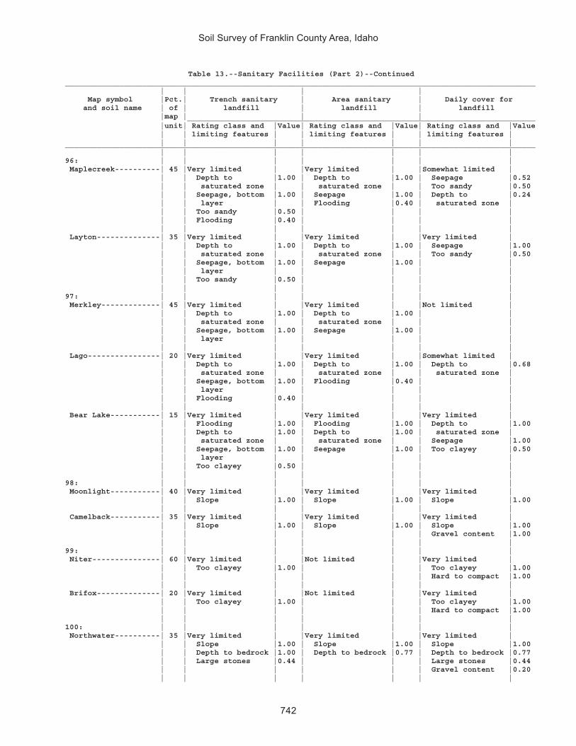
Soil Survey of Franklin County Area, Idaho
742
Table 13.--Sanitary Facilities (Part 2)--Continued________________________________________________________________________________________________________ | | | | Map symbol |Pct.| Trench sanitary | Area sanitary | Daily cover for and soil name | of | landfill | landfill | landfill |map | | | _____________________________________________________________________________ |unit| Rating class and |Value| Rating class and |Value| Rating class and |Value | | limiting features | | limiting features | | limiting features | | | | | | | |________________________________________________________________________________________________________ | | | | | | |96: | | | | | | | Maplecreek----------| 45 |Very limited | |Very limited | |Somewhat limited | | | Depth to |1.00 | Depth to |1.00 | Seepage |0.52 | | saturated zone | | saturated zone | | Too sandy |0.50 | | Seepage, bottom |1.00 | Seepage |1.00 | Depth to |0.24 | | layer | | Flooding |0.40 | saturated zone | | | Too sandy |0.50 | | | | | | Flooding |0.40 | | | | | | | | | | | Layton--------------| 35 |Very limited | |Very limited | |Very limited | | | Depth to |1.00 | Depth to |1.00 | Seepage |1.00 | | saturated zone | | saturated zone | | Too sandy |0.50 | | Seepage, bottom |1.00 | Seepage |1.00 | | | | layer | | | | | | | Too sandy |0.50 | | | | | | | | | | |97: | | | | | | | Merkley-------------| 45 |Very limited | |Very limited | |Not limited | | | Depth to |1.00 | Depth to |1.00 | | | | saturated zone | | saturated zone | | | | | Seepage, bottom |1.00 | Seepage |1.00 | | | | layer | | | | | | | | | | | | Lago----------------| 20 |Very limited | |Very limited | |Somewhat limited | | | Depth to |1.00 | Depth to |1.00 | Depth to |0.68 | | saturated zone | | saturated zone | | saturated zone | | | Seepage, bottom |1.00 | Flooding |0.40 | | | | layer | | | | | | | Flooding |0.40 | | | | | | | | | | | Bear Lake-----------| 15 |Very limited | |Very limited | |Very limited | | | Flooding |1.00 | Flooding |1.00 | Depth to |1.00 | | Depth to |1.00 | Depth to |1.00 | saturated zone | | | saturated zone | | saturated zone | | Seepage |1.00 | | Seepage, bottom |1.00 | Seepage |1.00 | Too clayey |0.50 | | layer | | | | | | | Too clayey |0.50 | | | | | | | | | | |98: | | | | | | | Moonlight-----------| 40 |Very limited | |Very limited | |Very limited | | | Slope |1.00 | Slope |1.00 | Slope |1.00 | | | | | | | Camelback-----------| 35 |Very limited | |Very limited | |Very limited | | | Slope |1.00 | Slope |1.00 | Slope |1.00 | | | | | | Gravel content |1.00 | | | | | | |99: | | | | | | | Niter---------------| 60 |Very limited | |Not limited | |Very limited | | | Too clayey |1.00 | | | Too clayey |1.00 | | | | | | Hard to compact |1.00 | | | | | | | Brifox--------------| 20 |Very limited | |Not limited | |Very limited | | | Too clayey |1.00 | | | Too clayey |1.00 | | | | | | Hard to compact |1.00 | | | | | | |100: | | | | | | | Northwater----------| 35 |Very limited | |Very limited | |Very limited | | | Slope |1.00 | Slope |1.00 | Slope |1.00 | | Depth to bedrock |1.00 | Depth to bedrock |0.77 | Depth to bedrock |0.77 | | Large stones |0.44 | | | Large stones |0.44 | | | | | | Gravel content |0.20 | | | | | | |

Soil Survey of Franklin County Area, Idaho
743
Table 13.--Sanitary Facilities (Part 2)--Continued________________________________________________________________________________________________________ | | | | Map symbol |Pct.| Trench sanitary | Area sanitary | Daily cover for and soil name | of | landfill | landfill | landfill |map | | | _____________________________________________________________________________ |unit| Rating class and |Value| Rating class and |Value| Rating class and |Value | | limiting features | | limiting features | | limiting features | | | | | | | |________________________________________________________________________________________________________ | | | | | | |100: | | | | | | | Foxol---------------| 25 |Very limited | |Very limited | |Very limited | | | Slope |1.00 | Slope |1.00 | Depth to bedrock |1.00 | | Depth to bedrock |1.00 | Depth to bedrock |1.00 | Slope |1.00 | | Large stones |1.00 | | | Large stones |1.00 | | | | | | | Vitale--------------| 20 |Very limited | |Very limited | |Very limited | | | Slope |1.00 | Slope |1.00 | Depth to bedrock |1.00 | | Depth to bedrock |1.00 | Depth to bedrock |1.00 | Slope |1.00 | | Large stones |1.00 | | | Large stones |1.00 | | Too clayey |0.50 | | | Too clayey |0.50 | | | | | | |101: | | | | | | | Northwater----------| 65 |Very limited | |Very limited | |Very limited | | | Slope |1.00 | Slope |1.00 | Slope |1.00 | | Large stones |0.09 | | | Large stones |0.09 | | | | | | Gravel content |0.02 | | | | | | | Povey---------------| 25 |Very limited | |Very limited | |Very limited | | | Slope |1.00 | Slope |1.00 | Slope |1.00 | | | | | | Gravel content |0.96 | | | | | | |102: | | | | | | | Northwater----------| 65 |Very limited | |Very limited | |Very limited | | | Slope |1.00 | Slope |1.00 | Slope |1.00 | | Large stones |0.09 | | | Large stones |0.09 | | | | | | Gravel content |0.02 | | | | | | | Povey---------------| 15 |Very limited | |Very limited | |Very limited | | | Slope |1.00 | Slope |1.00 | Slope |1.00 | | | | | | Gravel content |0.96 | | | | | | |103: | | | | | | | Nyman---------------| 50 |Very limited | |Very limited | |Very limited | | | Slope |1.00 | Slope |1.00 | Depth to bedrock |1.00 | | Depth to bedrock |1.00 | Depth to bedrock |1.00 | Slope |1.00 | | Large stones |0.13 | | | Large stones |0.13 | | | | | | | | | | | | | | Lonigan-------------| 20 |Very limited | |Very limited | |Very limited | | | Slope |1.00 | Slope |1.00 | Depth to bedrock |1.00 | | Depth to bedrock |1.00 | Seepage |1.00 | Slope |1.00 | | Seepage, bottom |1.00 | Depth to bedrock |1.00 | Gravel content |1.00 | | layer | | | | Seepage |0.52 | | | | | | | Copenhagen----------| 15 |Very limited | |Very limited | |Very limited | | | Slope |1.00 | Slope |1.00 | Depth to bedrock |1.00 | | Depth to bedrock |1.00 | Depth to bedrock |1.00 | Slope |1.00 | | | | | | Gravel content |0.91 | | | | | | |104: | | | | | | | Oxford--------------| 45 |Very limited | |Not limited | |Very limited | | | Too clayey |1.00 | | | Too clayey |1.00 | | | | | | Hard to compact |1.00 | | | | | | | Banida--------------| 35 |Very limited | |Not limited | |Very limited | | | Too clayey |1.00 | | | Too clayey |1.00 | | | | | | Hard to compact |1.00 | | | | | | |

Soil Survey of Franklin County Area, Idaho
744
Table 13.--Sanitary Facilities (Part 2)--Continued________________________________________________________________________________________________________ | | | | Map symbol |Pct.| Trench sanitary | Area sanitary | Daily cover for and soil name | of | landfill | landfill | landfill |map | | | _____________________________________________________________________________ |unit| Rating class and |Value| Rating class and |Value| Rating class and |Value | | limiting features | | limiting features | | limiting features | | | | | | | |________________________________________________________________________________________________________ | | | | | | |105: | | | | | | | Oxford--------------| 45 |Very limited | |Somewhat limited | |Very limited | | | Too clayey |1.00 | Slope |0.01 | Too clayey |1.00 | | Slope |0.01 | | | Hard to compact |1.00 | | | | | | Slope |0.01 | | | | | | | Banida--------------| 35 |Very limited | |Somewhat limited | |Very limited | | | Too clayey |1.00 | Slope |0.01 | Too clayey |1.00 | | Slope |0.01 | | | Hard to compact |1.00 | | | | | | Slope |0.01 | | | | | | |106: | | | | | | | Oxford--------------| 50 |Very limited | |Very limited | |Very limited | | | Too clayey |1.00 | Slope |1.00 | Too clayey |1.00 | | Slope |1.00 | | | Hard to compact |1.00 | | | | | | Slope |1.00 | | | | | | | Banida--------------| 35 |Very limited | |Very limited | |Very limited | | | Too clayey |1.00 | Slope |1.00 | Too clayey |1.00 | | Slope |1.00 | | | Hard to compact |1.00 | | | | | | Slope |1.00 | | | | | | |107: | | | | | | | Oxford--------------| 65 |Very limited | |Very limited | |Very limited | | | Slope |1.00 | Slope |1.00 | Slope |1.00 | | Too clayey |1.00 | | | Too clayey |1.00 | | | | | | Hard to compact |1.00 | | | | | | | Gullied land--------| 15 |Not rated | |Very limited | |Not rated | | | | | Slope |1.00 | | | | | | | | |108: | | | | | | | Parkay--------------| 45 |Very limited | |Very limited | |Very limited | | | Slope |1.00 | Slope |1.00 | Slope |1.00 | | Depth to bedrock |1.00 | Depth to bedrock |0.68 | Gravel content |0.75 | | Too clayey |0.50 | | | Depth to bedrock |0.68 | | | | | | Too clayey |0.50 | | | | | | | Povey---------------| 30 |Very limited | |Very limited | |Very limited | | | Slope |1.00 | Slope |1.00 | Slope |1.00 | | | | | | Gravel content |0.96 | | | | | | |109: | | | | | | | Parleys-------------| 85 |Somewhat limited | |Not limited | |Somewhat limited | | | Too clayey |0.50 | | | Too clayey |0.50 | | | | | | |110: | | | | | | | Parleys-------------| 85 |Somewhat limited | |Not limited | |Somewhat limited | | | Too clayey |0.50 | | | Too clayey |0.50 | | | | | | |111: | | | | | | | Parleys, wet--------| 90 |Very limited | |Very limited | |Somewhat limited | | | Depth to |1.00 | Depth to |1.00 | Too clayey |0.50 | | saturated zone | | saturated zone | | | | | Too clayey |0.50 | Flooding |0.40 | | | | Flooding |0.40 | | | | | | | | | | |112: | | | | | | | Pavohroo------------| 30 |Very limited | |Very limited | |Very limited | | | Slope |1.00 | Slope |1.00 | Slope |1.00 | | | | | | |

Soil Survey of Franklin County Area, Idaho
745
Table 13.--Sanitary Facilities (Part 2)--Continued________________________________________________________________________________________________________ | | | | Map symbol |Pct.| Trench sanitary | Area sanitary | Daily cover for and soil name | of | landfill | landfill | landfill |map | | | _____________________________________________________________________________ |unit| Rating class and |Value| Rating class and |Value| Rating class and |Value | | limiting features | | limiting features | | limiting features | | | | | | | |________________________________________________________________________________________________________ | | | | | | |112: | | | | | | | Sedgway-------------| 30 |Very limited | |Very limited | |Very limited | | | Slope |1.00 | Slope |1.00 | Slope |1.00 | | Large stones |0.63 | | | Large stones |0.63 | | Too clayey |0.50 | | | Too clayey |0.50 | | | | | | | Toponce-------------| 20 |Very limited | |Very limited | |Very limited | | | Slope |1.00 | Slope |1.00 | Slope |1.00 | | Too clayey |1.00 | | | Too clayey |1.00 | | | | | | Hard to compact |1.00 | | | | | | |113: | | | | | | | Picabo--------------| 45 |Very limited | |Very limited | |Very limited | | | Depth to |1.00 | Depth to |1.00 | Sodium content |1.00 | | saturated zone | | saturated zone | | Carbonate content|1.00 | | Excess sodium |1.00 | Flooding |0.40 | Depth to |0.09 | | Flooding |0.40 | | | saturated zone | | | | | | | | Thatcherflats-------| 30 |Very limited | |Very limited | |Very limited | | | Depth to |1.00 | Depth to |1.00 | Sodium content |1.00 | | saturated zone | | saturated zone | | Too clayey |0.50 | | Excess sodium |1.00 | Flooding |0.40 | | | | Too clayey |0.50 | | | | | | Flooding |0.40 | | | | | | | | | | |114: | | | | | | | Pits, gravel--------|100 |Not rated | |Not rated | |Not rated | | | | | | | |115: | | | | | | | Pollynot------------| 75 |Very limited | |Somewhat limited | |Somewhat limited | | | Seepage, bottom |1.00 | Slope |0.01 | Slope |0.01 | | layer | | | | | | | Slope |0.01 | | | | | | | | | | |116: | | | | | | | Pollynot------------| 75 |Very limited | |Not limited | |Not limited | | | Seepage, bottom |1.00 | | | | | | layer | | | | | | | | | | | |117: | | | | | | | Pollynot------------| 75 |Very limited | |Not limited | |Not limited | | | Seepage, bottom |1.00 | | | | | | layer | | | | | | | | | | | |118: | | | | | | | Pollynot------------| 75 |Very limited | |Somewhat limited | |Somewhat limited | | | Seepage, bottom |1.00 | Slope |0.63 | Slope |0.63 | | layer | | | | | | | Slope |0.63 | | | | | | | | | | |119: | | | | | | | Polumar-------------| 45 |Very limited | |Very limited | |Very limited | | | Slope |1.00 | Slope |1.00 | Slope |1.00 | | Depth to bedrock |1.00 | Depth to bedrock |0.77 | Large stones |0.96 | | Large stones |0.96 | | | Depth to bedrock |0.77 | | | | | | | Ireland-------------| 30 |Very limited | |Very limited | |Very limited | | | Slope |1.00 | Slope |1.00 | Depth to bedrock |1.00 | | Depth to bedrock |1.00 | Depth to bedrock |1.00 | Slope |1.00 | | Large stones |0.52 | | | Large stones |0.52 | | | | | | Gravel content |0.16 | | | | | | |
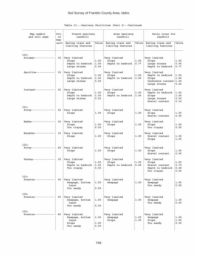
Soil Survey of Franklin County Area, Idaho
746
Table 13.--Sanitary Facilities (Part 2)--Continued________________________________________________________________________________________________________ | | | | Map symbol |Pct.| Trench sanitary | Area sanitary | Daily cover for and soil name | of | landfill | landfill | landfill |map | | | _____________________________________________________________________________ |unit| Rating class and |Value| Rating class and |Value| Rating class and |Value | | limiting features | | limiting features | | limiting features | | | | | | | |________________________________________________________________________________________________________ | | | | | | |120: | | | | | | | Polumar-------------| 30 |Very limited | |Very limited | |Very limited | | | Slope |1.00 | Slope |1.00 | Slope |1.00 | | Depth to bedrock |1.00 | Depth to bedrock |0.77 | Large stones |0.96 | | Large stones |0.96 | | | Depth to bedrock |0.77 | | | | | | | Sprollow------------| 30 |Very limited | |Very limited | |Very limited | | | Slope |1.00 | Slope |1.00 | Depth to bedrock |1.00 | | Depth to bedrock |1.00 | Depth to bedrock |1.00 | Slope |1.00 | | Large stones |0.26 | | | Carbonate content|1.00 | | | | | | Large stones |0.26 | | | | | | | Ireland-------------| 20 |Very limited | |Very limited | |Very limited | | | Slope |1.00 | Slope |1.00 | Depth to bedrock |1.00 | | Depth to bedrock |1.00 | Depth to bedrock |1.00 | Slope |1.00 | | Large stones |0.52 | | | Large stones |0.52 | | | | | | Gravel content |0.16 | | | | | | |121: | | | | | | | Povey---------------| 35 |Very limited | |Very limited | |Very limited | | | Slope |1.00 | Slope |1.00 | Slope |1.00 | | | | | | Gravel content |0.96 | | | | | | | Hades---------------| 30 |Very limited | |Very limited | |Very limited | | | Slope |1.00 | Slope |1.00 | Slope |1.00 | | Too clayey |0.50 | | | Too clayey |0.50 | | | | | | | Hondoho-------------| 15 |Very limited | |Very limited | |Very limited | | | Slope |1.00 | Slope |1.00 | Gravel content |1.00 | | | | | | Slope |1.00 | | | | | | |122: | | | | | | | Povey---------------| 45 |Very limited | |Very limited | |Very limited | | | Slope |1.00 | Slope |1.00 | Slope |1.00 | | | | | | Gravel content |0.96 | | | | | | | Parkay--------------| 30 |Very limited | |Very limited | |Very limited | | | Slope |1.00 | Slope |1.00 | Slope |1.00 | | Depth to bedrock |1.00 | Depth to bedrock |0.68 | Gravel content |0.75 | | Too clayey |0.50 | | | Depth to bedrock |0.68 | | | | | | Too clayey |0.50 | | | | | | |123: | | | | | | | Preston-------------| 90 |Very limited | |Very limited | |Very limited | | | Seepage, bottom |1.00 | Seepage |1.00 | Seepage |1.00 | | layer | | | | Too sandy |0.50 | | Too sandy |0.50 | | | | | | | | | | |124: | | | | | | | Preston-------------| 90 |Very limited | |Very limited | |Very limited | | | Seepage, bottom |1.00 | Seepage |1.00 | Seepage |1.00 | | layer | | | | Too sandy |0.50 | | Too sandy |0.50 | | | | | | | | | | |125: | | | | | | | Preston-------------| 85 |Very limited | |Very limited | |Very limited | | | Seepage, bottom |1.00 | Seepage |1.00 | Seepage |1.00 | | layer | | Slope |1.00 | Slope |1.00 | | Slope |1.00 | | | Too sandy |0.50 | | Too sandy |0.50 | | | | | | | | | | |

Soil Survey of Franklin County Area, Idaho
747
Table 13.--Sanitary Facilities (Part 2)--Continued________________________________________________________________________________________________________ | | | | Map symbol |Pct.| Trench sanitary | Area sanitary | Daily cover for and soil name | of | landfill | landfill | landfill |map | | | _____________________________________________________________________________ |unit| Rating class and |Value| Rating class and |Value| Rating class and |Value | | limiting features | | limiting features | | limiting features | | | | | | | |________________________________________________________________________________________________________ | | | | | | |126: | | | | | | | Preston-------------| 55 |Very limited | |Very limited | |Very limited | | | Slope |1.00 | Slope |1.00 | Slope |1.00 | | Seepage, bottom |1.00 | Seepage |1.00 | Seepage |1.00 | | layer | | | | Too sandy |0.50 | | Too sandy |0.50 | | | | | | | | | | | Xerorthents---------| 20 |Very limited | |Very limited | |Very limited | | | Slope |1.00 | Slope |1.00 | Depth to bedrock |1.00 | | Depth to bedrock |1.00 | Depth to bedrock |1.00 | Slope |1.00 | | Seepage, bottom |1.00 | | | Gravel content |0.91 | | layer | | | | Seepage |0.16 | | Large stones |0.04 | | | Large stones |0.04 | | | | | | |127: | | | | | | | Ricrest-------------| 90 |Somewhat limited | |Somewhat limited | |Somewhat limited | | | Slope |0.01 | Slope |0.01 | Gravel content |0.05 | | | | | | Slope |0.01 | | | | | | |128: | | | | | | | Sanyon--------------| 30 |Very limited | |Very limited | |Very limited | | | Slope |1.00 | Slope |1.00 | Depth to bedrock |1.00 | | Depth to bedrock |1.00 | Depth to bedrock |1.00 | Slope |1.00 | | | | | | Gravel content |1.00 | | | | | | | Staberg-------------| 30 |Very limited | |Very limited | |Very limited | | | Slope |1.00 | Slope |1.00 | Depth to bedrock |1.00 | | Depth to bedrock |1.00 | Seepage |1.00 | Slope |1.00 | | Seepage, bottom |1.00 | Depth to bedrock |1.00 | | | | layer | | | | | | | | | | | | Kabear--------------| 20 |Very limited | |Very limited | |Very limited | | | Slope |1.00 | Slope |1.00 | Slope |1.00 | | Seepage, bottom |1.00 | | | | | | layer | | | | | | | | | | | |129: | | | | | | | Smidale-------------| 85 |Very limited | |Very limited | |Very limited | | | Slope |1.00 | Slope |1.00 | Slope |1.00 | | Large stones |0.08 | | | Large stones |0.08 | | | | | | Gravel content |0.08 | | | | | | |130: | | | | | | | Smidale-------------| 45 |Very limited | |Very limited | |Very limited | | | Slope |1.00 | Slope |1.00 | Slope |1.00 | | Large stones |0.08 | | | Large stones |0.08 | | | | | | Gravel content |0.08 | | | | | | | Staberg-------------| 40 |Very limited | |Very limited | |Very limited | | | Slope |1.00 | Slope |1.00 | Depth to bedrock |1.00 | | Depth to bedrock |1.00 | Seepage |1.00 | Slope |1.00 | | Seepage, bottom |1.00 | Depth to bedrock |1.00 | | | | layer | | | | | | | | | | | |131: | | | | | | | Sprollow------------| 45 |Very limited | |Very limited | |Very limited | | | Slope |1.00 | Slope |1.00 | Depth to bedrock |1.00 | | Depth to bedrock |1.00 | Depth to bedrock |1.00 | Slope |1.00 | | Large stones |0.26 | | | Carbonate content|1.00 | | | | | | Large stones |0.26 | | | | | | |

Soil Survey of Franklin County Area, Idaho
748
Table 13.--Sanitary Facilities (Part 2)--Continued________________________________________________________________________________________________________ | | | | Map symbol |Pct.| Trench sanitary | Area sanitary | Daily cover for and soil name | of | landfill | landfill | landfill |map | | | _____________________________________________________________________________ |unit| Rating class and |Value| Rating class and |Value| Rating class and |Value | | limiting features | | limiting features | | limiting features | | | | | | | |________________________________________________________________________________________________________ | | | | | | |131: | | | | | | | Hondoho-------------| 35 |Very limited | |Very limited | |Very limited | | | Slope |1.00 | Slope |1.00 | Slope |1.00 | | | | | | Gravel content |1.00 | | | | | | |132: | | | | | | | Sprollow------------| 40 |Very limited | |Very limited | |Very limited | | | Slope |1.00 | Slope |1.00 | Depth to bedrock |1.00 | | Depth to bedrock |1.00 | Depth to bedrock |1.00 | Slope |1.00 | | Large stones |0.26 | | | Carbonate content|1.00 | | | | | | Large stones |0.26 | | | | | | | Hymas---------------| 35 |Very limited | |Very limited | |Very limited | | | Slope |1.00 | Slope |1.00 | Depth to bedrock |1.00 | | Depth to bedrock |1.00 | Depth to bedrock |1.00 | Slope |1.00 | | Large stones |0.01 | | | Gravel content |0.56 | | | | | | Large stones |0.01 | | | | | | |133: | | | | | | | Sterling------------| 85 |Not limited | |Not limited | |Very limited | | | | | | | Gravel content |1.00 | | | | | | |134: | | | | | | | Sterling------------| 85 |Not limited | |Not limited | |Very limited | | | | | | | Gravel content |1.00 | | | | | | |135: | | | | | | | Sterling------------| 90 |Very limited | |Very limited | |Very limited | | | Slope |1.00 | Slope |1.00 | Gravel content |1.00 | | | | | | Slope |1.00 | | | | | | |136: | | | | | | | Sterling------------| 85 |Very limited | |Very limited | |Very limited | | | Slope |1.00 | Slope |1.00 | Slope |1.00 | | | | | | Gravel content |1.00 | | | | | | |137: | | | | | | | Sterling------------| 50 |Not limited | |Not limited | |Very limited | | | | | | | Gravel content |1.00 | | | | | | | Parleys-------------| 30 |Somewhat limited | |Not limited | |Somewhat limited | | | Too clayey |0.50 | | | Too clayey |0.50 | | | | | | |138: | | | | | | | Thatcher------------| 45 |Somewhat limited | |Somewhat limited | |Somewhat limited | | | Slope |0.84 | Slope |0.84 | Slope |0.84 | | | | | | | Bearhollow----------| 35 |Somewhat limited | |Somewhat limited | |Somewhat limited | | | Slope |0.84 | Slope |0.84 | Gravel content |0.84 | | | | | | Slope |0.84 | | | | | | |139: | | | | | | | Toponce-------------| 50 |Very limited | |Very limited | |Very limited | | | Too clayey |1.00 | Slope |1.00 | Too clayey |1.00 | | Slope |1.00 | | | Hard to compact |1.00 | | | | | | Slope |1.00 | | | | | | | Broadhead-----------| 30 |Very limited | |Very limited | |Very limited | | | Slope |1.00 | Slope |1.00 | Hard to compact |1.00 | | Too clayey |0.50 | | | Slope |1.00 | | | | | | Too clayey |0.50 | | | | | | |

Soil Survey of Franklin County Area, Idaho
749
Table 13.--Sanitary Facilities (Part 2)--Continued________________________________________________________________________________________________________ | | | | Map symbol |Pct.| Trench sanitary | Area sanitary | Daily cover for and soil name | of | landfill | landfill | landfill |map | | | _____________________________________________________________________________ |unit| Rating class and |Value| Rating class and |Value| Rating class and |Value | | limiting features | | limiting features | | limiting features | | | | | | | |________________________________________________________________________________________________________ | | | | | | |140: | | | | | | | Trenton-------------| 50 |Very limited | |Very limited | |Very limited | | | Depth to |1.00 | Depth to |1.00 | Sodium content |1.00 | | saturated zone | | saturated zone | | Too clayey |0.50 | | Excess sodium |1.00 | | | Depth to |0.09 | | Too clayey |0.50 | | | saturated zone | | | | | | | | Battle Creek--------| 40 |Very limited | |Very limited | |Very limited | | | Depth to |1.00 | Depth to |1.00 | Too clayey |1.00 | | saturated zone | | saturated zone | | Hard to compact |1.00 | | Too clayey |1.00 | | | | | | | | | | |141: | | | | | | | Trenton, cool-------| 50 |Very limited | |Very limited | |Very limited | | | Depth to |1.00 | Depth to |1.00 | Sodium content |1.00 | | saturated zone | | saturated zone | | Too clayey |0.50 | | Excess sodium |1.00 | | | Depth to |0.09 | | Too clayey |0.50 | | | saturated zone | | | | | | | | Battle Creek, cool--| 40 |Very limited | |Very limited | |Very limited | | | Depth to |1.00 | Depth to |1.00 | Too clayey |1.00 | | saturated zone | | saturated zone | | Hard to compact |1.00 | | Too clayey |1.00 | | | | | | | | | | |142: | | | | | | | Trenton-------------| 45 |Very limited | |Very limited | |Very limited | | | Depth to |1.00 | Depth to |1.00 | Sodium content |1.00 | | saturated zone | | saturated zone | | Too clayey |0.50 | | Excess sodium |1.00 | | | Depth to |0.09 | | Too clayey |0.50 | | | saturated zone | | | | | | | | Parleys-------------| 35 |Very limited | |Very limited | |Somewhat limited | | | Depth to |1.00 | Depth to |1.00 | Too clayey |0.50 | | saturated zone | | saturated zone | | | | | Too clayey |0.50 | Flooding |0.40 | | | | Flooding |0.40 | | | | | | | | | | |143: | | | | | | | Valmar--------------| 40 |Very limited | |Very limited | |Very limited | | | Slope |1.00 | Slope |1.00 | Depth to bedrock |1.00 | | Depth to bedrock |1.00 | Depth to bedrock |1.00 | Slope |1.00 | | Large stones |1.00 | | | Large stones |1.00 | | | | | | | Camelback-----------| 25 |Very limited | |Very limited | |Very limited | | | Slope |1.00 | Slope |1.00 | Slope |1.00 | | | | | | Gravel content |1.00 | | | | | | | Hades---------------| 20 |Very limited | |Very limited | |Very limited | | | Slope |1.00 | Slope |1.00 | Slope |1.00 | | Too clayey |0.50 | | | Too clayey |0.50 | | | | | | |144: | | | | | | | Vitale--------------| 40 |Very limited | |Very limited | |Very limited | | | Slope |1.00 | Slope |1.00 | Depth to bedrock |1.00 | | Depth to bedrock |1.00 | Depth to bedrock |1.00 | Slope |1.00 | | Large stones |1.00 | | | Large stones |1.00 | | Too clayey |0.50 | | | Too clayey |0.50 | | | | | | |

Soil Survey of Franklin County Area, Idaho
750
Table 13.--Sanitary Facilities (Part 2)--Continued________________________________________________________________________________________________________ | | | | Map symbol |Pct.| Trench sanitary | Area sanitary | Daily cover for and soil name | of | landfill | landfill | landfill |map | | | _____________________________________________________________________________ |unit| Rating class and |Value| Rating class and |Value| Rating class and |Value | | limiting features | | limiting features | | limiting features | | | | | | | |________________________________________________________________________________________________________ | | | | | | |144: | | | | | | | Bergquist-----------| 25 |Very limited | |Very limited | |Very limited | | | Slope |1.00 | Slope |1.00 | Slope |1.00 | | Depth to bedrock |1.00 | Seepage |1.00 | Gravel content |1.00 | | Seepage, bottom |1.00 | Depth to bedrock |0.14 | Seepage |1.00 | | layer | | | | Depth to bedrock |0.14 | | | | | | | Rock outcrop--------| 15 |Not rated | |Very limited | |Not rated | | | | | Slope |1.00 | | | | | | Depth to bedrock |1.00 | | | | | | | | |145: | | | | | | | Vitale--------------| 35 |Very limited | |Very limited | |Very limited | | | Depth to bedrock |1.00 | Depth to bedrock |1.00 | Depth to bedrock |1.00 | | Slope |1.00 | Slope |1.00 | Slope |1.00 | | Large stones |1.00 | | | Large stones |1.00 | | Too clayey |0.50 | | | Too clayey |0.50 | | | | | | | Yeates Hollow-------| 25 |Very limited | |Very limited | |Very limited | | | Slope |1.00 | Slope |1.00 | Slope |1.00 | | Too clayey |0.50 | | | Too clayey |0.50 | | Large stones |0.04 | | | Gravel content |0.13 | | | | | | Large stones |0.04 | | | | | | | Northwater----------| 15 |Very limited | |Very limited | |Very limited | | | Slope |1.00 | Slope |1.00 | Slope |1.00 | | Depth to bedrock |1.00 | Depth to bedrock |0.77 | Depth to bedrock |0.77 | | Large stones |0.44 | | | Large stones |0.44 | | | | | | Gravel content |0.20 | | | | | | |146: | | | | | | | Welby---------------| 90 |Very limited | |Not limited | |Not limited | | | Seepage, bottom |1.00 | | | | | | layer | | | | | | | | | | | |147: | | | | | | | Welby---------------| 90 |Very limited | |Not limited | |Not limited | | | Seepage, bottom |1.00 | | | | | | layer | | | | | | | | | | | |148: | | | | | | | Welby, wet----------| 85 |Very limited | |Very limited | |Not limited | | | Depth to |1.00 | Depth to |1.00 | | | | saturated zone | | saturated zone | | | | | Seepage, bottom |1.00 | | | | | | layer | | | | | | | | | | | |149: | | | | | | | Collinston----------| 40 |Somewhat limited | |Somewhat limited | |Somewhat limited | | | Slope |0.01 | Slope |0.01 | Slope |0.01 | | | | | | | Wheelon-------------| 40 |Somewhat limited | |Somewhat limited | |Somewhat limited | | | Slope |0.01 | Slope |0.01 | Slope |0.01 | | | | | | |150: | | | | | | | Wheelon-------------| 40 |Very limited | |Very limited | |Very limited | | | Slope |1.00 | Slope |1.00 | Slope |1.00 | | | | | | | Collinston----------| 35 |Very limited | |Very limited | |Very limited | | | Slope |1.00 | Slope |1.00 | Slope |1.00 | | | | | | |

Soil Survey of Franklin County Area, Idaho
751
Table 13.--Sanitary Facilities (Part 2)--Continued________________________________________________________________________________________________________ | | | | Map symbol |Pct.| Trench sanitary | Area sanitary | Daily cover for and soil name | of | landfill | landfill | landfill |map | | | _____________________________________________________________________________ |unit| Rating class and |Value| Rating class and |Value| Rating class and |Value | | limiting features | | limiting features | | limiting features | | | | | | | |________________________________________________________________________________________________________ | | | | | | |151: | | | | | | | Wheelon-------------| 45 |Very limited | |Very limited | |Very limited | | | Slope |1.00 | Slope |1.00 | Slope |1.00 | | | | | | | Collinston----------| 30 |Very limited | |Very limited | |Very limited | | | Slope |1.00 | Slope |1.00 | Slope |1.00 | | | | | | |152: | | | | | | | Windernot-----------| 40 |Very limited | |Very limited | |Very limited | | | Depth to |1.00 | Depth to |1.00 | Too sandy |1.00 | | saturated zone | | saturated zone | | Seepage |1.00 | | Seepage, bottom |1.00 | Seepage |1.00 | Gravel content |1.00 | | layer | | Flooding |0.40 | | | | Too sandy |1.00 | | | | | | Flooding |0.40 | | | | | | | | | | | Lewnot--------------| 20 |Very limited | |Very limited | |Somewhat limited | | | Depth to |1.00 | Depth to |1.00 | Depth to |0.24 | | saturated zone | | saturated zone | | saturated zone | | | Seepage, bottom |1.00 | Seepage |1.00 | Seepage |0.22 | | layer | | Flooding |0.40 | | | | Flooding |0.40 | | | | | | | | | | | Stinkcreek----------| 15 |Very limited | |Very limited | |Very limited | | | Depth to |1.00 | Depth to |1.00 | Depth to |1.00 | | saturated zone | | saturated zone | | saturated zone | | | Seepage, bottom |1.00 | Seepage |1.00 | Too sandy |1.00 | | layer | | Flooding |0.40 | Seepage |1.00 | | Too sandy |1.00 | | | Sodium content |1.00 | | Excess sodium |1.00 | | | Gravel content |0.99 | | Flooding |0.40 | | | | | | | | | | |153: | | | | | | | Winn----------------| 90 |Very limited | |Very limited | |Somewhat limited | | | Depth to |1.00 | Depth to |1.00 | Depth to |0.09 | | saturated zone | | saturated zone | | saturated zone | | | Flooding |0.40 | Flooding |0.40 | | | | | | | | |154: | | | | | | | Winwell-------------| 80 |Somewhat limited | |Not limited | |Somewhat limited | | | Too clayey |0.50 | | | Too clayey |0.50 | | | | | | |155: | | | | | | | Winwell-------------| 45 |Somewhat limited | |Not limited | |Somewhat limited | | | Too clayey |0.50 | | | Too clayey |0.50 | | | | | | | Collinston----------| 35 |Not limited | |Not limited | |Not limited | | | | | | | |156: | | | | | | | Wormcreek-----------| 50 |Very limited | |Very limited | |Very limited | | | Slope |1.00 | Slope |1.00 | Slope |1.00 | | Depth to bedrock |1.00 | Depth to bedrock |0.61 | Depth to bedrock |0.61 | | Large stones |0.29 | | | Gravel content |0.54 | | | | | | Large stones |029 | | | | | | | Copenhagen----------| 30 |Very limited | |Very limited | |Very limited | | | Slope |1.00 | Slope |1.00 | Depth to bedrock |1.00 | | Depth to bedrock |1.00 | Depth to bedrock |1.00 | Slope |1.00 | | | | | | Gravel content |0.91 | | | | | | |

Soil Survey of Franklin County Area, Idaho
752
Table 13.--Sanitary Facilities (Part 2)--Continued________________________________________________________________________________________________________ | | | | Map symbol |Pct.| Trench sanitary | Area sanitary | Daily cover for and soil name | of | landfill | landfill | landfill |map | | | _____________________________________________________________________________ |unit| Rating class and |Value| Rating class and |Value| Rating class and |Value | | limiting features | | limiting features | | limiting features | | | | | | | |________________________________________________________________________________________________________ | | | | | | |157: | | | | | | | Wormcreek-----------| 45 |Very limited | |Very limited | |Very limited | | | Slope |1.00 | Slope |1.00 | Slope |1.00 | | Depth to bedrock |1.00 | Depth to bedrock |0.61 | Depth to bedrock |0.61 | | Large stones |0.29 | | | Gravel content |0.54 | | | | | | Large stones |0.29 | | | | | | | Lonigan-------------| 35 |Very limited | |Very limited | |Very limited | | | Slope |1.00 | Slope |1.00 | Depth to bedrock |1.00 | | Depth to bedrock |1.00 | Seepage |1.00 | Slope |1.00 | | Seepage, bottom |1.00 | Depth to bedrock |1.00 | Gravel content |1.00 | | layer | | | | Seepage |0.52 | | | | | | |158: | | | | | | | Wursten-------------| 45 |Very limited | |Very limited | |Very limited | | | Slope |1.00 | Slope |1.00 | Slope |1.00 | | Seepage, bottom |1.00 | Seepage |1.00 | Seepage |0.22 | | layer | | | | | | | | | | | | Dirtyhead-----------| 35 |Very limited | |Very limited | |Very limited | | | Depth to bedrock |1.00 | Depth to bedrock |1.00 | Depth to bedrock |1.00 | | Slope |1.00 | Slope |1.00 | Gravel content |1.00 | | | | | | Slope |1.00 | | | | | | |159: | | | | | | | Xerochrepts---------| 30 |Very limited | |Very limited | |Very limited | | | Slope |1.00 | Slope |1.00 | Slope |1.00 | | | | | | | Wormcreek-----------| 25 |Very limited | |Very limited | |Very limited | | | Slope |1.00 | Slope |1.00 | Slope |1.00 | | Depth to bedrock |1.00 | Depth to bedrock |0.61 | Depth to bedrock |0.61 | | Large stones |0.29 | | | Gravel content |0.54 | | | | | | Large stones |0.29 | | | | | | | Xerorthents---------| 20 |Very limited | |Very limited | |Very limited | | | Slope |1.00 | Slope |1.00 | Depth to bedrock |1.00 | | Depth to bedrock |1.00 | Depth to bedrock |1.00 | Slope |1.00 | | Seepage, bottom |1.00 | | | Gravel content |0.91 | | layer | | | | Seepage |0.16 | | Large stones |0.04 | | | Large stones |0.04 | | | | | | |160: | | | | | | | Xerorthents---------| 75 |Very limited | |Very limited | |Very limited | | | Slope |1.00 | Slope |1.00 | Depth to bedrock |1.00 | | Depth to bedrock |1.00 | Depth to bedrock |1.00 | Slope |1.00 | | Seepage, bottom |1.00 | | | Gravel content |0.91 | | layer | | | | Seepage |0.16 | | Large stones |0.04 | | | Large stones |0.04 | | | | | | |161: | | | | | | | Yeates Hollow-------| 85 |Very limited | |Very limited | |Very limited | | | Slope |1.00 | Slope |1.00 | Slope |1.00 | | Too clayey |0.50 | | | Too clayey |0.50 | | Large stones |0.04 | | | Gravel content |0.13 | | | | | | Large stones |0.04 | | | | | | |

Soil Survey of Franklin County Area, Idaho
753
Table 13.--Sanitary Facilities (Part 2)--Continued________________________________________________________________________________________________________ | | | | Map symbol |Pct.| Trench sanitary | Area sanitary | Daily cover for and soil name | of | landfill | landfill | landfill |map | | | _____________________________________________________________________________ |unit| Rating class and |Value| Rating class and |Value| Rating class and |Value | | limiting features | | limiting features | | limiting features | | | | | | | |________________________________________________________________________________________________________ | | | | | | |162: | | | | | | | Yeates Hollow-------| 40 |Very limited | |Very limited | |Very limited | | | Slope |1.00 | Slope |1.00 | Slope |1.00 | | Too clayey |0.50 | | | Too clayey |0.50 | | Large stones |0.04 | | | Gravel content |0.13 | | | | | | Large stones |0.04 | | | | | | | Manila--------------| 25 |Very limited | |Very limited | |Very limited | | | Slope |1.00 | Slope |1.00 | Hard to compact |1.00 | | Too clayey |0.50 | | | Slope |1.00 | | | | | | Too clayey |0.50 | | | | | | | Softback------------| 15 |Very limited | |Very limited | |Very limited | | | Slope |1.00 | Slope |1.00 | Slope |1.00 | | Too clayey |0.50 | | | Too clayey |0.50 | | Large stones |0.26 | | | Large stones |0.26 | | | | | | Gravel content |0.25 | | | | | | |163: | | | | | | | Yeates Hollow-------| 45 |Very limited | |Very limited | |Very limited | | | Slope |1.00 | Slope |1.00 | Slope |1.00 | | Too clayey |0.50 | | | Too clayey |0.50 | | Large stones |0.04 | | | Gravel content |0.13 | | | | | | Large stones |0.04 | | | | | | | Vitale--------------| 35 |Very limited | |Very limited | |Very limited | | | Slope |1.00 | Slope |1.00 | Depth to bedrock |1.00 | | Depth to bedrock |1.00 | Depth to bedrock |1.00 | Slope |1.00 | | Large stones |1.00 | | | Large stones |1.00 | | Too clayey |0.50 | | | Too clayey |0.50 | | | | | | |164: | | | | | | | Water---------------|100 |Not rated | |Not rated | |Not rated | | | | | | | |________________________________________________________________________________________________________

Soil Survey of Franklin County Area, Idaho
754
Table 14.--Agricultural Waste Management (Part 1)
(The information in this table indicates the dominant soil condition but does not eliminate the need for onsite investigation. The numbers in the value columns range from 0.01 to 1.00. The larger the value, the greater the limitation. See text for further explanation of ratings in this table.)
______________________________________________________________________________ | | | Map symbol |Pct.| Application of | Application and soil name | of | manure and food- | of sewage sludge |map | processing waste | |unit| | ___________________________________________________ | | Rating class and |Value| Rating class and |Value | | limiting features | | limiting features | | | | | |______________________________________________________________________________ | | | | |1: | | | | | Airport-------------| 80 |Very limited | |Very limited | | | Sodium content |1.00 | Sodium content |1.00 | | Slow water |1.00 | Slow water |1.00 | | movement | | movement | | | Salinity |1.00 | Salinity |1.00 | | Depth to |0.86 | Depth to |0.86 | | saturated zone | | saturated zone | | | Runoff |0.40 | Flooding |0.40 | | | | |2: | | | | | Ant Flat------------| 85 |Very limited | |Very limited | | | Slow water |1.00 | Slow water |1.00 | | movement | | movement | | | Runoff |0.40 | | | | | | |3: | | | | | Ant Flat------------| 85 |Very limited | |Very limited | | | Slow water |1.00 | Slow water |1.00 | | movement | | movement | | | Runoff |0.40 | | | | | | |4: | | | | | Ant Flat------------| 90 |Very limited | |Very limited | | | Slow water |1.00 | Slow water |1.00 | | movement | | movement | | | Runoff |0.40 | Slope |0.01 | | Slope |0.01 | | | | | | |5: | | | | | Ant Flat------------| 65 |Very limited | |Very limited | | | Slow water |1.00 | Slow water |1.00 | | movement | | movement | | | Runoff |0.40 | | | | | | | Oxford--------------| 25 |Very limited | |Very limited | | | Slow water |1.00 | Slow water |1.00 | | movement | | movement | | | Runoff |0.40 | Slope |0.04 | | Slope |0.04 | | | | | | |6: | | | | | Ant Flat------------| 50 |Very limited | |Very limited | | | Slow water |1.00 | Slow water |1.00 | | movement | | movement | | | Slope |1.00 | Slope |1.00 | | Runoff |0.40 | | | | | | | Oxford--------------| 35 |Very limited | |Very limited | | | Slow water |1.00 | Slow water |1.00 | | movement | | movement | | | Slope |1.00 | Slope |1.00 | | Runoff |0.40 | | | | | | |

Soil Survey of Franklin County Area, Idaho
755
Table 14.--Agricultural Waste Management (Part 1)--Continued______________________________________________________________________________ | | | Map symbol |Pct.| Application of | Application and soil name | of | manure and food- | of sewage sludge |map | processing waste | |unit| | ___________________________________________________ | | Rating class and |Value| Rating class and |Value | | limiting features | | limiting features | | | | | |______________________________________________________________________________ | | | | |7: | | | | | Arbone--------------| 80 |Somewhat limited | |Somewhat limited | | | Filtering |0.01 | Filtering |0.01 | | capacity | | capacity | | | | | |8: | | | | | Banida--------------| 85 |Very limited | |Very limited | | | Slow water |1.00 | Slow water |1.00 | | movement | | movement | | | Runoff |0.40 | | | | | | |9: | | | | | Banida--------------| 80 |Very limited | |Very limited | | | Slow water |1.00 | Slow water |1.00 | | movement | | movement | | | Runoff |0.40 | | | | | | |10: | | | | | Battle Creek--------| 85 |Very limited | |Very limited | | | Slow water |1.00 | Slow water |1.00 | | movement | | movement | | | Runoff |0.40 | | | | | | |11: | | | | | Battle Creek--------| 85 |Very limited | |Very limited | | | Slow water |1.00 | Slow water |1.00 | | movement | | movement | | | Runoff |0.40 | | | | | | |12: | | | | | Battle Creek--------| 95 |Very limited | |Very limited | | | Slow water |1.00 | Slow water |1.00 | | movement | | movement | | | Runoff |0.40 | | | | | | |13: | | | | | Bear Lake-----------| 40 |Very limited | |Very limited | | | Depth to |1.00 | Depth to |1.00 | | saturated zone | | saturated zone | | | Ponding |1.00 | Flooding |1.00 | | Flooding |0.60 | Ponding |1.00 | | Slow water |0.41 | Slow water |0.31 | | movement | | movement | | | Runoff |0.40 | Filtering |0.01 | | | | capacity | | | | | | Chesbrook-----------| 30 |Very limited | |Very limited | | | Depth to |1.00 | Depth to |1.00 | | saturated zone | | saturated zone | | | Filtering |0.99 | Filtering |0.99 | | capacity | | capacity | | | Too acid |0.50 | Too acid |0.99 | | Slow water |0.41 | Flooding |0.40 | | movement | | Slow water |0.31 | | Runoff |0.40 | movement | | | | | |

Soil Survey of Franklin County Area, Idaho
756
Table 14.--Agricultural Waste Management (Part 1)--Continued______________________________________________________________________________ | | | Map symbol |Pct.| Application of | Application and soil name | of | manure and food- | of sewage sludge |map | processing waste | |unit| | ___________________________________________________ | | Rating class and |Value| Rating class and |Value | | limiting features | | limiting features | | | | | |______________________________________________________________________________ | | | | |13: | | | | | Picabo--------------| 15 |Very limited | |Very limited | | | Sodium content |1.00 | Sodium content |1.00 | | Depth to |0.43 | Depth to |0.43 | | saturated zone | | saturated zone | | | | | Flooding |0.40 | | | | |14: | | | | | Bear Lake-----------| 50 |Very limited | |Very limited | | | Depth to |1.00 | Depth to |1.00 | | saturated zone | | saturated zone | | | Flooding |1.00 | Flooding |1.00 | | Slow water |0.41 | Slow water |0.31 | | movement | | movement | | | Runoff |0.40 | Filtering |0.01 | | Filtering |0.01 | capacity | | | capacity | | | | | | | | Downata-------------| 35 |Very limited | |Very limited | | | Depth to |1.00 | Depth to |1.00 | | saturated zone | | saturated zone | | | Flooding |1.00 | Flooding |1.00 | | Ponding |1.00 | Ponding |1.00 | | Filtering |0.99 | Filtering |0.99 | | capacity | | capacity | | | Too acid |0.50 | Too acid |0.99 | | | | |15: | | | | | Bear Lake-----------| 50 |Very limited | |Very limited | | | Depth to |1.00 | Depth to |1.00 | | saturated zone | | saturated zone | | | Flooding |1.00 | Flooding |1.00 | | Slow water |0.41 | Slow water |0.31 | | movement | | movement | | | Runoff |0.40 | Filtering |0.01 | | Filtering |0.01 | capacity | | | capacity | | | | | | | | Downata-------------| 25 |Very limited | |Very limited | | | Depth to |1.00 | Depth to |1.00 | | saturated zone | | saturated zone | | | Flooding |1.00 | Flooding |1.00 | | Ponding |1.00 | Ponding |1.00 | | Filtering |0.99 | Filtering |0.99 | | capacity | | capacity | | | Too acid |0.50 | Too acid |0.99 | | | | | Thatcherflats-------| 20 |Very limited | |Very limited | | | Slow water |1.00 | Slow water |1.00 | | movement | | movement | | | Sodium content |1.00 | Sodium content |1.00 | | Runoff |0.40 | Flooding |0.40 | | Depth to |0.09 | Depth to |0.09 | | saturated zone | | saturated zone | | | Salinity |0.06 | | | | | | |

Soil Survey of Franklin County Area, Idaho
757
Table 14.--Agricultural Waste Management (Part 1)--Continued______________________________________________________________________________ | | | Map symbol |Pct.| Application of | Application and soil name | of | manure and food- | of sewage sludge |map | processing waste | |unit| | ___________________________________________________ | | Rating class and |Value| Rating class and |Value | | limiting features | | limiting features | | | | | |______________________________________________________________________________ | | | | |16: | | | | | Bear Lake-----------| 65 |Very limited | |Very limited | | | Depth to |1.00 | Depth to |1.00 | | saturated zone | | saturated zone | | | Flooding |0.60 | Flooding |1.00 | | Slow water |0.41 | Slow water |0.31 | | movement | | movement | | | Runoff |0.40 | Filtering |0.01 | | Filtering |0.01 | capacity | | | capacity | | | | | | | | Lago----------------| 30 |Somewhat limited | |Somewhat limited | | | Depth to |0.95 | Depth to |0.95 | | saturated zone | | saturated zone | | | Slow water |0.41 | Flooding |0.40 | | movement | | Slow water |0.31 | | | | movement | | | | | |17: | | | | | Bearhollow----------| 30 |Very limited | |Very limited | | | Slope |1.00 | Slope |1.00 | | Sodium content |0.32 | Sodium content |0.32 | | | | | Brifox--------------| 25 |Very limited | |Very limited | | | Slope |1.00 | Slow water |1.00 | | Slow water |1.00 | movement | | | movement | | Slope |1.00 | | | | | Iphil---------------| 20 |Very limited | |Very limited | | | Slope |1.00 | Slope |1.00 | | Sodium content |0.82 | Sodium content |0.82 | | | | |18: | | | | | Bergquist-----------| 60 |Very limited | |Very limited | | | Slope |1.00 | Low adsorption |1.00 | | Droughty |0.94 | Slope |1.00 | | Filtering |0.01 | Droughty |0.94 | | capacity | | Filtering |0.01 | | | | capacity | | | | | | Rubble land---------| 15 |Not rated | |Not rated | | | | | |19: | | | | | Bergquist-----------| 45 |Very limited | |Very limited | | | Slope |1.00 | Low adsorption |1.00 | | Droughty |0.94 | Slope |1.00 | | Filtering |0.01 | Droughty |0.94 | | capacity | | Filtering |0.01 | | | | capacity | | | | | | Softback------------| 30 |Very limited | |Very limited | | | Slope |1.00 | Slope |1.00 | | Filtering |0.99 | Filtering |0.99 | | capacity | | capacity | | | Too acid |0.50 | Too acid |0.99 | | Slow water |0.41 | Slow water |0.31 | | movement | | movement | | | | | |

Soil Survey of Franklin County Area, Idaho
758
Table 14.--Agricultural Waste Management (Part 1)--Continued______________________________________________________________________________ | | | Map symbol |Pct.| Application of | Application and soil name | of | manure and food- | of sewage sludge |map | processing waste | |unit| | ___________________________________________________ | | Rating class and |Value| Rating class and |Value | | limiting features | | limiting features | | | | | |______________________________________________________________________________ | | | | |20: | | | | | Bergquist-----------| 55 |Very limited | |Very limited | | | Slope |1.00 | Low adsorption |1.00 | | Droughty |0.94 | Slope |1.00 | | Filtering |0.01 | Droughty |0.94 | | capacity | | Filtering |0.01 | | | | capacity | | | | | | Vitale--------------| 25 |Very limited | |Very limited | | | Slope |1.00 | Droughty |1.00 | | Large stones on |1.00 | Low adsorption |1.00 | | the surface | | Large stones on | | | Droughty |1.00 | the surface |1.00 | | Depth to bedrock |0.65 | Slope |1.00 | | Slow water |0.41 | Depth to bedrock |0.65 | | movement | | | | | | | |21: | | | | | Bothwell------------| 80 |Somewhat limited | |Somewhat limited | | | Slow water |0.41 | Slow water |0.31 | | movement | | movement | | | Slope |0.01 | Slope |0.01 | | | | |22: | | | | | Bothwell------------| 80 |Very limited | |Very limited | | | Slope |1.00 | Slope |1.00 | | Slow water |0.41 | Slow water |0.31 | | movement | | movement | | | | | |23: | | | | | Bothwell------------| 35 |Very limited | |Very limited | | | Slope |1.00 | Slope |1.00 | | Slow water |0.41 | Slow water |0.31 | | movement | | movement | | | | | | Hades---------------| 30 |Very limited | |Very limited | | | Slope |1.00 | Slope |1.00 | | Slow water |0.41 | Slow water |0.31 | | movement | | movement | | | | | | Justesen------------| 20 |Very limited | |Very limited | | | Slope |1.00 | Slope |1.00 | | Slow water |0.41 | Slow water |0.31 | | movement | | movement | | | | | |24: | | | | | Bothwell------------| 40 |Somewhat limited | |Somewhat limited | | | Slow water |0.41 | Slow water |0.31 | | movement | | movement | | | | | | Thatcher------------| 35 |Somewhat limited | |Somewhat limited | | | Slow water |0.41 | Slow water |0.31 | | movement | | movement | | | | | |25: | | | | | Brifox--------------| 40 |Very limited | |Very limited | | | Slow water |1.00 | Slow water |1.00 | | movement | | movement | | | Slope |0.01 | Slope |0.01 | | | | |

Soil Survey of Franklin County Area, Idaho
759
Table 14.--Agricultural Waste Management (Part 1)--Continued______________________________________________________________________________ | | | Map symbol |Pct.| Application of | Application and soil name | of | manure and food- | of sewage sludge |map | processing waste | |unit| | ___________________________________________________ | | Rating class and |Value| Rating class and |Value | | limiting features | | limiting features | | | | | |______________________________________________________________________________ | | | | |25: | | | | | Huffman-------------| 35 |Somewhat limited | |Somewhat limited | | | Slow water |0.41 | Slow water |0.31 | | movement | | movement | | | Slope |0.01 | Slope |0.01 | | | | |26: | | | | | Brifox--------------| 40 |Very limited | |Very limited | | | Slow water |1.00 | Slow water |1.00 | | movement | | movement | | | Slope |1.00 | Slope |1.00 | | | | | Huffman-------------| 35 |Very limited | |Very limited | | | Slope |1.00 | Slope |1.00 | | Slow water |0.41 | Slow water |0.31 | | movement | | movement | | | | | |27: | | | | | Brifox--------------| 55 |Very limited | |Very limited | | | Slow water |1.00 | Slow water |1.00 | | movement | | movement | | | Slope |0.01 | Slope |0.01 | | | | | Niter---------------| 25 |Very limited | |Very limited | | | Slow water |1.00 | Slow water |1.00 | | movement | | movement | | | Slope |0.01 | Slope |0.01 | | | | |28: | | | | | Brifox--------------| 65 |Very limited | |Very limited | | | Slow water |1.00 | Slow water |1.00 | | movement | | movement | | | Slope |1.00 | Slope |1.00 | | | | | Niter---------------| 20 |Very limited | |Very limited | | | Slow water |1.00 | Slow water |1.00 | | movement | | movement | | | Slope |1.00 | Slope |1.00 | | | | |29: | | | | | Brifox--------------| 55 |Very limited | |Very limited | | | Slope |1.00 | Slow water |1.00 | | Slow water |1.00 | movement | | | movement |1.00 | Slope |1.00 | | | | | Niter---------------| 25 |Very limited | |Very limited | | | Slope |1.00 | Slow water |1.00 | | Slow water | | movement | | | movement |1.00 | Slope |1.00 | | | | |30: | | | | | Broadhead-----------| 30 |Very limited | |Very limited | | | Slow water |1.00 | Slow water |1.00 | | movement | | movement | | | Slope |0.63 | Slope |0.63 | | | | | Hades---------------| 25 |Somewhat limited | |Somewhat limited | | | Slope |0.63 | Slope |0.63 | | Slow water |0.41 | Slow water |0.31 | | movement | | movement | | | | | |

Soil Survey of Franklin County Area, Idaho
760
Table 14.--Agricultural Waste Management (Part 1)--Continued______________________________________________________________________________ | | | Map symbol |Pct.| Application of | Application and soil name | of | manure and food- | of sewage sludge |map | processing waste | |unit| | ___________________________________________________ | | Rating class and |Value| Rating class and |Value | | limiting features | | limiting features | | | | | |______________________________________________________________________________ | | | | |30: | | | | | Yago----------------| 25 |Very limited | |Very limited | | | Large stones on |1.00 | Large stones on |1.00 | | the surface | | the surface | | | Slow water |1.00 | Slow water |1.00 | | movement | | movement | | | Cobble content |1.00 | Cobble content |1.00 | | Slope |0.63 | Slope |0.63 | | Too acid |0.03 | Too acid |0.14 | | | | |31: | | | | | Broadhead-----------| 40 |Very limited | |Very limited | | | Slow water |1.00 | Slow water |1.00 | | movement | | movement | | | Slope |1.00 | Slope |1.00 | | | | | Yago----------------| 35 |Very limited | |Very limited | | | Large stones on |1.00 | Large stones on |1.00 | | the surface | | the surface | | | Slow water |1.00 | Slow water |1.00 | | movement | | movement | | | Slope |1.00 | Slope |1.00 | | Cobble content |1.00 | Cobble content |1.00 | | Too acid |0.03 | Too acid |0.14 | | | | |32: | | | | | Camelback-----------| 55 |Very limited | |Very limited | | | Slope |1.00 | Slope |1.00 | | | | | Lonigan-------------| 25 |Very limited | |Very limited | | | Slope |1.00 | Low adsorption |1.00 | | Droughty |0.99 | Slope |1.00 | | Depth to bedrock |0.90 | Droughty |0.99 | | Filtering |0.01 | Depth to bedrock |0.90 | | capacity | | Filtering |0.01 | | | | capacity | | | | | |33: | | | | | Camelback-----------| 40 |Very limited | |Very limited | | | Slope |1.00 | Slope |1.00 | | | | | Hades---------------| 20 |Very limited | |Very limited | | | Slope |1.00 | Slope |1.00 | | Slow water |0.41 | Slow water |0.31 | | movement | | movement | | | | | | Valmar--------------| 20 |Very limited | |Very limited | | | Slope |1.00 | Low adsorption |1.00 | | Droughty |1.00 | Slope |1.00 | | Depth to bedrock |0.90 | Droughty |1.00 | | Cobble content |0.75 | Depth to bedrock |0.90 | | Large stones on |0.08 | Cobble content |0.75 | | the surface | | | | | | | |34: | | | | | Cedarhill-----------| 90 |Very limited | |Very limited | | | Slope |1.00 | Slope |1.00 | | Droughty |0.88 | Droughty |0.88 | | Filtering |0.01 | Filtering |0.01 | | capacity | | capacity | | | | | |

Soil Survey of Franklin County Area, Idaho
761
Table 14.--Agricultural Waste Management (Part 1)--Continued______________________________________________________________________________ | | | Map symbol |Pct.| Application of | Application and soil name | of | manure and food- | of sewage sludge |map | processing waste | |unit| | ___________________________________________________ | | Rating class and |Value| Rating class and |Value | | limiting features | | limiting features | | | | | |______________________________________________________________________________ | | | | |35: | | | | | Cedarhill-----------| 40 |Very limited | |Very limited | | | Slope |1.00 | Slope |1.00 | | Droughty |0.88 | Droughty |0.88 | | Filtering |0.01 | Filtering |0.01 | | capacity | | capacity | | | | | | Hades---------------| 25 |Very limited | |Very limited | | | Slope |1.00 | Slope |1.00 | | Slow water |0.41 | Slow water |0.31 | | movement | | movement | | | | | | Ricrest-------------| 20 |Very limited | |Very limited | | | Slope |1.00 | Slope |1.00 | | | | |36: | | | | | Cedarhill-----------| 35 |Very limited | |Very limited | | | Slope |1.00 | Slope |1.00 | | Droughty |0.88 | Droughty |0.88 | | Filtering |0.01 | Filtering |0.01 | | capacity | | capacity | | | | | | Hondoho-------------| 30 |Very limited | |Very limited | | | Slope |1.00 | Slope |1.00 | | Large stones on |0.82 | Large stones on |0.82 | | the surface | | the surface | | | | | | Ridgecrest----------| 20 |Very limited | |Very limited | | | Slope |1.00 | Droughty |1.00 | | Large stones on |1.00 | Low adsorption |1.00 | | the surface | | Large stones on |1.00 | | Droughty |1.00 | the surface | | | Depth to bedrock |0.71 | Slope |1.00 | | Cobble content |0.02 | Depth to bedrock |0.71 | | | | |37: | | | | | Chesbrook-----------| 60 |Very limited | |Very limited | | | Depth to |1.00 | Depth to |1.00 | | saturated zone | | saturated zone | | | Filtering |0.99 | Filtering |0.99 | | capacity | | capacity | | | Too acid |0.50 | Too acid |0.99 | | Slow water |0.41 | Flooding |0.40 | | movement | | Slow water |0.31 | | Runoff |0.40 | movement | | | | | | Bear Lake-----------| 20 |Very limited | |Very limited | | | Depth to |1.00 | Depth to |1.00 | | saturated zone | | saturated zone | | | Flooding |0.60 | Flooding |1.00 | | Slow water |0.41 | Slow water |0.31 | | movement | | movement | | | Runoff |0.40 | Filtering |0.01 | | Filtering |0.01 | capacity | | | capacity | | | | | | | |

Soil Survey of Franklin County Area, Idaho
762
Table 14.--Agricultural Waste Management (Part 1)--Continued______________________________________________________________________________ | | | Map symbol |Pct.| Application of | Application and soil name | of | manure and food- | of sewage sludge |map | processing waste | |unit| | ___________________________________________________ | | Rating class and |Value| Rating class and |Value | | limiting features | | limiting features | | | | | |______________________________________________________________________________ | | | | |38: | | | | | Cloudless-----------| 50 |Somewhat limited | |Somewhat limited | | | Slow water |0.41 | Slow water |0.31 | | movement | | movement | | | Slope |0.01 | Slope |0.01 | | | | | Hades---------------| 40 |Somewhat limited | |Somewhat limited | | | Slow water |0.41 | Slow water |0.31 | | movement | | movement | | | Slope |0.01 | Slope |0.01 | | | | |39: | | | | | Cloudless-----------| 35 |Very limited | |Very limited | | | Slope |1.00 | Slope |1.00 | | Slow water |0.41 | Slow water |0.31 | | movement | | movement | | | | | | Hades---------------| 30 |Very limited | |Very limited | | | Slope |1.00 | Slope |1.00 | | Slow water |0.41 | Slow water |0.31 | | movement | | movement | | | | | | Howcan--------------| 20 |Very limited | |Very limited | | | Slope |1.00 | Slope |1.00 | | Large stones on |0.08 | Large stones on |0.08 | | the surface | | the surface | | | Filtering |0.01 | Filtering |0.01 | | capacity | | capacity | | | | | |40: | | | | | Copenhagen----------| 35 |Very limited | |Very limited | | | Depth to bedrock |1.00 | Droughty |1.00 | | Droughty |1.00 | Depth to bedrock |1.00 | | Slope |1.00 | Low adsorption |1.00 | | Runoff |0.40 | Slope |1.00 | | Cobble content |0.08 | Cobble content |0.08 | | | | | Lonigan-------------| 30 |Very limited | |Very limited | | | Slope |1.00 | Low adsorption |1.00 | | Droughty |0.99 | Slope |1.00 | | Depth to bedrock |0.20 | Droughty |0.99 | | Filtering |0.01 | Depth to bedrock |0.20 | | capacity | | Filtering |0.01 | | | | capacity | | | | | | Manila--------------| 20 |Very limited | |Very limited | | | Slow water |1.00 | Slow water |1.00 | | movement | | movement | | | Slope |1.00 | Slope |1.00 | | | | |41: | | | | | Delish--------------| 40 |Very limited | |Very limited | | | Depth to |0.99 | Depth to |0.99 | | saturated zone | | saturated zone | | | Salinity |0.01 | Flooding |0.40 | | Filtering |0.01 | Salinity |0.13 | | capacity | | Filtering |0.01 | | | | capacity | | | | | |

Soil Survey of Franklin County Area, Idaho
763
Table 14.--Agricultural Waste Management (Part 1)--Continued______________________________________________________________________________ | | | Map symbol |Pct.| Application of | Application and soil name | of | manure and food- | of sewage sludge |map | processing waste | |unit| | ___________________________________________________ | | Rating class and |Value| Rating class and |Value | | limiting features | | limiting features | | | | | |______________________________________________________________________________ | | | | |41: | | | | | Cachecan------------| 25 |Somewhat limited | |Somewhat limited | | | Sodium content |0.68 | Sodium content |0.68 | | Depth to |0.43 | Depth to |0.43 | | saturated zone | | saturated zone | | | Slow water |0.41 | Flooding |0.40 | | movement | | Slow water |0.31 | | | | movement | | | | | | Stinkcreek----------| 15 |Very limited | |Very limited | | | Filtering |1.00 | Filtering |1.00 | | capacity | | capacity | | | Depth to |1.00 | Depth to |1.00 | | saturated zone | | saturated zone | | | Sodium content |1.00 | Sodium content |1.00 | | Slow water |0.41 | Flooding |0.40 | | movement | | Slow water |0.31 | | Runoff |0.40 | movement | | | | | |42: | | | | | Downata-------------| 80 |Very limited | |Very limited | | | Depth to |1.00 | Depth to |1.00 | | saturated zone | | saturated zone | | | Flooding |1.00 | Flooding |1.00 | | Ponding |1.00 | Ponding |1.00 | | Filtering |0.99 | Filtering |0.99 | | capacity | | capacity | | | Too acid |0.50 | Too acid |0.99 | | | | |43: | | | | | Dranburn------------| 45 |Very limited | |Very limited | | | Slope |1.00 | Slope |1.00 | | Filtering |0.99 | Filtering |0.99 | | capacity | | capacity | | | Too acid |0.50 | Too acid |0.99 | | Slow water |0.41 | Slow water |0.31 | | movement | | movement | | | | | | Robin---------------| 35 |Very limited | |Very limited | | | Slope |1.00 | Slope |1.00 | | | | |44: | | | | | Enochville----------| 75 |Very limited | |Very limited | | | Depth to |1.00 | Depth to |1.00 | | saturated zone | | saturated zone | | | Flooding |1.00 | Flooding |1.00 | | Slow water |0.41 | Slow water |0.31 | | movement | | movement | | | Runoff |0.40 | Filtering |0.01 | | Filtering |0.01 | capacity | | | capacity | | | | | | | |45: | | | | | Foxol---------------| 45 |Very limited | |Very limited | | | Slope |1.00 | Droughty |1.00 | | Depth to bedrock |1.00 | Depth to bedrock |1.00 | | Large stones on |1.00 | Low adsorption |1.00 | | the surface | | Large stones on |1.00 | | Droughty |1.00 | the surface | | | Runoff |0.40 | Slope |1.00 | | | | |

Soil Survey of Franklin County Area, Idaho
764
Table 14.--Agricultural Waste Management (Part 1)--Continued______________________________________________________________________________ | | | Map symbol |Pct.| Application of | Application and soil name | of | manure and food- | of sewage sludge |map | processing waste | |unit| | ___________________________________________________ | | Rating class and |Value| Rating class and |Value | | limiting features | | limiting features | | | | | |______________________________________________________________________________ | | | | |45: | | | | | Vitale--------------| 30 |Very limited | |Very limited | | | Slope |1.00 | Droughty |1.00 | | Large stones on |1.00 | Low adsorption |1.00 | | the surface | | Large stones on |1.00 | | Droughty |1.00 | the surface | | | Depth to bedrock |0.65 | Slope |1.00 | | Slow water |0.41 | Depth to bedrock |0.65 | | movement | | | | | | | |46: | | | | | Hades---------------| 35 |Very limited | |Very limited | | | Slope |1.00 | Slope |1.00 | | Slow water |0.41 | Slow water |0.31 | | movement | | movement | | | | | | Camelback-----------| 20 |Very limited | |Very limited | | | Slope |1.00 | Slope |1.00 | | | | | Hondoho-------------| 20 |Very limited | |Very limited | | | Slope |1.00 | Slope |1.00 | | Large stones on |0.82 | Large stones on |0.82 | | the surface | | the surface | | | | | |47: | | | | | Hades---------------| 25 |Very limited | |Very limited | | | Slope |1.00 | Slope |1.00 | | Slow water |0.41 | Slow water |0.31 | | movement | | movement | | | | | | Lanoak--------------| 25 |Very limited | |Very limited | | | Slope |1.00 | Slope |1.00 | | | | | Camelback-----------| 25 |Very limited | |Very limited | | | Slope |1.00 | Slope |1.00 | | | | |48: | | | | | Haploxerolls--------| 45 |Very limited | |Very limited | | | Slope |1.00 | Slope |1.00 | | Droughty |0.99 | Droughty |0.99 | | | | | Xerorthents---------| 30 |Very limited | |Very limited | | | Slope |1.00 | Droughty |1.00 | | Depth to bedrock |1.00 | Depth to bedrock |1.00 | | Droughty |1.00 | Low adsorption |1.00 | | Runoff |0.40 | Slope |1.00 | | | | |49: | | | | | Hendricks-----------| 90 |Somewhat limited | |Somewhat limited | | | Slow water |0.41 | Slow water |0.31 | | movement | | movement | | | Slope |0.01 | Slope |0.01 | | | | |50: | | | | | Holmes--------------| 90 |Very limited | |Very limited | | | Filtering |1.00 | Filtering |1.00 | | capacity | | capacity | | | Dense layer |1.00 | Droughty |0.75 | | Droughty |0.75 | Flooding |0.40 | | | | |

Soil Survey of Franklin County Area, Idaho
765
Table 14.--Agricultural Waste Management (Part 1)--Continued______________________________________________________________________________ | | | Map symbol |Pct.| Application of | Application and soil name | of | manure and food- | of sewage sludge |map | processing waste | |unit| | ___________________________________________________ | | Rating class and |Value| Rating class and |Value | | limiting features | | limiting features | | | | | |______________________________________________________________________________ | | | | |51: | | | | | Hondee--------------| 85 |Very limited | |Very limited | | | Filtering |1.00 | Filtering |1.00 | | capacity | | capacity | | | Droughty |0.23 | Droughty |0.23 | | | | |52: | | | | | Hondee--------------| 75 |Very limited | |Very limited | | | Filtering |1.00 | Filtering |1.00 | | capacity | | capacity | | | Droughty |0.23 | Droughty |0.23 | | Slope |0.01 | Slope |0.01 | | | | |53: | | | | | Hondoho-------------| 50 |Somewhat limited | |Somewhat limited | | | Large stones on |0.82 | Large stones on |0.82 | | the surface | | the surface | | | Slope |0.01 | Slope |0.01 | | | | | Hades---------------| 30 |Somewhat limited | |Somewhat limited | | | Slow water |0.41 | Slow water |0.31 | | movement | | movement | | | Slope |0.01 | Slope |0.01 | | | | |54: | | | | | Hondoho-------------| 50 |Somewhat limited | |Somewhat limited | | | Large stones on |0.82 | Large stones on |0.82 | | the surface | | the surface | | | Slope |0.63 | Slope |0.63 | | | | | Ricrest-------------| 40 |Somewhat limited | |Somewhat limited | | | Slope |0.01 | Slope |0.01 | | | | |55: | | | | | Hondoho-------------| 35 |Very limited | |Very limited | | | Slope |1.00 | Slope |1.00 | | Large stones on |0.82 | Large stones on |0.82 | | the surface | | the surface | | | | | | Sprollow------------| 30 |Very limited | |Very limited | | | Slope |1.00 | Low adsorption |1.00 | | Droughty |0.19 | Slope |1.00 | | Depth to bedrock |0.01 | Droughty |0.19 | | | | Depth to bedrock |0.01 | | | | | Hades---------------| 20 |Very limited | |Very limited | | | Slope |1.00 | Slope |1.00 | | Slow water |0.41 | Slow water |0.31 | | movement | | movement | | | | | |56: | | | | | Hondoho-------------| 45 |Very limited | |Very limited | | | Slope |1.00 | Slope |1.00 | | Large stones on |0.82 | Large stones on |0.82 | | the surface | | the surface | | | | | |

Soil Survey of Franklin County Area, Idaho
766
Table 14.--Agricultural Waste Management (Part 1)--Continued______________________________________________________________________________ | | | Map symbol |Pct.| Application of | Application and soil name | of | manure and food- | of sewage sludge |map | processing waste | |unit| | ___________________________________________________ | | Rating class and |Value| Rating class and |Value | | limiting features | | limiting features | | | | | |______________________________________________________________________________ | | | | |56: | | | | | Vitale--------------| 30 |Very limited | |Very limited | | | Slope |1.00 | Droughty |1.00 | | Large stones on |1.00 | Low adsorption |1.00 | | the surface | | Large stones on |1.00 | | Droughty |1.00 | the surface | | | Depth to bedrock |0.65 | Slope |1.00 | | Slow water |0.41 | Depth to bedrock |0.65 | | movement | | | | | | | |57: | | | | | Huffman-------------| 80 |Somewhat limited | |Somewhat limited | | | Slow water |0.41 | Slow water |0.31 | | movement | | movement | | | | | |58: | | | | | Huffman-------------| 80 |Somewhat limited | |Somewhat limited | | | Slow water |0.41 | Slow water |0.31 | | movement | | movement | | | Slope |0.01 | Slope |0.01 | | | | |59: | | | | | Huffman-------------| 45 |Somewhat limited | |Somewhat limited | | | Slow water |0.41 | Slow water |0.31 | | movement | | movement | | | Slope |0.01 | Slope |0.01 | | | | | Dirtyhead-----------| 30 |Very limited | |Very limited | | | Droughty |1.00 | Low adsorption |1.00 | | Depth to bedrock |0.01 | Droughty |1.00 | | Slope |0.01 | Depth to bedrock |0.01 | | | | Slope |0.01 | | | | |60: | | | | | Huffman-------------| 35 |Somewhat limited | |Somewhat limited | | | Slow water |0.41 | Slow water |0.31 | | movement | | movement | | | | | | Harroun-------------| 30 |Very limited | |Very limited | | | Depth to cemented|1.00 | Droughty |1.00 | | pan | | Depth to cemented|1.00 | | Droughty |1.00 | pan | | | Runoff |0.40 | Low adsorption |1.00 | | Slope |0.01 | Slope |0.01 | | | | | Lanoak--------------| 25 |Not limited | |Not limited | | | | | |61: | | | | | Huffman-------------| 45 |Somewhat limited | |Somewhat limited | | | Slow water |0.41 | Slow water |0.31 | | movement | | movement | | | Slope |0.01 | Slope |0.01 | | | | | Wursten-------------| 35 |Somewhat limited | |Somewhat limited | | | Sodium content |0.02 | Sodium content |0.02 | | Slope |0.01 | Slope |0.01 | | | | |

Soil Survey of Franklin County Area, Idaho
767
Table 14.--Agricultural Waste Management (Part 1)--Continued______________________________________________________________________________ | | | Map symbol |Pct.| Application of | Application and soil name | of | manure and food- | of sewage sludge |map | processing waste | |unit| | ___________________________________________________ | | Rating class and |Value| Rating class and |Value | | limiting features | | limiting features | | | | | |______________________________________________________________________________ | | | | |62: | | | | | Iphil---------------| 60 |Somewhat limited | |Somewhat limited | | | Slope |0.96 | Slope |0.96 | | Sodium content |0.82 | Sodium content |0.82 | | | | | Lonigan-------------| 20 |Somewhat limited | |Very limited | | | Droughty |0.99 | Low adsorption |1.00 | | Slope |0.96 | Droughty |0.99 | | Depth to bedrock |0.90 | Slope |0.96 | | Filtering |0.01 | Depth to bedrock |0.90 | | capacity | | Filtering |0.01 | | | | capacity | | | | | |63: | | | | | Ireland-------------| 50 |Very limited | |Very limited | | | Slope |1.00 | Droughty |1.00 | | Droughty |1.00 | Low adsorption |1.00 | | Depth to bedrock |0.95 | Slope |1.00 | | Cobble content |0.59 | Depth to bedrock |0.95 | | | | Cobble content |0.59 | | | | | Polumar-------------| 25 |Very limited | |Very limited | | | Slope |1.00 | Low adsorption |1.00 | | Droughty |0.57 | Slope |1.00 | | | | Droughty |0.57 | | | | |64: | | | | | Kabear--------------| 50 |Somewhat limited | |Somewhat limited | | | Filtering |0.01 | Filtering |0.01 | | capacity | | capacity | | | Slope |0.01 | Slope |0.01 | | | | | Staberg-------------| 25 |Somewhat limited | |Very limited | | | Droughty |0.18 | Low adsorption |1.00 | | Depth to bedrock |0.01 | Droughty |0.18 | | Filtering |0.01 | Depth to bedrock |0.01 | | capacity | | Filtering |0.01 | | Slope |0.01 | capacity |0.01 | | | | Slope |0.01 | | | | | Copenhagen----------| 15 |Very limited | |Very limited | | | Depth to bedrock |1.00 | Droughty |1.00 | | Droughty |1.00 | Depth to bedrock |1.00 | | Runoff |0.40 | Low adsorption |1.00 | | Cobble content |0.08 | Cobble content |0.08 | | Slope |0.01 | Slope |0.01 | | | | |65: | | | | | Kabear--------------| 50 |Very limited | |Very limited | | | Slope |1.00 | Slope |1.00 | | Filtering |0.01 | Filtering |0.01 | | capacity | | capacity | | | | | | Staberg-------------| 25 |Very limited | |Very limited | | | Slope |1.00 | Low adsorption |1.00 | | Droughty |0.18 | Slope |1.00 | | Depth to bedrock |0.01 | Droughty |0.18 | | Filtering |0.01 | Depth to bedrock |0.01 | | capacity | | Filtering |0.01 | | | | capacity | | | | | |

Soil Survey of Franklin County Area, Idaho
768
Table 14.--Agricultural Waste Management (Part 1)--Continued______________________________________________________________________________ | | | Map symbol |Pct.| Application of | Application and soil name | of | manure and food- | of sewage sludge |map | processing waste | |unit| | ___________________________________________________ | | Rating class and |Value| Rating class and |Value | | limiting features | | limiting features | | | | | |______________________________________________________________________________ | | | | |65: | | | | | Copenhagen----------| 15 |Very limited | |Very limited | | | Depth to bedrock |1.00 | Droughty |1.00 | | Droughty |1.00 | Depth to bedrock |1.00 | | Slope |1.00 | Low adsorption |1.00 | | Runoff |0.40 | Slope |1.00 | | Cobble content |0.08 | Cobble content |0.08 | | | | |66: | | | | | Kearns--------------| 80 |Not limited | |Not limited | | | | | |67: | | | | | Kearnsar------------| 60 |Somewhat limited | |Somewhat limited | | | Slow water |0.41 | Slow water |0.31 | | movement | | movement | | | | | | Battle Creek--------| 25 |Very limited | |Very limited | | | Slow water |1.00 | Slow water |1.00 | | movement | | movement | | | Runoff |0.40 | | | | | | |68: | | | | | Kidman--------------| 90 |Not limited | |Not limited | | | | | |69: | | | | | Kidman--------------| 85 |Not limited | |Not limited | | | | | |70: | | | | | Kidman--------------| 85 |Very limited | |Very limited | | | Slope |1.00 | Slope |1.00 | | | | |71: | | | | | Kidman, wet---------| 85 |Not limited | |Not limited | | | | | |72: | | | | | Kidman--------------| 45 |Not limited | |Not limited | | | | | | Sterling------------| 30 |Somewhat limited | |Somewhat limited | | | Droughty |0.01 | Droughty |0.01 | | | | |73: | | | | | Lando---------------| 75 |Very limited | |Very limited | | | Slow water |1.00 | Slow water |1.00 | | movement | | movement | | | Depth to |0.43 | Depth to |0.43 | | saturated zone | | saturated zone | | | Sodium content |0.02 | Sodium content |0.02 | | | | |74: | | | | | Lanoak--------------| 75 |Not limited | |Not limited | | | | | |75: | | | | | Lanoak--------------| 75 |Somewhat limited | |Somewhat limited | | | Slope |0.01 | Slope |0.01 | | | | |76: | | | | | Lanoak--------------| 45 |Very limited | |Very limited | | | Slope |1.00 | Slope |1.00 | | | | |

Soil Survey of Franklin County Area, Idaho
769
Table 14.--Agricultural Waste Management (Part 1)--Continued______________________________________________________________________________ | | | Map symbol |Pct.| Application of | Application and soil name | of | manure and food- | of sewage sludge |map | processing waste | |unit| | ___________________________________________________ | | Rating class and |Value| Rating class and |Value | | limiting features | | limiting features | | | | | |______________________________________________________________________________ | | | | |76: | | | | | Broadhead-----------| 40 |Very limited | |Very limited | | | Slow water |1.00 | Slow water |1.00 | | movement | | movement | | | Slope |1.00 | Slope |1.00 | | | | |77: | | | | | Lanoak--------------| 35 |Very limited | |Very limited | | | Slope |1.00 | Slope |1.00 | | | | | Broadhead-----------| 30 |Very limited | |Very limited | | | Slope |1.00 | Slope |1.00 | | Slow water |1.00 | Slow water |1.00 | | movement | | movement | | | Runoff |0.40 | | | | | | | Hades---------------| 15 |Very limited | |Very limited | | | Slope |1.00 | Slope |1.00 | | Slow water |0.41 | Slow water |0.31 | | movement | | movement | | | | | |78: | | | | | Lanoak--------------| 40 |Somewhat limited | |Somewhat limited | | | Slope |0.84 | Slope |0.84 | | | | | Hades---------------| 35 |Somewhat limited | |Somewhat limited | | | Slope |0.84 | Slope |0.84 | | Slow water |0.41 | Slow water |0.31 | | movement | | movement | | | | | |79: | | | | | Lanoak--------------| 60 |Very limited | |Very limited | | | Slope |1.00 | Slope |1.00 | | | | | Thatcher------------| 25 |Very limited | |Very limited | | | Slope |1.00 | Slope |1.00 | | Slow water |0.41 | Slow water |0.31 | | movement | | movement | | | | | |80: | | | | | Layton--------------| 85 |Very limited | |Very limited | | | Filtering |1.00 | Filtering |1.00 | | capacity | | capacity | | | Droughty |0.16 | Droughty |0.16 | | | | |81: | | | | | Layton--------------| 80 |Very limited | |Very limited | | | Filtering |1.00 | Filtering |1.00 | | capacity | | capacity | | | Droughty |0.16 | Droughty |0.16 | | | | |82: | | | | | Lizdale-------------| 80 |Very limited | |Very limited | | | Slope |1.00 | Large stones on |1.00 | | Large stones on |1.00 | the surface | | | the surface | | Slope |1.00 | | Filtering |0.01 | Filtering |0.01 | | capacity | | capacity | | | | | |

Soil Survey of Franklin County Area, Idaho
770
Table 14.--Agricultural Waste Management (Part 1)--Continued______________________________________________________________________________ | | | Map symbol |Pct.| Application of | Application and soil name | of | manure and food- | of sewage sludge |map | processing waste | |unit| | ___________________________________________________ | | Rating class and |Value| Rating class and |Value | | limiting features | | limiting features | | | | | |______________________________________________________________________________ | | | | |83: | | | | | Lizdale-------------| 55 |Very limited | |Very limited | | | Large stones on |1.00 | Large stones on |1.00 | | the surface | | the surface | | | Slope |1.00 | Slope |1.00 | | Filtering |0.01 | Filtering |0.01 | | capacity | | capacity | | | | | | Searla--------------| 35 |Very limited | |Very limited | | | Slope |1.00 | Slope |1.00 | | Slow water |0.41 | Slow water |0.31 | | movement | | movement | | | Droughty |0.03 | Droughty |0.03 | | | | |84: | | | | | Logan---------------| 90 |Very limited | |Very limited | | | Depth to |1.00 | Depth to |1.00 | | saturated zone | | saturated zone | | | Slow water |1.00 | Slow water |1.00 | | movement | | movement | | | Filtering |0.99 | Filtering |0.99 | | capacity | | capacity | | | Too acid |0.50 | Too acid |0.99 | | Runoff |0.40 | Flooding |0.40 | | | | |85: | | | | | Lonigan-------------| 40 |Very limited | |Very limited | | | Slope |1.00 | Low adsorption |1.00 | | Droughty |0.99 | Slope |1.00 | | Depth to bedrock |0.20 | Droughty |0.99 | | Filtering |0.01 | Depth to bedrock |0.20 | | capacity | | Filtering |0.01 | | | | capacity | | | | | | Lizdale-------------| 40 |Very limited | |Very limited | | | Large stones on |1.00 | Large stones on |1.00 | | the surface | | the surface | | | Slope |1.00 | Slope |1.00 | | Filtering |0.01 | Filtering |0.01 | | capacity | | capacity | | | | | |86: | | | | | Lonigan-------------| 45 |Very limited | |Very limited | | | Slope |1.00 | Low adsorption |1.00 | | Droughty |0.99 | Slope |1.00 | | Depth to bedrock |0.90 | Droughty |0.99 | | Filtering |0.01 | Depth to bedrock |0.90 | | capacity | | Filtering |0.01 | | | | capacity | | | | | | Ricrest-------------| 30 |Very limited | |Very limited | | | Slope |1.00 | Slope |1.00 | | | | |87: | | | | | Manila--------------| 85 |Very limited | |Very limited | | | Slow water |1.00 | Slow water |1.00 | | movement | | movement | | | | | |

Soil Survey of Franklin County Area, Idaho
771
Table 14.--Agricultural Waste Management (Part 1)--Continued______________________________________________________________________________ | | | Map symbol |Pct.| Application of | Application and soil name | of | manure and food- | of sewage sludge |map | processing waste | |unit| | ___________________________________________________ | | Rating class and |Value| Rating class and |Value | | limiting features | | limiting features | | | | | |______________________________________________________________________________ | | | | |88: | | | | | Manila--------------| 80 |Very limited | |Very limited | | | Slow water |1.00 | Slow water |1.00 | | movement | | movement | | | Slope |0.01 | Slope |0.01 | | | | |89: | | | | | Manila--------------| 85 |Very limited | |Very limited | | | Slow water |1.00 | Slow water |1.00 | | movement | | movement | | | Slope |1.00 | Slope |1.00 | | | | |90: | | | | | Manila--------------| 50 |Very limited | |Very limited | | | Slow water |1.00 | Slow water |1.00 | | movement | | movement | | | Slope |0.37 | Slope |0.37 | | | | | Bancroft------------| 30 |Somewhat limited | |Somewhat limited | | | Slope |0.37 | Slope |0.37 | | | | |91: | | | | | Manila--------------| 50 |Very limited | |Very limited | | | Slow water |1.00 | Slow water |1.00 | | movement | | movement | | | Slope |0.01 | Slope |0.01 | | | | | Broadhead-----------| 25 |Very limited | |Very limited | | | Slow water |1.00 | Slow water |1.00 | | movement | | movement | | | Slope |0.01 | Slope |0.01 | | | | |92: | | | | | Manila--------------| 40 |Very limited | |Very limited | | | Slow water |1.00 | Slow water |1.00 | | movement | | movement | | | Slope |1.00 | Slope |1.00 | | | | | Broadhead-----------| 35 |Very limited | |Very limited | | | Slow water |1.00 | Slow water |1.00 | | movement | | movement | | | Slope |1.00 | Slope |1.00 | | | | |93: | | | | | Manila--------------| 50 |Very limited | |Very limited | | | Slow water |1.00 | Slow water |1.00 | | movement | | movement | | | Slope |1.00 | Slope |1.00 | | | | | Lonigan-------------| 30 |Very limited | |Very limited | | | Slope |1.00 | Low adsorption |1.00 | | Droughty |0.99 | Slope |1.00 | | Depth to bedrock |0.20 | Droughty |0.99 | | Filtering |0.01 | Depth to bedrock |0.20 | | capacity | | Filtering |0.01 | | | | capacity | | | | | |

Soil Survey of Franklin County Area, Idaho
772
Table 14.--Agricultural Waste Management (Part 1)--Continued______________________________________________________________________________ | | | Map symbol |Pct.| Application of | Application and soil name | of | manure and food- | of sewage sludge |map | processing waste | |unit| | ___________________________________________________ | | Rating class and |Value| Rating class and |Value | | limiting features | | limiting features | | | | | |______________________________________________________________________________ | | | | |94: | | | | | Manila--------------| 55 |Very limited | |Very limited | | | Slow water |1.00 | Slow water |1.00 | | movement | | movement | | | Slope |0.84 | Slope |0.84 | | | | | Yeates Hollow-------| 30 |Somewhat limited | |Somewhat limited | | | Slope |0.84 | Slope |0.84 | | Slow water |0.74 | Slow water |0.60 | | movement | | movement | | | Cobble content |0.01 | Cobble content |0.01 | | | | |95: | | | | | Maplecreek----------| 95 |Somewhat limited | |Somewhat limited | | | Depth to |0.68 | Depth to |0.68 | | saturated zone | | saturated zone | | | Filtering |0.01 | Flooding |0.40 | | capacity | | Filtering |0.01 | | | | capacity | | | | | |96: | | | | | Maplecreek----------| 45 |Somewhat limited | |Somewhat limited | | | Depth to |0.68 | Depth to |0.68 | | saturated zone | | saturated zone | | | Filtering |0.01 | Flooding |0.40 | | capacity | | Filtering |0.01 | | | | capacity | | | | | | Layton--------------| 35 |Very limited | |Very limited | | | Filtering |1.00 | Filtering |1.00 | | capacity | | capacity | | | Droughty |0.16 | Droughty |0.16 | | | | |97: | | | | | Merkley-------------| 45 |Very limited | |Very limited | | | Filtering |1.00 | Filtering |1.00 | | capacity | | capacity | | | Sodium content |0.02 | Sodium content |0.02 | | | | | Lago----------------| 20 |Somewhat limited | |Somewhat limited | | | Depth to |0.95 | Depth to |0.95 | | saturated zone | | saturated zone | | | Slow water |0.41 | Flooding |0.40 | | movement | | Slow water |0.31 | | | | movement | | | | | | Bear Lake-----------| 15 |Very limited | |Very limited | | | Depth to |1.00 | Depth to |1.00 | | saturated zone | | saturated zone | | | Flooding |0.60 | Flooding |1.00 | | Slow water |0.41 | Slow water |0.31 | | movement | | movement | | | Runoff |0.40 | Filtering |0.01 | | Filtering |0.01 | capacity | | | capacity | | | | | | | |

Soil Survey of Franklin County Area, Idaho
773
Table 14.--Agricultural Waste Management (Part 1)--Continued______________________________________________________________________________ | | | Map symbol |Pct.| Application of | Application and soil name | of | manure and food- | of sewage sludge |map | processing waste | |unit| | ___________________________________________________ | | Rating class and |Value| Rating class and |Value | | limiting features | | limiting features | | | | | |______________________________________________________________________________ | | | | |98: | | | | | Moonlight-----------| 40 |Very limited | |Very limited | | | Slope |1.00 | Slope |1.00 | | Filtering |0.99 | Filtering |0.99 | | capacity | | capacity | | | Too acid |0.50 | Too acid |0.99 | | | | | Camelback-----------| 35 |Very limited | |Very limited | | | Slope |1.00 | Slope |1.00 | | | | |99: | | | | | Niter---------------| 60 |Very limited | |Very limited | | | Slow water |1.00 | Slow water |1.00 | | movement | | movement | | | | | | Brifox--------------| 20 |Very limited | |Very limited | | | Slow water |1.00 | Slow water |1.00 | | movement | | movement | | | | | |100: | | | | | Northwater----------| 35 |Very limited | |Very limited | | | Slope |1.00 | Low adsorption |1.00 | | Droughty |0.90 | Slope |1.00 | | Filtering |0.01 | Droughty |0.90 | | capacity | | Filtering |0.01 | | | | capacity | | | | | | Foxol---------------| 25 |Very limited | |Very limited | | | Slope |1.00 | Droughty |1.00 | | Depth to bedrock |1.00 | Depth to bedrock |1.00 | | Large stones on |1.00 | Low adsorption |1.00 | | the surface | | Large stones on |1.00 | | Droughty |1.00 | the surface | | | Runoff |0.40 | Slope |1.00 | | | | | Vitale--------------| 20 |Very limited | |Very limited | | | Slope |1.00 | Droughty |1.00 | | Large stones on |1.00 | Low adsorption |1.00 | | the surface | | Large stones on |1.00 | | Droughty |1.00 | the surface | | | Depth to bedrock |0.65 | Slope |1.00 | | Slow water |0.41 | Depth to bedrock |0.65 | | movement | | | | | | | |101: | | | | | Northwater----------| 65 |Very limited | |Very limited | | | Slope |1.00 | Low adsorption |1.00 | | Droughty |0.90 | Slope |1.00 | | Filtering |0.01 | Droughty |0.90 | | capacity | | Filtering |0.01 | | | | capacity | | | | | | Povey---------------| 25 |Very limited | |Very limited | | | Slope |1.00 | Slope |1.00 | | | | |

Soil Survey of Franklin County Area, Idaho
774
Table 14.--Agricultural Waste Management (Part 1)--Continued______________________________________________________________________________ | | | Map symbol |Pct.| Application of | Application and soil name | of | manure and food- | of sewage sludge |map | processing waste | |unit| | ___________________________________________________ | | Rating class and |Value| Rating class and |Value | | limiting features | | limiting features | | | | | |______________________________________________________________________________ | | | | |102: | | | | | Northwater----------| 65 |Very limited | |Very limited | | | Slope |1.00 | Low adsorption |1.00 | | Droughty |0.90 | Slope |1.00 | | Filtering |0.01 | Droughty |0.90 | | capacity | | Filtering |0.01 | | | | capacity | | | | | | Povey---------------| 15 |Very limited | |Very limited | | | Slope |1.00 | Slope |1.00 | | | | |103: | | | | | Nyman---------------| 50 |Very limited | |Very limited | | | Slope |1.00 | Low adsorption |1.00 | | Filtering |0.99 | Slope |1.00 | | capacity | | Filtering |0.99 | | Too acid |0.50 | capacity | | | Droughty |0.44 | Too acid |0.99 | | Depth to bedrock |0.05 | Droughty |0.44 | | | | | Lonigan-------------| 20 |Very limited | |Very limited | | | Slope |1.00 | Low adsorption |1.00 | | Droughty |0.99 | Slope |1.00 | | Depth to bedrock |0.90 | Droughty |0.99 | | Filtering |0.01 | Depth to bedrock |0.90 | | capacity | | Filtering |0.01 | | | | capacity | | | | | | Copenhagen----------| 15 |Very limited | |Very limited | | | Slope |1.00 | Droughty |1.00 | | Depth to bedrock |1.00 | Depth to bedrock |1.00 | | Droughty |1.00 | Low adsorption |1.00 | | Runoff |0.40 | Slope |1.00 | | Cobble content |0.08 | Cobble content |0.08 | | | | |104: | | | | | Oxford--------------| 45 |Very limited | |Very limited | | | Slow water |1.00 | Slow water |1.00 | | movement | | movement | | | Runoff |0.40 | | | | | | | Banida--------------| 35 |Very limited | |Very limited | | | Slow water |1.00 | Slow water |1.00 | | movement | | movement | | | Runoff |0.40 | | | | | | |105: | | | | | Oxford--------------| 45 |Very limited | |Very limited | | | Slow water |1.00 | Slow water |1.00 | | movement | | movement | | | Runoff |0.40 | Slope |0.01 | | Slope |0.01 | | | | | | | Banida--------------| 35 |Very limited | |Very limited | | | Slow water |1.00 | Slow water |1.00 | | movement | | movement | | | Runoff |0.40 | Slope |0.01 | | Slope |0.01 | | | | | | |

Soil Survey of Franklin County Area, Idaho
775
Table 14.--Agricultural Waste Management (Part 1)--Continued______________________________________________________________________________ | | | Map symbol |Pct.| Application of | Application and soil name | of | manure and food- | of sewage sludge |map | processing waste | |unit| | ___________________________________________________ | | Rating class and |Value| Rating class and |Value | | limiting features | | limiting features | | | | | |______________________________________________________________________________ | | | | |106: | | | | | Oxford--------------| 50 |Very limited | |Very limited | | | Slow water |1.00 | Slow water |1.00 | | movement | | movement | | | Slope |1.00 | Slope |1.00 | | Runoff |0.40 | | | | | | | Banida--------------| 35 |Very limited | |Very limited | | | Slow water |1.00 | Slow water |1.00 | | movement | | movement | | | Slope |1.00 | Slope |1.00 | | Runoff |0.40 | | | | | | |107: | | | | | Oxford--------------| 65 |Very limited | |Very limited | | | Slope |1.00 | Slow water |1.00 | | Slow water |1.00 | movement | | | movement | | Slope |1.00 | | Runoff |0.40 | | | | | | | Gullied land--------| 15 |Not rated | |Not rated | | | | | |108: | | | | | Parkay--------------| 45 |Very limited | |Very limited | | | Slope |1.00 | Low adsorption |1.00 | | Filtering |0.99 | Slope |1.00 | | capacity | | Filtering |0.99 | | Too acid |0.50 | capacity | | | Slow water |0.41 | Too acid |0.99 | | movement | | Slow water |0.31 | | | | movement | | | | | | Povey---------------| 30 |Very limited | |Very limited | | | Slope |1.00 | Slope |1.00 | | | | |109: | | | | | Parleys-------------| 85 |Somewhat limited | |Somewhat limited | | | Slow water |0.41 | Slow water |0.31 | | movement | | movement | | | | | |110: | | | | | Parleys-------------| 85 |Somewhat limited | |Somewhat limited | | | Slow water |0.41 | Slow water |0.31 | | movement | | movement | | | | | |111: | | | | | Parleys, wet--------| 90 |Somewhat limited | |Somewhat limited | | | Slow water |0.41 | Flooding |0.40 | | movement | | Slow water |0.31 | | | | movement | | | | | |112: | | | | | Pavohroo------------| 30 |Very limited | |Very limited | | | Slope |1.00 | Slope |1.00 | | Filtering |0.99 | Filtering |0.99 | | capacity | | capacity | | | Too acid |0.50 | Too acid |0.99 | | | | |

Soil Survey of Franklin County Area, Idaho
776
Table 14.--Agricultural Waste Management (Part 1)--Continued______________________________________________________________________________ | | | Map symbol |Pct.| Application of | Application and soil name | of | manure and food- | of sewage sludge |map | processing waste | |unit| | ___________________________________________________ | | Rating class and |Value| Rating class and |Value | | limiting features | | limiting features | | | | | |______________________________________________________________________________ | | | | |112: | | | | | Sedgway-------------| 30 |Very limited | |Very limited | | | Slope |1.00 | Slope |1.00 | | Filtering |0.99 | Filtering |0.99 | | capacity | | capacity | | | Too acid |0.50 | Too acid |0.99 | | Slow water |0.41 | Slow water |0.31 | | movement | | movement | | | | | | Toponce-------------| 20 |Very limited | |Very limited | | | Slope |1.00 | Slope |1.00 | | Slow water |1.00 | Slow water |1.00 | | movement | | movement | | | Too acid |0.03 | Too acid |0.14 | | | | |113: | | | | | Picabo--------------| 45 |Very limited | |Very limited | | | Sodium content |1.00 | Sodium content |1.00 | | Depth to |0.43 | Depth to |0.43 | | saturated zone | | saturated zone | | | | | Flooding |0.40 | | | | | Thatcherflats-------| 30 |Very limited | |Very limited | | | Slow water |1.00 | Slow water |1.00 | | movement | | movement | | | Sodium content |1.00 | Sodium content |1.00 | | Runoff |0.40 | Flooding |0.40 | | Depth to |0.09 | Depth to |0.09 | | saturated zone | | saturated zone | | | Salinity |0.06 | | | | | | |114: | | | | | Pits, gravel--------|100 |Not rated | |Not rated | | | | | |115: | | | | | Pollynot------------| 75 |Very limited | |Very limited | | | Filtering |1.00 | Filtering |1.00 | | capacity | | capacity | | | Slow water |0.41 | Slow water |0.31 | | movement | | movement | | | Slope |0.01 | Slope |0.01 | | | | |116: | | | | | Pollynot------------| 75 |Very limited | |Very limited | | | Filtering |1.00 | Filtering |1.00 | | capacity | | capacity | | | Slow water |0.41 | Slow water |0.31 | | movement | | movement | | | | | |117: | | | | | Pollynot------------| 75 |Very limited | |Very limited | | | Filtering |1.00 | Filtering |1.00 | | capacity | | capacity | | | Slow water |0.41 | Slow water |0.31 | | movement | | movement | | | | | |

Soil Survey of Franklin County Area, Idaho
777
Table 14.--Agricultural Waste Management (Part 1)--Continued______________________________________________________________________________ | | | Map symbol |Pct.| Application of | Application and soil name | of | manure and food- | of sewage sludge |map | processing waste | |unit| | ___________________________________________________ | | Rating class and |Value| Rating class and |Value | | limiting features | | limiting features | | | | | |______________________________________________________________________________ | | | | |118: | | | | | Pollynot------------| 75 |Very limited | |Very limited | | | Filtering |1.00 | Filtering |1.00 | | capacity | | capacity | | | Slope |0.63 | Slope |0.63 | | Slow water |0.41 | Slow water |0.31 | | movement | | movement | | | | | |119: | | | | | Polumar-------------| 45 |Very limited | |Very limited | | | Slope |1.00 | Low adsorption |1.00 | | Droughty |0.57 | Slope |1.00 | | | | Droughty |0.57 | | | | | Ireland-------------| 30 |Very limited | |Very limited | | | Slope |1.00 | Droughty |1.00 | | Droughty |1.00 | Low adsorption |1.00 | | Depth to bedrock |0.95 | Slope |1.00 | | Cobble content |0.59 | Depth to bedrock |0.95 | | | | Cobble content |0.59 | | | | |120: | | | | | Polumar-------------| 30 |Very limited | |Very limited | | | Slope |1.00 | Low adsorption |1.00 | | Droughty |0.57 | Slope |1.00 | | | | Droughty |0.57 | | | | | Sprollow------------| 30 |Very limited | |Very limited | | | Slope |1.00 | Low adsorption |1.00 | | Droughty |0.19 | Slope |1.00 | | Depth to bedrock |0.01 | Droughty |0.19 | | | | Depth to bedrock |0.01 | | | | | Ireland-------------| 20 |Very limited | |Very limited | | | Slope |1.00 | Droughty |1.00 | | Droughty |1.00 | Low adsorption |1.00 | | Depth to bedrock |0.95 | Slope |1.00 | | Cobble content |0.59 | Depth to bedrock |0.95 | | | | Cobble content |0.59 | | | | |121: | | | | | Povey---------------| 35 |Very limited | |Very limited | | | Slope |1.00 | Slope |1.00 | | | | | Hades---------------| 30 |Very limited | |Very limited | | | Slope |1.00 | Slope |1.00 | | Slow water |0.41 | Slow water |0.31 | | movement | | movement | | | | | | Hondoho-------------| 15 |Very limited | |Very limited | | | Slope |1.00 | Slope |1.00 | | Large stones on |0.82 | Large stones on |0.82 | | the surface | | the surface | | | | | |122: | | | | | Povey---------------| 45 |Very limited | |Very limited | | | Slope |1.00 | Slope |1.00 | | | | |

Soil Survey of Franklin County Area, Idaho
778
Table 14.--Agricultural Waste Management (Part 1)--Continued______________________________________________________________________________ | | | Map symbol |Pct.| Application of | Application and soil name | of | manure and food- | of sewage sludge |map | processing waste | |unit| | ___________________________________________________ | | Rating class and |Value| Rating class and |Value | | limiting features | | limiting features | | | | | |______________________________________________________________________________ | | | | |122: | | | | | Parkay--------------| 30 |Very limited | |Very limited | | | Slope |1.00 | Low adsorption |1.00 | | Filtering |0.99 | Slope |1.00 | | capacity | | Filtering |0.99 | | Too acid |0.50 | capacity | | | Slow water |0.41 | Too acid |0.99 | | movement | | Slow water |0.31 | | | | movement | | | | | |123: | | | | | Preston-------------| 90 |Very limited | |Very limited | | | Filtering |1.00 | Filtering |1.00 | | capacity | | capacity | | | Leaching |0.45 | Droughty |0.23 | | Droughty |0.23 | | | | | | |124: | | | | | Preston-------------| 90 |Very limited | |Very limited | | | Filtering |1.00 | Filtering |1.00 | | capacity | | capacity | | | Leaching |0.45 | Droughty |0.23 | | Droughty |0.23 | | | | | | |125: | | | | | Preston-------------| 85 |Very limited | |Very limited | | | Filtering |1.00 | Filtering |1.00 | | capacity | | capacity | | | Slope |1.00 | Slope |1.00 | | Leaching |0.45 | Droughty |0.23 | | Droughty |0.23 | | | | | | |126: | | | | | Preston-------------| 55 |Very limited | |Very limited | | | Slope |1.00 | Filtering |1.00 | | Filtering |1.00 | capacity | | | capacity | | Slope |1.00 | | Leaching |0.45 | Droughty |0.23 | | Droughty |0.23 | | | | | | | Xerorthents---------| 20 |Very limited | |Very limited | | | Slope |1.00 | Droughty |1.00 | | Depth to bedrock |1.00 | Depth to bedrock |1.00 | | Droughty |1.00 | Low adsorption |1.00 | | Runoff |0.40 | Slope |1.00 | | | | |127: | | | | | Ricrest-------------| 90 |Somewhat limited | |Somewhat limited | | | Slope |0.01 | Slope |0.01 | | | | |128: | | | | | Sanyon--------------| 30 |Very limited | |Very limited | | | Slope |1.00 | Droughty |1.00 | | Depth to bedrock |1.00 | Depth to bedrock |1.00 | | Droughty |1.00 | Low adsorption |1.00 | | Runoff |0.40 | Slope |1.00 | | | | |

Soil Survey of Franklin County Area, Idaho
779
Table 14.--Agricultural Waste Management (Part 1)--Continued______________________________________________________________________________ | | | Map symbol |Pct.| Application of | Application and soil name | of | manure and food- | of sewage sludge |map | processing waste | |unit| | ___________________________________________________ | | Rating class and |Value| Rating class and |Value | | limiting features | | limiting features | | | | | |______________________________________________________________________________ | | | | |128: | | | | | Staberg-------------| 30 |Very limited | |Very limited | | | Slope |1.00 | Low adsorption |1.00 | | Droughty |0.18 | Slope |1.00 | | Depth to bedrock |0.01 | Droughty |0.18 | | Filtering |0.01 | Depth to bedrock |0.01 | | capacity | | Filtering |0.01 | | | | capacity | | | | | | Kabear--------------| 20 |Very limited | |Very limited | | | Slope |1.00 | Slope |1.00 | | Filtering |0.01 | Filtering |0.01 | | capacity | | capacity | | | | | |129: | | | | | Smidale-------------| 85 |Very limited | |Very limited | | | Slope |1.00 | Slope |1.00 | | Filtering |0.99 | Filtering |0.99 | | capacity | | capacity | | | Too acid |0.50 | Too acid |0.99 | | | | |130: | | | | | Smidale-------------| 45 |Very limited | |Very limited | | | Slope |1.00 | Slope |1.00 | | Filtering |0.99 | Filtering |0.99 | | capacity | | capacity | | | Too acid |0.50 | Too acid |0.99 | | | | | Staberg-------------| 40 |Very limited | |Very limited | | | Slope |1.00 | Low adsorption |1.00 | | Droughty |0.18 | Slope |1.00 | | Depth to bedrock |0.01 | Droughty |0.18 | | Filtering |0.01 | Depth to bedrock |0.01 | | capacity | | Filtering |0.01 | | | | capacity | | | | | |131: | | | | | Sprollow------------| 45 |Very limited | |Very limited | | | Slope |1.00 | Low adsorption |1.00 | | Droughty |0.19 | Slope |1.00 | | Depth to bedrock |0.01 | Droughty |0.19 | | | | Depth to bedrock |0.01 | | | | | Hondoho-------------| 35 |Very limited | |Very limited | | | Slope |1.00 | Slope |1.00 | | Large stones on |0.82 | Large stones on |0.82 | | the surface | | the surface | | | | | |132: | | | | | Sprollow------------| 40 |Very limited | |Very limited | | | Slope |1.00 | Low adsorption |1.00 | | Droughty |0.19 | Slope |1.00 | | Depth to bedrock |0.01 | Droughty |0.19 | | | | Depth to bedrock |0.01 | | | | | Hymas---------------| 35 |Very limited | |Very limited | | | Slope |1.00 | Droughty |1.00 | | Depth to bedrock |1.00 | Depth to bedrock |1.00 | | Droughty |1.00 | Low adsorption |1.00 | | Runoff |0.40 | Slope |1.00 | | | | |
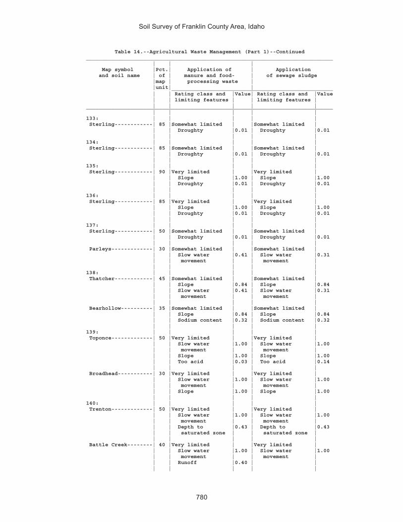
Soil Survey of Franklin County Area, Idaho
780
Table 14.--Agricultural Waste Management (Part 1)--Continued______________________________________________________________________________ | | | Map symbol |Pct.| Application of | Application and soil name | of | manure and food- | of sewage sludge |map | processing waste | |unit| | ___________________________________________________ | | Rating class and |Value| Rating class and |Value | | limiting features | | limiting features | | | | | |______________________________________________________________________________ | | | | |133: | | | | | Sterling------------| 85 |Somewhat limited | |Somewhat limited | | | Droughty |0.01 | Droughty |0.01 | | | | |134: | | | | | Sterling------------| 85 |Somewhat limited | |Somewhat limited | | | Droughty |0.01 | Droughty |0.01 | | | | |135: | | | | | Sterling------------| 90 |Very limited | |Very limited | | | Slope |1.00 | Slope |1.00 | | Droughty |0.01 | Droughty |0.01 | | | | |136: | | | | | Sterling------------| 85 |Very limited | |Very limited | | | Slope |1.00 | Slope |1.00 | | Droughty |0.01 | Droughty |0.01 | | | | |137: | | | | | Sterling------------| 50 |Somewhat limited | |Somewhat limited | | | Droughty |0.01 | Droughty |0.01 | | | | | Parleys-------------| 30 |Somewhat limited | |Somewhat limited | | | Slow water |0.41 | Slow water |0.31 | | movement | | movement | | | | | |138: | | | | | Thatcher------------| 45 |Somewhat limited | |Somewhat limited | | | Slope |0.84 | Slope |0.84 | | Slow water |0.41 | Slow water |0.31 | | movement | | movement | | | | | | Bearhollow----------| 35 |Somewhat limited | |Somewhat limited | | | Slope |0.84 | Slope |0.84 | | Sodium content |0.32 | Sodium content |0.32 | | | | |139: | | | | | Toponce-------------| 50 |Very limited | |Very limited | | | Slow water |1.00 | Slow water |1.00 | | movement | | movement | | | Slope |1.00 | Slope |1.00 | | Too acid |0.03 | Too acid |0.14 | | | | | Broadhead-----------| 30 |Very limited | |Very limited | | | Slow water |1.00 | Slow water |1.00 | | movement | | movement | | | Slope |1.00 | Slope |1.00 | | | | |140: | | | | | Trenton-------------| 50 |Very limited | |Very limited | | | Slow water |1.00 | Slow water |1.00 | | movement | | movement | | | Depth to |0.43 | Depth to |0.43 | | saturated zone | | saturated zone | | | | | | Battle Creek--------| 40 |Very limited | |Very limited | | | Slow water |1.00 | Slow water |1.00 | | movement | | movement | | | Runoff |0.40 | | | | | | |

Soil Survey of Franklin County Area, Idaho
781
Table 14.--Agricultural Waste Management (Part 1)--Continued______________________________________________________________________________ | | | Map symbol |Pct.| Application of | Application and soil name | of | manure and food- | of sewage sludge |map | processing waste | |unit| | ___________________________________________________ | | Rating class and |Value| Rating class and |Value | | limiting features | | limiting features | | | | | |______________________________________________________________________________ | | | | |141: | | | | | Trenton, cool-------| 50 |Very limited | |Very limited | | | Slow water |1.00 | Slow water |1.00 | | movement | | movement | | | Depth to |0.43 | Depth to |0.43 | | saturated zone | | saturated zone | | | | | | Battle Creek, cool--| 40 |Very limited | |Very limited | | | Slow water |1.00 | Slow water |1.00 | | movement | | movement | | | Runoff |0.40 | | | | | | |142: | | | | | Trenton-------------| 45 |Very limited | |Very limited | | | Slow water |1.00 | Slow water |1.00 | | movement | | movement | | | Depth to |0.43 | Depth to |0.43 | | saturated zone | | saturated zone | | | | | | Parleys-------------| 35 |Somewhat limited | |Somewhat limited | | | Slow water |0.41 | Flooding |0.40 | | movement | | Slow water |0.31 | | | | movement | | | | | |143: | | | | | Valmar--------------| 40 |Very limited | |Very limited | | | Slope |1.00 | Low adsorption |1.00 | | Droughty |1.00 | Slope |1.00 | | Depth to bedrock |0.90 | Droughty |1.00 | | Cobble content |0.75 | Depth to bedrock |0.90 | | Large stones on |0.08 | Cobble content |0.75 | | the surface | | | | | | | | Camelback-----------| 25 |Very limited | |Very limited | | | Slope |1.00 | Slope |1.00 | | | | | Hades---------------| 20 |Very limited | |Very limited | | | Slope |1.00 | Slope |1.00 | | Slow water |0.41 | Slow water |0.31 | | movement | | movement | | | | | |144: | | | | | Vitale--------------| 40 |Very limited | |Very limited | | | Slope |1.00 | Droughty |1.00 | | Large stones on |1.00 | Low adsorption |1.00 | | the surface | | Large stones on |1.00 | | Droughty |1.00 | the surface | | | Depth to bedrock |0.65 | Slope |1.00 | | Slow water |0.41 | Depth to bedrock |0.65 | | movement | | | | | | | | Bergquist-----------| 25 |Very limited | |Very limited | | | Slope |1.00 | Low adsorption |1.00 | | Droughty |0.94 | Slope |1.00 | | Filtering |0.01 | Droughty |0.94 | | capacity | | Filtering |0.01 | | | | capacity | | | | | | Rock outcrop--------| 15 |Not rated | |Not rated | | | | | |

Soil Survey of Franklin County Area, Idaho
782
Table 14.--Agricultural Waste Management (Part 1)--Continued______________________________________________________________________________ | | | Map symbol |Pct.| Application of | Application and soil name | of | manure and food- | of sewage sludge |map | processing waste | |unit| | ___________________________________________________ | | Rating class and |Value| Rating class and |Value | | limiting features | | limiting features | | | | | |______________________________________________________________________________ | | | | |145: | | | | | Vitale--------------| 35 |Very limited | |Very limited | | | Large stones on |1.00 | Droughty |1.00 | | the surface | | Low adsorption |1.00 | | Droughty |1.00 | Large stones on |1.00 | | Slope |1.00 | the surface | | | Depth to bedrock |0.99 | Slope |1.00 | | Cobble content |0.04 | Depth to bedrock |0.99 | | | | | Yeates Hollow-------| 25 |Very limited | |Very limited | | | Slope |1.00 | Slope |1.00 | | Slow water |0.74 | Slow water |0.60 | | movement | | movement | | | Cobble content |0.01 | Cobble content |0.01 | | | | | Northwater----------| 15 |Very limited | |Very limited | | | Slope |1.00 | Low adsorption |1.00 | | Droughty |0.90 | Slope |1.00 | | Filtering |0.01 | Droughty |0.90 | | capacity | | Filtering |0.01 | | | | capacity | | | | | |146: | | | | | Welby---------------| 90 |Very limited | |Very limited | | | Sodium content |0.99 | Sodium content |0.99 | | Filtering |0.01 | Filtering |0.01 | | capacity | | capacity | | | | | |147: | | | | | Welby---------------| 90 |Very limited | |Very limited | | | Sodium content |0.99 | Sodium content |0.99 | | Filtering |0.01 | Filtering |0.01 | | capacity | | capacity | | | | | |148: | | | | | Welby, wet----------| 85 |Somewhat limited | |Somewhat limited | | | Sodium content |0.08 | Sodium content |0.08 | | Filtering |0.01 | Filtering |0.01 | | capacity | | capacity | | | | | |149: | | | | | Collinston----------| 40 |Somewhat limited | |Somewhat limited | | | Slow water |0.41 | Slow water |0.31 | | movement | | movement | | | Slope |0.01 | Slope |0.01 | | | | | Wheelon-------------| 40 |Somewhat limited | |Somewhat limited | | | Sodium content |0.50 | Sodium content |0.50 | | Slow water |0.41 | Slow water |0.31 | | movement | | movement | | | Slope |0.01 | Slope |0.01 | | | | |150: | | | | | Wheelon-------------| 40 |Very limited | |Very limited | | | Slope |1.00 | Slope |1.00 | | Sodium content |0.50 | Sodium content |0.50 | | Slow water |0.41 | Slow water |0.31 | | movement | | movement | | | | | |

Soil Survey of Franklin County Area, Idaho
783
Table 14.--Agricultural Waste Management (Part 1)--Continued______________________________________________________________________________ | | | Map symbol |Pct.| Application of | Application and soil name | of | manure and food- | of sewage sludge |map | processing waste | |unit| | ___________________________________________________ | | Rating class and |Value| Rating class and |Value | | limiting features | | limiting features | | | | | |______________________________________________________________________________ | | | | |150: | | | | | Collinston----------| 35 |Very limited | |Very limited | | | Slope |1.00 | Slope |1.00 | | Slow water |0.41 | Slow water |0.31 | | movement | | movement | | | | | |151: | | | | | Wheelon-------------| 45 |Very limited | |Very limited | | | Slope |1.00 | Slope |1.00 | | Sodium content |0.50 | Sodium content |0.50 | | Slow water |0.41 | Slow water |0.31 | | movement | | movement | | | | | | Collinston----------| 30 |Very limited | |Very limited | | | Slope |1.00 | Slope |1.00 | | Slow water |0.41 | Slow water |0.31 | | movement | | movement | | | | | |152: | | | | | Windernot-----------| 40 |Very limited | |Very limited | | | Filtering |1.00 | Filtering |1.00 | | capacity | | capacity | | | Droughty |0.99 | Droughty |0.99 | | | | Flooding |0.40 | | | | | Lewnot--------------| 20 |Very limited | |Very limited | | | Filtering |1.00 | Filtering |1.00 | | capacity | | capacity | | | Depth to |0.68 | Depth to |0.68 | | saturated zone | | saturated zone | | | | | Flooding |0.40 | | | | | Stinkcreek----------| 15 |Very limited | |Very limited | | | Filtering |1.00 | Filtering |1.00 | | capacity | | capacity | | | Depth to |1.00 | Depth to |1.00 | | saturated zone | | saturated zone | | | Sodium content |1.00 | Sodium content |1.00 | | Slow water |0.41 | Flooding |0.40 | | movement | | Slow water |0.31 | | Runoff |0.40 | movement | | | | | |153: | | | | | Winn----------------| 90 |Somewhat limited | |Somewhat limited | | | Depth to |0.43 | Depth to |0.43 | | saturated zone | | saturated zone | | | | | Flooding |0.40 | | | | |154: | | | | | Winwell-------------| 80 |Very limited | |Very limited | | | Slow water |1.00 | Slow water |1.00 | | movement | | movement | | | | | |155: | | | | | Winwell-------------| 45 |Very limited | |Very limited | | | Slow water |1.00 | Slow water |1.00 | | movement | | movement | | | | | |

Soil Survey of Franklin County Area, Idaho
784
Table 14.--Agricultural Waste Management (Part 1)--Continued______________________________________________________________________________ | | | Map symbol |Pct.| Application of | Application and soil name | of | manure and food- | of sewage sludge |map | processing waste | |unit| | ___________________________________________________ | | Rating class and |Value| Rating class and |Value | | limiting features | | limiting features | | | | | |______________________________________________________________________________ | | | | |155: | | | | | Collinston----------| 35 |Somewhat limited | |Somewhat limited | | | Slow water |0.41 | Slow water |0.31 | | movement | | movement | | | | | |156: | | | | | Wormcreek-----------| 50 |Very limited | |Very limited | | | Slope |1.00 | Low adsorption |1.00 | | Slow water |0.41 | Slope |1.00 | | movement | | Slow water |0.31 | | Droughty |0.12 | movement | | | | | Droughty |0.12 | | | | | Copenhagen----------| 30 |Very limited | |Very limited | | | Slope |1.00 | Droughty |1.00 | | Depth to bedrock |1.00 | Depth to bedrock |1.00 | | Droughty |1.00 | Low adsorption |1.00 | | Runoff |0.40 | Slope |1.00 | | Cobble content |0.08 | Cobble content |0.08 | | | | |157: | | | | | Wormcreek-----------| 45 |Very limited | |Very limited | | | Slope |1.00 | Low adsorption |1.00 | | Slow water |0.41 | Slope |1.00 | | movement | | Slow water |0.31 | | Droughty |0.12 | movement | | | | | Droughty |0.12 | | | | | Lonigan-------------| 35 |Very limited | |Very limited | | | Slope |1.00 | Low adsorption |1.00 | | Droughty |0.99 | Slope |1.00 | | Depth to bedrock |0.90 | Droughty |0.99 | | Filtering |0.01 | Depth to bedrock |0.90 | | capacity | | Filtering |0.01 | | | | capacity | | | | | |158: | | | | | Wursten-------------| 45 |Very limited | |Very limited | | | Slope |1.00 | Slope |1.00 | | Sodium content |0.02 | Sodium content |0.02 | | | | | Dirtyhead-----------| 35 |Very limited | |Very limited | | | Droughty |1.00 | Low adsorption |1.00 | | Slope |1.00 | Droughty |1.00 | | Depth to bedrock |0.01 | Slope |1.00 | | | | Depth to bedrock |0.01 | | | | |159: | | | | | Xerochrepts---------| 30 |Very limited | |Very limited | | | Slope |1.00 | Slope |1.00 | | | | | Wormcreek-----------| 25 |Very limited | |Very limited | | | Slope |1.00 | Low adsorption |1.00 | | Slow water |0.41 | Slope |1.00 | | movement | | Slow water |0.31 | | Droughty |0.12 | movement | | | | | Droughty |0.12 | | | | |

Soil Survey of Franklin County Area, Idaho
785
Table 14.--Agricultural Waste Management (Part 1)--Continued______________________________________________________________________________ | | | Map symbol |Pct.| Application of | Application and soil name | of | manure and food- | of sewage sludge |map | processing waste | |unit| | ___________________________________________________ | | Rating class and |Value| Rating class and |Value | | limiting features | | limiting features | | | | | |______________________________________________________________________________ | | | | |159: | | | | | Xerorthents---------| 20 |Very limited | |Very limited | | | Slope |1.00 | Droughty |1.00 | | Depth to bedrock |1.00 | Depth to bedrock |1.00 | | Droughty |1.00 | Low adsorption |1.00 | | Runoff |0.40 | Slope |1.00 | | | | |160: | | | | | Xerorthents---------| 75 |Very limited | |Very limited | | | Slope |1.00 | Droughty |1.00 | | Depth to bedrock |1.00 | Depth to bedrock |1.00 | | Droughty |1.00 | Low adsorption |1.00 | | Runoff |0.40 | Slope |1.00 | | | | |161: | | | | | Yeates Hollow-------| 85 |Very limited | |Very limited | | | Slope |1.00 | Slope |1.00 | | Slow water |0.74 | Slow water |0.60 | | movement | | movement | | | Cobble content |0.01 | Cobble content |0.01 | | | | |162: | | | | | Yeates Hollow-------| 40 |Very limited | |Very limited | | | Slope |1.00 | Slope |1.00 | | Slow water |0.74 | Slow water |0.60 | | movement | | movement | | | Cobble content |0.01 | Cobble content |0.01 | | | | | Manila--------------| 25 |Very limited | |Very limited | | | Slow water |1.00 | Slow water |1.00 | | movement | | movement | | | Slope |1.00 | Slope |1.00 | | | | | Softback------------| 15 |Very limited | |Very limited | | | Slope |1.00 | Slope |1.00 | | Filtering |0.99 | Filtering |0.99 | | capacity | | capacity | | | Too acid |0.50 | Too acid |0.99 | | Slow water |0.41 | Slow water |0.31 | | movement | | movement | | | | | |163: | | | | | Yeates Hollow-------| 45 |Very limited | |Very limited | | | Slope |1.00 | Slope |1.00 | | Slow water |0.74 | Slow water |0.60 | | movement | | movement | | | Cobble content |0.01 | Cobble content |0.01 | | | | | Vitale--------------| 35 |Very limited | |Very limited | | | Slope |1.00 | Droughty |1.00 | | Large stones on |1.00 | Low adsorption |1.00 | | the surface | | Large stones on |1.00 | | Droughty |1.00 | the surface | | | Depth to bedrock |0.80 | Slope |1.00 | | Slow water |0.41 | Depth to bedrock |0.80 | | movement | | | | | | | |164: | | | | | Water---------------|100 |Not rated | |Not rated | | | | | |______________________________________________________________________________

Soil Survey of Franklin County Area, Idaho
786
Table 15.--Agricultural Waste Management (Part 2)
(The information in this table indicates the dominant soil condition but does not eliminate the need for onsite investigation. The numbers in the value columns range from 0.01 to 1.00. The larger the value, the greater the limitation. See text for further explanation of ratings in this table.)
______________________________________________________________________________ | | | Map symbol |Pct.| Disposal of | Overland flow of and soil name | of | wastewater | wastewater |map | by irrigation | |unit| | ___________________________________________________ | | Rating class and |Value| Rating class and |Value | | limiting features | | limiting features | | | | | |______________________________________________________________________________ | | | | |1: | | | | | Airport-------------| 80 |Very limited | |Very limited | | | Sodium content |1.00 | Sodium content |1.00 | | Slow water |1.00 | Salinity |1.00 | | movement | | Depth to |0.86 | | Salinity |1.00 | saturated zone | | | Depth to |0.86 | Flooding |0.40 | | saturated zone | | | | | | | |2: | | | | | Ant Flat------------| 85 |Very limited | |Not limited | | | Slow water |1.00 | | | | movement | | | | | | | |3: | | | | | Ant Flat------------| 85 |Very limited | |Not limited | | | Slow water |1.00 | | | | movement | | | | | | | |4: | | | | | Ant Flat------------| 90 |Very limited | |Somewhat limited | | | Slow water |1.00 | Too steep for |0.22 | | movement | | surface | | | Too steep for |1.00 | application | | | surface | | | | | application | | | | | Too steep for |0.10 | | | | sprinkler | | | | | application | | | | | | | |5: | | | | | Ant Flat------------| 65 |Very limited | |Not limited | | | Slow water |1.00 | | | | movement | | | | | Too steep for |0.68 | | | | surface | | | | | application | | | | | | | | Oxford--------------| 25 |Very limited | |Somewhat limited | | | Slow water |1.00 | Too steep for |0.50 | | movement | | surface | | | Too steep for |1.00 | application | | | surface | | | | | application | | | | | Too steep for |0.22 | | | | sprinkler | | | | | application | | | | | | | |

Soil Survey of Franklin County Area, Idaho
787
Table 15.--Agricultural Waste Management (Part 2)--Continued______________________________________________________________________________ | | | Map symbol |Pct.| Disposal of | Overland flow of and soil name | of | wastewater | wastewater |map | by irrigation | |unit| | ___________________________________________________ | | Rating class and |Value| Rating class and |Value | | limiting features | | limiting features | | | | | |______________________________________________________________________________ | | | | |6: | | | | | Ant Flat------------| 50 |Very limited | |Very limited | | | Too steep for |1.00 | Too steep for |1.00 | | surface | | surface | | | application | | application | | | Slow water |1.00 | | | | movement | | | | | Too steep for |1.00 | | | | sprinkler | | | | | application | | | | | | | | Oxford--------------| 35 |Very limited | |Very limited | | | Slow water |1.00 | Too steep for |1.00 | | movement | | surface | | | Too steep for |1.00 | application | | | surface | | | | | application | | | | | Too steep for |1.00 | | | | sprinkler | | | | | application | | | | | | | |7: | | | | | Arbone--------------| 80 |Somewhat limited | |Very limited | | | Filtering |0.01 | Seepage |1.00 | | capacity | | | | | | | |8: | | | | | Banida--------------| 85 |Very limited | |Not limited | | | Slow water |1.00 | | | | movement | | | | | | | |9: | | | | | Banida--------------| 80 |Very limited | |Not limited | | | Slow water |1.00 | | | | movement | | | | | | | |10: | | | | | Battle Creek--------| 85 |Very limited | |Somewhat limited | | | Slow water |1.00 | Seepage |0.69 | | movement | | | | | | | |11: | | | | | Battle Creek--------| 85 |Very limited | |Somewhat limited | | | Slow water |1.00 | Seepage |0.69 | | movement | | | | | | | |12: | | | | | Battle Creek--------| 95 |Very limited | |Somewhat limited | | | Slow water |1.00 | Seepage |0.69 | | movement | | | | | Too steep for |0.68 | | | | surface | | | | | application | | | | | | | |

Soil Survey of Franklin County Area, Idaho
788
Table 15.--Agricultural Waste Management (Part 2)--Continued______________________________________________________________________________ | | | Map symbol |Pct.| Disposal of | Overland flow of and soil name | of | wastewater | wastewater |map | by irrigation | |unit| | ___________________________________________________ | | Rating class and |Value| Rating class and |Value | | limiting features | | limiting features | | | | | |______________________________________________________________________________ | | | | |13: | | | | | Bear Lake-----------| 40 |Very limited | |Very limited | | | Depth to |1.00 | Flooding |1.00 | | saturated zone | | Seepage |1.00 | | Ponding |1.00 | Depth to |1.00 | | Flooding |0.60 | saturated zone | | | Slow water |0.31 | Ponding |1.00 | | movement | | | | | Filtering |0.01 | | | | capacity | | | | | | | | Chesbrook-----------| 30 |Very limited | |Very limited | | | Depth to |1.00 | Seepage |1.00 | | saturated zone | | Depth to |1.00 | | Filtering |0.99 | saturated zone | | | capacity | | Too acid |0.99 | | Too acid |0.99 | Flooding |0.40 | | Slow water |0.31 | | | | movement | | | | | | | | Picabo--------------| 15 |Very limited | |Very limited | | | Sodium content |1.00 | Seepage |1.00 | | Depth to |0.43 | Sodium content |1.00 | | saturated zone | | Depth to |0.43 | | | | saturated zone | | | | | Flooding |0.40 | | | | |14: | | | | | Bear Lake-----------| 50 |Very limited | |Very limited | | | Depth to |1.00 | Flooding |1.00 | | saturated zone | | Seepage |1.00 | | Flooding |1.00 | Depth to |1.00 | | Slow water |0.31 | saturated zone | | | movement | | | | | Filtering |0.01 | | | | capacity | | | | | | | | Downata-------------| 35 |Very limited | |Very limited | | | Depth to |1.00 | Flooding |1.00 | | saturated zone | | Seepage |1.00 | | Flooding |1.00 | Depth to |1.00 | | Ponding |1.00 | saturated zone | | | Filtering |0.99 | Ponding |1.00 | | capacity | | Too acid |0.99 | | Too acid |0.99 | | | | | | |15: | | | | | Bear Lake-----------| 50 |Very limited | |Very limited | | | Depth to |1.00 | Flooding |1.00 | | saturated zone | | Seepage |1.00 | | Flooding |1.00 | Depth to |1.00 | | Slow water |0.31 | saturated zone | | | movement | | | | | Filtering |0.01 | | | | capacity | | | | | | | |

Soil Survey of Franklin County Area, Idaho
789
Table 15.--Agricultural Waste Management (Part 2)--Continued______________________________________________________________________________ | | | Map symbol |Pct.| Disposal of | Overland flow of and soil name | of | wastewater | wastewater |map | by irrigation | |unit| | ___________________________________________________ | | Rating class and |Value| Rating class and |Value | | limiting features | | limiting features | | | | | |______________________________________________________________________________ | | | | |15: | | | | | Downata-------------| 25 |Very limited | |Very limited | | | Depth to |1.00 | Flooding |1.00 | | saturated zone | | Seepage |1.00 | | Flooding |1.00 | Depth to |1.00 | | Ponding |1.00 | saturated zone | | | Filtering |0.99 | Ponding |1.00 | | capacity | | Too acid |0.99 | | Too acid |0.99 | | | | | | | Thatcherflats-------| 20 |Very limited | |Very limited | | | Slow water |1.00 | Sodium content |1.00 | | movement | | Seepage |1.00 | | Sodium content |1.00 | Flooding |0.40 | | Depth to |0.09 | Depth to |0.09 | | saturated zone | | saturated zone | | | | | |16: | | | | | Bear Lake-----------| 65 |Very limited | |Very limited | | | Depth to |1.00 | Flooding |1.00 | | saturated zone | | Seepage |1.00 | | Flooding |0.60 | Depth to |1.00 | | Slow water |0.31 | saturated zone | | | movement | | | | | Filtering |0.01 | | | | capacity | | | | | | | | Lago----------------| 30 |Somewhat limited | |Very limited | | | Depth to |0.95 | Seepage |1.00 | | saturated zone | | Depth to |0.95 | | Slow water |0.31 | saturated zone | | | movement | | Flooding |0.40 | | | | |17: | | | | | Bearhollow----------| 30 |Very limited | |Very limited | | | Too steep for |1.00 | Seepage |1.00 | | surface | | Too steep for |1.00 | | application | | surface | | | Too steep for |1.00 | application | | | sprinkler | | Sodium content |0.32 | | application | | | | | Sodium content |0.32 | | | | | | | Brifox--------------| 25 |Very limited | |Very limited | | | Slow water |1.00 | Too steep for |1.00 | | movement | | surface | | | Too steep for |1.00 | application | | | surface | | | | | application | | | | | Too steep for |1.00 | | | | sprinkler | | | | | application | | | | | | | |

Soil Survey of Franklin County Area, Idaho
790
Table 15.--Agricultural Waste Management (Part 2)--Continued______________________________________________________________________________ | | | Map symbol |Pct.| Disposal of | Overland flow of and soil name | of | wastewater | wastewater |map | by irrigation | |unit| | ___________________________________________________ | | Rating class and |Value| Rating class and |Value | | limiting features | | limiting features | | | | | |______________________________________________________________________________ | | | | |17: | | | | | Iphil---------------| 20 |Very limited | |Very limited | | | Too steep for |1.00 | Seepage |1.00 | | surface | | Too steep for |1.00 | | application | | surface | | | Too steep for |1.00 | application | | | sprinkler | | Sodium content |0.82 | | application | | | | | Sodium content |0.82 | | | | | | |18: | | | | | Bergquist-----------| 60 |Very limited | |Very limited | | | Too steep for |1.00 | Seepage |1.00 | | surface | | Too steep for |1.00 | | application | | surface | | | Too steep for |1.00 | application | | | sprinkler | | Depth to bedrock |0.14 | | application | | Cobble content |0.11 | | Droughty |0.94 | | | | Filtering |0.01 | | | | capacity | | | | | | | | Rubble land---------| 15 |Not rated | |Not rated | | | | | |19: | | | | | Bergquist-----------| 45 |Very limited | |Very limited | | | Too steep for |1.00 | Seepage |1.00 | | surface | | Too steep for |1.00 | | application | | surface | | | Too steep for |1.00 | application | | | sprinkler | | Depth to bedrock |0.14 | | application | | Cobble content |0.11 | | Droughty |0.94 | | | | Filtering |0.01 | | | | capacity | | | | | | | | Softback------------| 30 |Very limited | |Very limited | | | Too steep for |1.00 | Seepage |1.00 | | surface | | Too steep for |1.00 | | application | | surface | | | Too steep for |1.00 | application | | | sprinkler | | Too acid |0.99 | | application | | Stone content |0.64 | | Filtering |0.99 | Cobble content |0.14 | | capacity | | | | | Too acid |0.99 | | | | Slow water |0.31 | | | | movement | | | | | | | |20: | | | | | Bergquist-----------| 55 |Very limited | |Very limited | | | Too steep for |1.00 | Seepage |1.00 | | surface | | Too steep for |1.00 | | application | | surface | | | Too steep for |1.00 | application | | | sprinkler | | Depth to bedrock |0.14 | | application | | Cobble content |0.11 | | Droughty |0.94 | | | | Filtering |0.01 | | | | capacity | | | | | | | |