Embed Size (px)
Citation preview
United StatesDepartment ofAgriculture
NaturalResourcesConservationService
Soil Survey ofCaribbean NationalForest and LuquilloExperimental Forest,Commonwealth ofPuerto Rico
In cooperation withthe United StatesDepartment of Agriculture,Forest Service, SouthernRegion and SouthernResearch Station; theInternational Institute ofTropical Forestry; and theUniversity of Puerto Rico,Agricultural ExperimentStations

General Soil Map
The general soil map, which is a color map, shows the survey area divided into groups of associated soils calledgeneral soil map units. This map is useful in planning the use and management of large areas.
To find information about your area of interest, locate that area on the map, identify the name of the map unit in thearea on the color-coded map legend, then refer to the section General Soil Map Units for a general description ofthe soils in your area.
Detailed Soil Maps
The detailed soil maps can be useful in planning the use andmanagement of small areas.
To find information about your areaof interest, locate that area on theIndex to Map Sheets. Note thenumber of the map sheet and turnto that sheet.
Locate your area of interest onthe map sheet. Note the map unitsymbols that are in that area. Turnto the Contents, which lists themap units by symbol and nameand shows the page where eachmap unit is described.
The Contents shows which tablehas data on a specific land use foreach detailed soil map unit. Alsosee the Contents for sections ofthis publication that may addressyour specific needs.
3
How To Use This Soil Survey
4
Additional information about the Nation’s natural resources is available onlinefrom the Natural Resources Conservation Service at http://www.nrcs.usda.gov.
This soil survey is a publication of the National Cooperative Soil Survey, a joint effortof the United States Department of Agriculture and other Federal agencies, Stateagencies including the Agricultural Experiment Stations, and local agencies. TheNatural Resources Conservation Service (formerly the Soil Conservation Service) hasleadership for the Federal part of the National Cooperative Soil Survey.
Major fieldwork for this soil survey was completed in 1992. Soil names anddescriptions were approved in 2000. Unless otherwise indicated, statements in thispublication refer to conditions in the survey area in 2001. This survey was madecooperatively by the Natural Resources Conservation Service and the USDA ForestService, Southern Region and Southern Research Station; the International Institute ofTropical Forestry; and the University of Puerto Rico, Agricultural Experiment Stations.The survey is part of the technical assistance furnished to the USDA Forest Service,Southern Region.
Soil maps in this survey may be copied without permission. Enlargement of thesemaps, however, could cause misunderstanding of the detail of mapping. If enlarged,maps do not show the small areas of contrasting soils that could have been shown at alarger scale.
The U.S. Department of Agriculture (USDA) prohibits discrimination in all itsprograms and activities on the basis of race, color, national origin, sex, religion, age,disability, political beliefs, sexual orientation, or marital or family status. (Not allprohibited bases apply to all programs.) Persons with disabilities who requirealternative means for communication of program information (Braille, large print,audiotape, etc.) should contact USDA’s TARGET Center at (202) 720-2600 (voice andTDD).
To file a complaint of discrimination, write USDA, Director, Office of Civil Rights,Room 326-W, Whitten Building, 1400 Independence Avenue, SW, Washington, D.C.20250-9410 or call (202) 720-5964 (voice and TDD). USDA is an equal opportunityprovider and employer.
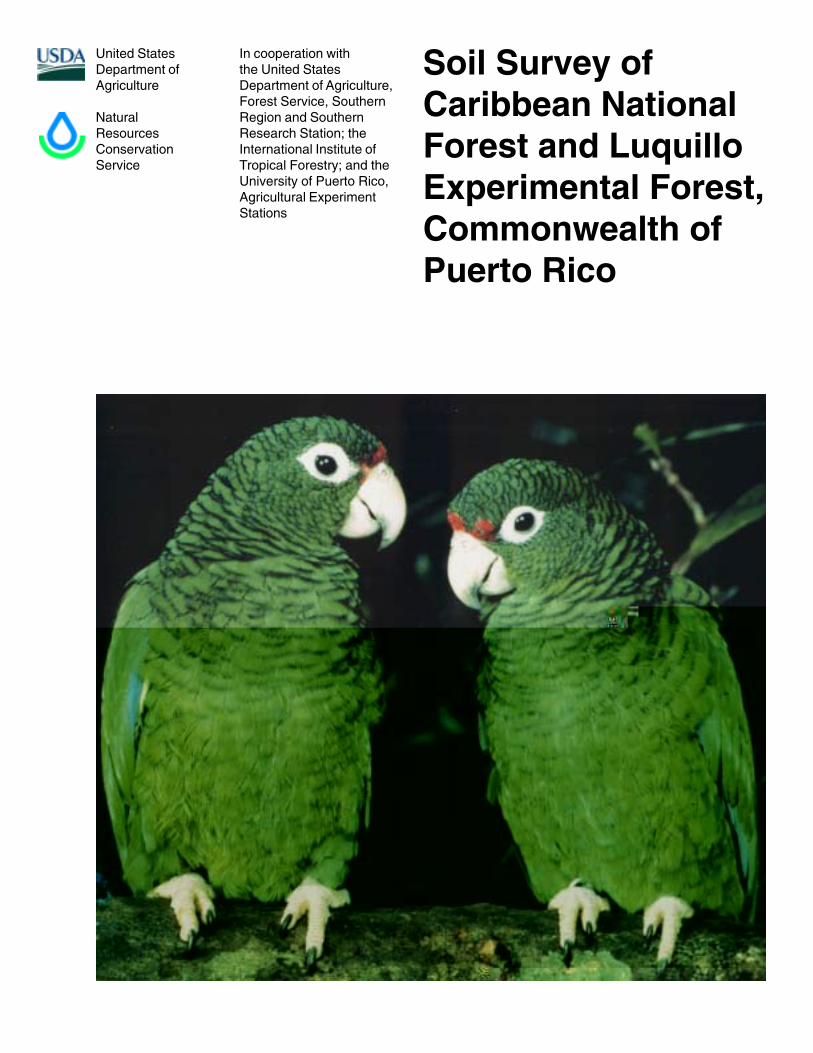
Cover: A pair of juvenile Puerto Rican parrots (Amazona vittata) in the Caribbean National Forest.Much effort is going into maintaining and increasing the population of this endangered species(photo courtesy of Francisco Valenzuela, USDA Forest Service).
5
Contents
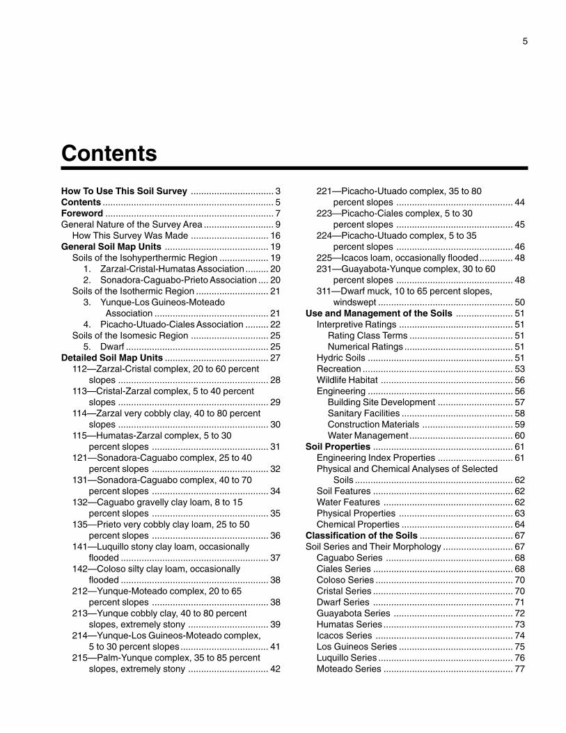
How To Use This Soil Survey ................................ 3Contents .................................................................. 5Foreword ................................................................. 7General Nature of the Survey Area ........................... 9
How This Survey Was Made .............................. 16General Soil Map Units ........................................ 19
Soils of the Isohyperthermic Region ................... 191. Zarzal-Cristal-Humatas Association ......... 202. Sonadora-Caguabo-Prieto Association .... 20
Soils of the Isothermic Region ............................ 213. Yunque-Los Guineos-Moteado
Association ............................................ 214. Picacho-Utuado-Ciales Association ......... 22
Soils of the Isomesic Region .............................. 255. Dwarf ....................................................... 25
Detailed Soil Map Units ........................................ 27112—Zarzal-Cristal complex, 20 to 60 percent
slopes .......................................................... 28113—Cristal-Zarzal complex, 5 to 40 percent
slopes .......................................................... 29114—Zarzal very cobbly clay, 40 to 80 percent
slopes .......................................................... 30115—Humatas-Zarzal complex, 5 to 30
percent slopes ............................................. 31121—Sonadora-Caguabo complex, 25 to 40
percent slopes ............................................. 32131—Sonadora-Caguabo complex, 40 to 70
percent slopes ............................................. 34132—Caguabo gravelly clay loam, 8 to 15
percent slopes ............................................. 35135—Prieto very cobbly clay loam, 25 to 50
percent slopes ............................................. 36141—Luquillo stony clay loam, occasionally
flooded ......................................................... 37142—Coloso silty clay loam, occasionally
flooded ......................................................... 38212—Yunque-Moteado complex, 20 to 65
percent slopes ............................................. 38213—Yunque cobbly clay, 40 to 80 percent
slopes, extremely stony ............................... 39214—Yunque-Los Guineos-Moteado complex,
5 to 30 percent slopes.................................. 41215—Palm-Yunque complex, 35 to 85 percent
slopes, extremely stony ............................... 42
221—Picacho-Utuado complex, 35 to 80percent slopes ............................................. 44
223—Picacho-Ciales complex, 5 to 30percent slopes ............................................. 45
224—Picacho-Utuado complex, 5 to 35percent slopes ............................................. 46
225—Icacos loam, occasionally flooded............. 48231—Guayabota-Yunque complex, 30 to 60
percent slopes ............................................. 48311—Dwarf muck, 10 to 65 percent slopes,
windswept .................................................... 50Use and Management of the Soils ...................... 51
Interpretive Ratings ............................................ 51Rating Class Terms ........................................ 51Numerical Ratings .......................................... 51
Hydric Soils ........................................................ 51Recreation .......................................................... 53Wildlife Habitat ................................................... 56Engineering ........................................................ 56
Building Site Development ............................. 57Sanitary Facilities ........................................... 58Construction Materials ................................... 59Water Management ........................................ 60
Soil Properties ...................................................... 61Engineering Index Properties ............................. 61Physical and Chemical Analyses of Selected
Soils ............................................................. 62Soil Features ...................................................... 62Water Features .................................................. 62Physical Properties ............................................ 63Chemical Properties ........................................... 64
Classification of the Soils .................................... 67Soil Series and Their Morphology ........................... 67
Caguabo Series ................................................. 68Ciales Series ...................................................... 68Coloso Series ..................................................... 70Cristal Series ...................................................... 70Dwarf Series ...................................................... 71Guayabota Series .............................................. 72Humatas Series .................................................. 73Icacos Series ..................................................... 74Los Guineos Series ............................................ 75Luquillo Series .................................................... 76Moteado Series .................................................. 77
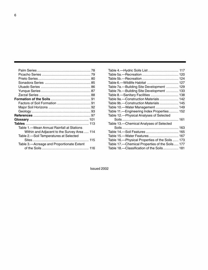
6
Palm Series ........................................................ 78Picacho Series ................................................... 79Prieto Series....................................................... 80Sonadora Series ................................................ 85Utuado Series .................................................... 86Yunque Series .................................................... 87Zarzal Series ...................................................... 88
Formation of the Soils .......................................... 91Factors of Soil Formation ................................... 91Major Soil Horizons ............................................ 92Geology .............................................................. 93
References ............................................................ 97Glossary .............................................................. 101Tables .................................................................. 113
Table 1.—Mean Annual Rainfall at StationsWithin and Adjacent to the Survey Area ..... 114
Table 2.—Soil Temperatures at SelectedSites........................................................... 115
Table 3.—Acreage and Proportionate Extentof the Soils ................................................. 116
Table 4.—Hydric Soils List ................................ 117Table 5a.—Recreation ...................................... 120Table 5b.—Recreation ...................................... 124Table 6.—Wildlife Habitat ................................. 127Table 7a.—Building Site Development ............. 129Table 7b.—Building Site Development ............. 133Table 8.—Sanitary Facilities ............................. 138Table 9a.—Construction Materials .................... 142Table 9b.—Construction Materials .................... 145Table 10.—Water Management ........................ 149Table 11.—Engineering Index Properties.......... 152Table 12.—Physical Analyses of Selected
Soils ........................................................... 161Table 13.—Chemical Analyses of Selected
Soils ........................................................... 163Table 14.—Soil Features .................................. 165Table 15.—Water Features ............................... 167Table 16.—Physical Properties of the Soils ...... 173Table 17.—Chemical Properties of the Soils..... 177Table 18.—Classification of the Soils ................ 181
Issued 2002

7
This soil survey contains information that affects land use planning in this surveyarea. It contains predictions of soil behavior for selected land uses. The survey alsohighlights soil limitations, improvements needed to overcome the limitations, and theimpact of selected land uses on the environment.
This soil survey is designed for many different users. Foresters, land use planners,and researchers can use it to evaluate the potential of the soil and the managementneeded for maximum use and production. Planners, community officials, engineers,and builders can use the survey to plan land use, select sites for construction, andidentify special practices needed to ensure proper performance. Conservationists,teachers, students, and specialists in recreation, wildlife management, waste disposal,and pollution control can use the survey to help them understand, protect, and enhancethe environment.
Various land use regulations of Federal, Commonwealth, and local governmentsmay impose special restrictions on land use or land treatment. The information in thisreport is intended to identify soil properties that are used in making various land use orland treatment decisions. Statements made in this report are intended to help the landusers identify and minimize the effects of soil limitations on various land uses. Thelandowner or user is responsible for identifying and complying with existing laws andregulations.
Great differences in soil properties can occur within short distances. Some soils areseasonally wet or subject to flooding. Some are shallow to bedrock. Some are toounstable to be used as a foundation for buildings or roads. Clayey or wet soils arepoorly suited to use as septic tank absorption fields. A high water table makes a soilpoorly suited to basements or underground installations.
These and many other soil properties that affect land use are described in this soilsurvey. Broad areas of soils are shown on the general soil map. The location of eachsoil is shown on the detailed soil maps. Each soil in the survey area is described.Information on specific uses is given for each soil. Help in using this publication andadditional information are available at the local office of the Natural ResourcesConservation Service, the Forest Service, or the Cooperative Extension Service.
Juan A. MartínezDirector, Caribbean AreaNatural Resources Conservation Service
Foreword


10 Soil Survey
approximately 12,384 acres (5,018 hectares) of theForest. Parts of the Forest have been in a protectedstatus since the 1870s. In 1898, Puerto Rico becamea territory of the United States and the Forest becamethe property of the federal government. Most of theoriginal “Crown Lands,” except for some lands thatwere used for high-grade logging, are the same todayas when Columbus first visited the island (Robinson,1997).
By the early 1900s, a large portion of the lowerslopes of the Luquillo Mountains was used forsubsistence cropland and pasture. Small, scatteredplots were cultivated to produce food crops for thelocal population. Coffee plantations were alsowidespread in the foothills. Much of the lowerTabonuco Forest was cut or cleared for agricultural
purposes. Most of these areas proved marginal forcommercial crops.
The Forest was proclaimed a federal reserve in1903 and has been managed by the USDA ForestService since 1917. In 1931, the Weeks Law and theClarke-McNary Act of 1924 were extended byCongress to include Puerto Rico. Under these laws,the Forest Service was able to acquire many of theexhausted, eroded agricultural lands on the peripheryof the Forest and make them productive again(Scatena, 1989). The “parcelero” program aided thiseffort. It maintained a local labor force for onsiterestoration. Each farmer residing on Forest landplanted both food crops and timber. The programended in 1960, but many of the plantations developedduring this program remain today.
Figure 2.—Petroglyphs inscribed by Taino Indians on a large boulder in Río Icacos. The boulder is in an area of Sonadora-Caguabocomplex, 25 to 40 percent slopes. The Taino Indians of Puerto Rico numbered more than 60,000 during pre-Columbian times.
Caribbean National Forest, Puerto Rico 11
Current Land Use
Today, agriculture is not practiced in the CaribbeanNational Forest. Most of the land is consideredunsuitable for modern agriculture, and no permanentprivate residences remain. Except for a few landslideareas, virtually all of the lands within the Forestcontain native forest types or plantation forest types.Many stands of timber that originated with landpurchases in the 1930s and 1940s now containmature sawtimber. Occasionally, some timber isextracted for research or for other limited purposes.Since 1978, approximately 1,200 acres (480 hectares)of the degraded secondary timber stands have beenplanted (called enrichment plantings) to mahogany(Brown and others, n.d.).
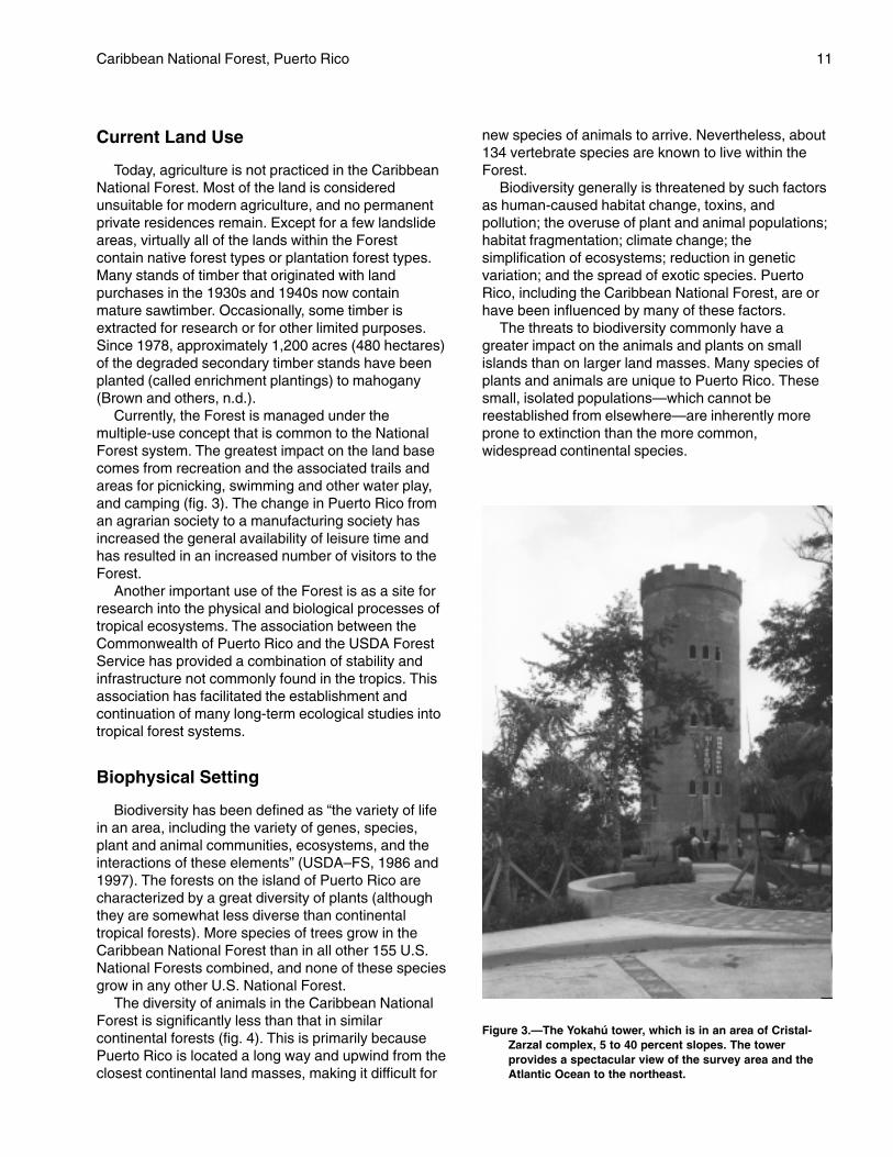
Currently, the Forest is managed under themultiple-use concept that is common to the NationalForest system. The greatest impact on the land basecomes from recreation and the associated trails andareas for picnicking, swimming and other water play,and camping (fig. 3). The change in Puerto Rico froman agrarian society to a manufacturing society hasincreased the general availability of leisure time andhas resulted in an increased number of visitors to theForest.
Another important use of the Forest is as a site forresearch into the physical and biological processes oftropical ecosystems. The association between theCommonwealth of Puerto Rico and the USDA ForestService has provided a combination of stability andinfrastructure not commonly found in the tropics. Thisassociation has facilitated the establishment andcontinuation of many long-term ecological studies intotropical forest systems.
Biophysical Setting
Biodiversity has been defined as “the variety of lifein an area, including the variety of genes, species,plant and animal communities, ecosystems, and theinteractions of these elements” (USDA–FS, 1986 and1997). The forests on the island of Puerto Rico arecharacterized by a great diversity of plants (althoughthey are somewhat less diverse than continentaltropical forests). More species of trees grow in theCaribbean National Forest than in all other 155 U.S.National Forests combined, and none of these speciesgrow in any other U.S. National Forest.
The diversity of animals in the Caribbean NationalForest is significantly less than that in similarcontinental forests (fig. 4). This is primarily becausePuerto Rico is located a long way and upwind from theclosest continental land masses, making it difficult for
new species of animals to arrive. Nevertheless, about134 vertebrate species are known to live within theForest.
Biodiversity generally is threatened by such factorsas human-caused habitat change, toxins, andpollution; the overuse of plant and animal populations;habitat fragmentation; climate change; thesimplification of ecosystems; reduction in geneticvariation; and the spread of exotic species. PuertoRico, including the Caribbean National Forest, are orhave been influenced by many of these factors.
The threats to biodiversity commonly have agreater impact on the animals and plants on smallislands than on larger land masses. Many species ofplants and animals are unique to Puerto Rico. Thesesmall, isolated populations—which cannot bereestablished from elsewhere—are inherently moreprone to extinction than the more common,widespread continental species.
Figure 3.—The Yokahú tower, which is in an area of Cristal-Zarzal complex, 5 to 40 percent slopes. The towerprovides a spectacular view of the survey area and theAtlantic Ocean to the northeast.
12 Soil Survey
Vegetation
By Luis Rivera, USDA Forest Service.
The Caribbean National Forest contains fiveecological life zones: subtropical wet forest,subtropical rain forest, lower montane wet forest,lower montane rain forest, and a small area ofsubtropical moist forest. Figure 5 shows thedistribution of the four major forest types in the surveyarea. They are the Tabonuco, Colorado, Palm, andDwarf forest types (USDA–FS, 1989, 1986, and 1997;Ford, 1981; Ewell and Whitmore, 1993).
The four major forest types have their nearest alliesin the Lesser Antilles. Nearly one-third of the treespecies in the Caribbean National Forest are unique toPuerto Rico and the Virgin Islands, and 10 percent areunique to the Caribbean National Forest itself.
The Tabonuco forest type, named for the dominanttree Dacryodes excelsa, occurs on foothills and slopesbelow elevations of 2,000 feet (610 m). It is the mostextensive forest type in the survey area, coveringabout 13,800 acres (5,585 hectares), which is about49 percent of the Forest. The Tabonuco forest typealso has the richest flora, containing at least 175 treespecies. One hundred and fifteen of these species
occur less commonly than 1 tree per 2.5 acres (1 treeper hectare). Two prominent species in this forest typeare Sloanea berteriana (motillo) and Manilkarabidentata (bulletwood or ausubo). Significant impact

Caribbean National Forest, Puerto Rico 13
Colorado forest type covers 8,200 acres (3,318hectares), which is about 30 percent of the CaribbeanNational Forest. At least 80 percent of this acreage isessentially unmodified by human activities.
The Palm forest type is dominated by a singlespecies: Prestoea montana (Sierra palm). This foresttype is a component of all five ecological life zones inthe Caribbean National Forest. The Palm forest typeoccurs chiefly on steep slopes and along stream bedsat about 1,500 feet (457 m). This forest type indicatesunstable soils. It covers about 4,800 acres (1,942hectares), which is about 17 percent of the CaribbeanNational Forest. This acreage is essentiallyunmodified by human activities. A few small areas areused as recreational sites.
The Dwarf forest type, also known as the “elfinwoodland” or “cloud forest,” is associated with the
lower montane rain forest ecological life zone. Thisforest type occurs only on the higher peaks andridges that are above 2,500 feet (762 m) and aresubject to extreme exposure. Trees in this foresttype are stunted and twisted. The largest trees areabout 15 feet (4.6 m) tall and 12 inches (30.5 cm) indiameter. The average diameter is about 2 to 4inches (5 to 10 cm). The exposed environment inthis forest type supports a smaller number ofspecies per unit area than the other types. A higherpercentage of these species, however, are endemicto Puerto Rico. Common trees include Ocoteaspathulata (nemocá), Eugenia borinquensis(guayabota), and Tabebuia rigida (roble de sierra).Some of the species in this forest type grow only inthe Caribbean National Forest. The Dwarf foresttype covers only about 1,000 acres (405 hectares),
Figure 5.—The four major forest types in the Caribbean National Forest.
14 Soil Survey
which is about 4 percent of the Caribbean NationalForest. Most of this acreage is unmodified byhuman activities. A few areas on the peaks havebeen developed as sites for electronic equipmentand have access roads.
A zone of riparian vegetation about 200 feet wide(61 m) occurs along perennial streams. This zonetotals about 2,200 acres (890 hectares).
Primary Forest
The core of the Caribbean National Forest remainsin primary condition without significant humanmodification. This primary forest is the largest remnantof the forest that covered virtually the entire island at
the time of Columbus’s arrival 500 years ago. At least85 percent of Puerto Rico was cleared for agriculture,resulting in the disappearance of nearly all of theforest.
The primary forest presents a unique window intothe past. It also provides a natural control againstwhich changes to tropical forests in Puerto Ricoand elsewhere can be measured. It provides theonly currently suitable habitat for many endemicplant species and for the endangered Puerto Ricanparrot. The biological values of the primary forestremain incompletely known, but are certainlyunique.
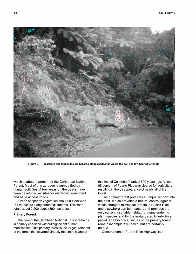
Construction of Puerto Rico Highway 191
Figure 6.—Rockslides and landslides are hazards along roadbanks where the soil has low bearing strength.

Caribbean National Forest, Puerto Rico 15
through the Caribbean National Forest andconstruction of access roads to electronic sites onEl Yunque Peak and East Peak opened up theprimary forest to vehicular traffic (fig. 6). El Toro-Trade Winds Trail traverses the primary forest forabout 5 miles (8 km), providing the main walkingaccess into the primary forest. Tree harvesting forcharcoal in the Colorado forest type during WorldWar II also impacted some primary forest. Timbersales that began in 1931 never entered the Dwarfand Palm forest types and were discontinued in theColorado type about 40 years ago. Despite theseimpacts, nearly 50 percent of the CaribbeanNational Forest, about 13,700 acres (5,544hectares), remains in pristine condition.
Climate
Precipitation
The climate in the Caribbean National Forest isdominated by trade winds. The constant tradewinds, punctuated by occasional remnant frontsfrom the northwest during the winter, bring moistureon a daily basis against the Luquillo Mountains.Tropical storms and hurricanes impact the forest,primarily in August and September (Robinson,1997).
The Luquillo Mountains are the wettest area inPuerto Rico, with rainfall generally increasing withelevation. Table 1 shows the mean rainfall for ninestations in or adjacent to the Forest. The stations arearranged according to elevation from the lowest (RíoBlanco 1) at 100 feet (30.5 m) to the highest (Pico delEste) at 3,448 feet (1,051.0 m). The mean annualrainfall ranges from about 97 inches (246 cm) annuallyat the lower elevations to over 150 inches (381 cm) atthe higher elevations.
Peak rainfall occurs in May, particularly at thehigher elevations. Minimum rainfall occurs in March(Robinson, 1997). The mean monthly rainfall rangesfrom about 6 to 12 inches (15 to 30 cm) at Río Blanco1 and from about 8 to 22 inches (20 to 56 cm) at Picodel Este.
At the higher elevations, about 250 rainy daysand 1,700 showers occur annually. The averageprecipitation from each shower is a little over 0.1inch (3 mm). The rainfall at the higher elevationsincludes about twice as many rainy days and threetimes as many showers as on the northeast coast.The south and west sides of the Forest receive lessprecipitation than the north and east sides due tothe mountain barrier. Hurricanes occur on aperiodic basis and are expected to hit the Forestdirectly once every 50 to 60 years (Mount and
others, 1992; Robinson, 1997; USDA–FS, 1986;Wadsworth and Englerth, 1959).
Temperature
Soil temperatures in the Luquillo Mountains, on ayear-round basis, are 8 to 12 degrees F (4 to 7 °C)cooler than on the coast and are about equal to thoseof the central mountain ranges of Puerto Rico. Themonthly mean soil temperature is about 70.3 degreesF (21.3 °C). The extreme maximum temperature in thegeographic center of the Forest, at the El YunqueRecreation Areas, is 90 degrees F (32 °C), and theextreme minimum is 52 degrees F (11 °C).
Soil Temperature Regimes
Temperature is an important soil property. Inclassification, soil temperature is used to differentiatesoil taxon at the family level. On a practical level,biological processes are largely controlled by soiltemperature. For example, soil temperatures between32 and 41 degrees F (0 and 5 °C) restrict root growthof all but the most highly adapted species.Temperature also strongly influences the biological,chemical, and physical processes of the soil. Theseprocesses are reflected in the plant community thatoccupies a particular landscape.
As is common in mountain landscapes, thevegetation in the Caribbean National Forest changeswith increasing altitude. The changes in vegetation arean expression of changes in temperature andmoisture; the landscape is cooler and wetter upslopeand is dryer and warmer downslope. In themountainous parts of the western United States, suchchanges in vegetation commonly are used to identifychanges in the soil temperature regime, which is thenused for soil classification. This same principle wasused to classify the soils of the Caribbean NationalForest.
According to “Soil Taxonomy” (Soil Survey Staff,1999), “Soil temperature often can be estimated fromclimatological data with a precision that is adequatefor the present needs of soil surveys. If we cannotmake reasonably precise estimates, the measurementof soil temperature need not be a difficult or a time-consuming task.”
Soil Taxonomy further states, “If the temperature ofa soil is measured at a depth below the influence ofthe daily cycle of fluctuations, such as a depth of 20inches (50 cm), four readings equally spacedthroughout the year give a very close approximation ofthe mean annual temperature. For example, theaverage of readings taken at a depth of 20 inches (50cm) at Vauxhall, Alberta, on January 1, April 1, July 1,

16 Soil Survey
and October 1, 1962, differs from the average of tworeadings each day of the year by only about 1.8degrees F (0.3 °C).”
Soil temperature was measured at seven locationseither entirely within or near the fringes of thedominant vegetation types in the Caribbean NationalForest. These sites were at 430 and 760 feet (130 and230 m) for the Tabonuco forest type, at 1,080 and1,380 feet (330 and 420 m) for the fringe between theTabonuco and Palo Colorado types, at 1,720 and2,400 feet (525 and 730 m) for the Palo Coloradotype, at 2,710 feet (825 m) for the fringe between thePalo Colorado and Dwarf types, and at 3,220 feet (980m) for the Dwarf type. Readings were taken at a depthof 20 inches (50 cm) between the 14th and 29th ofeach month for the 20 months between April, 1985,and November, 1986. Unfortunately, the station at1,380 feet (420 m) was vandalized after three monthsof readings. It was not replaced. Table 2 gives the datafrom the temperature study. These data were used tohelp define the soil climate regions of the CaribbeanNational Forest.
An “average for one year” is included in table 2because the data do not include two complete years.The averages for the 20-month totals are skewedtowards the warm side because they include twosummer readings and only one winter reading. Thereadings for the 3,220 foot (980 m) sample representthe first recognized isomesic (47 to 59 °F, or 8 to 15°C) soil temperatures in Puerto Rico. The data alsosupport the use of the “iso” modifiers because thespread between mean summer and mean wintertemperatures is less than the maximum allowed,which is 10.8 degrees F (6 °C).
How This Survey Was MadeThis survey was made to provide information about
the soils within the Caribbean National Forest. Theinformation includes descriptions of the soils and theirlocation and a discussion of the suitability, limitations,and management of the soils for specified uses.Observations were made concerning the steepness,length, and shape of slopes; the general pattern ofdrainage; the kinds of native plants; and the kinds ofbedrock. Many holes or pits were sampled to studythe soil profile, which is the sequence of naturallayers, or horizons, in a soil. The profile extends fromthe surface down into the unconsolidated material inwhich the soil formed. The unconsolidated material isdevoid of roots and other living organisms and has notbeen changed by other biologic activity.
The soils in the survey area are in an orderly
pattern that is related to the geology, landforms, relief,climate, and natural vegetation of the area. Each typeof soil is associated with a particular kind of landscapeor with a segment (landform) of the landscape.Concepts, or models, of how the soils formed weredeveloped by observing the soils in the survey areaand relating their position to a landform of thelandscape. During mapping, these models were usedto predict with considerable accuracy the kind of soilsthat occur at a specific locations on the landscape(Steers and Hajek, 1979).
Commonly, individual soils on the landscape mergeinto one another as their characteristics graduallychange. To construct an accurate soil map, however,the boundaries between the soils must be determined.Only a limited number of soil profiles can be observed,and not all boundary lines can be verified by onsiteinvestigation. Nevertheless, these observations,supplemented by an understanding of the soil-landscape relationship, are sufficient to determine theboundaries. The types of soil and their percentcomposition within each mapped area weredetermined by random transects of individual mappingunits.
Profiles were studied and soil characteristics wererecorded in descriptions. Soil color, texture, size andshape of soil aggregates, kind and amount of rockfragments, distribution of plant roots, acidity, and otherfeatures were noted. After the soils in the survey areawere described and their properties were determined,the soils were then assigned to taxonomic classes andmap units. Taxonomic classes are concepts. Eachtaxonomic class has a set of soil characteristics withprecisely defined limits. The system of taxonomicclassification used in the United States is basedmainly on the kind and character of soil properties andthe arrangement of horizons within the profile. Afterthe soils in the survey area were classified andnamed, comparisons were made with similar soils inthe same taxonomic class in other areas in order toconfirm the classification and to assemble additionaldata based on experience and research (Soil SurveyStaff, 1996).
Predictions about soil behavior are based on soilproperties and such variables as climate andbiological activity. Soil conditions are predictable overlong periods of time, but they are not predictable fromyear to year. For example, predictions can be madewith a fairly high degree of accuracy that a given soilwill have a high water table within certain depths inmost years, but predictions cannot be made that ahigh water table will always be at a specific level in thesoil on a specific date.
After the significant natural bodies of soil in the

Caribbean National Forest, Puerto Rico 17
survey area were located and identified, theboundaries of these bodies were drawn on aerialphotographs and each was identified as a specificmap unit. Aerial photographs show trees, buildings,clearings, roads, and rivers, all of which help inlocating boundaries. These are the original and mostaccurate maps. For reproduction, the lines weretransferred to 1:20,000 USGS quadrangle topographic
maps. These are the maps contained in thepublication and the base for any further use ingeographic information systems (Soil Survey Staff,1996).
The soil maps for this survey have been producedin digital format that meet Soil Survey GeographicDatabase (SSURGO) standards. The digital data canbe acquired from the USDA Forest Service.

19
The general soil map in this publication showsbroad areas that have a distinctive pattern of soils,relief, and drainage. Each map unit on the general soilmap is a unique natural landscape. Typically, itconsists of one or more major soils and some minorsoils. It is named for the major soils. The componentsof one map unit can occur in another but in a differentpattern.
The general soil map can be used to compare thesuitability of large areas for general or Forest-wideland use and planning. Areas of broad suitability canbe identified on the map. Likewise, areas where thesoils are not suitable for certain uses can be identified.For example, the land in the isohyperthermic zone(commercial timber area) may be contrasted againstthe areas that do not have commercial potential. Areasderived from volcanic sandstone and breccia may becontrasted against those of plutonic origin.
Because the amount of rainfall increases withelevation, hydric soils are generally more common atthe higher elevations than at the lower.
Because of its small scale, the map is not suitablefor planning the location of recreation areas, roads, orother projects that require onsite evaluation. The soilsin any one map unit differ widely from place to place inslope, depth, drainage, and other characteristics thataffect use and management.
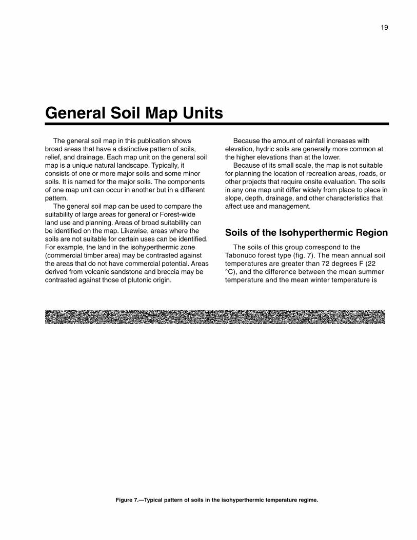
Soils of the Isohyperthermic RegionThe soils of this group correspond to the
Tabonuco forest type (fig. 7). The mean annual soiltemperatures are greater than 72 degrees F (22°C), and the difference between the mean summertemperature and the mean winter temperature is
General Soil Map Units
Figure 7.—Typical pattern of soils in the isohyperthermic temperature regime.
20 Soil Survey
less than 9 degrees F (6 °C) at a depth of 20 inches(50 cm) (Boccheciamp and others, 1977).
1. Zarzal-Cristal-Humatas Association
Very deep, well drained and somewhat poorly drainedclayey soils that formed in residuum that weatheredfrom volcanic sandstone and mudstone of the HatoPuerco, Tabonuco, and Fajardo Formations
This association is dominantly on the north side ofthe survey area in a band that runs east to west fromthe boundary of the survey area to about the contourline at 1,970 feet (600 m). Isolated areas are alsoaround Gurabo and in the southeastern part of thesurvey area. The association covers about 35 percentof the survey area.
The Zarzal soils are very deep and well drained.They are on convex parts of mountain side slopes andfootslopes. Typically, the surface layer is dark reddishbrown clay about 1 inch (2 cm) thick. The upper part ofthe subsoil, to a depth of 35 inches (89 cm), isyellowish brown clay. The lower part of the subsoil, toa depth of 82 inches (209 cm), is strong brown clay. Ithas mottles in shades of red and, below a depth of 56inches (143 cm), gray. The underlying material, to adepth of 91 inches (230 cm) or more, is strong brown,weathered sandstone having a texture of very gravellyclay.
The Cristal soils are very deep and somewhatpoorly drained. They are in concave parts of coves, onlower parts of side slopes, and in drainageways.Typically, the surface layer is dark brown clay loamabout 2 inches (5 cm) thick. The upper part of thesubsoil, to a depth of 15 inches (38 cm), is pale brownclay that has mottles in shades of brown, red, andgray. The next part of the subsoil, to a depth of 26inches (66 cm), is yellowish brown gravelly clay thathas mottles in shades of brown, red, and gray. Thelower part of the subsoil, to a depth of 39 inches (99cm), is strong brown clay that has mottles in shades ofyellow, red, and brown. The substratum, to a depth of60 inches (152 cm) or more, is yellowish red clay loamthat has mottles in shades of brown and yellow.
The Humatas soils are very deep and well drained.They are on ridgetops and side slopes. Typically, thesurface layer is dark brown silty clay about 4 inches(10 cm) thick. The upper part of the subsoil, to a depthof 12 inches (30 cm), is yellowish brown silty clay. Thenext part of the subsoil, to a depth of 19 inches (48cm), is yellowish brown clay that has red mottles. Thelower part of the subsoil, to a depth of 38 inches (97cm) is clay mottled in shades of red and yellow. Thesubstratum, to a depth of 60 inches (152 cm) or more,is red clay that has mottles in shades of yellow.
The minor components in this association includeColoso and Luquillo soils on flood plains. The Colososoils are somewhat poorly drained. The Luquillo soilshave a stony substratum. Also included are smallareas of very steep Zarzal soils.
Most areas of this association were once used forextensive logging, for charcoal production, or for both.Some areas were used for intensive agriculture,subsistence agriculture, or both. Currently, theassociation supports second-growth native forest orplantations and is used as a site for recreation,research, wildlife habitat, and watershed protection.
Most areas of this association have moderate orsevere limitations affecting timber management anddispersed recreational activities, such as hiking andbird watching. Onsite investigation is needed to locatefacilities and to plan development for recreationalareas.
2. Sonadora-Caguabo-PrietoAssociation
Moderately deep and shallow, well drained and poorlydrained clayey soils that formed in residuum thatweathered from volcanic mudstones andconglomerates of the Hato Puerco, Tabonuco, andFajardo Formations
This association is in isolated areas in the extremenorthwestern and southern parts of the survey areaand south of the Río Cubuy. The association coversabout 5 percent of the survey area.
The Sonadora soils are well drained andmoderately deep. They are on the lower side slopesand footslopes. Typically, the surface layer is darkreddish brown clay loam about 1 inch (3 cm) thick.The upper part of the subsoil, to a depth of 16 inches(41 cm), is dark brown to dark yellowish brown clay.The lower part of the subsoil, to a depth of 21 inches(53 cm), is grayish brown clay. The substratum, to adepth of 36 inches (91 cm), is clay loam mottled inshades of brown. The underlying material, below adepth of 36 inches (91 cm), is dark gray mudstone.
The Caguabo soils are well drained and shallow.They are on side slopes on uplands. Typically, thesurface layer is dark grayish brown gravelly clay loamabout 3 inches (8 cm) thick. The subsoil, to a depth of7 inches (18 cm), is brown very gravelly clay loam.The substratum, to a depth of 11 inches (28 cm), isbrown very gravelly clay loam. The upper part of theunderlying material, to a depth of 16 inches (41 cm), isweathered, gravelly mudstone. The lower part of theunderlying material, at a depth of 16 inches (41 cm) ormore, is hard, gravelly mudstone.
The Prieto soils are poorly drained and moderately

Caribbean National Forest, Puerto Rico 21
deep. They are in concave positions in mountaincoves, on side slopes, and in drainageways. Typically,the surface layer is gray very cobbly clay loam about 4inches (10 cm) thick. The upper part of the subsoil, toa depth of 13 inches (33 cm), is dark gray cobbly claythat has mottles in shades of brown. The next part ofthe subsoil, to a depth of 25 inches (64 cm), isgreenish gray cobbly clay that has mottles in shadesof yellow and brown. The lower part of the subsoil, to adepth of 35 inches (89 cm), is light gray cobbly siltyclay that has mottles in shades of brown and gray. Theunderlying material, below a depth of 35 inches (89cm), is hard, volcanic mudstone.
The minor components in this association includethe well drained Luquillo soils. They are on narrowflood plains and stream terraces and have a verystony substratum.
Most areas of this association were once used forintensive agriculture, subsistence agriculture, or both.A few areas were used for timber and charcoalproduction. Currently, the association supportssecond-growth native forest or plantations and is usedas a site for recreation, research, and wildlife habitat.
Except for the areas in the south-central part of thesurvey area, this association generally has moderatelimitations affecting timber management and dispersedrecreational activities, such as hiking and birdwatching. The areas in the south-central part aredominated by the Prieto soils and have severelimitations.
Soils of the Isothermic RegionThe soils of this group correspond to the Palo
Colorado forest type. Soil temperatures range from59 to 72 degrees F (15 to 22 °C), and the differencebetween the mean summer temperature and themean winter temperature is less than 9 degrees F(6 °C) at a depth of 20 inches (50 cm) (Boccheciampand others, 1977).
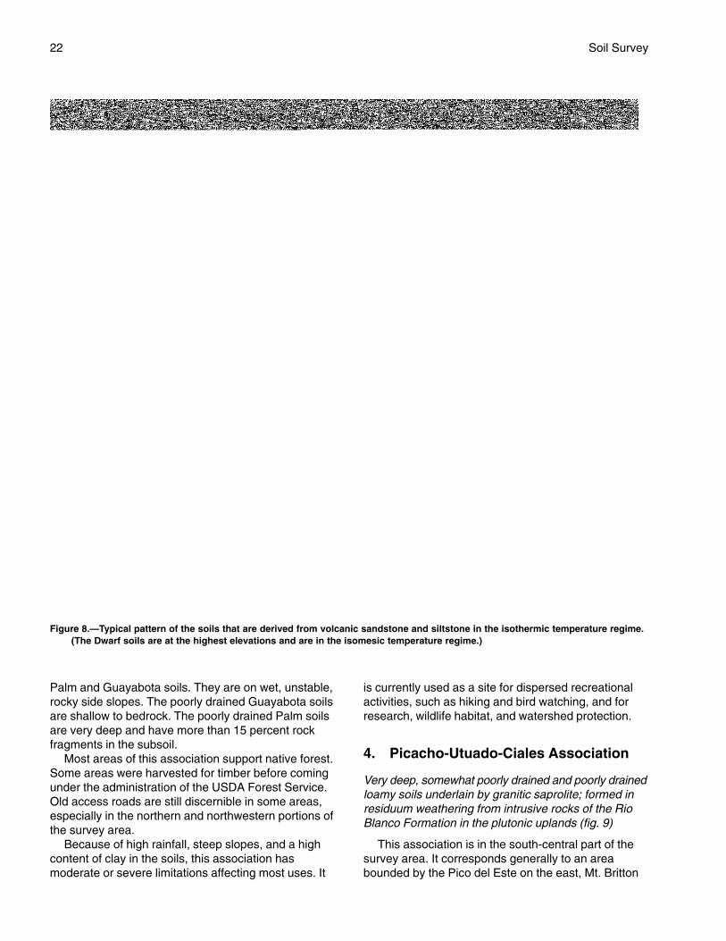
3. Yunque-Los Guineos-MoteadoAssociation
Very deep and deep, moderately well drained, welldrained, and poorly drained clayey soils that formed inresiduum that weathered from volcanic sandstone andmudstone of the Hato Puerco, Tabonuco, and FajardoFormations (fig. 8)
This association is in an arc that starts east of Picodel Oeste, where the arc roughly corresponds to thecontour band at 1,310 to 2,950 feet (400 to 900 m),and then continues northwest to La Coca falls and
west to Quebrada Jimenez. From Quebrada Jimenez,the arc rises transitionally up the land mass inresponse to a warming microclimate and roughlycorresponds to the contour band at 1,800 to 3,120 feet(550 to 950 m). The arc crosses southwest to ElNegro and then circles to the east to La Mina. Theassociation covers about 35 percent of the surveyarea.
The Yunque soils are very deep and moderatelywell drained. They are on mountain side slopes andconvex ridgetops on strongly dissected uplands.Typically, the upper part of the surface layer is a rootmat about 2 inches (5 cm) thick. The lower part of thesurface layer, to a depth of 7 inches (18 cm), is darkyellowish brown cobbly clay or clay having mottles inshades of brown. The upper part of the subsoil, to adepth of 30 inches (76 cm), is yellowish brown claythat has mottles in shades of red, yellow, gray, andbrown. The middle part of the subsoil, to a depth of 51inches (130 cm), is yellowish red to strong brown siltyclay to silty clay loam having mottles in shades ofbrown and gray. The lower part of the subsoil, to adepth of 62 inches (157 cm), is silty clay loam mottledin shades of red and brown.
The Los Guineos soils are very deep and welldrained. They are on mountain side slopes. Typically,the surface layer is dark yellowish brown clay about 1inch (3 cm) thick. The upper part of the subsoil, to adepth of 18 inches (46 cm), is yellowish brown tobrownish yellow clay. It has red mottles below a depthof 9 inches (23 cm). The next part of the subsoil, to adepth of 43 inches (109 cm), is red clay that hasmottles in shades of brown. The lower part of thesubsoil, to a depth of 93 inches (236 cm), is strongbrown to yellowish red clay that has mottles in shadesof brown and red.
The Moteado soils are deep and poorly drained.They are in concave areas on ridgetops and sideslopes on uplands. Typically, the upper part of thesurface layer is a root mat about 1 inch (3 cm) thick.The lower part of the surface layer is grayish brown todark grayish brown clay about 13 inches (33 cm) thick.The upper part of the subsoil, to a depth of 22 inches(56 cm), is dark grayish brown clay that has mottles inshades of brown and gray. The next part of thesubsoil, to a depth of 41 inches (104 cm), is yellowishbrown to light olive brown clay that has mottles inshades of brown, gray, and, below a depth of 27inches (69 cm), red. The lower part of the subsoil, to adepth of 54 inches (137 cm), is olive gray clay that hasmottles in shades of brown. The underlying material,below a depth of 54 inches (135 cm), is unweathered,volcanic sandstone bedrock.
The minor components in this association include
22 Soil Survey
Palm and Guayabota soils. They are on wet, unstable,rocky side slopes. The poorly drained Guayabota soilsare shallow to bedrock. The poorly drained Palm soilsare very deep and have more than 15 percent rockfragments in the subsoil.
Most areas of this association support native forest.Some areas were harvested for timber before comingunder the administration of the USDA Forest Service.Old access roads are still discernible in some areas,especially in the northern and northwestern portions ofthe survey area.
Because of high rainfall, steep slopes, and a highcontent of clay in the soils, this association hasmoderate or severe limitations affecting most uses. It
is currently used as a site for dispersed recreationalactivities, such as hiking and bird watching, and forresearch, wildlife habitat, and watershed protection.
4. Picacho-Utuado-Ciales Association
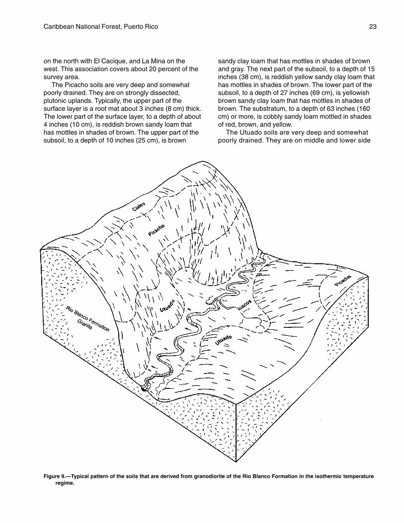
Very deep, somewhat poorly drained and poorly drainedloamy soils underlain by granitic saprolite; formed inresiduum weathering from intrusive rocks of the RioBlanco Formation in the plutonic uplands (fig. 9)
This association is in the south-central part of thesurvey area. It corresponds generally to an areabounded by the Pico del Este on the east, Mt. Britton
Figure 8.—Typical pattern of the soils that are derived from volcanic sandstone and siltstone in the isothermic temperature regime.(The Dwarf soils are at the highest elevations and are in the isomesic temperature regime.)
Caribbean National Forest, Puerto Rico 23
on the north with El Cacique, and La Mina on thewest. This association covers about 20 percent of thesurvey area.
The Picacho soils are very deep and somewhatpoorly drained. They are on strongly dissected,plutonic uplands. Typically, the upper part of thesurface layer is a root mat about 3 inches (8 cm) thick.The lower part of the surface layer, to a depth of about4 inches (10 cm), is reddish brown sandy loam thathas mottles in shades of brown. The upper part of thesubsoil, to a depth of 10 inches (25 cm), is brown
sandy clay loam that has mottles in shades of brownand gray. The next part of the subsoil, to a depth of 15inches (38 cm), is reddish yellow sandy clay loam thathas mottles in shades of brown. The lower part of thesubsoil, to a depth of 27 inches (69 cm), is yellowishbrown sandy clay loam that has mottles in shades ofbrown. The substratum, to a depth of 63 inches (160cm) or more, is cobbly sandy loam mottled in shadesof red, brown, and yellow.
The Utuado soils are very deep and somewhatpoorly drained. They are on middle and lower side
Figure 9.—Typical pattern of the soils that are derived from granodiorite of the Rio Blanco Formation in the isothermic temperatureregime.
24 Soil Survey
slopes of strongly dissected uplands. Typically, theupper part of the surface layer is a root mat about 1inch (3 cm) thick. The lower part of the surfacelayer, to a depth of about 2 inches (5 cm), is darkbrown gravelly loam. The upper part of the subsoil,to a depth of 7 inches (18 cm), is dark brown loamthat has mottles in shades of brown and gray. Thelower part of the subsoil, to a depth of 13 inches (33cm), is dark yellowish brown loam that has mottlesin shades of gray. The upper part of the substratum,to a depth of 28 inches (71 cm), is yellowish brownsandy loam. The lower part of the substratum, to adepth of 61 inches (155 cm) or more, is saprolitemottled in white, black, and brown and having atexture of loamy sand.
The Ciales soils are very deep and poorly drained.They are in concave positions on lower side slopesand footslopes of dissected mountains. Typically, thesurface layer is dark reddish brown mucky clay loam
about 9 inches (23 cm) thick. The upper part of thesubsoil, to a depth of 25 inches (64 cm), is dark grayto olive gray sandy clay loam that has mottles inshades of black and brown. The next part of thesubsoil, to a depth of 39 inches (99 cm), is strongbrown to yellowish brown sandy loam that has mottlesin shades of brown. The lower part of the subsoil, to adepth of 56 inches (142 cm), is stratified yellowishbrown and dark brown loam. The substratum, to adepth of 73 inches (185 cm) or more, is stratified darkyellowish brown, strong brown, yellowish brown, anddark red sandy loam.
The minor components in this association includethe somewhat poorly drained Icacos soils on floodplains. Also included are very narrow, extremelybouldery areas along drainageways.
Most areas of this association support native forest.In the past, the largest Palo Colorado trees wereremoved by high-grade logging for charcoal
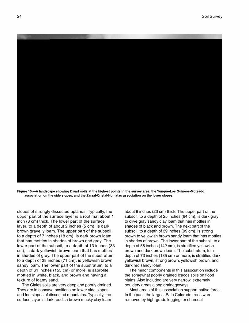
Figure 10.—A landscape showing Dwarf soils at the highest points in the survey area, the Yunque-Los Guineos-Moteadoassociation on the side slopes, and the Zarzal-Cristal-Humatas association on the lower slopes.

Caribbean National Forest, Puerto Rico 25
production and sphagnum moss was harvested fromthe wetter areas.
Because of high rainfall, steep slopes, and theinstability of cutbanks, this association has severelimitations affecting most uses. It is currently used as asite for dispersed recreational activities, such as hikingand bird watching, and for research, wildlife habitat,and watershed protection.
Soils of the Isomesic RegionThe soils of this region correspond to the Dwarf
forest type (fig. 10). Soil temperatures range from 47to 59 degrees F (8 to 15 °C), and the differencebetween the mean summer temperature and the meanwinter temperature is less than 9 degrees F (6 °C) at adepth of 20 inches (50 cm) (Boccheciamp and others,1977).
5. Dwarf
Very deep, poorly drained clayey soils that have anorganic surface layer, are on summits and ridges ofmountains, and formed in residuum that weatheredfrom metamorphosed andesitic to basaltic, marine-deposited, volcanic sandstone of the Hato Puerco,Fajardo, and Tabonuco Formations
This association is at elevations of more than 2,950feet (900 m) around the highest major peaks in thesurvey area. It corresponds roughly to the areasidentified on vegetative maps as dwarf forest orBosque Enano. It covers about 5 percent of the surveyarea.
Typically, the upper part of the surface layer isvery dark grayish brown muck about 4 inches (10cm) thick. The lower part of the surface layer, to adepth of 9 inches (23 cm), is dark brown muckysandy loam that has mottles in shades of brown.The upper part of the subsoil, to a depth of 26inches (66 cm), is dark grayish brown to olive graysilty clay loam to silty clay having mottles in shadesof brown and olive. The next part of the subsoil, to adepth of 35 inches (89 cm), is olive silty clay thathas mottles in shades of olive, brown, and gray.The lower part of the subsoil, to a depth of 43inches (109 cm), is olive brown clay loam that hasmottles in shades of brown and gray. The upperpart of the substratum, to a depth of 52 inches (132cm), is olive silt loam that has mottles in shades ofbrown and gray. The lower part of the substratum,to a depth of 60 inches (152 cm) or more, is strongbrown silty clay loam that has mottles in shades ofbrown.
The minor components in this association includePalm soils on unstable and rocky slopes. The Palmsoils have more than 15 percent rock fragments in thesubsoil.
Most areas of this association support native forest.Because of high rainfall and the low bearing strengthof the topsoil, this association has severe limitationsaffecting most uses. In some areas, however, it hasbeen used as a site for electronic equipment becauseit is at the highest elevations. It is also used as a sitefor dispersed recreational activities, such as hikingand bird watching, and for research, wildlife habitat,and watershed protection.


27
The map units delineated on the detailed soilmaps in this survey represent the soils in thesurvey area. The map unit descriptions in thissection, along with the maps, can be used todetermine the suitability and potential of a unit forspecific uses. They also can be used to plan themanagement needed for those uses.
A map unit delineation on a soil map representsan area dominated by one or more major kinds ofsoil. A map unit is identified and named according tothe taxonomic classification of the dominant soils.Within a taxonomic class there are preciselydefined limits for the properties of the soils. On thelandscape, however, the soils are naturalphenomena, and they have the characteristicvariability of all natural phenomena. Thus, the rangeof some observed properties may extend beyondthe limits defined for a taxonomic class. Areas ofsoils of a single taxonomic class rarely, if ever, canbe mapped without including areas of othertaxonomic classes. Consequently, every map unit ismade up of the soils for which it is named and someminor components that belong to taxonomic classesother than those of the major soils.
Most minor soils have properties similar to those ofthe dominant soil or soils in the map unit, and thusthey do not affect use and management. These arecalled noncontrasting, or similar, components. Theymay or may not be mentioned in a particular map unitdescription. Other minor components, however, haveproperties and behavioral characteristics divergentenough to affect use or to require differentmanagement. These are called contrasting, ordissimilar, components. They generally are in smallareas and could not be mapped separately because ofthe scale used. Some small areas of stronglycontrasting soils or miscellaneous areas are identifiedby a special symbol on the maps. The contrastingcomponents are mentioned in the map unitdescriptions. A few areas of minor components maynot have been observed, and consequently they arenot mentioned in the descriptions, especially wherethe pattern was so complex that it was impractical tomake enough observations to identify all the soils onthe landscape.
The presence of minor components in a map unit inno way diminishes the usefulness or accuracy of thedata. The objective of mapping is not to delineate puretaxonomic classes but rather to separate thelandscape into landforms or landform segments thathave similar use and management requirements. Thedelineation of such segments on the map providessufficient information for the development of resourceplans. If intensive use of small areas is planned,however, onsite investigation is needed to define andlocate the soils.
An identifying symbol precedes the map unit namein the map unit descriptions. Each description includesgeneral facts about the unit and gives the principalhazards and limitations to be considered in planningfor specific uses.
Soils that have profiles that are almost alike makeup a soil series. Except for differences in texture of thesurface layer, all the soils of a series have majorhorizons that are similar in composition, thickness,and arrangement.
Soils of one series can differ in texture of thesurface layer, slope, stoniness, salinity, degree oferosion, and other characteristics that affect their use.On the basis of such differences, a soil series isdivided into soil phases. Many of the areas shown onthe detailed soil maps are phases of soil series. Thename of a soil phase commonly indicates a featurethat affects use or management. For example, Zarzalvery cobbly clay, 40 to 80 percent slopes, is a phaseof the Zarzal series.
Some map units are made up of two or more majorsoils. These map units are complexes. A complexconsists of two or more soils in such an intricatepattern or in such small areas that they cannot beshown separately on the maps. The pattern andproportion of the soils are somewhat similar in allareas. Zarzal-Cristal complex, 20 to 60 percentslopes, is an example.
Table 3 gives the acreage and proportionateextent of each map unit. Other tables giveproperties of the soils and the limitations,capabilities, and potentials for many uses. TheGlossary defines many of the terms used indescribing the soils or miscellaneous areas.
Detailed Soil Map Units
28 Soil Survey
112—Zarzal-Cristal complex, 20 to60 percent slopes
This map unit consists of the very deep, welldrained Zarzal soil and the very deep, somewhatpoorly drained Cristal soil. The soils are on mountainside slopes dominantly at the lower elevations (<1,970feet, or 600 m, Tabonuco zone). In the far southwesternpart of the survey area, this map unit reacheselevations of up to 2,460 feet (750 m). Generally, theslope is convex in areas of the Zarzal soil andconcave in areas of the Cristal soil. Individual areas ofthe map unit are irregular in shape and range from 20to more than 500 acres (8 to 202 hectares) in size.
The soils occur as areas so intricately intermingledthat they could not be mapped separately at the scaleselected for mapping. The Zarzal soil makes up about50 percent of the map unit, and the Cristal soil makesup about 25 percent.
The soils in this map unit are isohyperthermic.Rainfall is moderate: 80 to 90 inches (203 to 229 cm).The isohyperthermic soil temperatures and moderaterainfall result in moisture competition in areas that donot receive additional water from runoff. Relief withinthe map unit is extreme, causing a wide range ofgrowing conditions.
The Zarzal soil is generally on upper and middleside slopes. Typically, the surface layer is dark reddishbrown clay about 1 inch (2 cm) thick. The upper part ofthe subsoil, to a depth of 35 inches (89 cm), isyellowish brown clay. The lower part of the subsoil, toa depth of 82 inches (209 cm), is strong brown claythat has mottles in shades of red, and, below a depthof 56 inches (143 cm), gray. The underlying material,to a depth of 91 inches (230 cm) or more, is strongbrown weathered sandstone having a very gravellyclay texture.
Important properties of the Zarzal soil—
Permeability: Moderately slowAvailable water capacity: HighContent of organic matter: MediumNatural fertility: MediumDepth to bedrock: More than 60 inches (152 cm)Root zone: More than 60 inches (152 cm)Depth to seasonal high water table: More than 6 feet
(1.8 m)Shrink-swell potential: ModerateFlooding: NoneHydric: No
The Cristal soil is on the lower side slopes and insmall drainageways. Typically, the surface layer isbrown clay loam about 2 inches (5 cm) thick. The
upper part of the subsoil, to a depth of 15 inches (38cm), is pale brown clay that has mottles in shades ofbrown, red, and gray. The next part of the subsoil, to adepth of 26 inches (66 cm), is yellowish browngravelly clay that has mottles in shades of brown, red,and gray. The lower part of the subsoil, to a depth of39 inches (99 cm), is strong brown clay that hasmottles in shades of yellow, red, and brown. Thesubstratum, to a depth of 60 inches (152 cm) or more,is yellowish red clay loam that has mottles in shadesof yellow and brown.
Important properties of the Cristal soil—
Permeability: SlowAvailable water capacity: MediumContent of organic matter: MediumNatural fertility: MediumDepth to bedrock: More than 60 inches (152 cm)Root zone: More than 60 inches (152 cm)Seasonal high water table: At a depth of 12 to 36
inches (30 to 91 cm) from January throughDecember, perched
Shrink-swell potential: ModerateFlooding: NoneHydric: No
Included in mapping are small areas of Humatasand Luquillo soils. The well drained Humatas soils areon higher and more stable ridgetops and shouldersthan the Zarzal and Cristal soils and have less clay inthe subsoil. The well drained Luquillo soils are on thelower adjacent flood plains. Also included are narrowdrainageways on bedrock substratum and small areasof Zarzal soils that have slopes of more than 60percent. The inclusions make up about 25 percent ofthe map unit and are generally less than 10 acres (4hectares) in size.
Most areas of this map unit are used for dispersedrecreational activities, such as hiking and birdwatching, and for wildlife habitat, watershedprotection, and research.
This map unit is poorly suited to commercial timberproduction. The major management concerns are thehazard of erosion and the restricted use of equipment.Disturbed and compacted sites are susceptible to highrates of erosion and the loss of productivity in futurestands. Scheduling timber operations for the dryseason, using cable-yarding systems, and restrictingtimber operations to the less sloping areas help toreduce the hazard of erosion. This map unit is poorlysuited to the use of rubber-tired skidders or crawler-type equipment for timber harvesting. Using thisequipment on this map unit damages the surface layerand litter layer. Seedling mortality is moderate in areasof the Zarzal soil. It is high in areas of the Cristal soil
Caribbean National Forest, Puerto Rico 29
due to the high water table. The most economicalmethod of reestablishing the trees is naturalregeneration through coppice or an existing seedsource.
This map unit is poorly suited to recreationaldevelopment. The major management concerns arerestricted permeability, the high content of clay in thesubsoil, wetness in the Cristal soil, and the slope.Locating facilities in the less sloping areas and cuttingand filling help to minimize the slope limitation. Thedesign and installation of alternate sewage disposalsystems and the use of suitable fill material from anoffsite location help to overcome low percolation ratesand the shrink-swell potential. Selecting the drier partsof the map unit helps to overcome the wetness.
This map unit is poorly suited to the establishmentof paths and trails. The major management concernsare clayey surfaces, wetness in the Cristal soil, andthe slope. Locating trails on ridges or in the lesssloping areas, applying gravel to the trails, andselecting areas that do not include the Cristal soil helpto minimize these limitations.
This map unit is poorly suited to the construction oflocal roads. The major management concerns arewetness in the Cristal soil, the slope, landslides, andslumping. These limitations can be partially overcomeby surfacing roads and constructing lined ditches.Selecting the drier parts of the map unit helps toovercome the wetness. Because of the slope, watershould be drained away from the roadbed such thatthe water does not flow back to the roadbed fartherdownslope. If possible, roads should be constructedon the narrow ridgetops or in the less sloping areas.Unshaped cutbanks should be less than 6 feet (1.8 m)in length because of the hazard of slumping. Roadsbuilt in areas of this unit entail steep grades,switchbacks, and cutbanks over 6 feet (1.8 m). Thecutbanks are susceptible to slumping and landslides.The design and implementation of cuts that haveproper slope ratios, the use of rip-rap to support thelower parts of the slope, and the use of benching helpto minimize the slumping and landslides.
113—Cristal-Zarzal complex, 5 to 40percent slopes
This map unit consists of the very deep, somewhatpoorly drained Cristal soil and the very deep, welldrained Zarzal soil. The soils are on mountain sideslopes at the lower elevations (<1,970 feet, or 600 m,Tabonuco zone). Generally, the slope is convex inareas of the Zarzal soil and concave in areas of theCristal soil. Individual areas of the map unit are
irregular in shape and range from 20 to 200 acres (8to 81 hectares) in size.
The soils occur as areas so intricately intermingledthat they could not be mapped separately at the scaleselected for mapping. The Cristal soil makes up about55 percent of the map unit, and the Zarzal soil makesup about 40 percent.
The soils in this map unit are isohyperthermic.Rainfall is moderate: 80 to 90 inches (203 to 229 cm).
In general, most areas of this unit were used forextensive logging, for charcoal production, or for both.Some areas were also used for intensive orsubsistence agriculture. Most areas have beenreforested with native and/or naturalized species. Afew areas still need silvicultural treatment to be fullyproductive.
The Cristal soil is generally in the concave, lowerpositions. Typically, the surface layer is brown clayloam about 2 inches (5 cm) thick. The upper part ofthe subsoil, to a depth of 15 inches (38 cm), is palebrown clay that has mottles in shades of brown, red,and gray. The next part of the subsoil, to a depth of 26inches (66 cm), is yellowish brown gravelly clay thathas mottles in shades of brown, red, and gray. Thelower part of the subsoil, to a depth of 39 inches (99cm), is strong brown clay that has mottles in shades ofyellow, red, and brown. The substratum, to a depth of60 inches (152 cm) or more, is yellowish red clay loamthat has mottles in shades of yellow and brown.
Important properties of the Cristal soil—
Permeability: SlowAvailable water capacity: MediumContent of organic matter: MediumNatural fertility: MediumDepth to bedrock: More than 60 inches (152 cm)Root zone: More than 60 inches (152 cm)Seasonal high water table: At a depth of 12 to 36
inches (30 to 91 cm) from January throughDecember, perched
Shrink-swell potential: ModerateFlooding: NoneHydric: No
The Zarzal soil is generally in the convex, higherpositions. Typically, the surface layer is dark reddishbrown clay about 1 inch (2 cm) thick. The upper part ofthe subsoil, to a depth of 35 inches (89 cm), isyellowish brown clay. The lower part of the subsoil, toa depth of 82 inches (209 cm), is strong brown claythat has mottles in shades of red, and, below a depthof 56 inches (143 cm), gray. The underlying material,to a depth of 91 inches (230 cm) or more, is strongbrown weathered sandstone having a texture of verygravelly clay.

30 Soil Survey
Important properties of the Zarzal soil—
Permeability: Moderately slowAvailable water capacity: HighContent of organic matter: MediumNatural fertility: MediumDepth to bedrock: More than 60 inches (152 cm)Root zone: More than 60 inches (152 cm)Depth to seasonal high water table: More than 6 feet
(1.8 m)Shrink-swell potential: ModerateFlooding: NoneHydric: No
Included in mapping are small areas of Humatasand Luquillo soils. The well drained Humatas soils areon the higher and more stable ridgetops andshoulders. The well drained Luquillo soils are on thelower adjacent flood plains. Also included are smallareas of narrow drainageways on bedrock substratumand Zarzal soils that have slopes of more than 40percent. The inclusions make up about 5 percent ofthe map unit and are generally less than 10 acres (4hectares) in size.
Most areas of this map unit are used for dispersedrecreational activities, such as hiking and birdwatching, and for research, wildlife habitat, andwatershed protection.
This map unit is poorly suited to commercialtimber production. The major managementconcerns are the hazard of erosion and therestricted use of equipment. This map unit is poorlysuited to the use of rubber-tired skidders or crawler-type equipment for timber harvesting. Using thisequipment in areas of the Zarzal soil, which has ahigh content of clay and steep slopes, damages thesurface layer and litter layer. Disturbed andcompacted sites are susceptible to high rates oferosion and the loss of productivity in future stands.Scheduling timber operations for the dry season,using cable-yarding systems, and restricting timberoperations to the less sloping areas help to reducethe hazard of erosion. Seedling mortality ismoderate in areas of the Zarzal soil. It is severe inareas of the Cristal soil due to the high water table.The most economical method of reestablishing thetrees is natural regeneration through coppice or anexisting seed source.
This map unit is poorly suited to recreationaldevelopment. The major management concerns arerestricted permeability, wetness in the Cristal soil, andslope. Locating facilities in the less sloping areas andcutting and filling help to minimize the slope limitation.The design and installation of alternate sewagedisposal systems and the use of suitable fill material
from an offsite location help to overcome lowpercolation rates and the shrink-swell potential.Selecting the drier parts of the map unit helps toovercome the wetness.
This map unit is poorly suited to theestablishment of paths and trails. The majormanagement concerns are clayey surfaces,wetness in the Cristal soil, and the slope. Locatingthe trails on ridges or in the less sloping areas,applying gravel to the trails, and selecting areasthat do not include the Cristal soil help to minimizethese limitations.
This map unit is poorly suited to the constructionof local roads. The major management concernsare wetness in the Cristal soil, the slope, landslides,and slumping. These limitations can be partiallyovercome by surfacing roads and constructing linedditches. Selecting the drier parts of the map unithelps to overcome the wetness. Because of theslope, water should be drained away from theroadbed such that the water does not flow back tothe roadbed farther downslope. Roads built in areasof this unit entail steep grades, switchbacks, andcutbanks over 6 feet (1.8 m). The cutbanks aresusceptible to slumping and landslides. The designand implementation of cuts that have proper sloperatios, the use of rip-rap to support the lower partsof the slope, and the use of benching help tominimize the slumping and landslides. If possible,roads should be constructed on the narrowridgetops or in the less sloping areas.
114—Zarzal very cobbly clay, 40 to80 percent slopes
This very deep, well drained soil is on mountainside slopes at the lower elevations (<1,805 feet, or550 m, Tabonuco zone). Slopes are generally complexand convex. Individual areas are irregular in shapeand range from 20 to 300 acres (8 to 121 hectares) insize.
The Zarzal soil is isohyperthermic. Rainfall ismoderate: 80 inches (203 cm).
Due to the continuous or sustained nature of theslope, runoff is very rapid. The opportunities forinfiltration because of breaks or depressions in theslope are few. The Zarzal soil in this map unit isgenerally dryer than Zarzal soils in other map units.Also, coarse fragments reduce the overall waterholding capacity. Stands of trees are characterized bya few large old “wolf” trees that occupy the mostfavorable microsites and that are surrounded bysmaller trees. The smaller trees rarely develop
Caribbean National Forest, Puerto Rico 31
sawtimber characteristics because of adverse growingconditions.
Typically, the surface layer is dark reddish brownvery cobbly clay about 1 inch (2 cm) thick. The upperpart of the subsoil, to a depth of 35 inches (89 cm), isyellowish brown clay. The lower part of the subsoil, toa depth of 82 inches (209 cm), is strong brown claythat has mottles in shades of red, and, below a depthof 56 inches (143 cm), gray. The underlying material,to a depth of 91 inches (230 cm) or more, is strongbrown weathered sandstone having a texture of verygravelly clay.
Important properties of the Zarzal soil—
Permeability: Moderately slowAvailable water capacity: HighContent of organic matter: MediumNatural fertility: MediumDepth to bedrock: More than 60 inches (152 cm)Root zone: More than 60 inches (152 cm)Depth to seasonal high water table: More than 6 feet
(1.8 m)Shrink-swell potential: ModerateFlooding: NoneHydric: No
Included in mapping are small areas of Cristal,Humatas, Los Guineos, and Luquillo soils. Thesomewhat poorly drained Cristal soils are in landscapepositions similar to those of the Zarzal soil but have asignificant increase in content of clay in the subsoil.Humatas and Los Guineos soils are on the higher andmore stable ridgetops and side slopes and have mixedmineralogy. Also, the Humatas soils have less clay inthe subsoil than the Zarzal soil. Luquillo soils are onthe lower adjacent flood plains. Also included arenarrow drainageways on bedrock substratum andcommon rock outcrops, ledges, and surface boulders.The inclusions make up about 25 percent of the mapunit and are generally less than 5 acres (2 hectares) insize.
This map unit is used for dispersed recreationalactivities, such as hiking and bird watching, and forresearch, wildlife habitat, and watershed protection.
This map unit is not suited to commercial timberproduction, recreational development, or theconstruction of low-standard access roads. Theslope and restricted permeability are severelimitations.
This map unit is poorly suited to the establishmentof paths and trails. The major management concernsare the slope and clayey surfaces. Locating paths andtrails on suitable ridges and along the contour andapplying gravel to the pathways help to minimizethese limitations.
115—Humatas-Zarzal complex, 5 to30 percent slopes
This map unit consists of the very deep, welldrained Humatas soil and the very deep, well drainedZarzal soil. The soils are on hill summits, ridgetops,and shoulders on mountain footslopes at the lowerelevations (<1,476 feet, or 450 m, Tabonuco zone).Slopes are generally short, convex, and complex.Individual areas are irregular in shape and range from10 to more than 300 acres (4 to 121 hectares) in size.
The soils occur as areas so intricately intermingledthat they could not be mapped separately at the scaleselected for mapping. The Humatas soil makes upabout 52 percent of the map unit, and the Zarzal soilmakes up about 45 percent.
This map unit occupies the most stable positions onthe landscape. The soils are isohyperthermic. Rainfallis moderate: 80 inches (203 cm).
Nutrient status is low, but the soils respond well toapplications of fertilizer. This map unit has fewmanagement restrictions, but growth rates for treesmay be slower than in surrounding areas due tomoisture competition.
The Humatas soil is on hilltops and the lowerridges. Typically, the surface layer is dark brown siltyclay about 4 inches (10 cm) thick. The upper part ofthe subsoil, to a depth of 12 inches (30 cm), isyellowish brown silty clay. The next part of the subsoil,to a depth of 19 inches (48 cm), is yellowish brownclay that has red mottles. The lower part of thesubsoil, to a depth of 38 inches (97 cm), is claymottled in shades of red and yellow. The substratum,to a depth of 60 inches (152 cm) or more, is red claythat has mottles in shades of yellow.
Important properties of the Humatas soil—
Permeability: Moderately slowAvailable water capacity: HighContent of organic matter: MediumNatural fertility: MediumDepth to bedrock: More than 60 inches (152 cm)Root zone: More than 60 inches (152 cm)Depth to seasonal high water table: More than 6 feet
(1.8 m)Shrink-swell potential: HighFlooding: NoneHydric: No
The Zarzal soil is on the higher side slopes andshoulders. Typically, the surface layer is dark reddishbrown clay about 1 inch (2 cm) thick. The upper part ofthe subsoil, to a depth of 35 inches (89 cm), isyellowish brown clay. The lower part of the subsoil, to
32 Soil Survey
a depth of 82 inches (209 cm), is strong brown claythat has mottles in shades of red, and, below a depthof 56 inches (143 cm), gray. The underlying material,to a depth of 91 inches (230 cm) or more, is strongbrown weathered sandstone having a texture of verygravelly clay.
Important properties of the Zarzal soil—
Permeability: Moderately slowAvailable water capacity: HighContent of organic matter: MediumNatural fertility: MediumDepth to bedrock: More than 60 inches (152 cm)Root zone: More than 60 inches (152 cm)Depth to seasonal high water table: More than 6 feet
(1.8 m)Shrink-swell potential: ModerateFlooding: NoneHydric: No
Included in mapping are small areas of Cristal soils.The somewhat poorly drained Cristal soils have asignificant increase in content of clay in the subsoil.Also included are Zarzal soils that have slopes ofmore than 30 percent. The inclusions make up about 3percent of the map unit and are generally less than 5acres (2 hectares) in size.
Most areas of this map unit are used for dispersedrecreational activities, such as hiking and birdwatching, and for research, wildlife habitat, andwatershed protection.
This map unit is suited to commercial timberprotection. The major management concerns are thehazard of erosion, the restricted use of equipment,and seedling mortality. The slope can be a limitation inareas where it exceeds 15 percent. Locating roadsand trails on the contour, establishing turnouts, andconstructing lined ditches help to reduce the hazard oferosion. Using vehicles that have wide tires or tandemaxles and restricting timber operations to the dryseason help to overcome the equipment limitations.
This map unit is poorly suited to recreationaldevelopment. The major management concerns arethe slope, restricted permeability, the shrink-swellpotential of the Humatas soil, and the clay in thesubsoil. Locating facilities in the less sloping areasand cutting and filling help to minimize the slopelimitation. Using fill material from an offsite location orusing special design helps to overcome the shrink-swell potential of the Humatas soil. The use ofalternate systems for sewage disposal helps toovercome the restricted permeability.
This map unit is suited to the establishment ofpaths and trails. The major management concerns areclayey surfaces and the slope. Locating the trails on
ridges or in the less sloping areas and applying gravelhelp to minimize these limitations.
This map unit is suited to the construction of localroads. The major management concerns are theslope, landslides, slumping, the shrink-swell potential,and the low bearing strength of the subsoil. Theselimitations can be partially overcome by surfacing theroads and constructing lined ditches. Because of theslope, water should be drained away from the roadbedsuch that the water does not flow back to the roadbedfarther downslope. A subgrade of suitable fill materialfrom an offsite location helps to provide a stable basefor paving. The design and implementation of cuts thathave proper slope ratios, the use of rip-rap to supportthe lower parts of the slope, and the use of benchinghelp to minimize the slumping and landslides. Locatinglogging roads and skid trails on the contour, usingdiversions, and mulching can help to reduce thehazard of erosion. Slumping can be minimized by thedesign and construction of shaped cutbanks.Unshaped cutbanks should be less than 6 feet (1.8 m)in length because of the hazard of slumping.
121—Sonadora-Caguabo complex,25 to 40 percent slopes
This map unit consists of the moderately deep, welldrained Sonadora soil and the shallow, well drainedCaguabo soil. The soils are on mountain side slopesat the lower elevations (<1,640 feet, or 500 m,Tabonuco zone). Most areas of this map unit are in thesouthern part of the survey area (fig. 11). This mapunit is of small extent. Access is typically restricted bymap units of less accessibility. Slopes are bothconcave and convex and are complex. Individualareas are irregular in shape and range from 50 to 200acres (20 to 81 hectares) in size.
The soils occur as areas so intricately intermingledthat they could not be mapped separately at the scaleselected for mapping. The Sonadora soil makes upabout 60 percent of the map unit, and the Caguabosoil makes up about 25 percent.
The soils in this map unit are isohyperthermic.Rainfall is moderate: 80 inches (203 cm).
The Sonadora soil is on side slopes and footslopesof the lower hills and strongly dissected uplands.Typically, the surface layer is dark reddish brown clayloam about 1 inch (3 cm) thick. The upper part of thesubsoil, to a depth of 16 inches (41 cm), is dark brownto dark yellowish brown clay. The lower part of thesubsoil, to a depth of 21 inches (53 cm), is grayishbrown clay. The substratum, to a depth of 36 inches(91 cm), is clay loam mottled in shades of brown. The

Caribbean National Forest, Puerto Rico 33
Figure 11.—An area of Sonadora-Caguabo complex, 25 to 40 percent slopes, in the southern part of the survey area.
34 Soil Survey
underlying material, below a depth of 36 inches (91cm), is dark gray mudstone.
Important properties of the Sonadora soil—
Permeability: Very slowAvailable water capacity: MediumContent of organic matter: MediumNatural fertility: MediumDepth to bedrock: 20 to 40 inches (51 to 102 cm)Root zone: 20 to 40 inches (51 to 102 cm)Depth to seasonal high water table: More than 6 feet
(1.8 m)Shrink-swell potential: HighHydric: NoFlooding: None
The Caguabo soil is on side slopes of stronglydissected uplands. Typically, the surface layer is darkgrayish brown gravelly clay loam about 3 inches (8cm) thick. The subsoil, to a depth of 7 inches (18 cm),is brown very gravelly clay loam. The substratum, to adepth of 11 inches (28 cm), is brown very gravelly clayloam. The upper part of the underlying material, to adepth of 16 inches (41 cm), is conglomerate in shadesof gray and brown. It crushes into very gravelly sandyclay loam. The lower part of the underlying material,below a depth of 16 inches (41 cm), is mudstonehaving few fractures.
Important properties of the Caguabo soil—
Permeability: ModerateAvailable water capacity: LowContent of organic matter: LowNatural fertility: LowDepth to bedrock: 10 to 20 inches (25 to 51 cm)Root zone: 10 to 20 inches (25 to 51 cm)Depth to seasonal high water table: More than 6 feet
(1.8 m)Shrink-swell potential: LowHydric: NoFlooding: None
Included in mapping are small areas of Zarzal soilsthat have slopes of more than 40 percent. The Zarzalsoils are in the higher positions and are very deep tobedrock. Also included are rocky, narrowdrainageways and areas of soils that formed incolluvium. The inclusions make up about 15 percent ofthe map unit and are generally less than 10 acres (4hectares) in size.
Most areas of this map unit are used for dispersedrecreational activities, such as hiking and birdwatching, and for research, wildlife habitat, andwatershed protection.
This map unit is poorly suited to commercial timber
production. The major management concerns are thehazard of erosion, the restricted use of equipment,and seedling mortality. Also, windthrow is a hazard inareas of the Caguabo soil. Windthrow can beminimized by proper thinning techniques. Disturbedand compacted sites are susceptible to high rates oferosion and the loss of productivity in future stands.The hazard of erosion can be minimized by locatingroads and skid trails on the contour, establishingturnouts, and constructing lined ditches. Restrictingtimber operations to the dry season, using vehiclesthat have wide tires, and using rubber-tired skidders orcrawler-type equipment help to overcome theequipment limitations. Seedling mortality can bepartially overcome by increasing planting rates.
This map unit is poorly suited to recreationaldevelopment. The major management concerns arethe slope, depth to bedrock, large stones, a highcontent of clay in the subsoil, restricted permeability,the high shrink-swell potential in the Sonadora soil,and accessibility. Locating recreational facilities in theless sloping areas or cutting and filling help tominimize the slope limitation. The use of alternatesystems and the use of suitable fill material from anoffsite location help to overcome the restrictedpermeability. The removal of the large stones isrecommended. Special design and the use of suitablefill material from an offsite location help to overcomethe shrink-swell potential of the Sonadora soil. Theconstruction of roads and trails can help to overcomethe restricted accessibility.
This map unit is poorly suited to the establishmentof paths and trails. The slope is a managementconcern. Locating paths and trails in the less slopingareas and along ridges helps to minimize thislimitation.
This map unit is poorly suited to the construction oflow-standard access roads. The major managementconcerns are the slope, the hazard of erosion, the lowbearing strength of the Sonadora soil, and a highcontent of clay in the subsoil. Locating logging roadsand skid trails on the contour, establishing turnouts,and mulching help to overcome the slope and thehazard of erosion. The use of gravel or road materialfrom an offsite location help to overcome the lowbearing strength of the subsoil.
131—Sonadora-Caguabo complex,40 to 70 percent slopes
This map unit consists of the moderately deep,well drained Sonadora soil and the shallow, welldrained Caguabo soil. The soils are on mountain
Caribbean National Forest, Puerto Rico 35
footslopes at the lower elevations (<1,970 feet, or600 m, Tabonuco zone). Most areas of this map unitare in the southwest and northwest parts of thesurvey area. The unit is of small extent. Slopes areconvex and concave and are complex. The mapunit has a distinctive and repeating toposequence:side slope, bench, and ledge. Individual areas ofthis map unit are irregular in shape and range from50 to more than 500 acres (20 to 202 hectares) insize.
The soils occur as areas so intricately intermingledthat they could not be mapped separately at the scaleselected for mapping. The Sonadora soil makes upabout 70 percent of the map unit, and the Caguabosoil makes up about 15 percent.
The soils in this map unit are isohyperthermic.Rainfall is moderate: 80 inches (203 cm).
The Sonadora soil is on side slopes andfootslopes of the lower hills and strongly dissecteduplands. Typically, the surface layer is dark reddishbrown clay loam about 1 inch (3 cm) thick. Theupper part of the subsoil, to a depth of about 16inches (41 cm), is dark brown to dark yellowishbrown clay. The lower part of the subsoil, to a depthof 21 inches (53 cm), is grayish brown clay. Thesubstratum, to a depth of 36 inches (91 cm), is clayloam mottled in shades of brown. The underlyingmaterial, below a depth of 36 inches (91 cm), isdark gray mudstone.
Important properties of the Sonadora soil—
Permeability: Very slowAvailable water capacity: MediumContent of organic matter: MediumNatural fertility: MediumDepth to bedrock: 20 to 40 inches (51 to 102 cm)Root zone: 20 to 40 inches (51 to 102 cm)Depth to seasonal high water table: More than 6 feet
(1.8 m)Shrink-swell potential: HighHydric: NoFlooding: None
The Caguabo soil is on ledges. Typically, thesurface layer is dark grayish brown gravelly clayloam about 3 inches (8 cm) thick. The subsoil, to adepth of 7 inches (18 cm), is brown very gravellyclay loam. The substratum, to a depth of 11 inches(28 cm), is brown very gravelly clay loam. Theupper part of the underlying material, to a depth of16 inches (41 cm), is conglomerate mottled inshades of gray and brown. It crushes into verygravelly sandy clay loam. The lower part of theunderlying material, below a depth of 16 inches (41cm), is mudstone having few fractures.
Important properties of the Caguabo soil—
Permeability: ModerateAvailable water capacity: LowContent of organic matter: LowNatural fertility: MediumDepth to bedrock: 10 to 20 inches (25 to 51 cm)Depth to seasonal high water table: More than 6 feet
(1.8 m)Root zone: 10 to 20 inches (25 to 51 cm)Shrink-swell potential: LowHydric: NoFlooding: None
Included in mapping are small areas of Caguabosoils that have slopes of less than 40 percent; rocky,narrow drainageways; soils that formed in colluvium;and Zarzal soils. The Zarzal soils are in the higherpositions, have less plastic clay, and are very deep tobedrock. The inclusions make up about 15 percent ofthe map unit and are generally less than 10 acres (4hectares) in size.
Most areas of this map unit are used for dispersedrecreational activities, such as hiking and birdwatching, and for research, wildlife habitat, andwatershed management.
This map unit is not suited to commercial timberproduction, recreational development, or theconstruction of low-standard access roads. The slope,the high shrink-swell potential in the Sonadora soil, thehazard of erosion, large stones, depth to bedrock, andwindthrow in areas of the Caguabo soil are severelimitations.
This map unit is poorly suited to the establishmentof paths and trails. The slope is a managementconcern. Locating paths and trails on the contour andalong ridgetops helps to overcome this limitation.
132—Caguabo gravelly clay loam,8 to 15 percent slopes
This shallow, well drained soil is at the lowerelevations (<1,804 feet, or 550 m, Tabonuco zone) onside slopes and footslopes of lower hills and stronglydissected uplands. It occupies both convex andconcave positions. Slopes are generally convex andcomplex. Individual areas are irregular in shape andrange from 10 to 50 acres (4 to 20 hectares) in size.
The Caguabo soil is isohyperthermic. Rainfall ismoderate: 80 inches (203 cm). The shallow depth,coarse fragments, and low available soil moisturemake this one of the least productive units in theTabonuco zone.
Typically, the surface layer is dark grayish brown

36 Soil Survey
gravelly clay loam about 3 inches (8 cm) thick. Thesubsoil, to a depth of 7 inches (18 cm), is brown verygravelly clay loam. The substratum, to a depth of 11inches (28 cm), is brown very gravelly clay loam. Theupper part of the underlying material, to a depth of 16inches (41 cm), is conglomerate mottled in shades ofgray and brown. It crushes into very gravelly sandyclay loam. The lower part of the underlying material,below a depth of 16 inches (41 cm), is mudstonehaving few fractures.
Important properties of the Caguabo soil—
Permeability: ModerateAvailable water capacity: LowContent of organic matter: LowNatural fertility: MediumDepth to bedrock: 10 to 20 inches (25 to 51 cm)Root zone: 10 to 20 inches (25 to 51 cm)Depth to seasonal high water table: More than 6 feet
(1.8 meters)Shrink-swell potential: LowFlooding: NoneHydric: No
Included in mapping are small areas of Caguabosoils that have slopes of more than 15 percent,Sonadora soils, Zarzal soils, and soils that formed incolluvium. The Sonadora and Zarzal soils are in thehigher positions. The Sonadora soils are moderatelydeep to bedrock, and the Zarzal soils are very deep.The inclusions make up about 10 percent of the mapunit and are generally less than 5 acres (2 hectares) insize.
Most areas of this map unit are used for dispersedrecreational activities, such as hiking and birdwatching, and for research, wildlife habitat, andwatershed protection.
This map unit is poorly suited to commercial timberproduction. The major management concerns are therestricted use of equipment and the hazard of erosion.Equipment use during wet periods causes excessivedisturbance of the soil, rutting, and compaction of thesite and thus makes the soil susceptible to high ratesof erosion. Restricting timber operations to the dryseason, using cable-yarding systems, and usingcrawler-type equipment help to overcome theequipment limitations. Locating logging roads and skidtrails on the contour, establishing turnouts, andmulching help to reduce the hazard of erosion.
This map unit is poorly suited to recreationaldevelopment. The major management concerns arethe depth to bedrock, the slope, restrictedpermeability, and surface cobbles and stones.Construction of facilities in the less sloping areas andcutting and filling help to minimize the slope limitation.
The design and installation of alternate sewagedisposal systems, such as mounds or onsite sewagetreatment, and the use of suitable fill material from anoffsite location help to overcome the depth to bedrockand the restricted permeability. The removal andreplacement of the surface layer minimize the limitationscaused by the cobbles and stones on the surface.
This map unit is well suited to the establishment ofpaths and trails. There are no significant managementconcerns.
This map unit is poorly suited to building low-standard access roads. The major managementconcerns are the slope and the depth to bedrock.These limitations can be partially overcome bysurfacing roads and constructing lined ditches. Asubgrade of suitable fill material from an offsitelocation helps to provide a stable base for paving. Ifpossible, roads should be constructed in the lesssloping areas and on the contour.
135—Prieto very cobbly clay loam,25 to 50 percent slopes
This moderately deep, poorly drained soil is at thelower elevations (<1,970 feet, or 600 m, Tabonucozone) in concave positions in mountain coves, on sideslopes, and in drainageways. This map unit is at thesouthern boundary of the Forest. It is of small extent. Itis characterized by long, continuous, convex slopesdissected internally by numerous small drainagewaysthat are parallel to the slope. Except for short, steeperslopes next to drainageways, this map unit has littleinternal relief compared to other parts of the surveyarea. Slopes are generally concave and complex.Individual areas are irregular in shape and range from150 to 300 acres (60 to 121 hectares) in size.
The Prieto soil is isohyperthermic. Rainfall is high:130 inches (330 cm).
Typically, the surface layer is gray very cobbly clayloam about 4 inches (10 cm) thick. The upper part ofthe subsoil, to a depth of 13 inches (33 cm), is darkgray cobbly clay that has mottles in shades of brown.The next part of the subsoil, to a depth of 25 inches(64 cm), is greenish gray cobbly clay that has mottlesin shades of yellow and brown. The lower part of thesubsoil, to a depth of 35 inches (89 cm), is light graycobbly silty clay that has mottles in shades of brownand gray. The underlying material, below a depth of 35inches (89 cm), is volcanic mudstone bedrock.
Important properties of the Prieto soil—
Permeability: Moderately slowAvailable water capacity: High

Caribbean National Forest, Puerto Rico 37
Content of organic matter: MediumNatural fertility: MediumDepth to bedrock: 20 to 40 inches (51 to 102 cm)Root zone: 20 to 40 inches (51 to 102 cm)Seasonal high water table: At the surface to a depth of
12 inches (30 cm) from January throughDecember, perched
Shrink-swell potential: ModerateFlooding: NoneHydric: Yes
Included in mapping are small areas of Zarzal soilsthat have very steep slopes and small areas of rocky,narrow drainageways. The well drained Zarzal soilsare in higher positions than the Prieto soil and havefew coarse fragments in the subsoil. Also included aresoils that are similar to the Prieto soils but aresomewhat poorly drained. The inclusions make upabout 10 percent of the map unit and are generallyless than 5 acres (2 hectares) in size.
Most areas of this map unit are used for dispersedrecreational activities, such as hiking and birdwatching, and for research, wildlife habitat, andwatershed protection.
This map unit is not suited to commercial timberproduction, recreational development, or theconstruction of local roads. Wetness, the slope,restricted permeability, the depth to bedrock, erosion,and surface cobbles are severe limitations.
This map unit is poorly suited to the establishmentof paths and trails. The major management concernsare the slope, wetness, clayey surfaces, and surfacecobbles. Locating paths and trails on ridges and onthe contour helps to minimize the slope limitation.Applying gravel to the pathways helps to overcomethe wetness and the clayey surfaces. The removal ofthe cobbles or the selection of a site that does nothave concentrations of cobbles is recommended.
141—Luquillo stony clay loam,occasionally flooded
This very deep, well drained soil is at the lowerelevations (<1,312 feet, or 400 m, Tabonuco zone) onflood plains and low stream terraces along mountainstreams and rivers. Slopes are generally smooth andconvex. Individual areas are generally long andnarrow in shape and range from 20 to 100 acres (8 to40 hectares) in size.
The Luquillo soil is isohyperthermic. Rainfall ismoderate: 80 inches (203 cm). This map unit isdominated by a large amount of surface stones.The stones are fragments larger than 10 inches (25 cm) and hamper most management activities.
The unit is flooded an average of twice every 5years.
Typically, the surface layer is dark yellowish brownstony clay loam about 5 inches (13 cm) thick. Theupper part of the subsoil, to a depth of 17 inches (43cm), is yellowish brown clay. The lower part of thesubsoil, to a depth of 35 inches (89 cm), is strongbrown clay. The substratum, to a depth of 60 inches(152 cm) or more, is brownish yellow very stony claythat has mottles in shades of red.
Important properties of the Luquillo soil—
Permeability: Moderately slowAvailable water capacity: LowContent of organic matter: MediumNatural fertility: MediumDepth to bedrock: More than 60 inches (152 cm)Root zone: More than 60 inches (152 cm)Depth to seasonal high water table: More than 6 feet
(1.8 m)Shrink-swell potential: LowFlooding: Occasional; brief; June through SeptemberHydric: No
Included in mapping are small areas of Coloso,Cristal, and Zarzal soils. The somewhat poorly drainedColoso soils are in the slightly higher, concave areason flood plains and stream terraces. The somewhatpoorly drained Cristal soils have more clay in thesubsoil than the Luquillo soil and are on the higher,adjacent side slopes. The Zarzal soils are in adjacenthigher positions and have more clay in the subsoilthan the Luquillo soil. Also included are areas ofextremely stony riverbeds. The inclusions make upabout 15 percent of the map unit and are generallyless than 5 acres (2 hectares) in size.
This map unit is used for dispersed recreationalactivities, such as hiking and bird watching, and forresearch, wildlife habitat, and watershed protection.
This map unit is suited to commercial timberproduction. Plant competition is a managementconcern. The most acceptable method of minimizingthe plant competition is removing the undesirablespecies by hand. The use of native or naturalizedspecies from natural regeneration of rootstock or seedis recommended for reforestation.
This map unit is not suited to recreationaldevelopment or to the construction of local roads. Thehazard of flooding, a high content of clay in thesubsoil, restricted permeability, and large stones onthe surface are severe limitations.
This unit is poorly suited to the construction ofpaths and trails. The major management concerns arethe occasional flooding and the clayey surfaces. Theflooding is very difficult to overcome on a cost-

38 Soil Survey
effective basis. Applying gravel to the pathways helpsto overcome the clayey surfaces.
142—Coloso silty clay loam,occasionally flooded
This very deep, somewhat poorly drained soil is atthe lower elevations (<1,312 feet, or 400 m, Tabonucozone) on flood plains and low terraces along mountainstreams and rivers. Slopes are generally smooth andslightly concave. Individual areas are generally longand narrow in shape and range from 50 to 150 acres(20 to 61 hectares) in size. The unit is flooded anaverage of once every 5 years.
The Coloso soil is isohyperthermic. Rainfall ismoderate: 80 inches (203 cm).
Typically, the surface layer is dark yellowish brownsilty clay loam about 4 inches (10 cm) thick. Thesubsoil, to a depth of 7 inches (18 cm), is darkyellowish brown clay that has mottles in shades of red.The upper part of the substratum, to a depth of 35inches (89 cm), is light yellowish brown clay that hasmottles in shades of red and gray. The lower part ofthe substratum, to a depth of 60 inches (152 cm) ormore, is light yellowish brown clay that has mottles inshades of gray.
Important properties of the Coloso soil—
Permeability: SlowAvailable water capacity: HighContent of organic matter: MediumNatural fertility: MediumDepth to bedrock: More than 60 inches (152 cm)Root zone: More than 60 inches (152 cm)Seasonal high water table: At a depth of 24 to 48
inches (61 to 122 cm) from July throughSeptember, apparent
Shrink-swell potential: ModerateFlooding: Occasional; brief; July through SeptemberHydric: No
Included in mapping are small areas of Cristal,Luquillo, and Zarzal soils. Cristal soils are in the higheradjacent positions and ephemeral drains. The welldrained Luquillo soils are in the slightly lower, slightlyconvex positions on flood plains. The well drainedZarzal soils are in the higher adjacent positions. Alsoincluded are areas of extremely stony creekbeds. Theinclusions make up about 25 percent of the map unitand are generally less than 5 acres (2 hectares) insize.
This map unit is used for dispersed recreationalactivities, such as hiking and bird watching, and forresearch, wildlife habitat, and watershed protection.
This map unit is suited to commercial timberproduction. The major management concerns areequipment limitations, seedling mortality, and plantcompetition. Restricting timber operations to the drierperiods and using vehicles that have wide tires orusing crawler-type equipment help to overcome theequipment limitations. The most acceptable method ofminimizing the plant competition is removing theundesirable species by hand. Increasing planting rateshelps to offset seedling mortality. The use of native ornaturalized species from natural regeneration ofrootstock or seed is recommended for reforestation.
This map unit is not suited to recreationaldevelopment or to local roads. The flooding, the slowpermeability, the shrink-swell potential, wetness, and ahigh content of clay in the subsoil are severelimitations.
This map unit is suited to the establishment ofpaths and trails. The occasional flooding, however, isa management concern. The flooding is very difficult toovercome on a cost-effective basis.
212—Yunque-Moteado complex,20 to 65 percent slopes
This map unit consists of the very deep, moderatelywell drained Yunque soil and the deep, poorly drainedMoteado soil. The soils are on mountain side slopes atthe middle and upper elevations (1,970 to 2,950 feet,or 600 to 900 m, Palo Colorado zone). Generally, theslope is convex in areas of the Yunque soil andconcave in areas of the Moteado soil. Individual areasare irregular in shape and range from 10 to more than1,000 acres (4 to 405 hectares) in size.
The soils occur as areas so intricately intermingledthat they could not be mapped separately at the scaleselected for mapping. The Yunque soil makes upabout 45 percent of the map unit, and the Moteado soilmakes up about 25 percent.
The soils in this map unit are isothermic. Rainfall ishigh: 160 to 165 inches (406 to 419 cm). Relief withinthe map unit is extreme, causing a wide range ofgrowing conditions.
The Yunque soil is generally on the convex, upperand middle side slopes in the higher positions.Typically, the upper part of the surface layer is a rootmat about 2 inches (5 cm) thick. The lower part of thesurface layer, to a depth of 7 inches (18 cm), is darkyellowish brown clay that has mottles in shades ofbrown. The upper part of the subsoil, to a depth of 30inches (76 cm), is yellowish brown clay that hasmottles in shades of red, yellow, gray, and brown.The next part of the subsoil, to a depth of 51 inches
Caribbean National Forest, Puerto Rico 39
(130 cm), is yellowish red to strong brown silty clay tosilty clay loam having mottles in shades of brown andgray. The lower part of the subsoil, to a depth of 62inches (157 cm), is silty clay loam mottled in shades ofred and brown.
Important properties of the Yunque soil—
Permeability: ModerateAvailable water capacity: HighContent of organic matter: MediumNatural fertility: MediumDepth to bedrock: More than 60 inches (152 cm)Root zone: More than 60 inches (152 cm)Seasonal high water table: At a depth of 30 to 48
inches (76 to 122 cm) from December to March,perched; at a depth of 24 to 30 inches (61 to 76cm) from April to November, perched
Shrink-swell potential: ModerateFlooding: NoneHydric: No
The Moteado soil is generally in the concave, lowerpositions and drainageways. Typically, the upper partof the surface layer is a root mat about 1 inch (3 cm)thick. The lower part of the surface layer is grayishbrown to dark grayish brown clay about 13 inches (33cm) thick. The upper part of the subsoil, to a depth of22 inches (56 cm), is dark grayish brown clay that hasmottles in shades of brown and gray. The next part ofthe subsoil, to a depth of 41 inches (104 cm), isyellowish brown to light olive brown clay that hasmottles in shades of brown, gray, and, below a depthof 27 inches (69 cm), red. The lower part of thesubsoil, to a depth of 54 inches (137 cm), is olive grayclay that has mottles in shades of brown. Theunderlying material, below a depth of 54 inches (137cm), is unweathered, volcanic sandstone bedrock.
Important properties of the Moteado soil—
Permeability: SlowAvailable water capacity: HighContent of organic matter: HighNatural fertility: MediumDepth to bedrock: 40 to 60 inches (102 to 152 cm)Root zone: 40 to 60 inches (102 to 152 cm)Seasonal high water table: At the surface to a depth of
12 inches (30 cm) from December through March,perched; at the surface to a depth of 6 inches (15cm) from April through November, perched
Shrink-swell potential: HighFlooding: NoneHydric: Yes
Included in mapping are small areas of LosGuineos and Palm soils. The very deep, well drained
Los Guineos soils are on the higher and more stableridgetops and shoulders. The very deep, poorlydrained Palm soils are in landscape positions similarto those of the Yunque and Moteado soils and havemore coarse fragments in the subsoil. Also includedare small areas of narrow, rocky drainageways andextremely stony soils. The inclusions make up about30 percent of the map unit and are generally less than10 acres (4 hectare) in size.
This map unit is used for dispersed recreationalactivities, such as hiking and bird watching, and forresearch, wildlife habitat, and watershed protection.
This map unit is not suited to commercial timberproduction, recreational development, or theestablishment of local roads. The slope, wetness inthe Moteado soil, restricted permeability, the shrink-swell potential, the restricted use of equipment, anderosion are severe limitations.
This map unit is poorly suited to the establishmentof paths and trails. The major management concernsare the slope, clayey surfaces, and wetness in theMoteado soil. Because of the high rainfall, trails mustbe armored as protection against erosion and eventualwashout. Locating paths and trails on ridges andcontours, applying gravel to the pathways, andselecting the less sloping parts of the map unit help toovercome the slope, the clayey surfaces, and thewetness.
213—Yunque cobbly clay, 40 to 80percent slopes, extremely stony
This very deep, moderately well drained soil is atthe middle and upper elevations (1,970 to 2,953 feet,or 600 to 900 m, Palo Colorado zone) in mountaincanyons and on side slopes. It is characterized bycontinuous and sustained slopes topped by narrowridgetops or benches that are too small to beseparated at the scale selected for mapping (fig. 12).Large amounts of surface cobbles and stones andfrequent rock outcrops are distinctive features of thismap unit. Slopes are convex and complex. Individualareas are irregular in shape and range from 10 tomore than 500 acres (4 to 202 hectares) in size.
The Yunque soil is isothermic. Rainfall is high: 160inches (406 cm).
Typically, the upper part of the surface layer iscomposed of a root mat about 2 inches (5 cm) thick.The lower part of the surface layer, to a depth of 7inches (18 cm), is dark yellowish brown cobbly claythat has mottles in shades of brown. The upper part ofthe subsoil, to a depth of 30 inches (76 cm), isyellowish brown clay that has mottles in shades of red,
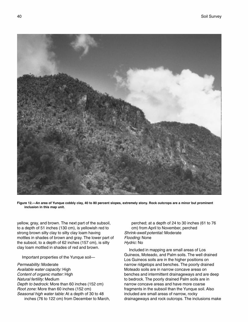
40 Soil Survey
yellow, gray, and brown. The next part of the subsoil,to a depth of 51 inches (130 cm), is yellowish red tostrong brown silty clay to silty clay loam havingmottles in shades of brown and gray. The lower part ofthe subsoil, to a depth of 62 inches (157 cm), is siltyclay loam mottled in shades of red and brown.
Important properties of the Yunque soil—
Permeability: ModerateAvailable water capacity: HighContent of organic matter: HighNatural fertility: MediumDepth to bedrock: More than 60 inches (152 cm)Root zone: More than 60 inches (152 cm)Seasonal high water table: At a depth of 30 to 48
inches (76 to 122 cm) from December to March,
perched; at a depth of 24 to 30 inches (61 to 76cm) from April to November, perched
Shrink-swell potential: ModerateFlooding: NoneHydric: No
Included in mapping are small areas of LosGuineos, Moteado, and Palm soils. The well drainedLos Guineos soils are in the higher positions onnarrow ridgetops and benches. The poorly drainedMoteado soils are in narrow concave areas onbenches and intermittent drainageways and are deepto bedrock. The poorly drained Palm soils are innarrow concave areas and have more coarsefragments in the subsoil than the Yunque soil. Alsoincluded are small areas of narrow, rockydrainageways and rock outcrops. The inclusions make
Figure 12.—An area of Yunque cobbly clay, 40 to 80 percent slopes, extremely stony. Rock outcrops are a minor but prominentinclusion in this map unit.
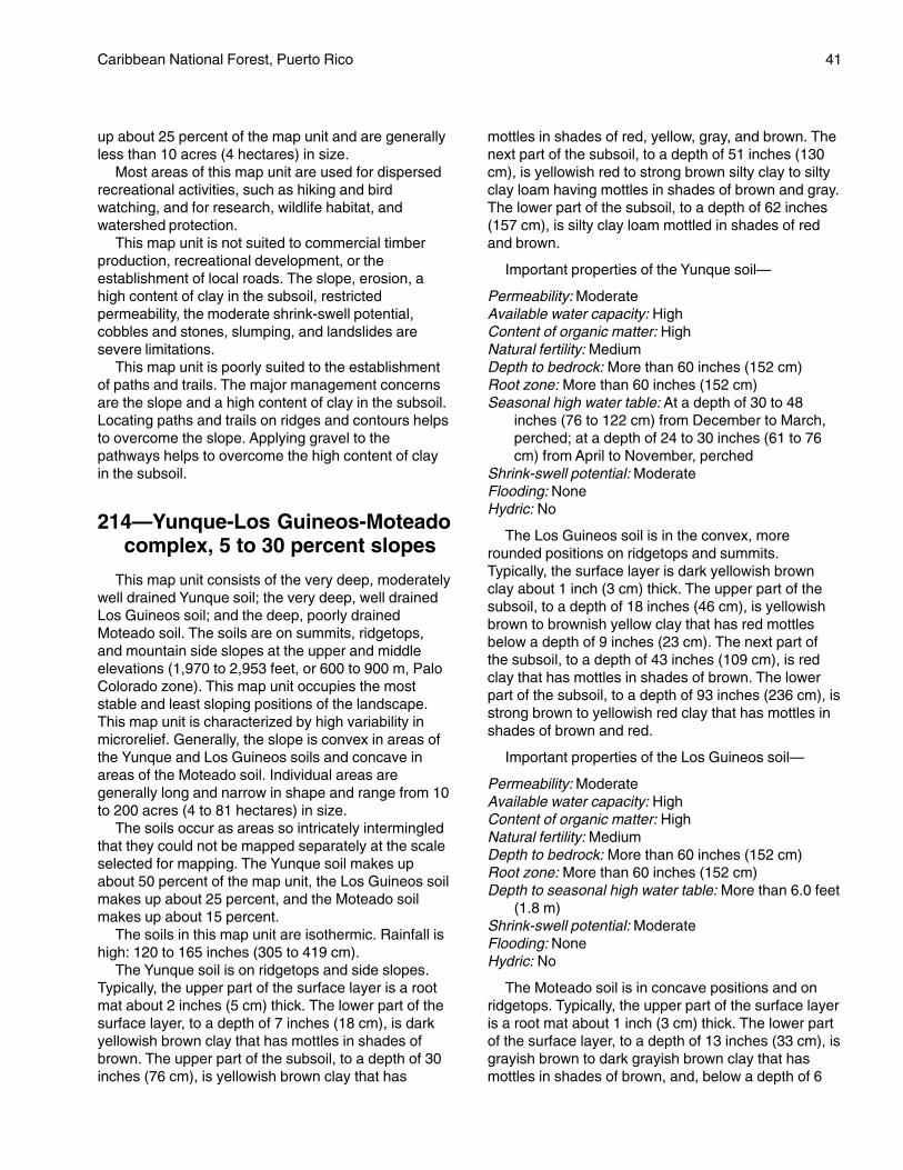
Caribbean National Forest, Puerto Rico 41
up about 25 percent of the map unit and are generallyless than 10 acres (4 hectares) in size.
Most areas of this map unit are used for dispersedrecreational activities, such as hiking and birdwatching, and for research, wildlife habitat, andwatershed protection.
This map unit is not suited to commercial timberproduction, recreational development, or theestablishment of local roads. The slope, erosion, ahigh content of clay in the subsoil, restrictedpermeability, the moderate shrink-swell potential,cobbles and stones, slumping, and landslides aresevere limitations.
This map unit is poorly suited to the establishmentof paths and trails. The major management concernsare the slope and a high content of clay in the subsoil.Locating paths and trails on ridges and contours helpsto overcome the slope. Applying gravel to thepathways helps to overcome the high content of clayin the subsoil.
214—Yunque-Los Guineos-Moteadocomplex, 5 to 30 percent slopes
This map unit consists of the very deep, moderatelywell drained Yunque soil; the very deep, well drainedLos Guineos soil; and the deep, poorly drainedMoteado soil. The soils are on summits, ridgetops,and mountain side slopes at the upper and middleelevations (1,970 to 2,953 feet, or 600 to 900 m, PaloColorado zone). This map unit occupies the moststable and least sloping positions of the landscape.This map unit is characterized by high variability inmicrorelief. Generally, the slope is convex in areas ofthe Yunque and Los Guineos soils and concave inareas of the Moteado soil. Individual areas aregenerally long and narrow in shape and range from 10to 200 acres (4 to 81 hectares) in size.
The soils occur as areas so intricately intermingledthat they could not be mapped separately at the scaleselected for mapping. The Yunque soil makes upabout 50 percent of the map unit, the Los Guineos soilmakes up about 25 percent, and the Moteado soilmakes up about 15 percent.
The soils in this map unit are isothermic. Rainfall ishigh: 120 to 165 inches (305 to 419 cm).
The Yunque soil is on ridgetops and side slopes.Typically, the upper part of the surface layer is a rootmat about 2 inches (5 cm) thick. The lower part of thesurface layer, to a depth of 7 inches (18 cm), is darkyellowish brown clay that has mottles in shades ofbrown. The upper part of the subsoil, to a depth of 30inches (76 cm), is yellowish brown clay that has
mottles in shades of red, yellow, gray, and brown. Thenext part of the subsoil, to a depth of 51 inches (130cm), is yellowish red to strong brown silty clay to siltyclay loam having mottles in shades of brown and gray.The lower part of the subsoil, to a depth of 62 inches(157 cm), is silty clay loam mottled in shades of redand brown.
Important properties of the Yunque soil—
Permeability: ModerateAvailable water capacity: HighContent of organic matter: HighNatural fertility: MediumDepth to bedrock: More than 60 inches (152 cm)Root zone: More than 60 inches (152 cm)Seasonal high water table: At a depth of 30 to 48
inches (76 to 122 cm) from December to March,perched; at a depth of 24 to 30 inches (61 to 76cm) from April to November, perched
Shrink-swell potential: ModerateFlooding: NoneHydric: No
The Los Guineos soil is in the convex, morerounded positions on ridgetops and summits.Typically, the surface layer is dark yellowish brownclay about 1 inch (3 cm) thick. The upper part of thesubsoil, to a depth of 18 inches (46 cm), is yellowishbrown to brownish yellow clay that has red mottlesbelow a depth of 9 inches (23 cm). The next part ofthe subsoil, to a depth of 43 inches (109 cm), is redclay that has mottles in shades of brown. The lowerpart of the subsoil, to a depth of 93 inches (236 cm), isstrong brown to yellowish red clay that has mottles inshades of brown and red.
Important properties of the Los Guineos soil—
Permeability: ModerateAvailable water capacity: HighContent of organic matter: HighNatural fertility: MediumDepth to bedrock: More than 60 inches (152 cm)Root zone: More than 60 inches (152 cm)Depth to seasonal high water table: More than 6.0 feet
(1.8 m)Shrink-swell potential: ModerateFlooding: NoneHydric: No
The Moteado soil is in concave positions and onridgetops. Typically, the upper part of the surface layeris a root mat about 1 inch (3 cm) thick. The lower partof the surface layer, to a depth of 13 inches (33 cm), isgrayish brown to dark grayish brown clay that hasmottles in shades of brown, and, below a depth of 6

42 Soil Survey
inches (15 cm), gray. The upper part of the subsoil, toa depth of 22 inches (56 cm), is dark grayish brownclay that has mottles in shades of brown and gray. Thenext part of the subsoil, to a depth of 41 inches (104cm), is yellowish brown and light olive brown clay thathas mottles in shades of brown, gray, and red. Thelower part of the subsoil, to a depth of 54 inches (137cm), is olive gray clay that has mottles in shades ofbrown. The underlying material, below a depth of 54inches (137 cm), is unweathered, volcanic sandstonebedrock.
Important properties of the Moteado soil—
Permeability: SlowAvailable water capacity: HighContent of organic matter: HighNatural fertility: MediumDepth to bedrock: 40 to 60 inches (102 to 152 cm)Root zone: 40 to 60 inches (102 to 152 cm)Seasonal high water table: At the surface to a depth of
12 inches (30 cm) from December through March,perched; at the surface to a depth of 6 inches (15cm) from April through November, perched
Shrink-swell potential: HighFlooding: NoneHydric: Yes
Included in mapping are small areas of the poorlydrained Palm soils in the higher positions. The Palmsoils are moderately deep and clayey-skeletal. Alsoincluded are small areas of narrow, rockydrainageways and rock outcrops. The inclusions makeup about 10 percent of the map unit and are generallyless than 10 acres (4 hectares) in size.
This map unit is used for dispersed recreationalactivities, such as hiking and bird watching, and forresearch, wildlife habitat, and watershed protection.
This map unit is suited to timber management. Themajor management concerns are the slope, thehazard of erosion, the restricted use of equipment, thehazard of windthrow, seedling mortality, and plantcompetition. Locating roads and skid trails on thecontour and, in the less sloping areas, establishingturnouts and mulching help to reduce the hazard oferosion. Restricting timber operations to the drierperiods of the year and using vehicles that have widetires or using crawler-type equipment help toovercome the equipment limitations. Proper thinningtechniques help to reduce the hazard of windthrow.The removal of undesirable species by hand is themost acceptable method of limiting plant competition.Artificial regeneration (plantings) is not recommended.This map unit should be regenerated from coppicerootstock or seed.
The map unit is poorly suited to recreational
development. The major management concerns arethe slope, a high content of clay in the subsoil, theshrink-swell potential, restricted permeability, andwetness and the depth to bedrock in the Moteado soil.Cutting and filling with suitable fill material from anoffsite location and locating facilities in the less slopingareas help to minimize the slope limitation. Specialdesign, suitable fill material from an offsite location,the selection of areas that do not include the Moteadosoil, and the use of an alternate sewage disposalsystem help to overcome the clay in the subsoil, therestricted permeability, the shrink-swell potential, andthe wetness.
This map unit is suited to the establishment ofpaths and trails. The major management concerns areclayey surfaces, the slope, and the wetness in theMoteado soil. Applying gravel to the pathways helps toovercome the clayey surfaces. Locating paths andtrails on the ridges and selecting areas that do notinclude the Moteado soil help to overcome the slopeand the wetness. Because of the high rainfall, trailsmust be armored as protection against erosion andeventual washout.
This map unit is poorly suited to the construction oflocal roads. The major management concerns are lowbearing strength, the high shrink-swell potential, theslope, and wetness and landslides in areas of theMoteado soil. These limitations can be partiallyovercome by surfacing the roads, using suitablesubgrade material, and constructing lined ditches.Also, selecting the drier parts of the map unit helps toovercome the wetness. Because of the slope, culvertwater should be drained away from the roadbed suchthat the water does not flow back to the roadbedfarther downslope. Roads built in areas of this mapunit entail steep grades, switchbacks, and cutbanksover 6 feet (1.8 m). The cutbanks are susceptible toslumping and landslides. The design andimplementation of cuts that have proper slope ratios,the use of rip-rap to support the lower parts of theslope, and the use of benching help to minimize theslumping and landslides. If possible, roads should beconstructed on the ridgetops or in the less slopingareas. Unshaped cutbanks should be less than 6 feet(1.8 m) in length because of the hazard of slumping.
215—Palm-Yunque complex, 35 to85 percent slopes, extremelystony
This map unit consists of the very deep, poorlydrained Palm soil and the very deep, moderately welldrained Yunque soil. The soils are on mountain side
Caribbean National Forest, Puerto Rico 43
slopes at the upper elevations (2,460 to 2,952 feet, or750 to 900 m, Palo Colorado zone). Generally, theslope is concave in areas of the Palm soil and convexin areas of the Yunque soil. Individual areas areirregular in shape and range from 20 to more than 300acres (8 to 121 hectares) in size.
The soils occur as areas so intricately intermingledthat they could not be mapped separately at the scaleselected for mapping. The Palm soil makes up about40 percent of the map unit, and the Yunque soil makesup about 30 percent.
The soils in this map unit are isothermic. Rainfall isvery high: 160 inches (406 cm).
A combination of very steep slopes, high rainfall,and overland flow have left a continuous mantel ofcobbles and stones on the surface. Vegetation typesare dominated by Sierra Palm. Sierra Palm is a siteindicator of unstable, rocky, wet landscapes.Saturation is a function of rainfall as opposed toponding from upslope runoff in depressions and levelareas.
The Palm soil is on concave side slopes andbenches. Typically, the upper part of the surface layeris a root mat about 3 inches (8 cm) thick. The next partof the surface layer, to a depth of about 10 inches (25cm), is dark reddish brown mucky clay. The lower partof the surface layer, to a depth of 19 inches (48 cm), isblack clay. The upper part of the subsoil, to a depth of31 inches (79 cm), is olive gray very cobbly clay thathas mottles in shades of brown. The lower part of thesubsoil, to a depth of 63 inches (160 cm) or more, isolive very cobbly clay that has mottles in shades ofred and gray.
Important properties of the Palm soil—
Permeability: Moderately slowAvailable water capacity: MediumContent of organic matter: HighNatural fertility: HighDepth to bedrock: More than 60 inches (152 cm)Root zone: More than 60 inches (152 cm)Seasonal high water table: At the surface to a depth of
12 inches (30 cm) from December through March,perched; at the surface to a depth of 6 inches (15cm) from April through November, perched
Shrink-swell potential: HighFlooding: NoneHydric: Yes
The Yunque soils generally are on convexridgetops. Typically, the upper part of the surface layeris a root mat about 2 inches (5 cm) thick. The lowerpart of the surface layer, to a depth of 7 inches (13cm), is dark yellowish brown clay that has mottles inshades of brown. The upper part of the subsoil, to a
depth of 30 inches (76 cm), is yellowish brown claythat has mottles in shades of red, yellow, gray, andbrown. The next part of the subsoil, to a depth of 51inches (130 cm), is yellowish red to strong brown siltyclay to silty clay loam having mottles in shades ofbrown and gray. The lower part of the subsoil, to adepth of 62 inches (157 cm), is silty clay loam mottledin shades of red and brown.
Important properties of the Yunque soil—
Permeability: ModerateAvailable water capacity: HighContent of organic matter: HighNatural fertility: MediumDepth to bedrock: More than 60 inches (152 cm)Root zone: More than 60 inches (152 cm)Seasonal high water table: At a depth of 30 to 48
inches (76 to 122 cm) from December to March,perched; at a depth of 24 to 30 inches (61 to 76cm) from April to November, perched
Shrink-swell potential: ModerateFlooding: NoneHydric: No
Included in mapping are small areas of LosGuineos and Moteado soils. The well drained LosGuineos soils are on the higher, isolated, convexridgetops. The poorly drained Moteado soils are deepto bedrock and are in the slightly lower concave areason narrow benches and in drainageways. Alsoincluded are small areas of narrow, rockydrainageways and rock outcrops. The inclusions makeup about 30 percent of the map unit and are generallyless than 10 acres (4 hectares) in size.
Most areas of this map unit are used for dispersedrecreational activities, such as hiking and birdwatching, and for research, wildlife habitat, andwatershed protection (fig. 13).
This map unit is not suited to commercial timberproduction, recreational development, or local roads.The slope, the shrink-swell potential, wetness andlarge stones in the Palm soil, landslides, restrictedpermeability, and a high content of clay in the subsoilare severe limitations.
This map unit is poorly suited to theestablishment of paths and trails. The majormanagement concerns are the slope, cobbles andstones, and clayey surfaces and the wetness in thePalm soil. Locating paths and trails on ridges andselecting areas that do not include the Palm soilhelp to overcome the wetness and the slope. Trailsconstructed without surfacing are difficult to utilizebecause of the rough edges of the coarsefragments. Removing the large cobbles and stonesand applying gravel to the pathways help to
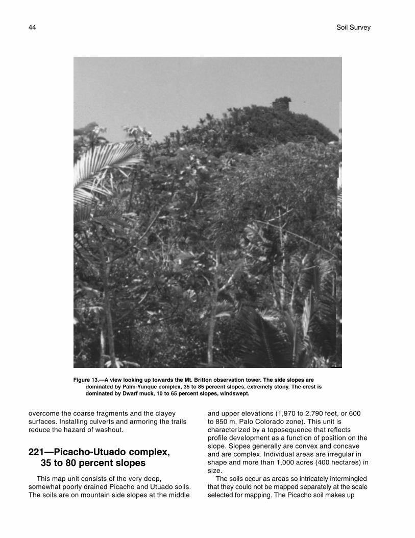
44 Soil Survey
overcome the coarse fragments and the clayeysurfaces. Installing culverts and armoring the trailsreduce the hazard of washout.
221—Picacho-Utuado complex,35 to 80 percent slopes
This map unit consists of the very deep,somewhat poorly drained Picacho and Utuado soils.The soils are on mountain side slopes at the middle
and upper elevations (1,970 to 2,790 feet, or 600to 850 m, Palo Colorado zone). This unit ischaracterized by a toposequence that reflectsprofile development as a function of position on theslope. Slopes generally are convex and concaveand are complex. Individual areas are irregular inshape and more than 1,000 acres (400 hectares) insize.
The soils occur as areas so intricately intermingledthat they could not be mapped separately at the scaleselected for mapping. The Picacho soil makes up
Figure 13.—A view looking up towards the Mt. Britton observation tower. The side slopes aredominated by Palm-Yunque complex, 35 to 85 percent slopes, extremely stony. The crest isdominated by Dwarf muck, 10 to 65 percent slopes, windswept.

Caribbean National Forest, Puerto Rico 45
about 60 percent of the map unit, and the Utuado soilmakes up about 35 percent.
The soils in this map unit are isothermic. Rainfall ishigh: 120 to 160 inches (305 to 406 cm).
The Picacho soil is generally in the higher positionson upper and middle side slopes of mountains.Typically, the upper part of the surface layer is a rootmat up to 3 inches (8 cm) thick. The lower part of thesurface layer, to a depth of about 4 inches (10 cm), isreddish brown sandy loam that has mottles in shadesof brown. The upper part of the subsoil, to a depth of10 inches (25 cm), is brown sandy clay loam that hasmottles in shades of brown and gray. The next part ofthe subsoil, to a depth of 15 inches (38 cm), is reddishyellow sandy clay loam that has mottles in shades ofbrown. The lower part of the subsoil, to a depth of 27inches (69 cm), is yellowish brown sandy clay loamthat has mottles in shades of brown. The substratum,to a depth of 63 inches (160 cm) or more, is cobblysandy loam mottled in shades of red, brown, andyellow.
Important properties of the Picacho soil—
Permeability: ModerateAvailable water capacity: HighContent of organic matter: LowNatural fertility: LowDepth to bedrock: More than 60 inches (152 cm)Root zone: More than 60 inches (152 cm)Seasonal high water table: At a depth of 12 to 18
inches (30 to 46 cm) from January throughDecember, perched
Shrink-swell potential: ModerateFlooding: NoneHydric: No
The Utuado soil is generally in the lower positionson the landscape. Typically, the upper part of thesurface layer is a root mat about 1 inch (3 cm) thick.The lower part of the surface layer, to a depth of about2 inches (5 cm), is dark brown gravelly loam. Theupper part of the subsoil, to a depth of 7 inches (18cm), is dark brown loam that has mottles in shades ofbrown and gray. The lower part of the subsoil, to adepth of 13 inches (33 cm), is dark yellowish brownloam that has mottles in shades of gray. The upperpart of the substratum, to a depth of 28 inches (71cm), is yellowish brown sandy loam. The lower part ofthe substratum, to a depth of 61 inches (155 cm) ormore, is saprolite that is mottled in white, black, andbrown and that has a texture of loamy sand.
Important properties of the Utuado soil—
Permeability: Moderately rapidAvailable water capacity: High
Content of organic matter: MediumNatural fertility: LowDepth to bedrock: More than 60 inches (152 cm)Root zone: More than 60 inches (152 cm)Seasonal high water table: At a depth of 12 to 24
inches (30 to 61 cm) from January throughDecember, perched
Shrink-swell potential: LowFlooding: NoneHydric: No
Included in mapping are small areas of Ciales andIcacos soils. The poorly drained Ciales soils are inconcave areas on the narrow, higher, more stableridgetops. Icacos soils are in the adjacent narrowdrainageways. Also included are small areas of verybouldery drainageways. The inclusions make up about5 percent of the map unit and are generally less than10 acres (4 hectares) in size.
This map unit is used for dispersed recreationalactivities, such as hiking and bird watching, and forresearch, wildlife habitat, and watershed protection.
This map unit is not suited to commercial timberproduction, recreational development, or theconstruction of local roads. The slope, wetness, and ahigh content of clay in the subsoil are severelimitations.
This map unit is poorly suited to the establishmentof paths and trails. The major management concernsare the slope and wetness. Locating trails on ridgesand on the contour, selecting areas that do not includethe Utuado soils, applying gravel to the pathways, andarmoring the trails help to overcome these limitations.
223—Picacho-Ciales complex, 5 to30 percent slopes
This map unit consists of the very deep, somewhatpoorly drained Picacho soil and the very deep, poorlydrained Ciales soil. The soils are on ridgetops,tablelands, and mountain side slopes at the middleelevations (1,970 to 2,625 feet, or 600 to 800 m, PaloColorado zone). Generally, the slope is concave inareas of the Ciales soil and convex in areas of thePicacho soil. Individual areas of this map unit areirregular in shape and range from 10 to more than 100acres (4 to 40 hectares) in size.
The soils occur as areas so intricately intermingledthat they could not be mapped separately at the scaleselected for mapping. The Picacho soil makes upabout 50 percent of the map unit, and the Ciales soilmakes up about 30 percent.
The soils in this map unit are isothermic. Rainfall ishigh: 150 to 160 inches (381 to 406 cm).
46 Soil Survey
This map unit is characterized by open stands ofPalo Colorado with little understory vegetation. It has asurface layer overlain by organic material with a lowbearing strength that is generally saturated.
The Picacho soil is on the higher ridges and sideslopes. Typically, the upper part of the surface layer isa root mat about 3 inches (8 cm) thick. The lower partof the surface layer, to a depth of about 4 inches (10cm), is reddish brown sandy loam that has mottles inshades of brown. The upper part of the subsoil, to adepth of 10 inches (25 cm), is brown sandy clay loamthat has mottles in shades of brown and gray. Thenext part of the subsoil, to a depth of 15 inches (38cm), is reddish yellow sandy clay loam that hasmottles in shades of brown. The lower part of thesubsoil, to a depth of 27 inches (69 cm), is yellowishbrown sandy clay loam that has mottles in shades ofbrown. The substratum, to a depth of 63 inches (160cm) or more, is cobbly sandy loam mottled in shadesof red, brown, and yellow.
Important properties of the Picacho soil—
Permeability: ModerateAvailable water capacity: HighContent of organic matter: LowNatural fertility: LowDepth to bedrock: More than 60 inches (152 cm)Root zone: More than 60 inches (152 cm)Seasonal high water table: At a depth of 12 to 18
inches (30 to 46 cm) from January throughDecember, perched
Shrink-swell potential: ModerateFlooding: NoneHydric: No
The Ciales soil generally is in the concave areas onlower ridges and in side slope positions. Typically, thesurface layer is dark reddish brown mucky clay loamabout 9 inches (23 cm) thick. The upper part of thesubsoil, to a depth of 25 inches (64 cm), is dark grayto olive gray sandy clay loam that has mottles inshades of black and brown. The next part of thesubsoil, to a depth of 39 inches (99 cm), is strongbrown to yellowish brown sandy loam that has mottlesin shades of brown. The lower part of the subsoil, to adepth of 56 inches (142 cm), is yellowish brown anddark brown loam. The substratum, to a depth of 73inches (185 cm) or more, is stratified dark yellowishbrown, strong brown, yellowish brown, and dark redsandy loam.
Important properties of the Ciales soil—
Permeability: SlowAvailable water capacity: HighContent of organic matter: High
Natural fertility: MediumDepth to bedrock: More than 60 inches (152 cm)Root zone: More than 60 inches (152 cm)Seasonal high water table: At a depth of 6 to 12 inches
(15 to 30 cm) from December through March,perched; at the surface to a depth of 6 inches (15cm) from April through November, perched
Shrink-swell potential: LowFlooding: NoneHydric: Yes
Included in mapping are small areas of Icacos andUtuado soils. Icacos soils are on the adjacent lowerflood plains and terraces. The somewhat poorlydrained Utuado soils are in landscape positions similarto those of the Picacho and Ciales soils but have lessclay in the subsoil. Also included are small areas ofvery bouldery drainageways. The inclusions make upabout 20 percent of the map unit and are generallyless than 10 acres (4 hectares) in size.
This map unit is used for dispersed recreationalactivities, such as hiking and bird watching, and forresearch, wildlife habitat, and watershed protection.
This map unit is not suited to commercial timberproduction. The restricted use of equipment due towetness, the slope, erosion, plant competition,seedling mortality, and windthrow are severelimitations.
This map unit is not suited to recreationaldevelopment or to low-standard access roads. Theslope, restricted permeability, the shrink-swellpotential, and wetness are severe limitations.
This map unit is poorly suited to the establishmentof paths and trails. The major management concernsare wetness, the slope, and the mucky surface of theCiales soil. Locating pathways along the contour andon ridges helps to overcome the slope. Applyinggravel to the pathways and selecting areas that do notinclude the Ciales soil help to overcome the wetnessand the mucky surfaces.
224—Picacho-Utuado complex, 5 to35 percent slopes
This map unit consists of the very deep, somewhatpoorly drained Picacho and Utuado soils. The soils areon hills and footslopes in mountain river valleys at themiddle and upper elevations (1,970 to 2,790 feet, or600 to 850 m, Palo Colorado zone). Slopes aregenerally convex and complex in areas of the Picachosoil and convex, concave, and complex in areas of theUtuado soil. Individual areas of this map unit areirregular in shape and range from 10 to more than 100acres (4 to 40 hectares) in size.
Caribbean National Forest, Puerto Rico 47
The soils occur as areas so intricately intermingledthat they could not be mapped separately at the scaleselected for mapping. The Picacho soil makes upabout 50 percent of the map unit, and the Utuado soilmakes up about 35 percent.
The soils in this map unit are isothermic. Rainfall ishigh: 120 to 160 inches (305 to 406 cm).
This map unit is characterized by dissected low hillsand drainageways between steep side slopes and theadjacent alluvial lands. This map unit receives waterfrom the adjacent upper areas and from frequentrainfall.
The Picacho soil is generally on hilltops and upperside slopes. Typically, the upper part of the surfacelayer is a root mat about 3 inches (8 cm) thick. Thelower part of the surface layer, to a depth of 4 inches(10 cm), is reddish brown sandy loam that has mottlesin shades of brown. The upper part of the subsoil, to adepth of 10 inches (25 cm), is brown sandy clay loamthat has mottles in shades of brown and gray. Thenext part of the subsoil, to a depth of 15 inches (38cm), is reddish yellow sandy clay loam that hasmottles in shades of brown. The lower part of thesubsoil, to a depth of 27 inches (69 cm), is yellowishbrown sandy clay loam that has mottles in shades ofgray. The substratum, to a depth of 63 inches (160cm) or more, is cobbly sandy loam mottled in shadesof red, brown, and yellow.
Important properties of the Picacho soil—
Permeability: ModerateAvailable water capacity: HighContent of organic matter: LowNatural fertility: LowDepth to bedrock: More than 60 inches (152 cm)Root zone: More than 60 inches (152 cm)Seasonal high water table: At a depth of 12 to 18
inches (30 to 46 cm) from January throughDecember, perched
Shrink-swell potential: ModerateFlooding: NoneHydric: No
The Utuado soil is generally on convex or concavelower side slopes and in drainageways. Typically, theupper part of the surface layer is a root mat about 1inch (3 cm) thick. The lower part of the surface layer,to a depth of about 2 inches (5 cm), is dark browngravelly loam. The upper part of the subsoil, to a depthof 7 inches (18 cm), is dark brown loam that hasmottles in shades of brown and gray. The lower part ofthe subsoil, to a depth of 13 inches (33 cm), is darkyellowish brown loam that has mottles in shades ofgray. The upper part of the substratum, to a depth of28 inches (71 cm), is yellowish brown sandy loam.
The lower part of the substratum, to a depth of 61inches (155 cm) or more, is saprolite that is mottled inwhite, black, and brown and that has a texture ofloamy sand.
Important properties of the Utuado soil—
Permeability: Moderately rapidAvailable water capacity: HighContent of organic matter: MediumNatural fertility: LowDepth to bedrock: More than 60 inches (152 cm)Root zone: More than 60 inches (152 cm)Seasonal high water table: At a depth of 12 to 24
inches (30 to 61 cm) from January throughDecember, perched
Shrink-swell potential: LowFlooding: NoneHydric: No
Included in mapping are small areas of Ciales andIcacos soils. The poorly drained Ciales soils are in thelower positions and have mucky surface layers.Icacos soils are on the adjacent lower flood plains.Also included are small areas of narrow, rockydrainageways and very stony soils. The inclusionsmake up about 15 percent of the map unit and aregenerally less than 10 acres (4 hectares) in size.
This map unit is used for dispersed recreationalactivities, such as hiking and bird watching, and forresearch, wildlife habitat, and watershed protection.
This map unit is poorly suited to commercial timberproduction. The major management concerns are thehazard of erosion, the slope, the restricted use ofequipment, seedling mortality, and plant competition.Equipment use during wet periods causes excessivedisturbance of the soil, rutting, and compaction of thesite and thus makes the soil susceptible to high ratesof erosion. Restricting timber operations to the dryseason, using vehicles that have wide tires, usingcrawler-type equipment, and using cable-yardingsystems help to overcome the equipment limitations.Locating logging roads and skid trails on the contour,establishing turnouts, and mulching reduce the hazardof erosion. The removal of undesirable species byhand is the most acceptable method of limiting plantcompetition. Artificial regeneration (planting) is notrecommended. This map unit should be regeneratedfrom coppice rootstock or seed.
This map unit is poorly suited to recreationaldevelopment. The major management concerns arethe slope and wetness. Locating facilities in the lesssloping areas and cutting and filling help to overcomethe slope. The use of fill material from an offsitelocation and alternate sewage disposal systems helpto overcome the wetness.
48 Soil Survey
This map unit is suited to the establishment ofpaths and trails. The major management concerns arewetness and the slope. Applying gravel to thepathways, constructing proper ditches, armoring thetrails, and establishing turnouts help to overcome thewetness. Locating pathways in the less sloping areas,along the contour, and on ridges help to overcome theslope. This map unit is well suited to light-use trailsand to armored high-use trails.
This map unit is poorly suited to the construction oflocal roads. The major management concerns are theslope and wetness. These limitations can be partiallyovercome by surfacing roads, constructing linedditches, and installing culverts. Because of the slope,culvert water should be drained away from theroadbed such that the water does not flow back to theroadbed farther downslope. If mixed with gravel, thesoils in this map unit are well suited to use assubgrade in road construction. If possible, roadsshould be constructed in the less sloping areas.Unshaped cutbanks should be less than 6 feet (1.8 m)in length because of the hazard of slumping.
225—Icacos loam, occasionallyflooded
This very deep, somewhat poorly drained soil is onflood plains and on low terraces along perennial rivervalleys at the middle elevations (1,970 to 2,460 feet,or 600 to 750 m, Palo Colorado zone). Slopes aregenerally smooth and concave. Individual areas aregenerally long and narrow in shape and range from 50to 200 acres (20 to 81 hectares) in size.
The Icacos soil is isothermic. Rainfall is high: 150inches (381 cm). The unit is flooded an average ofonce every 5 years.
Typically, the surface layer is brown loam about 4inches (10 cm) thick. The subsoil, to a depth of 14inches (36 cm), is yellowish brown silty clay loam thathas mottles in shades of brown and gray. The upperpart of the substratum, to a depth of 23 inches (58cm), is gray silt loam that has mottles in shades ofbrown. The next part of the substratum, to a depth of37 inches (94 cm), is greenish gray silty clay loam thathas red mottles. The lower part of the substratum, to adepth of 60 inches (152 cm) or more, is olive brownsilt loam that has mottles in shades of red and brown.
Important properties of the Icacos soil—
Permeability: ModerateAvailable water capacity: HighContent of organic matter: HighNatural fertility: High
Depth to bedrock: More than 60 inches (152 cm)Root zone: More than 60 inches (152 cm)Seasonal high water table: At a depth of 6 to 12 inches
(15 to 30 cm) from April through December,apparent
Shrink-swell potential: LowFlooding: Occasional; brief; January through
DecemberHydric: No
Included in mapping are small areas of Picacho andUtuado soils on the adjacent higher side slopes.Utuado soils have less clay in the subsoil than theIcacos soil. Also included are small areas of sandyriverbeds. The inclusions make up about 10 percent ofthe map unit and are generally less than 5 acres (2hectares) in size.
This map unit is used for dispersed recreationalactivities, such as hiking and bird watching, and forresearch, wildlife habitat, and watershed protection.
This map unit is poorly suited to timber production.The major management concerns are the restricteduse of equipment, seedling mortality, the hazard ofwindthrow, and plant competition. Restricting timberoperations to the drier periods, using vehicles thathave wide tires, and using crawler-type equipmenthelp to overcome the equipment limitations. Properthinning techniques help to reduce the hazard ofwindthrow. The most acceptable method of minimizingthe plant competition is removing the undesirablespecies by hand. The use of native or naturalizedspecies from natural regeneration of rootstock or seedis recommended for reforestation.
This map unit is not suited to recreationaldevelopment or to local roads. Wetness and theflooding are severe limitations.
This map unit is poorly suited to the establishmentof paths and trails. Wetness is a managementconcern. Applying gravel to the pathways helps toovercome the wetness. The occasional flooding ismanagement concern. The flooding is very difficult toovercome on a cost-effective basis.
231—Guayabota-Yunque complex,30 to 60 percent slopes
This map unit consists of the shallow, poorlydrained Guayabota soil and the very deep,moderately well drained Yunque soil. The soils areon mountain side slopes at the middle elevations(1,970 to 2,460 feet, or 600 to 750 m, PaloColorado zone). Generally, the slope is concave inareas of the Guayabota soil and convex in areas ofthe Yunque soil. Individual areas are generally
Caribbean National Forest, Puerto Rico 49
irregular in shape and range from 200 to more than300 acres (81 to 121 hectares) in size.
The soils occur as areas so intricately intermingledthat they could not be mapped separately at the scaleselected for mapping. The Guayabota soil makes upabout 70 percent of the map unit, and the Yunque soilmakes up about 25 percent.
The soils in this map unit are isothermic. Rainfall ishigh: 160 to 165 inches (406 to 419 cm).
The soils formed in an association of two distinctgeologic types: metamorphosed volcanic siltstone andbreccia. These geologic types are intermingled in sucha manner that the relative proportion of the soils differssignificantly from one part of the unit to another.Generally, the Yunque soil has long, sustained slopesand is on broad ridgetops and the Guayabota soil hasshort slopes and is on rounded hilltops. The solum isdeeper on the side slopes than on the ridgetops.Although this map unit is not widely distributedthroughout the survey area, it is important due to itsprominence in the El Yunque Recreation Area.
The Guayabota soil generally has 10 to 50 percentcoarse fragments on the surface, and the Yunque soilgenerally has 10 to 40 percent.
The Guayabota soil is on ridges and upper sideslopes. It formed over the metamorphosed volcanicsiltstone. Typically, the surface layer is very dark graysilty clay loam about 5 inches (13 cm) thick. The upperpart of the subsoil, to a depth of about 11 inches (28cm), is dark olive silty clay that has mottles in shadesof brown and gray. The lower part of the subsoil, to adepth of 14 inches (36 cm), is dark olive gray silty claythat has mottles in shades of brown, red, and gray.The substratum, to a depth of 18 inches (46 cm), issilty clay loam mottled in shades of gray, yellow, andred. The underlying material, below a depth of 18inches (46 cm), is hard siltstone bedrock.
Important properties of the Guayabota soil—
Permeability: SlowAvailable water capacity: HighContent of organic matter: MediumNatural fertility: LowDepth to bedrock: 10 to 20 inches (25 to 51 cm)Root zone: 10 to 20 inches (25 to 51 cm)Seasonal high water table: At a depth of 6 to 18 inches
(15 to 46 cm) from December through March,perched; at the surface to a depth of 6 inches (15cm) from April through November, perched
Shrink-swell potential: HighFlooding: NoneHydric: Yes
The Yunque soil is on ridges and side slopes. Itformed over the breccia. Typically, the upper part of
the surface layer is a root mat about 2 inches (5 cm)thick. The lower part of the surface layer, to a depth of7 inches (18 cm), is dark yellowish brown clay that hasmottles in shades of brown. The upper part of thesubsoil, to a depth of 30 inches (76 cm), is yellowishbrown clay that has mottles in shades of red, yellow,gray, and brown. The next part of the subsoil, to adepth of 51 inches (130 cm), is yellowish red to strongbrown silty clay to silty clay loam having mottles inshades of brown and gray. The lower part of thesubsoil, to a depth of 62 inches (157 cm), is silty clayloam mottled in shades of red and brown.
Important properties of the Yunque soil—
Permeability: ModerateAvailable water capacity: HighContent of organic matter: HighNatural fertility: MediumDepth to bedrock: More than 60 inches (152 cm)Root zone: More than 60 inches (152 cm)Seasonal high water table: At a depth of 30 to 48
inches (76 to 122 cm) from December throughMarch, perched; at a depth of 24 to 30 inches (61to 76 cm) from April through November, perched
Shrink-swell potential: ModerateFlooding: NoneHydric: No
Included in mapping are small areas of Moteado,Palm, Picacho, and Utuado soils. The deep, poorlydrained Moteado soils are in the lower concavepositions. The poorly drained Palm soils are verydeep, have more coarse fragments in the subsoil thanthe Guayabota and Yunque soils, and are in thehigher, unstable, steep, rocky areas. The somewhatpoorly drained Picacho and Utuado soils are verydeep. The Picacho soils have less clay in the subsoilthan the Guayabota and Yunque soils. The inclusionsmake up about 5 percent of the map unit and aregenerally less than 5 acres (2 hectares) in size.
This map unit is used for dispersed recreationalactivities, such as hiking and bird watching, and forresearch, wildlife habitat, and watershed protection.
This map unit is not suited to commercial timberproduction, recreational development, or local roads.The slope, erosion, the restricted use of equipment,plant competition, seedling mortality, wetness, a highcontent of clay in the subsoil, the shrink-swellpotential, and the depth to bedrock and windthrow inareas of the Guayabota soil are severe limitations.
This map unit is poorly suited to the establishmentof paths and trails. The major management concernsare wetness and the slope and the clayey surface ofthe Yunque soil. Locating trails along the ridgetops,applying gravel to the pathways, and selecting areas

50
that do not include the Guayabota soil help tominimize these limitations. Because of the highrainfall, trails must be armored as protection againsterosion and eventual washout.
311—Dwarf muck, 10 to 65 percentslopes, windswept
This map unit consists of very deep poorly drainedsoils on mountain summits at the upper elevations(>2,625 feet, or 800 m). Slopes are generally convexand concave and are complex. Individual areas areirregular in shape and range from 100 to 200 acres(40 to 81 hectares) in size.
High rainfall (180 inches, or 457 cm) and cool soiltemperatures (52 to 58 °F, or 11 to 14 °C) dominatebiological and chemical processes. Surfaceaccumulation of organic matter is high. Rainfallexceeds evapotranspiration rates in all months,causing soil moisture tension to rarely exceed 1atmosphere. These conditions result in very lowproductivity.
Typically, the upper part of the surface layer is verydark grayish brown muck about 4 inches (10 cm)thick. The lower part of the surface layer, to a depth of9 inches (23 cm), is dark brown mucky sandy loamthat has mottles in shades of brown. The upper part ofthe subsoil, to a depth of 26 inches (66 cm), is darkgrayish brown to olive gray silty clay loam to silty clayhaving mottles in shades of brown and olive. The nextpart of the subsoil, to a depth of 35 inches (89 cm), isolive silty clay that has mottles in shades of olive,brown, and gray. The lower part of the subsoil, to adepth of 43 inches (109 cm), is olive brown clay loamthat has mottles in shades of brown and gray. Theupper part of the substratum, to a depth of 52 inches(132 cm), is olive silt loam that has mottles in shadesof brown and gray. The lower part of the substratum,to a depth of 60 inches (152 cm) or more, is strongbrown silty clay loam that has mottles in shades ofbrown.
Important properties of the Dwarf soil—
Permeability: Moderately slowAvailable water capacity: HighContent of organic matter: Very high
Natural fertility: HighDepth to bedrock: More than 60 inches (152 cm)Root zone: More than 60 inches (152 cm)Seasonal high water table: At the surface to a depth
of 6 inches (15 cm) from April throughNovember, perched; at a depth of 6 to 12inches (15 to 30 cm) from December throughMarch, perched
Shrink-swell potential: HighFlooding: NoneHydric: Yes
Included in mapping are areas of Palm soils inthe lower drainageways and on very steep sideslopes. Palm soils have more coarse fragments inthe subsoil than the Dwarf soil and have lessorganic matter in the surface layer. Also includedare areas that have bedrock at a depth of less than40 inches and areas that have rock outcrops onledges. The inclusions make up about 10 percent ofthe map unit and are generally less than 5 acres (2hectares) in size.
This map unit is used for dispersed recreationalactivities, such as hiking and bird watching; forresearch, wildlife habitat, and watershed protection;and as a site for communication towers.
This map unit is not suited to commercial timberproduction, recreational development, or local roads.The slope, the restricted use of equipment, seedlingmortality, plant competition, wetness, erosion, a highcontent of clay in the subsoil, the shrink-swellpotential, and the low bearing strength of the organicsurface layer are severe limitations.
This map unit is poorly suited to theestablishment of paths and trails. The majormanagement concerns are the slope, wetness, andthe mucky texture of the surface layer. Locatingpathways on ridges and along the contour helps toovercome the slope. The organic layers have a verylow bearing strength and are subject to subsidence.Removing the organic matter on pathways andapplying gravel help to minimize the limitationsassociated with the organic material and thewetness. Because of erosion and puddling, trailsshould be paved or have a thick layer of graveladded. Organic material removed from this mapunit should not be used as fill because itdecomposes and thus weakens the base.
51
This soil survey is an inventory and evaluation ofthe soils in the survey area. It can be used to adjustland uses to the limitations and potentials of naturalresources and the environment. Also, it can help toprevent soil-related failures in land uses.
In preparing a soil survey, soil scientists,conservationists, engineers, and others collectextensive field data about the nature and behavioralcharacteristics of the soils. They collect data onerosion, droughtiness, flooding, and other factors thataffect various soil uses and management. Fieldexperience and collected data on soil properties andperformance are used as a basis in predicting soilbehavior.
Information in this section can be used to plan theuse and management of soils for recreation andforestland; as sites for buildings, sanitary facilities,highways and other transportation systems, and parksand other recreational facilities; and as wildlife habitat.It can be used to identify the potentials and limitationsof each soil for specific land uses and to help preventconstruction failures caused by unfavorable soilproperties (fig. 14).
Planners and others using soil survey informationcan evaluate the effect of specific land uses onproductivity and on the environment in all or part of thesurvey area. The survey can help planners to maintainor create a land use pattern in harmony with thenatural soil.
Contractors can use this survey to locate sourcesof sand and gravel, roadfill, and topsoil. They can useit to identify areas where bedrock, wetness, or veryfirm soil layers can cause difficulty in excavation.
Health officials, highway officials, engineers, andothers may also find this survey useful. The surveycan help them plan the safe disposal of wastes andlocate sites for pavements, sidewalks, campgrounds,playgrounds, and trails.
Interpretive Ratings
The interpretive tables in this survey rate thesoils in the survey area for various uses. Many ofthe tables identify the limitations that affectspecified uses and indicate the severity of those
limitations. The ratings in these tables are bothverbal and numerical.
Rating Class Terms
Rating classes are expressed in the tables in termsthat indicate the extent to which the soils are limited byall of the soil features that affect a specified use or interms that indicate the suitability of the soils for theuse. Thus, the tables may show limitation classes orsuitability classes. Terms for the limitation classes arenot limited, somewhat limited, and very limited. Thesuitability ratings are expressed as well suited,moderately suited, poorly suited, and unsuited or asgood, fair, and poor.
Numerical Ratings
Numerical ratings in the tables indicate the relativeseverity of individual limitations. The ratings are shownas decimal fractions ranging from 0.00 to 1.00. Theyindicate gradations between the point at which a soilfeature has the greatest negative impact on the useand the point at which the soil feature is not alimitation. The limitations appear in order from themost limiting to the least limiting. Thus, if more thanone limitation is identified, the most severe limitation islisted first and the least severe one is listed last.
Hydric Soils
Wade Hurt, Natural Resources Conservation Service, SoilsDivision, helped prepare this section.
In this section, hydric soils are defined anddescribed. The hydric soils in the survey area arelisted.
The three essential characteristics of wetlandsare hydrophytic vegetation, hydric soils, andwetland hydrology (Cowardin and others, 1979;U.S. Army Corps of Engineers, 1987; NationalResearch Council, 1995; Tiner and Burke, 1995).Criteria for each of the characteristics must be metfor areas to be identified as wetlands. Undrainedhydric soils that have natural vegetation shouldsupport a dominant population of ecological wetlandplant species. Hydric soils that have been
Use and Management of the Soils
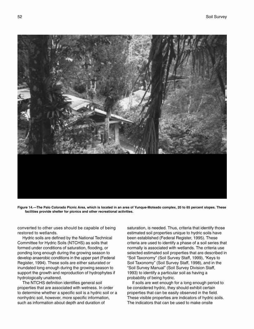
52 Soil Survey
converted to other uses should be capable of beingrestored to wetlands.
Hydric soils are defined by the National TechnicalCommittee for Hydric Soils (NTCHS) as soils thatformed under conditions of saturation, flooding, orponding long enough during the growing season todevelop anaerobic conditions in the upper part (FederalRegister, 1994). These soils are either saturated orinundated long enough during the growing season tosupport the growth and reproduction of hydrophytes ifhydrologically unaltered.
The NTCHS definition identifies general soilproperties that are associated with wetness. In orderto determine whether a specific soil is a hydric soil or anonhydric soil, however, more specific information,such as information about depth and duration of
saturation, is needed. Thus, criteria that identify thoseestimated soil properties unique to hydric soils havebeen established (Federal Register, 1995). Thesecriteria are used to identify a phase of a soil series thatnormally is associated with wetlands. The criteria useselected estimated soil properties that are described in“Soil Taxonomy” (Soil Survey Staff, 1999), “Keys toSoil Taxonomy” (Soil Survey Staff, 1998), and in the“Soil Survey Manual” (Soil Survey Division Staff,1993) to identify a particular soil as having aprobability of being hydric.
If soils are wet enough for a long enough period tobe considered hydric, they should exhibit certainproperties that can be easily observed in the field.These visible properties are indicators of hydric soils.The indicators that can be used to make onsite
Figure 14.—The Palo Colorado Picnic Area, which is located in an area of Yunque-Moteado complex, 20 to 65 percent slopes. Thesefacilities provide shelter for picnics and other recreational activities.

Caribbean National Forest, Puerto Rico 53
determinations of hydric soils are listed as thoseappropriate for the Caribbean National Forest, PuertoRico, in “Field Indicators of Hydric Soils in the UnitedStates” (Hurt, Whited, and Pringle, 1998).
Hydric soils are identified by examining anddescribing the soil to a depth of about 20 inches. Thisdepth may be greater if determination of anappropriate indicator so requires. It is alwaysrecommended that soils be excavated and describedto the depth necessary for an understanding of theredoximorphic processes. Then, using the completedsoil description, soil scientists can compare the soilfeatures required by each indicator and specify whichindicator, if any, has been matched with the conditionsobserved in the soil. The soil can be classified as ahydric soil if one (or more) of the approved indicatorsis present. Conversely, the soil is assumed to benonhydric if none of the approved indicators are present.
This soil survey can be used to locate probableareas of hydric soils.
Field Indicators have been developed for onsiteidentification of hydric soils. These indicators havebeen established by combining the bestprofessional judgement of practicing wetland soilscientists with data generated by participatingresearch soil scientists. Often it is assumed thatsoils with a field indicator are hydric and soilswithout a field indicator are nonhydric. Thisassumption may or may not be correct. All soils withan indicator may not, in fact, be hydric. Converselysoils without an indicator may, in fact, be hydric.Presently, there is no approved methodology forproving the hydric status of a soil using site-specificdata; therefore, it is necessary to have a technicalstandard based on soil properties that reflect thehydric soil definition.
The NTCHS has developed specific requirementsfor measurement of saturation, reduction/oxidationpotential, reduced iron (Fe++), in-situ pH, and onsiteprecipitation. The technical standard for hydric soilsestablishes threshold value requirements andinstrumentation methodology for data collection.Guidelines have been developed by the NTCHS forthe interpretation of each data set. To be useful forimproving the field indicators or proving the hydricstatus of a specific site, the data must be collectedduring “normal” precipitation months.
The following map units, or parts of map unitswhich are complexes, meet the definition of hydricsoils and have at least one of the hydric soil indicators.This list can help in planning land uses and updatesthe hydric soils previously noted in the CaribbeanNational Forest (USDA–SCS, 1993). Due to scalelimitations, however, onsite investigation is
recommended to determine the presence of hydricsoils on a specific site (National Research Council,1995; Hurt, Whited, and Pringle, 1998). Table 4 listsadditional information.
135 Prieto very cobbly clay loam, 25 to 50 percentslopes
212 Yunque-Moteado complex, 20 to 65 percentslopes (Moteado part)
214 Yunque-Los Guineos-Moteado complex, 5 to30 percent slopes (Moteado part)
215 Palm-Yunque complex, 35 to 85 percentslopes, extremely stony (Palm part)
223 Picacho-Ciales complex, 5 to 30 percent slopes(Ciales part)
231 Guayabota-Yunque complex, 30 to 60 percentslopes (Guayabota part)
311 Dwarf muck, 10 to 65 percent slopes,windswept
Map units that are made up of hydric soils mayhave small areas, or inclusions, of nonhydric soils inthe better drained or convex portions of the landform.Map units made up of nonhydric soils may haveinclusions of hydric soils in the poorer drained orconcave portions of the landform.
The following map units, in general, do not meet thedefinition of hydric soils and therefore do not have oneof the hydric soil indicators. A portion of these mapunits, however, may include hydric soils. Onsiteinvestigation is recommended to determine if hydricsoils occur on a specific site.
141 Luquillo stony clay loam, occasionally flooded142 Coloso silty clay loam, occasionally flooded221 Picacho-Utuado complex, 35 to 80 percent
slopes224 Picacho-Utuado complex, 5 to 35 percent
slopes225 Icacos loam, occasionally flooded
Recreation
The Caribbean National Forest provides numerousopportunities for recreation. The Forest receivesabundant rainfall, and numerous areas are used forswimming (fig. 15). Hiking trails throughout the Forestprovide access for recreation and research.
The soils of the survey area are rated in tables 5aand 5b according to limitations that affect theirsuitability for recreation. The ratings are both verbaland numerical. Rating class terms indicate the extentto which the soils are limited by all of the soil featuresthat affect the recreational uses. Not limited indicatesthat the soil has features that are very favorable for
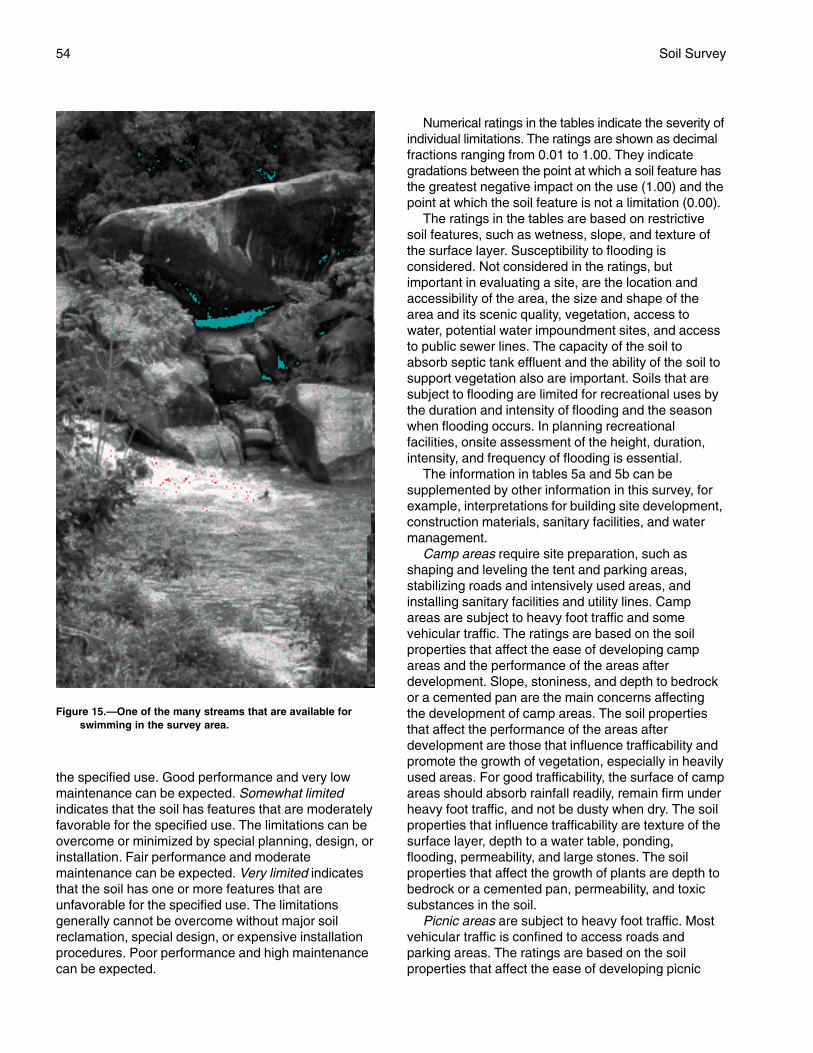
54 Soil Survey
the specified use. Good performance and very lowmaintenance can be expected. Somewhat limitedindicates that the soil has features that are moderatelyfavorable for the specified use. The limitations can beovercome or minimized by special planning, design, orinstallation. Fair performance and moderatemaintenance can be expected. Very limited indicatesthat the soil has one or more features that areunfavorable for the specified use. The limitationsgenerally cannot be overcome without major soilreclamation, special design, or expensive installationprocedures. Poor performance and high maintenancecan be expected.
Numerical ratings in the tables indicate the severity ofindividual limitations. The ratings are shown as decimalfractions ranging from 0.01 to 1.00. They indicategradations between the point at which a soil feature hasthe greatest negative impact on the use (1.00) and thepoint at which the soil feature is not a limitation (0.00).
The ratings in the tables are based on restrictivesoil features, such as wetness, slope, and texture ofthe surface layer. Susceptibility to flooding isconsidered. Not considered in the ratings, butimportant in evaluating a site, are the location andaccessibility of the area, the size and shape of thearea and its scenic quality, vegetation, access towater, potential water impoundment sites, and accessto public sewer lines. The capacity of the soil toabsorb septic tank effluent and the ability of the soil tosupport vegetation also are important. Soils that aresubject to flooding are limited for recreational uses bythe duration and intensity of flooding and the seasonwhen flooding occurs. In planning recreationalfacilities, onsite assessment of the height, duration,intensity, and frequency of flooding is essential.
The information in tables 5a and 5b can besupplemented by other information in this survey, forexample, interpretations for building site development,construction materials, sanitary facilities, and watermanagement.
Camp areas require site preparation, such asshaping and leveling the tent and parking areas,stabilizing roads and intensively used areas, andinstalling sanitary facilities and utility lines. Campareas are subject to heavy foot traffic and somevehicular traffic. The ratings are based on the soilproperties that affect the ease of developing campareas and the performance of the areas afterdevelopment. Slope, stoniness, and depth to bedrockor a cemented pan are the main concerns affectingthe development of camp areas. The soil propertiesthat affect the performance of the areas afterdevelopment are those that influence trafficability andpromote the growth of vegetation, especially in heavilyused areas. For good trafficability, the surface of campareas should absorb rainfall readily, remain firm underheavy foot traffic, and not be dusty when dry. The soilproperties that influence trafficability are texture of thesurface layer, depth to a water table, ponding,flooding, permeability, and large stones. The soilproperties that affect the growth of plants are depth tobedrock or a cemented pan, permeability, and toxicsubstances in the soil.
Picnic areas are subject to heavy foot traffic. Mostvehicular traffic is confined to access roads andparking areas. The ratings are based on the soilproperties that affect the ease of developing picnic
Figure 15.—One of the many streams that are available forswimming in the survey area.
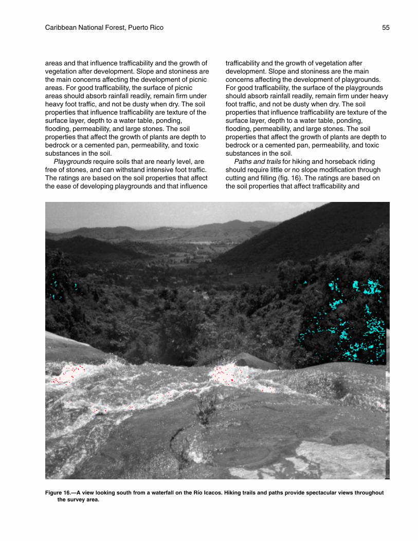
Caribbean National Forest, Puerto Rico 55
areas and that influence trafficability and the growth ofvegetation after development. Slope and stoniness arethe main concerns affecting the development of picnicareas. For good trafficability, the surface of picnicareas should absorb rainfall readily, remain firm underheavy foot traffic, and not be dusty when dry. The soilproperties that influence trafficability are texture of thesurface layer, depth to a water table, ponding,flooding, permeability, and large stones. The soilproperties that affect the growth of plants are depth tobedrock or a cemented pan, permeability, and toxicsubstances in the soil.
Playgrounds require soils that are nearly level, arefree of stones, and can withstand intensive foot traffic.The ratings are based on the soil properties that affectthe ease of developing playgrounds and that influence
trafficability and the growth of vegetation afterdevelopment. Slope and stoniness are the mainconcerns affecting the development of playgrounds.For good trafficability, the surface of the playgroundsshould absorb rainfall readily, remain firm under heavyfoot traffic, and not be dusty when dry. The soilproperties that influence trafficability are texture of thesurface layer, depth to a water table, ponding,flooding, permeability, and large stones. The soilproperties that affect the growth of plants are depth tobedrock or a cemented pan, permeability, and toxicsubstances in the soil.
Paths and trails for hiking and horseback ridingshould require little or no slope modification throughcutting and filling (fig. 16). The ratings are based onthe soil properties that affect trafficability and
Figure 16.—A view looking south from a waterfall on the Río Icacos. Hiking trails and paths provide spectacular views throughoutthe survey area.
56 Soil Survey
erodibility. These properties are stoniness, depth to awater table, ponding, flooding, slope, and texture ofthe surface layer.
Wildlife Habitat
Soils affect the kind and amount of vegetation thatis available to wildlife as food and cover. They alsoaffect the construction of water impoundments. Thekind and abundance of wildlife depend largely on theamount and distribution of food, cover, and water.Wildlife habitat can be created or improved by plantingappropriate vegetation, by maintaining the existingplant cover, or by promoting the natural establishmentof desirable plants.
In table 6, the soils in the survey area are ratedaccording to their potential for providing habitat forvarious kinds of wildlife. This information can be usedin planning parks, wildlife refuges, nature study areas,and other developments for wildlife; in selecting soilsthat are suitable for establishing, improving, ormaintaining specific elements of wildlife habitat; and indetermining the intensity of management needed foreach element of the habitat.
The potential of the soil is rated good, fair, poor,or very poor. A rating of good indicates that theelement or kind of habitat is easily established,improved, or maintained. Few or no limitationsaffect management, and satisfactory results can beexpected. A rating of fair indicates that the elementor kind of habitat can be established, improved, ormaintained in most places. Moderately intensivemanagement is required for satisfactory results. Arating of poor indicates that limitations are severefor the designated element or kind of habitat.Habitat can be created, improved, or maintained inmost places, but management is difficult and mustbe intensive. A rating of very poor indicates thatrestrictions for the element or kind of habitat arevery severe and that unsatisfactory results can beexpected. Creating, improving, or maintaininghabitat is impractical or impossible.
The elements of wildlife habitat are described in thefollowing paragraphs.
Grasses and legumes are domestic perennialgrasses and herbaceous legumes. Soil properties andfeatures that affect the growth of grasses and legumesare depth of the root zone, texture of the surface layer,available water capacity, wetness, surface stoniness,flooding, and slope. Soil temperature and soil moisturealso are considerations.
Wild herbaceous plants are native or naturallyestablished grasses and forbs, including weeds. Soilproperties and features that affect the growth of these
plants are depth of the root zone, texture of thesurface layer, available water capacity, wetness,surface stoniness, and flooding. Soil temperature andsoil moisture also are considerations.
Shrubs are bushy woody plants that produce fruit,buds, twigs, bark, and foliage. Soil properties andfeatures that affect the growth of shrubs are depth ofthe root zone, available water capacity, salinity, andsoil moisture.
Wetland plants are annual and perennial wildherbaceous plants that grow on moist or wet sites.Submerged or floating aquatic plants are excluded.Soil properties and features affecting wetland plantsare texture of the surface layer, wetness, reaction,salinity, slope, and surface stoniness.
Shallow water areas have an average depth of lessthan 5 feet. Some are naturally wet areas. Others arecreated by dams, levees, or other water-controlstructures. Soil properties and features affectingshallow water areas are depth to bedrock, wetness,surface stoniness, slope, and permeability. Examplesof shallow water areas are marshes, waterfowl feedingareas, and ponds.
The habitat for various kinds of wildlife is describedin the following paragraphs.
Habitat for openland wildlife consists of pasture,meadows, and areas that are overgrown with grasses,herbs, shrubs, and vines. These areas produce grainand seed crops, grasses and legumes, and wildherbaceous plants.
Habitat for woodland wildlife consists of areas oflarge canopy plants and associated grasses, legumes,and wild herbaceous plants.
Habitat for wetland wildlife consists of open, marshyor swampy shallow water areas.
Engineering
This section provides information for planning landuses related to urban development and to watermanagement. Soils are rated for various uses, and themost limiting features are identified. Ratings are givenfor building site development, sanitary facilities,construction materials, and water management. Theratings are based on observed performance of thesoils and on the data in the tables described under theheading “Soil Properties.”
Information in this section is intended for landuse planning, for evaluating land use alternatives,and for planning site investigations prior to designand construction. The information, however, haslimitations. For example, estimates and other datagenerally apply only to that part of the soil betweenthe surface and a depth of 5 to 7 feet. Because of
Caribbean National Forest, Puerto Rico 57
the map scale, small areas of different soils may beincluded within the mapped areas of a specific soil.
The information is not site specific and does noteliminate the need for onsite investigation of thesoils or for testing and analysis by personnelexperienced in the design and construction ofengineering works.
Government ordinances and regulations thatrestrict certain land uses or impose specific designcriteria were not considered in preparing theinformation in this section. Local ordinances andregulations should be considered in planning, in siteselection, and in design.
Soil properties, site features, and observedperformance were considered in determining theratings in this section. During the fieldwork for thissoil survey, determinations were made aboutparticle-size distribution, liquid limit, plasticity index,soil reaction, depth to bedrock, hardness of bedrockwithin 5 to 7 feet of the surface, soil wetness, depthto a water table, ponding, slope, likelihood offlooding, natural soil structure aggregation, and soildensity. Data were collected about kinds of clayminerals, mineralogy of the sand and silt fractions,and the kinds of adsorbed cations. Estimates weremade for erodibility, permeability, corrosivity, shrink-swell potential, available water capacity, and otherbehavioral characteristics affecting engineeringuses.
This information can be used to evaluate thepotential of areas for residential, commercial,industrial, and recreational uses; make preliminaryestimates of construction conditions; evaluatealternative routes for roads, streets, highways,pipelines, and underground cables; evaluatealternative sites for sanitary landfills, septic tankabsorption fields, and sewage lagoons; plan detailedonsite investigations of soils and geology; locatepotential sources of gravel, sand, earthfill, and topsoil;plan drainage systems, irrigation systems, ponds,terraces, and other structures for soil and waterconservation; and predict performance of proposedsmall structures and pavements by comparing theperformance of existing similar structures on the sameor similar soils.
The information in the tables, along with the soilmaps, the soil descriptions, and other data provided inthis survey, can be used to make additionalinterpretations.
Some of the terms used in this soil survey have aspecial meaning in soil science and are defined in theGlossary. Additional information is contained in theUSDA Natural Resources Conservation ServicesNational Engineering Handbook (USDA–NRCS, n.d.).
Building Site Development
Soil properties influence the development ofbuilding sites, including the selection of the site, thedesign of the structure, construction, performanceafter construction, and maintenance. Tables 7a and 7bshow the degree and kind of soil limitations that affectdwellings with and without basements, smallcommercial buildings, local roads, and shallowexcavations.
The ratings in the tables are both verbal andnumerical. Rating class terms indicate the extent towhich the soils are limited by all of the soil featuresthat affect building site development. Not limitedindicates that the soil has features that are veryfavorable for the specified use. Good performance andvery low maintenance can be expected. Somewhatlimited indicates that the soil has features that aremoderately favorable for the specified use. Thelimitations can be overcome or minimized by specialplanning, design, or installation. Fair performance andmoderate maintenance can be expected. Very limitedindicates that the soil has one or more features thatare unfavorable for the specified use. The limitationsgenerally cannot be overcome without major soilreclamation, special design, or expensive installationprocedures. Poor performance and high maintenancecan be expected.
Numerical ratings in the tables indicate the severityof individual limitations. The ratings are shown asdecimal fractions ranging from 0.01 to 1.00. Theyindicate gradations between the point at which a soilfeature has the greatest negative impact on the use(1.00) and the point at which the soil feature is not alimitation (0.00).
Dwellings are single-family houses of three storiesor less. For dwellings without basements, thefoundation is assumed to consist of spread footings ofreinforced concrete built on undisturbed soil at a depthof 2 feet. For dwellings with basements, the foundationis assumed to consist of spread footings of reinforcedconcrete built on undisturbed soil at a depth of about 7feet. The ratings for dwellings are based on the soilproperties that affect the capacity of the soil to supporta load without movement and on the properties thataffect excavation and construction costs. Theproperties that affect the load-supporting capacityinclude depth to a water table, ponding, flooding,subsidence, linear extensibility (shrink-swell potential),and compressibility. Compressibility is inferred fromthe Unified classification. The properties that affect theease and amount of excavation include depth to awater table, ponding, flooding, slope, depth to bedrockor a cemented pan, hardness of bedrock or a
58 Soil Survey
cemented pan, and the amount and size of rockfragments.
Small commercial buildings are structures that areless than three stories high and do not havebasements. The foundation is assumed to consist ofspread footings of reinforced concrete built onundisturbed soil at a depth of 2 feet. The ratings arebased on the soil properties that affect the capacity ofthe soil to support a load without movement and onthe properties that affect excavation and constructioncosts. The properties that affect the load-supportingcapacity include depth to a water table, ponding,flooding, subsidence, linear extensibility (shrink-swellpotential), and compressibility (which is inferred fromthe Unified classification). The properties that affectthe ease and amount of excavation include flooding,depth to a water table, ponding, slope, depth tobedrock, hardness of bedrock, and the amount andsize of rock fragments.
Local roads have an all-weather surface and carryautomobile and light truck traffic all year. They have asubgrade of cut or fill soil material; a base of gravel,crushed rock, or soil material stabilized by lime orcement; and a surface of flexible material (asphalt),rigid material (concrete), or gravel with a binder. Theratings are based on the soil properties that affect theease of excavation and grading and the traffic-supporting capacity. The properties that affect theease of excavation and grading are depth to bedrock,hardness of bedrock, depth to a water table, ponding,flooding, the amount of large stones, and slope. Theproperties that affect the traffic-supporting capacity aresoil strength (as inferred from the AASHTO groupindex number), subsidence, linear extensibility (shrink-swell potential), depth to a water table, and ponding.
Shallow excavations are trenches or holes dug to amaximum depth of 5 or 6 feet for graves, utility lines,open ditches, or other purposes. The ratings arebased on the soil properties that influence the ease ofdigging and the resistance to sloughing. Depth tobedrock, hardness of bedrock, the amount of largestones, and dense layers influence the ease ofdigging, filling, and compacting. Depth to the seasonalhigh water table, flooding, and ponding may restrictthe period when excavations can be made. Slopeinfluences the ease of using machinery. Soil texture,depth to the water table, and linear extensibility(shrink-swell potential) influence the resistance tosloughing.
Sanitary Facilities
Table 8 shows the degree and kind of soillimitations that affect septic tank absorption fields andsewage lagoons. The ratings are both verbal and
numerical. Rating class terms indicate the extent towhich the soils are limited by all of the soil featuresthat affect these uses. Not limited indicates that thesoil has features that are very favorable for thespecified use. Good performance and very lowmaintenance can be expected. Somewhat limitedindicates that the soil has features that are moderatelyfavorable for the specified use. The limitations can beovercome or minimized by special planning, design, orinstallation. Fair performance and moderatemaintenance can be expected. Very limited indicatesthat the soil has one or more features that areunfavorable for the specified use. The limitationsgenerally cannot be overcome without major soilreclamation, special design, or expensive installationprocedures. Poor performance and high maintenancecan be expected.
Numerical ratings in the tables indicate the severityof individual limitations. The ratings are shown asdecimal fractions ranging from 0.01 to 1.00. Theyindicate gradations between the point at which a soilfeature has the greatest negative impact on the use(1.00) and the point at which the soil feature is not alimitation (0.00).
Septic tank absorption fields are areas in whicheffluent from a septic tank is distributed into the soilthrough subsurface tiles or perforated pipe. Only thatpart of the soil between depths of 24 and 60 inches isevaluated. The ratings are based on the soil propertiesthat affect absorption of the effluent, construction andmaintenance of the system, and public health.Permeability, depth to a water table, ponding, depth tobedrock, and flooding affect absorption of the effluent.Stones and boulders and bedrock interfere withinstallation. Subsidence interferes with installation andmaintenance. Excessive slope may cause lateralseepage and surfacing of the effluent in downslopeareas.
Some soils are underlain by loose sand and gravelor fractured bedrock at a depth of less than 4 feetbelow the distribution lines. In these soils theabsorption field may not adequately filter the effluent,particularly when the system is new. As a result, theground water may become contaminated.
Sewage lagoons are shallow ponds constructed tohold sewage while aerobic bacteria decompose thesolid and liquid wastes. Lagoons should have a nearlylevel floor surrounded by cut slopes or embankmentsof compacted soil. Nearly impervious soil material forthe lagoon floor and sides is required to minimizeseepage and contamination of ground water.Considered in the ratings are slope, permeability,depth to a water table, ponding, depth to bedrock,flooding, large stones, and content of organic matter.
60
The ratings are for the whole soil, from the surfaceto a depth of about 5 feet. It is assumed that soillayers will be mixed when the soil material isexcavated and spread.
The ratings are based on the amount of suitablematerial and on soil properties that affect the ease ofexcavation and the performance of the material after itis in place. The thickness of the suitable material is amajor consideration. The ease of excavation isaffected by large stones, depth to a water table, andslope. How well the soil performs in place after it hasbeen compacted and drained is determined by itsstrength (as inferred from the AASHTO classificationof the soil) and linear extensibility (shrink-swellpotential).
Water Management
Table 10 gives information on the soil propertiesand site features that affect water management. Thedegree and kind of soil limitations are given for pondreservoir areas and embankments, dikes, and levees.The limitations are considered slight if soil propertiesand site features are generally favorable for theindicated use and limitations are minor and are easilyovercome; moderate if soil properties or site featuresare not favorable for the indicated use and specialplanning, design, or maintenance is needed toovercome or minimize the limitations; and severe ifsoil properties or site features are so unfavorable orso difficult to overcome that special design, significantincrease in construction costs, and possibly increasedmaintenance are required.
This table also gives for each soil the restrictivefeatures that affect drainage.
Pond reservoir areas hold water behind a dam orembankment. Soils best suited to this use have lowseepage potential in the upper 60 inches. Theseepage potential is determined by the permeability ofthe soil and the depth to fractured bedrock or other
permeable material. Excessive slope can affect thestorage capacity of the reservoir area.
Embankments, dikes, and levees are raisedstructures of soil material, generally less than 20 feethigh, constructed to impound water or to protect landagainst overflow. In this table, the soils are rated as asource of material for embankment fill. The ratingsapply to the soil material below the surface layer to adepth of about 5 feet. It is assumed that soil layers willbe uniformly mixed and compacted duringconstruction.
The ratings do not indicate the ability of the naturalsoil to support an embankment. Soil properties to adepth even greater than the height of the embankmentcan affect performance and safety of theembankment. Generally, deeper onsite investigation isneeded to determine these properties.
Soil material in embankments must be resistant toseepage, piping, and erosion and have favorablecompaction characteristics. Unfavorable featuresinclude less than 5 feet of suitable material and a highcontent of stones or boulders, organic matter, or saltsor sodium. A high water table affects the amount ofusable material. It also affects trafficability.
Drainage is the removal of excess surface andsubsurface water from the soil. How easily andeffectively the soil is drained depends on the depth tobedrock or other layers that affect the rate of watermovement; permeability; depth to a high water table ordepth of standing water if the soil is subject toponding; slope; susceptibility to flooding; andsubsidence of organic layers. Excavating and gradingand the stability of ditchbanks are affected by depth tobedrock, large stones, slope, and the hazard ofcutbanks caving. The productivity of the soil afterdrainage is adversely affected by extreme acidity or bytoxic substances in the root zone, such as salts,sodium, and sulfur. Availability of drainage outlets isnot considered in the ratings.
61
Data relating to soil properties are collected duringthe course of the soil survey.
Soil properties are ascertained by field examinationof the soils and by laboratory index testing of somebenchmark soils. Established standard procedures arefollowed. During the survey, many shallow borings aremade and examined to identify and classify the soilsand to delineate them on the soil maps. Samples aretaken from some typical profiles and tested in thelaboratory to determine particle-size distribution,plasticity, and compaction characteristics.
Estimates of soil properties are based on fieldexaminations, on laboratory tests of samples from thesurvey area, and on laboratory tests of samples ofsimilar soils in nearby areas. Tests verify fieldobservations, verify properties that cannot beestimated accurately by field observation, and help tocharacterize key soils.
The estimates of soil properties are shown intables. They include engineering index properties,physical and chemical properties, and pertinent soiland water features.
Engineering Index Properties
Table 11 gives the engineering classifications andthe range of index properties for the layers of each soilin the survey area.
Depth to the upper and lower boundaries of eachlayer is indicated.
Texture is given in the standard terms used by theU.S. Department of Agriculture. These terms aredefined according to percentages of sand, silt, andclay in the fraction of the soil that is less than 2millimeters in diameter. “Loam,” for example, is soilthat is 7 to 27 percent clay, 28 to 50 percent silt, andless than 52 percent sand. If the content of particlescoarser than sand is 15 percent or more, anappropriate modifier is added, for example, “gravelly.”Textural terms are defined in the Glossary.
Classification of the soils is determined according tothe Unified soil classification system (ASTM, 2001)and the system adopted by the American Associationof State Highway and Transportation Officials(AASHTO, 2000).
The Unified system classifies soils according toproperties that affect their use as constructionmaterial. Soils are classified according to particle-sizedistribution of the fraction less than 3 inches indiameter and according to plasticity index, liquid limit,and organic matter content. Sandy and gravelly soilsare identified as GW, GP, GM, GC, SW, SP, SM, andSC; silty and clayey soils as ML, CL, OL, MH, CH, andOH; and highly organic soils as PT. Soils exhibitingengineering properties of two groups can have a dualclassification, for example, CL-ML.
The AASHTO system classifies soils according tothose properties that affect roadway construction andmaintenance. In this system, the fraction of a mineralsoil that is less than 3 inches in diameter is classifiedin one of seven groups from A-1 through A-7 on thebasis of particle-size distribution, liquid limit, andplasticity index. Soils in group A-1 are coarse grainedand low in content of fines (silt and clay). At the otherextreme, soils in group A-7 are fine grained. Highlyorganic soils are classified in group A-8 on the basis ofvisual inspection.
If laboratory data are available, the A-1, A-2, andA-7 groups are further classified as A-1-a, A-1-b, A-2-4, A-2-5, A-2-6, A-2-7, A-7-5, or A-7-6. As anadditional refinement, the suitability of a soil assubgrade material can be indicated by a groupindex number. Group index numbers range from 0for the best subgrade material to 20 or higher forthe poorest.
Rock fragments larger than 10 inches in diameterand 3 to 10 inches in diameter are indicated as apercentage of the total soil on a dry-weight basis. Thepercentages are estimates determined mainly byconverting volume percentage in the field to weightpercentage.
Percentage (of soil particles) passing designatedsieves is the percentage of the soil fraction less than 3inches in diameter based on an ovendry weight. Thesieves, numbers 4, 10, 40, and 200 (USA StandardSeries), have openings of 4.76, 2.00, 0.420, and 0.074millimeters, respectively. Estimates are based onlaboratory tests of soils sampled in the survey areaand in nearby areas and on estimates made in thefield.
Soil Properties
62 Soil Survey
Liquid limit and plasticity index (Atterberg limits)indicate the plasticity characteristics of a soil. Theestimates are based on test data from the survey areaor from nearby areas and on field examination.
The estimates of particle-size distribution, liquidlimit, and plasticity index are generally rounded to thenearest 5 percent. Thus, if the ranges of gradation andAtterberg limits extend a marginal amount (1 or 2percentage points) across classification boundaries,the classification in the marginal zone is generallyomitted in the table.
Physical and Chemical Analyses ofSelected Soils
The results of physical analyses of several typicalpedons in the survey area are given in table 12 andthe results of chemical analyses in table 13. The dataare for soils sampled at carefully selected sites.Unless otherwise indicated, the pedons are typical ofthe series. They are described in the section “SoilSeries and Their Morphology.” Soil samples wereanalyzed by the National Soil Survey Laboratory,Lincoln, Nebraska.
Most determinations, except those for grain-sizeanalysis and bulk density, were made on soil materialsmaller than 2 millimeters in diameter. Measurementsreported as percent or quantity of unit weight werecalculated on an ovendry basis. The methods used inobtaining the data are indicated in the list that follows.The codes in parentheses refer to published methods(USDA, 1996).
Sand—(0.05-2.0 mm fraction) weight percentages ofmaterial less than 2 mm (3A1).
Silt—(0.002-0.05 mm fraction) pipette extraction,weight percentages of all material less than 2 mm(3A1).
Clay—(fraction less than 0.002 mm) pipette extraction,weight percentages of material less than 2 mm(3A1).
Organic carbon—wet combustion. Walkley-Blackmodified acid-dichromate, ferric sulfate titration(6A1c).
Extractable cations—ammonium acetate pH 7.0, ICP;calcium (6N2i), magnesium (6O2h), sodium(6P2f), potassium (6Q2f).
Extractable acidity—barium chloride-triethanolamineIV (6H5a).
Cation-exchange capacity—ammonium acetate, pH7.0, steam distillation (5A8b).
Cation-exchange capacity—sum of cations (5A3a).Effective cation-exchange capacity—sum of
extractable cations plus aluminum (5A3b).
Base saturation—ammonium acetate, pH 7.0 (5C1).Reaction (pH)—potassium chloride (8C1g).Reaction (pH)—calcium chloride (8C1f).Aluminum—potassium chloride extraction (6G9a).
Soil Features
Table 14 gives estimates of various soil features.The estimates are used in land use planning thatinvolves engineering considerations.
A restrictive layer is a nearly continuous layer thathas one or more physical, chemical, or thermalproperties that significantly impede the movement ofwater and air through the soil or that restrict roots orotherwise provide an unfavorable root environment.Examples are bedrock, cemented layers, and denselayers. The table indicates the hardness of therestrictive layer, which significantly affects the ease ofexcavation. Depth to top is the vertical distance fromthe soil surface to the upper boundary of the restrictivelayer.
Risk of corrosion pertains to potential soil-inducedelectrochemical or chemical action that corrodes orweakens uncoated steel or concrete. The rate ofcorrosion of uncoated steel is related to such factorsas soil moisture, particle-size distribution, acidity, andelectrical conductivity of the soil. The rate of corrosionof concrete is based mainly on the sulfate and sodiumcontent, texture, moisture content, and acidity of thesoil. Special site examination and design may beneeded if the combination of factors results in asevere hazard of corrosion. The steel or concrete ininstallations that intersect soil boundaries or soil layersis more susceptible to corrosion than the steel orconcrete in installations that are entirely within onekind of soil or within one soil layer.
For uncoated steel, the risk of corrosion, expressedas low, moderate, or high, is based on soil drainageclass, total acidity, electrical resistivity near fieldcapacity, and electrical conductivity of the saturationextract.
For concrete, the risk of corrosion also is expressedas low, moderate, or high. It is based on soil texture,acidity, and amount of sulfates in the saturationextract.
Water Features
Table 15 gives estimates of various water features.The estimates are used in land use planning thatinvolves engineering considerations.
Hydrologic soil groups are based on estimates ofrunoff potential. Soils are assigned to one of fourgroups according to the rate of water infiltration when
Caribbean National Forest, Puerto Rico 63
the soils are not protected by vegetation, arethoroughly wet, and receive precipitation from long-duration storms.
The four hydrologic soil groups are:Group A. Soils having a high infiltration rate (low
runoff potential) when thoroughly wet. These consistmainly of deep, well drained to excessively drainedsands or gravelly sands. These soils have a high rateof water transmission.
Group B. Soils having a moderate infiltration ratewhen thoroughly wet. These consist chiefly ofmoderately deep or deep, moderately well drained orwell drained soils that have moderately fine texture tomoderately coarse texture. These soils have amoderate rate of water transmission.
Group C. Soils having a slow infiltration rate whenthoroughly wet. These consist chiefly of soils having alayer that impedes the downward movement of wateror soils of moderately fine texture or fine texture.These soils have a slow rate of water transmission.
Group D. Soils having a very slow infiltration rate(high runoff potential) when thoroughly wet. Theseconsist chiefly of clays that have a high shrink-swellpotential, soils that have a high water table, soils thathave a claypan or clay layer at or near the surface,and soils that are shallow over nearly imperviousmaterial. These soils have a very slow rate of watertransmission.
The months in the table indicate the portion of theyear in which the feature is most likely to be aconcern.
Water table refers to a saturated zone in the soil.Table 15 indicates, by month, depth to the top (upperlimit) and base (lower limit) of the saturated zone inmost years. Estimates of the upper and lower limitsare based mainly on observations of the water table atselected sites and on evidence of a saturated zone,namely grayish colors or mottles (redoximorphicfeatures) in the soil. A saturated zone that lasts forless than a month is not considered a water table.
Flooding is the temporary inundation of an areacaused by overflowing streams, by runoff fromadjacent slopes, or by tides. Water standing for shortperiods after rainfall or snowmelt is not consideredflooding, and water standing in swamps and marshesis considered ponding rather than flooding.
Duration and frequency are estimated. Duration isexpressed as extremely brief if 0.1 hour to 4 hours,very brief if 4 hours to 2 days, brief if 2 to 7 days, longif 7 to 30 days, and very long if more than 30 days.Frequency is expressed as none, very rare, rare,occasional, frequent, and very frequent. None meansthat flooding is not probable; very rare that it is veryunlikely but possible under extremely unusual weather
conditions (the chance of flooding is less than 1percent in any year); rare that it is unlikely but possibleunder unusual weather conditions (the chance offlooding is 1 to 5 percent in any year); occasional thatit occurs infrequently under normal weather conditions(the chance of flooding is 5 to 50 percent in any year);frequent that it is likely to occur often under normalweather conditions (the chance of flooding is morethan 50 percent in any year but is less than 50 percentin all months in any year); and very frequent that it islikely to occur very often under normal weatherconditions (the chance of flooding is more than 50percent in all months of any year).
The information is based on evidence in the soilprofile, namely thin strata of gravel, sand, silt, or claydeposited by floodwater; irregular decrease in organicmatter content with increasing depth; and little or nohorizon development.
Also considered are local information about theextent and levels of flooding and the relation of eachsoil on the landscape to historic floods. Information onthe extent of flooding based on soil data is lessspecific than that provided by detailed engineeringsurveys that delineate flood-prone areas at specificflood frequency levels.
Physical Properties
Table 16 shows estimates of some physicalcharacteristics and features that affect soil behavior.These estimates are given for the layers of each soil inthe survey area. The estimates are based on fieldobservations and on test data for these and similarsoils.
Depth to the upper and lower boundaries of eachlayer is indicated.
Particle size is the effective diameter of a soilparticle as measured by sedimentation, sieving, ormicrometric methods. Particle sizes are expressed asclasses with specific effective diameter class limits.The broad classes are sand, silt, and clay, rangingfrom the larger to the smaller.
Clay as a soil separate consists of mineral soilparticles that are less than 0.002 millimeter indiameter. In table 16, the estimated clay content ofeach soil layer is given as a percentage, by weight, ofthe soil material that is less than 2 millimeters indiameter.
The content of sand, silt, and clay affects thephysical behavior of a soil. Particle size is importantfor engineering and agronomic interpretations, fordetermination of soil hydrologic qualities, and for soilclassification.
The amount and kind of clay affect the fertility and
64 Soil Survey
physical condition of the soil and the ability of the soilto adsorb cations and to retain moisture. Theyinfluence shrink-swell potential, permeability, plasticity,the ease of soil dispersion, and other soil properties.The amount and kind of clay in a soil also affect tillageand earthmoving operations.
Moist bulk density is the weight of soil (ovendry) perunit volume. Volume is measured when the soil is atfield moisture capacity, that is, the moisture content at1/3- or 1/10-bar (33kPa or 10kPa) moisture tension.Weight is determined after the soil is dried at 105degrees C. In the table, the estimated moist bulkdensity of each soil horizon is expressed in grams percubic centimeter of soil material that is less than 2millimeters in diameter. Bulk density data are used tocompute shrink-swell potential, available watercapacity, total pore space, and other soil properties.The moist bulk density of a soil indicates the porespace available for water and roots. Depending on soiltexture, a bulk density of more than 1.4 can restrictwater storage and root penetration. Moist bulk densityis influenced by texture, kind of clay, content oforganic matter, and soil structure.
Saturated hydraulic conductivity refers to the abilityof a soil to transmit water. The term “permeability,” asused in soil surveys, indicates saturated hydraulicconductivity (K
sat ). The estimates in the table indicate
the rate of water movement, in micrometers persecond (um/sec), when the soil is saturated. They arebased on soil characteristics observed in the field,particularly structure, porosity, and texture.Permeability is considered in the design of soildrainage systems and septic tank absorption fields.
Available water capacity refers to the quantity ofwater that the soil is capable of storing for use byplants. The capacity for water storage is given ininches of water per inch of soil for each soil layer. Thecapacity varies, depending on soil properties thataffect retention of water. The most importantproperties are the content of organic matter, soiltexture, bulk density, and soil structure. Availablewater capacity is an important factor in the choice ofplants or crops to be grown and in the design andmanagement of irrigation systems. Available watercapacity is not an estimate of the quantity of wateractually available to plants at any given time.
Linear extensibility refers to the change in lengthof an unconfined clod as moisture content isdecreased from a moist to a dry state. It is anexpression of the volume change between thewater content of the clod at 1/3- or 1/10-bar tension(33kPa or 10kPa tension) and oven dryness. Thevolume change is reported in the table as percentchange for the whole soil. Volume change is
influenced by the amount and type of clay mineralsin the soil.
Linear extensibility is used to determine the shrink-swell potential of soils. The shrink-swell potential islow if the soil has a linear extensibility of less than 3percent; moderate if 3 to 6 percent; high if 6 to 9percent; and very high if more than 9 percent. If thelinear extensibility is more than 3 percent, shrinkingand swelling can cause damage to buildings, roads,and other structures and to plant roots. Special designcommonly is needed.
Organic matter is the plant and animal residue inthe soil at various stages of decomposition. In table16, the estimated content of organic matter isexpressed as a percentage, by weight, of the soilmaterial that is less than 2 millimeters in diameter.
The content of organic matter in a soil can bemaintained by returning crop residue to the soil.Organic matter has a positive effect on available watercapacity, water infiltration, soil organism activity, andtilth. It is a source of nitrogen and other nutrients forplants and soil organisms.
Erosion factors are shown in table 16 as the Kfactor (Kw and Kf) and the T factor. Erosion factor Kindicates the susceptibility of a soil to sheet and rillerosion by water. Factor K is one of six factors used inthe Universal Soil Loss Equation (USLE) and theRevised Universal Soil Loss Equation (RUSLE) topredict the average annual rate of soil loss by sheetand rill erosion in tons per acre per year. Theestimates are based primarily on percentage of silt,sand, and organic matter and on soil structure andpermeability. Values of K range from 0.02 to 0.69.Other factors being equal, the higher the value, themore susceptible the soil is to sheet and rill erosion bywater.
Erosion factor Kw indicates the erodibility of thewhole soil. The estimates are modified by thepresence of rock fragments.
Erosion factor Kf indicates the erodibility of the fine-earth fraction, or the material less than 2 millimeters insize.
Erosion factor T is an estimate of the maximumaverage annual rate of soil erosion by wind or waterthat can occur without affecting crop productivity overa sustained period. The rate is in tons per acre peryear.
Chemical Properties
Table 17 shows estimates of some chemicalcharacteristics and features that affect soil behavior.These estimates are given for the layers of each soil inthe survey area. The estimates are based on field
Caribbean National Forest, Puerto Rico 65
observations and on test data for these and similarsoils.
Depth to the upper and lower boundaries of eachlayer is indicated.
Cation-exchange capacity is the total amount ofextractable bases that can be held by the soil,expressed in terms of milliequivalents per 100 gramsof soil at neutrality (pH 7.0) or at some other stated pHvalue. Soils having a low cation-exchange capacityhold fewer cations and may require more frequent
applications of fertilizer than soils having a high cation-exchange capacity. The ability to retain cationsreduces the hazard of ground-water pollution.
Soil reaction is a measure of acidity or alkalinity.The pH of each soil horizon is based on many fieldtests. For many soils, values have been verified bylaboratory analyses. Soil reaction is important inselecting crops and other plants, in evaluating soilamendments for fertility and stabilization, and indetermining the risk of corrosion.

67
The system of soil classification used by theNational Cooperative Soil Survey has six categories(Soil Survey Staff, 1998 and 1999). Beginning with thebroadest, these categories are the order, suborder,great group, subgroup, family, and series.Classification is based on soil properties observed inthe field or inferred from those observations or fromlaboratory measurements. Table 18 shows theclassification of the soils in the survey area. Thecategories are defined in the following paragraphs.
ORDER. Twelve soil orders are recognized. Thedifferences among orders reflect the dominant soil-forming processes and the degree of soil formation.Each order is identified by a word ending in sol. Anexample is Oxisol.
SUBORDER. Each order is divided into subordersprimarily on the basis of properties that influence soilgenesis and are important to plant growth orproperties that reflect the most important variableswithin the orders. The last syllable in the name of asuborder indicates the order. An example is Udox (Ud,meaning humid, plus ox, from Oxisol).
GREAT GROUP. Each suborder is divided intogreat groups on the basis of close similarities in kind,arrangement, and degree of development ofpedogenic horizons; soil moisture and temperatureregimes; type of saturation; and base status. Eachgreat group is identified by the name of a suborderand by a prefix that indicates a property of the soil. Anexample is Hapludox (Hapl, meaning other, plus udox,the suborder of the Oxisols that has a udic moistureregime).
SUBGROUP. Each great group has a typicsubgroup. Other subgroups are intergrades orextragrades. The typic subgroup is the centralconcept of the great group; it is not necessarily themost extensive. Intergrades are transitions to otherorders, suborders, or great groups. Extragradeshave some properties that are not representative ofthe great group but do not indicate transitions toany other taxonomic class. Each subgroup isidentified by one or more adjectives preceding thename of the great group. The adjective Aquicidentifies the subgroup that has gray mottles withina depth of 50 inches (125 cm) and has aquic
conditions for some time in normal years. Anexample is Aquic Hapludox.
FAMILY. Families are established within asubgroup on the basis of physical and chemicalproperties and other characteristics that affectmanagement. Generally, the properties are those ofhorizons below plow depth where there is muchbiological activity. Among the properties andcharacteristics considered are particle-size class,mineralogy class, cation-exchange activity class, soiltemperature regime, soil depth, and reaction class. Afamily name consists of the name of a subgrouppreceded by terms that indicate soil properties. Anexample is very-fine, kaolinitic, isohyperthermic AquicHapludox.
SERIES. The series consists of soils within afamily that have horizons similar in color, texture,structure, reaction, consistence, mineral and chemicalcomposition, and arrangement in the profile. The soilsof the Cristal series are very-fine, kaolinitic,isohyperthermic Aquic Hapludox.
Soil Series and Their MorphologyIn this section, each soil series recognized in the
Caribbean National Forest is described. The fielddata that were collected for each soil include aminimum of three complete descriptions for seriesof minor extent and ten or more for the majorseries. Characteristics of the soil and the material inwhich it formed are identified for each series. Thedetailed description of each soil horizon followsstandards in the Soil Survey Manual (Soil SurveyDivision Staff, 1993). Many of the technical termsused in the descriptions are defined in SoilTaxonomy (Soil Survey Staff, 1998 and 1999).Unless otherwise stated, colors in the descriptionare for moist soil. Following the pedon description isthe range of the important characteristics of thesoils in the series for this survey area.
A pedon is a small three-dimensional area of soil. Atypical pedon for each series in the survey area isdescribed. Lab data for many of the typical pedons arein tables 12 and 13. The typical pedons represent the
Classification of the Soils
68 Soil Survey
central theme or idea of a particular soil series as itoccurs in the survey area. The typical pedon iscompared and contrasted with similar soils and withnearby soils of other series. Characteristics which setit apart from other recognized series in the surveyarea are given.
Caguabo Series
The Caguabo series consists of shallow, welldrained soils on ridgetops, ledges, and side slopes ofstrongly dissected uplands. These soils formed inmaterial that weathered from andesitic to basaltic,marine-deposited, calcareous mudstone of the HatoPuerco Formation. Near the type location, the meanannual precipitation is about 80 inches (203 cm) andthe mean annual temperature is 76 degrees F (24 °C).Slopes range from 8 to 70 percent. These soils areloamy, mixed, active, isohyperthermic, shallow TypicEutrudepts.
Caguabo soils are commonly associated with Prietoand Sonadora soils. The poorly drained Prieto soilsare in the higher positions, are moderately deep, andhave more clay in the subsoil than the Caguabo soils.Sonadora soils are generally in the lower positions,are moderately deep, and have a clayey, smectiticcambic horizon.
Typical pedon of Caguabo gravelly clay loam, 8 to15 percent slopes; about 3,500 feet (1,067 m)southeast of the garage at El Verde, along trailnumber 21 to the ridgetop, then west about 100 feet(30 m) along the ridgetop; El Yunque topographicquadrangle; lat. 18 degrees 20 minutes 11 seconds N.and long. 65 degrees 49 minutes 41 seconds W.; PRD1940; Río de Grande Municipio, Caribbean NationalForest:
A—0 to 3 inches (0 to 8 cm); dark grayish brown(10YR 4/2) gravelly clay loam; moderate very fineand fine granular structure; friable, slightly stickyand slightly plastic; common very fine, fine,medium, and coarse roots; about 15 percent, byvolume, pebbles; slightly acid; abrupt smoothboundary.
Bw—3 to 7 inches (8 to 18 cm); brown (10YR 4/3)very gravelly clay loam; moderate fine subangularblocky structure; common very fine, fine, andmedium roots; about 25 percent, by volume,pebbles; about 10 percent, by volume, pale yellow(2.5Y 8/2) and brown (10YR 5/3) highly weatheredmudstone paragravel; slightly acid; clear wavyboundary.
C—7 to 11 inches (18 to 28 cm); brown (10YR 4/3)very gravelly clay loam; massive; few fine andcommon medium roots; about 35 percent, by
volume, pebbles; about 40 percent, by volume,pale yellow (2.5Y 8/2) and brown (10YR 5/3)mudstone paragravel; slightly acid; clear wavyboundary.
Cr—11 to 16 inches (28 to 41 cm); 25 percent lightolive gray (5Y 6/2), 25 percent olive brown (2.5Y4/4), 25 percent dark grayish brown (2.5Y 4/2),and 25 percent brown (10YR 5/3) mudstoneconglomerate that crushes to very gravelly sandyclay loam; massive; few fine and medium roots infractures; about 60 percent, by volume, lithicpebbles and about 40 percent, by volume,mudstone paragravel; slightly acid; clear wavyboundary.
R—16 inches (41 cm); mudstone; massive; hard; fewfractures.
The thickness of the solum ranges from 6 to 18inches (15 to 46 cm). Depth to bedrock ranges from10 to 20 inches (25 to 50 cm). Reaction is slightly acidthroughout the profile.
The A horizon has hue of 7.5YR to 2.5Y, value of 3to 5, and chroma of 2 to 6. It is loam, clay loam, or thegravelly analogs of those textures.
The Bw horizon has hue of 7.5YR to 2.5Y, value of4 to 6, and chroma of 3 to 6. It is the gravelly toextremely gravelly analogs of silty clay loam, clayloam, or clay.
The content of mudstone pararock fragmentsranges from 10 to 20 percent, by volume. The contentof pebbles ranges from 25 to 50 percent, by volume.
The C horizon, where present, has hue of 10YR or2.5Y, value of 3 or 4, and chroma of 3 to 6; or it has nodominant matrix color and is multicolored in shades ofbrown and yellow. It is the gravelly or very gravellyanalogs of sandy clay loam or clay loam. The contentof mudstone pararock fragments ranges from 20 to 80percent, by volume. The content of pebbles rangesfrom 15 to 50 percent, by volume.
The Cr horizon, where present, is mudstoneconglomerate that is multicolored in shades of olive,gray, brown, and yellow.
The R layer is extremely hard, massive mudstonethat has a few fractures.
Ciales Series
The Ciales series consists of very deep, poorlydrained soils in concave positions on lower sideslopes and footslopes of dissected mountains.These soils formed in residuum from igneous rocks.Near the type location, the mean annualprecipitation is about 150 inches (381 cm) and themean annual temperature is about 71 degrees F(22 °C). Slopes range from 5 to 45 percent. These
Carribean National Forest, Puerto Rico 69
soils are fine-loamy, isotic, acid, isothermic HisticHumaquepts.
Ciales soils are commonly associated with Picacho,Utuado, and Yunque soils. The associated soils are inthe higher positions. The somewhat poorly drainedPicacho soils do not have a histic epipedon. Utuadosoils have a coarse-loamy control section. Themoderately well drained Yunque soils have a clayeysubsoil and are Oxisols.
Typical pedon of Ciales mucky clay loam, in anarea of Picacho-Ciales complex, 5 to 30 percentslopes; about 2,000 feet (610 m) southwest of thejunction of Puerto Rico Highways 191 and 990 atkilometer marker 130, on Trade Winds Trail; lat. 18degrees 17 minutes 38 seconds N. and long. 65degrees 47 minutes 41 seconds W.; PRD 1940; ElYunque topographic quadrangle; Naguabo Municipio,Caribbean National Forest:
A—0 to 9 inches (0 to 23 cm); dark reddish brown(5YR 3/3) mucky clay loam; moderate finesubangular blocky structure parting to moderatefine granular; friable, slightly sticky and slightlyplastic; many fine and medium roots; commonlarge worm tunnels filled with black (7.5YR 2.5/1)material and girdled with yellowish red (5YR 5/8)material; very strongly acid; abrupt smoothboundary.
Bg1—9 to 16 inches (23 to 41 cm); dark gray (10YR4/1) sandy clay loam; moderate mediumsubangular blocky structure parting to moderatefine subangular blocky; friable, slightly sticky andslightly plastic; common fine and medium roots;common fine interstitial and tubular pores;common large worm tunnels filled with black(7.5YR 2.5/1) material; few fine flakes of mica;common medium distinct light yellowish brown(10YR 6/4) and common medium distinctyellowish brown (10YR 5/8) masses of ironaccumulation; very strongly acid; clear smoothboundary.
Bg2—16 to 25 inches (41 to 64 cm); olive gray (5Y5/2) sandy clay loam; moderate mediumsubangular blocky structure parting to moderatefine subangular blocky; friable, slightly sticky andslightly plastic; common fine roots; common finetubular pores; few large worm tunnels filled withblack (7.5YR 2.5/1) material; few fine quartzgrains; few fine flakes of mica; common finerounded soft masses of iron-manganese; commonmedium distinct light yellowish brown (2.5Y 6/4)and strong brown (7.5YR 5/6) masses of ironaccumulation and common medium faint gray (N5/0) iron depletions; very strongly acid; abruptsmooth boundary.
Bw1—25 to 36 inches (64 to 91 cm); strong brown(7.5YR 5/6) sandy loam; weak mediumsubangular blocky structure; friable, slightly stickyand slightly plastic; few fine roots; few fineinterstitial and tubular pores; common fine flakesof mica; very strongly acid; clear wavy boundary.
Bw2—36 to 39 inches (91 to 99 cm); yellowish brown(10YR 5/6) sandy loam; weak medium subangularblocky structure; friable, slightly sticky and slightlyplastic; few fine roots; few fine interstitial andtubular pores; common fine flakes of mica;common medium distinct strong brown (7.5YR5/8) masses of iron accumulation; very stronglyacid; clear smooth boundary.
BC—39 to 56 inches (99 to 142 cm); 34 percentyellowish brown (10YR 5/6), 33 percent darkbrown (7.5YR 4/4), and 33 percent dark brown(7.5YR 3/2) loam; weak coarse subangular blockystructure; friable, slightly sticky and slightly plastic;few fine roots; common fine tubular pores; manyfine grains of quartz; very strongly acid; clearsmooth boundary.
C—56 to 73 inches (142 to 191 cm); stratified darkyellowish brown (10YR 4/6), strong brown (7.5YR5/8), yellowish brown (10YR 5/8), and dark red(7.5R 3/6) sandy loam; massive; very friable; fewfine roots; common fine tubular pores; commonfine flakes and grains of quartz; very strongly acid.
The thickness of the solum ranges from 36 to morethan 60 inches (91 to 152 cm). Reaction ranges fromextremely acid to strongly acid throughout the profile.The content of rock fragments ranges from 0 to 15percent, by volume.
The upper part of the A horizon has hue of 5YR to10YR and value and chroma of 3 or less. It is muckyloam or mucky clay loam. The lower part of the Ahorizon, where present, has hue of 5YR to 2.5Y, valueof 5 or less, and chroma of 1 to 3. It is loam, sandyclay loam, or clay loam.
The Bg horizon has hue of 10YR to 5Y, value of 4to 7, and chroma of 1 or 2; or it is neutral in hue andhas value of 4 to 7. It is loam, sandy clay loam, clayloam, silty clay, or clay.
The Bw horizon has hue of 7.5YR or 10YR, value of4 to 6, and chroma of 3 to 8. It has few to manyredoximorphic features in shades of yellow, brown,red, and gray. It is sandy loam, loam, or sandy clayloam.
The BC horizon, where present, has hue of 7.5YRor 10YR, value of 4 to 7, and chroma of 3 to 8; or ithas no dominant matrix color and is multicolored inshades of brown, yellow, and red. It is sandy loam,loam, or sandy clay loam.
The C horizon has hue of 5YR or 7.5YR, value of 4
70 Soil Survey
to 6, and chroma of 4 to 8; or it has no dominant colorand is multicolored in shades of brown, yellow, andred. It is sandy, loam, silt loam, sandy clay loam, orsilty clay loam.
Coloso Series
The Coloso series consists of very deep, somewhatpoorly drained, slowly permeable soils on flood plainsand terraces. These soils formed in stratified loamyand clayey alluvial sediments. Near the type location,the mean annual precipitation is about 80 inches (203cm) and the mean annual air temperature is about 78degrees F (26 °C). Slopes range from 0 to 8 percent.These soils are very-fine, kaolinitic, acid,isohyperthermic Vertic Endoaquepts.
Coloso soils are commonly associated with Cristal,Luquillo, and Zarzal soils. Cristal and Zarzal soils areon uplands in the higher positions. The Cristal soilsand the well drained Zarzal soils have more clay in thecontrol section than the Coloso soils. The well drainedLuquillo soils have mixed mineralogy and are inpositions that are similar to those of the Coloso soilsor higher.
Typical pedon of Coloso silty clay loam,occasionally flooded; on the west side of the RíoEspíritu Santo at kilometer marker 21.9 on PuertoRico Road 186, on the terrace about 30 feet (9 m)north of the west side of the low water ford behind theGirl Scout camp; El Yunque topographic quadrangle;lat. 18 degrees 20 minutes 21 seconds N. and long.65 degrees 49 minutes 18 seconds W.; PRD 1940;Caribbean National Forest:
A—0 to 4 inches (0 to 10 cm); dark yellowish brown(10YR 4/4) silty clay loam; weak thick platystructure; friable; common very fine and fine roots;slightly acid; abrupt smooth boundary.
Bw—4 to 7 inches (10 to 18 cm); dark yellowish brown(10YR 4/4) clay; weak fine subangular blockystructure; firm, slightly sticky and plastic; few fineand medium roots; common faint pressure faceson surfaces of peds; common medium distinctyellowish red (5YR 5/6) masses of ironaccumulation; slightly acid; clear smoothboundary.
C1—7 to 35 inches (18 to 89 cm); light yellowishbrown (10YR 6/4) clay; massive; firm, slightlysticky and plastic; few medium roots; commonmedium distinct black (10YR 2/1) masses of ironand manganese oxide; common medium distinctyellowish red (5YR 5/6) masses of ironaccumulation and light olive gray (5Y 6/2) irondepletions; moderately acid; gradual smoothboundary.
C2—35 to 60 inches (89 to 152 cm); light yellowishbrown (10YR 6/4) clay; massive; firm, slightlysticky and plastic; about 10 percent, by volume,saprolite fragments; common medium distinctblack (10YR 2/1) masses of iron and manganeseoxide; common medium distinct light olive gray(5Y 6/2) iron depletions; moderately acid.z
The thickness of the solum ranges from 7 to 22inches (18 to 56 cm). Reaction is moderately acid orslightly acid throughout the profile. The content of rockfragments ranges from 0 to 10 percent, by volume,throughout.
The A horizon has hue of 10YR, value of 3 or 4, andchroma of 2 to 4. It is silty clay loam or silty clay.
The Bw horizon has hue of 10YR, value of 4 or 5,and chroma of 3 to 6. It has few to manyredoximorphic features in shades of red, yellow,brown, and gray. It is silty clay loam, silty clay, or clay.
The C horizon has hue of 10YR, value of 5 or 6,and chroma of 3 or 4. It has few or commonredoximorphic features in shades of yellow, red, olive,and gray. It is silty clay or clay.
Cristal Series
The Cristal series consists of very deep, somewhatpoorly drained soils in concave positions in mountaincoves and on lower side slopes of volcanic hills andmountains. These soils formed in a mixture of alluviumand colluvium. Near the type location, the meanannual rainfall is about 90 inches (229 cm) and themean annual temperature is about 75 degrees F (24°C). Slopes range from 5 to 60 percent. These soilsare very-fine, kaolinitic, isohyperthermic AquicHapludox.
Cristal soils are commonly associated with Coloso,Humatas, Luquillo, and Zarzal soils. The somewhatpoorly drained Coloso soils and the well drainedLuquillo soils are in lower positions than the Cristalsoils and are on adjacent flood plains. The welldrained Humatas soils are also in lower positions thanthe Cristal soils and have less clay in the controlsection. The well drained Luquillo soils also have lessclay in the control section. The well drained Zarzalsoils are in the higher positions and are Oxisols.
Typical pedon of Cristal clay loam, in an area ofCristal-Zarzal complex, 5 to 40 percent slopes; about1,000 feet (305 m) south of the junction of Puerto RicoRoad 988 and the Virgilio (number 5) Trail, past thegrove of royal palm, then downslope to the north about20 feet (6 m); Fajardo topographic quadrangle; lat. 18degrees 19 minutes 41 seconds N. and long. 65degrees 42 minutes 30 seconds W.; PRD 1940;Caribbean National Forest:
Carribean National Forest, Puerto Rico 71
A—0 to 2 inches (0 to 5 cm); brown (10YR 4/3) clayloam; moderate fine granular structure; friable;many fine, medium, and coarse roots; about 10percent, by volume, cobbles; very strongly acid;clear smooth boundary.
Bw1—2 to 15 inches (5 to 38 cm); pale brown (10YR6/3) clay; weak medium subangular blockystructure; firm; few fine, medium, and coarseroots; common medium distinct very dark brown(10YR 2/2) masses of iron and manganese andyellowish red (5YR 5/6) masses of ironaccumulation; common medium faint lightbrownish gray (10YR 6/2) iron depletions; verystrongly acid; clear smooth boundary.
Bw2—15 to 26 inches (38 to 66 cm); yellowish brown(10YR 5/6) gravelly clay; weak mediumsubangular blocky structure; firm; few fine roots;about 15 percent, by volume, pebbles; commonmedium distinct very dark brown (10YR 2/2)masses of iron and manganese and yellowish red(5YR 5/6) masses of iron accumulation; commonmedium distinct light gray (10YR 7/2) irondepletions; very strongly acid; gradual smoothboundary.
Bw3—26 to 39 inches (66 to 99 cm); strong brown(7.5YR 5/6) clay; weak fine subangular blockystructure; firm; common medium distinct yellow(10YR 7/6) and red (2.5YR 5/6) masses of ironaccumulation and very dark brown (10YR 2/2)masses of iron and manganese; very stronglyacid; gradual smooth boundary.
C—39 to 60 inches (99 to 152 cm); yellowish red (5YR5/8) clay loam; massive; friable; many mediumdistinct yellow (10YR 7/6) masses of ironaccumulation and very dark brown (10YR 2/2)masses of iron and manganese; very stronglyacid.
The thickness of the solum ranges from 30 to 50inches (76 to 127 cm). Reaction ranges fromextremely acid to strongly acid throughout the profile.The content of rock fragments ranges from 0 to 30percent, by volume, throughout.
The A horizon has hue of 10YR, value of 2 to 5, andchroma of 4 to 8. It is loam, silty clay loam, clay loam,or the gravelly, cobbly, or stony analogs of thosetextures.
The Bw horizon has hue of 7.5YR to 5Y, value of4 to 6, and chroma of 3 to 8. It has few to manyredoximorphic features in shades of yellow, brown,red, and gray. It is silty clay loam, silty clay, clayloam, clay, or the gravelly analogs of thosetextures.
The C horizon has hue of 5YR to 5GY, value of 4 to6, and chroma of 1 to 8; or it has no dominant color
and is multicolored in shades of gray, brown, yellow,and red. It is silty clay loam, clay loam, or the gravellyanalogs of those textures.
Dwarf Series
The Dwarf series consists of very deep, poorlydrained, moderately slowly permeable soils onsummits, ridges, and side slopes of mountains. Thesesoils formed in residuum from volcanic sandstone.Near the type location, the mean annual precipitationis about 180 inches (457 cm) and the mean annualtemperature is about 55 degrees F (13 °C). Slopesrange from 5 to 80 percent. These soils are very-fine,mixed, isomesic Humic Haplaquox.
Dwarf soils are commonly associated with Moteadoand Palm soils. Both of the associated soils are inlower positions than the Dwarf soils. The Moteadosoils are deep to bedrock and are not Oxisols. ThePalm soils are clayey-skeletal.
Typical pedon of Dwarf muck, 10 to 65 percentslopes, windswept; about 0.9 mile (1.45 km) north ofForest Road 10 (El Yunque Peak Road) from itsjunction with Puerto Rico Road 191, about 20 feet (6m) from the east side of Forest Road 10, and about 20feet (6 m) northeast from the pullout of the firstelectronic-site building and Forest Road 10; El Yunquetopographic quadrangle sheet; lat. 18 degrees 17minutes 37 seconds N. and long. 65 degrees 47minutes 44 seconds W.; PRD 1940; Río GrandeMunicipio, Caribbean National Forest:
Oa—0 to 4 inches (0 to 10 cm); very dark grayishbrown (10YR 3/2) muck; massive; very friable;many medium roots; common fine interstitial andtubular pores; very strongly acid; clear smoothboundary.
A—4 to 9 inches (10 to 23 cm); dark brown (10YR 3/3)mucky sandy loam; weak fine subangular blockystructure; very friable, slightly sticky and slightlyplastic; many fine and medium roots; common fineand medium interstitial and tubular pores; few faintdark brown (7.5YR 3/2 and 4/4) masses of ironaccumulation along root channels; few mediumdistinct grayish brown (2.5Y 5/2) iron depletions;very strongly acid; abrupt smooth boundary.
Bg1—9 to 16 inches (23 to 41 cm); dark grayishbrown (2.5Y 4/2) silty clay loam; weak mediumsubangular blocky structure parting to weak finesubangular blocky; very friable, slightly sticky andslightly plastic; common fine and medium roots;common fine and medium vesicular and tubularpores; many dark brown (7.5YR 3/4) and strongbrown (7.5YR 4/6) masses of iron accumulationalong root channels; common very dark grayish

72 Soil Survey
brown (10YR 3/2) wormcasts; very strongly acid;clear smooth boundary.
Bg2—16 to 26 inches (41 to 66 cm); olive gray (5Y4/2) silty clay; weak medium subangular blockystructure parting to weak fine subangular blocky;friable, slightly sticky and slightly plastic; commonfine and medium roots; common fine and mediumvesicular and tubular pores; few distinct coats oforganic material in root channels and pores;common large very dark grayish brown (10YR3/2) wormcasts; common coarse distinct olive (5Y4/4) masses of iron accumulation; very stronglyacid; clear smooth boundary.
Bw—26 to 35 inches (66 to 89 cm); olive (5Y 4/4) siltyclay; weak coarse angular blocky structure;friable, sticky and plastic; few fine roots; few fineand medium vesicular and tubular pores; fewdistinct pressure faces on horizontal faces ofpeds; few coarse and common medium irregularconcretions of iron and manganese oxide; manylarge very dark grayish brown (2.5Y 3/2)wormcasts; few old roots; common fine distinctolive (5Y 5/6) and light olive brown (2.5Y 5/6)masses of iron accumulation; few coarse distinctgreenish gray (5GY 5/1) iron depletions; verystrongly acid; clear smooth boundary.
2BC—35 to 43 inches (89 to 109 cm); olive brown(2.5Y 4/4) clay loam; weak coarse angular blockystructure; firm, sticky and plastic; few fine andmedium vesicular and tubular pores; few distinctpressure faces on horizontal faces of peds;common large wormcasts; few distinct very darkgrayish brown (2.5Y 3/2) stains and organiccoatings on faces of peds; many mediumprominent dark yellowish brown (10YR 4/4)masses of iron accumulation and common coarseprominent greenish gray (5GY 5/1) areas of irondepletions; very strongly acid; clear smoothboundary.
2C1—43 to 52 inches (109 to 132 cm); olive (5Y 5/6)silt loam; massive; friable, slightly sticky andplastic; few fine and medium vesicular and tubularpores; few large very dark grayish brown (2.5Y3/2) and light olive brown (2.5Y 5/4) wormcasts;few coarse prominent strong brown (7.5YR 4/6)and few medium prominent yellowish brown(10YR 5/8) masses of iron accumulation; few finedistinct greenish gray (5GY 5/1) iron depletions;very strongly acid; clear smooth boundary.
2C2—52 to 60 inches (132 to 152 cm); strong brown(7.5YR 5/6) silty clay loam; massive; friable,slightly sticky and plastic; few fine and mediumvesicular and tubular pores; few large dark olivegray (5Y 3/2) wormcasts; few medium irregular
concretions of iron and manganese oxides; manycoarse prominent strong brown (7.5YR 5/8) andyellowish brown (10YR 5/8) masses of ironaccumulation; few medium prominent very palebrown (10YR 8/3) iron depletions; very stronglyacid.
The thickness of the solum ranges from 30 to 50inches (76 to 127 cm). Reaction ranges fromextremely acid to strongly acid throughout the profile.The content of rock fragments ranges from 0 to 10percent, by volume, throughout.
The Oa horizon has hue of 10YR, value of 2 or 3,and chroma of 2 or less; or it is neutral in hue and hasvalue of 2 or 3. Rubbed fiber content is less than 25percent.
The A horizon has hue of 10YR or 2.5Y, value of 2to 4, and chroma of 3 or less; or it is neutral in hue andhas value of 2 or 3. It is mucky sandy loam, loam, ormucky silt loam.
The Bg horizon has hue of 10YR to 5Y, value of 4to 6, and chroma of 1 or 2. It is silt loam, silty clayloam, or silty clay.
The Bw horizon has hue of 2.5Y or 5Y, value of 4 or5, and chroma of 3 or 4. It has common or manyredoximorphic features in shades of yellow, brown,olive, and gray. It is silty clay or clay.
The BC or 2BC horizon, where present, is similar incolor to the Bw horizon. Texture ranges from sandyloam to clay.
The C or 2C horizon has hue of 7.5YR to 5GY,value of 4 to 6, and chroma of 1 to 8; or it has nodominant color and is multicolored in shades of brown,yellow, olive, and gray. It is sandy loam, loam, siltloam, silty clay loam, or clay loam.
Guayabota Series
The Guayabota series consists of shallow, poorlydrained soils on ridgetops and side slopes of deeplydissected mountains of volcanic origin. These soilsformed in material weathered from andesitic tobasaltic, marine-deposited, metamorphosed volcanicsiltstone of the Tabonuco Formation. Near the typelocation, the mean annual rainfall is about 165 inches(419 cm) and the mean annual temperature is about72 degrees F (22 °C). Slopes range from 5 to 80percent. These soils are clayey, mixed, subactive,acid, isothermic, shallow Typic Humaquepts.
Guayabota soils are commonly associated withMoteado, Palm, Picacho, Utuado, and Yunque soils.Moteado soils are in positions similar to those of theGuayabota soils, are deep to bedrock, and areOxisols. Palm soils are in the higher positions, are
Carribean National Forest, Puerto Rico 73
very deep, and have a clayey-skeletal control section.The somewhat poorly drained Picacho and Utuadosoils are very deep and are in the lower positions. ThePicacho soils have a fine-loamy control section, andthe Utuado soils have a coarse-loamy control section.The moderately well drained Yunque soils are verydeep and are in positions that are similar to those ofthe Guayabota soils or higher.
Typical pedon of Guayabota silty clay loam, in anarea of Guayabota-Yunque complex, 30 to 60 percentslopes; about 300 feet (91 m) northwest fromkilometer marker 11.8 on Highway 191 to GlorietaBohique, then about 150 (46 m) feet south; El Yunquetopographic quadrangle; lat. 18 degrees 18 minutes22 seconds N. and long 65 degrees 47 minutes 5seconds W.; PRD 1940; Caribbean National Forest:
A—0 to 5 inches (0 to 13 cm); very dark gray (5Y 3/1)silty clay loam; weak fine subangular blockystructure; slightly sticky and slightly plastic; manyfine and medium roots; few fine and mediuminterstitial pores; few fine reddish brown (5YR 4/4)masses of iron accumulation along pores; verystrongly acid; clear smooth boundary.
Bg1—5 to 11 inches (13 to 28 cm); dark olive gray (5Y3/2) silty clay; weak coarse subangular blockystructure parting to weak medium subangularblocky; firm, slightly sticky and slightly plastic;common fine and medium roots; few fine vesicularand tubular pores; many fine dark reddish brown(5YR 3/4) and few medium distinct yellowishbrown (10YR 5/8) masses of iron accumulation;common medium distinct dark bluish gray (5B 4/1)iron depletions; very strongly acid; gradual smoothboundary.
Bg2—11 to 14 inches (28 to 36 cm); dark olive gray(5Y 3/2) silty clay; weak medium subangularblocky structure; firm, slightly sticky and plastic;about 5 percent, by volume, weathered siltstonefragments; common coarse distinct yellowishbrown (10YR 5/8) and few medium distinctyellowish red (5YR 5/8) masses of ironaccumulation; few fine distinct dark gray (10YR4/1) iron depletions; extremely acid; abruptsmooth boundary.
Cg—14 to 18 inches (36 to 46 cm); 34 percent darkbluish gray (5B 4/1), 33 percent dark greenishgray (5G 4/1), and 33 percent yellowish red (5YR4/8) silty clay loam; massive; friable, slightly stickyand slightly plastic; few fine and medium roots;few fine pores; about 50 percent, by volume,saprolite fragments; the areas of yellowish red areiron accumulation and the areas of dark bluishgray and greenish gray are iron depletions;extremely acid; abrupt smooth boundary.
R—18 inches (46 cm); dark bluish gray (5B 4/1) andgreenish gray (5G 4/1) hard siltstone bedrock.
Depth to the hard siltstone bedrock ranges from 10to 20 inches (25 to 50 cm). Reaction ranges fromextremely acid to strongly acid throughout the profile.
The Oi horizon, where present, is composed of fine,medium, and coarse roots that form a mat up to 5inches (13 cm) thick.
The A horizon has hue of 2.5Y to 5B, value of 2 to4, and chroma of 3 or less; or it is neutral in hue andhas value of 2 to 4. The quantity of redoximorphicfeatures in shades of brown ranges from none tocommon. The A horizon is silty clay loam or silty clay.
The Bg horizon has hue of 2.5Y to 5B, value of 3 to5, and chroma of 2 or less; or it is neutral in hue andhas value of 3 to 5. It has few to many redoximorphicfeatures in shades of brown, yellow, red, and gray. It issilty clay loam, clay loam, or silty clay.
The Cg horizon, where present, has colors similarto those of the Bg horizon. The Cg horizon is silty clayloam or silty clay. The content of saprolite fragmentsranges from 40 to 70 percent, by volume.
The Cr horizon, where present, is fractured siltstonethat has a texture of silt loam when crushed. It hascolors similar to those of the Bg horizon.
The R layer is hard siltstone bedrock.
Humatas Series
The Humatas series consists of very deep, welldrained soils on side slopes and ridges of stronglydissected uplands. These soils formed in clayey andloamy material that weathered from igneous rocks.Near the type location, the mean annual precipitationis about 80 inches (203 cm) and the mean annualtemperature is about 75 degrees F (24 °C). Slopesrange from 5 to 60 percent. These soils are very-fine,parasesquic, isohyperthermic Typic Haplohumults.
Humatas soils are commonly associated withCristal and Zarzal soils. The somewhat poorly drainedCristal soils are in higher positions than the Humatassoils and have more clay in the control section. Zarzalsoils are in the lower positions, have more clay in thecontrol section, have kaolinitic mineralogy, and areOxisols.
Typical pedon of Humatas silty clay, in an area ofHumatas-Zarzal complex, 5 to 30 percent slopes;about 0.5 mile (0.80 km) west of Sabana, on the eastside of Puerto Rico Road 988, in the curve that turnsnorth, about 40 feet (12 m) from the road, in themiddle of planted mahogany; Fajardo topographicquadrangle; lat. 18 degrees 19 minutes 37 seconds N.and long. 65 degrees 44 minutes 11 seconds W.; PRD1940; Caribbean National Forest:
74 Soil Survey
A—0 to 4 inches (0 to 10 cm); dark brown (10YR 4/3)silty clay; moderate fine and medium subangularblocky structure; friable, slightly sticky and slightlyplastic; common very fine, fine, medium, andcoarse roots; very strongly acid; clear wavyboundary.
Bt1—4 to 12 inches (10 to 30 cm); yellowish brown(10YR 5/6) silty clay; weak medium and coarsesubangular blocky structure; friable, slightly stickyand plastic; few fine roots; common faint claypressure faces on peds; very strongly acid; clearsmooth boundary.
Bt2—12 to 19 inches (30 to 48 cm); yellowish brown(10YR 5/6) clay; weak medium and coarseprismatic structure parting to weak medium andcoarse subangular blocky; firm, slightly sticky andplastic; few fine and common medium roots;common faint pressure faces on peds; commonmedium distinct red (2.5YR 5/6) masses of ironaccumulation; very strongly acid; clear wavyboundary.
BC—19 to 38 inches (48 to 97 cm); 50 percent red(2.5YR 4/6) and 50 percent brownish yellow(10YR 6/6) clay; weak medium subangular blockystructure; firm, slightly sticky and slightly plastic;few very fine and fine roots; very strongly acid;gradual wavy boundary.
C—38 to 60 inches (97 to 152 cm); red (2.5YR 4/6)clay; massive; firm, nonsticky and slightly plastic;common medium distinct brownish yellow (10YR6/6) masses of iron accumulation; very stronglyacid.
The thickness of the solum ranges from 22 to 51inches (56 to 130 cm). Reaction is very strongly acidor strongly acid throughout the profile. The content ofrock fragments ranges from 0 to 20 percent, byvolume, throughout; except in the A horizon, whichranges from 0 to 40 percent.
The A horizon has hue of 5YR to 10YR, value of 3to 5, and chroma of 3 to 6. It is silty clay loam, siltyclay, clay, or the gravelly or cobbly analogs of thosetextures.
The Bt horizon has hue of 10YR or 2.5YR, value of4 to 6, and chroma of 4 to 8. It is silty clay, clay, or thegravelly analogs of those textures.
The BC horizon has hue of 10R to 5YR, valueof 4 to 6, and chroma of 4 to 8; or it has nodominant matrix color and is multicolored in shadesof red, yellow, brown, and gray. It is silty clay loam,silty clay, clay, or the gravelly analogs of thosetextures.
The C horizon has hue of 10R to 5YR, value of 4 to6, and chroma of 4 to 8. It is silty clay loam, clay loam,clay, or the gravelly analogs of those textures.
Icacos Series
The Icacos series consists of very deep, somewhatpoorly drained soils on flood plains along rivers. Thesesoils formed in alluvium that weathered fromgranodiorite in the plutonic uplands of Rio Blancostock. Near the type location, the mean annualprecipitation is about 150 inches (381 cm) and themean annual temperature is about 65 degrees F (18°C). Slopes range from 0 to 15 percent. These soilsare fine-loamy, mixed, semiactive, acid, isothermicAeric Endoaquepts.
Icacos soils are commonly associated with Picachoand Utuado soils. The associated soils are on uplandsin higher positions than the Icacos soils. Picacho soilshave kaolinitic mineralogy, and Utuado soils have acoarse-loamy control section.
Typical pedon of Icacos loam, occasionally flooded;about 75 feet (23 m) east of kilometer marker 16.5 onPuerto Rico Road 191, on the west side of the Icacosflood plain; El Yunque topographic quadrangle; lat. 18degrees 16 minutes 16 seconds N. and long. 65degrees 47 minutes 57 seconds W.; PRD 1940;Caribbean National Forest:
A—0 to 4 inches (0 to 10 cm); brown (10YR 4/3) loam;moderate fine granular structure; friable; manyvery fine, fine, medium, and coarse roots; verystrongly acid; clear smooth boundary.
Bw—4 to 14 inches (10 to 36 cm); yellowish brown(10YR 5/4) silty clay loam; weak fine subangularblocky structure; friable; few fine roots; commonmedium distinct strong brown (7.5YR 5/6) massesof iron accumulation; common medium distinctgray (10YR 5/1) areas of iron depletions; verystrongly acid; clear smooth boundary.
Cg1—14 to 23 inches (36 to 58 cm); gray (10YR 5/1)silt loam; massive; few fine roots; common fineflakes of mica; common medium distinct strongbrown (7.5YR 5/6) masses of iron accumulation;very strongly acid; gradual smooth boundary.
Cg2—23 to 37 inches (58 to 94 cm); greenish gray(5GY 5/1) silty clay loam; massive; few very fineroots; common fine flakes of mica; commonmedium distinct red (2.5YR 4/6) masses of ironaccumulation; very strongly acid; common fineflakes of mica; abrupt smooth boundary.
Cg3—37 to 60 inches (94 to 152 cm); olive gray (5Y4/2) silt loam; massive; common fine flakes ofmica; common medium distinct yellowish red (5YR5/6) and dark brown (10YR 3/3) masses of ironaccumulation; very strongly acid.
The thickness of the solum ranges from 10 to 40inches (25 to 102 cm). Reaction ranges from

Carribean National Forest, Puerto Rico 75
extremely acid to strongly acid throughout the profile.The content of rock fragments ranges from 0 to 10percent, by volume, throughout.
The A horizon has hue of 10YR or 2.5Y, value of 2to 5, and chroma of 2 to 4; or it is neutral in hue andhas value of 2 to 5. It is silt loam, loam, or clay loam.
The Bw horizon has hue of 10YR to 5Y, value of 4to 6, and chroma of 3 or 4. It has few or commonredoximorphic features in shades of brown and gray. Itis silt loam, silty clay loam, or clay loam.
The Cg horizon has hue of 7.5YR to 5GY, value of4 to 6, and chroma of 1 or 2; or it has no dominantmatrix color and is multicolored in shades of gray,yellow, and brown. In areas that have a dominantmatrix color, the Cg horizon has common or manyredoximorphic accumulations in shades of yellow,brown, and gray. The Cg horizon is sandy loam, siltloam, loam, silty clay loam, clay loam, or clay.
Los Guineos Series
The Los Guineos series consists of very deep, welldrained soils on side slopes of mountains. These soilsformed in residuum that weathered from sandstonematerial. Near the type location, the mean annualprecipitation is about 120 inches (305 cm) and themean annual temperature is about 68 degrees F (20°C). Slopes range from 5 to 60 percent. These soilsare very-fine, kaolinitic, isothermic Humic Hapludox.
Los Guineos soils are commonly associated withMoteado, Picacho, Utuado, Yunque, and Zarzal soils.The poorly drained Moteado soils are deep to bedrockand are in positions that are similar to those of the LosGuineos soils or slightly lower. The somewhat poorlydrained Picacho soils are in lower positions than theLos Guineos soils, have less clay in the controlsection, and have kaolinitic mineralogy. The somewhatpoorly drained Utuado soils are in lower positions thanthe Los Guineos soils and have less clay in the controlsection. The moderately well drained Yunque soils arein higher positions than the Los Guineos soils, havekaolinitic mineralogy, and have less clay in the controlsection. Zarzal soils are in the lower positions, areisohyperthermic, and have a kaolinitic control section.
Typical pedon of Los Guineos clay, in an area ofYunque-Los Guineos-Moteado complex, 5 to 30percent slopes; about 150 feet (46 m) southwest of abridge on Puerto Rico Road 911; El Yunquetopographic quadrangle; lat. 18 degrees 18 minutes47 seconds N. and long. 65 degrees 49 minutes 27seconds W.; PRD 1940; Caribbean National Forest:
A—0 to 1 inch (0 to 3 cm); dark yellowish brown(10YR 4/4) clay; moderate medium granular
structure parting to moderate fine granular; firm,sticky and plastic; common very fine and manyfine roots; few fine discontinuous tubular pores;many faint organic coats on vertical and horizontalfaces of peds; extremely acid; clear smoothboundary.
Bt1—1 to 3 inches (3 to 8 cm); yellowish brown (10YR5/4) clay; moderate fine subangular blockystructure; firm, very sticky and very plastic; veryfew coarse and common fine and medium roots;common very fine discontinuous tubular pores;few faint clay films on vertical and horizontal facesof peds; few wormcasts; extremely acid; clearsmooth boundary.
Bt2—3 to 9 inches (8 to 23 cm); yellowish brown(10YR 5/6) clay; moderate medium subangularblocky structure parting to moderate coarsesubangular blocky; firm, very sticky and veryplastic; common fine and medium roots; commonfine and medium discontinuous tubular pores;many distinct clay films on vertical and horizontalfaces of peds; few wormcasts; extremely acid;clear smooth boundary.
Bt3—9 to 18 inches (23 to 46 cm); brownish yellow(10YR 6/6) clay; moderate coarse subangularblocky structure; firm, very sticky and very plastic;common fine and medium roots; few finediscontinuous tubular pores; many distinct clayfilms on vertical and horizontal faces of peds; fewwormcasts; common fine distinct red (2.5YR 4/6)masses of iron accumulation; extremely acid;clear wavy boundary.
Bt4—18 to 31 inches (46 to 79 cm); red (2.5YR 4/6)clay; moderate coarse subangular blockystructure parting to moderate medium subangularblocky; firm, very sticky and very plastic; few fineroots; few medium discontinuous tubular pores;many distinct clay films on vertical and horizontalfaces of peds; few wormcasts; many coarsedistinct yellowish brown (10YR 5/6) masses of ironaccumulation; very strongly acid; gradual smoothboundary.
Bw1—31 to 43 inches (79 to 109 cm); red (2.5YR 4/6)clay; weak coarse subangular blocky structure;firm, very sticky and very plastic; few fine roots;few medium discontinuous tubular pores; commondistinct pressure faces on peds; common mediumdistinct yellowish brown (10YR 5/6) masses of ironaccumulation; very strongly acid; gradual smoothboundary.
Bw2—43 to 61 inches (109 to 155 cm); strong brown(7.5YR 5/6) clay; weak very coarse subangularblocky structure; firm, sticky and plastic; few fineroots; few medium discontinuous tubular pores;
76 Soil Survey
common faint pressure faces on peds; manymedium distinct yellowish red (5YR 4/6) and fewmedium distinct yellowish brown (10YR 5/6)masses of iron accumulation; very strongly acid;clear smooth boundary.
Bw3—61 to 74 inches (155 to 188 cm); strong brown(7.5YR 5/6) clay; weak very coarse subangularblocky structure; firm, sticky and plastic; fewmedium discontinuous tubular pores; commondistinct coatings in root channels and pores; about10 percent, by volume, saprolite fragments; manymedium distinct yellowish red (5YR 4/6) massesof iron accumulation; very strongly acid; gradualsmooth boundary.
Bw4—74 to 93 inches (188 to 236 cm); yellowish red(5YR 4/6) clay; weak very coarse subangularblocky structure; firm, sticky and plastic; fewmedium discontinuous tubular pores; about 10percent, by volume, saprolite fragments; verystrongly acid.
The thickness of the solum and the depth tobedrock are more than 80 inches (205 cm). Thecontent of rock fragments ranges from 0 to 10 percent,by volume, throughout the profile. Reaction rangesfrom extremely acid to strongly acid throughout. Thelower depth of the Oxic horizon is about 50 inches(127 cm). Cobbles and stones cover 0 to 15 percent ofthe surface.
The A horizon has hue of 7.5YR or 10YR and valueand chroma of 3 or 4. It is clay loam or clay.
The Bt horizon has hue of 2.5YR to 10YR, value of4 to 6, and chroma of 4 to 8. It is clay loam or clay.
The Bo horizon, where present, has hue of 2.5YRto 10YR, value of 4 or 5, and chroma of 6 to 8. It isclay.
The Bw horizon has hue of 2.5YR to 7.5YR, valueof 4 to 6, and chroma of 6 to 8. It is clay (calculated ateither 2.5 or 3 times the 15-bar water). Because ofpoor dispersion, the measured content of clay rangesfrom 15 to 45 percent. The content of saprolitefragments ranges from 0 to 20 percent, by volume, inthe lower part.
Luquillo Series
The Luquillo series consists of very deep, welldrained soils on terraces and flood plains along largestreams and rivers. These soils formed inunconsolidated Quaternary-terrace- and bouldery-alluvial deposits that weathered from material ofsandstone origin. Near the type location, the meanannual precipitation is about 80 inches (203 cm) andthe mean annual temperature is about 76 degrees F(24 °C). Slopes range from 0 to 5 percent. These soils
are fine, mixed, semiactive, isohyperthermic TypicEutrudepts.
Luquillo soils are commonly associated withColoso, Cristal, and Zarzal soils. The somewhatpoorly drained Coloso soils have kaoliniticmineralogy and are in positions that are similar tothose of the Luquillo soils or slightly lower. Cristaland Zarzal soils are not subject to flooding and areon side slopes in higher positions than the Luquillosoils. The somewhat poorly drained Cristal soilshave more clay in the control section than theLuquillo soils. The well drained Zarzal soils havemore clay in the control section than the Luquillosoils, have kaolinitic mineralogy, and are Oxisols.
Typical pedon of Luquillo stony clay loam,occasionally flooded; at the junction of the QuebradaJimenez and the Forest boundary on the northcutback just before the river leaves the Forest; ElYunque topographic quadrangle; lat. 18 degrees 21minutes 03 seconds N. and long. 65 degrees 48minutes 09 seconds W.; PRD 1940; CaribbeanNational Forest:
A—0 to 5 inches (0 to 13 cm); dark yellowish brown(10YR 4/6) stony clay loam; moderate finegranular structure; friable; many very fine, fine,and medium roots; about 25 percent, by volume,pebbles and cobbles; very strongly acid; abruptsmooth boundary.
Bw1—5 to 17 inches (13 to 43 cm); yellowish brown(10YR 5/8) clay; moderate medium subangularblocky structure; firm; few fine and medium roots;strongly acid; common distinct black (10YR 2/1)concretions; clear smooth boundary.
Bw2—17 to 35 inches (43 to 89 cm); strong brown(7.5YR 5/8) clay; moderate medium subangularblocky structure; firm; few fine and mediumroots; common distinct black (10YR 2/1)concretions; strongly acid; clear smoothboundary.
2C—35 to 60 inches (89 to 152 cm); brownish yellow(10YR 6/6) very stony clay; massive; firm; fewmedium roots; about 60 percent, by volume,stones; common medium distinct yellowish red(5YR 5/6) masses of iron accumulation; extremelyacid.
The thickness of the solum ranges from 20 to 50inches (51 to 127 cm). Reaction ranges fromextremely acid to strongly acid throughout the profile.The content of rock fragments, by volume, rangesfrom 10 to 60 percent in the A horizon, from 0 to 30percent in the Bw horizon, and from 10 to 65 percentin the C horizon. It averages less than 35 percent inthe control section. Pebbles, cobbles, stones, and


80 Soil Survey
minutes 44 seconds N. and long. 65 degrees 47minutes 38 seconds W.; PRD 1940; CaribbeanNational Forest:
Oi—0 to 3 inches (0 to 8 cm); many fine, medium, andcoarse aerial roots forming a root mat; abruptsmooth boundary.
A—3 to 4 inch (8 to 10 cm); reddish brown (5YR 4/3)sandy loam; moderate fine subangular blockystructure; very friable, slightly sticky andnonplastic; many fine and medium roots; few finepores; common fine grains of quartz; few faintdark yellowish brown (10YR 4/4) masses of ironaccumulation along root channels; many finedistinct dark yellowish brown (10YR 4/3) andcommon coarse distinct dark brown (7.5 YR 4/4)masses of iron accumulation; very strongly acid;clear smooth boundary.
Bw1—4 to 10 inches (10 to 25 cm); brown (7.5YR 4/3)sandy clay loam (fig. 18); moderate mediumsubangular blocky structure; friable, slightly stickyand slightly plastic; common very fine, fine, andmedium roots; common fine interstitial and tubularpores; few faint dark yellowish brown (10YR 4/4)masses of iron accumulation along root channels;few large dark grayish brown (10YR 3/2)wormcasts; few fine quartz grains; commonmedium distinct yellowish brown (10YR 5/6)masses of iron accumulation; many mediumdistinct gray (10YR 5/1) iron depletions; verystrongly acid; clear smooth boundary.
Bw2—10 to 15 inches (25 to 38 cm); reddish yellow(7.5YR 6/6) sandy clay loam; weak mediumsubangular blocky structure; friable, slightly stickyand slightly plastic; common very fine roots;common fine interstitial and tubular pores; fewlarge dark brown (7.5YR 4/2) wormcasts; about 3percent, by volume, pebbles; few faint pressurefaces on ped surfaces; common fine grains ofquartz; common fine distinct yellowish brown(10YR 5/6) masses of iron accumulation; commonmedium distinct grayish brown (10YR 5/2) irondepletions; very strongly acid; clear smoothboundary.
Bw3—15 to 27 inches (38 to 69 cm); yellowish brown(10YR 5/6) sandy clay loam; weak fine andmedium subangular blocky structure; friable,slightly sticky and slightly plastic; few very fineroots; common very fine and fine interstitial andtubular pores; few faint pressure faces on pedsurfaces; many very fine flakes of mica; few finedistinct grayish brown (10 YR 5/2) iron depletions;very strongly acid; clear smooth boundary.
C—27 to 63 inches (69 to 160 cm); 45 percentyellowish red (5YR 5/6), 35 percent brown (7.5YR
5/4), and 20 percent dark brown (10 YR 4/3)cobbly sandy loam (fig. 19); massive; friable,nonsticky and plastic; few very fine roots; commondistinct pockets of brownish yellow (10YR 6/6)loam; about 5 percent, by volume, pebbles andabout 10 percent, by volume, cobbles; manydistinct flakes of mica; strongly acid.
The thickness of the solum ranges from 24 to 47inches (61 to 119 cm). Reaction ranges fromextremely acid to strongly acid throughout the profile.The content of pebbles and cobbles ranges, byvolume, from 0 to 10 percent in the A and Bw horizonsand from 0 to 15 percent in the C horizon.
The Oi horizon, where present, is composed ofroots forming a mat.
The A horizon has hue of 5YR to 10YR, value of 3or 4, and chroma of 2 to 4. It is sandy loam, loam,sand clay loam, or silty clay loam.
The Bw horizon has hue of 5YR to 10YR, value of 4to 6, and chroma of 3 to 8. It has few to manyredoximorphic features in shades of gray, yellow, andbrown. The upper part of the Bw horizon has commonor many redox depletions; the quantity decreases withdepth. The Bw horizon is sandy clay loam, loam, orclay loam.
The C horizon has hue of 2.5YR to 7.5YR, value of4 to 6, and chroma of 4 to 8; or it has no dominantcolor and is multicolored in shades of red, brown, andyellow. It is sandy loam, loam, sandy clay loam, clayloam, or the gravelly or cobbly analogs of thosetextures.
Prieto Series
The Prieto series consists of moderately deep,poorly drained soils in concave areas of mountaincoves, side slopes, and drainageways. These soilsformed in residuum and colluvium that weathered fromandesitic to basaltic, marine-deposited,metamorphosed volcanic mudstone of the FajardoFormation. Near the type location, the mean annualprecipitation is about 130 inches (330 cm) and themean annual temperature is about 73 degrees F (23°C). Slopes range from 25 to 50 percent. These soilsare very-fine, mixed, semiactive, nonacid,isohyperthermic Vertic Epiaquepts.
Prieto soils are associated with Caguabo, Palm,Sonadora, and Zarzal soils. The well drainedCaguabo soils are in the lower positions, are shallowto bedrock, and have a loamy control section. Palmsoils are very deep, are in the higher positions, areisothermic, have kaolinitic mineralogy, and are clayey-skeletal. The well drained Sonadora soils are in thelower positions and have smectitic mineralogy. The
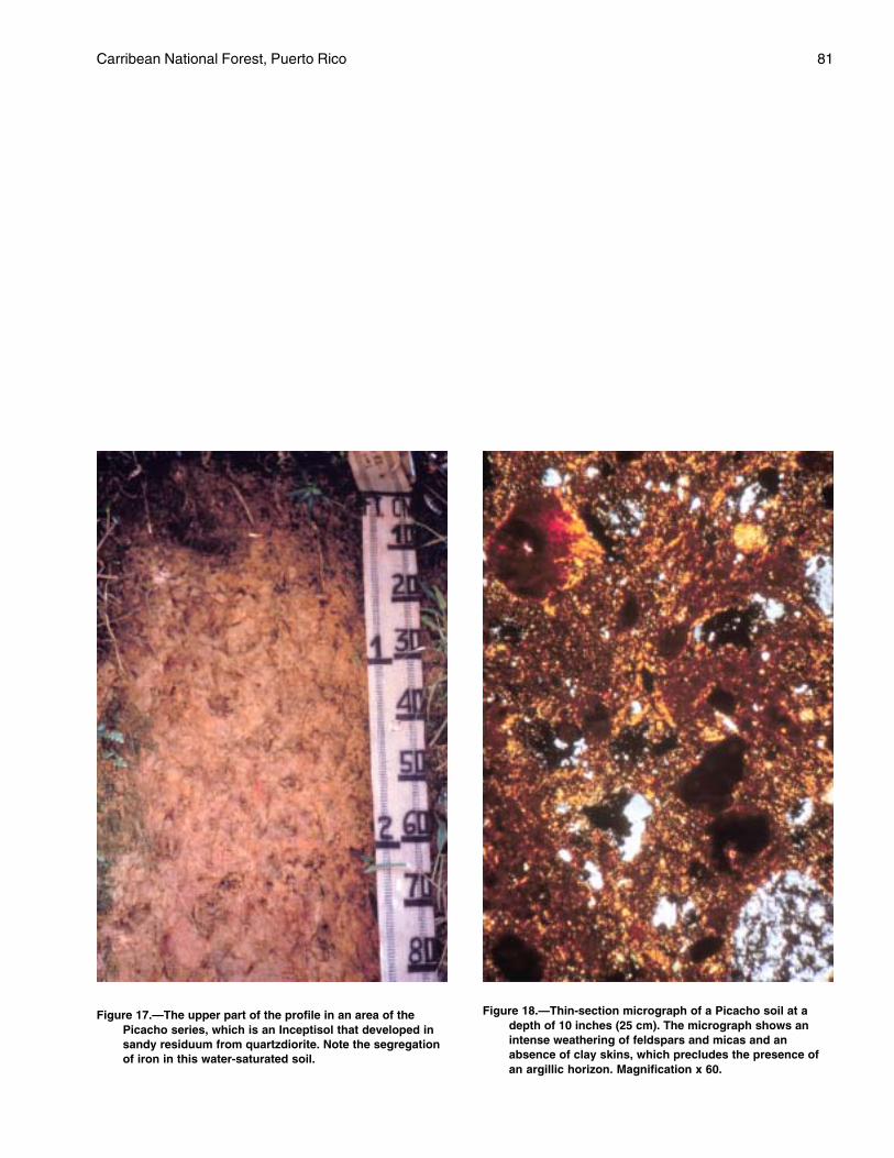
Carribean National Forest, Puerto Rico 81
Figure 18.—Thin-section micrograph of a Picacho soil at adepth of 10 inches (25 cm). The micrograph shows anintense weathering of feldspars and micas and anabsence of clay skins, which precludes the presence ofan argillic horizon. Magnification x 60.
Figure 17.—The upper part of the profile in an area of thePicacho series, which is an Inceptisol that developed insandy residuum from quartzdiorite. Note the segregationof iron in this water-saturated soil.
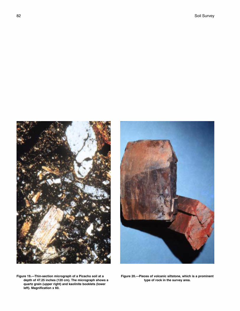
82 Soil Survey
Figure 19.—Thin-section micrograph of a Picacho soil at adepth of 47.25 inches (120 cm). The micrograph shows aquartz grain (upper right) and kaolinite booklets (lowerleft). Magnification x 60.
Figure 20.—Pieces of volcanic siltstone, which is a prominenttype of rock in the survey area.
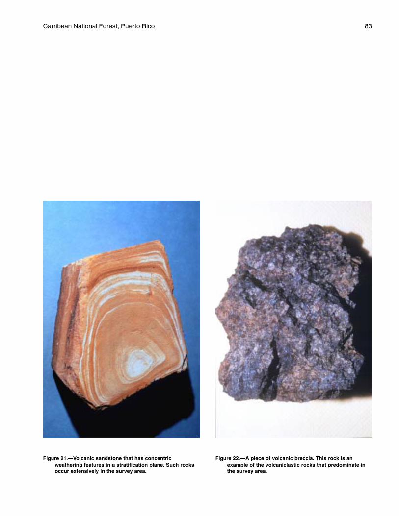
Carribean National Forest, Puerto Rico 83
Figure 21.—Volcanic sandstone that has concentricweathering features in a stratification plane. Such rocksoccur extensively in the survey area.
Figure 22.—A piece of volcanic breccia. This rock is anexample of the volcaniclastic rocks that predominate inthe survey area.
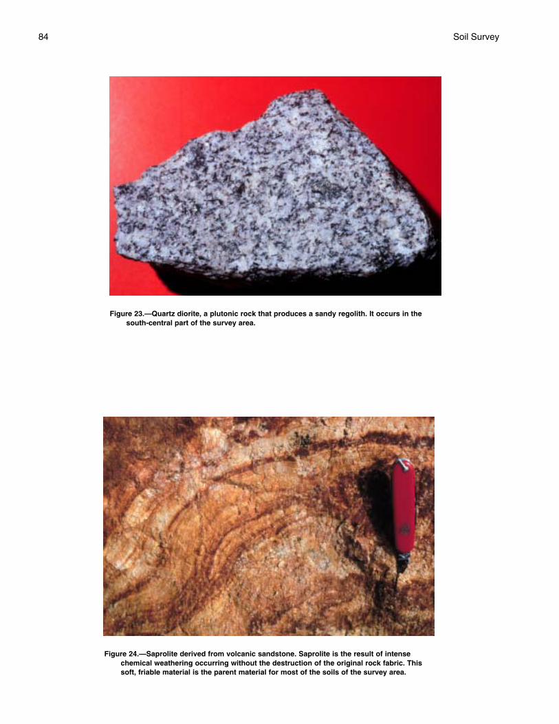
84 Soil Survey
Figure 23.—Quartz diorite, a plutonic rock that produces a sandy regolith. It occurs in thesouth-central part of the survey area.
Figure 24.—Saprolite derived from volcanic sandstone. Saprolite is the result of intensechemical weathering occurring without the destruction of the original rock fabric. Thissoft, friable material is the parent material for most of the soils of the survey area.
Carribean National Forest, Puerto Rico 85
well drained Zarzal soils are very deep, are inpositions that are similar to those of the Prieto soils orslightly higher, have more clay in the subsoil, havekaolinitic mineralogy, and are Oxisols.
Typical pedon of Prieto very cobbly clay loam, 25 to50 percent slopes; about 150 feet (46 m) north fromthe southernmost point of the Forest boundary, or fromPuerto Rico Road 969, on the road on the ridge up tothe power line, then along the fence line to the cornerjust inside the Forest property; Humacao topographicquadrangle; lat. 18 degrees 14 minutes 45 seconds N.and long. 65 degrees 46 minutes 09 seconds W.; PRD1940; Caribbean National Forest:
A—0 to 4 inches (0 to 10 cm); gray (10YR 5/1) verycobbly clay loam; moderate fine granularstructure; friable; common fine and medium roots;about 35 percent, by volume, cobbles; moderatelyacid; clear smooth boundary.
Bg1—4 to 13 inches (10 to 33 cm); dark gray (10YR4/1) cobbly clay; weak coarse subangular blockystructure; firm; common fine and medium roots;about 15 percent, by volume, cobbles; commonmedium distinct olive brown (2.5Y 4/4) and brown(10YR 5/3) masses of iron accumulation;moderately acid; clear smooth boundary.
Bg2—13 to 25 inches (33 to 64 cm); greenish gray (5G6/1) cobbly clay; weak coarse subangular blockystructure; firm; few fine and medium roots; commonlarge wormcasts filled with very dark brown (10YR2/2) organic material; common medium distinctbrownish yellow (10YR 6/6) and dark brown(10YR 3/3) masses of iron accumulation;moderately acid; clear smooth boundary.
BCg—25 to 35 inches (64 to 89 cm); light gray (2.5Y7/2) cobbly silty clay; massive; friable; few quartzcrystals; about 15 percent, by volume, cobbles;common medium distinct yellowish brown (10YR5/6) masses of iron accumulation; commonmedium distinct dark gray (10YR 4/1) irondepletions; moderately acid; abrupt smoothboundary.
R—35 inches (89 cm); metamorphosed volcanicmudstone; massive; hard.
The thickness of the solum ranges from 20 to 40inches (51 to 102 cm). Reaction is moderately acid orslightly acid throughout the profile. The content of rockfragments, pebbles, and cobbles ranges from 10 to 40percent, by volume, throughout the profile butaverages less than 35 percent, by volume, in theparticle-size control section.
The A horizon has hue of 10YR or 2.5Y, value of 2or 3, and chroma of 3 or less; or it is neutral in hueand has value of 2 or 3. It is clay loam, clay, or the
gravelly to very gravelly or cobbly to very cobblyanalogs of those textures.
The Bg horizon has hue of 10YR to 5GY, value of 4to 6, and chroma of 2 or less. It is clay loam, clay, orthe cobbly or very cobbly analogs of those textures.
The BCg horizon has hue of 10YR to 5Y, value of 6to 8, and chroma of 1 or 2. It is silty clay, clay loam,clay, or the gravelly or cobbly analogs of thosetextures.
The R layer is hard volcanic mudstone.
Sonadora Series
The Sonadora series consists of moderately deep,well drained soils on side slopes of lower hills and onfootslopes of strongly dissected uplands. These soilsformed in residuum and colluvium that weathered fromcalcareous mudstone of the Hato Puerco Formation.Near the type location, the mean annual precipitationis about 80 inches (203 cm) and the mean annualtemperature is about 76 degrees F (24 °C). Slopesrange from 25 to 70 percent. These soils are fine,smectitic, isohyperthermic Vertic Eutrudepts.
Sonadora soils are commonly associated withCaguabo and Prieto soils. Caguabo soils are in thehigher positions, are shallow to bedrock, and have aloamy-skeletal control section. The poorly drainedPrieto soils are in the higher positions and have mixedmineralogy.
Typical pedon of Sonadora clay loam, in an area ofSonadora-Caguabo complex, 40 to 70 percent slopes;about 3,000 feet (914 m) southeast of the garage atthe El Verde Work Center, along Trail Number 21 tothe second switchback, and about 15 feet (5 m) west;El Yunque topographic quadrangle; lat. 18 degrees 20minutes 11 seconds N. and long. 65 degrees 49minutes 16 seconds W.; PRD 1940; CaribbeanNational Forest:
A—0 to 1 inch (0 to 3 cm); dark reddish brown (5YR3/2) clay loam; moderate fine subangular blockystructure; friable, slightly sticky and plastic; manyvery fine, fine, and medium roots; strongly acid;abrupt smooth boundary.
Bw1—1 to 4 inches (3 to 10 cm); dark brown (10YR3/3) clay; moderate fine and medium subangularblocky structure; about 0.2-inch (0.5 cm) cracksbetween peds; common very fine and fine roots;firm, sticky and very plastic; very strongly acid;clear smooth boundary.
Bw2—4 to 10 inches (10 to 25 cm); dark yellowishbrown (10YR 4/6) clay; strong medium and coarsesubangular blocky structure; few very fine, fine,and coarse roots along pressure faces; firm, sticky

86 Soil Survey
and very plastic; about 0.3-inch (0.75 cm) cracksbetween peds; few faint pressure faces onsurfaces of peds; very strongly acid; clear wavyboundary.
Bw3—10 to 16 inches (25 to 41 cm); dark yellowishbrown (10YR 4/6) clay; strong coarse prismaticstructure parting to strong medium subangularblocky; few fine, medium, and coarse roots alongpressure faces; firm, sticky and very plastic; about0.3-inch (0.75 cm) cracks between peds; commondistinct pressure faces on surfaces of peds; fewfaint slickensides that have faintly polished andgrooved surfaces; very strongly acid; clear smoothboundary.
BC—16 to 21 inches (41 to 53 cm); grayish brown(2.5Y 5/2) clay; moderate coarse subangularblocky structure; firm, sticky and plastic; few fine,medium, and coarse roots; about 10 percent, byvolume, fragments of mudstone; strongly acid;clear smooth boundary.
C—21 to 36 inches (53 to 91 cm); 35 percent grayishbrown (10YR 5/2), 35 percent yellowish brown(10YR 5/6), and 30 percent very dark grayishbrown (10YR 3/2) clay loam; massive; friable,sticky and slightly plastic; few very fine roots;strongly acid; clear smooth boundary.
R—36 inches (91 cm); dark gray (10YR 4/1)mudstone; extremely hard.
The thickness of the solum ranges from 10 to 25inches (25 to 64 cm). The content of pebbles andcobbles ranges from 0 to 20 percent, by volume,throughout. Depth to mudstone bedrock ranges from 20to 40 inches (51 to 102 cm). Reaction ranges from verystrongly acid to neutral in the A and Bw horizons andfrom strongly acid to neutral in the BC and C horizons.
The A horizon has hue of 5YR to 10YR and valueand chroma of 2 or 3. It is loam, silty clay loam, clayloam, or the gravelly or cobbly analogs of thosetextures.
The Bw horizon has hue of 10YR or 2.5Y, value of 3to 6, and chroma of 2 to 6. It is clay loam, clay, or thegravelly or cobbly analogs of those textures.
The BC horizon, where present, has hue of 10YRor 2.5Y, value of 4 to 6, and chroma of 2 to 6. It is clayloam, clay, or the gravelly or cobbly analogs of thosetextures.
The C horizon has hue of 10YR or 2.5Y, value of 4to 6, and chroma of 2 to 6; or it has no dominant colorand is multicolored in shades of brown, yellow, andgray. It is loam, clay loam, or the gravelly or cobblyanalogs of those textures.
The Cr horizon, where present, has the same rangein colors as the C horizon. It is weathered mudstone.
The R layer is mudstone bedrock.
Utuado Series
The Utuado series consists of very deep,somewhat poorly drained soils on the middle andlower side slopes of strongly dissected uplands. Thesesoils formed in the plutonic uplands in residuumweathering from granodiorite of Río Blanco stock.Near the type location, the mean annual precipitationis about 120 inches (305 cm) and the mean annualtemperature is about 69 degrees F (21 °C). Slopesrange from 25 to 80 percent. These soils are coarse-loamy, mixed, active, isothermic Aquic HumicDystrudepts.
Utuado soils are commonly associated with Ciales,Guayabota, Icacos, Los Guineos, Picacho, andYunque soils. The poorly drained Ciales soils are inthe lower positions and have a fine-loamy controlsection. The poorly drained Guayabota soils areshallow to bedrock, are in the higher positions, andhave a clayey control section. Icacos soils are in lowerpositions than those of the Utuado soils, are onadjacent flood plains, and have a fine-loamy controlsection. The well drained Los Guineos soils are inhigher positions than those of the Utuado soils andhave more clay in the control section. Picacho soilsare in the higher positions, have kaolinitic mineralogy,and have a fine-loamy control section. The moderatelywell drained Yunque soils are in higher positions thanthose of the Utuado soils, have a kaolinitic controlsection, and have more clay in the control section.
Typical pedon of the Utuado gravelly loam, in anarea of Picacho-Utuado complex, 35 to 80 percentslopes; about 75 feet (23 m) west of kilometer marker14 on Puerto Rico Road 191; El Yunque topographicquadrangle; lat. 18 degrees 17 minutes 38 seconds N.and long. 65 degrees 47 minutes 32 seconds W.; PRD1940; Caribbean National Forest:
Oi—0 to 1 inch (0 to 3 cm); many fine, medium, andcoarse roots forming a mat; abrupt smoothboundary.
A—1 to 2 inch (3 to 5 cm); dark brown (10YR 3/3)gravelly loam; moderate very fine and finesubangular blocky structure; common fine,medium, and coarse roots; many fine interstitialpores; about 20 percent, by volume, pebbles;strongly acid; abrupt smooth boundary.
Bw1—2 to 7 inches (5 to 18 cm); dark brown (10YR3/3) loam; weak fine and medium subangularblocky structure; very friable; few medium roots;about 10 percent, by volume, stones; commonmedium distinct strong brown (7.5YR 5/8) massesof iron accumulation; common medium distinctgray (10YR 5/1) iron depletions; strongly acid;clear smooth boundary.
Carribean National Forest, Puerto Rico 87
Bw2—7 to 13 inches (18 to 33 cm); dark yellowishbrown (10YR 4/4) loam; moderate mediumsubangular blocky structure; few very fine and fineroots; few fine tubular pores; about 10 percent, byvolume, stones; common medium distinct gray(10YR 5/1) iron depletions; strongly acid; abruptsmooth boundary.
C1—13 to 28 inches (33 to 71 cm); yellowish brown(10YR 5/6) sandy loam; weak fine and mediumsubangular structure; common very fine, fine, andmedium roots; few fine tubular pores; stronglyacid; gradual smooth boundary.
C2—28 to 61 inches (71 to 155 cm); variegated verypale brown (10YR 8/2), black (10YR 2/1), andbrown (10YR 5/3) saprolite having a texture ofloamy sand; about 40 percent, by volume, stones;strongly acid.
The thickness of the solum ranges from 18 to 31inches (46 to 79 cm). Reaction ranges from extremelyacid to strongly acid throughout the profile. Thecontent of pebbles, cobbles, and stones ranges from 0to 20 percent, by volume, throughout.
The Oi, where present, is composed of rootsforming a mat.
The A horizon has hue of 7.5YR to 2.5Y, value of 2to 5, and chroma of 1 to 4. It is sandy loam, loam, orthe gravelly, cobbly, or stony analogs of thosetextures.
The Bw horizon has hue of 7.5YR or 10YR, value of3 to 6, and chroma of 3 to 8. It has few to manyredoximorphic features in shades of yellow, brown,and gray; the quantity decreases with depth and maybe none in the lower part of the Bw horizon in somepedons. The Bw horizon is sandy loam, loam, or thegravelly, cobbly, or stony analogs of those textures.
The upper part of the C horizon has hue of 7.5YRto 2.5YR, value of 4 to 6, and chroma of 4 to 8. It isloamy sand, sandy loam, or the gravelly, cobbly, orstony analogs of those textures. The lower part of theC horizon is saprolite in shades of brown, yellow, andblack. It can be dug with a spade.
Yunque Series
The Yunque series consists of very deep,moderately well drained soils on side slopes andconvex ridgetops of strongly dissected uplands. Thesesoils formed in a mixture of colluvium and residuumthat weathered from andesitic to basaltic, marine-deposited, volcanic and volcaniclastic sandstone andmudstone of the Hato Puerco and TabonucoFormations. Near the type location, the mean annualprecipitation is about 160 inches (406 cm) and themean annual temperature is about 69 degrees F (21
°C). Slopes range from 10 to 90 percent. These soilsare very-fine, kaolinitic, isothermic Humic Hapludox.
Yunque soils are commonly associated with Ciales,Guayabota, Los Guineos, Moteado, Palm, Picacho,and Utuado soils. The associated soils are in lowerpositions than those of the Yunque soils. The poorlydrained Ciales soils have a fine-loamy control sectionand do not have Oxic horizons. The poorly drainedGuayabota soils are shallow to bedrock and have lessclay in the control section than the Yunque soils. Thewell drained Los Guineos soils have mixedmineralogy. The poorly drained Moteado soils aredeep to bedrock and have mixed mineralogy. Thepoorly drained Palm soils have a clayey-skeletalcontrol section. The somewhat poorly drained Picachosoils have a fine-loamy control section. The somewhatpoorly drained Utuado soils have mixed mineralogyand have a coarse-loamy control section.
Typical pedon of the Yunque clay, in an area ofYunque-Moteado complex, 20 to 65 percent slopes;about 1.6 miles (2.6 km) northwest of Mt. Britton andabout 3,000 feet (914 m) east-southeast of the end ofPuerto Rico Road 911 at the Estacion Fluviometrica,down the west fork trail past the creeks and pastwhere the trail turns south and levels out on thecontour, then upslope; El Yunque topographicquadrangle; lat. 18 degrees 18 minutes 44 seconds N.and long. 65 degrees 48 minutes 54 seconds W.; PRD1940; Caribbean National Forest:
Oi—0 to 2 inches (0 to 5 cm); many fine and mediumroots forming a root mat; abrupt smooth boundary.
A—2 to 7 inches (5 to 18 cm); dark yellowish brown(10YR 4/6) clay; weak fine subangular blockystructure; firm, sticky and plastic; many fine andmedium roots; common large very dark brown(10YR 2/2) wormcasts; extremely acid; clearsmooth boundary.
Bto1—7 to 17 inches (18 to 43 cm); yellowish brown(10YR 5/8) clay; weak coarse subangular blockystructure parting to weak medium subangularblocky; firm, sticky and very plastic; common fineand medium roots; common fine interstitial andtubular pores; few faint clay films on vertical andhorizontal faces of peds; common large very darkbrown (10YR 2/2) wormcasts; common distinctred (2.5YR 4/6) masses of iron accumulationalong root channels; few fine distinct strong brown(7.5YR 5/6) and few medium distinct lightyellowish brown (10YR 6/4) masses of ironaccumulation; extremely acid; clear smoothboundary.
Bto2—17 to 30 inches (43 to 76 cm); yellowish brown(10YR 5/8) clay; weak medium prismatic structureparting to weak medium subangular blocky; firm,
88 Soil Survey
sticky and very plastic; few fine and mediuminterstitial and tubular pores; common distinct clayfilms on vertical and horizontal faces of peds;common large very dark brown (10YR 2/2)wormcasts; common coarse prominent strongbrown (7.5YR 5/6) and few fine distinct yellow(10YR 7/6) masses of iron accumulation; few finedistinct light gray (10YR 7/1) iron depletions;extremely acid; abrupt smooth boundary.
Bw1—30 to 33 inches (76 to 84 cm); yellowish red(5YR 5/8) silty clay; weak medium platy structure;friable, sticky and plastic; weakly cemented; manycoarse prominent strong brown (7.5YR 5/8)masses of iron accumulation; few fine distinct lightgray (10YR 7/1) iron depletions; extremely acid;abrupt smooth boundary.
Bw2—33 to 51 inches (84 to 130 cm); strong brown(7.5YR 5/8) silty clay loam; massive; friable, stickyand plastic; common coarse prominent yellowishred (5YR 5/8) masses of iron accumulation; fewfine distinct light gray (10YR 7/1) iron depletions;extremely acid; gradual wavy boundary.
Bw3—51 to 62 inches (130 to 157 cm); 50 percentyellowish red (5YR 5/8), 35 percent strong brown(7.5YR 5/8), and 15 percent very pale brown(10YR 8/2) silty clay loam; massive; friable, stickyand plastic; the yellowish red and strong brownareas are iron accumulations and the white areasare iron depletions; extremely acid.
The thickness of the solum is more than 60 inches(152 cm). The combined thickness of the Bt horizonsranges from 18 to 35 inches. Reaction ranges fromextremely acid to strongly acid throughout the profile.The content of rock fragments ranges from 0 to 40percent, by volume, throughout. Cobbles, stones, andboulders cover 0 to 60 percent of the surface. Thecumulative volume in the control section does notexceed 35 percent.
The Oi horizon, where present, is composed ofroots forming a mat.
The A horizon has hue of 7.5YR or 10YR, value of 2to 5, and chroma of 1 to 6. It is silty clay loam, siltyclay, or clay.
The Bto horizon has hue of 7.5YR to 2.5Y, value of4 or 5, and chroma of 4 to 8. It has few to manyredoximorphic features in shades of yellow, brown,red, and gray. It is clay, gravelly clay, or very gravellyclay.
The Bo horizon, where present, has colors andtextures similar to those of the Bt horizon.
The Bw horizon has hue of 2.5YR to 7.5YR, valueof 4 to 6, and chroma of 4 to 8. It has few to manyredoximorphic features in shades of yellow, brown,red, and gray. In some pedons, the lower part of the
horizon does not have a dominant matrix color and ismulticolored in shades of yellow, red, brown, and gray.The Bw horizon is silty clay loam, silty clay, clay loam,clay, or the gravelly or very gravelly analogs of thosetextures.
The BC horizon, where present, has hue of 2.5YRto 7.5YR, value of 4 to 6, and chroma of 6 to 8; or ithas no dominant matrix color and it is multicolored inshades of yellow, red, brown, and gray. It has few tomany redoximorphic features in shades of yellow,brown, red, and gray. It is silty clay loam, silty clay,clay loam, clay, or the gravelly or very gravellyanalogs of those textures.
The C horizon, where present, has colors andtextures similar to those of the BC horizon.
Zarzal Series
The Zarzal series consists of very deep, welldrained soils on mountain side slopes and footslopes.These soils formed in a mixture of colluvium andresiduum that weathered from andesitic to basaltic,marine-deposited, volcanic and volcaniclasticsandstone and mudstone of the Hato Puerco andTabonuco Formations. Near the type location, themean annual precipitation is about 80 inches (203 cm)and the mean annual temperature is about 77 degreesF (25 °C). Slopes range from 15 to 90 percent. Thesesoils are very-fine, kaolinitic, isohyperthermic IncepticHapludox.
Zarzal soils are commonly associated with Coloso,Cristal, Humatas, Los Guineos, Luquillo, Palm, andPrieto soils. The somewhat poorly drained Colososoils are on flood plains, are in lower positions thanthe Zarzal soils, and have less clay in the controlsection. The somewhat poorly drained Cristal soils arealso in the lower positions and are not Oxisols.Humatas soils are in higher positions than those of theZarzal soils, have less clay in the control section, andhave mixed mineralogy. Los Guineos soil are also inthe higher positions, are isothermic, and have mixedmineralogy. The Luquillo soils have mixed mineralogy,are on flood plains, are in lower positions than theZarzal soils, and have less clay in the control section.The poorly drained Palm soils are in the higherpositions, are isothermic, and have a clayey-skeletalcontrol section. The poorly drained Prieto soils are inpositions similar to those of the Zarzal soils or slightlylower, are moderately deep to bedrock, and havemixed mineralogy.
Typical pedon of the Zarzal clay, in an area ofZarzal-Cristal complex, 20 to 60 percent slopes; about600 feet (183 m) north of kilometer marker 7.0 onPuerto Rico Road 966; El Yunque topographic
Carribean National Forest, Puerto Rico 89
quadrangle; lat. 18 degrees 19 minutes 44 seconds N.and long. 65 degrees 49 minutes 19 seconds W.; PRD1940; Caribbean National Forest:
A—0 to 1 inch (0 to 2 cm); dark reddish brown (5YR2/2) clay; moderate fine granular structure; firm,nonsticky; many fine and medium roots; commonfine discontinuous interstitial pores; slightly acid;abrupt smooth boundary.
Bo—1 to 7 inches (2 to 17 cm); yellowish brown(10YR 5/6) clay; moderate fine subangular blockystructure; firm, slightly sticky and slightly plastic;few fine and medium roots; common very finediscontinuous tubular pores; common distinctorganic coats on faces of peds; few fine roundedconcretions of iron and manganese oxide; fewlarge dark reddish brown (5YR 2/2) wormcasts;strongly acid; clear smooth boundary.
Bto1—7 to 15 inches (17 to 38 cm); yellowish brown(10YR 5/8) clay; moderate fine subangular blockystructure; firm, slightly sticky and slightly plastic;few fine and medium roots; common distinct clayfilms on faces of peds; common fine roundedconcretions of iron and manganese oxide; manylarge dark reddish brown (5YR 2/2) wormcasts;strongly acid; clear smooth boundary.
Bto2—15 to 26 inches (38 to 65 cm); yellowish brown(10YR 5/8) clay; moderate medium subangularblocky structure; slightly sticky and slightly plastic;few fine and medium roots; few very finediscontinuous tubular pores; common distinct clayfilms on faces of peds; common fine roundedconcretions of iron and manganese oxide;common large root channels filled with darkmaterial; strongly acid; gradual smooth boundary.
Bto3—26 to 35 inches (65 to 89 cm); yellowish brown(10YR 5/4) clay; moderate medium subangularblocky structure; firm, slightly sticky and slightlyplastic; few fine roots; few fine discontinuoustubular pores; common distinct clay films on facesof peds; few fine rounded concretions of iron andmanganese oxide; few medium prominent red(2.5YR 4/8) masses of iron accumulation; stronglyacid; gradual smooth boundary.
Bw1—35 to 46 inches (89 to 118 cm); strong brown(7.5YR 5/8) clay; weak coarse subangular blockystructure; firm, slightly sticky and slightly plastic;few fine roots; few fine discontinuous tubularpores; few fine rounded concretions of iron andmanganese oxide; about 10 percent, by volume,igneous pebbles; common fine prominent red(2.5YR 4/8) masses of iron accumulation; verystrongly acid; gradual smooth boundary.
Bw2—46 to 56 inches (118 to 143 cm); strong brown(7.5YR 5/8) clay; weak coarse subangular blockystructure parting to weak medium subangular;firm, slightly sticky and slightly plastic; few finediscontinuous tubular pores; few fine roundedconcretions of iron and manganese oxide; about15 percent, by volume, saprolite fragments;strongly acid; clear wavy boundary.
Bw3—56 to 69 inches (143 to 175 cm); strongbrown (7.5YR 5/8) clay; weak very coarsesubangular blocky structure; firm, slightly stickyand slightly plastic; few fine discontinuoustubular pores; few fine rounded iron-manganeseconcretions; about 40 percent, by volume,saprolite fragments; common distinct light gray(10YR 7/1) iron depletions; strongly acid; clearwavy boundary.
Bw4—69 to 75 inches (175 to 190 cm); strongbrown (7.5YR 5/8) clay; weak very coarsesubangular blocky structure; firm, slightly stickyand slightly plastic; strongly acid; gradualsmooth boundary.
Bw5—75 to 82 inches (190 to 209 cm); strong brown(7.5YR 5/8) clay; weak very coarse subangularblocky structure; firm, slightly sticky and slightlyplastic; few fine prominent red (2.5YR 4/8) andfew fine faint yellowish brown (10YR 5/8) massesof iron accumulation; strongly acid; gradualsmooth boundary.
Cr—82 to 91 inches (209 to 230 cm); strong brown(7.5YR 5/8) weathered sandstone conglomerate;massive; about 40 percent, by volume, igneouspebbles.
The thickness of the solum and the depth tobedrock are more than 80 inches (203 cm). Reactionis moderately acid or slightly acid in the A horizon andvery strongly acid or strongly acid in the Bo, Bto, andBw horizons.
The Oi horizon, where present, is composed ofroots forming a mat.
The A horizon, where present, has hue of 5YR to10YR, value of 2 to 5, and chroma of 1 to 4. It is clayloam or clay.
The B horizon has hue of 5YR to 10YR, value of 4to 6, and chroma of 4 to 8. It is clay.
The C horizon, where present, has hue of 7.5YR or10YR, value of 5 or 6, and chroma of 6 to 8. It is clayloam, clay, or the cobbly or stony analogs of thosetextures.
The Cr horizon is weathered conglomeratesandstone. The content of igneous pebbles rangesfrom 10 to 50 percent, by volume.

91
Factors of Soil FormationThis section describes the factors of soil formation
as they relate to the soils of the Caribbean NationalForest and explains the major processes in thedevelopment of soil horizons (Birkeland, 1974 and1984; Jenny, 1941; Thornbury, 1969).
Climate
Temperature and precipitation influence the ratesof chemical and physical processes in the soil. Thesurvey area has a warm, maritime tropical climatethat is influenced by trade winds interacting with theLuquillo Mountains.
Rainfall
The amount of annual rainfall increasessubstantially as elevation increases in the surveyarea. The average rainfall ranges from about 97inches (246 cm) at the lower elevations to morethan 200 inches (381 cm) at the highest elevationsof the cloud (dwarf) forest. There is no sharplydefined wet or dry season in the survey area. Thepeak rainfall is usually in May, and the driest periodis in March (Robinson, 1997).
Temperature
The temperature in the survey area decreases aselevation and rainfall increase. Three soiltemperature regimes occur in the survey area:isohyperthermic, isothermic, and isomesic. TheCaguabo, Coloso, Cristal, Humatas, Luquillo,Prieto, Sonadora, and Zarzal soils are in theisohyperthermic regime. The Ciales, Guayabota,Icacos, Los Guineos, Moteado, Palm, Picacho,Utuado, and Yunque soils are in the isothermicregime. The Dwarf soils are in the isomesic regime.
The highest temperatures in the survey areaoccur in August or September, and the lowesttemperatures occur in January or February. Theleaching of nutrients becomes more efficient aselevation increases. This increased efficiency isevidenced by decreasing faunal biota in the soilsand overstory at the higher elevations. Organic
matter tends to accumulate at the higher elevationsdue to the higher rainfall and cooler temperatures(Stevenson, 1982).
Plant and Animal Life
Plants, animals, bacteria, fungi, and humansaffect the formation of soils. The impact of plant andanimal life on soil formation is especially significantin wet tropical climates because activity occursyear-round. The type of vegetation affects thecontent of organic matter and the amount ofnutrients released to the soil. Animals, particularlyburrowing animals and insects, keep the soil openand porous. Bacteria and fungi decompose plantmaterial into organic matter and promote theincorporation of the organic matter into the soil.Research into overstory fungi and epiphytesindicates a significant amount of decompositionoccurs before organic debris reaches the forestfloor. Human activities that alter the soils in thesurvey area include clearing, construction, andrecreational activities. Nutrient recycling in organicmatter is crucially important in tropical climates.Slash and burn agriculture is practiced in thetropics because nutrients are released into therelatively infertile soil when vegetation is burned.
Parent Material
Parent material is the weathered mass fromwhich soil forms. Parent material generallydetermines the chemical and mineral composition ofthe soil. The soils in the Caribbean National Forestformed in materials of volcanic origin extruded inthe sea and then subjected to weathering anderosion.
Topography
Topography, or relief, modifies the effects of theother soil-forming factors. In many places that havesimilar parent material, differences in topographyresult in differences in the kind of soil that forms.For example, soils in convex areas typically are
Formation of the Soils
92 Soil Survey
drier than soils in flat areas because water movesaway from the convex areas. In contrast, soils inconcave areas can display wetness indicatorsresulting from the concentration of surface andsubsurface water. Cristal and Zarzal soils formed insimilar parent material and are adjacent to eachother. Because of topography, however, Zarzal soilsare better drained than the Cristal soils. Soils in thesurvey area that are subject to flooding include theColoso, Icacos, and Luquillo soils. They receivenew sediments during each period of flooding, showlittle profile development, and are considered youngsoils (Coleman, 1981).
Time
Time is needed for the development of a soil profile;consequently, younger soils have less developedhorizons than older soils. Many of the soils throughoutthe survey area are shallow but have well-developedhorizons.
Major Soil HorizonsThe results of the soil-forming factors can be
distinguished by the different layers, or soilhorizons, in a soil profile. The soil profile extendsfrom the surface down to materials that are onlyslightly altered by soil-forming processes. Mostsoils in the survey area contain horizons, generallyidentified as A, B, and C horizons. These majorhorizons are subdivided by the use of numbers andletters to indicate changes within a horizon. The Bthorizon, for example, is a B horizon that has anaccumulation of clay.
The A horizon, or surface layer, is characterized byan accumulation of organic matter.
The B horizon underlies the A horizon and iscommonly called the subsoil. It is the horizon ofmaximum accumulation, or illuviation, of clay, iron,aluminum, or other compounds leached from thesurface and subsurface layers. In the survey area,the B horizon forms through the alteration ofmaterials in place and illuviation. Most of theweathering products in the survey area arecompletely leached out of the system unless theyare taken up by plants. Iron and aluminum stay asoxides and weather toward Oxisols. Some of thesoils in the survey area, such as the Los Guineosand Yunque soils, feel coarser to the touch thanwould be expected from the laboratory data. This islikely due to iron oxides causing a high aggregationof particles. Some of the clayey soils in the surveyarea have the moisture-release characteristics of
sandy soils. The B horizon commonly has blocky orprismatic structure. Generally, the B horizon isfirmer and lighter in color than the A horizon. The Bhorizon may be darker in color than the C horizon.
The C horizon consists of materials that have beenaltered little by the soil-forming processes. Some Chorizons are composed of saprolite, which is theparent material that has been altered chemically butretains the spatial characteristics of the parent rockmaterial (Jenny, 1980).
Processes of Horizon Differentiation
In the Caribbean National Forest, severalprocesses are involved in the formation of soilhorizons. Among these are the accumulation oforganic matter, the leaching of soluble salts, thereduction and transfer of iron, the formation of soilstructure, and the formation and translocation ofclay minerals. These processes continually takeplace, generally at the same time, throughout theprofile. Processes such as these have been goingon for thousands of years. The accumulation andincorporation of organic matter takes place with thedecomposition of plant residue. These additions ofresidue darken the surface layer and help to formthe A horizon. If organic matter has been lost, along period of time generally is needed to replace it.
Most soils have strong to moderate, fine tomedium, granular structure in the surface layer. Thestructure of the subsoil is weak to strong andprismatic or blocky.
Well drained and moderately well drained soils inthe survey area have a dark reddish brown to lightolive brown subsoil. These colors have beencaused mainly by thin coatings of iron oxides onsand and silt grains, except where the colors wereinherited from the parent material.
The reduction of iron, called gleying, isassociated mainly with the wetter, more poorlydrained soils. Because rainfall increases withelevation in the survey area, the poorly drainedsoils, such as Ciales, Dwarf, and Moteodo soils, arepredominantly gray in the upper horizons and thelower horizons are less reduced. Moderately welldrained to somewhat poorly drained soils haveyellowish brown and strong brown redoximorphicconcentrations because of the segregation of ironand manganese. In poorly drained soils, such asCiales, Dwarf, and Moteado soils, and in somewhatpoorly drained soils, such as Coloso, Cristal, andIcacos soils, the grayish subsoil is the result of thereduction of iron in solution (Buol, Hole, andMcCracken, 1980; Jenny, 1980; Simonson, 1959).
Caribbean National Forest, Puerto Rico 93
GeologyF.H. Beinroth, professor of soil science, Department of
Agronomy and Soils, University of Puerto Rico-Mayagüez,prepared this section.
The geology of the Caribbean National Forest(CNF) is characterized by the dominance of volcanicrocks of Cretaceous age into which plutonic rocksintruded during the Lower Tertiary. Although thegeologic history of the area is short, it exhibitsconsiderable complexity. Most of the CNF is located inthe southeastern part of the El Yunque quadrangle. Asmaller part extends into the western part of theFajardo quadrangle. The U.S. Geological Survey hasmapped both quadrangles and has published maps ata scale of 1:20,000 with explanatory texts (Briggs andCortés, 1980; Seiders, 1971). A more recent paper byJolly et al. (1998) describes the volcanism andtectonics of the region. Much of the following accounthas been gleaned from these publications.
Tectonics and Structure
The island of Puerto Rico is located on a microplatein the tension zone between the North American plateand the Caribbean plate. The latter originated about88 million years ago in the Pacific basin as a plateauof oceanic crust of Jurassic and Cretaceous ageknown as the Caribbean Cretaceous Basalt Province.The Caribbean plate subsequently moved eastwardinto a widening gap between North and SouthAmerica. By about 75 million years ago, the gap hadbecome the Atlantic Ocean. The younger and morebuoyant Caribbean plate overrode the older NorthAmerican and South American plates but subductedinto the Muertos trough and under a sliver of oceaniccrust that forms the Puerto Rico-Virgin Islands block.This block collided with the Bahama banks to the northduring mid-Santonian time (about 85 million ago) andthen rotated counterclockwise to its present east-westorientation (Jolly and others, 1998).
Although various tectonic models of the formationof the Caribbean are currently under consideration, aconsensus has yet to emerge. As a result, thegeography and polarity of the subduction zone thatproduced the Greater Antilles arc is indeterminate atthis time.
The island arc volcanic strata in Puerto Rico rangein age from Lower Cretaceous (Aptian) to mid-Tertiary(Eocene), about 120 to 45 million years, and representone of the longest oceanic arc sequences preservedin the world. Cessation of subduction-relatedmagmatism during the Eocene was probably causedby the collision of the Greater Antilles arc with the
North American plate. Subsequent movement alongthe northern boundary of the Caribbean plate changedto a left-lateral strike-slip motion (Jolly and others,1998).
The volcanic strata of Puerto Rico are subdividedinto three provinces: the western volcanic province,the central volcanic province, and the northeasternvolcanic province. The survey area is located in thenortheastern volcanic province. This province isseparated from the central province by the Cerro MulaFault, which is a northwest-southeast oriented strike-slip fault of mid-Santonian age and has at least a 50-kilometer lateral displacement (Jolly and others,1998). A few, mostly northwest trending, faults ofmoderate displacement have also been mapped in thesurvey area.
Two broad, northeast-trending folds are majorgeologic structures of importance to the survey area.They are the axis of the Rio Canovanas syncline tothe northwest and the axis of the Luquillo anticline tothe southeast. The area between these two fold axesis, therefore, largely underlain by northwest-dippingbeds.
The plutonic Río Blanco stock and other smallintrusive bodies are younger than the folds and faults.The rectilinear outline of Río Blanco stock suggeststhat its emplacement was influenced by northwest-trending fractures (Seiders, 1971).
During the Paleocene and Eocene epochs of thelower Tertiary (about 65 to 45 million years ago),compressive orogenic forces severely faulted andfolded the volcanic strata and lifted them above sealevel, thus creating the island of Puerto Rico. Asuccession of minor uplifts that occurred sporadicallythrough the end of the Tertiary brought the island to itspresent altitude. Periods of quiescence between upliftsallowed widespread degradation of the mountainousisland, resulting in a series of erosion surfaces ofwhich the St. John Peneplain is the most prominent(Beinroth, 1969).
Stratigraphy
The oldest rocks in the survey area are theUnnamed Volcaniclastics of Lower Cretaceous age.By correlation with beds in the adjacent Fajardo area,where a specimen of the ammonite Manuaniceras hasbeen recovered, the rocks are presumed to be ofAlbian age (about 120 to 105 million years). Thesestrata are overlain by the Tabonuco Formation, whichyielded both ammonites and planktonic Foraminiferaof Albian age. The youngest stratified rocks are thoseof the Hato Puerco Formation, which originated in theUpper Cretaceous. This formation contains
94
Foraminifera and rudists, which dates their age asCenomanian (about 97 to 92 million years).
The plutonic rocks of the Río Blanco stock areyounger than the stratified volcanics. They were likelyemplaced during the Upper Cretaceous(Maastrichtian, about 65 to 73 million years ago) andlower Tertiary (Paleocene, about 65 to 55 million yearsago), concurrent with tectonic and orogenicprocesses.
Rocks
Stratified Rocks
The volcanic rocks of the survey area arepredominantly of primary and reworked volcanicorigin. Figures 20, 21, and 22 illustrate common rocksof volcanic origin in the survey area. The moderatelygood sorting and graded bedding in the volcaniclasticrocks together with the exclusively planktoniccharacter of the interbedded mudstones indicate anenvironment of deposition in at least moderately deepwater.
The Unnamed Volcanic Rocks are marine-deposited, andesitic, thick-bedded, grayish-greenvolcanic sandstone and fine volcanic breccia. Theyare of moderate extent in the southeastern part of thesurvey area.
The Tabonuco Formation is composed of marine-deposited, andesitic to basaltic volcanic sandstone(about 60 percent), mudstone (about 30 percent), andvolcanic breccia and conglomerate (about 10 percent).The volcanic sandstone is thick-bedded, moderatelysorted, calcareous, and gray. The breccia-conglomerate member of the Tabonuco Formationconsists of fine to coarse, poorly sorted breccia-conglomerate and pebbly mudstone and sandstone.This formation is moderately extensive in thenortheastern part of the survey area.
The rocks of the Hato Puerco Formation also arepredominantly marine-deposited, grayish-greenishandesitic to basaltic volcanic sandstone and brecciawith minor amounts of volcanic mudstone. Grains and,rarely, boulders of shallow-water limestone occursparsely in the volcanic rocks. This is the mostextensive formation in the survey area.
No mineralogical analysis is available for thevolcaniclastic rocks in the survey area. However, verysimilar rocks from the nearby Barranquitas area,which presumably came from the same magmaticreservoir, have the following composition: 53 percentplagioclase, 11 percent orthoclase, 27 percentpyroxene, 1 percent olivine, 6 percent magnetite, 1percent ilmenitite, and 1 percent apatite (Briggs andGelabert, 1962).
Intrusive Rocks
The quartz diorite of the survey area is a light-gray,medium- to coarse-grained rock that forms the bulk ofthe Río Blanco stock (fig. 23). According to Seiders(1971), the typical mineral composition of this rock isabout one quarter quartz and three quarters silicates(26 percent quartz, 5 percent orthoclase, 59 percentplagioclase, 6 percent hornblende, and 4 percentbiotite).
Medium-gray, medium-grained hornblende dioriteoccurs as a local border phase and apophyses of theRío Blanco stock. It is the plutonic equivalent of theandesitic to basaltic volcaniclastics and therefore hasa similar mineralogical composition.
Contact Metamorphism
An aureole of contact metamorphism with diffuseouter limits surrounds the Río Blanco stock.Contact metamorphosed volcaniclastic rockstypically show greater hardness and darker colorsthan their unmetamorphosed equivalents. Chiefmineralogical changes are the development ofactinolite, blue-green hornblende, and, occasionally,biotite in place of clinopyroxene and chlorite;epidote is locally abundant. Parenthetically, it maybe noted that the metamorphosed rocks are thesource for the placer gold that many years ago waswashed from alluvium along the lower parts of theRío Espiritu Santo and the Río Blanco.
Weathering Products
Volcaniclastic Rocks
The volcaniclastic rocks in the survey area varyin appearance, but because they are derived fromthe same pool of magma they have essentially thesame mineralogical composition. They areintermediate to basaltic and therefore contain onlysmall or very small amounts of quartz. These rocksare predominantly composed of basic feldspars andsmaller amounts of ferromagnesian minerals. Thevolcaniclastic rocks weather to form residuum that,under conditions of free drainage, consists mainlyof clay minerals of the 1:1 lattice type, such askaolinite; oxides of iron and aluminum; and smallamounts of quartz.
Intrusive Rocks
The substantial amount of quartz in the quartzdiorite accumulates residually during the weatheringprocess because quartz resists decomposition. Theprimary silicates decompose to produce clay minerals

Caribbean National Forest, Puerto Rico 95
and sesquioxides. This results in a sandy to loamyregolith.
Intense, continuous weathering in the warm, humidtropical climate that has prevailed in the survey areasince the emergence of the island above seal levelhas transformed the rocks into saprolite (fig. 24). Thissaprolite is the parent material of the soils. Becausethe lithology of the country rock determines the quartz
and clay content of the saprolite, the soils in the areaof volcaniclastic rocks are clayey and the soils in theoutcrop area of quartz diorite are sandy or loamy.Because of its medium to coarse texture, quartzdiorite weathers more rapidly than the volcanic rocks.Other conditions being equal, the regolith in the areaof quartz diorite is thicker than that in the volcanicareas.

97
American Association of State Highway and Transportation Officials (AASHTO). 2000.Standard specifications for transportation materials and methods of samplingand testing. 20th edition, 2 volumes.
American Society for Testing and Materials (ASTM). 2001. Standard classification ofsoils for engineering purposes. ASTM Standard D 2487–00.
Beinroth, F.H. 1969. An outline of the geology of Puerto Rico. University of Puerto Rico,Agricultural Experiment Station Bulletin 213.
Birkeland, Peter W. 1974. Pedology, weathering, and geomorphological research.
Birkeland, Peter W. 1984. Soils and geomorphology. 2nd edition.
Boccheciamp, R.A., W.F. Rivera, J.E. Trigo, J.E. Brunet, E.O. Torres, W.E. McKinze,and L.H. Rivera. 1977. Soil Survey of Humacao Area of Eastern Puerto Rico.U.S. Department of Agriculture, Soil Conservation Service.
Briggs, R.P., and E. Aguilar-Cortés. 1980. Geologic map of the Fajardo and Icacosquadrangles, Puerto Rico. U.S. Geological Survey Miscellaneous GeologicInvestigations Map I–1153.
Briggs, R.P., and P.A. Gelabert. 1962. Preliminary report of the geology of theArranquitas quadrangle, Puerto Rico. U.S. Geological Survey MiscellaneousGeologic Investigations Map I–336.
Brown, S., A.E. Lugo, S. Silander, and L. Liegal. n.d. Research history andopportunities in the Luquillo Experimental Forest. U.S. Department ofAgriculture, Forest Service, Southern Forest Experiment Station (Institute ofTropical Forestry) General Technical Report SO–44.
Buol, S.W., F.D. Hole, and R.J. McCracken. 1980. Soil genesis and classification. 3rdedition.
Coleman, Steven M. 1981. Rock-weathering rates as functions of time. QuaternaryResearch 15: 250–264.
Cowardin, L.M., V. Carter, F.C. Golet, and E.T. LaRoe. 1979. Classification of wetlandsand deep-water habitats of the United States. U.S. Fish and Wildlife ServiceFWS/OBS–79/31.
Ewell, J.J., and J.L. Whitmore. 1993. The ecological life zones of Puerto Rico and theU.S. Virgin Islands. U.S. Department of Agriculture, Forest Service, Institute ofTropical Forestry Research Paper ITF–18.
References
98 Soil Survey
Federal Register. July 13, 1994. Changes in hydric soils of the United States.
Federal Register. February 24, 1995. Hydric soils of the United States.
Ford, E.W. 1981. The soils of El Yunque—An order III soil resource inventory of theCaribbean National Forest. U.S. Department of Agriculture, Forest Service,Southern Region.
Hurt, G.W., P.M. Whited, and R.F. Pringle, editors. 1998. Field Indicators of hydric soilsin the United States. Version 4.0. U.S. Department of Agriculture, NaturalResources Conservation Service.
Jenny, Hans. 1941. Factors of soil formation.
Jenny, Hans. 1980. The soil resource—Origin and behavior. Ecological Studies.
Jolly, W.T, E.G. Lidiak, J.H. Schellekens, and H. Santos. 1998. Volcanism, tectonics,and stratigraphic correlations in Puerto Rico. In Lidiak, E.G., and D.K. Laura,editors. Tectonics and geochemistry of the Northeastern Caribbean. GeologicalSociety America Special Paper 322.
Mitchell, R.C. 1954. A survey of the geology of Puerto Rico. University of Puerto Rico,Agricultural Experiment Station Technical Paper No. 13.
Mount, H.R., R.F. Bauer, W.J. Waltman, and B.C. Dubee. 1992. Soil climate regimes onthe Commonwealth of Puerto Rico and the United States Virgin Islands. U.S.Department of Agriculture, Soil Conservation Service.
National Research Council. 1995. Wetlands: Characteristics and boundaries.
Robinson, K. 1997. Where dwarfs reign: A tropical rain forest in Puerto Rico. Universityof Puerto Rico.
Scatena, F.N. 1989. An introduction to the physiography and history of the BisleyExperimental Watersheds in the Luquillo Mountains of Puerto Rico. U.S.Department of Agriculture, Forest Service General Technical Report SO–72.
Seiders, V.M. 1971. Geologic map of the El Yunque quadrangle, Puerto Rico. U.S.Geological Survey Miscellaneous Geologic Investigations Map I–658.
Simonson, Roy W. 1959. Outline of a generalized theory of soil genesis. Soil ScienceSociety of America Proceedings 23:152–156.
Soil Survey Division Staff. 1993. Soil survey manual. Soil Conservation Service. U.S.Department of Agriculture Handbook 18.
Soil Survey Staff. 1995. Order I soil survey of the Luquillo long-term ecologicalresearch grid, Puerto Rico. U.S. Department of Agriculture, National ResourcesConservation Service.
Soil Survey Staff. 1996. National soil survey handbook, title 430–VI. (Available in theoffice of the Natural Resources Conservation Service at San Juan or online athttp://www.statlab.iastate.edu/soils/nssh/). U.S. Department of Agriculture,Natural Resources Conservation Service.
Caribbean National Forest, Puerto Rico 99
Soil Survey Staff. 1998. Keys to soil taxonomy. 8th edition. U.S. Department ofAgriculture, Natural Resources Conservation Service.
Soil Survey Staff. 1999. Soil taxonomy: A basic system of soil classification for makingand interpreting soil surveys. 2nd edition. Natural Resources ConservationService. U.S. Department of Agriculture Handbook 436.
Steers, C.A., and B.F. Hajek. 1979. Determination of map unit composition by a randomselection of transects. Soil Science Society of America Journal, volume 43.
Stevenson, F.J. 1982. Humus chemistry: Genesis, composition, reactions.
Thornbury, William D. 1969. Principles of geomorphology. 2nd edition.
Tiner, R.W., and D.G. Burke. 1995. Wetlands of Maryland. U.S. Fish and WildlifeService and Maryland Department of Natural Resources.
United States Army Corps of Engineers, Environmental Laboratory. 1987. Corps ofEngineers wetlands delineation manual. Waterways Experiment StationTechnical Report Y–87–1.
United States Department of Agriculture, Forest Service, Southern Region andSouthern Forest Experiment Station. 1989. Draft, Amended land and resourcemanagement plan: Caribbean National Forest and Luquillo Experimental Forest.
United States Department of Agriculture, Forest Service. 1986. Final land and resourcemanagement plan: Caribbean National Forest and Luquillo Experiment Forest.
United States Department of Agriculture, Forest Service. 1997. Final environmentalimpact statement for the revised land and resource management plan:Caribbean National Forest and Luquillo Experimental Forest. ManagementBulletin R8–MB80F.
United States Department of Agriculture, Natural Resources Conservation Service.National engineering handbook. n.d. (Available in the office of the NaturalResources Conservation Service at San Juan.)
United States Department of Agriculture, Natural Resources Conservation Service.1996. Soil survey laboratory methods manual. Soil Survey InvestigationsReport 42.
United States Department of Agriculture, Soil Conservation Service. 1993. Hydric soilsof the Caribbean Area.
Wadsworth, F. H. 1951. Forest management in the Luquillo Mountains. I. The setting.Caribbean Forester 12:93–114.
Wadsworth F.H., and G.H. Englerth. 1959. Effect of the 1956 hurricane on forests inPuerto Rico. Caribbean Journal of Science 20:38–51.

101
Aeration, soil. The exchange of air in soil with airfrom the atmosphere. The air in a well aerated soilis similar to that in the atmosphere; the air in apoorly aerated soil is considerably higher incarbon dioxide and lower in oxygen.
Aggregate, soil. Many fine particles held in a singlemass or cluster. Natural soil aggregates, such asgranules, blocks, or prisms, are called peds. Clodsare aggregates produced by tillage or logging.
Albian. The uppermost stage of the LowerCretaceous period, after the Aptian stage andbefore the Cennomanian; about 113 to 97 millionyears ago.
Alluvial cone. The material washed down the sides ofmountains and hills by ephemeral streams anddeposited at the mouth of gorges in the form of amoderately steep, conical mass descendingequally in all directions from the point of issue.
Alluvial fan. The fanlike deposit of a stream where itissues from a gorge upon a plain or of a tributarystream near or at its junction with its main stream.
Alluvium. Material, such as sand, silt, or clay,deposited on land by streams.
Alpha,alpha-dipyridyl. A dye that when dissolved in1N ammonium acetate is used to detect thepresence of reduced iron (Fe II) in the soil. Apositive reaction indicates a type of redoximorphicfeature.
Andesite. A dark-colored, fine-grained extrusive rockthat is typically composed primarily of plagioclaseand one or more mafic minerals, such ashornblende and pyroxene.
Apophysis. A branch or offshoot of a larger intrusivebody.
Aptian. A stage of the Lower Cretaceous period,above the Barremian stage and below the Albian;about 120 to 113 million years ago.
Aquic. A mostly reducing soil moisture regime that isnearly free of dissolved oxygen due to saturationby water and that occurs during periods when thesoil temperature at a depth of 20 inches (50 cm) isabove 41 degrees F (5 °C).
Aquic conditions. Current soil wetness characterizedby saturation, reduction, and redoximorphicfeatures.
Argillic horizon. A subsoil horizon characterized byan accumulation of illuvial clay.
Armored trail. A trail to which material, such asgravel, asphalt, boards, soil cement, and sawdust,has been applied to protect the surface fromerosion and the wearing caused by foot traffic.
Aspect. The direction in which a slope faces.Association, soil. A group of soils or miscellaneous
areas geographically associated in a characteristicrepeating pattern and defined and delineated as asingle map unit.
Available water capacity (available moisturecapacity). The capacity of soils to hold wateravailable for use by most plants. It is commonlydefined as the difference between the amount ofsoil water at field moisture capacity and theamount at wilting point. It is commonly expressedas inches of water per inch of soil. The capacity, ininches, in a 60-inch profile or to a limiting layer isexpressed as:
Very low ............................................................ 0 to 3
Low ................................................................... 3 to 6
Moderate .......................................................... 6 to 9
High ................................................................ 9 to 12
Very high .............................................. more than 12
Backslope. The position that forms the steepest andgenerally linear, middle portion of a hillslope. Inprofile, backslopes are commonly bounded by aconvex shoulder above and a concave footslopebelow.
Basal area. The area of a cross section of a tree,generally referring to the section at breast heightand measured outside the bark. It is a measure ofstand density, commonly expressed in squarefeet.
Base saturation. The degree to which material havingcation-exchange properties is saturated withexchangeable bases (sum of Ca, Mg, Na, and K),expressed as a percentage of the total cation-exchange capacity.
Base slope. A geomorphic component of hillsconsisting of the concave to linear (perpendicularto the contour) slope that, regardless of the lateralshape, forms an apron or wedge at the bottom of
Glossary
102 Soil Survey
a hillside dominated by colluvium and slope-washsediments (for example, slope alluvium).
Bedding planes. Fine strata, less than 5 millimetersthick, in unconsolidated alluvial, eolian, lacustrine,or marine sediment.
Bedrock. The solid rock that underlies the soil andother unconsolidated material or that is exposedat the surface.
Bedrock-controlled topography. A landscape wherethe configuration and relief of the landforms aredetermined or strongly influenced by theunderlying bedrock.
Bisequum. Two sequences of soil horizons, each ofwhich consists of an illuvial horizon and theoverlying eluvial horizons.
Bottom land. The normal flood plain of a stream,subject to flooding.
Boulders. Rock fragments larger than 2 feet (60centimeters) in diameter.
Breaks. The steep and very steep broken land at theborder of an upland summit that is dissected byravines.
Breast height. An average height of 4.5 feet abovethe ground surface; the point on a tree wherediameter measurements are ordinarily taken.
Breccia. A coarse-grained clastic rock composed ofangular, broken rock fragments.
Brush management. Use of mechanical, chemical,or biological methods to make conditionsfavorable for reseeding or to reduce oreliminate competition from woody vegetationand thus allow understory grasses and forbs torecover. Brush management increases forageproduction and thus reduces the hazard oferosion. It can improve the habitat for somespecies of wildlife.
Cable yarding. A method of moving felled trees to anearby central area for transport to a processingfacility. Most cable yarding systems involve use ofa drum, a pole, and wire cables in an arrangementsimilar to that of a rod and reel used for fishing. Toreduce friction and soil disturbance, felled treesgenerally are reeled in while one end is lifted orthe entire log is suspended.
Calcareous soil. A soil containing enough calciumcarbonate (commonly combined with magnesiumcarbonate) to effervesce visibly when treated withcold, dilute hydrochloric acid.
California bearing ratio (CBR). The load-supportingcapacity of a soil as compared to that ofstandard crushed limestone, expressed as aratio. First standardized in California. A soilhaving a CBR of 16 supports 16 percent of theload that would be supported by standard
crushed limestone, per unit area, with the samedegree of distortion.
Canopy. The leafy crown of trees or shrubs. (SeeCrown.)
Canyon. A long, deep, narrow, very steep sided valleywith high, precipitous walls in an area of high localrelief.
Capillary water. Water held as a film around soilparticles and in tiny spaces between particles.Surface tension is the adhesive force that holdscapillary water in the soil.
Catena. A sequence, or “chain,” of soils on alandscape that formed in similar kinds of parentmaterial but have different characteristics as aresult of differences in relief and drainage.
Cation. An ion carrying a positive charge of electricity.The common soil cations are calcium, potassium,magnesium, sodium, and hydrogen.
Cation-exchange capacity. The total amount ofexchangeable cations that can be held by the soil,expressed in terms of milliequivalents per 100grams of soil at neutrality (pH 7.0) or at someother stated pH value. The term, as applied tosoils, is synonymous with base-exchange capacitybut is more precise in meaning.
Cenomanian. The lowermost stage of the UpperCretaceous period, above the Albian stage andbelow the Turonian; about 97 to 92 million yearsago.
Channery soil material. Soil material that has, byvolume, 15 to 35 percent thin, flat fragments ofsandstone, shale, slate, limestone, or schist asmuch as 6 inches (15 centimeters) along thelongest axis. A single piece is called a channer.
Chemical treatment. Control of unwanted vegetationthrough the use of chemicals.
Clay. As a soil separate, the mineral soil particles lessthan 0.002 millimeter in diameter. As a soil texturalclass, soil material that is 40 percent or more clay,less than 45 percent sand, and less than 40percent silt.
Clay depletions. Low-chroma zones having a lowcontent of iron, manganese, and clay because ofthe chemical reduction of iron and manganeseand the removal of iron, manganese, and clay. Atype of redoximorphic depletion.
Clay film. A thin coating of oriented clay on thesurface of a soil aggregate or lining pores or rootchannels. Synonyms: clay coating, clay skin.
Claypan. A slowly permeable soil horizon thatcontains much more clay than the horizons aboveit. A claypan is commonly hard when dry andplastic or stiff when wet.
Climax plant community. The stabilized plant
Caribbean National Forest, Puerto Rico 103
community on a particular site. The plant coverreproduces itself and does not change so long asthe environment remains the same.
Coarse fragments. Mineral or rock particles 0.10 to10.0 inches (2 mm to 25 cm) in diameter.
Coarse textured soil. Sand or loamy sand.Cobble (or cobblestone). A rounded or partly
rounded fragment of rock 3 to 10 inches (7.6 to 25centimeters) in diameter.
Cobbly soil material. Material that has 15 to 35percent, by volume, rounded or partially roundedrock fragments 3 to 10 inches (7.6 to 25centimeters) in diameter. Very cobbly soil materialhas 35 to 60 percent of these rock fragments, andextremely cobbly soil material has more than 60percent.
COLE (coefficient of linear extensibility). SeeLinear extensibility.
Colluvium. Soil material or rock fragments, or both,moved by creep, slide, or local wash anddeposited at the base of steep slopes.
Complex slope. Irregular or variable slope. Planningor establishing terraces, diversions, and otherwater-control structures on a complex slope isdifficult.
Complex, soil. A map unit of two or more kinds of soilor miscellaneous areas in such an intricate patternor so small in area that it is not practical to mapthem separately at the selected scale of mapping.The pattern and proportion of the soils ormiscellaneous areas are somewhat similar in allareas.
Concretions. Cemented bodies with crude internalsymmetry organized around a point, a line, or aplane. They typically take the form of concentriclayers visible to the naked eye. Calciumcarbonate, iron oxide, and manganese oxide arecommon compounds making up concretions. Ifformed in place, concretions of iron oxide ormanganese oxide are generally considered a typeof redoximorphic concentration.
Conglomerate. A sedimentary rock made ofrounded rock fragments, such as pebbles,cobbles, and boulders, in a finer-grained matrix.For material to be conglomerate, some of theconstituent pebbles must be at least 1/13 of aninch (2 mm) in diameter.
Consistence, soil. Refers to the degree of cohesionand adhesion of soil material and its resistance todeformation when ruptured. Consistence includesresistance of soil material to rupture and topenetration; plasticity, toughness, and stickinessof puddled soil material; and the manner in whichthe soil material behaves when subject to
compression. Terms describing consistence aredefined in the “Soil Survey Manual.”
Control section. The part of the soil on whichclassification is based. The thickness variesamong different kinds of soil, but for many it is thatpart of the soil profile between depths of 10 inchesand 40 or 80 inches.
Coppice. A method of reforestation in which all butone sprout is cut from a stump. Some trees sproutfrom the stump when cut. Generally, multiplesprouts grow and develop into more of a bushthan a tree. If all but one sprout is pruned, thesprout forms a new tree on the old stump.
Corrosion. Soil-induced electrochemical or chemicalaction that dissolves or weakens concrete oruncoated steel.
Cretaceous. The final period of the Mesozoic era,after the Jurassic period and before the Tertiaryperiod of the Cenozoic era; about 135 to 65 millionyears ago.
Crown. The upper part of a tree or shrub, includingthe living branches and their foliage.
Cuesta. A hill or ridge that has a gentle slope on oneside and a steep slope on the other; specifically,an asymmetric, homoclinal ridge capped byresistant rock layers of slight or moderate dip.
Culmination of the mean annual increment (CMAI).The average annual increase per acre in thevolume of a stand. Computed by dividing the totalvolume of the stand by its age. As the standincreases in age, the mean annual incrementcontinues to increase until mortality begins toreduce the rate of increase. The point where thestand reaches its maximum annual rate of growthis called the culmination of the mean annualincrement.
Cutbanks cave (in tables). The walls of excavationstend to cave in or slough.
Depth, soil. The thickness of the soil over hardbedrock. Very deep soils are more than 60 inches(152 cm) deep over bedrock; deep soils, 40 to 60inches (100 to 152 cm); moderately deep, 20 to 40inches (50 to 100 cm); and shallow, 10 to 20inches (20 to 50 cm).
Depth to rock (in tables). Bedrock is too near thesurface for the specified use.
Diorite. A plutonic rock intermediate between acidicand basic and typically composed of plagioclase,hornblende, and pyroxene with little or no quartz.
Dip slope. A slope of the land surface, roughlydetermined by and approximately conforming tothe dip of the underlying bedrock.
Drainage. Refers to the frequency and duration ofperiods of saturation or partial saturation during
104 Soil Survey
soil formation. The classes of drainage recognizedin the survey area are:Well drained.—Water is removed from the soilreadily, but not rapidly. It is available to plantsthroughout most of the year, and wetness doesnot inhibit growth of roots for significant periods.Well drained soils are commonly medium-textured. They are mainly free of redoximorphicfeatures.Moderately well drained.—Water is removedfrom the soil somewhat slowly during someperiods. Moderately well drained soils are wet foronly a short time but periodically they are wet longenough that most mesophytic plants are affected.They commonly have a slowly pervious layerwithin or directly below the solum, or periodicallyreceive high rainfall, or both.Somewhat poorly drained.—Water is removedslowly enough that the soil is wet for significantperiods of time. Wetness markedly restricts thegrowth of mesophytic plants. Somewhat poorlydrained soils commonly have a slowly perviouslayer, a high water table, additional water fromseepage or upslope runoff, nearly continuousrainfall, or a combination of these factors.Poorly drained.—Water is removed so slowlythat the soil is saturated and remains wet for longperiods. Free water is commonly at or near thesurface long enough that most mesophytic plantscannot be grown. Poor drainage results from ahigh water table, a slowly pervious layer within theprofile, seepage, nearly continuous rainfall, or acombination of these.Very poorly drained.—Water is removed fromthe soil so slowly that free water remains at ornear the surface at all times. Very poorly drainedsoils are commonly level, concave positions, or indepressional areas. Where rainfall is high, theycan have moderate or high slope gradients.
Drainage, surface. Runoff, or surface flow of water,from an area.
Draw. A small stream valley that generally is moreopen and has broader bottom land than a ravineor gulch.
Duff. A generally firm organic layer on the surface ofmineral soils. It consists of fallen plant materialthat is in the process of decomposition andincludes everything from the litter on the surfaceto underlying pure humus.
Ecological site. An area where climate, soil, and reliefare sufficiently uniform to produce a distinctnatural plant community. An ecological site is theproduct of all the environmental factorsresponsible for its development. It is typified by an
association of species that differ from those onother ecological sites in kind and/or proportion ofspecies or in total production.
Eluviation. The movement of material in true solutionor colloidal suspension from one place to anotherwithin the soil. Soil horizons that have lost materialthrough eluviation are eluvial; those that havereceived material are illuvial.
Endosaturation. A type of saturation of the soil inwhich all horizons between the upper boundary ofsaturation and a depth of 2 meters are saturated.
Eocene. An epoch of the early Tertiary period; about55 to 45 million years ago.
Ephemeral stream. A stream, or reach of a stream,that flows only in direct response to precipitation.It receives no long-continued supply from meltingsnow or other source, and its channel is above thewater table at all times.
Episaturation. A type of saturation indicating aperched water table in a soil in which saturatedlayers are underlain by one or more unsaturatedlayers within 2 meters of the surface.
Erosion. The wearing away of the land surface bywater, wind, ice, or other geologic agents and bysuch processes as gravitational creep.Erosion (geologic). Erosion caused by geologicprocesses acting over long geologic periods andresulting in the wearing away of mountains andthe building up of such landscape features asflood plains and coastal plains. Synonym: naturalerosion.Erosion (accelerated). Erosion much more rapidthan geologic erosion, mainly as a result of humanor animal activities or of a catastrophe in nature,such as a fire, that exposes the surface.
Erosion pavement. A layer of gravel or stones thatremains on the surface after fine particles areremoved by sheet or rill erosion.
Escarpment. A relatively continuous and steep slopeor cliff breaking the general continuity of moregently sloping land surfaces and resulting fromerosion or faulting. Synonym: scarp.
Extrusive rock. Igneous rock derived from deep-seated molten matter (magma) emplaced on theearth’s surface.
Feldspar. A group of abundant rock-forming minerals,including plagioclase—Ca, Na(AlSi
3O
8 )—and
orthoclase—K(AlSi3O
8).
Fertility, soil. The quality that enables a soil toprovide plant nutrients, in adequate amounts andin proper balance, for the growth of specifiedplants when light, moisture, temperature, tilth, andother growth factors are favorable.
Fibric soil material (peat). The least decomposed of

Caribbean National Forest, Puerto Rico 105
all organic soil material. Peat contains a largeamount of well preserved fiber that is readilyidentifiable according to botanical origin. Peat hasthe lowest bulk density and the highest watercontent at saturation of all organic soil material.
Field moisture capacity. The moisture content of asoil, expressed as a percentage of the ovendryweight, after the gravitational, or free, water hasdrained away; the field moisture content 2 or 3days after a soaking rain; also called normal fieldcapacity, normal moisture capacity, or capillarycapacity.
Fill slope. A sloping surface consisting of excavatedsoil material from a road cut. It commonly is on thedownhill side of the road.
Fine textured soil. Sandy clay, silty clay, or clay.First bottom. The normal flood plain of a stream,
subject to frequent or occasional flooding.Flaggy soil material. Material that has, by volume, 15
to 35 percent flagstones. Very flaggy soil materialhas 35 to 60 percent flagstones, and extremelyflaggy soil material has more than 60 percentflagstones.
Flagstone. A thin fragment of sandstone, limestone,slate, shale, or (rarely) schist 6 to 15 inches (15 to38 centimeters) long.
Flooding. Accumulation of large amounts of runoff onthe landscape as a result of rainfall in excess ofthe soil’s ability to drain water from the landscapebefore extensive inundation and ponding occurs.Frequency is expressed as none, rare,occasional, and frequent. None means that thereis no reasonable possibility of flooding; rare thatflooding occurs on the average 1 to 5 times in 100years; occasional that flooding occurs 5 to 50times in 100 years; and frequent that floodingoccurs 50 or more times in 100 years.
Flood plain. The land bordering a stream, built up ofsediment from stream overflow and subject toinundation when the stream is at flood stage.
Fluvial. Of or pertaining to rivers; produced by riveraction, as a fluvial plain.
Foothill. A steeply sloping upland that has relief of asmuch as 1,000 feet (300 meters) and fringes amountain range or high-plateau escarpment.
Footslope. The position that forms the inner, gentlyinclined surface at the base of a hillslope. Inprofile, footslopes are commonly concave. Afootslope is a transition zone between upslopesites of erosion and transport (shoulders andbackslopes) and downslope sites of deposition(toeslopes).
Foraminfera. An order of marine protozoanscomposed of calcite.
Forb. Any herbaceous plant not a grass or a sedge.Forest cover. All trees and other woody plants
(underbrush) covering the ground in a forest.Forest type. A stand of trees similar in composition
and development because of given physical andbiological factors by which it may be differentiatedfrom other stands.
Genesis, soil. The mode of origin of the soil. Refersespecially to the processes or soil-forming factorsresponsible for the formation of the solum, or truesoil, from the unconsolidated parent material.
GIS. Geographic Information System. A form ofcomputer-based land and resource datamanipulation.
Gleyed soil. Soil that formed under poor drainage,resulting in the reduction of iron and otherelements in the profile and in gray colors.
Gravel. Rounded or angular fragments of rock asmuch as 3 inches (2 millimeters to 7.6centimeters) in diameter. An individual piece is apebble.
Gravelly soil material. Material that has 15 to 35percent, by volume, rounded or angular rockfragments, not prominently flattened, as much as3 inches (7.6 centimeters) in diameter.
Ground water. Water filling all the unblocked pores ofthe material below the water table.
Gully. A miniature valley with steep sides cut byrunning water and through which water ordinarilyruns only after rainfall. The distinction between agully and a rill is one of depth. A gully generally isan obstacle to farm machinery and is too deep tobe obliterated by ordinary tillage; a rill is of lesserdepth and can be smoothed over by ordinarytillage.
Hard bedrock. Bedrock that cannot be excavatedexcept by blasting or by the use of specialequipment that is not commonly used inconstruction.
Hard to reclaim (in tables). Reclamation is difficultafter the removal of soil for construction and otheruses. Revegetation and erosion control areextremely difficult.
Head slope. A geomorphic component of hillsconsisting of a laterally concave area of a hillside,especially at the head of a drainageway. Theoverland waterflow is converging.
Hemic soil material (mucky peat). Organic soilmaterial intermediate in degree of decompositionbetween the less decomposed fibric material andthe more decomposed sapric material.
Hill. A natural elevation of the land surface, rising asmuch as 1,000 feet above surrounding lowlands,commonly of limited summit area and having a

106 Soil Survey
well defined outline; hillsides generally haveslopes of more than 15 percent. The distinctionbetween a hill and a mountain is arbitrary and isdependent on local usage.
Histic. A thin, organic soil horizon that is saturatedwith water at some period of the year unlessartificially drained and that is at or near thesurface of a mineral soil. A histic epipedon has amaximum thickness depending on the kind ofmaterials in the horizon; the lower limit of organiccarbon is the upper limit for the mollic epipedon.
Horizon, soil. A layer of soil, approximately parallel tothe surface, having distinct characteristicsproduced by soil-forming processes. In theidentification of soil horizons, an uppercase letterrepresents the major horizons. Numbers orlowercase letters that follow representsubdivisions of the major horizons. An explanationof the subdivisions is given in the “Soil SurveyManual.” The major horizons of mineral soil are asfollows:O horizon.—An organic layer of fresh anddecaying plant residue.A horizon.—The mineral horizon at or near thesurface in which an accumulation of humifiedorganic matter is mixed with the mineral material.Also, a plowed surface horizon, most of which wasoriginally part of a B horizon.E horizon.—The mineral horizon in which themain feature is loss of silicate clay, iron,aluminum, or some combination of these.B horizon.—The mineral horizon below an Ahorizon. The B horizon is in part a layer oftransition from the overlying A to the underlying Chorizon. The B horizon also has distinctivecharacteristics, such as (1) accumulation of clay,sesquioxides, humus, or a combination of these;(2) prismatic or blocky structure; (3) redder orbrowner colors than those in the A horizon; or (4)a combination of these.C horizon.—The mineral horizon or layer,excluding indurated bedrock, that is little affectedby soil-forming processes and does not have theproperties typical of the overlying soil material.The material of a C horizon may be either like orunlike that in which the solum formed. If thematerial is known to differ from that in the solum,an Arabic numeral, commonly a 2, precedes theletter C.Cr horizon.—Soft, consolidated bedrock beneaththe soil.R layer.—Consolidated bedrock beneath the soil.The bedrock commonly underlies a C horizon, butit can be directly below an A or a B horizon.
Humus. The well decomposed, more or less stablepart of the organic matter in mineral soils.
Hydrologic soil groups. Refers to soils groupedaccording to their runoff potential. The soilproperties that influence this potential are thosethat affect the minimum rate of water infiltration ona bare soil during periods after prolonged wettingwhen the soil is not frozen. These properties aredepth to a seasonal high water table, theinfiltration rate and permeability after prolongedwetting, and depth to a very slowly permeablelayer. The slope and the kind of plant cover arenot considered but are separate factors inpredicting runoff.
Igneous rock. Rock formed by solidification from amolten or partially molten state. Major varietiesinclude plutonic and volcanic rock. Examples areandesite, basalt, and granite.
Illuviation. The movement of soil material from onehorizon to another in the soil profile. Generally,material is removed from an upper horizon anddeposited in a lower horizon.
Impervious soil. A soil through which water, air, orroots penetrate slowly or not at all. No soil isabsolutely impervious to air and water all the time.
Infiltration. The downward entry of water into theimmediate surface of soil or other material, ascontrasted with percolation, which is movement ofwater through soil layers or material.
Infiltration capacity. The maximum rate at whichwater can infiltrate into a soil under a given set ofconditions.
Infiltration rate. The rate at which water penetratesthe surface of the soil at any given instant, usuallyexpressed in inches per hour. The rate can belimited by the infiltration capacity of the soil or therate at which water is applied at the surface.
Interfluve. An elevated area between twodrainageways that sheds water to thosedrainageways.
Intermittent stream. A stream, or reach of a stream,that flows for prolonged periods only when itreceives ground-water discharge or long,continued contributions from melting snow orother surface and shallow subsurface sources.
Iron depletions. Low-chroma zones having a lowcontent of iron and manganese oxide because ofchemical reduction and removal, but having a claycontent similar to that of the adjacent matrix. Atype of redoximorphic depletion.
Isohyperthermic. A soil temperature regime thathas mean annual soil temperatures of 22degrees C or more and has less than 5 degreesC difference between mean summer and mean

Caribbean National Forest, Puerto Rico 107
winter soil temperatures at a depth of 50centimeters.
Isomesic. A soil temperature regime that has meanannual soil temperatures of 8 degrees C or morebut less than 15 degrees C and has less than 5degrees C difference between mean summer andmean winter soil temperatures at a depth of 50centimeters.
Isothermic. A soil temperature regime that has meanannual soil temperatures of 15 degrees C or morebut less than 22 degrees C and has less than 5degrees C difference between mean summer andmean winter soil temperatures at a depth of 50centimeters.
Jurassic. The second period of the Mesozoic era,after the Triassic period and before theCretaceous; about 190 to 135 million years ago.
Knoll. A small, low, rounded hill rising above adjacentlandforms.
Ksat. Saturated hydraulic conductivity. (SeePermeability.)
Landform. A particular member of a landscape.Landscape. All the natural features, such as hills,
valleys, and slopes, that distinguish one part ofthe earth’s surface from another.
Landslide. The rapid downhill movement of a mass ofsoil and loose rock, generally when wet orsaturated. The speed and distance of movement,as well as the amount of soil and rock material,vary greatly.
Large stones (in tables). Rock fragments 3 inches(7.6 centimeters) or more across. Large stonesadversely affect the specified use of the soil.
Leaching. The removal of soluble material from soil orother material by percolating water.
Linear extensibility. Refers to the change in length ofan unconfined clod as moisture content isdecreased from a moist to a dry state. Linearextensibility is used to determine the shrink-swellpotential of soils. It is an expression of the volumechange between the water content of the clod at1/3- or 1/10-bar tension (33kPa or 10kPa tension)and oven dryness. Volume change is influencedby the amount and type of clay minerals in thesoil. The volume change is the percent change forthe whole soil. If it is expressed as a fraction, theresulting value is COLE, coefficient of linearextensibility.
Lined ditch. A ditch that is lined with gravel, rip-rap,or concrete to protect from overflow andscouring.
Liquid limit. The moisture content at which the soilpasses from a plastic to a liquid state.
Loam. Soil material that is 7 to 27 percent clay
particles, 28 to 50 percent silt particles, and lessthan 52 percent sand particles.
Low strength. The soil is not strong enough tosupport loads.
Maastrichtian. The uppermost stage of theCretaceous period, above the Campanian stageand below the Danian stage of the Tertiary period;about 73 to 65 million years ago.
Masses. Concentrations of substances in the soilmatrix that do not have a clearly defined boundarywith the surrounding soil material and cannot beremoved as a discrete unit. Common compoundsmaking up masses are calcium carbonate,gypsum or other soluble salts, iron oxide, andmanganese oxide. Masses consisting of iron oxideor manganese oxide generally are considered atype of redoximorphic concentration.
Mechanical treatment. Use of mechanical equipmentfor seeding, brush management, and othermanagement practices.
Medium textured soil. Very fine sandy loam, loam,silt loam, or silt.
Metamorphic rock. Rock of any origin altered inmineralogical composition, chemical composition,or structure by heat, pressure, and movement.Nearly all such rocks are crystalline.
Mineral soil. Soil that is mainly mineral material andlow in organic material. Its bulk density is morethan that of organic soil.
Miscellaneous area. An area that has little or nonatural soil and supports little or no vegetation.
Moderate. As applied to management concernscaused by soil properties, this term indicates thatthe limitation(s) can be overcome or alleviated byplanning, design, or special maintenance.
Moderately coarse textured soil. Coarse sandyloam, sandy loam, or fine sandy loam.
Moderately fine textured soil. Clay loam, sandy clayloam, or silty clay loam.
Mollic epipedon. A thick, dark, humus-rich surfacehorizon (or horizons) that has high base saturationand pedogenic soil structure. It may include theupper part of the subsoil.
Morphology, soil. The physical makeup of the soil,including the texture, structure, porosity,consistence, color, and other physical, mineral,and biological properties of the various horizons,and the thickness and arrangement of thosehorizons in the soil profile.
Mottling, soil. Irregular spots of different colors thatvary in number and size. Descriptive terms are asfollows: abundance—few, common, and many;size—fine, medium, and coarse; and contrast—faint, distinct, and prominent. The size
108 Soil Survey
measurements are of the diameter along thegreatest dimension. Fine indicates less than 5millimeters (about 0.2 inch); medium, from 5 to 15millimeters (about 0.2 to 0.6 inch); and coarse,more than 15 millimeters (about 0.6 inch).
Mountain. A natural elevation of the land surface,rising more than 1,000 feet above surroundinglowlands, commonly of restricted summit area(relative to a plateau) and generally having steepsides. A mountain can occur as a single, isolatedmass or in a group forming a chain or range.
Muck. Dark, finely divided, well decomposed organicsoil material. (See Sapric soil material.)
Mudstone. Sedimentary rock formed by induration ofsilt and clay in approximately equal amounts.
Munsell notation. A designation of color bydegrees of three simple variables—hue, value,and chroma. For example, a notation of 10YR6/4 is a color with hue of 10YR, value of 6, andchroma of 4.
Neutral soil. A soil having a pH value of 6.6 to 7.3.(See Reaction, soil.)
Nodules. Cemented bodies lacking visible internalstructure. Calcium carbonate, iron oxide, andmanganese oxide are common compoundsmaking up nodules. If formed in place, nodules ofiron oxide or manganese oxide are consideredtypes of redoximorphic concentrations.
Nose slope. A geomorphic component of hillsconsisting of the projecting end (laterally convexarea) of a hillside. The overland waterflow ispredominantly divergent.
Nutrient, plant. Any element taken in by a plantessential to its growth. Plant nutrients are mainlynitrogen, phosphorus, potassium, calcium,magnesium, sulfur, iron, manganese, copper,boron, and zinc obtained from the soil and carbon,hydrogen, and oxygen obtained from the air andwater.
Organic matter. Plant and animal residue in the soil invarious stages of decomposition. The content oforganic matter in the surface layer is described asfollows:
Very low ................................... less than 0.5 percent
Low ................................................ 0.5 to 1.0 percent
Moderately low .............................. 1.0 to 2.0 percent
Moderate ....................................... 2.0 to 4.0 percent
High ............................................... 4.0 to 8.0 percent
Very high ............................... more than 8.0 percent
Paleocene. An epoch of the early Tertiary period;about 65 to 55 million years ago.
Pan. A compact, dense layer in a soil that impedes themovement of water and the growth of roots. For
example, hardpan, fragipan, claypan, plowpan,and traffic pan.
Parent material. The unconsolidated organic andmineral material in which soil forms.
Peat. Unconsolidated material, largely undecomposedorganic matter, that has accumulated underexcess moisture. (See Fibric soil material.)
Ped. An individual natural soil aggregate, such as agranule, a prism, or a block.
Pedon. The smallest volume that can be called “asoil.” A pedon is three dimensional and largeenough to permit study of all horizons. Its arearanges from about 10 to 100 square feet (1 squaremeter to 10 square meters), depending on thevariability of the soil.
Percolation. The movement of water through the soil.Percs slowly (in tables). The slow movement of water
through the soil adversely affects the specifieduse.
Permeability. The quality of the soil that enableswater or air to move downward through theprofile. The rate at which a saturated soiltransmits water is accepted as a measure ofthis quality. In soil physics, the rate is referredto as “saturated hydraulic conductivity,” which isdefined in the “Soil Survey Manual.” In line withconventional usage in the engineeringprofession and with traditional usage inpublished soil surveys, this rate of flowcontinues to be expressed as “permeability.”Terms describing permeability, measured ininches per hour, are as follows:
Impermeable ........................... less than 0.0015 inch
Very slow .................................... 0.0015 to 0.06 inch
Slow .................................................. 0.06 to 0.2 inch
Moderately slow ................................. 0.2 to 0.6 inch
Moderate ................................. 0.6 inch to 2.0 inches
Moderately rapid ............................ 2.0 to 6.0 inches
Rapid ............................................... 6.0 to 20 inches
Very rapid ................................. more than 20 inches
Phase, soil. A subdivision of a soil series based onfeatures that affect its use and management, suchas slope, stoniness, and flooding.
pH value. A numerical designation of acidity andalkalinity in soil. (See Reaction, soil.)
Plasticity index. The numerical difference betweenthe liquid limit and the plastic limit; the range ofmoisture content within which the soil remainsplastic.
Plastic limit. The moisture content at which a soilchanges from semisolid to plastic.
Ponding. Standing water on soils in closeddepressions. Unless the soils are artificially
Caribbean National Forest, Puerto Rico 109
drained, the water can be removed only bypercolation or evapotranspiration.
Poorly graded. Refers to a coarse grained soil or soilmaterial consisting mainly of particles of nearly thesame size. Because there is little difference in sizeof the particles, density can be increased onlyslightly by compaction.
Potential native plant community. See Climax plantcommunity.
Potential rooting depth (effective rooting depth).Depth to which roots could penetrate if the contentof moisture in the soil were adequate. The soil hasno properties restricting the penetration of roots tothis depth.
Productivity, soil. The capability of a soil forproducing a specified plant or sequence of plantsunder specific management.
Profile, soil. A vertical section of the soil extendingthrough all its horizons and into the parentmaterial.
Quartz diorite. A plutonic rock having the compositionof diorite but with an appreciable amount ofquartz.
Reaction, soil. A measure of acidity or alkalinity of asoil, expressed in pH values. A soil that tests to pH7.0 is described as precisely neutral in reactionbecause it is neither acid nor alkaline. Thedegrees of acidity or alkalinity, expressed as pHvalues, are:
Ultra acid ............................................... less than 3.5
Extremely acid ............................................ 3.5 to 4.4
Very strongly acid ....................................... 4.5 to 5.0
Strongly acid .............................................. 5.1 to 5.5
Moderately acid .......................................... 5.6 to 6.0
Slightly acid ................................................ 6.1 to 6.5
Neutral ........................................................ 6.6 to 7.3
Slightly alkaline .......................................... 7.4 to 7.8
Moderately alkaline .................................... 7.9 to 8.4
Strongly alkaline ......................................... 8.5 to 9.0
Very strongly alkaline ......................... 9.1 and higher
Redoximorphic concentrations. Nodules,concretions, soft masses, pore linings, and otherfeatures resulting from the accumulation of iron ormanganese oxide. An indication of chemicalreduction and oxidation resulting from saturation.
Redoximorphic depletions. Low-chroma zones fromwhich iron and manganese oxide or a combinationof iron and manganese oxide and clay has beenremoved. These zones are indications of thechemical reduction of iron resulting fromsaturation.
Redoximorphic features. Redoximorphicconcentrations, redoximorphic depletions,
reduced matrices, a positive reaction toalpha,alpha-dipyridyl, and other featuresindicating the chemical reduction and oxidationof iron and manganese compounds resultingfrom saturation.
Reduced matrix. A soil matrix that has low chromain situ because of chemically reduced iron (Fe II).The chemical reduction results from nearlycontinuous wetness. The matrix undergoes achange in hue or chroma within 30 minutes afterexposure to air as the iron is oxidized (Fe III). Atype of redoximorphic feature.
Regolith. The fragmental and unconsolidated rockmaterial that overlies unweathered bedrock.
Relief. The elevations or inequalities of a land surface,considered collectively.
Residuum (residual soil material). Unconsolidated,weathered or partly weathered mineral materialthat accumulated as consolidated rockdisintegrated in place.
Rill. A steep-sided channel resulting from acceleratederosion. A rill generally is a few inches deep andnot wide enough to be an obstacle to farmmachinery.
Road cut. A sloping surface produced by mechanicalmeans during road construction. It is commonly onthe uphill side of the road.
Rock fragments. Unattached pieces of rock 2millimeters in diameter or larger that have ruptureresistance of strongly cemented or higher. Theroundness of the fragments may be indicated asangular (strongly developed faces with sharpedges), irregular (prominent flat faces withincipient rounding of corners), subrounded(detectable flat faces with well-rounded corners),and rounded (flat faces absent or nearly absentwith all corners).
Shape and size Noun Adjective
Spherical, cubelike,or equiaxial(diameter):2 to 75 mm .................. Pebbles .........Gravelly
2 to 5 mm .................... Fine ...............Fine
5 to 20 mm .................. Medium .........Medium
20 to 75 mm................ Coarse ..........Coarse
75 to 250 mm.............. Cobbles ........Cobbly
250 to 600 mm............ Stones ..........Stony
>600 mm ..................... Boulders .......Bouldery
Flat (length):
2 to 150 mm................ Channers ......Channery
150 to 380 mm............ Flagstones ....Flaggy
380 to 600 mm............ Stones ..........Stony
>600 mm ..................... Boulders .......Bouldery
110 Soil Survey
Root zone. The part of the soil that can be penetratedby plant roots.
Runoff. The precipitation discharged into streamchannels from an area. The water that flows offthe surface of the land without sinking into the soilis called surface runoff. Water that enters the soilbefore reaching surface streams is called ground-water runoff or seepage flow from ground water.
Sand. As a soil separate, individual rock or mineralfragments from 0.05 millimeter to 2.0 millimeters indiameter. Most sand grains consist of quartz. As asoil textural class, a soil that is 85 percent or moresand and not more than 10 percent clay.
Sandstone. Sedimentary rock containing dominantlysand-sized particles.
Santonian. A stage of the Upper Cretaceous period,above the Coniacian stage and below theCampanian; about 87 to 83 million years ago.
Sapric soil material (muck). The most highlydecomposed of all organic soil material. Muck hasthe least amount of plant fiber, the highest bulkdensity, and the lowest water content at saturationof all organic soil material.
Saprolite. Soft, friable, isovolumetrically weatheredbedrock that retains the fabric and structure of theparent rock exhibiting extensive inter-crystal andintra-crystal weathering. In pedology, saprolitewas formerly applied to any unconsolidatedresidual material underlying the soil and grading tohard bedrock below.
Saturation. Wetness characterized by zero or positivepressure of the soil water. Under conditions ofsaturation, the water will flow from the soil matrixinto an unlined auger hole.
Second bottom. The first terrace above the normalflood plain (or first bottom) of a river.
Sedimentary rock. Rock made up of particlesdeposited from suspension in water. The chiefkinds of sedimentary rock are conglomerate,formed from gravel; sandstone, formed from sand;shale, formed from clay; and limestone, formedfrom soft masses of calcium carbonate. There aremany intermediate types. Some wind-depositedsand is consolidated into sandstone.
Seepage (in tables). The movement of water throughthe soil. Seepage adversely affects the specifieduse.
Sequum. A sequence consisting of an illuvial horizonand the overlying eluvial horizon. (See Eluviation.)
Series, soil. A group of soils that have profiles that arealmost alike, except for differences in texture ofthe surface layer. All the soils of a series havehorizons that are similar in composition, thickness,and arrangement.
Severe. As applied to management concerns causedby soil properties, this term indicates that the soilproperties are not favorable and that limitation(s)can be offset only by costly soil reclamation,special design, intensive maintenance, limiteduse, or a combination of the above.
Shale. Sedimentary rock formed by the hardening of aclay deposit.
Sheet erosion. The removal of a fairly uniform layerof soil material from the land surface by the actionof rainfall and surface runoff.
Shoulder. The position that forms the uppermostinclined surface near the top of a hillslope. It is atransition from backslope to summit. The surfaceis dominantly convex in profile and erosional inorigin.
Shrink-swell (in tables). The shrinking of soil whendry and the swelling when wet. Shrinking andswelling can damage roads, dams, buildingfoundations, and other structures. It can alsodamage plant roots.
Side slope. A geomorphic component of hillsconsisting of a laterally planar area of a hillside.The overland waterflow is predominantlyparallel.
Silica. A combination of silicon and oxygen. Themineral form is called quartz.
Silicate. The most abundant group of minerals whosecrystal structure contains SiO
4 tetrahedra,
including feldspars, hornblende, pyroxene, olivine,biotite, and kaolinite.
Silica-sesquioxide ratio. The ratio of the number ofmolecules of silica to the number of molecules ofalumina and iron oxide. The more highlyweathered soils or their clay fractions in warm-temperate, humid regions, and especially those inthe tropics, generally have a low ratio.
Silt. As a soil separate, individual mineral particlesthat range in diameter from the upper limit of clay(0.002 millimeter) to the lower limit of very finesand (0.05 millimeter). As a soil textural class, soilthat is 80 percent or more silt and less than 12percent clay.
Siltstone. Sedimentary rock made up of dominantlysilt-sized particles.
Similar soils. Soils that share limits of diagnosticcriteria, behave and perform in a similar manner,and have similar conservation needs ormanagement requirements for the major landuses in the survey area.
Site index. A designation of the quality of a forest sitebased on the height of the dominant stand at anarbitrarily chosen age. For example, if the averageheight attained by dominant and codominant trees
Caribbean National Forest, Puerto Rico 111
in a fully stocked stand at the age of 50 years is75 feet, the site index is 75.
Skeletal. Soil material having more than 35 percentfragments, by volume.
Slickensides. Polished and grooved surfacesproduced by one mass sliding past another. Insoils, slickensides may occur at the bases of slipsurfaces on the steeper slopes; on faces ofblocks, prisms, and columns; and in swellingclayey soils, where there is marked change inmoisture content.
Slight. As applied to management concerns causedby soil properties, this term indicates that nosignificant limitations are present.
Slope. The inclination of the land surface from thehorizontal. Percentage of slope is the verticaldistance divided by horizontal distance, thenmultiplied by 100. Thus, a slope of 20 percent is adrop of 20 feet in 100 feet of horizontal distance.In this survey, classes for simple slopes are asfollows:
Nearly level ......................................... 0 to 2 percent
Gently sloping ..................................... 2 to 5 percent
Strongly sloping ................................ 5 to 12 percent
Moderately steep ............................ 12 to 20 percent
Steep ............................................... 20 to 40 percent
Very steep ....................................... 40 to 60 percent
Strongly steep ................................. 60 to 90 percent
Classes for complex slopes are as follows:
Nearly level ......................................... 0 to 2 percent
Undulating ........................................... 2 to 5 percent
Rolling ............................................... 5 to 12 percent
Hilly .................................................. 12 to 20 percent
Steep ............................................... 20 to 40 percent
Very steep ....................................... 40 to 60 percent
Strongly steep ................................. 60 to 90 percent
Slope (in tables). Slope is great enough thatspecial practices are required to ensuresatisfactory performance of the soil for aspecific use.
Soft bedrock. Bedrock that can be excavated withtrenching machines, backhoes, small rippers, andother equipment commonly used in construction.
Soil. A natural, three-dimensional body at the earth’ssurface. It is capable of supporting plants and hasproperties resulting from the integrated effect ofclimate and living matter acting on earthy parentmaterial, as conditioned by relief over periods oftime.
Soil separates. Mineral particles less than 2millimeters in equivalent diameter and rangingbetween specified size limits. The names and
sizes, in millimeters, of separates recognized inthe United States are as follows:
Very coarse sand ....................................... 2.0 to 1.0Coarse sand ............................................... 1.0 to 0.5Medium sand ............................................ 0.5 to 0.25Fine sand ............................................... 0.25 to 0.10Very fine sand ........................................ 0.10 to 0.05Silt ........................................................ 0.05 to 0.002Clay .................................................. less than 0.002
Solum. The upper part of a soil profile, above the Chorizon, in which the processes of soil formationare active. The solum in soil consists of the A, E,and B horizons. Generally, the characteristics ofthe material in these horizons are unlike those ofthe material below the solum. The living roots andplant and animal activities are largely confined tothe solum.
Stone line. A concentration of coarse fragments in asoil. Generally, it is indicative of an old weatheredsurface. In a cross section, the line may be onefragment or more thick. It generally overliesmaterial that weathered in place and is overlain byrecent sediment of variable thickness.
Stones. Rock fragments 10 to 24 inches (25 to 60centimeters) in diameter if rounded or 15 to 24inches (38 to 60 centimeters) in length if flat.
Stony. Refers to a soil containing stones in numbersthat interfere with or prevent tillage.
Stratigraphy. The science of rock strata concernedwith all characteristics and attributes of rock asstrata and their interpretation in terms of origin andgeologic history.
Structure, soil. The arrangement of primary soilparticles into compound particles or aggregates.The principal forms of soil structure are—platy(laminated), prismatic (vertical axis of aggregateslonger than horizontal), columnar (prisms withrounded tops), blocky (angular or subangular),and granular. Structureless soils are either singlegrained (each grain by itself, as in dune sand) ormassive (the particles adhering without anyregular cleavage, as in many hardpans).
Subduction. The process of one lithospheric platedescending beneath another.
Subsoil. Technically, the B horizon; roughly, the partof the solum below plow depth.
Substratum. The part of the soil below the solum.Subsurface layer. Any surface soil horizon (A, E, AB,
or EB) below the surface layer.Summit. The topographically highest position of a
hillslope. It has a nearly level (planar or onlyslightly convex) surface.
Surface layer. The soil ordinarily moved in tillage, orits equivalent in uncultivated soil, ranging in depth
112
from 4 to 10 inches (10 to 25 centimeters).Frequently designated as the “plow layer,” or the“Ap horizon.”
Surface soil. The A, E, AB, and EB horizons,considered collectively. It includes all subdivisionsof these horizons.
Talus. Fragments of rock and other soil materialaccumulated by gravity at the foot of cliffs or steepslopes.
Tectonics. A branch of geology dealing with the broadarchitecture of the outer earth, including the majorstructural or deformational features and theirrelations, origin, and historical evolution.
Terrace (geologic). An old alluvial plain, ordinarily flator undulating, bordering a river, a lake, or the sea.
Tertiary. The first period of the Cenozoic era, after theCretaceous period of the Mesozoic era and beforethe Quaternary era; about 65 to 2 million yearsago.
Texture, soil. The relative proportions of sand, silt,and clay particles in a mass of soil. The basictextural classes, in order of increasing proportionof fine particles, are sand, loamy sand, sandyloam, loam, silt loam, silt, sandy clay loam, clayloam, silty clay loam, sandy clay, silty clay, andclay. The sand, loamy sand, and sandy loamclasses may be further divided by specifying“coarse,” “fine,” or “very fine.”
Thin layer (in tables). Otherwise suitable soil materialthat is too thin for the specified use.
Tilth, soil. The physical condition of the soil as relatedto tillage, seedbed preparation, seedlingemergence, and root penetration.
Toeslope. The position that forms the gently inclinedsurface at the base of a hillslope. Toeslopes inprofile are commonly gentle and linear and areconstructional surfaces forming the lower part of ahillslope continuum that grades to valley orclosed-depression floors.
Toposequence. A sequence of related soils that differfrom each other primarily because of the effects oftopography (landscape position or slope) on soilformation.
Topsoil. The upper part of the soil, which is the mostfavorable material for plant growth. It is ordinarilyrich in organic matter and is used to topdressroadbanks, lawns, and land affected by mining.
Trace elements. Chemical elements, for example,
zinc, cobalt, manganese, copper, and iron, in soilsin extremely small amounts. They are essential toplant growth.
Transect. A method of data collection based on even-spaced points of observation along a straight linethat dissects transversely across a map unitdelineation.
Tuff. A compacted deposit that is 50 percent or morevolcanic ash and dust.
Upland. Land at a higher elevation, in general, thanthe alluvial plain or stream terrace; land above thelowlands along streams.
Variegation. Refers to patterns of contrasting colorsassumed to be inherited from the parent materialrather than to be the result of poor drainage.
Volcaniclastic. A rock containing fragmental volcanicmaterial.
Water bars. Smooth, shallow ditches or depressionalareas that are excavated at an angle across asloping road. They are used to reduce thedownward velocity of water and divert it off andaway from the road surface. Water bars can easilybe driven over if constructed properly.
Water table. The upper surface of ground water orthat level below which the soil is saturated withwater.
Weathering. All physical and chemical changesproduced in rocks or other deposits at or near theearth’s surface by atmospheric agents. Thesechanges result in disintegration anddecomposition of the material.
Well graded. Refers to soil material consisting ofcoarse grained particles that are well distributedover a wide range in size or diameter. Such soilnormally can be easily increased in density andbearing properties by compaction. Contrasts withpoorly graded soil.
Wilting point (or permanent wilting point). Themoisture content of soil, on an ovendry basis, atwhich a plant (specifically a sunflower) wilts somuch that it does not recover when placed in ahumid, dark chamber.
Windthrow. The uprooting and tipping over of trees bythe wind.
Wolf tree. A generally predominant or dominant treethat has a broad, spreading crown and thatoccupies more growing space than its moredesirable neighbors.

113
Tables

114 Soil Survey
��������������� ���������������������������������������������������� ������������������������������������������������������������������������������������������������������������������������������������������������������������������������������������������������ �������������������!�������������������������� ������������������������������������������������!���"!��#��������������������������������������������������������������������������������������������������������������������������������$��������������������������������������������%�������&�����������������������������������������������������������������������������������������������������������������������������������������������������'��(���������������������))�������*)�+����,-�+.�/�"0+-12.�������3�����42���310�'��(������3��������������*��������*4�4����,-�+.�/�"0+-12.�������0�����)1���3015������������������������**��������))�4����,-�0.�/�"0+-1*.������1*�����43���3*1�'��6������ ��7����������*+��������)2�)����,-3�.�/�"0+-14.������3)�����)1���301�'��(������*�������������144�������+3������,-�+.�/�"0+-12.�������,�����)0���304 ��7��������������������801)������144�4��������������������������2�����+1���*4��'��(������1������������8,))������+1,�0����,-�,.�/�"0+-12.������32�����+3���*,0!���������������������38*+)������2�0�*��������������������������,�����,+���12)5�������� �������������*811,����8�)+��)����,-�0.�/�"0+-1+.�������4�����13���*0�������������������������������������������������������������������������������������������������������������������������������������������������������������

Caribbean National Forest, Puerto Rico 115
������3��������&9���� ���������������������
:��&9���� ���������#�����$��������������;���� ���������9������3)��������:+)��&<���=����>������������������ ���#���3)&�����9�����������#��������������������������?��������������9������������@�����#�8����������@<
��������������������������������������������������������������������������������������������������������������������������������������������������������������&9���� ��������������������������������������������������������������������������������������������������������������=������������13+��������2++�������8),)�������8*,)�������823)������38*4+������382�)������*83�+���������������������������������������������������������������������������������������������������������:�*)�&<����:3*)�&<����:**)�&<����:13)�&<����:+3+�&<����:2*)�&<����:,3+�&<����:4,)�&<�������������������������������������������������������������������������������������������������������������-$���-;����-$���-;����-$���-;����-$���-;����-$���-;����-$���-;����-$���-;����-$���-;���������������������������������������������������������������������������������������������������������������������������������������������������������������������������������������������)1"�0",+����21���3*����23���33����2)���3�����04���3�����0+����,����01����,����0)����0����+0����*)+")+",+����2+���31����2*���33����23���33����2)���3�����00����4����0+����,����0�����0����+,����1)0"�1",+����2,���30����2+���31����21���3*����2*���33����04���3�����02����4����03����2����0)����0)2"�,",+����24���30����2+���31�����A����A����2*���33����04���3�����0,���3)����0*����2����0�����0),"34",+����24���30����2,���30���������������2*���33����2)���3�����04���3�����01����,����03����2)4"�0",+����24���30����24���30���������������2*���33����2)���3�����04���3�����01����,����03����2�)"3*",+����22���3+����2+���31���������������2*���33����04���3�����0,���3)����0*����2����0)����0��"30",+����20���31����21���3*���������������2����33����02����4����00����4����03����2����+,����1�3"�4",+����20���31����2*���33���������������2)���3�����02����4����00����4����03����2����+,����1)�"�0",0����2+���31����23���33���������������2)���3�����00����4����0+����,����0�����0����+2����1)3"�1",0����2*���33����2����33���������������04���3�����0+����,����01����,����0)����0����+0����*)*"3)",0����21���3*����23���33���������������04���3�����0+����,����0+����,����0)����0����+2����1)1"�2",0����20���31����2*���33���������������2����33����00����4����0*����2����0�����0����+4����+)+"�+",0����21���3*����2*���3*���������������2����33����02����4����00����4����03����2����+,����1)0"�,",0����22���3+����2+���33���������������23���33����04���3�����02����4����0*����2����0)����0)2"�2",0����2,���30����20���31���������������2*���33����0,���3)����04���3�����01����,����0�����0),"30",0����2,���30����20���31���������������21���3*����2)���3�����0,���3)����00����4����03����2)4"�+",0����24���30����22���3+���������������21���3*����04���3�����00����4����0�����0�������)"32",0����2,���30����20���31���������������21���3*����0,���3)����0,���3)����01����,����0�����0��"32",0����2,���30����21���3*���������������2����33����0,���3)����02����4����0*����2����0�����0��������������������������������������������������������������������������������������������������#�����20�2�31�,��21�+�3*�0�������������2��2�33�)��02�2��4�,��00�2��4�*��03�0��4�2��+4�1��+�3��������������������������������������������������������������������������������������������������#�8�����������������������������������������������������������������������������������������������20�3+�31�0�21�),�3*�1������������2��),�3��2�02�**��4�0�00�**��4���0��,*��0�0�+,�2+��1�4����������������������������������������������������������������������������������������������������������������������������������������������������������������������������������������������
����A����������������B��

116 Soil Survey
������*������#������5��9���������� ?�������������������������������������������������������������������������������������������������������������������������������������������������������������������������������������������������������������������������9�������������������������������������������&�����������������������������������������������5��������&����������������������������������������������������������������������������������������������������������������������������������������������������������������������������������������������������������������������������������������������������������������������������������������������������3�����C��B��;���������&9��?8�3)����0)�9����������9���������+80,+�����3)�1��*�����;������C��B�����&9��?8�+����1)�9����������9����������82,1������0�1��1�����C��B�������������������8�1)����,)�9����������9����������84�4������0�4��+�����D &����C��B�����&9��?8�+����*)�9����������9�����������41)������*�1�3��������������;�# ������&9��?8�3+����1)�9����������9������������,)������)�0�*��������������;�# ������&9��?8�1)����2)�9����������9�����������44+������*�0�*3�����;�# ����#����������������&8�,�����+�9����������9������������,1������)�*�*+�����5��������������������������&8�3+����+)�9����������9�����������333������)�,�1������! E �������������������&8�������������������������������44������)�1�13�����;��������������������&8�������������������������������*)������)��3�3������ �E ����������&9��?8�3)����0+�9����������9���������+8,2,�����3���3�*������ �E �������������8�1)����,)�9����������9��8��?���&����������������38332������,�)3�1������ �E �!���6 ��������������&9��?8�+����*)�9����������9�����������,+)������*��3�+�����5��&� �E ����&9��?8�*+����,+�9����������9��8��?���&�����������������8�41������1�*33������5������F� ������&9��?8�*+����,)�9����������9���������*84+)������1�333*�����5������;��������&9��?8�+����*)�9����������9�����������**0��������3331�����5������F� ������&9��?8�+����*+�9����������9�����������++3������3�)33+�����%���������&8������������������������������3*4������)�43*������6 �������� �E ����&9��?8�*)����0)�9����������9�����������3)+������)�2*�������=>����& �G8��)����0+�9����������9��8�>����>�9����������122��������2�������������������������������������������������������������������������������������������������������������������������������328,10�����))�)�������������������������������������������������������������������������������������������������������

Caribbean National Forest, Puerto Rico 117
������1�D������������!������������������������������������������������������������������������������������������������������������������������������������������������������������������������������������������������������������������������������������������������������������������������������D����������������������������������9���&�������������������������������������������������������������������������������������������&�9� ������&��������;�&9��������D������!������������&��D�������������������������������������������������������������������������������������������������������������� ��������������#�9�����#�������������������������������������������������������������������������������������������������������������������������������������������������������������������������������������������������������������������������������������������������������������������������������������������������������������3H����������������������������������������������������������������������������������������������C��B��;���������������C��B�����������/����� ���������9�����������������������������38,13����&9��?8�3)����0)�����;��������������/����� ���������9������������������������������813���9����������9����������F���&����������/����� ���������9�������������������������������+0,������������������������D &������������/����� ���������9�������������������������������1++������������������������! E �����������/����$�����9�������������������������������������*4,���������������������������������������������������������������������������������������������������*H����������������������������������������������������������������������������������������������;������C��B�����������;��������������/����� ���������9�������������������������������4,�����&9��?8�+����1)������C��B�����������/����� ���������9�������������������������������2�1��9����������9����������D &������������/����� ���������9��������������������������������*0������������������������F���&���������������=�����#�>���������3(*�����������������/��������/���������*0������������������������! E �����������/����$�����9���������������������������������������,���������������������������������������������������������������������������������������������������1H����������������������������������������������������������������������������������������������C��B�������������������C��B�����������/����� ���������9������������������������������81*4������8�1)����,)��������F���&����������/����� ���������9�������������������������������314��9����������9����������D &������������/����� ���������9��������������������������������22������������������������;��������������/����� ���������9��������������������������������+,������������������������!���6 ���������/����� ���������9��������������������������������+,������������������������! E �����������/����$�����9��������������������������������������*,���������������������������������������������������������������������������������������������������+H����������������������������������������������������������������������������������������������D &����C��B�����������D &������������/����� ���������9�������������������������������1,4����&9��?8�+����*)������C��B�����������/����� ���������9�������������������������������13*��9����������9����������;��������������/����� ���������9���������������������������������4������������������������F���&���������������=�����#�>���������3(*�����������������/��������/����������4��������������������������������������������������������������������������������������������������3�H������������������������������������������������������������������������������������������������������;�# �������������������������/����� ���������9��������������������������������),����&9��?8�3+����1)�����;�# �����������/����� ���������9��������������������������������1+��9����������9����������F���&���������������� ���������9�����3(*�����������������/��������/����������,������������������������C��B�����������/����� ���������9���������������������������������4��������������������������������������������������������������������������������������������������*�H������������������������������������������������������������������������������������������������������;�# �������������������������/����� ���������9�������������������������������040����&9��?8�1)����2)�����;�# �����������/����� ���������9��������������������������������14��9����������9����������F���&���������������� ���������9�����3(*�����������������/��������/���������))������������������������C��B�����������/����� ���������9��������������������������������+)��������������������������������������������������������������������������������������������������*3H����������������������������������������������������������������������������������������������;�# ����#��������������;�# �����������/����� ���������9��������������������������������20�����&8�,�����+�9����������������������/����� ���������9���������������������������������1�����9���������������������������������������������������������������������������������������������������������������������������������������������������������������������������������������������*+H����������������������������������������������������������������������������������������������5����������������������5�������������������� ���������9�����3(*�����������������/��������/��������3))����������&8�3+����+)���F���&���������������� ���������9�����3(*�����������������/��������/����������*��9����������9����������C��B�����������/����� ���������9���������������������������������4��������������������������������������������������������������������������������������������������1�H����������������������������������������������������������������������������������������������! E �������������������! E �����������/����$�����9��������������������������������������,1�����&8�����������������F���&���������������$�����9�����������3(*�����������������/��������/����������,������������������������C��B�����������/����� ���������9���������������������������������*������������������������;��������������/����$�����9���������������������������������������3������������������������;��������������/����� ���������9���������������������������������3�������������������������������������������������������������������������������������������������

118 Soil Survey
������1�D������������!���;����� �����������������������������������������������������������������������������������������������������������������������������������������������������������������������������������������������������������������������������������������������������������������������������D����������������������������������9���&�������������������������������������������������������������������������������������������&�9� ������&��������;�&9��������D������!������������&��D�������������������������������������������������������������������������������������������������������������� ��������������#�9�����#������������������������������������������������������������������������������������������������������������������������������������������������������������������������������������������������������������������������������������������������������������������������������������������������������������13H����������������������������������������������������������������������������������������������;����������������������;��������������/����$�����9��������������������������������������33�����&8�����������������F���&���������������$�����9�����������3(*�����������������/��������/����������1������������������������! E �����������/����$�����9���������������������������������������*������������������������;��������������/����� ���������9����������������������������������������������������������C��B�����������/����� ���������9�����������������������������������������������������������������������������������������������������������������������������������3�3H����������������������������������������������������������������������������������������������� �E ����������������� �E ����������/����� ���������9�����������������������������3801+����&9��?8�3)����0+������������������������� ���������9�����3(*�����������������/��������/�������812)��9����������9����������F���&����������/����� ���������9�������������������������������2)+������������������������5��&����������������� ���������9�����3(*�����������������/��������/��������012������������������������!���6 ���������/����� ���������9�������������������������������1���������������������������������������������������������������������������������������������������3�*H����������������������������������������������������������������������������������������������� �E �������������8�1)�� �E ����������/����� ���������9������������������������������802)�����,)�9����������9��8�5��&����������������� ���������9�����3(*�����������������/��������/���������2,���?���&�������������������G�� ����9���/����� ���������9��������������������������������2,�������������������������������������������� ���������9�����3(*�����������������/��������/�����������������������������������!���6 ���������/����� ���������9��������������������������������1+������������������������F���&���������������� ���������9�����3(*�����������������/��������/���������1+�������������������������������������������������������������������������������������������������3�1H����������������������������������������������������������������������������������������������� �E �!���6 ���������� �E ����������/����� ���������9�������������������������������13+�����������&9��?8�+����!���6 ���������/����� ���������9�������������������������������3�3��*)�9����������9��������������������������� ���������9�����3(*�����������������/��������/���������3,������������������������5��&����������������� ���������9�����3(*�����������������/��������/���������13������������������������F���&���������������� ���������9�����3(*�����������������/��������/���������30���������������������������G�� ����9���/����� ���������9���������������������������������2�������������������������������������������������������������������������������������������������3�+H����������������������������������������������������������������������������������������������5��&� �E ����&9��?8���5��&����������������� ���������9�����3(*�����������������/��������/��������+42��*+����,+�9������������� �E ����������/����� ���������9�������������������������������*+,�����9��8��?���&��������!���6 ���������/����� ���������9��������������������������������0)�������������������������������������������� ���������9�����3(*�����������������/��������/���������0)���������������������������G�� ����9���/����� ���������9��������������������������������0)������������������������F���&���������������� ���������9�����3(*�����������������/��������/���������0)�������������������������������������������������������������������������������������������������33�H����������������������������������������������������������������������������������������������5������F� ������������5��������������/����� ���������9�����������������������������38*2)����&9��?8�*+����,)�����F� ������������/����� ���������9������������������������������8*,3��9����������9����������;�������������������� ���������9�����3(*�����������������/��������/���������24������������������������%��������������/����$�����9��������������������������������������24������������������������F���&���������������� ���������9�����3(*�����������������/��������/���������1)�������������������������������������������������������������������������������������������������33*H����������������������������������������������������������������������������������������������5������;��������������5��������������/����� ���������9��������������������������������0,����&9��?8�+����*)������;�������������������� ���������9�����3(*�����������������/��������/���������)���9����������9����������F���&����������/����� ���������9��������������������������������*1������������������������%��������������/����$�����9���������������������������������������2������������������������F� ������������/����� ���������9���������������������������������2�������������������������������������������������������������������������������������������������331H����������������������������������������������������������������������������������������������5������F� ������������5��������������/����� ���������9�������������������������������320����&9��?8�+����*+������F� ������������/����� ���������9��������������������������������4*��9����������9����������;�������������������� ���������9�����3(*�����������������/��������/���������3,������������������������%��������������/����$�����9��������������������������������������3,������������������������F���&���������������� ���������9�����3(*�����������������/��������/���������3,�������������������������������������������������������������������������������������������������

Caribbean National Forest, Puerto Rico 119
������1�D������������!���;����� �����������������������������������������������������������������������������������������������������������������������������������������������������������������������������������������������������������������������������������������������������������������������������D����������������������������������9���&�������������������������������������������������������������������������������������������&�9� ������&��������;�&9��������D������!������������&��D�������������������������������������������������������������������������������������������������������������� ��������������#�9�����#�����������������������������������������������������������������������������������������������������������������������������������������������������������������������������������������������������������������������������������������������������������������������������������������������������������33+H����������������������������������������������������������������������������������������������%���������&8�����������%��������������/����$�����9�������������������������������������3�+������������������������F� ������������/����� ���������9���������������������������������3������������������������5��������������/����� ���������9���������������������������������2������������������������F���&���������������$�����9�����������3(*�����������������/��������/����������+��������������������������������������������������������������������������������������������������������������������������������������������������������������������������������������������������3*�H����������������������������������������������������������������������������������������������6 �������� �E ��������6 ������������������� ���������9�����3(*�����������������/��������/���������11����&9��?8�*)����0)������ �E ����������/����� ���������9��������������������������������+���9����������9������������������������������ ���������9�����3(*�����������������/��������/����������1������������������������5��&����������������� ���������9�����3(*�����������������/��������/����������3������������������������5��������������/����� ���������9���������������������������������3������������������������F� ������������/����� ���������9���������������������������������3�������������������������������������������������������������������������������������������������*��H����������������������������������������������������������������������������������������������=>����& �G8��)����0+���=>������������������� ���������9�����3(*�����������������/��������/��������134��9����������9��8����������G�� ����9���/����� ���������9��������������������������������**��>����>�9��������������5��&����������������� ���������9�����3(*�����������������/��������/����������1��������������������������������������������������������������������������������������������������������������������������������������������������������������������������������������������������������

120 Soil Survey
������+������������
:���������&������������������������������������&���������������������� ��������������&�������������������������������������#������������� &��������������� ����� &������#�����&�)�)�������))��������������#���������� �8�����#�������������&����������������?������� �������?9�����������������#��������������������<
���������������������������������������������������������������������������������������������������������������������������������������������������������������������������������������������9���&����������5�����������;�&9���������������������5��������������������������5���#�� ������������������&��������������������������������������������������������������������������������������������������������������&�9��������#�������������7�� ��������#�������������7�� ��������#�������������7�� ����������������������� �������&����#����� ��������������&����#����� ��������������&����#����� ������������������������������������������������������������������������������������������������������������������������������������������������������������������������������������������������������������������3H������������������������������������������������������������������������������������������������C��B����+)��7������&������������������7������&������������������7������&��������������������������������������������9����������������))�������9����������������))�������9����������������))�����������������������������������������������)�+)����������������������)�+)����������������������)�+)�����������������������������������������������)�30����������������������)�30����������������������)�30������������������������������9��&����������������������9��&����������������������9��&����������������������������������������������������������������������������������������������;�������������#���)�3)�������������������������������������������������������������������������������������������������������������������������������������������������������������������������������������������������������;��������3+��7������&������������������7������&������������������7������&��������������������������������������������9����������������))�������9����������������))�������9����������������))�����������������������������=�9�����������������))����=�9���������������)�41����=�9�����������������))��������������������������������� ������B������������������ ������B������������������ ������B�����������������������������������������������������)�+)����������������������)�+)����������������������)�+)�����������������������������������������������)�30����������������������)�30����������������������)�30������������������������������9��&����������������������9��&����������������������9��&����������������������������������������������������������������������������������������������;�������������#���)�3)��������������������������������������������������������������������������������������������������������������������������������������������������������������������������������������������������������*H������������������������������������������������������������������������������������������������;��������++��7������&������������������7������&������������������7������&�����������������������������������������=�9�����������������))�������9����������������))�������9����������������))��������������������������������� ������B��������������=�9���������������)�41����=�9�����������������))��������������������������������9����������������))�������� ������B������������������ ������B�����������������������������������������������������)�+)����������������������)�+)����������������������)�+)�����������������������������������������������)�30����������������������)�30����������������������)�30������������������������������9��&����������������������9��&����������������������9��&����������������������������������������������������������������������������������������������;�������������#���)�)��������������������������������������������������������������������������������������������������������������������������������������������������������������������������������������������������������C��B����1)��7������&������������������7������&������������������7������&��������������������������������������������9����������������))�������9����������������))�������9����������������))�����������������������������������������������)�+)����������������������)�+)����������������������)�+)�����������������������������������������������)�30����������������������)�30����������������������)�30������������������������������9��&����������������������9��&����������������������9��&����������������������������������������������������������������������������������������������;�������������#���)�����������������������������������������������������������������������������������������������������������������������������������������������������������������������������������������������������������1H������������������������������������������������������������������������������������������������C��B����2+��7������&������������������7������&������������������7������&��������������������������������������������9����������������))�������9����������������))�������9����������������))�����������������������������������������������)�+)����������������������)�+)����������������������)�+)�����������������������������������������������)�30����������������������)�30����������������������)�30������������������������������9��&����������������������9��&����������������������9��&����������������������������������������������������������������������������������������������;�������������#���)�3)��������������������������������������������������������������������������������������������������������������������������������������������������������������������������������������������������������+H������������������������������������������������������������������������������������������������D &������+3��7������&������������������7������&������������������7������&��������������������������������������������9����������������))�������9����������������))�������9����������������))�����������������������������������������������)�+)����������������������)�+)����������������������)�+)����������������������������������������������������������������������������������������������������C��B����1+��7������&������������������7������&������������������7������&��������������������������������������������9����������������))�������9����������������))�������9����������������))�����������������������������������������������)�+)����������������������)�+)����������������������)�+)�����������������������������������������������)�30����������������������)�30����������������������)�30������������������������������9��&����������������������9��&����������������������9��&����������������������������������������������������������������������������������������������������������������

Caribbean National Forest, Puerto Rico 121
������+������������;����� �����������������������������������������������������������������������������������������������������������������������������������������������������������������������������������������������9���&����������5�����������;�&9���������������������5��������������������������5���#�� ������������������&��������������������������������������������������������������������������������������������������������������&�9��������#�������������7�� ��������#�������������7�� ��������#�������������7�� ����������������������� �������&����#����� ��������������&����#����� ��������������&����#����� �����������������������������������������������������������������������������������������������������������������������������������������������������������������������������������������������������������������3�H����������������������������������������������������������������������������������������������������������0)��7������&������������������7������&������������������7������&��������������������������������������������9����������������))�������9����������������))�������9����������������))�����������������������������������������������)�40����������������������)�40����������������������)�40������������������������������9��&����������������������9��&����������������������9��&����������������������������������������������������������������������������������������������=�9������������G��)�13���������������������������������������������������������������������������������;�������������#���)�3)�������������������������������������������������������������������������������������������������������������������������������������������������������������������������������������������������������;�# �����3+��7������&������������������7������&������������������7������&��������������������������������������������9����������������))�������9����������������))�������9����������������))�����������������������������=�9������������G����))����=�9������������G����))����=�9������������G����))�����������������������������������������������)�40����������������������)�40����������������������)�40������������������������������9��&����������������������9��&����������������������9��&����������������������������������������������������������������������������������������������;�������������#���)���������������������������������������������������������������������������������������������������������������������������������������������������������������������������������������6�����������������)�)�����������������������������������������������������������������������������������������������������*�H����������������������������������������������������������������������������������������������������������2)��7������&������������������7������&������������������7������&��������������������������������������������9����������������))�������9����������������))�������9����������������))�����������������������������������������������)�40����������������������)�40����������������������)�40������������������������������9��&����������������������9��&����������������������9��&����������������������������������������������������������������������������������������������;�������������#���)�,1������������������������������������������������������������������������������������������������������������������������������������������������������������������������������������=�9������������G��)�13����������������������������������������������������������������������������������������������������;�# ������+��7������&������������������7������&������������������7������&��������������������������������������������9����������������))�������9����������������))�������9����������������))�����������������������������=�9������������G����))����=�9������������G����))����=�9������������G����))�����������������������������������������������)�40����������������������)�40����6�������������������))������������������������������9��&����������������������9��&���������������������������������������)�40�����������������������������6�����������������)�)+����6�����������������)�)+�����9��&����������������������������������������������������������������������������������������������;�������������#���)�,1�������������������������������������������������������������������������������������������������������������������������������������������������������������������������������������������������������*3H������������������������������������������������������������������������������������������������;�# �����4)��7������&������������������7������&������������������7������&�����������������������������������������=�9������������G����))����=�9������������G����))����6�������������������))�����������������������������������������������)�40����������������������)�40�������9����������������))������������������������������9��&����������������������9��&���������������������=�9������������G����))��������������������������������9��������������)�0*�������9��������������)�0*����������������������)�40�����������������������������6�����������������)�+)����6�����������������)�+)�����9��&�����������������������������������������������������������������������������������������������������������������*+H������������������������������������������������������������������������������������������������5�������4)��7������&������������������7������&������������������7������&�����������������������������������������=�9�����������������))�������9����������������))����=�9�����������������))��������������������������������� ������B��������������=�9�����������������))�������� ������B��������������������������������������9����������������))�������� ������B�����������������9����������������))�����������������������������������������������)�30����������������������)�30����;�������������#���)�4+������������������������������9��&����������������������9��&��������������������������������������������������������������������;�������������#���)�)�����;�������������#���)�)�����=�9������������G��)�13���������������������������������������������������������������������������������������������������)�30����������������������������������������������������������������������������������9��&�����������������������������������������������������������������������������������������������������������������1�H������������������������������������������������������������������������������������������������! E ������,+��7������&������������������7������&������������������7������&�����������������������������������������$������#������������))������������������������))������������������������))�������������������������������������������������))������������������������������$������#����������)�0)���������������������������������������������������������������������������������;�������������#���)�+1������������������������������������������������������������������������������������������������������������������������������������������������������������������������������������6�����������������)�)����������������������������������������������������������������������������������������������������

122 Soil Survey
������+������������;����� �����������������������������������������������������������������������������������������������������������������������������������������������������������������������������������������������9���&����������5�����������;�&9���������������������5��������������������������5���#�� ������������������&��������������������������������������������������������������������������������������������������������������&�9��������#�������������7�� ��������#�������������7�� ��������#�������������7�� ����������������������� �������&����#����� ��������������&����#����� ��������������&����#����� �����������������������������������������������������������������������������������������������������������������������������������������������������������������������������������������������������������������13H������������������������������������������������������������������������������������������������;�������2+��7������&��������������������&�>������&����������������&�>������&�������������������������������������$������#������������))����������������������)�0)����������������������)�0)�����������������������������������������������)�0)�����9��&����������������������9��&�������������������������������������������9��&�����������������������������������������������$������#����������)�0)���������������������������������������������������������������������������������������������������3�3H������������������������������������������������������������������������������������������������� �E ���1+��7������&������������������7������&������������������7������&��������������������������������������������9����������������))�������9����������������))�������9����������������))�����������������������������=�9���������������)�),����=�9���������������)�)*����=�9���������������)�),��������������������������������� ������B������������������ ������B������������������ ������B������������������������������������������������������������������������������������������������������������������3+��7������&������������������7������&������������������7������&�����������������������������������������=�9�����������������))�������9����������������))����=�9�����������������))��������������������������������� ������B��������������=�9�����������������))�������� ������B��������������������������������������9����������������))�������� ������B�����������������9����������������))�����������������������������������������������)�40����������������������)�40����������������������)�40������������������������������9��&����������������������9��&����������������������9��&����������������������������������������������������������������������������������������������������������������3�*H������������������������������������������������������������������������������������������������� �E ���2+��7������&������������������7������&������������������7������&��������������������������������������������9����������������))�������9����������������))�������9����������������))�����������������������������=�9���������������)�),����=�9���������������)�)*����=�9���������������)�),��������������������������������� ������B������������������ ������B������������������ ������B���������������������������������������������������������������������������������������������������������3�1H������������������������������������������������������������������������������������������������� �E ���+)��7������&������������������7������&������������������7������&��������������������������������������������9����������������))�������9����������������))�������9����������������))�����������������������������=�9���������������)�),����=�9���������������)�)*����=�9���������������)�),��������������������������������� ������B������������������ ������B������������������ ������B����������������������������������������������������������������������������������������������������������!���6 �������3+��7������&������������������7������&������������������7������&��������������������������������������������9����������������))�������9����������������))�������9����������������))�����������������������������������������������)�+)����������������������)�+)����������������������)�+)�������������������������������������������������������������������������������������������������������������+��7������&������������������7������&������������������7������&�����������������������������������������=�9�����������������))����=�9�����������������))����=�9�����������������))��������������������������������� ������B������������������ ������B������������������ ������B��������������������������������������9����������������))�������9����������������))�������9����������������))�����������������������������������������������)�40����������������������)�40����������������������)�40������������������������������9��&����������������������9��&����������������������9��&����������������������������������������������������������������������������������������������������������������3�+H������������������������������������������������������������������������������������������������5��&��+)��7������&������������������7������&������������������7������&�����������������������������������������=�9�����������������))�������9����������������))����=�9�����������������))��������������������������������� ������B��������������=�9�����������������))�������� ������B��������������������������������������9����������������))�������� ������B�����������������9����������������))�����������������������������������������������)�30����������������������)�30����������������������)�30������������������������������9��&����������������������9��&����������������������9��&������������������������������������������������������������������������������������������������������������������ �E ���*)��7������&������������������7������&������������������7������&��������������������������������������������9����������������))�������9����������������))�������9����������������))�����������������������������=�9���������������)�),����=�9���������������)�)*����=�9���������������)�),��������������������������������� ������B������������������ ������B������������������ ������B���������������������������������������������������������������������������������������������������������33�H������������������������������������������������������������������������������������������������5��������0)��7������&������������������7������&������������������7������&��������������������������������������������9����������������))�������9����������������))�������9����������������))�����������������������������=�9�����������������))����=�9���������������)�41����=�9�����������������))��������������������������������� ������B������������������ ������B������������������ ������B�����������������������������������������������������)�30����������������������)�30����������������������)�30������������������������������9��&����������������������9��&����������������������9��&����������������������������������������������������������������������������������������������������������������

Caribbean National Forest, Puerto Rico 123
������+������������;����� �����������������������������������������������������������������������������������������������������������������������������������������������������������������������������������������������9���&����������5�����������;�&9���������������������5��������������������������5���#�� ������������������&��������������������������������������������������������������������������������������������������������������&�9��������#�������������7�� ��������#�������������7�� ��������#�������������7�� ����������������������� �������&����#����� ��������������&����#����� ��������������&����#����� ����������������������������������������������������������������������������������������������������������������������������������������������������������������������������������������������������������������33�H������������������������������������������������������������������������������������������������F� �����*+��7������&������������������7������&������������������7������&��������������������������������������������9����������������))�������9����������������))�������9����������������))�����������������������������=�9�����������������))����=�9���������������)�2+����=�9�����������������))��������������������������������� ������B������������������ ������B������������������ ������B���������������������������������������������������������������������������������������������������������33*H������������������������������������������������������������������������������������������������5��������+)��7������&������������������7������&������������������7������&�����������������������������������������=�9�����������������))�������9����������������))����=�9�����������������))��������������������������������� ������B��������������=�9���������������)�41�������� ������B��������������������������������������9����������������))�������� ������B�����������������9����������������))�����������������������������������������������)�30����������������������)�30����������������������)�30������������������������������9��&����������������������9��&����������������������9��&�����������������������������������������������������������������������������������������������������������������;�������*)��7������&������������������7������&������������������7������&�����������������������������������������=�9�����������������))����=�9�����������������))����=�9�����������������))��������������������������������� ������B������������������ ������B������������������ ������B��������������������������������������9����������������))�������9����������������))�������9����������������))�����������������������������������������������)�40����������������������)�40����������������������)�40������������������������������9��&����������������������9��&����������������������9��&����������������������������������������������������������������������������������������������������������������331H������������������������������������������������������������������������������������������������5��������+)��7������&������������������7������&������������������7������&�����������������������������������������=�9�����������������))�������9����������������))����=�9�����������������))��������������������������������� ������B��������������=�9���������������)�41�������� ������B��������������������������������������9����������������))�������� ������B�����������������9����������������))����������������������������������������������������������������������������������������������������F� �����*+��7������&������������������7������&������������������7������&��������������������������������������������9����������������))�������9����������������))�������9����������������))�����������������������������=�9�����������������))����=�9���������������)�2+����=�9�����������������))��������������������������������� ������B������������������ ������B������������������ ������B���������������������������������������������������������������������������������������������������������33+H������������������������������������������������������������������������������������������������%�������4)��7������&������������������7������&������������������7������&�����������������������������������������=�9�����������������))����=�9�����������������))����=�9�����������������))��������������������������������� ������B������������������ ������B������������������ ������B�����������������������������������$������#������������))������������������������������$������#����������)�0)������������������������������������������������������������������������������������9��������������)�)����������������������������������������������������������������������������������������������������3*�H������������������������������������������������������������������������������������������������6 ���������2)��7������&������������������7������&������������������7������&�����������������������������������������=�9�����������������))�������9����������������))����=�9�����������������))��������������������������������� ������B��������������=�9�����������������))�������� ������B��������������������������������������9����������������))�������� ������B�����������������9����������������))�������������������������������������������������))������������������������))������������������������))������������������������������9��&����������������������9��&����������������������9��&������������������������������������������=�9������������G����))����=�9������������G����))����=�9������������G����))����������������������������������������������������������������������������������������������������� �E ���3+��7������&������������������7������&������������������7������&��������������������������������������������9����������������))�������9����������������))�������9����������������))�����������������������������=�9���������������)�),����=�9���������������)�)*����=�9���������������)�),��������������������������������� ������B������������������ ������B������������������ ������B���������������������������������������������������������������������������������������������������������*��H������������������������������������������������������������������������������������������������=>�����4)��7������&������������������7������&������������������7������&�����������������������������������������=�9�����������������))����=�9�����������������))����=�9�����������������))��������������������������������� ������B������������������ ������B������������������ ������B�����������������������������������;�������������������))����;�������������������))�������9����������������))��������������������������������#�����&�������������������#�����&����������������;�������������������))��������������������������������9����������������))�������9����������������))�������#�����&�������������������������������������������������������)�30����������������������)�30����������������������)�30������������������������������9��&����������������������9��&����������������������9��&������������������������������������������������������������������������������������������������������������������������������������������������������������������������������������������������������������������������

124 Soil Survey
������+������������
:���������&������������������������������������&�������������������������� ��������������&�������������������������������������#������������� &������������������� ����� &�����#�����&�)�)�������))��������������#���������� �8�����#�������������&�������������������?������� �������?9�����������������#��������������������<
�������������������������������������������������������������������������������������9���&����������5��������5������������������������������&����������������������������������������������������������&�9��������#�������������7�� ����������������������� �������&����#����� ����������������������������������������������������������������������������������������������������������3H��������������������������������������������C��B����+)��7������&��������������������������������������������9����������������))�����������������������������������������������)�+)������������������������������������������������;��������3+��7������&��������������������������������������������9����������������))�����������������������������=�9���������������)�,0��������������������������������� ������B�����������������������������������������������������)�+)�������������������������������������������������*H��������������������������������������������;��������++��7������&��������������������������������������������9����������������))�����������������������������=�9���������������)�,0��������������������������������� ������B�����������������������������������������������������)�+)������������������������������������������������C��B����1)��7������&��������������������������������������������9����������������))�����������������������������������������������)�+)�������������������������������������������������1H��������������������������������������������C��B����2+��7������&��������������������������������������������9����������������))�����������������������������������������������)�+)�������������������������������������������������+H��������������������������������������������D &������+3����&�>������&�������������������������������������������������������)�+)��������������������������������9��������������)��,������������������������������������������������C��B����1+����&�>������&�������������������������������������������������������)�+)��������������������������������9��������������)��,������������������������������������������������3�H������������������������������������������������������0)��7������&��������������������������������������������9����������������))������������������������������������������������;�# �����3+��7������&��������������������������������������������9����������������))������������������������������������������������*�H������������������������������������������������������2)��7������&��������������������������������������������9����������������))������������������������������������������������;�# ������+��7������&��������������������������������������������9����������������))������������������������������������������������*3H��������������������������������������������;�# �����4)��/�����&������������������������������������������������������������

Caribbean National Forest, Puerto Rico 125
������+������������;����� ���������������������������������������������������������������������������������������9���&����������5��������5������������������������������&����������������������������������������������������������&�9��������#�������������7�� ����������������������� �������&����#����� ���������������������������������������������������������������������������������������������������������*+H��������������������������������������������5�������4)��7������&�����������������������������������������=�9�����������������))��������������������������������� ������B��������������������������������������9����������������))�����������������������������;�������������#���)�)������������������������������������������������������������������������������������������������1�H��������������������������������������������! E ������,+��7������&�������������������������������������������������������������))������������������������������������������������13H��������������������������������������������;�������2+��/�����&������������������������������������������������������������3�3H��������������������������������������������� �E ���1+��7������&�������������������������������������������������������������))��������������������������������9����������������))��������������������������������������������������������3+��7������&�����������������������������������������=�9�����������������))��������������������������������� ������B�������������������������������������������������������))��������������������������������9����������������))�����������������������������������������������3�*H��������������������������������������������� �E ���2+��7������&��������������������������������������������9����������������))�������������������������������������������������))�����������������������������������������������3�1H��������������������������������������������� �E ���+)��7������&�������������������������������������������������������������))��������������������������������9��������������)��,������������������������������������������������!���6 �������3+����&�>������&�������������������������������������������������������)�+)��������������������������������9��������������)��,���������������������������������������������������������+��7������&�����������������������������������������=�9�����������������))��������������������������������� ������B�������������������������������������������������������))��������������������������������9��������������)��,�����������������������������������������������3�+H��������������������������������������������5��&��+)��7������&�����������������������������������������=�9�����������������))��������������������������������� ������B��������������������������������������9����������������))�������������������������������������������������))������������������������������������������������� �E ���*)��7������&��������������������������������������������9����������������))�������������������������������������������������))�����������������������������������������������33�H��������������������������������������������5��������0)��7������&��������������������������������������������9����������������))�������������������������������������������������))�����������������������������=�9���������������)�,0��������������������������������� ������B�����������������������������������������������������

126 Soil Survey
������+������������;����� ���������������������������������������������������������������������������������������9���&����������5��������5������������������������������&����������������������������������������������������������&�9��������#�������������7�� ����������������������� �������&����#����� ��������������������������������������������������������������������������������������������������������33�H��������������������������������������������F� �����*+��7������&��������������������������������������������9����������������))�������������������������������������������������))�����������������������������=�9���������������)�11��������������������������������� ������B�����������������������������������������������������33*H��������������������������������������������5��������+)��7������&�������������������������������������������������������������))�����������������������������=�9���������������)�,0��������������������������������� ������B��������������������������������������9��������������)��,������������������������������������������������;�������*)��7������&�����������������������������������������=�9�����������������))��������������������������������� ������B��������������������������������������9��������������)��,�����������������������������������������������331H��������������������������������������������5��������+)��7������&�������������������������������������������������������������))��������������������������������9��������������)�43�����������������������������=�9���������������)�,0��������������������������������� ������B������������������������������������������������������F� �����*+��7������&�������������������������������������������������������������))��������������������������������9��������������)�43�����������������������������=�9���������������)�11��������������������������������� ������B�����������������������������������������������������33+H��������������������������������������������%�������4)��7������&�����������������������������������������=�9�����������������))��������������������������������� ������B�����������������������������������������������������3*�H��������������������������������������������6 ���������2)��7������&�����������������������������������������=�9�����������������))��������������������������������� ������B��������������������������������������9����������������))������������������������������������������������� �E ���3+��7������&��������������������������������������������9����������������))�������������������������������������������������))�����������������������������������������������*��H��������������������������������������������=>�����4)��7������&�����������������������������������������=�9�����������������))��������������������������������� ������B�����������������������������������;�������������������))��������������������������������#�����&����������������������������������������9����������������))���������������������������������������������������������������������������������������������������

Caribbean National Forest, Puerto Rico 127
������0����������D������
:������?������������������������&�� �������������������������������������������������������������������#�����99��������<
�������������������������������������������������������������������������������������������������������������������������������������������������������������5��������������������������������������������������5������������������������&�����������������������������������������������������������������������������������������������������������������9���&�����������������������������������������������������I9�����������������������������������&��������6����������������� ������������������>������������������>����������������������������������������� �����������9��������>�������>������>��������������������������������������# &���9����������������������������������������������������������������������������������������������������������������������������������������������������������������������������������������������������������������������������3H�������������������������������������������������������������������������������C��B���7�������6�������6�������7�������7�������7�������6�������7������������������������������9�����������������������9�������9�������9���������������9��������������������������������������������������������������������������������������;�������7�������$�������6�������$�������7�������7�������6�������$������������������������������9�������������������������������9�������9��������������������������������������������������������������������������������������������������*H�������������������������������������������������������������������������������;�������7�������$�������6�������$�������7�������7�������6�������$������������������������������9�������������������������������9�������9�������������������������������������������������������������������������������������������������C��B���7�������6�������6�������7�������7�������7�������6�������7������������������������������9�����������������������9�������9�������9���������������9���������������������������������������������������������������������������������������1H�������������������������������������������������������������������������������C��B���7�������6�������6�������7�������7�������7�������6�������7������������������������������9�����������������������9�������9�������9���������������9���������������������������������������������������������������������������������������+H�������������������������������������������������������������������������������D &�����7�������6�������6�������7�������7�������7�������6�������7������������������������������9�����������������������9�������9�������9���������������9��������������������������������������������������������������������������������������C��B���7�������6�������6�������7�������7�������7�������6�������7������������������������������9�����������������������9�������9�������9���������������9��������������������������������������������������������������������������������������3�H����������������������������������������������������������������������������������������7�������6�������6�������7�������7�������7�������6�������7������������������������������9�����������������������9�������9�������9���������������9��������������������������������������������������������������������������������������;�# ����7�������$�������$�������7�������7�������7�������6�������7������������������������������9�����������������������9�������9�������9���������������9��������������������������������������������������������������������������������������*�H����������������������������������������������������������������������������������������7�������6�������6�������7�������7�������7�������6�������7������������������������������9�����������������������9�������9�������9���������������9��������������������������������������������������������������������������������������;�# ����7�������6�������$�������7�������7�������7�������6�������7������������������������������9�����������������������9�������9�������9���������������9��������������������������������������������������������������������������������������*3H�������������������������������������������������������������������������������;�# ����7�������6�������$�������7�������7�������7�������6�������7������������������������������9�����������������������9�������9�������9���������������9��������������������������������������������������������������������������������������*+H�������������������������������������������������������������������������������5������7�������$�������$�������6�������7�������7�������6�������6������������������������������9�������������������������������9�������9�������������������������������������������������������������������������������������������������1�H�������������������������������������������������������������������������������! E �����6�������6�������6�������5�������5�������6�������6�������7��������������������������������������������������������������������������������������9��������������������������������������������������������������������������������������13H�������������������������������������������������������������������������������;������$�������$�������6�������$�������$�������6�������6�������$�����������������������������������������������������������������������������������������������������������������������������������������������������������������������

128 Soil Survey
������0����������D������;����� ���������������������������������������������������������������������������������������������������������������������������������������������������������������5��������������������������������������������������5������������������������&�����������������������������������������������������������������������������������������������������������������9���&�����������������������������������������������������I9�����������������������������������&��������6����������������� ������������������>������������������>����������������������������������������� �����������9��������>�������>������>��������������������������������������# &���9��������������������������������������������������������������������������������������������������������������������������������������������������������������������������������������������������������������������������3�3H�������������������������������������������������������������������������������� �E ��7�������6�������6�������7�������7�������7�������6�������7������������������������������9�����������������������9�������9�������9���������������9���������������������������������������������������������������������������������������������7�������$�������6�������6�������7�������7�������6�������6������������������������������9�������������������������������9�������9������������������������������������������������������������������������������������������������3�*H�������������������������������������������������������������������������������� �E ��7�������6�������6�������7�������7�������7�������6�������7������������������������������9�����������������������9�������9�������9���������������9�������������������������������������������������������������������������������������3�1H�������������������������������������������������������������������������������� �E ��7�������6�������6�������7�������7�������7�������6�������7������������������������������9�����������������������9�������9�������9���������������9��������������������������������������������������������������������������������������!���6 ������7�������6�������6�������7�������7�������7�������6�������7������������������������������9�����������������������9�������9�������9���������������9���������������������������������������������������������������������������������������������7�������$�������6�������6�������7�������7�������6�������6������������������������������9�������������������������������9�������9������������������������������������������������������������������������������������������������3�+H�������������������������������������������������������������������������������5��&�7�������$�������$�������6�������7�������7�������6�������6������������������������������9�������������������������������9�������9�������������������������������������������������������������������������������������������������� �E ��7�������6�������6�������7�������7�������7�������6�������7������������������������������9�����������������������9�������9�������9���������������9�������������������������������������������������������������������������������������33�H�������������������������������������������������������������������������������5�������7�������$�������6�������$�������7�������7�������6�������$������������������������������9�������������������������������9�������9�������������������������������������������������������������������������������������������������F� ����7�������$�������6�������$�������7�������7�������6�������$������������������������������9�������������������������������9�������9������������������������������������������������������������������������������������������������33*H�������������������������������������������������������������������������������5�������7�������$�������6�������$�������7�������7�������6�������$������������������������������9�������������������������������9�������9�������������������������������������������������������������������������������������������������;������7�������$�������$�������6�������5�������7�������6�������6������������������������������9���������������������������������������9������������������������������������������������������������������������������������������������331H�������������������������������������������������������������������������������5�������7�������$�������6�������$�������7�������7�������6�������$������������������������������9�������������������������������9�������9�������������������������������������������������������������������������������������������������F� ����7�������$�������6�������$�������7�������7�������6�������$������������������������������9�������������������������������9�������9������������������������������������������������������������������������������������������������33+H�������������������������������������������������������������������������������%������$�������$�������6�������$�������$�������$�������6�������$�������������������������������������������������������������������������������������3*�H�������������������������������������������������������������������������������6 ��������7�������5�������$�������6�������7�������7�������6�������6������������������������������9�������������������������������9�������9�������������������������������������������������������������������������������������������������� �E ��7�������6�������6�������7�������7�������7�������6�������7������������������������������9�����������������������9�������9�������9���������������9�������������������������������������������������������������������������������������*��H�������������������������������������������������������������������������������=>����7�������$�������6�������6�������7�������7�������6�������6������������������������������9�������������������������������9�������9�������������������������������������������������������������������������������������������������������

Caribbean National Forest, Puerto Rico 129
������2��( �����#������=�����9&���
:���������&������������������������������������&���������������������� ��������������&�������������������������������������#������������� &��������������� ����� &������#�����&�)�)�������))��������������#���������� �8�����#�������������&����������������?������� �������?9�����������������#��������������������<
���������������������������������������������������������������������������������������������������������������������������������������������������������������������������������������������9���&����������5��������=>�����#��>���� �����������=>�����#��>���������������&������&&���������������������&�����������������������&�������������������������&���������������������� �����#�����������������������&�9����������������������������������������������������������������������������������������������������� ����������#�������������7�� ��������#�������������7�� ��������#�������������7�� �������������������������������&����#����� ��������������&����#����� ��������������&����#����� ������������������������������������������������������������������������������������������������������������������������������������������������������������������������������������������������������������������3H������������������������������������������������������������������������������������������������C��B����+)��7������&������������������7������&������������������7������&��������������������������������������������9����������������))�������9����������������))�������9����������������))����������������������������������G�>���������)�+)���������G�>���������)�+)���������G�>���������)�+)����������������������������������������������������������������������������������������������������;��������3+��7������&������������������7������&������������������7������&��������������������������������������������9����������������))�������9����������������))�������9����������������))�����������������������������=�9�����������������))����=�9�����������������))����=�9�����������������))��������������������������������� ������B������������������ ������B������������������ ������B����������������������������������������G�>���������)�+)�����������������������������������G�>���������)�+)�����������������������������������������������������������������������������������������������������*H������������������������������������������������������������������������������������������������;��������++��7������&������������������7������&������������������7������&�����������������������������������������=�9�����������������))����=�9�����������������))�������9����������������))��������������������������������� ������B������������������ ������B��������������=�9�����������������))��������������������������������9����������������))�������9����������������))�������� ������B����������������������������������������G�>���������)�+)�����������������������������������G�>���������)�+)����������������������������������������������������������������������������������������������������C��B����1)��7������&������������������7������&������������������7������&��������������������������������������������9����������������))�������9����������������))�������9����������������))����������������������������������G�>���������)�+)���������G�>���������)�+)���������G�>���������)�+)�����������������������������������������������������������������������������������������������������1H������������������������������������������������������������������������������������������������C��B����2+��7������&������������������7������&������������������7������&��������������������������������������������9����������������))�������9����������������))�������9����������������))����������������������������������G�>���������)�+)���������G�>���������)�+)���������G�>���������)�+)�����������������������������������������������������������������������������������������������������+H������������������������������������������������������������������������������������������������D &������+3��7������&������������������7������&������������������7������&����������������������������������������������G�>�����������))���������G�>�����������))���������G�>�����������))��������������������������������9����������������))�������9����������������))�������9����������������))����������������������������������������������������������������������������������������������������C��B����1+��7������&������������������7������&������������������7������&��������������������������������������������9����������������))�������9����������������))�������9����������������))����������������������������������G�>���������)�+)���������G�>���������)�+)���������G�>���������)�+)�3�H����������������������������������������������������������������������������������������������������������0)��7������&������������������7������&������������������7������&��������������������������������������������9����������������))�������9����������������))�������9����������������))����������������������������������G�>�����������))���������G�>�����������))���������G�>�����������))�������������������������������������������������������=�9���������������)�13������������������������������������������������������������������������������������G����������������������������������������������������������������������������������������������������������������������������������������;�# �����3+��7������&������������������7������&������������������7������&��������������������������������������������9����������������))�������9����������������))�������9����������������))�����������������������������=�9�����������������))����=�9�����������������))����=�9�����������������))������������������������������������G�������������������������G�������������������������G��������������������������������������������������������������������������������������������������������������*�H����������������������������������������������������������������������������������������������������������2)��7������&������������������7������&������������������7������&��������������������������������������������9����������������))�������9����������������))�������9����������������))����������������������������������G�>�����������))���������G�>�����������))���������G�>�����������))�������������������������������������������������������=�9���������������)�13������������������������������������������������������������������������������������G���������������������������������������������������������������������������������������������������������������������������������������

130 Soil Survey
������2��( �����#������=�����9&���;����� �����������������������������������������������������������������������������������������������������������������������������������������������������������������������������������������������9���&����������5��������=>�����#��>���� �����������=>�����#��>���������������&������&&���������������������&�����������������������&�������������������������&���������������������� �����#�����������������������&�9����������������������������������������������������������������������������������������������������� ����������#�������������7�� ��������#�������������7�� ��������#�������������7�� �������������������������������&����#����� ��������������&����#����� ��������������&����#����� �����������������������������������������������������������������������������������������������������������������������������������������������������������������������������������������������������������������*�H������������������������������������������������������������������������������������������������;�# ������+��7������&������������������7������&������������������7������&��������������������������������������������9����������������))�������9����������������))�������9����������������))�����������������������������=�9�����������������))����=�9�����������������))����=�9�����������������))������������������������������������G�������������������������G�������������������������G��������������������������������������������������������������������������������������������������������������*3H������������������������������������������������������������������������������������������������;�# �����4)��7������&������������������7������&������������������7������&�����������������������������������������=�9�����������������))����=�9�����������������))����=�9�����������������))������������������������������������G�������������������������G�������������������������G������������������������������������������9��������������)�0*�������9��������������)�0*�������9����������������))����������������������������������������������������������������������������������������������������*+H������������������������������������������������������������������������������������������������5�������4)��7������&������������������7������&������������������7������&��������������������������������������������9����������������))�������9����������������))�������9����������������))�����������������������������=�9�����������������))����=�9�����������������))����=�9�����������������))��������������������������������� ������B������������������ ������B������������������ ������B����������������������������������������G�>���������)�+)���������G�>���������)�+)���������G�>���������)�+)�������������������������������������������������������=�9���������������)�13������������������������������������������������������������������������������������G����������������������������������������������������������������������������������������������������������������������������������������1�H������������������������������������������������������������������������������������������������! E ������,+��7������&������������������7������&������������������7������&�����������������������������������������$������#������������))����$������#������������))����$������#������������))����������������������������������������������������������������������������������������������������13H������������������������������������������������������������������������������������������������;�������2+��7������&������������������7������&������������������7������&�����������������������������������������$������#������������))����$������#������������))����$������#������������))����������������������������������G�>���������)�+)����=�9���������������)�4+���������G�>���������)�+)����������������������������������������������������������� ������B��������������������������������������������������������������������������������������������G�>���������)�+)�������������������������������������������������������������������������������������������������������������������������3�3H������������������������������������������������������������������������������������������������� �E ���1+��7������&������������������7������&������������������7������&��������������������������������������������9����������������))�������9����������������))�������9����������������))����������������������������������G�>���������)�+)����=�9�����������������))���������G�>���������)�+)�����������������������������=�9���������������)�),�������� ������B��������������=�9���������������)�),��������������������������������� ������B�������������������G�>���������)�+)�������� ������B������������������������������������������������������������������������������������������������������������������3+��7������&������������������7������&������������������7������&��������������������������������������������9����������������))�������9����������������))�������9����������������))�����������������������������=�9�����������������))����=�9�����������������))����=�9�����������������))��������������������������������� ������B������������������ ������B������������������ ������B����������������������������������������G�>�����������))���������G�>�����������))���������G�>�����������))�������������������������������������������������������=�9���������������)�13������������������������������������������������������������������������������������G���������������������������������������������������������������������������������������������������������������������������������������3�*H������������������������������������������������������������������������������������������������� �E ���2+��7������&������������������7������&������������������7������&��������������������������������������������9����������������))�������9����������������))�������9����������������))����������������������������������G�>���������)�+)����=�9�����������������))���������G�>���������)�+)�����������������������������=�9���������������)�),�������� ������B��������������=�9���������������)�),��������������������������������� ������B�������������������G�>���������)�+)�������� ������B���������������������������������������������������������������������������������������������������������3�1H������������������������������������������������������������������������������������������������� �E ���+)��7������&������������������7������&������������������7������&��������������������������������������������9����������������))����=�9�����������������))�������9����������������))����������������������������������G�>���������)�+)�������� ������B�������������������G�>���������)�+)�����������������������������=�9���������������)�),�������9����������������))����=�9���������������)�),��������������������������������� ������B�������������������G�>���������)�+)�������� ������B���������������������������������������������������������������������������������������������������������

Caribbean National Forest, Puerto Rico 131
������2��( �����#������=�����9&���;����� �����������������������������������������������������������������������������������������������������������������������������������������������������������������������������������������������9���&����������5��������=>�����#��>���� �����������=>�����#��>���������������&������&&���������������������&�����������������������&�������������������������&���������������������� �����#�����������������������&�9����������������������������������������������������������������������������������������������������� ����������#�������������7�� ��������#�������������7�� ��������#�������������7�� �������������������������������&����#����� ��������������&����#����� ��������������&����#����� ����������������������������������������������������������������������������������������������������������������������������������������������������������������������������������������������������������������3�1H������������������������������������������������������������������������������������������������!���6 �������3+��7������&������������������7������&������������������7������&��������������������������������������������9����������������))�������9����������������))�������9����������������))����������������������������������G�>���������)�+)���������G�>���������)�+)���������G�>���������)�+)�������������������������������������������������������������������������������������������������������������+��7������&������������������7������&������������������7������&�����������������������������������������=�9�����������������))����=�9�����������������))����=�9�����������������))��������������������������������� ������B������������������ ������B������������������ ������B����������������������������������������G�>�����������))���������G�>�����������))���������G�>�����������))��������������������������������9����������������))�������9����������������))�������9����������������))�������������������������������������������������������=�9���������������)�13������������������������������������������������������������������������������������G���������������������������������������������������������������������������������������������������������������������������������������3�+H������������������������������������������������������������������������������������������������5��&��+)��7������&������������������7������&������������������7������&��������������������������������������������9����������������))�������9����������������))�������9����������������))�����������������������������=�9�����������������))����=�9�����������������))����=�9�����������������))��������������������������������� ������B������������������ ������B������������������ ������B�����������������������������������;�������������#���)�4)����;�������������#���)�4)����;�������������#���)�4)�������������������������������������������������������������������������������������������������������������������������������������G�>���������)�+)���������G�>���������)�+)���������G�>���������)�+)����������������������������������������������������������������������������������������������������� �E ���*)��7������&������������������7������&������������������7������&��������������������������������������������9����������������))�������9����������������))�������9����������������))����������������������������������G�>���������)�+)����=�9�����������������))���������G�>���������)�+)�����������������������������=�9���������������)�),�������� ������B��������������=�9���������������)�),��������������������������������� ������B�������������������G�>���������)�+)�������� ������B���������������������������������������������������������������������������������������������������������33�H������������������������������������������������������������������������������������������������5��������0)��7������&������������������7������&������������������7������&��������������������������������������������9����������������))�������9����������������))�������9����������������))�����������������������������=�9�����������������))����=�9�����������������))����=�9�����������������))��������������������������������� ������B������������������ ������B������������������ ������B����������������������������������������G�>���������)�+)�����������������������������������G�>���������)�+)����������������������������������������������������������������������������������������������������F� �����*+��7������&������������������7������&������������������7������&��������������������������������������������9����������������))�������9����������������))�������9����������������))�����������������������������=�9�����������������))����=�9�����������������))����=�9�����������������))��������������������������������� ������B������������������ ������B������������������ ������B���������������������������������������������������������������������������������������������������������33*H������������������������������������������������������������������������������������������������5��������+)��7������&������������������7������&������������������7������&�����������������������������������������=�9�����������������))����=�9�����������������))����=�9�����������������))��������������������������������� ������B������������������ ������B������������������ ������B��������������������������������������9����������������))�������9����������������))�������9����������������))����������������������������������G�>���������)�+)���������G�>���������)�+)���������G�>���������)�+)����������������������������������������������������������������������������������������������������;�������*)��7������&������������������7������&������������������7������&�����������������������������������������=�9�����������������))����=�9�����������������))����=�9�����������������))��������������������������������� ������B������������������ ������B������������������ ������B��������������������������������������9����������������))�������9����������������))�������9����������������))���������������������������������������������������������������������������������������������������331H������������������������������������������������������������������������������������������������5��������+)��7������&������������������7������&������������������7������&�����������������������������������������=�9�����������������))����=�9�����������������))����=�9�����������������))��������������������������������� ������B������������������ ������B������������������ ������B��������������������������������������9����������������))�������9����������������))�������9����������������))����������������������������������������������������������������������������������������������������F� �����*+��7������&������������������7������&������������������7������&��������������������������������������������9����������������))����=�9�����������������))�������9����������������))�����������������������������=�9�����������������))�������� ������B��������������=�9�����������������))��������������������������������� ������B�����������������9����������������))�������� ������B���������������������������������������������������������������������������������������������������������

132 Soil Survey
������2��( �����#������=�����9&���;����� �����������������������������������������������������������������������������������������������������������������������������������������������������������������������������������������������9���&����������5��������=>�����#��>���� �����������=>�����#��>���������������&������&&���������������������&�����������������������&�������������������������&���������������������� �����#�����������������������&�9����������������������������������������������������������������������������������������������������� ����������#�������������7�� ��������#�������������7�� ��������#�������������7�� �������������������������������&����#����� ��������������&����#����� ��������������&����#����� ����������������������������������������������������������������������������������������������������������������������������������������������������������������������������������������������������������������33+H������������������������������������������������������������������������������������������������%�������4)��7������&������������������7������&������������������7������&�����������������������������������������$������#������������))����$������#������������))����$������#������������))�����������������������������=�9�����������������))����=�9�����������������))����=�9�����������������))��������������������������������� ������B������������������ ������B������������������ ������B���������������������������������������������������������������������������������������������������������3*�H������������������������������������������������������������������������������������������������6 ���������2)��7������&������������������7������&������������������7������&��������������������������������������������9����������������))�������9����������������))�������9����������������))�����������������������������=�9�����������������))����=�9�����������������))����=�9�����������������))��������������������������������� ������B������������������ ������B������������������ ������B����������������������������������������G�>�����������))���������G�>�����������))���������G�>�����������))�����������������������������=�9�����������������))����=�9�����������������))����=�9�����������������))������������������������������������G�������������������������G�������������������������G��������������������������������������������������������������������������������������������������������������� �E ���3+��7������&������������������7������&������������������7������&��������������������������������������������9����������������))�������9����������������))�������9����������������))����������������������������������G�>���������)�+)����=�9�����������������))���������G�>���������)�+)�����������������������������=�9���������������)�),�������� ������B��������������=�9���������������)�),��������������������������������� ������B�������������������G�>���������)�+)�������� ������B���������������������������������������������������������������������������������������������������������*��H������������������������������������������������������������������������������������������������=>�����4)��7������&������������������7������&������������������7������&�����������������������������������������=�9�����������������))����=�9�����������������))�������9����������������))��������������������������������� ������B������������������ ������B��������������=�9�����������������))����������������������������������G�>�����������))�������9����������������))�������� ������B��������������������������������������9����������������))�����������������������������������G�>�����������))�����������������������������������������������������������������������������������������������������������������������������������������������������������������������������������������������������������

Caribbean National Forest, Puerto Rico 133
������2��( �����#������=�����9&���
:���������&������������������������������������&���������������������� ������������������&���������������������������������#������������� &������������������� ����� &������#�����&�)�)�������))����������#���������� �8�����#�����������������&����������������?������� �������?9�����������������#��������������������<
�����������������������������������������������������������������������������������������������������������������������������������������9���&����������5�����������!���������������������������>��?������������������������&������������������������������������������������������������������������������������&�9��������#�������������7�� ��������#�������������7�� ����������������������� �������&����#����� ��������������&����#����� ��������������������������������������������������������������������������������������������������������������������������������������������������������������3H����������������������������������������������������������������������C��B����+)��7������&������������������7������&��������������������������������������������9����������������))�������9����������������))����������������������������������G�>���������)�+)����������������������)�42�������������������������������������������������������; ����G�����������)��)��������������������������������������������������������������������������;��������3+��7������&������������������7������&��������������������������������������������9����������������))�������9����������������))�����������������������������=�9���������������)�41����=�9�����������������))��������������������������������� ������B������������������ ������B����������������������������������������G�>���������)�+)����������������������)�3,�������������������������������������������������������; ����G�����������)��)���������������������������������������������������������������������������*H����������������������������������������������������������������������;��������++��7������&������������������7������&��������������������������������������������9����������������))����=�9�����������������))�����������������������������=�9���������������)�41�������� ������B��������������������������������������� ������B�����������������9����������������))����������������������������������G�>���������)�+)����������������������)�3,�������������������������������������������������������; ����G�����������)��)��������������������������������������������������������������������������C��B����1)��7������&������������������7������&��������������������������������������������9����������������))�������9����������������))����������������������������������G�>���������)�+)����������������������)�42�������������������������������������������������������; ����G�����������)��)���������������������������������������������������������������������������1H����������������������������������������������������������������������C��B����2+��7������&������������������7������&��������������������������������������������9����������������))�������9����������������))����������������������������������G�>���������)�+)����������������������)�42�������������������������������������������������������; ����G�����������)��)���������������������������������������������������������������������������+H����������������������������������������������������������������������D &������+3��7������&������������������7������&����������������������������������������������G�>�����������))������������������������))��������������������������������9����������������))�������9����������������))�������������������������������������������������������; ����G�����������)��)��������������������������������������������������������������������������C��B����1+��7������&������������������7������&��������������������������������������������9����������������))�������9����������������))����������������������������������G�>���������)�+)����������������������)�42�������������������������������������������������������; ����G�����������)��)��������������������������������������������������������������������������3�H��������������������������������������������������������������������������������0)��7������&������������������7������&����������������������������������������������G�>�����������))�������9����������������))��������������������������������9����������������))����=�9���������������)�13��������������������������������������������������������������G�����������������������������������������������������������������������������������)�3,�������������������������������������������������������; ����G�����������)��)�������������������������������������������������������������������������

134 Soil Survey
������2��( �����#������=�����9&���;����� �������������������������������������������������������������������������������������������������������������������������������������������9���&����������5�����������!���������������������������>��?������������������������&������������������������������������������������������������������������������������&�9��������#�������������7�� ��������#�������������7�� ����������������������� �������&����#����� ��������������&����#����� �������������������������������������������������������������������������������������������������������������������������������������������������������������3�H����������������������������������������������������������������������;�# �����3+��7������&������������������7������&��������������������������������������������9����������������))����=�9�����������������))�����������������������������=�9�����������������))�����������G����������������������������������������������G���������������������9����������������))�������������������������������������������������������; ����G�����������)��)��������������������������������������������������������������������������*�H��������������������������������������������������������������������������������2)��7������&������������������7������&����������������������������������������������G�>�����������))�������9����������������))��������������������������������9����������������))����=�9���������������)�13��������������������������������������������������������������G�����������������������������������������������������������������������������������)�3,�������������������������������������������������������; ����G�����������)��)��������������������������������������������������������������������������;�# ������+��7������&������������������7������&��������������������������������������������9����������������))����=�9�����������������))�����������������������������=�9�����������������))�����������G����������������������������������������������G���������������������9����������������))�������������������������������������������������������; ����G�����������)��)��������������������������������������������������������������������������*3H����������������������������������������������������������������������;�# �����4)��7������&������������������7������&�����������������������������������������=�9�����������������))����=�9�����������������))������������������������������������G�������������������������G������������������������������������������9��������������)�0*�������9��������������)�0*�������������������������������������������������������; ����G�����������)��)��������������������������������������������������������������������������*+H����������������������������������������������������������������������5�������4)��7������&������������������7������&�����������������������������������������=�9�����������������))�������9����������������))��������������������������������� ������B��������������=�9�����������������))��������������������������������9����������������))�������� ������B����������������������������������������G�>���������)�+)����=�9���������������)�13��������������������������������������������������������������G�����������������������������������������������������������������; ����G�����������)��)�������������������������������������������������������������������������)�)*��������������������������������������������������������������������������1�H����������������������������������������������������������������������! E ������,+��7������&������������������7������&�����������������������������������������$������#������������))����; ����G�������������))�������������������������������������������������������$������#����������)�0)��������������������������������������������������������������������������13H����������������������������������������������������������������������;�������2+��7������&��������������������&�>������&�������������������������������������$������#������������))����=�9���������������)�4+����������������������������������G�>���������)�+)�������� ������B�������������������������������������������������������������$������#����������)�0)�������������������������������������������������������������������������)��3�������������������������������������������������������; ����G�����������)��)�������������������������������������������������������������������������3�3H����������������������������������������������������������������������� �E ���1+��7������&������������������7������&��������������������������������������������9����������������))�������9����������������))����������������������������������G�>���������)�+)����=�9�����������������))�����������������������������=�9���������������)�)*�������� ������B��������������������������������������� ������B��������������������������������)�23�������������������������������������������������������; ����G�����������)��)�������������������������������������������������������������������������

Caribbean National Forest, Puerto Rico 135
������2��( �����#������=�����9&���;����� �������������������������������������������������������������������������������������������������������������������������������������������9���&����������5�����������!���������������������������>��?������������������������&������������������������������������������������������������������������������������&�9��������#�������������7�� ��������#�������������7�� ����������������������� �������&����#����� ��������������&����#����� ������������������������������������������������������������������������������������������������������������������������������������������������������������3�3H������������������������������������������������������������������������������3+��7������&������������������7������&�����������������������������������������=�9�����������������))�������9����������������))��������������������������������� ������B��������������=�9�����������������))��������������������������������9����������������))�������� ������B����������������������������������������G�>�����������))����������������������)�42�������������������������������������������������������=�9���������������)�13��������������������������������������������������������������G�����������������������������������������������������������������; ����G�����������)��)�������������������������������������������������������������������������3�*H����������������������������������������������������������������������� �E ���2+��7������&������������������7������&��������������������������������������������9����������������))�������9����������������))����������������������������������G�>���������)�+)����=�9�����������������))�����������������������������=�9���������������)�)*�������� ������B��������������������������������������� ������B��������������������������������)�23�������������������������������������������������������; ����G�����������)��)�������������������������������������������������������������������������3�1H����������������������������������������������������������������������� �E ���+)��7������&������������������7������&��������������������������������������������9����������������))����=�9�����������������))����������������������������������G�>���������)�+)�������� ������B�����������������������������������=�9���������������)�)*�������9����������������))��������������������������������� ������B��������������������������������)�23�������������������������������������������������������; ����G�����������)��)��������������������������������������������������������������������������!���6 �������3+��7������&������������������7������&��������������������������������������������9����������������))�������9����������������))����������������������������������G�>���������)�+)����������������������)�23�������������������������������������������������������; ����G�����������)��)�����������������������������������������������������������������������������������+��7������&������������������7������&�����������������������������������������=�9�����������������))����=�9�����������������))��������������������������������� ������B������������������ ������B����������������������������������������G�>�����������))�������9����������������))��������������������������������9����������������))����������������������)�42�������������������������������������������������������=�9���������������)�13��������������������������������������������������������������G�����������������������������������������������������������������; ����G�����������)��)�������������������������������������������������������������������������3�+H����������������������������������������������������������������������5��&��+)��7������&������������������7������&�����������������������������������������=�9�����������������))�������9����������������))��������������������������������� ������B��������������=�9�����������������))��������������������������������9����������������))�������� ������B�����������������������������������;�������������#���)�4)����;�������������#���)�4)�����������������������������������������������������������������������������������������������������������G�>���������)�+)����������������������)��3�������������������������������������������������������; ����G�����������)��)��������������������������������������������������������������������������� �E ���*)��7������&������������������7������&��������������������������������������������9����������������))�������9����������������))����������������������������������G�>���������)�+)����=�9�����������������))�����������������������������=�9���������������)�)*�������� ������B��������������������������������������� ������B��������������������������������)�23�������������������������������������������������������; ����G�����������)��)�������������������������������������������������������������������������33�H����������������������������������������������������������������������5��������0)��7������&������������������7������&��������������������������������������������9����������������))�������9����������������))�����������������������������=�9���������������)�41����=�9�����������������))��������������������������������� ������B������������������ ������B����������������������������������������G�>���������)�+)������������������������))�������������������������������������������������������; ����G�����������)��)�������������������������������������������������������������������������

136 Soil Survey
������2��( �����#������=�����9&���;����� �������������������������������������������������������������������������������������������������������������������������������������������9���&����������5�����������!���������������������������>��?������������������������&������������������������������������������������������������������������������������&�9��������#�������������7�� ��������#�������������7�� ����������������������� �������&����#����� ��������������&����#����� ������������������������������������������������������������������������������������������������������������������������������������������������������������33�H����������������������������������������������������������������������F� �����*+��7������&������������������7������&��������������������������������������������9����������������))�������9����������������))�����������������������������=�9���������������)�2+����=�9�����������������))��������������������������������� ������B������������������ ������B�������������������������������������������������������������; ����G�����������)��)�������������������������������������������������������������������������33*H����������������������������������������������������������������������5��������+)��7������&������������������7������&��������������������������������������������9����������������))����=�9�����������������))�����������������������������=�9���������������)�41�������� ������B��������������������������������������� ������B�����������������9����������������))����������������������������������G�>���������)�+)����; ����G�����������)��)��������������������������������������������������������������������������;�������*)��7������&������������������7������&�����������������������������������������=�9�����������������))����=�9�����������������))��������������������������������� ������B������������������ ������B��������������������������������������9����������������))�������9����������������))�������������������������������������������������������������������������)��3�������������������������������������������������������; ����G�����������)��)�������������������������������������������������������������������������331H����������������������������������������������������������������������5��������+)��7������&������������������7������&��������������������������������������������9����������������))����=�9�����������������))�����������������������������=�9���������������)�41�������� ������B��������������������������������������� ������B�����������������9����������������))�������������������������������������������������������; ����G�����������)��)��������������������������������������������������������������������������F� �����*+��7������&������������������7������&��������������������������������������������9����������������))����=�9�����������������))�����������������������������=�9���������������)�2+�������� ������B��������������������������������������� ������B�����������������9����������������))�������������������������������������������������������; ����G�����������)��)�������������������������������������������������������������������������33+H����������������������������������������������������������������������%�������4)��7������&������������������7������&�����������������������������������������=�9�����������������))����=�9�����������������))��������������������������������� ������B������������������ ������B�����������������������������������$������#������������))����$������#����������)�0)�������������������������������������������������������; ����G�����������)��)�������������������������������������������������������������������������3*�H����������������������������������������������������������������������6 ���������2)��7������&������������������7������&�����������������������������������������=�9�����������������))����=�9�����������������))��������������������������������� ������B���������������������G������������������������������������������9����������������))�������9����������������))����������������������������������G�>�����������))����=�9�����������������))�����������������������������=�9�����������������))�������� ������B������������������������������������������G������������������������������������)�+)�������������������������������������������������������; ����G�����������)��)��������������������������������������������������������������������������� �E ���3+��7������&������������������7������&��������������������������������������������9����������������))�������9����������������))����������������������������������G�>���������)�+)����=�9�����������������))�����������������������������=�9���������������)�)*�������� ������B��������������������������������������� ������B��������������������������������)�23�������������������������������������������������������; ����G�����������)��)�������������������������������������������������������������������������

Caribbean National Forest, Puerto Rico 137
������2��( �����#������=�����9&���;����� �������������������������������������������������������������������������������������������������������������������������������������������9���&����������5�����������!���������������������������>��?������������������������&������������������������������������������������������������������������������������&�9��������#�������������7�� ��������#�������������7�� ����������������������� �������&����#����� ��������������&����#����� ������������������������������������������������������������������������������������������������������������������������������������������������������������*��H����������������������������������������������������������������������=>�����4)��7������&������������������7������&�����������������������������������������=�9�����������������))����=�9�����������������))��������������������������������� ������B������������������ ������B����������������������������������������G�>�����������))�������9����������������))��������������������������������9����������������))����������������������)�3,�������������������������������������������������������; ����G�����������)��)�������������������������������������������������������������������������������������������������������������������������������������������������������

138 Soil Survey
������,����������$���������
:���������&������������������������������������&���������������������� ������������������&���������������������������������#������������� &������������������� ����� &������#�����&�)�)�������))����������#���������� �8�����#�����������������&����������������?������� �������?9�����������������#��������������������<
�����������������������������������������������������������������������������������������������������������������������������������������9���&����������5�������������9�������G���������������>�#����#�������������������&��������������������9��������������������������������������&�9��������������������������������������������������������������������������� ����������#�������������7�� ��������#�������������7�� �������������������������������&����#����� ��������������&����#����� ��������������������������������������������������������������������������������������������������������������������������������������������������������������3H����������������������������������������������������������������������C��B����+)��7������&������������������7������&��������������������������������������������9����������������))�������9����������������))�������������������������������������������������))����������������������������������������������������9��&�����������������������������������������������������������������������������������������������������������������;��������3+��7������&������������������7������&�����������������������������������������=�9�����������������))�������9����������������))��������������������������������� ������B��������������=�9���������������)�),��������������������������������9����������������))�������� ������B�������������������������������������������������������))����������������������������������������������������9��&������������������������������������������������������������������������������������������������������������������*H����������������������������������������������������������������������;��������++��7������&������������������7������&�����������������������������������������=�9�����������������))�������9����������������))��������������������������������� ������B��������������=�9���������������)�),�������������������������������������������������))�������� ������B������������������������������������9��&�����������������������������������������������������������������������9����������������))������������������������������������������������������������������������������������������������C��B����1)��7������&������������������7������&�������������������������������������������������������������))�������9����������������))������������������������������9��&�����������������������������������������������������������������������9����������������))�������������������������������������������������������������������������������������������������1H����������������������������������������������������������������������C��B����2+��7������&������������������7������&��������������������������������������������9����������������))�������9����������������))�������������������������������������������������))����������������������������������������������������9��&������������������������������������������������������������������������������������������������������������������+H����������������������������������������������������������������������D &������+3��7������&������������������7������&��������������������������������������������9����������������))�������9����������������))�����������������������������������������������)�+)�������9�#������������)�+)������������������������������9��&�����������������������������������������������������������������������������������������������������������������C��B����1+��7������&������������������7������&�������������������������������������������������������������))�������9����������������))������������������������������9��&�����������������������������������������������������������������������9����������������))������������������������������������������������������������������������������������������������3�H��������������������������������������������������������������������������������0)��7������&������������������7������&��������������������������������������������9����������������))�������9����������������))�����������������������������=�9������������G����))����=�9�����������������))��������������������������������������������������������������G��������������������������������������������������������������������9�#������������)�+)��������������������������������������������������������������������������;�# �����3+��7������&������������������7������&�����������������������������������������=�9������������G����))����=�9�����������������))��������������������������������9����������������))�����������G��������������������������������������������������������������������9����������������))�������������������������������������������������������������������������

Caribbean National Forest, Puerto Rico 139
������,����������$���������;����� �������������������������������������������������������������������������������������������������������������������������������������������9���&����������5�������������9�������G���������������>�#����#�������������������&��������������������9��������������������������������������&�9��������������������������������������������������������������������������� ����������#�������������7�� ��������#�������������7�� �������������������������������&����#����� ��������������&����#����� �������������������������������������������������������������������������������������������������������������������������������������������������������������*�H��������������������������������������������������������������������������������2)��7������&������������������7������&��������������������������������������������9����������������))�������9����������������))�����������������������������=�9������������G����))����=�9�����������������))��������������������������������������������������������������G��������������������������������������������������������������������9�#������������)�+)��������������������������������������������������������������������������;�# ������+��7������&������������������7������&�����������������������������������������=�9������������G����))����=�9�����������������))��������������������������������9����������������))�����������G��������������������������������������������������������������������9����������������))��������������������������������������������������������������������������*3H����������������������������������������������������������������������;�# �����4)��7������&������������������7������&�����������������������������������������=�9������������G����))����=�9�����������������))��������������������������������9��������������)�0*�����������G��������������������������������������������������������������������9����������������))��������������������������������������������������������������������������*+H����������������������������������������������������������������������5�������4)��7������&������������������7������&�����������������������������������������=�9�����������������))�������9����������������))��������������������������������� ������B��������������=�9�����������������))��������������������������������9����������������))�����������G�����������������������������������������������������������))����������������������������������������������������9��&��������������������������������������������������������������������=�9������������G����))������������������������������������������������������������������������������������������������1�H����������������������������������������������������������������������! E ������,+��7������&������������������7������&�����������������������������������������$������#������������))����$������#������������))����������������������������������������������������������9�#��������������))��������������������������������������������������������������������������13H����������������������������������������������������������������������;�������2+��7������&������������������7������&�����������������������������������������$������#������������))����$������#������������))�������������������������������������������������))����=�9�����������������))������������������������������9��&������������������������� ������B�����������������������������������=�9�����������������))������������������������������������������������������� ������B���������������������������������������������������������������������������������������������������������3�3H����������������������������������������������������������������������� �E ���1+��7������&������������������7������&�����������������������������������������=�9�����������������))�������9����������������))��������������������������������� ������B��������������=�9�����������������))��������������������������������9����������������))�������� ������B�����������������������������������������������������)�+)�������9�#������������)�+)������������������������������9��&�������������������������������������������������������������������������������������������������������������������������3+��7������&������������������7������&�������������������������������������������������������������))�������9����������������))������������������������������9��&���������������������=�9���������������)�13�����������������������������=�9�����������������))�����������G������������������������������������������� ������B����������������������������������������������������������������9����������������))���������������������������������������������������=�9������������G��)�2,�����������������������������������������������������������������������������������������������3�*H����������������������������������������������������������������������� �E ���2+��7������&������������������7������&�����������������������������������������=�9�����������������))�������9����������������))��������������������������������� ������B��������������=�9�����������������))��������������������������������9����������������))�������� ������B�����������������������������������������������������)�+)�������9�#������������)�+)������������������������������9��&����������������������������������������������������������������������������������������������������������������

140 Soil Survey
������,����������$���������;����� �������������������������������������������������������������������������������������������������������������������������������������������9���&����������5�������������9�������G���������������>�#����#�������������������&��������������������9��������������������������������������&�9��������������������������������������������������������������������������� ����������#�������������7�� ��������#�������������7�� �������������������������������&����#����� ��������������&����#����� ������������������������������������������������������������������������������������������������������������������������������������������������������������3�1H����������������������������������������������������������������������� �E ���+)��7������&������������������7������&�����������������������������������������=�9�����������������))�������9����������������))��������������������������������� ������B��������������=�9�����������������))��������������������������������9����������������))�������� ������B�����������������������������������������������������)�+)�������9�#������������)�+)������������������������������9��&�����������������������������������������������������������������������������������������������������������������!���6 �������3+��7������&������������������7������&��������������������������������������������9����������������))�������9����������������))�����������������������������������������������)�+)�������9�#������������)�+)������������������������������9��&��������������������������������������������������������������������������������������������������������������������������+��7������&������������������7������&�������������������������������������������������������������))�������9����������������))������������������������������9��&���������������������=�9���������������)�13�����������������������������=�9�����������������))�����������G������������������������������������������� ������B����������������������������������������������������������������9����������������))���������������������������������������������������=�9������������G��)�2,�����������������������������������������������������������������������������������������������3�+H����������������������������������������������������������������������5��&��+)��7������&������������������7������&�����������������������������������������=�9�����������������))�������9����������������))��������������������������������� ������B��������������;�������������������))��������������������������������9����������������))�������#�����&���������������������������������������������������������))����������������������������������������������������9��&��������������������������������������������������������������������;�������������#���)�4)�������������������������������������������������������������������������������������������������������������������������������������������������������������������������� �E ���*)��7������&������������������7������&�����������������������������������������=�9�����������������))�������9����������������))��������������������������������� ������B��������������=�9�����������������))��������������������������������9����������������))�������� ������B�����������������������������������������������������)�+)�������9�#������������)�+)������������������������������9��&����������������������������������������������������������������������������������������������������������������33�H����������������������������������������������������������������������5��������0)��7������&������������������7������&�����������������������������������������=�9�����������������))�������9����������������))��������������������������������� ������B�����������������9�#������������)�+)��������������������������������9����������������))�����������������������������������������������������������������������))����������������������������������������������������9��&�����������������������������������������������������������������������������������������������������������������F� �����*+��7������&������������������7������&�����������������������������������������=�9�����������������))�������9����������������))��������������������������������� ������B�����������������9�#��������������))��������������������������������9����������������))����=�9���������������)�)������������������������������$�������#�����������))�������� ������B��������������������������������������9�����������������������������������������������������������������������������������������������������������������33*H����������������������������������������������������������������������5��������+)��7������&������������������7������&�����������������������������������������=�9�����������������))�������9����������������))��������������������������������� ������B���������������������������������������������������������������������������������))����������������������������������������������������9��&�����������������������������������������������������������������������9����������������))�����������������������������������������������������������������������������������������������

Caribbean National Forest, Puerto Rico 141
������,����������$���������;����� �������������������������������������������������������������������������������������������������������������������������������������������9���&����������5�������������9�������G���������������>�#����#�������������������&��������������������9��������������������������������������&�9��������������������������������������������������������������������������� ����������#�������������7�� ��������#�������������7�� �������������������������������&����#����� ��������������&����#����� ������������������������������������������������������������������������������������������������������������������������������������������������������������33*H����������������������������������������������������������������������;�������*)��7������&������������������7������&�������������������������������������������������������������))�������9����������������))������������������������������9��&������������������������9�#������������)�+)�����������������������������=�9�����������������))������������������������������������������������������� ������B����������������������������������������������������������������9����������������))�����������������������������������������������������������������������������������������������331H����������������������������������������������������������������������5��������+)��7������&������������������7������&�����������������������������������������=�9�����������������))�������9����������������))��������������������������������� ������B�����������������9�#������������)�+)��������������������������������9����������������))���������������������������������������������������������������������)�+)����������������������������������������������������9��&�����������������������������������������������������������������������������������������������������������������F� �����*+��7������&������������������7������&�����������������������������������������=�9�����������������))�������9�#��������������))��������������������������������� ������B�����������������9����������������))�����������������������������$�������#�����������))����=�9���������������)�)���������������������������������9�������������������������� ������B��������������������������������������9����������������))�����������������������������������������������������������������������������������������������33+H����������������������������������������������������������������������%�������4)��7������&������������������7������&�����������������������������������������$������#������������))����$������#������������))�����������������������������=�9�����������������))����=�9�����������������))��������������������������������� ������B������������������ ������B�����������������������������������������������������)�+)�������9�#������������)�+)������������������������������9��&������������������������9��������������)�)��������������������������������������������������������������������������3*�H����������������������������������������������������������������������6 ���������2)��7������&������������������7������&�����������������������������������������=�9������������G����))����=�9�����������������))�����������������������������=�9�����������������))�����������G������������������������������������������� ������B�����������������9����������������))��������������������������������9����������������))�������9�#������������)�+)��������������������������������������������������������������������������� �E ���3+��7������&������������������7������&�����������������������������������������=�9�����������������))�������9����������������))��������������������������������� ������B��������������=�9�����������������))��������������������������������9����������������))�������� ������B�����������������������������������������������������)�+)�������9�#������������)�+)������������������������������9��&����������������������������������������������������������������������������������������������������������������*��H����������������������������������������������������������������������=>�����4)��7������&������������������7������&�����������������������������������������=�9�����������������))�������9����������������))��������������������������������� ������B��������������;�������������������))�������������������������������������������������))�������#�����&��������������������������������������9��&�����������������������������������������������������������������������9����������������))�����������������������������������������������������������������������������������������������������������������������������������������������������������������������������

142 Soil Survey
������4��;����� ��������������
:���������&������������������������������������&���������������������� ������������������&���������������������������������#�����������������#��#���������������������G��������������������������G���������������������?�� ���#��������������&�������������� &��������������� ����� &������#�����&�)�))����)�44����������#�������������� �8�����#�������������G����������������������&������������������G����������������������������� ���������������#�������������?����������� �������?9�����������������#����������������<
�����������������������������������������������������������������������������������������������������������������������������������������9���&����������5�������5����������� �������������5����������� ���������������������&��������������������#����������������������������������������������������&�9��������������������������������������������������������������������������� ������������#�����������7�� ����������#�����������7�� ����������������������������������������������������������������������������������������������������������������������������������������������������������3H����������������������������������������������������������������������C��B����+)��5�������������������������5������������������������������������������������(����&������������)�))����(����&������������)�))���������������������������������G�������������)�))��������G�������������)�))��������������������������������������������������������������������������;��������3+��5�������������������������5������������������������������������������������(����&������������)�))����(����&������������)�))���������������������������������G�������������)�))��������G�������������)�))���������������������������������������������������������������������������*H����������������������������������������������������������������������;��������++��5�������������������������5������������������������������������������������(����&������������)�))����(����&������������)�))���������������������������������G�������������)�))��������G�������������)�))��������������������������������������������������������������������������C��B����1)��5�������������������������5������������������������������������������������(����&������������)�))����(����&������������)�))���������������������������������G�������������)�))��������G�������������)�))���������������������������������������������������������������������������1H����������������������������������������������������������������������C��B����2+��5�������������������������5������������������������������������������������(����&������������)�))����(����&������������)�))���������������������������������G�������������)�))��������G�������������)�))���������������������������������������������������������������������������+H����������������������������������������������������������������������D &������+3��5�������������������������5������������������������������������������������(����&������������)�))����(����&������������)�))���������������������������������G�������������)�))��������G�������������)�))��������������������������������������������������������������������������C��B����1+��5�������������������������5������������������������������������������������(����&������������)�))����(����&������������)�))���������������������������������G�������������)�))��������G�������������)�))��������������������������������������������������������������������������3�H��������������������������������������������������������������������������������0)��5�������������������������5������������������������������������������������(����&������������)�))����(����&������������)�))���������������������������������G�������������)�))��������G�������������)�))��������������������������������������������������������������������������;�# �����3+��5�������������������������5������������������������������������������������(����&������������)�))����(����&������������)�))���������������������������������G�������������)�))��������G�������������)�))��������������������������������������������������������������������������*�H��������������������������������������������������������������������������������2)��5�������������������������5������������������������������������������������(����&������������)�))����(����&������������)�))���������������������������������G�������������)�))��������G�������������)�))��������������������������������������������������������������������������;�# ������+��5�������������������������5������������������������������������������������(����&������������)�))����(����&������������)�))���������������������������������G�������������)�))��������G�������������)�))��������������������������������������������������������������������������*3H����������������������������������������������������������������������;�# �����4)��5�������������������������5������������������������������������������������(����&������������)�))����(����&������������)�))���������������������������������G�������������)�))��������G�������������)�))�������������������������������������������������������������������������

Caribbean National Forest, Puerto Rico 143
������4��;����� ��������������;����� �������������������������������������������������������������������������������������������������������������������������������������������9���&����������5�������5����������� �������������5����������� ���������������������&��������������������#����������������������������������������������������&�9��������������������������������������������������������������������������� ������������#�����������7�� ����������#�����������7�� ���������������������������������������������������������������������������������������������������������������������������������������������������������*+H����������������������������������������������������������������������5�������4)��5�������������������������5������������������������������������������������(����&������������)�))����(����&������������)�))���������������������������������G�������������)�))��������G�������������)�))��������������������������������������������������������������������������1�H����������������������������������������������������������������������! E ������,+��$�������������������������5������������������������������������������������(����&������������)�)0����(����&������������)�))���������������������������������G�������������)�)0��������G�������������)�))��������������������������������������������������������������������������13H����������������������������������������������������������������������;�������2+��5�������������������������5������������������������������������������������(����&������������)�))����(����&������������)�))���������������������������������G�������������)�))��������G�������������)�))�������������������������������������������������������������������������3�3H����������������������������������������������������������������������� �E ���1+��5�������������������������5������������������������������������������������(����&������������)�))����(����&������������)�))���������������������������������G�������������)�))��������G�������������)�))����������������������������������������������������������������������������������3+��5�������������������������5������������������������������������������������(����&������������)�))����(����&������������)�))���������������������������������G�������������)�))��������G�������������)�))�������������������������������������������������������������������������3�*H����������������������������������������������������������������������� �E ���2+��5�������������������������5������������������������������������������������(����&������������)�))����(����&������������)�))���������������������������������G�������������)�))��������G�������������)�))�������������������������������������������������������������������������3�1H����������������������������������������������������������������������� �E ���+)��5�������������������������5������������������������������������������������(����&������������)�))����(����&������������)�))���������������������������������G�������������)�))��������G�������������)�))��������������������������������������������������������������������������!���6 �������3+��5�������������������������5������������������������������������������������(����&������������)�))����(����&������������)�))���������������������������������G�������������)�))��������G�������������)�))�����������������������������������������������������������������������������������+��5�������������������������5������������������������������������������������(����&������������)�))����(����&������������)�))���������������������������������G�������������)�))��������G�������������)�))�������������������������������������������������������������������������3�+H����������������������������������������������������������������������5��&��+)��5�������������������������5������������������������������������������������(����&������������)�))����(����&������������)�))���������������������������������G�������������)�))��������G�������������)�))��������������������������������������������������������������������������� �E ���*)��5�������������������������5������������������������������������������������(����&������������)�))����(����&������������)�))���������������������������������G�������������)�))��������G�������������)�))�������������������������������������������������������������������������33�H����������������������������������������������������������������������5��������0)��5�������������������������$������������������������������������������������(����&������������)�))��������G�������������)�))���������������������������������G�������������)�))����(����&������������)�),��������������������������������������������������������������������������F� �����*+��5�������������������������$������������������������������������������������(����&������������)�))��������G�������������)�))���������������������������������G�������������)�))����(����&������������)�),�������������������������������������������������������������������������

144 Soil Survey
������4��;����� ��������������;����� �������������������������������������������������������������������������������������������������������������������������������������������9���&����������5�������5����������� �������������5����������� ���������������������&��������������������#����������������������������������������������������&�9��������������������������������������������������������������������������� ������������#�����������7�� ����������#�����������7�� ��������������������������������������������������������������������������������������������������������������������������������������������������������33*H����������������������������������������������������������������������5��������+)��5�������������������������$������������������������������������������������(����&������������)�))��������G�������������)�))���������������������������������G�������������)�))����(����&������������)�),��������������������������������������������������������������������������;�������*)��5�������������������������5������������������������������������������������(����&������������)�))����(����&������������)�))���������������������������������G�������������)�))��������G�������������)�))�������������������������������������������������������������������������331H����������������������������������������������������������������������5��������+)��5�������������������������$������������������������������������������������(����&������������)�))��������G�������������)�))���������������������������������G�������������)�))����(����&������������)�),��������������������������������������������������������������������������F� �����*+��5�������������������������$������������������������������������������������(����&������������)�))��������G�������������)�))���������������������������������G�������������)�))����(����&������������)�),�������������������������������������������������������������������������33+H����������������������������������������������������������������������%�������4)��5�������������������������5������������������������������������������������(����&������������)�))����(����&������������)�))���������������������������������G�������������)�))��������G�������������)�))�������������������������������������������������������������������������3*�H����������������������������������������������������������������������6 ���������2)��5�������������������������5������������������������������������������������(����&������������)�))����(����&������������)�))���������������������������������G�������������)�))��������G�������������)�))��������������������������������������������������������������������������� �E ���3+��5�������������������������5������������������������������������������������(����&������������)�))����(����&������������)�))���������������������������������G�������������)�))��������G�������������)�))�������������������������������������������������������������������������*��H����������������������������������������������������������������������=>�����4)��5�������������������������5������������������������������������������������(����&������������)�))����(����&������������)�))���������������������������������G�������������)�))��������G�������������)�))�������������������������������������������������������������������������������������������������������������������������������������������������������

Caribbean National Forest, Puerto Rico 145
������4��;����� ��������������
:���������&������������������������������������&���������������������� ��������������&�������������������������������������#������������� &��������������� ����� &������#�����&�)�))����)�44������������&������������� �8�����#�������������&����������������?������� �������?9�����������������#��������������������<
���������������������������������������������������������������������������������������������������������������������������������������������������������������������������������������������9���&����������5�������5����������� �������������5����������� �������������5����������� ���������������������&������������������&������&������������������������������������������������9��������������������������&�9����������������������������������������������������������������������������������������������������� ����������#�������������7�� ��������#�������������7�� ��������#�������������7�� �������������������������������&����#����� ��������������&����#����� ��������������&����#����� ������������������������������������������������������������������������������������������������������������������������������������������������������������������������������������������������������������������3H������������������������������������������������������������������������������������������������C��B����+)��5�������������������������5�������������������������5������������������������������������������������������������������)�))�������9��������������)�))�������9��������������)�))�����������������������������������������������)�*3����������������������������������;�������������)�))���������������������������������������������������������������������������������������������������)�,,����������������������������������������������������������������������������������������������������;��������3+��5�������������������������5�������������������������5������������������������������������������������������������������)�))�������9��������������)�))�������9��������������)�))�����������������������������������������������)�),����=�9���������������)�)1��������;�������������)�))�����������������������������!�>���������������)��3�������� ������B��������������=�9���������������)�)1��������������������������������#�����&���������������������G�>���������)�44�������� ������B���������������������������������������������������������������������������������������������������������)�+)�����������������������������������������������������������������������������������������������������*H������������������������������������������������������������������������������������������������;��������++��5�������������������������5�������������������������5������������������������������������������������������������������)�))�������9��������������)�))��������;�������������)�))�����������������������������������������������)�),����=�9���������������)�)1�������9��������������)�))�����������������������������!�>���������������)��3�������� ������B��������������=�9���������������)�)1��������������������������������#�����&���������������������G�>���������)�44�������� ������B���������������������������������������������������������������������������������������������������������)�+)����������������������������������������������������������������������������������������������������C��B����1)��5�������������������������5�������������������������5������������������������������������������������������������������)�))�������9��������������)�))��������;�������������)�))�����������������������������������������������)�*3���������������������������������9��������������)�))���������������������������������������������������������������������������������������������������)�,,�����������������������������������������������������������������������������������������������������1H������������������������������������������������������������������������������������������������C��B����2+��5�������������������������5�������������������������5������������������������������������������������������������������)�))�������9��������������)�))�������9��������������)�))�����������������������������������������������)�*3����������������������������������;�������������)�))���������������������������������������������������������������������������������������������������)�,,�����������������������������������������������������������������������������������������������������+H������������������������������������������������������������������������������������������������D &������+3��5�������������������������$�������������������������5������������������������������������������������������������������)�))���������G�>���������)�24��������;�������������)�))�����������������������������������������������)�*3�������9��������������)�,3�������9��������������)�))���������������������������������������������������������������������������������������������������)�,,����������������������������������������������������������������������������������������������������C��B����1+��5�������������������������$�������������������������5������������������������������������������������������������������)�))�������9��������������)�,3��������;�������������)�))�����������������������������������������������)�*3���������������������������������9��������������)�))���������������������������������������������������������������������������������������������������)�,,����������������������������������������������������������������������������������������������������3�H����������������������������������������������������������������������������������������������������������0)��5�������������������������5�������������������������5������������������������������������������������������������������)�))�������9��������������)�))�������9��������������)�))�����������������������������=�� #�������������)�31����=�9������������G��)�))��������;�������������)�))�����������������������������=�9������������G��)�+,���������G�>���������)�))����=�9������������G��)�+,�����������������������������������������������)�4+���������������������������������G����#&��������)�,,����������������������������������������������������������������������������������������������������;�# �����3+��5�������������������������5�������������������������5������������������������������������������������=�� #�������������)�))����=�9������������G��)�))�������9��������������)�))�����������������������������=�9������������G��)�))�������9��������������)�))�������G����#&��������)�))�����������������������������!�>���������������)�,,������������������������������=�9������������G��)�))��������������������������������#�����&����������������������������������������������;�������������)�2)�����������������������������������������������)�4,�����������������������������������������������������������������������������������������������)�44���������������������������������������������������������������������������������������������������������������������������������������������������

146 Soil Survey
������4��;����� ��������������;����� �����������������������������������������������������������������������������������������������������������������������������������������������������������������������������������������������9���&����������5�������5����������� �������������5����������� �������������5����������� ���������������������&������������������&������&������������������������������������������������9��������������������������&�9����������������������������������������������������������������������������������������������������� ����������#�������������7�� ��������#�������������7�� ��������#�������������7�� �������������������������������&����#����� ��������������&����#����� ��������������&����#����� �����������������������������������������������������������������������������������������������������������������������������������������������������������������������������������������������������������������*�H����������������������������������������������������������������������������������������������������������2)��5�������������������������5�������������������������5������������������������������������������������������������������)�))�������9��������������)�))�������9��������������)�))�����������������������������=�� #�������������)�3+����=�9������������G��)�))��������;�������������)�))�����������������������������=�9������������G��)�+,���������G�>���������)�))����=�9������������G��)�+,�����������������������������������������������)�4+���������������������������������G����#&��������)�,,����������������������������������������������������������������������������������������������������;�# ������+��5�������������������������5�������������������������5������������������������������������������������=�� #�������������)�))����=�9������������G��)�))�������9��������������)�))�����������������������������=�9������������G��)�))�������9��������������)�))�������G����#&��������)�))�����������������������������!�>���������������)�,,������������������������������=�9������������G��)�))��������������������������������#�����&����������������������������������������������;�������������)�2)�����������������������������������������������)�4,�����������������������������������������������������������������������������������������������)�44����������������������������������������������������������������������������������������������������������������������������������������������������*3H������������������������������������������������������������������������������������������������;�# �����4)��5�������������������������5�������������������������5������������������������������������������������=�� #�������������)�))����=�9������������G��)�))�������G����#&��������)�))�����������������������������=�9������������G��)�))������������������������������=�9������������G��)�))�����������������������������!�>���������������)�,,���������������������������������9��������������)�*2��������������������������������#�����&����������������������������������������������;�������������)�2)�����������������������������������������������)�4,�����������������������������������������������������������������������������������������������)�44����������������������������������������������������������������������������������������������������������������������������������������������������*+H������������������������������������������������������������������������������������������������5�������4)��5�������������������������5�������������������������5������������������������������������������������������������������)�))����=�9���������������)�))�������9��������������)�))�����������������������������=�9������������G��)�+,�������� ������B��������������=�9���������������)�))�����������������������������=�� #�������������)�,*�������9��������������)�))�������� ������B�����������������������������������������������������)�4+����=�9������������G��)�))��������;�������������)�))������������������������������������������������������������G�>���������)�,2�������G����#&��������)�1��������������������������������������������������������/�����������������)�44����=�9������������G��)�+,����������������������������������������������������������&��������������������������������������������������������������������������������������������������������������������������������������������1�H������������������������������������������������������������������������������������������������! E ������,+��5�������������������������$�������������������������5������������������������������������������������������������������)�))����������������������)�),����D�������������&���)�))�����������������������������������������������)�),���������������������������������G����#&��������)�))�����������������������������������������������)�),����������������������������������;�������������)�))���������������������������������������������������������������������������������������������������)�+)����������������������������������������������������������������������������������������������������13H������������������������������������������������������������������������������������������������;�������2+��5�������������������������$�������������������������5������������������������������������������������������������������)�))���������G�>���������)�,2��������;�������������)�))�����������������������������������������������)�4+���������������������������������������������������������������������������������������������������������������������������������������������������3�3H������������������������������������������������������������������������������������������������� �E ���1+��5�������������������������5�������������������������5������������������������������������������������������������������)�))�������9��������������)�))�������9��������������)�))�����������������������������������������������)�3)����=�9���������������)�20��������;�������������)�))�����������������������������!�>���������������)�+)�������� ������B��������������=�9���������������)�20��������������������������������#�����&���������������������G�>���������)�,2�������� ������B���������������������������������������������������������������������������������������������������������)�20������������������������������������������������������������������������������������������������������������3+��5�������������������������5�������������������������5������������������������������������������������������������������)�))����=�9���������������)�))�������9��������������)�))�����������������������������������������������)�),�������� ������B������������������;�������������)�))����������������������������������������������������������9��������������)�))����=�9���������������)�))������������������������������������������������������������G�>���������)�30�������� ������B�������������������������������������������������������������=�9������������G��)�+,����������������������)�+)���������������������������������������������������������������������������������������������������

Caribbean National Forest, Puerto Rico 147
������4��;����� ��������������;����� �����������������������������������������������������������������������������������������������������������������������������������������������������������������������������������������������9���&����������5�������5����������� �������������5����������� �������������5����������� ���������������������&������������������&������&������������������������������������������������9��������������������������&�9����������������������������������������������������������������������������������������������������� ����������#�������������7�� ��������#�������������7�� ��������#�������������7�� �������������������������������&����#����� ��������������&����#����� ��������������&����#����� ����������������������������������������������������������������������������������������������������������������������������������������������������������������������������������������������������������������3�*H������������������������������������������������������������������������������������������������� �E ���2+��5�������������������������5�������������������������5������������������������������������������������������������������)�))�������9��������������)�))�������9��������������)�))�����������������������������������������������)�3)����=�9���������������)�20��������;�������������)�))�����������������������������!�>���������������)�+)�������� ������B��������������=�9���������������)�20��������������������������������#�����&���������������������G�>���������)�,2�������� ������B���������������������������������������������������������������������������������������������������������)�20���������������������������������������������������������������������������������������������������3�1H������������������������������������������������������������������������������������������������� �E ���+)��5�������������������������$�������������������������5������������������������������������������������������������������)�))����=�9���������������)�20��������;�������������)�))�����������������������������������������������)�3)�������� ������B�����������������9��������������)�))�����������������������������!�>���������������)�+)�������9��������������)�,3����=�9���������������)�20��������������������������������#�����&���������������������G�>���������)�,2�������� ������B���������������������������������������������������������������������������������������������������������)�20����������������������������������������������������������������������������������������������������!���6 �������3+��5�������������������������$�������������������������5������������������������������������������������������������������)�))�������9��������������)�,3��������;�������������)�))�����������������������������������������������)�)*���������G�>���������)�,2�������9��������������)�))���������������������������������������������������������������������������������������������������)�*3�������������������������������������������������������������������������������������������������������������+��5�������������������������5�������������������������5������������������������������������������������������������������)�))����=�9���������������)�))��������;�������������)�))�����������������������������������������������)�),�������� ������B��������������=�9���������������)�))������������������������������������������������������������G�>���������)�30�������� ������B�������������������������������������������������������������=�9������������G��)�+,�������9��������������)�))����������������������������������������������������������9��������������)�,3����������������������)�+)���������������������������������������������������������������������������������������������������3�+H������������������������������������������������������������������������������������������������5��&��+)��5�������������������������5�������������������������5������������������������������������������������������������������)�))����=�9���������������)�))�������9��������������)�))�����������������������������������������������)�))�������� ������B��������������=�9���������������)�))�����������������������������������������������)�),�������9��������������)�))�������� ������B�������������������������������������������������������������������������������)�))�������G����#&��������)�))������������������������������������������������������������G�>���������)�20����D�������������&���)�))�������������������������������������������������������;�����������������)�4+��������;�������������)�))���������������������������������������������������������������������������������������������������)�+)����������������������������������������������������������������������������������������������������� �E ���*)��5�������������������������5�������������������������5������������������������������������������������������������������)�))�������9��������������)�))�������9��������������)�))�����������������������������������������������)�3)����=�9���������������)�20��������;�������������)�))�����������������������������!�>���������������)�+)�������� ������B��������������=�9���������������)�20��������������������������������#�����&���������������������G�>���������)�,2�������� ������B���������������������������������������������������������������������������������������������������������)�20���������������������������������������������������������������������������������������������������33�H������������������������������������������������������������������������������������������������5��������0)��5�������������������������5�������������������������5������������������������������������������������������������������)�))�������9��������������)�))�������9��������������)�))�����������������������������������������������)�),����=�9���������������)�)1��������;�������������)�))����������������������������������������������������������� ������B��������������=�9���������������)�)1������������������������������������������������������������������������������������� ������B���������������������������������������������������������������������������������������������������������)�+)���������������������������������������������������������������������������������D�������������&���)�0,����������������������������������������������������������������������������������������������������F� �����*+��$�������������������������5�������������������������5������������������������������������������������!�>���������������)��3�������9��������������)�))�������9��������������)�))��������������������������������#�����&����������������=�9���������������)��1����=�9���������������)��1�����������������������������������������������)�3)�������� ������B������������������ ������B���������������������������������������������������������������������������������������D�������������&���)�*+���������������������������������������������������������������������������������������������������)�20���������������������������������������������������������������������������������������������������

148 Soil Survey
������4��;����� ��������������;����� �����������������������������������������������������������������������������������������������������������������������������������������������������������������������������������������������9���&����������5�������5����������� �������������5����������� �������������5����������� ���������������������&������������������&������&������������������������������������������������9��������������������������&�9����������������������������������������������������������������������������������������������������� ����������#�������������7�� ��������#�������������7�� ��������#�������������7�� �������������������������������&����#����� ��������������&����#����� ��������������&����#����� ����������������������������������������������������������������������������������������������������������������������������������������������������������������������������������������������������������������33*H������������������������������������������������������������������������������������������������5��������+)��$�������������������������$�������������������������5������������������������������������������������������������������)�),����=�9���������������)�)1�������9��������������)�))�����������������������������!�>���������������)�,,�������� ������B��������������=�9���������������)�)1��������������������������������#�����&�������������������9��������������)�,3�������� ������B������������������������������������������������������������������G�>���������)�,2����������������������)�+)���������������������������������������������������������������������������������D�������������&���)�0,����������������������������������������������������������������������������������������������������;�������*)��5�������������������������5�������������������������5������������������������������������������������������������������)�))����=�9���������������)�))��������;�������������)�))�����������������������������������������������)�),�������� ������B��������������=�9���������������)�))�����������������������������!�>���������������)�+)�������9��������������)�,3�������� ������B��������������������������������������#�����&���������������������������������������������9��������������)�))���������������������������������������������������������������������������������������������������)�+)���������������������������������������������������������������������������������������������������331H������������������������������������������������������������������������������������������������5��������+)��$�������������������������$�������������������������5������������������������������������������������������������������)�),����=�9���������������)�)1�������9��������������)�))�����������������������������������������������)�20�������� ������B��������������=�9���������������)�)1�����������������������������!�>���������������)�,,�������9��������������)�),�������� ������B��������������������������������������#�����&������������������������������������������������������������)�+)�������������������������������������������������������������������������������������;�������������)�00���������������������������������������������������������������������������������D�������������&���)�0,����������������������������������������������������������������������������������������������������F� �����*+��$�������������������������$�������������������������5������������������������������������������������!�>���������������)��3�������9��������������)�),�������9��������������)�))��������������������������������#�����&����������������=�9���������������)��1����=�9���������������)��1�����������������������������������������������)�3)�������� ������B������������������ ������B���������������������������������������������������������������������������������������D�������������&���)�*+���������������������������������������������������������������������������������������������������)�20���������������������������������������������������������������������������������������������������33+H������������������������������������������������������������������������������������������������%�������4)��$�������������������������5�������������������������5������������������������������������������������������������������)�),����=�9���������������)�))����=�9���������������)�))����������������������������������������������������������� ������B������������������ ������B���������������������������������������������������������������������������������������������������������)�+)���������������������������������������������������������������������������������������������������3*�H������������������������������������������������������������������������������������������������6 ���������2)��5�������������������������5�������������������������5������������������������������������������������������������������)�))����=�9������������G��)�))�������9��������������)�))�����������������������������=�� #�������������)�))����=�9���������������)�))��������;�������������)�))�����������������������������=�9������������G��)�))�������� ������B��������������=�9���������������)�))�����������������������������������������������)�),�������9��������������)�))�������� ������B������������������������������������������������������������������G�>���������)�3�����=�9������������G��)�))���������������������������������������������������������������������������������������������������)�20����������������������������������������������������������������������������������������������������� �E ���3+��5�������������������������5�������������������������5������������������������������������������������������������������)�))�������9��������������)�))�������9��������������)�))�����������������������������������������������)�3)����=�9���������������)�20��������;�������������)�))�����������������������������!�>���������������)�+)�������� ������B��������������=�9���������������)�20��������������������������������#�����&���������������������G�>���������)�,2�������� ������B���������������������������������������������������������������������������������������������������������)�20���������������������������������������������������������������������������������������������������*��H������������������������������������������������������������������������������������������������=>�����4)��$�������������������������5�������������������������5������������������������������������������������������������������)�)3����=�9���������������)�))����=�9���������������)�))�����������������������������������������������)�),�������� ������B������������������ ������B����������������������������������������������������������������9��������������)�))�������9��������������)�))������������������������������������������������������������G�>���������)�,2��������;�������������)�)3���������������������������������������������������������������������������������������������������)�+)�����������������������������������������������������������������������������������������������������������������������������������������������������������������������������������������������������������

Caribbean National Forest, Puerto Rico 149
�������)����������#�&���
:���������&������������������������������������&�������������������������� ��������������&���������������������������������#������������������?������������������������&�� ������������������������������������������������������������������#�����99��������<
�����������������������������������������������������������������������������������������������������!�&����������������������������������������������������������������������������$��� �����������9���&�����������5��������������� &���G&����8�������������#����������������&���������������������������G��8����������������#��������������������������������������������������������������������������������������������������������������������������������������������������������������������������������������3H����������������������������������������������������C��B���������H��������������H��������!�&�������H�����������������������������9�������������������9��G������9������������������������������������������������������������9����>������������������������������������������������������������;�������������H���������������H������!�&�������H�����������������������������9�����������>�����������������9����������������������������������������������������������*H����������������������������������������������������;�������������H���������������H������!�&�������H�����������������������������9�����������>�����������������9���������������������������������������������������������C��B���������H��������������H��������!�&�������H�����������������������������9�������������������9��G������9������������������������������������������������������������9����>�������������������������������������������������������������1H����������������������������������������������������C��B���������H��������������H��������!�&�������H�����������������������������9�������������������9��G������9������������������������������������������������������������9����>�������������������������������������������������������������+H����������������������������������������������������D &�����������H���������������H������!�&�������H�����������������������������9�����������9�9��#������������9������������������������������������������������������������9����>������������������������������������������������������������C��B���������H��������������H��������!�&�������H�����������������������������9�������������������9��G������9������������������������������������������������������������9����>������������������������������������������������������������3�H�������������������������������������������������������������������H��������������H��������!�&�������H�����������������������������9�������������������9��G������9������������������������������������������������������������9����>������������������������������������������������������������;�# ����������H��������������H��������!�&�������H�����������������������������9�����������������������������9�����������������������������9���������G��������������������9����>������������������������������������������������������������*�H�������������������������������������������������������������������H��������������H��������!�&�������H�����������������������������9�������������������9��G������9������������������������������������������������������������9����>������������������������������������������������������������;�# ����������H��������������H��������!�&�������H�����������������������������9�����������������������������9�����������������������������9���������G��������������������9����>������������������������������������������������������������*3H����������������������������������������������������;�# ����������H��������������H��������!�&�������H�����������������������������9�����������������������������9����>��������������������������������9���������G������������������������������������������������������������������������*+H����������������������������������������������������5������������H��������������H��������!�&�������H�����������������������������9�������������������9��G������#�������������������������������������������������>�����������������9�����������������������������������������������������������9���������G�������������������������������������������������������

150 Soil Survey
�������)����������#�&���;����� �������������������������������������������������������������������������������������������������������!�&����������������������������������������������������������������������������$��� �����������9���&�����������5��������������� &���G&����8�������������#����������������&���������������������������G��8����������������#�������������������������������������������������������������������������������������������������������������������������������������������������������������������������������������1�H����������������������������������������������������! E �����������H�����������#�����������!�&�������H���������������������������������#�����������������������������#�����������������������������9�#������������������������9��������>�������������������������������������������������������������9����>������������������������������������������������������������13H����������������������������������������������������;�������������H�������������H������!�&�������H���������������������������������#���������������9��G����������#�����������������������������������������>��������������9��������>���������������������������������������������������������3�3H����������������������������������������������������� �E ��������H��������������H��������!�&�������H�����������������������������9�������������������9��G������9������������������������������������������������������������9����>�������������������������������������������������������������������������H��������������H��������!�&�������H�����������������������������9�������������������9��G���9��������>�������������������������������������������>�����������������9��������������������������������������������������������3�*H����������������������������������������������������� �E ��������H��������������H��������!�&�������H�����������������������������9�������������������9��G������9������������������������������������������������������������9����>�����������������������������������������������������������3�1H����������������������������������������������������� �E ��������H��������������H��������!�&�������H�����������������������������9�������������������9��G������9������������������������������������������������������������9����>������������������������������������������������������������!���6 ������������H��������������H��������!�&�������H�����������������������������9�������������������9��G���9��������>�������������������������������������������������������������9������������������������������������������������������������9����>�������������������������������������������������������������������������H��������������H��������!�&�������H�����������������������������9�������������������9��G���9��������>�������������������������������������������>�����������������9��������������������������������������������������������3�+H����������������������������������������������������5��&�������H��������������H��������!�&�������H�����������������������������9�������������������9��G������#�������������������������������������������������>�����������������9���������������������������������������������������������� �E ��������H��������������H��������!�&�������H�����������������������������9�������������������9��G������9������������������������������������������������������������9����>����33�H����������������������������������������������������5�������������H��������������H��������!�&�������H�����������������������������9�����������>�����������������9������������������������������������������������������������9����>������������������������������������������������������������F� ����������H�����������#�����������!�&�������H�����������������������������9�#���������������������������9������������������������������9�����������������������������9����>�����������������������������������������������������������33*H����������������������������������������������������5�������������H��������������H��������!�&�������H�����������������������������9�����������>�����������������9������������������������������������������������������������9����>������������������������������������������������������������;������������H��������������H��������!�&�������H�����������������������������9�����������>�����������������9��������������������������������������������������������

Caribbean National Forest, Puerto Rico 151
�������)����������#�&���;����� �������������������������������������������������������������������������������������������������������!�&����������������������������������������������������������������������������$��� �����������9���&�����������5��������������� &���G&����8�������������#����������������&���������������������������G��8����������������#������������������������������������������������������������������������������������������������������������������������������������������������������������������������������������331H����������������������������������������������������5�������������H��������������H��������!�&�������H�����������������������������9�����������>�����������������9������������������������������������������������������������9����>������������������������������������������������������������F� ����������H�����������#�����������!�&�������H�����������������������������9�#���������������������������9������������������������������9�����������������������������9����>�����������������������������������������������������������33+H����������������������������������������������������%�������������H������������H��������!�&�������H���������������������������������#�������>���������������������#�������������������������������������������������������3*�H����������������������������������������������������6 ��������������H��������������H��������!�&�������H�����������������������������9��������������������������9��������>������������������������������9���������G��>�����������������9�����������������������������������������������������������9���������G��������������������������������������������������������� �E ��������H��������������H��������!�&�������H�����������������������������9�������������������9��G������9������������������������������������������������������������9����>����*��H����������������������������������������������������=>����������H��������������H��������!�&�������H�����������������������������9�������������������9��G���9��������>�������������������������������������������>�����������������9�����������������������������������������������������������������������������������������������������������������������������

152S
oil Survey
��������� �#�������#�%���?�5��9������
:��������������������������������������������>������������&�����<
�����������������������������������������������������������������������������������������������������������������������������������������������������������������������������;�����������������������$��#&�����������5�������#��9�����#�����������������9���&���������=�9�����F�=����?� ������������������������������������������������������������ &�����������!�E ����5����������������&���������������������������������������������������������J�)����*�)��������������������������������&�������������������������������������������������������F����������������D�I���������������������1�������)�����1)����3))��������������?�������������������������������������������������������������������������������������������������������������������������������������������������%��������������������������������������������������5������5����������������������������������5������������������������������������������������������������������������������������������������������������������������������3H��������������������������������������������������������������������������������������������������������������������C��B�����)����;���������������D�������������2+����������)�)���+�)��4)�))�4)�))�,+�))�2+4+��+)0+��3)32���������������������2���;���������������D�������������2+����������)�����)����4)�))�4)�))�,+�))�2+4+��++0+��3)3+��������������������2*+��;���������������D�������������2+����������)�����)����4)�))�4)�))�,+�))�2+4+��++0+��3)3+�������������������*+10��;���������������D�������������2+����������)�����)����4)�))�4)�))�,+�))�2)4)��+)0+���231�������������������10,3��;���8�����������D�������������2+����������)�����)����4)�))�4)�))�,+�))�2)4)��++0)���03)������������������������������&8��������������������������������������������������������������������������������������������������������������������������&������������������������������������������������������������������������������������������������������,34�������������������������������������������������������������������������������������������������������������G�������������������������������������������������������������������������������������������������������������������������������������������������������������������������������������������������������������;���������)3���;�������&�������D�������������2+����������)�)���+�)��4)�))�4)�))�,+�))�2+4+��+)0+���,3+��������������������3�+��;�������&8������D�������������2+����������)�����)+���4)�))�4)�))�,+�))�2)4+��++2)���,3+�������������������������������8�#��������������������������������������������������������������������������������������������������������������������������������������������������������������������������������������������������������������������������������+30��;�������&8������D�������������2+����������)�����)+���4)�))�4)�))�,+�))�2)4+��++2)���,3+�������������������������������8�#�������������������������������������������������������������������������������������������������������������������������������������������������������������������������������������������������������������������������������30*4��;�������&8������D�������������2+����������)�����)+���4)�))�4)�))�,+�))�2)4+��+)0+���03*�������������������������������8�#�������������������������������������������������������������������������������������������������������������������������������������������������������������������������������������������������������������������������������*40)��;�������&8������;!8�!���������08��20�����)�����)����,+�))�,)4+��2+4+��0+4)��*01,���13)�����������������������������������������������������������������������������������������������������������������������������������������������������&�����������������������������������������������������������������������������������������������������������������������������������������������������������������������������������������������������������������*H��������������������������������������������������������������������������������������������������������������������;���������)3���;�������&�������D8�!���������2+8��20���)+����)+���4)�))�4)�))�,+�))�2)4)��1+++���033��������������������3�+��;�������&8������D�������������2+����������)�����)+���4)�))�4)�))�,+�))�2)4+��++2)���,3+�������������������������������8�#��������������������������������������������������������������������������������������������������������������������������������������������������������������������������������������������������������������������������������+30��;�������&8������D�������������2+����������)�����)+���4)�))�4)�))�,+�))�2)4+��++2)���,3+�������������������������������8�#�������������������������������������������������������������������������������������������������������������������������������������������������������������������������������������������������������������������������������30*4��;�������&8������D�������������2+����������)�����)+���4)�))�4)�))�,+�))�2)4+��+)0+���03*�������������������������������8�#�������������������������������������������������������������������������������������������������������������������������������������������������������������������������������������������������������������������������������*40)��;�������&8������;!8�!���������08��20�����)�����)����,+�))�,)4+��2+4+��0+4)��*01,���13)�����������������������������������������������������������������������������������������������������������������������������������������������������&���������������������������������������������������������������������������������������������������������������������������������������������������������������������������������������������������������������

Caribbean N
ational Forest, P
uerto Rico
153
��������� �#�������#�%���?�5��9������;����� �������������������������������������������������������������������������������������������������������������������������������������������������������������������������������;�����������������������$��#&�����������5�������#��9�����#�����������������9���&���������=�9�����F�=����?� ������������������������������������������������������������ &�����������!�E ����5����������������&���������������������������������������������������������J�)����*�)��������������������������������&�������������������������������������������������������F����������������D�I���������������������1�������)�����1)����3))��������������?�������������������������������������������������������������������������������������������������������������������������������������������������%��������������������������������������������������5������5����������������������������������5������������������������������������������������������������������������������������������������������������������������������*H��������������������������������������������������������������������������������������������������������������������C��B�����)����;���������������D�������������2+����������+�)���)+���4)�))�4)�))�,+�))�2+4+��+)0+��3)32���������������������2���;���������������D�������������2+����������)�����)����4)�))�4)�))�,+�))�2+4+��++0+��3)3+��������������������2*+��;���������������D�������������2+����������)�����)����4)�))�4)�))�,+�))�2+4+��++0+��3)3+�������������������*+10��;���������������D�������������2+����������)�����)����4)�))�4)�))�,+�))�2)4)��+)0+���231�������������������10,3��;���8�����������D�������������2+����������)�����)����4)�))�4)�))�,+�))�2)4)��++0)���03)������������������������������&8��������������������������������������������������������������������������������������������������������������������������&������������������������������������������������������������������������������������������������������,34�������������������������������������������������������������������������������������������������������������G��������������������������������������������������������������������������������������������������������������������������������������������������������������������������������������������������������������1H��������������������������������������������������������������������������������������������������������������������C��B�����)����7���������������D�������������2+����������)�)���+�)��4)�))�4)�))�,+�))�2+4+��+)0+��3)32��������������������������������������������������������������������������������������������������������������������������������������������2���;���������������D�������������2+����������)�����)����4)�))�4)�))�,+�))�2+4+��++0+��3)3+��������������������2*+��;���������������D�������������2+����������)�����)����4)�))�4)�))�,+�))�2+4+��++0+��3)3+�������������������*+10��;���������������D�������������2+����������)�����)����4)�))�4)�))�,+�))�2)4)��+)0+���231�������������������10,3��;���8�����������D�������������2+����������)�����)����4)�))�4)�))�,+�))�2)4)��++0)���03)������������������������������&8��������������������������������������������������������������������������������������������������������������������������&������������������������������������������������������������������������������������������������������,34�������������������������������������������������������������������������������������������������������������G��������������������������������������������������������������������������������������������������������������������������������������������������������������������������������������������������������������+H��������������������������������������������������������������������������������������������������������������������D &�������)1�������������������!�������������2+8��20�����)������)�����))�����))���4)�))�,+4+��+30+��3**)��������������������1*,��;���8�����������D8�!���������2+������������)������)�����))�����))���4)�))�,+4+��0�23��3,*0������������������������������������������������������������������������������������������������������������������������������������������*,0)������������������;!�������������08��20�������)������)�����))�����))���4+�))�,+4+��*012���13)������������������������������&8����������������������������������������������������������������������������������������������������������������������8���������������������������������������������������������������������������������������������������������������������������������������������������������������������������������������������������������������C��B�����)����;���������������D�������������2+����������)�����)+���4)�))�4)�))�,+�))�2+4+��+)0+��3)32���������������������2���;���������������D�������������2+����������)�����)����4)�))�4)�))�,+�))�2+4+��++0+��3)3+��������������������2*+��;���������������D�������������2+����������)�����)����4)�))�4)�))�,+�))�2+4+��++0+��3)3+�������������������*+10��;���������������D�������������2+����������)�����)����4)�))�4)�))�,+�))�2)4)��+)0+���231�������������������10,3��;���8�����������D�������������2+����������)�����)����4)�))�4)�))�,+�))�2)4)��++0)���03)������������������������������&8��������������������������������������������������������������������������������������������������������������������������&������������������������������������������������������������������������������������������������������,34�������������������������������������������������������������������������������������������������������������G������������������������������������������������������������������������������������������������������������������������������������������������������������������������������������������������������������

154S
oil Survey
��������� �#�������#�%���?�5��9������;����� �������������������������������������������������������������������������������������������������������������������������������������������������������������������������������;�����������������������$��#&�����������5�������#��9�����#�����������������9���&���������=�9�����F�=����?� ������������������������������������������������������������ &�����������!�E ����5����������������&���������������������������������������������������������J�)����*�)��������������������������������&�������������������������������������������������������F����������������D�I���������������������1�������)�����1)����3))��������������?�������������������������������������������������������������������������������������������������������������������������������������������������%��������������������������������������������������5������5����������������������������������5�����������������������������������������������������������������������������������������������������������������������������3�H�������������������������������������������������������������������������������������������������������������������������������)����;�������&�������;D8�;!���������20�����������+����)3)����))�����))���4)�))�2+4+��10+0��3+**���������������������3���;���8�����������;D�������������20������������)����)3)����))�����))���4)�))�2+4+��+023��**10�������������������������������8���������������������������������������������������������������������������������������������������������������������������������������������������������������������������������������������������������������������������������3�*0��!��&8���������&�;!8�!���������20������������)����)3)����))�����))���4)�))�2+4+��10+0��3+**�������������������*00)������������������������������������������������������������������������������������������������������������G�������������������������������������������������������������������������������������������������������������������������������������������������������������������������������������������������������������;�# ������)*���6���������������;!�������������08��20������+����+�)��,)�))�2+�))�2+�))�+),)��*+1*���+3�������������������������������&������������������������������������������������������������������������������������������������������������*����6���������������6;�������������308��32�����)������)���*++)��*)1+��3+1+��3)*+��*+1*���+3�������������������������������&8������������������������������������������������������������������������������������������������������������������#�������������������������������������������������������������������������������������������������������������������������&��������������������������������������������������������������������������������������������������������������0������������������������������������������������������������������������������������������������������������G���������������������������������������������������������������������������������������������������������00)��F�>�������������������������������������������������������������������������������������������������������G�������������������������������������������������������������������������������������������������������������������������������������������������������������������������������������������������������������*�H�������������������������������������������������������������������������������������������������������������������������������)����;�������&�������;D8�;!���������20����������+3)���)3)����))�����))���4+�))�,+4+��10+0��3+**���������������������3���;���8�����������;D�������������20������������)����)3)����))�����))���4)�))�2+4+��+023��**10�������������������������������8���������������������������������������������������������������������������������������������������������������������������������������������������������������������������������������������������������������������������������3�*0��!��&8���������&�;!8�!���������20������������)����)3)����))�����))���4)�))�2+4+��10+0��3+**�������������������*00)��F�>�������������������������������������������������������������������������������������������������������G�������������������������������������������������������������������������������������������������������������������������������������������������������������������������������������������������������������;�# ������)*���6���������������;!8�6;8��;�����08��20�����+3)���+�+��++,)��+)2+��1+2+��*+0)��*+1*���+3�������������������������������&������������������������������������������������������������������������������������������������������������*����6���������������6;�������������308��32�����)������)���*++)��*)1+��3+1+��3)*+��*+1*���+3�������������������������������&8������������������������������������������������������������������������������������������������������������������#�������������������������������������������������������������������������������������������������������������������������&��������������������������������������������������������������������������������������������������������������0������������������������������������������������������������������������������������������������������������G���������������������������������������������������������������������������������������������������������00)��F�>�������������������������������������������������������������������������������������������������������G������������������������������������������������������������������������������������������������������������������������������������������������������������������������������������������������������������

Caribbean N
ational Forest, P
uerto Rico
155
��������� �#�������#�%���?�5��9������;����� �������������������������������������������������������������������������������������������������������������������������������������������������������������������������������;�����������������������$��#&�����������5�������#��9�����#�����������������9���&���������=�9�����F�=����?� ������������������������������������������������������������ &�����������!�E ����5����������������&���������������������������������������������������������J�)����*�)��������������������������������&�������������������������������������������������������F����������������D�I���������������������1�������)�����1)����3))��������������?�������������������������������������������������������������������������������������������������������������������������������������������������%��������������������������������������������������5������5����������������������������������5�����������������������������������������������������������������������������������������������������������������������������*3H��������������������������������������������������������������������������������������������������������������������;�# ������)*���6���������������;!�������������08��20�������)������)���++,)��+)2+��1+2+��*+0)��*+1*���+3�������������������������������&������������������������������������������������������������������������������������������������������������*����6���������������6;8��;���������308��32�����)������)���*++)��*)1+��3+1+��3)*+��*+1*���+3�������������������������������&8������������������������������������������������������������������������������������������������������������������#�������������������������������������������������������������������������������������������������������������������������&��������������������������������������������������������������������������������������������������������������0������������������������������������������������������������������������������������������������������������G���������������������������������������������������������������������������������������������������������00)��F�>�������������������������������������������������������������������������������������������������������G�������������������������������������������������������������������������������������������������������������������������������������������������������������������������������������������������������������*+H��������������������������������������������������������������������������������������������������������������������5��������)1���7���������������D8�!���������20����������)�����)1)��4)�))�,+4+��,)4)��2+4)��1+++���,3+�����������������������������������&�������������������������������������������������������������������������������������������������������1�*��;���������������D�������������2+����������)������*)��4)�))�,+�))�,)4+��2+4+��++2)���,3+������������������������������&8����������������������������������������������������������������������������������������������������������������������8�����������������������������������������������������������������������������������������������������������*3+��;���������������D�������������2+����������)������*)��4)�))�,+�))�,)4+��2+4+��++2)���,3+������������������������������&8����������������������������������������������������������������������������������������������������������������������8����������������������������������������������������������������������������������������������������������3+*+��;���������������D8�!���������2+����������)�����+*)��4)�))�,+4+��,)4)��2+4)��+)0+���+33������������������������������&8����������������������������������������������������������������������������������������������������������������������8���������������������������������������������������������������������������������������������������������������������������������������������������������������������������������������������������������������������������������*+0)��F�>�������������������������������������������������������������������������������������������������������G�������������������������������������������������������������������������������������������������������������������������������������������������������������������������������������������������������������1�H��������������������������������������������������������������������������������������������������������������������! E �������)+�����������������&�;D8�;!���������28��0�������+3)���)�)��4)4+��,+4)��2+4)��0+,+��1,00��3+*4��������������������+*+��;���8�#���������6;�������������308��328��+3)���)�)��1++)��*++)��*)+)��3+1)��*21*���03������������������������������������&8���������������������0��������������������������������������������������������������������������������������#������������8�����������������������������������������������������������������������������������������������������������������������������������������������������������������������������������������������������������������������������������&�����������������������������������������������������������������������������������������������������������*+0)��7���������������6;�������������308��328��+3)���)�)��1++)��*++)��*)+)��3+1)��*21*���03��������������������������������8�#������������������������0����������������������������������������������������������������������������������������������&8������������������������������������������������������������������������������������������������������������������#�������������������������������������������������������������������������������������������������������������������������&8��������������������������������������������������������������������������������������������������������������������������������������������������������������������������������������������������������������������������������������������&����������������������������������������������������������������������������������������������������������������������������������������������������������������������������������������������������������

156S
oil Survey
��������� �#�������#�%���?�5��9������;����� �������������������������������������������������������������������������������������������������������������������������������������������������������������������������������;�����������������������$��#&�����������5�������#��9�����#�����������������9���&���������=�9�����F�=����?� ������������������������������������������������������������ &�����������!�E ����5����������������&���������������������������������������������������������J�)����*�)��������������������������������&�������������������������������������������������������F����������������D�I���������������������1�������)�����1)����3))��������������?�������������������������������������������������������������������������������������������������������������������������������������������������%��������������������������������������������������5������5����������������������������������5�����������������������������������������������������������������������������������������������������������������������������13H��������������������������������������������������������������������������������������������������������������������;��������)1�����������������&�;!�������������08��2���������)������)�����))�����))���4+�))�,+4+��*41,���,3+��������������������10)������������������;D8�;!���������20������������)������)�����))�����))���4+�))�2+4+��1*0���3�*+������������������������������&8����������������������������������������������������������������������������������������������������������������������8��������������������������������������������������������������������������������������������������������������������������������������������������������������������������������������������������������������3�3H��������������������������������������������������������������������������������������������������������������������� �E ����)3������������������������������������������������������������������������������������������������32���;���������������D�������������2������������)�)���+�)����))�����))���4)�))�2+4,��+00,���,31��������������������2*)������������8�����D�������������2��������������)����)+���4+�))�4+�))�4)�))�2+4,��++2+���,3+�������������������������������8���������������������������������������������������������������������������������������������������������������������&�����������������������������������������������������������������������������������������������������������*)03������������8�����D8�!���������28��20�������)����)+���4+�))�4+�))�4)�))�2+4,��++2+���+3)�������������������������������8���������������������������������������������������������������������������������������������������������������������&�������������������������������������������������������������������������������������������������������������������������������������������������������������������������������������������������������������������������)��������������������������������������������������������������������������������������������������0���;���������������D�������������2+����������)�)���+�)��4+�))�,+4+��0+,+��0)2+��+)0)���23+��������������������033��;���8�����������D�������������2+����������)�����)+���4+�))�,+�))�2+4+��0+,+��++2)���23+������������������������������������������������������������������������������������������������������������������������������������������331���;���8�����������D�������������2+������������)����)����4+�))�4)�))�,+�))�,+�))�++2)���23+������������������������������������������������������������������������������������������������������������������������������������������1�+1��;���8�����������D8�!���������2+������������)����)����4+�))�4+�))�4)�))�,+�))�++2)���23+������������������������������������������������������������������������������������������������������������������������������������������+10)��F�>�������������������������������������������������������������������������������������������������������G������������������������������������������������������������������������������������������������������������������������������������������������������������������������������������������������������������3�*H��������������������������������������������������������������������������������������������������������������������� �E ����)3������������������������������������������������������������������������������������������������32���;���������������D�������������2������������)�)���+�)����))�����))���4)�))�2+4,��+00,���,31��������������������2*)������������8�����D�������������2��������������)����)+���4+�))�4+�))�4)�))�2+4,��++2+���,3+�������������������������������8���������������������������������������������������������������������������������������������������������������������&�����������������������������������������������������������������������������������������������������������*)03������������8�����D8�!���������28��20�������)����)+���4+�))�4+�))�4)�))�2+4,��++2+���+3)�������������������������������8���������������������������������������������������������������������������������������������������������������������&���������������������������������������������������������������������������������������������������������������������������������������������������������������������������������������������������������������3�1H��������������������������������������������������������������������������������������������������������������������� �E ����)3������������������������������������������������������������������������������������������������32���;���������������D�������������2��������������)������)�����))�����))���4)�))�2+4,��+00,���,31��������������������2*)������������8�����D�������������2��������������)����)+���4+�))�4+�))�4)�))�2+4,��++2+���,3+�������������������������������8���������������������������������������������������������������������������������������������������������������������&�����������������������������������������������������������������������������������������������������������*)03������������8�����D8�!���������28��20�������)����)+���4+�))�4+�))�4)�))�2+4,��++2+���+3)�������������������������������8���������������������������������������������������������������������������������������������������������������������&���������������������������������������������������������������������������������������������������������������������������������������������������������������������������������������������������������������

Caribbean N
ational Forest, P
uerto Rico
157
��������� �#�������#�%���?�5��9������;����� �������������������������������������������������������������������������������������������������������������������������������������������������������������������������������;�����������������������$��#&�����������5�������#��9�����#�����������������9���&���������=�9�����F�=����?� ������������������������������������������������������������ &�����������!�E ����5����������������&���������������������������������������������������������J�)����*�)��������������������������������&�������������������������������������������������������F����������������D�I���������������������1�������)�����1)����3))��������������?�������������������������������������������������������������������������������������������������������������������������������������������������%��������������������������������������������������5������5����������������������������������5����������������������������������������������������������������������������������������������������������������������������3�1H��������������������������������������������������������������������������������������������������������������������!���6 ��������)����;���������������;D8�;!8�D8����2+8��20�����)������)�����))�����))���4)�))�2+4+��120���3)3,�������������������������������������������!�����������������������������������������������������������������������������������������������*���;���������������;D8�;!8�D8����2+8��20�����)������)�����))�����))���4)�))�2+4+��120���3)3,�������������������������������������������!���������������������������������������������������������������������������������������������*�4*��;���������������;D8�;!8�D8����2+8��20�����)������)�����))�����))���4)�))�2+4+��120���3)3,�������������������������������������������!�����������������������������������������������������������������������������������������������������������������������������������������������������������������������������������������������������������)��������������������������������������������������������������������������������������������������0���;���������������D�������������2+����������)�����)3)��4)�))�,+4+��0+,+��0)2+��+)0)���23+��������������������033��;���8�����������D�������������2+����������)�����)+���4+�))�,+�))�2+4+��0+,+��++2)���23+������������������������������������������������������������������������������������������������������������������������������������������331���;���8�����������D�������������2+������������)����)����4+�))�4)�))�,+�))�,+�))�++2)���23+������������������������������������������������������������������������������������������������������������������������������������������1�+1��;���8�����������D�������������2+������������)����)����4+�))�4+�))�4)�))�,+�))�++2)���23+������������������������������������������������������������������������������������������������������������������������������������������+10)��F�>�������������������������������������������������������������������������������������������������������G������������������������������������������������������������������������������������������������������������������������������������������������������������������������������������������������������������3�+H��������������������������������������������������������������������������������������������������������������������5��&���)*������������������������������������������������������������������������������������������������*�)�� �G������������D8�!8�ID8����20���������3)1)���)�)��4)�))�4)�))�4)�))�2+4+��1+++���,3+�������������������������������������������I!����������������������������������������������������������������������������������������������)�4��;���8�����������D8�!���������20����������)�����)�+��4)�))�4)�))�,+�))�2)4+��1+++���,3+�������������������������������8���������������������������������������������������������������������������������������������������������������������&������������������������������������������������������������������������������������������������������������4*���7���������������68�D���������2+���������*)+)��3)1)��++2)��++2)��+)0+��1+0)��++2)���,3+�������������������������������8��������������������������������������������������������������������������������������������������������������������������������������������������������������������������������������������������������������������������������������������&�����������������������������������������������������������������������������������������������������������*�0*��7���������������68�D���������2+���������*)+)��3)1)��+)2)��+)2)��1+0+��1+0)��++2)���,3+�������������������������������8��������������������������������������������������������������������������������������������������������������������������������������������������������������������������������������������������������������������������������������������&����������������������������������������������������������������������������������������������������������������������������������������������������������������������������������������������������������������� �E ����)3������������������������������������������������������������������������������������������������32���;���������������D�������������2�����������3)1)���+�)����))�����))���4)�))�2+4,��+00,���,31��������������������2*)������������8�����D�������������2��������������)����)+���4+�))�4+�))�4)�))�2+4,��++2+���,3+�������������������������������8���������������������������������������������������������������������������������������������������������������������&�����������������������������������������������������������������������������������������������������������*)03������������8�����D8�!���������28��20�������)����)+���4+�))�4+�))�4)�))�2+4,��++2+���+3)�������������������������������8���������������������������������������������������������������������������������������������������������������������&���������������������������������������������������������������������������������������������������������������������������������������������������������������������������������������������������������������

158S
oil Survey
��������� �#�������#�%���?�5��9������;����� �������������������������������������������������������������������������������������������������������������������������������������������������������������������������������;�����������������������$��#&�����������5�������#��9�����#�����������������9���&���������=�9�����F�=����?� ������������������������������������������������������������ &�����������!�E ����5����������������&���������������������������������������������������������J�)����*�)��������������������������������&�������������������������������������������������������F����������������D�I���������������������1�������)�����1)����3))��������������?�������������������������������������������������������������������������������������������������������������������������������������������������%��������������������������������������������������5������5����������������������������������5����������������������������������������������������������������������������������������������������������������������������33�H��������������������������������������������������������������������������������������������������������������������5���������)*������������������������������������������������������������������������������������������������*1������������&�������;�����������38��1���������)����)�)����))�����))���4)�))�*)1)��3�3,���+�)��������������������132��!��&8������������;�8�;!!���08��1���������)����)�)����))�����))���4)�))�0)2+��3�*+���3�,�����������������������������������&8���������������������������������������������������������������������������������������������������������������������&������������������������������������������������������������������������������������������������������320*��;����������������;�8��;������18��3�������)�)���+3)����))�����))���,)4+��*)1)��3�3,���14������������������������������&8���������������������������������������������������������������������������������������������������������������������&����������������������������������������������������������������������������������������������������������������������������������������������������������������������������������������������������������������F� ������)��������������������������������������������������������������������������������������������������3���6�����������&���;!�������������08��20�������)������)�����))�����))���4)�))�2),)��*21*���03���������������������3�*��;�������&8����&�;!�������������08��20�������)������)�����))�����))���4)�))�2),)��*21*���03���������������������*3,��!��&������������;!8�;!!������18��0���������)������)�����))�����))���,+4+��0)2+��3�*0���1�0�������������������3,0������������&�������;8��;�������38��1���������)������)�����))�����))���0)2)��*)1)��3�3,���14�����������������������������������������������������������������������������������������������������������������������33*H��������������������������������������������������������������������������������������������������������������������5���������)*������������������������������������������������������������������������������������������������*1������������&�������;�����������18��3���������)����)�)����))�����))���4)�))�*)1)��3�3,���+�)��������������������132�������������������;�8�;!!���08��1���������)����)�)����))�����))���4)�))�0)2+��3�*+���3�,������������������������������&8���������������������������������������������������������������������������������������������������������������������&8����&�����������������������������������������������������������������������������������������������������320*�����������&8������;�8��;������18��3�������)�)���+3)����))�����))���4)�))�*)1)��3�3,���14�����������������������������������������������������������������������������������������������������������������������������������������������������&����������������������������������������������������������������������������������������������������������������������������������������������������������������������������������������������������������������;��������)4��� �G����������&�!�������������18��+8�������)������)�����))�����))���4+�))�2),+��*1+)���+�2���������������������������������������������������������2+8��20������������������������������������������������������������������������43+��;���8�����������;D8�;!8�D8����20������������)������)�����))�����))���4)�))�2+4+��1*+3���,3*�������������������������������������������!���������������������������������������������������������������������������������������������3+*4����������������&�;!�������������08��20�������)������)�����))�����))���4+�))�,+4+��*01����1�2�������������������*42*����������������&�;!�������������0��������������)������)�����))�����))���4+�))�,+4+��*)*,�����+�����������������������������������������������������������������������������������������������������������������������331H��������������������������������������������������������������������������������������������������������������������5���������)*������������������������������������������������������������������������������������������������*1������������&�������;�����������18��3���������)����)�)����))�����))���4)�))�*)1)���33,���+�)��������������������132��!��&8������������;�8�;!!���08��1���������)����)�)����))�����))���4)�))�0)2+��3�*+���3�,������������������������������&8��������������������������������������������������������������������������������������������������������������������������&������������������������������������������������������������������������������������������������������320*��;����������������;�8��;������18��3�������)�)���+3)����))�����))���,)4+��*)1)���33,���14������������������������������&8���������������������������������������������������������������������������������������������������������������������&���������������������������������������������������������������������������������������������������������������������������������������������������������������������������������������������������������������

Caribbean N
ational Forest, P
uerto Rico
159
��������� �#�������#�%���?�5��9������;����� �������������������������������������������������������������������������������������������������������������������������������������������������������������������������������;�����������������������$��#&�����������5�������#��9�����#�����������������9���&���������=�9�����F�=����?� ������������������������������������������������������������ &�����������!�E ����5����������������&���������������������������������������������������������J�)����*�)��������������������������������&�������������������������������������������������������F����������������D�I���������������������1�������)�����1)����3))��������������?�������������������������������������������������������������������������������������������������������������������������������������������������%��������������������������������������������������5������5����������������������������������5����������������������������������������������������������������������������������������������������������������������������331H��������������������������������������������������������������������������������������������������������������������F� ������)��������������������������������������������������������������������������������������������������3���6�����������&���;!�������������08��20�����)+����)*)����))�����))���4)�))�2),)��*21*���03���������������������3�*��;�������&8����&�;!�������������08��20�������)������)�����))�����))���4)�))�2),)��*21*���03���������������������*3,��!��&������������;!8�;!!������18��0���������)������)�����))�����))���,+4+��0)2+��3�*0���1�0�������������������3,0������������&�������;8��;�������38��1���������)������)�����))�����))���0)2)��*)1)��3�3,���14�����������������������������������������������������������������������������������������������������������������������33+H��������������������������������������������������������������������������������������������������������������������%��������)1���!��&������������;!�������������08��20�������)����)+�����))�����))���,+�))�0),)��*+1+���03���������������������1�1����������&8������;!�������������08��20�������)����)+�����))�����))���,+�))�0),+��*+12���03*�����������������������������������������������������������������������������������������������������������������������������������������������������&8���������������������������������������������������������������������������������������������������������������������&������������������������������������������������������������������������������������������������������������10)����������&8������;!�������������08��20�������)����)+�����))�����))���,+�))�0),+��*+12���03*�����������������������������������������������������������������������������������������������������������������������������������������������������&8���������������������������������������������������������������������������������������������������������������������&���������������������������������������������������������������������������������������������������������������������������������������������������������������������������������������������������������������3*�H��������������������������������������������������������������������������������������������������������������������6 ����������)+�����������������&�;!�������������08��2���������)������)�����))�����))���4+�))�,+4+��*+1,���+3+��������������������+�1������������������;D8�;!���������2��������������)������)�����))�����))���4+�))�4)4+��1,00��3+*4��������������������1�,����������������&�;!�������������08��2���������)������)�����))�����))���4+�))�,+4+��*+1,���+3+��������������������,0)��F�>�������������������������������������������������������������������������������������������������������G�������������������������������������������������������������������������������������������������������������������������������������������������������������������������������������������������������������� �E ����)3������������������������������������������������������������������������������������������������32���;���������������D�������������2��������������)����)�)����))�����))���4)�))�2+4,��+00,���,31��������������������2*)������������8�����D�������������2��������������)����)+���4+�))�4+�))�4)�))�2+4,��++2+���,3+�������������������������������8���������������������������������������������������������������������������������������������������������������������&�����������������������������������������������������������������������������������������������������������*)03������������8�����D8�!���������28��20�������)����)+���4+�))�4+�))�4)�))�2+4,��++2+���+3)�������������������������������8���������������������������������������������������������������������������������������������������������������������&���������������������������������������������������������������������������������������������������������������������������������������������������������������������������������������������������������������

160S
oil Survey
��������� �#�������#�%���?�5��9������;����� �������������������������������������������������������������������������������������������������������������������������������������������������������������������������������;�����������������������$��#&�����������5�������#��9�����#�����������������9���&���������=�9�����F�=����?� ������������������������������������������������������������ &�����������!�E ����5����������������&���������������������������������������������������������J�)����*�)��������������������������������&�������������������������������������������������������F����������������D�I���������������������1�������)�����1)����3))��������������?�������������������������������������������������������������������������������������������������������������������������������������������������%��������������������������������������������������5������5����������������������������������5����������������������������������������������������������������������������������������������������������������������������*��H��������������������������������������������������������������������������������������������������������������������=>������)1��� �G������������5��������������,������������������������������������������������������������14��� �G�������������;8��;�������308��18������)������)���4)�))�4)�))�+)2+��*)+)��3�*0���+�0������������������������������&8�& �G���������������������0����������������������������������������������������������������������������������������������&8����������������������������������������������������������������������������������������������������������������&������������������������������������������������������������������������������������������������������������430����������&8������D8�!���������2+������������)������)���4)�))�4)�))�4)�))�,+42��1+0+���+31�����������������������������������������������������������������������������������������������������������������������������������������������������&8���������������������������������������������������������������������������������������������������������������������������������������������������������������������������������������������������������������������������������30*+������������������D�������������2+������������)������)���4)�))�4)�))�4)�))�,+42��++2)���03+������������������������������&8����������������������������������������������������������������������������������������������������������������������8����������������������������������������������������������������������������������������������������������*+1*�����������&8�����;D8�;!8�D8����18��08�������)������)���4)�))�4)�))�0+4)��1+,+��3+++���,31�����������������������������������&8������!������������2+�����������������������������������������������������������������������������������������������������������������������������������������������������������������������������������������������������1*0)�����������&8�����;!8�!8��;8����18��08�������)������)���4)�))�4)�))�0)44��*+4,��3++)���,3)�����������������������������������&8�������������������20����������������������������������������������������������������������������������������������������������������������������������������������������������������������������������������������������������������&��������������������������������������������������������������������������������������������������������������������������������������������������������������������������������������������������������������������������������������������������������������������������������������������������������������������������������������������

Caribbean National Forest, Puerto Rico 161
�������3�5������������������������������������������������������������������������������������������������������������������������������������������������������������������������������������������5���������B��������� ������������&�������������=�9����������D���B�����������������:5�����������������3�)�&&<��������������������������������������������������������������������������������������������������&9���� &��������������������������������������������������������������������������;������������������������������������������������:3�))�)+�&&<����:)�)+)�))3�&&<�����:K)�))3�&&<�������������������������������������������������������������������������������������������������������������������%�������&����������������������������������������������������������������������������������������������������������������������������������������������������������������=>���H���������������������������������������������������������������������������,25�))*))*������)1�����)�)������I�������������������������������������������������������������14�����)3*������������������2)�1��������������3*�)���������������0�0�������������������4�0���3*1�������(#�����������,�)��������������+,�,��������������**�3�������������������030���1�00������(#3����������1�4��������������+3����������������1*�)������������������30*+���00,4������(>�����������2�2��������������10�,��������������1+�+������������������*+1*���,4�)4�����3(;���������30�3��������������11�+��������������34�*������������������1*+3���)4�*3�����3;�����������3�+��������������2��)��������������30�+������������������+30)���*3�+3�����3;3����������+�2��������������00�,��������������32�+��������������������������������������������������������������������������������!���6 �����H���������������������������������������������������������������������,05���4)�)������)������)*��������������������1�*���������������0�3��������������24�+��������������������*�����*,�������(������������3�4���������������*�3��������������,*�4�������������������*4�����,3*������(�3����������*�*���������������*�2��������������,*�)�������������������4�,���3*1+������(�*����������*�1���������������0�2��������������24�4�������������������,*����1+,)������(�1����������,�2��������������*+�)��������������+0�*������������������*�1*���,)��)�����(>�����������0�1��������������1)�0��������������1*�)������������������1*0�����)�++�����(>3����������*����������������+)�4��������������*0�)������������������0�21���++�,2�����(>*���������3,�)��������������+)�1��������������3��0������������������214*���,23*2�����(>1���������*)�*��������������+3�)���������������2�2��������������������������������������������������������������������������������5��&H����������������������������������������������������������������������������,25���4))1������)*�����),�������I�������������������������������������������������������������*�)����,3+�������������������2�3��������������+)�1��������������*3�1�������������������)�4���3+1,������(�����������30�3��������������1)�4��������������*3�4�������������������4*����1,24������(#����������3��0��������������13�+��������������*+�4������������������*�0*���24�0)�����(>�����������4�1��������������1*����������������*2�+��������������������������������������������������������������������������������5������H�������������������������������������������������������������������������,25�))*))+������)*�����),�������I�������������������������������������������������������������*1�����,�)������������������02�)���������������1�1���������������,�0�������������������1�)����)3+������(>����������0+�2���������������1����������������3)�3�������������������)�+���3+*,������(>3���������01�*���������������+�3��������������3)�+�������������������+32���*,04������(>*���������0��+���������������+�4��������������33�0������������������320*���04�0)�����;�����������0��2��������������3*�2���������������1�0��������������������������������������������������������������������������������F� ���H��������������������������������������������������������������������������,+5��)*))�������)������)*�������I��������������������������������������������������������������3�����*+�������������������03����������������3��)���������������0�4�������������������32�����+�,������(>����������03�2��������������3)�3���������������2���������������������2�*����,**������(>3���������0+�����������������4�2���������������+�3�������������������*3,���**2�������;�����������2*�3��������������31�)���������������3�,������������������3,0����2��++�����;3����������2,�0���������������4�3���������������3�3��������������������������������������������������������������������������������� �E �H��������������������������������������������������������������������������,25�))*))3������)3�����)+�������I�������������������������������������������������������������32�����+�,�������������������*����������������3��+��������������2+�1�������������������2�2����,1*������(������������3�,��������������3��2��������������2+�+�������������������2*)���1*20������(�3����������*����������������*1����������������03�,������������������*)**���20,1������(>�����������2�4��������������12�,��������������11�*������������������**+����,1�*)�����(>3����������3�4��������������+)�)��������������*2��������������������+�03���*)�+2�����(>*����������+�3��������������+��*��������������**�+��������������������������������������������������������������������������������

162 Soil Survey
�������3�5����������������������������������;����� ����������������������������������������������������������������������������������������������������������������������������������������������������������5���������B��������� ������������&�������������=�9����������D���B�����������������:5�����������������3�)�&&<��������������������������������������������������������������������������������������������������&9���� &��������������������������������������������������������������������������;������������������������������������������������:3�))�)+�&&<����:)�)+)�))3�&&<�����:K)�))3�&&<�������������������������������������������������������������������������������������������������������������������%�������&����������������������������������������������������������������������������������������������������������������������������������������������������������������C��B��H��������������������������������������������������������������������������,05���4)�3������)������)3�������������������3)�3��������������34�2��������������+)����������������������2�����3�2������(��������������1��������������31�*��������������01�*�������������������2�+����2*,������(������������)�0��������������31�3��������������0+�3�������������������+30���*,0+������(��3���������3�0��������������33�0��������������01�,������������������30*+���0+,4������(��*���������2�)��������������31����������������+,�4������������������*+10���,4��,�����(>����������30�*��������������34�2��������������11�)������������������10+0����,�1*�����(>3���������30�,��������������*0�*��������������*0�4������������������+004���1*�2+�����(>*����������,�1��������������14�)��������������*3�0������������������042+���2+�4)�����(>1���������32�)��������������1��,��������������*��3������������������2+,3���4)3)4�����(>+���������34�3��������������1*�4��������������30�4������������������,34)��3)43*)�����;�����������*��,��������������*,�2��������������34�+�������������������������������������������������������������������������������������������������������������������������������������������������������������������������������

Caribbean N
ational Forest, P
uerto Rico
163
�������*�;��&�������������������������������
:=�������������������������>�������������&���������&����������8�����; ;�&������������?����#����9������<
��������������������������������������������������������������������������������������������������������������������������������������������������������������������������������������������������������������������������������������������������������������������������������������������������� ?������������������������������ ?���������������; ;�����������������������������������������������������������������������������������������������������������������������������������������&���������=�9��������D���B���������������������������������������������������������������������(������9D����9D����I�#�������������������������������������������������������������������������������� &������ &���/D1I���(������� &��:D3I<�:L;�<����������&9���� &����������������������������;����#����L����/������ &������������� &��������������������M������������������������������������������������������������������������������������������������������������������������������������������������������������������������������������������������������������������������������������������������������������������������������������������������%�������&�����������������E ��������"�))�#��&�����������5������������������5���������������������������������������������������������������������������������������������������������������������������������������������������������������������������������������������������������������������������������������������������������=>���H���������)1�����)�)���I�������)�0����2��)�3���)�*���3�,���2��0������2������21�1�����+1�3���4�4����1���1�0���*�4���33�3)�,25�))*))*��14�����)3*�������������)�3�����������)�3���14�1������2�4����14�0�����1*�+���,����������1�+���*�2������2)���������������4�0���3*1)���(#��������)����������)�����*1�3������0�*����*1�*�����34�,���0�1��������1�2���*�4����4�13���������������030���1)00���(#3�������)����������)�����34�2������+�+����34�,�����3��)���+�0��������1�4���1�)����2��2��������������30*+���00,4���(>�������������������������3+�3������1�+����3+�3������*�2���)�3��������+�)���1������1�3+��������������*+1*���,4��)��3(;�������)�3�����������)�3����0�0������*�)�����0�,������4�2���*�3����3���+�)���1�)������3*��������������1*+3����)�**��3;��������)�3��������)�3������,������1�,�����3�)������,�*���+�)����3���1�,���*�4����)�42��������������+30)���**�+3��3;3�������)����������)��������)������+�)��������������,�)���+����������1�2���*�4����)�+2�������������������������������������������������������������������������������������������������������������������������!���6 �����H���)������)*������������*�0��*�4��)�1���)�3���,�����1*��������1�0����+��3�����1��3���3�2����0���1�*���*�+����3�1)�,05���4)�)���*�����*,����(���������)����0��)�3������3�,���*3�0������1�)����*+�1�����30�1���0�,����,���1�1���*�2����2�0+���������������*4�����,3*���(�3�����)�3��)�0��)��������)�4���3���������1�)����33�)������1�+���1�4����1���1�*���*�,����*�4����������������4�,���3*10���(�*�����)����)�*��)��������)�+����2�*������*�+�����2�,������)�2���1�)����*���1�1���*�,����3�01���������������,*����102)���(�1�����)����)����������)�3����+�0������3�,�����+�,������,�*���*�)��������1�+���*�4������)���������������*�1*���2)�)4��(>��������)����������)������+�)������3�*�����+��������,�3���3�1��������1�2���1�)����)�+,��������������1*0����)4�++��(>3�������)����������)������*�4������*�+�����1�)������,�����*�0��������1�2���*�4����)�10��������������0�21���++�,,��(>*�������)����������)��������+������*�,�������0������0�4���*�4��������1�2���1�)����)�**��������������214*���,,3*0��(>1�������)�������)�3�������*�2������*�3�����������+�2���*�3�����1�,�������)��2�������������������������������������������������������������������������������������������������������������������������5��&H����������)*�����),����I������������������������������������������������������,25���4))1��*�)����,3+�����������4�*��3�1�������3��2���*4�+������)�+����0��3�����1)�+��33�3���*+���+�*���1�0����*�*)���������������)�4���3+1,���(�������)�*����4��)�3���)�����3�+���13�,������3�2����++�*�����1+�0���+�3���3*���1�,���1�)����)�1)���������������4*����1,24���(#������3�)��)�2��)�3������3�4����4�*��������)����33�3������0�4���*�4����*���+�����1�3����3�)2��������������*�0*���24�0)��(>��������+��)�+��)�����������3������,�*������)�0����3)�1������+�,���3�2����)���+�*���1�1������1,�������������������������������������������������������������������������������������������������������������������������5������H�������)*�����),����I������������������������������������������������������,25�))*))+��*1�����,�)�����������3�)����)��)�3������*�3����,�,��������*����33�)������1�+���1�+����+���1�,���*�4����+�*3���������������1�)����)3+���(>��������*��)�4�����������3�3����0�)��������+�����,�3��������,���*�2����3���1�4���*�4����1�*����������������)�+���3+*,���(>3�����)����)�3��������)�*����,����������+�����,�1������+�1�����,����1���1�4���1�)������11���������������+32���*,04���(>*�������)����������)������,�2��������0�����,�,������0�������2��������+�)���1�)������))��������������320*���04�0)��;��������������*�����������)�*����4�0������3�0�����4�4������,�2���3�4����*���+�����*�4����)�3)�������������������������������������������������������������������������������������������������������������������������F� ���H��������)������)*����I������������������������������������������������������,+5��)*))����3�����*+������������1�1����2��)�*���)�3���0�0����0��������)�1����33�2������+�1���2�)���34���+�1�������+�04���������������32�����+�,���(>������3�*��)�,��)�����)�����*�*����*�)������)�4�����0�*������)�+���1�3���3)���+�3�������*�3)���������������2�*����,**���(>3�����)�4��)�+��������)�������+����,�0������)�4�����)��������2�*���3�1����+���+�3���������+)���������������*3,���**2����;�������)�0��)�1��������)������������+�1������3�)�����0�+������,�*���*������2���+���������)��2��������������3,0����2��++��;3������)�0��)�2�����)�������1����2�1������*�4�����0�,������4�1���+�*����0���+�3�������)��1�������������������������������������������������������������������������������������������������������������������������

164S
oil Survey
�������*�;��&�������������������������������;����� ����������������������������������������������������������������������������������������������������������������������������������������������������������������������������������������������������������������������������������������������������������������������������������������������������� ?������������������������������ ?���������������; ;�����������������������������������������������������������������������������������������������������������������������������������������&���������=�9��������D���B���������������������������������������������������������������������(������9D����9D����I�#�������������������������������������������������������������������������������� &������ &���/D1I���(������� &��:D3I<�:L;�<����������&9���� &����������������������������;����#����L����/������ &������������� &��������������������M������������������������������������������������������������������������������������������������������������������������������������������������������������������������������������������������������������������������������������������������������������������������������������������������%�������&�����������������E ��������"�))�#��&�����������5������������������5���������������������������������������������������������������������������������������������������������������������������������������������������������������������������������������������������������������������������������������������������������� �E �H��������)3�����)+����I������������������������������������������������������,25�))*))3��32�����+�,�����������)�3��)�1��)�����)�3���)�4���31�2������1�*����3+�0������0�����+�3����1���1�+���*�4����1�++���������������2�2����,1*���(�������)����)�3��������)�����)�1����4�*������*�,�����4�2��������3���1�3����3���1�+���1�)����*������������������2*)���1*20���(�3�����)����)�������)�3���)�1����+��������3�0�����+��������,�4���*�)����*���1�2���1�)������++��������������*)**���20,1���(>������)������������)�����)�3����4�3�����3+�)�����4�3������0�0��3+�3����3���+�)���1�)����)�*2��������������**+����,1�*)��(>3�����)������������)�3���)�*����0�*�����34�)�����0�*������,�)��34�*����+���1�4���*�4����)��4��������������+�03���*)�+2��(>*�������)�������)�����)�3����4�2������*�*�����4�4������2�1���*�+����3���+�)���*�4����)��+�������������������������������������������������������������������������������������������������������������������������C��B��H��������)������)3�����������+3�2����3�������������0+�)���33�*����������,2�*�����0*�,������21���0�*���+�4����0�3)�,05���4)�3���2�����3�2���(�������*�1��3�+��)�1������0�*����,����������)����31�1������,�,���2�*���30���1�4���1������3�10���������������2�+����2*,���(�������3�3��3����)�����)�����1�+����2�3��������0����3��2������+�*���0�����3����+�)���1�)������41���������������+30���*,0+���(��3�����������+��������������3�0����0�3������3�������,�,������3�,���1�2����1���+�����1�)������)*��������������30*+���0+,4���(��*����)�,����0��������)�����3�+����0��������3�+�����,�0������*�)���+�)����*���+�����1�)����)�00��������������*+10���,4��,��(>������)�0����,��������)�����3�+����0�1������1�)�����,�4������*�1���0�+����*���+�3���*�4����)�*)��������������10+0����,�1*��(>3�����)�,����4��������)�����3�,����0�)������+�)�����,�,������*�0���2�,����+���+�3���*�4����)�34��������������+004���1*�2+��(>*�����)�1����3��������)�3�����,����3�1������*�0�����1�3������4�0���+�1����*���+�3���*�4����)�30��������������042+���2+�43��(>1�����)�,��3�+��������)�3���*�+����2�*������0�0����3)�,������+�1���)������2���+�)���*�,����)�3*��������������2+,3���433)4��(>+�����)�0��3�1��������)�3���*�3����,�)������2�2����3��3������0�+���)�4����+���+�����*�,����)��2��������������,34)��3)43*)��;�������)�1����4��)�����)�3���3�0����+�)������0�3�����2�0������1�1���,�,����+���+�)���*�,����)��1����������������������������������������������������������������������������������������������������������������������������������������������������������������������������������������������������������������������������������������������������������������������������

Caribbean National Forest, Puerto Rico 165
�������1������$��� ���
:������?������������������������&�� ������������������������������������������������������������������� ���������������������������������>������������&�����<
��������������������������������������������������������������������������������������������������������������������������������������������������������������������������G���������������������9���&������������������������������������������������������������������������������������������������&���������������������������=�9������������������������F�����������������������������������������L����������������9������D����������������������������;��������������������������������������������������������������������������������������������������������������������������������������������������%��������������������������������������3H�������������������������������������������������������������������������������C��B��������������������������������������D�#����������D�#������������������������������������������������������������������������������������;������������������������������������������D�#����������D�#�������������������������������������������������������������������������������������*H�������������������������������������������������������������������������������;������������������������������������������D�#����������D�#������������������������������������������������������������������������������������C��B��������������������������������������D�#����������D�#�������������������������������������������������������������������������������������1H�������������������������������������������������������������������������������C��B��������������������������������������D�#����������D�#�������������������������������������������������������������������������������������+H�������������������������������������������������������������������������������D &����������������������������������������D�#����������D�#������������������������������������������������������������������������������������C��B��������������������������������������D�#����������D�#������������������������������������������������������������������������������������3�H����������������������������������������������������������������������������������������(�����G������������3)1)�������#�����&������D�#����������!�>��������������������������:9���������<�������������������������������������������������������������������������������������������������������������������������������;�# ����(�����G�:������<����)3)��%�� ��������������������������!�>�����������������������������������������������������������������������������������*�H����������������������������������������������������������������������������������������(�����G������������3)1)�������#�����&������D�#����������!�>��������������������������:9���������<�������������������������������������������������������������������������������������������������������������������������������;�# ����(�����G�:������<����)3)��%�� ��������������������������!�>�����������������������������������������������������������������������������������*3H�������������������������������������������������������������������������������;�# ����(�����G�:������<����)3)��%�� ��������������������������!�>�����������������������������������������������������������������������������������*+H�������������������������������������������������������������������������������5������(�����G������������3)1)�������#�����&������D�#�������������������������������������������:9���������<�������������������������������������������������������������������������������������������������������������������������������1�H�������������������������������������������������������������������������������! E ����������������������������������������D�#����������������������������������������������������������������������������������������������������13H�������������������������������������������������������������������������������;�����������������������������������������D�#���������������������������������������������������������������������������������������������������3�3H�������������������������������������������������������������������������������� �E �������������������������������������D�#����������D�#�������������������������������������������������������������������������������������������(�����G�:������<���1)0)��%�� ��������������D�#����������D�#�����������������������������������������������������������������������������������3�*H�������������������������������������������������������������������������������� �E �������������������������������������D�#����������D�#�����������������������������������������������������������������������������������3�1H�������������������������������������������������������������������������������� �E �������������������������������������D�#����������D�#������������������������������������������������������������������������������������!���6 �����������������������������������������D�#����������D�#�������������������������������������������������������������������������������������������(�����G�:������<���1)0)��%�� ��������������D�#����������D�#�����������������������������������������������������������������������������������3�+H�������������������������������������������������������������������������������5��&������������������������������������D�#����������D�#������������������������������������������������������������������������������������� �E �������������������������������������D�#����������D�#�����������������������������������������������������������������������������������

166 Soil Survey
�������1������$��� ���;����� ����������������������������������������������������������������������������������������������������������������������������������������������������������������������������G���������������������9���&������������������������������������������������������������������������������������������������&���������������������������=�9������������������������F�����������������������������������������L����������������9������D����������������������������;��������������������������������������������������������������������������������������������������������������������������������������������������%������������������������������������33�H�������������������������������������������������������������������������������5������������������������������������������D�#����������D�#������������������������������������������������������������������������������������F� ���������������������������������������������������D�#�����������������������������������������������������������������������������������33*H�������������������������������������������������������������������������������5������������������������������������������D�#����������D�#������������������������������������������������������������������������������������;�����������������������������������������D�#����������D�#�����������������������������������������������������������������������������������331H�������������������������������������������������������������������������������5������������������������������������������D�#����������D�#������������������������������������������������������������������������������������F� ���������������������������������������������������D�#�����������������������������������������������������������������������������������33+H�������������������������������������������������������������������������������%�����������������������������������������D�#����������D�#�����������������������������������������������������������������������������������3*�H�������������������������������������������������������������������������������6 ��������(�����G�:������<����)3)��%�� ��������������D�#����������D�#������������������������������������������������������������������������������������� �E �������������������������������������D�#����������D�#�����������������������������������������������������������������������������������*��H�������������������������������������������������������������������������������=>���������������������������������������D�#����������D�#���������������������������������������������������������������������������������������������������������������������������������������������������������������������������������

Caribbean National Forest, Puerto Rico 167
�������+�������$��� ���
:������?������������������������&�� �������������������� ���&���������������E �������������������#��99����������>�������������������������������� ���&������������������������������������������������������� ���������������������������������>����������������&�����<
�������������������������������������������������������������������������������������������������������������������������������������������������������������$������#������������������������������������������������������������������������������������������������9���&�������������D����������������F99�����!�>������= ����������$��E ����������������������&�����������#������������������&�������&���������������������������������������������#�� 9���������������������������������������������������������������������������������������������������������������������������������������������������������������������������������$�������$��������������������3H������������������������������������������������������������������������C��B�����(����N��=������������������������������/����������������������������������������������������������������������������������������������������������������������������������������������������������;���������;����N�� ���������+3�)�3�)*�)���������������/��������������������������������������$��� ��������+3�)�3�)*�)���������������/��������������������������������������������������+3�)�3�)*�)���������������/���������������������������������������9�����������)��+���+3�)���������������/��������������������������������������������������)��+���+3�)���������������/��������������������������������������N �����������)��+���+3�)���������������/��������������������������������������N �����������)��+���+3�)���������������/��������������������������������������� # ���������)��+���+3�)���������������/����������������������������������������9��&�������)��+���+3�)���������������/��������������������������������������I������������)��+���+3�)���������������/��������������������������������������/���&��������)��+���+3�)���������������/��������������������������������������=���&��������+3�)�3�)*�)���������������/��������������������������������������������������������������������������������*H������������������������������������������������������������������������;���������;����N�� ���������+3�)�3�)*�)���������������/��������������������������������������$��� ��������+3�)�3�)*�)���������������/��������������������������������������������������+3�)�3�)*�)���������������/���������������������������������������9�����������)��+���+3�)���������������/��������������������������������������������������)��+���+3�)���������������/��������������������������������������N �����������)��+���+3�)���������������/��������������������������������������N �����������)��+���+3�)���������������/��������������������������������������� # ���������)��+���+3�)���������������/����������������������������������������9��&�������)��+���+3�)���������������/��������������������������������������I������������)��+���+3�)���������������/��������������������������������������/���&��������)��+���+3�)���������������/��������������������������������������=���&��������+3�)�3�)*�)���������������/�������������������������������������������������������������������������������C��B�����(����N��=������������������������������/��������������������������������������������������������������������������������1H������������������������������������������������������������������������C��B�����(����N��=������������������������������/�����������������������������������������������������������������������������������������������������������������������������������������������������������+H������������������������������������������������������������������������D &�������;����N��=������������������������������/�������������������������������������������������������������������������������C��B�����(����N��=������������������������������/�������������������������������������������������������������������������������3�H�����������������������������������������������������������������������������������=����N��=������������������������������/�������������������������������������������������������������������������������;�# ������=����N��=������������������������������/�������������������������������������������������������������������������������*�H�����������������������������������������������������������������������������������=����N��=������������������������������/�������������������������������������������������������������������������������;�# ������=����N��=������������������������������/�������������������������������������������������������������������������������*3H������������������������������������������������������������������������;�# ������=����N��=������������������������������/������������������������������������������������������������������������������

168 Soil Survey
�������+�������$��� ���;����� ���������������������������������������������������������������������������������������������������������������������������������������������������������������$������#������������������������������������������������������������������������������������������������9���&�������������D����������������F99�����!�>������= ����������$��E ����������������������&�����������#������������������&�������&���������������������������������������������#�� 9���������������������������������������������������������������������������������������������������������������������������������������������������������������������������������$�������$�������������������*+H������������������������������������������������������������������������5��������=����N�� �������)�)��)���2*�*���������������/��������������������������������������$��� ������)�)��)���2*�*���������������/������������������������������������������������)�)��)���2*�*���������������/���������������������������������������9���������)�))�+���2*�*���������������/������������������������������������������������)�))�+���2*�*���������������/��������������������������������������N ���������)�))�+���2*�*���������������/��������������������������������������N ���������)�))�+���2*�*���������������/��������������������������������������� # �������)�))�+���2*�*���������������/����������������������������������������9��&�����)�))�+���2*�*���������������/��������������������������������������I����������)�))�+���2*�*���������������/��������������������������������������/���&������)�))�+���2*�*���������������/��������������������������������������=���&������)�)��)���2*�*���������������/�������������������������������������������������������������������������������1�H������������������������������������������������������������������������! E �������(����N ����������������������(����������I��������������������������������������������N ����������������������(����������I��������������������������������������������� # ��������������������(����������I����������������������������������������������9��&������������������(����������I�������������������������������������������������������������������������������������13H������������������������������������������������������������������������;��������=����N ���������3�)1�)��J0�)������(����������I��������������������������������������������� # �������3�)1�)��J0�)������(����������I����������������������������������������������9��&�����3�)1�)��J0�)������(����������I������������������������������������������������������������������������������������3�3H������������������������������������������������������������������������� �E ����;����N�� �������3�+1�)�*�)+�)���������������/��������������������������������������$��� ������3�+1�)�*�)+�)���������������/������������������������������������������������3�+1�)�*�)+�)���������������/���������������������������������������9���������3�)3�+�*�)+�)���������������/������������������������������������������������3�)3�+�*�)+�)���������������/��������������������������������������N ���������3�)3�+�*�)+�)���������������/��������������������������������������N ���������3�)3�+�*�)+�)���������������/��������������������������������������� # �������3�)3�+�*�)+�)���������������/����������������������������������������9��&�����3�)3�+�*�)+�)���������������/��������������������������������������I����������3�)3�+�*�)+�)���������������/��������������������������������������/���&������3�)3�+�*�)+�)���������������/��������������������������������������=���&������3�+1�)�*�)+�)���������������/����������������������������������������������������������������������������������������=����N�� �������)�)��)�*�*+�)���������������/��������������������������������������$��� ������)�)��)�*�*+�)���������������/������������������������������������������������)�)��)�*�*+�)���������������/���������������������������������������9���������)�)��)�*�*+�)���������������/������������������������������������������������)�))�+�*�*+�)���������������/��������������������������������������N ���������)�))�+�*�*+�)���������������/��������������������������������������N ���������)�)��)�*�*+�)���������������/��������������������������������������� # �������)�))�+�*�*+�)���������������/����������������������������������������9��&�����)�))�+���+1�)���������������/��������������������������������������I����������)�)��)�*�*+�)���������������/��������������������������������������/���&������)�))�+�*�*+�)���������������/��������������������������������������=���&������)�)��)�*�*+�)���������������/������������������������������������������������������������������������������

Caribbean National Forest, Puerto Rico 169
�������+�������$��� ���;����� ���������������������������������������������������������������������������������������������������������������������������������������������������������������$������#������������������������������������������������������������������������������������������������9���&�������������D����������������F99�����!�>������= ����������$��E ����������������������&�����������#������������������&�������&���������������������������������������������#�� 9���������������������������������������������������������������������������������������������������������������������������������������������������������������������������������$�������$������������������3�*H������������������������������������������������������������������������� �E ����;����N�� �������3�+1�)�*�)+�)���������������/��������������������������������������$��� ������3�+1�)�*�)+�)���������������/������������������������������������������������3�+1�)�*�)+�)���������������/���������������������������������������9���������3�)3�+�*�)+�)���������������/������������������������������������������������3�)3�+�*�)+�)���������������/��������������������������������������N ���������3�)3�+�*�)+�)���������������/��������������������������������������N ���������3�)3�+�*�)+�)���������������/��������������������������������������� # �������3�)3�+�*�)+�)���������������/����������������������������������������9��&�����3�)3�+�*�)+�)���������������/��������������������������������������I����������3�)3�+�*�)+�)���������������/��������������������������������������/���&������3�)3�+�*�)+�)���������������/��������������������������������������=���&������3�+1�)�*�)+�)���������������/������������������������������������������������������������������������������3�1H������������������������������������������������������������������������� �E ����;����N�� �������3�+1�)�*�)+�)���������������/��������������������������������������$��� ������3�+1�)�*�)+�)���������������/������������������������������������������������3�+1�)�*�)+�)���������������/���������������������������������������9���������3�)3�+�*�)+�)���������������/������������������������������������������������3�)3�+�*�)+�)���������������/��������������������������������������N ���������3�)3�+�*�)+�)���������������/��������������������������������������N ���������3�)3�+�*�)+�)���������������/��������������������������������������� # �������3�)3�+�*�)+�)���������������/����������������������������������������9��&�����3�)3�+�*�)+�)���������������/��������������������������������������I����������3�)3�+�*�)+�)���������������/��������������������������������������/���&������3�)3�+�*�)+�)���������������/��������������������������������������=���&������3�+1�)�*�)+�)���������������/�������������������������������������������������������������������������������!���6 ��������;����N��=������������������������������/����������������������������������������������������������������������������������������=����N�� �������)�)��)�*�*+�)���������������/��������������������������������������$��� ������)�)��)�*�*+�)���������������/������������������������������������������������)�)��)�*�*+�)���������������/���������������������������������������9���������)�))�+�*�*+�)���������������/������������������������������������������������)�))�+�*�*+�)���������������/��������������������������������������N ���������)�))�+�*�*+�)���������������/��������������������������������������N ���������)�))�+�*�*+�)���������������/��������������������������������������� # �������)�))�+�*�*+�)���������������/����������������������������������������9��&�����)�))�+�*�*+�)���������������/��������������������������������������I����������)�))�+�*�*+�)���������������/��������������������������������������/���&������)�))�+�*�*+�)���������������/��������������������������������������=���&������)�)��)�*�*+�)���������������/������������������������������������������������������������������������������3�+H������������������������������������������������������������������������5��&���=����N�� �������)�)��)���)0�)���������������/��������������������������������������$��� ������)�)��)���)0�)���������������/������������������������������������������������)�)��)���)0�)���������������/���������������������������������������9���������)�))�+���)0�)���������������/������������������������������������������������)�))�+���)0�)���������������/��������������������������������������N ���������)�))�+���)0�)���������������/��������������������������������������N ���������)�))�+���)0�)���������������/��������������������������������������� # �������)�))�+���)0�)���������������/����������������������������������������9��&�����)�))�+���)0�)���������������/��������������������������������������I����������)�))�+���)0�)���������������/��������������������������������������/���&������)�))�+���)0�)���������������/��������������������������������������=���&������)�)��)���)0�)���������������/������������������������������������������������������������������������������


Caribbean National Forest, Puerto Rico 171
�������+�������$��� ���;����� ���������������������������������������������������������������������������������������������������������������������������������������������������������������$������#������������������������������������������������������������������������������������������������9���&�������������D����������������F99�����!�>������= ����������$��E ����������������������&�����������#������������������&�������&���������������������������������������������#�� 9���������������������������������������������������������������������������������������������������������������������������������������������������������������������������������$�������$������������������33*H������������������������������������������������������������������������;��������=����N�� �������)�+��)���+3�+���������������/��������������������������������������$��� ������)�+��)���+3�+���������������/������������������������������������������������)�+��)���+3�+���������������/���������������������������������������9���������)�))�+���+3�+���������������/������������������������������������������������)�))�+���+3�+���������������/��������������������������������������N ���������)�))�+���+3�+���������������/��������������������������������������N ���������)�))�+���+3�+���������������/��������������������������������������� # �������)�))�+���+3�+���������������/����������������������������������������9��&�����)�))�+���+3�+���������������/��������������������������������������I����������)�))�+���+*�)���������������/��������������������������������������/���&������)�))�+���+3�+���������������/��������������������������������������=���&������)�+��)���+3�+���������������/������������������������������������������������������������������������������331H������������������������������������������������������������������������5���������;����N�� ���������)��+�3�)+�)���������������/��������������������������������������$��� ��������)��+�3�)+�)���������������/��������������������������������������������������)��+�3�)+�)���������������/���������������������������������������9�����������)��+�3�)+�)���������������/��������������������������������������������������)��+�3�)+�)���������������/��������������������������������������N �����������)��+�3�)+�)���������������/��������������������������������������N �����������)��+�3�)+�)���������������/��������������������������������������� # ���������)��+�3�)+�)���������������/����������������������������������������9��&�������)��+�3�)+�)���������������/��������������������������������������I������������)��+�3�)+�)���������������/��������������������������������������/���&��������)��+�3�)+�)���������������/��������������������������������������=���&��������)��+�3�)+�)���������������/�������������������������������������������������������������������������������F� ������(����N�� ���������)3�)���+3�+���������������/��������������������������������������$��� ��������)3�)���+3�+���������������/��������������������������������������������������)3�)���+3�+���������������/���������������������������������������9�����������)3�)���+3�+���������������/��������������������������������������������������)3�)���+3�+���������������/��������������������������������������N �����������)3�)���+3�+���������������/��������������������������������������N �����������)3�)���+3�+���������������/��������������������������������������� # ���������)3�)���+3�+���������������/����������������������������������������9��&�������)3�)���+3�+���������������/��������������������������������������I������������)3�)���+3�+���������������/��������������������������������������/���&��������)3�)���+3�+���������������/��������������������������������������=���&��������)3�)���+3�+���������������/������������������������������������������������������������������������������33+H������������������������������������������������������������������������%��������=����N�� ��������������������(����������I��������������������������������������������$��� �������������������(����������I�������������������������������������������������������������������(����������I���������������������������������������������9���������)�+��)��J0�)������(����������I������������������������������������������������������)�+��)��J0�)������(����������I��������������������������������������������N ���������)�+��)��J0�)������(����������I��������������������������������������������N ���������)�+��)��J0�)������(����������I��������������������������������������������� # �������)�+��)��J0�)������(����������I����������������������������������������������9��&�����)�+��)��J0�)������(����������I��������������������������������������������I����������)�+��)��J0�)������(����������I��������������������������������������������/���&������)�+��)��J0�)������(����������I��������������������������������������������=���&������)�+��)��J0�)������(����������I������������������������������������������������������������������������������������

172 Soil Survey
�������+�������$��� ���;����� ���������������������������������������������������������������������������������������������������������������������������������������������������������������$������#������������������������������������������������������������������������������������������������9���&�������������D����������������F99�����!�>������= ����������$��E ����������������������&�����������#������������������&�������&���������������������������������������������#�� 9���������������������������������������������������������������������������������������������������������������������������������������������������������������������������������$�������$������������������3*�H������������������������������������������������������������������������6 ����������=����N�� �������)�+��+�)�,��2���������������/��������������������������������������$��� ������)�+��+�)�,��2���������������/������������������������������������������������)�+��+�)�,��2���������������/���������������������������������������9���������)�))�+�)�,��2���������������/������������������������������������������������)�))�+�)�,��2���������������/��������������������������������������N ���������)�))�+�)�,��2���������������/��������������������������������������N ���������)�))�+�)�,��2���������������/��������������������������������������� # �������)�))�+�)�,��2���������������/����������������������������������������9��&�����)�))�+�)�,��2���������������/��������������������������������������I����������)�))�+�)�,��2���������������/��������������������������������������/���&������)�))�+�)�,��2���������������/��������������������������������������=���&������)�+��+�)�,��2���������������/�������������������������������������������������������������������������������� �E ����;����N�� �������3�+1�)�*�)+�)���������������/��������������������������������������$��� ������3�+1�)�*�)+�)���������������/������������������������������������������������3�+1�)�*�)+�)���������������/���������������������������������������9���������3�)3�+�*�)+�)���������������/������������������������������������������������3�)3�+�*�)+�)���������������/��������������������������������������N ���������3�)3�+�*�)+�)���������������/��������������������������������������N ���������3�)3�+�*�)+�)���������������/��������������������������������������� # �������3�)3�+�*�)+�)���������������/����������������������������������������9��&�����3�)3�+�*�)+�)���������������/��������������������������������������I����������3�)3�+�*�)+�)���������������/��������������������������������������/���&������3�)3�+�*�)+�)���������������/��������������������������������������=���&������3�+1�)�*�)+�)���������������/������������������������������������������������������������������������������*��H������������������������������������������������������������������������=>������=����N�� �������)�+��)�*�)+�)���������������/��������������������������������������$��� ������)�+��)�*�)+�)���������������/������������������������������������������������)�+��)�*�)+�)���������������/���������������������������������������9���������)�))�+�*�)+�)���������������/������������������������������������������������)�))�+�*�)+�)���������������/��������������������������������������N ���������)�))�+�*�)+�)���������������/��������������������������������������N ���������)�))�+�*�)+�)���������������/��������������������������������������� # �������)�))�+�*�)+�)���������������/����������������������������������������9��&�����)�))�+�*�)+�)���������������/��������������������������������������I����������)�))�+�*�)+�)���������������/��������������������������������������/���&������)�))�+�*�)+�)���������������/��������������������������������������=���&������)�+��)�*�)+�)���������������/���������������������������������������������������������������������������������������������������������������������������������������������������������������������

Caribbean National Forest, Puerto Rico 173
�������0�5��������5��9�������������������
: ������� �����@ ���������������@��99�����������������9�����������������������������������������������������>������������&�����<
����������������������������������������������������������������������������������������������������������������������������������������������������������������������������������������� ������������������9���&��������=�9�����;������������������ �������������������!���������I�#���������������������������������&���������������������� �G���������� ��������>��������?��������&������������������������������������������������������������������ ����������9����������������������������L>����L�����������������������������������������������������������������������������������������������������������������������������%������5�������#"�������� &"����������%�"�������5���������5����������������������������������������������������������������������������������������������������������������������3H����������������������������������������������������������������������������������������������C��B�����)�����1+++���)+��3)��1�))�1�))��)��3)�3)��0�),�4���*�)0�)����)3�����)���+��������������������2����+)0+���)+��3)����1)1�))���)��*)�3���*�)+�4���3�)+�)�����2����3)���������������������2*+���+)0+���))���+����1)1�))���)��*)�3)��*�)+�4�����)1�)�����+����3)��������������������*+10���+)0)���)+��3)����1)1�))���)��*)��2��)�)3�4���)�+��)�����+����3)��������������������10,3���3+1+���))��3)����1)1�))���)��,)�3+��)�)3�4���)�))�+����3,����*3��������������������,34�����������������������������������������������������������������������������������������������������������������������������������������������������;���������)3����*)++���))��3)��1�))�1�))��)���)�33��*�)+�4���3�)+�)����)3�����)���+�������������������3�+���*+0)���)+��3+����1)1�))���)��*)�3���*�)+�4�����)*�)�����2����3)���������������������+30���*+++����)��3+����1)1�))���)��*)�3���*�)+�4���)�+3�)�����+����3)��������������������30*4���*)+)����)��3+����1)1�))���)��*)�3���*�)+�4���)�)��)�����+����3)��������������������*40)���*)1)���))��3+����1)1�))���)��+)�3)��)�)3�4���)�))�+����3,����*3�����������������������������������������������������������������������������������������������������*H����������������������������������������������������������������������������������������������;���������)3����*)++���))��3)��1�))�1�))��)��3)�33��*�)+�4���3�)+�)����)+�����)���+�������������������3�+���*+0)���)+��3+����1)1�))���)��*)�3���*�)+�4�����)*�)�����2����3)���������������������+30���*+++����)��3+����1)1�))���)��*)�3���*�)+�4���)�+3�)�����+����3)��������������������30*4���*)+)����)��3+����1)1�))���)��*)�3���*�)+�4���)�)��)�����+����3)��������������������*40)���*)1)���))��3+����1)1�))���)��+)�3)��)�)3�4���)�))�+����3,����*3����������������������������������������������������������������������������������������������������C��B�����)�����1+++���)+��3)��1�))�1�))��)��3)�3)��0�),�4���*�)0�)����)+�����)���+��������������������2����+)0+���)+��3)����1)1�))���)��*)�3���*�)+�4���3�)+�)�����2����3)���������������������2*+���+)0+���))���+����1)1�))���)��*)�3)��*�)+�4�����)1�)�����+����3)��������������������*+10���+)0)���)+��3)����1)1�))���)��*)��2��)�)3�4���)�+��)�����+����3)��������������������10,3���3+1+���))��3)����1)1�))���)��,)�3+��)�)3�4���)�))�+����3,����*3��������������������,34������������������������������������������������������������������������������������������������������������������������������������������������������1H����������������������������������������������������������������������������������������������C��B�����)�����1+++���)+��3)��1�))�1�))��)��3)�3)��0�),�4���*�)0�)����)3�����)���+��������������������2����+)0+���)+��3)����1)1�))���)��*)�3���*�)+�4���3�)+�)�����2����3)���������������������2*+���+)0+���))���+����1)1�))���)��*)�3)��*�)+�4�����)1�)�����+����3)��������������������*+10���+)0)���)+��3)����1)1�))���)��*)��2��)�)3�4���)�+��)�����+����3)��������������������10,3���3+1+���))��3)����1)1�))���)��,)�3+��)�)3�4���)�))�+����3,����*3��������������������,34������������������������������������������������������������������������������������������������������������������������������������������������������+H����������������������������������������������������������������������������������������������D &�������)1����1+0+���))��3+��1�))�1�))��)��3)��,��*�)+�4���3�),�)����)3����)3���+�������������������1*,���0)2+���)+��3)��1�))�1�))��)��3)��,��0�),�4�����)1�)����)3����)3��������������������*,0)���*31+���))��3)��1�))�1�))��)��))��0��)�)3�4���)�+��)����)3����)3����������������������������������������������������������������������������������������������������C��B�����)�����1+0)���))���)��1�))�1�))��)��0)�33��0�),�4���*�)0�)�����)�����)���+��������������������2����+)0+���)+��3)����1)1�))���)��*)�3���*�)+�4���3�)+�)�����2����3)���������������������2*+���+)0+���))���+����1)1�))���)��*)�3)��*�)+�4�����)1�)�����+����3)��������������������*+10���+)0)���)+��3)����1)1�))���)��*)��2��)�)3�4���)�+��)�����+����3)��������������������10,3���*)+)���))��3)����1)1�))���)��,)�3+��)�)3�4���)�))�+����3,����*3��������������������,34�����������������������������������������������������������������������������������������������������������������������������������������������������3�H���������������������������������������������������������������������������������������������������������)�����*)1)���*+��1+��1�))�1�))��)��))��*��0�),�4���3�)0�)�����)�����)���*��������������������3����1)++���*+��1+��1�))�1�))��)��,)�3)��4�)3+�)����)*�)����31����31��������������������3�*0���*)1)���*+��1+��)�13��1)���)�)))�)���0�),�4���)�+��)�����)�����)��������������������*00)����������������������������������������������������������������������������������������������������������������������������������������������������;�# ������)*����32*+���3+��*+��1�))�1�))��)��+)�3)��*�)+�4�����)*�)�����2����31�����������������������*�����32*+���*)��1)��1�))�1�))��)�)+)��)��)�)3�4���)�+��)�����2����31�����������������������0��������������)�13��1)���)�)))�)�����������������������������������������00)���������������������������������������������������������������������������������������������������������������������������������������������������

174 Soil Survey
�������0�5��������5��9�������������������;����� ������������������������������������������������������������������������������������������������������������������������������������������������������������������������������������������� ������������������9���&��������=�9�����;������������������ �������������������!���������I�#���������������������������������&���������������������� �G���������� ��������>��������?��������&������������������������������������������������������������������ ����������9����������������������������L>����L�����������������������������������������������������������������������������������������������������������������������������%������5�������#"�������� &"����������%�"�������5���������5���������������������������������������������������������������������������������������������������������������������*�H���������������������������������������������������������������������������������������������������������)�����*)1)���*)��1)��1�))�1�))��)��))��3��0�),�4���3�)0�)����)+�����)���*��������������������3����1)++���*+��1+��1�))�1�))��)��,)�3)��4�)3+�)����)*�)����31����31��������������������3�*0���*)1)���*+��1+��)�13��1)���)�)))�)���0�),�4���)�+��)����)+�����)��������������������*00)����������������������������������������������������������������������������������������������������������������������������������������������������;�# ������)*����32*+���3+��*+��1�))�1�))��)��))��+��)�)3�4�����)*�)�����+����31�����������������������*�����32*+���*)��1)��1�))�1�))��)�)+)��)��)�)3�4���)�+��)�����2����31�����������������������0��������������)�13��1)���)�)))�)�����������������������������������������00)����������������������������������������������������������������������������������������������������������������������������������������������������*3H����������������������������������������������������������������������������������������������;�# ������)*����32*+���3+��*+��1�))�1�))��)��))��+��)�)3�4�����)*�)�����2����31�����������������������*�����32*+���*)��1)��1�))�1�))��)�)+)��)��)�)3�4���)�+��)�����2����31�����������������������0��������������)�13��1)���)�)))�)�����������������������������������������00)����������������������������������������������������������������������������������������������������������������������������������������������������*+H����������������������������������������������������������������������������������������������5��������)1����*+1+���))��3)��1�))�1�))��)��))��0��*�)+�4���*�)0�)����)3�����+���*�������������������1�*���*++)���)+��3+����1)1�))���)��*)�3���*�)+�4���3�)1�)�����)�����2���������������������*3+���*++)����)��3+����1)1�))���)��*)�3���*�)+�4�����)*�)�����)�����2��������������������3+*+���*++)����)��3+����1)1�))���)��+)�3)��*�)+�4���)�+*�)�����+����3)��������������������*+0)����������������������������������������������������������������������������������������������������������������������������������������������������1�H����������������������������������������������������������������������������������������������! E �������)+����*)0)���3)��*+��1�))�1�))��)��+)�3)��0�),�4�����)*�)�����)�����)���+�������������������+*+���*)+)���*)��+)��1�))13�))��)��))��+��)�)3�4�����)*�)�����)����)+��������������������*+0)���3+1)���*)��+)��1�))13�))��)��))��+��)�)3�4�����)*�)�����)����)+����������������������������������������������������������������������������������������������������13H����������������������������������������������������������������������������������������������;��������)1����*)1)���3+��*+����1)1�))���)��1)��,��*�)+�4���3�)1�)����31����31���+�������������������10)���*+++���3+��*)��)�131�))���)��3)��,��*�)+�4�����)*�)����31����31���������������������������������������������������������������������������������������������������3�3H����������������������������������������������������������������������������������������������� �E ����)3����������������������������������������������������+�������������������32����1)2)���3)��1)��1�))�1�))��)��+)�3)��*�)+�4���3�),�)����)+�����)���������������������2*)���*+2)���))��*)��1�))�1�))��)��))��0��*�)+�4���)�+*�)�����)�����)��������������������*)03���*)0)���))��*)��1�))�1�))��)��))��0��*�)+�4���)�3��)�����)�����)�������������������������������������������������������������������������������������������������������������)�����������������������������������������������������*��������������������0����*+++�)�,)��3)��1�))�1�))��)��))��+��0�),�4���0�)�)�����)+�����+���������������������033���1+0)�)�4)��3)��)�13��1)���)��3)�3)��0�),�4���+�),�)�����)�����+��������������������331����+)0+�)�4)��3)��)�13��1)���)��))��4��0�),�4���)�+3�)�����)�����+��������������������1�+1���+)0+���))��3+��)�13��1)���)��))��+��*�)+�4���)�+��)�����2����3)��������������������+10)���������������������������������������������������������������������������������������������������������������������������������������������������3�*H����������������������������������������������������������������������������������������������� �E ����)3����������������������������������������������������+�������������������32����1)2)���3)��1)��1�))�1�))��)��+)�3)��*�)+�4���3�),�)����)+�����)���������������������2*)���*+2)���))��*)��1�))�1�))��)��))��0��*�)+�4���)�+*�)�����)�����)��������������������*)03���*)0)���))��*)��1�))�1�))��)��))��0��*�)+�4���)�3��)�����)�����)���������������������������������������������������������������������������������������������������3�1H����������������������������������������������������������������������������������������������� �E ����)3����������������������������������������������������+�������������������32����1)2)���3)��1)��1�))�1�))��)��+)�3)��*�)+�4���3�),�)����)+�����)���������������������2*)���*+2)���))��*)��1�))�1�))��)��))��0��*�)+�4���)�+*�)�����)�����)��������������������*)03���*)2)���))��*)��1�))�1�))��)��))��0��*�)+�4���)�3��)�����)�����)����������������������������������������������������������������������������������������������������!���6 ��������)�����1+0)���3)��*)��1�))�1�))��)��+)��2��*�)+�4���1�)�)������)�����)���+��������������������*����1+0)���3)��*+��1�))�1�))��)��+)��2��*�)+�4�����)1�)�����)�����)��������������������*�4*���1+0)���3)��*+��1�))�1�))��)��+)��2��*�)+�4�����)1�)�����)�����)���������������������������������������������������������������������������������������������������

Caribbean National Forest, Puerto Rico 175
�������0�5��������5��9�������������������;����� ������������������������������������������������������������������������������������������������������������������������������������������������������������������������������������������� ������������������9���&��������=�9�����;������������������ �������������������!���������I�#���������������������������������&���������������������� �G���������� ��������>��������?��������&������������������������������������������������������������������ ����������9����������������������������L>����L�����������������������������������������������������������������������������������������������������������������������������%������5�������#"�������� &"����������%�"�������5���������5��������������������������������������������������������������������������������������������������������������������3�1H�������������������������������������������������������������������������������������������������������)�����������������������������������������������������*��������������������0����*+++�)�,)��3)��1�))�1�))��)��))��+��0�),�4���0�)�)������)�����+���������������������033���1+0)�)�4)��3)��)�13��1)���)��3)�3)��0�),�4���+�),�)�����)�����+��������������������331����+)0+�)�4)��3)��)�13��1)���)��))��4��0�),�4���)�+3�)�����)�����+��������������������1�+1���+)0+���))��3+��)�13��1)���)��))��+��*�)+�4���)�+��)�����2����3)��������������������+10)���������������������������������������������������������������������������������������������������������������������������������������������������3�+H����������������������������������������������������������������������������������������������5��&���)*����������������������������������������������������+�������������������*�)���1)+)�)�0))�2+����1)1�))���)��,)�3+��0�),�4����3)*)�����31����*3���������������������)�4���*)+)�)�0))�,)����1)1�))���)�3))�3+��0�),�4�����1�4�����31����3,���������������������4*����*)+)�)�,)��3)����1)1�))���)�),)��3��*�)+�4���3�)+�)����)+����31��������������������*�0*���*)+)�)�,)��3)����1)1�))���)�),)��0��*�)+�4�����)*�)����)+����31����������������������������������������������������������������������������������������������������� �E ����)3����������������������������������������������������+�������������������32����1)2)���3)��1)��1�))�1�))��)��+)�3)��*�)+�4���3�),�)����)+�����)���������������������2*)���*+2)���))��*)��1�))�1�))��)��))��0��*�)+�4���)�+*�)�����)�����)��������������������*)03���*)0)���))��*)��1�))�1�))��)��))��0��*�)+�4���)�3��)�����)�����)���������������������������������������������������������������������������������������������������33�H����������������������������������������������������������������������������������������������5���������)*����������������������������������������������������+�������������������*1�����,32���3)��*+��1�))�1�))��)��+)�3)��*�)+�4�����)*�)�����2�����2���������������������132���1),)���3+��*)����1)1�))���)�3))�3+��*�)+�4�����)*�)����3)����3)��������������������320*����,32���3)��*)��1�))�1�))��)��+)�3)��)�)3�4���)�+3�)�����)�����)����������������������������������������������������������������������������������������������������F� ������)�����������������������������������������������������+��������������������3�����,*+���*+��++��1�))�1�))��)��0)��,��)�)3�4���3�),�)�����2�����2���������������������3�*����,*+���*)��1+��1�))�1�))��)��0)��,��)�)3�4���3�)1�)�����2�����2���������������������*3,����)32���*+��++��1�))13�))��)��1)��,��)�)3�4�����)*�)����3)����3)��������������������3,0�����)�,���++��4+�13�))�1��))�)��))��1��)�)3�4���)�))�+�����)�����)���������������������������������������������������������������������������������������������������33*H����������������������������������������������������������������������������������������������5���������)*����������������������������������������������������+�������������������*1�����*32���3)��*+��1�))�1�))��)��+)�3)��*�)+�4�����)*�)�����2�����2���������������������132����,1)���3+��*)����1)1�))���)�3))�3+��*�)+�4�����)3�)����3)����3)��������������������320*����*32���3+��*)����1)1�))���)��+)�3)��*�)+�4���)�+��)����3)����3)����������������������������������������������������������������������������������������������������;��������)4����32*+����)���+��1�))�1�))��)��0)�3)��)�)3�4�����)*)�����3)����3)���+�������������������43+���1)+)����+��3+��)�13��1)���)��+)�3)��)�)3�4�����)2�)����31����31��������������������3+*4���*3*,����+��3+��1�))�1�))��)��))��+��)�)3�4���)�)��)����31����31��������������������*42*���32*+����+��3+��1�))�1�))��)��))��+��)�)3�4���)�)��)����31����31���������������������������������������������������������������������������������������������������331H����������������������������������������������������������������������������������������������5���������)*����������������������������������������������������+�������������������*1�����*32���3)��*+��1�))�1�))��)��+)�3)��*�)+�4�����)*�)�����2�����2���������������������132���321)���*)��1)��1�))�1�))��)��+)�3)��)�)3�4���)�+3�)����3)����3)��������������������320*����,32���3)��*)��1�))�1�))��)��+)�3)��)�)3�4���)�+��)����3)����3)����������������������������������������������������������������������������������������������������F� ������)�����������������������������������������������������+��������������������3�����,*+���*+��++��1�))�1�))��)��0)��,��)�)3�4���3�),�)�����2�����2���������������������3�*����,*+���*)��1+��1�))�1�))��)��0)��,��)�)3�4���3�)1�)�����2�����2���������������������*3,����)32���*+��++��1�))13�))��)��1)��,��)�)3�4�����)*�)����3)����3)��������������������3,0�����)�,���++��4+�13�))�1��))�)��))��1��)�)3�4���)�))�+�����)�����)���������������������������������������������������������������������������������������������������33+H����������������������������������������������������������������������������������������������%��������)1�����,*)���*+��1+��1�))�1�))��)��1)��,��)�)3�4���0�)�)������+�����+���+�������������������1�1���3)*)���*+��1+��1�))�1�))��)��1)��,��)�)3�4���1�)0�)�����+�����+���������������������10)���3)1)���*+��1+��1�))�1�))��)��3)��2��)�)3�4���*�)+�)�����+�����+���������������������������������������������������������������������������������������������������

176 Soil Survey
�������0�5��������5��9�������������������;����� ������������������������������������������������������������������������������������������������������������������������������������������������������������������������������������������� ������������������9���&��������=�9�����;������������������ �������������������!���������I�#���������������������������������&���������������������� �G���������� ��������>��������?��������&������������������������������������������������������������������ ����������9����������������������������L>����L�����������������������������������������������������������������������������������������������������������������������������%������5�������#"�������� &"����������%�"�������5���������5��������������������������������������������������������������������������������������������������������������������3*�H����������������������������������������������������������������������������������������������6 ����������)+����321)���3+��*)��1�))�1�))��)���)�3*��*�)+�4�����)*�)����31����31�����������������������+�1���1)0)���*)��*+��)�)�)�13���)��3)��4��0�),�4�����)*�)����31����31���������������������1�,���321)���*)��1+��1�))�1�))��)��))��*��*�)+�4���)�+��)����3)����3)���������������������,0)����������������������������������������������������������������������������������������������������������������������������������������������������� �E ����)3����������������������������������������������������+�������������������32����*+2)���3)��1)��1�))�1�))��)���)��0��*�)+�4���3�),�)����)+�����)���������������������2*)���*+2)���))��*)��1�))�1�))��)��))��0��*�)+�4���)�+*�)�����)�����)��������������������*)03���*)0)���))��*)��1�))�1�))��)��))��0��*�)+�4���)�3��)�����)�����)���������������������������������������������������������������������������������������������������*��H����������������������������������������������������������������������������������������������=>������)1�����))��)�*))�1+��1�))�1�))��)�33)�3+��)�)3�4����*+1*�����3)����3)���+�������������������14�����23)�)�+))�4)��1�))�1�))��)�33)�3+��0�),�4�����130�����3)����*3���������������������430���3,+)�)�2))�4+����1)1�))���)�33)�3+��0�),�4�����)�0������2����31��������������������30*+���*+0)�)�4+���)����1)1�))���)��,)�33��*�)+�4���0�)4�)����31����31��������������������*+1*����++)����)���+����1)1�))���)��3)�3+��*�)+�4�����)*�)����31����*3��������������������1*0)����+1)����)��3)����1)1�))���)��3)�3+��)�)3�4���)�+3�)�����2����31�������������������������������������������������������������������������������������������������������������������������������������������������������������������������������������������������������

Caribbean National Forest, Puerto Rico 177
�������2�;��&�����5��9�������������������
:����������������������������������������>����������������&�����<
��������������������������������������������������������������������������������������������������9���&�����������=�9�����;�����������������������������&����������������?����#��������������������������������������������9���������������������������������������������������������������������������������������������������������������������������%�����&�E"�))�#����9D�������������������������������������������3H��������������������������������������C��B�����)�������3�+����+�00�+��������������������������2����0�),�)���1�++�+�������������������������2*+���+�)2�)���1�++�+������������������������*+10���0�)������1�++�+������������������������10,3���2�)4�)���1�++�+������������������������,34�������������������������������������������������������;���������)3������3�+����*�++�+�������������������������3�+���1�)�)����*�++�+�������������������������+30���1�)�)����*�++�+������������������������30*4���1�)�)����*�++�+������������������������*40)���*�),�)���*�++�+�������������������������������������������*H��������������������������������������;���������)3������)�1����*�++�+�������������������������3�+���1�)�)����*�++�+�������������������������+30���1�)�)����*�++�+������������������������30*4���1�)�)����*�++�+������������������������*40)���*�),�)���*�++�+������������������������������������������C��B�����)�������3�+����+�00�+��������������������������2����0�),�)���1�++�+�������������������������2*+���+�)2�)���1�++�+������������������������*+10���0�)������1�++�+������������������������10,3���2�)4�)���1�++�+������������������������,34��������������������������������������������������������1H��������������������������������������C��B�����)�������3�+����+�00�+��������������������������2����0�),�)���1�++�+�������������������������2*+���+�)2�)���1�++�+������������������������*+10���+�)������1�++�+������������������������10,3���2�)4�)���1�++�+������������������������,34��������������������������������������������������������+H��������������������������������������D &�������)1����4�)�2����1�++�+�������������������������1*,���*�)�1����1�++�+������������������������*,0)���*�)�2����1�++�+������������������������������������������C��B�����)�������3�+����+�00�+��������������������������2����0�),�)���1�++�+�������������������������2*+���+�)2�)���1�++�+������������������������*+10���0�)������1�++�+������������������������10,3���2�)4�)���1�++�+������������������������,34�������������������������������������������������������3�H�������������������������������������������������)������*)+)����1�+2�*��������������������������3�����*)+)����1�+2�*������������������������3�*0����*)+)����+��2�*������������������������*00)������������������������������������������������������;�# ������)*�����3+1)����0��0�+�������������������������*������3+1)����0��0�+���������������������������0�������������������������������������00)�����������������������������������������������������

178 Soil Survey
�������2�;��&�����5��9������������������������;����� ����������������������������������������������������������������������������������������������������9���&�����������=�9�����;�����������������������������&����������������?����#��������������������������������������������9���������������������������������������������������������������������������������������������������������������������������%�����&�E"�))�#����9D������������������������������������������*�H�������������������������������������������������)������*)+)����1�+2�*��������������������������3�����*)+)����1�+2�*������������������������3�*0����*)+)����+�02�*������������������������*00)������������������������������������������������������;�# ������)*�����3+1)����0��0�+�������������������������*������3+1)����0��0�+���������������������������0�������������������������������������00)������������������������������������������������������*3H��������������������������������������;�# ������)*�����3+1)����0��0�+�������������������������*������3+1)����0��0�+���������������������������0�������������������������������������00)������������������������������������������������������*+H��������������������������������������5��������)1�����3)1)����+�00�+�������������������������1�*�����+3)����+�00�+�������������������������*3+�����+3)����+�00�+������������������������3+*+�����+�,����+�00�+������������������������*+0)������������������������������������������������������1�H��������������������������������������! E �������)+�����*)1)����*�++�+�������������������������+*+����*)1)����*�++�+������������������������*+0)����*)1)����*�++�+������������������������������������������13H��������������������������������������;��������)1�����3)*)����+�00�+�������������������������10)����3)3,����+�00�+�����������������������������������������3�3H��������������������������������������� �E ����)3��������������������������������������32�����*)1)����*�++�+�������������������������2*)����33*)����*�++�+������������������������*)03����33*)����*�++�+���������������������������������������������������)����������������������������������������0����*�)+�)���*�++�+�������������������������033���*�)+�)���*�++�+������������������������331����3�)+�)���*�++�+������������������������1�+1���3�)+�)���*�++�+������������������������+10)�����������������������������������������������������3�*H��������������������������������������� �E ����)3��������������������������������������32�����*)1)����*�++�+�������������������������2*)����33*)����*�++�+������������������������*)03����33*)����*�++�+�����������������������������������������3�1H��������������������������������������� �E ����)3��������������������������������������32�����*)1)����*�++�+�������������������������2*)����33*)����*�++�+������������������������*)03����33*)����*�++�+������������������������������������������!���6 ��������)�������33*����*�++�)��������������������������*����*�)0�)���*�++�)������������������������*�4*���*�)0�)���*�++�)�����������������������������������������

Caribbean National Forest, Puerto Rico 179
�������2�;��&�����5��9������������������������;����� ����������������������������������������������������������������������������������������������������9���&�����������=�9�����;�����������������������������&����������������?����#��������������������������������������������9���������������������������������������������������������������������������������������������������������������������������%�����&�E"�))�#����9D�����������������������������������������3�1H�����������������������������������������������)����������������������������������������0����*�)+�)���*�++�+�������������������������033���*�)+�)���*�++�+������������������������331����3�)+�)���*�++�+������������������������1�+1���3�)+�)���*�++�+������������������������+10)�����������������������������������������������������3�+H��������������������������������������5��&���)*��������������������������������������*�)�����,30����*�++�+�������������������������)�4�����3�,����*�++�+�������������������������4*����*�)0�)���*�++�+������������������������*�0*���3�)1�)���*�++�+������������������������������������������� �E ����)3��������������������������������������32�����*)1)����*�++�+�������������������������2*)����33*)����*�++�+������������������������*)03����33*)����*�++�+�����������������������������������������33�H��������������������������������������5���������)*��������������������������������������*1����1�)�)����*�++�+�������������������������132���3�)0�)���*�++�+������������������������320*���3�)+�)���*�++�+������������������������������������������F� ������)����������������������������������������3����0�)�)����*�++�+�������������������������3�*���*�)0�)���*�++�+�������������������������*3,���*�)0�)���*�++�+������������������������3,0������)1�)���*�++�+�����������������������������������������33*H��������������������������������������5���������)*��������������������������������������*1����1�)�)����*�++�+�������������������������132���3�)0�)���*�++�+������������������������320*���3�)0�)���*�++�+������������������������������������������;��������)4����1�),�)���*�++�+�������������������������43+���3�)1�)���*�++�+������������������������3+*4�����)1�)���*�++�+������������������������*42*�����)1�)���*�++�+�����������������������������������������331H��������������������������������������5���������)*��������������������������������������*1����1�)�)����*�++�+�������������������������132���3�)0�)���*�++�+������������������������320*�����)+�)���*�++�+������������������������������������������F� ������)����������������������������������������3����0�)�)����*�++�+�������������������������3�*���*�)0�)���*�++�+�������������������������*3,���*�)0�)���*�++�+������������������������3,0������)1�)���*�++�+�����������������������������������������33+H��������������������������������������%��������)1����0�)�)����*�++�+�������������������������1�1���0�)�)����*�++�+�������������������������10)���0�)�)����*�++�+�����������������������������������������

180 Soil Survey
�������2�;��&�����5��9������������������������;����� ����������������������������������������������������������������������������������������������������9���&�����������=�9�����;�����������������������������&����������������?����#��������������������������������������������9���������������������������������������������������������������������������������������������������������������������������%�����&�E"�))�#����9D�����������������������������������������3*�H��������������������������������������6 ����������)+������+3)����*�++�+�������������������������+�1�����+3)����*�++�+�������������������������1�,�����)�+����*�++�+�������������������������,0)������������������������������������������������������� �E ����)3��������������������������������������32�����*)1)����1�++�)�������������������������2*)����33*)����1�++�)������������������������*)03����33*)����1�++�)�����������������������������������������*��H��������������������������������������=>������)1����,�)�3����*�++�+�������������������������14����2�)�)����*�++�+�������������������������430���+�),�)���*�++�+������������������������30*+���1�)2�)���*�++�+������������������������*+1*���*�)2�)���*�++�+������������������������1*0)���*�)0�)���*�++�+�������������������������������������������������������������������������������������������

Caribbean National Forest, Puerto Rico 181
�������,�;���������������������������������������������������������������������������������������������������������������������������������������������������������������������������&�������������������������������$�&���������#������?���&������������������������������������������������������������������������������������������������������������������������������������������;�# ����!��&�8�&�?��8�������8������9������&��8�������>���9��� �� ��9���;������$������&�8�������8�����8��������&���D������D &�E �9���;������7�������8�G���������8�����8������9������&���7������ ����E �9���;�������7�������8�G���������8������9������&����E ���D�9� ��?�=>����7�������8�&�?��8����&�����D &���D�9��E �?�6 ��������;�����8�&�?��8�� �������8�����8��������&��8�������>���9���D &�E �9���D &�����7�������8�9������E ��8������9������&�����9���D�9��� & ����%������$������&�8�&�?��8���&�������8�����8��������&��������� ����E �9���!���6 ������7�������8�G���������8��������&���D &���D�9� ��?�! E �����$���8�&�?��8���&�������8������9������&�����9��� �� ��9����������7�������8�G���������8��������&���D &���D�9��E �?�5��&�;������G������8�������8�����8��������&����E ������D &�E �9���5�������$������&�8�G���������8��������&����E ���=���� ��9���5������7�������8�&�?��8���&�������8��������8������9������&���7������ 9��E �9������������$���8��&�������8������9������&���7������ �� ��9���F� ����;��������&�8�&�?��8�������8��������&����E ���D &���=���� ��9���� �E ��7�������8�G���������8��������&���D &���D�9� ��?�C��B���7�������8�G���������8������9������&���%���9����D�9� ��?������������������������������������������������������������������������������������������������������

The Natural Resources Conservation Service (NRCS) is committed to making itsinformation accessible to all of its customers and employees. If you are experiencingaccessibility issues and need assistance, please contact our Helpdesk by phone at1-800-457-3642 or by e-mail at [email protected]. For assistancewith publications that include maps, graphs, or similar forms of information, you mayalso wish to contact our State or local office. You can locate the correct office andphone number at http://offices.sc.egov.usda.gov/locator/app.
NRCS Accessibility Statement