Embed Size (px)
Citation preview
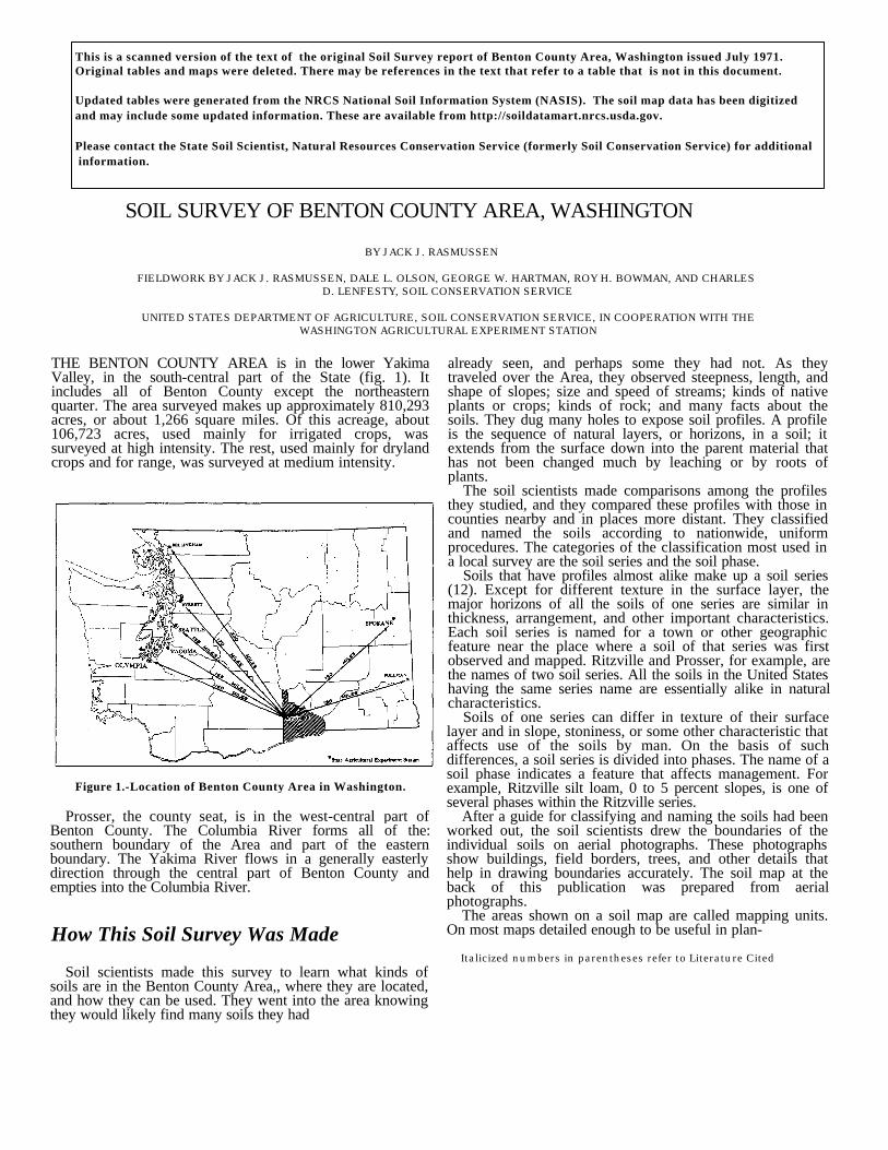
THE BENTON COUNTY AREA is in the lower YakimaValley, in the south-central part of the State (fig. 1). Itincludes all of Benton County except the northeasternquarter. The area surveyed makes up approximately 810,293acres, or about 1,266 square miles. Of this acreage, about106,723 acres, used mainly for irrigated crops, wassurveyed at high intensity. The rest, used mainly for drylandcrops and for range, was surveyed at medium intensity.
Figure 1.-Location of Benton County Area in Washington.
Prosser, the county seat, is in the west-central part ofBenton County. The Columbia River forms all of the:southern boundary of the Area and part of the easternboundary. The Yakima River flows in a generally easterlydirection through the central part of Benton County andempties into the Columbia River.
How This Soil Survey Was Made
Soil scientists made this survey to learn what kinds ofsoils are in the Benton County Area,, where they are located,and how they can be used. They went into the area knowingthey would likely find many soils they had
already seen, and perhaps some they had not. As theytraveled over the Area, they observed steepness, length, andshape of slopes; size and speed of streams; kinds of nativeplants or crops; kinds of rock; and many facts about thesoils. They dug many holes to expose soil profiles. A profileis the sequence of natural layers, or horizons, in a soil; itextends from the surface down into the parent material thathas not been changed much by leaching or by roots ofplants.
The soil scientists made comparisons among the profilesthey studied, and they compared these profiles with those incounties nearby and in places more distant. They classifiedand named the soils according to nationwide, uniformprocedures. The categories of the classification most used ina local survey are the soil series and the soil phase.
Soils that have profiles almost alike make up a soil series(12). Except for different texture in the surface layer, themajor horizons of all the soils of one series are similar inthickness, arrangement, and other important characteristics.Each soil series is named for a town or other geographicfeature near the place where a soil of that series was firstobserved and mapped. Ritzville and Prosser, for example, arethe names of two soil series. All the soils in the United Stateshaving the same series name are essentially alike in naturalcharacteristics.
Soils of one series can differ in texture of their surfacelayer and in slope, stoniness, or some other characteristic thataffects use of the soils by man. On the basis of suchdifferences, a soil series is divided into phases. The name of asoil phase indicates a feature that affects management. Forexample, Ritzville silt loam, 0 to 5 percent slopes, is one ofseveral phases within the Ritzville series.
After a guide for classifying and naming the soils had beenworked out, the soil scientists drew the boundaries of theindividual soils on aerial photographs. These photographsshow buildings, field borders, trees, and other details thathelp in drawing boundaries accurately. The soil map at theback of this publication was prepared from aerialphotographs.
The areas shown on a soil map are called mapping units.On most maps detailed enough to be useful in plan-
Italicized numbers in parentheses refer to Literature Cited
SOIL SURVEY OF BENTON COUNTY AREA, WASHINGTON
BY JACK J. RASMUSSEN
FIELDWORK BY JACK J. RASMUSSEN, DALE L. OLSON, GEORGE W. HARTMAN, ROY H. BOWMAN, AND CHARLESD. LENFESTY, SOIL CONSERVATION SERVICE
UNITED STATES DEPARTMENT OF AGRICULTURE, SOIL CONSERVATION SERVICE, IN COOPERATION WITH THEWASHINGTON AGRICULTURAL EXPERIMENT STATION
This is a scanned version of the text of the original Soil Survey report of Benton County Area, Washington issued July 1971.Original tables and maps were deleted. There may be references in the text that refer to a table that is not in this document. Updated tables were generated from the NRCS National Soil Information System (NASIS). The soil map data has been digitized and may include some updated information. These are available from http://soildatamart.nrcs.usda.gov. Please contact the State Soil Scientist, Natural Resources Conservation Service (formerly Soil Conservation Service) for additional information.
ning management of farms and fields, a mapping unit isnearly equivalent to a soil type or a phase. It is not exactlyequivalent, because it is not practical to show on such a mapall the small, scattered bits of soil of some other kind thathave been seen within an area that is dominantly of arecognized soil phase.
Most surveys include areas where the soil material is sorocky, so shallow, or so frequently worked by wind andwater that it cannot be classified by soil series. These areasare shown on the map like other mapping units, but they aregiven descriptive names, such as Dune land, and are calledland types.
While a soil survey is in progress, samples of soils aretaken, as needed, for laboratory measurements and forengineering tests. Laboratory data from the same kinds ofsoils in other places are assembled. Data on yields of cropsunder defined practices are assembled from farm recordsand from field or plot experiments on the same kinds of soils.Yields under defined management are estimated for thosesoils that are suitable for cultivation.
But only part of a soil survey is done when the soils havebeen named, described, and delineated on the map, and thelaboratory data and yield data have been assembled. Themass of detailed information then needs to be organized insuch a way that it is readily useful to different groups ofreaders, among them farmers, ranchers, managers ofwoodland, engineers, and homeowners. Grouping soils thatare similar in suitability for each specified use is the methodof organization commonly used in soil surveys. On the basisof yield and practice tables and other data, the soil scientistsset up trial groups. They test these groups by further studyand by consultation with farmers, agronomists, engineers,and others, and then adjust the groups according to theresults of their studies and consultation. Thus, the groupsthat are finally evolved reflect up-to-date knowledge of thesoils and their behavior under methods of use andmanagement current at the time of this survey.
General Soil Map
The general soil map shows, in color, the soil associationsin the Benton County Area. A soil association is a landscapethat has a distinctive proportional pattern of soils. It normallyconsists of one or more major soils and at least one minorsoil, and it is named for the major soils. The soils in oneassociation may occur in another, but in a different pattern.
A map showing soil associations is useful to people whowant a general idea of the soils in an Area, who want tocompare different parts of an Area, or who want to know thelocation of large tracts that are suitable for a certain kind ofland use. Such a map is a useful general guide in managing awatershed, a wooded tract, or a wildlife area, or in planningengineering works, recreational facilities, and communitydevelopments. It is not a suitable map for planning themanagement of a farm or field, or for selecting the exactlocation of a road, building, or similar structure, because thesoils in any one association ordinarily differ in slope, depth,stoniness, drainage, and other characteristics that affect theirmanagement.
The soil associations in the Benton County Area arediscussed in the following pages.
1. Ritzville-Willis associationGently sloping soils that are silt loam throughout and verydeep to shallow over basalt bedrock; formed in loess;precipitation zone 9 to 12 inches
This association occurs mainly in the higher part of HorseHeaven Hills and midway up the slopes in the RattlesnakeHills. The topography is generally smooth and gently sloping,but steeper areas along the larger drainageways are included.The soils formed in silty, wind deposited material (loess).They are generally underlain by basalt bedrock at a depth ofmore than 40 inches. The parent material on the uplandsincluded a small amount of volcanic ash. The annualprecipitation is 9 to 12 inches, the mean annual temperature isapproximately 48° F., and the frost-free season is about 140days. Elevations range from 1,200 to 2,500 feet. Thisassociation makes up about 31 percent of the Area.
Ritzville soils make up about 80 percent of the association.Willis soils make up about 10 percent, and Ellisforde,Esquatzel, and Kiona soils make up the rest. The soils arewell drained.
This association is used mainly for wheat, barley, and ryein a summer-fallow system. Soils that are shallow, stony, orsteep are used for grazing. The vegetation in uncultivatedareas is grass and sagebrush. An average farm has about2,400 acres of cultivated land. The population is sparse.
2. Warden-Shano associationGently sloping soils that are silt loam throughout and verydeep to moderately deep over basalt bedrock; formed inlacustrine material and loess; precipitation zone 6 to 9 inches
This association occurs mainly midway up the slopes ofHorse Heaven Hills, in the lower Rattlesnake Hills, and in thevicinity of Kiona. The topography is generally smooth andgently sloping but is steeper along the larger drainageways.The soils formed mainly in reworked lacustrine material andin silty, wind deposited material (loess). The parent materialon the uplands included a small amount of volcanic ash. Theannual precipitation is 6 to 9 inches, the mean annualtemperature is approximately 50°F., and the frost-free seasonis about 150 days. Elevations range from 550 to 1,200 feet.This association makes up about 31 percent of the Area.
Warden soils make up about 65 percent of the association,Shano soils make up 25 percent, and Burke, Esquatzel, andKiona soils make up the rest. These soils are well drained. Inplaces they are shallow or moderately deep over a cementedlime-silica hardpan that overlies basalt.
This association is used mainly for wheat, barley, and ryein a summer-fallow system. Approximately 18 percent of it iswithin irrigation districts. The Warden and Shano soils arehighly productive, and many crops are suitable. Soils that areshallow, stony, or too steep for cultivation are used forgrazing. The vegetation is grass and sagebrush. Innonirrigated areas, an average farm has about 2,500 acres incultivation. These areas are sparsely populated. In irrigatedareas, an average farm covers about 160 acres. Most ownersof irrigated farms
live on their farms, and many provide housing for farmlaborers.
3. Walla Walla-Endicott-Lickskillet associationGently sloping soils that are silt loam throughout and verydeep to shallow over basalt bedrock; formed in loess;precipitation zone 11 to 15 inches
This association occurs mainly in the higher parts of theRattlesnake Hills. The topography is generally smooth andgently sloping, but steeper areas along the largerdrainageways are included. The soils formed in silty,wind-deposited material (loess). They are generally underlainby basalt bedrock. In some places the bedrock is cappedwith a cemented lime-silica hardpan. The annual precipitationis 11 to 15 inches, the mean annual temperature isapproximately 47°F., and the frost-free season is about 130days. Elevations range from 2,200 to 3,500 feet. Thisassociation makes up about 4 percent of the Area.
The deep Walla Walla soils make up about 42 percent ofthe association. Shallow to moderately deep Endicott soilsmake up about 30 percent, and very stony Lickskillet soilsmake up about 28 percent. The soils are well drained.
This association is used mainly for wheat, barley, and ryein a summer-fallow system. Soils that are shallow, stony, orsteep are used for grazing. The vegetation in uncultivatedareas is grass and sagebrush. An average farm has about2,200 acres of cultivated land. The population is sparse.
4. Starbuck-Scooteney associationGently sloping soils that are silt loam throughout andshallow to very deep over gravel or basalt bedrock; formedin old alluvium and loess; precipitation zone 6 to 9 inches
This association occurs mainly along the Yakima River.The topography is generally smooth and gently sloping, butsome basalt escarpments are included. The soils formed inold alluvium and silty, wind-deposited material (loess).Starbuck soils are shallow over basalt bedrock; Scooteneysoils are underlain by gravelly deposits. The annualprecipitation is 6 to 9 inches, the mean annual temperature isapproximately 50°F., and the frost-free season is about 155days. Elevations range from 500 to 1,000 feet. Thisassociation makes up about 5 percent of the Area.
Starbuck soils make up about 40 percent of theassociation, and Scooteney soils, about 30 percent. Also inthis association are Wamba soils, which make up about 8percent; Esquatzel soils, which make up 5 percent; and smallacreages of Burbank, Burke, Finley, Prosser, and Wardensoils, which make up the rest. The soils are mainly welldrained, but a few areas are somewhat poorly drained.
Except for areas that are too stony or too steep, most ofthis association is irrigated. Starbuck and Wamba soils areused mainly for hay and pasture. Scooteney soils are usedfor tree fruits and grapes, as well as for hay and pasture. Thevegetation in uncultivated areas is grass and sagebrush. Anaverage farm covers about 40 acres. Many of the farmerswork at part-time jobs off the farm.
5. Kiona-Ritzville associationSteep soils that are silt loam throughout and very deep toshallow over basalt rubble or bedrock; formed in loess andresiduum; precipitation zone 6 to 12 inches
This association occupies bluffs that extend from HorseHeaven Hills to the Columbia River and areas along theYakima River. The topography is rough and steep; rockoutcrops and escarpments are common. The soils formed insilty, wind-deposited material, and basalt residuum. They areunderlain by basalt rubble and basalt bedrock. The annualprecipitation is 6 to 12 inches, the mean annual temperatureis approximately 49°F., and the frost-free season is about147 days. Elevations range from 800 to 2,500 feet. Thisassociation makes up about 4 percent of the Area.
The very stony Kiona soils make up about 85 percent ofthe association, and Ritzville and Shano soils make up about10 percent. Small acreages of Scooteney soils and of Rockoutcrop make up the rest. The soils are well drained.
This association is used for grazing and for wildlifehabitat. The vegetation is mainly grass and sagebrush. Thereare no homes in this association.6. Hezel-Quincy-Burbank associationGently sloping soils that have a loamy sand surface layerand are very deep to shallow over gravel, lacustrinematerial, or basalt bedrock; formed in windblown sand,lacustrine material, or alluvium; precipitation zone 6 to 9inches
This association occurs as two main areas: one area is inthe southern part of Benton County along the Columbia River,and the other is northwest of Kennewick and south of theHorn and the Yakima Rivers. The topography is smooth andgently sloping. The soils formed in windblown sand, loamysand, or alluvium, or in a combination of these materials.They are generally very deep, but in places they are shallowover basalt bedrock or a cemented lime-silica hardpan. Theannual precipitation is 6 to 9 inches, the mean annualtemperature is approximately 51°F., and the frost-freeseason is about 170 days. Elevations range from 300 to 900feet. This association makes up about 21 percent of the Area.
Hezel soils make up about 30 percent of the association,Quincy soils about 29 percent, and Burbank soils about 16percent. Also in this association are small acreages ofKoehler and Pasco soils and of miscellaneous land types. Thesoils are mainly excessively drained or somewhat excessivelydrained, but some areas near the rivers are poorly drained.
Most of this association is used for range. The vegetationis mainly grass and sagebrush. Small areas near Benton Cityand West Richland are used for irrigated hay and pasture.The population is sparse.7. Scooteney-Kennewick associationGently sloping, very deep soils that are silt loam throughout;formed in old alluvium and lacustrine material; precipitationzone 6 to 9 inches
This association, which includes the city of Kennewick,occurs in the southeastern part of the Area. The topographyis mainly smooth and gently sloping. The soils
formed in lacustrine sediments and in old alluvium. Theannual precipitation is 6 to 9 inches, the mean annualtemperature is approximately 50°F., and the frost-free seasonis about 150 days. Elevations range from 550 to 800 feet.This association makes up about 2 percent of the Area.
Scooteney soils make up about 40 percent of theassociation, and Kennewick soils, about 25 percent. Smallacreages of Burbank, Finley, Pasco, and Warden soils makeup the rest. The soils are well drained and very deep.
This association is used for many kinds of irrigated crops.The vegetation in uncultivated areas is mainly grass andsagebrush. An average farm covers about 160 acres.
8. Finley-Burbank-Quincy associationNearly level soils that are loamy sand to very fine sandthroughout; formed in old alluvium and windblown sand;precipitation zone 6 to 9 inches
This association occurs in the southeastern part of theArea, along the Columbia River. It is generally east ofKennewick. The topography is mainly smooth and nearlylevel. The soils formed in coarse textured and moderatelycoarse textured old alluvium, windblown sand, or acombination of these materials. The annual precipitation is 6to 9 inches, the mean annual temperature is approximately51°F., and the frost-free season is about 160 days.Elevations range from 350 to 450 feet. This associationmakes up about 2 percent of the Area.
Finley, Burbank, and Quincy soils make up approximatelyequal parts of the association; soils of each series constituteabout 30 percent of the acreage. Small acreages of Pasco andHezel soils and of miscellaneous land types make up the rest.The soils are mainly well drained or excessively drained, butthere are a few somewhat poorly drained areas.
Most of this association is irrigated and used for hay andpasture. A few areas are used for grapes, mint, asparagus,and other crops. The vegetation in uncultivated areas is grassand sagebrush. An average farm has about 50 acres. Many ofthe residents have jobs in town and farm part time.
Use and Management of the Soils
This section explains the system of capability classificationused by the Soil Conservation Service. It describes theirrigated and dryland capability units into which the soils ofthe Area have been classified, and it contains a section onestimated yields of both irrigated and dryland crops.
This section also groups the soils according to theirsuitability for range and for wildlife habitat, and it discussesthe use of the soils for windbreaks. In addition, it contains asection that gives information about soil characteristicssignificant in engineering.
Capability Grouping
Capability grouping shows, in a general way, the suitabilityof soils for most kinds of field crops. The soils are
grouped according to their limitations when used for fieldcrops, the risk of damage when they are used, and the waythey respond to treatment. The grouping does not take intoaccount major and generally expensive land-forming thatwould change slope, depth, or other characteristics of thesoils; does not take into consideration possible but unlikelymajor reclamation projects; and does not apply to rice,cranberries, horticultural crops, or other crops requiringspecial management.
Those familiar with the capability classification can inferfrom it much about the behavior of soils when used for otherpurposes, but this classification is not a substitute forinterpretations designed to show suitability and limitations ofgroups of soils for range, for forest trees, or engineering.
In the capability system, the kinds of soils are grouped atthree levels: the capability class, the subclass, and the unit.These are discussed in the following paragraphs.
CAPABILITY CLASSES, the broadest groups, aredesignated by Roman numerals I through VIII. The numeralsindicate progressively greater limitations and narrowerchoices for practical use, defined as follows
Class I soils have few limitations that restrict their use.Class II soils have moderate limitations that reduce the
choice of plants or that require moderateconservation practices.
Class III soils have severe limitations that reduce thechoice of plants, require special conservationpractices, or both.
Class IV soils have very severe limitations that reducethe choice of plants, require very carefulmanagement, or both.
Class V soils are subject to little or no erosion but haveother limitations, impractical to remove, that limittheir use largely to pasture, range, woodland, orwildlife habitat. (None of the soils of the BentonCounty Area are in class V.)
Class VI soils have severe limitations that make themgenerally unsuited to cultivation and limit their uselargely to pasture or range, woodland, or wildlifehabitat.
Class VII soils have very severe limitations that makethem unsuited to cultivation and that restrict theiruse largely to pasture or range, woodland, orwildlife habitat.
Class VIII soils and landforms have limitations thatpreclude their use for commercial plant productionand restrict their use to recreation, wildlife habitat,or water supply, or to esthetic purposes.
CAPABILITY SUBCLASSES are soil groups within oneclass; they are designated by adding a small letter, e, w, s, orc, to the class numeral, for example, IIe. The letter e showsthat the main limitation is risk of erosion unless close-growing plant cover is maintained; w shows that water in oron the soil interferes with plant growth or cultivation (insome soils the wetness can be partly corrected by artificialdrainage) ; s shows that the soil is limited mainly because it isshallow, droughty, saline, alkali, or stony; and c, used in onlysome parts of the United States, shows that the chieflimitation is climate that is too cold or too dry.

In class I there are no subclasses, because the soils of thisclass have few limitations. Class V can contain, at the most,only the subclasses indicated by w, s, and c, because the soilsin class V are subject to little or no erosion, though they haveother limitations that restrict their use largely to pasture,range, woodland, wildlife, or recreation.
CAPABILITY UNITS are soil groups within thesubclasses. The soils in one capability unit are enough aliketo be suited to the same crops and pasture plants, to requiresimilar management, and to have similar productivity andother responses to management. Thus, the capability unit is aconvenient grouping for making many statements aboutmanagement of soils. Capability units are generally designatedby adding an Arabic numeral to the subclass symbol, forexample, IIe-1 or IIIe-20. Thus, in one symbol, the Romannumeral designates the capability class, or degree oflimitation; the small letter indicates the subclass, or kind oflimitation, as defined in the foregoing paragraph; and theArabic numeral specifically identifies the capability unitwithin each subclass. In this survey Area, the irrigatedcapability units have a one-digit capability unit number (1),and the dryland capability units have a two-digit number(20).
The names of the soil series represented are mentioned inthe description of each capability unit, but the listing of theseries name does not necessarily indicate that all the soils of aseries are in the same capability unit. The capabilityclassification of any given soil can be learned by referring tothe "Guide to Mapping Units."
In the following pages the capability units in the BentonCounty Area are described, and suggestions for the use andmanagement of the soils are given.
Management by Irrigated Capability Units
Irrigation water is available in about 10 percent of theBenton County Area, predominantly areas irrigated by waterdiverted from the Yakima River. Where irrigation water isavailable, many kinds of irrigated crops are grown.
In this section the irrigated soils of the Benton CountyArea have been grouped by irrigated capability units.
IRRIGATED CAPABILITY UNIT I -1This unit consists of well-drained, nearly level soils of the
Esquatzel, Shano, and Warden series. These soils aregenerally more than 60 inches deep.
The water-holding capacity is high, and permeability ismoderate. Surface runoff is very slow to slow. Watererosion is a slight hazard, and wind erosion is a slight tomoderate hazard. The frost-free season is about 150 to 155days.
Suitable crops are sugar beets, asparagus, potatoes, peas,mint, hops, grain, tree fruits, grapes, and hay and pasture.
Management needs include application of fertilizer in theamounts indicated by soil tests, use of suitable croppingsystems, use of crop residue, and proper application ofirrigation water. Irrigation water can be applied bycorrugation, furrow, border, controlled flooding, or sprinklersystems. Deep cuts can be made in these soils with little orno effect on their suitability for crops.
IRRIGATED CAPABILITY UNIT IIe-1This unit consists of Warden very fine sandy loam, 0 to 2
percent sloes, eroded. This soil is well drained. It is morethan 60 Inches deep.
The water-holding capacity is high, and permeability ismoderate. Surface runoff is very slow. Water erosion is onlya slight hazard, but wind erosion is a moderate hazard whenthe surface is bare. The frost-free season is about 150 days.
Suitable crops are those that keep a permanent cover onthe ground, such as tree fruits, grapes, and hay and pasture.Many other crops are also suitable.
Management needs include practices to control winderosion, such as maintaining a vegetative cover as much ofthe time as possible, utilizing plant residue, and maintainingthe organic -matter content. When the soil is bare, the surfaceshould be left rough and cloddy to retard wind erosion.Fertilizer should be applied in the amounts indicated by soiltests. Irrigation water can be applied by corrugation, furrow,or sprinkler systems.
IRRIGATED CAPABILITY UNIT IIe-2This unit consists of well-drained, medium-textured, gently
sloping soils of the Burke, Esquatzel, Kennewick, Prosser,Scooteney, Shano, and Warden series. These soils aregenerally more than 60 inches deep, but shallow soils, nomore than 20 inches deep, are included.
The water-holding capacity is moderate to high.Permeability is moderate to moderately slow. Surface runoffis slow. Erosion is a slight to moderate hazard. The frost-freeseason is about 150 to 160 days.
Suitable crops are sugar beets, mint, asparagus, potatoes,peas, corn, hops, grain, and hay. Tree fruits, grapes, andpasture are also suitable.
Management needs include application of fertilizer in theamounts indicated by soil tests, use of suitable croppingsystems, use of crop residue, and proper application ofirrigation water.
Either surface or sprinkler irrigation is suitable. Furrowsand corrugations in surface systems should be held to a 2percent gradient, or else runs should be short, to minimizethe erosion hazard.
Calcareous soils and areas where a calcareous subsoil hasbeen exposed in leveling are suited to grass and legume hay,pasture, or small grain the first few years under irrigation.Special emphasis should be placed on increasing theorganic -matter content before growing row crops in areas ofcalcareous soils. If row crops are grown, phosphorus isneeded, and in places, sulfur and zinc.
IRRIGATED CAPABILITY UNIT IIs-1This unit consists of well-drained, medium-textured, nearly
level soils of the Kennewick and Umapine series. These soilsare more than 60 inches deep. They are strongly calcareous.They have either strongly alkaline or laminated layers thatrestrict plant roots until after the soil has been croppedseveral years.
The water-holding capacity is high. Permeability rangesfrom moderate to moderately slow. Surface runoff is veryslow. Erosion is a slight hazard. The frost-free season isabout 150 to 160 days.
For the first few years under irrigation, these soils arebetter suited to grass-and-legume hay and pasture than
to other crops. Sugar beets and asparagus are suitable afterthe fields have become uniformly productive.
Management needs include application of fertilizer, use ofsuitable cropping systems, with initial emphasis on addingorganic matter to the soil, and proper application of irrigationwater. Sulfur and a heavy application of phosphorus areneeded by some crops.
Irrigation water can be applied by furrow, corrugation,border, controlled flooding, or sprinkler systems. Gooddrainage of subsoil water and tail water is important. For thefirst few years of irrigation, this drainage water is notsuitable for reuse.
IRRIGATED CAPABILITY UNIT IIs-2This unit consists of well-drained, medium-textured,
nearly level soils of the Burke, Prosser, and Scooteney series.The Prosser and Burke soils are 20 to 36 inches deep overbasalt bedrock or cemented hardpan, and the Scooteney soilsare 10 to 24 inches deep over gravelly silt loam.
The water-holding capacity is moderate to moderatelyhigh, and permeability is moderate. Surface runoff is veryslow. Water erosion is a slight hazard, and wind erosion is aslight to moderate hazard. The frost-free season is about 150to 155 days.
Suitable crops are mint, corn, wheat, peas, hay, andpasture.
Management needs include application of fertilizer,especially nitrogen, in the amounts indicated by soil tests; useof suitable cropping systems; and use of crop residue.
Proper application of irrigation water is especiallyimportant where these soils occur in the same field with soilsthat have either high or low water-holding capacity. In suchplaces one soil can be overirrigated, and an adjacent soilunderirrigated. Water can be applied by furrow, corrugation,controlled flooding, or sprinkler systems.
IRRIGATED CAPABILITY UNIT IIIe-1This unit consists of well-drained, medium-textured and
moderately coarse textured soils of the Burke, Finley, Shano,and Warden series. The slope ranges from 2 to 8 percent. Inmost places the soils are more than 60 inches deep, but insome areas they are no more than 20 inches deep.
The water-holding capacity is moderate to high, andpermeability is moderate to moderately rapid. Runoff is slowto medium. The hazard of water erosion is slight tomoderate, and the hazard of wind erosion is severe when thesurface is left without plant cover. The frost-free season isabout 150 to 160 days.
The principal crops are tree fruits, grapes, hay, andpasture. Many other crops are suitable.
Management needs include practices to control winderosion, such as utilizing crop residue, maintaining theorganic -matter content, and keeping a vegetative cover on thesoil as much of the time as possible. When the ground isbare, the surface should be left rough and cloddy. Minimumtillage is advisable. Irrigation water can be applied bysprinkler, corrugation, or furrow systems. Reducing thelength of the furrows and corrugations helps to control watererosion.
Management needs include applying irrigation water in away that will minimize the hazard of erosion. The soils arewell suited to sprinkler irrigation. Furrows and corrugationsin surface systems should be held to a 2 percent gradient, orelse runs should be short, to minimize the erosion hazard.Careful investigation should precede leveling because thedepth of the soils is variable. Fertilizer should be appliedaccording to the needs of the crop to be grown. Managementshould also include use of crop residue, use of suitablecropping systems, and minimum tillage.
IRRIGATED CAPABILITY UNIT IIIw-1This unit consists of somewhat poorly drained, dark-
colored, medium-textured and moderately coarse textured,nearly level soils of the Pasco and Wamba series. In mostplaces the soils are more than 60 inches deep, but in someareas of the Wamba soil, a substratum of basalt bedrock is ata depth of less than 60 inches.
The water-holding capacity is moderate to high, andpermeability is moderately slow to moderate. In places thesurface layer is strongly alkaline. In some places the watertable is near the surface during part of the growing season.Surface runoff is very slow to ponded, and the hazard ofwater erosion is no more than slight. The hazard of winderosion is moderate on Pasco fine sandy loam. The frost-freeseason is about 150 to 155 days.
Peas, corn, hay, and small grain are suitable crops in areasthat are properly drained and irrigated. Water-
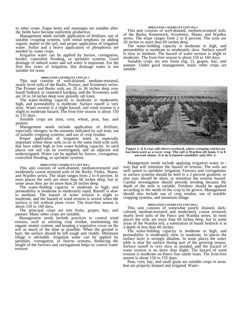
Figure 2.-A 6-year-old cherry orchard, where creeping red fescuehas been used as a cover crop. The soil is Warden silt loam, 5 to 8
percent slopes. It is in irrigated capability unit IIIe -2.
IRRIGATED CAPABILITY UNIT IIIe-2This unit consists of well-drained, medium-textured soils
of the Burke, Kennewick, Scooteney, Shano, and Wardenseries. The slope ranges from 2 to 8 percent. The soils are20 inches to more than 60 inches deep.
The water-holding capacity is moderate to high, andpermeability is moderate to moderately slow. Surface runoffis slow to medium. The hazard of water erosion is slight tomoderate. The frost-free season is about 150 to 160 days.
Suitable crops are tree fruits (fig. 2), grapes, hay, andpasture. Under good management, many other crops aresuitable.
tolerant pasture plants, such as reed canarygrass, redtop, altafescue, white clover, and strawberry clover, are suitable forundrained areas.
Drainage needs vary. Some areas need outlets; others needprovision for intercepting water. Strongly alkaline areas canbe made more suitable for crops by proper drainage andirrigation. In some of the low-lying areas along the river, thewater table fluctuates with the rise and fall of the river. Inthese places a drainage system may be useful only infacilitating the rapid removal of water once the river hasreceded.
In undrained areas crops receive little or no benefit fromfertilizer. In drained areas crops respond to fertilization,management of residue, and rotation of crops.
Irrigation water can be applied by furrow, corrugation,border, flooding, or sprinkler systems.
IRRIGATED CAPABILITY UNIT IIIs-1This unit consists of well-drained, nearly level, moderately
coarse textured and medium-textured soils of the Burke andFinley series.
The water-holding capacity is moderate to moderatelyhigh, and permeability is moderate to moderately rapid.Surface runoff is very slow. The hazard of wind erosion ismoderate. The frost-free season is about 160 days.
Tree fruits, grapes, hay, and pasture are suitable crops.Management needs include minimum tillage, using extra carein leveling to avoid exposing the subsoil, maintaining theorganic -matter content by management of crop residue, useof green-manure crops, and use of suitable croppingsystems. Fertilizer, especially nitrogen, is needed.
Furrow, corrugation, border, and sprinkler irrigationsystems are suitable. To minimize the erosion hazard, thelength of furrows and corrugations should not exceed 440feet.
IRRIGATED CAPABILITY UNIT IVe -1This unit consists of well-drained, medium-textured and
moderately coarse textured soils of the Burke, Finley, andWarden series. The slope ranges from 2 to 15 percent. Inmost places the soil is more than 30 inches deep, but in afew areas it is no more than 15 inches deep.
The water-holding capacity is low to high, andpermeability is moderate to moderately rapid. Surface runoffis very slow to rapid. The hazard of water erosion is slight tosevere; the hazard of wind erosion is moderate when thesurface is bare. The frost-free season is about 150 to 160days.
Hay, pasture, and orchard crops are suitable. In someplaces the Burke soil is too shallow for orchards and otherdeep-rooted crops.
Management needs include controlling erosion, maintainingthe organic -matter content, using soil-building croppingsystems, and maintaining as rough and cloddy a surface aspossible.
These soils are well suited to sprinkler irrigation. Fertilizershould be applied according to the needs of the crop to begrown.
IRRIGATED CAPABILITY UNIT IVe -2This unit consists of well-drained, medium-textured soils
of the Burke, Kennewick, Prosser, Scooteney, Shano,
Starbuck, and Warden series. The slope ranges from 5 to 15percent. Although most of the soils are very deep, some areshallow.
The water-holding capacity ranges from low in the shallowsoils to high in the deep soils. Permeability is moderate tomoderately slow. Surface runoff is medium to rapid. Thehazard of water erosion is moderate to high. The frost-freeseason is about 150 to 155 days.
These soils are well suited to permanent vegetation, suchas hay and pasture. Orchards are well suite, except on theshallow soils, such as the Starbuck and Burke soils.
Management needs include controlling erosion, keeping apermanent cover on the soil as much of the time as possible,and using a minimum amount of tillage. The soils are bettersuited to sprinkler irrigation than to surface systems. All cropresidue should be returned. Fertilizer should be appliedaccording to the needs of the crop to be grown.
IRRIGATED CAPABILITY UNIT IVe -3This unit consists of excessively drained and well-drained,
coarse-textured soils of the Burbank, Hezel, and Quincyseries. These soils are underlain by gravel, sand, or lacustrinematerial at a depth of 10 to 40 inches. The slope ranges from0 to 15 percent.
The water-holding capacity is low to moderately high, andpermeability is very rapid to moderate. Surface runoff is veryslow to medium. The hazard of water erosion is slight tomoderate, and the hazard of wind erosion is severe. Thefrost-free season is about 155 to 180 days.
These soils are suited to permanent crops, such as alfalfa,and to grass-and-legume pasture. Vineyards and orchards canbe maintained under careful management.
Proper management of these soils is important. A sprinklerirrigation system is suitable, but adequate distribution ofwater is a problem. Light, frequent applications of water andsplit applications of fertilizer are effective. Furrow orsubirrigation systems are used where the slope is 2 percent orless. Other practices needed include maintenance of avegetative cover to minimize wind erosion, utilization of cropresidue to maintain the organic -matter content, and care inleveling so as not to expose the gravelly, porous subsoil.
IRRIGATED CAPABILITY UNIT IVe -4This unit consists of well-drained, shallow, medium-
textured soils of the Burke and Starbuck series. The sloperanges from 0 to 8 percent.
The water-holding capacity is low, and permeability ismoderate. Surface runoff is very slow to medium. Thehazard of water erosion is slight to moderate, and the hazardof wind erosion is moderate. The frost-free season is about150 to 155 days.
These soils are suited to hay and pasture, mint, small grain,and other shallow-rooted crops.
Sprinkler irrigation is suitable, but proper application ofwater is difficult because the soils are shallow. Light,frequent applications are effective. A few areas are suitablefor corrugation or controlled flooding systems. Fertilizershould be applied according to the needs of the crop to begrown.
IRRIGATED CAPABILITY UNIT IVs -2The only soil in this capability unit is Finley fine sandy
loam, 0 to 2 percent slopes. This is a well-drained,moderately coarse textured soil underlain by very gravellymaterial at a depth of 10 to 30 inches.
The water-holding capacity is low, and permeability ismoderately rapid. Surface runoff is very slow. The hazard ofwater erosion is slight, and the hazard of wind erosion ismoderate when the surface is bare. The frost-free season isabout 150 to 165 days.
This soil is suited to permanent vegetation, such asorchards, hay, and pasture.
Management needs include minimum tillage, levelingcarefully to avoid exposing the gravelly subsoil, using allcrop residue, and maintaining the organic -matter content.Fertilizer, especially nitrogen, is needed.
This soil is well suited to sprinkler irrigation. If a
surface system is used, the length of corrugations should notexceed 440 feet, in order to keep the erosion hazard to aminimum.
Estimated yields of irrigated cropsTable 1 gives estimates of yields of the principal irrigated
crops grown in the Area under good management. Thefigures are estimated averages for a period of years. In anygiven year, the yield may be substantially higher or lowerthan the average. Also, there is considerable variation ofproductivity in some soils because of variations in the heightof the water table or in the content of salts and alkali.
It is advisable to consult local agricultural advisors fromtime to time for up-to-date information on improved cropvarieties, on new methods of controlling insects and disease,and on improved methods of fertilization, tillage, irrigation,and drainage.
In the original manuscript, there was a table in this space.All tables have been updated and are available as a separate document.
Following are examples of specific management practices,by crops, under which a farmer obtains the yields shown intable 1 from a representative irrigated soil.
For grapes (9) on Warden silt loam, 2 to 5 percent slopes-Variety: Concord.Spacing: 8 x 9 feet-605 plants per acre.Fertilization: None.Cover crop: Vetch and barley.Pruning: December through February,
leaving approximately 80 buds per plant; chop prun- ings and disk into soil.
Cultivation: 3 regular cultivations with grape hoe, timed to be most effective for weed control.
Irrigation:Method ---------------Furrow.Frequency ------------3 applications before harvest,
beginning about June 1; 1irrigation after harvest.
Amount --------------28 to 36 inches.Drainage -------------Removal of tail water.
Insect control: Dust with a suitable insecti-cide to control mealybugs,black vineweevils, and cut-worms.
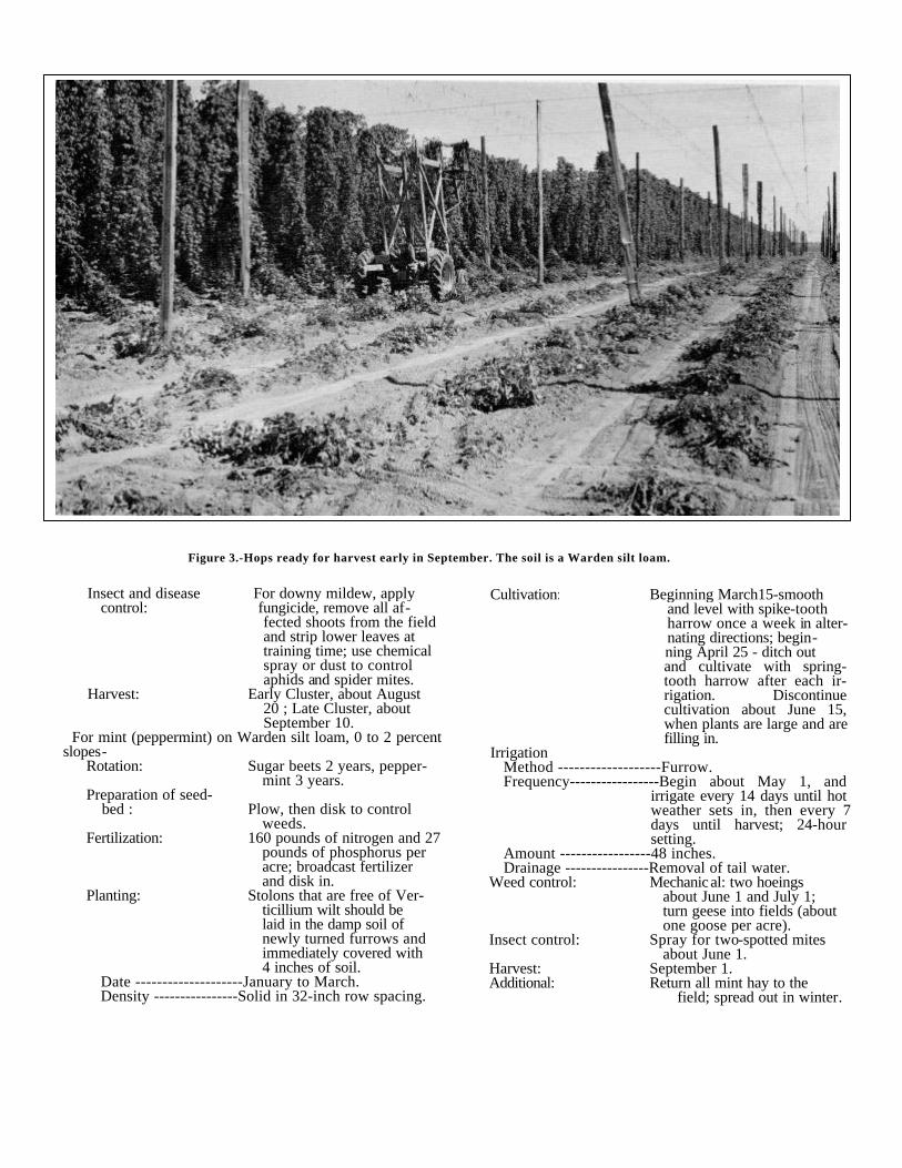
Harvest: October 1.For hops (3) (fig. 3) on Warden silt loam, 0 to 2 percent
slopes-Variety: Cluster (early and late
types), propagated from rhizome cuttings.
Spacing: 7 x 7 feet-889 plants per acre on 18-foot high trellis.
Fertilization: 150 pounds of nitrogen and 36pounds of phosphorus peracre. Before establishing anew yard, 30 pounds ofzinc sulfate per acre shouldbe plowed down. Zinc sprayshould be used to correctzinc deficiency during thegrowing season.
Cover crop: Vetch, seeded in July anddisked in April.
Pruning: Early spring pruning of ex-cess shoots from the rootstock; confine crowns to areasonable area and removeall diseased parts.
Training: When vines are about 2 feetlong, one to three vinesshould be trained up eachstring and excess vinesremoved.
Cultivation: Begin with disking in thecover crop and pruning.The condition of the soiland the weediness deter-mine the advisability oflater cultivations.
IrrigationMethod ------------------ Furrow.Frequency---------------- About 8 applications, begin-
ning about April 1; 48-hoursettings and 800-foot fur-rows.
Amount ------------------ 36 inches.Drainage----------------- Removal of tail water.
In the original manuscript, there was a table in this space.All tables have been updated and are available as a separate document.
Insect and disease For downy mildew, applycontrol: fungicide, remove all af-
fected shoots from the fieldand strip lower leaves attraining time; use chemicalspray or dust to controlaphids and spider mites.
Harvest: Early Cluster, about August20 ; Late Cluster, aboutSeptember 10.
For mint (peppermint) on Warden silt loam, 0 to 2 percentslopes-
Rotation: Sugar beets 2 years, pepper-mint 3 years.
Preparation of seed-bed : Plow, then disk to control
weeds.Fertilization: 160 pounds of nitrogen and 27
pounds of phosphorus peracre; broadcast fertilizerand disk in.
Planting: Stolons that are free of Ver-ticillium wilt should belaid in the damp soil ofnewly turned furrows andimmediately covered with4 inches of soil.
Date --------------------January to March.Density ----------------Solid in 32-inch row spacing.
Cultivation: Beginning March15-smooth and level with spike-tooth harrow once a week in alter- nating directions; begin-
ning April 25 - ditch outand cultivate with spring-tooth harrow after each ir-rigation. Discontinuecultivation about June 15,when plants are large and arefilling in.
IrrigationMethod -------------------Furrow.Frequency-----------------Begin about May 1, and
irrigate every 14 days until hotweather sets in, then every 7days until harvest; 24-hoursetting.
Amount -----------------48 inches.Drainage ----------------Removal of tail water.
Weed control: Mechanical: two hoeings about June 1 and July 1; turn geese into fields (about one goose per acre).
Insect control: Spray for two-spotted mites about June 1.
Harvest: September 1.Additional: Return all mint hay to the
field; spread out in winter.
Figure 3.-Hops ready for harvest early in September. The soil is a Warden silt loam.
For sugar beets (6) on Shano silt loam, 2 to 5 percentslopes-
Rotation: Alfalfa 3 years, corn 1 year,sugar beets 2 years.
Preparation of seed-bed: Fall plow; spring till and
pack. Prepare a level, finegranular, firm seedbed, butdo not pack too firmly.
Fertilization: 180 pounds of nitrogen and40 pounds of phosphorusper acre.
SeedingAmount ----------------6 pounds per acre of seed from
which the husks have beenremoved; plant three-fourthsof an inch deep in a firm,moist seedbed.
Date --------------------About March 20.Density ----------------22-inch, row spacing.
Cultivation : First cultivation soon afterplants have emerged andthe rows are visible.
Thinning: Partial mechanical thinning,followed by hand thinningwhen plants have about 6leaves (about May 15) ;leave one beet plant every10 inches.
Weeding: Mechanical cultivation forweed control and furrow-ing out; hand hoeing whenneeded (2 or 3 times a
Irrigation year).Method -------------------Furrow.Frequency ----------------Irrigate every 8 days in alter-
nate rows at peak of irrigationseason; early irrigation issometimes need to insuregermination. Irrigate untilharvest. (When the soil is atfield capacity, replenish theamount of water used, but ap-ply no more.)
Amount -----------------36 inches.Drainage ----------------Removal of tail water.
Harvest: By machine in October.For alfalfa (hay) on Warden silt loam, 2 to 5 percent
slopes-Rotation:
Alfalfa 3 years, corn 1 year,sugar beets 2 years, greenpeas followed by summerseeding of alfalfa.
Preparation of seed-bed : Plow, disk, and pack.
Fertilization: 44 pounds of phosphorus atseeding time.
Seeding: Use inoculated seed; sow nodeeper than half an inch infirm, weed-free seedbed.
Variety--------------------Ranger or Vernal.
Rate---------------------- 10 pounds per acre.Date--------------------- September 1.
Irrigation:Method ----------------- Corrugation, 32-inch width.Frequency---------------Irrigate first cutting twice,
beginning about May 15 ;irrigate second and thirdcuttings 1 week before cut-ting; irrigate once after thirdcutting (a total of fiveapplications).
Amount ------------------ 36 inches.Drainage ----------------- Removal of tail water.
Harvest: Cut in late bud stage, 3 or 4cuttings a year.
For pasture (5) on Shano silt loam, 2 to 5 percent slopes-Rotation: Pasture 5 years, sugar beets 2
years, and green peas 1year, followed by reestab-lishment of pasture.
Preparation of seed- Plow, disk, and pack.bed:
Fertilization: 125 pounds of nitrogen and 22pounds of phosphorus per
acre at planting; annualapplication of 100 poundsof nitrogen in three equal
applications, one about thelast of March, one in themiddle of June, and one
early in August; 22 poundsof phosphorus per acre,
broadcast each fall.Seeding: Use inoculated legume seeds;
sow no deeper than 1/2 inchin firm, weed-free seedbed.
Variety---------------------- S-143 orchardgrassand Ranger alfalfa.
Rate-------------------------10 pounds of orchardgrassand 5 pounds of alfalfa peracre.
Date-------------------------Seed no later thanSeptember 15.
IrrigationMethod -------------------Rill; corrugations spaced 36
inches apart.Frequency------------------Every 10 days during
period of maximumconsumption.
Amount --------------------36 inches per season.Drainage -------------------Removal of tail water.
Grazing: .Schedule------------------Rotation pasture is based on
stage of growth; allowalfalfa and grass to reach aminimum growth of 12 to14 inches, then graze backto about 2 to 4 inches;pasture season normallyextends from about May 1to early in October.
Other practices---_ Clipping excess growth, spreadingdung, ditching, fertilizing,and irrigating should bescheduled so as to notinterfere with grazing.
Management by Dryland Capability Units
In those areas where natural precipitation is adequate,suitable soils are used for dryland farming. The main drylandcrop is winter wheat.
In this section the dryland soils of the Benton County Areahave been grouped by dryland capability units.
DRYLAND CAPABILITY UNIT IIc-20This unit consists of Walla Walla silt loam, 0 to 5 percent
slopes, a well-drained, medium-textured soil. This soil ismore than 60 inches deep in most places, but in some it isbetween 36 and 60 inches in depth. It occurs on highterraces in the Rattlesnake Hills. Elevations range from about2,200 to 3,300 feet. The annual precipitation amounts to 11to 15 inches, and the frost-free season is about 130 days.
The water-holding capacity is high, and permeability ismoderate. Surface runoff is very slow to slow. The hazardof water and wind erosion is slight.
This soil is used mainly for wheat. It is one of the mostconsistently productive of the dryland soils.
In some years a sharp rise in temperature brings abruptsnowmelt while the ground is still frozen. The rapid runoffthat results not only carries off the water that wouldotherwise recharge the ground supply, but also carries offsome of the soil.
Management practices should include stubble-mulchtillage, diversion of runoff water, and seeding along thecontour. The soil should be cultivated only enough to controlweeds and to prepare the seedbed. Fall chiseling of stubblechecks runoff over frozen ground. Crops generally respondto nitrogen.
DRYLAND CAPABILITY UNIT IIIe-20This unit consists of well-drained, medium-textured soils
of the Endicott and Walla Walla series. These soils occur onhigh terraces in the Rattlesnake Hills. They are 20 to morethan 60 inches deep. The slope ranges from 5 to 15 percent.Elevations range from 2,200 to 3,500 feet. The annualprecipitation amounts to 11 to 15 inches, and the frost-freeseason is about 130 days.
The water-holding capacity is moderate to high, andpermeability is moderate. Surface runoff is slow to medium.Water erosion is a slight to moderate hazard, and winderosion is a slight hazard.
These soils are used mainly for production of wheat.Management practices should include stubble-mulch tillage,cross-slope tillage, diversion of runoff water, and cultivationonly to control weeds and to prepare the seedbed. Fallchiseling of stubble checks runoff over frozen ground. Cropsgenerally respond to nitrogen.
DRYLAND CAPABILITY UNIT IIIe-21This unit consists of Esquatzel fine sandy loam, 0 to 5
percent slopes, a well-drained, very deep soil on bottomlands. Elevations range from 300 to 1,400 feet. The annual
precipitation amounts to 6 to 12 inches, and the frost-freeseason is about 150 days.
The water-holding capacity is high, and permeability ismoderate. Runoff is very slow to slow. Water erosion is aslight hazard, and wind erosion is a moderate hazard.
In cultivated areas, timely practices that minimize thehazard of wind erosion and properly utilize the limitedmoisture supply are important. Management practices shouldinclude minimum tillage, diversion of runoff, deep-furrowseeding at right angles to prevailing winds, Art cropping, andstubble-mulch tillage. This soil should be cultivated only tocontrol weeds and to prepare the seedbed.
DRYLAND CAPABILITY UNIT IIIs-20This unit consists of well-drained, medium-textured soils
of the Endicott and Willis series. These soils are 20 to 36inches deep. The slope ranges from 0 to 5 percent.Elevations range from 1,200 to 3,000 feet. The annualprecipitation amounts to 9 to 15 inches, and the frost-freeseason is about 130 to 140 days.
The water-holding capacity is moderate to moderatelyhigh, and permeability is moderate. Surface runoff is veryslow to slow. Water erosion is a slight to moderate hazard,and wind erosion is a slight to moderate hazard. In yearswhen moisture is plentiful, the soils become saturated anderosion is a serious hazard.
These soils are used mainly for wheat. If rainfall isespecially low in May and June, the crop may be seriouslyretarded. Management practices should include stubble-mulch tillage, cross-slope tillage, deep-furrow seeding,minimum tillage, and diversion of runoff. The soils should becultivated only to control weeds and to prepare the seedbed.
DRYLAND CAPABILITY UNIT IIIs-20This unit consists of well-drained, medium-textured soils
of the Ellisforde, Esquatzel, and Ritzville series. These soilsoccur in Horse Heaven Hills and in the Rattlesnake Hills.They are generally more than 60 inches deep but in someareas are between 36 and 60 inches in depth. The sloperanges from 0 to 5 percent. Elevations range from 1,000 to2,500 feet. The annual precipitation amounts to 9 to 12inches, and the frost-free season is about 140 to 150 days.
The water-holding capacity is high, and permeability ismoderate to moderately slow. Surface runoff is slow to veryslow. Water erosion is a slight hazard, and wind erosion is aslight to moderate hazard (fig. 4).
These soils are used mainly for production of wheat.Management practices should include stubble-mulch tillage,deep-furrow seeding at right angles to prevailing winds,diversion of runoff, and minimum tillage. The soils should becultivated only to control weeds and to prepare the seedbed.Crops generally respond to nitrogen.
DRYLAND CAPABILITY UNIT IVe -20This unit consists of well-drained, medium-textured soils
of the Ellisforde, Ritzville, and Walla Walla series. These soilsgenerally occupy breaks extending from high terraces of theRattlesnake Hills and Horse Heaven Hills. They are generallymore than 36 inches deep. The slope ranges from 15 to 30percent. In places all the surface soil has been removed byerosion, and shallow gullies
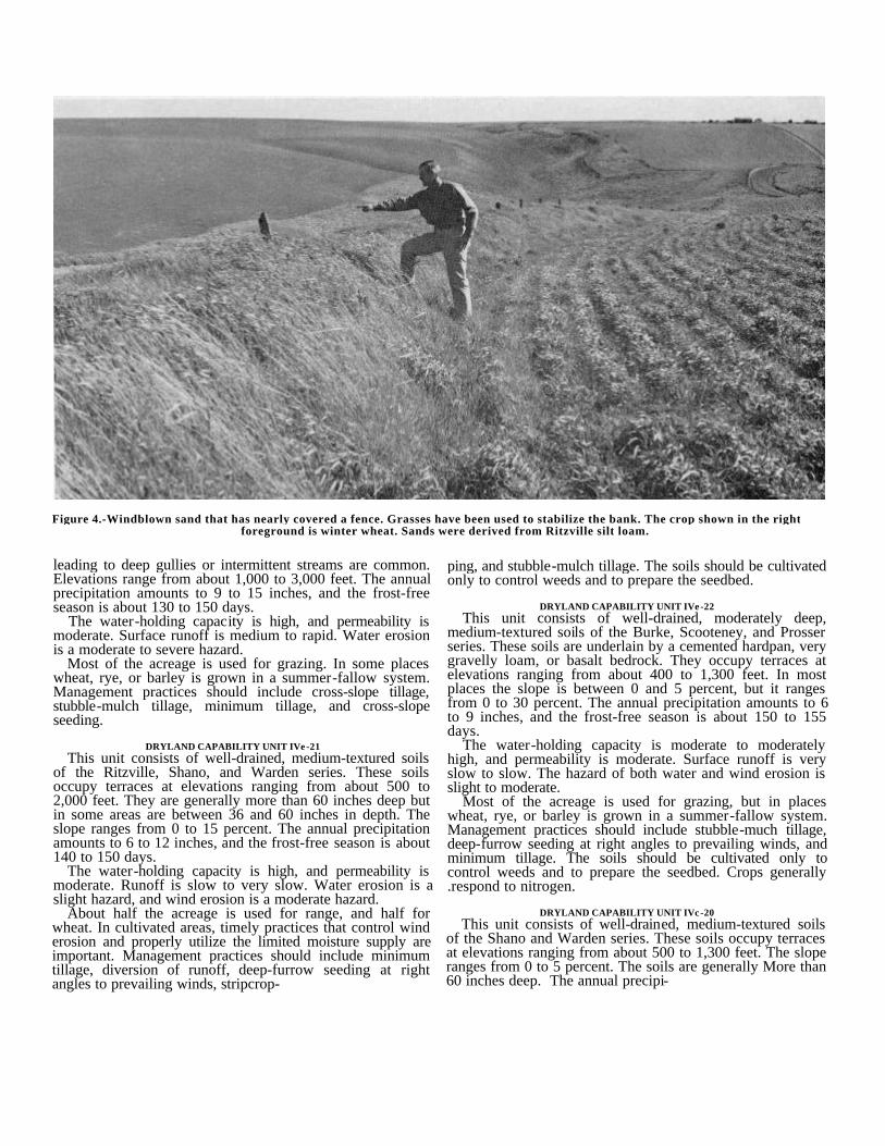
Figure 4.-Windblown sand that has nearly covered a fence. Grasses have been used to stabilize the bank. The crop shown in the rightforeground is winter wheat. Sands were derived from Ritzville silt loam.
leading to deep gullies or intermittent streams are common.Elevations range from about 1,000 to 3,000 feet. The annualprecipitation amounts to 9 to 15 inches, and the frost-freeseason is about 130 to 150 days.
The water-holding capacity is high, and permeability ismoderate. Surface runoff is medium to rapid. Water erosionis a moderate to severe hazard.
Most of the acreage is used for grazing. In some placeswheat, rye, or barley is grown in a summer-fallow system.Management practices should include cross-slope tillage,stubble-mulch tillage, minimum tillage, and cross-slopeseeding.
DRYLAND CAPABILITY UNIT IVe -21This unit consists of well-drained, medium-textured soils
of the Ritzville, Shano, and Warden series. These soilsoccupy terraces at elevations ranging from about 500 to2,000 feet. They are generally more than 60 inches deep butin some areas are between 36 and 60 inches in depth. Theslope ranges from 0 to 15 percent. The annual precipitationamounts to 6 to 12 inches, and the frost-free season is about140 to 150 days.
The water-holding capacity is high, and permeability ismoderate. Runoff is slow to very slow. Water erosion is aslight hazard, and wind erosion is a moderate hazard.
About half the acreage is used for range, and half forwheat. In cultivated areas, timely practices that control winderosion and properly utilize the limited moisture supply areimportant. Management practices should include minimumtillage, diversion of runoff, deep-furrow seeding at rightangles to prevailing winds, stripcrop-
ping, and stubble-mulch tillage. The soils should be cultivatedonly to control weeds and to prepare the seedbed.
DRYLAND CAPABILITY UNIT IVe -22This unit consists of well-drained, moderately deep,
medium-textured soils of the Burke, Scooteney, and Prosserseries. These soils are underlain by a cemented hardpan, verygravelly loam, or basalt bedrock. They occupy terraces atelevations ranging from about 400 to 1,300 feet. In mostplaces the slope is between 0 and 5 percent, but it rangesfrom 0 to 30 percent. The annual precipitation amounts to 6to 9 inches, and the frost-free season is about 150 to 155days.
The water-holding capacity is moderate to moderatelyhigh, and permeability is moderate. Surface runoff is veryslow to slow. The hazard of both water and wind erosion isslight to moderate.
Most of the acreage is used for grazing, but in placeswheat, rye, or barley is grown in a summer-fallow system.Management practices should include stubble-much tillage,deep-furrow seeding at right angles to prevailing winds, andminimum tillage. The soils should be cultivated only tocontrol weeds and to prepare the seedbed. Crops generally.respond to nitrogen.
DRYLAND CAPABILITY UNIT IVc -20This unit consists of well-drained, medium-textured soils
of the Shano and Warden series. These soils occupy terracesat elevations ranging from about 500 to 1,300 feet. The sloperanges from 0 to 5 percent. The soils are generally More than60 inches deep. The annual precipi-
tation amounts to 6 to 9 inches, and the frost-free season isabout 150 days.
The water-holding capacity is high, and permeability ismoderate. Surface runoff is very slow to slow. Watererosion is a slight hazard, and wind erosion is a slight tomoderate hazard.
These soils are used for wheat, rye, barley, or range.Management practices should include stubble-mulch tillage,and deep-furrow seeding at right angles to prevailing winds.The soils should be cultivated only to control weeds and toprepare the seedbed. Crops generally respond to nitrogen.
DRYLAND CAPABILITY UNIT VIe-20This unit consists of well-drained, medium-textured soils
of the Burke, Endicott, Kennewick, Shano, Warden, andWillis series. These soils are shallow, severely eroded, orhighly susceptible to erosion. In most places the slope isbetween 15 and 30 percent, but it ranges from 0 to 40percent. The annual precipitation amounts to 6 to 15 inches,and the frost-free season is 130 to 155 days.
The water-holding capacity is low to high, andpermeability is moderate. Runoff is very slow to rapid.
These soils are suitable for grazing. Seeding for rangeimprovement is practical.
DRYLAND CAPABILITY UNIT VIe-21This unit consists of well-drained, medium-textured soils
of the Ritzville and Walla Walla series. These soils aremoderately deep to deep. The slope ranges from 30 to 65percent. The annual precipitation amounts to 6 to 15 inches,and the frost-free season is 130 to 150 days.
The water-holding capacity is high, and permeability ismoderate. Runoff is rapid to very rapid. The hazard of watererosion is severe to very severe.
These soils are suitable for grazing. Seeding for rangemanagement is practical.
DRYLAND CAPABILITY UNIT VIe-22This unit consists of well-drained, medium-textured and
moderately coarse textured soils of the Burke, Finley, andProsser series. These soils are 20 to 36 inches deep. Theslope ranges from 0 to 15 percent. The annual precipitationamounts to 6 to 9 inches, and .the frost-free season is about150 to 155 days.
The water-holding capacity is low to moderately high, andpermeability is moderate. Runoff is very slow to slow. Thehazard of erosion is slight to moderate.
These soils are suitable for grazing. Seeding for rangeimprovement is practical.
DRYLAND CAPABILITY UNIT VIs-22This unit consists of Umapine silt loam, 0 to 5 percent
slopes, a deep, moderately well drained, saline-alkali soil. Theannual precipitation amounts to 6 to 9 inches, and thefrost-free season is about 150 days.
Runoff is very slow, and the hazard of erosion is slight.This soil is suitable for grazing. Seeding for range
improvement is practical.
DRYLAND CAPABILITY UNIT VIIe-21This unit consists of well-drained, medium-textured soils
of the Burke, Shano, Warden, and Willis series. The
slope ranges from 30 to 65 percent. The annual precipitationamounts to 6 to 9 inches, and the frost-free season is about150 to 155 days.
The water-holding capacity is moderate to high, andpermeability is moderate. Runoff is rapid to very rapid. Thehazard of water erosion is severe to very severe.
These soils are used to a limited extent for grazing.Mechanical range improvement practices are not practical.Proper grazing use and grazing systems that provide periodicrest from grazing in order to improve plant vigor areappropriate.
DRYLAND CAPABILITY UNIT VIIe-23This unit consists of excessively drained to well-drained,
coarse-textured soils of the Burbank, Hezel, Koehler, andQuincy series. These soils are moderately deep to deep. Theslope ranges from 0 to 30 percent. The annual precipitationamounts to 6 to 9 inches, and the frost-free season is about155 to 180 days.
The water-holding capacity is low to moderately high, andpermeability is rapid to very rapid. Runoff is very slow toslow. The hazard of wind erosion is severe.
These soils are used to a limited extent for grazing.Maintaining ground cover and controlling soil drifting areserious problems. Preparation of a seedbed for grasses is notpractical.
DRYLAND CAPABILITY UNIT VIIs-20This unit consists of excessively drained to well-drained,
coarse-textured to medium-textured soils of the Burbank,Burke, Finley, Mona, Lickskillet, Scooteney, and Starbuckseries. The soils are rocky or very stony. The slope rangesfrom 0 to 65 percent. The annual precipitation amounts to 6to 15 inches, and the frost-free season is 130 to 180 days.
The water-holding capacity is low to moderate, andpermeability is very rapid to moderately slow. Runoff rangesfrom very slow to very rapid. The hazard of erosion rangesfrom slight to very severe.
These soils are used to a limited extent for grazing and forwildlife habitat. Preparation of a seedbed for grasses is notpractical.
DRYLAND CAPABILITY UNIT VIIIe-20This unit is made up of Dune land, a land type that
consists of deep, loose, wind-worked fine sand. The dunesare active and vary in size and shape, but they arepredominantly 5 to 20 feet high. They are barren and have noagricultural value.
DRYLAND CAPABILITY UNIT VIIIw-20This unit is made up of Riverwash, a land type that
consists mainly of sand and gravel bars along rivers andstreams. These areas are subject to flooding and shiftingwhen the streams overflow. Most areas are bare ofvegetation. They have no agricultural value.
DRYLAND CAPABILITY UNIT VIIIs-20This unit is made up of Rock outcrop, a land type that
consists of vertical escarpments and outcrops of basalt. Theslope ranges from gently sloping to very steep. This land typehas no agricultural value.
Estimated yields of dryland wheatTable 2 lists the soils in this Area that are used mainly for
winter wheat and gives estimates of average yields over a5-year period using a summer-fallow system, where a cropis grown every other year. The estimates are given only forhigh-level management, because such management isnecessary to prevent crop failure. They are based on theexperience of individual farmers and on data provided byFederal agricultural advisors.
Basically the same cultural practices are followedthroughout the Area, but the intensity and timing ofoperations vary from one place to another, largely because ofvariations in the weather. The following are typical practicesin a harvest-to-harvest cycle on Warden silt loam, 0 to 5percent slopes
July 5-----------Harvest; after harvest, nothing is doneuntil the following spring.
March 1---------Stubble-mulch; a disk plow is used ifthe stubble is thick, or a chisel-sweep plow if the stubble is light.
April l-----------Cultivation and seal-off with rod weeder.June 15---------Cultivation with rod weeder, if needed.
In years when rainfall is low, thiscultivation may not be necessary.
August 1--------Spot weeding with small tractor, orhand weeding.
October 1------ Cultivation with rod weeder if rainfallhas amounted to more than half aninch since last weeding, followedimmediately (no later than October15) by seeding. Seeding rate shouldbe 55 to 70 pounds per acre. Seed indust, deep furrows (3 to 4 inchesdeep) with 14-inch spacing, 1/2 inchto 1 inch of soil should cover seed.
Additional practices should include spraying withchemicals, if needed, for control of tarweed, Russian-thistle,and mustard, as well as fertilizing with 20 to 30 pounds ofnitrogen per acre if there is adequate moisture.
Range
Nearly half, or approximately 397,530 acres, of the BentonCounty Area is used for range. This acreage consists mainlyof areas on sandy terraces along the Yakima and ColumbiaRivers and on the upper slopes and steep breaks of theRattlesnake Hills and Horse Heaven Hills. The areas aregenerally unsuitable for cultivation.
The livestock industry is the third largest agriculturalenterprise in the Area. The income from livestock is derivedmainly from production of stocker and feeder cattle, oflambs, and of wool.
Most of the ranchers in the Area depend on native foragefor livestock feed the year around. Hay is fed as partial or fullfeed only during calving or lambing time and when badweather prevents grazing, usually about 1 or 2 months out ofthe year. Some of the ranchers use a protein supplementduring periods late in summer and early in fall when the feedis dry.
Range sites and condition classesProper range management requires knowledge of the
capabilities of the soils that make up a range site and thekinds and amounts of forage that can be produced. Arancher also needs the ability to evaluate the presentcondition of the vegetation in relation to its potential.
For the purpose of classifying range resources, soils areplaced, in groups called range sites. Each site has a distinctivepotential plant community, the composition of which dependsupon a combination of environmental conditions, mainly thecombined effects of soil and climate. The potential plantcommunity reproduces itself so long as the environmentalconditions remain the same. Generally, the potential plantcommunity is the most productive combination of forageplants that will grow on a range site.
Following is a list of the common and scientific names ofthe range plants that generally make up the vegetation on therange sites of this Area.
By HARRY H. WEGELEBEN, range conservationist, Soil Conservation Service,Yakima, assisted by JACK J. RASMUSSEN, soil scientist, Soil Conservation Service.
In the original manuscript, there was a table inthis space.
All tables have been updated and are available as a separate document.
Common name Scientific nameAlkali bluegrass -------------------------------- Poa juncifoliaAlkali cordgrass-------------------------------- Spartina gracilisAntelope bitterbrush-------------------------- Purshia tridentataBasin wildrye----------------------------------- Elymus cinerensBluebunch wheatgrass----------------------- Agropyron spicatumBig bluegrass ---------------------------------- Poa amplaBig sagebrush --------------------------------- Artemisia tridentataBlack greasewood----------------------------- Sarcobatus veriniculatusBottlebrush squirreltail---------------------- Sitanion hystrixBuckwheat, wild------------------------------ Eriogonum spp.Cheatgrass brome---------------------------- Bromus tectorumCocklebur ------------------------------------ Xanthium spp.Currant --------------------------------------- Ribes spp.Cusick bluegrass --------------------------- Poa CusickiGroundsmoke-------------------------------- Gayophytuin spp.Horsebrush ---------------------------------- Tetradymia canescensIdaho fescue---------------------------------- Festuca idahoensisIndian ricegrass----------------------------- Oryzopsis hymenoidesInland saltgrass----------------------------- Distichlis strictaNeedle-and-thread ------------------------ Stipa comataPacific fescue-------------------------------- Festuca pacificaPlantain ------------------------------------- PlantagoPrairie junegrass--------------------------- Koeleria cristataPrickly lettuce ----------------------------- Lactuca serriolaRabbitbrush ------------------------------- Chrysothamnus spp.Ragweed, common ----------------------- Ambrosia artemisifoliaRose ---------------------------------------- Rosa spp.Sandberg bluegrass --------------------- Poa secundaSandbur ----------------------------------- Cenchrus pauciforacsSixweeks fescue--------------------------- Festuca octofloraServiceberry ------------------------------ Amelanchier spp.Spiny hopsage----------------------------- Grayia spinosaTarweed ------------------------------------ Madia spp.Thickspike wheatgrass------------------- Agropyron dasystachyumThreadleaf sedge ------------------------- Carex filifoliaThreetip sagebrush ---------------------- Artemisia tripartitaThurber needlegrass--------------------- Stipa thurberianaWillowweed ------------------------------- Epilobium spp.Yellow wildrye----------------------------- Elymus flavescens
Livestock are selective in their grazing habits. They seekout the more palatable and nutritious plants. The most heavilygrazed plants are referred to as decreasers because they arethe first to be depleted by close grazing (4). The lesspalatable plants are referred to as increasers because theywithstand intensive grazing and replace the more desirableplants. Weeds and other plants that invade the site after thedesirable plants have been reduced are referred to asinvaders.
The relationship between the present vegetation and thepotential plant community is measured in terms of rangecondition. Range condition is evaluated to determine thedegree of deterioration that has taken place in the originalplant cover, as well as to provide a basis for predicting theamount of improvement possible. It is expressed in terms ofcondition classes. Four classes are used to indicate the degreeto which the potential plant community has been changed bygrazing or other use.
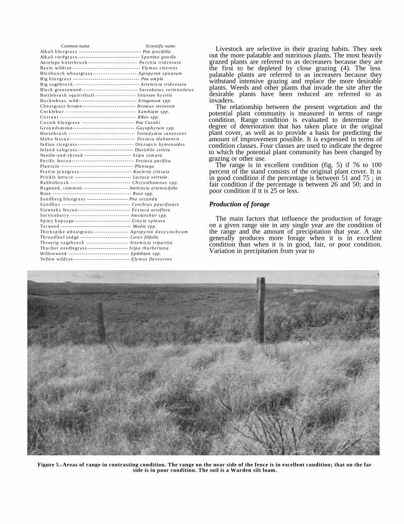
The range is in excellent condition (fig. 5) if 76 to 100percent of the stand consists of the original plant cover. It isin good condition if the percentage is between 51 and 75 ; infair condition if the percentage is between 26 and 50; and inpoor condition if it is 25 or less.
Production of forage
The main factors that influence the production of forageon a given range site in any single year are the condition ofthe range and the amount of precipitation that year. A sitegenerally produces more forage when it is in excellentcondition than when it is in good, fair, or poor condition.Variation in precipitation from year to
Figure 5.-Areas of range in contrasting condition. The range on the near side of the fence is in excellent condition; that on the farside is in poor condition. The soil is a Warden silt loam.
year cause marked variation in forage yield. Stocking ratesmust, therefore, be adjusted on a given range site to reflectdifferences in range condition and even from year to year onthe same range site in one condition class, depending on theprecipitation.
In table 3 are estimates of forage production expressed inanimal unit months for each of the eight range sites in theBenton County Area. These estimates are based on localgrazing history and on field observations. The stocking ratefor a particular grazing unit must be evaluated according toits own particular conditions in accord with intended use andmanagement.
Descriptions of range sites
The range sites of the Benton County Area are described inthe following pages. The soil series represented are named inthe description of each site, but this does not mean that allthe soils of a given series are in the site. The description ofeach range site gives significant soil characteristics, lists theprincipal range plants, and gives estimates of total annualyields.
Table 4 lists representative species in the potential plantcommunity and gives the range in percentage of such plantsin the total annual yield.
To learn the range site for any given soil in the Area, referto the "Guide to Mapping Units." The soils used primarily forirrigated crops are not assigned to range sites. Also, thefollowing land types are unsuitable for use as range and arenot included in any range site: Dune land, Riverwash, andRock outcrop.
ALKALI RANGE SITEUmapine silt loam, 0 to 5 percent slopes, is the only soil in
this range site. This is a moderately well drained, saline-alkalisoil. The site occupies only about 700 acres, and of this,nearly 200 acres is used for irrigated hay and pasture. Mostof the acreage still in native vegetation
occurs along the Columbia River in an area that will be underwater upon completion of a dam now under construction.
The vegetation consists of basin wildrye, alkali bluegrass,inland saltgrass, alkali cordgrass, and scattered clumps ofblack greasewood. Reseeding is ]practical. Saltgrass andgreasewood are dominant in unirrigated areas that have beenovergrazed.
If the site is in excellent condition, the total annual yieldranges from 4,000 pounds per acre in favorable years to2,000 pounds per acre in unfavorable years.
BOTTOMLAND RANGE SITEThis range site occurs mainly as fingerlike strips along
narrow canyon bottoms. The soils are members of theEsquatzel series. These are deep, well-drained fine sandyloams and silt loams. More than half the acreage is irrigated.
All the areas are suitable for range seeding. Stands ofsuitable perennial grasses can be established if a firm,weedfree seedbed is prepared.
If the site is in excellent condition, bluebunch wheatgrassand basin wildrye are dominant. Idaho fescue, Sandbergbluegrass, Thurber needlegrass, needle-and-thread, andthreadleaf sedge make up as much as 15 percent of thevegetation.
If the site is overgrazed, the dominant plants are largelyreplaced by cheatgrass brome, six-weeks fescue, bigsagebrush, rabbitbrush, and annual weeds.
If the range is in excellent condition, the total annual yieldranges from 6,000 pounds per acre in favorable years to4,000 pounds per acre in unfavorable years.
LOAMY RANGE SITE (6 TO 9 INCHES PRECIPITATION)
This range site occurs at slightly higher elevations than theSandy and Sandy Loam range sites, but it is closelyassociated with those sites and in many places the areasoverlap. The soils are members of the Burke, Kennewick,Prosser, Scooteney,. Shano, and Warden series. These are
In the original manuscript, there was atable in this space.
All tables have been updated and are available as a separate document.
In the original manuscript, there was atable in this space.
All tables have been updated and are available as a separate document.
generally dark grayish-brown very fine sandy loams and siltloams more than 30 inches deep. They are well drained andmoderately permeable. Wind erosion is a moderate to severehazard. Elevations range from 600 to 1,800 feet.
Because of its extensive acreage, this is one of the mostimportant range sites in the Benton County Area. It is suitablefor grazing in spring, late in fall, and in winter. Suitability forsummer grazing can be improved by the use of proteinsupplement during periods when the feed is dry and by theuse of plastic pipelines to improve watering places (fig. 6).Range seeding is effective except on Scooteney stony siltloam and on areas of other soils where the slope is more than40 percent.
If the site is in excellent condition, beardless bluebunchwheatgrass is dominant. Thurber needlegrass, Sandbergbluegrass, Cusick bluegrass, Idaho fescue, Indian ricegrass,and needle-and-thread are other range plants. Big sagebrushand rabbitbrush are the dominant shrubs.
If the site is overgrazed, the dominant range plants areSandberg bluegrass, needle-and-thread, cheatgrass bromeand other annuals, six-weeks fescue, groundsmoke, annualplantain, willowweed, and big sagebrush.
If the range is in excellent condition, the total annual yieldranges from 1,000 pounds per acre in favorable years to 400pounds per acre in unfavorable years.
LOAMY RANGE SITE(9 TO 15 INCHES PRECIPITATION)
This range site (fig. 7) occurs on foot slopes, terraces,and uplands, mainly on south-facing slopes. The soils aremembers of the Ellisforde, Endicott, Ritzville, Walla Walla,and Willis series. These are mainly dark grayish-brown todark-brown silt loams more than 30 inches deep.
They are nearly level to steep. Elevations range from 750 to3,000 feet.
This site is suitable for grazing late in spring, early insummer, and late in fall. The vegetation consists ofbluebunch wheatgrass, Idaho fescue, Sandberg bluegrass,Cusick bluegrass, Thurber needlegrass, big bluegrass, basinwildrye, prairie junegrass, Indian ricegrass, andneedle-and-thread. The plant cover is thicker and moreproductive than that of the Loamy range site where pre-cipitation is 6 to 9 inches.
If the site is in excellent condition, bluebunch wheatgrassis dominant. Antelope bitterbrush, big sagebrush,rabbitbrush, and horsebrush make up 3 percent of thevegetation.
If the site is overgrazed, the dominant vegetation isSandberg bluegrass, needle-and-thread, cheatgrass brome,six-weeks fescue, groundsmoke, annual plantain,willowweed, and big sagebrush. Overgrazing increases thehazard of water erosion.
If the range is in excellent condition, the total annual yieldranges from 1,400 pounds per acre in favorable years to 700pounds in unfavorable years.
SANDY RANGE SITEThis range site occurs on broad, undulating terraces and
hills along the Columbia River and the lower part of theYakima River. The soils are members of the Burbank, Hezel,Koehler, and Quincy series. These are light-colored loamyfine sands and loamy sands underlain by gravel, a cementedhardpan, reworked lake sediments, or basalt bedrock. Theyare low in organic -matter content. Wind erosion is a severehazard. The slope ranges from 0 to 65 percent. Elevationsrange from 250 to 1,300 feet.
Figure 6.-Cattle at watering trough placed in an area of the Loamy range site. Water stored in facilities such as this contributesgreatly to proper use of range resources. This soil is a Warden silt loam.
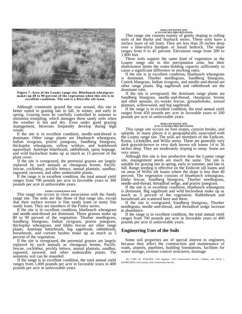
Figure 7.-Area of the Loamy range site. Bluebunch wheatgrassmakes up 40 to 90 percent of the vegetation when this site is in
excellent condition. The soil is a Ritzville silt loam.
Although commonly grazed the year around, this site isbetter suited to grazing late in fall, in winter, and early inspring. Grazing must be carefully controlled in summer tominimize trampling, which damages these sandy soils whenthe weather is hot and dry. Even under good grazingmanagement, blowouts frequently develop during highwinds.
If the site is in excellent condition, needle-and-thread isdominant. Other range plants are bluebunch wheatgrass,Indian ricegrass, prairie junegrass, Sandberg bluegrass,thickspike wheatgrass, yellow wildrye, and bottlebrushsquirreltail. Antelope bitterbrush, rabbitbrush, spiny hopsage,and wild buckwheat make up as much as 15 percent of theplant cover.
If the site is overgrazed, the perennial grasses are largelyreplaced by such annuals as cheatgrass brome, Pacificfescue, cocklebur, prickly lettuce, annual plantain, sandbur,ragweed, tarweed, and other undesirable plants.
If the range is in excellent condition, the total annual yieldranges from 700 pounds per acre in favorable years to 300pounds per acre in unfavorable years.
SANDY LOAM RANGE SITEThis range site occurs in close association with the Sandy
range site. The soils are like those of that range site, exceptthat their surface texture is fine sandy loam or stony finesandy loam. They are members of the Finley series.
If the site is in excellent condition, bluebunch wheatgrassand needle-and-thread are dominant. These grasses make up80 to 90 percent of the vegetation. Thurber needlegrass,Sandberg bluegrass, Indian ricegrass, prairie junegrass,thickspike wheatgrass, and Idaho fescue are other rangeplants. Antelope bitterbrush, big sagebrush, rabbitbrush,horsebrush, and currant bushes make up as much as 5percent of the vegetation.
If the site is overgrazed, the perennial grasses are largelyreplaced by such annuals as cheatgrass brome, Pacificfescue, cocklebur, prickly lettuce, annual plantain, sandbur,ragweed, tarweed, and other undesirable plants. Thenonstony soil can be reseeded.
If the range is in excellent condition, the total annual yieldranges from 1,000 pounds per acre in favorable years to 400pounds per acre in unfavorable years.
SHALLOW RANGE SITE(6 TO 9 INCHES PRECIPITATION)
This range site consists mainly of gently sloping to rollingsoils of the Burke and Starbuck series. These soils have asurface layer of silt loam. They are less than 20 inches deepover a lime-silica hardpan or basalt bedrock. The sloperanges from 0 to 45 percent. Elevations range from 500 to1,800 feet.
These soils support the same kind of vegetation as theLoamy range site in this precipitation zone, but theirshallowness limits the water-holding capacity sufficiently tocause a significant difference in stocking rates.
If the site is in excellent condition, bluebunch wheatgrassis dominant. Thurber needlegrass, Sandberg bluegrass,Cusick bluegrass, Indian ricegrass, and needle-and-thread areother range plants. Big sagebrush and rabbitbrush are thedominant rubs.
If the site is overgrazed, the dominant range plants areSandberg bluegrass, needle-and-thread, cheatgrass bromeand other annuals, six-weeks fescue, groundsmoke, annualplantain, willowweed, and big sagebrush.
If the range is in excellent condition, the total annual yieldranges from 450 pounds per acre in favorable years to 200pounds per acre in unfavorable years.
SHALLOW RANGE SITE(9 TO 15 INCHES PRECIPITATION)
This range site occurs on foot slopes, canyon breaks, anduplands. In many places it is geographically associated withthe Loamy range site. The soils are members of the Endicott,Kiona, Lickskillet, and Willis series. These are generally verydark grayish-brown to very dark brown silt loams 14 to 36inches deep. They are moderately sloping to steep. Some arevery stony.
Although this site is less productive than the Loamy rangesite, management needs are much the same. The site issuitable for grazing late in spring, early in summer, and late infall. Range seeding is effective on the Endicott silt loams andon areas of Willis silt loams where the slope is less than 40percent. The vegetation consists of bluebunch wheatgrass,Idaho fescue, Sandberg bluegrass, Thurber needlegrass,needle-and-thread, threadleaf sedge, and prairie junegrass.
If the site is in excellent condition, bluebunch wheatgrassis dominant. Big sagebrush and wild buckwheat make up asmuch as 3 percent of the vegetation. Rabbitbrush andhorsebrush are scattered here and there.
If the site is overgrazed, Sandberg bluegrass, Thurberneedlegrass, needle-and-thread, and threadleaf sedge increasein abundance.
If the range is in excellent condition, the total annual yieldranges from 700 pounds per acre in favorable years to 400pounds per acre in unfavorable years.
Engineering Uses of the Soils
Some soil properties are of special interest to engineersbecause they affect the construction and maintenance ofroads, airports, pipelines, building foundations, facilities forwater storage, erosion control structures, drainage
By CARL W. WALKER, civil engineer, Soil Conservation Service, Yakima, and JACK J.RASMUSSEN, soil scientist, Soil Conservation Service.
systems, and sewage disposal systems. Among theproperties most important to engineers are permeability,shear strength, compaction characteristics, grain size,plasticity, and reaction (pH). Also important are the depth tobedrock and the topography.
Information in this soil survey can be used to-1. Make studies that will aid in selecting and developing
sites for industrial, business, residential, andrecreational uses.
2. Develop information for the design of drainage andirrigation systems, farm ponds, diversion terraces,and other structures for soil and water conservation.
3. Make preliminary evaluations that will aid in selectinglocations for highways and airports and in planningdetailed surveys of the soils at the site.
4. Locate possible sources of sand, gravel, andquarry rock.
5. Correlate performance of engineering structures withsoil mapping units to develop information that will beuseful in designing and maintaining such structures.
6. Determine the suitability of soils for cross-countrymovement of vehicles and construction equipment.
7. Supplement information obtained from publishedmaps, reports, and aerial photographs for thepurpose of making maps and reports that can beused readily by engineers.
8. Develop other preliminary estimates for constructionpurposes pertinent to a particular area.
With the use of the soil map for identification, theengineering interpretations reported here can be useful formany purposes. It should be emphasized that they do noteliminate the need for sampling and testing at the site fordesign and construction of specific engineering works.Additional investigation is especially important at the site ofworks involving heavy loads or excavations deeper than thedepths of layers here reported. Even in these situations, thesoil map is useful for planning more detailed fieldinvestigations and for suggesting the kinds of problems thatmay be expected.
Much of the information in this section is presented in theform of tables. Table 5 gives estimated engineering propertiesof the soils, and table 6 gives engineering interpretations forseveral uses.
Engineering classification systems
Two systems of classifying soils for engineering purposesare in general use. They are described in the PCA Soil Primer(7). Classification of the soils of the Benton County Areaaccording to both of these systems is given in this survey.
The Unified system of soil classification was developed bythe Waterways Experiment Station, Corps of Engineers (15).In this system, soil classification is based on texture andplasticity and performance as construction material. In theUnified system SW and SP are clean sands, SM and SC aresands with fines of silt and clay, ML and CL are silts andclays of low liquid limit, and MH and CH are silts and claysof high liquid limit. If
soils are on the borderline between two classifications, ajoint classification symbol is used, for example, SP-SM.
The system used by the American Association of StateHighway Officials (AASHO) (1) is based on fieldperformance of soils in highways. In this system, soilmaterials are classified into seven principal groups,designated A-1 through A-7. The best materials for use inhighway subgrades (gravelly soils of high bearing capacity)are classified as A-1, and the poorest (clayey soils havinglow strength when wet) are classified A-7.
Estimated properties
Estimates of some of the properties of the soils of theBenton County Area are given in table 5.
Permeability indicates the rate at which water movesthrough soil material that is not compacted. The estimates arebased on soil texture, structure, and porosity. Available watercapacity is an estimate of the amount of water available toplants. The estimates of permeability and available watercapacity are especially significant in planning irrigation anddrainage systems.
A seasonally high water table is a problem in only a fewsoils in this survey Area. The soils and land types that have aseasonally high water table are as followsPasco soils, Riverwash, Umapine soils, and Wamba soils. Inaddition, some areas of Esquatzel and Burbank soils thatoccur near streams or in seepage areas are affected by a highwater table.
Corrosivity is closely related to reaction, drainage, andelectrical conductivity. Generally, soils that have pooraeration, a high pH value, and high electrical conductivity arecorrosive to metal conduits. Soils that have a low pH valueare more corrosive to concrete conduits. In both cases,corrosion is more rapid when the moisture content of the soilis high.
Engineering interpretations
Table 6 gives engineering interpretations based on the soilproperties described in table 5. These interpretations aregeneral and will not take the place of examination andevaluation of the soil at the exact site of a plannedengineering project.
Piping is frequently mentioned as a soil feature affectingthe construction of embankments for dikes, levees, and farmponds. As used in such instances, the word refers toprogressive internal erosion within embankments andfoundations. If piping occurs, soil material is removed bywater under pressure. If enough soil material is removed,failure results.
Cracking, also mentioned as a soil feature affecting theconstruction of embankments for dikes, levees, and farmponds, is a result of differential settlement of earth fills. Suchsettlement is caused by variation in the material. Differencesin the height of the embankment or compression of theunderlying strata may cause the formation of cracks throughthe embankment. Such cracks encourage concentration ofseepage water, which may attain a velocity high enough tocause piping and consequent embankment failure. Cracking isassociated with nonplastic soils that are unable to deformwithout cracking when settlement occurs.
Some features of a soil may be an advantage in one kind ofengineering work and a hindrance in another.
For example, a rapidly permeable substratum would make asoil unsuitable as a site for a farm pond but suitable as adisposal field for a sewage disposal system, although theremight be some danger of contaminating nearby water.
Susceptibility to frost action is an important considerationin engineering, particularly in selecting sites for roads andairports. For frost action to occur, there must be water inthe soil and low temperatures must persist long enough forthe water to freeze. The water may come from a high watertable, it may be capillary water or water held in voids, or itmay be water that infiltrates. The formation of ice is alsoinfluenced by topographic position, stratification of theparent material, transitions into cut sections, lateral flow ofwater from side cuts, localized pockets of perched groundwater, and drainage conditions. In general, silt and very finesand are the most susceptible to frost action. Coarse-grainedmaterial that contains little or no fine material is affected onlyslightly, if at all. Drainage to prevent the accumulation ofwater in soil pores helps to prevent accumulation of ice inthe subgrade and subbase.
Three major factors that influence the suitability of soilsfor use in embankments are permeability, strength, and easeof compaction. Gravelly and sandy soils that contain little orno fine material are stable and pervious; they are easilycompacted with crawler-type tractors and rubber-tiredrollers. These soils are suitable for use in the pervioussections of earth embankments. Gravel and sand that containfines vary, depending on gradation and on the nature of thefine fraction. These materials may be sufficiently imperviousand stable to be used for the impervious sections ofembankments. Silt and very fine sand are undesirable forrolled-fill construction and in general must be closelycontrolled in the field to secure the desired strength.
Frozen soil material should not be used in constructingembankments. If the material is gravelly or sandy and doesnot contain more than a small percentage of silt or clay,earthwork may be performed in winter, provided the materialis compacted according to the required standards for suchconstruction and frozen material is not included.
Wildlife
Before the Benton County Area was settled, the wildlifepopulation was small. Good numbers of waterfowl, deer,sage grouse, and furbearers were to be found only alongstreams and around springs and potholes. The Columbia andYakima Rivers provided resting place for migratorywaterfowl in spring and fall. In the rest of the Area, therewere few trees, and the native sagebrush and bunch grassesprovided insufficient food and cover. Water was scarce, andthe habitat was favorable only for such species as jackrabbitsand desert mice, which can travel long distances for freewater or can live without it.
After the Area was settled, wheatfields were planted andirrigation canals were built. These changes in environmentfavored an increase in the kinds and numbers
By BERT J. JAHN, wildlife biologist, Soil Conservation Service, assisted by JACK J. RASMUSSEN,soil scientist, Soil Conservation Service.
of wildlife. Grain-eating species and those that need freewater began to flourish. The ring-necked pheasant,Hungarian and chukar partridge, and California quail wereintroduced, and their numbers multiplied.
At the present time, waterfowl nest along the rivers.Mallards, pintails, and Canada geese feed in the many grainfields. Mourning dove inhabit irrigated areas and open range.A few deer can be found. There is a small population of sagegrouse in the Rattlesnake Hills.
Of the introduced species, the larger populations ofring-necked pheasant are in the irrigated areas but there aresmaller populations near water in the rest of the Area.California quail are numerous in brushy areas along streamsand irrigation canals and in border areas between irrigatedfields and open range. Hungarian partridge are found neargrain fields and grassland. There are good populations ofchukar partridge on rocky slopes, where cheatgrass isplentiful. The long-billed curlew is occasionally seen onrangeland near the rivers. This large shore bird is rare.
Open season for game birds in upland areas ordinarily laststwo months or more in fall. Both resident and nonresidentsportsmen find good hunting.
Wildlife grouping
The soils of the Area have been grouped according to theirsuitability for producing specific kinds of habitat essentialfor supporting key species of wildlife. The key species arethose that are important throughout the Area. In many places,a particular site is more suitable for minor species than forthe key species.
The following criteria were used in rating the limitations ofthe soils for the key species.
Not limited to slightly limited: Minimum conservationmanagement of the site is needed to support the key wildlifespecies.
Moderately limited: Average conservation management ofthe site is needed.
Severely limited: Intensive conservation management ofthe site is needed, and the development or management ofsuch sites is not advisable.
Very severely limited: Conservation development ormanagement of the site for the key species is not feasible oris not practical.
The following criteria were used in rating the limitations ofthe soils for elements of wildlife habitat.
Not limited to slightly limited: Wildlife habitat is generallyeasily established, improved, or maintained. There are few orno soil limitations, and satisfactory results seem assured.
Moderately limited: Wildlife habitat can be established,improved, or maintained, but there are moderate limitationsthat affect management. A moderate intensity ofmanagement and fairly frequent attention are needed toassure satisfactory results.
Severely limited: Wildlife habitat can be established,improved, or maintained, but there are severe limitations.Management is difficult and expensive, and intensive effort isneeded. Results are uncertain.
Very severely limited: In most places wildlife habitatcannot be established, improved, or maintained, or it isimpractical to attempt to do so. Unsatisfactory results areprobable.
Descriptions of wildlife sites
The soils of the Benton County Area have been placed innine wildlife sites. Each site is made up of soils that aresimilar in their suitability for wildlife habitat.
The names of the soil series represented are mentioned inthe description of each site, but the listing of the series namedoes not necessarily indicate that all the soils of a series are inthe same site. The wildlife site designation of any given soilcan be learned by referring to the "Guide to Mapping Units."
WILDLIFE SITE 1This site consists of very deep, medium-textured to
moderately coarse textured soils of the Ellisforde, Esquatzel,Scooteney, Shano, and Warden series. These soils aregenerally used for dryland production of wheat, barley, andrye.
Ring-necked pheasant, California quail, and mourning doveare the key wildlife species. The limitations of the site aresevere for pheasant and dove and very severe for quail. Thelimitations for elements of wildlife habitat are as follows: forgrain crops, moderate; for standard hay and pasturemixtures, moderate; for standard windbreaks, very severe;for native grasses and forbs, moderate; for native brush,severe.
Water and cover are lacking in winter. The soils aresuitable for pheasant if water is available at springs, wells, orwildlife watering places. Food is normally available in grainfields. Cover, however, is a limiting factor, because brushyplants can be grown only under intensive management. Insummer these are important feeding areas for migratingwaterfowl.
WILDLIFE SITE 2This site consists of medium-textured or moderately
coarse textured soils of the Burke, Esquatzel, Finley,Kennewick, Pasco, Prosser, Scooteney, Shano, and Wardenseries. The soils are irrigated, and they are suitable for manykinds of crops.
Ring-necked pheasant, California quail, and mourning doveare the key wildlife species. The limitations of the site are nomore than slight for pheasant and moderate for quail anddove. The limitations for elements of wildlife habitat are asfollows: for grain crops, none to slight; for standard hay andpasture mixtures, none to slight; for standard windbreaks,none to slight; for native grasses and forbs, none to slight.
Water is well distributed by irrigation canals and ditches,and the small fields of various crops provide a habitat forpheasant that is especially suitable. The pheasant populationcan be increased by raising more grain, especially corn, andby providing winter cover in the form of brushy hedgerowsor windbreaks. California quail are abundant in brushy areasand in areas bordering rangeland. Orchards provide goodhabitat for mourning doves.
WILDLIFE SITE 3This site consists of soils of the Burbank, Burke,
Ellisforde, Finley, Hezel, Kennewick, Koehler, Prosser,Quincy, Shano, Starbuck, Umapine, and Warden series. Thesoils are shallow, and in many places they are steep or verysteep. They are not irrigated.
Ring-necked pheasant, California quail, and mourning
dove are the key wildlife species. The limitations of the siteare severe for mourning dove and very severe for pheasantand quail. The limitations for elements of wildlife habitat areas follows: for grain crops, very severe; for standard hayand pasture mixtures, severe to very severe; for standardwindbreaks, very severe; for native grasses and forbs,moderate to severe; for native brush, severe.
This site is only poorly suited to wildlife habitat. Areas thatborder better sites, however, provide food and cover forpheasant, quail, Hungarian partridge, and dove. In these areasexisting brushy cover should be protected and wateringplaces should be provided.
WILDLIFE SITE 4This site consists of soils of the Burbank, Burke, Hezel,
Kennewick, Quincy, Scooteney, Shano, Starbuck, Umapine,Wamba, and Warden series. The soils are shallow, mediumtextured and coarse textured, and strongly sloping.
Ring-necked pheasant, California quail, and mourning doveare the key wildlife species. The limitations of the site aremoderate for all the key species. The limitations for elementsof wildlife habitat are as follows: for grain crops, severe tovery severe; for standard hay and pasture mixtures, none toslight; for standard windbreaks, none to moderate; for nativegrasses and forbs, none to slight.
These soils are suitable for irrigated hay, pasture, andorchards. Although they do not support so high a populationof game birds as other irrigated soils, this is an important sitefor production of pheasant, quail, and dove. Protection ofnests is especially important. Fence rows, odd areas, andother nesting cover should not be mowed or otherwisedisturbed until after the young have hatched.
WILDLIFE SITE 5This site consists of generally steep, stony, and rocky
soils of the Burbank, Scooteney, and Starbuck series. Thesoils are used for range.
Ring-necked pheasant, California quail, and mourning doveare the key wildlife species. The limitations of the site aresevere for all the key species. The limitations for elements ofwildlife habitat are as follows: for grain crops, very severe;for standard hay and pasture mixtures, very severe; forstandard windbreaks, very severe; for native grasses andforbs, moderate; for native brush, severe.
Although the soils are only poorly suited to the key wildlifespecies, they often produce enough food and cover for largenumbers of chukar partridge. Installation of watering placesat proper intervals increases the range of chukar.
WILDLIFE SITE 6This site consists of very deep, medium-textured soils of
the Walla Walla series. The soils are used almost entirely fordryland production of grain.
Ring-necked pheasant and California quail are the keywildlife species. The limitations of the site are moderate forpheasant and very severe for quail. The limitations forelements of wildlife habitat are as follows: for grain crops,moderate; for standard hay and pasture mixtures, moderate;for standard windbreaks, moderate; for native grasses andforbs, moderate; for native brush, severe.
Lack of cover and water limit suitability for pheasant. Thelimitations can be overcome by installation of watering placesand by planting hedgerows or windbreaks. Caragana,Russian-olive, black locust, and Austrian pine are suitable forwindbreaks.
WILDLIFE SITE 7This site consists of moderately deep to very deep,
medium-textured soils of the Endicott, Ritzville, and Willisseries. The soils are used for dryland production of grain.
Ring-necked pheasant and California quail are the keywildlife species. The limitations of the site are severe forpheasant and very severe for quail. The limitations forelements of wildlife habitat are as follows: for grain crops,moderate; for standard hay and pasture mixtures, moderate;for standard windbreaks, severe; for native grasses andforbs, moderate; for native brush, severe.
Although this site does not offer cover for upland birds, itis useful for growing grain for food if cover is nearby andwater is provided.
WILDLIFE SITE 8This site consists of shallow, steep, and eroded soils of the
Endicott, Ritzville, and Walla Walla series. It lacks water andcover, and except for those areas adjoining more favorablesites, has low value for wildlife habitat.
Ring-necked pheasant and California quail are the keywildlife species. The limitations of the site are severe forpheasant and very severe for quail. The limitations forelements of wildlife habitat are as follows: for grain crops,severe; for standard hay and pasture mixtures, severe; forstandard windbreaks, severe; for native grasses and forbs,moderate; for native brush, severe.
WILDLIFE SITE 9This site consists of steep, very stony and rocky,
medium-textured soils of the Kiona and Lickskillet series.Ring-necked pheasant and California quail are the key
wildlife species. The limitations of the site are very severe forboth key species. The limitations for elements of wildlifehabitat are as follows: for grain crops, very severe; forstandard hay and pasture mixtures, very severe; for standardwindbreaks, very severe; for native grasses and forbs,moderate; for native brush, severe.
Chukar partridge is the most important of the wildlifespecies. Some sage grouse can be found, as well as a fewdeer. Installation of watering places increases the value ofthis site for wildlife habitat.
Windbreaks
Many of the farms in the Benton County Area needprotection from strong winds. Well-planned and cared-forplantings of trees and shrubs check drifting snow, controlwind erosion, protect livestock and buildings, and providefood and cover for wildlife. The trees and shrubs specified intable 7 can be grown on any of the irrigated soils if irrigationwater is applied as needed. Most of these soils are welldrained, deep, medium textured, and neutral to moderatelyalkaline.
By CLARK W. RINKER, forester, Soil Conservation Service, Yakima, with the assistance of JACKJ. RASMUSSEN, soil scientist, Soil Conservation Service.
Three or more rows are generally used for windbreaksaround farmsteads and feedlots. One or two are used forsome field windbreaks. Dense, fast-growing shrubs areneeded on the windward side of a multiple-row windbreak,one or more rows of tall evergreens or deciduous trees m themiddle, and evergreens on the leeward side.
Caragana and Russian-olive are suitable shrubs formultiple-row plantings. Black locust is generally preferred forthe center rows, where height is needed. Austrian pine andScotch pine are the generally preferred evergreen trees.Douglas-fir, Norway spruce, blue spruce, and RockyMountain juniper are well suited if the moisture supply issufficient. Most evergreens need protection from heat andwind the first year after planting. Protection can be providedby placing a supporting shingle on the south side of the tree.
On unprotected sandy soils, blowing sand will damageearly-maturing crops, such as asparagus. Such crops need adense windbreak of trees that leaf out early in spring. Anexample of a suitable windbreak is a row of Caragana on thewindward side, then a row of Austrian pine or RockyMountain juniper.
High winds can cause damage to orchards. Protection isneeded to reduce water transpiration through the leaves andto limit fruit-fall. Lombardy poplar, a fast-growing tree, issuitable for single-row windbreaks (fig. 8).
Windbreaks should be planted where they will intercept thewind but will not interfere with irrigation systems or farmingoperations. The soils should be plowed in fall and should befree of weeds because shrubs and trees cannot competesuccessfully with weeds and grass. Clean cultivation andirrigation are necessary to assure good survival. Windbreaksneed protection from grazing animals and fire.
In addition to providing protection for fields andfarmsteads, windbreaks improve the wildlife habitat.Caragana, bladdersenna, Russian-olive, and black locustprovide food and shelter for game birds and songbirds.
Descriptions of the Soils
In this section the soil series and mapping units of theBenton County Area are described. The approximate acreageand proportionate extent of each mapping unit are given intable 8.
The series descriptions are in alphabetic order. Followngeach series description is a fairly detailed description of onemapping unit of the series. This detailed description isfollowed by brief descriptions of the rest of the mappingunits, first those that are not irrigated, then those that areirrigated.
In each series description is a short narrative description ofa profile representative of the series. In the first mapping unitdescription is a much more detailed description of the sameprofile, which can be used by scientists, engineers, andothers in making highly technical interpretations. Thedescriptions of the rest of the mapping units tell mainly howthese units differ from the one described in detail.
Unless otherwise stated, the color names and colorsymbols given are for moist soils.
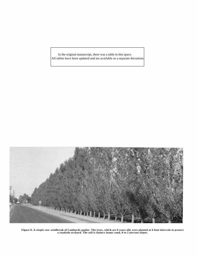
Figure 8.-A single-row windbreak of Lombardy poplar. The trees, which are 6 years old, were planted at 6-foot intervals to protecta roadside orchard. The soil is Quincy loamy sand, 0 to 2 percent slopes.
In the original manuscript, there was a table in this space.All tables have been updated and are available as a separate document.
Following the name of each mapping unit is a symbol inparentheses. This symbol identifies the mapping unit on thedetailed soil map. At the end of the description of eachmapping unit are listed the capability unit, the range site, andthe wildlife site in which the mapping unit has been placed.The pages where these interpretive groups are described canbe readily learned by referring to the "Guide to MappingUnits."
In the Benton County Area, the soils were mapped at twointensities. Soils within irrigated areas were mapped at highintensity, and those in unirrigated areas were mapped atmedium intensity. The composition of the medium-intensitymapping units is more variable than that of the high-intensityunits but has been controlled well enough to allowinterpretations for the expected uses of the soils. Thecapability classification indicates whether the mapping unit isof medium or high intensity. Unirrigated soils were mappedat medium intensity and are in dryland capability units.Irrigated soils were mapped at high intensity and are inirrigated capability units. A separate "Guide to MappingUnits" is given for the soils mapped at each intensity.
For more general information about the soils, the readercan refer to the section "General Soil Map," in which thebroad patterns of soils are described. Many of the termsused in the soil descriptions and other parts of the survey aredefined in the Glossary.
Burbank Series
This series consists of excessively drained,coarse-textured soils on terraces along the Yakima andColumbia Rivers. These soils developed under grass andsagebrush in gravelly and stony alluvial deposits mantled withmixed alluvium and windblown sand. In some places solidbasalt bedrock occurs at a depth of about 25 inches. Thesesoils are nearly level to steep. Elevations range from 300 to800 feet. The annual precipitation is 6 to 8 inches, the meanannual temperature is 53°F., and the frost-free season isabout 180 days. Burbank soils are geographically associatedwith Quincy soils.
In a representative profile, the surface layer is very darkgrayish-brown loamy fine sand to loamy sand about
16 inches thick. The next layer is very dark grayish-browngravelly loamy sand. Gravel makes up about 45 percent, byvolume, of this material. The material between about 35inches and 60 inches consists of sandy gravel or basaltbedrock.
These soils are used mainly for range. A few areas areirrigated.
Burbank loamy fine sand, 0 to 15 percent slopes(BbC).-This soil occurs on old alluvial terraces. In mostplaces the slope is about 4 percent. Included in mapping werea few areas of Quincy loamy sand, a few areas where thesurface layer is gravelly or stony, and a few areas wherebedrock is within about 25 inches of the surface.
This soil is excessively drained. Permeability is very rapid,and the water-holding capacity is low. Runoff is very slow.The hazard of water erosion is slight, and the hazard of winderosion is severe. The effective rooting depth is less than 30inches in most places. Fertility is low.
Representative profile in a grassy area, 1,000 feet west ofBombing Road between West Richland and U.S. Highway 12,NE1/4SE1/4 sec. 7, T. 9 N., R 28 E.
C1-0 to 5 inches, very dark grayish-brown (10YR 3/2) loamy fine sand,grayish brown (10YR 5/2) when dry; single grain; loose, nonstickyand nonplastic; abundant roots; mildly alkaline (pH 7.4) ; gradual,wavy boundary. 0 to 5 inches thick.
C2-5 to 16 inches, very dark grayish-brown (10YR 3/2) loamy sand,grayish brown (10YR 5/2) when dry; single grain; loose, nonstickyand nonplastic ; few roots; mildly alkaline (pH 7.6) ; gradual, wavyboundary. 10 to 30 inches thick.
IIC3-16 to 30 inches, very dark grayish-brown (10YR 3/2) gravellyloamy sand, light brownish gray (10YR 6/2) when dry; single grain;loose, nonsticky and nonplastic ; few roots; mildly alkaline (pH 7.8;strong effervescence; about 45 percent gravel, some of which iscoated with lime-silica on the lower side; abrupt, wavy boundary.10 to 20 inches thick.
IIIC4ca-30 to 35 inches, dark grayish-brown (10YR 4/2) very gravellyloamy sand, light brownish gray (10YR 6/2) when dry; single grain;loose, nonsticky and nonplastic; moderately alkaline (pH 8.3) ;violent effervescence; about 85 percent gravel and stones; some ofthe fragments are completely coated with lime-silica; gradual, wavyboundary. 4 to 20 inches thick.
IIIC5-35 to 60 inches, sandy gravel.
In the original manuscript, there was a table in this space.All tables have been updated and are available as a separate document.
The surface horizon ranges from very (lark grayish brown (10YR 3/2) todark brown (10YR 4/3) in color and froze loamy fine sand to fine sandin texture. In some places the Cca horizon is sufficiently developed thatthe gravel and stones are weakly cemented by lime and silica. Thedepth to sandy gravel is more than 20 inches. In places a layer ofgravelly fine sandy loam, 2 to 6 inches thick, directly overlie, the sandygravel. Gravel makes up less than 50 percent of the Cca horizon in afew places.
This soil is used for grazing. Dryland capability unitVIIe-23; Sandy mange site; wildlife site 3.
Burbank loamy fine sand, basalt substratum, 0 to 30percent slopes (BdE).-Basalt bedrock is at a depth of 20 to36 inches, but the profile of this soil is otherwise like that ofBurbank loamy fine sand, 0 to 15 percent slopes, The soil ishummocky, and there are some blowouts. In most places theslope is about 5 percent. In some place small fragments ofbasalt are scattered throughout the soil. Included in mappingwere small areas of soil as shallow as 10 inches over basaltbedrock, as well as small areas of Koehler loamy fine sandand of Quincy loamy sand, moderately shallow.
This soil is used for grazing. Dryland capability unitVIIe-23; Sandy site; wildlife site 3.
Burbank rocky loamy fine sand, basalt substratum, 0to 30 percent slopes (BfE).-This soil has a profile like thatof Burbank loamy fine sand, basalt substratum, 0 to 30percent slopes. About 20 to 50 percent of the acreageconsists of Rock outcrop. Included in mapping were a fewsmall areas of deep sand that contains basalt stones andboulders dislodged from higher, rockier areas. Also includedwere a few small areas in which sandy gravel is at a depth ofabout 35 inches and a few stony areas on lowlands along theYakima River.
This soil is used for range. Dryland capability unitVIIs-20; Sandy range site; wildlife site 5.
Burbank rocky loamy fine sand, 30 to 65 percentslopes (BkF).-This soil has a profile like that of Burbankloamy fine sand, basalt substratum, 0 to 30 percent slopes.About 50 percent of the acreage consists of basaltescarpments and talus. Included in mapping were small areasof deep loamy fine sand and areas of Dune land, as much as40 acres in size.
This soil is used for range. Dryland capability unitVIIs-20; Sandy range site; wildlife site 5.
Burbank loamy fine sand, 0 to 2 percent slopes(BbA).-Gravelly loamy sand is at a depth of 20 to 36 inches,but the profile of this soil is otherwise like that of Burbankloamy fine sand, 0 to 15 percent slopes. Included in mappingwere a few poorly drained areas along the Yakima River.Some of these wet areas are strongly affected by salts andalkali.
This soil is used mainly for hay and pasture. It is within anirrigation district and is irrigated in places. Application ofwater is difficult because permeability is very rapid andwater-holding capacity is low. Although sprinkler irrigationsystems are more suitable, surface or subsurface systems areused to irrigate some areas. Small, frequent applications ofwater are desirable. Irrigated capability unit IVe-3; wildlifesite 4.
Burbank loamy fine sand, 2 to 15 percent slopes(BbD).-Gravelly loamy sand is at a depth of 20 to 36 inches,but the profile of this soil is otherwise like that of Burbankloamy fine sand, 0 to 15 percent slopes.
This soil is used mainly for hay and pasture. Irrigatedcapability unit IVe-3; wildlife site 4.
Burbank loamy fine sand, gravelly substratum, 0, to 2percent slopes (BlA).-Except for the depth to gravelly loamysand, this soil has a profile like that of Burbank loamy finesand, 0 to 15 percent slopes. Gravelly loamy sand begins at adepth ranging from 10 to 20 inches.
This soil is used mainly for hay and pasture. Irrigatedcapability unit IVe-3; wildlife site 4.
Burbank loamy fine sand, gravelly substratum, 2 to.15 percent slopes (BlD).-Except for the depth to gravellyloamy sand, this soil has a profile like that of Burbank loamyfine sand, 0 to 15 percent slopes. Gravelly loamy sand beginsat a depth ranging from 10 to 20 inches.
This soil is used mainly for hay and pasture. Irrigatedcapability unit IVe-3; wildlife site 4.
Burke Series
This series consists of well-drained, shallow andmoderately deep, medium-textured soils that have a hardpan.These soils occur on uplands midway up the slopes of theRattlesnake Hills and in the Horse Heaven Hills. Theydeveloped under bunch grasses in windblown deposits ofmixed origin. In most places they are underlain by basaltbedrock, but in some areas, by very gravelly material. Theyare gently sloping to steep. Elevations range from 1,000 to1,300 feet. The annual precipitation is 6 to 9 inches, the meanannual temperature is 50°F., and the frost-free season is about155 days. Burke soils are geographically associated withShano soils.
In a representative profile, the uppermost 14 inches is darkgrayish-brown silt loam. This material grades tograyish-brown, strongly calcareous silt loam. A hardpanconsisting of indurated lime and silica begins at a depth of 25inches.
These soils are used for range, for small grain in acrop-fallow system, and for irrigated crops.
Burke silt loam, 0 to 5 percent slopes (BmAB).-This soil(fig. 9) occurs mainly on broad ridgetops. In most places theslope is about 4 percent. Included in mapping were smallareas of Rock outcrop, other rocky areas, and areas of aShano silt loam.
This soil is well drained. Permeability is moderate, and thewater-holding capacity is moderate to moderately high.Runoff is very slow to slow. The hazard of water erosion isslight, and the hazard of wind erosion is slight to moderate.The effective rooting depth is 10 to 36 inches. Tilth is good,and the soil is easily worked. Fertility is high.
Representative profile in a cultivated area, 500 feet northand 50 feet west of the intersection of Snipes and McDonaldRoads, SEl/4SE1/4 sec. 31, T. 10 N., R. 25 E.
Ap1-0 to 5 inches, dark grayish-brown (10YR 4/2) silt loam, lightbrownish gray (10YR 6/2) when dry; weak, fine, granularstructure; soft, friable, nonsticky and slightly plastic; plentifulroots; mildly alkaline (pH 7.6) ; abrupt, smooth boundary. 4 to 6inches thick.
Ap2-5 to 7 inches, dark grayish-brown (10YR 4/2) silt loam, lightbrownish gray (10YR 6/2) when dry; weak, thick, platy structure;soft, friable, nonsticky and slightly plastic; plentiful roots; commonfine pores; mildly alkaline (pH 7.7) ; clear, wavy boundary. 0 to 3inches thick.
B2-7 to 14 inches, dark grayish-brown (10YR 4/2) silt loam, lightbrownish gray (10YR 6/2) when dry; weak, coarse,
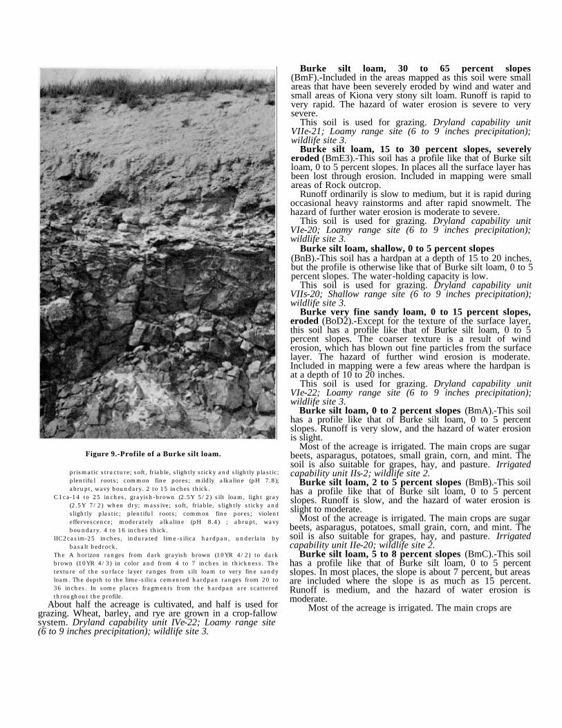
Figure 9.-Profile of a Burke silt loam.
prismatic structure; soft, friable, slightly sticky and slightly plastic;plentiful roots; common fine pores; mildly alkaline (pH 7.8);abrupt, wavy boundary. 2 to 15 inches thick.
C1ca-14 to 25 inches, grayish-brown (2.5Y 5/2) silt loam, light gray(2.5Y 7/2) when dry; massive; soft, friable, slightly sticky andslightly plastic; plentiful roots; common fine pores; violenteffervescence; moderately alkaline (pH 8.4) ; abrupt, wavyboundary. 4 to 16 inches thick.
IIC2casim-25 inches, indurated lime-silica hardpan, underlain bybasalt bedrock.
The A horizon ranges from dark grayish brown (10YR 4/2) to darkbrown (10YR 4/3) in color and from 4 to 7 inches in thickness. Thetexture of the surface layer ranges from silt loam to very fine sandyloam. The depth to the lime-silica cemented hardpan ranges from 20 to36 inches. In some places fragments from the hardpan are scatteredthroughout the profile.
About half the acreage is cultivated, and half is used forgrazing. Wheat, barley, and rye are grown in a crop-fallowsystem. Dryland capability unit IVe-22; Loamy range site(6 to 9 inches precipitation); wildlife site 3.
Burke silt loam, 30 to 65 percent slopes(BmF).-Included in the areas mapped as this soil were smallareas that have been severely eroded by wind and water andsmall areas of Kiona very stony silt loam. Runoff is rapid tovery rapid. The hazard of water erosion is severe to verysevere.
This soil is used for grazing. Dryland capability unitVIIe-21; Loamy range site (6 to 9 inches precipitation);wildlife site 3.
Burke silt loam, 15 to 30 percent slopes, severelyeroded (BmE3).-This soil has a profile like that of Burke siltloam, 0 to 5 percent slopes. In places all the surface layer hasbeen lost through erosion. Included in mapping were smallareas of Rock outcrop.
Runoff ordinarily is slow to medium, but it is rapid duringoccasional heavy rainstorms and after rapid snowmelt. Thehazard of further water erosion is moderate to severe.
This soil is used for grazing. Dryland capability unitVIe-20; Loamy range site (6 to 9 inches precipitation);wildlife site 3.
Burke silt loam, shallow, 0 to 5 percent slopes(BnB).-This soil has a hardpan at a depth of 15 to 20 inches,but the profile is otherwise like that of Burke silt loam, 0 to 5percent slopes. The water-holding capacity is low.
This soil is used for grazing. Dryland capability unitVIIs-20; Shallow range site (6 to 9 inches precipitation);wildlife site 3.
Burke very fine sandy loam, 0 to 15 percent slopes,eroded (BoD2).-Except for the texture of the surface layer,this soil has a profile like that of Burke silt loam, 0 to 5percent slopes. The coarser texture is a result of winderosion, which has blown out fine particles from the surfacelayer. The hazard of further wind erosion is moderate.Included in mapping were a few areas where the hardpan isat a depth of 10 to 20 inches.
This soil is used for grazing. Dryland capability unitVIe-22; Loamy range site (6 to 9 inches precipitation);wildlife site 3.
Burke silt loam, 0 to 2 percent slopes (BmA).-This soilhas a profile like that of Burke silt loam, 0 to 5 percentslopes. Runoff is very slow, and the hazard of water erosionis slight.
Most of the acreage is irrigated. The main crops are sugarbeets, asparagus, potatoes, small grain, corn, and mint. Thesoil is also suitable for grapes, hay, and pasture. Irrigatedcapability unit IIs-2; wildlife site 2.
Burke silt loam, 2 to 5 percent slopes (BmB).-This soilhas a profile like that of Burke silt loam, 0 to 5 percentslopes. Runoff is slow, and the hazard of water erosion isslight to moderate.
Most of the acreage is irrigated. The main crops are sugarbeets, asparagus, potatoes, small grain, corn, and mint. Thesoil is also suitable for grapes, hay, and pasture. Irrigatedcapability unit IIe-20; wildlife site 2.
Burke silt loam, 5 to 8 percent slopes (BmC).-This soilhas a profile like that of Burke silt loam, 0 to 5 percentslopes. In most places, the slope is about 7 percent, but areasare included where the slope is as much as 15 percent.Runoff is medium, and the hazard of water erosion ismoderate.
Most of the acreage is irrigated. The main crops are
sugar beets, asparagus, potatoes, small grain, corn, and mint.The soil is also suitable for grapes, hay, and potatoes.Irrigated capability unit IIIe-2; wildlife site 4.
Burke silt loam, shallow, 5 to 8 percent slopes (BnC).-Except for the depth to the hardpan, this soil has a profile likethat of Burke silt loam, 0 to 5 percent slopes. In this soil thehardpan begins at a depth of 15 to 20 inches. Runoff ismedium, and the hazard of water erosion is moderate tosevere. The water-holding capacity is low. Shallow-rootedcrops are suitable. Irrigated capability unit IVe-2; wildlifesite 4.
Burke very fine sandy loam, 0 to 2 percent slopes,eroded (BoA2).-Except for the texture of the surface layer,this soil has a profile like that of Burke silt loam, 0 to 5percent slopes. The coarser texture results from winderosion, which has blown out fine particles from the surfacelayer. Runoff is very slow. The hazard of further winderosion is moderate when the surface is bare. Tree fruits,grapes, hay, and pasture are suitable crops. Irrigatedcapability unit IIIs-1; wildlife site 2.
Burke very fine sandy loam, 2 to 5 percent slopes,eroded (BoB2).-Except for the texture of the surface layer,this soil has a profile like that of Burke silt loam, 0 to 5percent slopes. Runoff is slow, and the hazard of watererosion is slight to moderate. The hazard of further winderosion is moderate when the surface is bare. Tree fruits,grapes, hay, and pasture are suitable crops. Irrigatedcapability unit IIIe-1; wildlife site 2.
Burke very fine sandy loam, 5 to 8 percent slopes,eroded (BoC2).-Except for the texture of the surface layer,this soil has a profile like that of Burke silt loam, 0 to 5percent slopes. Runoff is medium, and the hazard of windand water erosion is moderate. Tree fruits, grapes, hay, andpasture are suitable crops. Irrigated capability unit IVe-1;wildlife site 2.
Burke very fine sandy loam, shallow, 0 to 8 percentslopes, eroded (BrC2).-Except for the texture of the surfacelayer and the depth to the hardpan, this soil has a profile likethat of Burke silt loam, 0 to 5 percent slopes. In this soil thehardpan begins at a depth of 15 to 20 inches.
Runoff is very slow to medium, and the hazard of windand water erosion is slight to moderate. The water-holdingcapacity is low. Fertility is low. Shallow-rooted crops aresuitable. Irrigated capability unit IVe-4; wildlife site 4.
Dune Land
Dune land (Du) consists of very deep, loose fine sand thatblows and shifts with the wind. The dunes vary in size andshape but are predominantly 5 to 20 feet high. Their long axisis oriented from southwest to northeast. Dune land occursmainly in the southeastern part of the Area. It is barren andhas no agricultural value. Dryland capability unit VIIIe-20.
Ellisforde Series
This series consists of well-drained, deep, medium-textured soils on uplands in the northeastern part of the Area.These soils developed under bunch grasses in a mantle ofsilty, wind-deposited material over lacustrine
sediments. They are nearly level to moderately steep.Elevations range from 1,000 to 1,900 feet. The annualprecipitation is 9 to 12 inches, the mean annual temperature is50°F., and the frost-free season is about 150 days. Ellisfordesoils are geographically associated with Ritzville soils.
In a representative profile, the surface layer is very darkgrayish-brown to dark-brown silt loam about 13 inchesthick. The subsoil and substratum are dark grayish-brownsilt loam to a depth of 60 inches or more.
These soils are used mainly for production of wheat in acrop-fallow system.
Ellisforde silt loam, 0 to 5 percent slopes (EfB).-Thissoil occurs on uplands. In most places the slope is about 4percent. Included in mapping were small areas of Ritzville siltloam and Warden silt loam.
This soil is well drained. Permeability is moderately slow,and the water-holding capacity is high. Runoff is slow tovery slow. The hazard of water erosion is slight, and thehazard of wind erosion is slight to moderate. The effectiverooting depth is more than 60 inches. Fertility is high.
Representative profile in a cultivated area, 150 feet west ofClodfelter Road and 1 mile south of irrigation canal,SE1/4SE1/4 sec. 14, T. 8 N., R. 28 E.
Ap1-0 to 4 inches, very dark grayish-brown (10YR 3/2) silt loam,grayish brown (10YR 5/2) when dry; weak, fine, granularstructure; soft, friable, nonsticky and slightly plastic; abundantroots; neutral (pH 7.1) ; abrupt, smooth boundary. 4 to 13 inchesthick.
Ap2-4 to 13 inches, dark-brown (10YR 3/3) silt loam, brown (10YR 5/3)when dry; weak to moderate, coarse, prismatic structure; slightlyhard, friable, nonsticky and slightly plastic; plentiful roots;common fine pores; neutral (pH 7.1) ; gradual, wavy boundary. 0 to9 inches thick.
B2-13 to 20 inches, dark grayish-brown (10YR 4/2) silt loam, lightbrownish gray (10YR 6/2) when dry; weak, coarse, prismaticstructure; soft, friable, slightly sticky and slightly plastic; plentifulroots; common fine pores; mildly alkaline (pH 7.4) ; abrupt, wavyboundary.
C1-20 to 29 inches, dark grayish-brown (10YR 4/2) silt loam; lightbrownish gray (10YR 6/2) when dry; massive; soft, friable, slightlysticky and slightly plastic; plentiful roots; few fine pores; slighteffervescence; mildly alkaline (pH 7.6) ; abrupt, wavy boundary.Variable thickness.
IIC2ca-29 to 62 inches, dark grayish-brown (2.5Y 4/2) silt loam, lightbrownish gray (2.5Y 6/2) when dry; massive; some layers thinlylaminated; hard, friable, slightly sticky and slightly plastic; fewroots; few fine pores; disseminated and segregated mycelial lime;violent effervescence; moderately alkaline (pH 8.4).
The color of the A horizon ranges from very dark grayish brown(10YR 3/ 2) to dark brown (10YR 4/ 3) . The depth to the compactlacustrine sediments ranges from 15 to 36 inches. The C1 horizondoes not occur in all profiles. The color of the IIC2ca horizonranges from 10YR to 2.5Y in hue.
About 80 percent of the acreage is cultivated. Wheat andbarley are grown in a crop-fallow system. Dryland capabilityunit IIIc-20; Loamy range site (9 to 15 inches precipitation);wildlife site 1.
Ellisforde silt loam, 15 to 30 percent slopes, severelyeroded (EfE3).-Erosion has removed some, and in places all,of the surface layer, but otherwise, this soil has a profile likethat of Ellisforde silt loam, 0 to 5 percent slopes. Onnorth-facing slopes the depth to the substratum is generallyabout 36 inches. The hazard of water erosion is severe.
Runoff is normally medium, but it is rapid duringoccasional severe thunderstorms and after rapid snowmelt.
About 20 percent of the acreage is cultivated. The rest isused for grazing. Dryland capability unit IVe-20; Loamyrange site (9 to 15 inches precipitation); wildlife site 3.
Endicott Series
This series consists of well-drained, shallow, andmoderately deep, medium-textured soils on uplands in theRattlesnake Hills. These soils developed under bunch grassesin silty, wind-worked deposits over basalt bedrock. They aregently sloping to steep. Elevations range from 2,200 to 3,500feet. The annual precipitation is 11 to 15 inches, the meanannual temperature is 47°F., and the frost-free season isabout 130 days. Endicott soils are geographically associatedwith Walla Walla soils.
In a representative profile, the surface layer is very darkbrown to very dark grayish-brown silt loam about 9 inchesthick. The subsoil consists of dark-brown silt loam about 9inches thick. A lime-silica cemented hardpan begins at adepth of about 27 inches. Fragments from the hardpan arescattered throughout the profile in some places.
These soils are used for range and for small grain in acrop-fallow system.
Endicott silt loam, 0 to 5 percent slopes (EnB).-This soiloccurs on uplands. In most places the slope is about 4percent. Included in mapping were a few areas of WallaWalla silt loam.
This soil is well drained. Permeability is moderate, and thewater-holding capacity is moderate to moderately high.Runoff is slow to very slow. When the soil is partly frozen,runoff on long slopes is more rapid and some erosion maytake place. The hazard of water erosion is slight to moderate,and the hazard of wind erosion is slight. The effective rootingdepth is 20 to 36 inches. Fertility is medium to high.
Representative profile in a cultivated area, 700 feet east ofCrosby Road and 1 mile south of Pearl Road, SW1/4SW1/4sec. 5, T. 10 N., R. 25 E.
Ap1-0 to 5 inches, very dark brown (10YR 2/2) silt loam, darkgrayish-brown (10YR 4/2) when dry; weak, fine, granularstructure; slightly hard, friable, slightly sticky and slightly plastic;abundant roots; common fine pores; mildly alkaline (pH 7.4) ;abrupt, smooth boundary. 4 to 6 inches thick.
Ap2-5 to 9 inches, very dark grayish-brown (10YR 3/2) silt loam,grayish brown (10YR 5/2) when dry; weak, thick, platy structure;hard, friable, slightly sticky and slightly plastic; plentiful roots ;common fine pores; mildly alkaline (pH 7.4); gradual, wavyboundary. 3 to 5 inches thick.
B2-9 to 18 inches, dark-brown (10YR 3/3) silt loam, brown (10YR 3/3)when dry; weak, coarse, prismatic structure; soft, friable, slightlysticky and slightly plastic; plentiful roots; common fine pores;mildly alkaline (pH 7.6) ; abrupt, wavy boundary. 4 to 13 inchesthick.
C1ca-18 to 27 inches, dark grayish-brown (10YR 4/2) silt loam, lightbrownish gray (10YR 6/2) when dry; massive; soft, friable, slightlysticky and slightly plastic; plentiful roots; common fine pores;moderately alkaline (pH 8.2); violent effervescence; abrupt, wavyboundary. 6 to 16 inches thick.
IIC2casim-27 inches +, white, indurated, lime-silica cemented hardpanunderlain by basalt bedrock. There are some matted roots on thesurface of the hardpan.
The depth to the lime-silica cemented hardpan ranges from 20 to 36inches. In places fragments of the hardpan are scattered throughout theprofile. The prominence of the B horizon lessens as the depth to thehardpan decreases.
About 75 percent of the acreage is cultivated. Wheat andbarley are grown in a crop-fallow system. Dryland capabilityunit IIIs-20; Loamy range site (9 to 15 inches precipitation);wildlife site 7.
Endicott silt loam, 5 to 15 percent slopes (EnD).-Thissoil has a profile like that of Endicott silt loam, 0 to 5 percentslopes.
Runoff is slow to medium, and the hazard of water erosionis moderate. In some places erosion has removed 25 to 50percent of the surface layer.
About 60 percent of the acreage is cultivated. The rest isused for grazing. Dryland capability unit IIIe-20; Loamyrange site (9 to 15 inches precipitation); wildlife site 7.
Endicott silt loam, shallow, 0 to 40 percent slopes(EoE)-This soil has a profile like that of Endicott silt loam, 0to 5 percent slopes, except that the depth to the lime-silicacemented hardpan ranges from 14 to 20 inches. In addition,the hardpan is generally less prominent, especially in areasadjacent to major drainageways. Much of the acreage isincised by gullies and is difficult to cross with farmmachinery. Included in mapping were escarpments androcky areas.
The water-holding capacity is low. Runoff is normallyslow, but it is rapid during heavy rainstorms and after rapidsnowmelt. The hazard of water erosion is moderate tosevere.
This soil is suited to grazing. Dryland capability unitVIe-20; Shallow range site (9 to 15 inches precipitation);wildlife site 8.
Esquatzel Series
This series consists of deep, well-drained,medium-textured, nearly level to gently sloping soils onbottom lands. These soils developed under bunch grasses inalluvium. The areas are generally narrow and are incised byintermittent streams. They are scattered throughout the Area;the largest acreage is adjacent to the Yakima River, west ofProsser. Elevations range from 300 to 1,400 feet. The annualprecipitation is 6 to 12 inches, the mean annual temperature is50°F., and the frost-free season is about 150 days. Esquatzelsoils are geographically associated with Ritzville, Shano, andWarden soils.
In a representative profile the soil is dark-brown to darkgrayish-brown silt loam or very fine sandy loam to a depth of60 inches or more. The material below a depth of about 35inches is calcareous. In places the surface layer is fine sandyloam.
Although these soils are typically well drained, they aresubject to seepage from surrounding irrigated soils, and, as aresult, the depth to the water table varies. Also, some of theareas are subject to flash flooding as a result of runoff fromhigher soils. Unirrigated areas are used for grain or range.
Esquatzel silt loam, 0 to 5 percent slopes (EuAB).-Thissoil occurs as narrow, elongated areas on bottom
lands. In most places the slope is about 2 percent. Includedin mapping were small areas of Warden silt loam, 0 to 5percent slopes, and of Shano silt loam, 0 to 5 percent slopes.
This soil is well drained. Permeability is moderate, and thewater-holding capacity is high. Runoff is slow to very slow.The hazard of either wind or water erosion is generally slight.In a few places, however, there is a hazard of severe gullyerosion because the soil receives runoff from higher lyingsoils. The effective rooting depth is more than 60 inches.Fertility is high.
Profile in a cultivated area, 1/2 mile west of Richards Roadand 50 feet north of Highway 22, NW1/4SE1/4 sec. 9, T. 8N., R. 24 E. Profile is in an area mapped as Esquatzel siltloam, 0 to 2 percent slopes, but is representative of this soil.
Apl-0 to 4 inches, dark-brown (10YR 3/3) silt loam, brown (10YR 5/3)when dry; weak, fine, granular structure; soft, friable, nonstickyand slightly plastic; abundant roots ; neutral (pH 7.0) ; abrupt,smooth boundary. 3 to 11 inches thick.
Ap2-4 to 11 inches, dark-brown (10YR 3/3) silt loam, brown (10YR 5/3)when dry; moderate, medium, subangular blocky structure;slightly hard, friable, slightly sticky and slightly plastic; plentifulroots; common fine pores; neutral (pH 7.1); clear, smoothboundary. 0 to 7 inches thick.
C1-11 to 35 inches, dark-brown (10YR 4/3) silt loam, pale brown (10YR6/3) when dry; massive; soft, friable, slightly sticky and slightlyplastic; few roots; common fine pores; mildly alkaline (pH 7.4) ;abrupt, wavy boundary. 15 to 25 inches thick.
C2-35 to 44 inches, dark grayish-brown (10YR 4/2) silt loam, lightbrownish gray (10YR 6/2) when dry; massive; soft, friable, slightlysticky and slightly plastic; few roots; few fine pores; moderatelyalkaline (pH 8.4) ; strong effervescence; gradual, wavy boundary.Variable thickness.
C3-44 to 55 inches, dark grayish-brown (10YR 4/2) very fine sandyloam, light brownish gray (10YR 6/2) when dry; massive; soft,friable, nonsticky and slightly plastic; few roots; few fine pores;moderately alkaline (pH 8.4) ; strong effervescence; abrupt, wavyboundary. Variable thickness.
C4-55 to 65 inches, dark grayish-brown (10YR 4/2) silt loam, lightbrownish gray (10YR 6/2) when dry; massive; soft, friable, slightlysticky and slightly plastic; moderately alkaline (pH 8.4); slighteffervescence. Variable thickness.
The color of the Ap and C horizons is dark brown, dark grayish brown,or very dark grayish brown within the 10YR hue. In places strata of finesandy loam occur in the C horizon. The depth to the calcareous layer isnormally about 35 inches but ranges from 12 to 40 inches.
This soil is suited to dryland grain in a crop-fallow system,but because of its position, much of the acreage is used forrange. Dryland capability unit IIIc-20; Bottomland rangesite; wildlife site 1.
Esquatzel fine sandy loam, 0 to 5 percent slopes(EsB).-Except that the surface layer is fine sandy loam andthe subsoil is generally stratified with coarser sand, theprofile of this soil is like that of Esquatzel silt loam, 0 to 5percent slopes. In a few places the soil contains a layer ofgravel. Included in mapping were small areas of Shano veryfine sandy loam, 0 to 15 percent slopes, eroded, and Quincyloamy sand, 0 to 30 percent slopes. The hazard of winderosion is moderate.
This soil is suited to dryland grain or range. It is generallyused in the same way as adjoining areas. Dryland capabilityunit IIIe-21; Bottomland range site; wildlife site 1.
Esquatzel fine sandy loam, 0 to 2 percent slopes(EsA).-Except for the texture of the surface layer, theprofile of this soil is like that of Esquatzel silt loam, 0 to 5percent slopes. The hazard of water erosion is slight, and thehazard of wind erosion is moderate.
Suitable crops include hops, grapes, corn, alfalfa hay,and pasture. Irrigated capability unit I-1; wildlife site 2.
Esquatzel silt loam, 0 to 2 percent slopes (EuA).-Thissoil has a profile like that of Esquatzel silt loam, 0 to 5percent slopes. Included in mapping were areas that areaffected by seepage from higher lying irrigated soils, whichresults in variation in depth to the water table. The hazard ofwind and water erosion is slight.
Suitable crops are mint, grapes, asparagus, corn, peas,sugar beets, hops, alfalfa hay, and pasture. Irrigatedcapability unit I-1; wildlife site 2.
Esquatzel silt loam, 2 to 5 percent slopes (EuB).-Thissoil has a profile like that of Esquatzel silt loam, 0 to 5percent slopes. Included in mapping were a few areas wherethe surface layer is moderately coarse textured.
Runoff is slow. The hazard of water and wind erosion isslight to moderate.
Suitable crops include hops, grapes, corn, alfalfa hay, andpasture. Irrigated capability unit IIe-2; wildlife site 2.
Finley Series
This series consists of well-drained, nearly level to steepsoils on old alluvial terraces and bottom lands of intermittentstreams. These soils are underlain by gravel. They formedunder bunch grasses in old alluvial material derived mainlyfrom loess and basalt but partly from granite and quartzite.Elevations on terraces range from 300 to 800 feet. On someof the bottom lands, elevations are in excess of 1,200 feet.The annual precipitation is 6 to 9 inches, the mean annualtemperature is 51°F., and the frost-free season is about 160days. Finley soils are geographically associated with Burbankand Scooteney soils.
In a representative profile the surface layer is very darkgrayish-brown fine sandy loam about 13 inches thick. Theneat layer is dark grayish-brown very gravelly loam to adepth of 28 inches. Below a depth of 28 inches is sandygravel and cobblestones. In places the surface layer isgravelly or stony.
Unirrigated areas of these soils are used for range.Finley fine sandy loam, 0 to 15 percent slopes (FeC).-
This soil occurs on old alluvial terraces. In most places theslope is about 2 percent. Included in mapping were smallareas of Quincy loamy sand and Burbank loamy fine sand.
This soil is well drained. Permeability is moderately rapidabove the gravel, and the water-holding capacity is low.Runoff is very slow to slow. The hazard of water erosion isslight, and the hazard of wind erosion is moderate. Theeffective rooting depth is about 30 inches. Fertility is low tomoderate.
Profile in an area of native grasses, 50 feet east of NineCanyon Road and 300 feet south of Teril Road,NW1/4SW1/4 sec. 27, T. 8 N., R. 30 E. Profile is in an areamapped as Finley stony fine sandy loam, 0 to 30 percentslopes, but is representative of this soil.
C1-0 to 3 inches, very dark grayish-brown (10YR 3/2) fine sandy loam,grayish brown (10YR 5/2) when dry; weak, fine, granular structure;soft, very friable, nonsticky and nonplastic ; abundant roots; mildlyalkaline (pH 7.8) ; abrupt, smooth boundary. 2 to 6 inches thick.
C2-3 to 13 inches, very dark grayish-brown (10YR 3/2) fine sandyloam, grayish brown (10YR 5/2) when dry; massive; soft, veryfriable, nonsticky and nonplastic ; plentiful roots; mildly alkaline(pH 7.8) ; clear, wavy boundary. 4 to 19 inches thick.
IIC3-13 to 22 inches, dark grayish-brown (10YR 4/2) very gravellyloam, light brownish gray (10YR 6/2) when dry; massive; soft, veryfriable, slightly sticky and slightly plastic; few roots; common finepores; mildly alkaline (pH 7.8) ; 60 percent gravel; some of thepebbles are coated with silica or lime-silica on the lower side;abrupt, wavy boundary. Variable thickness.
IIC3ca-22 to 28 inches, dark grayish-brown (10YR 4/2) very gravellyloam, light brownish gray (10YR 6/2) when dry; massive; soft, veryfriable, slightly sticky and slightly plastic ; moderately alkaline (pH8.0) ; strong effervescence; 80 percent gravel and stones; manypebbles and stones are coated with lime-silica on the lower side. 5to 15 inches thick.
IIIC4-28 to 60 inches, sandy gravel and cobblestones.The C horizon ranges from very dark grayish brown (10YR 3/2) to darkbrown (l0YR 4/3). In most places the depth to sandy gravel is less than30 inches.
This soil is used for grazing. Dryland capability unitVIe-22; Sandy Loam range site; wildlife site 3.
Finley stony fine sandy loam, 0 to 30 percent slopes(FfE).-The profile of this soil is like that of Finley fine sandyloam, 0 to 15 percent slopes, except that the surface layer isstony and the depth to the gravelly substratum is generallyless, but varies from place to place. Much of the acreage ison bottom lands of old streams, where it is subject toperiodic flash flooding.
Runoff is very slow to medium. Wind erosion is not ahazard.
This soil is used for grazing. Dryland capability unitVIIs-20; Sandy Loam range site; wildlife site 3.
Finley fine sandy loam, 0 to 2 percent slopes (FeA).-The profile of this soil is like that of Finley fine sandy loam, 0to 15 percent slopes. Runoff is very slow. Included inmapping were a few somewhat poorly drained areas onbottom lands along streams.
Suitable crops are mint, corn, peas, wheat, grapes,orchard crops, alfalfa hay, and pasture. The areas on bottomlands are suitable for pasture. Irrigated capability unit IVs-2;wildlife site 2.
Finley fine sandy loam, 2 to 5 percent slopes (FeB).-The profile of this soil is like that of Finley fine sandy loam, 0to 15 percent slopes. Included in mapping were a fewsomewhat poorly drained areas on bottom lands.
Runoff is slow, and the hazard of water erosion is slight tomoderate.
Suitable crops are mint, corn, peas, wheat, grapes, treefruits, alfalfa hay, and pasture. The areas on bottom lands aresuitable for pasture. Irrigated capability unit IVe-1; wildlifesite 2.
Finley fine sandy loam, moderately deep, 0 to 2percent slopes (FnA).-Except that the depth to very gravellyloam ranges from 20 to 28 inches, the profile of this soil islike that of Finley fine sandy loam, 0 to 15 percent slopes.
Runoff is very slow. The water-holding capacity ismoderate. The abrupt boundary between the loamy mate-
rial and the gravelly substratum restricts the movement ofwater, which results in a higher water-holding capacity thanmight otherwise be expected. Fertility is medium.
Suitable irrigated crops are mint, corn, peas, wheat,grapes, tree fruits, alfalfa hay, and pasture. Irrigatedcapability unit IIIs-1; wildlife site 2.
Finley fine sandy loam, moderately deep, 2 to 5percent slopes (FnB).-The profile of this soil is like that ofFinley fine sandy loam, 0 to 15 percent slopes, but it differsin the following respects: the slope is 2 to 5 percent, and thedepth to very gravelly material ranges from 20 to 28 inches.
Runoff is slow, and the hazard of water erosion ismoderate. The water-holding capacity is moderate. Fertility ismedium.
Suitable irrigated crops are mint, corn, peas, wheat,grapes, tree fruits, alfalfa hay, and pasture. Irrigatedcapability unit IIIe-1; wildlife site 2.
Finley fine sandy loam, 5 to 15 percent slopes (FeD).-Except that the depth to very gravelly material ranges from10 to 36 inches, the profile of this soil is like that of Finleyfine sandy loam, 0 to 15 percent slopes.
Runoff is medium to rapid, and the hazard of watererosion is moderate to severe. The water-holding capacity islow to moderate.
Hay and pasture are well suited. Row crops are notgenerally grown. Irrigated capability unit IVe-1; wildlife site2.
Finley gravelly fine sandy loam, 2 to 5 percent slopes(FgB).-Except for the texture of the surface layer, the profileof this soil is like that of Finley fine sandy loam, 0 to 15percent slopes. The depth to the very gravelly material varies,but it is generally about 22 inches. Fertility is low. Hay andpasture are suitable crops. Irrigated capability unit IVe-1;wildlife site 2.
Hezel Series
This series consists of deep, well-drained soils onhummocky or dunelike terraces, mostly at the lowerelevations in the Horse Heaven Hills. These soils developedunder grass, sagebrush, and rabbitbrush in a mantle ofwindblown sand over silty lacustrine sediments. They aregently sloping to steep. Elevations range from 500 to 1,000feet. The annual precipitation is 6 to 8 inches, the meanannual temperature is 51°F., and the frost-free season isabout 155 days. Hezel soils are geographically associated withQuincy and Warden soils.
In a representative profile, the surface layer is very darkgrayish-brown to dark-brown loamy fine sand or loamy veryfine sand to a depth of about 16 inches. The underlyingmaterial is grayish-brown or dark grayish-brown stratified siltloam to a depth of 60 inches or more. The material below adepth of about 16 inches is calcareous.
Unirrigated areas of these soils are used for range.Hezel loamy fine sand, 0 to 30 percent slopes (HeE).-
This soil is on terraces. In most places the slope is about 6percent. Included in mapping were a few small areas ofWarden silt loam, Quincy loamy sand, and Dune land.
This soil is well drained. Permeability is rapid in thesurface layer, but moderately slow in the substratum. Thewater-holding capacity is moderately high. Runoff is very
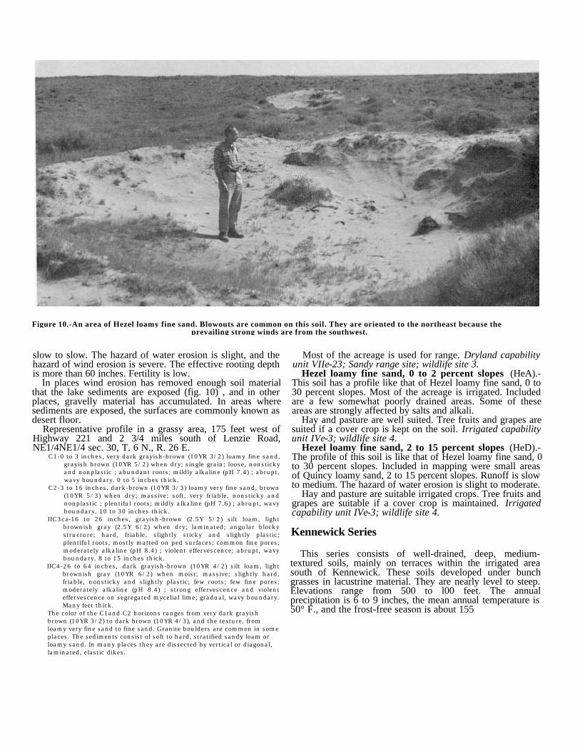
Figure 10.-An area of Hezel loamy fine sand. Blowouts are common on this soil. They are oriented to the northeast because theprevailing strong winds are from the southwest.
slow to slow. The hazard of water erosion is slight, and thehazard of wind erosion is severe. The effective rooting depthis more than 60 inches. Fertility is low.
In places wind erosion has removed enough soil materialthat the lake sediments are exposed (fig. 10) , and in otherplaces, gravelly material has accumulated. In areas wheresediments are exposed, the surfaces are commonly known asdesert floor.
Representative profile in a grassy area, 175 feet west ofHighway 221 and 2 3/4 miles south of Lenzie Road,NE1/4NE1/4 sec. 30, T. 6 N., R. 26 E.
C1-0 to 3 inches, very dark grayish-brown (10YR 3/2) loamy fine sand,grayish brown (10YR 5/2) when dry; single grain; loose, nonstickyand nonplastic ; abundant roots; mildly alkaline (pH 7.4) ; abrupt,wavy boundary. 0 to 5 inches thick.
C2-3 to 16 inches, dark-brown (10YR 3/3) loamy very fine sand, brown(10YR 5/3) when dry; massive; soft, very friable, nonsticky andnonplastic ; plentiful roots; mildly alkaline (pH 7.6) ; abrupt, wavyboundary. 10 to 30 inches thick.
IIC3ca-16 to 26 inches, grayish-brown (2.5Y 5/2) silt loam, lightbrownish gray (2.5Y 6/2) when dry; laminated; angular blockystructure; hard, friable, slightly sticky and slightly plastic;plentiful roots, mostly matted on ped surfaces; common fine pores;moderately alkaline (pH 8.4) ; violent effervescence; abrupt, wavyboundary. 8 to 15 inches thick.
IIC4-26 to 64 inches, dark grayish-brown (10YR 4/2) silt loam, lightbrownish gray (10YR 6/2) when moist; massive; slightly hard,friable, nonsticky and slightly plastic; few roots; few fine pores;moderately alkaline (pH 8.4) ; strong effervescence and violenteffervescence on segregated mycelial lime; gradual, wavy boundary.Many feet thick.
The color of the C1and C2 horizons ranges from very dark grayishbrown (10YR 3/2) to dark brown (10YR 4/3), and the texture, fromloamy very fine sand to fine sand. Granite boulders are common in someplaces. The sediments consist of soft to hard, stratified sandy loam orloamy sand. In many places they are dissected by vertical or diagonal,laminated, elastic dikes.
Most of the acreage is used for range. Dryland capabilityunit VIIe-23; Sandy range site; wildlife site 3.
Hezel loamy fine sand, 0 to 2 percent slopes (HeA).-This soil has a profile like that of Hezel loamy fine sand, 0 to30 percent slopes. Most of the acreage is irrigated. Includedare a few somewhat poorly drained areas. Some of theseareas are strongly affected by salts and alkali.
Hay and pasture are well suited. Tree fruits and grapes aresuited if a cover crop is kept on the soil. Irrigated capabilityunit IVe-3; wildlife site 4.
Hezel loamy fine sand, 2 to 15 percent slopes (HeD).-The profile of this soil is like that of Hezel loamy fine sand, 0to 30 percent slopes. Included in mapping were small areasof Quincy loamy sand, 2 to 15 percent slopes. Runoff is slowto medium. The hazard of water erosion is slight to moderate.
Hay and pasture are suitable irrigated crops. Tree fruits andgrapes are suitable if a cover crop is maintained. Irrigatedcapability unit IVe-3; wildlife site 4.
Kennewick Series
This series consists of well-drained, deep, medium-textured soils, mainly on terraces within the irrigated areasouth of Kennewick. These soils developed under bunchgrasses in lacustrine material. They are nearly level to steep.Elevations range from 500 to l00 feet. The annualprecipitation is 6 to 9 inches, the mean annual temperature is50° F., and the frost-free season is about 155
clays. Kennewick soils are geographically associated withScooteney and Warden soils.
In a representative profile the soil is dark grayish-brown orgrayish-brown silt loam to a depth of 12 inches. Below this,to a depth of 60 inches or more, is dominantlygrayish-brown, laminated silt loam. These soils arecharacteristically strongly calcareous throughout. In placesgranite boulders are common.
These soils are used mainly for irrigated crops.Kennewick silt loam, 0 to 2 percent slopes (KeA).-This
soil occurs on uplands. It is strongly calcareous. Included inmapping were small areas of Warden silt loam.
Permeability is moderately slow, and the water-holdingcapacity is high. Runoff is very slow, and the hazard of rindand water erosion is slight. The effective rooting depth isabout 20 inches. Fertility is medium.
Representative profile, at a point 100 feet north and 400feet west of the intersection of Olympia Street and West 36thAvenue, SE1/4SE1/4NE1/4 sec. 14, T. 8 N., R. 29 E.
A1-0 to 2 inches, dark grayish-brown (10YR 4/2) silt loam, grayishbrown (10YR 5/2) when dry; vesicular; weak, thin, platy structure;soft, friable, nonsticky and slightly plastic; abundant roots; strongeffervescence; moderately alkaline (pH 8.2); abrupt, smoothboundary. 1 to 5 inches thick.
C1-2 to 12 inches, grayish-brown (2.5Y 5/2) silt loam, light gray (2.5Y7/2) when dry; massive; slightly hard, friable, slightly sticky andplastic; plentiful roots; violent effervescence; moderately alkaline(pH 8.4) ; gradual, wavy boundary. 4 to 12 inches thick.
C2-12 to 19 inches, grayish-brown (2.5Y 5/2) silt loam, light gray (2.5Y7/2) when dry; finely laminated; slightly hard, friable, slightlysticky and plastic; few roots; few fine tubular pores; violenteffervescence; moderately alkaline (pH 8.4); abrupt, wavyboundary. 4 to 14 inches thick.
C3-19 to 32 inches, dark-gray (10YR 4/1) silt loam, light brownish gray(10YR 6/2) when dry; strong, fine lamination; hard, firm, slightlysticky and plastic; few fine tubular pores; disseminated andsegregated mycelial lime; violent effervescence; strongly alkaline(pH 8.5) ; gradual, wavy boundary. 8 to 17 inches thick.
C4-32 to 40 inches, grayish-brown (2.5Y 5/2) silt loam, light gray (2.5Y7/2) when dry; strong, fine lamination; hard, firm, sticky andplastic; few fine tubular pores; disseminated and segregatedmycelial lime; violent effervescence; strongly alkaline (pH 8.8) ;gradual, wavy boundary. 6 to 12 inches thick.
C5-40 to 49 inches, dark grayish-brown (2.5Y 4/2) silt loam, lightbrownish gray (2.5Y 6/2) when dry; moderate, fine lamination;hard, firm, slightly sticky and plastic; few fine tubular pores;disseminated and segregated mycelial lime; violent effervescence;strongly alkaline (pH 8.8) ; abrupt, wavy boundary. 7 to 12 inchesthick.
C6-49 to 62 inches, dark grayish-brown (2.5Y 4/2) silt loam, lightbrownish gray (2.5Y 6/2) when dry; massive; slightly hard, friable,slightly sticky and plastic; violent effervescence; moderatelyalkaline (pH 8.3).
The A1 horizon ranges from dark grayish brown (10YR 4/2) to grayishbrown (10YR 5/2) in color and from 1 to 6 inches in thickness. Thedepth to the hard, firm, laminated horizon is commonly about 20inches, but it ranges from 10 to 30 inches. The C horizon is commonlydissected by vertical or diagonal, laminated, elastic dikes.
Alfalfa, small grain, and grass-and-legume pasture aresuitable irrigated crops when an irrigation system has beenrecently installed. After the soil has been irrigated severalyears, it is suitable for most crops grown in the Area.Irrigated capability unit IIs-1; wildlife site 2.
Kennewick silt loam, 15 to 30 percent slopes, severelyeroded (KeE3).-This soil has a profile like that of Kennewicksilt loam, 0 to 2 percent slopes. It is steeper than that soil,and in places it has lost all of the surface layer througherosion. Runoff is rapid, and the hazard of further watererosion is severe. Eroded shallow gullies that lead to deepgullies or intermittent streams are common. Included insnapping were a few small rocky or stony areas. This soil isused mainly for range. Dryland capability unit VIe-20;Loamy range site (6 to 9 inches precipitation); wildlife site 3.
Kennewick silt loam, 2 to 5 percent slopes (KeB).-Theprofile of this soil is like that of Kennewick silt loam, 0 to 2percent slopes. Runoff is slow, and the hazard of watererosion is slight to moderate. Alfalfa, small grain, andgrass-legume pasture are suitable irrigated crops where anirrigation system has been recently installed. After the soil hasbeen irrigated several years, it is suitable for most cropsgrown in the Area. Irrigated capability unit IIe-2; wildlifesite 2.
Kennewick silt loam, 5 to 8 percent slopes (KeC).-Theprofile of this soil is like that of Kennewick silt loam, 0 to 2percent slopes. Runoff is medium, and the erosion hazard ismoderate. Alfalfa, small grain, and grass-legume pasture aresuitable irrigated crops where an irrigation system has beenrecently installed. After the soil has been irrigated severalyears, it is suitable for most crops grown in the Area.Irrigated capability unit IIIe-2; wildlife site 2.
Kennewick silt loam, 8 to 15 percent slopes (KeD).-Theprofile of this soil is like that of Kennewick silt loam, 0 to 2percent sloes. Runoff is rapid, and the hazard of watererosion is severe. Alfalfa, small grain, and grass-legumepasture are suitable irrigated crops where an irrigation systemhas been recently installed. After the soil has been irrigatedseveral years, it is suitable for most crops grown in the Area.Irrigated capability unit IVe-2; wildlife site 4.
Kiona Series
The Kiona series consists of well-drained, very stony,medium-textured soils underlain by basalt rubble. These soilsdeveloped under bunch grasses in a mixture of windlaiddeposits and basalt residuum. They are on steep slopes,ridgetops, and terraces in the Rattlesnake Hills and in theHorse Heaven Hills. Elevations range from 800 to 2,500 feet.The annual precipitation is 7 to 12 inches, the mean annualtemperature is 49° F., and the frost-free season is about 145days. Kiona soils are geographically associated with Ritzvilleand Shano soils.
In a representative profile the surface layer is very darkgrayish-brown to dark grayish-brown very stony silt loamabout 4 inches thick. Below this is dark-brown very stony siltloam about 16 inches thick. Below a depth of about 20 inchesis very gravelly loam or basalt rubble or bedrock. Basaltfragments, as much as 10 inches in diameter, occur invarying numbers throughout the soil. Rock outcrops arecommon.
Kiona soils are used for grazing.Kiona very stony silt loam, 0 to 30 percent slopes
(KnE).-This soil occurs in rough, broken areas in the HorseHeaven Hills and in the lower Rattlesnake Hills.
In most places the slope is about 15 percent. Included inmapping were areas that are shallow over basalt, areas ofRock outcrop, and, where the slope is 5 percent or less,small areas of Ritzville, Shano, and Warden silt loams.
Drainage is good. Permeability is moderate, and thewater-holding capacity is low. Runoff is very slow tomedium, except during heavy rainstorms and after snowmelt,when it is rapid. The hazard of water erosion is slight tomoderate. The effective rooting depth is about 30 to 60inches. Fertility is low.
Representative profile in an area of virgin grassland, 1 mileeast of Gibbon, SE1/4NW1/4 sec. 25, T. 9 N., R.. 25 E.
A1-0 to 4 inches, very dark grayish-brown (10YR 3/2) very stony siltloam, grayish brown (10YR 5/2) when dry; weak fine, granularstructure; soft friable, nonsticky and slightly plastic; abundantroots; mildly alkaline (pH 7.4) ; about 15 percent basalt fragments;abrupt, wavy boundary. 2 to 4 inches thick.
C1-4 to 20 inches, dark-brown (10YR 3/3) very stony silt loam, brownwhen dry; massive; soft, friable, nonsticky and slightly plastic;plentiful roots; common fine pores; mildly alkaline (pH 7.6) ; about25 to 55 percent angular basalt gravel, cobblestones, and stones;abrupt, irregular boundary. 5 to 25 inches thick.
IIC2ca-20 to 60 inches, dark grayish-brown (10YR 4/2) very gravellyloam, light brownish gray (10YR 6/2) when dry; massive; soft,friable, slightly sticky and slightly plastic; few roots; violenteffervescence; moderately alkaline (pH 8.2) ; about 70 percentangular basalt gravel, cobblestones, and stones.
The color of the A horizon ranges from very dark grayish brown (10YR3/2) to dark grayish brown (10YR 4/2) . A calcareous layer occurs insome places. Basalt bedrock is at a depth of 30 inches in some places.
This soil is used for grazing. Dryland capability unitVIIs-20; Shallow range site (9 to 15 inches precipitation);wildlife site 9.
Kiona very stony silt loam, 30 to 65 percent slopes(KnF).-This soil has a profile like that of Kiona very stony siltloam, 0 to 30 percent slopes. Runoff is rapid to very rapid.The hazard of water erosion is severe to very severe.Included in mapping were many rock escarpments, as well assmall areas of Ritzville silt loam and Shano silt loam.
This soil is used for grazing. Dryland capability unitVIIs-20; Shallow range site (9 to 15 inches precipitation);wildlife site 9.
Koehler Series
This series consists of somewhat excessively drained,coarse-textured soils on hummocky terraces, mainly at thelower elevations in the Horse Heaven Hills. These soilsformed under grass, sagebrush, and rabbitbrush in a mantleof windblown sand overlying a lime-silica cemented hardpan.They are nearly level to sloping. Elevations range from 300 to800 feet. The annual precipitation is 6 to 8 inches, the meanannual temperature is 53° F., and the frost-free season isabout 165 days. Koehler soils are associated with Quincysoils.
In a representative profile the surface layer is very darkgrayish-brown or dark grayish-brown loamy fine sand about12 inches thick. Below this is dark grayish-brown, stronglycalcareous loamy fine sand and sandy loam. At a depth ofabout 31 inches is an indurated lime-
silica hardpan. In many places hardpan fragments arescattered throughout the profile. In areas that have beenseverely eroded by wind, hardpan fragments haveaccumulated on the surface.
Koehler soils are used for range.Koehler loamy fine sand, 0 to 8 percent slopes (KoC).-
Included in the areas mapped as this soil are small areas ofQuincy loamy sand. The slope is generally about 4 percent.
This soil is somewhat excessively drained. Permeability israpid, and the water-holding capacity is low. Runoff is veryslow. The hazard of water erosion is slight, and the hazard ofwind erosion is severe. The effective rooting depth is 15 to36 inches. Fertility is low.
Representative profile in a grassy area, 75 feet east ofintersection of Umatilla Road and Highway 14, SW1/4SW1/4sec. 32, T. 6 N., R. 28 E.
C1-0 to 4 inches, very dark grayish-brown (10YR 3/2) loamy fine sand,grayish brown (10YR 5/2) when dry; single grain; loose, nonstickyand nonplastic ; abundant roots; mildly alkaline (pH 7.8) ; clear,wavy boundary. 0 to 5 inches thick.
C2-4 to 12 inches, very dark grayish-brown (10YR 3/2) loamy finesand, light brownish gray (10YR 6/2) when dry; single grain; loose,nonsticky and nonplastic ; plentiful roots; moderately alkaline (pH7.9) ; slight effervescence; clear, wavy boundary. 0 to 15 inchesthick.
C3ca-12 to 25 inches, dark grayish-brown (10YR 4/2) loamy fine sand,light brownish gray (10YR 6/2) when dry; massive; soft, veryfriable, nonsticky and nonplastic ; few roots; moderately alkaline(pH 8.2) ; violent effervescence; abrupt, wavy boundary. Variablethickness.
C4ca-25 to 31 inches, dark grayish-brown (10YR 4/2) sandy loam, lightgray (10YR 7/2) when dry; embedded fragments of lime-silicahardpan; massive; soft, very friable, nonsticky and nonplastic ; fewmatted roots; moderately alkaline (pH 8.2) ; violent effervescence;abrupt, wavy boundary. Variable thickness.
IIC5casim-31 inches, indurated lime-silica hardpan that does not breakdown completely in acid alone.
The texture of the C1 and C2 horizons ranges from loamy fine sand tofine sand, and the color from very dark grayish brown (10YR 3/2) todark grayish brown (10YR 4/2). In places the profile is calcareousthroughout. Lime-silica hardpan fragments, 1 inch or less in size, arescattered throughout the profile in varying quantities. The depth to theindurated lime-silica hardpan ranges from about 15 inches to about 36inches.
This soil is used for range. Dryland capability unitVIIe-23; Sandy range site; wildlife site 3.
Lickskillet Series
This series consists of shallow, well-drained, medium-textured soils on steep canyon slopes and rolling ridgetops inthe Rattlesnake Hills. These soils are very stony. Theyformed under bunch grasses in a mixture of windlaiddeposits and basalt residuum. They are underlain by basaltbedrock. Elevations range from 2,200 to 3,500 feet. Theannual precipitation is 11 to 15 inches, the mean annualtemperature is 48° F., and the frost-free season is about 130days. Lickskillet soils are associated with Walla Walla andEndicott soils.
In a representative profile the surface layer is very darkbrown very stony silt loam about 5 inches thick. The subsoilis dark-brown or dark yellowish-brown, very stony heavy siltloam about 13 inches thick. Below this is basalt bedrock.Basalt fragments as much as 10 inches in
diameter occur in varying numbers throughout the profile.These soils are used for grazing.Lickskillet very stony silt loam, 0 to 30 percent slopes
(LcE).-This soil occurs in the upper Rattlesnake Hills. Inmost places the slope is about 10 percent. Included inmapping were areas, making up about 5 percent of theacreage, where the soil is less than 8 inches deep overbedrock. Also included were areas, making up another 5percent of the acreage, where the soil has a substratum ofrubble or colluvium. In addition, small areas were includedwhere the soil is more than 20 inches deep.
Drainage is good. Permeability is moderately slow, and thewater-holding capacity is low. Runoff is normally slow tomedium, but it is rapid during heavy rainstorms or after rapidsnowmelt. The hazard of water erosion is moderate. Theeffective rooting depth is 10 to 20 inches. Fertility is low.
Representative profile in an area of virgin grassland, 800feet south and 1 mile east of the intersection of Bennett andJones Roads, NW1/4SW1/4 sec. 23, T. 11 N., R. 24 E.
A1-0 to 5 inches, very dark brown (10YR 2/ 2) very stony silt loam,grayish brown (10YR 5/2) when dry; weak, fine, granularstructure; soft, friable, slightly sticky and slightly plastic;abundant roots; many, fine, vesicular pores; mildly alkaline (pH7.6) ; about 10 percent basalt fragments; gradual, wavy boundary.2 to 8 inches thick.
B21-5 to 11 inches, dark-brown (10YR 3/3), very stony heavy silt loam,brown (10YR 5/3) when dry; moderate, medium, subangularblocky structure; few thin coatings on ped surfaces; slightly hard,friable, sticky and plastic; plentiful roots; common fine pores;mildly alkaline (pH 7.6); approximately 40 percent basaltfragments; gradual, wavy boundary. 3 to 10 inches thick.
B22-11 to 18 inches dark yellowish-brown (10YR 3/4), very stonyheavy silt loam, yellowish brown (10YR 5/4) when dry; moderate,medium, subangular blocky structure; few thin coatings on pedsurfaces; slightly hard, friable, sticky and plastic; plentiful roots;common fine pores; mildly alkaline (pH 7.8); approximately 60percent angular basalt fragments; abrupt, irregular boundary. 5 to12 inches thick.
IIR-18 inches, basalt bedrock with some fractures. The rock fracturesare coated with lime-silica and contain matted roots.
The color of the A horizon ranges from very dark brown tovery dark grayish brown. The texture of the B horizon ranges from heavysilt loam to silty clay loam. The stoniness and the number of rockoutcrops varies widely within short distances. The depth to basaltbedrock ranges from 10 to 20 inches; the average depth is about 18inches.
This soil is used for grazing. Dryland capability unitVIIs-20; Shallow range site (9 to 15 inches precipitation);wildlife site 9.
Lickskillet very stony silt loam, 30 to 65 percentslopes (LcF).-The profile of this soil is like that of Lickskilletvery stony silt loam, 0 to 30 percent slopes. In most placesthis soil occurs in steep canyons where the slope is about 35percent. Included in mapping were areas, making up about 5percent of the acreage, where the soil is less than 8 inchesdeep over bedrock. Also included were areas, making upanother 5 percent of the acreage, where the soil has asubstratum of rubble or colluvium. In addition, small areaswere included where the soil is, more than 20 inches deep, aswell as many rock escarpments.
Runoff is rapid to very rapid. The hazard of water erosionis severe to very severe.
This soil is used for grazing. Dryland capability unitVIIs-20; Shallow range site (9 to 15 inches precipitation);wildlife site 9.
Pasco Series
This series consists of deep, somewhat poorly drained,dominantly medium-textured soils on bottom lands along theYakima and Columbia Rivers. These soils developed in recentalluvium deposited in ponded areas. They are level to nearlylevel. Elevations range from 250 to 600 feet. The annualprecipitation is 6 to 8 inches, the mean annual temperature is53° F., and the frost-free season is about 155 days. Pascosoils are geographically associated with Burbank soils.
Pasco soils consist of stratified layers of very darkgrayish-brown or very dark brown silt loam and fine sandyloam to a depth of 60 inches or more. The surface layer ismoderately alkaline, and the lower layers are mildly alkaline.
These soils are used mainly for hay and pasture. Thevegetation includes sedges, saltgrass, and willows.
Pasco silt loam, 0 to 2 percent slopes (PcA).-This soiloccurs on bottom lands. In most places the slope is about 1percent. Included in mapping were small areas where theslope is as much as 5 percent. Also included were areas,mostly near West Richland or east of Kennewick, that arestrongly affected by salts and alkali to a depth of about 20inches. The vegetation in these areas consists mainly ofsaltgrass and greasewood.
This soil is somewhat poorly drained. Permeability ismoderate, and the water-holding capacity is high. There islittle or no erosion hazard. The water table is seasonally high.The effective rooting depth varies, but in some places it ismore than 60 inches. Fertility is high.
Representative profile in a pasture, NW1/4SW1/4SW1/4sec. 24, T. 9 N., R. 28 E.
Ap-0 to 6 inches, very dark grayish-brown (10YR 3/2) silt loam, grayishbrown (10YR 5/2) when dry; weak, fine and medium, granularstructure; soft, friable, slightly sticky and slightly plastic; abundantroots; few, fine, faint mottles; slight effervescence; moderatelyalkaline (pH 8.2) ; clear, smooth boundary. 4 to 12 inches thick.
C1-6 to 20 inches, very dark grayish-brown (10YR 3/2) silt loam,grayish brown (10YR 5/2) when dry; massive; soft, friable, slightlysticky and slightly plastic; plentiful roots; common, medium, faintmottles; slight effervescence; moderately alkaline (pH 8.4) ; clear,wavy boundary. 4 to 16 inches thick.
C2-20 to 33 inches, very dark gray (10YR 3/1) heavy silt loam, grayishbrown (10YR 5/2) when dry; weak, medium, prismatic structure;slightly hard, friable, sticky and slightly plastic; plentiful roots;common fine pores; slight effervescence; moderately alkaline (pH8.0) ; clear, wavy boundary. 4 to 16 inches thick.
C3-33 to 52 inches, very dark gray (10YR 3/1) very fine sandy loam,gray (10YR 5/1) when dry; massive; soft, very friable, slightlysticky and slightly plastic; plentiful roots; common, medium, faintmottles; slight effervescence; mildly alkaline (pH 7.8) ; clear, wavyboundary. 4 to 20 inches thick.
C4-52 to 62 inches, very dark brown (10YR 2/2) heavy silt loam, gray(10YR 5/1) when dry; massive; slightly hard, friable, sticky andslightly plastic; few roots; common fine pores; slight effervescence;mildly alkaline (pH 7.8).
The color of the Ap horizon ranges from very dark grayish brown (10YR3/2) to very dark brown (10YR 2/2), and the texture from fine sandyloam to silt loam. The reaction ranges from neutral to moderatelyalkaline. In places the C horizon is stratified with lenses of loamy sandor gravelly sand about 1 to 3 inches thick.
This soil is used mainly for pasture. If drained andirrigated, it is suitable for corn, peas, and hay. Irrigatedcapability unit IIIw-1; wildlife site 2.
Pasco fine sandy loam, 0 to 2 percent slopes (PaA).-Except for the texture of the surface layer and stratificationof the underlying material with fine sand, this soil has aprofile like that of Pasco silt loam, 0 to 2 percent slopes.Included in snapping were small areas of Quincy loamy sand,0 to 2 percent slopes. Also included were areas, mostly nearWest Richland or east of Kennewick, that are stronglyaffected by salts and alkali to a depth of about 20 inches. Thevegetation in these areas consists mainly of saltgrass andgreasewood.
The hazard of wind erosion is moderate if the soil has beendrained and is in cultivation.
Most of the acreage is used for pasture. Irrigatedcapability unit IIIw-1; wildlife site 2.
Prosser Series
This series consists of well-drained, moderately deep,medium-textured soils on terraces. These soils formed underbunch grasses and sagebrush in silty alluvium andwind-deposited material overlying basalt bedrock. They arenearly level to steep. Elevations range from 500 to 800 feet.The annual precipitation is 6 to 9 inches, the mean annualtemperature is 50° F., and the frost-free season is about 150days. Prosser soils are geographically associated with Shanoand Starbuck soils.
In a representative profile the surface layer is dark-brownor grayish-brown silt loam or very fine sandy loam 3 inchesthick. The subsoil is dark-brown silt loam 10 inches thick.The substratum is dark-brown to dark grayish-brown siltloam that is very gravelly in the lower part. Basalt bedrockbegins at a depth of 28 inches.
These soils are used for range and for irrigated crops.Prosser silt loam, 0 to 30 percent slopes (PoE).-This
soil occurs or low terraces. In most places the slope is about4 percent. Included in mapping were small areas of aStarbuck silt loam, a few areas of Rock outcrop, and a fewareas that are underlain by clay or tuffaceous sandstone.
Drainage is good. Permeability is moderate, and thewater-holding capacity is moderate to moderately high.Runoff is slow. The hazard of wind erosion is moderate, andthe hazard of water erosion is slight. Fertility is high.
Profile in an area of grassland, 900 feet south and 100 feeteast of intersection, NE1/4NE1/4 sec. 18, T. 9 N., R. 26 E.Profile is in an area mapped as Prosser silt loam, 5 to 15percent slopes, but is representative of this soil.
A-0 to 3 inches, dark-brown (10YR 3/3) silt loam, grayish brown (10YR5/2) when dry; moderate, medium, platy structure breaking toweak, fine, granular; soft, friable, nonsticky and slightly plastic;abundant roots; few fine pores; neutral (pH 6.9) ; abrupt, smoothboundary. 2 to 6 inches thick.
B-3 to 13 inches, dark-brown (10YR 4/3) silt loam, brown (10YR 5/3)when dry; weak, coarse, prismatic structure; soft, friable, slightlysticky and slightly plastic; plentiful roots; few fine pores; neutral(pH 7.2) ; gradual, wavy boundary. 5 to 15 inches thick.
C1-13 to 25 inches, dark-brown (10YR 4/3) silt loam, brown (10YR5/3) when dry; massive; soft, friable, slightly sticky and slightlyplastic; plentiful roots; neutral (pH 7.3) ; abrupt, wavy boundary.Variable thickness.
IIC2-25 to 28 inches, dark grayish-brown (10YR 4/2) very gravelly siltloam, light brownish gray when dry; massive; soft, friable, slightlysticky and slightly plastic; matted roots between rock fragments;mildly alkaline (pH 7.4) ; 80 percent angular fragments of basalt;some of the fragments are coated with lime-silica on the lower side;abrupt, wavy boundary. 0 to 4 inches thick.
IIIR-28 inches, basalt bedrock.The color ranges from dark brown to dark grayish brown throughout theprofile. The depth to basalt bedrock ranges from 20 to 36 inches. Inplaces the soil below a depth of about 24 inches is calcareous.
This soil is used for grazing. Dryland capability unitIVe-22; Loamy range site (6 to 9 inches precipitation);wildlife site 3.
Prosser very fine sandy loam, 0 to 15 percent slopes,eroded (PrD2).-Except for the texture of the surface layer,this soil has a profile like that of Prosser silt loam, 0 to 30percent slopes. The coarser texture results from winderosion, which has winnowed out the fine particles from thesurface layer. The hazard of further wind erosion ismoderate.
This soil is used for range. Much of the vegetation isneedle-and-thread and cheatgrass. Dryland capability unitVIe-22; Loamy range site (6 to 9 inches precipitation);wildlife site 3.
Prosser silt loam, 0 to 2 percent slopes (PoA).-This soilhas a profile like that of Prosser silt loam, 0 to 30 percentslopes. Included in mapping were small areas of Scooteney,Wamba, and Starbuck silt loams; a few areas of Rockoutcrop; and a few areas that are strongly affected by saltsand alkali.
Runoff is very slow. The hazard of water erosion is slight.Corn, peas, mint, wheat, hay, and pasture are suitable crops.Irrigated capability unit IIs-2; wildlife site 2.
Prosser silt loam, 2 to 5 percent slopes (PoB).-This soilhas a profile like that of Prosser silt loam, 0 to 30 percentslopes. Included in mapping were a few areas of fine sandyloam, a few areas that are strongly affected by salts andalkali, and a few areas that are underlain by remnants of theEllensburg geologic formation. In some of the included areasthe substratum consists of strata of readily permeablesandstone or siltstone or deep, slowly permeable clay. Corn,mint, hay, and pasture are suitable crops. Irrigated capabilityunit IIe-2; wildlife site 2.
Prosser silt loam, 5 to 15 percent slopes (PoD).-Thissoil has a profile like that of Prosser silt loam, 0 to 30 percentslopes. In places the texture of the surface layer is sandyloam. Included in mapping were a few areas that areunderlain by clay or tuffaceous sandstone of the Ellensburggeologic formation.
Runoff is medium to rapid, and the hazard of watererosion is moderate to severe. Hay and pasture are suitablecrops. Irrigated capability unit IVe-2, wildlife site 2.
Quincy Series
The Quincy series consists of excessively drained,coarse-textured soils on hummocky or dunelike terracesmainly near West Richland and in the southern part of theArea. These soils formed under grass, sagebrush, andrabbitbrush; the parent material was windblown sand derivedfrom granite, basalt, and quartzite. They are nearly level tosteep. Elevations range from 300 to 1,100 feet. The annualprecipitation is 6 to 8 inches, the mean annual temperature is51° F., and the frost-free season is about 165 days. Thesesoils are geographically associated with Burbank and Hezelsoils.
Typically, Quincy soils consist of dark-brown to darkgrayish-brown loamy sand to loamy fine sand to a depth of60 inches or more. In places the soil is underlain by basalt ata depth of 20 to 36 inches.
These soils are used mainly for range, but some areas areirrigated.
Quincy loamy sand, 0 to 30 percent slopes (QuE).-Thissoil is deep and sandy. It is hummocky and dunelike, andthere are some blowouts. Much of the acreage consists oflong, narrow, duned ridges that extend considerabledistances. In most places the slope is about 5 percent.Included in mapping were small areas of a Hezel loamy finesand, areas of Dune land, and areas where bedrock is at adepth of 20 to 36 inches.
This soil is excessively drained. Permeability is very rapid,and the water-holding capacity is low. Runoff is very slow,and the hazard of wind erosion is severe. The effectiverooting depth is more than 60 inches.
Representative profile in an area of grassland, 50 feet westof Umatilla Road and 4,500 feet north of intersection withHighway 14, SEl/4SE1/4 sec. 30, T. 6 N., R. 28 E.
C1-0 to 9 inches, dark grayish-brown (10YR 4/2) loamy sand, grayishbrown (10YR 5/2) when dry; single grain; loose, nonsticky andnonplastic; abundant roots; mildly alkaline (pH 7.8); gradual, wavyboundary. 0 to 10 inches thick.
C2-9 to 35 inches, dark grayish-brown (10YR 4/2) loamy fine sand,grayish brown (10YR 5/2) when dry; single grain; loose, nonstickyand nonplastic ; few roots; mildly alkaline (pH 7.8) ; gradual, wavyboundary. 10 to 40 inches thick.
C3-35 to 40 inches, dark grayish-brown (10YR 4/2) loamy fine sand,light brownish gray (10YR 6/2) when dry; single grain; loose,nonsticky and nonplastic ; moderately alkaline (pH 8.2) ; abrupt,wavy boundary. 5 to 30 inches thick.
C4ca-40 to 65 inches, dark grayish-brown (10YR 4/2) loamy fine sand,light brownish gray (10YR 6/2) when dry; single grain; loose,nonsticky and nonplastic ; moderately alkaline (pH 8.4) ; violenteffervescence.
The texture ranges from loamy fine sand to fine sand, and thecolor ranges from dark brown (10YR 3/3) to dark grayish brown (10YR4/2). In some places the soil is noncalcareous throughout.
This soil is used for range. Dryland capability unitVIIe-23; Sandy range site; wildlife site 3.
Quincy loamy sand, moderately shallow, 0 to 30percent slopes (QyE).-Except that it is underlain by basaltbedrock at a depth of 20 to 36 inches, this soil has a profilelike that of Quincy loamy sand, 0 to 30 percent slopes. Theareas are on low terraces. Elevations are 300 to 800 feet.This soil is used for range. Dryland capability unit VIIe-23;Sandy range site; wildlife site 3.
Quincy loamy sand, 0 to 2 percent slopes (QuA).-Thissoil has a profile like that of Quincy loamy sand, 0 to 30percent slopes. It is suited to hay and pasture. Included werea few somewhat poorly drained areas, mainly near theYakima River. Some of these areas are strongly affected bysalts and alkali. Irrigated capability unit IVe-3; wildlife site4.
Quincy loamy sand, 2 to 15 percent slopes (QuD).-Thissoil has a profile like that of Quincy loamy sand, 0 to 30percent slopes. Irrigated hay and pasture are well suited.Irrigated capability unit IVe-3; wildlife site 4.
Ritzville Series
This series consists of well-drained, medium-textured soilson uplands in the Rattlesnake Hills and in Horse Heaven Hills.These soils developed under bunch grasses in silty,windblown deposits mixed with small amounts of volcanicash. They are gently sloping to steep. Elevations range from1,200 to 2,500 feet. The annual precipitation is 9 to 12inches, the mean annual temperature is 48° F., and thefrost-free season is about 140 days. Ritzville soils aregeographically associated with Shano and Willis soils.
In a representative profile the surface layer is very darkgrayish-brown to dark-brown silt loam or very fine sandyloam about 13 inches thick. The subsoil is dark-brown siltloam that extends to a depth of 36 inches, and the materialunderlying this layer is dark grayish-brown, calcareous siltloam to a depth of more than 60 inches.
These soils are used mainly for small grain in a crop-fallowsystem and for grazing.
Ritzville silt loam, 0 to 5 percent slopes (ReB).-This soiloccurs on uplands. In most places the slope is about 4percent. Included in mapping were a few areas where theslope is as much as 15 percent and small areas of Willis siltloam and of Ritzville very fine sandy loam, eroded.
Drainage is good. Permeability is moderate, and thewater-holding capacity is high. Runoff is very slow to slow.The hazard of water erosion is slight, and the hazard of winderosion is slight to moderate. The effective rooting depth ismore than 36 inches (fig. 11). Tilth is good, and fertility ishigh.
Representative profile in a cultivated area, 100 feet northand 550 feet west of the intersection of Beck and NineCanyon Roads, SE1/4NW1/4 sec. 30, T. 7 N., R. 30 E.
Ap-0 to 6 inches, very dark grayish-brown (10YR 3/2) silt loam, grayishbrown (10YR 5/2) when dry; weak, fine, granular structure; soft,very friable, nonsticky and slightly plastic; abundant roots; neutral(pH 6.9) ; abrupt, smooth boundary. 5 to 10 inches thick.
A1-6 to 13 inches, very dark grayish-brown (10YR 3/2) silt loam,grayish brown (10YR 5/2) when dry; weak, coarse, prismaticstructure; soft, friable, nonsticky and slightly plastic; plentifulroots; common fine pores; neutral (pH 7.2) ; gradual, wavyboundary. 6 to 17 inches thick.
B2-13 to 36 inches, dark-brown (10YR 3/3) silt loam, brown (10YR5/3) when dry; weak, coarse, prismatic structure; soft, friable,nonsticky and slightly plastic; few roots; common fine pores;mildly alkaline (pH 7.6) ; abrupt, wavy boundary. 10 to 25 inchesthick.
C1ca-36 to 51 inches, dark grayish-brown (10YR 4/2) silt loam, lightbrownish gray (10YR 6/2) when dry; weak, coarse, prismaticstructure; soft, friable, nonsticky and slightly plastic; few roots;common fine pores; strong
Figure 11-Profile of a Ritzville silt loam.
effervescence; moderately alkaline (pH 8.2); gradual, wavyboundary. 6 to 20 inches thick.
C2ca-51 to 67 inches, dark grayish-brown (10YR 4/2) silt loam, lightbrownish gray (10YR 6/2) when dry; massive; slightly hard, firm,nonsticky and slightly plastic; few roots; common fine pores;violent effervescence; moderately alkaline (pH 8.4).
The A horizon, when moist, ranges from very dark grayish brown (10YR3/2) to dark brown (10YR 3/3). Generally, the depth to bedrock is morethan 60 inches, but in places it is as little as 36 inches. The depth tolime is commonly more than 36 inches, but it is less than 36 inches insome of the areas where bedrock is within 60 inches of the surface.Firm aggregates of silt from overlying horizons have been deposited ininsect burrows. These aggregates are as much as 1/2 inch wide and 4inches long. They are common in the C horizon.
Most of the acreage is cultivated. Wheat, barley, and ryeare grown in a crop-fallow system. In many of the cultivatedareas a slightly hard, compact layer has formed just belowtillage depth. Dryland capability unit IIIe-20; Loamy rangesite (9 to 15 inches precipitation); wildlife site 7.
Ritzville silt loam, 30 to 65 percent slopes (ReF).-Areasof this soil contain small areas of Rock outcrop, ofescarpments, and of soils that have been severely eroded bywind or water.
Runoff is rapid to very rapid, and the hazard of watererosion is severe to very severe. The depth to free lime ismore than 60 inches in solve places on north and northeastslopes.
This soil is used for grazing. Dryland capability unitVIe-21; Loamy range site (9 to 15 inches precipitation);wildlife site 8.
Ritzville silt loam, 15 to 30 percent slopes, severelyeroded (ReE3).-Much of this soil occurs as narrow,elongated areas incised by shallow and deep gullies that arenot easy to cross with farm machinery. Included in mappingwere small areas of windblown sand and small areas of Rockoutcrop.
Runoff is normally medium, but it is rapid duringoccasional heavy downpours or after rapid snowmelt.
Most of the acreage is used for grazing, but in placeswheat is grown in a crop-fallow system. Dryland capabilityunit IVe-20; Loamy range site (9 to 15 inches precipitation);wildlife site 8.
Ritzville very fine sandy loam, 0 to 15 percent slopes,eroded (RfD2).-Wind erosion has altered the texture of thesurface layer, but the profile of this soil is otherwise like thatdescribed for Ritzville silt loam, 0 to 5 percent slopes. Inmost places the slope is about 5 percent, but included inmapping were a few areas where the slope is as much as 25percent. Also included were small duned areas, mainly alongfield borders or depressions.
Runoff is slow. The hazard of water erosion is slight, andthe hazard of wind erosion is moderate.
This soil is suited to dryland grain or range. Drylandcapability unit IVe-21; Loamy range site (9 to 16 inchesprecipitation); wildlife site 8.
Riverwash
Riverwash (Rh) consists mainly of alluvial sand and gravelalong rivers and streams. These areas are flooded when thestreams overflow and are exposed when the water is low.Most areas are bare of vegetation, but willows andcottonwoods are becoming established in places. They haveno agricultural value. Dryland capability unit VIIIw-20.
Rock Outcrop
Rock outcrop (Ro) consists of outcrops of basalt bedrock.The areas are gently sloping to very steep, and there are somevertical escarpments. Except for scattered patches ofvegetation in small pockets of soil, the areas are nearlybarren. They have no agricultural value. Dryland capabilityunit VIIIs-20.
Scooteney Series
This series consists of well-drained, medium-textured soilson old alluvial terraces and on bottom lands along intermittentstreams. These soils developed under bunch grasses in stonyand gravelly alluvium and in silty, windblown deposits. Theyare nearly level to steep. Elevations range from 400 to 1,300feet. The annual precipitation is
6 to 9 inches, the mean annual temperature is 50° F., and thefrost-free season is about 150 days. Scooteney soils aregeographically associated with Starbuck and Wamba soils.
In a representative profile the surface layer is darkgrayish-brown silt loam about 4 inches thick. The subsoil isdark grayish-brown silt loam about 12 inches thick. The nextlayer is calcareous, dark grayish-brown silt loam. Theunderlying material, to a depth of 60 inches or more, consistsof grayish-brown gravelly silt loam and dark-gray verygravelly loam.
Unirrigated areas are used for range. Irrigated areas areused for grapes, orchard crops, mint, hay, and pasture.
Scooteney silt loam, 0 to 5 percent slopes (ScAB).-Thissoil occurs on old alluvial terraces. In most places the slopeis about 4 percent. Included in mapping were a few areaswhere the slope is as much as 15 percent and areas wherethe subsoil is gravelly. Also included were areas of Starbucksilt loam and of Wamba silt loam, 0 to 2 percent slopes.
Drainage is good. Permeability is moderate, and thewater-holding capacity is moderately high. Runoff is veryslow to slow, and the hazard of wind and water erosion isslight to moderate. The effective rooting depth is more than36 inches (fig. 12). Fertility is high.
Profile in a grassy area, 700 feet east of Hinzerling Roadand 100 feet north of railroad track, NE1/4NW1/4SW1/4sec. 25, T. 9 N., R. 24 E. Profile is in an area mapped asScooteney silt loam, gravelly subsoil, 2 to 5 percent slopes,but is representative of this soil.
A1-0 to 4 inches, dark grayish-brown (10YR 4/2) silt loam, brown(10YR 5/3) when dry; weak, very thick, platy structure; slightlyhard, friable, nonsticky and slightly plastic; abundant roots;common fine pores; neutral (pH 7.2) ; gradual, wavy boundary. 3 to6 inches thick.
B-4 to 16 inches, dark grayish-brown (10YR 4/2) silt loam, brown(10YR 5/3) when dry; weak, coarse, prismatic structure; slightlyhard, friable, nonsticky and slightly plastic; plentiful roots;common fine pores; mildly alkaline (pH 7.4); abrupt, wavyboundary. 6 to 15 inches thick.
C1ca-16 to 21 inches, dark grayish-brown (2.5Y 4/2) silt loam, lightbrownish gray (2.5Y 6/2) when dry; weak, coarse, prismaticstructure; slightly hard, friable, nonsticky and slightly plastic;plentiful roots; common fine pores; moderately alkaline (pH 8.2) ;violent effervescence; abrupt, wavy boundary. 0 to 14 inchesthick.
IIC2ca-21 to 38 inches, grayish-brown (10YR 5/2) gravelly silt loam,light brownish gray (10YR 6/2) when dry; massive; slightly hard,friable, nonsticky and slightly plastic; plentiful roots; moderatelyalkaline (pH 8.2); violent effervescence; gradual, wavy boundary. 2to 20 inches thick.
IIIC3-38 to 60 inches, dark-gray (10YR 4/1) very gravelly loam, gray(10YR 6/1) when dry; massive; soft, very friable, nonsticky andnonplastic; few roots; moderately alkaline (pH 8.2); strongeffervescence; about 70 percent gravel.
The A1 horizon ranges from dark grayish brown (10YR 4/2)to dark brown (10YR 4/3) in color. In places angular stones and gravelare common throughout the profile. The structure of the B horizonranges from weak, medium, subangular blocky to weak coarse,prismatic. The color of the C horizon ranges from 10YR to 2.5Y in hue.In places the substratum is weakly cemented with lime-silica.
This soil is used mainly for grazing. Dryland capabilityunit IVe-22; Loamy range site (6 to 9 inches precipitation);wildlife site 1.
Scooteney stony silt loam, 0 to 30 percent slopes(SeE).-This soil has a stony and gravelly surface layer, but itsprofile is otherwise like that of Scooteney silt loam, 0 to 5percent slopes. In most places the slope is about 12 percent.Included are escarpments that form the banks of the YakimaRiver in some places.
Runoff is slow to medium. The erosion hazard is slight tomoderate.
This soil is used for grazing. Dryland capability unitVIIs-20; Loamy range site (6 to 9 inches precipitation);wildlife site 5.
Scooteney gravelly silt loam, 2 to 5 percent slopes(SgB).-This soil has a gravelly surface layer, but its profile isotherwise like that of Scooteney silt loam, 0 to 5 percentslopes. Much of the gravel has been brought to the surfaceby deep tillage or leveling.
Runoff is slow. The erosion hazard is slight to moderate.Grapes, tree fruits, hay, and pasture are suitable crops.
Irrigated capability unit IIIe-2; wildlife site 2.
Figure 12.-Profile of a Scooteney silt loam.
Scooteney silt loam, 0 to 2 percent slopes (ScA).-Thissoil has a profile like that of Scooteney silt loam, 0 to 5percent slopes. Included in mapping were small areas ofScooteney silt loam, gravelly subsoil, and small areas ofFinley fine sandy loam.
Runoff is very slow. The erosion hazard is slight.Most of the acreage is irrigated. Tree fruits, grapes, mint,
hay, and pasture are the main crops. Irrigated capability unitIIs-2; wildlife site 2.
Scooteney silt loam, 2 to 5 percent slopes (ScB).-Thissoil has a profile like that of Scooteney silt loam, 0 to 5percent slopes.
Runoff is slow. The hazard of water erosion is slight tomoderate.
Most of the acreage is irrigated. Tree fruits, grapes, mint,hay, and pasture are the main crops. Irrigated capability unitIIe-2; wildlife site 2.
Scooteney silt loam, 5 to 8 percent slopes (ScC).-Thissoil has a profile like that of Scooteney silt loam, 0 to 5percent slopes. In most places the slope is about 7 percent.
Runoff is medium. The hazard of water erosion ismoderate.
Suitable crops include tree fruits, hay, and pasture.Irrigated capability unit IIIe-2; wildlife site 2.
Scooteney silt loam, gravelly subsoil, 0 to 2 percentslopes (SdA).-Gravelly silt loam occurs at a depth of 10 to20 inches in this soil, but the profile is otherwise like that ofScooteney silt loam, 0 to 5 percent slopes. Included inmapping were small areas of a Scooteney silt loam, aScooteney gravelly silt loam, a Starbuck silt loam, and aWamba silt loam. Also included were a few areas that arestrongly affected by salts and alkali.
Runoff is very slow. The erosion hazard is slight.Most of the acreage is irrigated. Tree fruits, grapes, mint,
hay, and pasture are suitable crops. Irrigated capability unitIIs-2; wildlife site 2.
Scooteney silt loam, gravelly subsoil, 2 to 5 percentslopes (SdB).-Gravelly silt loam is at a depth of 10 to 20inches, but the profile of this soil is otherwise like that ofScooteney silt loam, 0 to 5 percent slopes.
Runoff is slow. The hazard of water erosion is slight tomoderate.
This soil is suited to tree fruits, grapes, mint, hay, andpasture. Irrigated capability unit IIIe-2; wildlife site 2.
Scooteney silt loam, gravelly subsoil, 5 to 15 percentslopes (SdD).-Gravelly silt loam is at a depth of 10 to 20inches, but the profile is otherwise like that of Scooteney siltloam, 0 to 5 percent slopes.
Runoff is medium to rapid. The hazard of water erosion ismoderate to severe.
This soil is suited to tree fruits, hay, and pasture. Irrigatedcapability unit IVe-2; wildlife site 4.
Shano Series
This series consists of well-drained, medium-textured soilson uplands in the Rattlesnake Hills and in the Horse HeavenHills. These soils developed under bunch grasses in silty,windblown deposits. They are gently sloping to steep.Elevations range from 500 to 1,300 feet. The annualprecipitation is 6 to 9 inches, the mean annual temperature is50° F., and the frost-free season is about 150 days.
Shano soils are geographically associated with Burke andWarden soils.
The surface layer is dark grayish-brown silt loam or veryfine sandy loam about 6 inches thick. The subsoil is darkgrayish-brown silt loam about 14 inches thick. Below this isdark-brown, grayish-brown, and brown silt loam. These soilsare normally more than 60 inches deep, but in places they areunderlain by basalt at a depth of 36 to 60 inches.
Unirrigated areas of these soils are used mainly for smallgrain in a crop-fallow system and for grazing. Irrigated areasare used for asparagus, sugar beets, hops, orchard crops,grapes, corn, mint, hay, and pasture.
Shano silt loam, 0 to 5 percent slopes (ShAB).-This soiloccurs on uplands. In most places the slope is about 4percent. Included in mapping were a few areas where theslope is as much as 15 percent. Also included were smallareas of a Burke silt loam, an eroded phase of a Shano veryfine sandy loam, and a Warden silt loam.
Drainage is good. Permeability is moderate, and thewater-holding capacity is high. Runoff is very slow to slow.The hazard of water erosion is slight, and the hazard of winderosion is slight to moderate. The effective rooting depth is36 inches or more. Tilth is good, and fertility is high.
Representative profile in a cultivated area, 120 feet northand 1,050 feet west of the intersection of Crosby and SnipesRoads, SW1/4SE1/4SE1/4 sec. 36, T. 10 N., R. 24 E.
Ap-0 to 6 inches, dark grayish-brown (10YR 4/2) silt loam, lightbrownish gray (10YR 6/2) when dry; medium, fine, granularstructure; soft, very friable, nonsticky and slightly plastic;abundant roots; neutral (pH 7.3) ; abrupt, smooth boundary. 5 to 8inches thick.
B-6 to 20 inches, dark grayish-brown (10YR 4/2) silt loam, lightbrownish gray (10YR 6/2) when dry; weak, coarse, prismaticstructure; soft, friable, nonsticky and slightly plastic; plentifulroots; common fine pores; mildly alkaline (pH 7.4) ; abrupt, wavyboundary. 8 to 18 inches thick.
C1-20 to 28 inches, dark-brown (10YR 4/3) silt loam, pale brown (10YR6/3) when dry; massive; soft, friable, nonsticky and slightlyplastic; plentiful roots; common fine pores; slight effervescence;moderately alkaline (pH 8.3) ; gradual, wavy boundary. 8 to 15inches thick.
C2ca-28 to 49 inches, grayish-brown (10YR 5/ 2) silt loam, very palebrown (10YR 7/3) when dry; massive; slightly hard, friable,nonsticky and slightly plastic; plentiful roots; common fine pores;disseminated and segregated mycelial lime; violent effervescence;strongly alkaline (pH 8.6) ; abrupt, wavy boundary. 7 to 15 inchesthick.
C3-49 to 56 inches, brown (10YR 5/3) silt loam, pale brown (10YR 6/3)when dry; massive; soft, friable, nonsticky and slightly plastic; fewroots; common fine pores; strongly alkaline (pH 8.6); abrupt,smooth boundary. 7 inches to many feet thick.
IIR-56 inches, basalt bedrock, generally capped with lime-silica coatingor cemented hardpan.
The A horizon ranges from dark grayish brown (10YR 4/2) todark brown (10YR 4/3) in color. The depth to lime ranges from 17 to 34inches. Segregated mycelial lime is lacking in the Cca horizon of someprofiles. In some places hard concentric (Cicada) nodules occur in the Chorizon. The depth to basalt bedrock ranges from 36 to more than 60inches.
Most of the acreage is cultivated. Wheat, barley, and ryeare grown in a crop-fallow system. Dryland capability unitIVc-20; Loamy range site (6 to 9 inches precipitation);wildlife site 1.
Shano silt loam, 30 to 65 percent slopes (ShF).- Thissoil has a profile like that of Shano silt loam, 0 to 5 percentslopes. Included in mapping were small, severely erodedareas and small areas of a Kiona very stony silt loam.
Runoff is rapid to very rapid. The hazard of water erosionis severe to very severe.
This soil is used for range. Dryland capability unitVIIe-21; Loamy range site (6 to 9 inches precipitation);wildlife site 3.
Shano silt loam, 15 to 30 percent slopes, severelyeroded (ShE3).-This soil has lost part or all of its surfacelayer through erosion, but the profile is otherwise like that ofShano silt loam, 0 to 5 percent slopes. Much of the acreageconsists of narrow, elongated areas incised by shallow anddeep gullies that are difficult to cross with farm machinery.Included in mapping were small areas of a Kiona very stonysilt loam, an eroded phase of a Shano very fine sandy loam,and a Quincy loamy sand.
Runoff is normally medium, but it is rapid during heavyrainstorms or after rapid snowmelt. The hazard of furtherwater erosion is moderate to severe.
Most of the acreage is used for grazing, but wheat isgrown in a crop-fallow system in a few areas. Drylandcapability unit VIe-20; Loamy range site (6 to 9 inchesprecipitation); wildlife site 3.
Shano very fine sandy loam, 0 to 15 percent slopes,eroded (SnD2)-Except for the texture of the surface layer,this soil has a profile like that of Shano silt loam, 0 to 5percent slopes. Included in mapping were small duned areas,mainly along field borders and in depressions. Also includedwere small areas of a Quincy loamy sand.
Blowouts are common in some of the areas. The hazard offurther wind erosion is moderate.
This soil is used for production of dryland grain and forrange. Dryland capability unit IVe-21; Loamy range site (6to 9 inches precipitation); wildlife site 1.
Shano very fine sandy loam, 15 to 30 percent slopes,eroded (SnE2).-Except for the texture of the surface layer,this soil has a profile like that of Shano silt loam, 0 to 5percent slopes. Much of the acreage consists of moderatelysteep areas incised by gullies that are difficult to cross withfarm machinery. Included in mapping were a few areaswhere the slope is as much as 65 percent.
Runoff is generally slow to medium, but it is raid when theground is frozen. The hazard of further erosion is moderate.
This soil is used for range. Dryland capability unitVIe-20; Loamy range site (6 to 9 inches precipitation);wildlife site 3.
Shano silt loam, 0 to 2 percent slopes (ShA).-This soilhas a profile like that of Shano silt loam, 0 to 5 percentslopes. It is generally more than 60 inches deep, but a fewareas 36 to 60 inches deep over bedrock were included.
This soil is well suited to both surface and sprinklerirrigation. Suitable crops include asparagus, sugar beets,hops, tree fruits, grapes, corn, mint, hay, and pasture.Irrigated capability unit I-1; wildlife site 2.
Shano silt loam, 2 to 5 percent slopes (ShB).-This soilhas a profile like that of Shano silt loam, 0 to 5 per-
cent slopes. It is more than 60 inches deep. Included insnapping were small areas of a Warden silt loam.
Runoff is slow. The hazard of water erosion is slight tomoderate.
Suitable crops include asparagus, sugar beets, hops, treefruits, grapes, hay, and pasture. Irrigated capability unitIIe-2; wildlife site 2.
Shano silt loam, 5 to 8 percent slopes (ShC).-This soilhas a profile like that of Shano silt loam, 0 to 5 percentslopes. The depth to basalt bedrock is 60 inches or more.Included in mapping were small areas of a Warden silt loamand a Burke silt loam.
Runoff is medium. The hazard of water erosion ismoderate.
Suitable crops include grapes, tree fruits, hay, and pasture.Irrigated capability unit IIIe-2; wildlife site 2.
Shano silt loam, 8 to 15 percent slopes (ShD).-This soilhas a profile like that of Shano silt loam, 0 to 5 percent sloes.It is generally more than 60 inches deep. Included in mappingwere small areas of Shano very fine sandy loam, deep, 2 to 8percent slopes, eroded, areas of Warden silt loam, and a fewareas that are 36 to 60 inches deep over bedrock.
Runoff is rapid. The hazard of water erosion is severe.Tree fruits, hay, and pasture are well suited. Irrigated
capability unit IVe-2; wildlife site 4.Shano silt loam, deep, 2 to 5 percent slopes (SmB).-
Basalt is at a depth of 36 to 60 inches in this soil, but theprofile is otherwise like that of Shano silt loam, 0 to 5 percentslopes.
Runoff is slow. The Hazard of water erosion is slight tomoderate.
Suitable crops include asparagus, hops, sugar beets,grapes, tree fruits, hay, and pasture. Irrigated capability unitIIe-2; wildlife site 2.
Shano silt loam, deep, 5 to 8 percent slopes (SmC).-Basalt is at a depth of 36 to 60 inches in this soil, but theprofile is otherwise like that of Shano silt loam, 0 to 5 percentslopes.
Runoff is medium. The hazard of water erosion ismoderate.
Suitable crops include tree fruits, grapes, hay, and pasture.Irrigated capability unit IIIe-2; wildlife site 2.
Shano very fine sandy loam, deep, 2 to 8 percentslopes, eroded (SoC2).-Except for the texture of the surfacelayer and depth to bedrock, this soil has a profile like that ofShano silt loam, 0 to 5 percent slopes. Basalt bedrock is at adepth of 36 to 60 inches.
Runoff is slow to medium. Water erosion is a slight tomoderate hazard. Wind erosion is a moderate hazard whenthe surface is bare.
Tree fruits, hay, and pasture are suitable crops. Irrigatedcapability unit IIIe-1; wildlife site 2.
Starbuck Series
This series consists of well-drained, shallow, medium-textured soils on terraces. These soils formed under bunchgrasses and sagebrush in silty wind-deposited material and inalluvium. They are nearly level to steep. Elevations rangefrom 500 to 750 feet. The annual precipitation is 6 to 9inches, the mean annual temperature is 50° F., and thefrost-free season is about 155 days. Starbuck soils
are geographically associated with Prosser and Scooteneysoils.
The surface layer is dark-brown silt loam about 3 inchesthick. The subsoil is generally dark-brown silt loam that isunderlain by dark-brown very gravelly silt loam. Basaltbedrock begins at a depth of 17 inches.
Unirrigated areas are used for range.Starbuck silt loam, 0 to 8 percent slopes (SrBC).-This
soil occurs on low terraces. In most places the slope is about4 percent. Included in mapping were small areas of Burbankloamy fine sand, basalt substratum; areas of a Prosser siltloam; a few areas of Rock outcrop; and areas of Starbucksoils that have a slope of as much as 30 percent.
Permeability is moderate, and the water-holding capacity islow. Runoff is very slow to medium. The hazard of winderosion is moderate, and the hazard of water erosion is slight.The effective rooting depth is 12 to 20 inches. Fertility ismedium to low.
Profile in a grassy area, 120 feet west and 2,300 feet southof the intersection of Wilgus Road and U.S. Highway 12,NE1/4SE1/4 sec. 29, T. 9 N., R. 24 E. Profile is in an areamapped as Starbuck silt loam, 0 to 5 percent slopes, but isrepresentative of this soil.
A-0 to 3 inches, dark-brown (10YR 3/3) silt loam, brown (10YR 5/3)when dry; weak, medium, platy structure breaking to weak, fine,granular; soft, friable, slightly sticky and slightly plastic; abundantroots; neutral (pH 7.0) ; abrupt, smooth boundary. 3 to 6 inchesthick.
B-3 to 12 inches, dark-brown (10YR 3/3) silt loam, brown (10YR 5/ 3)when dry; weak, subangular blocky structure; soft, friable, slightlysticky and slightly plastic; plentiful roots; common fine pores;neutral (pH 7.3) ; gradual, wavy boundary. 3 to 17 inches thick.
IICca-12 to 17 inches, dark-brown (10YR 3/3) very gravelly silt loam,brown (10YR 5/3) when dry; slightly plastic; plentiful roots mattedbetween rocks; mildly alkaline (pH 7.6) ; 70 percent gravel, mostlyangular basalt; many of the pebbles are coated with lime-silica onthe lower side; abrupt, wavy boundary. Variable thickness.
IIIR-17 inches, basalt bedrock with some fractures; some of thefractures are coated with lime-silica.
The A horizon ranges from dark brown (10YR 3/3) to dark grayish brown(10YR 4/2). In some places the IIC horizon contains rounded pebbles ofgranite, quartzite, and basalt in addition to the angular fragments ofbasalt. In some places the soil is entirely leached of free lime. Bedrockis at a depth of 12 to 20 inches. Outcrops of basalt are common.
This soil is used for range. Dryland capability unitVIIs-20; Shallow range site (6 to 9 inches precipitation);wildlife site 3.
Starbuck rocky silt loam, 5 to 45 percent slopes(SsE).-This soil has a profile like that of Starbuck silt loam, 0to 8 percent slopes. About 20 to 50 percent of the acreageconsists of Rock outcrop. Many of the outcrops occur aslong escarpments. Included in mapping were a few areaswhere the slope is as much as 65 percent.
Runoff is medium to rapid, and the hazard of watererosion is moderate to severe.
This soil is used for range. Dryland capability unit VIIs-20; Shallow range site (6 to 9 inches precipitation); wildlifesite 5.
Starbuck stony silt loam, 0 to 15 percent slopes(StD).-Except that the surface is stony, this soil has a profilelike that of Starbuck silt loam, 0 to 8 percent slopes. Inplaces about 5 percent of the acreage consists
of Rock outcrop. The stones are mainly fragments of basaltbedrock.
This soil is used for range. A few areas are sprinklerirrigated and are used for pasture. Dryland capability unitVIIs-20; Shallow range site (6 to 9 inches precipitation);wildlife site 5.
Starbuck silt loam, 0 to 5 percent slopes (SrB).-Thissoil has a profile like that of Starbuck silt loam, 0 to 8 percentslopes. Included in mapping were small areas of a Scooteneysilt loam, gravelly subsoil; a Prosser silt loam; a Wamba siltloam; and a few areas of Rock outcrop. Also included were afew areas that are strongly affected by salts and alkali. Thehazard of water erosion is slight to moderate.
Most areas are used for hay and pasture, but some areused for mint, corn, wheat, and other shallow, rooted crops.Irrigated capability unit IVe-4; wildlife site 4.
Starbuck silt loam, 5 to 8 percent slopes (SrC).-Thissoil has a profile like that of Starbuck silt loam, 0 to 8 percentslopes. Included in mapping were small areas of a Prosser siltloam; a Scooteney silt loam, gravelly subsoil and Rockoutcrop. Runoff is medium, and the hazard of water erosionis moderate.
This soil is used mainly for pasture. Irrigated capabilityunit IVe-2; wildlife site 4.
Umapine Series
This series consists of moderately well drained,medium-textured, saline-alkali soils on bottom lands. Thesesoils are nearly level. They formed in alluvium under avegetative cover of wildrye, alkali bluegrass, andgreasewood. Elevations range from 250 to 1,000 feet. Theannual precipitation is 6 to 9 inches, the mean annualtemperature is 50° F., and the frost-free season is about 150days. These soils are geographically associated withEsquatzel and Warden soils.
In a representative profile the surface layer is dark-brownto dark grayish-brown silt loam about 8 inches thick. Belowthis is dark grayish-brown, stratified silt loam to a depth of60 inches or more.
Undrained and unirrigated areas are used for range. Inplaces the soils have been drained and partially reclaimed.
Umapine silt loam, 0 to 5 percent slopes (UmB).-This isa saline-alkali soil on alluvial bottom lands. In most places theslope is about 1 percent. Included in mapping were smallareas where the soil contains a weakly cemented hardpan.Also included were a few small areas where the surface layeris fine sandy loam. The sandy areas are hummocky andhighly susceptible to wind erosion.
This soil is moderately well drained and moderatelypermeable. Runoff is very slow, and the hazard of both windand water erosion is slight. The effective rooting depth isabout 30 inches, and fertility is low to medium. The watertable is seasonally high. Drainage and irrigation increase therooting depth and improve fertility.
Representative profile in a cultivated area, 1 mile east ofcounty line and 300 feet north of Highway 14, SW1/4SW1/4sec. 32, T. 5 N., R. 24 E.
Ap1-0 to 3 inches, dark-brown (10YR 4/3) silt loam, pale brown (10YR6/3) when dry; weak, thin, platy structure; slightly hard, friable,slightly sticky and plastic; abundant
roots; very strongly alkaline (pH 9.4); violent effervescence; abrupt,smooth boundary. 2 to 3 inches thick.
Ap2-3 to 8 inches, dark grayish-brown (10YR 4/2) silt loam, pale brown(10YR 6/3) when dry; common faint mottles; moderate, thick, platystructure; hard, friable, slightly sticky and plastic; plentiful roots;common fine pores; very strongly alkaline (pH 9.2) ; violenteffervescence; abrupt, smooth boundary. 4 to 6 inches thick.
C1ca-8 to 16 inches, dark grayish-brown (10YR 4/2) silt loam, lightbrownish gray (10YR 6/2) when dry; common faint mottles;massive; hard, friable, slightly sticky and plastic: plentiful roots;common fine pores; strongly alkaline (pH 8.9); violenteffervescence; gradual, wavy boundary. 7 to 10 inches thick.
C2ca-16 to 44 inches, dark grayish-brown (10YR 4/2) light silt loam,light brownish gray (10YR 6/2) when dry; common faint mottles;massive; slightly hard, friable, slightly sticky and slightly plastic;plentiful roots to a depth of 24 inches and few below; common finepores; strongly alkaline (pH 8.6) ; violent effervescence; gradual,wavy boundary. Variable thickness.
C3-44 to 52 inches, dark grayish-brown (10YR 4/2) very fine sandyloam, light brownish gray (10YR 6/2) when dry; common faintmottles; massive; soft, friable, nonsticky and slightly plastic; fewroots; common fine pores; strongly alkaline (pH 8.9); violenteffervescence; gradual, wavy boundary. Variable thickness.
C4-52 to 60 inches, dark grayish-brown (10YR 4/2) silt loam, lightbrownish gray (10YR 6/2) when dry; water table at a depth of 52inches; common faint mottles; massive; slightly hard, friable,slightly sticky and plastic; strongly alkaline (pH 9.0); violenteffervescence.
The A horizon ranges from dark brown (10YR 4/3) to dark grayish brown(10YR 4/2) in color and from fine sandy loam to silt loam in texture.Reaction ranges from strongly alkaline to very strongly alkaline. Thematerial underlying the A horizon is mainly silt loam, but in places it isstratified with sandy loam and lenses of sand arid gravel. Reaction rangesfrom mildly alkaline to strongly alkaline below a depth of 8 inches.
This soil is used for range. Dryland capability unit VIs-22;Alkali range site; wildlife site 3.
Umapine silt loam, drained, 0 to 2 percent slopes(UpA).-This soil has a profile like that of Umapine silt loam, 0to 5 percent slopes. It has been drained, and the surface layerhas been somewhat leached of salts.
The surface layer is moderately to strongly alkaline. Theeffective rooting depth is more than 36 inches. Fertility ismedium. Runoff is very slow.
Suitable crops include alfalfa, asparagus, and sugar beets.Irrigated capability unit IIs-1; wildlife site 4.
Walla Walla Series
This series consists of deep, well-drained, medium-textured soils on high uplands in the Rattlesnake Hills. Thesesoils developed under bunch grasses in silty windblowndeposits. They are gently sloping to steep. Elevations rangefrom 2,200 to 3,500 feet. The annual precipitation is 11 to 15inches, the mean annual temperature is 47° F., and thefrost-free season is about 130 days. Walla Walla soils aregeographically associated with Lickskillet soils.
The surface layer is very dark brown silt loam about 11inches thick. The subsoil is very dark grayish-brown tograyish-brown silt loam to a depth of about 48 inches. Thesubstratum is grayish-brown to brown silt loam. The soilbelow a depth of about 36 inches is calcareous.
Walla Walla soils are used mainly for wheat in acrop-fallow system.
Walla Walla silt loam, 0 to 5 percent slopes (WaB).-This soil occurs on uplands in the Rattlesnake Hills. In mostplaces the. slope is about 4 percent. Included in mappingwere small areas of an Endicott silt loam.
This soil is well drained and moderately permeable. Thewater-holding capacity is high. Surface runoff is generallyvery slow to slow, and the hazard of wind and water erosionis slight. On long slopes, however, and during periods whenthe soil is frozen, runoff is more rapid, and water erosion is ahazard. The effective rooting depth is more than 36 inches.Fertility is high.
Representative profile in a cultivated area, 125 feet southof Bennett Road and 1,500 feet east of Jones Road,NEl/4NW1/4 sec. 25, T. 11 N., R. 24 E.
Ap-0 to 5 inches, very dark brown (10YR 2/2) silt loam, dark grayishbrown (10YR 4/2) when dry; medium, fine, subangular blockystructure; slightly hard, friable, slightly sticky and slightly plastic;abundant roots; neutral (pH 6.8) ; abrupt, smooth boundary. 4 to 6inches thick.
A1-5 to 11 inches, very dark brown (10YR 2/2) silt loam, grayish brown(10YR 5/2) when dry; weak, coarse, prismatic structure and weak,thick, platy; slightly hard, friable, slightly sticky and slightlyplastic; plentiful roots; common fine pores; neutral (pH 6.8);gradual, wavy boundary. 3 to 10 inches thick.
B1-11 to 22 inches, very dark grayish-brown (10YR 3/2) silt loam,brown (10YR 5/3) when dry; weak, coarse, prismatic structure;slightly hard, friable, slightly sticky and slightly plastic; plentifulroots; common fine pores; neutral (pH 7.0); gradual, wavyboundary. 10 to 20 inches thick.
B21-22 to 36 inches, dark grayish-brown (10YR 4/2) silt loam, brown(10YR 5/3) when dry; moderate, medium, prismatic structure; fewthin coatings on ped surfaces; slightly hard, friable, slightly stickyand slightly plastic; plentiful roots; common fine pores; neutral (pH7.3) ; abrupt, wavy boundary. 10 to 15 inches thick.
B22ca-36 to 48 inches, grayish-brown (2.5Y 5/2) silt loam, pale brown(10YR 6/3) when dry; moderate, medium, prismatic structure; fewthin coatings on ped surfaces; hard, friable, sticky and plastic; fewroots; common fine pores; disseminated and segregated myceliallime; violent effervescence; strongly alkaline (pH 8.8); abrupt,wavy boundary. 8 to 20 inches thick.
C1ca-48 to 61 inches, grayish-brown (2.5Y 5/2) silt loam, pale brown(10YR 6/3) when dry; massive; slightly hard, friable, slightlysticky and slightly plastic; few roots; few fine pores; violenteffervescence; strongly alkaline (pH 8.8) ; diffuse, wavy boundary.8 to 25 inches thick.
C2ca-61 to 73 inches, brown (10YR 5/3) silt loam, pale brown (10YR6/3) when dry; massive; slightly hard, friable, slightly sticky andslightly plastic; few roots; few fine pores; violent effervescence;strongly alkaline (pH 8.6) ; abrupt, wavy boundary. 0 to many feetthick.
IIR-73 inches, basalt bedrock, generally capped by a lime-silica coatingor by a cemented hardpan.
The A horizon ranges from very dark brown (10YR 2/2) to very darkgrayish brown (10YR 3/2) in color and from 8 to 16 inches in thickness.Segregated mycelial lime does not occur in the B horizon in all profiles.Basalt bedrock is at a depth of 36 to 60 inches in places.
Most of the acreage is cultivated. Wheat and barley aregrown in a crop-fallow system. Dryland capability unitIIc-20; Loamy range site (9 to 15 inches precipitation);wildlife site 6.
Walla Walla silt loam, 5 to 15 percent slopes (WaD).-The profile of this soil is like that of Walla Walla silt loam, 0to 5 percent slopes. In some places about 25 to 50 percent ofthe surface layer has been lost through erosion.
Runoff is slow to medium, and the hazard of water erosionis slight to moderate.
About 70 percent of the acreage is used for wheat andbarley, and the rest for range. Dryland capability unitIIIe-20; Loamy range site (9 to 15 inches precipitation);wildlife site 6.
Walla Walla silt loam, 30 to 65 percent slopes (WaF).-The profile of this soil is like that of Walla Walla silt loam, 0to 5 percent slopes. In places more than 50 percent of thesurface layer has been lost through erosion. Free lime occursbelow a depth of 60 inches on some of the north-facingslopes. Included in snapping were small areas of a Lickskilletvery stony silt loam.
Runoff .is rapid to very rapid. The hazard of water erosionis severe to very severe.
This soil is used for range. Dryland capability unitVIe-21; Loamy range site (9 to 15 inches precipitation);wildlife site 8.
Walla Walla silt loam, 15 to 30 percent slopes,severely eroded (WaE3).-This soil has a profile like that ofWalla Walla silt loam, 0 to 5 percent slopes. In places erosionhas removed all of the surface layer. Free lime occurs belowa depth of 60 inches on some of the north-facing slopes.
Runoff' is medium to rapid, and the hazard of watererosion is severe. Eroded shallow gullies leading to deepgullies or intermittent streams are common.
Most of the acreage is used for range and wildlife habitat.About 20 percent is used for wheat and barley. Drylandcapability unit IVe-20; Loamy range site (9 to 15 inchesprecipitation); wildlife site 8.
Wamba Series
This series consists of somewhat poorly drained,medium-textured soils on terraces. These soils occur asnearly level to slightly depressed areas. They formed in sandyand gravelly alluvium mantled with a mixture of alluvium andsilty, windblown deposits. Elevations range from 675 to 775feet. The annual precipitation is 6 to 8 inches, the meanannual temperature is 50° F., and the frost-free season isabout 150 days. Wamba soils are geographically associatedwith Scooteney and Starbuck soils.
The surface layer is very dark brown silt loam about 5inches thick. The subsoil is mainly dark-gray, mottled siltloam that grades to gravelly silt loam at a depth of about 17inches. Sand and gravel begins at a depth of about 23 inchesand extends to a depth of 60 inches or more.
These soils are used mainly for hay and pasture.Wamba silt loam, 0 to 2 percent slopes (WbA).-This
soil occurs on old alluvial terraces. In most places the slopeis about 1 percent. Included in mapping were small areaswhere the surface layer is strongly affected by salts andalkali. The vegetation in these areas consists mainly ofsaltgrass. Also included were small areas of Starbuck siltloam and Scooteney silt loam.
This soil is somewhat poorly drained. Permeability ismoderate, and the water-holding capacity is moderate tomoderately high. Runoff is very slow to ponded. Drainage isrestricted, mainly by slight cementation of rocks or by basaltdikes. The water table is seasonally high. There is little or nohazard of erosion. The effective rooting depth is about 30inches. Fertility is medium.
Representative profile in a cultivated area, 75 feet north ofJohnson Road and 1,200 feet west of Missimer Road,SW1/4SE1/4SE1/4 sec. 28, T. 9 1T., R. 24 E.
Ap-0 to 5 inches, very dark brown (10YR 2/2) silt loam, grayish brown(10YR 5/2) when dry; medium, fine, granular structure; slightlyhard, friable, nonsticky and slightly plastic; abundant roots;moderately alkaline (pH 8.0) ; slight effervescence; abrupt, smoothboundary. 3 to 6 inches thick.
B21g-5 to 9 inches, very dark gray (10YR 3/1) silt loam, gray (10YR5/1) when dry; common medium mottles, reddish brown (5YR4/4). and strong brown (7.5YR 5/6) when dry; weak, medium,subangular blocky structure; hard, firm, nonsticky and slightlyplastic; plentiful roots; common fine pores; mildly alkaline (pH7.6) ; clear, wavy boundary. 2 to 5 inches thick.
B22g-9 to 17 inches, dark-gray (10YR 4/1) silt loam, gray (10YR 6/1)when dry; common medium mottles, dark brown (10YR 4/3) andbrownish yellow (10YR 6/6) when dry; weak, medium, subangularblocky structure; hard, friable, slightly sticky and plastic; plentifulroots; common fine pores; mildly alkaline (pH 7.8) ; gradual, wavyboundary. 5 to 12 inches thick.
IIC1g-17 to 23 inches, dark-gray (10YR 4/1) gravelly silt loam, gray(10YR 6/1) when dry; common medium mottles, dark brown (10YR4/3) and brownish yellow (10YR 6/6) when dry; massive; slightlyhard, friable, slightly sticky and plastic; plentiful roots; commonfine pores; mildly alkaline (pH 7.8); gradual, wavy boundary. 5 to15 inches thick.
IIIC2-23 to 60 inches, sand and gravel; single grain; loose, nonstickyand nonplastic ; plentiful roots; moderately alkaline (pH 8.0) ; 60percent pebbles more than 1 inch in diameter; some of the pebblesare coated with lime-silica on the lower side.
Reaction in the Ap horizon ranges from 7.5 to 8.4. Whencrushed, the B and C horizons have a color one unit higher in chromabecause of the mixing of matrix material with the mottled material. Thedepth to sand and gravel ranges from 20 to 40 inches. In areas thatoccur in close association with Starbuck soils, this Wamba soil isgenerally underlain by basalt bedrock, rather than by sand and gravel.
This soil is used mainly for pasture. Drained and irrigatedareas are used for corn, peas, mint, and hay. Irrigatedcapability unit IIIw-1; wildlife site 4.
Warden Series
This series consists of well-drained, medium-textured soilson uplands in the Rattlesnake Hills and at the lower elevationsin Horse Heaven Hills. These soils developed under bunchgrasses in a mantle of windblown deposits over reworkedlacustrine material. They are gently sloping to steep.Elevations range from 550 to 1,000 feet. The annualprecipitation is 6 to 9 inches, the mean annual temperature is50° F., and the frost-free season is about 150 days. Thesesoils are geographically associated with Shano and Scooteneysoils.
The surface layer is dark-brown to dark grayish-brown siltloam or very fine sandy loam about 9 inches thick. Thesubsoil is dark grayish-brown silt loam that grades tograyish-brown, strongly calcareous silt loam at a depth ofabout 19 inches. The substratum is brown to grayish-brownsilt loam extending to a depth of 60 inches or more.
Unirrigated areas of these soils are used for small grain in acrop-fallow system and for range. Irrigated areas are used forasparagus, sugar beets, hops, tree fruits, grapes, corn, mint,hay, and pasture.
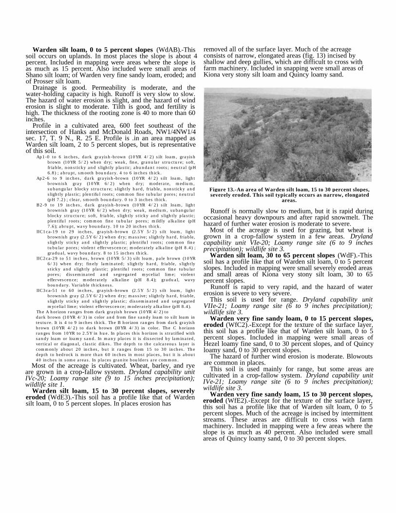
Warden silt loam, 0 to 5 percent slopes (WdAB).-Thissoil occurs on uplands. In most places the slope is about 4percent. Included in mapping were areas where the slope isas much as 15 percent. Also included were small areas ofShano silt loam; of Warden very fine sandy loam, eroded; andof Prosser silt loam.
Drainage is good. Permeability is moderate, and thewater-holding capacity is high. Runoff is very slow to slow.The hazard of water erosion is slight, and the hazard of winderosion is slight to moderate. Tilth is good, and fertility ishigh. The thickness of the rooting zone is 40 to more than 60inches.
Profile in a cultivated area, 600 feet southeast of theintersection of Hanks and McDonald Roads, NW1/4NW1/4sec. 17, T. 9 N., R. 25 E. Profile is .in an area mapped asWarden silt loam, 2 to 5 percent slopes, but is representativeof this soil.
Ap1-0 to 6 inches, dark grayish-brown (10YR 4/2) silt loam, grayishbrown (10YR 5/2) when dry; weak, fine, granular structure; soft,friable, nonsticky and slightly plastic; abundant roots; neutral (pH6.8) ; abrupt, smooth boundary. 4 to 6 inches thick.
Ap2-6 to 9 inches, dark grayish-brown (10YR 4/2) silt loam, lightbrownish gray (10YR 6/2) when dry; moderate, medium,subangular blocky structure; slightly hard, friable, nonsticky andslightly plastic; plentiful roots; common fine tubular pores; neutral(pH 7.2) ; clear, smooth boundary. 0 to 3 inches thick.
B2-9 to 19 inches, dark grayish-brown (10YR 4/2) silt loam, lightbrownish gray (10YR 6/2) when dry; weak, medium, subangularblocky structure; soft, friable, slightly sticky and slightly plastic;plentiful roots; common fine tubular pores; mildly alkaline (pH7.6); abrupt, wavy boundary. 10 to 20 inches thick.
IIC1ca-19 to 29 inches, grayish-brown (2.5Y 5/2) silt loam, lightbrownish gray (2.5Y 6/2) when dry; massive; slightly hard, friable,slightly sticky and slightly plastic; plentiful roots; common finetubular pores; violent effervescence; moderately alkaline (pH 8.4) ;gradual, wavy boundary. 8 to 15 inches thick.
IIC2ca-29 to 51 inches, brown (10YR 5/3) silt loam, pale brown (10YR6/3) when dry; finely laminated; slightly hard, friable, slightlysticky and slightly plastic; plentiful roots; common fine tubularpores; disseminated and segregated mycelial lime; violenteffervescence; moderately alkaline (pH 8.4); gradual, wavyboundary. Variable thickness.
IIC3ca-51 to 60 inches, grayish-brown (2.5Y 5/2) silt loam, lightbrownish gray (2.5Y 6/2) when dry; massive; slightly hard, friable,slightly sticky and slightly plastic; disseminated and segregatedmycelial lime; violent effervescence; moderately alkaline (pH 8.4).
The A horizon ranges from dark grayish brown (10YR 4/2) todark brown (10YR 4/3) in color and from fine sandy loam to silt loam intexture. It is 4 to 9 inches thick. The B horizon ranges from dark grayishbrown (10YR 4/2) to dark brown (l0YR 4/3) in color. The C horizonranges from 10YR to 2.5Y in hue. In places this horizon is stratified withsandy loam or loamy sand. In many places it is dissected by laminated,vertical or diagonal, clastic dikes. The depth to the calcareous layer iscommonly about 20 inches, but it ranges from 15 to 30 inches. Thedepth to bedrock is more than 60 inches in most places, but it is about40 inches in some areas. In places granite boulders are common.
Most of the acreage is cultivated. Wheat, barley, and ryeare grown in a crop-fallow system. Dryland capability unitIVc-20; Loamy range site (9 to 15 inches precipitation);wildlife site 1.
Warden silt loam, 15 to 30 percent slopes, severelyeroded (WdE3).-This soil has a profile like that of Wardensilt loam, 0 to 5 percent slopes. In places erosion has
Runoff is normally slow to medium, but it is rapid duringoccasional heavy downpours and after rapid snowmelt. Thehazard of further water erosion is moderate to severe.
Most of the acreage is used for grazing, but wheat isgrown in a crop-fallow system in a few areas. Drylandcapability unit VIe-20; Loamy range site (6 to 9 inchesprecipitation); wildlife site 3.
Warden silt loam, 30 to 65 percent slopes (WdF).-Thissoil has a profile like that of Warden silt loam, 0 to 5 percentslopes. Included in mapping were small severely eroded areasand small areas of Kiona very stony silt loam, 30 to 65percent slopes.
Runoff is rapid to very rapid, and the hazard of watererosion is severe to very severe.
This soil is used for range. Dryland capability unitVIIe-21; Loamy range site (6 to 9 inches precipitation);wildlife site 3.
Warden very fine sandy loam, 0 to 15 percent slopes,eroded (WfC2).-Except for the texture of the surface layer,this soil has a profile like that of Warden silt loam, 0 to 5percent slopes. Included in mapping were small areas ofHezel loamy fine sand, 0 to 30 percent slopes, and of Quincyloamy sand, 0 to 30 percent slopes.
The hazard of further wind erosion is moderate. Blowoutsare common in places.
This soil is used mainly for range, but some areas arecultivated in a crop-fallow system. Dryland capability unitIVe-21; Loamy range site (6 to 9 inches precipitation);wildlife site 3.
Warden very fine sandy loam, 15 to 30 percent slopes,eroded (WfE2).-Except for the texture of the surface layer,this soil has a profile like that of Warden silt loam, 0 to 5percent slopes. Much of the acreage is incised by intermittentstreams. These areas are difficult to cross with farmmachinery. Included in mapping were a few areas where theslope is as much as 40 percent. Also included were smallareas of Quincy loamy sand, 0 to 30 percent slopes.
Figure 13.-An area of Warden silt loam, 15 to 30 percent slopes,severely eroded. This soil typically occurs as narrow, elongated
areas.
removed all of the surface layer. Much of the acreageconsists of narrow, elongated areas (fig. 13) incised byshallow and deep gullies, which are difficult to cross withfarm machinery. Included in snapping were small areas ofKiona very stony silt loam and Quincy loamy sand.
Runoff is normally slow to medium, but it is rapid duringoccasional heavy downpours and after rapid snowmelt,especially if the ground is frozen. The hazard of furthererosion is moderate.
This soil is used for range. Dryland capability unit VIe-20;Loamy range site (6 to 9 inches precipitation); wildlife site 3.
Warden silt loam, 0 to 2 percent slopes. (WdA).-Thissoil has a profile like that of Warden silt loam, 0 to 5 percentslopes. It is generally more than 60 inches deep. Included inmapping were small areas of Shano silt loam, 0 to 2 percentslopes, and a few areas that are strongly affected by salts andalkali.
Suitable crops include asparagus, sugar beets, hops, treefruits, grapes, corn, mint, hay, and pasture. Irrigatedcapability unit, I-1; wildlife site 2.
Warden silt loam, 2 to 5 percent slopes (WdB).-Thissoil has a profile like that of Warden silt loam, 0 to 5 percentslopes. Included in mapping were small areas of Shano siltloam, 2 to 5 percent slopes, and Prosser silt loam, 2 to 5percent slopes.
Runoff is slow. The hazard of water erosion is slight tomoderate. To minimize the erosion hazard, irrigation furrowsand corrugations should be held to a gradient of 2 percent, orelse the runs should be short.
Suitable crops include asparagus, sugar beets, hops, treefruits, grapes, corn, mint, hay, and pasture. Irrigatedcapability unit IIe-2; wildlife site 2.
Warden silt loam, 5 to 8 percent slopes (WdC).-Thissoil has a profile like that of Warden silt loam, 0 to 5 percentslopes. Included in mapping were small areas of Shano siltloam, 5 to 8 percent slopes, and Prosser silt loam, 5 to 15percent slopes. Also included were a few areas that arestrongly affected by salts and alkali.
Runoff is medium. The hazard of water erosion ismoderate.
Suitable crops include tree fruits, grapes, hay, and pasture.Irrigated capability unit IIIe-2; wildlife site 2.
Warden silt loam, 8 to 15 percent slopes (WdD).-Thissoil has a profile like that of Warden silt loam, 0 to 5 percentslopes. Included in mapping were small areas of Wardenvery fine sandy loam, 8 to 15 percent slopes, eroded, andShano silt loam, 8 to 15 percent slopes.
Runoff is rapid, and the hazard of water erosion is severe.In some places wind erosion is a moderate hazard.
Tree fruits, hay, and pasture are suitable crops. Irrigatedcapability unit IVe-2; wildlife site 4.
Warden very fine sandy loam, 0 to 2 percent slopes,eroded (WfA2).-Except for the texture of the surface layer,this soil has a profile like that of Warden silt loam, 0 to 5percent slopes. The coarser texture results from winderosion, which has blown out fine particles from the surfacelayer. Included in mapping were small areas of Hezel loamyfine sand, 0 to 2 percent slopes.
Runoff is very slow. The hazard of further wind erosion ismoderate when the surface is bare. The water-holdingcapacity is high.
Tree fruits, grapes, hay, and pasture are suitable crops.Irrigated capability unit IIe-1; wildlife site 2.
Warden very fine sandy loam, 2 to 8 percent slopes,eroded (WfB2).-Except for the texture of the surface layer,this soil has a profile like that of Warden silt loam,
0 to 5 percent slopes. Included in mapping were small areasof Hezel loamy fine sand, 2 to 15 percent slopes.
Runoff is slow to medium, and the hazard of water erosionis slight to moderate. The hazard of further wind erosion ismoderate when the surface is bare.
Suitable crops include tree fruits, grapes, hay, and pasture.Irrigated capability unit IIIe-1; wildlife site 2.
Warden very fine sandy loam, 8 to 15 percent slopes,eroded (WfD2).-Except for the texture of the surface layer,this soil has a profile like that of Warden silt loam, 0 to 5percent slopes. Included in mapping were small areas ofHezel loamy fine sand, 2 to 15 percent slopes.
Runoff is medium to rapid, and the hazard of water erosionis severe. The hazard of further wind erosion is moderatewhen the surface is bare.
Suitable crops include tree fruits, grapes, hay, and pasture.Irrigated capability unit IVe-1; wildlife site 4.
Willis Series
This series consists of well-drained, shallow andmoderately deep, medium-textured soils on uplands in theRattlesnake Hills and in the Horse Heaven Hills. These soilsdeveloped under bunch grasses in silty, wind-depositedmaterial. They are underlain by a lime-silica hardpan overlyingbasalt bedrock. The slopes are gentle to steep. Elevationsrange from 1,200 to 2,200 feet. The annual precipitation is 8to 12 inches, the mean annual temperature is 48° F., and thefrost-free season is about 140 days. Willis soils aregeographically associated with Ritzville soils.
The surface layer is very dark grayish-brown silt loam 3 to8 inches thick. The subsoil is dark-brown silt loam thatgrades to dark grayish-brown, strongly calcareous silt loam.An indurated lime-silica hardpan occurs at a depth of 15 to 36inches.
These soils are used for range and for wheat in a crop-fallow system.
Willis silt loam, shallow, 0 to 15 percent slopes(WtD).-This soil occurs mainly on broad ridgetops in theRattlesnake Hills. In most places the slope is about 4 percent.The depth to the hardpan is generally less than 20 inches, butincluded in mapping were small areas where the hardpan is ata depth of 20 to 36 inches. Also included were small areas ofvery fine sandy loam and areas of Rock outcrop.
Drainage is good. Permeability is moderate, and thewater-holding capacity is low. Runoff is very slow to slow.The hazard of wind and water erosion is slight to moderate.The effective rooting depth is less than 20 inches. Fertility islow to medium.
Representative profile in an area of native grasses, 50 feetwest of Jones Road and 1 1/4 miles north of Anderson Road,SE1/4SE1/4 sec. 16, T. 10 N., R. 24 E.
A-0 to 3 inches, very dark grayish-brown (10YR 3/2) silt loam, grayishbrown (10YR 5/2) when dry; weak, fine, granular structure andweak, thin, platy; soft, friable, nonsticky and slightly plastic;abundant roots; neutral (pH 7.0) ; abrupt, wavy boundary. 3 to 8inches thick.
B-3 to 10 inches, dark-brown (10YR 3/3) silt loam, brown (10YR 5/3)when dry; weak, coarse, prismatic structure; slightly hard, friable,slightly sticky and slightly plastic; plentiful roots; common finepores; mildly alkaline (pH 7.6); abrupt, wavy boundary. 5 to 20inches thick.
C1ca-10 to 18 inches, dark grayish-brown (10YR 4/2) silt loam, lightbrownish gray (10YR 6/2) when dry; massive; soft, friable, slightlysticky and slightly plastic; plentiful roots; few fine pores; violenteffervescence; moderately alkaline (pH 8.3); abrupt, wavyboundary. 3 to 12 inches thick.
IIC2casim-18 inches, indurated, lime-silica cemented hardpan,underlain by basalt bedrock.
The B horizon is less distinct in areas where the hardpan is closer tothe surface. In places small fragments of the hardpan are scatteredthroughout the profile. The hardpan is generally underlain by basaltbedrock, but in places it is underlain by gravel.
This soil is used mainly for range. Dryland capability unitVI-20; Shallow range site (9 to 15 inches precipitation);wildlife site 7.
Willis silt loam, 0 to 5 percent slopes (WsB).-This soilis moderately deep, but the profile is otherwise like that ofWillis silt loam, shallow, 0 to 15 percent slopes.
The water-holding capacity is moderate to moderatelyhigh. The effective rooting depth is 20 to 36 inches. Fertilityis medium to high.
This soil is used mainly for wheat in a crop-fallow system.Dryland capability unit IIIs-20; Loamy range site (9 to 15inches precipitation); wildlife site 7.
Willis silt loam, 30 to 65 percent slopes (WsF).-Exceptfor the slope and the depth, this soil is similar to Willis siltloam, shallow, 0 to 15 percent slopes. Included in mappingwere small areas of a Ritzville silt loam and of a Willis siltloam, severely eroded, and small rocky or shallow areas.
The water-holding capacity is moderate to moderatelyhigh. The effective rooting depth is 20 to 36 inches. Fertilityis medium to high. Runoff is rapid, and the hazard of erosionis very severe.
This soil is used for grazing. Dryland capability unitVIIe-21; Loamy range site (9 to 15 inches precipitation);wildlife site 7.
Willis silt loam, 15 to 30 percent slopes, severelyeroded (WsE3).-In places this soil has lost all of the surfacelayer through erosion, but the profile is otherwise like that ofWillis silt loam, shallow, 0 to 15 percent slopes. Much of theacreage consists of narrow, elongated areas incised by gulliesthat are not easy to cross with farm machinery. Included inmapping were small areas of Ritzville silt loam, severelyeroded, and small rocky or shallow areas.
Runoff is normally slow to medium, but it is rapid duringoccasional heavy downpours and after rapid snowmelt. Thehazard of further water erosion is moderate to severe.
Most of the acreage is used for grazing, but wheat isgrown in a crop-fallow system in a few areas. Drylandcapability unit VIe-20; Shallow range site (9 to 15 inchesprecipitation), wildlife site 7.
Formation and Classification ofthe Soils
This section tells how soil-forming factors have affectedformation of the soils of the Benton County Area. It showsthe classification of the soils according to both the systemused before 1965 and the current system and de-
scribes each of the great soil groups represented in the Area.
Factors of Soil Formation
Soils differ in fertility, physical and chemical properties,and productivity because they are the product of theinteraction of several soil-forming factors. These factors are:(1) the physical and mineralogical composition of the parentmaterial; (2) the climate under which the soil materialaccumulated and has existed since accumulation; (3) relief, orlay of the land; (4) the vegetation; and (5) the length of timethese forces have been active. The soil-forming factors, asthey affect the soils of the Benton County Area, are describedin the following paragraphs.
Parent materialThe soils of this Area formed in five distinct kinds of
parent material of mixed mineralogy: recent alluvium, oldalluvium (basically glacial outwash), eolian sands, lacustrinedeposits, and loess. Basalt bedrock underlies all thesedeposits. The basalt is of multiple flows and undeterminedthickness; in the Rattlesnake Hills, oil drills have reached adepth of twelve thousand feet without clearing basalt.
In places the soils are underlain by a hardpan cementedwith lime or lime and silica. The origin of the hardpan isunknown. The pan generally appears to be unrelated to thepresent-day soils. One theory is that the pan formed along theedges of old lakes before deposition of the material in whichthe present-day soils formed. Another is that the pan resultedfrom soil-forming processes acting on soil material that wassubsequently eroded away. The hardpan has been thickenedin places by the addition of lime and silica from present-daysoil material. In the drier parts of the Area, parent material hashad more influence on soil formation than other factors.
Soils that formed in lacustrine deposits are particularlyinteresting in this Area, where loessal soils are so extensive.The lacustrine sediments are part of the Touchet Beds. Soilsof the Warden series formed in this material. Their subsoilconsists of weakly stratified sediments that have beenreworked to the extent that they are discontinuous.
In many places the sediments are dissected by vertical anddiagonal elastic dikes (fig. 14). The dikes apparently formedwhen wet sediments, under pressure from below, wereforced upward through cracks in the drier sediments near thesurface or when material was deposited in cracks fromabove.
Another peculiarity of the soils that formed in lacustrinedeposits is that ice-transported granite boulders occursporadically (fig. 15).
ClimateThis Area lies within the rain shadow of the Cascade
Mountains. The annual precipitation ranges fromapproximately 6 inches at a 500-foot elevation toapproximately 15 inches at an elevation of 3,500 feet. At theProsser Irrigation Experiment Station, elevation 840 feet, theaverage annual precipitation is 7.51 inches, and the averagetotal evaporation from April to October, inclusive, is 36.93inches (14).
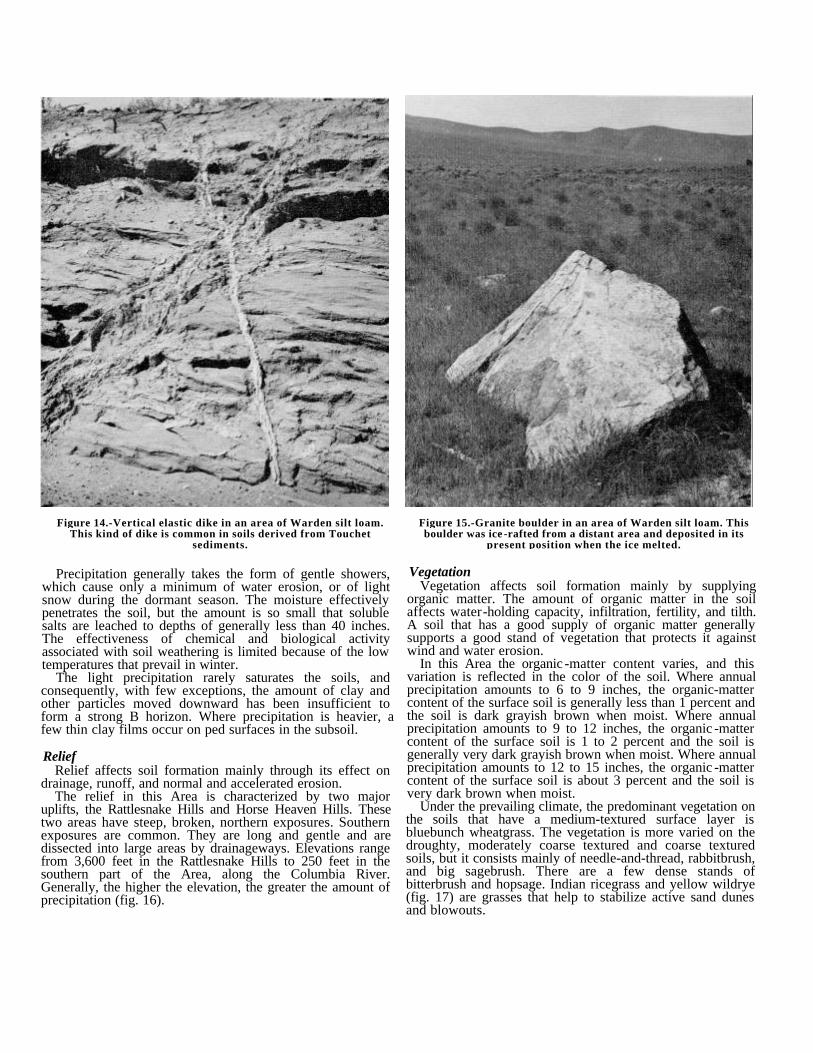
Figure 14.-Vertical elastic dike in an area of Warden silt loam.This kind of dike is common in soils derived from Touchet
sediments.
Figure 15.-Granite boulder in an area of Warden silt loam. Thisboulder was ice -rafted from a distant area and deposited in its
present position when the ice melted.
Precipitation generally takes the form of gentle showers,which cause only a minimum of water erosion, or of lightsnow during the dormant season. The moisture effectivelypenetrates the soil, but the amount is so small that solublesalts are leached to depths of generally less than 40 inches.The effectiveness of chemical and biological activityassociated with soil weathering is limited because of the lowtemperatures that prevail in winter.
The light precipitation rarely saturates the soils, andconsequently, with few exceptions, the amount of clay andother particles moved downward has been insufficient toform a strong B horizon. Where precipitation is heavier, afew thin clay films occur on ped surfaces in the subsoil.
ReliefRelief affects soil formation mainly through its effect on
drainage, runoff, and normal and accelerated erosion.The relief in this Area is characterized by two major
uplifts, the Rattlesnake Hills and Horse Heaven Hills. Thesetwo areas have steep, broken, northern exposures. Southernexposures are common. They are long and gentle and aredissected into large areas by drainageways. Elevations rangefrom 3,600 feet in the Rattlesnake Hills to 250 feet in thesouthern part of the Area, along the Columbia River.Generally, the higher the elevation, the greater the amount ofprecipitation (fig. 16).
VegetationVegetation affects soil formation mainly by supplying
organic matter. The amount of organic matter in the soilaffects water-holding capacity, infiltration, fertility, and tilth.A soil that has a good supply of organic matter generallysupports a good stand of vegetation that protects it againstwind and water erosion.
In this Area the organic -matter content varies, and thisvariation is reflected in the color of the soil. Where annualprecipitation amounts to 6 to 9 inches, the organic-mattercontent of the surface soil is generally less than 1 percent andthe soil is dark grayish brown when moist. Where annualprecipitation amounts to 9 to 12 inches, the organic -mattercontent of the surface soil is 1 to 2 percent and the soil isgenerally very dark grayish brown when moist. Where annualprecipitation amounts to 12 to 15 inches, the organic -mattercontent of the surface soil is about 3 percent and the soil isvery dark brown when moist.
Under the prevailing climate, the predominant vegetation onthe soils that have a medium-textured surface layer isbluebunch wheatgrass. The vegetation is more varied on thedroughty, moderately coarse textured and coarse texturedsoils, but it consists mainly of needle-and-thread, rabbitbrush,and big sagebrush. There are a few dense stands ofbitterbrush and hopsage. Indian ricegrass and yellow wildrye(fig. 17) are grasses that help to stabilize active sand dunesand blowouts.
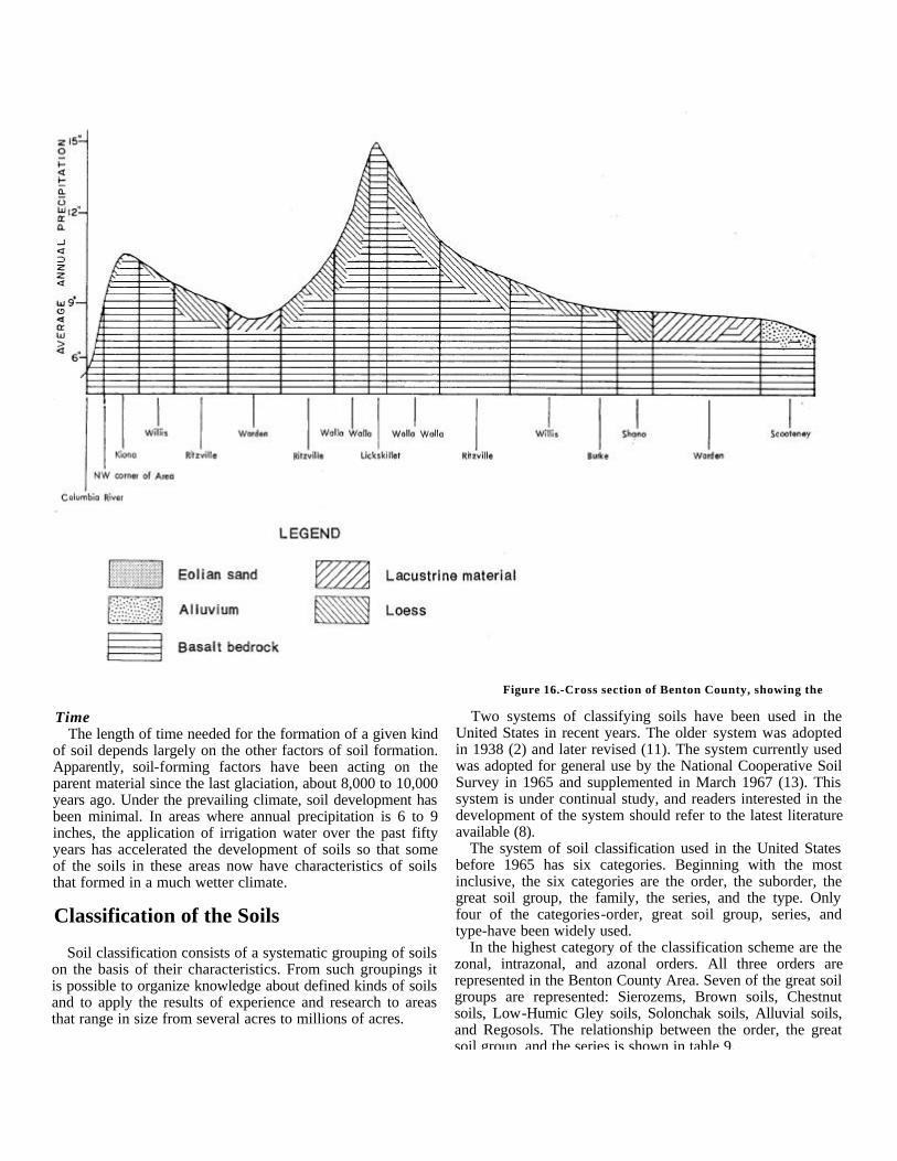
Figure 16.-Cross section of Benton County, showing the
TimeThe length of time needed for the formation of a given kind
of soil depends largely on the other factors of soil formation.Apparently, soil-forming factors have been acting on theparent material since the last glaciation, about 8,000 to 10,000years ago. Under the prevailing climate, soil development hasbeen minimal. In areas where annual precipitation is 6 to 9inches, the application of irrigation water over the past fiftyyears has accelerated the development of soils so that someof the soils in these areas now have characteristics of soilsthat formed in a much wetter climate.
Classification of the Soils
Soil classification consists of a systematic grouping of soilson the basis of their characteristics. From such groupings itis possible to organize knowledge about defined kinds of soilsand to apply the results of experience and research to areasthat range in size from several acres to millions of acres.
Two systems of classifying soils have been used in theUnited States in recent years. The older system was adoptedin 1938 (2) and later revised (11). The system currently usedwas adopted for general use by the National Cooperative SoilSurvey in 1965 and supplemented in March 1967 (13). Thissystem is under continual study, and readers interested in thedevelopment of the system should refer to the latest literatureavailable (8).
The system of soil classification used in the United Statesbefore 1965 has six categories. Beginning with the mostinclusive, the six categories are the order, the suborder, thegreat soil group, the family, the series, and the type. Onlyfour of the categories-order, great soil group, series, andtype-have been widely used.
In the highest category of the classification scheme are thezonal, intrazonal, and azonal orders. All three orders arerepresented in the Benton County Area. Seven of the great soilgroups are represented: Sierozems, Brown soils, Chestnutsoils, Low-Humic Gley soils, Solonchak soils, Alluvial soils,and Regosols. The relationship between the order, the greatsoil group, and the series is shown in table 9.
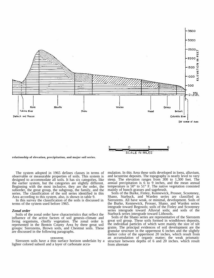
relationship of elevation, precipitation, and major soil series.
The system adopted in 1965 defines classes in terms ofobservable or measurable properties of soils. This system isdesigned to accommodate all soils. It has six categories, likethe earlier system, but the categories are slightly different.Beginning with the most inclusive, they are the order, thesuborder, the great group, the subgroup, the family, and theseries. The classification of the soil series identified in thisArea according to this system, also, is shown in table 9.
In this survey the classification of the soils is discussed interms of the system used before 1965.
Zonal orderSoils of the zonal order have characteristics that reflect the
influence of the active factors of soil genesis-climate andliving organisms, chiefly vegetation. The zonal order isrepresented in the Benton County Area by three great soilgroups: Sierozems, Brown soils, and Chestnut soils. Theseare discussed in the following paragraphs.
SIEROZEMSSierozem soils have a thin surface horizon underlain by a
lighter colored subsoil and a layer of carbonate accu-
mulation. In this Area these soils developed in loess, alluvium,and lacustrine deposits. The topography is nearly level to verysteep. The elevation ranges from 300 to 1,300 feet. Theannual precipitation is 6 to 9 inches, and the mean annualtemperature is 50° to 51° F. The native vegetation consistedmainly of bunch grasses and sagebrush.
Soils of the Burke, Finley, Kennewick, Prosser, Scooteney,Shano, Starbuck, and Warden series are classified asSierozems. All have weak, or minimal, development. Soils ofthe Burke, Kennewick, Prosser, Shano, and Warden seriesintegrade toward Regosols; soils of the Finley and Scooteneyseries intergrade toward Alluvial soils; and soils of theStarbuck series intergrade toward Lithosols.
Soils of the Shano series are representative of the Sierozemgreat soil group. These soils formed in windblown deposits,the individual particles of which were mainly the size of siltgrains. The principal evidences of soil development are thegranular structure in the uppermost 6 inches and the slightlydarker color of the uppermost 20 inches, which result froman accumulation of organic matter; the weak prismaticstructure between depths of 6 and 20 inches. which resultfrom alternate
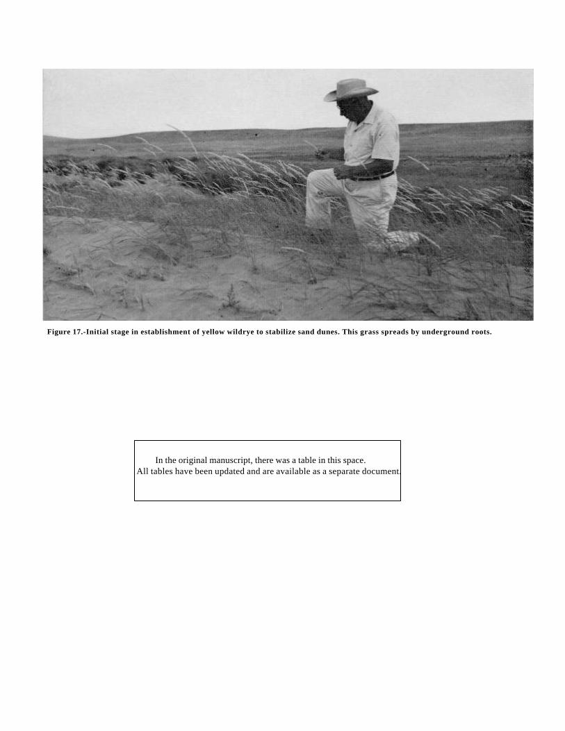
Figure 17.-Initial stage in establishment of yellow wildrye to stabilize sand dunes. This grass spreads by underground roots.
In the original manuscript, there was a table in this space.All tables have been updated and are available as a separate document.
shrinking and swelling of the soil material; and the layer ofcarbonate accumulation below a depth of 28 inches. Theparticle-size distribution is nearly uniform throughout theprofile. This uniformity indicates that the weathering of silt toclay and the downward movement of clay have been slight.
BROWN SOILSBrown soils have a surface layer slightly thicker and darker
than that of Sierozems. The surface layer is underlain by alighter colored subsoil and a layer of carbonate accumulation.In this Area these soils developed mainly in loess or lacustrinesediments. The topography is nearly level to very steep. Theelevation ranges from 800 to 2,500 feet. The annualprecipitation is 9 to 12 inches, except on Kiona soils, where itis as little as 7 inches. The mean annual temperature is 48° to50° F. The native vegetation consisted mainly of bunchgrasses and sagebrush. Soils of the Ellisforde, Kiona,Ritzville, and Willis series are classified as Brown soils. Allhave weak, or minimal, development and intergrade towardRegosols.
Soils of the Ritzville series are representative of the Browngreat soil group. These soils formed in silty, windblowndeposits. Their surface layer is slightly darker colored andcontains slightly more organic matter than that of Shanosoils, which are members of the Sierozem great soil group.In addition, lime has been more deeply leached than in theShano soils. These differences in properties reflect mainly thedifferences in the amount of precipitation and in the amountand kind of vegetation under which the soils formed.
CHESTNUT SOILSChestnut soils have a dark-colored surface layer, a lighter
colored subsoil, and a layer of carbonate accumulation. Inthis Area these soils developed mainly in silty, windblowndeposits or in windblown deposits mixed with basaltresiduum. The topography is nearly level to very steep. Theelevation ranges from 2,200 to 3,500 feet. The annualprecipitation is 11 to 15 inches. The mean annual temperatureis 47° to 48° F. The native vegetation consisted mainly ofbunch grasses. Soils of the Endicott, Lickskillet, and WallaWalla series are classified as Chestnut soils. All have weak,minimal development. Soils of the Endicott and Walla Wallaseries intergrade toward Regosols, and soils of the Lickskilletseries intergrade toward Lithosols.
Soils of the Walla Walla series are representative of theChestnut great soil group. They differ from Shano soils, amember of the Sierozem great soil group, and from Ritzvillesoils, a member of the Brown great soil group, mainly incolor and organic -matter content of the surface layer and indepth to lime. These differences in properties reflect mainlythe differences in the amount of precipitation and the amountand kind of vegetation under which the soils formed.
Intrazonal orderSoils of the intrazonal order have characteristics that
reflect the dominant influence of a local factor of relief orparent material over the effects of climate and vegetation.The intrazonal order is represented in the Benton County Areaby two great soil groups: Low-Humic Gley
soils and Solonchak soils. These are discussed in thefollowing paragraphs.
LOW-HUMIC GLEY SOILSLow-Humic Gley soils are somewhat poorly drained or
poorly drained. These soils have a thin surface horizon that ismoderately high in organic -matter content. The surfacehorizon is underlain by mottled gray or brown, gleyed,mineral horizons that show a low degree of texturaldifferentiation. In this Area, Low-Humic Gley soils formed inalluvium and in silty, windblown deposits over gravellyalluvium. They occupy nearly level areas and slightdepressions on terraces. The elevation ranges from 675 to775 feet. The annual precipitation is 6 to 8 inches, and themean annual temperature is 50° F. Soils of the Wamba seriesare classified as Low-Humic Gley soils.
In their natural state Wamba soils probably lacked gleyedhorizons and mottles and probably had a lighter coloredsurface layer than they do now. The gleying and the mottlesresult from a deficiency of oxygen during periods when thesoils were saturated, after irrigation was introduced some 50years ago. Organisms that live in the soil obtain some of theiroxygen from iron compounds which, along with organicmatter, are the main coloring agents in soils. With the loss ofoxygen, the iron compounds change from reddish oryellowish to gray or green and become soluble. Some of thesoluble iron has been removed in drainage water. As the soilperiodically dries out, some of the iron reogidizes andbecomes segregated and the bright-colored mottles form.Wamba soils have some free lime in the surface layer becausemore lime has been added in the irrigation water than hasbeen leached away.
SOLONCHAK SOILSSolonchak soils have a high concentration of soluble salts.
These soils are ordinarily light colored and have weakstructure or none at all. They developed under salt-tolerantgrasses or shrubs, mainly in an arid, semiarid, or subhumidclimate. In the Benton County Area, Solonchak soils formedin alluvium on bottom lands. The topography is nearly level.The elevation ranges from 250 to 1,000 feet. The annualprecipitation is 6 to 9 inches. The mean annual temperature is50° F. Soils of the Umapine series are classified as Solonchaksoils.
The principal evidences of soil development are theaccumulation of lime, salts, and alkali throughout the profileand faint mottles below a depth of 3 inches. The parentmaterial probably was nearly neutral, noncalcareous or onlyslightly calcareous, and free or nearly free of soluble salts andalkali. Seepage, which brought in dissolved salts, sodium, andlime from adjacent soils, is responsible for the presentchemical properties of the soils, and periodic saturation hasbrought about the mottling.
Azonal orderSoils of the azonal order lack well-developed profile
characteristics because of their youth, resistant parentmaterial, or relief. The azonal order is represented in theBenton County Area by the Alluvial and Regosol great soilgroups. These are discussed in the following paragraphs.
ALLUVIAL SOILSAlluvial soils develop in water-transported, recently
deposited material, or alluvium, that has undergone little or nomodification by soil-forming processes. The characteristicsof Alluvial soils depend largely on the nature of the parentmaterial. The Alluvial soils in Benton County formed inmaterial derived mainly from loess and lake sediments. Theyare nearly level to gently sloping. The elevation ranges from250 to 1,400 feet. The annual precipitation is 6 to 12 inches,and the mean annual temperature is 50° to 53° F. The nativevegetation consisted of bunch grasses, sedges, saltgrass, andwillows. Soils of the Esquatzel and Pasco series are classifiedas Alluvial soils.
Soils of the Esquatzel series are representative of theAlluvial great soil group. Evidence of soil development islacking except for the weak structure and slightly darkercolor of the uppermost 11 inches, which is a result of anaccumulation of organic matter. In addition, the higher pHvalue and effervescence in the C horizon indicate that bases,including calcium carbonate, have been leached from theupper layers by rainwater.
REGOSOLSRegosols develop in thick, unconsolidated rock material or
soft mineral deposits. Few or no clearly expressed horizonshave formed. As is the case with Alluvial soils, thecharacteristics of Regosols depend largely on the nature ofthe parent material. The Regosols in Benton County formedmainly in windblown sands that are underlain in places bygravelly or stony alluvium, lacustrine sediments, or ahardpan. The slope ranges from nearly level to very steep,and the elevation from 300 to 1,100 feet. The annualprecipitation is 6 to 8 inches, and the mean annualtemperature is 51° to 53° F. The native vegetation consistedmainly of grass and sagebrush. Soils of the Burbank, Hezel,Koehler, and Quincy series are classified as Regosols.
Soils of the Quincy series are representative of the Regosolgreat soil group. The principal evidence of soil developmentis the lower pH value in the uppermost part of the soil. Thisfact indicates that some bases have been removed byleaching and have been replaced by hydrogen. In addition, alayer of lime accumulation begins at a depth of 40 inches.
Additional Facts About the Area
The Benton County Area covers about three-fourths ofBenton County. The northeastern part was excluded from thesurvey. The first inhabitants of this Area were Indians wholived on the banks of the Yakima and Columbia Rivers.Artifacts from this early period can still be found along theriver banks.
In 1805 the Lewis and Clark expedition passed through,and fur traders, trappers, and settlers followed in succeedingyears. The first settler's cabin was built near the mouth ofthe Yakima River in 1863.
Benton County was established by legislative act on March8, 1905, with Prosser as the county seat. The county wascreated from parts of Yakima and Klickitat Counties.
In 1910 the population of Benton County was 7,937. By1960 it had reached 62,070.
Farming
Before 1890 the climate of Benton County was consideredtoo dry for farming. The only settlements were those ofstockmen, who lived near rivers where their stock couldgraze and find water. Large herds of wild horses roamedthroughout the county. Grazing cattle and horses was theprincipal enterprise until after 1900.
In 1892 irrigation canals were constructed on both sides ofthe Yakima River. One canal led to Kennewick, and anotherto Richland. Today, irrigation is an important part of thefarming economy. There are many irrigation districts in theArea where farmers can use irrigation water from the YakimaRiver. There are a few farms where the water comes fromprivately owned wells or directly from the Yakima orColumbia Rivers; at each point of withdrawal the user hasobtained water rights. All irrigation water is of good quality.
In 1959 irrigated crops were harvested from 1,141 farms,covering 55,283 acres. The most common irrigation methodsare by furrow or corrugation. Alfalfa, asparagus, corn,grapes, hops, mint, orchard crops, pasture, peas, potatoes,and sugar beets are the principal irrigated crops.
Dryland farming was begun about 1900 in the HorseHeaven Hills. Wheat and rye were the main crops. The soilwas plowed with a moldboard plow, and the wheat was cutwith wooden combines pulled by 30 to 36 horses. Yields of 6to 10 bushels per acre were considered good. Crop failureswere frequent.
Better equipment and improved moisture-conservationpractices have contributed to better yields of dryland crops.Wheat, barley, and rye are the principal unirrigated crops.
Industry
Industries in the Area are mainly those related to farming.They include facilities for canning, freezing, and storingvegetables, fruits, and juice concentrates; large grainelevators; and manufacturing plants where fertilizer andchemicals for agricultural use are produced.
In addition, hydroelectric power plants on the ColumbiaRiver provide power for industry. Ocean-barge transportationis available through a network of canals and slack-waterroutes created by impounding water behind dams. An almostunlimited supply of natural gas is available through an existingpipeline. Three railroads serve the Area, and there is a goodsystem of highways.
Climate
The climate of the Benton County Area has both marineand continental characteristics. It is influenced by moist airmoving in from the Pacific Ocean and by cold air movingsouthward from Canada. The weather systems are modifiedby the Rocky Mountains to the east and north and by theCascade Mountains to the west.
The summers are hot, and the winters are clear, dry,
By EARL L. PHILLIPS, State climatologist, U. S. Weather Bureau, Seattle.
and cold. Occasional cold snaps late in spring or early in fallcause extensive damage to crops. Tables 10, 11, 12, 13, 14,15, and 16 give data on temperature and precipitation,probability of low temperatures, precipitation means andextremes, evapotranspiration, and evaporation and windmovement.
In summer the afternoon temperature reaches the nineties,and the nighttime temperature falls to about 60° F. In anaverage summer, the temperature exceeds 90° on 50 to 60days and 100° on 8 to 12 days. The relative humidity rangesfrom approximately 50 percent at sunrise to about 25 percentin the afternoon.
In the original manuscript, there was a table in this space.All tables have been updated and are available as a separate document.
In winter the afternoon temperature reaches the thirties,and the nighttime temperature falls to about 20° F. Therelative humidity ranges from approximately 85 percent atnight to about 75 percent in the afternoon. In an averagewinter, the maximum temperature is below freezing on 20 to30 days, and the minimum is below zero
on two to five nights. In some of the colder winters, thetemperature falls below zero on 10 to 20 nights. In January,normally the coldest month, the temperature can be expectedto drop to zero or below on one or more nights in three out often winters, to 10° below zero or lower in two out of tenwinters, and to 20° below zero in one out of ten winters. Onclear, calm nights the minimum temperature in the valleys isfrequently 5° to 10° below that on adjacent hills.Occasionally, a chinook wind brings a rapid rise intemperature.
The lower elevations of Benton County are in the driestpart of eastern Washington. Moist air moving inland from thePacific cools as it rises over the western slopes of theCascade Mountains and becomes warmer and drier as itdescends along the eastern slopes. These weather systemsbring heavy precipitation along the windward slopes, butlighter precipitation along the lee slopes. At the lowerelevations the annual precipitation is 7 or 8 inches; it graduallyincreases to 10 inches or more over Horse Heaven Hills andthe Rattlesnake Hills.
Fall rains begin about the first of October. Precipitationgradually increases late in fall, reaches a peak of 1 to 1 1/4inches each month in winter, then gradually decreases inspring, increases again in June, and then decreases sharply inJuly.
Thunderstorms can be expected on 1 to 3 days each monthfrom March through September. Occasionally, severethunderstorms develop over the ridges and move across thevalleys.
Snowfall in winter usually amounts to 10 to 20 inches. Inabout 1 year in 20, it totals 30 to 40 inches. Snow seldomaccumulates to a depth of more than 6 to 10 inches
In the original manuscript, there was a table in this space.All tables have been updated and are available as a separate document.
In the original manuscript, there was a table inthis space.
All tables have been updated and are available as a separate document.
or stays on the ground longer than 2 to 4 weeks. In unusuallysevere winters snow is on the ground most of the time fromlate in December until early in February. Frost penetrates to adepth of 10 to 15 inches nearly every winter and to a depthof 20 to 30 inches in extremely cold winters.
The following number of days with measurable precitationcan be expected each year: 0.01 of an inch or more on 60 to80 days, 0.10 of an inch or more on 20 to 35 days, and 0.50of an inch or more on 6 to 10 days. Measurable rainfall canbe expected 1 to 2 days each month in summer and 8 to 15days each month in winter.
The percentage of possible sunshine each month rangesfrom 20 to 30 percent in winter; from 50 to 60 percent inspring and fall; and from 80 to 90 percent in summer. Thenumber of clear days each month is less than 5 in winter butmore than 20 in summer. There is considerable fog andcloudiness in winter. Heavy fog can be expected on five toten nights each month.
Techniques developed by Palmer-Havens for application ofthe Thornthwaite method (1948) (10) were used in arriving atthe estimates of potential evapotranspiration shown in table15. Evapotranspiration is the combined loss of moisture byevaporation from the soil and by transpiration through theleaves and stems of plants. Potential evapotranspiration is anestimate of the amount of moisture that will be lost from asoil that has a good cover of growing, grasslike plants. Actualevapotranspiration is the actual amount. of moisture lost; it isusually the same as annual precipitation, less any runoff thatmay occur. Actual evapotranspiration cannot exceed potentialevapotranspiration.
The prevailing winds are from the west and northwest, butthe strongest are from the southwest. The average velocityfor a month ranges from approximately 6 miles per hour inwinter to 9 miles per hour in summer. In winter there is verylittle diurnal variation in windspeed, but in summer there is anoticeable increase in wind velocity late in the afternoon. At30 feet above the ground wind velocities can be expected toreach 50 miles per hour at least once in 2 years, 60 to 75miles per hour once in 50 years, and 80 miles per hour oncein 100 years.
Literature Cited
(1) AMERICAN ASSOCIATION OF STATE HIGHWAY OFFICIALS.1961. STANDARD SPECIFICATIONS FOR HIGHWAY MATERIALS AND METHODS
OF SAMPLING AND TESTING. Ed. 8, 2 v., illus.(2) BALDWIN, M., KELLOGG, C. E., and THORP, J.
1938. SOIL CLASSIFICATION. U.S. Dept. of Agr. Ybk.: 948-1001.(3) BROOKS, S. N., HORNER, C. E., and LIKENS, S. T.
[n.d.] HOP PRODUCTION. Agricultural Research Service, U.S.D.A. Agr. Inform. Bul. 240.(4) CRIDER, FRANKLIN J.
1955. ROOT-GROWTH STOPPAGE RESULTING FROM DEFOLIATION OF GRASS.U.S.D.A. Tech. Bul. 1102, 23 pp., illus.
(5) HEINEMANN, W. W. and VAN KEUREN, R. W.1958. FATTENING STEERS ON IRRIGATED PASTURES. Washington Agricultural
Experiment Station Bul. 578, Olympia.(6) LILL, J. G.
1946. SUGAR BEET CULTURE IN THE NORTH-CENTRAL STATES. AgriculturalResearch Service, Farmers Bul. 2060.
(7) PORTLAND CEMENT ASSOCIATION.1956. PcA SOIL PRIMER. 86 pp., illus. Chicago, Ill.
(8) SIMONSON, ROY W.1962. SOIL CLASSIFICATION IN THE UNITED STATES. Science, v. 137, No. 3535, pp.
1027-1034.(9) SNYDER, J. C. and BRANNON, D. H.
1961. GROWING GRAPES IN WASHINGTON. Extension Bul. 271.(10) THORNTHWAITE, C. W., and MATHER, J. R.
1955. THE WATER BALANCE. Drexel Inst. of Tech., Published in Climatology, v. 8, No. 1,104 pp., illus.
(11) THORP, JAMES, and SMITH, GUY D.1949. HIGHER CATEGORIES OF SOIL CLASSIFICATION: ORDER, SUBORDER, AND
GREAT SOIL GROUPS. Soil Sci. 67: 117-126.(12) UNITED STATES DEPARTMENT OF AGRICULTURE.
1951. SOIL SURVEY MANUAL. U.S.D.A. Handbook 18, 503 pp., illus.(13)___
1960. SOIL CLASSIFICATION, A COMPREHENSIVE SYSTEM, 7THAPPROXIMATION. 265 pp., illus. [Supplement issued in March 1967]
(14) WASHINGTON AGRICULTURAL EXPERIMENT STATION.[N.D.] DATA ON WEATHER FROM 1924 TO 1957 AT THE IRRIGATION
EXPERIMENT STATION NEAR PROSSER, WASHINGTON. Bul. 593.(15) WATERWAYS EXPERIMENT STATION, CORPS OF ENGINEERS, U.S. ARMY.
1953. THE UNIFIED SOIL CLASSIFICATION SYSTEM. Tech. Memo. 3-357, 2 v., illus.Vicksburg, Miss. [Revised June 1957]
Glossary
Aggregate, soil. Many fine particles held in a single mass or cluster. Naturalsoil aggregates such as crumbs, blocks, or prisms, are called peds.Clods are aggregates produced by tillage or logging.
Alkali soil. Generally, a highly alkaline soil. Specifically, an alkali soil hasso high a degree of alkalinity (pH 8.5 or higher) or so high a percentageof exchangeable sodium (15 percent or more of the total exchangeablebases), or both, that the growth of most crop plants is low from thiscause.
Alluvium. Soil material, such as sand, silt, or clay, that has been depositedon land by streams.
Available water capacity . The capacity of a soil to hold water in a formavailable to plants. Amount of moisture held in soil between fieldcapacity, or about one-third atmosphere of tension, and the wiltingcoefficient, or about 15 atmospheres of tension. The ratings are low, lessthan 3.75 inches; moderate, 3.75 to 5 inches; moderately high, 5 to 7.5inches; high, more than 7.5 inches. Soils of low capacity requirefrequent but light irrigations, using a large head of irrigation water andshort runs. Soils of high capacity can be irrigated less frequently withlarge quantities of water, using a smaller head and longer runs.
Blowout. An area from which soil material has been removed by wind. Suchan area appears as a nearly barren, shallow depression with a fiat orirregular floor consisting of a resistant layer, an accumulation ofpebbles, or wet soil lying just above a water table.
Bottom land. Low land formed by alluvial deposits along a river; a floodplain.
Calcareous soil. A soil containing enough calcium carbonate to effervesce(fizz) visibly when treated with cold, dilute hydrochloric acid.
Clay . As a soil separate, the mineral soil particles less than 0.002 millimeterin diameter. As a soil textural class, soil material that is 40 percent ormore clay, less than 45 percent sand, and less than 40 percent silt.
Consistence, soil. The feel of the soil and the ease with which a lump can becrushed by the fingers. Terms commonly used to describe consistenceare-
Loose.-Noncoherent when dry or moist; does not hold together in a mass.Friable.-When moist, crushes easily under gentle pressure between thumb
and forefinger and can be pressed together into a lump.Firm.-When moist, crushes under moderate pressure between thumb and
forefinger, but resistance is distinctly noticeable.
Plastic.-When wet, readily deformed by moderate pressure but can bepressed into a lump; will form a "wire" when rolled between thumband forefinger.
Sticky .-When wet, adheres to other material and tends to stretch somewhatand pull apart, rather than to pull free from other material.
Hard.-When dry, moderately resistant to pressure; can be broken withdifficulty between thumb and forefinger.
Soft.-When dry, breaks into powder or individual grains under very slightpressure.
Cemented.-Hard and brittle; little affected by moistening.Contour farming . Following the contour of the land in plowing, planting,
and cultivating.Cover crop. A close-growing crop grown primarily to improve and to protect
the soil between periods of regular crop production; or a crop grownbetween trees and vines in orchards and vineyards.
Depth, soil. Effective depth to which plant roots can readily penetrate withoutbeing inhibited by a layer of hardened lime, a claypan, gravel, stones,or bedrock. In this survey the depth classes are (1) very shallow, 0 to10 inches; (2) shallow, 10 to 20 inches; (3) moderately deep, 20 to 36inches; and (4) deep, 36 to 60 inches or more.
Drainage class. The relative terms used to describe natural drainage areexplained as follows
Excessively drained soils are commonly very porous and rapidlypermeable, and have low water-holding capacity.
Somewhat excessively drained soils are rapidly permeable and are freefrom mottling throughout the profile.
Well-drained soils are nearly free of mottling and are commonly ofmoderately coarse to moderately fine texture.
Moderately well drained soils commonly have a slowly permeable layer inor immediately beneath the solum. They have uniform color in the Ahorizon and the upper part of the B horizon and mottling in the lowerpart of the B horizon and in the C horizon.
Somewhat poorly drained soils are wet for significant periods but not allthe time. They commonly have a slowly permeable layer in the profile,a high water table, or they receive seepage.
Poorly drained soils are wet for long periods of time. Most of these soilsare light gray and are generally mottled from the surface downward.
Very poorly drained soils are wet nearly all the time. They generally have adark-gray or black surface layer and are gray or light gray, with orwithout mottling, in the deeper part.
Dryfarming . Producing crops that require some tillage in a semiarid regionwithout irrigation. The system usually requires periods of fallow betweencrops, and during these periods water from precipitation is absorbedand stored in the soil.
Erosion. The wearing away of the land surface by wind (sandblast), runningwater, and other geological agents.
Erosion hazard. Susceptibility to wind or water erosion. The terms used inthis survey are slight, moderate, severe and very severe. These termsare relative and apply only in relation to other soils of the DentonCounty Area.
Fallow . Cropland left idle in order to restore productivity, mainly throughaccumulation of water, nutrients, or both. The soil is tilled but notplanted for at least one growing season to control weeds, to aiddecomposition of plant residue, and to encourage the storage ofmoisture for the succeeding grain crop.
Fertility, soil. The quality of a soil that enables it to provide compounds, inadequate amounts and in proper balance, for the growth of specifiedplants, when other growth factors such as light, moisture, temperature,and the physical condition of the soil are favorable.
Green-manure crop. Any crop grown and plowed under to improve the soil bythe addition of organic matter.
Head, irrigation. The difference in elevation of the irrigation water supply;therefore, the pressure at the point of discharge.
Horizon, soil. A layer of soil, approximately parallel to the surface that hasdistinct characteristics produced by soil-forming processes. These arethe major horizons
0 horizon.-The layer of organic matter on the surface of a mineral soil. Thislayer consists of decaying plant residues.
A horizon.-The mineral horizon at the surface or just below an O horizon.This horizon is the one in which living organisms are most active andtherefore is marked by the accu-
mulation of humus. The horizon may have lost one or more of solublesalts, clay, and sesquioxides (iron and aluminum oxides).
B horizon.-The mineral horizon below an A horizon. The B horizon is in parta layer of change from the overlying A to the underlying C horizon.The B horizon also has distinctive characteristics caused (1) byaccumulation of clay, sesquioxides, humus or some combination ofthese; (2) by prismatic or blocky structure; (3) by redder or strongercolors than the A horizon; or (4) by some combination of these.Combined A and B horizons are usually called the solum, or true soil.If a soil lacks a B horizon, the A horizon alone is the solum.
C horizon.-The weathered rock material immediately beneath the solum. Inmost soils this material is presumed to be like that from which theoverlying horizons were formed. If the material is known to bedifferent from that in the solum, a Roman numeral precedes the letterC.
R layer.-Consolidated rock beneath the soil. The rock usually underlies aC horizon but may be immediately beneath an A or B horizon.
Irrigation. The artificial application of water to soils to assist in theproduction of crops. The common methods of irrigation are these:
Border. Water is applied at the upper end of a strip in which the lateralflow of water is controlled by small earth ridges called border dikes,or borders.
Corrugation. Water is applied to small, closely spaced furrows or ditchesin fields of close-growing crops or in orchards to confine the flow ofwater -to one direction.
Controlled flooding. Water is released at intervals from closely spaced fieldditches and distributed uniformly over the field.
Furrow. Water is applied in small ditches made by cultivation implementsused for tree and row crops.
Sprinkler. Water is sprayed over the soil surface through pipes or nozzlesfrom a pressure system.
Subirrigation. Water is applied in open ditches or tile lines until the watertable is raised enough to wet the soil.
Lacustrine deposits (geology). Material deposited in lake water and exposedby lowering of the water level or by elevation of the lakebed.
Loess. Fine-grained, windblown deposits, mainly of silt-sized particles.Mottled. Irregularly marked with spots of different colors that vary in number
and size. Mottling in soils usually indicates poor aeration and lack ofdrainage. Descriptive terms are as follows: Abundance-few, common,,and many; size-fine, medium, and coarse; and contrast -faint, distinct,and prominent. The size measurements are these: fine, less than 5millimeters (about 0.2 inch) in diameter along the greatest dimension;medium, ranging from 5 millimeters to 15 millimeters (about 0.2 to 0.6inch) in diameter along the greatest dimension; and coarse, more than15 millimeters (about 0.6 inch) in diameter along the greatestdimension.
Permeability . The quality of a soil horizon that enables water or air to movethrough it. Terms used to describe permeability are as follows: veryslow, slow, moderately slow, moderate, moderately rapid, rapid, andvery rapid.
Profile, soil. A vertical section of the soil through all its horizons andextending into the parent material.
Reaction, soil. The degree of acidity or alkalinity of a soil, expressed in pHvalues. A soil that tests to pH 7.0 is precisely neutral in reactionbecause it is neither acid nor alkaline. An acid, or "sour," soil is one thatgives an acid reaction; an alkaline soil is one that is alkaline in reaction.In words, the degrees of acidity or alkalinity are expressed thus
pH pHExtremely acid-------- Below 4.5 Neutral -----------------6.6 to 7.3Very strongly acid---- 4.5 to 5.0 Mildly alkaline---------7.4 to 7.8Strongly acid---------- 5.1 to 5.5 Moderately alkaline---7.9 to 8.4Medium acid---------- 5.6 to 6.0 Strongly alkaline-------8.5 to 8.0Slightly acid----------- 6.1 to 6.5 Very strongly alkaline-9.1 and
higher
Saline-alkali soil. A soil that contains a harmful concentration of salts andeither a high degree of alkalinity or a large amount of exchangeablesodium, or both.
Sand. Individual rock or mineral fragments in soils having diameters rangingfrom 0.05 to 2.0 millimeters. Most sand grains consist of quartz, butthey may be any mineral composition.
The textural class name of any soil that contains 85 percent or moresand and not more than 10 percent clay.
Silt. Individual mineral particles in a soil that range in diameter from theupper limit of clay (0.002 millimeter) to the lower limit of very fine sand(0.05 millimeter). Soil of the silt textural class is 80 percent or more siltand less than 12 percent clay.
Slope. The incline of the surface of a soil, usually expressed in percentageterms that equal the number of feet of fall per 100 feet of horizontaldistance. In this publication slope is expressed as follows
Nearly level-------------------------------------0 to 2 percent.Gently sloping----------------------------------2 to 5 percent.Moderately sloping----------------------------5 to 8 percent.Strongly sloping-------------------------------8 to 15 percent.Moderately steep------------------------------15 to 30 percent.Steep --------------------------------------------30 to 65 percent.Very steep---------------------------------------65 percent or more.
Structure, soil. The arrangement of primary soil particles into compoundparticles or clusters that are separated from adjoining aggregates andhave properties unlike those of an equal
mass of unaggregated primary soil particles. The principal forms of soilstructure are-platy (laminated), prismatic (vertical axis of aggregateslonger than horizontal), columnar (prisms with rounded tops), blocky(angular or subangular), and granular. Structureless soils are (1) singlegrain. (each grain by itself, as in dune sand) or (2) massive (theparticles adhering together without any regular cleavage, as in manyclaypans and hardpans).
Subsoil. Technically, the B horizon; roughly, the part of the solum belowplow depth.
Subsurface tillage. Tillage with a sweeplike plow or blade that does not turnover the surface cover or incorporate it into the lower part of the surfacesoil.
Surface soil. The soil ordinarily moved in tillage, or its equivalent inuncultivated soil, about 5 to 8 inches in thickness. The plowed layer.
Texture, soil. The relative proportions of sand, silt, and clay particles in amass of soil. The basic textural classes, in order of increasingproportion of fine particles, are sand, loamy sand, sandy loam, loam,silt loam, silt, sandy clay loam, clay loam, silty clay loam, sandy clay,silty clay, and clay. The sand, loamy sand, and sandy loam classes maybe further divided by specifying "coarse," "fine," or "very fine."