Embed Size (px)
Citation preview

6th Grade 2011-2012 World Geography CURRICULUM MAP
Revised, June 11
Social Studies Curriculum Map
Volusia County Schools
WORLD GEOGRAPHY (2103010/NBB and 2103020/NBC)

6th Grade 2011-2012 World Geography CURRICULUM MAP
Revised, June 11
UNDERSTANDING THE CURRICULUM MAPS If you look at the document entitled, “Social Studies Curriculum Mapping – Teaching with a Purpose in Mind,” you will see a chart that shows the basic framework for our curriculum maps. Everything begins with the purpose, the Organizing Principle. The OP is like a thesis statement in an essay. It provides the direction for an essay and lets the reader know what the writer is trying to prove. Similarly, an OP provides direction for a unit of study in a classroom. It lets the student know what you as a teacher are trying to prove. All the concepts, essential questions, skills and vocabulary that you teach should come back to the Organizing Principle in some way. By the end of the unit of instruction, a student should be able to look the Organizing Principle and prove it to you (or perhaps in some instances, disprove it). The words Essential Questions are used in the maps because these are items essential to the coverage area, the things students should absolutely know. The same holds true for the concepts and terms. The skills listed are examples of Social Studies skills that should go on in classrooms regularly and they correspond to the types of skills tested on FCAT, SAT, AP, IB and other assessments. On the back side of the maps, you will find examples of teaching resources and assessment. These are only examples of some of the items you can use to teach the unit. Likewise, the assessment section provides only examples. One thing to keep in mind is that each of our courses are survey-type courses; we cannot possibly teach everything there is to know about geography and history. We are bound to the Sunshine State Standards and have a responsibility to teach the necessary timeline (for instance, in American History teachers should make it to contemporary periods). The maps are designed to help teachers determine areas of coverage and to avoid trying to teaching 34 chapters in a textbook. Instead the maps are designed around the Organizing Principles and teachers are encouraged to use a variety of resources to teach the content and skills. The textbook should be merely one of the resources. The mapping teams have done a great job on the maps but something important to know is the curriculum maps are not static documents, they are dynamic and open to revision. If you have questions or suggestions about specific teaching units please use the reflection pages to note ideas.
Jason Caros Social Studies Curriculum Specialist
Volusia County Schools

6th Grade 2011-2012 World Geography CURRICULUM MAP
Revised, June 11
Social studies curriculum mapping -TEACHING WITH A PURPOSE IN MIND-
Sunshine State Standards
6th Grade 2011-2012 World Geography CURRICULUM MAP
Revised, June 11
WORLD GEOGRAPHY - ORGANIZING PRINCIPLES
1. ELEMENTS OF GEOGRAPHY The geographically informed person understands the elements of geography applied to the world in which we live.
2. CANADA AND THE UNITED STATES - UNITED STATES The United States is a diverse physical and cultural nation that is the world’s leading economic and political power.
3. CANADA AND THE UNITED STATES – CANADA Canada is a vast country affected by its climate and location.
4. LATIN AMERICA Location, migration, and environment have influenced the development of Latin America
5. EUROPE INCLUDING RUSSIA The physical and political geography of Europe have helped lead to the development of many distinct cultures.
6. EAST, SOUTHEAST, AND SOUTH ASIA Asian culture is a cornerstone to civilization shaped by ancient traditions and religions, high population densities, rich natural resources, expanding economies, and deadly natural hazards.
7. SOUTHWEST AND CENTRAL ASIA Two different but related regions bring together diverse people and cultures despite periods of conflict and environmental challenges.
8. AFRICA This region has the world’s fastest growing population while facing challenges involving low standards of living, ethnic rivalries, and diminishing natural resources.
9. OCEANIA AND ANTARCTICA This isolated region located south of the equator is home to unique physical and human systems.

6th Grade 2011-2012 World Geography CURRICULUM MAP
Revised, June 11
ELEMENTS OF GEOGRAPHY ORGANIZING PRINCIPLE 1: The geographically informed person understands the elements of geography applied to the world in which we live.
ESTIMATED # OF WEEKS: 8
PACING: August-October
Concepts
Essential Questions People, Organizations, Terms Benchmark(s)
Understanding the world in spatial terms
1. What tools do geographers use to find location on map? Absolute Location Relative Location Parts of map Atlas Globe
SS.B.1.3.1 SS.B.1.3.2 SS.B.1.3.3 SS.B.1.3.4 SS.B.1.3.5 SS.B.1.3.6 SS.B.2.3.1 SS.B.2.3.2 SS.B.2.3.3 SS.B.2.3.5 SS.B.2.3.6 SS.A.3.3.1 SS.A.3.3.3 SS.D.2.3.1
Understanding the world in spatial terms
2. What are the different types of maps and projections and what are the advantages of each?
Projection Distortion Thematic Maps: Political Physical Vegetation Climate Population Density Economic Activity
Places, Regions, Physical Systems
3. What are the physical characteristics of a place? Elevation Topography Landforms Bodies of Water Environment Climate Vegetation
Places, Regions, Human Systems
4. What are the human characteristics of a place?
Culture Population Resources Government Economics
6th Grade 2011-2012 World Geography CURRICULUM MAP
Revised, June 11
ACTIVITIES (Teaching Resources) ASSESSMENT Geo-Themes Atlas Activities Glencoe Textbook Unit One Resources – TE p. 18A – 18C Chapter One Resources – TE p. 20A – 20D Chapter Two Resources – TE p. 46A – 46D Chapter Three Resources – TE p. 78A – 78D On-Line Map Activities http://illuventicus.org http://www.geographyolympics.com http://www.nationalgeographic.com http://glencoe.mcgraw-hill.com/sites/0078654807/ Reference Atlas – p. RA1-RA30 Geography Handbook – p. 1-15 Video: National Geographic Latitude and Longitude Catalog: Video Teacher Library The World and Its People: Ch. 1 video Readings: Mark Twain’s Following the Equator
Exam Pro test maker CD Rom Map Project – using parts of a map Correctly create a map of your own Make a board game using geography ideas Mind Jogger Video Quiz Chapter 1 resource – assessment Standardized assessment and skills 1: pg. 20B 2: pg. 46B 3: pg. 78B
6th Grade 2011-2012 World Geography CURRICULUM MAP
Revised, June 11
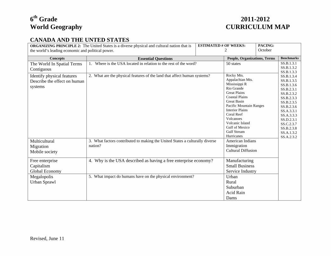
CANADA AND THE UNTED STATES ORGANIZING PRINCIPLE 2: The United States is a diverse physical and cultural nation that is the world’s leading economic and political power.
ESTIMATED # OF WEEKS: 2
PACING: October
Concepts Essential Questions People, Organizations, Terms Benchmarks
The World In Spatial Terms Contiguous
1. Where is the USA located in relation to the rest of the word? 50 states SS.B.1.3.1 SS.B.1.3.2 SS.B.1.3.3 SS.B.1.3.4 SS.B.1.3.5 SS.B.1.3.6 SS.B.2.3.1 SS.B.2.3.2 SS.B.2.3.3 SS.B.2.3.5 SS.B.2.3.6 SS.A.3.3.1 SS.A.3.3.3 SS.D.2.3.1 SS.C.2.3.7 SS.B.2.3.8 SS.A.1.3.2 SS.A.2.3.2
Identify physical features Describe the effect on human systems
2. What are the physical features of the land that affect human systems? Rocky Mts. Appalachian Mts. Mississippi R Rio Grande Great Plains Coastal Plains Great Basin Pacific Mountain Ranges Interior Plains Coral Reef Volcanoes Volcanic Island Gulf of Mexico Gulf Stream Hurricanes
Multicultural Migration Mobile society
3. What factors contributed to making the United States a culturally diverse nation?
American Indians Immigration Cultural Diffusion
Free enterprise Capitalism Global Economy
4. Why is the USA described as having a free enterprise economy? ManufacturingSmall Business Service Industry
Megalopolis Urban Sprawl
5. What impact do humans have on the physical environment? UrbanRural Suburban Acid Rain Dams
6th Grade 2011-2012 World Geography CURRICULUM MAP
Revised, June 11
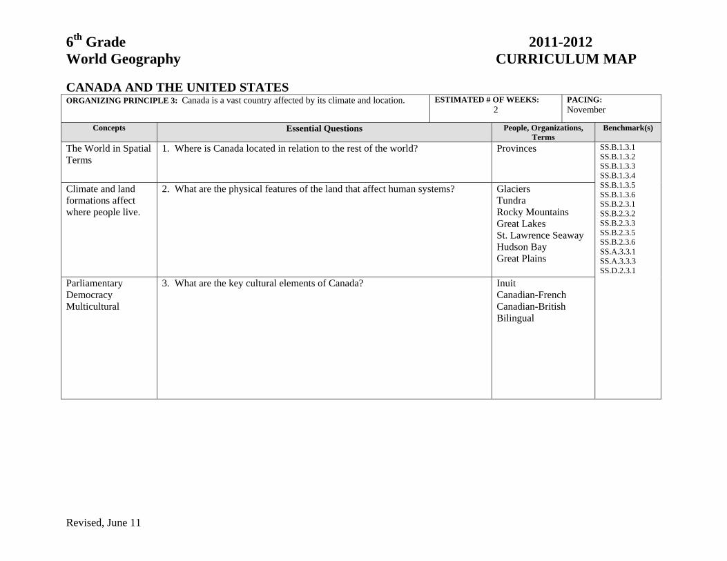
CANADA AND THE UNITED STATES ORGANIZING PRINCIPLE 3: Canada is a vast country affected by its climate and location. ESTIMATED # OF WEEKS:
2 PACING: November
Concepts Essential Questions People, Organizations, Terms
Benchmark(s)
The World in Spatial Terms
1. Where is Canada located in relation to the rest of the world? Provinces
SS.B.1.3.1 SS.B.1.3.2 SS.B.1.3.3 SS.B.1.3.4 SS.B.1.3.5 SS.B.1.3.6 SS.B.2.3.1 SS.B.2.3.2 SS.B.2.3.3 SS.B.2.3.5 SS.B.2.3.6 SS.A.3.3.1 SS.A.3.3.3 SS.D.2.3.1
Climate and land formations affect where people live.
2. What are the physical features of the land that affect human systems? GlaciersTundra Rocky Mountains Great Lakes St. Lawrence Seaway Hudson Bay Great Plains
Parliamentary Democracy Multicultural
3. What are the key cultural elements of Canada?
InuitCanadian-French Canadian-British Bilingual
6th Grade 2011-2012 World Geography CURRICULUM MAP
Revised, June 11
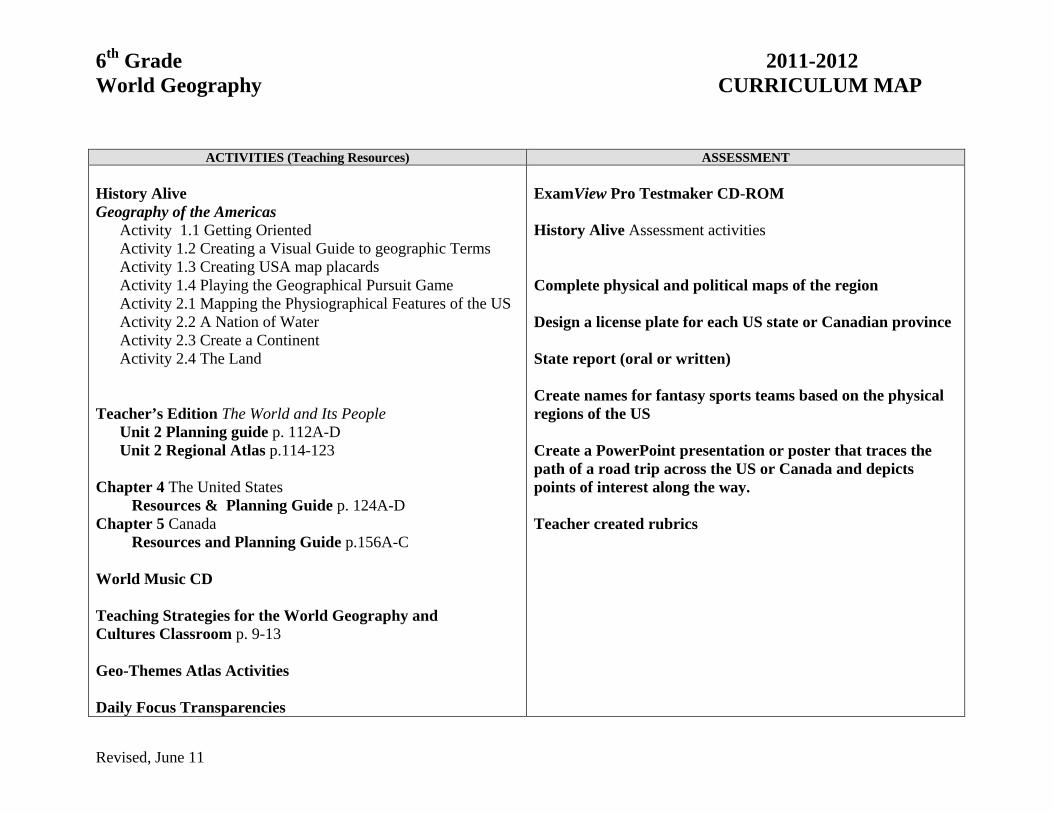
ACTIVITIES (Teaching Resources) ASSESSMENT History Alive Geography of the Americas
Activity 1.1 Getting Oriented Activity 1.2 Creating a Visual Guide to geographic Terms Activity 1.3 Creating USA map placards Activity 1.4 Playing the Geographical Pursuit Game Activity 2.1 Mapping the Physiographical Features of the US Activity 2.2 A Nation of Water Activity 2.3 Create a Continent Activity 2.4 The Land
Teacher’s Edition The World and Its People Unit 2 Planning guide p. 112A-D Unit 2 Regional Atlas p.114-123 Chapter 4 The United States Resources & Planning Guide p. 124A-D Chapter 5 Canada Resources and Planning Guide p.156A-C World Music CD Teaching Strategies for the World Geography and Cultures Classroom p. 9-13 Geo-Themes Atlas Activities Daily Focus Transparencies
ExamView Pro Testmaker CD-ROM History Alive Assessment activities Complete physical and political maps of the region Design a license plate for each US state or Canadian province State report (oral or written) Create names for fantasy sports teams based on the physical regions of the US Create a PowerPoint presentation or poster that traces the path of a road trip across the US or Canada and depicts points of interest along the way. Teacher created rubrics

6th Grade 2011-2012 World Geography CURRICULUM MAP
Revised, June 11
LATIN AMERICA ORGANIZING PRINCIPLE 4: Location, migration, and environment have influenced the development of Latin America
ESTIMATED # OF WEEKS: 4
PACING: November-December
Concepts Essential Questions People, Organizations, Terms
Benchmark(s)
The world in spatial terms
1. Where is Latin America located in relation to the rest of the world? SS.B.1.3.1 SS.B.1.3.2 SS.B.1.3.3 SS.B.1.3.4 SS.B.1.3.5 SS.B.1.3.6 SS.B.2.3.1 SS.B.2.3.2 SS.B.2.3.3 SS.B.2.3.5 SS.B.2.3.6 SS.A.3.3.1 SS.A.3.3.3 SS.D.2.3.1
Mental Mapping 2. What are the major countries that comprise Latin America? Mexico Brazil Venezuela Argentina
Ecosystem Elevations
3. What are the physical features of the land that affect human systems? Andes Mts.Amazon River Rainforest
Urbanization Migration Federal Republic
4. What are the important human features of Latin America? Indigenous culturesGovernment Systems Economic systems
Conservation of Natural Resources
5. How has the natural environment influenced the development of cultures and how have people changed the natural environment?
Deforestation Smog Pollution Acid rain

6th Grade 2011-2012 World Geography CURRICULUM MAP
Revised, June 11
ACTIVITIES (Teaching Resources) ASSESSMENT History Alive Contemporary World Cultures
Latin America World History from 500-1700
Civilization of the Americas Modern World History
Modern Latin America Teacher’s Edition The World and Its People Unit 3 Planning guide p.174A-D Unit 3 Regional Atlas p. 174-187 Chapter 6 Mexico Resources & Planning Guide p.188A-D p. 201 The Aztec Calendar Stone Chapter 8 Brazil and Its Neighbors Resources & Planning Guide p.230A-D p. 235 Amazon Rainforest diorama p. 235 Kayapo Indian Myth pp 250-251 Eye on the Environment: Vanishing Rainforest Video Visits videos (Mexico, Argentina and Brazil) World Music CD Teaching Strategies for the World Geography and Cultures Classroom p. 14-18 Geo-Themes Atlas Activities
ExamView Pro Testmaker CD-ROM History Alive Assessment activities Complete physical and political maps of the region Create a/an :
Mexican mural Amazon Rainforest diorama Foldable to contrast Mexico and Brazil
Letter to government representative to support plans to save the rain forest Use a graphic organizer to analyze the Kayapo Indian Myth on text page 235 Teacher created

6th Grade 2011-2012 World Geography CURRICULUM MAP
Revised, June 11
EUROPE INCLUDING RUSSIA ORGANIZING PRINCIPLE 5: The physical and political geography of Europe have helped lead to the development of many distinct cultures.
ESTIMATED # OF WEEKS: 4
PACING: January – February
Concepts Essential Questions People, Organizations, Terms
Benchmark(s)
The World in Spatial Terms Mental Mapping
1. Where is Europe located in relation to the rest of the world? Arctic Circle SS.B.1.3.1 SS.B.1.3.2 SS.B.1.3.3 SS.B.1.3.4 SS.B.1.3.5 SS.B.1.3.6 SS.B.2.3.1 SS.B.2.3.2 SS.B.2.3.3 SS.B.2.3.5 SS.B.2.3.6 SS.A.3.3.1 SS.A.3.3.3 SS.D.2.3.1 SS.B.2.3.7 SS.B.2.3.9 SS.B.2.3.4 SS.A.2.3.7 SS.A.3.3.2 SS.A.3.3.4 SS.A.2.3.5 SS.A.2.3.2 SS.A.2.3.8 SS.A.3.3.5 SS.C.1.3.2 SS.B.2.3.4 SS.A.2.3.3
Europe: A continent and region
2. What are the major physical features of Europe that affect human systems? Alps English Channel Rhine R, Danube R. Mediterranean Sea Northern European Plain Ural Mts.
The World in Spatial Terms Mental Mapping
3. What are the major regions in Europe? Siberia Southern Europe Eastern Europe Western Europe Scandinavia Baltic States
Government Systems Economic Systems
4. What major political and economic events contributed to the development of various European societies, and describe the characteristics of each?
Monarchy Constitutional monarchy Parliamentary democracy Federal republic Imperialism Renaissance
5. How did religion influence the development of Europe societies? Christianity Judaism Islam
Free Enterprise 6. What are the primary economic activities, and what governmental systems manage those activities?
Coalition governmentEuropean Union, Euro Multinational cooperation
Communism Democracy
7. What economic and cultural changes have occurred in Russia and Eastern Europe since the decline of communism in the early 1990s?
Gorbachev Perestroika Glasnost
6th Grade 2011-2012 World Geography CURRICULUM MAP
Revised, June 11
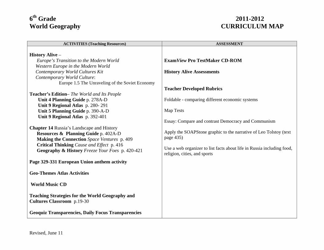
ACTIVITIES (Teaching Resources) ASSESSMENT
History Alive – Europe’s Transition to the Modern World Western Europe in the Modern World Contemporary World Cultures Kit Contemporary World Culture: Europe 1.5 The Unraveling of the Soviet Economy Teacher’s Edition– The World and Its People Unit 4 Planning Guide p. 278A-D Unit 9 Regional Atlas p. 280- 291 Unit 5 Planning Guide p. 390-A-D Unit 9 Regional Atlas p. 392-401 Chapter 14 Russia’s Landscape and History Resources & Planning Guide p. 402A-D Making the Connection Space Ventures p. 409 Critical Thinking Cause and Effect p. 416 Geography & History Freeze Your Foes p. 420-421 Page 329-331 European Union anthem activity Geo-Themes Atlas Activities World Music CD Teaching Strategies for the World Geography and Cultures Classroom p.19-30 Geoquiz Transparencies, Daily Focus Transparencies
ExamView Pro TestMaker CD-ROM History Alive Assessments Teacher Developed Rubrics Foldable - comparing different economic systems Map Tests Essay: Compare and contrast Democracy and Communism Apply the SOAPStone graphic to the narrative of Leo Tolstoy (text page 435) Use a web organizer to list facts about life in Russia including food, religion, cities, and sports

6th Grade 2011-2012 World Geography CURRICULUM MAP
Revised, June 11
EAST, SOUTHEAST, AND SOUTH ASIA ORGANIZING PRINCIPLE 6: Asian culture is a cornerstone to civilization shaped by ancient traditions and religions, high population densities, rich natural resources, expanding economies, and deadly natural hazards.
ESTIMATED # OF WEEKS: 4
PACING: February – March
Concepts Essential Questions People, Organizations, Terms Benchmark(s)
The World in Spatial Terms Mental Mapping Plate Tectonics
1. Where are China, India, and Indonesia located in relation to the rest of the world?
Subcontinent SS.B.1.3.1 SS.B.1.3.2 SS.B.1.3.3 SS.B.1.3.4 SS.B.1.3.5 SS.B.1.3.6 SS.B.2.3.1 SS.B.2.3.2 SS.B.2.3.3 SS.B.2.3.5 SS.B.2.3.6 SS.A.3.3.1 SS.A.3.3.3 SS.D.2.3.1 SS.A.1.3.4 SS.A.2.3.2 SS.A.2.3.5 SS.A.2.3.6 SS.A.2.3.8 SS.A.3.3.5 SS.A.1.3.1 SS.A.3.3.2 SS.A.3.1.4
Physical Systems Ecosystem River Systems Islands
2. What are the physical and human features of the land that affect human systems?
Steppe Yangtze R. Himalaya Mtns Ganges R. Plateau of Tibet Indus R. Gobi Desert Mt. Everest North China Plain Great Wall Three Gorges Dam
Human Systems Dynastic Systems Communism
3. What are the key historic events and people that have influenced this region? Mao Zedong Taj Mahal Gandhi Caste System Dynasty Silk Road
Human Systems Autocracy Communism Free Enterprise
4. How has the changing economy and government impacted the standard of living?
Communism Free Enterprise Tiananmen Square Globalization
Environment & Society Population Density
5. How has high population density influenced the use of natural and human resources?
Terrace farming One-Child Policy
Global Economy 6. What is China’s role in modern society in relation to its neighbors and the rest of the world?
SS.A.2.3.4 SS.B.2.3.8 SS.C.2.3.7
Environment & Society
7. What are the causes and effects of natural disasters that have affected this region?
Tsunami Earthquake Typhoon Monsoon
Human Systems Asian Belief
Systems
8. How have religions influenced people, events, and culture of the region? Hinduism Buddhism Confucianism Daoism Islam

6th Grade 2011-2012 World Geography CURRICULUM MAP
Revised, June 11
ACTIVITIES (Teaching Resources) ASSESSMENT History Alive – Contemporary World Culture: China Ancient World History: Ancient World History Modern World History: Communist China Teacher’s Edition – The World and Its People Unit 8 Planning Guide p. 622A-D Unit 8 Regional Atlas p. 622-635 Chapter 22 South Asia Resources & Planning Guide p. 636A-D Chapter 23 China and Its Neighbors Resources & Planning Guide p. 658A-658D Time Reports p. 671 -677 Geography and History: The Silk Road p. 686 Time Lines p. 676 & 687 Geo Themes Atlas Activity Set Teaching Strategies for the World Geography and Cultures Classroom p. 45-47
ExamView Pro Testmaker CD-ROM K-W-L Chart Current Events Journal TE p. 676 Create a map of the Silk Road p. 687 Create the front page of a newspaper focusing on a topic from the organizing principle. Create a travel brochure about the region Asian Food Fair (w/China) Create a diorama of China’s Regions Create a timeline of the important people, places, and events in China’s or India’s History Create a thematic map of East Asia. Suggestion: Population Density Teacher created rubric to assess projects Essay question analyzing the organizing principle. Assess with FCAT writing rubric.
6th Grade 2011-2012 World Geography CURRICULUM MAP
Revised, June 11
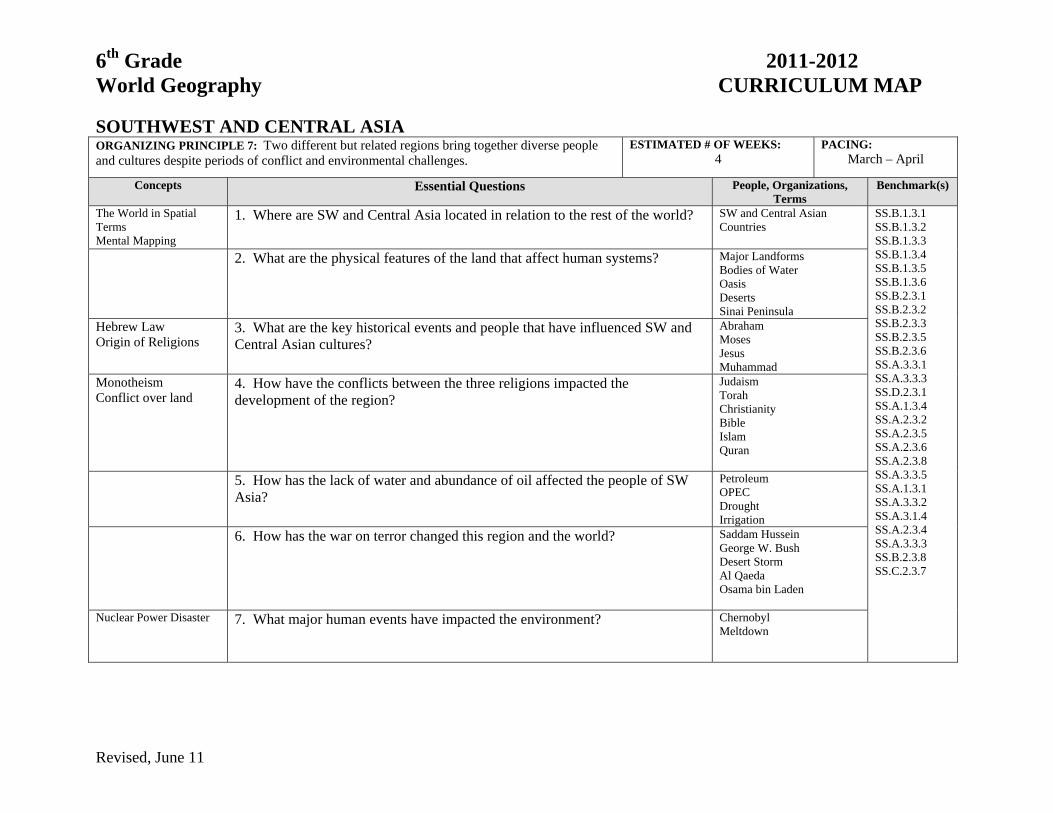
SOUTHWEST AND CENTRAL ASIA ORGANIZING PRINCIPLE 7: Two different but related regions bring together diverse people and cultures despite periods of conflict and environmental challenges.
ESTIMATED # OF WEEKS: 4
PACING: March – April
Concepts Essential Questions People, Organizations, Terms
Benchmark(s)
The World in Spatial Terms Mental Mapping
1. Where are SW and Central Asia located in relation to the rest of the world? SW and Central Asian Countries
SS.B.1.3.1 SS.B.1.3.2 SS.B.1.3.3 SS.B.1.3.4 SS.B.1.3.5 SS.B.1.3.6 SS.B.2.3.1 SS.B.2.3.2 SS.B.2.3.3 SS.B.2.3.5 SS.B.2.3.6 SS.A.3.3.1 SS.A.3.3.3 SS.D.2.3.1 SS.A.1.3.4 SS.A.2.3.2 SS.A.2.3.5 SS.A.2.3.6 SS.A.2.3.8 SS.A.3.3.5 SS.A.1.3.1 SS.A.3.3.2 SS.A.3.1.4 SS.A.2.3.4 SS.A.3.3.3 SS.B.2.3.8 SS.C.2.3.7
2. What are the physical features of the land that affect human systems? Major Landforms Bodies of Water Oasis Deserts Sinai Peninsula
Hebrew Law Origin of Religions
3. What are the key historical events and people that have influenced SW and Central Asian cultures?
Abraham Moses Jesus Muhammad
Monotheism Conflict over land
4. How have the conflicts between the three religions impacted the development of the region?
Judaism Torah Christianity Bible Islam Quran
5. How has the lack of water and abundance of oil affected the people of SW Asia?
Petroleum OPEC Drought Irrigation
6. How has the war on terror changed this region and the world?
Saddam Hussein George W. Bush Desert Storm Al Qaeda Osama bin Laden
Nuclear Power Disaster 7. What major human events have impacted the environment?
Chernobyl Meltdown

6th Grade 2011-2012 World Geography CURRICULUM MAP
Revised, June 11
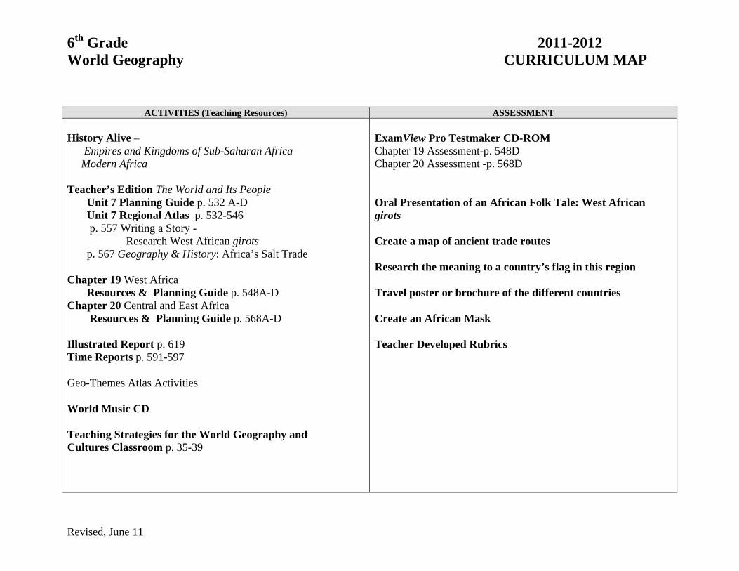
ACTIVITIES (Teaching Resources) ASSESSMENT History Alive Ancient Egypt and the Near East • The Ancient Israelites: In the Land of Canaan • Connecting Past to Present The Rise Of Islam The Modern Middle East Contemporary World Cultures Teacher’s Edition The World and Its People Unit 6 Planning guide p.452A-D Unit 6 Regional Atlas p. 456-463 Chapter 16 Birthplace of Civilization Resources & Planning Guide p.464A-D Chapter 18 Southwest Asia Resources & Planning Guide p.500A-D Chapter 15 The New Russia and Independent Republics (p.436-440) Resources & Planning Guide p. 422A-D Study and Writing Skill p. 448 Time Reports p 521-527 Geo-Themes Atlas Activities Teaching Strategies for the World Geography and Cultures Classroom p. 31-34 Central Asian Republics-Making comparisons p.437
ExamView Pro Testmaker CD-ROM History Alive assessments
Maps Creating a Time Line Illustrated Journal Written responses
Arabic Alphabet poster – student illustrated enhancement of chosen Arabic letter Design a camel blanket using a repeated pattern (Tessellation)

6th Grade 2011-2012 World Geography CURRICULUM MAP
Revised, June 11
AFRICA ORGANIZING PRINCIPLE 8: This region has the world’s fastest growing population while facing challenges involving low standards of living, ethnic rivalries, and diminishing natural resources.
ESTIMATED # OF WEEKS: 4
PACING: April – May
Concepts Essential Questions People, Organizations Terms
Benchmark(s)
The World in Spatial Terms Mental Mapping
1. Where is Africa located in relation to the rest of the world, and where are the major countries located?
Nigeria South Africa Kenya Ghana Congo Egypt
SS.B.1.3.1 SS.B.1.3.2 SS.B.1.3.3 SS.B.1.3.4 SS.B.1.3.5 SS.B.1.3.6 SS.B.2.3.1 SS.B.2.3.2 SS.B.2.3.3 SS.B.2.3.5 SS.B.2.3.6 SS.A.3.3.1 SS.A.3.3.3 SS.D.2.3.1 SS.A.2.3.4 SS.B.3.3.3 SS.A.1.3.4 SS.A.2.3.2 SS.A.2.3.5 SS.A.2.3.6 SS.A.2.3.8 SS.A.3.3.2 SS.B.2.3.8 SS.C.2.3.7
2. What are the physical features that affect human systems? Sahara and other deserts Sahel Nile R. Niger R. Savanna Victoria Falls
3. What are the key historical events and people that have influenced the cultures of this region?
Salt Trade Slave Trade European Colonialism
Desertification 4. How is the growing population of the region affecting the region? Drought/Overgrazing Deforestation Subsistence Farming
5. What are the important natural resources that impact the economy? Petroleum Hydroelectric Power Diamonds Cash Crops
Apartheid Ethnic Cleansing
6. How have ethnic rivalries affected the region? Nelson Mandela Refugees Sudan/Darfur
6th Grade 2011-2012 World Geography CURRICULUM MAP
Revised, June 11
ACTIVITIES (Teaching Resources) ASSESSMENT History Alive – Empires and Kingdoms of Sub-Saharan Africa Modern Africa Teacher’s Edition The World and Its People Unit 7 Planning Guide p. 532 A-D Unit 7 Regional Atlas p. 532-546 p. 557 Writing a Story - Research West African girots p. 567 Geography & History: Africa’s Salt Trade Chapter 19 West Africa Resources & Planning Guide p. 548A-D Chapter 20 Central and East Africa Resources & Planning Guide p. 568A-D Illustrated Report p. 619 Time Reports p. 591-597 Geo-Themes Atlas Activities World Music CD Teaching Strategies for the World Geography and Cultures Classroom p. 35-39
ExamView Pro Testmaker CD-ROM Chapter 19 Assessment-p. 548D Chapter 20 Assessment -p. 568D Oral Presentation of an African Folk Tale: West African girots Create a map of ancient trade routes Research the meaning to a country’s flag in this region Travel poster or brochure of the different countries Create an African Mask Teacher Developed Rubrics

6th Grade 2011-2012 World Geography CURRICULUM MAP
Revised, June 11
OCEANIA AND ANTARCTICA ORGANIZING PRINCIPLE 9: This isolated region located south of the equator is home to unique physical and human systems.
ESTIMATED # OF WEEKS: 4
PACING: May
Concepts Essential Questions People, Organizations, Terms
Benchmark(s)
Oceania The World In Spatial Terms Mental Mapping
1. Where are Australia, New Zealand, Oceania, and Antarctica located in relation to each other and the rest of the world?
Polynesia Micronesia Melanesia Australian States and Territories
SS.B.1.3.1 SS.B.1.3.2 SS.B.1.3.3 SS.B.1.3.4 SS.B.1.3.5 SS.B.1.3.6 SS.B.2.3.1 SS.B.2.3.2 SS.B.2.3.3 SS.B.2.3.5 SS.B.2.3.6 SS.A.3.3.1 SS.A.3.3.3 SS.D.2.3.1 SS.A.2.3.4 SS.B.2.3.7 SS.A.2.3.2 SS.A.3.3.2 SS.A.2.3.5 SS.A.2.3.6 SS.B.2.3.8
2. What are the physical features of the land that affect human systems? Outback Bush Coral Reef Major Landforms and Bodies of Water
3. What are the key historical events and people that influenced the cultures of
this region? British Colonialism Aborigines Abel Tasman Capt. James Cook Maori
Immigration Threatened and Endangered Species
4. How has the absolute and relative location of this region affected what physical and human systems exist there?
Native species Exotic species
Continental Islands Volcanic Islands
5. How is life affected by the three types of islands found in Oceania? Lagoon Atoll
Greenhouse Effect Climate Change
6. How is Antarctica affected by world climate changes, and why is this unique land ideal for studying climate change?
Ice Shelf

6th Grade 2011-2012 World Geography CURRICULUM MAP
Revised, June 11
ACTIVITIES (Teaching Resources) ASSESSMENT
Teacher’s Edition The World and Its People Unit 9 Planning Guide p. 722A-D Unit 9 Regional Atlas p. 724-733 Chapter 26 Australia and New Zealand Resources & Planning Guide p. 734A-D Travel Brochure p. 769 Time Reports p. 745-751 Outlining p. 752 Writing a Report p. 763 Chapter 27 Oceania and Antarctica Resources & Planning Guide p. 756A-D Eye of the Environment p. 772-773 Geo Themes Atlas Activity Set Teaching Strategies for the World Geography and Cultures Classroom p. 55-59
ExamView Pro TestMaker CD-ROM Chapter 26 Assessment-p.734D Chapter 27 Assessment-p. 756D Review and Assess p.752 Unique Animals Poster identifying habitat, food sources, predators, unusual adaptations, etc Australian Strine vocabulary activities: Comic Strip with Australian animal and strine words Teacher Developed Rubrics