Embed Size (px)
Citation preview

RESEARCH PUBLICATION NO. 103
Social and Economic Profile ofthe Great Barrier Reef Catchment2009

RESEARCH PUBLICATION NO. 103
PO Box 1379Townsville QLD 4810
Telephone: (07) 4750 0700Fax: (07) 4772 6093Email: [email protected]
www.gbrmpa.gov.au
Social and Economic Profile ofthe Great Barrier Reef Catchment2009
Social and Economic Information and Research
Science Coordination
Compiled by
Karen Lawrence

© Commonwealth of Australia 2010
Published by the Great Barrier Reef Marine Park Authority
ISBN 978 1 921682 14 8 (pdf)
This work is copyright. Apart from any use as permitted under the Copyright Act 1968,
no part may be reproduced by any process without the prior written permission of the
Great Barrier Reef Marine Park Authority.
The National Library of Australia Cataloguing-in-Publication entry :
Social and economic profile of the Great Barrier Reef catchment 2009 [electronic resource] /
compiled by Karen Lawrence.
ISBN 978 1 921682 14 8 (pdf)
Research publication (Great Barrier Reef Marine Park Authority : Online) ; 103.
Bibliography.
Great Barrier Reef Region (Qld.)--Economic conditions.
Great Barrier Reef Region (Qld.)--Social conditions.
Lawrence, Karen.
Great Barrier Reef Marine Park Authority.
330.9943
DISCLAIMER
The views and opinions expressed in this publication are those of the authors and do not necessarily reflect those of the
Australian Government. While reasonable effort has been made to ensure that the contents of this publication are
factually correct, the Commonwealth does not accept responsibility for the accuracy or completeness of the contents,
and shall not be liable for any loss or damage that may be occasioned directly or indirectly through the use of, or
reliance on, the contents of this publication.
Requests and inquiries concerning reproduction and rights should be addressed to:
Director, Communication and Education Group
2-68 Flinders Street
PO Box 1379
TOWNSVILLE QLD 4810
Australia
Phone: (07) 4750 0700
Fax: (07) 4772 6093
Comments and inquiries on this document are welcome and should be addressed to:
Chief Scientist, Director Science Coordination
www.gbrmpa.gov.au

3
Preface
In 2008 the GBRMPA commissioned OESR to undertake a project to extract the data
relevant for the Reef catchment from the 2006 census data and more recent data
where available. Unless stated otherwise all figures reported in this report are from
the 2006 census data.
Since the collection of data in the 2006 census Queensland local governments have
undertaken a process of amalgamation. This was announced in July 2007 and come
into effect in March 2008. To remain current the data shown in this report has been
altered to represent the reformed local government areas. The pre-amalgamation
local governments are shown in Appendix 1.
The recreational vessel registration data used in this report is current as of
September 2009.
The Environmental Management Charge (EMC) data used in this report includes up
to 30 September 2009.

4
Executive Summary
Reef Catchment Wide
Economic valuation The direct/indirect value added contributions of selected activities to the Reef
catchment, Queensland and Australia for the 06/07 financial year are $3.6
billion, $4 billion and $5.4 billion respectively
The Great Barrier Reef Foundation found the total assessed value of the Reef
to be $51.4 billion
Population The population of the Reef catchment from the 2006 census is 1,024,653
which makes up 26.2 per cent of the Queensland State population
From 2006 to 2011 the Reef catchment population is projected to increase by
4.5 per cent (compared to 3.4 per cent for the Queensland state)
From 2011 to 2026 the Reef catchment population is projected to increase by
1.4 per cent (compared to 1.5 per cent for the Queensland state)
Indigenous population The proportion of the population that identified themselves as Indigenous was
6.7 per cent (compared to 3.3 per cent for the Queensland state)
Visitation to the Reef In 2008, there were 1,945,619 visits to the Reef recorded through EMC data.
This was down from 2,026,158 in 2007
Recreational vessel registrations As of September 2009 there are 83,314 recreational vessels registered in the
Reef Catchment
Employment by industry The industries with the highest proportion of workers in the Reef catchment
are retail trade (11.3 per cent), health care and social assistance (9.4 per cent)
and construction (9.1 per cent)
Building approvals The total building approvals for 2007 in the Reef catchment was 13,146 and
had a total value of $4.7 million
Method of transport to work Almost 60 per cent of workers drive themselves to work
Internet connection
Nearly 57 per cent of homes in the Reef catchment have some sort of Internet
connection

5
Region Specific
Far North
Population The population of the Far North statistic division is 321,050 which makes up
22.6 per cent of the Reef catchment
Of the total population 14.3 per cent identified themselves as Indigenous
Employment by industry The industries with the highest proportion of workers are retail trade (11.6 per
cent), public administration and safety (10.7 per cent) and health care and
social assistance (9.3 per cent)
Building approvals The total building approvals for 2007 was 3,141 with a total value of $1.2
million
Education and employment In the Far North area there are 113,350 employed people and 44,596 school
students
Northern
Population The population of the Northern statistic division is 196,670 which makes up
19.3 per cent of the Reef catchment
Of the total population 6.6 per cent identified themselves as Indigenous
Employment by industry The industries with the highest proportion of workers are public administration
and safety (11.2 per cent), retail trade (10.9 per cent) and health care and
social assistance (10.7 per cent)
Building approvals The total building approvals for 2007 was 2,669 with a total value of $1.1
million
Education and employment In the North area there are 94,738 employed people and 38,598 school
students
Mackay
Population The population of the Mackay statistic division is 150,176 which makes up
14.7 per cent of the Reef catchment
Of the total population 3.6 per cent identified themselves as Indigenous
Employment by industry The industries with the highest proportion of workers are mining (11.7 per
cent), retail trade (10.8 per cent) and construction (9.6 per cent)

6
Building approvals The total building approvals for 2007 was 1,756 with a total value of $770,000
Education and employment In the Mackay area there are 76,756 employed people and 27,860 school
students
Fitzroy
Population The population of the Fitzroy statistic division is 188,406 which makes up
18.5 per cent of the Reef catchment
Of the total population 4.7 per cent identified themselves as Indigenous
Employment by industry The industries with the highest proportion of workers are manufacturing (10.8
per cent), retail trade (10.6 per cent) and construction (9.3 per cent)
Building approvals The total building approvals for 2007 was 1,991 with a total value of $680,000
Education and employment In the Fitzroy area there are 89,900 employed people and 37,733 school
students
Wide Bay-Burnett
Population The population of the Wide Bay-Burnett statistic division is 254,663 which
makes up 24.9 per cent of the Reef catchment
Of the total population 3.3 per cent identified themselves as Indigenous
Employment by industry The industries with the highest proportion of workers are retail trade (12.7 per
cent), health care and social assistance (11 per cent) and agriculture/forestry
and fishing (10.3 per cent)
Building approvals The total building approvals for 2007 was 3,582 with a total value of $970,000
Education and employment In the Wide Bay-Burnett area there are 96,520 employed people and 47,075
school students

7
Contents Preface............................................................................................................................ 3
Executive Summary ....................................................................................................... 4
List of Tables ................................................................................................................. 9
List of Figures ................................................................................................................ 9
Introduction .................................................................................................................. 10
Reef Catchment Wide .................................................................................................. 14
Economic valuation ................................................................................................. 14
Population and population projections..................................................................... 15
Indigenous population .............................................................................................. 17
Visitation to the Reef ............................................................................................... 18
Recreational vessel registration ............................................................................... 19
Employment by industry .......................................................................................... 24
Building approvals and values ................................................................................. 25
Method of travel to work ......................................................................................... 25
Internet and computer usage .................................................................................... 27
Region Specific ............................................................................................................ 28
Far North .................................................................................................................. 28
Population and population projections................................................................. 28
Indigenous population .......................................................................................... 28
Employment by industry ...................................................................................... 28
Building approvals and values ............................................................................. 29
Education and employment.................................................................................. 30
Northern ................................................................................................................... 31
Population and population projections................................................................. 31
Indigenous population .......................................................................................... 31
Employment by industry ...................................................................................... 31
Building approvals and values ............................................................................. 32
Education and employment.................................................................................. 33
Mackay ..................................................................................................................... 34
Population and population projections................................................................. 34
Indigenous population .......................................................................................... 34
Employment by industry ...................................................................................... 34
Building approvals and values ............................................................................. 35
Education and employment.................................................................................. 36
Fitzroy ...................................................................................................................... 37
Population and population projections................................................................. 37

8
Indigenous population .......................................................................................... 37
Employment by industry ...................................................................................... 37
Building approvals and values ............................................................................. 38
Education and employment.................................................................................. 39
Wide Bay-Burnett .................................................................................................... 40
Population and population projections................................................................. 40
Indigenous population .......................................................................................... 40
Employment by industry ...................................................................................... 40
Building approvals and values ............................................................................. 41
Education and employment.................................................................................. 42
References ................................................................................................................ 43
Appendix 1 ............................................................................................................... 44

9
List of Tables
Table 1: Direct/indirect value added contributions of selected activities to the
Reef Catchment, Queensland and Australia in 2006-07 ($million)….13
Table 2: Variation of registered recreational vessels for Cairns, Cook and Total…...20
Table 3: Number of people and the percent of workforce employed in each
industry in the Reef Catchment as at the Census 2006………………23
Table 4: Total number of residential and non-residential building approvals and
the total dollar value for the year ending 31 December 2007 for the
Reef Catchment………………………………………………………24
Table 5: Method of travel to work…………………………………………………....25
Table 6: Internet use………………………………………………………………….26
Table 7: Employment by industry for the Far North…………………………………28
Table 8: Building approvals and values for the Far North…………………………...29
Table 9: Schooling and qualifications of the workforce in the Far North……………29
Table 10: Employment by industry for the North……………………………………31
Table 11 Building approvals and values for the North………………………………32
Table 12: Schooling and qualifications of the workforce in the North………………32
Table 13: Employment by industry for Mackay……………………………………..34
Table 14: Building approvals and values for Mackay………………………………..35
Table 15: Schooling and qualifications of the workforce in Mackay………………..35
Table 16: Employment by industry for the Fitzroy…………………………………..37
Table 17: Building approvals and values for the Fitzroy…………………………….38
Table 18: Schooling and qualifications of the workforce in the Fitzroy……………..38
Table 19: Employment by industry for the Wide Bay-Burnett………………………40
Table 20: Building approvals and values for the Wide Bay-Burnett………………...41
Table 21: Schooling and qualifications of the workforce in the Wide Bay-Burnett…41
List of Figures Figure 1: Map of the Great Barrier Reef Catchment Local Council Areas…………..12
Figure 2: Population and projected population of local government areas in the
Reef catchment for 2006, 2011 and 2026…………………………….15
Figure 3: Map showing Indigenous population of local government areas and as
a proportion of general population…………………………………...16
Figure 4: Graph showing EMC visitation to the Reef………………………………..17
Figure 5: EMC by quarter for visits to the whole Marine Park………………………18
Figure 6: Total recreational vessel registration............................................................19
Figure 7: Graph showing the breakdown of recreational vessel registrations for
each local government area…………………………………………..20
Figure 8: Registered recreational vessels for 2001 and 2006 and as proportion
of population ………………………………………………………...22

10
Introduction The Great Barrier Reef is a national and international icon, famous for its beauty and
vast scale. It is the largest and best known coral reef ecosystem in the world, spanning
a length of 2300 km along two-thirds of the east coast of Queensland. The reefs of the
Great Barrier Reef – almost 3000 in total - represent about 10 per cent of all the coral
reef areas in the world. The Great Barrier Reef Marine Park covers an area of
345,000 km2. It is recognised under the World Heritage criteria as having outstanding
universal value. The marine plant, fish and mammal life supported by the Marine
Park is immensely diverse.
The Great Barrier Reef Marine Park is a multiple use marine park, supporting a wide
range of uses, including commercial marine tourism, defence activities, fishing, ports
and shipping, recreation, scientific research and Indigenous traditional use. It brings
billions of dollars into Australia’s economy each year, and supports more than 50 000
jobs. Within the Marine Park, a number of activities are strictly prohibited (such as
mining and oil drilling) and there is careful management of all other activities (such as
fishing, commercial marine tourism and shipping operations). A range of measures
are employed to manage the various uses of the Marine Park and to protect its values.
About 70 Great Barrier Reef Aboriginal and Torres Strait Islander Traditional Owner
clan groups hold a range of past and present heritage values for their land and sea
country, and for surrounding sea countries. These values may be cultural, spiritual,
economic, social or physical, and demonstrate continuing connections with the Great
Barrier Reef Region and its natural resources.
The Great Barrier Reef was inscribed on the World Heritage List in 1981, the first
coral reef ecosystem in the world to have this distinction and the only such coral reef
region that has ever qualified on all four natural criteria. This recognition continues to
highlight the international significance of the Great Barrier Reef; it also carries an
obligation and responsibility to protect and conserve its values for all future
generations and to present its values to the world.
The experience of the last two decades has shown that much of what will happen to
the Great Barrier Reef in the future will be determined by factors external to it and to
Australia. In the Outlook Report (2009) the factors that are currently and are projected
to influence the Great Barrier Reef’s environmental, economic and social values are
three major external factors – climate change, catchment runoff and coastal
development plus the influence of direct use of the Region. Many of the threats from
both the external factors and those from direct use within the Great Barrier Reef are
combining to cause serious impacts on the ecosystem. All these factors are significant
to the ecosystem’s future functioning and resilience.
Impacts from climate change have already been witnessed and all parts of the
ecosystem are vulnerable to its increasing effects, with coral reef habitats the most
vulnerable. Industries that rely on the Reef, such as tourism and fishing, will be
affected by the impacts of climate change. In the last decade there have been two
severe mass coral bleaching events resulting from prolonged elevated sea
temperatures. calcification14

11
Coastal development, primarily driven by mining, industry and population growth, is
still significantly affecting coastal habitats that support the Great Barrier Reef,
connectivity between habitats and the water quality of the Great Barrier Reef. In the
past 150 years, the area of the catchment that is intensively farmed has quadrupled.
Over the same period, 53 000 mining leases have been granted in Queensland, with
more than 3000 current as at October 2008. Mining and industrial activity has driven
population growth throughout the catchment at rates faster than the Australian
average, especially along the coast. A growing population leads to an increase in
infrastructure and services and, if poorly planned and implemented, these
constructions can further modify the coastal environment and cause sedimentation,
water quality issues and drainage impacts. Mining and industry is also fuelling growth
in ports and shipping with proposals for significant expansion in at least seven of the
10 major trading ports along the Great Barrier Reef coast. ! ! ! !
Sediment loads entering the Great
The Great Barrier Reef receives the runoff from 38 major catchments which drain
424000 km2 of coastal Queensland. Over the last decade, the declining quality of water
entering the Great Barrier Reef has been recognised as a major threat to the
ecosystem. Despite improvements in local land management, the quality of catchment
runoff entering the Great Barrier Reef continues to cause deterioration in the water
quality in the Great Barrier Reef Region. Most sediment entering the Great Barrier
Reef comes from catchments with large pastoral areas. Much continues to be done to
improve water quality entering the Great Barrier Reef but it will be decades before the
full benefits are seen. A decline in inshore habitats will have economic and social
implications for coastal communities.
The impacts of different commercial and non-commercial uses of the Great Barrier
Reef Region overlap and are concentrated inshore and next to developed areas. Direct
use of the Region is likely to be having minor, if any, impact on many ecosystem
processes and some uses may have positive benefits through improving understanding
and contributing to management. However, there are some key groups of species and
ecological processes that are affected by direct use including fish populations, some
species of conservation concern, predation, herbivory and particle feeding.
This report brings together current social and economic information that relates to the
Marine Park catchment. This report is broken into two sections, the first provides
data for the Reef catchment as a whole and the second section looks more specifically
at the five Reef catchment regions (Far North, Northern, Mackay, Fitzroy and Wide
Bay-Burnett).
For the purposes of this report, the Great Barrier Reef catchment area is defined as the
area incorporating the following Local Government Areas (LGAs) as illustrated in
Figure 1; Aurukun Shire Council, Banana Shire Council, Barcaldine Regional
Council, Bundaberg Regional Council, Burdekin Shire Council, Cairns Regional
Council, Cassowary Coast Regional Council, Central Highlands Regional Council,
Charters Towers Regional Council, Cherbourg Aboriginal Shire Council, Cook Shire
Council, Croydon Shire Council, Etheridge Shire Council, Fraser Coast Regional
Council, Gladstone Regional Council, Gympie Regional Council, Hinchinbrook Shire
Council, Hope Vale Aboriginal Shire Council, Isaac Regional Council, Kowanyama
Aboriginal Shire Council, Lockhart River Aboriginal Shire Council, Mackay
Regional Council, Mapoon Aboriginal Shire Council, Napranum Aboriginal Shire

12
Council, North Burnett Regional Council, Northern Peninsula Area Regional Council,
Palm Island Aboriginal Shire Council, Pormpuraaw Aboriginal Shire Council,
Rockhampton Regional Council, South Burnett Regional Council, Tablelands
Regional Council, Torres Strait island Regional Council, Torres Shire Council,
Townsville City Council, Weipa Town Area, Whitsunday Regional Council,
Woorabinda Aboriginal Shire Council, Wujal Wujal Aboriginal Shire Council and
Yarrabah Aboriginal Shire Council.

13
Figure 1: Map of the Great Barrier Reef Catchment Local Council Areas

14
Reef Catchment Wide
Economic valuation
Value added approach The Great Barrier Reef Marine Park Authority has commissioned Access Economics
on three separate occasions to estimate the economic and financial values of activities
undertaken within the Marine Park. The latest results are for the 2006-07 financial
year. The activities included in the analysis include tourism, commercial fishing and
recreational activity. The results shown in the report are restricted to financial
transactions and make no attempt to take into account social or environmental values.
The table below shows the direct/indirect value added contribution of selected
activities to the Reef Catchment, Queensland and Australia for the 2006-07 financial
year ($million).
Table 1: Direct/indirect value added contributions of selected activities to the Reef
Catchment, Queensland and Australia in 2006-07 ($million)
Activity Reef
Catchment
Queensland Australia
Direct contribution
Tourism 2,257 2,314 2,682
Commercial fishing 89 89 87
Recreational fishing 39 39 46
Other recreational activity 23 23 26
Total direct contribution 2,408 2,465 2,841
Indirect contribution
Tourism 1,087 1,408 2,435
Commercial fishing 28 34 52
Recreational fishing 22 28 51
Other recreational activity 13 17 30
Total indirect contribution 1,150 1,487 2,567
Direct plus indirect contribution
Tourism 3,344 3,722 5,117
Commercial fishing 117 124 139
Recreational fishing 61 66 96
Other recreational activity 36 39 57
Total contribution 3,558 3,951 5,409
Source: Access Economics 2009. Totals may differ from sums of components due to
rounding.

15
Total economic value approach The Great Barrier Reef Foundation is an independent investor in science who directly
link Reef science with business, government and philanthropy. The Foundation work
with its partners to develop and fund strategic projects addressing the major threats to
the Reef. The aim of the Foundation is to channel private investment into such
projects.
One of the Foundation's research projects was to value the effect of bleaching to
assess the loss from a total or permanent bleaching event. In order to do this a total
assessed value of the Reef was required. Using a new method the Foundation
combined a direct use value, of fishing and tourism such as the value found by Access
Economics, with the non-use value, such as the willingness of people to pay to protect
the Reef. Using this method a total assessed value of the entire Reef was found to be
$51.4 billion. For more information on this refer to the Great Barrier Reef Foundation
website
http://www.barrierreef.org/ZooXFund/ResearchProjects/ValuingBleachingEffects/Re
portoutcomes.aspx
Population and population projections As at the 2006 census the estimated resident population of the Reef catchment
was 1,024,653 people. This represents 26.2 per cent of the Queensland
population.
For the Reef Catchment the population projections for 2011 and 2026
respectively are 1,256,900 and 1,576,834. See Figure 2.
For the Reef catchment from 2006 to 2011 the population is estimated to grow
by 4.5 per cent per annum. The Queensland State population for the same
period is expected to grow by 3.4 per cent per annum.
However, from 2011 to 2026 the growth rate for the population of the Reef
catchment is estimated to be 1.4 per cent per annum and for the whole state to
be slightly higher with 1.5 per cent per annum.

16
Figure 2: Population and projected population of local government areas in the Reef
catchment for 2006, 2011 and 2026.

17
Indigenous population Of the total population, 68,908 identified themselves as Indigenous. (64,116
did not state their Indigenous status).
6.7 per cent of the population in the Reef catchment is Indigenous compared to
for the whole state of Queensland where Indigenous population represents
only 3.3 per cent of the total. See Figure 3.
Figure 3: Map showing Indigenous population of local government areas and as a
proportion of general population

18
Visitation to the Reef
Information on the number of tourists visiting the Marine Park is analysed using data
provided through environmental management charge (EMC) logbooks. EMC is a
charge payable by all commercial tourism operators to the Great Barrier Reef Marine
Park Authority. Information collected through the EMC logbooks includes:
The number of visitors per day
The locations visited
Passengers carried by the tourism operators are categorised in the following way:
Pax – refers to full day passengers who undertake a trip of three hours or
longer
Half pax – refers to passengers who undertake a trip of less than three hours
FOC – refers to passengers who are exempt from EMC (free of charge) and
can include the following:
o Young children
o Trade familiarisation passengers
o Passengers who have paid EMC to another operator on the same day
o The fourth and subsequent days for passengers on extended trips
Figure 4, below shows the total EMC collected for tourism across the whole Marine
Park from 1994 to 2008. The category 'half-pax' was introduced in the fourth quarter
of 2001, and before that they were included in the 'pax' category.
Figure 4: Graph showing EMC visitation to the Reef
0
500,000
1,000,000
1,500,000
2,000,000
2,500,000
19
94
19
95
19
96
19
97
19
98
19
99
20
00
20
01
20
02
20
03
20
04
20
05
20
06
20
07
20
08
Tota
l Vis
its
Year
Total EMC for Marine Park from 1994 to 2008
FOC
Half_Pax
Pax

19
Figure 5 gives a better idea of how tourism numbers have changed in the last three
years. The graph shows the first three quarters of 2007, 2008 and 2009 (1st quarter is
Jan to March, 2nd
April to June and 3rd
July to September). As can be seen from the
graph for the first quarter there was a slight decrease from 2007 to 2008 and a seven
percent decrease from 2008 to 2009. For the second quarter there was a rise of over
two and a half percent from 2007 to 2008 followed by a decrease of over three percent
from 2008 to 2009. From 2007 to 2008, third quarter figures dropped by over seven
percent and dropped again by four percent from 2008 to 2009.
Figure 5: EMC by quarter for visits to the whole Marine Park
Recreational Vessel Registration Data for the number of registered recreational vessels is provided by Queensland
Transport. This is used as a measure of how many people have the potential to pursue
recreational activities in the Marine Park. The information is categorised by type of
vessel as well as length of vessel. Figure 6 shows the total number of recreational
vessels registered in 17 local government areas within the Reef catchment. As
indicated by the graph, the total number of recreational vessels in the Reef catchment
has increased in every reporting period with the exception of from December 2007 to
March 2008 which was around the time of the start of global financial crisis. During
this period, the number of registered recreational vessels fell by 450 registrations for
the whole Reef catchment, which was a reduction of less than one per cent.
0
100000
200000
300000
400000
500000
600000
700000
1st Q 2007
1st Q 2008
1st Q 2009
2nd Q
2007
2nd Q
2008
2nd Q
2009
3rd Q 2007
3rd Q 2008
3rd Q 2009
Nu
mb
er
Vis
its
Quarter and Year
EMC by Quarter
FOC
Half Pax
Pax

20
Figure 6: Total recreational vessel registration
Figure 7 shows the breakdown of the total recreational vessel registrations for each
local government. Although the graph is a little cluttered, showing all 17 local
government areas, it can be clearly seen that Mackay, Townsville and Cairns councils
have the highest number of recreational vessel registrations. It is expected that these
city councils would have the highest number of recreational vessels registered as they
have the highest populations. From the graph it can also be seen that all local
government areas have gradually increased over the reporting period with the
exception of Cook Shire.

21
Figure 7: Graph showing the breakdown of recreational vessel registrations for each
local government area
The local government area of Cook experienced a reduction in registrations from
October 2006 to June 2007. However, the greatest reduction was from December
2007 to March 2008, which is consistent with the overall results. Cairns also
experienced quite a decrease between December 2007 and March 2008 however,
there was an overall increase for the whole reporting period. Table 2 shows the
figures for the period from December 2007 to March 2008 for the Total Registrations,
Cairns and Cook local governments.
Table 2: Variation of registered recreational vessels for Cairns, Cook and Total
Dec 2007 Mar 2008 Number
change
Per cent
change
Total 79,383 78,933 450 0.6%
Cairns 10,283 10,049 234 2.3%
Cook 919 497 422 45.9%
0
2000
4000
6000
8000
10000
12000
14000
Dec
-01
May
-02
Oct
-02
Mar
-03
Au
g-0
3
Jan
-04
Jun
-04
No
v-0
4
Ap
r-0
5
Sep
-05
Feb
-06
Jul-
06
Dec
-06
May
-07
Oct
-07
Mar
-08
Au
g-0
8
Jan
-09
Jun
-09
Nu
mb
er
of
Re
gist
rati
on
s
Reporting Period
Graph showing the total recreational vessel registrations for each local government area
Banana
Bundaberg
Burdekin
Cairns
Cassowary Coast
Central Highlands
Charters Towers
Cook
Gladstone
Hinchinbrook
Isaac
Mackay
North Burnett
Rockhampton
Tablelands
Townsville
Whitsundays

22
As can be seen in the table the Cook Shire experienced a huge drop (over 45 per cent)
in the number of boats registered in the shire between December 2007 and March
2008 and the Cairns Council had a decrease of over 230 registrations. It can only be
speculated that these two council areas were affected by the economic downturn.
Tourism to Cairns has also been impacted by a reduction of direct flights from Japan.
Apart from in March 2008 the total number of registrations has increased in every
reporting period. There are a couple of possible explanations for the continued
increases in registrations:
More people from within the catchment are buying boats
Population increases from interstate are bringing boats with them
Figure 8 shows a map of the number of recreational vessels registered in each local
government area for 2001 and 2006. It also shows the proportion of population that
own a boat in each council area in both years. Data is reported on for these two years
as more accurate population data is available from the census. As can be seen from
the map, the proportion of boat owners has increased in all local government areas
with the exception of the Cook Shire where the proportion of boat owners fell from
23.4 per cent in 2001 to 16.7 per cent in 2006. The actual number of registered
vessels increased yet proportionally there was a decrease due to a substantial
population increase.

23
Figure 8: Registered recreational vessels for 2001 and 2006 and as proportion of
population

24
Employment by industry Employment by industry is an indication of the number of people working and the
percent of the workforce working in each industry. Table 3 shows the employment by
industry for the Reef catchment from the 2006 census data. As shown in the table
retail trade (11.3%), health care and social assistance (9.4 per cent) and construction
(9.1 per cent) are the most dominant industries.
Table 3: Number of people and the per cent of workforce employed in each industry
in the Reef catchment as at the census 2006
Number of people Per cent of workforce
Agriculture\ Forestry &
Fishing 30,294 6.6
Mining 19,754 4.3
Manufacturing 40,039 8.7
Electricity\ Gas\ Water &
Waste Services 6,387 1.4
Construction 41,828 9.1
Wholesale Trade 14,052 3.1
Retail Trade 52,051 11.3
Accommodation & Food
Services 35,349 7.7
Transport\ Postal &
Warehousing 24,358 5.3
Information Media &
Telecommunications 4,427 1.0
Financial & Insurance
Services 7,387 1.6
Rental\ Hiring & Real
Estate Services 7,994 1.7
Professional\ Scientific &
Technical Services 16,236 3.5
Administrative & Support
Services 12,514 2.7
Public Administration &
Safety 35,267 7.7
Education & Training 34,559 7.5
Health Care & Social
Assistance 43,381 9.4
Arts & Recreation
Services 4,261 0.9
Other Services 16,667 3.6
Inadequately
Described\Not Stated 12,569 2.7
Total Persons (b) 459,375 100.0
25
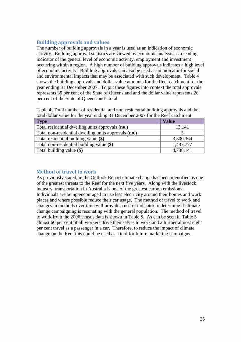
Building approvals and values The number of building approvals in a year is used as an indication of economic
activity. Building approval statistics are viewed by economic analysts as a leading
indicator of the general level of economic activity, employment and investment
occurring within a region. A high number of building approvals indicates a high level
of economic activity. Building approvals can also be used as an indicator for social
and environmental impacts that may be associated with such development. Table 4
shows the building approvals and dollar value amounts for the Reef catchment for the
year ending 31 December 2007. To put these figures into context the total approvals
represents 30 per cent of the State of Queensland and the dollar value represents 26
per cent of the State of Queensland's total.
Table 4: Total number of residential and non-residential building approvals and the
total dollar value for the year ending 31 December 2007 for the Reef catchment
Type Value
Total residential dwelling units approvals (no.) 13,141
Total non-residential dwelling units approvals (no.) 5
Total residential building value ($) 3,300,364
Total non-residential building value ($) 1,437,777
Total building value ($) 4,738,141
Method of travel to work As previously stated, in the Outlook Report climate change has been identified as one
of the greatest threats to the Reef for the next five years. Along with the livestock
industry, transportation in Australia is one of the greatest carbon emissions.
Individuals are being encouraged to use less electricity around their homes and work
places and where possible reduce their car usage. The method of travel to work and
changes in methods over time will provide a useful indicator to determine if climate
change campaigning is resonating with the general population. The method of travel
to work from the 2006 census data is shown in Table 5. As can be seen in Table 5
almost 60 per cent of all workers drive themselves to work and a further almost eight
per cent travel as a passenger in a car. Therefore, to reduce the impact of climate
change on the Reef this could be used as a tool for future marketing campaigns.

26
Table 5: Method of travel to work
Type of travel Number of
workers
Per cent of this
method
Per cent of all
workers
One method:
Train 123 0.03% 0.03%
Bus 6,711 1.80% 1.46%
Ferry 317 0.09% 0.07%
Tram (includes light rail) 36 0.01% 0.01%
Taxi 1,273 0.34% 0.28%
Car, as driver 274,522 73.80% 59.76%
Car, as passenger 36,546 9.82% 7.96%
Truck 8,030 2.16% 1.75%
Motorbike/scooter 6,270 1.69% 1.37%
Bicycle 7,806 2.10% 1.70%
Other 4,567 1.23% 0.99%
Walked only 25,787 6.93% 5.61%
Total one method 371,988 100.00%
Two methods:
Train and:
Bus 12 0.29% 0.00%
Car, as driver 21 0.51% 0.00%
Car, as passenger 16 0.39% 0.00%
Bus and:
Ferry 49 1.18% 0.01%
Car, as driver 312 7.52% 0.07%
Car, as passenger 291 7.02% 0.06%
Other 175 4.22% 0.04%
Other two methods 3,271 78.88% 0.71%
Total two methods 4,147 100.00%
Three methods:
Train and two other
methods 25 5.76% 0.01%
Bus and two other methods
(excludes train) 152 35.02% 0.03%
Other three methods 257 59.22% 0.06%
Total three methods 434 100.00%
Worked at home 24,841 5.41%
Did not go to work 49,365 10.75%
Method of travel to work not
stated 8,565
1.86%
Total 459,340 100.00%

27
Internet and computer usage Table 6 shows that nearly 57 per cent of dwellings in the 2006 census had some sort
of internet connection. More importantly it shows that nearly 40 per cent of dwellings
do not have the Internet connected. This is important as more frequently the Internet
is becoming the preferred medium for communication and educations. Therefore, by
using the Internet as a way of communication a substantial proportion of the
population within the Reef catchment may not be reached.
Table 6: Internet use
Type of connection Number of dwellings Per cent of dwellings
No Internet connection 143,164 39.73%
Type of Internet connection:
Broadband 113,826 31.58%
Dial-up 88,644 24.60%
Other 2,184 0.61%
Total 204,654 56.79%
Internet connection not
stated 12,562 3.49%
Total 360,380 100%

28
Region Specific Far North The local government areas included in the Far Northern Statistical Division that are
included in the Great Barrier Reef Catchment (wholly or partially) are: Aurukun Shire
Council, Cairns Regional Council, Cassowary Coast Regional Council, Cook Shire
Council, Croydon Shire Council, Etheridge Shire Council, Hope Vale Aboriginal
Shire Council, Kowanyama Aboriginal Shire Council, Lockhart River Aboriginal
Shire Council, Mapoon Aboriginal Shire Council, Napranum Aboriginal Shire
Council, Northern Peninsula Area Regional Council, Pormpuraaw Aboriginal Shire
Council, Tablelands Regional Council, Torres Shire Council, Torres Strait Island
Regional Council, Wujal Wujal Aboriginal Shire Council and Yarrabah Aboriginal
Shire Council.
The results presented in this section are for the above listed local government areas.
Population and population projections The population of the Far North statistical division is 231,050 which make up 22.6 per
cent of the catchment population.
Indigenous population Of the total population in the Far North, 33,118 identified themselves as Indigenous
(14.3 per cent). (However, 17,365 did not state their Indigenous status).
Employment by industry Table 7 shows the number of people and the percentage of workforce for each
industry. The highest category, retail trade (11.6 per cent) is consistent with the
whole catchment. Next was public administration and safety (10.7 per cent) followed
by health care and social assistance (9.3 per cent).

29
Table 7: Employment by industry for the Far North
Number of people Per cent of workforce
Agriculture\ Forestry &
Fishing 6,291 5.85%
Mining 1,323 1.23%
Manufacturing 6,980 6.49%
Electricity\ Gas\ Water &
Waste Services 1,067 0.99%
Construction 9,502 8.84%
Wholesale Trade 2,959 2.75%
Retail Trade 12,444 11.58%
Accommodation & Food
Services 10,385 9.66%
Transport\ Postal &
Warehousing 6,397 5.95%
Information Media &
Telecommunications 990 0.92%
Financial & Insurance
Services 1,724 1.60%
Rental\ Hiring & Real
Estate Services 2,077 1.93%
Professional\ Scientific &
Technical Services 3,938 3.66%
Administrative & Support
Services 3,674 3.42%
Public Administration &
Safety 11,478 10.68%
Education & Training 7,560 7.03%
Health Care & Social
Assistance 9,959 9.27%
Arts & Recreation
Services 1,591 1.48%
Other Services 3,708 3.45%
Inadequately
Described\Not Stated 3,421 3.18%
Total Persons (b) 107,468 100.00%
Building approvals and values Table 8 shows the total number of residential and non-residential building approvals
and the total dollar value for the year ending 31 December 2007 for the Far North.
The total approvals for the Far North make up nearly 24 per cent of all approvals and
nearly 25 per cent of the value of the catchment.

30
Table 8: Building approvals and values for the Far North
Type Value
Total residential dwelling units approvals (no.) 3,139
Total non-residential dwelling units approvals (no.) 2
Total residential building value ($) 782,401
Total non-residential building value ($) 392,048
Total building value ($) 1,174,449
Education and employment In the Far North area there are 113,350 employed people (52,220 females and 61,130
males) and 44,596 school students. Table 9 shows the highest level of schooling or
qualification of the workforce in the Far North.
Table 9: Schooling and qualifications of the workforce in the Far North
Highest level of schooling Qualification levels
Year 8 Or Below 14,558
Postgraduate
degree 2,052
Year 9 Or Equivalent 10,567
Graduate diploma
and graduate
certificate 1,688
Year 10 Or
Equivalent 48,396 Bachelor degree 13,918
Year 11 Or
Equivalent 16,569
Advanced
diploma and
diploma 10,789
Year 12 Or
Equivalent 66,194 Certificate 34,668
Did Not Go To
School 1,080
Persons with a
qualification 90,869
Highest Year Of
School Not Stated 21,491
Per cent of
persons with a
qualification 50.8%
Total Persons 178,855 Total persons 178,855

31
Northern The local government areas that are included in the Northern Statistical Division of
the Great Barrier Reef catchment (wholly or partially) are: Burdekin Shire Council,
Charters Towers Regional Council, Hinchinbrook Shire Council, Palm Island
Aboriginal Shire Council and Townsville City Council.
The results presented in this section are for the above listed local government areas.
Population and population projections The population of the Northern statistical division is 196,670 which makes up 19.3
per cent of the catchment population.
Indigenous population Of the total population in the North, 12,905 identified themselves as Indigenous (6.6
per cent). (10,427 did not state their Indigenous status).
Employment by industry Table 10 shows the number of people and the per cent of workforce employed in each
industry in the Northern Statistical Division of the Reef Catchment. The most popular
industries are public administration and safety (11.2 per cent), retail trade (10.9 per
cent) and health care and social assistance (10.7 per cent).

32
Table 10: Employment by industry for the North
Number of people Per cent of workforce
Agriculture\ Forestry &
Fishing 3,926 4.16%
Mining 2,824 2.99%
Manufacturing 8,429 8.93%
Electricity\ Gas\ Water &
Waste Services 1,298 1.38%
Construction 8,492 9.00%
Wholesale Trade 2,780 2.95%
Retail Trade 10,267 10.88%
Accommodation & Food
Services 6,200 6.57%
Transport\ Postal &
Warehousing 4,478 4.74%
Information Media &
Telecommunications 1,338 1.42%
Financial & Insurance
Services 1,626 1.72%
Rental\ Hiring & Real
Estate Services 1,500 1.59%
Professional\ Scientific &
Technical Services 3,681 3.90%
Administrative & Support
Services 2,491 2.64%
Public Administration &
Safety 10,556 11.18%
Education & Training 7,687 8.14%
Health Care & Social
Assistance 10,079 10.68%
Arts & Recreation
Services 1,056 1.12%
Other Services 3,270 3.46%
Inadequately
Described\Not Stated 2,399 2.54%
Total Persons (b) 94,377 100.00%
Building approvals and values Table 11 shows the total number of residential and non-residential building approvals
and the total dollar value for the year ending 31 December 2007 for the North. The
total approvals in the North account for 20 per cent of all approvals in the catchment.
The North's buildings account for around 24 per cent of the total catchment value.

33
Table 11: Building approvals and values for the North
Type Value
Total residential dwelling units approvals (no.) 2,667
Total non-residential dwelling units approvals (no.) 2
Total residential building value ($) 745,535
Total non-residential building value ($) 397,962
Total building value ($) 1,143,497
Education and employment In the North area there are 94,738 employed people (42,959 females and 51,779
males) and 38,598 school students. Table 12 shows the highest level of schooling or
other qualification of the workforce.
Table 12: Schooling and qualifications of the workforce in the North
Highest level of schooling Qualification levels
Year 8 Or Below 12,744
Postgraduate
degree 2,310
Year 9 Or Equivalent 9,229
Graduate diploma
and graduate
certificate 1,345
Year 10 Or
Equivalent 43,211 Bachelor degree 13,359
Year 11 Or
Equivalent 13,704
Advanced
diploma and
diploma 8,096
Year 12 Or
Equivalent 59,307 Certificate 29,308
Did Not Go To
School 629
Persons with a
qualification 72,987
Highest Year Of
School Not Stated 14,885
Per cent of
persons with a
qualification 47.5%
Total Persons 153,709 Total persons 153,709

34
Mackay The local government areas included in the Mackay Statistical Division that are
included in the Great Barrier Reef Catchment (wholly or partially) are: Isaac Regional
Council, Mackay Regional Council and Whitsunday Regional Council.
The results presented in this section are for the above listed local government areas.
Population and population projections The population of the Mackay statistical division is 150,176 which makes up 14.7 per
cent of the catchment population.
Indigenous population Of the total population in Mackay, 5,480 identified themselves as Indigenous (3.6 per
cent). (12,719 did not state their Indigenous status).
Employment by industry Table 13 shows the number of people and the per cent of workforce employed in each
industry in the Mackay Statistical Division of the Reef Catchment. The most popular
industries for Mackay are mining (11.7 per cent), retail trade (10.8 per cent) and
construction (9.6 per cent).

35
Table 13: Employment by industry for Mackay
Number of people Per cent of workforce
Agriculture\ Forestry &
Fishing 4,872 6.70%
Mining 8,502 11.69%
Manufacturing 5,858 8.05%
Electricity\ Gas\ Water &
Waste Services 599 0.82%
Construction 6,970 9.58%
Wholesale Trade 2,810 3.86%
Retail Trade 7,886 10.84%
Accommodation & Food
Services 6,017 8.27%
Transport\ Postal &
Warehousing 4,366 6.00%
Information Media &
Telecommunications 480 0.66%
Financial & Insurance
Services 1,113 1.53%
Rental\ Hiring & Real
Estate Services 1,314 1.81%
Professional\ Scientific &
Technical Services 2,697 3.71%
Administrative & Support
Services 1,776 2.44%
Public Administration &
Safety 2,700 3.71%
Education & Training 4,282 5.89%
Health Care & Social
Assistance 5,085 6.99%
Arts & Recreation
Services 435 0.60%
Other Services 2,975 4.09%
Inadequately
Described\Not Stated 2,021 2.78%
Total Persons (b) 72,758 100.00%
Building approvals and values Table 14 shows the total number of residential and non-residential building approvals
and the total dollar value for the year ending 31 December 2007 for Mackay. The
total approvals for Mackay make up 13.4 per cent of all approvals in the Reef
catchment. The total value of Mackay makes up 16.2 per cent of the total catchment
value, which is lower than for both the Far North and the North.

36
Table 14: Building approvals and values for Mackay
Type Value
Total residential dwelling units approvals (no.) 1,756
Total non-residential dwelling units approvals (no.) 0
Total residential building value ($) 520,577
Total non-residential building value ($) 247,672
Total building value ($) 768,248
Education and employment In the Mackay area there are 76,756 employed people (32,101 females and 44,655
males) and 27,860 school students. Table 15 shows the level of schooling and other
qualifications of the workforce in Mackay.
Table 15: Schooling and qualifications of the workforce in Mackay
Highest level of schooling Qualification levels
Year 8 Or Below 10,163
Postgraduate
degree 770
Year 9 Or Equivalent 7,649
Graduate diploma
and graduate
certificate 826
Year 10 Or
Equivalent 36,391 Bachelor degree 7,461
Year 11 Or
Equivalent 10,408
Advanced
diploma and
diploma 5,419
Year 12 Or
Equivalent 37,638 Certificate 24,895
Did Not Go To
School 380
Persons with a
qualification 57,030
Highest Year Of
School Not Stated 14,709
Per cent of
persons with a
qualification 48.6%
Total Persons 117,338 Total persons 117,338

37
Fitzroy The local government areas included in the Fitzroy Statistical Division that are
included in the Great Barrier Reef Catchment (wholly or partially) are: Banana Shire
Council, Barcaldine Regional Council, Central Highlands Regional Council,
Gladstone Regional Council, Rockhampton Regional Council and Woorabinda
Aboriginal Shire Council.
The results presented in this section are for the above listed local government areas.
Population and population projections The population of the Fitzroy statistical division is 188,406 which makes up 18.5 per
cent of the catchment population.
Indigenous population Of the total population in the Fitzroy, 8,921 identified themselves as Indigenous (4.7
per cent). (11,030 did not state their Indigenous status).
Employment by industry Table 16 shows the number of people and the per cent of workforce employed in each
industry in the Fitzroy Statistical Division of the Reef Catchment. The most popular
industries for Fitzroy are manufacturing (10.8 per cent), retail trade (10.6 per cent)
and construction (9.3 per cent).

38
Table 16: Employment by industry for Fitzroy
Number of people Per cent of workforce
Agriculture\ Forestry &
Fishing 4,727 5.39%
Mining 5,926 6.76%
Manufacturing 9,433 10.76%
Electricity\ Gas\ Water &
Waste Services 2,063 2.35%
Construction 8,133 9.28%
Wholesale Trade 2,649 3.02%
Retail Trade 9,272 10.58%
Accommodation & Food
Services 5,898 6.73%
Transport\ Postal &
Warehousing 5,081 5.80%
Information Media &
Telecommunications 702 0.80%
Financial & Insurance
Services 1,451 1.66%
Rental\ Hiring & Real
Estate Services 1,444 1.65%
Professional\ Scientific &
Technical Services 3,118 3.56%
Administrative & Support
Services 2,065 2.36%
Public Administration &
Safety 4,851 5.54%
Education & Training 7,348 8.39%
Health Care & Social
Assistance 7,568 8.64%
Arts & Recreation
Services 531 0.61%
Other Services 3,262 3.72%
Inadequately
Described\Not Stated 2,110 2.41%
Total Persons (b) 87,632 100.00%
Building approvals and values Table 17 shows the total number of residential and non-residential building approvals
and the total dollar value for the year ending 31 December 2007 for the Fitzroy. The
building approvals in the Fitzroy made up 15 per cent of the total catchment and 14
per cent of the total value.

39
Table 17: Building approvals and values for the Fitzroy
Type Value
Total residential dwelling units approvals (no.) 1,991
Total non-residential dwelling units approvals (no.) 0
Total residential building value ($) 508,973
Total non-residential building value ($) 169,939
Total building value ($) 678,912
Education and employment In the Fitzroy area there are 89,900 employed people (38,029 females and 51,871
males) and 37,733 school students. Table 18 shows the highest level of schooling and
the qualification levels of the workforce.
Table 18: Schooling and qualification levels for the Fitzroy
Highest level of schooling Qualification levels
Year 8 Or Below 13,809
Postgraduate
degree 1,449
Year 9 Or Equivalent 9,742
Graduate diploma
and graduate
certificate 1,270
Year 10 Or
Equivalent 45,203 Bachelor degree 10,480
Year 11 Or
Equivalent 12,385
Advanced
diploma and
diploma 6,550
Year 12 Or
Equivalent 48,149 Certificate 28,035
Did Not Go To
School 496
Persons with a
qualification 66,454
Highest Year Of
School Not Stated 15,227
Per cent of
persons with a
qualification 45.8%
Total Persons 145,011 Total persons 145,011

40
Wide Bay-Burnett The local government areas included in the Wide Bay-Burnett Statistical Division that
are included in the Great Barrier Reef Catchment (wholly or partially) are: Bundaberg
Regional Council, Cherbourg Aboriginal Shire Council, Fraser Coast Regional
Council, Gympie Regional Council, North Burnett Regional Council and South
Burnett Regional Council.
The results presented in this section are for the above listed local government areas.
Population and population projections The population of the Wide Bay-Burnett statistical division is 254,663 which makes
up 24.9 per cent of the catchment population.
Indigenous population Of the total population in the Wide Bay-Burnett, 8,280 identified themselves as
Indigenous (3.3 per cent). (12,373 did not state their Indigenous status).
Employment by industry Table 19 shows the number of people and the per cent of workforce employed in each
industry in the Wide Bay-Burnett Statistical Division of the Reef Catchment. The
industries with the highest percentage of the workforce are retail trade (12.7 per cent),
health care and social assistance (11 per cent) and agriculture/forestry and fishing
(10.3 per cent).

41
Table 19: Employment by industry for Wide Bay-Burnett
Number of people Per cent of workforce
Agriculture\ Forestry &
Fishing 9,789 10.27%
Mining 1,148 1.20%
Manufacturing 9,304 9.77%
Electricity\ Gas\ Water &
Waste Services 1,336 1.40%
Construction 8,614 9.04%
Wholesale Trade 2,783 2.92%
Retail Trade 12,107 12.71%
Accommodation & Food
Services 6,767 7.10%
Transport\ Postal &
Warehousing 3,922 4.12%
Information Media &
Telecommunications 917 0.96%
Financial & Insurance
Services 1,454 1.53%
Rental\ Hiring & Real
Estate Services 1,645 1.73%
Professional\ Scientific &
Technical Services 2,751 2.89%
Administrative & Support
Services 2,477 2.60%
Public Administration &
Safety 5,515 5.79%
Education & Training 7,537 7.91%
Health Care & Social
Assistance 10,541 11.06%
Arts & Recreation
Services 614 0.64%
Other Services 3,428 3.60%
Inadequately
Described\Not Stated 2,625 2.76%
Total Persons (b) 95,274 100.00%
Building approvals and values Table 20 shows the total number of residential and non-residential building approvals
and the total dollar value for the year ending 31 December 2007 for the Wide Bay-
Burnett. The total building approvals for Fitzroy make up 27.2 per cent and 20.5 per
cent of the value for the whole Reef catchment.

42
Table 20: Building approvals and values for Wide Bay-Burnett
Type Value
Total residential dwelling units approvals (no.) 3,581
Total non-residential dwelling units approvals (no.) 1
Total residential building value ($) 739,665
Total non-residential building value ($) 229,849
Total building value ($) 969,514
Education and employment In the Wide Bay-Burnett area there are 96,520 employed people (44,197 females and
52,323 males) and 47,075 school students. Table 21 shows the highest level of
schooling or other qualification for the Wide Bay-Burnett region.
Table 21: Schooling and qualification levels for Wide Bay-Burnett
Highest level of schooling Qualification levels
Year 8 Or Below 24,768
Postgraduate
degree 1,340
Year 9 Or Equivalent 17,797
Graduate diploma
and graduate
certificate 1,513
Year 10 Or
Equivalent 67,999 Bachelor degree 10,743
Year 11 Or
Equivalent 16,004
Advanced
diploma and
diploma 9,736
Year 12 Or
Equivalent 54,344 Certificate 38,533
Did Not Go To
School 838
Persons with a
qualification 88,413
Highest Year Of
School Not Stated 20,424
Per cent of
persons with a
qualification 43.7%
Total Persons 202,174 Total persons 202,174
Want more information?
Data is available on the above social and economic descriptors to the local
government level.
To access the information contact the Social and Economic Information and
Research section of the Science Coordination Group at the Great Barrier Reef
Marine Park Authority

43
References Access Economics, 2009. Economic contribution of the GBRMP, 2006-2007. Research
publication (Great Barrier Reef Marine Park Authority ; Online) ; 98. Great Barrier Reef
Marine Park Authority, Townsville.
Great Barrier Reef Marine Park Authority, 2009. The Great Barrier Reef Outlook
Report 2009. Great Barrier Reef Marine Park Authority, Townsville.
http://www.barrierreef.org/ZooXFund/ResearchProjects/ValuingBleachingEffects/Re
portoutcomes.aspx viewed 11 November 2009

44
Appendix 1 The local government area as they were pre-amalgamation.
Aramac, Atherton, Arukun, Badu, Bamaga, Banana, Barcaldine, Bauhinia, Belyando,
Biggenden, Boigu, Bowen, Broadsound, Bundaberg, Burdekin, Burnett, Cairns,
Calliope, Cardwell, Charters Towers, Cherbourg, Cook, Cooloola, Croydon,
Dalrymple, Dauan, Douglas, Duaringa, Eacham, Eidsvold, Emerald, Erub, Etheridge,
Fitzroy, Gayndah, Gladstone, Hammond, Herberton, Hervey Bay, Hinchinbrook,
Hope Vale, Iama, Injinoo, Isis, Jericho, Johnstone, Kilkivan, Kingaroy, Kolan,
Kowanyama, Kubin, Livingstone, Lockart River, Mabuiag, Mackay, Mapoon,
Mareeba, Maryborough, Mer, Mirani, Miriam Vale, Monto, Mount Morgan,
Mundubbera, Murgon, Nanango, Napranum, Nebo, New Mapoon, Palm Island, Peak
Downs, Perry, Pormpuraaw, Poruma, Rockhampton, Saibai, St Paul, Sarina, Seisia,
Thuringowa, Tiaro, Torres, Townsville, Ugar, Umagico, Warraber, Weipa,
Whitsunday, Wondai, Woocoo, Woorabinda, Wujal Wujal, Yarrabah and Yorke.