Embed Size (px)
Citation preview
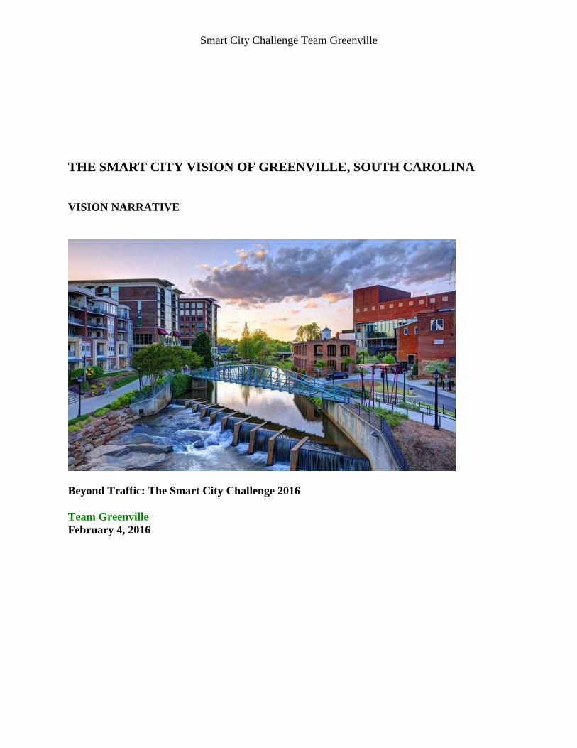
Smart City Challenge Team Greenville
THE SMART CITY VISION OF GREENVILLE, SOUTH CAROLINA
VISION NARRATIVE
Beyond Traffic: The Smart City Challenge 2016
Team Greenville
February 4, 2016
Smart City Challenge Team Greenville
Table of Contents
Chapter 1 – Current challenges of city development, Greenville’s Smart City Vision,
approach to demonstrate the vision........................................................................ 1
Chapter 2 – Greater Greenville’s population characteristics and its alignment with
USDOT’s Smart City characteristics ........................................................................ 4
Chapter 3 – Other characteristics .................................................................................................. 6
Chapter 4 – Annotated Preliminary Site Map ............................................................................... 9
Chapter 5 – Alignment of Greenville’s Smart City approach with USDOT vision
elements .................................................................................................................. 10
Chapter 6 – Risk assessment ....................................................................................................... 21
Chapter 7 – Partnership structure and governance processes ..................................................... 22
Chapter 8 – Existing transportation infrastructure ...................................................................... 23
Chapter 9 – Smart City data approach ........................................................................................ 25
Chapter 10 –Use of standards, architectures and certification processes ................................... 27
Chapter 11 – Greenville’s Smart City goals and objectives ....................................................... 28
Chapter 12 – Evidence of capabilities ........................................................................................ 29
Chapter 13 – Leveraging opportunities of Federal resources ..................................................... 29
Smart City Challenge Team Greenville
1
Vision Narrative
USDOT Grant Ref #DTFH611RA00002. Beyond Traffic: The Smart City Challenge
Chapter 1 – Current challenges of city development, Greenville’s Smart City Vision,
approach to demonstrate the vision
The City of Greenville was incorporated in 1831 and its original growth was driven by the boom
of the textile industry. Infrastructure innovations such as railroad and telecommunication as well
as the availability of hydro-power were instrumental in attracting textile mill owners to the
Greenville area. With the establishment of textile mills so called mill towns were created where
factory workers lived, worked and also could educate their children and which laid the
foundation for Greenville to be called “Textile Capital of the World” in the early 20th
century.
Though most mill village owners chose not to incorporate into the City of Greenville, a very high
percentage of the mill village citizens connected to downtown by walking, using bicycles, or
using electrified buses operated by the local power company for transportation.
In the decades after WWII, Greenville communities changed as textile manufacturing went
offshore. The mill villages lost population and their roads, sewer and water lines fell into
disrepair. The privately operated bus system service deteriorated as automobiles gradually
replaced bus vehicles and utilization dropped. Today, the ring of former mill villages around
Greenville City limits still suffers from industry flight. These areas have high population
densities and high levels of unemployment, poverty and crime influenced by drug-abuse. Further
compounding these major issues, is the lack of transportation options within these areas thus
limiting access to the better paying job opportunities and other quality of life amenities.
Over the last few decades, Greenville city and county leadership has transformed the downtown
area into a highly attractive residential, business, entertainment, and recreational environment.
Greenville’s vibrant downtown supports strategic business sectors and generates well-paying
jobs well beyond the city limits. A prime example is the automotive industry.
Greenville envisions a smart city with improved mobility and safety by providing the following
core transportation services:
1) high density zones of urban activities are being served with low speed automated electric
vehicle fleets that are publicly or privately operated
2) low density urban zones are being supported by on-demand connected zero-emission enabled
public and private shuttles in a ride-share model available to all citizens
3) zero-emission public transit buses connect the different high density zones and provide the
backbone in a multi-modal transportation system
4) high-capacity intelligent parking structures are centered around key multi-modal
transportation nodes
Smart City Challenge Team Greenville
2
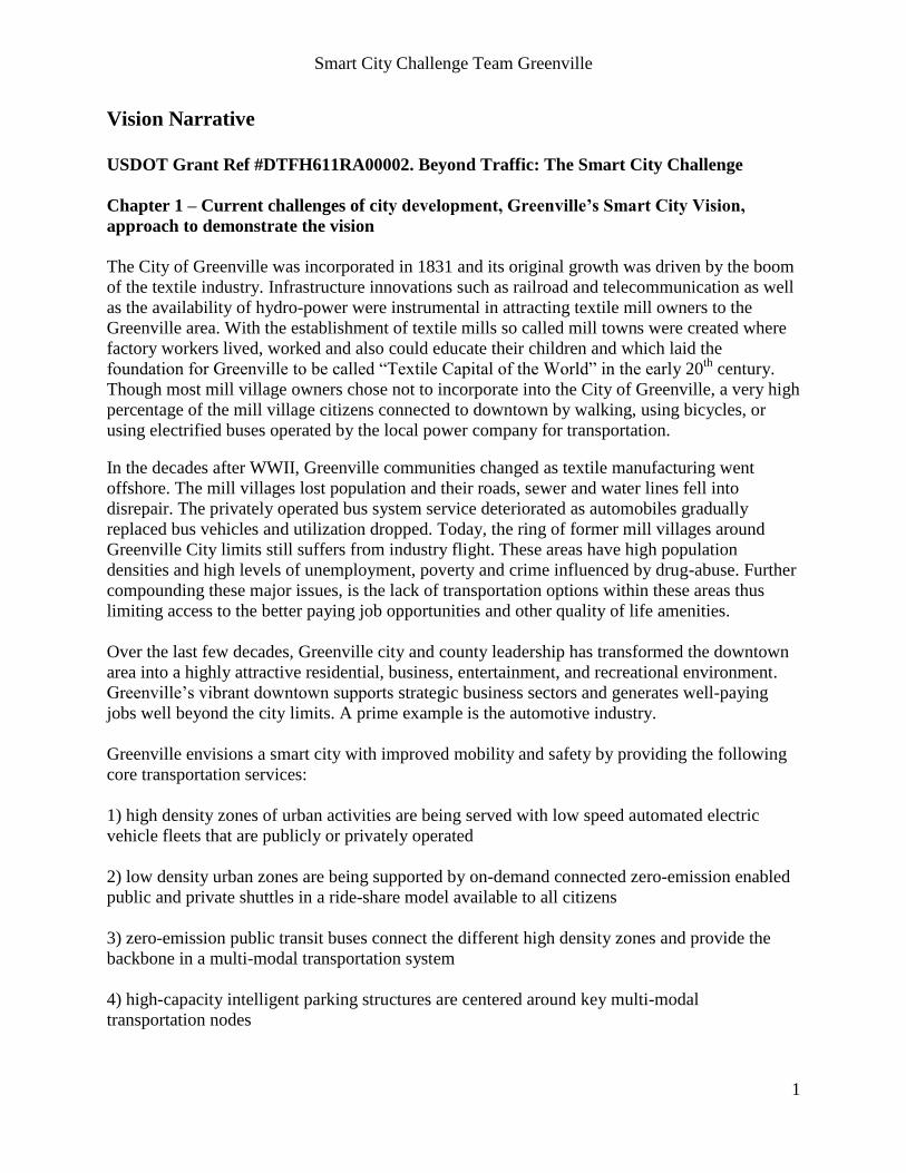
Figure 1 illustrates which vehicles types could be used to support the Smart City Vision.
Figure 1. Greenville Smart City Vision
The vision of Greenville Metro is to become a place where every citizen enjoys multi-modal
mobility options that are optimized to the personal lifestyle with a minimum environmental
footprint and the highest safety and efficiency level that is technically feasible and economically
responsible.
Greenville County’s crumbling infrastructure and unsafe road conditions are well documented.
In 2013, for the third consecutive year, Greenville County ranked in the top five in AAA
Carolinas’ annual list of South Carolina’s most dangerous counties for collisions. Ranking
second in the state for collisions for three years straight, Greenville County averaged 334.5
crashes per 100 million vehicle miles traveled.
Many residents choose to accept significant commuting times to their work locations in
exchange for affordable housing farther away from job and shopping centers. On the other hand
the City of Greenville attracts both younger generations as well as retired people who choose a
living place in the downtown area with more options for entertainment. As Greenville is an
important manufacturing location – with a specific focus on automotive industry sector -
significant numbers of workers need to commute from their homes to manufacturing sites. Of
growing importance is the knowledge worker which prefers a work location in attractive
business parks or in downtown office locations.
With the population growth both in the City and County of Greenville, driven by an attractive
downtown area on the one side and affordable housing in particular for families on the other
side, the transportation problems in terms of infrastructure capacity, road safety and lack of
public transportation options are continuously increasing.
Smart City Challenge Team Greenville
3
The Smart City Vision of Greenville is to create a transportation system that in general reduces
the dependency of major groups of citizens on owning a personal car and specifically supports
the use of automated and zero-emission private and public vehicles supported by suitable
infrastructure and regulations. The main goal is to improve transportation for all citizens by
providing a variety of multi-modal choices. A cornerstone of the vision is to find ways where
pedestrians, bicyclists and low-speed small electric vehicles can jointly use road infrastructure
without compromising safety or increasing congestion. A good starting point is the Swamp
Rabbit multi-use trail system. Opened in 2010 after being converted from an original rail road,
the Swamp Rabbit Trail is being expanded due to its high popularity with Greenville citizens and
visitors.
In 2007, the Greenville-Pickens Area Transportation Study (GPATS) MPO long-range plan
envisioned major transportation corridors - north-south from Travelers Rest to Fountain Inn, and
east-west from Greenville-Spartanburg (GSP) International Airport connecting Greenville’s
urban attractors through Easley to Clemson University (see map). An important part of the
Smart City vision of Greenville is to fulfill the GPATS plan with 21st century transportation
solutions on major urban corridors.
The Greenville Spartanburg Airport is currently in the process to initiate the procurement of a
$20 M modern automated transit network (ATN) to connect parking structure with the terminals
– likely to be the first of its kind in the US. Clemson University main campus is interested to
explore automated transportation systems to connected university buildings with parking
structures.
In order to address the challenges of the Greenville transportation system and illustrate the Smart
City vision of Greenville, the following demonstration areas have been chosen:
a) Greenville Main Street support the vision of a personal car-free zero-emission downtown
mobility zone
b) Woodruff Road/Verdae area support the vision of a smart shopping area with a fully
automated transportation system for people and goods including remote parking connectivity and
c) Automated transportation-enabled airport and university campus pilot automated commute
between remote parking areas and buildings (simulated for GSP and Clemson Main Campus) at
the property of the South Carolina Technology and Aviation Center (SC-TAC) connected to a
solar powered smart grid network
Greenville has a very unique situation with the presence of the International Transportation
Innovation Center (ITIC) and Clemson University International Center for Automotive Research
(CU-ICAR) in terms of transportation innovation research and demonstration capabilities.
Furthermore, Greenville is the home of multiple leading companies that are relevant for
transportation vehicle and component design, transportation logistics and transportation
infrastructure development. CU-ICAR will play a key role in vehicle and infrastructure concept
development for the suggested demonstration projects. ITIC will play a key role in vehicle and
infrastructure system validation and supplier selection. The suggested approach is that ITIC will
implement a program management office to supervise the design, build and operation of the
demonstration projects. Each demonstration project first needs to validate all relevant
technology elements at ITIC. For each demonstration project a specific project management
team is selected which will be composed of representatives of city/county/citizen community

Smart City Challenge Team Greenville
4
interest groups, industry and academia.
The planning lead for the demonstration projects is with city/county – the implementation lead is
with industry with support from academia and citizen community interest groups. The
involvement of start-up companies in the technology demonstrations is highly encouraged and
will be supported by incubation centers and investor groups. The operational lead of the
demonstration areas will be with ITIC.
Figure 2. ITIC testing facilities
Chapter 2 – Greater Greenville’s population characteristics and its alignment with
USDOT’s Smart City characteristics
Greenville County’s population was 451,225 according to the 2010 Census and its land area is
785.12 sq. miles and had a density of 574.7 persons per square mile. The City of Greenville is
surrounded by contiguous neighborhoods developed as mill villages in the past, other developed
communities, and the City of Mauldin. These communities have a combined population of
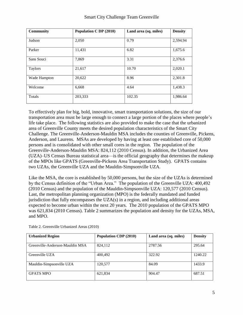
203,333 and an average density of 2’000 people per square mile. Table 1 provides a list of those
communities and their 2010 Census information.
Table 1. City of Greenville and Surrounding Communities Population (2010)
Community Population C DP (2010) Land area (sq. miles) Density
Berea 14,295 7.70 1,855.5
City of Greenville 58,409 28.67 2,037.4
City of Mauldin 22,889 9.95 2,300.40
City of Simpsonville 18,238 8.81 2,070.15
City View 1,345 .52 2,586.54
Dunean 3,671 1.57 2,338.22
Gantt 14,229 9.91 1,435.82
Smart City Challenge Team Greenville
5
Community Population C DP (2010) Land area (sq. miles) Density
Judson 2,050 0.79 2,594.94
Parker 11,431 6.82 1,675.6
Sans Souci 7,869 3.31 2,376.6
Taylors 21,617 10.70 2,020.1
Wade Hampton 20,622 8.96 2,301.8
Welcome 6,668 4.64 1,438.3
Totals 203,333 102.35 1,986.64
To effectively plan for big, bold, innovative, smart transportation solutions, the size of our
transportation area must be large enough to connect a large portion of the places where people’s
life take place. The following statistics are also provided to make the case that the urbanized
area of Greenville County meets the desired population characteristics of the Smart City
Challenge. The Greenville-Anderson-Mauldin MSA includes the counties of Greenville, Pickens,
Anderson, and Laurens. MSAs are developed by having at least one established core of 50,000
persons and is consolidated with other small cores in the region. The population of the
Greenville-Anderson-Mauldin MSA: 824,112 (2010 Census). In addition, the Urbanized Area
(UZA)–US Census Bureau statistical area—is the official geography that determines the makeup
of the MPOs like GPATS (Greenville-Pickens Area Transportation Study). GPATS contains
two UZAs, the Greenville UZA and the Mauldin-Simpsonville UZA.
Like the MSA, the core is established by 50,000 persons, but the size of the UZAs is determined
by the Census definition of the “Urban Area.” The population of the Greenville UZA: 400,492
(2010 Census) and the population of the Mauldin-Simpsonville UZA: 120,577 (2010 Census).
Last, the metropolitan planning organization (MPO) is the federally mandated and funded
jurisdiction that fully encompasses the UZA(s) in a region, and including additional areas
expected to become urban within the next 20 years. The 2010 population of the GPATS MPO
was 621,834 (2010 Census). Table 2 summarizes the population and density for the UZAs, MSA,
and MPO.
Table 2. Greenville Urbanized Areas (2010)
Urbanized Region Population CDP (2010) Land area (sq. miles) Density
Greenville-Anderson-Mauldin MSA 824,112 2787.56 295.64
Greenville UZA 400,492 322.92 1240.22
Mauldin-Simpsonville UZA 120,577 84.09 1433.9
GPATS MPO 621,834 904.47 687.51
Smart City Challenge Team Greenville
6
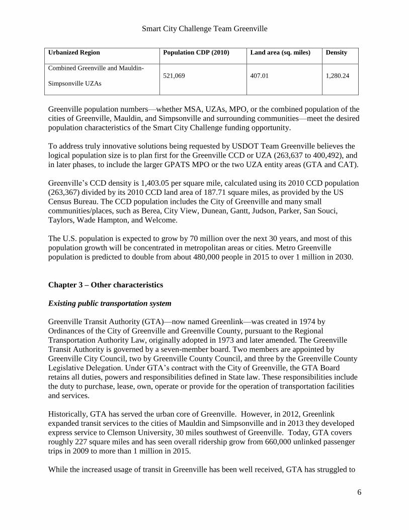
Urbanized Region Population CDP (2010) Land area (sq. miles) Density
Combined Greenville and Mauldin-
Simpsonville UZAs
521,069 407.01 1,280.24
Greenville population numbers—whether MSA, UZAs, MPO, or the combined population of the
cities of Greenville, Mauldin, and Simpsonville and surrounding communities—meet the desired
population characteristics of the Smart City Challenge funding opportunity.
To address truly innovative solutions being requested by USDOT Team Greenville believes the
logical population size is to plan first for the Greenville CCD or UZA (263,637 to 400,492), and
in later phases, to include the larger GPATS MPO or the two UZA entity areas (GTA and CAT).
Greenville’s CCD density is 1,403.05 per square mile, calculated using its 2010 CCD population
(263,367) divided by its 2010 CCD land area of 187.71 square miles, as provided by the US
Census Bureau. The CCD population includes the City of Greenville and many small
communities/places, such as Berea, City View, Dunean, Gantt, Judson, Parker, San Souci,
Taylors, Wade Hampton, and Welcome.
The U.S. population is expected to grow by 70 million over the next 30 years, and most of this
population growth will be concentrated in metropolitan areas or cities. Metro Greenville
population is predicted to double from about 480,000 people in 2015 to over 1 million in 2030.
Chapter 3 – Other characteristics
Existing public transportation system
Greenville Transit Authority (GTA)—now named Greenlink—was created in 1974 by
Ordinances of the City of Greenville and Greenville County, pursuant to the Regional
Transportation Authority Law, originally adopted in 1973 and later amended. The Greenville
Transit Authority is governed by a seven-member board. Two members are appointed by
Greenville City Council, two by Greenville County Council, and three by the Greenville County
Legislative Delegation. Under GTA’s contract with the City of Greenville, the GTA Board
retains all duties, powers and responsibilities defined in State law. These responsibilities include
the duty to purchase, lease, own, operate or provide for the operation of transportation facilities
and services.
Historically, GTA has served the urban core of Greenville. However, in 2012, Greenlink
expanded transit services to the cities of Mauldin and Simpsonville and in 2013 they developed
express service to Clemson University, 30 miles southwest of Greenville. Today, GTA covers
roughly 227 square miles and has seen overall ridership grow from 660,000 unlinked passenger
trips in 2009 to more than 1 million in 2015.
While the increased usage of transit in Greenville has been well received, GTA has struggled to
Smart City Challenge Team Greenville
7
keep up with the mobility needs of a rapidly growing area. In response to this challenge the
Piedmont Health Foundation launched a transit study in 2015 and identified several key themes
as a result of soliciting feedback from the community:
• Lack of transportation is a primary barrier to economic success in the region.
• Citizens desire an innovative transportation system and mobility infrastructure,
• Transit service must be improved with more direct route patterns, shorter wait times, and
longer hours.
• Infrastructure and land use planning must be integrated into future transit plans.
GTA has been working closely with the Piedmont Health Foundation, Clemson University, local
officials, and other interest groups to address these challenges by creating collaborative inter-
agency and public-private partnerships.
Environment that is conducive to demonstrating proposed strategies system
Greenville is the home of institutions and industry partners that are critical to demonstrate the
suggested Smart City vision – examples are CU-ICAR, ITIC, GE, AT&T, IBM.
Greenville citizens are open to use new technologies that improve their quality of life and with
estimated 5.8 million visitors annually it has the potential to become an ambassador of new
transportation solutions to the world.
Continuity of committed leadership and capacity to carry out the demonstration throughout
the period of performance
As illustrated in the long list of support letters by City, County and State level as well as
corporate leadership for the Greenville Smart City Challenge proposal, the Greenville team is
confident to secure the commitment to implement and operate the suggested demonstration pilots
over the time period of performance. CU-ICAR and ITIC are strategic investments on State level
and located in Greenville, which will be instrumental to provide the R&D capacity to design,
implement and operate the pilots in partnership with leading industry companies.
A commitment to integrating with the sharing economy
Through partnership efforts with the City of Greenville, Upstate Forever—a nonprofit
organization focusing on conservancy and sustainability efforts—operates eight bike-sharing
stations located in proximity to the Central Business District (CBD) to facilitate mobility of
residents and employees throughout the CBD. Plans include the expansion of the bike-sharing
program with the extension of the Swamp Rabbit Trail and expansion of Greenlink’s public
transit services. In addition, Uber mobility services are also available in Greenville County.
Another shared mobility service is the public transit system known as Greenlink; however, in
Greenville this service is limited as already described in more detail before.
Smart City Challenge Team Greenville
8
Commitment to open, machine-readable data
Greenville is planning to integrate the use of smart phone and smart cards into its public
transportation system. This will allow a bigger and better data collection of what fare types are
being used (single ride versus day pass) and how the transit system is being used (small group of
heavy users versus large group of light users). Smart phone payment applications can also be
used to notify users of service alerts, solicit feedback, and track user locations from origin to
destination. Furthermore, it is planned to develop a comprehensive computer-aided dispatch
(CAD) and automated vehicle locator (AVL) system which provides dispatchers and passengers
the ability to see “real time” locations and predict arrival/departure times. Last automatic
passenger counting (APC) systems are being planned to identify geo-coded locations for all on-
and off-boardings of transit vehicles.
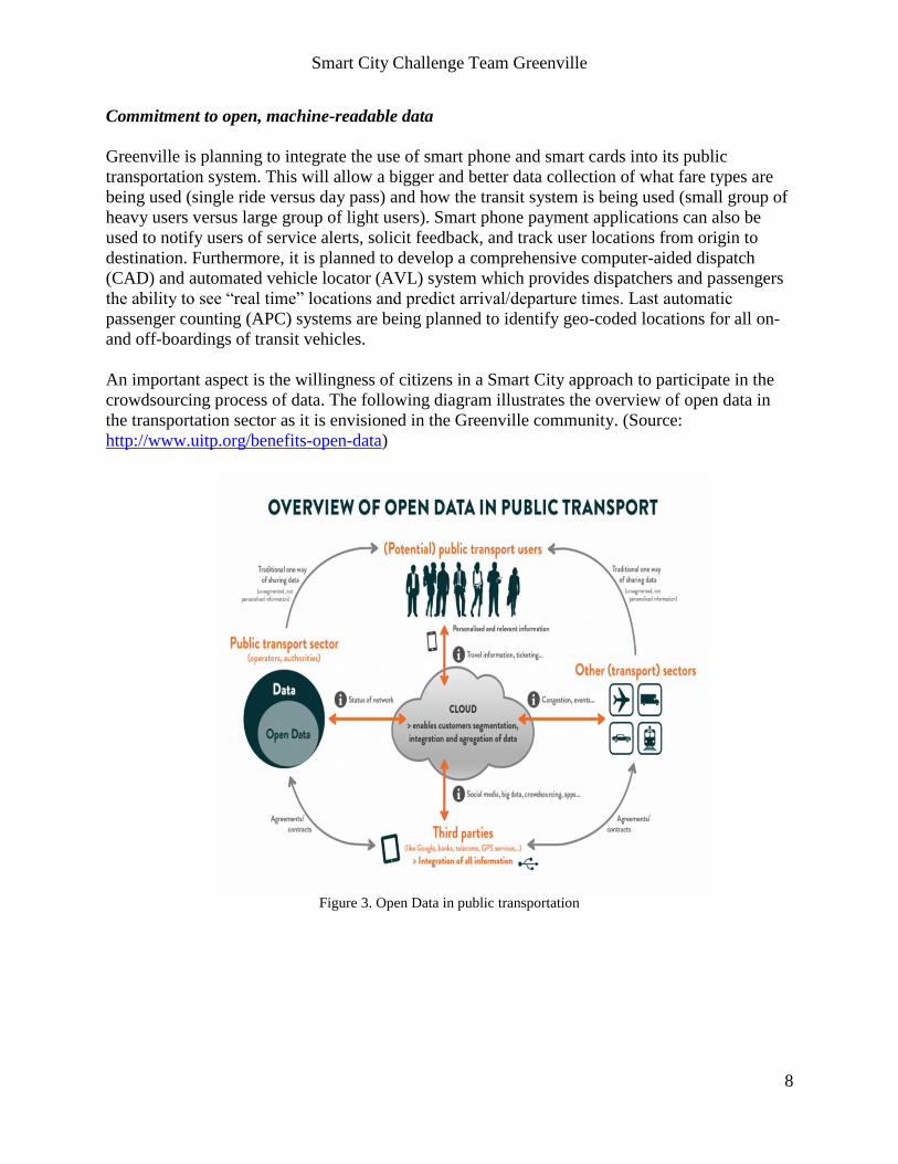
An important aspect is the willingness of citizens in a Smart City approach to participate in the
crowdsourcing process of data. The following diagram illustrates the overview of open data in
the transportation sector as it is envisioned in the Greenville community. (Source:
http://www.uitp.org/benefits-open-data)
Figure 3. Open Data in public transportation
Smart City Challenge Team Greenville
9
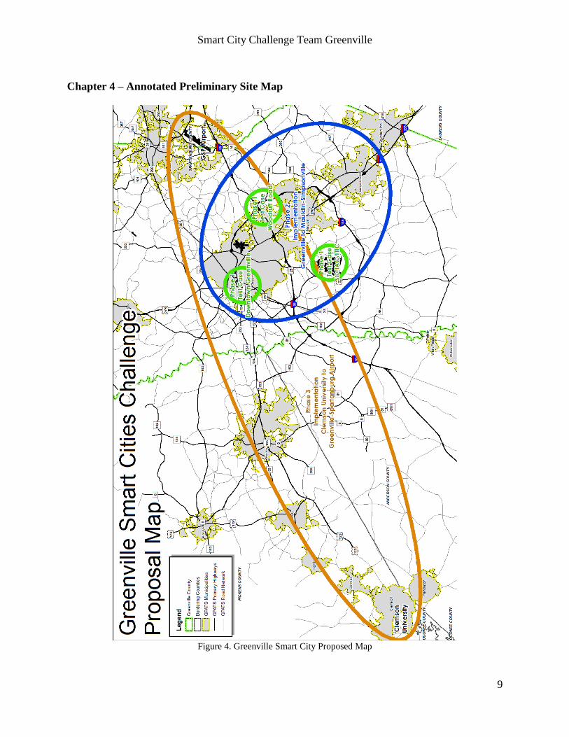
Chapter 4 – Annotated Preliminary Site Map
Figure 4. Greenville Smart City Proposed Map
Smart City Challenge Team Greenville
10
Chapter 5 – Alignment of Greenville’s Smart City approach with USDOT vision elements
Vision element #1 (Urban Automation):
In Greenville, urban automation can be applied to divert traffic into dedicated parking areas and
reduce the vehicle density on key roads in a way that walking, biking and shuttling can co-exist
using the same road infrastructure. The automation can allow a shift from a scheduled public
transportation model to an on-demand model where the vehicle size as well as the pick-up/drop-
off nodes can be dynamically adapted to the demand situation. Furthermore, vehicle automation
can be utilized to automatically store vehicles in parking systems as well as automatically
recharge them if they are electrified. Automated private taxis can complement the public
transportation to feed key commute arteries in a multi-modal transportation network. Last but not
least, automation can be utilized to shuttle people from parking structures to key buildings to
minimize waiting as well as travel time.
In the Greenville downtown area, existing parking structures can be utilized to connect people
with automated low-speed electrified vehicles with their desired downtown locations via a road
system that is prepared for automated driving while at the same time allow walking and biking.
The automated road system will not allow Main Street parking of private cars. Public
transportation – in particular electrified buses - will choose parking structures at the boundaries
of the downtown areas as multi-modal nodes where both users of private and public
transportation merge and then can choose to utilize the automated LSEV (low speed electric
vehicle fleet) or a bike-share fleet for down-town commute.
The Woodruff/Verdae Road main shopping areas will use automation to transport people and
goods from dedicated parking structures to the different commercial buildings and restaurants
along the demonstration zone. Thus typical traffic choke points can be eliminated and the
shopping experience can be significantly improved. The parking areas that are freed up close to
the shopping locations can be re-used for open-air markets or events or for recreational purposes
(e.g. skate boarding, street soccer, basketball). A fleet of automated low-speed electric vehicles
can be utilized to shuttle people along scheduled routes to the different shopping locations. A
dedicated fleet of automated low-speed electric vehicles designed for goods transportation bring
the shopping items from the stores to the parking structures where they are either stored for
customer pick up at a central location or where they can also be hand-delivered to the customer
vehicle (either while the customer is present or via authorized trunk-unlock).
At SCTAC/ITIC a pilot system of an automated parking shuttle will be tested under all possible
utilization scenarios to prepare a major deployment at the Greenville-Spartanburg International
Airport and thus to avoid the construction of additional expensive parking garages close to the
terminals or to the university buildings and to use remote parking options instead. The results of
these automated parking shuttle tests could also be applied to the development of new parking
solutions at the Clemson University main campus.
A key element of the Greenville Smart City Vision is to combine the use of self-driving low-
speed electric vehicles in high density urban areas with either higher capacity zero-emission
public transit buses connecting the high density urban areas as well as the low-density areas or
with the use of private connected vehicles which are being temporarily stored in parking
structures at the edges of urban high activity zones with multi-mode transportation connectivity
nodes.
Smart City Challenge Team Greenville
11
Vision element #2 (Connected Vehicles):
Major regional corridors in the Greenville urban area are I-85 connecting Atlanta with Charlotte
and I-385 connecting Columbia with Greenville. Interstate 85 connects eight metropolitan
centers, including Greenville, in the US Southeast. The Center for Quality Growth and Regional
Development reported that the I-85 corridor is the most critical transportation link in the region
and is projected to experience a significant increase in demand for freight capacity from intra-
region commodity movement alone. I-85 as well as I-385 are perfect candidates to be V2I
enabled and Clemson University is already implementing a V2I pilot on I-85 close to CU-ICAR.
Considering the fact that the density of V2V-enabled vehicles on the road will be rather low over
the next few years, the utilization of mixed networks combining LTE and DSRC technology in a
fog-computing network deployment architecture might be an interesting path for V2I
communication as many vehicles are already 4G-enabled and in basically all vehicles smart
phones are being used. Thus safety, traffic or parking related information can be brought quickly
to a large number of vehicles. In particular, the parking structures at the edges of the automated
driving zones will benefit from the connected vehicle technology to optimize the traffic flow and
to guide vehicles in the most efficient way to available parking spots. Within the automated
driving zones all vehicles including bicycles from bike share programs will be V2V and V2I
enabled. Citizens will be incentivized to load on their smart phones smart city mobility apps that
support safety features and guide through the multi-modal transportation network. All public
transportation vehicles operating in the Greenville urban area will also be V2V/V2I enabled to
leverage the smart communication infrastructure. In particular, GSP coordinates of transit
vehicles will be reported to a central server in real-time where their travel times and arrival times
will be estimated and made available to the public via web and mobile apps. A team at Clemson
University has created a running prototype of such a system. The data will find many other uses
such as estimation of congestion in real time and also provides valuable insights to city traffic
engineers to optimize transit routes and schedules.
Greenville may be one of the first pilot cities in the US for 5G network deployment to support
vehicle and infrastructure connectivity. High resolution map data and infrastructure generated
sensor data can thus be streamed into the connected vehicle and be merged with high resolution
data generated from vehicle sensors to create an intelligent awareness zone around the vehicle
that can anticipate/predict future events and thus increase the safety level of operation both for
passengers as well as the other traffic participants. The idea is to first support the pilot
demonstration areas with mixed 4G/DSRC network capabilities and then compare the results
with 5G network connectivity. The results will help guide Greenville to determine how it should
invest in resilient and high performance communication networks and which public and private
partners it will require to achieve the best performance/cost trade off. Within this initiative, we
will equip all traffic signals along congested corridors and around the city center with DSRC
devices so the timings of traffic lights can be broadcasted to approaching vehicles. This enables
several applications within connected vehicles such as intersection collision warning and eco-
speed advisory when navigating city streets.
As the Greenville area experiences significant mobility challenges, the team will deploy three
connected vehicle mobility applications using multiple communication technologies (i.e. DSRC,
4G, and 5G) following the concept of operations defined in connected vehicle reference
implementation architecture (CVRIA) developed by USDOT:

Smart City Challenge Team Greenville
12
Application 1: Vehicle Data for Traffic Operations
Application 2: Queue Warning
Application 3: Advanced Traveler Information Systems
It is important to understand that Greenville’s Smart City vision does approach the reduction of
traffic congestion and road accidents as well as the improvement of citizen mobility with the
combination of vehicle connectivity as well as vehicle automation. Whereas the main urban
zones of high activities are supported by automated vehicles systems, the corridors between these
zones and the corridors to the parking hubs are optimized for vehicle connectivity.
Vision element #3 (Intelligent, Sensor-based Infrastructure):
Greenville will implement a cloud-based IT infrastructure solution to manage all relevant
transportation related data which will be fed from the data sources of Table 3.
Table 3. Greenville Smart Cities Sensor Infrastructure
Stationary sensors Dynamic sensors
> traffic light sensors
> street sensors
> building-mounted sensors
> sensors mounted on street lamps/posts
> sensors integrated in parking structures
> security surveillance sensors
> vehicle-integrated sensors
> mobile-device sensors
> wearable sensors
Dynamic sensors can significantly contribute to generate data that can substantially improve the
quality of the urban traffic situation in real time. Furthermore it is possible to identify
“misbehaving” transportation system participants which support the work of law enforcement. It
can also improve the work of first responders to help them find optimal routes and to decide on
traffic rerouting patterns with less impact on congestion.
The synergy of stationary and dynamic sensor data can help to operate automated transportation
systems and to optimize the balance of infrastructure and vehicle-related cost of automation.
The generated data can also be of commercial value for retail stores and restaurants in an IoT
ecosystem where advertising can be targeted towards transportation system participants to
stimulate the consumption of services which in return could be monetized by the infrastructure
system operators.
The demonstration pilots for the Greenville Smart City Vision will leverage both stationary and
dynamic sensors and a dedicated IT cloud infrastructure will be developed and operated in a joint
effort between Clemson University and industry partners to manage all transportation related
data.
Smart City Challenge Team Greenville
13
Vision element #4 (Urban Analytics):
One of the big advantages of leveraging urban analytics is to respond faster to demand/supply
patterns in transportation system configurations with complex interdependencies. For example in
the case of Greenville, the influence of unpredictable events on predictable base traffic patterns
requires a quick real-time response in rerouting of traffic. It is essential to actually reach the
vehicles and influence driving and routing behavior. Sharing transportation related data both
between public and private partners can lead to a significant improvement of the traffic situation
(e.g. reporting of shopping-induced or event-induced traffic and proactive rerouting and
enhancement of parking capacity or multi-modal transportation options).
One of the big concerns of citizens is to be compromised in privacy or security, so it is essential
that proper filtering mechanisms are in place in the data collection process to protect the
confidentiality of information. On the other hand data analytics can help to identify people or
objects that are posing a public threat.
Price can drive the behavior of transportation system participants – whether using public or
private transportation. Dynamic pricing models for parking or dynamic pricing for the use of
public transportation (e.g. using smart phone technology) or even the use of subsidized
transportation pricing (e.g. using digital coupons) could be relevant to influence traffic patterns.
The demonstration areas supporting the Greenville Smart City Vision will deploy the latest
methods of data analytics to provide an optimal demand/supply situation of transportation
services at all times. This will also include dynamic pricing models and the use of monetary
incentives through advertising or promotional models.
Greenville also realizes that the collected data can be of great commercial value for various
industry partners in the IoT ecosystem providing innovative services based on real-time
information, such as advertising agencies for location based, mobility solution providers like
parking, navigation, traffic management, or even retailers for tracking the density of potential
customers to name a few. In order to facilitate this, Greenville Smart City Vision will also deploy
the necessary cloud services (cloud APIs) so that existing and emerging industry partners in the
ecosystem can access the analyzed as well as the raw datasets collected. This will not only foster
innovation, but also provide a powerful platform for service-based startups to launch with
reduced capital cost stimulating a startup revolution in the area.
Greenville could attract application developers for transportation related services to get involved
in these start-up activities, leveraging both the corporate as well as the start-up incubator
infrastructure that has been built up recently in Greenville over the last few years and is still
being expanded.
Vision element #5 (User-Focused Mobility Services and Choices):
Greenville citizens will have a dramatically improved situation in terms of mobility choices
which allows them to reduce the exclusive use of their personal vehicle in general and to use
more environmental friendly and efficient transportation options which they can share with
others without compromising comfort or privacy. In order to leverage the multimodal
transportation infrastructure, it is essential to present the mobility services via a simple and easy
to understand interface to the user, and making them available to the most popular mobile
devices which can be used by a large proportion of the city population.

Smart City Challenge Team Greenville
14
Access to almost everything associated with economic opportunity and upward progress —jobs,
health care, healthy foods and schools— relies on the ability to get around in an efficient and
affordable manner. The recently completed Piedmont Health Foundation transportation study
revealed that 78.9% of respondents use a personal vehicle to mobilize. In addition, between
13.4% and 23.8% of respondents have difficulty getting to their destinations including jobs,
drug, alcohol, and mental treatment centers, school/training, grocery stores/shopping, doctors
and dentists offices, recreation, places of worship, and family visits.
The downtown and Woodruff/Verdae Road demonstration areas are clearly suited to experiment
with user-focused mobility services and choices and to also allow industry partners to provide
interaction interfaces that support the seamless transition between the different transportation
modes. Consider two very different groups of citizens, the one that are dependent on a personal
car and do not want to compromise on convenience and comfort and the other group that cannot
afford a personal car and must live with the limitations of public transportation. This social gap
can be narrowed by a multimodal transportation model but it is essential that the need for
personal space and security for transportation system users is not compromised.
Vision element #6 (Urban Delivery and Logistics):
One of the key challenges in adapting the transportation infrastructure for automated driving is to
minimize the potential disruption of traffic patterns by large trucks delivering goods as well as
the need of personal goods delivery services that require vehicle access to specific buildings.
In order to overcome these challenges, it is important to establish urban goods delivery terminals
that can be used for trucks and delivery vehicle as single point of entry. Then the goods are
“micro-distributed” via a dedicated goods delivery system. One of the disadvantages is that the
end-to-end delivery is disrupted and an additional hand-over is needed, furthermore there could
be a discomfort that the service is not controlled by the delivery company that guarantees with its
brand for the quality of service. Therefore, it is important to provide distribution choices to
companies that are in the delivery business from total channel control to commoditized service.
In the Woodruff/Verdae as well as the Main Street demonstration area Greenville wants to
experiment with a new shopping experience which provide the following options:
> personal pick-up of goods at the parking terminal
> personal delivery to the vehicle in the parking structure
> automated delivery with remote owner-authorized trunk opening via mobile devices
These goods delivery system for individual customers can also be used for businesses, although
this may require a dedicated parking terminal structure for larger trucks as well as larger or
special purpose goods delivery vehicles. Another important aspect is to optimize temporary
goods storage with integrated warehouse structures into parking structures and to automate the
handover of goods between different transportation modes (e.g. using material handling robots).
Vision element #7 (Strategic Business Models and Partnering Opportunities):
Greenville has a long tradition in forming public private partnerships in transportation
technology development and deployment. CU-ICAR has been developed in a public private
partnership model. For example the highly successful Deep Orange Program of CU-ICAR is a
Smart City Challenge Team Greenville
15
partnership between automotive OEMs and academia where advanced vehicle concepts are being
developed by students under the guidance of experienced engineers from the industry. CU-ICAR
offers courses where students can apply their knowledge in automotive engineering to develop
new business models as well as infrastructure concepts for smart urban transportation. Thus
students are stimulated to create or join start-up’s to transfer their knowledge or at least apply
their acquired skills in innovation projects of more mature automotive companies. But also the
250 acre CU-ICAR campus itself attracted more than 20 industry partners to co-locate with the
university, most of which are active in the automotive sector. ITIC has been designed as a test
and technology demonstration site on more then 500 acres of the 2600 acre business park of
SCTAC which promotes the partnership between public and private entities and which
successfully demonstrated in a DOE-funded research activity to implement a testbed for wireless
charging of electrified vehicles between university, government lab, utility, automotive OEM,
ICT company and a start-up company. ITIC plans to partner not only with CU-ICAR but also
with the UTC Southeast as well as UTC Portland to help implement technologies required for the
demonstration areas. Furthermore, ITIC has a large portfolio of industry partners it already
works with as well as a large number of international partnerships.
It also has longstanding partnerships with SAE and IEEE. As Greenville has been selected as one
of the Top 10 cities of Envision America, it has access to alliances of private sector companies
willing to support smart city programs, for example the Smart City Alliance (AT&T, IBM,
Ericsson). Furthermore, Greenville in partnership with Clemson University has been an active
participant of the NIST Global City Team Challenge.
Vision element #8 (Smart Grid, Roadway Electrification, and Electric Vehicles):
CU-ICAR in collaboration with ITIC has been working on road electrification since 2012 in
partnership with Oakridge National Lab (ORNL) and a wireless power transfer testbed has been
implemented to support both stationary and in-motion wireless charging for power levels of up to
250 kW. Thus both electrified passenger vehicles as well as electrified buses can be tested. ITIC
has designated expansion areas for road electrification which cover both urban driving scenarios
(opportunity-charging, quasi-dynamic charging) as well as in-motion wireless charging on
dedicated highway lanes.
CU-ICAR also experimented over multiple years with wired and wireless charging systems of
electrified of different power levels in the CU-ICAR parking garage serving a larger fleet of
electrified test vehicles. The combination of wireless stationary charging and automated parking
could be very significant to support commercial EV fleet charging but could also optimize the
design of charging infrastructure for private EV’s being parked in public or private parking
garages or even on the street. The charging infrastructure can be shared and the utilization of the
infrastructure can be optimized. For example, in the future it would be possible to automatically
re-park an electric vehicle in a parking garage to be charged wirelessly and then re-parked again
after the charging process is completed. The process to move the car could be authorized by the
owner without the need of being physically present.
Electrified roads could play a significant role in building automated transportation systems with
low speed electric vehicles where the vehicles could be in continuous operation without the need
to have significant downtime for charging, leading to smaller fleet sizes to serve a specific
transportation demand. We need to distinguish between roads that are continuously electrified or
Smart City Challenge Team Greenville
16
where only certain sections are electrified. In the latter case, the power level of the energy
transfer needs to be adapted to the charging needs of the vehicle. The available battery capacity
will determine how often the vehicle needs to be recharged within a defined operational cycle
and what the cost distribution of vehicle-side energy storage and V2I energy transfer capability
will be. The standardization of the vehicle-to-infrastructure power transfer technology is key to
ensure interoperability of different vehicle types and OEMs with the charging infrastructure.
Clemson University collaborates with SRNL on a 15MW smart grid simulator. The Real-Time
Power and Intelligent Systems Laboratory (http://rtpis.org) at Clemson University has a real-time
power grid simulator capable of simulating the distribution system of Greenville. Thus the
Greenville team could simulate the impact of a major vehicle and road electrification strategy in
the Greenville area. We propose to utilize models of load and EV charging patterns for
intelligent charging to perform frequency response control, balancing phase power, voltage
regulation and peak shaving. By adjusting the charging times, we can minimize the impact on the
grid by avoiding peak hours, and still guarantee EV functionality.
With respect to the demonstration areas of the Greenville Smart City Vision, electric vehicles –
in particular low speed electric vehicles and electric buses – will play a very important role to
develop a zero-emission vehicle environment. Parking structure can become very important
charging hubs, both for parked electrified vehicles, but also for electric buses that can be fast
charged at the multi-mode terminals as well as automated fleet LSEV’s which could be fully
automatically charged between their operational cycles. The Greenville team thinks that LSEV’s
could use specific “electrified” lanes that allow in-motion wireless charging. The results of the
demonstration areas by using wireless charging technology could be utilized as an input for the
improvement of SAE and IEEE WPT (wireless power transfer) standards.
Vision element #9 (Connected, Involved Citizens):
Greenville’s Smart City Vision, deployment outreach events will be organized at CU-ICAR and
ITIC for Greenville citizens to explain and demonstrate mobility technologies that are relevant to
them to be an active part of the pilot activities. Most important is to explain the use of mobile
devices and applications in context of multimodal transportation. Social networks can be used to
organize shared rides as well as organized food shopping. Bus or shuttle transit systems could be
organized in a manner utilizing smart phones to determine optimal pick-up and drop-off points
depending on the demand pattern. It would even be possible to think about models where citizens
could serve specific routes as volunteers for underprivileged groups such as people with
disabilities or older people with private vehicles or in a ride sharing model. The citizens could
act as a proactive self-organizing transportation community leveraging technology. This could
also include retail to sponsor trips with electronic coupons whether these trips are automated or
not. Using such collaborative transportation social networks would generate data which can be
valuable both for the city and private sectors as it generates insights in consumer demand
patterns. However, it is the goal to guarantee a minimum level of safety, security and privacy for
those who provide transportation opportunities as well as those who use them which requires the
use of appropriate technology solutions.
To move in an automated transportation environment, it is important to train citizens to use
mobile devices and wearables as sensors to enhance their awareness of moving objects that can
harm them and to make those moving objects aware of them and their mobility intent.
Smart City Challenge Team Greenville
17
Vision element #10 (Architecture and Standards):
The US DOT emphasizes building a foundation of reference architectures and standards upon
which to build emerging transportation applications. Several strategies that can be applied to
leverage the existing National ITS Architecture and the Connected Vehicle Reference
Implementation Architecture (CVRIA) to address the various dimensions of automated
transportation. Domain specific architectures focus on an aspect of the larger context, much like
AUTOSAR provides a reference architecture for vehicles. The Greenville team’s strategy is to
define a framework within which reference architectures and open standards can be integrated
and aligned to provide a more complete, correct, and consistent structure within which specific
aspects of the transportation domain can be researched. The architectural framework should
emphasize flexibility, interoperability, and modularity to be able to respond to the maturing of
technologies.
The framework would tap into existing work such as that of the ISO/TC 204 which coordinates
ISO efforts, but would be more comprehensive. It would integrate reference architectures such as
CVRIA, and open standards such as the DSRC protocols for intelligent transport systems. The
framework organizing the interactions of architectures and standards, enhances the flexibility and
modularity of the ecosystem. For example, the logical structure of the framework can be built on
the concept of a model bus. Like a computer bus, the model bus allows elements to be hung off it
without interfering with the existing elements on the bus. As technologies emerge, mature, and
give way, the framework makes the network of design information easy to maintain.
The Greenville team is leveraging Clemson University’s work with the Software Engineering
Institute’s Architecture. This work leverages open standards such as the Architecture Analysis
and Design Language (AADL), an open standard from SAE, the world’s largest automotive and
aerospace standards setting body. The use of open standards in the architectures prevents vendor
lock in to so-called “solutions,” which usually are not sufficiently flexible to respond to change
rapidly. AADL is a system modeling language with constructs to model systems from an abstract
reference architecture level to a level of detail from which compilable source code can be
generated. The tooling that accompanies AADL allows even abstract architectures to be
quantitatively analyzed. This environment supports the definition of highly specialized
architectures that can refine, or encompass, selected concepts in existing reference architectures.
SAE has agreed to support Greenville’s Smart City proposal. SAE currently has 65 active
committees working across the passenger and commercial vehicle sectors on an expansive set of
critical Connected Vehicle subjects—including Safety and Human Factors (incorporating driver-
vehicle interface); Vehicle Architecture for Data Communications; Active Safety Systems
(including sensors); Functional Safety; Cybersecurity; Vehicle Event Data Recorders; Reliability
Prediction for Automotive Electronics; Advanced Lighting, and Driver Distraction, among many
others.
Vision element #11 (Low-Cost, Efficient, Secure, and Resilient Information and
Communications Technology):
To implement the Smart City vision of Greenville, a low cost, open standard based computing
and networking infrastructure is chosen. With such infrastructure, current academic and
industrial R&D is swiftly realizing the vision of software defined infrastructure (SDI) - a
Smart City Challenge Team Greenville
18
software driven, highly automated paradigm for future highly diverse and agile network-based
application deployment, from network services to connected vehicles to Internet of Things.
In addition to vehicle applications, mobile apps on smart phones become the primary means of
interaction with the transportation ecosystem for citizens, enabling bidirectional real-time
information exchange with cloud based application, such as real time public transportation map,
real-time help line (requesting shared ride or public transport, or reporting issues such as traffic
accidents, or reporting needs of additional public transportation coverage). Greenville will
pursue big data analytics methodologies to allow citizens to quickly get the information they
need, connect to service providers they wish, to allow city agencies to have real time visibility to
the city’s operational efficiencies and service priorities, and to allow first responders to have
real-time visibility.
On networking standards, in addition to DSRC, Greenville will explore an Internet based, cloud
driven, network technology agnostic paradigm. Via any wireless or wired infrastructure, the city
envisions its residents to utilize smart phone apps, personal computers, and kiosks, to access the
same range of rich services through a single city portal.
Privacy and security play a critical role in enabling smart cities. Sensors in a smart city can
generate a large amount of data, including user private information. In such a data-rich
environment, private information pertains to any emitted, collected, or stored data about
individuals. A key concept in privacy protection is personal identifiable information (PII), which
is any information that can be used to distinguish or trace an individual’s identity. With the
network connectivity and the Internet, PII can be accessed by a wide range of parties.
Privacy management in our smart city solution will ensure the privacy is protected and any
required PII is handled appropriately, considering the different types of protection based on the
Fair Information Practice Principles (FIPPs).
(1) Transparency: The smart city deployment will be open and transparent about policies,
procedures, and technologies that directly affect individuals and/or their PII. Individuals are
notified by our system that their information is being captured for records.
(2) Individual Participation and Redress: In the smart city development, individuals will be
active participants in the decision-making process regarding the collection and use of their PII
and be provided reasonable access to their PII and the opportunity to have their PII corrected,
amended, or deleted.
(3) Purpose Specification: The smart city deployment will identify the legal bases that authorize
a particular PII collection, activity, or technology that impacts privacy and specify the purpose(s)
for which its collects, uses, maintains, or disseminates PII.
(4) Data Minimization: The smart city deployment will collect, use, and retain only PII that is
relevant and necessary for the specified purpose for which it was originally collected.
(5) Use Limitation: The smart city deployment will limit the scope of its PII use to ensure that we
do not use PII in any manner that is not specified in notices, incompatible with the specified
purposes for which the information was collected, or for any purpose not otherwise permitted by
law.
(6) Data Quality and Integrity: The smart city deployment will ensure that any PII collected and
maintained by the system is accurate, relevant, timely, and complete for the purpose for which it
is to be used.
(7) Accountability and Auditing: The smart city deployment will implement effective governance
controls, monitoring controls, risk management, and assessment controls to minimize the privacy
risk to individuals.
Smart City Challenge Team Greenville
19
To support the overall privacy and security of participants in the smart city development, we will
adopt the Security Credential Management System (SCMS) developed by USDOT in our smart
city deployment to enable “Privacy by Design”, and support the security of general deployment
communication and of all proposed applications. A key goal of the system is to protect the
privacy and security of end-users. To maintain the systems against attackers from outside and
inside the SCMS, the SCMS can do frequent certificate changes, dividing operations among its
different components.
In addition, the security solution in our smart city deployment will accomplish the following
objectives:
(1) Best-practice implementation from a security perspective for each information and
communication technology. Naturally, network and system engineers are concerned more with
connectivity and performance, but not security.
(2) Identification of all the communications in the smart cities; analysis of the security
requirement of the communications and determination of the right level of protection
accordingly.
(3) Detection and isolation of insecure devices in a smart city environment before they can
negatively affect transportation networks. Upon discovering a potential threat, our solution
identifies the problem and automatically adopts the necessary strategies to resolve it. After the
threat has been contained, our solution automatically allows the devices to rejoin the network.
(4) Security vulnerability testing after the security solution is implemented.
(5) Consideration of the physical security of the components in the smart city deployment. We
will provide the physical protection around equipment such as tamper-proof casings.
Vision element #12 (Smart Land Use):
The Greenville County Comprehensive Plan and the Comprehensive Plans for the municipalities
include Housing Elements that show an increasing focus on affordability, adaptive reuse of infill
sites, and creating walkable communities. The market does drive where new housing will go, but
investments in municipal downtowns and in infrastructure such as the Swamp Rabbit Trail have
increased the amount of development and density in units over the last decade. This trend is
expected to continue, opening up possibilities for sustainable developments, adapting
communities to be more walkable, and maintain housing affordability while improving quality of
life.
The Greenville-Pickens Area Transportation Study (GPATS), which serves as the Metropolitan
Planning Organization for the Greenville and Mauldin-Simpsonville Urbanized Areas, since
2007 has adopted Long-Range Transportation Plans that would implement transportation
infrastructure across all modes. The knowledge that traditional transportation infrastructure
upgrades cannot solve congestion issues and do not improve the quality of residential,
commercial, or industrial developments has caused a shift towards supporting alternative
transportation modes. Support has grown for improvements such as greenways, on/off-street
paths, expanded sidewalk networks, bicycle facilities including bike share options, transit hubs,
electric bus lines, regional commuter bus service. Plans are also in place to support eventual
expansion and upgrade of transit systems to include but not be limited to Bus Rapid Transit,
Smart City Challenge Team Greenville
20
Light Rail, Automated Transit Networks, Personal Rapid Transit, and High Speed Rail. These
infrastructure improvements will spur and accelerate paradigm shifts with regard to where people
want to live and how they chose to mobilize there, making Smart City choices the norm rather
than the current exception.
The Greenville Smart City Vision will lead to more efficient land use in high density and high
demand urban areas. A core aspect is to channel private cars into dedicated parking hubs with
multimode connectivity options reducing waiting time in traffic congestions or time to search for
available street parking. The freed up transportation zones that offer multiple ways to be mobile
(either by foot, bicycle or small electric vehicle) need to be equipped with sensor capabilities that
ensure the safety and security of citizens. Smart street lights, smart light poles as well as building
sensors can enhance the mobility awareness capabilities.
Also be considered, shared bicycles and fleet LSEV’s do not need individual street parking but
can be stored in central locations equipped with suitable charging options.
The parking hubs can be designed in a way that fleet vehicles, private vehicles as well as goods
can be stored in an integrated way providing energy, security as well as maintenance services.
Integration of the USDOT vision elements:
The demonstration areas of the Greenville Smart City vision combine the different vision
elements in the following manner (Table 4):
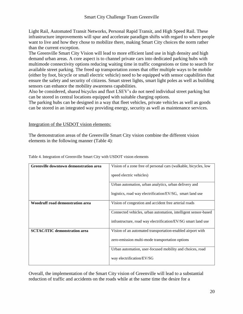
Table 4. Integration of Greenville Smart City with USDOT vision elements
Greenville downtown demonstration area Vision of a zone free of personal cars (walkable, bicycles, low
speed electric vehicles)
Urban automation, urban analytics, urban delivery and
logistics, road way electrification/EV/SG, smart land use
Woodruff road demonstration area Vision of congestion and accident free arterial roads
Connected vehicles, urban automation, intelligent sensor-based
infrastructure, road way electrification/EV/SG smart land use
SCTAC/ITIC demonstration area Vision of an automated transportation-enabled airport with
zero-emission multi-mode transportation options
Urban automation, user-focused mobility and choices, road
way electrification/EV/SG
Overall, the implementation of the Smart City vision of Greenville will lead to a substantial
reduction of traffic and accidents on the roads while at the same time the desire for a
Smart City Challenge Team Greenville
21
personalized and customized transportation experience is not compromised. A major advantage
is that valuable land that is currently being occupied by surface parking can be utilized otherwise
as parking is shifted towards the edges of key urban activity zones. Also the creation of
expensive parking garages on prime real estate can either be avoided or at least be reduced. The
implementation of high capacity parking hubs with multi-mode connectivity options is key to the
success of the smart city strategy. These parking hubs need to consider not only vehicle, but also
goods storage.
Chapter 6 – Risk assessment
ITIC first will test the vehicle and infrastructure technologies at their facilities and testbeds
before they are being deployed at the pilot demonstration areas. Furthermore, the Greenville
team will seek guidance from legislation experts to ensure that all systems can be operated based
on a valid legal framework. All operational aspects of vehicle automation, vehicle charging and
IT service delivery will be assessed from independent auditors.
Risk assessment is a fundamental activity that will be an explicit part of every systems
engineering process under this project. The lead organization for each major project element will
have the primary responsibility for risk assessment for that element. Members of the other
organizations will participate in each assessment. Risk assessments will be carried out for
building, acquiring, and operating each piece of hardware and each software system. These
assessments will include appropriate levels of security and safety analysis depending upon the
operational profile for each system. Techniques such as Functional Hazard Analysis, Failure
Modes and Effects Analysis, and Fault Tree Analysis will be used to identify safety requirements
that need to be added to the system requirements. The architecture definition tools mentioned
under Vision #10 take advantage of early architecture information to conduct these analyses
early in the development process. Linking the analysis results to the newly added requirements
and to verification and validation activities, allows the faults to be identified and removed. Risk
assessments will be carried out for any services offered by the project.
Operational risks will be reviewed prior to each major test or demonstration. All operational
aspects of vehicle automation, vehicle charging and IT service delivery will be assessed by
auditors independent of the project. Vehicles and infrastructure technologies will be tested using
ITIC facilities and testbeds before they are deployed at the pilot demonstration areas. Teams
inviting vendors in for demonstrations will first assess any risk associated with those
demonstrations and will require the vendor to mitigate or justify any outstanding risks.
The iterative nature of most modern systems engineering techniques ensures that risk assessment
will be applied repeatedly. Newly identified risks are fed into a risk repository and reviewed
during each subsequent iteration. Risk assessment techniques will be periodically reviewed to
ensure that the techniques being used are still appropriate and effective at identifying and
quantifying the types of risks associated with the new technologies being introduced into the
ecosystem as responsibilities shift from hardware to software and from statically defined actions
to dynamically configured services.
As project manager, ITIC has the responsibility for assessing project level risks related to
Smart City Challenge Team Greenville
22
operations, funding, and goal achievement. ITIC will interact with the appropriate authorities to
ensure that all activities operate lawfully as well as safely. The project will use a standard
hierarchical risk management strategy with an easily understood risk rating system such as the
Red, Yellow, Green system used by NASA. ITIC will roll up the individual team risk reports
into an overall project risk report that will be reviewed periodically. The project management
may push down required risk mitigations where the individual team is not maintaining
acceptable levels of risk.
Given the nature of new technology projects we can identify some examples of risks:
1. A technology refresh cycle that operates faster than the integration and test cycles for
applications that apply the new technology results in always testing the previous version.
There will be pressures to skip some “non-essential” activities such as detailed design
and testing, resulting in even longer debugging sessions.
2. The time required to fabricate parts is difficult to predict. Aggressive schedules will often
lead to chaos with time overruns propagating and affecting related activities.
Chapter 7 – Partnership structure and governance processes
CU-ICAR was founded in 2003 on a 250 acre site right next to I-85 and with more then 250
million USD invested CU-ICAR developed into a magnet for automotive engineering students
from all over the world. More than 20 faculty members and more than 200 students provide an
excellent talent pool for the automotive ecosystem and the CU-ICAR campus itself attracted
private sector tenants with several hundred highly qualified employees to co-locate with the
university to form a public private partnership. In 2010 CU-ICAR started an economic
development partnership with SC-TAC, with 2,600 acres the largest business park in South
Carolina and located on a former Air Force base to support automotive companies, IT companies
and utilities to test vehicle and related infrastructure systems in real-world sustainable and
connected mobility scenarios. SC-TAC established as result of this partnership the International
Transportation Innovation Center (ITIC) to design, build and operate a test site to validate
advanced communication technologies, charging technologies and different road configurations
in context with connected, automated and zero-emission enabled vehicles. ITIC has also access
to 120’000 square feet of mixed used buildings for incubation, confidential testing and
prototyping, vehicle storage and events as well as to a 20 mile highway segment (I-185) which
can be completely closed from public traffic for dedicated private testing.
ITIC finalized its masterplan for a major expansion of the test site in 2015 with the leading
German engineering firm in race and test track design Tilke and is currently moving towards
implementation via a public private partnership model.
The City and County of Greenville engages SCTAC/ITIC with the overall program management
of the pilot implementation of the Smart City Vision. ITIC will implement a program
management office and engage with CU-ICAR/CU, other local university partners and industry
partners such as BMW, Proterra, Clubcar, Michelin, Duke Energy, AT&T, IBM to name a few.
Each pilot demonstration project reports to the program office and will be staffed by a project
manager, a technical implementation team and an operations team.
Smart City Challenge Team Greenville
23
Chapter 8 – Existing transportation infrastructure
Arterial miles
There are 476.23 miles of arterial roadway infrastructure within the Greenville-Pickens Area
Transportation Study (GPATS) Metropolitan Planning Organization.
Freeway miles
There are 68.5 miles of Freeway roadway infrastructure within the Greenville-Pickens Area
Transportation Study (GPATS) Metropolitan Planning Organization. This includes the
Interstates of I-85, I-385, and I-185
Transit Services in Greenville
Greenlink routes are currently oriented in a hub and spokes system with the downtown transfer
center serving as the nexus of the system. All Greenlink bus routes begin and end at the transfer
center and return to the facility every hour. Greenlink currently offers 11 fixed routes serving the
cities of Greenville, Mauldin, and Simpsonville. The earliest trip begins at 5:30 AM and the
latest trip ends at 7:30 PM. On Saturdays, all fixed routes operate from 8:30 AM to 6:30 PM.
Greenlink also offers an express route to Clemson University, a connector service that runs
between CU-ICAR and downtown Greenville, and a shuttle service that connects CU-ICAR, St.
Francis Hospital, and Haywood Mall. The regular adult fare for riding one-way on Greenlink is
$1.50. Reduced fares are available for the elderly and disabled persons. All transfers cost $0.50.
In addition to these services, Greenlink also provides complimentary paratransit service. This
service is designed primarily for individuals whose disabilities prevent them from using the fixed
route vehicles. Greenlink operates this service during the same hours as its regular fixed routes
and the fare for such services is $3.00 for a one-way trip.
As Greenville continues to attract more businesses and its population grows, the transit system
must adapt to serve these populations efficiently and effectively. This awareness was the impetus
behind the City of Greenville’s recent TIGER VII application, which was developed in
conjunction with Greenlink, Greenville County, and more than 40 other partners in the region.
Building off the success of the Swamp Rabbit Trail, an 18.7 mile rails-to-trails greenway, the
TIGER VII application looked to implement a wide-reaching multimodal public transportation
network in Greenville County. Fed by neighborhood circulators and an extended Swamp Rabbit
Trail, the creation of two transit expressways served as the basis of the application, connecting
the farthest points of Greenville to areas of employment, recreation, health care, and education.
The plan called for zero-emission electric buses, twenty-four transit hubs equipped with
electronic pay stations, and fourteen bike share stations. Each of the transit hubs would serve as
incubators for smart technology projects. While the city was not awarded a TIGER VII grant,
they did receive positive feedback from USDOT and they intend on re-applying this year.
Smart City Challenge Team Greenville
24
Shared-use mobility services miles
Greenville B-cycle, a partnership of Upstate Forever and Greenville Health System, launched
with six stations located primarily in the City's downtown area in March 2013. Since then the
system has grown to eight stations and 243 annual members. Since launch, more than 4,550
unique riders have taken trips on B-cycle, and more than 9200 rides have been made. Ridership
has steadily gained since the program's inception with a total of nearly 4,000 rides taken in 2015
- approximately 50% more than the year prior.
Information and communication technology (ICT)
The present situation of ICT in Greenville SC shows basically 2 cable providers (Charter and
ATT). The fixed broadband provider levels are 25 mbps/3mbps, and the speed of the broadband
is 100mbps/5mbps. These levels for residential areas and commercial areas may have to be
improved for future data needs. The wireless network is dominated by CDMA technology and
would be insufficient for future technology and needs. LTE coverage for Greenville, SC is good,
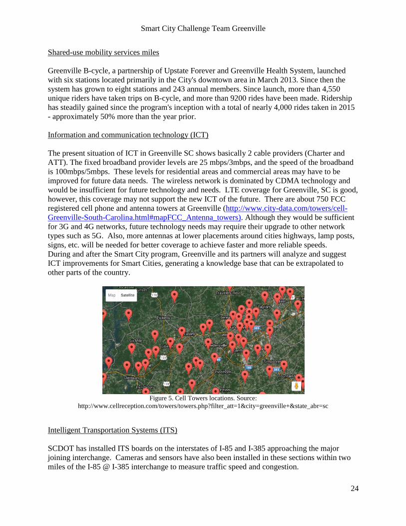
however, this coverage may not support the new ICT of the future. There are about 750 FCC
registered cell phone and antenna towers at Greenville (http://www.city-data.com/towers/cell-
Greenville-South-Carolina.html#mapFCC_Antenna_towers). Although they would be sufficient
for 3G and 4G networks, future technology needs may require their upgrade to other network
types such as 5G. Also, more antennas at lower placements around cities highways, lamp posts,
signs, etc. will be needed for better coverage to achieve faster and more reliable speeds.
During and after the Smart City program, Greenville and its partners will analyze and suggest
ICT improvements for Smart Cities, generating a knowledge base that can be extrapolated to
other parts of the country.
Figure 5. Cell Towers locations. Source:
http://www.cellreception.com/towers/towers.php?filter_att=1&city=greenville+&state_abr=sc
Intelligent Transportation Systems (ITS)
SCDOT has installed ITS boards on the interstates of I-85 and I-385 approaching the major
joining interchange. Cameras and sensors have also been installed in these sections within two
miles of the I-85 @ I-385 interchange to measure traffic speed and congestion.
Smart City Challenge Team Greenville
25
There is a formal memorandum of understanding (MOU) between Clemson University and
South Carolina Department of Transportation (SCDOT) in place that allows university
researchers access to the SCDOT right-of-way for installation of test bed equipment, technical
support as needed, intersection infrastructure to support intersection-related applications, and
SCDOT fiber network for back-haul communication.
Smart grid infrastructure including electric vehicle charging infrastructure
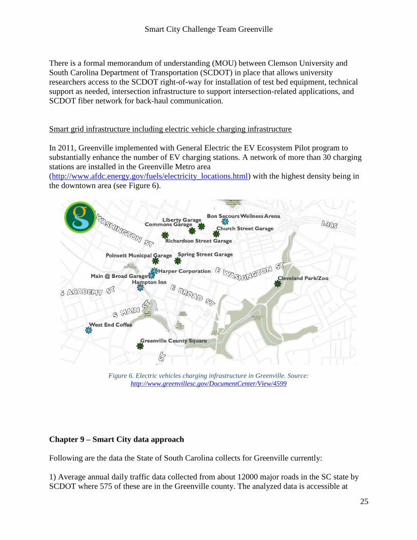
In 2011, Greenville implemented with General Electric the EV Ecosystem Pilot program to
substantially enhance the number of EV charging stations. A network of more than 30 charging
stations are installed in the Greenville Metro area
(http://www.afdc.energy.gov/fuels/electricity_locations.html) with the highest density being in
the downtown area (see Figure 6).
Figure 6. Electric vehicles charging infrastructure in Greenville. Source:
http://www.greenvillesc.gov/DocumentCenter/View/4599
Chapter 9 – Smart City data approach Following are the data the State of South Carolina collects for Greenville currently:
1) Average annual daily traffic data collected from about 12000 major roads in the SC state by
SCDOT where 575 of these are in the Greenville county. The analyzed data is accessible at
Smart City Challenge Team Greenville
26
http://www.scdot.org/getting/annualTraffic.aspx. The information is updated yearly. Each
location provides two-way daily vehicles counts on the respective road, averaged over a year.
2) Traffic count data on an hourly basis generated from traffic counting devices. The counts can
be accessed from the Traffic Polling and Analysis System at the following link
(http://www.scdot.org/getting/trafficCounts.aspx). These data are uploaded on an hourly or
nightly basis. However, there are no current provisions for real-time availability of data. Further,
there are no APIs provided to use these datasets and can be accessed only manually through a
web server currently.
3) http://www.511sc.org/# has live streams to 82 different cameras installed around Greenville.
The feed however is not accessible through an API.
4) The city also has traffic loop detectors at the actuated traffic signals. While these work fine for
four wheelers, they are not equipped well enough to detect motorcycles, mopeds and bicycles.
Due to this reason, South Carolina is one of the 6 states in the US where bicyclists/ motorcyclists
are allowed to proceed through an intersection with a red light.
All the data above are curated directly or indirectly by SCDOT currently. The 3 sites identified
for pilots will be equipped with new infrastructure to collect new data. The data sources will
include, but not limited to, V2I communication equipment, traffic vision cameras, parking
sensors, smart traffic signals & signs, smart charging infrastructure and weather sensors.
For the new data, the curator will be ITIC. To have the existing data from SCDOT available
along with the new one, SCDOT will be requested to provide its data centers to share the raw
data with ITIC. With that, ITIC will be the central entity responsible for ensuring the sharing of
this data with other partners is as per the policies. Amongst the partners, Clemson University will
use this data for the research work and publications as follows: the traffic engineering
department at CUICAR will study the traffic patterns, identifying the root causes of the current
traffic problems and suggesting methods for improving the operations; the computer science
department will work on data processing algorithms for big-data; the automotive engineering
department which has groups focusing on connected vehicles and autonomous vehicles, will
perform research related to safety of transportation; and finally ITS department will study the
network traffic that an in-vehicle communication unit as well as a road side communication unit
handles to understand the bandwidth requirements, while the communications security group will
work on security protocols to ensure the sanctity of the communications.
With the sharing of the collected data between the partners, policies will have to be put in place
to facilitate safe exchange of data. The consortium will abide by Articles 1 and 3, Chapter 2 of
the South Carolina Code of Laws (http://www.scstatehouse.gov/code/t30c002.php) to ensure no
personally identifiable information (PII) is present in the data. The consortium will also draft the
terms of use similar to the Research Data Exchange (https://www.its-rde.net/) while sharing the
data between the partners. That being said, it needs to be noted that new policies and legislations
will be required to put in place for data collection as well as sharing with the advent of connected
vehicles and autonomous vehicles. Hence, this will be an opportunity for the research
institutions, USDOT, SCDOT and the state legislature to evaluate and draft the necessary laws

Smart City Challenge Team Greenville
27
and policies to ensure the privacy and security of the citizens.
After the necessary analysis and research from the experiment, ITIC will publish the necessary
guidelines for the data collection and the best practices, so that the data centers at the
Transportation Management Centers can be upgraded accordingly.
Data from grid monitoring especially at the charging stations will be metered, transmitted and
analyzed at the respective distribution system control centers of Greenville. This will provide us
insights to effective and optimal power management systems. Importantly, we will harness the
use of renewable energy sources including solar PV at the charging stations and parking lots.
This is expected to reduce the additional load from electric vehicles in the city of Greenville.
Power system operation analysis will be implemented in a real-time fashion to guarantee security
of the Greenville distribution power system. The capabilities of the Real-Time Power and
Intelligent Systems Laboratory (http://rtpis.org) under the direction of Dr. Kumar
Venayagamoorthy will allow us to study the impact and operation of the charging stations and
data collection.
Chapter 10 –Use of standards, architectures and certification processes
As it was stated in the vision element #10, the Greenville team will apply all existing standards
for vehicle automation, charging infrastructure, IoT, connected vehicles (CVRIA using SET-IT
software tool), cybersecurity and ICT and grid infrastructure operation. By collaborating closely
with SAE and IEEE, it will leverage opportunities to provide input towards standards
development and to seek advice from standardization experts. Furthermore, it will work with
certification agencies to ensure that the operation of automated vehicles is safe and secure.
Lessons learned, conclusions and recommendations resulting from the use of these standards and
architecture will be documented properly and shared with the standards community.
To support the processing of real-time collected data from sensors and infrastructure, a data
analytics framework will be developed that includes data sources, processing and distribution to
process the data and develop analytics models. Greenville will leverage supercomputing facilities
at Clemson University for developing and evaluating the data analytics framework that is based
on a multi-tier data infrastructure to support smart application that is based upon big data tools
and management systems and well understood data and SLA requirements of the different
applications. Data requirements from the Connected Vehicle Reference Implementation
Architecture (CVRIA) will be used. The Intelligent Transportation Systems Laboratory at
Clemson University, directed by Dr. Chowdhury, has built a simulation network of the City of
Clemson that provides a baseline for the architecture in the proposed project.
The middleware systems and technologies for the management of large scale data infrastructure
can be divided into: relational databases, key-value stores, document stored and extensible record
stores. Relational databases include choices such as MySQL or PostgreSQL. As raw connected
transportation data streams typically come from a variety of sources with different data structures
under XML/JSON format the one component of the information infrastructure should be a
document store in order to support rapid, large-scale data ingestion in the absence of a unified
data schema. MongoDB and CouchBase are among the most popular open source solutions for
document stores. At the next stage, the data documents need to be normalized, indexed, and
integrated with other data to support near-real-time analytics, trend detections, and forecasting.
This requires the implementation of extensible records store solutions due to the unstructured,
Smart City Challenge Team Greenville
28
dynamic, and temporal characteristics of the data. Available solutions include HBase,
HyperTable, HPCC, Cassandra, and Accumulo, which also supports security and privacy of data
elements. In-memory databases (SQL or NoSQL), such as VoltDB and MySQL can be part of
the data infrastructure to support applications that require very strict SLA.
Chapter 11 – Greenville’s Smart City goals and objectives The main goals that are related to the Smart City vision of Greenville are the following:
Goal #1: Reduce traffic-related congestions in high density urban zones
Goal #2: Enhance the mobility of all Greenville citizens
Goal #3: Reduce traffic-related CO2 and emissions
Goal #4: Improve safety level on roads
Goal #5: Increase efficiency of point-to-point travel
Goal #1 and #4 can be measured with sensor-based traffic statistics.
Goal #2 and #5 can be measured via surveys as well as testing mobility options via defined
standard use cases at different demand situations.
Goal #3 can be measured by vehicle statistics as well as utilization of charging infrastructure.
Regarding objectives for the concrete demonstration areas, the Greenville team has the following
roadmap:
Greenville Main Street area:
Objective 1: Convert Main Street into a zone which can only be used by pedestrians, bicycles or
automated LSEV’s (both for people and good transportation).
Objective 2: Establish parking hubs for private and commercial vehicles entering the downtown
area with multi-mode connectivity (bicycle share program, LSEV’s)
Objective 3: Provide sensor-based connected vehicle support to route vehicles to the parking
hubs with available capacity
Objective 4: Introduce dynamic pricing models for downtown parking structures in high-demand
situations to encourage the use of offsite-parking with public transit shuttles
Objective 5: Develop mobility awareness apps for mobile devices and wearables to ensure safety
of walking and biking citizens
Woodruff/Verdae road area:
Objective 1: Establish dedicated lanes for automated driving between parking structures and The
Shops at Greenridge (TSGR)
Objective 2: Eliminate parking in pilot zones of TSGR mall area and reuse surface parking areas
Objective 3: Establish new model of people and goods delivery between shops, restaurants and
parking area
Objective 4: Integrate charging infrastructure both in parking structure as well as on designated
Smart City Challenge Team Greenville
29
road areas (quasi-dynamic and dynamic wireless charging)
Objective 5: Establish an EV bus terminal at parking structure
SCTAC/ITIC:
Objective 1: Validate reliability of automated transportation service between terminals/building
and parking areas
Objective 2: Validate business case assumptions
Objective 3: Improve vehicle and infrastructure technology
Across pilot zones:
Objective 1: Use of Open API for mobility applications for smart phones and wearable
Objective 2: Use of Mobility Cloud Service
Chapter 12 – Evidence of capabilities
SCTAC developed over the timeframe of 6 years a joint economic development initiative with
CU-ICAR (Project Green) which addresses the redevelopment of more than 500 acres of
property into a testbed for connected, automated and zero-emission vehicle and infrastructure
technologies. The maturity level of this initiative is now at a point where the Smart City initiative
can be supported in an optimal manner both from a facility development as well as from an
organizational perspective.
Greenville County and the GPATS MPO have served as the regional transportation planning
entity for the Greenville Region since 1969. The GPATS Policy Committee is comprised of 29
voting members and six (6) non-voting members made up from mayors, council members, and
legislative delegates concerned about transportation, and supported by a Study Team of
administrators, planners, and engineers from every GPATS jurisdiction. GPATS is staffed by
the Greenville County Department of Planning and Code Compliance. GPATS coordinates
projects with SCDOT, FHWA, and FTA, directly programming $18 million per year from the
Surface Transportation Program, and indirectly programming several hundred million dollars per
year from SCDOT towards Interstate, Resurfacing and Bridge, Safety, and Transit projects. Chapter 13 – Leveraging opportunities of Federal resources
ITIC as well as CU-ICAR developed a large network of industry partnerships that can be utilized
to leverage Federal resources through cost-share and in-kind donations. In addition, the
Greenville team is working on partnerships with VC/PE entities that are willing to invest in start-
up companies with a transportation focus that could leverage the incubation facilities in the
Greenville area and directly engage in the pilot demonstration projects. In its TIGER VII application the Greenville team demonstrated its ability to leverage federal
resources by mobilizing more than 40 different project partners and matching the federal
investment with a 43% local match investment. This local commitment from various
Smart City Challenge Team Greenville
30
government agencies, educational institutions, research centers, health care organizations, and
nonprofits confirms that the region is eager to implement smarter, cleaner and more effective
public transportation initiatives.
Greenville participates regularly in the application of Federal grants and partnership
opportunities. Greenville applied for USDOT TIGER grants since 2009, and received positive
comments on the TIGER VII grant, although it was not funded. Anticipation is high for the
application to TIGER VIII.
In January 2016, Greenville was selected one of ten (10) U.S. municipalities in the “Envision
America” workshop, held in Charlotte, NC. During the workshop, many partnerships were made
that Greenville intends to capitalize on for the SCC, future TIGER and other grant opportunities,
and its own “Envision Greenville” effort.
In addition, longstanding partnerships between Greenville, Greenville County, and GPATS allow
for the application of state and Federal funding beyond the local level, and inclusion into
Federally-mandated Long-Range Planning processes. Through the MPO processes, Greenville
can leverage local support for Federal funding, create regional partnerships, and call upon state
resources if needed.
Greenville County, SC, is waiting on SCDOT approval to submit, as a sub-recipient, a FHWA
grant proposal for $1 million to deploy electric, connected, assisted/automated Taxis (aTaxis) in
a multi-modal environment and develop a business model that is financially sustainable. We will
evaluate several aTaxi shuttles under commercial conditions in order to assess their life-cycle
costs, performance, and reliability that will serve as the initial link in a community network of
aTaxi vehicles. The Greenville pilot also involves a true public-private partnership with
significant financial and marketing support from Verdae Properties, a 1,100 acre GreenVillages
development that will use the aTaxi shuttle services to improve mobility.