Embed Size (px)
Citation preview

1 INTRODUCTION Ground movement is normal in open cut mining operations, mainly caused by excavation re-sponse and blasting. Movement of the ground can be acceptable provided it is not unexpected and catastrophic. However, in steep mine walls and the very large open pits being developed to-day the consequence of slope collapse can be catastrophic. Such risks can be minimized at the planning stage by reducing slope angles, but this carries a very high cost. Also, instabilities which develop whilst mining can lead to ore reserves being quarantined, which represent a high cost to the mining operation. In spite of such safety measures, unexpected failures have occurred in the past. These issues motivated the development and production of the slope stability radar (SSR). There are currently over 80 GroundProbe SSR systems deployed in metalliferous and coal mines in 17 countries.
The unexpected failure of rock walls at mining sites is a major cause of death and serious in-jury. Slope failure is also one of the major causes of economic and production losses. An unex-pected wall failure can bury critical equipment. It also disrupts the mine plan. It is common to cease mining for several days or weeks following a wall collapse due to uncertainty over stabili-ty. Direct economic losses in remediation alone can easily exceed $1,000,000 per incident. The economic costs of injury or fatality are much higher including closure of mines during the inci-dent investigation process. Massive wall failure can result in direct and indirect costs measured in millions of dollars. This paper will present some recent case studies of the SSR operation in open cut mines in North America. 1.1 GroundProbe North America LLC
The North American subsidiary of GroundProbe (GPNA) began operations in Tucson, Arizona in 2005. A strategic alliance with a major global mining company resulted in the initial deploy-ment of 5 radars in Arizona and New Mexico. GPNA has since deployed radars at new custom-
Slope Stability Radar for Managing Rock Fall Risks in Open Cut Mines
Neal Harries, David Noon, Hilary Pritchett GroundProbe
Dave Bates, P.G. Thompson Creek Mining Company
ABSTRACT: The management of risks associated with slope instability is essential in the safe and economic operation of open cut mines. Over 80 Slope Stability Radar (SSR) systems have been installed at major mines around the world to manage those risks. The SSR technology is now considered best-practice by the global mining industry for managing unstable and pro-duction-critical slopes. The SSR uses radar to remotely scan a rock slope, continuously measur-ing movement of the face. The technology can detect and alert users of wall movements with sub-millimeter precision. Radar waves adequately penetrate through rain, dust and smoke giving reliable and real-time measurements, 24 hours a day. SSR systems have detected and recorded warning movements in over 200 rock falls and slope failures, ranging from small wedge failures of a few tonnes to dump failures of up to thirty million tonnes which has allowed productivity, planning and safety gains in many operations.
ROCKENG09: Proceedings of the 3rd CANUS Rock Mechanics Symposium, Toronto, May 2009 (Ed: M.Diederichs and G. Grasselli)
PAPER 4279 1
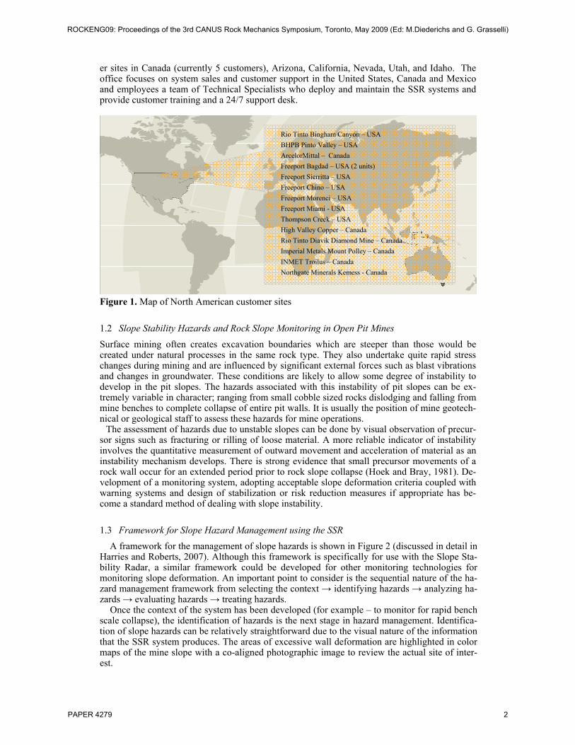
er sites in Canada (currently 5 customers), Arizona, California, Nevada, Utah, and Idaho. The office focuses on system sales and customer support in the United States, Canada and Mexico and employees a team of Technical Specialists who deploy and maintain the SSR systems and provide customer training and a 24/7 support desk.
Figure 1. Map of North American customer sites
1.2 Slope Stability Hazards and Rock Slope Monitoring in Open Pit Mines Surface mining often creates excavation boundaries which are steeper than those would be created under natural processes in the same rock type. They also undertake quite rapid stress changes during mining and are influenced by significant external forces such as blast vibrations and changes in groundwater. These conditions are likely to allow some degree of instability to develop in the pit slopes. The hazards associated with this instability of pit slopes can be ex-tremely variable in character; ranging from small cobble sized rocks dislodging and falling from mine benches to complete collapse of entire pit walls. It is usually the position of mine geotech-nical or geological staff to assess these hazards for mine operations.
The assessment of hazards due to unstable slopes can be done by visual observation of precur-sor signs such as fracturing or rilling of loose material. A more reliable indicator of instability involves the quantitative measurement of outward movement and acceleration of material as an instability mechanism develops. There is strong evidence that small precursor movements of a rock wall occur for an extended period prior to rock slope collapse (Hoek and Bray, 1981). De-velopment of a monitoring system, adopting acceptable slope deformation criteria coupled with warning systems and design of stabilization or risk reduction measures if appropriate has be-come a standard method of dealing with slope instability.
1.3 Framework for Slope Hazard Management using the SSR A framework for the management of slope hazards is shown in Figure 2 (discussed in detail in
Harries and Roberts, 2007). Although this framework is specifically for use with the Slope Sta-bility Radar, a similar framework could be developed for other monitoring technologies for monitoring slope deformation. An important point to consider is the sequential nature of the ha-zard management framework from selecting the context → identifying hazards → analyzing ha-zards → evaluating hazards → treating hazards.
Once the context of the system has been developed (for example – to monitor for rapid bench scale collapse), the identification of hazards is the next stage in hazard management. Identifica-tion of slope hazards can be relatively straightforward due to the visual nature of the information that the SSR system produces. The areas of excessive wall deformation are highlighted in color maps of the mine slope with a co-aligned photographic image to review the actual site of inter-est.
Rio Tinto Bingham Canyon – USA BHPB Pinto Valley – USA ArcelorMittal – Canada Freeport Bagdad – USA (2 units) Freeport Sierritta – USA Freeport Chino – USA Freeport Morenci – USA Freeport Miami - USA Thompson Creek – USA High Valley Copper – Canada Rio Tinto Diavik Diamond Mine – Canada Imperial Metals Mount Polley – Canada INMET Troilus – Canada Northgate Minerals Kemess - Canada
ROCKENG09: Proceedings of the 3rd CANUS Rock Mechanics Symposium, Toronto, May 2009 (Ed: M.Diederichs and G. Grasselli)
PAPER 4279 2

The responsible personnel must then analyze this data, usually reviewing the deformation style and rate, as well as the size of area that appears to be failing. This information can then be evaluated against organization protocols (for example it may be only a small sub-bench failure that will be ‘caught’ by existing benches and hence can be categorized as a lower risk). Once these hazards are evaluated they can then be treated if required. Two major options are available to reduce the risk during this treatment option. We can reduce the likelihood of failure – for ex-ample by buttressing the failure or de-pressurizing of water pressures in a slope. However, the most likely plan of action is to reduce the consequence of the failure.
Figure 2. Framework for Slope Hazard Management using the SSR One of the most successful opportunities to reduce the consequence of a slope failure is to en-sure that no personnel or mining equipment is present at the location of a slope failure when col-lapse finally occurs. This has been the major benefit of the SSR system to the different mining operations around the world.
2 SLOPE STABILITY RADAR TECHNOLOGY OUTLINE Slope Stability Radar system specifications and capabilities: • Measurement precision +/- 0.1mm (std.) • Perforated dish and other features enable it to operate in high wind conditions • Measurement range is 1700 meters • Scans 270 degrees horizontally and 120 degrees vertically • 1 – 30 minute repeat rate for area scans (varies according to area being scanned • RF exposure (<0.05mW/cm2) is a factor of 200 below the acceptable limit for the gen-
eral population (1 mW/cm2) • Tolerant to vibration and mining equipment • The system weighs approximately 1500 Kg • Remote area power supply enabling unmanned, continuous 24/7 monitoring • Real time monitoring • Alarming system automatically alerts the mine should movements exceed user defined
thresholds The system is an all weather system that has operated from arctic to tropical conditions in
altitudes higher than 4500m.
3 CASE STUDIES 3.1 Thompson Creek Mining Company In order to better understand and monitor a wedge failure in their open pit molybdenum mine, Thompson Creek Mining Company leased GroundProbe’s Slope Stability Radar (SSR) in July 2008.
Thompson Creek Mine (located in central Idaho) is owned by the Thompson Creek Metals Company Inc., which is one of the largest publicly traded, pure molybdenum producers in the world. The Company also owns a metallurgical roasting facility in Langeloth, Pennsylvania and
2 . Id e n tify H a z a rd
S SR u se d to find s lo p e
a re a s sh o w in g e xce ss ive
d e fo rm a t ion
3 . A n a ly s e H a z a rd s
S S R u sed fo r d e fo rm a tio n ra te , s ty le , fa ilu re s ize a n d to h e lp
a s se ss fa ilu re ch a ra cte r is t ic s
4 . E v a lu a te H a z a rd s
(u se o rg an isa tio n
in p u t to e va lu a te h aza rd s .)
C o m m u n ic a te a n d C o n s u lt (T ra in p e rso n n e l o n S S R sy s te m a n d sh o w d a ta )
6 . M o n ito r a n d R e v ie w (M o n ito r m o ve m en t a nd re v ie w a la rm s )
5 . T re a t H a z a rd sR ed u ce
like lih oo d b y a id in g
e n g in e e r in g con tro l o f
fa ilu re . R e d u ce con se q u e n ce b y se t u p o f S S R a la rm e va cua tion
1 . S e le c t C o n te x t
S e le c t ro le fo r th e S S R sy ste m
ROCKENG09: Proceedings of the 3rd CANUS Rock Mechanics Symposium, Toronto, May 2009 (Ed: M.Diederichs and G. Grasselli)
PAPER 4279 3

a 75% share of the Endako open-pit mine, mill and roasting facility in northern British Colum-bia. The open-pit Thompson Creek Mine has produced molybdenum since 1982. The mine has an estimated minimum 10-year mine life based upon proven and probable mineral reserves as estimated as of September 30, 2007. The mill has the capacity to process 27,000 tonnes of ore per day to produce molybdenum sulfide concentrate.
Prior to the arrival of the SSR, Thompson Creek’s slope monitoring network consisted of 20 prisms and one extensometer. A wedge failure had been occurring in the central portion of the north highwall since January 2008. The extensometer and one prism were located within that failure. The extensometer and prism network monitoring did provide good slope monitoring data; however, Thompson Creek sought to improve its monitoring network.
Figure 3. GroundProbe SSR-X system deployed in Thompson Creek Mine
Figure 4. Wedge failure in central portion of north highwall
ROCKENG09: Proceedings of the 3rd CANUS Rock Mechanics Symposium, Toronto, May 2009 (Ed: M.Diederichs and G. Grasselli)
PAPER 4279 4

Use of the SSR at Thompson Creek has led to the detection of several slope acceleration
events within their wedge failure. When these events are detected, mine operations is notified and the area is cleared. Not all detected acceleration events as indicated by the SSR data led to slope failures. It is Thompson Creek’s policy to employ a conservative approach when accele-rations are detected. This philosophy has created a safer work environment for Thompson Creek personnel.
Within a month after monitoring with the leased SSR unit began, Thompson Creek decided to purchase the SSR-X unit. This unit was delivered to Thompson Creek in late November 2008.
This case study highlights a slope failure that was predicted with GroundProbe’s SSR unit (prior to the arrival of the SSR-X). A significant acceleration event was detected on October 30, 2008. Thompson Creek decided to clear the area of personnel and equipment at that time. The area within the wedge failure began to ravel over the next few days, and culminated in the main failure on November 3, 2008. No personnel were injured and no equipment was damaged dur-ing the failure, which resulted in the discharge of about 70,000 tons of material.
Figure 5. Photograph and pixilated image of November 3, 2008 failure The SSR-X’s ability to define the entire wedge failure was a great boon to Thompson Creek’s comprehension of the failure mechanism. Moreover, the ability of the SSR-X to predict failures within the wedge increased the mine’s ability to operate safely and efficiently. Thompson Creek is proud of its slope monitoring network, of which now GroundProbe’s SSR-X is the cor-nerstone (Bates, 2007).
ROCKENG09: Proceedings of the 3rd CANUS Rock Mechanics Symposium, Toronto, May 2009 (Ed: M.Diederichs and G. Grasselli)
PAPER 4279 5
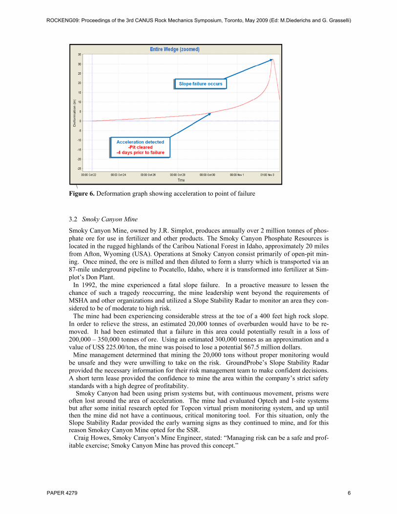
\
Figure 6. Deformation graph showing acceleration to point of failure
3.2 Smoky Canyon Mine
Smoky Canyon Mine, owned by J.R. Simplot, produces annually over 2 million tonnes of phos-phate ore for use in fertilizer and other products. The Smoky Canyon Phosphate Resources is located in the rugged highlands of the Caribou National Forest in Idaho, approximately 20 miles from Afton, Wyoming (USA). Operations at Smoky Canyon consist primarily of open-pit min-ing. Once mined, the ore is milled and then diluted to form a slurry which is transported via an 87-mile underground pipeline to Pocatello, Idaho, where it is transformed into fertilizer at Sim-plot’s Don Plant.
In 1992, the mine experienced a fatal slope failure. In a proactive measure to lessen the chance of such a tragedy reoccurring, the mine leadership went beyond the requirements of MSHA and other organizations and utilized a Slope Stability Radar to monitor an area they con-sidered to be of moderate to high risk.
The mine had been experiencing considerable stress at the toe of a 400 feet high rock slope. In order to relieve the stress, an estimated 20,000 tonnes of overburden would have to be re-moved. It had been estimated that a failure in this area could potentially result in a loss of 200,000 – 350,000 tonnes of ore. Using an estimated 300,000 tonnes as an approximation and a value of US$ 225.00/ton, the mine was poised to lose a potential $67.5 million dollars.
Mine management determined that mining the 20,000 tons without proper monitoring would be unsafe and they were unwilling to take on the risk. GroundProbe’s Slope Stability Radar provided the necessary information for their risk management team to make confident decisions. A short term lease provided the confidence to mine the area within the company’s strict safety standards with a high degree of profitability.
Smoky Canyon had been using prism systems but, with continuous movement, prisms were often lost around the area of acceleration. The mine had evaluated Optech and I-site systems but after some initial research opted for Topcon virtual prism monitoring system, and up until then the mine did not have a continuous, critical monitoring tool. For this situation, only the Slope Stability Radar provided the early warning signs as they continued to mine, and for this reason Smokey Canyon Mine opted for the SSR. Craig Howes, Smoky Canyon’s Mine Engineer, stated: “Managing risk can be a safe and prof-itable exercise; Smoky Canyon Mine has proved this concept.”
ROCKENG09: Proceedings of the 3rd CANUS Rock Mechanics Symposium, Toronto, May 2009 (Ed: M.Diederichs and G. Grasselli)
PAPER 4279 6
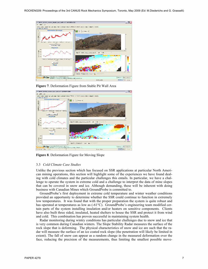
Figure 7. Deformation Figure from Stable Pit Wall Area
Figure 8. Deformation Figure for Moving Slope
3.3 Cold Climate Case Studies Unlike the previous section which has focused on SSR applications at particular North Ameri-can mining operations, this section will highlight some of the experiences we have found deal-ing with cold climates and the particular challenges this entails. In particular, we have a chal-lenge to operate the system in extreme cold and a challenge to interpret the data of mine slopes that can be covered in snow and ice. Although demanding, these will be inherent with doing business with Canadian Mines which GroundProbe is committed to.
GroundProbe’s first deployment in extreme cold temperature and winter weather conditions provided an opportunity to determine whether the SSR could continue to function in extremely low temperatures. It was found that with the proper preparation the system is quite robust and has operated at temperatures as low as (-61°C). GroundProbe’s engineering team modified cer-tain parts of the system installing insulation and/or heaters on sensitive components. Clients have also built three sided, insulated, heated shelters to house the SSR and protect it from wind and cold. This combination has proven successful in maintaining system health.
Radar monitoring during wintry conditions has particular challenges due to snow and ice that is very common during Canadian winters. The Slope Stability Radar measures the surface of the rock slope that is deforming. The physical characteristics of snow and ice are such that the ra-dar will measure the surface of an ice coated rock slope (the penetration will likely be limited in extent). The fall of snow can appear as a random change in the measured deformation over the face, reducing the precision of the measurements, thus limiting the smallest possible move-
ROCKENG09: Proceedings of the 3rd CANUS Rock Mechanics Symposium, Toronto, May 2009 (Ed: M.Diederichs and G. Grasselli)
PAPER 4279 7

ments. In contrast, when the snow melts (e.g. snow during daylight hours), both regional movements in combination with random changes occurs, depending on the structure of the snow. This is assumed to be due to combination of movement of the snow and changing of the snow surface (which the radar is imaging - radar does not penetrate significantly through snow).
The poor coherence and deformation noise added to the system during heavy snowfall sug-gests that the SSR systems would be of limited value in alarming for rapid brittle failure (usual-ly single bench scale) during periods of heavy snowfall (in other mining operations, we regular-ly see small rapid brittle failures occurring with less than 1 inch pre-failure deformation). During rapid brittle failure it is going to be extremely challenging to mitigate for these slope ha-zards during snowfall. However during wintry conditions (periods of heavy snowfall) signifi-cant slope deformation hazards can be observed by the SSR system where large deformations of the slope are occurring. Greater precision of deformation and velocity measures can be made over relatively short time spans (hours preferably), between heavy snowfall.
Some of the more interesting winter phenomena that were not initially considered during the origins of the Slope Stability Radar (in the very warm Queensland coal mines of Australia) are glaciers, ice falls and avalanches. Glacier monitoring was seen in one of the high altitude mine sites in the Chilean Andes. Although the movement rates were noisy during high temperature times due to surface melting, the movement rates seen in the glacier above the mine were of a magnitude that had been monitored by the mine staff and they were happy with the results. Ice falls have been seen in Canadian operations and in particular the area where ice growth was ac-tively occurring was noted, which is an excellent example of hazard identification using the Slope Stability Radar. The operation could then mitigate for this hazard accordingly as they knew its location. Finally, snow avalanches have been monitored on North American mine sites. It is unknown whether characteristic pre-cursor deformation of snow could be used to alarm for avalanches but the timing, geographical extent, and location of avalanches is certainly clearly recorded by the SSR data.
4 CONCLUSIONS
The SSR is a state-of-the-art development for monitoring slope movement in open pit mines. It offers unprecedented sub-millimeter precision and broad area coverage of wall movements through rain, dust and smoke. The real-time display of the movement of mine walls has allowed continuous management of the risk of slope instability at a mine operations level. There are two key roles where mines are now using the slope stability radar:
1. Safety Critical Monitoring: The radar is used during mining production as a primary monitoring tool of a designated unstable slope. 2. Campaign Monitoring: The radar is moved around the mine in a repeatable manner to compare movements at each site over an extended time, and determine problematic areas. Campaign monitoring in this manner is often used in metalliferous mines until determina-tion of developing failure is observed.
In the case studies discussed in this paper, the SSR was utilized in both roles. The SSR tech-nology has enabled a radical change in the management of risks in open cut mining operations, which has resulted in a rapid take-up of the technology throughout the world to date. Our first SSR system was deployed in Canada in January 2008 and we currently have 5 systems deployed in Canada. GroundProbe is committed and looks forward to our continued success in providing real-time slope hazard management services to the Canadian Mining industry.
5 REFERENCES
HOEK, E. & BRAY, J.W. (1981), “Rock Slope Engineering”, The Institute of Mining and Metlurgy. HARRIES, N.J.& ROBERTS, H. (2007), “The Use of Slope Stability Radar (SSR) in Managing Slope Instability Hazards”, in Proceedings of the 1st Canada-US Rock Mechanics Symposium, Rock Mechanics: Meeting Society’s Challenges and Demands - Eberhardt, Stead & Morrison (eds), Vancouver, Canada, 27-31 May 2007. BATES, DAVE, P.G. (2009), Case Study of Use of SSR System at Thompson Crk Mine in Idaho, USA.
ROCKENG09: Proceedings of the 3rd CANUS Rock Mechanics Symposium, Toronto, May 2009 (Ed: M.Diederichs and G. Grasselli)
PAPER 4279 8