Embed Size (px)
Citation preview
Slide 1
Edexcel Entry Level Certificate: Delivering the 2012 Entry Level Geography qualification
11OGM03/01
Aim of the session:To help teachers prepare students for delivery of the revised 2012 Edexcel Entry Level Certificate in Geography, this session will:
- Give an overview of the structure and content of the new qualification - Explore the differences between the new qualification and the legacy
Entry Level Certificate in Geography - Explain how fieldwork forms an important part of the
qualification. - Look at sample assessment materials - Address any questions
Slide 2
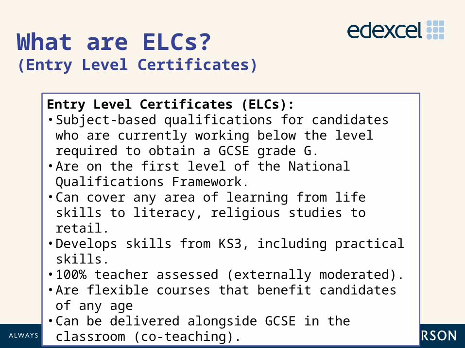
Entry Level Certificates (ELCs):• Subject-based qualifications for candidates who are
currently working below the level required to obtain a GCSE grade G.
• Are on the first level of the National Qualifications Framework.
• Can cover any area of learning from life skills to literacy, religious studies to retail.
• Develops skills from KS3, including practical skills.• 100% teacher assessed (externally moderated).• Are flexible courses that benefit candidates of any age• Can be delivered alongside GCSE in the classroom (co-
teaching).
What are ELCs? (Entry Level Certificates)
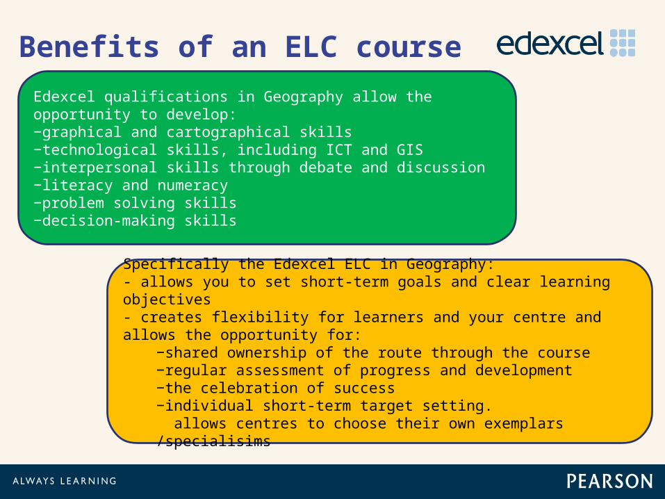
Benefits of an ELC course
Edexcel qualifications in Geography allow the opportunity to develop: −graphical and cartographical skills −technological skills, including ICT and GIS −interpersonal skills through debate and discussion −literacy and numeracy −problem solving skills −decision-making skills
Specifically the Edexcel ELC in Geography:- allows you to set short-term goals and clear learning objectives - creates flexibility for learners and your centre and allows the opportunity for:
−shared ownership of the route through the course −regular assessment of progress and development −the celebration of success −individual short-term target setting. allows centres to choose their own exemplars /specialisims
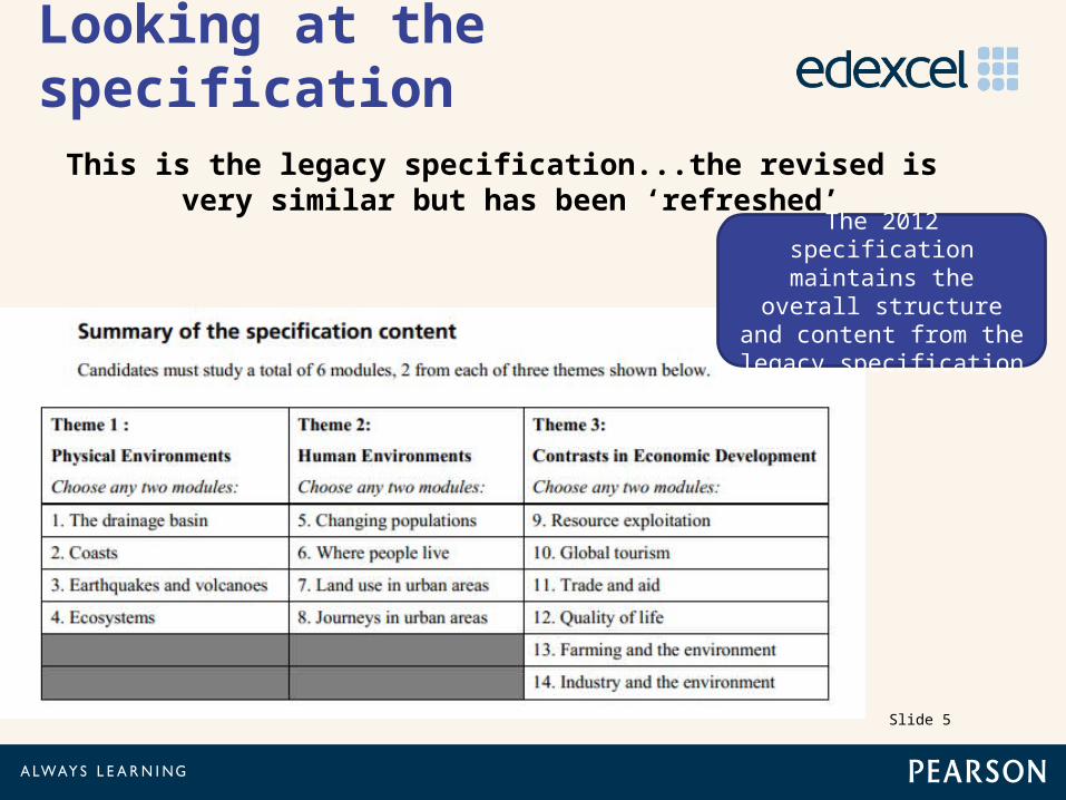
Looking at the specification
Slide 5
This is the legacy specification...the revised is very similar but has been ‘refreshed’
The 2012 specification maintains the overall structure and content
from the legacy specification
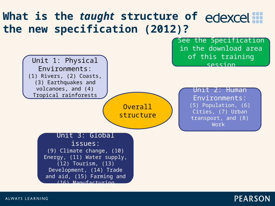
What is the taught structure of the new specification (2012)?
Unit 1: Physical Environments:
(1) Rivers, (2) Coasts, (3) Earthquakes and
volcanoes, and (4) Tropical rainforests Unit 2: Human
Environments:(5) Population, (6) Cities, (7) Urban transport, and
(8) Work
Unit 3: Global issues:(9) Climate change, (10)
Energy, (11) Water supply, (12) Tourism, (13) Development,
(14) Trade and aid, (15) Farming and (16)
Manufacturing
Overall structure
See the Specification in the download area of this
training session
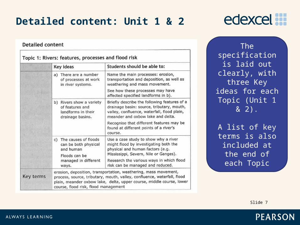
Detailed content: Unit 1 & 2
Slide 7
The specification is laid out clearly,
with three Key ideas for each Topic (Unit 1 &
2).
A list of key terms is also
included at the end of each Topic
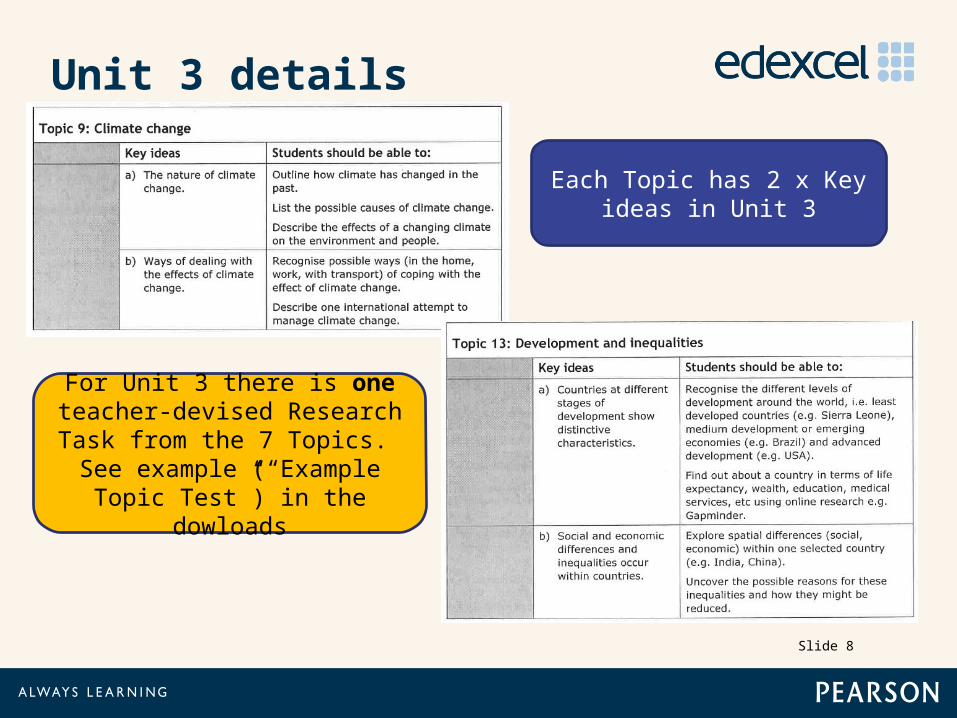
Unit 3 details
Slide 8
For Unit 3 there is one teacher-devised Research
Task from the 7 Topics. See example (“Example Topic
Test”) in the dowloads
Each Topic has 2 x Key ideas in Unit 3
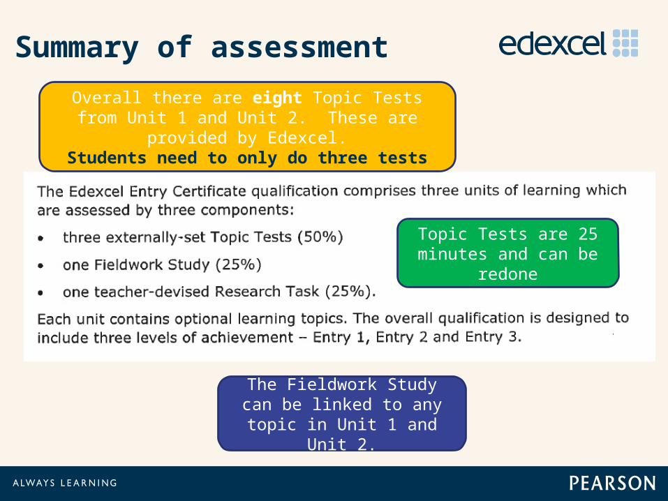
Summary of assessment
The Fieldwork Study can be linked to any topic in
Unit 1 and Unit 2.
Overall there are eight Topic Tests from Unit 1 and Unit 2. These are provided by Edexcel.Students need to only do three tests
Topic Tests are 25 minutes and can be
redone
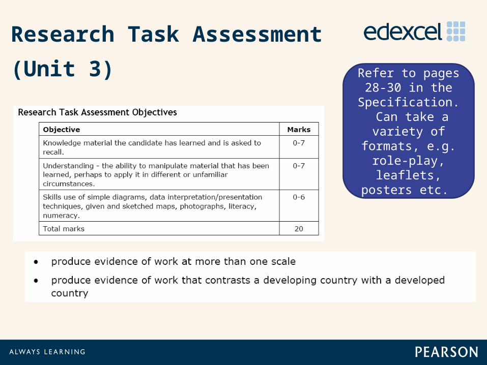
Research Task Assessment
(Unit 3) Refer to pages 28-30 in the
Specification. Can take a variety of
formats, e.g. role-play,
leaflets, posters etc.
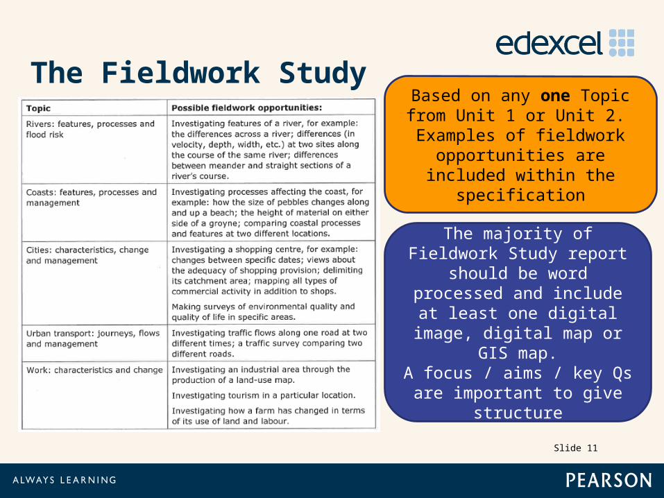
The Fieldwork Study
Slide 11
Based on any one Topic from Unit 1 or Unit 2. Examples of
fieldwork opportunities are included within the
specification
The majority of Fieldwork Study report should be
word processed and include at least one digital
image, digital map or GIS map.
A focus / aims / key Qs are important to give structure

Planning and organising your fieldwork
Fieldwork must be based on actually going-out into the
‘field’ and collecting first-
hand data.
Group-work is the most likely situation. Fine!
“Field” can be in the school-grounds, but vastly preferable to
offer alternative location. Same as
GCSE.

A Model of good fieldwork experience - ‘burger Bun’?
Pre fieldwork preparation- staff and students
Post fieldwork experience
Virtual fieldwork to familiarise (video / pictures)
Use of maps to locate
Asking relevant questions: how, why, when etcRelating
classroom experience to fieldwork content
Linking fieldwork to other ELC topics
Write-up of work for the Fieldwork Study
Fieldwork experience
Making decisions, i.e. developing solutions
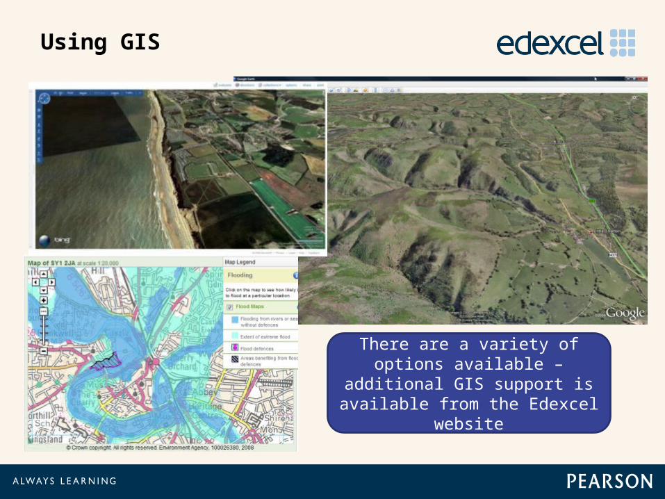
Using GIS
There are a variety of options available – additional GIS
support is available from the Edexcel website
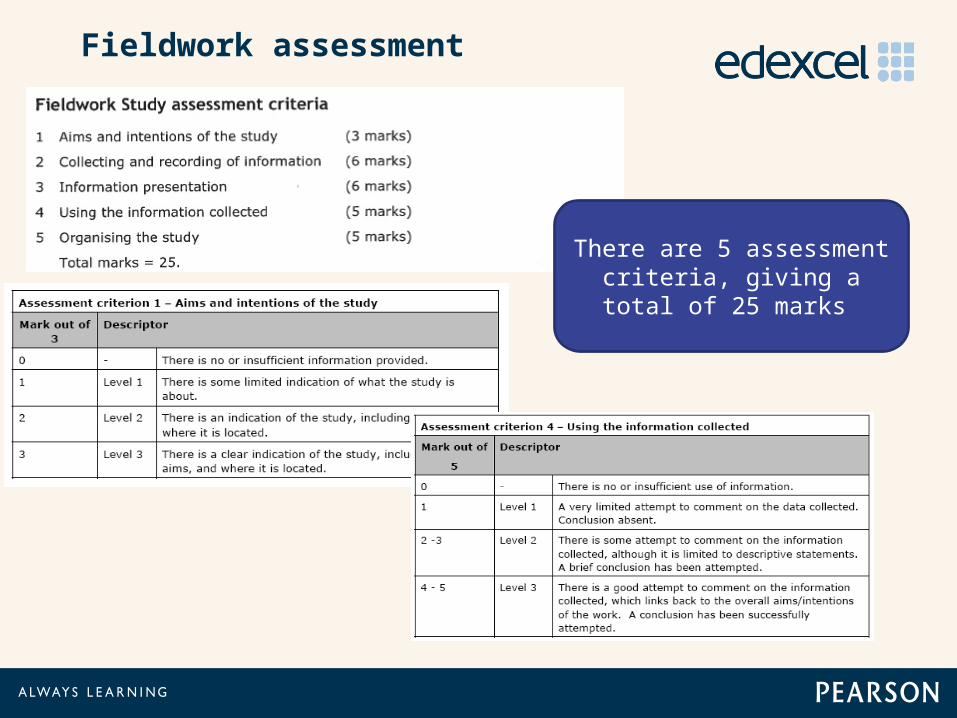
Fieldwork assessment
There are 5 assessment criteria, giving a total of
25 marks
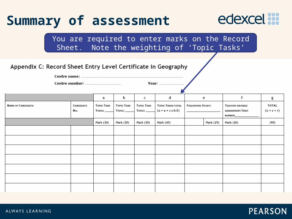
Summary of assessmentYou are required to enter marks on the Record Sheet.
Note the weighting of ‘Topic Tasks’

Summary of assessment
A student working at Entry Level 3 is approaching the standard
required for a GCSE Grade G. See specification pages 31-32
You can now link your total marks (90)
In summary
• The new September 2012 specification remains broadly similar to the legacy specification in terms of content and structure.
• The ELC in Geography tries to encourage flexible learning and independent learning as well as delivery through a co-teaching approach.
• The qualification remains 100% teacher assessed (externally moderated). There is no terminal examination.
• Fieldwork remains important; there is a choice • Additional support for the ELC: Geography Advisor and
Geography Communitieswww.edexcel.com/Subjects/Geography/Pages/Default.aspx