Embed Size (px)
Citation preview

UM09441A24.730
June 2020
Resolution Copper Mining LLC
Resolution Copper Project
Skunk Camp Tailings Storage Facility ‘Dry’ Slumping Extents
Doc. # CCC.03-81600-EX-REP-00031 – Rev. 1

200622R-SkunkCampTSF_SlumpRev1.docx UM09441A24.730
KCB Consultants Ltd. 2 North Central Avenue, 18th Floor ▪ Phoenix Arizona 85004 ▪ USA t 602.283.1006 ▪ www.kcbconsultants.com
June 22, 2020
Resolution Copper Mining LLC P.O. Box 1944 Superior, Arizona 85273 Ms. Victoria Peacey Senior Manager – Permitting and Approvals Dear Ms. Peacey: Resolution Copper Project Skunk Camp Tailings Storage Facility ‘Dry’ Slumping Extents Doc. # CCC.03-81600-EX-REP-00031 - Rev. 1 Please find enclosed a summary of the Skunk Camp Tailings Storage Facility hypothetical ‘dry’ slumping extent analysis. The hypothetical ‘dry’ slumping extent represents a condition in which there is minimal to no ponded water on the scavenger beach and a hypothetical slump of the Skunk Camp TSF Main Embankment occurs. The results of this assessment compliment the TSF consequence evaluation in the Resolution Project Draft Environmental Impact Statement and used to confirm consequence classification identified in the Skunk Camp TSF risk assessment held on February 5 to 7, 2020. Please let us know if you have any questions. Yours truly,
KCB CONSULTANTS LTD.
Kate Patterson, P.E., P.Eng. Project Manager
KP/OL:dl

UM09441A24.730 June 2020
Resolution Copper Mining LLC
Resolution Copper Project
Skunk Camp Tailings Storage Facility ‘Dry’ Slumping Extents
Doc. # CCC.03-81600-EX-REP-00031 – Rev. 1

Resolution Copper Mining LLC Resolution Copper Project Doc. # CCC.03-81600-EX-REP-00031 - Rev. 1
Skunk Camp Tailings Storage Facility ‘Dry’ Slumping Extents
TABLE OF CONTENTS
200622R-SkunkCampTSF_SlumpRev1.docx
Page i UM09441A24.730 June 2020
1 INTRODUCTION .......................................................................................................................... 1
2 TSF DESCRIPTION ....................................................................................................................... 4 2.1 Project Description ...................................................................................................... 4 2.2 TSF Description ............................................................................................................ 4
3 RISK ASSESSMENT ...................................................................................................................... 8
4 SLUMPING BENCHMARKING .................................................................................................... 10
5 METHODOLOGY ....................................................................................................................... 12 5.1 Approach ................................................................................................................... 12 5.2 Slumping Extent ........................................................................................................ 13
6 CONCLUSIONS .......................................................................................................................... 17
7 CLOSING ................................................................................................................................... 18
REFERENCES ......................................................................................................................................... 19
List of Tables
Table 4.1 Historical and Simulated Tailings Failures .................................................................... 10 Table 4.2 Residual Undrained Strength Ratio of Resolution Tailings ........................................... 11 Table 5.1 Slumping Failure Modeling Results .............................................................................. 14
List of Figures
Figure 1.1 Mitigation Measure FS-227: Conduct Refined FMEA before Final EIS for the Preferred Alternative ..................................................................................................... 2
Figure 1.2 Mitigation Measure FS-229: Development of an Emergency Action Plan for the Tailings Storage Facility for the Preferred Alternative .................................................... 3
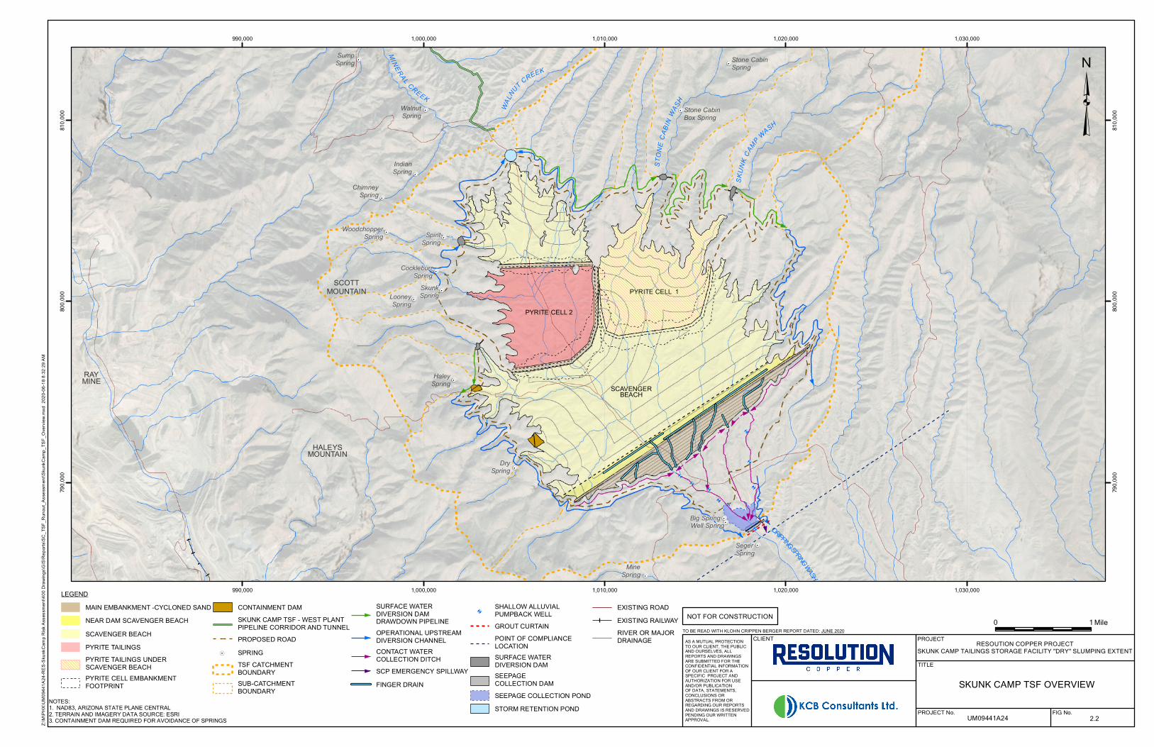
Figure 2.1 Skunk Camp Location Plan ............................................................................................. 6 Figure 2.2 Skunk Camp DEIS TSF Overview ..................................................................................... 7 Figure 5.1 Muk3D Model Results of Slumping Post-Failure Surface .............................................. 13 Figure 5.2 Post-Failure Slumping Extent ....................................................................................... 15 Figure 5.3 Post-Failure Slumping Extent (Section A) ..................................................................... 16

Resolution Copper Mining LLC Resolution Copper Project Doc. # CCC.03-81600-EX-REP-00031 - Rev. 1
Skunk Camp Tailings Storage Facility ‘Dry’ Slump Extents
200622R-SkunkCampTSF_SlumpRev1.docx
Page 1 UM09441A24.730 June 2020
1 INTRODUCTION
Resolution Copper Mining LLC (RCM) is proposing to develop the Resolution Copper Project, an underground copper mine approximately two miles east of the town of Superior in the Pioneer Mining District, Pinal County, Arizona. Tonto National Forest (the Forest) issued the Draft Environmental Impact Statement (DEIS) for the proposed Resolution Copper Project and Land Exchange in August 2019 (Forest 2019). The DEIS identified the preferred Tailings Storage Facility (TSF) alternative as the Alternative 6 – Skunk Camp. The DEIS also listed mitigation measures, some to be completed prior to issuing the Final Environmental Impact Statement (FEIS), two of these include (detailed description of mitigation measure are given in Figure 1.1 and Figure 1.2):
FS-227: Conduct Refined FMEA before Final EIS for the Preferred Alternative
FS-229: Development of an Emergency Action Plan for the Tailings Storage Facility for the Preferred Alternative
The Forest disclosed the potential effects of a catastrophic TSF failure event in the DEIS based on Rico et al. (2010), an empirical assessment method based on case histories. These results were used to identify the consequence category of certain Potential Failure Modes (PFMs) for the Failure Modes and Effects Analysis (FMEA) risk assessment held on February 5 to 7, 2020 to address FS-227.
During the risk assessment workshop it was agreed that not all PFMs would result in TSF failure extent estimated by the Rico et al. (2010) methodology. For some of the PFMs in which the Skunk Camp TSF Main Embankment hypothetically fails, it was agreed that the released tailings from the ‘dry’ scavenger beach (i.e., no ponded water on the scavenger beach) would result in slumping failure that may not reach the Gila River.
KCB Consultants Ltd. (KCBCL) was asked to estimate the possible maximum extent of a hypothetical slumping failure of the Skunk Camp TSF Main Embankment. This assessment compliments the Rico et al. (2010) results to help classify PFMs into consequence categories and confirm the results of the FMEA risk assessment (ref). The two TSF failure extent assessments (the Rico estimate and the hypothetical ‘dry’ slumping estimate) are not representative of all PFMs, but potentially bracket the likely major hypothetical failure extents.
The results of the hypothetical slumping failure would also be used in the preliminary Emergency Action Plan (EAP) for the FEIS.
As the TSF design progresses and is constructed/operated failure mode assessments, risk assessments, runout/inundation assessments and the EAP should be regularly updated.

Resolution Copper Mining LLC Resolution Copper Project Doc. # CCC.03-81600-EX-REP-00031 - Rev. 1
Skunk Camp Tailings Storage Facility ‘Dry’ Slump Extents
200622R-SkunkCampTSF_SlumpRev1.docx
Page 2 UM09441A24.730 June 2020
Figure 1.1 Mitigation Measure FS-227: Conduct Refined FMEA before Final EIS for the Preferred Alternative

Resolution Copper Mining LLC Resolution Copper Project Doc. # CCC.03-81600-EX-REP-00031 - Rev. 1
Skunk Camp Tailings Storage Facility ‘Dry’ Slump Extents
200622R-SkunkCampTSF_SlumpRev1.docx
Page 3 UM09441A24.730 June 2020
Figure 1.2 Mitigation Measure FS-229: Development of an Emergency Action Plan for the Tailings Storage Facility for the Preferred Alternative

Resolution Copper Mining LLC Resolution Copper Project Doc. # CCC.03-81600-EX-REP-00031 - Rev. 1
Skunk Camp Tailings Storage Facility ‘Dry’ Slump Extents
200622R-SkunkCampTSF_SlumpRev1.docx
Page 4 UM09441A24.730 June 2020
2 TSF DESCRIPTION
2.1 Project Description
The Resolution Copper Project is proposing to mine the ore by panel caving and convey it to an ore processing facility. The Mine Plan of Operations (MPO) proposed mine plan will produce a daily maximum of 132,000 dry tons per day (tpd) of tailings, an approximately cumulative 1.37 billion tons over the proposed 41-year mine life. Processing will generate two physically, mineralogically and geochemically discrete tailings streams known as “scavenger” tailings and “pyrite” tailings; scavenger tailings will account for approximately 84% of tailings produced and pyrite tailings will account for the remaining 16%.
The scavenger tailings specific gravity is approximately 2.78. The tailings are approximately equal proportions of sand and low to non-plastic fines (SM/ML). The scavenger tailings can be cycloned to produce a coarse sand suitable for dam construction. The scavenger tailings contain a very low percentage of sulfide minerals (with a mean sulfide content of less than 0.1% by weight based on current laboratory testing results) and low neutralization potential. The release of acidity, sulfate and metal/metalloids from the scavenger tailings are limited by the very low sulfide and residual metal contents (Duke HydroChem 2016).
The pyrite tailings contain a much higher percentage of pyrite (>20% by weight) and are classified as Potentially Acid Generating (PAG) (Duke HydroChem 2016). The pyrite tailings specific gravity is variable and is approximately 3.5 on average. The pyrite tailings are predominantly low to non-plastic silt and clay-size particles, typically with a sand content less than 20%.
2.2 TSF Description
The proposed Skunk Camp TSF will be located in the head waters of Dripping Springs Wash approximately 13 miles southeast of the proposed concentrator site (West Plantsite) and the Resolution orebody (refer to Figure 2.1).
The Dripping Springs Mountains define the western boundary of the proposed site, while the Mescal Mountains and Pinal Mountains define the eastern boundary. The approximate base elevation of the proposed TSF is El. 3,160 ft and the peaks of adjacent mountains are: El. 4,566 ft at Haleys Mountain (Dripping Springs Mountains), El. 6,568 ft at El Capitan Mountain (Mescal Mountains), and El. 7,848 ft at Pinal Peak (Pinal Mountains). Within the proposed TSF area, the drainages are ephemeral and infilled with sand and gravel alluvial deposits. In response to storms, surface water flows in Dripping Springs Wash from northeast to southwest approximately 13 miles to its confluence with the Gila River. The proposed site is located just southwest of the surface water divide between Dripping Springs Wash and Mineral Creek, see Figure 2.1. The low point along the divide is El. 3,703 fasl. Storm water south of the divide flows through the site, roughly southeast through Dripping Springs Wash Basin to the Gila River, while storm water north of the divide flows into the Mineral Creek basin, which flows into the Gila River approximately 16 miles downstream of the confluence of Dripping Springs Wash and the Gila River.

Resolution Copper Mining LLC Resolution Copper Project Doc. # CCC.03-81600-EX-REP-00031 - Rev. 1
Skunk Camp Tailings Storage Facility ‘Dry’ Slump Extents
200622R-SkunkCampTSF_SlumpRev1.docx
Page 5 UM09441A24.730 June 2020
The Skunk Camp TSF will consist of two pyrite cells upstream of the scavenger beach contained by a cross-valley embankment (the Main Embankment) as shown in Figure 2.2. The pyrite cells and scavenger beach have the capacity to store more than the 72-hour Probable Maximum Flood (PMF) and are designed for the 1 in 10,000 yr earthquake, assuming all potentially liquefiable tailings liquefy.
The pyrite tailings will be deposited subaqueously in low permeability pyrite cells contained by independent downstream raised compacted cycloned sand embankments. Pyrite Cell 1 will receive tailings from startup to Year 15 and will be subsequently covered with scavenger tailings starting in Year 16. Pyrite Cell 2 construction will start prior to Year 15 and will receive pyrite tailings from Year 16 to Year 41. The pyrite cells will also act as the supernatant or reclaim pond for reuse in processing. Slurry bleed water and precipitation runoff from the scavenger tailings beach will be collected in low spots and pumped into the active pyrite cell, such that no permanent pond will be maintained on the scavenger beach.
The Main Embankment will be constructed of compacted cyclone underflow (coarser underflow scavenger tailings produced during cycloning) using the centerline construction method up to El. 3,600 fasl (approximately 100 ft below the divide to Mineral Creek). Cyclone overflow (finer scavenger tailings produced during cycloning) and uncycloned scavenger tailings will be deposited upstream of the Main Embankment forming the tailings beach. Entrained water within the scavenger beach will be minimized by thickening prior to deposition in the TSF and adopting “thin-lift” deposition, allowing time for water to evaporate resulting in a relatively ‘dry’ tailings beach (KCB 2018). The resulting tailings beach at the end of operation that is expected to have saturation ranging from less than 80% (at depths from 0 ft to ~100 ft in the near dam area) becoming saturated at a greater distance from the dam where the fines deposit. All tailings is expected to be saturated below 100 ft to the base of the tailings. As the scavenger beach drains down after closure, the saturation will reduce, and tailings will become non-flowable (i.e., not susceptible to liquefaction).
Further details of the TSF design are provided in the DEIS design report (KCB 2018) and the updated ultimate configuration for the final EIS is included in the Skunk Camp TSF Reclamation Plan (KCBCL 2020).

!.
!.
!.
!.
!.
!.
!.
!.
!.
!.
!B(_̂
&*
£¤70
RAYMINE
TULA
P AI C
REEK
PINA
L CRE
EK
£¤77
£¤60
£¤77
LITTLEBOX LAKE
SAN CARLOSRESERVOIR
PINALMOUNTAINS
HALEYSMOUNTAIN
EL CAPITANMOUNTAIN
MESCALMOUNTAINS
PINAL
GILA
GILAPIN
AL
SILVE RCREEK
DRIPPING SPRINGSMOUNTAINS
KEARNY
HAYDEN
WINKELMAN
ARNETT CREEK
MINERAL CREEK
Boyce ThompsonArboretum State Park
DRIPPING SPRINGS WASH
GILARIV
ER
GILA RIVER
SAN CARLOS DAM
SUPERIOR
SKUNK CAMP TSF
Needles Eye
White Canyon
950,000
950,000
1,000,000
1,000,000
1,050,000
1,050,000
1,100,000
1,100,000
1,150,000
1,150,000
750,0
00
750,0
00
800,0
00
800,0
00
NOTES:1. NAD83, ARIZONA STATE PLANE CENTRAL, COORDINATES IN FEET2. IMAGERY PROVIDED BY ESRI/BING AERIAL IMAGERY3. TERRAIN AND IMAGERY DATA SOURCE: ESRI
³
SKUNK CAMP TSF LOCATION
UM09441A24
CLIENT PROJECT
TITLE
PROJECT No. FIG No.
AS A MUTUAL PROTECTIONTO OUR CLIENT, THE PUBLICAND OURSELVES, ALL REPORTS AND DRAWINGSARE SUBMITTED FOR THE CONFIDENTIAL INFORMATION OF OUR CLIENT FOR ASPECIFIC PROJECT ANDAUTHORIZATION FOR USEAND/OR PUBLICATIONOF DATA, STATEMENTS,CONCLUSIONS ORABSTRACTS FROM ORREGARDING OUR REPORTS AND DRAWINGS IS RESERVEDPENDING OUR WRITTEN APPROVAL. 2.1
LEGEND
_̂PROPOSED CONCENTRATOR SITE(WEST PLANTSITE)
!B( RESOLUTION OREBODY
SKUNK CAMP TSF
SEEPAGE COLLECTION DAM
SKUNK CAMP TSF - WEST PLANTPIPELINE CORRIDOR AND TUNNEL
MAJOR CATCHMENT BOUNDARY
TSF CATCHMENT BOUNDARY
WILDERNESS AREAAND STATE PARK
&* SAN CARLOS DAM
!. TOWN OR CITY
COUNTY LINE
HIGHWAY
EXISTING RAILWAY
ARIZONA NATIONAL SCENICTRAIL (ARIZONA TRAIL)
NATURAL WATERCOURSE
Z:\M
\PH
X\U
M09
441A
24-R
ES
-Sku
nkC
amp
Ris
k A
sses
smen
t\400
Dra
win
gs\G
IS\R
epor
ts\S
C_T
SF_
Run
out_
Ass
essm
ent\S
kunk
Cam
pTS
F_Lo
catio
n.m
xd 2
020-
06-1
8 8:
35:4
5 A
M
TO BE READ WITH KLOHN CRIPPEN BERGER REPORT DATED: JUNE 2020
!B(!.
!.
!.
!. !.
!.
!.
!.
!.
!. !.
!.
STATE OF ARIZONA
£¤40
£¤17
£¤8
£¤10
£¤60
£¤160
YUMA
MESA
TUCSON
PHOENIX
PRESCOTT
FLAGSTAFF
0 100 Miles
NOT FOR CONSTRUCTION 0 5 Mile
RESOUTION COPPER PROJECTSKUNK CAMP TAILINGS STORAGE FACILITY "DRY" SLUMPING EXTENT
!.
!.
!.
!.
!.
!.
!.
!.
!.
!.
!.
!.
!.
!.
!.
!.
!.
!.
STON
ECA
BIN
WASH
SKUN
KCA
MP WASH
HALEYSMOUNTAIN
RAYMINE
DRIPPINGSPRINGWASH
PYRITE CELL 1
PYRITE CELL 2
MINERAL CREEK
WALN
UT CREEK
SCOTTMOUNTAIN
SCAVENGERBEACH
WalnutSpring
IndianSpring
ChimneySpring
SumpSpring Stone Cabin
Spring
WoodchopperSpring Spirit
Spring
CockleburrSpring
SkunkSpringLooney
Spring
HaleySpring
DrySpring
MineSpring
SegerSpring
Stone CabinBox Spring
Big SpringWell Spring
990,000
990,000
1,000,000
1,000,000
1,010,000
1,010,000
1,020,000
1,020,000
1,030,000
1,030,000
790,0
00
790,0
00
800,0
00
800,0
00
810,0
00
810,0
00
NOTES:1. NAD83, ARIZONA STATE PLANE CENTRAL2. TERRAIN AND IMAGERY DATA SOURCE: ESRI3. CONTAINMENT DAM REQUIRED FOR AVOIDANCE OF SPRINGS
³
SKUNK CAMP TSF OVERVIEW
UM09441A24
CLIENT PROJECT
TITLE
PROJECT No. FIG No.
AS A MUTUAL PROTECTIONTO OUR CLIENT, THE PUBLICAND OURSELVES, ALL REPORTS AND DRAWINGSARE SUBMITTED FOR THE CONFIDENTIAL INFORMATION OF OUR CLIENT FOR ASPECIFIC PROJECT ANDAUTHORIZATION FOR USEAND/OR PUBLICATIONOF DATA, STATEMENTS,CONCLUSIONS ORABSTRACTS FROM ORREGARDING OUR REPORTS AND DRAWINGS IS RESERVEDPENDING OUR WRITTEN APPROVAL. 2.2
LEGEND
MAIN EMBANKMENT -CYCLONED SAND
NEAR DAM SCAVENGER BEACH
SCAVENGER BEACH
PYRITE TAILINGS
PYRITE TAILINGS UNDERSCAVENGER BEACHPYRITE CELL EMBANKMENTFOOTPRINT
CONTAINMENT DAM
SKUNK CAMP TSF - WEST PLANTPIPELINE CORRIDOR AND TUNNEL
PROPOSED ROAD
!. SPRING
TSF CATCHMENTBOUNDARYSUB-CATCHMENTBOUNDARY
SURFACE WATERDIVERSION DAMDRAWDOWN PIPELINE
OPERATIONAL UPSTREAMDIVERSION CHANNELCONTACT WATERCOLLECTION DITCH
SCP EMERGENCY SPILLWAY
FINGER DRAIN
!ASHALLOW ALLUVIALPUMPBACK WELL
GROUT CURTAIN
POINT OF COMPLIANCELOCATIONSURFACE WATERDIVERSION DAMSEEPAGECOLLECTION DAM
SEEPAGE COLLECTION POND
STORM RETENTION POND
EXISTING ROAD
EXISTING RAILWAY
RIVER OR MAJORDRAINAGE
Z:\M
\PH
X\U
M09
441A
24-R
ES
-Sku
nkC
amp
Ris
k A
sses
smen
t\400
Dra
win
gs\G
IS\R
epor
ts\S
C_T
SF_
Run
out_
Ass
essm
ent\S
kunk
Cam
p_TS
F_O
verv
iew
.mxd
202
0-06
-18
8:32
:29
AM
0 1 MileTO BE READ WITH KLOHN CRIPPEN BERGER REPORT DATED: JUNE 2020
NOT FOR CONSTRUCTION
RESOUTION COPPER PROJECTSKUNK CAMP TAILINGS STORAGE FACILITY "DRY" SLUMPING EXTENT

Resolution Copper Mining LLC Resolution Copper Project Doc. # CCC.03-81600-EX-REP-00031 - Rev. 1
Skunk Camp Tailings Storage Facility ‘Dry’ Slump Extents
200622R-SkunkCampTSF_SlumpRev1.docx
Page 8 UM09441A24.730 June 2020
3 RISK ASSESSMENT
The Forest commissioned Gannett Fleming to facilitate a FMEA for the Resolution Copper Project’s Skunk Camp TSF (DEIS design) to address mitigation measure FS-227. The FMEA was held between February 5 to 7, 2020, and identified PFM of the TSF and assigned qualitative likelihood and consequence categories to each PFM to help assess their associated risk. This session was conducted jointly with representatives from USFS, ADEQ, USACE, EPA, Resolution Copper Mining, SWCA, BGC, KCBCL, Golder, Tetra Tech, and Gannett Fleming. The Forest disclosed the potential effects of a catastrophic TSF failure event in the DEIS based on Rico et al. (2010). These results were used to identify the consequence category of certain PFMs in the FMEA risk assessment.
During the risk assessment workshop, it was agreed that not all PFMs would result in TSF failure extent estimated by the Rico et al. (2010) case history based methodology. For some of the PFMs in which the Skunk Camp TSF Main Embankment hypothetically fails, it was agreed that the released tailings from the ‘dry’ scavenger beach (i.e., no ponded water on the scavenger beach) would result in slumping that may not reach the Gila River. The attendees of the FMEA workshop estimated that a slump failure could extend about 4 to 8 miles downstream of the dam. It was recommended that the estimated extent of the slumping failure be further assessed to check the validity of the workshop estimate. Consequently this report provides an analysis, based on relevant case histories and mass balance, of the maximum extent of a hypothetical slumping failure of the Skunk Camp TSF Main Embankment.
The Skunk Camp TSF is robustly design and for the purposes of this assessment, the following characterization of the Skunk Camp TSF and assumptions for the hypothetical ‘dry’ slumping failure were made:
The TSF has stringent design criteria and incorporates robust design features to address the PFM’s identified during the risk assessment.
Cyclone sand embankments (pyrite cell dams and the Main Embankment):
The cyclone sand embankments are designed to be well-drained and compacted. They are therefore assumed to be non-flowable.
Scavenger beach:
The scavenger beach will be managed as ‘dry’ as possible, thus resulting in an average saturation less than 100% near the dam and at shallow depths. Based on this, the tailings closest to a potential slump are expected to be non-flowable (unless mixed with free water) if operated as designed with climate and tailings properties assumed in analysis. However, tailings at depth and further into the impoundment are likely to be saturated and potentially flowable. As the scavenger beach pore water drains down on closure, the saturation will reduce, and all the tailings is expected to become non-flowable (i.e., not susceptible to liquefaction).

Resolution Copper Mining LLC Resolution Copper Project Doc. # CCC.03-81600-EX-REP-00031 - Rev. 1
Skunk Camp Tailings Storage Facility ‘Dry’ Slump Extents
200622R-SkunkCampTSF_SlumpRev1.docx
Page 9 UM09441A24.730 June 2020
Pyrite tailings cells:
The pyrite tailings have a high specific gravity, are fine, and will be deposited subaqueously within a supernatant pond. Whether the pyrite tailings are potentially flowable is unknown and is therefore assumed to be possible for this stage of design (until investigations conducted during operations when it can be confirmed that they are not susceptible to flow liquefaction). However, due to the placement of the pyrite cells behind downstream raised compacted cycloned sand dams, the drier scavenger beach and the Main Embankment, the likelihood of releasing the pyrite tailings is extremely remote and release is not considered as part of this analysis and was not envisioned in the PFMs considered by the FMEA workshop group for this analysis.
If the TSF breaches, it is assumed that the material will slump down Drippings Springs Wash. It is assumed that it is not credible to breach towards Mineral Creek.
For the purpose of this assessment the scavenger Main Embankment was assumed to breach, resulting in slumping of the ‘dry’ scavenger beach (i.e., managed with minimal operating pond, scavenger beach will be variably saturated, as describe above), the slump was assumed to progress back to the pyrite tailings cell embankments, thus estimating the maximum possible tailings volume, and therefore maximum failure extent, that could be released downstream during such an event. Because the pyrite cell embankments are downstream raised compacted cycloned sand, dual failure of both the Main Embankment and the pyrite cell embankments was not evaluated and assumed to be close to non-credible.
Resolution Copper Mining LLC Resolution Copper Project Doc. # CCC.03-81600-EX-REP-00031 - Rev. 1
Skunk Camp Tailings Storage Facility ‘Dry’ Slump Extents
200622R-SkunkCampTSF_SlumpRev1.docx
Page 10 UM09441A24.730 June 2020
4 SLUMPING BENCHMARKING
A slumping failure occurs when a mass of tailings displaces outside of the design TSF footprint and rests at an assumed post-failure slope. This failure mode could potentially be triggered by strain-induced strength softening or slope failure of the embankment and upstream tailings beach, resulting in horizontal and vertical slumping displacements. The prediction of post-failure slumping distance and slope for failures is complex. The post-failure distance and slope are affected by many variables, some include:
height of the dam;
slope of the topography downstream;
trigger mechanism;
residual strength or the undrained shear strength ratio, (Su/σv’) of the tailings; and
rheology of the tailings (if flowable).
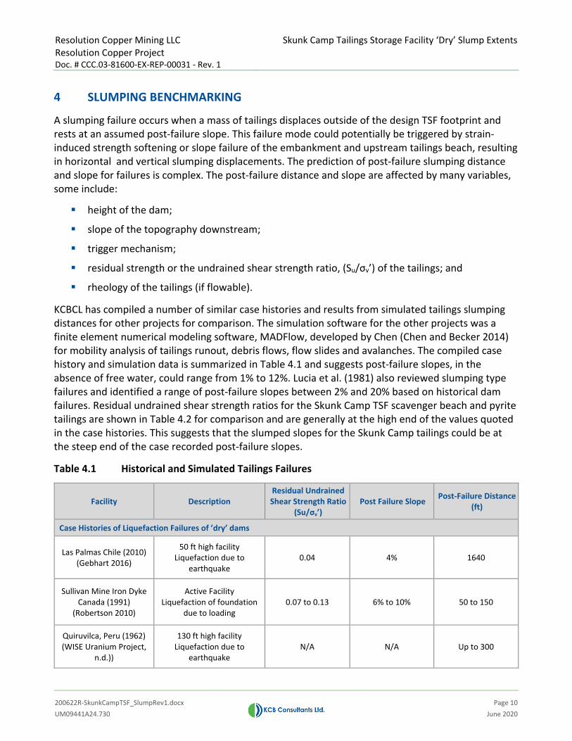
KCBCL has compiled a number of similar case histories and results from simulated tailings slumping distances for other projects for comparison. The simulation software for the other projects was a finite element numerical modeling software, MADFlow, developed by Chen (Chen and Becker 2014) for mobility analysis of tailings runout, debris flows, flow slides and avalanches. The compiled case history and simulation data is summarized in Table 4.1 and suggests post-failure slopes, in the absence of free water, could range from 1% to 12%. Lucia et al. (1981) also reviewed slumping type failures and identified a range of post-failure slopes between 2% and 20% based on historical dam failures. Residual undrained shear strength ratios for the Skunk Camp TSF scavenger beach and pyrite tailings are shown in Table 4.2 for comparison and are generally at the high end of the values quoted in the case histories. This suggests that the slumped slopes for the Skunk Camp tailings could be at the steep end of the case recorded post-failure slopes.
Table 4.1 Historical and Simulated Tailings Failures
Facility Description Residual Undrained Shear Strength Ratio
(Su/σv’) Post Failure Slope Post-Failure Distance
(ft)
Case Histories of Liquefaction Failures of ’dry’ dams
Las Palmas Chile (2010) (Gebhart 2016)
50 ft high facility Liquefaction due to
earthquake 0.04 4% 1640
Sullivan Mine Iron Dyke Canada (1991)
(Robertson 2010)
Active Facility Liquefaction of foundation
due to loading 0.07 to 0.13 6% to 10% 50 to 150
Quiruvilca, Peru (1962) (WISE Uranium Project,
n.d.))
130 ft high facility Liquefaction due to
earthquake N/A N/A Up to 300

Resolution Copper Mining LLC Resolution Copper Project Doc. # CCC.03-81600-EX-REP-00031 - Rev. 1
Skunk Camp Tailings Storage Facility ‘Dry’ Slump Extents
200622R-SkunkCampTSF_SlumpRev1.docx
Page 11 UM09441A24.730 June 2020
Facility Description Residual Undrained Shear Strength Ratio
(Su/σv’) Post Failure Slope Post-Failure Distance
(ft)
Simulated Extent Estimated using MADFlow
Facility #1 95 ft high facility with
downstream topography sloping from 0 to 2%
0.06 4% 1,430
0.07 4% 1,270
0.10 5% 1,130
0.14 8% 810
0.20 12% 140
Facility #2
300 ft high facility with downstream in a basin
topography sloping approximately 5%
0.05 3% 6,760
0.06 3% 5,980
0.10 8% 2,890
0.14 14% 860
0.20 22% 70
Table 4.2 Residual Undrained Strength Ratio of Resolution Tailings
Tailings Residual Undrained Strength Ratio (Su/σv’)
Reference
Cyclone Sand 0.24 KCBCL 2020
Scavenger Beach 0.13
Pyrite Tailings 0.05 KCB 2018

Resolution Copper Mining LLC Resolution Copper Project Doc. # CCC.03-81600-EX-REP-00031 - Rev. 1
Skunk Camp Tailings Storage Facility ‘Dry’ Slump Extents
200622R-SkunkCampTSF_SlumpRev1.docx
Page 12 UM09441A24.730 June 2020
5 METHODOLOGY
5.1 Approach
Muk3D ver. 2020.1.2 (MineBridge Software Inc. 2020), software was used to model the Skunk Camp TSF maximum potential slumping failure surface. Muk3D is capable of three-dimensional (3D) geometric modeling and volumetric calculations for earthwork structures such as tailings dams. The procedure used to determine the maximum potential post-failure extent are summarized below:
1. Assume a lower bound post-failure slope of 3% based on the benchmarking and tailings properties (see Section 4).
2. Complete a volume balance calculation using the dam break module of Muk3D to estimate the volume that is released downstream. This method balances the released volume with the support provided at the toe by the depositing tailings, this balance defines the elevation of the breach at the embankment centerline. The released volume of about 30% of the stored volume calculated by this method, which agrees with the case history compilation used in Rico et al. (2010).
3. The tailings bulk density and material volume balance is maintained before and after the slumping failure (i.e., the backscarp volume is equal to the runout volume).
4. The post-failure extent are overlaid on aerial photography to depict this hypothetical failure.

Resolution Copper Mining LLC Resolution Copper Project Doc. # CCC.03-81600-EX-REP-00031 - Rev. 1
Skunk Camp Tailings Storage Facility ‘Dry’ Slump Extents
200622R-SkunkCampTSF_SlumpRev1.docx
Page 13 UM09441A24.730 June 2020
Figure 5.1 Muk3D Model Results of Slumping Post-Failure Surface
Notes:
1. For the purposes of the MUK3D model, nominal breach bottom is assumed to be 2000 ft and breach side slopes are 10H:1V. These parameters have negligible effects on the downstream extent.
5.2 Slumping Extent
Estimated post-failure slumping extent is shown in plan on Figure 5.2, and the model results are summarized in Table 5.1.
The calculated post-failure distance is approximately 30,000 ft, which is much larger than the simulated runout distances in Table 4.1 for the given the expected undrained strength ratio for the Resolution tailings. The estimated distance is similar to that assumed at the FMEA, where an approximate distance 5-6 miles was used to assign the PFMs consequence category.
As shown on Figure 5.2, a hypothetical slumping failure would result in inundating the seepage collection pond and approximately a 10,000 ft long section of Dripping Springs Road.

Resolution Copper Mining LLC Resolution Copper Project Doc. # CCC.03-81600-EX-REP-00031 - Rev. 1
Skunk Camp Tailings Storage Facility ‘Dry’ Slump Extents
200622R-SkunkCampTSF_SlumpRev1.docx
Page 14 UM09441A24.730 June 2020
Table 5.1 Slumping Failure Modeling Results
Result Value
Top Elevation of Displaced Tailings (fasl) 3531.2 Elevation at the Embankment that Balances Failure
Volumes (displaced and deposited) 3350.0
Tailings Beach Failure Slope 3%
Post-Failure Deposited Slope 3%
Slope of Downstream Topography Approximately 2.2%
Volume of Displaced Tailings (acre-ft) 222,520 acre-ft or 359 Mcyd (approx. 30% of total stored tailings)
Length of Post-Failure Distance(1) (ft) 30,000 ft (5.7 miles) Notes:
1. Distance measured from the toe of the TSF along the reach or valley bottom through Dripping Springs Wash.

STON
E CAB
INWAS
H
SKUN
K CAMP
HALEYSMOUNTAIN
RAYMINE
EL CAPITANMTN
MESCAL MOUNTAINS
DRIPPING SPRING MOUNTAINS
PYRITECELL 1PYRITE
CELL 2
£¤77
MINERAL CREEK
SCOTTMOUNTAIN
SCAVENGERBEACH
MAIN EMBANKMENT
DRIPPING SPRINGS WASH
DRIPPING SPRINGS ROAD
GILA
RIVE
R
GILA RIVER
WASH
WAS
H
SEEPAGECOLLECTION
DAM
5AA5.3
5AA5.3
Needles Eye
980,000
980,000
995,000
995,000
1,010,000
1,010,000
1,025,000
1,025,000
1,040,000
1,040,000
1,055,000
1,055,000
1,070,000
1,070,000
1,085,000
1,085,000
770,0
00
770,0
00
785,0
00
785,0
00
800,0
00
800,0
00
NOTES:1. NAD83, ARIZONA STATE PLANE CENTRAL2. TERRAIN AND IMAGERY DATA SOURCE: ESRI
³
POST-FAILURE SLUMPING EXTENT
UM09441A24
CLIENT PROJECT
TITLE
PROJECT No. FIG No.
AS A MUTUAL PROTECTIONTO OUR CLIENT, THE PUBLICAND OURSELVES, ALL REPORTS AND DRAWINGSARE SUBMITTED FOR THE CONFIDENTIAL INFORMATION OF OUR CLIENT FOR ASPECIFIC PROJECT ANDAUTHORIZATION FOR USEAND/OR PUBLICATIONOF DATA, STATEMENTS,CONCLUSIONS ORABSTRACTS FROM ORREGARDING OUR REPORTS AND DRAWINGS IS RESERVEDPENDING OUR WRITTEN APPROVAL. 5.2
LEGEND
"DRY" SLUMPNG EXTENT
RESIDENCES
MAIN EMBANKMENT -CYCLONED SAND
SCAVENGER BEACH
PYRITE TAILINGS
PYRITE TAILINGS UNDERSCAVENGER BEACH
PYRITE CELL EMBANKMENTFOOTPRINT
CONTAINMENT DAM
SEEPAGE COLLECTION DAM
SKUNK CAMP TSF - WEST PLANTPIPELINE CORRIDOR AND TUNNEL
PROPOSED ROAD
TSF CATCHMENTBOUNDARY
SURFACE WATERDIVERSION DAMDRAWDOWN PIPELINEOPERATIONAL UPSTREAMDIVERSION CHANNEL
WILDERNESS AREAAND STATE PARK
EXISTING ROAD
EXISTING RAILWAY
RIVER OR MAJORDRAINAGE
Z:\M
\PH
X\U
M09
441A
24-R
ES
-Sku
nkC
amp
Ris
k A
sses
smen
t\400
Dra
win
gs\G
IS\R
epor
ts\S
C_T
SF_
Run
out_
Ass
essm
ent\P
ostF
ailu
re_S
lum
ping
Ext
ent.m
xd 2
020-
06-2
2 9:
36:2
2 A
M
0 2 MileTO BE READ WITH KLOHN CRIPPEN BERGER REPORT DATED: JUNE 2020
NOT FOR CONSTRUCTION
S I LVERCREEK
RESOUTION COPPER PROJECTSKUNK CAMP TAILINGS STORAGE FACILITY "DRY" SLUMPING EXTENT

Resolution Copper Mining LLC Resolution Copper Project Doc. # CCC.03-81600-EX-REP-00031 - Rev. 1
Skunk Camp Tailings Storage Facility ‘Dry’ Slump Extents
200622R-SkunkCampTSF_SlumpRev1.docx
Page 16 UM09441A24.730 June 2020
Figure 5.3 Post-Failure Slumping Extent (Section A)
2300
2500
2700
2900
3100
3300
3500
3700
0 1 2 3 4 5 6 7 8
Elev
atio
n (f
asl)
Distance (miles)
3% Post-Failure Slope
3% Modelled Failure Slope
5.7 mi Post-Failure Extents
El. 3350
Main Embankment
Failure Surface
Existing GroundApprox. 2.2% Slope
Pyrite Cell #2
SCALE: NTS
2.6% Overall Slope
VDeposited
VDisplaced
VDisplaced = VDeposited
Residences

Resolution Copper Mining LLC Resolution Copper Project Doc. # CCC.03-81600-EX-REP-00031 - Rev. 1
Skunk Camp Tailings Storage Facility ‘Dry’ Slump Extents
200622R-SkunkCampTSF_SlumpRev1.docx
Page 17 UM09441A24.730 June 2020
6 CONCLUSIONS
The Skunk Camp TSF is designed with stringent design criteria and incorporates robust design features to address the PFM’s identified during the risk assessment.
For some of the PFMs identified in the FMEA workshop in which the Skunk Camp TSF Main Embankment hypothetically fails, it was agreed that the released tailings from the ‘dry’ scavenger beach (i.e., no ponded water on the scavenger beach) would result in slumping failure that may not reach the Gila River.
The maximum extent of a hypothetical ‘dry’ slumping failure of the Skunk Camp TSF Main Embankment is estimated to be approximately 5.7 miles from the toe of the TSF down Dripping Springs Wash. Small residential area and approximately 1.9 miles of Dripping Springs Road would become inaccessible. The post-failure slumping distance would not reach the Gila River.
This analysis confirms that the failure extent envisioned during the FMEA workshop and confirms the consequence category of the PFMs assigned during the workshop.
As the TSF design progresses and is constructed/operated failure mode assessments, risk assessments, runout/inundation assessments and the EAP should be regularly updated.

Resolution Copper Mining LLC Resolution Copper Project Doc. # CCC.03-81600-EX-REP-00031 - Rev. 1
Skunk Camp Tailings Storage Facility ‘Dry’ Slump Extents
200622R-SkunkCampTSF_SlumpRev1.docx
Page 18 UM09441A24.730 June 2020
7 CLOSING
This report is an instrument of service of KCBCL. The report has been prepared for the exclusive use of Resolution Copper Mining LLC (Client) for the specific application to the Resolution Copper Project, and it may not be relied upon by any other party without KCBCL's written consent. KCBCL has prepared this report in a manner consistent with the level of care, skill and diligence ordinarily provided by members of the same profession for projects of a similar nature at the time and place the services were rendered. KCBCL makes no warranty, express or implied.
Yours truly,
KCB CONSULTANTS LTD.
Kate Patterson, P.E., P.Eng. Project Manager

Resolution Copper Mining LLC Resolution Copper Project Doc. # CCC.03-81600-EX-REP-00031 - Rev. 1
Skunk Camp Tailings Storage Facility ‘Dry’ Slump Extents
200622R-SkunkCampTSF_SlumpRev1.docx
Page 19 UM09441A24.730 June 2020
REFERENCES Chen, H. and Becker, D. 2014. “Dam Breach Tailings Runout Analysis”. Proceedings of Canadian Dam
Association 2014 Annual Conference, Banff, Alberta, Oct. 4-9.
Duke HydroChem (Duke). 2016. Geochemical Characterization of Resolution Tailings Update: 2014-2016. June.
Gannett Fleming. 2020. Failure Modes and Effects Analysis 2020 Workshop, Resolution Copper – Skunk Camp Tailings Storage Facility. June.
Gebhart, T.R. 2016 Post Liquefaction Residual Strength Assessment of the Las Palmas, Chile Tailings Failure. September.
Klohn Crippen Berger Ltd. 2018. DEIS Design for Alternative 6 -Skunk Camp -Rev. 1. Document number CCC.03-81600-EX-REP-00006. August 8.
KCB Consultants Ltd. 2019. Skunk Camp TSF Reclamation Plan – Rev. 0. Document number tbc###. June.
KCB Consultants Ltd. 2020. Tailings Geotechnical Summary Rev. 0. Document Number tbc###. June.
Lucia P.C., Duncan J.M., Seed H.B. 1981. Summary of Research on Case Histories of Flow Failures of Mine Tailings Impoundments.
Martin V., Al-Mamun M., and Small A. 2019. CDA Technical Bulletin on Tailings Dam Breach Analyses. Presented at the International Committee on Large Dams (ICOLD) 2019 Conference in Ottawa, Canada.
MineBridge Software Inc. 2020. Muk3D [computer software].
Rico, M., Benito, G., Diez-Herrero, A. 2010. Floods from tailings dam failures.
Robertson, P.K. 2010. Evaluation of Liquefaction and Liquefied Strength Using the Cone Penetration Test. June.
United States Bureau of Reclamation. 1982. Guidelines for defining inundated areas downstream from Bureau of Reclamation Dams. Reclamation Planning Instruction No. 82-11.
United States Bureau of Reclamation. 1988. Downstream Hazard Classification Guidelines. ACER Technical Memorandum No. 11. Denver, Colorado. December.
United States Bureau of Reclamation. 2014. RCEM – Reclamation Consequence Estimating Methodology: Interim Guidelines for Estimating Life Loss for Dam Safety Risk Analysis.
United States Census Bureau. 2012. Arizona 2010 - Summary Population and Housing Characteristics. October. Accessed September 4, 2019. ftp://ftp2.census.gov/library/publications/2012/dec/cph-1-4.pdf
United States Tonto National Forest Service (Forest). 2019. Draft Environmental Impact Statement: Resolution Copper Project and Land Exchange.
Wise Uranium Project. n.d. Chronology of Major Tailings Dam Failures. Accessed May 8, 2020. https://www.wise-uranium.org/mdaf.html