Embed Size (px)
Citation preview

Six-Year
(2018-2023)
Transportation
Improvement
Program (TIP)
Kelli Linville, MayorTed Carlson, Public Works Director
City Council MembersMichael Lilliquist – 6th Ward, Council President
Roxanne Murphy - At Large, Council President Pro Tempore
April Barker – 1st Ward, Mayor Pro Tempore
Gene Knutson - 2nd Ward
Dan Hammill - 3rd Ward
Pinky Vargas - 4th Ward
Terry Bornemann - 5th Ward
Public Review ProcessPosted on City Web site for Public Review: May 2, 2017
Transportation Commission Review: May 9, 2017
City Council Public Hearing: May 22, 2017
City Council Work Session to adopt: June 5, 2017
Submittal to Washington State: June 30, 2017
Adopted June 5, 2017
Prepared by Chris Comeau, AICP-CTP
Transportation Planner
Public Works Engineering

Transportation Planning Documents
The 2018-2023 Transportation Improvement Program (TIP)
is informed by the transportation planning documents listed below, which are available on the City of Bellingham
web site by clicking on the links
2016 Bellingham Comprehensive Plan, Multimodal Transportation Chapter
2012 Pedestrian Master Plan
2014 Bicycle Master Plan
2017 Transportation Report on Annual Mobility (TRAM)
2016 Whatcom Transportation Authority (WTA) Strategic Transit Plan
Please contact Public Works staff listed below if you have questions about the TIP or any other transportation planning information.
Chris Comeau, AICP-CTP, Transportation Planner ............... [email protected]
Bellingham Public Works Engineering (360) 778-7946

State Law Requirements for
Six-Year Transportation
Improvement Program (TIP)
RCW 35.77.010Perpetual advanced six-year plans for coordinated transportation program expenditures -- Nonmotorized transportation -- Railroad right-of-way.
(1) The legislative body of each city and town, pursuant to one or more public hearings thereon, shall prepare and adopt a comprehensive transportation program for the ensuing six calendar years. If the city or town has adopted a comprehensive plan pursuant to chapter 35.63 or 35A.63 RCW, the inherent authority of a first-class city derived from its charter, or chapter 36.70A RCW, the program shall be consistent with this comprehensive plan. The program shall include any new or enhanced bicycle or pedestrian facilities identified pursuant to RCW 36.70A.070(6) or other applicable changes that promote nonmotorized transit.
The program shall be filed with the secretary of transportation not more than thirty days after its adoption. Annually thereafter the legislative body of each city and town shall review the work accomplished under the program and determine current city transportation needs. Based on these findings each such legislative body shall prepare and after public hearings thereon adopt a revised and extended comprehensive transportation program before July 1st of each year, and each one-year extension and revision shall be filed with the secretary of transportation not more than thirty days after its adoption. The purpose of this section is to assure that each city and town shall perpetually have available advanced plans looking to the future for not less than six years as a guide in carrying out a coordinated transportation program. The program may at any time be revised by a majority of the legislative body of a city or town, but only after a public hearing.
The six-year plan for each city or town shall specifically set forth those projects and programs of regional significance for inclusion in the transportation improvement program within that region.
(2) Each six-year transportation program forwarded to the secretary in compliance with subsection (1) of this section shall contain information as to how a city or town will expend its moneys, including funds made available pursuant to chapter 47.30 RCW, for nonmotorized transportation purposes.
(3) Each six-year transportation program forwarded to the secretary in compliance with subsection (1) of this section shall contain information as to how a city or town shall act to preserve railroad right-of-way in the event the railroad ceases to operate in the city's or town's jurisdiction.

Funding Source Definitions
NOTE: All funding sources listed below are affected by frequent changes in economic conditions, funding levels, and eligibility and funding criteria.
Local Funding Sources
• Bellingham Street Fund: Public Works Street Fund comprised of motor vehicle gas tax and 39%of the total sales tax collected by the City of Bellingham.
• Bellingham Real Estate Excise Tax (REET): Comprised of 1/2 of 1% of the total real estate revenue for a given year. REET funding is divided into first quarter (¼) and second quarter (¼) and can be used for limited types of transportation projects.
• Bellingham Transportation Benefit District (TBD): Comprised of 0.2 cents of the total 8.7 cents per dollar annual sales tax receipts collected within City limits to fund the following specific transportation needs: arterial resurfacing, WTA bus service, and non-motorized transportation infrastructure. The Bellingham TBD was approved by voters, is governed by the TBD Board of Directors, and is effective January 1, 2011 to December 31, 2020.
• Bellingham Transportation Impact Fees (TIF): The proportional share contribution from private developments for annual transportation investments citywide per BMC 19.06.
Washington State Funding Sources
• Transportation Improvement Board (TIB): State grant funding for urban arterials and sidewalks. TIB is one of Bellingham’s primary grant funding sources.
• WSDOT: State administered grant funding programs, such as WSDOT Bicycle and Pedestrian grants (BP) or State-funded Safe Routes to School (SR2S) grants. Also includes State-funded educational institutions such as Western Washington University (WWU), Whatcom Community College (WCC), and Bellingham Technical College (BTC).
• WSDOT Connecting Washington (CW): Washington state gas tax 15-year funding package.
Federal Funding Sources
• Federal: Federal Highway Administration (FHWA), Federal Transit Administration (FTA), or U.S. Department of Transportation (USDOT) administered grant funding programs, including federal Safe Routes to School (SR2S) and Highway Safety Improvement Program (HSIP) funding.
• Highway Bridge Program (HBP): Provides federal funds for structural repair or replacement administered by Washington State Bridge Replacement Advisory Committee (BRAC).
• STBG (formerly STP & MAP-21): Surface Transportation Block Grant provides federal funds to construct, maintain, and expand eligible regionally important arterial street systems.
• Transportation Alternatives Program (TAP): Provides federal funds to construct and enhance facilities for non-motorized transportation modes.
Private and Other Partnerships
• Transportation Impact Fees (TIF), Whatcom County, Economic Development Investment (EDI), Whatcom Transportation Authority (WTA), private business investment, private mitigation, etc.

FUNDING Previous FUNDED
No. PROJECT DESCRIPTION SOURCE Budget 2017 2018
Street
TBD Resurface
2 James-Woodstock Federal STP 1,850 Build
Intersection Reconstruction Subtotal 1,850
West Maplewood Avenue TBD Resurface 790 500
3 Multimodal Improvements TBD Non-Motor 475 640
(Sidew alk, bike lanes, resurfacing) Federal SRTS 895 Build
Subtotal 2,160 1,140
12th Street Sidewalk and TBD Non-Motor 200
4 Multimodal Improvements State TIB 300 Build
(12th/Mill in Fairhaven) Private Mitigation 150
Subtotal 650 650
Mahogany Avenue Street 350 500
Multimodal Arterial TBD Non-Motor 250
5 East-West arterial access betw een Federal STP / Map 21 2,650
Northw est Ave to Pacif ic Highw ay State TIB (UAP + CS) 2,750
Sew er-Water-Storm 2,000
Subtotal 5,750 2,750 8,500
Granary Avenue-Laurel Street Street 1,000
6 (Roeder Ave to Cornw all Ave) Federal 8,200
County EDI 1,100
Subtotal 10,300 10,300
7
a) Tier 1
b) Tier 1
c) Tier 3
d) Tier 1
e) Tier 2
f) n/a
g) Tier 1
h) Tier 2
i) Tier 1
j) Tier 1
k) n/a
l) n/a
m) n/a
State Street marked bike lane enhanced to Buffered Bike Lane (York St to Wharf Roundabout)
Forest Street lane reduction, parking installation, and Buffered Bike Lane (S. State St to Rose St)
Bicycle Wayfinding on Prospect-Dupont-Elm-Northw est Avenue (Dow ntow n to north City limit)
Bicycle Wayfinding on Young-Kentucky-Nevada-Texas-Michigan (Dow ntow n to Barkley Village)
Woburn/Kentucky Pedestrian Safety Improvements - Sidew alk West Side; Marked Crossw alk
Woburn/Fraser Pedestrian Safety Improvements - Flashing Crossw alk Installed
Orleans Street Bike lanes (Sunset Drive to Alabama Street) Parking Removed One Side
Orleans/Illinois Pedestrian & Bicycle Safety Improvements - Curb Extensions; Marked Crossw alks
Woburn Street Bike Lanes (Texas St to Lakew ay Drive) Parking Removed West Side
Arterial Street Resurfacing1
Transportation Projects Under Construction 2017-2018
(Not Included in 2018-2023 TIP)
Build
Build
Harrison Avenue (40th Street to Haw k Way)
Holly Street (Railroad Avenue to Bay Street)
Texas Street (Pacif ic Street to Valencia Street)
Mill Ave/21st St Pedestran Safety Improvements - ADA ramps & Marked Crossw alks
Non-Motorized (Pedestrian & Bicycle) Projects
Mill Avenue Bike Blvd (10th Street to 24th Street) - Bicycle Shared Lane Markings & Wayfinding
Alderw ood Ave Bike Blvd (Northw est Avenue to Bennett Drive) Bicycle Shared Lane Markings
Barkley Blvd Bike Lanes (Woburn St to Britton Rd) Enhancement to Substandard Bike Lanes


FUNDING Previous PROJECT
No. PROJECT DESCRIPTION SOURCE Budget 2018 2019 2020 2021 2022 2023 TOTALS
Annual Arterial Street Street 1,425 1,320 1,465 2,515 2,565 2,600 2,640
1 Pavement Resurfacing1,2,3TBD Resurface 1,500 2,000 2,315 2,650
1) Increase annual sales tax 1.5 - 2.0% Subtotal 2,925 3,320 3,780 5,165 2,565 2,600 2,640 22,995
Nonmotorized Transport1,2,3TBD Non-Motor 1,110 1,300 850 2,400
2 Sidew alk & Bikew ay Improvements 10% Grant Reserve 250 250
3) Current TBD expires 12/31/2020 Subtotal 1,110 1,300 1,100 2,650 6,160
Cordata/Stuart Roundabout Street 300
3 Public-Private Partnership State TIB 1,500 Build
(WCC & Private Development) Private Mitigation 300
Subtotal 1,800 300 2,100
Cordata Safe Route to School TBD Resurface 200
[Aldrich Road - Cordata ES] TBD Non-Motor 250 650
4 (Sidew alk, bike lane east side Aldrich) BSD 75
Federal SRTS 778 Build
Subtotal 778 1,175 1,953
Lakeway Drive and Lincoln Street 10% Grant Reserve 250
5 Pedestrian - Bicycle Safety & Mobility WSDOT Ped-Bike 1,250 Build
(HAWK signals, sidew alks, bike blvds) Subtotal 1,500 1,500
Orchard Drive Extension Street 864
6 Multimodal Grade-Separated Federal STP-R 1,250
Crossing of Interstate 5 WSDOT Gas Tax
(Birchw ood/Squalicum to James St) Subtotal 2,114 12,114
West Horton Road Multimodal Street 1,100 600
Corridor Improvements-Phase 1 TBD Non-Motor 300 500
7 (Current terminus to Aldrich Road) Private Mitigation 812 500
Federal STP/Map 21 500 1,300 Build
Subtotal 1,312 3,200 1,100 5,612
Telegraph Road Multimodal Street 150 250
Safety Improvements TBD Non-Motor 250 1,000
8 (James Street to Deemer Road) Private Mitigation 50 115 115
WTA 62
Federal STBG
State TIB UAP & CS
Unknow n 3,850
Subtotal 50 515 1,427 3,850 5,842
Northwest Ave / Bakerview Rd. Street 75
9 Intersection Safety Improvements Unknow n 4,000
(Multimodal Roundabout) Subtotal 75 4,000 4,075
James/Bakerview Intersection Street 120
10 Safety Improvements Federal STP 385
(Expandable roundabout) Unknow n 3,300
Subtotal 505 3,300 3,805
UNFUNDED
Build
10,000
10,000
Transportation Improvement Projects 2018-2023 (Fund Page 1)Cost Estimates (000's) 2017 Dollars
FUNDED

FUNDING Previous PROJECT
No. PROJECT DESCRIPTION SOURCE Budget 2018 2019 2020 2021 2022 2023 TOTALS
Ellis Street Bridge Reconstruction Street 100
11 (Ellis - N. State Intersection) TBD Resurface 300 285
Federal BRAC 2,740
Subtotal 400 285 2,740 3,425
12 Bellingham Railroad Quiet Zones 1st 1/4 REET 250 250 250 250
Subtotal 250 250 250 250 1,000
Samish-Maple-Ellis Corridor Street 50
13 Multimodal Safety Improvements TBD Non-Motor
(Bill McDonald Pkw y to Lakew ay Drive) Unknow n 3,000
Subtotal 3,000 3,000
Meridian/Birchwood/Squalicum Street 75
14 Intersection Safety Improvements Unknow n 7,000
(Safety & Feasibility Study) Subtotal 50
James Street Multimodal Street 50
15 Safety Improvements Pvt Mitigation
(E. Orchard to Bakerview ) Unknow n 7,000
Subtotal 7,000 7,000
North James Street Pvt Mitigation
16 Multimodal Arterial Connection Unknow n 6,000
(Gooding to Van Wyck) Subtotal 6,000 6,000
West Horton Road Multimodal Federal Map 21 1,000
Corrdor Extension, Phase 2 County Road Fund 260
17 [City-County Partnership] Pvt Mitigation 1,000
(Aldrich to Northw est) Unknow n 10,000
Subtotal 1,260 1,000 10,000 12,260
Previous
FUNDING SOURCES Budget 2018 2019 2020 2021 2022 2023 TOTALS
2,834 2,620 2,440 2,515 2,565 2,600 2,640 18,214
1,500 2,200 2,600 2,650 0 0 0 8,950
1,610 2,500 2,600 2,650 0 0 0 9,360
250 250 250 250 0 0 0 1,000
2,750 0 10,000 0 0 0 0 12,750
2,913 2,300 0 0 0 0 0 5,213
1,162 390 115 0 0 0 0 1,667
0 335 0 0 0 0 0 335
0 0 0 0 16,890 14,000 16,000 46,890
13,019 10,595 18,005 8,065 19,455 16,600 18,640 104,379
TRANSPORTATION BENEFIT DISTRICT - Nonmotorized
Cost Estimates (000's) 2017 Dollars
FUNDED UNFUNDED
Cost Estimates (000's) 2017 Dollars
Transportation Improvement Projects 2018-2023 (Fund Page 2)
TOTAL 2017-2022 TIP FUNDS
1st & 2nd QUARTER REET FUNDS
STATE FUNDS (TIB, WSDOT, Gas Tax, WWU, WCC, etc)
FEDERAL FUNDS (STP, SR2S, HSIP, etc)
PRIVATE MITIGATION FUNDS
OTHER (Parks, Port, County, EDI, WTA, etc)
UNKNOWN FUNDS
FUNDED UNFUNDED
2018-2023 TIP PROJECT FUNDING SOURCE SUMMARIES
STREET FUNDS
TRANSPORTATION BENEFIT DISTRICT - Resurfacing


Project #1: Annual Arterial
Pavement Resurfacing Program(Goal: 5% of Arterial Street Network Per Year)
PROJECT NARRATIVE: Annual maintenance of existing arterial streets and bicycle lanes to protect the
City’s investment in these facilities and to ensure an adequate quality driving and riding surface at an
optimized life-cycle cost. Presuming a 20-year life cycle, approximately 5% of the City’s arterial streets
require resurfacing each year, but that goal has not been achieved due to funding shortfalls. In
November 2010, Proposition 1 was approved by Bellingham voters to establish a Transportation Benefit
District (TBD) with the specific purpose of using TBD revenue to supplement the City Street Fund for
arterial resurfacing through the year 2020.
TRANSPORTATION IMPACT FEES COLLECTED Arterial Street Maintenance – Not Eligible
RIGHT-OF-WAY ACQUISITION NECESSARY No
MULTIMODAL TRANSPORTATION BENEFITS: Automobiles represent the dominant mode choice of
travelers on the multimodal transportation network, but adding bicycle lanes, sidewalks, curb extensions,
and crosswalks (where possible) when arterial pavement resurfacing occurs, also helps to expand and
enhance the citywide pedestrian, bicycle, and WTA transit networks and increases safety for all users.
PROJECT STATUS: Annual program, 2017 - 2022; Goal 5% of arterial street network per year
FUNDING Previous PROJECT
No. PROJECT DESCRIPTION SOURCE Budget 2018 2019 2020 2021 2022 2023 TOTALS
Annual Arterial Street Street 1,425 1,320 1,465 2,515 2,565 2,600 2,640
1 Pavement Resurfacing1,2,3TBD Resurface 1,500 2,000 2,315 2,650
1) Increase annual sales tax 1.5 - 2.0% Subtotal 2,925 3,320 3,780 5,165 2,565 2,600 2,640 22,995
UNFUNDED
Cost Estimates (000's) 2017 Dollars
FUNDED

Project #2: Non-Motorized
Transportation Improvements
PROJECT NARRATIVE: In November 2010, Proposition 1 was approved by Bellingham voters to
establish a Transportation Benefit District (TBD) with the specific purpose of funding arterial resurfacing,
transit, and non-motorized improvements in Bellingham. Non-motorized improvements are primarily
prioritized through the Pedestrian and Bicycle Master Plans, but also through grant funding opportunities
and other capital improvement needs, such as those of WTA for public transit. Non-motorized funding is
provided by revenue from the TBD through the 1st quarter of 2021.
PROJECT STATUS: The TBD Board meets quarterly to discuss the status of TBD funds, projects in
construction and/or design/engineering, and possible future projects.
TRANSPORTATION IMPACT FEES COLLECTED Yes, citywide Complete Networks
RIGHT-OF-WAY ACQUISITION NECESSARY Undetermined
MULTIMODAL TRANSPORTATION BENEFITS: Additional sidewalk connections, crosswalks, and
various bicycle facilities will help to complete and enhance the citywide Pedestrian and Bicycle non-
motorized transportation network and the WTA transit network throughout Bellingham.
Recommended TBD Nonmotorized Improvements Cost-Estimate1 PE/Construction
2018
Reserve 10% Non-motorized Fund – Local Match for Grant applications $250,000 2017 Grant Applications
2.a. Aldrich Road sidewalk (P1) and bike lane (B1) (east side) $650,000 Design 2017-Build 2018
2.b. Otis/Maple Amber Flashing Crosswalk & Bike Blvd (B1) $400,000 Design 2017-Build 2018
2.c. Undine St Sidewalk (P1) and Bike Blvd (B2) $700,000 Design 2017-Build 2018
2.d. West Horton Sidewalks (P1) and Bike Lanes (B3) $300,000 Design 2017-Build 2018
2.e. St. Paul Bike Blvd (B1) $100,000 Design 2017-Build 2018
2.f. Various Bike Blvds and Bike Lanes as funding allows $100,000 Design 2017-Build 2018
2,500,000
2019
Reserve 10% Non-motorized Fund – Local Match for Grants $250,000 2018 Grant Applications
2.g. West Horton Sidewalks (P1) and Bike Lanes (B3) $500,000 Design 2018-Build 2019
2.h. Telegraph Road Sidewalks (P3) and Bike Lanes (B3) $1,000,000 Design 2018-Build 2019
2.ii. Lakeway Bike Lane (B2) and Old Lakeway Bike Blvd (B2) $750,000 Design 2018-Build 2019
2.j. Various Bike Blvds and Bike Lanes as funding allows $100,000 Design 2018-Build 2019
$2,600,000
Notes:
1.) Preliminary estimates of project costs are primarily from Pedestrian and Bicycle Master Plans
2.) P 1, 2, 3 and B 1, 2, 3 refers to Tier 1, 2, or 3 scores in the Pedestrian and Bicycle Master Plans
FUNDING Previous PROJECT
No. PROJECT DESCRIPTION SOURCE Budget 2018 2019 2020 2021 2022 2023 TOTALS
UNFUNDED
Cost Estimates (000's) 2017 Dollars
FUNDED
Nonmotorized Transport1,2,3TBD Non-Motor 1,110 1,300 850 2,400
2 Sidew alk & Bikew ay Improvements 10% Grant Reserve 250 250
3) Current TBD expires 12/31/2020 Subtotal 1,110 1,300 1,100 2,650 6,160

Project #2: Non-Motorized
Transportation Improvements
2018 Recommended TBD Nonmotorized Improvements Cost-Estimate1 PE/Construction
2.a. Aldrich Road sidewalk (P1) and bike lane (B1) (east side) $650,000 Design 2017-Build 2018
Tier 1 sidewalk and Tier 1 Bike Lane east side of Aldrich Road (See TIP Project #4). Possible future WTA transit service route.
2.b. Otis/Maple Amber Flashing Crosswalk & Bike Blvd (B1) $400,000 Design 2017-Build 2018
Install amber flashing crosswalk at Otis/Maple in support of rerouted Tier 2 Bike Boulevard across N. Samish Way and Bellingham
Housing Authority redevelopment of Aloha Motel site for affordable housing (Integrated with TIP Project #5 and TIP Project #13). Serves
WTA transit route 107 and 108..
2.c. Undine St Sidewalk (P1) and Bike Blvd (B2) $700,000 Design 2017-Build 2018
Tier 1 sidewalk east side of Undine connecting to pedestrian hybrid beacon (HAWK) signal constructed at Alabama/Undine in 2015. This
Tier 2 Bike Boulevard will connect to the multiuse Railroad Trail and the Tier 1 Kentucky/Nevada/Texas Bike Boulevard. Bicycle
wayfinding signs and street markings will be installed with all of these connections. Serves WTA transit route 331.
2.d. West Horton Sidewalks (P1) and Bike Lanes (B3) $300,000 Design 2017-Build 2018
Tier 1 sidewalk and Tier 3 Bike Lane both sides of West Horton Road (See TIP Project #7). Possible future WTA transit service route.
2.e. St. Paul Bike Blvd (B1) $100,000 Design 2017-Build 2018
Tier 2 Bike Boulevard on St. Paul connecting to pedestrian hybrid beacon (HAWK) signal constructed at Alabama/St. Paul in 2015. This Tier
2 Bike Boulevard will connect to the multiuse Railroad Trail and the Tier 1 Kentucky/Nevada/Texas Bike Boulevard. Bicycle wayfinding
signs and street markings will be installed with all of these connections. Serves WTA transit route 331 and 525.
2.f. Various Bike Blvds and Bike Lanes, as TBD funding allows $100,000 Design 2017-Build 2018
2019 Recommended TBD Nonmotorized Improvements Cost-Estimate1 PE/Construction
2.g. West Horton Sidewalks (P1) and Bike Lanes (B3) $500,000 Design 2018-Build 2019
Tier 1 sidewalk and Tier 3 Bike Lane both sides of West Horton Road (See TIP Project #7). Possible future WTA transit service route.
2.h. Telegraph Road Sidewalks (P3) and Bike Lanes (B3) $1,000,000 Design 2018-Build 2019
Tier 3 sidewalks and Tier 3 Bike Lane both sides of Telegraph Road (See TIP Project #8) to support significant multifamily and affordable
housing in King Mountain Neighborhood and WTA Gold GO Line (Route 331) to allow transit riders to walk and bike to WTA bus stops.
2.ii. Lakeway Bike Lane (B2) and Old Lakeway Bike Blvd (B2) $750,000 Design 2018-Build 2019
As a result of the Tier 1 Lakeway Drive Bikeway Study, Phase 1 recommendations are to install a Tier 2 Bike Boulevard on Old
Lakeway Drive between Yew Street and Lakeway Drive and a Tier 2 protected 2-way bike lane between Old Lakeway and the
new Tier 1 pedestrian HAWK crossing (See TIP Project #5) between Undine and Toledo. Tier 2 marked bike lanes can be
installed on Lakeway from the HAWK to Puget for interim connectivity benefit until funding is available for protected bike lanes.
2.j. Various Bike Blvds and Bike Lanes, as TBD funding allows $100,000 Design 2018-Build 2019
Notes:
1.) Preliminary estimates of project costs are primarily from Pedestrian and Bicycle Master Plans
2.) P 1, 2, 3 and B 1, 2, 3 refers to Tier 1, 2, or 3 scores in the Pedestrian and Bicycle Master Plans

Project #3: Cordata/Stuart
Intersection Safety Improvements PROJECT NARRATIVE: Cordata Parkway is the major north-south secondary arterial through the
Cordata Neighborhood and Stuart Road provides east-west access to Whatcom Community College
(WCC). Development is proposed on all four corners and the Parks Department purchased 27 acres for
a regional park on the northeast side of this intersection. Intersection operations are approaching the
LOS E/F threshold and left-turns from Stuart to Cordata have become difficult. A multimodal roundabout
will slow vehicles, reduce collisions, and improve safety for all transportation users as the Cordata
Neighborhood continues to develop over time. Tier 3 intersection crossing improvement.
PROJECT STATUS: TIB grant received, private mitigation contribution required
TRANSPORTATION IMPACT FEES COLLECTED Yes, for local funds
RIGHT-OF-WAY ACQUISITION NECESSARY Yes
MULTIMODAL TRANSPORTATION BENEFITS: Tier 1 crosswalks with pedestrian refuges, Tier 3
bikeways, vehicle collision reduction, increased safety & efficiency of freight and goods movement, and
WTA Transit Route 24.
Cordata/Stuart Roundabout Street 300
3 Public-Private Partnership State TIB 1,500 Build
(WCC & Private Development) Private Mitigation 300
Subtotal 1,800 300 2,100

Project #4: Cordata Safe Route to School (Mahogany Avenue to Cordata ES)
PROJECT NARRATIVE: Aldrich Road is an old rural standard County road that was annexed to the
City in 2009. Cordata Elementary School was opened on Aldrich Road in 2011, but school children,
staff, and visitors cannot walk or bike to school because there are not complete sidewalks on Aldrich. A
private developer constructed sections of sidewalk and bike lane on the east side of Aldrich Road in
2013 as mitigation requirements for a large multifamily complex, but significant gaps remain in the
sidewalk and bike lane. There is no sidewalk or bike lane on the west side of Aldrich. This Safe Route
to School project will fill the Tier 1 sidewalk and Tier 1 bike lane gaps on the east side of Aldrich, install
flashing 20 mph school zone signs, and improve street lighting. Mitigation will be required for impacts to
environmental features (wetlands, streams).
PROJECT STATUS: Funded. PE-Design-ROW 2016-2017. Construction 2018.
TRANSPORTATION IMPACT FEES COLLECTED Yes, for local funds
RIGHT-OF-WAY ACQUISITION NECESSARY Probable
MULTIMODAL TRANSPORTATION BENEFITS: Sidewalk, bicycle lane, school zone, street lighting,
possible future WTA transit route as W. Horton Road and MF & SF developments are completed.
Cordata Safe Route to School TBD Resurface 200
[Aldrich Road - Cordata ES] TBD Non-Motor 250 650
4 (Sidew alk, bike lane east side Aldrich) BSD 75
Federal SRTS 778 Build
Subtotal 1,028 925 1,953
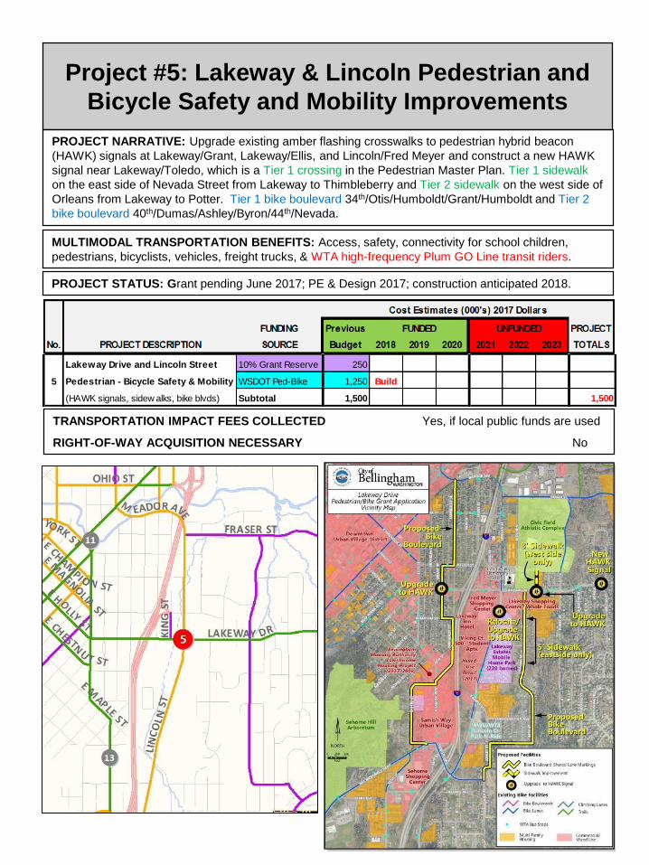
Project #5: Lakeway & Lincoln Pedestrian and
Bicycle Safety and Mobility Improvements
PROJECT NARRATIVE: Upgrade existing amber flashing crosswalks to pedestrian hybrid beacon
(HAWK) signals at Lakeway/Grant, Lakeway/Ellis, and Lincoln/Fred Meyer and construct a new HAWK
signal near Lakeway/Toledo, which is a Tier 1 crossing in the Pedestrian Master Plan. Tier 1 sidewalk
on the east side of Nevada Street from Lakeway to Thimbleberry and Tier 2 sidewalk on the west side of
Orleans from Lakeway to Potter. Tier 1 bike boulevard 34th/Otis/Humboldt/Grant/Humboldt and Tier 2
bike boulevard 40th/Dumas/Ashley/Byron/44th/Nevada.
PROJECT STATUS: Grant pending June 2017; PE & Design 2017; construction anticipated 2018.
TRANSPORTATION IMPACT FEES COLLECTED Yes, if local public funds are used
RIGHT-OF-WAY ACQUISITION NECESSARY No
MULTIMODAL TRANSPORTATION BENEFITS: Access, safety, connectivity for school children,
pedestrians, bicyclists, vehicles, freight trucks, & WTA high-frequency Plum GO Line transit riders.
Lakeway Drive and Lincoln Street 10% Grant Reserve 250
5 Pedestrian - Bicycle Safety & Mobility WSDOT Ped-Bike 1,250 Build
(HAWK signals, sidew alks, bike blvds) Subtotal 1,500 1,500

Project #6: Orchard Drive ExtensionMultimodal Grade-Separated Crossing of I-5
PROJECT NARRATIVE: Construct a multimodal arterial from the corner of Birchwood
Avenue/Squalicum Parkway generally along the former railroad bed (north of Bug Lake), through the
railroad tunnel beneath Interstate 5, to James/Orchard north of Sunset Pond Park This new east-west
arterial will enhance regional transportation circulation for all modes between rapidly-growing northern
Bellingham, St Joseph’s Hospital, and central Bellingham. Construction of this arterial street will ease
pressure on the Interstate interchanges at Meridian and Sunset and is the last opportunity for a grade-
separated crossing of Interstate 5 in Bellingham. The WA legislature has allocated $10 million in
“Connecting Washington” gas tax funds for this important regional connection.
PROJECT STATUS: Funded. 90% design engineering 2017; Squalicum Re-route completed 2015; Bay
to Baker Trail completed 2016. Orchard Drive construction anticipated 2018-2019.
TRANSPORTATION IMPACT FEES COLLECTED Yes for local funds
RIGHT-OF-WAY ACQUISITION NECESSARY Yes
MULTIMODAL TRANSPORTATION BENEFITS: Tier 3 sidewalk north side, Tier 1 bicycle lanes both
sides, off-street multi-use Bay-to-Baker trail, improved emergency response time to St Joseph hospital,
Tier 3 grade-separated multimodal crossing of Interstate 5, and possible future WTA transit route, .
Orchard Drive Extension Street 864
6 Multimodal Grade-Separated Federal STP-R 1,250
Crossing of Interstate 5 WSDOT Gas Tax
(Birchw ood/Squalicum to James St) Subtotal 2,114 12,114
Build
10,000
10,000

Project #7: West Horton Road
Multimodal Corridor Extension, Phase 1(Horton terminus to Aldrich Road)
PROJECT NARRATIVE: Regional growth and development and the 30-acre Cordata Park with parking
access from Horton requires that West Horton Road be extended as a secondary arterial street with Tier
1 sidewalks and Tier 1 bicycle lanes on both sides from the current terminus to Aldrich Road.
Environmental impacts require land acquisition, off-site mitigation, and attempts to minimize the road
prism footprint. Dedicated left-turn lanes will be needed at the intersection of W. Horton/Aldrich.
PROJECT STATUS: Feasibility studies, wetland delineations, & survey completed 2009-2011; land
acquisition & mitigation planning 2012-2015; 60% PE & Design 2016; construction anticipated 2018.
TRANSPORTATION IMPACT FEES COLLECTED Yes, if local public funds are used
RIGHT-OF-WAY ACQUISITION NECESSARY No
MULTIMODAL TRANSPORTATION BENEFITS: Access, safety, connectivity for school children,
pedestrians, park and trail users, bicyclists, vehicles, freight trucks, & possible future WTA transit route.
West Horton Road Multimodal Street 1,100 600
Corridor Improvements-Phase 1 TBD Non-Motor 300 500
7 (Current terminus to Aldrich Road) Private Mitigation 812 500
Federal STP/Map 21 500 1,300 Build
Subtotal 1,312 3,200 1,100 5,612

Project #8: Telegraph Road
Multimodal Safety Improvements (James Street to Deemer Road)
PROJECT NARRATIVE: Telegraph Road has seen a significant increase in vehicle traffic, as well as
pedestrian, bicycle, and transit demand, as a result of annexations, growth, and development of
commercial retail and multifamily housing. Vacant land along Telegraph Road is zoned for more high-
density housing units and there are several development projects in plan review and permitting stages.
Pedestrian and Bicycle Master Plans call for sidewalks and bike lanes on Telegraph Road and WTA re-
routed the high-frequency Gold GO Line to James Street-Telegraph Road-Deemer Road in March 2017.
PROJECT STATUS: Unfunded. State & federal grants as well as private & WTA funding will be sought.
TRANSPORTATION IMPACT FEES COLLECTED Yes, if local funds are used
RIGHT-OF-WAY ACQUISITION NECESSARY Yes
MULTIMODAL TRANSPORTATION BENEFITS: Tier 3 sidewalks, Tier 3 bicycle lanes, pedestrian
crossing, center turn lane, access management, safety, LED street lights, traffic signals, and transit
shelters for WTA Gold GO Line (Route 331).
Telegraph Road Multimodal Street 150 250
Safety Improvements TBD Non-Motor 250 1,000
8 (James Street to Deemer Road) Private Mitigation 50 115 115
WTA 62
Federal STBG
State TIB UAP & CS
Unknow n 3,850
Subtotal 50 515 1,427 3,850 5,842

Project #9: Northwest/W. Bakerview
Intersection Safety Improvements
PROJECT NARRATIVE From 2009-2015, over 150 vehicle collisions were recorded at the
Northwest/Bakerview intersection. This high collision rate is likely to continue as more development
occurs in northwest Bellingham in the future unless safety countermeasures can be installed or
improvements made to the intersection. The nearby intersection of Northwest/Aldrich may also require
a new northbound drop/right-turn lane from West Bakerview Road to Aldrich Road to enhance safety,
reduce existing traffic congestion, and accommodate additional infill development in the Bakerview
corridor. A feasibility study was conducted in 2016-2017 and both short-term and long-term safety
countermeasures have been identified for these intersections.
PROJECT STATUS: Feasibility study 2016 – 2017; Construction unfunded.
TRANSPORTATION IMPACT FEES COLLECTED Yes, if local public funds are used
RIGHT-OF-WAY ACQUISITION NECESSARY Possibly
MULTIMODAL TRANSPORTATION BENEFITS Tier 3 sidewalk, Tier 3 bikeways, collision reduction,
improved safety, reduced congestion, regional circulation benefits, safety and on-time performance for
WTA transit routes 3, 4, 27, 55, and 232.
Northwest Ave / Bakerview Rd. Street 75
9 Intersection Safety Improvements Unknow n 4,000
Subtotal 75 4,000 4,075

Project #10: James/Bakerview
Intersection Safety Improvements
PROJECT NARRATIVE: East Bakerview Road is a major arterial and trucking route between the
Irongate industrial area, SR 539, and I-5. James Street is the only north-south secondary arterial
between Sunset Drive and Kellogg Road. Increased traffic and lack of north-south left-turn lanes
contribute to an increase in speeding and collisions at the James/Bakerview intersection. Constructing
an expandable multimodal roundabout will slow speeding vehicles, reduce collisions, and improve safety
for all users, while also providing long-term transportation capacity, as the King Mountain area develops.
PROJECT STATUS: 90% engineering and design 2013-2016; TIB grant secured; other grant being
sought; construction pending full funding.
TRANSPORTATION IMPACT FEES COLLECTED Yes, for local funds
RIGHT-OF-WAY ACQUISITION NECESSARY Yes
MULTIMODAL TRANSPORTATION BENEFITS: Tier 3 sidewalks, crosswalk with pedestrian refuges,
Tier 3 bicycle lanes, collision reduction, increased safety & efficiency of freight and goods movement,
WTA transit route 48 and possible future WTA transit routes as ridership demand increases.
James/Bakerview Intersection Street 120
10 Safety Improvements Federal STP 385
(Expandable roundabout) Unknow n 3,300
Subtotal 505 3,300 3,805

Project #11: Ellis Street Bridge Reconstruction(Ellis Street/N. State Street Intersection)
PROJECT NARRATIVE The existing bridge was constructed in 1940 and has experienced major
substructure deterioration. Major repairs were made in the year 2000 when new pilings were
driven in, but the overall deterioration has continued. Temporary shoring allows the bridge to
remain open, but reconstruction of the bridge is necessary in the near future. Federal BRAC
grant funding for construction has been applied for with funding awards anticipated for Autumn
2017. Local funding is programmed here for preliminary engineering, design, and local matching
fund requirements for the BRAC grant., which would allow construction to occur in 2019.
PROJECT STATUS: Unfunded; Federal BRAC grant funding application pending.
TRANSPORTATION IMPACT FEES COLLECTED Yes, if local public funds are used
RIGHT-OF-WAY ACQUISITION NECESSARY No
MULTIMODAL TRANSPORTATION BENEFITS Sidewalks, bikeways,
FUNDING Previous PROJECT
No. PROJECT DESCRIPTION SOURCE Budget 2018 2019 2020 2021 2022 2023 TOTALS
Ellis Street Bridge Reconstruction Street 100
11 (Ellis - N. State Intersection) TBD Resurface 300 285
Federal BRAC 2,740
Subtotal 400 3,025 3,425
Cost Estimates (000's) 2017 Dollars
Pending
FUNDED UNFUNDED

Project #12: BNSF Railroad Quiet Zone (Boulevard Park at-grade street/rail crossing )
PROJECT NARRATIVE: The City of Bellingham will examine the possibility of making significant safety
improvements for the at-grade street crossing of the Burlington Northern Sante Fe (BNSF) railroad
tracks on the Bayview Drive vehicular entrance into Boulevard Park. If safety improvements can be
made that meet BNSF and federal guidelines, then a “Railroad Quiet Zone” may be established that
would allow train engineers not to blow train horns unless there was an emergency. Several different
types of at-grade crossing improvements can be used, depending on the circumstances and needs of
the specific site. Preliminary cost estimates are approximately $500,000 to $750,000 per at-grade
crossing, depending on the improvements made.
PROJECT STATUS: REET funding identified as most-appropriate for these improvements.
TRANSPORTATION IMPACT FEES COLLECTED No
RIGHT-OF-WAY ACQUISITION NECESSARY No
MULTIMODAL TRANSPORTATION BENEFITS: ADA-compliant surface crossing of railroad tracks and
reduction of vehicle/rail conflicts.
FUNDING Previous PROJECT
No. PROJECT DESCRIPTION SOURCE Budget 2018 2019 2020 2021 2022 2023 TOTALS
Cost Estimates (000's) 2017 Dollars
FUNDED UNFUNDED
12 Bellingham Railroad Quiet Zones 1st 1/4 REET 250 250 250 250
Subtotal 250 250 250 250 1,000

Project #13: Samish-Maple-Ellis Corridor
Pedestrian and Bicycle Safety Improvements
PROJECT NARRATIVE: Rechannelize the Samish-Maple-Ellis corridor to install on-street parking and
a protected bike lane along the east side, a buffered bike lane on the west side, a new pedestrian-
activated flashing crosswalk at Otis/Maple, and where possible, driveway consolidation to reduce turning
movement conflicts for pedestrians and bicyclists. Tier 2 bike lanes on Samish Way will be integrated
with the 2018 Tier 1 bike boulevard along 34th/Otis/Humboldt/Grant/Humboldt and Tier 2 bike boulevard
40th/Dumas/Ashley/Byron/44th/Nevada (See Project #5 Lakeway-Lincoln Pedestrian-Bicycle Safety)
PROJECT STATUS: Unfunded; State grant funding sought 2018.
TRANSPORTATION IMPACT FEES COLLECTED Yes, if local public funds are used
RIGHT-OF-WAY ACQUISITION NECESSARY No
MULTIMODAL TRANSPORTATION BENEFITS: Access, safety, connectivity for pedestrians,
bicyclists, vehicles, freight trucks, & WTA transit riders on routes 107 & 108.
Samish-Maple-Ellis Corridor Street 50
13 Pedestrian and Bicycle Safety TBD Non-Motor
Improvements Unknow n 3,000
(Bill McDonald to Lakew ay Drive) Subtotal 3,000 3,000

Project #14: James Street
Multimodal Safety Improvements (East Orchard Drive to East Bakerview Road)
PROJECT NARRATIVE: James Street is the only north- south transportation corridor serving north-
central Bellingham between Meridian (SR 539) and Hannegan, which is already zoned for up to 2,000
new housing units. James Street also provides access to Sunset Pond Park between Sunset and East
Bakerview. A vertical curve on the hill between Orchard and McLeod may require elimination of a sight
distance issue, but more investigation is required. Pedestrian and Bicycle Master Plans call for
sidewalks and bike lanes on James Street and WTA rerouted the high-frequency Gold GO Line Route
331 to travel on James Street-Telegraph Road-Deemer Road in both directions in March 2017.
PROJECT STATUS: Unfunded. State and federal grant funding will be sought.
TRANSPORTATION IMPACT FEES COLLECTED Yes, if local funds are used
RIGHT-OF-WAY ACQUISITION NECESSARY Unknown
MULTIMODAL TRANSPORTATION BENEFITS: Tier 3 sidewalks, Tier 3 bicycle lanes, turn lanes,
increased access, safety, sight distance, and efficiency. WTA Gold GO Line high-frequency transit route
331 in 2017 and possible future WTA transit routes as King Mountain Neighborhood develops. .
James Street Multimodal Street 50
14 Safety Improvements Pvt Mitigation
(E. Orchard to Bakerview ) Unknow n 7,000
Subtotal 7,000 7,000

Project #15: North James Street
Multimodal Arterial Connection (Gooding Avenue to Van Wyck Road)
PROJECT NARRATIVE: James Street currently terminates at Gooding Avenue, but the Transportation
Element of the Bellingham Comprehensive Plan identifies the need for James to be extended north to
Van Wyck Road as a full standard secondary arterial. James Street is the only north- south
transportation corridor serving north-central Bellingham between Meridian (SR 539) and Hannegan,
which is already zoned for up to 2,000 new housing units. In addition to supporting the development
planned for the King Mountain Neighborhood, this northern extension of James Street will provide
another north-south corridor parallel to Meridian (SR 539), which will help to ease some of the
northbound evening and weekend traffic congestion.
PROJECT STATUS: Private developer constructed first phase in 2014 with King Mountain subdivision
TRANSPORTATION IMPACT FEES COLLECTED Yes, if local public funds are used
RIGHT-OF-WAY ACQUISITION NECESSARY? Yes, private development to dedicate
MULTIMODAL TRANSPORTATION BENEFITS: Tier 3 sidewalks, Tier 3 bike lanes, center turn lanes
at intersections, regional multimodal transportation connectivity, and possible future WTA transit route.
North James Street Pvt Mitigation
15 Multimodal Arterial Connection Unknow n 6,000
(Gooding to Van Wyck) Subtotal 6,000 6,000

Project #16: West Horton Road
Multimodal Corridor Extension, Phase 2(Aldrich Road to Northwest Avenue)
PROJECT NARRATIVE: City – County partnership to extend an east-west regional transportation
connection in northern Bellingham. Phase 2 extends West Horton for one-half mile west as an arterial
street with sidewalks and bicycle lanes on both sides from Aldrich Road to Northwest Avenue.
Environmental impacts require land acquisition, off-site mitigation, and minimizing the road footprint.
PROJECT STATUS: Feasibility studies, wetland delineations, & survey: 2017; land acquisition &
mitigation planning 2017-2018; PE & Design 2018-2020; additional funding being sought.
TRANSPORTATION IMPACT FEES COLLECTED Yes, if local public funds are used
RIGHT-OF-WAY ACQUISITION NECESSARY Yes
MULTIMODAL TRANSPORTATION BENEFITS: Increased access, safety, and connectivity for
pedestrians, bicyclists, transit riders, and vehicles. Tier 1 sidewalks, Tier 1 bike lanes, possible future
WTA transit route as W. Horton Road, annexations, and MF & SF developments are completed.
West Horton Road Multimodal Federal Map 21 1,000
Corrdor Extension, Phase 2 County Road Fund 260
16 [City-County Partnership] Pvt Mitigation 1,000
(Aldrich to Northw est) Unknow n 10,000
Subtotal 1,260 1,000 10,000 12,260