Embed Size (px)
Citation preview

December 2007
Six Points Urban Village
Master Plan


Six Points Urban Village
Table of Contents i
Table of Contents
1. Introduction 11.1 Plan Purpose 11.2 Plan Process 1
2. Master Plan Principles 32.1 Historical Context 32.2 Existing Conditions 42.3 Values & Principles 5
3. Urban Village Plan 73.1 Urban Race Street North 83.2 Urban Race Street South 83.3 Race Street Enhancements 93.4 Housing Rehabilitation 93.5 Urban Village Residential 103.6 Six Points Intersection Improvements 10
4. Implementation 134.1 Policy Tool Box 134.2 Action Package 194.3 Action-FaÇade Program 194.4 Action-Land Partnership 194.5 Action-No Vacancy 214.6 Action-Mobility & Accessibility 214.7 Action-Safe Zone 224.8 Action-Urban Village Sweep 23

The City of Fort Worth
Acknowledgementsii
The Six Points Village Plan provides a framework for realizing a vision to be implemented over time. This “living document” could not have been prepared without the participation and guidance of many individuals. We would like to thank the citizens of Fort Worth for contributing in public work sessions, interviews and other correspondence. Special appreciation is also given to the following:
• MayorandCityCouncil
• CouncilmemberSalvadorEspino& CouncilmemberDannyScarth
• CityofFortWorthPlanning&Development Department,FernandoCosta-Director
• ScottBellen,SeniorPlanner-Planning&DevelopmentDepartment
• VillageAdvisoryTeamMembers:
• SarahWalker-RiversideAlliance
• LibbyWillis-RiversideAlliance
• BelindaNorris-ScenicBluff NeighborhoodAssociation
• BethEllis-CarterRiverside
• RickHerring-UrbanRiverside,Inc.
• JustinMcWilliams-RaceStreet Properties,LP
• JylDeHaven-UrbanRaceStreet,LP
• VannSmith-Kirby’sRadiator
• ConsultantTeam:
• TCB
• EDAW
• LelandConsultingGroup
• KomatsuArchitecture
• Berkenbile-CraigLandscape Architecture
• PavlikandAssociates
Acknowledgements

Six Points Urban Village
Summary iii
TheUrbanVillageMasterPlandocumentsetsoutashortandlong-termvisionforthevillage.Thisvisionistheproductofthreepublicworksessions,one-on-one interviews and nearly a year long sequence of activities, including initial analysis, staff conversations, establishment of principles and values, and subsequent development of concepts, strategies, and projects.
The chapters are organized to build upon the decisions and strategies noted in previous chapters. For example, early in the process, the plan included a work session in which perceptions and preferences were gathered and recorded, as well as priorities for transportation improvements. The comments and site analysis served as the basis for the formulation of vision principles and values, which are discussed in the earlychapters.Basedupontheseprinciples,detailedstrategies, catalyst projects, and implementation processes are developed in subsequent chapters.
Thelevelofspecificityalsoincreasesinfollow-up chapters. For example, the issues and public commentsinChapter1:Introduction,andthegeneralvisionprinciplesandvaluesnotedinChapter2:MasterPlan Principles, are interpreted and become the basis forthePlanshowninChapter3.TheoutgrowthsofChapter3:ThePlan,arespecificitemsoutlinedinChapter4:Implementation,whichsetsoutthepolicy,actions, and catalyst projects to achieve the completion of the Plan.
Consistentwiththeaboveapproach,thechaptersaresummarized as follows:
Chapter 1: IntroductionThis chapter describes the general approach to the MasterPlan,includinghowthedocumentisorganized,and the comments gathered as part of the public work sessionprocess.ItalsoprovidesabriefhistoryoftheUrbanVillageinitiativeandSixPointstoday.
Chapter 2: Master Plan PrinciplesThemasterplanprinciplesreflecttheconcernswhichwere established as a result of site analysis, the public work sessions, and other reviews. These principles affirmtheshort-andlong-termdirectionofthemasterplan, and the essential philosophies which should guide development.
Chapter 3: The PlanThecoreofthischapterconsistsofsixspecificdirectivesthatfulfillthemasterplanprinciples.Fivecatalyst project areas form the foundation of the masterplan.Inaddition,asixthareaoffocusisthe prioritization of transportation and infrastructure improvements as part of the state transportation funding grant.
Chapter 4: ImplementationThe roles of city leadership, neighborhood associations, businesses, and property owners are key to the success of the plan. This chapter provides a partnership tiered approach, including policies, actions, and how they apply to catalyst projects.
AppendixThis section contains the following information:
1. Bestpracticeexamples.
2. Marketanddemographicdata.
3. Historicinventorydata.
4. Crimetrends.
5. Mixed-useguidelines.
6. Public meeting summaries.
Summary

iv
The City of Fort Worth
Summary

Six Points Urban Village
Introduction
1.1 Plan PurposeWhy create an urban village master plan? Since early2001,theCityofFortWorthhasembarkedoncreating dynamic urban villages across the city core. Six Points, with its storied past of traditions and strong neighborhoods, has naturally evolved as a place of renewed interest. With the recent success of attracting newinvestmenttoSixPoints,conflicthasarisenwhenthe new investment collides with rooted traditions and values.
There are few documents which are more comprehensive or informative than an effective master plan. The process of framing such a plan places a premium on gauging needs of various kinds: the assessment of existing facilities, the demand for new ones, the response to experienced growth, and the anticipationoffuturechanges.Italsofacilitatestheadjustment of attitudes and trends. The most recent visioning exercise performed on the Six Points village wasthe2004UTAstudentproject.Inaddition,townhall meetings and workshops have been organized by local community groups.
Howtoapproachthemasterplan?Thecreationof a useful master plan requires understanding the nature of an urban village, making calculations regarding its future needs, and setting out a method ofsatisfyingthem.ForSixPointsUrbanVillage,the master planning effort requires a balancing of its traditionswithaninformedinquiryintoitsfuture.Amasterplanshouldbenefitfromthevillage’sampleexperience related to the planning and operation of the village over the course of a century while absorbing successive generations of demographic, market, and physical changes. This experience gives the plan an appropriatecontext,reflectivecharacter,andhistoricalperspective.
What were the key goals for the urban village in embarkingupontheplan?AsarticulatedbyCityleadership, Six Points residents, and property owners, the key objectives for the urban village master plan process are:
• Visionconsensus.
• Partnershipframework.
• Developmentopportunities.
• Neighborhoodpreservation.
• Zoningenhancements.
• Transportationimprovements.
1.2 Plan ProcessThemasterplanwasa10-monthlongeffortdesignedto seek input and ideas from all stakeholders who may have an interest in the urban village future. The eight-taskprocessincludedthreepublicworksessions,conversations with city staff and village advisory team members,andone-on-oneinterviews.
The process was organized in a series of tasks:
Task1.0 ProjectStart-upandProject Management
Task2.0 PublicInvolvement
Task3.0 ProjectContext,Inventoryand Analysis
Task4.0 DevelopmentOpportunities
Task5.0 TransportationNeedsandPriorities
Task6.0 MarketAnalysis
Task7.0 Mixed-UseZoning
Task8.0 UrbanVillageMasterPlan
1. Introduction
1

Introduction
The City of Fort Worth
2

Six Points Urban Village
Master Plan Principles
Thischapteridentifiesvillage-widevaluesthatconstitutetheframeworkfortheplan.Historicalcontext, values and principles, and best practice examplesmakeupthebasisfortheSixPointsUrbanVillage Plan.
2.1 Historical ContextSixPointsisoneofFortWorth’smostproudandhistoricalareas.TheareaoriginallyknownasGreasyBend,thenSylvaniatoRiverside,evolvedfromthearea’shistoryoffarmersandnurseryworkers.
Manyofthetraditionsandstoriescomefromand are based on neighborhood and institutional traditions. The proximity to downtown and the Trinity RivergivetheSixPointsareaauniquegeographicadvantage.CommercealongBelknapStreetledtothe development of the commercial buildings and institutions that attracted the surrounding residential developments.Architecturaldiversityhasbecomeacornerstoneofthearea’sidentity.
SeveraldistinctneighborhoodsareidentifiedwithintheSixPointsUrbanVillagearea.Theseneighborhoodsinclude:CarterRiverside,Oakhurst,ScenicBluff,andSylvanHeightsWest.Theseneighborhoodgroups,alongwithRiversideAllianceandUrbanRiversideInc.,makeupthecoregroupofcommunity-basedorganizations that are working to improve Six Points.
Anumberofplanningactivitiesandpublicmeetingshave been recently conducted that provided a baseline for the new recommendations contained in this report. SomeoftherecentinitiativesintheSixPointsUrbanVillage include:
• UTArlingtonDesignProject,2004.
• CityPlanCommissionbeginsurbanvillage process,September2005.
• RiversideTownHallmeeting,November2005.
• FederalTransportationallocationforurban villages,December2005.
• RiversidePlanningWorkshop,May2006.
• CentralClusterSelectionofurbanvillages, December2006.
2. Master Plan Principles
The existing architectural and cultural diversity in Six Points will continue to shape this urban village for years to come.
3
Master Plan Principles
The City of Fort Worth
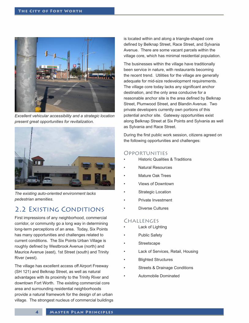
2.2 Existing ConditionsFirst impressions of any neighborhood, commercial corridor, or community go a long way in determining long-termperceptionsofanarea.Today,SixPointshas many opportunities and challenges related to currentconditions.TheSixPointsUrbanVillageisroughlydefinedbyWestbrookAvenue(north)andMauriceAvenue(east),1stStreet(south)andTrinityRiver(west).
ThevillagehasexcellentaccessoffAirportFreeway(SH121)andBelknapStreet,aswellasnaturaladvantageswithitsproximitytotheTrinityRiveranddowntown Fort Worth. The existing commercial core area and surrounding residential neighborhoods provide a natural framework for the design of an urban village. The strongest nucleus of commercial buildings
islocatedwithinandalongatriangle-shapedcoredefinedbyBelknapStreet,RaceStreet,andSylvaniaAvenue.Therearesomevacantparcelswithinthevillage core, which has minimal residential population.
The businesses within the village have traditionally been service in nature, with restaurants becoming therecenttrend.Utilitiesforthevillagearegenerallyadequateformid-sizeredevelopmentrequirements.Thevillagecoretodaylacksanysignificantanchordestination, and the only area conducive for a reasonableanchorsiteistheareadefinedbyBelknapStreet,PlumwoodStreet,andBlandinAvenue.Twoprivate developers currently own portions of this potentialanchorsite.GatewayopportunitiesexistalongBelknapStreetatSixPointsandSylvaniaaswellasSylvaniaandRaceStreet.
Duringthefirstpublicworksession,citizensagreedonthe following opportunities and challenges:
Opportunities• HistoricQualities&Traditions
• NaturalResources
• MatureOakTrees
• ViewsofDowntown
• StrategicLocation
• PrivateInvestment
• DiverseCultures
Challenges• LackofLighting
• PublicSafety
• Streetscape
• LackofServices,Retail,Housing
• BlightedStructures
• Streets&DrainageConditions
• AutomobileDominated
The existing auto-oriented environment lacks pedestrian amenities.
Excellent vehicular accessibility and a strategic location present great opportunities for revitalization.
4
Six Points Urban Village
Master Plan Principles
2.3 Values & PrinciplesBasedonhistoricalinformationandpublicworksessionconsensus,anewSixPointsUrbanVillagevision emerged. This vision is dynamic and based on keyvaluesandprinciples.Imagesfromothersimilarurbanareaswerealsoidentifiedandrankedaspartof the visioning exercise. The values and principles agreed upon during the public work sessions include:
• Celebratingthearea’shistoricvaluesand traditions.
• Livingforworking-classresidents.
• Entertainmentenvironmentforresidentsand visitors.
• MusicandculinaryMecca.
• Mixeduseswhilepreservingsinglefamily base.
• Pedestrianfriendly.
• MainStreet/Deco-themedurbandesign.
• Texasoasisoflandscapedesign.
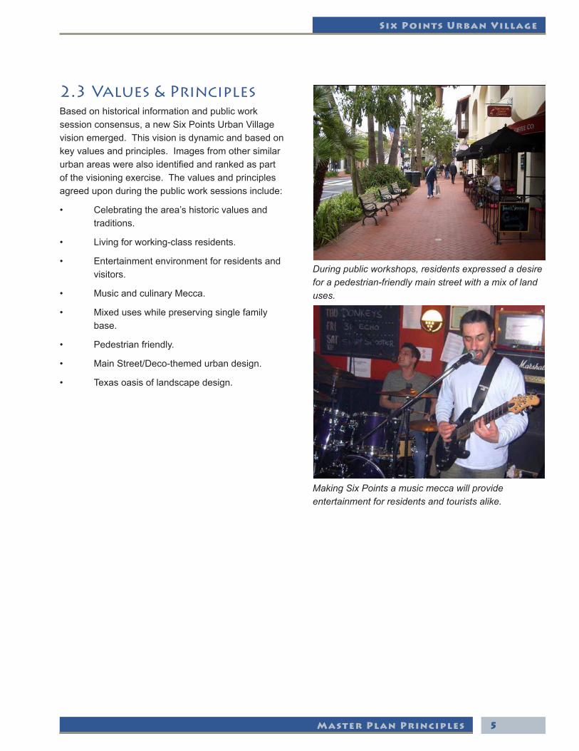
During public workshops, residents expressed a desire for a pedestrian-friendly main street with a mix of land uses.
Making Six Points a music mecca will provide entertainment for residents and tourists alike.
5
Master Plan Principles
The City of Fort Worth
6

Six Points Urban Village
Urban Village Plan
3. Urban Village Plan
7

Urban Village Plan
The City of Fort Worth
3.1 Urban Race Street North
ThecurrentmixofbuildingsnorthofRaceStreetfromSylvaniatoRiversideformavariedmixofarchitectureanduses.FromagedapartmentstoadecoofficebuildingtothehipSwankyShackCoffeeBar,RaceStreetNorthrepresentsacorenucleusofvillagecomponents. Private investment has been the driving force behind the revival.
Aspartoftheoverallvillageplan,limitedinfillandexisting building rehabilitation are the primary focuses for this area. Single family houses existing alongMcLemoreshouldbeintegratedintoaretail/commercial use under their current design and scale. Mixed-use(MU-1)zoningshouldbeallowedthroughoutthis zone. The primary uses within this zone should include: entertainment, restaurant, services, hotel, and office.
3.2 Urban Race Street South
TheareasouthofRaceStreetbetweenSylvaniaandRiversidepresentsthegreatestopportunityforurbanvillage realization. The triangle zone bordered by RaceStreettothenorth,Belknaptothesouth/east,andGraceStreettothewestincludesfourkeysub-components of this area that are critical to the overall vision success:
1. GraceStreet/BlandinStreetcommonarea parking lot.
2. Belknap/Plumwoodanchorsite.
3. SouthRaceStreetcore/villagepublicplaza.
4. SixPointsPark/Mixed-Use.
Improvements to the South Race Street core and the development of a plaza will stimulate revitalization.
8
Six Points Urban Village
Urban Village Plan
3.3 Race Street Enhancements
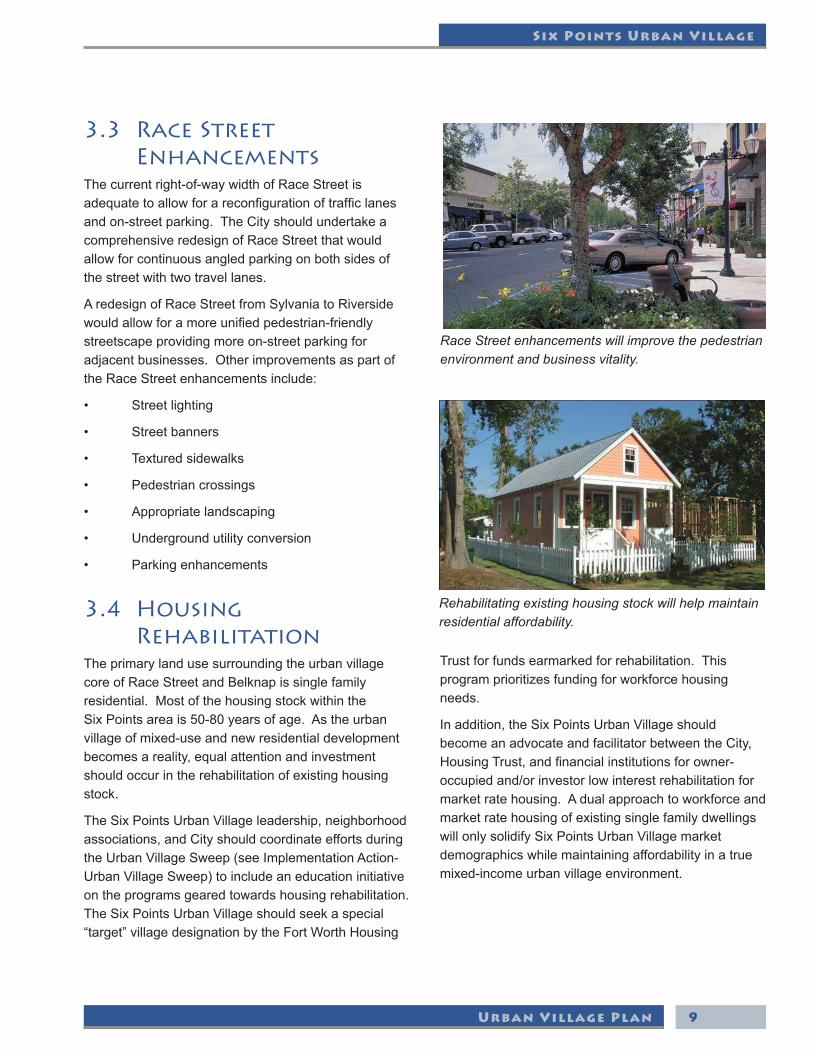
Thecurrentright-of-waywidthofRaceStreetisadequatetoallowforareconfigurationoftrafficlanesandon-streetparking.TheCityshouldundertakeacomprehensiveredesignofRaceStreetthatwouldallow for continuous angled parking on both sides of the street with two travel lanes.
AredesignofRaceStreetfromSylvaniatoRiversidewouldallowforamoreunifiedpedestrian-friendlystreetscapeprovidingmoreon-streetparkingforadjacentbusinesses.OtherimprovementsaspartoftheRaceStreetenhancementsinclude:
• Streetlighting
• Streetbanners
• Texturedsidewalks
• Pedestriancrossings
• Appropriatelandscaping
• Undergroundutilityconversion
• Parkingenhancements
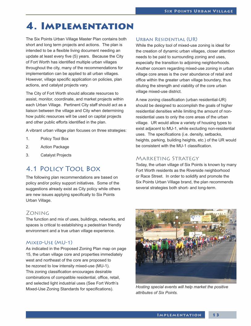
3.4 Housing Rehabilitation
The primary land use surrounding the urban village coreofRaceStreetandBelknapissinglefamilyresidential.MostofthehousingstockwithintheSixPointsareais50-80yearsofage.Astheurbanvillageofmixed-useandnewresidentialdevelopmentbecomes a reality, equal attention and investment should occur in the rehabilitation of existing housing stock.
TheSixPointsUrbanVillageleadership,neighborhoodassociations,andCityshouldcoordinateeffortsduringtheUrbanVillageSweep(seeImplementationAction-UrbanVillageSweep)toincludeaneducationinitiativeon the programs geared towards housing rehabilitation. TheSixPointsUrbanVillageshouldseekaspecial“target”villagedesignationbytheFortWorthHousing
Trust for funds earmarked for rehabilitation. This program prioritizes funding for workforce housing needs.
Inaddition,theSixPointsUrbanVillageshouldbecomeanadvocateandfacilitatorbetweentheCity,HousingTrust,andfinancialinstitutionsforowner-occupiedand/orinvestorlowinterestrehabilitationformarketratehousing.Adualapproachtoworkforceandmarket rate housing of existing single family dwellings willonlysolidifySixPointsUrbanVillagemarketdemographics while maintaining affordability in a true mixed-incomeurbanvillageenvironment.
Race Street enhancements will improve the pedestrian environment and business vitality.
Rehabilitating existing housing stock will help maintain residential affordability.
9

Urban Village Plan
The City of Fort Worth
3.5 Urban Village Residential
Animportantcomplementtomixed-usezoningaspartoftheSixPointsUrbanVillageistheintroductionof new urban residential development. The areas recommendedforthisusebook-endthemixed-usevillagecoreofSixPoints.Urbanresidentialconsistsoflow-tomid-densityresidentialuses2-3storiesinheight.Amoredetailedexplanationofthisproposednewclassificationisprovidedintheimplementationsection.
3.6 Six Points Intersection Improvements
Acentralpartoftheurbanvillagemasterplanistheidentificationandimplementationofinfrastructureandtransportation improvements. The allocation of federal fundingforthisefforttotals$740,000.Twooptionswere considered for the expenditure of these dollars at publicworksessions:1)RaceStreetimprovements,or2)SixPointsintersection.
Theconsensusofthefourbreak-outgroupsofcitizensfrom the second work session was to focus the improvement dollars on the Six Points intersection. Identifiedimprovementstotheintersectionrangedfrompedestrian crosswalks to signage and landscaping. Atthethirdworksessionsomeconcernwasvoicedby participants as to whether pedestrian crosswalks werefeasiblefortheSixPointsintersection.TheCityshould focus the allocated resources at the Six Points intersection,whiletakingimprovementspecificsanddesign options to the public during the next phase of thecontractin2008.
While the Six Points intersection should be the initial focus for the federal transportation funding, other areas (i.e.,alongBelknap,RaceStreet,orSylvania)canbesecond or third phase projects when future funding sourcesareidentified.
Residential buildings 2-3 stories high will add diversity to the urban village.
Existing conditions at the Six Points intersection.
Public art will help define the Six Points intersection as an important gateway to the urban village.
10

Six Points Urban Village
Urban Village Plan
Race Street improvements were proposed at a public workshop, and breakout groups decided such improvements were not as important as enhancing the Six Points intersection.
11
Conceptual rendering of future potential streetscape improvements.

Urban Village Plan
The City of Fort Worth
12
Six Points Urban Village
Implementation
4. ImplementationTheSixPointsUrbanVillageMasterPlancontainsbothshort and long term projects and actions. The plan is intendedtobeaflexiblelivingdocumentneedinganupdateatleasteveryfive(5)years.BecausetheCityofFortWorthhasidentifiedmultipleurbanvillagesthroughout the city, many of the recommendations for implementation can be applied to all urban villages. However,villagespecificapplicationonpolicies,planactions, and catalyst projects vary.
TheCityofFortWorthshouldallocateresourcestoassist, monitor, coordinate, and market projects within eachUrbanVillage.PertinentCitystaffshouldactasaliaisonbetweenthevillageandCitywhendetermininghow public resources will be used on capital projects andotherpubliceffortsidentifiedintheplan.
Avibranturbanvillageplanfocusesonthreestrategies:
1. PolicyToolBox
2. ActionPackage
3. CatalystProjects
4.1 Policy Tool BoxThe following plan recommendations are based on policyand/orpolicysupportinitiatives.SomeofthesuggestionsalreadyexistasCitypolicywhileothersarenewissuesapplyingspecificallytoSixPointsUrbanVillage.
ZoningThe function and mix of uses, buildings, networks, and spaces is critical to establishing a pedestrian friendly environment and a true urban village experience.
Mixed-Use (MU-1)AsindicatedintheProposedZoningPlanmaponpage15,theurbanvillagecoreandpropertiesimmediatelywest and northeast of the core are proposed to berezonedtolowintensitymixed-use(MU-1).Thiszoningclassificationencouragesdesirablecombinationsofcompatibleresidential,office,retail,andselectedlightindustrialuses(SeeFortWorth’sMixed-UseZoningStandardsforspecifications).
Urban Residential (UR)Whilethepolicytoolofmixed-usezoningisidealforthe creation of dynamic urban villages, closer attention needs to be paid to surrounding zoning and uses, especially the transition to adjoining neighborhoods. Anotherconcernregardingmixed-usezoninginurbanvillage core areas is the over abundance of retail and officewithinthegreaterurbanvillageboundary,thusdiluting the strength and viability of the core urban villagemixed-usedistrict.
Anewzoningclassification(urbanresidential-UR)should be designed to accomplish the goals of higher residentialdensitieswhilelimitingtheamountofnon-residential uses to only the core areas of the urban village.URwouldallowavarietyofhousingtypestoexistadjacenttoMU-1,whileexcludingnon-residentialuses.Thespecifications(i.e.density,setbacks,heights,parking,buildingheights,etc.)oftheURwouldbeconsistentwiththeMU-1classification.
Marketing StrategyToday, the urban village of Six Points is known by many FortWorthresidentsastheRiversideneighborhoodorRaceStreet.InordertosolidifyandpromotetheSixPointsUrbanVillagebrand,theplanrecommendsseveralstrategiesbothshort-andlong-term.
Hosting special events will help market the positive attributes of Six Points.
13

The City of Fort Worth
Implementation14

Six Points Urban Village
Implementation 15

The City of Fort Worth
Implementation16

Six Points Urban Village
Implementation
Some of the marketing initiatives appropriate for Six Points include:
• Specialevents.
• Urbanvillagenewsletter.
• Targetpromotionwithlocalrestaurants.
• Briefingstoprospectivedevelopers/investors.
• Marketingcollaborationwithothercentral cluster villages.
• Transportationlinkfordowntownpatrons.
OrganizationTheSixPointsUrbanVillageisfortunatetoalreadyhavestrongcommunity-basedorganizations.Severalneighborhood associations have come together to formtheumbrellaorganizationRiversideAlliance.Inaddition,UrbanRiversideInc.wasrecentlycreatedwith the focus to promote business activities in the area.
While all of these organizations and associations are important advocates for implementing the plan, the community should support an organization with the capacity and structure to facilitate new development and investment opportunities. Two options may be pursued to accomplish this goal.
First,astrategyutilizinganexistingorganization(i.e.UrbanRiverside,Inc.)couldbeused.Thiseffortwouldbemostefficient;however,boardmembershipshouldreflectabalanceofbusinessowners,propertyowners,and residents. The second option would involve a new organizationcreatedspecificallyfortheimplementationoftheSixPointsUrbanVillagePlan.
Regardlessofwhichoptionisselected,theorganizationshouldqualifyfor501c(3)tax-exemptstatus.By-lawswouldgoverntheorganization.The group should implement the urban village plan while balancing the different perspectives of stakeholder groups. This would not be a membership organization.Rather,itwouldrepresenteachofthemajororganizationsandinterests.Inaddition,theorganization should enlist the services and participation oflocalfinancialinstitutions.
Streamlined Development Review ProcessAspartoftheCityofFortWorth’snewone-stopshopcreated last year, development review enhancements and priority for appropriate urban village projects shouldbeprovided.Aconsistentconcernfromprivate businesses and developers throughout each oftheurbanvillagesisthedifficultyandtimeittakesfor permit review and, in some cases, receiving information. This challenge is not unusual for a city the sizeofFortWorth.However,citiesacrossthecountryhavemovedtowardscreatingamoreefficientprocessfor permit applications and review.
While a single location is ideal, having adequate and equipped staff to handle the volume of visitors and knowing how to coordinate and disseminate informationisequallyimportant.Andwhiletheone-stopsystemisappliedcity-wideforalldevelopmentservices,specialtrainingandbriefingsontheimportance and goals of the urban village initiative shouldbegiventoallCityemployeesinvolvedwiththepermit review process.
Urban Design FrameworkWiththeimplementationofMU-1andURwithinthevillage, guidelines for urban design can be achieved. TheCityshouldcarryforwardtheexistingframeworkof urban design principles which include: setbacks, buildingheights,density,openspace/landscaping,parking, façades, building materials, entries, and signs (SeeFortWorth’sMixed-UseZoningStandards).
An existing or new organization should be charged with implementing this plan.
17

The City of Fort Worth
Implementation
Funding Options and IncentivesTheCityofFortWorthhasmadethecreationofdistinctive, vibrant urban villages a priority. Through its investment in capital improvements and planning documents,theCitycontinuestoleadtheeffortinpreserving and enhancing these unique urban places. However,inordertosustainalongtermsuccessfulvisionandplan,otherfinancingpartnersmustbeequally engaged.
Aspartoftheimplementationsectionofthisplan,various components and catalyst projects will necessitate multiple layers of partnership and financing.TheSixPointsDevelopmentorganizationandtheCityneedtocoordinateandassigndifferentfunding options for each of the components of the master plan. Some of the funding options critical to the long term implementation of the plan include:
• Financialinstitutionswithtargetprogramsand investmentwithintheSixPointsUrbanVillage.
• Privateinvestmentanddevelopers.
• City’sannualbudget.
• Futurebondissuances.
• CreationofaPublicImprovementDistrict.
• TaxIncrementFinancing.
• OtherincentivesthroughaNeighborhood EmpowermentZone.
Urban Village Neighborhood ProtectionCitiesandneighborhoodsacrosstheUnitedStateshave used various approaches to preserve the integrityofolderurbanneighborhoods.Historicandconservation districts are two of the more popular policytoolsusedbylocalmunicipalities.Historicdistricts are the strictest of local policy options, offering guideline protection from incompatible new construction, changing of existing structures, and other actions or projects which change a neighborhood character.Conservationdistrictsarelessrestrictiveand focus primarily on front exterior changes.
TheCityofFortWorthcurrentlyusesthehistoricdistrictoption more frequently in its older neighborhoods. For SixPointsUrbanVillage,debatehasalreadybegunonthe pros and cons of implementing a historic district. While residents generally support the introduction of mixed-useandurbanvillageresidential,manyareconcernedaboutmixed-useencroachmentintoexistingstable single family areas, as well as new residential gentrification.
Interviewswithlocalresidentsanddiscussionattheurban village public work sessions highlighted the following neigborhood objectives:
• Preservetheintegrityofsingle-familyscalein stable areas.
• Createaproactiveenvironmentand neighborhood-drivenprocesswhichmonitors andreviewsnewhomedesignoninfilllotsand rehabilitation of existing properties to conform in scale and design.
• Allowforaccountabilityandinputonany demolition application.
Urban design guidelines will help ensure new development is of a desirable character appropriate for Six Points.
18
Six Points Urban Village
Implementation
• Sensibleapproachtoneighborhood preservation that conforms to the unique characteristicsofCarterRiverside,Oakhurst, ScenicBluffandSylvanHeightsWest.
ShouldtheneighborhoodsofSixPointsUrbanVillageseek historic district designation?
Eventuallyyes.However,theprimaryfocusneedstobethepassageandimplementationofmixed-usezoningintheurbancore.Anintensedebateonthepros and cons of historic designation will dilute the effort to enhance the urban village core. Short of therestrictivehistoricdesignation,theCityshouldworkwithSixPointsUrbanVillagetoaddresstheneighborhood objectives outlined above in regards to singlefamilypreservationadjacenttonewmixed-usezoningdesignations.Oneimmediatewayofdoingthisis through stronger enforcement and strengthening of thecurrentpolicyofDemolitionDelay(“DD”).
4.2 Action PackageSixPointsUrbanVillageisfortunateinthatithas already attracted new private investment by developers. This momentum of private investment can be heightened by other actions taken immediately by propertyowners,businesses,residents,andtheCity.The following action items make up a comprehensive package of short term initiatives that can maintain the positive momentum.
4.3 Action-FaÇade Program
Inmostexamplesacrossthecountry,urbanrevitalizationhappensonebuildingatatime;oneblockatatime;andonevillageatatime.Byfocusingresources on individual buildings, façade improvements can create a snowball effect of new investment and a resulting increase in property values.
OldercommercialcorridorsthroughouttheUnitedStates have particular challenges to overcome, includingbuildingneglect,vacancy,andcrime.Oneofthe biggest challenges is maintaining the appearance of older buildings.
Manyownersofoldercommercialbuildingswouldinvest in their property if there were more certainty that such investment would yield greater value. Some ownersfearhigherpropertytaxesshortlyafterout-of-pocketinvestmentismadetoabuilding.Lowinterestfinancingisalsodifficulttoobtain,especiallyinareasoftheCitywherefinancialinstitutionsmaybeleerytoinvest.
To help offset the the challenges mentioned in the aboveparagraphs,theCityshouldconsidercreatinga low interest rate façade improvement program. The CityofFortWorthshouldcreatea12month“pilot”matching loan program to support building façade improvements.Thesuggestedprogramcouldkick-offasearlyas2008,afterathree-monthpublicrelationsand outreach media blitz. The program should include the following:
• City-wideUrbanVillageFundof$500,000.
• Offeredonafirst-come,first-servedbasis.
• Quarterlyaccountabilityandreview.
• Lowinterestrateloan.
• Maximumloanamountof$50,000/building.
• Requireadollarfordollarprivatesector match.
• Five-yearpropertytaxfreezeonnew improvements.
4.4 Action-Land Partnership
Oneofthemostdifficultchallengesinthecreationof an urban village within a commercial revitalization context is the ability to implement critical elements of the overall plan amidst the existing development pattern.InthecaseofSixPoints,severalpublicprojects and the creation of an anchor site are consideredcriticaltotheoverallplan’ssuccess.
ThepublicprojectsidentifiedwithintheSixPointsplaninclude common area parking, shared commercial services areas, a village public plaza, and a village publicpark.Allofthesepublicelementsarefoundwithinsuburbantowncenterdevelopments;thesame
19

The City of Fort Worth
Implementation
developments which lured the base market away from the locations of the current urban villages. To be competitive with suburban or new downtown destinations/attractions,theSixPointsUrbanVillagemustprovideadequateon-streetandsurfacelotparking, as well as identify common services areas for commercial and public spaces, rather than each building providing their own. The public plaza and park space should provide the needed areas for pedestrians to intermingle between destination stops.
Itisrareforapublicelementwithinanoveralldevelopmenttoincludeaprivatepurpose.However,
in the case of Six Points, a private component lacking from recent private investment is the stability of an anchor tenant. The city should also designate an anchor site as a secondary priority towards realizing the overall vision of an urban village.
Asdescribedthroughouttheurbanvillageplan,locationshavebeenidentifiedforcommonareaparking and service areas, park and public spaces, and an anchor site. These locations are priority parcels as part of a land partnership strategy. These parcels should be part of a short and long term strategy of land acquisition by both private and public partners.
TheCity,SixPointsDevelopmentOrganization,andaffected property owners should mutually strategize on how to realize the vision. The following actions are recommended:
• SixPointsDevelopmentOrganizationfacilitate parkingagreementswithRiversideBaptist Churchforjoint-useparkingandparkingarea enhancements.
• CityofFortWorthfacilitatenegotiationswith propertyownersaspartoftheBlandin/Grace Street public parking lot.
• SixPointsDevelopmentOrganization coordinate and facilitate with private propertyownersintheSouthRaceStreetcore area for a village plaza and common service areas along with an agreement on use.
• SixPointsDevelopmentOrganizationbegindiscussions with private property owners alongBelknaptofacilitatetheanchorsitedevelopment.TheSixPointsDevelopmentOrganization,asatax-exemptorganization,can provide tax relief to private property owners in the sale of the property.
4.5 Action-No VacancyAprimarymissionoftheSixPointsUrbanVillageorganization is the occupancy of existing building space. The Six Points organization should coordinate withtheCityinajointmarketingeffortintendedtofillexistingvacantspace.Acomprehensiveinventory
Façade improvements can go a long way towards increasing value.
Land partnerships will help achieve plan recommendations, including the creation of more green space.
20

Six Points Urban Village
Implementation
analysis of existing buildings needs to be conducted for an accurate understanding of available space.
TheSixPointsUrbanVillagehasmanystrategicadvantages and opportunities for attracting new private investment and increasing occupancy. Some of the highlightsidentifiedinthemarketanalysisinclude:
• ProximitytoTrinityUptownandthelong-term impact on Six Points land values.
• Stablecommunityservicessuchasthepolice sub-station,restaurants,andstable neighborhoods.
• Ethnicallydiverse,largelyworking-class population.
• GrowingHispanicandAsianpopulations.
• Favorablepropertyownershippatternswith functional land assemblages.
• Increaseinprivatesectorinvestment.
• Significantconcentrationofneighborhood “infrastructure” elements including schools, churches,locally-ownedstores,etc.
• Consistentpublicpolicysupport.
• Culinarydestinationsupportingentertainment venues.
From an inventory analysis, the Six Points organization andCitycanidentifythetypeandsizeoftenantstotargetformarketingefforts.Aprofessionalmarketingbrochure should be part of the coordinated marketing effort to attract an appropriate tenant mix. Some of the demographic data that could be included in marketing materialsinclude:2007populationof36,000,12,000householdswithmedianincomeof$37,000,43%growingHispanicpopulation,and8%ofthetradeareamakingover$100,000.
Basedonpreliminarymarketanalysis,thefollowingmarket demand is projected for the urban village for a 10-yearperiod:
• 50to100condo/townhome/loftunits.
• 15to40singlefamilydetachedunits.
• 35to75rentalhousingunits.
• 45,000to75,000squarefeetofoffice.
• 35,000to75,000squarefeetofretail.
• 60to75roomboutiquehotel.
4.6 Action-Mobility & Accessibility
The primary physical characteristic supporting a vibrantmixed-useurbanvillageisapedestrian-friendlybuiltenvironment.Aspartoftheoverallvillageplan,pedestrian amenities must be enhanced throughout the village area. Sidewalks, lighting, and signage are all basic examples of pedestrian elements necessary for goodmobilityandaccessibility.TheCityshouldpursuefunding through various local, state, federal, and other sources for the implementation of these improvements.
The priority location for mobility and accessibility improvements is the Six Points intersection during thefirstphase;however,overtimetheentiretrianglevillagecoreshouldbeincluded.RaceStreetrealignment to accommodate wider sidewalks, angled parking, and underground utility conversion should alsobeplannedduringthefirstphase,leadingtoamorevillage-wideimprovementeffort.Secondphase improvements should concentrate in the areas identifiedalongBelknapandSylvania.Thelastphaseshould include the remaining areas of the village.
TheSixPointsorganizationandtheCityshoulddevelop a comprehensive strategy to improve mobilityandaccessibilitythroughoutthevillage.Keypedestrian improvements include the following:
Market information and existing buildings should be used to attract and retain new uses.
21

The City of Fort Worth
Implementation
• Village-widesidewalkimprovements.
• Village-widepedestriancrosswalks.
• Consistentandappropriatelandscaping.
• SixPointsuniquestreet/pedestrianlighting.
• Undergroundutilityconversion.
• UniformSignage(consistentwithMU-1 requirements).
Significantdiscussioncenteredontheideaofundergroundutilityconversion.TheCityshouldtakeseriously the desire by local residents to improve theaestheticqualityofthepublicright-of-wayandunderstand the challenges to achieve this outcome. Ifthepoliticalwillexiststomakethisapriority,apilotprogramshouldbepursuedforSixPointsUrbanVillage.CompleteutilityconversionundergroundonRaceStreetandBelknapwithinthevillagecoreshouldbe the focus, with replacing current poles with lighting more appropriate for Six Points as the ultimate result.
4.7 Action-Safe ZonePublic safety and the perception of crime is a universal challenge for all urban villages in Fort Worth. The plan envisions a comprehensive approach and proactive solutions for reducing crime and making the urban village feel safer. The coordination of initiatives and programsaimedatpublicsafetyneedsbuy-inbyelectedleaders,theFortWorthPoliceDepartment,andthe community.
TheCityshouldimplementaspartofacomprehensivepublicsafetystrategyaSafeZonestrategyforSixPointsUrbanVillage.Thisstrategywouldbringtogether under one umbrella programs already in use as well as shared resources between various urban villages.
Implementation of SafeScape PrinciplesSafeScape is a holistic approach for responding to the issues of crime and personal safety that plague many neighborhoods, business districts, and communities. The application of SafeScape requires only a basic
understanding of how to use the principles to determine why people may not feel safe in a given situation and then how to respond to improve the situation. There are seven SafeScape Principles:
Human Factor Principles1. InformationandOrientation:Wefeelunsafe whenwedon’tknowwhereweareand/or where we are going.
2. InteractionandSocialization:Wefeelunsafe when we are alone and there are no other people with whom we can interact.
3. OwnershipandStewardship:Wefeelunsafe when the physical environment is not properly cared for and not maintained.
4. SeeingandBeingSeen:Wefeelunsafewhen wecan’tseeotherpeopleandtheycan’tsee us.
Implementation Principles5. LandUseandDesign:Encouragessafety andcommunity-buildingthroughproperdesign of the physical environment.
6. ActivityandProgramming:Facilitatessafety andcommunity-buildingbybringingpeople together in the physical environment.
7. ManagementandMaintenance:Sustains safetyandcommunity-buildingthroughthe long-termcommitmenttopropercareofthe physical environment.
Source: www.downtowndevelopment.com
Surveillance Camera Project(s)TheFortWorthPoliceDepartmentiscurrentlyevaluating its capacity to implement surveillance cameraprojectsinappropriateareasoftheCity.Surveillance cameras could be used in the urban village to increase the visibility of the Police Department,aswellastohelpapprehendpersonsthatcommitcrimesinthearea.ThePoliceDepartmenthasyettodeterminetheparticularareasoftheCitytoimplement a camera project.
22

Six Points Urban Village
Implementation
Police StorefrontTheFortWorthPoliceDepartmentoperatesatotalof20PoliceStorefronts.TheseserveassmallofficeareasprovidedtotheCityatnoorlowcostbyalandlordandaresometimesutilizedbyNeighborhoodPoliceOfficers(NPOs)andbeatofficerstocompletepaperwork and to assist the public with community problems.Currently,thereisastorefrontattheSixPointsUrbanVillage.
Shared Bike Patrol TheFortWorthPoliceDepartmentcurrentlyhasbikeofficersthatpatrolthecentralbusinessdistrict(CBD).TheBikeUnitwasre-establishedin1989asatacticalresponse to apartment crimes in the Woodhaven area. The mobility of the bike and resulting close contact officershadwithcitizensaddedgreatvaluetoourCommunityPolicingefforts.In1991,theFortWorthPoliceDepartmentrecognizedtheneedtoincreasethepolicepresenceandmobilityintheCentralBusinessDistrict.TheFootPatrolUnitevolvedintotheCity’scurrentDowntownBikePatrolUnit.
Today,theunitconsistsof18full-timebikeofficersworking on three shifts. These highly trained and motivatedofficersrespondtocallsforservice,enforcetrafficviolations,andconductsurveillancetodetercriminalactivity.Eachofficerisissuedaspeciallyfittedbicycle, wears a distinctive bike uniform, and receives 40hoursoftrainingonthetacticalusesofbikesinpolicework.Theversatilityofthebicycleallowsofficersto easily navigate the congested streets within the businessdistrict.BikeOfficersinteractwithcitizenstoprovide a sense of security, a source of information, and a visible presence.
TheUrbanVillageProgramcouldbenefitfromthe addition of bike patrols, particularly within the CentralCluster(SixPoints,SouthMain,andHistoricMarine).Toimplementbikepatrolsintheseareas,theNeighborhoodPoliceOfficers(NPO)havetheoptionofbecomingbike-certifiedandrequestingadonatedbikefromtheBikeSupportGroup.Thiswouldallowforbikepatrols to occur with minimal resources.
OtherpublicsafetystrategiespossibleforeachoftheCentralClustervillagesinclude:
• CentralClustercrimeanalysisusing GeographicInformationSystemdata identifying hot spots and trends.
• PatrolcarassignmentsbasedonGIShotspots.
• Joint“villagenightout”eventsincollaboration withotherCentralClustervillages.
4.8 Action-Urban Village Sweep
Inadditiontoattractingnewinvestmentintoanurbanvillage, code enforcement and upkeep of existing structures is equally important. The “nuts and bolts” of revitalization includes a comprehensive approach to establishing trust and a strong bond between communityandCity.Ratherthanonlyfocusingoncode enforcement violations within the village, the planrecommendsamorecomprehensive“good-will”approachtoclean-up:UrbanVillageSweep.
Thevillagesweepisenvisionedasamonth-longcomprehensivebundleofCityservicesinadditiontoayear-longfollowupofservices.Acommandpostwould be established where residents can voice their concernsandinquireaboutallCityservices.Throughcommunity meetings, residents are empowered to make requests for services and report concerns in an effort to customize services to each individual neighborhood’sneedsandtoensureefficiencyintheirdelivery.
Mounted police patrol can help increase public safety and reduce crime.
23

The City of Fort Worth
Implementation
Inaddition,door-to-doorvisitsandpropertycheckscould be made. Some of the services included in this mobilization effort might include:
• Codeenforcement.
• Housingrehabilitationprograms.
• Energysavingsprograms.
• Brushandtrashpickup.
• Crime“hotspot”surveillance.
• Healthdepartmentmobilization.
• AnimalCareservices.
• Employmentopportunities.
• Streetsweepers.
• Graffiticleanup.
24
Six Points Urban Village
Appendix
Appendix - Best Practice Examples

The City of Fort Worth
Appendix

Six Points Urban Village
Appendix
Best Practice Examples• MiamiBeach,Florida
• SoCo-Austin,Texas
Miami Beach• Entertainment/culturealdestination.
• Greatrestaurants.
• Attractivestreetscapes.
• Artdecoarchitecture.
SoCo - Austin• Hip,urbanatmosphere.
• Uniqueshopsandrestaurants.
• JustacrossriverfromdowntownAustin.
• FirstThursdayfestival.Six Points Urban Village
Miami Beach
• Entertainment/Cultural Destination
• Great Restaurants• Attractive Streetscapes• Art Deco Architecture
Six Points Urban Village
Miami Beach
• Entertainment/Cultural Destination
• Great Restaurants• Attractive Streetscapes• Art Deco Architecture
Six Points Urban Village
SoCo – Austin
• Hip, Urban Atmosphere• Unique Shops and
Restaurants• Just across river from
downtown Austin• First Thursday Festival
Six Points Urban Village
SoCo – Austin
• Hip, Urban Atmosphere• Unique Shops and
Restaurants• Just across river from
downtown Austin• First Thursday Festival

The City of Fort Worth
Appendix

Six Points Urban Village
Appendix
Appendix - Market and demographic data

The City of Fort Worth
Appendix
Six Points Urban Village
Appendix
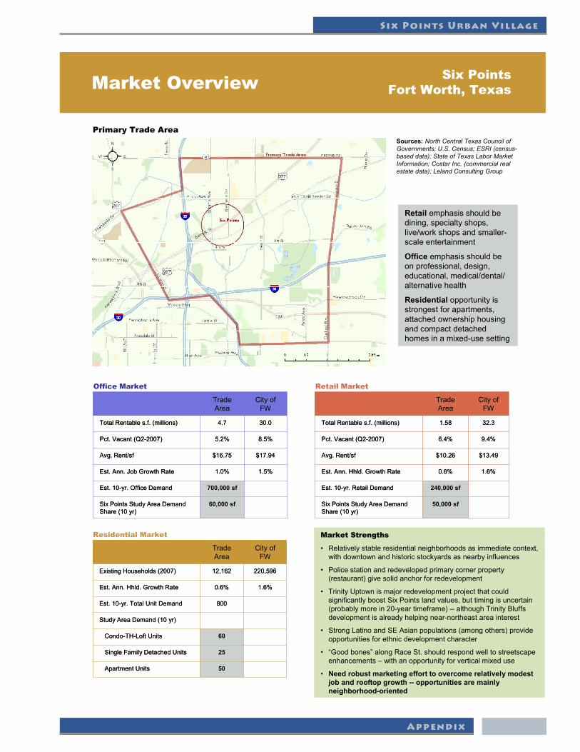
Market Overview Six Points Fort Worth, Texas
Primary Trade Area
1.5%1.0%Est.Ann.JobGrowthRate
$17.94$16.75Avg.Rent/sf
700,000 sfEst.10-yr.OfficeDemand
60,000 sfSixPointsStudyAreaDemandShare(10yr)
8.5%5.2%Pct.Vacant(Q2-2007)
30.04.7TotalRentables.f.(millions)
CityofFW
Trade Area
1.5%1.0%Est.Ann.JobGrowthRate
$17.94$16.75Avg.Rent/sf
700,000 sfEst.10-yr.OfficeDemand
60,000 sfSixPointsStudyAreaDemandShare(10yr)
8.5%5.2%Pct.Vacant(Q2-2007)
30.04.7TotalRentables.f.(millions)
CityofFW
Trade Area
Office Market
1.6%0.6%Est.Ann.Hhld.GrowthRate
$13.49$10.26Avg.Rent/sf
240,000 sfEst.10-yr.RetailDemand
50,000 sfSixPointsStudyAreaDemandShare(10yr)
9.4%6.4%Pct.Vacant(Q2-2007)
32.31.58TotalRentables.f.(millions)
CityofFW
Trade Area
1.6%0.6%Est.Ann.Hhld.GrowthRate
$13.49$10.26Avg.Rent/sf
240,000 sfEst.10-yr.RetailDemand
50,000 sfSixPointsStudyAreaDemandShare(10yr)
9.4%6.4%Pct.Vacant(Q2-2007)
32.31.58TotalRentables.f.(millions)
CityofFW
Trade Area
Retail Market
StudyAreaDemand(10yr)
25SingleFamilyDetachedUnits
220,59612,162ExistingHouseholds(2007)
60Condo-TH-LoftUnits
1.6%0.6%Est.Ann.Hhld.GrowthRate
800Est.10-yr.TotalUnitDemand
50ApartmentUnits
CityofFW
Trade Area
StudyAreaDemand(10yr)
25SingleFamilyDetachedUnits
220,59612,162ExistingHouseholds(2007)
60Condo-TH-LoftUnits
1.6%0.6%Est.Ann.Hhld.GrowthRate
800Est.10-yr.TotalUnitDemand
50ApartmentUnits
CityofFW
Trade Area
Residential Market Market Strengths
• Relativelystableresidentialneighborhoodsas immediate context, with downtown and historic stockyards as nearby influences
• Police station and redeveloped primary corner property (restaurant)givesolidanchorforredevelopment
• TrinityUptownismajorredevelopmentprojectthatcouldsignificantly boost Six Points land values, but timing is uncertain (probablymorein20-yeartimeframe)-- althoughTrinityBluffsdevelopment is already helping near-northeast area interest
• StrongLatinoandSEAsianpopulations(amongothers)provideopportunities for ethnic development character
• “Goodbones” alongRaceSt.shouldrespondwelltostreetscapeenhancements – with an opportunity for vertical mixed use
• Need robust marketing effort to overcome relatively modest job and rooftop growth -- opportunities are mainly neighborhood-oriented
Retail emphasis should be dining, specialty shops, live/workshopsandsmaller-scale entertainment
Office emphasis should be on professional, design, educational,medical/dental/alternative health
Residential opportunity is strongest for apartments, attached ownership housing and compact detached homes in a mixed-use setting
Sources: North Central Texas Council of Governments; U.S. Census; ESRI (census-based data); State of Texas Labor Market Information; Costar Inc. (commercial real estate data); Leland Consulting Group

The City of Fort Worth
Appendix
Trade Area Profile Six PointsFort Worth, Texas
26.0%42.3%Pct.BlueCollar(Age25+)
22.3%9.8%Pct.WithBachelorsDegree
20.1%11.7%Pct.Black/African-American
29.8%43.3%Pct.Hispanic
16.5%7.7%Pct.WithIncomeOver$100,000
South-western Families
South-western Families
Top Tapestry™ Lifestyle/PsychographicSegments
34.6%32.0%Pct.Non-familyHouseholds(2007)
43.0%43.3%Pct.Renters(2007)
2.692.97AverageHouseholdSize(2007)
32.131.3MedianAge
23.2%25.8%Pct.Age0-14
9.3%9.2%Pct.Age65+
32.3%40.1%Pct.WithIncomeBelow$25,000
$23,609$16,280PerCapitaIncome
$47,229$37,048MedianHouseholdIncome
Young and Restless
Milk and Cookies
3.3%
1.6%
250,583
686,850
CityofFortWorth
5.1%Pct.Asian/Pacific
0.6%AnnualHouseholdGrowthRate(Projectedthrough2030)
Home Town
Industrious Urban Fringe
12,1622007Households
36,3432007Population
TradeArea

Six Points Urban Village
Appendix
Appendix - Historic Inventory Data

The City of Fort Worth
Appendix
Six Points Urban Village
Appendix

The City of Fort Worth
Appendix

Six Points Urban Village
Appendix

The City of Fort Worth
Appendix

Six Points Urban Village
Appendix
The City of Fort Worth
Appendix
Six Points Urban Village
Appendix

The City of Fort Worth
Appendix

Six Points Urban Village
Appendix

The City of Fort Worth
Appendix

Six Points Urban Village
Appendix

The City of Fort Worth
Appendix

Six Points Urban Village
Appendix
Appendix - Crime Trends

The City of Fort Worth
Appendix

Six Points Urban Village
Appendix
Since 1991, Part I Crime has decreased by 48%Since 1995, Part I Crime has increased by 10%Since 2000, Part I Crime has increased by 7%
Comparing Year-to-date 2007 to the same time in 2006596 Part I Crimes in the area for Jan – Sept 2007536 Part I Crimes in the area for Jan – Sept 2006

The City of Fort Worth
Appendix

Six Points Urban Village
Appendix
Appendix - MIXED-USE GUIDELINES

The City of Fort Worth
Appendix
An illustrated guide to Fort Worth’s mixed-use development regulations FORT WORTH’S MIXED-USE ZONING STANDARDS
This document is intended to serve as a useful guide to development standards in mixed-use zoning districts. This guide is not a City of Fort Worth ordinance or a substitute for the City’s Zoning Ordinance and City Plan Commission Rules and Regulations.
City of Fort Worth Planning Department 1000 Throckmorton St. Fort Worth, TX 76102 (817) 392-8000 November 2005


General Development Standards
• Intent 5 • Greenfield Development Sites 5 • General Land-Uses 5 • Mix of Use Requirements 5-6 • Conceptual Site Plan 6
Exterior Design Standards • Intent 11 • Required Drawings 11 • Façade Variations 11-12 • Fenestration 12 • Fences and Gates 12 • Building Materials 12 • Building Entries 12-13 • Drive-Through Design Standards 13 • Signs 13 • Outdoor Storage or Display 13 • Exterior Elements of a Building 14
Site and Building Design
• Block Lengths 7 • Building Setbacks 7-8 • Building Heights 8 • Residential Density 8 • Open Space and Landscaping 9 • Parking Requirements 10
t a b l e o f c o n t e n t s 2
Introduction
• Frequently Asked Questions 3 • Map of Mixed-Use Growth Centers and Urban Villages 4

Why does the City encourage mixed-use development in appropriate locations?
The City of Fort Worth Comprehensive Plan designates mixed-use growth cen-ters as areas where compact, pedestrian-scaled, mixed-use neighborhoods and commercial districts should be developed. Within these growth centers, and in other appropriate areas, such as designated urban villages, mixed-use zoning helps provide a desirable combination of compatible residential, office, retail, and selected light industrial uses. Vibrant, compact, mixed-use districts:
• Help to reduce the frequency and distance of car trips; • Foster safe, active pedestrian environments; • Provide residential and employment density to support public transporta-
tion and neighborhood businesses; and • Attract residents and employers looking for urban amenities.
A map of designated mixed-use growth centers and urban villages is shown on page 4.
What is the purpose of this guide to the mixed-use zoning standards?
The mixed-use zoning standards are significantly different than the conventional standards of other commercial districts. Because the classifications are intended to encourage a compatible mix of residential and non-residential uses, the mixed-use standards place more emphasis on the form, or design, of new development. An illustrated guide is the most effective way to present these form-based stan-dards.
What are the mixed-use zoning classifications?
MU-1 Low Intensity Mixed-Use District — Provides areas in which a variety of housing types may exist among neighborhood-serving commercial and institutional uses.
MU-1G Greenfield Low Intensity Mixed-Use District* — Promotes low inten-sity mixed-use development in undeveloped mixed-use growth centers.
MU-2 High Intensity Mixed-Use District — Provides areas in which a variety of higher density housing types may exist among commercial, institutional, and se-lected light industrial uses.
MU-2G Greenfield High Intensity Mixed-Use District* — Promotes high inten-sity mixed-use development in undeveloped mixed-use growth centers.
* The greenfield zoning classifications are limited to sites of at least 100 acres.
Are single-use projects allowed in mixed-use zoning districts?
Single-use projects that are smaller than three acres are allowed. Projects that are three acres in size or larger require a mix of uses, with exceptions for single-use projects that are within walking distance (1,000 feet) of other uses and that help create a larger mixed-use area. The mix of use requirements are described in de-tail on pages 5-6.
How does the City help property owners within a growth center or urban village initiate a zoning change to MU-1, MU-1G, MU-2, or MU-2G?
To encourage mixed-use zoning districts, the City Council has established the fol-lowing process for petition-based zoning changes:
• Property owners submit a petition for a new mixed-use zoning district. Those signing the petition must own property constituting at least 50 percent of the proposed district's land area and at least 50 percent of the parcels to be re-zoned;
• City staff validates the petition and confirms that the proposed district is logi-cal and consistent with the Comprehensive Plan.
Once the above conditions are met, City staff submits a zoning application on be-half of the property owners for consideration by the Zoning Commission and the City Council.
May individual property owners submit an application to change their property’s zoning to MU-1, MU-1G, MU-2, or MU-2G?
Yes. Individual property owners may submit a zoning change application to re-zone their property. For these individual applications, the standard zoning applica-tion fees would apply. Additionally, the proposed rezoning should be consistent with the Comprehensive Plan.
f r e q u e n t l y a s k e d q u e s t i o n s 3
MU-1: Low intensity mixed-use development. MU-2: High intensity mixed-use development.

Regional Mixed-Use Growth Centers Texas Motor Speedway Alliance Gateway West Nance Ranch Centreport Eastchase Downtown Cultural District Medical District Ridgmar Walsh Ranch Clear Fork Hulen/Cityview Community Mixed-Use Growth Centers Alliance Town Center Fossil Creek Marine Creek Stockyards Near Southeast Polytechnic/Texas Wesleyan Miller/Berry Texas Christian University Loop 820 East/Lake Arlington La Gran Plaza SH121/FM1187 Spinks/Huguley Urban Villages 1. Historic Handley 2. Berry/Stalcup 3. Oakland Corners 4. Polytechnic/Wesleyan 5. Berry/Riverside 6. Near East Side 7. Evans & Rosedale 8. South Main 9. Magnolia 10. Berry/Hemphill 11. Berry/University 12. Bluebonnet Circle 13. Ridglea 14. West 7th 15. Mercado 16. Six Points
m i x e d - u s e g r o w t h c e n t e r s a n d u r b a n v i l l a g e s 4
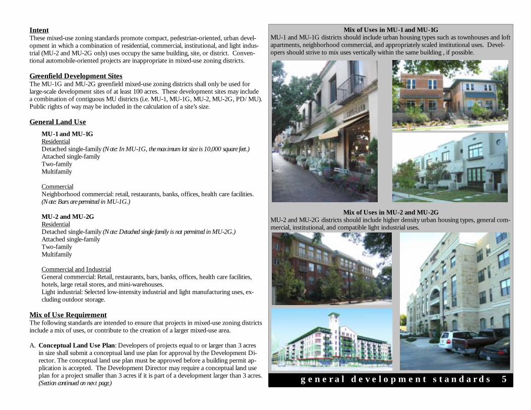
Intent These mixed-use zoning standards promote compact, pedestrian-oriented, urban devel-opment in which a combination of residential, commercial, institutional, and light indus-trial (MU-2 and MU-2G only) uses occupy the same building, site, or district. Conven-tional automobile-oriented projects are inappropriate in mixed-use zoning districts. Greenfield Development Sites The MU-1G and MU-2G greenfield mixed-use zoning districts shall only be used for large-scale development sites of at least 100 acres. These development sites may include a combination of contiguous MU districts (i.e. MU-1, MU-1G, MU-2, MU-2G, PD/MU). Public rights of way may be included in the calculation of a site’s size. General Land Use
MU-1 and MU-1G Residential
Detached single-family (Note: In MU-1G, the maximum lot size is 10,000 square feet.) Attached single-family Two-family Multifamily
Commercial Neighborhood commercial: retail, restaurants, banks, offices, health care facilities.
(Note: Bars are permitted in MU-1G.)
MU-2 and MU-2G Residential Detached single-family (Note: Detached single family is not permitted in MU-2G.) Attached single-family Two-family Multifamily Commercial and Industrial General commercial: Retail, restaurants, bars, banks, offices, health care facilities, hotels, large retail stores, and mini-warehouses. Light industrial: Selected low-intensity industrial and light manufacturing uses, ex-cluding outdoor storage.
Mix of Use Requirement The following standards are intended to ensure that projects in mixed-use zoning districts include a mix of uses, or contribute to the creation of a larger mixed-use area. A. Conceptual Land Use Plan: Developers of projects equal to or larger than 3 acres
in size shall submit a conceptual land use plan for approval by the Development Di-rector. The conceptual land use plan must be approved before a building permit ap-plication is accepted. The Development Director may require a conceptual land use plan for a project smaller than 3 acres if it is part of a development larger than 3 acres. (Section continued on next page.)
Mix of Uses in MU-1 and MU-1G MU-1 and MU-1G districts should include urban housing types such as townhouses and loft apartments, neighborhood commercial, and appropriately scaled institutional uses. Devel-opers should strive to mix uses vertically within the same building , if possible.
g e n e r a l d e v e l o p m e n t s t a n d a r d s 5
Mix of Uses in MU-2 and MU-2G MU-2 and MU-2G districts should include higher density urban housing types, general com-mercial, institutional, and compatible light industrial uses.

Mix of Use Requirement (cont.) The conceptual land use plan shall illustrate the proposed location and calculated land area of land uses on the site, using the following land use categories:
Conceptual Land Use Plan for Large Projects The mix of use requirements are intended to prevent large single-use projects that do not contribute to the creation of a larger mixed-use area. A conceptual land use plan is required for projects of at least 3 acres. The diagram below illustrates staff’s vicinity test analysis.
Conceptual Site Plan for Administrative Review To facilitate timely review and compliance with the development standards, developers are required to submit a conceptual site plan for administrative review.
g e n e r a l d e v e l o p m e n t s t a n d a r d s 6
• One- or two-family residential • Multifamily residential • Commercial • Institutional
• Mixed-use buildings (must include at least 20% residential and 10% non-residential)
• Public park.
Parking facilities and private open spaces shall be classified the same as the primary land use they serve.
B. Project Test: The conceptual land use plan shall be approved if it shows that:
1. The project includes uses within at least two of the land use categories, and 2. No land use category other than mixed-use buildings occupies greater than 2/3 of
the total land area (70 percent in MU-1G and MU-2G). If a project does not comply with the project test, then the vicinity test shall apply.
C. Vicinity Test: Developments not complying with the project test are permitted if:
1. The Development Director determines that the following conditions are satisfied: a) The proposed land use at any location within the proposed development site
must be within a walking distance of 1,000 feet of a different land use, as measured by the shortest pedestrian route, and
b) The percentage of any single land use category other than mixed-use build-ings within a 1,000-foot radius of any location within the proposed develop-ment site shall not be greater than greater than 2/3 of the total land area (70 percent in MU-1G and MU-2G) within the radius. The proposed develop-ment shall be included in the calculation of this percentage. Undeveloped or agricultural property located within the radius shall not be included in the cal-culation;
or
2. The Development Director determines that the developer has demonstrated that unique site conditions (e.g. adjacency to natural features, highways, freight yards, etc.) make compliance with the conditions of section 1. above impractical in cer-tain areas of the development site.
Conceptual Site Plan In order to facilitate compliance with the mixed-use zoning standards, developers shall submit a conceptual site plan to the Development Department for administrative review prior to submittal of permit application for new construction projects. The site plan shall show the anticipated location of proposed streets, sidewalks and walkways, build-ing footprints, parking areas, landscaped areas and features, and open spaces.
Block Lengths
MU-1 and MU-2
A. Minimum Block Length: 200 feet B. Maximum Block Length: 500 feet, with the following provision:
To provide flexibility for larger development projects, a publicly accessible private street with adjacent sidewalks, or a publicly accessible private walk-way, may count as a block boundary for measurement purposes. Public ac-cess easements are required to qualify for this exception, and the distance between two public streets shall not exceed 1,000 feet.
C. Maximum Block Perimeter: 1,600 feet
MU-1G and MU-2G A. Minimum Block Length: 200 feet B. Maximum Block Length:
• 1,320 feet for exterior blocks, i.e. those in which at least one block face borders a highway, principal arterial, or other barrier to convenient pedes-trian access.
• 700 feet for all other blocks, with the following provision: For purposes of measurement, a publicly accessible private street with adjacent sidewalks, or
a publicly accessible private walkway, may count as a block boundary for measurement purposes. Public access easements are required to qualify for this exception, and the distance between two public streets shall not exceed 1,320 feet.
C. Maximum Block Perimeter: None
Building Setbacks A. Front Yard: 20 feet maximum, with the following provisions applying in certain
situations: 1. Angled, Perpendicular, or Parallel Parking Located on Private Property: If
the parking meets the conditions listed on page 10 of this guide, the setback shall be measured from the front of the parking space instead of the property line.
2. Interior Buildings in Campus Developments, e.g. Schools or Hospitals:Interior buildings may be constructed if there are also buildings that are oriented to the public streets bordering the campus. Specifically, buildings may be set back from the property line more than 20 feet if at least 50 percent of the public street frontage on each block face within the development contains buildings within the maximum setback of 20 feet.
3. Large Retail Buildings in MU-1G and MU-2G: To allow convenient access to parking from the entrances of large retail buildings greater than 50,000 square feet, the building side of any internal street with a public access easement may serve as the line from which the maximum 20-foot setback is measured. The total ground floor area of buildings utilizing this exception, however, may constitute no more than 50 percent of the total ground floor area of buildings shown on the concep-tual site plan.
4. Setback for MU-2 and MU-2G Buildings Taller than 60 Feet: Any portion of a building above 60 feet must be set back at least 20 feet from the property line. (Section continued on next page.)
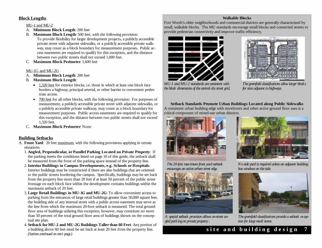
Walkable Blocks Fort Worth’s older neighborhoods and commercial districts are generally characterized by small, walkable blocks. The MU standards encourage small blocks and connected streets to provide pedestrian connectivity and improve traffic efficiency.
Setback Standards Promote Urban Buildings Located along Public Sidewalks A consistent urban building edge with storefronts and other active ground floor uses is a critical component of mixed-use urban districts.
s i t e a n d b u i l d i n g d e s i g n 7
MU-1 and MU-2 standards are consistent with the block dimensions of the central city street grid.
The greenfield classifications allow larger blocks for sites adjacent to highways.
A special setback provision allows on-street an-gled parking on private property .
The greenfield classifications provide a setback excep-tion for large retail stores.
The 20-foot maximum front yard setback encourages an active urban street edge.
No side yard is required unless an adjacent building has windows on the side.
500
300

Transitional Height Plane for Buildings Adjacent to One- or Two-Family Districts The 45-degree transitional height plane helps ensure that buildings in MU districts are com-patible in scale with adjacent lower density neighborhoods.
Maximum Residential Density A. Single-Use Projects in MU-1 and MU-1G: 40 units per acre; 18 units per acre for
townhouses. B. Mixed-Use** Projects in MU-1 and MU-1G: 60 units per acre. C. Single-Use Projects in MU-2 and MU-2G: 60 units per acre; 24 units per acre for
townhouses. D. Mixed-Use** Projects in MU-2 and MU-2G: Unlimited. ** Mixed-use projects must include at least 20% residential and 10% office, restaurant, and/or retail uses, as measured by gross floor area, to qualify for the density bonus.
MU-2 and MU-2G: Setbacks for Buildings Taller than 60 feet If a taller building is built to the property line, the portion of the building above 60 feet is required to step back at least 20 feet from the property line to prevent a canyon effect.
s i t e a n d b u i l d i n g d e s i g n 8
60’
60’
20’
120’
Prop
erty
Lin
e
Both Buildings Conform To MU-2/MU-2G Setback Standards
Prop
erty
Li
ne
20’
45°
Property line
45 feet
MU district One- or two- family district
Height and Density Bonuses for Mixed-Use Buildings and Projects The MU standards provide significant height and density bonuses to encourage a mix of residential and non-residential uses within the same building or project.
Up to 5 stories for MU-1 mixed-use buildings. No density limit for MU-2 mixed-use projects.
Maximum Building Heights A. Single-Use Buildings in MU-1 and MU-1G: 45 feet or 3 stories, whichever is less. B. Mixed-Use* Buildings in MU-1 and MU-1G: 60 feet or 5 stories, whichever is less. C. Single-Use Buildings in MU-2 and MU-2G: 60 feet or 5 stories, whichever is less;
45 feet or 3 stories, whichever is less, for townhouses. D. Mixed-Use* Buildings in MU-2: 120 feet or 10 stories, whichever is less (see set-
back condition in previous section). E. Mixed-Use* Buildings in MU-2G: 10 stories (see setback condition in previous
section). F. Transitional Height Plane for Buildings Adjacent to One- or Two-Family Zon-
ing Districts: Any portion of a building above 45 feet or 3 stories, whichever is less, shall be set back to allow for a 45 degree transitional height plane.
G. Rooftop Terraces: Rooftop terraces and the structures providing access to them shall not be included in the measurement of building height.
* Mixed-use buildings must include at least 20% residential and 10% office, restaurant, and/or retail uses, as measured by gross floor area, to qualify for the height bonus.
Building Setbacks (cont.) 5. Corner Clip: A triangular right-of-way dedication (corner clip) measuring 5 feet by
5 feet, measured at the property line, is required for corner lots at the intersection of two streets or the intersection of a street and an alley, except: a) No dedication is required at all-way stops and signalized intersections where
there is a required stop in at least two directions. B. Rear Yard: 5 feet minimum. C. Side Yard: None required, except when an abutting property with an existing build-
ing has windows facing to the side. Then, any new development or addition shall provide at least 10 feet of separation between the existing and new building.
D. Setback Between Mixed-Use Districts and Adjacent One- and Two-Family Districts: A five-foot bufferyard and 20-foot building setback are required between the boundary of a mixed-use district and an adjacent one- or two-family zoning dis-trict, unless the development within the mixed-use district is also one- or two-family, such as townhouses. Bufferyard requirements are described on page 9.
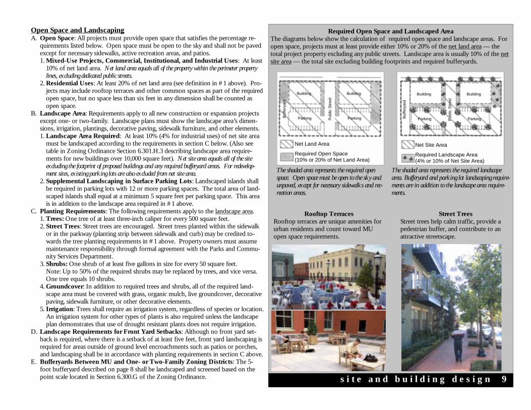
Rooftop Terraces Rooftop terraces are unique amenities for urban residents and count toward MU open space requirements.
Open Space and Landscaping A. Open Space: All projects must provide open space that satisfies the percentage re-
quirements listed below. Open space must be open to the sky and shall not be paved except for necessary sidewalks, active recreation areas, and patios. 1. Mixed-Use Projects, Commercial, Institutional, and Industrial Uses: At least
10% of net land area. Net land area equals all of the property within the perimeter property lines, excluding dedicated public streets.
2. Residential Uses: At least 20% of net land area (see definition in #1 above). Pro-jects may include rooftop terraces and other common spaces as part of the required open space, but no space less than six feet in any dimension shall be counted as open space.
B. Landscape Area: Requirements apply to all new construction or expansion projects except one- or two-family. Landscape plans must show the landscape area’s dimen-sions, irrigation, plantings, decorative paving, sidewalk furniture, and other elements. 1. Landscape Area Required: At least 10% (4% for industrial uses) of net site area
must be landscaped according to the requirements in section C below. (Also see table in Zoning Ordinance Section 6.301.H.3 describing landscape area require-ments for new buildings over 10,000 square feet). Net site area equals all of the site excluding the footprint of proposed buildings and any required bufferyard areas. For redevelop-ment sites, existing parking lots are also excluded from net site area.
2. Supplemental Landscaping in Surface Parking Lots: Landscaped islands shall be required in parking lots with 12 or more parking spaces. The total area of land-scaped islands shall equal at a minimum 5 square feet per parking space. This area is in addition to the landscape area required in #1 above.
C. Planting Requirements: The following requirements apply to the landscape area. 1. Trees: One tree of at least three-inch caliper for every 500 square feet. 2. Street Trees: Street trees are encouraged. Street trees planted within the sidewalk
or in the parkway (planting strip between sidewalk and curb) may be credited to-wards the tree planting requirements in #1 above. Property owners must assume maintenance responsibility through formal agreement with the Parks and Commu-nity Services Department.
3. Shrubs: One shrub of at least five gallons in size for every 50 square feet. Note: Up to 50% of the required shrubs may be replaced by trees, and vice versa. One tree equals 10 shrubs.
4. Groundcover: In addition to required trees and shrubs, all of the required land-scape area must be covered with grass, organic mulch, live groundcover, decorative paving, sidewalk furniture, or other decorative elements.
5. Irrigation: Trees shall require an irrigation system, regardless of species or location. An irrigation system for other types of plants is also required unless the landscape plan demonstrates that use of drought resistant plants does not require irrigation.
D. Landscape Requirements for Front Yard Setbacks: Although no front yard set-back is required, where there is a setback of at least five feet, front yard landscaping is required for areas outside of ground level encroachments such as patios or porches, and landscaping shall be in accordance with planting requirements in section C above.
E. Bufferyards Between MU and One- or Two-Family Zoning Districts: The 5-foot bufferyard described on page 8 shall be landscaped and screened based on the point scale located in Section 6.300.G of the Zoning Ordinance. s i t e a n d b u i l d i n g d e s i g n 9
Required Open Space and Landscaped Area The diagrams below show the calculation of required open space and landscape areas. For open space, projects must at least provide either 10% or 20% of the net land area — the total project property excluding any public streets. Landscape area is usually 10% of the net site area — the total site excluding building footprints and required bufferyards.
The shaded area represents the required open space. Open space must be open to the sky and unpaved, except for necessary sidewalks and rec-reation areas.
The shaded area represents the required landscape area. Bufferyard and parking lot landscaping require-ments are in addition to the landscape area require-ments.
Street Trees Street trees help calm traffic, provide a pedestrian buffer, and contribute to an attractive streetscape.
Net Land Area
Required Open Space (10% or 20% of Net Land Area)
Building Building
Parking Parking Buffe
ryar
d
Pub
lic S
treet
Net Site Area
Required Landscape Area (4% or 10% of Net Site Area)
Building Building
Parking Parking Buf
fery
ard
Publ
ic S
treet

Parking Requirements Section 6.201B of the Zoning Ordinance includes a detailed list of off-street parking requirements for the uses allowed in MU-1, MU-1G, MU-2, and MU-2G. For mixed-use buildings and projects, the total parking requirement shall be the sum of the individual requirements for all uses. These requirements apply with the following provisions: A. Reduced Parking Requirements:
1. All MU districts: 25% reduction for all uses. 2. Rail Transit Bonus: 50% reduction for all uses in buildings whose primary entrance
is within 1,000 feet of an entrance to a passenger rail station or rail stop (1,500 feet for MU-1G and MU-2G).
B. Parking Exemption for Historically Significant Buildings: Historically significant buildings are exempt from off-street parking requirements. Buildings must be deter-mined by the City’s Historic Preservation Officer to be eligible for listing in the Na-tional Register of Historic Places, or eligible for local “HC” Historic and Cultural Landmark or “HSE” Highly Significant Endangered designation.
C. Credit for On-Street Parking: Adjacent on-street parking may be applied toward the minimum parking requirements, but shall not reduce the pertinent maximum parking limitations.
D. Townhouse Parking Requirements: Minimum of one off-street parking space per dwelling unit, and a maximum of two spaces per unit.
E. Parking Cap: The maximum number of parking spaces shall be limited to 100 per-cent (110 percent in MU-1G and MU-2G) of the minimum requirements listed in Section 6.201.B of the Zoning Ordinance.
F. Joint Parking: Joint parking facilities are encouraged. Uses may provide more than the maximum number of parking spaces if the additional spaces are provided as part of a joint-use parking facility. However, if the joint use parking facility is a surface parking lot, the total number of spaces in the surface lot shall not exceed the sum of the maximum spaces allowed for all individual uses sharing the facility. This limit shall not apply to a multi-level parking garage that is used as a joint use facility.
G. Parking Location: Surface parking shall not be permitted between a building front and the street, with the following exception for on-street parking located on private property: 1. Angled, perpendicular, or parallel parking that is partially or completely located on
private property shall be permitted if it meets the following two conditions: a) The City’s Traffic Engineer determines that the parking does not adversely
affect public safety or circulation and satisfies the conditions described in Sec-tion 22-175b of the City Code; and
b) The parking is located adjacent to and is directly accessible from a public street right-of-way or a publicly accessible private street.
In these situations, the front yard setback shall be measured from the front of the parking space.
H. Screening of Surface Parking and Driveways: Parking lots, and driveways that are located adjacent and parallel to a public street, shall be screened from the public right-of-way with landscaping, berms, fences or walls 36 to 42 inches in height.
Parking Exemption for Historically Significant Buildings An important incentive for the preservation and adaptive reuse of older buildings is the waiver of off-street parking requirements for historically significant buildings.
s i t e a n d b u i l d i n g d e s i g n 1 0
The MU parking waiver for historic buildings facilitated the adaptive reuse of older buildings in the Magno-lia (left) and West Seventh (right) urban villages.
Credit for On-Street Parking On-street parking supports neighborhood retail and helps to calm traffic in urban areas.
Inconspicuous Parking Lots Unlike conventional strip shopping centers, parking lots are not located between the street and the building in MU districts.
Conventional auto-oriented commercial strips locate parking lots at the street edge.
Surface parking lots are screened and are located at the rear or sides of buildings in mixed-use districts.
Parking lot at conventional strip shopping center
Access to parking in MU district

Intent The following design standards are intended to encourage new buildings that comple-ment neighborhood character, add visual interest, and support a pedestrian-oriented envi-ronment. The standards are not intended to encourage architectural uniformity or the imitation of older buildings. Required Drawings To illustrate compliance with the following standards, developers shall submit to the Development Department elevation drawings for those building facades that are oriented to: • Public streets; • Private streets and walkways that are publicly accessible through a public use ease-
ment; or • Publicly accessible open space.
Exception for Large Retail Stores in Greenfield Districts: Mixed-use standards related to façade variations, fenestration, building materials, and building entries do not apply to large retail stores greater than 50,000 square feet in MU-1G and MU-2G. (Big box design standards in Section 5.133 of the Zoning Ordinance apply to these large retail stores.)
Façade Variations The massing of all new buildings shall be articulated in a variety of ways, including the use of projecting and recessed elements such as porches, cantilevers, balconies, bay win-dows or recessed windows, and roof dormers, to reduce their apparent overall bulk and volume, to enhance visual quality, and to contribute to human-scaled development. A. Scaling Elements: Each new building façade oriented to a publicly accessible street
or open space shall at a minimum incorporate 3 or more of the following 4 scaling elements on building facades greater than 50 feet in width; and at least 2 of the fol-lowing elements on building facades less than 50 feet in width: 1. Structural Elements: See page 14 for photographs and glossary of architectural elements.
a) Floors (banding, belt courses, etc. not less than 1” deep and 4” wide), b) Columns (pilasters, piers, quoins, etc. not less than 4” deep and 6” wide), or c) Foundation (water tables, rustication, etc.).
2. Variation in Wall Plane: Buildings shall incorporate projecting and recessed ele-ments not less than four inches in depth. Such elements could include door and window openings, and/or more pronounced architectural features, such as porches, alcoves, and roof dormers.
3. Changes in Material or Material Pattern: Each change of material shall involve a minimum of 1 inch variation in wall plane.
4. Changes in Color: Variation in exterior color helps create visual interest. B. Differentiation between Lower and Upper Levels: New commercial and mixed-
use building facades oriented to a publicly accessible street or open space shall include differentiation between the first or second level and the upper levels with a cornice, canopy, balcony, arcade, or other architectural feature.
(Section continued on next page.)
Façade Variations Façade variation standards are intended to reduce the overall bulk and volume of urban buildings, enhance visual quality, and contribute to human-scale development.
e x t e r i o r d e s i g n s t a n d a r d s 1 1
Windows and other openings helps break up fa-cades, create a human scale, and activate streets.
Multifamily Design The mixed-use standards promote architectural variety in multifamily projects. The images below contrast conventional garden apartments with a conforming MU design.
Elevation Drawings for Façades Facing Streets or Public Spaces The image below is an example of the type of elevation drawing that should be submitted.
Façade projections and recesses may be dramatic or subtle. This façade combines both approaches.
Conventional suburban multifamily MU multifamily
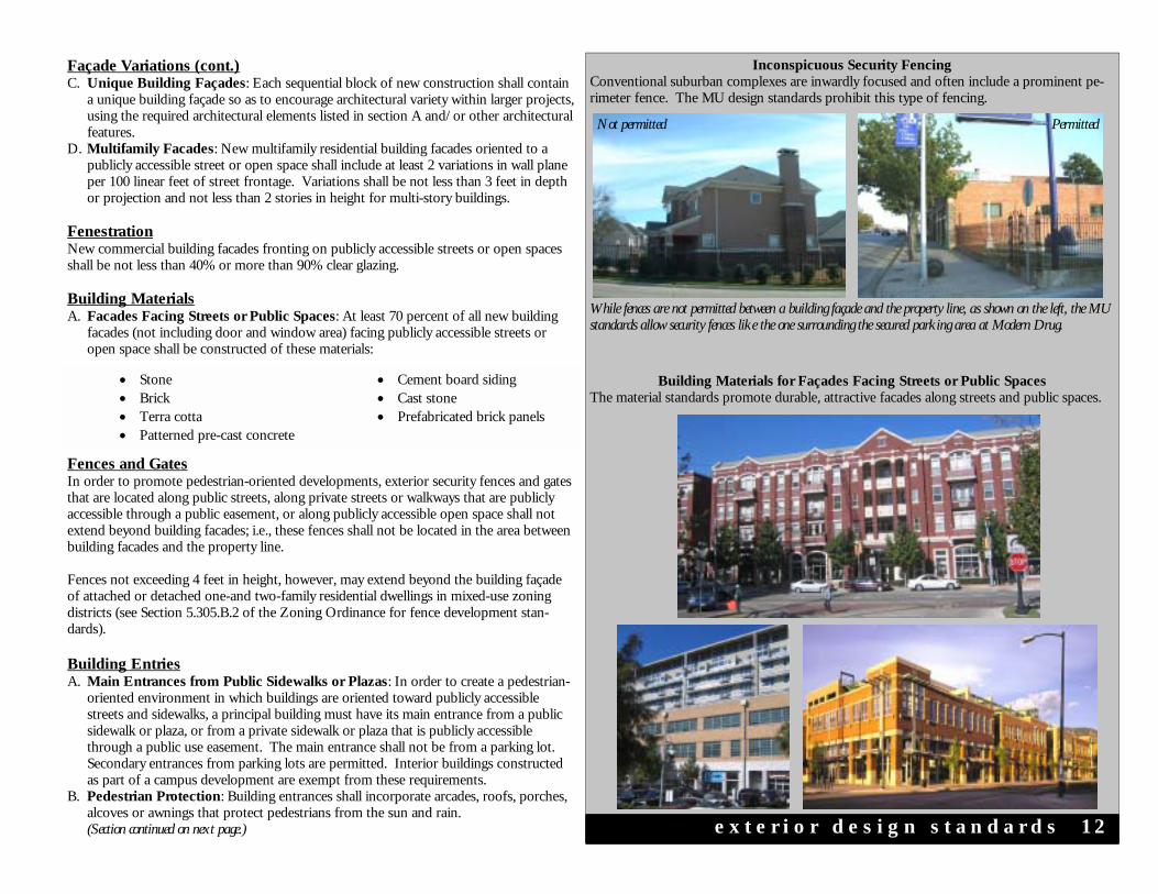
e x t e r i o r d e s i g n s t a n d a r d s 1 2
Inconspicuous Security Fencing Conventional suburban complexes are inwardly focused and often include a prominent pe-rimeter fence. The MU design standards prohibit this type of fencing.
• Stone • Brick • Terra cotta • Patterned pre-cast concrete
• Cement board siding • Cast stone • Prefabricated brick panels
Fences and Gates In order to promote pedestrian-oriented developments, exterior security fences and gates that are located along public streets, along private streets or walkways that are publicly accessible through a public easement, or along publicly accessible open space shall not extend beyond building facades; i.e., these fences shall not be located in the area between building facades and the property line. Fences not exceeding 4 feet in height, however, may extend beyond the building façade of attached or detached one-and two-family residential dwellings in mixed-use zoning districts (see Section 5.305.B.2 of the Zoning Ordinance for fence development stan-dards). Building Entries A. Main Entrances from Public Sidewalks or Plazas: In order to create a pedestrian-
oriented environment in which buildings are oriented toward publicly accessible streets and sidewalks, a principal building must have its main entrance from a public sidewalk or plaza, or from a private sidewalk or plaza that is publicly accessible through a public use easement. The main entrance shall not be from a parking lot. Secondary entrances from parking lots are permitted. Interior buildings constructed as part of a campus development are exempt from these requirements.
B. Pedestrian Protection: Building entrances shall incorporate arcades, roofs, porches, alcoves or awnings that protect pedestrians from the sun and rain.
(Section continued on next page.)
Façade Variations (cont.) C. Unique Building Façades: Each sequential block of new construction shall contain
a unique building façade so as to encourage architectural variety within larger projects, using the required architectural elements listed in section A and/or other architectural features.
D. Multifamily Facades: New multifamily residential building facades oriented to a publicly accessible street or open space shall include at least 2 variations in wall plane per 100 linear feet of street frontage. Variations shall be not less than 3 feet in depth or projection and not less than 2 stories in height for multi-story buildings.
Fenestration New commercial building facades fronting on publicly accessible streets or open spaces shall be not less than 40% or more than 90% clear glazing. Building Materials A. Facades Facing Streets or Public Spaces: At least 70 percent of all new building
facades (not including door and window area) facing publicly accessible streets or open space shall be constructed of these materials:
Building Materials for Façades Facing Streets or Public Spaces The material standards promote durable, attractive facades along streets and public spaces.
While fences are not permitted between a building façade and the property line, as shown on the left, the MU standards allow security fences like the one surrounding the secured parking area at Modern Drug.
Not permitted Permitted

Primary Entrances from Public Sidewalks Building entrances in mixed-use districts should resemble those found in downtown areas, with primary entrances located along publicly accessible streets and sidewalks.
Building Entries (cont.) C. Retail Entries: Each retail use with exterior, street-oriented exposure shall have an
individual public entry from the street. D. Residential Entries:
1. Primary entrances shall be provided for every 125 linear feet of street oriented resi-dential building frontage.
2. Townhouse and other similar street level dwelling units within multi-unit structures shall have individual street-oriented entries for each unit.
Drive-Through Design Standards Conventional drive-through uses do not support a pedestrian-oriented environment and are inconsistent with the intent of the mixed-use zoning standards. A. Location of Windows and Stacking Lanes: Drive-through windows and stacking
lanes shall not be located along facades of buildings that face a street, and where pos-sible shall be located to the rear of buildings;
B. Location of Driveways: Driveways shall not be located within the front yard setback between the building front and the street;
C. Circulation: The design and location of the facility shall not impede vehicular traffic flow and shall not impede pedestrian movement and safety. Shared driveways and/or driveways located off of non-arterial streets should be used, where possible;
D. Screening: Architectural elements, landscaping, and/or other screening elements shall be used to minimize the visual impacts of the drive-through facility; and
E. Consistency with Other District-Specific Design Guidelines or Standards: The design and location of the facility shall be consistent with any design standards or guidelines that may be applicable to the pertinent district.
Signs MU-1 and MU-1G Sign requirements included in Chapter 6, Article 4 of the zoning ordinance for the “E” District shall apply to MU-1 and MU-1G, with additional provisions described below. MU-2 & MU-2G Sign requirements included in Chapter 6, Article 4 of the zoning ordinance for the “I” District shall apply to MU-2 and MU-2G, with additional provisions described below. A. Attached Signs: The maximum aggregate area for attached signs, as described in Sec-
tion 6.404E of the zoning ordinance, shall be 200 square feet per façade. B. Detached Signs: Permitted detached signs shall be monument style and shall be lim-
ited to eight feet in height. Pole signs are not allowed, except: 1. Pole Signs in MU-1G and MU-2G: Pole signs are allowed along highway frontage
and principal arterials in MU-1G and MU-2G . These pole signs shall be subject to unified sign agreements.
Outdoor Storage or Display MU-1 and MU-1G Refer to zoning ordinance standards for the “E” Neighborhood Commercial District. MU-2 and MU-2G Refer to zoning ordinance standards for the “G” Intensive Commercial District. e x t e r i o r d e s i g n s t a n d a r d s 1 3
Signs The sign standards are intended to reduce visual clutter and to complement urban buildings. Pole signs are not permitted, except under certain circumstances in the greenfield districts.
Most signs in MU districts should be attached to building facades or hang above sidewalks.
Monument signs are appropriate for buildings that are set back the maximum 20 feet from the property line.
Drive-Through Facilities The MU standards specify certain drive-through design requirements to ensure compatibility with a pedestrian-oriented environment. Conventional drive-throughs are inappropriate. The bank drive-through at Magnolia Green (below) complies with the MU standards.
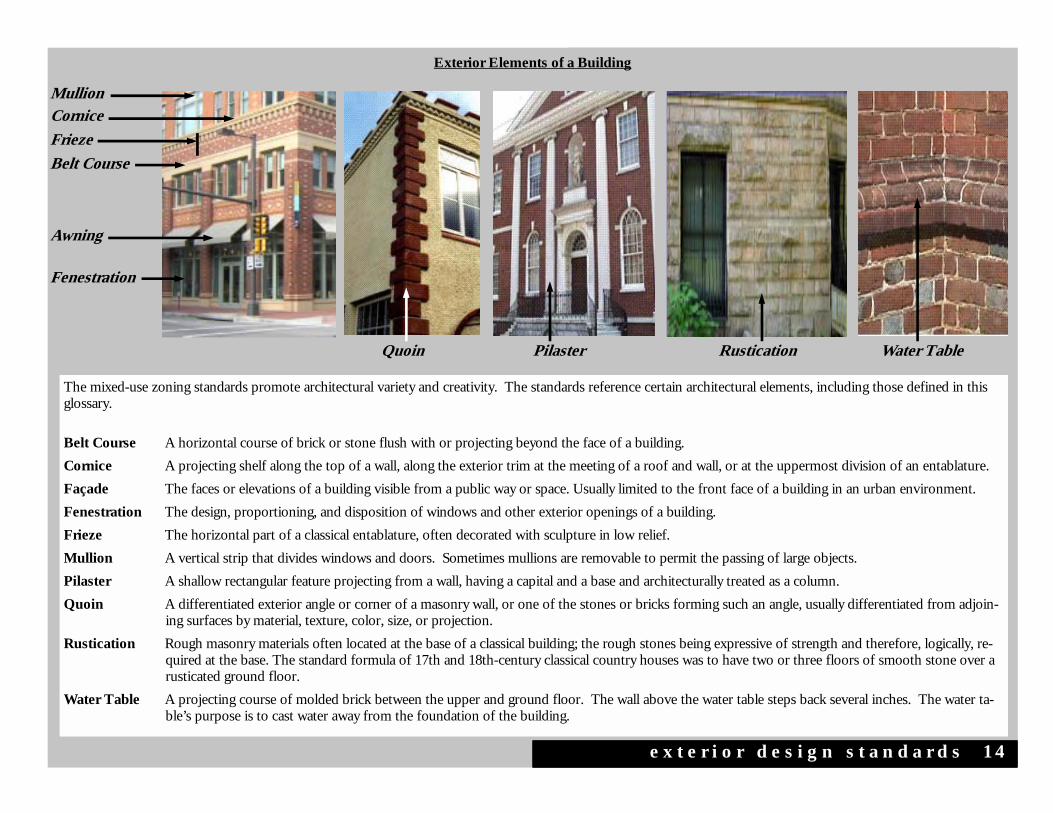
The mixed-use zoning standards promote architectural variety and creativity. The standards reference certain architectural elements, including those defined in this glossary.
Belt Course A horizontal course of brick or stone flush with or projecting beyond the face of a building. Cornice A projecting shelf along the top of a wall, along the exterior trim at the meeting of a roof and wall, or at the uppermost division of an entablature. Façade The faces or elevations of a building visible from a public way or space. Usually limited to the front face of a building in an urban environment. Fenestration The design, proportioning, and disposition of windows and other exterior openings of a building. Frieze The horizontal part of a classical entablature, often decorated with sculpture in low relief. Mullion A vertical strip that divides windows and doors. Sometimes mullions are removable to permit the passing of large objects. Pilaster A shallow rectangular feature projecting from a wall, having a capital and a base and architecturally treated as a column. Quoin A differentiated exterior angle or corner of a masonry wall, or one of the stones or bricks forming such an angle, usually differentiated from adjoin-
ing surfaces by material, texture, color, size, or projection. Rustication Rough masonry materials often located at the base of a classical building; the rough stones being expressive of strength and therefore, logically, re-
quired at the base. The standard formula of 17th and 18th-century classical country houses was to have two or three floors of smooth stone over a rusticated ground floor.
Water Table A projecting course of molded brick between the upper and ground floor. The wall above the water table steps back several inches. The water ta-ble’s purpose is to cast water away from the foundation of the building.
Quoin Pilaster Rustication Water Table
Exterior Elements of a Building
e x t e r i o r d e s i g n s t a n d a r d s 1 4
Awning
Mullion
Belt Course
Frieze
Cornice
Fenestration

Six Points Urban Village
Appendix
Appendix - public meeting summaries

The City of Fort Worth
Appendix
Six Points Urban Village
Appendix
SIXPOINTSURBANVILLAGECOMMUNITYMEETINGSUMMARY-JUNE14,2007
FortWorthHarvestChurch620NorthChandlerDr.
AnnKovich,withtheTCBteam,calledthemeetingtoorderandintroducedmembersoftheTCBteampresentforthekick-offmeetingoftheSixPointsUrbanVillageplanninginitiative.ShealsopresentedanoverviewoftheuniqueprojectsforwhichTCBandEDAWhavebeenresponsiblelocallyandnationally.
EdGarza,withEDAW,discussedtheimportanceofcommunityinputtotheoverallprocess.Hedefinedanurbanvillage as “an urbanized place with a mix of uses, jobs, public spaces, transportation, connections, pedestrian activityandasenseofplace.EmphasizingwhytheCityofFortWorthcreatedmixed-usezoning,henotedthebenefitstobe:(1)revitalizationofcentralcitycommercialdistricts;(2)protectionofsingle-familyresidentialneighborhoods;(3)efficiencyintheprovisionofpublicfacilitiesandservices;(4)convenienceforresidentsandworkers;(5)reductionintrafficcongestionandsupportfortransit;and(5)protectionoftheenvironment.Thefollowingaretheconsultantteam’sassessmentofthearea’sstrengths:
• TrinityUptownisamajordevelopmentprojectthatcouldsignificantlyboostSixPointslandvalues,althoughtimingisuncertain.TheTrinityBluffsdevelopmentisalreadystimulatinginterestinthenearnortheastareaof Fort Worth.
• Residentialneighborhoodsarerelativelystableinrelationshiptodowntown.
• ThePoliceSub-stationandredevelopedprimarycornerproperty(restaurant)provideasolidanchorforfuture development.
• “Goodbones”alongRaceStreetshouldrespondwelltostreetscapeinfrastructure.
• Development/designstandardsandarobustmarketingprogramcanhelpovercomerelativelymodestjoband rooftop growth.
OpportunitieswhichMr.Garzapresentedincluded:(1)turningBelknapintoapedestrian-friendlyurbancorridor;(2)takingadvantageofarealand,includingtheTrinityRivercorridor,parksanddevelopableparcels;and(3)makingimprovements to the Six Points intersection.
Constraintsthatwereidentifiedincludethearea’svariedarchitecture;single-landuses,andlackofanchoraroundwhichotherdevelopmentcanoccur.Mr.GarzanotedthatSixPointsisdominatedbyautomobiles;thereisalackofpedestrianamenitiesandlandscaping.Henotedthatbymakingthegatewayintotheareamoredynamic,itcouldserve as a catalyst for other projects.
AfterMr.Garza’spresentation,attendeesbrokeupintogroupstofurtherdiscussthearea’spositivesandnegatives,infrastructureneedsandthebenefitsofmixed-usezoning.Onceeachgroupreachedaconsensus on these discussion topics, attendees came back together and through presentations by a representative of each group, the following consensus was determined.
• Thearea’smostpositiveattributesareSixPoints’location,itsperiodarchitectureanditsculturaldiversity.
• Thearea’smostsignificantnegativesarecrime(especiallyvisiblefromthestreet),blightedstructuresandpoorcodeenforcement,andsubstandardinfrastructure(suchasthelackofadequatelightinganddrainage).
• Themostfavoredimagesofthegroupwereabrickstreetscape/sidewalkandanarchitecturaltreatmentofcolored buildings.
• Capitalimprovementsthatshouldbemadeintheareaincludestreetbeautification,drainageandtrafficcalming schemes.
• Thegroupunanimouslyvotedthatmixed-usezoningismoreappropriatethanconventionalzoningforthearea.

The City of Fort Worth
Appendix
SIXPOINTSURBANVILLAGECOMMUNITYMEETINGSUMMARY-AUGUST1,2007
RiversideCommunityCenter,3700E.Belknap
AnnKovich,withtheTCBteam,calledthemeetingtoorderandintroducedmembersoftheTCBteampresentforthe second public meeting.
Inpresentinganoverviewofthemeetingapproach,EdGarzanotedthatthevillagehasapproximately$700,000ingrantdollarsforinfrastructurework.BasedondiscussionsduringthefirstpublicmeetingoftheSixPointsVillage,hereiteratedthecommunity’sperceptionsofthearea’sstrengthsandweaknesses.Positive,asrankedbytheparticipants,werelocation(schools,TrinityRiver);thearea’sarchitecture,anddiverseculture.Negatives,asrankedbytheparticipants,werecrime;thelackoflightingandlandscaping;andblightedstructures/poorstreetsanddrainage.Imagesthatparticipantsinthefirstgroupmostpreferredwereofwidesidewalk;useofcoloronbuildingsalongawidesidewalk;multi-storytownhomes;anddecorativestreetlighting.Participantspreferredmixed-usezoningoverconventionalzoningexamples.Toptransportationand/infrastructureimprovementcategories,asrankedbytheparticipantsinthefirstpublicmeeting,werestreetbeautificationandpedestrianimprovements.
Mr.Garzagaveasbestpracticesexamplesofmixed-usedevelopmentsinthreecities.HenotedthatMiamiBeach,Florida, as an entertainment and cultural destination, has great restaurants, attractive streetscapes and art deco architecture.SoCoinAustin,Texasisahip,urbanatmospherethatconnectstodowntownandTownLake.EventsliketheFirstThursdayFestivalanduniqueshopsandrestaurantsworktogetherto“celebratecommunity.”ChapelHillinNorthCarolinaisratedoneofthemostcreativecitiesarchitecturallyintheU.S.EventsliketheAppleChillStreet Fair are big draws.
TheSixPointsVillagevisionpresentedbytheconsultingteamincludesalivemusicdestination;aculinarymecca;andamixed-useCommercialServiceCenter.TheDeco/MainStreeturbandesigncoupledwithaTexasoasislandscapedesignworktogethertomaketheareapedestrian-friendly.Inordertodevelopthecore,retailshouldnotbe scattered through the village.
TheconsultingteampresentedConceptA,notingthatthevillagealreadyhasmomentum.Astrategyshouldbeemployedtoinfillvacantlots,andamixed-usestrategyallowsforthetargetingofunderrepresentedretailservice,the amassing of restaurant and entertainment venues, and denser housing alternatives to increase pedestrian traffic.
Mr.Garzasaidthatareasshouldbepublicparking.Becauseexistinglandusesoftenconflict,Mr.Garzasaidallproperty owners must be encouraged to participate in redevelopment activities. For example, building owners who improvethefacadesoftheirpropertiesputpressureonotherstodothesame.Improvingpublicsafetyshouldbethe goal of everyone.
InthepresentationofConceptB,ananchortenantinthetrianglecreatedbyRace,SylvaniaandBelknapStreetsbecomes very important. This tenant—which could be a specialty bookstore or grocery, culinary school or neighborhoodmovietheater,needstobecompatiblewiththeneedsofthecommunity.AVillagePlazawouldbean“oasis,refuge,placethatthecommunitytakesownershipof,”Mr.Garzasaid.Pocketparkswouldemphasizeopenspace.TwostreetbeautificationalternativesaregatewayimprovementsatSixPointsandimprovementstoRaceStreet.
Twooptionswerepresentedforstreetbeautificationprojects.OneatSixPointsincludedtexturedsidewalks,landscaping,streetlighting,signage,art/waterfeature,undergroundutilityconversionandpedestriancrosswalks.
Six Points Urban Village
Appendix
ThesecondoneonRaceStreetincludedparkingenhancements,streetlighting,streetbanners,texturedsidewalks,landscaping and pedestrian crosswalks.
The attendees broke up into four groups and discussed their preferences for concepts as well as brainstormed specificideasforredevelopment.TheirfavoritebestpracticesprojectswereChapelHill,NorthCarolina,andtheypreferredmakinggatewayimprovementsoverimprovementstoRaceStreetinthenearfuture.Theylikedcomponentsofbothconcepts.Specificcommentsincluded:
• Ananchorsiteisverypositive,andcouldbeagrocerystore,movietheaterorfitnesscenter.
• Lotsofgreeneryispositive.
• Infillonvacantpropertiesispositive.
• TheuniqueSixPoints/Riversideidentityshouldbereinforcedasnewdevelopmentbegins.
• AgatewayattheSixPointsintersectioncanstartauniformdevelopmentpattern.
• TrafficshouldbesloweddownonRaceandBelknapStreets.
• ParkingonRaceStreetshouldbeangled,head-in,inthecenterofthestreet.
ThenextpublicmeetingisscheduledforSept.26,at6p.m.atthesamelocation.
The City of Fort Worth
Appendix
SIXPOINTSURBANVILLAGECOMMUNITYMEETINGSUMMARY-SEPTEMBER26,2007
RiversideCommunityCenter,3700E.Belknap
AnnKovich,withtheTCBteam,calledthemeetingtoorderandintroducedmembersoftheTCBteampresentforthethirdandfinalcommunitymeetingoftheSixPointsUrbanVillageplanninginitiative.
CouncilMemberSalEspinobeganwithadescriptionofthe16villagesthroughoutFortWorth.TheSixPointsUrbanVillageisaneconomicrevitalizationtoolinDistrict4andDistrict8neighborhoods.Mr.EspinoandCouncilMemberDannyScarthareworkingtogetherascolleaguesandfriends.TheprojectispartofthepublicprocessandMr.Espinorequestedanyonewithquestionstocallhim.Mr.ScarthgreetedtheparticipantsandreaffirmedthegoodrelationshipwithinthecommunityandwithMr.Espino.Healsorequestedthosewithquestionstocallhim.
Inpresentinganoverviewofthemeetingapproach,Mr.Garzanotedthatthevillagehasapproximately$700,000ingrantdollarsforinfrastructurework.BasedondiscussionsduringthefirstpublicmeetingoftheSixPointsVillage,hereiteratedthecommunity’sperceptionsofthearea’sstrengthsandweaknesses.Positive,asrankedbytheparticipants,werelocation(schools,TrinityRiver);thearea’sarchitecture,anddiverseculture.Negatives,asrankedbytheparticipants,werecrime;thelackoflightingandlandscaping;andblightedstructures/poorstreetsanddrainage.Imagesthatparticipantsinthefirstgroupmostpreferredwereofawidesidewalk;useofcoloronbuildingsalongawidesidewalk;multi-storytownhomes;anddecorativestreetlighting.Participantspreferredmixed-usezoningoverconventionalzoningexamples.Toptransportationand/infrastructureimprovementcategories,asrankedbytheparticipantsinthefirstpublicmeeting,werestreetbeautificationandpedestrianimprovements.
Todevelopaframework,Mr.Garzaestablishedsiteanalysis,historicinventory,existingzoning,demographics,opportunitiesandchallengesofthearea.Thehistoricinventoryevaluated11siteswithapreliminaryreviewandhistorictaxcreditopportunities.LelandConsultingGroup,ateammember,assembleddemographicsfortheSixPointstradearea,analyzingthedistancepeoplearewillingtodriveforservices.The2007tradeareademographicsarecomparedagainstthecityofFortWorthandincludeapopulationof36,343with12,162households.Theannualhouseholdgrowthrate(projectedthrough2030)is0.6%withanaveragehouseholdsizeof2.97persons.Non-familyhouseholdsaccountfor32%and43.3%arerenters.Themedianhouseholdincomeis$37,048,bluecollarworkersaccountfor42.3%andtheHispanicpopulationis43.3%.
The strategic location of urban corridors with natural resources such as mature oak trees and views of downtown accompany private investment, diversity and neighborhood traditions combine as marketing opportunities within the trade area. The market analysis recognizes several constraints to development including lack of identity, varied architecture,singlelanduses,overheadutilities,non-pedestrianfriendlylandscapingandahighperceptionofcrime.
Within10yearsthemarketdemandcouldincludeupto100condounits,40singlefamilydetachedunits,75rentalhousingunits,75,000squarefeetofofficespace,35,000to75,000squarefeetofretailspaceandupto75roomsin a boutique hotel. The level of investment which actually occurs, however, will be directly proportionate to the Cityandpropertyowners’commitmenttostrongerphysicalconnections,supportiveinfillpolicies,creativefinancialsolutions and removal of barriers.
Theoverallurbanvillageplanincludesatwozoningenhancements.LowIntensityMixed-UseDistrict(MU-1)zoningwillprovideareasinwhichavarietyofhousingtypesmayexistamongneighborhood-servingcommercialandinstitutionaluses.ThesecondproposedzoningdesignationisUrbanVillageResidential(UVR)forareasinwhichamoderatedensity(2-3stories)ofresidentialisallowed.Nootheruseisallowed.
Six Points Urban Village
Appendix
Theactionpackageincludesutilizingacity-wideurbanvillagefundof$500,000thatisfirstcomefirstserve.Itrequiresa50%matchbythepropertyownerandthemaximumpublicamountis$50,000tobegivenasagrantorwithlowinterest.Afive-yearpropertytaxfreezemaybeincluded.Landbankingisanotheractionitemalongwithestablishing higher occupancy and increasing mobility, accessibility and safety. Full city services could be mobilized to do a clean sweep of the urban village and correct the top ten most serious code violations.
CapitalimprovementstoNorthandSouthRaceStreetsarethenumberonepriority.Othercatalystsforredevelopment include parking, lighting and street enhancements, underground utility conversion, housing rehabilitation,additionalmid-densityresidentialhousing,andtransportationimprovements.
Ms.Kovichcontinuedthemeetingbyoutliningtheexistingconditionsoftransportationimprovements,transportationalternativesandaskingforpreferencesonfundingrecommendations.Thereare$740,000intotalfundswithapproximately$500,000availabletospend.Alsounderconsiderationisapublicartcomponentwith$50,000available in a separate fund.
She asked the participants to choose between two items:
• ItemAoutlinedimprovementsforRaceStreettoincludeenhancedsidewalks.
• ItemBconcentratedontheSixPointsIntersectiontoallowforcrosswalks.
TheparticipantsfavoredItemB,theSixPointsIntersection,duetoconcernoverpoortrafficandpedestrianorganization.
ThemeetingconcludedwithadescriptionofPhaseIIoftheinitiativewhichwillbethedesigneffort.MorepublicmeetingswillbeheldforinputafterapprovalbytheCityCouncilandPlanningCommissioninthenextseveralmonths.

The City of Fort Worth
Appendix