Embed Size (px)
Citation preview
Similarity-based Information Retrieval and itsRole within Spatial Data Infrastructures
Krzysztof Janowicz1, Marc Wilkes1, Michael Lutz2
1 Institute for Geoinformatics, University of Muenster, Germanyjanowicz|[email protected]
2 European Commission – Joint Research CentreInstitute for Environment and Sustainability, Ispra, Italy
Abstract. While similarity has gained in importance in research aboutinformation retrieval on the (geospatial) semantic Web, information re-trieval paradigms and their integration into existing spatial data in-frastructures have not been examined in detail so far. In this paper,intensional and extensional paradigms for similarity-based informationretrieval are introduced. The differences between these paradigms withrespect to the query and results are pointed out. Web user interfaces im-plementing two of these paradigms are presented, and steps towards theintegration of the SIM-DL similarity theory into a spatial data infrastruc-ture are discussed. Remaining difficulties are highlighted and directionsof further work are given.
1 Introduction and Motivation
Semantics-based information retrieval [1, 2] plays an increasing role in GIScienceand research on the geospatial semantic Web. In general, two approaches can bedistinguished, those based on classical subsumption reasoning and those based onso-called non-standard inference techniques [3, 4] – similarity being one of them.While the number of similarity theories for information retrieval is increasing,the number of real geo-application is still low. So far, the most prominent reasonwas that existing theories were not able to handle the expressivity of descriptionlogics used by ontologies on the (geospatial) semantic Web. Recently developedtheories [5–8] bear the potential to close this gap, which moves the focus towardsnew challenges. This paper addresses one of these challenges: How can similaritybe integrated within existing spatial data infrastructures (SDIs) to support usersduring information retrieval?
The paper is based on the SIM-DL similarity theory [7], which is introducedin section 2. This section also describes relevant background in the areas of sim-ilarity measurement, description logics, and SDIs. Sections 3 and 4 present thetwo main contributions of the paper. In section 3, we present a classificationof semantics-based information retrieval paradigms. We investigate the differ-ences between subsumption and similarity-based approaches in terms of how aquery is phrased and which results can be expected. The examined paradigms
2
are grouped into intensional and extensional approaches (and combinations ofboth). In section 4, we discuss how the similarity-based paradigms can be im-plemented using a SDI and what difficulties have to be overcome. Section 5concludes the paper and points out directions for future research.
In order to illustrate our work, the following scenario is used: A tourist,Nicole, is planing a trip to Utah, US. As a passionate canoeist she would like tospend some time canoeing. Since she has never been to Utah before, she does notknow any waterbodies that might please her. However, she does remember somerivers and lakes that she canoed a few years ago while visiting friends in Canada.Therefore, she decides to search for this kind of features browsing services onthe Web. We assume that these services are part of a SDI that also includes acatalogue service providing information about available geographic feature typesand a web similarity service (WSS) based on the SIM-DL server [7].
2 Related Work
This section introduces related work. The objectives and basic components ofSDIs are presented in section 2.1. Sections 2.2 and 2.3 describe similarity mea-surement and description logics, respectively. These provide the basis for theSIM-DL similarity theory introduced in section 2.4.
2.1 Spatial Data Infrastructures
The main goal of SDIs is to offer access to distributed data sources. The de-velopment of interoperability specifications – and here most prominently thework within the Open Geospatial Consortium3 (OGC) – has created a tech-nology evolution that moves from standalone GIS applications towards a moreloosely coupled and distributed model based on self-contained, specialized, andinteroperable (Web) services [9]. In such an infrastructure, where resources aredistributed and controlled by different organizations, catalogue services providea means for describing the services’ locations and capabilities. They store meta-data and support users in discovering and using these resources. The OGC hasspecified a catalogue service for the Web (CS-W) and related metadata profiles.
While thus the SDI concept promises an efficient sharing and reuse of geo-graphic data among heterogeneous user groups [9, 10], most existing SDIs arestill at an early stage in their development. Many just offer geoportals that in-tegrate on-line map viewers and catalogue services for their data holdings [11,12].
In this work, we focus on geographic data provided through the Web featureservice interface (WFS) and organized into geographic feature types. In SDIs,metadata about feature types can be stored in so-called feature catalogues [13].Feature catalogues define the types of features, their operations, attributes, and
3 The OpenGIS standards and specifications are available fromhttp://www.opengeospatial.org/standards/.
3
associations. Their goal is to provide a better understanding of geographic datain order to enable users to judge whether the data fits their purpose. An imple-mentation of a feature type catalogue as an extension package for the ebRIMProfile of the CS-W has been proposed [14].
2.2 Similarity Measurement
Similarity has its origin in cognitive science and was established as a theory to in-vestigate how entities are grouped into categories, and why some categories (andtheir members) are comparable while others are not [15, 16]. Semantic similaritymeasures the proximity of meanings as opposed to purely structural compari-son. While entities can be expressed in terms of attributes, the representation ofconcepts4 is more complex. In dependence of the (computational) characteristicsof the representation language, concepts are specified as unstructured bags offeatures5, regions in a multidimensional space, or set-restrictions specified usingvarious kinds of description logics. As the computational concepts are models ofconcepts in human minds, similarity depends on what is said (in terms of repre-sentation) about these concepts. Context is the next big challenge for similarityresearch. In most cases, meaningful notions of similarity cannot be establishedwithout defining in respect to what similarity is measured [16, 18–20].
Similarity-based information retrieval plays an increasing role in GIScience.Based on Tversky’s feature model [17], Rodrıguez and Egenhofer [21] developedthe Matching Distance Similarity Measure which offers a basic context theory,feature weights, and asymmetry, while Raubal [22] proposed geometric similar-ity measures based on conceptual spaces. Several measures [5–8] were developedto close the gap between ontologies specified in description logics and similar-ity theories which had not been able to cope with the expressivity of theselanguages. Other similarity theories [23, 24] have been established to determinethe similarity between spatial scenes and also investigate how to use similaritywithin spatial queries [24]. The ConceptVISTA [25] ontology management andvisualization toolkit uses similarity for knowledge retrieval and organization.
2.3 Description Logics and Inference
Description logics (DL) are a family of knowledge representation languages usedto model concepts and individuals within a knowledge base. A knowledge baseconsists of a TBox which contains the terminology, i.e., the concepts withina given domain, and an ABox which stores assertions (about named individu-als). A DL system offers services to reason about the content of a knowledgebase. Standard reasoning services include satisfiability, subsumption, and in-stance checking. The computation of the most specific concept (MSC) for an
4 The term concept is used in this paper for the ontological representation of ge-ographic feature types and should not be confused with the concepts in humanminds.
5 In the sense of concept characteristics, see [17].
4
individual and the least common subsumer (LCS) of several concepts are so-called non-standard reasoning services [4]. Computing the MSC of an individualyields the least concept that the individual is an instance of. Accordingly, theLCS of some concepts is the least concept that subsumes all of them, i.e., thereis no subconcept of the LCS which is a superconcept of all these concepts.
Computing the MSC and LCS can serve a variety of purposes. A top-downapproach for constructing knowledge bases is not always feasible, since not allrelevant concepts might be known beforehand. Instead, one could only specifythe building blocks in the TBox and then introduce typical examples as indi-viduals in the ABox. By computing the MSC (and LSC) for these individuals,more complex concepts can be added to the TBox. A semantics-based retrievalapproach based on computing the LCS has been proposed by Moller et al [3].
2.4 SIM-DL Similarity Theory and Implementation
While the previous sections focus on similarity in general, this section givesan insight into a similarity theory (and its implementation) which measuressimilarity between concepts specified in expressive description logics.
SIM-DL [6, 7] is an asymmetric and context-aware similarity measurementtheory used for information retrieval. It compares a search concept Cs with a setof target concepts {Ct1 , ..., Ctm
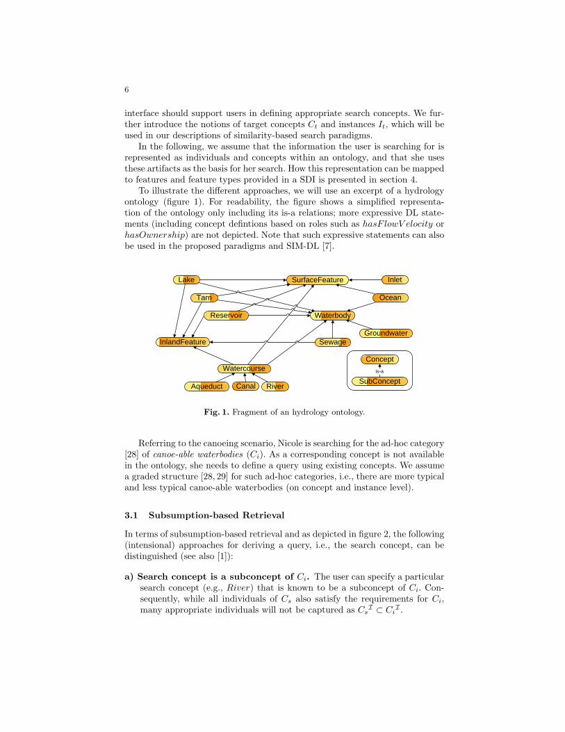
} from an ontology (or several ontologies usinga shared top-level ontology). The concepts themselves can be specified usingvarious kinds of expressive description logics. The compared-to target conceptscan be either selected by hand, or derived from the so-called context of discourseCd [6, 19, 18], i.e., a subset of the ontology, also referred to as the domain ofapplication [21]. It is defined as the set of concepts which are subsumed bythe context concept Cc (Cd = {Ct|Ct v Cc}). Hence, each (named) conceptC ∈ Cd is a target concept for which the similarity sim(Cs, Ct) is computed.Besides cutting out the set of compared concepts, Cd also influences the resultingsimilarities (see [6, 7] for details). With respect to the canoeing scenario thismeans that the similarity between the concepts River and Canal also dependson whether Cc is set to Watercourse or the more general Waterbody (see figure1). Up to now, the user has to specify the context concept manually. Informationretrieval paradigms overcoming this restriction are discussed in section 3. SIM-DL offers an extended context model, but we focus on Cd here (see [18]).
SIM-DL compares two DL concepts in canonical form [6, 26] by measuringthe degree of overlap between their definitions. A high level of overlap indicatesa high similarity and vice versa. DL concepts are specified by applying languageconstructors, such as intersection or existential quantification, to primitive con-cepts and roles – hence forming complex concepts. Consequently, similarity isdefined as a binary and real-valued function Cs × Ct → R[0,1] providing im-plementations for all language constructs offered by the used description logics.Finally, the overall similarity between concepts is the normalized (and weighted)sum of the single similarities calculated for all parts of the concept definitions.A similarity value of 1 indicates that the compared concepts cannot be differ-entiated, whereas 0 indicates that they are not similar at all. SIM-DL is an
5
asymmetric measure, i.e., the similarity sim(Cs, Ct) is not necessarily equal tosim(Ct, Cs). Therefore, the comparison of two concepts does not only depend ontheir descriptors, but also on the direction in which both are compared. In case ofconcepts composed by disjunction, SIM-DL distinguishes between two similaritymodes, the maximum similarity and the average similarity. In the first case, sim-ilarity depends on the most similar concept that is part of the disjunction. In thesecond case, similarity is defined as the average of all involved concepts. Whilethis distinction is a consequence of the used representation language and thedefinition of similarity functions in SIM-DL [6, 7], we will discuss its importancefor information retrieval in section 3.
A single similarity value computed between two concepts hides most of theimportant information. It does not answer the question whether there are moreor less similar target concepts in the examined ontology. It is not sufficient toknow that possible similarity values range from 0 to 1 as long as their distribu-tion is unclear [7, 18]. Besides these interpretation problems, isolated comparisonputs too much stress on the concrete similarity value. It is hard to argue thatand why the result is (cognitively) plausible without other reference values [18].Consequently, SIM-DL focuses on similarity rankings. The result of a similarityquery is an ordered list with descending similarity values. SIM-DL, supportsvarious result representations including font-size scaling or categorization.
The SIM-DL theory is implemented as semantic similarity service (calledWSS here). The current (beta) release6 2.2 supports subsumption reasoning andsimilarity measurement up to ALCHQ, as well as MCS and LCS computation(up to ALE). More details on the SIM-DL implementation and a similarity plug-in to the Protege ontology editor are given by Janowicz et al. [7]. The extensionsto the description logics communication interface DIG, necessary to integratethe WSS within the Semantic Web are discussed by Wilkes and Janowicz [27].
3 Intensional and Extensional Retrieval
In this section, we will introduce paradigms for similarity-based informationretrieval and group them into intensional and extensional approaches (and com-binations of both). We will motivate the need for similarity by contrasting it toapproaches purely based on subsumption reasoning. To illustrate the differences,we define two concepts, the intended concept Ci, which represents exactly theinformation the user is looking for, and the search concept Cs, which is the con-cept actually used in the search. We make this distinction, because we assumethat in most cases the intended concept is not part of the queried ontology andhas to be approximated by the search concept. The result of a query, i.e., theconcepts or individuals returned to the user, is the better the more accurate Cs
approximates Ci. In the ideal case, Cs would be equal to Ci. If CsI ⊂ Ci
I , allinstances of Cs fulfill the user’s requirements. In contrast, if Cs
I ⊃ CiI , some
instances of Cs might not fulfill the user’s requirements. Consequently, a user
6 The release can be downloaded at http://sim-dl.sourceforge.net/.
6
interface should support users in defining appropriate search concepts. We fur-ther introduce the notions of target concepts Ct and instances It, which will beused in our descriptions of similarity-based search paradigms.
In the following, we assume that the information the user is searching for isrepresented as individuals and concepts within an ontology, and that she usesthese artifacts as the basis for her search. How this representation can be mappedto features and feature types provided in a SDI is presented in section 4.
To illustrate the different approaches, we will use an excerpt of a hydrologyontology (figure 1). For readability, the figure shows a simplified representa-tion of the ontology only including its is-a relations; more expressive DL state-ments (including concept defintions based on roles such as hasF lowV elocity orhasOwnership) are not depicted. Note that such expressive statements can alsobe used in the proposed paradigms and SIM-DL [7].
Lake
Watercourse
Reservoir
Tarn
Aqueduct Canal River
Waterbody
Sewage
SurfaceFeature
Groundwater
Ocean
Inlet
InlandFeature
SubConcept
Conceptis-a
Fig. 1. Fragment of an hydrology ontology.
Referring to the canoeing scenario, Nicole is searching for the ad-hoc category[28] of canoe-able waterbodies (Ci). As a corresponding concept is not availablein the ontology, she needs to define a query using existing concepts. We assumea graded structure [28, 29] for such ad-hoc categories, i.e., there are more typicaland less typical canoe-able waterbodies (on concept and instance level).
3.1 Subsumption-based Retrieval
In terms of subsumption-based retrieval and as depicted in figure 2, the following(intensional) approaches for deriving a query, i.e., the search concept, can bedistinguished (see also [1]):
a) Search concept is a subconcept of Ci. The user can specify a particularsearch concept (e.g., River) that is known to be a subconcept of Ci. Con-sequently, while all individuals of Cs also satisfy the requirements for Ci,many appropriate individuals will not be captured as Cs
I ⊂ CiI .
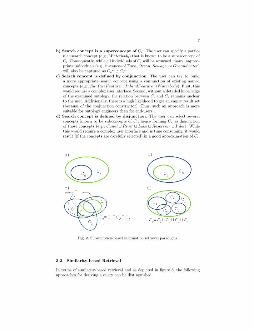
7
b) Search concept is a superconcept of Ci. The user can specify a partic-ular search concept (e.g., Waterbody) that is known to be a superconcept ofCi. Consequently, while all individuals of Ci will be returned, many inappro-priate individuals (e.g., instances of Tarn, Ocean, Sewage, or Groundwater)will also be captured as Cs
I ⊃ CiI .
c) Search concept is defined by conjunction. The user can try to builda more appropriate search concept using a conjunction of existing namedconcepts (e.g., SurfaceFeature u InlandFeature uWaterbody). First, thiswould require a complex user interface. Second, without a detailed knowledgeof the examined ontology, the relation between Ci and Cs remains unclearto the user. Additionally, there is a high likelihood to get an empty result set(because of the conjunction constructor). Thus, such an approach is moresuitable for ontology engineers than for end-users.
d) Search concept is defined by disjunction. The user can select severalconcepts known to be subconcepts of Ci, hence forming Cs as disjunctionof those concepts (e.g., Canal t River t Lake t Reservoir t Inlet). Whilethis would require a complex user interface and is time consuming, it wouldresult (if the concepts are carefully selected) in a good approximation of Ci.
Fig. 2. Subsumption-based information retrieval paradigms.
3.2 Similarity-based Retrieval
In terms of similarity-based retrieval and as depicted in figure 3, the followingapproaches for deriving a query can be distinguished.
8
Intensional Paradigm The intensional information retrieval paradigm exclu-sively relies on concept descriptions to reason about similarity, i.e., no individualsare taken into account. Consequently, a concept ranking is returned to the user.
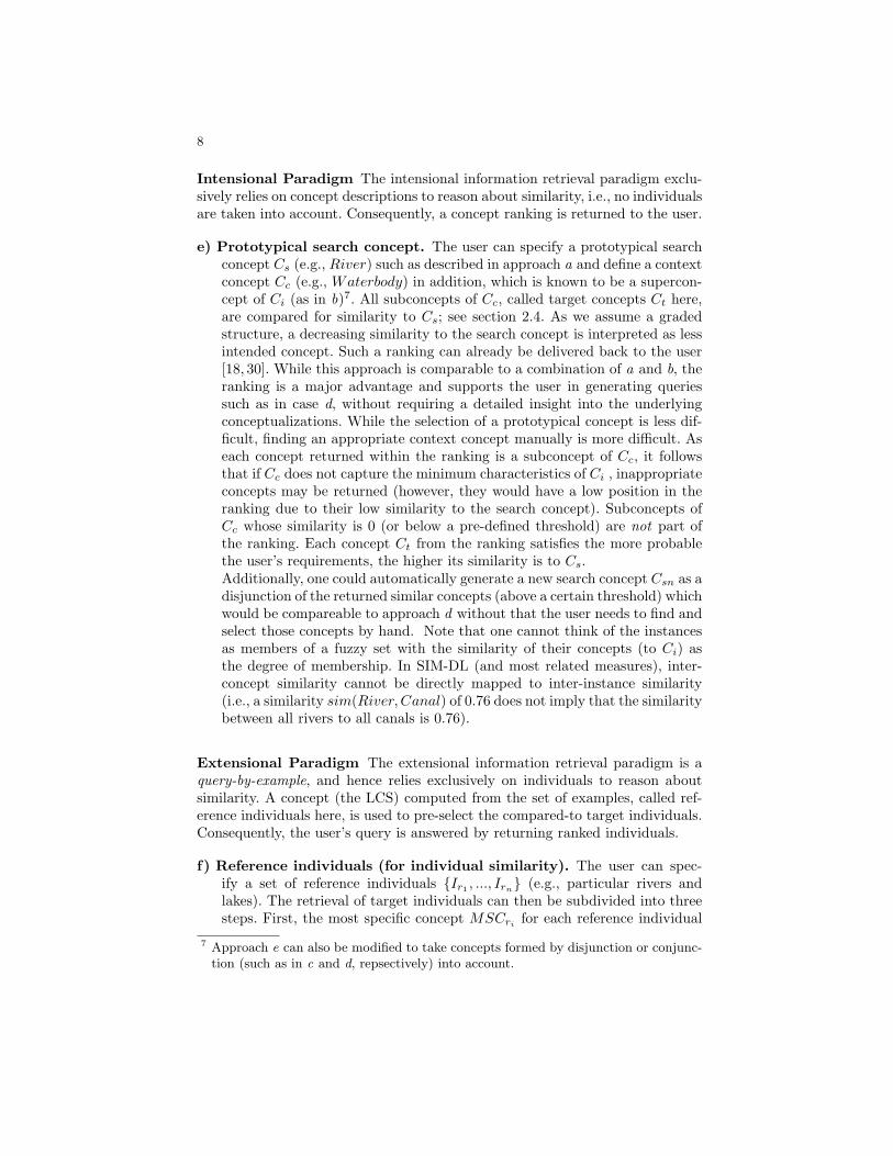
e) Prototypical search concept. The user can specify a prototypical searchconcept Cs (e.g., River) such as described in approach a and define a contextconcept Cc (e.g., Waterbody) in addition, which is known to be a supercon-cept of Ci (as in b)7. All subconcepts of Cc, called target concepts Ct here,are compared for similarity to Cs; see section 2.4. As we assume a gradedstructure, a decreasing similarity to the search concept is interpreted as lessintended concept. Such a ranking can already be delivered back to the user[18, 30]. While this approach is comparable to a combination of a and b, theranking is a major advantage and supports the user in generating queriessuch as in case d, without requiring a detailed insight into the underlyingconceptualizations. While the selection of a prototypical concept is less dif-ficult, finding an appropriate context concept manually is more difficult. Aseach concept returned within the ranking is a subconcept of Cc, it followsthat if Cc does not capture the minimum characteristics of Ci , inappropriateconcepts may be returned (however, they would have a low position in theranking due to their low similarity to the search concept). Subconcepts ofCc whose similarity is 0 (or below a pre-defined threshold) are not part ofthe ranking. Each concept Ct from the ranking satisfies the more probablethe user’s requirements, the higher its similarity is to Cs.Additionally, one could automatically generate a new search concept Csn as adisjunction of the returned similar concepts (above a certain threshold) whichwould be compareable to approach d without that the user needs to find andselect those concepts by hand. Note that one cannot think of the instancesas members of a fuzzy set with the similarity of their concepts (to Ci) asthe degree of membership. In SIM-DL (and most related measures), inter-concept similarity cannot be directly mapped to inter-instance similarity(i.e., a similarity sim(River, Canal) of 0.76 does not imply that the similaritybetween all rivers to all canals is 0.76).
Extensional Paradigm The extensional information retrieval paradigm is aquery-by-example, and hence relies exclusively on individuals to reason aboutsimilarity. A concept (the LCS) computed from the set of examples, called ref-erence individuals here, is used to pre-select the compared-to target individuals.Consequently, the user’s query is answered by returning ranked individuals.
f) Reference individuals (for individual similarity). The user can spec-ify a set of reference individuals {Ir1 , ..., Irn} (e.g., particular rivers andlakes). The retrieval of target individuals can then be subdivided into threesteps. First, the most specific concept MSCri
for each reference individual
7 Approach e can also be modified to take concepts formed by disjunction or conjunc-tion (such as in c and d, repsectively) into account.
9
is determined. The second step is the computation of the least common sub-sumer for {MSCr1 , ...,MSCrn
}. The LCS comprises those characteristicsthat are common to all MSCs, and is therefore used as the context con-cept Cc
8. Finally, retrieving the instances of Cc yields the target individuals{It1 , ..., Itm
} (particular rivers, lakes, reservoirs, canals, etc.). Since all targetindividuals instantiate Cc, they share the same characteristics common to allreference individuals. Now, similarity is used to account for those characteris-tics that differ among the reference individuals. For example, a characteristicthat is common to {Ir1 , ..., Irn−1}, but does not apply to Irn , is not capturedby Cc, and is therefore no requirement for a target individual. Nevertheless,a target individual that shares that characteristic with n− 1 reference indi-viduals might be more relevant than target individuals lacking that property.The overall relevance of a target individual can be determined by comparingit to each of the reference individuals and combining (e.g., averaging) theresulting similarities. The result returned to the user is a ranking of targetindividuals illustrating their similarity to the reference individuals.Recapitulating, the reference individuals are an extensional way to approx-imate Ci, and at the same time their common characteristics are used ascontext concept. The set of target individuals might capture inappropriateindividuals as {Ir1 , ..., Irn} ⊂ Ci
I ⊆ {It|It ∈ Cc and It /∈ {Ir1 , ..., Irn}}holds. Due to the similarity ranking of target individuals, this drawback iscompensated. The higher a target individual is ranked the more likely it iswithin Ci
I . In contrast to paradigm e, one could also think of the returnedranking as a fuzzy set by replacing the crisp membership (or instance-of)relation with its counterpart from fuzzy sets theory9. Then, the degree ofmembership of a certain (target) individual is given by its similarity value.
Combinations of the Intensional and Extensional Paradigm A combi-nation of the intensional and extensional paradigms reduces the difficulties inselecting appropriate search and context concepts by allowing for the selectionof reference individuals (however, both paradigms return (similar) concepts).
g) Prototypical search concept and reference individuals. The user canspecify a search concept (e.g., River) and a set of reference individuals(e.g., waterbodies Nicole had canoed before). This is a combination of theparadigms e and f, where the search concept is used for comparison andthe least common subsumer of the reference individuals is used as contextconcept to define the context of discourse. The result is a concept ranking
8 Consider the following example: MSCr1 ≡ River u ∃hasF lowV elocity.V elocity u∃hasOwnership.Public and MSCr2 ≡ Lakeu∃hasOwnership.Public results in theLCS Cc ≡ SurfaceFeatureuWaterbodyuInlandFeatureu∃hasOwnership.Public.The restriction hasOwnership.Public is common to both MSCs, and although Lakeand River do not match, their common superconcepts SurfaceFeature, Waterbody,and InlandFeature are considered by the LCS.
9 See Cross and Sudkamp [31] for an overview on fuzzy sets and similarity.

10
Fig. 3. Similarity-based information retrieval paradigms.
such as in e. The advantage is that the user does not need to specify thecontext concept manually. However, the distinction between search conceptand reference individuals may be difficult to explain to the user.
h) Reference individuals (for concept similarity). The user can specify aset of reference individuals. Their LCS is computed and acts as context con-cept. All resulting target concepts (Ctj v Cc) are compared to the concepts(Cri
) the reference individuals are instances of. For example, if one refer-ence instance is a Lake, one a River and a third a Canal, the LCS wouldbe SurfaceFeatureuWaterbody u InlandFeature and the target conceptsall concepts from our ontology fragment except Ocean, Inlet, Groundwaterand Sewage. Each target concept is compared to each Cr (Lake, Canal,and River in our example); note that each Cr is a subconcept of Cc, andtherefore a target concept itself. This raises the question of how the resultingranking should be generated. The similarity modes introduced for SIM-DLallow for two different solutions. Out of the user’s reference individuals asearch concept can be defined as disjunction of the respective reference con-cepts. Next, either the average or maximum similarity mode can be used tocompute the similarity sim(Cs, Ctj
). In the first case, each Ct is comparedto all Cr and the average of its similarity values is used for the ranking.In the second case, the ranking depends on the highest similarity value toone of the Cr. With respect to our example and the average mode, River,Canal, and IrrigationCanal would occupy a higher position in the ranking,followed by Lake (see figure 5). This is due to the two watercourses selectedas reference individuals.
As in g, this approach is also a combination of e and f, but does not requirethe manual definition of the search concept. The user only needs to specifyreference individuals while Cs and Cc are computed automatically.
11
3.3 Summary
In contrast to the subsumption-based approaches, similarity supports the userin phrasing queries and delivers a ranking to help the user in judging how wellreturned individuals or concepts fit her requirements. In the cases a and d, it isguaranteed that all returned concepts are subconcepts of the intended concepts,i.e., fulfill the user’s requirements – this is not the case for similarity-basedretrieval in general. To overcome this difficulty the context concept is introducedto capture the minimal characteristics and only its subconcepts are compared forsimilarity. The approaches e–h offer different solutions on how to reduce the effortof phrasing the search and the context concept, and automate these steps. Thequestion which of the proposed paradigms fits best depends on the applicationarea. In general, the focus of similarity is more to facilitate the navigation andbrowsing through results and hence to improve interaction with the user. Section4 introduces two prototypical user Web interfaces to demonstrate how similarity-based information retrieval can be integrated into a SDI.
4 Integration into SDI
This section presents two conceptual designs for Web user interfaces implement-ing the similarity-based retrieval paradigms e and h for the canoeing scenario10.An architecture and workflow for the integration of SIM-DL into an SDI is dis-cussed and the requirements for such integration are pointed out.
4.1 Similarity-enabled User Interfaces
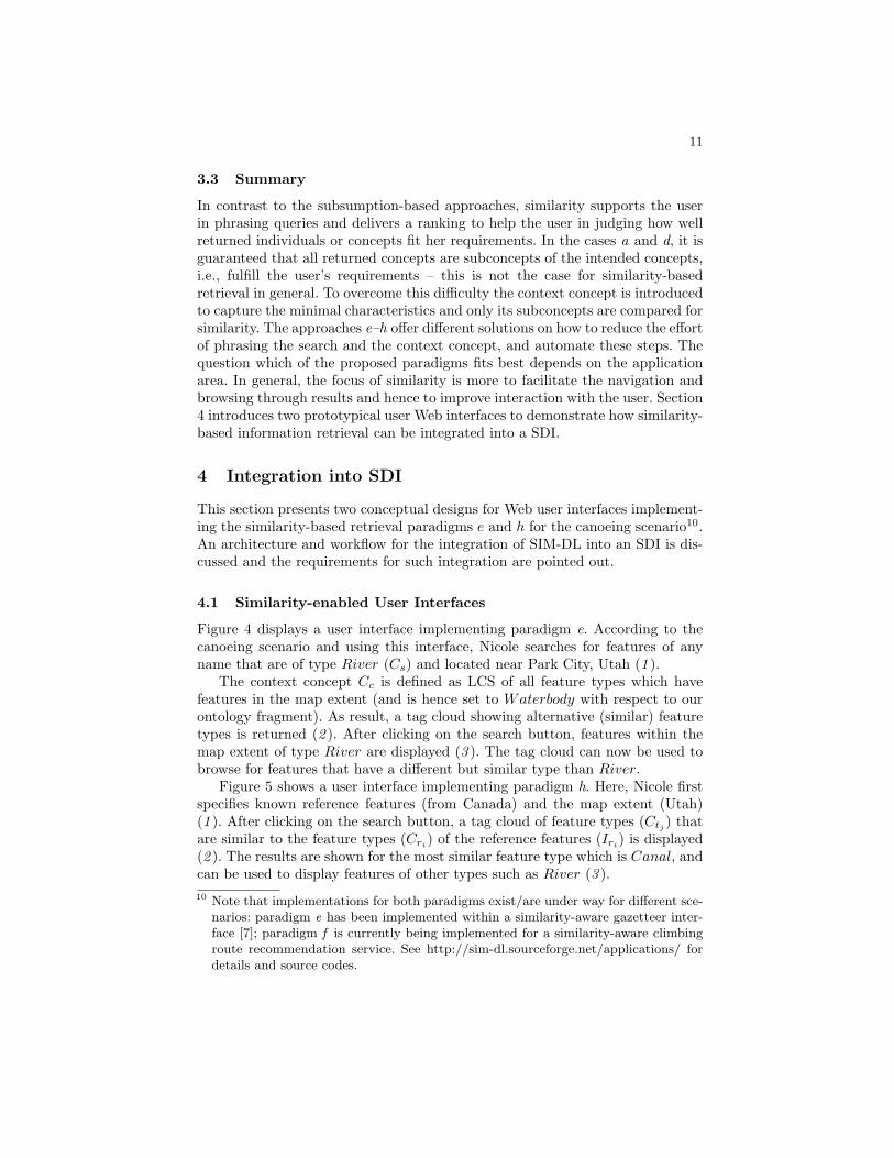
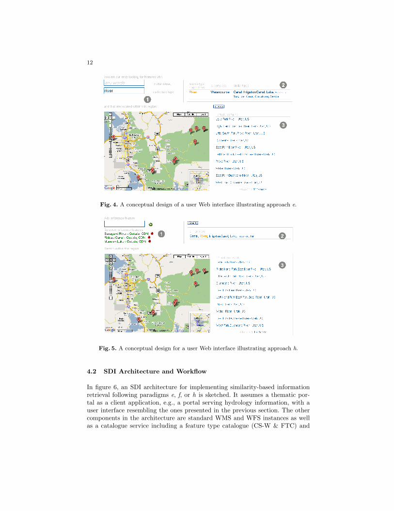
Figure 4 displays a user interface implementing paradigm e. According to thecanoeing scenario and using this interface, Nicole searches for features of anyname that are of type River (Cs) and located near Park City, Utah (1 ).
The context concept Cc is defined as LCS of all feature types which havefeatures in the map extent (and is hence set to Waterbody with respect to ourontology fragment). As result, a tag cloud showing alternative (similar) featuretypes is returned (2 ). After clicking on the search button, features within themap extent of type River are displayed (3 ). The tag cloud can now be used tobrowse for features that have a different but similar type than River.
Figure 5 shows a user interface implementing paradigm h. Here, Nicole firstspecifies known reference features (from Canada) and the map extent (Utah)(1 ). After clicking on the search button, a tag cloud of feature types (Ctj
) thatare similar to the feature types (Cri) of the reference features (Iri) is displayed(2 ). The results are shown for the most similar feature type which is Canal, andcan be used to display features of other types such as River (3 ).10 Note that implementations for both paradigms exist/are under way for different sce-
narios: paradigm e has been implemented within a similarity-aware gazetteer inter-face [7]; paradigm f is currently being implemented for a similarity-aware climbingroute recommendation service. See http://sim-dl.sourceforge.net/applications/ fordetails and source codes.
12
Fig. 4. A conceptual design of a user Web interface illustrating approach e.
Fig. 5. A conceptual design for a user Web interface illustrating approach h.
4.2 SDI Architecture and Workflow
In figure 6, an SDI architecture for implementing similarity-based informationretrieval following paradigms e, f, or h is sketched. It assumes a thematic por-tal as a client application, e.g., a portal serving hydrology information, with auser interface resembling the ones presented in the previous section. The othercomponents in the architecture are standard WMS and WFS instances as wellas a catalogue service including a feature type catalogue (CS-W & FTC) and
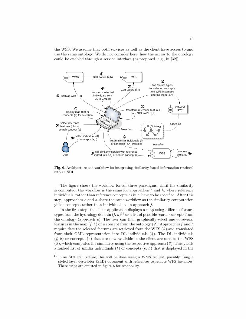
13
the WSS. We assume that both services as well as the client have access to anduse the same ontology. We do not consider here, how the access to the ontologycould be enabled through a service interface (as proposed, e.g., in [32]).
WFSWMS
CS-W & FTCdisplay map (f,h) or
concepts (e) for selection
GetMap with SLD
GetFeature (e,h)
User
select referencefeatures (f,h) or
search concept (e)
call similarity service with referenceindividuals (f,h) or search concept (e)
transform reference featuresfrom GML to DL (f,h)
computesimilarity
return similar individuals (f)or concepts (e,h) (ranked)
find feature types for selected conceptsand WFS instancesoffering them (e,h)
select individuals (f)or concepts (e,h)
ClientApplication
transform selectedindividuals from DL to GML (f)
based on
based on
Ontologybased on
GetFeature (f,h)
WSS
Fig. 6. Architecture and workflow for integrating similarity-based information retrievalinto an SDI.
The figure shows the workflow for all three paradigms. Until the similarityis computed, the workflow is the same for approaches f and h, where referenceindividuals, rather than reference concepts as in e, have to be specified. After thisstep, approaches e and h share the same workflow as the similarity computationyields concepts rather than individuals as in approach f.
In the first step, the client application displays a map using different featuretypes from the hydrology domain (f, h)11 or a list of possible search concepts fromthe ontology (approach e). The user can then graphically select one or severalfeatures in the map (f, h) or a concept from the ontology (2 ). Approaches f and hrequire that the selected features are retrieved from the WFS (3 ) and translatedfrom their GML representation into DL individuals (4 ). The DL individuals(f, h) or concepts (e) that are now available in the client are sent to the WSS(5 ), which computes the similarity using the respective approach (6 ). This yieldsa ranked list of similar individuals (f ) or concepts (e, h) that is displayed in the
11 In an SDI architecture, this will be done using a WMS request, possibly using astyled layer descriptor (SLD) document with references to remote WFS instances.These steps are omitted in figure 6 for readability.
14
client (7 ). The user can then select one or several of the presented individuals (f )or one of the presented concepts (e, h) (8 ). In approach f, the selected individualsare translated back into GML, in approaches e and h, the CS-W is queried forWFS instances offering feature types annotated with the selected concepts (9 ).Based on the GML or WFS instances, the client builds a SLD document andcalls a WMS GetMap operation (10 ). The map is created from the GML directly(f ) or based on a GetFeature requests to the WFS instances listed in the SLD(e, h) (11).
4.3 The Missing Pieces
The architecture and workflow sketched in the previous section puts a numberof requirements on the used SDI components, in particular the CS-W and WFS.
Catalogue Service The catalogue service needs to store metadata about threetypes of resources: (1) services, (2) data, and (3) feature types, as well as therelationships between them. The ebRIM catalogue profile for the CS-W allowsstoring this information in one registry as well as queries combining them. TheebRIM basic extension package describes the relationship between services anddatasets through the OperatesOn Association defined in ISO 19119 [33]. In [14],an ebRIM extension package is described that allows the storage of feature cata-logue (as defined in ISO 19110 [13]) metadata in an ebRIM catalogue. However,there is no association between the feature types and services and/or data. Suchan association would be required in order to find WFS instances that provide aspecific feature type.
The model defined in ISO 19110 only includes an optional definition attributeof type string to describe a feature type. In order to do similarity-based search,a link needs to be established to a concept that annotates the feature type.This link should be stored in the (feature) catalogue rather than the ontologyin order to avoid having to update the ontology every time a new feature typeis registered in the feature catalogue.
Web Feature Service For the intensional paradigm, the WFS does not haveto be changed as the approach works at the feature type (rather than the featureinstance) level and the concepts in the ontology only annotate features (ratherthan also their attributes and/or operations). Thus, once one or several featuretypes have been discovered, a normal GetFeature request can be sent using theselected feature type (cf. steps 3 and 11 in figure 6).
For the extensional paradigm, features need to be translated into ontologyindividuals and vice versa (cf. steps 4 and 9). This could be done following theapproach described in [34], i.e., by simply mapping the GML properties to DLproperties. If the approach is to be successful, this mapping should, whereverpossible, use DL roles already existing in the ontology. Otherwise the similarityto existing concepts will be very low. The mapping should preferably be definedby the data provider, or – if no mapping is yet available – by the requester. Howto support the creation of such mappings is an open research question.
15
5 Conclusions and Further Work
This paper investigates paradigms for similarity-based information retrieval,presents prototypical Web user interfaces applying these paradigms, and dis-cusses their integration into SDI as well as remaining difficulties. While theintensional paradigm e has been implemented within SIM-DL and used for agazetteer research scenario before [7, 35], the integration of the new extensionalparadigm f within SIM-DL is under development. Further research should espe-cially focus on approach h. It allows to compute inter-concept similarity withoutrequiring the user to define the search and context concept manually. In manyapplication areas, selecting reference individuals, i.e., examples, may be moreintuitive both in terms of using the Web user interface as well as in interpret-ing the results. In several cases, such as the gazetteer scenario [7, 35] and to acertain degree also the SDI integration discussed here, geographic features arenot available as instances within the ontology; hence paradigm h can be usedinstead of f (and e) to deliver similar feature types. While the question which ofthe presented search paradigms (also including those purely based on subsump-tion reasoning) fits best depends on the application area, it would be fruitfulto analyze whether certain scenarios abet a particular paradigm. This could bedone by human participants tests, but also by classifying the scenarios. For in-stance, the benefit of similarity lies in browsing through potential results andreducing the complexity of user interfaces [35], while scenarios which requireguaranteed results (e.g., in emergency scenarios) may put more focus on sub-sumption reasoning. Additionally, the list of subsumption and similarity-basedparadigms presented in this paper is not exclusive. On may also think of usinglogical negation to define the search concept. As pointed out by Nedas and Egen-hofer [24], the interpretation of such queries is not trivial in terms of a similarityranking.
Further research should also focus on how to display the retrieved featuresand types to the user. While SIM-DL supports value rankings, tag clouds, andcategories so far [18], other visualization and interaction methods have to beinvestigated. For instance (for paradigm f), one may think of sliders to selectthe similarity threshold value above which features should be displaying on themap.
References
1. Lutz, M., Klien, E.: Ontology-based retrieval of geographic information. Interna-tional Journal of Geographical Information Science 20(3) (2006) 233–260
2. Stoimenov, L., Djordjevic-Kajan, S.: An architecture for interoperable gis use ina local community environment. Computers & Geosciences 31 (2005) 211–220
3. Moller, R., Haarslev, V., Neumann, B.: Semantics-based information retrieval. In:Proc. IT&KNOWS-98: International Conference on Information Technology andKnowledge Systems, 31. August- 4. September, Vienna, Budapest. (1998) 49–56
4. Kusters, R.: Non-Standard Inferences in Description Logics. Volume 2100 of Lec-ture Notes in Artificial Intelligence. Springer (2001)
16
5. d’Amato, C., Fanizzi, N., Esposito, F.: A semantic similarity measure for expressivedescription logics. In: CILC 2005, Convegno Italiano di Logica Computazionale,Rome, Italy (2005)
6. Janowicz, K.: Sim-dl: Towards a semantic similarity measurement theory for thedescription logic ALCNR in geographic information retrieval. In Meersman, R.,Tari, Z., Herrero, P., eds.: On the Move to Meaningful Internet Systems 2006: OTM2006 Workshop SeBGIS. Proceedings. Volume 4278 of Lecture Notes in ComputerScience. Springer, Montpellier, France (2006) 1681 – 1692
7. Janowicz, K., Keßler, C., Schwarz, M., Wilkes, M., Panov, I., Espeter, M., Baeumer,B.: Algorithm, Implementation and Application of the SIM-DL Similarity Server.In: Second International Conference on GeoSpatial Semantics (GeoS 2007). Num-ber 4853 in Lecture Notes in Computer Science, Springer (2007) 128–145
8. Araujo, R., Pinto, H.S.: Towards semantics-based ontology similarity. In Shvaiko,P., Euzenat, J., Giunchiglia, F., He, B., eds.: Proceedings of the Workshop onOntology Matching (OM2007) at ISWC/ASWC2007, Busan, South Korea. (2007)
9. Nebert, D.D.: Developing spatial data infrastructures: The SDI cookbook (2004)Available from http://www.gsdi.org/docs2004/Cookbook/cookbookV2.0.pdf.
10. McKee, L. In: Who wants a GDI? Oxford University Press (2000) 13–2411. Bernard, L., Kanellopoulos, I., Annoni, A., Smits, P.: The european geoportal
- one step towards the establishment of a european spatial data infrastructure.Computers, Environment and Urban Systems 29 (2005) 15–31
12. European Commission: Spatial data infrastructures in europe, state of play spring2005: Summary report of activity 5 of a study commissioned by the ec (eurostat& dgenv) in the framework of the inspire initiative. Technical report, EuropeanCommission, Brussels (2005)
13. ISO: ISO 19110:2005 geographic information – methodology for feature catalogu-ing. International standard, ISO TC 211 (2005)
14. OGC: Feature type catalogue extension package for ebRIM (ISO/TS 15000-3)profile of CSW 2.0. Discussion Paper OGC 07 172r1, Open Geospatial ConsortiumInc. (2007)
15. Goldstone, R.L., Son, J.: Similarity. In Holyoak, K., Morrison, R., eds.: CambridgeHandbook of Thinking and Reasoning. Cambridge University Press (2005)
16. Medin, D., Goldstone, R., Gentner, D.: Respects for similarity. PsychologicalReview 100(2) (1993) 254–278
17. Tversky, A.: Features of similarity. Psychological Review 84(4) (1977) 327–35218. Janowicz, K.: Kinds of contexts and their impact on semantic similarity measure-
ment. In: 5th IEEE Workshop on Context Modeling and Reasoning (CoMoRea’08)at the 6th IEEE International Conference on Pervasive Computing and Commu-nication (PerCom’08), Hong Kong, IEEE Computer Society (March 2008)
19. Keßler, C., Raubal, M., Janowicz, K.: The effect of context on semantic similar-ity measurement. In Meersman, R., Tari, Z., Herrero, P., eds.: On the Move toMeaningful Internet Systems 2007: OTM 2007 Workshop SWWS 2007. Number4806 in Lecture Notes in Computer Science, Vilamoura, Portuga, Springer (2007)1274–1284
20. Frank, A.U.: Similarity measures for semantics: What is observed? In: COSIT’07Workshop on Semantic Similarity Measurement and Geospatial Applications, Mel-bourne, Australia (2007)
21. Rodrıguez, A., Egenhofer, M.: Comparing geospatial entity classes: an asymmetricand context-dependent similarity measure. International Journal of GeographicalInformation Science 18(3) (2004) 229–256
17
22. Raubal, M.: Formalizing conceptual spaces. In Varzi, A., Vieu, L., eds.: Formal On-tology in Information Systems, Proceedings of the Third International Conference(FOIS 2004). Volume 114 of Frontiers in Artificial Intelligence and Applications.IOS Press, Amsterdam, NL (2004) 153–164
23. Li, B., Fonseca, F.: Tdd - a comprehensive model for qualitative spatial similarityassessment. Spatial Cognition and Computation 6(1) (2006) 31–62
24. Nedas, K., Egenhofer, M.: Spatial similarity queries with logical operators. InHadzilacos, T., Manolopoulos, Y., Roddick, J., Theodoridis, Y., eds.: SSTD ’03 -Eighth International Symposium on Spatial and Temporal Databases, Santorini,Greece. Volume 2750 of Lecture Notes in Computer Science. (2003) 430–448
25. Gahegan, M., Agrawal, R., Banchuen, T., DiBiase, D.: Building rich, semanticdescriptions of learning activities to facilitate reuse in digital libraries. InternationalJournal on Digital Libraries 7(1) (2007) 81–97
26. Horrocks, I.: Implementation and optimization techniques. In: The descriptionlogic handbook: theory, implementation, and applications. Cambridge UniversityPress, New York, NY, USA (2003) 306–346
27. Wilkes, M., Janowicz, K.: A brief intro to the sim-dl dig extension. Technicalreport, Institute for Geoinformatics, University of Munster, Germany (2008)
28. Barsalou, L.: Ad hoc categories. Memory & Cognition 11 (1983) 211–22729. Barsalou, L.: Intraconcept similarity and its implications for interconcept simi-
larity. In: Similarity and analogical reasoning. Cambridge University Press (1989)76–121
30. Janowicz, K., Keßler, C., Panov, I., Wilkes, M., Espeter, M., Schwarz, M.: Astudy on the cognitive plausibility of SIM-DL similarity rankings for geographicfeature types. In Bernard, L., Friis-Christensen, A., Pundt, H., eds.: 11th AGILEInternational Conference on Geographic Information Science (AGILE 2008). Lec-ture Notes in Geoinformation and Cartography, Girona, Spain, Springer (5-8. May2008) 115–133
31. Cross, V., Sudkamp, T.: Similarity and Computability in Fuzzy Set Theory: Assess-ments and Applications. Volume 93 of Studies in Fuzziness and Soft Computing.Physica-Verlag (2002)
32. Lacasta, J., Nogueras-Iso, J., Bejar, R., Muro-Medrano, P.R., Zarazaga-Soria, F.J.:A web ontology service to facilitate interoperability within a spatial data infras-tructure: Applicability to discovery. Data & Knowledge Engineering 63(3) (2007)945–969
33. ISO: ISO 19119:2005 geographic information - services. International standard,ISO TC 211 (2005)
34. Klien, E.: A rule-based strategy for the semantic annotation of geodata. Transac-tions in GIS, Special Issue on the Geospatial Semantic Web 11(3) (2007) 437–452
35. Janowicz, K., Keßler, C.: The role of ontology in improving gazetteer interac-tion. International Journal of Geographical Information Science (IJGIS) 10 (2008;forthcoming)