Embed Size (px)
Citation preview


Significant Wildlife HabitatTechnical Guide
2000
Fish and Wildlife BranchWildlife Section
Science Development and Transfer BranchSouthcentral Sciences Section

© 2000, Queen’s printer for Ontario
Printed in Ontario, Canada
MNR #51438(.5k P.R. 00 10 16)ISBN# 0-7794-0262-6-6 (Internet)
This publication should be cited as:OMNR. 2000. Significant wildlife habitat technical guide. 151p.
Copies of this publication are available from:
Ontario Ministry of Natural ResourcesFish and Wildlife Branch - Wildlife Section300 Water StreetP.O. Box 7000Peterborough,K9J 8M5
Cette publication scientifique n’est disponible qu’en anglais.

Significant Wildlife Habitat Technical Guide
i
Acknowledgements
This document has undergone numerous reviews. We would like to thank all those whoreviewed this document and contributed comments.
Main contributors to the technical guide include:
Kerry Coleman – Ontario Ministry of Natural ResourcesAl Sandilands – Biological ConsultantTim Haxton – Ontario Ministry of Natural ResourcesDave Bland – Biological ConsultantVivian Brownell – Biological ConsultantRichard Rowe – Ontario Ministry of Natural Resources
Main contributors to the appendices include:
Ruth Grant – Biological ConsultantDon Cuddy – Ontario Ministry of Natural ResourcesMike Oldham – Natural Heritage Information Centre

Significant Wildlife Habitat Technical Guide
ii

Significant Wildlife Habitat Technical Guide
ii
Table of Contents
Acknowledgements .................................................................................................................... i
List of Tables............................................................................................................................ vi
List of Figures ......................................................................................................................... vii
List of Appendices ................................................................................................................. viii
1 Introduction ...................................................................................................................... 1
2 A Landscape Approach to Conserving Significant Wildlife Habitat .............................. 32.1 Gap analysis – A critical tool in landscape analysis........................................................... 6
3 Preparing to Identify Significant Wildlife Habitat .......................................................... 83.1 Significant wildlife habitat................................................................................................ 83.2 Available information ...................................................................................................... 83.3 Other information.......................................................................................................... 123.4 The conservation advisory committee ............................................................................ 133.5 Finding potentially significant wildlife habitat................................................................. 14
3.5.1 Wetlands ............................................................................................................... 163.5.2 Woodlands ............................................................................................................ 17
3.6 Mapping significant wildlife habitat................................................................................ 19
4 Identifying Habitats of Seasonal Concentrations of Animals........................................ 204.1 Definition ...................................................................................................................... 204.2 Ecological functions/effects of loss ................................................................................ 204.3 Identification of potentially significant seasonal concentration areas ............................... 20
4.3.1 Mapping and verifying known seasonal concentration areas ................................... 204.3.2 Finding animal Concentration areas that have not been previously identified........... 21
4.4 How to find some specific seasonal concentration areas ................................................. 224.4.1 Winter deer yards .................................................................................................. 224.4.2 Moose late winter habitat....................................................................................... 234.4.3 Colonial bird nesting sites ...................................................................................... 234.4.4 Waterfowl stopover and staging areas.................................................................... 254.4.5 Waterfowl nesting.................................................................................................. 254.4.6 Shorebird migratory stopover areas........................................................................ 264.4.7 Landbird migratory stopover areas......................................................................... 274.4.8 Raptor winter feeding and roosting areas ............................................................... 274.4.9 Wild turkey winter range ....................................................................................... 284.4.10 Turkey vulture summer roosting areas ................................................................... 29

Significant Wildlife Habitat Technical Guide
iii
4.4.11 Reptile hibernacula ................................................................................................ 294.4.12 Bat hibernacula ...................................................................................................... 304.4.13 Bullfrog concentration areas .................................................................................. 314.4.14 Migratory butterfly stopover areas ......................................................................... 32
5 Identifying Rare Vegetation Communities or Specialised Habitats for Wildlife.......... 335.1 Definitions..................................................................................................................... 335.2 Ecological function/effects of loss.................................................................................. 33
5.2.1 Rare vegetation communities ................................................................................. 335.2.2 Specialised habitats for wildlife .............................................................................. 33
5.3 Identification of potentially rare vegetation communities or specialised habitat for wildlife345.3.1 Potentially rare vegetation communities ................................................................. 355.3.2 Specialised habitats for wildlife .............................................................................. 36
5.4 How to find some rare vegetation communities or specialised habitats for wildlife.......... 375.4.1 Rare vegetation communities ................................................................................. 37
5.4.1.1 Alvars............................................................................................................... 375.4.1.2 Tall-grass prairies ............................................................................................. 385.4.1.3 Savannahs......................................................................................................... 395.4.1.4 Rare forest types............................................................................................... 405.4.1.5 Talus slopes...................................................................................................... 415.4.1.6 Rock barrens .................................................................................................... 415.4.1.7 Sand barrens..................................................................................................... 425.4.1.8 Great Lakes dunes ............................................................................................ 42
5.4.2 How to find specialised habitats for wildlife ........................................................... 435.4.2.1 Habitat for area-sensitive species ...................................................................... 435.4.2.2 Forests providing a high diversity of habitats..................................................... 455.4.2.3 Old-growth or mature forest stands................................................................... 455.4.2.4 Foraging areas with abundant mast ................................................................... 465.4.2.5 Amphibian woodland breeding ponds................................................................ 475.4.2.6 Turtle nesting habitat ........................................................................................ 475.4.2.7 Specialised raptor nesting habitat ...................................................................... 485.4.2.8 Moose calving areas ......................................................................................... 495.4.2.9 Moose aquatic feeding areas ............................................................................. 505.4.2.10 Mineral licks ................................................................................................... 505.4.2.11 Mink, otter, marten, and fisher denning sites ................................................... 50
5.4.3 Highly diverse areas............................................................................................... 515.4.4 Cliffs...................................................................................................................... 525.4.5 Seeps and springs .................................................................................................. 53
6 Identifying Habitats of Species of Conservation Concern............................................. 546.1 Definition ...................................................................................................................... 54

Significant Wildlife Habitat Technical Guide
iv
6.2 Ecological function/effects of loss.................................................................................. 546.3 Identification of habitat of species of conservation concern ............................................ 54
6.3.1 A suggested approach to habitat identification ....................................................... 556.3.2 Summary ............................................................................................................... 56
7 Identifying Animal Movement Corridors ...................................................................... 587.1 Definition ...................................................................................................................... 587.2 Ecological function/effects of loss.................................................................................. 587.3 Identification of animal movement corridors .................................................................. 59
7.3.1 Recommendations.................................................................................................. 60
8 Evaluation of Significant Wildlife Habitat..................................................................... 628.1 Evaluation criteria and guidelines................................................................................... 628.2 Field investigations ........................................................................................................ 658.3 Evaluation of habitat of seasonal concentrations of animals............................................ 66
8.3.1 Winter deer yards .................................................................................................. 678.3.2 Moose late winter habitat....................................................................................... 678.3.3 Colonial bird nesting sites ...................................................................................... 688.3.4 Waterfowl stopover and staging areas.................................................................... 698.3.5 Waterfowl nesting habitat ...................................................................................... 698.3.6 Shorebird migratory stopover sites......................................................................... 708.3.7 Landbird migratory stopover areas......................................................................... 718.3.8 Raptor wintering areas........................................................................................... 728.3.9 Wild turkey wintering areas ................................................................................... 728.3.10 Turkey vulture summer roosting areas ................................................................... 738.3.11 Reptile hibernacula ................................................................................................ 738.3.12 Bat hibernacula ...................................................................................................... 738.3.13 Bullfrog concentration areas .................................................................................. 748.3.14 Migratory butterfly stopover areas ......................................................................... 74
8.4 Evaluation of rare vegetation communities..................................................................... 758.5 Evaluation of specialised habitats for wildlife ................................................................. 76
8.5.1 Sites supporting area-sensitive species ................................................................... 778.5.2 Forest stands providing a diversity of habitats ........................................................ 788.5.3 Old growth or mature forest stands........................................................................ 788.5.4 Seeps and springs .................................................................................................. 798.5.5 Woodlands supporting amphibian breeding ponds .................................................. 798.5.6 Special woodland feeding habitat ........................................................................... 808.5.7 Osprey nesting habitat............................................................................................ 808.5.8 Turtle nesting habitat ............................................................................................. 808.5.9 Special moose habitats–aquatic feeding areas, calving sites and mineral licks.......... 818.5.10 Mink and otter feeding/denning sites; marten and fisher denning sites..................... 818.5.11 Areas of high diversity ........................................................................................... 82

Significant Wildlife Habitat Technical Guide
v
8.5.12 Cliffs and caves...................................................................................................... 828.6 Evaluation of habitat of species of conservation concern................................................ 828.7 Evaluation of animal movement corridors ...................................................................... 83
9 Ranking Significant Wildlife Habitat............................................................................. 859.1 An evaluation of three ranking methods......................................................................... 859.2 Recommended method for ranking similar habitats ........................................................ 88
9.2.1 Importance of representation of habitats ................................................................ 889.2.2 Establishing minimum standards for representation................................................. 889.2.3 Minimum standards of other selected evaluation criteria......................................... 899.2.4 Avoiding numerical values for some minimum standards ........................................ 909.2.5 Explanation of the tables in Appendix Q................................................................. 90
10 How Much Habitat to Protect ........................................................................................ 9210.1 Difficulties in determining how much habitat to protect.............................................. 9210.2 Some considerations for determining how much habitat to protect ............................. 9310.3 What to protect?- summary of guidelines ................................................................... 9610.4 How much to protect?- summary of factors to consider ............................................. 9910.5 How much to protect?- suggested Amounts............................................................. 10010.6 Some hypothetical examples .................................................................................... 10510.7 General habitat requirements of species of conservation concern.............................. 120
10.7.1 Seasonal concentration areas................................................................................ 12010.7.2 Rare or specialised habitats .................................................................................. 12210.7.3 Habitat of species of conservation concern........................................................... 124
11 Assessment of the Natural Heritage System................................................................. 12711.1 Gap analysis ............................................................................................................ 128
11.1.1 Gap analysis of vegetation communities ............................................................... 12911.1.2 Gap analysis of species......................................................................................... 130
11.2 Restoration and rehabilitation opportunities ............................................................. 131
12 References...................................................................................................................... 13412.1 Literature Cited ....................................................................................................... 13412.2 Glossary .................................................................................................................. 137

Significant Wildlife Habitat Technical Guide
vi
List of TablesTable 3-1. Information sources that will assist in the identification of significantwildlife habitat. ........................................................................................................................... 9
Table 8-1. General evaluation criteria for wildlife habitats. ........................................................ 63
Table 9-1. Minimum standards evaluation method example. ...................................................... 85
Table 9-2. Additive weighting evaluation method example. ....................................................... 86
Table 9-3. Ranking evaluation method example......................................................................... 87
Table 10-1. Suggested values for protection of selected wildlife habitats. ................................ 101
Table 10-2. Minimum standards for nesting waterfowl for six hypothetical sites. ..................... 109
Table 10-3. Minimum standards for three hypothetical off-shield amphibianbreeding ponds........................................................................................................................ 115
Table 10-4. Minimum standards of three hypothetical woodlots for southernflying squirrels. ....................................................................................................................... 119
Table 10-5. Primary locations of seasonal concentrations of wildlife. ....................................... 120
Table 10-6. Primary locations of rare or specialised habitats. ................................................... 122
Table 10-7. General habitat requirements of selected species of conservation concern. ............ 124
Significant Wildlife Habitat Technical Guide
vii
List of Figures
Figure 2-1. Hill's site Regions in Ontario. .................................................................................... 4
Figure 4-1. Colonial nesting species such as gulls, will seek islands to nest and returnto the same location annually..................................................................................................... 24
Figure 5-1. Bogbean buckmoth, specific to eastern Ontario fen habitat, are known inonly in two locations in Ontario................................................................................................. 34
Figure 5-2. Monarch caterpillars feed strictly on milkweed. ....................................................... 86
Figure 5-3. Alvar, Misery Bay, Manitoulin Island. ..................................................................... 38

Significant Wildlife Habitat Technical Guide
viii
List of AppendicesAppendix A. A description of Ramsar sites, biosphere reserves, Carolinian Canada
sites and Western Hemisphere Shorebird Reserve Network and theirapplication in landuse planning.
Appendix B. Ecological considerations underlying Natural Heritage Systemplanning.
Appendix C. A list of area sensitive species and key references.
Appendix D. Guidelines for conducting field investigations.
Appendix E. Natural heritage gap analysis methodologies used by the OntarioMinistry of Natural Resources.
Appendix F. List of agencies and organisations and information that may beobtained.
Appendix G. Wildlife habitat matrices and habitat descriptions for rare vascularplants.
Appendix H. Suggested terms of reference for the formation and operation of aConservation Advisory Committee (CAC).
Appendix I. Information sources for the identification of specific significantwildlife habitats.
Appendix J. Natural heritage resources of Ontario: Vegetation communities ofSouthern Ontario.
Appendix K. Significant waterfowl habitat.
Appendix L. Practical approaches for identifying rare vegetation communitiesusing the southern Ontario Ecological Land classification approach.
Appendix M. Locations of known rare vegetation communities in Ontario.
Appendix N List of indicator species of Alvar, Tall Grass Prairie, Savannah andCarolinian forest habitats in southern Ontario.
Appendix O. Finding and identifying raptor nests.
Appendix P. List of endangered, threatened and vulnerable plant and animalspecies in Ontario.
Appendix Q. Evaluation criteria for significant wildlife habitat.
Appendix R. Summary of Forest Management guidelines for various wildlifespecies.

Significant Wildlife Habitat Technical Guide
1
1 Introduction
In May 1996, the Provincial Policy Statement (PPS) was issued under the Planning Act.This document identified matters of provincial interest to be considered as part of the landuse planning process in the province of Ontario. Section 3 of the Planning Act requiresthat planning authorities shall “have regard to” the PPS when exercising any authority thataffects municipal planning matters.
Among other things, Section 2.3 of the PPS requires that “natural heritage features andareas will be protected from incompatible development” and that development and sitealteration will be permitted on or adjacent to these areas “if it can be demonstrated thatthere will be no negative impact on the natural features or ecological functions for whichthe area is identified.”
Significant Wildlife Habitat has been identified as a natural heritage area for the purposesof Section 2.3 of the PPS. Wildlife is described as:
“all wild mammals, birds, reptiles, amphibians, fishes, invertebrates, plants,fungi, algae, bacteria and other wild organisms” (Ontario Wildlife WorkingGroup 1991)
The PPS specifically identifies wildlife habitat as:
areas where plants, animals, and other organisms live, and find adequateamounts of food, water, shelter, and space needed to sustain their populations.Specific wildlife habitats of concern may include areas where species concentrateat a vulnerable point in their annual or life cycle; and areas which are importantto migratory or non-migratory species.
Wildlife habitat is considered significant where it is:
ecologically important in terms of features, functions, representation or amount,and contributing to the quality and diversity of an identifiable geographic area orNatural Heritage System. Criteria for determining significance may berecommended by the Province, but municipal approaches that achieve the sameobjective may also be used.
The Natural Heritage Reference Manual–June 1999 (OMNR 1999) and this documentthe Significant Wildlife Habitat Technical Guide were prepared by the Ministry ofNatural Resources to assist planning authorities and other participants in the land useplanning system. Both documents represent the most up to date information available atthe date of publication on specific technical issues.
Significant Wildlife Habitat Technical Guide
2
The Natural Heritage Reference Manual is a general reference manual that appliesadditional information on technical issues relative to Section 2.3 of the PPS. The manual isintended for use by those who have a basic understanding of the Planning Act process andthe intent of the PPS. It will be of most interest to those involved in the development andreview of policy documents and the review and approval of development applications.
The Significant Wildlife Habitat Technical Guide is a more detailed technical manual thatprovides information on the identification, description, and prioritisation of significantwildlife habitat. This manual is intended for use by ecologists, biologists, environmentalplanners, and others involved in the development of strategies to identify and protectsignificant wildlife habitat in the municipal planning process. More specifically it:
• describes in more detail some of the techniques, issues, andprocesses identified in the Natural Heritage Reference Manual• provides recommended approaches to describe, identify andprioritise significant wildlife habitat• provides a compilation of relevant technical support materials andreferences
Neither of these documents should be read in isolation of the PPS. They are advisory onlyand may be updated as technology or techniques improve. They provide information toassist in understanding the policy. They do not add to or detract from policy. Except asotherwise specified (e.g. where requirements are established by legislation or regulation),they do not represent the only acceptable approaches. There may be other ways to achievethe results established in the PPS. However, in all cases planning authorities must haveregard to the PPS.
This technical guide is intended for use in the municipal policy and development processunder the Planning Act. However, this document may also be useful in consideringapplications that must fulfil other approval processes (e.g. Class EnvironmentalAssessments). In cases where matters are subject to other legislation (e.g. EndangeredSpecies Act), appropriate references are noted in the text.
The Significant Wildlife Habitat Technical Guide consists of three sections:Background and approach to significant wildlife habitat (Chapters 1–2)Identifying significant wildlife habitat (Chapters 3–7)Evaluating and ranking significant wildlife habitat (Chapters 8–11)
Technical information has been included in the appendices to this document. Theappendices are voluminous and presented in a separate document. The intent is to makeupdates of these appendices permissible as new science and information becomesavailable.

Significant Wildlife Habitat Technical Guide
3
2 A Landscape Approach to Conserving Significant WildlifeHabitat
The Natural Heritage Reference Manual (OMNR 1999) outlines a Natural HeritageSystem approach. This approach is a useful method for the protection of specific naturalheritage features and areas because it reinforces an understanding that individual areas andfeatures have strong ecological ties to other physical features and areas in the overalllandscape. When addressing the significant wildlife habitat feature of this system, it isimportant to consider significant wildlife habitat at more than one scale. Some habitatsmay be of national or provincial importance, such as an important migration stopover sitefor migrating birds (e.g. RAMSAR sites–Appendix A). Other habitats may be locallysignificant, such as a winter concentration area for a local population of deer. Generally,those habitats that are significant at larger scales are considered to be of greatersignificance than those at the local scale. That does not imply that significance at the locallevel is not important, as it can be very important. However, scale is a very importantcriterion when ranking significance between two or more potential sites.
Landscapes are relatively large geographic areas. From an ecological perspective,landscape boundaries are most appropriately defined based on climatic considerations andphysiography. These are the two main ecological features used to identify ecological unitsknown as site regions. At a finer scale, vegetation responses to climate and physiographyare the primary factors used to define site districts. Hills (1959) divided the province into14 site regions and 67 site districts (Figure 2-1). The ecosystems that occur in a given sitedistrict are distinct from those in other site districts with respect to climate, landform, andpatterns of vegetation. For more information on site regions and site districts of Ontario(Figure 2-1), refer to a Framework for the Conservation of Ontario’s Biological Heritage(Beechey 1980). The Ontario Ministry of Natural Resources (OMNR) has used theseecological units as the basis for determining representation of potential Areas of Naturaland Scientific Interest (ANSIs), wetland rarity in the provincial wetland evaluation system,and for determining the rarity of species and vegetation communities across the province.Planning authorities can also use these units as a basis for making landscape level decisionswith respect to significance. Other criteria can be used to define landscape boundaries,such as watersheds, sub-watersheds, regional municipalities, and counties. Landscapes thatonly consider the smaller scales are not as ecologically sound as large-scale landscapes innatural heritage planning. Many significant features extend beyond administrativeboundaries and certainly, wildlife is not confined by these boundaries. Planning authoritieshave to make planning policies for land within their jurisdiction. Ideally, a NaturalHeritage System for a planning area would incorporate a variety of scales from global tolocal and these would be taken into account during the planning process.

Significant Wildlife Habitat Technical Guide
4
Figure 2-1. Hill's Site Regions (modified) in Ontario.
By definition, a landscapeapproach to NaturalHeritage System planninginvolves assessing therelative ecological value ofindividual features in aparticular area in relation toother similar features in alarger area (i.e. alandscape). Such anapproach, particularly whenit considers natural heritagefeatures at a variety ofscales results in acomprehensive, soundNatural Heritage System.The concept of assessingecological importance tosimilar features in a largerlandscape can and shouldbe applied even at the site-specific scale. A particularhabitat for a species may beconsidered as significant
wildlife habitat because it is under-represented at some scale in the landscape. This couldbe at the provincial scale, site region or even at the planning area level. Generally, greaterpriority is given to representation at larger scales.
The concept of representation at a variety of scales in the landscape can assist planningauthorities to determine what habitats should be considered significant. For example, theblack tern is a colonial nesting bird species that is under-represented (rare) at theprovincial scale. Because these colonies are critical to local populations and the species israre provincially, it is reasonable to assume that all colonies of this species should beconsidered significant. The great blue heron is also a colonial nesting bird. It is not under-represented (rare) at the provincial scale. Great blue herons can nest in colonies rangingfrom 5 or 6 nests to well over 100 nests. In smaller landscapes where great blue herons arecommon, the planning authority may decide that only those colonies with greater than aspecific number of nests (e.g. >25), should be considered significant. However, in othersmall landscapes where great blue heron populations have declined from historical levelsand are not common, the planning authority may decide that all colonies that are found inthe planning area should be considered significant.

Significant Wildlife Habitat Technical Guide
5
Natural heritage planning at the landscape scale has a number of advantages. Theseinclude:1. Enabling resource planners to identify the most important natural heritage features
based on ecosystem representation and linkages between ecosystems. This is moreeffectively accomplished when examining the entire landscape and later focusing on thesite-specific scale, than starting at the site-specific scale and working up to largerscales.
2. Allowing planning authorities to reduce their time and costs early in the planningprocess. The identification of large natural areas and linkages by using ecologicallysound, landscape level criteria such as representation, size, shape, distribution,connectivity and community and species diversity (Appendix B) often does not requireextensive field studies. Many of the criteria can be applied using existing information onpotential sites as well as remote technologies such as satellite imagery and air photointerpretation.
3. Allowing subsequent finer scale, site-specific planning for significant wildlife habitat tobe more focused. After a system of large, well-connected core natural areas has beenidentified, subsequent efforts to identify site-specific significant wildlife habitat can beconcentrated on those portions of the planning area outside of the preliminary NaturalHeritage System that have already been identified using landscape criteria.
4. Providing the best protection for significant wildlife habitats that are difficult to identifyand quantify. This would include such habitats as waterfowl breeding habitat,amphibian breeding ponds, snake hibernacula, bat hibernacula, marten and fisherdenning habitat, habitats for area-sensitive species and a number of other specialised,highly diverse habitats. These habitats are critical to the survival of many species, butare extremely difficult to locate and, when they are located, the significant portions (i.e.critical habitat) of the habitat are often difficult to quantify. The identification andprotection of a system of large, well-connected natural areas with good representationof the ecosystems and natural communities in the planning area will often include manyof these features. The large size of these areas can provide better protection than ifhabitats are individually identified and protected as isolated features on the landscape.Isolated habitats, even with protective buffers, are less effective in protecting theecological functions of a feature than when that feature is part of a larger natural area.
5. Providing a greater probability that the habitat size thresholds of some species are met.The habitat size threshold for many area-sensitive species is much larger than the actualterritory of an individual breeding pair (Villard et al. 1992). For example, theloggerhead shrike uses open scrubland habitat. The home range for a nesting pair isgenerally considered to be a radius of approximately 400 metres around the nest(approx. 0.5 km2). However, habitats that appear to be suitable may not be used unless

Significant Wildlife Habitat Technical Guide
6
there is a minimum amount of suitable habitat available within a defined landscape. Ageneral guideline is that 10% of the landscape must be suitable habitat. Therefore within a100 km2 landscape, 10 km2 would have to be suitable shrike habitat before any of thehabitat would be used. The same concept applies to many area-sensitive species. AppendixC lists a number of area-sensitive species and key references for these species.
6. Allowing better integration of all of the natural heritage features and areas covered bythe policy, than when they are identified and evaluated on their own. Ideally, a planningauthority’s Natural Heritage System should be comprised of a fully represented systemof well-connected natural heritage features and areas broadly distributed across theplanning area.
The landscape approach to planning for significant wildlife habitat can be considered a firststep in the planning process. It does not eliminate the need for finer scale site-specificidentification and evaluation of significant wildlife habitat. Chapters 4 to 7 in this guideprovide detailed discussion on the identification of site-specific significant wildlife habitat.Some potentially significant wildlife habitat will be missed when identifying a system ofcore natural areas at the landscape level. Many of these fine-scale sites can be veryimportant habitats.
Examining significant wildlife habitats at a fine scale after a system of large, well-connected natural areas have been identified at the landscape level, provides theopportunity to gain a better understanding of the ecological functions and speciesinteractions within these areas. This can be very beneficial to a planning authority,particularly during consultation regarding potential development in and adjacent tosignificant wildlife habitat.
Some field studies may be required to verify existing information or to collect informationabout potentially significant core natural areas. When conducting field studies it should bekept in mind that additional information may be required at a later date for site-specificevaluation (Appendix D).
2.1 Gap analysis – A critical tool in landscape analysisGap analysis is the most commonly accepted landscape-scale methodology for identifyinghigh priority natural areas in need of protection. Gap analysis is an approach to identifyingand fulfilling natural heritage targets. It facilitates the identification of natural features thatare not represented or are under-represented within natural areas systems and is the basisof the OMNR’s program for selecting ANSI’s. The areas identified form core naturalareas around which the rest of the Natural Heritage System can be completed. The keyassumptions underlying natural area gap analysis are:

Significant Wildlife Habitat Technical Guide
7
• that enduring features on the landscape (i.e. landforms) are more stable in theirdistribution than vegetation or other biotic elements (Noss 1995)
• that the ecological diversity of an area is largely a result of interactions betweenclimate and enduring features (Noss 1995); and
• that, by representing all landform-vegetation associations in a protected areasystem, a significant portion of the biodiversity will be maintained (Crins andKor 1999)
Collectively, these assumptions recognise that the best way to ensure the survival of thegreatest diversity of species is to ensure that the widest possible range of habitat types isprotected. OMNR’s current gap analysis procedures are described in Crins and Kor(1999) and are summarised in Appendix E. Other important references include NCASI(1996) and Riley and Mohr (1994).
As described above, a gap analysis is a very useful method for determining which naturalareas should be considered for protection. A gap analysis can also be used to determinewhat natural heritage features may be missing from the landscape. These can also includevegetative or biotic communities that were historically found in the planning area, but areno longer present or have been degraded.

Significant Wildlife Habitat Technical Guide
8
3 Preparing to Identify Significant Wildlife Habitat
3.1 Significant wildlife habitatTo ensure a comprehensive approach to identifying and evaluating significant wildlifehabitat, wildlife habitat has been divided into four broad categories:
• seasonal concentration areas• rare vegetation communities or specialised habitats for wildlife• habitats of species of conservation concern, excluding the habitats of endangered
and threatened species• animal movement corridors
The task of identifying significant wildlife habitat will be facilitated if other natural heritagefeatures listed in the Natural Heritage Policy are mapped first as outlined by the NaturalHeritage Reference Manual (OMNR 1999) and the appropriate technical manuals. Manyknown, as well as unknown, wildlife habitats exist in these other reference areas.Significant wildlife habitat that is found in other natural heritage features is very importantand should be identified. However, as a priority, surveys should concentrate on areasoutside identified features. It will save time and be more efficient to concentrate on areasnot included in other natural heritage features and areas. This approach can also enhancenatural heritage conservation if the planning authority concentrates its efforts to find andprotect significant wildlife habitats outside the boundaries of the other identified naturalheritage features and areas.
However, significant wildlife habitat in other natural heritage areas should not be ignored.These areas may receive development pressure, and it is essential that proponentsconducting impact assessments understand their functions and identify potential impactson significant wildlife habitat.
3.2 Available information
There are several sources of information that will help planning authorities identifysignificant wildlife habitats. Table 3-1 summarises the most useful information and itsspecific application to identifying wildlife habitat. Most of the listed information can beobtained from local OMNR offices. A list of agencies and their respective areas ofexpertise has been comprised in Appendix F.
The most recent aerial photographs used with topographical maps and Ontario base maps(OBMs) will enable the planning authority to determine the precise location of previouslymapped significant natural heritage features such as provincially significant wetlands andANSIs, as well as identify some potential habitats. Interpretation of Forest ResourceInventory (FRI) maps, used with aerial photographs, may help locate potentially rare or

Significant Wildlife Habitat Technical Guide
9
specialised communities. Most OMNR district offices have land tenure maps showing lotsand concessions; crown land, agreement forests, and provincial wildlife areas; privateproperty; and property owned by conservation authorities and other agencies.
OMNR wetland evaluations are located at OMNR offices. Although class 4 to 7 wetlandsare not provincially significant, their evaluations should still be examined for informationabout significant wildlife habitats, including rare or specialised habitat such as bogs andfens; important seasonal concentration areas for white-tailed deer and waterfowl; andcolonial bird sites such as heronries and black tern colonies.
Table 3-1. Information sources that will assist in identification of significant wildlifehabitat.
Sources Information that source can provide
Aerial photographs(scale may be1:10,000 or 1:15,840)Available from: MNRNatural ResourcesInformation Centre1
• show relative sizes and precise location of woodlands, grasslands, wetlands,other natural areas
• indicate presence and location of human activities (e.g. roads, drainageditches, pits, quarries, agriculture); settlements and other land uses
• reveal location of potential corridors and linkages• indicate presence and nature of buffers• help to verify information from older FRI and topographic maps• photo interpretation can identify some species and discern some types of
woodlands (e.g. those dominated by large trees); wetland types (e.g. marsh,swamp); rock outcroppings; dunes
• essential for field investigations – navigation, identification, mappingcommunities and other natural heritage features and areas
• help to estimate size of communitiesTopographic maps(scale 1:50,000)Available from:Canada Map Office,Natural ResourcesCanada, 130 BentleyAve. Nepean, ONK2E 6T9 (1-800-465-6277); localbookstores
• indicate approximate location and size of natural areas and features• show relief of land using incremental contours (e.g. cliffs, lowlands,
depressions)• indicate location and type of roads• indicate location of railway tracks, pipelines, hydro corridors, telephone
lines• useful in field investigations when used in conjunction with aerial
photographs• can provide overview of planning area for larger landscape perspective• can help to identify potential corridors and linkages
Ontario Base Maps(OBM) (scale may be1:10,000 or 1:15,840)Available from MNRNatural ResourcesInformation Centre1
• are same scale as aerial photographs and therefore valuable for identifyingprecise locations of specific features
• useful for mapping areas and features (particularly those that can beidentified on aerial photographs)
• used for mapping wetlands• some have topographic relief• valuable for locating lot and concession lines
Forest ResourceInventory (FRI) Maps
• provide information about tree composition, age, height, stocking of foreststands (be sure to take into account the date of FRIs)

Significant Wildlife Habitat Technical Guide
10
Sources Information that source can provide
(scale may be1:10,000 or 1:15,840)Available from:Natural ResourcesInformation Centre1
• can be used to help map existing forest cover• can be used to locate older forests which are likely to contain high
concentrations of cavity trees, snags and downed logs• have potential to locate uncommon forest associations, sensitive species or
species of conservation concern such as forest interior birdsNote:• not all geographic areas have FRI mapping• composition is not recorded unless it makes up at least 10% of the stand
MNR Land Tenuremaps(scales vary1:125,000, 1:150,000)Available from:Natural ResourcesInformation Centre1
• indicate private land, Crown Land, Agreement Forests, Provincial WildlifeAreas, Conservation Authority properties, pits and quarries, evaluatedwetlands
County Soil SurveyReports and Maps(Southern Ontario)Available fromOntario Ministry ofAgriculture and Foodand Rural Affairs(OMAFRA – ibid.Appendix F) or MNRGeology Mapsavailable fromCanadian GeologicalSurveys or OntarioGeological Surveys
• provide description of local soils, relief, drainage, forest types• can help to locate potentially rare or specialised communities associated
with certain soil, soil depths, landforms• used in wetland evaluations
MNR WetlandEvaluations (scale1:10,000; some withscale of 1:15,840)Available from MNRarea offices
• indicate location, size and type of wetland• identify some rare species, species of conservation concern such as bullfrogs
and other amphibians and reptiles• describe types of wetland communities by dominant plant species• indicate presence of uncommon wetland communities (e.g. fens, bogs)• indicate presence of seasonal concentrations of wildlife (e.g. heron colonies,
black tern colonies, nesting waterfowl)• indicate wetland’s importance to waterfowl• indicate presence of fish habitat• include lists of species observed (not all evaluations)• indicate level of disturbance of the wetland• cite other studies, information sources• maps indicate vegetation communities, wetland types and species

Significant Wildlife Habitat Technical Guide
11
Sources Information that source can provide
Areas of Natural andScientific Interest(ANSI) Site Districtand inventory reportsAvailable from MNRarea offices
• provide excellent ecological overview of significant biological areas assessedat the landscape scale
• explain basis for selection of sites based on vegetation/landscape features• describe size, location and ecological significance of sites• include list of rare – uncommon flora and fauna observed• list rare species, communities, habitats• identify older forests, diverse communities• include lists of other sites of potential biological significance• include maps (scale 1:250,000), list of references
Ecological LandClassification (ELC)Available from theFederation of OntarioNaturalists, 355Lesmill Road, DonMills ON M3B 2W8
• provides lists of natural vegetation communities by site type• can assist with the identification of rare vegetation communitiesNOTE:• forest and wetland classifications completed for northern Ontario and are
available from MNR offices in Thunder Bay and Timmins• forest classification completed for central Ontario and is available through
the MNR office in North Bay• preliminary classification available for southern Ontario is available in
Bakowsky, W. D. 1996. Natural Heritage Resources of Ontario: VegetationCommunities of Southern Ontario. Ontario Ministry of Natural Resources,Natural Heritage Information Centre, Peterborough Ontario (Appendix J)
Wildlife habitatmatrices(ibid.Appendix G)
• provides comprehensive list of wildlife species, their provincial range andspecific habitat description
• can help identify and evaluate habitats for species of conservation concernbut can be applied to species found in other habitats as well
Other • Ontario Geological Survey Peat and Peatland Evaluations provide maps anddetailed descriptions of all observed wetland communities (Ministry ofNorthern Development and Mines)
• naturalist reports often include results of inventories conducted on specificareas; some studies have been reported in journals such as the Canadian FieldNaturalist
• Canada Land Inventory provides maps of land capability for agriculture,forestry, recreation, and wildlife (ungulates and waterfowl) (ibid. Appendix A)
• Conservation Authority Watershed Plans describe natural resource featureson a watershed level (local conservation authorities)
• Natural Areas Inventory conducted by municipalities• Landsat, Natural Heritage Information Centre, consultant reports, local
experts, Parks Canada, Ontario Parks1 Ministry of Natural Resources, Natural Resources Information Centre, 1st Floor N, 300 Water St, POBox 7000, Peterborough ON K9J 8M5 or Rm M1-70 Macdonald Block, 900 Bay St, Toronto ON M7A2C1
ANSI site district and inventory reports provide excellent summaries of ecologicallysignificant sites. They identify sites that support rare species, species of conservationconcern, and areas with high species and community diversity. Frequently a list of otherpotentially significant sites (in addition to those identified as ANSIs) is listed at the back ofthe document. They also identify the best known remaining examples of the full range

Significant Wildlife Habitat Technical Guide
12
of landform-vegetation associations. These reports were created with the objective ofassuring full representation of the biodiversity and natural landscapes for the site districtand province. ANSI Site District and inventory reports provide readers with a generalunderstanding of the full spectrum of biological communities that have been identified inthe district and why they are important. Of particular interest are candidate ANSIs andANSIs considered provincially or regionally significant.
Descriptions of the habitats of species of conservation concern are listed in the habitatmatricesfound in Appendix G. This list can help the planning authority identify species thatare likely to occur in its jurisdiction and to identify potentially significant habitats for them.The planning authority may wish to compile/establish its own list of species ofconservation concern, based on more specific knowledge of wildlife and wildlife habitatwithin its jurisdiction and on criteria that better meet the planning authority’s needs.
3.3 Other information
Interest in conservation biology has grown rapidly during the past 10 years. A result ofthis has been an increase in the number of publications about developing Natural HeritageSystems, and how to protect regional biodiversity and important natural areas. Thefollowing reports provide information about how to protect biodiversity, and identify andevaluate natural areas and features, including wildlife habitat.
The natural heritage of southern Ontario’s settled landscapes (Riley and Mohr 1994)• focus is on the southern Ontario landscape• provides a good summary of the ecological concepts of conservation biology
and reviews some of the most cited conservation biology literature• discusses core natural areas, corridors, woodland ecosystems etc.• discusses the formation of Natural Heritage Systems.
Saving nature’s legacy (Noss and Cooperrider 1994)• one of the best and most comprehensive books about protecting and restoring
native biodiversity• provides numerous case studies of application of concepts of conservation
biology• many suggestions and recommendations for evaluation of natural areas, and
building a Natural Heritage SystemNatural Heritage Reference Manual (OMNR 1999)
• provides a summary of some of the most commonly discussed concepts ofconservation biology
• based on an extensive review of the literature and written for the layman• outlines the key concepts of Natural Heritage System planning• provides recommendations about how to identify and evaluate natural heritage
features and areas

Significant Wildlife Habitat Technical Guide
13
Reports produced by consultants and government and non-government agencies can oftenprovide useful information concerning areas with important wildlife habitat. Most of thesestudies and reports apply to the more densely populated areas of southern Ontario. Somereports have been done for conservation authorities, such as sub-watershed plans, andnumerous inventories have been done as part of impact studies for development or utilitiesright-of-way studies. Contact the ecologist at the local OMNR office to help to locateexisting reports and studies that have been conducted in the municipality. Reports mayalso be found at the offices of Ontario Power Generation, Ontario Hydro ServicesCompany, the Ontario Ministry of Transportation and local municipalities.
3.4 The conservation advisory committee
Local residents and experts can be a tremendous asset to planning authorities. Many ofthese people have a good knowledge of wildlife, natural heritage features, and ecologicallyimportant areas in their municipality. The planning authority can form a ConservationAdvisory Committee (CAC) consisting of a voluntary panel of these people, and theninvolve them in environmental land-use planning. The involvement of such a group innatural heritage planning and decision-making processes can minimise and even eliminatethe need for expensive inventories and still provide excellent results. It can assist inestablishing lists of significant species and habitats. The use of a CAC may also lendcredibility to the planning authority’s decisions by involving local residents in the planningdecisions and fostering greater acceptance of the need for wildlife habitat protectionthrough education and participation. Please refer to Appendix H for suggestions regardingthe formation and operation of a CAC.
One of the most important roles of the CAC is to provide accurate information aboutspecific wildlife habitats within the municipality. These may include animal movementcorridors, seasonal concentration areas, rare vegetation communities or specialisedhabitats, and habitats of species of conservation concern. A CAC may be especially helpfulin the development of criteria for determining species of conservation concern and theinitial production of these lists for birds, reptiles, amphibians, mammals, vascular plants,and butterflies. Eventually lists for fish and certain other groups of invertebrates might bedeveloped. Finally, if site investigations and habitat assessments are required, the CACmay provide input to the terms of reference for fieldwork. This could potentially save themunicipality money by avoiding unnecessary work. In some cases, the CAC, incooperation with the municipality, may organise field days to collect data on wildlife inspecific habitats for which there is little information.
Listed below are some objectives that a CAC might adopt.• develop criteria for determining local species of conservation concern• develop criteria for determining the respective quality of wildlife habitats• determine how much locally significant wildlife habitat should be protected

Significant Wildlife Habitat Technical Guide
14
• determine how to best protect all identified significant wildlife habitat in themunicipality
• collect, organise, and file information about flora, fauna, and natural heritagefeatures and areas
• map all identified significant wildlife habitats• organise and conduct field investigations to gather more site-specific information,
update old wildlife habitat information, or find previously unknown habitats andrare species
• develop terms of reference for consultants to collect needed data• maintain a list of important contacts e.g., experts, government personnel, local
landowners and naturalists• provide input toward decisions regarding conservation priorities for the
municipality• provide guidance for public education programs in the municipality• assist with the review of development proposals to determine their potential
impacts on significant wildlife habitats.
Perhaps the easiest way to find individuals who would like to become involved with such acommittee is to speak with local naturalist club and/or fish and game club members. TheOMNR may also know knowledgeable people who would be interested in working withthe planning authority. Members of the local CAC need not necessarily live in the area, butthey must be familiar with the flora and fauna in the municipality.
3.5 Finding potentially significant wildlife habitat
Some wildlife habitat has already been identified and its function is well known. Otherpotential wildlife habitats and their location may not be known. Some significant wildlifehabitats are described in this guide even though very few of these sites have been identifiedand mapped. Often, this is because they are hard to find (turtle nesting sites, snake, andbat hibernacula). These habitats, however, have been included because they are oftencritical to the survival of local and even regional populations. When they are located, theyshould be protected. The information sources discussed in Sections 3.2 and 3.3 andAppendix I provide a starting point for identifying potentially significant wildlife habitatsthat have not previously been described. They may also be used to determine which sitesshould be verified because of outdated information. The planning authority should beprepared to maintain an open file for new natural heritage information and revise thisinformation periodically.
Some potential wildlife habitats can be identified by using information such as maps andaerial photographs. Examples of such habitats include animal movement corridors; rare orspecialised habitats such as fens, bogs and old growth forests; deer yards; and rare

Significant Wildlife Habitat Technical Guide
15
communities such as alvars and savannah and prairie remnants. However, field surveysmay be required to confirm their habitat type.
Other wildlife habitats such as bat and reptile hibernacula, habitats of some rare species,and rare vegetation communities; and highly diverse sites are unlikely to be found usingthese sources alone. However, sometimes potential areas may be identified based onspecies habitat requirements. This can focus further investigations. In some cases,protection can be provided to sites with the most suitable habitat. For some of thesehabitats, the planning authority will have to rely more on people such as local experts andOMNR personnel. The CAC may also help to find these hard-to-find habitats.
This guide does not advocate that planning authorities conduct exhaustive searches withintheir jurisdiction to find “everything.” The methods suggested in this guide are intended tofocus searches in the most likely sites at the right time of year. By including potentiallysignificant habitats that have not been previously identified and mapped, future work maybe conducted on the most likely sites. For example, there may be regular sightings of rarespecies in the planning area, but the location of critical components of their habitat may beunknown. Until these sites are found and protected either as significant wildlife habitat orpart of a larger protected area, the long-term sustainability of these species is not assured.
Significant wildlife habitats do not occupy discrete, isolated parts of the landscape. Oftendifferent wildlife habitats, each with different boundaries, are found in the same naturalarea. Each provides important ecological functions that together give the area high value.For example, a large forest stand may provide forest-interior habitat for breeding birds. Itmay also provide denning habitat for martens, a woodland breeding pond for amphibians,and enough undisturbed area for wide-ranging carnivores such as fishers and wolves.Identifying the various significant wildlife habitats found at one site may determine the sizeand shape of the area to be protected. It would also assist in understanding the ecologicalfunctions of the site and implications of proposed activities in the area.
Sub-sections 3.5.1 and 3.5.2 describe a general process for finding potentially significantwildlife habitat in wetlands and woodlands. It involves compilation of backgroundinformation, determination of essential information needed to find specific habitats, stepsto take to find the habitat, and suggestions concerning related field work. This process isused in this guide to find previously unidentified wildlife habitat and to verify oldinformation on existing sites.

Significant Wildlife Habitat Technical Guide
16
3.5.1 Wetlands
For all habitats found in wetlands, the first step should be to check the OMNR wetlandevaluations and ANSI site district report(s) that cover the municipality, as well as thehabitat matrices (Appendix G). Potential significant wildlife habitat might include seasonalconcentration areas of colonial birds, waterfowl nesting, or staging areas, or shorebirdstopover areas; rare wetland communities such as fens; highly diverse sites; and areassupporting species of conservation concern.
The OMNR wetland evaluations and ANSI site district and inventory reports willdocument the presence of these habitats if they were observed during the inventory. Thereare usually more detailed site descriptions for OMNR evaluated wetlands that are alsoANSIs. Often several significant wildlife habitats are described for these sites. Informationcontained in these reports may need to be verified depending on the date of the wetlandevaluation or site district report.
The following example describes one way to use the above information to find potentiallyrare wetland vegetation communities, fens and bogs.
Background information
Bogs are nutrient-poor, acidic wetlands comprised mostly of peat-covered areas with ahigh water table. The vegetation consists predominantly of a surface carpet of mosses,chiefly Sphagnum species, ericaceous shrubs, and sedges. Black spruce is commonlyfound in many bogs. Tamarack may be present at a lower density and is usually confinedto bog edges.
Fens are peatlands characterised by surface layers of poorly to moderately decomposedpeat, often with well-decomposed peat near the base. Sedge species form the dominantvegetation of fens; mosses may be present or absent. Often there are many small and mid-sized shrubs and sometimes a sparse layer of trees, typically white cedar and tamarack.The water and peat are less acidic than in bogs and often relatively nutrient rich since theyreceive water through groundwater discharge.
Fens and bogs may be uncommon to very rare wetland communities in many parts ofsouthern Ontario. Numerous fens are found on the Bruce Peninsula.
Information needed• The OMNR wetland evaluations, note presence of fens and bogs and wetland maps
that accompany the evaluations show the precise location of these communities.• Ontario geological survey peat and peatland evaluation reports also describe and map
these communities and are available from OMNR.

Significant Wildlife Habitat Technical Guide
17
• ANSI site district and inventory reports often mention and discuss in some detail manyimportant fens and bogs found in southern Ontario. Other fens may be found listed inthe back of the reports.
• ANSI inventory reports note the presence of individual vegetation communities suchas fens and bogs. The vegetation community map that accompanies the inventoryshows the precise location of these communities and significant features.
How to find• Ask the OMNR ecologist for locations of fens and bogs in the municipality. Local
naturalists and residents may also know where some of these communities are. Manybotanists are familiar with these wetlands because of the rare plant species often foundin them.
• Locate previously identified fens and bogs by examining all OMNR wetlandevaluations, checking the “type of wetland” section for a mark beside fen and bogtypes.
• Appendix J details a list of rare vegetation communities in southern Ontario.• For all wetlands with identified fens and bogs, obtain the wetland maps to pinpoint
precise location of these communities.• Ask the OMNR ecologist to determine whether a peat and peatland evaluation was
conducted by the Ontario geological survey, and if so, obtain reports and maps fromthe local OMNR office.
• Check the ANSI site district report(s) that cover the planning area and relevant ANSIinventory reports. Check the descriptions of every wetland, looking for references tofens and bogs. Also, check the list of sites that are not considered provincially orregionally significant ANSIs for mention of fens and bogs.
Field workSometimes fens and bogs have not been identified but are known to exist. Local naturalistsmay volunteer to help the planning authority find these communities. The OMNRecologist can help confirm whether newly identified wetland communities are truly fensand bogs. Sometimes potential sites can be discovered on aerial photographs.
3.5.2 Woodlands
For significant wildlife habitats in wooded environments, the first step should be to contactthe OMNR for advice. Use the FRI maps, ANSI site district report(s), Informationsources (Appendix F) and habitat matrices (Appendix G) to develop a list of potentiallysignificant wildlife habitats. Check the Significant Wildlife Habitat Decision SupportSystem1 to determine which significant wildlife habitats may occur in woodlands.
1 Supporting document that is intended to assist in understanding the functions of significant wildlifehabitat, potential impacts and possibilities for mitigation.

Significant Wildlife Habitat Technical Guide
18
The following example describes one way to use the above information to find aspecialised wildlife habitat: forested areas containing numerous cavity trees.
Information needed• OMNR FRI maps provide information about size, composition and age of forest
stands. Consider the date of the FRI. For example, if the FRI was based on 1978 aerialphotography, a mapped forest stand of 60 years of age would be 82 years old in 2000.
• Interpretation of aerial photographs will indicate the largest, most contiguous foreststands of mature trees. For most of southern Ontario, aerial photographs are morerecent than FRI maps (1991 vs. 1978) and consequently should be used to verify FRImap information.
• Habitat matrices (Appendix G) provide specific habitat descriptions for species thatrely heavily on tree cavities. More detailed information on habitat requirements isprovided in the Significant Wildlife Habitat Decision Support System.
How to find• Ask OMNR foresters for locations of mature and overmature forests comprised of
species such as basswood, beech, maple, and poplar. They may know of stands with ahigh concentration of cavities or sites containing concentrations of diseased and/ordamaged trees that are likely to have more cavities.
• Examine the FRI maps and note the oldest forest stands and stands with compositionconsisting primarily of poplar, beech, basswood, and conifers; cavities are commonlyfound in these tree species.
• Use aerial photographs to locate largest, contiguous forests. Also, note the oldest,most mature forest cover because this can increase the likelihood of finding numerouscavity trees.
Field workBoth known and potentially significant forest stands should be checked for the presence oftrees with suitable cavities of a wide range of sizes. In addition, forests with large amountsof fallen logs on the forest floor can have numerous cavity trees. The presence of pileatedwoodpeckers in a forest indicates cavity trees that may be used by wildlife.Forests containing a large number of trembling aspen, largetooth aspen, and downed logsoften attract woodpeckers that can excavate cavities.
Birds such as chickadee and nuthatch use small cavities. Barred owl and porcupine uselarger cavities. In general, cavities in living trees are particularly valuable because theyusually last longer than those in dead trees. Larger cavities may also be more valuablebecause they can be used by a greater variety of wildlife.

Significant Wildlife Habitat Technical Guide
19
3.6 Mapping significant wildlife habitat
It is suggested that planning authorities first identify and map the other six componentnatural heritage features and areas described in Policy 2.3 of the Provincial PolicyStatement and outlined in the Natural Heritage Reference Manual (OMNR 1999). Thismapped information is an important component of a natural heritage conservation strategybecause it provides a visual overview of the potential Natural Heritage System, and gapsin protection and information.
Mapping existing sites helps to identify unrepresented or under-represented features andhabitats within the municipality. Potential links among local natural areas and otherimportant sites, and animal movement corridors in the greater region are easier to see. Italso facilitates initial evaluations of potentially significant sites by showing the relativesize, location, shape, and degree of fragmentation of existing sites in the planning area.
Significant Wildlife Habitat Technical Guide
20
4 Identifying Habitats of Seasonal Concentrations of Animals
4.1 Definition
At certain times of the year, some species of wildlife are highly concentrated withinrelatively small areas. In spring and autumn, migratory species of birds and butterfliesconcentrate in critical stopover areas where they can rest and feed. Other examples ofsuch habitat include winter deer yards, bird breeding colonies, and hibernation sites forbats or snakes. See the Significant Wildlife Habitat Decision Support System for adetailed description of significant seasonal concentration habitats.
4.2 Ecological functions/effects of loss
Areas of seasonal concentrations of animals provide important cover and protection frominclement weather conditions and predators. They may also provide access to abundantfood sources or nesting and breeding sites. This habitat may be limited and directlyinfluence populations numbers of a species. Loss of these seasonal concentration habitatsresults in a disproportionate loss of associated wildlife. To maintain the biodiversity of theplanning area and Ontario, these critical wildlife habitats should be identified andprotected.
4.3 Identification of potentially significant seasonal concentrationareas
One approach to the identification of potentially significant seasonal concentration areas isoutlined below. Emphasis is on first identifying known important sites and then looking foradditional habitats. Appendix C provides sources of information about seasonalconcentration of animals. The habitat matrices in Appendix G describe the habitatrequirements of species that concentrate seasonally.
4.3.1 Mapping and verifying known seasonal concentration areas
• First, narrow the search for species that may concentrate seasonally. Use the habitatmatrices in Appendix G plus the various atlases for the province (butterflies,amphibians and reptiles, breeding birds, mammals [see Appendix I]) to determinewhich species are likely to occur in the planning area. There is no point in looking forlate winter moose habitat or tern breeding colonies if these species are known not tooccur in the study area.
• Ask the OMNR ecologist and biologist, and staff at the Canadian Wildlife Service,Ontario Region Office in Ottawa (for birds) to identify known significant seasonalconcentrations of animals within the planning area. Appendix C provides information
Significant Wildlife Habitat Technical Guide
21
sources for identifying seasonal concentration areas and Appendix G identified habitatrequirement for these species. Several provincially and regionally significant seasonalconcentration areas have already been recognised and mapped by the OMNR (winter deeryards, some waterfowl stopover areas, and some heronries) and by the Canadian WildlifeService (some colonial bird nesting sites, some waterfowl breeding and staging habitat,and some shorebird and landbird migratory stopover areas). Sometimes a specificconcentration habitat may not be mapped, but knowledgeable staff may be able to identifypotential sites (wild turkey and raptor winter roosting areas, amphibian breeding ponds,and migration stopover sites).
• Map (preferably at 1:10,000 scale) all of the important concentration areas that areknown to occur in the municipality.
4.3.2 Finding animal Concentration areas that have not been previouslyidentified
• Begin to identify seasonal concentration habitats most likely to exist within theplanning area that have not been identified and described. Examples may includepotentially significant waterfowl breeding and staging habitats, heronries, andmigratory bird stopover areas; winter feeding and roosting areas for hawks, owls, andwild turkeys; turkey vulture summer roosting areas; reptile and bat hibernacula; andbutterfly migratory stopover areas. Some of these habitats may not exist in theplanning area or the species may not occur even if there appears to be suitable habitat.It must be realised that seasonal concentration areas are difficult to find. For example,snakes often overwinter underground. In spring, a large number of snakes may emergefrom a small opening within a few days and unless someone is present at the right timeand place, these sites can easily be overlooked.
• Appendix C provides a list of information sources for the identification of seasonalconcentrations of animals. OMNR site district and inventory reports, wetlandevaluations, sensitive area reports, ANSI inventory reports, and consultant reports arethe most easily obtained materials and contain the most site-specific information.
• A Conservation Advisory Committee (CAC) might be very helpful in finding seasonalconcentration habitats. They are also an excellent liaison with other groups within theplanning area. Landowners with potentially significant wildlife habitats on theirproperty might be able to provide more information. Hunters, anglers, trappers,members of cottage associations, fish and game, and naturalist clubs, as well as peopleworking in the outdoor recreation sector (outfitters and resort operators) are oftenaware of seasonal wildlife concentrations.

Significant Wildlife Habitat Technical Guide
22
• Encourage knowledgeable people to help the planning authority to identify potentiallysignificant habitats, particularly those habitats that are hard to find.
4.4 How to find some specific seasonal concentration areas
A number of habitats of species that concentrate seasonally are described below and stepsto find them are presented. Emphasis is on use of existing information sources to findpotentially significant sites. The information sources outlined in Table 3-1 and discussed inSection 3.2 will be very useful to find potentially significant wildlife habitats. Key elementsof the habitat are listed. Field investigations may be necessary to confirm the use of thehabitat by the species. Specific information about how to conduct field investigations isdiscussed in Appendix D.
Planning authorities are advised to rely on OMNR advice for locations and significance ofdeer and moose seasonal concentration areas. However, if they wish to examine thesehabitats in more detail, a suggested approach is outlined below.
4.4.1 Winter deer yards
White-tailed deer do not move well in deep snow. As snow begins to accumulate, deerstart to move to sheltered areas and remain in the general vicinity until early April. In areaswith little snow accumulation, such as in much of southwestern Ontario, deer may notyard in the traditional sense, but often still congregate in large numbers in suitable forestedareas.
Deer yards consist of a core area of mainly coniferous trees (pines, hemlock, cedar,spruce) with a canopy cover of more than 60%. In severe winters, deer are confined to thecore part of the yard. In mild winters, they may be found in loose aggregations in andaround the core of the yard. This core area provides primarily shelter, ease of movement,and protection from predators. The land surrounding the core area is usually mixed ordeciduous forest. Understorey shrubs and small trees, especially white cedar, providewinter food. When snow accumulation is light, deer move to nearby agricultural land if itprovides food such as leftover corn and grains. Deer tend to use the same yards year afteryear and are not highly adaptable in moving to a new yard. Animals will often move longdistances to some deer yards. Generally, deer yards make up about 10% of the summerdeer range.
How to find• OMNR biologists, foresters, conservation officers, and local hunters know the location
of some deer yards.• Use FRI maps in conjunction with aerial photographs to help to find other potential
areas. Locate areas consisting of preferred tree species such as hemlock, white cedar,

Significant Wildlife Habitat Technical Guide
23
pines, and white spruce. Use aerial photographs to verify existence of potential sitesand to assess the apparent canopy closure and features of the surrounding landscape.
• Conduct field investigations during mid to late winter to confirm use (can be donefrom a vehicle or aircraft).
4.4.2 Moose late winter habitat
As snow accumulates, moose move to dense stands of coniferous trees that permit easiermovement and provide protection from cold winds and predators. This usually occurs inmid to late winter. Canopy closure within the conifer stand should be at least 60% andmost trees should be at least 6 metres tall. Moose are not as dependent on late winterhabitat in the southern part of their range as they are in the north because snow isgenerally not as deep and temperatures not as cold as in northern areas. When moosecongregate farther south, they generally use the association of hemlock, balsam fir, andwhite spruce because of its superior snow interception qualities.
How to find• OMNR biologists, foresters, conservation officers, and some local hunters and
trappers may know the location of some late-winter habitat.• Use FRI maps in conjunction with aerial photographs to help to locate potential
habitats. Identify contiguous forest stands consisting of mainly older (> 40 years)conifer trees. FRI maps indicate species composition and age of forest stands.
• Use aerial photographs to verify existence of potential habitats, assess the apparentcanopy closure and features of the surrounding landscape, and determine theapproximate size of these habitats. Suitable habitat should be greater than 4 ha.
• Conduct field investigation in late winter to confirm use by moose. Since many areasare difficult to reach, flying over potential areas is recommended.
4.4.3 Colonial bird nesting sites
Colonial birds are a diverse group including several species of herons, gulls, terns, andswallows. Sometimes an entire local population can depend on the survival of just one ortwo colonies. Under favourable conditions, some species are capable of rapid populationgrowth. In some planning areas, species with expanding populations such as ring-billedgulls and double-crested cormorants may be unpopular and considered pests. Planningauthorities will have to decide on the level of protection offered to these species.However, these birds are protected by the Convention of Migratory Birds and these lawsmust be abided. The habitat matrices in Appendix G provide a list of all of the colonialnesting birds and describe their habitats.
Generally, herons nest in trees in swamps and along large bodies of water. Gulls and ternsprefer to nest on the ground, and colonies are frequently found on islands in the GreatLakes and large rivers such as the St. Lawrence River and Ottawa River. Birds often

Significant Wildlife Habitat Technical Guide
24
Figure 4-1. Colonial nesting species such asgulls, will seek islands to nest and return to thesame location annually.
show considerable nesting site fidelity, returning year after year. Different species ofswallows congregate on specific habitat types such as cliffs, banks, and artificialstructures. Certain grassland birds are also colonial.
How to find• Colonial bird nesting sites are often found by speaking with knowledgeable
landowners whose property provides suitable habitat. Local naturalists may beespecially helpful in finding these sites.
• Check Appendix G to see which of the colonial bird species was documented in therelevant site district(s). Also, check the Atlas of the Breeding Birds of Ontario todetermine which atlas squares they were sighted in. This will greatly narrow thesearch. In addition, the habitat information provided in this appendix and the
Significant Wildlife HabitatDecision Support System will helpplanning authorities to key in onareas that may support colonial-nesting birds.• OMNR offices have someinformation about local heronriesbut it may be out-dated and requireverification. Bird Studies Canadahas information on the OntarioHeronry Inventory, which wascompleted in the early 1990s.• Check all OMNR WetlandEvaluations because these indicatethe presence of colonial nestingspecies.
• Bird Studies Canada coordinates the Ontario Birds at Risk program and severalcolonial-nesting birds are on the list of Ontario Birds at Risk. Volunteers reportnesting sites.
• Local conservation authorities may also have wetland or watershed studies thatidentify these areas.
• Sometimes aerial photographs can help to identify large heronries. They are mosteasily seen by using a stereoscope or magnifying glass to search lightly woodedswamps consisting of mostly dead trees. Great blue herons tend to use woodedswamps. Aerial photographs can also be used to identify specific habitat types. Forexample, black terns generally use sedge or cattail marshes that are about 50% waterand 50% vegetation. Many of these can be identified on aerial photographs.
• Sometimes black tern and heron colonies can be identified from the air. The flightshould cover potential areas identified from aerial photographs and care should betaken not to disturb nesting birds.

Significant Wildlife Habitat Technical Guide
25
• Check potential sites and verify reports of colonies by field investigation.
4.4.4 Waterfowl stopover and staging areas
During spring and fall migration, waterfowl require habitat that supplies adequate food toreplenish energy reserves, resting areas, and cover from predators and adverse weatherconditions. Migrating waterfowl usually prefer larger wetlands, especially those adjacentto large bodies of water, and relatively undisturbed shorelines with vegetation.
Many waterfowl congregate in relatively large flocks before fall migration. They raisebroods in small areas (ponds, marshes, drainage ditches, and creeks). Then they set up apattern of pre-migration staging, whereby 30 to a few hundred ducks move betweenfeeding ponds and a large night roosting pond. Often these roosting ponds are used untilthey freeze over and many of them are used year after year. These ponds may beconsidered locally significant. Appendix K outlines an approach on how to determinesignificant waterfowl habitat.
How to find• OMNR staff such as local conservation officers may be aware of important fall staging
areas within the planning area, such as areas that traditionally receive heavy huntingpressure. Often local duck hunters and fish and game club members know the mostimportant areas.
• CWS staff know the larger, most significant sites. They also commonly fly to find“baited” ponds and often observe local staging areas.
• Check OMNR wetland evaluations and ANSI inventory reports because these indicatepresence of locally and regionally significant waterfowl staging habitat. Conservationauthorities may also have wetland or watershed studies that identify locally significantsites.
• Use aerial photographs to find large beaver ponds and small lakes. In early September,observations of flights of ducks in the evening can also help to locate these ponds.
• Conduct field investigation of the most likely areas identified from aerial photographs,preferably in the early evening just before dark.
4.4.5 Waterfowl nesting
The most significant waterfowl nesting sites are usually relatively large, undisturbedupland areas with abundant ponds and wetlands. The upland areas provide nesting cover.Most species nest in grassy or shrubby fields adjacent to wetlands and most nests occur inrelatively dense vegetation that is about 50 cm tall. Wood duck, bufflehead, commongoldeneye, and hooded merganser nest in cavities in trees located in swamps or on theshorelines of water bodies, and sometimes in adjacent upland woods. Species such asmallard and teal commonly nest near small ponds surrounded by grassy cover. Sites with

Significant Wildlife Habitat Technical Guide
26
an aggregation of several small ponds may be significant for waterfowl nesting. Uplandareas should be at least 100 m wide so that predators such as racoons, skunk, and foxhave difficulty finding nests. The area should also provide plenty of food and cover foryoung and adult birds.
One of the best approaches for the conservation of waterfowl is to protect relatively largeareas with a high density of small and medium-sized ponds. If single wetlands are beingexamined, large, diverse wetlands are most likely to contain the best nesting habitat forwaterfowl (Appendix I).
In 1996, a group of waterfowl experts was assembled to examine criteria for determiningsignificant waterfowl habitat. The group prepared a report that outlined a number offactors that should be considered when identifying significant waterfowl habitat. Thisreport is included as Appendix K.
How to find• Ask OMNR biologists and local hunters and naturalists for locations of habitats of
greatest use. This is often determined by the number of broods on the wetland,although different ponds or wetlands may be used for nesting and brood habitat.
• Check OMNR Wetland Evaluations for indication of significant waterfowl nestinghabitat.
• Check with Ducks Unlimited. Staff may know the locations of particularly productivesites.
• Use topographical maps to find areas with a large number of wetlands.• Use aerial photographs to examine wetlands and determine density, and general nature
of surrounding vegetation. Photographs can also help to determine the approximateconfiguration of the adjacent upland nesting habitat, as well as aggregations of smallponds and potential disturbances to the habitat.
4.4.6 Shorebird migratory stopover areas
Migrating shorebirds often follow shorelines of the Great Lakes in their movementsbetween winter and summer ranges. Traditionally used areas provide safe places to restand feed to replenish energy reserves needed to continue migration. Large numbers ofshorebirds may accumulate in stopover areas during poor flying weather. Important areasmust provide relatively undisturbed shorelines that produce abundant food (insects, clams,snails, and worms) for many birds of a variety of species. Great Lakes shorelines providesome of the best shorebird migratory stopover habitat because of their location alongmigration routes and because wave action maintains large and productive beaches.Southern James Bay is a critical shorebird staging area, particularly in autumn. Almost theentire world population of certain shorebird species may congregate here each year. Theshorebird migration period may last one to three months in late summer and fall.

Significant Wildlife Habitat Technical Guide
27
How to find• Staff at the CWS and OMNR may be aware of the most significant sites. Participants
in a recently initiated shorebird monitoring program coordinated by CWS staff mayalso be aware of locally important sites.
• Ask knowledgeable people such as local birders. These people will probably know thelocations of most of the important seasonal concentrations of shorebirds.
4.4.7 Landbird migratory stopover areas
Since flying across large water bodies such as the Great Lakes is potentially exhaustingand dangerous for landbirds, many choose to cross at narrow spots (Point Pelee, WolfeIsland). During migration, large numbers of birds move along Great Lakes shorelines andstop at traditionally-used sites to feed, rest, and/or wait out periods of bad flying weather.
These stopover areas must provide a variety of different habitat types ranging from openfields to large woodlands, to provide abundant food and cover for the diversity of differentspecies during migration. In addition, raptors will use updrafts along cliff faces to assist inmigration during spring and fall.
How to find• Ask local birders for the location of important migratory stopover areas. Many of the
best sites are found within 2 km of Lake Ontario and Lake Erie.• Topographical maps and aerial photographs may be used to find natural habitats close
to the Great Lakes that may be used by migratory landbirds.
4.4.8 Raptor winter feeding and roosting areas
Open fields, including hayfields, pastures, and meadows that support large and productivesmall mammal populations (mice, voles) are important to the winter survival of many birdsof prey. Such fields usually have a diversity of herbaceous vegetation that provides foodfor mammals. Scattered trees and fence posts provide perches for hunting birds.Windswept fields in more open areas that are not covered by deep snow are preferred byraptors because hunting prey is easier. The best roosting sites will likely be found inrelatively mature mixed or coniferous woodlands that abut these windswept fields. Somespecies, such as northern harriers and short-eared owls, roost in large grassy fields. Somefeeding and roosting sites support many birds, especially in years when northern speciesare numerous. In areas with few remaining forested areas, woodlots with dense conifercover may support numerous roosting birds, especially long-eared owls. Highwaycorridors appear to attract many hunting raptors throughout the year, because these areasare open and the vegetation is relatively low, making hunting easier.As with waterfowlnesting habitat, protection of large areas of potentially suitable habitat will increase theprobability of including significant raptor winter feeding and roosting areas within aNatural Heritage System.

Significant Wildlife Habitat Technical Guide
28
How to find• Residents are most likely to know where these habitats are found. Local naturalists
may know the locations of winter concentrations of raptors.• If a Christmas bird count (CBC) is conducted in the planning area, the compiler of the
CBC data should be contacted to see if there are significant concentrations ofwintering raptors.
• Farmers in areas of potential habitat often know when and where concentrations ofraptors are found on their property.
• Use aerial photographs to locate open field areas next to woodlands comprised of atleast some large trees. Prime areas would be hayfields, old fields, and pastures.
• Field investigations in potential areas should be conducted after first accumulation ofsnow. Usually, raptors are easily seen from roads.
4.4.9 Wild turkey winter range
Since most of its feeding is on the ground, the wild turkey’s ability to move and foragefreely is critical to its winter survival. Wild turkey will use fields and pastures, feeding onweed seeds and waste grain if the snow is not too deep. The birds do not stray too farfrom dense conifer cover. Dense coniferous forests provide the best winter habitat becausethey minimise snow accumulation on the ground and provide protection from the cold andpredators. Coniferous stands used by turkeys are usually on valley floors or lower slopes.Hemlock stands appear to provide the best thermal protection and are often used duringsevere weather.
Wild turkey always roost at night for protection from predators. They prefer to use thelargest conifers for roosts. Favoured roosts are normally found close to winter foodsupplies, which often includes agricultural fields where they can scratch for seeds left overfrom harvesting. Acorns are another favoured food. Wild turkeys readily move to newfood sources and may change roosting sites from year to year. However, most significantwinter roost sites will be used year after year.
The presence of groundwater seeps in the forest enhances wild turkey winter habitatbecause they melt the snow and expose food in the form of foliage and invertebrates. Thebest seeps are found on slopes with southern aspects that have increased exposure tosunlight, resulting in reduced snow depth and increased food availability. Turkeys alsodrink water regularly, so the presence of seeps or open watercourses is essential.
Wild turkey do not use winter range areas consistently over time. Use appears to dependon food supply conditions and availability of coniferous cover. Where coniferous cover islimited, they may use the same roosts more frequently. The most consistently used areashave stable, abundant, and high quality food sources located nearby (cornfields, oak

Significant Wildlife Habitat Technical Guide
29
trees). Those sites that have consistent use year after year would be considered significant.
How to find• Ask the OMNR biologist for the location of important winter turkey habitat. Many
OMNR offices have been conducting post card surveys to determine the distribution ofbirds. Farmers may have observed wild turkey feeding in their fields and be aware ofpotential habitat in adjacent areas. Landowners may also know where groundwaterseeps occur.
• Use FRI maps in conjunction with aerial photographs to identify older coniferous ormixed woods with a good proportion of conifers and/or oaks. Stands of large coniferscan often be identified from aerial photographs, these are areas are most likely to beused. In some areas, there is a shortage of coniferous forest and these pockets ofconifers may be used. Birds may be forced to roost in hardwoods when conifers arerare.
• Conduct field investigations of most likely areas during winter. Flocks of feeding birdsmay be observed and winter roosts will usually be in the near vicinity.
4.4.10 Turkey vulture summer roosting areas
Turkey vultures like to roost on rocky cliff ledges and large, dead or partially dead trees,preferably in undisturbed areas, and often near water. Preferred day roosting areas appearto be open areas where the birds can easily take flight or sunbathe. Cliff ledges haveexcellent rising air currents that are conducive for flight and soaring. Significant sites arethose that are used consistently year after year.
How to find• Ask OMNR staff, local naturalists, and cottage owners for help in locating these areas.• Use topographical maps in conjunction with aerial photographs to find areas with
steep relief. Further examination of aerial photographs might reveal cliff areas withtrees on the summit.
• Conduct field investigations on warm summer days after rainy periods, when birdsfrequently perch at roosts with outstretched wings. Copious amounts of whitewash(excrement) may be present at popular roosts.
4.4.11 Reptile hibernacula
Some species of snakes and turtles overwinter in sizeable concentrations in sites known ashibernacula. These sites are often in animal burrows, rock crevices, and other areas thatenable the animals to hibernate below the frost line and often in association with water toprevent desiccation. Frequently hibernacula are found among broken rocks at the base ofcliffs or in karst areas because these landforms provide an abundance of suitablesubterranean crevices. In fall, snakes and turtles usually make a gradual movement

Significant Wildlife Habitat Technical Guide
30
toward their hibernacula and may be observed basking in groups close to the hibernacula.In spring, many snakes may emerge together and usually remain close to the hibernaculafor a few days before dispersing.
Few hibernacula are known and they are normally very difficult to find. Radiotelemetrystudies may be required to locate them. Since hibernacula have ideal microclimateconditions, they are very important to long-term sustainability of local populations;therefore, a reasonable amount of effort should be made to find these sites. Searches canbe focused near sites where snakes or turtles have been observed. The assistance ofgroups of volunteers might be enlisted to search the most likely locations at the best timesof the year.
How to find• Ask the OMNR ecologist for the location of potential reptile hibernacula. Local
naturalists and experts, as well as university herpetologists may also know where tofind some of these sites.
• The Herpetofaunal Atlas should be referred to. The records are mostly fromobservations during the summer. However, the records may reveal what species aremost likely to inhabit the area, and Appendix G can be referred to for their preferredhabitat.
• In spring, search any place where numerous snakes or turtles are encountered within asmall area in less than a couple of hours. For snakes, prime spots to check are aroundslabs of broken or fissured bedrock, talus slopes, abandoned houses, and other placesthat provide access to subterranean areas. For turtles, prime areas are bogs andoxbows of rivers.
• Naturalists may provide assistance, especially for the more uncommon species.• Consider conducting a public survey among residents and animal control professionals.
In spring, some people observe the emergence of snakes from hibernacula on theirproperty.
4.4.12 Bat hibernacula
Many species of bats overwinter in caves or abandoned mines. These winter hibernaculamust have interior air temperatures slightly above freezing, relative humidity levels above90%, and sufficient space for roosting. Preferred hibernacula are usually deep caves orabandoned mines, with remote and restricted openings with sufficient space for entry byflight. Flowing water helps moderate temperature and maintain sufficient humidity insidethe cave. Largely because of their intolerance of disturbance, large, open caves andcrevices are rarely used by bats in winter.
Hibernacula are relatively scarce and therefore large numbers of bats from severalthousand square kilometres converge on certain sites every year. These populations areextremely vulnerable if these main hibernacula are altered, destroyed, or disturbed during

Significant Wildlife Habitat Technical Guide
31
critical periods. Research has shown that disturbances in winter hibernacula are a majormortality factor. Bats must wake periodically during hibernation. This requires aconsiderable amount of energy obtained from the conversion of fat reserves. Anyunnecessary disturbance further stresses the animals. Even minor disturbances can have alethal impact. Aroused individuals produce an alarm response and a chain reaction,triggering the arousal of many others.
How to find• Natural caves are scarce in Ontario. Large caves are usually found in limestone areas
where underground water dissolves the rock and produces chambers (karsttopography). Geological maps indicate the presence of limestone formations and thepotential for caves. In southern Ontario, most caves and karst topography are found inthe upper Ottawa Valley and along the Niagara Escarpment, including the BrucePeninsula. Ask OMNR ecologists in these districts for locations of known hibernaculaor for potential candidate sites.
• Contact the Ontario Ministry of Northern Development and Mines to obtain locationsof abandoned mines in the planning area. They can be checked to determine if they arestill open or have been sealed off.
• Some faculty members in university biology departments may know locations ofhibernating bats. Contact the OMNR ecologist for names.
• Some recreationists explore caves and may know caves with hibernating bats. Contactthe Sierra Club.
4.4.13 Bullfrog concentration areas
Bullfrogs are primarily aquatic and found in marsh habitat. They require permanentwaterbodies for survival. Bullfrog tadpoles may take up to several years beforeundergoing metamorphosis. Numbers of bullfrogs in a wetland can vary drasticallydepending upon geographical location. Populations on the Canadian Shield tend to besmaller than those in located off the shield.
Bullfrogs will congregate in the early summer and males will chorus for breedingpurposes. Populations have declined in Ontario due to habitat destruction and exploitation.
How to find• Consult the Ontario Herpetofaunal Summary for distribution of bullfrogs. In addition,
the CWS (Burlington) may have documentation of bullfrog populations throughAmphibian Road Surveys, Backyard Amphibian Call Count.
• Ask the local OMNR ecologist, biologist for known populations.• Use 1:50,000 NTS maps or aerial photography to locate marsh habitat• Consult wetland evaluations for documented populations.• Surveys could be conducted from mid-May to late June to locate chorusing population.

Significant Wildlife Habitat Technical Guide
32
4.4.14 Migratory butterfly stopover areas
In fall, during the southward migration, some species of butterflies (monarchs) stop tofeed, rest, or wait for inclement weather conditions to pass before they attempt to crossLake Ontario, Lake Erie, and Lake Huron. Preferred stopover areas provide an abundanceof preferred nectar plants, as well places for shelter and sunning.
How to find• Ask the local OMNR ecologist, local naturalists, and butterfly experts for help in
locating these areas. Agriculture Canada (Ottawa) has entomologists on staff withexpertise in butterflies.
• Use aerial photographs to find fields and other open areas within 5 km of LakeOntario, Lake Erie, or Lake Huron shorelines.
• Conduct field investigations of selected areas in mid September, preferably just afterrainy periods

Significant Wildlife Habitat Technical Guide
33
5 Identifying Rare Vegetation Communities or SpecialisedHabitats for Wildlife
5.1 DefinitionsRare vegetation communities include:• areas that contain a provincially rare vegetation community• areas that contain a vegetation community that is rare within the planning area
Specialised habitats include:• areas that support wildlife species that have highly specific habitat requirements• areas with exceptionally high species diversity or community diversity• areas that provide habitat that greatly enhances a species' survival
5.2 Ecological function/effects of loss
5.2.1 Rare vegetation communities
Rare vegetation communities often contain rare species, particularly plants and smallinvertebrates, which depend on such habitats for their survival, and cannot readily moveto, or find alternative habitats. Some communities such as tall-grass prairies and savannahswere never widespread in the province. Now these habitats and many of the species theysupport are rare or threatened because of changes to the landscape. Often these habitatsare very sensitive to changes in moisture or amount of vegetative cover.
The ecological function of these rare communities is to ensure that species that dependupon them will maintain viable populations and biodiversity of communities on thelandscape. Loss or degradation of rare habitats will lead to an increase in the numbers ofspecies that are rare, vulnerable, threatened, and endangered and, over time, to a decreasein biodiversity within the planning area and province. Protection of rare vegetationcommunities now, will protect their associated species and reduce costs of future speciesrecovery programs.
5.2.2 Specialised habitats for wildlife
Certain wildlife species have highly specific requirements for their survival. For example,the larvae of some butterfly species require specific plants, many of which are confined tojust a few small areas. Many species of birds and mammals require tree cavities in which tonest or find shelter. Salamanders require moist, sheltered, and temperate habitats forsurvival. Large fallen logs that are moss-covered and in an advanced state ofdecomposition provide such specialised habitat for them. Sometimes the presence of aspecialised habitat may not mean life or death to the animal in the short-term, but it may
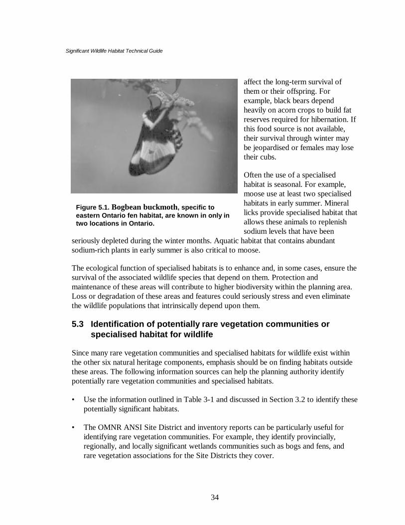
Significant Wildlife Habitat Technical Guide
34
affect the long-term survival ofthem or their offspring. Forexample, black bears dependheavily on acorn crops to build fatreserves required for hibernation. Ifthis food source is not available,their survival through winter maybe jeopardised or females may losetheir cubs.
Often the use of a specialisedhabitat is seasonal. For example,moose use at least two specialisedhabitats in early summer. Minerallicks provide specialised habitat thatallows these animals to replenishsodium levels that have been
seriously depleted during the winter months. Aquatic habitat that contains abundantsodium-rich plants in early summer is also critical to moose.
The ecological function of specialised habitats is to enhance and, in some cases, ensure thesurvival of the associated wildlife species that depend on them. Protection andmaintenance of these areas will contribute to higher biodiversity within the planning area.Loss or degradation of these areas and features could seriously stress and even eliminatethe wildlife populations that intrinsically depend upon them.
5.3 Identification of potentially rare vegetation communities orspecialised habitat for wildlife
Since many rare vegetation communities and specialised habitats for wildlife exist withinthe other six natural heritage components, emphasis should be on finding habitats outsidethese areas. The following information sources can help the planning authority identifypotentially rare vegetation communities and specialised habitats.
• Use the information outlined in Table 3-1 and discussed in Section 3.2 to identify thesepotentially significant habitats.
• The OMNR ANSI Site District and inventory reports can be particularly useful foridentifying rare vegetation communities. For example, they identify provincially,regionally, and locally significant wetlands communities such as bogs and fens, andrare vegetation associations for the Site Districts they cover.
Figure 5.1. Bogbean buckmoth, specific toeastern Ontario fen habitat, are known in only intwo locations in Ontario.

Significant Wildlife Habitat Technical Guide
35
• Refer to Table I-3 in Appendix I for a list of information sources for identifying rarevegetation communities or specialised habitats for wildlife. The habitat matricesinAppendix G describe the habitat requirements of species associated with specialisedhabitats.
5.3.1 Potentially rare vegetation communities
A list of rare vegetation communities for southern Ontario (Site Regions 6 and 7) has beenprepared and described in a document entitled “Natural Heritage Resources of Ontario:S-ranks for Communities in Site Regions 6 and 7” (Bakowsky, 1996). This document isfound in Appendix J. All of the vegetation communities are listed for southern Ontario,including marshes, swamps, bogs, fens, beaches, sand dunes, barrens, alvars, prairies,savannahs, and forests. Dominant species and a site description based largely on soilmoisture and texture are used to discern communities. The rarity of each community andits presence or absence in Site Regions 6E and 7E of southern Ontario are provided.
The Natural Heritage Information Centre also has a web site (see Appendix F), that can bechecked to see if there are any updates.
The Ecological Land Classification for Southern Ontario (Lee et al. 1998), providedmore specific details for vegetation communities in southern Ontario, including:descriptions of how each community is broadly defined; its status and distribution; theprinciple ecological factors that have helped to determine communities; topography andsoils of the communities; the dominant and associated species; and sometimes thedistribution of vegetation within the community.
Some vegetation communities described in these publications are difficult to identifybecause considerable field experience is required. However, they provide an excellentstarting point for the identification of rare vegetation communities. Appendix L describes apractical approach for identifying rare vegetation communities using the Ecological LandClassification (ELC) system.
A summary of the approach to the identification of potentially rare vegetationcommunities is outlined below.
• Some provincially and regionally significant vegetation communities such as alvars andprairie remnants have already been described and mapped by the OMNR. Table 1 inAppendix M describes the locations of some of these rare vegetation communities.Ask the OMNR ecologist for locations of rare vegetation communities found withinthe planning area.
• Map (preferably at 1:10,000 scale) all these known rare vegetation communities.
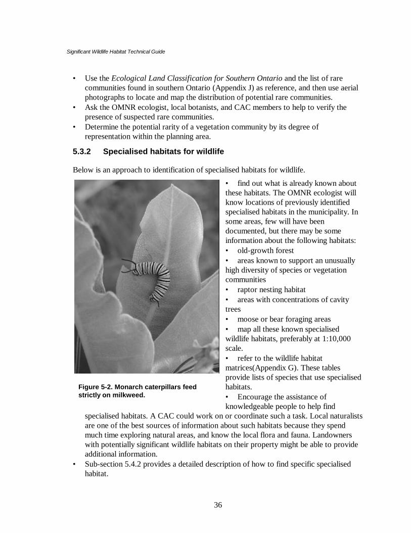
Significant Wildlife Habitat Technical Guide
36
Figure 5-2. Monarch caterpillars feedstrictly on milkweed.
• Use the Ecological Land Classification for Southern Ontario and the list of rarecommunities found in southern Ontario (Appendix J) as reference, and then use aerialphotographs to locate and map the distribution of potential rare communities.
• Ask the OMNR ecologist, local botanists, and CAC members to help to verify thepresence of suspected rare communities.
• Determine the potential rarity of a vegetation community by its degree ofrepresentation within the planning area.
5.3.2 Specialised habitats for wildlife
Below is an approach to identification of specialised habitats for wildlife.
• find out what is already known aboutthese habitats. The OMNR ecologist willknow locations of previously identifiedspecialised habitats in the municipality. Insome areas, few will have beendocumented, but there may be someinformation about the following habitats:• old-growth forest• areas known to support an unusuallyhigh diversity of species or vegetationcommunities• raptor nesting habitat• areas with concentrations of cavitytrees• moose or bear foraging areas• map all these known specialisedwildlife habitats, preferably at 1:10,000scale.• refer to the wildlife habitatmatrices(Appendix G). These tablesprovide lists of species that use specialisedhabitats.• Encourage the assistance ofknowledgeable people to help find
specialised habitats. A CAC could work on or coordinate such a task. Local naturalistsare one of the best sources of information about such habitats because they spendmuch time exploring natural areas, and know the local flora and fauna. Landownerswith potentially significant wildlife habitats on their property might be able to provideadditional information.
• Sub-section 5.4.2 provides a detailed description of how to find specific specialisedhabitat.

Significant Wildlife Habitat Technical Guide
37
5.4 How to find some rare vegetation communities or specialisedhabitats for wildlife
The following sections provide detailed descriptions of rare vegetation communities andspecialised habitat for wildlife. They are provided to familiarise the reader with thesevegetation communities and habitats so they will be able to recognise them. Most of thesehabitats, especially the specialised habitats for wildlife, have not been identified andmapped, and finding them can be difficult. Some of these habitats may not exist in theplanning area, while some habitats may exist, but the species that normally use it may notoccur. For example, there may be springs and seeps that are not used by wintering wildturkeys.
Each rare vegetation community and specialised habitat description is accompanied bysome specific suggestions on how to find them. The following is a list of informationsources that can be used to find these habitats:• Table 3-1, general information sources required to find significant wildlife habitat.• Appendix F, list of agencies and their areas of expertise (these include web sites for
updated information).• Appendix I, information sources for the identification of specific significant habitat.• Appendix G, wildlife habitat matrices, with lists of species that use specialised habitats.• Appendix J provides a list of all the rare vegetation communities in Site Regions 6 and
7.• Appendix M describes the locations of all known rare vegetation communities.• Appendix L provides a suggested approach for using the Ecological Land
Classification system to identify rare vegetation communities.• Seek advice from the local OMNR ecologist for locations of rare or specialised
habitats.• Involve the CAC and local naturalists in searches for rare and specialised habitats.
5.4.1 Rare vegetation communities
Refer to Table M -1 in Appendix M for a list of known locations of provincially andregionally rare vegetation communities of southern Ontario.
5.4.1.1 AlvarsAlvars are naturally open areas of thin soil over essentially flat limestone, dolostone ormarble rock. They support a sparse vegetation cover of shrubs and herbs, and trees areoften absent or scattered. In spring, alvars may have standing water; in summer, soils canbecome very hot and dry. Vegetation is adapted to these extreme variations in temperatureand soil moisture. Some of the characteristic plants that can indicate the presence of alvarcommunities include spring forget-me-not, long-plumed purple avens,

Significant Wildlife Habitat Technical Guide
38
false pennyroyal, small skullcap, and narrow-leaved vervain. Table N–1 in Appendix N isa list of alvar plant indicator species.
Approximately 85% of alvar sites and more than 90% of alvar landscape area in the GreatLakes region are in southern Ontario (Catling & Brownell, 1995). Concentrations ofalvars are found in the following areas: Manitoulin Island, Bruce Peninsula, Lake ErieIslands, Carden Plain, Napanee Plain, and the Smiths Fall Plain. Many alvars have beenidentified in southern Ontario. Refer to Appendix L for locations of known alvars.
How to find• Use soil reports and maps
and aerial photographs tolocate open areas of flattopography, with shallowsoils over limestone bedrock.
• Check “Barren andScattered” areas on FRImaps with correspondingaerial photographs.
• Refer to the list of plantspecies that are consideredindicators of an alvar (TableN–1 in Appendix N).
• Published alvar reports (e.g.Catling and Brownell 1995,etc.)
5.4.1.2 Tall-grass prairiesTall-grass prairies in Ontario are usually small remnants (< 1 ha) located mainly in thesouthwestern part of the province. High quality prairies have few trees, non-native plantspecies, and a large proportion of provincially significant species. A history of burningeliminates or controls invasion by woody shrubs and maintains this rare community.Prairie habitats are very susceptible to natural succession and must be frequently disturbedby such natural processes such as fire in order to be maintained. Many of the prairieremnants that remain have invasive plant species.
Indicator species are usually the dominant grasses including big bluestem, Indian grass,switch grass, and tall cord grass. Soil depth is variable; soils are usually fine-textured,ranging from dry-mesic sands to wet-mesic sandy loams, over limestone bedrock. TableN-2 of Appendix N is a list of Tall-grass prairies and Savannah indicator species.
Figure 5-3. Alvar, Misery Bay, Manitoulin Island.
Significant Wildlife Habitat Technical Guide
39
Many prairie remnants have been identified. In Site Region 7E prairie remnants have beenidentified on the following landforms: Horseshoe Moraines, Caradoc Sand Plains,Bothwell Sand Plains, St. Clair Clay Plains, Norfold Sand Plain. In Site Region 6E prairieremnants are found on the Peterborough Drumlin Field. See Appendix M for locations ofknown provincially or regionally significant sites.
How to find• Use aerial photographs in conjunction with County Soil Survey reports and maps, and
FRI maps to find open, treeless areas of non-cultivated land.• Early writings or maps documenting the location of aboriginal communities may help
to find remnant prairies. The frequent burning in these areas helped to maintain thesehabitats.
• Maps of vegetation communities have been prepared from the original surveyors’notes, and these may identify where prairies originally occurred. These are availablefor southern Ontario from the Ministry of Citizenship, Culture, and Recreation.
• Refer to Table N–2 in Appendix N for a list of tall-grass prairie plant indicator species.
5.4.1.3 SavannahsSavannahs are characterised by widely-spaced, open-grown trees producing a cover of60% or less growing in association with an assortment of grasses and forbs that arecharacteristic of prairie communities. Soil depth is variable and is usually underlain bylimestone bedrock. Soils are often silt loams and Farmington loams. In the spring, they arefrequently saturated and internal drainage is restricted due to the underlying bedrock.Conversely, in mid to late summer, soils dry out, often creating drought-like conditions.Fire maintains these communities by controlling the invasion of woody shrubs and non-native species of grasses.
The trees are usually oaks and hickories, mainly black oak, bur oak, and shagbark hickory.Black oak is the dominant species in southern Ontario savannahs. On dry sites, otherdominant species include white oak and red cedar. Some dominant or indicator plantspecies of oak savannahs include big bluestem, hair grass, rough-leaved dogwood, wildbergamot, gray-headed coneflower, nodding wild onion, fragrant sumac, and commonjuniper. Poorly-stocked, and barren and scattered stands as depicted on FRI maps, shouldnot be considered savannahs unless they have the appropriate canopy and understoreycharacteristics. Refer to Table N–2 of Appendix N for a list of savannah indicator species.
Many savannahs have been identified. These communities are found mainly insouthwestern Ontario. In Site Region 7E they are found on the following landforms: St.Clair Clay Plains, Horseshoe Moraines, Norfolk Sand Plain, and Erie Spits. In Site Region6E they are found on the Oak Ridges Moraine. See Appendix M for locations of someprovincially or regionally significant savannahs.

Significant Wildlife Habitat Technical Guide
40
How to find• Use aerial photographs and soil survey reports to find open areas of flat topography,
with shallow soils over limestone bedrock, and scattered trees.• Check “barren and scattered” areas on FRI maps with aerial photographs.• Check the distribution maps of some savannah indicator species, such as black oak.• Refer to Table N-2 in Appendix N for a list of savannah indicator species.
5.4.1.4 Rare forest typesForests are treed communities with greater than 60% canopy closure. A deciduous forestis a forest in which deciduous tree species are more than 75% of the total tree cover. InSite Districts 6E and 7E, there are several rare deciduous forest types consisting mainly ofregionally or locally uncommon tree associations or supporting some provincially orregionally rare trees. A mixed forest has greater than 60% canopy closure, and bothconiferous and deciduous tree composition, with each component forming greater than25% canopy cover. A coniferous forest has greater than 75% conifer composition.Potentially rare forest community types are listed in Appendix J.
Reports produced by the Ontario Soil Survey can further help in finding rare foresthabitats. Soil formation, soil depths and textures, drainage, relief, and indigenous forestassociations of the counties of southern Ontario are summarised. This information can beused to narrow the search for certain forest types. These soil surveys and maps areavailable from the Ontario Ministry of Agriculture, Food and Rural Affairs in Toronto.More information about landforms, their formation and distribution, can be found in thePhysiography of Southern Ontario (Chapman and Putnam 1984). Finally, Trees in Canada(Farrar 1995) is a good reference textbook for information about the habitats anddistribution of trees in the province.
The forest communities listed in Appendix J are those that may be significant at theprovincial level. Planning authorities may wish to identify additional forest communitytypes that may be significant within their jurisdiction. Certain community types that arecommon within the province or site district may be rare within a municipality. This mayoccur if the municipality is at the periphery of a vegetation community’s distributionrange, or if land-use practices have resulted in the loss of a high proportion of thecommunity.
How to find• Use FRI maps to locate potentially rare tree associations and to determine relative
rarity of existing associations within the planning area. FRI maps note treecomposition of forest stands.
• Use Ontario Soil Survey reports and maps to determine the range of specific soilstypes, textures, and depths in the planning area. This information, used in conjunctionwith Appendix J and the ELC for southern Ontario, FRI maps, and Trees in Canadacan help to indicate areas with good potential to support rare communities.

Significant Wildlife Habitat Technical Guide
41
• Check the OMNR site district report(s) that apply to the municipality for descriptionsof potentially rare forest types. Site district and inventory reports often includedetailed site descriptions that can narrow the search and they identify landforms thatmay support some of these forest types.
• Contact the director of the Ontario Tree Atlas Program at the Arboretum, Universityof Guelph, for information about the location of locally and regionally uncommon orrare trees in southern Ontario. Volunteers have collected data on tree speciesdistribution in southern Ontario, within 10 x 10 km blocks.
• Conduct field investigations of the most likely areas.
5.4.1.5 Talus slopesThese habitats are characterised by blocks of limestone/dolostone, sandstone, or granite ofvariable size, found at the base of cliffs of steep slopes. Often substantial amounts of rockrubble accumulate through the formation and weathering of cliffs. These sites have coarserocky material occupying greater than 50% of the ground surface. Soils are shallow, havelittle mineral material, and are primarily made up of organic debris. In general, vegetationis sparse and patchy.
Talus slopes provide specialised habitat (hibernacula) for some snakes. The accumulatedbroken rocks at the base of the cliffs frequently provide subterranean entry points forsnakes that must hibernate below the frost line. Often these slopes support diversevegetation communities, particularly if they have a southern exposure, basic soils, andpresence of some water.
How to find• Use topographical maps to locate areas of sharp relief that could be searched.
Sometimes abandoned quarries will provide talus habitat.• Check geological maps for areas of limestone outcrops.
5.4.1.6 Rock barrensRock barrens are open to moderately-treed sites (up to 60% crown coverage)characterised by exposed bedrock and very shallow soils (less than 15 cm). Precambrianbarrens, including the more common metamorphic types, and the less common graniticand marble types are normally found on ridges and other elevated, glacially scoured sites.Paleozoic barrens, including limestone/dolostone and sandstone types are generally flat.
In southern Ontario they are largely restricted to Site Region 6E, where they are found onlimestone plains adjacent to the Precambrian Shield. Good examples ofmetamorphic/granitic rock barrens are found on the northern part of the Frontenac Axis ineastern Ontario. Extensive limestone rock barrens (also referred to as dolostonepavement) are found on Manitoulin Island, the Bruce Peninsula and the NapaneeLimestone Plain. Sandstone barrens are much rarer. Small examples occur on the NepeanSandstone Formation in eastern Ontario.

Significant Wildlife Habitat Technical Guide
42
Several provincially rare species are associated with granitic rock barrens including pitchpine found only in Leeds County, winged sumac, small prickly pear cactus, bear oak,Case’s ladies’ tresses, sharp-leaved goldenrod, and several grasses and sedges.Precambrian rock barrens often attract mammals such as red fox, coyote, and black bearthat come to forage on berries and insects found under rocks. Flat rocks on many barrensalso provide important foraging and cover habitat for many snakes and five-lined skinks.They may also function as animal movement corridors, especially in areas with numerouswetlands and ponds.
How to find• Use aerial photographs to locate open areas and large rock outcrops with little or no
vegetation.• Check distribution maps for some of the species listed above.
5.4.1.7 Sand barrensSand barrens are open (tree cover < 25%) herbaceous communities occurring inland ondry, deep sand deposits. These rare vegetation communities are dominated by species suchas bracken fern, hay sedge, deep-green sedge, and New Jersey tea. Mosses and reindeerlichen form a substantial component of the vegetation cover. Vegetation is usually low tothe ground, sparse and patchy, and there is much exposed mineral soil. These rare habitatsare known to occur in Site Region 6E on the Iroquois Plain. See Appendix M for adescription of some of their locations.
How to find• Use County Soil Survey reports and maps to locate areas with deep sandy soils.• Use aerial photographs to locate open areas with little noticeable vegetation cover in
parts of municipality with deep sandy soils.
5.4.1.8 Great Lakes dunesGreat Lakes dunes are open vegetation communities occurring on sand dunes along theshores of the Great Lakes. Soils are severely-drained calcareous sands. Further back frommore active shoreline areas, the more stabilised sand has greater cover of trees and shrubs.Dominant tree species include eastern cottonwood, red cedar, white pine, red pine, blackoak, red oak, and white oak. Characteristic grasses include beachgrass, Canada wild rye,switch grass, and little bluestem; characteristic plants include tall wormwood, rocksandwort, and starry false Solomon’s-seal. The beach communities consist mainly of searocket, seaside spurge, Russian thistle, and horsetail, among other species.
Several important dune areas have been identified and include: along Lake Huronshorelines at Manitoulin Island, Sauble Beach, McGregor Point, Inverhuron, Grand Bend,Pinery, Ipperwash; along Lake Erie shorelines at Point Abino, lesser remnants at FishPoint, Port Burwell; and along Lake Ontario at Burlington Beach, Weller Bay, PrinceEdward Peninsula. Other dunes are found in Georgian Bay and include the Mississagi

Significant Wildlife Habitat Technical Guide
43
River mouth, Wasaga Beach, and the Penetang Peninsula. See Appendix M a descriptionof the locations of some provincially and regionally significant Great Lakes dunes.
How to find• Use County Soil Survey reports and maps in conjunction with aerial photographs to
locate areas of sand along the Great Lakes.
5.4.2 How to find specialised habitats for wildlife
Most specialised habitats have not been formally identified and mapped by any agency.The planning authority can identify many of them by working with knowledgeable peoplewho know the natural heritage features and areas of the municipality (local naturalists,CAC, OMNR, landowners). OMNR site district and inventory reports and wetlandevaluations, as well as consultant and naturalist reports, are good sources of writteninformation.
Many of the specialised habitats described below can be identified using the informationdiscussed in Section 3.2 and listed in Table 3-1, plus some knowledge of the naturalhistory of their associated species and the unique physical structure of each habitat. Manyspecialised habitats are likely to exist in most municipalities. The following is a descriptionof several potentially specialised habitats, their value to wildlife, and how to find them.
5.4.2.1 Habitat for area-sensitive speciesSome wildlife species require large areas of suitable habitat for their long-term survival.This seems to be particularly true for larger mammalian carnivores such as gray wolf, lynx,and fisher. On a smaller scale, many birds require substantial areas of suitable habitat forsuccessful breeding and their populations decline when habitat becomes fragmented andreduced in size. Over time, competitive species, predators, and nest parasites (primarilythe brown-headed cowbird) reduce productivity of these birds. See the habitat matrices inAppendices C and G for a list of area-sensitive bird species of forested and open areassuch as grasslands.
The larger and least fragmented forest stands within a planning area will support the mostsignificant populations of forest-area sensitive birds. Forests should cover about 30% ofthe regional landscape to provide minimal conditions for these species and there should beseveral large woodlands (30 to 100+ ha) present to provide enough suitable forest-interiorbird nesting habitat. Forests comprised of a mainly closed canopy of large trees and avariety of vegetation layers tend to support a greater diversity of species because of thebroader range of habitats they provide.
The minimum forest habitat for area-sensitive species is at least 100 metres from any edgehabitat. Edges can have adverse effects on forest-interior habitat. For example, some

Significant Wildlife Habitat Technical Guide
44
forest birds may nest near or in forest edge habitat and then suffer reduced reproductivesuccess because of nest predation and parasitism.
For area-sensitive grassland bird species, large grassland areas are required as they aremore likely to be buffered from disturbance, more likely to increase the distance of nestinghabitat to woody edges (thereby reducing nest predation and parasitism), and providemore opportunities for nesting. An endangered species in Ontario, the Henslow’s sparrow,appears to prefer tall-grass fields of at least 30 ha. Sufficient habitat is required for severalbreeding pairs before the habitat will be used, although one pair of birds may only use anarea of 1 to 2 ha in size. Even more common grassland species such as bobolinks,savannah sparrows, and grasshopper sparrows are more abundant as breeding birds ingrasslands of at least 10 ha. Grasslands with a variety of vegetation structure, density, andcomposition tend to support a greater diversity of grassland nesting birds because differentspecies require different nesting habitat.
Protecting significant woodlands as suggested in the Natural Heritage Section of theProvincial Policy Statement, will also maintain some critical habitat for area-sensitiveforest species. The significant woodland component is closely linked to this importantsignificant wildlife habitat. The largest, least-disturbed grasslands might also be identifiedfor their value to area-sensitive grassland species and provision of further landscapediversity. Each planning area should protect representative examples of these habitats.
How to find• Use FRI maps together with aerial photographs of the municipality to identify
potentially significant forest-interior habitats.• Use aerial photographs to determine the amount of contiguous forest cover and
potential grasslands, the spatial arrangement of forest and grassland fragments, and theextent and nature of edge habitat within the planning area.
• Planning authorities with their resource data in a GIS system can make queries offorest stands based on size.
• Ask local birders for local woodlands and grasslands that support abundant andspecies rich populations of area-sensitive species. These people may know many of themost important areas. Appendix C provides a list of area-sensitive birds and importantreferences.
• Contact the Canadian Wildlife Service (CWS) for the location of forest birdmonitoring sites and names of volunteers who might assist the planning authority inlocating important areas.
• Bird Studies Canada may be of assistance. They conducted a 3-year study of 287woodlots to determine the effects of forest fragmentation on forest birds and todetermine what forests were of greatest value to interior species.

Significant Wildlife Habitat Technical Guide
45
• Conduct field investigations of the most likely looking areas in spring and earlysummer when birds are singing and defending their territories.
5.4.2.2 Forests providing a high diversity of habitatsForests with a variety of vegetation communities and dominant tree cover are most likelyto have the highest diversity of plant and wildlife species. Complexes of upland andwetland habitats also may have high diversity.
Many species of wildlife such as squirrels, and cavity-nesting birds like pileatedwoodpeckers, barred owls, and wood ducks use large trees with hollow cavities to bearand raise young. These trees can also provide resting or loafing habitat for mammals likeraccoon and porcupine. Refer to the habitat matrices in Appendix G for the habitatpreferences of species that depend on tree cavities. Older forest stands usually have morecavity trees and support a higher diversity of species than young stands. Best sites containa mix of large and small tree cavities. Cavities in living trees are generally better than thosein dead trees because they last longer. Some tree species make better cavity trees thanothers do. For example, species such as red pine or white birch break down very quicklyand are of limited use for cavities.
Very tall trees, such as white pine, that grow above the main canopy (supercanopy trees),provide important habitat for birds of prey, that may use these trees for nests, roosts, andhunting perches.
Forests with numerous vertical layers of vegetation also contribute greatly to site diversitybecause of the many microhabitats they provide for wildlife. In addition, an abundance ofground structure such as large fallen logs and leaf litter further enhances a site’s ability tosupport wildlife. Fallen logs are essential habitat for some salamanders, members of theweasel family, certain woodpeckers, and many invertebrate species.
How to find• Examine FRI maps for older forest stands (average tree age greater than 100 years old
or the oldest stands in the planning area), forests with several stand types, and standswith composition consisting primarily of trembling aspen, largetooth aspen, beech,basswood, white cedar, and white pine. These tree species readily form cavities thatare important to wildlife.
• Use aerial photographs to locate the largest, contiguous forests in the planning area. Inaddition, forest stands that are closely associated with other forest stands usuallyprovide greater diversity than isolated stands.
5.4.2.3 Old-growth or mature forest standsAlthough definitions of old-growth forest vary depending on tree species, generally thesesites are characterised by having a large proportion of trees in older age classes, many ofthem over 120 to 140 years old. Other features include: a broad spectrum of tree sizes

Significant Wildlife Habitat Technical Guide
46
with some very tall trees, an uneven canopy with scattered gaps due to fallen trees andlarge limbs, and abundant fallen logs in various stages of decomposition. These older,relatively undisturbed forests usually support a high diversity of wildlife species.
Old-growth forest stands are rare throughout the province, particularly in southernOntario, largely due to past logging practices. Most candidate sites will likely be smallstands that have experienced little or no forestry management.
How to find• Ask OMNR foresters for locations of old growth candidate sites in the planning area.• Examine FRI maps to locate the oldest stands and use aerial photographs to verify FRI
information.
5.4.2.4 Foraging areas with abundant mastOver 75 species of birds and mammals consume fruit and nuts within the Great Lakes-St.Lawrence forest region and abundant supplies can enhance their survival and productivity.In summer and fall, black bears search for areas of abundant food. The most importantareas are forests containing numerous large beech and red oak trees that supply theenergy-rich beechnuts and acorns that bears prefer. These sites are especially important inthe fall because the animals are building fat reserves for hibernation. Other animals such aswhite-tailed deer that remain active throughout winter may also rely on supplies of nuts tobuild fat reserves. In summer, in more open areas, large patches of berry-producing shrubs(blueberries, raspberries, huckleberries) provide important feeding habitat for a variety ofanimals and birds. Black cherry, mountain ash, and apple trees also may attract wildlife. Ifthese food sources are unavailable or drastically reduced, bears may wander into humancommunities in search of food.
How to find• Ask OMNR staff for locations of known feeding areas as well as sites with a high
composition of mast-producing trees. Landowners and local hunters may also know ofimportant sites, particularly more visible “bear nests” or claw marks in beech and oaktrees.
• Use FRI maps to locate forest stands with high proportion of beech and red oak trees.• Use aerial photographs to locate large bedrock outcrops where shrubs producing
berries are often found. Forest openings, old fields, and utility corridors are oftenexcellent sites.
5.4.2.5 Amphibian woodland breeding pondsThese ponds are used for breeding by several species of frogs and salamanders. Suchwater bodies may be small and ephemeral but nevertheless, important to local amphibianpopulations, especially if they provide the only suitable habitat in the area.

Significant Wildlife Habitat Technical Guide
47
The best breeding ponds are unpolluted, and contain a variety of vegetation structure,both in and around the edge of the pond, for egg-laying and calling by frogs. The bestadjacent habitats are closed-canopy woodlands with rather dense undergrowth thatmaintains a damp environment. Moist fallen logs are another important habitat componentrequired by salamanders. Sites with several ponds and/or ponds close to creeks areespecially valuable.
How to find• Ask the OMNR ecologist and biologist and local naturalists for locations of important
woodland ponds. Local landowners may also provide assistance as they may hearspringtime choruses of frogs on their property.
• Soil reports and maps may indicate presence of ponds by describing drainage patternsand locations of shallow soils over rock and relatively impervious soils (clay soils),physical characteristics that often lead to pond formation.
• Examine topographical maps to locate low-lying, poorly drained areas of themunicipality.
• Ask CWS (Burlington) if amphibian-monitoring programs (amphibian call counts andbackyard surveys) are being conducted in the planning area. If so, they can providenames of volunteers and areas surveyed.
• Contact Bird Studies Canada for information on their marsh-monitoring program.• Conduct field investigations in spring; warm spring evenings in April are good times to
listen for calling frogs to determine their relative abundance. For later-calling speciessuch as green frog and bullfrog, late May and early June is more optimum timing.
• Refer to the Ontario Herpetofaunal Summary for historical records.
5.4.2.6 Turtle nesting habitat In spring and early summer, turtles lay their eggs in areas that may be used year after year.Preferred nesting habitats are usually on relatively soft substrates such as sand or finegravel that allow turtles to easily dig their nests, and are located in open, sunny areas(enhancing development). In general, the best nesting habitats are close to water and awayfrom roads (less mortality of adults and hatchlings) and sites less prone to loss of eggs bypredation from skunks, raccoons, and other animals.
Areas with numerous turtle nests are hard to find and it is unlikely that many such siteswill be found. However, the following suggestions will help to narrow the search for primeareas.

Significant Wildlife Habitat Technical Guide
48
How to find• Use Ontario Soil Survey reports and maps to help to find suitable substrate for nesting
turtles (well-drained sand and fine gravel).• Check the Ontario Herpetofaunal Summary records for uncommon turtles; location
information may help to find potential nesting habitat for them.• Use aerial photographs and maps to narrow the search for prime nesting areas
including shoreline beaches located near good turtle habitat (weedy areas of wetlands,lake and river shorelines), road embankments near turtle habitat, and streamcrossings/culverts on water bodies.
• Conduct field investigations during prime nesting season near wetlands deemed toprovide the best turtle habitat.
5.4.2.7 Specialised raptor nesting habitat Several raptors, including ospreys, those nesting and hunting in forests, and several otherwoodland and grassland raptors require somewhat specialised nesting habitat for theirlong-term survival. For example, red-shouldered hawks prefer mature forests with closedcanopies, near water. If the site remains undisturbed, they may continue to use the samenest or site in consecutive years. Osprey nest along lake shorelines as well as in wetlandsclose to productive fishing waters. Short-eared owls nest on wet ground in open areas,including marshes and wet fields with sufficient ground cover.
Shorelines of productive water bodies with numerous large conifers and/or deciduoustrees and with extensive areas of shallow water (< 1 m) for fishing are prime nestinghabitat for ospreys. Trees used for perching and nesting are large and sturdy, and providebirds with clear flight paths and good visibility.
Most woodland raptors require mature trees that are large enough to support the nest, fullcanopy closure, and a minimum of trees and shrubs in the understorey. Since these birds ofprey hunt within the forest, an unimpeded flight zone under the canopy is required.
The presence of displaying or vocalising adults or active nests, is the most expedientapproach to take when attempting to identify specialised habitat for these species. Also,the presence of inactive nests can indicate important raptor nesting habitat because somespecies may have several inactive nests within their nesting territory. see habitat matricesin Appendix G for descriptions of nesting habitats of raptor species and Appendix O forhow to find and identify their nests.
How to find• Use FRI maps and aerial photographs to identify the largest tracts of contiguous forest
in the planning area. FRI maps indicate species composition and age of forest stands(two important factors in nesting habitat selection for several species of raptors,including red-shouldered hawk). To find potential osprey nesting habitat, focus on old

Significant Wildlife Habitat Technical Guide
49
shoreline forest stands first. FRI maps and aerial photographs may also be used toidentify large (>75 ha) fields and meadows that may be suitable for short-eared owlnest sites.
• Use maps and aerial photographs to identify forests with few roads that tend to haveless human disturbance. Use aerial photographs to identify areas of water withinforested areas that may provide red-shouldered hawk nesting habitat.
• Ask the OMNR ecologist or biologist. They may be aware of locations of nestingraptors. Often osprey nests are reported to OMNR. In addition, these staff may knowlocal naturalists that may be aware of the locations of raptor nests.
• Conduct field investigations from mid April to the end of May. The use of tape-recorded hawk calls can help to find raptor nests by eliciting calling responses fromcourting or nesting hawks.
• Short-eared owls may hunt with other raptors in winter seasonal concentration areas(open fields with abundant small mammals). If suitable nesting habitat is present, somebirds may remain to breed.
• Check data from the red-shouldered hawk survey administered by Bird StudiesCanada.
• Conduct aerial flights, concentrating on shorelines of lakes, large rivers, and marshes.• Check the Atlas of Ontario Breeding Birds or Rare Breeding Birds in Ontario for
species documented in your planning area.
5.4.2.8 Moose calving areasShortly before giving birth in mid-May, solitary cow moose move to areas providingisolation, cover, and escape paths from predators. Calving sites are usually slightlyelevated areas. Islands and peninsulas seem to be preferred, but shorelines and uplandareas are also used if they are relatively close to open water (100 to 500 metres). Thesesites are hard to find by field investigation because at this time of year moose are solitaryand intentionally looking for secluded areas.
The OMNR has the greatest expertise in looking for and finding moose calving areas, aswell as moose aquatic feeding areas and mineral licks briefly discussed below. OMNRbiologists are aware of these specific habitat requirements. Very few calving sites will beknown.
How to find
• Topographical maps used with aerial photographs will help locate potential habitatssuch as islands and peninsulas.
• Consult the OMNR biologist for known calving sites.

Significant Wildlife Habitat Technical Guide
50
5.4.2.9 Moose aquatic feeding areasFrom June through July, moose move as far as 30 km to consume large quantities ofaquatic plants, especially subagent species, to replenish their bodies with sufficient sodium.They feed several times a day at preferred aquatic feeding sites. Ideal sites provideabundant food, particularly pondweeds, water milfoil, and yellow water lily, and haveadjacent stands of lowland conifers to provide shade and hiding cover. Several moose mayuse prime sites.
How to find• Use aerial photographs to identify bays, shorelines, and river and creek systems with
aquatic vegetation.• Contact the OMNR biologist for the locations of potential sites.• Use FRI maps and aerial photographs to locate coniferous tree cover adjacent to
potentially suitable areas.• Conduct aerial flights in June and July to locate concentrations of moose or evidence
of use (an OMNR protocol is available).
5.4.2.10 Mineral licksIn spring, moose seek mineral licks to consume sodium that is found in upwellinggroundwater and the soil of these seepage areas. Mineral licks surrounded by forest coverand free of human disturbance may be used by large concentrations of moose for manyyears. These sites are rare, occurring most frequently in areas of sedimentary and volcanicbedrock. They rarely occur on granitic bedrock, except where the site is overlain bycalcareous glacial till.
How to find• Contact the OMNR biologist for the location of any known or potential areas. Local
residents may also know the location of licks.• Consider using a small aircraft to verify reported sites because mineral licks are
uncommon; however these areas stand out because they are so trampled.
5.4.2.11 Mink, otter, marten, and fisher denning sitesThese species are members of the weasel family. They are predators with large homeranges and must cover a large area in search of food (a male fisher may have a home rangeof 17.5 to 39 sq. km). Like most larger carnivores, they are rarely found in high densities,and have specific habitat components critical to their survival.
Mink prefer shorelines dominated by coniferous or mixed forests for feeding and denning.Dens are usually located underground, especially where shrubs and deadfalls provide morecover for dens and habitat for prey. They also den in abandoned muskrat lodges.

Significant Wildlife Habitat Technical Guide
51
Since otters avoid humans, undisturbed shorelines with abundant shrubby vegetation anddowned woody debris provide prime denning habitat. They often use old beaver lodges fordens and log jams and crevices in rock piles. Since this mammal eats primarily fish, itrequires shoreline habitats that support large, productive fish populations.
Marten and fisher share the same general distribution and habitats. Both require largeunbroken tracts of coniferous or mixed forest with abundant large trees for maternaldenning sites. Fisher dens are usually in cavities in dead or living trees or fallen logs andthese animals appear to prefer trees larger than 40 cm diameter at breast height. Martenoften use cavities originally made by woodpeckers.
Exhaustive searches are not recommended, since feeding and denning sites for all thesemammals are usually very hard to find. Long-term survival of these species and othercarnivores with large ranges is best assured by taking a broad, landscape approach toNatural Heritage System planning by identifying and protecting large natural areas thatinclude the best quality habitat for these species. Protection of sufficient habitat for thesearea-sensitive species will also help provide suitable habitat for many other species.
How to find• Although specific sites are hard to find, OMNR biologists and foresters, local
naturalists, and residents may know the location of some potential feeding and denninghabitats. OMNR staff can also provide contact with trappers who may know thelocation of prime habitats.
• Use aerial photographs, topographical maps, and FRI maps to locate relativelyundisturbed shorelines, wetlands, and closed-canopy forests with larger, older treesthat might provide suitable structure.
• Habitat supply models are available through OMNR.
5.4.3 Highly diverse areas
These are areas of high species or vegetation community diversity. If protected within aNatural Heritage System, such sites will contribute greatly to maintenance of overallbiodiversity. Although these areas may be found throughout the province, they havecertain characteristics that can help to narrow the search for them. Often highly diverseareas contain a wide range of habitats or ecosystems and the large variety of plants andanimals associated with them. These areas frequently have species with both northern andsouthern affinities, and rare species are often found on such sites.
The deciduous forest region of Ontario (the Carolinian zone) has long been recognised asa part of the province with many highly diverse areas. More vulnerable, threatened andendangered species are found here than in any other Canadian life zone. Other parts ofsouthern Ontario with many highly diverse areas include the Frontenac Axis of

Significant Wildlife Habitat Technical Guide
52
southeastern Ontario; Grey and Bruce counties; and parts of Frontenac, Lennox-Addington, Lanark, Renfrew, Hastings, and Haliburton counties.
On the Canadian Shield, areas underlain by carbonate bedrock frequently support richcommunities because these substrates are less erosion resistant than the acidic granite andgneiss bedrock types, and encourage development of more nutrient-rich, basic soils. Insouthern Ontario, sites within the contact zone between Paleozoic limestone and theprecambrian bedrock of the Canadian shield often support highly diverse communities.
How to find• Use local expertise, aerial photographs, and maps to look for areas with the following
characteristics that frequently result in highly diverse communities:§ good diversity of vegetation and vertical structure, usually in the form of different
vegetation layers§ good diversity of ecosystems such as wetlands, forests, and old fields§ biophysical features such as the presence of cliffs; springs or seeps; pockets of
deeper, more fertile soils; abundant organic debris on the ground (e.g., largedecaying logs)
§ relatively little human disturbance• Conduct field investigations where necessary to check potentially diverse sites.• Site district and inventory reports and environmentally significant areas studies often
provide descriptions of many sites. This information may provide a start for furtherinvestigations.
5.4.4 Cliffs
Cliffs are dominated by bedrock with sharp or variably broken edges and a vertical reliefgreater than three meters. Average soil depth is usually less than 15 cm and restricted toplaces where organic debris and mineral material can accumulate such as in cracks,hollows, and along the upper rim.
Many cliffs may be locally significant because of their value as specialised habitat forwildlife such as nesting peregrine falcons or rare plants such as purple-stemmed cliffbrake. During summer, large numbers of turkey vultures may roost on secluded cliff faces.Many cliffs have areas where groundwater seepage creates a thin film of water runningover the rock surfaces. Often unique floral and insect species are associated with thesespecialised habitats. Some surfaces contain a diverse assemblage of algae and fungi thatlive within the crystalline structure of the rock.
Cliffs composed of limestone, dolostone and/or sandstone are most prevalent along theNiagara Escarpment, from Manitoulin Island to near Niagara-on-the-Lake. Granite cliffs

Significant Wildlife Habitat Technical Guide
53
are more widespread in the province, but metamorphic/granitic cliffs are only found on theFrontenac axis in Site Region 6E.
How to find• Use topographical maps to locate areas of sharp relief.
5.4.5 Seeps and springs
Seepage areas, springs, and small intermittent streams provide habitat for numerousuncommon species such as northern two-lined salamander and ginseng. In winter, wildturkey and white-tailed deer also forage in these areas because of the lack of snow on theground. Often these areas support a high diversity of plant species. Many of the mostimportant seeps are in forested areas where the canopy maintains cool, shaded conditions.
These landscape features are hard to find but, because of their importance to manyspecies, considerable effort should be made to find them, especially sites with severalseeps and springs.
How to find• Use topographical maps and aerial photographs to locate small streams and headwater
areas that could indicate the presence of seeps. Headwater areas for coldwater streamsare often excellent areas to find seeps and springs. These areas often have rollingtopography.
• Use of thermography, location of brook trout redds and reference to local tohydrogeological studies.

Significant Wildlife Habitat Technical Guide
54
6 Identifying Habitats of Species of Conservation Concern
6.1 DefinitionSpecies that can be considered species of conservation concern include:
• species identified as nationally endangered or threatened by the Committee onthe Status of Endangered Wildlife in Canada, which are not protected inregulation under Ontario’s Endangered Species Act
• species identified as provincially vulnerable based on lists of Vulnerable,Threatened, Endangered, Extirpated, or Extinct Species of Ontario that areupdated periodically by the OMNR (Appendix P)
• species that are listed as rare or historical in Ontario based on records kept bythe Natural Heritage Information Centre in Peterborough (S1 is extremely rare,S2 is very rare, S3 is rare to uncommon)
• species whose populations are known to be experiencing substantial declines inOntario
• species that have a high percentage of their global population in Ontario andare rare or uncommon in the planning area
• species that are rare within the planning area, even though they may not beprovincially rare
• species that are subjects of recovery programs (e.g., the Black Duck JointVenture of the North American Waterfowl Management Plan)
• species considered important to the municipality, based on recommendationsfrom the Conservation Advisory Committee
Habitat for these species is exclusive of those habitats for species covered under theHabitat of Endangered and Threatened Species of the Natural Heritage Component of theProvincial Policy Statement.
6.2 Ecological function/effects of loss
The ecological function of this habitat is to ensure that associated species can maintainlong-term, viable populations. Loss or degradation of this habitat may threaten the globalexistence of some species, and lead to accelerated declines of species already at risk. Atthe local level, the loss of species will result in loss of biodiversity.
6.3 Identification of habitat of species of conservation concern
Preliminary estimates in 1996 indicate, at the provincial scale, there were at least 105species of conservation concern (not including species designated vulnerable by OMNR’sCommittee on the Status of Species at Risk in Ontario). Thirteen Ontario species arenationally endangered; at least 57 species have a high percentage of their global

Significant Wildlife Habitat Technical Guide
55
population in Ontario; and 35 species of birds in Ontario are experiencing significantpopulation declines. These numbers are based on long-term data, such as 25 years ofbreeding bird survey data. Experts are aware of declines in other groups of wildlife, suchas amphibians however; they do not have long-term data on these species.
In this guide, the species of conservation concern do not include species that have beendesignated threatened or endangered by the OMNR. These species are protected under theHabitat of Endangered and Threatened Species component of the Natural Heritagesection of the Provincial Policy Statement and there are methods for determining thesignificant portions of their habitat. Yet, some of the methods described in this guide maybe useful for finding any rare species. Refer to Appendix P for a list of endangered,threatened, rare, vulnerable, or declining wildlife species of Ontario.
Many species of conservation concern are uncommon or rare species that normally do notexhibit high population densities (red-shouldered hawks, lynx). Others have fairlyspecialised habitat requirements or narrow tolerances for survival that are poorlyunderstood. Other species may be uncommon because their habitat is rare. Because of thesensitive nature of these species, even seemingly minor alterations to their habitats oftenresult in their disappearance. Protection of their habitats in the municipality will help tomaintain local populations and contribute to their recovery.
6.3.1 A suggested approach to habitat identification
Although there is often little specific information about the habitat requirements of manyspecies of conservation concern, most of these species can still be protected within aNatural Heritage System. To accomplish this, the planning authority will need to answerthe following questions:
What species of conservation concern are likely to occur in the municipality?
Appendix F provides a list of information sources that can be used to identify manyhabitats of species of conservation concern that are found in the planning area. TheOMNR Ecologist will know which endangered, threatened, or rare species listed inAppendix P occur or are likely to occur in the planning area. Bird Studies Canada and theOMNR recently prepared a list of Ontario breeding landbirds with high conservationpriority. Appendix G provides lists of plants and animals, describes their distribution, andgives an indication of where they may be found.
Where are these species likely to be found in the municipality?
The information sources listed in Table I-3 in Appendix I may provide locations of someof these species but most will not be located easily. Therefore, it is suggested that theplanning authority consider forming a Conservation Advisory Committee (CAC)
Significant Wildlife Habitat Technical Guide
56
consisting of experts familiar with the flora and fauna of the municipality (see Section 3.4).Atlas data indicates areas where species of conservation concern may occur.
Many species and habitats of conservation concern will be contained within the othernatural heritage features and areas of the Natural Heritage Component of the ProvincialPolicy Statement (significant woodlands, wetlands, valleylands, ANSIs, fish habitat) aswell as the other components of Significant Wildlife Habitat. It is common to find severalspecies of conservation concern in close proximity. Therefore, the planning authorityshould focus its effort on habitats and species of conservation concern that will not beadequately protected through the identification of these other components.
Which of these species should the planning authority protect under this componentof The Natural Heritage Policy?
The planning authority is urged to protect species of conservation concern and theirhabitats in the following order of priority:
• globally rare• nationally rare• provincially rare• regionally rare• locally rare species• species of concern to the planning authority
Ontario’s wildlife species have been ranked for rarity by staff at the Natural HeritageInformation Centre (NHIC) in Peterborough. Planning authorities can obtain these listsfrom the OMNR ecologist or from the NHIC website (Appendix F). In addition, Table Q-3 in Appendix Q provides a list of criteria that the planning authority can use to determinespecies of conservation concern. This does not include species designated as endangeredunder the Endangered Species Act. Many species (globally rare etc) are not designated.
6.3.2 Summary
The following guidelines summarise the process of identification of species and habitats ofconservation concern.
• Contact the OMNR ecologist and Appendices G and P for a list of potentialspecies of conservation concern that are known for the planning area, based onprovincial and regional lists. Additional species may be added to this list based onrecommendations from the Conservation Advisory Committee.
• Afford the highest priority for protection to habitats of the rarest species regardlessof where they are found.
• Next, concentrate protection efforts on species of conservation concern that aremost threatened and/or currently unprotected because their habitats are found

Significant Wildlife Habitat Technical Guide
57
outside other natural heritage features. Refer to the habitat matrices (Appendix G) forinformation regarding the habitat requirements of some of these species.• Conduct field investigations of sites that may be important to these species, but
have not had their conservation importance assessed. See Table Q-3 in AppendixQ for criteria that could be used to evaluate these sites. See Appendix D forinformation about how to conduct field investigations and Appendix G for thehabitat requirements of species.

Significant Wildlife Habitat Technical Guide
58
7 Identifying Animal Movement Corridors
7.1 Definition
Animal movement corridors are elongated, naturally vegetated parts of the landscape usedby animals to move from one habitat to another. They exist at different scales andfrequently link or border natural areas. Animal movement corridors encompass a widevariety of landscape features including riparian zones and shorelines, wetland buffers,stream and river valleys, woodlands, and anthropogenic features such as hydro andpipeline corridors, abandoned road and rail allowances, and fencerows and windbreaks.The Natural Heritage Component of the Provincial Policy Statement states that naturalconnections between natural features should be maintained and improved where possible.
7.2 Ecological function/effects of loss
Animal movement corridors allow animals to travel freely and safely across the landscapeby providing cover, shelter from harsh weather conditions, and by minimising encounterswith predators and people. They are especially important to animals that require a varietyof habitats to survive.
Animals move for several reasons. Often a particular area does not satisfy all seasonalhabitat requirements of a species. For example, some forest salamanders spend thesummer and winter in forest soils but, in spring, breed and lay their eggs in ponds,marshes, or temporary pools that may or may not be located in forest. Larvae mature inthe aquatic environment, emerge as adults, and then move back to the forest. Largemammals often must travel over large areas for all of their needs.
Other animals move in response to seasonal changes in climate (white-tailed deer, moose,caribou, and migratory birds). Often these animals follow traditional migration routes orcorridors. For example, the north shores of Lake Ontario and Lake Erie form an importantmigratory corridor for land birds flying south during fall migration.
Subadult animals of many species disperse from their place of birth to establish territoriesof their own. In order for populations to persist, enough individuals must be able to moveamong suitable habitats to balance local extirpations and ensure genetic diversity.
Corridors often provide permanent dwelling habitat for some plants and animals. Forexample, a creek connecting two wetlands may support amphibians and reptiles that arealso found in the wetlands; or some corridors connecting patches of forest can provide theentire required habitat for smaller forest mammals such as chipmunks and mice.

Significant Wildlife Habitat Technical Guide
59
Adding corridors to a natural heritage conservation system may increase dispersal abilitiesof many wildlife species and help maximise biological diversity within a given planningarea. They are one way to help offset the negative impacts on wildlife of highlyfragmented landscapes, and in some situations, may increase habitat and populations ofsome species. They may also function as buffer zones, by protecting natural areas and theirecological processes from adjacent land-use activities.
Loss of wildlife movement corridors makes species more vulnerable to predation anddisturbance. Local populations of some species (e.g. white-footed mice) may even beextirpated when re-colonisation is impossible due to an absence of corridors.
7.3 Identification of animal movement corridors
In many municipalities in southern Ontario, corridors consist of naturally vegetated areas,often forested land, that run through more developed and open landscapes. They connectthe remaining natural areas within and beyond the municipality. Other potentiallysignificant corridors include forested river valleys, shrubby riparian vegetation alongsmaller watercourses such as creeks, and undeveloped lake shorelines. Sparsely vegetatedareas can also function as corridors provided they link relatively natural areas. Manywildlife species move freely through agricultural land to reach natural areas.
It is seldom possible to observe wildlife species using corridors. Some species passthrough corridors quickly whereas others may reside there for some time. Often animalmovement corridors can be determined accurately using maps, aerial photographs, and asound knowledge of species’ habitat requirements. The following guidelines are presentedto help identify potentially significant animal movement corridors.
• Identify animal movement corridors only after other natural heritage features,including significant wildlife habitats have been located and mapped.
• Contact OMNR for their suggestions on the locations of corridors and restorablecorridors. Knowledgeable local residents may be aware of locations of somecorridors, especially for large, visible species.
• Use knowledge of habitat requirements and behaviour of key species to helpidentify potential corridors for them.
• Use the most recent aerial photographs and maps (topographical, FRI, wetland,ANSI, land use) to help to identify potentially significant corridors. Use them tolocate:§ the largest natural areas within the municipality and adjacent municipalities that
should be linked by existing or restorable inter-regional movement corridors.These inter-regional corridors will be visible on aerial photographs andtopographical maps as mostly naturally-vegetated links.
§ the largest and oldest forest stands in and adjacent to the planning area. Theseareas are likely to support high species diversity. Use the FRI maps to

Significant Wildlife Habitat Technical Guide
60
determine the age and composition of the forest stands in the region.Examination of aerial photographs will help to verify the accuracy of FRImaps.
§ the largest and most diverse wetlands. Examination of aerial photographs andtopographical maps of wetlands will reveal their configurations and spatialrelationship to other natural heritage areas, as well as help to indicateimportant linkages among them.
§ relatively steep and undeveloped river valleys and riparian zones along lakes,rivers and streams. Although it is easy to identify these areas by using aerialphotographs and topographical maps, an evaluation of at least some of them isrecommended. In some of the most densely populated municipalities ofsouthern Ontario, these riparian areas may be the most important remaininganimal movement corridors.
§ the most probable linkages to and from known significant wildlife habitat suchas winter deer yards and amphibian breeding ponds.
§ unopened road and rail allowances, and utility corridors that are potentialanimal movement corridors.
§ hedgerows, windbreaks, and old fields that could function as animal movementcorridors. Examination of aerial photographs can help to identify these smallerlinkages. In densely populated and heavily developed parts of somemunicipalities, these small corridors may be the only remaining natural areasthat allow animal movement from one area to another.
Identifying the most important corridors that provide connectivity across the landscape ischallenging because of a lack of specific information concerning animal movements. Thereis also some uncertainty about the optimum width and mortality risks of corridors.Furthermore, a corridor may be beneficial for some species but detrimental to others. Forexample, narrow linear corridors may concentrate breeding species. Raccoons, cats, andother predators can quickly decimate these populations. Also, narrow corridors dominatedby edge habitat may encourage invasion by weedy generalist plants and opportunisticspecies of birds and mammals. Despite the difficulty of identifying exact movementcorridors for all species, these landscape features are important to the long-term viabilityof certain wildlife populations.
7.3.1 Recommendations
The following recommendations are based on widely accepted principles of corridoridentification and design.
• All potentially significant corridors should allow safe movement of animals andprovide safe dwelling habitat for resident wildlife populations. Corridors shouldprotect moving animals from predators and road mortality.

Significant Wildlife Habitat Technical Guide
61
• Emphasis should be on retaining connections among the most significant andsimilar natural areas at the larger scale (inter-regional) and within the municipalityas well as habitats of species most in need of conservation.
• Maintain corridors that provide several benefits. For example, riparian corridorspermit animal movement and help to ensure stable soils, necessary inputs oforganic matter, and good water quality. Often these corridors are diverse naturalareas because of fertile soils, a variety of habitat structure, a dependable source ofwater, abundant insect and plant foods, and several different microclimates.
• Corridors should be as continuous and unfragmented as possible. However, somegaps in a potential corridor should not preclude it from consideration.
• There should be no barriers to animal movement within designated corridors.• Wherever possible, select corridors in regions of the landscape with the lowest
road density. Roads can be a serious cause of mortality for species such as nestingand migrating turtles, basking snakes, and frogs, as well as mammals and birds thatfeed near roadsides.
• Generally, corridor habitat should be as similar as possible to the habitat in whichthe target species lives.
• Incorporate known animal migration routes into corridors.• Shorter corridors are preferred since the longer the corridor, the greater the
likelihood of increased mortality, barriers to movement, and unsuccessful dispersalattempts. Longer corridors may also need to be wider.
• Generally, the widest possible corridors are best for linking patches of a species’habitat that are farther apart than normal juvenile dispersal distances. Widercorridors minimise edge effects. However, for some small animals at least, corridorwidth may not be as important as corridor presence. Even small fencerowcorridors may be beneficial to the movement of small mammals such as chipmunks.
• Corridors surrounded by inhospitable habitat need to be as wide as possible.• Corridors should have a good diversity of vegetation structure and composition.• Consider restoring corridors that link important natural areas or wildlife habitats
when and where restoration activities such as reforestation, stream rehabilitation,and regulation of land uses are feasible.
• Natural areas that have been historically isolated should not be connected as theyare unique and have evolved to their existing condition.

Significant Wildlife Habitat Technical Guide
62
8 Evaluation of Significant Wildlife Habitat
Evaluation is the process of determining if wildlife habitat should be considered significantunder the Natural Heritage Features and Areas Policy and therefore warrants protectionunder the Planning Act. Specific wildlife habitats are compared to evaluation criteria todetermine if they should be considered significant. Appendix Q provides lists of evaluationcriteria for significant wildlife habitat. The evaluation process can be used to determine if ahabitat meets a minimum standard for significance. The evaluation criteria can also be usedto compare one potential significant wildlife habitat to another, if they need to be ranked.This may be necessary where there are several potential sites and the planning authoritywants to place the greatest emphasis on the best sites.
The evaluation process is an important step for designating lands for protection. It canalso be used to identify sites that merit further study because of their apparentconservation value or to identify suitable candidates for future restoration efforts.Evaluation allows a planning authority to focus its time and resources on sites that aremost likely to be significant. The degree of representation of significant natural heritagefeatures and areas within a planning area is a very important element of evaluation. Inorder to achieve a comprehensive Natural Heritage System, all natural heritage featuresand areas should be well represented, or at the very least opportunities for restorationshould be identified.
Not all identified wildlife habitats will prove to be significant for the purposes of theNatural Heritage Features and Areas Policy. In landscapes that are still very natural, thereare more likely to be some habitats that, although they have value for wildlife, will not beconsidered significant because they are well represented in the planning area. In areas withvery little natural cover remaining, it is more likely that a high proportion of the identifiedhabitats will be considered significant.
8.1 Evaluation criteria and guidelines
The evaluation process involves examining a number of criteria that describe keyecological functions of the habitat. Table 8-1 provides a list of criteria for evaluatingwildlife habitat. They provide a comprehensive overview of the most common evaluationcriteria used by wildlife and conservation biologists. More specific criteria are presented inAppendix Q.
The criteria listed in Table 8-1 have not been weighted, although this can be done as partof a ranking process (see Chapter 9). However, a high emphasis should be placed onrepresentation. It is expected that for many of the wildlife habitats listed in this guide, theapplication of the criterion current representation of the wildlife habitat in the planningarea will be sufficient to determine that a specific habitat is at least locally significant. If

Significant Wildlife Habitat Technical Guide
63
a particular type of habitat is poorly represented in the planning area, then it is very likelyall examples of this habitat should be considered significant. There may not be a need toapply every criterion to a particular habitat if it has already been determined to besignificant. Some further examination may be beneficial in situations where there is adesire to determine what aspects might be improved at some point in the future. Aplanning authority may also consider breaking their planning area into physiographic unitsfor determining representation within the planning area. Some physiographic features areunique, such as the Oak Ridges Moraine or Niagara Escarpment, and representationwithin that feature may make more sense than representation within the planning area as awhole.
In general, habitat evaluation should not be a costly and time-consuming exercise. Itshould first concentrate on criteria that can be evaluated using existing information. Somecriteria can be applied using aerial photographs and topographic maps. If the habitat isdeemed significant using these criteria, it may not be necessary to conduct a field survey.However, there may be situations where fieldwork is necessary.
Extensive searches for hard-to-find habitats, such as snake or bat hibernacula are notrecommended, particularly if the species is unlikely to occur in the planning area. In areaswhere particular species have been recorded, but critical habitats have not been found,some potential sites can be indicated on maps so that future investigations can be focusedon these areas.
The difficulty of finding precise locations of the significant wildlife habitats of somespecies emphasises the value of adopting some of the basic principles of a landscapeapproach to planning, discussed in Chapter 2. This includes ensuring that there is adequaterepresentation of all habitat types within the planning area. Although this approach cannotguarantee that all critical portions of habitat of a particular species will be adequatelyprotected, there is a greater probability that these important habitats will be protected thanif some habitat types are not included in the Natural Heritage System.
Table 8-1. General evaluation criteria for wildlife habitats.
Criteria Definition and implications
Current representation ofwildlife habitat, species,or natural features in theplanning area
• refers to the existing range of wildlife habitats, natural features, and species in theplanning area, with the primary goal of protecting as complete a representation aspossible of them
• it applies to both rare and common species• normally assessed at the site district level, but could also be done at the local level• representative natural areas, features, landforms, and wildlife habitats are a solid
foundation around which a Natural Heritage System can be designed

Significant Wildlife Habitat Technical Guide
64
Abundance
• refers to the number of individual plants or animals of particular species or guildwithin a given site, community, or habitat.
• it is often based on population estimates for a given area• also can refer to the amount of a given habitat feature (food, ground debris, tree
cavities) within an area or habitat
Species diversity
• refers to the number of different species present• sometimes it is applied more specifically (referring to only breeding or migratory
species)• generally areas of high species diversity are more significant than areas of lower
diversity• areas of lower species diversity may be significant (if site is habitat of species of
conservation concern, or site is uncommon in the planning area)
Presence of species ofconservation concern(e.g. rare, vulnerable,threatened, endangered,declining, uncommon,sensitive, endemicspecies)
• usually refers to species that are encountered less often than most other species, orwhose population is declining
• may refer to species that are rare at some larger scale (ecological region, province,global)
• such species may be rare in the planning area but common elsewhere, or commonin the planning area but rare elsewhere
• such species may be more numerous than perceived but due to size, secretivenature, or other factors, are infrequently encountered
• some species may be quite numerous but found at few locations• sensitive species are those species that can least tolerate many human activities or
that have very specific microhabitat requirements• endemic species are species restricted to a specified region or locality
Ability of the site to meetthe known habitatrequirements of targetspecies
• refers to the presence of biophysical features and attributes required by targetspecies for survival and long-term maintenance of viable populations
• usually wildlife agencies can provide this habitat information for well-studiedspecies
Condition/quality of site
• refers to the general level of disturbance (either natural or human) on the site• determined by comparison with perceived “pristine” sites• condition often determined by assessing such features as the proportion of non-
native species on site; level of human use; number of roads, vehicle tracks, amountof refuse
• undisturbed or lightly-disturbed areas are usually more significant than disturbedareas
• undisturbed areas have additional value as potential areas for research, provisionof baseline information
Potential for long-termprotection of site/habitat
• refers to the likelihood of enacting restrictions on land uses that will result inprotection of identified habitat and associated species for many years
• can also refer to habitats where no restrictions are required because habitat is partof an existing protected area or habitats protected by their inaccessibility
Provision of severalsignificant wildlifehabitats
• refers to the presence of more than one of the significant wildlife habitatsdiscussed in this guide
Size of habitat/site• larger habitats/sites are usually more significant because they tend to support more
wildlife, including sensitive species, than smaller areas, due to their tendency tohave a broader range of habitats and features, larger interior, and better resilience
Significant Wildlife Habitat Technical Guide
65
to impacts• small areas may also be significant, especially when they support rare species, or
provide several representatives of a particular habitat or natural feature
Shape of habitat/site
• refers to the physical configuration of the habitat/site• round or block-shaped sites contain less edge per unit area than long, narrow sites
and may help protect some species from predation, parasitism, and competitionfrom edge species
Location of habitat/site
• location refers to geographical position relative to other habitats, natural areas,corridors; its degree of isolation from other similar habitats; and/or its spatialdistribution across the landscape
• generally, habitats within or close to other natural areas are more significant thanthose that are separated or distant from natural areas
Habitatdiversity/complexity
• refers to important physical (configuration of site; local topographic, soil, andmoisture conditions; presence of water or corridor/linkage) and biologicalcharacteristics (presence of certain species; species and community diversity;diversity of layers of vegetation) that can meet wildlife habitat requirements
• high habitat diversity/complexity usually indicates a greater probability that thesite is of significant value to wildlife
Evidence of use• refers to signs of current or traditional use of the habitat by the associated species• usually refers to observations of wildlife or signs of presence of wildlife (scats,
tracks, feathers, fur, lodges, nests etc.)
Other perceived values
• refers primarily to values of a site to the larger ecosystem in which it is found(maintenance of hydrological and nutrient cycles, erosion control)
• also refers to values of a site to humans (scientific and educational studies,aesthetic and recreational values)
8.2 Field investigations
At times, there will be a need for field investigations to collect important habitatinformation pertaining to some of the evaluation criteria (habitat quality, species richness).More than one visit to a site is not encouraged, unless necessary, such as to obtainseasonal information. If a site is visited during identification, then sufficient informationshould be collected at that time for evaluation. Appendix D describes the types ofinformation that should be collected during a field investigation.
The following Sections (8.3 to 8.6) discuss important factors to consider when evaluatingspecific wildlife habitats.

Significant Wildlife Habitat Technical Guide
66
8.3 Evaluation of habitat of seasonal concentrations of animals
Table Q-1 in Appendix Q lists criteria and suggested guidelines for evaluation of seasonalconcentrations of animals. The following section describes key factors to consider duringthe evaluation of seasonal concentrations of animals. It expands on some of the criteriaand provides additional detail that is not in the table. In general for determiningsignificance, the greatest emphasis should be placed on the following:
Representation–this can include representation at the large scale, such as habitat forspecies that are provincially rare, or it can include representation at the local level
Abundance–habitats supporting high numbers of animals relative to other habitats of thesame species within the planning area
Rare Species–the presence of rare species (or species of conservation concern) in ananimal concentration area, adds to the probability it will be significant
Multiple Benefits–these are habitats that not only provide habitat for a seasonalconcentration of animals, but also other significant wildlife habitat as well, such as rarevegetation communities, specialised habitat for wildlife, habitat for species of conservationconcern and/or and animal movement corridor.
Not all sites identified as candidates for protection will be significant. In some cases therewill be better examples of the same habitat within the planning area. Some habitats maynot be sustainable due to serious habitat limitations that were not identified earlier. Somehabitats may not meet a minimum standard for habitat quality and sustainability. Forexample, a winter deer concentration area may have been identified. However, the sitemay support only a very small number of deer in winter. Although any concentration ofdeer may be important, the number of deer using the concentration area may be too smallto be considered significant in the context of land-use planning.
Habitat evaluation can be difficult. One difficulty is in finding some of the habitats. Thishas been discussed in Chapters 2 and 4. Another difficulty is determining the degree ofsignificance of some of the criteria for the identified habitats. Examples include knowingthe relative importance of a winter deer yard to the local deer population and knowing therelative importance of a colonial bird nesting site to the local population. The planningauthority may not have the expertise to be confident in making a decision on these criteria.Many government agencies and non-government organisations have knowledge of manyof these species and their habitats. These organisations should be consulted wheneverpossible. Appendix F provides a list of agencies and their areas of expertise. Appendix Glists information sources for seasonal concentrations of animals. This information will behelpful when using the evaluation criteria.

Significant Wildlife Habitat Technical Guide
67
See Chapter 4 for a detailed description of seasonal concentration areas and theirfunctions.
8.3.1 Winter deer yards
The OMNR is responsible for managing deer in Ontario. Staff responsible for deermanagement, are aware of most deer winter habitat and should be consulted about therelative importance of deer yards to the planning area.
The significance of a particular deer yard depends on its context in the landscape. In areaswhere deer populations are high (and there are a number of large deer yards distributedacross the landscape), some of the smaller yards may not be considered significant withrespect to the application of the Natural Heritage Features and Areas Policy. That is notto say those small deer yards do not have value. All winter habitat for deer has value. Itsimply means that not all areas will be designated as significant wildlife habitat. In areaswhere deer are not as abundant and wintering deer are found in a limited number of smallyards, all of the deer yards may be considered significant.
Deer management goals can also be used to determine significance. In many parts ofOntario, deer provide high numbers of recreational opportunities, both for viewing and forhunting. Revenue generated from these opportunities is not only important to the localeconomy, but to the province as a whole. This contrasts to some urban areas where toomany deer may be considered a hazard on the roads and a nuisance to landowners. Theseareas are often not open to hunting.
Deer yard quality is determined from field investigations. Deer yard surveys can be used todetermine the quality and extent of the conifer cover, the amount of food available and therelative density of the deer population with respect to the carrying capacity of its habitat.
The planning authority must work cooperatively with the Ministry of Natural Resources insetting deer management objectives. If there are numerous complaints about cropdepredation or concern about high numbers of deer-motor vehicle accidents, the Ministrycan set higher harvest targets to keep numbers down.
8.3.2 Moose late winter habitat
The OMNR is responsible for the management of moose in Ontario. The Ministryconducts aerial moose inventories once every three years for each Wildlife ManagementUnit having moose populations. The inventories are normally conducted in January andearly February. Although the surveys are not conducted specifically in late winter, OMNRstaff may be aware of locations of late winter habitats. They should be contacted forinformation about the relative importance of any late winter moose habitat.

Significant Wildlife Habitat Technical Guide
68
If moose are common in the planning area, the planning authority should be aware theremight be late winter moose habitat that has not been identified. This may be of greatestconcern when associated with the shorelines of lakes where there may be potential forconflict with cottage development.
It is recommended that the planning authority contact the OMNR to find out the locationand importance of any known late winter moose habitat on Crown land within theirjurisdiction, particularly those areas of Crown land that are closely associated with privateland where there could be potential conflict.
8.3.3 Colonial bird nesting sites
Agencies such as OMNR, Canadian Wildlife Service, and Bird Studies Canada haveinformation on colonial nesting species. Staff at these agencies can be consulted as well asreference texts such as the Atlas of the Breeding Birds of Ontario to determine therelative importance of colonial nesting species in a particular planning area. Nestingcolonies that are poorly represented should be considered most significant.
Nesting colonies that support rare species and species that are highly sensitive todisturbance should be considered significant. Higher priority should be given to rarity atthe larger scale, such provincial rarity, than rarity at the local level.
Often when evaluating and ranking more than one colony, the number of nests in thecolony is one important criterion used to compare colonies. This criterion should alsoconsider whether the colony is expanding or declining. A new colony that is expandingmay have a greater chance of long-term sustainability, than a colony that is declining.
Historical use of a colonial nesting site can be an important criterion. Colonies with a longhistory of use are highly significant. The evaluator should also consider new andexpanding populations. Some populations may be recovering due to improvements inwater quality or habitat. Colonies for some of these species may not have a long history ofuse, but they are still very important.
In some cases, potential habitats may also be considered for protection, particularly forspecies with expanding populations or for species that are forced to move periodically(such as herons where the nesting trees fall down).
Some colonial nesting species can be considered a nuisance when their populations get toohigh. Examples are ring-billed gulls and double-crested cormorants. These birds and theirnesting habitats are protected under the Migratory Birds Convention Act. The planningauthority must decide if the colonies in their jurisdiction require additional protectionthrough the Planning Act.

Significant Wildlife Habitat Technical Guide
69
8.3.4 Waterfowl stopover and staging areas
Generally, the most significant areas support the greatest number of birds and/or species inthe planning area. The best areas tend to be very large wetlands. These are oftenassociated with lakes, but that is not always the situation. The best wetlands generallyhave a diversity of vegetation communities interspersed with open water. Many of themarshes along the Great Lake shorelines are particularly valuable as waterfowl migrationstopover habitat because they have an excellent mix of deep open water and shallowmarsh habitat.
The Canadian Wildlife Service (CWS) is the lead agency for waterfowl management inCanada. They routinely conduct migration surveys in late fall and early winter. CWS staffare knowledgeable of most of the major migration stopover sites. OMNR conservationofficers check waterfowl hunters in the fall and are often aware of locally significantstaging habitat. These staff may also know if some uncommon species frequently usecertain wetlands. OMNR staff is frequently involved in waterfowl management projects,such as projects associated with the Eastern Habitat Joint Venture. OMNR wetlandevaluations include the degree of use of the wetland by migrating waterfowl. Staff at theseagencies should be contacted for advice on the relative importance of waterfowl migrationstopover and staging habitat.
The amount and distribution of staging areas within the planning area may determine thesignificance of some locally important staging areas. Some planning areas will have veryfew large wetlands with open water that can be used by staging waterfowl. All of thesewetlands may be very important. Other planning areas may have several locally importantstaging habitats and the planning authority may want to use the criteria in Appendix Q todetermine which areas are best.
Appendix G, the wildlife habitat matrices, lists the habitat requirements of migratingwaterfowl. Knowledge of waterfowl staging habitat requirements is important whendetermining which sites are most significant.
The permanency of wetlands should be considered. Some wetlands, such as new beaverfloods, may be temporary. Some of these ponds may be very attractive to locally stagingwaterfowl for a few years, but when beaver leave the pond they may no longer supportstaging waterfowl. The highest significance should be placed on permanent wetlands andwetlands that have provided habitat for staging waterfowl for many years.
8.3.5 Waterfowl nesting habitat
Marshes and swamps have greater value to nesting waterfowl than bogs and fens becausethey are more productive and have more permanent open water. However, bogs and fensare important to certain waterfowl species, and should not be ignored as potential

Significant Wildlife Habitat Technical Guide
70
significant waterfowl nesting habitat. Large wetlands and clusters of small wetlandslocated close to one another usually support greater waterfowl production than singlesmall wetlands.
A number of agencies such as the OMNR, Canadian Wildlife Service, and DucksUnlimited are very actively involved in waterfowl management in Ontario. Some of theseagencies routinely conduct brood surveys in late spring and early summer. OMNR hascompleted about 2000 wetland evaluations in southern Ontario. Each of these evaluationsprovides an estimate of the relative value of the wetland for waterfowl nesting. Theseagencies should be contacted for advice on the relative importance of waterfowl nestinghabitat in the planning area.
In 1996, a group of waterfowl experts assembled to develop criteria for determining thesignificance of waterfowl breeding habitat. Their report is included as Appendix K.
In general, the most significant sites will consistently support large concentrations ofnesting waterfowl, species of conservation concern, or a variety of species. All knownnesting habitat for ruddy duck, gadwall, northern pintail, green-winged teal, Americanwigeon, and northern shoveler should be given high priority for protection. These speciesare uncommon nesters in Ontario. Black duck populations have declined in many parts ofNorth America, in large part due to hybridisation with mallards. In southern Ontario,wetlands supporting black duck nesting should be considered significant. Due to thedecline of waterfowl, populations in North America, Canada and the U.S.A. signed theNorth American Waterfowl Management Plan. Considering the continental objectives forwaterfowl, sites with high concentrations of more common nesting species, such asmallards and blue-winged teal, should also be considered significant.
A good distribution of nesting habitat should be protected across the planning area. Inparts of the planning area where no large highly diverse wetlands remain, some smallerwetlands should be considered significant because they add to the diversity of the planningarea.
8.3.6 Shorebird migratory stopover sites
There are a number of sources that can be consulted for information on shorebird stopoverhabitat (see Appendices A and F). Agencies that have knowledge of important shorebirdstopover habitat include OMNR, Canadian Wildlife Service, Bird Studies Canada, and TheFederation of Ontario Naturalists. Staff with these agencies and other information sourcesshould be consulted to determine the relative importance of shorebird habitat in theplanning area.
The Great Lakes shorelines provide some of the best habitat for migrating shorebirds.Many of these sites have been used for many years and should be considered significant.

Significant Wildlife Habitat Technical Guide
71
High quality shorebird stopover habitat is often in short supply. If a site is lost, birds haveno alternate habitats to use or may be forced to use inferior sites which results in increasedmortality and subsequent population declines.
Most significant shorebird stopover habitats have a long history of use. Many localbirdwatchers will be knowledgeable of these areas.
If there is little information about shorebird stopover sites for a planning area, anexamination of aerial photographs and topographic maps will be helpful in determining therelative importance of a site.
Natural, permanent sites are generally more significant than artificial sites such as sewagelagoons or temporarily flooded or exposed areas such as mudflats. An exception would bewhere natural sites do not exist in the planning area and the only sites available areartificial.
The level of threat to a site should also be considered during evaluation. This isparticularly important when considering the Lake Ontario and Lake Erie shorelines. Largeportions of these shorelines have been developed, especially near large urban areas. Thosesites that remain are extremely important and should be considered significant.
8.3.7 Landbird migratory stopover areas
There are a number of information sources on migrating landbirds (see Appendix F).There are also a number of agencies involved in the protection and management oflandbirds. These include Canadian Wildlife Service, Bird Studies Canada, Federation ofOntario Naturalists, and the Ontario Ministry of Natural Resources. The sources and stafffrom these agencies should be consulted for information on the relative importance ofstopover sites in a planning area.
Many significant landbird stopover sites are located within 2 to 10 km of Great Lakeshorelines because migrating birds follow these shorelines moving to narrow crossingpoints to continue their migration. The Niagara Escarpment forms a natural corridor formigrating birds from Niagara Falls to the Bruce Peninsula and onto Manitoulin Island andnorthern Ontario. Sites with a high diversity of habitat types are best.
Sites that consistently support high numbers of birds, as well as a high diversity of species,including rare species, should be considered significant. Many of these sites will have along history of use. This type of information can be obtained from local birdwatchers.

Significant Wildlife Habitat Technical Guide
72
8.3.8 Raptor wintering areas
Many raptor wintering areas are used year after year. Few agencies actually monitor thesehabitats and they will have little information on the relative importance of a particular site.It is important to ensure there is good representation of this habitat in the planning area.Often local naturalists will be aware of sites that consistently attract raptors. Site visits inwinter may be necessary to confirm that an area is used by wintering raptors. If aChristmas bird count is conducted in the area, the coordinator of the count should becontacted to find out where raptor concentrations occur.
Raptors frequently hunt over large areas and, as winter progresses, prey populationsdecline. Therefore, it is important to protect sites that are large enough to supportwintering raptors for the entire winter. The best sites should be at least 25 to 30 ha in size.
Sites that consistently support large numbers of birds should be considered significant. Thepresence of large numbers of birds throughout the winter is a good indication that thereare abundant prey populations and there is the right mix of food and cover.
The landuse of a site should be noted. Sites that are most likely to remain unchanged forseveral years are preferred. Cattle pastures often remain unchanged for many years,whereas hay fields can be cultivated and different crops planted that make the siteunsuitable. Sites that are least disturbed are preferred and sites that are part of a rurallandscape are preferred to those surrounded by urban development.
8.3.9 Wild turkey wintering areas
The OMNR has responsibility for wild turkey management in Ontario. Staff from theOMNR should be contacted for advice on the relative importance of wild turkey winterroosting habitats to the local planning area. Sites that consistently support large numbersof birds are most significant.
The amount of potential roosting cover is an important consideration when determiningsignificance. In some parts of a planning area, conifer cover may be in short supply. It iscommon in these situations for the birds to move a considerable distance from their dailyfeeding area to their nighttime roosting cover. These roosting sites are very important andshould be protected. Areas of potential roosting cover can be identified on aerialphotographs and these can be compared to the distribution maps from the local OMNR.
At times, turkeys will roost close to houses and people. These birds are susceptible todisturbance. Activities such as snowmobiling and free-running dogs can prevent turkeysfrom using a suitable area. Greatest significance should be assigned to the least disturbedsites.
Significant Wildlife Habitat Technical Guide
73
8.3.10 Turkey vulture summer roosting areas
These habitats are not easy to identify. Large numbers of birds may not observed using aroosting site every day. Often birds can be observed in the daytime soaring in search offood. They range over broad areas, often returning to their roosts at night. Any siteswhere roosting birds have been reported should be checked to note the characteristics ofthe site. Suitable known sites will likely be poorly represented in the planning area andshould be considered significant. Sites that consistently support the largest numbers ofroosting birds and are exposed to the least amount of disturbance are most significant.
8.3.11 Reptile hibernacula
All sites of locally rare or uncommon species should be considered significant. Thereshould also be representation of sites for more common species, such as the garter snake.This species uses habitats with a good mix of open grassy habitat mixed with forest stands.This type of habitat is also used by many other species.
The most common situation will be where certain species are known to exist in theplanning area, but hibernacula have not been located. These species are very important tothe biological diversity of a planning area. Areas of suitable habitat for these speciesshould be identified and representative examples should be protected. Areas of suitablehabitat can be identified by referring to Appendix G and reference texts. Areas with thegreatest potential for having hibernacula should be identified and subsequent investigationscan focus on these areas.
The criteria listed in Appendix Q (Table Q-1) can be used to evaluate reptile hibernacula.Areas of suitable habitat should be examined using different criteria. For example, thehighest significance should be assigned to:• sites that are known to have populations of snake or turtle species that concentrate in
winter• the largest areas containing suitable habitat. These are most likely to contain critical
features such as hibernacula.• sites containing the greatest diversity of habitat types• the least disturbed areas, as they have the greatest probability of maintaining snake or
turtle populations. Many snakes and turtles are killed on roads, especially in spring andfall when they are attracted to warm asphalt or are moving to nesting areas. Also,many people do not like snakes and will destroy them.
8.3.12 Bat hibernacula
All known sites should be considered significant. Potential habitats can be identified fromgeological maps and from the Ministry of Northern Development and Mines. Individualswho explore caves recreationally are known as spelunkers. They commonly map caves
Significant Wildlife Habitat Technical Guide
74
and note their characteristics. Information about the size of the cave opening, depth of thecave, presence of water in the cave, winter air temperature and humidity, and evidence ofany bat use would be helpful in determining the potential of the cave to supply winterhibernation habitat. Potential sites should be investigated by someone knowledgeable ofbats who would know where to look and what species they might encounter. Bats shouldnot be disturbed in winter and that is another reason why someone with expertise shouldconduct any investigations. University researchers may know of potential habitats that canbe investigated.
Appendix Q (Table Q-1) lists criteria for evaluating identified bat hibernacula. Potentialhabitats such as caves, if they are found in the planning area, should be consideredsignificant. These habitats are uncommon in Ontario and they provide a unique habitat, notonly for bats, but other species as well.
8.3.13 Bullfrog concentration areas
The OMNR has responsibility for managing bullfrog populations in Ontario. They haveknowledge of local populations and distribution of the species. Staff at the OMNR shouldbe consulted for advice on the relative importance of bullfrog concentration areas in theplanning area.
The planning authority should ensure there is good representation of this habitat in theplanning area. The criteria listed in Appendix Q (Table Q-1) can be used to evaluatebullfrog concentration habitats.
Greatest significance should be assigned to sites that consistently support the highestnumber of bullfrogs. Bullfrogs are very vocal and easy to observe. Surveys should beconducted in mid-May to late June, when they are concentrated and males are in fullchorus. Field investigations should include information on the relative abundance ofbullfrogs; a description of the habitat, including size, vegetation species and shorelinecover; adjacent land uses and any other potential concerns, such as water-levelfluctuations.
In areas where bullfrogs have declined and there is potential for population recovery, evensmall concentrations of bullfrogs may be considered significant. This is especially the casein planning areas where there is poor representation of bullfrogs and bullfrog habitat. Sitessupporting low densities of bullfrogs may be significant if they are near the limits of thespecies’ range.
8.3.14 Migratory butterfly stopover areas
Agencies such as Agriculture Canada (Ottawa) and the Federation of Ontario Naturalistsmonitor some populations of butterflies and have a particular interest in monarch

Significant Wildlife Habitat Technical Guide
75
butterflies. Also individuals devote considerable time tracking monarch butterflies each falland spring. Staff at the above agencies, as well as Ontario Parks staff at provincial parksalong the shorelines of lakes Erie, Ontario and Huron can be consulted for advice on therelative importance of identified butterfly stopover areas. They may be able to offer adviceon the historical use of sites and on the relative numbers of butterflies using sites.
The criteria listed in Appendix Q (Table Q-1) can be used to evaluate identified butterflystopover habitats. Large sites are usually most significant because they contain the greatestdiversity of plant species.
8.4 Evaluation of rare vegetation communities
All provincially rare vegetation communities (S1 to S3 ranking) as described by Bakowsky(1996) in the planning area should be considered significant. The precise locations of manyof them are known and the planning authority should contact the OMNR ecologist formore specific information. See Appendix J for a list of the provincially rare vegetationcommunities and Appendix M for of some of their locations.
Table Q-2 in Appendix Q lists criteria that could used to evaluate potentially rarevegetation communities. One of the most important criteria is current representation of thecommunity in the planning area based on its area relative to the total landscape or thenumber of examples of it within the planning area.
Geomatics International Inc. (1991) used the criterion of five or fewer documentedlocations of a community type within Halton Region to define remnant habitat. Brownelland Larson (1995) prepared a preliminary list of regionally rare communities found in theRegion of Ottawa-Carleton based on the area of each community; each of thesecommunities represented less than one percent of the remaining natural area of themunicipality. In addition, the OMNR has recommended that any forest cover typecomprising less than five percent of the forest group to which it belongs (deciduous,coniferous, mixed) should be considered uncommon and significant. The NatureConservancy in the United States considers vegetation communities rare if they representless than three percent of the remaining natural area in the planning area and/or are foundin five or fewer locations.
In addition to the criteria of rarity and representation, other criteria such as the rate of lossor degradation of a specific community and its value to wildlife might also be used toevaluate its level of significance. For example, in many areas, riparian areas that not onlysupport rare vegetation communities, but often other significant wildlife habitats, aredisappearing because of shoreline development along some lakes and rivers. Earlysuccessional fields that support rare vegetation communities and provide important

Significant Wildlife Habitat Technical Guide
76
nesting habitat for several species of birds are being lost to development or naturalsuccession. Recognition of these important sites, followed by their protection, willsafeguard many species.
Key information to know• significant sites identified by local naturalists, Federation of Ontario Naturalists,
Agriculture Canada (Ottawa)• current representation of the rare community in the planning area• presence of species of conservation concern• presence of other significant wildlife habitats• level of disturbance in the community (least disturbed sites often are of higher
quality and contain more species of conservation concern)• age of woodland (mature woodlots often contain more species of conservation
concern than younger woodlots)• level of threat to community
Additional information• size of the site and amount and distribution of suitable habitat• quality of the vegetation community (level of disturbance from human activities such
as off-road vehicle use; number of non-native, invasive plant species; agriculture, cattlegrazing)
• species diversity and abundance
8.5 Evaluation of specialised habitats for wildlife
Many species have special habitat requirements. Some species have specific requirementsfor the size of the habitat patch they need. For others, the critical element is the amount oftotal suitable habitat in the general area that is required to make it suitable for them.Specialised habitats can also refer to special habitat structure, such as cavities for nestingor rotting logs that provide a source of food. It can also refer to unique habitats thatprovide specialised conditions, such as springs and seepage areas.
Evaluation of some of these habitats is difficult. Many may not have been identified and, insome cases, the planning authority may have to choose the most significant habitats from anumber of potential habitats that have been identified in Chapter 5. Table Q-2 in AppendixQ lists criteria that can be used to evaluate specialised habitats. The criteria in Table Q-2are not prioritised, although it is suggested that the “current representation in the planningarea” is probably the most important criterion. The planning authority may choose toprioritise the criteria in Table Q-2 according to needs and priorities for their planning area.
It should be noted that there is overlap between some specialised habitats. For example,old growth or mature forests may also contain interior habitat for area-sensitive species,

Significant Wildlife Habitat Technical Guide
77
areas of high diversity, and seeps and springs. Each of the habitat types is discussed andevaluation criteria provided in Table Q-2 because they are not necessarily found in thesame sites and it is important to understand the diversity of ecological functions that a sitemay possess. Chapter 5 summarises the ecological characteristics of specialised habitatsfor wildlife.
8.5.1 Sites supporting area-sensitive species
Generally the planning authority can best protect local populations by protecting thelargest, unfragmented forests, the largest grasslands (which may include unimprovedpasture or early succession fields) and the largest wetlands. In some planning areas, thelargest sites that remain may not meet the area requirements of all the area-sensitivespecies that could potentially use this type of habitat. However, it is still important toprotect the best of what remains. These habitats will be used by some species and byprotecting them, there may be opportunities to improve these habitats.
The planning authority should have an idea of the structure and composition of the habitat.This can be determined from aerial photograph interpretation and FRI maps for foreststands. Natural forest stands containing a diversity of forest tree species and structurewould be more significant than the same sized forest stand composed of a single species.
A number of agencies are actively involved in the monitoring and protection of area-sensitive species especially birds. These include the Canadian Wildlife Service, OntarioMinistry of Natural Resources, Bird Studies Canada, and the Federation of OntarioNaturalists. The information sources listed in Appendix F and the staff at the aboveagencies should be contacted for advice on the relative importance of habitats, both in thecontext of the planning area and the greater landscape.
Habitat shape is also an important consideration when determining the significance of apotential habitat. Habitat shapes that maximise the amount of interior habitat, such ascircular or square shapes are best.
Some species require larger blocks of habitat than others (see Appendices C and G).Greatest significance should be assigned to those habitats that support species with thelargest habitat requirements or that support species of conservation concern (Section 8.6).
Minimum habitat thresholds apply to species that require a minimum amount of suitablehabitat within the general landscape before they will use that habitat, although theirterritorial requirements may be much smaller. In order to address minimum habitatthresholds, a landscape approach must be applied. A specific amount of habitat must beprotected. This has been addressed somewhat by the recommendations in this guide tomaintain good representation of all habitat types in the planning area.

Significant Wildlife Habitat Technical Guide
78
8.5.2 Forest stands providing a diversity of habitats
The most significant stands contain a diversity of features, such as tree cavities, fallen logs,abundant forest structure (in terms of topography as well as species composition and agestructure of the forest stand), soil moisture conditions, and food plants for wildlife. TableQ-2 in Appendix Q lists criteria that can be used to evaluate forest stands that provide adiversity of habitats. Following are some general considerations:
• Large, older, undisturbed forest stands provide the most significant habitat. The size ofstands can be determined from aerial photographs, topographic maps, and satelliteimagery maps. Stand ages and composition can be obtained FRI maps.
• OMNR and conservation authority staff may be knowledgeable of the forest stands inthe planning area and may be contacted for advice on the relative importance ofstands. It should be stressed that this significance determination is based on the stand’sdiversity of wildlife habitats and not necessarily on its timber production value. OMNRstaff may also be aware of the management history of the stand.
• Stands containing species of conservation concern and a large number of cavity-dependent species (see Appendix G) should be considered significant.
• Stands that contain other specialised habitats for wildlife should also be consideredsignificant. Examples include the presence of candidate old growth stands and thepresence of springs and seepage areas. Stands with a variety of vegetationcommunities of different age classes will support a high diversity of wildlife species.
8.5.3 Old growth or mature forest stands
Since true old growth forest stands in southern Ontario are very rare, the maturest standsin the planning area should be considered most significant. The best stands are those thatexhibit the greatest number of old growth characteristics. These stands can be identified byconsulting OMNR forestry staff and using FRI maps. Candidate sites should be checked inthe field and characteristics of the stand noted. OMNR staff may be able to provideinformation on management history.
Greatest significance should be placed on the least disturbed forest stands. The closedcanopy and moist growing conditions allow some very sensitive species to grow and theseare vulnerable to trampling.
Stands that provide habitat for species of conservation concern should be consideredsignificant.

Significant Wildlife Habitat Technical Guide
79
8.5.4 Seeps and springs
Agencies such as the OMNR, conservation authorities and the Ontario Ministry ofEnvironment (OMOE) may be aware of areas with seeps and springs, particularly thoseassociated with the headwaters of cold water streams and wetlands. No specific rankingsystem exists for these features. However, staff with these agencies may be contacted foradvice about the relative importance of seeps and springs and their value for maintainingcold water habitat for fish. This is also an important consideration.
Planning authorities should ensure they protect a good representation of this type ofhabitat.
Seeps and springs that are part of a forest or some other natural vegetation communityshould be assigned greater significance than those that are isolated or in disturbed habitats.Those that are important to other natural heritage resources, such as fish habitat, shouldbe considered significant.
It may be necessary to conduct field investigations of identified seeps and springs. Wildlifespecies at these sites can be recorded as well as the characteristics. Appendix G provides alist of wildlife species known to use seeps and springs. The permanency of these featurescan be determined by checking them in the summer. Some dry up in summer and othersmaintain a moist environment throughout the year. Greatest significance should beassigned to sites that support species of conservation concern and to sites that provideyear-round moist conditions.
8.5.5 Woodlands supporting amphibian breeding ponds
It is unlikely the planning authority will find an expert to provide advice about whichwoodland ponds are most significant. There may be naturalists in your area that areknowledgeable about amphibians. These people should be contacted for information onspecies occurrence and abundance. The primary consideration is to ensure there is goodrepresentation of this type of habitat in the planning area. Generally, the most significantsites will be associated with large woodlands associated with some type of riparian habitat.
It may be necessary to conduct field investigations in spring, when species using the pondscan be identified. The characteristics of the ponds should also be recorded. This wouldinclude such information as a description of the forest stand in which the pond is located(species, size, abundance of rotting logs on the forest floor, etc.), diversity of vegetation inthe pond, shoreline vegetation, water quality, and degree of disturbance. The permanencyof ponds may also be a consideration. The greatest significance would be assigned toponds that support a high diversity of species, species of conservation concern, and highnumbers of amphibians.

Significant Wildlife Habitat Technical Guide
80
8.5.6 Special woodland feeding habitat
Most special woodland feeding habitats will not be identified and ranked. OMNR forestrystaff may be aware of some particularly valuable stands and may be consulted. Somestands may be identified on FRI maps. The planning authority should ensure there is goodrepresentation of this type of habitat in the planning area. Large forest stands containing adiversity of mast producing trees would generally be most significant.
Any forest stands that are used consistently year after year should be assigned a higherlevel of significance. In many cases, this will not be known. The exception is some areas ofblack bear range, where evidence of bear use, especially in stands of beech trees, isobvious.
It may be necessary to investigate some sites in the field. Field investigations shouldcollect information of the species and age of the trees (vigorous, full-crowned trees are thebest producers). Field investigators should also record any signs of use by wildlife.
8.5.7 Osprey nesting habitat
Ospreys may be considered a species of conservation concern (see Sections 6.0 and 8.7).Ospreys are often considered an indicator of good water quality. It is recommended thatall known Osprey nests be considered significant.
Nesting records that are not recent should be verified in the field. Sometimes nest trees falldown and the birds use another site close by. It is common for new nesting pairs to nest inthe same general area.
In areas where Osprey populations are expanding, some potential habitat should beidentified and protected. Sites with the greatest potential are undisturbed shorelines, withlarge trees close to productive shallow water feeding areas.
8.5.8 Turtle nesting habitat
Few turtle nesting sites have been identified. It is common to see turtles along roadsidesattempting to lay eggs in the gravel shoulders of the roads. Obviously, these are notpreferred sites. There is considerable risk to females and young as they cross roads. Turtleeggs suffer high mortality due to predation by raccoon and skunk. In some areas, virtuallyall eggs are lost each year. This problem becomes worse as turtles are forced toconcentrate in fewer and fewer sites. Greatest significance should be assigned to sites thatare natural, least disturbed and are closest to their habitat. The most significant sitesshould have safe movement corridors between the nesting and aquatic habitat.

Significant Wildlife Habitat Technical Guide
81
The most significant sites will be those that are used by species of conservation concernand that consistently support the most nesting turtles. To ensure good representation ofturtle nesting habitat, some potential habitats should be protected, even if it is not knownto what extent they are used.
8.5.9 Special moose habitats–aquatic feeding areas, calving sites andmineral licks
Table Q-2 in Appendix Q lists criteria that can be used to evaluate moose aquatic feedingareas.
The OMNR may be aware of some of these special habitats, especially moose aquaticfeeding habitats. They should be consulted for advice on the relative importance of any ofthese identified special habitats to the planning area. Very few calving sites and minerallicks have been identified. Therefore, any identified sites should be considered significant.The least disturbed aquatic habitats are most significant.
Movement corridors to these special habitats should be identified and protected. Mooseare strongly attracted to aquatic feeding areas and mineral licks. New roads constructednear these sites may result in increased mortality to moose and a high risk to people.
Habitat adjacent to any special moose habitats should be identified and described. Forexample, the loss of the conifer resting cover adjacent to an aquatic feeding area maymake it useless for moose.
8.5.10 Mink and otter feeding/denning sites; marten and fisher denningsites
Few of these specialised habitats have been identified. First, it is necessary to know whichspecies occur in the planning area. Then, the planning authority should ensure it identifiesand protects a good representation of suitable habitat for those species. This is an exampleof where a landscape approach to planning would be best. If these species are present inthe planning area and large blocks of suitable habitat are represented in the NaturalHeritage System, there is a good probability these species will continue to survive.
Natural shoreline habitat should be protected for mink and otter. High quality aquatichabitats are required that produce an abundance of fish, crustaceans and insects. Natural,undisturbed habitats are best.
Large, unfragmented blocks of forest are preferred by marten and fisher. Many of theseforest stands will have a number of other values as well, such as interior forest habitat.

Significant Wildlife Habitat Technical Guide
82
Sites that are the most natural and have the least amount of disturbance are the mostsignificant.
8.5.11 Areas of high diversity
Often the most highly diverse sites contain several different vegetation communities andnumerous microhabitats. Large, natural sites have a greater likelihood of having morediversity, although this is not always the case. Disturbed sites often have less vegetativestructure, sensitive species are frequently missing, and non-native species can reduce thediversity of natural species.
A higher level of significance should be assigned to sites that contain rare species orvegetation communities.
Some potential sites may have been identified from existing reports or from input fromlocal naturalists. It may be necessary to conduct field investigations to verify and updateinformation. This information can be used when applying the evaluation criteria listed inTable Q-2 in Appendix Q. During field investigations information should be collected onspecies occurrence, vegetation community identification, soils and topography.
8.5.12 Cliffs and caves
Many planning areas do not have cliff or cave habitat. In areas where cliffs have beenidentified, the planning authority should ensure there is good representation of this habitat.
Greatest significance should be assigned to cliffs that provide habitat for rare species orrare vegetation communities. It may be necessary to conduct field investigations to verifyor update information. Information should be recorded on species occurrence andvegetation communities. Physical characteristics of the cliff should also be recorded. Thiswould include height, bedrock type, surrounding landuse, potential for human disturbance,etc. Cliffs that support other significant habitats or functions should be consideredsignificant. Examples include nesting habitat for birds, roosts for turkey vultures, or talusslopes.
Any caves that provide winter habitat for bats should be considered significant. Thesehabitats are rare and any sites are very important.
8.6 Evaluation of habitat of species of conservation concern
Section 6.1 defines species of conservation concern and Section 6.3 describes whatspecies should be considered and an approach that could be used to identify their habitats.

Significant Wildlife Habitat Technical Guide
83
Refer to Table Q-3 in Appendix Q for criteria and guidelines for the evaluation of thesehabitats, and Appendix G for critical habitat requirements of many of these species.
Many habitats for these species will be under-represented within the planning area andtherefore should be considered significant. Habitats that support large populations of aspecies of concern should be considered significant.
Key information to know• current representation of habitat/species in the planning area• critical habitat requirements• member of a species group/guild• location of habitat (in seasonal concentration area or rare or specialised habitat)• size of population
Additional information• sensitivity of species to specific environmental conditions, disturbance• habitat quality
8.7 Evaluation of animal movement corridorsIn general, the evaluation of the significance of animal movement corridors is based on anassessment of physical characteristics of a corridor:§ length§ width§ continuity§ habitat structure and type of corridor§ condition of corridor§ distance between the natural areas that the corridor connects§ actual or potential use of the corridor by wildlife§ whether the corridor meets the basic needs of the target species or group of
species that reputedly use itSeveral criteria and guidelines that can be used to evaluate animal movement corridors areoutlined in Table Q-4 in Appendix Q.
Intuition and/or professional judgement, is often required to evaluate animal movementcorridors because knowledge about their actual effectiveness and use by wildlife is limited.Also, animal movements may occur quickly, often under certain weather conditions, or atnight. However, sometimes their importance can be accurately inferred from existinginformation. For example, if a rare species of salamander is known to occur in a forestedarea and there is only one pond near the forest where females can lay their eggs, it is a safeassumption that salamanders use the corridor between the pond and the forested area.

Significant Wildlife Habitat Technical Guide
84
Animal movement corridors must be evaluated within the context of the local landscape;therefore, the local characteristics of the landscape must be considered. In municipalitieswith little remaining forest cover, relatively narrow and somewhat fragmented hedgerowsor small streams with some riparian vegetation may be considered significant. In naturalregions, significant animal movement corridors should be of higher quality and providewider, unfragmented links to important natural areas.
Significant corridors will usually be wider (the wider it is, the fewer edge effects willoccur), without roads (to provide safer movement), and structurally and compositionallydiverse. Often they will be part of a known wildlife migratory route (deer movement fromtheir winter yard to summer range). Sometimes, significant corridors will link two or moreimportant natural areas within or outside the planning area. In densely populated parts ofOntario, significant corridors may be among the few remaining natural areas. Fence andhedgerows should not be considered significant unless they provide the only animalmovement corridors in the planning area.
Key information to know• location of important natural areas (forest, undisturbed grassland patches, wetlands)• location of remnant and disjunct habitats• location of seasonal concentration habitats and presumed home range habitat for target
species• relative location of roads and potential corridors• list of species that are dependent on corridors (see wildlife habitat matrices in
Appendix G)• possible hazards facing wildlife moving in potential corridors• provision of other important wildlife habitats• presence of species of conservation concern
Additional information• description of important corridor characteristics (vegetation structure and
composition, approximate width and length, presence of roads across or in corridor,degree of fragmentation and size of gaps in the corridor)
• description of adjacent land uses• level of human disturbance in and adjacent to the potential corridor• evidence of use by wildlife• diversity and abundance of species using the corridor

Significant Wildlife Habitat Technical Guide
85
9 Ranking Significant Wildlife Habitat
Ranking habitats is only necessary when several examples of the same type of habitat havebeen identified and there is a need to assign relative levels of conservation significance tothem. Those receiving the highest ranking represent the best examples of the habitat in theplanning area and probably address significant wildlife habitat at several levels. Often thesehabitats will have conservation significance at the larger regional scale.
In many cases, ranking will be unnecessary. For example, all poorly or under-representedhabitats, habitats of provincially or regionally rare species of conservation concern, andhabitats of obvious importance to many wildlife species might automatically be consideredhighly significant.
9.1 An evaluation of three ranking methods
Three commonly-used comparative evaluation methods that could be used to ranksignificant wildlife habitats are described and compared below, based on a review ofmultiple criteria evaluation systems by Smith and Theberge (1987).
1. Minimum standards
The minimum standards evaluation method is useful when criteria are measured ondifferent scales and when different criteria are not comparable, as is the case in evaluatingnumerous natural areas for several ecological criteria. This method ranks candidate sitesbased on whether they meet an acceptable minimum standard for at least a few criterion.Therefore, if the minimum standard for species diversity is 20 percent more recordedspecies than the average for all candidate sites, then all of the candidate sites in Table 9.1might be considered “significant”, as indicated by the “√”. The minimum standardsevaluation method does not overlook sites that are outstanding in one criterion ascompared to another evaluation method called additive weighting, where the summedscore for candidate sites that have “average” scores for all criteria may be higher.
Table 9-1. Minimum standards evaluation method example.
Candidate Site Diversity Rarity Productivity
Site A √ √ √
Site B √
Site C √ √

Significant Wildlife Habitat Technical Guide
86
The minimum standards evaluation method is more ecologically and mathematically validthan the other two evaluation methods discussed in this section. For many reasons, theaggregation of criteria measurements into one index (as with the additive weighting andranking evaluation methods) obscures the complexity of the evaluation process.Aggregating criteria ignores relationships among ecological criteria. Also, not all criteriaare applicable to every kind of natural area. For example, rarity may be more applicable tosmaller areas while diversity may be more applicable to larger areas.
Evaluators will also find that the minimum standards method is the simplest to explain tonon-specialists in government, industry, and the public. Using the minimum standardsevaluation method will enhance understanding of why a natural area has been determinedsignificant. For example, a particular woodland may be significant because it meets theminimum size criterion and it is believed that larger woodlands support area-sensitive birdspecies, are less sensitive to invasion by exotic species, and more likely to have associatedwoodland ecosystem functions and processes intact.
2. Additive weighting
Using the additive weighting evaluation method, candidate sites are scored for severalcriteria. The criteria may also be weighted in some manner to reflect their relativeimportance. Scores for each criterion are first multiplied by the weighting for that criterionand then summed for all the criteria to obtain an overall index for each candidate site. Thisindex is used to determine the comparative value of two or more candidate sites.
Scores must therefore be numerical and comparable among criteria. Criteria must bemeasured using an interval or ratio scale and in comparable units so that a drop in onecriterion can be offset by an increase in another. For example, the two hypotheticalcandidate sites in Table 9.2 have equivalent ecological value.
Table 9-2. Additive weighting evaluation method example.
Candidate Site Rarity Value Productivity Value Recreation Value Sum
Site A 0 3 0 3
Site B 0 3 0 3
Site C 1 1 1 3
Although this evaluation system is simple, it makes a number of false assumptions. Forexample, it assumes that criteria are independent of each other when in fact ecological

Significant Wildlife Habitat Technical Guide
87
data are highly correlated (e.g., size is positively correlated with diversity [Domon andBergeron 1987]). The criteria must also be weighted using some reasonable basis fordetermining the relative importance of each criterion. Weights are often subjective andvary widely. The additive weighting evaluation method may result in the identification ofaverage sites as significant while sites that are outstanding in one criterion are classified asnot significant.
3. Ranking
The ranking evaluation method is similar to additive weighting except that each candidatesite is ranked for each criterion. For example, three candidate sites may be ranked 1, 2, 3for rarity and 2, 1, 3 for diversity. The criteria are also ranked (e.g., rarity = 1 anddiversity = 2, see Table 9.3). Each candidate site’s rank for each criterion is thenmultiplied by the criterion’s rank, all these values are summed for each site, and the sumsare used to rank the sites.
Table 9-3. Ranking evaluation method example.
Candidate Site Rarity x 1 Diversity x 2 Sum
Site A 1 x 1 = 1 2 x 2 = 4 5
Site B 2 x 1 = 2 1 x 2 = 2 4
Site C 3 x 1 = 3 3 x 2 = 6 9
The ranking evaluation method assumes that each candidate site can be ranked for eachcriterion (a difficulty if there are many candidate sites), the criteria can be ranked (basedon some reasonable basis for relative importance), and the criteria are independent.Moreover, the sums or total scores obtained are the result of mathematically non-permissible numerical operations on ordinal numbers (i.e., the evaluator subjectively rankseach candidate site for each criterion, the criteria are also ranked, and then the two ranksare multiplied).
With this evaluation system, there may be considerable uncertainty in field measurements,variation among people in assigning scores and in the weights given to different criteria, aswell as fuzziness in the definitions of the criteria. This is an important consideration forevaluators who want to have a high degree of confidence in the derived scores or ranks inorder to defend them and base official plan designations on their accuracy. A ConservationAdvisory Committee can help establish criteria and ranking.

Significant Wildlife Habitat Technical Guide
88
9.2 Recommended method for ranking similar habitats
Planning authorities are advised to use the minimum standards evaluation methodwhenever possible because it provides one of the simplest and most ecologically soundapproaches to ranking significant wildlife habitats. Numerous examples of evaluationcriteria that can be used with it are listed in the tables in Appendix Q and in Table 8-1.However, only a few key criteria will need to be used to evaluate most candidate sites.These are listed for selected habitats, in Appendix Q. The majority of them arerecommended for initial ranking of similar habitats because they can be deduced fromavailable information (maps, aerial photographs, site reports, expert opinion). Theeffective use of other criteria frequently requires extensive knowledge of each site and/orfield investigation.
9.2.1 Importance of representation of habitats
When designing a Natural Heritage System, the most important criterion is “currentrepresentation of habitat within the planning area.” If identification of wildlife habitats isconducted in a thorough manner, the application of this criterion to the evaluation of thesesites will ensure that the full range of wildlife habitats existing within the planning area isincluded within the Natural Heritage System.
This criterion has other advantages. It applies to most habitats within the four significantwildlife habitat categories and it is easy to use. Usually, evaluators only need to know thenumber of examples of a specific habitat in order to determine its conservation significance(all under-represented habitats would be considered very important and worthy of someform of protection, regardless of their ranking according to other criteria). Furthermore,field investigations are less likely to be required when this criterion is used.
9.2.2 Establishing minimum standards for representation
It is suggested that whenever habitats appear to be under-represented according to theestablished minimum number of examples required for adequate representation of thehabitat within the planning area, all existing examples should be ranked highly. For manyof them, there will be no need to apply additional evaluation criteria.
To ensure adequate representation of habitats within the planning area, two or threeexamples of a specific habitat, depending on the habitat type, are suggested as minimumstandards for the criterion of current representation. This does not mean that more ofthese habitats cannot be protected but, as a very minimum, the number identified as astandard should be protected. Generally, habitats for species of conservation concern,species sensitive to human activities and disturbances, and rare vegetation communitiesshould automatically be considered highly significant if they are found at three or fewer

Significant Wildlife Habitat Technical Guide
89
locations. If there are more than three examples, then other criteria, in addition to ‘currentrepresentation’ should be used to rank them.
For most habitats of more common or less sensitive species (e.g., white-tailed deer) thevalue of two examples is presented as a reasonable minimum standard for currentrepresentation. It must be stressed that this is a minimum standard; i.e. if there are one ortwo deer yards, they would be significant based on representation; additional deer yardsmay be significant based on other criteria. Protection of only one habitat example may notprovide enough long-term protection for many species. This is particularly true for speciesof small habitats, isolated habitats, and habitats located near or in developed or settledparts of the planning area. A possible exception to this approach concerns very extensivehabitats. For example, a single, large site may be resilient enough to provide significanthabitat for a variety of wildlife species for many years.
9.2.3 Minimum standards of other selected evaluation criteria
The choice of minimum standards for evaluation of some criteria is subjective and can bedifficult. For example, how many species should be present on a site in order for it to berecognised as significant because of diversity? What should be the minimum size of a site,to be considered significant? How rare would a habitat or species have to be before it wasconsidered significant? The answers to these questions and others will vary across theprovince depending on the quality and amount of habitat remaining in different planningareas, as well as the knowledge and aims of the evaluators.
The minimum standards in Appendix Q are presented as guidelines. Planning authoritieselecting to use values other than those provided are urged to develop minimum standardsthat do not unnecessarily preclude potentially significant sites from consideration. Forexample, if an objective of the Natural Heritage System were to protect habitat for area-sensitive birds, a minimum standard of 10 ha of forest interior would eliminate smallersites from consideration, a potentially serious problem in many parts of southern Ontariowhere forest cover is limited and heavily fragmented. A minimum standard of 4 ha mightresult in several sites being considered significant or at least being further assessed usingother criteria. The use of more generous or inclusive minimum standards represents amore cautious approach to Natural Heritage System planning and design. Since little isknown about the specific habitat requirements of many species and because unforeseenfuture events can destroy or seriously degrade habitats, it seems reasonable to protectmore wildlife habitat whenever possible.
Highest conservation significance might be assigned to habitats meeting the greatestnumber of minimum standards for the evaluation criteria, although any habitat meeting theminimum standards for only one criterion should be considered sufficiently

Significant Wildlife Habitat Technical Guide
90
significant to merit some form of protection. No candidate habitats should be consideredsignificant unless they meet a certain minimum standard.
9.2.4 Avoiding numerical values for some minimum standards
There are several reasons why, for some criteria, the use of absolute numerical values forminimum standards has been avoided (e.g., size or numbers of animals occupying ahabitat). It is very difficult to develop specific and yet comprehensive minimum standardsthat can be applied to different landscapes across the province with varying amounts andquality of habitat. What may be considered significant in one area may not be in another. Itis hard to assign minimum standards to certain criteria (e.g., level of disturbance, degree ofthreat, location of habitat). Often these minimum standards are either unknown or poorlyunderstood. For example, spatial area is considered an important criterion when assessingthe conservation value of forest stands to area-sensitive bird species. Although mostbiologists believe that larger, contiguous forests have greater value to these species thansmaller patches, they are still learning about the minimum areas required to support localpopulations and to maintain long-term population viability. A suggested minimum area of50 ha (a commonly-cited value) could be criticised by some people as being too large ortoo small. More important, if a forest stand has to be at least 50 ha to be consideredsignificant as habitat for area-sensitive bird species, planning areas with only smaller standsremaining could decide that there is no significant forest habitat for these species in theirjurisdiction. However, these smaller patches of forest may have value to some of thesebirds, as well as local wildlife.
For these reasons, suggested minimum standards for some criteria (e.g., size, diversity) arebased on comparisons made between similar habitats. If five sites are to be ranked fordiversity, rough estimates of plant and animal diversity for each site can be calculatedbased on reports about the sites and/or informed opinions from knowledgeable people. Amean diversity value for all five sites can also be easily determined. As a minimumstandard for diversity, the diversity of a single site would have to exceed the meandiversity value for all five sites by at least 20 percent.
9.2.5 Explanation of the tables in Appendix Q
The tables in Appendix Q list important evaluation criteria for seasonal concentrationhabitats, rare vegetation communities or specialised wildlife habitats, and habitats ofspecies of conservation concern that have been discussed in this guide. By definition, manyspecies of conservation concern are rare, declining, or have a large proportion of theirglobal population in Ontario and urgently need some protection. The criteria in Table Q-3were selected because they are closely tied to the definition of these species and minimumstandards for them are more easily derived than for some criteria (e.g.,

Significant Wildlife Habitat Technical Guide
91
abundance, location of habitat, degree of threat or decline of habitat, ability of habitat tomeet species’ requirements).
As mentioned earlier, other criteria can be used and the suggested minimum standards areonly guidelines. In addition, not all criteria listed in these tables for each habitat need to beused, especially when there are only a few habitats to be ranked. Having several criteria tochoose from for each habitat can prove helpful where information for some criteria isunavailable, out-dated, or incomplete. For example, if planning authority staff do not haveaccurate information about the size of a deer yard or the number of deer it supports, theymight rely more on some of the other criteria (current representation, provision of othersignificant wildlife habitats, provision of suitable habitat or habitat diversity). Thesecriteria are more easily determined from readily available information such as maps, aerialphotographs, and from local experts.
Finally, whenever the minimum standard for current representation is met, planningauthorities are advised to use at least three evaluation criteria. The highest ranked habitatswould meet the minimum standards of the largest number of criteria. Ideally, significanthabitats should meet the minimum standards of at least two criteria to reduce the potentialfor conflict should some people disagree with one of the criteria. There does not need tobe a minimum number of habitats that are protected. The number protected should bedetermined by the number that meet the minimum criteria.

Significant Wildlife Habitat Technical Guide
92
10 How Much Habitat to Protect
After wildlife habitats have been evaluated and ranked to determine the number of habitatsto protect, the planning authority may have to decide how much of each individual habitatto protect. When determining specific amounts, the primary guiding principle should be toprotect enough habitat to maintain those important functions and conditions of the habitatthat enable it to sustain dependent species. For example, a rare plant species might occupyonly a few square meters of a forest floor. But in order to adequately protect it, this localpopulation plus some of the surrounding landscape would have to be protected becausethe adjacent trees help to provide the conditions on which the plants depend (e.g., shade,moisture). A black rat snake hibernaculum is a small (20 square meters or less) but criticalcomponent of this species’ habitat. However, when the snakes emerge in the spring, theydisperse to their summer range, as far as 5 km from the hibernaculum. If a movementcorridor and sufficient summer range habitat are not protected, in addition to thehibernaculum, then the snake population will not be sustainable.
Many planning authorities will have situations where they have disparate landscapes withintheir jurisdiction. This will occur mostly in the south where the landscape is predominantlyagricultural or urban, but portions of the planning area may include the Shield, the NiagaraEscarpment, or moraines with more extensive natural areas. In addition, some planningauthorities may occur in more than one site region. In these instances, it is recommendedthat different criteria for determining significant wildlife habitat be developed for majorphysiographic regions and different site regions in the planning area. This avoids havingsituations where species that are locally at risk in one physiographic area are unprotected,or where onerous conditions for development are imposed because of the presence of anabundant species in a different area.
10.1 Difficulties in determining how much habitat to protect
For several reasons, it is difficult and not always desirable to provide numerical targets foramounts of protected habitats. The specific habitat requirements of many species and thenumber of individuals of a particular species (each requiring a certain amount of habitat)required to maintain a viable population remains poorly understood. Some individualswithin a species show considerable variation in habitat preferences and tolerance todisturbance, even when they are found in the same geographical area.
Often it is difficult to protect sufficient habitat because some species are wide-ranging(e.g. fisher), wandering over many square kilometres; or require several disparate habitats.Habitat quality can influence the amount of required habitat; an animal or population mayrequire a larger area of lower quality habitat to meet its needs. Unfortunately, habitatquality is often hard to assess. In addition, since landscape and

Significant Wildlife Habitat Technical Guide
93
wildlife habitats are dynamic and they change over time, present amounts of protectedhabitat may prove to be inadequate in future.
Since it is often difficult to place boundaries on some habitats because they are not alwaysclearly defined, it is hard to determine how much to protect. Also the width of whatshould be considered significant wildlife habitat for the same species or type of habitat canvary, depending on specific site conditions (e.g., hilly topography on one site providesbetter protection for a species that is sensitive to human intrusion, than a flat, more opensite). Frequently the minimum width of a setback required to mitigate negative impacts isunknown because impacts on the habitat are unclear or the species’ response to a varietyof potential impacts varies or has not been studied.
Designating an exact amount of protected habitat for a species can cause some problems.Some people might assume that once specified amounts of habitat have been protected,remaining land in the planning area should be open to development and other uses that candestroy or degrade wildlife habitats. The protection of small islands of habitats is not veryeffective in truly protecting these features. This concern has been discussed in Section 2.This could lead to a loss of more important wildlife habitats and accelerate the conversionof natural areas to anthropogenic landscapes.
Furthermore, if a certain habitat exists in a planning area, but is smaller than therecommended minimum size, there is the danger that it could be considered insignificantand then receive no protection at all. However, this habitat may still be important to thespecies of concern and many other wildlife species. A habitat of this size may haveexcellent potential for rehabilitation.
10.2 Some considerations for determining how much habitat toprotect
The above discussion suggests that assigning specific numerical values is best suited torelatively small habitats with reasonably clear boundaries; sedentary species; and habitatsand species that have been quite well studied and for which some guidelines exist. It is alsoapparent that determination of how much habitat to protect is best conducted site by sitebased on fieldwork and going through a detailed decision-making process.
For most habitats, it is not possible to give precise amounts that should be protected.However, suggested amounts for selected habitats are listed in Table 10-1 and discussed inSection 10.6. The tables in Appendix Q present some minimum standards that may help todetermine the amount of habitat that should be protected.
Three key guidelines should be kept in mind when deciding how much habitat to protect.First, the full range of habitats found in the planning area, should be protected. Second,

Significant Wildlife Habitat Technical Guide
94
protection of several examples of each habitat type is preferable to protection of only onearea. This will also provide some insurance against unforeseen habitat losses and potentialopportunities for linkage to other similar habitats and colonisation and restoration of them.Third, it is preferable to protect larger blocks of habitat. Larger habitats are more resilientto adverse disturbance, provide better protection against future habitat loss ordegradation, can better maintain important ecological processes and their dependentspecies, and support more species.
The following considerations can be helpful in determining generally how much habitatshould be protected.
Critical requirements of the speciesThe amount of protected habitat depends on the species or group of species that require it.Some species have strict area requirements. Wildlife such as carnivores and birds of preyrequire much larger habitats than many herbivorous species. In general, it is morechallenging to maintain viable populations of these area-sensitive species because morehabitat must be set aside for them and the habitat must include all of their critical habitatrequirements. However, protection of habitat for these species benefits many other speciesas well. Fortunately, sites supporting these species can often be managed for both wildlifeand human uses.
Some species have small home ranges, but when they must travel outside this area, theyrequire corridors to move safely over the landscape. Often, these are small animals thatrely on vegetation cover to survive. For them, protected habitat must include appropriatecorridors. Often their habitats and corridors are found within the home ranges of area-sensitive species.
Some species are sensitive to human activities that disrupt the natural landscape. Some arehabitat specialists; they have highly specific habitat requirements and cannot toleratechanges. Others have limited ability to move from where they are found (e.g., numerousplants, insects). For these species, habitat protection must not only focus on how muchhabitat they require, but also on the most critical components of that habitat. Often thehabitat for these species is small, but several protected habitats are often needed as aprecaution against unforeseen future disturbance that could destroy one or more of them.
Habitat characteristicsThe amount of habitat that should be protected depends on the physical and ecologicalconditions found on the site, as well as its location. The habitats of some species aresusceptible to natural changes and disturbance. As a heronry ages, more nest trees falldown. Beach dunes are built up, moved, and eroded. Habitats located on unstable slopesor on flood plains may be short-lived. Rare vegetation communities such as alvars aresupported by very shallow soils that are quite easily removed or severely damaged.

Significant Wildlife Habitat Technical Guide
95
Others habitats are found in somewhat more resilient sites (e.g., maple-beech woodlot, oldfield). In general, habitats that are susceptible to degradation or destruction by naturalprocesses or human activities are in greatest need of protection.
The quality of a habitat can influence how much of it should be protected. High qualityhabitats (diversity of structure and composition, relatively pristine, free from humandisturbance) often support a greater diversity and sometimes abundance of associatedwildlife than similar habitats of poorer quality. Consequently, less high quality habitat mayhave to be protected than similar, but inferior habitat.
Some habitats, such as tall-grass prairie and oak savannah, require disturbance to maintainand/or restore them. Fire, either of natural origin or a prescribed burn, maintains thespecies composition. In order to allow a disturbance like fire to operate on a naturalspatial and temporal scale, larger amounts of these habitats may have to be protected thanhabitats that are not dependent on widespread disturbance.
Habitats located close to or in residential or recreational areas or near roads have theirassociated species at higher risk than similar habitats found in areas with no roads and lowpopulation density. As residential areas encroach on natural areas, they may disruptnatural processes such as hydrological cycles, remove natural vegetative cover, andincrease human disturbance in the area. They can introduce pest species (non-nativeplants, house cats, urban species). The presence of roads often increases mortality ofwildlife in the area (road-kills, increased access for non-native species, fragmentation ofhabitat) and encourages use of the surrounding landscape by more people. Protection ofgreater amounts of these habitats as compared with those under less pressure will berequired to offset future habitat deterioration and/or loss.
In southern Ontario, many habitats are fragmented. Perhaps the most commonlymentioned examples are the loss of wetlands and forest cover that used to be far morewidespread in this region. Some habitats are now disjunct (i.e. greatly isolated from similarhabitats). These habitats are high priority for conservation. Several examples of thesehabitats should be protected because some will undoubtedly be lost. Ultimately, this willmean that larger amounts of the most disjunct habitats should be protected than similar,but better connected habitats.
Adjacent lands and land usesThe type of landscape and land use adjacent to a wildlife habitat can directly affect howmuch of a habitat should be protected. If a significant wildlife habitat is adjacent to anatural area, it may be possible to protect less area as significant wildlife habitat, thansimilar habitats surrounded by incompatible land uses.

Significant Wildlife Habitat Technical Guide
96
Other factorsThe amount of natural landscape in the planning area can affect the total amount ofwildlife habitat that should be protected. In planning areas with few remaining naturalareas, the size of remaining habitats will be smaller than similar habitats in planning areaswith more extensive natural areas. However, proportionally more of the natural landscapein developed areas should be protected, relative to the total land area, because they haveless to start with and are more likely to be lost to development.
The presence of a greater diversity of natural heritage features and areas increases theamount of habitat that should be protected to represent this increased diversity. However,the presence of already existing protected natural areas such as provincial parks,conservation areas, and wildlife refuges can substantially reduce the amount of additionalhabitat that should be protected.
Demographic and land use trends can help the planning authority determine the totalamount of habitat that should be protected. An increasing human population may increasepressure to develop remaining natural areas. At the same time, many of these people mayvalue natural areas close to home for recreational and educational opportunities,particularly if the population is ageing. Protection of more of these areas will be easier andless expensive now than in the future.
The planning authority may also want to consider what their Natural Heritage Systemshould be in the future. There may be existing habitats that are degraded that havepotential to be restored in order to achieve better representation of these habitats withinthe planning area.
Finally, the design of the Natural Heritage System will affect how much total habitat willbe protected. A system that includes as broad a representation of habitats as possible willrequire the protection of more land than a simpler system. But such a system will alsobetter protect the biodiversity and important ecological processes of the planning area, andprovide opportunities for people to appreciate and learn more about the natural world.
10.3 What to protect?- summary of guidelines
Since there are no rules governing the exact amount of habitat that should be protected,the following guidelines are presented to help the planning authority with this decision.They are based on the recognition that the most effective and ecologically sound approachto protecting significant wildlife habitat is by protecting large natural areas, consolidatingand connecting habitats wherever possible, and encouraging public appreciation of theconservation value of important natural areas (Chapter 2).

Significant Wildlife Habitat Technical Guide
97
General principles of habitat protection• When there is some doubt as to how much habitat to protect, it is usually prudent to
be conservative and protect more rather than less habitat.• Whenever possible, several protected examples of a specific habitat are preferable to
only one, especially when they are small and isolated from one another.• Protection of habitat for species guilds or associated species found together is often
preferable to habitat protection for a single species.• Where several species of conservation concern occur together, protection of sufficient
habitat for those species requiring more space should also protect less demandingspecies.
• Some potentially suitable but currently unoccupied habitats might be maintained toprovide opportunities for future colonisation, especially where they are connected toother natural areas.
Guidelines for the protection of corridors• There is no optimum width or length for a corridor but longer corridors increase the
probability of mortality, unsuccessful dispersal, and barriers to movement.• Corridors should be designed taking the requirements of the species inhabiting the
planning area and specifically the species using the habitat to be connected intoaccount.
• Ideally, corridors should be as wide as possible to minimise edge effects, accommodatethe movement of a greater number of species, and provide more habitat for residentspecies.
• Corridors surrounded by unsuitable habitat need to be wider.• Large corridors may provide significant wildlife habitat for many small species of
birds, mammals, reptiles, amphibians, and insects.• Locating and then protecting potentially significant corridors, as well as possibly
restoring or improving natural landscape connections, may be more important thantrying to determine their optimal width.
• Known wildlife migratory routes should be incorporated into corridors.• Busy roads should not pass through corridors (corridors should be routed across
landscapes with the lowest density of roads).• Work within the existing landscape. Utility rights-of-way and abandoned railway lines
may be useful as corridors.
Priorities for habitat protection• Highest priority for protection should be given to the best examples of seasonal
concentration areas, provincially rare (S1-S3) vegetation communities, habitats ofprovincially or regionally significant species of conservation concern, and large naturalareas with diversity of habitats and communities.

Significant Wildlife Habitat Technical Guide
98
• Sites that support several significant wildlife habitats should be protected.
Habitats to include as significant wildlife habitat• When identifying and protecting habitat, all critical components of that habitat should
be protected. This includes essential adjacent features and functions such as seedsources, groundwater recharge areas, and water quality, as well as all critical parts of aspecies’ habitat. To adequately protect a bird species of concern, its nest site, nestingterritory, and foraging habitat should be maintained.
• Many specialised habitats are within larger forested areas (e.g., nesting habitat forarea-sensitive species; cavity and supercanopy trees; mast-producing trees; seeps andsprings). This implies that protection of larger forested areas should protect many ofthese specialised habitats associated with it.
• Numerous bird species of conservation concern require relatively large tracts of forest,grassland, or marsh. Protection of these species requires maintenance of large blocksof suitable habitat.
• Corridors that enable animals to move safely over their home range or between criticalcomponents of their habitat should be protected. Development should not sever thesecorridors. A significant wildlife habitat may be rendered useless if animals cannotmaintain access to other critical components of their habitat.
Reduce or avoid disturbance• Regular disturbance may lead to abandonment of habitats and can be especially serious
for seasonal concentration habitats (e.g., heronries and other colonial nesting birdsites, raptor and wild turkey wintering areas, bat hibernacula).
• Detrimental edge effects may extend at least 200 meters into forested lands and affectthe functions of habitats in these areas.
• Maintaining natural vegetation around significant wildlife habitats may provideimproved protection from detrimental edge effects, predators, and human disturbance.
• The size of the area that should be considered significant wildlife habitat will dependon the quality of the habitat, the adjacent land uses, and the sensitivity of the species.
• Many habitats exhibit a subtle structural complexity that, if altered, may result inhabitat abandonment (e.g. interior forest habitat).
• For some habitats (e.g., colonial-nesting birds), seasonal control of human access maybe the only protection required.
Protection of sites with high potential• Management may be required to maintain and improve some of these habitats (e.g.,
tall-grass prairie, and savannah).• Some rare vegetation communities (e.g., tall-grass prairie) can be restored on sites
where they once existed.• Management guidelines to maintain and improve some of these habitats have been
developed by the OMNR and other agencies (Appendix R). Silvicultural activities can

Significant Wildlife Habitat Technical Guide
99
be conducted according to guidelines designed to protect and sometimes enhance thedistribution and supply of specialised habitats such as cavity trees, down woody debris,pockets of conifer cover, raptor nest trees, and supercanopy trees.
• Some management activities designed to encourage the enhancement of habitats (e.g.,snags, and cavity trees, down woody debris, denning sites) are long-term projectsconducted over several decades.
• Agencies may be very interested in the management of specific significant wildlifehabitats are listed in Chapter 11.
Development• Where development is inevitable, the negative impacts on some of these habitats can
be somewhat mitigated, by directing it away from core areas. See the SignificantWildlife Habitat Decision Support System for potential mitigation techniques.
Public education• A public education campaign may help to protect some habitats, especially if they are
near residential areas. It could also lead to less disturbance of wildlife by people.• Increased public awareness of significant habitats and the principles of why they
should be protected may facilitate protection of them.
Incentives• Grants may be available for restoration projects (see Chapter 11).• There are agencies that focus on rehabilitation and restoration of degraded habitats
(Appendix F).
10.4 How much to protect?- summary of factors to consider
Decisions concerning how much habitat to protect should be based on the most recentresearch, as well as habitat management guidelines developed by the OMNR and otherwildlife conservation agencies. The OMNR can provide guidelines for white-tailed deer,moose, some colonial birds, raptors, and bullfrogs (Appendix R). Many of the guidelineswere developed for forest management planning, but the principles on which therecommendations were made are valid for land use planning applications as well.
The following factors will also influence the amount of habitat that should be protected.• size of the habitat or site• historical distribution of habitat in the planning area• amount of currently protected habitat• amount of potential habitat in the planning area• presence of rare species and their degree of rarity (i.e., rarer species may require
stronger protection which can mean protecting several habitat locations or a largersingle habitat that supports them)

Significant Wildlife Habitat Technical Guide
100
• location of habitat can help to determine how much area should be included assignificant wildlife habitat and needs to be protected
• if important components of a species’ habitat go beyond the identified habitat (e.g.,foraging areas, summer range), this will increase the amount of habitat that should beprotected
• other areas and features that affect the quality of the habitat or on which the habitatdepends (e.g., headwater, groundwater recharge area) may increase the amount ofhabitat that should be protected
• area requirement of the species (see habitat matricesin Appendix G)• species’ sensitivity to disturbance to help to determine how large a habitat should be
protected, and if a corridor is required• abundance of species at the site• quality of the habitat, often smaller amounts of higher quality habitats will need to be
protected than habitats of lower quality• incompatible adjacent land uses may require a larger area to be identified as significant
wildlife habitat and more stringent protection
10.5 How much to protect?- suggested amounts
Table 10-1 lists some selected habitats and species that might be protected. It is importantto note that most of these habitats form just one habitat component among several withinthe home range of a species. It is necessary to protect all these critical habitats for aspecies in addition to protecting natural connections to these habitats. The suggestedguidelines attempt to address the question of how much total habitat should be protected,and where possible, numerical values are suggested. Also refer to the wildlife habitatmatrices in Appendix G for average home ranges for selected species. To improve theprobability of providing adequate habitat for a species or guild, the planning authorityshould try to protect several examples of each habitat, as outlined in Appendix Q.

Significant Wildlife Habitat Technical Guide
101
Table 10-1. Suggested values for protection of selected wildlife habitats.Habitat/Species/Guild Suggested Guidelines
10-1-1 Seasonal Concentration Areas
White-tailed deerwinter yard
• protect the entire area of the deer yard• core areas in yards less than 10 km2 should be entirely protected• protect at least 85% of core areas in larger yards• from a landscape perspective, ideally 10-30% of total deer range should be
conifer-dominated stands, with a minimum conifer component of 70% andcrown closure of 60%
• ideally a minimum of 40% of deer range should be second growth orregenerating stands, occurring within 800 m of conifer shelter
• as much as 300 m around certain deer yards may have to be protected ifdisturbance or other factors may affect the functions of the habitat
Moose late winterhabitat
• protect the complete area of the site• in addition, protect sufficient conifer forest and patches of conifers within
hardwood forests to support number of moose in the planning area based onOMNR biologist estimates
• as much as an additional 300 m may need to be protected to ensure maintenanceof functions
Colonial-nestingbirds
• protect the area of the site• protect an additional area to protect the birds from disturbance. The width of this
area will vary depending on sensitivity of birds, local site conditions, andadjacent land use (see Appendix C and the Decision Support System)
Raptor winteringareas (hunting,roosting)
• protect the area of the site• protect several large blocks of fields (minimum of 15 ha, preferably much larger)• protect key roosting sites adjacent to these areas• an additional 100 m width adjacent to this habitat may have to be protected to
ensure that raptors are not disturbed
Landbird/shorebird/butterfly migratorystopover area
• protect the area of the site• since the minimum threshold size of this habitat is unknown, existing significant
sites should be protected in their entirety and not be reduced in area• protection of undisturbed sites with a diversity of suitable habitats and structure
will improve the sustainability of long-term populations• for shorebirds, an additional 100 m may have to be protected to ensure the birds
are not disturbed
Wild turkey winterrange
• protect the area of the site• this habitat is best protected by protecting as many mature conifer stands and
patches of conifers within hardwood stands, as well as springs and seeps, aspossible
• an additional 100 m or more may need to be protected so that birds are notdisturbed

Significant Wildlife Habitat Technical Guide
102
Turkey vulturesummer roost
• protect the area of the site• additional areas that should be considered part of the significant wildlife habitat
will vary according to local site conditions (e.g., height of cliff, adjacent landuse, local topography, how remote the site is)
Bat/reptilehibernacula
• protect the area of the site• protection of all bat hibernacula is desirable because this habitat is limited• protect an additional 200 m from the entrance to bat hibernacula, although
individual site inspections may find that a smaller protected area will provideadequate protection
• this habitat for snakes is best protected by maintaining a variety of protectednatural areas (see Chapter 2)
Bullfrogconcentration area
• protect the area of the site• protection of wetlands and undisturbed shorelines will help to maintain long-
term populations and fish habitat
10-1-2 Rare Vegetation Communities or Specialised Habitat for Wildlife
Rare vegetationcommunities
• protect the area of the site• the amount of area that should be protected will vary depending on species’
sensitivity to disturbance, adjacent land uses, area of community, hydrologicalconditions
Marten and fisherdenning sites
• protect the area of the site• protect as many large blocks of contiguous mid-aged to mature forest as possible• the area protected may be larger if disturbance becomes a problem (an additional
100 m)
Mink and otterfeeding/denningsites
• protect the area of the site• protect as much wetland and undeveloped, undisturbed shorelines on lakes,
rivers, and streams as possible• a large area may need to be protected if disturbance becomes a problem (100 m)
Moose aquaticfeeding areas
• protect the area of the site• protect as much wetland and undeveloped, undisturbed shorelines on lakes and
rivers as possible (potential target of 2% of planning area in well distributedaquatic feeding areas)
• width of the area that should be protected depends on local site conditions,adjacent land use, importance of site to moose
Moose calving areas• protect the area of the site• protect as much undeveloped, undisturbed shorelines on lakes, rivers, and
islands as possible• additional area (200 m) may have to be protected if there is potential for
disturbance
Moose mineral lick• protect the area of the site• protect as many large blocks of contiguous forest as possible• a larger area may be required if site is exposed to disturbance (100-200 m)
Black bear/othermammal foragingareas
• protect the area of the site• protect as many large blocks of contiguous forest with food species and
associated openings as possible• a larger area may be required if site is exposed to disturbance (100-200 m)
Waterfowl nesting• protect the area of the site (approximately 120 m of upland grassland cover
within water)

Significant Wildlife Habitat Technical Guide
103
habitat • protect as many upland grassland areas adjacent to wetlands and other waterbodies
• the entire area encompassing several small ponds should be protected
Waterfowl stagingareas
• protect the area of the site• protect large wetlands and shorelines of large water bodies• an additional 100 to 300 m may have to be protected depending on sensitivity of
birds, local site conditions, and adjacent land use
Osprey nestinghabitat
• protect the area of the site• protect as much wetland and undeveloped, undisturbed shorelines (and islands)
of large lakes and rivers as possible• protect large trees adjacent to wetlands and water bodies• an additional 100 m for Ospreys may be required if the area is subject to
disturbance
Raptor huntingareas
• protect the area of the site• protect as many large (minimum of 10 ha, preferably larger), contiguous blocks
of undisturbed grasslands as possible• a larger area may be necessary for sites surrounded by incompatible land uses
(e.g., 100 m)
Sites supportingarea-sensitive forestspecies
• protect the area of the site• where they exist, protect blocks of forest of at least 30 ha, and preferably with 50
ha or more• protect forest patches with at least 4 ha forest interior, and preferably larger
areas• protection of as much forest as possible, with a variety of age classes, structure,
and composition will provide important habitat for many other wildlife species• in areas with little remaining forest cover, but where presettlement forest cover
was high, a long-term recovery objective might be to eventually have 30% ofplanning area in native forest cover (Chapter 11)
Woodlandamphibian breedingponds
• protect the area of the site• protect as many ponds (including vernal ponds) and adjacent woodlands as
possible• the amount of area that requires protection will vary depending on local site
conditions such as slope, amount of riparian vegetation, high water mark, heightand density of adjacent trees, and groundwater and surface water conditions
Turtle nesting areas• protect the area of the site• protect as many undeveloped, undisturbed shorelines with sandy soils• an additional 30 to 100 m may have to be protected depending on local site
conditions such as slope, amount of vegetation, adjacent land use, and theamount of nest predation
Old-growth ormature forest stands
• protect the area of the site• protect as many mature stands as possible

Significant Wildlife Habitat Technical Guide
104
Forest standsproviding adiversity of habitats
• protect the area of the site• protect as much forest with a variety of age classes, structure and composition as
possible• maintain at least six cavity trees per ha; one supercanopy tree (tree taller than
the remainder of the woodland) per 4 ha; at least seven or eight mast-producingtrees of each species per ha
Areas of highdiversity
• protect the area of the site• protect a good representation of these sites• more area may be required, particularly if the site is surrounded by incompatible
land use
Cliffs, caves• protect the area of the site or portion of the site where habitat value appears to be
the greatest (e.g., ledge where birds nest or roost) and provide additional area ifrequired
• the area protected will vary depending on local site conditions amount ofvegetation, amount of disturbance, size of site; a buffer may not be required
Seeps, springs• protect the area of the site or portion of the site where habitat value appears to be
the greatest• size of the habitat protected will vary depending on local site conditions such as
slope, amount of vegetation, height and density of adjacent trees, groundwaterconditions
• protect recharge areas
10-1-3 Habitat of Species of Conservation Concern
Raptors• protect the area of the site and an area of at least 200 m around active nests
(some species are more tolerant and smaller areas may suffice)• protect the largest and oldest contiguous forests of at least 30 ha (preferably 50
to over 100 ha) or the largest existing forest blocks remaining in the planningarea
• protect areas around inactive nests as well, as they may be re-used• plan for no reduction in area of existing forest cover in the planning area• plan for no increase in forest fragmentation in the planning area• there should be no activities permitted within 200 m of an active nest during the
nesting season (Mar 1- Aug. 1 [Sept. 1 in northern areas])
Area-sensitive birds• protect the area of the site• protect large contiguous forests or grasslands with at least 4 ha (preferably at
least 10 ha or more) of interior or the remaining forests and grasslands with thelargest existing interiors
• maintain as much forest cover in the landscape as possible (ideally 30% forestcover)
• plan for no reduction in area of existing forest or large grassland• plan for no increase in fragmentation of forest or large grassland cover
Grassland birds• protect the area of the site• protect largest contiguous undisturbed grasslands of at least 30 ha (preferably 50
ha or more) or the largest existing expanse of grassland in the planning area• additional area may be required for sites surrounded by incompatible land use
(200 m)

Significant Wildlife Habitat Technical Guide
105
Amphibians• protect the area of the site• protect best examples of suitable habitat for the species of concern• in general, protect as many wetlands and breeding ponds as possible• additional area may be required around significant breeding ponds
Reptiles• protect the area of the site• protect all known hibernacula• protect all known nesting sites• protect best examples of suitable habitat for the species of concern• in general, protect a diversity of natural areas, and protect areas of suitable
habitat in areas where specific species are known to occur• buffers may be required around hibernacula and nest sites
Mammals• protect the area of the site• protect best examples of suitable habitat for the species of concern• in general, protect a diversity of natural areas• protect as much forest, wetland, undisturbed grassland, and shoreline as possible
Insects• protect the area of the site• protect several colonies of species’ food plant• protect best examples of suitable habitat for the species of concern• in general, protect areas with diversity of plant species
Plants• protect the area of the site• additional area may be required to protect sensitive species or sites surrounded
by incompatible land use• in general, protect a diversity of natural areas
10.6 Some hypothetical examples
The following hypothetical examples are presented to illustrate some of the questions thatshould be asked when trying to determine how much habitat to protect. The answers arebased on the considerations, principles, and factors discussed in Sections 10.2 to10.4. Inthis guide, this process is necessarily brief. In reality, sites would usually be morerigorously assessed and might be displayed in a matrix that would make the comparison ofsites easier. While there may be no absolute answers regarding the amount of habitat toprotect, it is hoped that as much as possible of all types of significant wildlife habitats willbe appropriately protected. The purpose of providing these examples is to give thoseidentifying significant wildlife the flexibility to determine those sites with the greatest valueto wildlife.
Example 1: Seasonal Concentration Area
1. What is the significant wildlife habitat to be protected?waterfowl nesting/breeding habitat
2. BackgroundHow many sites have been identified?6

Significant Wildlife Habitat Technical Guide
106
Approximate size of the site:Hard to estimate, but if we consider breeding habitat as consisting of nest sites andsome brood habitat for the young ducklings, then:
Site 1 is at least 50 haSite 2 is at least 100 haSite 3 is approximately 20 haSites 4 and 5 are both less than 10 ha (areas in a marsh)Site 6 is 5 ha (creek and adjacent fields).
Is the site found on private or public land?Five of the 6 sites are entirely on private land. Site 1 is largely on a conservationauthority property.
What species use the site?Primarily mallards on all sites; blue-winged teal also nest on Sites 1, 2, 3; Americanblack duck on Sites 4, 6; there are records for green-winged teal (OMNR WetlandEvaluation) on Site 2 and gadwall on Site 3 (local landowner).
Other species regularly observed on Sites 1 to 3 include American coot, commonmoorhen, common merganser, pied-billed grebe, Canada goose, wood duck, great blueheron, and green heron. Pied-billed grebe, Canada geese, American bittern, and greatblue heron are commonly seen on Sites 4 and 5. Great Blue Herons are seen on Site6.
Does the habitat support species of conservation concern?Yes. Site 2 has supported a colony of black terns, and green-winged teal have nestedthere (OMNR Wetland Evaluation). Apparently gadwall are nesting regularly on Site 3(local landowner).
There is an old record (1970) of a spotted turtle on Site 6.
Are population estimates for the site available?No. But aerial photograph interpretation of potentially suitable habitat tends to indicatethat Sites 1 to 3 would probably support the largest numbers of breeding waterfowl.Site 6 would appear to support the fewest birds.
If so, approximately how many individuals use the site?Unknown. Perhaps local landowners, others could help conduct a survey once ducksand ducklings are on the water.
Does the species depend on a corridor?Yes.
Is there a corridor?All sites have some sort of corridor that could help ducklings to move safely from thenest to the water. However, on Site 1 a gravel road cuts through a considerable amountof nesting habitat and could threaten ducklings if traffic were heavy (which is unlikely).
Significant Wildlife Habitat Technical Guide
107
Describe the corridor.From aerial photographs, all corridors appear to be brushy fields that should providesufficient cover. The corridor on Site 1 appears somewhat fragmented by summermowing of grass in the picnic area and a gravel road.
Is the corridor continuous or severed? Describe.Only on Site 1- severed by a gravel road. However, the road may not be very busyduring the nesting season. (Check with CA office. If so, maybe they could place awarning sign on the road).
Are there existing guidelines for the species or habitat?No, but Ducks Unlimited and the local OMNR biologist would probably agree to visitsome of the sites to assess them and provide some advice. There is good knowledgeof the nesting habitat requirements of all the species.
Is the habitat part of a larger natural area?Sites 1, 2, 4, and 5 are part of larger natural areas. Site 3 was but now the area hasbeen developed with estate housing along the river. Site 6 is the only natural area.
Habitat description:Site 1: fields (ranging from 2 to10 ha) in varying successional stages along the shore ofa river. Shoreline is mainly irregular with lots of cover and aquatic vegetation andinvertebrates. Fishing is good, and there are many frogs.
Site 2: fields (ranging from about 2 to 20 ha) and large marsh along a big lake. Part ofthe lake is very shallow and weedy in the summer. It is also very productive (OMNRWetland Evaluation). There are wooded upland areas extending into the fields alongthe lake. This is a Provincially Significant Wetland.
Site 3: consists of fields along a river. Some of the fields are very shrubby withnumerous small trees. The shoreline is quite regular. Vegetation (both shoreline andaquatic) has been cleared along the stretches where homes front on the river.
Site 4 and 5: are primarily marshes with open water areas.
Site 6: is a meandering narrow creek with varying amounts of aquatic and riparianvegetation. Fields appear to be ideal nesting habitat and they are found on both sidesof the creek. However, they are rather narrow (approximately 50 to 150 m wide).
What is the approximate quality of the habitat for the species?Not sure. All sites were selected because their breeding/nesting habitat represents thebest in the area. Aerial photograph interpretation indicates that all sites have goodnesting habitat, but Sites 1, 2, 4, and 5 also appear to have the best brood habitat (lotsof cover and food for young ducklings). Perhaps OMNR Biologist or Ducks Unlimitedpersonnel can help evaluate the habitat.

Significant Wildlife Habitat Technical Guide
108
Describe the adjacent landscape.The adjacent landscape of Sites 1 and 2 is largely natural. There is both forest andopen field habitat around Site 1. Much of Site 2 is surrounded by upland forest.Residential housing is scattered. Farming (beef and dairy cattle, corn) is a major landuse. Large estate housing dominates landscape adjacent to Site 3. There are lots forsale. Upland forest is found around much of Site 4. Land use is primarily residentialhousing with some farming (cash crop). Upland forest and agricultural cropland is foundadjacent to Site 5. Land use is primarily residential housing. Site 6 is in the middle ofcropland (corn and soybeans).
Are there important features located outside the site that help to maintain the site?Need to investigate. Site 1 may be subject to water level fluctuation since flow volumeis seasonally controlled through a series of small dams.
Cattle grazing and mowing of hay may be delaying natural succession and maintainingnesting habitat on Sites 2, 4, and 5.
Is the site disturbed by human activities? If so, what are they?Breeding period is from approximately mid April to mid August for late broods.
Site 1: most use of the Conservation Area is during July and August and consists ofprimarily human foot traffic— hikers, joggers, bathers, and people walking their dogs.Some people launch canoes and boats from the ramp; fishing pressure is relativelylight. Disturbance to nesting areas is probably light because most people stay on thenature trails or around the beach. Some of this habitat may be mowed (find out).
Site 2: most use is during July and August by anglers fishing the weedy shoreline forbass. There may be disturbance to some nest sites from haying operations, somedisturbance to broods by anglers.
Site 3: human activity occurs year round, but with highest boating disturbance duringJuly and August. Domestic dogs and cats may be a problem in the nesting habitat butthere is no information about this.
Sites 4 and 5: mowing is probably the greatest threat to nesting habitat but this mayoccur sporadically and on only some parts of the sites.
Site 6: No apparent disturbance, but agricultural effluent run-off into creek upstreammay be affecting water quality and aquatic organisms that might have effects onwaterfowl.
What are the major concerns about protecting the habitat for this species/guild?• disruption of nesting habitat (e.g., loss of grasslands, large cavity trees)• disruption of brood-rearing habitat (e.g., loss of riparian vegetation and thick cover
in the wetland)• disruption of water levels (i.e., fluctuating water levels can destroy nests)• water quality• disturbance during nesting period from haying operations and nest predators

Significant Wildlife Habitat Technical Guide
109
• disruption by roads of movement of broods to the waterOther concerns:• Other values of the habitat (e.g., economic, recreational). Throughout the year,
school groups use the Conservation Area for outdoor education, waterfowl watchesare a common component of these programs. A small number of residents enjoyduck hunting, although some of them have complained that the hunting is not whatit used to be because duck numbers are down.
• what is required to manage this habitat?• what is the level of public awareness of this habitat?
3. What sites should be protected?
Selected sites for protection:Sites with the highest priority for protection are 1, 2, 4, and 6. Table 10-2 summarisesthe minimum standards for the six sites.
Table 10-2. Minimum standards for nesting waterfowl for six hypothetical sites.Minimum Standard Site 1 Site 2 Site 3 Site 4 Site 5 Site 6Number of waterfowl species 2 3 3 2 1 2Large numbers of waterfowl √ √ √Good brood habitat √ √ √ √Number of waterfowl species ofconservation concern
0 1 1 1 0 0
Number of other species of conservationconcern
0 1 0 0 0 1
Other natural heritage features √Long-term sustainability √ √ √ √
Rationale for protecting four sites:• Four protected sites would provide better representation of these habitats as well as
better long-term protection in case of loss or severe degradation of one or more ofthese areas.
• More protected habitat will allow for greater diversity of nesting habitatstructure/composition, making nesting habitat more attractive to a greater diversityof waterfowl.
• These sites appear to have the best nesting and brood rearing habitat.• Sites 1 and 2 support a good diversity of wildlife.• Site 1 is primarily on a conservation authority property where protection of the
habitat from human activities should be relatively easy to ensure (e.g., corridor canbe improved, nesting habitat can be managed).
• Site 2 is a Provincially Significant Wetland and all of its important habitats should beprotected.
• Site 2 has supported species of conservation concern.• The future of Site 3 appears to be in doubt and the long-term sustainability of this
habitat would be difficult to maintain.

Significant Wildlife Habitat Technical Guide
110
• This planning area has a substantial amount of waterfowl nesting/breeding habitat.Site 6 is small and there are other better habitats.
Is there a minimum area standard for this species?Yes: √ No:
• At least 120 m of nesting habitat adjacent to wetlands and other waterbodiesshould be protected since over 90 percent of waterfowl nests are likely to occurwithin 120 m of water.
4. How much habitat to protect
Recommended amount of habitat to protect and rationale:• Based on this minimum standard area, a band of nesting habitat adjacent to the
water of at least 120 m wide on the most significant sites (Sites 1, 2, 4, 5) should beprotected. On Sites 1 and 2, more than this minimum amount could probably beprotected without too much difficulty.
• The adjacent riparian vegetation and littoral zone should also be protected asbrood-rearing habitat.
Additional protection:• All shoreline within 100 m of the nesting area should be maintained (i.e., vegetation
should not be removed, no deposition of fill, creation of beaches).• Landowners on Sites 4 and 5 should be encouraged to time haying operations to
avoid the peak nesting period. They should be encouraged to use “flushing bars”(see Ducks Unlimited for information).
• Conservation authority personnel should be apprised of the nesting habitat andappropriate habitat management measures (e.g., no mowing during the nestingseason). The gravel road through the nesting habitat might be closed if such ameasure is warranted.
• No current need for buffer zones since disturbance is minimal.
Example 2: Rare or Specialised Habitat
1. What is the significant wildlife habitat to be protected?woodland amphibian breeding ponds
2. Background
How many sites have been identified?Several. The planning authority lies within two major physiographic regions. Part of theplanning area is on the Canadian Shield, while the remainder is on agricultural landsouth of the Shield. Woodland breeding ponds for amphibians are abundant and toonumerous to count on the shield. However, information is not available for many ofthem. There are three known sites on lands south of the Shield.

Significant Wildlife Habitat Technical Guide
111
Approximate size of the sites:The size of sites on the Shield varies from tiny (a few square metres) to large beaverponds that are several hectares in area. The sizes of the three off-Shield sites arepresented below. In addition to these areas, there are other woodland pools, but theyare very ephemeral and do not hold water long enough for larvae or tadpoles totransform into adults. Therefore, they are not viable habitat for breeding amphibians,other than for American toads, which are abundant in the area and use a variety ofnon-woodland pools for breeding.
Sites south of the Shield:Site 1 is 10 haSite 2 is 2 haSite 3 is 0.5 ha
Is the site found on private or public land?All sites are on private land.
Habitat description:Amphibian breeding ponds on the Shield are variable, but generally fall into thefollowing categories:
• small ephemeral pools that dry up by June;• larger ephemeral pools that usually contain water until near the end of July;• permanent, isolated ponds that do not contain fish; and• permanent ponds with fish populations.
Sites 1 and 2 off-Shield are permanent ponds located in deciduous forest. Site 1 islocated on a creek that has been dammed by beavers. There is abundant shorelinevegetation and adjacent canopy closure is high. Site 2 is a wetland depression.Shoreline vegetation is limited due to heavy shading that inhibits wetland vegetationgrowth. The surrounding forest is more open.
Site 3 is an ephemeral pond in a small, mature maple woodlot. There is some shorelinevegetation. Canopy closure is high.
Is there a diversity of microhabitats (e.g., downed logs, seeps, and cavity trees) inthe vicinity of the site? If so, describe them.Sites on the Shield are too variable and numerous to describe. The off-Shield sites aredescribed below:
Site 1 has a good diversity of microhabitats attractive to a variety of wildlife. Downwoody debris is especially abundant.Site 2 has few microhabitats.Site 3 has a few cavity trees and snags.
Does the habitat support species of conservation concern?None are known from any of the sites.

Significant Wildlife Habitat Technical Guide
112
What species use the site?Extremely variable on the Shield. Very ephemeral ponds are used mostly by springpeepers, but only if there is good vegetation cover and considerable woody cover in thepond. These ponds may also be used by toads, particularly if the ponds are not farfrom forest edge.
Ponds that dry up, but have water that persists until late July, may support a range ofamphibian breeding species. These include mole salamanders (mostly blue-spottedsalamanders and rarely spotted salamanders), gray tree frogs, wood frogs, leopardfrogs, spring peepers, and toads.
Permanent ponds without fish may support all of the above species plus green frogsand bullfrogs. Red-spotted newts may also be present. Some permanent ponds in thenorth of the planning area support mink frogs, which are at the southern extent of theirrange here.
Green frogs and bullfrogs dominate permanent ponds with fish. Small populations ofother frog species may be present.
Species breeding in the off-Shield ponds are mostly frogs. Spring peepers, chorusfrogs, gray tree frogs, and wood frogs breed on all 3 sites. Blue-spotted salamandersare known from Site 1.
What is the approximate abundance of individuals?Very variable on the Shield, and no information is available for many sites. Generalinformation is provided below under approximate species diversity.
Off the Shield, Sites 1 and 3 appear to be packed with frogs. Spring frog songchoruses are said to be very loud on Site 3 (local landowner information).
What is approximate species diversity?Species diversity on the Shield depends on several factors such as permanence of thepond, how large it is, whether there are fish that may prey on eggs and larvae,proximity of other woodland pools, and the surrounding habitat. Latitude also affectsspecies diversity, with mink frogs only occurring in the north. Generally, ponds thathave the following characteristics have the greatest species diversity:
• permanent ponds that can support species such as green frog and bullfrog• ponds that hold water until at least the end of July• ponds without fish• large ponds• ponds surrounded by natural habitat• ponds in close proximity to other wetlands.
A system of several small ponds in close proximity will support the greatest number ofspecies. Wood frogs are likely to occur only in ponds within extensively forested areasor in large forest patches. Bullfrogs usually occur only in larger, open ponds with fullsunlight. Leopard frogs and toads are more likely to occur in ponds near forestopenings or edges.

Significant Wildlife Habitat Technical Guide
113
In the off-Shield ponds, Site 1 probably supports the highest diversity of amphibians.According to knowledgeable sources, the diversity of other wildlife also appears highestat this site (e.g., turtles, waterfowl, herons, beaver).
Are there existing guidelines for the species or habitat?No. However, OMNR forest management guidelines could be used to protect andmaintain this habitat.
Is the site part of a larger natural area?The sites on the Shield are part of an extensively forested area that is predominantlynatural except for roads and cottage development around lakes. All three off-Shieldsites are part of larger natural areas. Site 3 is located within the smallest natural area.
Is the site isolated?Most on-Shield sites are adjacent to natural areas. Off the Shield, Sites 1 and 2 are notisolated; there are other small ponds and wet areas in the vicinity. Site 3 appears to beisolated.
What is the approximate quality of the habitat? Is there good habitat structure?Limited data for the on-Shield sites. Site 1 off-Shield has the best habitat: permanentwater, lots of shoreline vegetation and closed canopy forest near the pond. Site 2appears to have poor habitat and yet there are many frogs. Site 3 has intermediatehabitat.
Describe the adjacent landscape.Not defined for most of the Shield sites. Site 1: mature deciduous forest (approximately120 ha) with a little-used bush road leading to the pond.
Site 2: young, open, mixed-deciduous forest (approximately 30 ha). There are severaltrails.
Site 3: mature deciduous forest (approximately 20 ha) with numerous openings in thecanopy. Fallen logs are common.
Is there natural cover around the breeding ponds?Not described for on-Shield ponds.
Sites 1 and 3 have some surrounding natural habitat.
Site 2 is quite open and has no adjacent natural habitat.
Are there important features located outside the site that help to maintain the site?Not described for on-Shield ponds.
Site 1 may be affected by the creek that flows through it and beaver dams may beaffecting water levels and flow rates.
Site 2: unknown

Significant Wildlife Habitat Technical Guide
114
Site 3 is probably highly dependent on the continued existence of the surroundingwoodlot. If the trees are removed or thinned substantially, this pond could dry out toomuch to support breeding amphibians. In addition, the local topography on and perhapsoff the site may be largely responsible for the existence of this pond.
Are population estimates for the site available?No.
If so, approximately how many individuals use the site?Unknown, but perhaps local naturalists and school groups could conduct spring countsto provide some of this information and the CAC provides input.
Does the species depend on a corridor?Yes, several of the species do because they spend much of the summer in theadjacent forest, and some, such as the leopard frog and toad, may move to openhabitats in summer.
Is there a corridor?Yes for Sites 1 and 3.
Describe the corridor.Site 1 and 3: forested with lush understorey vegetation.
Is the corridor continuous or severed? Describe.Corridors are very short and intact.
Is the site disturbed by human activities? If so, what are they?Disturbance on Sites 1 and 2 is probably low.
Site 3 may be more disturbed. Landowner is removing some of the older trees adjacentto the pond.
What are the major concerns about protecting this habitat?• There should be no disruption of the breeding pond.
• Water quality, riparian vegetation, and adjacent wooded areas must be maintained.
• Canopy closure in adjacent forest must be maintained.
• Amphibians must be able to move safely to summer range
Other concerns:• What is the level of public awareness of this habitat?
3. What habitats should be protected?
Selected sites for protection and rationale:
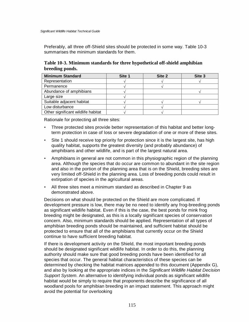
Significant Wildlife Habitat Technical Guide
115
Preferably, all three off-Shield sites should be protected in some way. Table 10-3summarises the minimum standards for them.
Table 10-3. Minimum standards for three hypothetical off-shield amphibianbreeding ponds.Minimum Standard Site 1 Site 2 Site 3Representation √ √ √Permanence √ √Abundance of amphibians √ √Large size √Suitable adjacent habitat √ √ √Low disturbance √ √Other significant wildlife habitat √ √Rationale for protecting all three sites:
• Three protected sites provide better representation of this habitat and better long-term protection in case of loss or severe degradation of one or more of these sites.
• Site 1 should receive top priority for protection since it is the largest site, has highquality habitat, supports the greatest diversity (and probably abundance) ofamphibians and other wildlife, and is part of the largest natural area.
• Amphibians in general are not common in this physiographic region of the planningarea. Although the species that do occur are common to abundant in the site regionand also in the portion of the planning area that is on the Shield, breeding sites arevery limited off-Shield in the planning area. Loss of breeding ponds could result inextirpation of species in the agricultural areas.
• All three sites meet a minimum standard as described in Chapter 9 asdemonstrated above.
Decisions on what should be protected on the Shield are more complicated. Ifdevelopment pressure is low, there may be no need to identify any frog-breeding pondsas significant wildlife habitat. Even if this is the case, the best ponds for mink frogbreeding might be designated, as this is a locally significant species of conservationconcern. Also, minimum standards should be applied. Representation of all types ofamphibian breeding ponds should be maintained, and sufficient habitat should beprotected to ensure that all of the amphibians that currently occur on the Shieldcontinue to have sufficient breeding habitat.
If there is development activity on the Shield, the most important breeding pondsshould be designated significant wildlife habitat. In order to do this, the planningauthority should make sure that good breeding ponds have been identified for allspecies that occur. The general habitat characteristics of these species can bedetermined by checking the habitat matrices appended to this document (Appendix G),and also by looking at the appropriate indices in the Significant Wildlife Habitat DecisionSupport System. An alternative to identifying individual ponds as significant wildlifehabitat would be simply to require that proponents describe the significance of allwoodland pools for amphibian breeding in an impact statement. This approach mightavoid the potential for overlooking

Significant Wildlife Habitat Technical Guide
116
some significant sites, or designating some ponds that are of lesser importance thansome that have not been designated.
Is there a minimum area standard for this species?Yes: No: √The final amount protected habitat should address the concerns listed above. Permittedland uses and amount of protected habitat might best be based on individual siteinspections.
4. How much habitat to protect
Recommended amount of habitat to protect and rationale:The breeding pond should be protected as well as some additional woodland aroundthe pond to minimise disturbance and maintain essential habitat components such asriparian vegetation and shade. The size and composition of the additional area thatshould be considered part of the significant wildlife habitat should be determined in anImpact Assessment.
For the breeding pond to continue to function over time, it must remain connectedthrough a corridor to the surrounding woodland. Protecting an area beyond the ponditself may provide the corridor if it links the pond to suitable forest that can be used bymore terrestrial amphibians.
Additional protection• Landowners on Site 1 should be apprised of the significant wildlife habitat and
urged not to destroy the beaver dams on the creek.
• These landowners should also be asked to try to maintain a high canopy closurewithin 150 m of the pond.
• Landowners may be advised of programs such as the OMNR Community WildlifeInvolvement Program (CWIP) that provides grants for wildlife habitat improvement.There may also be groups that are interested in improving habitat on the property.
Example 3: Habitat of Species of Conservation Concern
1. What is the significant wildlife habitat to be protected?
Habitat for the southern flying squirrel, a vulnerable species.
2. Background
How many occurrences of the species/habitat are known from the planning area?Three current records from scattered locations across the planning area.
Why is this species designated as a species of conservation concern?

Significant Wildlife Habitat Technical Guide
117
Globally, nationally, or provincially rare: √Regionally rare: √Locally rare: √Species declining:
Other reason (e.g., species of economic value):
Is the species a member of a larger group or guild of species with similar habitatrequirements?Yes. Birds and mammals that require cavities in trees.
Is the species/guild dependent on or found in seasonal concentrations or rare orspecialised habitat?specialised habitat: forest with an abundance of cavity trees
seasonal concentration area: during winter months several squirrels may use the samecavity tree
Are there other species of conservation concern that occur at the site?All three sites support rare plants and forest bird species of conservation concern.
How likely is it that the species occurrence represents a disjunct (isolated)population?Unlikely. The planning area has moderate forest cover (approximately 35 percent),much of it affording suitable habitat for this species. This species is hard to detect sinceit is nocturnal.
Are there guidelines to protect this species?No. However, OMNR silvicultural guidelines can be applied to protect the habitat(specifically maintenance of required density of cavity trees). Silvicultural guidelinesmay also be used to protect and enhance food species (oak, hickory, beech, etc. –Appendix R).
Site description:Site 1 (approximately 35 ha) and Site 2 (approximately 10 ha) are dry-mesic deciduousstands of primarily red oak, white oak, and some white pine.
Site 3 (approximately 4 ha) is a mesic deciduous stand consisting of mainly sugarmaple.
Describe existing habitat for the species and the quality.Site 1 would appear to be good habitat for this species. It is a relatively large andmature forest for the planning area. There are numerous large trees with cavitiessuitable for nesting and denning by this species. The dominant tree species, oaks andwhite pine, probably provide abundant mast during most years.

Significant Wildlife Habitat Technical Guide
118
Site 2 appears to have inferior but adequate habitat for this species. The supply ofseeds, nuts, and fungi are probably sufficient for several squirrels, large cavity trees areuncommon (approximately 1 to 3/ha).
Site 3 may represent inferior habitat. It is probably too small to support more than a fewanimals. The shortage of cavity trees appears to be the major limiting factor. Forestsize may also be a limiting factor, as well as competition for cavities by the greysquirrel.
Is there additional habitat associated with this habitat?All sites have a natural buffer of forest.
Describe the adjacent landscape.The landscape adjacent to all sites is agricultural land with numerous roads andhouses.
There are a few small woodlots (approximately 5 ha) within 1 to 2 km of Site 3.
Are there important features located outside the site that help to maintain the site?Unknown.
Is the site disturbed by human activities? If so, what are they?All sites have been disturbed by logging. Landowners are removing dead, dying, andhazardous trees that are often cavity trees.
What are the major concerns about protecting the habitat for this species/guild?• Maintenance of cavity trees and forage (e.g., mast trees)
• Disruption of nesting and rearing activities
• No disturbance to animals in winter from timber operations
• Predators (e.g. domestic cats)
Other concerns:• What management is required to protect its habitat?
• What is the level of public awareness of this species and its conservation status?
• What management is required to ensure a continued food supply?
3. What sites should be protected?
Selected sites for protection and rationale:All 3 sites should be protected in their entirety. Table 10-3 summarises the minimumstandards for the three sites.

Significant Wildlife Habitat Technical Guide
119
Table 10-4. Minimum standards of three hypothetical woodlots for southern flyingsquirrels.Minimum Standard Site 1 Site 2 Site 3Representation √ √ √Good habitat √Large size √Other species of conservation concern √ √ √Rationale for protecting all three sites:
• Protection of these sites would benefit not only this species of concern, but manyother wildlife species that are dependent on forests.
• These sites support other species of conservation concern.
• Three protected sites provide better representation of this habitat; one or more sitescould be lost or severely degraded quite easily (e.g., removal of cavity trees).
• Site 1 should receive the highest protection priority because it likely supports themost squirrels, it may be providing significant seasonal concentration habitat forother squirrels, and the abundant supply of cavity trees is probably important toother wildlife.
• Although Site 3 is not as good, there are opportunities to enhance habitat.
Is there a minimum area standard for this species?Yes: No: å Home range for a single male squirrel may be about 1.5 to 2 ha depending on the
quality of the habitat. However, larger forests (e.g., at least 20 ha) of suitablehabitat support more squirrels and contribute more to long-term population viability.
4. How much habitat to protect
Recommended amount of habitat to protect and rationale:• Site 1: protect the entire 35 ha.
• Site 2: protect the entire 10 ha.
• Site 3: protect the entire 4 ha.
Additional protection:• A public education program stressing the importance of local forests to wildlife and
humans in the planning area would help to involve landowners in forest protectionand restoration programs.
• Remaining forest stands should not be fragmented.

Significant Wildlife Habitat Technical Guide
120
• Further loss of forest cover should be minimised.
• Local naturalist groups might be interested in monitoring the population.
Additional comments:The southern flying squirrel is a very difficult to detect species. Over time, it is likely thatadditional sites for it will be discovered in the planning area. In this event, new and oldsites should be re-evaluated. Because of the small size of Site 3, it may not be capableto sustaining a long-term population. If better sites were found, there may be less needto protect Site 3 for southern flying squirrels, although it still may be protected tomaintain populations of the other species of conservation concern that it supports.Local groups may want to enhance this site through tree planting or other managementtechniques.
10.7 General habitat requirements of species of conservation concern
The broad habitat requirements of many species of wildlife are quite well understood.Some of these are summarised below in Tables 10.5 to 10.7 in an attempt to demonstratethe overlap in wildlife habitats. The important point is that an effective Natural HeritageSystem can be constructed by protecting substantial amounts of those habitats that appearrepeatedly in these tables.
10.7.1 Seasonal concentration areas
Table 10.5 provides an overview of where seasonal concentration areas are most likely tobe found. Forests, shorelines, and wetlands provide much of this very important habitat.More specifically, older forests and in southern Ontario, some coniferous forests, areespecially significant because of the larger trees and the variety of habitat they affordwildlife. The most important shorelines appear to be those adjacent to forests or wetlands,with weedy shallows. Large fields with abundant vegetation and scattered trees and shrubsare important open country habitat. Important wetlands are likely to be large andobviously productive.
Table 10-5. Primary locations of seasonal concentrations of wildlife.Type of Seasonal Concentration Primary Location of Habitat Notes/Key RequirementsBat hibernacula • specific site— cave, mine • often in forested area
• undisturbed habitat is essentialWhite-tailed deer winter yard • forests with at least 60 %
canopy closure• conifer cover (white cedar,
hemlock) particularly importantin southern Ontario
• corridor required; undisturbedhabitat is important
Moose late winter habitat • coniferous forests • corridor required

Significant Wildlife Habitat Technical Guide
121
Type of Seasonal Concentration Primary Location of Habitat Notes/Key RequirementsReptile hibernacula • site specific • often in large forested areas,
depending on species• rocky outcrops, talus slopes• corridor required
Amphibian summer habitat • wetlands, shorelines, otherriparian areas
• corridor required
Bullfrog concentration areas • permanent wetlands, shorelines,other riparian areas
• permanent water
Raptor wintering areas • undisturbed fields for huntingsmall mammals (mice, voles)
• adjacent forests for roosting ofsome species; undisturbedhabitat is important
Wild turkey winter range • coniferous forests• spring and seeps
• pockets of conifers may suffice• nearby food source
Turkey vulture summer roost • specific site • undisturbed habitat is importantWaterfowl breeding/staging/areas • wetlands
• shorelines of water bodies withemergent vegetation
• larger wetlands preferred forstaging and moulting
• grassy/shrubby areas for nestingColonial bird nesting sites (gulls,terns, double-crested cormorants)
• islands, shoals, peninsulas, andsome shorelines
• undisturbed habitat duringnesting season is essential
• treed swampsHeronries • wetlands (swamps)
• lake and river shorelines• forests
• undisturbed habitat duringnesting season is essential
Colonial bird nesting sites(heronries, marsh birds)
• wetlands • undisturbed habitat duringnesting season is essential
Landbird migratory stopover area • open water shorelines withadjacent mature forests, old-fields and grasslands
• forest cover along watercourses,forested ravines
• Great Lakes shorelines andadjacent lands within 5 km(especially Lake Erie & LakeOntario) are very important
Shorebird migratory stopover areas • shorelines of water bodies(rivers, large lakes), marshes
• key is undisturbed shorelines• Great Lakes shorelines
(especially Lake Erie & LakeOntario) are very important
Butterfly migratory stopover areas • shorelines of large lakes• forest, old field, and
undisturbed open lands
• Great Lakes shorelines andadjacent lands within 5 km(especially Lake Ontario &Lake Erie) are very important
• Fields with milkweed veryimportant habitat for monarchbutterflies

Significant Wildlife Habitat Technical Guide
122
10.7.2 Rare or specialised habitats
Table 10-6 provides an overview of where rare or specialised habitats are most likely to befound. Closer examination of this table reveals considerable repetition in habitats fordifferent wildlife. In particular, it shows how important forests, wetlands, and shorelinesare to many species; more specifically, large, mature, relatively unfragmented forests andshorelines adjacent to forested areas. In addition, many species require undisturbed areasand corridors permitting safe movement throughout their home ranges.
This table helps to emphasise the importance of protecting adequate representation ofthese habitats within a Natural Heritage System. Also, cooperation among adjacentplanning authorities can contribute greatly to the long-term protection of wide-ranging,area-sensitive species.
Table 10-6. Primary locations of rare or specialised habitats.Type of Habitat Primary Location of Habitat Notes/Key Requirements
Marten and fisher denning sites • large forests, especiallymature and unfragmented
• area-sensitive species• corridor required• large undisturbed areas are
importantMoose aquatic feeding area • weedy shorelines and bays
with adjacent forest cover• wetlands
• requires forested corridor• undisturbed areas are
importantMoose calving sites • forested islands
• shorelines, especiallypeninsulas
• requires forested corridor• undisturbed areas are
essentialMoose mineral lick • forest openings with adjacent
forest• specific site that is very hard
to find• forested corridor required• undisturbed areas are
importantBlack bear/mammal foragingarea
• specific sites with abundanceof berries, grasses, mast-producing trees
• relatively mature,undisturbed forests
• forested corridor required
Osprey nesting habitat • forested shorelines (oftenalong large lakes)
• wetlands• islands
• undisturbed areas areimportant
• shallow-water feeding areas
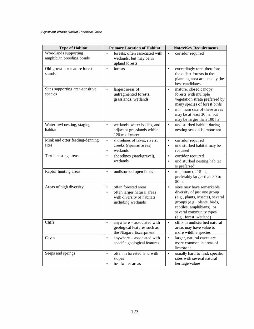
Significant Wildlife Habitat Technical Guide
123
Type of Habitat Primary Location of Habitat Notes/Key RequirementsWoodlands supportingamphibian breeding ponds
• forests; often associated withwetlands, but may be inupland forests
• corridor required
Old-growth or mature foreststands
• forests • exceedingly rare, thereforethe oldest forests in theplanning area are usually thebest candidates
Sites supporting area-sensitivespecies
• largest areas ofunfragmented forests,grasslands, wetlands
• mature, closed canopyforests with multiplevegetation strata preferred bymany species of forest birds
• minimum size of these areasmay be at least 30 ha, butmay be larger than 100 ha
Waterfowl nesting, staginghabitat
• wetlands, water bodies, andadjacent grasslands within120 m of water
• undisturbed habitat duringnesting season is important
Mink and otter feeding/denningsites
• shorelines of lakes, rivers,creeks (riparian areas)
• wetlands
• corridor required• undisturbed habitat may be
requiredTurtle nesting areas • shorelines (sand/gravel),
wetlands• corridor required• undisturbed nesting habitat
is preferredRaptor hunting areas • undisturbed open fields • minimum of 15 ha,
preferably larger than 30 to50 ha
Areas of high diversity • often forested areas• often larger natural areas
with diversity of habitatsincluding wetlands
• sites may have remarkablediversity of just one group(e.g., plants, insects), severalgroups (e.g., plants, birds,reptiles, amphibians), orseveral community types(e.g., forest, wetland)
Cliffs • anywhere – associated withgeological features such asthe Niagara Escarpment
• cliffs in undisturbed naturalareas may have value tomore wildlife species
Caves • anywhere – associated withspecific geological features
• larger, natural caves aremore common in areas oflimestone
Seeps and springs • often in forested land withslopes
• headwater areas
• usually hard to find, specificsites with several naturalheritage values

Significant Wildlife Habitat Technical Guide
124
10.7.3 Habitat of species of conservation concern
Biologists, for various reasons, consider some wildlife to be species of conservationconcern. Sometimes this is because Ontario supports a large proportion of their totalglobal population. Often they are rare and/or their numbers in Ontario are declining.Current low numbers of a few species may be due to exploitation (bullfrogs and somewaterfowl) or persecution (snakes). Some species may not compete well with otherspecies that share their range (e.g., southern flying squirrel, red-shouldered hawk) whileothers may never have been very common in the province (Fowler’s toad).
Table 10-7 provides an overview of the broader habitat requirements of some of thesespecies and is organised around the major ecosystems: forests, wetlands, grasslands, andshorelines. Many species are found in several habitats. Refer to Appendix G (wildlifehabitat matrices) for a more extensive list with their specific habitat requirements andgeographic location. Often they have specialised habitat requirements, and many aresensitive to human disturbance.
Most species will be protected if sufficient amounts of these four ecosystems are placedwithin a natural heritage system of protected areas (see Chapter 2). Cooperation amongadjacent planning authorities and landowners can do much to protect wide-rangingspecies. For example, they might agree to jointly protect significant conservation areasthat cross township or county boundaries, and make their joint cooperation known to theresidents through signs and interpretative trails stressing the importance of larger,unfragmented natural areas to a variety of wildlife.
Table 10-7. General habitat requirements of selected species of conservationconcern.Species/Guild of
ConservationConcern
Forest Wetland Grassland Shoreline
Five-lined skink • Abundantdown woodydebris, othergroundstructure (e.g.,rocks)
• ground debris
EasternMassasaugarattlesnake
• larger forestswith abundantdown woodydebris, rockyopenings
• hibernates inkarst habitatwetlands
• hunts in wetmeadows
• may feed inriparianhabitat

Significant Wildlife Habitat Technical Guide
125
Species/Guild ofConservation
ConcernForest Wetland Grassland Shoreline
Eastern hognosesnake
• larger forestswith abundantdown woodydebris
• sandy soil,with toad andotheramphibianprey, adjacentto largerforests
Black rat snake • larger forestswith abundantdown woodydebris
Wood turtle • river floodplains,flowing water
Eastern spinysoftshell turtle
• abundantaquaticvegetation andmoderatelydeep water
• abundantaquaticvegetation
Spotted turtle • aquaticvegetation
Amphibians • woodlandbreedingponds
Fowler’s toad • sandy areasBullfrogs • aquatic
vegetation• permanent
waterArea –sensitivebirds (See habitatmatrices–Appendix G)
• largeunfragmentedforests withdiversity ofverticalstructure
• large swamps,marshes, bogs,or fens
• large,unfragmentedareas ofgrassland
Southern flyingsquirrel
• maturedeciduouswoods
West Virginiawhite butterfly
• moist maturedeciduousforest withriparianfeatures
• toothwort

Significant Wildlife Habitat Technical Guide
126
Species/Guild ofConservation
ConcernForest Wetland Grassland Shoreline
Karner bluebutterfly
• grasslandswith lupines
• lupine• beach dunes
Frosted elfinbutterfly
• prefers pine-oak savannah
• beach dunes
Numerous otherbutterflies (e.g.,monarch)
• grasslands forfood and hostplants
Again the importance of forest ecosystems is clear, especially larger, more mature forestswith some water and abundant down woody debris. Shorelines are very important habitatsfor many species of conservation concern, especially those with sandy soils and adjacentwater with abundant emergent and submergent vegetation. Many species of conservationconcern are dependent on healthy, relatively undisturbed wetlands.

Significant Wildlife Habitat Technical Guide
127
11 Assessment of the Natural Heritage System
The first ten chapters of this technical document focus on identifying and prioritisingsignificant wildlife habitat. There are, however, six other types of natural heritage featuresidentified in the Natural Heritage Component of the Provincial Policy Statement. To beecologically functional, the best examples of all of the natural heritage features should beidentified and protected. The mosaic of natural heritage features on the landscape and theconnections among them is known as a Natural Heritage System (OMNR 1999).
The other natural heritage features (in addition to significant wildlife habitat) aresignificant wetlands, the significant portions of the habitat of endangered and threatenedspecies, significant woodlands, significant valleylands, significant ANSI’s, and fish habitat.Methods for identifying and protecting these features are presented in the NaturalHeritage Reference Manual (OMNR 1999) and supporting technical documents, whereavailable.
Once all natural heritage features have been identified, they should be mapped. This mapthen should be closely examined to see if a functional natural heritage system has been putin place. Key questions to ask:
Are there examples of all seven types of natural heritage features on the map? Note thatthere may be no examples of some of these in certain planning authority's jurisdictions. Forinstance, there may be no endangered or threatened species, significant wetlands, orANSI’s in some municipalities. Significant woodlands and valleylands are not designatedon the Canadian Shield. Conceivably, planning authorities that straddle the Shield couldhave significant woodlands or valleylands in part of their jurisdiction, but not on theShield. If not all types of natural heritage features are represented in the municipality, theplanning authority should confirm that they do not exist and have not been overlooked.
Is all fish habitat adequately protected by the natural heritage system? Unlike the othersix types of natural heritage features, where the best examples are protected, all fishhabitat is considered equal under the federal Fisheries Act. If development is allowed toproceed that have negative impacts on fish habitat, the proponent and possibly even theplanning authority may be in contravention of the Fisheries Act.
Are there good connections among natural areas? If there are isolated areas, thoughtshould be given to connecting them to the remainder of the natural heritage system. Thismay not need to be a corridor per se, but it could be a series of smaller natural areas thatcould act as stepping stones for species travelling across the landscape. Some of theevaluated natural heritage features (i.e. non significant wetlands or wildlife habitat) thatdid not stand out as best examples might be included in the natural heritage system if theyfulfil a linkage function.

Significant Wildlife Habitat Technical Guide
128
11.1 Gap analysis
A gap analysis is the process of determining what is unrepresented or under representedfrom a planning area. The OMNR techniques for undertaking a gap analysis are presentedin Appendix E. It should be referred to for more detail, but a brief overview is providedbelow.
After the natural heritage system has been mapped and examined in the above broadfashion, it should be looked at in more detail. The first step, if it were not undertakenduring initial phases, should be to break the planning area into physiographic units. Thiscould be done at a variety of scales:
• Site region. Some planning areas will be in more than one site region.
• Site district. Many planning areas will be in more than one site district.
• Physiographic area. Most planning areas will have more than one physiographic unitwithin their boundaries, as defined by Chapman and Putnam (1984).
• Soil types. All planning areas will contain more than one soil type.
All of these units (where applicable) should be indicated on the natural heritage systemmap. Then each of the types of natural heritage features should be re-examined to see ifthey are adequately represented in each physiographic unit.
This analysis may reveal large disparities within the natural heritage system. For instance,all of the significant woodlands may be in one physiographic unit, and unrepresented inothers. If most of the municipality were on a forested moraine, it may have been decidedthat significant woodlands should be 30 ha in size. By applying this criterion to the entiremunicipality, none of the woodlands on till plains may have met the size criterion. Oncethe planning area is subdivided into physiographic units, it may be obvious that there is aneed for more than one set of criteria. In this example, woodlands as small as 4 ha or even2 ha might be significant on the till plain although the 30 ha criteria may remain in place onthe forested moraine.
Wetlands are another good example. Using the same scenario, the moraine may haveseveral significant wetlands as well as many other wetlands that did not achieve provincialsignificance. On the till plain, there may be no significant wetlands according to thewetland evaluation system and the PPS. Wetlands in general may be small and rare on thisphysiographic unit, so the planning authority may wish to protect the best examples ofthese wetlands.
Significant Wildlife Habitat Technical Guide
129
At the broad scale, the natural heritage system should be evaluated for distribution ofnatural areas and features within the physiographic units that the planning authority hasdecided to use. Once this has been completed and criteria adjusted as necessary to ensureas complete a representation as possible within each unit, it is time to look at it at a finerscale. Failure to look holistically at natural heritage features at least within majorphysiographic units may result in certain significant features being overlooked,subsequently lost, and possibly unnecessary challenges of the natural heritage system atthe Ontario Municipal Board.
11.1.1 Gap analysis of vegetation communities
As part of the process of identifying significant woodlands, wetlands, and wildlife habitat,it is likely that planning authorities will have a good idea of what vegetation communitiesoccur within their jurisdiction. Examination of FRI maps, air photos, watershed studies,and other information will help confirm vegetation community types. The distribution ofvegetation communities should be examined within the entire municipality and within thedifferent physiographic units.
This is frequently a very enlightening process. It may become apparent that there arecertain rare habitats throughout the planning area. In this case, they could be consideredsignificant wildlife habitat for the entire municipality. What is often surprising is that someof the most common vegetation communities in the planning area may be rare orunrepresented in some physiographic units. For example, upland white cedar coniferousforest may be common to abundant on the portion of the planning area that is on theShield, but rare in the agricultural portion of the area. Disparities in the distribution ofvegetation communities may be even more profound if the planning authority is examinedat the soil-type level.
Certain planning areas may contain small portions of a different forest region. Forexample, some may have Carolinian and Great-Lakes St. Lawrence forest regions, orGreat-Lakes St. Lawrence and Boreal forest regions. It is essential that goodrepresentation of each type be maintained.
As in the case of looking at the broad scale of distribution of the major types of naturalheritage features, it may be necessary to have different criteria for vegetation communitiesby physiographic unit to ensure good representation within the planning area.
There may have been vegetation communities within the planning area that no longerexist. Prairies and savannahs are classic examples, with less than one percent of theoriginal coverage of these habitats remaining. Many wetlands have also been lost (about70 percent in the south), so that certain types of wetlands may have been lost entirely fromthe planning area, or wetlands may have disappeared from certain physiographic units.

Significant Wildlife Habitat Technical Guide
130
One source of information for determining historical vegetation community distribution isthe notes of the original land surveyors. They were commissioned to survey the landbefore extensive land clearing. This information has been mapped and is available from theMinistry of Citizenship, Culture, and Recreation, and from the Natural HeritageInformation Centre. The quality of this information varies, depending on the interest andidentification skills of the surveyor. However, these maps may be invaluable in identifyingareas where there were prairies, savannahs, specific forest types and wetlands.
Another technique for identifying where wetlands previously occurred, is to examine oldertopographical and soil maps. Areas on old topographical maps where there are wetlandsymbols or organic soils indicated on soil maps were likely previous wetlands. A series ofwetland approximation maps has been prepared using this information. The maps areavailable from Environment Canada.
The current distribution of vegetation communities within the planning authority'sjurisdiction compared to historical times may give a very good indication of whichcommunities are currently poorly represented and, if rehabilitation is planned, where it canbe focused.
11.1.2 Gap analysis of species
At the finest level of gap analysis, planning authorities should look at the distribution ofspecies within their jurisdiction. This, of course, requires a more intimate knowledge ofthe ecology of the area than looking at vegetation communities.
Initially, this might be done at a guild level, by lumping species with similar broad habitatcharacteristics together. For instance, by examining the various atlases, it may becomeapparent that area-sensitive bird species and amphibians are well distributed in the portionof the planning area that is on the Niagara Escarpment, but rare to absent on the clay plainbelow it. Again, different criteria for the maintenance of habitat for these species should bederived for different physiographic units. This analysis will also demonstrate which speciesare lacking habitat in certain portions of the planning area.
A gap analysis for individual species may also be undertaken. This may be done at thephysiographic unit level within the planning area, or species that are lacking from theplanning area entirely may be identified. This may be done by consulting the variousatlases, knowledgeable individuals, and a CAC, if the planning authority has one.
Some species appear to be shifting their ranges southward, such as ravens, black bears,and fishers. Planning authorities that are currently near the range of these species (wherethey still do not occur) should consider if there is a need to provide habitat for them. Incertain cases, it may be necessary to consider whether these species are desirable in theplanning area before attempting to rehabilitate habitat for them. For instance, in a planningarea that

Significant Wildlife Habitat Technical Guide
131
is experiencing significant human population growth, it may not be desirable to encourageblack bears.
By examining the atlases, particularly, the breeding bird atlas, it may become apparent thatcertain species occur adjacent, or even all around, the planning area, but are absent withinit. In these instances, these species may be targets for restoration work to provide habitatfor them.
11.2 Restoration and rehabilitation opportunities
Gap analysis will have identified what natural heritage features, vegetation communities,species and functions are absent from all or a portion of the planning area, and also whatfeatures are degraded and would benefit from rehabilitation.
Many organisations and local clubs are actively involved in habitat and species restoration.A small number of examples are listed in Appendix F. The gap analysis described abovemay provide a starting point for restoration efforts within a planning area.
Several excellent documents deal with habitat restoration and rehabilitation. Planningauthorities as well as private organisations that wish to improve their natural environmentare urged to consult them.
Riley and Mohr (1994) summarise the ecological principals behind establishing a naturalheritage system, and identify municipalities that were deficient in forest cover.
Noss (1995) provides valuable information on using physiographic units as the basis forecological frameworks.
A manual prepared by Environment Canada, OMNR, and the Ministry of the Environment(1998) identifies targets for habitat restoration for aquatic and terrestrial habitats, andindicates which species might be expected at lower thresholds of restoration.
The Waterfront Regeneration Trust (1995) have a book on restoring natural habitats. Thisis a practical manual that gives advice on how to decide what to restore, and then how todo it.
The Temperate Wetland Restoration Guidelines (OMNR, Canadian Wildlife Service, andDucks Unlimited Canada, 1998) describe the ecology of wetlands and provide step-by-step details on how to create or restore a wetland. This manual goes through the entireprocess from initial planning to as-built drawings and monitoring requirements.
It is recommended that before habitat restoration and rehabilitation efforts be consideredthe proponent should consult the aforementioned publications. Some of them define the

Significant Wildlife Habitat Technical Guide
132
philosophy and rationale for conducting restoration; some provide targets, while othersare how-to manuals.
Several sources of funding may be available to those wishing to undertake habitatrestoration. Many of these funds are channelled through government agencies andnationally or provincially based private organisations. Funding sources and partnershipschange depending on agency priorities. It is recommended that the agencies listed inAppendix F be contacted to inquire about available programs and partnershipopportunities. Some specific programs and suggestions are provided below:
• The Community Fisheries/Wildlife Involvement Program (CFWIP) is sponsored byOMNR. Projects that involve habitat improvements for fisheries and/or wildlife may befunded. Generally, OMNR will fund materials necessary for habitat rehabilitation workif labour required to conduct the work is volunteered by a group or landowner.
• The Eastern Joint Habitat Venture (EJHV) encourages conservation and restoration ofwildlife habitat, particularly if it benefits waterfowl and contributes to achieving thegoals of the North American Waterfowl Management Plan. Grants are given tolandowners and stakeholders that improve habitats, especially wetlands.
• Ducks Unlimited Canada will provide assessments of habitat restoration and creationon private and public land if it has the potential to improve habitat for waterfowl. Ifthere will be positive benefits, Ducks Unlimited will do the necessary habitatmanagement provided that the landowner enters into a long-term agreement to protectthe habitat. Management undertaken by Ducks Unlimited and also those projectsfunded by the Eastern Joint Habitat Venture may assist planning authorities inachieving their targets for certain habitat types and species. Wetlands created forwaterfowl also benefit all other groups of wildlife and contribute to biodiversity.
• The planning authority should check to see if it is in a Great Lakes Area of Concern(AOC). The International Joint Commission has identified these areas as havingsignificantly degraded water quality. Sixteen of these sites occur in Ontario, and theobjective is to improve habitat in all of them so that they can be de-listed.Rehabilitation plans are in place for all sixteen sites. If restoration plans of themunicipality are likely to contribute to the rehabilitation programs identified for theAOC, the Great Lakes Cleanup Fund may assist with funding.
• Local conservation authorities may have programs for private landowners that helpdefray costs of habitat restoration, such as for tree planting. Co-ordination with theconservation authority may help to target landowners where a high priority for habitatmanagement has been identified.

Significant Wildlife Habitat Technical Guide
133
• If there are highly significant habitats within the municipality, such as Carolinianforests, prairies, or savannahs, groups such as Carolinian Canada, the NatureConservancy, the World Wildlife Fund, Wildlife Habitat Canada and WetlandsInternational may be interested in assisting with habitat restoration.
• Consider setting up a foundation that raises funds from the public. This has been aproven success at many natural areas (e.g. Second Marsh). This needs a dedicatedcore of individuals who can effectively communicate goals, needs, and results to thepublic.

Significant Wildlife Habitat Technical Guide
134
12 References
12.1 Literature Cited
Bakowsky, W.D. 1996. Natural heritage resources of Ontario: S-ranks for communities insite regions 6 and 7. Ontario Ministry of Natural Resources, Natural HeritageInformation Centre, Peterborough. Draft.
Beechey, T.J. 1980. A framework for the conservation of Ontario's biological heritage.Ontario Ministry of Natural Resources. Parks and Recreational Areas Branch,Toronto, ON.
Brownell, V.R. and B.M.H. Larson. 1995. An evaluation framework for natural areas inthe regional municipality of Ottawa-Carelton: Volume 1. Regional Municipality ofOttawa-Carleton, Ottawa. 120 p.
Catling, P.M. and V.R. Brownell. 1995. A review of the alvars of the Great Lakes region.Distribution, floristic composition, biogeography and protection. Can. Field-Naturalist. 109:143-171.
Chapman, L.J., and D.F. Putnam. 1984. The Physiography of Southern Ontario; OntarioGeological Survey, Special Volume 2, 270p
Crins, W.J. and P.S. Kor. 1999. Natural heritage gap analysis methodologies used by theOntario Ministry of Natural Resources. Ontario Ministry of Natural Resources,Natural Heritage Section. Draft
Domon, G. and Y. Bergeron. 1987. Development of synthetic criteria for the ecologicalevaluation of woodlots and woodlot units. Environmental Management 11:667-673.
Environment Canada, Ontario Ministry of Natural Resources and the Ontario Ministry ofthe Environment. 1998. A framework for guiding habitat rehabilitation in GreatLakes Area of Concern. Canada-Ontario Remedial Action Plan SteeringCommittee.
Farrar, J.L. 1995. Trees in Canada. Canadian Forest Service, Fitzhenry & WhitesideLimited, Markham, ON.
Geomatics International Inc. 1991. Environmentally Sensitive Area Study. Addendumreport,. Regional Municipality of Halton Planning and Development Department. 2volumes.

Significant Wildlife Habitat Technical Guide
135
Hills, G.A. 1959. A ready reference to the description of the land of Ontario and itsproductivity. Ontario Department of Lands and Forests, Research DivisionPreliminary Report, 141 p.
Lee, H., W. Bakowsky, J. Riley, J. Bowles, M. Puddister, P. Uhlig and S. McMurray.1998. Ecological Land Classification for Southern Ontario First approximation andits application. Ontario Ministry of Natural Resource, Southcentral SciencesSection, Science Development and Transfer Branch. SCSS Field Guide FG-02.
NCASI. 1996. The National Gap Analysis Program: Ecological assumptions andsensitivity to uncertainty. National Council of the Paper Industry for Air andStream Improvement, Inc. Technical Bulletin No. 270. North Carolina, U.S.A.
Noss, R.F. 1995. Maintaining ecological integrity in representative reserve networks. AWorld Wildlife Fund Canada/World Wildlife Fund-United States Discussion Paper.77p.
Noss, R.F. and A.Y. Cooperrider. 1994. Saving nature's legacy: protecting and restoringbiodiversity. Island Press, Washington, DC. 416 p.
OMNR 1999. Natural Heritage Reference Manual for Policy 2.3 of the Provincial PolicyStatement. Ontario Ministry of Natural Resources. 127 p
OMNR, CWS and Ducks Unlimited. 1998. The Temperate Wetland RestorationGuidelines.
Ontario Wildlife Working Group. 1991. Looking ahead: a wild life strategy for Ontario.Ontario Ministry of Natural Resources, Queens Printers, Toronto. 172 p.
Riley, J.L. and P. Mohr. 1994. The natural heritage of southern Ontario's settledlandscapes. A review of conservation and restoration ecology for land-use andlandscape planning. Ontario Ministry of Natural Resources, Southern Region,Aurora, Science and Technology Transfer, Technical Report TR-001. 78pp.
Smith, P.G.R and J.A.Theberge 1986. A review of criteria for evaluating natural areas.Environmental Management 10: 715-734
Villard, M.-A., K. Freemark and G. Merriam. 1992. Metapopulation theory andneotropical migrant birds in temperate forests: an equilibrium investigation. Pp.474–482, in, J.M. Hagan and D.W. Johnson (eds.) Ecology and Conservation ofNeotropical Landbirds Smithsonian Institution Press. 609 pp.

Significant Wildlife Habitat Technical Guide
136
Waterfront Regeneration Trust. 1995 Restoring natural habitats. A manual for habitatrestoration in the Greater Toronto Bioregion. Waterfront Regeneration Trust,Toronto.179 pp.

Significant Wildlife Habitat Technical Guide
137
12.2 Glossary
Alvar - naturally open areas of thin soils over essentially flat limestone, dolostone ormarble rock, supporting sparse vegetation cover of shrine and herbs.
Aquatic feeding area – sites, generally marsh habitat, that contain aquatic vegetation richin sodium (pondweeds, water milfoil, and yellow water lily) with sufficient shoreline coverthat is frequented by moose to replenish sodium supplies.
Biodiversity – the variability among organisms from all sources including terrestrial,marine and other aquatic ecosystems and the ecological complexes of which they are part:this includes diversity within species and ecosystems.
Bog – nutrient-poor, acidic wetlands comprised primarily of peat-covered areas with ahigh water table.
Calving site – an isolated area providing cover and escape paths from predators thatmoose utilize on an annual basis to give birth. Generally, these are elevated areas onpeninsulas or islands.
Colonial nesting – species that nest in colonies, large groups.
Corridor – the naturally vegetated or potential re-vegetated areas that link or bordernatural areas and provide ecological functions such as habitat, passage, hydrological flow,connection or buffering from adjacent impacts. They can occur across or along uplands,lowlands or slopes. Ravine, valley, river and stream corridors are further defined aslandform depressions, usually with water flowing through or standing in them for someperiod of the year.
Cumulative impacts – the sum of all individual impacts occurring over space and time,including those of the foreseeable future.
Ecological site district – a subdivision of a site region based on characteristic pattern ofphysiographic features which set apart fairly large areas from one another.
Ecological site region – an area of land within which the resource of vegetation to thefeatures of the landform follows a consistent pattern. Each specific type of land (defined interms of relief, texture and petrography of geologic materials, depth of bedrock anddrainage conditions) within a specific region has it characteristic plant succession. Since anecological site region is the integration of all the landscape features within a prescribedarea, it can best be defined as a region of potential biological productivity.

Significant Wildlife Habitat Technical Guide
138
Ecosystem – any area with a boundary through which the input or output of energy andmaterials can be measured and related to some unifying factor, and includes the living andnon-living environment together with the non-living components of their environment,related ecological process and humans.
Ecosystem Land Classification (ELC) – the Canadian classification of lands from anecological perspective: an approach to identify ecologically similar areas.
Endangered - any native species that, on the basis of the best available scientific evidence,is at risk of extinction or extirpation throughout all or a significant portion of its Ontariorange if the limiting factors are not reversed.
Endemic – a species or taxon naturally occurring only in a particular geographicalarea/range.
Exotic species – a non-indigenous species introduced into an area.
Extinct - any species formally native to Ontario that no longer exists.
Extirpated - any native species no longer existing in the wild in Ontario, but existingelsewhere in the wild.
Fen – peatlands characterized by surface layers of poorly to moderately decomposed peat,often with well-decomposed pear near the base. Sedge species form the dominantvegetation of fens; mosses may be present or absent.
Forbs –a broad leave herbaceous (non-woody) plant
FRI (Forest Resource Inventory) – a resource inventory of Ontario forests based on aninterpretation of aerial photography. Photo-interpreters use field data of sample plots(such as tree species, basal area, age and height) and aerial photography to delineate foreststand boundaries and describe forest stands. Descriptions are then transferred to OntarioBase Maps, FRI is designed to provide a snap-shot picture of existing forest conditionsand a data base for decision-making and planning for a variety of resource managers.
Guilds – species which are grouped together because of common strategies and/or use ofareas for life cycle stages.
Hibernacula – a protected area with stable non-freezing temperatures, such as a cave,where bats survive the winter, or a burrow where snakes do the same.

Significant Wildlife Habitat Technical Guide
139
Indigenous – species which have originate naturally in a particular region or environment
Mineral lick – an area of upwelling groundwater rich in sodium, generally surrounded byforest cover that is visited by moose in spring to replenish sodium supplies.
Moraine – a knobby ridge either of (a) boulder clay built by a thrust of a glacier or of (b)gravel and sand deposited at the edge of glacier by escaping meltwater.
Natural heritage features and areas – means features and areas, such as significantwetlands, fish habitat, significant woodlands south and east of the Canadian Shield,significant valleylands south and east of the Canadian Shield, significant portions of habitatof endangered and threatened species, significant wildlife habitat, and significant areas ofnatural and scientific interest, which are important for their environmental and socialvalues as a legacy of the natural landscapes of an area.
Patch – in a landscape, a non-linear surface differing in appearance from its surroundings.
Significant wildlife habitat – ecologically important in terms of features, functions,representation or amount, and contributing to the quality and diversity of an identifiablegeographic area or natural heritage system.
Talus – a sloping mass of rock fragments at the base of a cliff.
Threatened -any native species that, on the basis of the best available scientific evidence, isat risk of becoming endangered throughout all or a significant portion of its Ontario rangeif limiting factors are not reversed.
Vulnerable - any native species that, on the basis of the best available scientific evidence, isa species of special concern in Ontario, but is not a threatened or endangered species.

Significant Wildlife Habitat Technical Guide - Appendix A
140
APPENDIX A
A Description of Ramsar Sites, Biosphere Reserves, Carolinian Canada Sites andWestern Hemisphere Shorebird Reserve Network and Their Application in Land
Use Planning
Appendix A provides a description of natural heritage features and areas that have beenrecognised as significant at the international or national level. Due to their recognition bythe scientific community, planning authorities are also encouraged to recognise thesesites.
RAMSAR SITES
A RAMSAR site is a wetland designated under the Convention on Wetlands asinternationally significant based on a variety of criteria including ecological, biologicaland hydrological functions and values.
The Convention on Wetlands of International Importance, often referred to as the RamsarConvention from its place of adoption in 1971 in Iran, is an international treaty, whichprovides the framework for international cooperation for the conservation of wetlandhabitats.
Canada became a Contracting Party to the Ramsar Convention in 1981. ContractingParties to the Convention recognise that wetlands are essential not only for theirhydrological and ecological processes, but also for the rich fauna and flora they support.The broad objectives of the Convention are to stem the loss of wetlands and to ensuretheir conservation and sustainable use for future generations. There are presently 114Contracting Parties to the Convention, with 975 wetland sites, totalling 70.7 millionhectares designated for inclusion in the Ramsar list of Wetlands of InternationalImportance.
There are three criteria for identifying Wetlands of International Importance. They are:
1. Quantitative criteria for identifying wetlands of importance to waterfowl.
A wetland should be considered internationally important if it:a) regularly supports either 10,000 ducks, geese and swans; or 10,000 coots; or
20,000 waders (shorebirds), orb) regularly supports one percent of the individuals in a population of one
species or subspecies of waterfowl, orc) regularly supports one percent of the breeding pairs in a population of one
species or subspecies of waterfowl.
2. General criteria for identifying wetlands of importance to plants or animals.

Significant Wildlife Habitat Technical Guide - Appendix A
141
A wetland should be considered internationally important if it:a) supports an appreciable number of a rare, vulnerable or endangered species or
subspecies of plant or animal, orb) is of special value for maintaining the genetic and ecological diversity of a
region because of the quality and peculiarities of its flora and fauna, orc) is of special value as the habitat of plants or animals at a critical stage of their
biological cycles, ord) is of special value for its endemic plant or animal species or communities.
3. Criteria for assessing the value of representative or unique wetlands.
A wetland should be considered internationally important if it is a particularly goodexample of a specific type of wetland characteristic of its region.
As of January 1999, Canada has designated 36 wetlands as Ramsar sites. Eight of thesesites are in Ontario (Figure A-1). The wetland sites in southern Ontario have also beenevaluated using the OMNR’s Wetland Evaluation System and are also designated asprovincially significant wetlands. All of these wetlands are of global importance andshould be recognised by planning authorities.

Significant Wildlife Habitat Technical Guide - Appendix A
142
Figure A-1. Location of RAMSAR sites in Ontario.
For additional information please refer to:
Canadian Ramsar Site – http://wetlands.ca/wetcentre/wetcanada/wetcanada.html
Canada and the Ramsar Convention –http://wetlands.ca/wetcentre/wetcanada/RAMSAR/booklet/booklet.html
The Ramsar List of Wetlands – http://www.ramsar.org/key_sitelist.htm
BIOSPHERE RESERVES
A biosphere reserve is an international designation of recognition from the UnitedNations Educational, Scientific and Cultural Organisation (UNESCO) under the Man andthe Biosphere Program (MAB). The designation signifies that the area is a good exampleof some of the ways in which conservation objectives can be balanced with development.

Significant Wildlife Habitat Technical Guide - Appendix A
143
The term biosphere refers to the association of the designated area with theUNESCO/MAB program and the reserve means that there are some already protectedsites within the biosphere reserve.
The long-range goal of the MAB is to create a worldwide network of biosphere reservesto include examples of all of the globes main ecological systems with their differentpatterns of human use and adaptations to them. To receive a designation, each biospherereserve must have a protected core of undisturbed landscape, which can provide baselinedata for comparison with nearby areas being managed to meet human needs. Fullyfunctional biosphere reserves perform three main roles:
a) conservation of ecosystems and biota of particular interestb) establishment of demonstration areas for ecologically sustainable land and
resource usec) provision of logistic support for research, monitoring, education and training
related to conservation and sustainable issues
Some biosphere reserves provide sites for the monitoring of long-range transport ofatmospheric pollutants, or for “integrated environmental monitoring” to correlateecosystemic changes with pollutant loading.
As of 1999 the province Ontario has two biosphere reserves. One is the NiagaraEscarpment (207,240 ha) and the other is Long Point (27,000ha). These are very largesites and are comprised of a mix of publicly and privately owned land. One objective ofthe biosphere reserve program is to demonstrate through monitoring and scientificstudies, a balance between conservation and development. In that regard, it is not theintent of the biosphere reserve program to exclude all development within the total areadesignated as a biological reserve, but rather to demonstrate how development can occurand still maintain the ecological functions and integrity of the natural landscape. Eachbiological reserve includes an existing protected core area.
Planning authorities that have a biosphere reserve within their jurisdiction need not beconcerned about protecting all lands within the designated area. These sites have beenspecifically selected because they have existing protected areas that can be compared toareas that are appropriately developed. In some situations protected buffers around acore-protected area may be considered to ensure the ecological functions of the core areaare maintained. This may be accomplished by identifying and protecting any one theseven components of the Natural Heritage Areas and Features Policy of the Planning Act.
For additional information, please contact:
1. Long Point Biosphere Reserve –http://www.cciw.ca/cbra/english/biosphere/br_longpoint/2. Niagara Escarpment Biosphere Reserve –
http://www.cciw.ca/cbra/english/biosphere/br_niagara/intro.html3. World Biosphere Reserve – http://escarpment.org/biosphere/world.html

Significant Wildlife Habitat Technical Guide - Appendix A
144
CAROLINIAN CANADA SITES
Carolinian Canada is a popular name for the extreme southwest region of Ontario wherethe Eastern Deciduous Forest of North America has its northernmost limits. TheCarolinian Life Zone is one of Canada’s most significant landscapes, where a warmclimate accounts for the presence of many rare species of plants and animals.
Carolinian Canada is found south of an imaginary line which runs approximately fromGrand Bend to Toronto. The climate of this region is the main reason it forms such aunique ecosystem. Often referred to as the ‘banana belt’ of Canada, this zone boasts thewarmest annual temperatures, the longest frost-free seasons and the mildest winters inOntario. For example, Point Pelee near Windsor averages over 170 frost-free days whileGuelph, which is just north of the Carolinian Canada boundary averages only 135 frost-free days per year.
Botanists have mapped the distribution of plants in Ontario, and have established theboundary of the Carolinian Life Zone based on the northern limits of the many species,which are found only within this region of Canada. A glance through either the Atlas ofRare Vascular Plants of Ontario or the Atlas of the Breeding Birds of Ontario will revealmany species whose range corresponds to Carolinian Canada.
Even though Carolinian Canada is small compared with other Canadian vegetation zones,making up only 1% of Canada’s total land area, it boasts a greater number of both floraand fauna species than any other ecosystem in Canada. It is estimated that some 2,200species of herbaceous plants are found here, including 64 species of ferns, at least 110species of grasses and over 130 different sedge species. There are 70 species of treesalone. Numerous species of reptiles and amphibians make their home primarily orentirely in this region and close to 400 species of birds have been recorded, representingover half of the species in all of Canada. Several butterflies, such as the Karner Blue andthe Frosted Elfin are restricted to this region. Several mammals such as the Badger, theGray Fox and the Virginia Opossum are primarily restricted to the Carolinian forest.Appendix H provides a list of those animals and plants that are representative of theCarolinian Life Zone of Canada (site regions 6E and 7E).
The most unique feature of the Carolinian Life Zone is the number of rare species foundthere. The region has one third of the rare, threatened and endangered species found in allof Canada. Sixty five percent of Ontario’s rare plants are found in this region and 40%are restricted to the Carolinian Life Zone. Appendix H provides a list of plant and animalspecies in Ontario and includes a description of their distribution.
The Carolinian Canada Program was established in 1984 as a partnership betweengovernment agencies and non-government conservation groups to address the specialneeds of the region. This program has protected 38 of the most important sites. Thesesites have been identified as Carolinian Canada sites and are illustrated in Figure A-2.Each site has been selected as a Carolinian Canada site because it possesses an excellentrepresentation of a unique Carolinian life form. There is no legislation or policies

Significant Wildlife Habitat Technical Guide - Appendix A
145
specifically aimed at protecting Carolinian Canada sites. Most of these sites are protectedhowever through the Natural Heritage Features and Areas Policy (provincially significantwetlands [PSW’s] and Areas of Natural and Scientific Interest [ANSI’s]) and by planningauthorities through Endangered Species Act (ESA) designations in official plans. TableA-1 provides a list of all 38 Carolinian Canada sites, the municipal jurisdiction in whichthey are found, the agencies involved in their protection and the level of protection (i.e.PSW’s, ANSI’s and ESA’s).
Figure A-2. Carolinian Canada Sites in Ontario.
In addition to the 38 protected Carolinian Canada sites, private landowners have beenencouraged as part of the Carolinian Canada program to protect important naturalfeatures on their land. Carolinian Canada was the first region in Canada to use avoluntary ‘handshake’ stewardship agreement as a means of encouraging a commitmentto conservation by private landowners. The Natural Heritage Stewardship Award is aplaque given to landowners of Carolinian Canada sites in return for a promise to protectthe natural features of their land. As of 1999, 519 landowners that own over 6,000ha in32 different natural areas have made such agreements.
Planning authorities in the Carolinian Canada Life Zone should be aware the CarolinianCanada sites in their planning area. In most cases the sites already qualify for protectionunder the Natural Heritage Features and Areas Policy and/or municipal official plandesignation. The lands that are under stewardship agreement may or may not beprotected. A complete listing of these lands can be found in a report entitled “Report onLandowner Contact Information for the Carolinian Canada, Niagara Escarpment andWetland Habitat Agreement Programs” by van Hemessen, D. et al 1995.

Significant Wildlife Habitat Technical Guide - Appendix A
146
For more information on Carolinian Canada please contact:
1. http://www.carolinian.org
2. Allen, G.M., P.F.J. Eagles, S.D. Price (editors). 1990. Conserving Carolinian Canada.University of Waterloo Press, Ontario.
3. Beechey, T.J. and P.F.J. Eagles. 1985. Critical Unprotected Natural Areas in theCarolinian Life Zone of Canada.
4. Lussier, C. and P. Lawrence. 1999. Natural Heritage Planning in the CarolinianCanada Zone – Final Report. Natural Resources Centre, University of Waterloo.Technical Paper 15.
5. Van Hemessen, D., L. O’Grady and R. Martin. 1995. Report on Landowner ContactInformation for the Carolinian Canada, Niagara Escarpment and Wetland HabitatAgreement Programs. Draft. Ontario Ministry of Natural Resources.
Western Hemisphere Shorebird Reserve Network
The Western Hemisphere Shorebird Reserve Network (WHSRN) is an internationalconservation initiative designed to protect key habitats and resources used by shorebirdsthroughout their migration ranges. Many species of shorebirds depend on a chain ofcritically important sites to complete their annual migrations, and for conservation to besuccessful, all the links in the chain need to be preserved. Fifty-four potential and/ordeclared WHSRN sites for shorebirds have been identified in Canada (Morrison et al.1985).
Four categories of WHSRN sites are recognised:
Hemispheric sites: support at least 500,000 shorebirds annually, or 30% of aspecies’ flyway population. Hemispheric Sites are intended to include areassupporting major concentrations of shorebirds, with daily total reaching about50,000 birds during migration.
International sites: support at least 100,000 shorebirds annually, or 15% of aspecies’ flyway population.
Regional sites: support at least 20,000 shorebirds annually, or 5% of a species’flyway population.
Endangered Species sites: are critical to the survival of endangered species (nominimum number of birds is required).

Significant Wildlife Habitat Technical Guide - Appendix A
147
The most important habitats for shorebirds in Ontario are found along the coasts of JamesBay and Hudson Bay (Figure A-3). Habitats in the south of the province are generallysmaller in area and are located along the shores of the Great Lakes or of other lakes andrivers. Many of these are affected by fluctuating water levels and thus may vary inimportance from year to year, depending on the amount and quality of habitat available.Most are affected by developments, pollution or by increasing recreational use byhumans. Few of the numerous lakes in northern and central Ontario are thought to havehabitats suitable for shorebirds.
Figure A-3. Potential Western Hemisphere Shorebird Reserves in Southern Ontario.
Presqu’ille Provincial Park (Regional ?)
The long beach and point at this site provide sandy and muddy habitats that can beheavily used by shorebirds, especially when beds of washed up algae accumulate alongthe lakeshore. Numbers occurring in the park generally range into the hundreds for themore common species (McRae 1982, 1986), although large concentrations can occurwhen birds are forced down by poor weather. High counts include 5,950 and 7,000Dunlin in 1983 and 1985, respectively (Morrison et al. 1985). McRae (1986) reportedthat as many as 20,000 shorebirds have been found during northward migration after thebirds have been grounded by adverse whether and considers that this many may use thearea during the course of a year.
Western End of Lake Ontario (Regional ?)
A complex of sites around Hamilton, including Dundas Marsh, the Windermere Basin,the Smithville Sewage Ponds, and sections of the lakeshore have been estimated tosupport over 20,000 shorebirds during the course of the year (Clarke 1988, ISS counts),though numbers at the individual sites do not reach levels to satisfy WHSRN criteria. The
Significant Wildlife Habitat Technical Guide - Appendix A
148
heavily polluted nature of parts of this area makes its designation as a reservequestionable.
Reference:
Clarke, M.F.G. 1988. A proposal of the Western End of Lake Ontario as a RegionalReserve in the Western Hemisphere Shorebird Reserve Network. Unpubl. Rep. 14pp.
McRae, R.D. 1982. Birds of Presqu’ile, Ontario. 74 pp. Ontario Ministry of NaturalResources.
McRae, R.D. 1986. Presqu’ile Provincial Park, Ontario, Canada. Site Guide. AmericanBird 40: 35-36.
Morrison, R.I.G., R.W. Butler, G.W. Beyerbergen, H.L. Dickson, A. Bourget, P.W.Hicklin, J.P. Goossen, R.K. Ross, and C.L. Gratto-Trevor. 1995. PotentialWestern Hemisphere Shorebird Reserve Network Sites for Shorebirds in Canada:Second Edition 1995. Canadian Wildlife Service Technical Report Series 227,147 pp. Canadian Wildlife Service, Headquarters, Ottawa.

Significant Wildlife Habitat Technical Guide - Appendix A
149
Table A-1. List of Carolinian Canada Sites in Ontario.Site Name Jurisdiction Agencies NGO's Wetland ANSI ESA
1 Rouge River Valley Toronto Rouge Park, MNR, MTRCA Friends of the Rouge 2 * *2 Iroquois Shoreline Woods Oakville/Halton Town of Oakville, MNR * *3 Sassafras Woods Halton Halton RCA, MNR 1 * *4 Beverly Swamp Hamilton-Wentworth GRCA,HRCA, HamRCA,
MNR* *
5 Dundas Valley Hamilton-Wentworth HamRCA, MNR 5 * *6 Grimbsy-Winona Escarpment and Beamer Valley Niagara NPCA, HamRCA, MNR, NEC *7 Jordan Escarpment Valley Niagara NPCA, MNR, NEC8 Caistor-Canborough Slough Forest Niagara NPCA, MNR 2 *9 Fonthill Sandhill Valley Niagara NPCA, MNR, NEC *
10 Willoughby Clay Plain Niagara NPCA, MNR 1 *11 Point Albino Peninsula Sandland Forest Niagara NPCA, MNR 2 *12 Sudden Bog Waterloo/Brant GRCA, MNR 3 *13 Grand River Valley Forests and Spottiswood
LakesWaterloo/Brant GRCA, MNR 1 *
14 Six Nations I.R. Forests I.R. Six Nations Eco Centre15 Embro Upland Forest Oxford UTRCA, MNR 7 *16 Oriskany Sandstone and Woodlands Haldimand-Norfolk LPRCA, MNR 2 * *17 Delphi Big Creek Valley Haldimand-Norfolk LPRCA, MNR NFN 1 * *18 St. Williams Dwarf Oak Forest Haldimand-Norfolk MNR NFN *19 Big Creek Valley - South Walsingham Sand
RidgesHaldimand-Norfolk LPRCA, MNR NFN 1&2 * *
20 Dorchester Swamp Middlesex UTRCA, MNR LAG 2 *21 Skunk's Misery Kent/Middlesex LTVCA, StCRCA, MNR 2 *22 Catfish Creek Slope and Floodplain Forest Elgin CCCA, MNR 423 Port Franks Wetlands and Forested Dunes Lambton ABCA, MNR LWI 1 * *24 Ausable River Valley Lambton ABCA, MNR LWI * *25 Plum Creek Upland Woodlots Lambton StCRCA, MNR LWI 4 * *26 Shetland Kentucky Coffee-tree Woods Lambton StCRCA, MNR LWI *27 Sydenham River Corridor Lambton StCRCA, MNR LWI *28 Walpole Island I.R. I.R. 1 *29 Lake St. Clair Marshes Kent LTVCA, StCRCA, MNR 1 *30 Sinclair's Marsh Kent LTVCA, MNR *31 Ojibway Prairie Remnants Essex City of Windsor, MNR OTPSA * *32 Canard River Kentucky Coffee-tree Woods Essex ERCA, MNR *33 Big Creek Marsh Essex ERCA, MNR 1 * *34 Oxley Poison Sumac Swamp Essex ERCA, MNR 3 * *35 Cedar Creek Essex ERCA, MNR 3 * *36 Middle Point Woods Essex ERCA, MNR * *37 Stone Road Alvar Essex ERCA, MNR FON * *38 Middle Island Essex ERCA, MNR * *

Significant Wildlife Habitat Technical Guide - Appendix B
150
APPENDIX B
Ecological Considerations UnderlyingNatural Heritage Planning
Effective implementation of the Natural Heritage Policy requires an understanding of some of the key concepts andecological factors underlying natural heritage system planning. The text that follows is intended to introduce someof these concepts and factors. This material will help address three fundamental questions in natural heritage systemplanning:
1. How do surrounding landscapes affect natural heritage protection needs within a planning area?2. How much natural area should be protected within a planning area?3. Which are the most important areas to protect within a planning area?
In areas where few natural heritage features and areas remain, or where they are degraded or fragmented, theinformation provided in this appendix will help determine where improvements (i.e., restoration efforts) would bemost effective. This is consistent with Policy 2.3.4 of the Provincial Policy Statement.
Maintaining Natural Heritage Systems
The reasons why natural heritage features and areas need to be protected can be distilled into two key goals:
• to help conserve biodiversity• to ensure that ecosystems/landscapes are both healthy and functional
Achieving these goals is essential to human survival and to ensure that society can continue to derive benefits fromnatural heritage systems.
Biodiversity
Biodiversity, or biological diversity, is a concept that expresses the variability of life on earth, and the diversity ofecological processes and dependencies that are characteristic of ecosystems (Riley and Mohr 1994). The UnitedNations Convention on Biodiversity, which was signed by Canada in 1992, defines biodiversity as follows:
Biodiversity is the variability among organisms from all sources including terrestrial, marine and otheraquatic ecosystems and the ecological complexes of which they are part; this includes diversity withinspecies, between species and of ecosystems.
Biodiversity is commonly measured at several levels. Noss and Cooperrider (1994), Decker et al. (1991) and Rileyand Mohr (1994) describe four-level systems with the following components: genetic; species/population;community/ecosystem; and landscape/region.
• Genetic variability refers to the genetic differences that occur within a particular species that can bepassed along to offspring. It is the set of traits that allow species to adapt to change over time.
• Species diversity refers to the variety of species that occur within a particular area. Collectively, all of theindividuals of a particular species in a particular area form a population. Management efforts andconservation goals are often directed at populations, or the habitats necessary to sustain them.
• Community diversity refers to the associations of species within an area. These associations, also calledbiological communities, are the living components of ecosystems. Ecosystems are composed of twoelements: (1) the biological communities within an area, and (2) the physical environment within the area.

Significant Wildlife Habitat Technical Guide - Appendix B
151
In many cases, the most effective way to manage or conserve species or populations is to manage orconserve the communities/ecosystems within which they are found.
• Landscape/regional diversity refers to the variety of ecosystems and communities that can be foundwithin the landscape. At this scale, the size, arrangement and degree of interconnection betweenecosystems/communities are particularly important.
These four biodiversity levels are interdependent. Conserving the biodiversity within a planning area requires thateach of these levels be considered. Management/protection actions are often most appropriately undertaken(effectively) at the community/ecosystem level. Planning for natural heritage values, however, often benefits fromconsiderations at the landscape level.
The conservation of species and ecosystems is fundamental to the protection of the province’s, and the planet’s,biodiversity. The need to protect biodiversity is recognised globally. Canada, with the support of provincial andterritorial governments, acknowledged this by signing the United Nations Convention on Biodiversity in 1993. Sincethat time, the Canadian Biodiversity Strategy has been developed, and all provinces have made a commitment toimplement it within their respective jurisdictions.
Healthy/Functional Ecosystems/Landscapes
The maintenance of biodiversity, as described above, is of immense importance. However, planning for biodiversity,alone, will not ensure the proper functioning of the underlying ecosystems and landscapes. Additional measures arerequired in order to ensure the health and proper functioning of the ecosystems in which we live. These measuresinvolve conserving more of the landscape than is required to meet biodiversity objectives alone. Maintaining thehealth and functionality of ecosystems and landscapes is essential if municipalities are to continue to derive benefitsfrom natural heritage systems.

Significant Wildlife Habitat Technical Guide - Appendix B
152
KEY CONCEPTS IN NATURAL HERITAGE SYSTEM PLANNING
Important steps in natural heritage system planning are to identify the natural areas within the planning area and toassess their ecological importance. Each candidate site can be evaluated using several criteria since natural heritagefeatures and areas provide many values. However, it is often necessary to rely on a limited number of criteria due toconstraints such as budget, time or information.
The following is a discussion of some ecological factors that are commonly incorporated into various naturalheritage areas, evaluation procedures. These factors are based largely upon Crins (1996), Decker et al. (1991), Nossand Cooperrider (1994), Phillips (1996), Primack (1993), Riley and Mohr (1994) and Smith and Theberge (1986).Some are illustrated in Figure 1.
Figure B-1: Relative Habitat Value In Relation to Patch Size, Shape, Arrangement and Function
Rule Good Poor
A Natural heritage systemsthat include the full rangeof habitat-landform typesare better than those thatcontain fewer habitat-landform types.
B Large patches areusually better thansmaller patches.
C Large patches are usuallybetter than clusters ofsmaller patches withthe same total area.
D A compact patch with alimited amount of edgeis better than a narrow patchwith more edge.

Significant Wildlife Habitat Technical Guide - Appendix B
153
Rule Good Poor
E Connected patches areusually better thanunconnected patches.
F Closely clustered patchesare usually better than lessclosely clustered patches.
G Clustered patches areusually better than“in-line” patches of thesame total area.
H Patches that meet severalof the habitat needs of oneor more species are morevaluable than patchesthat meet fewer habitatneeds.
I Clusters of patches thatcollectively meet several ofthe habitat needs of one ormore species are morevaluable than clusters ofpatches that meet fewerhabitat needs.
J Natural areas that containmore than one naturalheritage feature or area maybe more valuable than patcheswith a single natural heritagefeature or area.
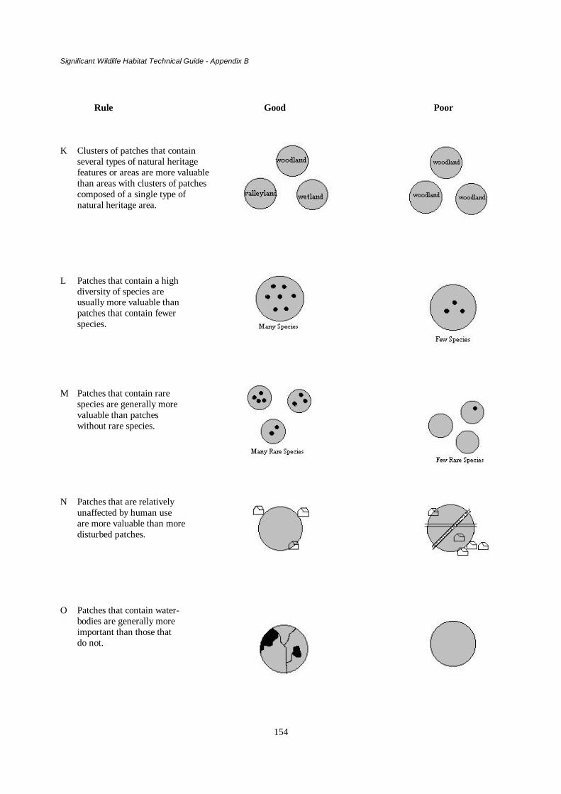
Significant Wildlife Habitat Technical Guide - Appendix B
154
Rule Good Poor
K Clusters of patches that containseveral types of natural heritagefeatures or areas are more valuablethan areas with clusters of patchescomposed of a single type ofnatural heritage area.
L Patches that contain a highdiversity of species areusually more valuable thanpatches that contain fewerspecies.
M Patches that contain rarespecies are generally morevaluable than patcheswithout rare species.
N Patches that are relativelyunaffected by human useare more valuable than moredisturbed patches.
O Patches that contain water-bodies are generally moreimportant than those thatdo not.

Significant Wildlife Habitat Technical Guide - Appendix B
155
Representation/Distribution
A fundamental step in natural heritage system planning is to ensure that the full range of natural features that occurin an area, including both rare and common features, are protected. The rationale for doing so is to ensure that thefull range of species and habitats within those features are protected, thus contributing to the preservation ofbiodiversity at the species and community levels. Further, species, communities and ecosystems that are welldistributed across their native range are less susceptible to decline than species, communities and ecosystemsconfined to small portions of their historic range (see Figure B -1A).
Representation is normally assessed at the site district level. It forms the cornerstone of the identification andevaluation procedure for the province’s ANSI program. Planning authorities can make a significant contribution tothe protection of the full range of natural features and species that occur in an area by ensuring the protection of anysignificant ANSIs that have been identified. Representative areas provide a logical foundation around which aplanning area’s natural heritage system can be designed.
Rule #1. Ensure that the full range of habitat/landform types that occur in an area are protected.
Size
Large patches of natural areas are generally more valuable than smaller patches (see Figure B - 1B). Similarly, asingle large patch is generally better than several smaller patches of the same total area (see Figure B - 1C). Thereare several reasons.
1. Larger patches tend to contribute more to biodiversity than smaller patches of similar habitat (Phillips 1996).This is because large areas tend to contain a broader diversity of features and habitats than smaller areas. Indoing so, larger areas generally
• contribute more to the diversity of features in an ecoregion/ecodistrict than smaller areas, and
• meet more of the habitat requirements of a greater number of species than smaller areas. One of the reasonsfor this is that large areas generally provide more “interior” (i.e., contiguous, relatively undisturbed,unfragmented) habitat than smaller areas. “Interior” habitat is critical to the survival of many species,particularly “forest-interior” birds.
2. Larger natural areas are generally more resilient to the impacts of human disturbance. For example, many of thesmaller woodlots in southern Ontario contain a large number of invasive exotic plant species that can or havedisplaced native species. Larger natural areas are more likely to have internal ecosystem functions like nutrientcycles and food webs intact and to be large enough to permit different successional stages to co-exist on the site.
3. Large areas are capable of supporting larger populations of different species than smaller blocks of similarhabitat (Noss and Cooperrider 1994). Large populations tend to be more resilient to human-induced and otherdisturbances than smaller populations.
4. Cumulatively, small areas can provide significant benefits to the overall landscape by reducing erosion,providing wildlife habitat, etc. These effects, in turn, benefit other critical habitats.
Are small areas worth keeping? Many small natural areas should be protected. There are several reasons why suchareas can be important.
1. Small areas, particularly if they provide unique habitat conditions, can support rare plant or animal speciesfound nowhere else in the area. Such small areas are particularly important to species with low mobility (Rileyand Mohr 1994).
2. Small areas, particularly if interspersed amongst larger habitat patches, can provide important temporaryrefuges better enabling more mobile species to move between larger patches.

Significant Wildlife Habitat Technical Guide - Appendix B
156
3. As well, in highly diverse landscapes, the protection of several smaller habitat patches can provide betterrepresentation of a wider range of habitats than a single larger habitat patch (Peterson and Peterson 1991; Rileyand Mohr 1994).
Rule 2. Large patches are generally more valuable than small patches.Rule 3. A single large patch is generally better than clusters of smaller patches with the same total area.
Shape
The shape of natural heritage areas affects their value as wildlife habitat and their resilience to disturbance effects.Round or block-shaped patches contain less “edge” per unit of area than long, narrow patches (see Figure 1D). Edgerefers to the area where different habitats (or habitat conditions) meet. For examples, edges occur where woodlotsmeet open fields, where uplands meet lowlands, along shorelines and fencerows, at the interface between deep waterand shallow water, etc. Many species of wildlife (e.g., deer, and grouse) need “edge” habitats.
Other species, however, require large contiguous blocks of habitat well away from habitat edges. These areas areoften termed interior habitats. Some interior habitat dwelling species will only use an area if it is 100 metres or moreaway from an edge.
In parts of Ontario, particularly in the south, the fragmentation of natural habitats has created an abundance of edgehabitat while, at the same time, reducing the availability of interior habitats. Consequently, in southern Ontario,round or block-shaped areas would normally be higher priority areas for protection than long, narrow habitats ofsimilar composition. In some situations, however, narrow habitat patches may have special value in ensuring theconnection of other important patches.
Rule #4. Patch shapes that minimise “edge” are generally preferred over patches with more edge.
Fragmentation/Connectedness
An obvious impact of development on natural areas is fragmentation. Fragmentation refers to the process by whichlarge, interconnected natural areas are converted to a series of smaller, often isolated natural areas. In much ofsouthern Ontario, the landscape has become highly fragmented. In other parts of the province, particularly somenorthern areas, fragmentation has been less severe.
Rule #5. Avoid fragmenting natural areas.
As indicated above, smaller natural areas generally meet the needs of fewer species of wildlife than larger areas.This results from the fact that the remaining areas may simply be too small to meet the habitat needs of the speciesthat once used the area, and the fact that smaller areas, on average, will contain a lower diversity of habitatconditions than larger areas. Small areas are also more easily damaged by disturbance effects and are less likely tohave their functional processes intact.
Another potentially serious consequence of habitat fragmentation is the physical separation, or isolation, of onehabitat patch from another. If separation distances are large enough, the movement of plants (i.e., their seeds) andanimals from one patch to another can be hindered or prevented. The resultant isolation of one wildlife populationfrom another can:
• lead to inbreeding which, over time, may reduce the ability of the population to survive; and• prevent the recolonization of an area after local extinction
As a general rule, then, interconnected patches of habitat are better than isolated patches (Figure 1E). However,there are exceptions. Some habitats and species that are found in isolated areas are better protected when they areisolated from other areas. Other habitats (and species) do benefit from connections, but only if the connectionsbetween them have the appropriate characteristics. For example, very narrow connections, such as fencerows, whichlink one woodlot to another, can provide predators with an extremely effective hunting environment, which can putprey species at risk. The key is to plan for connections of larger woodlots or a network of smaller areas. In doing so,

Significant Wildlife Habitat Technical Guide - Appendix B
157
the widest possible connections should be protected. Where connections are very narrow, planning authoritiesshould consider improving (i.e., widening) them. This is consistent with Section 2.3.3 of the Natural HeritageFeatures and Areas Policy.
Rule #6. Connected patches are usually better than unconnected patches.
Arrangement/Proximity
Blocks of habitats that are arranged close together are usually better than blocks of habitat that are located furtherapart. There are two reasons for this. First, wildlife is able to move more safely between closely spaced habitatpatches than between patches located farther apart. Secondly, closely spaced patches are more likely to haveimportant functional (i.e., hydrological or biochemical) linkages than more distant patches (see Figures B - 1F andG).
Rule #7. Clustered patches are usually better than “in-line” patches of the same total area.Rule #8. Closely clustered patches are usually better than more distant patches.
Habitat Diversity/Complexity
Natural areas (or clusters of areas) that span a range of topographic, soil and moisture conditions, tend to contain awider variety of plant species and plant communities, and may also support a greater diversity of ecologicalprocesses, than similar areas that occupy a narrower range of topographic, soil and moisture conditions. Areas with ahigh diversity of plant species and plant communities will generally support a correspondingly high diversity ofanimal species and communities. For example, a natural area that includes both wetland (lowland) and uplandcomponents will provide a greater range of habitat conditions for wildlife than either habitat type alone. Similarly, awetland that contains each of the four wetland types (marsh, swamp, bog and fen) will provide more habitatdiversity than a wetland composed entirely of marsh (see Figures B - 1H-K). A variety of techniques are availablefor assessing habitat and/or vegetation community diversity.
Rule #9. Patches, or clusters of patches, that meet several of the habitat needs of one or several speciesare more valuable than patches that meet fewer habitat needs.
Rule #10. Patches or clusters of patches, that contain more than one natural heritage feature or area maybe more valuable than patches with a single natural heritage feature or area.
Species Diversity
Areas that contain a high diversity of plant and animal species are generally more important than areas that contain alower diversity of species (Figure B - 1L). In some situations, however, areas that contain a relatively low diversityof plant and/or animal species are important and should be protected, for example, where they provide habitat for anendangered or threatened species, or some other species of particular interest or conservation concern.
Species richness assessments can be undertaken as a means of comparing species diversity between sites. Specieslists compiled in OMNR’s Site District reports or in individual site inventory reports may be useful in conductingsuch assessments. It is essential to assess diversity relative to each candidate area’s size since the number of specieswill vary with size.

Significant Wildlife Habitat Technical Guide - Appendix B
158
Rule #11. Patches that contain a high diversity of plant and animal species are generally morevaluable than patches with a lower diversity of plant and animal species.
Species Rarity
In general, habitats that contain rare species are more valuable than habitats that do not contain suchspecies (Figure B - 1M). Rarity is a relative term and can be described in 5 different ways:(1) species that are scarce, but occur over a wide geographical area(2) species that only inhabit one place(3) species that are geographically separated from their main range(4) species that are at the edge of their geographical range(5) declining species that were once more abundant and/or widespread but are now depleted
Assessments of rarity are often expressed as the number of rare species or features in an area. Lists ofspecies and features considered rare at one or several scales (e.g., local, regional, or national), such as thoseprovided in OMNR’s Site District reports or in NHIC’s status lists, will be useful in evaluating candidatenatural areas for significance. Specifically, the occurrence of rare species may add to the significance of aparticular feature or area. However, it is important to realise that rare species are not necessarilyendangered or threatened species, as defined in the policy.
Rule #12. Patches that contain rare species are generally more valuable than patches that do notcontain such species.
Naturalness/Disturbance
Relatively undisturbed natural areas are generally more desirable than highly altered areas (Figure B - 1N).The manner in which the adjacent lands surrounding a protected natural area are used and/or developed canmarkedly affect the viability of the natural area or the features within it. The most common rationale forusing naturalness as a criterion is that undisturbed, natural areas provide the best source of baselineinformation to compare with other modified areas. By studying how undisturbed ecosystems function, abetter understanding of how human impacts modify ecosystems can be gained. These areas will alsoprovide important clues for restoring ecosystems that have been modified.
Methods used to evaluate naturalness vary depending on the ecosystem, information available and the levelof human disturbance. For example, measuring the relative absence of exotic species could assess thenaturalness of a valley-land, cattle-grazing or man-made structures such as riprap, dams, roads or buildings.
Rule #13. Patches that are relatively unaffected by human disturbance are generally morevaluable than patches that are more highly disturbed.
Hydrologic and Related Values
In many areas, water bodies including wetlands, often represent a relatively small percentage of the totalland area, yet they can be disproportionately more valuable than other areas (Figure B - 1O) for severalreasons:
• there is a large number of aquatic or riparian (moist-area dependent) plant and animal species thatdepend upon water bodies or wetlands to fulfil their habitat needs
• there is a large number of other animal species that require access to water bodies for all or part oftheir life cycle in order to survive
• there is a large number of species that use water bodies, especially streams, as travel or migrationcorridors
• they are critical to the maintenance of nutrient and other bio-chemical nutrient cycling processesupon which all species depend
• they are integral to the hydrologic functioning of the watershed within which they are located

Significant Wildlife Habitat Technical Guide - Appendix B
159
Water bodies, wetlands, and other areas of significant hydrological importance (i.e., headwaters, rechargeareas, discharge areas, etc.) should be protected.
Rule #14. Waterbodies, wetlands and other areas (e.g. seeps, recharge/discharge areas) are veryimportant and should be protected wherever possible.

Significant Wildlife Habitat Technical Guide - Appendix B
160
References Cited
Crins, W.J. 1996.Life science gap analysis for site district 4E-3. Ontario Ministry of Natural Resources,Lands and Natural Heritage Branch, Peterborough, Ontario. 251 p.
Decker, D.J., M.E.. Krasny, G.R. Goff, C.R. Smith and D.W. Gross, editors. 1991. Challenges in theconservation of biological reserves - a practitioner’s guide. Westview Press. 402 pp.
Noss, R.F. and A.Y. Cooperrider. 1994. Saving nature's legacy: protecting and restoring biodiversity.Island Press, Washington, DC. 416 p.
Peterson, E.B. and N.M. Peterson. 1991. A first approximation of principles and criteria to make Canada’sprotected areas system representative of the nation’s ecological diversity. Western EcologicalServices Limited, Victoria, British Columbia. Report for the Canadian Council on EcologicalAreas. 47 p + appendices.
Phillips, M.E.J. 1996. Natural heritage protection in southern Ontario. Terrestrial ecosystem assessmentand management: the case of forested environments. M.Sc. Research Paper. University School ofRural Planning and Development, University of Guelph, Guelph, Ontario. 77 p, Appendices.
Primack, R.B. 1993. Essentials of conservation biology. Sinauer Publishing. 564 p.
Riley, J.L. and P. Mohr. 1994. The natural heritage of southern Ontario's settled landscapes. A review ofconservation and restoration ecology for land-use and landscape planning. Ontario Ministry ofNatural Resources, Southern Region, Aurora, Science and Technology Transfer, Technical ReportTR-001. 78pp.
Smith, P.G.R and J.A.Theberge 1986. A review of criteria for evaluating natural areas. EnvironmentalManagement 10: 715-734

Significant Wildlife Habitat Technical Guide - Appendix C
161
APPENDIX C
A List of Area Sensitive Species and Key References
A number of wildlife species require large areas of suitable habitat in order to sustain their populationnumbers. These species, referred to as area sensitive species, are identified in Appendix G. Area sensitivespecies identified in Appendix G are listed below. A short list of references to scientific literature that areparticular to each species is also provided.
The reference list provided in this section is by no means complete. These references are meant to assist thereader in doing a further search of the scientific literature for information about these particular wildlifespecies and the habitats in which they live.
There are two parts to this appendix. Table 1 has been arranged by Class. A short list of referencesassociated with each species is provided in this table. These references are listed in the reference sectionthat follows Table 1.
The reference section also is arranged by Family and alphabetically by author. This section includesadditional references other than those listed in Table 1. The Birds section is subdivided into sevensubsections:1) General2) Effects of Habitat Fragmentation3) Waterfowl and Other Marsh Birds4) Birds Associated with Grasslands and Old Fields5) Birds Associated with Forests6) Woodpeckers7) Raptors
While the majority of bird references listed in Table 1 will be found in subsections 3-7, if an author’s namecan not be found in these subsections, check the subsection on effects of habitat fragmentation, particularlyfor grassland or forest species.
Table 1: A list of area sensitive wildlife species and associated references.
SPECIES REFERENCESAmphibiansBullfrogRana catesbeiana
Cebek (1986); Coleman (1995); Ontario Ministry of Natural Resources (1994)
ReptilesSpotted TurtleClemmys guttata
Chippindale (1984); Chippindale (1985); Cook et al. (1980); Ernst (1967); Ernst (1976);Lovich (1988); Litzgus (1996); Haxton (1997); Haxton and Berrill (1999)
Wood TurtleClemmys insculpta
Obbard (1985); Quinn and Tate (1991); Brooks et al. (1992); Foscarini (1994)
Common Map TurtleGraptemys geographica
Graham and Graham (1992); Daigle et al. (1994)
Eastern Spiny SoftshellApalone spiniferaspinifera
Campbell and Donaldson (1980)
Black Rat SnakeElaphe obseleta obseleta
Fitch (1963); Fitch and Shirer (1971); Parsons (1977); Stickel and Cope (1947)

Significant Wildlife Habitat Technical Guide - Appendix C
162
Eastern Hognose SnakeHeterodon platirhinos
Platt (1969)
MammalsNorthern Flying SquirrelGlaucomys sabrinus
Cowan (1936)
Southern Flying SquirrelGlaucomys volans
Sollberger (1940); Sollberger (1943)
MartenMartes americana
Bushkirk and Powell (1994); De Vos (1952); Francis and Stephenson (1972); Koehler etal. (1975); Thompson (1991); Watt et al. (1996); Wynne and Sherburne (1984)
FisherMartes pennanti
Bushkirk and Powell (1994); De Vos (1952) ; Kilpatrcik and Rego (1994); Garent andCrete (1997)
LynxLynx canadensis
Quinn (1984)
MooseAlces alces
Ontario Ministry of Natural Resources (1984); Ontario Ministry of Natural Resources(1990)
Woodland CaribouRangifer tarandus
Bergerud (1974); Calef (1981); Cringan (1957); Skoog (1968);
BirdsRed-necked GrebePodiceps grisegena
Cringan (1957); De Smet (1982)
American BitternBotaurus lentiginosus
Gibbs et al. (1992)
Least BitternIxobrychus exilis
Gibbs et al. (1992)
Northern PintailAnas acuta
Austin and Miller (1995) Smith (1971)
CanvasbackAythya valisineria
Bergman (1973); Dennis and Chandler (1974); Dennis et al. (1984); Korschgen et al.(1984)
RedheadAythya americana
Dennis and Chandler (1974); Dennis et al. (1984)
Common GoldeneyeBucephala clangula
Campbell and Milne (1977); Eadie et al. (1995); Hume (1976); Mathews (1982); Ross(1984)
Common MerganserMergus merganser
Mathews (1982); Ross (1984)
Red-breasted MerganserMergus serrator
Ross (1984)
Bald EagleHaliaeetus leucocephalus
Broley (1952); McKeating (1985)
Northern HarrierCircus cyaneus
Bent (1961)

Significant Wildlife Habitat Technical Guide - Appendix C
163
SPECIES REFERENCESSharp-shinned HawkAccipiter striatus
Bent (1961)
Cooper’s HawkAccipiter cooperii
Bent (1961); Penak (1983); Rosenfield and Bielefeldt (1993)
Northern GoshawkAccipiter gentilis
Bent (1961); Squire and Reynolds (1997)
Red-shouldered HawkButeo lineatus
Bent (1961); Bryant (1986); Crocoll (1994); Risley (1982); Sharp et al. (1982)
Broad-winged HawkButeo platypterus
Bent (1961); Goodrich et al. (1996)
Sharp-tailed GrouseTympanuchus phasianellus
Connelly et al. (1998); Olsen (1959); Snyder (1935)
Yellow RailCoturnicopsnoveboracensis
Anderson (1977); Bart et al. (1984); Brookhout (1995)
King RailRallus elegans
Meanley (1969); Meanley (1992)
American CootFulica americana
Friley et al. (1938)
Sandhill CraneGrus canadensis
Hall-Armstrong and Armstrong (1982); Lumsden (1971); Riley (1982); Tacha et al.(1992); Tebbel and Ankney (1982)
Upland SandpiperBartramia longicauda
Swanson (1996)
Forster’s TernSterna forsteri
Bergman et al. (1970)
Black TernChlidonias niger
Bergman et al. (1970); Dunn 1979
Barred OwlStrix varia
Bent (1961); Eckert (1974)
Great Gray OwlStrix nebulosa
Bent (1961); Eckert (1974); Nero (1979); Nero and Taylor (1980)
Short-eared OwlAsio flammeus
Bent (1961); Eckert (1974); Holt and Leasure (1996)
Boreal OwlAegolis funereus
Bent (1961); Bondrup-Nielsen (1978); Eckert (1974)
Whip-poor-willCaprimulgus vociferus
Cadman et al. (1987)

Significant Wildlife Habitat Technical Guide - Appendix C
164
SPECIES REFERENCESHairy WoodpeckerPicoides villosus
Bent (1939)
Three-toed WoodpeckerPicoides tridactylus
Bent (1939)
Black-backedWoodpeckerPicoides arcticus
Bent (1939)
Pileated WoodpeckerDryocopus pileatus
Bent (1939); Bull and Holthausen (1993); Bull et al. (1992); Freemark and Collins(1992); Kirk and Naylor (1996); Naylor et al. (1996)
Acadian FlycatcherEmpidonax virescens
Christy (1942)
Least FlycatcherEmpidonax minimus
Breckenridge (1956); Davis (1959)
Tufted TitmouseParus bicolor
Grubb and Pravosudov (1994); Woodford (1962)
Red-breasted NuthatchSitta canadensis
Bent (1964)
White-breasted NuthatchSitta carolinensis
Bent (1964); Pravosudov and Grubb (1993)
Brown CreeperCerthia americana
Bent (1964)
Winter WrenTroglodytes troglodytes
Bent (1964)
Blue-gray GnatcatcherPolioptila caerulea
Ellison (1992)
VeeryCatharus fuscescens
Bertin (1977); Moskoff (1995)
Hermit ThrushCatharus guttatus
Hoover et al. (1995); Jones and Donovan (1996)
Loggerhead ShrikeLanius ludovicianus
Cadman (1986); Campbell (1975); Yosef (1996)
Blue-headed VireoVireo solitarius
James (1998)
Yellow-throated VireoVireo flavifrons
Rodewald and James (1996)
Northern ParulaParula americana
Bent (1953); Moldenhauer and Regelski (1996)
Magnolia WarblerDendroica magnolia
Bent (1953); Hall (1994); Sutherland (1986)

Significant Wildlife Habitat Technical Guide - Appendix C
165
SPECIES REFERENCESBlack-throated Blue WarblerDendroica caerulescens
Bent (1953); Holmes (1994)
Black-throated GreenWarblerDendroica virens
Bent (1953); Collins (1983); Morse (1993)
Blackburnian WarblerDendroica fusca
Bent (1953); Lawrence (1953); Morse (1994)
Pine WarblerDendroica pinus
Bent (1953)
Cerulean WarblerDendroica cerulea
Bent (1953); Dunn and Garrett (1997); Oliarnyk and Robertson (1996)
Black-and-white WarblerMniotilta varia
Bent (1953); Kricher (1995)
American RedstartSetophaga ruticilla
Bent (1953); Sidel and Whitmore (1982)
Prothonotary WarblerProtonotaria citrea
Bent (1953); Flaspohler (1996); McCracken (1981)
OvenbirdSeiurus aurocapillus
Bent (1953); Burke and Nol (1998); Porneluzi et al. (1993); Villard et al. (1993)
Canada WarblerWilsonia canadensis
Bent (1953)
Scarlet TanagerPiranga olivacea
Bent (1958)
Savannah SparrowPasserculus sandwichensis
Bedard and LaPointe (1984); Dixon (1972); Dixon (1978); Potter (1972); Swanson(1996); Wiens (1973)
Grasshopper SparrowAmmodramus savannarum
Swanson (1996); Whitmore (1981); Wiens (1973)

Significant Wildlife Habitat Technical Guide - Appendix C
166
REFERENCES
AMPHIBIANS AND REPTILES
BROOKS, R.J., C.M. SHILTON, G.P. BROWN AND N.W.S. QUINN. 1992. Body size, age distribution,and reproduction in a northern population of wood turtles (Clemmys insculpta). Can J. Zool. 70: 462-469.
CAMPBELL, C.A. AND G.R. DONALDSON. 1980. A status report for the eastern spiny softshell turtle,Trionyx spiniferus spiniferus, in Canada. M.E. Obbard [ed.]. Unpubl. Rep. Ont. Min. Nat. Resour., WildlifeBranch, Toronto. 50 p.
CEBEK, J.E. 1986. Thermal ecology of the bullfrog, Rana catesbeiana, in southern Ontario. M. Sc. Thesis,Trent Univ., Peterborough, Ontario. 72 p.
CHIPPINDALE, P. 1984. A study of the spotted turtle (Clemmys gutatta) in the Mer Bleue Bog.Conservation Studies Publ. No. 25, National Capital Commission, Ottawa. 84 p.
CHIPPINDALE, P. 1985. The Mer Bleue spotted turtles: results of 1984 study. Unpubl. Rep. NationalCapital Commission, Ottawa.
COLEMAN, K. 1995. Bullfrog Management in Ontario. Transfer Line, a newsletter of the Southern RegionScience and Technology Transfer Unit, Volume 2(3): 1-3. Ont. Min. Nat. Resour., Kemptville.
COOK, F.R. 1984. Introduction to Canadian amphibians and reptiles. Natl. Mus. Nat. Sci., Ottawa.200 p.
COOK, F.R., J.D. LAFONTAINE, S. BLACK, L. LUCIUK AND R.V. LINDSAY. 1980. Spotted turtles(Clemmys guttata) in eastern Ontario and adjacent Quebec. Can. Field-Nat. 94(4): 411-415.
DAIGLE, C., A. DESROSIERS and J. BONIN. 1994. Distribution and abundance of common map turtles,Graptemys geographica, in the Ottawa River, Québec. Can. Field Nat. 108:84-86.
ERNST, C.H. 1967. A mating aggregation of the turtle, Clemmys guttata. Copeia 1967: 473-474.
ERNST, C.H. 1976. Ecology of the spotted turtle, Clemmys guttata (Reptilia, Testudines, Testudinidae) insoutheastern Pennsylvania. J. Herptol. 10: 25-33.
FITCH, H.S. 1963. Natural history of the black rat snake (Elaphe obsoleta obsoleta) in Kansas. Copeia 4:649-658.
FITCH, H.S. AND H.W. SHIRER. 1971. A radiotelemetric study of spatial relationships in some commonsnakes. Copeia 1: 118-128.
FOSCARINI, D.A. 1994. Demography of the wood turtle (Clemmys insculpta) and habitat selection in theMaitland River valley. M.Sc. Thesis. University of Guelph, Guelph, Ontario. 108 p.
GRAHAM, T.E. AND A.A. GRAHAM. 1992. Metabolism and behavior of wintering common map turtles,Graptemys geographica, in Vermont. Can. Field - Natur. 106 (4):517-519
HAXTON, T. 1997. Home range and habitat selectivity of spotted turtles (Clemmys guttata) in centralOntario: implications for a management strategy. M.Sc. Thesis. Trent University, Peterborough, Ontario.
HAXTON, T. and M. BERRILL. 1999. Habitat selectivity of spotted turtles (Clemmys guttata) in centralOntario. Can. J. Zool. 77:593-599.

Significant Wildlife Habitat Technical Guide - Appendix C
167
KING, R.B. 1987. Reptile distributions on islands in Lake Erie. J. Herptol. 21(1): 65-67.
LITZGUS, J. 1996. Life history and demography of a northern population of spotted turtles, Clemmysguttata. M.Sc. Thesis. University of Guelph, Guelph, Ontario. 145 p.
LOVICH, J.E. 1988. Geographic variation in the seasonal cycle of spotted turtles, Clemmys guttata. J.Herptol. 22: 482-485.
OBBARD, M.E. 1985. A status report for the wood turtle (Clemmys insculpta) in Ontario with an overviewof its status in Canada. Unpubl. Rep. Ont. Min. Nat. Resour., Wildlife Branch, Toronto. 43 p.
OLDHAM, M.J. 1984. A preliminary list of the reptiles of Essex County. Can. Amphibian and ReptileConserv. Soc. Bull. 22(1): 1-8.
ONTARIO MINISTRY OF NATURAL RESOURCES 1994. Bullfrog Management in Ontario. K.Coleman and R. Cholmondeley [eds.] Southern Region Science and Technology Transfer Unit WorkshopProceedings WP-005. 38 p.
PARSONS, H.J. 1977. The black rat snake in Ontario - Rideau Lakes population. BUFO Inc. for Ont. Min.Nat. Resour., Toronto. 49 p.
PLATT, D.R. 1969. Natural history of the hognose snakes, Heterodon platyrhinos and Heterodon masicus.University of Kansas Publications. Museum of Natural History, V.18, No.4. Lawrence, Univ. Kansas.
QUINN, N.W.S. and D.P. TATE. 199. Seasonal movements and habitat of wood turtles (Clemmysinsculpta) in Algonquin Park, Canada. J. of Herp. 25:217-220.
SMITH, H.M. 1978. A guide to field identification - amphibians of North America. Golden Press, NewYork, and Western Publishing Co. Inc., Racine, Wisconsin. 160 p.
SMITH, H.M. 1978. A guide to field identification - reptiles of North America. Golden Press, New York,and Western Publishing Co. Inc., Racine, Wisconsin. 240 p.
STICKEL, W.H. AND J.H. COPE. 1947. The home ranges and wanderings of snakes. Copeia 7: 127-136.
MAMMALS
BERGERUD, A.T. 1974. The role of the environment in the aggregation, movement and disturbancebehaviour of caribou. Volume 2, pages 552-584 in V. Geist and F. Walther [eds.] The behaviour ofungulates and its relation to management. The Papers of an International Symposium held at the Universityof Calgary, Alberta, Canada, 2-5 November 1971. Morges, Switzerland: International Union forConservation of Nature and Natural Resources, IUCN Publications New Series No. 24.
BUSKIRK, S.W. AND R.A. POWELL. 1994. Habitat ecology of fishers and American martens. Pages 283-396 in S.W. Buskirk, A.S. Harestad and M.G. Raphael [comps, eds.] Martens, sables and fishers: biologyand conservation. Ithica, N.Y. Cornell University Press.
CALEF, G. 1981. Caribou and the barren-lands. Firefly Books, Ltd. Scarborough, Ontario. 176 p.
COWAN, I.M. 1936. Nesting habits of the flying squirrel, Glaucomys sabrinus. J. Mammal. 12(3): 233-238.
CRINGAN, A.T. 1957. History, food habits and range requirements of the woodland caribou of continentalNorth America. Pages 485-501 in Reprint from Trans. of the 22nd North Am. Wildl. Conf., Washington,D.C.
Significant Wildlife Habitat Technical Guide - Appendix C
168
DE VOS, A. 1952. Ecology and management of fisher and marten in Ontario. Ont. Dep. Lands, Toronto,On. 90 p.
FRANCIS, G.R. AND A.B. STEPHENSON. 1972. Marten ranges and food habits in Algonquin Park,Ontario. Ont. Min. Nat. Resour. Rep. No. 91.
GARENT, Y. and M. CRETE. 1997. Fisher, Martes pennanti, home range characteristics in a high densityuntrapped population in southern Québec. Can. Field Nat. 111: 359-365.
KILPATRICK, H. AND P. REGO. 1994. Influence of season, sex, and site availability on fisher (Martespennanti) rest-site selection in the central hardwood forest. Can. J. Zool. 72: 1416 – 1420.
KOHLER, G.M., W.R. MOORE AND A.R. TAYLOR. 1975. Preserving the pine marten: managementguidelines for western forests. Western Wildlands 2: 31-36.
ONTARIO MINISTRY OF NATURAL RESOURCES. 1984. Guidelines for moose habitat management inOntario. Wildlife Branch, Toronto. 154 p.
ONTARIO MINISTRY OF NATURAL RESOURCES. 1990. The moose in Ontario. Book 1- Moosebiology, ecology and management. M. Buss and R. Truman [eds.] Ont. Min. Nat. Resour. and Ont. Fed.Anglers and Hunters. 33 p.
QUINN, N. 1984. The lynx. Ont. Min. Nat. Resour., Toronto. 24 p.
SKOOG, R.O. 1968. Ecology of the caribou (Rangifer tarandus granti) in Alaska. Ph.D. Thesis. Berkeley:Univ. California 699 p.
SOLLBERGER, D.E. 1940. Notes on the life history of the small eastern flying squirrel. J. Mammal. 21(3):282-293.
SOLLBERGER, D.E. 1943. Notes on the breeding habits of the eastern flying squirrel (Glaucomys volansvolans). J. Mammal. 24(2): 163-173.
THOMPSON, I.D. 1991. Could marten become the spotted owl of eastern Canada? For. Chron. 67: 136-140.
WATT, W.R., J. A. BAKER, A. BARAUSKAS, D.M. HOGG, J.G. MCNICOL AND B. NAYLOR. 1996.Forest Management Guidelines for the Provision of Marten Habitat. Ont. Min. Nat. Resour. 27 p.
WYNNE, K.M. AND J.A. SHERBURNE. 1984. Summer home range use by adult marten in northwesternMaine. Can. J. Zool. 62: 941-943.
BIRDS - GENERAL
BEST, L.B. 1983. Bird use of fencerows: implications of contemporary fencerow management practices.Wildl. Soc. Bull. 11: 343-347.
CADMAN, M.D., P.F.J. EAGLES, F.M. HELLEINER. 1988. Atlas of the breeding birds of Ontario.University of Waterloo Press, Waterloo, Ontario. 617 p.
DANCE, K.W., AND D.M. FRASER. 1985. Use of the breeding bird atlas data in environmental planning.Ont. Breed. Bird Atlas Newsletter 14: 1-2.
GODFREY, W.E. 1966. The birds of Canada. Natl. Mus. Can. Bull. 203. 423 p.

Significant Wildlife Habitat Technical Guide - Appendix C
169
EFFECTS OF HABITAT FRAGMENTATION
ANDRÉN, H. 1994. Effects of habitat fragmentation on birds and mammals in landscapes with differentproportions of suitable habitat: a review. Oikos 71: 355-366.
AUSTEN, M.J., C.M. FRANCIS, D.B. BURKE AND M.S.W. BRADSTREET. in prep. Effects of forestfragmentation on woodland birds in southern Ontario.
BURKE, D.M. AND E. NOL. 1998. Influence of food abundance, nest site habitat, and forest fragmentationon breeding ovenbirds. Auk 115: 96-104.
BURKEY, T.V. 1989. Extinction in nature reserves: the effect of fragmentation and the importance ofmigration between reserve fragments. Oikos 55: 75-81.
FAABORG, J., M. BRITTINGHAM, T. DONOVAN AND J. BLAKE. 1993. Habitat fragmentation in thetemperate zone: a perspective for managers. Pages 331-338 in Status and management of neotropicalmigratory birds. D.M. Finch and P.W. Stangel [eds.] USDA Forest Serv. Gen. Tech. Rep. RM-229, RockyMt. Forest Range Exp. Sta., Fort Collins, CO.
FAHRIG, L. 1997. Relative effects of habitat loss and fragmentation on population extinction. J. Wildl.Manage. 61(3): 603-610.
FREEMARK, K.E. 1989. Landscape ecology of forest birds in the northeast. Pages 7-12 in Is forestfragmentation a management issue in the northeast? R.M. DeGraaf and W.M. Healy [comps.] USDA ForestServ. Gen Tech. Rep. NE-140, Northeasterm Froest Exp. Sta., Radnor, PA.
FREEMARK, K. AND B. COLLINS. 1992. Landscape ecology of birds breeding in temperate forestfragments. Pages 443-454 in J.M. Hagan and D.W. Johnson, [eds.] Ecology and Conservation ofNeotropical Migrant Landbirds. Smithsonian Institution Press, Washington D.C. 609 p.
FREEMARK, K.E., J.B. DUNNING, S.J. HEJL AND J.R. PROBST. 1995. A landscape ecologyperspective for research, conservation and management. Pages 381-427 in T. Martin and D. Finch [eds.]Ecology and Management of Neotropical Migratory Birds: A synthesis and Review of the Critical Issues.Oxford University Press, Cambridge, UK.
FRIESEN, L.E., P.F.J. EAGLES AND J.R. MACKAY. 1995. Effects of residential development on forest-dwelling neotropical migrant songbirds. Conserv. Biol. 9: 1408-1414.
HAYDEN, T.J. 1985. Minimum area requirements of some breeding bird species in fragmented habitats inMissouri. M.S. Thesis, Univ. Missouri-Columbia.
HERKERT, J.R. 1994. The effects of habitat fragmentation on Midwestern grassland communities. Ecol.Appl. 4: 461-471.
JOHNSON, R.G. AND S.A. TEMPLE. 1986. Assessing habitat quality for birds nesting in fragmentedtallgrass prairies. Pages 245-249 in J. Verner, M.L. Morrison and C.J. Ralph, [eds.] Wildlife 2000:modeling habitat relationships of terrestrial vertebrates. Univ. Wisconsin Press, Madison.
REESE, K.P. AND J.T. RATTI. 1988. Edge effect: a concept under scrutiny. Trans. North Am. Wildl. Nat.Resourc. Conf. 53:127-136.
ROBBINS, C.S. 1979. Effects of forest fragmentation on bird populations. Pages 198-212 in R.M. Degraafand N. Tilghman [eds.] Proceedings of the Workshop on Management of North-Central and NortheasternForests for Nongame Birds. U.S. Forest Serv. Gen. Tech. Rep. NC-51.

Significant Wildlife Habitat Technical Guide - Appendix C
170
ROBBINS, C.S. 1988. Forest fragmentation and its effects on birds. Pages 61-65 in Managing NorthCentral forests for non-timber values. J.E. Johnson [ed]. SAF publication 88-04. Soc. Am. Foresters.
ROBINSON, S.K., F.R. THOMPSON, III, T.M. DONOVAN, D.R. WHITEHEAD AND J. FAABORG.1987. Regional forest fragmentation and the nesting success of migratory birds. Science 267: 1987-1990.
SZAFONI, R.E. 1992. Forest fragmentation - the breaking up of wildlife’s home. Ill. Steward 1:6-8.
TEMPLE, S.A. 1986. Predicting impacts of habitat fragmentation on forest birds: A comparison of twomodels. Pages 301-304 in Wildlife 2000; Modeling habitat relationships of terrestrial vertebrates. J. Verner,M.L. Morrison and C.J. Ralph [eds.] University of Wisconsin Press, Madison
VENIER, L.A. AND L. FAHRIG. 1996. Habitat availability causes the species abundance-distributionrelationship. Oikos 76: 564-570.
VILLARD, M.-A., P.R. MARTIN AND C.G. DRUMMOND. 1993. Habitat fragmentation and pairingsuccess in the Ovenbird (Seiurus aurocapillus). Auk 110: 759-768.
VILLARD, M.-A., G. MERRIAM AND B.A. MAURER. 1995. Dynamics in subdivided populations ofneotropical migratory birds in a fragmented temperate forest. Ecology 76: 27-40.
WHITCOMB, B.L., R.F. WHITCOMB AND D. BYSTRAK. 1977. Island biogeography and “habitatislands” of eastern forest. III. Long-term turnover and effects of selective logging on the avifauna for forestfragments. Amer. Birds 31: 17-23.
WHITCOMB, R.F., C.S. ROBBINS, J.F. LYNCH, B.L. WHITCOMB, M.K. KLIEMKIEWICZ AND D.BYSTRAK. 1981. Effects of forest fragmentation on avifauna of the eastern deciduous forest. Pages 125-205 in Forest island dynamics in man-dominated landscapes. R.L. Burgess and D.M. Sharpe [eds.]Springer-Verlag, New York.
WATERFOWL AND OTHER MARSHLAND BIRDS
ANDERSON, J.M. 1977. Yellow Rail. Pages 66-70 in G.C. Sanderson [eds.] Management of migratoryshore and upland game birds in North America. Int. Assoc. Fish Wildl. Agencies, Washington.
AUSTIN, J.E., AND M.R. MILLER. 1995. Northern Pintail (Anas acuta). in A. Poole and F. Gill [eds.] TheBirds of North America, No. 163. The Acadamy of Natural Sciences, Philadephia, and The AmericanOrnithologists’ Union, Washington, DC. 32pp.
BART, J., A. STEHN, J.A. HERRICK, N.A. HEASLIP, T.A. BOOKHOUT AND J.R. STENZEL. 1984.Survey methods for breeding Yellow Rails. J. Wildl. Manage. 48: 1382-1386.
BERGMAN, R. D. 1973. Use of southern boreal lakes by postbreeding Canvasbacks and Redheads. J.Wildl. Manage. 37:160-170.
BERGMAN, R.D., P. SWAIN AND M.W.WELLER. 1970. A comparative study of nesting Forster’s andBlack Terns. Wilson Bull. 82: 435-444.
BOOKHOUT, T.A. 1995. Yellow Rail (Coturnicops noveboracensis). in A. Poole and F. Gill [eds.] TheBirds of North America, No. 139. The Academy of Natural Sciences, Philadelphia, PA, and The AmericanOrnithologists’ Union, Washington, D.C. 16 p.
CAMPBELL, L. H. AND H. MILNE. 1977. Goldeneye feeding close to sewer outfalls in winter. Wildfowl28:81-85.

Significant Wildlife Habitat Technical Guide - Appendix C
171
CRINGAN, A.T. 1957. Notes on the biology of the Red-necked Grebe in western Ontario. Can. Field-Natur. 71: 72-73.
DENNIS, D. G., G. B. MCCULLOUGH, N. R. NORTH AND R. K. ROSS. 1984. An updated assessment ofmigrant waterfowl use of the Ontario shorelines of the southern Great Lakes. Pages 37-42 in S. G. Curtis,D. G. Dennis, and H. Boyd, eds. Waterfowl studies in Ontario, 1973-81. Occasional Paper No. 54, Can.Wildl. Serv.
DENNIS, D. G. AND R. E. CHANDLER. 1974. Waterfowl use of the Ontario shorelines of the southernGreat Lakes during migration. Pages 58-65 in H. Boyd, ed. Canadian Wildlife Service studies in easternCanada, 1969-73. Can. Wildl. Serv. Rep. Ser. No. 29.
DE SMET, K.D. 1982. Status report on the Red-necked Grebe (Podiceps grisegena) in Canada. Committeeon the Status of Endangered Wildlife in Canada, Ottawa.
DUNN, E.H. 1979. Nesting biology and development of young in Ontario Black Terns. Can. Field-Natur.93: 276-281.
EADIE, J.M., M.L. MALLORY AND H.G. LUMSDEN. 1995. Common Goldeneye : Bucephala clangula.in A. Poole and F. Gill [eds.] The Birds of North America, No.170. The Academy of Natural Sciences,Philadelphia, PA, and The American Ornithologists’ Union, Washington, D. C.32 p.
FRILEY, C.E., JR., L.H. BENNETT AND G.O. HENDRICKSON. 1938. The American Coot in Iowa.Wilson Bull. 50: 81-86.
GIBBS, J.P., S. MELVIN AND F.A. REID. 1992. American Bittern : Botaurus lentiginosus. in A. Poole andF. Gill [eds.] The Birds of North America, No. 18. The Academy of Natural Sciences, Philadelphia, PA,and The American Ornithologists’ Union, Washington, D. C.
GIBBS, J.P., F.A. REID, AND S.M. MELVIN. 1992b. Least Bittern : Ixobrychus exilis. in A. Poole and F.Gill [eds.] The Birds of North America, No. 17. The Academy of Natural Sciences, Philadelphia, PA, andThe American Ornithologists’ Union, Washington, D. C. 12 p.
HALL-ARMSTRONG, J. AND E.R. ARMSTRONG. 1982. The status of Sandhill Cranes in CochraneDsitrict of northeastern Ontario. Unpubl. Rep., Ont. Min. Nat. Resour.
HUME, R. A. 1976. Reactions of Goldeneyes to boating. British Birds 69:178-179.
KORSCHGEN, C. E., L. S. GEORGE AND W. L. GREEN. 1985. Disturbance of diving ducks by boaterson a migrational staging area. Wildl. Soc. Bull. 13:290-296.
LUMSDEN, H.G. 1971. The status of the Sandhill Crane in northern Ontario. Can. Field-Natur. 85: 285-293.
MATHEWS, G. V. T. 1982. The control of recreational disturbance. Chap. 42, pages 325-330 in D. A.Scott, ed. Managing wetlands and their birds, a manual of wetland and waterfowl management.Proceedings 3rd Technical Meeting on Western Palearctic Migratory Bird Management, BiologischeStation Rieselfelder Münster, Federal Republic of Germany, 12-15 October 1982.
MEANLEY, B. 1969. Natural history of the King Rail. U.S. Dep. Inter., Fish Wildl. Serv., N. Amer. FaunaNo. 67.

Significant Wildlife Habitat Technical Guide - Appendix C
172
MEANLEY, B. 1992. King Rail: Rallus elegans. in A. Poole and F. Gill [eds.] The Birds of NorthAmerica, No. 3. The Academy of Natural Sciences, Philadelphia, PA, and The American Ornithologists’Union, Washington, D. C. 12 p.
RILEY, J.L. 1982. Habitats of Sandhill Cranes in southern Hudson Bay Lowland, Ontario. Can Field-Natur. 96: 51-55.
ROSS, R. K. 1984. Migrant waterfowl use of the major shorelines of eastern Ontario. Pages 53-62 in S. G.Curtis, D. G. Dennis, and H. Boyd, eds. Waterfowl studies in Ontario, 1973-81. Occasional Paper No. 54,Can. Wildl. Serv.
SMITH, A. G. 1971. Ecological factors affecting waterfowl production in the Alberta parklands. U.S. Dep.Interior, Fish Wildl. Serv. Resour. Publ. 98. 49 pp.
TACHA, T.C., S.A. NESBITT AND P.A. VOHS. 1992. Sandhill Crane: Grus canadensis. in A. Poole andF. Gill [eds.] The Birds of North America, No. 31. The Academy of Natural Sciences, Philadelphia, PA,and The American Ornithologists’ Union, Washington, D. C. 24 p.
TEBBEL, P.D. AND C.D. ANKNEY. 1982. Status of Sandhill Cranes (Grus canadensis) in central Ontario.Can. Field-Natur. 96: 136-166.
BIRDS ASSOCIATED WITH GRASSLAND AND OLD FIELD HABITATS
AILES, I.W. 1980. Breeding bird biology and habitat use of the Upland Sandpiper in central Wisconsin.Passenger Pigeon 42: 53-63.
AILES, I.W. AND J.E. TOEPFER. 1977. Home range and daily movement of radio-tagged UplandSandpipers in central Wisconsin. Inland Bird Band. News 49: 203-212.
ASKINS, R.A. 1993. Population trends in grassland, shrubland, and forest birds in eastern North America.Pages 1-34 in D.M. Power, [ed.] Current Ornithology, Vol. 11. Plenum Press, New York.
BASKETT, T.S., D.A. DARROW, D.L. HALLETT, M.J. ARMBUSTER, J.A. ELLIS, B.F.SPARROWE,AND P.A. KORTE. 1980. A handbook for terrestrial habitat evaluation in central Missouri. U.S. Fish andWild. Serv. Resour. Publ. 133. 155 p.
BEDARD, J. AND G. LAPOINTE. 1984. The Savannah Sparrow territorial system: can habitat features berelated to breeding success? Can. J. Zool. 62: 1819-1828.
BENT, A.C. 1929. Life histories of North American shorebirds. U.S. Natl. Mus. Bull. 146. 420 p.
BENT, A.C. 1968. Life histories of North American cardinals, grosbeaks, buntings, towhees, finches,sparrows, and allies. U.S. Natl. Mus. Bull. 237. 1020 p.
BERGER, A,J, 1968. Pooecetes gramineus gramineus (Gmelin): Eastern Vesper Sparrow. Pages 863-882in O.L. Austin [ed.] Life Histories of North American cardinals, grosbeaks, buntings, towhees, finches,sparrows and allies. U.S. Natl. Mus. Bull. 237. 1020 p.
BEST, L.B. AND N.L. RODENHOUSE. 1984. Territory preference of Vesper Sparrows in cropland.Wilson Bull. 96: 72-82.
BLANKESPOOR, G.W. 1980. Prairie restoration: effects on nongame birds. J. Wildl. Manage. 44: 667-672.

Significant Wildlife Habitat Technical Guide - Appendix C
173
BOLLINGER, E.K. AND T.A. GAVIN. 1989. The effects of site quality on breeding site fidelity inbobolinks. Auk 106: 584-594.
BOLLINGER, E.K AND T.A. GAVIN. 1992. Eastern Bobolink populations: ecology and conservation in anagricultural landscape. Pages 497-506 in J.M. Hagan, III and D.W. Johnston [eds.] Ecology andconservation of neotropical migrant landbirds. Smith Inst. Press, Washington D.C.
BOWEN, B.S. AND A.D. KRUSE. 1993. Effects of grazing on nesting Upland Sandpipers in southcentralNorth Dakota. J. Wildl. Manage. 57: 291-301.
BOWEN, D.E., JR. 1976. Coloniality, reproductive success, and habitat interactions of the UplandSandpiper (Bartramia longicauda). Ph.D. Thesis, Kansas Univ., Manhattan. 127 p.
BURGER, L.D., L.W. BURGER AND J. FAABORG. 1994. Effects of prairie fragmentation and predationon artificial nests. J. Wildl. Manage. 58: 249-254.
CADMAN, M.D. 1986. Status report on the Loggerhead Shrike (Lanius ludovicianus) in Canada.Committee on the Status of Endangered Wildlife in Canada, Ottawa.
CAMP, M. AND L.B. BEST. 1994. Nest density and nesting success of birds in roadsides adjacent torowcrop fields. Am. Midl. Nat. 131: 347-358.
CAMPBELL, C.A. 1975. Distribution and breeding success of the Loggerhead Shrike in southern Ontario.Can. Wildl. Serv. Rep. No. 6065.
CASTRALE, J.S. 1983. Selection of song perches by sagebrush-grassland birds. Wilson Bull. 95: 647-655.
CLAWSON, R.L. 1991. Henslow’s Sparrow habitat, site fidelity, and reproduction in Missouri. Fed. Aid.Perf.. Rep., Mo. Dep. Conserv., Proj. W-14-R-45. 18p.
CONNELLY, J.W., M.W. GRATSON, AND K.P. REESE. 1998. Sharp-tailed Grouse: Tympanuchusphasianellus. in A. Poole and F. Gill [eds.] The Birds of North America, No. 354. The Academy of NaturalSciences, Philadelphia, PA, and The American Ornithologists’ Union, Washington, D. C. 20 p
DALE, B.C. 1984. Birds of grazed and ungrazed grasslands in Saskachewan. Blue Jay 42: 102-105.
DAMACH, C.A. AND E.E. GOOD. 1940. The effect of certain land use practices on populations ofbreeding birds in southwestern Ohio. J. Wildl. Manage. 4: 63-76.
DIXON, C.L. 1972. A population study of Savannah Sparrows on Kent Island in the Bay of Fundy. Ph.D.Thesis, Univ. Michigan, Ann Arbor. 143 p.
DIXON, C.L. 1978. Breeding biology of the Savannah Sparrow on Kent Island. Auk 95: 235-246.
FARRIS, A.L. AND J.H. COLE. 1981. Strategies and goals for wildlife habitat restoration on agriculturallands. Trans. Am. Wildl. Nat. Resour. Conf. 46: 130-136.
GAVIN, T.A. AND E.K. BOLLINGER. 1988. Reproductive correlates of breeding site fidelity inBobolinks, Dolichonyx oryzivorus. Ecology 69: 96-103.
GOOD, E.E. AND C.A. DAMBACH. 1943. Effect of land use practices on breeding bird populations inOhio. J. Wildl. Manage. 7: 291-297.
HARRISON, K.G. 1977. Perch height selection of grassland birds. Wilson Bull. 89: 486-487.
Significant Wildlife Habitat Technical Guide - Appendix C
174
HERKERT, J.R. 1991. An ecological study of the breeding birds of grassland habitat within Illinois. Ph.D.Thesis, Univ. Illinois, Urbana. 115 p.
HERKERT, J.R. 1994. Breeding bird communities of midwestern prairie fragments: the effects ofprescribed burning and habitat-area. Nat. Areas J. 14: 128-135.
HERKERT, JR. 1994. Status and habitat selection of the Henslow’s Sparrow in Illinois. Wilson Bull. 106:35-45.
HERKERT, J.R., R.E. SZAFONI, V.M. KLEEN AND J.E. SCHWEGMAN. 1993. Habitat establishment,enhancement and management for forest and grassland birds in Illinois. Ill. Dep. Conserv., Nat. HeritageTech. Publ. No. 1. 20 p.
HOLT, D. W. AND S. M. LEASURE. 1996. Short-eared Owl (Asio flammeus). in A. Poole and F. Gill[eds.] The Birds of North America, No. 62. The Academy of Natural Sciences, Philadelphia, PA, and TheAmerican Ornithologists’ Union, Washington, D. C.
HULBERT, L.C. 1986. Fire effects on tallgrass prairie. Proc. North Am. Prairie Conserv. 9: 138-142.
HURLEY, R.L. AND E.W. FRANKS. 1976. Changes in the breeding ranges of two grassland birds. Auk93: 108-115.
HYDE, A.S. 1939. The life history of Henslow’s Sparrow, Passerherbulus henslowi (Audubon). Univ.Mich. Misc. Publ. No. 41. 72 p.
JOBANEK,G.A. 1994. History of the Bobolink in Oregon. Oreg. Birds 20: 50-54.
JOHNSON, R.G. AND S.A. TEMPLE. 1990. Nest predation and brood parasitism of tallgrass prairie birds.J. Wildl. Manage. 54: 106-111.
JOYNER, D.E. 1978. Use of an old field habitat by Bobolinks and Red-winged Blackbirds. Can. Field-Nat.92: 383-386.
MCNICHOLL, M.K. 1988. Ecological and human influences on Canadian populations of grassland birds.Int. Counc. Bird Preservation Tech. Publ. 7: 1-25.
OLSEN, A.R. 1959. Report on the status of Sharp-tailed Grouse, Kenora District. Unpubl. Rep., Ont. Min.Nat. Resour.
POTTER, P.E. 1972. Territorial behavior in Savannah Sparrows in southeastern Michigan. Wilson Bull.84: 48-59.
RENKEN, R.B. AND J.J. DINSMORE. 1987. Nongame bird communities in managed grasslands in NorthDakota. Can. Field-Nat. 101: 551-557.
REYNOLDS, R.E., T.L. SHAFFER, J.R. SAUER AND B.G. PETERJOHN. 1994. Conservation reserveprogram: benefit for grassland birds in the northern plains. Trans. North Am. Wildl. Nat. Resour. Conf. 59:328-336.
SAMSON, F.B. 1980. Island biogeography and the conservation of nongame birds. Trans. Am. Wildl. Nat.Resour. Conf. 45: 245-251.
SNYDER, L.L. 1935. A study of the Sharp-tailed Grouse. Univ. Toronto Biol. Ser. No. 40.
Significant Wildlife Habitat Technical Guide - Appendix C
175
SWANSON, D.A. 1996. Nesting ecology and nesting habitat requirements of Ohio’s grassland-nesting birds: A literature review. Ohio Department of Natural Resources, Division of Wildlife,Ohio Fish and Wildlife Report 13. 60pp.
VAN HORNE, B. 1983. Density as a misleading indicator of habitat quality. J. Wildl. Manage. 47: 893-901.
VICKERY, P.D., M.L. HUNTER, JR., AND S.M. MELVIN. 1994. Effects of habitat area distribution ofgrassland birds in Maine. Conserv. Biol. 8: 1087-1097.
VOLKERT, W.K. 1992. Response of grassland birds to a large-scale prairie planting. Passenger Pigeon 54:191-196.
WHITMORE, R.C. 1979. Temporal variation in the selected habitats of a guild of grassland sparrows.Wilson Bull. 91: 5929-598.
WHITMORE, R.C. 1981. Structural characteristics of Grasshopper Sparrow habitat. J. Wildl. Manage. 45:811-814.
WIENS, J.A. 1963. Aspects of Cowbird parasitism in southern Oklahoma. Wilson Bull. 75: 130-134.
WIENS, J.A. 1969. An approach to the study of ecological relationships among grassland birds. Ornithol.Monogr. 8: 1-93.
WIENS, J.A. 1973. Interterritorial habitat variation in Grasshopper and Savannah Sparrows. Ecology 54:877-884.
WIENS, J.A. 1973. Pattern and process in grassland bird communities. Ecol. Monogr. 43: 237-270.
WRAY, T., K.A. STRAIT AND R.C. WHITMORE. 1982. Reproductive success of grassland birds on areclaimed surface mine in West Virginia. Auk 99: 157-164.
YOSEF, R. 1996. Loggerhead Shrike: Lanius ludovicianus. in A. Poole and F. Gill [eds.] The Birds ofNorth America, No. 231. The Academy of Natural Sciences, Philadelphia, PA, and The AmericanOrnithologists’ Union, Washington, D. C. 28 p.
BIRDS ASSOCIATED WITH FORESTS
ASKINS, R.A., M.J. PHILBRICK, AND D.S. SUGENO. 1987. Relationship between the regionalabundance of forest and the composition of forest bird communities. Biol. Conserv. 39:129-52.
BENT, A.C. 1953. Life histories of North American warblers. U.S. Natl. Mus. Bull. 203. 733 p.
BENT, A.C. 1958. Life histories of North American blackbirds, orioles, tanagers, and allies. U.S. Natl.Mus. Bull. 211. 490 p.
BENT, A.C. 1964. Life histories of North American nuthatches, wrens, thrashers, and their allies. NewYork : Dover Publications. 90 p.
BERTIN, R.I. 1977. Breeding habits of the Wood Thrush and Veery. Condor 79: 303-311.
BLAKE, J.G. 1986. Species-area relationship of migrants in isolated woodlots in east-central Illinois.Wilson Bull. 98:291-296.
BLAKE, J.G. AND J.R. KARR. 1984. Species compositions of bird communities and the conservationbenefit of large versus small forests. Biol. Conserv. 30:173-187.

Significant Wildlife Habitat Technical Guide - Appendix C
176
BLAKE, J.G. AND J.R. KARR. 1987. Breeding birds of isolated woodlots: area and habitat relationships.Ecology 68: 1724-1734.
BRECKENRIDGE, W.J. 1956. Measurements of the habitat niche of the Least Flycatcher. Wilson Bull. 68:47-51.
BUSHMAN, E.S. AND G.D. THERRES. 1988. Habitat management guidelines for forest interior breedingbirds of coastal Maryland. Maryland Department of Natural Resources; Forest, Park, and Wildlife Service,Wildl. Tech. Publ. 88-100. Annapolis.
CHRISTY, B.H. 1942. Empidonax virescens (Villeot). Acadian Flycatcher. Pages 183-197 in A.C. Bent[ed.] Life histories of North American flycatchers, larks, swallows and allies. Bull. U.S. Natl. Mus. No.179.
COLLINS, S.L. 1983. Geographic variation in habitat structure of the Black-throated Green Warbler(Dendroica virens). Auk 100: 382-389.
DAVIS, D.E. 1959. Observations on territorial behavior of Least Flycatchers. wilson bull. 71: 73-85.
DUNN, J.L. AND K.L. GARRETT. 1997. Cerulean Warbler (Dendroica cerulea). in A Field Guide toWarblers of North America. Houghton Mifflin, New York, NY. p.560-568.
ELLISON, W.G. 1992. Blue-gray Gnatcatcher: Polioptila caerulea. in A. Poole and F. Gill [eds.] TheBirds of North America, No. 23. The Academy of Natural Sciences, Philadelphia, PA, and The AmericanOrnithologists’ Union, Washington, D. C. 20 p.
FLASPOHLER, D. J. 1996. Nesting success of the Prothonotary Warbler (Protonotaria citrea) in the upperMississippi River bottomlands. Wilson Bull. 108:457-466.
GRUBB, T.C. JR. AND V.V. PRAVOSUDOV. 1994. Tufted Titmouse: Parus bicolor. in A. Poole and F.Gill [eds.] The Birds of North America, No. 86. The Academy of Natural Sciences, Philadelphia, PA, andThe American Ornithologists’ Union, Washington, D. C. 16 p.
HALL, G.A. 1994. Magnolia Warbler: Dendroica magnolia. in A. Poole and F. Gill [eds.] The Birds ofNorth America, No. 136. The Academy of Natural Sciences, Philadelphia, PA, and The AmericanOrnithologists’ Union, Washington, D. C. 16 p.
HAMES, S. 1998. Birds in Forested Landscapes analyzes early results. Birdscope 12(2): ?-?. (also seehttp://www.birds.cornell.edu/bfl/BFLBSc.htm)
HAGEN, J.M. III AND D.W. JOHNSON [eds.] Ecology and conservation of neotropical landbirds.Smithsonian Institute Press. 609 p.
HAYDEN, T.J., J. FAABORG, AND R.L. CLAWSON. 1985. Estimates of minimum area requirements forMissouri forest birds. Trans. Missouri Acad. Sci. 19:11-22.
HOLMES, R.T. 1994. Black-throated Blue Warbler (Dendroica caerulescens). in A. Poole and F. Gill[eds.] The Birds of North America, No. 87. The Academy of Natural Sciences, Philadelphia, PA, and TheAmerican Ornithologists’ Union, Washington, D.C.
HOOVER, J.P., M.C. BRITTINGHAM AND L.J. GOODRICH. 1995. Effects of forest patch size onnesting success of wood thrushes. Auk 112: 146-155.

Significant Wildlife Habitat Technical Guide - Appendix C
177
IVERSON, L.R., R.L. OLIVER, D.P. TUCKER, P.G. RISSER, C.D. BURNETT, AND R.G. RAYBURN.1989. The forest resources of Illinois: an analysis of spatial and temporal trends. Illinois Nat. Hist. Surv.Spec. Publ. No. 11. 181pp.
JACKMAN, S.M., AND J.M. SCOTT. 1975. Literature review of twenty-three selected forest birds of thePacific Northwest Region 6. U.S. Forest Serv. 382 p.
JAMES, R.D. 1998. Blue-headed Vireo: Vireo solitarius. in A. Poole and F. Gill [eds.] The Birds of NorthAmerica, No. 379. The Academy of Natural Sciences, Philadelphia, PA, and The American Ornithologists’Union, Washington, D. C. 24 p.
JOHNSON, D.W. AND J.M. HAGAN III. 1992. An analysis of long-term breeding bird censuses fromeastern deciduous forests. Pages 75-84 in J.M. Hagen III and D.W. Johnson [eds.] Ecology andConservation of Neotropical Landbirds. Smithsonian Institute Press. 609 p.
JONES, P.W. AND T.M. DONOVAN. 1996. Hermit Thrush: Catharus guttatus. in A. Poole and F. Gill[eds.] The Birds of North America, No. 261. The Academy of Natural Sciences, Philadelphia, PA, and TheAmerican Ornithologists’ Union, Washington, D. C. 28 p.
KRICHER, J.C. 1995. Black and White Warbler, Mniotilta varia. in A. Poole and F. Gill [eds.] The Birdsof North America, No. 158. The Academy of Natural Sciences, Philadelphia, PA, and The AmericanOrnithologists’ Union, Washington, D. C. 20 p.
LAWRENCE, L. DE K. 1953. Notes on the nesting behavior of the Blackburnian Warbler. Wilson Bull. 65:135-144.
MARTIN, T.E. 1992. Breeding productivity considerations: what are the appropriate habitat features formanagement? Pages 455-473 in J.M. Hagan and D.W. Johnson, [eds.] Ecology and Conservation ofNeotropical Migrant Landbirds. Smithsonian Institution Press, Washington D.C. 609 p.
MCCRACKEN, J.D. 1981. Status report on the Prothonotary Warbler (Protonotaria citrea) in Canada.Committee on the Status of Endangered Wildlife in Canada, Ottawa.
MCINTYRE, N. 1995. Effects of forest patch size on avian diversity. Landscape Ecol. 10: 85-99.
MEDIN, D.E. AND G.D. BOOTH. 1989. Responses of birds and small mammals to single-tree selectionlogging in Idaho. U.S. Forest Serv. Resourc. Paper INT-408. 11p.
MOLDENHAUER, R.R. AND D.J. REGELSKI. 1996. Northern Parula: Parula americana. in A. Poole andF. Gill [eds.] The Birds of North America, No. 215. The Academy of Natural Sciences, Philadelphia, PA,and The American Ornithologists’ Union, Washington, D. C. 24 p.
MOORE, F.R. AND T.R. SIMONS. 1992. Habitat suitability and stopover ecology of neotropical landbirdmigrants. Pages 345-355 in J.M. Hagan and D.W. Johnson, [eds.] Ecology and Conservation of NeotropicalMigrant Landbirds. Smithsonian Institution Press, Washington D.C. 609 p.
MORSE, D.H. 1993. Black-throated Green Warbler: Dendroica virens. in A. Poole and F. Gill [eds.] TheBirds of North America, No. 55. The Academy of Natural Sciences, Philadelphia, PA, and The AmericanOrnithologists’ Union, Washington, D. C. 20 p.
MORSE, D.H. 1994. Blackburnian Warbler: Dendroica fusca. in A. Poole and F. Gill [eds.] The Birds ofNorth America, No. 102. The Academy of Natural Sciences, Philadelphia, PA, and The AmericanOrnithologists’ Union, Washington, D. C. 20 p.

Significant Wildlife Habitat Technical Guide - Appendix C
178
MOSKOFF, W. 1995. Veery : Catharus fuscescens. in A. Poole and F. Gill [eds.] The Birds of NorthAmerica, No. 142. The Academy of Natural Sciences, Philadelphia, PA, and The American Ornithologists’Union, Washington, D. C. 16 p.
OLIARNYK, C.J. AND R.J. ROBERTSON 1996. Breeding behavior and reproductive success of CeruleanWarblers in southeastern Ontario. Wilson Bull. 108:673-684.
PORNELUZI, P., J. BEDNARZ, L.J. GOODRICH, N. ZAWANDA AND J. HOOVER. 1993. Reproductiveperformance of territorial Ovenbirds occupying forest fragments and a contiguous forest in Pennsylvania.Conserv. Biol. 7: 618-622.
PRAVOSUDOV, V.V. AND T.C. GRUBB. 1993. White-breasted Nuthatch: Sitta carolinensis. in A. Pooleand F. Gill [eds.] The Birds of North America, No. 54. The Academy of Natural Sciences, Philadelphia,PA, and The American Ornithologists’ Union, Washington, D. C. 16 p.
PROBST, J.R. AND J. WEINRICH. 1993. Relating Kirtland’s Warbler population to changing landscapecomposition and structure. Landscape Ecol. 8: 257-271.
ROBBINS, C.S., D.K. DAWSON AND B.A. DOWELL. 1989. Habitat area requirements of breeding forestbirds of the middle Atlantic states. Wildl. Monogr. No. 103. 34 p.
RODEWALD, P.G. AND R.D. JAMES. 1996. Yellow-throated Vireo : Vireo flavifrons. in A. Poole and F.Gill [eds.] The Birds of North America, No. 247. The Academy of Natural Sciences, Philadelphia, PA, andThe American Ornithologists’ Union, Washington, D. C. 20 p.
ROHRBRAUGH, R. 1997. Birds in forested landscapes. Birdscope. 11(2): 4-5.
SIDEL, G.E. AND R.C. WHITMORE. 1982. Effect of forest structure on American Redstart foragingbehavior. Wilson Bull. 94: 289-296.
SUTHERLAND, D. 1986. Magnolia Warbler breeding in the Regional Municipality of Halton, Ontario.Ont. Birds 4: 69-71.
TERBORGH, J. 1992. Why American songbirds are vanishing. Sci. Am. 266:98-104.
TILGHMAN, N.G. 1987. Characteristics of urban woodlands affecting breeding bird diversity andabundance. Landscape and Urban Planning 14:481-495.
WILCOVE, D.S. 1985. Nest predation in forest tracts and the decline of migratory songbirds. Ecology66:1211-1214.
WOODFORD, J. 1962. The Tufted Titmouse “invades” Ontario. Fed. Ont. Natur. Bull. 95: 18-20.
YAHNER, R.H. 1988. Changes in wildlife communities near edges. Conserv. Biol. 2:333-339.
WOODPECKERS
BENT, A.C. 1939. Life histories of North American woodpeckers. U.S. Natl. Mus. Bull. No. 174. 334 p.
BULL, E.L. AND R.S. HOLTHAUSEN. 1993. Habitat use and management of pileated woodpeckers innortheastern Oregon. J. Wildl. Manage. 57: 335-345.
BULL, E.L., R.S. HOLTHAUSEN AND M.G. HENJUM. 1992. Roost trees used by pileated woodpeckersin northeastern Oregon. J. Wildl. Manage. 56: 786-793.

Significant Wildlife Habitat Technical Guide - Appendix C
179
FREEMARK, K. AND B. COLLINS. 1992. Landscape ecology of birds breeding in temperate forestfragments. Pages 443-454 in J.M. Hagan and D.W. Johnson, [eds.] Ecology and Conservation ofNeotropical Migrant Landbirds. Smithsonian Institution Press, Washington D.C. 609 p.
HOYT, S.F. 1957. The ecology of the Pileated Woodpecker. Ecology 38: 246-256.
KILHAM, K. 1971. Reproductive behavior of Yellow-bellied Sapsuckers. I. Preference for nesting infomes-infected aspens, and nest hole interrelations with flying squirrels, raccoons, and other animals.Wilson Bull. 83: 158-171.
KIRK, D.A. AND B.J. NAYLOR. 1996. Habitat requirements of the Pileated Woodpecker (Dryocopuspileatus) with special reference to Ontario. Ont. Min. Nat. Res., CRST Tech. Rep. No. 46. 65p.
NAYLOR, B., J. BAKER, A. BARAUSKAS, D. HOGG, J. MCNICOL AND W.R. WATT. 1996. ForestManagement guidelines for the provision of Pileated Woodpecker habitat. Ont. Min. Nat. Resour. 30 p.
RAPTORS
BENT, A.C. 1961. Life histories of North American birds of prey. Parts I and II. (Reprints) DoverPublications, Inc., New York.
BONDRUP-NIELSEN, S. 1978. Vocalizations, nesting and habitat preferences of the boreal owl (Aegoliusfunereus) in north america. Unplubl. M.Sc. Thesis, Univ. Toronto.
BROLEY, M.J. 1952. Eagle Man. Pellegrini and Cudahy, New York. 210 p.
BRYANT, A.A. 1986. Influence of selective logging on Red-shouldered Hawks , Buteo lineatus, inWaterloo Region, Ontario. Can. Field-Natur. 100: 520-525.
CROCOLL, S.T., 1994. Red-shouldered Hawk: Buteo lineatus. in A. Poole and F. Gill [eds.] The Birds ofNorth America, No. 107. The Academy of Natural Sciences, Philadelphia, PA, and The AmericanOrnithologists’ Union, Washington, D. C. 20 p.
ECKERT, A.W. 1974. The owls of North America. Garden City, N.Y. Doubleday and Co. 278 p.
EVERETT, M. 1977. A natural history of owls. The Hamlyn Publishing Group Ltd., London, England. 156p.
GOODRICH, L.J., S. C. CROCOLL, AND S. E. SENNER. 1996. Broad-winged Hawk: Buteo platypterus.in A. Poole and F. Gill [eds.] The Birds of North America, No. 218. The Academy of Natural Sciences,Philadelphia, PA, and The American Ornithologists’ Union, Washington, D. C. 28 p.
MCKEATING, G. 1985. Charles Broley: eagles then and now in southern Ontario. Pages 25-34 in J.M.Gerrard and T.M. Ingram [eds.] The Bald Eagle in Canada. White Horse Plains Publ., Headingley.
NERO, R.W. 1979. Status report on the Great Gray Owl (Strix nebulosa) in Canada, 1979. Committee onthe Status of Endangered Wildlife in Canada, Ottawa.
NERO, R.W. AND R.R. TAYLOR. 1980. The Great Gray Owl - phantom of the northern forest.Smithsonian Institute Press, Washington, D.C. 167 p.
PENAK, B.L. 1983. The status of the Cooper’s Hawk (Accipiter cooperii) in Ontario, with an overview ofthe status in Canada. committee on the Status of Endangered Wildlife in Canada, Ottawa.
RISLEY, C.J. 1982. The status of the Red-shouldered Hawk (Buteo lineatus) in Ontario, with an overviewof the status in Canada. Committee on the Status of Endangered Species in Canada, Ottawa.

Significant Wildlife Habitat Technical Guide - Appendix C
180
HARP, M.J. AND C.A. CAMPBELL. 1982. Breeding ecology and status of Red-shouldered Hawks (Buteolineatus) in Waterloo Region. Ont. Field biol. 36: 1-10.
ROSENFIELD, R.N. AND J. BIELEFELDT. 1993. Cooper’s Hawk: Accipiter cooperii. in A. Poole and F.Gill [eds.] The Birds of North America, No. 75. The Academy of Natural Sciences, Philadelphia, PA, andThe American Ornithologists’ Union, Washington, D. C. 24 p.
SQUIRE, J.R. AND R.T. REYNOLDS. 1997. Northern Goshawk: Accipiter gentilis. in A. Poole and F. Gill[eds.] The Birds of North America, No. 298. The Academy of Natural Sciences, Philadelphia, PA, and TheAmerican Ornithologists’ Union, Washington, D. C. 32 p.
Significant Wildlife Habitat Technical Guide - Appendix D
181
APPENDIX D
Guidelines for Conducting Field Investigations
Some seasonal concentration areas, and many rare and specialized habitats and habitats of species ofconservation concern in the municipality probably have not been identified or evaluated. Also there mayidentified habitats currently considered to be “potentially significant wildlife habitat” because theinformation about them is either insufficient, vague, or outdated. Well-planned field investigations shouldenable the planning authority to collect sufficient information for the identification, evaluation, and rankingof specific wildlife habitats according to their relative importance.
The following guidelines will help the planning authority to:
• provide comprehensive terms of reference for any field work• obtain the required information, in a form that is useful to the planning authority• minimize the cost and time required to conduct field investigations by obtaining sufficient
information from a minimum number of site visits• ensure that proper documentation of important information (e.g., location of rare species and
habitats) is obtained by the planning authority• ensure that field investigations are scheduled to be done at the proper time of year• ensure that private property rights are respected
Pre-field investigation
• Have clear objectives for any field investigations, preferably in written form (e.g., to determine thesignificance of a site based on the evaluation criteria provided; to record as thoroughly as possible,all the different habitats on the site; to accurately record observations; to accurately mapvegetation communities on the site)
• Determine the detail and intensity of the field investigation. For example, it may only involve aquick reconnaissance to determine whether the site has changed considerably from some earlierdescription of it, or it may be very detailed (e.g., collecting species information about a rarehabitat).
• Collect and review all information pertaining to the identification and evaluation of the site. Suchinformation usually includes OMNR Site District Reports and relevant literature, aerialphotographs of the area, topographical maps, Ontario Base Maps, Ontario soils maps, the variousatlases, and information from the Natural Heritage Information Centre. Consultation with localnaturalists, OMNR staff, scientists, and academics can also help the planning authority obtainrelevant information on the area to be investigated.
• Determine specific priorities for site visits (e.g., to assess the nature and level of disturbance onspecific portions of the site, to describe the ecological features of the rare habitat, to determinespecies presence)
• Provide a schedule for the field investigations that ensures that the required information can beobtained at the time(s) of year. For example, to evaluate the significance of a migratory shorebirdstopover area, field workers will want to be present at peak periods when the greatest number anddiversity of shorebirds will be observed on the site. Most wetland community identification andevaluation is better done in July and August because most wetland plants flower later than mostplants of terrestrial/upland communities. Most breeding bird observations should be done betweenlate May and the end of July, but observations of raptors and waterfowl breeding should be donein April and early May. Different seasonal timing is required for amphibian breeding, floweringplants, deer yards, etc.
• Provide operational guidelines for any field investigations on private property

Significant Wildlife Habitat Technical Guide - Appendix D
182
Field Investigations
• Assemble the necessary materials for work in the field. These include topographical maps(1:50,000 scale), Ontario Base Maps (scale 1:10,000, 1:20,000 in the north), aerial photographs(scale 1:10,000, 1:20,000 in the north) of the site; a compass adjusted for declination of the area;information about the site (e.g., existing species checklist, community maps); clipboard withsheets of Mylar; field notebook or small tape recorder; pencils, eraser, sharpener; andmiscellaneous equipment such as binoculars and field guides.
• Have a list of basic information to record as field notes or observations. This list usually includesthe following information: approximate size of site; level and type(s) of disturbance on the site orwithin specific communities; diversity of site (vegetation composition and structure, floral andfaunal diversity; special or unusual ecological features of the site), and a description of as manysite conditions as expertise permits (aspect, slope, soils texture, drainage, moisture regime,microclimates etc.).
• Prior to undertaking fieldwork, take a photocopy of the pertinent aerial photos (use the photoenhancement capability of the photocopier). If the planning authority has the capabilities, it is veryuseful to scan the aerial photos and print them off to take into the field. Original aerial photos maybe used in the field, and erasable grease pencils may be used to write on them. If none of thesefacilities are available, an overlay of Mylar on the aerial photographs may be useful. Mark on thefield map/photos the sites to be visited, your present location, and the location of your parkedvehicle. Recording this information before entering the area to be investigated makes it easier tokeep track of your location.
• On most aerial photographs, north is found at the top of the photograph, and 1 cm on an aerialphotograph is roughly equivalent to 100 metres in the field at a scale of 1:10,000 and 200 m at1:20,000. Field workers should measure their pace to determine approximately, how many stepsare taken to cover a measured distance. This knowledge can provide a reasonable estimate of thedistance covered on foot in the field, help field workers know where they are, and even providerough estimates of the size of areas covered on foot.
• Keep track of your location on the site in order to accurately describe and map it. On sites greaterthan 100 hectares, pay constant attention to the maps, aerial photographs and compass bearings.Use a compass and prominent landmarks, preferably ones that are visible on both aerialphotographs and maps (or at least on aerial photographs) as reference points to travel to desiredpoints of interest. Be sure to record all compass bearings, these reference points, and approximatedistances travelled, in a field notebook or on a small tape recorder. For future reference and anymapping, it also helps to sketch simple maps in a field notebook, noting due north and anyprominent landscape features.
• Use triangulation to find out where you are in an unfamiliar area. To do this, first locate tworecognizable reference points on the distant landscape that are also visible on the aerial photograph(or map). Take bearings from your position to one of these landmarks. Place the compass on theaerial photograph, with the cover opened wide so that the long edge intersects the landmark andthe cover is towards the landmark. Rotate the compass edge about the landmark until the parallelmeridian lines on the compass are roughly parallel with the vertical edges of the aerial photograph(or meridian lines of the map) and fixed North indicator on the rotating bezel (not the compassneedle) is on the North side of the aerial photograph or map. Then starting from the landmark,draw a line on the aerial photograph or map, along the edge of the compass. Repeat this for thesecond visible landmark. The intersection of the two lines is your position.
• Consider using photography to help further document the overall character, unique features andvarious communities of the site, for future meetings and discussions.
The above discussion focuses on material and background information to take to the field, and how todetermine where one is. It does not provide any information on how to actually collect pertinent data. Inmany instances, planning authorities may not have in-house expertise for collecting field data and mayhave to hire consultants or rely on proponents to provide relevant data. There are, however, some planningauthorities that have their own environmental staff or that have agreements with conservation authorities orother conservation groups.

Significant Wildlife Habitat Technical Guide - Appendix D
183
Following are some general guidelines for conducting fieldwork for specific natural features:
• A basic requirement is identification of habitat types. The most recent version of the Ecological LandClassification system for southern Ontario should be used (Lee et al., 1998). Similar classificationsystems are available for the north. Personnel completing this analysis should be capable of identifyingtree species, dominant species that occur in the understory, and have an understanding of soilproperties.
• A qualified botanist is usually required to identify plant species and also their habitat requirements andthe amount of habitat that should be protected to ensure their continued survival in the planning area. Itmay be necessary to conduct fieldwork during early spring, summer, and early autumn to ensure thatmost species have been detected (there is no such thing as a “complete inventory”).
• The Canadian Wildlife Service has prepared protocols for monitoring amphibian populations. Theseare not very useful when working on a site-specific basis. However, they do provide a tape so that onecan identify the songs of calling frogs.
• There is no standard protocol for sampling reptiles. For snakes, when a species of conservationconcern may occur in the planning area, distributing hiding sites may give an excellent indication ofwhere these species occur. Placing boards and other cover may reveal the location of species and givean indication of their relative abundance.
• For breeding birds, there are several standardized techniques. Fieldworkers should be able to identifybirds by song and visually. For most birds, the breeding season extends from very late May until thefirst week of July. Surveys should be done starting shortly before dawn and ending by 0900 or 1000 atthe latest. Calm days with no rain should be selected for surveying. Shorebirds, waterfowl, and raptorsnest earlier through April and May. For difficult to detect species (marsh birds, certain hawks, owls)tapes of their calls may be played to elicit a response. There are also special protocols for samplingmarsh birds, certain owls, and Red-shouldered Hawks.
• Most mammal observations rely on checking for signs such as tracks, scats, dens, etc. When surveyingfor a specific species, it is necessary to know its habitat requirements before designing the fieldmethods. Appendix G gives the general habitat requirements of the mammals that occur in Ontario.

Significant Wildlife Habitat Technical Guide - Appendix E
184
APPENDIX E
Natural Heritage Gap Analysis MethodologiesUsed by the Ontario Ministry of Natural Resources
This appendix was prepared as part of the Living Legacy (Lands for Life) exercise. The methodology wasfirst developed and described as an efficient method for identifying unrepresented or under-representednatural heritage features within an area of interest. However, the principles described for gap analysis canbe applied province wide or can be applied to the site district scale as criteria can be added to apply gapanalysis to a finer scale.

Significant Wildlife Habitat Technical Guide - Appendix E
185
Natural Heritage Gap Analysis Methodologies Used bythe Ontario Ministry of Natural Resources
(DRAFT 25 January 1999)
William J. Crins and Philip S.G. KorOpen File Natural Heritage Technical Report 9901January 1999
Ontario Ministry of Natural ResourcesLands and Natural Heritage BranchNatural Heritage SectionPeterborough, Ontario

Significant Wildlife Habitat Technical Guide - Appendix E
186
1.0 INTRODUCTION
The goal of the Natural Heritage Areas Program is “to establish a system of protected natural heritageareas, representing the full spectrum of the province’s natural features and ecosystems” (OMNR 1997).For life science features, this goal is achieved through an assessment of the landform/ vegetationassociations in each Site District, and the selection of a set of natural heritage areas that best meets a set offive selection criteria. For earth science features, the goal is accomplished through the development ofenvironmental themes identified by the record of Earth history in the rocks, landforms and geologicalprocesses, both past and present, of Ontario.
The best representatives of the life science and earth science features are denoted as provinciallysignificant. Protective zoning designations in Provincial Parks (Wilderness, Nature Reserve, and NaturalEnvironment zones), Conservation Reserves, and Areas of Natural and Scientific Interest (ANSIs), takentogether, provide the mechanisms by which the natural heritage features of each Site District or earthscience theme are represented and protected. The focus in site selection is on the best representation of thenatural diversity of the Site District or earth science theme. In the case of life science values, both livingand non-living components must be assessed; hence, the setting of representation targets is based oncombinations of landforms and vegetation.
2.0 LIFE SCIENCE GAP ANALYSIS
Gap analysis, in the conservation biology context, refers to an approach (or a set of methodologies) forsetting and filling natural heritage targets. It facilitates the identification of features that are unrepresentedor under-represented within a natural heritage areas system. Different approaches have been used indifferent jurisdictions, but the underlying premise is common to all approaches: natural heritage featuresare assessed to determine whether or not some of those features require conservation.
The purpose of this chapter of the document is to outline the current life science gap analysis methodologyemployed in Ontario, and to outline the application of the five site selection criteria. In this province, theprimary objectives of life science gap analysis are the assessment of the conservation status of the naturallyoccurring landform/ vegetation associations of each Site District, and the identification of the bestrepresentative areas that together contain the full array of these associations. The selection of therepresentative areas must be conducted using as rigorous and objective an approach as is possible withqualitative or semi-quantitative site selection criteria.
While being cognizant of the principles of conservation biology, as well as current dialogue regarding theconcept of ‘biological integrity’, the selection of areas must be accomplished within the scope of existingpolicies and principles. The methodologies described here serve to identify core representative areas only,in as efficient a manner as possible. Resource management activities on the intervening lands must beconducted in a manner that does not compromise the values of these core areas, thereby contributing to theecological sustainability of these core areas as well as of the landbase as a whole.
The objective of selecting the best representative sites carries with it the need to identify parts of thelandscape that have been subject to limited recent human disturbance. The objective of identifying the bestremaining examples of each landform/ vegetation association in a Site District means that, on occasion,relatively small remnants will be identified, although in other cases, large aggregations or assemblages offeatures will occur together. No assumptions about minimum size requirements have been applied a priori.Rather, the methodologies focus on the identification of the best examples of what exists. Restoration ofareas and their component features, and other conservation biology objectives, potentially can be added tothe system in the future, but to avoid arbitrariness in site selection, the search for sites begins with theundisturbed or least disturbed areas.
Most gap analysis projects that have been conducted in various parts of the world have focused on lifescience features, and in particular, species and habitat representation. Almost all jurisdictions applying gapanalysis have used a broad landform template, and some have superimposed habitat or vegetation onto that

Significant Wildlife Habitat Technical Guide - Appendix E
187
landform template. Most of the variation in approach occurs in the template on which natural heritagefeatures will be assessed (landforms, soils, vegetation types, species, geographic units, etc.), in theresolution of the targets, and in the determination of adequacy of present conservation of the naturalheritage values. The approach used by the OMNR is outlined below.
2.1 General Approach for Life Science Gap Analysis
OMNR’s gap analysis method consists of four steps:
n Identifying landform features (coarse filter)n Identifying vegetation features on each landform unit (fine filter)n Assessing existing representationn Identifying the gaps Step 1: Coarse filter - landform units (enduring features) For the ecological district being studied (in Ontario, the Site District is the unit of study), availablelandform maps are examined. Surficial geology, bedrock geology, and combinations of these themes, canbe used to delineate the landform patterns of the district. Mapping at a scale of 1:250 000 is suitable foranalysis at the Site District scale. Sources such as the biophysiographic mapping produced by Noble (e.g.,1982, 1983) have been used in central Ontario. They were produced through interpretation of surficialgeology, the biophysiographic units essentially consisting of aggregations and/or refinements of OntarioLand Inventory (OLI) units, taking account of mode of deposition, major and minor overburden, andruggedness or irregularity of the terrain. These maps are somewhat similar conceptually to thephysiographic mapping produced by Chapman and Putnam for southern Ontario (1984), although producedat a somewhat finer scale. All landform units within the Site District are tabulated in this first step of the method. The finest level ofresolution in Noble’s biophysiographic unit classification system is used (i.e., Ia-1 and Ia-4 are consideredto be different biophysiographic (landform) units). OLI units may also be suitable for use at this stage of the analysis, but may require some preliminaryaggregation of units, to make them comparable to Noble’s units. All landform units recognizable at 1:250000 scale within the study area are tabulated and mapped in this step. Other alternative landform systemscould include Chapman and Putnam’s system (1984) or soil surveys for the south, a combination of thebedrock geology and surficial geology coverages produced by the Ontario Geological Survey, or theNorthern Ontario Engineering Geology Terrain Study (NOEGTS) coverage in the north. However, some ofthese coverages are at a coarser scale than OLI or Noble’s coverages (with lower resolution), and therefore,are less preferable. Step 2: Fine filter - vegetation response to landform Using available databases, reports, and literature, the natural vegetation types known to occur within theSite District are summarized, and are correlated with the landforms examined in Step 1. This may beaccomplished by manual overlays of the landform units with vegetation mapping (e.g., Forest ResourceInventory [FRI] maps or classified LANDSAT imagery). However, ideally, gap analysis should beconducted in a Geographic Information System (GIS) environment, where large data sets can be overlaid,analyzed and summarized much more efficiently. In section 2.5 of this document, a step-wise analyticalprocedure is described for the completion of gap analysis in a GIS environment. Overlaying the landforms and vegetation types results in tabular and cartographic outputs for eachlandform/ vegetation unit created within the study area. When FRI is used, the working group (generally,the dominant tree species) serves as a convenient level of classification for forested vegetation types. These

Significant Wildlife Habitat Technical Guide - Appendix E
188
are further subdivided by three broad age classes (see Appendix I). Thus, for forest vegetation types,representation targets consist of young, medium-aged, and old forests of each dominant tree species in eachSite District. Summary statistics for each vegetation type and age class on each landform unit can beproduced. In all cases involving the use of FRI data as the vegetation coverage, the codes representing rock outcropsand wetland types can serve as a coarse classification system (albeit far from ideal) for non-forestvegetation types. Step 3: Assessing existing representation Examination of landform/ vegetation complexes in existing protected areas including protective zoneswithin Provincial Parks (e.g., Wilderness, Nature Reserve, Natural Environment), National Parks, and otherland designations (e.g., Conservation Reserves) is undertaken to determine which landform/ vegetationfeatures are currently protected. Only those areas regulated or zoned specifically for natural heritageprotection are factored in to the assessment of existing representation. The landform/ vegetation features occurring within existing protected areas are compared with thelandform/ vegetation features found in the Site District as a whole (Step 2, above). The comparison ofexisting protected landform/ vegetation types with those known to occur in the Site District yields theunfulfilled representation targets, or gaps, that still require inclusion and protection in the natural heritageareas system. In the GIS version of gap analysis, guidelines are applied to ensure that features containedwithin inappropriate park classes or zones (e.g., Recreation and Historical Parks; Access, Development,Historical, and Recreation/ Utilization Zones) are not considered to be represented. These guidelines do notaddress the question of adequacy of representation, but simply provide a means of excluding featurescontained within developed or otherwise disturbed parks and protected areas that might otherwise befactored into the existing representation calculations. In the manual version of the method, these classes ofparks and types of zones would be ignored when considering existing protection. Step 4: Filling the gaps Landform/ vegetation features that are not yet represented in the natural heritage areas system serve as thefocus for the search for new areas to fill those gaps. The focus of the method is to identify suitable sites tofill the representation gaps. Selection criteria for new sites conform to those used in existing OMNR naturalheritage programs (Parks systems planning, ANSI program). These include: representation (the basis forgap analysis, including broad age-class representation of forest types), diversity (the number of differentlandform/ vegetation features within a given area), condition (the degree to which anthropogenicdisturbance has occurred), ecological considerations (e.g., local hydrological/ watershed functions), andspecial features (presence of populations of vulnerable, threatened, and endangered species, localized orunusual features). The application of these five selection criteria allows for the assignment of relativesignificance levels to each example of the unrepresented features (e.g., provincial, regional, or localsignificance), taking into account the surrounding landscape (other adjacent unrepresented features, nearbyspecial features, hydrological characteristics, etc.). FRI or LANDSAT databases and landform maps serve as the background in which the search forunrepresented features occurs. Previous disturbance of the landbase by human influences (logging, mining,road-building, hydro development, agriculture, settlement) reduces the value of certain portions of thelandbase for the achievement of natural heritage representation targets. Thus, such disturbances are takeninto account in the search for areas to represent required features. OMNR District/ Area Offices arecanvassed for cut-over maps and other information relevant to the determination of impacts on thelandbase. Other sources of disturbance information may also be sought out and used, including informationheld by resource-based companies, planning authorities, other agencies, etc. The entire Site District is scanned for potential representative areas. Each area that is still relatively intact,in the sense that it does not contain extensive cut-overs, road networks, or other developments, is comparedwith respect to the landform units and forest types (working groups and age classes) that it contains. An

Significant Wildlife Habitat Technical Guide - Appendix E
189
assessment of diversity within a block (relatively undisturbed portion of a Site District) is made on the basisof the number of landform units, working groups, and broad age classes, since other site-specific measuresof diversity may not be available, especially in the north. Other parameters relevant to the five selectioncriteria also are assessed, including juxtaposition with existing protected areas, hydrological features, size,and special features. Since very little information is available on special features in many parts of Ontario,this criterion often cannot be applied with any rigor, but when information is available, it can be used tocompare otherwise similar areas. The final result of the gap analysis is a set of provincially significant areas that, taken together, provide thebest representation of the array of landform/ vegetation associations known to occur in the Site District. Italso results in the identification of additional sites that fulfil all or some of the selection criteria, but that arenot deemed to be the best representatives. These sites are assigned lower levels of significance (regionallyor locally significant). 2.2 Site Selection Criteria Five site selection criteria are employed to assist in the determination and delineation of provinciallysignificant sites. These are: 1) representation, 2) condition, 3) diversity, 4) ecological considerations, and 5)special features. Landscape-scale Criteria 1) Representation Ontario’s approach to life science gap analysis can be considered to be a ‘feature-representation’ approach.The method attempts to identify the ‘best’ examples of all landform/ vegetation features (given the set ofselection criteria described herein), thereby representing the full array of these features. This approachrecognizes the reality that some landscapes are more diverse than others, without assigning a givenpercentage target, and also acknowledges that the land use history differs among landscapes and/orlandform units. As Harris (1984, p. 109) notes “... the question of how much is enough can only be fairlyaddressed in the context of surrounding forest conditions.” The most important selection criterion is representation, since the entire natural heritage areas system isbased on the principle that the areas containing the best representatives of each landform/ vegetationcomplex are to be conserved, if possible. If an area does not contain a high-quality example of at least onelandform/ vegetation feature, then it should not be considered further, in this context. However,determination of the best representative examples may require comparisons among several potentialalternatives, and this is where the additional selection criteria become necessary. 2) Condition In the gap analysis method described above, the landbase under consideration for contribution torepresentation is screened by considering existing and past land uses (but not proposed future uses),including cut-overs, road networks, mining areas, other unnatural corridors (hydro-lines, railways, etc.),agricultural areas, settlements, and other types of development. In effect, condition, or the degree ofanthropogenic disturbance, has already been used as a selection criterion at this point. Potential sites forconsideration as natural heritage areas are screened early in the selection process for their relative conditionor quality. Local-scale (Site Comparison) Criteria Sites that remain under consideration after the Representation and Condition criteria have been appliedmust be compared using the remaining three criteria. Because there is often a lack of information aboutspecial features (populations of rare, threatened, or endangered species, unusual or localized geological

Significant Wildlife Habitat Technical Guide - Appendix E
190
features or habitats, etc.), especially on the Precambrian Shield, the special features criterion is best used asa supplementary or supportive one. Thus, all else being equal with regard to representation and condition,the diversity and ecological considerations criteria can be used to determine which of several sites shouldbe regarded as the best site for a given feature or set of features. 3) Diversity A site is considered to be more diverse than another if it contains more high-quality, representativefeatures. Diversity can be achieved at several scales. However, in the landscape (Site District)-scale gapanalysis, assessments of diversity are made at the landform and vegetation community scales, rather than atthe species scale. In most cases, species richness is unknown in these sites anyway. Thus, a site thatstraddles several landform units will be more diverse than a site that is entirely confined to one unit. If thesites being compared are all situated on a single landform unit, then, again all else being equal, the site withthe greatest range of vegetation types is preferred. If information sources permit (e.g., FRI data), age-classes within vegetation types also are considered in the assessment of relative diversity. This is done byusing broad age classes, defined for each forest vegetation type (see Appendix I). At the present time, thereis no method for determining the effects of past logging (particularly when removal of single or a fewspecies was involved) or human-induced fires on age-class structure of the current forests. Thus, theapproach taken here is to consider the existing forest, taking account of as much information on forestdisturbance as possible. Unfortunately, most databases available for use in life science gap analysis in Ontario do not do anadequate job of classifying non-forested vegetation types. Nevertheless, an attempt also should be made toconsider rock outcrops, shorelines, non-treed wetlands and other non-forested vegetation types in theassessment of diversity, even if only broad categories and presence/absence can be determined. 4) Ecological Considerations Ecological considerations relate to such attributes as hydrological functions and connectivity (aquatic andterrestrial). An area that provides natural, biologically meaningful connections with other nearby significantareas, or an area that contains headwater lakes, ponds, springs, or streams, will fulfill this criterion.Limiting components of habitat, such as important moose aquatic feeding areas, bat hibernacula, spawningbeds, etc., could also fulfill this criterion. These features are used to refine boundaries where they occur in close proximity to the core representativefeatures. They also may be used to distinguish among areas that otherwise are similar in theirrepresentation, condition, and diversity. 5) Special Features Special features include populations of rare, threatened, or endangered species, and unusual or localizedgeological features or habitats. Some parts of Ontario are extremely rich in such information (e.g.,southwestern Ontario). However, in other areas, there is a lack of information. This lack of informationmay be due to difficulty of access or limited survey effort, rather than an actual absence of these features.Therefore, this criterion is best used in a supplementary or supportive role. Areas should not necessarily bepenalized or downgraded if they lack special features, unless areas against which they are being compareddo contain known special features. The Natural Heritage Information Centre is a primary repository fordata on special features. 2.3 Step-wise Methodology for Life Science Gap Analysis This section outlines an algorithm for data analysis which results in the identification of representative coreareas that, taken together, will contain the full set of landform/ vegetation features found in a given SiteDistrict. Part 1 - assessment of unrepresented features, and options for filling gaps:

Significant Wildlife Habitat Technical Guide - Appendix E
191
n For each Site District, overlay landform and vegetation layers;n Summarize proportions and amounts of each landform unit within the Site District (output=table);n Summarize proportions and amounts of each FRI Working Group by three broad age classes (Appendix
I), on each landform unit (output=table); each Working Group age class equals a vegetation type;n Overlay existing Protected Areas layer;n Summarize proportions and amounts of landform/ vegetation types for existing protected areas
(output=table);n Subtract landform/ vegetation types found in protected areas from total set of landform/ vegetation
types in Site District; produce table of unprotected types. ------------ Rules for determining minimum levels of representation in protected areas:n At least 50 ha of any landform/ vegetation feature must be contained within a protected area in order to
be considered represented, at this stage in the analysis;n At least 1% of each landform/ vegetation feature must be contained within the suite of protected areas
in the Site District in order to be considered represented, at this stage in the analysis. ------------n Overlay disturbance layers for Site District;n Remove disturbed areas from Site District land base;n Identify all areas having unprotected landform/ vegetation types (polygons), subject to the minimum
representation rules applied above;n If there are landform/ vegetation types within the Site District that do not occur in undisturbed areas, re-
examine the disturbed landbase for those types; examination of the disturbed areas may occur in a step-wise manner until suitable polygons are found;
n Delineate clusters of contiguous unprotected landform/ vegetation polygons, including single polygons;n Tabulate and sum the number of polygon types in each cluster; produce a table summarizing the
numbers, types and sizes of polygons for each cluster;n Overlay Special Features data, where available, for the Site District;n Produce a map of clusters, using the above layers, including labels in hard copy and digital formats, and
categorize the clusters on the map according to the number of unrepresented features contained in them- the digital file will be the plot file used to create the hard copy map.
Part 2 - identification of “best” representative areas: Using an iterative approach, identify those clusters that, together, best represent the features not yetrepresented in protected areas within the Site District. This will be accomplished by searching for theclusters that contain the most unrepresented landform/ vegetation features, subject to the minimumrepresentation rules noted above. n Select the cluster identified in Part 1 that contains the most unrepresented landform/ vegetation features,
subject to the minimum representation rules used above (50 ha and 1%);n Subtract the features contained therein from the list of unrepresented features in the Site District;n Select the next cluster identified in Part 1 that contains the most unrepresented landform/ vegetation
features from the revised list, subject to the minimum representation rules used above (50 ha and 1%);n Subtract the features contained therein from the revised list of unrepresented features in the Site
District; Continue this iterative analysis until all landform/ vegetation features are represented in a set of areas. Part 3 - option development: The same approach as outlined in Part 2 can be used to identify optional representative areas, if needed, forplanning purposes.

Significant Wildlife Habitat Technical Guide - Appendix E
192
n Re-do the above iterative analysis, using the clusters that contain the second largest set of unrepresented
features, assuming that the sites containing the most unrepresented features cannot be protected;n Re-do the above analysis, using the clusters that contain the third largest set of unrepresented features
(development of planning scenarios).
2.4 Assumptions
The life science gap analysis approach described here requires several assumptions. The over-ridingassumption implicit in this methodology is that the Site District (ecodistrict) scale is the appropriate scale atwhich representative features should be selected to build a natural heritage areas system. This assumptionalso rests on the selection of the Ecological Land Classification (ELC) system originally designed by Hills(1959), and modified by others (e.g., Burger 1993, Jalava et al. 1997), as the template within which thesegap analyses would be conducted. Arguments for coarser and finer scales of resolution have been made, butthe Site District scale has stood the test of time in Ontario (it has been used for over 20 years for thepurpose of establishing and meeting natural heritage targets), and it provides a useful scale for thedetermination of major ecosystem attributes and dynamics. A coarser scale (e.g., Site Region or ecoregion)forces too much generalization. The substantial variation that exists in ecosystem composition, structure,and function across an ecoregion is not well reflected when natural heritage areas are selected at this scale,assuming that the approach described in this paper is used. A finer scale of resolution would be difficult toapply in most parts of Ontario, because of the lack of ecosection definition and mapping (however, thismay become available in the near future), and the limited data available on detailed distributions andspecific habitat requirements of most species.
In the present approach, it is assumed that landform/ vegetation associations serve as adequate surrogatesfor ecosystem components, especially relating to habitat. The method attempts to identify potential naturalareas on the basis of aggregations of these landform/ vegetation associations, so that at least some of thenatural areas will contain diverse assemblages of habitats and associated species.
Another inherent assumption is that undisturbed or least disturbed examples of the landform/ vegetationassociations are better, from a conservation point-of-view, than more severely disturbed examples of thosesame associations. This assumption has as its premise that relatively undisturbed examples of ecosystemsare more likely to contain and support the full range of compositional, structural, and functional attributesof those ecosystems. Thus, they provide the best available samples of those ecosystems.
The limitations of the data sets that are used in the life science gap analyses in Ontario (see Sect. 2.5)require that assumptions be made about several types of ecosystems (particularly non-forested, wetland,and aquatic systems). Since the data sets do not contain adequate classifications for these community types,reliance must be placed on very broad categorizations (e.g., ‘rock’ in the FRI data set would include naturalrock barrens, cliffs, alvars, etc.). By including samples of such non-forested categories from each landformtype, it is assumed that the range of ecosystems in these categories can be represented in the set of sitesselected in the Site District.
The gap analysis method described here uses the concept of efficiency in an attempt to identify a set ofareas that represents the landform/ vegetation diversity of a Site District. Thus, areas are selected based ontheir relative diversity, with the areas containing the most remaining unrepresented landform/ vegetationfeatures selected at each iteration. It is assumed that more diverse areas generally will support moreecological functions, and contain more habitats and species. More diverse sites also tend to be larger,although this is not always the case.Perhaps the most important assumption, in terms of application of this methodology, is that the remainder(bulk) of the landbase is being managed on an ecologically sustainable basis. This means that, for example,appropriate silvicultural approaches are being used in the forests adjacent to these sites, that guidelinesconserving non-timber values are being applied, and that natural patterns are being emulated in resourceplanning and management activities.

Significant Wildlife Habitat Technical Guide - Appendix E
193
The methodology, as presently designed, focuses on core representative features, with boundaries designedto account for local hydrological, topographic, and special features. There are no provisions for additional‘buffers’, because it is assumed that activities on the adjacent lands will not be detrimental to the values ofthe core areas. This assumption clearly does not hold true in the settled parts of Ontario, but there, naturalheritage core area design is constrained largely by adjacent land uses that have removed the natural or near-natural vegetation cover. Other approaches, including restoration activities, would be required to enhancethe integrity of the core areas in such landscapes. In the less densely settled or developed parts of theprovince, forest management can be planned and conducted in an ecologically sustainable manner, throughthe application of guidelines and silvicultural approaches that maintain forest types that are adapted to thelocal site conditions. Thus, ecological functions including nutrient and water fluxes, gene flow, and variousother components of population genetics and dynamics, can be maintained across the actively managed -protected area boundary interface. The ‘edges’ in properly managed landscapes containing core protectedareas should be soft edges, not sharp discontinuities.
2.5 Limitations
In conducting gap analyses in Ontario, it has been necessary to use data sets that may have been compiledfor entirely different purposes. This is because they may be the only data sets available that can provide thenecessary thematic information (vegetation, landforms, disturbances, etc.). The various data sets also havebeen compiled or interpreted at varying scales, so there is the potential for inaccuracies to occur when thesedata sets are correlated or overlaid. This problem has been addressed, in part, by the exclusion of ‘slivers’(landform/ vegetation features less than 1 ha in size) from consideration when assessing the diversity ofpotential representative areas. Nevertheless, there is still the potential for artifacts when overlaying datasets with different scales of accuracy.
Two existing data sets have potential applicability for the vegetation component of life science gapanalysis. These are classified LANDSAT TM imagery, and the Forest Resource Inventory (FRI). Each hasadvantages and disadvantages. The current classified LANDSAT data set does not provide adequateresolution of many vegetation types. For example, it is not possible to distinguish between spruce species,nor among intolerant hardwood species, nor is it possible to distinguish between ecotypes of a particularspecies (e.g., upland versus lowland Black Spruce). This is possible to some degree with FRI, by examiningthe stand composition, and understanding the ecological preferences of the species associated with BlackSpruce. Neither LANDSAT nor FRI data sets classify non-forested lands adequately. However, the FRIdoes contain general categories for rock outcrops and various lake and wetland types. These categoriesgenerally are inadequate for natural heritage analysis purposes. Thus, it is necessary to make assumptionsabout non-forested vegetation communities that may be included within the sites recommended forprotection in gap analyses using these data sources. In any event, it would be preferable to have data setsthat are more ecologically based. A province-wide classification of ecosections and ecosites would be idealfor gap analysis purposes, and would provide the necessary analogs to the present landform/ vegetationapproach.
Another limitation of the vegetation data sets is that they are interpreted, although both data sets have hadsome degree of ground-truthing. There has been greater emphasis placed on refining the FRI data set onCrown Land, through additional timber cruising, than there has been on private land, although even onCrown Land, the focus always has been on commercial tree species. Also, the age of the actual FRI datavaries from area to area. This is also true for disturbance information, such as cut-over information. Up-to-date forest history data (cut-overs, roads, etc.) often exist only in paper (not in digital) form, although someof these data are available in the LANDSAT and FRI data sets. Often, it is necessary to update disturbancecoverages by digitizing the newer information, and by vetting the results of gap analyses withknowledgeable staff from the district and area offices. It may be necessary to revise the boundaries ofproposed protected areas in the light of these additional disturbance data.The method focuses on existing diversity. There has been no modeling of previous landscape structure andcomposition. Therefore, it is possible (likely in some areas) that some landform/ vegetation associationsthat may have occurred in the past are not included in the sets of sites identified using the currentmethodology. Future research in natural heritage area systems should include modeling of past ecosystem

Significant Wildlife Habitat Technical Guide - Appendix E
194
distribution. Such work could then enable the identification of ecosystems in need of restoration, andsuitable locations for such efforts.
Ideally, gap analysis should be conducted with proper spatial analytical tools, such as a GeographicInformation System (GIS). Manual analysis of data sets is possible, and has been employed in the absenceof the necessary digital data sets, but it is extremely time-consuming and inefficient. However, even withGIS, the size of some of the data sets to be analyzed, especially for the larger Site Districts, can stretch thecapabilities of the existing technology.Several steps in the automated methodology outlined in Section 2.3 have potential limitations that requirefurther consideration and development in the future. The rules with regard to minimum levels ofrepresentation in existing protected areas and new candidate sites (50 ha and 1% of the landform/vegetation feature within the Site District) were designed to ensure that features within inappropriate areas(e.g., Recreation class parks) were not considered to be representative. This does not mean that theseminimal levels are adequate for representation. They should be considered for what they were intended tobe, minima. Adequacy of representation is an issue that has no resolution at the present time. Adequacywill depend, in part, on the dynamics of the ecosystem being considered, and also on the nature of the landuses adjacent to, but outside of, that ecosystem. Thus, again, with the methodology described here, it iscritical that ecologically sustainable resource management occurs outside of the protected corerepresentative areas.
The GIS-based algorithm relies on the contiguity/ adjacency of polygons containing unrepresentedlandform/ vegetation features when identifying clusters and assessing diversity within those clusters. Thus,breaks in the landscape, whether they are based on features that are already represented, on disturbances, oron other types of polygons that are not classified or not factored in as features for representation, will serveto limit the sizes of the clusters identified as being potential representative core areas. Most of these breaksin the landscape are consistent with the approach of identifying core areas for protection using landform/vegetation diversity and efficiency assumptions. However, water bodies also cause breaks in the landscape.Ideally, the system of representative areas would include the full array of aquatic ecosystems, as well. Theecological considerations selection criterion assists with this. Nevertheless, water bodies (including lakes,ponds, and large rivers) are not treated as targets for representation up-front in the current methodology,and must be factored in once the clusters have been identified. This also means that water may breakclusters that might otherwise have been combined. A method is being developed to minimize this effect,but it is only partially successfully at present, and therefore, it is still necessary to assess this effectmanually after clusters have been generated.Although the present GIS-based algorithm accounts for numerous combinations and permutations in theavailable data sets, given the current approach to representation, it seems likely that there will always be aneed for informed judgment by specialists after the results of any gap analysis have been obtained.
Since gap analysis is extensive, dealing with large land bases, field inventories likely will be limited.However, the results of gap analyses will always benefit from field visits to the sites, even if these occur atsome time after the analyses are completed, for the purposes of confirming the results, providing additionaldetails on the vegetation communities of the sites (particularly with regard to understorey species and non-forested communities), and acquiring data on special features. It is possible that boundary revisions may bewarranted at such time as site-specific inventories are conducted, or as information becomes available,either from staff or from members of the public who may visit these sites.
Most of the information on populations of rare, threatened, or endangered species is found in OMNR files,and in the north, much of it relates to a few “featured species”, such as Bald Eagle. Virtually nothing isknown of the botany of large portions of the province. The Natural Heritage Information Centre containsthe most comprehensive data sets for rare species, and is constantly updating its data sets, but data fornorthern areas are still limited.
3.0 EARTH SCIENCE GAP ANALYSIS
3.1 Background

Significant Wildlife Habitat Technical Guide - Appendix E
195
In 1978, a revised Parks Policy established a goal and objectives for Ontario’s Provincial Parks. One majorobjective of the policy is: “to protect provincially significant elements of the natural and cultural landscape ofOntario”. This objective was to be satisfied through a system of parks and zoning (now expanded to includeConservation Reserves) founded on the principles of representation, variety and permanence. The policyguideline articulating the Ministry’s protection objective as applied to geological component of the naturallandscape is: “to protect a system of earth science features representative of Ontario’s earth science history anddiversity”.
Earth science features are defined as the physical elements of the natural landscape, created by the earth’sprocesses and distinguished by their composition, structure, and internal and external form. Earth scienceconservation is the recognition of the significant elements of the natural landscape and their protection fromundue alteration by man’s activities. Gap analysis is a term recently coined of a comparative evaluation processwhich seeks to achieve representation of these elements in a system of protected areas. This section explains thegap analysis process as used for earth science conservation.
The protection of geological and landform elements of the landscape has a long history in Ontario, and wasformally recognized in policy as early as 1959. The presented gap analysis process has been in use in Ontariosince the early 1970s (Beechey and Davidson 1980; Davidson 1981, 1988), although the term “gap analysis”has only recently been applied to the process. Earth science conservation is becoming increasingly recognizedwithin the context of international environmental circles.
3.2 Earth Science Conservation
To satisfy the Provincial Parks Policy’s earth science guideline, a framework, or model, was needed toguide the selection of features. The resulting document, informally called the Earth Science Framework(Davidson 1981), essentially a synthesis of the geological history of Ontario, outlines the geologic themesand features which are targeted for representation in a system of protected areas.
Earth science conservation (also known as earth heritage conservation, or geological conservation) concerns theprotection of selected, representative features of the province’s geological history and its physical expression onthe landscape in a system of protected areas, and the monitoring of the remainder of the physical land base toprovide alternate sites for scientific and educational opportunities. Earth science gap analysis is a selectionprocess which determines the existing and required levels of representation of the earth sciences in Ontario.Earth science gap analysis identifies the features which are unrepresented or under-represented within asystem of protected areas, and identifies sites where features of the geological history, landforms andprocesses in Ontario will address the completion of that representation.
The objective of the earth science gap analysis process is the identification of the representative features of theprovince’s physical landscape that best define its past and present environments. These environments areinterpreted through scientific study of the province’s rock record, surface morphology, and geologic processesactive in the past and present. In order to determine what features are most important to be set aside, it isnecessary to describe the earth science diversity of the land base and to determine the most significant elementsessential to the description of that diversity.
The classification of earth science diversity is based on internationally recognized (if not always agreed to)concepts of time, landform evolution (geomorphology) and geologic process. The earth sciences encompass arange of interconnected but quite distinct subdisciplines which together help to explain how Earth formed andchanged through time, at depth and at the surface. Earth science representation attempts not only to identify anexample of all the known geological features in the province (rock types, fossil assemblages, landforms andgeological processes), but also to identify a suite of features which define the significant geological eventsthrough time. This time aspect of geological representation is found in the rock record by its lithostratigraphy,in the fossil record by its biostratigraphy, and in the landform record by its morphostratigraphy. Thus earthscience representation seeks protection of the elements of the physical makeup of the province, as well asprotection of complexes of the physical features of the province that define the passing of geologic time.

Significant Wildlife Habitat Technical Guide - Appendix E
196
In the bedrock record, the protection target is to identify one best representative example of each rock(lithological) type from the full range of identifyable units that we know to occur in the exposed rock record(lithology). In addition, the protection target is to identify examples of each discrete period of time within thesequence of events in the geologic time scale as represented by individual rock units (lithostratigraphy). Thisinevitably results in the duplication of rock type representation, because of the inherent cyclicity in geologicprocesses over time .
A similar approach is required for the representation of landforms, which, in Ontario, are predominantly glacialin origin. Representation targets consist of the identification of the best examples of each landform (and itsderivatives) that occurs in the province, as individual features (i.e., esker, moraine, drumlin, kame, etc.), and,the identification of landform features which best reflect the major events in the (in this case) glacial history ofthe province (morphostratigraphy).
The ancient geologic processes which have shaped the province are reflected in the rock record, fossil recordand landform record of the current landscape. Representation of these processes is achieved largely through theidentification of sites noted for their values in representing chronology and stratigraphy. Representation targetsfor modern geological processes, such as lakeshore, fluvial and aeolian processes, constitute those sites whichbest display the current actions of a selected process and its resulting landform(s).
To accommodate the range of geologic time, stratigraphy and landform in the province, the geologic record inOntario has been classified into 43 environmental themes , each of which represents a particular, interpretableenvironment of formation. Each environmental theme is characterized by a set of features, or elements, of thephysical landscape, be it in the rock record, the fossil record, or the landform record, that defines a set ofconditions of formation, or environment. In this way, each environmental theme is distinguishable fromadjacent themes. The environmental themes are tied closely to the geologic time scale, in that each themerepresents a set of conditions known to occur during a particular time period of earth history. Examples ofenvironments that helped shape the landscape and that are accompanied by physical evidence, are periods ofmountain building, periods of profound erosion, the incursion of warm tropical seas, the impact ofextraterrestrial objects on the earth’s surface, and periods of glacial activity. The elements of each of thesethemes, that is, the features which serve to characterize the environment which identifies each theme, make upthe representational targets of the gap analysis process. The environmental themes used in Ontario are definedand described in the Earth Science Framework (Davidson 1981).
The scale of representation of the elements of an environmental theme varies considerably. Individual outcropsof bedrock or unconsolidated sediment are generally small, less than 1 hectare in size . Individual landformsand some process themes may only need a few 10s of hectares to adequately represent enclosed features .Larger landforms, and associations of landforms, may require many 100s of hectares to adequately representthe identified features . The representation of active geological processes often encompasses large areas ,sometimes requiring the management of areas beyond the specific identified element(s) in order to assure thecontinued natural functioning of the identified process(es).
Because of the wide range of scale in the types of earth science features evaluated, no assumptions aboutminimum size requirements have been applied a priori. There are np upper or lower limits set on theamount of land to be protected for earth science features because there is no scientific basis for setting sucharbitrary limits. Rather, the methodologies focus on the identification of the best examples of any featuresappropriate to the scale of that feature. The scale of each feature or combination of features will determinethe size and shape of the site boundary required for its adequate protection.
What constitutes "best", as in the "best example" of a geological feature? By virtue of its location, history, etc.,each outcrop and landform may be considered unique. Depending on the level of research and study of thegeology of a specific region, each unit or feature may have several known exposures or occurrences,recognizing that not all occurrences may be known at the time of study. The best example of a geologicalelement is chosen first from one that is known to occur, and second, one which adequately displays a range oftypical characteristics by which the element is recognized. Such a best example is often chosen by theconsensus of geoscientists, as reflected by its use in the literature, in field trip guidebooks and by the academic

Significant Wildlife Habitat Technical Guide - Appendix E
197
community, to characterize a certain rock type, fossil assemblage, landscape or process. Additional bestexamples will be determined through literature review, consultation with experts in the various fields ofgeology, and original field work by OMNR earth science staff or consultants through theme studies or regionalinventories. In the identification of elements related to the landform and process themes, an importantcomponent of this field work is the review of all available remote sensing information (particularly airphotosand surficial geology mapping).
The selection of the best representative examples of earth science features generally consist of those whichhave not been altered or impacted by man’s activities. It is preferred that the morphological integrity oflandform features, and the continuance of active geologic processes, be captured intact. However, for earthscience gap analysis, the objective of selecting the best representative sites sometimes requires that parts ofthe landscape that have been subject to human disturbance be identified. The objective of identifying thebest remaining examples of each feature relevant to the geologic history and features of the province meansthat, where no other examples occur or are available, then sites with acceptable degrees of impact arechosen.
While undisturbed or least disturbed sites are generally preferred in initial evaluations, a significantexception to this rule is in the selection of bedrock sites and sites consisting of unconsolidated sediments.Many of these are significant precisely because they have been artificially exposed through blasting orquarrying to reveal the internal structure of the selected geologic units or features. Road cuts, quarry faces,mine shafts, aggregate pits, etc., have existing or potential significance in defining Ontario’s pastenvironments. With every new section that is exposed, there is potential for improvement in our knowledgeof an event or aspect of our geological past.
The minimum requirement of a system of protected earth science features is to represent a complete suite ofelements that define each of the 43 environmental themes in Ontario. This "one-of-each" approach representsthe minimum "line" required to achieve complete representation. This approach is not ideal in that it fails toprovide for unforeseen events which may negatively impact this minimum. It also fails to provide the flexibilityneeded to address changes in ideas and concepts, and associated significant sites, with time and alwaysexpanding knowledge. Geology is a fluid science. Theories and hypotheses change as the knowledge basegrows, and the list of significant sites which help to identify these new ideas may change or grow as a result.
3.3 The Gap Analysis Process
The methodology for determining the best candidate areas to represent earth science diversity within thecontext of an environmental theme is a comparative evaluation which has recently come to be known as "gapanalysis". Gap analysis involves the description of earth science diversity in a selected theme, the identificationof protection targets, the determination of which targets are already represented in a system of protected areas,and, the resultant "gaps" in representation of the diversity that still require protection. This process ofcomparative analysis as applied to earth science conservation has been followed in Ontario relativelyunchanged since the early 1970s (Davidson 1981, Davidson 1988).
The gap analysis process is normally carried out in two phases: a broad analysis of the possible representationaltargets of a theme (steps 1-4), and a subsequent detailed inventory of specific features and sites required tocomplete representation (step 5). These steps are summarized below and in the accompanying flow chart , anddescribed in more detail as follows:
Step 1: Identification of significant elements of a theme (representation targets);Step 2: Distribution mapping of the significant elements;Step 3: Determination of existing representation within protected areas;Step 4: Identification of features not in protected areas (the “gaps”);Step 5: Identification and comparison of selected sites capable of filling the gaps.
Step 1: Identification of significant elements of a theme (representation targets)

Significant Wildlife Habitat Technical Guide - Appendix E
198
For the selected environmental theme, this step identifies the significant elements that make up the theme; thatis, the features of the theme which characterize it. This step involves the documentation of the complexity ofthe theme and the variations that exist in individual features of the theme. The suite of elements so identifiedconstitutes the representation targets of the theme.
For themes identified by the bedrock record, the targets will constitute representation of each bedrock unitwithin the theme and its significant variations, as well as representation of unit contacts and other importantassociations. A chronostratigraphy, lithostratigraphy and/or biostratigraphy are assembled from this informationfor each theme. For themes identified in the landscape record, representation targets will consist generally ofexamples of landforms and landform associations that describe the environmental conditions during theselected theme. A morphostratigraphy will be prepared for each of these themes. Representational targets forlandform process themes will constitute a record of the salient elements that characterize the process, be theyancient or modern. A listing of these elements is prepared for each selected theme.
This step is primarily one of information-gathering. All pertinent literature is reviewed, and discussions aresought with experts in the particular discipline or subdisciplines of geology which make up the theme (e.g.,Precambrian Grenville Province bedrock; Quaternary glacial themes; Paleozoic fossil assemblages). Theexpertise and knowledge of the earth science surveyor/ specialist conducting the gap analysis may alsocontribute to site identification. In this way, features which are important to the recognition of each theme areidentified.
Step 2: Distribution mapping of the significant elements
The second step requires the mapping of all significant elements of the selected theme identified in Step 1.Thus, the distribution and/or general location of all features are documented and plotted. Where completegeological mapping is available, the features of a theme may be identified on the maps. The informationgathering process in Step 1 will have identified the significant elements of each theme, and will likely haveidentified several localities for each element. All potential site locations are plotted and mapped so that theirvalues can be evaluated and compared during the field stage of gap analysis.
The scale and complexity of features that make up each theme is dependent on the state of knowledge of itscomponent geology, and the spatial distribution of the theme elements on the landscape. Some environmentalthemes consist of only a few known occurrences of features, whereas others encompass a large portion of theprovince and constitute many features. Similarly, some aspects of the province’s geology are well documented,whereas others are little known. These discrepancies in scale and knowledge will affect the number and size ofrepresentation targets for each theme.
Step 3: Determination of existing representation within protected areas
The next step in the gap analysis method is the identification of the elements of the theme that already occur inprotected areas. At the time of writing, protected areas constitute Provincial Parks, Conservation Reserves, andAreas of Natural and Scientific Interest (ANSIs).
For a theme element or feature to be considered represented, it must be provincially significant, and it must becontained by appropriate protected area class or zoning, or have relative protection outside parks throughmunicipal zoning or landowner agreements.
This step is again an information gathering exercise which involves a review of the available literature, notablyearth science inventories of individual parks, and earth science theme studies, regional earth science systemsplans and earth science checksheets prepared by OMNR since the early 1970s. The Earth Science Data Basehoused with Ontario Parks, Peterborough, contains information on all Provincial Parks and earth science ANSIsin an electronic form.
Field work of a reconnaissance nature may also be required at this stage to confirm the quality and condition ofidentified features, especially in protected areas for which a detailed report has not been prepared.

Significant Wildlife Habitat Technical Guide - Appendix E
199
Step 4: Identification of features not in protected areas (the “gaps”)
The previous step serves to identify the elements or features of a selected theme which are formally protected inOntario’s protected areas system. The remaining elements of the selected environmental theme that are notformally protected constitute the “gaps” in representation that require filling. Sites where these elements arefound are determined from the lists prepared during Steps 1 and 2. In some cases, specific localities will havebeen identified. These need to be field checked for quality and condition. In many cases however, specific siteswill not have been identified. The geological mapping or literature searches will have identified generallocalities where certain features may be found. These areas will form the basis for field work to identify morespecifically the location of significant features.
Step 5: Identification and comparison of selected sites capable of filling the gaps
As noted in Step 4, some unrepresented features will have been recognized through … Where more than onesite is identified as representing a feature, or if a regional or area study is needed to identify new features, acomparison of like elements from the list produced in Step 4 will be required. The comparison of sites andselection of candidate areas for protection is achieved with the application of a set of six primary selectioncriteria. These criteria are: representation, type sections and related features (including reference sections, typemorphologies, type localities), diversity, integrity (condition), life science values and special features. These aredescribed in more detail in the following section of the report.
Step 5 involves original field work by OMNR staff or consultants to locate and evaluate the candidate sitesidentified in Step 4. Field work is essential in order that the most up-to-date site conditions (quality, integrity,condition), and aspects of the feature(s) not evident in the literature and/or remote sensing reviews, arerecorded. A gross filtering occurs at this stage to remove sites that have a history of disturbance, past or present(primarily applied to glacial, landform and process themes). Disturbance consists of any man-made activitywhich has altered or removed a feature from its natural state. This criterion does not generally apply to bedrockfeatures, which are commonly best displayed in highly altered sites such as road cuts and quarries, or to someexposures of unconsolidated sediment, which may occur in active or abandoned aggregate pits. The resultinglist of the best remaining sites constitutes the set of preferred candidate protected areas for the environmentaltheme under study. Given that they represent the diversity of the theme in question, the sites so identified areranked as provincially significant within the context of the theme.
In a large province like Ontario, there is also a need to provide for the protection of sites of regional and localsignificance for the benefit of scientific study and educational opportunities. Such sites also serve as back-upsfor the provincially significant sites. As such, in addition to the provincially significant sites, a suite ofregionally significant sites should be identified and protected. It is not the intent of the gap analysis process tobring forward regionally significant sites for formal protection. Regionally significant sites should be dealt withthrough other protection mechanisms (such as ANSIs, Areas of Concern, etc.) to ensure their future availabilityfor research, educational and interpretive purposes.
3.4 Selection Criteria
The following site selection criteria are used in the identification and ranking of earth science features. Due tothe nature of very different types of earth science features, the application of the criteria vary on a feature, andoccasionally per-site, basis. Different approaches are applied to the representation and protection of bedrocksites, landforms, and landform-process themes (where these are modern processes active on the earth’s surfacetoday). The differences in approach are discussed in the following section.
1) Representation
The primary criterion for choosing earth science features is representation. A representative feature is one thatbest displays its components, or make-up, and its environment(s) of formation. A representative feature of thegeological record can generally be thought of as one that is typical, or normal, or one that shows "classical"elements of the feature.

Significant Wildlife Habitat Technical Guide - Appendix E
200
In the context of features exposed in bedrock outcrop, representation refers to the best available (or known)examples of each type of lithological unit (rock type) that occurs for a given theme element, as well asexamples of each geological time unit as exhibited in the rock record (lithostratigraphy) for that theme element.In order to achieve this chronostratigraphic (time related) representation, the best example of some units may beless-than-ideal because the only known examples may be small, of poor quality, or have been adverselydisturbed. In these cases, representation may still be sought in order to satisfy representation of the geologictime unit in the physical record. The best representative examples of the fossil record (in Ontario, Precambrianmicrofossils and Paleozoic macrofossils) as displayed in the rock record, and the best representative examplesof past (ancient) landform-process themes as displayed in the rock record, are also sought for protection. Manyof these will overlap with lithological and chronostratigraphic representation at the same site, imparting extrasignificance to those sites, and reducing the total number of sites identified.
In the landscape perspective, representation is also applied to both the physical form of a selected feature, andthe morphostratigraphy (ordering of landform features through time) of a theme. Representation of the physicalform of a feature should best display an "ideal" morphology and/or the best example(s) of deviations from the"ideal" form. Morphostratigraphy refers to representation of like features as they relate to events and timethrough the geologic record (e.g., an ice retreat phase of a glacial theme will produce similar landforms andrelated features at several stages in its history; elements of all of these may be targets for representation).Representation of the internal components of landforms and landform process themes will be sought inoutcrops of unconsolidated sediment. Identification of these will follow the same process as for bedrockoutcrops, discussed in the previous paragraph.
Representation also refers to the range of features that identifies a geologic event or process, both active todayand in the rock and landform record through time. It seeks to identify the best example of each element of the 8landform/ process themes that are considered essential to their definition. A combination of all types ofgeological features, from bedrock outcrops to large-scale landform associations, will be required for completerepresentation.
2) Type Sections and related features
Type sections provide standard definitions for all representative lithostratigraphic and biostratigraphic rockunits. Type sections represent the sites where rock units were first identified, described and formally named.They are the localities against which all other occurrences of the unit are generally compared. Type sections aregenerally of the highest scientific value, and may also have historical value as locations where the geology of aregion was first described and ranked. In Ontario, type sections are generally only applied to stratified rocks.These constitute volcanic and sedimentary rock sequences of Late Precambrian (Keweenawan) age andsedimentary sequences of Paleozoic age (concentrated in southern Ontario and the Hudson Bay/ James BayLowland), although some older Precambrian units have also been formalized in this way.
Related features such as reference sections and type localities represent units for which a type section has yet tobe defined. This situation is common in central Ontario, where type sections have not been formalized for mostof the Paleozoic stratigraphy of Manitoulin Island (most correlative units have type sections described on theOntario mainland), or for the sedimentary units of the Precambrian Huronian Supergroup. Reference sectionsmay also serve to supplement the type section by representing some variation or additional feature(s) of theoriginal site. Reference sections often represent a regionally accessible site or variation of the original typesection, an important factor where the unit has a widespread distribution.
The primary elements of the surficial geology of a region are defined by the distribution and association ofrelated landforms and their stratigraphic makeup (morphostratigraphy), and by the type of individual landforms,the best example of each being referred to as a type morphology (or morphotype). In Ontario, themorphostratigraphy of glacial deposits and landforms, and the type morphologies related to these, have notbeen used in either a formal or consistent manner. Regional morphostratigraphies have been prepared byOMNR staff since 1972 in order to address this lack of formal structuring of the glacial geology of theprovince, and have been used to identify protection targets. The assignation of formal type morphologies withinthis morphostratigraphy has not been attempted to date.

Significant Wildlife Habitat Technical Guide - Appendix E
201
3) Diversity
Diversity addresses the variability of form or features within a candidate site that describes a theme element. Asite that incorporates more than one element or feature of the identified geologic unit (i.e., an outcrop of abedrock formation that exhibits its range of lithologies and its contact relations with adjacent units), or,incorporates an association of features (such as a glacial landscape of drumlins, eskers and meltwater channels),usually occurs in an area more compact than several separate areas. Such associations, offering a diversity offeatures in a single site, are more efficient, have a higher ecological value, and may generally be ranked morefavourably than a collection of individual sites in separated areas.
Very large landform features also require this approach when possible. Their size generally prohibitsrepresentation of a complete feature or association of features. This applies to features with extensive linearelements and those with broad areal extent. Examples of linear geological features include bedrock faults andshear zones, glacial features such as meltwater channels, end moraines, eskers and raised shorelines, andgeomorphological elements such as bedrock escarpments and riverine environments. Features with a broadareal extent include bedrock domes, glacial features such as ancient lake plains, dune fields, and outwashplains, and topographic forms such as ancient meteorite impact craters.
The approach taken to representation of these large landform features focuses on the identification of the majorelements which make up the feature, and seeking representation of the best examples of each of these elements.For example, the Cartier Moraine belt across the north shore of Lake Huron consists of a series of mounds andridges of ice-contact sediment, anchored to bedrock knolls, which are associated with shoreline elements ofglacial Lake Algonquin, such as now-abandoned (raised) beach terraces on perched deltas. Representation ofthis complex of features focuses on the identification of the best examples of each of these elements: anirregular mound element of ice-contact debris; a ridge element of ice-contact debris, preferably intact (i.e.,identified by topography along natural boundaries); the bedrock component integral to the story of formation ofthe moraine; and, a perched delta with its associated beach elements. Where several elements occur together,and their form adequately display the mode of formation of the features and their link to the ice stand positionmarked by the moraine, an area boundary encompassing this association of elements is desirable. Such featureassociations are preferred particularly because they exhibit the inter-relationships within a diverse morphology,and because they occur together, facilitating protection more easily than would a suite of separate sites.
4) Integrity (Condition)
Integrity refers to the wholeness or completeness, or condition, of a geological feature, and the lack ofsignificant external impacts or alteration by natural or man-induced activities on this wholeness. This appliesparticularly to landforms, where morphological completeness is a requirement for their adequate definition.Examples of landforms for which complete morphological representation is desirable are usually relativelysmall and discrete (e.g., drumlins, perched deltas, aeolian dunes, landslides and their ancient scars, etc.). Thebest examples of these may be considered informal type morphologies.
Site integrity is not as important a factor in the representation of bedrock sites. Adequate representation of aparticular lithological (bedrock) unit requires a clear face or surface which exhibits all the elements used todefine the unit. These may occur in a natural setting, such as on bare bedrock surfaces (the Georgian BayFringe area and north shore of Lake Huron are outstanding examples of this) or in cliff face exposures (theNiagara Escarpment is the best example of this). Here, site integrity may be excellent due to the extent ofexposure (horizontally and/or vertically), and constitutes an aesthetic component due to the natural setting.
In most cases, however, the best examples of representative bedrock units occur in man-made exposures suchas highway or road cuts, and pits and quarries, where aesthetic qualities may be very low, but representationalvalues are high because of the freshness and quality of exposure. Such man-made exposures are often th eonlyavailable representation of the internal components of the bedrock of a region. They may provide a three-dimensional view not available anywhere else. In such cases, natural site integrity is not a consideration forrepresentational rank. Protection of such sites will focus on ensuring that the selected outcrop is not

Significant Wildlife Habitat Technical Guide - Appendix E
202
permanently covered up or removed. Site integrity may, in some cases, be enhanced by one-time or occasionalre-exposure, or "freshening", of exposures. This is particularly true of natural riverbank exposures and in man-made aggregate operations and quarries that support outstanding exposures of unconsolidated sediments.
5) Life Science Values
When comparing sites where earth science values are similar, overlapping life science values may be used tochoose a site. This approach is generally only relevant to landscape sites (landforms, landform associationsand/or process features) which are large enough to support significant vegetation stands or communities. Smallsites (outcrop or some landform-scale features) generally do not constitute a large enough area to contribute toprotection of most life science values. Smaller geological features can however, form a component of a largerlife science site, and would constitute a preferable site choice given equal values elsewhere. The evaluation ofoverlapping life science values depends on the level of existing life science information or the availability oflife science input to site selection.
The life science classification system used in the gap analysis process has a strong landform-based componentin its Site District target identification. Protection of the diversity of landform/ vegetation units (LV units) in aSite District ensures that identification of a broad range of landforms is targeted for protection. However, thelandforms identified by the life science process may not (and often do not) represent the best examples of thoselandforms to contribute to representation of earth science targets. Where possible, comparison with selected lifescience candidate protected areas is always attempted before final determination of candidate earth scienceareas.
6) Special Features
Where two or more sites have similar earth science values, the presence of special features may determine theselection of a preferred site. Special features may be geological, such as unusual or unique elements of a themenot represented elsewhere, or regionally important sites used for education and/or interpretation. Specialfeatures may also constitute less scientific values such as the quality of a feature's setting or the aesthetic valuesof a site. The geology of an area may contribute significantly to the character of that area’s landscape.
Where known occurrences of a particular unit are already included in the system of protected areas, theselection of discrete bedrock and unconsolidated sediment sites (e.g., road-side outcrops, quarries, aggregatepits, etc.) popular with the geoscience community (i.e., documented in field trip guidebooks), in addition to thesites identified in protected areas, may be of importance because they are accessible, known to geologists, andserve to protect significant occurrences for further research and educational values. This duplication has manyvalues, the most notable of which is that units may be observed, studied, and interpreted at some distance fromthe provincially significant occurrences, thereby allowing interested parties in regional settings access to goodsites. Another important value of regional site duplication is in their role as backups or alternatives to theprimary sites, should the primary sites be adversely disturbed or lost.
Geology, and particularly geomorphology, often determines the impact of the landscape it creates on the culturethat inhabits it. A particular landscape or landform association may be integral to that culture, be it local,regional or national. Any dramatic change in its integrity might have detrimental effects on the overall culture.Where the scientific values are equal, the choice between two or more sites may thus be determined by thecultural or aesthetic values of a particular natural setting. For example, the geology influences the setting andlandscape of many areas of Ontario, and influence how these areas are perceived by the population, bothresidents and non-residents of those areas, beyond the required representation of individual units. Outstandingexamples include, but are not restricted to, the low rocklands and lakes of Muskoka, the white quartzite hillsand ridges of the LaCloche Range near Killarney, the mesa and cuesta topography of the Nor’Westers aroundThunder Bay and Lake Nipigon, the quartzite canyons in the Raven Lake area near Elliott Lake, and the incisedvalleys of the Pinad Moraine in northeastern Ontario. Representation of such “landscapes” is integral to theearth science protection strategies of many countries world-wide. The maintenance of these landscape values inOntario may also be considered in earth science gap analysis where appropriate.

Significant Wildlife Habitat Technical Guide - Appendix E
203
3.5 Comparisons with Life Science Representation
There continues to be confusion about the relationship and differentiation between earth science representationtargets and life science representation targets. How does earth science representation compare to life sciencerepresentation?
Earth science classification systems, based on physical features and, importantly, on time, cannot generally becorrelated with the life science classification system, which is based on macroclimate, landforms, microclimate,moisture regime, and substrate (Angus Hills' division of the province into Site Regions and Site Districts, withclassification of site conditions within each Site District; see Hills 1959, Burger 1993, Jalava et al. 1997).Although there may be some correlation between the two disciplines based on landform and substrate, earthscience classification is not related at all to present patterns of climate and moisture.
For example, Precambrian Grenville Province rock types and environments occur geologically to a specificarea of exposure, in south-central Ontario. The diversity of features which reflect the history of evolution of theGrenville Province can only be found within this specific area of exposure. The geological diversity within thearea of exposure of the Grenville Province, and its significance, is not affected by the vegetation patterns whichoccur on its surface, nor by the classification schemes devised to arrange that vegetation diversity. Therefore,the distribution of significant earth science sites required to represent the Grenville Province geological themecannot be related to a Site District and is therefore not affected by life science values. However, the type andaspect of the bedrock substrate may have a significant influence on the composition of the vegetationcommunities and species that grow on that substrate. Obvious examples are the different effects of carbonateversus granitic substrates on the vegetation communities growing on them.
Although earth science and life science classification schemes are not compatible, there is an inter-connectedness between the two disciplines at the landform/substrate level. The diversity of earth sciencefeatures at the Site District level will determine the diversity of life science representation targets for vegetationcommunities and species. Earth science diversity in a Site District presents the biological environment with arange of temperature, exposure, aspect, moisture regime, substrate types and habitat on which vegetation typesand communities develop and evolve. The land base of an area determines the diversity of the life forms thatoccupy and characterize that area.
As stated in the previous section, where all other factors are equal, it is a goal of OMNR’s gap analysis process,where possible, to combine earth science and life science values into a set of related protected areas. Thus asuite of sites so selected will help to conserve both regional biodiversity and abiotic features.
A comparison of the gap analysis process and the site selection criteria for earth science representation and lifescience representation shows that these are very similar in approach. The cornerstones of both approaches arethe achievement of a suite of sites that are representative, in excellent condition, and reflect the diversity of thefeatures and history identified by the individual disciplines.
3.5 Assumptions
The data sets used in the earth science gap analysis process come in many forms and scales. None existssatisfactorily in any one place or as one unified entity. Primary sources include maps of bedrock and surficialgeology, published in a wide variety of scale, detail and coverage, by the Ontario Geological Survey (OGS;Ontario Ministry of Northern Development and Mines) and the Geological Survey of Canada (GSC).Interpretations of the geological history of the province are extracted from a vast base of academic andprofessional literature sources, as well as discussions with experts in all fields of geology. Interpretations oftendiffer due to the fluid nature of the science, as data becomes available and is disseminated to the field. Giventhis range of inputs, it is assumed that the present level of knowledge of the geological conditions in theprovince is the most up-to-date and complete, despite obvious weaknesses in that knowledge. The Geology ofOntario (Ontario Geological Survey 1991, 1992) summarizes the most up-to-date geological picture of theprovince, and provides the framework on which the interpretations used in gap analysis are based. Detailedinformation about the geology of much of the province is limited. Because the search for knowledge has been

Significant Wildlife Habitat Technical Guide - Appendix E
204
largely driven by past and present interest in the economic potential of an area’s mineral or aggregate resources,there remain large areas of the province in which detailed data collection and interpretation has not beenattempted or completed.
The geological definition and interpretations of significant sites only reflect the current state of knowledgeand/or follow current understanding and theories of concepts in the particular field of geology underconsideration. Theories and ideas, and their associated evidence in the field (on the ground) that may beimportant today, may become less important or redundant in future with the advent of new field work or otherstudies. Advancement of new theories and concepts will involve new sites of importance in providing proof.Thus where previously important sites become less so, new sites may be introduced to define the new science.What is important in the gap analysis planning process is the opportunity to identify and protect a near-complete system of representative and significant features reflecting the present state of the science, and theflexibility to incorporate changes and advances in the science.
In the case of landforms and landform process themes, an underlying assumption is that the least disturbed asite or feature is, the better its representational value. Where undisturbed features are not available, a site withsome disturbance may be preferable to no representation at all. Other jurisdictions world-wide, includingANSIs in Ontario, assume some disturbance is acceptable if that disturbance has not adversely altered theconditions of the feature(s) for which identification was first proposed.
Field investigation of the attributes of the feature(s) of a site is almost always required prior to thedetermination of significance. For instance, bedrock sites are small enough that no matter how welldocumented, exact locations and present condition need to be established in situ in order to properly verify andprotect a site. Although remote sensing techniques can determine the best likely locations for landform andprocess theme sites, present-day quality and condition of the identified features must be verified and establishedin the field prior to the determination of representation and/or significance.
3.6 Limitations
As already mentioned, geological mapping coverage and scales vary greatly across the province. Therefore, alot is known about the geology of selected regions and/or geological environments, and hence selectedenvironmental themes, and less is known about others. The effect this has on representation targets is that theenvironmental themes with a good base of knowledge may have a great number of representational targets,whereas those environmental themes about which relatively little is known will have fewer representationaltargets. As the knowledge base in these under-represented themes improves, with new, more detailed mappingof a region, new representational targets will present themselves, and the number of candidate sites mayincrease.
The data set of information related to the bedrock geology of the province is limited to sites that are knownfrom the published literature, and those known to the geoscience and academic community. The specificattributes and values of bedrock sites are too difficult to identify through remote sensing methods (bedrock sitesare generally too discrete), with the result that the geology of an area cannot easily be interpreted and comperedwith such regional techniques. Landforms and some process themes on the other hand can generally beidentified quite easily through remote sensing techniques (through geological and topographical maps,airphotos, etc.). This limits the bedrock site representation to what we know, whereas landform and someprocess themes can be identified through original field work on a very regional level (i.e., it can therefore bedone relatively quickly).
Another limitation of the gap analysis process is that much geological data, especially more detailedinformation, is not readily available in digital format, although coverage is improving rapidly. This limits theready comparison of site evaluations on a regional scale through electronic means, and still requires a highdegree of manual inputs.

Significant Wildlife Habitat Technical Guide - Appendix E
205
4.0 ACKNOWLEGEMENTS
The life science gap analysis method has evolved from manual approaches used since before 1980, to theelectronic iterative process described in this document. Many people have been involved in these processes andits evolution. Specific to the present document, several people have provided comments on earlier drafts of thispaper. In particular, Jarmo Jalava, Stewardship Biologist, Natural Heritage Information Centre, Peterborough,provided stimulating discussion and editorial comments at several stages in the writing of this document.
The earth science gap analysis process has been in use, relatively unchanged, since the early 1970s. Theconcepts and procedures presented in this document reflect the input and refinement of this process by manyfield staff during that time. Specific to this document, R.J. (Bob) Davidson, Senior Conservation Geologist, andG.S. (George) Cordiner, Conservation Geologist, both of MNR Ontario Parks, Peterborough, provided timelydiscussion and review.
5.0 LITERATURE CITED
Beechey, T. J. 1980. A Framework for the Conservation of Ontario’s Biological Heritage.Ontario Ministry of Natural Resources, Parks and Recreational Areas Branch, Toronto, Ontario.
Beechey, T. J. and R. J. Davidson. 1980. Protection of Provincially Significant Wildlife Areas:the Nature Reserve System; in Protection of Natural Areas in Ontario, Proceedings, University ofToronto, Faculty of Environmental Studies, Working Paper No.3.
Burger, D. 1993. Revised Site Regions of Ontario: Concepts, Methodology and Utility. OntarioForest Research Institute Forest Research Report No. 129.
Chapman, L. J. and D. F. Putnam. 1984. The Physiography of Southern Ontario. Third Edition.Ontario Geological Survey Special Volume 2.
Davidson, R. J. 1981. A Framework for the Conservation of Ontario’s Earth Science Features.Ontario Ministry of Natural Resources, Parks and Recreational Areas Branch, Open File EarthScience Report 8101.
Davidson, R. J. 1988. A strategy for the conservation of Ontario’s Earth Science Heritage.Ontario Ministry of Natural Resources, Provincial Parks and Natural Heritage Policy Branch,Earth Science Open File Report 8801.
Harris, L. D. 1984. The Fragmented Forest. University of Chicago Press, Chicago, Illinois.Hills, G. A. 1959. A Ready Reference to the Description of the Land of Ontario and its
Productivity. Ontario Department of Lands and Forests, Division of Research, Maple, Ontario.Jalava, J. V., J. L. Riley, D. G. Cuddy, and W. J. Crins. 1997. Natural Heritage Resources of
Ontario: Revised Site Districts in Ecological Site Regions 6E and 7E. [draft]. Ontario Ministry ofNatural Resources, Natural Heritage Information Centre, Peterborough.
Noble, T. W. 1982. Life Science Report, Site Region 4E (Within Northern Region) (Abridged).Ontario Ministry of Natural Resources, Northern Region, Cochrane.
Noble, T. W. 1983. Biophysiographic Analysis, Site Region 5E, Algonquin Region. OntarioMinistry of Natural Resources, Algonquin Region, Huntsville.
Ontario Geological Survey. 1991. Geology of Ontario; Ontario Geological Survey, SpecialVolume 4, Part 1.
Ontario Geological Survey. 1992. Geology of Ontario; Ontario Geological Survey, SpecialVolume 4, Part 2.
Ontario Ministry of Natural Resources. 1997. Nature’s Best: Ontario’s Parks & Protected Areas:A Framework & Action Plan; Ontario Ministry of Natural Resources, Lands and Natural HeritageBranch, Natural Heritage Section, Peterborough.

Significant Wildlife Habitat Technical Guide - Appendix E
206
Appendix I:
List of broad age classes for working groups likely to be encountered in FRI data.
White Pine Pw 0-40(1959- )
41-120(1879-1958)
121+(pre-1879)
Red Pine Pr as PwTamarack L as PwBlack Ash or Ash Ab or A as PwSugar Maple Mh as PwYellow Birch By as PwRed Oak Or as PwRed/Silver Maple Ms as PwBeech Be as PwBasswood Bd as PwOther hardwoods OH or H as Pw
Jack Pine Pj 0-30(1969- )
31-70(1929-1968)
71+(pre-1929)
Balsam Fir B or Bf as PjPoplar/aspen Po as PjWhite Birch Bw as Pj
Spruces S, Sb, Sw 0-30(1969- )
31-100(1899-1968)
101+(pre-1899)
Cedar Ce 0-40(1959- )
41-110(1899-1958)
111+(pre-1889)
Hemlock He 0-40(1959- )
41-140(1859-1958)
141+(pre-1859)

Significant Wildlife Habitat Technical Guide - Appendix F
207
APPENDIX F
Agencies and Organizations, Their Major Activities and Information Available1
This appendix provides a list of key agencies and/or organizations and information that may be useful forthe identification of significant wildlife habitat. The websites and phone numbers were current as ofOctober 1999, and however, are subject to change.
AGENCY/ORGANIZATION ACTIVITY/INFORMATIONAgriculture and Agri-Food Canada http://www.agr.ca/ Best Management Practices series of publications :
e.g. Fish and Wildlife Habitat Management, WaterManagement, A First Look - Practical Solutions forSoil and Water Problems• also offers a wide range of identification services
(e.g. plants, invertebrates)• has a butterfly expert on staff
Bird Studies Canada – Ontariohttp://www.bsc-eoc.org/ontario.html
also see information on Long Point Bird Observatory
Administers a variety of bird monitoring programs.• Ontario Birds at Risk (OBAR) a program started
in 1994 to build upon work which began with theAtlas of the Breeding Birds of Ontario (1981-1985) and the Ontario Rare Breeding BirdProgram (1989-1993). The goal of OBAR is towork towards the protection and recovery ofvulnerable, threatened and endangered (VTE) andother bird species at risk in Ontario. Target listis derived from COSEWIC, COSSARO lists andrecommendations from the OBAR AdvisoryCommittee.
• seasonal summaries of bird sightings• Ontario heronry inventory• woodlands fragmentation studies• nocturnal owls survey• survey information about loggerhead shrike, red-
shoulder hawks, woodpeckers, barn owls andprothonotary warbler
• Great Lakes marsh monitoring program (includesamphibian, marsh bird monitoring)
Canadian Museum of Nature http://www.nature.ca/P.O. Box 3443, Station DOttawa, OntarioK1P 6P4
• the library of the Canadian Museum of Naturecontains over 42,000 books and 100,000 volumesof periodicals on a wide variety of topics in thefields of biology, biodiversity, botany, ecology,mineral sciences, natural history, paleobiologyand wildlife
• provides taxonomic identification services• publications (for sale) such as checklists of
mosses, vascular plants, lichens of Ontario
1 The web site addresses in this list were last checked for accuracy on September 21, 2000.
Loggerhead Shrike Others
OBAR
Ontario Programs
Long PointBird Observatory
Others
Canadian Migration Monitoring Program
BIRD STUDIES CANADA

Significant Wildlife Habitat Technical Guide - Appendix F
208
AGENCY/ORGANIZATION ACTIVITY/INFORMATIONCanadian Wildlife Federation http://www.cwf-fcf.org/2740 Queensview DriveOttawa, OntarioK2B 1A2Phone: (613) 721-2286 or 1-800-563-WILD
• directory of CWS wildlife surveys• Remedial Action Plans
Canadian Wildlife ServiceEnvironment Canada351 St. Joseph BoulevardHull, QuebecK1A 0H3Tel.: (819) 997-1095Fax: (819) 997-2756
http://www.cws-scf.ec.gc.ca/cwshom_e.html
also see Environment Canadahttp://www.ec.gc.ca/http://www.cws-scf.ec.gc.ca/sara/main.htm
Http://www.cws-scf.ec.gc.ca/hww-fap/eng_ind.html
handles wildlife matters that are the responsibility ofthe federal government
• includes protection and management ofMigratory Birds (Migratory Birds ConventionAct), nationally significant habitat andendangered species (Canada Endangered SpeciesProtection Act), other wildlife issues of nationaland international importance; conducts researchin many fields of wildlife biology; also conductsresearch on the socio-economic importance ofwildlife
• endangered species fact sheets• Wild Animal and Plant Protection and Regulation
of International and Inter-provincial TradeLegislation
• information on Canada's law to control trade inwild animals and plants
• current Migratory Birds Hunting Regulations• environmental assessment guidelines (Canadian
Environmental Assessment Act)• publications e.g. – Hinterlands Who’s Who
series; endangered species fact sheets• information on Ramsar Sites and Biosphere
Reserves
Conservation Authoritiesfor addresses, phone numbers and web site locations of localoffices see:http://www.geocities.com/Yosemite/Trails/1551/conserv.htmor write :Conservation OntarioBox 11, 120 Bayview ParkwayNewmarket, ONL3Y 4W3(905) 895-0716E-mail - [email protected]
• watershed plans• floodplain mapping and fill regulations• some inventory or other pertinent information
about Conservation Authority-owned lands• natural heritage inventories• information on woodlands, wildlife habitat,
wildlife movement corridors, fish habitat,environmentally sensitive areas, wetlands,valleylands, shorelines
• GIS formatted natural heritage databases• watershed plans and inventories• floodplain and hazard land mapping

Significant Wildlife Habitat Technical Guide - Appendix F
209
AGENCY/ORGANIZATION ACTIVITY/INFORMATION(The) Conservation Council of Ontario43 Sorauren AveToronto, OntarioM6R 2C8phone: (416) 410-6637http://greenontario.com/cco.htm
http://www.greenontario.com/
The Conservation Council of Ontario (CCO) is anassociation of twenty-five provincial organizationsand fifty individual members who work to promoteeffective action on environmental issues. Our memberorganizations include environmental, naturalist, andprofessional associations and our Individual Membersreflect a broad range of interests and expertise.
• a directory of governments, organizations andmajor businesses in Ontario
COSEWIC – Committee on the Status of EndangeredWildlifeto order copies of status reports write to:Mrs. Sylvia NormandCOSEWIC Secretariatc/o Canadian Wildlife ServiceEnvironment CanadaOttawa, Ontario K1A 0H3Tel: (819) 997-4991, (819) 994-2407Fax: (819) 994-3684
Http://www.cosewic.gc.ca/COSEWIC/Default.cfm
http://www.mcgill.ca/Redpath/cosehome.htmhttp://magi.com/~ehaber/
http://infoweb.magi.com/~ehaber/b_intro.html
COSEWIC determines the national status of wildCanadian species, subspecies and separate populationssuspected of being at risk. Decisions are based on thebest up-to-date scientific information available. Allnative mammals, birds, reptiles, amphibians fish,molluscs, butterflies and moths, vascular plants,mosses and lichens are included in its currentmandate.
• updated lists of extirpated, endangered,threatened and vulnerable species
• guidelines for the preparation of status reports• subcommittee for reptiles and amphibians• subcommittee for vascular plants, mosses and
lichens• subcommittee for birds
COSSARO - Committee on the Status of Species at Risk inOntarioco-ordinated by Ontario Ministry of Natural Resources
• assigns status and maintains updated lists ofextirpated, endangered, threatened and vulnerablespecies for Ontario
• recovery planning and plan implementation
Ducks Unlimited Canada (Ontario)
local offices located in Barrie, Timmins, Kingston, Thunder Bayhttp://vm.ducks.ca/prov/DUCONT.HTM
Ducks Unlimited (Canada)The Oak Hammock Marsh Conservation CentreBox 1160Stonewall, ManitobaR0C 2Z0Phone (204)467-3000 OR 1-800-665-DUCK.
• advice on wetland management administersOntario LandCare - financial incentives andtechnical assistance help farmers conserve theirsoil and water resources while improving theenvironment for wildlife and for people
• biological and behavioural information aboutwaterfowl
• brood surveys

Significant Wildlife Habitat Technical Guide - Appendix F
210
AGENCY/ORGANIZATION ACTIVITY/INFORMATIONEastern Ontario Model Forest http://www.eomf.on.ca/Postal Bag 2111Kemptville, OntarioK0G 1J0Tel: 613.258.8241
• mapping and information services forlandowners, governing bodies and organizations
• thematic maps, aerial photographs, spatialanalysis, topographic maps any size or scale ineastern Ontario
• publications
Federation of Ontario Naturalists355 Lesmill Road http://www.ontarionature.org/Don Mills,OntarioM3B 2W8Phone: (416) 444-8419
• a membership-based non-profit, non-governmentorganization dedicated to protecting andconserving Ontario's natural heritage.
• conducts scientific research, initiates natureprotection programs and contributes to publicpolicy relating to land use issues
• information on invasive species, backyardhabitats, Great Lakes Wetlands publications
• educational resources
Field Botanists of OntarioBill McIlveen (membership) Ed Morris (newsletter)RR 1, Acton, Ontario RR 3, Sudbury, OntarioN1H 4A6 P3E 4N1
• field trips, workshops intended to providemembers and non-members with opportunities tolearn Ontario's flora and natural areas
• newsletterLandowner Resource Centre http://www.lrconline.com/P.O. Box 5995524 Dickinson StreetManotick, OntarioK4M 1A5Phone: (613) 692-2390
• information on forestry, agriculture, wildlife,water, soil and any land management issues
• environmental facts sheets, publications• workshops
Long Point Bird Observatoryhttp://www.bsc-eoc.org/Lpbo.html
A research and monitoring station operated by BirdStudies Canada• research directed at the conservation of wild birds
and their habitats. Programs at Long Point arefocused on local breeding and migratory birds.
• publishes results of studies of wild birds and theirhabitats
Natural Heritage Information Centre (NHIC)Ministry of Natural Resources300 Water Street, 2nd Floor, North TowerPeterborough, OntarioK9J 8M5Phone: (705) 755-2159Fax: (705) 755-2168
http://www.mnr.gov.on.ca/MNR/nhic/nhic.html
Compiles, maintains and provides information onrare, threatened and endangered species and spaces inOntario. This information is stored in a centralrepository containing a computerized database, mapfiles and an information library, which are accessiblefor conservation applications, land use planning, parkmanagement, etc.
• lists of Ontario species• vegetation communities and ecological land
classification

Significant Wildlife Habitat Technical Guide - Appendix F
211
AGENCY/ORGANIZATION ACTIVITY/INFORMATIONNatural Resources Canada
Canadian Centre for Remote Sensinghttp://www.ccrs.nrcan.gc.ca
Canada Land Inventory (CLI)http://geogratis.cgdi.gc.ca/CLI/frames.html
• responsible for the acquisition of earthobservation data and for the development ofremote sensing applications and relatedmethodologies and systems
• CLI is a comprehensive, multi-disciplinary landinventory of rural Canada, covering over 2.5million square kilometres of land and water.Land capability for agriculture, forestry,recreation and wildlife (ungulates and waterfowl)is mapped. Over 1000 map sheets at the1:250,000 scale are available on this site for on-line map making and download of desktoppublishing, or GIS formats
Ontario Environmental Network http://www.web.net/~oen/27 Douglas StreetGuelph, OntarioN1H 2S7(519) 837-2565
• provides a central referral service for anyoneseeking environmental information, organizesworkshops and conferences, publishes resourcematerials and facilitates issue specific caucuses.
• also maintains a database of Ontarioenvironmental groups and a delegate database forpublic consultations
• web site provides background information aboutthe Environmental Bill of Rights (EBR) and theelectronic Environmental Registry
Ontario Federation of Anglers and Hunters http://ofah.org/P.O. Box 2800Peterborough, Ontario,K9J 8L5Phone: (705) 748-6324
• invading species resource library• Invading Species Hotline at 1-800-563-7711• conservation news updates
Ontario Field Ornithologists http://www.interlog.com/~ofo/Box 455, Station RToronto, OntarioM4G 4E1
• an organization dedicated to the study of bird lifein Ontario
• current field checklist of Ontario birds “OntarioBirds” includes notes and articles concerning thestatus, distribution, identification and behaviourof Ontario’s birds, as well as site guides, bookreviews, letters and the Annual Report of theOntario Bird Records Committee (OBRC)
Ontario Fur Managers Federation531 Second Line EastSault Ste. Marie, OntarioP6B 4K2Phone: (705) 254-3338Fax: (705) 254-3297
• promotes conservation, sustainability of furbearers and ecosystem
• promotes, participates in public education andawareness
• fur bearer information

Significant Wildlife Habitat Technical Guide - Appendix F
212
AGENCY/ORGANIZATION ACTIVITY/INFORMATION
Ontario Ministry of Agriculture and Rural Affairshttp://www.gov.on.ca/OMAFRA/english/
http://www.gov.on.ca/OMAFRA/english/products/soils.html• products and services catalogue• soil survey reports and agricultural capability
maps
Ontario Ministry of Natural Resources (also see NHIC)http://www.mnr.gov.on.ca/MNR/index.html
Main Office – Peterborough300 Water StreetP.O. Box 7000Peterborough, OntarioK9J 8M5
Natural Resources Information Centre Toronto:General Inquiry (416) 314-2000French Inquiry (416) 314-1665
Peterborough:General Inquiry (705) 755-2000
• land use planning and land information• fish and wildlife information• forest information, Forest Resource Inventory
(FRI) maps , Forest Management Plans forCrown Lands
• maintains provincially and non-provinciallysignificant wetland evaluations
• Areas of Natural and Scientific Interest SiteDistrict reports
• Ontario’s parks information• e.g. Fish and Wildlife Conservation Act and other
related legislation• extinct, extirpated, vulnerable, threatened and
endangered species lists for Ontario• regional checklists of Ontario’s species at risk• wildlife management guidelines• aerial photographs (1:10,000 and some 1:15,840)• Growth and Yield and Ecological Land
Classification information• maintains Natural Values Information System
Ontario Ministry of Northern Development and Mineshttp://www.gov.on.ca/MNDM/ndmhpge.htm
Willet Green Miller Centre933 Ramsey Lake Road, Level A3Sudbury, OntarioP3E 6B5Phone: 1-888-415-9845 (toll-free)Phone: (705) 670-5691 (local calls)Fax: (705) 670-5770
• locations of abandoned mines that might providepotentially significant bat hibernacula
• National Topographic System (NTS) of digitalbase maps, at a 1:250,000 scale
• bedrock geology of Ontario data; mining claimmaps by township/area
• local claim maps are available for viewing at allMining Lands Consultant's offices as well as atthe District Geologist's offices in Kenora andSioux Lookout
• Regional Resident Geologist's and DistrictGeologist's offices provide advice andinformation on local geology, mineral explorationopportunities and activities, and public access togeological data, including industry assessmentfiles, mineral deposits information and diamonddrill core
• publication sales, Mines Library, access toassessment files, geoscience information, publiceducation at the Willet Green Miller Centre inSudbury

Significant Wildlife Habitat Technical Guide - Appendix F
213
AGENCY/ORGANIZATION ACTIVITY/INFORMATIONOntario Soil and Crop Improvement Association1 Stone Road WestGuelph, OntarioN1G 4Y2Phone: 519-826-4214 http://www.ontariosoilcrop.org/
Promotes the responsible economic management ofsoil, water and crops.
• keeps farmers up-to-date on conservation andproduction issues, including information ongovernment programs and initiatives
• develops and delivers educational packages,demonstration projects, environmentalimprovement programs, and investigative surveys
Parks Canada http://parkscanada.pch.gc.ca/parks/main_e.htmNational Office25 Eddy StreetHull, QuebecK1A 0M5
Offers information pertaining to National Parks• ecological inventories (wildlife and plant species
lists), research and studies, information onchanges in species occurrence, GIS database
Recovery of Nationally Endangered Wildlife (RENEW)(see COSEWIC)
• co-ordinates preparation, distribution of recoveryplans for species designated by COSEWIC asnationally threatened or endangered
Royal Ontario Museum http://www.rom.on.ca100 Queen's ParkToronto, OntarioM5S 2C6
http://www.rom.on.ca/ontario/index.htmlhttp://www.rom.on.ca/ontario/risk.html
http://www.rom.on.ca/ontario/fieldguides.html
Canada's largest museum features galleries in Art,Archaeology, Science
• index of available information• regional lists and species profiles of the plant and
animal species at risk in Ontario (provided byCOSSARO)
• lists of common mammals, birds, reptiles,amphibians and fish in Ontario by county
Soil and Water Conservation Society http://www.swcs.org/7515 NE Ankeny RoadAnkeny, Iowa 50021Phone (515) 289-2331Fax (515) 289-1227
An international organization comprised of more than10,000 professionals and students involved inconservation.
• publishes The Journal of Soil and WaterConservation, a scientific journal; ConservationVoices: Listening to the Land, a magazine witharticles about relationships between rural andurban dwellers, erosion control, wetlandsrestoration, and community-supported watershedprojects; and Conservogram, a newsletter.
Universities • plant and animal collections (with locations anddates)
• plant and animal reports and studies• access to researchers with expertise in a variety of
fields

Significant Wildlife Habitat Technical Guide - Appendix F
214
AGENCY/ORGANIZATION ACTIVITY/INFORMATIONUniversity of Guelph Arboretumhttp://www.uoguelph.ca/~arboretu/
University of Guelph ArboretumGuelph, OntarioN1G 2W1Phone: (519) 824 4120 ext 2113Fax: (519) 763 9598
• coordinator of Ontario Tree Atlas• conducts research• access to researchers
Wildlife Habitat Canada7 Hinton Avenue N., STE 200,Ottawa, ONK1Y 4P1Phone: (613) 722-2090
http://www.wetlandfund.com/english.htm
• publications
• Wetland Habitat Fund - provides privatelandowners with financial assistance for projectsthat improve the ecological integrity of wetlandhabitats
World Wildlife Fund (Canada) http://www.wwfcanada.org/245 Eglinton Avenue EastSuite 410Toronto, Ontario (416) 489-3611M4P 3J1Phone: 1-800-26-PANDA (toll free)Phone: (416) 489-8800 (Toronto area)Fax: (416) 489-3611
• maintains lists for Canadian wildlife at risk byprovince
• fact sheets on species and conservation issues• publications

Significant Wildlife Habitat Technical Guide - Appendix G
215
APPENDIX G
Wildlife Habitat Matrices and Habitat Descriptions for Rare Vascular Plants.
This appendix contains specific habitat descriptions for plant and animal (amphibians,reptiles, birds, mammals) species that occur in Ontario and which are most likely to beaffected by changes in the landscape as a result of development pressures associated withthe Planning Act. Those species that are known to only occur in Hill's Site Regions 1E,2E And 3E have been excluded from these lists since there is very little likelihood thatthese species would be affected by Planning Act applications. The wildlife habitatmatrices are intended to provide the user with some information about the plant andanimal species that are likely to occur in a particular planning area and what habitat theyare most likely to be found in. In addition, the tables identify those animal species thatuse many of the habitat categories identified as significant. These include seasonalconcentrations of wildlife, specialized habitats for wildlife, habitat for species ofconservation concern and animal movement corridors.
Appendix G is comprised of five tables. They are as follows:
Table G-1. Habitat descriptions for native Ontario amphibians.Table G-2. Habitat descriptions for native Ontario reptiles.Table G-3. Habitat descriptions for native Ontario birds.Table G-4. Habitat descriptions for native Ontario mammals.Table G-5. Habitat descriptions for rare, vascular plants that are tracked by the Ministryof Natural Resources Natural Heritage Information Centre.
How to this appendix
This appendix provides a summary of plant and animal distributions in Ontario by Hill'sSite Regions and Districts; site descriptions for plant species1 and habitat/habitdescriptions for animals. The plant list is arranged alphabetically by family. The animallists are listed phylogenically (in taxonomic order).
1. Determine what species may be in your planning area
By noting the Site Region or Site District location, the reader can quickly ascertain whatspecies may occur in their area of study.
2. Consider what habitat features and therefore what species your planning area maysupport
General habitat features are recorded to the far right of each table. A slight variationbetween the plant and animal lists occurs in this part of the matrices. Many of the habitatfeatures are described in the text of the Technical Guide or are self-explanatory. As anexample, thickets, second growth, found in the animal matrices includes fencerows, early 1 Sources: Argus et al. 1987. Atlas of Rare Vascular Plants in Ontario.

Significant Wildlife Habitat Technical Guide - Appendix G
216
succession growth of old fields and secondary growth as a result of a clear-cut operationor fire. A check mark under a column heading indicates that the corresponding speciesuses this habitat type during some part of its life.
3. Determine each species general habitat requirements and habits
Column two of the matrices provides a detailed description of habitat for each species.Particular habits of a species may also be described. The information provided here islimited because of space. A proponent would be expected to provide more detail on thehabitat requirements and life history parameters for key species when preparing anImpact Assessment.
The animal matrices have four additional columns on the right-hand side of the table thatindicate whether a species is colonial (birds) or concentrates seasonally; is a cavity user,is area sensitive and, if the species is provincially rare.
Seasonally Concentrated/Colonial
Many species congregate at a specific time of the year in very specific habitat. Thesehabitats are used repetitively and animals are often very vulnerable at this time. Bats,some amphibians and reptiles hibernate in groups; waterfowl and many bird speciesmigrate in large numbers during the spring and fall; deer concentrate in wintering yards;many bird species nest in colonies. Survival of these species depends on the continuedavailability of these areas.
Cavity User
Many species rely on cavities in trees, crevices in rocks and slopes and holes in theground to nest, roost or hibernate. Many species use the same cavity year after year(traditional use). The loss of traditional sites can be detrimental to many species.
Area Sensitive
Some species require large areas of suitable habitat for long term population survival.Fragmentation of essential habitats can result in overall declines in populations.
Provincial Rarity
Staff from the Ontario Ministry of Natural Resources Natural Heritage InformationCentre (NHIC) use a provincial ranking system to set protection priorities for rare speciesand natural communities. These rankings have been included in the first column for eachof the tables in this appendix. Not recorded in these lists are those species that are notbelieved to be a native component of Ontario's flora or fauna (ranking code SE).
A species that is ranked as an S1, S2 or S3 is considered provincially rare.

Significant Wildlife Habitat Technical Guide - Appendix G
217
Definitions of Provincial Ranking Codes Used by NHIC
S1 Extremely rare in Ontario; usually 5 or fewer occurrences in the province or veryfew remaining individuals; often especially vulnerable to extirpation.
S2 Very rare in Ontario; usually between 5 and 20 occurrences in the province or withmany individuals in fewer occurrences; often susceptible to extirpation.
S3 Rare to uncommon in Ontario; usually between 20 and 100 occurrences in theprovince; may have fewer occurrences, but with a large number of individuals in somepopulations; may be susceptible to large-scale disturbances.
S4 Common and apparently secure in Ontario; usually with more than 100 occurrencesin the province.
S5 Very Common and demonstrably secure in Ontario.
In some cases NHIC goes one step further for birds by including a suffix to the rankingto indicate whether species is ranked according to its breeding (B) or non-breeding (N)status in Ontario.
S#? Uncertain (e.g. S1?) in Ontario. These species are thought to be rare in Ontario, butis insufficient information available to assign a more accurate rank.
SU Unranked.
SH Historically known from Ontario, but has not been recorded in the last 20 years. Itis believed that suitable habitat is thought to still be present in the province. There issome expectation that a species with this ranking may be rediscovered in the province.
SR Reported for Ontario with less than convincing documentation to either accept orreject the report.
SX the species is apparently extirpated from Ontario with little chance of rediscovery.These species have not been seen for many decades even though searches of historiclocations have been done.
Species recorded as Vulnerable, Threatened or Endangered by the Committee on theStatus of Endangered Wildlife in Canada (COSEWIC) or the Committee of the Status ofSpecies at Risk in Ontario (COSSARO) or Ministry of Natural Resources (MNR) aremarked accordingly with a V, T or E in small, capital letters after the scientific name ofthe species followed in parentheses by the designating authority. A note also is includedwhen a species is protected by provincial legislation.

Significant Wildlife Habitat Technical Guide - Appendix G – Table 1
218
Table G - 1: Habitat descriptions for native Ontario amphibians.
Family NameScientific NameCommon NameNHIC ranking
(Special ProtectionMeasures)
Habitat / Habits Description Site Region(Districts)
Wet
land
s e.
g. M
arsh
es, S
wam
ps
Ope
n W
ater
(Lak
es, P
onds
, Riv
ers,
Str
eam
s)
Rip
aria
n - S
hore
s or
Nea
rsho
re A
reas
Gra
ssla
nds
Par
klan
ds,/
Sub
urba
n A
reas
Thic
kets
, Sec
ond
Gro
wth
Old
Gro
wth
, Mat
ure
Sta
nds
Fore
st E
dges
Dow
ned
Woo
dy D
ebris
See
ps
Clif
fs, T
alus
Slo
pes,
Rav
ines
Sea
sona
lly C
once
ntra
ted
Cav
ity U
ser
Pro
vinc
ially
Rar
e
Are
a S
ensi
tive
AMBYSTOMATIDAEAmbystomajeffersonianumJefferson SalamanderS2
damp shady deciduous forest, swamps, moist pasture, lakeshores;temporary woodland pools for breeding; hides under leaf litter, stonesor in decomposing logs
6E(1); 7E(2,5)
√ √ √ √ √ √ √ √ √
AMBYSTOMATIDAEAmbystoma lateraleBlue-spottedSalamanderS4
moist woods in floodplains; ponds, sedge meadows, bogs, swamps orareas with semi-permanent water; occasionally in overgrown fields orin sandy soil; found under logs or other forest debris; home rangesize 250 m2
5E(11); 6E(9);7E(1,2)
√ √ √ √ √ √ √ √
AMBYSTOMATIDAEAmbystoma maculatumSpotted SalamanderS4
prefers well-drained, upland deciduous, mixed forest adjacent topermanent or temporary pools; marshes, wet meadows, ponds, orstreams; adults hide under stones, boards or fallen logs
3E; 3W; 4E; 5E; 6E;7E √ √ √ √ √ √ √ √
AMBYSTOMATIDAEAmbystomatexanumV(COSEWIC)
SmallmouthSalamanderS1
damp, hardwood forest; temporary ponds; in burrows; underneathforest debris
7E(1) Pelee Island
√ √ √ √ √ √ √
PLETHODONTIDAEDesmognathus fuscusNorthern DuskySalamanderS1
riparian woodlands; cool running water, clear rocky streams withspringy banks; seepage areas; hides under areas of moist debris
7E(3,5) (NiagaraRiver Region)
√ √ √ √ √ √
PLETHODONTIDAEEurycea bislineataNorthern Two-linedSalamanderS4
wet coniferous, deciduous or mixed riparian habitats next to clearrocky brooks or streams; boggy areas near springs or seeps; wetwoodlands or pasture; found under leaf litter or debris at water'sedge; coarse sand or gravel banks; may congregate in winter insprings and cold-flowing streams and adjacent unfrozen soil; severalfemales may use same nest site; home range size 14 m2
2E; 5E; 5E;6E(10,11,12)
√ √ √ √ √ √
PLETHODONTIDAEHemidactyliumscutatumFour-toed SalamanderS4
wet deciduous, or coniferous woodlands with sphagnum moss; bogs,shallow marshes and fens; shallow woodland ponds
5E(4,7,8);6E(9,10,12);7E(2,3,4,5,6) √ √ √ √
PLETHODONTIDAEPlethodon cinereusNorthern RedbackSalamanderS5
mixed, coniferous or deciduous forest; lives in decaying logs orstumps, or under stones, leaf litter and bark; bogs; derelict buildingsor debris; avoids wet areas
3E; 3W; 4E; 4W; 5E;6E; 7E
√ √ √ √
PROTEIDAENecturus maculosusCommon MudpuppyS4
rivers, lakes, bays; shallow waters under debris; completely aquatic;nocturnal; does not hibernate
4E; 4W; 5E; 6E; 7E
√ √
SALAMANDRIDAENotophthalmusviridescenslouisianensisCentral NewtS4?
ponds with abundant submerged vegetation; weedy sections of lakes,rivers and deep marshes; live under damp leaves, brush piles, logs orstumps in coniferous or deciduous forests; prefers beech-maple-hemlock woods or oak-pine woods
3W; 4W; 4S; 5S
√ √ √ √ √ √ √ √
SALAMANDRIDAENotophthalmusviridescens viridescensRed-spotted NewtS5
ponds with abundant submerged vegetation; weedy sections of lakes,rivers and deep marshes; live under damp leaves, brush piles, logs orstumps in coniferous, mixed or deciduous forests; adult is aquatic;home range size 270 m2
3W; 3S; 4E; 5E; 6E;7E
√ √ √ √ √ √ √ √
BUFONIDAEBufo americanusAmerican ToadS5
breeds in temporary or permanent, shallow woodland pools; livesanywhere with cover, damp soil and a food supply; adults remain inforest habitat, open or residential areas
All
√ √ √ √ √ √ √ √
BUFONIDAEBufo fowleriT(COSEWIC)
Fowler's ToadS2(protected in Regulationunder Fish and WildlifeConservation Act )
restricted in Ontario to shores of Lake Erie; requires sandy soils forburrowing to escape sun; hibernates during winter in burrows >1mdeep in sand; suitable areas are along shorelines, river valleys orbeaches that provide adequate insect supply; requires shallow waterfor breeding
5E(7); 6E(1,7);7E(1,2,5)
√ √ √ √
HYLIDAEAcris crepitansblanchardiE(COSEWIC)
Blanchard's CricketFrogSH(protected in Regulationunder EndangeredSpecies Act and Fishand WildlifeConservation Act)
found in old fields, swamps, prairies; breeds in sluggish creeks,temporary pools; prefers permanent ponds, swamps; seldom foundfar from water; hibernate on land during winter
7E(1) Pelee Island
√ √ √ √ √ √
HYLIDAEHyla chrysoscelisCope's Gray TreefrogSR
wetlands, deep marshes and swamps, ponds; woodlands nearshallow water; adults are arboreal; found on moss or lichen; on treesor shrubs; in residential areas; this species reported for Ontario butwithout convincing documentation; are reported just west in Manitoba
5S (Rainy Riverarea)
√ √ √ √ √ √ √ √
HYLIDAEHyla versicolorTetraploid GrayTreefrogS5
migrates from forests to breeding areas; breeds in deep marshes andswamps, ponds; woodlands near shallow water; often found on mossor lichen on trees or shrubs
4E; 4W; 4S; 5E; 5S;6E; 7E
√ √ √ √ √ √ √ √
HYLIDAEPseudacris triseriataWestern Chorus FrogS5
roadside ditches or temporary ponds in fields; swamps or wetmeadows; woodland or open country with cover and moisture; smallponds and temporary pools
5E(7,10,11); 6E; 7E
√ √ √ √ √ √ √ √

Significant Wildlife Habitat Technical Guide - Appendix G – Table 1
219
Family NameScientific NameCommon NameNHIC ranking
(Special ProtectionMeasures)
Habitat / Habits Description Site Region(Districts)
Wet
land
s e.
g. M
arsh
es, S
wam
ps
Ope
n W
ater
(Lak
es, P
onds
, Riv
ers,
Str
eam
s)
Rip
aria
n - S
hore
s or
Nea
rsho
re A
reas
Gra
ssla
nds
Par
klan
ds,/
Sub
urba
n A
reas
Thic
kets
, Sec
ond
Gro
wth
Old
Gro
wth
, Mat
ure
Sta
nds
Fore
st E
dges
Dow
ned
Woo
dy D
ebris
See
ps
Clif
fs, T
alus
Slo
pes,
Rav
ines
Sea
sona
lly C
once
ntra
ted
Cav
ity U
ser
Pro
vinc
ially
Rar
e
Are
a S
ensi
tive
HYLIDAEPseudacris cruciferSpring PeeperS5
cool moist woods with ponds, streams or marshes; second growthwoodlots or swamps; sphagnum bogs; lowlands near ponds orswamps with aquatic debris; riparian habitat; hibernates under mossor leaves; home range size 95 m2
2W; 3E; 3W; 3S; 4E;4W; 4S; 5E; 5S;6E;7E; √ √ √ √ √ √ √ √
HYLIDAEPseudacris maculataBoreal Chorus FrogS5
swamps, marshes, ditches or temporary pools with a border oftangled vines and shrubs; sheltered sunny places
2W; 3E; 3W; 4W; 5S
√ √ √ √ √ √ √ √
RANIDAERana catesbeianaBullfrogS4
live in deep, permanent water with abundant emergent plants;requires stable water levels, particularly during winter hibernation andsummer spawning periods
4E; 5E; 6E; 7E
√ √ √ √ √
RANIDAERana clamitansGreen FrogS5
moist woodlands near water; riparian areas; requires permanentbodies of water; lake or pond shores, stream banks, edges of shallowpermanent or semi-permanent fresh water; home range size 200 m2
2W; 3E; 3W; 4E; 4W;4S; 5E; 5S; 6E; 7E √ √ √ √
RANIDAERana palustrisPickerel FrogS4
requires cool water provided by groundwater seepage; permanentwoodland lakes, ponds, bogs or streams, with shallow clear waterand thick vegetation on borders; during summer can be found in wetpastures or fields in large concentrations; most selected habitatslocated within 100 m from standing water
4E; 5E; 6E; 7E
√ √ √ √ √ √ √
RANIDAERana pipiensNorthern Leopard FrogS5
wet sedge meadows, fields or forests; river floodplains; ponds,shallow marshes or weedy lake edges; during summer can be foundin wet pastures or fields in large concentrations; most selectedhabitats located within 100 m from standing water
2W; 3S; 4E; 4W; 4S;5E; 5S; 6E; 7E √ √ √ √ √ √ √
RANIDAERana septentrionalisMink FrogS5
edges of lakes, ponds and streams; cold springs; open water withabundant lily pads; occasionally in bogs or marshes
2E; 2W; 3E; 3W; 3S;4E; 4W; 4S; 5E; 5S;6E; 7E √ √ √ √ √
RANIDAERana sylvaticaWood FrogS5
moist coniferous woods; wooded areas with small ponds; swamps;upland hardwood forests; flooded meadows hibernates under moistdebris or in flooded meadows; home range size 66 m2
All
√ √ √ √ √ √

Significant Wildlife Habitat Technical Guide - Appendix G – Table 2
220
Table G - 2: Habitat descriptions for native Ontario reptiles1.
Family NameScientific NameCommon NameNHIC Ranking
(Special Protection Measures)
Habitat / Habits Description Site Region(Districts)
Wet
land
s e.
g. M
arsh
es, S
wam
ps
Ope
n W
ater
(Lak
es, P
onds
, Riv
ers,
Str
eam
s)
Rip
aria
n - S
hore
s or
Nea
rsho
re A
reas
Gra
ssla
nds
Par
klan
ds,/
Sub
urba
n A
reas
Thic
kets
, Sec
ond
Gro
wth
Old
Gro
wth
, Mat
ure
Sta
nds
Fore
st E
dges
Dow
ned
Woo
dy D
ebris
See
ps
Clif
fs, T
alus
Slo
pes,
Rav
ines
Sea
sona
lly C
once
ntra
ted
Cav
ity U
ser
Pro
vinc
ially
Rar
e
Are
a S
ensi
tive
CHELYDRIDAEChelydra serpentinaSnapping TurtleS5
permanent, semi-permanent fresh water; marshes,swamps or bogs; rivers and streams with soft muddybanks or bottoms; often uses soft soil or clean dry sandon south-facing slopes for nest sites; may nest at somedistance from water; often hibernate together in groupsin mud under water; home range size ~28 ha
4E; 5E; 6E; 7E
√ √ √ (√)2
EMYDIDAEChrysemys picta belliiWestern Painted TurtleS4
quiet, warm, shallow water with abundant aquaticvegetation such as ponds, large pools, streams, ditches,swamps, marshy meadows; eggs are laid in sandyplaces, usually in a bank or hillside, or in fields; bask ingroups; not territorial
3E; 3S; 4W; 4S; 5S
√ √ √ √ √ (√)
EMYDIDAEChrysemys picta marginataMidland Painted TurtleS5
quiet, warm, shallow water with abundant aquaticvegetation such as ponds, large pools, streams, ditches,swamps, marshy meadows; eggs are laid in sandyplaces, usually in a bank or hillside, or in fields; basks ingroups; not territorial
4E; 5E;6E;7E
√ √ √ (√)
EMYDIDAEClemmys guttataV(COSEWIC,
COSSARO)
Spotted TurtleS3(protected in Regulation underFish and Wildlife ConservationAct)
unpolluted, shallow bodies of water such as streams,ponds, wet meadows, marshes or swamps with aquaticvegetation, logs or clumps of vegetation for basking;nest is dug near water in fine-textured soil (e.g. sand) ormoss; vulnerable to factors affecting water quality,vegetation composition and structure; average homerange size 3.7 ha
5E;(7); 6E;7E
√ √ √ √ √ √
EMYDIDAEClemmys insculptaV(COSEWIC,OMNR)
Wood TurtleS2(protected in Regulation underFish and Wildlife ConservationAct)
slow-moving streams with sandy bottoms and woodyedges; ponds, marshes, swamps; woodlands infloodplains; lives within 150m of stream shores; homerange may be 5 to 25 ha, sometimes as much as 115ha; riparian corridors important since this species is quiteterrestrial
4E; 5E(4,9,10,11);6E(1,2,6,9,10,11,12);7E(2,3)
√ √ √ √ √ √ √ √
EMYDIDAEEmydoidea blandingiiBlanding's TurtleS4
shallow water marshes, bogs, ponds or swamps, orcoves in larger lakes with soft muddy bottoms andaquatic vegetation; basks on logs, stumps, or banks;surrounding natural habitat is important in summer asthey frequently move from aquatic habitat to terrestrialhabitats; hibernates in bogs; not readily observed
4E; 5E; 6E; 7E
√ √ √ √
EMYDIDAEGraptemys geographicaCommon Map TurtleS4
large bodies of water with soft bottoms, and aquaticvegetation; basks on logs or rocks or on beaches andgrassy edges, will bask in groups; uses soft soil or cleandry sand for nest sites; may nest at some distance fromwater; home range size is larger for females (about 70ha) than males (about 30 ha) and includes hibernation,basking, nesting and feeding areas; aquatic corridors(e.g. stream) are required for movement; not readilyobserved
3E; 5E(4,7,12); 6E(6,10,13,15); 7E
√ √ √ √ (√) √
KINOSTERNIDAESternotherus odoratusCommon Musk TurtleS4
aquatic, except when laying eggs; shallow slow movingwater of lakes, streams, marshes and ponds; hibernatein underwater mud, in banks or in muskrat lodges; eggsare laid in debris or under stumps or fallen logs at watersedge; often share nest sites; sometimes congregate athibernation sites; not readily observed
5E(4,7,8,11); 6E; 7E
√ √ √ √ (√)
TRIONYCHIDAEApalone spiniferaspiniferaT(COSEWIC, COSSARO)
Eastern Spiny SoftshellS3(protected in Regulation underFish and Wildlife ConservationAct)
intolerant of pollution; large river systems, shallow lakesand ponds with muddy bottoms and aquatic vegetation;basks on sandbars, mud flats, grassy beaches, logs orrocks; eggs are laid near water on sandy beaches orgravel banks in areas with sun; requires acceptablefeeding, nesting, habitat and natural, undisturbedcorridors between these critical habitats
5E(12); 6E(15); 7E
√ √ √ √ √ √
SCINCIDAEEumeces fasciatusV(COSEWIC)
Five-lined SkinkS3(protected in Regulation underFish and Wildlife ConservationAct)
moderately dense or open deciduous or mixedwoodlands with logs and slash piles; damp spots underlogs, leaf litter, or sawdust; open talus slopes, barrenrock; sandy beaches of Lake Erie, Lake Ontario; breedsin forest floor litter; lays, protects eggs under rocks, logs;forages in open woodlands, in sandy areas, alongshores of lakes, and islands; hibernates under rock piles,in rock crevices, under logs and in stumps
5E(7,8,11);6E(1,6,8,9,10,11); 7E(1,2)
√ √ √ √ √ √ √
COLUBRIDAEColuber constrictorflaviventrisE(COSEWIC)
Blue RacerS1(protected in Regulation underEndangered Species Act)
abandoned fields, grassland, sparse brushy areas alongprairie land, open woodland; hibernates in rock crevicesin large numbers and with other species
7E(1) Pelee Island(mainland population ofPoint Pelee extirpated)
√ √ √ √ √ √ √
COLUBRIDAEDiadophis punctatusRingneck SnakeS4
moist shady woodlands with lots of cover; stonywoodland pasture; shrubby old fields; under rocks, logsor debris and in stone walls or old junk piles; eggs arelaid in or under logs or stones; several females may usethe same nest
4E; 5E; 6E; 7E
√ √ √ √ √ √
COLUBRIDAEElaphe obsoletaobsoletaT(COSEWIC)
Black Rat SnakeS3
shrubby, old field, deciduous or mixed forests, thickets,field edges, rocky hillsides, river bottoms; talus slopes;uses talus slopes, unused wells or cisterns forhibernation; will hibernate in groups with other snakes
5E(11); 6E(10,11,15);7E(1,2,3,5)
√ √ √ √ √ √ √ √ √ √ √
COLUBRIDAEElaphe gloydiT(COSEWIC)
Eastern Fox SnakeS3
shrub swamps and bogs; deciduous forest containingopenings with shrubs and saplings; prefer woodland-marsh edges for hunting, breeding; in Lake Erie area,often seen near or adjacent to large marshes
5E(3,4,7,8);6E(1,2,4,7,14); 7E(1,2,4) √ √ √ √ √ √ √ √ √

Significant Wildlife Habitat Technical Guide - Appendix G – Table 2
221
Family NameScientific NameCommon NameNHIC Ranking
(Special Protection Measures)
Habitat / Habits Description Site Region(Districts)
Wet
land
s e.
g. M
arsh
es, S
wam
ps
Ope
n W
ater
(Lak
es, P
onds
, Riv
ers,
Str
eam
s)
Rip
aria
n - S
hore
s or
Nea
rsho
re A
reas
Gra
ssla
nds
Par
klan
ds,/
Sub
urba
n A
reas
Thic
kets
, Sec
ond
Gro
wth
Old
Gro
wth
, Mat
ure
Sta
nds
Fore
st E
dges
Dow
ned
Woo
dy D
ebris
See
ps
Clif
fs, T
alus
Slo
pes,
Rav
ines
Sea
sona
lly C
once
ntra
ted
Cav
ity U
ser
Pro
vinc
ially
Rar
e
Are
a S
ensi
tive
COLUBRIDAEHeterodonplatirhinosV(COSEWIC, COSSARO)
Eastern Hognose SnakeS3(protected in Regulation underFish and Wildlife ConservationAct)
sandy upland fields, pastures, savannahs, sandybeaches; dry open oak-pine-maple forest with sandysoils; prefer forest areas > 5ha
4E; 5E(3,4,5,7,8);6E(2,5,6,7,9);7E
√ √ √ √ √ √ √ √
COLUBRIDAELampropeltis triangulumMilk SnakeS4
farmlands, meadows, hardwood or aspen stands; pineforest with brushy or woody cover; river bottoms or bogwoods; hides under logs, stones, or boards or inoutbuildings; often uses communal nest sites
5E(7, 11,12)6E; 7E
√ √ √ √ √ √ √ √
COLUBRIDAENerodia sipedoninsularumE(COSEWIC)
Lake Erie Water SnakeS2(protected in Regulation underEndangered Species Act)
inhabit shoreline except during hibernation; prefer shruband tree line along beaches and rocky shores;hibernation occurs away from water in abandonedquarries, deserted cisterns or closer to water along rockyshore ledges; habitat destruction is main limiting factor
7E(1) Pelee Island
√ √ √
COLUBRIDAENerodia sipedon sipedonNorthern Water SnakeS5
near rivers, brooks, wet meadows, ponds, swamps, bogsor old quarries; around spillways and bridges; usesbranches or logs overhanging water or emergentboulders for basking
4E; 5E; 6E; 7E
√ √ √ √ (√)
COLUBRIDAERegina septemvittataT(COSEWIC)
Queen SnakeS2
margins of streams with slow currents and gravelbottoms; shorelines with rocks and debris; old quarries;canals; aquatic habitat with overhanging trees,particularly willows
7E(1,2)
√ √ √ √ √
COLUBRIDAEStoreria dekayiBrown SnakeS5
urban or rural areas; vacant lots or trash piles; parks ordamp mixed or deciduous woods; swamps or wetmeadows; clearings, cultivated lands, pastures or openfields; hides under stones, banks, logs, brush or leafpiles; hibernates in groups in ant hills or abandonedmammal burrows
5E(7,8,9,11);6E(1,2,3,4,5,6,7,8,9,10);7E √ √ √ √ √ √ √
COLUBRIDAEStoreria occipitomaculataRedbelly SnakeS5
moist woods and hillsides, woodlands with pine, oak-hickory, aspen or hemlock groves; occasionally insphagnum bogs, shrubby swamps, marshes, and wetmeadows; river valleys; debris and abandoned buildings
5E; 5S; 6E; 7E
√ √ √ √ √ √
COLUBRIDAEThamnophis butleriV(COSEWIC)
Butler's Garter SnakeS2
wet meadows, pastures, margins of marshes andstreams, and open country
7E(1,2)
√ √ √ √ √ √
COLUBRIDAEThamnophis sauritusRibbon SnakeS4
sunny grassy areas with low dense vegetation nearbodies of shallow permanent quiet water; wet meadows,grassy marshes or sphagnum bogs; borders of ponds,lakes or streams; hibernates in groups
5E(7,8,11,12);6E(2,5,7,8,9,10,11,14);7E √ √ √ √ √ √ √
COLUBRIDAEThamnophis sirtalis sirtalisEastern Garter SnakeS5
moist areas, stream and swamp borders, bogs ormarshes; wood edges or fencerows; vacant lots;hibernates in holes, crevices, anthills, mud, rotted wood,uprooted trees, or house foundations; hibernates ingroups
All except 1E
√ √ √ √ √ √ √ √ √ √
COLUBRIDAEThamnophis sirtalis parietalisRed-sided Garter SnakeS4?
near flowing water; tall grass; decaying leaves;hibernates in groups; known to travel several kilometres(3.5 km) to hibernation site
3S; 4S; 5S
√ √ √ √ √ √ √ √
COLUBRIDAELiochlorophis vernalisSmooth Green SnakeS4
grassy open fields or meadows; open aspen stands;other hardwood stands; sphagnum bogs or marshes;found in vines, brambles; nest sites may be used byseveral females
4E; 5E; 6E; 7E
√ √ √ √ √ √ √
VIPERIDAESistrurus catenatuscatenatusT(COSEWIC, COSSARO)
Eastern MassasaugaRattlesnakeS3(protected in Regulation underFish and Wildlife ConservationAct)
use upland, old field in summer; marsh, shrub swamp orbog; rivers and streams that provide sedge or lowvegetative growth; in fall and winter; hibernateunderground in mammal burrows, under rotting stumps,in rock crevices
5E(2,3,4,7,8);6E(2,4,5,6,9,14);7E(5)
√ √ √ √ √ √ √ √ √
1 The Eastern Box Turtle, Terrapene carolina, and Slider, Trachemys scripta are not believed to be native components of Ontario’s fauna and are therefore not included in this list.
2 (√) denotes that a species may or may not exhibit (1) a certain behaviour; or, (2) a particular habitat preference

Significant Wildlife Habitat Technical Guide - Appendix G – Table G-3
222
Table G - 3: Habitat descriptions for native Ontario birds.
Family NameScientific NameCommon NameNHIC Ranking
(Special ProtectionMeasures)
Habitat / Habits Description Site Region(Districts)
Wet
land
s e.
g. M
arsh
es, S
wam
ps
Ope
n W
ater
(Lak
es, P
onds
, Riv
ers,
Str
eam
s)
Rip
aria
n - S
hore
s or
Nea
rsho
re A
reas
Gra
ssla
nds
Par
klan
ds,/
Sub
urba
n A
reas
Thic
kets
, Sec
ond
Gro
wth
Old
Gro
wth
, Mat
ure
Sta
nds
Fore
st E
dges
Dow
ned
Woo
dy D
ebris
See
ps
Clif
fs, T
alus
Slo
pes,
Rav
ines
Col
onia
l
Cav
ity N
este
r
Pro
vinc
ially
Rar
e
Are
a S
ensi
tive
GAVIIDAE – LoonsGavia immerCommon LoonS5B
large bodies of water with stable water levels and littlehuman disturbance; freshwater lakes in open or densely-forested areas; shallow coves of larger lakes; deepmarshes; need long stretches of water for take off
All except 7E
√ √ √ √
COLYMBIDAE – GrebesPodilymbus podicepsPied-billed GrebeS4B
areas with open water, emergent aquatic vegetation;densely vegetated marshes or shrub-bordered swampswith open water; ponds with emergent shorelinevegetation; marshy inlets and bays of large lakes; eachpair requires 1 to 3 ha of breeding territory; habitat loss isa serious threat to this species
All except 1E
√ √ √
COLYMBIDAE – GrebesPodiceps auritusHorned GrebeS1S2B
deep water marshes or sloughs with a mix of open water,emergent vegetation; small freshwater ponds or protectedbays of larger lakes with emergent vegetation; territoriesare about 1 ha, but birds are very territorial
1E; 7E
√ √ √ √
COLYMBIDAE – GrebesPodiceps grisegenaRed-necked GrebeS3B
permanent freshwater lakes with a fringe of aquaticemergent vegetation; marshes, impoundments or sewagelagoons with > 4 ha of open water; protected marshyareas or bays in larger lakes; nest greatly affected bywave action of boats and other human disturbances
2E; 2W; 3E; 3W; 3S; 4E;4S; 5E(1,2,3); 5S; 6E(5)
√ √ √ √ √
PELECANIDAE - PelicansPelecanuserythrorhynchosE(MNR)
American White PelicanS3(protected in Regulationunder Endangered SpeciesAct)
small, remote bedrock islands in freshwater permanentlakes; sparsely vegetated with grasses, nettles, shrubs,trees; intolerant of disturbance; colonial nester often withDouble-crested Cormorants and Herring Gulls
5S
√ √ √
PHALACROCORACIDAE -CormorantsPhalacrocorax auritusDouble-crested CormorantS4B
undisturbed shores or islands of large lakes; sometimessmaller inland lakes; nests in colonies often with gulls andherons; returns to same nesting site
All except 1E; 2E
√ √ √
ARDEIDAE - Herons, BitternsBotaurus lentiginosusAmerican BitternS4B
marshes, wet meadows, swamps, bogs with tall marshvegetation like cattails, bulrushes; slow-flowing rivers,streams with dense bordering vegetation and thickets ofalder, willow; intolerant of human disturbance, loss ofwetland habitat
All
√ √ (√) √
ARDEIDAE - Herons, BitternsIxobrychus exilisV(COSEWIC)
Least BitternS3B
deep marshes, swamps, bogs; marshy borders of lakes,ponds, streams, ditches; dense emergent vegetation ofcattail, bulrush, sedge; nests in cattails; intolerant of lossof habitat and human disturbance
4S; 5E; 5S; 6E; 7E
√ √ √ (√) √ √
ARDEIDAE - Herons, BitternsArdea herodiasGreat Blue HeronS5
wetlands, shores of ponds and lakes, marshes, standingtrees in open water, swamps, including woodlots; requiretall trees for nesting
All but 1E
√ √ √ √
ARDEIDAE - Herons, BitternsEgretta albaGreat EgretS2
open swamp woods or willow thickets, offshore islands,mudflats for feeding; nests in standing trees in openwater, thickets, sometimes low vegetation on islands or inrookeries of other herons and egrets
6E(1,2,3,4,5,6,14); 7E(1,2)
√ √ √ √ √
ARDEIDAE - Herons, BitternsButorides virescensGreen HeronS4
wetlands with heavy cover, woodland pools, streams orrivers, brushy drainage ditches, streamside thickets,conifer plantations; commonly a solitary nester
4E; 5S; 5E; 6E; 7E
√ √ √ √
ARDEIDAE - Herons, BitternsNycticorax nycticoraxBlack-crowned Night HeronS3
deciduous woodland swamps, cattail marshes, islands,wooded river and lake banks, coastal wetlands
5E(2,3,7,8,11); 6E; 7E
√ √ √ √
CATHARTIDAE - VulturesCathartes auraTurkey VultureS4
bottomland hardwood forests and thickets, rocky cliffs,various habitats, except heavy unbroken forest; roost intall woods of live or dead trees with limbs >18 inchesdiameter; feed on carrion
3E; 3W; 3S;4E;4W;4S;5E;5S; 6E;7E √ √ √ √ √ √
ANSERINAE - GeeseBranta canadensisCanada GooseS5
open or forested areas near water; marshes, woodyswamps; riparian habitat, shores of ponds, lakes or rivers;bogs and fens; generally nests <100m from water; strongnest site fidelity; there is concern for south James Bayand Atlantic populations of this species
All
√ √ √ √ √
ANSERINAE - GeeseBranta berniclaBrantS4N
tundra, braided river mouths, coastal areas withhummocks, near shallow ponds; nest on small islands inmarshy pond areas in loose colonies or singly; oftenfound with Eider Ducks; considered transients insouthern Ontario
Great Lakes Region duringmigration; 1E in summer
√ √ √
ANATINAE - Surface-feedingducksAix sponsaWood DuckS5
mature wooded swamps, shallow wetlands with emergentvegetation and forested edges; open woodland nearponds or rivers; nest trees greater than 40 cm diameter(dbh); readily uses nest boxes
3E; 3W; 3S; 4E; 4W; 4S;5E; 5S; 6E; 7E
√ √ √ √ √ √
ANATINAE - Surface-feedingducksAnas streperaGadwallS4
open areas near water, large open marsh wetlands; nestsin tall, dense vegetation; islands are preferred nestinglocations, occasionally with colonies of gulls or terns;sometimes feed on grain stubble of fields
1E; 2E; 3E; 3W; 3S; 4S;4W; 5E(2,3,5.7); 6E; 7E
√ √ √ √
ANATINAE - Surface-feedingducksAnas americanaAmerican WigeonS4
uplands associated with water; also bogs, marshes or wetmeadows; open coniferous woods; islands; open shallowwater such as lakes and ponds; needs emergentvegetation, especially sedges; nests are 15-50 m fromwater but found as far as 400 m away
All
√ √ √
ANATINAE - Surface-feedingducksAnas rubripesAmerican Black DuckS4
forested shallow wetlands, marshes or swamps;woodland lakes or streams; mixed wood forests; islands;marshy borders of lakes and rivers; nest sometimessome distance from water; decrease in population mostsevere in southern portion of province
All
√ √ √ √ √
ANATINAE - Surface-feedingducksAnas platyrhynchosMallardS5
shallow wetlands, edges of marshes, grassy wetmeadows, islands, small ponds or lakes, rivers orstreams; nests may be considerable distance from water
All
√ √ √ √ √

Significant Wildlife Habitat Technical Guide - Appendix G – Table G-3
223
Family NameScientific NameCommon NameNHIC Ranking
(Special ProtectionMeasures)
Habitat / Habits Description Site Region(Districts)
Wet
land
s e.
g. M
arsh
es, S
wam
ps
Ope
n W
ater
(Lak
es, P
onds
, Riv
ers,
Str
eam
s)
Rip
aria
n - S
hore
s or
Nea
rsho
re A
reas
Gra
ssla
nds
Par
klan
ds,/
Sub
urba
n A
reas
Thic
kets
, Sec
ond
Gro
wth
Old
Gro
wth
, Mat
ure
Sta
nds
Fore
st E
dges
Dow
ned
Woo
dy D
ebris
See
ps
Clif
fs, T
alus
Slo
pes,
Rav
ines
Col
onia
l
Cav
ity N
este
r
Pro
vinc
ially
Rar
e
Are
a S
ensi
tive
ANATINAE - Surface-feedingducksAnas discorsBlue-winged TealS5
shallow open wetlands, ponds or lakes; margins of rivers;marshes near grasslands or open woodland; hillsidethickets
All
√ √ √ √ √
ANATINAE - Surface-feedingducksAnas clypeataNorthern ShovelerS3S4
short grassy areas such as meadows or hay fields, closeto open water with lots of aquatic vegetation; marshes,sloughs; nests typically 20-60 m from water but may beup to 1.6 km away; migrate in small flocks
1E; 2E; 3E; 4E; 4W;5E(2,4,5,9); 6E; 7E
√ √ √ √
ANATINAE - Surface-feedingducksAnas acutaNorthern PintailS5
shallow marshes, swamps or ponds; tundra; meadowsnear water; islands; open country with low, sparsevegetation; maximum distance of nest from open water inOntario 90-100 m but averages 40 m; frequently feeds ongrain stubble
All except 4S
√ √ √
ANATINAE - Surface-feedingducksAnas creccaGreen-winged TealS4
marshes, rivers, lakes or ponds, shorelines; nests inupland areas, dense stands of grass or brush from 36-100 m from wetland edge; nest occasionally found farfrom water
All
√ √ √
AYTHYINAE - Diving ducksAythya valisineriaCanvasbackS1
large marshes for nesting; prefer deep, permanent water-bodies for feeding and courtship
3S;6E(5);7E(1)
√ √ √ √
AYTHYINAE - Diving ducksAythya americanaRedheadS2
shallow cattail/bulrush marshes, lakes and ponds andfens; preferred nesting usually close to shallow water(most within 2 m), but can be found as far as 266 m fromwater's edge
3S; 5E(4,5); 6E;7E(1,2)
√ √ √ √
AYTHYINAE - Diving ducksAythya collarisRing-necked DuckS4
small (<4 ha) wetlands with some surrounding woodyvegetation, often in heavily forest areas; shallow swamps,marshes and bogs with emergent vegetation; near reedylakes or rivers; during migration also rivers, larger lakes,ponds with marshy edges
2E; 2W; 3E; 3S; 3W; 4E;4S; 4W; 5E; 5S; 6E
√ √ √
AYTHYINAE - Diving ducksAythya affinisLesser ScaupS4
tundra ponds, inland boreal wetlands; Great Lakes inlandmarshes; open grassy areas near water with littleemergent vegetation
1E; 2E;2W;3E;3W;4E;4S;5S;6E(1,2,3,4,5,6,11,12,13,14,15); 7E(2,3,6,15) √ √ √
AYTHYINAE - Diving ducksBucephala albeolaBuffleheadS3B
forested lakes, ponds; sheltered bays of rivers and lakesduring migration; nests in tree cavities and will use nestboxes
1E; 2E; 2W; 3E; 3W; 3S;4E; 4S; 5E(1); 5S √ √ √ √ √ √
AYTHYINAE - Diving ducksBucephala clangulaCommon GoldeneyeS5
wetlands, rivers or lakes with deep (~2 m) water; openlakes with nearby woodlands and marshy edges; bulrushin water 1m deep; breeding distribution depends onavailability of trees >30 cm diameter (dbh)
1E; 2E; 2W; 3E; 3S; 3W;4E; 4S; 4W; 5E √ √ √ √ √ √ √
MERGINAE - MergansersMergus merganserCommon MerganserS5
clear, freshwater ponds, lakes, and rivers with forestededges; riverine wetlands; clear water is preferred and isprobably necessary for feeding; nests in tree cavities andsnags, but may use crevices in cliffs or nest on ground;trees must be >50 cm diameter (dbh); nests <200 m fromwater; feed on fish
All
√ √ √ √ √ √ √ √
MERGINAE - MergansersLophodytes cucullatusHooded MerganserS?
woodland ponds and river; remote waterways; nests intree cavities at edge or over water; trees must be >38 cmdiameter (dbh); nests <50m from water; feed on fish,invertebrates
All but 1E
√ √ √ √ √ √
MERGINAE - MergansersMergus serratorRed-breasted MerganserS5
lakes, ponds, rivers or streams in forested areas, largedeep swamps, rocky islands with shrubby growth or lakeand river shorelines; nests on the ground under denseshrubbery, rocks or driftwood <50 m to water
All except 6E(12)
√ √ √
ERISMATURINAE - Ruddy,masked ducksOxyura jamaicensisRuddy DuckS2
open habitat near wetlands with emergent vegetation;nest situated above shallow water in reeds, cattails,sedges; somewhat colonial; returns to same place to nestyear after year
4E; 5E(4,5,11); 5S;6E(1,7,8,10,11,12,13);7E(1,2,5,6) √ √ (√) √
PANDIONIDAE - OspreysPandion haliaetusOspreyS4B
associated with lakes, rivers; nests in trees near water'sedge or over water; will use artificial structure; may nestin small, loose colonies
All
√ √ (√)
BUTEONINAE (in part) -EaglesHaliaeetusleucocephalusE(MNR)
Bald EagleS3B(protected in Regulationunder Endangered SpeciesAct)
require large continuous area of deciduous or mixedwoods around large lakes, rivers; require area of 255 hafor nesting, shelter, feeding, roosting; prefer open woodswith 30 to 50% canopy cover; nest in tall trees 50 to 200m from shore; require tall, dead, partially dead treeswithin 400 m of nest for perching; sensitive to toxicchemicals
1E; 2E; 2W; 3E; 3W; 3S;4E; 4W; 4S; 5E(1,2,3,7);5S; 7E(1)
√ √ √ √ √
CIRCINAE - HarriersCircus cyaneusNorthern HarrierS4B
open country with herbaceous or low woody vegetationfor nesting; open agricultural fields; wetlands (marshes,bogs); fresh, saltwater marshes; wet meadows; each pairrequires at least 640 ha of foraging area; prefers areas> 30 ha; loss of grassland, wetland area is a threat to thisspecies
All
√ √ √
ACCIPITRINAE - AccipitersAccipiter striatusSharp-shinned HawkS4B
dense, coniferous or mixed forests; usually near a lake orriver; sometimes wet forest; uses more open areas likeforest edges or forest clearings for hunting; requiresminimum of 4 ha of dense (>80%) canopy closure fornesting; forests >30 ha appear to be preferred
All
√ √ √ √ √
ACCIPITRINAE - AccipitersAccipiter cooperiiCooper's HawkS4B
dense, extensive mixed or deciduous forests, preferablyin Carolinian forest zone; usually near pools of water orstreams; woodlots interspersed with open fields;floodplain forests and wooded swamps; will nest nearhuman activity where habitat and food are available;nesting territory must be at least 6 ha with 60 to 70%canopy closure; hunting territory extends over 3 to 5 km2;requires minimum of 10 to 15 ha of habitat, but prefersforests > 50 ha
3E;3W;3S;4E;4S;5E;5S;6E;7E
√ √ √

Significant Wildlife Habitat Technical Guide - Appendix G – Table G-3
224
Family NameScientific NameCommon NameNHIC Ranking
(Special ProtectionMeasures)
Habitat / Habits Description Site Region(Districts)
Wet
land
s e.
g. M
arsh
es, S
wam
ps
Ope
n W
ater
(Lak
es, P
onds
, Riv
ers,
Str
eam
s)
Rip
aria
n - S
hore
s or
Nea
rsho
re A
reas
Gra
ssla
nds
Par
klan
ds,/
Sub
urba
n A
reas
Thic
kets
, Sec
ond
Gro
wth
Old
Gro
wth
, Mat
ure
Sta
nds
Fore
st E
dges
Dow
ned
Woo
dy D
ebris
See
ps
Clif
fs, T
alus
Slo
pes,
Rav
ines
Col
onia
l
Cav
ity N
este
r
Pro
vinc
ially
Rar
e
Are
a S
ensi
tive
ACCIPITRINAE - AccipitersAccipiter gentilisNorthern GoshawkS4B
extensive, deciduous, coniferous or mixed mature or oldgrowth forest with variety of shrubs, understory trees;usually near water; each pair requires 10 to 20 km2 ofsuitable hunting habitat; a minimum of 12 ha of mature toold growth / mature woods is required for nesting; seldomfound in forests < 100 ha
All
√ √ √ √ √
BUTEONINAE (in part) -ButeosButeo lineatusV(COSEWIC, COSSARO)
Red-shouldered HawkS4B
moist, mature hardwood forests ; woody swamps orwooded margins of marshes; wet bottomlands; restrictedto mature, closed (>80%) closed forests; nests reused;requires a minimum of 10 ha of continuous forest to meetterritorial requirements; prefers >100 ha of forest; tendsto nest in interior
3E;4E;5E;6E;7E
√ √ √ √
BUTEONINAE (in part) -ButeosButeo platypterusBroad-winged HawkS5B
nest in dense, extensive forests deciduous or mixedforests but rarely in coniferous; birch/aspen preferredover maple; nests near water or forest edges; homerange is as much as 2.5 km2; prefers forest >100 ha
All except 1E
√ √ √ √ √ √
BUTEONINAE (in part) -ButeosButeo jamaicensisRed-tailed HawkS5B
dry, deciduous, coniferous or mixed woodlands orhedgerows near open country such as meadows,agricultural lands, brushy pastures; open bogs or swampyareas; isolated trees in fields ; needs large trees fornesting and perching
All
√ √ √ √
BUTEONINAE (in part) -EaglesAquila chrysaetosE(mnr)
Golden EagleS1B(protected in Regulationunder Endangered SpeciesAct)
wild, arid plateaus, deeply cut by streams and canyons orsparsely treed slopes and rock crags
1E; possibly 4E
√ √ √
FALCONINAE - FalconsFalco sparveriusAmerican KestrelS4N
open country or grasslands with scattered trees; needslow vegetation and elevated perches; forest edges;scarce in boreal forest; require trees >30 cm in diameter(dbh) or snags
All
√ √ √
FALCONINAE - FalconsFalco columbariusMerlinS4B
open forest or heavy timber; mixed woods andplantations; marshes or bogs; cliffs; needs nearby opencountry such as grassland, old fields or pastures forhunting; nests on ledge, tree cavities or old nest of otherbirds; requires dead or live trees > 30 dbh; may nest incities
All but 7E
√ √ √ √ √ (√)
FALCONINAE - FalconsFalco peregrinusE(MNR),
T(COSEWIC)
Peregrine FalconS2B(protected in Regulationunder Endangered SpeciesAct)
rock cliffs, crags, especially situated near water; tallbuildings in urban centres; threatened by chemicalcontamination; reintroduction efforts have been attemptedin numerous locations throughout Ontario
5E(11)
√ √ √
TETRAONIDAE - GrouseBonasa umbellusRuffed GrouseS5
dry, deciduous forests with dense woody overhead cover, herbaceous ground cover; prefers second growth standsof poplar; requires sunny, open areas; uses fallen logs fordrumming and cover for nesting
All
√ √ √
TETRAONIDAE - GrouseDendragapus canadensisSpruce GrouseS5
dense stands of conifers, young jack pine, upland blackspruce forests on stream borders; tamarack swamps,cedar bogs; muskegs; nests on ground under woodydebris
All except 6E; 7E
√ √ √
TETRAONIDAE - GrouseTympanuchus phasianellusSharp-tailed GrouseS4
wet meadows, bogs, fens, muskegs or open fields withshrubs and scattered trees; grasslands and shrubbyareas on limestone plains; logged or burned-over areas;open habitat in extensive forest should be at least2.5 km2
1E; 2E; 2W; 3E; 3W; 3S;4E; 4S; 5E(1,2,3,4); 5S
√ √ √ √
MELEAGRIDIDAE - TurkeysMeleagris gallopavoWild TurkeyS3S4
large variety of successional stages, mix of trees andgrasses, spring seeps, south facing slopes, timberedcorridors; grassy areas; reintroduced over much of itshistorical range
5E(11,12);6E(1,5,7,9,10,11,12,15);7E(2,6) √ √ √ √ √ √
PHASIANIDAE - Partridges,quails, pheasantsColinus virginianusE(COSEWIC)
Northern BobwhiteS1S2
grassland, prairie or hay fields with woody cover in formof thickets, tangles of vines, shrubs; fence rows orwoodland edges; cropland growing corn, soybeans orsmall grains and clover or grass; well-drained sandy orloamy soil; pond edges
6E(1, 15); 7E
√ √ √ √
RALLIDAE - Rails, gallinules,cootsCoturnicopsnoveboracensisV(COSEWIC)
Yellow RailS3S4B
large, freshwater or brackish grass and sedge marsheswith dense vegetation including bulrushes, horsetails,grasses; loss of wintering habitat and southern wetlandsis limiting to this species
1E; 2E; 2W; 5E(1,2); 5S;6E(6,11,12,13)
√ √
RALLIDAE - Rails, gallinules,cootsRallus elegansE(COSEWIC)
King RailS2B
large, shallow, fresh water marshes, shrubby swamps,marshy borders of lakes and ponds with abundantvegetation; an 'edge' species; territories are 0.3 to 0.5 ha;loss of large marshes in the south is limiting to thisspecies
6E(6,9,13); 7E(1,2)
√ √ √ √
RALLIDAE - Rails, gallinules,cootsRallus limicolaVirginia RailS4B
freshwater, shallow marshes, sloughs or roadside ditcheswith a mix of open water; emergent vegetation (sedges,cattails); wetlands and ponds, lakes with sedge andcattail edge; fluctuating water levels are a threat to nests;territories are from 0.25 to 1 ha in size
3E; 3W; 3S; 4E; 4W; 4S;5E; 6E; 7E
√ √ √
RALLIDAE - Rails, galinulles,cootsPorzana carolinaSoraS4B
densely vegetated marshy habitats; cattail, grassymarshes, bogs, fens, swamps, wet grassy meadows;ponds with abundant aquatic emergent vegetation;prefers areas of deep mud and water ; rising and loweringwater levels are a threat to nests; loss of wetland habitatis a threat to species
All
√ √ √
RALLIDAE - Rails, gallinules,cootsGallinula chloropusCommon MoorhenS4B
deep, freshwater marshes with sheltered pools, channels;emergent vegetation growing in water >0.3 m deep;sewage lagoons, impoundments; any body of deep waterwith emergent vegetation
5E(7,8,9,10,11); 6E; 7E
√ √
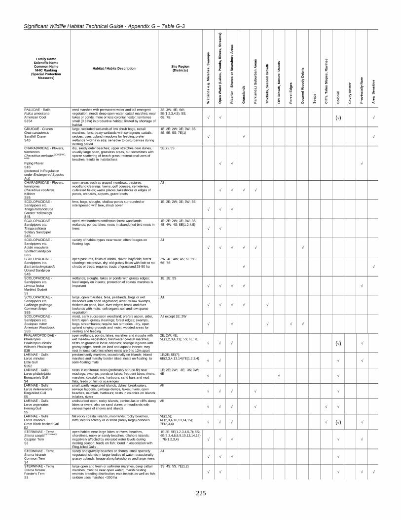
Significant Wildlife Habitat Technical Guide - Appendix G – Table G-3
225
Family NameScientific NameCommon NameNHIC Ranking
(Special ProtectionMeasures)
Habitat / Habits Description Site Region(Districts)
Wet
land
s e.
g. M
arsh
es, S
wam
ps
Ope
n W
ater
(Lak
es, P
onds
, Riv
ers,
Str
eam
s)
Rip
aria
n - S
hore
s or
Nea
rsho
re A
reas
Gra
ssla
nds
Par
klan
ds,/
Sub
urba
n A
reas
Thic
kets
, Sec
ond
Gro
wth
Old
Gro
wth
, Mat
ure
Sta
nds
Fore
st E
dges
Dow
ned
Woo
dy D
ebris
See
ps
Clif
fs, T
alus
Slo
pes,
Rav
ines
Col
onia
l
Cav
ity N
este
r
Pro
vinc
ially
Rar
e
Are
a S
ensi
tive
RALLIDAE - RailsFulica americanaAmerican CootS3S4
reed marshes with permanent water and tall emergentvegetation; needs deep open water; cattail marshes; nearlakes or ponds; more or less colonial nester; territoriessmall (0.3 ha) in productive habitat; limited by shortage ofhabitat
3S; 3W; 4E; 4W;5E(1,2,3,4,5); 5S;6E; 7E √ √ (√) √
GRUIDAE - CranesGrus canadensisSandhill CraneS4B
large, secluded wetlands of low shrub bogs, cattailmarshes, fens; peaty wetlands with sphagnum, cattails,sedges; uses upland meadows for feeding; preferwetlands >40 ha in size; sensitive to disturbances duringnesting period
1E; 2E; 2W; 3E; 3W; 3S;4E; 5E; 5S; 7E(1)
√ √ √
CHARADRIIDAE - Plovers,turnstonesCharadrius melodusE(COSEWIC,
MNR)
Piping PloverS1B(protected in Regulationunder Endangered SpeciesAct)
dry, sandy outer beaches; upper stretches near dunes,usually large open, grassless areas, but sometimes withsparse scattering of beach grass; recreational uses ofbeaches results in habitat loss
5E(7); 5S
√ √ √
CHARADRIIDAE - Plovers,turnstonesCharadrius vociferusKilldeerS5B
open areas such as grazed meadows, pastures,woodland clearings, lawns, golf courses, cemeteries,cultivated fields; waste places; lakeshores or edges ofponds, orchards, airports, gravel roofs
All
√ √ √ √
SCOLOPACIDAE -Sandpipers etc.Tringa melanoleucaGreater YellowlegsS4B
fens, bogs, sloughs, shallow ponds surrounded orinterspersed with tree, shrub cover
1E; 2E; 2W; 3E; 3W; 3S
√ √ √
SCOLOPACIDAE -Sandpipers etc.Tringa solitariaSolitary SandpiperS4B
open, wet northern coniferous forest woodlands;wetlands; ponds; lakes; nests in abandoned bird nests intrees
1E; 2E; 2W; 3E; 3W; 3S;4E; 4W; 4S; 5E(1,2,4,5)
√ √
SCOLOPACIDAE -Sandpipers etc.Actitis maculariaSpotted SandpiperS5B
variety of habitat types near water; often forages onfloating logs
All
√ √ √ √ √ √
SCOLOPACIDAE -Sandpipers etc.Bartramia longicaudaUpland SandpiperS4B
open pastures, fields of alfalfa, clover, hayfields; forestclearings; extensive, dry, old grassy fields with little to noshrubs or trees; requires tracts of grassland 25-50 ha
3W; 4E; 4W; 4S; 5E; 5S;6E; 7E
√ √
SCOLOPACIDAE -Sandpipers etc.Limosa fedoaMarbled GodwitS3
wetlands, sloughs, lakes or ponds with grassy edges;feed largely on insects; protection of coastal marshes isimportant
1E; 2E; 5S
√ √ √ √ √
SCOLOPACIDAE -Sandpipers etc.Gallinago gallinagoCommon SnipeS5B
large, open marshes, fens, peatlands, bogs or wetmeadows with short vegetation; alder, willow swamps,thickets on pond, lake, river edges; brook and riverlowlands with moist, soft organic soil and low sparsevegetation
All
√ √ √ √ √
SCOLOPACIDAE -Sandpipers etc.Scolopax minorAmerican WoodcockS5B
moist, early succession woodland; prefers aspen, alder,birch; open, grassy clearings; forest edges; swamps,bogs, streambanks; require two territories - dry, openupland singing grounds and moist, wooded areas fornesting and feeding
All except 1E; 2W
√ √ √ √ √
PHALAROPODIDAE -PhalaropesPhalaropus tricolorWilson's PhalaropeS3B
open wetlands, ponds, lakes, marshes and sloughs withwet meadow vegetation; freshwater coastal marshes;nests on ground in loose colonies; sewage lagoons withgrassy edges; feeds on land and aquatic insects; maynest in loose colonies where nests are 9 to 12m apart
2E; 2W; 4E;5E(1,2,3,4,11); 5S; 6E; 7E
√ √ √ (√) √
LARINAE - GullsLarus minutusLittle GullS1S2
predominantly marshes, occasionally on islands; inlandmarshes and marshy border lakes; nests on floating tosemi-floating mats
1E;2E; 5E(7);6E(2,3,4,13,14)7E(1,2,3,4) √ √ √ √
LARINAE - GullsLarus philadelphiaBonaparte's GullS4
nests in coniferous trees (preferably spruce-fir) nearmuskegs, swamps, ponds or lakes; frequent lakes, rivers,marshes, coastal bays, harbours; sand bars and mudflats; feeds on fish or scavenges
1E; 2E; 2W; 3E; 3S; 3W;4E √ √ √ √
LARINAE - GullsLarus delawarensisRing-billed GullS5
small, partly vegetated islands, dykes, breakwaters,sewage lagoons, garbage dumps, lakes, rivers, openbeaches, mudflats, harbours; nests in colonies on islandsin lakes, rivers
All
√ √ √ √ √
LARINAE - GullsLarus argentatusHerring GullS5
undisturbed open, rocky islands, peninsulas or cliffs alonglakes or rivers; also on sand dunes or headlands withvarious types of shores and islands
All
√ √ √ √ √ √
LARINAE - GullsLarus marinusGreat Black-backed GullS2
flat rocky coastal islands, moorlands, rocky beaches,cliffs; nest is solitary or in small (rarely large) colonies
5E(2,5);6E(2,3,4,10,13,14,15);7E(2,3,4) √ √ √ √ (√) √
STERNINAE - TernsSterna caspiaV(COSEWIC)
Caspian TernS3
open habitat near large lakes or rivers, beaches,shorelines, rocky or sandy beaches, offshore islands;negatively affected by elevated water levels duringnesting season; feeds on fish; found in association withRing-billed Gulls
1E;2E; 5E(1,2,3,4,5,7); 5S;6E(2,3,4,6,8,9,10,13,14,15); 7E(1,2,3,4) √ √ √ √ √
STERNINAE - TernsSterna hirundoCommon TernS4
sandy and gravelly beaches or shores; small sparselyvegetated islands in larger bodies of water; occasionallygrassy uplands; forage along lakeshores and large rivers
All
√ √ √ √
STERNINAE - TernsSterna forsteriForster's TernS3
large open and fresh or saltwater marshes, deep cattailmarshes; must be near open water; marsh nestingrestricts breeding distribution; eats insects as well as fish;seldom uses marshes <300 ha
3S; 4S; 5S; 7E(1,2)
√ √ √ √ √

Significant Wildlife Habitat Technical Guide - Appendix G – Table G-3
226
Family NameScientific NameCommon NameNHIC Ranking
(Special ProtectionMeasures)
Habitat / Habits Description Site Region(Districts)
Wet
land
s e.
g. M
arsh
es, S
wam
ps
Ope
n W
ater
(Lak
es, P
onds
, Riv
ers,
Str
eam
s)
Rip
aria
n - S
hore
s or
Nea
rsho
re A
reas
Gra
ssla
nds
Par
klan
ds,/
Sub
urba
n A
reas
Thic
kets
, Sec
ond
Gro
wth
Old
Gro
wth
, Mat
ure
Sta
nds
Fore
st E
dges
Dow
ned
Woo
dy D
ebris
See
ps
Clif
fs, T
alus
Slo
pes,
Rav
ines
Col
onia
l
Cav
ity N
este
r
Pro
vinc
ially
Rar
e
Are
a S
ensi
tive
STERNINAE - TernsChlidonias nigerV(COSSARO)
Black TernS3
wetlands, coastal or inland marshes; large cattailmarshes, marshy edges of rivers, lakes or ponds, wetopen fens, wet meadows; returns to same area to nesteach year in loose colonies; must have shallow (0.5 to 1m deep) water and areas of open water near nests;requires marshes >20 ha in size; feeds over adjacentgrasslands for insects; also feeds on fish, crayfish andfrogs
All except 1E
√ √ √ √ √ √ √
COLUMBIDAE - Pigeons,dovesZenaida macrouraMourning DoveS5
open, mature coniferous mixed woodlands interspersedwith open areas, agricultural fields; edges, woodlots andshelterbelts; evergreen plantations or orchards; urbanareas; open woodland with bare ground that producesenough food
2E; 3E; 3W; 3S; 4E; 4W;4S; 5E; 5S; 6E; 7E
√ √ √
CUCULIDAE - Cuckoos, anisetc.Coccyzus erythropthalmusBlack-billed CuckooS4B
dense, shrubby deciduous vegetation of low to mediumheight, interspersed with clearings; brushy pasture;shrubby hedgerows at field edges; dry open uplandwoods; overgrown old fields with hawthorn; swamps
2E; 3E; 3W; 4E; 4W; 4S;5E; 5S; 6E; 7E
√ √ √
CUCULIDAE - Cuckoos, anisetc.Coccyzus americanusYellow-billed CuckooS4B
Carolinian, Great Lakes- St. Lawrence forest zones; openwoodlands with dense, shrubby undergrowth; scrub-landwith small trees; orchards; parkland; edges of agriculturalareas; overgrown, weedy fields; streambanks with densethickets
5E(1,2,3,4,5,7); 6E; 7E
√ √ √ √ √
TYTONIDAE - Barn -owlsTyto albaE(COSEWIC), T(MNR)
Barn OwlS1
open areas such as fields, agricultural lands withscattered woodlots, buildings and/or orchards;grasslands, sedge meadows, marshes; snow-cover limitsability to catch prey; species has intolerance to severecold; nests in hollow trees and live trees >46 cm dbh;also nests in barns, abandoned buildings
6E(9); 7E(3,5)
√ √ √ √ √
STRIGIDAE - OwlsOtus asioEastern Screech OwlS5
open woodland, orchards or shade trees in urban areas;small woodlots; prefers mature deciduous trees; requirestrees > 30 cm dbh for nesting and roosting; confinedlargely to southern Ontario as a breeding bird; smallwoodlots are acceptable if scattered trees are availableover several hectares
4E;5E(1,2,3,7,8,9,11,12); 6E;7E √ √ √ √ √
STRIGIDAE - OwlsBubo virginianusGreat Horned OwlS5
deep, deciduous, mixed or coniferous forests or largewoodlots; mixed forests and fields; swamps; woodlandsnear large streams or pond; near dumps; feeds in openareas like fields or pastures
All
√ √ √ √ √
STRIGIDAE - OwlsSurnia ululaNorthern Hawk OwlS3S4
open, coniferous or mixed woods with clearings; forestedges; swamps or muskegs; dense bushy areas; burnedwoodland with standing stumps; diurnal habits; nests inold woodpecker holes
1E; 2E; 2W;3E; 3S
√ √ √ √
STRIGIDAE - OwlsStrix variaBarred OwlS4
coniferous or mixed woodlands with little understory andrelatively closed canopy; dense moist forest, particularlynear stream, river or lake; heavily wooded swamps; oftennear open area or clearing for hunting; requires trees withdiameter >50 cm, with cavities for nesting; has homerange of 10-250 ha; needs large 100 - 400 ha forests
All but 1E
√ √ √ √ √
STRIGIDAE - OwlsStrix nebulosaV(COSSARO)
Great Gray OwlS3S4
boreal forest; various woodlands; open fields or peatlandswith exposed perches for hunting; extensive muskegswith interspersed tamaracks and black spruce; open fens,bogs or meadows; diurnal habits; uses abandoned crow,raven, hawk nests; home range of 100 ha or more
1E; 2E; 2W; 3E; 3W;3S;4E; 4W; 4S; 5S
√ √ √ √ √
STRIGIDAE - OwlsAsio otusLong-eared OwlS4
dense stands of coniferous or mixed forest; reforestationplots; isolated groves of coniferous woods on farmland;needs large open areas for foraging; winters deep ingroves of evergreens
All except 2W; 3S; 4S; 4W
√ √
STRIGIDAE - OwlsAsio flammeusV(COSEWIC)
Short-eared OwlS2
grasslands, open areas or meadows that are grassy orbushy; marshes, bogs or tundra; both diurnal andnocturnal habits; ground nester; destruction of wetlandsby drainage for agriculture is an important factor in thedecline of this species; home range 25 -125 ha; requires75-100 ha of contiguous open habitat
All except 3W; 4W; 4S
√ √ √ √ √
STRIGIDAE - OwlsAegolius funereusBoreal OwlS4
boreal forest zone in mixed to pure coniferous forest;prefers spruce, balsam fir, trembling aspen, balsampoplar and white birch; open areas, such as beaverponds, edges or natural openings for hunting; requiredead or living trees with dbh >30 cm; hunting territories ofopen areas near edges ≥5 km2
2E; 2W;3E; 3W;3S; 4E;4W; 4S; 5E(4); 5S
√ √ √ √ √ √
STRIGIDAE - OwlsAegolius acadicusNorthern Saw-whet OwlS4S5B
coniferous, mixed or deciduous forests; prefers conifers;found in interior or edge of forest; requires dead trees>30 cm for nesting and roosting; also in chimneys,abandoned buildings; commonly found in urban areas
3E; 3W; 4E; 4W;4S;5E;6E;7E √ √ √ √
CAPRIMULGIDAE -GoatsuckersChordeiles minorCommon NighthawkS4B
open ground; clearings in dense forests; ploughed fields;gravel beaches or barren areas with rocky soils; openwoodlands; flat gravel roofs
All
√ √ √ √
CAPRIMULGIDAE -GoatsuckersCaprimulgus vociferusWhip-poor-willS5B
dry, open, deciduous woodlands of small to mediumtrees; oak or beech with lots of clearings and shaded leaf-litter; wooded edges, forest clearings with littleherbaceous growth; pine plantations; associated with>100 ha forests; may require 500 to 1000 ha to maintainpopulation
3E;4E; 4W; 4S 5E; 5S; 6E;7E
√ √ √ √ √ √
APODIDAE - SwiftsChaetura pelagicaChimney SwiftS5B
commonly found in urban areas near buildings; nests inhollow trees, crevices of rock cliffs, chimneys; highlygregarious; feeds over open water
2W; 3E; 3W; 3S; 4E; 4W;4S; 5E; 5S; 6E; 7E √ √ √ √ √ √ √ √
TRICHILIDAE -HummingbirdsArchilochus colubrisRuby-throated HummingbirdS5B
dense, mixed woodland or forest edges; shade trees ororchards in cultivated lands near a stream if possible;wooded swamps; abundant, preferably red flowers
All except 1E; 2E; 2W
√ √ √ √ √
ALECEDINIDAE - KingfishersCeryle alcyonBelted KingfisherS5B
sand, clay, gravelly banks within 1.6 km of water bodywith fish; eroded stream or river banks; lakeshore bluffs;gravel pits or road cuts close to adequate food source;needs perches near water for sighting prey
All
√ √ √

Significant Wildlife Habitat Technical Guide - Appendix G – Table G-3
227
Family NameScientific NameCommon NameNHIC Ranking
(Special ProtectionMeasures)
Habitat / Habits Description Site Region(Districts)
Wet
land
s e.
g. M
arsh
es, S
wam
ps
Ope
n W
ater
(Lak
es, P
onds
, Riv
ers,
Str
eam
s)
Rip
aria
n - S
hore
s or
Nea
rsho
re A
reas
Gra
ssla
nds
Par
klan
ds,/
Sub
urba
n A
reas
Thic
kets
, Sec
ond
Gro
wth
Old
Gro
wth
, Mat
ure
Sta
nds
Fore
st E
dges
Dow
ned
Woo
dy D
ebris
See
ps
Clif
fs, T
alus
Slo
pes,
Rav
ines
Col
onia
l
Cav
ity N
este
r
Pro
vinc
ially
Rar
e
Are
a S
ensi
tive
PICIDAE - WoodpeckersMelanerpeserythrocephalusV,V
Red-headed WoodpeckerS3B
open, deciduous forest with little understory; fields orpasture lands with scattered large trees; woodedswamps; orchards, small woodlots or forest edges;groves of dead or dying trees; feeds on insects andstores nuts or acorns for winter; loss of habitat is limitingfactor; requires cavity trees with at least 40 cm dbh;require about 4 ha for a territory
4E; 4S; 5E; 5S; 6E;7E
√ √ √ √ √ √ √
PICIDAE - WoodpeckersMelanerpes carolinusRed-bellied WoodpeckerS3S4
mature deciduous forests with numerous dead trees;open woodlands, suburbs or parks; both wet bottomlandor dry upland areas; requires at least 4 ha of continuousforest and cavity trees at least 35 cm dbh
6E(1,2,5,7,8,9,13,15); 7E
√ √ √ √ √
PICIDAE - WoodpeckersSphyrapicus variusYellow-bellied SapsuckerS5B
dry, second growth forests with dead trees >25 cm dbhfor nesting; prefers live trembling aspen; dense or opendeciduous or mixed birch, hemlock, maple forest with talltrees; territories are from 2-5 ha in size
All
√ √ √ √ √ √ √
PICIDAE - WoodpeckersPicoides pubescensDowny WoodpeckerS5
mainly deciduous, sometimes mixed forests; found inareas of few, young or mature matures; small woodlots oredges with shrubs and saplings; uses dead trees >20 cmdbh; territories cover 2-4 ha
All but 1E
√ √ √ √ √ √ √
PICIDAE - WoodpeckersPicoides villosusHairy WoodpeckerS5
mixed or deciduous forests; prefer mature trees, but usewide range in size and canopy cover; forest edges;requires a number of tall trees and snags; requires trees>25 cm dbh; territories cover 4-8 ha
All
√ √ √ √ √ √
PICIDAE - WoodpeckersPicoides tridactylusThree-toed WoodpeckerS4
moist, mature or old growth coniferous woodlands ofcedar-balsam fir; burns with stands of dead timber;riparian areas; bogs; loosely colonial where nestinghabitat is particularly suitable and food supply abundant;uses dead trees > 30 cm dbh; needs extensive (≥40 ha)of forest
1E; 2E; 2W; 3E; 3W;3S;4E; 4W; 4S; 5E(11); 5S;6E(10) √ √ √ √ (√) √ √
PICIDAE - WoodpeckersPicoides arcticusBlack-backed WoodpeckerS4
burned over coniferous sites with standing timber;mature, old growth coniferous forests of mainly cedar-balsam fir; bogs; riparian areas; territories cover 30-40 ha
1E; 2E; 2W; 3E; 3W; 3S;4E; 4W; 4S; 5E; 6E(5,13) √ √ √ √ √ √ √
PICIDAE - WoodpeckersColaptes auratusNorthern FlickerS5B
open deciduous, coniferous or mixed woodlands; forestedges; suburbs, farm woodlots; wetlands; uses dead ordying trees with dbh >30 cm; very adaptable species; notdependent on forest size
All
√ √ √ √ √ √ √
PICIDAE - WoodpeckersDryocopus pileatusPileated WoodpeckerS4S5
extensive tracts of mature deciduous or mixed forest withwater and large diameter (40+ cm) trees for cavityconstruction; both lowland, upland forests; sometimesfound in more open agricultural areas and parks withlarge trees; area sensitive species requiring 40-260 ha;requires trees >25 cm dbh for nesting and trees 40+ cmdbh for roosting
All but 1E
√ √ √ √ √
TYRANNIDAE - FlycatchersContopus borealisOlive-sided FlycatcherS5B
semi-open, conifer forest, prefers spruce; near pond, lakeor river; treed wetlands for nesting; burns with dead treesfor perching
All except 7E
√ √ √ √
TYRANNIDAE - FlycatchersContopus virensEastern Wood PeweeS5B
open, deciduous, mixed or coniferous forest;predominated by oak with little understory; forestclearings, edges; farm woodlots, parks
2E; 3E; 3W; 3S; 4E; 4W;4S; 5E; 5S; 6E; 7E √ √ √ √ √
TYRANNIDAE - FlycatchersEmpidonax flaviventrisYellow-bellied FlycatcherS5B
coniferous forest of pine and spruce with dense shrubs;shrubby swamps with spruce, alder; low, wet swampythickets bordering ponds, streams, bogs; talus slopes
All except 7E
√ √ √ √ √
TYRANNIDAE - FlycatchersEmpidonax virescensE(COSEWIC)
Acadian FlycatcherS2B
mature, shady, deciduous forests; heavily woodedravines; creek bottoms or river swamps; availability ofgood quality habitat is limiting factor; needs at least 30 haof forest
6E(1); 7E
√ √ √ √
TYRANNIDAE - FlycatchersEmpidonax alnorumAlder FlycatcherS5B
open areas with alder, willow thickets bordering lakes orstreams; low damp thickets in or near bogs, swamps ormarshes; prefers alders, willows, elders or sumacs
All
√ √ √ √
TYRANNIDAE - FlycatchersEmpidonax trailliiWillow FlycatcherS5B
open areas with secondary shrubby growth or low treesof willow, red osier dogwood, hawthorn; damp to drybrushy, abandoned fields or clearcuts; open forest ororchards with clearings; forest edges; hedgerows
4E; 5E; 6E; 7E
√ √
TYRANNIDAE - FlycatchersEmpidonax minimusLeast FlycatcherS5B
open deciduous woodland or forest edges; orchards;open shrub land; clearings or overgrown pasture of >100ha
All
√ √ √ √
TYRANNIDAE - FlycatchersSayornis phoebeEastern PhoebeS5B
suburban or agricultural areas; farmland; mature mixed,deciduous, coniferous woodlands; woodland cliffs orravines, often near streams
2W; 3E; 3W; 3S; 4E; 4W;4S; 5E; 5S; 6E; 7E √ √ √ √ √ √
TYRANNIDAE - FlycatchersMyiarchus crinitusGreat Crested FlycatcherS5B
broad-leafed trees in mature deciduous or mixed forests;prefers edges and clearings rather than forest interior;swamps, savannahs, old orchards; nests are in naturalcavities or woodpecker holes in trees > 46 cm dbh;territories may not be more than 1 ha in size, but birdsprefer rather extensive woodlands
3E; 3W; 3S;4E; 4W; 4S;5E; 5S; 6E; 7E
√ √ √ √ √
TYRANNIDAE - FlycatchersTyrannus verticalisWestern KingbirdS1B
dry, open country or scrub-land with trees; telephonepoles or other perches; hedgerows; agricultural land
5S
√ √ √
TYRANNIDAE - FlycatchersTyrannus tyrannusEastern KingbirdS5B
shrubby, forest edges; hedgerows or stream banks in ornear open fields; pastures, clearings or burned over landswith sufficient perches; swamps, marshes with deadstumps or snags; open woodlands and orchards; territoryabout 1 ha in size
All
√ √ √ √ √
LANIIDAE - ShrikesLanius ludovicianusE(COSEWIC,
MNR)
Loggerhead ShrikeS2B(protected in Regulationunder Endangered SpeciesAct)
grazed pasture, marginal farmland with scatteredhawthorn shrubs, hedgerows; fence posts, wires andassociated low-lying wetland; located on core areas oflimestone plain adjacent to Canadian Shield; greatestthreat is fragmentation of suitable habitat due to naturalsuccession; probably needs at least 25 ha of suitablehabitat
5E(11); 6E: 7E(3,6)
√ √ √

Significant Wildlife Habitat Technical Guide - Appendix G – Table G-3
228
Family NameScientific NameCommon NameNHIC Ranking
(Special ProtectionMeasures)
Habitat / Habits Description Site Region(Districts)
Wet
land
s e.
g. M
arsh
es, S
wam
ps
Ope
n W
ater
(Lak
es, P
onds
, Riv
ers,
Str
eam
s)
Rip
aria
n - S
hore
s or
Nea
rsho
re A
reas
Gra
ssla
nds
Par
klan
ds,/
Sub
urba
n A
reas
Thic
kets
, Sec
ond
Gro
wth
Old
Gro
wth
, Mat
ure
Sta
nds
Fore
st E
dges
Dow
ned
Woo
dy D
ebris
See
ps
Clif
fs, T
alus
Slo
pes,
Rav
ines
Col
onia
l
Cav
ity N
este
r
Pro
vinc
ially
Rar
e
Are
a S
ensi
tive
VIREONIDAE - VireosVireo griseusWhite-eyed VireoS2B
dense, swampy thickets and hillsides with blackberry andbriar tangles; forest edges, early successional fields;territories 1-2 ha
6E(1,7,13); 7E
√ √ √ √
VIREONIDAE - VireosVireo flavifronsYellow-throated VireoS4B
open woods of oak, maple or other hardwoods; orchards;groves; roadside trees; rarely in conifers; requires at least30 ha of forest area
6E; 7E
√ √ √ √ √
VIREONIDAE - VireosVireo solitariusBlue-headed VireoS5B
large, mature coniferous or mixed forests of pine,hemlock or spruce with nearly continuous canopy anddense understory; pine plantations; either closed canopyor where trees are more scattered; require youngconiferous or deciduous shrubs for nesting; oftenassociated with swampy areas; territories <1 ha; appearsto need about 100 ha of forest in the south
All except 7E(1)
√ √ √ √
VIREONIDAE - VireosVireo gilvusWarbling VireoS5B
open, mature mixed or deciduous woodlands, orchards,shade trees; watercourse edges with scattered trees;mature deciduous trees such as maple, poplar; forestedges; woodland groves, parks; towns, cities
3E; 3W; 3S; 4E; 4S; 5E;5S; 6E; 7E √ √ √ √ √ √
VIREONIDAE - VireosVireo philadelphicusPhiladelphia VireoS5B
open, deciduous, coniferous or mixed forest withtrembling aspen and alders; among or adjacent to aspengroves; forest edges; streamside willow and alderthickets; burned over areas or clearings; small (0.5 ha)territory
2E; 2W; 3E; 3W; 3S; 4E;4W; 4S; 5E; 5S; 6E(3,4,6,8,9,10,11,12,14) √ √ √ √
VIREONIDAE - VireosVireo olivaceusRed-eyed VireoS5B
open, second growth deciduous or mixed woodlands witha continuous canopy and dense understory includingsaplings; residential shade trees with continuous canopy;mesic stands in deciduous forest
All
√ √
CORVIDAE - Crows, jaysPerisoreus canadensisGray JayS5
coniferous, mixed wood forests; forest openings; bogs;highly territorial
1E; 2E; 2W; 3E; 3W; 3S;4E; 4W; 4S; 5E; 6E(9,12) √ √ √
CORVIDAE - Crows, jaysCyanocitta cristataBlue JayS5
coniferous, deciduous or mixed woods; regeneratingforests; scrub meadow; urban habitats
All except 1E
√ √ √ √ √ √
CORVIDAE - Crows, jaysPica picaBlack-billed MagpieS3
prairie fringes; open agricultural, parkland or scrub-land;pastures, fields with aspen, willow, alder groves; openwoodlands and thickets, especially along water courses;has close association with human, rural settlements
4S; 5S
√ √ √ √ √
CORVIDAE - Crows, jaysCorvus brachyrhynchosAmerican CrowS5
deciduous, coniferous, mixed woods with adjacent openareas or farmland; edges; open fields with scatteredwoodlots; forests near marshes, lakes, rivers
All
√ √ √ √ √ √ √
CORVIDAE - Crows, jaysCorvus coraxCommon RavenS5
relatively undisturbed habitat of boreal or mixed forest;nests on steep cliffs or in tall trees; uses and builds ontosame nest in consecutive years
All except 7E
√ √ √
ALAUDIDAE - LarksEremophila alpestrisHorned LarkS4N
large, open areas with short grasses, ploughed fields,agricultural lands, pastures, prairie, golf courses,cemeteries, airports; areas of little vegetation; tundra,seashore; needs a bare patch of exposed ground withinterritory
1E; 2E; 3E; 3S; 4E; 5E; 5S;6E; 7E
√ √
HIRUNDINIDAE - SwallowsProgne subisPurple MartinS4S5B
open, trees areas such as farmland, parks, yards,marshes; usually near large bodies of water; colonial;nests in tree cavities, cliff ledges; most common in nestboxes; requires open space for foraging; prefers trees>15 cm dbh
4E; 4W; 4S; 5E; 5S; 6E; 7E
√ √ √ √ √ √ √ √
HIRUNDINIDAE - SwallowsTachycineta bicolorTree SwallowS5B
open spaces; near open water or over water; clear cuts orfarmland; requires cavity trees with dbh >25 cm; normallya solitary nester
All
√ √ √ √ √ √ √
HIRUNDINIDAE - SwallowsStelgidopteryx serripennisNorthern Rough-wingedSwallowS5
open areas near river banks, lakeshores; gravel pits,sandy road banks, steep riparian banks, or drainageholes for nesting, and near a water supply
3E; 4E; 4S; 5E; 5S; 6E; 7E,
√ √ √ √ √
HIRUNDINIDAE - SwallowsRiparia ripariaBank SwallowS5
sand, clay or gravel river banks or steep riverbank cliffs;lakeshore bluffs of easily crumbled sand or gravel; gravelpits, road-cuts, grassland or cultivated fields that areclose to water; nesting sites are limiting factor for speciespresence
All
√ √ √ √ √
HIRUNDINIDAE - SwallowsHirundo pyrrhonotaCliff SwallowS5
cliffs and bluffs with nearby open areas such as farmland,fields or pasture; nests built on buildings, bridges nests;open forest for feeding
All except 1E
√ √
HIRUNDINIDAE - SwallowsHirundo rusticaBarn SwallowS5B
farmlands or rural areas; cliffs, caves, rock niches;buildings or other man-made structures for nesting; opencountry near body of water
All
√ √ √ √ √ √ √
PARIDAE - TitmiceParus atricapillusBlack-capped ChickadeeS5
small-open deciduous or mixed wooded areas (parks,residential areas); edges, thickets; nests in tree cavitiesof trees with dbh >10 cm; territory is 1-2 ha of woodland
All
√ √ √ √ √ √ √
PARIDAE - TitmiceParus hudsonicusBoreal ChickadeeS5
forests on poor soil; conifers (spruce); wooded swamps,bogs; thickets; nest in natural cavities, woodpecker holes,or their own excavation in decaying wood; territory isabout 1-2 ha of woodland
1E; 2E; 3E; 3W; 3S; 4E;4W; 4S; 5E(4,5,6,8,9,10);5S √ √ √ √ √ √
PARIDAE - TitmiceParus bicolorTufted TitmouseS2
mixed or deciduous forests; moist bottomlands andswamps, orchards; agricultural or urban forested areas,often near birdfeeders; Carolinian forest; nest in naturalcavities or woodpecker holes in live or soft dead trees>10 cm dbh; area sensitive, requiring at least4 ha of shrub and sapling growth near water
6E(1,6); 7E(1,3,5)
√ √ √ √ √ √ √ √
SITTIDAE - NuthatchesSitta canadensisRed-breasted NuthatchS5
coniferous and mixed wood forests; nests in a cavity insoft, decaying coniferous wood with dbh >12 cm; requiresconiferous component to its habitat; most abundant inmature woods and relatively dense forests; nests ininterior, requiring at least 10 ha of forest
All
√ √ √ √ √ √

Significant Wildlife Habitat Technical Guide - Appendix G – Table G-3
229
Family NameScientific NameCommon NameNHIC Ranking
(Special ProtectionMeasures)
Habitat / Habits Description Site Region(Districts)
Wet
land
s e.
g. M
arsh
es, S
wam
ps
Ope
n W
ater
(Lak
es, P
onds
, Riv
ers,
Str
eam
s)
Rip
aria
n - S
hore
s or
Nea
rsho
re A
reas
Gra
ssla
nds
Par
klan
ds,/
Sub
urba
n A
reas
Thic
kets
, Sec
ond
Gro
wth
Old
Gro
wth
, Mat
ure
Sta
nds
Fore
st E
dges
Dow
ned
Woo
dy D
ebris
See
ps
Clif
fs, T
alus
Slo
pes,
Rav
ines
Col
onia
l
Cav
ity N
este
r
Pro
vinc
ially
Rar
e
Are
a S
ensi
tive
SITTIDAE - NuthatchesSitta carolinensisWhite-breasted NuthatchS5
mature, broad-leafed woodland; tolerates mixed forest;orchards, shade trees in suburban and rural areas; usesnatural cavities in trees with dbh> 30 cm; needs at least10 ha or more of continuous forest
3E; 3W; 4E; 4W; 4S; 5E;5S; 6E; 7E √ √ √ √ √ √
CERTHIIDAE - CreepersCerthia americanaBrown CreeperS5B
mature dense, coniferous, deciduous, mixed woodlands;particularly wet areas with large dead trees; bogs;wooded swamps; older second growth forest; riparianareas; requires dead trees >25 cm dbh with loose barkfor nesting; occasionally nests in tree cavity; requires aminimum of 30 ha
All
√ √ √ √ (√) √
TROGLODYTIDAE - WrensThryothorus ludovicianusCarolina WrenS3
scrub-land; open deciduous woodland thickets andtangles along streams; woodland edges with slash piles;in winter found in sheltered stream valleys, deep ravineswith nearby food source
6E(6,9,11,13,15); 7E
√ √ √ √ √ √
TROGLODYTIDAE - WrensTroglodytes aedonHouse WrenS5B
edges of woods, rivers, swamps or clear cuts; openingswith shrubs and thickets; deciduous woods, shrubbery;gardens; orchards, swampy woodlands; nests in treeswith dbh >25 cm; territories may be no more than 0.4 hain size
3E; 3W; 3S; 4E; 4W; 4S;5E; 5S;6E; 7E
√ √ √ √ √ √
TROGLODYTIDAE - WrensTroglodytes troglodytesWinter WrenS5B
interior species; coniferous forest with hemlock-pinecommunities; cedar swamps; spruce bogs; deep woodswith dense undergrowth; downed wood close to foreststreams; nests in cavities of uprooted trees, old stumps,brush piles; nests in soft trees with dbh >10 cm; appearsto need at least 30 ha of forest
All
√ √ √ √ √ √ √ √
TROGLODYTIDAE - WrensCistothorus platensisSedge WrenS4B
shallow, wet sedge or grass marshes, bogs, old fields ormeadows with scattered shrubs of willow, alder; little tono standing water; territories 0.2 ha in size
All except 1E
√ √ √
TROGLODYTIDAE - WrensCistothorus palustrisMarsh WrenS4S5B
large, expanses of cattail marsh with some open water;shores of sluggish rivers or streams or inland ponds withmoderate density stands of tall robust emergentvegetation (sedges, cattails); gregarious; uses samebreeding area year after year; constructs "cavity nest" outof cattail leaves
2E; 3S; 4E; 4S; 5E; 5S; 6E;7E
√ √ √ (√)
SYLVIIDAE - Gnatcatchers,kingletsRegulus satrapaGolden-crowned KingletS5B
closed, mature coniferous forest; preferably spruce, fir,hemlock, pines; mature spruce and pine plantations withaverage dbh >15 cm and a closed canopy; cedar bogs
All
√ √
SYLVIIDAE - Gnatcatchers,kingletsRegulus calendulaRuby-crowned KingletS5B
coniferous or mixed woodlands with stands of fir, spruce,tamarack or pine; evergreen stands in a variety ofhabitats; coniferous open or edge areas with thickets ofbrush; bogs
All except 7E
√ √ √ √
SYLVIIDAE - Gnatcatchers,kingletsPolioptila caeruleaBlue-gray GnatcatcherS4B
Carolinian and Great Lakes-St. Lawrence Forest zones indeciduous or mixed woods; oak-pine woods or oaksavannahs; open, moist woodlands with brushy clearings;bottomland forests with closed canopies; woodedswamps; stream-side thickets; needs about 30 ha offorest
6E; 7E
√ √ √ √ √ √
TURDIDAE - Thrushes,robins, etc.Sialia sialisEastern BluebirdS4S5B
agricultural area, clearings, fields, pastures, lawns,cemeteries, golf courses or forest clearings; savannahs;swamps, edges; orchards; low cavities in trees >20 cmdbh; territories are 4-8 ha
2E; 3E;3S; 4E; 4W; 4S; 5E;6E; 7E
√ √ √ √ √
TURDIDAE - Thrushes,robins, etc.Catharus fuscescensVeeryS5B
cool, moist, mixed and deciduous young or disturbedforest with bushy undergrowth and ferns; forest edges;wooded swamps or damp ravines; open woods withdense high undergrowth of ferns, shrubs; showssensitivity to habitat fragmentation; needs at least 10 haof forest
All except 1E
√ √ √ √ √
TURDIDAE - Thrushes,robins, etc.Catharus ustulatusSwainson's ThrushS5B
interiors of coniferous forest (spruce, fir), with deciduousshrubs; low, damp woods near water; riverbanks; youngor mature stands; will use mixed woods
All except 7E
√ √ √ √
TURDIDAE - Thrushes,robins, etc.Catharus guttatusHermit ThrushS5B
boreal forest, or Great Lakes-St. Lawrence forest zones;rocky, dry, jack pine forests; dry sandy coniferous ordeciduous woods with dense young undergrowth; sprucebogs; borders of wooded swamps and damp forest;brushy pasture; appears to need at least 100 ha of forestin south
All
√ √ √ √ √ √
TURDIDAE - Thrushes,robins, etc.Hylocichla mustelinaWood ThrushS5B
Carolinian and Great Lakes-St. Lawrence forest zones;undisturbed moist mature deciduous or mixed forest withdeciduous sapling growth; near pond or swamp;hardwood forest edges; must have some trees higherthan 12 m
3E; 3W; 4E; 4W; 5E; 6E;7E
√ √ √ √
TURDIDAE - Thrushes,robins, etc.Turdus migratoriusAmerican RobinS5B
residential areas, lawns, gardens, ornamental trees,shrubberies; forest edges and openings, burns, cut-overareas; fens, bogs; lake or river shores
All
√ √ √ √ √ √
MIMIDAE - Mockingbirds,thrashersDumetella carolinensisGray CatbirdS5B
country lane or suburban garden with shrubs patches;woodland edges; hedgerows; forest clearings with brushyareas; near water; territory about 0.3 ha
3E; 3W; 3S; 4E; 4W; 4S;5E; 5S; 6E; 7E
√ √ √ √ √
MIMIDAE - Mockingbirds,thrashersMimus polyglottosNorthern MockingbirdS3S4
pastures, gardens or orchards with edible fruit- bearingshrubs; woodland edges, hedgerows; groves of largetrees, low, dense woody vegetation; needs elevatedperches
2E; 3E; 3W; 4E; 4W; 4S;5E; 5S; 6E; 7E
√ √ √
MIMIDAE - Mockingbirds,thrashersToxostoma rufumBrown ThrasherS5B
open pastures, hedgerows or woodland edges withbushes, low trees or tangles of vines; areas of low, densewoody vegetation; early successional habitat; overgrownhawthorn pasture or marginal farmland
3E; 3W; 3S; 4E; 4W; 4S5E; 5S; 6E; 7E
√ √

Significant Wildlife Habitat Technical Guide - Appendix G – Table G-3
230
Family NameScientific NameCommon NameNHIC Ranking
(Special ProtectionMeasures)
Habitat / Habits Description Site Region(Districts)
Wet
land
s e.
g. M
arsh
es, S
wam
ps
Ope
n W
ater
(Lak
es, P
onds
, Riv
ers,
Str
eam
s)
Rip
aria
n - S
hore
s or
Nea
rsho
re A
reas
Gra
ssla
nds
Par
klan
ds,/
Sub
urba
n A
reas
Thic
kets
, Sec
ond
Gro
wth
Old
Gro
wth
, Mat
ure
Sta
nds
Fore
st E
dges
Dow
ned
Woo
dy D
ebris
See
ps
Clif
fs, T
alus
Slo
pes,
Rav
ines
Col
onia
l
Cav
ity N
este
r
Pro
vinc
ially
Rar
e
Are
a S
ensi
tive
BOMBYCILLIDAE -WaxwingsBombycilla cedrorumCedar WaxwingS5B
open, deciduous, coniferous forests; forest edges;orchards, woodlots; residential areas with shade trees;semi-open country; agricultural areas; near water, withavailable supply of berries; edges of ponds, lakes, rivers,marshes, fens, open swamps
All
√ √ √ √ √
PARULIDAE - Wood warblersVermivora pinusBlue-winged WarblerS4B
brushy, overgrown fields or meadows or old fields withsaplings >3 m tall; second growth woodlands, edges;borders of wooded swamps, willow swamps, stream-sides; woodland openings; requires >20 ha of habitat
5E(7,8);6E(1,2,3,4,5,6,7,8,9,10);7E √ √ √
PARULIDAE - Wood warblersVermivora chrysopteraGolden-winged WarblerS4B
early successional habitat; shrubby, grassy abandonedfields with small deciduous trees bordered by lowwoodland and wooded swamps; alder bogs; deciduous,damp woods; shrubbery clearings in deciduous woodswith saplings and grasses; brier-woodland edges;requires >10 ha of habitat
4E; 5E; 5S; 6E; 7E
√ √ √
PARULIDAE - Wood warblersVermivora peregrinaTennessee WarblerS5B
brushy, semi-open land; grassy openings in coniferous,deciduous or mixed woods with dense shrubs andscattered clumps of young deciduous trees; treed fens orboggy areas; dry pine plantations and beach ridges
All except 7E
√ √ √ √
PARULIDAE - Wood warblersVermivora celataOrange-crowned WarblerS4B
open deciduous or mixed woods with shrub undergrowth;second growth in clearings or burns; brushy thickets andtall stands of shrubbery
1E; 2E; 2W;3E; 3W; 3S;4S; 5S √ √
PARULIDAE - Wood warblersVermivora ruficapillaNashville WarblerS5B
wet, open coniferous, deciduous or mixed woods ofyoung secondary growth; cedar, spruce swamps; dry ormoist overgrown pastures and old field with scatteredtrees and shrubs; edges; nests in depressions in groundunder dead, dry bracken fern
All
√ √ √
PARULIDAE - Wood warblersParula americanaNorthern ParulaS4B
wooded bogs or swamps; conifers on which beardedlichen grows; closed canopy coniferous or mixed woodsnear water; area sensitive requiring at least 100 ha; aninterior forest species
All except 1E
√ √ √ √
PARULIDAE - Wood warblersDendroica petechiaYellow WarblerS5B
open areas with dense scrub; shrubby wetland areas;stream and river banks or lakeshores with scattered smalltrees or dense shrubbery; farmlands, orchards orsuburban yards
All
√ √ √ √ √
PARULIDAE - Wood warblersDendroica pensylvanicaChestnut-sided WarblerS5B
shrubby, second growth deciduous woodland edges andfields next to stands of mature forest; hardwoodregeneration stands; brushy watercourses; woodlandclearings, burns; brushy woodland margins
All
√ √
PARULIDAE - Wood warblersDendroica magnoliaMagnolia WarblerS5B
mainly mixed and coniferous forests; may be maturetrees but require dense shrubs; in mature forests, preferopen areas, edges; disturbed woodland; appears torequire about 30 ha in the south
All except 7E(1)
√ √ √ √ √
PARULIDAE - Wood warblersDendroica tigrinaCape May WarblerS5B
a boreal forest species; coniferous and mixed forests;prefer relatively open woods and edges, but also occupydense forest; require tall, mature coniferous trees
2E; 2W; 3E; 3W; 3S; 4E;4W; 4S; 5E; 5S √ √
PARULIDAE - Wood warblersDendroica caerulescensBlack-throated Blue WarblerS5B
an interior forest species; deciduous or mixed secondgrowth forest; requires relatively closed canopy, but shrubundergrowth; hemlocks preferred in mixed forests; nestsclose to ground; likely requires over 100 ha in locationsoff the Shield
3E;3W;3S;4E; 4W; 4S; 5E;6E(2,3,4,5,6,7.8,9,10,11,12,14) √ √ √ √ √ √
PARULIDAE - Wood warblersDendroica coronataYellow-rumped WarblerS5B
dry coniferous or mixed forests dominated by fir, spruce,pine, hemlock or cedar; with scattered openings fromlogging, fire or abandoned fields; evergreen plantations;young coniferous growth at woodland edges; also wetterhabitat of black spruce or tamarack; adaptable andopportunistic
All except 7E(1,3,5)
√ √ √ √
PARULIDAE - Wood warblersDendroica virensBlack-throated Green WarblerS5B
prefer dense, mixed forest, but also coniferous or moreopen woods; hemlock, fir are favoured conifers; wetcedar swamps; beech, maple, birches with multi-layeredcanopy and well developed shrub layer; requires about30 ha
All except 1E
√ √ √ √
PARULIDAE - Wood warblersDendroica fuscaBlackburnian WarblerS5B
an interior forest species; requires mature deciduous ormixed forest; swampy woods with spruces thickly drapedwith bearded lichen; second growth deciduous woods;hardwood forests with chestnut trees; requires about 50ha
All except 1E
√ √ √ √
PARULIDAE - Wood warblersDendroica pinusPine WarblerS5B
mature white pine (red to lesser degree) forests that aresomewhat open; 40 to 50 year old pine plantations; areasensitive needing at least 15-30 ha
4E; 4W; 4S; 5E; 5S; 6E; 7E
√ √
PARULIDAE - Wood warblersDendroicadiscolorV(COSEWIC,COSSARO)
Prairie WarblerS3B
scrub-land; mixed pine-oak barrens; old pastures;hillsides with scattered red cedars; avoids thick woodsand benefits from cutting and burning of forests
5E(7,11); 6E(1,6,7,9,10);7E(2)
√ √ √ √
PARULIDAE - Wood warblersDendroica palmarumPalm WarblerS5B
in summer, bogs; during migration, open places,especially weedy fields and borders of marshes andwoodlands; nests on ground in grass clump; territoriesare 1-2 ha in size; less common in south, particularlywhere wetlands have been eliminated
All but 7E
√ √
PARULIDAE - Wood warblersDendroica castaneaBay-breasted WarblerS5B
mature, conifer or mixed forest with spruce, balsam fir;young trees along ponds or streams or in bogs or forestclearings; early coniferous second growth
All except 6E; 7E
√ √ √ √
PARULIDAE - Wood warblersDendroicaceruleaV(COSEWIC,COSSARO)
Cerulean WarblerS3B
mature deciduous woodland of Great Lakes- St.Lawrence and Carolinian forests, sometimes coniferous;swamps or bottomlands with large trees; area sensitivespecies needing extensive areas of forest (>100 ha)
5E(7,8,9);6E(1,2,3,4,5,6,7,10,11, 14);7E √ √ √
PARULIDAE - Wood warblersMniotilta variaBlack-and-white WarblerS5B
breeds at edges of large continuous stands of mature orold second growth deciduous or mixed forest; cedarswamps or bogs; riparian habitat; during migration preferbottomland forests and forest edges; nests in interior inthe south; area sensitive, requiring in excess of 100 ha ofcontinuous forest
All
√ √ √ √ √ √ √

Significant Wildlife Habitat Technical Guide - Appendix G – Table G-3
231
Family NameScientific NameCommon NameNHIC Ranking
(Special ProtectionMeasures)
Habitat / Habits Description Site Region(Districts)
Wet
land
s e.
g. M
arsh
es, S
wam
ps
Ope
n W
ater
(Lak
es, P
onds
, Riv
ers,
Str
eam
s)
Rip
aria
n - S
hore
s or
Nea
rsho
re A
reas
Gra
ssla
nds
Par
klan
ds,/
Sub
urba
n A
reas
Thic
kets
, Sec
ond
Gro
wth
Old
Gro
wth
, Mat
ure
Sta
nds
Fore
st E
dges
Dow
ned
Woo
dy D
ebris
See
ps
Clif
fs, T
alus
Slo
pes,
Rav
ines
Col
onia
l
Cav
ity N
este
r
Pro
vinc
ially
Rar
e
Are
a S
ensi
tive
PARULIDAE - Wood warblersSetophaga ruticillaAmerican RedstartS5B
deciduous or mixed woods with closed canopy of eithertall shrubs or dense young trees or mature trees;woodland edges; upland or lowland; requires >100 ha offorest habitat
All except 1E
√ √ √ √
PARULIDAE - Wood warblersProtonotaria citreaE
Prothonotary WarblerS1S2B
area sensitive species preferring 100 ha of flooded orswampy woodlands with standing or flowing water andmore than 25% canopy cover with numerous stumps andsnags; stream borders or flooded bottomlands; soft, deadtrees with dbh >10 cm; Carolinian species
6E(1,2,3); 7E(1,2,5)
√ √ √ √
PARULIDAE - Wood warblersSeiurus aurocapillusOvenbirdS5B
undisturbed, open, mature deciduous or mixed forest withclosed canopy, little ground vegetation, lots of fallenleaves, logs or rocks; forested ravines or well-drainedriverbanks; nests in depression of dead leaves at base oftree or log; area sensitive species, requiring >70 ha ofcontinuous forest
All
√ √ √ √ √
PARULIDAE - Wood warblersSeiurus noveboracensisNorthern WaterthrushS5B
cool, shady, wet ground with open shallow pools of water;shrubby tangles, fallen logs; wooded swamps, bogs,creek, stream banks or swampy lakeshores; nests inbanks, upturned tree roots or under mossy logs orstumps
All
√ √ √ √
PARULIDAE - Wood warblersSeiurus motacillaV(COSEWIC,
COSSARO)
Louisiana WaterthrushS3B
prefers wooded ravines with running streams; alsowoodlands swamps; large tracts of mature deciduous ormixed forests; canopy cover is essential; has strongaffinity to nest sites; nests on ground
5E(11);6E(1,2,5,6,9,10,11); 7E
√ √ √ √ √
PARULIDAE - Wood warblersOporornis agilisConnecticut WarblerS4B
well-spaced black spruce swamps with good groundcover of Labrador Tea; moist woodlands with well-developed understory for nesting; aspen or poplar
2E; 2W; 3E; 3W; 3S; 4E;4W; 4S; 5E(1,2,3,4); 5S √ √ √
PARULIDAE - Wood warblersOporornis philadelphiaMourning WarblerS5B
shrubby, forest clearings; burned or over-cut areas withsaplings and brambles; dense underbrush; margin oflowland swamps, bogs, watercourses; mesic areas withdense shrubby undergrowth; extensive stands of densesaplings; woodland edges
All except 1E
√ √ √ √
PARULIDAE - Wood warblersGeothlypis trichasCommon YellowthroatS5B
wetlands; cattail marshes, bogs; dense shrubby thicketson stream, pond margins; woodland edges; densetangles near water; dense undergrowth in open woods;second growth old fields; feeds on or near ground
All
√ √ √ √ √
PARULIDAE - Wood warblersWilsonia citrinaT(COSEWIC)
Hooded WarblerS3B
favours mature, deciduous forest (Carolinian), particularlyalong stream bottoms, ravine edges and where saplingsand shrubbery grow; nests above ground in small shrubs;feeds on or near ground
7E
√ √ √ √ √
PARULIDAE - Wood warblersWilsonia pusillaWilson's WarblerS5B
boggy areas with cedar, tamarack or spruce; swampy,brushy land; streamside thickets and tangles; wet,wooded high shrubs or low deciduous trees
All except 6E; 7E
√ √ √ √
PARULIDAE - Wood warblersWilsonia canadensisCanada WarblerS5B
an interior forest species; dense, mixed coniferous,deciduous forests with closed canopy, wet bottomlands ofcedar or alder; shrubby undergrowth in cool moist maturewoodlands; riparian habitat; usually requires at least 30ha
All except 1E
√ √ √ √
PARULIDAE - Wood warblersIcteria virensV,V
Yellow-breasted ChatS2S3B
thickets, tall tangles of shrubbery beside streams, ponds;overgrown bushy clearings with deciduous thickets; nestsabove ground in bush, vines etc.
6E(1,5,9,10,15); 7E
√ √ √ √
THRAUPIDAE -TanagersPiranga olivaceaScarlet TanagerS5B
upland, undisturbed, mature deciduous or mixed forestsin Carolinian and Great Lakes-St. Lawrence Forestzones; nests in thick growth of small trees borderingforests of larger trees; also damp, alder, willow thickets;requires at least 20 ha of forest
All except 1E; 2W
√ √ √ √
FRINGILLIDAE - Grosbeaks,finches, sparrows, buntingsPipilo erythrophthalmusEastern TowheeS4B
dense, brushy cover with leaf litter; abandoned fields orpastures with developing young trees or shrubs;woodland edges with dense undergrowth; streamsidethickets; brushy hillsides
4E; 5E; 5S; 6E; 7E
√ √ √
FRINGILLIDAE - Grosbeaks,finches, sparrows, buntingsSpizella arboreaAmerican Tree SparrowS5B
open areas with scattered trees, brush; low-lying tundrawith stands of shrubs, stunted trees, especially willow,birch, alder; in winter, weedy, brushy fields; open countrywith groves of small trees; hedgerows; marshes
1E (summer);5E; 6E; 7E (winter)
√ √ √
FRINGILLIDAE - Grosbeaks,finches, sparrows, buntingsSpizella passerinaChipping SparrowS5B
open, grassy areas nest to woodland or with thickets oftrees; lawns, gardens or orchards; open mixed woodland;forest clearings; lakeshores or stream borders
All
√ √ √ √ √
FRINGILLIDAE - Grosbeaks,finches, sparrows, buntingsSpizella pallidaClay-coloured SparrowS4B
brushy, open areas in prairies; young pine plantations;abandoned fields with shrubs, small trees; regeneratingburns; thickets along edges of waterways
All
√ √ √
FRINGILLIDAE - Grosbeaks,finches, sparrows, buntingsSpizella pusillaField SparrowS5B
open areas with low shrubs or trees; abandoned pasture,farm fields; overgrown power line corridors; thickets;forest edges; young conifer plantations
5E; 6E; 7E
√ √ √
FRINGILLIDAE - Grosbeaks,finches, sparrows, buntingsPooecetes gramineusVesper SparrowS5B
open areas with short, herbaceous vegetation and songperches; fields with hedgerows or regrowth; well-draineddry grassland areas with scattered trees or shrubs; open,dry conifer plantations; gravel pits; short grass meadowsand pastures
All except 1E; 2E; 2W
√
FRINGILLIDAE - Grosbeaks,finches, sparrows, buntingsPasserculus sandwichensisSavannah SparrowS5B
hayfields, pastures, fields and meadows with denseground vegetation of grasses and other vegetation ofmoderate height; moist lowlands and sedge meadowsbordered by willows and sweet gale; territory is 1.5 to 2ha in size; requires tracts of grassland >50 ha
All
√ √ √ √

Significant Wildlife Habitat Technical Guide - Appendix G – Table G-3
232
Family NameScientific NameCommon NameNHIC Ranking
(Special ProtectionMeasures)
Habitat / Habits Description Site Region(Districts)
Wet
land
s e.
g. M
arsh
es, S
wam
ps
Ope
n W
ater
(Lak
es, P
onds
, Riv
ers,
Str
eam
s)
Rip
aria
n - S
hore
s or
Nea
rsho
re A
reas
Gra
ssla
nds
Par
klan
ds,/
Sub
urba
n A
reas
Thic
kets
, Sec
ond
Gro
wth
Old
Gro
wth
, Mat
ure
Sta
nds
Fore
st E
dges
Dow
ned
Woo
dy D
ebris
See
ps
Clif
fs, T
alus
Slo
pes,
Rav
ines
Col
onia
l
Cav
ity N
este
r
Pro
vinc
ially
Rar
e
Are
a S
ensi
tive
FRINGILLIDAE - Grosbeaks,finches, sparrows, buntingsAmmodramus savannarumGrasshopper SparrowS4B
well-drained grassland or prairie with low cover ofgrasses, taller weeds on sandy soil; hayfields or weedyfallow fields; uplands with ground vegetation of variousdensities; perches for singing; requires tracts of grassland> 10 ha
4E; 5E; 5S; 6E; 7E
√ √
FRINGILLIDAE - Grosbeaks,finches, sparrows, buntingsAmmodramushenslowiiE(COSEWIC, MNR)
Henslow's SparrowS1B(protected in Regulationunder Endangered SpeciesAct)
large, fallow, grassy area with ground mat of deadvegetation, dense herbaceous vegetation, ground litterand some song perches; neglected weedy fields; wetmeadows; cultivated uplands; a moderate amount ofmoisture needed; requires a minimum tract of grasslandof 40 ha, but usually in areas >100 ha
5E(1,2,3,7,8,9,11); 6E;7E(2)
√ √ √
FRINGILLIDAE - Grosbeaks,finches, sparrows, buntingsAmmodramus leconteiiLe Conte's SparrowS4B
nest in variety of open habitats; often found on drieredges of marshes and wet meadows in grasses, sedges,alder, willow; dense graminoid marsh, with or withoutshrubs
1E; 2E; 2W; 3E; 3W; 4E;4W; 4S; 5S; 6E(1,5)
√ √
FRINGILLIDAE - Grosbeaks,finches, sparrows, buntingsMelospiza melodiaSong SparrowS5B
brushy edge habitat near water; swamps, brushyclearings, pastures or fields; hedgerows; ponds or streamshores; elevated perches for song-posts
All
√ √ √ √ √ √
FRINGILLIDAE - Grosbeaks,finches, sparrows, buntingsMelospiza lincolniiLincoln's SparrowS5B
muskegs, bogs, swamps; regenerated stands followingcutting or fires; hedgerows; spruce forests with clearings;willow, alder thickets; low brushy growth with openings ofgrass or sedge; edges of lakes, rivers
All except 7E(1,2,3,4,6)
√ √ √ √
FRINGILLIDAE - Grosbeaks,finches, sparrows, buntingsMelospiza georgianaSwamp SparrowS5B
wetlands with little overstory; extensive cattail marshes,wet meadows, bogs of grasses, sedges or reeds; lowswampy shores of lakes and streambanks; deciduousriparian thickets; moist woodlands
All
√ √ √
FRINGILLIDAE - Grosbeaks,finches, sparrows, buntingsZonotrichia albicollisWhite-throated SparrowS5B
coniferous or mixed, semi-open forests with jack pine orspruce, balsam fir, aspen, white birch; old cut-overs orburns with forest regeneration and slash piles; brushyclearings; borders of bogs; nests on ground in brush pilesor under log
All
√ √ √ √
FRINGILLIDAE - Grosbeaks,finches, sparrows, buntingsZonotrichia leucophrysWhite-crowned SparrowS4B
breeding habitat is shrub growth in open areas such aswoodland edge, forest burns, willow clumps on tundra,stream edges; nests on ground; may winter in southernOntario
1E; 2E; 2W
√ √ √
FRINGILLIDAE - Grosbeaks,finches, sparrows, buntingsJunco hyemalisDark-eyed JuncoS5B
coniferous woodlands with aspen, birch and clearings;young jack pine stands; burned areas; forest edges;borders of streams or clearings; nests in depression onground, under roots, rocks or logs; winters in conifers,hedgerows or brushy field borders
All
√ √ √
FRINGILLIDAE - Grosbeaks,finches, sparrows, buntingsCardinalis cardinalisNorthern CardinalS5
open woodlands with heavy underbrush; woodlandedges; urban areas, parks, groves, gardens; swamps orstreamside thickets; brushy tangles; nests in denseshrub, small trees, tangles of vines, thickets or briars
4E; 5E; 6E; 7E
√ √ √ √ √
FRINGILLIDAE - Grosbeaks,finches, sparrows, buntingsPheucticus ludovicianusRose-breasted GrosbeakS5B
immature and mature broad-leaved deciduous forests;swamp borders; thickets, old orchards; suburban trees,shrubs
All except 1E; 2E; 2W;7E(1)
√ √ √ √ √
FRINGILLIDAE - Grosbeaks,finches, sparrows, buntingsPasserina cyaneaIndigo BuntingS5B
deciduous, mixed forest; woodland edge or hedgerows;second-growth shrubbery; old fields; old burns; thickets;brushy ravines; vegetated areas along creeks, rivers;needs elevated perches
All except 1E
√ √ √ √
ICTERIDAE - Meadowlarks,blackbirds, oriolesDolichonyx oryzivorusBobolinkS4B
large, open expansive grasslands with dense groundcover; hayfields, meadows or fallow fields; marshes;requires tracts of grassland >50 ha
All except 1E; 2W
√ √ √
ICTERIDAE - Meadowlarks,blackbirds, oriolesAgelaius phoeniceusRed-winged BlackbirdS5B
marshes, swamps, ponds or wet meadows with extensivegrowth of cattails, bulrushes, sedges or reeds; grassyroadsides, suburban gardens or dry fields; colonial nester
All
√ √ √ √ √ √
ICTERIDAE - Meadowlarks,blackbirds, oriolesSturnella magnaEastern MeadowlarkS5B
open, grassy meadows, farmland, pastures, hayfields orgrasslands with elevated singing perches; cultivated landand weedy areas with trees; old orchards with adjacent,open grassy areas >10 ha in size
3E; 4E; 5E; 5S; 6E; 7E
√ √
ICTERIDAE - Meadowlarks,blackbirds, oriolesSturnella neglectaWestern MeadowlarkS4B
prairies, grasslands >10 ha in size 6E(1,2,3,4,5,6,7,8,9,14)
√ √
ICTERIDAE - Meadowlarks,blackbirds, oriolesXanthocephalusxanthocephalusYellow-headed BlackbirdS3
deep (0.6 to 1.2 m) marshes or sloughs, lake edges withemergent vegetation, cattails, reedy lakes; also forageson grain fields, freshly ploughed ground and barnyards;nests in semi-colonial situations
3S; 4S; 5S; 6E(4,6);7E(1,2)
√ (√) √
ICTERIDAE - Meadowlarks,blackbirds, oriolesEuphagus carolinusRusty BlackbirdS5B
openings in coniferous woodlands bordering bodies ofwater; tree- bordered marshes, beaver ponds, muskegs,bogs, fens or wooded swamps; stream borders withalder, willow; wooded islands on lakes
All except 7E
√ √ √ √ √ √

Significant Wildlife Habitat Technical Guide - Appendix G – Table G-3
233
Family NameScientific NameCommon NameNHIC Ranking
(Special ProtectionMeasures)
Habitat / Habits Description Site Region(Districts)
Wet
land
s e.
g. M
arsh
es, S
wam
ps
Ope
n W
ater
(Lak
es, P
onds
, Riv
ers,
Str
eam
s)
Rip
aria
n - S
hore
s or
Nea
rsho
re A
reas
Gra
ssla
nds
Par
klan
ds,/
Sub
urba
n A
reas
Thic
kets
, Sec
ond
Gro
wth
Old
Gro
wth
, Mat
ure
Sta
nds
Fore
st E
dges
Dow
ned
Woo
dy D
ebris
See
ps
Clif
fs, T
alus
Slo
pes,
Rav
ines
Col
onia
l
Cav
ity N
este
r
Pro
vinc
ially
Rar
e
Are
a S
ensi
tive
ICTERIDAE - Meadowlarks,blackbirds, oriolesEuphagus cyanocephalusBrewer's BlackbirdS4
grassy prairie with trees or shrubs, marsh edges, bogs,dry open fields, roadside ditches with fresh water; foragesextensively in fields, pastures (often associated withcattle or sheep); golf courses and lawns; nest in coloniesof 5 to 10 pairs; new colonies may only have 2 to 3 pairs;have common feeding areas
3E; 3S; 3W; 5E(1,2,3,4,5,6,7);6E(2,3,4,5,6,8,14); 7E(1) √ √ √ √ √
ICTERIDAE - Meadowlarks,blackbirds, oriolesQuiscalus quisculaCommon GrackleS5B
farmland, suburbs or abandoned buildings; meadows;marshes, swamps; coniferous trees, hedges; treestumps; may nest in small colonies
All except 1E
√ √ √ √ √ √ √
ICTERIDAE - Meadowlarks,blackbirds, oriolesMolothrus aterBrown-headed CowbirdS5B
agricultural or residential areas; open coniferous,deciduous woodlands; forest edges; short-grass areas
All except 1E
√ √ √ √ √ √ √
ICTERIDAE - Meadowlarks,blackbirds, oriolesIcterus galbulaBaltimore OrioleS5B
deciduous, wooded areas with natural openings;hedgerows, deciduous groves, orchards, shade trees inparks, gardens, backyards; woodland edges; alongstreams and lakes
3E; 3W; 3S; 4E; 4W; 4S;5E; T55S; 6E; 7E
√ √ √ √ √ √
FRINGILLIDAE - Grosbeaks,finches, sparrows, buntingsPinicola enucleatorPine GrosbeakS4B
open coniferous forests with spruce or fir; forest edges,clearings
1E; 2E; 2W; 3E; 3W; 4E;4W
√ √ √ √
FRINGILLIDAE - Grosbeaks,finches, sparrows, buntingsCarpodacus purpureusPurple FinchS5B
coniferous woodland or forest edges; coniferousplantations; ornamental conifers in residential areas,parks; orchards; winters in deciduous woodlands
All
√ √ √
FRINGILLIDAE - Grosbeaks,finches, sparrows, buntingsLoxia curvirostraRed CrossbillS5B
coniferous forest with red or white pine in Great Lakes-St.Lawrence and southern Boreal Forest zones
3E; 3W; 4E; 4W; 4S; 5E;5S; 6E; 7E(2,4,5)
√ √ √
FRINGILLIDAE - Grosbeaks,finches, sparrows, buntingsLoxia leucopteraWhite-winged CrossbillS5B
boreal forest with tamarack, spruce, fir or hemlock All except 7E
√ √ √
FRINGILLIDAE - Grosbeaks,finches, sparrows, buntingsCarduelis flammeaCommon RedpollS4B
low shrub tundra or barren-lands with patches of spruce,tamarack, alder, willow thickets; winters near alder,birches in snow-covered weedy fields - frequents feeder
1E; 2E; 2W;winters in 6E
√ √ √ √
FRINGILLIDAE - Grosbeaks,finches, sparrows, buntingsCarduelis pinusPine SiskinS5B
coniferous, mixed woods; coniferous plantations; alderthickets, weed patches next to forests
All
√ √ √
FRINGILLIDAE - Grosbeaks,finches, sparrows, buntingsCarduelis tristisAmerican GoldfinchS5B
forest edges; open weedy fields or pastures withscattered trees or woody growth; river bottomlands withserviceberry and hawthorns; immature maples; gardenplants in suburbs; open swamps
All except 1E; 2W
√ √ √ √ √
FRINGILLIDAE - Grosbeaks,finches, sparrows, buntingsCoccothraustes vespertinusEvening GrosbeakS5B
coniferous or mixed forests; deciduous tree stands;parks, orchards
All except 1E; 7E
√ √ √

Significant Wildlife Habitat Technical Guide - Appendix G – Table G-4
234
Table G- 4: Habitat descriptions for native Ontario mammals1.
Family NameScientific NameCommon NameNHIC Ranking
(Special Protection Measures)
Habitat / Habits Description Site Region(Districts)
Wet
land
s e.
g. M
arsh
es, S
wam
ps
Ope
n W
ater
(Lak
es, P
onds
, Riv
ers,
Str
eam
s)
Rip
aria
n - S
hore
s or
Nea
rsho
re A
reas
Gra
ssla
nds
Par
klan
ds,/
Sub
urba
n A
reas
Thic
kets
, Sec
ond
Gro
wth
Old
Gro
wth
, Mat
ure
Sta
nds
Fore
st E
dges
Dow
ned
Woo
dy D
ebris
See
ps
Clif
fs, T
alus
Slo
pes,
Rav
ines
Sea
sona
lly C
once
ntra
ted
Cav
ity U
ser
Pro
vinc
ially
Rar
e
Are
a S
ensi
tive
DIDELPHIMORPHIADidelphis virginianaVirginia OpossumS4
lowland to upland deciduous wooded areas,preferably near water; common on farmland,particularly corn fields; inactive in dens during coldperiods; requires live, hollow trees > 60 cm dbh; coldweather limits range; home range 6-16 ha, but mayoverlap with other opossum; omnivorous but prefersinsects, carrion
6E(1,2,4,5,6,14,15); 7E
√ √ √ √ √ √ √
INSECTIVORASorex arcticusArctic ShrewS5
boreal forest, north to tundra; wet meadow, shrubswamp bogs; semi-open low conifer woodlands withclosed canopy; relies on leaf litter, downed woodydebris for nesting and feeding; feed on insects
1E; 2E; 2W; 3E; 3W; 4E;4W; 4S; 5S √ √ √
INSECTAVORASorex cinereusMasked ShrewS5
damp deciduous, coniferous forests with cover suchas grass, rocks, logs, stumps; bogs, marshes withcover; home range 0.04 ha; relies on grass, downedwoody debris, brush for nesting, feeding; feed oninsects
All
√ √ √ √ √
INSECTAVORASorex fumeusSmoky ShrewS5
moist, upland forests, usually of beech, maple, birchor hemlock with boulders, thick leaf litter; nearstreams with moss-covered banks; relies on downedwoody debris, leaf litter for nesting and feeding
3E; 3W; 4E; 5E;6E;7E(2,3,4,5,6) √ √ √ √ √ √
INSECTAVORASorex hoyiPygmy ShrewS4
usually dry woodland, grass clearings, thickets andunder ferns; also moist sphagnum areas, damp leaflitter, rotten stumps, logs; relies on downed woodydebris, leaf litter for nesting and feeding; prefersinsects for food
1E; 2E; 2W; 3E; 3W; 3S;4E; 4W; 4S; 5E;6E(6,7,8,10,11,12); 7E(2,4) √ √ √ √ √ √
INSECTIVORASorex palustrisWater ShrewS5
shrubby banks of streams, ponds or other aquaticsystems in coniferous forests, sedge marshes; homerange 0.3 ha; uses crevices between rocks, tree rootsor overhanging banks for cover, nesting, feeding;prefers insects for food
1E; 2E; 2W; 3E; 3W; 3S;4E; 4W; 4S; 5E; 6E; 7E(4)
√ √ √ √ √ √
INSECTIVORABlarina brevicaudaNorthern Short-tailed ShrewS5
deciduous, mixed, occasionally coniferous forests;open habitat with tall grass or brush piles; alongstream banks; grass-sedge marshes; areas of loose,moist humus, low vegetation; home range 0.5 ha;relies on downed woody debris for cover, nesting,feeding; prefers insects for food
All except 1E; 2E
√ √ √ √ √ √ √ √
INSECTIVORACryptotis parvaLeast ShrewSH
open, grassy areas with or without scattered brush;woodland edges; needs loose soil for tunnelling;somewhat gregarious and colonial; feeds on insects,worms; may cache insects for future use
7E(2)
√ √ √ √ √ √ √
INSECTIVORAParascalops breweriHairy-tailed MoleS4
open woods or meadows; requires vegetative coverand sufficiently deep soil, loose, moist, well-drainedsoil; home range 0.1 ha; feeds on worms, adult andlarval insects
5E; 6E(1,3,6,7,8,9,10);7E(2,3,4,5,6) √ √ √ √
INSECTIVORAScalopus aquaticusV(COSEWIC)
Eastern MoleS2
prefers areas of deep, sandy or sandy-loam soils inpastures, meadows or lawns; occasionally openwoodland; often found in moist bottomlands
7E(1)
√ √ √ √ √
INSECTIVORACondylura cristataStar-nosed MoleS5
low, wet ground such as marshes, wet fields; low-lyingwoods, shorelines; likes wet, mucky humus; homerange 0.4 ha; relies on downed woody debris forcover and feeding; prefers insects
All except 1E
√ √ √ √ √ √ √ √
CHIROPTERAMyotis leibiiSmall-footed BatS2S3
roosts in caves, mine shafts, crevices or buildings thatare in or near woodland; hibernates in cold dry cavesor mines; maternity colonies in caves or buildings;hunts in forests
4E; 5E(34,7,8,9,10,11);6E;7E(2,3,4,5,6) √ √ √ √ √ √ √ √ √ √
CHIROPTERAMyotis lucifugusLittle Brown BatS5
uses caves, quarries, tunnels, hollow trees orbuildings for roosting; winters in humid caves;maternity sites in dark warm areas such as attics andbarns; feeds primarily in wetlands, forest edges
All except 1E
√ √ √ √ √ √ √ √ √
CHIROPTERAMyotis septentrionalisNorthern Long-eared BatS3?
hibernates during winter in mines or caves; duringsummer males roost alone and females formmaternity colonies of up to 60 adults; roosts inhouses, manmade structures but prefers hollow treesor under loose bark; hunts within forests, belowcanopy
All except 1E; 7E(1)
√ √ √ √ √ √
CHIROPTERALasionycteris noctivagansSilver-haired BatS4B
prefers temperate, hardwoods with ponds or streamsnearby; roosts in tree foliage or hollow snags,buildings or caves; somewhat solitary except for smallmaternity colonies usually found in hollow trees; foundin forested areas near watercourses; migrates southin winter
2E; 3W; 4E; 4W; 4S;5E(7,8,9,10,11); 6E; 7E
√ √ √ √ √ √ √
CHIROPTERAPipistrellus subflavusEastern PipistrelleS3?
open woods near water; roosts in trees, cliff crevices,buildings or caves; hibernates in damp, draft-free,warm caves, mines or rock crevices
4E; 5E(8,9,10,11);6E(1,8,9); 7E(2,3,4) √ √ √ √ √ √ √ √
CHIROPTERAEptesicus fuscusBig Brown BatS5
prefers deciduous forest but thrives in urban and ruralsettings; roosts in buildings, caves, tunnels or hollowtrees; may roost in small colonies; maternity coloniesfound in buildings; hibernates in cool dry caves orbuildings; preferred feeding habitat is over wetlands;found in semi-open forests, agricultural or urban areas
All except 1E; 2E; 2W
√ √ √ √ √ √ √ √ √ √
CHIROPTERALasiurus borealisRed BatS4B
roosts in leafy trees such as elm and maple but alsomay use conifers; forage habitat includes overstreams, near lights and along field and forest edges;migrates south in winter; prefers to feed over wetlandsor open fields; a solitary species
2E; 2W; 4E; 4W; 5E(7); 5S;6E; 7E
√ √ √ √ √ √ √ √
CHIROPTERALasiuris cinereusHoary BatS4B
roosts in trees with dense leaf foliage, forest edges orhedgerows; also in city parks; do not use caves ;feeds over water or open areas; migrates south inwinter; a solitary species, only forming groups whilehunting
2E; 3W; 4E; 4W;5E(2,5,7,8,9,10,11); 5S;6E; 7E √ √ √ √ √ √ √ √
CHIROPTERANycticeius humeralisEvening BatSAN
prefers woodland, mixed woodland habitats andwatercourses; rarely found in caves; roost andmaternity sites in hollow trees or under loose bark
7E(1)
√ √ √ √ √ √

Significant Wildlife Habitat Technical Guide - Appendix G – Table G-4
235
Family NameScientific NameCommon NameNHIC Ranking
(Special Protection Measures)
Habitat / Habits Description Site Region(Districts)
Wet
land
s e.
g. M
arsh
es, S
wam
ps
Ope
n W
ater
(Lak
es, P
onds
, Riv
ers,
Str
eam
s)
Rip
aria
n - S
hore
s or
Nea
rsho
re A
reas
Gra
ssla
nds
Par
klan
ds,/
Sub
urba
n A
reas
Thic
kets
, Sec
ond
Gro
wth
Old
Gro
wth
, Mat
ure
Sta
nds
Fore
st E
dges
Dow
ned
Woo
dy D
ebris
See
ps
Clif
fs, T
alus
Slo
pes,
Rav
ines
Sea
sona
lly C
once
ntra
ted
Cav
ity U
ser
Pro
vinc
ially
Rar
e
Are
a S
ensi
tive
LAGOMORPHASylvilagus floridanusEastern CottontailS5
wooded areas with undergrowth; builds nest inthickets or briars; feeds in grassy areas
5E; 6E; 7E
√ √ √ √ √ √
LAGOMORPHALepus americanusSnowshoe HareS5
primarily resident of boreal forest, but in southern partof range found in cedar and spruce swamps; woodswith dense brushy under-story; shrubby old fields orpasture; cut-over areas or burns with forestregeneration
All except 7E(1,2)
√ √ √ √ √ √
LAGOMORPHALepus arcticusArctic HareSAN
wind-swept rocky slopes; upland tundra; may ventureinto wooded areas near forest edges
1E
√
LAGOMORPHALepus townsendiiWhite-tailed JackrabbitSH
open areas such as prairies, fields or open agriculturalland
5S
√ √
RODENTIATamias minimusLeast ChipmunkS5
young or mature deciduous, coniferous or mixedforest with openings of shrub and saplings
All except 1E; 6E; 7E
√ √ √ √ √ √
RODENTIATamias striatusEastern ChipmunkS5
deciduous hardwood forests, prefers mature maple-beech woods; open situations; evergreen-deciduousforest edges; needs tree or shrub cover, old logs orstone walls and elevated perches
All except 1E; 2W
√ √ √ √ √ √ √
RODENTIAMarmota monaxWoodchuck (Ground Hog)S5
uses wide variety of habitats; favours agriculturalareas, small woodlots, open forests or large denseforests; digs deep borrows in ground or under treeroots
All
√ √ √ √ √ √
RODENTIASpermophilus frankliniiFranklin's Ground SquirrelS2S3
prairies or forest clearings, open fields, shrub-saplingopening; open mature mixed, coniferous or deciduousforest
5S
√ √ √ √ √ √
RODENTIASciurus carolinensisGray SquirrelS5
deciduous or mixed forest or woodlots, preferably withmast producing trees; city parks; river bottomland;makes food caches
All except 1E; 2E; 2W
√ √ √ √ √ √ √
RODENTIATamiasciurus hudsonicusRed SquirrelS5
all forest types; rural woodlots; makes food caches All
√ √ √ √ √ √ √
RODENTIAGlaucomys sabrinusNorthern Flying SquirrelS5
mature coniferous-deciduous forest, sometimes puredeciduous forest; cool heavily wooded areas; an areasensitive species, it requires 51-100 ha of continuouswooded area
All except 1E; 7E(1,2)
√ √ √ √ √ √ √
RODENTIAGlaucomys volansV(COSEWIC)
Southern Flying SquirrelS3
mature deciduous and mixed forest, particularlybeech-maple, oak-hickory and aspen woodlands;needs cavity trees
5E(7,8,9,10,11,12); 6E: 7E
√ √ √ √ √ √
RODENTIACastor canadensisBeaverS5
wetlands with an adequate food supply and deepwater; slow flowing brooks, streams, rivers, lakesbordered by woodlands; makes food caches
All
√ √ √ √ √ √
RODENTIAPeromyscus leucopusWhite-footed MouseS5
interiors or edges of coniferous, deciduous or mixedforest; brushy woodland clearings or pastures;streamside thickets; nests in cavities, buildings orunder stumps and logs; home range 0.2 ha; makesfood caches
6E; 7E
√ √ √ √ √ √ √ √ √
RODENTIAPeromyscus maniculatusDeer MouseS5
wide range of habitat types; interior or edges ofconiferous or mixed forest; field borders; out-buildingsnear areas with small trees and dense ground cover;nests in stone walls, buildings, old burrows, underlogs or in tree cavities; home range 1.2 ha
All
√ √ √ √ √ √ √ √ √
RODENTIAClethrionomys gapperiSouthern Red-backed VoleS5
cool, damp or swampy deciduous and coniferousforest with deep litter; among mossy rocks, logs,stumps or other cover; talus slopes;. requires a watersource such as a spring or bog and debris cover
All except 7E
√ √ √ √ √ √
RODENTIAPhenacomys intermediusHeather VoleS4
semi-open coniferous forest with understory ofheaths; usually near water; bogs
1E; 2E; 2W; 3E; 3W; 3S;4E; 4W;; 4S; 5E(4,5,7) √ √ √ √ √ √
RODENTIAMicrotus chrotorrhinusRock VoleS3
rocky areas such as moss-covered rock outcrops ortalus slopes near streams; cool damp coniferous ormixed forests
2E; 3E; 3W; 4E; 4W;5E(4,5,9) √ √ √ √ √ √
RODENTIAMicrotus pennsylvanicusMeadow VoleS5
areas with herbaceous vegetation and loose organicsoil; wet or dry open areas such as meadows, fields,pastures, swamps, bogs and marshes, open forest,clear-cuts or orchards
All
√ √ √ √
RODENTIAPitymys pinetorumWoodland VoleS3?
mature deciduous forest in the Carolinian forest zone,with loose sandy soil and deep humus; grasslands,meadows and orchards with groundcover of duff orgrass
7E(2,3,5,6)
√ √ √ √ √ √
RODENTIAOdonatra zibethicusMuskratS5
wetlands with dense emergent vegetation wherewater doesn't freeze to bottom; shallow portions oflakes or ponds, slow flowing streams and rivers withabundant vegetation; drainage ditches; requiresstable water levels; makes food caches
All
√ √ √
RODENTIASynaptomys borealisNorthern Bog LemmingSU
sphagnum bogs, moist black spruce-horsetail forest;dry black spruce-lichen woodland; hemlock-beechforest; sub-alpine meadows, alpine tundra, weedyfields
1E; 2E; 5S
√ √ √ √ √ √ √
RODENTIASynaptomys cooperiSouthern Bog LemmingS4
sphagnum bogs and marshes; moist deciduous ormixed forest with loose duff; well-drained uplandcovered with grass or forests; orchards; openmeadows or small forest openings with sufficientcover; needs moist soils; home range 0.4 ha
1E; 2E; 2W; 3E; 3W; 4E;4W; 4S; 5E; 6E(1,6,7,14);7E(2,3,6) √ √ √ √ √ √

Significant Wildlife Habitat Technical Guide - Appendix G – Table G-4
236
Family NameScientific NameCommon NameNHIC Ranking
(Special Protection Measures)
Habitat / Habits Description Site Region(Districts)
Wet
land
s e.
g. M
arsh
es, S
wam
ps
Ope
n W
ater
(Lak
es, P
onds
, Riv
ers,
Str
eam
s)
Rip
aria
n - S
hore
s or
Nea
rsho
re A
reas
Gra
ssla
nds
Par
klan
ds,/
Sub
urba
n A
reas
Thic
kets
, Sec
ond
Gro
wth
Old
Gro
wth
, Mat
ure
Sta
nds
Fore
st E
dges
Dow
ned
Woo
dy D
ebris
See
ps
Clif
fs, T
alus
Slo
pes,
Rav
ines
Sea
sona
lly C
once
ntra
ted
Cav
ity U
ser
Pro
vinc
ially
Rar
e
Are
a S
ensi
tive
RODENTIAZapus hudsoniusMeadow Jumping MouseS5
forested or open areas with shrubs and small trees;loose soil and herbaceous ground cover; open grassyor brushy marshes, swamps and wet meadows;riparian habitat
All
√ √ √ √ √ √
RODENTIANapaeozapus insignisWoodland Jumping MouseS5
cool, moist or dry deciduous and coniferous forestedareas with herbaceous ground cover; loose soil andlow woody shrubs; brush on along lakes or streams
All except 1E; 2W; 3S;7E(1) √ √ √ √ √ √
RODENTIAErithizon dorsatumPorcupineS5
wooded riparian areas and swamps; orchards,savannahs, old field or pasture; home range 15 ha;den sites in rock ledges, trees or other protectedplaces
All except 7E(1)
√ √ √ √ √ √
CARNIVORACanis latransCoyoteS5
open woodland or forest edges or openings createdby clear-cutting or fires; agricultural areas or openfields; secluded den sites; home range 70 km2; duringwinter in northern part of range, may concentrate inlow-lying areas with lots of prey; makes food caches
All except 1E; 2W
√ √ √ √ √ √ √ √
CARNIVORACanis lupusGray WolfS4
heavily forested areas; home range 300 km2; makesfood caches
All except6E(1,2,3,4,5,6,7,9,12,13,14); 7E √ √ √ √ √ √ √
CARNIVORAVulpes vulpesRed FoxS5
dry upland, with open areas, patches of cover;swamps, marsh edges, extensive forests, agriculturalareas, suburbs; requires loose soil for maternity densites; does not den up in winter, sleeping open andusing downed woody debris for cover; makes foodcaches
All
√ √ √ √ √ √ √ √ √
CARNIVORAUrocyoncinereoargenteusV(COSEWIC)
Gray FoxSZN?
hardwood forests with a mix of fields and woods;swamps; wooded, brushy or rocky habitats; woodlandfarmland edge; old fields with thickets; dens in hollowlog or tree; individual has numerous winter densthroughout its range which is > 40 ha
3W; 4W; 5S;6E(6,7,8,9,11,12); 7E(2,5)
√ √ √ √ √ √
CARNIVORAUrsus americanusBlack BearS5
large undeveloped tracts of mixed forest withclearings, early successional vegetation, mast treesand thick understory; swamps; dens under fallentrees, in hollow logs, rock ledges, slash piles or otherprotected areas
All except 7E
√ √ √ √ √ √ √
CARNIVORAProcyon lotorRaccoonS5
wooded areas near lakes or streams, with open fields;wetlands; near human habitation; needs water
All
√ √ √ √ √ √ √ √ √ √ √
CARNIVORAMartes americanaMartenS5
continuous tracts of mature coniferous or coniferdominated mixed wood forests; cedar swamps; mainlyterrestrial in winter and more arboreal in summer;home range is larger for males (2.0-15.0 km2) thanfemales (0.8-8.4 km2); maternal dens in cavities oftrees > 40 cm dbh; also require large snags assummer resting sites; winter den and resting sitesunder snow cover in large logs, stumps or snags
All except6E(1,2,3,4,5,6,7,13,14, 15);7E
√ √ √ √ √ √ √ √
CARNIVORAMartes pennantiFisherS5
requires extensive forest cover; mixed or early-successional deciduous forests; forested wetlandssuch as wet meadows, swamps and bogs; riparianhabitats; mainly terrestrial; home range about 20 km2;nests in hollow trees, log or cavity among rocks;makes food caches
All except6E(1,2,3,4,5,6,7,8,9,13,14,15); 7E √ √ √ √ √ √ √ √
CARNIVORAMustela ermineaErmine (Short-tailed Weasel)S5
wooded or open habitat with heavy cover such asthickets or rock piles; often close to watercourses;home range 25 ha; needs small rodents for food anddense brushy cover; relies on downed woody debrisfor cover, food and nesting; makes food caches
All except 7E(1)
√ √ √ √ √ √ √
CARNIVORAMustela frenataLong-tailed WeaselS4
farmland, prairies, woodlands, swamps; forest edges,hedgerows and fencerows; dens in previouslyexcavated burrows or natural holes or crevices
3E; 3W; 4E; 4W; 5E; 6E;7E √ √ √ √ √ √ √
CARNIVORAMustela nivalisLeast WeaselSU
grassy, brushy areas; open woodland; river bottoms;marshes; floodplains; dens in stump, log, rabbit holeor rock pile; makes food caches
2W; 3E; 5E(8)
√ √ √ √ √ √ √ √
CARNIVORAMustela visonMinkS5
stream banks, lakeshores, beaver ponds, marshes orforested wetlands with lots of cover such as rocks,logs or thickets; dens inside hollow logs, under treeroots or in burrows along watercourse edges; makesfood caches
All
√ √ √ √ √ √
CARNIVORATaxidea taxusAmerican BadgerS2S3
open grasslands and oak savannahs; dens in newhole or enlarged existing hole; sometimes makes foodcaches
7E(2,5)
√ √ √
CARNIVORAMephitis mephitisStriped SkunkS5
semi-open woods, orchards or savannah; meadows,grasslands, fields, cultivated lands or pasture; rural orurban areas; dumps; dens in buildings, stumps, rockcavities, abandoned burrows
All except 2W
√ √ √ √ √
CARNIVORALontra candensisRiver OtterS5
riparian habitat; borders of streams, lakes or otherwetlands in forested areas; needs a body of water andsuitable den sites such as crevices in rocky ledges,under a fallen tree, an abandoned beaver or muskratlodge or dense thickets bordering water; home rangechanges as water freezes or feeding or livingconditions are altered
All except 6E(1); 7E
√ √ √ √ √
CARNIVORAFelis concolor cougarI(COSEWIC)
CougarSH(protected in Regulation underEndangered Species Act)
undisturbed, mixed, coniferous forests; rough, hillycountry; swampy land
undetermined
√ √ √ √ √

Significant Wildlife Habitat Technical Guide - Appendix G – Table G-4
237
Family NameScientific NameCommon NameNHIC Ranking
(Special Protection Measures)
Habitat / Habits Description Site Region(Districts)
Wet
land
s e.
g. M
arsh
es, S
wam
ps
Ope
n W
ater
(Lak
es, P
onds
, Riv
ers,
Str
eam
s)
Rip
aria
n - S
hore
s or
Nea
rsho
re A
reas
Gra
ssla
nds
Par
klan
ds,/
Sub
urba
n A
reas
Thic
kets
, Sec
ond
Gro
wth
Old
Gro
wth
, Mat
ure
Sta
nds
Fore
st E
dges
Dow
ned
Woo
dy D
ebris
See
ps
Clif
fs, T
alus
Slo
pes,
Rav
ines
Sea
sona
lly C
once
ntra
ted
Cav
ity U
ser
Pro
vinc
ially
Rar
e
Are
a S
ensi
tive
CARNIVORALynx canadensisLynxS5
interiors of extensive unbroken coniferous ordeciduous forests; distribution strongly tied todistribution and abundance of snowshoe hares;swamps or bogs; rocky areas; uses secluded densites such as among rocks, under a fallen tree or in ahollow log or other natural cavity; home range 20 km2
All except 7E
√ √ √ √ √ √ √
CARNIVORALynx rufusBobcatS3S4?
mixed or deciduous forest; brushy and rockywoodlands broken by fields, old roads and farmland;cedar swamps and spruce thickets; areas with thickundergrowth, conifer cover in winter; dens in log,thicket or under rock ledge; home range 156 km2,covering 32-40 km in one night
2E; 3E; 3W; 3S; 4E; 4W;4S; 5E(11); 6E(11)
√ √ √ √ √ √ (√)
ARTIODACTYLAOdocoileus virginianusWhite-tailed DeerS5
forest with interspersed open areas such as pasturesor fields, forest edges; swamps and swamp edges; inwinter requires dense cover such as stands ofconifers; in more northern range, yards up in winter
All except 1E; 2E; 2W
√ √ √ √ √ √ √ √ √
ARTIODACTYLAAlces alcesMooseS5
Boreal Forest and Great Lakes-St. Lawrence regions;requires some semi-open spaces and swamps orother wetlands for cover and aquatic plants for food;feeding areas with specific aquatic plant species areused; travel corridors to these sites are important;naturally occurring mineral licks are important inspring and early summer; in summer, wetlandspreferred; in winter drier forests used; cut-overs andburns particularly important; concentrate in largernumbers at specific sites in winter, during calving andat mineral licks
1E; 2E; 2W; 3E; 3W; 3S;4E; 4W; 4S; 5E; 5S; 6E(12)
√ √ √ √ √ √ √ √ √
ARTIODACTYLACervus elaphus nelsoniAmerican Elk (Wapiti)re-introduced(contact MNR for information onthe Elk Restoration Plan whichbegan in 1998)
wide variety of habitats; prefers semi-open forests;performs local, seasonal movements; live in herds butcalving occurs singly, usually in open country
4E; 5Ebroad geographic areasoffering suitable habitat forelk restoration include:Lake of the Woods,Haliburton Highlands, LakeHuron (north shore),Nipissing-French River,Frontenac Axis, OttawaValley
√ √ √ √ √ √ √
ARTIODACTYLARangifer tarandusV(COSEWIC)
Woodland CaribouS3S4?
large expanses (at least 130-150 ha ) of mature,lichen-rich coniferous forest (particularly 80-120 yearold jack pine); uniformly aged stands; bogs, fens; inwinter, wander in small bands of three or four
1E; 2E; 2W; 3E; 3W; 3S;4W; 4S; 5S √ √ √ √ √ √
1 The following species are not listed in this table by virtue of their more northern geographic range: Beluga, Delphinapterus leucas; Arctic Fox, Alpoex lagopus, Polar Bear, Ursus maritimusV(COSEWIC); Wolverine, Gulo guloV(COSEWIC); Walrus,Odobenus rosmarus; Ringed Seal, Phoca hispida; Bearded Seal, Erignathus barbatus. European Hare, Lepus europaeus, is not listed, as it is not believed to be a native component of Ontario's fauna.

Significant Wildlife Habitat Technical Guide - Appendix G – Table G-5
238
Table G-5. Habitat descriptions for rare vascular plants that are tracked by the Ministry of Natural Resources Natural HeritageInformation Centre (NHIC).
Family Family Name1
Scientific NameCommon NameNHIC ranking
Habitat Description2 Site Region2
(Site District)
Alv
ars
Aqu
atic
Clif
fs
Dun
es (s
and)
Pra
iries
/Gra
ssla
nds
Rip
aria
n
Roc
k O
utcr
oppi
ngs
Sav
anna
hs
See
ps
Sho
relin
es
Talu
s S
lope
s
Tund
ra
Wet
land
s
Woo
dlan
ds
Woo
dlan
d E
dges
ACANTHACEAEJusticia americanaT,V
Water-willowS2
borders of streams, lakes and ponds 7E(1,2,3,5)
√ √ √
ADOXACEAEAdoxa moschatellinaMuskrootS1
moist to wet, rich deciduous orconiferous woods
4W;5S
√
ALISMATACEAEAlisma gramineumNarrow-leaved Water-plantainS3S4
shallow water and muddy shores 5E(11);6E(10,11,12,15);7E(4) √ √
ALISMATACEAESagittaria graminea var. cristataCrested Arrow-headS3
shallow, alkaline water of rocky orsandy shores
5E(2,3,7);6E(4,6,8,14); 7E(2) √ √
ANACARDIACEAERhus copallinaWinged SumacS3S4
rocky outcrops and dry sandy areas 5E(11);6E(10);7E(1,2,6)
√
ANNONACEAEAsimina trilobaPawpawS3
moist woods and stream banks 7E
√ √ √
APIACEAEChaerophyllum procumbens var. procumbensSpreading ChervilS2
rich moist deciduous woods andedges, thickets; moist open places
7E(1,2)
√
APIACEAEChaerophyllum procumbens var. shortiiSpreading ChervilS1
rich moist deciduous woods andedges, thickets; moist open places
7E(1,2)
√
APIACEAEConioselinum chinenseHemlock ParsleyS3
calcareous cedar swamps; wetborders of streams and rivers;seepage slopes in wet coniferouswoods, swampy thickets, moistclearings and damp roadsides - innorthern Ontario in Salix-Alnusthickets; moist Populus stands, moistsandy shorelines
2E;6E(1);7E(2)
√ √ √ √
APIACEAEErigenia bulbosaHarbinger-of-springS3
rich, moist deciduous woods, open,wooded river floodplains andbottomlands; streambanks andlimestone shingle shores
6E(1); 7E(1,2,4,6)
√ √
APIACEAELigusticum scoticumScotch LovageS3
coastal, intertidal marshes andsupratidal meadow-marshes; raisedsand, gravel beeach ridges; tidalmudflats and moist, clay-gravel shorematrix
2E
√ √
APIACEAEOxypolis rigidiorStiff CowbaneS2
moist, sandy-clay prairies; rich wet tomesic hardwood forests; sandy,swampy woodlands, thickets andmeadows; open, sandy fields
7E(1)
√ √ √
APIACEAESanicula canadensis var. grandisLong-stlyed Canadian SnakerootS2
rich deciduous woods 7E(2,5,6)
√
APIACEAEThaspium barbinodeHairy-jointed Meadow-parsnipS1
dry to moist soil of low, sandy woodsand clearings; rich wet to mesichardwoods; openings in Juniperussavannahs on limestone flats; thicketsand borders of wetlands
7E(1,3,5)
√ √ √
APIACEAEThaspium trifoliatumMeadow-parsnipS2
clay soil of oak-hickory woods andfloodplain forests, thickets andwoodland edges and dry uplandwoods
7E(1)
√ √ √
APIACEAEZizia apteraHeartleaf AlexandersS2
dry open scrubby woods, rockycalcareous riverflats, clearings incedar-spruce woods and adventivealong railway tracks
6E(2);7E(2)
√ √ √
ARACEAEArisaema dracontiumV
Green DragonS3
wet bottomlands along rivers andcreeks
6E(1);7E
√ √ √
ARACEAEPeltandra virginicaArrow-arumS2
shallow waters in streams, rivers andmarshes
5E(2,3);6E(6,10,15); 7E(5)
√ √ √
ARALIACEAEOplopanax horridusDevil's ClubS1
open-mixed or coniferous woods andthickets
3W
√
ARALIACEAEPanax quinquefoliumE
GinsengS3
deep leaf litter in rich, moist deciduouswoods, especially on rocky, shadedcool slopes in sweet soil
5E(7);6E;7E
√
ASCLEPIADACEAEAsclepias hirtellaTall Green MilkweedS1
dry sandy soil, prairies 7E(1)
√
ASCLEPIADACEAEAsclepias purpurascensPurple MilkweedS2
dry to moist thickets, prairies, alvar 7E(1)
√ √ √ √
ASCLEPIADACEAEAsclepias sullivantiiPrairie MilkweedS2
wet meadows and prairies, andadventive along roadsides
7E(1,4)
√
ASCLEPIADACEAEAsclepias verticillataWhorled MilkweedS2
open, sandy woods, and adventivealong roadsides and in old fields
6E(1);7E(1,2,5)
√ √

Significant Wildlife Habitat Technical Guide - Appendix G – Table G-5
239
Family Family Name1
Scientific NameCommon NameNHIC ranking
Habitat Description2 Site Region2
(Site District)
Alv
ars
Aqu
atic
Clif
fs
Dun
es (s
and)
Pra
iries
/Gra
ssla
nds
Rip
aria
n
Roc
k O
utcr
oppi
ngs
Sav
anna
hs
See
ps
Sho
relin
es
Talu
s S
lope
s
Tund
ra
Wet
land
s
Woo
dlan
ds
Woo
dlan
d E
dges
ASCLEPIADACEAEAsclepias viridifloraGreen MilkweedS2
open sandy woods and sand dunes,savannah and alvar
5E(3);7E(1,2)
√ √ √ √
ASCLEPIADACEAEAsclepias ovalifoliaOval MilkweedS1
silty, river banks, prairie 5S
√ √ √
ASPLENIACEAEAsplenium ruta-murariaWallrue SpleenwortS2
cliffs and crevices in very drylimestone rock
5E(2);6E(14)
√ √ √
ASPLENIACEAEAsplenium scolopendriumHart's-tongue FernS3
shaded calcareous rock (limestoneand dolostone)3
6E(4,5)
√ √ √ √
ASTERACEAEAdenocaulon bicolorTrail-plantS1
wooded rocky hillsides 6E(14)
√
ASTERACEAEAntennaria microphyllaPussy-toesS1
open, dry to mesic prairies and streammargins
2E
√ √
ASTERACEAEAntennaria oxyphyllaPussy-toesS1?
exposed rocky outcroppings, openwoods from lower montane to alpineand arctic zones
2E;3W;4W
√ √
ASTERACEAEAntennaria parvifoliaPussy-toesS1
open, dry prairies and exposed rockyplaces
3W;4W
√ √
ASTERACEAEAntennaria roseaPussy-toesS1
exposed rocky outcroppings, openwoods from lower montane to alpineand arctic zones
2E;3W;4W
√ √
ASTERACEAEAntennaria subviscosaPussy-toesS1
exposed rocky outcroppings, openwoods from lower montane to alpineand arctic zones
2E;3W;4W
√ √
ASTERACEAEArnica cordifoliaHeartleaf ArnicaS1
mixed woods 3W;4W
√
ASTERACEAEArnica lonchophylla ssp. chionopappaSnowy ArnicaS1
cold, calcareous sites in openwoodlands, river gravels, shorelines,rocky barrens, outcrops and cliffcrevices
1E;3W;4W
√ √ √
ASTERACEAEArnica lonchophylla ssp. lonchophyllaArnicaS1
cold, calcareous sites in openwoodlands, river gravels, shorelines,rocky barrens, outcrops and cliffcrevices
1E;3W;4W
√ √ √
ASTERACEAEArtemisia frigidaPrairie SagebrushS2S3
prairies and dry open places,3
cliffs and adventive along roadsides4W, 5S
√ √ √
ASTERACEAEArtemisia tilesiiTilesius WormwoodS2
raised beaches and ridges alongcoast
2E
√
ASTERACEAEAster alpinusAlpine AsterS1
arctic/alpine tundra 1E
√
ASTERACEAEAster brachyactisRayless AsterS3?
Coastal salt marshes in N, Ont.,saline, waste places, roadsides,entirely adventive3 in southern Ontario
2E
√ √
ASTERACEAEAster divaricatusT
White Wood AsterS1
mesic to dry deciduous woods 7E (3,5)
√
ASTERACEAEAster dumosusBushy AsterS2
wet marshy thickets and wet sandyshores
6E(13,15); 7E (1,2)
√ √
ASTERACEAEAster ericoides var. pansusPrairie Heath AsterS1
dry prairie-like grasslands 4S;5S
√
ASTERACEAEAster praealtusWillow AsterS2
sandy, prairie-like open oaksavannahs
7E(1)
√ √ √
ASTERACEAEAster prenanthoidesCrooked-stem AsterS2
moist woods, fields, floodplain woods 7E(2)
√ √
ASTERACEAEAster radulaRough AsterS1
open, grassy fens 2E
√
ASTERACEAEAster schreberiSchreber's AsterS2
woods3 7E
√
ASTERACEAEAster sericeusV
Silver-leaf AsterS1
open oak woods and glades on sandand limestone soils
5S
√ √
ASTERACEAEAster shortiiShort's AsterS2
mesic to dry deciduous woods andsavannah
7E(1)
√ √ √ √
ASTERACEAEBidens coronataSouthern TickseedS2
moist, sandy meadows, marshes,stream banks and gravelly shores
5E(7); 7E(1,2,5)
√ √ √

Significant Wildlife Habitat Technical Guide - Appendix G – Table G-5
240
Family Family Name1
Scientific NameCommon NameNHIC ranking
Habitat Description2 Site Region2
(Site District)
Alv
ars
Aqu
atic
Clif
fs
Dun
es (s
and)
Pra
iries
/Gra
ssla
nds
Rip
aria
n
Roc
k O
utcr
oppi
ngs
Sav
anna
hs
See
ps
Sho
relin
es
Talu
s S
lope
s
Tund
ra
Wet
land
s
Woo
dlan
ds
Woo
dlan
d E
dges
ASTERACEAEBidens hyperboreaEstuary Beggar-ticksS1S2
shore of James Bay3 1E,2E
√ √
ASTERACEAECacalia plantagineaV
Prairie Indian-plantainS3
marl fens, wet meadows, sandyshores and moist limestone flats
6E(1,2,4,5, 14); 7E(2)
√ √ √
ASTERACEAEChrysanthemum arcticumArctic DaisyS3ASTERACEAECirsium drummondiiDrummond's ThistleS1
Prairie 3W;4W
√
ASTERACEAECirsium flodmaniiFlodman ThistleS2?
Prairie, open woods 4W
√ √ √
ASTERACEAECirsium hilliiPrairie ThistleS3
sand dunes, sandy woods, limestonepavement and open woods onlimestone
5E(2); 6E(2,4,6,14)
√ √ √
ASTERACEAECirsium pitcheriT
Dune ThistleS2
sand dunes, beaches 3W;3E
√ √
ASTERACEAECoreopsis tripterisTall CoreopsisS2
damp prairies, thickets, open woods 7E(1)
√ √ √
ASTERACEAEEchinacea pallidaPale Purple ConeflowerS1
dry, open places; prairies3 7E(2)
√
ASTERACEAEEclipta prostrataYerba de TajoS2
muddy soil3, shorelines 7E
√ √ √
ASTERACEAEErigeron glabellusSmooth FleabaneS1
prairies and open ground3 4W
√
ASTERACEAEErigeron humilisLow FleabaneS1
NO INFORMATION
ASTERACEAEEupatorium altissimumTall BonesetS1
Alvars, open woodlands andsavannah, adventive along railwaysand roadsides
7E(1)
√
ASTERACEAEEupatorium maculatum ssp. bruneriSpotted Joe Pye WeedS2?
NO INFORMATION
ASTERACEAEEupatorium purpureumPurple-jointed Joe Pye WeedS3
Moist woolands, usuallu riparian 6E(1,7); 7E
√ √
ASTERACEAEEuthamia gymnospermoidesViscid Grass-leaved GoldenrodS1
prairie 7E(1)
√
ASTERACEAEGnaphalium sylvaticumWoodland CudweedS3?
Open woos and edges
√ √
ASTERACEAEHeterotheca villosaPrairie Golden AsterS1
dry, open areas, prairies and wasteplaces, occasionally adventive alongrailways
3S;4S;3W;4W
√ √
ASTERACEAEHieracium paniculatumPanicled HawkweedS2
dry open woods and sandy slopes 6E(10);7E(2,3,5)
√
ASTERACEAEHieracium venosumRattlesnake HawkweedS2
open, dry sand woods 5E(1);6E(1,9); 7E(2,3,5)
√
ASTERACEAEHymenoxys herbaceaLakeside DaisyS2
open limestone pavement3 5E(2);6E(14)
√
ASTERACEAEKrigia bifloraTwo-flowered CynthiaS2
Open woodlands, meadows andfields, prairies
7E(1,2)
√ √
ASTERACEAELactuca floridanaWoodland Blue LettuceS2
dry, deciduous woods 7E(1)
√ √
ASTERACEAELiatris asperaRough Blazing-starS2
open, sandy woods, dry roadsidesand sandy prairies
6E(1)
√ √ √
ASTERACEAELiatris cylindraceaCylindrical Blazing-starS3
limestone and dolostone pavement,prairies3, open woods
5E(2);6E(7,8)
√ √ √ √
ASTERACEAELiatris spicataV
Dense Blazing-starS3
Prairies, savannahs and open sandywoods, occasionally adventive
7E(1,2)
√ √ √ √
ASTERACEAEMatricaria maritima ssp. phaeocephalaChamomileS3?

Significant Wildlife Habitat Technical Guide - Appendix G – Table G-5
241
Family Family Name1
Scientific NameCommon NameNHIC ranking
Habitat Description2 Site Region2
(Site District)
Alv
ars
Aqu
atic
Clif
fs
Dun
es (s
and)
Pra
iries
/Gra
ssla
nds
Rip
aria
n
Roc
k O
utcr
oppi
ngs
Sav
anna
hs
See
ps
Sho
relin
es
Talu
s S
lope
s
Tund
ra
Wet
land
s
Woo
dlan
ds
Woo
dlan
d E
dges
ASTERACEAERatibida pinnataGray-headed ConeflowerS2 S3
Prairies, open sandy woods 7E(1,2)
√ √ √ √ √
ASTERACEAESenecio eremophilusGroundselS1
Talus slopes 4W(2)
ASTERACEAESenecio obovatusRoundleaf RagwortS3
rocky woods and shaded shorelines,alvar woodland
5E(2);6E(4,14)
√ √
ASTERACEAESenecio plattensisPrairie RagwortS2S3
Prairies, savannahs and dry openplaces3
7E(2)
√ √
ASTERACEAESilphium laciniatumCompass PlantS1
prairies, probably one native site,rarely introduced elsewhere3, alongrailways
7E(2)
√
ASTERACEAESilphium perfoliatumCup PlantS2
riverbanks, flloodplains and moistfields; planted, escaped elsewhere3-
7E(1,2)
√
ASTERACEAESilphium terebinthinaceumPrairie DockS1
wet prairies, thickets and roadsides 7E(1)
√
ASTERACEAESolidago argutaSharp-leaved GoldenrodS3
mesic to dry woods 6E(1,3,5,7,9,13); 7E(3,4)
√
ASTERACEAESolidago houghtoniiHoughton's GoldenrodS2
marshy limestone pavements andshorelines
5E(2,3); 6E(14)
√ √ √
ASTERACEAESolidago missouriensisMissouri GoldenrodS2
dry soils and rocky slopes 3W;4W;5S
√
ASTERACEAESolidago nemoralis ssp. decemfloraGray-stemmed GoldenrodS1 S2
open granitic bedrock ledges onlakeshores; open mesic grasslands
4S
√ √
ASTERACEAESolidago puberulaDowny GoldenrodS2
open, sandy disturbed areas 6E(11,12)
√
ASTERACEAESolidago riddelliiRiddell's GoldenrodS2 S3
wet, marshy ground and old fields,prairies
7E(1,2)
√ √ √ √
ASTERACEAESolidago rigida ssp. rigidaStiff GoldenrodS3
dry, sandy soil, prairies and wasteplaces
4W
√
ASTERACEAESolidago simplex ssp. randiiGoldenrodS3
dolomitic limestone cliffs andpavements, rocky woods and sanddunes
5E(2); 6E(4,14)
√ √ √ √
ASTERACEAESolidago speciosaShowy GoldenrodS1
prairies and dry thickets 7E(1)
√
ASTERACEAESolidago ulmifoliaElm-leaf GoldenrodS1
woods, fields 7E(1,2)
√
ASTERACEAEVerbesina alternifoliaWingstemS2 S3
clay banks, sandy thickets, riverbanks and rich alluvial woods
7E(1,2)
√ √ √
ASTERACEAEVernonia giganteaGiant IronweedS3
mesic prairies, thickets, moist woods,roadsides and grassy meadows
7E(1,2,3)
√ √ √
AZOLLACEAEAzolla carolinianaMosquito FernS1
floating on still water of lakes, ponds,creeks and streams; often assoicatedwith Lemna; may form dense mats onwater's surface
6E(10);7E(3)
√ √
BETULACEAEBetula lentaCherry BirchS1
woods 7E(3)
√
BETULACEAEBetula neoalaskanaAlaska Paper BirchS2
Precambrian rocks and acid, peatysoils3
2W
√
BETULACEAEBetula occidentalisSpring BirchS3
ridges, slopes, streambanks3 2E;2W
BIGNONIACEAECampsis radicansTrumpet CreeperS2
open, deciduous woods andhedgerows
7E(1)
√ √ √
BORAGINACEAELithospermum canescensHoary PuccoonS3?
sandy, or rocky prairie remnants andopen woodlands
6E, 7, 5S, 4W
√ √ √
BORAGINACEAELithospermum incisumFringed PuccoonS1
dune,savannah, sandy woods and dryground
7E(1,2,3,4)
√ √ √
BORAGINACEAELithospermum latifoliumBroad-leaved PuccoonS3
river floodplains, woods and openareas near edges of woods
6E(1,5);7E(1,2,4,6)
√ √ √

Significant Wildlife Habitat Technical Guide - Appendix G – Table G-5
242
Family Family Name1
Scientific NameCommon NameNHIC ranking
Habitat Description2 Site Region2
(Site District)
Alv
ars
Aqu
atic
Clif
fs
Dun
es (s
and)
Pra
iries
/Gra
ssla
nds
Rip
aria
n
Roc
k O
utcr
oppi
ngs
Sav
anna
hs
See
ps
Sho
relin
es
Talu
s S
lope
s
Tund
ra
Wet
land
s
Woo
dlan
ds
Woo
dlan
d E
dges
BORAGINACEAEMertensia virginicaBluebellsS3
moist or wet deciduous woods andthickets, usually on floodplains,occasional escape from cultivation
6E(6);7E
√ √
BORAGINACEAEMyosotis macrospermaLarge-seeded Forget-me-notS1
low, wet woods 7E(1)
√
BORAGINACEAEOnosmodium molleSoft-hairy False-gromwellS2
river banks and flats and dry rockywoods, fields, gravelly soil; stablesand dune ridges
6E(1,2,5);7E(1,2)
√ √ √
BRASSICACEAEArabis alpinaAlpine Rock-cressS1
calcareous shoreline gravels andmeadows
1E
√
BRASSICACEAEArabis arenicola var. arenicolaRock-cressS1
blowout sandy beach ridge 1E
√
BRASSICACEAEArabis arenicola var. pubescensRock-cressS2
sandy and gravelly beach ridges 1E
√
BRASSICACEAEArabis divaricarpa var. dacoticaPurple Rock-cressS3?
NO INFORMATION
BRASSICACEAEArabis hirsuta ssp. adpressipilisHairy Rock-cressS1
Rocky calcareous woodland andedges
7E
√ √
BRASSICACEAEArabis shortiiToothed Rock-cressS2
shady thickets and roacky woodland 7E(1)
√ √
BRASSICACEAECardamine pratensis ssp. angustifoliaCuckoo FlowerS2 S3
NO INFORMATION
BRASSICACEAECochlearia groenlandicaGreenland CochleariaS1
coastal supratidal meadow at edgesof dry sand ridges
1E
√
BRASSICACEAEDraba alpinaAlpine Whitlow-grassS2?BRASSICACEAEDraba cinereaGray-leaved Whitlow-grassS1
open sand or gravel of dry coastalbeach ridges
1E
√
BRASSICACEAEDraba nivalisLittle Snow Whitlow-grassS1
raised and open sand-gravel beachridges
1E
√
BRASSICACEAEDraba reptansCarolina Whitlow-grassS2
dry sandy areas, dry open flats,limestone pavements
6E(9,15);7E(1,2)
√ √ √
BRASSICACEAENeobeckia aquaticaLake-cressS3?
lakes and rivers3 5E(5);6E(10,12)
√ √
BRASSICACEAESubularia aquaticaWater AwlwortS3?
Shallow sandy lake margins 5E(5)
√ √ √
CACTACEAEOpuntia fragilisLittle Prickly Pear CactusS2
exposed bedrock, rocky open areas 4W;5E(11);5S
√
CACTACEAEOpuntia humifusaE
Eastern Prickly Pear CactusS1
dry sandy soil in open savannahs,sand dunes and ridges
7E(1)
√ √
CALLITRICHACEAECallitriche heterophyllaLarge Water StarwortS2?
Ponds, lakes, muddy shores3
√ √ √
CAPRIFOLIACEAETriosteum angustifoliumNarrow-leaved Tinker's-weedS1
dry open calcareous woods 7E(1)
√ √
CAPRIFOLIACEAETriosteum perfoliatumPerfoliate Tinker's-weedS1
Rich deciduous woods 7E(1)
√
CARYOPHYLLACEAEArenaria humifusaLow SandwortS2 S3
wet, often mossy places along riversand streams
1E;3W
√
CARYOPHYLLACEAECerastium alpinumAlpine ChickweedS3?CARYOPHYLLACEAECerastium brachypodumShort-pedicelled ChickweedS1
Open alvar pavement 6E
√
CARYOPHYLLACEAECerastium velutinumLong-hairy ChickweedS2
Lopen imestone woods and edges 7E(1)
√ √ √ √
CARYOPHYLLACEAEMinuartia groenlandicaMountain SandwortS1
cliff tops and open rock summits ofPrecambrain intrusive uplands ofSutton Ridges
1E
√

Significant Wildlife Habitat Technical Guide - Appendix G – Table G-5
243
Family Family Name1
Scientific NameCommon NameNHIC ranking
Habitat Description2 Site Region2
(Site District)
Alv
ars
Aqu
atic
Clif
fs
Dun
es (s
and)
Pra
iries
/Gra
ssla
nds
Rip
aria
n
Roc
k O
utcr
oppi
ngs
Sav
anna
hs
See
ps
Sho
relin
es
Talu
s S
lope
s
Tund
ra
Wet
land
s
Woo
dlan
ds
Woo
dlan
d E
dges
CARYOPHYLLACEAEMinuartia rubellaBoreal StitchwortS1
gravelly ground, usually more or lesscalcareous
1E
CARYOPHYLLACEAEMoehringia macrophyllaLarge-leaved SandwortS2
rocky ledges, open rocky woodlandsand talus slopes
3E;3W;4W
√ √ √ √
CARYOPHYLLACEAEParonychia canadensisTall Forked ChickweedS1
woods 7E(1)
√
CARYOPHYLLACEAEParonychia fastigiataLow Forked ChickweedS1
clay or clay-loam soil in clearings andopening of mixed deciduouswoodlands
7E(3,5)
√
CARYOPHYLLACEAESilene involucrataArctic CampionS1 S2
gravelly tundra 1E
√
CARYOPHYLLACEAESilene uralensisApetalous CatchflyS1
tundra, usually damp gravelly places 1E
√
CARYOPHYLLACEAESpergularia canadensisCanada Sand-spurreyS2
salt marshes and shores 2E
√ √
CARYOPHYLLACEAEStellaria humifusaLow StarwortS2 S3
salt marshes and coastal ponds 1E;2E
√
CELASTRACEAEEuonymus atropurpureaBurning BushS3
dry to moist thickets and woods 7E
√ √
CERATOPHYLLACEACeratophyllum echinatumSpiny HornwortS3
5E
√ √
CHENOPODIACEAEChenopodium bushianumVillage GoosefootS1 S2
Disturbed open areas, often riparian
√ √
CHENOPODIACEAEChenopodium foggiiFogg's GoosefootS2
sandy areas on limestone under oakor pine-oak forests
6E(6,10);7E(1,2)
√ √
CHENOPODIACEAEChenopodium leptophyllumNarrow-leaved GoosefootS1
sandy blowouts under deciduousvegetation; shaley cliffs
7E(1)
√ √
CHENOPODIACEAEChenopodium pratericolaGoosefootS1 S3
Open rocky ground 4W, 5S
√ √
CHENOPODIACEAEChenopodium standleyanumWoodland GoosefootS2
dry deciduous or mixed forests 7E(1)
√
CHENOPODIACEAECorispermum americanumBugseedS1 S3
Dry, sandy open areas
√
CHENOPODIACEAECorispermum hookeriBugseedS1 S3
Dry, sandy open areas
√
CHENOPODIACEAECorispermum pallasiiBugseedS1 S3
Dry, sandy open areas
√
CHENOPODIACEAECorispermum villosumBugseedS1 S3
Dry, sandy open areas
√
CHENOPODIACEAESuaeda calceoliformisSea-bliteS2
saline and alkaline areas, rarleyadventive on saline roadsides in S.Ont.
2E;7E(6)
√ √
CISTACEAEHudsonia tomentosaSand-heatherS2 S3
sand dunes and other dry sandy openareas, occasionally adventiveespecially on dry roadsides
5E(12)
√
CISTACEAELechea pulchellaPretty PinweedS1
prairies and open fields and sandywoods
7E(1)
√ √
CISTACEAELechea villosaHairy PinweedS3
dry prairies and open sandy woods 7E(1,2)
√ √
CLUSIACEAEHypericum gentianoidesOrange-grass St. John's-wortS1
open sandy areas, prairies 7E(1)
√
CLUSIACEAEHypericum prolificumShrubby St. John's-wortS2
fields, prairies and open woods 6E(1);7E(1,2)
√ √ √
CLUSIACEAEHypericum sphaerocarpumRound-fruited St. John's-wortS1
Disturbed open areas, perhapsadventive
CLUSIACEAETriadenum virginicumMarsh St. John's-wortS3
bogs, swamps, beaver dams, sandy,muddy or rocky lake shorelines
5E(7,8,11);6E(6,10,12) √ √

Significant Wildlife Habitat Technical Guide - Appendix G – Table G-5
244
Family Family Name1
Scientific NameCommon NameNHIC ranking
Habitat Description2 Site Region2
(Site District)
Alv
ars
Aqu
atic
Clif
fs
Dun
es (s
and)
Pra
iries
/Gra
ssla
nds
Rip
aria
n
Roc
k O
utcr
oppi
ngs
Sav
anna
hs
See
ps
Sho
relin
es
Talu
s S
lope
s
Tund
ra
Wet
land
s
Woo
dlan
ds
Woo
dlan
d E
dges
COMMELINACEAETradescantia ohiensisOhio SpiderwortS2
prairies, wet meadows, moist openoak woodlands
7E(1)
√ √ √
CONVOLVULACEAEIpomoea pandurataWild Sweet PotatoS1
sandy clearings in woods or fields 7E(1)
√ √
CUSCUTACEAECuscuta campestrisField DodderS2
marsh,creek banks and pond margins;also cultivated fields - parasitic onAmbrosia,Aster, Bidens, Circaea,Daucus, Linum, Malva, Medicago,Melilotus, Polygonum, Trifolium
6E(1,6,12); 7E(1,5,6)
√ √
CUSCUTACEAECuscuta cephalanthiButton-bush DodderS2
moist ditches, creek and pond edgesand floodplain woods - parasitic onAster, Decodon, Lythrum, Polygonum,Pycnathemum,Solidago
4W;6E(10);7E(1,5)
√ √
CUSCUTACEAECuscuta coryliHazel DodderS1
open, moist tall-grass prairie andmeadows - parasitic on Aster,Heliathus, Monarda, Rubus, Solidago
7E(1,2)
√
CYPERACEAEBlysmus rufusRed BulrushS3
coastal and estuarine sites; upperintertidal marshes; most frequentlysupertidal meadow marshes inFestuca rubra communities
1E;2E
√ √
CYPERACEAEBulbostylis capillarisHair-like BulbostylisS3?
on lakeshores or river margins inmoist or dry sand or gravel or cracksin rocks, sometimes adventive alongrailways and roadsides
5E(7,8,10,12);6E(9,10);7E(1) √ √
CYPERACEAECarex aggregataSmooth Clustered SedgeS1
dry clearings in open hackberry forest 7E(1)
√ √
CYPERACEAECarex alataWinged Oval SedgeS1
swampy decidious woods 7E(2)
√ √
CYPERACEAECarex albicans var. albicansBlunt-scaled Oak SedgeS2
Open sandy or rocky woods 7E
√
CYPERACEAECarex albicans var. emmonsiiSharp-scaled Oak SedgeS1
Heath bog 7E
√
CYPERACEAECarex amphibolaGray SedgeS2
Moist woods 7E
√
CYPERACEAECarex annectens var. annectensLarge Yellow Fox SedgeS1
Open alvar woodland 6E
√ √
CYPERACEAECarex annectens var. xanthocarpaSmall Yellow Fox SedgeS2
Dry open woods, edges and fields 7E
√ √ √
CYPERACEAECarex appalachicaAppalachian SedgeS2 S3
Rich woods 7E
√
CYPERACEAECarex assiniboinensisAssiniboia SedgeS1
wet-mesic forests 5S
√
CYPERACEAECarex atlanticaAtlantic Star SedgeS1
clearings in shrubby bogs 6E(12)
√
CYPERACEAECarex atratiformisBlack SedgeS2
rocky shores, wet rocks and cliffs(north shore of Lake Superior)
3W;4W
√ √
CYPERACEAECarex bicknelliiCopper-shouldered Oval SedgeS2
open prairie and open oak woods,usually dry
7E(1)
√ √ √
CYPERACEAECarex bigelowiiBigelow's SedgeS1
summit rocks and cliff faces 1E
√
CYPERACEAECarex capillaris ssp. krauseiKrause's SedgeS1
NO INFORMATION
CYPERACEAECarex careyanaCarey's Wood SedgeS2
mesic to dry-mesic hardwood forests,floodplain woods
6E(1);7E(2)
√ √
CYPERACEAECarex conoideaPrairie Gray SedgeS3
rock crevices, sand, gravel along lakeand river shores in north; sandygrassland associated with prairiespecies in south
4W;5E(10);6E(6);7E(1,6) √ √
CYPERACEAECarex crus-corviCrowfoot Fox SedgeS1
wet woodland depressions 7E(1)
√
CYPERACEAECarex davisiiAwned Graceful SedgeS2
wet-mesic hardwood forests andmargins, floodplain woods
7E(1,2)
√ √ √
CYPERACEAECarex emoryiRiverbank SedgeS3
open sedge meadows along riverbottoms
7E(1,2)
√ √

Significant Wildlife Habitat Technical Guide - Appendix G – Table G-5
245
Family Family Name1
Scientific NameCommon NameNHIC ranking
Habitat Description2 Site Region2
(Site District)
Alv
ars
Aqu
atic
Clif
fs
Dun
es (s
and)
Pra
iries
/Gra
ssla
nds
Rip
aria
n
Roc
k O
utcr
oppi
ngs
Sav
anna
hs
See
ps
Sho
relin
es
Talu
s S
lope
s
Tund
ra
Wet
land
s
Woo
dlan
ds
Woo
dlan
d E
dges
CYPERACEAECarex festucaceaFescue Oval SedgeS1
Open oak woodland and edges 7E(1)
√ √
CYPERACEAECarex folliculataFollicle SedgeS3
bogs, wet shorelines and cedarswamps
5E(7,8,10);6E(6)
√
CYPERACEAECarex formosaAwnless Graceful SedgeS3 S4
Forests and edges 6E(1,5,6,8,9,15); 7E(6)
√ √
CYPERACEAECarex frankiiBristly Cattail SedgeS2
moist habitats 7E(1)
√ √ √
CYPERACEAECarex glaucodeaBlue SedgeS1
open oak woodlands and openhawthorn meadows on clay soil
7E(1,5)
√ √
CYPERACEAECarex gracilescensSlender Wood SedgeS3
wet-mesic hardwood forest 6E(1);7E(1,2,3,4,5)
√ √
CYPERACEAECarex haydeniiLong-scaled Tussock SedgeS2
open and shaded wet habitats 3E;4E;5E(7,10)
√ √
CYPERACEAECarex heleonastesHudson Bay SedgeS2
fens 1E
√
CYPERACEAECarex hirsutellaHairy Green SedgeS3
dry-mesic to wet-mesic hardwoodforests, edges and old fields
7E(1,3,5)
√
CYPERACEAECarex inopsSun SedgeS1
open, dry, sand prairies 7E(2)
√
CYPERACEAECarex jamesiiGrass SedgeS3
dry-mesic to wet-mesic hardwoodforests often on floodplains
6E(1);7E(1,2,3,6)
√ √
CYPERACEAECarex juniperorumJuniper SedgeS1
alvar woodlands3 6E(15)
√ √
CYPERACEAECarex leavenworthiiDwarf Bracted SedgeS1
dry places, alvar woodlands 7E(1)
√ √
CYPERACEAECarex loliaceaSedgeS2
bogs, muskegs and black spruceforests
2E;2W;3E;3W;4W
√ √
CYPERACEAECarex lupuliformisKnobbed Hop SedgeS1
wet wooded habitats 6E(1), 7E
√ √
CYPERACEAECarex marinaSedgeS3?CYPERACEAECarex meadiiMead's Stiff SedgeS2
prairies 7E(1)
√
CYPERACEAECarex mesochoreaMidland Bracted SedgeS1
dry, open woodland3 7E(2)
√
CYPERACEAECarex misandraShort-leaf SedgeS1
NO INFORMATION
CYPERACEAECarex muskingumensisSwamp Oval SedgeS2
wet-mesic hardwood forests 7E(1)
√ √
CYPERACEAECarex nigromarginataBlack-edged SedgeS1
open deciduous woods on sand 7E(2)
√
CYPERACEAECarex novae-angliaeNew England SedgeS3
mesic to mesic-wet hardwood forests 5E(6,8,10);6E(12)
√
CYPERACEAECarex obtusataDryland Blunt SedgeS1
open, dry granitic outcrops (inOntario); dry prairies and openconifer-grasslands
5S
√ √
CYPERACEAECarex oligocarpaEastern Few-fruited SedgeS2
dry woods and banks, alvar woodland 6E(13,15);7E(1,2)
√ √ √
CYPERACEAECarex praticolaLarge-fruited Oval SedgeS2?
Open woods, talus slopes, cliffs 4W, 5S
√ √ √ √
CYPERACEAECarex raymondiiRaymond's SedgeS2
sandy gravel beach ridges 1E
√
CYPERACEAECarex retroflexaReflexed SedgeS1
dry grassy openings in richhardwoods and grassy woodlandedges
7E(1)
√ √

Significant Wildlife Habitat Technical Guide - Appendix G – Table G-5
246
Family Family Name1
Scientific NameCommon NameNHIC ranking
Habitat Description2 Site Region2
(Site District)
Alv
ars
Aqu
atic
Clif
fs
Dun
es (s
and)
Pra
iries
/Gra
ssla
nds
Rip
aria
n
Roc
k O
utcr
oppi
ngs
Sav
anna
hs
See
ps
Sho
relin
es
Talu
s S
lope
s
Tund
ra
Wet
land
s
Woo
dlan
ds
Woo
dlan
d E
dges
CYPERACEAECarex rossiiRoss's SedgeS2
Cliffs and talus slopes 3W, 4W
√ √ √
CYPERACEAECarex schweinitziiSchweinitz's SedgeS3
Moist woodland and seepages 6E, 7E
√ √ √ √
CYPERACEAECarex seorsaSwamp Star SedgeS2
peaty edges of woodland pools,swamp forests
7E(5)
√ √ √
CYPERACEAECarex shortianaShort's SedgeS1
Hardwood forests and meadows 7E(1)
√ √
CYPERACEAECarex squarrosaNarrow-leaved Cattail SedgeS2
mesic to wet hardwood forests, oftenon floodplains
7E(1,3)
√ √
CYPERACEAECarex suberectaWedge-fruited Oval SedgeS2
moist meadows and shores, prairies 7E(1)
√ √ √
CYPERACEAECarex supinaSedgeS1
cliff tops 4W
√
CYPERACEAECarex swaniiDowny Green SedgeS3
Openings and edges in hardwoodforests
7E(1,2,5)
√ √
CYPERACEAECarex tetanicaCommon Stiff SedgeS3
moist grassland, sandy shores andditches, prairies, seepages
2E;3E;5S;7E(1,2,8)
√ √ √ √
CYPERACEAECarex tinctaTinged Oval SedgeS1
Woodland edges 4W
√
CYPERACEAECarex trichocarpaHairy-fruited Lake SedgeS3
Riverbanks 7E(4,6)
√ √
CYPERACEAECarex trisperma var. billingsiiBillings' Three-seeded Bog SedgeS2 S3
bogs 5E, 6E, 7E
√
CYPERACEAECarex typhinaCommon Cattail SedgeS2
wet-mesic hardwood forests 6E(12)
√ √ √
CYPERACEAECarex virescensSlender Green SedgeS3
Dry and mesic hardwood forests 7E(2)
√ √
CYPERACEAECarex wiegandiiWiegand's SedgeS1
black spruce bogs and alder swamps 3E;4E;6E(12)
√
CYPERACEAECarex willdenowiiWilldenow's SedgeS1
moist to dry deciduous forests, mostlyacidic soils
7E(5)
√
CYPERACEAECarex williamsiiWilliam's SedgeS1
moist tundra 1E
√
CYPERACEAECarex xeranticaDry SedgeS1
Cliff tops, talus slopes 4W
√ √
CYPERACEAECyperus dentatusToothed Flat SedgeS1
open, sandy shores of lakes andrivers
6E(12)
√ √
CYPERACEAECyperus erythrorhizosRed-rooted Nut SedgeS3
marshes and moist shores 7E(1,2)
√ √
CYPERACEAECyperus flavescensYellow Flat SedgeS2
damp sand, moist shores 7E(2)
√ √
CYPERACEAECyperus houghtoniiSmooth Sand SedgeS3?
Dry open sandy areas 5E(10,11); 6E(6,10,12)
√ √
CYPERACEAECyperus schweinitziiRough Sand SedgeS3
Dry open sandy areas 5S, 7E
√ √
CYPERACEAEEleocharis engelmanniiEngelmann's Spike-rushS1
moist to wet, open, sandy to muddyground; usually shores
7E(1,2)
√ √
CYPERACEAEEleocharis equisetoidesHorse-tail Spike-rushS1
wet marshes and shallow water 7E(2)
√ √
CYPERACEAEEleocharis geniculataKnee Spike-rushS1
wet and sandy shores 7E(1,2)
√ √
CYPERACEAEEleocharis halophilaSalt-marsh Spike-rushS3?
wetlands 2E
√ √

Significant Wildlife Habitat Technical Guide - Appendix G – Table G-5
247
Family Family Name1
Scientific NameCommon NameNHIC ranking
Habitat Description2 Site Region2
(Site District)
Alv
ars
Aqu
atic
Clif
fs
Dun
es (s
and)
Pra
iries
/Gra
ssla
nds
Rip
aria
n
Roc
k O
utcr
oppi
ngs
Sav
anna
hs
See
ps
Sho
relin
es
Talu
s S
lope
s
Tund
ra
Wet
land
s
Woo
dlan
ds
Woo
dlan
d E
dges
CYPERACEAEEleocharis kamtschaticaKamtschatka Spike-rushS2
supratidal meadows and shallowwater
2E
√ √
CYPERACEAEEleocharis nitidaSlender Spike-rushS2
seeps 7E
√ √
CYPERACEAEEleocharis quadrangulataAngled Spike-rushS1
ponds, wet meadows and shores 7E(1,2)
√ √
CYPERACEAEEleocharis rostellataWicket Spike-rushS3
fens and shores 6E(5,6,14)
√ √
CYPERACEAEEriophorum callitrixSheathed Cotton-grassS2
NO INFORMATION
CYPERACEAEEriophorum scheuchzeriScheuchzer Cotton-grassS2 S3
NO INFORMATION
CYPERACEAEFimbristylis puberulaHairy FimbristylisS1
prairie 7E
√
CYPERACEAEKobresia bellardiiKobresiaS1
low shrub fens and willow thickets 1E
√
CYPERACEAELipocarpha micranthaT,T
Dwarf BulrushS1
Moist sandy shores 7E(1)
√ √
CYPERACEAEScirpus clintoniiClinton's BulrushS2
prairie and open woods in south;shorelines, rock crevices in north
3E;4W;5E(10);6E(6);7E(1,3,4) √ √ √ √
CYPERACEAEScirpus expansusWoodland BulrushS1
Seeps, stream edges 7E
√ √
CYPERACEAEScirpus georgianusBristleless Dark Green BulrushS1?
√
CYPERACEAEScirpus heterochaetusSlender BulrushS2
marshes and shores 2W;3E;3W;4W;5E(5,7);6E(12) √ √
CYPERACEAEScirpus maritimusSaltmarsh BulrushS2 S3
coastal and estuarine intertidalmarshes and supertidal meadow
1E;2E
√ √
CYPERACEAEScirpus purshianusPursh's Tutfted BulrushS1 S2
wet shores and beaches
√ √
CYPERACEAEScirpus smithiiSmith's Tufted BulrushS2?
wet shores and beaches 5E(7);6E(1,6,9,12, 13);7E(2,4) √ √
CYPERACEAEScirpus verecundus V
Small-flowered BulrushS1
Dry, open slopes in hardwood forests 7E(3,4)
√
CYPERACEAEScleria paucifloraFew-flowered Nut-rushS1
Sandy, prairies remnant 7E(1)
√
CYPERACEAEScleria triglomerataTall Nut-rushS1
moist prairie and thicket 7E(1,4,6)
√
CYPERACEAEScleria verticillataLow Nut-rushS3
moist, sandy meadows and shores 6E(2,6,8,14,15); 7E(2)
√
CYPERACEAECarex gravidaLong-awned Bracted SedgeS1
dry open ground, prairie 5S;7E(1)
√ √
DRYOPTERIDACEAECystopteris laurentianaLaurentian Bladder FernS2 S3
cliffs 6E, 3W
√ √
DRYOPTERIDACEAECystopteris montanaMountain Bladder FernS1
rich, moist calcareous soil in mixedand coniferous woods
3W;4W
√
DRYOPTERIDACEAECystopteris protrusaLowland Brittle FernS2
open deciduous woodlands on sandyloam; alluvial river terraces andhillsides that border streams or rivers
7E(1,2,5,6)
√ √
DRYOPTERIDACEAEGymnocarpium jessoenseNorthern Oak FernS3
cliffs 3W, 4W
√ √ √
DRYOPTERIDACEAEGymnocarpium robertianumLimestone Oak FernS2
ledges and slopes in calcareous rock;occasionally in sphagnum mats incedar swamps
3E;3W;4E;4W;5E(2,11) √ √
DRYOPTERIDACEAEPolystichum brauniiBraun's Holly FernS3
deciduous mixed woods on talusslopes, rocky ravines and streambeds
3W;4E;4W;5E(2);6E(1,7) √ √ √ √

Significant Wildlife Habitat Technical Guide - Appendix G – Table G-5
248
Family Family Name1
Scientific NameCommon NameNHIC ranking
Habitat Description2 Site Region2
(Site District)
Alv
ars
Aqu
atic
Clif
fs
Dun
es (s
and)
Pra
iries
/Gra
ssla
nds
Rip
aria
n
Roc
k O
utcr
oppi
ngs
Sav
anna
hs
See
ps
Sho
relin
es
Talu
s S
lope
s
Tund
ra
Wet
land
s
Woo
dlan
ds
Woo
dlan
d E
dges
DRYOPTERIDACEAEWoodsia alpinaNorthern WoodsiaS2
moist, cool, often shaded crevices incalcareous cliffs
3E;3W;4E;4W; 5E(8,11)
√
DRYOPTERIDACEAEWoodsia glabellaSmooth WoodsiaS3
shaded, calcareous rock crevices3 3E;3W;4E;4W;5E(1,9,10)
√ √
DRYOPTERIDACEAEWoodsia obtusaT
Blunt-lobed WoodsiaS1
open woods on granite slopes 6E(9,10)
√ √
DRYOPTERIDACEAEWoodsia oreganaWestern WoodsiaS3
shaded, calcareous ledges and cliffs 3W;4W;5E(2,10);6E(4,11,14) √ √ √ √
DRYOPTERIDACEAEWoodsia scopulinaRocky Mountain WoodsiaS3
moist to dry shaded crevices andledges in acidic rock
3W;4E;4W;5E(9,10)
√ √
ELATINACEAEElatine triandraLong-stemmed WaterwortS3
shallow water along sandy or muddylakeshores and river margins
4W;5E(3,4,7,10,11); 5S;6E(12) √ √ √ √
ERICACEAEKalmia microphyllaAlpine Bog-laurelS2?
mossy, inter-ridge tundra and sprucewoodland
1E
√ √
ERICACEAEPhyllodoce caeruleaMountain-heathS1
forested beach ridges 1E
√ √
ERICACEAERhododendron canadenseRhodoraS1
drier areas of bogs 6E(12)
√
ERICACEAEVaccinium membranaceumMountain BilberryS1
moist, mature white birch, balsam fir,white cedar forests on shallow, acidsoils
3E
√
ERICACEAEVaccinium ovalifoliumBlue BilberryS2
mixed woods 3E;4E;5E(1)
√
ERICACEAEVaccinium stamineumT
DeerberryS1
woods with shallow soils 6E(10);7E(4,5)
√ √
EUPHORBIACEAEEuphorbia commutataTinted SpurgeS1
dry, shady slopes, rocky thickets,limestone barrens and ridges
5E(11);6E(15);7E(2)
√ √ √
EUPHORBIACEAEEuphorbia obtusataBlunt-leaved SpurgeS1
open, oak savannahs, fields androadsides
7E(1)
√ √ √
FABACEAEAmorpha fruticosaIndigo BushS1
rich open or paritally shaded groundand roadsides
7E(1)
√
FABACEAEAstragalus americanusMilk-vetchS1
forest openings on riverbanks 1E
√ √
FABACEAEAstragalus australisMilk-vetchS1
sandy-gravel and boulder beaches 4E
√
FABACEAEAstragalus neglectusCooper's MilkvetchS3
open woods, frequently on limestoneplains3
6E(9,11, 14), 7E
√ √ √ √
FABACEAEAstragalus tenellusMilk-vetchS1
dry, south-facing juniper-aspen riverslopes
2E
√
FABACEAEBaptisia tinctoriaYellow Wild IndigoS2
prairies, roadsides and sandy openwoods
7E(1,2)
√ √ √
FABACEAECassia hebecarpaWild SennaS1
roadsides, riverflats and open fields 7E(1,5)
√
FABACEAEDalea purpureaPurple Prairie CloverS1
open, sandy or rocky areas 5S;7E(2)
√ √
FABACEAEDesmodium canescensHoaryTick-trefoilS2
sandy woods and thickets and openriver banks
7E(1,2)
√ √ √ √
FABACEAEDesmodium cuspidatumBracted Tick-treefoilS3
Rich, open woodlands 7E
√ √
FABACEAEDesmodium rotundifoliumRound-leaved Tick-trefoilS2
sandy woods 6E(10);7E(1,2,3,5,6)
√ √ √ √
FABACEAEGleditsia triacanthosHoney LocustS2
mesic to wet forests and forest edgeson rich bottomlands; in Ontario alsoon stabilized sand spits and dunes,frequently planted
7E(1,2,3,5)
√ √ √
FABACEAEGlycyrrhiza lepidotaWild LicoriceS1
open, sandy or rocky riverbanks 5S;6E(1);7E(5)
√ √

Significant Wildlife Habitat Technical Guide - Appendix G – Table G-5
249
Family Family Name1
Scientific NameCommon NameNHIC ranking
Habitat Description2 Site Region2
(Site District)
Alv
ars
Aqu
atic
Clif
fs
Dun
es (s
and)
Pra
iries
/Gra
ssla
nds
Rip
aria
n
Roc
k O
utcr
oppi
ngs
Sav
anna
hs
See
ps
Sho
relin
es
Talu
s S
lope
s
Tund
ra
Wet
land
s
Woo
dlan
ds
Woo
dlan
d E
dges
FABACEAEGymnocladus dioicaT,T
Kentucky Coffee-treeS2
floodplains, edges of marshes andshallow soil over limestone
7E(1,2,6)
√ √ √ √
FABACEAELespedeza violaceaViolet Bush-cloverS1
open woods and gravel beaches 7E(1,3,5)
√ √ √
FABACEAELespedeza virginicaE
Slender Bush-cloverS1
prairies and thickets 7E(1)
√ √
FABACEAELupinus perennisWild LupineS3
dry, sandy oak savannahs andprairies; open forests and forestedges
6E(13);7E
√ √ √ √
FABACEAEOxytropis deflexa var. foliolosaStemless LocoweedS2
open river flats and banks and beachridges
1E;2W
√ √
FABACEAEOxytropis deflexa var. sericeaBlue Pendant-pod OxytropeS1
littoral areas 1E
√
FABACEAEOxytropis splendensShowy LocoweedS3
shores3 , cliffs 3W, 4W
√ √ √
FABACEAEOxytropis viscida var. hudsonicaLocoweedS3
beach ridges and floodplains 1E;2E;3E
√ √
FABACEAEOxytropis viscida var. viscidaStemless LocoweedS1
cliffs 4W
√
FABACEAEStrophostyles helvolaTrailing Wild BeanS3
sand beaches and prairies 6E(10);7E
√ √ √
FABACEAETephrosia virginianaT
Goat's RueS1
dry, sandy open woods 7E(2)
√ √
FABACEAEVicia carolinianaWood VetchS2
dry woods, thickets and prairies 6E(15);7E(1,2,3,5,6)
√ √ √
FAGACEAECastanea dentataT
American ChestnutS3
moist to well drained forests on sand,occasionally heavy soils
7E
√
FAGACEAEQuercus ellipsoidalisNorthern Pin OakS3
open habitats or on edges of closedforests
4W;5S;7E(2,5,6)
√ √
FAGACEAEQuercus ilicifoliaScrub OakS1
Precambrian rock outcrops 5E(11)
√ √
FAGACEAEQuercus palustrisPin OakS3
lowland deciduous forests (wet soils) 7E(1,3,5)
√ √ √ √
FAGACEAEQuercus prinoidesDwarf Chinquapin OakS2
open, dry sandy places, savannahs 7E(2)
√ √
FAGACEAEQuercus shumardiiV
Shumard's OakS3
mesic and mesic -hydric sites on clayand clay-loam soils with poor drainage
7E(1,2,3)
√ √ √
FUMARIACEAECorydalis flavulaYellow CorydalisS2
sandy or rocky woods and lakeshores 7E(1,2,5)
√ √
GENTIANACEAEBartonia paniculataV
Twining BartoniaS1
sphagnum bogs 5E(7)
√
GENTIANACEAEBartonia virginicaYellow ScrewstemS2
open to slightly shaded moistPolytrichum and Sphagnum mats
5E(7);6E(1,6)
√
GENTIANACEAEFrasera caroliniensisV
Carolina GentianS1
woodlands on sandy and clay soils 7E(2,3,4,5,6)
√
GENTIANACEAEGentiana flavidaE
White Prairie GentianS1
dry to mesic oak savannah on silty-loam soil
6E(8);7E(1)
√
GENTIANACEAEGentianella quinquefoliaStiff GentianS2
moist soil, roadsides, streambanksand edges of woods; prairies
6E(2,3,5,9,10); 7E(1,2,4,6)
√ √ √
HIPPOCASTANACEAAesculus glabraOhio BuckeyeS1
mesic deciduous, riparian woods androadsides
7E(1)
√ √
HYDROPHYLLACEAEHydrophyllum appendiculatumAppendaged Water LeafS2
deciduous woods 7E(1,2,6)
√ √
HYDROPHYLLACEAEPhacelia frankliniiWild HeliotropeS2
sand and gravel roadsides,lakeshores and river banks
3W;4W
√ √ √

Significant Wildlife Habitat Technical Guide - Appendix G – Table G-5
250
Family Family Name1
Scientific NameCommon NameNHIC ranking
Habitat Description2 Site Region2
(Site District)
Alv
ars
Aqu
atic
Clif
fs
Dun
es (s
and)
Pra
iries
/Gra
ssla
nds
Rip
aria
n
Roc
k O
utcr
oppi
ngs
Sav
anna
hs
See
ps
Sho
relin
es
Talu
s S
lope
s
Tund
ra
Wet
land
s
Woo
dlan
ds
Woo
dlan
d E
dges
HYDROPHYLLACEAEPhacelia purshiiMiami MistS1
rich woods and clearings, alvarwoodland
7E(1)
√ √
IRIDACEAEIris brevicaulisLeafy Blue-flagS1
wet woods 7E(1)
√ √
IRIDACEAEIris lacustrisDwarf Lake IrisS3
dunes, sandy woods and shallow soilover limestone
5E(2);6E(2,14)
√ √ √ √ √
IRIDACEAESisyrinchium albidumWhite Blue-eyed GrassS1
prairies 7E(1)
√
ISOETACEAEIsoetes engelmanniiAppalachian QuillwortS1
lakes3 5E
√ √
ISOETACEAEIsoetes ripariaRiver Bank QuillwortS3
aquatic, on mud or gravel in shallowwater
5E(11);6E(8,9,12)
√ √
ISOETACEAEIsoetes tuckermaniiTuckerman's QuillwortS1
lakes3 5E
√ √
JUGLANDACEAECarya laciniosaBig Shellbark HickoryS3
wet or wet -mesic deciduous forests 7E(1,2,3,5)
√ √
JUGLANDACEAECarya ovalisSweet Pignut HickoryS3
dry to dry-mesic deciduous forestsand savannahs
7E(1,2,3,4,5)
√ √
JUNCACEAEJuncus acuminatusSharp-fruit RushS3
sandy and gravelly shorelines, ditchesand gravel pits
6E(6)
√ √ √
JUNCACEAEJuncus arcticusArctic RushS2S3
brackish marshes, treed fens, sanddunes, beach ridges and disturbedgravelly areas
1E
√ √ √
JUNCACEAEJuncus biflorusTwo-flowered RushS1
open, mesic, sandy prairies 7E(1,2)
√
JUNCACEAEJuncus brachycarpusShort-fruited RushS1
moist, sandy sites in tall-grass prairies 7E(1)
√
JUNCACEAEJuncus castaneusChestnut RushS3?
bogs
√
JUNCACEAEJuncus greeneiGreene's RushS3
beaches, crevices, in limestone;roadsides and dry open prairies
5E(7);6E(12,15); 7E(1,2)
√ √ √
JUNCACEAEJuncus interiorInland RushS2
crevices in granite along lakeshoresand open woodland in prairies
4S;4W;5S
√ √ √
JUNCACEAEJuncus longistylisLong-styled RushS3
riparian 4W(1), 2E
√
JUNCACEAEJuncus marginatusGrass-leaved RushS2
open, mesic, sandy prairies 7E(1,2,5)
√
JUNCACEAEJuncus militarisBayonet RushS3S4
lake and river shores3 5E(7,8)
√ √
JUNCACEAEJuncus secundusSecund RushS2
crevices in granitic rocks in openareas, alvars
5E(10);6E(9,10,11)
√ √
JUNCACEAEJuncus subtilisCreeping RushS3
Sandy shores 5E
√
JUNCACEAEJuncus tenuis var. anthelatusPath RushS1
prairie 7E(1)
√
JUNCACEAEJuncus vaseyiVasey's RushS3
sandy, open areas3 7E(1), 3w, 5s
√ √
JUNCACEAELuzula confusaNorthern Wood-rushS1
dry, turfy tundra heath, rocky slopesand ledges
1E
√
JUNCACEAELuzula echinataWood-rushS1?
Open woods 7E(1)
√
LAMIACEAEBlephilia ciliataDowny WoodmintS1
open ground and thickets onlimestone plains
7E(1)
√
LAMIACEAEBlephilia hirsutaHairy WoodmintS1
Woodlands, often rocky, especiallyrivers √ √

Significant Wildlife Habitat Technical Guide - Appendix G – Table G-5
251
Family Family Name1
Scientific NameCommon NameNHIC ranking
Habitat Description2 Site Region2
(Site District)
Alv
ars
Aqu
atic
Clif
fs
Dun
es (s
and)
Pra
iries
/Gra
ssla
nds
Rip
aria
n
Roc
k O
utcr
oppi
ngs
Sav
anna
hs
See
ps
Sho
relin
es
Talu
s S
lope
s
Tund
ra
Wet
land
s
Woo
dlan
ds
Woo
dlan
d E
dges
LAMIACEAELycopus asperRough Water HorehoundS2
Marshes, shorelines 6E, 7E
√ √
LAMIACEAELycopus rubellusStalked Water HorehoundS2
swampy thickets, woodlands andforests
7E(1,2,5)
√ √
LAMIACEAELycopus virginicusVirginia BugleweedS2
wet ground 7E(1)
√ √ √
LAMIACEAEMonarda didymaBee-balmS3
moist woods, swampy thickets androadsides
5E(8);6E(1,2,5,11,12); 7E √ √ √
LAMIACEAEMonarda punctataSpotted Bee-balmS1
sandy open areas 6E(8,12);7E(1,2)
LAMIACEAEMonarda x mediaPurple BergamotS1
Woods and edges 7E
√ √
LAMIACEAEPycnanthemum incanumE,E
Hoary Mountain-mintS1
dry woodlands in partial shade ofoaks and in openings
7E(3)
√
LAMIACEAEPycnanthemum tenuifoliumSlender Mountain-mintS3
Dry open areas 6E, 7E
LAMIACEAEPycnanthemum verticillatum var. pilosumHairy Mountain-mintS1
openings in sandy woodlands 7E(1)
√
LAMIACEAEPycnanthemum verticillatum var. verticillatumWhorled Mountain-mintS1?
NO INFORMATION 7E
LAMIACEAEScutellaria nervosaVeined SkullcapS1
marshy woodlands or forests 7E(1)
√ √ √
LAMIACEAEScutellaria parvula var. leonardiiSleonard's Small SkullcapS1
Prairies, rock outcrops 5S, 7E
√ √
LAMIACEAEStachys pilosaHedge NettleS1
shorelines 7E
√
LAMIACEAETrichostema dichotomumForked Blue CurlsS1
sandy openings in woodlands 7E(2)
√ √
LENTIBULARIACEAEPinguicula villosaHairy ButterwortS2S3
tundra and peaty soils3 1E
√ √
LENTIBULARIACEAEUtricularia geminiscapaHidden-fruited BladderwortS3
bog pools 5E(7,8);6E(9)
√
LILIACEAEAletris farinosaT,T
Colic RootS2
rich sandy woods and thickets; grassyopenings in forests; meadows and dryto mesic prairies
7E(1,2)
√ √ √
LILIACEAEAllium burdickiiNarrow-leaved Wild LeekS1?
Rich woods 6E, 7E
√ √
LILIACEAEAllium cernuumNodding OnionS2
dry woods, rocky banks and prairies 5S;7E(1)
√ √ √ √
LILIACEAEAllium stellatumPrairie OnionS2
rocky or sandy prairies; drysavannahs and hills
5S
√ √ √
LILIACEAECamassia scilloidesV
Wild HyacinthS2
fields, meadows and moist opendeciduous woods
7E(1)
√ √
LILIACEAEHypoxis hirsutaYellow Star-grassS3
dry open sandy woods; wet to drymeadows and prairies
6E(15);7E
√ √
LILIACEAELilium canadense ssp. editorumRed Canada LilyS2?
woodlands 6E, 7E
√ √
LILIACEAETrillium flexipesE
Drooping TrilliumS1
rich deciduous woods often alongriver flats or on heavy basic soilsassociated with limestone
7E(1,2,3)
√ √
LILIACEAEUvularia perfoliataPerfoliate BellwortS1
rich, mesic woodlands; dry oak-pinewoods and thickets
7E(3,5)
√
LINACEAELinum lewisiiPrairie FlaxS2
sandy or gravelly marine shorelines(beach ridges) and limestoneoutcroppings
1E
√ √
LINACEAELinum medium var. mediumSmall Yellow FlaxS3
rocky, sandy and muddy lakeshores 5E, 6E, 7E(2)
√ √

Significant Wildlife Habitat Technical Guide - Appendix G – Table G-5
252
Family Family Name1
Scientific NameCommon NameNHIC ranking
Habitat Description2 Site Region2
(Site District)
Alv
ars
Aqu
atic
Clif
fs
Dun
es (s
and)
Pra
iries
/Gra
ssla
nds
Rip
aria
n
Roc
k O
utcr
oppi
ngs
Sav
anna
hs
See
ps
Sho
relin
es
Talu
s S
lope
s
Tund
ra
Wet
land
s
Woo
dlan
ds
Woo
dlan
d E
dges
LINACEAELinum medium var. texanumSmall Yellow FlaxS1
moist, sandy soil along or nearlakeshores
7E(2)
√ √
LINACEAELinum striatumRidged Yellow FlaxS1
moist, rocky, sandy lakeshores andturfy riverbanks
5E(7)
√ √ √
LINACEAELinum sulcatumGrooved Yellow FlaxS3
prairies and dry, sandy open sites3 6E(7,12); 7E(2)
√ √
LINACEAELinum virginianumSlender Yellow FlaxS2
dry, open woods and adjacent fields 7E
√
LYCOPODIACEAEDiphasiastrum sabinifoliumGround-firS3
sandy woods and meadows3 3E; 3W; 4E; 5E
√
LYCOPODIACEAEHuperzia appalachianaAppalachian Fir ClubmossS1
Cliffs, talus slopes 3W, 4W
√ √ √
LYCOPODIACEAEHuperzia selagoFir ClubmossS3S4
rocky forest openings, bogs3 , cliffs 1E; 3E; 3W; 4E; 4W; 4E;4S; 5S; 6E √ √ √ √ √
LYTHRACEAEAmmannia robustaE
Scarlet AmmanniaS1
mudflats and wet sandy beaches 7E(1)
√ √
LYTHRACEAELythrum alatumWinged LoosestrifeS3
wet meadows, moist prairies, openwoods and wet, disturbed areas
6E(1,11,13);7E(1,2,5,6) √ √ √
LYTHRACEAERotala ramosiorE
ToothcupS1
moist, fields, shores 5e(11); 7E(2)
√ √
MAGNOLIACEAEMagnolia acuminataE,E
Cucumber TreeS2
rich, partly open, moist to wet woods 7E(2,3,5)
√
MALVACEAEHibiscus moscheutosV
Swamp Rose MallowS3
swamp marshes, wet woods andponds
7E(1,2,3,5)
√ √
MALVACEAESida hermaphroditaVirginia MallowS1
Open shores and thickets 7E
√ √
MELASTOMATACEAERhexia virginicaVirginia Meadow-beautyS3S4
exposed sandy and coarse gravelshorelines with sandy or peaty soils;mainly southern aspects
5E(7,8,9)
√ √
MONOTROPACEAEPterospora andromedeaGiant PinedropsS2
conifer woods, under pine3 4E; 5E; 6E(11,12); 7E
√ √
MORACEAEMorus rubraT
Red MulberryS2
moist woods and wooded river valleys 6E(7);7E(1,3,4,5)
√ √
MYRICACEAEMyrica pensylvanicaBayberryS1
moist sandy woods and marshmargins
7E(2)
√ √
NAJADACEAENajas gracillimaThread-like NaiadS2
shallow water of lakes and ponds withsandy to peaty substrate
6E(9);7E(2);5E(10)
√ √
NELUMBONACEAENelumbo luteaLotusS2
shallow open water in marshes 6E(6);7E(1,2)
√ √
NYMPHAEACEAENuphar advenaYellow Pond LilyS3
alkaline and neutral water 0.5 to 2 mdeep
7E
√
NYSSACEAENyssa sylvaticaBlack GumS3
dry to wet woods and savannahs 7E(1,2,3,5)
√ √ √
OLEACEAEFraxinus profundaPumpkin AshS2
Moist woods 7E
√ √ √
OLEACEAEFraxinus quadrangulataT,V
Blue AshS3
floodplains, shallow soil overlimestone
7E(1,2)
√ √ √ √
ONAGRACEAEEpilobium hornemanniiHornemann's Willow-herbS1
NO INFORMATION 5E
ONAGRACEAEGaura biennisBiennial GauraS2
sandy soil, dry prairies and roadsides 7E(1,2,3,4,5)
√
ONAGRACEAELudwigia alternifoliaSeedboxS1
prairies and ditch edges 7E(1)
√ √
ONAGRACEAELudwigia polycarpaMany-fruited False-loosestrifeS2
wet meadows, peat bogs, and wetdisturbed areas
7E(1,2,5)
√

Significant Wildlife Habitat Technical Guide - Appendix G – Table G-5
253
Family Family Name1
Scientific NameCommon NameNHIC ranking
Habitat Description2 Site Region2
(Site District)
Alv
ars
Aqu
atic
Clif
fs
Dun
es (s
and)
Pra
iries
/Gra
ssla
nds
Rip
aria
n
Roc
k O
utcr
oppi
ngs
Sav
anna
hs
See
ps
Sho
relin
es
Talu
s S
lope
s
Tund
ra
Wet
land
s
Woo
dlan
ds
Woo
dlan
d E
dges
ONAGRACEAEOenothera clelandiiSand Evening-primroseS1
dry sand in open relict prairie underscattered black oaks and sassafras
6E(13); 7E(6)
√ √
ONAGRACEAEOenothera pilosellaPrairie SundropsS2
moist edges of woods and wasteground, prairie
6E(9);7E(2,3,5,6)
√ √ √
ONAGRACEAEOenothera villosaHairy Evening-primroseS2?
Dry open ground 7E
OPHIOGLOSSACEAEBotrychium acuminatumPointed MoonwortS1
NO INFORMATION
OPHIOGLOSSACEAEBotrychium campestrePrairie DunewortS1
NO INFORMATION
OPHIOGLOSSACEAEBotrychium hesperiumWestern MoonwortS1
grassy slopes, edges of lakes, sandyfields and flat roadside ditches
5E(2);3W;4W
√
OPHIOGLOSSACEAEBotrychium lanceolatumNarrow Triangle MoonwortS3
dry to moist open woods and richmature deciduous forest
5E(7,8,9,11);6E(6,10,12,13); 7E(4,5) √
OPHIOGLOSSACEAEBotrychium oneidenseBlunt-lobed GrapefernS3
Open woods, sandy old fields 6E, 7E
√ √
OPHIOGLOSSACEAEBotrychium pallidumPale MoonwortS1
NO INFORMATION
OPHIOGLOSSACEAEBotrychium pseudopinnatumFalse Northwestern MoonwortS1
Sandy old fields 3W
OPHIOGLOSSACEAEBotrychium rugulosumRugulose GrapefernS2
sandy or silty soil in young Populus-Prunus-Acer woods; at edges ofPinusresinosa woods and rich Acer-Faguswoods, often with Pteridium; alongroadsides under Rubus; and in openexposed, grassy areas near marginsof sandy lakes
5E(7);6E(1,6,12,13);7E(2,6)
√ √
OPHIOGLOSSACEAEBotrychium spathulatumSpoon-leaf MoonwortS1
NO INFORMATION
ORCHIDACEAEAplectrum hyemalePuttyrootS2
moist deciduous woods 6E(6,9,10,12,14); 7E(1,2,3)
√
ORCHIDACEAECoeloglossum viride var. virideBracted OrchidS2?
NO INFORMATION
ORCHIDACEAECorallorhiza odontorhizaAutumn Coral-rootS2
open, oak-pine woods or occasionallyin open, red pine or white pineplantations in sandy areas
7E(2,3)
√
ORCHIDACEAECypripedium arietinumRam's-head Lady's-slipperS3
cedar woodland on limestone plains,wooded fens and sandy sites3
6E(9,11,14)
√ √ √ √
ORCHIDACEAECypripedium calceolus var. planipetalumFlat-petalled Yellow Lady's-slipperS1
open, white spruce forests onlimestone
2E
√
ORCHIDACEAECypripedium candidumE,E
Small White Lady's-slipperS1
dry to mesic prairies, marshes, marlfens, and wet grassy meadows
6E(2,9);7E(1,2)
√ √
ORCHIDACEAEIsotria medeoloidesE,E
Small Whorled PogoniaS1
sandy, open deciduous woods 7E(2)
√
ORCHIDACEAEIsotria verticillataE,E
Large Whorled PogoniaS1
moist deciduous woods 7E(2)
√ √
ORCHIDACEAELiparis liliifoliaT,T
Purple TwaybladeS2
dry sandy sites in open mixed woods,pine plantations and sumac thickets
6E(5);7E(1,2)
√ √
ORCHIDACEAEListera auriculataAuricled TwaybladeS3
moist, shaded sandy soil3 2E; 2W; 3E; 3W; 5E
√ √ √
ORCHIDACEAEListera australisSouthern TwaybladeS2
in clearings in sphagnum bogs 5E(7,10,11);6E(12)
√
ORCHIDACEAEListera borealisNorthern TwaybladeS2
cool, mossy woods and in thicketsalong river and lake shores
1E;2E;3W
√ √ √
ORCHIDACEAEMalaxis paludosaBog Adder's-mouthS1
sphagnum bogs and muskegs 3E;3W;4W
√
ORCHIDACEAEPlatanthera blephariglottisWhite Fringed OrchidS3S4
open sphagnum bogs 5E(7,10);6E(5,6,7,12);7E(5) √

Significant Wildlife Habitat Technical Guide - Appendix G – Table G-5
254
Family Family Name1
Scientific NameCommon NameNHIC ranking
Habitat Description2 Site Region2
(Site District)
Alv
ars
Aqu
atic
Clif
fs
Dun
es (s
and)
Pra
iries
/Gra
ssla
nds
Rip
aria
n
Roc
k O
utcr
oppi
ngs
Sav
anna
hs
See
ps
Sho
relin
es
Talu
s S
lope
s
Tund
ra
Wet
land
s
Woo
dlan
ds
Woo
dlan
d E
dges
ORCHIDACEAEPlatanthera flava var. herbiolaTubercled OrchidS3
wet, sandy or peaty open sites3 5E; 6E; 7E
√ √
ORCHIDACEAEPlatanthera grandifloraLarge Purple Fringed OrchidS1
damp meadows and open woods 6E(12)
√
ORCHIDACEAEPlatanthera leucophaeaV
Eastern Prairie White Fringed OrchidS2
fens, wet meadows, marshes andprairies
6E(5,6,11);7E(1,6)
√ √
ORCHIDACEAEPlatanthera macrophyllaLarge Round-leaved OrchidS2
moist mixed woods 5E(7);6E(1,6,14)
√
ORCHIDACEAESpiranthes lacera var. gracilisSouthern Slender Ladies'-tressesS1
grassy meadows, prairies 7E(1,2,3,4)
√
ORCHIDACEAESpiranthes magnicamporumGreat Plains Ladies'-tressesS3
sandy meadows, shores androadsides
6E(4);7E(1,20
√ √
ORCHIDACEAESpiranthes ochroleucaYellow Ladies'-tressesS2
sandy meadows, prairies androadsides
6E(10);7E(1,2,5)
√
ORCHIDACEAESpiranthes ovalisOval Ladies'-tressesS1
wet to mesic prairie on calcareoussandy loam and clay soils
7E(1)
√ √
ORCHIDACEAETriphora trianthophoraT
Nodding PogoniaS1
rich deciduous woods 7E(1)
√
OROBANCHACEAEOrobanche fasciculataClustered BroomrapeS1
shallow soil over limestone 5E(2)
√
PAPAVERACEAEStylophorum diphyllumE,E
Wood PoppyS1
rich, wooded riverbanks 6E(1);7E(6)
√ √
PINACEAEPinus rigidaPitch PineS2S3
shallow soil on quartzite and granite-gneiss outcroppins or ridges; exposedPotsdam sandstone pavements.Often associated with oaks
6E(10,11)
√
PLANTAGINACEAEPlantago cordataE,E
Heart-leaved PlantainS1
moist woods, streams, swamps andwet ditches
6E(1);7E(2)
√ √ √
PLUMBAGINACEAEArmeria maritimaWestern ThriftS3
sandy plains and treeless beachridges
1E
√ √
POACEAEAgrostis hyemalisTickle GrassS1
Dry, open ground on limestone 7E(1)
√
POACEAEAgrostis mertensiiNorthern BentgrassS1
NO INFORMATION
POACEAEAlopecurus alpinusAlpine FoxtailS3
moist, ericaceous heath, low willowthickets, and mossy geminoidmeadows in the maritime tundra zone
1E
√
POACEAEAmmophila breviligulataMarram GrassS3
Sandy shores 5E, 6E, 7E
√ √
POACEAEArctagrostis latifoliaPolar GrassS3
damp, mossy tundra and turfy inter-ridge depressions
1E
√
POACEAEArctophila fulvaPendent GrassS3
shallow, coastal inter-ridge meadowmarsh and supratidal freshwatermeadow marsh
1E
√
POACEAEAristida basirameaForked Three-awn GrassS1
open, dry, acid sand barrens 6E(6)
POACEAEAristida dichotomaShinners Three-awn GrassS1
rocky shores3 5E(11)
√ √
POACEAEAristida longespica var. geniculataThree-awn GrassS2
dry sandy soil3 7E(1)
√
POACEAEAristida longespica var. longespicaThree-awn GrassS2
dry to moist sandy fields and sandyopenings in prairies
6E(15); 7E(1,2)
√
POACEAEAristida purpurascensArrow Feather Three-awn GrassS1
dry prairie 7E(1)
√
POACEAEBouteloua curtipendulaSide-oats GramaS2
dry, open limestone plains and prairieopenings in dry, sandy oak woods
6E(8,15);7E(2,6)
√ √ √ √
POACEAEBromus nottowayanusNottoway Brome GrassS1?
woodlands 7E
√

Significant Wildlife Habitat Technical Guide - Appendix G – Table G-5
255
Family Family Name1
Scientific NameCommon NameNHIC ranking
Habitat Description2 Site Region2
(Site District)
Alv
ars
Aqu
atic
Clif
fs
Dun
es (s
and)
Pra
iries
/Gra
ssla
nds
Rip
aria
n
Roc
k O
utcr
oppi
ngs
Sav
anna
hs
See
ps
Sho
relin
es
Talu
s S
lope
s
Tund
ra
Wet
land
s
Woo
dlan
ds
Woo
dlan
d E
dges
POACEAECalamagrostis deschampsioidesReed GrassS1
brackish marsh, above the high tidelevel, in shallow peat
1E
√
POACEAECalamagrostis lapponicaReed GrassS1
dry Precambrian outcrop and claybanks
1E;2E;2W
√
POACEAECalamagrostis purpurascensPurple Reed GrassS1
exposed cliffs and talus slopes 3W;4W
√ √
POACEAECalamovilfa longifolia var. magnaSand ReedS3
active sand dunes, open sand plains,and openings in forests on stabilizedsand dunes
5E(2,3);6E(2);7E(2)
√
POACEAEDanthonia compressaFlat-stemmed Oat GrassS3
moist to dry open woods, especially inclearings
5E(10);7E(5)
√ √
POACEAEDeschampsia atropurpureaMountain HairgrassS1
open spruce-lichen woodland 1E
√
POACEAEDiarrhena obovataBeak GrassS1
Riparian woodlands 7E
√ √
POACEAEDigitaria cognatumFall Witch GrassS1
dry, sandy fields; prairies; and sandbarrens
7E
√
POACEAEEchinochloa walteriWalter's Barnyard GrassS3
marshes along streams and lakes;sometimes on recent, sandy strandsalong the shores of the Great Lakes
6E(12); 7E(11,2)
√ √ √
POACEAEElymus lanceolatus ssp. psammophilusGreat Lakes WheatgrassS3
Great Lakes sand dunes 5E, 6E, 7E
√ √
POACEAEElymus trachycaulus ssp. violaceusWheatgrassS2
NO INFORMATION
POACEAEElymus virginicus var. submuticusWild RyeS2?
NO INFORMATION
POACEAEEragrostis capillarisLace GrassS1
Dry open sandy ground 7E(1)
POACEAEEragrostis pilosaHairy Love GrassS1
Alvar, disturbed open ground 7E(1)
√
POACEAEEragrostis spectabilisPurple Love GrassS2
dry, sandy fields; prairies; sandbarrens and beaches
5E(11);7E(1,2,3,5,6)
√ √
POACEAEFestuca halliiRough FescueS1
sandy soil under jack pine, prairies,cliff top, rock outcrop
4W, 5S
√ √ √ √
POACEAEFestuca richardsoniiArctic FescueS1?
NO INFORMATION
POACEAEHierochloe alpinaAlpine Sweet GrassS1
exposed rocky summits and cliff topsof Precambrian intrusive outcrops
1E
√ √
POACEAEHierochloe paucifloraHoly GrassS2
open graminoid coastal meadows,shallow peat fens, and inter-ridgetundra
1E
√ √
POACEAEKoeleria macranthaJune GrassS2
prairies; stabilized sand dunes;openings in dry, sandy forests
4W;5S;7E(1,2,6)
√ √ √
POACEAEMuhlenbergia racemosaUpland Wild TimothyS1
rock outcrops and talus slopes, prairieremnants
3W;4W;5S
√ √ √
POACEAEMuhlenbergia richardsonisSoft-leaf MuhlyS2
Fens, seepages 4W, 6E, 7E
√ √ √
POACEAEMuhlenbergia soboliferaRock Satin GrassS1
Alvar woodland 7E(1)
√
POACEAEMuhlenbergia sylvaticaWoodland Satin GrassS2
rich deciduous woods, open rockyriparian areas
5E, 6E(8,11);7E(4)
√ √ √
POACEAEMuhlenbergia tenuifloraSlender Satin GrassS2
rich deciduous forest, often on rockyor sandy soil
6E(1,8,10);7E(2,3,6)
√ √
POACEAEPanicum clandestinumBroadleaf Panic GrassS2
deciduous forests, especially alongstreams; thickets and moist meadows
7E(1,2)
√ √
POACEAEPanicum dichotomumForked Panic GrassS2
dry to mesic sandy or rocky deciduousforest
6E(10);7E(2,3,4,5)
√

Significant Wildlife Habitat Technical Guide - Appendix G – Table G-5
256
Family Family Name1
Scientific NameCommon NameNHIC ranking
Habitat Description2 Site Region2
(Site District)
Alv
ars
Aqu
atic
Clif
fs
Dun
es (s
and)
Pra
iries
/Gra
ssla
nds
Rip
aria
n
Roc
k O
utcr
oppi
ngs
Sav
anna
hs
See
ps
Sho
relin
es
Talu
s S
lope
s
Tund
ra
Wet
land
s
Woo
dlan
ds
Woo
dlan
d E
dges
POACEAEPanicum gattingeriGattinger's Panic GrassS3
sandy or muddy shores of lakes andrivers, roadsides
6E, 7E(2,4,6)
√ √
POACEAEPanicum leibergii var. baldwiniiBaldwin's Panic GrassS1S2
dry to mesic prairies, sandy fields andsandy or rocky openings in oak forest;open, rocky riverbanks in northernOntario
2E;3E;4W; 5S
√ √ √ √
POACEAEPanicum leibergii var. leibergiiLeiberg's Panic GrassS1
prairie 6E, 7E
√ √ √
POACEAEPanicum meridionaleMat Panic GrassS1
moist, sandy, acid fields and shores 7E(1)
√ √
POACEAEPanicum perlongumLong-stalked Panic GrassS1S2
dry prairies; dry, sandy fields; and drysandy or rocky openings in deciduousor mixed forest
4W;5S;6E(13);7E(6)
√ √ √
POACEAEPanicum rigidulumRedtop Panic GrassS2S3
sandy and rocky shores of lakes andrivers, in acid soil
5E(7);6E(9)
√ √
POACEAEPanicum sphaerocarpon var. sphaerocarponRound-fruited Panic GrassS3
moist to dry sandy fields, prairies andlakeshores, in acid soil
6E(6);7E(1,2,6)
√ √
POACEAEPanicum spretumSand Panic GrassS2
sandy, acid lakeshores 6E(6)
√ √
POACEAEPanicum villosissimumWhite-haired Panic GrassS3
Dry open sandy woods, prairie 6E, 7E
√ √ √ √
POACEAEPaspalum setaceumSlender PaspalumS2
Dry, open ground, prairie 7E
√
POACEAEPhleum alpinumMountain TimothyS1S2
dry, open coastal beach ridges;riverside meadows
1E;2E
√ √
POACEAEPoa arcticaArctic BluegrassS2?
NO INFORMATION
POACEAEPoa interiorInland BluegrassS3?
Cliffs, rock outcrops 3W, 4W
√ √
POACEAEPoa languidaWeak BluegrassS3
Woods
√ √
POACEAEPoa secundaCanby BluegrassS1
Cliffs 4W, 6E
√
POACEAEPoa sylvestrisWoodland BluegrassS2
rich, deciduous forests 7E(1)
√ √
POACEAEPuccinellia ambiguaAlberton Alkali GrassS2
NO INFORMATION
POACEAEPuccinellia tenellaAlkali GrassS1
NO INFORMATION
POACEAEPuccinellia vaginataArctic Tussock Alkali GrassS1
NO INFORMATION
POACEAESphenopholis nitidaShiny Wedge GrassS1
rich deciduous forests 7E(2,3,5)
√
POACEAESphenopholis obtusataPrairie Wedge GrassS1
mesic to dry prairies, meadows, forestedges, and open forests
7E(1)
√ √ √
POACEAESporobolus asperRough DropseedS1S2
dry prairies; dry, sandy meadows andshores; roadsides and railway tracks
6E(1,6,12);7E(1,2,5,6)
√ √
POACEAESporobolus heterolepisPrairie DropseedS2
moist to dry limestone plains andcalcareous shores
5E(2,3);6E(8,12,14,15) √ √
POACEAESporobolus ozarkanusOzark DropseedS2?
Dry, open ground 6E, 7E
√ √
POACEAEStipa comataNeedle-and-threadS1
prairie 4W, 5S
√
POACEAEStipa sparteaPorcupine GrassS3
dry prairies, open stabilized dunes,and sandy openings in dry deciduousor confierous forests on dunes
5E(3,4,12);5S; 6E(6,14);7E(2,5) √ √ √
POACEAETorreyochloa pallidaTorrey's Manna GrassS2
shallow water and wet shores atedges of streams and ponds; boggydepressions in forests
6E(9,11,12);7E(5)
√ √ √ √

Significant Wildlife Habitat Technical Guide - Appendix G – Table G-5
257
Family Family Name1
Scientific NameCommon NameNHIC ranking
Habitat Description2 Site Region2
(Site District)
Alv
ars
Aqu
atic
Clif
fs
Dun
es (s
and)
Pra
iries
/Gra
ssla
nds
Rip
aria
n
Roc
k O
utcr
oppi
ngs
Sav
anna
hs
See
ps
Sho
relin
es
Talu
s S
lope
s
Tund
ra
Wet
land
s
Woo
dlan
ds
Woo
dlan
d E
dges
POACEAETrisetum melicoidesPurple False OatsS3S4
Rocky shores, moist woodlands 5E, 6E
√ √ √ √
POACEAEVulpia octofloraSlender Eight-flowered FescueS2
dry, sandy meadows; openings in drysandy forests; open, stabilized dunes
6E(10,15);7E(1,2,3,6)
√ √
POACEAEZizania aquatica var. subbrevisWIld RiceS1
Wetlands, marshes 6E
√
POACEAEBromus inermis ssp. pumpellianusPumpell's Brome GrassS1
sandy soils, prairie relicts3 2W;3W;4W;5S
√ √
PODOSTEMACEAEPodostemum ceratophyllumThreadfootS2
waterfalls and rapids of fast-movingrivers and streams; anchored tosubmersed rocky substrata by fleshyholdfasts and roothair-like rhizoids
5E(10,11);6E(9,12)
√
POLEMONIACEAEPhlox subulataMoss PhloxS1?
open, sandy woods, and sandyroadsides and lakeshores
6E(10,12);7E(2,3,4)
√ √ √
POLYGALACEAEPolygala incarnataE
Pink MilkwortS1
open, wet-mesic to dry sandy prairies;wet meadows
7E(1)
√ √
POLYGONACEAEKoenigia islandicaIceland KoenigiaS1
salt marsh growing with Puccinelliaand Ranunculus; grows on mudflatsand in gravelly, wet places throughoutits range
1E
√
POLYGONACEAEPolygonella articulataCoast JointweedS3
sandy beaches of rivers andlakeshores; sand dunes and hills,sand barrens and sandy openings injack pine forests; often adventivealong sandy or gravelly roadsides andrailway embankments
4E;5E(1,5,10,11,12)
√ √ √
POLYGONACEAEPolygonum arifoliumHalberd-leaved Tear-thumbS3
wet mucky soil under alders at marginof peat bogs; wet, shaded groundalong streams, ponds, swamps andlakes; rick thickets and marshyborders; wet depressions andseepage areas In mature hardwoodforests
5E(7);6E(10,12); 7E(1,2,5)
√ √ √ √
POLYGONACEAEPolygonum careyiCarey's SmartweedS3S4
Beaver ponds, wet, sandy or muckysoil at edges of marshes, meadows,swamps, lakes, rivers, streams,ponds; moist, gravel-clay roadsidesand ditches
5E(5,7,8,9,10)
√ √ √
POLYGONACEAEPolygonum caurianumAlaska KnotweedS2?POLYGONACEAEPolygonum erectumErect KnotweedS1
moist, silty, clay/loam soils in areassubject to persistent disturbance;edges of actively cultivated fields, dirtfarm roads, trampled cattle pastures,farmyards; wet stream edges andfloodplain washout areas
7E(1,2,3,4)
√ √
POLYGONACEAEPolygonum franktoniiFrankton's KnotweedS1?
shorelines
√
POLYGONACEAEPolygonum tenueSlender KnotweedS2
dry, sandy, open areas in deciduous(often oak woods), prairie meadows;at edges of sand pits
7E(1,2)
√
POLYGONACEAERumex altissimusPale DockS2?
River edges 7E
√ √
POLYPODIACEAEPolypodium appalachianumAppalachian PolypodyS1
shaded rock outcrops3 6E(10)
√ √
POLYPODIACEAEPolypodium sibiricumSiberian PolypodyS1
NO INFORMATION
PORTULACACEAEMontia fontanaFountain Miner's-lettuceS2
low, shrub meadows; shallow andmossy inter-ridge areas
1E
√
POTAMOGETONACEAEPotamogeton bicupulatusSnail-seed PondweedS3S4
acidic waters of ponds, lakes andstreams, often over sandy or peatysubstrates
5E(7,8,9)
√ √
POTAMOGETONACEAEPotamogeton confervoidesAlgae-like PondweedS2
acidic waters of bogs, lakes and slow-moving streams
5E(3,7,8)
√ √
POTAMOGETONACEAEPotamogeton hilliiV
Hill's PondweedS2
highly alkaline waters of ditches,beaver ponds and slow-moving coldwaters
5E(2);6E(1,5,14); 7E(2)
√ √
POTAMOGETONACEAEPotamogeton subsibiricusPondweedS1
fresh to brackish water 1E
√ √
PRIMULACEAEGlaux maritimaSea MilkwortS3?
inter- and supra-tidal areas of saltmarshes
2E
√
PRIMULACEAELysimachia hybridaRiver LoosestrifeS1
Floodplain, woodland edges 4W
√

Significant Wildlife Habitat Technical Guide - Appendix G – Table G-5
258
Family Family Name1
Scientific NameCommon NameNHIC ranking
Habitat Description2 Site Region2
(Site District)
Alv
ars
Aqu
atic
Clif
fs
Dun
es (s
and)
Pra
iries
/Gra
ssla
nds
Rip
aria
n
Roc
k O
utcr
oppi
ngs
Sav
anna
hs
See
ps
Sho
relin
es
Talu
s S
lope
s
Tund
ra
Wet
land
s
Woo
dlan
ds
Woo
dlan
d E
dges
PTERIDACEAECryptogramma acrostichoidesMountain ParsleyS2
rock crevices, cliffs and dry openwoods
2W,4S
√ √
PTERIDACEAEPellaea atropurpureaPurple-stemmed CliffbrakeS3
crevices and earthen ledges on south-facing calcareous cliffs and rockslopes
3W,5E(2,10,11,12);6E(4,10,11,14); 7E(3,5) √ √ √ √
PYROLACEAEChimaphila maculataE
Spotted WintergreenS1
dry, sandy woods 5E(7);6E(6);7E(2,3)
√
RANUNCULACEAEAnemone richardsoniiYellow AnemoneS1
NO INFORMATION
√ √
RANUNCULACEAEAnemonella thalictroidesRue AnemoneS3
decidous woods3 6E(10); 7E
√ √
RANUNCULACEAECaltha natansFloating Marsh-marigoldS2
ponds and shallow water 1E,4W
√ √
RANUNCULACEAECimicifuga racemosaBlack CohoshS2
open, rich, moist woods 7E(3,4,5)
√
RANUNCULACEAEHydrastis canadensisT,T
Golden SealS2
damp, deciduous woods, often onclay soil
6E(1,5,15);7E(1,2)
√ √
RANUNCULACEAEIsopyrum biternatumV
False Rue-anemoneS2
floodplain woods and rich woodedslopes
7E(2,6)
√ √
RANUNCULACEAEMyosurus minimusMousetailS1
damp, calcareous, rocky places, opendisturbed ground
6E(15)
√ √
RANUNCULACEAEPulsatilla patensPasque-flowerS1
exposed slopes and dry prairies 5S
√ √
RANUNCULACEAERanunculus hispidus var. hispidusBristly ButtercupS1
Dry, opensandy woods, savannahs 6E, 7E
√ √ √
RANUNCULACEAERanunculus hyperboreusArctic ButtercupS2
wet mud and shallow tundra pools 1E
√
RANUNCULACEAERanunculus pallasiiButtercupS2
fens, marshes and lakshore meadows 1E;2E
√
RANUNCULACEAERanunculus pedatifidusNorthern ButtercupS2
moist tundra, shingle beaches andbrackish lagoons
1E
√
RANUNCULACEAERanunculus reptans var. ovalisCreeping SpearwortS1?
Wet shores
√ √
RANUNCULACEAERanunculus rhomboideusPrairie ButtercupS3
Dry sandy open woods, savannah,prairie
5E, 6E, 7E
√ √ √ √
RANUNCULACEAEThalictrum revolutumWaxy Meadow-rueS2
rich alluvial woods, marsh edges andmossy creek beds
7E(1,2,3,5)
√ √
ROSACEAEAgrimonia parvifloraSwamp AgrimonyS3S4
woods, fields prairies 7E(1,2,3,5)
√ √
ROSACEAEAmelanchier amabalisJuneberryS2S3
Open rocky or sandy woods andedges
6E, 7E
√ √
ROSACEAECrataegus apiomorphaHawthornS1S2
NO INFORMATION
ROSACEAECrataegus aterHawthornS1?
NO INFORMATION
ROSACEAECrataegus brainerdiiHawthornS2
old fields, poorly managed pastures,fencelines and roadsides
6E(6,9,12,15);7E(2,3,6)
ROSACEAECrataegus comptaHawthornS2?
NO INFORMATION
ROSACEAECrataegus conspectaHawthornS1
old fields, poorly managed pastures,fencelines and roadsides
7E(3,4,5)
ROSACEAECrataegus coruscaHawthornS2S3
old fields, poorly managed pastures,fencelines and roadsides
6E;7E(2)
ROSACEAECrataegus dilatataHawthornS1
NO INFORMATION

Significant Wildlife Habitat Technical Guide - Appendix G – Table G-5
259
Family Family Name1
Scientific NameCommon NameNHIC ranking
Habitat Description2 Site Region2
(Site District)
Alv
ars
Aqu
atic
Clif
fs
Dun
es (s
and)
Pra
iries
/Gra
ssla
nds
Rip
aria
n
Roc
k O
utcr
oppi
ngs
Sav
anna
hs
See
ps
Sho
relin
es
Talu
s S
lope
s
Tund
ra
Wet
land
s
Woo
dlan
ds
Woo
dlan
d E
dges
ROSACEAECrataegus dispermaHawthornS1?
Scrubby alvar 7E(1)
√ √
ROSACEAECrataegus dissonaHawthornS3
old fields, poorly managed pastures,fencelines and roadsides
7E(2,3,4,5,6)
ROSACEAECrataegus formosaHawthornS2
old fields, poorly managed pastures,fencelines and roadsides
7E(3,5)
ROSACEAECrataegus fullerianaHawthornS2?
Taxonomic problem;obscure
ROSACEAECrataegus grandisGrand HawthornS1?
NO INFORMATION
ROSACEAECrataegus perjucundaHawthornS1?
old fields, poorly managed pastures,fencelines and roadsides
7E(2,6)
ROSACEAECrataegus persimilisHawthornS1
NO INFORMATION
ROSACEAECrataegus scabridaHawthornS3?
taxonomic problem;obscure
ROSACEAECrataegus suborbiculataHawthornS1
old fields, poorly managed pastures,fencelines and roadsides
6E(4,14);7E(2,6)
ROSACEAEDryas drummondiiYellow DryasS1
rock crevices 3W
ROSACEAEGeum vernumSpring AvensS3
deciduous woods and alvars 7E(1,5)
√ √ √
ROSACEAEGeum virginianumPale AvensS1
Rocky woods 7E(1)
√
ROSACEAEPotentilla gracilisCinquefoilS2
stoney shorelines, clayey to sandymeadows and old fields
2W,3W,4W
√
ROSACEAEPotentilla hippianaCinquefoilS1
lakeshore meadows, rocky beachesand old fields
4W
√
ROSACEAEPotentilla multifidaCinquefoilS2
sandy to rocky soil on roadsides andshorelines
1E;2W;3W;4W
√
ROSACEAEPotentilla niveaCinquefoilS2
cliffs 1E;4W
√
ROSACEAEPotentilla paradoxaBushy CinquefoilS3
sandy shorelines 5S;6E(7,13,15); 7E(1,2,3)
√ √
ROSACEAEPotentilla pulchellaCinquefoilS2
sand and gravel beach ridges 1E
√
ROSACEAEPrunus pumila var. besseyiBessey's PlumS1
Dry, open sandy or rocky ground 5S, 6E
√ √
ROSACEAERosa setigeraV
Prairie RoseS3
open woods and thickets 7E(1)
√ √ √ √
RUBIACEAEGalium brevipesShort-stalked BedstrawS2?
Moist, open shores 5E
√ √
RUBIACEAEGalium concinnumShining BedstrawS1
woods 7E
√
RUBIACEAEGalium kamtschaticumBoreal BedstrawS2
cool, moist woods, thickets andvalleys
4E
√
RUBIACEAEGalium pilosumHairy BedstrawS3
dry, sandy woods and thickets;occasionally in dry sandy fields
6E(5,10);7E(1,2,3,4,5)
√ √ √
RUBIACEAEHedyotis caeruleaBluetsS1
moist, open or partly shaded, sandyareas
5E(10);6E(1,5,6)
RUPPIACEAERuppia maritimaDitch-grassS2
saline waters of coastal marsh poolsand intertidal flats
2E
√ √ √
RUTACEAEPtelea trifoliataV
Hop TreeS3
shorelines and other dry sites 7E(1,2,5)
√ √ √ √

Significant Wildlife Habitat Technical Guide - Appendix G – Table G-5
260
Family Family Name1
Scientific NameCommon NameNHIC ranking
Habitat Description2 Site Region2
(Site District)
Alv
ars
Aqu
atic
Clif
fs
Dun
es (s
and)
Pra
iries
/Gra
ssla
nds
Rip
aria
n
Roc
k O
utcr
oppi
ngs
Sav
anna
hs
See
ps
Sho
relin
es
Talu
s S
lope
s
Tund
ra
Wet
land
s
Woo
dlan
ds
Woo
dlan
d E
dges
SALICACEAESalix arbusculoidesWillowS1
calcareous clay-silts of riparian littoralzone
1E
√
SALICACEAESalix arcticaArctic WillowS3
beach ridges, dry hillsides and wetsand
1E
√
SALICACEAESalix luteaWillowS2
NO INFORMATION
SALICACEAESalix maccallianaMcCall's WillowS3
widespread or common
SALICACEAESalix myricoides var. albovestitaShoreline WillowS2?
NO INFORMATION
SALICACEAESalix myricoides var. myricoidesBlue-leaf WillowS2S3
Dunes 6E
√
SALICACEAESalix pseudomonticolaFalse Mountain WillowS3
NO INFORMATION
SAURURACEAESaururus cernuusLizard's TailS3
shores and shallow water 6E(12,15); 7E
√ √ √
SAXIFRAGACEAEChrysosplenium tetrandrumNorthern Golden-carpetS3?
NO INFORMATION
SAXIFRAGACEAEHeuchera americanaRock-geraniumS2
wet to moist woods and thickets 7E(1)
√ √
SAXIFRAGACEAEParnassia kotzebueiKotzebue's Grass-of-parnassus S2S3
riparian willow thickets and moss-covered or ericaceous, moist tundraheath
1E√
SAXIFRAGACEAESaxifraga cespitosaTufted SaxifrageS2
wet and dry areas in beach ridgecomplexes
1E
√
SAXIFRAGACEAESaxifraga oppositifoliaPurple Mountain SaxifrageS1
tundra barrens, disturbed gravelhabitats along roads and aircraftlanding strips
1E
√
SAXIFRAGACEAESaxifraga pensylvanicaSwamp SaxifrageS1
spruce bogs, cedar bogs, boggymeadows
5S
√
SCROPHULARIACEAEAgalinis gattingeriE
Round-stemmed Purple False FoxgloveS1
meadows and dry, open ground,alvars
5E, 6E, 7E(1,6)
√ √
SCROPHULARIACEAEAgalinis purpureaLarge Purple False FoxgloveS1
prairies 7E
√
SCROPHULARIACEAEAgalinis skinnerianaE
Pale Purple False FoxgloveS2
prairies and dry, open ground 7E(1)
√
SCROPHULARIACEAEAureolaria flavaSmooth Yellow False FoxgloveS3
Open oak woods 7E
√ √ √
SCROPHULARIACEAEAureolaria pediculariaFernleaf Yellow False FoxgloveS3
dry, open pine and oak woods andthickets; often on sand and alongdisturbed woodland margins; hostsfrequently include woody speciesother than pines and oaks
7E
√ √ √ √
SCROPHULARIACEAEAureolaria virginicaDowny Yellow False FoxgloveS1
dry, open, deciduous woods 7E(2,3)
√
SCROPHULARIACEAEBuchnera americanaT
BlueheartsS1
wet dune slacks, moist sandymeadows and damp, sandy soilbetween sparsely wooded sanddunes
7E(2)
√ √
SCROPHULARIACEAECollinsia parvifloraSmall-flowered Blue-eyed MaryS2
thin soil over acidic bedrock 5E(1,7);6E(6,15)
√ √ √
SCROPHULARIACEAEEuphrasia vinaceaEyebrightS1?
taxonomic problem; obscure
SCROPHULARIACEAELeucospora multifidaLeucosporaS1
open grasslands, damp sand orgravel and seams in limestonepavement
7E(1)
√ √ √
SCROPHULARIACEAELimosella aquaticaMudwortS2
lagoons, sandy shores and exposedclay flats
1E;2E;4S
√ √
SCROPHULARIACEAELinaria canadensisBlue ToadflaxS1
disturbed peaty ground and cultivatedfields; weedy
7E(2,5)
SCROPHULARIACEAELindernia dubia var. anagallideaSlender False PimpernelS1
Moist shores 5E(11)
√ √

Significant Wildlife Habitat Technical Guide - Appendix G – Table G-5
261
Family Family Name1
Scientific NameCommon NameNHIC ranking
Habitat Description2 Site Region2
(Site District)
Alv
ars
Aqu
atic
Clif
fs
Dun
es (s
and)
Pra
iries
/Gra
ssla
nds
Rip
aria
n
Roc
k O
utcr
oppi
ngs
Sav
anna
hs
See
ps
Sho
relin
es
Talu
s S
lope
s
Tund
ra
Wet
land
s
Woo
dlan
ds
Woo
dlan
d E
dges
SCROPHULARIACEAEMimulus alatusWinged Monkey FlowerS2
wet deciduous woods and streambanks
7E(1,5)
√ √ √
SCROPHULARIACEAEMimulus moschatusMuskflowerS2?
seepages 6E
√ √
SCROPHULARIACEAEPenstemon gracilisSlender Beard-tongueS1
dry open woods, prairies and openrocky slopes
5S
√ √ √
SCROPHULARIACEAERhinanthus minor ssp. groenlandicusYellow RattleS3SCROPHULARIACEAEVeronicastrum virginicumCulver's-rootS2
damp prairies and meadows, open,moist deciduous woods
7E(1,2)
√ √
SELAGINELLACEAESelaginella densaPrairie SpikemossS2
dominant on dry, eroding, grassyknolls and granitic slopes in Cladina(lichen) beds in open, medium-agedjack pine forests
3S;4S, 4W; 5S
√ √ √
SMILACACEAESmilax ecirrhataUpright Carrion FlowerS3?
Rich woods 7E
√
SMILACACEAESmilax illinoensisIllinois Carrion FlowerS2?
Rich woods 7E
√
SMILACACEAESmilax rotundifoliaT,V
Common GreenbrierS2
moist to dry woods or thickets 7E(1)
√
SOLANACEAELeucophysalis grandifloraLarge-flowered Ground-cherryS3?
sandy or rocky open areas 4W, 5E, 6E
√ √
SPARGANIACEAESparganium androcladumBranching Bur-reedS1
shallow water and muddy shores ofponds, lake margins and marshes
6E(5,8,9,11,12); 7E(5,6)
√ √
SPARGANIACEAESparganium hyperboreumNorthern Bur-reedS2?
wetlands
√
SPARGANIACEAESparganium multipedunculatumMany-stalked BurweedS1
shallow water of ponds, lake edgesand quiet stream shores
3W;4W
√ √ √
THELYPTERIDACEAE (ASPLENIACEAE)Phegopteris hexagonopteraV
Broad Beech FernS3
rich, moist soil in mature deciduousforests
6E(9,10,11);7E
√
THELYPTERIDACEAE (ASPLENIACEAE)Thelypteris simulataBog FernS1
densely shaded, red maple bog-fringeforest, with herb layer dominated bycinnamon fern (Osmundacinnamomea)
6E(12)
√ √
ULMACEAECeltis tenuifoliaV
Dwarf HackberryS2
open, sandy woods 6E(15);7E(1,2)
√ √ √
VALERIANACEAEValeriana edulisHairy ValerianS1
swampy river flats and meadows; wetprairies; wooded, rocky riverbanks
6E(2);7E(2,6)
√ √ √
VALERIANACEAEValeriana sitchensisMarsh ValerianS2
calcareous sphagnum bogs, marshymeadows, cedar-tamarack-spruceswamps, wet,open fens and wetwoods
6E(1,5,6,7,8,9); 7E(2,6)
√
VALERIANACEAEValerianella umbilicataNorthern Corn-saladS1
open Rhus-Cornus-Crataegus thicketson limestone plains
7E(1,2)
√ √
VERBENACEAEPhyla lanceolataFog FruitS2
roadside ditches and wet places 7E(1,2)
√ √ √
VIOLACEAEHybanthus concolorGreen VioletS2
rich, wet-mesic floodplain forests andmesic forests over limestone
6E(1,2,5);7E(2,3,5,6) √ √
VIOLACEAEViola epipsilaNorthern Marsh VioletS3
Moist woods
√
VIOLACEAEViola novae-angliaeNew England VioletS2S3
Rocky woods 3W, 4W
√ √
VIOLACEAEViola palmata var. dilatataCleft VioletS2
dry-mesic or sometimes wet-mesicsandy loam forests, disturbed forestsand prairie- forest ecotones
Regional Mun. ofHaldimand-Norfolk √
VIOLACEAEViola palmata var. palmataPalmate VioletS2
dry-mesic or sometimes wet-mesicsandy loam forests, disturbed forestsand prairie- forest ecotones
7E(1,2,5,6)
√ √
VIOLACEAEViola pedataT
Bird's-foot VioletS1
open, dry oak and jack pine woods ,sand barrens, dry prairies and duneforests
7E(2,3,5)
√ √ √ √
VIOLACEAEViola pedatifidaPrairie VioletS1
Dry open woods 7E
√

Significant Wildlife Habitat Technical Guide - Appendix G – Table G-5
262
Family Family Name1
Scientific NameCommon NameNHIC ranking
Habitat Description2 Site Region2
(Site District)
Alv
ars
Aqu
atic
Clif
fs
Dun
es (s
and)
Pra
iries
/Gra
ssla
nds
Rip
aria
n
Roc
k O
utcr
oppi
ngs
Sav
anna
hs
See
ps
Sho
relin
es
Talu
s S
lope
s
Tund
ra
Wet
land
s
Woo
dlan
ds
Woo
dlan
d E
dges
VIOLACEAEViola rafinesquiiWild PansyS1
dry, oak-hackberry-blue ash savannahover limestone in Ontario
7E(1)
√
VIOLACEAEViola rotundifoliaRound-leaved Yellow VioletS1
rich, mesic maple-birch-hemlockforests
6E(10);7E(2,3,5)
√
VIOLACEAEViola striataCream VioletS3
rich, floodplain forests and low,wetwoods
6E(1);7E(1,2,6)
√ √
VITACEAEVitis labruscaNorthern Fox GrapeS1
woods 7E
√
VITACEAEVitis vulpinaFrost GrapeS1
floodplain woods 7E(1)
√ √
XYRIDACEAEXyris difformisTall Yellow-eyed-grassS3?
gravelly or sandy shorelines, moistopen areas, bogs and depressions
5E(7,8);6E(6)
√ √
ZOSTERACEAEZostera marinaEel-grassS2
intertidal mudflats 2E
√ √ √
1 Source: Ministry of Natural Resources Natural Heritage Information Centre: List of Ontario Rare Vascular Plants (Revised March 1997)2 Source: Argus, G.W., K. M. Pryer, D.J. White and C. J. Keddy [eds]. 1987. Atlas of the rare vascular plants of Ontario. 4 Parts. National Museum of Natural Sciences, National Museum of Canada.3Source: Don Cuddy (Personal Communication 1999) Southern Science Technology Transfer Unit, Kemptville

Significant Wildlife Habitat Technical Guide - Appendix H
263
APPENDIX H
Suggested Terms of Reference for the Formation and Operation of a ConservationAdvisory Committee (CAC)
The following suggestions for the formation and operation of a Conservation AdvisoryCommittee are based largely on the experience and approach developed and used by theRegional Municipality of Waterloo to revise the Waterloo Region’s Significant Species List:Breeding Birds Component.
• Clearly stated objectives will help to guide the actions of the CAC and will keep it focusedon the most important tasks.
• Initial selection of tasks for the CAC should emphasize the strengths of the panel of experts.
Staff at the Regional Municipality of Waterloo began with the Bird Component of theRegion’s Significant Species List because birds are better known than other groups ofwildlife, there is a broader base of available expertise, and the list of birds is of a manageablelength. The examination of reptiles and amphibians species and their respective habitatsmight also provide a starting point because there are few species in the province and many ofthem are found in wetland habitats.
• Invite the most knowledgeable experts to a series of evening meetings. The participants
might represent a broad spectrum of backgrounds and interests: consultants; OMNR, CWSand other government agency staff; university professors; municipal staff or councilmembers; and local naturalists.
• Prospective members need not live in the municipality. However they must be familiar with
the flora and fauna in the planning area. Awareness of the important ecologicalconsiderations involved in the identification, evaluation, and protection of natural heritagefeatures and areas would an important asset. CAC candidates should be willing to work withother members towards the development of a natural heritage system for the municipality.However they must realize that their primary role is to assist the planning authority withdecisions concerning the conservation of important areas within the municipality.
• Include in the invitation, an explanation of the proposed objectives of the CAC, a description
of the specific tasks to be undertaken by committee members, any pertinent informationrelated to these specific tasks (e.g., list of bird species, written reports), a polite request thatthe recipient review the enclosed information, an explanation about why the recipient hasreceived an invitation and the need for his or her involvement, an agenda, location, andschedule of meetings, and a request that the recipient call by a certain date to indicate awillingness to attend, or send written comments.
• Informal, informative presentations at the first meeting (and subsequent meetings if desired)
can provide participants with the necessary background information, and a sense of the

Significant Wildlife Habitat Technical Guide - Appendix H
264
current situation (e.g., existing information, knowledge gaps, priorities) as well as set thestage for future involvement by them.
• As early as possible, try to agree by consensus on the approaches that will be used to work on
the specific tasks before the CAC. Sometimes this may require some facilitation. • Encourage feedback from participants by making time available for discussion and remaining
flexible. • To keep the process moving, provide “homework” for committee members during interludes
between meetings. This might include research, reading, revision of lists and data sources, orsite visits.
Prior to adoption of CAC recommendations, encourage public awareness and participation inCAC decisions through advertised information sessions. Occasional newsletters might help toinform local residents and provide opportunities for comments.
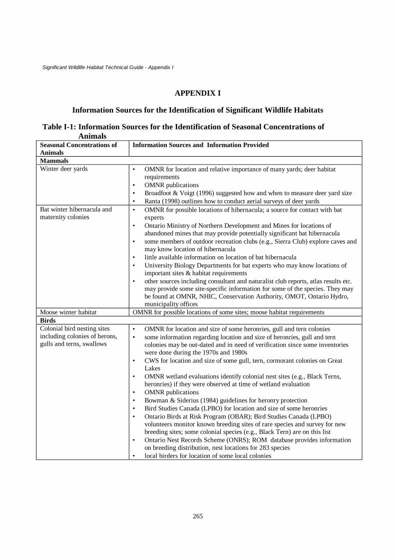
Significant Wildlife Habitat Technical Guide - Appendix I
265
APPENDIX I
Information Sources for the Identification of Significant Wildlife Habitats
Table I-1: Information Sources for the Identification of Seasonal Concentrations ofAnimals
Seasonal Concentrations ofAnimals
Information Sources and Information Provided
MammalsWinter deer yards • OMNR for location and relative importance of many yards; deer habitat
requirements• OMNR publications• Broadfoot & Voigt (1996) suggested how and when to measure deer yard size• Ranta (1998) outlines how to conduct aerial surveys of deer yards
Bat winter hibernacula andmaternity colonies
• OMNR for possible locations of hibernacula; a source for contact with batexperts
• Ontario Ministry of Northern Development and Mines for locations ofabandoned mines that may provide potentially significant bat hibernacula
• some members of outdoor recreation clubs (e.g., Sierra Club) explore caves andmay know location of hibernacula
• little available information on location of bat hibernacula• University Biology Departments for bat experts who may know locations of
important sites & habitat requirements• other sources including consultant and naturalist club reports, atlas results etc.
may provide some site-specific information for some of the species. They maybe found at OMNR, NHIC, Conservation Authority, OMOT, Ontario Hydro,municipality offices
Moose winter habitat OMNR for possible locations of some sites; moose habitat requirementsBirdsColonial bird nesting sitesincluding colonies of herons,gulls and terns, swallows
• OMNR for location and size of some heronries, gull and tern colonies• some information regarding location and size of heronries, gull and tern
colonies may be out-dated and in need of verification since some inventorieswere done during the 1970s and 1980s
• CWS for location and size of some gull, tern, cormorant colonies on GreatLakes
• OMNR wetland evaluations identify colonial nest sites (e.g., Black Terns,heronries) if they were observed at time of wetland evaluation
• OMNR publications• Bowman & Siderius (1984) guidelines for heronry protection• Bird Studies Canada (LPBO) for location and size of some heronries• Ontario Birds at Risk Program (OBAR); Bird Studies Canada (LPBO)
volunteers monitor known breeding sites of rare species and survey for newbreeding sites; some colonial species (e.g., Black Tern) are on this list
• Ontario Nest Records Scheme (ONRS); ROM database provides informationon breeding distribution, nest locations for 283 species
• local birders for location of some local colonies

Significant Wildlife Habitat Technical Guide - Appendix I
266
Seasonal Concentrations ofAnimals
Information Sources and Information Provided
Waterfowl nesting, staging,migration stopover areas
• OMNR for location of regionally and locally significant sites• Hickie (1985) – Habitat management guidelines for waterfowl in Ontario.• OMNR Wetland Evaluations identify locally significant areas• Canadian Wildlife Service for location of regionally and provincially significant
sites; species habitat requirements; species of conservation concern; source ofseveral potentially helpful publications
• Ontario Nest Records Scheme (ONRS); ROM database provides informationon breeding distribution, nest locations for 283 species
• Ducks Unlimited Canada for location of important local sites; species habitatrequirements; restoration of waterfowl nesting habitat
• local birders for location of some locally important areas; location of somenesting species of conservation concern
Forested sites withconcentrations of nesting birds
• Canadian Wildlife Service, Guelph for locations of and data on their Forest BirdMonitoring Program sites; may also provide contact with local Programvolunteers who know locations of sites with high density and diversity ofbreeding and/or migrant birds.
• OMNR/Bird Studies Canada (LPBO) for location of some sites with severalraptor nests (e.g., Ospreys)
• Ontario Nest Records Scheme (ONRS); ROM database provides informationon breeding distribution, nest locations for 283 species
• local birders for location of some locally significant sitesMigration stopover areas forlandbirds, shorebirds
• Canadian Wildlife Service; Bird Studies Canada; Federation of OntarioNaturalists for location of provincially and regionally significant sites
• CWS, Downsview for contact with volunteers involved in Ontario ShorebirdSurvey; these people may know locally significant sites for shorebirds
• local birders for location of some locally significant sites and names of localbirding guidebooks that describe location of hotspots for migratory birds
Raptor (hawks, eagles, owls,falcons)Winter roosting & feedingareas
• OMNR; local birders and area farmers for location of some significant areas(little available information)
Wild Turkey winter roostingand feeding areas
• OMNR; local birders and area farmers for location of some significant areas(little available information)
• OMNR publication:⇒ Reid (1991) OMNR habitat requirements of Wild Turkeys
• local residents and birders for location of some sitesTurkey Vulture summerroosting areas
• local residents and birders for location of some sites (little availableinformation)
• other sources including consultant and naturalist club reports, atlas results etc.may provide some site-specific information for some of the bird species listed inthis table. They may be found at OMNR, NHIC, Conservation Authority,OMOT, Ontario Hydro, and municipality offices.

Significant Wildlife Habitat Technical Guide - Appendix I
267
Seasonal Concentrations ofAnimals
Information Sources and Information Provided
Reptiles and Amphibians• OMNR offices for general location of some important habitats; location of a
few bullfrog concentration areas; species habitat requirements; a source ofcontact with experts
• NHIC in Peterborough maintains database on location of reptiles andamphibians & includes location of known concentration areas; contact throughlocal OMNR Ecologist
• Canadian Wildlife Service, Burlington for contact with volunteers participatingin Amphibian Road Call Counts who know locally important sites
• Long Point Bird Observatory for contact with local volunteers participating inMarsh Monitoring Program and the Backyard Amphibian Survey, who knowlocally important sites
• Royal Ontario Museum and Canadian Museum of Nature data have beenincorporated into the NHIC database
• other sources including consultant and naturalist club reports, atlas results etc.may provide some important site locations and species descriptions. They maybe found at OMNR, NHIC, Conservation Authority, OMOT, Ontario Hydro,municipality offices
Butterfly Migratory Stopover Areas (little available information)• OMNR; Agriculture Canada (Ottawa) are possible sources for contact with local
experts and location of locally and regionally significant sites• University Biology Departments for contact with authorities who may know
locally important sites• Holmes et al. 1991. The Ontario Butterfly Atlas. Toronto: Toronto
Entomologists’ Association for general information on distribution, habitat,food requirements but no site-specific information. This may be found at theNHIC in Peterborough, FON in Toronto, and various other bookstores
• Toronto Entomologists’ Association (contact Royal Ontario Museum) formembers who may know location of some locally significant sites
• local naturalists may know location of locally significant sites• other sources including consultant and naturalist club reports, atlas results etc.
may provide some important site locations and species descriptions. They maybe found at OMNR, NHIC, Conservation Authority, OMOT, Ontario Hydro,municipality offices

Significant Wildlife Habitat Technical Guide - Appendix I
268
Table I-2: Information sources for the identification of rare vegetation communities orspecialized wildlife habitats
RareVegetationCommunity
Information Sources and Information Provided
wetlandcommunities
• OMNR Ecologists can provide lists of plant species that are indicators of fen and bogwetlands.
• OMNR publication:⇒ Bakowsky (1996) Natural Heritage Resources of Ontario: Vegetation Communities
of Southern Ontario describes natural communities by dominant plant species, andphysical characteristics of the site such as soil depth and moisture regime and rarewetland community types are identified.
• OMNR Wetland Evaluations Class 1-7 differentiate more uncommon wetland type e.g.,fens, bogs that often support of rare vegetation communities; many provide common plantspecies lists; some rare plants are recorded for some wetlands; include map illustratingdominant plant communities; mention other scientific studies, reports related to thewetland.
• Ontario Geological Survey Peat and Peatland Evaluation reports also describe and mapthese communities.
• OMNR ANSI Site District Reports describe vegetation composition (species observed) ofcandidate areas; may briefly describe other potentially locally or regionally significantwetlands that have been identified but were not closely examined for ANSI status; providecomplete site descriptions and maps of ANSIs and candidate ANSIs.
• Topographical maps (scale 1:50,000) can help to locate wetlands, provide fairly specificlocation & approximate size of identified wetland communities.
• Aerial photographs (scale 1:10,000) can help to locate wetlands, especially helpful findingsmaller wetlands; can help to determine whether marsh or swamp and location of wetlandrelative to upland communities; essential in mapping location and extent of vegetationcommunities; some unique communities can be identified depending on photointerpretative skill.
• Local naturalists may know locations of locally significant communities.• OMNR NW Ontario Wetland Classification (Racey and Harris 1995) describes
procedures for differentiating wetland communities at a hierarchy of scales; locations ofsome rare wetland community types in northwestern Ontario are provided.
• Consultant and naturalist club reports may provide descriptions of significant wetlandvegetation communities found in local wetlands. They may be found at OMNR, OMOT,Ontario Hydro, Conservation Authority, and municipality offices.
• Parks Canada produced a report on all of the wetlands on the Rideau Canal system;contact Parks Canada, Smiths Falls or OMNR.
• Federation of Ontario Naturalists (FON) produced a report on some of the wetlands ofOntario.
• University, museum, and provincial/national park herbaria collections include rare plantspecies, name of collector and date of collection, approximate location where plants werecollected.

Significant Wildlife Habitat Technical Guide - Appendix I
269
RareVegetationCommunity
Information Sources and Information Provided
prairies, alvars,savannahs; rockbarrens; sandbarrens
• OMNR Ecologists can obtain maps of these rare plant communities from the NHIC inPeterborough and can provide lists of plant species that are indicators of prairies, alvars,savannahs.
• OMNR and NHIC publication:⇒ Bakowsky (1996) Natural Heritage Resources of Ontario: Vegetation Communities
of Southern Ontario describes plant communities by dominant plant species, andphysical characteristics of the site such as soil depth and moisture regime;comprehensive listing of rare plant communities found in southern Ontario.
• OMNR ANSI Site District Reports provide detailed descriptions (plant species andcommunities) of several of these rare communities as well as site maps.
• Some researchers have examined these communities in Ontario describing physicalcharacteristics, and plant species composition. They also have included precise locationsof sites (e.g., Catling and Catling (1993)- limestone savannah, prairie, sand barren;Catling and Brownell (1995)- alvars; Bakowsy (1993) - prairie, savannah. These studiescan be obtained from the OMNR Ecologist.
• Local naturalists may know locations of locally significant communities.• Consultant and naturalist club reports may provide some site-specific information about
locally significant areas. They may be found at OMNR, OMOT, Ontario Hydro,Conservation Authority, and municipality offices. They may also be found in scientificjournals and publications such as The Canadian Field-Naturalist.
• University, museum, and provincial/national park herbaria collections include rare plantspecies, name of collector and date of collection, approximate location where plants werecollected. Indicator plants of these rare communities found in these collections may helpto locate specific sites.
• County soil survey reports and maps describe local physical characteristics such aslandforms, drainage patterns, soils, and moisture regimes that can narrow search for rarecommunities such as alvars (e.g., indicate areas with deep sand deposits, little mineralsoil).
forest stands withrare tree associationsand/or rare treespecies
See Appendix L fora list of rare forestcommunities foundin S. Ontario
• OMNR Foresters often know the location of forest stands containing rare tree species.• OMNR publication:
⇒ Bakowsky (1996) Natural Heritage Resources of Ontario: Vegetation Communities ofSouthern Ontario describes these communities by dominant plant species, and physicalcharacteristics of the site such as soil depth and moisture regime; lists and briefly describes rareforest communities of southern Ontario.
• OMNR ANSI Site District Reports provide detailed descriptions (plant species and communities) ofcandidate ANSI sites that may contain rare forest types as well as site maps.
• OMNR Forest Resource Inventory (FRI) maps (scale 1:15,840) indicate the dominant tree species,percent composition of the stand, and approximate age of the forest stands; initially helpful inlocating potentially rare forest types for the municipality; but only indicate species comprising atleast 10% of the mapped stand.
• Local naturalists may know locations of locally significant communities.• Aerial photographs (scale 1:10,000) can help to locate woodlands, provide rough estimate of
woodland area, and are essential in mapping location and extent of vegetation communities; can alsolocate help to locate older woodlands.
• Topographical maps (scale 1: 50,000) can help to locate woodlands, provide fairly specific locationand approximate size of identified communities; they should be used in conjunction with ForestResource Inventory (FRI) maps and aerial photographs.
• OMNR Forest Ecosystem Classifications for NW Ontario (Sims et al. 1989); NE Ontario (Taylor etal. 2000); Central Ontario (Chambers et al. 1997); Southern Ontario (Lee et al. 1998)provide detailed descriptions of natural forest types of these regions; some information on the

Significant Wildlife Habitat Technical Guide - Appendix I
270
RareVegetationCommunity
Information Sources and Information Provided
distribution of species. Database for S. Ontario (contact H. Lee, OMNR London office).Municipalities can use the information to classify their own forests and determine therepresentation of forest types in the area; forest types should be mapped at similar scale to aerialphotograph interpretations (i.e., 1:10,000).
• OMNR Growth and Yield Program have established research plots in some woodlands with locallyor regionally rare trees and tree associations.
• Ontario Tree Atlas is being coordinated by the University of Guelph. Contact staff at theArboretum; they can provide contact with local volunteers who may know locations of woodlandscontaining rare trees and tree associations.
• University, museum, and provincial/national park herbaria collections include rare plant species,name of collector and date of collection, approximate location where plants were collected.Indicator plants of these rare communities found in these collections may help to locate specificsites.
• County soil survey reports and maps describe local physical characteristics such as landforms,drainage patterns, soils, and moisture regimes that can narrow search for rare forest associations.
• Consultant and naturalist club reports may provide some site-specific information about locallysignificant woodlands with rare trees and tree associations. They may be found at OMNR, OMOT,Ontario Hydro, Conservation Authority, and municipality offices. They may also be found inscientific journals and publications such as The Canadian Field- Naturalist.
cliffs/talus slopes;Great Lakes dunes;beach shorelines;grasslands etc.
• OMNR Ecologists may know the location of some of these rare communities.• OMNR publication:⇒ Bakowsky (1996) Natural Heritage Resources of Ontario: Vegetation Communities of Southern
Ontario describes these communities by dominant plant species, and physical characteristics of thesite such as soil depth and moisture regime; these rare communities are listed and briefly described.
• OMNR ANSI Site District Reports provide detailed descriptions (plant species and communities) ofsome of the candidate ANSI sites, and include site maps.
• Local naturalists may know locations of locally significant communities.• Aerial photographs used in conjunction with topographical maps can help to verify presence of
these communities.• Topographical maps indicate areas of sharp relief, shorelines, and potential grassland areas.• County soil survey reports and maps describe local physical characteristics such as landforms,
drainage patterns, soils, and moisture regimes that can narrow search for these communities (e.g.,indicate areas with deep sand deposits).
Consultant and naturalist club reports may provide some site-specific information about thesecommunities. They may be found at OMNR, OMOT, Ontario Hydro, Conservation Authority, andmunicipality offices. They may also be found in scientific journals and publications such as TheCanadian Field-Naturalist.

Significant Wildlife Habitat Technical Guide - Appendix I
271
SpecializedWildlife Habitats
Information Sources and Information Provided
habitat supportingarea-sensitive birds(e.g., hawks,songbirds)
• OMNR Ecologists may know the location of sites supporting area-sensitive species.• Topographical maps and aerial photographs can help to locate existing forest stands,
grasslands; aerial photographs especially helpful for finding areas of greatest amount ofcontiguous closed-canopy forest cover required by forest species
• OMNR Forest Resource Inventory (FRI) maps (scale 1:15,840) indicate dominant treespecies, percent composition of the stand, and approximate age of the forest stands; latterinformation particularly helpful in locating potentially significant forest habitats for thesespecies because older deciduous stands with abundant and diverse forest structure tend tobe preferred. Most effectively used in conjunction with aerial photographs andtopographical maps.
• Ontario Hydro has produced regional forest cover maps for southern Ontario that providean indication of percent forest cover for each mapped area; they could be used to identifysites with greatest potential to support these species.
• Local birders may know location of premier woodlands for area-sensitive species, thelocation of some forest nesting raptors, and premier grassland sites.
• Canadian Wildlife Service, Guelph, for locations of and data on their Forest BirdMonitoring Program sites; may also provide contact with local Program volunteers whoknow locations of locally significant forest stands supporting these species.
• OMNR Growth and Yield and Ecological Land Classification Programs (OMNR); plotinformation may reveal significant forest stands by providing information such aspresence of old and large trees, a variety of different vegetation strata and down woodydebris- forest characteristics that are attractive to these species.
• OMNR/Bird Studies Canada (LPBO) Ontario Birds at Risk Program (OBAR) runs theRed-shouldered Hawk Survey; volunteers monitor many stands in southwest and centralOntario and the records of nest locations can help to locate sites important to this area-sensitive species; OBAR program also monitors forest species currently at risk and canprovide some site-specific information concerning the location of these species.
• OMNR ANSI Site District Reports may describe such forest and grassland habitats andinclude list of bird species where observed; include site maps.
forest standsproviding a diversityof habitats (e.g., treecavities, fallen logs,verticalstratification)
• OMNR Foresters may know stands with high proportion of diseased or damaged trees andtherefore likely to have more snags and cavity trees. They may also know locations ofstands they call “over mature”.
• OMNR FRI maps note age and tree species composition of forest stands- can help tolocate sites with more cavity trees and snags; particularly older forests comprised of largeproportion of aspen, beech, basswood, conifers. These maps can also indicate older foreststhat often have diverse vertical structure. Consider the date of the FRI information.
• Topographical maps and aerial photographs indicate areas with steep slopes and valleysnext to streams; often these areas were not logged, resulting in older trees and abundantfallen logs. The proximity of water can make these areas attractive to salamanders.
• OMNR Growth and Yield Program- plot information includes sites with cavity trees andsnags, diversity of vegetation layers, and abundant down woody debris.
• OMNR ANSI Site District Reports- sites with a variety of recorded shrub and tree speciesmay indicate diversity of vegetation layers; include site maps.
• OMNR publications:⇒ Gerson (1984) - management guidelines for bats and cavity trees⇒ Keddy and Drummond (1995)- value of wildlife trees in Eastern Ontario forests⇒ Naylor et al. (1994)- forestry management guidelines for the provision of Pileated

Significant Wildlife Habitat Technical Guide - Appendix I
272
SpecializedWildlife Habitats
Information Sources and Information Provided
Woodpecker habitat.• Local birders may know location of locally significant stands with these features.• University biology departments for contact with researchers with knowledge of local
habitats supporting their species of interest (e.g. southern flying squirrel, PileatedWoodpecker, four-toed salamander).
woodlandssupportingspringtimeamphibian breedingponds
• Contact local OMNR Ecologist• Topographical maps and aerial photographs can help to locate some potential areas.• Local naturalists may know location of woodland ponds and areas with notable spring
breeding choruses of frogs.• Long Point Bird Observatory for contact with local volunteers participating in Marsh
Monitoring Program and Backyard Amphibian Survey• CWS (Burlington) for contact with volunteers involved with the Amphibian Road Call
Counts who know locally important sites.foraging areasproducing abundantfruit and nuts
• OMNR Foresters, Ecologists, and Conservation Officers know locations of some sites.• OMNR FRI maps will indicate forest stands with abundance of mature trees producing
mast nuts (e.g., oaks, beech, hickory)• Topographical maps and aerial photographs can indicate features like ridges and rock
barrens that often have oaks and berry-producing shrubs respectively.• OMNR Ecological Land Classification Programs- plot information records sites that were
sampled with trees and shrubs that can produce nuts and berries; food production potentialcan be inferred from this information
• OMNR ANSI Site District Reports describe plant communities and record shrubs andtrees-food production potential can be inferred from this information; include site maps
• OMNR/local fish and game and hunt clubs for contacts with local hunters (especiallyturkey, Ruffed Grouse, deer, bear) who may know local sites with significantconcentrations of mast and berry producing vegetation.
• Ontario Nut Producers Association- members are seed collectors and know whereproductive trees and stands are located.
moose aquaticfeeding areas,mineral licks,calving areas
• OMNR for location of some important aquatic feeding areas and description of suchhabitats; moose habitat requirements; contact with knowledgeable people
• Aerial photographs can help to identify sections of creeks and bays with high potential asaquatic feeding areas
• Little available information on location of mineral licks and calving areas• OMNR publications:⇒ OMNR (1988) for timber management guidelines for provision of moose habitat⇒ Ranta (1998) to identify, map and rank moose aquatic feeding areas⇒ Other references with more information about moose habitat include: Allen 1987;
Bellhouse et al. 1993; Jackson et al. 1987; Naylor et al. 1992mink and otterfeeding and denningsites
These sites are difficult to find but the following sources will provide assistance:• Aerial photographs can help to locate prime areas- undisturbed shorelines with abundant
vegetation and down woody debris e.g., dead falls, large logs• OMNR for contact with local trappers for information on locations of high populations• OMNR Wetland Evaluations record presence of these mammals or signs of them (tracks,
scat etc.) as well as presence in other years, through interviews with local trappers.• Novak et al. (eds.) 1987. Wild Furbearer and Conservation Management in Ontario -
available at OMNR offices

Significant Wildlife Habitat Technical Guide - Appendix I
273
SpecializedWildlife Habitats
Information Sources and Information Provided
marten and fisherdenning habitat
These sites are also hard to find but some may be found by referring to the following sources:• OMNR FRI maps will indicate potential woodlands containing larger, older trees that are
likely to provide cavities and abundant down woody debris.• OMNR for contact with local trappers for information on areas with high populations.• Novak et al. (eds.) 1987. Wild Furbearer and Conservation Management in Ontario –
available at OMNR officesareas of high speciesand/or communitydiversity
• OMNR Ecologist may know location of sites with high diversity.• OMNR ANSI Site District Reports note diverse communities and include species lists and
site maps.• Many OMNR Wetland Evaluations provide plant species lists and record all types of
wetland communities found within a defined wetland boundary.• Local naturalists and FON members may know location of areas of high community
and/or species diversity.• Aerial photographs may indicate sites with community diversity (e.g., several different
wetlands, forested uplands, open fields within the same general area).• Consultant and naturalist club reports may provide some site-specific information about
areas with high community diversity. They may be found at OMNR, OMOT, OntarioHydro, Conservation Authority, and municipality offices.
old growth ormature forest
• OMNR Foresters know locations of oldest forest stands and may refer to them as “over-mature”.
• OMNR FRI maps indicate age of forest stands and can help to locate older forests in themunicipality
• OMNR ANSI Site District Reports describe some examples of older forests of provincialor regional significance; some reference may be made to older forests of localsignificance; include site maps
• OMNR Growth and Yield and Ecological Land Classification Programs sampled plots insome stands with older trees.
• Local naturalists and FON members may know location of areas of older forests in themunicipality.
• Consultant and naturalist club reports may provide some site-specific information aboutareas of old growth forest. They may be found at OMNR, OMOT, Ontario Hydro,Conservation Authority, and municipality offices.
permanent springs;seeps; cold or cool-water streams
• Topographical maps and aerial photographs indicate headwaters of streams where springsmay be found.
• County soil survey reports and maps describe local physical characteristics such as soils,landforms, and drainage patterns that can narrow search for springs and seeps.
• Local naturalists and landowners may know of some locations.• Municipalities may have surveyed drainage systems and headwater areas may be mapped.• Many Conservation Authorities monitor stream flows and consequently may know
locations of springs and seeps.• OMNR staff and local anglers may know location of some springs/seeps that can affect
the distribution of sportfish such as brook trout or plants often associated with seeps (e.g.,ginseng).
caves • University faculty biologists with interest in caves or bats may know some locations.• Local naturalists, landowners, spelunkers may know location of some locations. Contact
applicable clubs (e.g., Sierra Club).• Geology maps can indicate areas with certain geological features resulting in more caves
(e.g., Niagara Escarpment, Upper Ottawa Valley).

Significant Wildlife Habitat Technical Guide - Appendix I
274
Table I-3: Information Sources for the Identification of Habitats of Species ofConservation Concern
Group Information Sources and Information ProvidedBirds OMNR Ecologists; NHIC in Peterborough
• lists of candidate species of conservation concern and mapped locations of some of them• Downes and Collins. 1996. The Canadian Breeding Bird Survey, 1966-1994. presents bird
population trends derived from annual surveys from 1966-1994; identified significantdeclines in some species; purpose of the program is to detect and measure year-to-year andlong-term changes in breeding bird populations (also found at CWS, Bird Studies Canada)
• Lepage et al. 1998. Setting Conservation Priorities for Ontario’s Breeding Landbirds-represents the most recent effort to provide lists of landbirds of high conservation priority; themethodology is explained; report was prepared for the OMNR and is available from OMNREcologists and Bird Studies Canada.
• Couturier. 1999. Conservation Priorities for the Birds of Southern Ontario reviews existingsystems for setting conservation priorities; presents a suggested approach and list of speciesof conservation concern; includes rankings of each species based on abundance in Ontarioand on the proportion of its North American breeding range/population in Canada andCanadian breeding range/population in Ontario (also found at CWS, Bird Studies Canada)
• Austen et al. 1994. Ontario Birds at Risk. Summarized data from the Ontario Breeding BirdsAtlas and Ontario Rare Breeding Bird Program to describe status, habitat requirements, andconservation needs of 58 bird species considered to be at risk (also found at Bird StudiesCanada; FON)
• Cadman et al. 1987. Atlas of the Breeding Birds of Ontario. University of Waterloo Press,Waterloo. Summary of results from atlas work by volunteers regarding breeding bird speciesabundance and richness observed in 10 by 10 km squares; good habitat descriptions forbreeding birds of Ontario; regional coordinators and local volunteers who conducted surveysare perhaps best source of site-specific information (field work proposed for 2001 – 2005 fornew updated atlas)
• COSEWIC and COSSARO lists of vulnerable, threatened, endangered species in Ontario• COSEWIC status reports- present population status of species, distribution, and habitat
requirements (found at CWS, Bird Studies Canada)• RENEW recovery plans for threatened and endangered species
Other potential sources of information• Naturalist club publications (e.g. Trail and Landscape by the Ottawa Field-Naturalists’ Club)• regional/local accounts such as Weir. 1989. Birds of the Kingston Region.• Parker et al. 1984. Toronto Region Bird Report possibly found at the Toronto Ornithological
Club, Toronto• studies of individual species funded by OMNR, WWF, Bird Studies Canada (LPBO),
universities; possibly found at OMNR; Bird Studies Canada• consultant, naturalist club, university studies may provide some additional information for
specific areas/regions and may be found at OMNR; OMOT; Ontario Hydro; ConservationAuthority, and municipality offices; NHIC in Peterborough
• Bain and Henshaw. 1992. Annual Bird Report, Durham Region• journals (e.g., The Canadian Field-Naturalist)
Plants OMNR Ecologists; NHIC in Peterborough• lists of some candidate species of conservation concern and mapped locations of some of
them• Argus and Pryer. 1990. Rare Vascular Plants in Canada. Our Natural Heritage. Canadian
Museum of Nature, Ottawa.• Provincially rare list of plants. This list is regularly updated by staff at the NHIC.

Significant Wildlife Habitat Technical Guide - Appendix I
275
Group Information Sources and Information Provided• Argus et al. Eds. 1982-87. Atlas of the Rare Vascular Plants of Ontario. Parts 1-4. National
Museum of Natural Sciences, Ottawa. Provides notes on status, habitat, small-scale maps ofknown locations, and pertinent references for many rare plants. Includes herbaria that wereconsulted and names and addresses of contributors- people who may be able to provide moresite-specific information.
• NHIC-Peterborough has produced a draft of an annotated plant species list for Ontario thatshows distribution of species by county.
• Cuddy. 1991. Vascular Plants of Eastern Ontario lists the status of plant species that grow inEastern Ontario by physiographic region as provincially rare, rare, and present.
• Riley. 1989. Distribution and status of the vascular plants of Central Region lists the statusof plant species that grow in Central Ontario by county as provincially rare, rare, uncommon,and common.
• Oldham. 1993. Distribution and status of the vascular plants of Southwestern Ontario liststhe status of plant species that grow in Southwestern Ontario by county as provincially rare,rare, very uncommon, uncommon, and common.
• County/regional municipality vascular plant floras for the Carolinian zone of Canada. (Vargaand Allen 1990) pp. 129-153. In Allen, G.M., P.F.J. Eagles & S.D. Price (eds.) ConservingCarolinian Canada, University of Waterloo Press, Waterloo. Summarizes vascular flora in 16counties and regional municipalities in Carolinian zone of southern Ontario; notes rarespecies, general locations of them; names and locations of top botanical sites in each areas;names, addresses of contributors.
• other county/regional flora and checklists (e.g., Gillette and White. 1978. Checklist ofVascular Plants of the Ottawa-Hull Region found at the National Museum of NaturalSciences, Ottawa; Morton and Venn. 1982. A Checklist of the Flora of Ontario: VascularPlants found at OMNR offices and University of Waterloo
• COSEWIC status reports on vulnerable species (also found at CWS)• Ontario tree atlas (in preparation) by the University of Guelph
Other potential sources of information• Field Botanists of Ontario newsletter may indicate locations of some species and diverse
vegetation communities; found at the NHIC in Peterborough, some OMNR offices• Naturalist club publications (e.g., Trail and Landscape by the Ottawa Field-Naturalists’ Club)• Scientific journals and publications (e.g., The Canadian Field-Naturalist)• Consultant, naturalist club, and university studies may be found at OMNR; OMOT; Ontario
Hydro; Conservation Authority, and municipality offices; NHIC in PeterboroughReptilesandamphibians
OMNR Ecologists; NHIC in Peterborough• status list of all provincial species is determined and regularly updated by OMNR & NHIC
staff• Weller and Oldham. 1986. Results of Ontario Herpetofaunal Summary provides locations of
different species of reptiles and amphibians; NHIC maintains the database• COSEWIC status reports on species at risk and may also document species that are declining
(also found at CWS)
Canadian Wildlife Service, Burlington• for contact with local volunteers participating in Amphibian Road Call Counts who know
locally important habitats for these species.Long Point Bird Observatory
• for contact with volunteers participating in Marsh Monitoring Program and/or BackyardAmphibian Survey who may know locally important habitats and sites for these species.
Other potential sources of information

Significant Wildlife Habitat Technical Guide - Appendix I
276
Group Information Sources and Information Provided• naturalist club publications• consultant, naturalist club, and university studies may be found at OMNR; OMOT; Ontario
Hydro; Conservation Authority, and municipality offices; NHIC in PeterboroughMammals OMNR Ecologists; NHIC in Peterborough
• status list of all provincial species is determined and regularly updated by OMNR and NHICstaff
• COSEWIC status reports on vulnerable species (also found at CWS)
Other potential sources of information• Dobbyn, J.S. 1994. Atlas of the Mammals of Ontario describes the range and distribution of
mammals in Ontario; may help to determine local rarity (available from FON)• naturalist club publications• Museum of Natural Science (Ottawa) produces some publications• consultant, naturalist club, university studies may be found at OMNR; OMOT; Ontario
Hydro; Conservation Authority, and municipality offices; NHIC in Peterborough• Peterson, R.L. 1966. The Mammals of Eastern Canada. Oxford University Press, Toronto
may be found at some University libraries; OMNR officesButterflies OMNR Ecologists; NHIC in Peterborough
• status list of all provincial species is determined and regularly updated by NHIC and OMNRstaff
• Campbell, C., D.P. Coulson and A.A. Bryant 1990. Status, distribution, and life historycharacteristics of some butterflies at risk in the Carolinian forest zone of Ontario. pp. 207-252. In Allen, G.M. , P.F.J. Eagles, and S.D. Price (eds.) Conserving Carolinian Canada,University of Waterloo Press, Waterloo. Reports on the status of most threatened butterfliesin the Carolinian zone of southern Ontario, includes general location of records; notes ondistribution, habitat preferences; mentions public and private collections; recommendationsfor conservation. Found at the NHIC-Peterborough; some OMNR offices and universitylibraries.
Other potential sources of information• Agriculture Canada, Ottawa, may provide contact with butterfly experts• Toronto Entomologists’ Association newsletter may be found at the NHIC• naturalist club publications• Holmes et al. 1991. The Ontario Butterfly Atlas. Toronto: Toronto Entomologists’
Association may be found at the NHIC• Layberry et al. 1998. The Butterflies of Canada.
Othergroups
NHIC in Peterborough• Maintains a database on rare dragonflies, moths, tiger beetles, & unionid mussels• can provide contact with specialists

Significant Wildlife Habitat Technical Guide - Appendix I
277
References
Allen, A.W. 1987. Habitat suitability index models: moose, Lake Superior region. USDI Fish and Wild. Sr., Biol.Rpt. 82(10.155) 47 p.
Argus, G.W. and K.M. Pryer. 1990. Rare vascular plants in Canada. Our natural heritage. Canadian Museum ofNature, Ottawa.
Argus,G.W., K.M. Pryer, D.J. White and C.J. Keddy. Eds 1982-87. Atlas of the rare vascular plants of Ontario. Part1 – 4. National Museum of Natural Sciences, Ottawa.
Austen, M., M. Cadman and R. James. 1994. Ontario Birds at Risk. Federation of Ontario Natralists, Don Mills. 165p.
Bakowsky, W. 1996. Natural Heritage Resources of Ontario: S-ranks for communities in site regions 6 and 7.Ontario Ministry of Natural Resources, Natural Hertiage Information Centre, Peterborough. Draft.
Bellhouse, T., B. Naylor and M. Twist. 1993. Late winter habitat selection by moose in the northern Great Lakes.Central Ontario Science and Technology Development Unit. Technical Report #25.
Bowman, I. and J. Siderius. 1984. Management guidelines for the protection of heronries in Ontario. OntarioMinistry of Natural Resources. Wildlife Branch, Toronto.
Broadfoot, J. and D. Voigt. 1996. Field inventory techniques for measuring winter deer browse supply andconsumption. Ontario Ministry of Natural Resources, Research Science and Technology Branch, TechnicalPaper #4.
Cadman, M.D. P.F.J Eagles, F.M Helleiner. 1988. Atlas of the breeding birds of Ontario. University of WaterlooPress, Waterloo, Ontario. 617 p.
Campbell, C., D.P. Coulson and A.A. Bryant 1990. Status, distribution, and life history characteristics of somebutterflies at risk in the Carolinian forest zone of Ontario. pp. 207-252. In Allen, G.M. , P.F.J. Eagles, andS.D. Price (eds.) Conserving Carolinian Canada, University of Waterloo Press, Waterloo
Catling, P.M. and V.R. Brownell. 1995. A review of the alvars of the Great Lakes region. Distribution, floristiccomposition, biogeography and protection. Can. Field-Naturalist. 109: 143-171
Catling, P.M. and V.R. Catling 1993. Floristic composition, phytogeography, and relationships of prairies, savannas,and sand barrens along the Trent River, eastern Ontario. Canadian Field Naturalist 107:24-45.
Chambers, B., B.J. Naylor, J. Nieppola, B. Merchant, and P.Uhlig. 1997. Field Guide to Forest Ecosystems ofCentral Ontario. Ontario Ministry of Natural Resources, SCSS Field Guide FG-01. 200 p.
Couturier, A. 1999. Conservation priorities for the birds of Southern Ontario. Brids Studies Canada, Port Rowan,Ontario.
Cuddy, D.G. 1991. Vascular plants of Eastern Ontario. Draft 2.0. Ontario Ministry of Natural Resources,Kemptville, Ontario. 80 p.
Dobbyn, J.S. 1994. Atlas of the Mammals of Ontario. Federation of Ontario Field Naturalist, Don Mills. 120 p.

Significant Wildlife Habitat Technical Guide - Appendix I
278
Downes, C.M. and B.T. Collins. 1996. The Canadian Breeding Bird Survey,1966-1994. Canadian Wildlife ServiceProgress Note No. 210. Ottawa,Ontario: Environment Canada.
Gerson,H.1984. Habitat management guidelines for bats of Ontario. Ontario Ministry of Natural Resources, WildlifeBranch, Toronto, Ontario.
Gillette and White. 1978. Chekclist of vascular plants of the Ottawa-Hull Region, National Museum of NaturalScience, Ottawa.
Hickie, J. 1985. Habitat management guidelines for waterfowl in Ontario. Ontario Ministry of Natural Resources,Wildlife Branch, Toronto.
Holmes, A.M., Q.F. Hess, R.R. Tasker and A.J. Hanks.1991. The Ontario Butterfly Atlas, Toronto, Ontario. 167 p.
Jackson, G.L., G.D. Racey, J.G. McNicol and L.A. Godwin, 1991. Moose habitat interpretation in Ontario. OntarioMinistry of Natural Resources, NWOFTDU Tech. Rep. 52, 74 p.
Keddy, P. and C. Drummond, 1995. Economic properties for the evaluation of eastern Ontario ecosystems. EasternOntario Model Forest, Kemptville, Ontario. Information report no. 13. 27p.
Layberry, R.A., P.W. Hall and J.D. Lafontaine 1988. The butterflies of Canada. University of Toronto Press,Toronto, Canada. 280 p.
Lepage, D., Bradstreet, M. and A. Couturier. 1998. Setting Conservation Priorities for Ontario's Breeding Landbirds.Unpubl. Rept. from Bird Studies Canada to Ontario Ministry of Natural Resources. Port Rowan, Ontario.56 pp.
Lee, H., W. Bakowsky, J. Riley, J. Bowles, M. Puddister, P. Uhlig and S. McMurray. 1998. Ecological LandClassification for Southern Ontario First approximation and its application. Ontario Ministry of NaturalResource, Southcentral Sciences Section, Science Development and Transfer Branch. SCSS Field GuideFG-02.
Morton, J.K. and J.M. Venn 1990. A checklist of the flora of Ontario. University of Waterloo, Biology SeriesNumber 34, 218 p.
Naylor, B.J., J.A. Baker, D.M. Hogg, J.G. McNicol and W.R. Watt. 1996. Forest management guidelines for theprovision of Pileated Woodpecker Habitat. Ontario Ministry of Natural Resources, Queen’s Printer, Sault.Ste. Marie. 26 p.
Naylor, B., S. Christilaw and P. Weilandt. 1992. Validation of a habitat suitability index model for moose in thenorthern portion of the Great Lakes- St. Lawrence Forest region of Ontario. Central Ontario ForestTechnology Development Unit. Technical Report 26.
Novak, M. J.A. Baker, M.E. Obbard and B. Mallock.1987. Wild furbearer management and conservation in NorthAmerica. Ontatio Ministry of Natural Resources. Queen’s Printer. Toronto, Ontario. 1150 p.
Oldham, M.J. 1993. Distribution and status of the vascular plants in southwestern Ontario. Ontario Ministry ofNatural Resources, Alymer, Ontario.
Ontario Ministry of Natural Resources. 1988. Timber management guidelines for the provision of moose habitat.Queen’s Printers, Toronto. 33 p.

Significant Wildlife Habitat Technical Guide - Appendix I
279
Parker, B. D., H. Currie, D. V. Weseloh, G. Coady, A. Jaramillo and K. Konze. 1985. Toronto Region Bird Report1984. Toronto Ornithological Club, Toronto, On., 68 p.
Peterson, R.L. 1966. The Mammals of Eastern Canada. Oxford University Press, Toronto
Racey, G.D., A.G. Harris, J.K. Jeglum, R.F. Foster and G.M. Wickware. 1996. Terrestrial and wetland ecosites ofnorthwestern Ontario. Ontario Ministry of Natural Resources, Northwest Science and Technology. FieldGuide FG-02. 94 p.
Ranta, B. (ed) 1998. Selected wildlife and habitat features: inventory manual. Ontario Ministry of NaturalResources, Queen’s Printers, Peterborough, Ontario. 217 p.
Reid, D.J. 1991. Ontario Wild Turkey status report. Ontario Ministry of Natural Resources, Simcoe, Ontario.Unpublished report.
Riley, J. 1989. Distribution and status of vascular plants of southwestern Ontario. Ontario Ministry of NaturalResources, Aurora, ON.
Sims, R.A, W.D. Towill, K.A. Baldwin and G.M. Wickware. 1989. Field ecosystemclassification for northwesternOntario. Forestry Canada and Ontario Ministry of Natural Resources, Thunder Bay, Ontario.
Taylor, K.C., R.W. Arnup, B.G. Merchant, W.J. Parton, J. Nieppola. 2000. Field guide to forest ecosystems ofnortheastern Ontario. Second Edition Ontario Ministry of Natural Resources, NEST Field Guide FG-001.218 p.
Varga and Allen 1990. County/regional municipality vascular plant floras for the Carolinian zone of Canada p 129 –153. In Allen, G.M., P.F.J. Eagles and S.D. Price (eds) Conserving Carolinian Canada, University ofWaterloo Press, Waterloo.
Voigt, D.R. and J.D. Broadfoot. 1995. Effects of cottage development on white-tailed deer, Odocoileus virginianus,winter habitat on Lake Muskoka, Ontario. Canadian Field Naturalist 109: 201-20.
Voigt, D.R., J.D. Broadfoot and J.A. Baker. 1997. Forest management guidelines for the provision of white-taileddeer habitat. Ontario Ministry of Natural Resources, Queen’s Printer, Sault, Ste. Marie.
Weir, R.D. 1989. Birds of the Kingston Region. Kingston Field Naturalist and Quarry Press Inc. Kingston, Ontario.608 p.
Weller, W. F. and M. J. Oldham. 1986. Ontario Herpetofaunal Summary. Ontario Field Herpetologists,Cambridge, Ontario. 221 p.

Significant Wildlife Habitat Technical Guide - Appendix J
280
APPENDIX J
Natural Heritage Resources of Ontario:S-Ranks for Communities in Site Regions 6 and 7
The classification of communities in this appendix is a first approximation of a classificationsystem for southern Ontario. It is based on a combination of empirical data, literature review andexpert opinion of ecologists work in this field. The S-ranks are assigned on frequency ofoccurrence as described in the following pages.

NATURAL HERITAGE RESOURCES OF ONTARIO:VEGETATION COMMUNITIES OF SOUTHERN ONTARIO
281
INTRODUCTION
The mission of the Natural Heritage Information Centre (NHIC), Ontario Ministry ofNatural Resources (OMNR), is to acquire, maintain and update, and make available dataon the province’s rare species, vegetation communities, and natural areas. Together, flora,fauna, and vegetation communities are considered to be ‘elements’ of biodiversity.
The NHIC actively collects information on rare vegetation types in Ontario, as well asinformation on high-quality, extensive examples of non-rare vegetation types. “Rare” inthis case refers to those types which are ranked as S1, S2 or S3, as are explained later inthis document. These data are stored and maintained in the NHIC central database, andare used for environmental and conservation planning and research.
This document lists the vegetation communities of southern Ontario that occur withinSite Regions 6E and 7E (Figure 1), and provides global and provincial ranks for eachcommunity type, along with the rationale used to determine each provincial rank, as wellas additional comments. Communities that are cultural (anthropogenic) in origin, anddominated by introduced species, are not tracked by the NHIC, and are excluded fromthis list.
Figure 1. Southern Ontario, showing Site Regions 6E and 7E.
Site Region refers to an ecological subdivision of the land, based upon a combination ofclimate, physiography, and biological productivity. The Site Regions of Ontario weredeveloped and mapped by Angus Hills (Hills 1961). The map below shows recentmodifications to the Site Region boundaries, based on more detailed mapping andinterpolation of physiographic features (Jalava et al. 1996).
6E
7E
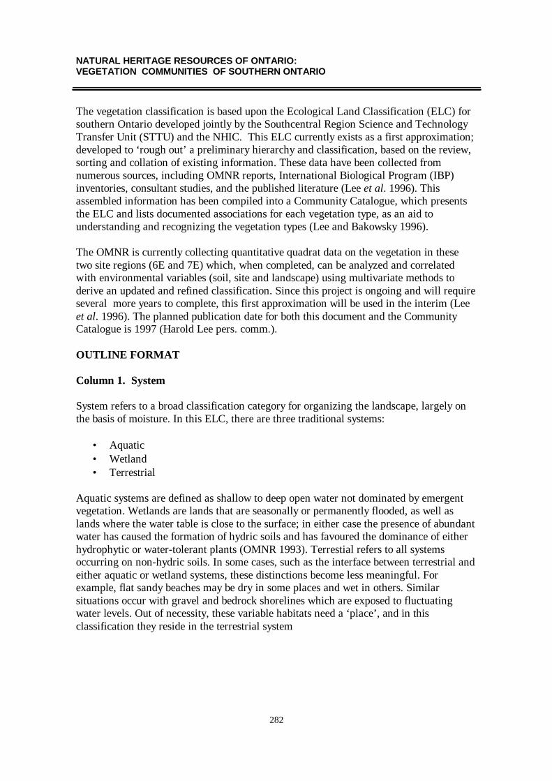
NATURAL HERITAGE RESOURCES OF ONTARIO:VEGETATION COMMUNITIES OF SOUTHERN ONTARIO
282
The vegetation classification is based upon the Ecological Land Classification (ELC) forsouthern Ontario developed jointly by the Southcentral Region Science and TechnologyTransfer Unit (STTU) and the NHIC. This ELC currently exists as a first approximation;developed to ‘rough out’ a preliminary hierarchy and classification, based on the review,sorting and collation of existing information. These data have been collected fromnumerous sources, including OMNR reports, International Biological Program (IBP)inventories, consultant studies, and the published literature (Lee et al. 1996). Thisassembled information has been compiled into a Community Catalogue, which presentsthe ELC and lists documented associations for each vegetation type, as an aid tounderstanding and recognizing the vegetation types (Lee and Bakowsky 1996).
The OMNR is currently collecting quantitative quadrat data on the vegetation in thesetwo site regions (6E and 7E) which, when completed, can be analyzed and correlatedwith environmental variables (soil, site and landscape) using multivariate methods toderive an updated and refined classification. Since this project is ongoing and will requireseveral more years to complete, this first approximation will be used in the interim (Leeet al. 1996). The planned publication date for both this document and the CommunityCatalogue is 1997 (Harold Lee pers. comm.).
OUTLINE FORMAT
Column 1. System
System refers to a broad classification category for organizing the landscape, largely onthe basis of moisture. In this ELC, there are three traditional systems:
• Aquatic• Wetland• Terrestrial
Aquatic systems are defined as shallow to deep open water not dominated by emergentvegetation. Wetlands are lands that are seasonally or permanently flooded, as well aslands where the water table is close to the surface; in either case the presence of abundantwater has caused the formation of hydric soils and has favoured the dominance of eitherhydrophytic or water-tolerant plants (OMNR 1993). Terrestial refers to all systemsoccurring on non-hydric soils. In some cases, such as the interface between terrestrial andeither aquatic or wetland systems, these distinctions become less meaningful. Forexample, flat sandy beaches may be dry in some places and wet in others. Similarsituations occur with gravel and bedrock shorelines which are exposed to fluctuatingwater levels. Out of necessity, these variable habitats need a ‘place’, and in thisclassification they reside in the terrestrial system

NATURAL HERITAGE RESOURCES OF ONTARIO:VEGETATION COMMUNITIES OF SOUTHERN ONTARIO
283
Column 2. Community Series I
The Community Series are useful units for grouping communities, based on similaritiesin physiognomy and site. The first Series is the broader of the two, organizingcommunities into largely widely-known units such as swamps, marshes, etc. This Seriesplaces a greater emphasis on physiognomic similarity.
Column 3. Community Series II
The second Series represents a refinement of the first Series, and broadly groupscommunities further along site criteria such as substrate and site moisture. For example,marshes are grouped into meadow marsh (drier) and shallow marsh (wetter).
Column 4. Ecosite and Vegetation Type
Ecosite is a mappable landscape unit defined by a relatively uniform parent material, soiland hydrology, and consequently supports a consistently recurring formation of plantspecies which develop over time (vegetation chronosequence). The Vegetation Type ispart of an ecosite, and represents a specific assemblage of species which generally occurin a site with a more uniform parent material, soil and hydrology, and a more specificstage within a chronosequence.
In this document, the Vegetation Type represents the basic community unit that is rankedfor conservation purposes. In some instances, where a vegetation type is known to occurbut for which insufficient information exists, the classification is left at the ecosite level,and the ecosite receives the provincial rank.
Columns 5 & 6. Occurrence in Site Regions 6E and 7E
An ‘X’ in either column indicates the occurrence of a particular vegetation type withinthe site region, as documented in the Community Catalogue (Lee and Bakowsky 1996).In some cases, a community type or ecosite is known to occur in a site region, but nodescriptions are available, thus it is not documented in the catalogue. In these instances,the column is marked as ‘(X)’, which indicates it is present, but not listed in thecatalogue.
Column 7. Global Rank (GRANK)
Heritage Programs such as the NHIC use a combination of global and provincial ranks asa tool to prioritize conservation and protection efforts, focusing efforts first on thoseelements of diversity that are both globally and provincially rare. Global ranks for eachelement are assigned by The Nature Conservancy (United States), based upon

NATURAL HERITAGE RESOURCES OF ONTARIO:VEGETATION COMMUNITIES OF SOUTHERN ONTARIO
284
consideration of the provincial and state ranks assigned by heritage programs for theelement across the range of its distribution, as well as the opinion of scientific experts.
The two major criteria used in determining a community’s rank are the total number ofoccurrences and the total areal extent of the community range-wide. Secondary factorsused in determining global rank include measures of the geographic range of anelement’s distribution, trends in status (eg. expanding or shrinking range), trends incondition (eg. declining condition of remaining areal extent), threats, and fragility(Grossman et al. 1994).
Until recently, global ranks were unavailable for community types, as there was nooverall classification scheme that heritage programs could use to consistently classifyvegetation according to similar standards. The Nature Conservancy (U.S.) has beenworking with the heritage programs to develop a standardized, hierarchical NorthAmerican classification system appropriate for conservation planning and management,and for the long-term monitoring of ecological communities and ecosystems (Grossmanet al. 1994). Global ranks for this list were provided by The Nature Conservancy (TNC),Midwestern Regional Office, Minneapolis, Minnesota, in December 1996.
Global ranks are defined as follows:
G1 Critically imperiled globally because of extreme rarity (5 or feweroccurrences or very few remaining hectares) or because of some factor(s) makingit particularly vulnerable to extinction.
G2 Imperiled globally because of extreme rarity (6 to 20 occurrences or fewremaining hectares) or because of some factor(s) making it very vulnerable toextinction throughout its range.
G3 Either very rare and local throughout its range or found locally (even abundantlyat some of its locations) in a restricted range (eg. a single province orphysiographic region) or because of other factor(s) making it vulnerable toextinction throughout its range; in terms of occurrences, in the range of 21 to 100.
Vegetation communities assigned lower ranks, such as G4 and G5, are considered to beglobally secure. A rank of G4 refers to a community which is apparently secure globally,while a rank of G5 indicates a community is demonstrably secure globally.
Global ranks can be modified further, usually in cases where insufficient informationexists for a community type. For example, G2G3 indicates that an element is rare, but itis not known if it is clearly G2 or G3. Since the global classification has only veryrecently been developed, and is based in some cases on incompletely documented

NATURAL HERITAGE RESOURCES OF ONTARIO:VEGETATION COMMUNITIES OF SOUTHERN ONTARIO
285
community occurrences, in some cases there is uncertainty as to the validity orappropriateness of the global community type. In such cases, a rank of GQ may beapplied. There are numerous information gaps for many communities, hence, a numberof global types have insufficient information on which to properly determine rank. Thesehave received an interim rank of G?, until more information on the community becomesavailable.
Column 8. Provincial Rank (SRANK)
The NHIC uses a ranking system that considers the provincial rank of an element(=species or community type) as a tool to prioritize protection efforts. These ranks are notlegal designations. The provincial (=subnational) rank is known as SRANK. These rankshave been assigned using the best available scientific information, and follow asystematic ranking procedure developed by The Nature Conservancy (U.S.). The ranksare based on the three factors outlined in the three previous columns, namely: estimatednumber of occurrences, estimated community areal extent, and estimated range of thecommunity within the province. The provincial ranks are explained below.
S1 Extremely rare in Ontario; usually 5 or fewer occurrences in the province, orvery few remaining remaining hectares.
S2 Very rare in Ontario; usually between 5 and 20 occurrences in the province, orfew remaining hectares.
S3 Rare to uncommon in Ontario;usually between 20 and 100 occurrences in theprovince; may have fewer occurrences, but with some extensive examplesremaining.
Communities are assigned lower ranks, such as S4 and S5, are considered to be commonand widespread in Ontario. A rank of S4 denotes a community that is apparently secure inthe province, with many occurrences, while S5 indicates it is demonstrably secure in theprovince.
The provincial ranks may be further modified. For example, S2S3 indicates that anelement is rare, but insufficient information exists to accurately assign a single rank. SHindicates that an element is known from the province historically, but that it hasn't beenseen in many years, although it is not known conclusively to be extirpated. SX indicatesthat an element is extirpated from the province.
It is important to note that while only those communities which occur in southern Ontarioare listed here, many of them occur elsewhere in the province. Consequently, these ranksare intended to reflect their total provincial extent and distribution.

NATURAL HERITAGE RESOURCES OF ONTARIO:VEGETATION COMMUNITIES OF SOUTHERN ONTARIO
286
Column 9. Estimated Number of Community Element Occurrences
In the methodology employed by the NHIC, a species or community is referred to as anelement. For the estimated number of element occurrences, the letter codes are:
A 1-5 occurrencesB 6-20 occurrencesC 21-100 occurrencesD >100 occurrences
In some cases, such as when communities have disappeared to the point that they nowexist mostly as tiny fragments, such as tallgrass prairie, only larger (e.g. > 2ha)occurrences are considered in the ranking.
Column 10. Estimated Areal Extent of the Community Element
The codes for the estimated areal extent of a community element within the province are:
A < 1,000 haB 1,000 - 5,000 haC 5,000 - 25,000 haD >25,000 ha
Column 11. Estimated Distribution Range of the Community Element
The codes for the estimated distribution range of the community element within theprovince are:
A Very small range in province, < 3% of province areaB Narrow range, > 3% but < 10% of province areaC Moderately widespread, > 10% but < 50% of province areaD Widespread, > 50% of the province area
Column 12. Comments
This column provides notes on various community types.

NATURAL HERITAGE RESOURCES OF ONTARIO:VEGETATION COMMUNITIES OF SOUTHERN ONTARIO
287
FINAL COMMENTS
The NHIC welcomes comments and information on community occurrences in theprovince, particularly those which are are ranked as rare, or which are high-quality,extensive examples of non-rare types. Also appreciated is any information or commentsthat would assist in refining the accuracy of assigned provincial ranks. See the next pagefor the mailing address.
LITERATURE CITED
Grossman, D.H., K.L. Goodin and C.L. Reuss, eds. 1994. Rare Plant Communities of theConterminous United States, An Initial Survey. The Nature Conservancy, Arlington,Virginia.
Hills, G.A. 1961. The Ecological Basis for Land-use Planning. Ontario Department ofLands and Forests, Toronto. Research Report 46. 204 pp.
Jalava, J.V., J.L. Riley, D.G. Cuddy, and W.J. Crins. 1996. A Proposed Revision toEcological Site District Boundaries in Site Regions 6 and 7 (Unpublished draft). NaturalHeritage Information Centre, Peterborough, Ontario.
Lee, H.T. and W.D. Bakowsky. 1996. Community Catalogue for Southern Ontario(Unpublished draft). Ontario Ministry of Natural Resources, London, Ontario.
Lee, H.T., W.D. Bakowsky, J.L. Riley, H. Stewart, P. Neave, D. G. Cuddy, K. Colemanand P. Uhlig. 1996. An Ecological Community Classification for Southern Ontario: AFirst Approximation (Unpublished draft). Ontario Ministry of Natural Resources, Aurora,Ontario.
Ontario Ministry of Natural Resources. 1993. Ontario Wetland Evaluation SystemSouthern Manual. 3rd Edition. NEST Technical Manual TM-002.

NATURAL HERITAGE RESOURCES OF ONTARIO:VEGETATION COMMUNITIES OF SOUTHERN ONTARIO
288
ACKNOWLEDGMENTS
The following people have contributed toward the development of the classification, orprovided comments on the classification and/or the provincial ranks: Peter W. Ball, JaneM. Bowles, William J. Crins, Donald G. Cuddy, Don Faber-Langendoen, AnthonyGoodban, Jarmo V. Jalava, Judith Jones, James Kamstra, Donald A. Kirk, Harold T. Lee,Douglas W. Larson, Michael J. Oldham, Murray Radford, John L. Riley, ClaudiaSchaefer, Donald A. Sutherland and David J. White.
Wasyl D. BakowskyNatural Heritage Information CentreOntario Ministry of Natural Resources300 Water Street, 2nd Floor, North TowerP.O. Box 7000Peterborough, OntarioK9J 8M5
telephone 705-755-2162fax 705-755-2168

Significant Wildlife Habitat Technical Guide - Appendix J
289
COMMON NAME SCIENTIFIC NAMEBalsam Fir Abies balsamea L. MillerManitoba Maple Acer negundo L.Red Maple Acer rubrum L.Silver Maple Acer saccharinum L.Black Maple Acer saccharum Marhsall ssp. nigrum (Michaux f.) DesmaraisSugar Maple Acer saccharum Marshall. ssp. saccharumMountain Maple Acer spicatum Lam.Maple Acer spp.Swamp Maple Acer x freemanii E. Murr. [rubrum x saccharinum]Red-top Agrostis gigantea RothNodding Onion Allium cernuum RothAlder Alnus spp.Serviceberry Amelanchier spp.Beachgrass Ammophila breviligulata Fern.Chokeberry Aronia melanocarpa (Michaux) Elliott [= Pyrus melanocarpa]Wormwood Artemisia campestris L. ssp. caudata (Michaux) H.M. Hall & ClementsPaw-paw Asimina triloba (L.) DunalYellow Birch Betula allegheniensis BrittonWhite Birch Betula papyrifera MarshallFen Birch Betula pumila L.Lowland Ash Black Ash, Green Ash, Red AshSea Rocket Cakile edentula (Bigelow) Hook.Bluejoint Calamagrostis canadensis (Michaux) P. Beauv.Long-leaved Reed Grass Calamovilfa longifolia (Hook.) Scribner var. magna Scribner & Merr.Calla Lily Calla palustris L.Slender Sedge Carex lasiocarpa Ehrh.Few-seeded Sedge Carex oligosperma MichauxHay Sedge Carex siccata Dewey [= C. foenea]Sedge Carex spp.Beaked Sedge Carex utriculata F. BoottBitternut Hickory Carya cordiformis (Wang.) K. KochShagbark Hickory Carya ovata (Miller) K. KochHickory Carya spp.Hackberry Celtis occidentalis L.Buttonbush Cephalanthus occidentalis L.Leatherleaf Chamaedaphne calyculata (L.) MoenchStonewort Chara spp.Twig-rush Cladium mariscoides (Muhlenb.) TorreySilky Dogwood Cornus amomum Miller ssp. obliqua (Raf.) J.S. Wilson [= C. obliqua]Gray Dogwood Cornus foemina Miller ssp. racemosa (Lam.) J.S. Wilson [C. racemosa]Round-leaved Dogwood Cornus rugosa Lam.Red-osier Cornus stolonifera MichauxHawthorn Crataegus spp.Bulblet Fern Cystopteris bulbifera (L.) Bernh.Water Willow Decodon verticillatus (L.) ElliottTufted Hairgrass Deschampsia cespitosa (L.) P. Beauv.Spike Rush Eleocharis spp.Waterweed Elodea spp.Slender Wheat-grass Elymus trachycaulus (Link) Gould in Shinn. [Agropyron trachycaulum]Great Lakes Wheat-grass Elymys lanceolatus (Scribner & J.G. Smith) Gould ssp. psammophilus
(J.M. Gillett & Senn) A. Löve [=Agropyron psammophilum]Horsetail Equisetum spp.

Significant Wildlife Habitat Technical Guide - Appendix J
290
COMMON NAME SCIENTIFIC NAMECotton-grass Eriophorum spp.Beech Fagus grandifolia Ehrh.White Ash Fraxinus americana L.Black Ash Fraxinus nigra MarshallGreen Ash Fraxinus pennsylvanica MarshallRed Ash Fraxinus pennsylvanica MarshallHuckleberry Gaylussacia baccata (Wang.) K. KochHerb Robert Geranium robertianum L.Fowl Manna Grass Glyceria spp.Water Star-grass Heteranthera dubia (Jacq.) MacMillanWinterberry Ilex verticillata (L.) A. GrayJewelweed Impatiens spp.Low Sedge includes Carex chordorrhiza Ehrh., C. limosa L., C. livida (Wahlenb.) Willd.Butternut Juglans cinerea L.Black Walnut Juglans nigra L.Common Juniper Juniperus communis L.Juniper Juniperus communis L. and Juniperus horizontalis MoenchCreeping Juniper Juniperus horizontalis MoenchRed Cedar Juniperus virginiana L.European Larch Larix decidua MillerTamarack Larix laricina (DuRoi) K. KochJapanese Larch Larix leptolepis (Sieb. & Zucc.) Gord.Rice Cut-grass Leersia spp.Duckweed Lemna spp.Spicebush Lindera benzoin (L.) BlumeTulip Tree Liriodendron tulipifera L.Water Marigold Megalodonta beckii (Torrey ex Sprengel) E. Greene [= Bidens beckii]Bog Buckbean Menyanthes trifoliata L.Sweet Gale Myrica gale L.Water Milfoil Myriophyllum spp.Watercress Nasturtium officinale R. Br. Ex Aiton and N. microphyllum (Boenn.)
Reichb.American Lotus Nelumbo lutea (Willd.) Pers.Mountain Holly Nemopanthus mucronatus (L.) Loes.Bullhead Lily Nuphar spp.Water Lily Nymphaea spp.Ironwood Ostrya virginiana (Miller) K. KochPhiladelphia Panic Grass Panicum philadelphicum Bernh. ex Trin.Switchgrass Panicum virgatum L.Cliffbrake Pellaea spp.Reed-canary Grass Phalaris arundinacea L.Rush Grass Phragmites australis (Cav.) Trin ex Steudel [= P. communis]Ninebark Physocarpus opulifolius (L.) Maxim.Norway Spruce Picea abies (L.) KarstenWhite Spruce Picea glauca (Moench) VossBlack Spruce Picea mariana (Miller) Britton, Sterns & Pogg.Red Spruce Picea rubens Sarg.Jack Pine Pinus banksiana LambertRed Pine Pinus resinosa Sol. ex AitonPitch Pine Pinus rigida P. Mill.Pine Pinus spp.White Pine Pinus strobus L.Scotch Pine Pinus sylvestris L.Canada Bluegrass Poa compressa L.Pickerel-weed Pontederia cordata L.

Significant Wildlife Habitat Technical Guide - Appendix J
291
COMMON NAME SCIENTIFIC NAMEBalsam Poplar Populus balsamifera L.Poplar Populus balsamifera L. and Populus grandidentata MichauxCottonwood Populus deltoides Bartram ex MarshallAspen Populus tremuloides MichauxHybrid Poplar Populus xPondweed Potamogeton spp.Shrubby Cinquefoil Potentilla fruticosa L.Sand Cherry Prunus pumila L.Black Cherry Prunus serotina Ehrh.Chokecherry Prunus virginiana L.Hop-tree Ptelea trifoliata L.Bracken Fern Pteridium aquilinum (L.) KuhnWhite Oak Quercus alba L.Swamp White Oak Quercus bicolor Willd.Bur Oak Quercus macrocarpa MichauxChinquapin Oak Quercus muehlenbergii Engelm.Pin Oak Quercus palustris Muenchh.Red Oak Quercus rubra L. [= Q. borealis]Shumard's Oak Quercus shumardii BuckleyOak Quercus spp.Black Oak Quercus velutina Lam.Fragrant Sumac Rhus aromatica AitonPoison Ivy Rhus radicans L.Sumac Rhus typhina L. and R. glabra L.Poison Sumac Rhus vernix L.Raspberry Rubus idaeus L.Black Willow Salix nigra MarshallWillow Salix spp.Sassafras Sassafras albidum (Nutt.) NeesLittle Bluestem Schizachyrium scoparium (Michaux) Nees [= Andropogon scoparius]Clubrush Scirpus hudsonianus (Michaux) Fern. and S. cespitosus L.Threesquare Scirpus pungens M. Vahl [= S. americanus]Bulrush Scirpus spp.Bur-reed Sparganium spp.Prairie Slough Grass Spartina pectinata LinkMeadowsweet Spiraea spp.Northern Dropseed Sporobolus heterolepis (A. Gray) A. GrayWhite Cedar Thuja occidentalis L.Basswood Tilia americana L.False Pennyroyal Trichostema brachiatum L. [= Isanthus brachiatus]Hemlock Tsuga canadensis (L.) CarriereCattail Typha spp.White Elm Ulmus americana L.Bladderwort Uticularia spp.Highbush Blueberry Vaccinium corymbosum L.Velvet-leaf Blueberry Vaccinium myrtilloides MichauxBlueberry Vaccinium spp.Wild Celery Vallisneria americana MichauxNannyberry Viburnum lentago L.Southern Arrow-wood Viburnum dentatum L. var. lucidum Ait [= V. recognitum]Prickly Ash Zanthoxylum americanum Miller [= Xanthoxylum americanum]Wild-rice Zizania spp.

COMMUNITY FIELD REPORTING FORM
292
INSTRUCTIONS - PLEASE READ CAREFULLY
1. Important: this form to be COMPLETED BY THE PERSON WHO MADE THE OBSERVATION and is for reporting FIRST-HANDON-SITE FIELD OBSERVATIONS; do NOT use this form to report second-hand data from a letter, report, or conversation. Send us acopy of the letter, report, memo etc. and we will process it in another manner.
2. Complete ONE FORM per COMMUNITY per SITE. Use a pen or dark pencil.3. Data sheets or cards from a standard survey method (eg. quadrat) may be attached to this sheet.4. Very Important: attach a copy of the NTS or OBM topographic map indicating the location/boundary of the community (see next page).
COMMUNITY TYPE:
OBSERVATION DATA:
LAST observed: month: day: yr: FIRST observed: month: day: yr:Name of observer(s):
Address: Telephone:FAX:
Others knowledgeable about this occurrence (name, address, telephone):
LOCATIONAL DATA:
SURVEY SITE NAME (local or place name):TOPOGRAPHIC MAP NAME: DATUM (eg. NAD27):TOPOGRAPHIC MAP NUMBER:CENTROID UTM: GRID ZONE:COUNTY OR DISTRICT: TOWNSHIP:SITE DISTRICT (Hill’s Site Region and district):
DIRECTIONS TO THE OCCURRENCE: Describe in detail the PRECISE LOCATION of the community occurrence. Refer to nearbytopographic landmarks and street names. Include distances whenever possible. Be clear and concise:
COMMUNITY PROFILE SKETCH:

COMMUNITY FIELD REPORTING FORM
293
COMMUNITY INFORMATION:
DOMINANT SPECIES:
OTHER SPECIES:
COMMUNITY DESCRIPTION (describe structure and composition of community in terms of layers):
ADJACENT COMMUNITIES:
MOSAIC COMMENTS:
SUCCESSIONAL DYNAMICS:
DISTURBANCE COMMENTS:
SPECIES LIST: IMPORTANT - If a species list for the community has been compiled, ATTACH (staple) a PHOTOCOPY of the specieslist. Also indicate the date the list was compiled, and the approximate time spent compiling the list. SPECIES LIST ATTACHED: Y N
ENVIRONMENTAL INFORMATION:
LANDFORM (eg. alluvial sand plain, gound moraine, bedrock):
TOPOGRAPHIC POSITION:
GEOLOGY:
SOIL TYPE: SITE MOISTURE: DRAINAGE:
SOIL DESCRIPTION:
HYDROLOGICAL INFLUENCE:
TOPOGRAPHIC MAP: (VERY IMPORTANT) - ATTACH (staple) a PHOTOCOPY of the appropriate portion of the TOPOGRAPHICMAP for the area, and indicate the precise location of each community occurrence centroid, and preferably draw a boundary or apporximateboundary for the community. If the community occurs as a mosaic within an area, please indicate this on the map with a comment.
FORM FILLED OUT BY: Name: Date:Address:

Significant Wildlife Habitat Technical Guide - Appendix JW.D. Bakowsky Natural Heritage Information Centre
Community Type ProvincialRanks
294
Community Series
Ecosite
6E 7E
Comments
I II
Aquatic: shallow to deep open water without emergent vegetation dominance (standing water always present)
Lacustrine / Riverine
Open Water (X) (X) NA S5 D D D
Shallow Waterthese community types are poorly documented and described in Ontario
Submerged Shallow Aquatic Ecosite
Pondweed Submerged Shallow Aquatic Type X X G5Q S5 D D Dshould be subdivided further, but more information needed
Waterweed Submerged Shallow Aquatic Type X X G5Q S4S5 D B? B?Stonewort Submerged Shallow Aquatic Type X X G5Q S4S5 D BC? DWater Milfoil Submerged Shallow Aquatic Type X X G? S5 D C DWild Celery Submerged Shallow Aquatic Type X (X) G? S4 D C CWater Marigold Submerged Shallow Aquatic Type X (X) G? S4 D BC? C?Water Star-grass Submerged Shallow Aquatic X (X) G5Q S3S4 D B? C
Submerged - Floating-leaved Shallow Aquatic Ecosite Pickerel-weed Submerged - Floating-leaved Shallow Aquatic Type
X X G5 S5 D CD D
Duckweed Submerged - Floating-leaved Shallow Aquatic Type
X (X) G5Q S5 D CD D
Watercress Submerged Shallow Aquatic Type X X G5Q S4 D A? DPondweed Submerged - Floating-leaved Shallow Aquatic Type
X (X) G5Q S5 B CD Dshould be subdivided further, but more information needed
Bur-reed Submerged - Floating-leaved Shallow Aquatic Type
X (X) G5Q S5 D CD D
Bladderwort Submerged - Floating-leaved Shallow Aquatic Type
X (X) G5Q S5 D C D
Water-milfoil Submerged - Floating-leaved Shallow Aquatic Type
(X) X G? S5 D CD D
Floating-leaved Shallow Aquatic EcositeWater Lily - Bullhead Lily Floating-leaved Shallow Aquatic Type
X X G5 S5 D D D
American Lotus Floating-leaved Shallow Aquatic Type
X G5 S1 AB A A
Duckweed Floating-leaved Shallow Aquatic Type X X G5Q S5 D C C?
Wetland: Lands that are seasonally or permanently flooded by shallow water as well as lands where the water table is close to the surface; in either case the presence of abundant water has caused the formation of hydric soils and has favoured the dominance of either hydrophytic or water tolerant plants
Marsh
Meadow Marsh
Great Lakes Coastal Meadow Marsh Ecosite ('Shoreline Fen' or 'Panne')
Graminoid Coastal Meadow Marsh Type X X G2? S2 C AB Boccur along Great Lakes shores and wet dune 'pannes' or 'wet meadows', composition varies with changes in water levels
Shrubby Cinquefoil Coastal Meadow Marsh Type X X G2? S1 B A Boccurs along drier, less frequently inundated portions of above habitats
Wet - Moist Tallgrass Prairie Meadow Marsh Ecosite
Wet Bluejoint-Prairie Slough Grass Tallgrass Prairie Meadow Marsh Type
X G2G3 S1 B A A
fewer than 5 extensive (>2 ha) EO's known, similar to Meadow Marsh, but grows in mosaic with tallgrass prairie, includes prairie species in its composition
Mineral Meadow Marsh EcositeBluejoint Mineral Meadow Marsh Type X X G5? S5 D D DFowl Manna Grass Mineral Meadow Marsh Type X X G? S4 D AB CNarrow-leaved Sedge Mineral Meadow Marsh X X G4? S5 D D D eg. <5mm leaf widthBroad-leaved Sedge Mineral Meadow Marsh Type X X G4G5Q S5 D D D eg. >5mm leaf width

Significant Wildlife Habitat Technical Guide - Appendix JW.D. Bakowsky Natural Heritage Information Centre
Community Type ProvincialRanks
295
Community Series
Ecosite
6E 7E
Comments
I IIForb Mineral Meadow Marsh Type X X G? S4S5 D C DHorsetail Mineral Meadow Marsh Type X X G? S5 D CD D
Prairie Slough Grass Mineral Meadow Marsh Type X (X) G2G3 S3 CD AB CDdoes not occur in association with tallgrass prairie, prairie species absent
Jewelweed Mineral Meadow Marsh Type (X) X G? S4 D AB D
Organic Meadow Marsh Ecosite Bluejoint Organic Meadow Marsh Type X X G5? S5 D D D Rice Cut-grass Organic Meadow Marsh Type X X G? S4 D BC CFowl Manna Grass Organic Meadow Marsh Type X X G? S4 D AB CNarrow-leaved Sedge Organic Meadow Marsh Type
X X G4? S5 D D D eg. <5mm leaf width
Broad-leaved Sedge Organic Meadow Marsh Type X X G4G5Q S5 D D D eg. >5mm leaf width
Forb Organic Meadow Marsh Type X X G? S4S5 D C D
Prairie Slough Grass Organic Meadow Marsh Type X (X) G2G3 S3 CD AB CD
Jewelweed Organic Meadow Marsh Type (X) X G? S4 D AB D
Shallow Marsh
Mineral Shallow Marsh Ecosite Cattail Mineral Shallow Marsh Type X X G5 S5 D D D Bulrush Mineral Shallow Marsh Type X X G? S5 D D D
Narrow-leaved Sedge Mineral Shallow Marsh Type X X G4? S5 D D D eg. <5mm leaf width
Broad-leaved Sedge Mineral Shallow Marsh Type X X G4G5Q S5 D D D eg. >5mm leaf width
Forb Mineral Shallow Marsh Type X X G? S4 D CD D marshes dominated by mixtures of forbs (=herbs)
Wild-rice Mineral Shallow Marsh Type X (X) G? S5 D D DThreesquare Mineral Shallow Marsh Type X G4G5 S4 D CD DBur-reed Mineral Shallow Marsh Type (X) X G4G5 S4 D C DRice Cut-grass Mineral Shallow Marsh Type X G? S4 D BC C
Organic Shallow Marsh Ecosite Cattail Organic Shallow Marsh Type X X G5 S5 D D D Bulrush Organic Shallow Marsh Type X X G? S5 D D DNarrow-leaved Sedge Organic Shallow Marsh Type
X X G4? S5 D D D eg. <5mm leaf width
Broad-leaved Sedge Organic Shallow Marsh Type X X G4G5Q S5 D D D eg. >5mm leaf widthWater Willow Organic Shallow Marsh Type X X G? S4 D BC B a herbaceous species, not a shrub
Forb Organic Shallow Marsh Type X X G? S4S5 D CD D marshes dominated by mixtures of forbs (=herbs)
Common Reed Grass Organic Shallow Marsh Type
X G3G4 S4 D C D if fen indicator species present, see fen section
Wild-rice Organic Shallow Marsh Type X (X) G? S5 D D DBur-reed Organic Shallow Marsh Type (X) X G4G5 S5 D D DRice Cut-grass Organic Shallow Marsh Type X G? S4 D BC CSpike-rush Organic Shallow Marsh Type (X) X G4G5 S4S5 D C DCalla Lily Organic Shallow Marsh Type (X) X G? S4 D BC D
Thicket Swamp
Mineral Thicket Swamp Ecosite Alder Mineral Thicket Swamp Type X X G5? S5 D D D Willow Mineral Thicket Swamp Type X X G5 S5 D D DMountain Maple Mineral Thicket Swamp Type X X G? S4 D C DButtonbush Mineral Thicket Swamp Type X X G4 S3 C AB BRed-osier Mineral Thicket Swamp Type X X G5 S5 D D DMeadowsweet Mineral Thicket Swamp Type X X G? S5 D D DNinebark Mineral Thicket Swamp Type X G? S4 CD D CDSilky Dogwood Mineral Thicket Swamp Type X G5 S3S4 C B BGray Dogwood Mineral Thicket Swamp Type X G5 S3S4 C B BNannyberry Mineral Thicket Swamp Type (X) X G? S4 D BC CSouthern Arrow-wood Mineral Thicket Swamp Type
X G? S3 C B C
Paw-paw Mineral Thicket Swamp Type X G? S1 AB A AB occurs on sites wet in spring, dry by summer

Significant Wildlife Habitat Technical Guide - Appendix JW.D. Bakowsky Natural Heritage Information Centre
Community Type ProvincialRanks
296
Community Series
Ecosite
6E 7E
Comments
I IIOrganic Thicket Swamp EcositeAlder Organic Thicket Swamp Type X X G5? S5 D D DWillow Organic Thicket Swamp Type X X G5 S5 D D DMountain Maple Organic Thicket Swamp Type X X G? S4 D C DButtonbush Organic Thicket Swamp Type X X G4 S3 C AB BRed-osier Organic Thicket Swamp Type X X G5 S5 D D DSweet Gale Organic Thicket Swamp Type X X G? S5 D D DWinterberry Organic Thicket Swamp Type X G3G4Q S3S4 CD BC CMountain Holly Organic Thicket Swamp Type X G? S3S4 CD BC CFen Birch Organic Thicket Swamp Type X G4G5 S4 D C CGray Dogwood Organic Thicket Swamp Type X G5 S4 D B BSpicebush Organic Thicket Swamp Type (X) X G? S3 C AB BNannyberry Organic Thicket Swamp Type (X) X G? S4 D BC CPoison Sumac Organic Thicket Swamp Type X G4? S3 C AB CHuckleberry Organic Thicket Swamp Type X G2Q S1 A A A only known from Dorchester Swamp, 2 ha
Deciduous Mineral Swamp (includes Wet Woods)
Oak Deciduous Mineral Swamp EcositeSwamp White Oak Mineral Deciduous Swamp Type
X X G1G2Q S2S3 BC B AB Swamp White Oak hybridizes with Bur Oak
Bur Oak Mineral Deciduous Swamp Type X X G2G3Q S3 BC BC BCPin Oak Mineral Deciduous Swamp Type X G2 S2S3 BC AB A
Ash Deciduous Mineral Swamp EcositeBlack Ash Mineral Deciduous Swamp Type X X G4 S5 D D DRed / Green Ash Mineral Deciduous Swamp Type X X G? S5 D D D
Maple Deciduous Mineral Swamp EcositeSilver / Red Maple Mineral Deciduous Swamp Type
X X G4? S5 D D BCmost of Ontario's trees are hybrids between these two species (Acer x freemanii)
Manitoba Maple - Willow Mineral Deciduous Swamp Type
(X) X G? S5 D C Cwet in spring, dry in summer, the open treed vegetation along floodplains
White Elm Deciduous Mineral Swamp Ecosite
White Elm Mineral Deciduous Swamp Type X X G? S5 D D Cnow dominated by saplings and immature trees due to Dutch Elm Disease
Aspen - White Birch - Poplar Mixed Deciduous Mineral Swamp EcositeAspen - White Birch - Poplar Mineral Deciduous Swamp Type
X X G5 S5 D D D
Yellow Birch Mineral Deciduous Swamp EcositeYellow Birch Mineral Deciduous Swamp Type X X G4 S5 D D D
Deciduous Organic Swamp
Ash Deciduous Organic Swamp EcositeBlack Ash Deciduous Organic Swamp Type X X G4 S5 D D D
Maple Deciduous Organic Swamp EcositeSilver / Red Maple Deciduous Organic Swamp Type
X X G4? S5 D D BCmost of Ontario's trees are hybrids between these two species (Acer x freemanii)
Aspen - White Birch - Poplar Organic Swamp EcositeAspen - White Birch - Poplar Deciduous Organic Swamp Type
X X G5 S5 D D D
Mixed Mineral Swamp
White Cedar - Mixed Mineral Swamp EcositeWhite Cedar - White Birch Mixed Mineral Swamp Type
X X G4? S5 D D D
White Cedar - Mixed Mineral Swamp Type X X G4? S5 D D D
Red Maple Mixed Mineral Swamp EcositeRed Maple - Hemlock Mixed Mineral Swamp Type X (X) G3 S3S4 C BC C

Significant Wildlife Habitat Technical Guide - Appendix JW.D. Bakowsky Natural Heritage Information Centre
Community Type ProvincialRanks
297
Community Series
Ecosite
6E 7E
Comments
I IIMixed Organic Swamp
White Cedar Mixed Organic Swamp EcositeWhite Cedar - Black Ash Mixed Organic Swamp Type
X X G? S5 D D D
White Cedar - Yellow Birch Mixed Organic Swamp Type
X (X) G4? S5 D CD C
White Cedar - White Birch Mixed Organic Swamp Type
X X G4? S5 D D D
White Cedar Mixed Organic Swamp Type X X G4? S5 D D D
Red Maple Mixed Organic Swamp EcositeRed Maple - Hemlock Mixed Organic Swamp Type X (X) G3 S3S4 C BC CRed Maple - Balsam Fir Mixed Organic Swamp Type
X G4? S5 D D D
Red Maple - Tamarack Mixed Organic Swamp Type
(X) X G4? S4S5 D CD C
Coniferous Mineral Swamp
White Cedar Mixed Mineral Swamp EcositeWhite Cedar - Balsam Fir Coniferous Mineral Swamp Type
X G4 S5 D D D
White Cedar - Hemlock Coniferous Mineral Swamp X G? S3S4 C BC CWhite Cedar - White Spruce Coniferous Mineral Swamp Type
X G4 S5 D D D
White Pine Coniferous Mineral Swamp Ecosite
White Pine Coniferous Mineral Swamp Type (X) X G3G4 S2 AB A B occur along borders of kettle peatlands
Coniferous Organic Swamp
Tamarack - Black Spruce Coniferous Organic Swamp EcositeTamarack Coniferous Organic Swamp Type X X G4 S5 D D DTamarack - Black Spruce Coniferous Organic Swamp Type
X X G5Q S5 D D D
Black Spruce Coniferous Organic Swamp Type X G5 S5 D D D
White Cedar Coniferous Organic Swamp EcositeWhite Cedar Coniferous Organic Swamp Type X (X) G4 S5 D D DWhite Cedar - Tamarack Coniferous Organic Swamp Type
X X G4G5 S5 D D D
White Cedar - Balsam Fir Coniferous Organic Swamp Type
X G4 S5 D D D
White Cedar - Black Spruce Coniferous Organic Swamp Type
X G4 S5 D D D
White Cedar - Hemlock Coniferous Organic Swamp Type
X G? S3S4 C BC C
White Cedar - White Spruce Coniferous Organic Swamp Type
X G4 S5 D D D
Fenfen indicators present, more species than in bogs, mineralized groundwater
Open Fen
Graminoid Fen EcositeTwig-rush Graminoid Fen Type X X G3Q S3? C BC CSlender Sedge Graminoid Fen Type X G4G5 S5 D D D Carex lasiocarpaLow Sedge - Clubrush Graminoid Fen Type X G2G4Q S4 CD CD DBeaked Sedge Graminoid Fen Type X G4? S4S5 D CD D Carex utriculataBog Buckbean Graminoid Fen Type X G3G4 S3S4 CD BC CD
Perched Mineral Prairie Fen Type X G3G4 S1 A A Asoils mineral, occur on mineralized seepage slopes, mixture of fen and prairie species

Significant Wildlife Habitat Technical Guide - Appendix JW.D. Bakowsky Natural Heritage Information Centre
Community Type ProvincialRanks
298
Community Series
Ecosite
6E 7E
Comments
I IIShrub Fen EcositeSweet Gale Shrub Fen Type X G? S5 D D DFen Birch Shrub Fen Type X G4G5 S5 D D D Betula pumilaLow White Cedar Shrub Fen Type X G? S4S5 CD CD DLeatherleaf - Forb Shrub Fen Type X G5 S5 D D DShrubby Cinquefoil Shrub Fen Type X G3G4 S4 CD CD DVelvet-leaf Blueberry Shrub Fen Type X G5 S5 D CD DMountain Holly Shrub Fen Type X G3G4 S3S4 C AC CChokeberry Shrub Fen Type X G3G4 S3S4 C AC CHighbush Blueberry - Leatherleaf Shrub Fen Type X X G2Q S2S3 B AB BC
Treed Fen
Treed Fen EcositeTamarack Treed Fen Type X X G4? S5 D D DTamarack - White Cedar Treed Fen Type X G4? S5 D D DGray Birch Treed Fen Type X G4? S2S3 C BC C occur along borders of fens
Bog species-poor, fen indicators few or absent
Open Bog
Graminoid Bog EcositeFew-seeded Sedge Graminoid Bog Type X G3G4 S5 D D D Carex oligospermaCotton-grass Graminoid Bog Type X G3G4 S5 D D D
Shrub Bog EcositeLeatherleaf Shrub Bog Type X G5 S5 D D D
Treed Bog
Treed Bog EcositeBlack Spruce Treed Bog Type X G5 S5 D D D
Kettle Peatlandoccur in kettles, local areas of bog and fen within, both fen and bog indicator species present
Open Kettle Peatland
Shrub Kettle Peatland EcositeLeatherleaf Shrub Kettle Peatland Type X G3G4 S3 C A AHighbush Blueberry Shrub Kettle Peatland Type X G2Q S1S2 AB A A
Treed Kettle Peatland
Treed Kettle Peatland EcositeTamarack-Leatherleaf Treed Kettle Peatland Type X G3G4 S3 C A A
Terrestrial: All communities occurring on non-hydric soils
Shoreline
Beach / Barthese communities interface with water, may be wet due to fluctuating water levels, and violate the strict terrestrial definition
Open Sand Beach / Bar EcositeSea Rocket Sand Beach Type X X G2G4 S2S3 BC AB A consists mostly of bare sand
Gravel / Shingle / Cobble Beach / Bar EcositeWormwood Gravel Beach Type X G3G4 S2S3 BC AB ARed Cedar-Common Juniper Shingle Beach Type X G3G4 S1 AB A AWillow Gravel Bar Type X (X) G? S4 D AB D

Significant Wildlife Habitat Technical Guide - Appendix JW.D. Bakowsky Natural Heritage Information Centre
Community Type ProvincialRanks
299
Community Series
Ecosite
6E 7E
Comments
I IILimestone Bedrock Beach / Bar Ecosite
Shrubby Cinquefoil Limestone Beach Type X X G3G4 S2 BC A Awave-washed areas, may occur adjacent to alvars adjacent to shoreline
Sandstone Bedrock Beach / Bar Ecosite (X) G4? S1 A A C
Granite Bedrock Beach / Bar Ecosite (X) G4? S5 D CD D
Sand Dune
Dune Grassland EcositeLittle Bluestem - Switchgrass - Beachgrass Dune Grassland Type
X X G? S2 B B A
Little Bluestem - Long-leaved Reed Grass - Great Lakes Wheat Grass Dune Grassland Type
X X G? S2 B B ACalamovilfa longifolia, Elymus lanceolatus ssp. psammophilus (=Agropyron psammophilum)
Dune Shrubland EcositeSand Cherry Dune Shrubland Type X X G2Q S2 B A AJuniper Dune Shrubland Type X X G? S2 B AB AHop-tree Dune Shrubland Type X G2Q S1 A A A
Dune Savannah EcositeCottonwood Dune Savannah Type X X G1G2 S1 A A ARed Cedar Dune Savannah Type X G? S1 A A ABalsam Poplar Dune Savannah Type X G1G2 S1 A A A
Bluff
Shale / Clay Bluff EcositeOpen Clay Bluff Type (X) X G? S4 C AB C
Sand / Till Bluff EcositeOpen Sand / Clay Bluff Type (X) (X) G? S4 C AB C
Cliff, Talus, Crevice and Cave
Cliff
Open Limestone / Dolostone Cliff EcositeCliffbrake - Lichen Open Unshaded Limestone / Dolostone Cliff Face Type
X X G5 S3 C A A
Bulblet Fern - Herb Robert Open Shaded Limestone / Dolostone Cliff Face Type
X X G5 S3 C A A
Canada Bluegrass Open Unshaded Limestone / Dolostone Cliff Face Type
X X G5 S3 C A A
Open Limestone / Dolostone Seepage Cliff Type (X) (X) G?Q S3 C A AOpen Limestone / Dolostone Cliff Rim Type X X G5 S2 B A A
Limestone / Dolostone Cliff Shrubland Ecosite
Common Juniper Open Limestone / Dolostone Cliff Rim Shrubland Type
X (X) G? S2S3 BC A A
Round-leaved Dogwood Open Limestone / Dolostone Cliff Rim Shrubland Type
X X G? S3 C A A
Treed Limestone / Dolostone Cliff EcositeWhite Cedar Treed Limestone Cliff Type X X G2Q S3 C AB ASugar Maple - Ironwood - White Ash Treed X X G? S3 C AB AWhite Birch - Aspen Treed Limestone Cliff Type X X G? S3S4 C B A
Open Sandstone Cliff Ecosite (X) G?Q S1 AB A C
Sandstone Cliff Shrubland Ecosite (X) G?Q S1 A A C may not occur in 6e and 7e
Treed Sandstone Cliff Ecosite (X) G?Q S1 AB A C may not occur in 6e and 7e
Open Granite Cliff EcositeMoist Moss - Liverwort Granite Cliff Face Type X G4Q S4 D AB D

Significant Wildlife Habitat Technical Guide - Appendix JW.D. Bakowsky Natural Heritage Information Centre
Community Type ProvincialRanks
300
Community Series
Ecosite
6E 7E
Comments
I IIGranite Cliff Shrubland Ecosite (X) G? S4 D AB D
Treed Granite Cliff Ecosite (X) G? S4S5 D BC D
Talus
Open Limestone / Dolostone Talus EcositeDry Herbaceous Limestone / Dolostone Talus X X G? S2 B A AWet Herbaceous Limestone / Dolostone Talus (X) (X) G? S2 B A A
Limestone / Dolostone Talus ShrublandRound-leaved Dogwood Open Limestone / Dolostone Talus Shrubland Type
X X G? S2S3 BC A Anot as rich or diverse, and more disturbed than Mountain Maple Type
Mountain Maple Open Limestone Talus Shrubland Type
X X G? S3 C A Aricher sites, more diverse and less disturbed than above
Treed Limestone / Dolostone Talus EcositeWhite Birch Dry Treed Limestone Talus Type X X G3G5 S3 C B AWhite Cedar Dry Treed Limestone Talus Type X X G? S3 C B ASugar Maple Moist Treed Limestone Talus Type X X G3G5 S3 C B ABasswood - White Ash - Butternut Moist Treed Limestone Talus Type
X (X) G3G5 S2 B A A
Hemlock - Sugar Maple Moist Limestone Talus Type
X X G? S2 B A A
Open Sandstone Talus Ecosite (X) G4G5 S1 A A C
Sandstone Talus Shrubland Ecosite (X) G4G5 S1 A A C
Treed Sandstone Talus Ecosite (X) G4G5 S1 B A C
Open Granite Talus Ecosite (X) G4G5Q S3S4 C B D
Granite Talus Shrubland Ecosite (X) G4G5Q S3S4 C B D
Treed Granite Talus Ecosite (X) G4G5Q S3S4 C B D
Crevice and Cave
Limestone / Dolostone Crevice Ecosite
Liverwort - Moss - Fern Limestone Crevice Type X (X) G5 S4 D A Aincludes crevices in limestone / dolostone barrens andalvars
Limestone / Dolostone Solution Cave Ecosite (X) G? S1 B A A
Limestone / Dolostone Crevice Cave Ecosite (X) G? S1 B A A
Rockland
Open and Treed Rock Barren
Open Limestone/Dolostone Barren Ecosite Rolling or uneven limestone reef bedrock, not flat alvar
Dry Limestone/Dolostone Barren Type X G? S2S3 AB AB B
Limestone / Dolostone Shrubland Barren EcositeCommon Juniper Limestone / Dolostone Shrubland Barren Type
(X) G? S3 B B A
Round-leaved Dogwood Limestone / Dolostone (X) G? S3 B A A Likely a post-fire or logging relict
Treed Limestone / Dolostone Barren Ecosite
Red Cedar Treed Limestone Barren Type X G? S1 A A ABHackberryTreed Limestone Barren Type X G? S1 AB A ABOak Treed Limestone Barren Type X G? S1 AB A AB
Open Sandstone Barren EcositeDry Sandstone Barren Type X X G? S1 A A B

Significant Wildlife Habitat Technical Guide - Appendix JW.D. Bakowsky Natural Heritage Information Centre
Community Type ProvincialRanks
301
Community Series
Ecosite
6E 7E
Comments
I IISandstone Barren Shrubland Ecosite (X) G? S1 A A B
Treed Sandstone Barren Ecosite (X) X G? S1 AB A B
Open Granite Barren EcositeDry Granite Barren Type X G? S5 D CD D
Granite Shrubland Barren EcositeBlueberry Granite Shrubland Barren Type X G? S5 D CD DChokeberry Granite Shrubland Barren Type X G? S3 C AB BCommon Juniper Granite Shrubland Barren Type X G? S4 CD BC D
Treed Granite Barren EcositeRed Cedar Treed Granite Barren Type X G? S1 AB A BPitch Pine Treed Granite Barren Type X G3G5 S1 A A BJack Pine Treed Granite Barren Type X G5 S5 D D DOak - Red Maple - Pine Treed Granite Barren Type X G? S4S5 C C C
Alvar
Open Alvar Ecosite <10% tree coverShrubby Cinquefoil - Creeping Juniper - Scirpus-like Sedge Alvar Pavement Type
X G2? S2 C B A>50 % exposed pavement Bruce (and Manitoulin in Site Region 5E)
Philadelphia Panic Grass - False Pennyroyal Alvar Pavement Type
X G1Q S1 A A A>50 % exposed pavement Napanee, Burnt Lands, Carden
Northern Dropseed - Little Bluestem - Scirpus-like Sedge Alvar Grassland Type
X G2G3? S2S3 C B A>50% herbaceous species cover Bruce (and Manitoulin in Site Region 5E)
Tufted Hairgrass - Canada Bluegrass - Philadelphia Panic Grass Alvar Grassland Type
X G2G3? S2S3 C B A
>50% herbaceous species cover Napanee, Burnt Lands, Carden drier portions of higher-quality examples may include areas dominated by Little Bluestem and/or Northern Dropseed
Canada Bluegrass - Nodding Onion Alvar Grassland Type
X G1? S1 A A A>50% herbaceous species cover Pelee Island only examples are disturbed by past grazing
Alvar Shrubland Ecosite > 25% shrub cover Bruce (and Manitoulin in Site Region 5E)Common Juniper - Creeping Juniper - Shrubby Cinquefoil Alvar Shrubland Type
X G2? S2 B AB A
Common Juniper - Fragrant Sumac - Hairy Beardtongue Alvar Shrubland Type
X G2? S2 B AB A
Treed Alvar Ecosite tree cover between 10% and 60%White Cedar - Jack Pine - Shrubby Cinquefoil Treed Alvar Pavement
X G1G2 S1 B A A >50% pavement Bruce (and Manitoulin in Site Region 5E)
Jack Pine - White Cedar - Low Calamint Treed Alvar Grassland Type
X G1? S1 B A A
>50% herbaceous species cover Bruce (and Manitoulin in Site Region 5E) all tree species not always present, may also have White Spruce, Tamarack
White Cedar - White Spruce - Philadelphia Panic Grass Treed Alvar Grassland Type
X G3? S3 C B A>50% herbaceous species cover Carden, Napanee, Burnt Lands
Red Cedar - Early Buttercup Treed Alvar Grassland Type
X G2? S2 B B A>50% herbaceous species cover Napanee
Chinquapin Oak - Nodding Onion Treed Alvar Grassland Type
X G1? S1 A A A
>50% herbaceous species cover Pelee Island only examples have been disturbed by past grazing
Shagbark Hickory - Prickly Ash - Philadelphia Panic Grass Treed Alvar Grassland Type
X G1Q S1 A A A Flamborough
Jack Pine - White Cedar - Common Juniper Treed Alvar Shrubland Type
X G2? S2 B AB A
>25% shrub cover Bruce (and Manitoulin in Site Region 5E) occasionally White Spruce or White Birch dominate
Non-Forested Deep Soil Terrestrial
Sand Barren
Sand Barren EcositeBracken Fern Sand Barren Type X G? S2 B A B reported from Trent River area
Hay Sedge Sand Barren Type X G? S1 A A BCarex siccata (C. foenea), reported from Trent River area
Slender Wheat-grass Sand Barren Type X G? S1 A A B Elymus trachycaulus (Agropyron trachycaulum)
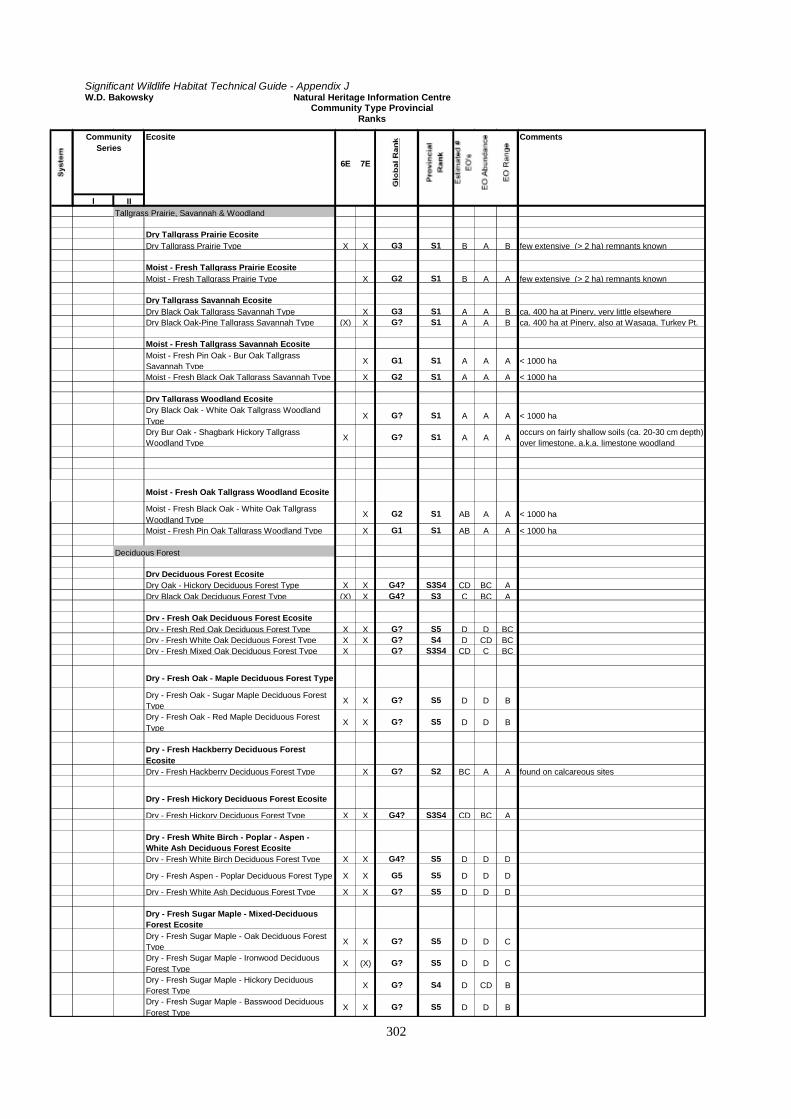
Significant Wildlife Habitat Technical Guide - Appendix JW.D. Bakowsky Natural Heritage Information Centre
Community Type ProvincialRanks
302
Community Series
Ecosite
6E 7E
Comments
I IITallgrass Prairie, Savannah & Woodland
Dry Tallgrass Prairie EcositeDry Tallgrass Prairie Type X X G3 S1 B A B few extensive (> 2 ha) remnants known
Moist - Fresh Tallgrass Prairie EcositeMoist - Fresh Tallgrass Prairie Type X G2 S1 B A A few extensive (> 2 ha) remnants known
Dry Tallgrass Savannah EcositeDry Black Oak Tallgrass Savannah Type X G3 S1 A A B ca. 400 ha at Pinery, very little elsewhereDry Black Oak-Pine Tallgrass Savannah Type (X) X G? S1 A A B ca. 400 ha at Pinery, also at Wasaga, Turkey Pt.
Moist - Fresh Tallgrass Savannah EcositeMoist - Fresh Pin Oak - Bur Oak Tallgrass Savannah Type
X G1 S1 A A A < 1000 ha
Moist - Fresh Black Oak Tallgrass Savannah Type X G2 S1 A A A < 1000 ha
Dry Tallgrass Woodland EcositeDry Black Oak - White Oak Tallgrass Woodland Type
X G? S1 A A A < 1000 ha
Dry Bur Oak - Shagbark Hickory Tallgrass Woodland Type
X G? S1 A A Aoccurs on fairly shallow soils (ca. 20-30 cm depth) over limestone, a.k.a. limestone woodland
Moist - Fresh Oak Tallgrass Woodland Ecosite
Moist - Fresh Black Oak - White Oak Tallgrass Woodland Type
X G2 S1 AB A A < 1000 ha
Moist - Fresh Pin Oak Tallgrass Woodland Type X G1 S1 AB A A < 1000 ha
Deciduous Forest
Dry Deciduous Forest EcositeDry Oak - Hickory Deciduous Forest Type X X G4? S3S4 CD BC ADry Black Oak Deciduous Forest Type (X) X G4? S3 C BC A
Dry - Fresh Oak Deciduous Forest EcositeDry - Fresh Red Oak Deciduous Forest Type X X G? S5 D D BC Dry - Fresh White Oak Deciduous Forest Type X X G? S4 D CD BC Dry - Fresh Mixed Oak Deciduous Forest Type X G? S3S4 CD C BC
Dry - Fresh Oak - Maple Deciduous Forest Type
Dry - Fresh Oak - Sugar Maple Deciduous Forest Type
X X G? S5 D D B
Dry - Fresh Oak - Red Maple Deciduous Forest Type
X X G? S5 D D B
Dry - Fresh Hackberry Deciduous Forest EcositeDry - Fresh Hackberry Deciduous Forest Type X G? S2 BC A A found on calcareous sites
Dry - Fresh Hickory Deciduous Forest Ecosite
Dry - Fresh Hickory Deciduous Forest Type X X G4? S3S4 CD BC A
Dry - Fresh White Birch - Poplar - Aspen - White Ash Deciduous Forest EcositeDry - Fresh White Birch Deciduous Forest Type X X G4? S5 D D D
Dry - Fresh Aspen - Poplar Deciduous Forest Type X X G5 S5 D D D
Dry - Fresh White Ash Deciduous Forest Type X X G? S5 D D D
Dry - Fresh Sugar Maple - Mixed-Deciduous Forest EcositeDry - Fresh Sugar Maple - Oak Deciduous Forest Type
X X G? S5 D D C
Dry - Fresh Sugar Maple - Ironwood Deciduous Forest Type
X (X) G? S5 D D C
Dry - Fresh Sugar Maple - Hickory Deciduous Forest Type
X G? S4 D CD B
Dry - Fresh Sugar Maple - Basswood Deciduous Forest Type
X X G? S5 D D B
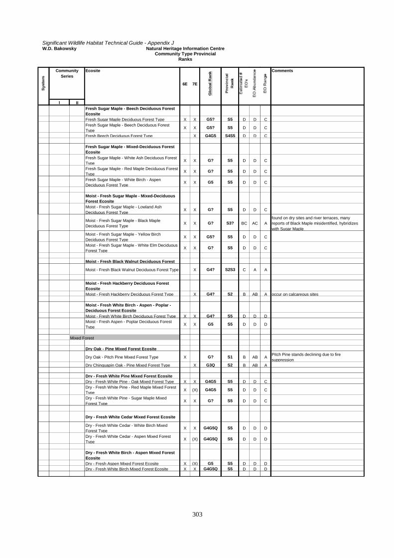
Significant Wildlife Habitat Technical Guide - Appendix JW.D. Bakowsky Natural Heritage Information Centre
Community Type ProvincialRanks
303
Community Series
Ecosite
6E 7E
Comments
I IIFresh Sugar Maple - Beech Deciduous Forest Ecosite
Fresh Sugar Maple Deciduous Forest Type X X G5? S5 D D CFresh Sugar Maple - Beech Deciduous Forest Type
X X G5? S5 D D C
Fresh Beech Deciduous Forest Type X G4G5 S4S5 D D C
Fresh Sugar Maple - Mixed-Deciduous Forest EcositeFresh Sugar Maple - White Ash Deciduous Forest Type
X X G? S5 D D C
Fresh Sugar Maple - Red Maple Deciduous Forest Type
X X G? S5 D D C
Fresh Sugar Maple - White Birch - Aspen Deciduous Forest Type
X X G5 S5 D D C
Moist - Fresh Sugar Maple - Mixed-Deciduous Forest EcositeMoist - Fresh Sugar Maple - Lowland Ash Deciduous Forest Type
X X G? S5 D D C
Moist - Fresh Sugar Maple - Black Maple Deciduous Forest Type
X X G? S3? BC AC Afound on dry sites and river terraces, many reports of Black Maple misidentified, hybridizes with Sugar Maple
Moist - Fresh Sugar Maple - Yellow Birch Deciduous Forest Type
X X G5? S5 D D C
Moist - Fresh Sugar Maple - White Elm Deciduous Forest Type
X X G? S5 D D C
Moist - Fresh Black Walnut Deciduous Forest
Moist - Fresh Black Walnut Deciduous Forest Type X G4? S2S3 C A A
Moist - Fresh Hackberry Deciduous Forest EcositeMoist - Fresh Hackberry Deciduous Forest Type X G4? S2 B AB A occur on calcareous sites
Moist - Fresh White Birch - Aspen - Poplar - Deciduous Forest EcositeMoist - Fresh White Birch Deciduous Forest Type X X G4? S5 D D DMoist - Fresh Aspen - Poplar Deciduous Forest Type
X X G5 S5 D D D
Mixed Forest
Dry Oak - Pine Mixed Forest Ecosite
Dry Oak - Pitch Pine Mixed Forest Type X G? S1 B AB APitch Pine stands declining due to fire suppression
Dry Chinquapin Oak - Pine Mixed Forest Type X G3Q S2 B AB A
Dry - Fresh White Pine Mixed Forest EcositeDry - Fresh White Pine - Oak Mixed Forest Type X X G4G5 S5 D D CDry - Fresh White Pine - Red Maple Mixed Forest Type
X (X) G4G5 S5 D D C
Dry - Fresh White Pine - Sugar Maple Mixed Forest Type
X X G? S5 D D C
Dry - Fresh White Cedar Mixed Forest Ecosite
Dry - Fresh White Cedar - White Birch Mixed Forest Type
X X G4G5Q S5 D D D
Dry - Fresh White Cedar - Aspen Mixed Forest Type
X (X) G4G5Q S5 D D D
Dry - Fresh White Birch - Aspen Mixed Forest EcositeDry - Fresh Aspen Mixed Forest Ecosite X (X) G5 S5 D D DDry - Fresh White Birch Mixed Forest Ecosite X X G4G5Q S5 D D D

Significant Wildlife Habitat Technical Guide - Appendix JW.D. Bakowsky Natural Heritage Information Centre
Community Type ProvincialRanks
304
Community Series
Ecosite
6E 7E
Comments
I IIMoist - Fresh Hemlock Mixed Forest EcositeMoist - Fresh Hemlock - Sugar Maple Mixed Forest Type
X X G4G5 S4S5 D CD C
Moist - Fresh Hemlock - White Birch Mixed Forest Type
X X G4G5 S4S5 D CD C
Moist - Fresh White Cedar Mixed Forest Ecosite
Moist - Fresh White Cedar - Birch - Aspen Mixed Forest Type
X X G5Q S5 D D D
Moist - Fresh White Cedar - Sugar Maple Mixed Forest Type
X X G5Q S5 D D D
Moist - Fresh White Birch - Aspen Mixed Forest EcositeMoist - Fresh White Birch - Aspen Mixed Forest Type
X X G5Q S5 D D D
Coniferous Forest
Dry Coniferous Forest EcositeDry Jack Pine Coniferous Forest Type X G4G5 S5 D D DDry Red Pine - White Pine Coniferous Forest Type X X G3G4 S4 C CD C
Dry Red Cedar Coniferous Forest EcositeDry Red Cedar Coniferous Forest Type X X G? S4 CD BC A
Dry - Fresh White Pine Coniferous Forest EcositeDry - Fresh White Pine Coniferous Forest Type X X G3G4 S4S5 D C C
Dry - Fresh White Cedar - White Spruce Coniferous Forest EcositeDry - Fresh White Cedar Coniferous Forest Type X X G4 S5 D D DDry - Fresh White Spruce Coniferous Forest Type X G4 S5 D D D
Fresh Hemlock Coniferous Forest EcositeFresh Hemlock Coniferous Forest Type X X G4? S4S5 D BC CFresh Hemlock - Mixed Coniferous Forest Type X X G3G4Q S4S5 D BC C
Moist - Fresh White Cedar - Mixed - Coniferous Forest EcositeMoist - Fresh White Cedar - Hemlock Coniferous Forest Type
X X G4? S5 D D D
Moist - Fresh White Cedar - Balsam Fir Coniferous Forest Type
X G4 S5 D D D

Significant Wildlife Habitat Technical Guide - Appendix M
305
APPENDIX K
Significant Wildlife Habitat: Waterfowl Component (ducks, geese and swans)
The significant waterfowl habitats described in this appendix were developed by a working group formed at asignificant wildlife habitat workshop held in January 1996. The working group membership includedrepresentatives of the Ministry of Natural Resources, Canadian Wildlife Service, Ducks Unlimited and privateconsultants. The group also included researchers and field staff. The group met on several occasions and producedthe report that makes up this appendix.
1. Conservation of Significant Waterfowl Habitat
Goal:
Ontario has a rich diversity of waterfowl species and the intent is that none of them shall be permitted toundergo sustained decline because of development-related loss of habitat or degraded habitat functions.
(Eleven waterfowl species that inhabit Ontario currently have populations that are below the goals established in the NorthAmerican waterfowl Management Plan for 2001: Mallard, Pintail, Wigeon, Green-winged Teal, Blue-winged Teal,Canvasback, Scaup, Southern James Bay Canada goose, Mississippi Valley Canada goose and Atlantic Brant)
(In some southern Ontario landscapes, wetland losses range from 78 % to 87 %)
(There is no estimate of the extent of degradation that settlement activities have had on wetland functions)
Objectives:
Identify and protect all waterfowl habitat of significance in the municipality.
(Only 18 % of the municipalities in southern Ontario have no mapped wetlands)
Ensure policies do not prevent management and restoration of wetlands.
(In a sample of 40 counties across southern Ontario, there are over 1.6 million ha of soils that are poorly drained,very poorly drained, bottomlands, organic or marshes that may need restoration or management to retain functions)
2. General Principles
All migratory species are potentially important at different scales.
Migratory wildlife are significantly different from sedentary species when it comes to habitat issues: no one jurisdictionencompasses the habitats required for their survival. Consequently, cooperation is needed at local, regional, provincial,national and even international levels to protect and enhance their habitat needs.
The entire suite of waterfowl habitats must be considered, including those that lie outside of wetlands.Agricultural practices that provide or promote ephemeral waterfowl habitats or functions (wet areas infarmed locations) should be encouraged.

Significant Wildlife Habitat Technical Guide - Appendix M
306
Waterfowl are a group of 32 species that use Ontario habitats for migration, staging, breeding, moulting, and in some cases,wintering. They depend on the following types of habitat to accommodate their needs over the course of their life cycle: pre-laying feeding habitat (usually ephemeral; include temporary pools, sheetwater, meltwater particularly on croplands duringspring migration before machinery can access); nesting habitat; brood-rearing habitat; moulting areas; local roosts; staginghabitat; and wintering habitat.
Habitats which are used by waterfowl that are rarely found in Ontario should be considered because oftheir contribution to the biological diversity of those sites.
For waterfowl, the issue of rarity is best dealt with by considering site biodiversity. Normally, waterfowl are rare only because asmall portion of their North American range includes Ontario. They may be abundant elsewhere. Their unique value should berecognized as a contribution to diversity rather than a rarity.
Planning controls should not prevent wetland management or restoration.
Most wetland sites in southern Ontario are degraded and require management to restore functions.
3. Specific Habitats
The habitat of significant species can be identified by two categories: locations that are known and mapped; andlocations that are unknown and must be mapped on the basis of population status and landform preference.
a) Known and Mapped Locations
The following sites are significant for waterfowl:
. Long Point; . Lake St Clair;
. lower Detroit River; . Wolfe Island;
. Hillman/Point Pelee . Rondeau Bay;
. Amherst Island; . St. Lawrence River;
. Hullett PWA; . Luther Marsh PWA;
. Minesing Swamp; . Tiny Marsh PWA;
. Matchedash Bay PWA; . Wye Marsh PWA;
. Lake St. Francis; . Prince Edward County shores;
. Presqu'ile Bay; . Lake Scugog;

Significant Wildlife Habitat Technical Guide - Appendix M
307
. Cache Bay; . west Rainy Lake;
. Lake of the Woods; . Little Claybelt;
. Nighthawk Lake; and . Holland/Scanlon Marshes.
(Sources for this information include Environment Canada - Canadian Wildlife Service, Ontario Ministry of Natural Resources,Ducks Unlimited Canada and local Conservation Authorities)
b) Unknown and Unmapped Locations
Knowledge of two factors are useful in mapping local sites of potentially significant waterfowl habitat: thepopulation status of the waterfowl species normally expected to inhabit the municipality and the locationof landforms that characterize their habitat preferences.
These 5 categories are useful in describing the population status of the waterfowl that could be present in Ontariomunicipalities:
Categories for Waterfowl Population Status Applicable Species or Populations (1995 Data)
A) Species whose populations are in decline Black Duck, Southern James Bay & Atlantic populationsof Canada goose
B) Species for which Ontario provides a large portion oftheir continental breeding and staging habitat
Common Goldeneye, Canvasback, Redhead, RingneckedDuck, Scaup (2 species),Hooded Merganser, Old Squaw,Scoters (3 species), Mississippi Valley & SouthernOntario Canada goose
C) Species for which Ontario provides an importantcomponent of continental breeding and staging habitat
Wood Duck, Merganser (2 species) Coot, Wigeon,Gadwall, Blue-winged Teal, Green-winged Teal, lesserSnow goose, Mallard
D) Species for which breeding, staging and winteringhabitat is limited in Ontario
Ruddy Duck, King & Common Eider, Trumpeter Swan,Atlantic Brant
E) Species that are dependant on transitory habitats Pintail, Tundra Swan, Shoveller
(Sources of this information include Environment Canada - Canadian Wildlife Service and the Ontario Ministry of NaturalResources)

Significant Wildlife Habitat Technical Guide - Appendix M
308
The following landforms characteristically provide significant waterfowl habitat and need to be examined:
Landform Type Measures of Significance
Wetlands • Type of wetland: using the definitions in the Provincial WetlandsClassification System, marshes and swamps are more important thanbogs or fens
• Size of wetland: small wetlands (based on confirmed boundaries) areimportant but as wetland size increases, so do the local values - largermay be better in some municipalities
• Groups of wetlands: clusters of wetlands (more than 10 within 1,000 mof the centre of each) are more important than single wetlands
• Peripheral lands: uplands, such as grass and shrub habitats, as well aspastureland within a significant distance can provide important nestinghabitat
Poorly Drained Landscapes
• Stream & Riverine Bottomlands: floodlands provide important waterfowl
habitat• Soils: certain soil types (ie. Farmington series as determined by soil maps
or Ontario land Inventory maps) are useful indicators of importanthabitat.
• Potholes: terrain with over 50 small wetlands per sq. km. are importantwaterfowl habitats
• Beaver Ponds: terrain with over 25 ponds per 10 sq. km. are importanthabitats
• Seasonal Wet Locations: seasonally flooded locations, even those underactive cultivation, such as sheetwater or meltwater areas and poorlydrained croplands provide seasonally important pre-nesting habitat
NAWMP Project Sites These wetland enhancement locations are undertaken only on importantwaterfowl habitats
Coastal Marshes The shores of Great Lakes and other large inland lakes provide uncommonbut valuable locations for breeding and staging waterfowl
(Sources of this information include Environment Canada - Canadian Wildlife Service, the Ontario Ministries of Agriculture, Foodand Rural Affairs and Natural Resources, Ducks Unlimited Canada, Conservation Authorities, agricultural associations and farm,naturalist, hunter and trapper clubs)
By combining the category for each waterfowl species known to be present in the municipality with mappedlandform information and the knowledge of interest groups, the local significance of waterfowl habitats can bedetermined.

Significant Wildlife Habitat Technical Guide - Appendix M
309
3. Impacts from Development
There are three impacts that residential, commercial and industrial development has on significant waterfowlhabitats (see the 5 types in section 3b):
. loss of area and function;
. degradation of wetland functions and values; and
. fragmentation from surrounding natural landscapes.
These impacts operate more commonly in urban environments because they result in permanent changes towaterfowl habitat.
In rural environments, even those under active cultivation, the changes to waterfowl habitat are normallytemporary and compensatory. Major drainage schemes and large-scale clearing efforts are the exceptions. Suchtechniques as crop rotation, grassed waterways, conservation tillage, buffer strips, living fencelines, windbreaks,rotational grazing and contour ploughing only shift the location of transitory habitat types - they do notpermanently destroy them - particularly if they are practice within 300 m of traditional habitats.
If existing habitats are not destroyed, it allows for future restoration at appropriate times and locations.

Significant Wildlife Habitat Technical Guide - Appendix M
310
APPENDIX L
Practical Approach for Identifying and Mapping Rare Vegetation CommunitiesUsing the Southern Ontario Ecological Land Classification Approach
IntroductionThe identification and protection of rare vegetation communities within a planning area is important. Frequentlythese areas support numerous provincially or regionally rare species. Many plant and animals species depend onrare vegetation communities because they provide critical habitat found nowhere else. On a larger scale, theyserve to maintain overall biodiversity; on a smaller scale, they contribute to healthy wildlife populations in theplanning area.
While some of these communities have never been common in Ontario, many others have been lost or severelydegraded, particularly in southern Ontario. The program and the efforts of researchers and naturalists havehelped to identify many of the rare vegetation communities in Ontario. Planning authorities across southernOntario, using the provincial ELC approach, can further help to identify and then protect these important naturalareas.
ELC and the Vegetation Communities of OntarioThe vegetation communities of Ontario can be surveyed and classified using a process called Ecological LandClassification (ELC). The ELC is the process of arranging or ordering information about land units to betterunderstand their similarities and relationships. The goal of the provincial ELC program is to establish acomprehensive and consistent province-wide approach for ecosystem description, classification, mapping, anddata collection. It helps to identify recurring ecological patterns on the landscape to reduce complex naturalvariation to a reasonable number of meaningful ecosystem units. The ELC framework is being designed tofacilitate key conservation, planning, and ecosystem management objectives, at various site to landscape scalesof resolution. It will provide community descriptions and sampling methodologies for identifying and mappingvaluable natural heritage features and areas. This will help municipalities to meet their obligations under thenew system of planning in Ontario as outlined in Policy 2.3 in the Provincial Policy Statement.
The vegetation communities identified by the ELC process are developed through extensive collection andstatistical analysis of primarily field data. To date, a complete range of forest communities for northern andcentral Ontario, and wetland communities for the northwestern part of the province have been identified. Insouthern Ontario, the ELC is still being developed, but during the interim, existing data have been used todevelop a preliminary ecological land classification for southern Ontario. This classification is described in a1998 publication entitled Ecological Land Classification for Southern Ontario: First Approximation and itsApplication.

Significant Wildlife Habitat Technical Guide - Appendix M
311
Organization and brief explanation of the ELC frameworkThere are 6 levels to the ELC arranged in a hierarchy. They are explained in the manual Ecological LandClassification for Southern Ontario: First Approximation and Its Application and vegetation and environmentalcharacteristics are listed for each one. From the largest to the smallest scale they are:
1. Site Region. The ELC for Southern Ontario applies to Site Regions 6E and 7E.2. System: Aquatic, Wetland, Terrestrial. The manual provides a key to determine the type of System.3. Community Class. Ultimately the division of Community Classes is based on recurring patterns in plant
species associations that have shared physiognomic characteristics, substrate type, geology, and meso- andmicroclimate, as well as other ecological factors.
4. Community Series. These units are normally visible and consistently recognizable on aerial photographs orfrom a combination of maps, aerial photograph interpretation, and other remote sensing techniques.Community Series are the lowest level in the ELC that can be identified without a site visit. They aredistinguished based on the type of vegetation cover or the plant form that characterizes the community.Generally, they are identified based on whether the community has open, shrub, or treed vegetation cover,as well as whether the plant form is deciduous, coniferous, or mixed.
5. Ecosite. This landscape unit represents recurring vegetation and soil types. The manual provides a key todetermine the type of Ecosite.
6. Vegetation Type. This is the finest level of resolution in the ELC hierarchy. Vegetation Types are recurringpatterns found in plant species assemblages associated with a particular Ecosite. They are generated bygrouping plant communities that are most similar together, based entirely on the plant species composition.
The Ontario Ministry of Natural Resources, Credit Valley Conservation Authority and a private consultant havedeveloped a description framework, field sampling methods, an integrated database, and a manual that might beuseful to southern municipalities interested in identifying and describing the vegetation communities withintheir jurisdiction. The following information is provided below to help municipalities identify and mapvegetation communities, especially those that may be rare.
Rare vegetation communitiesThe ultimate objective is to identify and accurately map the rare vegetation communities found in the planningarea. The methods outlined below can be used to identify and map the ELC units at a variety of scales. The listof rare vegetation communities for Site Regions 6E and 7E are listed in Appendix M. A planning authority maywish first to classify all of the land within its jurisdiction and later focus on the rare communities, or it maydecide to concentrate only on the rare vegetation communities.

Significant Wildlife Habitat Technical Guide - Appendix M
312
Remote methods such as aerial photograph interpretation, can normally be used to reliably identify vegetationcommunities to the Community Series level of the ELC hierarchy. However most rare vegetation communities(see Appendix J) have been identified at the Vegetation Type level, the finest scale in the ELC hierarchy. Fieldinvestigations are required to reliably identify both the Vegetation Types and Ecosites as information must becollected on soil and site conditions, as well as specific indicator vegetation species.
The identification of the Community Series can be an important first step in the screening process to identifyrare vegetation communities because it can indicate where there is a high probability of finding a rareVegetation Type and where field investigations should be focused. For example, the identification of theTallgrass Savannah Community Series will indicate the presence of rare vegetation communities because all ofthe Vegetation Types under this Community Series are rare (see Appendix J). In other situations theidentification of the Community Series will not readily indicate the location of the rare vegetation Types. Forexample, there are 27 Thicket Swamp Types under the Thicket Swamp Community Series (see Appendix J). Ofthese, 7 Vegetation Types are considered rare (i.e., S1 to S3). Two of them, Paw-paw Mineral Thicket Swampand Huckleberry Organic Thicket Swamp (only found in one location) are very rare (i.e., S1).
It requires considerable botanical knowledge to identify some of these Vegetation Types, comprised of suchspecies as Buttonbush, Southern Arrow-wood and Spicebush. However, knowing the distribution and preferredhabitat of species (see Appendix G) can make it easier. Also lists of species that often are included in wetlandevaluations, natural area inventories, site management plans, and consultant reports may assist in locating someof these species and rare vegetation communities.
Many, but not all rare vegetation communities have already been identified and mapped (see Appendix M). Theinformation in Appendix M provides general locations of rare vegetation communities and can be used toidentify areas where there may be additional examples of these communities.
Limitations of the ELCThe ELC is becoming the accepted framework for natural community description in Ontario and rare vegetationcommunities for Site Regions 6E and 7E have been identified and described based on the Ecological LandClassification for Southern Ontario: First Approximation and Its Application. However, there are somechallenges when using the ELC and they are outlined below.
• At the present time, the ELC for Southern Ontario and the 1998 OMNR manual only apply to Site Regions6E and 7E, an area roughly enclosed by the Ontario-Quebec border, along the north shores of Lake Ontarioand Lake Erie, up the eastern shoreline of Lake Huron to the tip of the Bruce Peninsula, around GeorgianBay to Midland, and eastward through Orillia, Marmora, to Arnprior. See Figure 2-1 (site regions). Thisarea does not include Manitoulin Island.
• The ELC for southern Ontario, based on new data collection and analysis, has only been completed for
forest land. However, it will be expanded to include wetlands. In the interim, the first approximationprovides an excellent source of information.
• It can be difficult to determine whether a vegetation community is rare and some communities do not fit
easily into the ELC description. Often this is because most natural communities in southern Ontario havebeen disturbed either directly or indirectly by people. Many communities may have some species that are

Significant Wildlife Habitat Technical Guide - Appendix M
313
indicators of a potentially rare community (e.g., some prairie grasses) but lack other key species. Or theymay be comprised of a few indicator species and many invasive, exotic species. The site might have oncesupported a relatively pristine community, but become somewhat degraded or otherwise altered due tochanges in land use. Sometimes difficult decisions are required to determine the status of thesecommunities. As a general rule, they should be based on the rarity of the remnant community and the effortsrequired to restore it. There are a growing number of examples of successful tall-grass prairie restorationprojects and remnants of other rare vegetation communities could be restored as well.
• It can be difficult to accurately map small vegetation communities. A minimum polygon size of 0.5 hectare
is a feasible mapping unit for applying the ELC at a scale of 1:10,000. A polygon is a discrete and uniquearea outlined on a map or aerial photograph that contains more or less homogeneous environmental andvegetation characteristics. A hand-held GPS unit might help to accurately locate some small communities.
• Effective application of the ELC for Southern Ontario requires skilled field workers with a good knowledge
of plants and soil characteristics. Some vegetation communities are quite difficult to describe because theyare complex or disturbed to varying degrees.
• Training of field staff (e.g., instruction on aerial photograph interpretation, soil description, ELC field
sampling methodology) might be required if the municipality would prefer to develop in-house knowledgeand familiarity with the ELC.
• Aerial photograph interpretation is a skill that takes considerable practice to develop. Also the planning
authority cannot assume that private consultants have this skill. • Application of the ELC is potentially expensive because of the volume of information that must be collected
during field visits. Field investigations will usually be required to find rare vegetation communities, thusincreasing overall costs. Even while working at the landscape scale, a very brief site reconnaissance may beadvisable to verify initial community typing obtained from aerial photographs, confirm boundaries, becomefamiliar with the level of variation found within the community,

Significant Wildlife Habitat Technical Guide - Appendix M
314
• or to check unusual features. This limited ground-truthing allows the photograph interpreter to develop afiner appreciation of the differences between the photograph and the communities on the ground.
How to apply ELC tools and techniques to identify rare vegetation communities for land use planning The following table provides a brief summary of how the ELC might be applied at both the larger landscapescale and the smaller site scale to achieve several important objectives. The tools and techniques, as well asexplanations of them and the ELC terminology (e.g., landform, slope position, vegetation form and cover) andDescription Framework are fully explained in the manual Ecological Land Classification for Southern Ontario:First Approximation and Its Application. Also included in the manual are examples of the ELC Field SamplingMethods and Data Cards. Table L-1: How to apply ELC tools and techniques to identify rare vegetation communities Objective Landscape Scale Site Scale Delineation of theboundaries ofpotentially rarevegetationcommunities
• use aerial photographs,topographical, physiographic,soils &/or other maps & any otherpertinent information (e.g., Arnup& Racey 1996 for details on howto interpret aerial photographs) todiscern prominent landforms,slope position, drainage pattern,& vegetation form & cover tohelp to delineate the naturalecological or anthropogenicboundaries of potentially rarevegetation communities
• same as for landscape scale but alsowill also include gathering additionalinformation in the field to help furtherdetermine boundaries of the rarecommunity
• look for additional communitieswithin the site based primarily onchanges in site conditions &vegetation and delineate their naturalor anthropogenic boundaries
Field survey ofpotentially rarevegetationcommunities
• select one or more potentially rarecommunities identified from thesources above
• from this list, first visit those withthe greatest potential to exhibitrarity for the planning area & usethe ELC Field Sampling Methods& Data Cards to collect thenecessary data to describe &classify them according to theELC
• where necessary, refine earlierinterpretations conducted beforethis field survey
• conduct more intensive fieldinvestigations of priority sites &/orsites for which more information isrequired
• collect detailed site & vegetation datafor each of these sites using the ELCField Sampling & Data Cards
Description ofpotentially rarevegetationcommunities
• use the ELC DescriptionFramework to describe theenvironmental, physical,historical, & vegetationconditions found on the site
• use other sources of informationto help to complete theDescription Framework
• same as for landscape scale butnecessarily includes more informationcollected during site visits
Classification ofpotentially rarevegetationcommunities
• use the information & datadocumented above to classify thesite to the Community Class &Community Series levels in theELC
• use information & data documentedabove to classify the site toCommunity Class, Community Series,Ecosite, & Vegetation Type levels inthe ELC

Significant Wildlife Habitat Technical Guide - Appendix M
315
Objective Landscape Scale Site Scale• use the ELC Keys & Community
Tables to assign ELC units to thesite
• Note: only Community Class &Community Series levelclassifications can be achievedwithout a site visit
• use the ELC Keys & CommunityTables to assign ELC units to the site
• Note: only by using field data can asite be classified according to all thelevels in the ELC
Mapping ofpotentially rarevegetationcommunities
• boundaries of rare communities &their corresponding classificationscan be mapped by 1) manuallytranscribing the boundaries tohard-copy maps or 2) digitizationinto Geographical InformationSystems (GIS) for digitalmapping
• mapping is to the CommunityClass or Community Series levelin the ELC
• same as for the landscape scale,however mapping can be done to theCommunity Class, Community Series,Ecosite, & Vegetation Type level inthe ELC
Basic equipment required to identify and map rare vegetation communities The following list describes basic equipment required to identify and map rare vegetation communities. • Maps, especially topographical, physiographical, soils, and Ontario Basic Mapping (OBM). Ontario Basic
Mapping (OBM) is available in hard copy and digital format for all of southern Ontario at a scale of1:10,000. It has become the standard for much of the natural areas mapping being carried out.
• Aerial photographs. Aerial photography varies considerably in scale, format, resolution, date, and seasonal
coverage. However it forms the basis of most of the community mapping that is prepared. Aerialphotographs available from the OMNR are mostly at 1:10,000. However if the planning authority wishes touse their own photos, it is suggested that they use those with a scale of 1:8,000 to facilitate interpretation.Also summer photography can be useful for the delineation of forested communities, if the expertise isavailable to differentiate species in the canopy of trees in full leaf. Spring photography would make areas ofconifer and hardwoods, as well as waterbodies, woodland ponds, and flooded lands easier to see.
• A pocket stereoscope (2X magnification) is used for aerial photograph interpretation.

Significant Wildlife Habitat Technical Guide - Appendix M
316
• Fine point technical pens (0.35 mm) are used to transcribe community boundaries directly onto the aerialphotographs. Their ink can be erased.
• Although the manual Ecological Land Classification for Southern Ontario: First Approximation and Its
Application was designed to produce an ecological land classification of communities for southern Ontario,it can be useful for identifying rare vegetation communities as well. It provides a description of the site,vegetation, and community characteristics that need to be sampled on a site, for the detailed description,identification, and classification of ecological land units in southern Ontario. It also provides details on howto sample characteristics, and a set of standardized data cards that can be used to record the collectedinformation.
• A soil auger or Oakfield Tube to sample soils. • Field guides for vascular plants to aid in plant identification. • A plant press for collecting plants that require future identification. • A Wedge Prism with a 2X prism factor to determine forest stand composition and basal area. • Copies of information/data collection forms: ELC Community Description & Classification; ELC Stand &
Soil Characteristics; ELC Plant Species List; ELC Management/Disturbance; and ELC Wildlife forms(sample copies are included in Ecological Land Classification for Southern Ontario: First Approximationand Its Application).
• There are several ways to transfer community boundaries interpreted from aerial photographs, to the OBMs.
Boundaries can be drawn on mylar overlays placed on top of aerial photographs. The overlays are thentransferred to the OBMs and boundaries can be traced onto the maps. This method is not recommendedbecause of the discrepancy of scales between photographs and OBMs. They can also be transferredmechanically using a Sketchmaster. A Sketchmaster is one of the more common reflection instruments usedfor manually transferring information from single vertical aerial photographs to maps of a different scale.Boundaries can also be electronically transferred through digitization directly from ortho-rectified aerialphotographs (i.e., photographs that have been corrected for distortion). Increasingly, digital aerialphotographs on compact discs are being used, providing benefits such as the ability to change scales, andstore line files.
• A dot grid and planimeter are used to calculate land cover area and percentage cover.

Significant Wildlife Habitat Technical Guide - Appendix M
317
Information that must be collected Data collection during field investigations is critical to accurate identification and mapping of potentially rarevegetation communities. But due to budget and time constraints, staffing expertise, time of year or othervariables, it is not always possible to collect all the information outlined in the manual Ecological LandClassification for Southern Ontario: First Approximation and Its Application. Nevertheless, the followinginformation should always be collected during a site visit to a potentially rare community. • In forests and woodlands, forest stand characteristics; for other communities, the dominant species of
vegetation. A small glass Wedge Prism is used to determine the forest stand composition and basal area ofthe site. Information about the vegetation composition of a site is mandatory for site classification.
• Soil characteristics. A soil auger or Oakfield tube is used to sample a soil core to ultimately determine soil
texture, depth of organic layer, depth to bedrock, soil moisture, and soil drainage regime of the polygon.This information is also of fundamental importance to the classification system. For example, sugar maple-beech may be a common forest cover type within the planning area, but if it is found on very shallow (e.g.,less than 15 cm) sandy soils, it might represent a rare vegetation community.
• Location of the site and its boundary. This is required for accurate mapping (and protection) of the
potentially rare vegetation community.

Significant Wildlife Habitat Technical Guide - Appendix M
318
APPENDIX M
Locations of Known Rare Vegetation Communitiies in Ontario
The Ministry of Natural Resources Natural Heritage Information Centre (NHIC) tracks the status andoccurrences of rare vegetation communities in Ontario. The table that makes up this appendix, indicates theupper tier municipalities where rare vegetation communities are known to occur. The numbers indicate thenumbers of known occurrences and an “x” denotes that the community is known to occur.
The table indicates the rarity of the vegetation community, which is represented by the S-rank (described inAppendix J) and G-rank (which denotes global rarity).
The Southern Ontario ELC Code and EL Code are listed in order to cross reference the communities listed withthe NHIC and those described by the Ecological Land Classification System.

Significant Wildlife Habitat Technical Guide - Appendix M
319
S. ONT ELC CODE
ELCODE COMMON NAME GRANK SRANK
ALO1-1 CEGL005192 Dry Lichen-Moss Open Alvar Pavement Type G2 S1 3ALO1-2 CEGL005235 Dry Annual Open Alvar Pavement Type G2 S1 1 X
ALO1-3 CEON000218Northern Dropseed - Little Bluestem - Scirpus-like Sedge Alvar Grassland Type
G2G3? S2S3 14 X X
ALO1-4 CEON000225White Cedar - White Spruce - Philadelphia Panic Grass Treed Alvar Grassland Type
G3? S3 1 X X
ALO1-5 CEON000219Tufted Hairgrass - Canada Bluegrass - Philadelphia Panic Grass Alvar Grassland Type
G2G3? S2S3 5 1 3
ALS1-1 CEON000222Common Juniper - Fragrant Sumac - Hairy Beardtongue Alvar Shrubland Type
G2? S2 3 2
ALS1-2 CEON000221Creeping Juniper - common Juniper - Shrubby Cinquefoil Alvar Shrubland Type
G2? S2 6
ALS1-3 CEON000216 Shrub Conifer - Dwarf Lake Iris Alvar Shrubland Type G2? S2 3
ALT1-1 CEON000220Chinquapin Oak - Canada Bluegrass - Nodding Onion Alvar Grassland Type
G1? S1 1
ALT1-2 CEGL005230 Shagbark Hickory - Prickly Ash Treed Alvar G? S? 1
ALT1-3 CEON000229Jack Pine - White Cedar - Common Juniper Treed Alvar Shrubland Type
G2? S2 4
ALT1-4 CEON000223White Cedar - Jack Pine - Shrubby Cinquefoil Treed Alvar Pavement
G1G2 S1 5
ALT1-5 CEON000226 Red Cedar - Early Buttercup Treed Alvar Grassland Type G2? S2 5
BBO1-1 CEGL005162 Sea Rocket Sand Beach Type G2G4 S2S3 X 6 X X XBOS2-1 CEON000121 Leatherleaf Shrub Kettle Peatland Type G3G4 S3 X X X X X X
CLO1-1 CEON000133Cliffbrake - Lichen Open Unshaded Limestone / Dolostone Cliff Face Type
G5 S3 5 X 1 7 X
CLO1-2 CEON000134Bulblet Fern - Herb Robert Open Shaded Limestone / Dolostone Cliff Face Type
G5 S3 10 X 1 11 2
CLO1-4 CEGL002048 Open Limestone / Dolostone Seepage Cliff Type G?Q S3 X X XCLO1-5 CEON000136 Open Limestone / Dolostone Cliff Rim Type G5 S2 9 X 1 X X
CLS1-1 CEGL005066Common Juniper Open Limestone / Dolostone Cliff Rim Shrubland Type
G? S2S3 1
CLS1-2 CEGL005070Round-leaved Dogwood Open Limestone / Dolostone Cliff Rim Shrubland Type
G? S3 1 1
CLT1-1 CEGL002451 White Cedar Treed Limestone Cliff Type G2Q S3 2 X 11 XFET1-3 CEON000117 Gray Birch Treed Fen Type G4? S2S3
FOC4-2 CEON000103 White Cedar - Hemlock Coniferous Organic Swamp Type G? S3S4
FOD1-3 CEGL005030 Dry Black Oak Deciduous Forest Type G4? S3 2 X 1 1 XFOD1-4 CEON000162 Dry - Fresh Mixed Oak Deciduous Forest Type G? S3S4 1 XFOD2-2 CEON000159 Dry Oak - Hickory Deciduous Forest Type G4? S3S4 X X 2FOD2-3 CEON000164 Dry - Fresh Hickory Deciduous Forest Type G4? S3S4 2 4FOD4-3 CEGL005021 Dry - Fresh Hackberry Deciduous Forest Type G? S2 16
FOD6-2 CEON000178Moist - Fresh Sugar Maple - Black Maple Deciduous Forest Type
G? S3? 2 1 4
FOD7-4 CEON000181 Moist - Fresh Black Walnut Deciduous Forest Type G4? S2S3MAM2-8 CEON000022 Prairie Slough Grass Mineral Meadow Marsh Type G2G3 S3 2MAM3-7 CEON000029 Prairie Slough Grass Organic Meadow Marsh Type G2G3 S3 1 XMAM4-1 CEON000016 Graminoid Coastal Meadow Marsh Type G2? S2 119 2 1 4 1 12MAM4-2 CEON000017 Shrubby Cinquefoil Coastal Meadow Marsh Type G2? S1 27MAM5-2 CEGL005139 Perched Mineral Prairie Fen Type G3G4 S1 1
RBS1-2 CEON000202Round-leaved Dogwood Limestone / Dolostone Shrubland Barren Type
G? S3 1
RBT3-1 CEGL005046 Pitch Pine Treed Granite Barren Type G3G5 S1SBO1-2 CEON000153 Hay Sedge Sand Barren Type G? S1
SDO1-1 CEON000126Little Bluestem - Switchgrass - Beachgrass Dune Grassland Type
G? S2 1 X
SDO1-2 CEON000127Little Bluestem - long-leaved Reed Grass - Great Lakes Wheat Grass Dune Grassland Type
X
SDS1-3 CEGL005064 Juniper Dune Shrubland Type G? S2 X 1 X X

Significant Wildlife Habitat Technical Guide - Appendix M
320
S. ONT ELC CODE
ELCODE COMMON NAME GRANK SRANK
SDT1-1 CEON000131 Cottonwood Dune Savannah Type G1G2 S1 2 X XSWT2-8 CEON000057 Silky Dogwood Mineral Thicket Swamp Type G5 S3S4 24SWT3-13 CEGL005083 Poison Sumac Organic Thicket Swamp Type G4? S3 X X 1SWT3-14 CEON000072 Huckleberry Organic Thicket Swamp Type G2Q S1SWT3-4 CEON000065 Buttonbush Organic Thicket Swamp Type G4 S3 1SWT3-7 CEON000067 Winterberry Organic Thicket Swamp Type G3G4Q S3S4 1TAO1-1 CEON000199 Dry Herbaceous Limestone / Dolostone Talus G? S2 12 X 3 1 4TAO1-2 CEON000200 Wet Herbaceous Limestone / Dolostone Talus G? S2 3 X X XTAS1-2 CEGL005067 Mountain Maple Open Limestone Talus Shrubland Type G? S3 2 X 3 4 XTAT1-2 CEON000138 White Birch Dry Treed Limestone Talus Type G3G5 S3 4 3 1TAT1-3 CEGL005172 White Cedar Dry Treed Limestone Talus Type G? S3 6 X 20 13 XTAT1-4 CEON000139 Sugar Maple Moist Treed Limestone Talus Type G3G5 S3 5 6 14 1
TAT1-5 CEON000140Basswood - White Ash - Butternut Moist Treed Limestone Talus Type
G3G5 S2 2 2
TAT1-6 CEGL005190 Hemlock - Sugar Maple Moist Limestone Talus Type G? S2 3 7 XTPO1-1 CEGL002210 Dry Tallgrass Prairie Type G3 S1 2 X 4 X 9 XTPO2-1 CEGL005096 Moist - Fresh Tallgrass Prairie Type G2 S1 3 X XTPS1-1 CEGL002492 Dry Black Oak Tallgrass Savannah Type G3 S1 1 XTPS1-2 CEGL005129 Dry Black Oak-Pine Tallgrass Savannah Type G? S1 X 1 X
TPS2-1 CEON000155 Moist - Fresh Pin Oak - Bur Oak Tallgrass Savannah Type G1 S1
TPW1-1 CEGL005029 Dry Black Oak - White Oak Tallgrass Woodland Type G? S1 X X 12 X
TPW1-2 CEON000230 Dry Bur Oak - Shagbark Hickory Tallgrass Woodland Type G? S1 4
TPW2-1 CEON000156Moist - Fresh Black Oak - White Oak Tallgrass Woodland Type
G2 S1 X X
TPW2-2 CEON000158 Moist - Fresh Pin Oak Tallgrass Woodland Type G1 S1 X X
CEON000322 Black Spruce - Tamarack - Leatherleaf Patterned Fen Type

Significant Wildlife Habitat Technical Guide - Appendix M
321
S. ONT ELC CODE
ELCODE COMMON NAME
ALO1-1 CEGL005192 Dry Lichen-Moss Open Alvar Pavement Type 2 5 2 XALO1-2 CEGL005235 Dry Annual Open Alvar Pavement Type 2 2 2 2 X X
ALO1-3 CEON000218Northern Dropseed - Little Bluestem - Scirpus-like Sedge Alvar Grassland Type
1 2 10 X 2 X
ALO1-4 CEON000225White Cedar - White Spruce - Philadelphia Panic Grass Treed Alvar Grassland Type
X 1 2 2 X X
ALO1-5 CEON000219Tufted Hairgrass - Canada Bluegrass - Philadelphia Panic Grass Alvar Grassland Type
1 10 2
ALS1-1 CEON000222Common Juniper - Fragrant Sumac - Hairy Beardtongue Alvar Shrubland Type
2 6 2 1
ALS1-2 CEON000221Creeping Juniper - common Juniper - Shrubby Cinquefoil Alvar Shrubland Type
10
ALS1-3 CEON000216 Shrub Conifer - Dwarf Lake Iris Alvar Shrubland Type 6
ALT1-1 CEON000220Chinquapin Oak - Canada Bluegrass - Nodding Onion Alvar Grassland Type
ALT1-2 CEGL005230 Shagbark Hickory - Prickly Ash Treed Alvar
ALT1-3 CEON000229Jack Pine - White Cedar - Common Juniper Treed Alvar Shrubland Type
X X X X
ALT1-4 CEON000223White Cedar - Jack Pine - Shrubby Cinquefoil Treed Alvar Pavement
X
ALT1-5 CEON000226 Red Cedar - Early Buttercup Treed Alvar Grassland Type X 2
BBO1-1 CEGL005162 Sea Rocket Sand Beach Type XBOS2-1 CEON000121 Leatherleaf Shrub Kettle Peatland Type X 1 X X
CLO1-1 CEON000133Cliffbrake - Lichen Open Unshaded Limestone / Dolostone Cliff Face Type
9
CLO1-2 CEON000134Bulblet Fern - Herb Robert Open Shaded Limestone / Dolostone Cliff Face Type
22 6 X
CLO1-4 CEGL002048 Open Limestone / Dolostone Seepage Cliff Type 6 1 XCLO1-5 CEON000136 Open Limestone / Dolostone Cliff Rim Type X X
CLS1-1 CEGL005066Common Juniper Open Limestone / Dolostone Cliff Rim Shrubland Type
CLS1-2 CEGL005070Round-leaved Dogwood Open Limestone / Dolostone Cliff Rim Shrubland Type
1
CLT1-1 CEGL002451 White Cedar Treed Limestone Cliff Type 2 2 XFET1-3 CEON000117 Gray Birch Treed Fen Type 2
FOC4-2 CEON000103 White Cedar - Hemlock Coniferous Organic Swamp Type 5
FOD1-3 CEGL005030 Dry Black Oak Deciduous Forest Type 7 6FOD1-4 CEON000162 Dry - Fresh Mixed Oak Deciduous Forest TypeFOD2-2 CEON000159 Dry Oak - Hickory Deciduous Forest TypeFOD2-3 CEON000164 Dry - Fresh Hickory Deciduous Forest TypeFOD4-3 CEGL005021 Dry - Fresh Hackberry Deciduous Forest Type
FOD6-2 CEON000178Moist - Fresh Sugar Maple - Black Maple Deciduous Forest Type
17 1 2
FOD7-4 CEON000181 Moist - Fresh Black Walnut Deciduous Forest Type 3MAM2-8 CEON000022 Prairie Slough Grass Mineral Meadow Marsh TypeMAM3-7 CEON000029 Prairie Slough Grass Organic Meadow Marsh TypeMAM4-1 CEON000016 Graminoid Coastal Meadow Marsh Type 2 3 3MAM4-2 CEON000017 Shrubby Cinquefoil Coastal Meadow Marsh Type 1MAM5-2 CEGL005139 Perched Mineral Prairie Fen Type
RBS1-2 CEON000202Round-leaved Dogwood Limestone / Dolostone Shrubland Barren Type
RBT3-1 CEGL005046 Pitch Pine Treed Granite Barren Type 11SBO1-2 CEON000153 Hay Sedge Sand Barren Type 1
SDO1-1 CEON000126Little Bluestem - Switchgrass - Beachgrass Dune Grassland Type
X X
SDO1-2 CEON000127Little Bluestem - long-leaved Reed Grass - Great Lakes Wheat Grass Dune Grassland Type
SDS1-3 CEGL005064 Juniper Dune Shrubland Type

Significant Wildlife Habitat Technical Guide - Appendix M
322
S. ONT ELC CODE
ELCODE COMMON NAME
SDT1-1 CEON000131 Cottonwood Dune Savannah TypeSWT2-8 CEON000057 Silky Dogwood Mineral Thicket Swamp TypeSWT3-13 CEGL005083 Poison Sumac Organic Thicket Swamp TypeSWT3-14 CEON000072 Huckleberry Organic Thicket Swamp Type 1SWT3-4 CEON000065 Buttonbush Organic Thicket Swamp TypeSWT3-7 CEON000067 Winterberry Organic Thicket Swamp TypeTAO1-1 CEON000199 Dry Herbaceous Limestone / Dolostone Talus 7 XTAO1-2 CEON000200 Wet Herbaceous Limestone / Dolostone Talus 2 XTAS1-2 CEGL005067 Mountain Maple Open Limestone Talus Shrubland Type 2 3 XTAT1-2 CEON000138 White Birch Dry Treed Limestone Talus Type 3TAT1-3 CEGL005172 White Cedar Dry Treed Limestone Talus Type 3 XTAT1-4 CEON000139 Sugar Maple Moist Treed Limestone Talus Type 2
TAT1-5 CEON000140Basswood - White Ash - Butternut Moist Treed Limestone Talus Type
1
TAT1-6 CEGL005190 Hemlock - Sugar Maple Moist Limestone Talus Type 8 1TPO1-1 CEGL002210 Dry Tallgrass Prairie Type 2 13TPO2-1 CEGL005096 Moist - Fresh Tallgrass Prairie TypeTPS1-1 CEGL002492 Dry Black Oak Tallgrass Savannah TypeTPS1-2 CEGL005129 Dry Black Oak-Pine Tallgrass Savannah Type 8 X
TPS2-1 CEON000155 Moist - Fresh Pin Oak - Bur Oak Tallgrass Savannah Type
TPW1-1 CEGL005029 Dry Black Oak - White Oak Tallgrass Woodland Type X 13
TPW1-2 CEON000230 Dry Bur Oak - Shagbark Hickory Tallgrass Woodland Type 1
TPW2-1 CEON000156Moist - Fresh Black Oak - White Oak Tallgrass Woodland Type
TPW2-2 CEON000158 Moist - Fresh Pin Oak Tallgrass Woodland Type
CEON000322 Black Spruce - Tamarack - Leatherleaf Patterned Fen Type 3

Significant Wildlife Habitat Technical Guide - Appendix M
323
S. ONT ELC CODE
ELCODE COMMON NAME
ALO1-1 CEGL005192 Dry Lichen-Moss Open Alvar Pavement TypeALO1-2 CEGL005235 Dry Annual Open Alvar Pavement Type
ALO1-3 CEON000218Northern Dropseed - Little Bluestem - Scirpus-like Sedge Alvar Grassland Type
3
ALO1-4 CEON000225White Cedar - White Spruce - Philadelphia Panic Grass Treed Alvar Grassland Type
2
ALO1-5 CEON000219Tufted Hairgrass - Canada Bluegrass - Philadelphia Panic Grass Alvar Grassland Type
5
ALS1-1 CEON000222Common Juniper - Fragrant Sumac - Hairy Beardtongue Alvar Shrubland Type
6
ALS1-2 CEON000221Creeping Juniper - common Juniper - Shrubby Cinquefoil Alvar Shrubland Type
ALS1-3 CEON000216 Shrub Conifer - Dwarf Lake Iris Alvar Shrubland Type
ALT1-1 CEON000220Chinquapin Oak - Canada Bluegrass - Nodding Onion Alvar Grassland Type
ALT1-2 CEGL005230 Shagbark Hickory - Prickly Ash Treed Alvar
ALT1-3 CEON000229Jack Pine - White Cedar - Common Juniper Treed Alvar Shrubland Type
X
ALT1-4 CEON000223White Cedar - Jack Pine - Shrubby Cinquefoil Treed Alvar Pavement
1
ALT1-5 CEON000226 Red Cedar - Early Buttercup Treed Alvar Grassland Type
BBO1-1 CEGL005162 Sea Rocket Sand Beach TypeBOS2-1 CEON000121 Leatherleaf Shrub Kettle Peatland Type X X X
CLO1-1 CEON000133Cliffbrake - Lichen Open Unshaded Limestone / Dolostone Cliff Face Type
CLO1-2 CEON000134Bulblet Fern - Herb Robert Open Shaded Limestone / Dolostone Cliff Face Type
CLO1-4 CEGL002048 Open Limestone / Dolostone Seepage Cliff TypeCLO1-5 CEON000136 Open Limestone / Dolostone Cliff Rim Type
CLS1-1 CEGL005066Common Juniper Open Limestone / Dolostone Cliff Rim Shrubland Type
CLS1-2 CEGL005070Round-leaved Dogwood Open Limestone / Dolostone Cliff Rim Shrubland Type
CLT1-1 CEGL002451 White Cedar Treed Limestone Cliff TypeFET1-3 CEON000117 Gray Birch Treed Fen Type
FOC4-2 CEON000103 White Cedar - Hemlock Coniferous Organic Swamp Type
FOD1-3 CEGL005030 Dry Black Oak Deciduous Forest TypeFOD1-4 CEON000162 Dry - Fresh Mixed Oak Deciduous Forest TypeFOD2-2 CEON000159 Dry Oak - Hickory Deciduous Forest TypeFOD2-3 CEON000164 Dry - Fresh Hickory Deciduous Forest TypeFOD4-3 CEGL005021 Dry - Fresh Hackberry Deciduous Forest Type
FOD6-2 CEON000178Moist - Fresh Sugar Maple - Black Maple Deciduous Forest Type
FOD7-4 CEON000181 Moist - Fresh Black Walnut Deciduous Forest TypeMAM2-8 CEON000022 Prairie Slough Grass Mineral Meadow Marsh TypeMAM3-7 CEON000029 Prairie Slough Grass Organic Meadow Marsh TypeMAM4-1 CEON000016 Graminoid Coastal Meadow Marsh Type 2MAM4-2 CEON000017 Shrubby Cinquefoil Coastal Meadow Marsh TypeMAM5-2 CEGL005139 Perched Mineral Prairie Fen Type
RBS1-2 CEON000202Round-leaved Dogwood Limestone / Dolostone Shrubland Barren Type
RBT3-1 CEGL005046 Pitch Pine Treed Granite Barren TypeSBO1-2 CEON000153 Hay Sedge Sand Barren Type
SDO1-1 CEON000126Little Bluestem - Switchgrass - Beachgrass Dune Grassland Type
SDO1-2 CEON000127Little Bluestem - long-leaved Reed Grass - Great Lakes Wheat Grass Dune Grassland Type
SDS1-3 CEGL005064 Juniper Dune Shrubland Type

Significant Wildlife Habitat Technical Guide - Appendix M
324
S. ONT ELC CODE
ELCODE COMMON NAME
SDT1-1 CEON000131 Cottonwood Dune Savannah TypeSWT2-8 CEON000057 Silky Dogwood Mineral Thicket Swamp TypeSWT3-13 CEGL005083 Poison Sumac Organic Thicket Swamp Type XSWT3-14 CEON000072 Huckleberry Organic Thicket Swamp TypeSWT3-4 CEON000065 Buttonbush Organic Thicket Swamp TypeSWT3-7 CEON000067 Winterberry Organic Thicket Swamp TypeTAO1-1 CEON000199 Dry Herbaceous Limestone / Dolostone TalusTAO1-2 CEON000200 Wet Herbaceous Limestone / Dolostone TalusTAS1-2 CEGL005067 Mountain Maple Open Limestone Talus Shrubland TypeTAT1-2 CEON000138 White Birch Dry Treed Limestone Talus TypeTAT1-3 CEGL005172 White Cedar Dry Treed Limestone Talus TypeTAT1-4 CEON000139 Sugar Maple Moist Treed Limestone Talus Type
TAT1-5 CEON000140Basswood - White Ash - Butternut Moist Treed Limestone Talus Type
TAT1-6 CEGL005190 Hemlock - Sugar Maple Moist Limestone Talus TypeTPO1-1 CEGL002210 Dry Tallgrass Prairie Type X 3 1TPO2-1 CEGL005096 Moist - Fresh Tallgrass Prairie TypeTPS1-1 CEGL002492 Dry Black Oak Tallgrass Savannah Type XTPS1-2 CEGL005129 Dry Black Oak-Pine Tallgrass Savannah Type X
TPS2-1 CEON000155 Moist - Fresh Pin Oak - Bur Oak Tallgrass Savannah Type
TPW1-1 CEGL005029 Dry Black Oak - White Oak Tallgrass Woodland Type 5 1
TPW1-2 CEON000230 Dry Bur Oak - Shagbark Hickory Tallgrass Woodland Type
TPW2-1 CEON000156Moist - Fresh Black Oak - White Oak Tallgrass Woodland Type
TPW2-2 CEON000158 Moist - Fresh Pin Oak Tallgrass Woodland Type
CEON000322 Black Spruce - Tamarack - Leatherleaf Patterned Fen Type

Significant Wildlife Habitat Technical Guide - Appendix N
325
APPENDIX N
Lists of Vascular Plant Indicators of Alvar, Tall Grass Prairie, Savannah andCarolinian Forests Habitats in Southern Ontario
The communities listed in this appendix are considered rare in Ontario. The tables in this appendix listthose plants that are considered to be true indicators of these rare habitat types and can be used to identifythe existence of the community, or in some cases, remnants of these communities.
Table N-1 List of vascular plant indicative of Alvar habitats in southern Ontario
Species – Scientific Name Common Name Site 6 Site 7 NotesAllium cernuum Nodding Wild Onion XAllium schoenoprasum Wild Chives XAstragalus neglectus Cooper’s Milk-vetch XBlephilia ciliata Downy Wood Mint XBouteloua curtipendula Side Oats Grama XCarex crawei Crawe’s Sedge X XCarex juniperorum Juniper Sedge XCarex richardsonii Richardson’s Sedge XCarex seirpoidea Bulrush Sedge XCirsium hillii Hill’s Thistle XCoreopsis lanceolata Coreopsis XDeschampsia caespitose Tufted Hair Grass XEleocharis compressa Flattened Spike-rush X XEuphorbia commutata Tinted Spurge XGeranium carolinianum Carolina Cranesbill X XGeum triflorum Prairie Smoke XHymenoxys herbacea Lakeside Daisy X XMyosurus minimus Mousetail XMyosotis verna Vernal Forget-me-not X XPanicum flexile Panic-grass X XPanicum philadelphicum Panic-grass X XPiperia unalascensis Alaskan Orchid XPoa alpina Alpine Bluegrass XPolygana senega Seneca-snakeroot X XRanunculus fascicularis Early Buttercup X XScutellaria parvula Small Skullcap X XSolidago houghtonii Houghton’s Goldenrod XSolidago ptarmicoides Upland Goldenrod XSporabolus heterolepis Northern Dropseed XTrichostema brachiatum False Pennyroyal X XValerianella umbilicata Corn-salad XVerena simplex Simple Vervain X X

Significant Wildlife Habitat Technical Guide - Appendix N
326
Table N-2. List of vascular plant indicative of Tall Grass Prairie and Savannah habitats in southern Ontario
Species – Scientific Name Common Name Site 6 Site 7 NotesAgalinis gattingeri Gattinger’s Agalinis XAgalinis skinneriana Skinner’s Agalinis XAletris farinosa Colicroot XAristida purpurascens Arrow-feather Three-awn XAscelpias hirtella Prairie Milkweed XAscelpias verticillata Whorled Milkweed XAster prealtus var. prealtus Willow Aster XBaptisia tinctoria Wild Indigo XBouteloua curtipendula var. curtipendula Side-oats Gramma X XBuchnera americana Blue-hearts XCarex bicknellii var. bicknellii Bicknell’s Sedge XCarex inops ssp. heliophila Sun Sedge XCarex meadii Mead’s Sedge XCarex mesochorea Midland Sedge XCarex suberecta Prairie Straw Sedge XCeltis tenuifolia Dwarf Hackberry X XCoreopsis tripteris Tall Tickseed XCuscuta coryli Hazel Dodder XDalea purpurea Purple Prairie Clover ExtirpatedDesmodium illinoense Illinois Tick-trefoil X X ExtirpatedDesmodium marilandicum Smooth Small-leaved Tick-trefoil X X ExtirpatedDesmodium sessilifolium Sessile-leaved Tick-trefoil XFimbristylis puberula var. puberula Hairy Fimbristylis XGentiana alba White Prairie Gentian X XHypericum gentianoides Orange-grass XJuncus biflorus Two-flowered Rush XJuncus brachycarpus Short-fruited Rush XKrigia biflora Orange dwarfLechea intermedia Dandelion XLechea pulchella Leggett’s Pinweed XLespedeza virginica Slender Bush Clover XLiatris aspera XLiastris spicata Dense Blazing Star XPanicum leibergii Leiber’s Panic Grass XPanicum praecocius Hairy Panic Grass X XPanicum rigidulum var. rigidulum Ridged Panic Grass X XPolygala cruciata Cross-leaved Milkwort XPolygala incarnata Pink Milkwort XPycnanthemum incanum var. incanum Hoary Mountain Mint XPycnanthemum pilosum Whorled Mountain Mint XQuerus prinoides Dwarf Chinquapin Oak XScleria pauciflora Papilose Nut-rush XScleria triglomerata Tall Nut-rush XSilphium terebinthinaccum Prairie Dock XSolidago speciosa var. rigidiuscula Showy Goldenrod XSphenopholis obtusata Early Bunch Grass XSpiranthes ovalis var. erostellata Small-flowered Ladie’s Tresses XTradescantia ohiensis Ohio Spiderwort XViola pedata Bird’s-foot Violet X

Significant Wildlife Habitat Technical Guide - Appendix N
327
Table N-3. List of species indicative of Carolinian forest habitats
The following species are largely restricted to forests, woodlands and forest edges of the Carolinian ForestRegion of Ontario (Hill’s Site Region 7E). Carolinian species found only in more open habitats, such asalvars and prairies, are listed in Tables N-1 and N-2. Many of the species listed here are rare in Ontario andso are also listed, together with additional detail on habitat and distribution, in Appendix G. Species whichare known to occur at fewer than five localities in Ontario (i.e. S-1) have generally not been included in thistable. Several of the species listed are quite widespread or common in portions of the adjacent Site Region6E but have been included due to their abundance in forests of the Carolinian region of the province.
Species - Scientific Name Common Name Site 6 Site 7 Notes
TreesAcer nigrum Black Maple X XCarya laciniosa Big Shellbark Hickory XCarya ovalis Sweet Pignut Hickory X (C. glabra)Carya ovata Shagbark Hickory X XCastanea dentata American Chestnut X Threatened in CanadaCeltis occidentalis Hackberry X XCercis canadensis Redbud X Mostly planted in OntarioCrategus spp. Hawthorn X Several species, most are rareFraxinus quadrangulata Blue Ash X Floodplains, threatened in CanadaGleditsia triacanthos Honey Locust X Widely planted elsewhereGymnocladus dioicus Kentucky Coffee Tree X Threatened in CanadaJuglans nigra Black Walnut X X Most occurrences outside 7E are plantedLiriodendron tulipifera Tulip Tree X Planted beyond natural rangeMagnolia acuminata Cucumber Tree X Endangered (in the wild) in Canada, often plantedMorus rubra Red Mulberry X Endangered in Canada, hybridizes with M. albaNyssa sylvatica Black Gum XPlatanus occidentalis Plane Tree, Sycamore X X Frequently planted beyond natural rangePtelea trifoliata Hoptree X Thickets, open woods, vulnerable in CanadaQuercus bicolor Swamp White Oak X XQuercus muhlenbergii Chinquapin Oak X XQuercus palustris Pin Oak X Wet forestsQuercus shumardii Shumard Oak X Vulnerable in CanadaQuercus velutina Black Oak X X Woodlands and savannahsSalix nigra Black Willow X X
Shrubs and Woody VinesAsimina triloba Pawpaw X EdgesCampsis radicans Trumpet Creeper X EdgesCeltis tenuifolia Dwarf Hackberry X X Woodlands, vulnerable in CanadaCornus drummondii Rough-leaved Dogwood X EdgesCornus florida Flowering Dogwood X Now very rareCorylus americana American Hazel X X Edge speciesCrategus crus-galli Cockspur Hawthorn X Edges, thicketsEuonymus atropurpurea Burning Bush XEuonymus obovatus Running Strawberry Bush X XHamamelis virginiana Witch-hazel X XHypericum prolificum Shrubby St. John’s-wort X Open sandy woods, rareLindera benzoin Spicebush X XMalus coronaria Wild Crabapple X Edges, thicketsPrunus americana Wild plum X Thickets, edges, planted north of natural rangeQuercus prinoides Dwarf Chinquapin Oak X Woodlands, also open dunesRhus vernix Poison Sumach X X SwampsRosa carolina Pasture Rose X Edges, thicketsRosa setigera Prairie Rose X X Open woods, edges, thickets; vulnerable in CanadaSassafras albidum Sassafras XSmilax rotundifolia Round-leaved Greenbrier X Threatened in CanadaStaphylea trifoliata Bladdernut X XVaccinium corymbosum High-bush Blueberry X X Low, acid woodsVaccinium pallidum Dryland Blueberry X X Dry acid woods

Significant Wildlife Habitat Technical Guide - Appendix N
328
Viburnum recognitum Southern Arrowwood X X Swampy woodsVitis aestivalis Summer Grape X Thickets, open woodsVitis labrusca Fox Grape X Woods, thickets, rare
Non-woody Vascular PlantsAgrimonia parviflora Swamp Agrimony X Damp woods but mostly open areasAletris farinosa Colic Root X Woods, thickets and openings, threatened in CanadaAllium cernuum Nodding Onion X Dry woods, prairiesAnemonella thalictroides Rue-anemone X XAplectrum hyemale Putty-root X XArisaema dracontium Green Dragon X Floodplains, vulnerable in CanadaAsclepias exaltata Poke Milkweed XAsclepias verticillata Whorled Milkweed X X Open sandy woodsAster prenanthoides Crooked-stem Aster X Vulnerable in CanadaAster schreberi Schreber’s Aster XAster shortii Short’s Aster XAureolaria pedicularia Fern-leaved False Foxglove X Oak woodlandsBaptisia tinctoria Yellow Wild Indigo X Open woods and prairiesCamassia scilloides Wild Hyacinth X Meadows and open woods, vulnerable in CanadaCampanula americana Tall Bellflower X Moist woods and thicketsCarex careyana Carey’s Wood Sedge XCarex davisii Awned Graceful Sedge X Low woodsCarex gracilescens Slender Wood Sedge XCarex grayii Gray’s Sedge X X Low woodsCarex hirsutella Hairy Green Sedge XCarex jamesii Grass Sedge XCarex muskingumensis Swamp Oval Sedge X Wet hardwood forestsCarex seorsa sedge X Wet woodsCarex squarrosa Narrow-leaved Cattail Sedge X Floodplain hardwoods forestsCarex swanii Downy Green Sedge X Edges and forest openingsCarex virescens Slender Green Sedge X Sandy, open woodsChaerophyllum procumbens Spreading Chervil X Low woods, edgesChenopodium standleyanum Woodland Goosefoot XCimicifuga racemosa Black Cohosh XCollinsonia canadensis Horse-balm XConioselinum chinense Hemlock-parsley X Swampy woodsCorallorhiza odontorhiza Autumn Coral-root X Pine and pine-oak woodsCorydalis flavula Yellow Corydalis X Sand or rocky woodsCystopteris protrusa Lowland Brittle Fern XDesmodium canescens Hairy Tick-trefoil XDesmodium cuspidatum Bracted Tick-trefoil X XDesmodium paniculatum Tick-trefoil XDesmodium rotundifolium Round-leaved Tick-trefoil X XDiscorea villosa Wild Yam XDisporum lanuginosum Yellow Mandarin XErigenia bulbosa Harbinger-of-spring X Low woodsErythronium albidum White Trout-lily X XEupatorium purpureum Purple-jointed Joe Pye Weed X Rocky woodsFloerkia proserpinacoides False Mermaid X X Wet woodsFrasera caroliniensis American Columbo X Vulnerable in CanadaGalium pilosum Hairy Bedstraw XGeum vernum Spring Avens X Low woods and floodplainsGeranium maculatum Spotted Geranium X XHeuchera americana Alum-root XHeuchera richardsonii Richardson’s Heuchera X Woodlands and open sitesHibiscus moscheutos Swamp Rose Mallow X X Swamps and marshes, vulnerable in CanadaHieraceum paniculatum Panicled Hawkweed X XHybanthus concolor Green Violet X XHydrastis canadensis Golden Seal X X Threatened in Canada, occasionally plantedHydrophyllum appendiculatum Appendaged Waterleaf XIsopyrum biternatum False Rue-anemone X Vulnerable in CanadaJeffersonia diphylla Twinleaf X XKriga biflora Two-flowered Cynthia X Woodlands and open areasLactuca floridana Woodland Blue Lettuce XLeersia virginica Virginia Cutgrass X X

Significant Wildlife Habitat Technical Guide - Appendix N
329
Lespedeza hirta Hairy Bush-clover X X Dry woods and openingsLespedeza intermedia Intermediate Bush-clover X X Dry woods and openingsLinum virginianum Slender Yellow Flax X Dry open woods and edgesLiparis liliifolia Purple Twayblade X X Sandy woods and thickets; endangered in CanadaLithospermum latifolium Broad-leaved Puccoon X Low woods and edgesLupinus perennis Wild Lupine X Open woods and prairies, also plantedLycopus rubellus Stalked Water Horehound X Wet forests and thicketsMenispermum canadense Moonseed X XMertensia virginica Bluebells X Wet woods and thicketsMimulus alatus Winged Monkey Flower XOxytropis rigidor Stiff Cowbane X Swamps and low woodsPanicum clandestinum Broadleaf Panic-grass XPanicum dichotomum Forked Panic-grass X XPeltandra virginica Arrow Arum X X Swamps, also marshesPhlox divaricata Blue Phlox X XPhytolaca americana Pokeweed X X Open forests and edgesPolygonatum biflorum Hairy Solomon’s-seal XPolygonum virginianum Virginia Knotweed X Swamps and wet woodsPolymnia canadensis Small-flowered Leafcup X XSanicula canadensis Canadian Snakeroot XSmilax ecirrata Upright Carrion-flower XSmilax illinoensis Illinois Carrion-flower XSmilax lasioneura Hairy-nerved Carrion-flower XSolidago patula Rough-leaved Goldenrod X XTaenidia integerrima Yellow Pimpernel X X Sandy or rocky woodlandsThalictrum revolutum Waxy Meadow-rue X Wet woods and edgesThaspium trifoliatum Meadow Parsnip XTradescantia ohiensis Ohio Spiderwort X Moist open woodlandsUvularia perfoliata Perfoliate Bellwort XUvularia sessilifolia Sessile-leaved Bellwort X XVerbesina alternifolia Wingstem X Low woods and shore thicketsVeronia gigantica Ironweed X Floodplain woods and open areasVeronicastrum virginicum Culver’s-root X Open woods and prairiesVicia caroliniana Wood Vetch X Dry woods and prairiesViola palmata Palmate Violet X (Incl. var. dilatata)Viola striata Cream Violet X
BirdsCaprimulgus carolinensis Chuck-Will’s-Widow XEpidonax virescens Acadian Flycatcher X Endangered in CanadaIcteria virens Yellow-breasted Chat X Vulnerable in CanadaIcterus spurius Orchard Oriole X X Range is expanding northwardOporornis formosus Kentucky Warbler XParus bicolor Tufted Titmouse X XProtonotaria citrea Prothonotary Warbler X Endangered in CanadaSeiurus motacilla Louisiana Waterthrush X X Vulnerable in CanadaThryothorus ludovicianus Carolina Wren XVireo griseus White-eyed Vireo X XWilsonia citrina Hooded Warbler X Vulnerable in Canada
MammalsDidelphis virginiana Virginia Opossum X X Sporadic more northerly occurrencesGlaucomys volans Southern Flying Squirrel X X Vulnerable in Canada, also in Site Region 5EPitymys pinetorum Woodland Vole X Vulnerable in Canada (also known as Pine Vole)Scalopus aquaticus Eastern Mole X Vulnerable in CanadaTaxidea taxus Badger ? X Vulnerable in Ontario, also in Site Region 5S

Significant Wildlife Habitat Technical Guide - Appendix R
330
Appendix OFinding and Identifying Hawk Nests
The underlying assumption is that undertaking this task is worthwhile because by finding and then trying toprotect the breeding habitat of wildife such as hawks that require relatively large areas to survive, other wildlifethat depend on the same general habitat (e.g., area-sensitive birds, mammals, and herptiles) can also benefit fromsuch protection efforts.
The following guidelines are intended to help anyone trying to find and identify hawk nests and nesting habitat.
• Familiarize yourself with the birds and their nesting habitat requirements by reading about their naturalhistory and biology and by consulting bird guides. Excellent sources include:
• Peck, G.K. and R.D. James.1983. Breeding birds of Ontario. Nidiology and distribution. Volume 1:Nonpasserines. Royal Ontario Life Sciences Miscellaneous Publication.
• Headstrom, R. 1961. Birds’ nests: a field guide. Ives Washburn Inc.• Szuba, K. and B. Naylor. 1998. Forest Raptors and their nests in central Ontario. A guide to stick nests and
their users. Southcentral Section Field Guide FG-03, OMNR, North Bay. 75 p.• Hawks will sometimes build or repair more than one nest within their nesting territory, but will only use
one of them in any given year. This is particularly true for Red-shouldered Hawks and NorthernGoshawks. Such nests are usually with 200m of each other.
• Signs of active nests include: down feathers stuck to the nest twigs and sticks, molted feathers near orunder the nest tree, freshly broken ends on twigs used to build the nest. Northern Goshawks, Red-tailedHawks, and Red-shouldered Hawks decorate their active nests with vegetation, often sprigs of coniferfoliage, especially hemlock. Little decoration is usually seen on Cooper’s, Sharp-shinned, and Broad-winged hawk nests. Active nests may also show some whitewash on the foliage of the nest tree andnearby trees and shrubs. Accumulations of feathers; regurgitated pellets of bits of bone, fur and/orfeathers; as well as prey remains may also be found near the nest.
• Frequently the tail of the hawk (usually one of the accipiters) projects over the nest edge and is all thatis visible to the observer on the ground.
• Use tape-recorded calls sparingly and watch for silent hawks (usually accipiters). Red-shoulderedHawks will call almost incessantly as they approach a tape-recorded call. Try to follow or retrace theflight path of hawks if they come to the tape.
• In March and April, investigate any calls just before dawn, that sound like pileated woodpeckers. Theymay be a pair of courting accipiters.
• Investigate what crows are mobbing (strong, incessant “cawing” by numerous birds). It could be an owlor one of these hawks.
If nests are found that appear active but no hawk is present, suspect a Cooper’s Hawk nest. Sit hidden andquietly and use the back of your hand or predator call to produce a squeaking sound. These hawks may respondby flying into view long enough for an identification to be made.
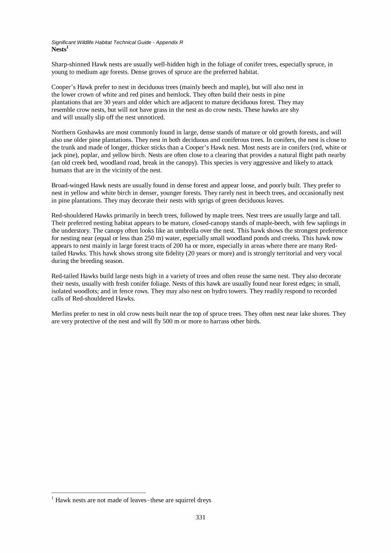
Significant Wildlife Habitat Technical Guide - Appendix R
331
Nests1
Sharp-shinned Hawk nests are usually well-hidden high in the foliage of conifer trees, especially spruce, inyoung to medium age forests. Dense groves of spruce are the preferred habitat.
Cooper’s Hawk prefer to nest in deciduous trees (mainly beech and maple), but will also nest inthe lower crown of white and red pines and hemlock. They often build their nests in pineplantations that are 30 years and older which are adjacent to mature deciduous forest. They mayresemble crow nests, but will not have grass in the nest as do crow nests. These hawks are shyand will usually slip off the nest unnoticed.
Northern Goshawks are most commonly found in large, dense stands of mature or old growth forests, and willalso use older pine plantations. They nest in both deciduous and coniferous trees. In conifers, the nest is close tothe trunk and made of longer, thicker sticks than a Cooper’s Hawk nest. Most nests are in conifers (red, white orjack pine), poplar, and yellow birch. Nests are often close to a clearing that provides a natural flight path nearby(an old creek bed, woodland road, break in the canopy). This species is very aggressive and likely to attackhumans that are in the vicinity of the nest.
Broad-winged Hawk nests are usually found in dense forest and appear loose, and poorly built. They prefer tonest in yellow and white birch in denser, younger forests. They rarely nest in beech trees, and occasionally nestin pine plantations. They may decorate their nests with sprigs of green deciduous leaves.
Red-shouldered Hawks primarily in beech trees, followed by maple trees. Nest trees are usually large and tall.Their preferred nesting habitat appears to be mature, closed-canopy stands of maple-beech, with few saplings inthe understory. The canopy often looks like an umbrella over the nest. This hawk shows the strongest preferencefor nesting near (equal or less than 250 m) water, especially small woodland ponds and creeks. This hawk nowappears to nest mainly in large forest tracts of 200 ha or more, especially in areas where there are many Red-tailed Hawks. This hawk shows strong site fidelity (20 years or more) and is strongly territorial and very vocalduring the breeding season.
Red-tailed Hawks build large nests high in a variety of trees and often reuse the same nest. They also decoratetheir nests, usually with fresh conifer foliage. Nests of this hawk are usually found near forest edges; in small,isolated woodlots; and in fence rows. They may also nest on hydro towers. They readily respond to recordedcalls of Red-shouldered Hawks.
Merlins prefer to nest in old crow nests built near the top of spruce trees. They often nest near lake shores. Theyare very protective of the nest and will fly 500 m or more to harrass other birds.
1 Hawk nests are not made of leaves-these are squirrel dreys

Significant Wildlife Habitat Technical Guide - Appendix P
332
APPENDIX P
Endangered, Threatened and Vulnerable Species in Ontario
In Ontario, species of flora and fauna may be protected by regulation under Ontario’s Endangered SpeciesAct or by regulation under the new Fish and Wildlife Conservation Act. This appendix is comprised of twoparts.
The first part (K-1) lists those species of flora and fauna that are protected by regulation under theEndangered Species Act. This Regulation was last revised in 1994. For those with Internet access,Regulations of Ontario can be searched by subject heading at the following location – http://209.195.107.57/en/index.html
Copies of this or any other piece of Ontario legislation or regulation can be purchased by calling 1-800-668-9938 or by writing: Publications Ontario, 50 Grosvenor Street, Toronto, Ontario M7A 1N8.
The second part of this appendix (K-2) lists those Ontario species of flora and fauna that have beendesignated as endangered, threatened, vulnerable, indeterminate or extirpated by the Ontario Ministry ofNatural Resources (OMNR) and/or the national Committee on the Status of Endangered Wildlife in Canada(COSEWIC).
Designations made by OMNR as of January 1995 are based on recommendations of a Ministry technicalcommittee called the Committee of the Status of Species at Risk in Ontario (COSSARO). The work ofCOSSARO is integrated with the work of COSEWIC. Designations assigned by OMNR?COSSARO applyat the provincial level, while those of COSEWIC apply at the national level. There may be somedifferences between provincial and national designations.
It should be noted that COSEWIC designation is revised annually. COSEWIC designations in thisappendix were last revised September 1999 (see http://www.cosewic.gc.ca/COSEWIC/).
OMNR/COSSARO designations are revised on an “as needed” basis. Designations in this appendix werelast revised September 1998 (see http://www.mnr.gov.on.ca/MNR/fwmenu.html orhttp://www.mnr.gov.on.ca/MNR/nhic/nhic.html ).
Up-to-date COSEWIC and OMNR/COSARO lists are also available for review at local OMNR offices andalso include species of fish as well as those species of flora and fauna that are designated as extinct.
OMNR/COSSARO Status Definitions
EXTINCT: Any species formally native to Ontario that no longer exists.
EXTIRPATED: Any native species no longer existing in the wild in Ontario, but existing elsewhere in thewild.
ENDANGERED: any native species that, on the basis of the best available scientific evidence, is at risk ofextinction or extirpation throughout all or a significant portion of its Ontario range if the limiting factors arenot reversed.
THREATENED: Any native species that, on the basis of the best available scientific evidence, is at risk ofbecoming endangered throughout all or a significant portion of its Ontario range is limiting factors are notreversed.
VULNERABLE: any native species that, on the basis of the best available scientific evidence, is a speciesof special concern in Ontario, but is not a threatened or endangered species.
INDETERMINATE: Any species for which there is insufficient scientific information on which to base astatus recommendation.

Significant Wildlife Habitat Technical Guide - Appendix P
333
COSEWIC Status Definitions
EXTINCT: A species that no longer exists.
EXTIRPATED: A species no longer existing in the wild in Canada, but occurring elsewhere.
ENDANGERED: A species facing imminent extirpation or extinction.
THREATENED: A species likely to become endangered if limiting factors are not reversed.
VULNERABLE: A species of special concern because characteristics that make it particularly sensitive tohuman activities or natural events.
INDETERMINATE: A species for which there is insufficient information to support a status designation.NOT AT RISK: A species that has been evaluated and found to be not at risk.

Significant Wildlife Habitat Technical Guide - Appendix P
334
R-1: Endangered Species Declared in Regulation under the Endangered Species Art, R.S.O. 1990,c.E. 15
Common Name Scientific NameVascular PlantsSmall White Lady’s-Slipper Orchid 1 Cypripedium candidumSmall Whorled Pogonia 2 Isotria medeoloidesLarge Whorled Pogonia 3 Iostria verticillataCucumber Tree 4 5 Magnolia acuminataWood Poppy 6 Stylophorum diphyllumPrickly Pear Cactus 7 8 Opuntia humifusaHoary Mountian-mint 9 Pycnanthemum incanumHeart-leaved Plantain 10 Plantago cordataAmphibiansBlanchard’s Cricket Frog 11 Acris crepitans blanchardiReptiles 12
Lake Erie Water Snake 13 Nerodia sipedon insularumBlue Racer 14 Coluber constrictor flaviventrisTimber Rattlesnake Crotalus horridusBirdsWhite Pelican 15 Pelecanus erythrorhynchosBald Eagle 16 Haliaeetus leucocephalus alascanusGolden Eagle 17 Aquila chrysaetosPeregrine Falcon 18 Falco peregrinusPiping Plover 19 Charadrius melodusEskimo Curlew Numenius borealisLoggerhead Shrike 20 Lanius ludovicianusKirtland’s Warbler 21 Dendroica kirtlandiiHenslow’s Sparrow 22 Ammodramus henslowiiMammalsMountain Lion (Eastern Cougar) 23 Felis concolor couguarInsectsFrosted Elfin 24 Incisalia irusKarner Blue Butterfly 25 Lycaeides melissa samuelis
1Designated as nationally endangered by COSEWIC in 1999; declared in Regulationunder the Endangered Species Act, R.S.O. 1990, c. E. 15 in 1978.2 Designated as nationally endangered by COSEWIC in 1982; designationreconfirmed in 1998.3 Designated as nationally endangered by COSEWIC in 1986; designationreconfirmed 1998.4 Designated as nationally endangered by COSEWIC in 1984.5 The regulation protects Cucumber Tree in specified locations only.6 Designated as nationally endangered by COSEWIC in 1993.7 Designated as nationally endangered by COSEWIC in 1985; designationreconfirmed in 1998.8 The Regulation protects Prickly Pear Cactus in specified locations only.9 Designated as nationally endangered by COSEWIC in 1986; designationreconfirmed in 1998.10 Designated as nationally endangered by COSEWIC in 1985; designationreconfirmed in 1998.11Blanchard's Cricket Frog is also protected in Regulation under the Fish andWildlife Conservation Act. Designated as nationally endangered by COSEWIC in1990.12 The three snakes on this list are also protected in Regulation under the Fishand Wildlife Conservation Act.13 Designated as nationally endangered by COSEWIC in 1991.14 Desingated as nationally endangered by COSEWIC in 1991.

Significant Wildlife Habitat Technical Guide - Appendix P
335
15 Designated as nationally threatened by COSEWIC in 1978; delisted in 1987.16 COSEWIC reviewed the national status of the Bald Eagle in 1984 and did notassign a status designation.17 Designated as "not at risk" nationally by COSEWIC in 1996.18 Subspecies Falco peregrinus anatum designated as nationally endangered in1978; downlisted to nationally threatened by COSEWIC in 1999; COSEWICdownlisted F. p. tundrius from nationally threatened to nationally vulnerablein 1992; all subspecies of F. peregrinus covered in Regulation under theEndangered Species Act, R.S.O. 1990, c. E. 15 in 1973.
19 Designated as nationally endangered by COSEWIC in 1985.20 Eastern population of Loggerhead Shrike designated as nationally endangeredby COSEWIC in 1991, western population designated as nationally threatened in1991. In Canada, the eastern population is restricted to Ontario, Quebec andManitoba.21 Designated as nationally endangered by COSEWIC in 1979; status reconfirmed byCOSEWIC in 1999.22 Designated as nationally endangered by COSEWIC in 1993.23 Designated as nationally endangered by COSEWIC in 1978; designated asnationally indeterminate by COSEWIC in 1998.24 Designated as nationally extirpated by COSEWIC in 1999; declared inRegulation under the Endangered Species Act, R.S.O. 1990, c. E. 15 in 1990.25 Designated as nationally extirpated by COSEWIC in 1997

Significant Wildlife Habitat Technical Guide - Appendix P
336
R-2: Endangered, Threatened, Vulnerable Species of Flora and Fauna in Ontario
Endangered (but not in Regulation under Endangered Species Act)
Common and Scientific Names Designating Authority Year DesignatedVascular PlantsEngelmann's QuillwortIsoetes engelmannii COSEWIC 1992Juniper SedgeCarex juniperorum COSEWIC 1999Drooping TrilliumTrillium flexipes COSEWIC 1996Small White Lady's-slipper Orchid1
Cypripedium candidum COSEWIC 1999Purple Twayblade2
Liparis lilifolia COSEWIC 1999Nodding Pogonia3
Triphora trianthophora COSEWIC 1999American Ginseng4
Panax quinquefolium COSEWIC 1999Pitcher's Thistle5
Cirsium pitcheri COSEWIC 1999Showy GoldenrodSolidago speciosa COSEWIC 1999White Prairie GentianGentiana alba COSEWIC 1991Slender Bush CloverLespedeza virginica COSEWIC 1986; reconfirmed status in 1999Scarlet AmmaniaAmmania robusta COSEWIC 1999ToothcupRotala ramosior COSEWIC 1999Cucumber Tree6
Magnolia acuminata COSEWIC 1999Red Mulberry7
Morus rubra COSEWIC 1999Pink MilkwortPolygala incarnata COSEWIC 1984; reconfirmed status in 1998Spotted WintergreenChimaphila maculata COSEWIC 1987; reconfirmed status in 1998Gattinger's AgalinisAgalinis gattingeri COSEWIC 1988; reconfirmed status in 1999Skinner's AgalinisAgalinis skinneriana COSEWIC 1988; reconfirmed status in 1999BlueheartsBuchnera americana COSEWIC 1998

Significant Wildlife Habitat Technical Guide - Appendix P
337
Common and Scientific Names Designating Authority Year DesignatedBirds8
Acadian FlycatcherEmpidonax virescens COSEWIC 1994King Rail9
Rallus elegans COSEWIC 1994Northern BobwhiteColinus virginianus COSEWIC 1994Barn Owl ( eastern population)10
Tyto alba COSEWIC 1999Kirtland's Warbler11
Dendroica kirtlandii COSEWIC 1999Prothonatary Warbler12
Prothonataria citrea COSEWIC 1996
THREATENED
Vascular PlantsBlunt-lobed WoodsiaWoodsia obtusa COSEWIC 1994False Hop SedgeCarex lupuliformis COSEWIC 1997Small-flowered Lipocarpha COSEWIC 1992Lipocarpha (Hemicarpha) micrantha COSSARO 1996Colicroot COSEWIC 1988Aletris farinosa COSSARO 1996Purple Twayblade13
Liparis liliifolia COSSARO 1996American ChestnutCastanea dentata COSEWIC 1987Golden Seal COSEWIC 1991Hydrastis canadensis COSSARO 1995Kentucky Coffee-tree COSEWIC 1983Gymnocladus dioicus COSSARO 1996Goat's-RueTephrosia virginiana COSEWIC 1996Bird's Foot VioletViola pedata COSEWIC 1990DeerberryVaccinium stamineum COSEWIC 1994White Wood AsterAster divaricatus COSEWIC 1995AmphibiansFowler's Toad 14 15
Bufo fowleri COSEWIC 1999

Significant Wildlife Habitat Technical Guide - Appendix P
338
Common and Scientific Names Designating Authority Year DesignatedReptilesEastern Spiny Softshell 16 17 COSEWIC 1991Apalone spinifera spinifera COSSARO 1995Black Rat SnakeElaphe obsoleta COSEWIC 1998Eastern Fox SnakeElaphe vulpina gloydi COSEWIC 1999Queen SnakeRegina septemvittata COSEWIC 1999Eastern Massasauga 18 19 COSEWIC 1991Sistrurus catenatus catenatus COSSARO 1995
BirdsPeregrine Falcon20
Falco peregrinus anatum COSEWIC 1999Barn Owl (eastern population)21
Tyto alba OMNR 1984Hooded WarblerWilsonia citrina COSEWIC 1994
VULNERABLE
Vascular PlantsBroad Beech FernPhegopteris hexagonoptera COSEWIC 1983Hill's PondweedPotamogeton hillii COSEWIC 1986Few-flowered Club-rushScirpus verecundus COSEWIC 1986Green DragonArisaema dracontium COSEWIC 1984Wild HyacinthCamassia scilloides COSEWIC 1990Round-leaved Greenbrier22
Smilax rotundifloia COSSARO 1995Eastern Prairie White Fringed OrchidPlatanthera leucophaea COSEWIC 1986Shumard OakQuercus shumardii COSEWIC 1984; reconfirmed status in 1999Dwarf HackberryCeltis tenuiflolia COSEWIC 1985False Rue-anemoneIsopyrum biternatum COSEWIC 1990Climbing Prairie RoseRosa setigera COSEWIC 1986Hop TreePtelea trifoliata COSEWIC 1984

Significant Wildlife Habitat Technical Guide - Appendix P
339
Common and Scientific Names Designating Authority Year DesignatedSwamp Rose MallowHibiscus moscheutos COSEWIC 1987Branched BartoniaBartonia paniculata COSEWIC 1992American ColumboFrasera caroliniensis COSEWIC 1993Blue Ash23
Fraxinus quadrangulata COSSARO 1996American Water-willow24
Justicia americana COSSARO 1996Indian PlantainCacalia plantaginea COSEWIC 1988; reconfirmed status in 1999Willow AsterAster praealtus COSEWIC 1999Crooked-stemmed AsterAster prenanthoides COSEWIC 1999Western Silver-leaf AsterVirgulus (Aster) sericeus COSEWIC 1988Dense Blazing StarLiatris spicata COSEWIC 1988
AmphibiansSmallmouth SalamanderAmbystoma texanum COSEWIC 1991
ReptilesSpotted Turtle25 COSEWIC 1991Clemmys guttata COSSARO 1995Wood Turtle 26 27 OMNR 1985Clemmys insculpta COSEWIC 1996Five-lined Skink28
Eumeces fasciatus COSEWIC 1998
Eastern Hognose Snake29 COSSARO 1996Heterodon platirhinos COSEWIC 1997Butler's Garter SnakeThamnophis butleri COSEWIC 1999
BirdsLeast BitternIxobrychus exilis COSEWIC 1988; reconfirmed status in 1999Red-shouldered Hawk COSEWIC 1983; reconfirmed status in 1996Buteo lineatus COSSARO 1995Yellow RailCoturnicops noveboracensis COSEWIC 1999
Caspian TernSterna caspia COSEWIC 1978

Significant Wildlife Habitat Technical Guide - Appendix P
340
Common and Scientific Names Designating Authority Year Designated
Black Tern30
Chlidonias niger COSSARO 1996Short-eared OwlAsio flammeus COSEWIC 1994Great Gray Owl31
Strix nebulosa COSSARO 1996Red-headed Woodpecker COSSARO 1996Melanerpes erythrocephalus COSEWIC 1996Prairie Warbler COSEWIC 1985Dendroica discolor COSSARO 1996Cerulean Warbler COSEWIC 1993Dendroica cerulea COSSARO 1996Louisiana Waterthrush COSEWIC 1991; reconfirmed status in 1996Seiurus motacilla COSSARO 1995Yellow-breasted Chat (Eastern) COSEWIC 1994Icteria virens COSSARO 1996MammalsEastern moleScalopus aquaticus COSEWIC 1980; reconfirmed status in 1998Southern Flying SquirrelGlaucomys volans COSEWIC 1988Woodland VoleMicrotus pinetorum COSEWIC 1998Gray FoxUrocyon cinereoargenteus COSEWIC 1979Polar BearUrsus maritimus COSEWIC 1991; reconfirmed status in 1999WolverineGulo gulo COSEWIC 1989Woodland Caribou32
Rangifer tarandus caribou COSEWIC 1984
InsectsWest Virginia White33
Artogeia (Pieris) virginiensis OMNR 1990
INDETERMINATE
MammalsGray Wolf (eastern population)Canis lupus COSEWIC 1999Mountain Lion (Eastern Cougar)Felis concolor couguar COSEWIC 1998

Significant Wildlife Habitat Technical Guide - Appendix P
341
Common and Scientific Names Designating Authority Year DesignatedEXTIRPATED
Vascular PlantsIllinois Tick-trefoilDesmondium illinoense COSEWIC 1991
Blue-eyed MaryCollinsia verna COSEWIC 1987
BirdsGreater Prairie ChickenTympanuchus cupido COSEWIC 1990
InsectsFrosted Elfin Butterfly34
Incisalia irus COSEWIC 1999Karner Blue Butterfly35
Lycaeides melissa samuelis COSEWIC 1997
1 Declared in Regulation under the Endangered Species Act, R.S.O. 1990, c. E. 15 in 19782 Designated as nationally threatened in 1989 by COSEWIC and provincially threatened by COSSARO; uplisted tonationally endangered in 19993 Designated as nationally threatened by COSEWIC in 1988; uplisted to nationally endangered in 19994 Designated as nationally threatened by COSEWIC in 1988; uplisted to endangered in 19995 Designated as nationally threatened in 1988; uplisted to endangered in 19996 Declared in Regulation under the Endangered Species Act, R.S.O. 1990, c.E. 15 in 19877 Designated as nationally threatened by COSEWIC in 1987; uplisted to endangered in 19998 Recorded present in Ontario with breeding occurrences primarily in the southwestern portion of the province(Cadman, M. D., P. F. J. Eagles and F. M. Helleiner. 1988. Atlas of the breeding birds of Ontario. Federation ofOntario Naturalists and the Long Point Bird Observatory. University of Waterloo Press).9 Designated as nationally vulnerable by COSEWIC in 1985; uplisted to nationally endangered in 1994.10 Designated as provincially threatened by OMNR in 1984; designated nationally vulnerable by COSEWIC in1984; uplisted to nationally endangered by COSEWIC in 1999.11 Declared in Regulation under the Endangered Species Act, R.S.O. 1990, c. E. 15 in 1978.12 Designated as nationally vulnerable by COSEWIC in 1984; uplisted to nationally endangered in 1996.13 Designated as provincially threatened by COSSARO in 1996; designated nationally threatened by COSEWIC in1989; uplisted to nationally endangered by COSEWIC in 1999.14 Designated nationally vulnerable by COSEWIC in 1986; uplisted to nationally threatened by COSEWIC in 1999.15 Fowler's toad is protected in Regulation under the Fish and Wildlife Conservation Act..16 Eastern Spiny Softshell is protected in Regulation under the provincial Fish and Wildlife Conservation Act.17 COSSARO reconfirmed the OMNR status of provincially threatened.18 The Eastern Massasauga is protected in Regulation under the provincial Fish and Wildlife Conservation Act19 COSSARO reconfirmed the OMNR status of provincially threatened.20 Subspecies Falco peregrinus anatum designated as nationally endangered in 1978; downlisted to nationallythreatened by COSEWIC in 1999; COSEWIC downlisted F. p. tundrius from nationally threatened to nationallyvulnerable in 1992; all subspecies of F. peregrinus covered in Regulation under the Endangered Species Act,R.S.O. 1990, c. E. 15 in 1973.21 Eastern population of Barn Owl was designated as provincially threatened by OMNR in 1984; designatednationally vulnerable by COSEWIC in 1984; uplisted to nationally endangered by COSEWIC in 1999.22 Ontario populations designated as nationally threatened by COSEWIC in 1994. COSSARO reviewed thescientific evidence against its Criteria in January 1995 and October 1995 and determined that a status ofprovincially vulnerable is warranted.

Significant Wildlife Habitat Technical Guide - Appendix P
342
23 Designated nationally threatened by COSEWIC in 1983. COSSARO reviewed the scientific evidence against itsCriteria in July 1996 and determined that a status of provincially vulnerable is warranted.24 Designated nationally threatened by COSEWIC in 1984. COSSARO reviewed the scientific evidence against itsCriteria in July 1996 and determined that a status of provincially vulnerable is warranted.25 Spotted Turtle is protected in Regulation under the Fish and Wildlife Conservation Act.26 Wood Turtle is protected in Regulation under the Fish and Wildlife Conservation Act.27 COSSARO was formed pursuant to the designation of the Wood Turtle by OMNR in 1985.28 Five-lined Skink is protected in Regulation under the Fish and Wildlife Conservation Act.29 Eastern Hognose Snake is protected in Regulation under the Fish and Wildlife Conservation Act.30 Designated as "not at risk" nationally by COSEWIC in 1996. This reconfirmed the committee's 1978 designationof "not in any category". COSSARO has reviewed the data for Ontario and considers that a designation ofprovincially vulnerable is warranted.31 Designated as nationally rare (vulnerable) by COSEWIC in 1979, and delisted in 1996. The Great Gray Owl isretained on OMNR's list of provincially vulnerable species pending further consideration by COSSARO.32 "Western population" of Woodland Caribou designated as nationally vulnerable by COSEWIC in 1984. Ontariopopulation is considered part of this population.33 In 1990 OMNR removed the Western Virginia White from Regulations under the Endangered Species Act,R.S.O. 1990, c. E. 15. A status of provincially vulnerable is assigned pending further review.34 Declared in Regulation under the Endangered Species Act, R.S.O. 1990, c. E. 15 in 1990.35 Declared in Regulation under the Endangered Species Act, R.S.O. 1990, c. E. 15 in 1990.

Significant Wildlife Habitat Technical Guide - Appendix Q
343
APPENDIX Q
Evaluation Criteria for Significant Wildlife Habitat
This appendix is made up of four tables. They are as follows:
Table Q - 1: Evaluation Criteria for Seasonal Concentration Habitats
Table Q – 2: Evaluation of Rare Vegetation Communities or Specialized Wildlife Habitats
Table Q – 3: Evaluation Criteria for Species/Habitats of Conservation Concern
Table Q - 4: Evaluating the Significance of Animal Movement Corridors.
These tables provide extensive lists of criteria that can be used to evaluate various significant wildlife habitats. Itis not essential that all criteria be used to evaluate every habitat. The evaluator should focus on those criteria theyfeel are most appropriate to their situation.

Significant Wildlife Habitat Technical Guide - Appendix Q
344
Table Q-1: Evaluation Criteria for Seasonal Concentration HabitatsSpecific Habitat Suggested Criteria Guidelines for EvaluationWinter deer yards • relative importance
of yard to local deerpopulation
• population size ofdeer supported by thesite
• size of the site• distribution of yards• quality of habitat• location of yard• historical use• importance of the
winter yard to otherwildlife
• degree of disturbance
• The yard is most significant if it is the only one in theplanning area; it is significant if it is one of only a fewin the area.
• Heavily populated sites are the most significant.• Larger sites are usually more significant than smaller
sites.• In areas where there are no clearly delineated large
yards, smaller, more loosely aggregated yards arecollectively significant.
• Significant sites have denser conifer cover (i.e., > 60%canopy closure), more woody browse in the core area,and good foraging on adjacent lands (e.g., agriculturalcrops, acorns).
• Significant sites have no barriers to safe movement bydeer to and from the yard, and are located within alandscape providing cover and food.
• Most significant yards will have a long history of use(e.g., at least 10 years).
• Significant yards provide important habitat for othermammals and birds.
• More significant yards will be less disturbed.Moose late winter habitat • relative importance
of the area to localmoose population
• quality of habitat• location of habitat• degree of disturbance• historical use• importance of the
winter habitat toother wildlife
• Significant sites are generally the only known sites inthe planning area; significant sites may be one of onlya few in the area.
• Most significant sites have denser conifer cover (i.e.,> 60% canopy closure and large conifers) withabundant woody browse in the understorey.
• Most significant sites are surrounded by forest, withsome open areas or south-facing slopes in the vicinity,and no barriers to safe movement to and from the site.
• Most significant sites are less disturbed.• Most significant sites have a long history of use (e.g.,
at least 10 years).• Significant sites provide important habitat for other
mammals and birds.Colonial bird nestingsites
• relative importanceof the site to localbird populations
• presence of speciesof conservationconcern
• number of nests inthe colony
• species diversity• quality of habitat• size of site• level of disturbance• historical use
• Significant sites are generally the only known sites inthe planning area; significant sites may be one of onlya few in the area.
• Most significant sites support several species ofconcern; significant sites support one species.
• Sites with the greatest number of nests are moresignificant.
• Sites with the greatest number of species are moresignificant.
• Significant sites generally have better habitat (e.g.,optimal vegetation composition, ratio of open water toemergent vegetation; stable water level; abundantfood) capable of supporting more birds for a longertime period.

Significant Wildlife Habitat Technical Guide - Appendix Q
345
Specific Habitat Suggested Criteria Guidelines for Evaluation• potential concerns of
the planningauthority
• Larger sites may be more significant (especially forarea-sensitive species).
• Least disturbed sites are more significant.• Sites with a longer history of use may be more
significant.• Suggested number of nests that should be considered
significant: Great Blue Heron, 25; Black-crownedNight-Heron, 25; Green Heron, 10; Great Egret, 5;Great Black-backed Gull, 5; Herring Gull, 100;Bonaparte’s Gull, 10; Little Gull, 1; Caspian Tern, 75;Common Tern, 100; Black Tern, 10; Forster’s Tern, 5(excluding Lake St. Clair); Cliff Swallow, 8; BankSwallow, 100; Northern Rough-winged Swallow, 10;Yellow-headed Blackbird, 10; Brewer’s Blackbird, 5.
• Where their populations are very high, even largecolonies of Ring-billed Gulls may not be consideredsignificant.
Waterfowl stopover andstaging areas
• relative importanceof the site to localwaterfowlpopulations
• presence of speciesof conservationconcern
• species diversity• abundance• quality of habitat• size of site
• Significant sites are generally the only known sites inthe planning area; significant sites may be one of onlya few in the area.
• Most significant sites support several species ofconcern; significant sites support one species.
• Sites with the greatest number of species are moresignificant.
• Sites with the highest number of individuals are moresignificant.
• Trumpeter Swans and Ruddy Ducks have limitedstaging areas in Ontario, and their regular use of thehabitat should be considered significant.
• Regular staging areas for Canvasbacks and Redheadsshould be considered significant.
• Significant sites generally have better habitat (e.g.,optimal vegetation composition, ratio of open water toemergent vegetation; extensive shoreline; abundantfood, nocturnal roosting cover)
• Larger wetlands are more significant.Waterfowl nesting areas • relative importance
of the site to localwaterfowlpopulations
• presence of speciesof conservationconcern
• species diversity• abundance• size of area• quality of habitat• location of site• nest predation• level of disturbance
• Most significant sites are the only known sites in theplanning area; significant sites may be one of only afew in the area.
• Most significant sites support several species ofconcern; significant sites support one species.
• Sites with the greatest number of species are moresignificant.
• Sites with nesting and brood habitat for AmericanBlack Ducks should be considered significant
• All nesting areas for Gadwall, Green-winged Teal,Northern Pintail, Northern Shoveler, and AmericanWigeon should be considered significant
• Sites with the highest number of individuals are moresignificant.

Significant Wildlife Habitat Technical Guide - Appendix Q
346
Specific Habitat Suggested Criteria Guidelines for Evaluation• Larger sites of suitable habitat (e.g., grasslands
adjacent to wetlands, ponds, lakes for many species)are more significant.
• Most significant sites have better habitat (e.g., optimalvegetation structure, stable water levels, abundantcover, and a wetland/water body within 150 m).
• Sites providing safe movement of broods from nest towetland/water body (i.e., no roads) are moresignificant.
• Sites with lower rates of nest predation are moresignificant.
• Sites with little disturbance (e.g., haying, cattlegrazing) are more significant.
Shorebird migratorystopover areas
• relative importanceof the site
• presence of speciesof conservationconcern
• species diversity• abundance• size of site• historical use of site• level of disturbance
• Significant sites are generally the only known sites inthe planning area; significant sites may be one of onlya few in the area; artificial sites (e.g., sewage lagoons)may be significant in some areas.
• Most significant sites support several species ofconcern; significant sites may support one species.
• Sites with the greatest number of species are moresignificant.
• Sites with the highest number of individuals are moresignificant.
• Large sites are more significant than smaller sites.• Sites that have been used for many years are more
significant.• Least disturbed sites may be more significant.
Landbird migratorystopover areas
• relative importanceof the site
• presence of speciesof conservationconcern
• species diversity• abundance• size of site• habitat diversity• historical use of site• location of site
• Significant sites are generally the only known sites inthe planning area; significant sites may be one of onlya few in the area.
• Most significant sites support several species ofconcern; significant sites support one species.
• Sites with the greatest number of species are moresignificant.
• Sites with the highest number of individuals are moresignificant.
• Large sites are more significant than smaller sites.• Sites with a variety of habitat types (e.g., forest,
grassland) are often more significant than sites withhomogeneous habitat.
• Sites that have been used for many years are moresignificant.
• Sites within 5 km of Lake Ontario and Lake Erieshoreline are most significant.
Raptor winter feedingand roosting areas
• relative importanceof the site
• presence of speciesof conservationconcern
• species diversity
• Significant sites are generally the only known sites inthe planning area; significant sites may be one of onlya few in the area.
• Most significant sites support several species ofconcern; significant sites support one species.
• Sites with the greatest number of species are more

Significant Wildlife Habitat Technical Guide - Appendix Q
347
Specific Habitat Suggested Criteria Guidelines for Evaluation• abundance• size of site• level of disturbance• location of site• habitat quality• historical use of area
significant.• Sites with the highest number of individuals are more
significant.• Large sites (e.g., at least 20 ha) are more significant
than smaller sites.• Least disturbed sites may be more significant.• Sites located near other open field areas, with adjacent
woods are more significant.• Sites with better habitat (e.g., abundant prey and
perches; a tendency toward less snow accumulationdue to exposure to strong prevailing winds) areprobably more significant.
• Significant sites may have been used for several yearsand/or at least 60% of winters.
Bald Eagle winterfeeding and roostingareas
• relative importanceof the site
• abundance• size of site• habitat quality• level of disturbance• location of roost• historical use of area
• Significant sites are generally the only known sites inthe planning area; significant sites may be one of onlya few in the area.
• Sites with the highest number of individuals are mostsignificant.
• Large sites are more significant than smaller sites.• Sites with better habitat (e.g., abundant open water
and fish, extensive large trees and snags) are moresignificant.
• Least disturbed sites may be more significant.• Sites adjacent to prime hunting area are often more
significant.• Most significant sites have been used for several years
and/or at least 60% of winters.Wild Turkey winter range • relative importance
of the site• abundance• size of site• habitat quality• location of habitat• level of disturbance
• Significant sites are generally the only known sites inthe planning area; significant sites may be one of onlya few in the area.
• Sites with the highest number of individuals are mostsignificant.
• Large sites are more significant than smaller sites.• Sites with better habitat (e.g., extensive large conifer
trees, springs and seeps) are more significant.• Sites located in valleys or lower south-facing slopes,
close to foraging areas (e.g., farm fields, oak woods)and water may be more significant.
• Least disturbed sites may be more significant.Turkey Vulture summerroosting areas
• relative importanceof the site
• abundance• level of disturbance• historical use of area
• Significant sites are generally the only known sites inthe planning area; significant sites may be one of onlya few in the area.
• Sites with the highest number of individuals are mostsignificant.
• Least disturbed sites may be more significant.• Sites that have been traditionally used for at least 10
years are more significant.

Significant Wildlife Habitat Technical Guide - Appendix Q
348
Specific Habitat Suggested Criteria Guidelines for EvaluationReptile hibernaculabat hibernacula
• relative importanceof the site
• presence of speciesof conservationconcern
• species diversity• abundance• habitat quality• location of site• level of disturbance
• Significant sites are generally the only known sites inthe planning area; significant sites may be one of onlya few in the area.
• Most significant sites support two or more species ofconcern; significant sites may support one species.
• Sites with the greatest number of species are moresignificant.
• Sites with the highest number of individuals are moresignificant.
• The following numbers of bats should be consideredsignificant at maternity colonies and winter roosts,respectively: big brown bat, 30, 30; little brown bat,100, 50; eastern pipistrelle, 10, 20; silver-haired bat,10, N/A; long-eared bat, 10, 20; small-footed bat, 10,all sites.
• Sites with better habitat (e.g., bats- deep cave withsmall entrance, water, abundant roosting area insidecave) are probably more significant.
• Sites located within or adjacent to large areas ofsuitable habitat (e.g., forests) are more significant; forreptiles, sites found in areas with good movementcorridors are more significant.
• Least disturbed sites are more significant.Migratory butterflystopover areas
• relative importanceof the site
• presence of speciesof conservationconcern
• species diversity• abundance• size of site• habitat diversity• location of site• level of disturbance• historical use of area
• Significant sites are generally the only known sites inthe planning area; significant sites may be one of onlya few in the area.
• Most significant sites support two or more species ofconcern; significant sites may support one species.
• Sites with the greatest number of species are moresignificant.
• Sites with the highest number of individuals are moresignificant.
• Large sites are more significant than smaller sites.• Sites with a variety of habitat types (e.g., forest,
grassland) are often more significant than sites withhomogeneous habitat.
• Sites within 5 km of Lake Ontario and Lake Erieshoreline are most significant.
• Least disturbed sites may be more significant.• Sites that have been traditionally used for at least 10
years are more significant.Bullfrog habitat • Relative importance
of the habitat to localpopulations
• Abundance• Size of site• Historical use of area
• Significant sites are generally the only known sites inthe planning area; significant sites may be one of onlya few in the area.
• Sites with the highest number of individuals are moresignificant.
• Large sites with suitable habitat are more significantthan smaller sites.
• Most significant areas have supported bullfrogs for atleast 10 years.
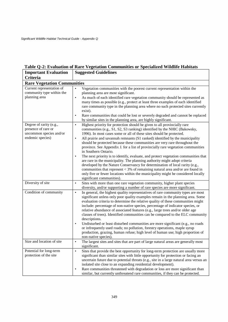
Significant Wildlife Habitat Technical Guide - Appendix Q
349
Table Q-2: Evaluation of Rare Vegetation Communities or Specialized Wildlife HabitatsImportant EvaluationCriteria
Suggested Guidelines
Rare Vegetation CommunitiesCurrent representation ofcommunity type within theplanning area
• Vegetation communities with the poorest current representation within theplanning area are most significant.
• As much of each identified rare vegetation community should be represented asmany times as possible (e.g., protect at least three examples of each identifiedrare community type in the planning area where no such protected sites currentlyexist).
• Rare communities that could be lost or severely degraded and cannot be replacedby similar sites in the planning area, are highly significant.
Degree of rarity (e.g.,presence of rare oruncommon species and/orendemic species)
• Highest priority for protection should be given to all provincially rarecommunities (e.g., S1, S2, S3 ranking) identified by the NHIC (Bakowsky,1996). In most cases some or all of these sites should be protected.
• All prairie and savannah remnants (S1 ranked) identified by the municipalityshould be protected because these communities are very rare throughout theprovince. See Appendix J. for a list of provincially rare vegetation communitiesin Southern Ontario.
• The next priority is to identify, evaluate, and protect vegetation communities thatare rare in the municipality. The planning authority might adopt criteriadeveloped by the Nature Conservancy for determination of local rarity (e.g.,communities that represent < 3% of remaining natural area and/or are found inonly five or fewer locations within the municipality might be considered locallysignificant communities).
Diversity of site • Sites with more than one rare vegetation community, higher plant speciesdiversity, and/or supporting a number of rare species are more significant.
Condition of community • In general, the highest quality representatives of rare community types are mostsignificant unless only poor quality examples remain in the planning area. Someevaluation criteria to determine the relative quality of these communities mightinclude: percentage of non-native species, percentage of indicator species, orrelative abundance of associated features (e.g., large trees and/or older ageclasses of trees). Identified communities can be compared to the ELC communitydescriptions.
• Undisturbed or least disturbed communities are more significant (e.g., no roadsor infrequently used roads; no pollution, forestry operations, maple syrupproduction, grazing, human refuse; high level of human use; high proportion ofnon-native species).
Size and location of site • The largest sites and sites that are part of large natural areas are generally mostsignificant.
Potential for long-termprotection of the site
• Sites that provide the best opportunity for long-term protection are usually moresignificant than similar sites with little opportunity for protection or facing anuncertain future due to potential threats (e.g., site in a large natural area versus anisolated site close to an expanding residential development).
• Rare communities threatened with degradation or loss are more significant thansimilar, but currently unthreatend rare communities, if they can be protected.

Significant Wildlife Habitat Technical Guide - Appendix Q
350
Important EvaluationCriteria
Suggested Guidelines
Provision of significantwildlife habitat
• Rare communities providing identified significant wildlife habitat (e.g., huntingareas for raptors, nesting areas for waterfowl or grassland birds, foraging areasfor shorebirds, food sources for rare butterflies) are most significant.
Specialized Habitats for WildlifeSites supporting area-sensitive speciesPresence of rare, uncommon,or declining species
• Sites supporting area-sensitive species of birds that are rare or uncommon, and/orexhibiting population declines provincially are most significant.
Overall area of site • Largest natural forest stands in the municipality are likely most significant withthose >30 ha being most likely to support and sustain a diversity of these birds.
• Largest grasslands in the municipality are likely most significant with those >30ha most likely to support and sustain diversity of these species.
Area of forest interiorcontained within the foreststand
• Most significant forest stands should contain at least 10 ha of forest interiorexcluding at least a 200m buffer around the forest interior.
• Smaller interior habitats may still be significant where no larger examples exist.Age and tree composition offorest stand
• Sites with an abundance of large (e.g., >40 cm DBH, >25 m tall), mature treesare more significant for certain nesting raptor species as well a number ofsongbird species.
Amount of verticalstratification of site
• Forests and grasslands with a variety of different layers of vegetation at differentheights likely provide more habitats and support more bird species and areconsequently more significant.
• Uneven-aged forests are generally more significant than even-aged forestsbecause they provide more forest structure.
Amount of contiguousclosed-canopy/open areas inforest stand
• Sites with largest contiguous canopy cover and fewest gaps in the canopy arelikely most significant. Natural gaps (e.g., windthrown trees, woodland ponds)are preferred to man-made gaps (e.g., roads).
• Gaps should be < 20 m including roads and rights-of-way.Degree of disturbance on sitee.g., roads, forestrymanagement and operations,grazing, crop production
• Roadless, relatively undisturbed sites with no history of disturbance fromgrazing, forestry operations during the last 20 years are most significant.
• Sites with history of only light grazing and/or forestry operations over the last 20years are potentially significant if properly managed.
• Uneven-aged forest stands are often more significant than even-aged foreststands because they may be less intensively managed, and generally contain anatural representation of species.
• Forest stands with a history of little or no forest management may be mostsignificant.
• In general, early successional grasslands that are not being used for agriculturalproduction are more significant that similar grasslands that are used foragriculture (e.g., crops, cattle grazing).
Amount of adjacentresidential development
• Sites with the least amount of adjacent residential development are moresignificant.
Current representation ofspecialized habitat inplanning area
• Sites that could be lost or severely degraded and cannot be replaced by similarsites in the planning area, are highly significant.
• Specialized habitats with the poorest current representation within the planningarea are significant.
Provision of significantwildlife habitat
• Sites providing several identified significant wildlife habitats (e.g., raptor nestsites, rare vegetation community, habitat for species of conservation concern) aremost significant.

Significant Wildlife Habitat Technical Guide - Appendix Q
351
Important EvaluationCriteria
Suggested Guidelines
Potential for long-termprotection of the site
• Sites that provide the best opportunity for long-term protection are usually moresignificant than similar sites with little opportunity for protection or facing anuncertain future due to potential threats (e.g., site in a large natural area versus.an isolated site close to an expanding residential development).
• Habitats threatened with degradation or loss are more significant than similar, butcurrently unthreatend habitats, if they can be protected.
Forest stands providing a diversity of habitats (e.g., tree cavities, fallen logs, verticalstratification)Provision of significantwildlife habitat
• Stands providing several significant wildlife habitats (e.g., forest interior habitat,raptor nesting, rare community) are most significant.
Size of site • Large sites are likely most significant.• Small sites are significant if no large sites exist in the planning area.
Age, condition of trees onsite
• Sites with a wide variety of age classes of trees are likely most significant forprovision of a variety of habitats.
• Sites with a high proportion of old or mature trees, and/or diseased or damagedtrees are likely more significant because they provide more organic groundstructure.
• Uneven-aged forest stands are likely more significant than even-aged foreststands because uneven-aged management often results in retention wildlifehabitat and they are often less disturbed by management activities.
Vegetation composition anddiversity of site
• Sites with a diversity of tree and shrub species provide more understoreystructure and consequently are more significant.
• Sites with a high proportion of aspens, beech, basswood, conifers are likely mostsignificant for tree cavity production.
• Sites with majority of cavities located in living trees are likely more significantbecause these trees last longer than dead cavity trees.
• Sites with cavities in living trees that also produce abundant mast (e.g., oak,beech, walnut, black cherry) are more significant.
• Sites with variety of tree species (e.g., hardwoods such as maple, oak, softwoodssuch as poplar, conifers) are more significant because some cavities can becreated quickly (e.g., in softwoods) and some will last longer (e.g., inhardwoods).
Cavity size, abundance, andlocation
• Sites containing a diversity of cavity sizes to meet the nesting, denning, foragingand resting habitat requirements of a variety of species are likely mostsignificant.
• Sites with trees with large cavities are more significant than sites with trees withmainly small cavities. OMNR forestry tree-marking guidelines suggest retentionof 6 cavity trees/ha with at least one large cavity tree (>50 cm diameter at breastheight ) per ha and the other 5 trees with at least 25 cm DBH.
• Generally, cavities in the upper trunk area of trees are more significant thancavities in the lower trunk area.
Location of site • Sites near water may be more significant (i.e., breeding habitat of forest dwellingamphibians such as some salamanders and frogs is nearby, preferred nestinghabitat of some raptors).
• Moist soil conditions are attractive to species of amphibians.

Significant Wildlife Habitat Technical Guide - Appendix Q
352
Important EvaluationCriteria
Suggested Guidelines
History of forest management • Sites with little or no management may be more significant because often thisresults in retention of more cavity trees, standing dead trees, verticalstratification, organic ground structure, cavity trees, and standing dead trees thatwill eventually become decaying woody debris, as well as a greater diversity oftrees.
Woodlands supporting amphibian breeding pondsProvision of significantwildlife habitat
• Woodlands providing several significant wildlife habitats (e.g., forest interiorhabitat, raptor nesting, abundant tree cavities and down woody debris) are mostsignificant.
Degree of permanence • Woodlands with permanent ponds or those containing water in most years untilat least mid July are most significant.
Species diversity of pond • Ponds supporting high species diversity are more significant.Presence of rare species • Ponds supporting rare amphibian species are more significant that ponds
supporting only common species.Size and number of ponds • In general, woodlands with larger and/or several ponds are more significant.Diversity of submergent andemergent vegetation
• Ponds with a good diversity of emergent and submergent aquatic vegetation aremost significant.
Presence of shrubs, logs atedge of pond
• Presence of shrubs and logs increase significance of pond for some amphibianspecies because of increased structure for calling, foraging, and escape andconcealment from predators.
Adjacent forest habitat • More significant areas will have closed canopy forest providing shaded, moistunderstorey and abundance of down woody debris for cover habitat.
• Breeding ponds with shortest distance to forest habitat are more significantbecause of reduced risk to moving amphibians and are more likely to be used.
Water quality • Prefer unpolluted waters.Level of disturbance • Woodlands with little or no disturbance (e.g., forest management, roads between
breeding pond and forest habitat) are more significant.Old growth or mature forest standsCurrent representation of oldgrowth or mature foreststands within the planningarea
• Due to the rarity and fragmented distribution of old growth forests in southernOntario, as much of identified sites should be represented as many times aspossible (e.g., protect at least three good examples of old growth or maturestands in the planning area where no such protected sites currently exist).
• Sites that could be lost or severely degraded and cannot be replaced by similarsites in the planning area, are highly significant.
Age of trees • Most significant sites will contain numerous trees of at least 140 years old.• Stands containing younger trees (e.g., 100 years or older) are significant where
older trees no longer exist.• Stands containing predominantly long-lived trees are probably more significant
than stands consisting primarily of short-lived species (e.g., trembling aspen,birch).
Age classes of trees in stand • More significant sites will contain several distinctly different age classes of trees.Presence of old growthcharacteristics
• Most significant sites will exhibit several to all of the following characteristics:broad array of fallen logs in various sizes and stages of decomposition; at leastsome very large fallen logs; large spectrum of tree sizes, including some very talltrees; some larger trees with more columnar form due to loss of large limbs frompast storm damage; numerous snags; some pit and mound ground topography;uneven canopy with scattered gaps due to fallen trees and tree limbs .

Significant Wildlife Habitat Technical Guide - Appendix Q
353
Important EvaluationCriteria
Suggested Guidelines
Species diversity • More significant sites will have a higher diversity of wildlife species becausethey provide many different habitats and regeneration niches for plants andanimals.
Provision of significantwildlife habitat
• Sites providing several significant wildlife habitats (e.g., forest interior habitat,raptor nesting, tree cavities and/or amphibian breeding ponds) are mostsignificant.
Potential for long-termprotection of site
• Sites that provide the best opportunity for long-term protection are usually moresignificant than similar sites with little opportunity for protection or facing anuncertain future due to potential threats (e.g., site in a large natural area versus anisolated site close to an expanding residential development).
• Sites threatened with degradation or loss are more significant than similar, butcurrently unthreatend sites, if they can be protected.
Stand history • More significant sites will have experienced little or no substantial logging orother forestry activities (e.g., no management or only periodic light selectioncutting).
Size and location of site • The largest sites and sites that are part of large natural areas are generally mostsignificant.
• Smaller, isolated sites are significant in areas with little or no remainingexamples of old growth or mature woodlands.
Degree of disturbance • Undisturbed or least disturbed sites are more significant (e.g., no roads orinfrequently used roads; no pollution, forestry operations, maple syrupproduction, grazing, human refuse; high level of human use; high proportion ofnon-native species).
Foraging areas producing fruit, hard mast (acorns, beechnuts)Provision of significantwildlife habitat
• Woodlands providing several significant wildlife habitats (e.g., forest interiorhabitat, raptor nesting, abundant tree cavities and down woody debris) are mostsignificant.
Area/abundance of foodsource
• Large areas of fruit-producing shrubs (e.g., blueberries, wild blackberries,serviceberries) and mast-producing trees (e.g., oaks, hickories, beech) are likelymost significant because they usually support more wildlife.
Size, age, health of trees • Sites with a high proportion of healthy, mature trees with large crowns are moresignificant because these trees generally produce more mast.
• Sites with numerous oak trees with 40-65 cm diameter at breast height aresignificant because such trees can produce heavy acorn crops.
Species diversity of site • Sites with a variety of mast-producing tree species and/or fruit-producing shrubsare most significant since production by species can vary widely from year toyear.
• Sites within the Great Lakes-St. Lawrence forest region with abundant andvigorous red oak trees are significant since this species is considered the singlemost important mast-producing tree species in this region.
Permanence of food source • Areas providing more long-term, relatively stable food supply are moresignificant than areas such as clearcuts and burns that provide more temporarysources of food.
Access to foraging areas • Sites with travel routes that provide cover and reduce mortality risk for wildlifemoving to and from foraging areas are most significant.
• Sites well removed from people, particularly those used by feeding bears, aremore significant because of reduction in wildlife/people interactions.

Significant Wildlife Habitat Technical Guide - Appendix Q
354
Important EvaluationCriteria
Suggested Guidelines
Consistent historical use bywildlife
• Since food production of such areas varies over time, areas traditionally used bywildlife are probably most significant.
Osprey, Bald Eagle Nesting HabitatAccess to foraging areas • Most significant nesting habitats are adjacent or close to relatively clear and
shallow (< 1 m) water bodies with productive fish populations.Presence of large, sturdytrees near shoreline
• Most significant nesting habitats have numerous large conifer and/or deciduoustrees in good condition along the shoreline providing birds with good visibilityand clear flight line to the nest.
Degree of disturbance • More significant sites will have no disturbance from human activities within 200m of the nest during the nesting season.
• Some Ospreys may tolerate some disturbance but more significant sites and sitesof more sensitive birds should not be disturbed after onset of nesting.
Evidence of use • Most significant habitat contains several nests within a single area (e.g., within 1square km)
• Sites with current evidence of use are most significant.• Sites with traditional use are most significant (many nests are used for several
consecutive years).Current representationof potential sites
• Potential nesting habitats that could be lost or severely degraded and cannot bereplaced by similar sites in the planning area, are significant.
Degree of threat • Sites threatened with degradation or loss are more significant than similar, butcurrently unthreatend sites.
Turtle Nesting HabitatSize of habitat • Larger sites are most significant because fewer nests are likely to be lost to
predation and larger areas are more likely to be important to larger numbers ofturtles.
Location of site • Nesting areas adjacent to permanent water bodies and large wetlands, andremoved from roads are more significant because of increased likelihood ofnesting success and hatchlings reaching the water; as well as reduced roadmortality.
• Higher, well-drained sites are more important than poorly drained, low-lyingareas at risk of inundation by water.
• Sites with good exposure to sunlight are more significant.Substrate • Generally nesting areas of preferred substrate (e.g., sands and gravels) are
preferred to sites over other substrates.Evidence of use • Presence of several nests or adult females observed during the nesting season,
within a single area indicates a significant habitat.• Sites with evidence of use by several species are more significant.• Sites with traditional use are more significant.
Presence of rare species • Nesting habitats used by rare species are more significant.Level of predation • More significant sites are less prone to nest predation (e.g., they are not located
in highly active wildlife corridors).Presence of movementcorridor
• Most significant nesting habitats are connected to other turtle habitats (e.g.,wetland) by corridors permitting relatively safe movement of these reptiles.

Significant Wildlife Habitat Technical Guide - Appendix Q
355
Important EvaluationCriteria
Suggested Guidelines
Degree of disturbance • Nesting habitat that is relatively undisturbed by human activities (e.g., away frombusy roads, residential areas) is most significant.
• Sites buffered by natural landforms & vegetation are usually more significantthan unbuffered, exposed sites because of their superior ability to protect nestingturtles, hatchlings, and nests from natural & human disturbance.
Degree of threat • Sites threatened with degradation or loss are more significant than similar, butcurrently unthreatend sites.
Moose aquatic feeding areasAbundance of preferredaquatic food plants
• Areas containing abundant pondweeds, yellow waterlily, and milfoil are moresignificant.
Quality of adjacent foresthabitat
• Aquatic feeding areas with dense stands of lowland conifer tree speciesimmediately adjacent to aquatic feeding areas are most significant.
Degree of disturbance of site • Undisturbed or least disturbed sites are probably significant (e.g., areas with nocottages and boat traffic in the vicinity of feeding areas are preferable).
Access to foraging areas • Sites with travel routes that provide cover and reduce mortality risk for moosemoving to and from aquatic feeding areas are more significant.
History of consistent use • Sites with record of traditional use by moose are most significant.Mink and otter feeding/denning sites; marten and fisher denning sitesListed below are suggested guidelines. However, these sites are difficult to find. Therefore knowledge of the mostsuitable habitat for these mammals may be the most practical way to ensure that some prime habitat is protected.Presence of suitable habitat For mink and otter
• Heavily vegetated shorelines, particularly those with abundance of shrubs aremore significant.
• Shorelines with numerous dead falls, large logs, log jams, and rock piles aremore significant because of increased denning sites and because they alsoprovide good habitat for prey species.
• Amount of habitat-average mink home range is 316-1,626 haFor marten and fisher• Large contiguous coniferous or mixed forests with abundant large trees (e.g., at
least 40 cm diameter at breast height) for maternal denning sites are mostsignificant.
• average marten home range is 1.3- 15.7 sq. km; average fisher home range is17.5- 39 sq. km
Degree of disturbance • Undisturbed areas with little or no human activity in vicinity are moresignificant, particularly for otters.
• For otters, longer, undeveloped stretches of shoreline habitat are moresignificant, as well as creek systems joining several ponds.
Size of local fish population • Water bodies producing large populations of fish (e.g., mesotrophic lakes) aremore likely to sustain otters over the long-term than unproductive waters (e.g.,oligotrophic lakes).
Areas of high diversityCurrent representationof such areas in theplanning area
• Most diverse areas known for the planning area should be considered mostsignificant until inventory information reveals more diverse areas.

Significant Wildlife Habitat Technical Guide - Appendix Q
356
Important EvaluationCriteria
Suggested Guidelines
Natural community diversity • Sites with high community diversity (e.g., site containing several differentwetland types and/or forested uplands, open uplands, and grasslands) aregenerally more significant that sites with only one community and are usuallymore species rich than sites consisting of single communities.
Species diversity • Usually a community with high species diversity is more significant than asimilar community supporting fewer species.
Presence of rare species • Sites supporting rare or uncommon species are more significant than those thatsupport only common species.
Size of site • Larger sites are generally more diverse and consequently more significant thansimilar, but considerably smaller sites.
Seeps/springsAbundance of seeps/springs • Sites with several seeps/springs (e.g., >5) are most significant.Duration of surface water • Most significant seeps/springs are present even during very dry summers.Nature of adjacent area • Most significant sites support diversity of native vegetation.Presence of rare species • Sites supporting rare or uncommon species (e.g., plants, salamanders), or species
that are unique to the area (e.g., Wild Turkey) are more significant than thosethat support only common species.
Location of seeps/springs • Seeps/springs located on south-facing slopes are probably more significant thanseeps with other aspects because of their winter value to some wildlife species.
• Seeps/springs in forest stands and/or headwater areas are generally moresignificant than those found in other areas.
• Seeps/spring found in relatively undisturbed areas are generally more significantthat those found in areas disturbed by human activities (e.g., off-road vehicletravel).
CliffsCurrent representationof cliffs within planningarea
• Consider as significant, relatively pristine cliffs that are currently unprotectedand occur at less than 4 locations in the planning area.
Provision of significantwildlife habitat
• Most significant sites will provide several significant wildlife habitats (e.g.,reptile hibernacula, nesting sites, resting sites for Turkey Vultures, migratorybird stopover area, unique vegetation community).
Diversity of habitat featuresassociated with cliff
• Most significant sites will have a variety of habitat features including thepresence of large rocks, crevices, caves, water for hibernacula; overhangs, flatledges of at least 1 square meter for nesting birds; presence of a buffer (fornesting raptors); presence of mature/large trees on summit.
Current or historical use bywildlife species
• Most significant sites will have active eyries or hibernacula.• Significant sites will have historical record of presence of eyries or hibernacula.
Species diversity • Most significant cliffs have higher associated plant diversity than similar cliffs.Presence of rare species • Cliffs supporting rare or uncommon species are more significant than those that
support only common species.Human disturbance • More significant sites are relatively undisturbed due to their inaccessibility.Size and location of cliff • Most significant sites will be within a larger natural area.
• South-facing cliffs may be more significant due to greater diversity of associatedplant species.

Significant Wildlife Habitat Technical Guide - Appendix Q
357
Important EvaluationCriteria
Suggested Guidelines
• CavesSolution versus physical (e.g.fissured, rock piles,abandoned mine)
• Solution caves are generally more significant than other caves types.• Abandoned mines may be significant to bats in areas with few or no natural
caves.Size of opening • Caves with small openings may be more important to wildlife (e.g., bats) than
caves with large openings permitting entry by humans.Depth of cave • Most significant caves have the greatest interior depth.Ambient winter temperature • Most significant caves have an ambient winter temperature slightly above
freezing.Ambient relative humidity • Most significant caves have an ambient winter relative humidity above 90%.Presence of water • Most significant caves have some water supplies for hibernating species.Human disturbance • Most significant caves are undisturbed due to poor access.
Table Q-3: Evaluation Criteria for Species/Habitats of Conservation ConcernCriteria for Identification ofSpecies/Habitats ofConservation Concern
Suggested Guidelines for Evaluation of Habitats of Speciesof Conservation Concern
Degree of rarity of species found atsite
• Habitats of the rarest species are more significant than those of lessrare species. For example, habitats for species ranked S1and S2 shouldbe considered more significant than habitats for species ranked S3.Species ranked as vulnerable by the OMNR should also be consideredsignificant.
• Less rare species and their habitats in the planning area may be deemedspecies of conservation concern by the municipality based on suchfactors as the number of known occurrences, total extent of remaininghabitat, degree of threat or risk to habitat, and/or local interest in aparticular species.
• If a species’ habitat is to be protected, sufficient area (based on thespecies’ known requirements) should be retained to ensure a viable andsustainable population.
Documented significant decline in aspecies and/or its critical habitat
• The habitat for species experiencing the greatest declines is mostsignificant.
• The habitat for declining species that has the lowest representation inthe planning area is more significant.
• Those habitats that provide the best opportunity for the long-termsustainability of the declining species are most significant (e.g., largewell-protected sites; sites that best meet the species’ habitatrequirements; sites with good connections to other similar habitats).
Species whose range is solely orprimarily found in Ontario (i.e.,provincial responsibility)
• Habitat for those species with the poorest representation within theplanning area is more significant.
• These species and their habitats are significant even if well representedin the planning area, due to high provincial responsibility for theirprotection.
• Those habitats that provide the best opportunities for the long-termsustainability of the target species are most significant (e.g., large well-protected sites; sites that best meet the species’ habitat requirements;sites with good connections to other similar habitats).

Significant Wildlife Habitat Technical Guide - Appendix Q
358
Criteria for Identification ofSpecies/Habitats ofConservation Concern
Suggested Guidelines for Evaluation of Habitats of Speciesof Conservation Concern
Condition of existing habitat at site • Sites that provide habitat that best meets the survival requirements ofthe target species and that also include a natural buffer zone are mostsignificant (i.e. most likely to sustain species/population over the long-term).
• Sites that contain the fewest non-native species of potential threat tothe target species are significant.
• Undisturbed or least-disturbed habitats (e.g., no/few deleteriousimpacts from roads, human activities) are significant.
• Sites capable of producing a large number of individuals of a singlespecies of conservation concern are significant.
• Highly diverse sites that support one or more species of conservationconcern are most significant.
Size of species population at site • Habitats supporting large populations of a several species ofconservation concern are most significant.
• Habitat supporting large populations of a single species is significant.Size and location of habitat • Large sites supporting large populations of several species of
conservation concern are most significant.• Large sites are generally more significant than most comparable but
smaller sites.• Sites large enough to ensure long-term support and viability of species
of conservation concern are significant.• Sites with large areas of suitable habitat that are also connected to
other potentially suitable habitat and/or natural areas are mostsignificant.
Potential for long-termprotection of the habitat
• Habitats that provide the best opportunity for long-term protection areusually more significant than similar habitats with little opportunity forprotection or facing an uncertain future due to potential threats (e.g.,habitat found in a large natural area vs. an isolated site close to anexpanding residential development).
• Habitats threatened with degradation or loss are more significant thansimilar, but currently unthreatend habitats, if they can be protected.
• Habitats of species currently experiencing severe population declinesin Ontario (e.g., grassland bird species) due to habitat loss are mostsignificant.
• Habitats of species currently experiencing significant populationdeclines in the municipality are significant.
Representation of species/habitatwithin the municipality
• Poorly represented habitats for species of conservation concern aresignificant.
• Habitats that could be lost or severely degraded and cannot be replacedby similar habitats in the planning area, are highly significant.
Evidence of use of the habitat • Sites with documented traditional use by species are most significant.Species of particular interest to theplanning authority (e.g., the CAC mayrecommend certain species such asindicator species)
• Sites providing the best examples of habitat that will ensure the long-term sustainability of the species are significant.

Significant Wildlife Habitat Technical Guide - Appendix Q
359
Table Q-4: Evaluating the Significance of Animal Movement CorridorsCriteria Suggested Guidelines for Evaluation of the Significance of Movement
CorridorsImportance ofareas to belinked bycorridor
• Corridors linking the most significant natural areas both in and outside the municipality aremost significant (e.g., wetlands, ANSIs in municipality, important waterfowl staging areas).
• Corridors that provide access to and from the most critical habitats within a species/ homerange are significant.
• Corridors connecting locally important conservation areas and/or currently unevaluatednatural areas in the planning area may be significant, particularly if the adjacent landscape isgreatly fragmented by roads, residential development, or agricultural activities.
Importance ofcorridor tosurvival oftarget species
• Corridors linking most significant or critical identified wildlife habitats for a target speciesare most significant (e.g., winter deer yards and summer feeding areas, spring breedingponds and summer woodlands for some species of amphibians). Animals must be able to getto and from their critical habitats.
Dimensions ofcorridor
• Wider corridors are usually more significant than narrow ones because they generallyprovide more food and habitat for more species and better protection from predation, naturaland human disturbance. Most significant woodland corridors should be at least 200 m wide.
• Shorter corridors are usually more significant than longer ones because they minimize thetime animals spend in the corridor and the mortality risks to moving animals.
Continuity ofcorridor
• Continuous corridors consisting of native vegetation, unbroken by roads, or other gaps suchas fields, water bodies, residential areas are most significant.
• Corridors with few small gaps and crossed by small, infrequently used roads are moresignificant than corridors containing numerous small gaps and crossed by busier roads. Gapsshould be < 20 m.
Habitat andhabitat structureof corridor
• Corridors with several layers of vegetation (e.g., mature tall trees, understorey trees, shrubs,herbaceous ground cover) are generally more significant than corridors with few vegetationlayers because they provide more cover (therefore protection from adverse weather,predators) for a wider variety of animals and potential sources of food.
• Corridors with variety of ground cover (living low vegetation, down woody debris, stumps,rock piles) and subterranean entries are usually more significant than corridors consisting ofmostly sparsely covered ground because they provide more and a greater variety of cover.
• Corridors through natural landscapes are more significant than those through moreanthropogenic landscapes
• Corridors with buffers of native vegetation on both sides are more significant than corridorswith no natural buffer(s) of native vegetation because they help to reduce impact of naturaland human disturbance. Adequate buffers can also reduce predation by raccoons, foxes, catsand other wildlife, on species residing in the corridor; as well as provide a place to feed forsmall mammals and birds that live in the corridor. Most significant riparian corridors shouldhave at least 15 m of vegetation on both sides of the waterway.
• Corridors containing water sources are usually more significant than similar corridorswithout water because of its importance to a variety of wildlife.
• Corridors with fruit and nut-producing vegetation are probably more significant thancorridors with no such vegetation because they provide a better food supply for manymammals and birds moving through or living in them.
• Corridors that best meet the habitat requirements for the target species are significant.Species foundin corridor orpresumed to beusing corridor
• Corridors containing high overall species diversity (vegetation, invertebrate, vertebratespecies) are probably more significant than corridors with less species diversity. At leastsome of these species found in a corridor provide food for users of that corridor. Diversity ofvegetation also provides cover for more species. Taken together, these factors increaseprobability that unobserved animals actually use a corridor.
• Corridors used for movement by many species are usually more significant than corridors

Significant Wildlife Habitat Technical Guide - Appendix Q
360
Criteria Suggested Guidelines for Evaluation of the Significance of MovementCorridors
used by only a few species.• Corridors used by rare species are significant (e.g., several species of salamander that move
between woodlands and their breeding ponds, southern flying squirrel moving between twowoodlots).
• Corridors providing safe movement for large numbers of a single species (e.g., salamanders)may be significant, especially if few or no other corridors for that species have beenidentified for the planning area.
• Corridors with a high diversity of species permanently residing within corridor are moresignificant than corridors with few permanent species.
Risk ofmortality forspecies usingcorridor
• Corridors providing safest passage for wildlife moving across the landscape are mostsignificant. Best corridors will have the lowest risk of mortality associated with them (e.g.,from predation, roadkills, or their location with respect to adjacent residential areas withcats, dogs).
Opportunity forprotection
• Corridors with the best opportunity for protection (e.g., unopened road allowances, rights-of-way, borders of conservation areas, undeveloped shorelines, hydro and pipeline corridors)are significant. However, this does not imply that more important or better corridors shouldnot be protected simply because these more easily protected corridors are found in the samearea.
Provision ofother relatedvalues
• Numerous and/or large corridors that could effectively increase the overall area of theexisting system of protected natural areas in the planning area are significant.
• Corridors that could increase local representation and diversity of habitats, successionalstages, or area of natural buffer zones are significant.
• Corridors that could result in increased foraging opportunities for wide-ranging species (e.g.,fisher, black bear) are significant.
• Corridors that may permit the future expansion of wildlife populations into an area (e.g.,fisher, southern flying squirrel) as habitat for these species improves are significant.
• Corridors that could increase or maintain landscape resistance to soil erosion, desiccation,water quality (e.g., riparian corridors along lake shorelines, woodlands) are significant.

Significant Wildlife Habitat Technical Guide - Appendix R
361
APPENDIX R
Summary of Existing Ontario Ministry of Natural Resources Habitat Management Guidelines
Over the past 20 years, the Ontario Ministry of Natural Resources has developed a series of forest managementguidelines. These guidelines have been developed to assist resource managers to maintain or create a forest thathas structure and composition to provide functional habitat for a variety of wildlife species. A variety ofconstraints and different timber harvest techniques are recommended in the guidelines in order to protect aspecific habitat. While these may be considered of limited value to the municipal planning process, the generalconcepts of forest size, diversity and distribution on a landscape scale are useful. These guidelines offer concisesummaries of specific habitat requirements for a number of wildlife species. Habitat requirements for some ofthese species are very specific (e.g. area sensitive species) while requirements of others may be more general.This information can be applied equally well in the municipal planning process.
Many of the guidelines recommend protecting wetlands and riparian forest areas. These areas provide habitatfor a large number of wildlife species. Because of this, many of these areas can be considered significantwildlife habitats (see Tables 10.2 - 10.4 in the text).
Where available, large forest areas will meet habitat requirements of many of the more specialized areasensitive species. The guidelines recommend protecting these areas from fragmentation. Many municipalitiesdo not have large tracts of forest. Instead they may have numerous smaller tracts of forested land that may ormay not be interconnected by corridors of forest, thicket or riparian vegetation. The guidelines recommendretaining these corridors, rather than fragmenting the forest landscape further. This may be enough to protectcritical habitat of some more specialized, yet adaptable wildlife species.
The concept of establishing buffer zones and timing restrictions for development activities to occur aroundknown significant wildlife habitat is presented in many of these guidelines. Timing restrictions are particularlyimportant during critical life stages (e.g. nesting, calving). All the guidelines provide lists of reference material.
While many of the wildlife species referred to in these guidelines are protected, in varying degrees, byprovincial or federal legislation, only those species covered under the Endangered Species Act have protectionextended to their habitat.
This appendix is arranged into two parts. The first part provides a list of existing guidelines with a shortsummary of how each may be valuable to the municipal planning process. The second part is a more detaileddescription of each set of guidelines.
It is important to take into account that many of these guidelines were written in the mid-1980s. Since thattime, there have been some changes in landscape ecology concepts. For example, today there is a greateremphasis placed on protecting large, undisturbed tracts of land and lesser emphasis on preserving edge habitat.Even so, all of the guidelines are a good source of information about habitat requirements for many individualspecies.
When referring to these guidelines, please keep in mind that protecting natural features during forestmanagement activities may be less stringent than those required for urban development. This is because urbandevelopments result in more dramatic and permanent changes to the landscape.
A complete copy of many of these guidelines is available for review at your local Ministry of Natural Resourcesoffice. The Black Rat Snake in Ontario, Rideau Lakes Population, specific to Kemptville District and BirdHabitat Guidelines for Forests and Grasslands, an Illinois document only are available at the KemptvilleDistrict Office.
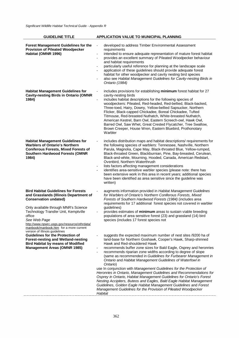
Significant Wildlife Habitat Technical Guide - Appendix R
362
GUIDELINE TITLE APPLICATION VALUE TO MUNICIPAL PLANNING
Forest Management Guidelines for theProvision of Pileated WoodpeckerHabitat (OMNR 1996)
- developed to address Timber Environmental Assessmentrequirements
- intended to ensure adequate representation of mature forest habitat- provides an excellent summary of Pileated Woodpecker behaviour
and habitat requirements- particularly useful reference for planning at the landscape scale- application of these guidelines should provide adequate forest
habitat for other woodpecker and cavity nesting bird species- also see Habitat Management Guidelines for Cavity-nesting Birds in
Ontario (1984)
Habitat Management Guidelines forCavity-nesting Birds in Ontario (OMNR1984)
- includes provisions for establishing minimum forest habitat for 27cavity-nesting birds
- includes habitat descriptions for the following species ofwoodpeckers: Pileated, Red-headed, Red-bellied, Black-backed,Three-toed, Hairy, Downy, Yellow-bellied Sapsucker, NorthernFlicker, Black-capped Chickadee, Boreal Chickadee, TuftedTitmouse, Red-breasted Nuthatch, White-breasted Nuthatch,American Kestrel, Barn Owl, Eastern Screech-owl, Hawk Owl,Barred Owl, Saw Whet, Great Crested Flycatcher, Tree Swallow,Brown Creeper, House Wren, Eastern Bluebird, ProthonotaryWarbler
Habitat Management Guidelines forWarblers of Ontario’s NorthernConiferous Forests, Mixed Forests ofSouthern Hardwood Forests (OMNR1984)
- includes distribution maps and habitat descriptions/ requirements forthe following species of warblers: Tennessee, Nashville, NorthernParula, Magnolia, Cape May, Black-throated Blue, Yellow-rumped,Black-throated Green, Blackburnian, Pine, Bay-breasted, Cerulean,Black-and-white, Mourning, Hooded, Canada, American Redstart,Ovenbird, Northern Waterthrush
- lists factors affecting management considerations- identifies area-sensitive warbler species (please note: there has
been extensive work in this area in recent years; additional specieshave been identified as area sensitive since the guideline waswritten)
Bird Habitat Guidelines for Forestsand Grasslands (Illinois Department ofConservation undated)
Only available through MNR's ScienceTechnology Transfer Unit, KemptvilleofficeSee Web Pagehttp://www.npwrc.usgs.gov/resource/othrdata/manbook/manbook.htm for a more currentversion of Illinois guidelines
- augments information provided in Habitat Management Guidelinesfor Warblers of Ontario’s Northern Coniferous Forests, MixedForests of Southern Hardwood Forests (1984) (includes arearequirements for 17 additional forest species not covered in warblerguidelines)
- provides estimates of minimum areas to sustain viable breedingpopulations of area sensitive forest (23) and grassland (14) birdspecies (includes 17 forest species not
Guidelines for the Protection ofForest-nesting and Wetland-nestingBird Habitat by means of ModifiedManagement Areas (OMNR 1985)
- suggests the expected maximum number of nest sites /9200 ha ofland-base for Northern Goshawk, Cooper’s Hawk, Sharp-shinnedHawk and Red-shouldered Hawk
- recommends buffer zone sizes for Bald Eagle, Osprey and heronries- recommends riparian zone widths according to degree of slope
(same as recommended in Guidelines for Furbearer Management inOntario and Habitat Management Guidelines of Waterfowl inOntario)
use In conjunction with Management Guidelines for the Protection ofHeronries in Ontario, Management Guidelines and Recommendations forOsprey in Ontario, Habitat Management Guidelines for Ontario’s ForestNesting Accipiters, Buteos and Eagles, Bald Eagle Habitat ManagementGuidelines, Golden Eagle Habitat Management Guidelines and ForestManagement Guidelines for the Provision of Pileated WoodpeckerHabitat

Significant Wildlife Habitat Technical Guide - Appendix R
363
GUIDELINE TITLE APPLICATION VALUE TO MUNICIPAL PLANNING
Habitat Management Guidelines forWaterfowl in Ontario (OMNR 1985)
- includes a description of species habitat requirements for a numberof wetland, upland and cavity-nesting waterfowl species
- recommends riparian zone widths according to degree of slope(same as recommended in Guidelines for furbearer habitatmanagement in Ontario, 1985)
- wetland and adjacent land protection measures are intended toprovide sufficient protection to wetland and riparian forest-nestingwaterfowl
Guidelines for Furbearer HabitatManagement in Ontario (OMNR 1985)
- provides description of habitat requirements, effects of habitatalterations and habitat management tactics for both wetland-associated and forest-associated furbearers
- recommends riparian zone widths according to degree of slope- wetland and adjacent land protection measures are intended to
provide sufficient protection for wetland-associated furbearers
Habitat Management Guidelines forBirds of Ontario Wetlands - includingmarshes, swamps and fens or bogs ofvarious types (OMNR 1985)
- includes habitat requirement descriptions for the following species:Pied-billed Grebe, Horned Grebe, Red-necked Grebe, AmericanBittern, Least Bittern, Green Heron, Northern Harrier, Merlin, YellowRail, King Rail, Virginia Rail, Sora, Common Moorhen, AmericanCoot, Sandhill Crane, Greater Yellowlegs, Lesser Yellowlegs,,Solitary Sandpiper, Whimbrel, Hudsonian Godwit, Marbled Godwit,Semipalmated Sandpiper, Least Sandpiper, Pectoral Sandpiper,Dunlin, Stilt Sandpiper, Short-billed Dowitcher, Common Snipe,American Woodcock, Wilson’s Phalarope, Red-neck Phalarope,Parasitic Jaeger, Little Gull, Common Tern, Forster’s Tern, BlackTern, Great Gray Owl, Short-eared Owl, Alder Flycatcher, EasternKingbird, Gray Jay, Sedge Wren, Marsh Wren, Swainson’s Thrush,Gray Catbird, Cedar Waxwing, Northern Shrike, White-eyed Vireo,Solitary Vireo, Philadelphia vireo, Blue-winged Warbler, Golden-winged Warbler, Yellow Warbler, Palm Warbler, Black-and-whiteWarbler, Connecticut Warbler, Yellowthroat, Wilson’s Warbler,Savannah Sparrow, Le Conte’s Sparrow, Sharp-tailed Sparrow,Lincoln’s Sparrow, Swamp Sparrow, Yellow-headed Blackbird,Rusty Blackbird, Brewer’s Blackbird
- wetland and adjacent land protection measures are intended toprovide sufficient protection for wetland birds
Management Guidelines for theProtection of Heronries in Ontario(OMNR 1984)
- identifies habitat requirements and sensitivities- particularly useful to identify work or timing restrictions and buffer
zones during development in areas close to existing heronries- helps determine suitable distance for development to occur
Management Guidelines andRecommendations for Osprey inOntario (OMNR 1983)
- identifies habitat requirements and sensitivities- can be used to identify work or timing restrictions and buffer zones
during development in areas close to Osprey nesting sites- different restrictions apply for northern and southern Ontario nest
sites
Habitat Management Guidelines forOntario’s Nesting Accipiters, Buteosand Eagles (OMNR 1984)
- includes habitat requirement descriptions and distribution maps forthe following species: Northern Goshawk, Cooper’s Hawk, Sharp-shinned Hawk, Red-shouldered Hawk, Broad-winged Hawk, BaldEagle
Peregrine Falcon Habitat ManagementGuidelines (OMNR 1987)
- recommends developing a nest site management plan within a 3 kmradius of any nesting site (short outline of plan and description ofmanagement options are included)

Significant Wildlife Habitat Technical Guide - Appendix R
364
GUIDELINE TITLE APPLICATION VALUE TO MUNICIPAL PLANNING
Bald Eagle Habitat ManagementGuidelines (OMNR 1987)
- provides description of essential habitat, Bald Eagle life history andcritical periods during the nesting period
- offers recommendations for regional (landscape scale) managementthat may be of value for municipalities that have known Bald Eaglenesting sites
Golden Eagle Habitat ManagementGuidelines (OMNR 1987)
- similar to Bald Eagle Habitat Management Guidelines (1987) withthe exception of offering large clearings beyond the 100 m bufferzone
Forest Management Guidelines for theProvision of Marten Habitat (OMNR1996)
- provides an excellent summary of marten behaviour and habitatrequirements
- particularly useful to refer to requirements at the landscape scale- application of these guidelines would provide habitat required by
mammals and birds associated with mature –overmature coniferousforests, cavity trees, woody debris
Habitat Management Guidelines forBats of Ontario (OMNR 1984)
- includes distribution maps, description of habits, diet, habitatrequirements
- species include: little brown myotis, Keen’s myotis, small-footed bat,silver-haired bat, eastern Pipistrelle, big brown bat, red bat, hoarybat
- guideline implementation requires knowledge of known roosting,nursery or hibernation sites
Forest Management Guidelines for theProvision of White-tailed Deer Habitat(OMNR 1997)
- excellent summary of winter and summer habitat requirements fordeer (note: deer do not yard as readily in southern portions ofOntario unless the winter is severe)
- protection of deer habitat will protect habitat for other wildlife speciesthat rely on mast producing trees and plants and require connectivitybetween forest patches
Forest Management Guidelines for theProvision of Moose Habitat (OMNR1988)
- wetland and adjacent land (120 m) protection measures will go along way to protecting moose feeding areas
- provides recommendation for no development areas adjacent tocritical mineral lick or calving sites
The Black Rat Snake in Ontario,Rideau Lakes Population (OMNR 1977)- A Field Guide
Copy available for viewing at KemptvilleDistrict Office or from the Science andTechnology Transfer Unit, Kemptville
- not a guideline document- provides concise description on range, habitat, prey hibernation,
reproduction of black rat snake- specific population information limited to eastern Ontario

Significant Wildlife Habitat Technical Guide - Appendix R
365
Forest Management Guidelines for the Provision of Pileated Woodpecker HabitatVersion 1.0 (OMNR, 1996)
A. Habitat types influenced
Mature or old growth productive forests (mixed, deciduous and to lesser extent coniferous)SnagsDowned woody debris
B. Intent of Guidelines
These guidelines were prepared as a commitment to the Class Environmental Assessment for TimberManagement. The Pileated Woodpecker is representative of mature and old growth forest habitat in theGreat Lakes-St. Lawrence Forest Region. Guidelines include provisions for the management of foresthabitat in order to meet current and future habitat needs of the Pileated Woodpeckers throughout the GreatLakes – St. Lawrence forest region by:
1) allowing sufficient flexibility in management options to suit a variety of situations
C. Environmental and Biological Factors Affecting Management Options
ü availability of large tracts of interconnected mature forest in the landscapeü current abundance and distribution of Pileated Woodpeckers
D. Management Approaches
q maintain sufficient supply of roosting trees, cavity nesting trees, potential cavity trees and treesthat provide a food source
q encourage continuous, adequate supply of downed wood and dead standing trees
E. Level of Guideline SpecializationProvides an overview of habitat needs for the Pileated Woodpecker. Application of these guidelines shouldprovide adequate habitat for other woodpecker and cavity nesting bird species.
F. Other Comments
• describes rationale and objectives for the guidelines• deals with habitat needs at the Stand Level (10s' of hectares) and Landscape Level (1000s' of
hectares)• guidelines provide an extensive list of reference materials, ecosite types and criteria for selecting
cavity trees

Significant Wildlife Habitat Technical Guide - Appendix R
366
Habitat Management Guidelines for Cavity-nesting Birds in Ontario (OMNR,1984)
A. Habitat types influenced
Semi-mature, mature forests (mixed, coniferous, deciduous)Forest edgeSnags or hollow, living treesDowned woody debris
B. Intent of Guidelines
Includes provisions for establishing minimum forest habitat for 27 cavity-nesting bird species and generalhabitat management guidelines by:
2) promoting the protection of large, undisturbed tracts of land3) recommending minimum (not optimum) habitat requirements
C. Environmental and Biological Factors Affecting Management Options
ü available number of snags in a given areaü variety of diameters and height of snagsü diversity of tree species and agesü forest sizeü width of riparian forest areasü Site Region locationü presence/absence of primary cavity excavators
D. Management Approaches
q maintain large, undisturbed tracts of forest area (650-2500 ha)q preservation of deciduous forests, particularly on the Canadian Shield (avoid clear cutting)q maintain 100 m wide corridors between fragmented forest areas, especially along shorelinesq preservation of adequate number of trees with heart-rot, dead or dying trees, malformed treesq girdle undesirable treesq retain fallen logs and slash during forest operationsq create irregular forest edge habitatq protection of riparian forestsq erect artificial nesting cavities (nest boxes)
E. Level of Guideline Specialization
Protection and preservation of optimum habitat requirements for primary cavity excavators, like thePileated woodpecker, are most likely to provide sufficient habitat for other cavity-nesting bird species. Alsosee Forest Management Guidelines for the Provision of Pileated Woodpecker Habitat (OMNR, 1996). Inaddition to birds, a variety of mammal, reptile and amphibian species benefit from the application of theseguidelines. These species are generally ones that: a) require travel corridors to move from one habitat toanother; b) require large tracts of mixed wood, deciduous and coniferous forests; and, use a variety oflowland and upland forests habitats; forest and riparian edge habitat; and, downed woody debris.
F. Other Comments
• provisions should be made to conserve tracts of forest large enough to provide for an entire birdpopulation, not just a single, breeding pair

Significant Wildlife Habitat Technical Guide - Appendix R
367
Habitat Management Guidelines for Warblers of Ontario’s Northern ConiferousForests, Mixed Forests of Southern Hardwood Forests (OMNR, 1984)
A. Habitat types influenced
ForestsForest edgeDowned woody debrisRiparian areas
B. Intent of Guidelines
Provides forest management options to preserve and protect forest habitats in general and large foresthabitats from fragmentation in particular.
C. Environmental and Biological Factors Affecting Management Options
ü insect abundanceü availability of downed woody debrisü diversity of habitat (forest, forest edge, openings)ü forest sizeü forest type (coniferous, deciduous, coniferous)ü stratification (overstory, understory, ground cover) within a stand (otherwise referred to as
structure)ü location and availability of riparian areasü presence of bird species (may include species requiring special habitat needs e.g. area sensitive,
old growth forest)ü present and future development pressures
D. Management Approaches
q manage for larger rather than smaller tracts of forestq maintain corridor connections between smaller forest areasq avoid cutting riparian forests
E. Level of Guideline Specialization
Guidelines are somewhat generalized. Descriptions of specific species requirements is valuable.
F. Other Comments
• provides habitat requirements for 19 warbler species• identifies species that require large tracts of forest (area sensitive species) and mature to old
growth forests• identifies species that are tolerant of timber harvest and may respond positively to logging• identifies species that require dense growth of deciduous shrubs, riparian habitats, closed canopies• includes a list of reference material

Significant Wildlife Habitat Technical Guide - Appendix R
368
Bird Habitat Guidelines for Forests and Grasslands (Illinois Dept. of Conservation,c. 1988)
A. Habitat types influenced
ForestsGrasslands
B. Intent of Guidelines
To provide guidance to resource managers who wish to enhance habitat of grassland and forest interiorbirds.
C. Environmental and Biological Factors Affecting Management Options
ü availability of larger-sized forest blocks situated away from forest edge effectsü availability of contiguous areas of grassy habitats (pasture, hayfields, but not row crops)ü presence/absence of highways or other disturbancesü
D. Management Approaches
Forestsq avoid unnecessary fragmentation of forestq maintain maximum contiguous woodland with least amount of edge in small tracts of forest (even
as small as 2 haq retain connecting corridors between isolated forest tractsq promote canopy closureq retain diversity of vegetationq plan to maximize unfragmented areas or reforest harvested or fragmented forest blocksq restrict human activities during breeding season
Grasslandsq optimal area for restoration of grassland areas is more than 100 haq reduce amount of linear edge habitatq adjacent areas should be open , not close to forest edgeq prescribed maintenance burning during early spring or late fall
E. Level of Guideline Specialization
For a variety of interior forest and grassland bird species.
F. Other Comments
• includes a list of references specific to forest interior bird species and grassland nesting birds• includes a list of true grassland nesting bird species and other birds that may breed or spend part of
their life in grasslands• includes a list of area sensitive forest birds and minimum forest area required to sustain viable
breeding populations• a 1993 revision to this document entitled Habitat establishment, enhancement and management
for forest and grassland birds in Illinois can be located on the following Internet web page:http://www.npwrc.usgs.gov/resource/othrdata/manbook/manbook.htm or, by writing to James R.Herkert, Division of Natural Heritage, Illinois Department of Conservation, Springfield, Illinois

Significant Wildlife Habitat Technical Guide - Appendix R
369
Guidelines for the Protection of Forest-nesting and Wetland-nesting Bird Habitatby means of Modified Management Areas [draft] (OMNR, 1985)
A. Habitat types influenced
Mature or old growth forestsForest edgeRiparian areasWetland areas
B. Intent of Guidelines
To help resource managers integrate wildlife management concerns into forest management plans andoperations.
C. Environmental and Biological Factors Affecting Management Options
ü presence of species with more specialized habitat requirementsü quality and quantity of available habitat (diversity, size)ü existing and future development pressures
D. Management Approaches
q aim to meet optimum, not minimum habitat requirements of wildlife speciesq preserve snags, downed woody debris, riparian habitatsq manage for habitat diversity (species richness)q provide forest tracts large enough to maintain healthy populations, not just single pairs
E. Level of Guideline Specialization
Special management guidelines are offered for Pileated Woodpecker (see 1996 guidelines), accipiters andbuteos (see 1984 guidelines), Bald Eagle, Golden Eagle, Osprey, heronries (see 1987 and 1984 guidelines),Sand Hill Crane, Great Gray Owl, American Woodcock. Also provides general guidelines for wetland andforest habitats.
F. Other Comments
• includes a list of reference material• includes species lists and habitat association, a list of area sensitive bird species, dimensions for
building nest boxes for cavity-nesting birds• recommends sizes of buffer zones around nest sites, by bird species

Significant Wildlife Habitat Technical Guide - Appendix R
370
Habitat Management Guidelines for Waterfowl in Ontario (OMNR, 1985)
A. Habitat types influenced
Mature upland forestsGrasslands (openings)Mature riparian forestsWetland areas (critical habitat)Open water areas
B. Intent of Guidelines
To assist resource managers in protecting and enhancing waterfowl habitat, particularly as it relates totimber harvesting.
C. Environmental and Biological Factors Affecting Management Options
ü nesting and feeding requirements of ducks and geeseü forest/woodpecker associations (in provision of critical habitat for cavity nesting ducks)ü availability of wetland, riparian and upland forest habitats and their proximity to one another
D. Management Approaches
q restrict activities during waterfowl nesting periodq encourage preservation of riparian areasq maintain uneven-aged, old growth forests with openings
E. Level of Guideline Specialization
Recommended management options are limited to forest management. Does not include recommendationsfor the management of habitat for all species of waterfowl.
F. Other Comments
• includes a list of waterfowl species that nest in forested areas of Ontario• includes a list of reference material

Significant Wildlife Habitat Technical Guide - Appendix R
371
Guidelines for Furbearer Habitat Management in Ontario (OMNR, 1985)
A. Habitat types influenced
ForestsForest edgeRiparian areasWetland areasDowned woody debris
B. Intent of Guidelines
To assist government and industry foresters and biologists to develop appropriate forest managementprescriptions.
C. Environmental and Biological Factors Affecting Management Options
ü whether furbearer is associated with forest or wetland habitatsü diet, size, reproductive requirements and behaviour of furbearersü furbearer species interactionsü habitat diversity and availabilityü water level permanence, fluctuation
D. Management Approaches
Wetland-associated furbearersq protect wetland habitat from development (drainage, channelization, filling etc.)q avoid development in riparian areas, particularly road developmentq maintain wetland coverq reduce water velocity and avoid extremes in water fluctuation that may negatively affect
furbearers at critical periods in their life (e.g. extreme water fluctuations during winter months caneither drown-out or freeze-out muskrats)
Forest-associated furbearersq maintain dense, continuous overhead coverq retain snags, downed woodq protect old-growth forestsq manage for future mature – old growth forestq protect large tracts of forested areaq retain or create corridors to connect smaller tracts of forest
E. Level of Guideline Specialization
Maintaining habitat quality of beaver and muskrat will have beneficial effects on habitat of mink, otter andother wetland species. Forest-associated furbearers have a wide diversity of habitat requirements, largercarnivores requiring larger, contiguous tracts of forested area. Management for these species benefit theirprey (e.g. small mammals such as rabbits, voles, mice).
F. Other Comments
• specific measures may be needed to meet the needs of individual species• guidelines include a list of reference material and description of individual species requirements

Significant Wildlife Habitat Technical Guide - Appendix R
372
Habitat Management Guidelines for Birds of Ontario Wetlands, including marshes, swamps andfens or bogs of various types (OMNR, 1985)
A. Habitat types influenced
Wetlands – a variety of different types of marsh, swamp, bog or fen habitatRiparian areasOpen water areasForest edgeSeepage areas
B. Intent of Guidelines
Includes provisions for timber harvest operations that are intended to help preserve remaining wetlandhabitat in Ontario for 66 Ontario wetland bird species by -
1. promoting the protection of riparian forests and forests on steep banks2. recommending a minimum no-cut zone (50 m) on either side of a river or lake3. providing suitable conditions for all wetland species by managing optimum habitat for the more
habitat-specific species
C. Environmental and Biological Factors Affecting Management Options
ü existing size, form and function of wetlandü wetland rarity (e.g. marshes are more rare in northern Ontario, whereas bogs are more rare in
southern Ontario)ü species diversity (flora and fauna)ü surrounding land usesü future development pressures
D. Management Approaches
q preserve all remaining wetlands, particularly rarer forms that support several rare species of floraor fauna
q conserve riparian and drier surrounding edgesq avoid creating channels in river wetlandsq discourage logging or development of swampy and riparian areasq encourage natural water regulation to promote a diversity of plant lifeq avoid use of chemical pesticidesq encourage public education programs and stewardshipq encourage research on wetland speciesq identify critical breeding, migration areas for rare species, or areas of high useq consider limiting recreational use of critical wetland areas during the breeding seasonq encourage wetland creation
E. Level of Guideline Specialization
Habitat requirements for a large number of species of flora and fauna are met when wetland habitat ingeneral is protected.
F. Other Comments
• an important aspect of wetland protection and management is the preservation of the area wherewater and land meet (riparian zone)
• protection of provincially significant wetlands now also involves the recognition of a 120 madjacent land area since many species use both wetland and upland areas to meet all their life’srequirements

Significant Wildlife Habitat Technical Guide - Appendix R
373
• for many species that are not area sensitive this adjacent land area may be sufficient to providethe required travel corridors to move from one habitat to another, or meet a breeding, nesting,foraging or shelter habitat requirement
• upland habitat may include: mixed-wood, deciduous, coniferous forests; open grassland areas;forest edge; and, downed woody debris

Significant Wildlife Habitat Technical Guide - Appendix R
374
Management Guidelines for the Protection of Heronries in Ontario (OMNR, 1984)
A. Habitat types influenced
Mature hardwood forest typesForest edgeRiparian areasWetland areas (marshes for feeding; swamps for nesting)
B. Intent of Guidelines
Includes provisions for preventing the loss of heron and egret colonial nesting sites by:1) encouraging educational programs to promote appreciation of herons2) providing information about the sensitivity of herons to disturbance3) specifying buffer zones for different levels of development disturbance
C. Environmental and Biological Factors Affecting Management Options
ü size of colonyü location of colonyü level of significance a colony has to the contribution of regional heron populationsü quality of habitat conditions throughout the landscape
D. Management Approaches
q conduct inventory of existing heronries and potential nest sitesq protect and manage relative to size of heronry, and its significance to regional population of
heronsq conserve habitat for future heronriesq develop and follow buffer zone criteria for various levels of developmentq specify activities prohibited and permitted during the breeding and non-breeding season
E. Level of Guideline SpecializationSpecific to Great Blue Heron, Black-crowned Night Heron, Green Heron, Great Egret, Cattle Egret,although management techniques and use of buffer zones during development activities may benefit otherwetland species, including Osprey.
F. Other Comments
• includes field and record sheets for the Ontario Heronry Inventory• includes a dated but extensive list of reference material

Significant Wildlife Habitat Technical Guide - Appendix R
375
Management Guidelines and Recommendations for Osprey in Ontario (OMNR,1983)
A. Habitat types influenced
Open water areasRiparian areas (treed)Wetland areas (treed)
B. Intent of Guidelines
Includes provisions for Osprey habitat and nest site improvement and preservation.
C. Environmental and Biological Factors Affecting Management Optionsü distribution and abundance of Ospreyü Osprey health (in the past, reproductive success has been negatively affected by high levels of
pesticides)ü level of human disturbance
D. Management Approaches
q maintain and report nesting records of Osprey (assists in estimating breeding bird populations)q develop and follow buffer zone criteria for various levels of development according to northern
and southern Ontario criteriaq specify activities prohibited and permitted during the breeding and non-breeding seasonq encourage educational programs to promote awareness and appreciation of Osprey
E. Level of Guideline Specialization
Specific to Osprey. Osprey may also benefit from the protection of heronries.
F. Other Comments
• includes a standard inventory data sheet for nesting osprey• includes a dated list of references

Significant Wildlife Habitat Technical Guide - Appendix R
376
Habitat Management Guidelines for Ontario’s Forest Nesting Accipiters, Buteosand Eagles (OMNR, 1984)
A. Habitat types influenced
Mature or old growth forests (mixed, deciduous and to lesser extent coniferous)Forest edgeRiparian areasWetland areas
B. Intent of Guidelines
Includes provisions for the protection of nesting and feeding habitats of six forest nesting species of raptorsby:
1) promoting the preservation of riparian forest habitat, forest edges and openings2) managing for present and future trees suitable for nesting and perching3) recognizing many raptors are area sensitive4) limiting human disturbances
C. Environmental and Biological Factors Affecting Management Options
ü Site Region location of forest standü existing size of forestü raptor species involved and its specific habitat requirements
D. Management Approaches
q maintain extensive forest cover, particularly near riparian edgesq suppress human activities where raptors are known to occur, particularly during the nesting seasonq manage areas to provide adequate nesting and perching sites
E. Level of Guideline Specialization
Specific habitat requirements and forest management guidelines are outlined for the following diurnalforest-dwelling raptors: Northern Goshawk, Cooper’s Hawk, Sharp-shinned Hawk, Red-shouldered Hawk,Broad-winged Hawk and Bald Eagle.
F. Other Comments
• of all the bird species, raptors are among the most easily disturbed by clearing or logging practices• provision of only minimum habitat requirements may lead to sub-optimal conditions that can lead to
low nesting success and eventual extinction of a population• guidelines include a copy of the inventory data sheet and the Ontario nest record card• guidelines include a dated but extensive list of reference material

Significant Wildlife Habitat Technical Guide - Appendix R
377
Peregrine Falcon Habitat Management Guidelines (OMNR, 1987)
A. Habitat types influenced
CliffsUrban settings (sometimes nesting on tall buildings)Open areasWetland areasForest (early successional and mature)
B. Intent of Guidelines
To provide criteria for the protection of existing and potential Peregrine Falcon nestingsites and for the protection of Peregrine Falcons from human disturbance during thebreeding season.
C. Environmental and Biological Factors Affecting Management Options
ü Peregrine Falcon occurrence and distributionü variability in tolerance to human presenceü availability of nesting sites adjacent to open water of lakes or riversü proximity of potential hunting areas (lakes, wetlands, forest openings, forest canopy) to the nest
siteü availability of preyü location and rate of human development as they relate to nesting site
D. Management Approaches
q survey for presence of Peregrine Falcon, assess habitat potential (data records)q collect information on historical nesting records for an areaq identify and preserve Peregrine Falcon hunting areasq prepare site-specific management plans (within 3 km radius) for each nest siteq identify buffer zones around nests within which human activities and habitat alterations are
restrictedq buffer zones above cliffs where nesting sites (eyries) are located should be wider than those at
base of cliffq prohibit human recreational activities with 0.6 and 0.8 km of nest site during breeding seasonq preserve potential nest sites
E. Level of Guideline Specialization
Specific to Peregrine Falcons, but preservation of habitat types that provide nesting sites for prey speciesfor Peregrines also preserve habitat for other species.
F. Other Comments
• cliffs and urban areas provide nesting sites for Peregrines; open areas, wetlands, forests providesites that produce prey species suitable for Peregrines (e.g. protection of snags preserves habitatfor cavity nesting bird and mammal species)
• guidelines include a one page summary of a Peregrine Falcon nest site management plan• guidelines include a short list of reference material

Significant Wildlife Habitat Technical Guide - Appendix R
378
Bald Eagle Habitat Management Guidelines (OMNR, 1987)
A. Habitat types influenced
Mature or old growth forests (super canopy trees)Forest edgeRiparian areasOpen water
B. Intent of Guidelines
To provide criteria for the protection and maintenance of Bald Eagle breeding habitat and for the protectionof Bald Eagles from human disturbance during the breeding season.
C. Environmental and Biological Factors Affecting Management Options
ü Bald Eagle occurrence and distributionü variability in eagle tolerance to human presenceü availability of large contiguous areas of habitatü rate of human development
D. Management Approaches
q survey for presence of Bald Eagle, assess habitat potential (data records)q essential habitat at each nest site includes aquatic and terrestrial habitats of 260 hectares (640
acres) or moreq prepare site-specific management plans to suit size and configuration of essential habitatsq identification of buffer zones around nests within which human activities and habitat alterations
are restrictedq maintain prey base consistent with Bald Eagle food habits (fish)q preserve potential nest and roost trees
E. Level of Guideline Specialization
Specific to Bald Eagle and Golden Eagle with one exception (see Golden Eagle Habitat ManagementGuidelines for exception)
F. Other Comments
• includes list of reference material• includes Bald Eagle Breeding and Nest Area Record sheets

Significant Wildlife Habitat Technical Guide - Appendix R
379
Golden Eagle Habitat Management Guidelines (OMNR, 1987)
A. Habitat types influenced
Mature or old growth forestsForest edgeGrasslandsWetland areasRock cliffs
B. Intent of Guidelines
To provide criteria for the protection and maintenance of Golden Eagle breeding and foraging habitat andfor the protection of Golden Eagles from human disturbance during the breeding season.
C. Environmental and Biological Factors Affecting Management Options
ü Golden Eagle occurrence and distributionü variability in eagle tolerance to human presenceü availability of large contiguous areas of forest habitat with large, adjacent clearingsü rate of human development
D. Management Approaches
q survey for presence of Golden Eagle, assess habitat potential (data records)q essential habitat at each nest site includes aquatic and terrestrial habitats of 260 hectares (640
acres) or moreq prepare site-specific management plans to suit size and configuration of essential habitatsq identification of buffer zones around nests within which human activities and habitat alterations
are restrictedq maintain prey base consistent with Golden Eagle food habits (small mammals, particularly rabbits
or hares)q preserve potential nest and roost trees
E. Level of Guideline Specialization
For full description of guidelines see Bald Eagle Habitat Management Guidelines (1987), with theexception that Golden Eagles benefit from large, contiguous clearings beyond 100 m from the nest site.These clearings are used as feeding areas.
F. Other Comments
• Golden Eagles are highly sensitive to disturbance during the breeding season

Significant Wildlife Habitat Technical Guide - Appendix R
380
Forest Management Guidelines for the Provision of Marten Habitat Version 1.0(OMNR, 1996)
A. Habitat types influenced
Moist, mature or overmature coniferous forestsHardwood dominated forests and wetlands to a lesser extent
B. Intent of Guidelines
These guidelines were prepared as a commitment to the Class Environmental Assessment for TimberManagement. The Marten is representative of contiguous, mature forest habitat in the Boreal ForestRegion. Includes provisions for the management of forest habitat in order to maintain sufficient quality andquantity of habitat to support healthy populations of marten in the boreal forest region.
C. Environmental and Biological Factors Affecting Management Options
ü availability of suitable forest coverage (hectares) and type and interconnecting corridorsü availability of downed wood on the forest floorü prey availabilityü current abundance and distribution of marten
D. Management Approaches
q maintain core habitat areas of between 30 and 50 km2
q maintain diversity of surrounding habitats to increase diversity of potential preyq provide suitable numbers and distribution of potential maternal and resting den sites
E. Level of Guideline SpecializationProvides an overview of habitat needs for marten. Application of these guidelines may provide somehabitat required by other mammals and birds that are associated with mature and overmature forests, cavitytrees and coarse woody debris.
F. Other Comments
• describes rationale and objectives for the guidelines• deals with habitat needs at the Stand Level (10s' of hectares) and Landscape Level (1000s' of
hectares)• guidelines provide an extensive list of reference materials

Significant Wildlife Habitat Technical Guide - Appendix R
381
Habitat Management Guidelines for Bats of Ontario (OMNR, 1984)
A. Habitat types influenced
Forests (particularly snags that provide roosting sites)Riparian areas (critical)Aquatic areas (critical)Natural and man-made cavesUrban and rural areas (open buildings)
B. Intent of Guidelines
Summarizes general and specific habitat requirements for a number of bat species.
C. Environmental and Biological Factors Affecting Management Options
ü bat habits, dietü specialized habitat requirements for some species of batsü temperatureü humidityü availability and location of natural or man-man caves
D. Management Approaches
q protect all known major and marginal hibernaculaq protect roost sites (e.g. snags)q restrict activities during periods of roosting and hibernation (caves, hollow trees)q limit accessibility to known hibernation sitesq avoid disturbance of riparian areasq provide artificial roost sites (bat houses)
E. Level of Guideline Specialization
While specifically written for bats, recommendations provided in these guidelines offer protection ofhabitat components (e.g. snags and cavities) for other wildlife species. Potential roosting sites for bats mayalso be protected through the application of habitat management guidelines for other cavity nesting species.
F. Other Comments
• bats are unique and specialized in their habits and habitat requirements• roosting and hibernation site availability is main factor limiting bat populations• guidelines include distribution maps, a description of habits, diet and habitat requirements for
eight bat species, a list of reference material, a summary of bat diseases, instructions on how tobuild a bat house

Significant Wildlife Habitat Technical Guide - Appendix R
382
Forest Management Guidelines for the Provision of White-tailed Deer Habitat(OMNR, 1997)
A. Habitat types influenced
Coniferous forestsEarly successional forestsForest edgeGrasslands
B. Intent of Guidelines
Includes provisions for summer and winter deer habitat by -1) promoting early successional growth for summer forage production2) protecting known migration and travel routes3) maintaining conifer cover and providing sufficient deer browse
C. Environmental and Biological Factors Affecting Management Options
ü quality, quantity and availability of cover- and forage-speciesü quality of summer habitatü quantity and quality of winter habitatü winter severityü traditional deer-use patterns
D. Management Approaches
Winter Habitatq select for conifer speciesq promote regeneration of hemlock and cedar specificallyq retain browse species such as cedar, hemlock, viburnums, maples, red oak, dogwood, beaked
hazel, birch
Summer Habitatq establish openings (0.4 to 4 ha in size)q promote growth of grasses, annuals, forbsq retain or release growth of mast producing species (oak, beech, raspberry)
E. Level of Guideline Specialization
Protection of deer habitat also provides habitat for a variety of species that: a) rely on mast producing treesand plants; b) require travel corridors to move from one habitat to another; and, c) use upland forest;lowland treed swamp areas; open grassland areas; forest edge; and, downed woody debris.
F. Other Comments
• areas of irregular terrain and areas containing wind-throws or downed woody debris provide goodwinter habitat
• hemlock and cedar are best conifer cover, often associated with preferred browse species• browse should be within 30 m of suitable winter cover in northern areas; 100 m in southern areas• protection of known travel corridors is essential• quality of summer habitat determines reproductive rate• quality of winter habitat and winter severity determines spring survival

Significant Wildlife Habitat Technical Guide - Appendix R
383
Forest Management Guidelines for the Provision of Moose Habitat (OMNR, 1988)
A. Habitat types influenced
Coniferous forestsEarly successional forestsForest edgeWetlands
B. Intent of Guidelines
Includes provisions for protecting moose habitat in the Boreal and Great Lakes-St. Lawrence ForestRegions by -
1) promoting growth and abundance of young deciduous stands2) protecting known feeding areas, calving sites and mineral licks3) maintaining large areas of semi-mature and mature conifer cover
C. Environmental and Biological Factors Affecting Management Options
ü quality, quantity and availability of specific (high sodium content) aquatic plant speciesü quality and quantity of summer, fall and early winter habitat (early successional forests)ü availability and quality of winter concentration areas, mineral licks, calving areasü traditional moose-use patternsü occurrences of natural disturbances such as fire or insect damageü forest region differences (e.g. winter severity; dominant forest types)
D. Management Approaches
q select harvest operations that create irregularly shaped cuts, scattered shelter patches, highdiversity of age-class and species composition
q prescribed burnsq in the Boreal Forest Region, maintain growth of existing and encourage growth of new mixed
wood stands; in the Great Lakes St. Lawrence Forest Region maintain existing semi-mature andmature coniferous growth
q exclude development (particularly roads) near or in known mineral lick and calving sites andaquatic feeding areas
q establish forested buffer zones between clear cuts, scattered trees within cutovers; shelter patches3-5 ha in size, spaced 300-400 m apart, being at least 6 m high and have 11 m2ha-1 basal area
E. Level of Guideline Specialization
It has been estimated that the needs of 70% of all wildlife in an area will be satisfied if provisions formoose habitat are made in accordance with these guidelines. Protection of moose habitat provides habitatfor a variety of species that: a) require travel corridors to move from one habitat to another; inhabit treedislands; and, c) use mixed wood and coniferous forests; lowland treed swamp, bog or marshy areas; opengrassland areas; forest edge; and, downed woody debris.
F. Other Comments
• the best habitat should provide conditions enabling a moose to be within 200 m of shelter patchesor other cover
• a buffer of 120 m should be maintained around aquatic feeding areas, mineral licks and calvingsites; travel corridors to these areas should be maintained

Significant Wildlife Habitat Technical Guide - Appendix R
384
The Black Rat Snake in Ontario, Rideau Lakes Population (OMNR, 1977) - A FieldGuide
A. Habitat types influenced
Talus slopesRock outcroppingsDowned woody debrisForestsForest openings, grasslands
B. Intent of Guidelines
Is not a guidelines document but represents a collection of information on black rat snakes, with aparticular reference to an area in eastern Ontario.
C. Environmental and Biological Factors Affecting Management Options
ü increases in vehicular trafficü interactions with human activityü availability of suitable habitat and sufficient preyü presence of predatorsü development pressures and loss of habitat
D. Management Approaches
q hold public education events regarding the conservation of black rat snakesq conduct population assessments and estimatesq locate and evaluate habitat (identify hibernacula and nesting sites)q protect known nesting and hibernation sites
E. Level of Guideline Specialization
Specific to the black rat snake. Not a true habitat management guidelines document.
F. Other Comments
• this document is available for viewing at Kemptville District Office or from the ScienceTechnology Transfer Unit, Kemptville; it may not be readily available at other MNR offices
• provides a concise description on the range, habitat, prey, hibernation, reproduction of the blackrat snake
• includes a list of reference material


![Developing a Wildlife Habitat Management Planweb.mnstate.edu/stockram/WildlifeEcol/4-H-991-W[1].pdfDeveloping a Wildlife Habitat Management Plan WILDLIFE HABITAT EVALUATION CAREER](https://img.dokumen.tips/doc/110x75/5fe7fa3d9f69891190384d11/developing-a-wildlife-habitat-management-1pdf-developing-a-wildlife-habitat-management.jpg)