Embed Size (px)
Citation preview

3050 Spruce Street, St. Louis, MO63103 USA
Tel: (800) 521-8956 (314) 771-5765 Fax: (800) 325-5052 (314) 771-5757
1 | P a g e
July 31, 2014
Mr. George Alexander
Nuclear Regulatory Commission
11545 Rockville Pike
Mail stop T8F5
Rockville, MD 20852
RE: Groundwater Pathway Elimination – Dose Modeling
NRC Decommissioning License 24-16273-01
Sigma-Aldrich Company, 11542 Fort Mims Dr., St. Louis, MO 63146
Dear Mr. Alexander:
In a letter dated April 24, 2013, Sigma Aldrich Company (SAC) provided information supporting a proposal to
remove the drinking water pathway from consideration in site specific dose modeling. The NRC documented its
reply in a public meeting summary dated August 9, 2013. In that summary, NRC required additional
documentation from the U.S. Geological Survey or an independent consultant to verify that both the upper
water-bearing unit as well as deeper units are of poor quality, low yield and/or inaccessible.
In response to NRC feedback, SAC presents below an exhaustive report that addresses NRC requirements for
elimination of drinking water pathway from consideration in site-specific dose modeling at the Fort Mims site.
Sigma Aldrich Company has taken a risk informed approach to the decommissioning of its facility located at
11543 Fort Mims Drive, Maryland Heights, Missouri. It is our position that the approach presented herein is
consistent with guidance in NUREG 1757 Consolidated Decommissioning Guidance: Decommissioning Process
for Materials Licensees Volume 1 and Consolidated Decommissioning Guidance: Characterization, Survey and
Determination of Radiological Criteria Volume 2. These guidance documents share a philosophy whereby risks
are considered together with other factors to better focus the attention and resources of both the licensee and the
NRC on the more risk significant aspects of the decommissioning process and on the elements of the facility and
the site that will most affect risk to members of the public following decommissioning.
First and foremost in assessing risk is to determine the most appropriate land use designation for the site upon
license termination. It is our position that industrial land use is the appropriate land use designation for the site
upon license termination and not a resident farmer or urban resident. It is our understanding that the NRC is in
agreement with this statement. Exhibit 1 Land Use Upon License Termination provides the basis upon which
SAC has made this determination.
The site specific information provided in this response enables one to focus resources on the single most critical
potential exposure pathway which is groundwater. Absent a viable groundwater pathway for potential exposure
there are no other pathways that present an exposure risk. Exhibit 2 Exclusion of the Groundwater Pathway in
the Risk Assessment provides basic documentation for the exclusion of the groundwater pathway in any risk
assessment.
Exhibit 3 Poor Water Quality and Yields in St. Louis County documents that it has been general knowledge for
over 150 years that the groundwater quality and yield for the area (east of the fresh water/saline zone) is poor.
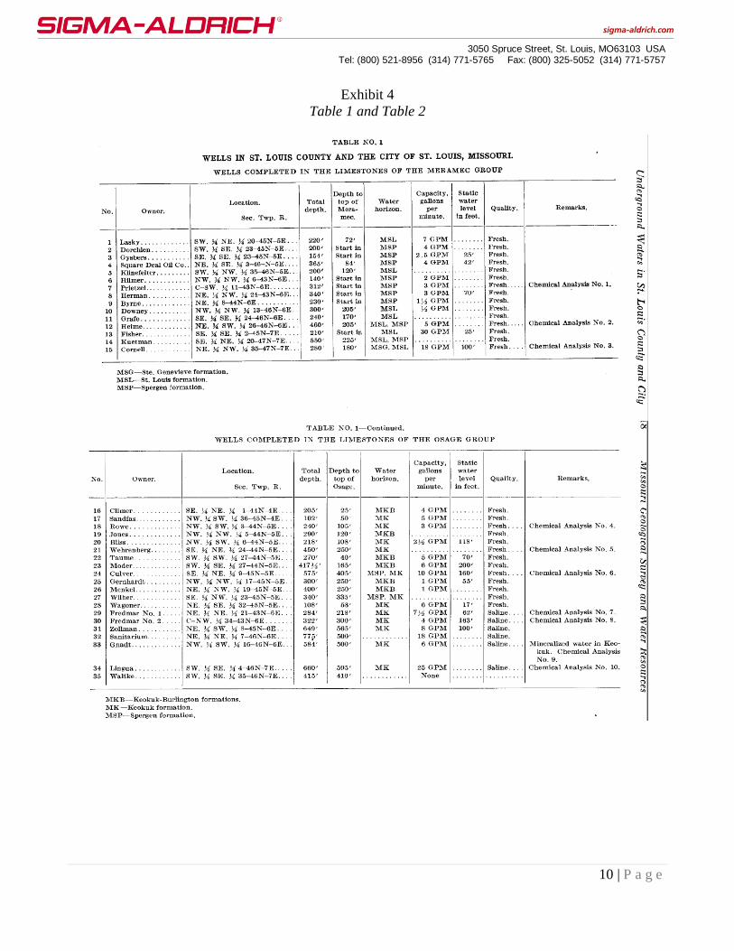
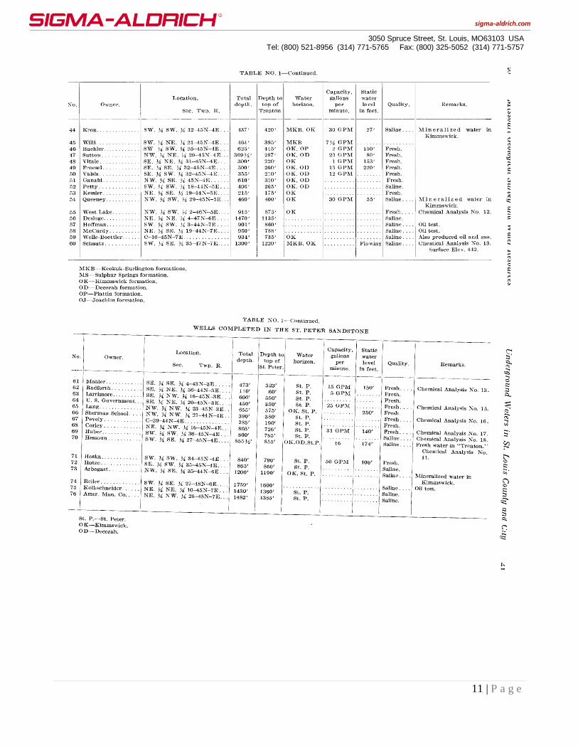
Exhibit 4 Table No.1 Wells in St. Louis County and the City of St. Louis, Missouri is taken from the Missouri
3050 Spruce Street, St. Louis, MO63103 USA
Tel: (800) 521-8956 (314) 771-5765 Fax: (800) 325-5052 (314) 771-5757
2 | P a g e
Geological Survey and Water Resources document Underground Waters In St. Louis County and City of St.
Louis. The table contains, in part, well locations to the nearest 10 acres, well depth, capacity in gallons per
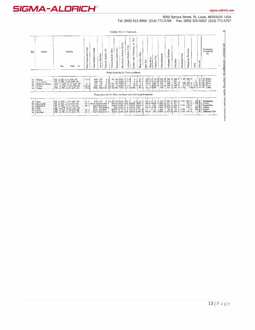
minute and water quality expressed as Fresh or Saline. Exhibit 4 also includes Table No. 2 Chemical Analyses
of Well Waters in St. Louis County and St. Louis City and lists the chemical attributes for 24 of the 89 wells
listed in Table 1. All wells located east of the freshwater saline zone where the site is located either are saline
and/or yield insignificant quantities of water unsuitable for a resident farmer much less for an industrial land
use.
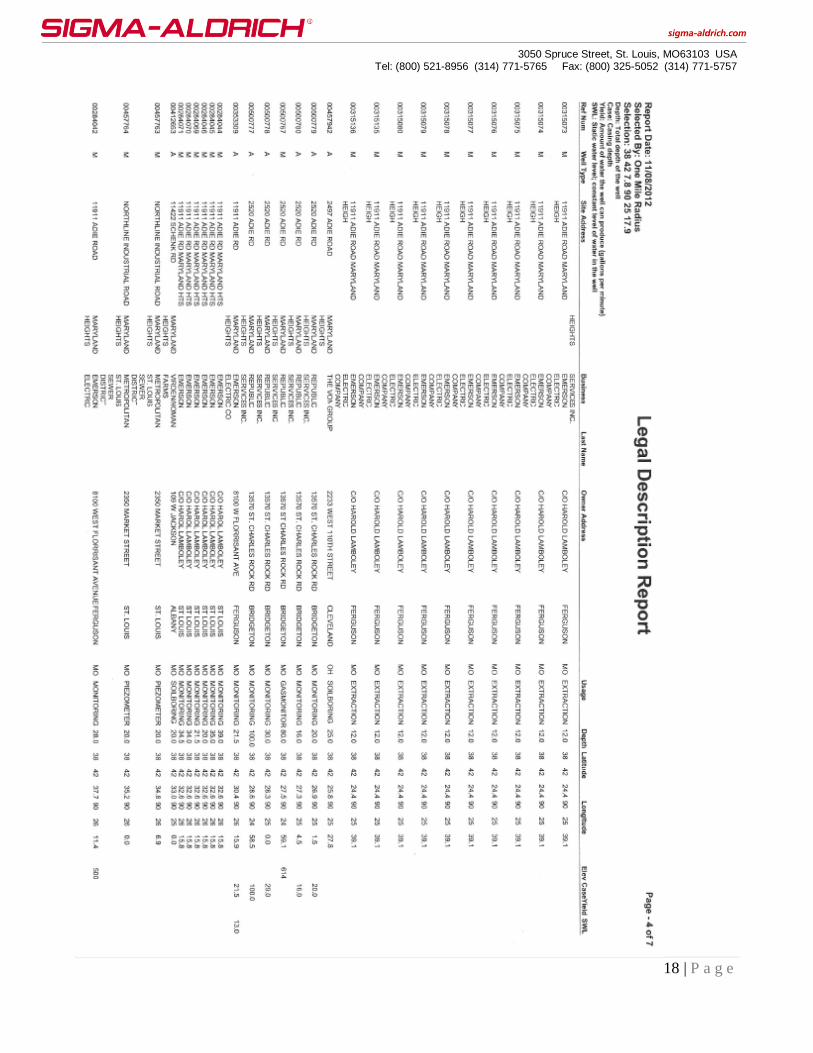
Exhibit 5 Well Permits and Use Within a One Mile Radius of the SAC Site is a listing of all well permits issued
by the Missouri Department of Natural Resources (MDNR) within a one miles radius of the site. The database
record extends back in time for over the past quarter century. None of the well permits listed in the database are
for a water well. What is noteworthy is that almost all of the permitted wells are for characterizing that the
extensive environmental contamination found in the area is due to industrial disposal activities that were not
associated with the SAC operations. All of these wells are located in a zone designated by the MDNR as a
brownfield and which the current land use plan states may present a hazard to public health and safety.
The NRC points out that there is no prohibition against drilling a water well at the site. However, the site is
within an area designated by the MDNR that prohibits the use of any shallow groundwater in the uppermost
unconsolidated aquifer. Any well in the area “shall set no less than 80 feet of casing and extend no less than 30
feet into bedrock and that the 80 foot casing requirements extends to residual weather rock.” Consequently, no
groundwater found within the first 80 feet of the land surface can be used. Since there is no prohibition against
drilling a water well in the area and none have actually been drilled supports the conclusion that groundwater
will not be used due to its poor quality, low yield, contamination from other industrial activities or a
combination of all of the above.
The NRC stated that they had contacted the MDNR regarding the adequacy of the MDNR database and
recommended that we contact the MDNR regarding conducting an area survey to determine if there were any
unpermitted water wells in the area. We are not aware of any instance where a licensee and/or permittee have
conducted such a survey or where it would be a condition for consideration in a license or permit termination. It
is our position that if this is a real concern within the two agencies, then it would be more appropriately handled
through one of the State’s enforcement groups.
Neither the MDNR nor EPA Region VII have formally classified any of the aquifers in St. Louis County. This
includes the groundwater within the St. Louis city limits which has been precluded by city ordinance from being
accessed and/or used for any purpose due to widespread environmental contamination. However, the State and
the EPA have concurred with the conclusion that groundwater in the area meets the EPA criteria as a Class III
groundwater and is discussed in detail in Exhibit 3.
SAC has conducted an exhaustive literature and database search on the water quality, yield and use for the St.
Louis county area. All scientific documents, data, professional geologic or hydrogeological reports conclude
that this area cannot provide a reliable potable water supply of sufficient yield to provide for the minimum needs
for a resident much less an industrial or commercial facility.
In summary, it is our position that SAC has provided convincing documentation to eliminate the groundwater
exposure pathway from further consideration in dose modeling. Our position is based on site-specific conditions
and regional and local hydrogeology.
3050 Spruce Street, St. Louis, MO63103 USA
Tel: (800) 521-8956 (314) 771-5765 Fax: (800) 325-5052 (314) 771-5757
3 | P a g e
Please contact me if you have any questions or concerns regarding this matter.
Sincerely,
SIGMA-ALDRICH COMPANY
Thomas K Spencer
Radiation Safety Officer
3500 Dekalb St
St. Louis, MO 63118
Phone 314/286-7686
Email [email protected]
3050 Spruce Street, St. Louis, MO63103 USA
Tel: (800) 521-8956 (314) 771-5765 Fax: (800) 325-5052 (314) 771-5757
4 | P a g e
Exhibit 1
Land Use Upon License Termination
Over the past half century land use in the area around the facility has been industrial/commercial and
will remain so into the foreseeable future. The City of Maryland Heights considers the location of the
facility to be within the Westport Industrial Planning Future Land Use as Manufacturing and Mixed
Use Planned Commercial. This comprehensive plan states, in part, that the majority of the properties
within this planned area are of a “deteriorated, disorganized condition and some uses (and the
operation of uses) in this area may present a hazard to public health and safety”(emphasis added).
Specifically, there are numerous sites that are known to have contaminated the environment with
heavy metals and volatile organic chemicals including both known and suspected carcinogens. As an
example, Chevron Chemical Company is the owner of a site located at 2497 Adie Road, Maryland
Heights, MO. The site is a former pesticide and fertilizer formulation plant that operated for over 30
years. This site is approximately 3,000 feet north of the SAC facility. Historical operations resulted in
contamination of soil and groundwater with pesticides and arsenic. In addition, fire debris
contaminated with pesticides was buried onsite in unlined pits in the 1950’s and over two tons of the
fungicide Maneb were buried onsite in 1974. Approximately 1,500 feet east of the SAC site is the BFI
Missouri Pass Landfill located at 2520 Adie Road. The 72 acre unlined landfill operated for
approximately 20 years from 1972 to 1995 and received approximately 12,800,000 cubic yards of
waste. The site has been the subject of several lawsuits and there has been offsite contamination of
methane gas that has been documented in a September 2008 notification by the facility owner to 30
adjacent landowners and again in February 2010 when an additional 129 new property owners were
notified. The MDNR maintains a comprehensive list of these sites in a brownfield registry and
Attachment 1 MDNR Brownfield Sites Near the SAC Facility is included as part of this exhibit which
lists numerous sites that are near the SAC facility.

3050 Spruce Street, St. Louis, MO63103 USA
Tel: (800) 521-8956 (314) 771-5765 Fax: (800) 325-5052 (314) 771-5757
5 | P a g e
Exhibit 2
Exclusion of the Groundwater Pathway in the Risk Assessment
NRC made references regarding the applicability of various sections of Appendix M Section 5.2.1
Ground Water and Surface Water for a Class 5 site with groundwater contamination. For example,
under 5.2.1.1 Is Ground Water Available? the two criteria listed for the subsistence farmer is that the
well is shallow enough that it could be reasonably pumped from a shallow aquifer and used to irrigate
a small farm while providing domestic drinking water and to connect to a fish pond and have sufficient
yield to sustain the pond. Section 5.2.1.4 Is Ground Water Suitable for Drinking Water? compares the
quality of the ground water for the subsistence farmer to the EPA primary and secondary drinking
water standards without consideration as to whether there is a sufficient amount of drinking water
available. The NRC uses the EPA value of a well yielding 150 gallons or greater of water per day as
an indicator that an aquifer that could be considered to be a viable drinking water source for a
subsistence farmer.
There are multiple criteria for concluding that an aquifer can be used as a drinking water source. The
EPA example of 150 gallons per day, for example, assumes that the water is potable and for residential
use. There are multiple criteria as to whether the aquifer is a dependable source of water. As an
example, a second criterion is whether the aquifer can produces a sufficient quantity of water to meet
the requirements for its end use that, in this case, is an industrial setting. It is SAC’s opinion that a 150
gallon per day well is unsuitable for industrial/commercial purposes. For example, converting the 150
gallons per day rate to a per minute rate yields approximately 13 ounces per minute, or a volume of
water that is just slightly greater than that found in a soda can per minute. Even though a subsistence
farmer is not an applicable scenario it is illuminating to make a few calculations based on an average
family size of four. In this scenario, the family gets up at approximately the same time in the morning
and each one flushes a toilet. An average toilet uses 1.6 gallons of water per flush or 6.4 gallons for
four flushes. If water is produced at 13 ounces per minute it would take about 15 minutes to refill the
toilet tank once or about one hour for the entire household to use the toilet once in the morning. The
average shower takes 8.2 minutes and uses 2.1 gallons per minute of water or 17.2 gallons. A family
of four would use 68.8 gallons. A well yielding 13 ounces per minute for 8.2 minutes would produce
0.85 gallons of water; this is significantly less than the 17.2 gallons of water used for an average
shower. Under this scenario it would take a family of four 2.75 hours to take a shower after it took
them an hour to flush the toilet four times. A subsistence farmer would probably have a cow which
can consume up to 30 gallons of water per day and possibly a horse that consumes up to 10 gallons of
water per day and would use an unspecified amount of water to irrigate a small farm and provide water
for a small pond.
By way of comparison, a 1990 SAC water bill documents that the facility used, on average, 2,940
gallons of water per day. It is readily apparent a well that yields such a small volume of water would
never meet the requirements of an industrial facility. In summary, the referenced criteria regarding a
resident farmer in Appendix M Section 5.2.1 have no relevance to an industrial site.
An abundant potable water of consistent quality that does not require treatment is readily available
from public water systems in St. Louis County. Data from the 2012 Census of Missouri Public Water
Systems puts into perspective the availability and historical use of groundwater. The area water
3050 Spruce Street, St. Louis, MO63103 USA
Tel: (800) 521-8956 (314) 771-5765 Fax: (800) 325-5052 (314) 771-5757
6 | P a g e
provider, Missouri American Water obtains 100% of its water supply for St. Louis and St. Charles
Counties from surface water with a supply capacity of 431 million gallons of water per day. This
public water system has been in operation since 1902. The City of St. Louis also obtains 100% of its
water supply from surface water and has been in operation since 1831. There are no designated water
districts or systems within St. Louis County that use groundwater.
Groundwater has been eliminated as a medium of concern for risk assessment purposes at the nearby
St. Louis airport site and other nearby sites as well, for example, the Chicago Heights area (Township
46N, Range 6E, SE1/4 of the NE1/4 of S31). The latter is a 15 acre site located in a mostly residential
area. The groundwater has been contaminated with solvents and there is an extensive volatile organic
chemical plume. As with the SAC site there is no regulation or ordinance preventing a resident from
drilling his own water well in this area. Despite this fact, both the EPA and the MDNR have
concluded that the groundwater pathway can be excluded from consideration in a risk assessment due
to the readily available municipal water supply.
3050 Spruce Street, St. Louis, MO63103 USA
Tel: (800) 521-8956 (314) 771-5765 Fax: (800) 325-5052 (314) 771-5757
7 | P a g e
Exhibit 3
Documentation on Poor Water Quality and Yield
For over 150 years, it has been established that groundwater in the St. Louis area is saline and not fit
for public consumption or for industrial use. As an example, there was a June 4, 1865 New York
Times article on the St. Louis Belcher sugar refinery that, at the time, was the largest sugar refiner in
the United States. The focus of the article was on the deep groundwater well the company had drilled.
The well was located next to their refinery in Section 13 of Township 45N and Range 7E. The
company drilled the well in the hopes that it provide an alternative to surface water taken from the
Mississippi River with its heavy sediment load and provide for all of the process water in their sugar
refinery. Construction of the well was begun in 1849. The well was finally completed in 1856 at the
then unheard depth of 2,200 feet within and below the St. Peter sandstone formation. The St. Peter
aquifer in this area is now known to be confined, under positive pressure and is classified as an artesian
aquifer. The water from the well did not require pumping. However, it only produced approximately
75 gallons per minute and did not meet their process needs. Moreover, the water quality from the well
was unsuitable for refining sugar and was dumped into the local sewer system. The article described
the water quality as follows: “It has a salty taste, and a strong odor of sulphur. In fact, so strong is the
sulphur, that the white paint on the building near it has been turned blue.” A more quantitative
description of the water quality appeared in the August 2008 issue of St. Louis magazine in an article
by Bryan Hollerback. The article quoted James Vandike, groundwater section chief with the MDNR,
who stated that the dissolved solids concentration was almost 19 times the current recommended
maximum and would have made the water salty to the taste. According to Vandike, most people can
detect the rotten egg odor from sulfinated water at a concentration of 1 mg/l and stated that “With a
concentration of the substance at 14 mg/l, the well’s flow undoubtedly reeked – and so, instead of
being used to refine sugar was allowed to run into the gutter.”
Since that time period there have been numerous publications authored by competent, qualified
professional hydrogeologists and geologists that describe in detail the scientific basis for the poor
groundwater quality and low yield. A number of those publications are discussed below:
The Water Resources Report 30, The Water Resources of the St. Louis Area, Missouri (Miller et al,
1974) states that the groundwater in the St. Louis County area is not a significant potable water
resource. The 1974 report stated that 97% of the 1,200 million gallons of water used daily came from
the Mississippi, Missouri and Meramec Rivers. Another 2% came from alluvial aquifers associated
with the surface water sources and only 1% came from bedrock aquifers associated with limestone,
dolomite or the St. Peter formation. The potable groundwater wells were located west of the
freshwater/saline groundwater transition zone in the extreme western portion of St. Louis County and
the southwest three fourths of Jefferson County. The SAC site is located to the east of the transition
zone well within the known saline/low yield aquifer yield zone.
According to the 1986 USGS National Water Summary – Groundwater Quality: Missouri Report,
about 40% of the aquifer systems in Missouri contain saline water that is unusable for most purposes
and the concentration of dissolved solids, chlorides, sulfates and other constituents in this saline water
greatly exceed the national drinking water standards. Detailed geologic maps have been generated that
3050 Spruce Street, St. Louis, MO63103 USA
Tel: (800) 521-8956 (314) 771-5765 Fax: (800) 325-5052 (314) 771-5757
8 | P a g e
have identified extensive areas of Missouri that contain saline and sulfinated groundwater including a
well-defined transition zone from fresh to the saline waters (zone where the dissolved solids
concentration is >1,000 mg/l). Figure 3 of the referenced report is just one example of such a map and
shows the extent of the areas where the groundwater is naturally impaired. The SAC site, located in
Section 26 of Township 46 North, Range 5 East, is several miles east of this transition zone.
Water Resources Report 46 Groundwater Resources of Missouri (Miller and Vandike, 1997) states
“that for an irrigation system, public water supply, or an industry requiring substantial water, any
quantity less than several hundred gallons per minute may not be considered significant. In many
areas of Missouri, the deep aquifer zones contain water that is of poor quality. Total dissolved solids, a
parameter which is most often used to denote water quality, can greatly exceed the 500 mg/L public
drinking water standard. Figure 5 is a map of Missouri showing a natural feature known as the
freshwater-saline water transition zone. Groundwater contained in deeper aquifer zones south of the
transition zone generally contains less than 1,000 mg/L total dissolved solids, and less than 250 mg/L
of chloride and sulfate, and is generally potable without treatment. North of the transition zone,
groundwater in the same aquifer zones becomes increasingly mineralized and contains excessive total
dissolved solids and chloride, and may contain excessive sulfate. Another factor that appears to be
related to the existence of the freshwater-saline water transition zone is the presence of hydrogen
sulfide gas and higher dissolved radionuclides in groundwater paralleling the transition zone on the
freshwater side. Near the transition zone in many areas across Missouri, gross alpha emissions exceed
15 picocuries per liter, and radium 226 and radium 228 activities exceed 5 picocuries per liter, the
maximum levels allowed for public drinking water. Although it is possible to treat the water to remove
the radionuclides, the added expense of removing them from the water and disposing of the slightly
radioactive sludge produced by treatment, often causes the owners of small water systems to look for
other sources of water.”
Water Resources Report Number 62 Topics in Water Use: Eastern Missouri (Garstang, 2002) provides
documentation as to the poor water quality and low yield found in this area. The document was
prepared under the direction of M.R. Garstang Director and State Geologist for the Geological Survey
and Resource Assessment Division of the Missouri Department of Natural Resources and is considered
to be authoritative and prepared by competent, professional hydrogeologists and geologists. The
document describes, in part, that the area in question is located in the physiographic dissected till
plains province. The report contains a generalized groundwater quality map (Figure 9) that documents
that the Maryland Heights area is well to the east of the freshwater-saline groundwater transition zone.
The report states “Except for the alluvial groundwater along the major rivers, the northern part of
Lincoln and the eastern parts of St. Charles and St. Louis counties groundwater requires extensive
treatment to make it potable.” The report goes on to state that the rest of the dissected till plain west of
the freshwater-saline divide has the Cambrian-Ordovician aquifer underlying it which can provide
significant quantities of potable groundwater. The above information is consistent with the generalized
groundwater quality map published by the MDNR Division of Geology and Land Survey. This map
identifies the production region and aquifer system in the St. Louis County area where SAC’s facility
is located as Pennsylvanian and Mississippian Limestones and Sandstones and that shallow aquifers
only yield 1 – 15 gallons per minute and that high yield aquifers below 400 feet yield mineralized
waters.
Further documentation on the poor water quality and low yield is found in Final Volume I: Feasibility

3050 Spruce Street, St. Louis, MO63103 USA
Tel: (800) 521-8956 (314) 771-5765 Fax: (800) 325-5052 (314) 771-5757
9 | P a g e
Study for the St. Louis North County Site and Final Record of Decision for the North St. Louis County
Sites by the U. S. Army Corps of Engineers. The two documents confirm the applicability of the
general geology and hydrologies discussed in the two water reports and provide detailed information
on the hydrostratigraphy for the area. The lithologic logs indicate that the north county site,
approximately four miles north of the SAC site, is underlain by the same stratigraphic units found at
the downtown St. Louis site near the Mississippi River. There is no technical or scientific basis for not
assuming that the same lithology is not found beneath the SAC site. The Feasibility Study concluded,
in part, that the upper water-bearing unit, the shallow loess and glaciolacustrine clay and silt units of
the Pleistocene Series are “essentially not water yielding (Miller, et al 1974). These are the same units
that occur beneath the SAC site. The summary referenced the EPA 150 gallons of water per day
criterion for an aquifer and concluded that the purge rates for the shallow monitoring units was 5 – 50
gallons per day at the St. Louis site. The hydraulic conductivities of the material was in the order of
10-6 to 10-8 cm/second and the poor extraction rates due to low hydraulic conductivities provided
confirmation that the uppermost water bearing zone did not produce water in sufficient quantities to fit
the definition of an aquifer or to serve as a drinking water supply much less for an industrial land use
setting. Lithological data documents that a highly impermeable clay aquitard separates the upper
groundwater system from underlying groundwater zones and that water movement to a deeper aquifer
would take an estimated 1,000 years or longer. The report stated that neither MDNR nor the EPA had
formally classified any of the aquifers in the St. Louis Area. In lieu of this classification the USACE
developed the rationale with supporting data and documentation for classifying the aquifers as an EPA
Class III aquifer not suitable for providing a drinking water source. The Record of Decision concluded
that wells placed in the water table and/or shallow aquifer were incapable of maintaining a sustained
pumping rate that would be capable of meeting the needs of private residences. The regulatory
conclusions and the geotechnical basis was coordinated with EPA Region VII and the MDNR. The
EPA Superfund Record of Decision (St. Louis Airport Site) stated “The contaminated shallow
groundwater system is not considered to be a potential source of drinking water due to its poor quality
and very low yields. There is no known use for groundwater of such poor quality and low yield
under any of the current or reasonably anticipated land uses” (emphasis added). Moreover,
according to Missouri regulations, any well that is drilled within an Area 1 designation (where the
SAC site is located) must be cased off to be water tight throughout the entire depth of unconsolidated
material until competent bedrock is reached and then the well must then be cased off a minimum of 30
feet into the competent bedrock.
The Agency for Toxic Substances and Disease Registry (ATSDR) conducted an independent
environmental assessment of the superfund site and stated, in part, that “there was no known use of the
aquifer within a 3-mile radius of the site. The ATSDR further stated that since the groundwater was
not used as a drinking water source in the area it was not considered to be a viable route for human
exposure and was excluded from their health assessment.
Further confirmation that the area does not and cannot provide suitable groundwater is the fact that
there have been 205 permitted wells drilled within a one mile radius of the site almost all of which
were used for monitoring and/or characterization for environmental contamination from sources not
associated with the SAC site. None of the wells were permitted as a drinking water well. A copy of
this report is provided in Exhibit 5 and the data was taken from the publicly available MDNR data
base. The one mile radius, when mapped, overlaps the three mile radius of no known groundwater use
associated with the St. Louis Airport Superfund site.
3050 Spruce Street, St. Louis, MO63103 USA
Tel: (800) 521-8956 (314) 771-5765 Fax: (800) 325-5052 (314) 771-5757
10 | P a g e
Exhibit 4
Table 1 and Table 2
3050 Spruce Street, St. Louis, MO63103 USA
Tel: (800) 521-8956 (314) 771-5765 Fax: (800) 325-5052 (314) 771-5757
11 | P a g e

3050 Spruce Street, St. Louis, MO63103 USA
Tel: (800) 521-8956 (314) 771-5765 Fax: (800) 325-5052 (314) 771-5757
12 | P a g e
3050 Spruce Street, St. Louis, MO63103 USA
Tel: (800) 521-8956 (314) 771-5765 Fax: (800) 325-5052 (314) 771-5757
13 | P a g e

3050 Spruce Street, St. Louis, MO63103 USA
Tel: (800) 521-8956 (314) 771-5765 Fax: (800) 325-5052 (314) 771-5757
14 | P a g e
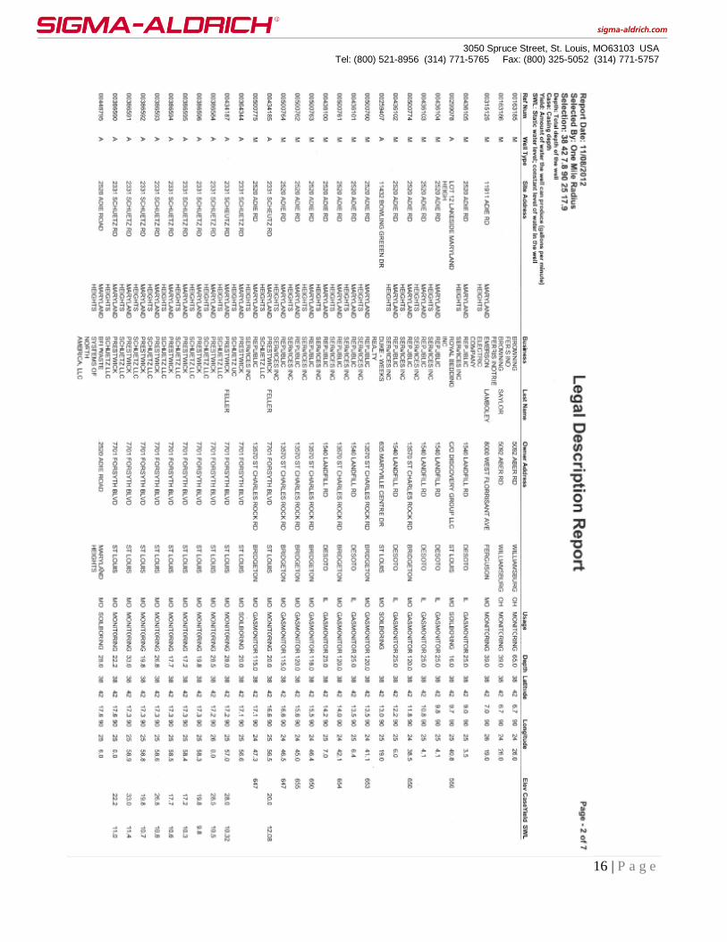
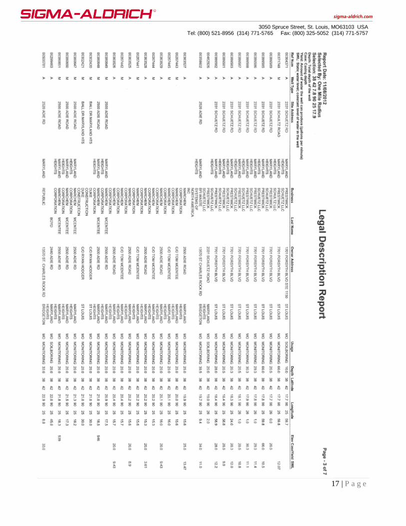
Exhibit 5
Well Permits and Use Within a One Mile Radius of the SAC Site

3050 Spruce Street, St. Louis, MO63103 USA
Tel: (800) 521-8956 (314) 771-5765 Fax: (800) 325-5052 (314) 771-5757
15 | P a g e
3050 Spruce Street, St. Louis, MO63103 USA
Tel: (800) 521-8956 (314) 771-5765 Fax: (800) 325-5052 (314) 771-5757
16 | P a g e
3050 Spruce Street, St. Louis, MO63103 USA
Tel: (800) 521-8956 (314) 771-5765 Fax: (800) 325-5052 (314) 771-5757
17 | P a g e
3050 Spruce Street, St. Louis, MO63103 USA
Tel: (800) 521-8956 (314) 771-5765 Fax: (800) 325-5052 (314) 771-5757
18 | P a g e

3050 Spruce Street, St. Louis, MO63103 USA
Tel: (800) 521-8956 (314) 771-5765 Fax: (800) 325-5052 (314) 771-5757
19 | P a g e

3050 Spruce Street, St. Louis, MO63103 USA
Tel: (800) 521-8956 (314) 771-5765 Fax: (800) 325-5052 (314) 771-5757
20 | P a g e

3050 Spruce Street, St. Louis, MO63103 USA
Tel: (800) 521-8956 (314) 771-5765 Fax: (800) 325-5052 (314) 771-5757
21 | P a g e