Embed Size (px)
DESCRIPTION
Shipboard, Remote Sensing, & Database Activities. Image from John Ryan. Kudela Lab. Shipboard Data: - Underway shipboard data (TSG, Fluor) - CTD data (with fluor, ancillary measurements) - Bottle chlorophyll and ancillary measurements - Nutrients (prior to August 2006) Remote Sensing: - PowerPoint PPT Presentation
Citation preview

Shipboard, Remote Sensing, & Database Activities
Shipboard, Remote Sensing, & Database Activities
Image from John Ryan

Kudela LabKudela LabShipboard Data:
- Underway shipboard data (TSG, Fluor)
- CTD data (with fluor, ancillary measurements)
- Bottle chlorophyll and ancillary measurements
- Nutrients (prior to August 2006)
Remote Sensing:
- NRT access to satellite data
- Interface with NOAA through Dave Foley and Rick Stumpf
- Process-oriented studies
Database:
- Took over in 2006
- Interface with Brian Fulfrost, Todd Anderson, Rondi Robison
Shipboard Data:
- Underway shipboard data (TSG, Fluor)
- CTD data (with fluor, ancillary measurements)
- Bottle chlorophyll and ancillary measurements
- Nutrients (prior to August 2006)
Remote Sensing:
- NRT access to satellite data
- Interface with NOAA through Dave Foley and Rick Stumpf
- Process-oriented studies
Database:
- Took over in 2006
- Interface with Brian Fulfrost, Todd Anderson, Rondi Robison

Shipboard DataShipboard Data
All CTD data through May 2006 consistently reprocessed– Manually inserted surface values, fluor from
upcast when necessary Underway data through July 2005 QA/QC’d All chlorophyll and nutrient data QA/QC’d
– GFF, 1 µm, 10 µm, Nitrate, Phosphate, Silicate Ancillary data in various stages of
processing

QuickTime™ and aTIFF (Uncompressed) decompressor
are needed to see this picture.

QuickTime™ and aTIFF (Uncompressed) decompressor
are needed to see this picture.

QuickTime™ and aTIFF (Uncompressed) decompressor
are needed to see this picture.
QuickTime™ and aTIFF (LZW) decompressor
are needed to see this picture.
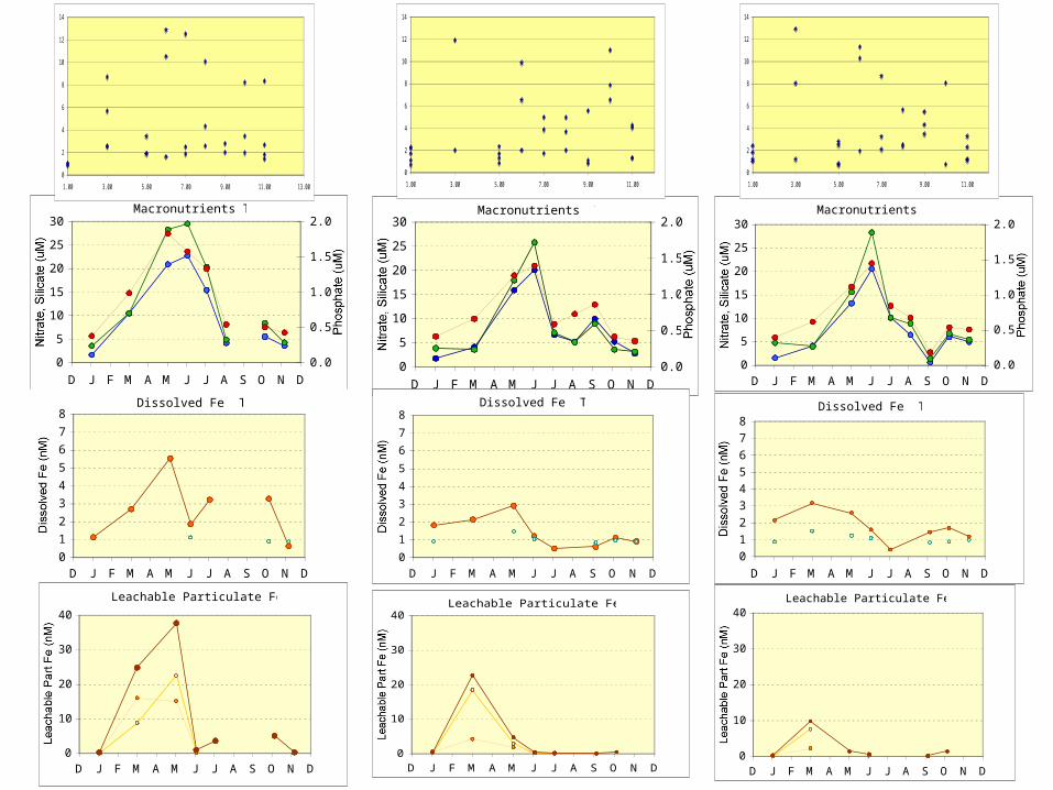
Macronutrients T100
0
5
10
15
20
25
30
D J F M A M J J A S O N D
Nitrate, Silicate (uM)
0.0
0.5
1.0
1.5
2.0
Phosphate (uM)
Dissolved Fe T100
0
1
2
3
4
5
6
7
8
D J F M A M J J A S O N D
Dissolved Fe (nM)
Leachable Particulate Fe T100
0
10
20
30
40
D J F M A M J J A S O N D
Leachable Part Fe (nM)
Macronutrients T401
0
5
10
15
20
25
30
D J F M A M J J A S O N D
Nitrate, Silicate (uM)
0.0
0.5
1.0
1.5
2.0
Phosphate (uM)
Dissolved Fe T401
0
1
2
3
4
5
6
7
8
D J F M A M J J A S O N D
Dissolved Fe (nM)
Leachable Particulate Fe T401
0
10
20
30
40
D J F M A M J J A S O N D
Leachable Part Fe (nM)
Macronutrients T601
0
5
10
15
20
25
30
D J F M A M J J A S O N D
Nitrate, Silicate (uM)
0.0
0.5
1.0
1.5
2.0
Phosphate (uM)
Dissolved Fe T601
0
1
2
3
4
5
6
7
8
D J F M A M J J A S O N D
Dissolved Fe (nM)
Leachable Particulate Fe T601
0
10
20
30
40
D J F M A M J J A S O N D
Leachable Part Fe (nM)
0
2
4
6
8
10
12
14
1.00 3.00 5.00 7.00 9.00 11.00 13.00
0
2
4
6
8
10
12
14
1.00 3.00 5.00 7.00 9.00 11.00
0
2
4
6
8
10
12
14
1.00 3.00 5.00 7.00 9.00 11.00

Remote SensingRemote Sensing
Near-Real Time data available @– http://oceandatacenter.ucsc.edu/NRT/– Also from CIMT webpage
Complete dataset from Rick Stumpf for SeaWiFS (1997-2005) available
Better cloud-masked data for CoastWatch SST available
Working on iterative EOF method to develop cloud-free imagery
Near-Real Time data available @– http://oceandatacenter.ucsc.edu/NRT/– Also from CIMT webpage
Complete dataset from Rick Stumpf for SeaWiFS (1997-2005) available
Better cloud-masked data for CoastWatch SST available
Working on iterative EOF method to develop cloud-free imagery

QuickTime™ and aTIFF (Uncompressed) decompressor
are needed to see this picture.
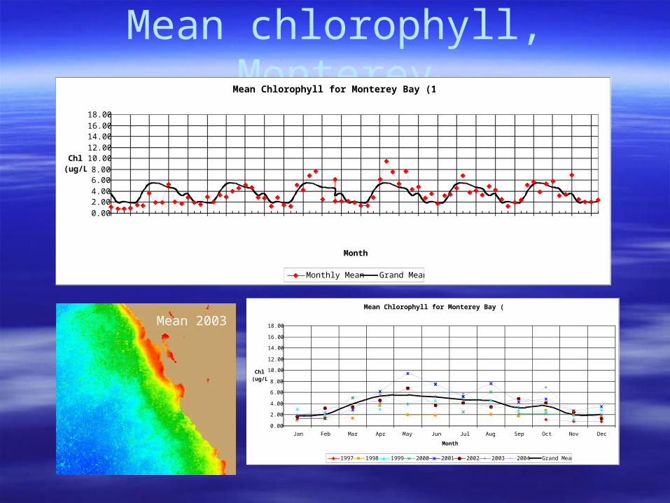
Mean chlorophyll, MontereyMean Chlorophyll for Monterey Bay (1997-2004)
0.00
2.004.00
6.008.00
10.0012.00
14.0016.00
18.00
Oct-97Jan-98Apr-98Jul-98Oct-98Jan-99Apr-99Jul-99Oct-99Jan-00Apr-00Jul-00Oct-00Jan-01Apr-01Jul-01Oct-01Jan-02Apr-02Jul-02Oct-02Jan-03Apr-03Jul-03Oct-03Jan-04
Month
Chl (ug/L)
Monthly Mean Grand Mean
Mean Chlorophyll for Monterey Bay (1997-2004)
0.00
2.00
4.00
6.00
8.00
10.00
12.00
14.00
16.00
18.00
Jan Feb Mar Apr May Jun Jul Aug Sep Oct Nov Dec
Month
Chl (ug/L)
1997 1998 1999 2000 2001 2002 2003 2004 Grand Mean
Mean 2003

Mean Chlorophyll for Monterey Bay Shallow Region (1997-2004)
0.002.004.006.008.00
10.0012.0014.0016.0018.00
Oct-97Jan-98Apr-98Jul-98Oct-98Jan-99Apr-99Jul-99Oct-99Jan-00Apr-00Jul-00Oct-00Jan-01Apr-01Jul-01Oct-01Jan-02Apr-02Jul-02Oct-02Jan-03Apr-03Jul-03Oct-03Jan-04
Month
Chl (ug/L)
Monthly Mean Grand Mean
Mean Chlorophyll for Monterey Bay Deep Region (1997-2004)
0.002.004.006.008.00
10.0012.0014.0016.0018.00
Oct-97Jan-98Apr-98Jul-98Oct-98Jan-99Apr-99Jul-99Oct-99Jan-00Apr-00Jul-00Oct-00Jan-01Apr-01Jul-01Oct-01Jan-02Apr-02Jul-02Oct-02Jan-03Apr-03Jul-03Oct-03Jan-04
Month
Chl (ug/L)
Monthly Mean Grand Mean
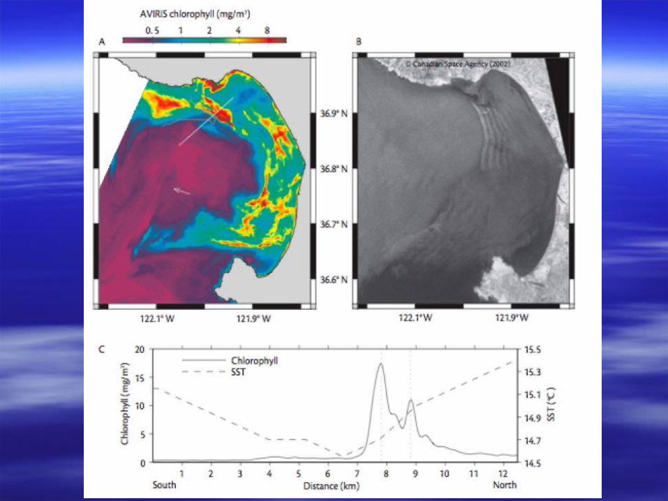
Coastal
Offshore
Chlorophyll, Monterey, coastal & offshore

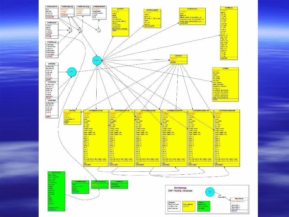
CIMT Database ActivitiesCIMT Database Activities
Took over as lead in 2005/2006 Progress:
– Mapped existing MySQL database– Moved to new hardware, with backup– Todd Anderson has been keeping the LAS up– Collecting data from data providers for update
To Do:– Hire database support person– Probably move to PostGres for better mapserver support– Working with Brian Fulfrost and Rondi on data output

Moving from Science to End-UsersMoving from Science to End-Users Established collaboration with CCLEAN
– Added urea, ammonium measurements for 2006– Mapping satellite data to river flow
Outreach to Dave Jessup @ OSPRS– Providing customized satellite imagery– Working with them on non-point source pollution issues
Working with CDHS, provided backround and imagery to Animal Planet, Sea Studios
NOAA is interested in testing improved GNOME model for event tracking
Established collaboration with CCLEAN– Added urea, ammonium measurements for 2006– Mapping satellite data to river flow
Outreach to Dave Jessup @ OSPRS– Providing customized satellite imagery– Working with them on non-point source pollution issues
Working with CDHS, provided backround and imagery to Animal Planet, Sea Studios
NOAA is interested in testing improved GNOME model for event tracking


![[REMOTE SENSING] 3-PM Remote Sensing](https://img.dokumen.tips/doc/110x75/61f2bbb282fa78206228d9e2/remote-sensing-3-pm-remote-sensing.jpg)


