Embed Size (px)
Citation preview

Shifting Cultivation in Vietnam: its social, economic and environmental values
relative to alternative land use
Dr. Do Dinh Sam Land Use Working Group
Ministry of Forestry 123 Lo Duc Street - Hanoi - Vietnam
Fax. +84 42 12661
and
Forest Science Institute of Vietnam Chem Tu Liem Hanoi Vietnam
Fax. +84 43 45722
Hanoi, 1994
This national report forms part of the study "Shifting cultivation in Thailand, Laos and Vietnam: its social, economic and environmental values relative to alternative land use". The study was financed by the Netherlands Ministry of Foreign Affairs and coordinated by the International Institute for Environment and Development.
Copies of this report may be obtained from the Forest Science Institute of Vietnam (where the report is also available in Vietnamese) or from the International Institute for Environment and Development (IIED). Copies of companion reports for Thailand and Laos, and the regional Overview Report, may be obtained from IIED.
International Institute for Environment and Development
3 Endsleigh Street London WCIHDD UK
CONTENTS
Tel. +44 713882117 Fax. +44 713882826 e-mail: iiedforestry@gn .apc.org
SECTION I: DESCRIPTION OF SITUATION AND PROBLEM 1
Chapter 1: Background 3
1.1 General features of forests and forest land in Vietnam 3
1.2 Ethnic minorities in Vietnam and shifting agriculture 7
1.3 Land tenure systems 9
1.3.1 Ownership of shifting cultivation areas 9
1.3.2 Land allocation 10
1.3.3 Tenure of forest land 11
1.4 The present situation of shifting agriculture 11
1.5 Land use changes in shifting agriculture areas 14
1.5.1 Total abandonment of shifting agriculture 14
1.5.2 Step by step replacement of shifting agriculture 15
1.5.3 Replacement of rotational by pioneer shifting agriculture 15
Chapter 2: Forces causing land use changes 16
Page 1 of 36
2.1 Population dynamics 16
2.2 National and local economic change 16
2.3 Government incentives for land use changes 16
2.4 Change in market structure 17
2.5 Changes in tenure arrangements 17
2.6 Changes in shifting agriculture practices 18
Chapter 3: Policy processes and changing emphases 19
3.1 Current national policy priorities 19
3.2 Current policy processes 19
Chapter 4: Problems and opportunities posed by shifting agricult ure in sustainable development 22
4.1 Shifting agriculture as seen by the policy makers and policy implementors 22
SECTION II: RESEARCH QUESTIONS AND METHODS 23
Chapter 5: Formulation of research questions 25
Chapter 6: Description of field research 26
6.1 Criteria for choosing research sites 26
6.2 Study organisation and techniques used in the field research 26
6.3 Problems and constraints faced in the work 27
SECTION III: RESULTS AND CONCLUSIONS 29
Chapter 7: Analysis of results 31
7.1 Field research results 31
7.2 Identification of the significant criteria of sustainability in land use 31
7.2.1 Economic sustainability indices 32
7.2.2 Environment sustainability indices 32
7.2.3 Social sustainability indices 32
7.3 Results related to sustainability criteria 33
7.3.1 Sustainability of shifting agriculture 33
7.3.1.1 Economic sustainability 33
7.3.1.2 Environment sustainability 35
7.3.1.3 Social sustainability 40
7.3.2 Sustainability of various land use alternatives 41
7.3.3 Policy initiatives 43
7.4 Description of successes and failures (in sustainability terms) of different policies 44
7.4.1 Successes of policy 44
7.4.2 Failures of policy 45
Page 2 of 36

ANNEXES
I Description of a number of localities studied
II Main ethnic groups practicing shifting cultivation
III Distribution of forest land
TABLES
FIGURES
47
7.5.1 The significant criteria of sustainability 47
7.5.2 Learning about sustainability of shifting agriculture 48
7.5.3 A question arises - where, and in what way, should shifting agriculture be replaced? 48
Chapter 8: Recommendation 50
8.1 Summary guidelines on sustainability of shifting agriculture and its alternatives 50
8.1.1 Shifting agriculture 50
8.1.2 Land use alternatives 50
8.1.3 Policy, market and other conditions required for sustainability 51
8.1.4 Identification of main "actors" 51
Chapter 9: Summary for policy makers 52
Chapter 10: Proposal for follow up activities 53
MAIN REFERENCES 55
1 Forest cover over time 3
2 Organisations and ministries related to land use in mountainous regions 21
3 Sources of income per capita in Taker hamlet (Gia Lai province) in 1992 33
4 Labour input by activity, per hectare, Taker hamlet 34
5 Relationship between shifting cultivation expansion and forest cover in the northwest during 1965-1985
36
6 Data on shifting cultivation in a number of districts in the upstream areas of the Da River (1990) 36
7 Changes in soil fertility under shifting cultivation 39
1 Present status of forest cover in Vietnam (1990) 4
2 The system of protection forests in Vietnam 5
3 The system of special use forests in Vietnam 6
4 Shifting cultivation in Vietnam mainland 8
5 Evaluation of sustainability in land use 39
Page 3 of 36

PREFACE
Shifting agriculture comprises many long-standing systems of cultivation, practised by the majority of ethnic minority people in the hilly and mountainous regions of Vietnam. of the 54 ethnic groups in Vietnam, up to 50 practise shifting agriculture: these amount to about 3 million people distributed throughout the hilly and mountainous regions from north to south of the country. The government campaign for fixed cultivation and sedentarization was started in 1968 and considerable achievements have been made. However, these still fall far below their targets, and shifting agriculture still exists in many areas.
To find out the current dynamics of shifting agriculture, a combined research project was carried out between three countries: Vietnam, Laos and Thailand. The project is entitled: "Shifting cultivation in Thailand, Laos and Vietnam: its social, economic and environmental values relative to alternative land uses". The project is funded by the Netherlands Ministry of Foreign Affairs, through the Forestry and Land Use Programme of the International Institute for Environment and Development (IIED) in London. IIED coordinated the project, guiding the preparation of workplans, providing guidelines for reports, and providing reference literature as well as organizing seminars and meetings in Thailand, Laos and Vietnam for the three national research teams to discuss the progress of the project.
Each country selected the topics to be studied in keeping with the characteristics and situation of shifting agriculture in that country. The Vietnamese team consisted of 4 members of the Land Use Working Group:
1. Associate Professor Dr. Do Dinh Sam, Forest Science Institute of Vietnam (FSIV): Team leader and main author.
2. Dr. Hoang Xuan Ty, Forest Science Institute of Vietnam.
3. Associate Professor Dr. Nguyen Tu Siem, Soil and Fertilizer Institute, Ministry of Agriculture.
4. Dr. Nguyen Quoc Hung, Economics Institute, National Centre for Social Sciences and Human Affairs.
The team carried out field studies and at the same time cooperated with a number of other research institutes and projects in the country (The Forest Science Institute of Vietnam, Forest Protection Centre No.2, Ministry of Forestry) to carry out research on agreed subjects.
We would like to express our thanks to the Netherlands Ministry of Foreign Affairs who provided funds for the research to the Forestry Land Use Programme of IIED - the organisation that guided and organised the combined research between the three countries; to people of the sites selected for research, who rendered help to our field studies; and to the Forest Science Institute of Vietnam and the Land Use Working Group for their direct and effective assistance to the implementation of this project.
This report, prepared by Associate Professor Dr. Do Dinh Sam with the participation of the team members, is the outcome of over one year’s implementation of the research project.
Due to the limitations of such broad-ranging research, the matters dealt with in the report are sure to contain errors. All these need further discussion, exchange of ideas and amendments. We sincerely hope to receive opinions from administrators and researchers who are interested in this issue.
Associate Professor Dr. Do Dinh Sam
Hanoi, May 1994
SECTION I: DESCRIPTION OF SITUATION AND PROBLEM
CHAPTER 1: BACKGROUND
1.1 General features of forests and forest land in Vietnam
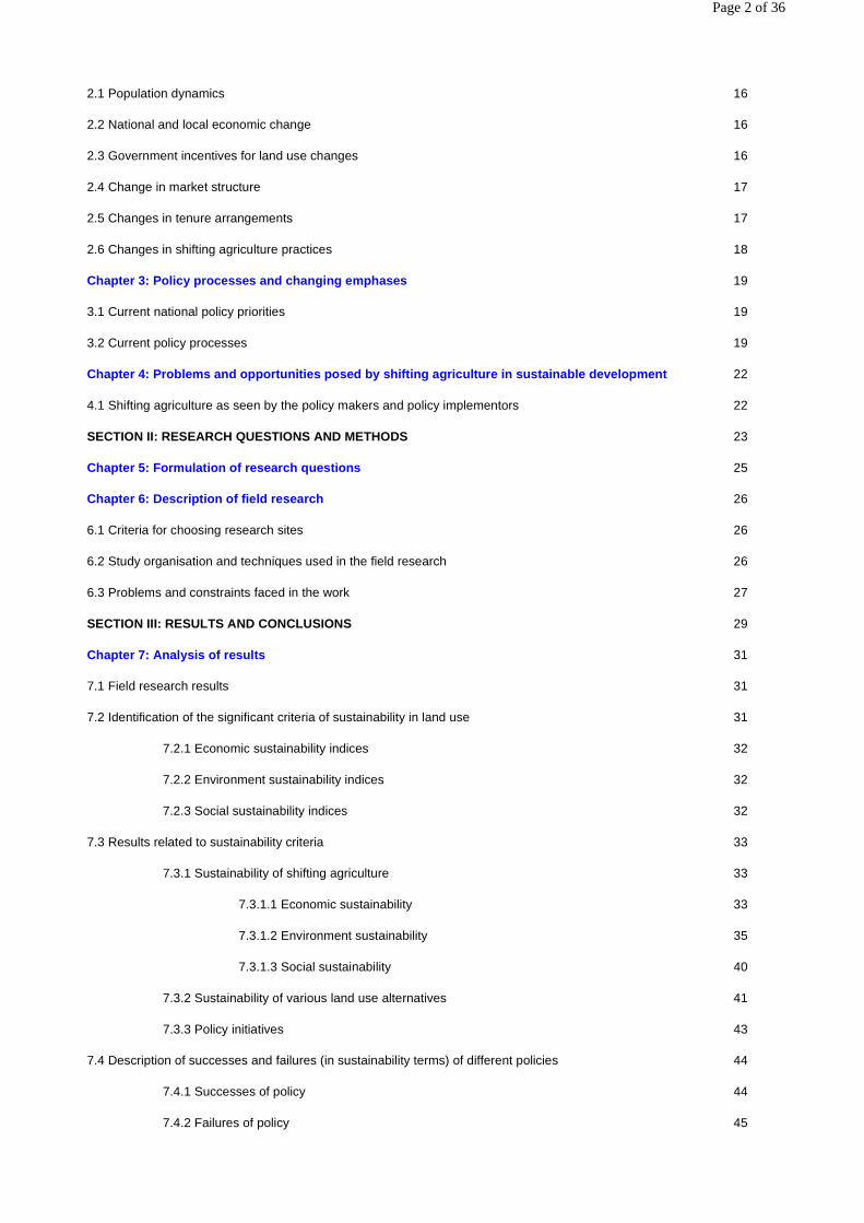
The area of Vietnam is over 33 million hectares (ha). According to 1993 inventory data, 8.6 million ha. are under natural forests, 0.55 million ha. are concentrated forest plantations, and 11.4 million ha. are classified as forest land but without forest cover. Forest cover in the country as a whole is 28%. Such cover is generally considered too small for ecological security. The decrease of the forest cover over time is therefore worth close attention.
Page 4 of 36
Table 1: Forest cover over time
* This figure may be low compared with later figures as vegetation with density less than 0.3 was not considered forest.
The decrease in forest cover varies according to region. The forest cover is 13.3% in the northwest, and 15.4 % in the northeast. In the Central Highlands it remains relatively high, at 61%. In other regions it is 20-30. The present extent of forest cover is given in Figure 1.
Nine forest economic regions have been defined, based on physical conditions and the characteristics of forest distribution. Forest land consists of all the land areas under forest cover (natural forests or forest plantations) and forest land devoid of forest (usually land under bush vegetation, sparse trees, grasses or bare land). Forest vegetation in Vietnam is divided into three categories based on the function of the forest:
� production forests, also called economic forests (including commercial forests) whose main function is to yield produce. The area of this forest category now is 5.8 million hectares;
� protection forests, comprising upstream watershed forests, windbreaks, wavebreaks, and forests used to stabilise shifting sand. Their area is now about 2.8 million hectares (Figure 2);
� special use forests, including national parks, nature reserves, historic forests, forests serving tourism, etc. Their area is now about 700,000 ha. (Figure 3).
Figure 1: Present status of forest cover in Vietnam (1990)
Year Forest area (ha) Forest cover (% of land)
1943 13,500,000 40.7
1975 9,500,000 28.6
1983 7,812,000 23.6*
1993 9,100,000 27.7
Page 5 of 36

Figure 2: The system of protection forests in Vietnam
Page 6 of 36
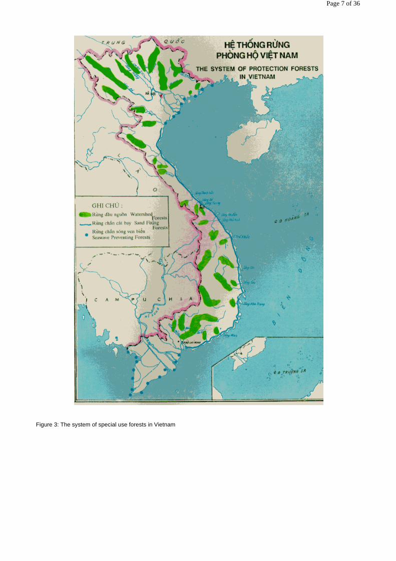
Figure 3: The system of special use forests in Vietnam
Page 7 of 36
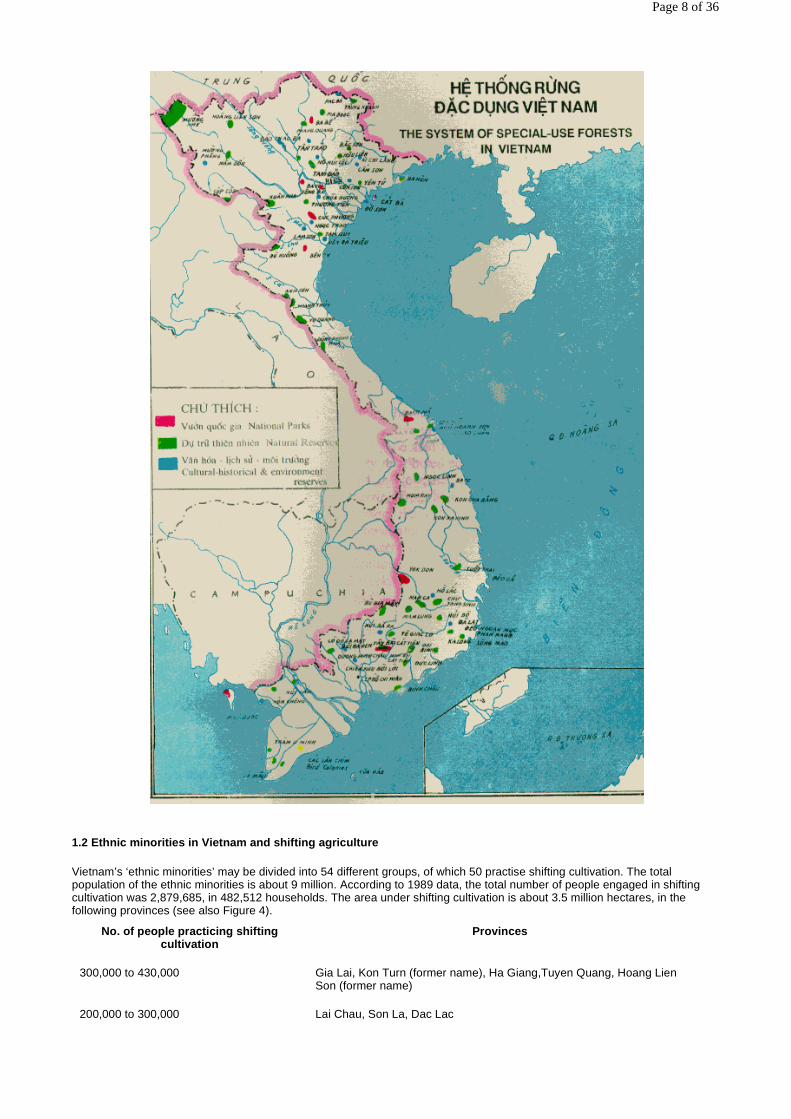
1.2 Ethnic minorities in Vietnam and shifting agriculture
Vietnam’s ‘ethnic minorities’ may be divided into 54 different groups, of which 50 practise shifting cultivation. The total population of the ethnic minorities is about 9 million. According to 1989 data, the total number of people engaged in shifting cultivation was 2,879,685, in 482,512 households. The area under shifting cultivation is about 3.5 million hectares, in the following provinces (see also Figure 4).
No. of people practicing shifting cultivation
Provinces
300,000 to 430,000 Gia Lai, Kon Turn (former name), Ha Giang,Tuyen Quang, Hoang Lien Son (former name)
200,000 to 300,000 Lai Chau, Son La, Dac Lac
Page 8 of 36

The percentages of people in each ethnic group practicing shifting cultivation are 7% (Tay), 16% (Nung), 45% (Thai) and 100% (almost all the remaining ethnic groups). Few Kinh1 people are thought to practise shifting agriculture.
In Vietnam the ethnic groups which practise shifting cultivation are usually distributed in aptitudinal belts. Here, we describe the groups according to altitude in different regions:
� In North Vietnam the H’Mong group, the largest number of people in the whole country practicing shifting cultivation, live in the highest aptitudinal belt (800-1700 m), in which many areas have soils generated from limestone. The Dao group lives in the lower belt and is widely distributed across many provinces in all three aptitudinal belts: highland, midland and lowland, and is transitional from the midland to the delta region. In moving from high mountains to lower areas, the Dao group became familiar with water rice cultivation. The Thai, Tay, Nung, and Muong ethnic groups live in the lower altitudes. Thus being able to communicate with the Kinh people and being adjacent to the delta, they practise a range of activities apart from shifting agriculture: water rice cultivation, handicrafts, weaving, cotton spinning, metal working, planting of industrial crops (mulberry, cotton) and development of the garden economy.
In north Vietnam, the area under natural forest cover in the areas where the ethnic groups practise shifting cultivation is drastically decreased compared to that in the past: in the northwest (where many H’Mong people live) only 9-13% of the land area is under natural forest cover and forest plantation; in the northeast, 15%; and in the central area, 20.6% (1993 figures).
1The Kinh ethnic group forms the majority (about 87%) of the population of Vietnam. Such people traditionally inhabit the lowlands. Kinh people are not included in the collective term ‘ethnic minorities’ (which include 54 specific ‘ethnic groups’) used in this report.
Figure 4: Shifting cultivation in Vietnam mainland (compiled by Nguyen Tu Siem, 1991)
100,000 to 200,000 Cao Bang, Thanh Hoa, Nghe Tinh, Lam Dong
Page 9 of 36

� In central Vietnam, including the coastal regions of north central Vietnam and the coastal region of south central Vietnam, the Dao, Vankieu, Xodang, H’re, Co, and Khomu ethnic groups live mainly in the moderately high belt (400-500 m) and in the low belt (200-300 m). A number of ethnic groups, such as Xodang and Co, also live at high altitudes (600-900 m). A greater proportion of land is under natural forest cover in central Vietnam: in the coastal regions of north central Vietnam it is 27.8%, and in the coastal region of south central Vietnam, 34%.
� In south Vietnam, shifting cultivation is practised mainly in the Central Highlands. The ethnic groups that practise shifting cultivation to a significant degree are Giarai, Ede and Bana, ranking lower than only the H’Mong, Dao, and Thai in the north, and followed by the Gie Trieng group. What is worth attention here is that the ratio of the area under natural forest cover remains the highest in the whole country at 61%. Topographical conditions are not harsh, typified by semi-plain-stratified highlands and mountains. The land is still relatively fertile with highly fertile basalt soil widely distributed throughout the Central Highlands. The ethnic groups in the Central Highlands are still unfamiliar with water rice cultivation; nor are they accustomed to using dung as manure.
Formerly most of the ethnic minority people lived in a self-sufficient economy. Very little commodity exchange took place except with the ethnic groups that lived in the low altitudes, such as the Tay, Nung, Muong, etc. Apart from shifting cultivation, the people’s life was also closely associated with forests through collecting minor forest products and fuelwood, hunting, fishing, and engaging in a number of handicrafts.
1.3 Land tenure systems
1.3.1 Ownership of shifting cultivation areas
A traditional perception amongst the ethnic minority people is that the immense forests and mountains around them are their own, and that they are free to use them indefinitely. In particular, they respect the land ownership of the community and
Page 10 of 36

individuals: an important convention in the ethnic communities is that there is no encroachment upon one another’s shifting cultivation areas. For example:
� after choosing a suitable area for slash-and-burn cultivation, the Nung people clear a boundary line, and insert a post with a bamboo stick into the ground to signify the ownership: this is recognised by others;
� in Bac Thai province 7-8 years ago, the Dao people moved downslope to replace the Tay people who, already familiar with water rice cultivation, moved to lower areas. So far, almost all the Tay people who then returned to reclaim their former water rice fields, had their land returned to them by the Dao people, even though the Dao had settled there and the Tay had settled elsewhere;
� in the Central Highlands the Bana, Ede, Giarai, and Chill (Mo nong group) live in hamlets with specific regulations on land. The area for slash-and-burn cultivation is also allocated according to definite principles. The allocation is decided by an old man or a council of old men of the hamlet (in the Mo nong group). There is the freedom to choose a piece of land in the area set aside for slash-and-burn cultivation. Formerly no one had a right to sell or transfer the ownership of land (in the Bana, Ede and Giarai groups).
Almost all the ethnic groups who practise shifting agriculture leave some forest areas intact, which serves to protect the environment and water sources for the community. The determination or selection of a place for slash-and-burn cultivation is traditionally based on definite criteria, for example:
� the forest should still be in good condition but it should not contain too many big trees which are difficult to cut down; � many ethnic groups select the area for slash-and-burn cultivation through the soil colour (the predominance of black
colour indicates good soil), abundance of organic matter, or porosity (a pointed knife is thrown lightly into the soil: if it goes deep into the soil, this shows that the soil is good because it is porous). Loam or clay soils are identified if earth sticks to the knife when it is withdrawn from the soil.
Such selection of land was made in the earlier times when much of the forest remained and the population pressure was not high. But generally speaking in the ethnic minority areas, there is free choice within communities and hamlets in selecting the area for slash-and-burn cultivation, but everyone respects others’ right to land use.
At present, however, due to the introduction of the market economy, the shifting cultivation areas are, in many cases, cleared and sold to be used by the people (including Kinh people). This happens mainly in the Central Highlands, where there is a large area of fertile basalt soil. In some areas the ethnic groups transfer the right to use the land under fallow to the Kinh people (this is considered as sale of the land), whilst the ethnic groups continue to clear forests for slash-and-burn cultivation - and for further transfer following cultivation.
1.3.2 Land allocation
From 1959 in the North and from 1976 in the South, the movement for forming cooperatives was strong. Cultivated land belonged to the cooperatives, and forest land was under the management of State forest enterprises.
Since 1988 land has been allocated to users for long term use. The revised Land Law which was approved by the National Assembly in 1993, clearly stated that land is owned by the whole people under the integrated management of the State. The State allocates land to the users for long term and stable use. The State also rents the land. Each household is allocated not more than 2 or 3 ha. of agricultural land for long term cultivation of annual crops. The area of bare land and denuded hills allocated for forest production is subject to the government’s regulations. The land allocated for annual crops is for a maximum of 20 years, and for perennial trees it is 1 or 2 rotations. At the end of this period, if the land user has a demand and meets the required conditions, he has the right to continue using the land. The land user may transfer the right to land use, or pass on the right to his inheritors as regulated by law.
1.3.3 Tenure of forest land
Concerning forest land, the Ministry of Forestry has instituted a system of land allocation. It also assigns the task of protecting natural forests and forest plantations to households, for payment: this is also a means of providing employment to the people.
� Natural forests are allocated mainly to state organizations (state forest enterprises). Scattered natural forests or forest plantations (except those with 100% investment from the State) can be allocated to households, communes or hamlets for management. The State invests on average 50,000 along (US$5) per hectare per year, which is equivalent to 20kg rice, for the protection of the existing natural or concentrated manmade forests. The forest managers allocate this budget to the households (or communes or hamlets), each household receiving up to 20 ha. of forest for protection. Households benefit from the payments they receive in return for forest protection, and may also benefit from practicing agroforestry.
� Bare land involved in the afforestation plan is allocated to peasant households and forest workers’ families on a long term and stable basis for forest planting or for agroforestry (for two rotations ie. 50 years).
� As regards protective forests that are planted using households’ or economic organizations’ own funds, these must comply only with the tax policy and people have the right to enjoy the produce from the land allocated. Concerning protective and special use forests, the people who do the planting are entitled to use the thinning products, dry firewood, and agroforestry produce. Once the canopy of protective forests is closed, the households have the right to be allocated the forests for protection.
Thus the Land Law, as well as the law on forest protection and development, has no regulations on the use of forested land for shifting cultivation or on implementing the forest shifting cultivation cycle, i.e. shifting cultivation is not considered to be a forest management practice.
Page 11 of 36
1.4 The present situation of shifting cultivation
In Vietnam there are two main types of shifting cultivation:
� Pioneer shifting cultivation: full use is made of soil fertility and then the land is abandoned without intended further use by the same cultivators. This type is mainly practised by the H’Mong people living in high mountains. For example the H’Mong people in Talacao, Tua Chua district (Lai Chau province) have moved an entire hamlet from 70 km away to its present location. To practise pioneer shifting cultivation, the people usually have to travel a great distance (about 70-80 km), even to another province, to wherever accessible forests are available.
� Rotational shifting cultivation: most of remaining ethnic groups practise this type. The fallowing period is usually 10-15 years depending on the conditions.
In a number of remote, highland localities, found in all mountainous provinces, transport and communications are difficult, and the people still practise shifting cultivation. They lead a poor life and are in want of almost everything.
In addition, supplementary shifting cultivation is usually found on steep slopes surrounding permanently cultivated valleys. The people are short of water-rice fields and must sometimes resort to slash-and-burn plots (mainly Thai and Muong ethnic groups). Due to lack of experience in shifting cultivation and little attention being paid to soil erosion control, this cultivation system is usually unstable. Moreover, soil erosion causes sedimentation in the rice fields lower down the slope, causing difficulties for water-rice cultivation.
However, in the last five to seven years, due to high population pressure, forest planting and forest rehabilitation planning, land available for shifting cultivation has become limited in some places and people have moved to new areas. Here, there has been an increasing trend towards pioneer shifting cultivation:
� the people tried to practise shifting cultivation far from home without the intention of returning to the old site; � in some places the people transferred the (existing, rotational) land under fallow to the Kinh people (for money) and
then continued clearing forests for shifting cultivation; � the fallow period had to be shortened and the soil fertility was more exhaustively exploited, a characteristic of pioneer
shifting cultivation; � people moved to new settlement areas or to the south to continue clearing forest for shifting cultivation.
The moving of the population to the south (including spontaneous migration) has led to forest clearing for shifting agriculture. For example the Dao people from Bac Thai and Quang Ninh, and the Tay people from Lang Son moved to Gia Lai and Dac Lac. A nearly 20 km stretch of land at the side of a provincial road which, one year ago, was covered by luxuriant Lagerstroemia cochinchinensis forests has now turned into an area of shifting cultivation. In four months in early 1993, 175 ha. of luxuriant forests in Krong No district (Dac Lac province) were cut and burned for shifting cultivation.
Thus generally speaking the area under shifting cultivation still tends to increase -particularly that under the destructive pioneer cultivation - and the role of shifting cultivation is changing. The negative aspects of shifting cultivation are expressing themselves more clearly as the rotational cycle is not ensured.
Shifting agriculture remains in much of Vietnam due to many reasons, especially:
� first of all in many places the urgent need of the people is still food for subsistence: food security remains a problem in many mountainous regions;
� shifting agriculture is a traditional cultivation practice long associated with the people and in some aspects it is also linked with the cultural and spiritual life of the people (eg. to hold ceremonies at the beginning of cropping season and crop harvesting as mental activities of the community);
� the general psychology of the people is that they only feel at ease when they see in their houses the rice harvested from slash-and-bum plots (especially in the uplands) ;
� people in the mountainous regions are not yet familiar with water-rice cultivation which requires much fertilizers and intensive management if good results are to be expected. Bad luck is also frequently encountered. Moreover Iabour invested in shifting cultivation brings a harvest in a short time. The yield per one labour day is twice or thrice that in water-rice cultivation in the Red River or Mekong River delta regions;
� many localities do not have conditions to develop water rice cultivation. The changing in the structure of planted crops takes some time to yield its harvest;
� lack of funds for implementation of fixed cultivation and sedentarization.
For these reasons, generally speaking 70% of the (former) shifting cultivators still practise shifting agriculture to various degrees. Basically their economy still depends on shifting agriculture.
In many localities however, apart from shifting cultivation, the people already pay attention to diversifying the products in the household economy: water rice cultivation, planting a number of industrial crops, eg. tea, high value fruit trees, eg. apricot, garden economy development, increasing income from special forest products, promoting livestock keeping, fish rearing, etc. But most of these activities are still infrequent.
In a number of localities the ethnic groups have adopted fixed cultivation and sedentarization, and no longer practise shifting cultivation. They take part in forest production activities (planting forests for the supply of raw materials and special products on the basis of payment for each piece of work done), join the forestry-agriculture-industry unions by receiving land and forest for production, or promote water-rice cultivation, planting of industrial crops, and fruit trees. Ethnic groups who have adopted such fixed cultivation include the Dao people in a number of localities in Bac Thai, Quang Ninh, Yen Bai provinces, the Giarai
Page 12 of 36

people in Gia Lai, and the Bana and Ede people in Dac Lac.
The planting of cinnamon (Cinnamomum cassia) by Dao and other ethnic groups in agroforestry models is highly effective economically. The Dao people can have cinnamon mixed planted under the forest canopy (2,000 - 3 ,000 trees/ha) and after 20-25 years cinnamon can attain a tree height of 20 m and stem diameter of 30-35 cm. Alternatively, it can be densely planted at the beginning (7,000-10,000 trees/ha) and mixed with dry rice and cassava. The latter provides shade for young cinnamon in the first few years. A 30-35 year old tree yields about 30-40 kg of bark: a ton of bark earns US$ 2,000. If mixed with dry rice and cassava, the rice yields 1.5-2 tons/ha/crop, cassava 8 tons/ha/crop. Water rice yields 5 tons/ha. In south Vietnam many ethnic minority households plant coffee. Households in the Central Highlands commonly obtain a coffee yield of 2.5 tons/year. Development of water rice cultivation obtains quite good productivity, contributing to the food supply of the people. The productivity can be 3 tons/ha, up to three times that of dry rice; 6-7 tons/ha is obtained in some places.
In many localities fixed cultivation and sedentarization have already been adopted - but shifting agriculture is practised alongside these settled systems. There may be several reasons: frequently, the infrastructure does not ensure the development of water rice cultivation, transportation is not convenient for food exchange, and there is no stable market for the products of permanent agriculture. In many cases, the fixed cultivation and sedentarization was not done on the basis of the people’s free will and it was not suited to the local traditional practice. Many such people return to shifting agriculture as in the past: others carry out both fixed cultivation and shifting cultivation within the area and outside the area, far from the living quarters.
1.5 Land use changes in shifting agriculture areas
1.5.1 Total abandonment of shifting agriculture
Shifting agriculture is abandoned when the life of the people is relatively stable, with active assistance from the State, and where there are many practical alternatives for land use. Commonly these include:
� water-rice development � development of industrial crops (eg. coffee, tea) � crops for special products (eg. Pinus merkusii. Aleurites montana, Cinnamomum cassia) � fruit trees (eg. apricot, prune) � forest rehabilitation (forest planting, forest enclosure for natural succession) � forest protection � practicing agroforestry at early stages of forest plantations.
Forms of implementation are numerous:
� the people receive land for forest planting, and forest for protection, from State Forest Enterprises, village authority, or unions of enterprises.
� the people undertake various activities as workers of the forest-agriculture-industry unions; � in some places contracts are signed between the people and the State organizations.
1.5.2 Step by step replacement of shifting agriculture
Stepwise replacement of shifting agriculture occurs where the conditions are not immediately favorable for the land use alternatives mentioned above (water-rice cultivation is limited, topographical conditions are unfavorable for communication and transport, or the land area is dissected). The alternatives here are mainly forest planting, forest protection, forest enclosure for natural succession, and fruit tree development. Shifting agriculture still remains predominantly of the pioneer type.
1.5.3 Replacement of rotational by pioneer shifting agriculture
In some cases rotational shifting agriculture has been replaced by pioneer shifting agriculture. Here shifting agriculture still plays a leading role in economic activities of the people, both in the short term for food and in the sale of land. This is potentially a very damaging trend, depending upon the forest type cleared and the subsequent land use.
There have also been changes in the distribution of shifting cultivation areas. Generally the forest areas are protected and gradually increase in area. However, forests might be lost in other places as pioneer shifting cultivation can hardly be controlled.
Cropping systems now undergo changes in the direction of discontinuing monocropping, diversifying the products, bringing into full play the comparative advantages of each locality, and not relying solely on food crops.
The economy of localities: in a number of shifting agriculture areas, the local economy has developed preliminarily into a commodity economy, but the majority of the local economies are still subsistence with food crops playing a leading role.
CHAPTER 2: FORCES CAUSING LAND USE CHANGES
2.1 Population dynamics
Page 13 of 36

In the mountainous areas the population growth is high (2.5-3.5%). Each family has on average five to seven children; some families even have eight or nine children. Thus food security in the mountainous regions is a great problem. Due to population pressure there is insufficient land to practise rotational shifting cultivation, and the fallow period is gradually shortened resulting in low productivity and soil degradation, although the land area per capita in the mountainous regions is still high.
Much of this population growth is due to the moving of the population from the lowlands to the mountainous areas and to the Central Highlands: in 30 years, up to 5 million people have undergone resettlement, including 2.3 million from 1981 to 1990. The growth of the population in the mountainous areas is due to land pressures in the lowlands as well as the establishment of state forest enterprises and state agricultural enterprises in the mountainous areas. In the uplands, there has also been the migration of ethnic minority people to lower altitudes or to the Central Highlands where much natural forest remains.
2.2 National and local economic change
There has been great change in the national economy in recent years. Inflation has been pushed back (from 67% in 1991 to just 5.2% in 1993), and GDP increased by an average of 7.2% per year. In particular, agricultural production has developed on all sides: food production in 1993 attained around 25 million tons, surpassing the target set for 1995; industrial production increased by an average of 13% per year; and a multi-sectored economic structure has started to take shape.
The local economies have also undergone great changes in the framework of the general changes of the country. But in the mountainous regions where the ethnic minorities live, life still meets with many difficulties and daily needs are in short supply. Part of the population still suffers from hunger and poverty, and illiteracy is increasing. This require a basic change in land use, bringing into full play the potential of land and natural resources.
2.3 Government incentives for land use change
With respect to shifting cultivation and home moving, the government has implemented a large programme of fixed cultivation and sedentarization since 1968, with many concrete policies and measures. These include infrastructure development, water rice fields, forest rehabilitation, planting of fruit trees, raising special product crops, developing livestock breeding, subsidies or even providing a free supply of rice for food, providing loans, etc. The government’s current desire has been to totally end forest clearing and burning for shifting cultivation within the next few years. The responsibility for fixed cultivation and sedentarization is now assigned to the Central Ethnic Minorities Committee directly under the Council of Ministers. The Ministry of Forestry plays an important role in land allocation, handing pieces of work on forests and forest planting to the people in the mountainous areas, in combination with fixed cultivation and sedentarization.
2.4 Change in market structure
With the development of the private sector, people in mountainous regions have opportunities to develop industrial forest plantations, special product crops, fruit trees, livestock breeding etc. for commodity production, but markets are as yet unsure, and state assistance is considered necessary.
As food production in the country as a whole is stable, such people also have opportunities to use income from other sources to buy food. However, due to the harsh topography, and difficulties in transport and communications which hamper exchange of commodities, such people still continue practicing shifting agriculture.
Due to the approaching free market, and higher requirements in living standards, the increased cultivation of cash crops is considered by the Government to be urgent.
In the mountainous regions, apart from participating in forest planting and forest rehabilitation, the general trend of the ethnic minority people is to develop fruit trees, depending on the land and climatic characteristics of each region. This can be considered an important link in the development of a commodity economy in the mountainous regions. The market will be a big problem. For example, the following calculations were made by a pre-feasibility study of a cooperation project with Germany (1993) for the development of plum plantations in Bacha, Lao Cai province where a well-known plum grows. Based on harvests in the 1970s, it is expected that in 1995, 20,000 tons of plum will be harvested in 45 days. It is estimated that the Hanoi market can receive 3,000 tons, and Ho Chi Minh city also about 3,000 tons. If there is a processing enterprise that can consume 50-60 % of the plum produced then the price will be stable. A big processing enterprise is, however, disadvantageous because the enterprise can concentrate its operation in only 2 months. Thus small processing units must be established so that the people can participate in the processing, avoiding waste. The establishment of the processing units will be accompanied with fuel requirements and this poses a great problem. If the fuel supply relies on firewood, there may be a danger of increased deforestation.
2.5 Changes in tenure arrangements
As the right to long term and stable use of land is ascertained by the State, in many regions the people attempt to change the land use systems in their favour quickly and capitalise on their knowledge of rights to land use:
� The allocation of land to the ethnic minority shifting cultivators still meets with many difficulties. In allocating land to the people in most localities respect is shown for the real situation of land ownership (no attempt is made to redistribute the areas of shifting cultivation to the people). In some areas the people try hard to clear more forests for shifting cultivation. Formerly when a slash-and-burn plot was abandoned it did not belong to the old cultivator. Thus when the forest was rehabilitated, anyone could choose the land for slash-and-burn cultivation. Now the situation has changed, the people have in mind the idea of owning the areas under fallow and they keep those lands.
Page 14 of 36

� The people take back the rice fields formerly transferred to people of other ethnic groups (eg. the Tay and Dao ethnic groups in Bac Thai province, mentioned in section 1.3).
� The shifting cultivators in some regions sell the areas under fallow to the Kinh people and continue practicing pioneer shifting cultivation (eg. in the Central Highlands). But generally speaking the allocation of land and assignment of work on forests to the ethnic minorities still meet with difficulties. To be effective they must be done step by step and experience must be drawn out and built upon.
2.6 Changes in shifting agriculture practices
There are three tendencies:
� Part of the ethnic minorities aspire to change their cultivation practices voluntarily turning to stable water rice cultivation eg. the Dao group in Bac Thai, Quang Ninh, etc; special product crops in Yen Bai, Lang Son. A number of ethnic group in the Central Highlands engage in stable production with industrial forest plantations: coffee, cashew nut, participation in forest-agriculture-industry unions. In brief there are favorable conditions which encourage people to change their old cultivation practices.
� Some ethnic groups, and sections of others, do not yet change their cultivation practices due to the causes mentioned above.
� Shifting agriculture can no longer be assured to be rotational, as was formerly the case. This change towards pioneer systems is due to high population pressure, drastically decreased forest area, and shortened fallowing period.
CHAPTER 3: POLICY PROCESSES AND CHANGING EMPHASES
3.1 Current national policy priorities
The central policy task for the future has been given as:"Promoting the conversion of the economic structure in the direction of industrializaon and modernization" (from the political report of the mid-term meeting of the Party’s Central Executive, 21 January 1994, which aims at creating more employment, speeding up economic growth, improving the material and spiritual life of the people, and averting the dangers of being backward as compared with the neighboring countries).
Also important is consistent implementation of the policy on developing a multi-sectored economy for speedy and effective development, developing a wholesome market mechanism under the management of the State in the socialist orientation.
Concerning rural socio-economic development, attention must be paid to linking rural agricultural and economic development with the national industrialization and modernization process - considering it a task of prime importance and strategic significance (Resolution of the 5th meeting of the Party’s Central Executive Committee, June 1993), and converting the rural economic structure in the direction of agriculture, industry and services, diversifying products, and doing away with rice monoculture.
In forestry the strategic task is to resolutely protect the existing 9.3 million hectares of forests. Forest planting is done only when the forests are well protected. The next important task for forestry is contribution to the socio-economic development of the mountainous regions. Obviously every measure must be taken to maintain the existing forests, preventing all sorts of deforestation (including that due to shifting cultivation).
3.2 Current policy processes
In Vietnam the administrative and organizational system is as follows: provinces, towns, districts, villages or communes, hamlets. The province is responsible for all the economic, cultural and social activities of the localities under its management. As in other countries, the government has many ministries. Each ministry is responsible to the State for the activities of its own branch. The National Assembly considers and approves the laws. Thus it can be said that all the State policies are formulated from the brainwork and real activities of the ministries, branches, provinces, localities, and the people’s representatives. The formulation of policies relies upon:
� studies, survey and study data that have been evaluated and analyzed; � reviewing the lessons and experiences from the people, resulting from the implementation of the promulgated policies,
drawing lessons from successes as well as failures; � learning from overseas experience (combined with study tours), especially in neighboring Asian countries that have
many achievements in economic development; � discussions and exchanges of views in seminars; � making known policies and collecting people’s opinions (especially in the case of laws) for supplementation and
amendments. A great change in directing all activities of the Party and Government and formulating policies is taking the people as a starting point with the slogan: The people know, the people speak, the people practise.
Take, for example, the achievement in rice production. In recent years Vietnam has ranked third in the world in rice exports, thanks to an utterly basic lever that is the policy to assign total responsibility down to the people in agricultural production (Resolution numbers 10 and 100 of the Party)2, besides the introduction of more intensive cultivation techniques. Before 1980, agricultural production relied on the cooperatives and the tendency was to establish big cooperatives (called high-level cooperatives) ie. at a scale of not one village but many villages. The production was carried out by the collective and was under concentrated management. In that process of collectivization in some places in the North and especially in South Vietnam after liberation (1975) a system of production management totally different from that of cooperatives developed, ie.
Page 15 of 36
assignment of total production responsibility down to the people. The people themselves care for the land allocated to them. This resulted in high rice productivity. The people were utterly inspired. Those practical experiences contributed much in the formulation of the policy on assignment of total responsibility to the people in agricultural production in the period 1980-1990.
The main organizations and ministries related to land use in the mountainous regions are the Ministry of Agriculture and Food Industries, the Ministry of Forestry, the Ministry of Aquatic Products, the Committee on Ethnic Minorities and Mountainous Regions, the Ministry of Science, Technology and Environment, the Central Committee on Economics, the General Department of Land Management (now the General Department of Land Management and Cadastre), and the Ministry of Irrigation. Their particular functions in the mountainous regions are listed in Table 2.
Amendments to policies have been effected in the process of implementation. Implementation and monitoring of land use policy is carried out by cadres at the provincial, district and village levels. The majority of provinces all have a provincial agriculture-forest service or forest service and Committee on Fixed Cultivation and Sedentarization. The cadres in this Committee, in coordination with the district and village authorities, implement the policies set forth. The cadres in the districts and villages directly guide the policy implementation in the localities.
2In agricultural production, the people are allowed to manage themselves the growing of rice in the fields allocated to them, with fixed payment to the State.
Table 2: Organisations and ministries related to land use in mountainous regions
CHAPTER 4:
PROBLEMS AND OPPORTUNITIES POSED BY SHIFTING AGRICULTURE IN S USTAINABLE DEVELOPMENT
4.1 Shifting agriculture as seen by the policy makers and policy imple mentors
Policy makers currently consider shifting agriculture to be detrimental to the environment, particularly as a cause of deforestation and soil erosion, and especially given the greatly reduced forest cover as compared with the past (from 43% in 1945 to 28% in 1993). In the past too much blame in general was put on shifting agriculture for causing deforestation but the intention to stop shifting agriculture continues to be formalised through the ‘Committee on Fixed Cultivation and Sedentrarisation’. However, now the problem is seen somewhat more fairly: the causes of forest destruction are acknowledged to be many, including land reclamation by the Kinh people, careless and abused forest exploitation, and forest fires. Following an inventory of forest, bare land and denuded hills, the Ministry of Forestry made a rough, preliminary estimate that 50% of forest loss is due to shifting cultivation.Policy implementors know well that with shilling cultivation in disequilibrium, the forests are being destroyed and now the life of the shifting cultivators is very hard. They are all anxious to know how to stop shifting cultivation in their localities, especially now that the tendency for pioneer shifting cultivation in some places is growing stronger. A question policy implementers tend to ask is: will it be possible to stop shifting cultivation in the mountainous regions where there exist many difficulties? But the extent to which these difficulties - economic, social and
Ministry/ organization Function (in mountainous regions)
General Department of Land Management and Cadastre
allocation of land, forests and agricultural land in the uplands (in principle)
Ministry of Forestry allocation of land and forests in the uplands (in practice)
Committee on Fixed Cultivation and Sedentarization (formerly of the Ministry of Forestry, now of the Committee for Ethnic Minorities and Mountainous Regions)
implementation and monitoring of policy on Fixed Cultivation and Sedentarisation (since 1968)
Ministry of Irrigation construction of the irrigation and drainage systems
Ministry of Aquatic Products use of water bodies, especially for fish rearing (together with the Ministry of Agriculture)
Department of Technology Development (of the Ministry of Science, Technology and Environment)
proposing and funding projects for the application of technical advances in socio-economic development in mountainous regions, especially concerning land use
Central Committee on Economics formulation of economic development strategies in general and for mountainous regions in particular
Page 16 of 36

environmental - are actually caused by shifting cultivation has not been very clear. Generally in the recent past the information on shifting cultivation was insufficient. However, most recently thanks to the implementation of projects, attending seminars, reading articles in journals, and translations of books, policymakers and implementers now have a better insight into shifting agriculture. The current study is an attempt to bring together much of this new information, in a form suitable for those involved in policy.
SECTION II: RESEARCH QUESTIONS AND METHODS
CHAPTER 5: FORMULATION OF RESEARCH QUESTIONS
In Vietnam there are many ethnic groups practicing shifting cultivation (50 out of 54 ethnic groups). It is practised from north Vietnam to the southernmost parts of central Vietnam. Over two thirds of Vietnam is hills and mountains, where the ethnic minorities -whose life is closely associated with forests and mountains - live. In the past 30 to 40 years, the forest cover has decreased drastically; even in the upstream watersheds it has decreased to an alarming degree as regards nationwide ecological conditions in Vietnam. Some prominent problems related to shifting agriculture are as follows:
� The general perception - both of the majority of the people and the policymakers -is that shifting agriculture causes severe environmental deterioration (forest disappearance, soil erosion). Shifting agriculture associated with the ethnic minorities also means poverty, hunger, and moving home. But the minorities themselves also see positive values in shifting cultivation, as evidenced by their continuing its practice when alternatives are possible, and by their adopting new forms of pioneer shifting cultivation for land speculation.
� In Vietnam an official movement for fixed cultivation and sedentarization began as early as 1968, but the results obtained are still limited. Shifting cultivation still remains in many regions.
� Forest protection and rehabilitation is a strategic task given to the forestry ministry by the State. In circumstances of deforestation, shifting agriculture and forestry interests come into apparent conflict.
� Information on shifting agriculture evaluation is insufficient. Studies on shifting agriculture in Vietnam are few and not detailed.
As part of the IIED research project on shifting agriculture in Vietnam, Thailand and Lao PDR, priorities for research were discussed and selected at a seminar held in Chiang Mai, Thailand, from 25-28 August 1992. The Vietnamese team put forward, as a top priority, research on the sustainability of shifting agriculture in three aspects: economic, environmental and social. The team proposed to study this by analysing and determining:
� criteria for evaluating the sustainability of shifting agriculture in economic, environmental and social aspects; � conditions to ensure sustainability; � how to ensure sustainability in the actual situation at present.
For a more profound evaluation it was decided that shifting agriculture should not be considered in isolation, but that the present land use alternatives in Vietnam should be compared and analysed with it.
CHAPTER 6: DESCRIPTION OF FIELD RESEARCH
6.1 Criteria for choosing research sites
� Ethnic group: selecting typical ethnic groups that are practicing shifting agriculture and who have non-permanent homes with different levels of knowledge of permanent cultivation.
� Site type: selecting representative sites in north, central and south Vietnam. � Policy, infrastructure and market conditions: places with favorable conditions and thosewith unfavorable conditions for
shifting agriculture; places with favorable conditions for various land use alternatives.
Thus the team chose the following sites:
Pioneer shifting cultivation:
� H’Mong ethnic group: Tua Chua district in North Western region.
Rotational shifting cultivation and mixed permanent agriculture/shifting cultivation:
� Dao ethnic group: in Bac Thai and Quang Ninh. � Van Kieu ethnic group: in Quang Binh Central Vietnam. � Bana ethnic group: in Gia Lai Central Highland.
Page 17 of 36
� Chill ethnic group: in Dasar, Lamdong, Central Highland.
6.2 Study organisation and techniques used in the field research
The study was carried out by a research team consisting of specialists in forestry, agriculture and socio-economics. The researchers are all experienced specialists in research work. Essential study organization and techniques were as follows:
� Meetings with cadres at provincial, district, village levels to grasp the situation and exchange information. � Selection of districts and villages to carry out the study and survey. � Studying the villages/ hamlets in two ways: surveying separate families and holding meetings with the people for
exchange of views. The main method used was Rapid Rural Appraisal (RRA), raising simple questions to investigate and grasp the situation, for example:
� Description of the process of shifting cultivation: site selection, tree felling slash-and-burn, rice sowing, weeding, harvesting, productivity, fallowing (time). Number of slash-and-burn plots per household.
� Income sources of the families. Food preference (maize, dry rice, plain rice, etc.) � Reasons for preference for shifting cultivation or otherwise. � Without shifting cultivation what can be done to earn one’s living? � Enquiring about the families’ aspirations.
and field survey and study:
� Observation of slash-and-burn plots of a number of households and interview: new slash-and-burn plots, slash-and-burn plots after 1-2 crops, slash-and-burn plots planted with cassava, slash-and-burn plots under fallow.
� Observation of the rehabilitated vegetation after fallowing period, natural succession stages, types of rehabilitated vegetation (plant species composition).
� Soil sampling and soil sample analysis. � Observation of soil erosion and landslides in the area.
� Discussion and analysis: after each field trip, the team members, each with an assigned task in keeping with their research field, prepared opinions to exchange and discuss in the team.
6.3 Problems and constraints faced in the work
The locations selected to carry out the research basically represent main regions where shifting agriculture is practised by the ethnic minorities.
The main difficulty experienced in the research was that study of the sustainability of a cultivation system ‘is not simple in environmental, economic as well as social aspects. There is little research experience in this field in Vietnam. Thus the determination of the evaluation method and the sustainability indices has been difficult - guidelines were developed at the seminars which brought IIED and the Vietnamese, Thai and Lao country teams together, but such guidelines obviously need further work for routine implementation at field level in Vietnam. The assessment of the forest area lost by shifting cultivation activities is, until now, only an estimate. The problem with any sustainability assessment in Vietnam is the lack of a relevant data baseline with which to compare the current situation.
SECTION III:
RESULTS AND CONCLUSIONSCHAPTER
CHAPTER 7: ANALYSIS OF RESULTS
7.1 Field research results
Field research results are summarized in Tables 3 (Sources of income), 4 (Labour input by activity) and 7 (Changes in soil fertility). The tables are presented at relevant points in the text below.
7.2 Identififcation of the signifcant criteria of sustainability in la nd use
Before identifying the scheme of sustainability in land use, we would like to present a diagram of our chosen method for overall evaluation of the sustainability in land use.
Figure 5: Evaluation of sustainability in land use
Page 18 of 36

It is shown in the diagram that the sustainability of land use is evaluated through two factors:
� The effect of physical factors. These are objective factors. Climate and land factors must be examined, in terms of: � their inherent characteristics; and � the changes, and the environmental effects in the utilization process.
� "Inputs-Outputs" over time used in the land use systems. This is the subjective factor, dependent on human impacts on the production potential of the land.
Directly affecting the "Inputs-Outputs" are labour, cultivation skills, and cultivation systems (land use).
Indirect effects are policies, market, price, etc. which promote or hamper sustainability in land use, and next come the cultural and social factors that also indirectly affect the human impact and production potential of the land (especially in shifting agriculture).
To determine indices for evaluation of the sustainability of shifting agriculture, we have selected the critical indices which reflect the basic features of the system and which, at the same time, can be collected from various information sources or through field survey, observation and sampling. They do not represent the complete range of sustainability factors, but are pragmatic and measurable indicators:
7.2.1 Economic sustainability indices:
� Food security is the first index chosen.‘Food security’ is taken to mean all income sources of the family used to meet the daily food requirement. This is calculated in terms of rice equivalent per capita per month.
� The second index is the volume of timber lost in shifting cultivation compared with the food obtained per unit area.
7.2.2 Environmental sustainability indices:
� For many people, the greatest concern regarding shifting agriculture is its effect on the loss of forests. Thus on the macro-scale the important index that must be identified is the proportion offorest loss due to shifting cultivation (compared to the overall forest loss).
� On the micro-scale, studies should be made of the capability of the forest to regenerate after shifting cultivation ie. identification of the characteristics of the natural succession process after shifting cultivation.
� The next index that needs identification is soil fertility characteristics in the shifting cultivation process (especially soil physical and chemical properties and soil erosion).
7.2.3 Social sustainability indices:
This aspect needs particular consideration, as it has received little attention in the past. However, the determination of concrete indices to evaluate the social sustainability of shifting agriculture is not entirely simple. Here, only the following are mentioned and analysed:
� characteristics of the ethnic minority people’s traditional cultivation system the community rules and management techniques which confer sustainability, and
� the spiritual values related to their shifting cultivation.
7.3 Results related to sustainability criteria
7.3.1 Sustainability of shifting agriculture
Page 19 of 36

7.3.1.1 Economic sustainability:
It is clearly shown from our studies and others in a number of hamlets, villages, provinces and in the country as a whole that shifting agriculture is unsustainable economically. The people practicing shifting agriculture are generally very poor: food security is poor, inputs required are high and yields are declining from year to year. For example: in Don Dac hamlet (Ba Che district, Quang Ninh province), which is solely inhabited by the Dao ethnic group (6.2 persons/household on average), 39% of the total people suffer food shortage all the year round, 50% suffer food shortage for 3-6 months, and the remaining 10%,for 1-2 months. 20% of the Dao people in Khuoi Sao (Cho Don district, Bac Thai province) suffer food shortage for 3-6 months a year. The per capita income of the Bana people in Taker, Sapay hamlet, Gia Lai province is only about 10-12 kg rice per month, the level of the "poor" people group3.
Table 3: Sources of income per capita in Takor hamlet (Gia Lai province) in 1992 (Vu Long, 1992)
3 From statistical data of the rural survey in the whole country, the Ministry for Soldier Invalids and Social Affairs gives the following
classification for households in the rural areas:
� those with average per capita income equivalent to 8 kg rice/month are "hungry", � those with average per capita income equivalent to 15 kg ricdmonth are "poor".
Thus 20-30 % of the households in mountainous regions in the north are ranked "hungry" and 40-60%, "poor " With a higher classification,households in rural areas having an income of less than 20kg rice/person/month are ranked as "poor":thus the poor households in the Central Highlands comprise 33.7 % of the population and in the mountainous and midland regions, 21.6%.
Data from surveys and calculations all show that 74-80% of the income of the people in the mountainous areas is from hill rice. Yet the shifting cultivators are poor because hill rice productivity is very low (due to extensive cultivation and reliance on the natural fertility of the land) and it decreases from year to year. If the fallow period is not long enough (as is the case in many places now), the productivity of the second crop is lower and only one or two crops are possible after clearing the forest. This also shows the unsustainability of shifting agriculture under present conditions. Taking some of the studied localities as examples:
� hill rice productivity in Lai Chau (northwestern Vietnam) gradually decreased from 1985 to 1991 (from 1.23 tons/ha to 1.08 tons/ha);
� hill rice productivity in Tua Chua (H’Mong ethnic group, northwestern Vietnam), is only 0.8 ton/ha; maize productivity is 0.8-0.9 ton/ha;
� hill rice in Cho Don district, Bac Thai province is 1-1.5 tons/ha; in years of crop failure; only 0.9 ton/ha; � hill rice in the Central Highlands (Gia Lai province) in the first year was 1.5 tons/ha; in the second year, 1.2 tons/ha; and
in the third year: 0.8 ton/ha.
The labour input for hill rice in the Central Highlands (including forest clearing, burning, seed sowing, weeding, tending and harvesting) is 250 work days/ha on average. Thus if the harvest is 1.5 tons/ha, then the pay for one work day is 6 kg of rice. Such value of a workday is high, usually twice or thrice that in the Red River and Mekong River deltas.
Sources of income Income (’000 dong) Proportion (%)
hill rice 203.0 74.5
green bean 26.2 9.6
maize 12.8 4.7
cassava 17.2 6.3
others 13.4 4.9
Total 272.6 100.03
Page 20 of 36

Table 4: Labour input by activity, per hectare (from a study in Takor village in the Central Highlands; Bana ethnic group)
However, to the labour inputs given here must be added the volume of wood and firewood lost in the process of forest clearing and burning. If the old forests in the Central Highlands are cleared with their average timber standing stock of 200-250 m3/ha, the value of the timber and firewood is much greater than the 1.5 tons of rice obtained by the people. The gradual decrease in rice and maize productivity over time also shows the long term unsustainability and instability of shifting agriculture, because after many cycles of slash-and-burn, the soil fertility in tropical forests cannot be recovered to that at the beginning of the forest clearing.In brief, food security remains a big problem in the mountainous regions. Food is required here not only as a foodstuff but also as a commodity for sale or exchange for other daily needs -moreover, the price of food is now low compared with other commodities, thus the other demands in life cannot be ensured. Then it is true that due to food shortage the ethnic minority people have to clear forests for shifting cultivation, and the more forest area they clear the less the crop productivity will be later on, and there remains the troubled cycle of food shortage. It does not seem possible, therefore, that shifting agriculture ensures the food security in the mountainous regions as a whole.
7.3.1.2 Environmental sustainability:
As regards environmental sustainability, the relationship between shifting agriculture and forest loss must first be considered.
A great difficulty is that one cannot discern through current statistics how much deforestation is caused by shifting agriculture and how much is caused by other activities and events (eg. exploitation, forest fires, careless forest cutting for trade and utilization purposes). We have noted that, according to Ministry of Forestry statistics, the forest area lost annually was 100,000 ha, of which about 50% was due to shifting cultivation. This is only an estimated figure, because the exact area under shifting cultivation is unknown. The analysis made here is much of an orientation nature, but suggests rather lower deforestation from shifting cultivation.
Take the northwest region for example (Table 5). In the 20 years from 1965 to 1985, forest cover decreased from 20.9 % to 10.6%, and in Lai Chau province it decreased from 18.6% to 7.5%. Thus the forest cover in Lai Chau decreased by 11.1% in 20 years. The increase in slash-and-burn area was 37,000 ha., equivalent to a forest cover of 2.2%, ie. the decrease in forest cover due to shifting cultivation was 2.2%. Similarly in Son La (natural area 1,420,999 ha.) forest cover decreased 8.5 %, slash-and-burn area increased by 48,000 ha, equivalent to the cover of 3.3%, and in Hoang Lien Son (natural area 1,485,520 ha.) there was an 11.1% decrease in forest cover, and 70,000 ha. increase in slash-and-burn area, equivalent to the cover of 4.7%. From the above data it can be found that deforestation due to shifting cultivation represents 20-40% of the total deforested area. The average proportion for the whole northwest region is about 30%. The table also shows that the income from shifting cultivation, as a proportion of total income, has varied little over 20 years, at 70-80%.Despite the changes in forest cover and land available for cultivation, the practise of shifting cultivation remained the major economic activity in the northwest.
Worth noting, however, is that in the Central Highlands the forest cover is now over 60% of the land area, and before liberation of South Vietnam it would have been much higher. Here, the ethnic minorities have practised shifting agriculture for centuries. The forest cover is still high. Thus little blame must be attributed to shilling agriculture for deforestation in the Central Highlands. Due to forest rehabilitation in rotational cultivation fallowing, the forest cover was not drastically reduced in the past.In study number 2,"The land use problem in the upstream areas of Da River" of the Vietnam-Germany technical cooperation project "Da River social forestry development"
Item of work Workdays/ha Variation Percentage
site clearing 42 20-60 17
burning 3 1 -6 1
seed sowing 30 10 - 50 12
weeding, tending 135 80 - 160 54
harvesting 40 20 - 60 16
Total 250 100
Page 21 of 36

Table 5: Relationship between shifting cultivation expansion and forest cover in the northwest during 1965-1985 (Bui Quang Toan, 1991)
(Dec 1993) the authors make use of an index that is worth attention ie. the shifting cultivation index expressing pressure on land by shifting cultivation (Table 6). It is calculated by dividing the area of fallow land (bushland, areas with sparse tree cover) by the area currently under shifting cultivation.
Table 6: Data on shifting cultivation in a number of districts in the upstream areas of the Da River (1990) (Nguyen Duy Khiem and Paul van der Poel, 1993)
With its value 1, the index indicates that there is one hectare of fallow land per one hectare under shifting cultivation. If the value is smaller than 1, it means that at least part of the land under shifting cultivation is managed as fixed cultivation. The greater the value of the index is, the lesser the pressure for land for shifting cultivation, or in other words, shifting cultivation is reduced. In this point the authors found out that in a number of districts in the northwest such as Thuan Chau, Yen Chau, Tan Lac, Tua Chua, and Son La there is 0.7-1.9 hectares of fallow land per one hectare of land under shifting cultivation.
This shows that, in these districts, there is no room for rotational shifting cultivation. There will be there a danger of pioneer shifting cultivation or the remaining natural forests will be cleared for slash-and-burn cultivation. In a number of other districts such as Muong Lay and Muong Te, the shifting cultivation index is rather high (13-14), where the shifting cultivation pressure will not be great. It is notable, moreover, that the forest cover percentage is not directly related to shifting cultivation. In the districts where the land area for shifting cultivation is the largest (13-36% of the total natural area) the forest cover represents 15-48 % of the land area. On the other hand, in districts where the area under shifting cultivation is small (6-8%) the forest cover remains only 7-9%. These figures suggest at least that shifting cultivation is not the main factor directly responsible for deforestation.
However, in recent years, the forest area lost by shifting agriculture is no longer small, because of the strong tendency of pioneer shifting cultivation that causes severe environmental deterioration (practised not only by H’Mong ethnic group but now also by others). For example in November 1992 in Dac Lac, 29 households of the Dao ethnic group coming from north Vietnam cleared and burned 65 hectares of good forest for shifting cultivation. In Krong No district, 175 hectares of good forest were cleared and burned in the first four months of 1993.
It must be further emphasized that the burning in shifting cultivation in dry season has caused forest fires in a number of places, resulting in damage to natural and manmade forests, especially pine, deciduous and bamboo forests etc.
Soil erosion and soil fertility changes after slash-and-burn
Whole northwest region and its provinces
Population ('000) Slash-and-burn area ('000 ha)
Income from shifting cultivation (% of total income)
Forest cover
1965 1985 1965 1985 1965 1985 1965 1985
Whole northwest region
878 2048 227.1 381.6 76.9 77.1 20.9 10.6
Lai Chau province 187 421 49.2 86.0 76.6 75.2 18.6 7.5
Son La province 269 632 71.0 119.4 73.3 75.7 17.5 9.0
Former Hoang Lien Son province
422 995 106.9 176.2 81.0 80.5 26.6 15.5
District Shifting cultivation index Shifting cultivation as % of total area
Forest cover as % of total area
Thuan Chau Yen Chau Tan Lac Tua Chua Son La Muong Lay Muong Te
0.7 0.8 0.7 1.3 1.9
10.1 14.5
36 19 13 13 15 8 6
15 21 48 9 8 7 9
Page 22 of 36

Data collected from soil erosion studies on slash-and-burn areas show that soil loss is rather great: with 15-25° slopes the soil loss is 115-130 tons/ha, with light soil structure (granite, sandstone) the soil loss is 250-350 tons/ha. These data, however, were collected in the surrounding open slash-and-burn areas.
More soil erosion occurs in shifting cultivation areas than in areas under forest, bush or thick grass cover. However, after the harvest the vegetation recovers quickly (grass, bushes) impeding soil erosion. Observations made at the areas where shifting cultivation had previously been practised (BacThai, Quang Ninh, Tay Bac, Tay Nguyen) show that soil erosion is not severe except in some places where the soil structure is light and landslides occur in rainy seasons.
Concerning the soil fertility changes in shifting cultivation, through our study and analysis in Bac Thai and according to the former research results (Bui Quang Toan, 1990), we conclude that there are decreases in humus content, acidity and exchangeable calcium, magnesium, and especially in soluble phosphorus. Through separate agriculture research these factors have been shown to be related rather closely to rice productivity, especially in the conditions of tropical soil poor in soluble phosphorous in Vietnam.
Changes in soil fertility in shifting cultivation areas are given in Table 7.
With respect to physical properties it is significant that there is water deficiency to below the wilting point in the dry season in the 0-50cm. surface soil layer, resulting in the laying to waste of the slash-and-burn areas in the winter and spring seasons. A point worth attention is that after crop harvesting the weed growth in the slash-and-burn areas is very fast. Weed growth is also the reason why some of the slash-and-burn areas must be abandoned due to insufficient Iabour for crop tending. With an extensive agricultural system, sustainability is reduced when the surrounding environment has been seriously deteriorated, and where forest rehabilitation is expected to be slow.
The potential for forest succession after slash-and-burn cultivation is worth great attention. That is really a basis for recovery of soil fertility and that is the wistful choice of the people in practicing shifting agriculture.Through studies and observations the main scenarios can be described as follows:
� When slash-and-burn areas are in openings in the forest, or where good forests remain in the surrounding area, the secondary forest rehabilitation after slash-and-burn cultivation is easy (usually 7 years only), and soil fertility is recovered more quickly.
� In abandoned slash-and-burn areas with bamboos as the main species of rehabilitated forests, the vegetation cover is rather stable and it takes a long time to change into timber forest (northwestern Vietnam, Central Highlands). Soil fertility under bamboo forest types is rather good.
� In slash-and-burn areas where the forests have been heavily degraded, and low bushes are dominant, the secondary forest rehabilitation is slower (15 or 20 years).
� In slash-and-burn areas where the forests have been removed, the areas under fallow are dominated by light demanding grasses. Then forest rehabilitation is very difficult (except when seed is available from sources in the surrounding area). For example Imperatacylindrica is dominant in the northwest region.
Depending on the characteristics of each region, the stages of forest rehabilitation after slash-and-burn cultivation are different. In Quang Ninh region for example we have seen a number of forest rehabilitation types after slash-and-burn cultivation as follows:
Table 7: Changes in soil fertility under shifting cultivation (Yellowish-red latosol)
Slash-and-burn area under fallow - Cheo (Engelhardtia colebroo Keana) or Soi, Gie (Quercus, Pasania Castanopsis)
Slash-and-burn area under fallow -Tre doc (Phyllostachvs sp.)- Cheo or Cheo - Soi, Gie
Slash-and-burn area under fallow - grassland - low bushes or Te, Guot (Dicranopteris linearis)- pioneer timber species.
Profile Depth (cm)
Clay % (<0.001) pH water Hunus
(%) N (%)
Exchangeable activity Al3+ H+ (meq/100g soil)
Hydroytic acidity (meq/100g)
Ca3+ Mg2+ meg/100g
Soluble P2O5 (mg/100g)
1st hill-rice crop after slash and burn 0-10 13.2 4.9 5.5 0.23 2.3 0.04 12.8 3.7 5.0
Cassava crop after several successive ones 0-10 10.8 5.6 3.8 0.17 0.4 6.3 4.2 1.2
Maize, two years after forest clearing 0-10 14.0 5.9 4.1 0.22 0.2 5.9 8.0 3.1
Maize, four years after forest clearing 0.10 19.6 6.1 4.2 0.21 0.1 4.4 10.5 0.8
Grasses, 7th year of the fallowing period
0-10 21.6 4.1 4.9 0.4 2.1 0.04 10.3 0.8 0.6
Secondary forest after slash-and-burn cultivation 0-10 21.6 4.8 6.2 0.24 2.3 0.06 14.0 2.7 1.5
Page 23 of 36

In the northwest, the following are found:
Slash-and-burn area under fallow - low bushes - Voi thuoc (Schima wellichi) in dominance.
Slash-and-burn area - bushes - Soi, Gie (Quercus, Castanopsis)
Slash-and-burn area - rather stable bamboo forest.
Slash-and-burn area - Imperata cylindrica (forest rehabilitation is very difficult).
In brief, the potential of forest rehabilitation after shifting cultivation is rather clearly in practice and soil fertility thus gradually increases. Where the forest environment in the surrounding area is much deteriorated and the slash-and-burn area is cultivated to exhausted conditions and turns into grassland, then the forest rehabilitation is slow or the grass land remains stable for a relatively long time.
In summary, the principal factor that contributes to the sustainability of shifting seen agriculture is the restoration of the forest and the recovery of soil fertility for the next cropping rotation. However, this is possible only in conditions where the population pressure in not high, enough time is allowed to the fallowing period, and much forest area is left so that the people can have enough land to practise shifting cultivation with the pattern of openings in forests. In this case environmental sustainability is ensured. In cultivation practice the people also try to turn some the slash-and-burn areas into fixed cultivating plots. This land use practice is quite sustainable environmentally.
7.3.1.3 Social sustainability
In considering its social values, shifting cultivation can be seen as a traditional cultivation system, associated with the people from generation to generation. Shifting cultivation can be seen as an age-old outcome of history, and is linked with the cultural and spiritual life of a number of ethnic groups. For example, for the ethnic groups in the Central Highlands the rice harvesting time (from slash-and-burn areas) is celebrated as a festival in the community. People customarily make offerings and worship before bringing in the crops, and in many places there is a habit of making ceremonies to welcome the rice from the field. There are also the ethnic groups that are used to living amidst mountains and forests, and are accustomed to forest surrounding their houses. That is why with the pressure from outside to clear forests, they like to retreat further to be near the forests (from our studies on Van Kieu ethnic people in Quang Ninh and Chill people in Dalat) and they are used to practicing shifting cultivation, considering hill rice as "sacred spirit" and also object of worship. When Chill people were interviewed and asked their priority wish or need, they invariably stated it was land for shifting cultivation, followed by roads, hospitals, schools, etc. The ethnic groups do not have the habit of storing rice in their household and in harvesting time they use it lavishly (except some which is saved for the next sowing season); that is partly why they consider life continues as long as land for shifting cultivation is available.
In brief, through the above evidence, interviews and studies it is shown that shifting cultivation is associated with the people’s life in many aspects: material as well as spiritual life, traditional habits, and it is not entirely easy for them to discontinue it overnight. However, as mentioned above and especially with land pressures and the emergence of markets, in many areas the ethnic minorities have adopted fixed cultivation and sedentarization: they no longer practise shifting cultivation and new cropping systems are practised instead or in addition.
7.3.2 Sustainability of various land use alternatives
A study of a number of alternatives to shifting agriculture in Lai Chau (Tua Chua), Quang Ninh, Bac Thai, and the Central Highlands considered the following land use systems:
� Development of water rice cultivation development � Planting of economic forests � Forest protection for payment � Planting industrial tree crops
Water rice expansion is suitable to the ethnic groups that are used to water rice cultivation or who quickly grasp this cultivation technique: Muong, Tay, Dao, Nung and even H’Mong. The technique does of course entail higher investment (for soil cultivation, irrigation, seed, fertilizers, disease and pest control). The expansion of the rice field area is still limited by many factors, especially topography and initial funds. With a number of ethnic groups that are not used to water rice cultivation, the benefits obtained have been limited and somewhat less sustainable. The ethnic people in the Central Highlands, for example, are disgusted at the use of animal dung as manure, and consider water rice cultivation as being fraught with difficulties and risks, caused by bad weather, pest and diseases and the need for big investment. Insufficient management has resulted in a meagre harvest.
Forest planting model: Another alternative to shifting agriculture is forest plantations using many species depending on the region and ecological conditions. Typical species found through surveys in Bac Thai and Quang Ninh are Mo (Mangletia glauca), Bo de (Styrax tonkinensis), Que (Cinnamomum cassia), Thong nhua (Pinus merkusii), Hoi (Illicium verum), Keo tai tuong (Acacia mangium) Samu (Cunninghamia sinensis); in the Central Highlands they are mainly Thong ba la (Pinus khasya), Bach dan (Eucalyptus spp.), Keo la tram (Acacia auriculiformis), Tech (Tectona grandisis), Dau (Dipterocartpus, alatus) Ven ven (Anisoptera cochinchinensis), Canarium spp, Gioi (Talaunna gioi), Muong den (Cassia sianea). These are usually species of high economic value and there are markets for their products (pulp and paper raw material, sliced wood, special products). In many cases the people practise agroforestry systems, with mixed planting under the open forest canopy
Page 24 of 36
in early stages.
Forest protection for payment As described in section 1.3, households can receive areas of natural or plantation forest (established entirely with state investment) for protection. In return for protecting the forest, the families receive payment in cash or in rice equivalent. The state regulates the payment, such that a family would receive about 20kg of rice per hectare of forest protected per year.
Planting industrial tree crops: Concerning industrial trees the main species currently planted include: rubber, coffee, (in the north as well as in the south), mulberry, tea and cashew. Valuable local provenances of fruit trees are being developed such as plum and apricot. Industrial trees yield products of export value known on the international market, therefore their products can basically be managed annually. The markets (home and abroad) for the products of fruit trees, however, are still to be sought and sustainability might be a problem when many households all have their products on the market at the same time. To obtain high yields from industrial tree crops, intensive management, high investment, adequate crop tending and application of advanced techniques are necessary this is still difficult in a number of regions and with parts of the ethnic minorities. For sustainable development there remain some problems that require attention:
� Firstly it is a long time (15-20) years before the forest plantations can give their yields; the question is then, on what can the people rely to earn their living in the meantime? Many measures can be taken: firstly, in the first few years of the forest plantation, agroforestry with hill rice can still be practised; secondly, short term fruit trees and industrial crops can be planted; thirdly, pieces of work on forest planting and forest protection may be paid for in cash or rice. In Quang Ninh province for example, food support for forest planting in the upland was 200-250 kg/ha (long term loan without interest). The province has set aside 300 tons of rice annually to support the people in forest planting and discontinuing shifting cultivation. The people can also undertake forest protection at the rate of 50,000 along/ha/year, equivalent to 25 kilograms of husked rice.
� Secondly, there is the problem of markets for the products: this is indeed a problem on the macro-scale, mainly dealt with by the State and the localities and depending on many domestic and international factors. Developing markets for products is a problem to be solved in any country, developed as well as developing. If the problem of markets is not satisfactorily solved the sustainability of such land use alternatives with a long time frame (i.e. without the flexibility of annual cropping systems) cannot be ensured.
� Thirdly, infracstructural development and capital sources. Many difficulties are still encountered, seriously limiting the reduction of production costs at the market and transportation of the products to the markets or the on-the-spot processing, etc. The State tries its best to mobilize all capital (short and long term government bonds, calling for finance assistance, borrowing money from World Bank etc.) but many localities still meet with difficulties.
7.3.3 Policy initiatives
� The most important policy is the Land Law (revised), approved by the National Assembly, in early November 1993, which affirms the right to long term and stable land use, the right to transfer land or hand land down to inheritants, and the entitlement of land users to enjoy the fruits of their labour and the results of their investment on the allocated land. This acts as an incentive for sustainable land use.
� With forestry in particular the Government has issued a decree (November 1993) on allocation offorest land to organizations, households and individuals for long term and stable use serving forestry with three types of forests: production, protection and special use forests, for 50 years’ duration. The rights and obligations of the users of forest land are specified in the Land Law. The land users enjoy aid from the State in forest protection and development (funds, techniques), and partial or total exemption from taxes for forest planting on bare land and denuded hills. The Ministry of Forestry has carried out pilot forests and forest land allocation in many localities.
� The Law on Forest Development and Protection was approved by the National Assembly in 1991. It states that: . � Forests and lands for forest planting are managed by the State in an integrated manner. The State allocates
forests and forest lands to organisations and individuals for stabilised, long-term forest protection, development and utilisation as planned by the State;
� Natural forests, and forest plantations established with 100 % state investment are owned by the State. The products of forest plantations on land allocated by the State, but not established with state capital, are owned by those organisations and individuals who invest in them. The State protects the lawful rights of forest owners who are allocated forests and lands for forest planting;
� The State encourages organisations and individuals to invest labour, capital, materials, and scientific advances to the raising and protection of forests, and exploitation and processing of forest products in the direction of agro-forest- pisciculture combined and linked with processing industry;
� The State has a policy to encourage foreign organisations and individuals to invest in forest protection, raising and processing of forest products as regulated by this law and the law on foreign investment in Vietnam;
� Determination of the utilisation purpose of forests (into one of three categories: protective forests, forests for special use, and production forests) and the changing of category of a forest, must be done by an authoritative state office.
� In order to carry out technology transfer to the people in contribution to rural economic development, the State has formulated an agricultural extension policy. The Ministry of Forestry has issued a ministerial decision which puts aside a definite fund for forest extension work (in terms of technology transfer and model establishment).
In brief, the basic laws and main policies have exerted their effective impact on land use and raised the land use sustainability.
7.4 Description of successes and failures (in sustainability terms) o f different policies
7.4.1 Successes of policy
After more than 22 years of implementing policies for changing from shifting agriculture to fixed cultivation and sedentarization,
Page 25 of 36

a (government) review was made in 1990 to preliminarily evaluate the successes over the whole targeted area. This concluded that results were mixed, ranging from
� "fairly good" to "poor"."fairly good result":about 30% of the area has basically transferred from shifting cultivation to fixed cultivation and sedentarization with initial commodity production. Here, the ethnic minority people have a "stable life" due to development of water rice cultivation, planting industrial and fruit trees (coffee, cashew), forest protection for payment and commodity production (mainly coffee, cashew nut, cinnamon bark);
� "moderately good result" has been achieved over about 40% of the area; � "poor result": over 30% of the area there remain many difficulties, and livelihoods are not stable. Shifting cultivation
remains in part or is practised again as in the past.
Land use alternatives have developed as mentioned above: expansion of water rice fields, forest planting with high economic species (Cinnamomum,Illicium verum, Dendrocalamus membranaceous) industrial crops planting (tea, coffee, cashew), forest garden models. Especially recently in the mountainous regions of north Vietnam, due to the Chinese market having opened up, a number of forest products which formerly lay stagnant now find an export outlet (Cunninghamia senensis wood, Aleurites montana fruit, Illicium verum flowers - in Quang Ninh, Lang Son and Lai Chau). A study made in Bac Thai showed that the Dao people are familiar with water rice cultivation. Many families wish to engage in water rice cultivation. The Dao people have promoted the planting of Cinnamomum cassia, Prunus armeniaca. There are families receiving 140 million along from the crops per hectare. In Quang Ninh people also plant Illicium verum, Cunninghamia sinensis, Thea sinensis, Morus alba
In a number of localities in Tua Chua region, (Lai Chau province) the H’Mong people have begun to adopt fixed cultivation through introducing new advanced techniques with a high-yielding, productive variety. Tea is planted with economic efficiency and can supersede opium poppies. In the Central Highlands industrial trees are planted eg. Coffee and cashew.
The basic benefits brought about by alternatives to shifting agriculture are:
� People’s living standards are raised and stabilized where the following have been successfully achieved: water-rice harvest, industrial crops of high economic value, special produce (crops and fruit trees), livestock raising, and payments from work done in forest protection and forest planting. An important point is that, apart from water rice fields, home gardens bring about high economic efficiency.
� Contribution to the protection of the existing natural forests and participation in the revegetation of denuded hills. For example, in the Easup forest-agriculture-industry union (Central Highlands) in a 2 year implementation (1991-1992), 5,266 households participated in receiving land for forest planting and protection of natural forests, of which more than half (2,720 households) belong to the ethnic minorities. The natural forest area was 116,944 ha and forest plantation area was 5,391 ha. The State invested on average 50,000 along/ha/year, equivalent to 25 kg of rice, for natural forest protection, and the people are allowed to use thinning products when necessary.
One model of Cinnamomum cassia planting and water rice expansion by Dao people in Vien Son village (where Dao people represent 98% of the population), Yen Bai province has been sustainable for over 20 years now. Formerly the people had enough food for only 4-5 months a year. In the remaining months they had to go into forests to dig some tubers for food. Today their life is already free from want, with higher daily needs being met. Brick and wooden houses spring up. Also in Yen Bai province the Xuan Toan village, Van Yen district with 220 households (of which only 5 are of Kinh people) in 15 years has planted 900 ha Cinnamomum cassia forests. In the 3 years from 1990 to 1992, 652 tons of Cinnamomum bark and 660 kg of Cinnamomum essential oil have been sold, the former at USD 2,000/ton.
7.4.2 Failures of policy
The fixed cultivation and sedentarization policy has been implemented for 25 years, but the results obtained are still limited. As mentioned above, the situation is "fairly good" only in 30% of the targeted area, the remaining 70% is "moderately good" or "poor". In fact the life of the people in the mountainous regions is still hard, and shifting cultivation is still popular. In all the surveyed provinces (Bat Thai, Quang Ninh, Quang Binh, Lai Chau, Gia Lai, and Lam Dong) shifting agriculture remains, especially the pioneer type, the latter exerting a bad effect on the environment. Even in areas ranked "good" the people still practise shifting agriculture. That reality shows that there are a number of causes making the land use alternatives in mountainous regions unsustainable. The main causes might be as follows:
� The markets for the products are not ensured, and are unstable. In some areas, the people have destroyed industrial and special product trees as there are no markets for the products, and have returned to shifting cultivation.
� Infrastructure is poor and not wholesome and the sustainability of the land use alternatives is not ensured. For example poor communication does not allow the transport of the products, or the production cost is high, and expansion of the rice fields is not possible.
� Funds are low and do not ensure the inputs of certain land use alternatives (intensive management, processing etc). � The psychology of the people is that the foodstuff for everyday use is ensured only if rice is kept in store in the house,
and the ethnic minority people are accustomed to eating maize and hill rice. (Formerly in a number of localities in Bac Thai, the people used water rice only for livestock feeding). The money received from forest planting and protection payment is used for other expenses. Food relies mainly on shifting cultivation and partly on water rice (mountainous conditions do not allow much expansion of the latter).
� Calculations show that the value of one workday of the ethnic minority people practicing shifting cultivation is rather high, attaining 6-8 kg of husked rice or more, twice or thrice that in the Red River and Mekong River deltas, so, in terms of labour input, the people still favour shifting cultivation (Nguyen Quang Ha, 1992). In the first five years the land use alternatives do not yet produce a harvest and the people still tend to practise shifting cultivation as well, to ensure their food supply.
Page 26 of 36

These are several conditions that make the land use alternatives potentially unsustainable and that encourage people to continue practicing shifting cultivation in many places. Many of these have been shortcomings in the policies and guidance. For example:
� For a long period of time, fixed cultivation and sedentarization - which were implemented in combination with the establishment of cooperatives in the mountainous regions -could not bring about good effect due to lack of analysis of the practice, and of the motivations of each and every ethnic group, so that flexible and suitable measures could be taken.
� The budget for fixed cultivation and sedentarization was little, and too widely spread, so that every locality did just a little bit. The investment was mainly for infrastructural construction: schools, wells, health care station, roads, etc. but production still lagged behind, and the people were still poor. After some time the infrastructure got degraded, and could not bring about good effect.
� The implementation of policies to "abolish" shifting agriculture was done in an impatient manner, not step by step.
One of the important requirements for the people to have a stable life and stop practicing shifting agriculture is the allocation of land under their secure tenure. In agriculture, land allocation policies have been effectively achieved. In forestry, however, the solution to this problem still meets with many difficulties and achievements are still limited. One of the reasons given by the Minister of Forestry is that, in many places the ethnic minority people are not interested in land allocation because in their minds, forests and mountains are their own, and consider that they have the right to practise shifting cultivation at will.
Hence policies draw a distinct differentiation between agriculture and forestry, and transitional land uses such as shifting agriculture are inadequately treated.
On receiving land and the "red certificate" of land rights, people no longer have the right to continue clearing forests for shifting cultivation and must do the cultivation on the land given to them. More recent land allocation and assigning of work to be done on the forests in many localities has led to a number of lessons and experiences, especially among Muong ethnic people in Tu Ne (Hoa Binh province). Two prominent experiences are:
� Land allocation and assigning work to be done on forests are done at the same time in the village to all the households, so that no land remains without an owner. No land remains for shifting cultivation.
� Having the people participate in land allocation, and assigning work to be done on forests: this involves identifying and allotting the land, and working out production plan.
7.5 Summary of priority issues
7.5.1 .The significant criteria of sustainability
With shifting agriculture the critical sustainability indices can be selected as follows:
Economic index:
� Food security (meeting the minimum requirements for poor people, the ratio of income from shifting cultivation to total income, etc.)
� Crop productivities and sustainability. � The wood value, biodiversity, forest resources lost compared with the food obtained; and the diversity of the planted
crops.
Environmental index
� The forest area lost due to shifting cultivation. � Possibility of forest rehabilitation after slash-and-burn cultivation. � Soil fertility change (erosion, rehabilitation of soil fertility).
Social index:
� Traditional cultivation practices and cultural and spiritual life.
The same indices are also used to examine the land use alternatives. Food security, crop productivities, and livestock productivity are used but special attention is paid to the economic aspect: market for the products, capability for product preservation and transport of the products to the markets; the impacts on ecological equilibrium, effects on the environment (epidemics, waste materials), change of soil fertility. The above-mentioned indices can all be observed, or collected from existing field surveys.
With the implemented policies and the activities carried out, the significant overall index for evaluation of sustainability maybe the reaction of the people (ie. participation in implementation of the policies).
7.5.2 Learning about sustainability of shifting agriculture
Shifting agriculture systems contain a number of practices which, at the field/ watershed and household/ village level, are sustainable. Alternative systems need to incorporate these values.
Page 27 of 36

� Land use relies on natural soil fertility, and upon its protection and maintenance by the rehabilitation and regeneration of forests (slash-and-burn areas as openings in the forests). Many ethnic groups are also aware of the importance of maintaining the forests around the slash-and-burn areas, especially in the watersheds.
� Ecological balance is maintained (crops suffer almost no disease and insect pests). � A diversity of planted crops is maintained (many types of slash-and-burn area at different places helps to avoid risks).
Rice, maize and cassava plots are mixed. Intercropping and relay cropping are practised: a number of leguminous species (bean: Phaseolus calcarahis Roxb.) are used, mainly in maize plots for farm produce and at the same time to improve the soil. A number of ethnic groups are aware of restoring the forests, sowing forest trees Melia azedarach, Mangletia glauca seed after cultivating the slash-and-burn areas.
� Terraced slash-and-burn areas and semi-fixed slash-and-burn plots, similar to gardens of a number of ethnic groups, are other types of sustainable land use.
It can be said that the technique of bench terracing of land for cultivation by the H’Mong ethnic people conserves soil fertility.
7.5.3 A question arises - where, and in what way, should shifting agriculture be replaced?
In Vietnam the land use alternatives to shifting cultivation have been adopted since 1968 through the implementation of the fixed cultivation and sedentarization movement. Various localities in the whole country were chosen to carry out this movement. The chosen regions spread far and wide from north to south, involving representatives of the main ethnic groups practicing shifting agriculture. However, these regions are, in general, in favorable conditions as regards communications, with easy market access, but little has been done in remote areas. Such favorable regions in general can adopt land-use alternatives to shifting agriculture by:
� expansion of water-rice cultivation � development of high-value industrial trees (especially coffee, tea), tree species yielding spices (Cinnamomum cassia,
Illicium verum) and fruit trees (apricot, plum) � attracting the people to the forest enterprises, and signing economic contracts, for forest management � participating in the World Food Programme, which setup 327 forest planting programmed (adopting agroforestry
systems); and � especially in recent times, the land allocation and assigning of pieces of work to be done in the forest have been
promoted, thus the people have other new sources of income (in the form of cash or husked rice).
The adoption of land use alternatives to shifting agriculture needs to go hand in hand with investment in socio-economic development of the hamlet and village communities (development of roads, schools, health stations, culture) in order to bring into full play the comparative advantages of each region. The on-the-spot solution to the food problem must not be taken as the focal point. Here, a new approach to the shifting agriculture problem is to look upon shifting agriculture not merely as clearing forest, burning, and crop cultivation but - together with these attributes - the relationship between man and forests in cultivation. In other words, shifting agriculture is far more than just a land management system. Thus the solution must not be rigid, resorting to force, but must be from the willingness of the grassroot people. In areas of poor communications, however, and with low population pressure, there appears to be little merit in replacing shifting agriculture as a priority.
CHAPTER 8: RECOMMENDATIONS
8.1 Summary guidelines on sustainability of shifting agriculture and it s alternatives
8.1.1 Shifting agriculture
Whilst rotational shifting cultivation is usually not economically sustainable, as regards the environment, it rarely causes the great detrimental effects to the environment that many people think (serious deforestation, soil erosion and degradation). However, the area available must be large enough to sustain rotational practices (bearing in mind that fertility of tropical soil lies mainly in the biomass). As regards social aspects, shifting agriculture can be considered as sustainable because it is a long-standing cultivation system of the people, closely linked with natural processes. Shifting agriculture does not, contrary to much belief by decision makers, entail only negative aspects. Furthermore, because it takes place in systems constrained by many limits, we can learn many insights for general sustainable approaches from it.
However, the sustainability expressed in rotational cultivation requires certain conditions: population pressure is not yet high; the forest environment in the surrounding area is still well protected, and favorable for rotational cultivation; the market factor does not yet exert strong pressures, and there is little existence of the Kinh people’s economic activities. However, now in Vietnam those conditions have changed and pioneer shifting cultivation is already predominant. This is not sustainable: its net effect is little more than a transfer of land into the dominant economic system, often with significant environmental damage.
8.1.2 Land use alternatives
With other land use alternatives: the models are not yet many and widespread in Vietnam, so that their sustainabilities cannot be definitively evaluated. Here and there appear to have been sustainable models over a rather long time but also others that proved themselves unsustainable. Two factors need attention to ensure sustainability:
� Sure markets for the products, capability of preservation of the products and the transport of the latter to their market. � Ecological balance (reduction of epidemics, waste materials etc.)
However the current State strategy on forestry is to protect the existing forests by any means. The government considers deforestation is a "national calamity" and the first rank responsibility of the forestry branch comes to be protection of the
Page 28 of 36

ecological environment, ensuring the protection role of the forests. To increase the forest cover is the government’s primary focus point and requires the participation of the entire people.
This is the third factor that needs attention - ensuring the effective and appropriate parcipation that was missing in past models. The State strategy is to invest funds and food for the people in forest rehabilitation and planting.
8.1.3 Policy, market and other conditions required for sustainability:
With shifting agriculture: Firstly there must not be impatience: steps must be taken to gradually reduce shifting cultivation where appropriate. In a number of localities it is quite legitimate for shifting agriculture to be combined with other land use alternatives in a way which meets local social, economic and environmental needs: continuing rotational practices, raising soil fertility (other technical measures and the people’s experiences), determining zones for shifting cultivation, expansion of fixed slash-and-burn plots, and replacement of the existing crops by others of higher economic value and productivity.
Other land use alternatives are numerous but include forest protection (receiving money or food from the State as incentives), forest enclosures for natural succession, planting economic forests (borrowing loan), agroforestry, expansion of special product crops, crops of high economic value, expansion of water-rice, livestock keeping, and forest gardens.
For other land use alternatives, it is necessary to ensure the market for products (including preservation and processing, and transport of the products), ensuring the investment for expanded production and wholesome infrastructure. It is advisable to have subsidy policy, ensuring the purchase of the produce when there are difficulties. There must be concrete policies appropriate to each forest type: protection forests, production forests, special use forests. Most important now is the agricultural and forest extension policy, described in section 7.3.3.
8.1.4 Identification of main "actors"
Responsibility lies mainly with the government and local authorities, as this is not merely a problem of technology but also of social affairs, social and production reorganization. Researchers, NGOs, and projects can play an important role in rendering help to develop models, approaches to solve practical problems, creating bright examples to be popularized in many localities. Reality demands concrete, suitable measures for the solution in each locality. Experiences in recent time in Vietnam in implementing policies, carrying out the guidelines and forestry projects show that the participation of the people themselves brings about good results, shortens the steps and even economizes on the budget.
CHAPTER 9: SUMMARY FOR POLICY MAKERS
� The principal need is to ensure that policymakers understand more clearly the types of shifting agriculture, to better inform judgments. There must at very least be a differentiation between rotational and pioneer shifting cultivation.
� There must be better understanding of pioneer shifting agriculture in Vietnam at the present. As the pioneer type is predominant and expanding, and has very few of the sustainability benefits that can be associated to rotational shifting cultivation, the causes of pioneer shifting cultivation and its detrimental effects must be understood.
� Blame must not be put entirely on shifting agriculture for all the observed "evil effects" of deforestation, etc. It must be made clear that we can learn from shifting agriculture, especially the rotational type, various ways of achieving sustainability in land use.
� It is hoped that this report provides a sound basis for improving policy understanding. � To solve the problem, there cannot be a hasty and total abolition of shifting agriculture. Various steps must be taken. It
is better to delineate three main areas to deal with the problem: � Shifting agriculture must be replaced right away in a number of areas where the protection role of forests is crucial, or
where conditions are favorable for commodity economy development and sustainable application of other land use alternatives (where alternatives produce greater benefits, both locally and nationally).
� In a number of areas, land use alternatives should be introduced, step by step, in a mixture with rotational shifting agriculture. On the basis of better understanding of the latter, new advanced techniques may gradually supplement those of established alternatives to ensure their sustainability. This implies research in sustainable agricultural systems, based on the resources, conditions and indigenous knowledge of shifting cultivation systems, and not merely applying scientific models wholesale. Rotational shifting cultivation can teach us much about achieving sustainability in land use patterns.
� Within a region, the conditions of a number of localities still allow rotational shifting agriculture, especially the "rocky pocket" type, which is highly suited to the direct drilling of rain-fed crops; little soil erosion occurs.Formation and implementation of policy must be based on participation of the people.
CHAPTER 10: PROPOSAL FOR FOLLOW UP ACTIVITIES
In addition to the policy recommendations of Chapter 9, we recommend some specific research/pilot project activities:
� Developing integrated land use models that combine permanent agriculture with shifting systems, in a managed, adaptable way based on adaptive research. Special attention is paid to combining permanent agriculture with managed rotational systems (i.e. more than mere dependence on natural processes). Multi-purpose leguminous species; forest rehabilitating in the shifting cultivation areas under fallowing period overgrown by Imperata cvlindrica; promoting in the immediate future the leguminous species for cattle feeding.
� Monitoring a number of land use alternatives in a number of localities to work out indices for evaluating the sustainability and continuing their comparison with shifting agriculture; this would build on the thesis of Chapter 7. This
Page 29 of 36

problem must be further studied because it is a critical methodological matter, central to the concept of sustainable development.
MAIN REFERENCES
Bui Quang Toan (1990). Some problems on slash-and-burn cultivation soil in North Western Region and the direction of its utilisation. Candidate PhD scientific thesis. Hanoi.
Central Executive Committee (1993). Resolution of the Party’s Central Executive Committee V on Rural socio-economic development. June 1993.
Chambers, R. (1991). Rural development.
Culture and Information Department (1986). Some images of the Gia Rai-Bana ethnic groups Gialai-Kontum.
Do Dinh Sam (1993). The problems of shifting agriculture in Vietnam. Forestry magazine, Ministry of Forestry, November 1993. Hanoi.
Do Dinh Sam (1990). Evaluation of forest soil fertility in Vietnam on the ecological and soil basis. Ph.D. Doctor scientific thesis. Hanoi.
Do Dinh Sam (1993). Paper presented at the national workshop on "Food Security", Hanoi, 1993, and at the international workshop on "Agroforestry and social forestry for rehabilitation of degraded lands", Ho Chi Minh city, 1993.
Eeuwes, J. (1991). The socio-economic dynamics of swidden fields in upland farming system in Dong Nai, Hoang Lien Son and Son La provinces in Vietnam.
Eeuwes, J. (1991). Land use in the uplands of Socialist Republic of Vietnam.
Huynh, F. and Stengel, H. (1993). Sustainable development: challenges to a developing country. Singapore.
ICRAF (1992). Sustainable land use alternatives to slash-and-burn in Asia. Project implementation framework. Nairobi.
Institute of Ethnology (1993). Economic, cultural changes in the mountainous provinces of North Vietnam. Hanoi.
Mid-term Party Congress (1994). Political report Mid-term Party Congress on Socio-economic development strategy in Vietnam. January 1994.
Ministry of Forestry (1992). Law on forest protection and development.
Ministry of Forestry (1992). Tropical Forestry Action Plan: Vietnam. Hanoi.
Ministry of Forestry (1993). Decree 11/1993 on the forest and forest land allocation.
Ministry of Forestry (1993). Report on the measures of implementation of the V Party’s Resolution in the Forestry Branch.
Ministry of Forestry (1990). Final report on the 22-year campaign for fixed cultivation and sedentrarisation. Hanoi.
Ministry of Forestry (1993). Final report on pilot land allocation and assigning pieces of work to be done on forests to the ethnic minority people in Tu Ne village, Tan Lac district, Hoa Binh province. Hanoi, December 1993.
Nguyen Dinh Khoa (1983). The ethnic groups in Vietnam. Social Sciences Publishing House, Hanoi.
Nguyen Quang Ha (1993). Renovation of strategies for foresty development until the year 2000. Ministry of Forestry, Hanoi.
Nguyen Ngoc Binh (1971). Slash-and-burn cultivation systems and soil conservation. (unpublished).
Nguyen Duy Khiem and Paul van Der Peel (1993). Problems of the land uses in watershed area of Da River (North - Western Vietnam). Hanoi.
Nguyen Van Tiem (1993). The rich and the poor in the reality of Vietnam. Agriculture Publishing House, Hanoi.
Nguyen Xuan Quat (1992). Project on socio-economic model development for the H’mong ethnic group in the mountainous areas (Tua Chua district Lai Chau province). Forest Science Institute, Hanoi.
Revised law on land (1993), land taxes (1993), law on Environment Protection (1993).
Page 30 of 36
Social Sciences Publishing House (1978). Ethnic minorities in (North) Vietnam. Hanoi.
Social Science Institute of Vietnam (1992). Tay, Nung ethnic groups in Vietnam. Institute of Ethnology. Hanoi.
State Scientific and Technical Committee (1984). Scientific report of the Central Highland integrated survey programme 1976-1980. Hanoi.
Statistics Publishing House (1992). Statistic data in agriculture forestry, fish culture in Vietnam (1976-1991). Hanoi.
Thai Phien and Nguyen Tu Siem (1990). Soil erosion in vietnam and its control measures. Agricultural Science Magazine.
Warner, K. (1992). Shifting cultivators: local technical knowledge and natural resource management in the humic tropics. Community forestry note 8. FAO, Rome.
ANNEX I: DESCRIPTION OF A NUMBER OF LOCALITIES STUDIED
1.1 Tua Chua district
A district in the highland of Lai Chau province (in the northwest of North Vietnam) with rugged topography. Elevation is 1000- 1200m. Most of the mountains are limestone and Katre action is strong. The water shortage is thus serious, especially in dry season. The natural land of Tua Chua is more than 70,000 ha, of which 78% (55,254 ha) is without forests. Nearly 48% of the land is bare limestone mountains (33,783 ha) of which 79% is over 35° slopes. The forest cover is 9.2% (6,496 ha). Agricultural land area is 8,293 ha, representing 11.7 %, average 0.26 ha per capita; permanent hillside cultivated land is 2,231 ha (27%); pastures, 2,884 ha (27%); and shifting cultivation area 9,242 ha.
The population of the district is 30,386 in 4,506 households with 11,631 people in labour age. Eight ethnic groups, mainly H’Mong (72%), live in the district. Population density is 43 Persons/km2 . 70-80% of the older people are illiterate. Shifting cultivation is the main land use. The main crop is maize (61% of farmland), followed by upland rice (21%) and paddy (18%). Crop productivity is low: dry rice yields 800 kg/ha, maize 800-900 kg/ha, one-cropped rice (paddy) 2,000 kg/ha, double-cropped rice 3,000-3,500 kg/ha. Cattle, buffaloes and horses grazing (2-3 heads/ household) are popular. 50-60% of the households suffer food shortage for 2-3 months a year, 60-80% households suffer food shortage for 1-6 months a year. The ethnic minority people know how to cultivate water-rice and making terraced rice fields but there is insufficient flat land and specially water shortage.
1.2 Cho Don district - Bac Thai province
Cho Don is an upland district of Bac Thai mountainous province. Its natural area is 90,700 ha of which forest land is 74,250 ha (representing 81.8%), the area under forests is 42,400 ha, more than half of which is natural forest. Deforested area is 31,850 ha (representing 43% of forest land). Agricultural land is 6,217 ha (6.8% of natural area). Total population is 37,000 in 6,700 households. Population density is 40 persons/km2. The movement for fixed cultivation and sedentarization has been carried out at 32 points in 13 villages with 4,850 people in 686 households. The Dao people represent the majority with 4,215 people in 605 households. The movement involved 240 ha of cultivated land of which 80 ha are water rice fields, the remaining are planted with dry rice and maize. Water rice productivity is low, 1.8 tons/ha, dry-rice and maize 1.2- 1.5 tons/ha. Many families of the ethnic minorities are short of food for about 4 months of the year, 8 months in some places. According to the data provided by the district, the forest area that is destroyed for slash-and-burn cultivation is 200-220 ha/year.
Cuom hamlet, Ngoc Phai village, Cho Don district is one of the hamlets of Ngoc Phai village that has favorable conditions for fixed cultivation and sedentarization. It lies near a national road. Average elevation of the hamlet is 400-420 m. The natural area is 1,190 ha; forest land is 1,056.6 ha; forested area 337.2 ha (28% of natural area) and the deforested area 721.4 ha. Agricultural land is 27.2 ha and land capable for agriculture 45 ha. All the people of this hamlet are Dao ethnic people, 470 people, 51 households. The main food is rice and maize. 70% of rice is dry rice, 30% is water rice from one-cropped rice fields. Livestock keeping is well developed and constitutes a significant part of the families’ income; there are 3 buffaloes/household on average. Other minor incomes of the families are also significant. According to statistics there are in the hamlet 4 households short of food for 2 months a year, 1 household is permanently short of food (all the year round), 25 households are of average living standard. Water rice development, investment in fruit trees (plum and apricot) and planning of maize planting (maize is very suitable but at present the planting is not well planned, varieties of high productivity are not yet used), forest protection for payment are the directions followed by fixed cultivation and sedentarization movement.
1.3 Ba Che district, Quang Ninh province.
The district lies entirely in the mountainous region. The natural area is 65,557 ha. Forest land covers 44,006 ha (representing 67%) of which the deforested area is 22,591 ha; area under natural forest is 18,818 ha. Agricultural land covers 752 ha, of which 164 ha are irrigated rice-fields for the winter-spring crop, and 250 ha for the autumn crop. Area under slash-and-burn cultivation decreases with time: 1985:499 ha;, 1987:200 ha; 1990: 233 ha; 1992: 141 ha. The decrease in slash-and-burn area was in part due to strong spontaneous moving of the population to the South or the people doing forest protection and forest planting for payment. The population in 1990 was 15,430, of which 12,265 people were in the rural area; in 1992 the population was 14,652, of which 11,594 were in the rural area. The Dao people represent the majority of the ethnic minority people, next come the Tay. Average food per capita is 15.6 kg/month. Many villages however still meet with difficulties (little
Page 31 of 36

land area, remotely located or no easy access to road). The life of the ethnic minority people is very poor. Take Don Dac village for example. Here up to 39% of the households are in hunger (permanently short of food), 50% of the households are poor (short of food in 3-6 months) and 11% of the households sufficient food. Surveys were made in two Dao hamlets (cooperatives): Don Dac and Nam Son villages.
� Kim Tien cooperative, Nam Kim hamlet, Don Dac village now has 52 households with 350 people. The cooperative has brought 10 ha of land under rice cultivation, more than 3 ha are double-cropped rice fields, the remaining are one-cropped ones. Before 1983 people in the cooperative had received rice books. They participated in forestry with payments on pieces of work done. Part of the people engaged in water-rice and cultivation of other food crops. Slash-and-burn cultivation was prohibited; in 1983-1985 the cooperative was disintegrated. Forest plantations were concentratedly exploited. The people were no longer given rice books as earlier and slash-and-burn cultivation developed, 1-1.5 ha /household on the average and some households: 2 ha. From 1989 until now slash-and-burn area gradually diminishes, people cultivated water-rice and engaged in forest protection, forest planting for payment.
� Khe Ho cooperative, Nam Son village: 33 households of Dao people. Population: 257. Part of the people now practise slash-and-burn cultivation, the remaining participate in forest planting with provincial investment in rice. Twelve hectares of Cinnamomum cassia and Cunninghamia sinensis were planted in 1992. These are the trees of high economic value and the market is available. In 1993 the province invested in planting 10 ha; evenly distributed to the volunteer households. In addition, fruit trees are being planted from loans with low interest. A loan is provided for planting of between 25 and 100 trees; the rate of loan is 25,000 along (equivalent to USD 2.5) per tree. Main income comes from forest planting payment, timber and bamboo exploitation dry rice, cassava, livestock keeping (buffaloes, pigs, chicken). The statistics of the cooperative shows that: 30% of the households are fairly well-off, having enough food, buying home utensils; 25% of the households are sufficient in food or go short of food in 1-2 months; 30% are short of food in 3-6 months, 15% are poor, insufficient of food in 6 months due to illness, lack of labour force, too many children.
1.4 Truong Son village, Quang Ning district, Quang Binh province.
Khe Cai hamlet of Truong Son village, Quang Ninh district, Quang Binh province (Central Vietnam) is a hamlet without regular administrative boundary. The living area of the Van Kieu ethnic group here extends where there remains forest for slash-and-burn cultivation. The people in the hamlet resettled here in 1974. The hamlet has 10 households with 55 people, and the area under forest around the hamlet is 40.8 ha. Hamlets of Van Kieu ethnic minority are groups of close relatives. In some hamlets there are only three households. The hamlets are 10-20 km apart. The area of agricultural land is 110.5 ha, of which 41.5 ha is for dry rice, 25 ha for ground nut, 18 ha for green bean and 15 ha for cassava. It is worth attention that the people here practise mixed planting in cultivation: maize with rice, and crop rotation and overlapping: 42% of the area planted with ground nut and 32% of the area planted with green bean are overlapped planting on land planted with dry rice. Dry rice productivity is 1.2- 1.4 tons/ha in the first year. Sticky maize is of high quality but low productivity, 0.4-0.6 ton/ha. Average income per capita is equivalent to 16.5 kg of husked rice/month. The income structure is agricultural products 57.9 % of which dry rice 10%, groundnut 18%, green bean 11.3%, livestock 18% (mainly used in the families for daily life, worship, festivals), forest products 24% of the 10 households in the hamlet 3 are fairly well-off, enough food, some extra food (30%), 6 households (6%) are poor, 1 household is short of food in 6-7 months.
The people here live in close link with forests, real forests are right at the door of their houses. They practise rotational shifting cultivation and systems of mixed and overlapped crops. As with many other ethnic minorities the Van Kieu people consider dry rice as a sacred object and make offerings and worship to God upon rice harvesting season.
1.5 Sopay village, K’bang district, Gia Lai province (high plateau of Sout h Vietnam):
Sopay is mountainous village, the area is 132.1 km2, elevation 650-1,000 m: There are two distinct seasons: rainy season (June-November), dry season (December - May). Average rainfall is 2,000-2,200 mm, average temperature: 24.l o C; average annual humidity 80%. Classification of land use as follows:
Total natural area 13.210 (ha) 100 (%)
1. Forested land 8.133 61.6
Natural forests 8.093 61.3
Forest plantations 40 0.3
2. Forest land without forest (grass-bushes) 3.643 27.6
3. Agricultural land 1341 10.1
Permanent cultivated hillsides 112 0.8
Rotating slash-and-burn areas 1112 8.4
Water-rice fields 42 0.3
Gardens, inhabited land 75 0.6
Page 32 of 36

There live in Sopay village 7 ethnic groups (Bana, Kinh, Tay, Nung, Muong, Re, Dao) in 8 hamlets. Bana is the native ethnic minority and Kinh, other ethnic groups come from the North. The total population is 2137 persons, in which Bana is 496 persons in 84 households. Average number of people in labour-age in a household is 2.2. The economy of Sopay is mainly self-sufficient by nature. The ethnic minorities, especially the Bana people are practicing slash-and-burn cultivation. Average productivity of rice is 1.3 tons/ha, maize: 1.2- 1.4 tons/ha. The Bana people do not know how to cultivate water-rice as yet. The Kinh people grow water-rice and also practise slash-and-burn cultivation to plant green bean, cassava. Livestock is mainly buffaloes and cows (274 heads, average per Bana household is 1.1). Survey of the livelihood in a hamlet of the Bana ethnic group (27 households) showed that 77% of the households were too poor and poor, 18% were average, only one household was somewhat well-off (USD 60/person/year). At present over 80% of the Bana people are illiterate.
1.6 Dasar village, Lac Duong district, Lam Dong province (high plateau of South Vietnam)
Natural area 19,817 ha with rather complex topography, rugged. Elevation is 1,100-2,000 m with steep slopes: 25-35° and over 35° in some places. The rugged topography results in many rivers, streams and ravines. Da Sar village thus lies in the upstream protective areas level I: utterly critical and level II: critical.
Total annual rainfall is 1729 mm. Average temperature is 18° C, average annual humidity is 84%.
Present land use is as follows:
Thus the agricultural land area is too small, average 1.22 ha for a household. The main crops are dry rice and maize. The productivity of rice is 1.07 tons/ha and maize 1.12 tons/ha. Slash-and-burn area and slash-and-burn gardens are planted mainly with summer or autumn maize. Up to now two thirds of the home gardens are laying waste. The remainder is planted with coffee, tea, persimmons and avocado. The conditions for livestock raising are favorable. Livestock keeping contributes rather high a proportion in annual income of the households (20.7%). The people in the village already participate in forestry production (tapping pine resin, thinning forest plantations for raw material for paper), specially in the past two years the households went far from home to do this thinning.
The great majority of the people living in the village belong to the Chill ethnic group (a branch of Coho ethnic group). They moved to this place in 1960 from another one. Total population is 2,232 persons in 302 households. Population density is 11 persons/km2. The Chill ethnic group has 2,216 persons, representing 99.3%. The management of the household life in material line. Kinh ethnic group: 16 persons. The Chill people establish hamlets 3-12 km from the village centre for slash-and-burn cultivation.
4. Others 93 0.7
Total natural area 19,818 (ha) 100 (%)
2. Agriculture land (total) 365 1.8
Water-rice fields 60
Slash-and-burn area 110
Slash-and-burn gardens 135
Home gardens 60
3. Forest land (total) 17.897 90.3
Forested land 14.362 72.5
Forest land without forests 3.535 17.8
4. Others 1.555 7.8
Page 33 of 36
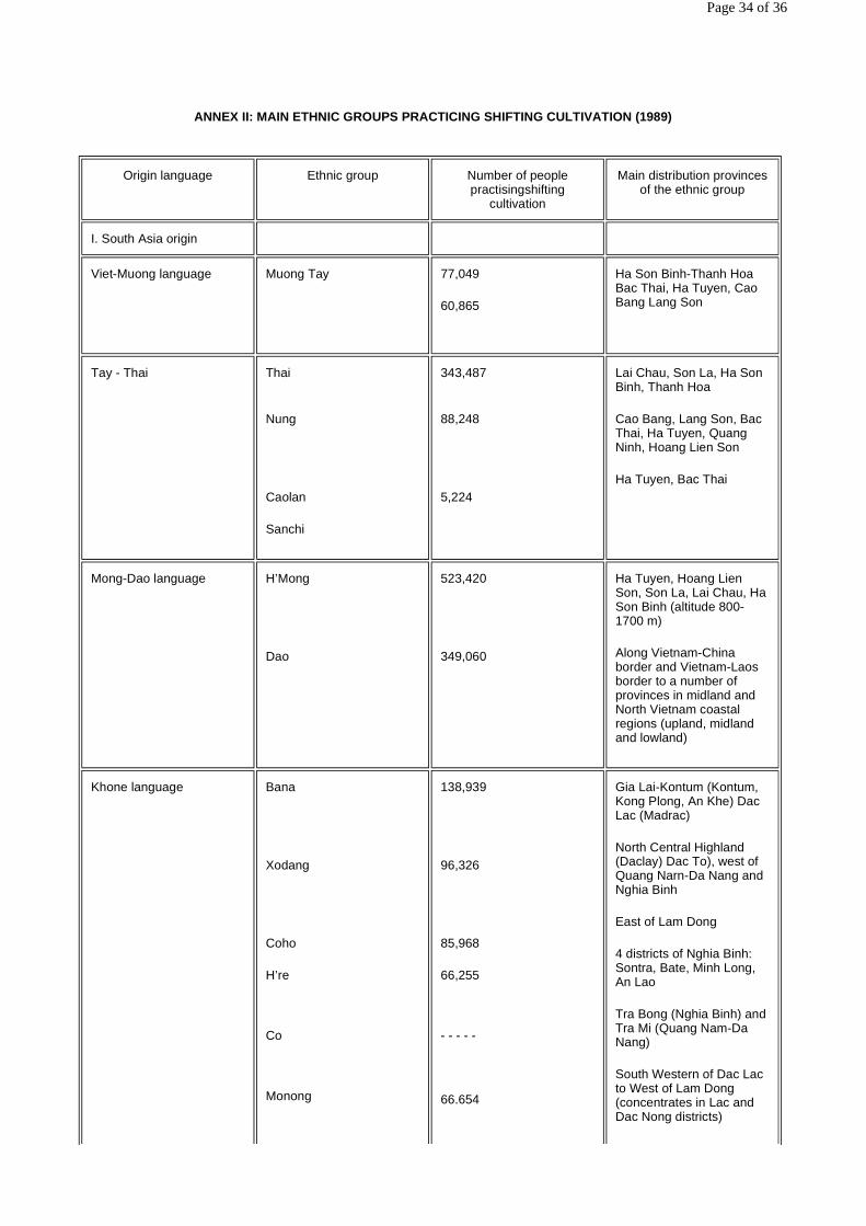
ANNEX II: MAIN ETHNIC GROUPS PRACTICING SHIFTING CULTIVATION (1989)
Origin language Ethnic group Number of people practisingshifting
cultivation
Main distribution provinces of the ethnic group
I. South Asia origin
Viet-Muong language
Muong Tay
77,049
60,865
Ha Son Binh-Thanh Hoa Bac Thai, Ha Tuyen, Cao Bang Lang Son
Tay - Thai Thai
Nung
Caolan
Sanchi
343,487
88,248
5,224
Lai Chau, Son La, Ha Son Binh, Thanh Hoa
Cao Bang, Lang Son, Bac Thai, Ha Tuyen, Quang Ninh, Hoang Lien Son
Ha Tuyen, Bac Thai
Mong-Dao language
H’Mong
Dao
523,420
349,060
Ha Tuyen, Hoang Lien Son, Son La, Lai Chau, Ha Son Binh (altitude 800-1700 m)
Along Vietnam-China border and Vietnam-Laos border to a number of provinces in midland and North Vietnam coastal regions (upland, midland and lowland)
Khone language
Bana
Xodang
Coho
H’re
Co
Monong
138,939
96,326
85,968
66,255
- - - - -
66.654
Gia Lai-Kontum (Kontum, Kong Plong, An Khe) Dac Lac (Madrac)
North Central Highland (Daclay) Dac To), west of Quang Narn-Da Nang and Nghia Binh
East of Lam Dong
4 districts of Nghia Binh: Sontra, Bate, Minh Long, An Lao
Tra Bong (Nghia Binh) and Tra Mi (Quang Nam-Da Nang)
South Western of Dac Lac to West of Lam Dong (concentrates in Lac and Dac Nong districts)
Page 34 of 36
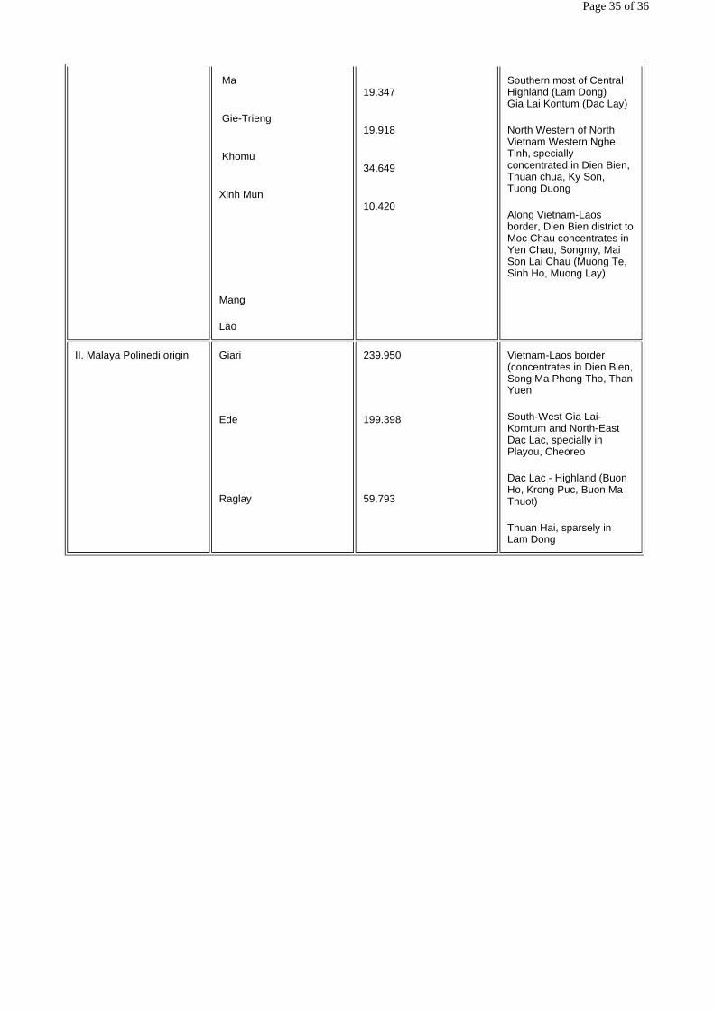
Ma
Gie-Trieng
Khomu
Xinh Mun
Mang
Lao
19.347
19.918
34.649
10.420
Southern most of Central Highland (Lam Dong) Gia Lai Kontum (Dac Lay)
North Western of North Vietnam Western Nghe Tinh, specially concentrated in Dien Bien, Thuan chua, Ky Son, Tuong Duong
Along Vietnam-Laos border, Dien Bien district to Moc Chau concentrates in Yen Chau, Songmy, Mai Son Lai Chau (Muong Te, Sinh Ho, Muong Lay)
II. Malaya Polinedi origin Giari
Ede
Raglay
239.950
199.398
59.793
Vietnam-Laos border (concentrates in Dien Bien, Song Ma Phong Tho, Than Yuen
South-West Gia Lai-Komtum and North-East Dac Lac, specially in Playou, Cheoreo
Dac Lac - Highland (Buon Ho, Krong Puc, Buon Ma Thuot)
Thuan Hai, sparsely in Lam Dong
Page 35 of 36
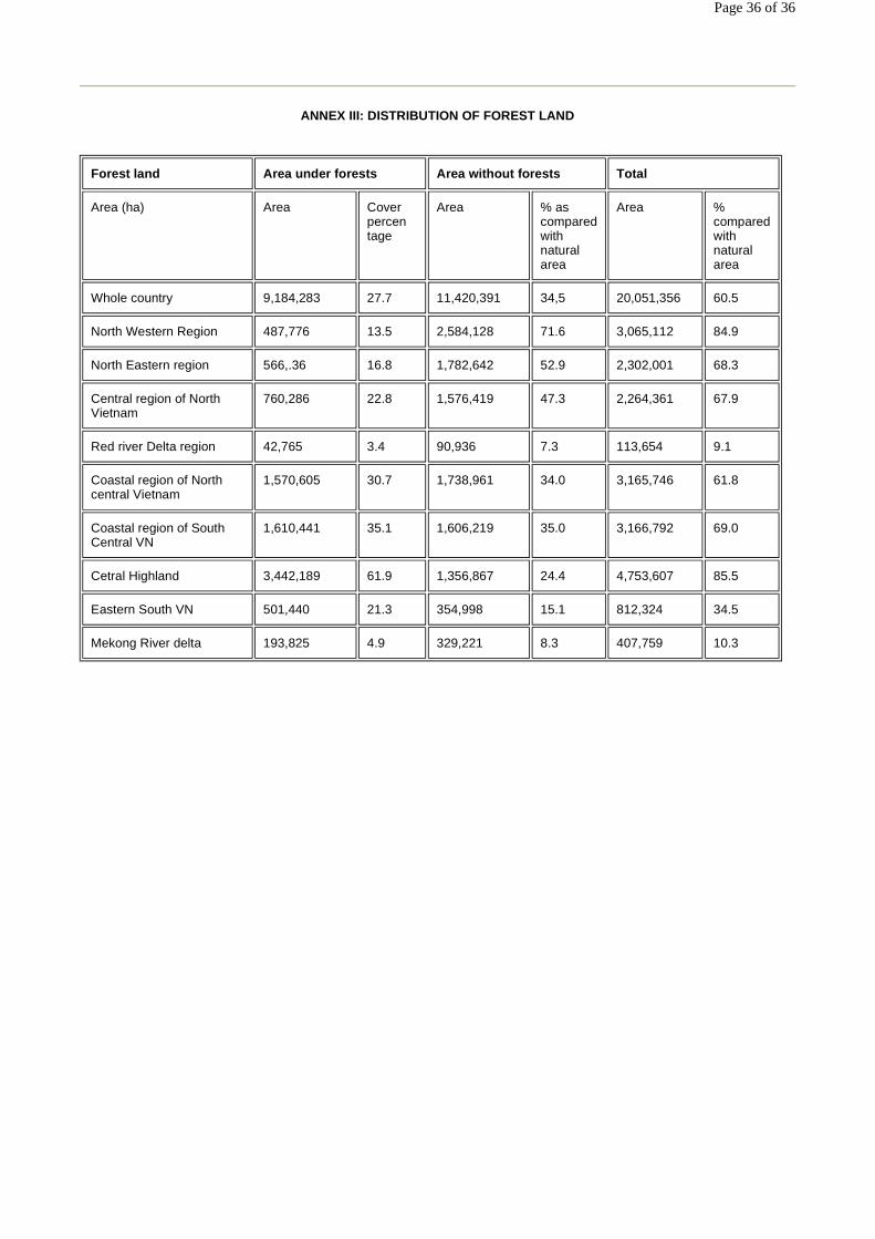
ANNEX III: DISTRIBUTION OF FOREST LAND
Forest land Area under forests Area without forests Total
Area (ha) Area Cover percen tage
Area % as compared with natural area
Area % compared with natural area
Whole country 9,184,283 27.7 11,420,391 34,5 20,051,356 60.5
North Western Region 487,776 13.5 2,584,128 71.6 3,065,112 84.9
North Eastern region 566,.36 16.8 1,782,642 52.9 2,302,001 68.3
Central region of North Vietnam
760,286 22.8 1,576,419 47.3 2,264,361 67.9
Red river Delta region 42,765 3.4 90,936 7.3 113,654 9.1
Coastal region of North central Vietnam
1,570,605 30.7 1,738,961 34.0 3,165,746 61.8
Coastal region of South Central VN
1,610,441 35.1 1,606,219 35.0 3,166,792 69.0
Cetral Highland 3,442,189 61.9 1,356,867 24.4 4,753,607 85.5
Eastern South VN 501,440 21.3 354,998 15.1 812,324 34.5
Mekong River delta 193,825 4.9 329,221 8.3 407,759 10.3
Page 36 of 36


![Shifting Cultivation[Date] Today I will: -Be introduced to the main characteristics of shifting cultivation Higher Rural](https://img.dokumen.tips/doc/110x75/56649cac5503460f9496d359/shifting-cultivationdate-today-i-will-be-introduced-to-the-main-characteristics.jpg)