Embed Size (px)
Citation preview

Sergipe-Alagoas Basin
Elaine Loureiro
Geophysicist
Superintendency of Block Delimitation
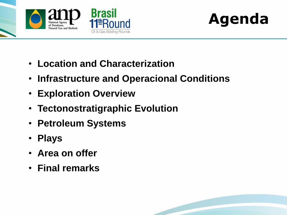
• Location and Characterization
• Infrastructure and Operacional Conditions
• Exploration Overview
• Tectonostratigraphic Evolution
• Petroleum Systems
• Plays
• Area on offer
• Final remarks
Agenda

• Location and Characterization
• Infrastructure and Operacional Conditions
• Exploration Overview
• Tectonostratigraphic Evolution
• Petroleum Systems
• Plays
• Area on offer
• Final remarks
Agenda

• Elongated in NE-SW direction
with 350 km in extension and 35
km of width onshore
• Total area: 44,370 Km²
• Onshore area:12,620 km²
•The onshore portion is classified
as mature
Location and Characterization
Jacuípe
Basin
Pernambuco-
Paraíba
Basin
Sergipe-Alagoas
Basin Aracaju
Maceió

Westhern
Basement
Distensional
Faults
Sergipe
Sub-basin
Pernambuco-Paraíba
Basin
Jacuípe
Basin
Northern Boundary
Maragogi High
Boundary between sub-
basins
Jaboatã-Penedo High
(onshore and
watershallow) Southern
Estância
Platform and
Vaza-Barris
Faults
Alagoas
Sub-Basin
Location and Characterization

Fazenda
Guindaste
Field
25 Blocks
in Alagoas Sub-basin
Total Area: 733 km²
Pilar Field
Location and Characterization
Legend Capitals
State Limits
Sector
Round 11 Blocks
Sedimentary Basin
Basement

SEAL T1
The block are in 9
alagoans municipalities
Considering Maceió city, the
population is greater than 1
million of inhabitants
Alagoas
Pernambuco
Sergipe
Aracaju
Maceió
Recife
Location and Characterization
Sector T1
R11 Blocks
Sedimentary Basin
Cities
Production fields
Legend
Agenda
• Location and Characterization
• Infrastructure and Operacional Conditions
• Exploration Overview
• Tectonostratigraphic Evolution
• Petroleum Systems
• Plays
• Area on offer
• Final remarks

UPGN - Lubnor Refinaria
Lubnor
Gasoduto Gasfor UPGN - Guamaré I, II e III
RPCC
RN CE
Nordestão
Gasalp
UPGN - Pilar
UPGN - Carmopólis UPGN - Atalaia
SE
BA
AL
UPGN’s – Bahia, Catu e Candeias
Refinaria
RLAM
PB
PE
3 Refineries
3,821 km of pipelines
10 Natural Gas Processing
Unit (NGPU)
Processing capacity of
natural gas in the region:
18.5 million m³/day
Source: Anuário Estatístico Brasileiro do Petróleo, Gás Natural e Biocombustíveis, 2012
Infrastructure
and Operacional
Legenda
NGPU
Refineries Capital
Pipelines
Catu - Carmopólis
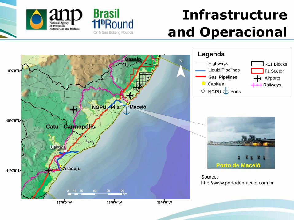
Maceió
Aracaju
NGPU - Pilar
UPGN
Catu - Carmopólis
Gasalp Legenda
Railways
Highways
Liquid Pipelines
Gas Pipelines
Capitals
Ports NGPU
Airports
R11 Blocks
T1 Sector
Porto de Maceió
Source:
http://www.portodemaceio.com.br
Infrastructure
and Operacional

Agenda
• Location and Characterization
• Infrastructure e Operacional Conditions
• Exploration Overview
• Tectonostratigraphic Evolution
• Petroleum Systems
• Plays
• Area on offer
• Final remarks

Discovery of the
Guaricema Field (SE)
(offshore)
1968
Geophysical surveys
well 2AL 0001 AL
(CNP)
1935
Exploration Overview
1930 1940 1950 1960 1970
1957
1st commercial
discovery of oil
(1TM 0001 AL)
Discovery of Carmopólis
Field (SE), with 1.7 Billion
bbl of oil in place
(onshore)
1963

1990 2010
2008
2005
2004
R10 R7 R6
2002
R4
2000
R2
1997
1998
Petroleum Law and creation of ANP
Round 0
1980 2000
1982
Discovery of Pilar Field (AL) with 230
millions bbl of oil in place onshore
Exploration Overview

Available Data
Alagoas Sub-basin
361 Exploration wells (332 onshore)
38,715 km onshore 2D lines
55,107 km offshore 2D lines
1,155 km² onshore 3D surveys
8,278 km² offshore 3D surveys Sergipe Sub-basin
762 Exploration wells (484 onshore)
3D public seismic
2D public seismic
Exploratory wells offshore
Exploratory wells onshore
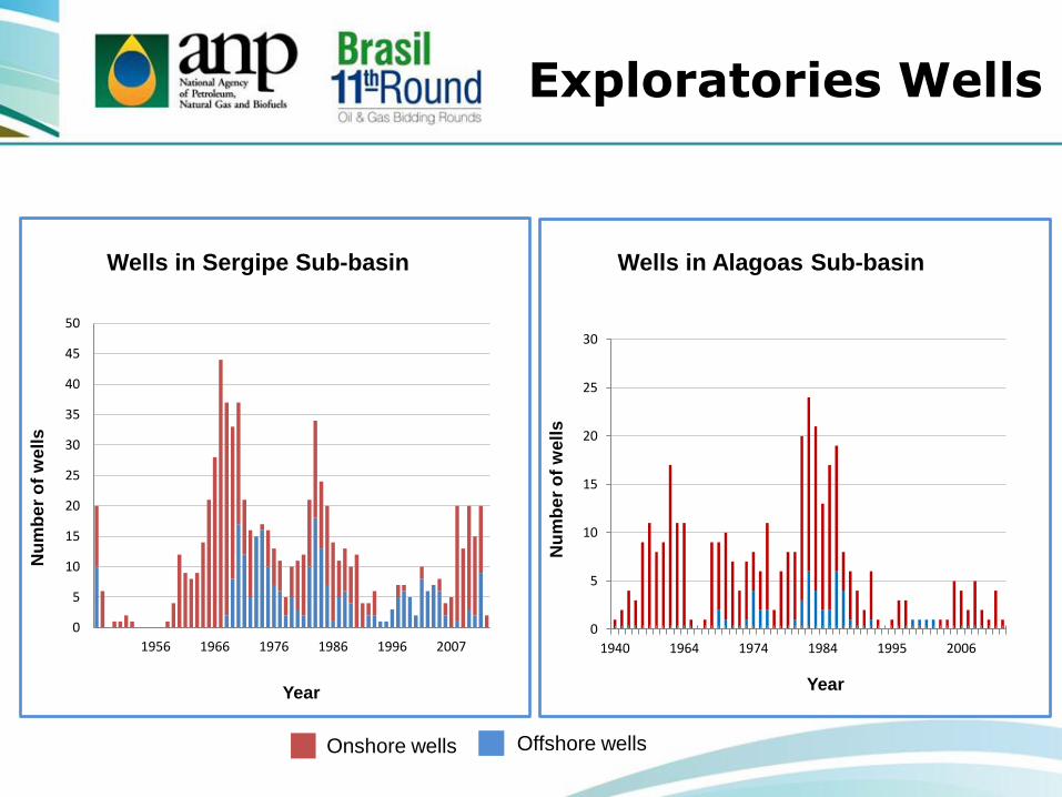
0
5
10
15
20
25
30
1940 1964 1974 1984 1995 2006
0
5
10
15
20
25
30
35
40
45
50
1956 1966 1976 1986 1996 2007
Wells in Sergipe Sub-basin
Onshore wells Offshore wells
Nu
mb
er
of
we
lls
Year
Wells in Alagoas Sub-basin
Nu
mb
er
of
we
lls
Year
Exploratories Wells

Sergipe Sub-basin
37 Fields in
Production/Development
28 onshore
9 offshore
35 Oil Producer
2 Gas and Oil Producer
Alagoas Sub-basin
18 Fields in
Production/Development
17 onshore
1 offshore
10 Oil Producer
7 Gas Producer
1 Gas and Oil Producer
Production and Development Fields
Sector
Round 11 Blocks
Sedimentary Basin
Basement
Development and
Production Fields
State Limits

Evolution of the Total Reserve (onshore)
The other basins
Sergipe-Alagoas
Basin
Total Reserve Petroleum
(Onshore)
20%
80%
Alagoas Sub-basin
Sergipe Sub-basin
Source: Anuário Estatístico Brasileiro do Petróleo, Gás Natural e Biocombustíveis, 2012
0
2000
4000
6000
8000
10000
12000
20
00
20
01
20
02
20
03
20
04
20
05
20
06
20
07
20
08
20
09
20
10
20
11
20
12
Total Oil Reserve
Year
MM
bbl
Total Gas Reserve
Year
0
50
100
150
200
250
300
350
400
20
00
20
01
20
02
20
03
20
04
20
05
20
06
20
07
20
08
20
09
20
10
20
11
20
12
B m
³

Pilar 46 Millions bbl
Furado 24 Millons bbl
Carmópolis 361 Millons bbl
Caioba 35,5 Millions bbl
Siririzinho 74 Millions bbl
Riachuelo 44 Millons bbl
Camorim 38 Millions bbl
Guaricema 70 Millons bbl
Production: 5 thousand bbl/day (dec/2012)
Accumulated Production (Oil)

Accumulated Production (Gas)
Pilar 9 Billions m3
Furado
4 Billions m3
Fazenda Pau Brasil 26 Millions m3
Tabuleiros dos Martins
117 Millions m3
Campo de Coqueiro
Seco 26 Millions m3
Cidade de São Miguel dos Campos
2 Billions m3
São Miguel dos
Campos 2,5 Billions m3
Ananbé
204 Thousand m3
Production:1,8 Million m3/day (dec/2012)

55 Blocks were granted in bidding
rounds: R2, R4, R6, R7 and R10.
Currently, 12 blocks are under
concession, 3 of them are onshore.
Integral de Petróleo e Gás do Brasil S.A.
Petrogal
Operators onshore:
Legenda
Sectors
Sedimentary Basin
Basement
Round 11 Blocks
. Capital Development and
Production Fields
State Limits
Exploratory Blocks
Round 2
Round 4
Round 6
Round 7
Round 10
Blocks on Concession and Bidding Rounds

Agenda
• Location and Characterization
• Infrastructure and Operacional Conditions
• Exploration Overview
• Tectonostratigraphic Evolution
• Petroleum Systems
• Plays
• Area on offer
• Final remarks

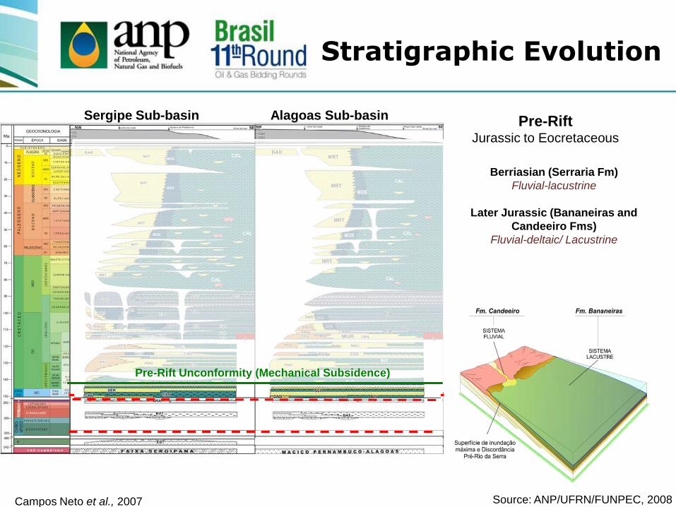
Stratigraphic Evolution
Campos Neto et al., 2007
Source: ANP/UFRN/FUNPEC, 2008
Sergipe Sub-basin Alagoas Sub-basin
Palaeozoic Sineclisis
Pre-Rift
Rift
Post-Rift
Drift

Campos Neto et al., 2007
Basement
Proterozoic
Sergipe Sub-basin
Sergipana Belt
Metamorphic
Alagoas Sub-basin
Pernambuco-Alagoas Massif
Granitic
Stratigraphic Evolution
Source: ANP/UFRN/FUNPEC, 2008
Sergipe Sub-basin Alagoas Sub-basin

Campos Neto et al., 2007
Palaeozoic Sineclisis
Early Permian (Aracaré Fm)
Desert and coastal
Later Carboniferous (Batinga Fm)
Glacial
Stratigraphic Evolution
Source: ANP/UFRN/FUNPEC, 2008
Sergipe Sub-basin Alagoas Sub-basin
Campos Neto et al., 2007
Pre-Rift Jurassic to Eocretaceous
Berriasian (Serraria Fm)
Fluvial-lacustrine
Later Jurassic (Bananeiras and
Candeeiro Fms)
Fluvial-deltaic/ Lacustrine
Pre-Rift Unconformity (Mechanical Subsidence)
Stratigraphic Evolution
Source: ANP/UFRN/FUNPEC, 2008
Sergipe Sub-basin Alagoas Sub-basin

Campos Neto et al., 2007
Pre Neo-Alagoas Unconformity (South Atlantic opening)
Middle Aptian (Maceió Fm)
Deltaic and Alluvial/Sabkha.
Early Aptian (Fm. Poção e
Coqueiro Seco)
Fluvial, alluvial and lacustrine
Neocomian to Barremian
(Feliz Deserto, Penedo and Barra
do Itiúba Fm )
Fluvial-deltaic and lacustrine
Rift Early Cretaceous
Stratigraphic Evolution
Source: ANP/UFRN/FUNPEC, 2008
Sergipe Sub-basin Alagoas Sub-basin

Campos Neto et al., 2007
Post-Rift
Albian to Coniacian
Sergipe Group
Riachuelo and Cotinguiba Fm
Pre-Calumbi Unconformity
Stratigraphic Evolution
Source: ANP/UFRN/FUNPEC, 2008
Sergipe Sub-basin Alagoas Sub-basin

Campos Neto et al., 2007
Drift
Santonian to Recent
Piaçabuçu Group
Marituba, Mosqueiro and
Calumbi Fm
Stratigraphic Evolution
Source: ANP/UFRN/FUNPEC, 2008
Sergipe Sub-basin Alagoas Sub-basin

Structural Maps
Gravimetric Map
Residual Bouguer Anomaly (mGal)
Pilar
Fazenda
Guindaste
Source: ANP/UFRN/FUNPEC, 2008

Magnetic Map
Analitic Sinal (nT/m)
Pilar
Fazenda
Guindaste
.
.
.
.
.
.
.
.
.
.
.
.
.
.
.
.
.
.
.
.
.
.
.
.
.
.
.
BA
PI
CE
PE
PB
RN
AL
SE
MA
MG
DF
Natal
Recife
Maceió
Aracaju
Teresina
Salvador
Fortaleza
João Pessoa
Structural Maps
Source: ANP/UFRN/FUNPEC, 2008
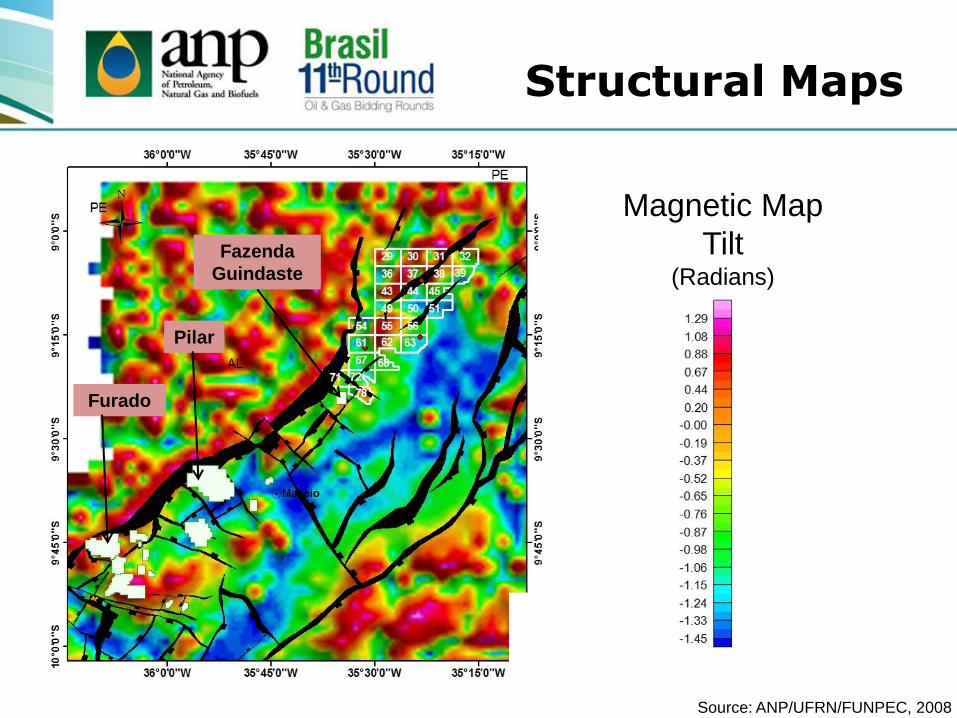
Magnetic Map
Tilt (Radians)
Pilar
Fazenda
Guindaste
Furado
Structural Maps
Source: ANP/UFRN/FUNPEC, 2008
Agenda
• Location and Characterization
• Infrastructure and Operacional Conditions
• Exploration Overview
• Tectonostratigraphic Evolution
• Petroleum Systems
• Plays
• Area on offer
• Final remarks

Petroleum Systems
Barra do Itiúba/Coqueiro Seco – Coqueiro Seco (.)
Maceió (.)
Fonte: ANP/UFRN/FUNPEC, 2008

Campos Neto et al., 2007
Petroleum Systems Source Rock
Generation Alagoas Sub-basin
Neocomian to
Barremian
Barra de Itiúba and
Coqueiro Seco Fm Shales of freshwater to brackish water
TOC ~ 3%, high potencial generator
and Kerogen Type I and II
Middle to Early Aptian
Maceió Fm TOC ~ 5%, high potencial oil and gas
generator

Petroleum Systems Reservoir Rock
Campos Neto et al., 2007
Reservoirs Alagoas Sub-basin
Jurassic
to Neocomian
Pre-Rift Sandstone
Serraria Fm
Good permoporosity
Aptian to Barremian
Maceió, Penedo and
Coqueiro Seco Fm
Sinrift Sandstones
Ø = 10% to 25%
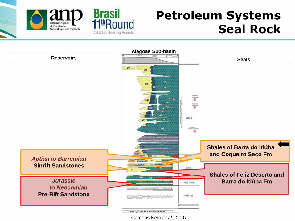
Petroleum Systems Seal Rock
Campos Neto et al., 2007
Reservoirs
Alagoas Sub-basin
Seals
Jurassic
to Neocomian
Pre-Rift Sandstone
Aptian to Barremian
Sinrift Sandstones
Shales of Feliz Deserto and
Barra do Itiúba Fm
Shales of Barra do Itiúba
and Coqueiro Seco Fm

Petroleum Systems Traps and Migration
Traps
Domic features
Horsts
Basculation in the basement
Normal faults NE
Source: ANP/UFRN/FUNPEC, 2008
Migration
Carrier layers
Permeable faults
Lateral migration

Agenda
• Location and Characterization
• Infrastructure and Operacional Conditions
• Exploration Overview
• Tectonostratigraphic Evolution
• Petroleum Systems
• Plays
• Area on offer
• Final remarks

Plays
Late Jurassic Sandstones
Neocomian Sandstones
Barremian Sandstones and Carbonates
Aptian Sandstones
Plays Summary

0
Linhas 027-0164
Late Jurassic Play
Sanstones
Serraria Fm
Barremian Play
Sandstones and
carbonates
Coqueiro Seco Fm and
Morro do Chaves Mb
Main Plays
Source: ANP/UFRN/FUNPEC, 2008
40
Neocomian Play
Sandstones
Barra do Itiúba Fm
Aptian Play
Sandstones
Maceió Fm

Rifte
Pré-rifte
Embasamento
São Miguel dos Campos Field
A A’
Barremian Sandstones
Source: ANP/UFRN/FUNPEC, 2008
35°0'0"W
35°0'0"W
36°0'0"W
36°0'0"W
9°0
'0"S
9°0
'0"S
10
°0'0
"S
10
°0'0
"S
0 5 10 15 20
km
Legenda
Limite Estadual
Setor em Oferta R11
Bacia Sedimentar
Embasamento
Blocos em Oferta R11
. CapitaisCampos em Des. ou Produção
Blocos Exploratórios
Rodada 2
Rodada 4
Rodada 6
Rodada 7
Rodada 10
A
A’

Anticline
> 700 Reservoirs (gas and oil)
Intensive faults Rift Tectonic
Geological Section of the Pilar Field
A A’
(Bizzi et al. 2003 - mod. de Borba, 1998)
35°0'0"W
35°0'0"W
36°0'0"W
36°0'0"W
9°0
'0"S
9°0
'0"S
0 5 10 15 20
km
Legenda
Limite Estadual
Setor em Oferta R11
Bacia Sedimentar
Embasamento
Blocos em Oferta R11
. CapitaisCampos em Des. ou Produção
Blocos Exploratórios
Rodada 2
Rodada 4
Rodada 6
Rodada 7
Rodada 10
A
A’
Barremian
Sandstones and carbonates

Aptian Sandstones
A A’
Barremian tops
Basement
Aptian tops
1FGT 0001 AL
Fazenda
Guindaste Line
0027-0358
Faults
Agenda
• Location and Characterization
• Infrastructure and Operacional Conditions
• Exploration Overview
• Tectonostratigraphic Evolution
• Petroleum Systems
• Plays
• Area on offer
• Final remarks

•SEAL-T1 Sector – Alagoas
Sub-basin
• 25 Blocks
• Total Area ~ 733 km²
• Block Area ~ 30 km²
Blocks on offer
Legend Capitals
State Limits
Sector
Round 11 Blocks
Sedimentary Basin
Basement

SEAL T1 Wells in the Area
Oil and gas
shows
Oil and gas
shows
Oil and gas
shows
Oil and gas
shows
throughout the
length of the
well
Fazenda Guindaste
Field has already
produced gas in
sandstones of
Maceió Fm

266 km of 2D seismic surveys
11 wells
Petroleum System Studies of
Sergipe-Alagoas Basin - ANP/UFRN
2008
Gravimetry
Data Package

Exploration Opportunities
Fonte: ANP/UFRN/FUNPEC, 2008
Magnetic Map
Tilt (Radians)

0027-0564
SEAL-T1-72
Barremian top
Basement
Aptian top
Faults
Line 0027-0359
Exploration Opportunities

SEAL-T1-72 SEAL-T1-78
Fazenda Guindaste
Field
Line 0027-0678
Barremian top
Basement Aptian top
Faults
Exploration Opportunities
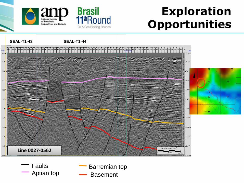
SEAL-T1-44 SEAL-T1-43
Line 0027-0562
Exploration Opportunities
Barremian top
Basement Aptian top
Faults
Fonte: ANP/UFRN/FUNPEC, 2008
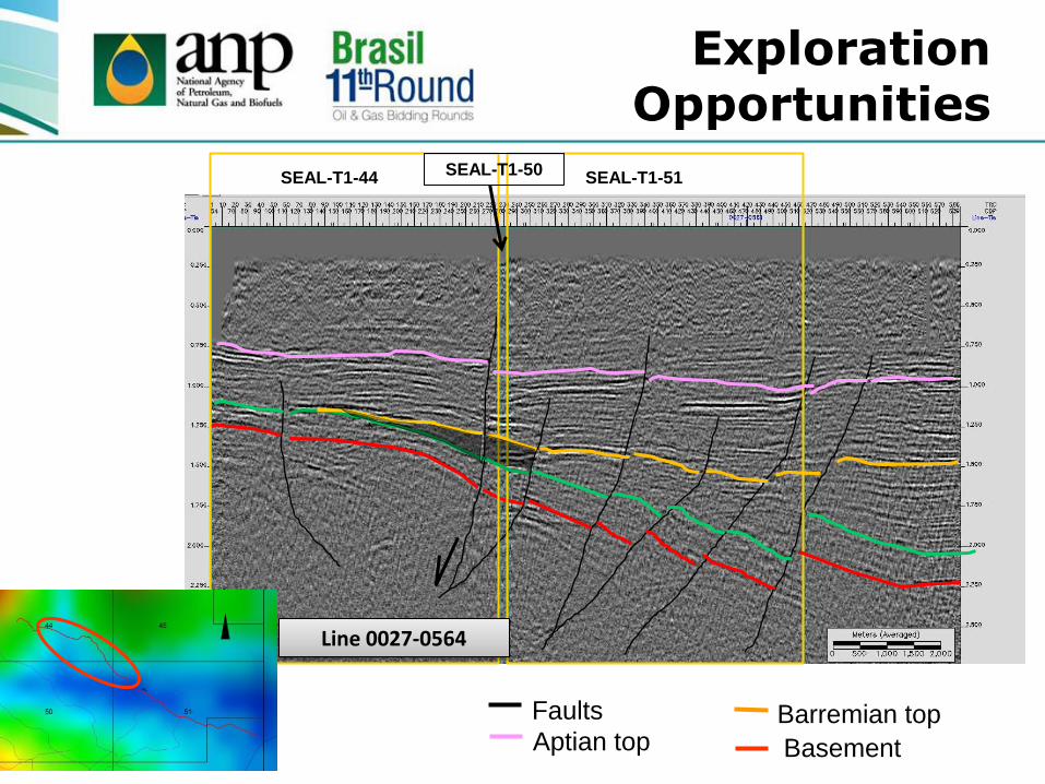
- 52
SEAL-T1-44 SEAL-T1-51 SEAL-T1-50
Line 0027-0564
Exploration Opportunities
Barremian top
Basement Aptian top
Faults

Speculative Resources (Gas)
Area on
offer
733 km²
1 well
per
114 km²
Reference Period
2002 to 2012
*Logarithmic
Mean
21
discoveries Risk
1 : 7
1 well
per
5 km²
Drill
147
wells
97 Millions m3
per discovery*
VGIP
2 Billions
m3

Contractual Aspects
SSEAL-T1 SECTOR
Exploratory Model Mature
Number of Blocks 25
Area per block 30 km²
Area on offer 733.16 km²
Exploration Phase 5 years
Exploratory Period 3+2 years
Technical Qualification of the Operator C
Minimum Bonus R$ 25,089.20 to R$ 51,599.73
Minimum Depth (Main Objective)
Coqueiro Seco Fm Aptian

Agenda
• Location and Characterization
• Infrastructure and Operacional Conditions
• Exploration Overview
• Tectonostratigraphic Evolution
• Petroleum Systems
• Plays
• Area on offer
• Final remarks
Mature basin
Active production of oil and gas in the northeast of Brazil
Blocks offered and acquired by bidders in several rounds
20% of the onshore reserves of the country
Infrastructure for the oil industry
Efficient petroleum system and diversity of plays
Adequate opportunities for small and medium-sized
companies
Reprocessing and non seismic methods are suggested
Final Remarks

57 57
National Agency of Petroleum, Natural Gas and
Biofuels
Elaine Loureiro
www.anp.gov.br