Embed Size (px)
Citation preview
0 (2006) 121–137www.elsevier.com/locate/sedgeo
Sedimentary Geology 19
Sequence stratigraphy of the Lower Cenomanian BahariyaFormation, Bahariya Oasis, Western Desert, Egypt
O. Catuneanu a, M.A. Khalifa b, H.A. Wanas b,⁎
a Department of Earth and Atmospheric Sciences, University of Alberta, 1-26 Earth Sciences Building, Edmonton, Alberta, Canada T6G 2E3b Geology Department, Faculty of Science, Menoufia University, Shebin El-Kom, Egypt
Abstract
The Lower Cenomanian Bahariya Formation corresponds to a second-order depositional sequence that formed within acontinental shelf setting under relatively low-rate conditions of positive accommodation (<200 m during 3–6 My). This overalltrend of base-level rise was interrupted by three episodes of base-level fall that resulted in the formation of third-order sequenceboundaries. These boundaries are represented by subaerial unconformities (replaced or not by younger transgressive waveravinement surfaces), and subdivide the Bahariya Formation into four third-order depositional sequences.
The construction of the sequence stratigraphic framework of the Bahariya Formation is based on the lateral and vertical changesbetween shelf, subtidal, coastal and fluvial facies, as well as on the nature of contacts that separate them. The internal (third-order)sequence boundaries are associated with incised valleys, which explain (1) significant lateral changes in the thickness of incisedvalley fill deposits, (2) the absence of third-order highstand and even transgressive systems tracts in particular areas, and (3) theabrupt facies shifts that may occur laterally over relatively short distances. Within each sequence, the concepts of lowstand,transgressive and highstand systems tracts are used to explain the observed lateral and vertical facies variability.
This case study demonstrates the usefulness of sequence stratigraphic analysis in understanding the architecture and stackingpatterns of the preserved rock record, and helps to identify 13 stages in the history of base-level changes that marked the evolutionof the Bahariya Oasis region during the Early Cenomanian.© 2006 Elsevier B.V. All rights reserved.
1. Introduction
The Bahariya Oasis is located in the heart of theWestern Desert between latitudes 27° 48′ and 28° 30′ Nand longitudes 28° 32′ and 29° 10′ E, about 370 kmsouthwest of Cairo and 190 km west of Samalut in theNile Valley (Fig. 1). This Oasis is one of the most geo-logically important areas in the Western Desert, andattracted considerable attention especially in the last four
⁎ Corresponding author.E-mail addresses: [email protected] (O. Catuneanu),
[email protected] (H.A. Wanas).
0037-0738/$ - see front matter © 2006 Elsevier B.V. All rights reserved.doi:10.1016/j.sedgeo.2006.05.010
decades, since the discovery of iron ore deposits in the ElGedida, Ghorabi and El Harra localities (Said, 1962; ElAkkad and Issawi, 1963; El Bassyouny, 1970; Issawi,1972; Khalifa, 1977; Franks, 1982; Dominik, 1985;Khalifa and Abu El-Hassan, 1993; Soliman and Khalifa,1993; Khalifa et al., 2002, 2003).
The presence of Cenomanian rocks in the BahariyaOasis was first recorded by Lyons (1894), with theidentification of Exogyra sp. fossils. Further work onthe stratigraphic framework of this region was done byBall and Beadnell (1903), who established that theoldest exposed rocks in the Oasis are of Cenomanianage. Stromer (1914) was the first to introduce the term

Fig. 1. Location map, and general geology of the study area (modified from El Akkad and Issawi, 1963). The stratigraphic objective is represented by theLower Cenomanian unconformity-bounded Bahariya Formation, which has an estimated duration of 3–6 My (Palmer, 1983). Measured sections: 1 —Naqb El-Selim; 2—Gabal Radwan; 3—West of Sandstone Hills; 4—Gabal El-Dist (type section for the Bahariya Formation); 5—Naqb El-Bahariya.
122 O. Catuneanu et al. / Sedimentary Geology 190 (2006) 121–137
Bahari-Jestufe for the Cenomanian sandstones andclaystones that crop out on the floor and along theescarpments of the depression. Later, Said (1962) usedthe term Bahariya Formation instead of Bahari-Jestufe.He mentioned that the Bahariya Formation consistspredominantly of sandstones with numerous intercala-tions of ferruginous layers, and termed the lowermostsandstone beds as the “Dinosaur bed” at the Gabal El-Dist locality. It is now firmly established that the age ofthe Bahariya Formation is Early Cenomanian (e.g.,Soliman and Khalifa, 1993), and current estimates indi-cate that its deposition took place during a time intervalof c. 3–6 My (Palmer, 1983).
The Bahariya Formation includes the lowest and theoldest exposed beds in the Bahariya Oasis. It forms thefloor of the Oasis and the basal part of the surrounding
scarps (Fig. 1). The base of the Bahariya Formation isunexposed, but inferred to be unconformable at thecontact with the underlying basement (El Bassyouny,1970), while its top shows an unconformable relation-ship with the overlying Upper Cenomanian El HeizFormation (Khalifa and Abu El-Hassan, 1993), or theLower–Middle Eocene El-Naqb Formation (El Bas-syouny, 1970, 2004). The exposed thickness of the For-mation ranges from c. 90 m in the central part of theOasis, to over 100 m in the northern sections.
From a lithological point of view, the Bahariya For-mation exhibits significant lateral and vertical changes offacies. In the central parts of the Oasis, the Formationconsists of three informal lithologic units defined byinterbedded siltstones and sandstones (lower unit), cross-bedded amalgamated sandstone bodies (middle unit) and
123O. Catuneanu et al. / Sedimentary Geology 190 (2006) 121–137
dark colored ferruginous sandstones (upper unit) (Soli-man and Khalifa, 1993). In the northern parts of the Oasis,two distinct units are recognized, i.e. a lower unitconsisting of siltstones andmudstones with plant remains,and an upper unit composed of glauconitic claystoneswith thin ferricrete interbeds. The correlation of theseunits was so far based primarily on lithological grounds(Soliman and Khalifa, 1993).
Between its limits, the Bahariya Formation forms anunconformity-bounded sequence (El Bassyouny, 1970),which in turn shows internal cyclicity at higher frequencylevels. This makes it an ideal candidate for a sequencestratigraphic study, which has never been performedbefore within the confines of the Bahariya Oasis. The aimof this paper is to construct the sequence stratigraphicframework for the Bahariya Formation, which shouldimprove our understanding of the succession of eventsthat marked the Early Cenomanian evolution of this areaand led to the preserved stratigraphic architecture withinthe Oasis, as seen today.
2. Geological setting
Egypt lies on the northeastern margin of the AfricanPlate, where it forms a part of the East Sahara Craton (ElEmam et al., 1990). Geologically, Egypt is subdividedinto three structural provinces. From south to north, theyare represented by the Arabo-Nubian Craton, a stableshelf, and an unstable shelf (Said, 1962; Meshref, 1982,1990). Within this setting, the Bahariya Oasis is placedat the transition between the stable and unstable shelfprovinces (Khalifa et al., 2002). The partitioning ofEgypt's territory into these structural provinces reflectsa complex history of extension, collision and wrenchfault tectonism within the northern part of the AfricanPlate brought about by the relative movement betweenAfrica and Laurasia (El Emam et al., 1990).
Interpretation of gravity data shows that the WesternDesert, which encloses the Bahariya Oasis, is essentiallypart of a Jurassic–Cenomanian divergent (“passive”)continental margin (El Emam et al., 1990) which evolvedas such in relation to the opening and development of theTethys Sea. Sedimentation on the continental shelf duringthe Lower Cenomanian is thought to have taken placeduring a stage of overall low-rate base-level rise, whichresulted in the deposition of an extensive succession ofdeposits (Ibrahim, 1990). The amount of accommodationgenerated on the shelf during this time was generallybetween 100 and 200 m, as documented by the more orless constant thickness of the Bahariya Formation at aregional scale. Localized increases in the thickness of theBahariya Formation, up to 400–500m, are recorded to the
north of the Oasis, in relation to restricted, fault-boundedbasins formed within the unstable shelf structural pro-vince. An example of such restricted and highly subsidingbasin is represented by the Abu Gharadig Basin, placed300 km north of the Bahariya Oasis, whichmay be relatedto processes of rifting that commenced in the Jurassic(Ibrahim, 1990; Ibrahim and Aly, 1994). This restrictedextensional basin may be superimposed on a failed suturethatwas reactivated as the Pangea supercontinent began tosplit into Gondwana and Laurasia. The extensional natureof the AbuGharadig Basin is evidenced by the thinning ofits underlying crust (El Emam et al., 1990). No such ex-tension has been noted within the perimeter of theBahariya Oasis, whose sedimentation history was gener-ally unaffected by the manifestation of syn-depositionalstructural elements (Aram, 1990).
3. Sedimentology
3.1. Data
The data for this paper were primarily collected bymeans of outcrop facies analyses performed in five mainsections located within the confines of the Bahariya Oasis(Fig. 1). The results of this work, as well as the inter-pretation of the data, are illustrated in Figs. 2–7.
The studied sections show a dominantly clasticsuccession, with lithologies ranging from claystones andshales to sandstones and conglomeratic lag deposits.Numerous iron-rich paleosol horizons, referred to asferricretes herein, are present almost throughout theBahariya Formation. The observed clastic lithofaciesrange in color from white to yellow, green, grey or black,with a variety of sedimentological features represented bydifferent types of physical structures, grading, load, andwater-escape structures. Some of these lithofacies maydominate parts of the stratigraphic succession, or mayrepeat themselves in a predictable fashion forming c.meter-scale cyclothems. The dominance of a particularlithofacies, or group of lithofacies, in different parts of theFormation allows the definition of eight main faciesassociations, as outlined below.
3.1.1. Facies association 1This association is characterized by a repetition of
meter-scale fining-upward cyclothems, each consisting oflight colored fine- to very fine-grained sandstones withhorizontal lamination, ripple cross-lamination, convolutebedding (Fig. 2A) and load structures (Fig. 2B) at thebase, capped by yellow siltstones and dark grey mud-stones with black wood, leaf imprints and dinosaur bones.This facies association is present at the base of the Gabal

Fig. 2. Field photographs of the various facies observed in the Bahariya Formation at the Bahariya Oasis. A — convolute bedding characterizing thelithologies of the facies association 1 at Naqb El-Bahariya section; B— load structure of white siltstone within grey mudstone of the basal lithologies of theBahariya Formation at Gabal El-Dist; C— swaly cross-bedding in the sandstones of the facies association 2 in the middle unit of the Bahariya Formation atGabal El-Dist; D— bivalves (Exogyra sp.) that are concentrated as lag deposits at the top of ferricrete horizons in the cyclothems of facies association 2 atGabal El-Dist; E—meter-scale package of yellow claystone topped by red iron-rich horizon in the facies association 3 at Gabal El-Dist section; F— verticalferruginous root casts within the iron-rich horizon and its underlying claystone of the facies association 3 of the Bahariya Formation at Naqb es Sillim. (Forinterpretation of the references to colour in this figure legend, the reader is referred to the web version of this article.)
124 O. Catuneanu et al. / Sedimentary Geology 190 (2006) 121–137

Fig. 4. Vertical profile of the Bahariya Formation in the Naqb El-Bahariya section (location shown in Fig. 1). The profile indicates theobserved facies associations (FA; see text for lithofacies descriptions),as well as the interpretation of paleodepositional environments.
Fig. 3. Vertical profile of the Bahariya Formation in Gabal El-Dist (typesection, with the location shown in Fig. 1). The profile indicates theobserved facies associations (FA; see text for lithofacies descriptions), aswell as the interpretation of paleodepositional environments.
125O. Catuneanu et al. / Sedimentary Geology 190 (2006) 121–137
El-Dist and Naqb El-Bahariya sections (Fig. 1), withthicknesses of about 15m (Figs. 3 and 4). The base of thisfacies association is unexposed, and the top contact issharp but apparently conformable in the Gabal El-Distsection and unconformable in the Naqb El-Bahariya sec-tion (Figs. 3 and 4). The unconformable contact is indi-cated by the abrupt change in lithology from fine-grainedsandstones and siltstones of the facies association 1 to theoverlying coarse- to medium-grained sandstones (Fig. 4).
3.1.2. Facies association 2This association consists of c. meter-scale coarsening-
upward cyclothems, which start with yellow to creamy-colored claystones at the base grading upwards intofossiliferous glauconitic siltstones and sandstones. Thesandstones display swaley cross-bedding (Fig. 2C), andeach coarsening-upward rhythm is topped by a centimeterto decimeter thick ferricrete layer. In this case, the for-mation of ferricrete is attributed to the in situ alteration ofglauconite under subaerial conditions. This is indicated bythe occurrence of glauconite and kaolinite (alunite?) rem-nants within the ferricrete layers (El Sharkawi and AlAwadi, 1981). The fossil assemblage includes marinebivalves (e. g.,Ostrea sp. and Exogyra sp.; El Bassyouny,2004). Beside them being present within the siltstone to
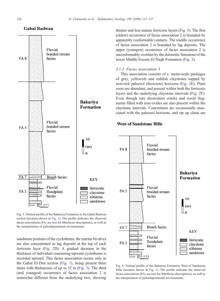
Fig. 6. Vertical profile of the Bahariya Formation West of SandstoneHills (location shown in Fig. 1). The profile indicates the observedfacies associations (FA; see text for lithofacies descriptions), as well asthe interpretation of paleodepositional environments.
Fig. 5. Vertical profile of the Bahariya Formation in the Gabal Radwansection (location shown in Fig. 1). The profile indicates the observedfacies associations (FA; see text for lithofacies descriptions), as well asthe interpretation of paleodepositional environments.
126 O. Catuneanu et al. / Sedimentary Geology 190 (2006) 121–137
sandstone portions of the cyclothems, the marine bivalvesare also concentrated as lag deposits at the top of eachferricrete layer (Fig. 2D). A gradual decrease in thethickness of individual coarsening-upward cyclothems isrecorded upward. This facies association occurs only inthe Gabal El-Dist section (Fig. 1), being present threetimes with thicknesses of up to 32 m (Fig. 3). The third(and youngest) occurrence of facies association 2 issomewhat different from the underlying two, showing
thinner and less mature ferricrete layers (Fig. 3). The first(oldest) occurrence of facies association 2 is bounded byapparently conformable contacts. The middle occurrenceof facies association 2 is bounded by lag deposits. Theupper (youngest) occurrence of facies association 2 isunconformably overlain by the dolomitic limestone of thelower Middle Eocene El-Naqb Formation (Fig. 3).
3.1.3. Facies association 3This association consists of c. meter-scale packages
of grey, yellowish and reddish claystones topped byiron-rich paleosol (ferricrete) horizons (Fig. 2E). Plantroots are abundant, and present within both the ferricretelayers and the underlying claystone intervals (Fig. 2F).Even though rare dessication cracks and wood frag-ments filled with iron oxides are also present within theclaystone intervals. Concretions are occasionally asso-ciated with the paleosol horizons, and rip up clasts are
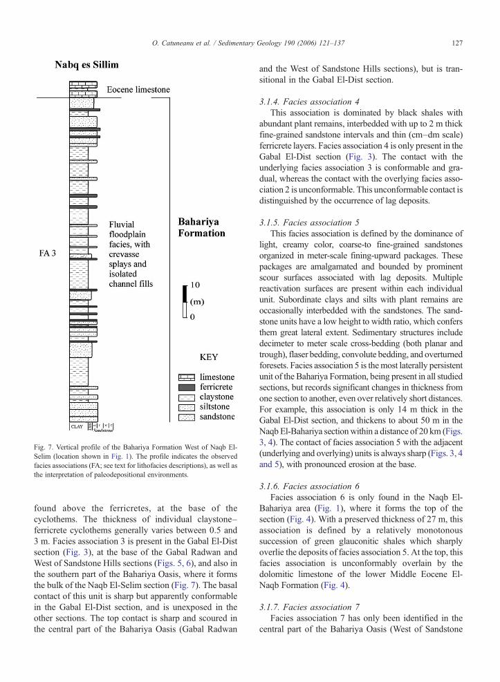
Fig. 7. Vertical profile of the Bahariya Formation West of Naqb El-Selim (location shown in Fig. 1). The profile indicates the observedfacies associations (FA; see text for lithofacies descriptions), as well asthe interpretation of paleodepositional environments.
127O. Catuneanu et al. / Sedimentary Geology 190 (2006) 121–137
found above the ferricretes, at the base of thecyclothems. The thickness of individual claystone–ferricrete cyclothems generally varies between 0.5 and3 m. Facies association 3 is present in the Gabal El-Distsection (Fig. 3), at the base of the Gabal Radwan andWest of Sandstone Hills sections (Figs. 5, 6), and also inthe southern part of the Bahariya Oasis, where it formsthe bulk of the Naqb El-Selim section (Fig. 7). The basalcontact of this unit is sharp but apparently conformablein the Gabal El-Dist section, and is unexposed in theother sections. The top contact is sharp and scoured inthe central part of the Bahariya Oasis (Gabal Radwan
and the West of Sandstone Hills sections), but is tran-sitional in the Gabal El-Dist section.
3.1.4. Facies association 4This association is dominated by black shales with
abundant plant remains, interbedded with up to 2 m thickfine-grained sandstone intervals and thin (cm–dm scale)ferricrete layers. Facies association 4 is only present in theGabal El-Dist section (Fig. 3). The contact with theunderlying facies association 3 is conformable and gra-dual, whereas the contact with the overlying facies asso-ciation 2 is unconformable. This unconformable contact isdistinguished by the occurrence of lag deposits.
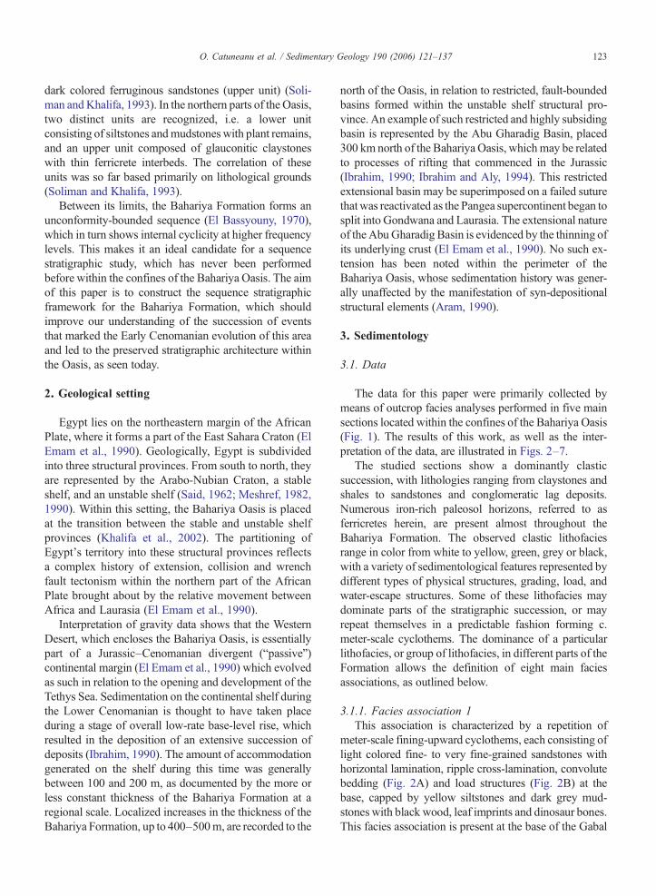
3.1.5. Facies association 5This facies association is defined by the dominance of
light, creamy color, coarse-to fine-grained sandstonesorganized in meter-scale fining-upward packages. Thesepackages are amalgamated and bounded by prominentscour surfaces associated with lag deposits. Multiplereactivation surfaces are present within each individualunit. Subordinate clays and silts with plant remains areoccasionally interbedded with the sandstones. The sand-stone units have a low height to width ratio, which confersthem great lateral extent. Sedimentary structures includedecimeter to meter scale cross-bedding (both planar andtrough), flaser bedding, convolute bedding, and overturnedforesets. Facies association 5 is themost laterally persistentunit of the Bahariya Formation, being present in all studiedsections, but records significant changes in thickness fromone section to another, even over relatively short distances.For example, this association is only 14 m thick in theGabal El-Dist section, and thickens to about 50 m in theNaqbEl-Bahariya sectionwithin a distance of 20 km (Figs.3, 4). The contact of facies association 5 with the adjacent(underlying and overlying) units is always sharp (Figs. 3, 4and 5), with pronounced erosion at the base.
3.1.6. Facies association 6Facies association 6 is only found in the Naqb El-
Bahariya area (Fig. 1), where it forms the top of thesection (Fig. 4). With a preserved thickness of 27 m, thisassociation is defined by a relatively monotonoussuccession of green glauconitic shales which sharplyoverlie the deposits of facies association 5. At the top, thisfacies association is unconformably overlain by thedolomitic limestone of the lower Middle Eocene El-Naqb Formation (Fig. 4).
3.1.7. Facies association 7Facies association 7 has only been identified in the
central part of the Bahariya Oasis (West of Sandstone
128 O. Catuneanu et al. / Sedimentary Geology 190 (2006) 121–137
Hills and Gabal Radwan sections; Fig. 1), with a thick-ness ranging from 4 m at Gabal Radwan section to 8 min the section at the western area of Sandstone Hills(Figs. 5, 6). It is a lithologically homogeneous unit,composed of light cream fine- to medium-grainedsandstones with a distinct low-angle cross-stratification.Several reactivation surfaces are observed in any givenlocation, separating packages with consistent foresetorientations. This association is bounded by sharpcontacts both at the base and top.
3.1.8. Facies association 8This facies association is generally similar with
facies association 5 excepting that the sandstones areblack in color and that the succession is punctuated bythe presence of multiple ferricrete horizons. Faciesassociation 8 is only present in the central part of theBahariya Oasis (at the top of the West of Sandstone Hillsand Gabal Radwan sections; Fig. 1), with a preservedthickness of about 20 m (Figs. 5, 6). This unit isbounded by a sharp contact with conglomeratic lagdeposits at the base, and by the present-day topographicprofile at the top.
3.2. Interpretation
The interpretation of the paleo-depositional environ-ments in which the sediments of the Bahariya Formationaccumulated during the Early Cenomanian is based on theobserved facies associations presented above. Rock types,grading trends, nature of facies contacts, and sedimentarystructures are primary proxies for such interpretations.The results of our paleo-depositional environment inter-pretations are synthesized in Figs. 3–7.
3.2.1. Facies association 1This facies association corresponds to a low energy
environment in which sediment supply was relativelyhigh and yet dominated by finer-grained sedimentfractions. Fluctuating energy levels with time are alsoinferred, as suggested by the interbedding of sands andmuds, possibly representing autocyclic shifts in thelocation of subenvironments. The presence of fining-upward cyclothems, as well as the nature of the fossilcontent, point towards a fluvial-dominated environmentinwhich thewater tablewas relatively high and the energyof unidirectional flows was minimal. Such conditions areoften found in delta plain settings characterized by anearly flat topography and the presence of straight (orvery low sinuosity) single channel systems (Elliott, 1986).This interpretation is also in agreement with the absenceof any discernable downstream or lateral accretion
macroforms. The fining-upward cyclothems likely reflecta shift from sand-filled distributary channels (lowestenergy, straight single channels) to mud-dominatedinterdistributary areas characterized by sedimentationfrom suspension in stagnant water. The load structures(load casts, load balls) often observed at the base of thefining-upward cyclothems, together with the frequentconvolute bedding that is present in the sandstones, reflecthigh sedimentation rates and associated water escape andsoft sediment deformation (Allen, 1982). The observedaggradational trend indicates that the base-levelwas risingat the time of deposition, hence this delta plain was part ofa normal regressive delta.
3.2.2. Facies association 2This facies association is composed of high-frequency
progradational packages, each starting with abruptdrowning (flooding surface) and ending with subaerialexposure (paleosol development). The fact that each newcycle brings transgression and a marine environment overthe area of occurrence is documented by the presence ofmarine fossils (Ostrea sp. and Exogyra sp.) within theclastic rocks, which also concentrate as lag deposits at thebase of each cyclothem. The base of these packages istherefore erosional, most likely represented byminor (loworder) wave ravinement surfaces. Such transgressivescours are one type among several candidates that mayserve as “flooding surfaces”, marking abrupt waterdeepening in the basin (see Catuneanu, 2002, 2006, fora discussion on flooding surfaces). The presence of waveravinement surfaces at the base of the observed cyclesindicates that the Jabal El-Dist section was generallylocated within the coastal area, and immediately adjacentenvironments, during the deposition of this faciesassociation. Wave ravinement surfaces are cut by wavesin the upper shoreface, so likely the marine facies of thesecyclothems are subtidal, accumulated above the fair-weather wave base. A shoreface environment is alsosupported by the presence of swaley cross-stratification(Tucker, 1991). Following transgression, a gradual pro-gradation of the coastlinewas recorded, as documented bythe coarsening-upward trend of each cyclothem (Num-medal et al., 1987). These regressive episodes proceededto the point where the coastline passed through the GabalEl-Dist location, leaving the area subaerially exposed.This is evidenced by the development of paleosol(ferricrete) horizons at the top of the prograding cyclo-thems. These high-frequency transgressive–regressivecycles took place during stages of base-level rise, asindicated by the vertical aggradation that accompanied thetransgressive and regressive shoreline shifts. The balancebetween sedimentation and the rates of base-level rise
129O. Catuneanu et al. / Sedimentary Geology 190 (2006) 121–137
dictates the overall transgressive or regressive character ofthe shoreline trajectory. In this case, the gradual decreasein the thickness of individual coarsening-upward cyclo-thems that is recorded up section is a diagnostic feature foroverall coastal backstepping (Catuneanu, 2003), whichmeans that facies association 2 accumulated during anoverall transgression of the shoreline.
3.2.3. Facies association 3This association of claystones and ferricretes, marked
by abundant plant roots and other plant fragmentsreplaced by iron oxides, is characteristic of a low energynonmarine environment (Selley, 1972), in which periodsof time of vertical aggradation (accumulation of clays-tones) alternated with periods of time of sedimentstarvation (formation of ferricretes). These high frequencyfluctuations in sediment supply, water discharge, and/orfluvial accommodation took place during a stage ofoverall base-level rise, as evidenced by the gradual buildup of the sedimentary succession. The claystone intervalsare interpreted to correspond to sedimentation fromsuspension in fluvial floodplain environments, whereasthe formation of ferricretes marks periods of paleosoldevelopment. The flooding of the overbank environment,following an interval of subaerial exposure dominated bypedogenic processes, was associated with slight scouringof the substrate as evidenced by the presence of rip upclasts at the base of each claystone–ferricrete cyclothem.Subordinate crevasse splay sands, with sharp but non-erosional boundaries and with gently inverse gradingtrends, are occasionally interbeddedwith the claystones ofthis facies association. The abundance of crevasse splaydeposits tends to increase from North (Gabal El-Distsection) to South (West of Naqb El-Selim section) withinthe Bahariya Oasis. Few isolated channel fills, with aribbon-like geometry, have been observed in the Naqb El-Selim area. This association of architectural elementssuggests a fluvial system with confined, low energy andhigh sinuosity channels, as commonly seen inmeanderingrivers (Miall, 1996; Selley, 1996).
3.2.4. Facies association 4This association reflects similar paleo-depositional
conditions to the ones noted for facies association 3, withthe bulk of sediment accumulated in floodplain environ-ments, and to a lesser extent in channels and crevassesplays. This combination of fluvial architectural elementsis again typical for low energy, high sinuosity meanderingrivers. The dominance of carbonaceous material in thefloodplain fines, which confers them the characteristicblack color that defines this facies association, suggests apossibly wetter climate (Retallack, 1986) relative to the
underlying facies association 3. This also indicates a highwater table and abundant vegetation in the overbankenvironment at the time of deposition (Retallack, 1986).This highly vegetated environment also points towardsstable river banks, which in turn supports the idea of aconfined nature of the interpreted meandering channels(Miall, 1996), and which is in agreement with the ob-served dominance of floodplain facies over the sandierchannel and crevasse splay architectural elements (Kraus,1987). As the transition between facies associations 3 and4 is gradual, and they both reflect similar paleo-depo-sitional environments, they may be grouped into onegenetic unit during the deposition of which the climategradually changed from drier to wetter conditions. Inconclusion, the vertical aggradation of facies association 4indicates continued base-level rise during its deposition,even though at smaller temporal scales the process ofsediment accumulation was temporarily interrupted byperiods of paleosol formation.
3.2.5. Facies association 5This association is also the product of sedimentation in
a fluvial environment, but it marks a major shift from thelow energy meandering style of facies associations 3 and4, by displaying the features of high energy, low sinuositybraided rivers. This association of facies is typical ofamalgamated braided stream channel fills, reflecting lowaccommodation conditions as generally found at the baseof fluvial depositional sequences. This interpretation is inagreement with the presence of large-scale cross-beddedsandstones, which are likely the product of downstreamaccreting, inside-channel bedforms and macroforms(Miall, 1996). Themultiple reactivation surfaces observedwithin individual channel fills correspond to the third-order fluvial surfaces in the hierarchy proposed by Miall(1996), and signify autocyclic reorganization of the fluvialsystem and associated changes in flow direction. The lowheight-to-width ratio of the channel fills indicates rivers ofunconfined nature, which partly explains the lowpreservation potential of floodplain fines. In addition tothis, the lack of floodplain facies may also be attributed tolow rates of base-level rise (low fluvial accommodation),which may only allow for sediment preservation in thechannel subenvironment characterized by lower eleva-tions. The significant changes in the thickness of thisbraided stream succession across the study area (Figs. 3, 4,5 and 6) suggests an irregular topography at the onset ofdeposition of this facies association, which is commonlycaused by differential fluvial incision during the previousstage of base-level fall (Shanley and McCabe, 1994). Wetherefore interpret these facies as incised valley filldeposits which contributed to the peneplanation of the

130 O. Catuneanu et al. / Sedimentary Geology 190 (2006) 121–137

131O. Catuneanu et al. / Sedimentary Geology 190 (2006) 121–137
syn-depositional topography in the early stages ofrenewed base-level rise.
3.2.6. Facies association 6This unit is marked by the presence of authigenic
glauconite, and is interpreted as a product of marinesedimentation (Odin, 1988). The succession is litholog-ically homogeneous, being exclusively composed ofshales. The lack of sand-size sediment suggests a distalposition relative to the sediment entry points into themarine basin, most likely below the storm wave base.Beyond the influence of storm currents, the depositionalenvironment for facies association 6 is probably repre-sented by an outer shelf setting.
3.2.7. Facies association 7This unit shows the characteristics of a beach deposit,
with well-sorted fine-to medium-grained sands and ty-pical low-angle stratification (Hoyt, 1967). The reactiva-tion surfaces observed within this unit correspond tostorm events (Mowbray and Visser, 1984), when thebeach is eroded. Bounded by reactivation surfaces, eachconformable package of low-angle stratified strata repre-sents an episode of beach construction during weather.The slight change in the dip direction of the beach faceaccretion surfaces across the reactivation scours is causedby the reorganization of the beach morphology duringstorm events.
3.2.8. Facies association 8Except for color and the presence of more frequent
ferricrete horizons, this association is similar to faciesassociation 5 in terms of types and stacking patterns ofarchitectural elements. Therefore, this succession is alsointerpreted as the product of sedimentation in a braidedstream fluvial environment. The deposits of faciesassociation 8 fill a syn-depositional topographic low inthe central part of the BahariyaOasis, which truncates intothe underlying strata of facies association 5. The localizednature of this topographic low, interpreted here as anincised valley, explains the lack of correlation and thelimited geographic distribution of this facies association.
4. Sequence stratigraphy
The sequence stratigraphic interpretation of the clasticdeposits of the Bahariya Formation is based on the ob-
Fig. 8. Cross-section of correlation of the studied localities, showing the sequthe location of stratigraphic sections). Abbreviations: LST— lowstand systemtract; FA— facies association (see text for lithofacies descriptions and interprsurface; MFS — maximum flooding surface; WRS/MRS — wave ravinemewave ravinement surface that replaces the subaerial unconformity.
served facies associations, as well as on the nature of thecontacts that separate them. This type of analysis isimportant because it allows one to understand theevolution and the history of base-level changes duringthe Early Cenomanian time in the Baharyia Oasis, andalso to explain the significant lateral changes of facies,their correlation and temporal relationships within thestudy area. For a review of sequence stratigraphicconcepts and terminology see Catuneanu (2002, 2006).
The lack of high resolution biostratigraphic (or of anyother dating method) time control to constrain thecorrelations is a reality in many Phanerozoic case stu-dies, and almost the norm in all studies of Precambriansuccessions. The application of sequence stratigraphicprinciples can however be successfully performed evenin the near absence of constrained time lines, where thefacies geometry, stacking patterns, and depositional mo-dels are well understood (see Catuneanu et al., 2004, fora discussion). In this case study, the lack of tectonic tiltand the preservation of the original horizontality of thestratal units provide additional hints to constrain thecorrelation of the studied sections. The flat nature of theBahariya Oasis topography, which parallels the watertable, provides a good reference horizon for the corre-lation of the basal units of the exposed sections in thestudied localities.We take this reference quasi-horizontalline as a datum for the stratigraphic cross-section (Fig. 8).
4.1. Systems tracts and bounding surfaces
Systems tracts are packages of strata composed ofage-equivalent depositional systems, and correspond tospecific stages of shoreline shifts (Brown and Fisher,1977; Posamentier and Vail, 1988). Four such stagesmay be distinguished during a full cycle of base-levelchanges, i.e. a late-rise (highstand) normal regression, aforced regression (base-level fall), an early-rise normalregression, and a transgression. The sediments accumu-lated in all depositional environments across the basinduring these stages result in the formation of highstand(HST), falling stage (FSST), lowstand (LST) andtransgressive (TST) systems tracts respectively. Eachsystems tract is bounded by particular types of sequencestratigraphic surfaces with a specific timing relative tothe reference curve of base-level changes, and lateralfacies shifts are expected along dip in response tochanging depositional environments. For a full account
ence stratigraphic framework of the Bahariya Formation (see Fig. 1 fors tract; TST— transgressive systems tract; HST— highstand systemsetations); SU— subaerial unconformity; MRS—maximum regressivent surface that replaces the maximum regressive surface; WRS/SU —

132 O. Catuneanu et al. / Sedimentary Geology 190 (2006) 121–137
of these sequence stratigraphic concepts, see Catuneanu(2002, 2006).
The subdivision of the Bahariya Formation intosystems tracts is fairly straight-forward, based on thesedimentological characteristics of the facies associationsdescribed above, as well as on the nature of contacts thatseparate them. The type section (Gabal El-Dist) of theBahariya Formation is also the most complete and diversefrom a sequence stratigraphic point of view, preservingthe highest number of systems tracts. For this reason, wewill start first with an account of the systems tractsencountered in the Gabal El-Dist section, after which wecomplete the sequence stratigraphic framework of thestudy area by correlating this type section with the otherfour studied sections.
4.1.1. Gabal El-Dist sectionEach facies association in the Gabal El-Dist section (1
to 5, with the association 2 repeated three times)corresponds to an entire, or part of a systems tract. Faciesassociation 2 displays a retrogradational character, beingcomposed of backstepping parasequences, and therefore isinterpreted as a TST. Underlying the oldest TST in thissection, the delta plain deposits of facies association 1correspond to a LST. The contact between these twosystems tracts is marked by a wave ravinement surface thatreplaces the maximum regressive surface, as there is noevidence of fluvial or coastal transgressive deposits belowthe wave ravinement surface. The wave ravinementsurface is associated with a 20–30 cm thick fossiliferouslag deposit (Fig. 2D), and marks an abrupt shift of facies ina landward direction from delta plain below to fully marineabove. Even though scoured, this contact is most likelyassociated with very little or no discernable stratigraphichiatus in the rock record because the change from lowstandnormal regression to subsequent transgression takes placeduring continuous base-level rise. The base of the LST,which coincides with the base of the Bahariya Formation,is not exposed but is inferred to be represented by anunconformity (El Bassyouny, 1970, 2004).
The oldest TST of the Gabal El-Dist section isconformably overlain by the floodplain-dominatedfluvial deposits of facies associations 3 and 4. Thesefluvial deposits mark a basinward shift of facies relativeto the underlying (TST) marine facies, and are thereforeinterpreted as the HST of the first (oldest) depositionalsequence of the Bahariya Formation (Fig. 8). This HSTis truncated at the top by a sequence boundary (contactwith overlying TST; Fig. 8), and is separated from theunderlying HST by a maximum flooding surface.
The middle TST of the Gabal El-Dist section forms adepositional sequence on its own, as it is bounded by
sequence boundaries both at the base and at the top. TheLST of this second sequence is missing, due to eithernon-deposition or subsequent wave ravinement erosion.The HST of this sequence is missing as well, most likelydue to subaerial erosion (fluvial incision) subsequent toits deposition. The upper boundary of this middle TST/second sequence is represented by a proper subaerialunconformity, whereas the lower contact is a waveravinement surface replacing the subaerial unconformity.
The third depositional sequence in the Gabal El-Distsection includes two systems tracts, i.e. a LST (facies asso-ciation 5) overlain by a TST (facies association 2) (Fig. 8).The HST of this upper depositional sequence is not pre-served, as the succession is truncated by the present-daytopographic profile. The LST of this sequence is a typicalfluvial low-accommodation succession, and is overlain bythe retrograding marine facies of the TST. The boundarybetween these two systems tracts is represented by a waveravinement surface that replaces the maximum regressivesurface. As in the case of the first depositional sequence ofthis section, there is no evidence of fluvial or coastal trans-gressive deposits being preserved below the wave ravine-ment surface, which means that the maximum regressivesurface is not preserved either. The lower boundary of thisthird sequence is represented by a subaerial unconformity,at the contact between the backstepping parasequences ofthe middle TST/second sequence and the overlyingamalgamated braided channel fills.
4.1.2. Naqb El-Bahariya sectionThe Naqb El-Bahariya section shows a simpler
succession of systems tracts relative to the Gabal El-Dist locality, even though the two sections attaincomparable total thicknesses, due to the process ofvalley incision that took place prior to the accumulationof the amalgamated braided channel fill deposits (faciesassociation 5; Fig. 8). This incised valley explains theabrupt increase in the thickness of braided fluvial facieswhich replace laterally, but are younger than, three ofthe systems tracts noted in the Gabal El-Dist section: thelower TST, the HST, and the middle TST. These threesystems tracts are not preserved in the Naqb El-Bahariyalocality, being eroded by the fluvial incision associatedwith the subaerial unconformity at the base of the thirddepositional sequence (Fig. 8).
From the base, the first/oldest systems tract encoun-tered in the Naqb El-Bahariya section is the LST com-posed of the delta plain facies of association 1, whichcorrelates to the basal LST of the Gabal El-Dist locality.These systems tracts occur at the same stratigraphic levelwithin the Bahariya Formation, and include virtuallyidentical facies. The rest of the first/oldest depositional
133O. Catuneanu et al. / Sedimentary Geology 190 (2006) 121–137
sequence (TST and HST systems tracts in the type sec-tion), as well as the second depositional sequence(middle TST in the type section), are missing here. Thebasal LST is directly overlain by the third deposi-tional sequence of the Bahariya Formation, being trun-cated at the top by the sequence boundary (subaerialunconformity).
The remaining part of the Naqb El-Bahariya section isthe correlative of the third depositional sequence in theGabal El-Dist section (Fig. 8). The lower part of thissequence, which forms the bulk of the exposedstratigraphy in this locality, consists of thick incisedvalley fill deposits, interpreted here as a LST. Theseamalgamated channel fill sandstones suggest depositionunder low accommodation conditions (Shanley andMcCabe, 1994), as expected from a stage of early base-level rise, lowstand normal regression. This LST is over-lain by transgressive marine facies (TST — faciesassociation 6) which represent the more distal equivalentof the upper TST in the Gabal El-Dist section. Thiscorrelation is in agreement with the regional trend of basindeepening towards N–NE, which explains the lateralchange of facies from shoreface (Gabal El-Dist) to shelf(Naqb El-Bahariya) along dip within this TST. Theboundary between the LST and the TST of this depo-sitional sequence is represented by a wave ravinementsurface that replaces the maximum regressive surface.The lack of a preserved maximum regressive surface isindicated by the absence of any discernable fluvial orcoastal transgressive facies (Embry, 1993). In this locality,the wave ravinement surface (systems tract boundary inthis case) also reworks a lower-order subaerial unconfor-mity, as the transgressive shales directly overlie the up-permost preserved paleosol (ferricrete) horizon of theLST. The youngest (TST) systems tract in this section istruncated at the top by the present-day topographicprofile.
4.1.3. West of SandstoneHills andGabal Radwan sectionsThe stratigraphic succession in the central part of the
Bahariya Oasis also starts with a LST, as in the correlativesections to the North. This basal LST seems to bepreserved throughout the study area, and groups togetherstrata placed at the same elevation and stratigraphic levelwithin the Bahariya Formation. The LST facies in theWest of Sandstone Hills and Gabal Radwan sections aredominated by floodplain fluvial deposits, which representthe proximal equivalent of the delta plain facies to theNorth. This correlation is also supported by the syn-depositional configuration of the basin, with topographicgradients dipping to the N–NE. In this interpretation, theshoreline at the time was probably oriented ESE–WNW
and positioned just North of the present-day BahariyaOasis.
The fluvial facies of the basal LST are overlain bybackstepping beach deposits (facies association 7), whichare therefore interpreted as part of a TST. The boundarybetween LST and TST in these central sections is markedby a maximum regressive surface, and not by a waveravinement surface as was the case with the base of theother TSTs discussed above for the northern part of thestudy area (Fig. 8). This is because in open coastal set-tings, wave ravinement surfaces always form at the top ofbackstepping beaches, as the shoreface (with its waveaction) retrogrades over coastal sediments. Themaximumregressive surface at the base of the transgressive beachdeposits is superimposed on a lower-order subaerialunconformity, as the beach sediments directly overlie theuppermost paleosol (ferricrete) horizon of the underlyingLST. As observed in the field, the maximum regressivesurface is slightly scoured, probably in relation to thebackstepping of the higher energy intertidal swash zoneover the overbank deposits of the LST. The transgressivebeach is truncated at the top by a subaerial unconformity(sequence boundary) associated with processes of fluvialincision, so the preserved TST (only 2–3 m thick) is mostlikely only the lower part of an originally better developedtransgressive succession. This beach correlates to thelower part of the first/oldest TST in the Gabal El-Distlocality (Fig. 8), and represents the proximal equivalent ofthe subtidal environment present in the type section.Again, this correlation is in agreement with the regionalconfiguration of the basin, in which the marine facies arepositioned to the North of the coastal facies at any giventime step.
The lower LST–TST package of the central sections,discussed above, is sharply overlain by the braided streamdeposits (facies association 5) which form the LST of thethird depositional sequence of the Bahariya Formation(Fig. 8). The thickness of this LST in the central part of thestudy area is greater then in the Gabal El-Dist section,suggesting the presence of another incised valley in theregion of the West of Sandstone Hills and Gabal Radwansections. The existence of this incised valley is alsoconfirmed by the absence of the HSTand the middle TSTnoted in the Gabal El-Dist locality, which are laterallyreplaced in the central sections by the braided fluvialdeposits of the incised valley fill (Fig. 8). These LSTincised valley fill deposits are bounded at the base and atthe top by major subaerial unconformities. In contrast tothe northern sections, no other systems tracts are pre-served within this third depositional sequence, suggestingstronger erosional processes associated with its upperboundary in this central region of the Bahariya Oasis.

134 O. Catuneanu et al. / Sedimentary Geology 190 (2006) 121–137
The top of the West of Sandstone Hills and GabalRadwan sections consists of a younger generation ofbraided stream deposits (facies association 8), which isunique within the study area and has a relatively localizedarea of occurrence. This unit is bounded at the base by asubaerial unconformity, which truncates a significantportion of the underlying sequence, and at the top by thepresent-day topographic profile (Fig. 8). Similar to faciesassociation 5, we interpret this package as the LST fill of ayounger incised valley, which forms the lower part of afourth depositional sequence and replaces laterally theolder TST facies of the third depositional sequence (Fig. 8).
4.1.4. West of Naqb El-Selim sectionThe southern part of the Bahariya Oasis is placed in
the most proximal position of the paleo-continental shelfrelative to all other studied sections, within an area thatwas subject to nonmarine sedimentation during theentire Bahariya Formation time interval. The West ofNaqb El-Selim section consists of a fully fluvial suc-cession, dominated by facies association 3. The rela-tively monotonous nature of this succession makes thetask of tracing the continuation of sequence stratigraphicsurfaces within this area difficult, and at this point thecorrelation proposed in Fig. 8 between the West of NaqbEl-Selim section and the other studied localities in thecentral and northern parts of the Bahariya Oasis shouldonly be regarded as tentative.
4.2. History of base-level changes
Our analysis shows that within the study area, theBahariya Formation is composed of four depositionalsequences whose architecture and spatio-temporal rela-tionships are illustrated in Fig. 8. These sequences arebounded by major subaerial unconformities, replaced ornot by transgressive wave ravinement surfaces, and cor-respond to four distinct stages of base-level rise in theEarly Cenomanian evolution of the Bahariya Oasis sepa-rated by periods of base-level fall (timing of sequenceboundaries). The following main stages, which arepresented in chronological order starting with the oldest,contributed to the preserved architecture of the BahariyaFormation stratigraphy:
1. Lowstand normal regression 1: this stage of earlybase-level rise was dominated by high sedimen-tation rates (as suggested, for example, by thesuite of sedimentary structures of facies associa-tion 1), higher than the rates of base-level rise, andresulted in the progradation and aggradation of thebasal LST of the Baharyia Formation. This
systems tract seems to be preserved across theentire study area.
2. Transgression 1: increased rates of base-level riseresulted in the overall flooding of the northern andperhaps central parts of the study area. Themaximum transgressive shoreline was probablylocated close to the West of Sandstone Hills andGabal Radwan sections, as suggested by thepreserved beach deposits in these areas. Thesediments accumulated in the Bahariya Oasis duringthis transgression formed a TST that is currentlypreserved in the Gabal El-Dist type section, as wellas in the central part of the Oasis (Fig. 8). This TSThas been completely eroded in theNaqbEl-Bahariyalocality during subsequent stages of base-level fall.
3. Highstand normal regression 1: this is the stage oflate base-level rise of the first depositional sequenceof the Bahariya Formation, when sedimentationrates outpaced again the rates of base-level rise. As aresult, nonmarine sedimentation was re-establishedon top of the marine facies of the underlying TST.Highstand deposits generally have a low preserva-tion potential due to the erosional processesassociated with the formation of the subaerialunconformity during subsequent base-level fall.This HST is no exception, as it is only preservedin the Gabal El-Dist type section.
4. Forced regression 1: this stage of base-level fallresulted in the formation of a subaerial unconformity(first sequence boundary within the BahariyaFormation) across the study area. This subaerialunconformity was subsequently downcut by youn-ger sequence boundaries (incised valleys), and wasreplaced in the Gabal El-Dist section by a youngertransgressivewave ravinement surface. This stage ofbase-level fall terminates the deposition of the firstsequence of the Bahariya Formation.
5. Lowstand normal regression 2: no LST depositsare preserved as part of the second depositionalsequence of the Bahariya Formation. This may bedue to non-deposition, or subsequent transgres-sive wave ravinement erosion.
6. Transgression 2: the sediments of the secondtransgressive stage in the Bahariya depositional his-tory are only preserved in the Gabal El-Dist locality.This TST was eroded by processes of subsequentvalley incision in all other studied sections, and, inthe type section, is the only remnant of the seconddepositional sequence of the Bahariya Formation.
7. Highstand normal regression 2: no HST depositsare preserved as part of the second depositionalsequence of the Bahariya Formation. The absence

135O. Catuneanu et al. / Sedimentary Geology 190 (2006) 121–137
of highstand strata is attributed to processes ofsubaerial erosion that took place during the stageof forced regression 2.
8. Forced regression 2: this is the stage of base-levelfall that resulted in the formation of the sequenceboundary that separates depositional sequences 2and 3. This sequence boundary is particularlyprominent, with significant topographic reliefassociated with the presence of a system ofincised valleys. The magnitude of base-level fallthat took place during this stage was of minimum36 m, which equals the difference in thicknessbetween the facies association 5 deposits in theGabal El-Dist and Naqb El-Bahariya sections.
9. Lowstand normal regression 3: this stage ofrenewed base-level rise resulted in the depositionof LST incised valley fill deposits which leveledthe highly irregular topography that existed alongtheir basal sequence boundary by the end of thepreceding falling stage. These LST deposits areinterpreted to have accumulated during the earlystage of base-level rise (lowstand), under lowaccommodation conditions. The high sedimentsupply from rejuvenated source areas likelyoutpaced the amount of newly created accommo-dation, leading to a normal regression of theshoreline which was positioned to the North of thestudy area during that particular time.
10. Transgression 3: following lowstand, the rates ofbase-level rise increased to the point where theyoutpaced the amount of sediment supply, leadingto a third marine flooding of the study area. Thesediments accumulated during this transgression(TST of depositional sequence 3) are nowpreserved at the top of the northern sections, andare eroded by processes of fluvial valley incisionin the central part of the Bahariya Oasis.
11. Highstand normal regression 3: no HST depositsare preserved to date as part of the seconddepositional sequence of the Bahariya Formation.The absence of highstand strata is attributed toprocesses of subaerial erosion that took placesubsequent to their sedimentation.
12. Forced regression 3: this stage of base-level fallterminated the deposition of the third sequence ofthe Bahariya Formation, and resulted in theformation of at least one incised valley in thecentral part of the study area. This incised valleytruncates into the underlying third sequence,removing its HSTand TST (see theWest SandstoneHills and Gabal Radwan sections in Figs. 5, 6). Thethickness of this incised valley fill (facies associ-
ation 8) provides a minimum estimate for theamount of base-level fall that took place during thisstage.
13. Lowstand normal regression 4: these LST depos-its (facies association 8; Fig. 8) are interpreted asthe youngest preserved strata of the BahariyaFormation. They form the fill of an incised valley,replacing laterally the older TST strata of thedepositional sequence 3. This LST is the onlypreserved portion of the depositional sequence 4,being truncated at the top by the present-daytopographic profile.
4.3. Hierarchy of sequences
The concept of hierarchy is a key in sequencestratigraphy, and deals with the relative importance ofcyclothems observed at different scales (Mitchum andVan Wagoner, 1991; Catuneanu et al., 2005). Forexample, in this case study the systems tracts wedelineated provide the basic subdivision of the BahariyaFormation/sequence into genetic packages that showconsistent trends. At a closer look, however, most ofthese systems tracts show internal cyclicity at muchsmaller scales. The TSTs observed in the Gabal El-Distsection consist of numerous cyclothems bounded byminor (lower order) wave ravinement surfaces, eachreplacing a same-order subaerial unconformity — theseare the contacts between ferricrete horizons (paleosolsformed during times of subaerial exposure) and theoverlying transgressive marine facies. Each of thesemeter-scale cyclothems is therefore a depositionalsequence on its own, corresponding to a full cycle ofhigh-frequency base-level change. As demonstratedbefore, sequence stratigraphic studies may be performedat any scale, including the delineation of systems tractsand sequence stratigraphic surfaces even within studyareas of only a few square meters (e.g., Posamentier etal., 1992).
The Bahariya Formation itself is an unconformity-bounded depositional sequence which corresponds to amajor stratigraphic cycle in the evolution of the passivemargin setting of theWestern Desert. The entire packageof passive margin deposits corresponds to a first-ordersequence, as being related to one distinct tectonicsetting. Hence, according to the hierarchy system basedon the magnitude of base-level changes that resulted inthe formation of the sequence (Embry, 1995), theBahariya Formation can be assigned a second-orderlevel of stratigraphic cyclicity. In this context, the fourdepositional sequences which form its stratigraphicsubdivisions, may be regarded as third-order sequences.

136 O. Catuneanu et al. / Sedimentary Geology 190 (2006) 121–137
This conclusion regarding the hierarchical level of thefour depositional sequences of the Bahariya Formation isalso in agreement with the hierarchy system based oncycle duration, as originally devised by Vail et al., 1977.These four sequences accumulated within a period of timeof c. 3–6 My, indicating stratigraphic cycles of approx-imately 1 My duration for each sequence. Such cycleshave also been delineated as “third-order” by theproponents of the time-based hierarchy (see Catuneanu,2006, for a full discussion of the concept of sequencestratigraphic hierarchy).
5. Conclusions
1. The unconformity-bounded Bahariya Formation is asecond-order depositional sequence, as representing amajor subdivision of the first-order Jurassic–Cen-omanian passive margin succession of the WesternDesert in Egypt.
2. The construction of the third-order sequence strati-graphic framework for the Bahariya Formation wasbased on a detailed sedimentological study, andpaleo-depositional environment interpretations, per-formed in five main localities in the Bahariya Oasis.
3. Eight distinct facies associations have been recog-nized, corresponding to changes in clastic lithology,color, sedimentary structures and stratal stackingpatterns. These facies associations reflect shifts inpaleo-depositional environments from outer shelf(deepest marine facies recorded in the study area) toshoreface, coastal, and fluvial (high and low energysystems).
4. Lateral and vertical changes of facies, as well as thenature of facies contacts, are explained by using asequence stratigraphic model in which systems tractsand sequence stratigraphic surfaces are linked toparticular stages in the evolution of the basin. Thesestages reflect consistent trends of aggradation,progradation, retrogradation or erosion at the third-order level of stratigraphic cyclicity.
5. The Bahariya Formation is composed of four stackeddepositional sequences, each corresponding to a stageof overall base-level rise in the basin. Sequenceboundaries signify stages of base-level fall, whosemagnitudemay be estimated from the amount of valleyincision as inferred from the thickness variation oflowstand deposits across the Bahariya Oasis.
6. The history of base-level changes and associated shiftsin depositional trends has been reconstructed forthirteen consecutive time steps during the EarlyCenomanian interval, showing repeated cycles oflowstand normal regressions, transgressions and high-
stand normal regressions, separated by stages of fluvialvalley incision.
7. At least two generations of incised valley systemshave been identified, which explain the absence ofsome systems tracts in particular areas, significantthickness variations of incised valley fills, and theabrupt lateral facies changes observed across rela-tively short distances.
Acknowledgments
O. Catuneanu acknowledges financial support fromthe University of Alberta and NSERC Canada. M. A.Khalifa and H. Wanas acknowledge Menoufia Univer-sity, Egypt for providing the research funding during thefield work. We thank A.Y. El Sayed and S. Hosny fortheir constructive feedback that helped improve theoriginal version of the manuscript, as well as P.G.Eriksson for his editorial support.
References
Allen, J.R., 1982. Sedimentary Structures: Their Characters andPhysical Basis. Developments in Sedimentology. Elsevier,Amsterdam. 1258 pp.
Aram, R.B., 1990. Seismic stratigraphic study of the CretaceousBahariya Formation, south Um Baraka concession, WesternDesert, Egypt. 9th Petrol. Explor. Prod. Conference, 2. EgyptianGeneral Petroleum Corporation, Cairo, pp. 460–514.
Ball, J., Beadnell, H., 1903. Bahariya Oasis— its Topography andGeology. Geological Survey of Egypt, Cairo. 84 pp.
Brown, L.F., Fisher, W.L., 1977. Seismic stratigraphic interpretation ofdepositional systems: examples from Barazilian rift and pull apartbasins. In: Payton, C.E. (Ed.), Seismic Stratigraphy —Applica-tions to Hydrocarbon Exploration. Am. Assoc. Petrol. Geol. Mem.,vol. 26, pp. 213–248.
Catuneanu, O., 2002. Sequence stratigraphy of clastic systems:concepts, merits, and pitfalls. J. Afr. Earth Sci. 35, 1–43.
Catuneanu, O., 2003. Sequence stratigraphy of clastic systems. ShortCourse Notes - Geol. Assoc. Can. 16. 248 pp.
Catuneanu, O., 2006. Principles of Sequence Stratigraphy, first ed.Elsevier, Amsterdam. 375 pp.
Catuneanu, O., Embry, A.F., Eriksson, P.G., 2004. Concepts of sequencestratigraphy. In: Eriksson, P.G., Altermann, W., Catuneanu, O.,Mueller, W., Nelson, D. (Eds.), The Precambrian Earth: Tempos andEvents. Book in the series “Developments in Precambrian Geology”.Elsevier Science Ltd, Amsterdam, pp. 685–704.
Catuneanu, O., Martins-Neto, M.A., Eriksson, P.G., 2005. Precambri-an sequence stratigraphy. Sediment. Geol. 176, 67–95.
Dominik, W., 1985. Stratigraphie und sedimentologie der oberkreidevon Bahariya und ihre korelation zum Dakhla Becken (WesternDesert Agypten). Berlin Geowiss., Abh. 50, 153–176.
El Akkad, S., Issawi, B., 1963. Geology and iron ore deposits of theBahariya Oasis. Geol. Surv. Egypt Cairo, Pap. 18. 301 pp.
El Bassyouny, A.A., 1970. Geology of the area between Gara ElHamra of Ball-Qur Lyons and Ghard El Moharrik, and itscorrelation with El Harra area, Bahariya Oasis, Egypt, Unpub-lished M.Sc. thesis, Cairo University. 180 pp.

137O. Catuneanu et al. / Sedimentary Geology 190 (2006) 121–137
El Bassyouny, A.A., 2004. Stratigraphy of El-Harra area, BahariyaOasis, Western Desert, Egypt. Sediment. Egypt 12, 207–232.
El Emam, A., Dishopp, D., Dunderdale, I., 1990. The structural settingof the central Western Desert. Egypt. 10th Egyptian GeneralPetroelum Corporation Seminar, vol. 2, pp. 30–70.
Elliott, T., 1986. Deltas, In: Reading, H.G. (Ed.), Sedimentary Environ-ments and Facies, 2nd edition. Blackwell, Oxford, pp. 113–154.
El Sharkawi,M.A.,AlAwadi, S.A., 1981.Alteration products of glauconitein Burgan oil field, Kuwait. J. Sediment. Petrol. 52, 999–1002.
Embry, A.F., 1993. Transgressive–regressive (T–R) sequence analysisof the Jurassic succession of the Sverdrup Basin, Canadian ArcticArchipelago. Can. J. Earth Sci. 30, 301–320.
Embry, A.F., 1995. Sequence boundaries and sequence hierarchies:problems and proposals. In: Steel, R.J., Felt, V.L., Johannessen, E.P.,Mathieu, C. (Eds.), Sequence Stratigraphy on the NorthwestEuropean Margin. Norwegian Petroleum Society (NPF), vol. 5.Special Publication, pp. 1–11.
Franks, J.R., 1982. Stratigraphic modelling of the Upper Cretaceoussediments of the Bahariya Oasis. 6th Egyptian General PetroelumCorporation Exploration, pp. 93–105.
Hoyt, J.H., 1967. Barrier island formation. Geol. Soc. Amer. Bull. 78,1125–1136.
Ibrahim, M., 1990. Review of the stratigraphic and tectonic frameworkof the west El Gindi area, Western Desert, Egypt: implications forhydrocarbon occurrence. 10th Egyptian General PetroelumCorporation Seminar, vol. 2, pp. 190–228.
Ibrahim, M., Aly, M., 1994. The impact of environmental problems onopen hole log evaluation of the Bahariya Formation,Western Desert.12th Egyptian General Petroelum Corporation, pp. 369–386.
Issawi, B., 1972. Review of Upper Cretaceous–Lower Tertiarystratigraphy in the central and northern Egypt. Am. Assoc. Petrol.Geol. Bull. 56, 1448–1463.
Khalifa, M.A. 1977. Geological and sedimentological studies of ElHefhuf area, Bahariya Oasis, Western Desert, Egypt. UnpublishedM.Sc. thesis, Cairo University. 181 pp.
Khalifa, M.A., Abu El-Hassan, M.M., 1993. Lithofacies, diagenesis,cyclicity and depositional environment of the Upper CenomanianEl-Heiz Formation, Bahariya Oasis, Western Desert, Egypt. J. Afr.Earth Sci. 17, 555–570.
Khalifa, M.A., Soliman, H.E., Abu El Hassan, M.M., 2002. Lithostrati-graphy and sequence stratigraphy of the Turonian–Santonian rocks,Bahariya Oasis, Western Desert, Egypt. The 6th conference of theGeological Arab World, Cairo University, pp. 483–500.
Khalifa, M.A., Wanas, H.A., Tsirambides, A., 2003. Depositionalhistory of the clastic-carbonate facies (El Ris Formation) of theLimestone Hills, central part of the Bahariya Oasis, WesternDesert, Egypt. Fifth Inter. Conf. Middle East, Ain ShamsUniversity, pp. 355–366.
Kraus, M.J., 1987. Integration of channel and floodplain suites: lateralrelations of alluvial paleosols. J. Sediment. Petrol. 57, 602–612.
Lyons, A.G., 1894. On the stratigraphy and physiography of theLibyan Desert of Egypt. Q. J. Geol. Soc. Lond. 50, 531–546.
Meshref,W.M., 1982. Regional structural setting of northern Egypt. 6thEgyptian General Petroelum Corporation Exploration, pp. 17–34.
Meshref, W.M., 1990. Tectonic Framework. In: Said, R. (Ed.), TheGeology of Egypt. Balkema, Rotterdam, pp. 113–155.
Miall, A.D., 1996. The Geology of Fluvial Deposits. Springer-Verlag.582 pp.
Mitchum, R.M., Van Wagoner, J.C., 1991. High-frequency sequencesand their stacking patterns: sequence stratigraphic evidence ofhigh-frequency eustatic cycles. Sediment. Geol. 70, 131–160.
Mowbray, T., Visser, M.J., 1984. Reactivation surface in subtidalchannel deposits, southwest Netherlands. J. Sediment. Petrol. 54,811–824.
Nummedal, D., Pilkey, O.H., Howard, J.D., 1987. Sea-level fluctua-tions and coastal evolution. Soc. Econ. Palaeontil. Miner. Spec.Publ. 41. 267 pp.
Odin, G.S., 1988. Green Marine Clays. Elsevier, Amsterdam. 445 pp.Palmer, A.R., 1983. The decade of North American Geology — 1983
geologic time scale. Geology 11, 503–504.Posamentier, H.W., Vail, P.R., 1988. Eustatic controls on clastic
deposition: sequence and system tract models. In: Wilgus, C.K.,Hastings, B.S., Kendall, C.G., Posamentier, H.W., Ross, C.A., VanWagoner, J.C. (Eds.), Sea-level Changes. Spec. Publ. Soc. Econ.Palaeont. Miner., vol. 42, pp. 109–124.
Posamentier, H.W., Allen, G.P., James, D.P., 1992. High resolutionsequence stratigraphy — the East Coulee Delta. J. Sediment.Petrol. 62, 310–317.
Retallack, G.J., 1986. Fossil soils as grounds for interpreting long-termcontrols on ancient rivers. J. Sediment. Petrol. 56, 1–18.
Said, R., 1962. The Geology of Egypt. Elsevier Sci. Ltd., Amsterdam.377 pp.
Selley, R.C., 1972. Diagnosis of marine and non-marine environmentsfrom the Cambro-Ordovician sandstones of Jordan. J. Geol. Soc.Lond. 128, 109–117.
Selley, R.C., 1996. Ancient Sedimentary Environments and their Sub-surface Diagnosis, 4th edition. Chapman and Hall, London. 300 pp.
Shanley, K.W., McCabe, P.J., 1994. Perspectives on the sequencestratigraphy of continental strata. Am. Assoc. Petrol. Geol. Bull.78, 544–568.
Soliman, H.E., Khalifa, M.A., 1993. Stratigraphy, facies anddepositional environments of the Lower Cenomanian BahariyaFormation, Bahariya Oasis, Western Desert, Egypt. Egypt. J. Geol.37, 193–209.
Stromer, E., 1914. Die topographie und geologie der strecks GharagBaharije nebst Ausfuhrungen, uper die geologische GeschichteAgyptens Abhandl. Konig. Bayerish. Akad. der Wissensch, Mat.Phus. Klasse. Band XXIV, Abh. II, pp. 1–78.
Tucker,M.E., 1991. Sedimentary Petrology: An Introduction to the Originof Sedimentary Rocks, 2nd edition. Blackwell, Oxford. 258 pp.
Vail, P.R., Mitchum Jr., R.M., Thompson, S., 1977. Seismicstratigraphy and global changes of sea level, part four: globalcycles of relative changes of sea level. Am. Assoc. Petrol. Geol.Mem. 26, 83–98.