Embed Size (px)
Citation preview

Sensitive Areas / Best Management Practice (BMP) Workgroup

Scope: To Identify:
1. Sensitive areas for groundwater contamination 2. Best Management Practices to reduce risk for groundwater contamination
15 members / Met 9 times (August 2015 - March 2016)
Sensitive Areas/BMP Workgroup

Recommendations (BMPs) 46 Recommendations 27 were incorporated into consensus 11 were discussed but no consensus was reached 8 were not discussed, but will be forwarded to alternative practices
group
Consensus recommendations ranked in priority for the greatest potential for improving / protecting groundwater quality
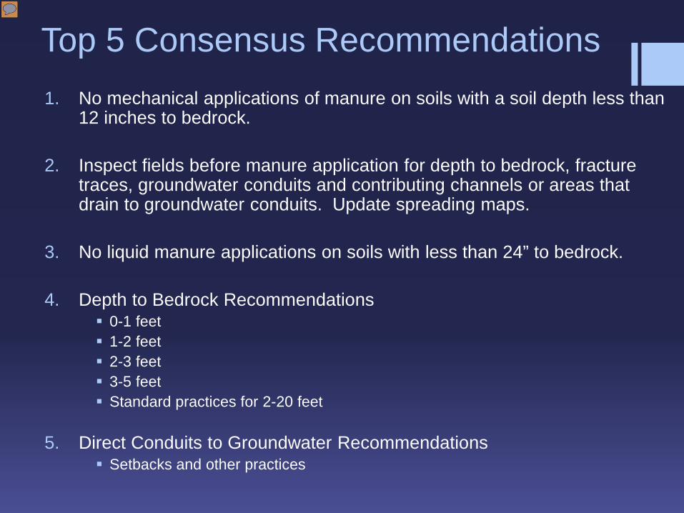
Top 5 Consensus Recommendations 1. No mechanical applications of manure on soils with a soil depth less than
12 inches to bedrock.
2. Inspect fields before manure application for depth to bedrock, fracture traces, groundwater conduits and contributing channels or areas that drain to groundwater conduits. Update spreading maps.
3. No liquid manure applications on soils with less than 24” to bedrock.
4. Depth to Bedrock Recommendations 0-1 feet 1-2 feet 2-3 feet 3-5 feet Standard practices for 2-20 feet
5. Direct Conduits to Groundwater Recommendations
Setbacks and other practices

1. Interim or intermediate steps are on a voluntary basis
2. Not final - should be evaluated over time
3. Focus on pathogen reduction and not directed towards reducing nitrate leaching to groundwater
4. Not meant to override meeting current performance standards or technical standards
5. Reconvene workgroup to review consensus and proposed recommendations after 2016 crop harvest
Consensus Recommendation Implementation Issues

Date: 9/14/2015
Areas Susceptible to Groundwater Contamination Sensitive Areas and Practices Groundwater Contamination Workgroup
Assumptions: • Focus on fractured dolomite/limestone as the primary bedrock type of concern.• Focusing primarily on bacteria/pathogen and nitrate contamination.• Source of contaminates includes but are not limited to: manure, industrial/municipal/septage
wastes, septic systems, fertilizers (agricultural and residential).• Focus on those materials that are applied to the landscape (liquid or solid forms).• Focus upon sandy soils, where present
Factors to identifying areas susceptible to groundwater contamination:
1. Depth to Bedrock or Groundwater: The depth to either bedrock or groundwater (whichever ismore limiting) greatly influences the potential for groundwater contamination as there is lesssoil depth available for treatment purposes.
2. Soil Type and Characteristics: The type of soil and characteristics of that soil determine thefiltering and water holding capacity of the soil. Sandier soils will have less filtering capacity, andtherefore less treatment capability, than clay soils impacting the drainage and permeabilityratings these soils have. Increasing soil health, organic matter and tilth can increase the waterholding and filtering capacity of some soils.
3. Land Use: The land use will play a critical role as to whether or not an area is susceptible togroundwater contamination. Agricultural and residential land uses may have highersusceptibility due to activities occurring on the land versus natural/undeveloped landscapeswhere little to no disturbance is occurring. Urbanized areas may have factors that fall in bothcategories and would need to be reviewed on in further detail depending on the contaminant.
Over-riding Considerations: Regardless of the factors listed above, certain elements have the potential to increase (or decrease) the potential of an area to be susceptible.
Conduits to Groundwater: The presence of a direct conduit to groundwater regardless of items1 through 3 above can increase the potential for a site to be susceptible. These areas mayinclude: a geologic feature (i.e. sinkhole), a manmade feature (i.e. well), channels or drain tileoutlets that drain to direct conduits to groundwater, and associated drainage areas thatcontribute to those features (i.e. watershed associated with a closed depression).
o An example of this may be the presence of a sinkhole in a forested lowland on the edgeof a field where the soils are generally more clay and there is a greater depth to bedrockor groundwater. While the conduit is located in a forested area which typically wouldhave a lower chance of susceptibility, the drainage to that sinkhole encompasses theneighboring agricultural field which increases the potential susceptibility. While thesoils may be less likely to infiltrate water and the depth to bedrock or groundwater is
1 | P a g e
Source: Groundwater Collaboration Workgroup Final Report, June 2016; page 21 and Appendix D document
Date: 9/14/2015
greater, the presence of the sinkhole acts like a pipe providing a direct “pipe” to groundwater and reducing or eliminating the potential treatment effects the surrounding soils may provide.
Water Supply Well - Wellhead Protection Area (WHPA): The land and subsurface area surrounding a water supply well through which contaminants are reasonably likely to be transported, and potentially enter, a well. This would include formally defined public water system WHPAs and designated protection areas around private home water supply wells.
Weather: Atmospheric conditions can play an important role in determining whether a site is
susceptible to groundwater contamination. Weather can change soil characteristics making it more or less susceptible.
o Drought: While clay soils typically have the ability to retain water and provide soil treatment, in drought conditions, these soils have a tendency to dry and crack opening conduits to more permeable soils or fractured bedrock below. In these situations, the fractures in a clay soil can act almost like a bedrock fracture at the surface and allow rapid transport of material down to groundwater.
o Frozen Conditions: When soils are frozen, there is less chance for material to infiltrate. However, in spring when the frost comes out of the ground, large pools of liquid that have built up behind closed depressional areas or in shallow bedrock/groundwater areas have a tendency to drain rapidly causing a large volume of material to flush through the system.
o Precipitation: Heavy precipitation events can force material to move through the soil profile more rapidly than normal or saturate soil and generate surface runoff. In general, soils with less permeability (i.e. clay) have more surface water runoff and soils with increased permeability (i.e. sand) allow water to infiltrate at a rapid rate reducing the soil’s treatment ability. In addition, soil saturation may also play a role in diminishing the soil’s treatment capability.
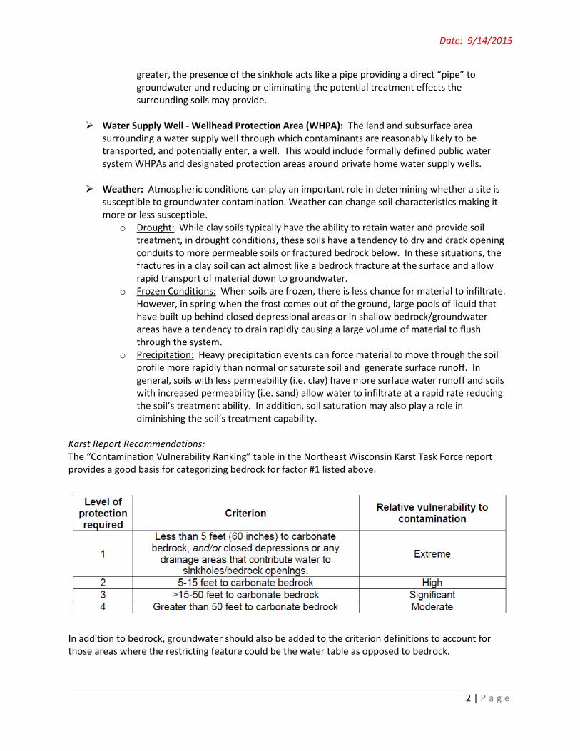
Karst Report Recommendations: The “Contamination Vulnerability Ranking” table in the Northeast Wisconsin Karst Task Force report provides a good basis for categorizing bedrock for factor #1 listed above.
In addition to bedrock, groundwater should also be added to the criterion definitions to account for those areas where the restricting feature could be the water table as opposed to bedrock.
2 | P a g e

Date: 9/14/2015
Existing Definitions: The following definitions are from DNR regulatory programs:
• “Site that is susceptible to groundwater contamination” under s. 281.16 (1)(g) , Stats, means any one of the following:
(a) An area within 250 feet of a private well. (b) An area within 1000 feet of a municipal well. (c) An area within 300 feet upslope and 100 feet downslope of a direct conduit to
groundwater. (d) A channel that flows to a direct conduit to groundwater. (e) An area where the soil depth to groundwater or bedrock is less than 2 feet. (f) An area where the soil does not exhibit one of the following soil characteristics:
1. At least a 2-foot soil layer with 40% fines or greater above groundwater and bedrock.
2. At least a 3-foot soil layer with 20% fines or greater above groundwater and bedrock.
3. At least a 5-foot soil layer with 10% fines or greater above groundwater and bedrock.
Chapter NR 151.015 (18), Wis. Adm. Code
• “Direct conduits to groundwater” means wells, sinkholes, swallets, fractured bedrock at the surface, mine shafts, non-metallic mines, tile inlets discharging to groundwater, quarries, or depressional groundwater recharge areas over shallow fractured bedrock.
Chapters NR 151.002 (11m) and NR 243.03 (20), Wis. Adm. Code
• “Water quality management area” or “WQMA” means [surface water references]… a site that is susceptible to groundwater contamination, or that has the potential to be a direct conduit for contamination to reach groundwater.
Chapter NR 151.015 (24), Wis. Adm. Code The following definitions are from NRCS Technical Standard 590 for Nutrient Management:
• Apparent Water Table – Continuous saturated zone in the soil to a depth of at least 6 feet without an unsaturated zone below it.
• Direct Conduits to Groundwater – Wells, sinkholes, swallets (a sinkhole or rock hole that intercepts a stream, diverting all or a portion of it to the groundwater), fractured bedrock at the surface, mine shafts, non-metallic mines, tile inlets discharging to groundwater, quarries, or depressional groundwater recharge areas over shallow fractured bedrock.
• High Permeability Soils – Equivalent to drained hydrologic group A that meet both of the following criteria:
1. Permeability = 6 inches/hour or more in all parts of the upper 20 inches and 2. Permeability of 0.6 inches/hour or more in all parts of the upper 40 inches
Use the lowest permeability listed for each layer when evaluating soil. For a multi-component map unit (complex), evaluate each component separately. If the high permeability components meet the criteria and cannot be separated, the entire map unit should be considered as high permeability.
3 | P a g e

SoilPasture/Hay
(Acres)
Cultivated Crops
(Acres) TOTAL% Restricted
AG acres20" to Bedrock 1,611 310 1,921 1.2%36" to Bedrock 19,071 9,122 28,193 17.7%60" to Bedrock 24,545 11,808 36,353 22.8%
AG Acres in Kewaunee Co.* 108,806 50,613 159,419
Total Acres in Kewaunee Co. 220,064
Soil Name Soil SymbolDepth to Rock
(Inches)Depth to Rock
(CM) Prevalence
(acres)Namur-Rock Outcrop NrD 7 18 < 1,000
Namur NaB 7 18 < 1,000 Ruse Ru 14 36 < 1,000
Casco-Rodman CdC2 17 43 < 1,000Casco-Rodman CdD2 17 43 < 1,000
Casco CbC2 18 46 > 1,000 Kolberg KxB 18 46 > 2,500 Casco CbB 18 46 > 5,000
Manawa McA 22 56 > 5,000 Longrie LoB 27 71 > 1,000 Bonduel Bn 30 76 < 1,000
Kewaunee KhB 30 74 > 10,000 Kolberg KwC2 31 79 < 1,000Kolberg KwB 31 79 > 2,500Onaway 7201 39 97 < 1,000Onaway 7203 39 97 < 10Onaway 7204 39 97 < 10
Onaway - Ossineke 7208 39 97 > 5,000Ossineke 7501 40 102 < 10
* = NRCS estimate - used 2011 NLC database

DOOR
BROWNKEWAUNEE
MANITOWOC
Kewaunee County "r" Restricted SoilsOverview Map
December 2015 ESRI Basemap WI Hydrology Layer NRCS HUC 10
'r" Restricted Soils

DOOR
BROWN
MANITOWOC
Kewaunee County Soils40" or Less to Bedrock
December 2015 ESRI Basemap Web Soil Survey Data
Soils with 40" or less to Bedrock