Embed Size (px)
Citation preview
Ann Reg Sci (1999) 33:213±232
9
Semantic interoperability:A central issue for sharing geographic information
Francis Harvey1*, Werner Kuhn2, Hardy Pundt2, Yaser Bishr2,Catharina Riedemann2
1Department of Geography, University of Kentucky, Lexington, KY 40506-0027, USA(e-mail: [email protected])2 Institute for Geoinformatics (IfGI), University of MuÈnster, D-48149 MuÈnster, Germany(e-mail: kuhn,hardy,bishr,[email protected])
Abstract. Technical interoperability has provided geographic informationcommunities with substantial improvements for constructing GIS capable ofvery low friction and dynamic data exchanges. These technical advances standto provide substantial advantages for sharing geographic information, how-ever reaping these advantages in highly heterogeneous operational and or-ganizational environments requires the understanding and resolution ofsemantic di¨erences. While the OpenGIS consortium has made importantprogress on technical interoperability, semantic interoperability still remainsan unpassed hurdle for e¨orts to share geographic information across organ-izational and institutional boundaries at the local, regional, and other levels.Identifying and resolving semantic interoperability issues is especially perti-nent for data sharing and considering future developments of standards. Thispaper presents an overview of semantic interoperability and through casestudies shows the breadth and depth of issues and approaches in di¨erentcountries and at di¨erent levels of organizations. These cases illustrate theimportance of developing ¯exible approaches to practical data sharing prob-lems that merge semantical with technical considerations. Based on our ex-aminations of semantic issues and approaches in ongoing research projects,we propose cognitive, computer science, and socio-technical frameworks forexamining semantic interoperability.
1. Semantic interoperability, standards, and data sharing
Interoperability is widely recognized as a new paradigm for joining heteroge-neous computer systems into synergistic units that facilitate a more e½cientuse of geographic information resources. This is part of a more comprehensiveenterprise-orientated view of information technology in general. Considerable
Please send all correspondence to F. HarveyThis work is supported by a grant from NCGIA's project Varenius. Portions of this paper werepresented at the Interop '99 conference (Zurich, March 1999) and will appear in that proceedingsvolume.
research on technical issues helps to cross many of the barriers that made mostinformation and GIS systems insular data (Bishr 1998). Although the goals oftransparent data exchange and remote access have yet to be reached by tech-nical interoperability, work on interoperability provides a basis for facilitatingdata sharing and helping resolve redundancy problems (McKee 1998). Recentinitiatives in the United States and elsewhere underscore the importance ofinteroperability in data sharing. E¨orts in the United States to build an in-frastructure for Federal geographic information sharing are now being com-plemented by e¨orts to build a national, federal, state, and local infrastructureof geographic information (NSDI) (National Academy of Public Admin-istration 1998). Data sharing is crucial, and technical interoperability willwithout doubt be signi®cant in building a more dynamic geographic in-formation infrastructure.
These technical opportunities warrant an examination of underlying ques-tions in regards to organizational, institutional, and cultural issues. How willdi¨erent agencies, organizations, institutions, and, ®nally, people, mean-ingfully use and share geographic information from multiple sources? Whatare the bene®ts of technical developments without applications? What costsare incurred when the technically feasible is impaired by unresolved organ-izational di½culties? We know that many information system projects don'twork (Ewusi-Mensah 1997). Design and implementation stages, criticalphases that meld the social and technical, are cited frequently as the origin ofthese breakdowns. Although the data sets might be exchangeable, roads inone agency can mean quite something di¨erent for another agency. How canthe geographic information systems of two agencies with di¨ering under-standing and models of roads be made interoperable? What are the semanticdi¨erences that should be addressed in constructing data sharing environ-ments and developing cross-standard exchange mechanisms? Data sharingdepends on reconciling di¨erent meanings. This paper looks at the issues oftransferring meaning (or semantics) on hand of three case studies and alsosketches out work developing methods to understand and resolve them. Theinitial work we present here points towards viable directions for consideringinteroperability not only as a technological issue, but rather as a con¯ux ofsocial and technical issues.
Data sharing needs to consider the di¨erent standards that are now in cir-culation as well. For some time, the call has gone out for viable standards thatlead to a frictionless exchange of data between agencies, regardless of whetherthey are in the same county government building, or across the world indi¨erent nations. This has led to a cacophony of standards, which suggests,perhaps, that the more you want to get people to agree, the more di¨erenceswill be found. Just as there is no single geographic reality that overrides allothers (Nyerges 1991), there is also no singular standard that encompasses thedi¨erent data models people use. The semantics of geographic phenomena aretoo broad for standardization. The key issue in standardization is ®ndingways to minimize information loss (Kuhn 1994).
Semantic interoperability goes beyond attempts to homogenize di¨erencesthrough standards. Accepting the diversity of geography and geographic in-formation technologies, this approach seeks ways to navigate di¨erences inmeaning. A central question underpinning our discussions about semanticinteroperability is how people and social groups with di¨erent perspectivesidentify and possibly resolve their semantic di¨erences. The construction of
214 F. Harvey et al.

information communities in heterogeneous institutional and disciplinary en-vironments calls for frameworks to conceptualize and articulate these seman-tic di¨erences. Semantic interoperability requires means to resolve complexdi¨erences that lurk behind apparently consensual terminology and proce-dures. This issue was frequently addressed as a crucial scienti®c issue at therecent Varenius I-20 Interoperability conference and workshop (NCGIA1997; Yuan 1997).
Semantic problems will persist and hinder the development of interoper-able solutions long after technical problems are solved. Several trends seem towork against a universal concept of one unique meaning for every geographicphenomena that technical interoperability and computer networking oftenseem to engender:
Previous e¨orts to specify uniform standards in the GIS community havenot met with great success, except where their adoption can be mandated.Even within a single agency there are di½culties in forcing compliancewith standards.
The fragmentation of the GIS software industry and increasing overlapwith other forms of software such as CAD and DBMS has made it moredi½cult to promote uniformity. After many years of concerted e¨ort, thefailure to arrive at a consensus on a unifying theory of geographic in-formation is frustrating. Because so much has been invested in research,data, and software already, it seems unlikely that a uniform theory couldbe successfully disseminated and accepted even if one could be foundÐifone were found, would the communities acknowledge it? Older systems ofknowledge dissemination are becoming confused by the comparative ease ofaccess to information on the Internet, the high prices of books and journals,and the budget problems faced by traditional libraries (NCGIA 1997).
Our research sets out to investigate the issues semantic interoperability posesin more depth and move beyond the past experiences with standards towardsdeveloping more ¯exible, non-normative approaches. An important startingpoint is geographic information communities (GIC) as described in theOpenGIS Abstract speci®cations (OGC 1998).
In design, implementation, data sharing, standardization, and interoper-ability, many common terms turn out to carry vastly divergent understandingsof the same or related phenomena. Terms such as `wetland' or `fallow' pretenda certain shared understanding, that provides some social coherence but,which on inspection, turns into complex and fragile arrangements of di¨erentsemantical models and intricate institutional agreements. Our initial researchactivities focus on understanding what constitutes semantic di¨erences andhow other researchers set out to understand and resolve them. As we willshow in the following Section 2, when di¨erent standards are competing, thechance to develop interoperable solutions is often minimal, though the need isparticularly strong.
2. Examples of semantic interoperability issues
This section documents the case studies we have investigated. Each case isdistinct and is approached di¨erently. The ®rst case, roads in Europe, stands
Semantic interoperability 215

out for its emphasis on ®nding mappings between divergent meanings as abasis for data sharing in an interoperable environment. The study of fallowlands in Europe points to the in¯uence institutional mandates assert on thesemantics, even when the phenomena in question are known under a commonname in identifying semantic di¨erences. The di½culties in negotiating a mu-tually acceptable de®nition of wetlands point to the problems ®nding viablesolutions between agencies. The last case study connects all these issues andillustrates how di½cult particular understandings make it for legal proceduresto be implemented.
2.1 What are roads?
Europe has a vast and extensive ground and water transportation network.Several public and private organizations deal with transportation information,e.g., suppliers of data for car navigation systems, logistics transportation, andtra½c control, management, and analysis. These agencies usually requiretransportation information that stretches beyond national borders. Forexample, tra½c management and control agencies sometimes require trans-portation information collected by mapping agencies.
There are several e¨orts to standardize transportation de®nitions andclassi®cation, e.g., ATKIS and GDF. Developed between 1985 and 1989,the O½cial Topographic-Cartographic Information System (AmtlichesTopographisch-Kartographisches Informationsystem) of the Federal Republicof Germany, ATKIS, is a topographic and cartographic model of reality.
Geographic Data Files, GDF, are a European standard released inOctober 1988 that was updated several times before 1995 (ERTICO 1998). Itaims to provide a reference data structure for describing road networks for carnavigation, vehicle routing, tra½c analysis and other applications. It has beencreated in order to improve e½ciency in the capture and handling of data forgeographic information industry.
The objectives of each standard di¨er because of di¨erences in the culturalsettings of each standard. These di¨erences correspond to social groupscalled geographic information communities (GICs'). In this case we considera German topographic GIC and a pan European tra½c management GIC.Di¨erent constellations of agencies and institutions may belong to multiplegroups. Both respectively take advantage of the ATKIS and GDF standards.We call them here for convenience, ATKIS GIC and GDF GIC, respectively.The ATKIS GIC conceptualizes transportation networks as artifacts that arepart of landscapes, which are presented in topographic maps. The GDF GICconceptualizes transportation networks as a section of the earth, which is de-signed for, or the result of any vehicular movement. Each GIC has a distinctpoint of view ± not only of their own data, but also of the point in exchangingdata. Roads are not always roads (ATKIS/GDF comparison) From the GDFGIC point of view, the main purposes of a connection between their in-formation system and the ATKIS information system are to provide the mostrecent and up to date information about new roads and status, e.g., to providean online service for car navigation systems.
From the ATKIS point of view, the main purposes of a connection be-tween their information system and the GDF information system, is to takeadvantage of the GDF's tra½c ¯ow information and routing information, and
216 F. Harvey et al.

provide it for local applications that adopt ATKIS as their base model andrequire more information about the tra½c ¯ow, direction, rules, etc.
Any consideration of this problem may start by asking the question ``Doestransportation network mean the same thing in the two GICs?''
In GDF, the term ``road'' encompasses roads, railways, waterways, junc-tions, rail junctions and water junctions, while in ATKIS waterways are notconsidered a part of ``roads.'' In the ATKIS GIC roads refer solely to groundtransportation networks. A road element is the smallest part of a road that hasa consistent width, e.g., does not change within a certain threshold. In GDF aroad network also encompasses ferry connections which are not implied inATKIS. A road element does not only depend on its width but also on tra½crules in GDF. For example, a new road element will be created in GDF if thedirection of ¯ow changes. In ATKIS this would be just one road element.
Even the term ``ferry networks'' in ATKIS refers only to ferryboats, whilein GDF a ferry is a vehicle transport facility between two ®xed locations onthe road network and which uses a prescribed mode of transport, for example,ship or train. Considering the ground transportation road network, we ®ndthat ATKIS includes pedestrian zones and bike paths as part of a road fea-ture, while in GDF, a pedestrian zone is not part of ``roads'' and a ``bikeroad'' is a type of a road network.
Figure 1 illustrates these di¨erences by showing a hypothetical road. BakerStreet is a two-direction street. In ATKIS it is viewed as one road element thathas two intersection points. In GDF the same road is presented as two roadelements, one for each direction of tra½c ¯ow. If you ask ATKIS GIC aboutBacker Street you will get one road as shown in Fig. 1b. If you ask the samequestion to the GDF GIC you will get two roads for Backer Street, one foreach tra½c ¯ow direction (Fig. 1c).
2.2 What are fallow lands?
Land use classi®cations are especially prone to di¨ering semantics of assumedsimilar land use types. Fallow land (often called ``set-aside land'' as well)
Fig. 1. a±c Roads are not always roads (ATKIS/GDF comparison)
Semantic interoperability 217

represents a special kind of land use subject to quite unique interpretations.Which land parcels in certain areas are assigned to the class ``fallow land''di¨ers between di¨erent geospatial information communities (GICs). Di¨er-ences depend on the rules and mandates by which parcels are designated. Suchrules are de®ned by speci®c GICs such as Nature Protection, Agriculture orLandscape Ecology.
In Germany, land use information is provided in the o½cial topographicand cartographic information system of Germany (ATKIS 1995). ATKISis based on an object catalogue where every geo-object is de®ned by severalattributes. Objects and attributes have identi®ers. ``Fallow land'', for example,is de®ned as object number 4110 in the ATKIS object catalogue.
Another GIC that is interested in information about ``fallow land'' isagriculture. For the purpose of paying subsidies to farmers, the GermanNational Chambers of Agriculture need information about the sizes of parcelswhich are declared as ``set-aside'' or ``fallow land'' (Groûe-Enking 1994; Weh-land 1994). However, the rules, de®ned within the chamber of agriculture GIC,to determinewhich parcels are ``fallow land'' are di¨erent from theATKIS rules.
Other GICs, e.g. Nature Protection, are seriously interested in informationabout ``fallow land'' within the framework of speci®c environmental projects.Many national nature protection laws de®ne the term ``fallow land'' clearly,and yet di¨erently (Klein et al. 1997).
As a consequence of the di¨erent semantics, it would not be possible to useATKIS data for nature protection projects, and even the nature protectionGIC could not share data with the agriculture GIC without considerable ad-ditional work. This case study represents a typical example of the limitationsvarying data semantics cause for interoperability between GICs.
In North Rhine-Westphalia (Germany) two agencies recently merged be-cause of political and ®nancial reasons. The agriculture agency was mergedwith the agency for ecology, landscape development and forestry. This merg-ing process gave rise to the di¨erent types of semantic heterogeneity not acrossGICs, but also within the same GIC. Although, it may now be one agency,the process of constructing a single GIC did not automatically follow thisadministrative action.
2.3 What are wetlands?
Data sharing encounters semantic issues head on in ways that frequently gobeyond technical and organizational issues and turns them into politicalissues. This is especially true for environmental phenomena that involveproperty rights. In the United States a very contentious category is ``wetlands''(Shapiro 1995). ``Wetlands'' mean di¨erent things to di¨erent agencies andindividuals. The apparently consensually agreed to term wetlands may con-ceal fundamental semantic di¨erences.
At the core of these debates lies the question, ``What exactly is a wetland?''The contentions surrounding Federal attempts to proclaim a wetland classi-®cation scheme, the Cowardin system developed by the U.S. Fish and WildlifeService 20 years ago (Cowardin et al. 1979) as a ``standard'' for use by theU.S. federal government (a process completed in 1997) illustrate well the in-tricate relationships between technology and institutions.
At least six agencies are involved in wetlands mapping activities throughover 19 programs and projects (Department of the Interior & Fish and Wild-
218 F. Harvey et al.

life Service, 1990). The agencies include the Fish and Wildlife Service (FWS),Geological Service (USGS), National Oceanic and Atmospheric Admin-istration (NOAA), Natural Resources Conservation Service (NRCS), andCorps of Engineers (CE). The programs range from activities required forhazardous waste clean-ups (Superfund), inventories of estuaries, ¯ood control,to various regional-federal-state cooperative programs with multiple goals. AsPresident Clinton's executive order leading to the organization of the FederalGeographic Data Center (FGDC) pointed out, it is necessary to improve thecoordination of these various activities.
Wetlands have seen much FGDC activity following this executive orderwith the speci®c Clinton policy goal to reconcile and integrate all federalagency wetland inventory activities (Shapiro 1995). A Wetlands subcommitteespeci®cally targeted this issue. To estimate the extent of the problems resultingfrom multiple de®nitions and establish ways to resolve them, comparisons ofdi¨erent wetland mapping techniques used in the Federal government weremade for an area in Maryland close to Washington DC. With the agenda toreconcile di¨erences and integrate results, this report comes to the conclusionthat the four data sets compared ``disagree in more than 90% of the area thatat least one of the four data sets delineates as wetland'' (Shapiro 1995, p. xiii).The report cites various reasons for this extreme disagreement, but acknowl-edges that even if the areas were extended by 50m in every direction (bu¨eredin GIS) the disagreement is still 60%. The maps included in the report dem-onstrate that the social agreement about de®nitions does not result in actuallydelineating the same areas on the landscape.
In conjunction with this analysis there was an attempt to standardizewetlands de®nitions and classi®cations, using the Fish and Wildlife ServiceCowardin Classi®cation Methods (Cowardin et al. 1979). This attempt metcontention, particularly from the US Corps of Engineers (CE), who was ap-parently not consulted by the FGDC. The CE has developed another meth-odology and found substantial di¨erences to the wetlands delineated by theCowardin classi®cation primarily because of the ecosystems orientation anddelineation of a wetland when just one positive wetland indicator is presentfor any parameter (vegetation, soils, and hydrology). The guidelines used bythe CE require all three parameters (Federal Geographic Data Committee &Wetlands Subcommittee 1997).
For groups with di¨erent mandates and semantics, such as the Corps ofEngineers, the Cowardin classi®cation is simply not a standard. As the pro-ponents from the Fish and Wildlife Service are forced to acknowledge, theCowardin system does not supersede existing law or agency policy, nor, mostimportantly, ``Application of the standard is not regulatory'' (Federal Geo-graphic Data Committee & Wetlands Subcommittee 1997). Other federalagencies embrace the Cowardin system, but the Corps of Engineers could re-sist this de®nition. In contrast to the Fish and Wildlife Service, the Corps ofEngineers characterize wetlands by combinations of vegetation, soils, and hy-drology aspects, not any single characteristic in isolation.
2.4 Noise abatement from sports grounds
Sport activities lead to noise. These noise emissions are addressed in the Ger-man ``LaÈrmminderungsplanung'' (noise abatement planning), an admin-
Semantic interoperability 219

istrative procedure dealing with multiple noise emissions coming from di¨er-ent sources, e.g. tra½c, industry and sports. When assessing the noise emittedfrom sports grounds, the understanding of terms plays an important role.
Noise abatement planning is designed as a small-scale instrument for ur-ban areas. Only those sports grounds that contribute signi®cantly to the noisesituation are examined in detail. Consequently, as a ®rst step the followingquestion must be answered: ``Which sports grounds qualify as relevant tonoise abatement planning?'' The term to be examined in this context is rele-vant sports ground. When the selected relevant sports grounds are looked at indetail, it is sensible to use existing information if it meets acoustic require-ments. This leads to the question: ``What data sets are used in modeling sportsgrounds for noise abatement planning?'' In other words: ``Do data sets existwhich have the same semantic understanding of a sports ground as an acous-tic expert?''
The local administration is responsible for noise abatement planning; thusinstructions contained in the law must ®rst be taken into consideration in de-termining which data sets are relevant. Further, it is useful to have a look athow such a task is executed, because this is done by people who did not createthe laws and because it usually needs re®nement and interpretation to putlegal instructions into practice. The following Table 1 shows how laws andother instructions in the federal state of North Rhine-Westphalia considersports grounds in noise abatement planning.
The table reveals that there is only one de®nition of sports grounds fornoise abatement purposes. The world of noise assessment seems to have acommon basic understanding of the term sports ground. However, di¨erencessoon show up. As the actual case becomes more practical, more criteria arefound and they become much more precise. In addition, an important changein criteria surfaces: the law refers to size (certainly taking it as a proxy foraspects of usage), but practice refers mainly to usage. Size is not mentioned,but instead refers to several more precise aspects of usage. A large number ofcriteria with high precision might be useful for understanding, but can makeinformation access di½cult. For a sports ground without scheduled use, no-body keeps a record of the hours of usage and the number of present people.In this case it becomes necessary to de®ne fewer criteria and dispense withaccuracy. Still, the same attributes have to be included. Probability of usageinstead of exact training and competition hours would be considered in thiscase (see table, rows 5 and 6).
Obviously di¨erent answers to the question ``Which sports grounds qualifyas relevant to noise abatement planning?'' will produce di¨erent results inemission assessment. The administration must avoid this as much as possible.Further, there is a point of communication. If you have to ask other author-ities for data, which happens regularly with noise abatement planning, youmust be able to give a precise description of what you want. This requires thatyou have a clear set of requirements and be able to express them adequatelyfor people outside of your discipline. If you ask for a list of all larger sportsgrounds and take the law literally, you might be presented with many sportsgrounds that are not used regularly and are consequently of no interest. Onthe other hand important smaller sports grounds being used regularly will notappear.
The ``Sportzentrum Roxel'', a sports complex in MuÈnster, was chosen as acase study to illustrate di¨erent views of sports grounds. It is a larger sports
220 F. Harvey et al.

Table 1. Sports grounds in North Rhine-Westphalian noise abatement planning
Regulation and informationsource
Aim, contents, de®nition ofsports grounds
Criteria for relevance ofsports grounds
1. Federal law for protectionagainst noise impact (§ 47aBImSchG)
introduces noise abatementplanning;
does not mention special noisesources like sports grounds;no de®nition
no criteria mentioned
2. Instructions concerning thefederal law for admin-istration; model (LAI1992) and version forNorth Rhine-Westphalia(VwV NRW)
makes instructions by lawmore concrete andpracticable;
mentions sports grounds asnoise sources;
no de®nition
. larger sports grounds
3. Instruction for protectionagainst the noise of sportsgrounds (18. BImSchV)
de®nes a uniform method forthe assessment of noiseimpact caused by sportsgrounds; assessmentprocedure;
stationary facilities intendedfor doing sports, includingfacilities that have closeproximity, spatially andoperationally
no criteria mentioned
4. North Rhine-Westphalianguide for making noiseimpact plans (Hillen 1993)
re®nes legal instructions to putthem into practice;
no de®nition
. competitions
. preparation of competitions
. run by municipalities,clubs, enterprises
. considerable noise emissionexamples:
football ®elds with more than200 spectators, tenniscomplex with more than 3courts
5. Practice, version for sportsgrounds with scheduleduse
carries out noise impactassessment
. outdoors
. ball games like soccer ortennis
. regular usage
. used by clubs
. competitions on Sundaysbetween 1 p.m. and 3 p.m.
. many spectators
. training after 8 p.m.
. usage of loud-speakers
. residential buildings in theneighborhood (within aradius of 200m in case of ausage before 8 p.m. or after10 p.m., otherwise within aradius of 100m)
6. Practice, version for sportsgrounds without scheduleduse
carries out noise impactassessment
. outdoors
. noisy forms of sports
. acceptance by population
. high probability of usageafter 8 p.m.
. much usage between 8 a.m.and 8 p.m. (counted in 25,50 or 75%)
Semantic interoperability 221
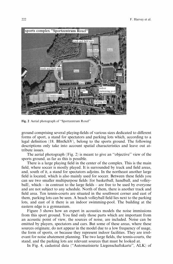
ground comprising several playing-®elds of various sizes dedicated to di¨erentforms of sport, a stand for spectators and parking lots which, according to alegal de®nition (18. BImSchV), belong to the sports ground. The followingdescriptions only take into account spatial characteristics and leave out at-tribute issues.
The aerial photograph (Fig. 2) is meant to give an ``objective'' view of thesports ground, as far as this is possible.
There is a large playing ®eld in the center of the complex. This is the main®eld, where soccer is mostly played. It is surrounded by track and ®eld areas,and, south of it, a stand for spectators adjoins. In the northeast another large®eld is located, which is also mainly used for soccer. Between these ®elds youcan see two smaller multipurpose ®elds (for basketball, handball, and volley-ball), which ± in contrast to the large ®elds ± are free to be used by everyoneand are not subject to any schedule. North of them, there is another track and®eld area. Ten tennis-courts are situated in the southwest corner and east ofthem, parking lots can be seen. A beach volleyball ®eld lies next to the parkinglots, and east of it there is an indoor swimming-pool. The building at theeastern edge is a gymnasium.
Figure 3 shows how an expert in acoustics models the noise immissionsfrom this sport ground. You ®nd only those parts which are important froman acoustic point of view, the sources of noise, are included. Noise can beemitted by players, spectators and cars. But some of these areas, where thesesources originate, do not appear in the model due to a low frequency of usage,the form of sports, or because they represent indoor facilities. They are irrel-evant for noise abatement planning. The two large ®elds, the tennis-courts, thestand, and the parking lots are relevant sources that must be looked at.
In Fig. 4, cadastral data (``Automatisierte Liegenschaftskarte'', ALK) of
Fig. 2 Aerial photograph of ``Sportzentrum Roxel''
222 F. Harvey et al.

the city of MuÈnster are shown. Cadastral data are meant to provide in-formation about location, shape and size of parcels as a basis for propertydocumentation and taxation.
From the cadastral perspective, sports grounds are not an object of pri-mary interest. They belong to the supplementary topography, which is notregistered systematically. This is why only few parts of the sports complexappear. There are three objects, each of which represents a generalization oftwo tennis-courts. In contrast to that, the parking lots are modeled in detail.The data model contains in addition objects for small and large ®elds, which iswhy we can expect extensions of the current map at some time, but no objectfor a stand.
The intention of topographic data is to show the surface of the earth andthe objects on it. Depending on scale and purpose, the modeling of real worldobjects in topographic maps varies. Figure 4 contains two examples forthis kind of data. On the one hand, a part of the German base map 1 : 5000(``Deutsche Grundkarte 1 : 5000'', DGK5, here not shown to scale) appears inblack lines. This map is available digitally only in raster format. On the otherhand, digital vector data of the Authoritative Topographic-Cartographic In-formation System (``ATKIS'') are shown in gray. The contents of ATKIS iscomparable to a topographic map with a scale of 1 : 25000.
In the DGK 5 (see Musterblatt DGK 5 1983), all ®elds are represented,but there are generalizations: the playing-®eld in the oval area is not a sepa-rate object, and two adjacent tennis-courts are represented by one object. Theparking lots are generalized as well by depicting just their outlines. Since theoutlines are not closed, they merge with the street to one object. The DGK5does not have an object ``stand''.
In ATKIS (see ATKIS-OK 1995), the whole sports complex is depicted byone large object. ATKIS also comprises objects like playing-®eld, stand and
Fig. 3. An acoustic model of the ``Sportzentrum Roxel''
Semantic interoperability 223

Fig. 4. ``Sportzentrum Roxel'' in ALK
Fig. 5. ``Sportzentrum Roxel'' in DGK 5 and ATKIS
224 F. Harvey et al.

parking lot, which could show more details, but they have not been includedhere yet. In the future, there will be a more detailed model of the sportscomplex.
The acoustic model used in noise abatement planning requires the ex-istence of certain objects at a certain level of generalization. The large ®elds,e.g., must be represented by rectangular objects, which means that the gener-alized oval object in the DGK5 is not acceptable. The parking lots just requireoutlines. In this respect the generalization of the DGK5 is better than the de-tailed cadastral data. For the consideration of spectators, which is only nec-essary for the large ®elds and not for tennis-courts, there are several possibil-ities. The easiest way is to assume spectators on the ®eld together with theplayers and the referee. When the number of spectators increases to more than500, more precision is needed and consequently geometry must change. Eitherthe spectator's stand must be introduced as an additional object, or the rec-tangle of the ®eld must be enlarged by several meters on the long sides. Thiswill somewhat improve results near the ®eld.
All data sets show weaknesses for noise abatement planning. The cadastraldata (Fig. 3), on the one hand, misses many objects, whereas parking lots aredepicted in too much detail. The DGK5 and ATKIS data models (Fig. 4) arenot detailed enough regarding the playing ®eld. ATKIS lacks any useful ob-jects at this time, although it is the only model that provides an object for thespectators stand.
All data models show that this is an area dedicated to sports, but each dataset has its own perspective di¨ering from the emissions legal perspective.Consequently each provides, at best, part of what is needed for emissionplanning. Currently, emissions studies rely on existing data that are oftendigitized again, or approximative data are used, although often more appro-priate data exist. This occurs because users are not presented with exactly thedata they need and because it is often too complicated to build the neededdata out of existing data sets. Support for transferring attributes and featuresemantics would help improve this situation. This would mean, on the onehand, improving the use of the available data and, on the other hand, givingaccess to the most appropriate data. To get an appropriate digital acousticmodel in the future, parts of future cadastral and future ATKIS data togethercan be taken as a basis and completed by digitizing supplementary informa-tion out of the DGK 5.
3. Semantic interoperability issues
Semantic interoperability, as the above cases illustrate, must account for avast range of issues and approaches to resolve situations with complicatedhistories. Standardization aids in documenting and reducing di¨erences,but cross-standard data sharing issues always remain. Clearly, each imple-mentation may need to combine data in di¨erent ways. The developmentof an interoperable GIS for a telecommunications company and utilitiescompany may require only a limited range of transfer points between GICs.The organizational requirements may be well known and the technical issuesmay be readily identi®able for the required process automation. InteroperableGIS for global change research may apparently present the opposite end ofthe spectrum, but even something as apparently mundane as data sharing in a
Semantic interoperability 225
county GIS, may be unsolvable if standards are used to entrench and con-struct data castles. Semantic interoperability is a way to avoid administrativedata wars and improve access by linking di¨erent groups in discussions aboutsubstantive technical issues (Harvey 1997b).
Technical issues remain crucial in delimiting the resources needed to de-velop viable interoperable solutions, but should be examined in light of se-mantic issues. First of all, based on our preliminary ®ndings, it is important todistinguish between open and closed systems. This di¨erentiation refers to thedegree in which the information systems in question are canonically de®nedand the system components documented. The information system of a nuclearpower plant is a closed system that eliminates outside factors (or controlsthem) in order to provide exact control over system functions. An open sys-tem, is, as the name indicates, not well de®ned, not rigorously documentedand subject to change. Most GIS used in public administrations probably fallinto this category.
Clearly, closed systems with their formalized descriptions and mathemat-ical rigor are ideally suited for intra-system interoperable solutions, but forsemantic interoperability between di¨erent closed systems (Bishr 1997, 1998;Harvey 1997b). Semantic interoperable solutions for open systems (which canalso involve di¨erent systems) call for a much wider range of considerationsthat we will discuss in the following section.
An important issue in determining semantic issues is assessing di¨erentviewpoints and perspectives. Understanding each groups semantics is morefundamental and a more viable solution than drafting canonical data de-scriptions and seeking to enforce them through regulations, that may, in fact,lead to more trench digging than otherwise. This is also an issue we discussfurther in the next section.
Finally, resolving semantic di¨erences calls for strong technical and socialprowess in mitigating di¨erences and presenting robust technical solutions.How di¨erent groups understand geographic phenomena may be central totheir institutional role and possibly even the broader social issues. Any Na-tional Mapping Agency has a long-standing de®nition of roads, often chiseledin deeper in bureaucratic stone than any standard. It will be far harder to altertheir semantic model than developing a translation package to exchange databetween their data model and others.
The cases above show how technical and organizational issues are en-meshed. Resolving semantic di¨erences requires that trenchant di¨erences beresolved in a holistic fashion. The two European road databases need to beunderstood in the context of the purposes for which they were constructed.Fallow lands designation is connected to an institutional mandate. Wetlandsare intricately part of agency agendas. The meaning of data comes throughuse. The semantics of interoperability and data sharing presents a means toaddress these issues and get to the di¨erences between groups.
4. Frameworks for semantic interoperability and data sharing
Although semantic issues are very broad, there has already been quite anamount of research in computer science, cognitive science, and anthro-pological linguistics that we should consider. We see this as a ®rst phase in a
226 F. Harvey et al.

broader research e¨ort that sets out to describe formal and computationalmodels for semantic interoperability. We are still in the process of consideringthis work for semantic interoperability, but we want to document the frame-works we have been investigating, and point out our initial and expectedresults in the following sections.
Our research is considering three frameworks that we will refer to with thelabels cognitive, computer scienti®c, and linguistic anthropological. Obviously,each of these three will have a distinct emphasis that we believe are not onlyinteresting and pertinent to examine in their own right, but even more so foreventual synergies between di¨erent frameworks. The rest of this sectionbrie¯y presents each framework. We defer any discussion about synergies tothe following, and ®nal, section of this paper.
4.1 Cognitive framework
The cognitive framework we are examining focuses on the work of Fauconnierand metaphorical mapping (Fauconnier 1994, 1997; Lako¨ 1997). In Fau-connier's concept of mental spaces, developed in the 1980s, the mind createsmultiple cognitive ``spaces'' to mediate its understanding of relations and ac-tivities in the world. We are looking at Lako¨'s work on metaphorical map-pings and Fauconnier's on more general mappings among conceptual domainswhich may well combine into an outstanding way to analyze semantic di¨er-ences and break-them down into integral components which could well becomethe base for more formal and rigorous models of semantic interoperability. Theessence of both these cognitive approaches are partial mappings from multiplesources structuring a target concept. Many of the semantic di¨erences we en-counter in our case studies appear to result from such partial structuring.Also, such mappings are amenable to mathematically rigorous formalizationand implementations, thus allowing for experimental testing of semanticmodels (Frank and Raubal, 1998). This work could complement computerscience work, although the process of formalization has yet to be tested.
4.2 Computer science framework
Substantial work on semantics as been published in computer science, whichprovides us with the strongest starting point for considering how to resolvesemantic di¨erences. At the present, we are perhaps furthest in building onAmit Sheth's computer science approach which is quite developed. Sheth's richpublications on interoperable computer system semantics provide us with aframework we don't feel to have yet exhausted (Kashyap and Sheth, 1996,1997; Sheth 1996, 1997; Sheth and Gala, 1989). Semantics for Sheth need to beassessed in terms of the context. The concept of semantic proximity refers to anabstraction or mapping between the domains of two objects. Establishing sim-ilarities calls for comparing the intensional (contextual) descriptions of the twoobjects, described in a description logic language that links the semantic andschematic level. Conceptually, semantic integration in this approach consists oftwo phases. In the ®rst phase objects are identi®ed in di¨erent databases thatare conceptually similar. In the second phase, the semantic di¨erences are re-solved between semantically related objects (Kashyap and Sheth, 1996).
Semantic interoperability 227

Sheth's approach provides the most rigorous framework we have found todate for dealing with semantic di¨erences in a practical, engineering-orientatedapproach. We have also begun to investigate the work of other computer sci-entists. The procedures outlined for dealing with partial incompatibilitiesbetween objects and domains are very detailed and beyond the focus ofthis paper to deal with in a just manner. This overview will hopefully serveas a suitable introduction to what we feel is a very promising approach toaddressing semantic di¨erences.
The concept in this approach is semantic proximity, which calls for de-clarative language to articulate the de®nitions of objects, and very strongontological de®nitions. Semantics is acknowledged to consist of more thanthis, and thus, this approach needs to be extended by a broader considerationof context, rather than just database ontologies and declarative descriptions.
According to Sheth and Kashyap semantics involves vocabulary, contentand structure (Sheth 1996). Reporting on a workshop, they point out thereis no clear de®nition of semantics among participants, but academics con-sistently refer to semantics as the similarities between objects, relationships,and context. If semantics are cultural agreements between independent agentsobserving the real world, then we expect that illuminating insights will comefrom the examination of the group processes that lead to `accepted' under-standings, and the role of language as the most fundamental way of ®ndingand assuring agreement.
4.3 Linguistic framework
Anthropologists, sociologists, and linguists have also examined semanticsalong these lines and have developed some very interesting insights thatprovoke us to think beyond the normal bounds of computer systems whenconsidering semantic interoperability. Their work is wholly outside thebounds of computer science, which, although a limitation, does not diminishits relevance for any activity we engage in involving language and socialgroups.
We have been examining approaches that consider the processes socialgroups engage in to assure collaborative action. Bruno Latour's well knowworks examine the historical process of consolidating power across divergentinterest groups, and the role of artifacts in enabling, e¨ecting, and replacinghuman action ± thus, acting themselves (Latour 1987, 1992, 1993, 1996;Latour and Bastide 1986). While most of this work is not directly pertinent toour project, its relevancy is expressed in the related work of lesser know, butmore empirical work that evaluates the processes of constructing informationtechnology in heterogeneous settings.
Barry's and Callon's work, for instance, points to the relevance of multiplegroups ®nding their interests supported by the information technology underdevelopment (Barry 1997; Callon et al. 1986; Coyne 1995). Without it, ulti-mately, a group's opposition leads to its failure. The role of technology hasbeen more extensively examined by other authors (Neumann and Star 1996;Star 1995a,b; Star and Griesemer 1989), which has also been recently appliedto GIS and geography (Harvey 1997ab). This work corresponds to similarityorientated work on participative design that clari®es the importance of in-volving di¨erent groups in articulating their di¨erences in order to ®nd robust
228 F. Harvey et al.

solutions to semantical, social, and political problems of information systemsdesign (Suchman 1987).
These points are all the pertinent when we bring linguistic anthropology's®ndings regarding the process of language development to bear on the issueof semantic interoperability. Many apparently simple problems of di¨erentmeanings are intricately tied together with the speci®c language used by acultural group. This is perfectly obvious when referring to di¨erent nationallanguages (German and English for instance) which are perfectly unable totranslate one-to-one common phrases into the other language. Versteht Ihrmich? has no direct equivalent in English. Translated as Do you understandme?, it loses the indication through the pronoun Ihr (second person plural) inGerman that the question is directed to more than one person, that thespeaker feels he/she can informally address.
These issues in dealing with one shared language (if English shouldbe counted as such, its regional and disciplinary di¨erences provide the bestcounterpoints) are more subtle, but multiple understandings can be associatedwith terms used by disciplines in di¨erent ways. Such common terms used forgeographic information are subject to myriad descriptions, disciplinary de®-nitions, and regional variations. The linguistic methods for studying di¨er-ences may be equally applicable for analytically determining crucial semanticdi¨erences (Holland and Quinn, 1987a,b; Salzmann 1993).
We believe these frameworks can each aid us ®nd valuable insights intoidentifying and resolving semantic di¨erences which can be crippling for datasharing and impair the successful dissemination and use of standards. Ourwork in progress speci®cally targets these two issues with the aim of makingscienti®c and research contributions.
5. Expected results and future research
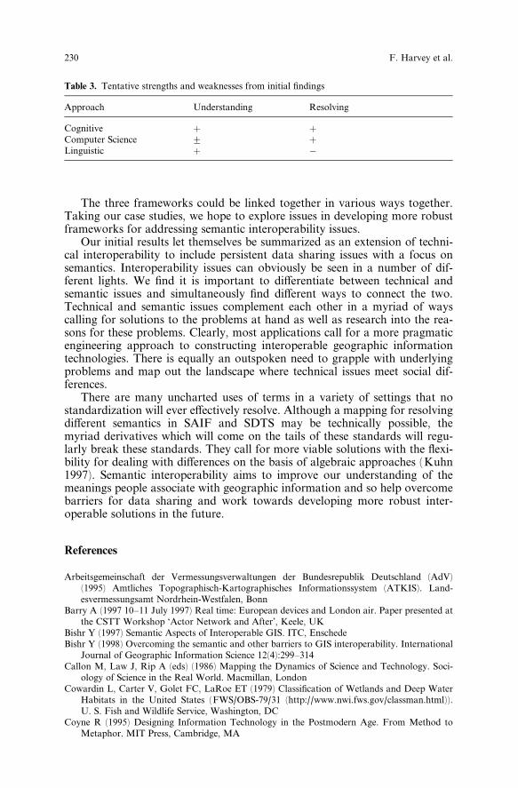
This paper provides an initial literature review of relevant frameworks forconsidering semantic interoperability and resolving cross-standard issues andgoing beyond lexical standards. We ®nd there is ample evidence already thatsemantic issues underlie many of the di½cult questions surrounding GIS datasharing and that as we conduct research on these questions we should strive todevelop frameworks for further work in this domain. Considered individually,the frameworks are helpful (Table 2), but their complementary use may bemuch more e¨ective.
Table 2. Components and brief descriptions of semantic proximity
Context representation partial or full representation, structural andsemantic components
Semantic taxonomy semantic similarity is a qualitative measureto distinguish semantic relationships
Semantic heterogeneities in Multidatabases Synonyms, data representation con¯icts,scaling, precision all need to be dealt with
Data value incomparability State di¨erences, time lags, etcAbstraction level incomparability Di¨erent generalizationsSchematic discrepancies Attributation con¯ictsStructural similarity Representation of structural similarities
Semantic interoperability 229
The three frameworks could be linked together in various ways together.Taking our case studies, we hope to explore issues in developing more robustframeworks for addressing semantic interoperability issues.
Our initial results let themselves be summarized as an extension of techni-cal interoperability to include persistent data sharing issues with a focus onsemantics. Interoperability issues can obviously be seen in a number of dif-ferent lights. We ®nd it is important to di¨erentiate between technical andsemantic issues and simultaneously ®nd di¨erent ways to connect the two.Technical and semantic issues complement each other in a myriad of wayscalling for solutions to the problems at hand as well as research into the rea-sons for these problems. Clearly, most applications call for a more pragmaticengineering approach to constructing interoperable geographic informationtechnologies. There is equally an outspoken need to grapple with underlyingproblems and map out the landscape where technical issues meet social dif-ferences.
There are many uncharted uses of terms in a variety of settings that nostandardization will ever e¨ectively resolve. Although a mapping for resolvingdi¨erent semantics in SAIF and SDTS may be technically possible, themyriad derivatives which will come on the tails of these standards will regu-larly break these standards. They call for more viable solutions with the ¯exi-bility for dealing with di¨erences on the basis of algebraic approaches (Kuhn1997). Semantic interoperability aims to improve our understanding of themeanings people associate with geographic information and so help overcomebarriers for data sharing and work towards developing more robust inter-operable solutions in the future.
References
Arbeitsgemeinschaft der Vermessungsverwaltungen der Bundesrepublik Deutschland (AdV)(1995) Amtliches Topographisch-Kartographisches Informationssystem (ATKIS). Land-esvermessungsamt Nordrhein-Westfalen, Bonn
Barry A (1997 10±11 July 1997) Real time: European devices and London air. Paper presented atthe CSTT Workshop `Actor Network and After', Keele, UK
Bishr Y (1997) Semantic Aspects of Interoperable GIS. ITC, EnschedeBishr Y (1998) Overcoming the semantic and other barriers to GIS interoperability. International
Journal of Geographic Information Science 12(4):299±314Callon M, Law J, Rip A (eds) (1986) Mapping the Dynamics of Science and Technology. Soci-
ology of Science in the Real World. Macmillan, LondonCowardin L, Carter V, Golet FC, LaRoe ET (1979) Classi®cation of Wetlands and Deep Water
Habitats in the United States (FWS/OBS-79/31 (http://www.nwi.fws.gov/classman.html)).U. S. Fish and Wildlife Service, Washington, DC
Coyne R (1995) Designing Information Technology in the Postmodern Age. From Method toMetaphor. MIT Press, Cambridge, MA
Table 3. Tentative strengths and weaknesses from initial ®ndings
Approach Understanding Resolving
Cognitive � �Computer Science G �Linguistic � ÿ
230 F. Harvey et al.

Department of the Interior, & Fish and Wildlife Service (1990) Federal Coastal Wetland MappingPrograms (Biological Report 90(18)). U.S. Department of the Interior, Washington, DC
Ewusi-Mensah K (1997) Critical issues in abandoned information systems development projects.Communications of the ACM 40(9):74±80
Fauconnier G (1994) Mental Spaces. Cambridge University Press, CambridgeFauconnier G (1997) Mappings in Thought and Language. Cambridge University Press, Cam-
bridgeFederal Geographic Data Committee, & Wetlands Subcommittee (1997) Proposal to Establish the
Cowardin System as the Federal Wetland Classi®cation Standard (WWW Document http://www.nwi.fws.gov/qanda.html). USGS, Washington DC
Forman RTT, Godron M (1986) Landscape Ecology. John Wiley & Sons, New YorkFrank AU, Raubal M (1998, 11±15 July 1998) Speci®cations for interoperability: Formalizing
image schemata for geographic space. Paper presented at the SDH `98, Vancouver, CanadaGroûe-Enking J (1994) Kontrollen bis 31. August. Landwirtschaftliches Wochenblatt 32(94):16±
17Harvey F (1997a, 19±21 November 1996) Agreeing to disagree: The social construction of geo-
graphic information technology. Paper presented at the GIS/LIS '97, Cincinnati, OHHarvey F (1997b). Improving Multi-Purpose GIS Design: Participative Design. In: Hirtle S,
Frank AU (eds) Spatial Information Theory. A Theoretical Basis for GIS, Vol. 1329, pp 313±328. Springer, Berlin Heidelberg New York
Holland D, Quinn N. (eds) (1987a) Cultural Models in Language and Thought. Cambridge Uni-versity Press, Cambridge
Holland D, Quinn N (1987b) Culture and cognition. In: Holland D, Quinn N (eds) CulturalModels in Language and Thought, pp. 3±40. Cambridge University Press, Cambridge
Kashyap V, Sheth A (1996) Semantic and schematic similarities between database objects: a con-text based approach. VLDB Journal 5:276±304
Kashyap V, Sheth A (1997) Semantic heterogeneity in Global Information Systems: The role ofMetadata, context, and ontologies. In: Papzoglou M, Schlageter G (eds) Cooperative In-formation Systems: Current Trends and Directions, pp. 1±30. Academic Press, New York
Klein M, Riecken U, SchroÈder E. (1997) Begri¨sde®nitionen im Spannungsfeld zwischen Natur-schutz und Landwirtschaft. Naturschutz und Landschaftsplanung 29(8):229±237
Kuhn W (1994, 5±9 September) De®ning semantics for spatial data transfers. Paper presented atthe Sixth International Symposium on Spatial Data Handling (SDH '94), Edinburgh, Scot-land, UK
Kuhn W (1997) Approaching the issue of information loss in geographic data transfers. Geo-graphical Systems 4(3):261±276
Lako¨ G (1997) Contemporary Theories of Metaphor. In: Ortony A (ed) Metaphor and Thought.Cambridge University Press, Cambridge
Latour B (1987) Science in Action. Harvard University Press, Cambridge, MALatour B (1992) Where are the missing masses? The sociology of a few mundane artifacts. In:
Bijker W, Law J (eds) Shaping Technology/Building Society, pp. 265±257. MIT Press, Cam-bridge, MA
Latour B (1993) We Have Never Been Modern (Porter, Catherine, Trans.). Harvard UniversityPress, Cambridge, MA
Latour B (1996) Aramis or the love of technology (Porter, Catherine, Trans.). Harvard UniversityPress, Cambridge, MA
Latour B, Bastide F (1986) Writing science ± fact and ®ction: The analysis of the process of realityconstruction through the application of socio-semiotic methods to scienti®c texts. In: CallonM, Law J Rip A (eds) Mapping the Dynamics of Science and Technology. Sociology of Sci-ence in the Real World, pp. 51±66. Macmillan, London
McKee L (1998, February) Open for business. Mapping Awareness 12:18±20National Academy of Public Administration (1998) Geographic Information for the 21st Century.
Building a Strategy for the Nation. National Academy of Public Administration, Washington,DC
NCGIA (1997, 3±4 December 1997) Paper presented at the INTEROP '97 International Confer-ence on Interoperating Geographic Information Systems, Santa Barbara, CA
Neumann LJ, Star SL (1996, 13±15 November 1996) Making Infrastructure: The dream of com-mon language. Paper presented at the PDC'96, Participatory Design Conference, Cambridge,MA, USA
Semantic interoperability 231

Nyerges T (1991) Representing geographical meaning. In: Butten®eld BP, McMaster RB (eds)Map Generalization: Making Rules for Knowledge Representation, pp. 59±85. LongmanScienti®c and Technical, Harlow, Essex
OGC (1998) Geospatial Information Communities ± Addressing the Geodata Semantics Problem,[HTML]. Available: http://www.opengis.org/techno/guide/guide980615/Chap6.htm [1998,5Oct1998]
Salzmann Z (1993) Language, Culture, and Society. Westview Press, New YorkShapiro C (1995) Coordination and Integration of Wetland Data for Status and Trend and In-
ventory Estimates (Technical Report 2). Federal Geographic Data Committee, WetlandsSubcommittee, Washington, DC
Sheth A (1996) Data Semantics: What, Where and How? Paper presented at the 6th IFIP Work-ing Conference on Data Semantics (DS-6), Atlanta, GA
Sheth A (1997, 3±4 December 1997). Semantic Interoperability in Infocosm: Beyond Infra-structural and data interoperability in federated information systems. Paper presented at theInternational Conference on Interoperating Geographic Systems (Interop'97), Santa Barbara
Sheth AP, Gala SK (1989, December 11±13, 1989) Attribute relationships: An impediment inautomating schema integration. Paper presented at the Workshop on Heterogeneous Data-base Systems, Chicago
Star SL (ed) (1995a) The Cultures of Computing. Blackwell Publishers/The Sociological Review,Oxford
Star SL (ed) (1995b) Ecologies of Knowledge. Work and Politics in Science and Technology. StateUniversity of New York Press, Albany
Star SL, Griesemer JR (1989) Institutional Ecology, ``Translations,'' and boundary objects:Amateurs and Professionals in Berkeley's Museum of Vertebrate Zoology. Social Studies ofScience 19:387±420
Suchman L (1987) Plans and Situated Actions. The Problem of Human-Machine Communica-tion. Cambridge University Press, Cambridge
Wehland W (1994) Neues zur FlaÈchenstillegung. Top Agrar 1(94):33Yuan M (1997, 3±4 December 1997). Development of a global conceptual schema for interoper-
able geographic information. Paper presented at the INTEROP '97 International Conferenceon Interoperating Geographic Information Systems, Santa Barbara, CA
232 F. Harvey et al.