Embed Size (px)
Citation preview

Selected Inventory of Potential Wetland Restoration Sites in the Buzzards Bay Watershed
Phase I: Southern Area
March 2004
Commonwealth of Massachusetts Mitt Romney, Governor
Kerry Healey, Lieutenant Governor
Executive Office of Environmental Affairs Ellen Roy Herzfelder, Secretary
Massachusetts Office of Coastal Zone Management
Tom Skinner, Director
Buzzards Bay Project National Estuary Program Joseph E. Costa, PhD., Executive Director

This is a publication of the Massachusetts Office of Coastal Zone Management (CZM) pursuant to National Oceanic and Atmospheric Administration Award No. NA17OZ2338. This publication is funded (in part) by a grant/cooperative agreement from the National Oceanic and Atmospheric Administration (NOAA). The views expressed herein are those of the author(s) and do not necessarily reflect the views of NOAA or any of its subagencies.

Buzzards Bay Project National Estuary ProgramMassachusetts Office of Coastal Zone Management
2870 Cranberry Highway East Wareham, Massachusetts 02538
(508) 291-3625 www.buzzardsbay.org
John Rockwell, Wetlands Specialist Sarah Williams, Land Use Analyst
Aria Brissette, Natural Resource Analyst
Selected Inventory of Potential Wetland Restoration Sites in the Buzzards Bay Watershed
Phase 1: Southern Area
Produced by:
Funded in part by, and prepared at the request of
Massachusetts Office of Coastal Zone Management Executive Office of Environmental Affairs
251 Causeway Street, Suite 800 Boston, MA 02114
(617) 626-1200
March 2004

Printed on Recycled Paper
Selected Inventory of Potential Wetland Restoration Sites in the Buzzards Bay Watershed – Phase I i
Table of Contents Table of Contents............................................................................................................................. i
List of Tables .................................................................................................................................. ii
List of Figures ................................................................................................................................. ii
Appendices...................................................................................................................................... ii
About This Selected Inventory ....................................................................................................... 1 Study Purpose .......................................................................................................................... 1 Information in the Inventory.................................................................................................... 1 How to Use the Information in the Inventory.......................................................................... 2 Distribution of the Inventory ................................................................................................... 2
Methods........................................................................................................................................... 3 Initial Site Selection................................................................................................................. 3 Site Selection Refinement........................................................................................................ 6 Site Visit Procedure ................................................................................................................. 9
Results........................................................................................................................................... 10
Acknowledgements....................................................................................................................... 10

Selected Inventory of Potential Wetland Restoration Sites in the Buzzards Bay Watershed – Phase I ii
List of Tables Table 1: Number of Sites Before and After Preliminary Selection Criteria ................................... 9 Table 2: Number of Restoration Sites and Acreage Sorted by Town........................................... 10 List of Figures Figure 1: Selected Inventory Study Area…………………………………………………………………..….3 Figure 2: Portion of New Bedford North Quadrangle 1948…………………………..…………………..5 Figure 3: Portion of New Bedford North Quadrangle 1973…………………………...………………….5 Figure 4: Layering of Data……………………………………………………………………………………….5 Figure 5: Site DART – 20………………………………………………………………………………………..6 Figure 6: Anomalies in the Orthophotographs……………………………………………………………….6 Figure 7: Public Facilities Located in a Former Wetland………….……………………………………7 Figure 8: Electric Easement……………………………………………………………………………………..7 Figure 9: Access Road Through Marsh…..…………………………………………………………………..8 Figure 10: Dry Field………………………………………….……………………………………………………8 Figure 11: Wet Field………………………………………………………………………………8 Appendices Appendix 1: Acushnet Restoration Sites…………………………………………………………………….13 Appendix 2: Dartmouth Restoration Sites…………………………………………………………………..39 Appendix 3: Fairhaven Restoration Sites……………………………………………………………………59 Appendix 4: Fall River Restoration Sites……………………………………………………………………79 Appendix 5: New Bedford Restoration Sites……………………………………………………………….87 Appendix 6: Westport Restoration Sites………………………………………………………..101

Selected Inventory of Potential Wetland Restoration Sites in the Buzzards Bay Watershed – Phase I 1
About This Selected Inventory Study Purpose This study was undertaken by the Buzzards Bay Project National Estuary Program (BBP) to identify potential wetland restoration opportunities in the southern portion of the Buzzards Bay Watershed. Of particular interest were both freshwater and saltwater wetlands that had been filled due to construction and agricultural related activities on public lands, private conservation areas, and abandoned cranberry bogs. This Selected Inventory is being produced as part of a series of Atlases, the first one being the “Atlas of Tidally Restricted Salt Marshes in the Buzzards Bay Watershed.” The salt marsh atlas identified salt marshes impaired by tidal restrictions and its purpose was to aid state and municipal officials in identifying potential remediation projects when road and bridgework is contemplated. It is hoped that this atlas will provide similar help to those government officials and local nongovernmental organizations looking for restoration projects as part of wetland mitigation efforts. Future efforts will be made to produce a "Selected Inventory of Potential Wetland Restoration Sites in the Buzzards Bay Watershed, Phase II: Northern and Eastern Areas." Although the BBP made considerable efforts to locate all wetland fill sites in the targeted parcels, we recognize that some sites may have been overlooked, and our list should not be considered definitive. Information in the Inventory The study area for this project encompassed the portion of the Buzzards Bay watershed in the southeastern Massachusetts towns of Acushnet, Dartmouth, Fairhaven, Fall River, Freetown, New Bedford, and Westport. Determining potential wetland restoration sites is a fairly complex task. Therefore, in order to establish a realistic set of achievable restoration sites, this project focused only on the following restoration opportunities:
o Public lands owned by the Commonwealth of Massachusetts - predominantly land managed by the Department of Fish and Game (formerly the Division of Fisheries, Wildlife, and Environmental Law Enforcement) and the Division of State Parks and Recreation (formerly the Department of Environmental Management);
o Municipally owned land (both conservation land and non-assigned town land); o Local land trust properties; and o Privately owned abandoned cranberry bogs.
The inventory of potential wetland restoration sites in this report contains the following information:
o Maps showing locations of potential wetland restoration sites within the study area; o An aerial photo of each restoration site with the extent of potential restoration area
shown; o Type of disturbance; o Approximate amount of fill to be removed for restoration; and o Property owner.

Selected Inventory of Potential Wetland Restoration Sites in the Buzzards Bay Watershed – Phase I 2
How to Use the Information in the Inventory For restoration sites of interest, the landowner should be contacted for a site visit. Since many of the sites have an existing use, coordination with the particular landowner is essential. While the amount of fill to be removed from the filled sites is given in the atlas, this information can only be viewed as a rough estimate. Furthermore, a more detailed look at each site may find more opportunities for restoration. What has been included in this atlas is the essential information for each site in order to save time for those seeking wetland restoration opportunities. The type of disturbance was included to give some idea concerning the level of environmental improvement as well as the cost of restoration. The depth of fill was included as it directly related to the cost of establishing pre-disturbance elevations to the site. Where possible, information on the type of fill was included as it too related to cost of removal. Distribution of the Inventory Distribution of the "Selected Inventory" will include single copies provided to the Conservation Commission and municipal executive (mayor, town manager, or selectmen) of each community. Additional copies will be provided to the Massachusetts Office of Coastal Zone Management, MassHighways, Army Corp of Engineers, NOAA, The Coalition for Buzzards Bay, Buzzards Bay Action Committee, Westport River Watershed Alliance, and area land trusts. A copy of the inventory has also been posted on the BBP web site, www.buzzardsbay.org.

Selected Inventory of Potential Wetland Restoration Sites in the Buzzards Bay Watershed – Phase I 3
Methods Initial Site Selection The area investigated for potential restoration sites included land in the Buzzards Bay watershed that is located within the following towns: Acushnet, Dartmouth, Fairhaven, Fall River, Freetown, New Bedford, and Westport (Figure 1). The BBP’s parcel GIS database was used to locate properties owned by the Commonwealth of Massachusetts, municipally owned land, privately owned abandoned cranberry bogs,1 and local land trust properties. The owner, or controlling agency, of the properties that were reviewed for potential restoration sites is given below for each town. Acushnet • Acushnet Park Commission • Acushnet Water Department • Acushnet Conservation Commission • Fairhaven-Acushnet Land Preservation Trust • New Bedford Harbor Trustee Council • New Bedford Water Department
Dartmouth • Dartmouth, Town of • Dartmouth Conservation Commission • Dartmouth Natural Resources Trust • Dartmouth Park Department • Dartmouth Water Department • Division of State Parks and Recreation • Department of Fish and Game • Fall River, City of • New Bedford, City of • The Trustees of Reservations • University of Massachusetts
1 The abandoned cranberry bog data was supplied by MassGIS and is available on their website, www.ma.state.us/mgis/massgis.htm.
Figure 1. Selected Inventory Study Area

Selected Inventory of Potential Wetland Restoration Sites in the Buzzards Bay Watershed – Phase I 4
Fairhaven • Division of State Parks and Recreation • Department of Fish and Game • Fairhaven, Town of • Fairhaven-Acushnet Land Preservation Trust • Fairhaven Conservation Commission
Fall River • Division of State Parks and Recreation • Department of Fish and Game • Fall River Conservation Commission • Fall River Water Department • Greater Fall River Land Conservation Trust • Massachusetts Land Conservation Trust • The Trustees of Reservations
Freetown • Division of State Parks and Recreation • Department of Fish and Game
New Bedford • Bristol County Conservation District • Division of State Parks and Recreation • Department of Fish and Game • New Bedford, City of • New Bedford Conservation Commission • New Bedford Parks Department
Westport • Division of State Parks and Recreation • Fall River Water Department • Westport, Town of • Westport Conservation Commission • Westport Land Conservation Trust
The property boundaries for the parcels owned by the above entities were overlain on two MassGIS ortho aerial photograph surveys with 0.5m pixel resolution. One of these photographic surveys was a black and white photography survey from March 1996 and the other was a color photography survey from April 2001. Restoration sites were identified on these properties by locating either areas of filled wetlands, changes in wetland boundaries, or anomalies in the photographs, such as apparent changes in features that might be inconsistent with wetland coverages. The wetland boundary information used for this analysis was based on three sets of information: historic and most recent United States Geographical Survey (USGS) topographic quadrangle maps, and the 1992 DEP Wetland Conservancy Program Maps. The historic USGS topographic maps dating from the late 1930s to the early 1940s were downloaded from http://docs.unh.edu/nhtopos/MassachusettsList.htm. These maps were

Selected Inventory of Potential Wetland Restoration Sites in the Buzzards Bay Watershed – Phase I 5
georeferenced and then where needed, a wetlands boundary was created from the georeferenced topographic maps. Wetland boundary changes were then evaluated by comparing the most recent USGS topographic wetlands (available from MassGIS) to the historical USGS topographic wetlands (Figures 2 & 3). The wetlands shown on the historic topographical maps and features evident on recent aerial photographs were also compared to the “core” wetlands identified in the 1992 Department of Environmental Protection Wetland Conservancy Program (DEP-WCP) wetland survey (Figure 4).2 The wetland boundaries identified by the Conservancy Program were based on evaluating infrared aerial photographs taken during early spring (leaf-off) conditions and are generally considered to delineate the minimum extent of wetlands, and not the regulatory wetland boundary pursuant to the Wetlands Protection Act.
2 Available from the MassGIS website.
2000 0 2000 4000 Feet
Figure 3: Portion of 1973 New Bedford North Quadrangle.
2000 0 2000 4000 Feet
Figure 2: Portion of 1948 New Bedford North Quadrangle.
1000 0 1000 2000 FeetDEP-WCP Wetlands1948 USGS Wetlands
Figure 4: Layering of Data (area depicted in illustrations 2 & 3, with the 1948 USGS wetlands and the DEP-WRP wetlands).

Selected Inventory of Potential Wetland Restoration Sites in the Buzzards Bay Watershed – Phase I 6
Site Selection Refinement A list of hundreds of potential wetland restoration sites was developed by overlaying property parcel coverages of targeted properties and wetland boundaries on the aerial photographs as described above. Due to the large number of sites all could not be field investigated, and because it was recognized that many of the filled or altered wetland areas on this list would not be viable restoration sites, a pilot study of 20 of the 51 sites identified in the Town of Dartmouth were field investigated to refine the remote selection process. Based on the site visits in this pilot study, the following types of sites were eliminated from consideration for the reasons given. 1. Footpaths Many sites on land trust and other passive recreation properties were existing footpaths. The BBP determined that these were not available for restoration, as the restoration activities would conflict with the existing use (Figure 5). 2. Vegetative Anomalies Some anomalies that were viewed in the orthophotographs did not represent actual wetland alterations. The 0.5m resolution orthophotographs available from MassGIS are detailed enough to show a fallen tree as something different from the surrounding area. Site visits revealed that many anomalies found in the orthophotographs were not wetland alterations (Figure 6).
Figure 5: Site DART-20
#
Typical Anomaly
100 0 100 200 Feet
Figure 6: Anomalies in the Orthophotographs

Selected Inventory of Potential Wetland Restoration Sites in the Buzzards Bay Watershed – Phase I 7
3. Existing Public Facilities Several sites turned out to be existing public facilities. The BBP determined that many public facilities were not available for restoration, as the restoration activities would conflict with the existing use (Figure 7). 4. Existing Utility Structures and Easements In areas where there were gas, electric, water, and sewer utility lines, wetlands had been altered to satisfy the needs of the particular utility. The BBP determined that the utility line easements were not available for restoration, as the restoration activities would conflict with the existing use (Figure 8).
City of New Bedford Athletic Fields
DEMSkating Rink
200 0 200 400 FeetFormer W etland (USGS 1948)DEP-WCP Wetlands
Figure 7: Public facilities located in a former wetland.
Electric Line Easement
Figure 8. Electric Easement
Selected Inventory of Potential Wetland Restoration Sites in the Buzzards Bay Watershed – Phase I 8
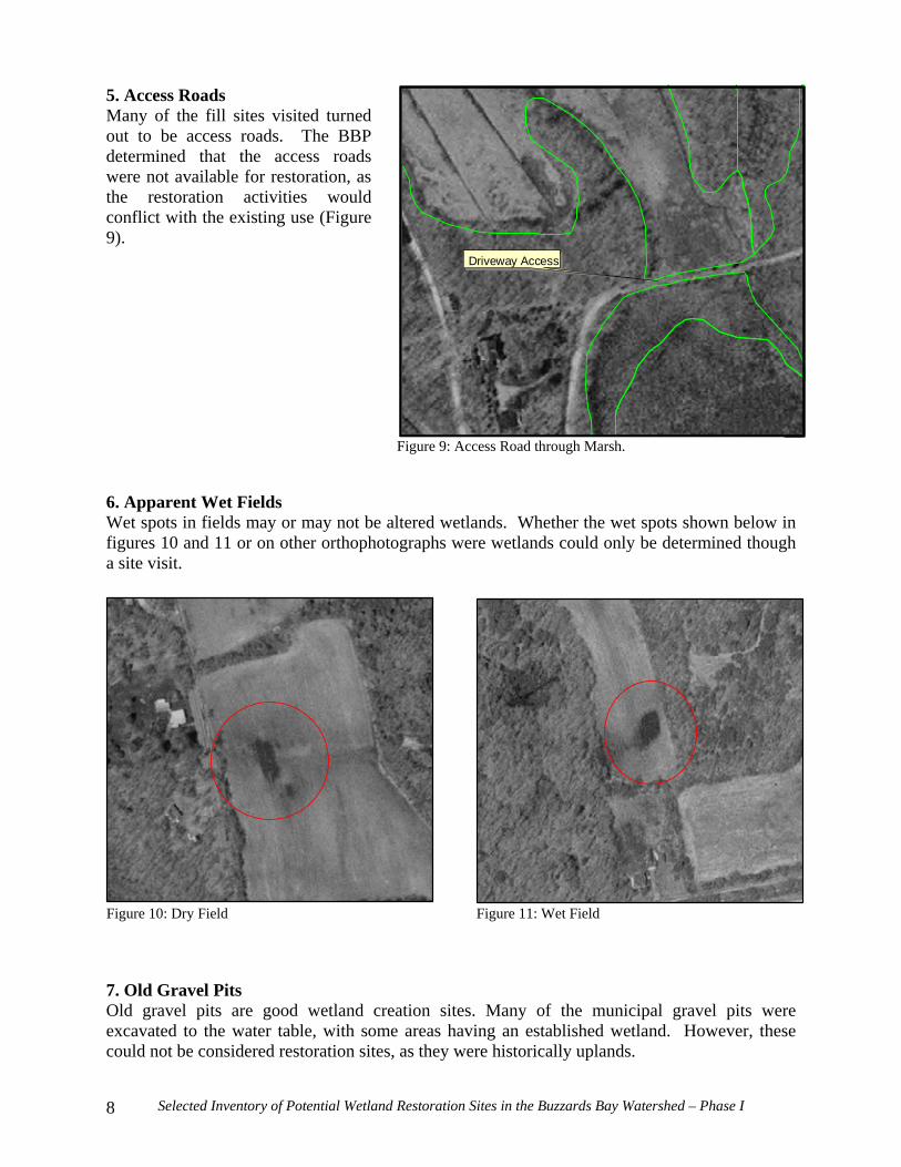
5. Access Roads Many of the fill sites visited turned out to be access roads. The BBP determined that the access roads were not available for restoration, as the restoration activities would conflict with the existing use (Figure 9). 6. Apparent Wet Fields Wet spots in fields may or may not be altered wetlands. Whether the wet spots shown below in figures 10 and 11 or on other orthophotographs were wetlands could only be determined though a site visit. 7. Old Gravel Pits Old gravel pits are good wetland creation sites. Many of the municipal gravel pits were excavated to the water table, with some areas having an established wetland. However, these could not be considered restoration sites, as they were historically uplands.
#
Driveway Access
Figure 9: Access Road through Marsh.
Figure 10: Dry Field Figure 11: Wet Field

Selected Inventory of Potential Wetland Restoration Sites in the Buzzards Bay Watershed – Phase I 9
The elimination of the seven categories of wetland alterations above reduced the number of sites needing field investigation from 225 to 120. The number of identified sites, before and after being sorted by the “pre-selection criteria,” is summarized by municipality in Table 1.
Table 1: Number of Sites Before and After Preliminary Selection Criteria
Town Abandoned Cranberry Bogs
Potential Sites Prior to Pre-selection
Criteria
Potential Sites After Pre-selection
Criteria Acushnet 4 51 32 Dartmouth 0 66 30 Fairhaven 1 28 18 Fall River 0 14 4 Freetown 1 4 1 New Bedford 1 26 17 Westport 0 36 18
Site Visit Procedure BBP staff visited the 120 sites that passed the Pre-selection Criteria. Based on these field investigations, the site was placed in one of the following three categories: • Rejected, Not Altered Wetland • Rejected, Restoration Criteria Not Met • Potential Restoration Site
Although the sorting process using the various information sources available was able to dramatically reduce the number of sites visited, several locations visited were found to be unaltered wetlands. This was considered normal as there was a different criterion for wetland identification for each data source, and the differences in coverage between the data sources were used to determine which sites to visit. These sites were identified as "Rejected, Not Altered Wetland." Many times conflicting uses were not apparent until a site visit was made. When the site contained an access road, park, ball field, utility lines, or some other use that was incompatible with a restoration project, the site was labeled as "Rejected, Restoration Criteria Not Met." Sites that were identified as altered wetlands and had opportunities for restoration were labeled as a "Potential Restoration Site." At "Potential Restoration Sites," the BBP personnel would inspect the site and note the type of disturbance, the extent of the disturbed area, and the depth of fill, if fill was the disturbance type. The extent of the fill was denoted on a color or black and white orthophotograph. Any additional information that could be of use was denoted on the orthophotograph margins. Areas that had more than one disturbance type were broken down into multiple sites with each disturbance listed as a discreet restoration site.

Selected Inventory of Potential Wetland Restoration Sites in the Buzzards Bay Watershed – Phase I 10
Results The types of disturbances discovered during the site visits were cropping, fill, abandoned cranberry bogs, and ditching. Cropping refers to the practice of cutting back vegetation to inhibit natural vegetation succession. Types of cropping found were: hay fields, mowed lawn, mowed rough of a golf course, and pasture. Since the type of fill may affect the cost of removal and disposal, the type of fill was noted when it could be determined. Types of fill encountered were gravel, road silt, asphalt, sand, trash, large stones, rocks (smaller stones), and municipal compost. There were 75 potential restoration sites in the study area, with the total area of all sites comprising 124 acres. Table 2 breaks down the number of restoration sites and acreage by town.
Table 2: Number of Potential Restoration Sites and Acreage Sorted by Town Town Number of Restoration Sites Total Acreage
Acushnet 21 16 Dartmouth 16 18 Fairhaven 16 23 Fall River 4 1 Freetown 0 0 New Bedford 10 59 Westport 8 7
Maps and data on each potential restoration site are included in the appendices. No maps for Freetown are included in this Atlas as there were no potential restoration sites identified in Freetown. Acknowledgements The Buzzards Bay Project staff wishes to thank David Janik, Bruce Carlisle, and Hunt Drury from the Massachusetts Coastal Zone Management Office.

Selected Inventory of Potential Wetland Restoration Sites in the Buzzards Bay Watershed – Phase I 11
Locus Map of Potential Restoration Sites
ÊÚ
ÊÚÊÚÊÚÊÚÊÚÊÚÊÚÊÚÊÚÊÚÊÚÊÚÊÚÊÚÊÚÊÚÊÚÊÚ
ÊÚ
ÊÚ
ÊÚ
ÊÚ
ÊÚ
ÊÚ
ÊÚÊÚÊÚ
ÊÚÊÚÊÚÊÚ
ÊÚÊÚ
ÊÚÊÚ
ÊÚ
ÊÚ
ÊÚÊÚ
ÊÚÊÚ
ÊÚ
ÊÚ
ÊÚÊÚ
ÊÚ
ÊÚÊÚ
ÊÚÊÚ
ÊÚ
ÊÚ
ÊÚ
ÊÚÊÚ
ÊÚ
ÊÚÊÚÊÚ
ÊÚ
ÊÚ
ÊÚ
ÊÚ
ÊÚ
ÊÚ
ÊÚ
ÊÚÊÚ
ÊÚ
ÊÚ
ÊÚÊÚ
ÊÚ
ÊÚ
DARTMOUTH
WESTPORT
NEWBEDFORD
ACUSHNET
FAIRHAVEN
FALL RIVER
FREETOWN
ROCHESTER
MATTAPOISETT
Study AreaCore Wetland ResourcesMajor PondsRivers & StreamsMajor RoadsBuzzards Bay Subwatersheds
ÊÚ Potential Restoration Sites
Map prepared by:Buzzards Bay Project National Estuary Program2870 Cranberry Highway, E. Wareham, MA 02538
N
10000 0 10000 20000 Feet
SlocumsRiver
Subwatershed
E. BranchWestport
RiverSubwatershed
W. BranchWestport
RiverSubwatershed
AllensPond
Subwatershed
LittleRiverSub-
watershed
ApponagansettBay
Subwatershed
ClarksCove
Subwatershed
InnerNew Bedford
HarborSubwatershed
MattapoisettHarbor
Subwatershed
NasketucketBay
Subwatershed
.-,195
(/6
#S88
#S18
#S140
#S105

Selected Inventory of Potential Wetland Restoration Sites in the Buzzards Bay Watershed – Phase I 12