Embed Size (px)
Citation preview
The 14th
World Conference on Earthquake Engineering October 12-17, 2008, Beijing, China
SEISMIC HAZARD IN ANDALUSIA REGION (SOUTHERN SPAIN).
B. Benito1, M. Navarro2, J. M. Gaspar-Escribano1, F. Vidal3, A. Góngora2, M. J. García Rodríguez1 , Martínez Solares, J.M4
1 ETSI Topografía, Geodesia y Cartografía, Universidad Politécnica de Madrid, Spain
2Universidad de Almería, Almería, Spain
3 Universidad de Granada, Granada, Spain.
4 Instituto Geografico Nacional, Spain. Email: [email protected]
ABSTRACT :
The global objective of the SISMOSAN Project has been to provide a general seismic risk assessment of Andalusian region (Southern Spain) associated with the ground motions expected for a return period of 475 years. The project was financed by Civil Defence of Andalusia and its results will be applied to the definition of regional emergency plans. We present here the study and main results of the first phase of the project, aimed at evaluating seismic hazard. In contrast to most of the previous studies in the region, which were performed forpeak ground accelerations (PGA) making use of Intensity-to-PGA relationships, hazard was here calculated in terms of magnitude and using published spectral ground-motion models. Moreover, we have considered distinct models for the Atlantic earthquakes, since the attenuation of those motions seem to be slower, as evidenced bythe extensive macroseismic areas of the 1755, 1969 and 2007 earthquakes. A comprehensive revision of the seismic catalogue, as well as of the seismogenic models proposed for the region (including those for North Africa, which is part of the influence area) has been done. In a first step, seismic hazard was evaluated at generic rock sites covering the entire region, using a seismic catalogue homogenized to moment magnitude andconsidering attenuation models in terms of PGA and spectral ordinates (SA). A Probabilistic Seismic HazardAssessment (PSHA) methodology was followed using a logic tree, in order to constrain the epistemic uncertainty, including two nodes for different options of zonification and attenuation models. In a second step, a geotechnical characterization of the whole region has been carried out, mainly inferred from geological maps and refined with on-site data, which are combined with rock acceleration estimates, in order to compose hazard maps that incorporate local soil effects.
KEYWORDS: Seismic Hazard, Response spectra, Normative, Spain
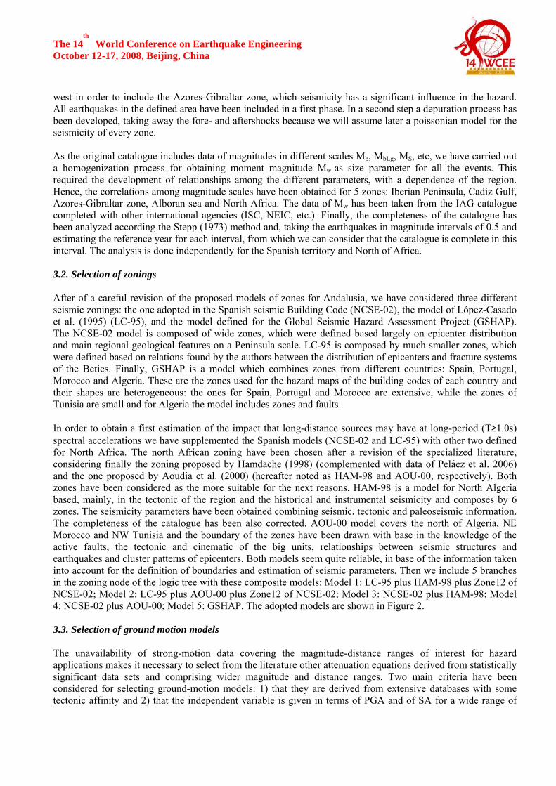
1. INTRODUCTION Andalusia, located in southern Spain, is an area of low-to-moderate seismic activity in a global context, but one of the Spanish regions with higher seismicity. Consequently, most seismic hazard studies in Spain have been focused in this region. Damaging earthquakes have struck the region several times in the last 500 years; the IEMSIX-X, December 25th, 1884 Arenas del Rey and the IEMS IX September 22nd, 1522 Gulf of Almería have been the more destructive events. In the last 20 years some earthquakes with magnitude Mw ~5 took place, causing some damage and big alarm in the population, like the December 12th, 1989 Ayamonte; December 23rd, 1993 Berja;January 4th, 1994 Adra and February 4th, 2002 Gergal earthquakes. Consequently, local authorities have promoted a seismic risk assessment study of Andalusia aimed at definition of the emergency plans, which has been named the SISMOSAN project. The first part of the project is the seismic hazard analysis presented in this paper. The seismic hazard assessment of moderate seismic areas is flawed by many factors. The scarceness ofinstrumental records of significant seismic sequences is one of the most crucial, due to the unavailability of strong-motion models covering magnitude ranges of engineering significance (Mw>5.0) (e.g., Benito and

The 14th
World Conference on Earthquake Engineering October 12-17, 2008, Beijing, China Gaspar-Escribano, 2007). It is also important to quote the difficulties in characterizing seismic sources. To overcome these shortcomings, different authors have performed their studies based strongly on the historicalseismic record of south Spain. This paper presents a new probabilistic seismic hazard assessment (PSHA) of the Andalusian region, accounting for the epistemic uncertainty in seismic source definition, and ground-motion attenuation, by means of a logic tree. The main results are hazard maps in terms of both PGA and SA. It is worthy to note two importantpeculiarities of the study. First, we have considered special strong-motion models for the Atlantic earthquakes (Azores-Gibraltar zone), taking into account the slower attenuation observed in this zone compared with theMediterranean or continental shocks. The adopted models have been checked with local data of recentearthquakes. Secondly, we follow a regional approach for including local effect in the seismic hazardestimations. As results of the study we develop, in a first phase, the hazard maps for rock conditions and for the 475-year return period in a wide range of spectral ordinates, and in a second step the hazard maps considering soil conditions. This is the first time that seismic expected ground motions, expressed as PGA, SA(T), and intensity (EMS) have been obtained for Andalusia including the influence of shallow ground structure on the shaking strength. These last maps show in a more realistic way the actual seismic hazard of the entire region. 2. SISMOTECTONIC FRAME 2.1. Regional Tectonic Setting The main geologic structures of Southern Spain include, besides the southern boundary of the Iberian Variscan massif, the Betics and the Guadalquivir Basin (Vera et al., 2004). Figure 1 shows the tectonic map of the region.The Betics represent the northernmost part of the Alboran region, a tectonic domain located in the western part of the Alpine orogenic belt. This domain, consisting of the Alboran sea and the Betics and Rif ranges, hasexperienced a complex Neogene continental deformation distributed over a broad zone more than 500 km widestretching from the High Atlas in Morocco to the Betics in Spain (Calvert et al, 2000). Active extension of the Betics continued until the end of the Miocene. In the Pliocene and Quaternary gross plate motions reassertedcontrol of the deformation in the region with primarily NNW-SSE shortening and strike-slip faulting (Calvert et al, 2000), which coexists with radial extensional stress pattern in the (western) Alboran Basin. During thebuilding up of the Betics several basins developed. The largest one is the Guadalquivir Depression, the Neogene northern foreland basin of the Betics, widening southeastwards. Other smaller Neogene intramontane pull-apart basins are located within the Betics, accommodating strong internal deformation (Huércal-Overa, Guadix-Baza, Granada basins).
Figure 1. Left: geological map of southeastern Spain. Right. Epicenter distribution of the historical (pentagons) and instrumental (circles) events in Andalusia.

The 14th
World Conference on Earthquake Engineering October 12-17, 2008, Beijing, China
2.2. Seismicity Andalusia presents a low-to-moderate seismic activity associated with the continent-continent collision between Africa and Eurasia plates and distributed over a wide area. Seismic energy is released predominantly throughfrequent, small seismic events (Grimison and Chen, 1986) and unusual earthquakes of moderate magnitude,most of them at shallow depth (h < 40 km), a significant number with foci at intermediate depth (40 < h < 150 km) and only a few rare very deep events (around 630km) (Vidal, 1986). Regarding the instrumental seismicity, the Andalusian events were firstly detected with a few local stations at the beginning of the XX century, afterwards with a gradually improved national seismic network, mainly since1962 and specially from 1983 to the present with the deployment of two local seismic networks also. Themainland Andalusian earthquakes instrumentally recorded generally are of low magnitude (Mw ≤ 5.5),exception done of 1910 Adra coast earthquake (Mw 6.2) and the very deep 1954 Durcal earthquake (Mw 7.0).Nevertheless, several strong earthquakes (Mw ≥ 6.5) occurred near Andalusia during the last half century: those of 1954, 1980 and 2004 in northern Algeria, 2004 in northern Morocco and 1969 and 2007 at the Gorringe Bank (SW Portugal); all them evidencing the influence of that seismogenetic zones in the hazard of Andalusia. The historical seismicity of Southern Spain is not well documentary known for the period before 15th century, when the area was under the Islamic dominion. During XV to XX centuries, several strong and damagingearthquakes took place with onshore epicentral location, being the most important those of the years 1431, 1522,1680, 1804, 1829 and 1884 with an intensity IEMS ≥ IX and others occurred in 1504, 1518, 1522, 1531, 1645,1658, 1674, 1748, 1806 that reached an intensity IEMS ≥ VIII. Other important historical shocks, with offshore epicenter but with high felt intensity in land (IEMS around VIII), are those of 1494 in South of Malaga, 1357 inAlmeria Gulf, and 1856 and 1722 in the Gulf of Cadiz. Furthermore, a relative distant marine active zonelocated SW of Saint Vicent Cape (Portugal) is the source of large magnitude earthquakes as those of 1356 and1755 affecting southwestern Spain. The most important one is the 1755 Lisbon earthquake, Mw magnitude around 8.5, and felt in Huelva and Cádiz with IEMS VIII (Martínez-Solares, 2001). The related tsunami caused destructive effects in the Spanish coast of the Gulf of Cadiz, causing more than 900 casualties. All these seismicevents are crucial in seismic hazard studies of this region. In the present study, a review of the more relevant historical earthquakes (I≥ VII or M ≥5.0) that occurred from 1000 to 1904 A.D. in Andalusia was carried out using available historical documents and archaeological data.As a result, 68 historic earthquakes underwent some modifications with respect to earlier studies. 3. SEISMIC HAZARD APPROACH (ROCK SITES) The seismic hazard analysis will follow a probabilistic zoning method framed in the well known PSHA methodology. A logic tree with two nodes for capturing epistemic uncertainty related to seismic zoning andground-motion models are formulated. In a first phase, the inputs for the application of this method have beenprepared: Seismic catalogue, seismogenic models and attenuation laws. 3.1. Seismic Catalogue A seismic catalogue has been created, taking as initial data base the information compiled in the catalogues of the Instituto Geográfico Nacional (IGN) and the Instituto Andaluz de Geofísica (IAG). A deep revision of the historical earthquakes with I≥VII has been done. After of this revision, a process of depuration andhomogenization of the catalogue to moment magnitude has been carried out. We prepared a final catalogue for the influence area, which is considered as the region in an extension ofapproximately 300 km from the boundary of the Andalusian territory. The area has been extended further to the
The 14th
World Conference on Earthquake Engineering October 12-17, 2008, Beijing, China west in order to include the Azores-Gibraltar zone, which seismicity has a significant influence in the hazard. All earthquakes in the defined area have been included in a first phase. In a second step a depuration process has been developed, taking away the fore- and aftershocks because we will assume later a poissonian model for the seismicity of every zone. As the original catalogue includes data of magnitudes in different scales Mb, MbLg, MS, etc, we have carried out a homogenization process for obtaining moment magnitude Mw as size parameter for all the events. This required the development of relationships among the different parameters, with a dependence of the region.Hence, the correlations among magnitude scales have been obtained for 5 zones: Iberian Peninsula, Cadiz Gulf,Azores-Gibraltar zone, Alboran sea and North Africa. The data of Mw has been taken from the IAG catalogue completed with other international agencies (ISC, NEIC, etc.). Finally, the completeness of the catalogue has been analyzed according the Stepp (1973) method and, taking the earthquakes in magnitude intervals of 0.5 and estimating the reference year for each interval, from which we can consider that the catalogue is complete in thisinterval. The analysis is done independently for the Spanish territory and North of Africa. 3.2. Selection of zonings After of a careful revision of the proposed models of zones for Andalusia, we have considered three differentseismic zonings: the one adopted in the Spanish seismic Building Code (NCSE-02), the model of López-Casado et al. (1995) (LC-95), and the model defined for the Global Seismic Hazard Assessment Project (GSHAP).The NCSE-02 model is composed of wide zones, which were defined based largely on epicenter distribution and main regional geological features on a Peninsula scale. LC-95 is composed by much smaller zones, which were defined based on relations found by the authors between the distribution of epicenters and fracture systemsof the Betics. Finally, GSHAP is a model which combines zones from different countries: Spain, Portugal,Morocco and Algeria. These are the zones used for the hazard maps of the building codes of each country and their shapes are heterogeneous: the ones for Spain, Portugal and Morocco are extensive, while the zones of Tunisia are small and for Algeria the model includes zones and faults. In order to obtain a first estimation of the impact that long-distance sources may have at long-period (T≥1.0s) spectral accelerations we have supplemented the Spanish models (NCSE-02 and LC-95) with other two defined for North Africa. The north African zoning have been chosen after a revision of the specialized literature, considering finally the zoning proposed by Hamdache (1998) (complemented with data of Peláez et al. 2006) and the one proposed by Aoudia et al. (2000) (hereafter noted as HAM-98 and AOU-00, respectively). Both zones have been considered as the more suitable for the next reasons. HAM-98 is a model for North Algeria based, mainly, in the tectonic of the region and the historical and instrumental seismicity and composes by 6zones. The seismicity parameters have been obtained combining seismic, tectonic and paleoseismic information.The completeness of the catalogue has been also corrected. AOU-00 model covers the north of Algeria, NE Morocco and NW Tunisia and the boundary of the zones have been drawn with base in the knowledge of theactive faults, the tectonic and cinematic of the big units, relationships between seismic structures and earthquakes and cluster patterns of epicenters. Both models seem quite reliable, in base of the information taken into account for the definition of boundaries and estimation of seismic parameters. Then we include 5 branchesin the zoning node of the logic tree with these composite models: Model 1: LC-95 plus HAM-98 plus Zone12 of NCSE-02; Model 2: LC-95 plus AOU-00 plus Zone12 of NCSE-02; Model 3: NCSE-02 plus HAM-98: Model 4: NCSE-02 plus AOU-00; Model 5: GSHAP. The adopted models are shown in Figure 2. 3.3. Selection of ground motion models The unavailability of strong-motion data covering the magnitude-distance ranges of interest for hazard applications makes it necessary to select from the literature other attenuation equations derived from statistically significant data sets and comprising wider magnitude and distance ranges. Two main criteria have been considered for selecting ground-motion models: 1) that they are derived from extensive databases with some tectonic affinity and 2) that the independent variable is given in terms of PGA and of SA for a wide range of
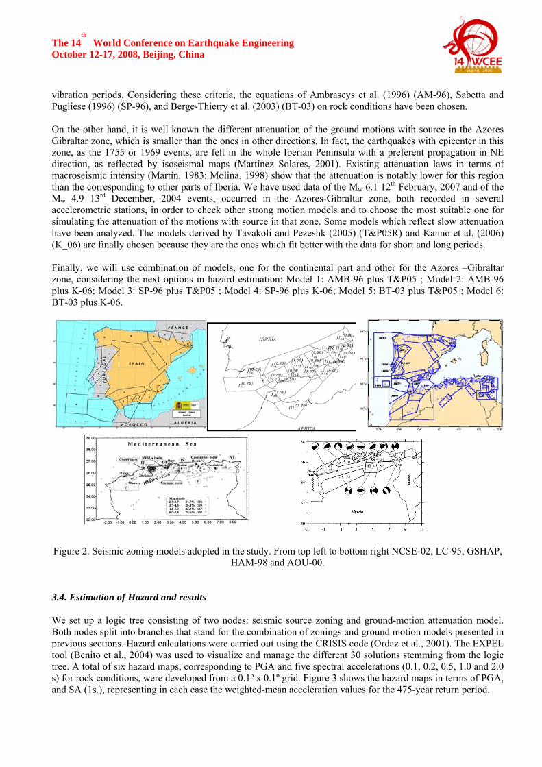
The 14th
World Conference on Earthquake Engineering October 12-17, 2008, Beijing, China vibration periods. Considering these criteria, the equations of Ambraseys et al. (1996) (AM-96), Sabetta and Pugliese (1996) (SP-96), and Berge-Thierry et al. (2003) (BT-03) on rock conditions have been chosen. On the other hand, it is well known the different attenuation of the ground motions with source in the AzoresGibraltar zone, which is smaller than the ones in other directions. In fact, the earthquakes with epicenter in this zone, as the 1755 or 1969 events, are felt in the whole Iberian Peninsula with a preferent propagation in NE direction, as reflected by isoseismal maps (Martínez Solares, 2001). Existing attenuation laws in terms ofmacroseismic intensity (Martín, 1983; Molina, 1998) show that the attenuation is notably lower for this region than the corresponding to other parts of Iberia. We have used data of the Mw 6.1 12th February, 2007 and of the Mw 4.9 13rd December, 2004 events, occurred in the Azores-Gibraltar zone, both recorded in several accelerometric stations, in order to check other strong motion models and to choose the most suitable one for simulating the attenuation of the motions with source in that zone. Some models which reflect slow attenuation have been analyzed. The models derived by Tavakoli and Pezeshk (2005) (T&P05R) and Kanno et al. (2006)(K_06) are finally chosen because they are the ones which fit better with the data for short and long periods. Finally, we will use combination of models, one for the continental part and other for the Azores –Gibraltar zone, considering the next options in hazard estimation: Model 1: AMB-96 plus T&P05 ; Model 2: AMB-96 plus K-06; Model 3: SP-96 plus T&P05 ; Model 4: SP-96 plus K-06; Model 5: BT-03 plus T&P05 ; Model 6: BT-03 plus K-06.
Figure 2. Seismic zoning models adopted in the study. From top left to bottom right NCSE-02, LC-95, GSHAP,
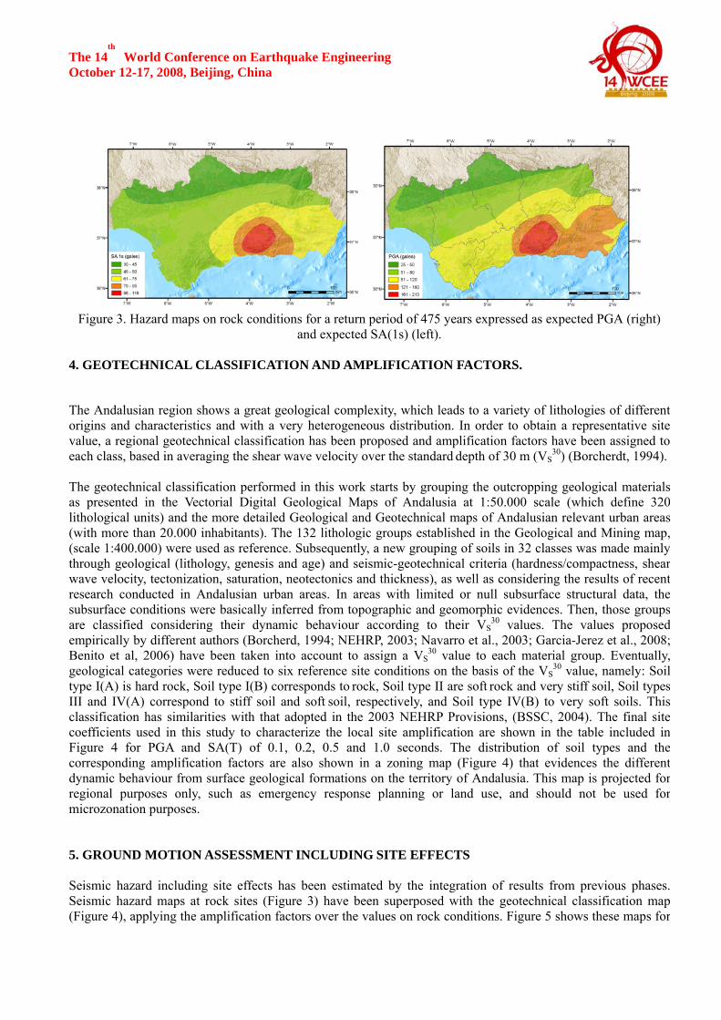
HAM-98 and AOU-00. 3.4. Estimation of Hazard and results We set up a logic tree consisting of two nodes: seismic source zoning and ground-motion attenuation model. Both nodes split into branches that stand for the combination of zonings and ground motion models presented inprevious sections. Hazard calculations were carried out using the CRISIS code (Ordaz et al., 2001). The EXPEL tool (Benito et al., 2004) was used to visualize and manage the different 30 solutions stemming from the logictree. A total of six hazard maps, corresponding to PGA and five spectral accelerations (0.1, 0.2, 0.5, 1.0 and 2.0 s) for rock conditions, were developed from a 0.1º x 0.1º grid. Figure 3 shows the hazard maps in terms of PGA, and SA (1s.), representing in each case the weighted-mean acceleration values for the 475-year return period.
The 14th
World Conference on Earthquake Engineering October 12-17, 2008, Beijing, China
Figure 3. Hazard maps on rock conditions for a return period of 475 years expressed as expected PGA (right)
and expected SA(1s) (left). 4. GEOTECHNICAL CLASSIFICATION AND AMPLIFICATION FACTORS.
The Andalusian region shows a great geological complexity, which leads to a variety of lithologies of differentorigins and characteristics and with a very heterogeneous distribution. In order to obtain a representative sitevalue, a regional geotechnical classification has been proposed and amplification factors have been assigned toeach class, based in averaging the shear wave velocity over the standard depth of 30 m (VS
30) (Borcherdt, 1994). The geotechnical classification performed in this work starts by grouping the outcropping geological materialsas presented in the Vectorial Digital Geological Maps of Andalusia at 1:50.000 scale (which define 320lithological units) and the more detailed Geological and Geotechnical maps of Andalusian relevant urban areas(with more than 20.000 inhabitants). The 132 lithologic groups established in the Geological and Mining map,(scale 1:400.000) were used as reference. Subsequently, a new grouping of soils in 32 classes was made mainlythrough geological (lithology, genesis and age) and seismic-geotechnical criteria (hardness/compactness, shearwave velocity, tectonization, saturation, neotectonics and thickness), as well as considering the results of recentresearch conducted in Andalusian urban areas. In areas with limited or null subsurface structural data, thesubsurface conditions were basically inferred from topographic and geomorphic evidences. Then, those groupsare classified considering their dynamic behaviour according to their VS
30 values. The values proposedempirically by different authors (Borcherd, 1994; NEHRP, 2003; Navarro et al., 2003; Garcia-Jerez et al., 2008;Benito et al, 2006) have been taken into account to assign a VS
30 value to each material group. Eventually,geological categories were reduced to six reference site conditions on the basis of the VS
30 value, namely: Soiltype I(A) is hard rock, Soil type I(B) corresponds to rock, Soil type II are soft rock and very stiff soil, Soil typesIII and IV(A) correspond to stiff soil and soft soil, respectively, and Soil type IV(B) to very soft soils. Thisclassification has similarities with that adopted in the 2003 NEHRP Provisions, (BSSC, 2004). The final sitecoefficients used in this study to characterize the local site amplification are shown in the table included inFigure 4 for PGA and SA(T) of 0.1, 0.2, 0.5 and 1.0 seconds. The distribution of soil types and thecorresponding amplification factors are also shown in a zoning map (Figure 4) that evidences the differentdynamic behaviour from surface geological formations on the territory of Andalusia. This map is projected forregional purposes only, such as emergency response planning or land use, and should not be used formicrozonation purposes. 5. GROUND MOTION ASSESSMENT INCLUDING SITE EFFECTS Seismic hazard including site effects has been estimated by the integration of results from previous phases.Seismic hazard maps at rock sites (Figure 3) have been superposed with the geotechnical classification map(Figure 4), applying the amplification factors over the values on rock conditions. Figure 5 shows these maps for

The 14th
World Conference on Earthquake Engineering October 12-17, 2008, Beijing, China PGA and SA (1s). We can appreciate the different morphology of hazard areas between these maps and theprevious ones in rock, as result of the strong influence of soil conditions in the expected ground motions.
Figure 4. Geotechnical classification map of Andalusia (left) and soil-dependent amplification factors (right).
Figure 5. Hazard maps including soil conditions for a return period of 475 years expressed as expected PGA (left) and expected SA(1s) (right).
SUMMARY AND CONCLUSIONS In a first step, seismic hazard maps in generic rock sites were developed for Andalusia, in terms of PGA and SA(1s), for a return period of 475 years. Values of PGA higher than 100 gals are present in the largest part of theterritory; PGA exceeds 140 gals in some places of Granada, Almeria and Malaga provinces, while the highestvalues, PGA ≥ 200 gal, are presented in the Granada Basin. PGA decreases from the Internal Betics toward theGuadalquivir Valley and Sierra Morena range, where PGA becomes 25 gals. Similar patterns appear in thespectral acceleration maps, obviously with different values. In a second step, a seismic-geotechnical classification into six categories has been proposed and seismicamplification factors have been determined for each class of soil. New hazard maps including local effects wereobtained by combination of rock maps, seismic–geothecnical classification and soil amplification factors. Thenew hazard maps present PGA values in the range ( 24-370 gal) for the whole Andalusian territory, with highestexpected values (PGA>300 gals) in some parts of Granada province and in Velez Malaga municipality. Lowestvalues PGA < 50 gales correspond to some municipalities of the north of Huelva and Cordoba provinces. ACKNOWLEDGEMENTS The SISMOSAN project was financed by the Junta de Andalucia. The authors wish to thank this support.
SA (T) SOIL TYPE PGA 0. 1 s 0.2 s 0.5 s 1.0 s
I(A) 0.87 0.84 0.80 0.80 0.80 I(B) 1.00 1.00 1.00 1.00 1.00 II 1.20 1.20 1.20 1.39 1.70 III 1.40 1.50 1.60 1.90 2.40
IV(A) 1.80 2.15 2.50 2.88 3.50 IV(B) 2.0* 2.25 2.5* 2.88* 3.5*

The 14th
World Conference on Earthquake Engineering October 12-17, 2008, Beijing, China REFERENCES Ambraseys, N.N.; Simpson, K.A.; Bommer, J.J. (1996). Prediction of Horizontal Response Spectra in Europe. Earthquake of Engineering and Structural Dynamics 25, 371-400. Aoudia, A; Vaccari, F; Suhadolc, P; Meghraoui, M (2000). Seismogenic Potential and Earthquake Hazard Assessment in the Tell Atlas of Algeria, Journal of Seismology 4, 79–98. Benito, B., Gaspar-Escribano, J. M. (2007). Ground motion characterization in Spain: context, problems andrecent developments in seismic hazard assessment. Journal of Seismology 11, 433–452. Benito, B., Gaspar-Escribano, J. M., Tévar, J. M., García, M. J., Jiménez E. (2004). The EXPEL code forprobabilistic seismic hazard analysis and uncertainties evaluation. Proceedings 13th World Conference on Earthquake Engineering, Vancouver, 2004, paper No. 1752, 15 pp. Berge-Thierry, C.; Cotton, F.; Scotti, O.; Griot-Pommera, D.A.; Fukushima, Y. (2003). New EmpiricalResponse Spectral Attenuation Laws for Moderate European Earthquakes, Journal of Earthquake Engineering 7(2), 193-222. Building Seismic Safety Council (BSSC) 2004. NEHRP Recommended Provisions for Seismic Regulations forNew Buildings and Other Structures (2003 edition) [S]. Washington D C:, FEMA 450/451. Calvert, A., Sandvol, E., Seber, D., Barazangi, M., Roecker, S., Mourabit, T., Vidal, F., Alguacil, G., Jabour, N.(2000). Geodynamic evolution of the lithosphere and upper mantle beneath the Alborán region of the westernMediterranean: Constraints from travel time tomography. Journal of Geophysical Research 105,10871–10898. Grimison, N. L.; Chen, W.-P. (1986). The Azores-Gibraltar plate boundary: Focal mechanisms, depths ofearthquakes, and their tectonic implications. Journal of Geophysical Research 91, 2029-2048. Hamdache, M (1998). Seismic Hazard Assessment for the Main Seismogenic Zones in North Algeria, Pure and Applied Geophysics 152, 281–314. Kanno, T., Narita, A., Morikawa, N., Fujiwara, H., Fukushima, Y. (2006). A new attenuation relation for strong ground motion in Japan based on recorded data. Bulletin of the Seismological Society of America 96(3), 879–897. López Casado, C.; Sanz de Galdeano, C.; Delgado, J.; Peinado M.A. (1995). The parameter b in the Betic Cordillera, the Rif and neighbouring areas. Its relations with the tectonics of the region. Tectonophysics 248, 277-292. Martín, A.J. (1983). Riesgo Sísmico en la Península Ibérica. PhD Thesis, Universidad Politécnica de Madrid. Martínez Solares, J. M. (2001). Los efectos en España del terremoto de Lisboa (1 de noviembre de 1755).Instituto Geográfico Nacional, Monografía 19, Madrid, 756 pp. Molina Palacios, S. (1998). Sismotectónica y Peligrosidad Sísmica del Área de Contacto entre Iberia y África.Tesis Doctoral. Universidad de Granada. 280 pp. NCSE-02 (2002). Norma de Construcción Sismorresistente: Parte General y Edificación Real Decreto997/2002, de 27 de Septiembre. Boletín Oficial del Estado 244, pp. 35898-35967. Ordaz, M.; Aguilar, A.; Arboleda, J. (2001). CRISIS 99-18 ver. 1.018. Program for Computing Seismic Risk.Instituto de Ingeniería, Universidad Nacional Autónoma de México. Peláez Montilla, J. A., Hamdache, M., López Casado, C. (2006). Seismic Hazard in Terms of Spectral Accelerations and Uniform Hazard Spectra in Northern Algeria. Pure and Applied Geophysics 163, 119–135. Sabetta, F.; Pugliese, A. (1996). Estimation of Response Spectra and Simulation of Nonstationary EarthquakeGround Motions. Bulletin of the Seismological Society of America 86(2), 337-352. Stepp, J. C. (1973) Analysis of completeness of the earthquake sample in the Puget Sound area. In Harding, S.T., editor, 1973, Contributions to seismic zoning: U.S. National Oceanic and Atmospheric AdministrationTechnical Report ERL 267-ESL 30, p. 16-28. Tavakoli, B; Pezeshk, S (2005). Empirical-Stochastic Ground-Motion Prediction for Eastern North America, Bulletin of the Seismological Society of America 95(6), 2283–2296. Vera, JA; Estévez, A; López Garrido, AC; Martina Algarra, A; Molina, JM; Sanz de Galdeano, C (2004). La tectónica em los episódios disetensivos del Mesozóico em las Zonas Béticas Externas. In: JÁ Vera (ed.) Geologia de España, SGE-IGME, Madrid, 890 pp. Vidal, F. (1986). Sismotectónica de la región Béticas-Mar de Alboran. PhD Thesis, Uni. de Granada 457 pp.

The 14th
World Conference on Earthquake Engineering October 12-17, 2008, Beijing, China