Embed Size (px)
Citation preview
152
ABSTRACT
A 100 m thick, more than 20 km wide upward-fining succession at the top of the Lower Cretaceous Upper Member ofthe Missisauga Formation was investigated in the Panuke Field, offshore Nova Scotia, using core, well logs and 3-D seis-mic data. The succession consists of 50 m of dune cross-stratified sandstone overlain by 50 m of tide-influenced het-erolithic strata, which in turn is overlain by 150 m of mudstone of the Naskapi Member of the Logan Canyon Formation.The succession is interpreted to be a fluvial–marine transition formed during a long-term (3rd order) relative sea-level rise.The two main Panuke reservoirs are thin (<5 m) sheet-like sandstones at the Missisauga–Naskapi contact interpreted to beremnants of a wave-formed barrier system. In seismic data, the Upper Member of the Missisauga Formation correlates bas-inward with progradational shelf-margin reflections, suggesting that the sheet-like fluvial sandstone at the base of theupward-fining succession transferred sediment, and possibly sand, to the continental slope.
RÉSUMÉ
Une succession d’affinages ascendants de 100 m d’épaisseur sur plus de 20 km de large au sommet du Crétacé inférieurdu Membre supérieur de la Formation de Missisauga, a été examinée dans le champ de Panuke, au large de côtes de laNouvelle Écosse, en utilisant des données de carottes, de diagraphies et de sismiques en 3-D. La succession se composede 50 m de dunes de grès à stratification entrecroisée recouvertes par 50 m de strates hétérolithiques à influence de marée,qui à leur tour sont recouvertes par 150 m de mudstone du Membre de Naskapi de la Formation Logan Canyon. La suc-cession est interprétée comme étant une transition fluviale–marine qui s’est formée durant une élévation relative du niveaude la mer à long terme (3e ordre). Les deux réservoirs principaux de Panuke sont composés de grès en nappes minces (<5m) au contact de Missisauga–Naskapi. Ces grès sont interprétés comme étant des restes d’un système de barrières forméespar des vagues. D’après les données sismiques, le Membre supérieur de la Formation de Missisauga est en corrélation versle bassin avec les réflexions de bordures de bassins progradantes, ce qui suggère que les nappes fluviales de grès, à la basede la succession d’affinages ascendants, ont transféré les sédiments, et probablement le sable, sur la pente continentale.
Traduction de Gabrielle Drivet
BULLETIN OF CANADIAN PETROLEUM GEOLOGYVOL. 54, NO. 2 (JUNE, 2006), P. 152-174
Sedimentology and stratigraphy of a thick, areally extensive fluvial–marine transition, MissisaugaFormation, offshore Nova Scotia, and its correlation with shelf margin and slope strata
DON I. CUMMINGS1
Department of Earth SciencesUniversity of Ottawa
Ottawa, ON K1N [email protected]
R. WILLIAM C. ARNOTT
Department of Earth SciencesUniversity of Ottawa
Ottawa, ON K1N 6N5
BRUCE S. HART
Department of Earth and Planetary SciencesMcGill University
Montreal, Quebec H3A 2A7
1 Current address: Department of Geological Sciences and Geological Engineering, Queen’s University, Kingston, Ontario.
LINKED CLASTIC SHELF-SLOPE DEPOSITIONAL SYSTEM, OFFSHORE NS 153
INTRODUCTION
Stratal successions that pass upward from fluvial to marinedeposits, here called fluvial–marine transitions, form duringtransgression following an episode of forced or normal regres-sion. During the past half-century, these successions have beenthe subject of much geological research (Fisk, 1944;Posamentier and Vail, 1988; Penland et al., 1988; Dalrymple etal., 1994; Cattaneo and Steel, 2002), not only because theycommonly host economic quantities of oil and natural gas, butbecause they can be used to estimate long-term rates of coastalland loss (Milliman and Haq, 1996), reconstruct paleogeogra-phy, and unravel the history of eustatic, tectonic, and climatechange. With the recent focus on offshore hydrocarbon explo-ration basinward of the shelf edge (Weimer et al., 2000) flu-vial–marine transitions have come under increased scrutinybecause, when incised, they commonly correlate with sandbodies on the shelf edge, slope and basin-floor (e.g., Roberts etal., 2003). As such, geologists are currently striving to under-stand how the sedimentologic and stratigraphic characteristicsof incised fluvial–marine transitions on the shelf can be used tobetter predict sandstone distribution at the shelf edge and bas-inward (e.g., Reading and Richards, 1994; Porebski and Steel,2003).
Sheet-like fluvial–marine transitions have seldom beenreported on continental shelves, and as a result, how (and if)
they feed sediment downdip to the shelf edge, slope and basin-floor is not well understood (Posamentier, 2001; Wellner andBartek, 2003). Using core, well log and 3-D seismic data fromthe Panuke Field, offshore Nova Scotia, this study describes athick, areally extensive fluvial–marine transition at the top ofthe Missisauga Formation, including the main Panuke reser-voirs that occur within it. Using regional 2-D seismic lines, thefluvial–marine transition is then correlated downdip to theundrilled shelf-edge and slope. Implications for reservoir dis-tribution within the western Sable Subbasin are discussed, andthe potential of the fluvial system as a deep-water feeder sys-tem is evaluated.
GEOLOGIC SETTING
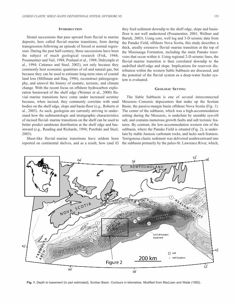
The Sable Subbasin is one of several interconnectedMesozoic–Cenozoic depocenters that make up the ScotianBasin, the passive-margin basin offshore Nova Scotia (Fig. 1).The center of the subbasin, which was a high-accommodationsetting during the Mesozoic, is underlain by unstable syn-riftsalt, and contains numerous growth faults and salt tectonic fea-tures. By contrast, the low-accommodation western rim of thesubbasin, where the Panuke Field is situated (Fig. 2), is under-lain by stable Jurassic carbonate rocks, and lacks such features.Terrigenous clastic sediment was delivered southwestward intothe subbasin primarily by the paleo-St. Lawrence River, which,
Fig. 1. Depth to basement (in part estimated), Scotian Basin. Contours in kilometres. Modified from MacLean and Wade (1992).

during the Mesozoic, was a sediment-charged, continental-scale fluvial system that drained much of Eastern Canada(Wade and MacLean, 1990; Grist et al., 1992). During deposi-tion of the Missisauga, Nova Scotia was located approximately30ºN of the equator (Irving et al., 1993), the receiving basin(i.e., the proto-Atlantic Ocean) was approximately 1000 kmwide (Ziegler, 1989), and climate was warm and temperate,having become progressively colder, wetter and less seasonalfollowing Pangean rifting in the Early Mesozoic (Rees et al.,2000).
LITHOSTRATIGRAPHY
In the Sable Subbasin, the Missisauga Formation forms asandstone-rich lens of fluvial to continental slope clastics withminor carbonates that thickens basinward to an estimated max-imum thickness of 3500 m below the modern shelf margin(Wade, 1991), and then thins basinward below the modernslope. It also thins laterally westward onto the low-accommo-dation western subbasin rim, and is approximately 950 m thickin the Panuke Field (MacLean and Wade, 1993). TheMissisauga is underlain by the lithologically similar Mic MacFormation, except along the western subbasin edge where it isunderlain by Jurassic carbonates of the Abenaki Formation. It
is overlain by marine shale of the Naskapi Member of theLogan Canyon Formation (Fig. 3).
The Missisauga Formation is typically divided into Upperand Lower members, or Upper, Middle and Lower members(Fig. 3). The Upper and Lower members (sensu Welsink et al.,1989) are separated by the O Marker, a mixed carbonate–sili-ciclastic unit that generates a strong seismic reflection in theproximal subbasin northwest of the Onondaga Field. In the dis-tal subbasin southeast of Onondaga, the O Marker becomes dif-ficult to identify in both seismic and well-log data because ofgrowth faults, poor quality seismic data, and facies changeand/or erosion.
PANUKE FIELD HISTORY AND RESERVOIR STRATIGRAPHY
The Panuke Field discovery well, Panuke B-90, was drilledin 1986 to test a drape structure formed by differential com-paction of Lower Cretaceous clastics over Abenaki carbonates(LASMO, 1990; Canada-Nova Scotia Offshore PetroleumBoard, 2000). The B-90 well penetrated five oil-bearing sand-stones in an interval approximately 40 m thick at the transitionbetween the Upper Missisauga and the overlying Naskapi mud-stone (Fig. 4). The field was delineated in 1987 with a second
154 D.I. CUMMINGS, B.S. HART and R.W.C. ARNOTT
Fig. 2. Location map of the Panuke Field, western edge of Sable Subbasin, offshore Nova Scotia (modified after Welsink et al., 1989; CanadaNova Scotia Offshore Petroleum Board, 2000). Solid black dots designate cored wells.

vertical well, Panuke F-99. Four directionally-drilled develop-ment wells, Panuke J-99 PP1 to PP4, were drilled between1991 and 1992. Original oil-in-place was estimated to be 6.676 x 10⁶ m3, or 42 MMbbls (Canada Nova Scotia OffshorePetroleum Board, 2000). Production began in 1992, and pro-ceeded in two separate phases. During phase one, the two mainreservoirs, the P2 and P3 sandstones, were perforated and pro-duced as a co-mingled zone under naturally pressured flow.Pressure data collected during this phase suggested that 75% ofthe hydrocarbons came from the P2 sandstone, the remaining25% from the P3 sandstone (Rick Werzbicki, personal commu-nication, 2002). Primary production was suspended in 1995. In1998, a water-flood program was initiated. During this phase,the P2 and P3 sandstones, along with the P4 sandstone and theC9 sandstone (C9 is a sharp-based sandstone at the base of theCree Member, Logan Canyon Formation; LASMO, 1990),were perforated and produced as a co-mingled zone underpump flow. Production ceased in 1999 because of high waterproduction and low volumes of hydrocarbon recovery. In total,38.5% of the original oil-in-place, or 2.2568 x 10⁶ m3
(16.155 MMbbls), was recovered from the Panuke Field.
DATASET AND METHODOLOGY
The results of this study are based on the analysis of geo-physical well-log data from 20 wells in the western SableSubbasin, eight cores (~320 m), a 3-D seismic survey from the
Panuke Field and regional 2-D seismic lines (Fig. 2). Coreswere described in 2.5 cm detail, noting sedimentary textures,physical and biogenic sedimentary structures, macrofossils, andmacroscopic diagenetic features. Core data were used to cali-brate well logs, which were then tied to the 3-D seismic datausing synthetic seismograms generated from sonic logs or sonicand density logs (Fig. 5). 3-D seismic geomorphology, whichinvolves the description and interpretation of depositional anderosional features in seismic plan view, was performed usingseismic time slices flattened on the O Marker. A flooding sur-face within the Naskapi Member was used as a stratigraphicdatum for well-log cross-sections. Lithostratigraphic and seis-mic stratigraphic picks used in this study are the same asMacLean and Wade (1993) and LASMO (1990), except for thetop of the Missisauga, which, for convenience, is picked at aneasily correlatable surface at the top of the main reservoir, theP2 sandstone, several metres above the MacLean and Wade(1993) pick (Fig. 4).
SEDIMENTOLOGY AND 3-D SEISMIC GEOMORPHOLOGY
Ten facies were identified in core data from theMissisauga–Naskapi transition in the Panuke Field region(Table 1). These are grouped into three facies associations(Table 2). Stratigraphically upward, facies associations areinterpreted to have been deposited in: 1) braided fluvial, 2) coastal plain and 3) offshore marine environments (Fig. 4).
LINKED CLASTIC SHELF-SLOPE DEPOSITIONAL SYSTEM, OFFSHORE NS 155
Fig. 3. Stratigraphic framework of Upper Jurassic and Lower Cretaceous strata in Sable Subbasin, Scotian Basin, offshore Nova Scotia (afterWelsink et al., 1989 and Wade and MacLean,1990).

FACIES ASSOCIATION 1: BRAIDED FLUVIAL DEPOSITS
Facies Association 1 is interpreted to be a sheet-like, multi-storied braided fluvial sandstone deposit. It occurs in the mid-dle of the Upper Member of the Missisauga Formation. Theunit has a blocky gamma ray signature (Fig. 4), and consistspredominantly of decimetre-thick, high-angle (dune) cross-stratified medium sandstone beds organized into metre-scaleupward-fining units (maximum ~8 m) interpreted to be channelfills (Fig. 6a). Evidence of tidal- and/or marine-influence istypically absent, except for an interval approximately 4 m thickin the middle of the unit and an interval approximately 15 mthick immediately below the top of the unit, which contain dou-ble mudstone drapes, Skolithos burrows and/or mudstone withoyster shells (Fig. 6b). Facies Association 1 erosively overliesundifferentiated shallow marine deposits (Fig. 6c).
In the low-accommodation Panuke Field region, FaciesAssociation 1 forms a sheet approximately 50 m thick that con-sists almost entirely of sandstone (Fig. 7A). The unit doubles inthickness to approximately 100 m and becomes more mudstonerich when correlated southeast into the higher-accommodationcentral Sable Subbasin (Fig. 7B). Facies Association 1 cannotbe confidently correlated into the distal Sable Subbasin south-east of the Thebaud Field because of intervening syndeposi-tional growth faults, facies change and/or erosion.
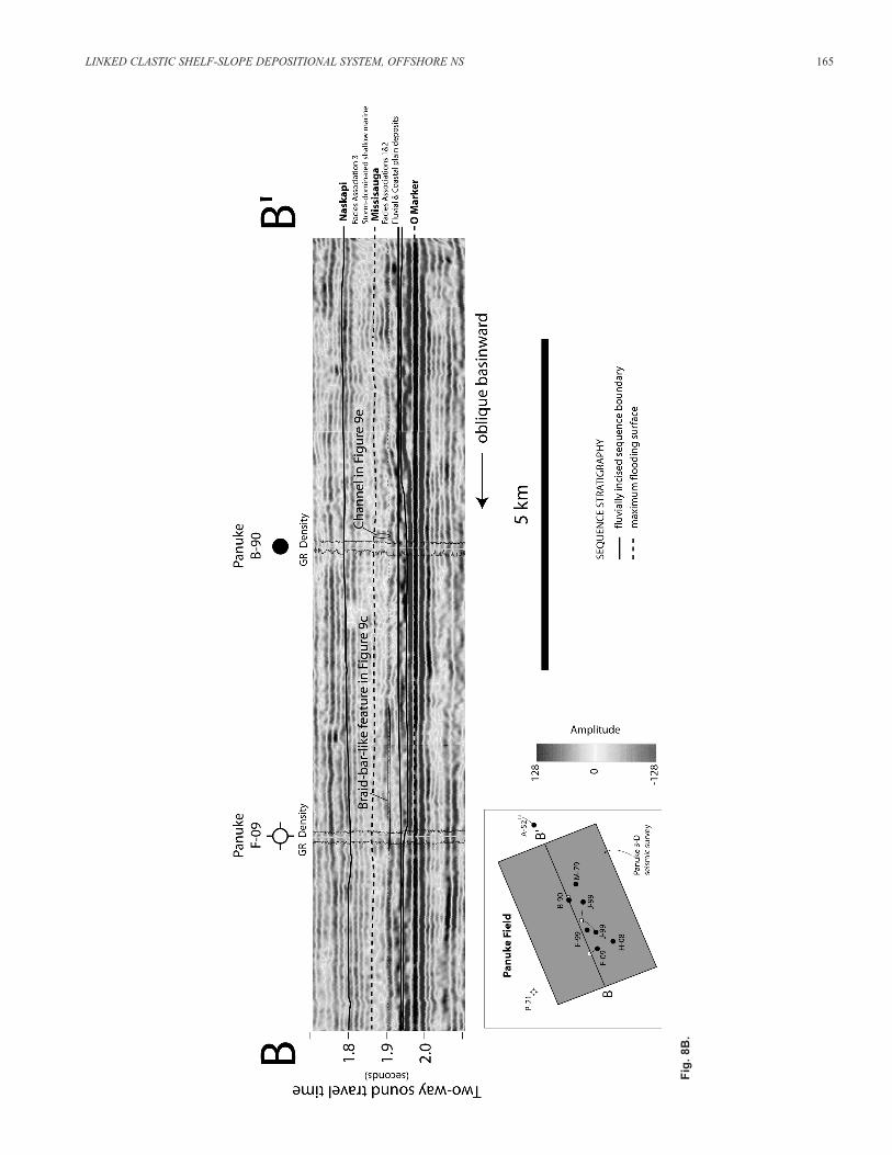
In cross-sections from the Panuke 3-D seismic survey,Facies Association 1 is typically characterized by discontinu-ous reflections (Fig. 8A, B). Enigmatic reflections are observedin one location in the 3-D seismic data that resemble large lateral accretion surfaces. The reflections dip to the north (i.e., perpendicular to the axis of the channel at the underlyingunconformity) and are traceable for 1 to 1.5 km (Fig. 8C). Theyare approximately 50 m high, which, assuming they formed bylateral accretion, suggests they formed in a 50 m deep channel.This estimate seems incompatible with channel-depth esti-mates obtained independently from dune cross-bed and chan-nel-fill-succession thicknesses (for method see Bridge and Tye,2000), which suggest fluvial channels were at most approxi-mately 10 m deep, and aggraded to form a multi-storied sand-stone sheet approximately 50 m thick (Cummings, 2004).Furthermore, modern fluvial channels rarely attain depths of50 m (e.g., Best and Ashworth, 1997). Therefore, although thedipping reflections may record lateral accretion in a locallyoverdeepened part of the channel (e.g., at a channel confluencescour), their large scale is not likely representative of the flu-vial system that deposited Facies Association 1.
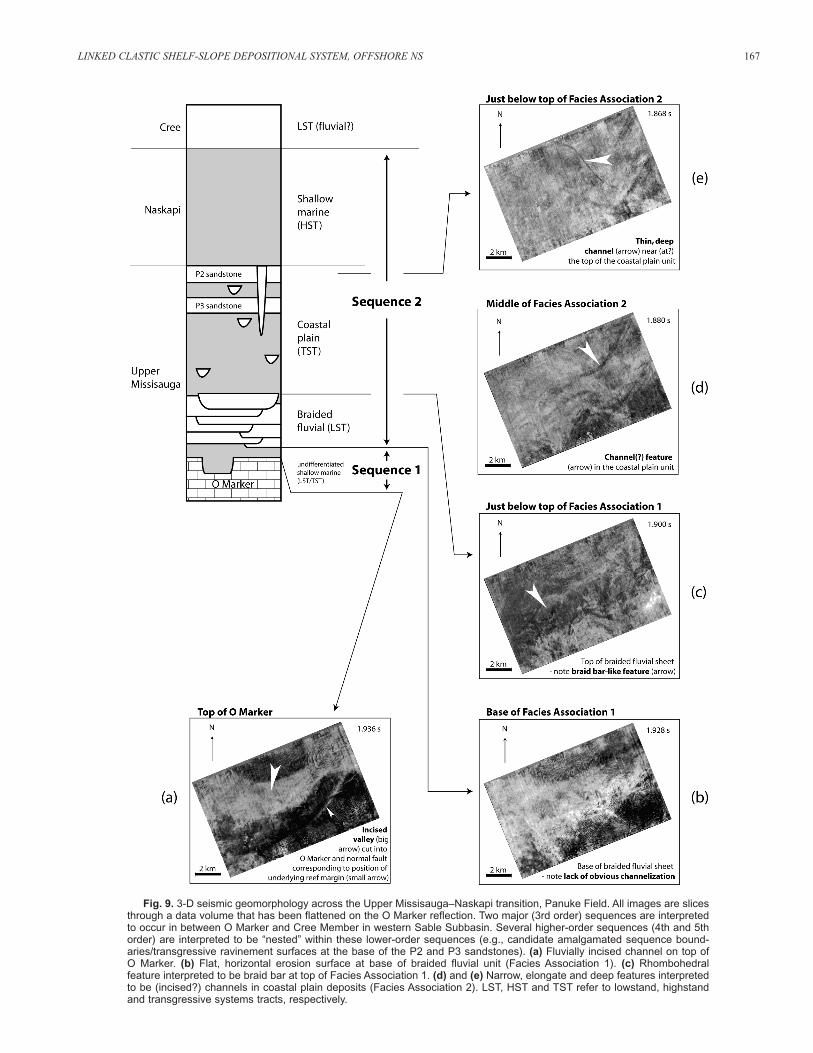
In 3-D seismic plan view, a prominent, uncored channelapproximately 12 m thick is present at the top of the O Marker
156 D.I. CUMMINGS, B.S. HART and R.W.C. ARNOTT
Fig. 4. Panuke reservoirs (P1 to P5 sandstones), UpperMissisauga–Naskapi transition, Panuke B-90 well. Lithostratigraphicpicks from MacLean and Wade (1993) and LASMO (1990). Reservoirpicks from LASMO (1990) and in-house data (Encana Corporation,unpublished). Note that for convenience, the Upper Missisauga ispicked so it coincides with top of main reservoir (P2 sandstone) and topof coastal plain deposits (Facies Association 2). The base of the UpperMissisauga is the base of the O Marker (not shown; see MacLean andWade, 1993).
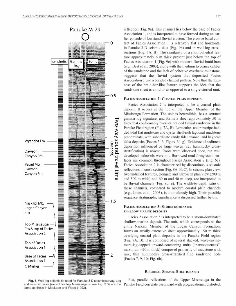
reflection (Fig. 9a). This channel lies below the base of FaciesAssociation 1, and is interpreted to have formed during an ear-lier episode of lowstand fluvial erosion. The erosive basal con-tact of Facies Association 1 is relatively flat and horizontal in Panuke 3-D seismic data (Fig. 9b) and in well-log cross-sections (Fig. 7A, B). The similarity of a rhombohedral fea-ture approximately 6 m thick present just below the top of Facies Association 1 (Fig. 9c) with modern fluvial braid bars (e.g., Best et al., 2003), along with the medium to coarse caliberof the sandstone and the lack of cohesive overbank mudstone,suggests that the fluvial system that deposited FaciesAssociation 1 had a braided channel pattern. Note that the thin-ness of the braid-bar-like feature supports the idea that thesandstone sheet is a multi- as opposed to a single-storied unit.
FACIES ASSOCIATION 2: COASTAL PLAIN DEPOSITS
Facies Association 2 is interpreted to be a coastal plaindeposit. It occurs at the top of the Upper Member of theMissisauga Formation. The unit is heterolithic, has a serratedgamma log signature, and forms a sheet approximately 50 mthick that conformably overlies braided fluvial sandstone in thePanuke Field region (Fig. 7A, B). Lenticular- and pinstripe-bed-ded tidal flat mudstone and oyster shell-rich lagoonal mudstonepredominate, with subordinate sandy tidal channel and bayheaddelta deposits (Facies 3–6; Figure 6d–g). Evidence of sedimentdeposition influenced by large waves (i.e., hummocky cross-stratification) is absent. Roots were observed once, but welldeveloped paleosols were not. Burrowed mud firmground sur-faces are common throughout Facies Association 2 (Fig. 6e).Facies Association 2 is characterized by discontinuous seismicreflections in cross-section (Fig. 8A, B, C). In seismic plan view,two undrilled features, elongate and narrow in plan view (200 mand 500 m wide) and 60 m and 40 m deep, are interpreted to be fluvial channels (Fig. 9d, e). The width-to-depth ratio ofthese channels, compared to modern coastal plain channels (e.g., Jones et al., 2003), is anomalously high. Their possiblesequence stratigraphic significance is discussed further below.
FACIES ASSOCIATION 3: STORM-DOMINATED
SHALLOW MARINE DEPOSITS
Facies Association 3 is interpreted to be a storm-dominatedshallow marine deposit. The unit, which corresponds to theentire Naskapi Member of the Logan Canyon Formation,forms an areally extensive sheet approximately 150 m thickoverlying coastal plain deposits in the Panuke Field region(Fig. 7A, B). It is composed of several stacked, wave-ravine-ment-lag-capped upward-coarsening units (“parasequences”;maximum ~20 m thick) composed primarily of mudstone withrare, thin hummocky cross-stratified fine sandstone beds(Facies 7, 9, 10; Fig. 6h).
REGIONAL SEISMIC STRATIGRAPHY
Flat, parallel reflections of the Upper Missisauga in thePanuke Field correlate basinward with progradational, distorted,
LINKED CLASTIC SHELF-SLOPE DEPOSITIONAL SYSTEM, OFFSHORE NS 157
Fig. 5. Well log-seismic tie used for Panuke 3-D seismic survey. Logand seismic picks (except for top Missisauga – see Fig. 3.3) are thesame as those in MacLean and Wade (1993).

158 D.I. CUMMINGS, B.S. HART and R.W.C. ARNOTT
Table 1. Facies descriptions and interpretations.

LINKED CLASTIC SHELF-SLOPE DEPOSITIONAL SYSTEM, OFFSHORE NS 159
Table 1. Continued

undrilled clinoform-shaped reflections approximately 25 km tothe southwest (Fig. 10). Clinoform reflections associated withthe Missisauga Formation are approximately 13 km long, and,based on well-log data, have approximately 0.8 km verticalrelief and a basinward slope of 3.5º. The 0.8 km vertical reliefsuggests that the clinoforms are not deltaic, but rather formedby progradation of the entire continental shelf margin and slope(see Porebski and Steel, 2003; Donovan, 2003; Cummings andArnott, 2005). At the Missisauga–Naskapi contact, the dip ofthe clinoforms decreases slightly, and the top-Missisaugareflection is onlapped by a landward thinning package ofreflections that has the stratigraphic character of a healingphase wedge (e.g., Posamentier and Allen, 1999, p. 165).Reflections associated with offshore mudstone of the overlyingNaskapi Member are parallel, have slightly lower amplitude,and exhibit no obvious internal downlap. The base of theblocky Cree Member, which truncates Naskapi mudstone in thePanuke Field, is associated with rejuvenated shelf marginprogradation (Fig. 10).
By contrast, in the central Sable Subbasin, Missisauga slopeclinoforms are typically difficult to resolve because of growth
faults and noisy seismic data (Cummings et al., 2006). TheUpper Missisauga (Barremian) shelf margin trend can, how-ever, be correlated into the central Sable Subbasin using acombination of seismic, well-log and core data. It is inter-preted to be located roughly several kilometres basinward ofthe Alma and Glenelg fields (Fig. 11; Cummings, 2004; Piperet al., 2004).
SEQUENCE STRATIGRAPHY
Two major (3rd order) sequences are interpreted to occurbetween the base of the Upper Missisauga and the base of theCree Member (Fig. 7A, B). The uppermost, Sequence 2, spansthe Missisauga–Naskapi contact, and consists (stratigraphicallyupward) of Facies Associations 1 to 3. The lower sequence,Sequence 1, is interpreted to exist between the top of the O Marker and the base of Sequence 2. Biostratigraphic datasuggest that these sequences likely formed during two separatethird order (1 to 10 million years long) relative sea-level fluc-tuations between the Albian and Hauterivian (MacLean andWade, 1993).
160 D.I. CUMMINGS, B.S. HART and R.W.C. ARNOTT
Table 2. Facies Associations.
Fig. 6. (opposite) Core photos from Facies Associations 1 (a–c), Facies Association 2 (d–g) and Facies Association 3 (h): (a) High-angle (dune)cross-stratified medium sandstone, Facies 1 (braided fluvial channel fill deposits), Panuke B-90 well, 2390.2 m MD; (b) High-angle (dune) cross-stratified medium sandstone with double mud-drape (lower arrow) and Skolithos burrow (upper arrow), Facies 2 (tide-influenced braided fluvialchannel fill deposits), Panuke B-90 well, 2354.91 m MD; (c) Sharp lower contact of Facies Association 1, Panuke B-90 well, 2400.52 m MD. Noteabrupt basinward lithofacies shift across contact; (d) Lenticular and pinstripe laminated fine sandstone in mudstone, Facies 4 (tidal flat deposits),Panuke B-90 well, 2333.15 m MD; (e) Burrowed firmground surface, with unlined Thalassinoides burrows subtending from sharp-based sandstone, Lawrence D-14 well, 2280 m MD; (f) Synaeresis cracks, Facies 4 (tidal flat deposits), Panuke B-90 well, 2336.11 m MD; (g) Oystershells, Facies 3 (lagoonal deposits), Panuke J-99 PP2 well, 2305.8 m MD; (h) Low-angle (hummocky) cross-stratified fine sandstone from FaciesAssociation 3 (storm-dominated shallow-marine deposits), Lawrence D-14 well, 2272.8 m MD. Note low-angle internal truncation surface (arrow)with onlapping laminae whose dip is shallow upward, a common feature of hummocky cross-stratified sandstone beds.

LINKED CLASTIC SHELF-SLOPE DEPOSITIONAL SYSTEM, OFFSHORE NS 161

SEQUENCE 1
Sequence 1 is not cored in the Panuke Field region; rather,its presence is inferred based on 3-D seismic data. A prominentchannel incised into the top of the O Marker is interpreted to bethe base of Sequence 1 (Fig. 9a). From the Panuke Field, thischannelized reflection correlates approximately 25 km south-westward (basinward) to progradational clinoform reflectionsat the shelf margin (Fig. 10). The channel at the top of the O Marker is therefore interpreted to be a fluvially incisedsequence boundary formed during relative sea-level fall belowthe shelf edge (cf. Cummings et al., 2006). Well-log data showsthe channel to be filled with a heterolithic assemblage of sand-stone, mudstone, and carbonate. This suggests that as a result
of low sediment supply the incised valley did not fill com-pletely with fluvial and estuarine sediment during transgres-sion. Rather, shelf sediment, including carbonates, wasdeposited as a late stage valley fill following transgressive pas-sage of the shoreline (e.g., Posamentier, 2001).
SEQUENCE 2
Sequence 2, which erosively overlies Sequence 1 in thePanuke Field region, fines upward from approximately 50 m ofbraided fluvial sandstone (Facies Association 1) to approxi-mately 50 m of coastal plain heterolithics (Facies Association2) to approximately 150 m of shallow-marine mudstone (FaciesAssociation 3; Fig. 9). The base of Sequence 2 is the fluvial
162 D.I. CUMMINGS, B.S. HART and R.W.C. ARNOTT
Fig. 7A. Strike-oblique (A) and dip-oblique (B) well-log cross-section. Note that all units are laterally extensive in these cross-sections, and that they thicken into the high-accommodation central subbasin. Shown also are synthetic traces generated from sonic logs used to tie well datato 2-D seismic data outside of the Panuke 3-D dataset (note strong peak generated by the O Marker).

LINKED CLASTIC SHELF-SLOPE DEPOSITIONAL SYSTEM, OFFSHORE NS 163
Fig
. 7
B.

erosion surface at the base of Facies Association 1, which hasless than 10 m relief and extends over more than 20 km later-ally normal to paleoflow (paleoflow is interpreted to be south-westward based on braid-bar orientation; see Fig. 9c). Theupper contact of Sequence 2 is the base of the blocky CreeMember, which truncates shallow-marine mudstone of theNaskapi Member, and is associated with rejuvenated shelf-mar-gin progradation.
Although minor amounts of fluvial sediment may have beendeposited at the base of Sequence 2 during falling relative sea-level (cf. Blum and Törnqvist, 2000), significant fluvial aggra-dation probably did not start until relative sea-level began torise. The rate of accommodation space increase was likely lowrelative to channel avulsion rate, allowing a sheet-like sand-stone to form over the sequence boundary (e.g., Blakey andGubitosa, 1984; Holbrooke, 1996; Arnott et al., 2001). The sig-nificant thickness of the braided fluvial sheet (~50 m in the
Panuke Field) suggests that sediment supply remained highduring net base-level rise (cf. Curray, 1964). No unequivocalupward change in channel style (i.e., braided to meandering oranastomosing) or density of the channel stacking pattern isobserved in either 3-D seismic or well-log data.
The contact between braided fluvial (Facies Association 1)and coastal plain (Facies Associaton 2) deposits is gradationalto sharp, lacks a coarse lag deposit, and is preceded by 15 mof marine- and tidally-influenced braided fluvial deposits(Facies 2). This suggests that the contact is conformable, andformed by backstepping of the tidally and marine-influencedcoastal plain over fluvial deposits (cf. Shanley et al., 1992).Given the considerable thickness of the coastal plain deposits(~50 m in the Panuke Field), sediment supply likely remainedhigh during net base-level rise (cf. Curray, 1964).
The contact between coastal plain heterolithics and overlyingshallow marine mudstone is characterized by interstratification
164 D.I. CUMMINGS, B.S. HART and R.W.C. ARNOTT
Fig. 8A. Vertical seismic transects of Upper Missisauga in Panuke 3-D seismic data. (A) Seismic cross-section showing fluvially incised valley on top of the O Marker (see Fig. 9a), and narrow channel in coastal plain deposits (Facies Association 2; see Fig. 9d); (B) (opposite)Seismic cross-section showing feature in Facies Association 1 that resembles braid bar in plan view (see Fig. 9c), and narrow, deep channel incoastal plain unit (Facies Association 2; see Fig. 9e); (C) (page 166) Seismic cross section showing lateral-accretion-like reflections in FaciesAssociation 1.
LINKED CLASTIC SHELF-SLOPE DEPOSITIONAL SYSTEM, OFFSHORE NS 165
Fig
. 8
B.

166 D.I. CUMMINGS, B.S. HART and R.W.C. ARNOTT
Fig
. 8
C.
LINKED CLASTIC SHELF-SLOPE DEPOSITIONAL SYSTEM, OFFSHORE NS 167
Fig. 9. 3-D seismic geomorphology across the Upper Missisauga–Naskapi transition, Panuke Field. All images are slicesthrough a data volume that has been flattened on the O Marker reflection. Two major (3rd order) sequences are interpretedto occur in between O Marker and Cree Member in western Sable Subbasin. Several higher-order sequences (4th and 5thorder) are interpreted to be “nested” within these lower-order sequences (e.g., candidate amalgamated sequence bound-aries/transgressive ravinement surfaces at the base of the P2 and P3 sandstones). (a) Fluvially incised channel on top of O Marker. (b) Flat, horizontal erosion surface at base of braided fluvial unit (Facies Association 1). (c) Rhombohedral feature interpreted to be braid bar at top of Facies Association 1. (d) and (e) Narrow, elongate and deep features interpretedto be (incised?) channels in coastal plain deposits (Facies Association 2). LST, HST and TST refer to lowstand, highstandand transgressive systems tracts, respectively.

168 D.I. CUMMINGS, B.S. HART and R.W.C. ARNOTT
Fig. 10. Uninterpreted and interpreted regional seismic section, western Sable Subbasin (GSI-GSI-PA99-110 seismic line). Well logs are tied to seismic data by stretching linearly between reflections associated with Wyandot and O Marker. Note that shelf margin continues to prograde throughout deposition of Upper Missisauga, Naskapi and Cree members, although shelf-margin trajectory has agreater basinward component during deposition of Upper Missisauga and Cree.

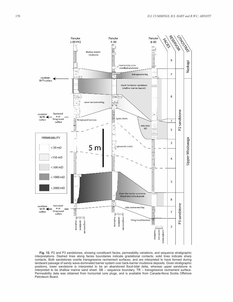
of thin (<5 m), sharp-based sandstone sheets (the P2 and P3sandstone reservoirs) and coastal plain mudstone (Fig. 12,Table 3). Given their stratigraphic position, sharp lower contactswith basal lags, high density/diversity trace fossil assemblages,and very well-sorted nature, the P2 and P3 sandstones are inter-preted to have been emplaced during backstepping of a sandywave-formed barrier island overtop of coastal plain mudstone(Fig. 13). Both sandstone reservoirs are interpreted to overlietransgressive ravinement surfaces; however, the P3 sandstone isboth under- and overlain by coastal plain mudstone, whereas theP2 sandstone occurs above coastal plain mudstone and belowshallow marine mudstone. As such, the P3 sandstone is inter-preted to be an abandoned flood-tidal delta that overlies a tidalravinement surface formed by migrating channels in the floodtidal delta (e.g., Boyd and Honig, 1992), and the P2 sandstoneis interpreted to be a shallow marine sandstone that overlies awave-ravinement surface formed during erosive shorefaceretreat (e.g., Snedden and Dalrymple, 1999).
Although the Missisauga–Naskapi contact represents a land-ward shift in lithofacies (shallow marine mudstone over coastalplain deposits), evidence for a major transgression and back-stepping of the shelf margin (i.e., a resolvable downlap surface,such as that which exists at the top of the Upper CretaceousWyandot Formation offshore Nova Scotia) is absent in seismic
data at the Missisauga–Naskapi contact. Rather, Naskapireflections are parallel and concordant with those in the under-lying Upper Missisauga and overlying Cree Member, and con-tinue to prograde the shelf margin (Fig. 10). In core data fromthe Panuke Field, which is 25 km landward of the terminal-Missisauga shelf edge, the Naskapi mudstone consists ofupward-coarsening units (“parasequences”) that are commonlylag-capped and contain rare hummocky cross stratified sand-stone beds. As such, it is argued that progradation of the shelfedge during Naskapi deposition was facilitated by multiple,high-frequency relative sea-level falls that forced shorelinesrepeatedly back to, or at least close to, the shelf edge. Parallelseismic reflections in the Naskapi likely represent transgressivesurfaces, not passive mudstone drapes (Cummings et al., 2005).The erosion surface at the top of the Naskapi Member (sharpNaskapi–Cree contact) is associated with rejuvenated shelf-margin progradation, and is interpreted to be the upper bound-ary of Sequence 2 (Fig. 9).
DISCUSSION
Studies of fluvial sheets in Late Pleistocene continental-shelfsuccessions suggest that they form during lowstands that do not expose the shelf edge, are unincised, and do not correlate
LINKED CLASTIC SHELF-SLOPE DEPOSITIONAL SYSTEM, OFFSHORE NS 169
Fig. 11. Barremian (Upper Missisauga) shelf-margin trend interpreted from subsurface data, Sable Subbasin. Solid grey zone indicates where shelf-margin is seismically resolvable, whereas hatched zone indicates where shelf-margin position is interpreted based on well log, sedimentological and biostratigraphic data.
170 D.I. CUMMINGS, B.S. HART and R.W.C. ARNOTT
Fig. 12. P2 and P3 sandstones, showing constituent facies, permeability variations, and sequence stratigraphicinterpretations. Dashed lines along facies boundaries indicate gradational contacts; solid lines indicate sharp contacts. Both sandstones overlie transgressive ravinement surfaces, and are interpreted to have formed duringlandward passage of sandy wave-dominated barrier system over back-barrier mudstone deposits. Given stratigraphicpositions, lower sandstone is interpreted to be an abandoned flood-tidal delta, whereas upper sandstone is interpreted to be shallow marine sand sheet. SB – sequence boundary, TR – transgressive ravinement surface.Permeability data was obtained from horizontal core plugs, and is available from Canada-Nova Scotia OffshorePetroleum Board.

LINKED CLASTIC SHELF-SLOPE DEPOSITIONAL SYSTEM, OFFSHORE NS 171
Fig. 13. General depositional model for hydrocarbon-bearing sheet-like sandstones near top of Upper Missisauga (e.g.,P2 and P3 sandstones), Panuke Field region, western Sable Subbasin.
Table 3. Sedimentology and reservoir quality of Panuke reservoir sandstones.

basinward with volumetrically significant shelf-margin deltaand/or slope turbidite deposits (e.g., Posamentier, 2001; Wellnerand Bartek, 2003). A sheet-like fluvial deposit requires two criteria in order to form (Blakey and Gubitosa, 1984) — theratio of channel avulsion to aggradation must be high, and avul-sion must be unrestricted by physical barriers. These two condi-tions are commonly met in unincised fluvial systems, but not innarrow incised valleys, where, by definition, overbank floodingcannot occur. Arguably, however, sheet-like fluvial depositsmay also form at the base of wide incised valleys. Modelingstudies suggest that wide incised valleys can form during pro-longed lowstands where valleys have the time to widen follow-ing rapid headward incision (e.g., Leeder and Stewart, 1996;Heller et al., 2001). In the Panuke Field, the sheet-like fluvialunit (Facies Association 1) lacks underlying delta-front facies(Fig. 6c) and correlates basinward with progradational shelf-margin clinoform reflections (Fig. 10). As such, despite itswidth (>20 km), the sheet-like fluvial unit is interpreted to liewithin a wide, low-relief incised valley formed during a slowrelative sea-level fall and lowstand.
Surprisingly, like underlying braided fluvial deposits, the50 m thick coastal plain unit (Facies Association 2) also cor-relates basinward with progradational shelf-margin reflections(Fig. 10); shelf-margin progradation did not stop with theonset of transgression. Typically, continental shelf marginsstop prograding and become sediment starved during trans-gression because most river-borne sediment is deposited closeto the retreating coast (Dalrymple and Cummings, 2005).However, if transgression is punctuated by higher-frequencyrelative sea-level falls and the shoreline is relatively close tothe shelf edge, sediment could theoretically bypass the shelfepisodically and prograde the shelf margin. In the westernSable Subbasin the following data suggest that higher order(4th and 5th order) relative sea-level fluctuations did punctu-ate the slow (3rd order) relative sea-level rise during the ter-minal phases of Missisauga deposition: 1) the shelf marginprogrades throughout; 2) several tide- and marine-influencedintervals occur in the approximately 50 m thick braided fluvialsheet; 3) narrow (<0.5 km), anomalously thick channels(40–60 m), interpreted to be incised valleys, are observed in 3-D seismic data within coastal plain deposits; and 4) severalof the burrowed mud firmground surfaces that occur through-out the coastal plain unit are overlain by anomalously thick(<3 m), locally oxidized lag deposits (e.g., at the base of theP2 and P3 sandstones). Renewed shelf-margin progradationafter the onset of transgression has been observed at a largeoutcrop of Eocene shelf-margin deposits in Spitsbergen,although it is unclear whether progradation resulted from asediment supply pulse or a relative sea-level fall (Ron Steel,personal communication, 2004). There is no evidence that asignificant sediment supply pulse occurred during coastalplain deposition at the top of the Missisauga; as such, it is sug-gested that continued shelf-margin progradation after the onsetof transgression was facilitated by higher-order (4th and 5th
order) relative sea-level falls to the shelf margin.
CONCLUSIONS
The main reservoirs in the Panuke Field (P2 and P3 sand-stones) occur in a 100 m thick, more than 20 km wide fluvial–marine transition at the top of the MissisaugaFormation. They are interpreted to have formed during trans-gressive passage of a wave-formed barrier system over back-barrier coastal plain deposits. Although they pinch out locallyand do not exceed 5 m in thickness, the Panuke reservoir sand-stones are sheet-like over tens of kilometres, consist of well-sorted sandstone with good reservoir quality (averagepermeability is 100–500 mD, with a maximum of ~2000 mD),and are overlain by thick mudstone of the Naskapi Member.Similar hydrocarbon-bearing sandstones occur at the top of the Missisauga Formation in the Alma Field (Cummings andArnott, 2005), suggesting that transgressively emplaced shallow marine sandstones are a significant stratigraphic playtype in the western Sable Subbasin.
In the Upper Missisauga at Panuke, fluvially incised sequenceboundaries are interpreted to occur at the base of the 100 m thickfluvial–marine transition that contains the Panuke reservoirs, andat the top of the O Marker. Upper Missisauga seismic reflectionsat Panuke correlate with progradational slope clinoform reflec-tions 25 km to the southwest, suggesting that sediment, and pos-sibly sand, was transferred to the continental slope through thesefluvial systems. Regional mapping of incised fluvial valleys inthe Upper Missisauga should help determine the most probablealong-strike distribution of coeval turbidite-fan systems on thecontinental slope offshore Nova Scotia.
ACKNOWLEDGMENTS
This paper stems from D.I. Cummings’ Ph.D. thesis on theMissisauga Formation, which was funded jointly by Encana,Murphy Oil, Norsk Hydro and the Government of Ontario.Thanks to editor Glen Stockmal and reviewers JockMcCracken and John Hogg for their insightful, constructivecomments; to Andrew MacRae, Ron Steel, Dave Brown andBob Dalrymple for open and engaging discussions; and toMary Jean Verrall, Nancy White and Keri O’Kroneg for logis-tical support. R.W.C. Arnott and B. Hart acknowledge the con-tinued support of the National Science and EngineeringResearch Council of Canada.
REFERENCES
Arnott, R.W.C., Zaitlin, B.A. and Potocki, D.J. 2001. Stratigraphic response tosedimentation in a net-accommodation-limited setting, Lower CretaceousBasal Quartz, south-central Alberta. Bulletin of Canadian PetroleumGeology, v. 50, p. 92-104.
Best, J.L. and Ashworth, P.J. 1997. Scour in large braided rivers and the recog-nition of sequence stratigraphic boundaries. Nature, v. 387, p. 275-277.
Best, J.L., Ashworth, P.J., Bristow, C.S. and Roden, J. 2003. Three-dimensionalsedimentary architecture of a large, mid-channel sand braid bar, JamunaRiver. Journal of Sedimentary Research, v. 73(4), p. 516-530.
172 D.I. CUMMINGS, B.S. HART and R.W.C. ARNOTT
Blakey, R.C. and Gubitosa, R. 1984. Controls of sandstone body geometry andarchitecture in the Chinle Formation (Upper Triassic), Colorado Plateau.Sedimentary Geology, v. 38, p. 51-86.
Blum, M.D. and Törnqvist. T.E. 2000. Fluvial responses to climatic and sea-level change: a review and look forward. Sedimentology, v. 47, p. 2-48.
Boyd, R. and Honig, C. 1992. Estuarine sedimentation on the Eastern Shore ofNova Scotia. Journal of Sedimentary Petrology, v. 62, p. 569-583.
Bridge, J.S. and Tye, R.S. 2000 Interpreting the dimensions of ancient fluvialchannel bars, channels, and channel belts from wireline logs and cores.American Association of Petroleum Geologists Bulletin, v. 84, p. 105-1228.
Canada-Nova Scotia Offshore Petroleum Board. 2000. Technical Summary.Unpublished report available on the Canada-Nova Scotia OffshorePetroleum Board website (www.cnsopb.ns.ca), 257p.
Cattaneo, A. and Steel, R.J. 2002. Transgressive deposits: a review of theirvariability. Earth Science Reviews, v. 1277, p. 1-42.
Cummings, D.I. 2004. Sedimentology and stratigraphy of an ancient prograda-tional terrigenous clastic shelf margin, Missisauga Formation (UpperJurassic-Lower Cretaceous), offshore Nova Scotia, Canada. PhD thesis,University of Ottawa, Ottawa, Ontario. 580p.
Cummings, D.I. and Arnott, R.W.C. 2005. Growth-faulted shelf-margin deltas:A new (but old) play type offshore Nova Scotia. Bulletin of CanadianPetroleum Geology, v. 53, p. 211-236.
Cummings, D.I., Dalrymple, R.W. and Arnott, R.W.C. 2005. Why does theNaskapi mudstone “blanket” prograde the paleoshelf-edge offshore NovaScotia? American Association of Petroleum Geologists-Society forSedimentary Geology Annual Conference (AAPG-SEPM), June 20-22,Calgary, Canada, on CD Rom.
Cummings, D.I., Arnott, R.W.C. and Hart, B.S. 2006. Tidal signatures in ashelf-margin delta. Geology, v. 34(4), p. 249-252.
Curray, J.R. 1964. Transgressions and regressions. In: Papers in MarineGeology. R.L. Miller (ed.). Shepard Commemorative Volume, Macmillan,New York, p. 175-203.
Dalrymple, R.W. and Cummings, D.I. 2005. The offshore transport of mud: Whyit doesn’t happen and the stratigraphic implications. American Association ofPetroleum Geologists-Society for Sedimentary Geology (AAPG-SEPM),Annual Conference, June 20-22, Calgary, Canada, on CD Rom.
Dalrymple, R.W., Boyd, R. and Zaitlin, B.A. (eds.). 1994. Incised-ValleySystems: Origin and Sedimentary Sequences. Society for SedimentaryGeology (SEPM) Special Publication 51, 391p.
Donovan, A.D. 2003. Depositional topography and sequence development. In:Shelf Margin Deltas and Linked Down Slope Petroleum Systems. H.H.Roberts, N.C Rosen, R.F. Fillon and J.B. Anderson (eds.). 23rd AnnualGulf Coast Section of the Society for Sedimentary Geology (GCSSEPM)Foundation Bob F. Perkins Research Conference, December 7-10, 2003,Houston, Texas, p. 493-522.
Fisk, H.N. 1944. Geological Investigation of the Alluvial Valley of the LowerMississippi River. US Army Corps Engineering, Mississippi RiverCommission Report, Vicksburg, MS.
Grist, A.M., Reynolds, P.H., Zentilli, M. and Beaumont, C. 1992. Provenanceand thermal history of the sandstones of the Scotian Basin, Nova Scotia: anapatite fission track and 40Ar/39Ar study. Canadian Journal of EarthSciences, v. 29, p. 909-924.
Heller, P.L., Paola, C., Hwang, I., John, B. and Steel, R.J. 2001.Geomorphology and sequence stratigraphy due to slow and rapid base-level changes in an experimental subsiding basin (XES 96-1). AmericanAssociation of Petroleum Geologists Bulletin, v. 85, p. 817-838.
Holbrook, J.M. 1996. Complex fluvial response to low gradients at maximumregression: A genetic link between smooth sequence-boundary morphologyand architecture of overlying sheet sandstone. Journal of SedimentaryResearch, v. 66(4), p. 713-722.
Irving, E., Wynne, P.J. and Globerman, B.R. 1993. Cretaceous paleolatitudesand overprints of the North American Craton. In: Evolution of the WesternInterior Craton. W.G.E. Caldwell and E.G. Kauffman (eds.). GeologicalSocitey of America Special Paper 39, p. 91-96.
Jones, B., Woodroffe, C. and Martin, G. 2003. Deltas in the Gulf ofCarpentaria, Australia: Forms, processes and products. In: Tropical Deltasof Southeast Asia: Sedimentology, Stratigraphy, and Petroleum Geology.
F.H. Sidi, D. Nummedal, P. Imbert, H. Darman and H.W. Posamentier(eds.). Society for Sedimentary Geology (SEPM) Special PublicationNo. 76, p. 21-43.
LASMO. 1990. Cohasset/Panuke Development Plan. Unpublished report sub-mitted to and available through the Canada-Nova Scotia OffshorePetroleum Board, Halifax, Canada, 191p.
Leeder, M.R. and Stewart, M.D. 1996. Fluvial incision and sequence stratigra-phy: alluvial responses to relative sea-level fall and their detection in thegeological record. In: Sequence Stratigraphy in British Geology. S.P.Hesselbo and D.N. Parkinson (eds.). Geological Society SpecialPublication No. 103, p. 25-39.
MacLean, B.C. and Wade, J.A. 1992. Petroleum geology of the continentalmargin south of the islands of St. Pierre and Miquelon, offshore EasternCanada: Bulletin of Canadian Petroleum Geology, v. 40, p. 222-253.
MacLean, B.C. and Wade, J.A. 1993. Seismic markers and stratigraphic picksin the Scotian Basin wells. Geological Survey of Canada, East Coast BasinAtlas Series, 276p.
Milliman, J.D. and Haq, B.U. 1996. Sea-Level Rise and Coastal Subsidence:Causes, Consequences and Strategies. Kluwer Academic Publishers, 369p.
Penland, S., Boyd, R. and Suter, J.R. 1988. Transgressive depositional systemsof the Mississippi delta plain: A model for barrier shoreline and shelf sanddevelopment. Journal of Sedimentary Petrology, v. 58, p. 932-949.
Piper, D.J.W., Pe-Piper, G. and Ingram, S. 2004. Early Cretaceous sediment fail-ure in the southwestern Sable Subbasin, offshore Nova Scotia. AmericanAssociation of Petroleum Geologists Bulletin, v. 88(7), p. 991-1006.
Porebski S.J. and Steel, R.J. 2003. Shelf-margin deltas: their stratigraphic sig-nificance and relation to deepwater sands. Earth-Science Reviews, v. 1282,p. 1-44.
Posamentier, H.W. 2001. Lowstand alluvial bypass systems: Incised vs. unin-cised: American Association of Petroleum Geologists Bulletin, v. 85(10),p. 1171-1793.
Posamentier, H.W. and Allen, G.P. 1999. Siliciclastic Sequence Stratigraphy –Concepts and Applications. Society for Sedimentary Geology (SEPM)Concepts in Sedimentology and Paleontology No. 7, 210p.
Posamentier, H.W. and Vail, P.R. 1988. Eustatic controls on clastic deposition:II. Sequence and systems tract models. In: Sea Level Changes: An inte-grated approach. C.K. Wilgus, C.K. Hastings, S.G. Kendall, H.W.Posamentier, C.A. Ross and J.C. Van Wagoner (eds.). Society forSedimentary Geology (SEPM) Special Publication 42, p. 125-154.
Reading, H.G. and Richards, M. 1994. Turbidite depositional systems in deep-water basin margins classified by grain size and feeder systems. AmericanAssociation of Petroleum Geologists Bulletin, v. 78, p. 792-822.
Rees, P.M., Ziegler, A.M. and Valdes, P.J. 2000. Jurassic phytogeography andclimates: New data and model comparisons. In: Warm Climates in EarthHistory. B.T. Huber, K.G. Macleod and S.L. Wang (eds.). CambridgeUniversity Press, p. 297-218.
Roberts, H.H., Rosen, N.C., Fillon, R.F. and Anderson, J.B. (eds.). 2003. ShelfMargin Deltas and Linked Down Slope Petroleum Systems. 23rd AnnualGulf Coast Section of the Society for Sedimentary Geology (GCSSEPM)Research Conference, December 7-10, 2003, Houston, Texas, 861p.
Shanley, K.W., McCabe, P.J. and Hettinger, R.D. 1992. Tidal influence inCretaceous fluvial strata from Utah, USA: a key to sequence stratigraphicinterpretation. Sedimentology, v. 39, p. 905-930.
Snedden, J.W. and Dalrymple, R.W. 1999. Modern shelf sand ridges: From his-torical perspective to a unified hydrodynamic and evolutionary model. In:Isolated Shallow Marine Sand Bodies: Sequence Stratigraphic Analysis andSedimentologic Interpretation. K.M. Bergman and J.W. Snedden (eds.).Society for Sedimentary Geology (SEPM) Special Publication 64, p. 13-28.
Wade, J.A. 1991. Lithostratigraphy 5: Missisauga Formation. In: East CoastBasin Atlas Series: Scotian Shelf. Atlantic Geoscience Center, GeologicalSurvey of Canada, p. 59.
Wade, J.A. and MacLean, B.C. 1990. Aspects of the geology of the ScotianBasin from recent seismic and well data. In: Geology of the ContinentalMargin of Eastern Canada. M.J. Keen and G.L. Williams (eds.). GeologicalSurvey of Canada Series, p. 190-238.
Weimer, P., Slatt, R.M., Dromgoole, P., Bowman, M. and Leonard, A. 2000.Developing and managing turbidite reservoirs: Case histories and experiences:
LINKED CLASTIC SHELF-SLOPE DEPOSITIONAL SYSTEM, OFFSHORE NS 173

Results of the 1998 EAGE/AAPG Research Conference. AmericanAssociation of Petroleum Geologists Bulletin, v. 84(4), p. 453-465.
Wellner, R.W. and Bartek, L.R. 2003. The effect of sea level, climate, andshelf physiography on the development of incised-valley complexes: amodern example from the East China Sea. Journal of SedimentaryResearch, v. 73(6), p. 926-940.
Welsink, H.J., Dwyer, J.D. and Knight, R.J. 1989. Tectono-stratigraphy of thepassive margin basin offshore Nova Scotia. In: Extensional Tectonics andStratigraphy of the North Atlantic Margins. A.J. Tankard and J.R.
Balkwell (eds.). American Association of Petroleum GeologistsMemoir 31, p. 215-231.
Ziegler, P.A. 1989. Evolution of Laurasia. Kluwer Academic Press, 102p.
Manuscript received: May 11, 2005
Manuscript accepted: April 5, 2006
Associate editor: John Hogg
174 D.I. CUMMINGS, B.S. HART and R.W.C. ARNOTT