Embed Size (px)
Citation preview

ORM Printer Friendly JD Form
APPROVED JURISDICTIONAL DETERMINATION FORM
U.S. Army Corps of Engineers
JD Status: DRAFT
SECTION I: BACKGROUND INFORMATION
A. REPORT COMPLETION DATE FOR APPROVED JURISDICTIONAL DETERMINATION (JD): B. DISTRICT OFFICE, FILE NAME, AND NUMBER: Sacramento District, SPK-2007-01913-JD4 C. PROJECT LOCATION AND BACKGROUND INFORMATION: State : CA - California County/parish/borough: Butte City: PalermoLat: 39.4767087Long: -121.520371Universal Transverse Mercator Folder UTM List
UTM list determined by folder location● NAD83 / UTM zone 37S
Waters UTM ListUTM list determined by waters location
● NAD83 / UTM zone 37S Name of nearest waterbody: Wyman RavineName of nearest Traditional Navigable Water (TNW): Feather RiverName of watershed or Hydrologic Unit Code (HUC): 18020106
Check if map/diagram of review area and/or potential jurisdictional areas is/are available upon request.
Check if other sites (e.g., offsite mitigation sites, disposal sites, etc¿) are associated with the action and are recorded on a different JD form.
D. REVIEW PERFORMED FOR SITE EVALUATION:
Office Determination Date:
Field Determination Date(s):
24-Oct-2007
SECTION II: SUMMARY OF FINDINGS
file:///R|/ORM/2007/200701913%20Versie's%20Place/NRPW2%20WET2%20%20JD%20Form.htm (1 of 7)10/8/2008 11:14:04 AM

ORM Printer Friendly JD Form
A. RHA SECTION 10 DETERMINATION OF JURISDICTION
There [ ] "navigable waters of the U.S." within Rivers and Harbors Act (RHA) jurisdiction (as defined by 33 CFR part 329) in the review area.
Waters subject to the ebb and flow of the tide.
Waters are presently used, or have been used in the past, or may be susceptible for use to transport interstate or foreign commerce.
Explain: B. CWA SECTION 404 DETERMINATION OF JURISDICTION.
There [ ] "waters of the U.S." within Clean Water Act (CWA) jurisdiction (as defined by 33 CFR part 328) in the review area.
1. Waters of the U.S. a. Indicate presence of waters of U.S. in review area:1
Water Name Water Type(s) Present
Non-RPW-1 Non-RPWs that flow directly or indirectly into TNWsWetlandpond-1 Wetlands adjacent to non-RPWs that flow directly or indirectly into TNWs
b. Identify (estimate) size of waters of the U.S. in the review area: Area: (m²)Linear: (m) c. Limits (boundaries) of jurisdiction: based on: [ ] OHWM Elevation: (if known) 2. Non-regulated waters/wetlands:3
Potentially jurisdictional waters and/or wetlands were assessed within the review area and determined to be not jurisdictional. Explain:
SECTION III: CWA ANALYSISA. TNWs AND WETLANDS ADJACENT TO TNWs
1.TNW Not Applicable.
2. Wetland Adjacent to TNW Not Applicable.
B. CHARACTERISTICS OF TRIBUTARY (THAT IS NOT A TNW) AND ITS ADJACENT WETLANDS (IF ANY): 1. Characteristics of non-TNWs that flow directly or indirectly into TNW (i) General Area Conditions:
Watershed size: 290 square miles
Drainage area: 100 square miles
Average annual rainfall: 28 inchesAverage annual snowfall: 0 inches
file:///R|/ORM/2007/200701913%20Versie's%20Place/NRPW2%20WET2%20%20JD%20Form.htm (2 of 7)10/8/2008 11:14:04 AM
ORM Printer Friendly JD Form
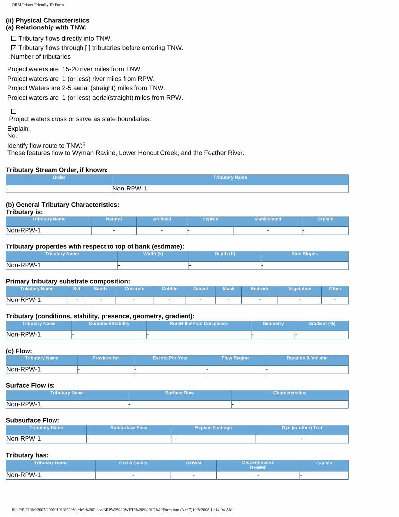
(ii) Physical Characteristics (a) Relationship with TNW:
Tributary flows directly into TNW. Tributary flows through [ ] tributaries before entering TNW.
:Number of tributaries
Project waters are 15-20 river miles from TNW.Project waters are 1 (or less) river miles from RPW.Project Waters are 2-5 aerial (straight) miles from TNW.Project waters are 1 (or less) aerial(straight) miles from RPW.
Project waters cross or serve as state boundaries.Explain: No.Identify flow route to TNW:5 These features flow to Wyman Ravine, Lower Honcut Creek, and the Feather River.
Tributary Stream Order, if known: Order Tributary Name
- Non-RPW-1
(b) General Tributary Characteristics: Tributary is:
Tributary Name Natural Artificial Explain Manipulated Explain
Non-RPW-1 - - - - -
Tributary properties with respect to top of bank (estimate): Tributary Name Width (ft) Depth (ft) Side Slopes
Non-RPW-1 - - -
Primary tributary substrate composition: Tributary Name Silt Sands Concrete Cobble Gravel Muck Bedrock Vegetation Other
Non-RPW-1 - - - - - - - - -
Tributary (conditions, stability, presence, geometry, gradient): Tributary Name Condition\Stability Run\Riffle\Pool Complexes Geometry Gradient (%)
Non-RPW-1 - - - -
(c) Flow: Tributary Name Provides for Events Per Year Flow Regime Duration & Volume
Non-RPW-1 - - - -
Surface Flow is: Tributary Name Surface Flow Characteristics
Non-RPW-1 - -
Subsurface Flow: Tributary Name Subsurface Flow Explain Findings Dye (or other) Test
Non-RPW-1 - - -
Tributary has: Tributary Name Bed & Banks OHWM Discontinuous
OHWM7Explain
Non-RPW-1 - - - -
file:///R|/ORM/2007/200701913%20Versie's%20Place/NRPW2%20WET2%20%20JD%20Form.htm (3 of 7)10/8/2008 11:14:04 AM
ORM Printer Friendly JD Form
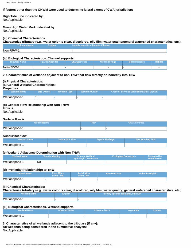
If factors other than the OHWM were used to determine lateral extent of CWA jurisdiction: High Tide Line indicated by: Not Applicable.
Mean High Water Mark indicated by: Not Applicable.
(iii) Chemical Characteristics: Characterize tributary (e.g., water color is clear, discolored, oily film; water quality;general watershed characteristics, etc.).
Tributary Name Explain Identify specific pollutants, if known
Non-RPW-1 - -
(iv) Biological Characteristics. Channel supports: Tributary Name Riparian Corridor Characteristics Wetland Fringe Characteristics Habitat
Non-RPW-1 - - - - -
2. Characteristics of wetlands adjacent to non-TNW that flow directly or indirectly into TNW (i) Physical Characteristics: (a) General Wetland Characteristics: Properties:
Wetland Name Size (Acres) Wetland Type Wetland Quality Cross or Serve as State Boundaries. Explain
Wetlandpond-1 .18 - - -
(b) General Flow Relationship with Non-TNW: Flow is: Not Applicable.
Surface flow is: Wetland Name Flow Characteristics
Wetlandpond-1 - -
Subsurface flow: Wetland Name Subsurface Flow Explain Findings Dye (or other) Test
Wetlandpond-1 - - -
(c) Wetland Adjacency Determination with Non-TNW: Wetland Name Directly Abutting Discrete Wetland
Hydrologic ConnectionEcological Connection Separated by
Berm/BarrierWetlandpond-1 No - - -
(d) Proximity (Relationship) to TNW: Wetland Name River Miles
From TNWAerial Miles From TNW
Flow Direction Within Floodplain
Wetlandpond-1 - - - -
(ii) Chemical Characteristics: Characterize tributary (e.g., water color is clear, discolored, oily film; water quality; general watershed characteristics, etc.).
Wetland Name Explain Identify specific pollutants, if known
Wetlandpond-1 - -
(iii) Biological Characteristics. Wetland supports: Wetland Name Riparian Buffer Characteristics Vegetation Explain
Wetlandpond-1 - - - -
3. Characteristics of all wetlands adjacent to the tributary (if any): All wetlands being considered in the cumulative analysis: Not Applicable.
file:///R|/ORM/2007/200701913%20Versie's%20Place/NRPW2%20WET2%20%20JD%20Form.htm (4 of 7)10/8/2008 11:14:04 AM

ORM Printer Friendly JD Form
Summarize overall biological, chemical and physical functions being performed: Not Applicable.
C. SIGNIFICANT NEXUS DETERMINATIONA significant nexus analysis will assess the flow characteristics and functions of the tributary itself and the functions performed by any wetlands adjacent to the tributary to determine if they significantly affect the chemical, physical, and biological integrity of a TNW. For each of the following situations, a significant nexus exists if the tributary, in combination with all of its adjacent wetlands, has more than a speculative or insubstantial effect on the chemical, physical and/or biological integrity of a TNW. Considerations when evaluating significant nexus include, but are not limited to the volume, duration, and frequency of the flow of water in the tributary and its proximity to a TNW, and the functions performed by the tributary and all its adjacent wetlands. It is not appropriate to determine significant nexus based solely on any specific threshold of distance (e.g. between a tributary and its adjacent wetland or between a tributary and the TNW). Similarly, the fact an adjacent wetland lies within or outside of a floodplain is not solely determinative of significant nexus. Findings for: Non-RPW-1, Wetlandpond-1 Non-RPW-1 and Wetlandpond-1 carry overland sheet flow and provide flood water retention, habitat, bio-filtration, and storm water retention before hydrology is carried to Wyman Ravine and ultimately the Feather River.
D. DETERMINATIONS OF JURISDICTIONAL FINDINGS. THE SUBJECT WATERS/WETLANDS ARE:
1. TNWs and Adjacent Wetlands: Not Applicable.
2. RPWs that flow directly or indirectly into TNWs: Not Applicable.
Provide estimates for jurisdictional waters in the review area: Not Applicable.
3. Non-RPWs that flow directly or indirectly into TNWs:8 Not Applicable.
Provide estimates for jurisdictional waters in the review area: Tributary Name Type Size (Linear) (m) Size (Area) (m²)
Non-RPW-1 Non-RPWs that flow directly or indirectly into TNWs - 161.87424Total: 0 161.87424
4. Wetlands directly abutting an RPW that flow directly or indirectly into TNWs. Not Applicable.
Provide acreage estimates for jurisdictional wetlands in the review area: Not Applicable.
5. Wetlands adjacent to but not directly abutting an RPW that flow directly or indirectly into TNWs: Not Applicable.
Provide acreage estimates for jurisdictional wetlands in the review area: Not Applicable.
6. Wetlands adjacent to non-RPWs that flow directly or indirectly into TNWs: Not Applicable.
Provide estimates for jurisdictional wetlands in the review area: Wetland Name Type Size (Linear) (m) Size (Area) (m²)
Wetlandpond-1 Wetlands adjacent to non-RPWs that flow directly or indirectly into TNWs - 728.43408Total: 0 728.43408
7. Impoundments of jurisdictional waters:9 Not Applicable.
file:///R|/ORM/2007/200701913%20Versie's%20Place/NRPW2%20WET2%20%20JD%20Form.htm (5 of 7)10/8/2008 11:14:04 AM

ORM Printer Friendly JD Form
E. ISOLATED [INTERSTATE OR INTRA-STATE] WATERS INCLUDING ISOLATED WETLANDS, THE USE, DEGRADATION OR DESTRUCTION OF WHICH COULD AFFECT INTERSTATE COMMERCE, INCLUDING ANY SUCH WATERS:10 Not Applicable.
Identify water body and summarize rationale supporting determination: Not Applicable.
Provide estimates for jurisdictional waters in the review area: Not Applicable.
F. NON-JURISDICTIONAL WATERS. INCLUDING WETLANDS
If potential wetlands were assessed within the review area, these areas did not meet the criteria in the 1987 Corps of Engineers Wetland Delineation Manual and/or appropriate Regional Supplements:
Review area included isolated waters with no substantial nexus to interstate (or foreign) commerce:
Prior to the Jan 2001 Supreme Court decision in "SWANCC," the review area would have been regulated based soley on the "Migratory Bird Rule" (MBR):
Waters do not meet the "Significant Nexus" standard, where such a finding is required for jurisdiction (Explain):
Other (Explain):
Provide acreage estimates for non-jurisdictional waters in the review area, where the sole potential basis of jurisdiction is the MBR factors (ie., presence of migratory birds, presence of endangered species, use of water for irrigated agriculture), using best professional judgment: Not Applicable.
Provide acreage estimates for non-jurisdictional waters in the review area, that do not meet the "Significant Nexus" standard, where such a finding is required for jurisdiction. Not Applicable.
SECTION IV: DATA SOURCES.A. SUPPORTING DATA. Data reviewed for JD (listed items shall be included in case file and, where checked and requested, appropriately reference below):
Data Reviewed Source Label Source Description
--Maps, plans, plots or plat submitted by or on behalf of the applicant/consultant
Versie's Place Draft delineation of waters of the U.S.
Delineation report submitted by agent; Gallaway Consulting.
B. ADDITIONAL COMMENTS TO SUPPORT JD: Not Applicable.
1-Boxes checked below shall be supported by completing the appropriate sections in Section III below. 2-For purposes of this form, an RPW is defined as a tributary that is not a TNW and that typically flows year-round or has continuous flow at least "seasonally" (e.g., typically 3 months). 3-Supporting documentation is presented in Section III.F. 4-Note that the Instructional Guidebook contains additional information regarding swales, ditches, washes, and erosional features generally and in the arid West. 5-Flow route can be described by identifying, e.g., tributary a, which flows through the review area, to flow into tributary b, which then flows into TNW. 6-A natural or man-made discontinuity in the OHWM does not necessarily sever jurisdiction (e.g., where the stream temporarily flows underground, or where the OHWM has been removed by development or agricultural practices). Where there is a break in the OHWM
file:///R|/ORM/2007/200701913%20Versie's%20Place/NRPW2%20WET2%20%20JD%20Form.htm (6 of 7)10/8/2008 11:14:04 AM

ORM Printer Friendly JD Form
that is unrelated to the waterbody's flow regime (e.g., flow over a rock outcrop or through a culvert), the agencies will look for indicators of flow above and below the break. 7-Ibid. 8-See Footnote #3. 9 -To complete the analysis refer to the key in Section III.D.6 of the Instructional Guidebook. 10-Prior to asserting or declining CWA jurisdiction based solely on this category, Corps Districts will elevate the action to Corps and EPA HQ for review consistent with the process described in the Corps/EPA Memorandum Regarding CWA Act Jurisdiction Following Rapanos.
file:///R|/ORM/2007/200701913%20Versie's%20Place/NRPW2%20WET2%20%20JD%20Form.htm (7 of 7)10/8/2008 11:14:04 AM

Project Site
City of Oroville
Versie's Place Location
0 0.25 0.5
MilesParcel data derived from Butte CountyIn Sections 27 &28 of T19N and R 4 EPalermo USGS 7.5' Quad.Map Date: September 11, 2007
Figure 1
Project Site (90.35 ac.)
BU TTE
PLU MAS
TE HAMA
YU BA
GLE NN
NEVADACO LU SA
SU TTER
SI E RRA
7099
32
49
89
162
45
174
149
191
147
162162
5
5

WF02
WF04
WF01
WF03
WF05
OW07
OW06
OW03
NJ02
OW05
OW01
OW04
OW08
NJ14OW13
OW11
OW12
OW09
U04
U03
U02W02
W04W03
U01W01
Wy ma n R av i n e
Sheet Flow
Orov i l le Bangor H
w y
Ina Ct
Coac
h Dr
Cha i se Dr
Phaet on Dr
Br ougham Dr
Mont e V i sta Av e
Tay lor S prin gs Ct
Fores tvie w D r
Shad
ow O
ak C
t
Arch ulet a Dr
Niss
en R
anch
Rd
unde
term
ined
V-E
AveVersie's Place Draft Delineation of the Waters of the U.S.
0 200 400Feet
All features to remain preliminary untilwritten verification from the USACE.1 ft. contours from RSA Civil (8/28/07)Surveyor: TL, BO (August 1, 2007)Parcel boundary derived from Butte County Tax Assessor information.Aerial: February 2005 (NAIP)Map Date: September 4, 2007.
Attachment A
Project Site (90.35 ac.)Contours (1 ft.)
Soil SamplesUpland - U#Wet - W#
Non-Jurisdictional FeaturesIsolated StreamIsolated Pond
Other Waters of the U.S.#FlumeRPWNRPWPond
Wetland Features - WF#Fresh Emergent WetlandRiparianSeasonal WetlandVernal PoolWet Meadow
Other Waters of the U.S.Type Label Designation Avg. Width (ft.) Length (ft.) Area (ft.2) AcresFlume OW13 NRPW 2 643.382 1286.765 0.030
Ephemeral OW01 NRPW 2.5 689.591 1723.978 0.040Ephemeral OW04 NRPW 1.5 300.798 451.197 0.010Ephemeral OW08 NRPW 2 1533.527 3067.053 0.070Ephemeral OW09 NRPW 2 374.040 748.079 0.017
Intermittent OW05 RPW 2.5 1401.007 3502.517 0.080Intermittent OW11 RPW 6 134.006 804.034 0.018Intermittent OW12 RPW 4.5 181.128 815.076 0.019
Pond OW03 Jurisdictional Pond n/a n/a 1610.734 0.037Pond OW06 Jurisdictional Pond n/a n/a 1097.126 0.025Pond OW07 Jurisdictional Pond n/a n/a 7707.900 0.177
NRPW Total = 3541.337 7277.071 0.167RPW Total = 1716.140 5121.626 0.118Pond Total = n/a 10415.761 0.239
Total of All OWOTUS = 5257.478 22814.459 0.524
Wetland FeaturesType Label Designation Avg. Width (ft.) Length (ft.) Area (ft.2) Acres
Fresh Emergent Wetland WF03 Adjacent n/a n/a 2447.014 0.056Riparian WF04 Adjacent n/a n/a 213858.655 4.910
Seasonal Wetland WF05 Adjacent n/a n/a 2369.927 0.054Vernal Pool WF01 Adjacent n/a n/a 2649.819 0.061
Wet Meadow WF02 Adjacent n/a n/a 32956.620 0.757Fresh Emergent Wetland Total = n/a 2447.014 0.056
Riparian Total = n/a 213858.655 4.910Seasonal Wetland Total = n/a 2369.927 0.054
Vernal Pool Total = n/a 2649.819 0.061Wet Meadow Total = n/a 32956.620 0.757
Total of All Wetland Features = n/a 254282.034 5.838
Total of OWOTUS and Wetland Features = 5257.478 277096.492 6.361