Embed Size (px)
Citation preview

Section 4: Behavioral Geography

Section Topic
Deals with a criminals spatial understanding about their world and the impact that this has on their spatial decisions about crime.
Specifically, we will discuss how an individuals spatial understanding and spatial knowledge will impact:
Where they will offend
Where they will search for victims
Other “where” aspects of crime

Behavioral Geography Section Outline
I. Introduction to Behavioral GeographyBackground
II. Mental MapsResearch Findings
III. Awareness SpaceResearch Findings
IV. Journey to CrimeResearch FindingsCriticisms of Research
V. Geographic ProfilingDevelopment of Geographic ProfilingResearch Findings
Rossmo ModelCanter ModelLevine Model
Criticism of Research
Behavioral Geography
Sub-field of geography concerned with decisions people make concerning travel and associated behavior.
Definition
The spatial decision-making of individuals which precedes their behavior
OR
Behavioral geography can be thought of as a body of research interested in why and how people make decisions about where to go for everything from food to entertainment to criminal activities
In general, research in behavioral geography can be divided into two different areas, both of which have implications for crime and criminal justice.
1. Behavior in Space
2. Spatial Behavior

Behavior in Space
A research approach that “considers the geographic distribution of opportunities for crime and the social, economic, physical, and physiological constraints on criminal spatial behavior”.
This area of crime research deals with how the spatial structure of opportunities for crime can shape the distribution of crime.
Thus, behavior in space research is more place specific and looks at how the mix of opportunities and constraints within an area impacts patterns of crime.
Criminological research that has been strongly influenced by this area of behavioral geography includes Crime Pattern Theory and opportunity structure models of crime.

Behavior in Space Example
In most cities shoplifting patterns are highest in certain areas, specifically those areas with high concentrations of stores.
Shoplifting hot spots tend to cluster in areas such as shopping districts and areas with high concentrations of malls and strip centers.
These concentrations are because shoplifting by definition requires shops and merchandise to take place.

Behavior in Space Continued
In analyzing how opportunity structures impacted the distribution of burglary in Philadelphia, Rengert (1991) found that the number of residential housing units in an area was a strong measure of “criminal attractiveness”.
While this area of research may seem relatively obvious in its findings, opportunity structure and its impact on crime distributions is nonetheless important to criminal justice practitioners and criminologists alike.
In particular, opportunity structures can foretell the spatial patterns of some crimes and effective criminal justice policy can be created to deal with these issues.
What are some crimes that can be in a sense “predicted” by analyzing opportunity structures?
Commercial robbery, bank robbery, auto theft
Is this an important thing for law enforcement policy and practice?

Spatial Behavior
Spatial behavior focuses more on the individual as an active participant in crime rather than just a reactor to physical and social elements within the physical environment.
Whereas behavior in space research is more place specific and is concerned with opportunities and constraints, spatial behavior research looks at the role of the person in the geography of crime.
Specifically, spatial behavior focuses on individual actors and their differences in terms of spatial knowledge and in turn their spatial activity.
While criminological research dealing with behavior in space concepts has been rather limited, research dealing with spatial behavior concepts has been much more extensive.
Mental Maps
Awareness Space
Journey to Crime

Mental Maps
Also called a cognitive map
Definition
“a mental description of an environment”
“those internal representations of the world that we all use to find our way around and make decisions about what we will do and where”.
In general, a mental map can be thought of as a mental sketch of a place or area comprising an individuals knowledge about that place or area.
Importantly, a mental map does not necessarily indicate that an individual has a detailed knowledge of an entire area, only that a person has a mental image of the geography of that area.
Most often people have mental maps that are highly detailed in some areas and only vague understandings of other areas, largely due to the variation in the amount of activity they conduct in the different areas.

Mental Map Example

Formation of Mental Maps
How do we form our mental maps?
Largely through two main sources of information
1. Individual experience
Gaining knowledge about an area through actual travel and interaction within that area.
More important of the two methods; has the biggest impact on mental maps.
2. Perception:
Gaining knowledge about an area from media and friends.
Seeing places on TV, reading about them, seeing maps of places
Hearing about places from friends and family.

Research on Mental Maps
Most of the research involves peoples perceptions of crime patterns within a city.
Perceptions of crime patterns were found to vary by several important factors:
Findings for Citizens PerceptionsRace: Blacks had a more accurate perception of where crime occurred within the city as
compared to White residents.Gender: Females tended to overestimate the amount of crime in city locations as
compared to Males.Age: Very young (16-19) and older (45-54) residents tended to overestimate the amount
of crime in city locations as compared to other groups.Income: Wealthier residents tended to overestimate the amount of crime in the city center
as compared to poorer residents.Education: Those with lower education levels had more accurate perceptions of city
center crime rates than those of higher education levels.Tenure: Those who lived in the area longer were more accurate with their perceptions of
high crime areas in the city center than those who were more recent to the area.Suburban Residents: Those who lived in the suburbs tended to have exaggerated
perceptions of the levels of crime within the city center.

Research on Mental Maps
Research on Police Officers’ Mental Maps
In looking at the perception of crime by police officers research has found that found that the accuracy of officers perceptions varied by crime types.
Officers were most accurate in their perceptions of where burglaries were concentrated and less accurate in their perceptions of other crimes such as auto theft and non-residential burglary.
It was theorized that the geographic knowledge of burglary was attributed to the seriousness of this crime and the officers increased desire to reduce and prevent these types of crime over other crime types (auto theft and non-residential burglary).
Other research has shown that distributing maps of crime patterns within a jurisdiction has no determinable impact on improving officers perceptions of crime patterns.
The importance of these incorrect perceptions lies in the increased use of community policing, a policing concept that relies heavily on problem solving by individual officers.
If officers have incorrect perceptions of where crimes occur within a jurisdiction it could significantly impair their ability to implement problem solving strategies in places where they will effectively reduce crime.

Research on Mental MapsResearch on Criminals’ Mental Maps
Research on criminals’ mental maps has focused on which areas of a city criminals feel are good for criminal activities.
* Overall, it was found that criminals and non-criminals have very similar perceptions of crime patterns, but that criminals view the city differently than non-criminals.
* Criminals images of the city can best be described as divided into “dimensions of evaluation”, in which criminals evaluate different areas based on their potential for criminal activity
* In general, criminals evaluate areas differently than non-criminals, largely based on their “work” oriented view of an area as either good or bad for criminal activity.
* Two key evaluative criteria are used by criminals in their mental maps of an area, familiarity with an area and potential strategy for an area
* Differences in mental maps were found to exist by both age and race AGE: Younger criminals chose areas with higher amounts of multi-family housing.RACE: Criminals were decidedly intra-racial in the areas they chose, preferring to avoid
areas where they might stand out. * Furthermore, black criminals mental maps were more heavily influenced by familiarity
considerations, whereas whites mental maps were found to be equally influenced by familiarity and strategy.

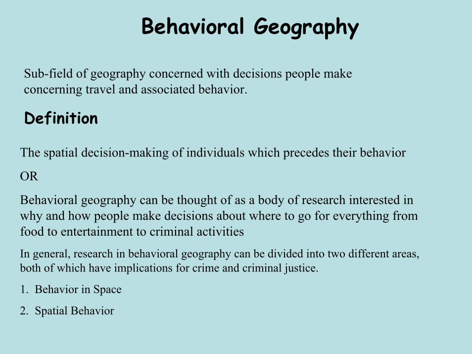
Awareness Space
As was mentioned previously, most peoples’ mental maps will contain both areas where they have only vague geographic knowledge and those areas where they have more detailed geographic knowledge.
In behavioral geography terms, those areas in which an individual has a more detailed geographic knowledge are called awareness spaces.
Awareness space is a very important concept to spatial crime research and journey to crime in particular, because research has shown that an offenders main search area in terms of criminal activity is within their awareness space
Within an individuals more general mental map is contained a more detailed area of spatial knowledge (awareness space).
It is within this more detailed awareness space that criminals will search for criminal targets.

Awareness Space Map
This map details the relationship between a general mental map, an awareness space, a search space and the actual criminal activity space of a burglar.

Awareness Space
Of utmost importance in a discussion of awareness space is how an individual acquires their awareness space.
As with mental maps, awareness space is not an inherently criminal concept, and both criminals and non-criminals obtain their awareness space through the same general processes of conducting legitimate routine activities.
Awareness space knowledge is gained through two general processes
Primary Spatial Learning
Passive Spatial Learning
Active Spatial Learning
Secondary Spatial Learning

Primary Spatial Learning
Passive Spatial Learning
Passive spatial learning occurs as we go about our legitimate daily activities.
Work, home, social places, shop, etc..
Importantly, the purpose of these daily activities can be anything in our normal activities EXCEPT exploring new areas to gain spatial knowledge.
In everyday activities such as traveling to work, shopping or social occasions, we passively gather spatial information.
The area in which an individual regularly travels for legitimate purposes is termed their activity space, and is contained within an individuals awareness space
ACTIVITY SPACE: Those places regularly visited by a person in which the majority of their activities are carried out.
Thus, the activity space of each individual will vary in size and shape depending on the distance and direction of their routine activities

Primary Spatial Learning
Passive Spatial Learning
Central to the size and shape of an individuals’ activity space are the concepts of nodes and paths.
NODES: Those places that are central to an individuals life, such as home, place of work, school, shopping areas and favorite recreation spots
These places where individuals travel to and from essentially make up the extent of an individuals activity space and act as anchor points for an individuals legitimate and criminal activities.
Specifically, nodes form mental boundary points within which criminal offenders will search for criminal opportunities.
These are essentially anchor points for an individuals activity space, beyond which they do not travel much.

SPECIALIZED NODESIn addition to central place nodes such as home, work and school locations, two specialized types of nodes, crime attractors and crime generators, also play a role in shaping an individuals activity and awareness space.
CRIME ATTRACTORS: Those places, areas, or neighborhoods where criminal opportunities are well known, and to which motivated offenders are subsequently attracted as a source for criminal activity Examples: red light districts, known drug markets, bar districts and large shopping areas, all of which provide ample criminal opportunities for different offenders. * Crime in these areas is often committed by people who live outside the area and who travel relatively long distances specifically because of the criminal opportunities that exist there.CRIME GENERATORS: Particular places and areas to which large numbers of people are attracted for legitimate reasons, but which provide criminal opportunities because of the sheer number of potential victims Examples: shopping centers, entertainment districts, college campuses and sports stadiums, all of which provide large influxes of people at specific times.* These areas generate crime by providing large numbers of potential victims at specific times and within concentrated areas.

PATHS
Complimentary to the concept of nodes are paths,
Paths: The everyday routes that people use to travel between different nodes of activity.
While nodes act as anchor points for a persons’ activity space, paths determine the areas an individual will learn about through the routes they travel on a regular basis.
Because people spend long hours in routine paths traveling to and from activity nodes, paths will determine the areas along which criminals will search for potential victims
As discussed earlier, these nodes and paths will form the basis for a criminals search area in terms of criminal activities.
Research has found that criminals choose to commit crimes in these areas they know well because they feel that they will not stand out and that they belong in that area.

This Figure provides an example of several different nodes and their resulting paths and provides a visualization of their impact on the activity space and awareness space of an individual.
In this example the nodes and paths are in a irregular shape and thus so is the activity space, but in reality nodes, paths and the subsequent activity space they create can be in any form or shape

Primary Spatial Learning
Active Spatial Learning
In contrast to Passive learning is active learning strategies.
Active Spatial Learning: Individuals gain spatial knowledge about places through the active exploration and evaluation of space.
The whole purpose of spatial activity in active learning is to obtain information for later use.
The environment is actively examined or cased and evaluated for its usefulness.
Usually this involves entering unfamiliar areas.
Unfamiliar territory is entered either by extending a known activity path into unfamiliar territory of by traveling in a different direction that leads to new places at shorter distances.
Thus activity space, nodes and paths are essential to this learning strategy
Is this a inherently criminal activity?
No, this is a natural process we all engage in (Sunday drive, exploring new city, etc..)

Secondary Spatial Learning
This is a special case type of learning about places.
Individuals obtain spatial information from secondary sources:
Friends, media, working partners, fences
These information sources do not depend on past spatial knowledge of the individual in any way.
Previous spatial behavior of an individual gives us no clues as to the probable location of the new spatial knowledge.
Crimes committed using this type of information are almost always planned and never opportunistic in nature.
Examples:
High level burglars often rely on information from inside sources in planning their crimes.
Insurance agent passing along information about insured goods at home locations for a cut of the proceeds of the burglary.

Awareness Space Research
Important research has been conducted concerning awareness space, nodes, and paths and their impact on crime.
In looking at awareness space and its related concepts, research has focused on two different areas:
1. Differences in awareness space and;2. The impact of awareness space, nodes, and paths on criminal activity.
Research involving differences in criminals awareness space has found that awareness space varies depending on several different factors:
AGE: Young people have a more limited awareness space than working age people.
This finding is largely due to transportation issues and younger people being more limited in their travel patterns.
This can change for very old people as they may be limited in their ability to travel and thus have a more limited awareness space.

Awareness Space Research
GENDER: Females have a more limited awareness space than males.
This finding is largely due to the disproportionate number of women who are tied to home, often with children.
RACE: Black criminals were shown to have less spatial awareness than White criminals,
These findings are largely due to access to transportation.
Moreover, Blacks were not likely to be familiar with White areas, and Whites were not likely to be familiar with Black areas.
S.E.S.: Poorer people have more limited awareness space than people who are from wealthier areas (Orleans, 1973).

Awareness Space Research
EMPLOYMENT STATUS: Those who are unemployed have more limited awareness space than those who are working.
This is different from S.E.S. in that many who are unemployed may be stay-at-home parents.
RESIDENTIAL STATUS: Inner city youth have smaller awareness spaces than those who live in suburban areas.
However, inner city youth have much more detailed geographic knowledge about their awareness space than do suburban youth
• Much of the awareness space differences can be attributed to differences in requirements and availability to transportation.
• Importantly, research has also shown that awareness space can change and evolve over time due either to availability of new transportation, learning from more experienced criminals and as people age.

Impact of Awareness Space on Crime Patterns
In terms of how awareness space impacts crime patterns, researchers have consistently found several important direct relationships
1. Criminals tend to operate in neighborhoods they know well, despite the fact that they identified other neighborhoods as having better potential opportunity.
2. Research found that burglars usually chose crime sites only a limited distance from their normal travel paths, usually along the path between home and work.
3. Other research has found that nearly all robbery, burglary, serial rape, and serial murder is committed within the awareness space defined by offenders nodes and paths .
4. Overall, research is consistent in the assertion that most criminals commit crime within their awareness space, usually centered around the nodes and paths that make up their routine activities, and that spatial exploration for the purposes of criminal activity is a very rare phenomenon.

Journey to Crime
The last of the interrelated behavioral geography concepts to be discussed is journey to crime.
Journey to Crime (JTC): Area of criminological research that is interested in the distances that criminals travel to commit crimes, specifically the distance from their home residence to the offense site.
While the idea of criminals’ journeys to crime is relatively simple, the implications of where and why criminals travel to a specific place to commit a crime impacts the majority of criminological theories
While criminals’ journeys to crime are influenced by numerous different theories, including Routine Activities, Rational Choice, Differential Association, and Crime Pattern Theory to name a few, in general criminals’ journeys to crime are thought to be driven by one or more of three important spatial factors.
Specifically, criminals’ Journey to Crime is influenced heavily by:
1. Target Attractiveness
2. Spatial Attractiveness
3. Target Backcloth

Target Attractiveness
Target Attractiveness: The amount of high value targets that are available within a given area.
Specifically, criminals will travel to areas with target attractiveness because of the perceived high value of criminal opportunities available in these areas.
Theoretically, the higher the target attractiveness of an area the more likely criminals will travel long distances to offend here.
Examples of area characteristics that rate high on a scale of target attractiveness are areas with
High income
High amounts of single-family dwellings or
Large amounts of potential victims
In the previous discussion of activity nodes, both crime generators and crime attractors are examples of factors that can increase the target attractiveness of an area.
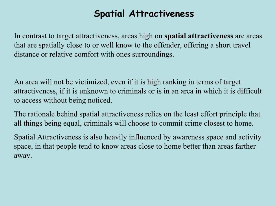
Spatial Attractiveness
In contrast to target attractiveness, areas high on spatial attractiveness are areas that are spatially close to or well know to the offender, offering a short travel distance or relative comfort with ones surroundings.
An area will not be victimized, even if it is high ranking in terms of target attractiveness, if it is unknown to criminals or is in an area in which it is difficult to access without being noticed.
The rationale behind spatial attractiveness relies on the least effort principle that all things being equal, criminals will choose to commit crime closest to home.
Spatial Attractiveness is also heavily influenced by awareness space and activity space, in that people tend to know areas close to home better than areas farther away.

Target Backcloth
Target Backcloth: also called victim backcloth, is the spatial distribution of criminal targets or victims within a given area
The importance of target backcloth is that the locations of suitable victims may not be uniformly distributed within a criminal’s hunting areas, particularly when a criminal is looking for a particular type of victim.
In cases in which the criminal is seeking a specific type of victim the journey to crime and offense locations will be influenced more heavily by the victims’ activity spaces than by the offenders’ activity spaces.
Example: Serial arsonist who only likes to burn warehouses.
In the case of such an offender, those areas where there are suitable victims (warehouse districts) would define his target backcloth, and subsequent journeys to crime.
In contrast, a serial arsonist who has no specific victim type would have a very different target backcloth and journeys to crime.

Pattern is driven by awareness and activity space
Pattern is impacted NOT by awareness space but the pattern of victim distribution
This Figure illustrates how Target Backcloth can impact journey to crime of an offender.
Target backcloth has been found to be particularly important in understanding the journey to crime of certain types of serial offenders, particularly serial murderers, serial rapists, arsonist, robbery, and burglary.

Journey to Crime Research
Much more research on JTC than on awareness space or mental maps
In general, research on journey to crime has produced a remarkably consistent body of findings indicating two overall principles concerning criminals’journeys to crime.
1. Distance Decay
2. Travel Journey distances

Distance Decay
The first major finding is that there is a definite distance decay factor at work in criminals’ journeys to crime
Distance Decay: Offenders generally select targets close to their home and thatthe farther you go from the home the fewer crimes they will commit.
Importantly, research shows there is a buffer distance around a criminals home area in which criminals will not commit crime in order to avoid detection.
This buffered distance decay function is particularly acute in confrontational crimes such as robbery where criminals do not want to choose victims from their neighborhood for fear of being recognized and apprehended.
Thus, after this buffer zone distance, crime decreases the further from home that a criminal travels.
This finding is so consistent and robust that it forms the basis for criminal geographic targeting (geographic profiling) and plays an important role in the overall profiling of criminal offenders

No crimes occur within the buffer zone.
More importantly, crimes decrease in frequency as the distance increases from the offenders home base.
Research indicates criminals first crimes are likely to be the ones closest to their homes
Ease
Local knowledge

Travel Journey Distances
The other major finding from journey to crime research is that the distances traveled by criminals vary greatly based on different offender and offense specific characteristics.
Property v. Personal: Offenders travel longer distances to commit property crimes such as burglary and auto theft than to commit personal crimes such as homicide, robbery or rape.
Individual Crimes: Research has found that even among general crime categories, such as property and personal crimes, there are differences between specific crimes
Distances have been found to be farther for armed robbery than for unarmed robbery.
City Type: In older cities that are more compact and have a more defined central core area, criminals should have shorter crime trips than criminals in newer more spread out cities.

Travel Journey Distances
Rural v. Urban: Criminals living in rural and mixed urban/rural areas have longer journeys to crime than those who live in purely urban areas.
Neighborhood Type: Distance traveled is positively related (longer) to the extent that an offender’s surrounding area consists of single-family dwellings, multiple dwellings, and small businesses.
Conversely, travel distance is negatively related (shorter) to the extent to which the surrounding neighborhood is characterized as industrial, transitional, and mixed.
Gender: Female offenders generally travel shorter distances to commit crimes than do males, although the distances traveled are not a great deal farther.
Race: Black offenders tend to travel shorter distance to commit crimes than do Whites.
Age: Juveniles are more likely to commit crimes in their home areas and are less mobile than adult offenders .
Travel Journey DistancesIncome: Those who are of lower economic status travel shorter distances to commit crimes than do those who are wealthier.
Planned v. Unplanned Crimes: Crimes that are more situationally induced, such as rape and homicide, occur closer to home than do crimes than involve more advance planning, such as robbery and burglary.
Victim/Offender Relationship: Crime distances are longer when the victim is a stranger than when the victim and offender know each other.
Criminal Experience: Offenders with criminal records travel farther than those without criminal records to commit crimes.
Hunting Type: Journey to crime distances differ according to the type of hunting method employed by the offender in acquiring victims.
Rapists who employed a capture the victim confidence hunting style traveled much farther distances than those employing other methods such as illegal entry or even kidnap methods.
Other research found that rapists were more likely to employ a marauder hunting technique involving hunting from a home base, than a commuter hunting technique in which the rapist traveled far from home to commit crimes.

JTC Research Criticisms
While the review of the literature concerning journey to crime made it clear that the research findings are well established and consistent, there are several important criticisms of journey to crime research, largely concerning the methods employed in the crime trips.
Main Criticisms1. Assumption about starting points of JTC2. Assumptions about route traveled3. Over reliance on official data.

Assumption about starting points of JTCWhen measuring journey to crime almost all researchers measure the distance
between an offenders home address and the offense site location, assuming that the offender started their journey to crime from their primary residence.
However, several researchers have found that criminals do not always start their journeys to crime from home. Specifically,
• One study found that burglars often started their victim search from well over a mile away from home, a significant distance in urban areas.
• Other research found that only 25% of crack users originated their drug buying trips from home, with over 30% starting their trips from shopping, business, or other places.
• The impact of this assumption is that it may obscure the reality of how far criminals are really traveling to commit crime from when they first decide to commit a crime to when they arrive at the offense site.
• Based on this “domocentric” assumption, journey to crime research may more accurately be said to be measuring the distance from a criminals home to their offense sites.
Assumption about route traveled
Even if we know the location where criminals originated their journey to crime (which in general we don’t) journey to crime research almost never knows the exact route used to arrive at the offense site.
Researchers use one of three different methods to estimate a criminals’ journey to a crime site.
Manhattan distance, Crow Flight, or Wheel Distance.
While each of these methods calculates the distance between the offenders home and the offense site differently, none of them uses the actual crime trip involved.
By not measuring the actual travel route used by the offender, journey to crime research again is only measuring the distance from an offenders’ residence to an offense site.
While this may be important information, it is in no way synonymous with a criminals’ trip to a crime site and may be either overestimating or underestimating the actual journey to crime of criminals.

Over-Reliance on Official DataWith a few notable exceptions almost all research on journey to crime involves only
offenders who have been arrested and prosecuted for a specific crime.
Problems with Official Data
1. Undercount of Crime: Official data is not a complete recording of all crimes, but rather it is only a recording of all crimes known to the police.
Victims report only one in three property crimes and that victims are more likely to report crimes if they are violent in nature, where an injury results, or where property loss is over $250 or more.
2. Clearance Rates: Of all crimes that are reported to the police few crimes are cleared (offender is arrested), further limiting the potential sample size used in journey to crime research.
In the year 2000 the clearance rate for violent crime offenses known to the police was 47.5% and only 16.7% for property crimes.
Since 1971 the clearance rates for violent crimes have never been over 50%, while the clearance rates for property crimes have never been over 19%.
The impact of this reliance on official data is that researchers are making assumptions about criminals travel distances based on small and most likely unrepresentative samples of the criminal population.
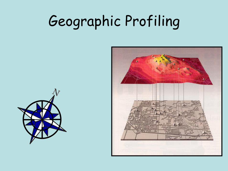
Geographic Profiling

What is Geographic Profiling?
Computer software system used for serial crime investigation
Analyzes crime locations to determine most probable area of offender residence
First created by Kim D. Rossmo

Types of Crimes Investigated
• Serial offencesmurder, rape, arson, bombing, burglary, robbery, etc
• Predatory crimessexual homicide, child molesting
• Multiple location crimestelephone calls, credit cards
• Missing bodies• Geographic profiles should only be brought into an investigation after a
series of crimes have been linked together through traditional police investigative techniques
• As with any investigative tool, geographic profiling has its limits and even its biggest proponents point out that there are numerous type of crimes that cannot be profiled and that only in appropriate cases can it produce beneficial results.
• It is also important to stress that a geographic profile alone cannot solve a crime, rather geographic profiling is part of an overall investigative strategy.

What Geographic Profiling is NOT
•“X” marks the spot showing where a criminal lives
• Psychological profile of an offenders motive
•Doesn’t tell you what the offender is like, but where they may live based on where they commit crimes.
•In reality geographic profiling can best be though of as a strategic information management system designed to support investigations into serial crimes, with the purpose of helping to narrow the search area for an offender
• Rather than place an “X” on a map where the offender lives, geographic profiles provide output in the form of probability maps that indicate the areas within the search area where the offender is most likely to reside.
• This information is then used by law enforcement officials to develop new investigative strategies.

How Geographic Profiling Works
The rationale behind geographic profiling comes from numerous sources including routine activities theory, rationale choice theory and research into mental maps, awareness space and journey to crime.
However, the biggest influence on geographic profiling can be most directly tied to crime pattern theory and research conducted by Paul and Patricia Brantingham.
In their research, the Brantinghams’ have used an understanding of a criminals activity space to predict where the offender will commit crimes.
Geographic profiling essentially takes these ideas and inverts them.
Using information about where an offender has chosen to commit crimes, geographic profiling attempts to determine where the offender is most likely to reside.
While the two models have different purposes and inputs, their underlying concepts and ideas are similar.

Brantingham Crime Pattern Theory
Target Areas
Residence
Work
Recreation
BufferZone
Activity Space
Crime Sites

Geographic Profiling ModelsThere are currently three different models used to create geographic profiles
1. RIGEL: Created by Kim D. Rossmo
2. Crimestat: Created by Ned Levine
3. DRAGNET: Created by David Canter
All three are fairly similar in their statistical calculations and output.
Main differences between the three methods
1. Cost: Ranges from free (Crimestat) to $5,500 (RIGEL Analyst).
2. Ease of Use: RIGEL is easiest, with Dragnet being a nightmare.
3. Output: RIGEL output looks prettier and comes with more statistics, Crimestat is next best, with Dragnet being the worst.

Step 1: Map all crime locations

Step 2: Place a buffer zone around crime sites

Step 3: Combine Buffer zones from all crime sites

Step 4: Darkest areas have highest probability of offender residence

Step 5: Use Profile to identify suspects

Using Profile ResultsThis information is then used by law enforcement officials to develop new investigative strategies.
Suspect Prioritization: Based on the results suspects who live in the areas of highest probability may receive additional investigative focus.
This is particularly beneficial when an investigation is suffering from “information overload” in which there are too many suspects.
Patrol Saturation: Police patrols can be increased in size in areas where the offender is thought to reside or where they are thought to search for victims.
Neighborhood Canvasses: Police can conduct door-to-door canvasses or mail information requests in areas where the offender is thought to live.
Police Information Systems: Data contained within police databases such as probationer and parolee residences, known offender information and criminal intelligence data can be overlaid with the profile results. Using this information suspects may be added to the investigation.
DNA Searches: Geographic profiles can be used to narrow down the lists of individuals required to submit DNA samples, reducing the costs associated with these tests. This is an investigative technique that has been used numerous times in Britain.

Paper bag
Rapist
Vancouver Canada

Highest probability of offender residence


Criticism of Geographic Profiling
While the benefits of geographic profiling are admittedly powerful, in that it can help drastically reduce the amount of time and energy expended in a serial crime investigation, there are several problems with the concept of geographic profiling
1. Independent Research: Of the five current publications dealing with the empirical findings of geographic profiling software, all were conducted by those individuals responsible for the development of the software tested.
Moreover, only one researcher has published their findings in a peer-reviewed journal, the gold standard of academic research.
2. Anecdotal Support: Much of the support for geographic profiling is anecdotal in nature, consisting of media reports of how geographic profiling was instrumental in solving a serial crime.
Lafayette Rapist was not caught thru profiling despite media reports
“ It's not that they have anything against Rossmo or geographic profiling. It's just that neither figured in the arrest and conviction of the so-called South Side Rapist, who was identified through an anonymous tip, Peters says. Armed with a name, police obtained a sample of the suspect's DNA from a discarded cigarette butt. And, Peters says, it matched the DNA evidence recovered from six of the rapes, confirming that police had the right man”

Criticism of Geographic Profiling
3. Data Problems: The data sets used for these various analyses suffer from serious generalizability problems including small sample sizes and non-random data selection.
RIGEL: Used data from a total of only 13 serial murder cases, comprising just 15 serial offenders and a total of 178 victims.
These 13 serial murder cases were selected from a larger data set of “serial killers responsible for five or more victims, after 1960, who were residentially stable, operated by themselves or with a single partner, and who hunted in certain ways”
This data on serial murderers comes not from official police data but rather from a Lexus/Nexus newspaper computerized topical search on serial murderers.
Dragnet: Sample of 79 serial offenders who accounted for an unmentioned number of victims.
Data gathered by consulting published accounts of U.S. serial killers who had been convicted since 1960, who killed in one location and deposited bodies in another location
Crimestat: Sample of data which was “not random, but was selected to produce a balance in the number of incidents committed by each individual and to, roughly, approximate the distribution of incidents by serial offenders”.

Criticism of Geographic Profiling4. Determining Accuracy: Poor methods used for determining the accuracy of the
software.
Specifically, in determining the accuracy of the geographic profiling software, only Levine (Crimestat) compares the geoprofile results against results from other spatial analysis methods.
Both Rossmo and Canter employ evaluation methods that report the percent of the search area that was reduced by the geographic profile.
While this method of accuracy assessment can be informative, without a baseline method to compare it against (such as a mean center) these measures tell us little of the true accuracy of the software.
While both the RIGEL and DRAGNET systems purport to significantly reduce the search area for serial offenders, we have no idea if these methods are any better than a simple center of minimum distance.
This is extremely important given the expense involved in both purchase and training with the RIGEL and DRAGNET systems. If they reduce the search area no better than a simple spatial analysis measure then is there any justification for using such a system

THE END


![A Geographic Approach to Racial Profiling: The ......12(2): 137-169. [June 2009] Sage - ISSN: 1098-6111 A Geographic Approach to Racial Profiling: The Microanalysis and Macroanalysis](https://img.dokumen.tips/doc/110x75/602126dbe43c7027327ace95/a-geographic-approach-to-racial-profiling-the-122-137-169-june-2009.jpg)