Embed Size (px)
Citation preview
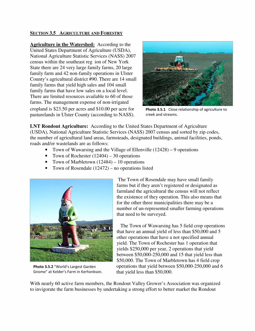
Photo 3.5.1 Close relationship of agriculture to
creek and streams.
SECTION 3.5 AGRICULTURE AND FORESTRY
Agriculture in the Watershed: According to the United States Department of Agriculture (USDA), National Agriculture Statistic Services (NASS) 2007 census within the southeast reg ion of New York State there are 24 very large family farms, 20 large family farm and 42 non-family operations in Ulster County’s agricultural district #90. There are 14 small family farms that yield high sales and 104 small family farms that have low sales on a local level. There are limited resources available to 60 of those farms. The management expense of non-irrigated
cropland is $23.50 per acres and $10.00 per acre for pasturelands in Ulster County (according to NASS). LNT Rondout Agriculture: According to the United States Department of Agriculture (USDA), National Agriculture Statistic Services (NASS) 2007 census and sorted by zip codes, the number of agricultural land areas, farmsteads, designated buildings, animal facilities, ponds, roads and/or wastelands are as follows:
• Town of Wawarsing and the Village of Ellenville (12428) – 9 operations
• Town of Rochester (12404) – 30 operations
• Town of Marbletown (12484) – 10 operations
• Town of Rosendale (12472) – no operations listed
The Town of Rosendale may have small family farms but if they aren’t registered or designated as farmland the agricultural the census will not reflect the existence of they operation. This also means that for the other three municipalities there may be a number of un-represented smaller farming operations that need to be surveyed.
The Town of Wawarsing has 5 field crop operations that have an annual yield of less than $50,000 and 5 other operations that have a not specified annual yield. The Town of Rochester has 1 operation that yields $250,000 per year, 2 operations that yield between $50,000-250,000 and 15 that yield less than $50,000. The Town of Marbletown has 4 field crop operations that yield between $50,000-250,000 and 6 that yield less than $50,000.
With nearly 60 active farm members, the Rondout Valley Grower’s Association was organized to invigorate the farm businesses by undertaking a strong effort to better market the Rondout
Photo 3.5.2 “World’s Largest Garden
Gnome” at Kelder’s Farm in Kerhonkson.

Valley Farms products; to do so they have established a brand name reputation for RVGA products. The Rondout Valley Grower’s Association is just one of the many agricultural center organizations that are working to improve the state of farm business and enhance overall economic development. For more detailed examples of economic development programs and agencies refer to Section 5 (Economic Development in the Watershed).
Recommendations for Agriculture: The following recommendations are summarized from existing programs provided by the United States Department of Agriculture’s (USDA) Forestry Services Association (FSA)1 and Natural Resources Conservation Services (NRCS)2:
1 http://www.fsa.usda.gov/FSA/webapp?area=home&subject=fmlp&topic=landing 2 http://www.nrcs.usda.gov/programs/
Map 3.5.1 Protected forest and agricultural districts in the lower non-tidal portion of the Rondout Creek.

1. Agricultural Management Assistance (AMA) provides cost share assistance to agricultural producers to voluntarily address issues such as water management, water quality, and erosion control by incorporating conservation into their farming operations. Producers may construct or improve water management structures or irrigation structures; plant trees for windbreaks or to improve water quality; and mitigate risk through production diversification or resource conservation practices, including soil erosion control, integrated pest management, or transition to organic farming.
2. The Cooperative Conservation Partnership Initiative (CCPI) is a voluntary conservation initiative that enables the use of certain conservation programs along with resource of eligible partners to provide financial and technical assistance to owners and operators of agricultural and non-industrial private forest lands.
3. The Environmental Quality Incentives Program (EQIP) was approved in 1996 by amending the Food Security Act of 1985 (Farm Bill), reauthorized in the Farm Security and Rural Investment Act of 2002 and again reauthorized in the Food, Conservation and Energy Act of 2008. EQIP provides a voluntary conservation program for farmers, ranchers and owners of private, non-industrial forest land that promotes agricultural production, forest management and environmental quality as compatible national goals. EQIP offers financial and technical help to assist eligible producers install or implement conservation practices on eligible agricultural land.
a. The five EQIP national priorities are: i. Reductions of nonpoint source pollution, such as nutrients, sediment,
pesticides, or excess salinity in impaired watersheds consistent with Total Daily Maximum Loads (TMDLs), where available; the reduction of surface and groundwater contamination; and reduction of contamination from agricultural point sources, such as concentrated animal feeding operations (CAFOs);
ii. Conservation of ground and surface water resources iii. Reduction of emissions, such as particulate matter, nitrogen oxides
(NOX), volatile organic compounds, and ozone precursors and depleters that contribute to air quality impairment violations of National Ambient Air Quality Standards
iv. Reduction in soil erosion and sedimentation from unacceptable levels on agricultural land and
v. Promotion of at-risk species habitat conservation.
4. The Wildlife Habitat Incentive Program (WHIP) is a voluntary program for conservation-minded landowners who want to develop and improve wildlife habitat on agricultural land, nonindustrial private forest land, and Indian land.
5. The purpose of the Emergency Watershed Protection (EWP) program is to undertake emergency measures, including the purchase of flood plain easements, for runoff retardation and soil erosion prevention to safeguard lives and property from floods, drought, and the products of erosion on any watershed whenever fire, flood or any other

Photo 3.5.3 Shows the massive
amounts of forestry still
preserved in some watersheds.
natural occurrence is causing or has caused a sudden impairment of the watershed.
6. FSA makes direct and guaranteed farm ownership (FO) and operating loans (OL) to family-size farmers and ranchers who cannot obtain commercial credit from a bank, Farm Credit System institution, or other lender. FSA loans can be used to purchase land, livestock, equipment, feed, seed, and supplies. Our loans can also be used to construct buildings or make farm improvements.
Forestry in the Watershed: Promoting and maintaining a sustainable and viable forestry industry should be a goal for the Lower Non-Tidal Rondout Watershed. For details on upland and wetland forest habitats see Section 3.3 (Biodiversity). To accomplish this there is currently a number of government, not-for-profit and industry programs in place to assist municipalities in achieving this goal. In addition to actively using the resources that are available, municipalities in the watershed need a current comprehensive plan that is supported by up-to-date zoning and land use regulations -- all of which should support the stewardship of forestlands and provide incentives for landowners to maintain large forested tracts of land. The following section reviews:
- Existing laws that exist to protect water quality - Programs that provide training, technical assistance
and funding to promote sustainable forestry management
- Ways to increase awareness of sustainable forestry among citizens andtown officials - Opportunities for coordination and partnerships in planning for forest uses - The benefit of updating a municipalities comprehensive plan to better promote forestry
practices - The importance of updating land use regulations to “facilitate the practice of forestry” - Land use regulations that are currently in use and other that can be used to support
forestry and forest uses - The use of Timber Harvest Plans, including Best Management Practices. - Review standards for the practice of land clearing of trees
The following discussion on Forestry is summarized from the publication “A Municipal Official’s Guide to Forestry in New York State1. Please visit http://www.dec.ny.gov/docs/lands_forests_pdf/guidetoforestry.pdf for a complete copy of this publication.
1 A Municipal Official’s Guide to Forestry in New York State, NY Planning Federations, DEC and Empire State Forest Products Association: (pg 10-21) February 2005

Photo 3.5.4 A representation of preserved forestry.
Existing Laws and Programs (for a complete description of the following law and programs please see Appendix J) Forestry-related requirements: New York State and the Federal government regulate forest activities, particularly timber harvesting, and their impact on water quality through the following government offices: The US Army Corps of Engineers, the New York State Department of Environmental Conservation and the NY State Department of Transportation. In addition State and Federal laws govern the use and disposal of hazardous materials such as petroleum products, fuels, and pesticides. Voluntary programs: Several State, Federal, university and not-for-profit programs provide training, technical assistance and funding to private forest landowners, forest managers and loggers to promote sustainable forestry management. These include:
- The NY State Forestry Best Management Practices Field Guide - the NY Forest Tax Program - NY Logger Training - NYS DECs Cooperative Forest Management Program - NYS DEC’s Cooperating Forester Program - Cornell’s Forestry Extension Program - Cornell University’s Master Forest Owner Program - The Watershed Agricultural Council’s Watershed Forest Program - Various Forest Certification Programs
Forest Regulations Currently in Use: There are several ways in which forest management activities and timber harvesting are currently reviewed in New York municipalities. They may be a permitted use – with or without notification or review – or may be allowed through a special use permit or site plan review process. Some towns require town board review, while others require planning or zoning board review and still others allow enforcement officers to make the decision. A few communities involve a consulting professional forester to conduct or assist in the review. It is useful to review the purpose of permitted uses, special use permits, site plan review and use variances in local zoning. All of these approaches have been used in reviewing proposals for timber harvests, yet some are more appropriate than others. Permitted uses are those that the municipality feels should be allowed in a particular zone under all circumstances, though they may be made subject to specific conditions that would be reviewed as part of a ministerial decision by the community’s enforcement officer. Some towns that do not list timber harvesting

Photo 3.5.5 Volunteers planting trees in their local
watershed.
as a permitted use nevertheless allow it through a temporary permit that may be obtained from the enforcement officer. Special use permits are for those uses that are felt to be generally appropriate for a particular zone, though perhaps not in all circumstances or as proposed, and are subject to either general or specific conditions to assure compatibility with and/or minimal impacts on nearby uses. Special use permits are normally issued by the planning board or zoning board of appeals as part of a discretionary review process involving a public hearing. While the special use permit process may allow timber harvests, this is often a burdensome and unpredictable process for landowners because review standards can be vague or unreasonable and the timeline is often drawn-out. The special use permit process is, in fact, designed to review development proposals, and the expertise of reviewing bodies is, accordingly, chiefly in the development area, not in the various facets of forest management. Site plan review is a process that is used to assure that whatever use is permitted is sited so as to minimize adverse impacts on- and off-site. Occasionally, this process is used to review proposed timber harvests and impose standards that really only apply to development proposals. Use variances can permit uses that are not listed as allowed in a particular zone. These are issued by the zoning board of appeals as part of a quasi-judicial review process involving a public hearing. The problem with the use variance process in reviewing proposed timber harvests is that this process exists to handle the unanticipated exception to the rule. The burden of proof of the appropriateness of the use rests on the landowner. Yet timber harvesting is a normal and common forest activity in many rural areas. It should not be more difficult to manage land for forest use than it is to develop. It is far better to allow the use in appropriate zones, and, if there are concerns about the way in which timber harvests are carried out, address these with specific conditions.
Opportunities for Local Leadership:
While the various programs exist to provide technical and other assistance to forest landowners in managing their forests for sustainability, it is at the local level where decisions are made as to whether, where and under what circumstances forest uses and harvesting are actually allowed. This puts local officials in the driver’s seat and requires a carefully-considered approach to these issues. The following is a summary of recommendations that will promote and
enhance healthy forestry practices within local Municipalities.

Recommendations for Forestry:
1. Public participation and education: Often, just raising the level of awareness of forests and sustainable forestry among citizens and town officials can bring a great deal of understanding to a community about the multiple values of forests as working landscapes, including the benefits they provide and threats to forestry. Efforts to convey generally-accepted forest practices and cycles to the public and to compare these with farm operations can also be helpful. Speakers, including educators, professional foresters and others can be invited to participate in informational workshops or forums. Not-for-profit land trusts, conservation organizations, Conservation Advisory Councils, county Soil and Water Conservation Districts (SWCDs) and county Environmental Management Councils also play an important role. Local newspapers or town newsletters can run a series of guest columns addressing various aspects of forestry and forest uses. Following an educational effort, the public should be invited to be an active participant in any adoption or updating of a community’s comprehensive plan and/or land use regulations that address forest uses. Involving citizens early in the process is important as this translates into long-term support and efforts that are more likely to be implemented. 2. Coordination and partnerships: There are many opportunities for coordination and partnerships in planning for forest uses. Towns can promote a variety of cooperative resources that are available to help private forest landowners be the best possible stewards of their forest land, including the several voluntary programs described above. Soil and Water Conservation Districts, Resource Conservation and Development Councils (RC&D), Regional Forest Practice Boards and county and regional planning agencies have knowledge of regional forest issues and resources and may be able to provide useful technical assistance or bring neighboring towns together to talk. Working with neighboring towns using a regional approach can provide advantages in protecting a critical mass of forest lands as a long-term working landscape. It can also help assure consistency across municipal boundaries in safeguarding important environmental features and systems that provide regional benefits. Intermunicipal agreements are a tool allowed by State law that can help towns manage shared resources in a mutually-beneficial way. Regional planning approaches often receive preferential consideration for grant assistance from public agencies that recognize the advantages of this approach. 3. Updating the comprehensive plan: Towns that are currently without a comprehensive plan and land use regulations should consider developing and adopting these. All New York communities that use zoning must base that zoning on an adopted comprehensive plan. A comprehensive plan is intended to guide future growth and development as well as identify important natural and cultural resources that should be protected and sustainably managed. A comprehensive plan should have three parts:
1) Inventory and analysis - The inventory is the primary building block of the plan because it identifies unique land capabilities and constraints that can be used to guide development, management and protection efforts. A comprehensive plan should inventory and map the town’s forest lands, as well as other land uses. An analysis should use a future population projection for the town, together with information about natural resource capabilities and constraints, existing land uses and infrastructure to make observations about the needs of forestry and forest land values

verses development pressures and the needs of the community as a whole.
2) Goals and objectives - Goals and objectives set forth the broad values and specific intentions of the community. They are often drawn from public input as part of a citizen participation process, from community surveys and from the input of the local planning advisory group. Forest goals and objectives should meld public opinion with the factual information derived from the inventory and analysis to guide the plan’s final recommendations for action.
3) An action strategy - This identifies the comprehensive plan’s specific recommendations related to forest land and uses. This should include a Future Land Use Map that identifies a “critical mass” of land to include the key, contiguous forest land holdings considered by the community to have the greatest value for single or multiple forest purposes. This map should provide a basis for reexamining zoning and making any needed changes for consistency with the plan map.
4. Evaluating Existing Land Use Regulations
Land use regulations, including the zoning and subdivision ordinances, are often updated in a parallel process to or right after the adoption of the comprehensive plan. Regulations must be “in accordance” with a comprehensive plan and are required, among other things, to “facilitate the practice of forestry,” according to the State’s 2003 Right to Practice Forestry law (Town Law Section 263). This means that towns should specifically identify forest uses as allowed and desirable in the town. Frequently, town zones omit any mention of forest uses or harvesting as allowed uses. Towns should also review existing regulations to identify any “forestry unfriendly” language. This may include language that creates obstacles to generally accepted forest management. It is important for towns to clearly distinguish between forestry uses or sustainable forestry practices, and development activities that change the underlying land use as well as permanently remove trees and forest cover. Often attempts to regulate development or land clearing end up restricting sustainable forestry. 5. Updating Land Use Regulations
Photo 3.5.6 Shows the lack of land use regulations.
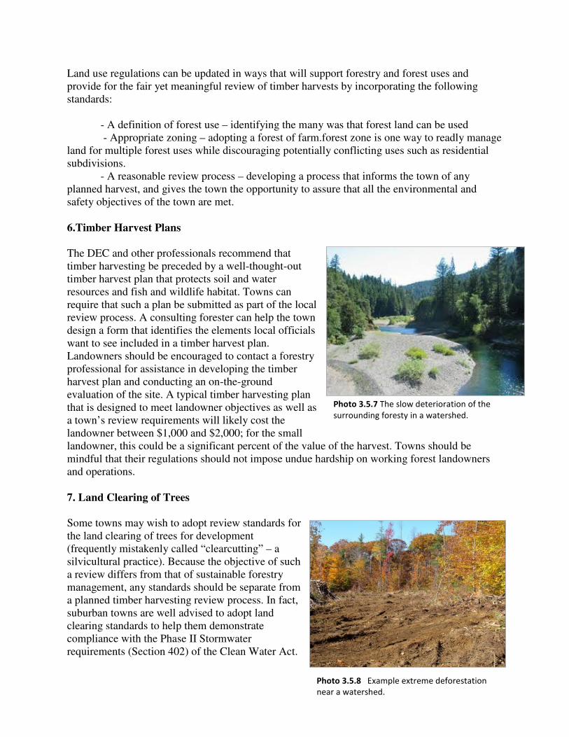
Land use regulations can be updated in ways that will support forestry and forest uses and provide for the fair yet meaningful review of timber harvests by incorporating the following standards: - A definition of forest use – identifying the many was that forest land can be used - Appropriate zoning – adopting a forest of farm.forest zone is one way to readly manage land for multiple forest uses while discouraging potentially conflicting uses such as residential subdivisions. - A reasonable review process – developing a process that informs the town of any planned harvest, and gives the town the opportunity to assure that all the environmental and safety objectives of the town are met. 6.Timber Harvest Plans The DEC and other professionals recommend that timber harvesting be preceded by a well-thought-out timber harvest plan that protects soil and water resources and fish and wildlife habitat. Towns can require that such a plan be submitted as part of the local review process. A consulting forester can help the town design a form that identifies the elements local officials want to see included in a timber harvest plan. Landowners should be encouraged to contact a forestry professional for assistance in developing the timber harvest plan and conducting an on-the-ground evaluation of the site. A typical timber harvesting plan that is designed to meet landowner objectives as well as a town’s review requirements will likely cost the landowner between $1,000 and $2,000; for the small landowner, this could be a significant percent of the value of the harvest. Towns should be mindful that their regulations should not impose undue hardship on working forest landowners and operations. 7. Land Clearing of Trees
Some towns may wish to adopt review standards for the land clearing of trees for development (frequently mistakenly called “clearcutting” – a silvicultural practice). Because the objective of such a review differs from that of sustainable forestry management, any standards should be separate from a planned timber harvesting review process. In fact, suburban towns are well advised to adopt land clearing standards to help them demonstrate compliance with the Phase II Stormwater requirements (Section 402) of the Clean Water Act.
Photo 3.5.7 The slow deterioration of the
surrounding foresty in a watershed.
Photo 3.5.8 Example extreme deforestation
near a watershed.

This Act requires permits for stormwater discharges from land clearing that disturbs one or more acres.