Embed Size (px)
Citation preview

02-1-13 13-1
SECTION 13. LE SUEUR COUNTY SHORELAND MANAGEMENT
SUBDIVISION 1. STATUTORY AUTHORIZATION AND POLICY
A. STATUTORY AUTHORIZATION
This Section regarding the regulation of shoreland is adopted pursuant to the authorization and policies contained in Minnesota Statutes, Chapter 103F, Minnesota Regulations, Parts 6120.2500 & 6120.3900, and the planning and zoning enabling legislation in Minnesota Statutes, Chapter 394, as amended from time to time.
B. POLICY
The uncontrolled use of shorelands of Le Sueur County, Minnesota affects the public health, safety and general welfare not only by contributing to pollution of public waters, but also by impairing the local tax base. Therefore, it is in the best interests of the public health, safety and welfare to provide for the wise subdivision, use and development of shorelands of public waters. The Legislature of Minnesota has delegated responsibility to local governments of the state to regulate the divisions, use and development of the shorelands of public waters and thus preserve and enhance the quality of surface waters, conserve the economic and natural environmental values of shorelands, and provide for the wise use of waters and related land resources. This responsibility is hereby recognized by Le Sueur County.
SUBDIVISION 2. GENERAL PROVISIONS AND DEFINITIONS
A. SHORELAND
The land located within the following distances from public waters:
1. One thousand (1,000) feet from the ordinary high water level of a lake, pond or flowage.
2. Three hundred (300) feet from a river or stream, or the landward extent of a flood plain designated by this Ordinance on such a river or stream, whichever is greater.
3. The practical limits of shorelands may be less than the statutory limits wherever the waters involved are bounded by natural topographic divides which extend landward from the waters for lesser distances and when approved by the Commissioner.
B. JURISDICTION
The provisions of this Section shall apply to the shorelands of the public water bodies as classified in this Section. Pursuant to Minnesota Regulations, Parts 6120.2500-6120.3900, no lake, pond, or flowage less than twenty five (25) acres in size in unincorporated areas need be regulated in a local government's shoreland regulations. A body of water created by a private user where there was no previous shoreland may, at the discretion of the governing body, be exempt from this Section.

02-1-13 13-2
C. COMPLIANCE
The use of any shoreland of public waters; the size and shape of lots; the use, size, type and location of structures on lots; the installation and maintenance of water supply and waste treatment systems, the grading and filling of any shoreland area; the cutting of shoreland vegetation; and the subdivision of land shall be in full compliance with the terms of this Section and other applicable regulations.
D. ENFORCEMENT
The Department is responsible for the administration and enforcement of this Section. Any violation of the provisions of this Section or failure to comply with any of its requirements (including violations of conditions and safeguards established in connection with grants of variances or conditional uses) shall constitute a misdemeanor and shall be punishable as defined by law. Violations of this Section can occur regardless of whether or not a permit is required for a regulated activity pursuant to this Section.
E. INTERPRETATION
In their interpretation and application, the provisions of this Section shall be held to be minimum requirements and shall be liberally construed in favor of the governing body and shall not be deemed a limitation or repeal of any other powers granted by State Statutes.
F. SEVERABILITY
In any subdivision, clause, provision, or portion of this Section is adjudged unconstitutional or invalid by a court of competent jurisdiction; the remainder of this Section shall not be affected thereby.
G. ABROGATION AND GREATER RESTRICTIONS
It is not intended by this Section to repeal, abrogate, or impair any existing easements, covenants, or deed restrictions. However, where this Section imposes greater restrictions, the provisions of this Section shall prevail. All other ordinances inconsistent with this Section are hereby repealed to the extent of the inconsistency only.
H. INJUNCTIVE RELIEF
The Department upon certification by the Board of County Commissioners, shall have the authority to petition the District Court for injunctive relief against continued violations of any of the provisions of this Section.
I. DEFINITIONS
See Section 4, of this Ordinance for definitions.

02-1-13 13-3
SUBDIVISION 3. ADMINISTRATION
A. PERMITS REQUIRED
1. A permit is required for the construction of any structure, structure additions, or enclosure of existing decks, (and including such related activities as construction of decks and signs), the installation and/or alteration of sewage treatment systems, vegetative alteration, and those grading, excavating or filling activities not exempted by this Section. Freestanding accessory structures less than one hundred (100) square feet in area and less than eight (8) feet high do not require a permit, but shall meet all setback requirements and all other provisions as required by this Section.
2. Application for a permit shall be made to the Department on the forms provided. The application shall include the necessary information so that the Department can determine the site's suitability for the intended use and that a complying sewage treatment system will be provided.
3. A permit authorizing any of the activities stated in this Section shall stipulate that an identified failed sewage treatment system, as defined by Section 17, shall be reconstructed or replaced in accordance with the provisions of this Section and thisOrdinance.
B. VARIANCES
1. Variances may only be granted in accordance with the standards in Minnesota Statutes, Chapter 394. A variance may not circumvent the general purposes and intent of this Section. No variance may be granted that would allow any use that is prohibited in the zoning district in which the subject property is located. Conditions may be imposed in the granting of a variance to ensure compliance and to protect adjacent properties and the public interest. In considering a variance request, the Board of Adjustment must also consider whether the property owner has reasonable use of the land without the variance, whether future sewage treatment system site location is available on the properties before additional development is approved, whether the property is used seasonally or year-round, whether the Variance is being requested solely on the basis of economic considerations, and the characteristics of development on adjacent properties.
2. The Board of Adjustment shall hear and decide requests for variances in accordance with the rules that it has adopted for the conduct of business. When a variance is approved after the Department of Natural Resources has formally recommended denial in the hearing record, the notification of the approved variance required in this Ordinance shall also include the Board of Adjustment's summary of the public record/testimony and the findings of facts and conclusions which supported the issuance of the variance.
3. For existing developments, the application for variance must clearly demonstrate whether a conforming sewage treatment system is present for the intended use of the property.

02-1-13 13-4
C. NOTIFICATIONS TO THE DEPARTMENT OF NATURAL RESOURCES
1. Copies of all notices of any public hearings to consider variances, amendments, or conditional uses under local shoreland management controls must be sent to the commissioner or the commissioner's designated representative and postmarked at least ten (10) days before the hearings. Notices of hearings to consider proposed subdivisions/plats must include copies of the subdivision/plat.
2. A copy of approved amendments and subdivision/plats, and final decisions granting variances or conditional uses under local shoreland management controls must be sent to the commissioner or the commissioner’s designated representative and postmarked within ten (10) days of final action.
SUBDIVISION 4. SHORELAND CLASSIFICATION SYSTEM AND LAND USE DISTRICTS
A. SHORELAND CLASSIFICATION SYSTEMS
1. The public waters of Le Sueur County have been classified below consistent with the criteria found in Minnesota Regulations, Part 6120.3300, and the Public Waters Inventory Map for Le Sueur County, Minnesota.
2. Definition of Shoreland terminology. The shoreland area for the water bodies listed in this Section shall be defined in Section 4, of this Ordinance and as shown on the Official Zoning Map.
3. Public Waters, Lakes
a. Natural Environment Lakes (NE) Inventory I.D. #Querums (Quiram's) Slough 40-3 Goose 40-8 Sunfish 40-9 Dora 40-10 Mabel 40-11 ---- 40-12 Diamond 40-13 Sabre 40-14 Rice 40-16 Borer 40-19 Mud 40-26 Sanborn 40-27 Pepin 40-28 Eggert 40-29 Dietz 40-30 Cherry 40-35 Rice 40-37

02-1-13 13-5
Natural Environment Lakes (NE) con’t Inventory I.D. #
---- 40-38 Roemhildts 40-39 ---- 40-41 Steele 40-44 Fish 40-51 Perch 40-54 Swains 40-55 Round 40-59 Tustin 40-61 Sander’s Slough 40-62 ---- 40-64 ---- 40-67 Sleepy Eye 40-68 ---- 40-69 Hecort's Marsh 40-70 Goose 40-72 Bossuot 40-73 Mud 40-74 Hackridge 40-77 Mary 40-78 Beiser 40-81 ---- 40-82 Mud 40-83 Tyler 40-84 Sautter 40-87 Renneberg 40-88 Sheas 40-90 School 40-91 Harriman Slough 40-93 Thomas 40-95 ---- 40-96
---- 40-97 ---- 40-98 ---- 40-99 ---- 40-100 ---- 40-102 Henry 40-104 Silver 40-106 Savidge 40-107 South Goldsmith 40-108 Scotch 40-109 Huoy 40-110 Dog 40-112 Rice 40-114

02-1-13 13-6
Natural Environment Lakes (NE) con’t Inventory I.D. #
Ely 40-116 Emily 40-118
North Goldsmith 40-120 Plaza 40-121 Spring 40-123 ---- 40-125 ---- 40-126 ---- 40-128 ---- 40-152
b. Recreational Development Lakes (RD) Inventory I.D. #Horseshoe 40-1 Upper Sakatah 40-2 Greenleaf 40-20 Tetonka 40-31 Gorman 40-32 Volney 40-33 Rays 40-56 Frances 40-57 German 40-63 Clear 40-79 Jefferson 40-92 Washington 40-117 Emily 40-124
c. Boundary Lakes. The following lakes are listed in the Division of Waters, Soils and Minerals Bulletin No. 25 within Waseca County and have shorelands in Le Sueur County.
Waseca County Lake Inventory I.D # Lily (NE) 81-67 Elysian (RD) 81-95
4. Public Waters, Rivers and Streams, These rivers and streams are public watercourses in Le Sueur County and are shown on the Public Waters Inventory Map for Le Sueur County, a copy of which is hereby adopted by reference and as amended from time to time.
From To Sec Twp Rng Sec Twp Rng a. Agricultural Rivers
Minnesota River (MNR) 13 109 27 28 110 26 10 111 26 25 112 26 Cannon River (CR) 12 110 23 27 109 23

02-1-13 13-7
b. Transitional Rivers Minnesota River (MNR) 28 110 26 10 111 26 25 112 26 2 112 26
c. Project Riverbend Minnesota River (MNR) 13 109 27 2 111 26
d. Tributary Streams Sec Twp Rng Sec Twp Rng Unnamed to MNR 17 109 26 17 109 26
18 109 26 18 109 26 Shanaska Creek (CD#67) 12 109 26 28 110 26 Unnamed to Lake Washington 16 109 25 17 109 25 Pauls Creek 14 110 26 10 110 26 Unnamed to MNR 24 110 26 10 110 26 Unnamed Tributary to 11 110 26 11 110 26
Unnamed MNR Tributary Unnamed Tributary to 11 110 26 12 110 26 Unnamed MNR Tributary
Cherry Creek (CC) 25 110 25 27 110 25 21 110 25 17 110 25 1 110 26 33 111 26 Unnamed to Scotch Lake 24 110 25 23 110 25 Unnamed to CC 27 110 25 27 110 25 Unnamed to CC 17 110 25 7 110 25 Unnamed to MNR 1 110 26 15 111 26 Le Sueur Creek (CD #23) 30 111 24 25 112 26 Unnamed to LSC 3 110 24 28 111 24 Unnamed to LSC 26 111 25 26 111 25 Unnamed Tributary (CD #51) 7 110 24 6 110 24 Unnamed to LSC (CD #60) 34 111 25 29 111 25 Unnamed to Unnamed 9 110 25 33 111 25 Unnamed to LSC 15 111 25 19 111 25 Unnamed to LSC 5 111 25 6 111 25 Forest Prairie Creek (FPC) 20 112 24 36 112 26 Unnamed Tributary 10 111 24 3 111 24
Unnamed Tributary 4 112 24 3 112 24 Unnamed to FPC 23 112 25 23 112 25 Unnamed to FPC 3 111 25 28 112 25 Unnamed to MNR 8 112 25 7 112 25 Unnamed to Raven Stream 10 112 24 2 112 24 Unnamed to Raven Stream 5 112 23 5 112 23 Unnamed to Tributary 3 112 23 3 112 23 Sand Creek 11 112 23 1 112 23 Unnamed Tributary 33 112 23 33 112 23 Unnamed to Unnamed 33 112 23 33 112 23

02-1-13 13-8
Tributary Streams con’t Sec Twp Rng Sec Twp Rng Unnamed to Lake Pepin 32 112 23 32 112 23 Unnamed to Lake Sanborn 4 109 24 4 109 24 Unnamed From Sanborn to 35 112 23 2 111 23 Rice Lake Unnamed to Rice Lake 1 111 23 1 111 23 Unnamed to CR 10 110 23 11 110 23 Unnamed to Lake Dora 24 111 23 25 111 23 3 110 23 3 110 23 Unnamed to Gorman Lake 12 110 24 6 110 23 Little Cannon River 25 110 23 25 110 23 Unnamed Tributary 35 110 24 31 110 23 Unnamed to Lake Jefferson 14 109 25 12 109 25 Unnamed to German Lake 5 109 24 5 109 24 Unnamed to German Lake 33 110 24 4 109 24 Unnamed to Lake Sanborn 4 109 24 4 109 24 White Water Creek 34 109 23 26 109 23 Waterville Creek 36 109 23 27 109 23
B. LAND USE DISTRICT DESCRIPTIONS
1. Criteria for Designation
The shoreland districts in this Ordinance, and the delineation of a land use district's boundaries on the Official Zoning Map, must be consistent with the goals, policies, and objectives of the comprehensive land use plan and the following criteria, considerations, and objectives:
2. General Considerations and Criteria for All Land Uses
a. Preservation of natural areas.
b. Present ownership and development of shoreland areas.
c. Shoreland soil types and their engineering capabilities.
d. Topographic characteristics.
e. Vegetative cover.
f. In-water physical characteristics, values, and constraints.
g. Recreational use of the surface water.
h. Road and service center accessibility.

02-1-13 13-9
i. Socioeconomic development needs and plans as they involve water and related land resources.
j. The land requirements of industry which, by its nature, requires location in shoreland areas.
k. The necessity to preserve and restore certain areas having significant historical or ecological value.
3. Factors and Criteria for Planned Unit Developments
a. Existing recreational use of the surface waters and likely increases in use associated with planned unit developments.
b. Physical and aesthetic impacts of increased density.
c. Suitability of lands for the planned unit development approach.
d. Level of current development in the area.
e. Amounts and types of ownership of undeveloped lands.
4. Shoreland District Descriptions
a. The land use districts provided below, and the allowable land uses therein for the given classifications of water bodies, shall be properly delineated on the Official Zoning Map for shorelands of this community. These shoreland districts are in conformance with the criteria specified in Minnesota Regulation, Part 6120.3200, Subp. 3.
b. The intent of the Special Protection (SP) District is to guide the wise development and utilization of shorelands of public waters for the preservation of water quality, natural characteristics, economic values and the general health, safety and welfare of all public waters in the unincorporated areas of the County. Further, the purpose of this district is to manage areas unsuitable for development due to wet soils, steep slopes or large areas of exposed bedrock; and to manage areas of unique natural and biological characteristics in accordance with compatible uses.
c. The intent of the Recreational Residential (RR) District is to preserve areas which have natural characteristics suitable for both passive and active recreational usage. Also, it is the intent of this district to manage areas suitable for residential development of varying types, including permanent and seasonal housing. Some non-residential uses with minimal impacts on residential uses are allowed if properly managed under conditional use procedures.

02-1-13 13-10
d. The intent of the Recreational Commercial (RC) District is to provide suitable locations for, and to encourage the development of, water orientated commercial recreation facilities in those areas of Le Sueur County which benefit the recreational needs of both residents and tourists, to avoid land use conflicts with residential areas and restrict incompatible commercial and industrial uses.
SUBDIVISION 5. DESIGN CRITERIA, SHORELAND ALTERATIONS AND SPECIAL PROVISIONS
A. DESIGN CRITERIA
1. Subdivisions
a. Platted subdivisions with dwelling unit densities exceeding those specified in Sections 13.1 & 13.2 may only be allowed if designed and approved as residential planned unit developments under this Section.
b. Only land above the ordinary high water level of public waters may be used to meet lot area standards, and lot width standards must be met at both the ordinary high water level and at the setback line.
c. Subdivisions of duplexes, triplexes, and quads on Recreational Development Lakes must also meet the following standards:
1. Each structure must be set back at least one hundred (100) feet from the ordinary high water level.
2. Each structure must have common sewage treatment and water systems in one (1)
location and serve all dwelling units in the structure. .
3. Watercraft docking facilities for each lot must be centralized in one (1) location and serve all dwelling units in the structure.
4. No more than twenty five (25) percent of a lake’s shoreline can be in duplex, triplex, or quad developments.
2. Guest Cottages
a. One (1) guest cottage may be allowed as a Conditional Use per lot.
b. The lot must meet the minimum width, depth, area and buildable lot requirements for single residential lots.
c. A guest cottage must not cover more than seven hundred (700) square feet of land surface and must not exceed fifteen (15) feet in height.

02-1-13 13-11
d. A guest cottage must be located or designed to reduce its visibility as viewed from public waters and adjacent shorelands by vegetation, topography, increased setbacks or color, assuming summer leaf-on conditions.
3. Controlled Access Lots
a. Lots intended as controlled accesses to public waters or as recreation areas for use by owners of lots within subdivisions are permissible.
b. The lot must meet the width and size requirements for residential lots and be suitable for the intended uses of controlled access lots.
c. If docking, mooring, or over-water storage of more than six (6) watercraft is to be allowed at a controlled access lot, then the width of the lot (keeping the same lot depth) must be increased by the percent of the requirements for riparian residential lots for each watercraft beyond six, consistent with the following table for lot frontage requirements:
Ratio of lake size/shore length Required increase in frontage to acres/mile percentage Less than 100 25 100-200 20 201-300 15 301-400 10 Greater than 400 5
d. The lot must be jointly owned by all purchasers of lots in the subdivision or by all purchasers of nonriparian lots in the subdivision who are provided riparian access rights on the access lot.
e. Covenants or other equally effective legal instruments must be developed that specify which lot owners have authority to use the access lot and what activities are allowed.
1. The activities may include watercraft launching, loading, storage, beaching, mooring, or docking.
2. The covenants must also include other outdoor recreational activities that do not significantly conflict with general public use of the public water or the enjoyment of normal property rights by adjacent property owners. Examples of the nonsignificant conflict activities include swimming, sunbathing, or picnicking.
3. The covenants must limit the total number of vehicles allowed to be parked and the total number of watercraft allowed to be continuously moored, docked, or stored over water, and must require centralization of all common facilities and activities in the most suitable locations on the lots to minimize topographic and vegetation alterations.

02-1-13 13-12
4. The covenants must also require all parking areas, storage structures, and other facilities to be screened by vegetation or topography as much as practical from view from the public water, assuming summer, leaf-on conditions.
4. High Water Elevations
a. Structures must be placed in accordance with any floodplain regulations applicable to the site. Where these controls do not exist, the elevation to which the lowest floor, including basement, is placed or flood-proofed must be determined as follows:
1. For lakes, by placing the lowest floor at a level at least three (3) feet above the highest known water level, or three (3) feet above the ordinary high water level, whichever is greater.
2. For rivers and streams there are three possible approaches.
a. Place the lowest floor at least three (3) feet above the flood of record, if data are available.
b. If data are not available, place the lowest floor at least three (3) feet above the ordinary high water level.
c. Or, by conducting a technical evaluation to determine effects of proposed
construction upon flood stages and flood flows and to establish a flood protection evaluation. Under all three approaches, technical evaluations must be done by a licensed professional engineer or hydrologist consistent with parts 6120.5000 to 6120.6200 of Minnesota Regulations, as amended from time to time, governing the management of flood plain areas.
d. If more than one (1) approach is used, the highest flood protection elevation determined must be used for placing structures and other facilities.
b. Water-oriented accessory structures may have the lowest floor placed lower than the elevation determined in this item if the structure is constructed of flood-resistant materials to the elevation, electrical and mechanical equipment is placed above the elevation and, if long duration flooding is anticipated, the structure is built to withstand ice action and wind-driven waves and debris.
5. Water-oriented Accessory Structures
a. Each lot may have one (1) water-oriented accessory structure.

02-1-13 13-13
b. Water-oriented accessory structures used solely for watercraft storage, and including storage of related boating and water-oriented sporting equipment (boathouses), may occupy an area up to four hundred (400) square feet on Recreational Development (RD) lakes only, provided the maximum width of the structure is twenty (20) feet as measured parallel to the configuration of the shoreline.
c. Water-oriented accessory structures must not exceed two hundred fifty (250) square feet on Natural Environment Lakes (NE) provided the maximum width of the structure is twenty (20) feet as measured parallel to the configuration of the shoreline.
d. The water-oriented accessory structure must not exceed ten (10) feet in height, exclusive of safety rails, and cannot occupy an area greater than two hundred fifty (250) square feet provided the maximum width of the structure is twenty (20) feet as measured parallel to the configuration of the shoreline.
e. Detached decks must not exceed eight (8) feet above grade at any point and cannot occupy an area greater than two hundred fifty (250) square feet provided the maximum width of the structure is twenty five (25) feet as measured parallel to the configuration of the shoreline.
f. The setback of the structure from the ordinary high water level must be at least ten (10) feet.
g. For conforming lots, all water orientated accessory structures shall be set back fifteen (15) feet from side yard property lines.
h. For non-conforming Lots of Record, all water orientated accessory structures shall be set back ten (10) feet from side yard property lines.
i. No water-oriented accessory structure shall be designed or used for human habitation and must not contain water supply or sewage treatment facilities.
j. The roof may be used as a deck with safety rails, but must not be enclosed or used as a storage area.
k. The structure or facility must be treated to reduce visibility as viewed from public waters and adjacent shorelands by vegetation, topography, increased setbacks or color, assuming summer, leaf-on conditions;
6. Stairways, Lifts, Landings and Paths
a. Stairways, lifts and paths must not exceed four (4) feet in width on residential lots. One (1) wider stairway may be used, up to six (6) feet, for commercial properties, public open-space recreational properties, and planned unit developments.

02-1-13 13-14
b. Landings for stairways and lifts on residential lots must not exceed thirty two (32) square feet in area. One (1) larger landing may be used, up to ninety six (96) square feet, for commercial properties, public open-space recreational properties, and planned unit developments.
c. Canopies or roofs are not allowed.
d. Stairways, lifts, and landings may be either constructed above the ground on posts or pilings, or placed into the ground, provided they are designed and built in a manner that ensures control of soil erosion;
e. Stairways, lifts, landings and paths must be located in the most visually inconspicuous portions of lots, as viewed from the surface of the public water assuming summer, leaf-on conditions, whenever practical; and
f. Facilities such as ramps, lifts, or mobility paths for physically handicapped persons are also allowed for achieving access to shore areas, provided that the dimensional and performance standards set forth herein are complied with in addition to the requirements of Minnesota Regulations, Chapter 1340 as amended from time to time.
7. Retaining Walls
a. Permitted Use
1. Retaining walls located outside the shore impact zone; three (3) feet in height or less; twenty five (25) feet in length or less as measured parallel to the configuration of the shoreline; or on slopes less than twelve (12) percent.
2. Land Alteration Plan is required as approved by the department.
3. Scaled site plan with 2-foot contours depicting existing topography. As-Built upon completion.
4. Inconspicuous location and vegetative screening as viewed from the water, assuming summer, leaf-on conditions.
5. A row of boulders, more than thirty (30) inches in diameter, shall be considered a retaining wall.
b. Conditional Use
1. Retaining walls located within the shore impact zone or outside the shore impact zone, but greater than three (3) feet in height or greater than twenty five (25) feet in length as measured parallel to the configuration of the shoreline or on steep slopes.

02-1-13 13-15
2. Land Alteration Plan is required as approved by the Department.
3. Scaled site plan with 2-foot contours depicting existing topography, As-Built upon completion. As-Built and site plan must be completed by a surveyor or engineer.
4. Inconspicuous location and vegetative screening as viewed from the water, assuming summer, leaf-on conditions.
5. A row of boulders, more than thirty (30) inches in diameter, shall be considered a retaining wall.
6. A conditional use permit may be issued notwithstanding the requirements of items 1-5 above, where there is a demonstrated need to stop or restore an existing erosion hazard and no other alternative exists.
8. Significant Historic Sites
No structure may be placed on a significant historic site in a manner that affects the values of the site unless adequate information about the site has been received and documented in a public repository.
9. Steep Slopes
The Department will evaluate possible soil erosion impacts and development visibility from public waters before issuing a permit for construction of sewage treatment systems, roads, driveways, structures, or other improvements on steep slopes. When determined necessary, conditions will be attached to issued permits to prevent erosion and to preserve existing vegetation screening of structures, vehicles, and other facilities as viewed from the surface of public waters, assuming summer, leaf-on vegetation.
10. Impervious Surface
a. Impervious surface coverage of lots shall not exceed twenty five (25) percent of the lot area.
b. Surface area of a lot physically separated by a public or private road right-of-way or access shall not be included for the purposes of the impervious surface calculation.
c. A Land Alteration Plan shall be required, as approved by the Department, for projects creating impervious surface including but not limited to driveways, patios, sidewalks, as follows:
Acreage Impervious Surface Project1. Lots less than one (1) acre 32 square feet
2. Lots one (1) acre to 1.99 acres 100 square feet

02-1-13 13-16
d. Impervious surface shall not be allowed in the shore impact zone, except for stairways, lifts, landings, paths and water-oriented accessory structures.
e. Direct drainage away from the lake and into pervious, grassed yards through site grading, rain gutters and downspouts shall be implemented for stormwater management.
f. Constructed facilities used for stormwater management shall be designed and installed consistent with the field office technical guide of the Le Sueur County SWCD or the Agency Stormwater Manual.. Accepted practices including but not limited to, gutters, rain gardens, grassed swales, permeable pavers, bioretention basins, underground storage, rain barrels and vegetated buffers.
g. Newly constructed stormwater outfalls to public waters must provide for filtering or settling of suspended solids and skimming of surface debris before discharge in accordance with Best Management Practices.
B. SHORELAND ALTERATIONS
1. Alterations of vegetation and topography will be regulated per Minnesota Rule 6120.3300, Subpart 4, to prevent erosion into public waters, fix nutrients, preserve shoreland aesthetics, preserve historic values, prevent bank slumping, and protect fish and wildlife habitat.
2. Vegetation Alterations. Removal or alteration of vegetation, except for agricultural and forest management uses as regulated in this Section, is allowed by permit subject to the following standards:
a. Vegetation alterations located within a shore or bluff impact zone.
1. Vegetation alterations within the shore or bluff impact zones may be allowed with a Land Alteration Plan as approved by the Department.
2. Removal of trees, shrubs, limbs or branches shall not be allowed other than those that are invasive species, dead, diseased or pose a safety hazard.
3. Pruning and trimming of the lower branches of trees is allowed to provide a view of the lake from the lower story windows of the principal structure.
4. Trimming and/or removal of trees is allowed if in connection with another permitted use.
b. Vegetation alterations located between the shore or bluff impact zone and the required structure setback line.

02-1-13 13-17
1. Removal of up to twenty five (25) percent of the trees and up to fifty (50) percent shrubs is allowed.
2. Except as provided in item 1 above, removal of trees, shrubs, limbs or branches shall not be allowed other than those that are invasive species, dead, diseased or pose a safety hazard.
3. Pruning and trimming of the lower branches of trees is allowed to provide a view of the lake from the lower story windows of the principal structure.
4. Trimming and/or removal of trees is allowed if in connection with another permitted use.
c. All vegetative alterations are subject to the following conditions.
1. Exposed bare soil shall be covered with mulch or similar materials within twenty four (24) hours.
2. A permanent vegetation cover shall be established within fourteen (14) days of completion of the project through a re-vegetation plan as approved by the Department.
3. Removal of vegetation shall not be greater than fifteen (15) feet in width in any contiguous strip.
4. Screening of structures or other improvements, including but not limited to parking areas as viewed from the water, assuming summer, leaf-on conditions, shall not be substantially reduced.
5. Along rivers, existing shading of water surfaces must be preserved.
6. All cutting shall be by hand at ground level. Topsoil shall not be disturbed and the root system must remain in place.
7. Erosion control and stormwater control methods as indicated by the Le Sueur County SWCD shall be implemented.
3. Topographic Alterations/Grading, Excavating or Filling
a. All grading, excavating or filling activities, including but not limited to, rip rap, sand and gravel, shall comply with all applicable standards in this Ordinance.

02-1-13 13-18
b. Grading, excavating or filling activities necessary for the construction of structures, sewage treatment systems, and driveways under validly issued construction permits for these facilities do not require the issuance of a separate grading, excavating or filling permit. However, the grading, excavating or filling standards in this Ordinance must be incorporated into the issuance of permits for construction of structures, sewage treatment systems, and driveways.
c. The following considerations and conditions must be adhered to during the issuance of construction permits, grading, excavating or filling permits, conditional use permits, variances and subdivision approvals:
1. Fill or excavated material must not be placed in bluff impact zones.
2. Any alterations below the ordinary high water level of public waters must be authorized by the commissioner under Minnesota Statutes, Section 103G.245.
3. Alterations of topography must only be allowed if they are accessory to permitted or conditional uses and do not adversely affect adjacent or nearby properties.
4. Grading or filling in any type 2, 3, 4, 5, 6, 7, or 8 wetland must be evaluated to determine how extensively the proposed activity would affect the following functional qualities of the wetland:
a. Sediment and pollutant trapping and retention.
b. Storage of surface runoff to prevent or reduce flood damage.
c. Fish and wildlife habitat.
d. Recreational use.
e. Shoreline or bank stabilization,
f. Noteworthiness, including special qualities such as historic significance, critical habitat for endangered plants and animals, or others.
g. This evaluation must also include a determination of whether the wetland alteration being proposed complies with the Minnesota Wetland Conservation Act, as amended or requires permits, reviews, or approvals by other local, state, or federal agencies such as a watershed district, the Minnesota Department of Natural Resources, or the United States Army Corps of Engineers. The applicant will be so advised.
5. Alterations must be designed and conducted in a manner that ensures only the smallest amount of bare ground is exposed for the shortest time possible.
02-1-13 13-19
6. Mulches or similar materials must be used, where necessary, for temporary bare soil coverage, and a permanent vegetation cover must be established as soon as possible.
7. Methods to minimize soil erosion and to trap sediments before they reach any surface water feature must be used for any development of one (1) acre or larger. Guidelines for sediment control contained within the Board of Water and Soil Resources' "Minnesota Construction Site Erosion and Sediment Control Planning Handbook" should be utilized.
8. Altered areas must be stabilized to acceptable erosion control standards consistent with the field office technical guides of the local SWCD and the United States Natural Resource Conservation Service.
9. Fill or excavated material must not be placed in a manner that creates an unstable slope.
10. Plans to place fill or excavated material on steep slopes must be reviewed by qualified professionals as approved by the Department for continued slope stability and must not create finished slopes of thirty (30) percent or greater.
11. Placement of natural rock riprap, including associated grading of the shoreline and placement of a filter blanket, is permitted if the finished slope does not exceed three (3) feet horizontal to one (1) foot vertical, the landward extent of the riprap is within ten (10) feet of the ordinary high water level, and the height of the riprap above the ordinary high water level does not exceed three (3) feet.
d. Public roads and parking areas as regulated by this Ordinance.
e. Excavations where the intended purpose is a connection to public waters, such as boat slips, canals, lagoons, and harbors, must be controlled by local shoreland controls. Permission for excavations may be given only after the commissioner has approved the proposed connection to public waters.
4. Placement and Design of Roads, Driveways, and Parking Areas
a. Public and private roads and parking areas must be designed to take advantage of natural vegetation and topography to achieve maximum screening from view from public waters. Documentation must be provided by a qualified individual as approved by the Department that all roads and parking areas are designed and constructed to minimize and control erosion to public waters consistent with the field office technical guides of Le Sueur County SWCD, or other applicable technical materials.
b. Roads, driveways, and parking areas must not be placed within bluff and shore impact zones.

02-1-13 13-20
c. Public and private watercraft access ramps, approach roads, and access-related parking areas may be placed within shore impact zones with a conditional use permit, provided the vegetation screening and erosion control conditions are met and must be designed to minimize adverse impacts.
d. For private facilities, the grading, excavating or filling provisions of this Ordinancemust be met.
5. Riprap
a. Land Alteration Plan is required as approved by the Department.
b. Riprap is allowed only where there is a demonstrated need to stop existing erosion or to restore an eroded shoreline.
c. Installation shall meet all grading, filling and excavating standards as regulated by this Ordinance.
d. Only natural rock, excluding limestone and similar erosive materials, shall be used that is free of debris that may cause pollution or siltation.
e. Rock riprap cannot average less than six (6) inches or more than thirty (30) inches in diameter.
f. A filter of crushed rock, gravel, excluding limestone or other erosive materials, or filter fabric material shall be placed underneath the rock riprap.
g. The minimum finished slope above the OHWL shall not be steeper than 3 to1, as measured horizontal to vertical.
h. The riprap shall conform to the natural alignment of the shore.
i. Live cuttings and plant plugs may be planted within riprap.
j. For lakes, the riprapped area shall be two hundred (200) linear feet or less of shoreline along lakes and wetlands.
k. For streams, the riprapped area shall be less than five (5) times the average width of the affected watercourse.
l. The site must not be a posted fish spawning area or designated trout stream.
m. Any activity below the ordinary high water level shall meet all DNR standards

02-1-13 13-21
6. Beach Sand Blanket
a. Land Alteration Plan is required as approved by the Department.
b. The sand or gravel layer, excluding limestone or other erosive materials, may be up to six (6) inches thick; up to fifty (50) feet wide along the shoreline or one-half (1/2) the width of the lot, whichever is less; and does not extend more than ten (10) feet above the ordinary high water level.
c. No plant barrier, liner or filter fabric material shall be placed underneath the beach sand blanket.
d. Beach sand blanket shall meet all grading, filling and excavating standards as regulated by this Ordinance.
e. Any activity below the ordinary high water level shall meet all DNR standards.
7. Rain Gardens
a. Constructed rain gardens shall be designed and installed consistent with the field office technical guide of the Le Sueur County SWCD or the Agency Stormwater Manual.
b. Set back no less than ten (10) feet from structures with foundations or basements.
c. Set back no less than ten (10) feet from a sewage tank and twenty (20) feet from a septic drainfield.
d. Shall not be located on slopes twelve (12) percent or greater.
e. Land Alteration Plan is required as approved by the Department.
C. SPECIAL PROVISIONS
1. Commercial, Public and Semipublic Uses
a. Surface water-oriented uses that need to have access to and use of public waters may be located on parcels or lots with frontage on public waters, and must meet the following standards:
1. In addition to meeting all other zoning standards in this section, the uses must be designed to incorporate topographic and vegetative screening of parking areas and structures.

02-1-13 13-22
2. Uses that require short-term watercraft mooring for patrons must centralize these facilities and design them to avoid obstructions or navigation and to be the minimum size necessary to meet the need.
3. Uses that depend on patrons arriving by watercraft may use signs and lighting to convey needed information to the public, subject to the sign and lighting standards of this Ordinance.
2. Agricultural Uses
a. Agricultural uses are permitted uses if steep slopes and shore and bluff impact zones are maintained in permanent vegetation or operated under an approved conservation plan consistent with the field office technical guides of the Le Sueur County SWCD or the United States Natural Resource Conservation Service, as provided by a qualified individual or agency.
b. The shore impact zone for parcels with permitted agricultural land uses is equal to a line parallel to and fifty (50) feet from the ordinary high water level.
3. Conditional Uses
The following additional evaluation criteria and conditions apply to conditional uses withinshoreland areas:
a. Evaluation criteria. A thorough evaluation of the water body and the topographic, vegetation, and soils conditions on the site must be made to ensure:
1. The prevention of soil erosion or other possible pollution of public waters, both during and after construction.
2. The visibility of structures and other facilities as viewed from public waters is limited.
3. The site is adequate for water supply and on-site sewage treatment.
4. The types, uses, and numbers of watercraft that the project will generate are compatible in relation to the suitability of public waters to safely accommodate this watercraft.
b. Conditions attached to Conditional Use Permits. The Board of County Commissioners, upon consideration of the criteria listed above and the purposes of this Ordinance, shall attach such conditions to the issuance of the conditional use permits as it deems necessary to fulfill the purposes of this Ordinance. Such conditions may include, but are not limited to, the following:

02-1-13 13-23
1. Increased setbacks from the ordinary high water level.
2. Limitations on the natural vegetation to be removed or the requirement that additional vegetation be planted.
3. Special provisions for the location, design, and use of structures, sewage treatment system, watercraft, launching and docking areas, and vehicle parking areas.
SUBDIVISION 6. NONCONFORMITIES
A. See Section 24 of this Ordinance for further non-conformity requirements.
B. All legally established nonconformities as of June 18, 1996 may continue, but they will be managed according to applicable state statutes, rules, and other regulations of this county for the subjects of alterations and additions, repair after damage, discontinuance of use, and intensification of use, except that the following standards will also apply in shoreland areas.
1. In accordance with Minnesota State Statute 394.36, as amended from time to time, the following shall apply to existing Nonconforming Lots in Shoreland Areas.
a. This subdivision applies to shoreland lots of record in the office of the County Recorder on the date of adoption of local shoreland controls that do not meet the requirements for lot size or lot width. The County shall regulate the use of nonconforming lots of record and the repair, replacement, maintenance, improvement, or expansion of nonconforming uses and structures in shoreland areas with the following regulations:
b. A nonconforming single lot of record located within a shoreland area may be allowed as a building site without variances from lot size requirements, provided that:
1. All structure and septic system setback distance requirements can be met.
2. A Type 1 sewage treatment system consistent with Minnesota Rules, chapter 7080, can be installed or the lot is connected to a public sewer.
3. The impervious surface coverage does not exceed twenty five (25) percent of the lot.
c. In a group of two (2) or more contiguous lots of record under a common ownership, an individual lot must be considered as a separate parcel of land for the purpose of sale or development, if it meets the following requirements:

02-1-13 13-24
1. The lot must be at least sixty six (66) percent of the dimensional standard for lot width and lot size for the shoreland classification consistent with Minnesota Rules, chapter 6120.
2. The lot must be connected to a public sewer, if available, or must be suitable for the installation of a Type 1 sewage treatment system consistent with Minnesota Rules, chapter 7080, and local government controls.
3. Impervious surface coverage must not exceed twenty five (25) percent of each lot.
4. Development of the lot must be consistent with an adopted comprehensive plan.
d. A lot subject to paragraph (c) not meeting the requirements of paragraph (c) must be combined with the one or more contiguous lots so they equal one or more conforming lots as much as possible.
e. Notwithstanding paragraph (c), contiguous nonconforming lots of record in shoreland areas under a common ownership must be able to be sold or purchased individually if each lot contained a habitable residential dwelling at the time the lots came under common ownership and the lots are suitable for, or served by, a sewage treatment system consistent with the requirements of section 115.55 and Minnesota Rules, chapter 7080, or connected to a public sewer.
f. In evaluating all variances, zoning permit applications, or conditional use requests, the Department shall require the property owner to address, when appropriate, storm water runoff management, reducing impervious surfaces, increasing setback, restoration of wetlands, vegetative buffers, sewage treatment and water supply capabilities, and other conservation-designedactions.
g. A portion of a conforming lot may be separated from an existing parcel as long as the remainder of the existing parcel meets the lot size and sewage system requirements of the zoning district for a new lot and the newly created parcel is combined with an adjacent parcel.

02-1-13 13-25
SECTION 13.1 SPECIAL PROTECTION (SP) DISTRICT
SUBDIVISION 1. PURPOSE
Lands within this Zoning District include shoreland areas adjacent to Recreational Development (RD) and Natural Environment (NE) lakes, agricultural and transitional rivers and tributary streams where agriculture or open space is the predominant use. The water feature needs protection from development and agriculture uses should utilize best management practices that prevent or reduce nonpoint source pollution to surface or groundwater. Housing density should be the same as in the Agriculture (A) District. Dwellings, livestock production and other intense land uses should be kept to a minimum. However, transfer of development rights may be utilized to exceed the permitted housing density of one dwelling per quarter-quarter section (40 acres), providing that the density does not exceed four dwellings per quarter-quarter section in the receiving quarter-quarter section. Lots of record shall be exempt from density standards.
SUBDIVISION 2. PERMITTED USES
The following uses shall be permitted within the Special Protection (SP) District:
A. Agriculture, including crop production and pasturing utilizing agricultural best management practices.
B. Existing feedlots as of June 18, 1996.
C. Accessory structures within existing building sites.
D. Sensitive resource management of nature areas, hiking trails, wildlife preserves, or designated official wetland areas and forest preserves owned or operated by governmental agencies.
E. Forest management outside shore and bluff impact zones.
F. One (1) single-family dwelling per existing building site, Lot of Record or quarter-quarter section.
G. One (1) temporary dwelling per lot that will be occupied for one (1) year or less.
H. Home occupations, Level I.
I. Non-Commercial Wind Energy Conversion System.
J. Retaining walls located outside the shore impact zone; three (3) feet in height or less; twenty five (25) feet in length or less as measured parallel to the configuration of the shoreline; or on slopes less than twelve (12) percent.

02-1-13 13-26
K. Small Capacity Rain Garden.
L. Grading, excavating or filling activities involving the movement of fifty (50) cubic yards or less of material that is not in connection with another permitted use, or within a shore impact zone involving the movement of less than ten (10) cubic yards of material, including but not limited to, rip rap, sand and gravel. Activities associated with the maintenance or improvement of public roads are exempt.
Permitted Use Permitted Use with Land Alteration(s)
PlanLand Alteration (s) Plan
Requirements
<5 cubic yards within Bluff and Shore Impact Zones
5-10 cubic yards within Bluff and Shore Impact Zones
Scaled site plan w/ 2-foot contoursdepicting existing and proposed topography. As-Built upon completion.
<25 cubic yardsoutside Bluff and Shore Impact Zones
25-50 cubic yards outside Bluff and Shore Impact Zones
Parcels < 5 acres: Scaled site plan w/ 2-foot contours depicting existing and proposed topography. As-Built upon completion.
Parcels 5-20 acres: Scaled site plan w/ 5-foot contours depicting existing and proposed topography. As-Built upon completion.
Parcels > 20 acres: Scaled site plan w/ 10-foot contours depicting existing and proposed topography. As-Built upon completion.
SUBDIVISION 3. CONDITIONAL USES
The following uses may be permitted in the Special Protection (SP) District as Conditional Uses:
A. Expansion of an existing feedlot up to a total of five hundred (500) animal units.
B. Home Occupations, Level II.
C. Mineral Extraction.

02-1-13 13-27
D. Water supply tanks or buildings, reservoirs, commercial wells, gas regulator stations, electric substations or transmission lines greater than 35kV, railroad right-of-way, but not including railroad yards, public sewage treatment facilities and other similar essential public utility and service structures.
E. Parks, recreational areas and historic sites.
F. Retaining walls located within the shore impact zone or greater than three feet in height or greater than twenty five (25) feet in length as measured parallel to the configuration of the shoreline or on steep slopes.
G. Forest management within the shore and bluff impact zones.
H. One (1) temporary dwelling per lot that will be occupied for one (1) year or more.
I. Bed and Breakfast Inns.
J. Special Events.
K. Transfer of Development Rights.
L. Commercial Wind Energy Conversion System.
M. Large Capacity Rain Garden.
N. Grading, excavating or filling activities within the bluff.
O. Grading, excavating or filling activities, excluding small capacity rain gardens, involving the movement of more than fifty (50) cubic yards of material that is not in connection with another permitted use, or within shore or bluff impact zones involving the movement of more than ten (10) cubic yards of material, including but not limited to, rip rap, sand and gravel. Activities associated with the maintenance or improvement of public roads are exempt.
(TABLE ON NEXT PAGE)

02-1-13 13-28
SUBIDIVISION 4. PERMITTED ACCESSORY USES AND STANDARDS
The following uses shall be permitted accessory uses within the Special Protection (SP) District.
A. ACCESSORY STRUCTURES
1. In the Special Protection (SP) District that have lot sizes less than five (5) acres shall conform to the following structure areas and maximum structure heights.
Lot Size Maximum Structure Area Maximum Structure Height Less than 1 acre 2,000 square feet 20 feet 1-1.99 acres 3,600 square feet 20 feet 2-4.99 acres 4,000 square feet 25 feet
2. Outside wall dimensions shall be used to determine maximum structure area, except where a roof projects out further than two (2) feet from the sidewall; roof area shall be used to determine maximum structure area.
3. The lowest floor elevation for all accessory structures shall be at least three (3) feet above the ordinary high water level (OHWL) or highest known lake elevation, whichever is greater.
Conditional Use Conditional Use Requirements
>10 cubic yards within Bluff and Shore Impact Zones
Scaled site plan w/ 2-foot contours depicting existing and proposed topography. As-Built upon completion.
Site Plan(s) and As-Built completed by a surveyor or engineer.
>50 cubic yards outside Bluff and Shore Impact Zones
Parcels < 5 acres: Scaled site plan w/ 2-foot contours depicting existing and proposed topography. As-Built upon completion.
Parcels 5-20 ac: Scaled site plan w/ 5-foot contours depicting existing and proposed topography. As-Built upon completion.
Parcels > 20 ac: Scaled site plan w/ 10-foot contours depicting existing and proposed topography. As-Built upon completion.
Site Plan(s) and As-Built completed by a surveyor or engineer.

02-1-13 13-29
4. No accessory structure or use shall be constructed or developed on a lot prior to construction of the principal dwelling.
B. SWIMMING POOL. PERMANENT
1. No pool shall be located within ten (10) feet of a septic tank/drain field.
2. No pool shall be located beneath overhead electrical lines or over underground utility lines of any type.
3. No pool shall be located within any private or public utility, walkway, drainage, or other easement.
4. Lighting for the pool shall be oriented so as not to cast light onto adjacent properties.
5. A fence of at least five (5) feet in height shall completely enclose the pool area and the access to the pool area shall be controlled.
C. HEIGHT AND SEPARATION REGULATIONS
1. For parcels greater than five (5) acres, there shall be a maximum height limitation of one hundred and fifty (150) feet on all structures. Any structure including but not limited to tower, spire and similar type structure, only after obtaining a letter of clearance from the Federal Aeronautics Administration and the Airport Commission for any airport located within ten (10) miles of the structure proposed to exceed the height limitation.
2. In case an accessory structure is attached to the principal structure, it shall be made structurally a part of the principal structure and shall comply in all respects with the requirements of this Ordinance applicable to the principal structure.
3. An accessory structure shall not be closer than five (5) feet to the principal structure.
a. In case an accessory structure is attached to the principal structure, it shall be made structurally a part of the principal structure and shall comply in all respects with the requirements of this Ordinance applicable to the principal structure.
D. DRAINAGE
Adequate drainage shall be provided and the drainage shall be directed away from adjacent private property.
E. Other accessory uses customarily incidental to the uses permitted in Section 13.1.

02-1-13 13-30
SUBDIVISION 5. DIMENSIONAL REGULATIONS
A. SETBACK EXEMPTIONS/STRUCTURE EXPANSIONS
1. In such cases, where proposed additions do not encroach further into the front, side, or rear yard than the existing structure, such additions will be permitted provided the use and the structure are in conformance with the following restrictions:
a. The use of the structure is conforming to the zoning district in which it is located.
b. The expansion of the structure shall not be located closer to the property line than the existing structure or at least one-half (1/2) of the required setback, whichever is greater.
c. The expansion of the structure will not reduce any other required setback below the minimum standards of this Ordinance.
d. The expansion of the structure will conform to all other restrictions of this Ordinance, including but not limited to, density, lot coverage and structure height.
e. The height of the expansion shall not be greater than the existing structure at the existing building line.
f. The proposed addition is not located in shore or bluff impact zones.
B. FRONT YARD SETBACKS
1. There shall be a front yard setback of not less than eighty five (85) feet from the right-of-way of State-Federal trunk arterials, expressways and State collector arterials.
2. There shall be a front yard setback of not less than seventy five (75) feet from the right-of-way of County Highways.
3. There shall be a front yard setback of not less than sixty five (65) feet from a township or any other public or private right-of-way.
4. When a lot is located at the intersection of two (2) or more roads, there shall be a front yard setback on each road right-of-way.
5. All components an onsite Subsurface Sewage Treatment System (SSTS) shall be twenty (20) feet from all road right-of-ways.
6. All components of an onsite Subsurface Sewage Treatment System (SSTS) for a non-conforming Lot of Record shall be ten (10) feet from all road right-of-ways.

02-1-13 13-31
7. The required front yard of a corner lot shall be unobstructed above a height of three (3) feet in a triangular area, two (2) sides of which are the lines running parallel along the right of way lines between the road intersection and a point fifty (50) feet from the intersection, and the third site of which is the line between the latter two (2) points.
8. No trees or shrubs shall be planted within ten (10) feet from any right-of-way.
9. On nonconforming Lots of Record, accessory structures with a door six (6) feet wide or greater which faces any road right-of-way shall be set back a minimum of twenty five (25) feet. All other accessory structures shall be set back a minimum of ten (10) feet from the road right-of-way.
C. SIDE YARD SETBACKS
1. All structures shall have a side yard setback of not less than fifty (50) feet.
2. For conforming lots, all water orientated accessory structures shall be set back fifteen(15) feet from side yard property lines.
3. For nonconforming Lots of Record, all water orientated accessory structures shall be set back ten (10) feet from side yard property lines.
D. REAR YARD SETBACKS
All structures shall have a rear yard setback of not less than fifty (50) feet.
E. ORDINARY HIGH WATER LEVEL (OHWL) SETBACKS
1. Structure and Subsurface Sewage Treatment System (SSTS) setbacks from Ordinary High Water Level (OHWL).
Classification Structure SSTS NE Lake 250 feet 200 feet RD Lake 150 feet 100 feet Agricultural River 150 feet 100 feet Transitional River 150 feet 100 feet Tributary River 150 feet 100 feet
2. A new dwelling constructed on a nonconforming Lot of Record may have a reduced OHWL setback with the following restrictions:
a. There shall be an existing dwelling located on each side of the lot.
b. The new dwelling shall not be located closer to the OHWL than the existing dwellings located on the adjacent, or at least one-half of the required set back whichever is greater.

02-1-13 13-32
c. The structure is not located in a shore impact zone or in a bluff impact zone.
3. A new dwelling constructed on a nonconforming Lot of Record may have a reduced OHWL setback if one of the adjacent lots is vacant with the following restrictions:
a. There shall be an existing dwelling located on one side of the lot.
b. The setback for the Lot of Record shall be the setback of the dwelling on the adjacent lot plus one half (1/2) the difference between the setback of the adjacent dwelling and the setback required by the Ordinance.
c. The structure is not located in a shore impact zone or in a bluff impact zone.
4. One (1) water-oriented accessory structure designed in accordance with this Section shall be set back a minimum distance of ten (10) feet from the ordinary high water level.
5. No expansion or modification of existing feedlots shall result in encroachment closer to the ordinary high water level than the existing setback or three hundred (300) feet, whichever is greater.
F. BLUFF SETBACKS
1. All structures shall be set back from the top and/or toe of the bluff:
a. Thirty (30) feet for bluffs with slopes eighteen (18) to thirty (30) percent.
b. Fifty (50) feet for bluffs with slopes greater than thirty (30) percent.
c. Existing Building Sites. All structures shall be set back thirty (30) feet from the top or toe of the bluff.
2. SSTS shall be set back thirty (30) feet from the top or toe of the bluff.
a. SSTS upgrade and/or replacement for an existing dwelling: 1. Shall be exempt from bluff setback. 2. May be located within the bluff impact zone. 3. Shall not be located within the bluff.
3. If the adjacent bluff is actively eroding, the Department may increase the setback requirement.
4. Structures and accessory facilities, except stairways and landings, must not be placed within bluff impact zones.

02-1-13 13-33
G. WETLAND SETBACKS
All structures shall be set back a minimum of seventy five (75) feet from the wetland boundary of any Type three (3) through eight (8) wetland.
H. ADDITIONAL SETBACKS
1. When more than one (1) set back applies to a site, structures must be located to meet all setbacks.
2. All structures shall be setback fifty (50) feet from a cemetery.
I. FEEDLOT AND ANIMAL REQUIREMENTS
1. Effective June 10, 2010, any new school, park, golf course, licensed campground, or residential zoning district shall be separated from an existing animal feedlot by the following:
a. 10-50 AU 500 feet b. 51-2000 AU 1000 feet c. Greater than 2000 AU 1500 feet
2. All new dwellings shall be separated from an existing animal feedlot by the following:
a. 10-50 AU 500 feet b. 51-2000 AU 1000 feet c. Greater than 2000 AU 1500 feet
3. The animal feedlot owner’s dwelling is exempt from these requirements.
4. Any expansion of an existing animal feedlot shall conform to the following lot requirement.
a. Up to 100 AU 5 acres b. 101-500 AU 10 acres
5. In the Special Protection (SP) District, the following standards shall be applicable for allowable animal units:
Suitable Area Acreage Animal Units Allowed < 1.49 acres Dogs, cats, and animals customarily kept as
pets1.5 to 2.49 acres 2 2.5 to 3.49 acres 3 3.5 to 4.49 acres 4 4.5 or more acres No more than 9 animals units

02-1-13 13-34
6. In the Special Protection (SP) District the following maximum number of domestic animals are allowed:
NumberOf Cats
NumberOf Dogs
Kennel (CUP) Animal Shelter (CUP)
5 3 NA NA
J. LOT AREA, WIDTH & DEPTH
1. Lot standards for all single-family dwelling lots in sewered and unsewered, riparian and nonriparian lots.
2. Lakes. On Natural Environment (NE) and Recreational Development (RD) Lakes the minimum lot area (in square feet) and minimum lot width at the setback line from the ordinary high water level (OHWL) and road right-of-way and depth standards (in feet) shall be as follows:
3.Area Width Depth
a. NE Lake 217,800 400 400 b. RD Lake 80,000 200 320
3. Rivers. On rivers, or streams classified as Agricultural, Transitional or Tributary the minimum lot area (in square feet and minimum lot width and depth standards (in feet) shall be the same as on a Natural Environment Lake.
4. Impervious surface of lots must not exceed twenty five (25) percent of the lot area.
K. HEIGHT
For parcels greater than five (5) acres, there shall be a maximum height limitation of one hundred and fifty (150) feet on all structures. Any structure including but not limited to tower, spire and similar type structure, only after obtaining a letter of clearance from the Federal Aeronautics Administration and the Airport Commission for any airport located within ten (10) miles of the structure proposed to exceed the height limitation.
L. BUILDABLE LOT STANDARDS
1. A Lot of Record, or other lot, tract, or parcel legally recorded with the County Recorder that meets the requirements of this Ordinance and which has frontage on an improved and maintained public road, or an approved and maintained private road or easement is considered a buildable lot. The buildable lot shall have the contiguous required lot area of which not more than ten (10) percent is comprised of:

02-1-13 13-35
a. Area of a slope in excess of eighteen (18) percent. b. An impact zone. c. Floodplain. d. Wetland. e. Below the Ordinary High Water Level (OHWL).
2. Each new building site created after the adoption of this Ordinance must have a minimum of forty thousand (40,000) square feet of contiguous buildable lot area.
3. Each new building site created after January 23, 1996 must have sufficient area for a minimum of two (2) onsite sewage treatment systems.
4. Lots of Record that are substandard in area must conform to all other applicable regulations to qualify for placement of a dwelling.
SUBDIVISION 6. DWELLING STANDARDS
A. PROHIBITED DWELLINGS
No garage, tent, trailer, or accessory structure shall at any time be used as a dwelling.
B. DWELLING REGULATIONS
1. No more than one (1) dwelling shall be placed on a lot except in the cases of temporary dwellings.
2. All dwellings shall be on foundations or piles or other foundation systems extending below the frost line, as approved by the Department.
3. The minimum dwelling width excluding porches, decks, or other similar attachments shall be twenty (20) feet except in the cases of temporary dwellings.
4. All dwellings must conform with the sewage treatment regulations of this Ordinance. No zoning permits will be issued for new dwellings prior to sewage treatment system approval.
5. Manufactured homes shall bear a State seal as verification of construction and inspection to ANSI A119.1 standards during original construction (issued for manufactured homes built between July 1, 1972 to June 14, 1976) or, for manufactured homes built after that date, a Federal seal in accordance with HUD CFR 3280 Construction Standards.
6. All dwellings shall have a minimum of seven hundred sixty (760) square feet of floor area on the ground floor.
7. Dwellings shall not exceed two and one-half (2 1/2) stories or thirty five (35) feet in height.

02-1-13 13-36
8. For all dwellings the lowest floor elevation shall be at least three (3) feet above the ordinary high water level (OHWL) or highest known lake elevation, whichever is greater.
9. Outside wall dimensions shall be used to determine maximum structure area, except where a roof projects out further than two (2) feet from the sidewall; roof area shall be used to determine maximum structure area.
SUBDIVISION 7. ACCESS DRIVES, ACCESS AND SERVICE ROADS
A. Access drives onto any public roads shall require a review by the Road Authority. The Road Authority shall determine the appropriate location, size, and design of such access drives along public roads and may limit the number of access drives in the interest of public safety and efficient traffic flow.
B. Access drives shall be constructed and maintained to meet all of the following:
1. A minimum driving surface width of fourteen (14) feet.
2. Inslope no greater than 4 to 1, as measured horizontal to vertical.
3. Base material depth sufficient to support access by emergency vehicles.
4. Unobstructed width of not less than twenty (20) feet.
5. Unobstructed vertical clearance of not less than thirteen (13) feet, six (6) inches.
C. Access drives in excess of one hundred fifty (150) feet in length shall provide a minimum turn-around of sixty (60 feet in width by sixty (60) feet in length.
D. Access drives shall have a twenty (20) foot long flat grade directly adjacent to the road that the drive accesses.
E. All lots or parcels with dwellings shall have direct physical access of adequate size for emergency vehicles along the frontage of the lot or parcel from either an existing or dedicated public roadway.
F. All roads serving more than two (2) lots or parcels with dwellings shall be built to township road specifications or at least sixty six (66) feet wide with a minimum driving surface width of twenty four (24) feet.
G. Access drives shall not be located within the bluff or shore impact zones.

02-1-13 13-37
SUBDIVISION 8. GENERAL REGULATIONS
A. STORAGE OF MATERIALS
1. All materials and equipment shall be stored within a structure or fully screened so as not to be visible from adjoining properties, except for the following:
a. Recreational equipment.
b. Laundry drying equipment.
c. Off-street parking of licensed passenger vehicles and pickup trucks.
d. Boats and unoccupied travel trailers, less than twenty (20) feet in length, are permissible if stored in the rear yard more than ten (10) feet from the property line.
2. No underground gasoline storage shall be permitted.
3. All land uses and development shall follow all other applicable regulations of this Ordinance.
02-1-13 13-38
SECTION 13.2 RECREATIONAL RESIDENTIAL (RR) DISTRICT
SUBDIVISION 1. PURPOSE
A District, adjacent to Recreational Development (RD) and Natural Environment (NE) lakes, to preserve areas which have natural characteristics suitable for both passive and active recreational usage. Also, it is the intent of this District to manage areas suitable for residential development of varying types, including permanent and seasonal housing. Some non-residential uses with minimal impacts on residential uses may be allowed.
SUBDIVISION 2. PERMITTED USES
The following uses shall be permitted within the Recreational Residential (RR) District:
A. Sensitive resource management, of nature areas, hiking trails, wildlife preserves, or designated official wetland areas.
B. One (1) single-family dwelling per existing building site, Lot of Record, platted lot or parcel.
C. One (1) temporary dwelling per lot that will be occupied for one (1) year or less.
D. Agriculture, including crop production and pasturing utilizing agricultural best management practices, existing feedlots as of June 18, 1996, and accessory structures within existing building sites.
E. Forest management outside shore and bluff impact zones.
F. Retaining walls located outside the shore impact zone; three (3) feet in height or less; twenty five (25) feet in length or less as measured parallel to the configuration of the shoreline; or on slopes less than twelve (12) percent.
G. Small Capacity Rain Garden.
H. Grading, excavating or filling activities involving the movement of fifty (50) cubic yards or less of material that is not in connection with another permitted use, or within a shore impact zone involving the movement of less than ten (10) cubic yards of material including but not limited to, rip rap, sand and gravel. Activities associated with the maintenance or improvement of public roads are exempt.
(TABLE ON NEXT PAGE)

02-1-13 13-39
Permitted Use Permitted Use with Land Alteration(s)
PlanLand Alteration (s) Plan
Requirements
<5 cubic yards within Bluff and Shore Impact Zones
5-10 cubic yards within Bluff and Shore Impact Zones
Scaled site plan w/ 2-foot contoursdepicting existing and proposed topography. As-Built upon completion.
<25 cubic yardsoutside Bluff and Shore Impact Zones
25-50 cubic yards outside Bluff and Shore Impact Zones
Parcels < 5 acres: Scaled site plan w/ 2-foot contours depicting existing and proposed topography. As-Built upon completion.
Parcels 5-20 acres: Scaled site plan w/ 5-foot contours depicting existing and proposed topography. As-Built upon completion.
Parcels > 20 acres: Scaled site plan w/ 10-foot contours depicting existing and proposed topography. As-Built upon completion.
SUBDIVISION 3. CONDITIONAL USES
The following uses may be allowed in the Recreational Residential (RR) District as Conditional Uses:
A. Semipublic uses.
B. Parks and historic sites.
C. Water supply tanks or buildings, reservoirs, commercial wells, regional pipe lines and regulator stations, power transmission lines greater than 35kV, public sewage treatment facilities, and similar essential public utility and service structures.
D. Golf courses and any structures normally associated with golf courses.
E. Platted subdivisions, as regulated by the Le Sueur County Subdivision Ordinance.
F. Residential Planned Unit Developments.
G. Guest cottage.

02-1-13 13-40
H. Duplex, triplex, and quad residential dwellings on RD Lakes.
I. Expansion of an existing animal feedlot up to a total of three hundred (300) animal units.
J. Boat or vehicle access ramps in shore impact zone.
K. Retaining walls located within the shore impact zone or greater than three (3) feet in height or greater than twenty five (25) feet in length as measured parallel to the configuration of the shoreline or on steep slopes.
L. Forest management within the bluff & shore impact zones.
M. Large Capacity Rain Garden.
N. Grading, excavating or filling activities within the bluff.
O. Grading, excavating or filling activities, excluding small capacity rain gardens, involving the movement of more than fifty (50) cubic yards of material that is not in connection with another permitted use, or within shore or bluff impact zones involving the movement of more than ten (10) cubic yards of material, including but not limited to, rip rap, sand and gravel. Activities associated with the maintenance or improvement of public roads are exempt.
(TABLE ON NEXT PAGE)

02-1-13 13-41
Conditional Use Conditional Use Requirements
>10 cubic yards within Bluff and Shore Impact Zones
Scaled site plan w/ 2-foot contours depicting existing and proposed topography. As-Built upon completion.
Site Plan(s) and As-Built completed by a surveyor or engineer.
>50 cubic yards outside Bluff and Shore Impact Zones
Parcels < 5 acres: Scaled site plan w/ 2-foot contours depicting existing and proposed topography.As-Built upon completion.
Parcels 5-20 ac: Scaled site plan w/ 5-foot contours depicting existing and proposed topography. As-Built upon completion.
Parcels > 20 ac: Scaled site plan w/ 10-foot contours depicting existing and proposed topography.As-Built upon completion.
Site Plan(s) and As-Built completed by a surveyor or engineer.
SUBIDIVISION 4. PERMITTED ACCESSORY USES AND STANDARDS
The following uses shall be permitted accessory uses within the Recreational Residential (RR) District.
A. ACCESSORY STRUCTURES
1. In the Recreational Residential (RR) District that have lot sizes less than five (5) acres shall conform to the following structure areas and maximum structure heights.
2. Outside wall dimensions shall be used to determine maximum structure area, except where a roof projects out further than two (2) feet from the sidewall; roof area shall be used to determine maximum structure area.
Lot Size Maximum Structure Area Maximum Structure Height Less than 1 acre 2,000 square feet 20 feet 1-1.99 acres 3,600 square feet 20 feet 2-4.99 acres 4,000 square feet 25 feet

02-1-13 13-42
3. The lowest floor elevation for all accessory structures shall be at least three (3) feet above the ordinary high water level (OHWL) or highest known lake elevation, whichever is greater.
4. No accessory structure or use shall be constructed or developed on a lot prior to construction of the principal dwelling.
B. SWIMMING POOL. PERMANENT
1. No pool shall be located within ten (10) feet of a septic tank/drain field.
2. No pool shall be located beneath overhead electrical lines or over underground utility lines of any type.
3. No pool shall be located within any private or public utility, walkway, drainage, or other easement.
4. Lighting for the pool shall be oriented so as not to cast light onto adjacent properties.
5. A fence of at least five (5) feet in height shall completely enclose the pool area and the access to the pool area shall be controlled.
C. HEIGHT AND SEPARATION REGULATIONS
1. For parcels greater than five (5) acres, there shall be a maximum height limitation of one hundred and fifty (150) feet on all structures. Any structure including but not limited to tower, spire and similar type structure, only after obtaining a letter of clearance from the Federal Aeronautics Administration and the Airport Commission for any airport located within ten (10) miles of the structure proposed to exceed the height limitation.
2. In case an accessory structure is attached to the principal structure, it shall be made structurally a part of the principal structure and shall comply in all respects with the requirements of this Ordinance applicable to the principal structure.
3. An accessory structure shall not be closer than five (5) feet to the principal structure.
a. In case an accessory structure is attached to the principal structure, it shall be made structurally a part of the principal structure and shall comply in all respects with the requirements of this Ordinance applicable to the principal structure.
D. DRAINAGE
Adequate drainage shall be provided and the drainage shall be directed away from adjacent private property.
E. Other accessory uses customarily incidental to the uses permitted in Section 13.2.

02-1-13 13-43
SUBDIVISION 5. DIMENSIONAL REGULATIONS
A. SETBACK EXEMPTIONS/STRUCTURE EXPANSIONS
1. In such cases, where proposed additions do not encroach further into the front, side, or rear yard than the existing structure, such additions will be permitted provided the use and the structure are in conformance with the following restrictions:
a. The use of the structure is conforming to the zoning district in which it is located.
b. The expansion of the structure shall not be located closer to the property line than the existing structure or at least one-half (1/2) of the required setback, whichever is greater.
c. The expansion of the structure will not reduce any other required setback below the minimum standards of this Ordinance.
d. The expansion of the structure will conform to all other restrictions of this Ordinance, including but not limited to, density, lot coverage, building height.
e. The height of the expansion shall not be greater than the existing structure at the existing building line.
f. The proposed addition is not located in shore or bluff impact zones.
B. FRONT YARD SETBACKS
1. There shall be a front yard setback of not less than eighty five (85) feet from the right-of-way of State-Federal trunk arterials, expressways and State collector arterials.
2. There shall be a front yard setback of not less than seventy five (75) feet from the right-of-way of County Highways.
3. There shall be a front yard setback of not less than sixty five (65) feet from a township or any other public or private right-of-way.
4. When a lot is located at the intersection of two (2) or more roads, there shall be a front yard setback on each road right-of-way.
5. All components an onsite Subsurface Sewage Treatment System (SSTS) shall be twenty (20) feet from all road right-of-ways.
6. All components an onsite Subsurface Sewage Treatment System (SSTS) for a non-conforming Lot of Record shall be ten (10) feet from all road right-of-ways.

02-1-13 13-44
7. The required front yard of a corner lot shall be unobstructed above a height of three (3) feet in a triangular area, two (2) sides of which are the lines running parallel along the right of way lines between the road intersection and a point fifty (50) feet from the intersection, and the third site of which is the line between the latter two (2) points.
8. No trees or shrubs shall be planted within ten (10) feet from any right-of-way.
9. On nonconforming Lots of Record, accessory structures with a door six (6) feet wide or greater which faces any road right-of-way shall be setback a minimum of twenty five (25) feet. All other accessory structures shall be setback a minimum of ten (10) feet from the road right-of-way.
10. A new dwelling constructed on a nonconforming Lot of Record may have a reduced front yard setback with the following restrictions:
a. There shall be an existing dwelling located on each side on the adjacent lots.
b. The new dwelling shall not be located closer to the road right-of-way than the existing dwellings located on the adjacent lots, or at least one-half of the required setback, whichever is greater.
c. The structure is not located in a shore impact zone or in a bluff impact zone.
11. A new dwelling constructed on a nonconforming Lot of Record may have a reduced front yard setback if the adjacent lot is vacant with the following restrictions:
a. There shall be an existing dwelling located on one side of the lot.
b. The setback for the Lot of Record shall be the setback of the dwelling on the adjoining lot plus one half the difference between the setback of the non-conforming dwelling and the setback required by the Ordinance.
c. The structure is not located in a bluff impact zone.
12. All fencing shall have a front yard setback of not less than ten (10) feet from a road right-of-way.
C. SIDE YARD SETBACKS
1. All structures shall have a side yard setback of not less than fifteen (15) feet.
2. Non-conforming Lots of Record shall be allowed a ten (10) foot side yard setback.
3. For conforming lots, all water orientated accessory structures shall be set back fifteen (15) feet from side yard property lines.
02-1-13 13-45
4. For non-conforming Lots of Record, all water orientated accessory structures shall be set back ten (10) feet from side yard property lines.
D. REAR YARD SETBACKS
All structures shall have a rear yard setback of not less than fifteen (15) feet.
E. ORDINARY HIGH WATER LEVEL (OHWL) SETBACKS
1. Structure and Subsurface Sewage Treatment System (SSTS) setbacks from Ordinary High Water Level (OHWL).
Classification Structure SSTS NE Lake 250 feet 200 feet RD Lake 100 feet 75 feet 2. A new dwelling constructed on a nonconforming Lot of Record may have a reduced
OHWL setback with the following restrictions:
a. There shall be an existing dwelling located on each side of the lot.
b. The new dwelling shall not be located closer to the OHWL than the existing dwellings located on the adjacent, or at least one-half of the required set back whichever is greater.
c. The structure is not located in a shore impact zone or in a bluff impact zone.
3. A new dwelling constructed on a nonconforming Lot of Record may have a reduced OHWL setback if one of the adjacent lots is vacant with the following restrictions:
a. There shall be an existing dwelling located on one side of the lot.
b. The setback for the Lot of Record shall be the setback of the dwelling on the adjacent lot plus one half (1/2) the difference between the setback of the adjacent dwelling and the setback required by the Ordinance.
c. The structure is not located in a shore impact zone or in a bluff impact zone.
4. One (1) water-oriented accessory structure designed in accordance with this Section shall be setback a minimum distance of ten (10) feet from the ordinary high water level.
5. No expansion or modification of existing feedlots shall result in encroachment closer to the ordinary high water level than the existing setback or three hundred (300) feet, whichever is greater.
6. Fencing shall not be placed within the shore impact zone.

02-1-13 13-46
F. BLUFF SETBACKS
1. All structures shall be set back from the top and/or toe of the bluff:
a. Thirty (30) feet for bluffs with slopes eighteen (18) to thirty (30) percent.
b. Fifty (50) feet for bluffs with slopes greater than thirty (30) percent,
c. Existing Building Sites. All structures shall be set back thirty (30) feet from the top or toe of the bluff.
2. SSTS shall be set back thirty (30) feet from the top or toe of the bluff.
a. SSTS upgrade and/or replacement for an existing dwelling: 1. Shall be exempt from bluff setback. 2. May be located within the bluff impact zone. 3. Shall not be located within the bluff.
3. If the adjacent bluff is actively eroding, the Department may increase the setback requirement.
4. Structures and accessory facilities, except stairways and landings, must not be placed within bluff impact zones.
5. Fencing shall not be placed within the bluff.
G. WETLAND SETBACKS:
All structures shall be set back a minimum of seventy five (75) feet from the wetland boundary of any Type three (3) through eight (8) wetland.
H. ADDITIONAL SETBACKS
1. When more than one (1) setback applies to a site, structures must be located to meet all setbacks.
2. All structures shall be set back fifty (50) feet from a cemetery.
I. FEEDLOT AND ANIMAL REQUIREMENTS
1. Effective June 10, 2010, any new school, park, golf course, licensed campground, or residential zoning district shall be separated from an existing animal feedlot by the following:

02-1-13 13-47
a. 10-50 AU 500 feet b. 51-2000 AU 1000 feet c. Greater than 2000 AU 1500 feet
2. All new dwellings shall be separated from an existing animal feedlot by the following:
a. 10-50 AU 500 feet b. 51-2000 AU 1000 feet c. Greater than 2000 AU 1500 feet
3. The animal feedlot owner’s dwelling is exempt from these requirements.
4. Any expansion of an existing animal feedlot shall conform to the lot following requirement:
a. Up to 100 AU 5 acres b. 101-300 AU 10 acres
5. In the Recreational Residential (RR) District only dogs, cats, and animals customarily kept as pets will be allowed. The following maximum number of domestic animals are allowed:
NumberOf Cats
NumberOf Dogs
Kennel (CUP) Animal Shelter (CUP)
5 3 NA NA
J. LOT AREA, WIDTH & DEPTH
1. Lot standards for all single-family dwelling lots in sewered and unsewered, riparian and nonriparian lots.
2. On Natural Environment (NE) and Recreational Development (RD) Lakes, the minimum lot area (in square feet) and minimum lot width at the setback line from the ordinary high water level (OHWL) and road right-of-way and depth standards (in feet) for single, duplex, triplex and quad residential lots shall be as follows:
a. RD Lakes Riparian Lots Non-riparian Lots Dwelling Area Width Depth Area Width Depth Single 40,000 150 260 40,000 150 260 Duplex 80,000 225 260 80,000 265 260 Triples 120,000 300 260 120,000 375 260 Quad 160,000 375 260 160,000 490 260

02-1-13 13-48
b. NE Lakes. Riparian and non-riparian lots shall have a minimum lot area of eighty thousand (80,000) square feet, minimum lot width at the setback line from the ordinary high water level (OHWL) and road right-of-way of two hundred (200) feet and minimum lot depth of three hundred twenty (320) feet.
3. Impervious surface of lots must not exceed twenty five (25) percent of the lot area.
K. HEIGHT
For parcels greater than five (5) acres, there shall be a maximum height limitation of one hundred and fifty (150) feet on all structures. Any structure including but not limited to tower, spire and similar type structure, only after obtaining a letter of clearance from the Federal Aeronautics Administration and the Airport Commission for any airport located within ten (10) miles of the structure proposed to exceed the height limitation.
L. BUILDABLE LOT STANDARDS
1. A Lot of Record, or other lot, tract, or parcel legally recorded with the County Recorder that meets the requirements of this Ordinance and which has frontage on an improved and maintained public road, or an approved and maintained private road or easement is considered a buildable lot. The buildable lot shall have the contiguous required lot area of which not more than ten (10) percent is comprised of:
a. Area of a slope in excess of eighteen (18) percent. b. An impact zone. c. Floodplain. d. Wetland. e. Below the Ordinary High Water Level (OHWL).
2. Each new building site created after the adoption of this Ordinance must have a minimum of forty thousand (40,000) square feet of contiguous buildable lot area.
3. Each new building site created after January 23, 1996 must have sufficient area for a minimum of two (2) onsite sewage treatment systems.
4. Lots of Record that are substandard in area must conform to all other applicable regulations to qualify for placement of a dwelling.
SUBDIVISION 6. DWELLING STANDARDS
A. PROHIBITED DWELLINGS
No garage, tent, trailer, or accessory structure shall at any time be used as a dwelling.

02-1-13 13-49
B. DWELLING REGULATIONS
1. No more than one (1) dwelling shall be placed on a lot except in the cases of temporary dwellings.
2. All dwellings shall be on foundations or piles or other foundation systems extending below the frost line, as approved by the Department.
3. The minimum dwelling width excluding porches, decks, or other similar attachments shall be twenty (20) feet except in the cases of temporary dwellings.
4. Manufactured homes less than twenty (20) feet in width shall be allowed as a single-family dwelling in the Recreational Residential (RR) District.
5. All dwellings must conform with the sewage treatment regulations of this Ordinance. No zoning permits will be issued for new dwellings prior to sewage treatment system approval.
6. Manufactured homes shall bear a State seal as verification of construction and inspection to ANSI A119.1 standards during original construction (issued for manufactured homes built between July 1, 1972 to June 14, 1976) or, for manufactured homes built after that date, a Federal seal in accordance with HUD CFR 3280 Construction Standards.
7. All dwellings shall have a minimum of seven hundred sixty (760) square feet of floor area on the ground floor.
8. Dwellings shall not exceed two and one-half (2 1/2) stories or thirty five (35) feet in height.
9. For all dwellings the lowest floor elevation shall be at least three (3) feet above the ordinary high water level (OHWL) or highest known lake elevation, whichever is greater.
10. Outside wall dimensions shall be used to determine maximum structure area, except where a roof projects out further than two (2) feet from the sidewall; roof area shall be used to determine maximum structure area.
SUBDIVISION 7. ACCESS DRIVES, ACCESS AND SERVICE ROADS
A. Access drives onto any public roads shall require a review by the Road Authority. The Road Authority shall determine the appropriate location, size, and design of such access drives along public roads and may limit the number of access drives in the interest of public safety and efficient traffic flow.
B. Access drives shall be constructed and maintained to meet all of the following:
1. A minimum driving surface width of fourteen (14) feet.

02-1-13 13-50
2. Inslope no greater than 4 to 1, as measured horizontal to vertical.
3. Base material depth sufficient to support access by emergency vehicles.
4. Unobstructed width of not less than twenty (20) feet.
5. Unobstructed vertical clearance of not less than thirteen (13) feet, six (6) inches.
C. Access drives in excess of one hundred fifty (150) feet in length provide a minimum turn- around of sixty (60) feet in width by sixty (60) feet in length.
D. Access drives shall have a twenty (20) foot long flat grade directly adjacent to the road that the drive accesses.
E. All lots or parcels with dwellings shall have direct physical access of adequate size for emergency vehicles along the frontage of the lot or parcel from either an existing or dedicated public roadway.
F. All roads serving more than two (2) lots or parcels with dwellings shall be built to township road specifications or at least sixty six (66) feet wide with a minimum driving surface width of twenty four (24) feet.
G. Access drives shall not be located within the bluff or shore impact zones.
SUBDIVISION 8. GENERAL REGULATIONS
A. STORAGE OF MATERIALS
1. All materials and equipment shall be stored within a structure or fully screened so as not to be visible from adjoining properties, except for the following:
a. Recreational equipment.
b. Laundry drying equipment.
c. Off-street parking of licensed passenger vehicles and pickup trucks.
d. Boats and unoccupied travel trailers, less than twenty (20) feet in length, are permissible if stored in the rear yard more than ten (10) feet from the property line.
2. No underground gasoline storage shall be permitted.

02-1-13 13-51
B. FENCING
1. Setbacks
a. All fencing shall have a front yard setback of not less than ten (10) feet from a road right-of-way.
b. Fencing shall not be placed within the bluff and shore impact zones.
c. Fencing shall not be placed within the bluff.
2. Height
a. Fencing located within any side and/or rear yard shall a maximum height of eight (8) feet.
b. Fencing located within any front yard shall have a maximum height of four (4) feet.
C. All land uses and development shall follow all other applicable regulations of this Ordinance.

02-1-13 13-52
SECTION 13.3 RECREATIONAL COMMERCIAL (RC) DISTRICT
SUBDIVISION 1. PURPOSE
A District, adjacent to Recreational Development (RD) lakes, Natural Environment (NE) lakes, agricultural and transitional rivers and tributary streams, to provide suitable locations for, and to encourage the development of, water orientated commercial recreation facilities in those areas of Le Sueur County which benefit the recreational needs of both residents and tourists, to avoid land use conflicts with residential areas and restrict incompatible commercial and industrial uses.
SUBDIVISION 2. PERMITTED USES
The following uses shall be permitted within the Recreational Commercial (RC) District:
A. Restaurants without transient docking facilities.
B. Sporting goods establishments, outfitters and suppliers, bait shops.
C. Retaining walls located outside the shore impact zone; three (3) feet in height or less; twenty five (25) feet in length or less as measured parallel to the configuration of the shoreline; or on slopes less than twelve (12) percent.
D. Small Capacity Rain Garden.
E. Grading, excavating or filling activities involving the movement of fifty (50) cubic yards or less of material that is not in connection with another permitted use, or within a shore impact zone involving the movement of less than ten (10) cubic yards of material including but not limited to, rip rap, sand and gravel. Activities associated with the maintenance or improvement of public roads are exempt.
(TABLE ON NEXT PAGE)

02-1-13 13-53
Permitted Use Permitted Use with Land
Alteration(s) PlanLand Alteration (s) Plan
Requirements
<5 cubic yards within Bluff and Shore Impact Zones
5-10 cubic yards within Bluff and Shore Impact Zones
Scaled site plan w/ 2-foot contours depicting existing and proposed topography. As-Built upon completion.
<25 cubic yardsoutside Bluff and Shore Impact Zones
25-50 cubic yards outside Bluff and Shore Impact Zones
Parcels < 5 acres: Scaled site plan w/ 2-foot contours depicting existing and proposed topography. As-Built upon completion.
Parcels 5-20 acres: Scaled site plan w/ 5-foot contours depicting existing and proposed topography. As-Built upon completion.
Parcels > 20 acres: Scaled site plan w/ 10-foot contours depicting existing and proposed topography. As-Built upon completion.
SUBDIVISION 3. CONDITIONAL USES
The following uses may be allowed in the Recreational Commercial (RC) District as Conditional Uses:
A. Parks and Historic Sites.
B. Campgrounds.
C. Resorts.
D. Golf courses and any structures normally associated with golf courses.
E. Commercial Planned Unit Developments.
F. One (1) single-family detached dwelling for personnel directly connected with the operation of the resort or campground.
G. Motels and Hotels.

02-1-13 13-54
H. Auditoriums.
I. Taverns.
J. Boat or vehicle access ramps in shore impact zones.
K. Expansion of an existing animal feedlot up to a total of three hundred (300) animal units.
L. Retaining walls located outside the shore impact zone or greater than three (3) feet in height or greater than twenty five (25) feet in length as measured parallel to the configuration of the shoreline or on steep slopes.
M. Open and Outdoor storage, sales and service.
N. Bed and Breakfast Inns.
O. Drive in Restaurant.
P. Organized Groups and Camps.
Q. Public Parks, Recreational Areas and Historic Sites.
R. Riding Academies and Stables.
S. Mini- Golf.
T. Drive-In Theater.
U. Winery.
V. Off-Sale Liquor Store.
W. Indoor/Outdoor Commercial Recreational Area.
X. Special Events.
Y. Large Capacity Rain Garden.
Z. Surface Water-Oriented Commercial Uses.
AA.Grading, excavating or filling activities within the bluff.
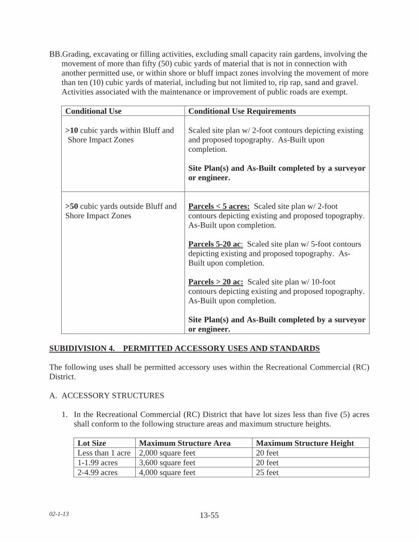
02-1-13 13-55
BB.Grading, excavating or filling activities, excluding small capacity rain gardens, involving the movement of more than fifty (50) cubic yards of material that is not in connection with another permitted use, or within shore or bluff impact zones involving the movement of more than ten (10) cubic yards of material, including but not limited to, rip rap, sand and gravel.
Activities associated with the maintenance or improvement of public roads are exempt.
Conditional Use Conditional Use Requirements
>10 cubic yards within Bluff and Shore Impact Zones
Scaled site plan w/ 2-foot contours depicting existing and proposed topography. As-Built upon completion.
Site Plan(s) and As-Built completed by a surveyor or engineer.
>50 cubic yards outside Bluff and Shore Impact Zones
Parcels < 5 acres: Scaled site plan w/ 2-foot contours depicting existing and proposed topography.As-Built upon completion.
Parcels 5-20 ac: Scaled site plan w/ 5-foot contours depicting existing and proposed topography. As-Built upon completion.
Parcels > 20 ac: Scaled site plan w/ 10-foot contours depicting existing and proposed topography.As-Built upon completion.
Site Plan(s) and As-Built completed by a surveyor or engineer.
SUBIDIVISION 4. PERMITTED ACCESSORY USES AND STANDARDS
The following uses shall be permitted accessory uses within the Recreational Commercial (RC) District.
A. ACCESSORY STRUCTURES
1. In the Recreational Commercial (RC) District that have lot sizes less than five (5) acres shall conform to the following structure areas and maximum structure heights.
Lot Size Maximum Structure Area Maximum Structure Height Less than 1 acre 2,000 square feet 20 feet 1-1.99 acres 3,600 square feet 20 feet 2-4.99 acres 4,000 square feet 25 feet

02-1-13 13-56
2. Outside wall dimensions shall be used to determine maximum structure area, except where a roof projects out further than two (2) feet from the sidewall; roof area shall be used to determine maximum structure area.
3. The lowest floor elevation for all accessory structures shall be at least three (3) feet above the ordinary high water level (OHWL) or highest known lake elevation, whichever is greater.
4. No accessory structure or use shall be constructed or developed on a lot prior to construction of the principal structure.
5. Saunas, outdoor recreational equipment and structures.
6. Commercial or business structures for use accessory to the Principal use but not exceeding twenty five (25) percent of the lot area and meeting all other setback and parking requirements of this section.
B. SWIMMING POOL. PERMANENT
1. No pool shall be located within ten (10) feet of a septic tank/drain field.
2. No pool shall be located beneath overhead electrical lines or over underground utility lines of any type.
3. No pool shall be located within any private or public utility, walkway, drainage, or other easement.
4. Lighting for the pool shall be oriented so as not to cast light onto adjacent properties.
5. A fence of at least five (5) feet in height shall completely enclose the pool area and the access to the pool area shall be controlled.
C. HEIGHT AND SEPARATION REGULATIONS
1. For parcels greater than five (5) acres, there shall be a maximum height limitation of one hundred and fifty (150) feet on all structures. Any structure including but not limited to tower, spire and similar type structure, only after obtaining a letter of clearance from the Federal Aeronautics Administration and the Airport Commission for any airport located within ten (10) miles of the structure proposed to exceed the height limitation.
2. In case an accessory structure is attached to the principal structure, it shall be made structurally a part of the principal structure and shall comply in all respects with the requirements of this Ordinance applicable to the principal structure.

02-1-13 13-57
3. An accessory structure shall not be closer than five (5) feet to the principal structure.
a. In case an accessory structure is attached to the principal structure, it shall be made structurally a part of the principal structure and shall comply in all respects with the requirements of this Ordinance applicable to the principal structure.
D. DRAINAGE
Adequate drainage shall be provided and the drainage shall be directed away from adjacent private property.
E. PARKING
Off-street parking and loading.
F. LANDSCAPING AND SCREENING
1. It is the intent of this Section to provide that uses of land and structures shall be established and maintained with proper appearance from streets and adjoining properties and to provide that each permitted and conditional use shall be a good neighbor to adjoining properties by the control of the following:
2. All required yards shall either be landscaped and green areas or be left in a natural state. If any yards are to be landscaped, they shall be landscaped attractively with lawn, trees, shrubs, etc. Any areas left in a natural state shall be properly maintained in a well kept condition. Where any business (structure, parking or storage) is adjacent to property zoned or developed for residential use, that business or industry shall provide screening along the boundary of the residential property. Screening shall also be provided where a business, parking lot, or industry is located across the street from a residential zone, but not on that side of a business or industry considered to be the front.
3. All exterior storage shall be screened. The exceptions are:
a. Merchandise being displayed for sale, b. Materials and equipment presently being used for construction on the premises. c. Merchandise located on service station pump islands.
4. The screening required may consist of fences and/or landscaping. Plans of such screen shall be submitted for approval as a part of the site plan and installed prior to occupancy of any tract in the district.
5. All open storage yards, shall be screened with buffer planting and screen fences. Plans of such screens shall be submitted for approval by the Planning Commission.

02-1-13 13-58
6. Landscaping Maintenance. All structures and areas requiring landscaping and fences shall be maintained so as not to be unsightly or present harmful health or safety conditions.
G. PERMITTED SIGNAGE
1. Ground/Pylon Signs
a. The maximum height of a sign is twenty (20) feet.
b. No more than one (1) ground/pylon sign shall be permitted per every thirty five (35) lineal feet of road frontage.
c. The square foot area of such signs shall not exceed one hundred (100) square feet.
d. Ground/pylon signs shall be set back a minimum of ten (10) feet from property lines and/or right-of-way.
2. Wall Signs
a. Wall signs on any structure shall not exceed twenty (20) percent of the wall area.
b. Wall signs shall not project above the roof level.
3. Signs may be placed, when necessary, within the shore impact zone if they are designed and sized to meet the following standards.
a. The signs must only convey the location and name of the establishment and the general types of goods or services available.
b. The signs must not contain other detailed information such as product brands and prices.
c. The signs must not be located higher than ten (10) feet above the ground, and must not exceed thirty two (32) square feet in size.
d. If illuminated by artificial light, the lights must be shielded or directed to prevent illumination out across public waters and meet lighting standards in this Ordinance.
H. OUTSIDE LIGHTING
Other outside lighting may be located within the shore impact zone or over public waters if it is used primarily to illuminate potential safety hazards and is shielded or otherwise directed to prevent direct illumination out across public waters. This does not preclude use of navigational lights.

02-1-13 13-59
I. Other accessory uses customarily incidental to the uses listed in Section 13.3.
SUBIDIVISION 5. DIMENSIONAL REGULATIONS
A. SETBACK EXEMPTIONS/STRUCTURE EXPANSIONS
1. In such cases, where proposed additions do not encroach further into the front, side, or rear yard than the existing structure, such additions will be permitted provided the use and the structure are in conformance with the following restrictions:
a. The use of the structure is conforming to the zoning district in which it is located.
b. The expansion of the structure shall not be located closer to the property line than the existing structure or at least one-half (1/2) of the required setback, whichever is greater.
c. The expansion of the structure will not reduce any other required setback below the minimum standards of this Ordinance.
d. The expansion of the structure will conform to all other restrictions of this Ordinance, including but not limited to, density, lot coverage, building height.
e. The height of the expansion shall not be greater than the existing structure at the existing building line.
f. The proposed addition is not located in shore or bluff impact zones.
B. FRONT YARD SETBACKS
1. There shall be a front yard setback of not less than one hundred (100) feet from the right-of-way of State-Federal trunk arterials, expressways and State collector arterials.
2. There shall be a front yard setback of not less than one hundred (100) feet from the right-of-way of County Highways.
3. There shall be a front yard setback of not less than one hundred (100) feet from a township or any other public or private right-of-way.
4. When a lot is located at the intersection of two (2) or more roads, there shall be a front yard setback on each road right-of-way.
5. All components an onsite Subsurface Sewage Treatment System (SSTS) shall be twenty (20) feet from all road right-of-ways.
6. All components an onsite Subsurface Sewage Treatment System (SSTS) for a non-conforming Lot of Record shall be ten (10) feet from all road right-of-ways.

02-1-13 13-60
7. The required front yard of a corner lot shall be unobstructed above a height of three (3) feet in a triangular area, two (2) sides of which are the lines running parallel along the right of way lines between the road intersection and a point fifty (50) feet from the intersection, and the third site of which is the line between the latter two (2) points.
8. No trees or shrubs shall be planted within ten (10) feet from any right-of-way.
9. On nonconforming Lots of Record, accessory structures with a door six (6) feet wide or greater which faces any road right-of-way shall be set back a minimum of twenty five (25) feet. All other accessory structures shall be set back a minimum of ten (10) feet from the road right-of-way.
10. Except that no structure within a Recreational Commercial (RC) District shall be located within fifty (50) feet of any side lot line adjoining any Residential or Agricultural District.
C. SIDE YARD SETBACKS
1. All structures shall have a side yard setback of not less than fifteen (15) feet.
2. No structure within a Recreational Commercial (RC) District shall be located within fifty (50) feet of any side yard lot line adjoining any Residential or Agricultural District.
3. For conforming lots, all water orientated accessory structures shall be set back fifteen (15) feet from side yard property lines.
4. For non-conforming Lots of Record, all water orientated accessory structures shall be set back ten (10) feet from side yard property lines.
D. REAR YARD SETBACKS
1. Principal structures shall have a rear yard setback of not less than forty (40) feet.
2. Accessory structures shall have a rear yard setback of not less than ten (10) feet.
3. No structure within a Recreational Commercial (RC) District shall be located within fifty (50) feet of any rear yard lot line adjoining any Residential or Agricultural District.
E. ORDINARY HIGH WATER LEVEL (OHWL) SETBACKS
1. All structures shall be set back one hundred (100) feet from the Ordinary High Water Level (OHWL).
2. Subsurface Sewage Treatment Systems (SSTS) shall be set back seventy five (75) feet from the Ordinary High Water Level (OHWL).

02-1-13 13-61
3. A new dwelling constructed on a nonconforming Lot of Record may have a reduced OHWL setback with the following restrictions:
a. There shall be an existing dwelling located on each side of the lot.
b. The new dwelling shall not be located closer to the OHWL than the existing dwellings located on the adjacent lots, or at least one-half of the required set back whichever is greater.
c. The structure is not located in a shore impact zone or in a bluff impact zone.
4. A new dwelling constructed on a nonconforming Lot of Record may have a reduced OHWL setback if one of the adjacent lots is vacant with the following restrictions:
a. There shall be an existing dwelling located on one side of the lot.
b. The setback for the Lot of Record shall be the setback of the dwelling on the adjacent lot plus one half (1/2) the difference between the setback of the adjacent dwelling and the setback required by the Ordinance.
c. The structure is not located in a shore impact zone or in a bluff impact zone.
5. One (1) water-oriented accessory structure designed in accordance with this Section shall be set back a minimum distance of ten (10) feet from the ordinary high water level.
6. No expansion or modification of existing feedlots shall result in encroachment closer to the ordinary high water level than the existing setback or three hundred (300) feet, whichever is greater.
F. BLUFF SETBACKS
1. All structures shall be set back from the top and/or toe of the bluff:
a. Thirty (30) feet for bluffs with slopes eighteen (18) to thirty (30) percent.
b. Fifty (50) feet for bluffs with slopes greater than thirty (30) percent,
c. Existing Building Sites. All structures shall be set back thirty (30) feet from the top or toe of the bluff.
2. SSTS shall be set back thirty (30) feet from the top or toe of the bluff.
a. SSTS upgrade and/or replacement for an existing dwelling: 1. Shall be exempt from bluff setback. 2. May be located within the bluff impact zone. 3. Shall not be located within the bluff.
02-1-13 13-62
3. If the adjacent bluff is actively eroding, the Department may increase the setback requirement.
4. Structures and accessory facilities, except stairways and landings, must not be placed within bluff impact zones.
G. WETLAND SETBACKS
All structures shall be set back a minimum of seventy five (75) feet from the wetland boundary of any Type three (3) through eight (8) wetland.
H. ADDITIONAL SETBACKS
1. When more than one (1) setback applies to a site, structures must be located to meet all setbacks.
2. All structures shall be set back fifty (50) feet from a cemetery.
I. FEEDLOT AND ANIMAL REQUIREMENTS
1. Effective June 10, 2010 any new school, park, golf course, licensed campground, or residential zoning district shall be separated from an existing animal feedlot by the following:
a. 10-50 AU 500 feet b. 51-2000 AU 1000 feet c. Greater than 2000 AU 1500 feet
2. All new dwellings shall be separated from an existing animal feedlot by the following:
a. 10-50 AU 500 feet b. 51-2000 AU 1000 feet c. Greater than 2000 AU 1500 feet
3. The animal feedlot owner’s dwelling is exempt from these requirements.
4. Any expansion of an existing animal feedlot shall conform to the following lot requirement:
a. Up to 100 AU 5 acres b. 101-300 AU 10 acres
5. In the Recreational Commercial (RC) District, the following standards shall be applicable for allowable animal units:
(TABLE ON NEXT PAGE)

02-1-13 13-63
Suitable Area Acreage Animal Units Allowed < 1.49 acres Dogs, cats, and animals customarily kept as pets 1.5 to 2.49 acres 2 2.5 to 3.49 acres 3 3.5 to 4.49 acres 4 4.5 or more acres No more than 9 animals units
6. In the Recreational Commercial (RC) District the following maximum number of domestic animals are allowed.
NumberOf Cats
NumberOf Dogs
Kennel (CUP) Animal Shelter (CUP)
2 1 NA NA
J. LOT AREA, WIDTH & DEPTH
1. Lot standards for sewered and unsewered, riparian and non-riparian lots shall have a minimum lot area of forty three thousand, five hundred sixty (43,560) square feet, minimum lot width at the setback line from the Ordinary High Water Level (OHWL) and road right-of-way of one hundred fifty (150) feet.
2. Impervious surface of lots must not exceed twenty five (25) percent of the lot area.
K. HEIGHT
For parcels greater than five (5) acres, there shall be a maximum height limitation of one hundred and fifty (150) feet on all structures. Any structure including but not limited to tower, spire and similar type structure, only after obtaining a letter of clearance from the Federal Aeronautics Administration and the Airport Commission for any airport located within ten (10) miles of the structure proposed to exceed the height limitation.
L. BUILDABLE LOT STANDARDS
1. A Lot of Record, or other lot, tract, or parcel legally recorded with the County Recorder that meets the requirements of this Ordinance and which has frontage on an improved and maintained public road, or an approved and maintained private road or easement is considered a buildable lot. The buildable lot shall have the contiguous required lot area of which not more than ten (10) percent is comprised of:
a. Area of a slope in excess of eighteen (18) percent. b. An impact zone. c. Floodplain. d. Wetland. e. Below the Ordinary High Water Level (OHWL).

02-1-13 13-64
2. Each new building site created after the adoption of this Ordinance must have a minimum of forty thousand (40,000) square feet of contiguous buildable lot area.
3. Each new building site created after January 23, 1996 must have sufficient area for a minimum of two (2) onsite sewage treatment systems.
4. Lots of Record that are substandard in area must conform to all other applicable regulations to qualify for placement of a dwelling.
SUBDIVISION 6. DWELLING STANDARDS
A. PROHIBITED DWELLINGS
No garage, tent, trailer, or accessory structure shall at any time be used as a dwelling.
B. DWELLING REGULATIONS
1. No more than one (1) dwelling shall be placed on a lot except in the case of temporary dwellings.
2. All dwellings shall be on foundations or piles or other foundation systems extending below the frost line, as approved by the Department.
3. The minimum dwelling width excluding porches, decks, or other similar attachments shall be twenty (20) feet except in the cases of temporary dwellings.
4. For Resorts, manufactured homes less than twenty (20) feet in width shall be allowed as a single-family dwelling or for seasonal occupancy in the Recreational Commercial (RC) District.
5. All dwellings must conform with the sewage treatment regulations of this Ordinance. No zoning permits will be issued for new dwellings prior to sewage treatment system approval.
6. Manufactured homes shall bear a State seal as verification of construction and inspection to ANSI A119.1 standards during original construction (issued for manufactured homes built between July 1, 1972 to June 14, 1976) or, for manufactured homes built after that date, a Federal seal in accordance with HUD CFR 3280 Construction Standards.
7. All dwellings shall have a minimum of seven hundred sixty (760) square feet of floor area on the ground floor.
8. Dwellings shall not exceed two and one-half (2 1/2) stories or thirty five (35) feet in height.
9. For all dwellings the lowest floor elevation shall be at least three (3) feet above theordinary high water level (OHWL) or highest known lake elevation, whichever is greater.

02-1-13 13-65
10. Outside wall dimensions shall be used to determine maximum structure area, except where a roof projects out further than two (2) feet from the sidewall; roof area shall be used to determine maximum structure area.
SUBDIVISION 7. ACCESS DRIVES, ACCESS AND SERVICE ROADS
A. Access drives onto any public roads shall require a review by the Road Authority. The Road Authority shall determine the appropriate location, size, and design of such access drives along public roads and may limit the number of access drives in the interest of public safety and efficient traffic flow.
B. Access drives shall be constructed and maintained to meet all of the following:
1. A minimum driving surface width of fourteen (14) feet.
2. Inslope no greater than 4 to 1, as measured horizontal to vertical.
3. Base material depth sufficient to support access by emergency vehicles.
4. Unobstructed width of not less than twenty (20) feet.
5. Unobstructed vertical clearance of not less than thirteen (13) feet, six (6) inches.
C. Access drives in excess of one hundred fifty (150) feet shall provide a minimum turn-around of sixty (60) feet in width by sixty (60) feet in length.
D. Access drives shall have a twenty (20) foot long flat grade directly adjacent to the road that the drive accesses.
E. All lots or parcels with dwellings shall have direct physical access of adequate size for emergency vehicles along the frontage of the lot or parcel from either an existing or dedicated public roadway.
F. A service road shall be constructed for two (2) or more contiguous properties in the Recreational Commercial (RC) District or when required by the Road Authority.
G. Access drives shall not be located within the bluff or shore impact zones.
SUBDIVISION 8. GENERAL REGULATIONS
A. STORAGE OF MATERIALS
1. All materials and equipment shall be stored within a structure or fully screened so as not to be visible from adjoining properties, except for the following:

02-1-13 13-66
a. Recreational equipment.
b. Laundry drying equipment.
c. Off-street parking of licensed passenger vehicles and pickup trucks.
d. Boats and unoccupied travel trailers, less than twenty (20) feet in length, are permissible if stored in the rear yard more than ten (10) feet from the property line.
2. No underground gasoline storage shall be permitted.
3. All land uses and development shall follow all other applicable regulations of this section.