Embed Size (px)
Citation preview

WIN PROPER-TYOFDYerr' GROLI •...R '. TTO
tS A~~y
Official Publication. of theCASCADEGROTTO N. S. S.
SEATTLE'S ONLY GENUINE UNDERGROUND NEWSPAPER
Volume 16 'No~ '1~2 Editor: Rod Crawford Jart. ":'Feb. t 1977

••
,- \{ '. . . ~ . .'
THE CASCADE CAVER is published ten times a year by the Cascade Grotto of theNational Speleological Society. Suhscription rate is $4.00 per year. Fullgrotto dues of $6.00 includes a subscription to the quarterly Northwest Caving.All payments should be made to the grotto treasurer, Chuck Coughlin, 6433S. l27th Pl., Seattle Washington 98178.
COMING ( AND I M M E D I ATE PAS T ) EVE N T S
March Cascade Caver.nonthly meeting. Same tine and 'place unless
See BobNWRA Convention, Vancouver Island.
DEADLINE for theMonday. Regularannounced.Friday to Monday.details.
Feb. 19-20. NSS Western Speleo-Educational Seminar, Vancouver, Washington.See witain, p. 11.Feb., 21, tlonday. 8:00 PM. February Meetin~ of the Cascade Grotto, at theHallidays', 1117 36th Ave. E, Seattle.Tentative Trips Planned for Near Future, But No Date Fixed:North Chuckanut Talus Caves. Call Rod Crawford late evenings, 543-4486.Mt. Adams area lava tubes. Call Hank Ramsey, TA4-l807.And if you feel like caving, call anyhody! The mountains are accessible andthe weather is beautiful. Why just sit there as if this was just a normalwinter?March 1.March 21,otheliviseJuly 1-4,Brown for
NEll SUBSCRIBERSDave CowanRoh Stitt
5313 North Ave., Carmichael, CA 956081417 9th Ave. \oJ, Seattle HA 98119
LATE RENEWALEllen Benedict 8106 SE Carlton, Portland OR 97206
NEWS AND NOTESThe Northwest Regional Patches are at last finished, and they are heautiful.Nearly half of our stock was sold at the NTtJRAseminar. They will be avail-able at this and subsequent meetines.
* * * * *Circumstances more-or-less beyond our control made it impractical to print thisissue before the Seminar, so feel at liber~y to if,!1orethe announcement on p.11. Sorry about that. i< * i< * *
RECENT DISCOVERIES BY VICEG: Scallop Cave, in the Hemekay area of Van-couver Island, was first explored on Sept. 6, 1976. 1,252 feet have heensurveyed, estimated to be less than half the total. Candlestick Cave, inthe same area, was first explored on Octooer 30 and bottomed on Nov. 6.The survey is incomplete and no fi~ures have been published. The cave provedto be so fragile that it was immediately gated in a maration effort, Nov-ember 11-14.
+ + + + + + +At the seminar, yr editor 80t the real tune for "The 1nld Caver" froM.PhilWhitfield, and exacted a promise of 'the tune for "Does it Go?" sometime inthe future. They will be printed as space permits.
COVER: Circle Limit IV (Heaven anelHen), \.Joodcutby H. C. Eseher.
2

F EAT U R E ART I C L E
Cave Mapping: Get Out and Do ItBy Steve Knutson
With additions by the editor and from the Cave Surveying Workshopby J~rry Broadus and Ken Byrd at the 1975 NWRA Seminar.
[Based o~an article by Steve Knutson in the Speleograph, V. 9No.3. 'Opinions expressed in this article are not necessarily
those of the original author].
Introduction.The most difficult aspect of cave mapping, by all odds, is finding the
motivation to do the job. Th~ process itself is fairly sireple,but it takesreal dedication to implement and see through to completion. ~~en you arewet and c61d~and/or tired, mapping seems relatively unimportant. Also, thebest of intentions go astray when, in the cave, one feels the ever-presentlure to explore. Mapping is a rather mundane activity. But it is important.It is, at the least, the first step in the study of any cave. It would takea great nany well-chosen words to do the job of a single cave map in describ-ing.a cave. So, I will end this introduction with this admonition--when youvisit unmapped cave~, go determined to do seme mapping. Then you'll actuallydo it once in a while!E~uipment.
Nearly all cave Qapping is done using a compass to determine the directionsof cave passages. Distances are deternined with a 50 or 100 foot steel (orfiberglass) tape. Assuming a cave to be other than horizontal, a verticalangle from one'station to the next must also be determined, so that slope dis-tance can be corrected to horizontal distance for plotting the plan view mapof the cave.
Any compass which ~vill allow one to aim it toward the next station andread the bearing or azimuth* to magnetic north indicated by the needle ~ thesame time will produce accuracy sufficient for most caves. Such compassesinclude the Suunto, Brunton, and lensatic (or prismatic) types. All arereasonably expensive. Lesser compasses can be used, but their accuracy issuitable only for simple caves; but then many of our lava tube caves qualifyas such.
Steel tapes are in standard use but suffer from the disadvantage of break-ing easily if they are bent or kinked, which can result from stepping orcrawling on the tape. The new fiberglass tapes are the thing to have. Clothtapes are poor because they stretch.
Clinometers (to measure vertical angles) can come built-in, as in theBrunton, or be a separate device, as the Suunto clinometer. They can also behomemade, with a protractor and plumb device.Survey Accuracy
It is possible to run a complete range in terms of quality and precisionin mapping, and this range has been divided by the Cave Research Group ofGreat Britain into a series of grades. When a map is produced, it is alwaysnecessary to state the grade.
*A bearing is an angle measured from.Northor South, never from East orWest. An azimuth is an angle measured from a single base, usualiy North.Trigonometrically they are the same; hence the sine of S 10. W is the sameas the sine of 190., et cetera.

The C. R. G. grades are as follows:1. Rough sketch from memory, not to scale.2. Sketch-plan, roughly to scale; no instruments used; directions and
distances estimated. '3. Rough plan survey; small pocket compass graduated in tens of degrees;
lengths by marked cord or cloth tape.4. Prismatic compass graduated in single degrees bur compass error not
known; steel or fiberglass tape.5. Calibrated pri~matic or Suunto compass and clinometer, or Brunton;
steel or fiberglass tape; bearings at least to nearest degree.6. Calibrated prismatic or Suunto compass and clinometer, or Brunton;
on tripod(s); ..~t2c:l br~ fib'crglaGe".~i::ape.'~ .. ' .~. 0.'
7. Theodolite, transit, or specialized hand-held compass~clinometerdevices such as those used by Stan Ulfield or Ellis Hedlund, for bearingsand slopes; steel or fiberglass tape.The Compass Scale.
Compasses, especially the Brunton, can come with several different scales.The Q ~ 360 scale is best. The only human error that can result is readingthe wrong end of the needle. When plotting the data, such an error becomesobviou~ and is easily corrected. A 0 to 360 circular protractor is helpfulin plotting dat~ froD such a scale, if the data is to be plotted directly.
The quadrant compass is calibrated as shown in Figure 1 (facing page).Thus, a bearing of 320 degrees en a 0 to 360 compass corresponds to "North40 degrees West" (N40W). I have noticed in working up data from a quadrantcompass that it is possible .to make an error, substituting E for W, as wellas a 180 degree error resulting fron reading the wrong end of the needle.This can be serious since a N5E read as NSW gives an error of 10 degrees.
'It may not be obvious which of several consecutive traverses is in error ifthe error is this small. Yet the error is large enough to be intolerable.
A third scale is graduated 0 to 6400 mils. This means that 6400 milsequals 360 degrees and every bearing must be converted to degrees' by mult-iplying by the conversion factor, 36/640 or 0.05625. However, this step canbe Virtually eliminated when data is being reduced with an electronic calcu-lator so this is not as serious an ir.convenience as using a quadrant compass.
Perhaps the rea.son there are compasses around graduated in quadrants isthat the owners didn't know what they were getting. The existence of Bruntonsgraduated in mils ~s easier to understand, since these may sometimes be hadat auctions of A~my property. But the lesson to learn is, when buying a newcompass, specify a 0 to 360 degree scale.ReadinR..the Conpass.
The azimclth or bearing is taken by aiming the compass at the next station " .using the sights (or whatever), allowing the needle to come to rest (towardmagnetic north), and reading the indicated bearing.
With a Suunto the scale of azimuths is around a thin cylinder, the diameterof which is the~needle of the compass. When' you sight the compass on a sta-tion, the bearing 'appears ina ~l1indowjust under the sights, and it is veryeasy to sight the compass and read ,it. One disadvantage is that it isrelatively difficult to sight on stations ~l1hichare very far above or belowthe horizontal'lineof sight. It has also been reported, although I havenot experienced this, that the window on the Suunto can fog up, rend~ringit useless. ' :,'
The lensatic (prismatic) type of compass has a bi~ged prism or lens whichis in line with the sights and as with the Suunto, the scale can be readwhile sighting the compas$.
The compasses mentioned Lihove are used with s,eparate clinometers~ The
,"

1-.
! :
.: ." r:'
Figure 2~ Brunton compass with quadrant scale.Note that sighting compasses have the positions of
"East" and !tWest"reversed from their positions on simplecompasses. This will give the correct direction of ~be
station being sighted.','I•
Figure 1.Quadrant compass scale.
Below is a s~le page of notebook entries, using-the data from Windy CreekCave. This Is:not an exact c~py of the original pages. Arrows indicate,thedistances to walls, cEdlLlg and floor from the station'being sighted from.,
'l ~.'
,~ Declination set ~t 23°E. _Sta. Azim. Inc!. Dist. ~t ..v' I ~:
,~
1-2 2420 +80- 19.7' .5,.5 6 2
2-,3 238~ _170 15.0 5 12 6 '23-4 ,1400 +3° 24.3 - 5 54-5 '2340 +80 17.9 1 I, 5 3
:5~6 185,° _20 14.6 4 3 5 1'-, r 6-7 2400 0 10.0 2 0 3 5
... ,.,..
'. ,WORKED-UP DATA FROM SAMPLE ENTR.I.F;S
E
True NY
xo-17.2-29.3~13.7
,/'':'28.0-29~3-38.0
123456
"r ..
Station
',: .
Below is the sample data corrected for slope ~d reduced to rectangularcoordinates. In this case, Y is north when positive, south when negative;-X is east when 'positive, west when negative; Z is elevation; all with respectto 0 at'fioor in center of entrance.
Horiz. dist.Y. Z to entr. ~ -} t J.
o +2 .0 O. •5 oS 6 2-9.2 4.7 19.5 5 12 6 2-16.7 '0.3 33.8 5 5--35.3 1~6 58.1 1 1 5 ,5-45.84-.1 ,75.84 3 5, i-60.33.6; 90.1 2, ,0 3 5", ..-65.3.3 •.6 100.4 1.:3 fg" J::
" ( , . . ...All data courtesy of Chuck CO\lghlinand 'Jerry Broadus. The .crude sketch
'map may be blamed,:'on'the.r~i~O~! For:..completedmap"s~e the lCls~ issue, p. 136.. . ~t ".' r. 'or,' ,R. I ~ "i:
5

Brunton has a built-in clinometer and is much more complicated to use (seefigure 2). Usually bearings are obtained by looking down on the compass,adjusting the hinged mirror so that the next station (marked preferably bya light) is in view, and superimposing (lining up) the image of the frontsight, the target station, and the hairline on the mirror. \fuenthese arein line, the bearing is read (you are looking down on the scale). Meanwhile,of course, you are keeping the bubble centered in the bullseye level.
To read the vertical angle, the Brunton is held on its side with the sightextended and toward you. The compass is held up to the eye and the targetstation is sighted along the extended sight and through the hole in themirror. The mirror is angled so that the level in the compass can be seenwhile the object is sighted. The bubble in the level is then centeredusing the lever on the bottom of the compass. The vertical angle is read onthe scale inside the compass body.Correction for Declination~
The compa;; needle points to magnetic north. Since the magnetic pole issome distance from the true pole, a sizable correction must be made to converta "magnetic" azimuth or bearing to a "true" one. Moreover, this correctionvaries with geographic position. In Washington, the differences in declinationfrom place to place can be rather significant. In the Trout Lake cave areait is 21°; at t,heMt. St. Helens cave area, 21.5.; at Cave Ridge and in theGardner Cave area, 22.5°; at Concrete, 23.; at the Black Mountain Karst,23.5°. The Brunton and some other compasses have a scale that can be adjustedto correct for declination. However, there is a great danger of leaving thesetting from a previous trip in an area where it is wrong, or of using com-passes with different settings in the same cave, so the best bet is to leavethe compass set at 0 declination and correct later, or just draft the Qapaccording to magnetic north. If you do set a correction, be ~ to indicatewhat correction you set in your notes.The M~ping Team
The number of members in a mapping team depends on the character of thecave or passage being mapped. In constricted crawlways or difficult verticalcaves, the team may be reduced to two, which is the smallest efficient party.Solo cave mapping is occasionally done, but must be exceedingly tiresome andtedious. In spacious caverns the team may include as many as five and achievegreat speed and efficiency.
The various jobs include: (1) reading the compass, (2) taking the notes,(3) handling the tape, one man on each end, and (4) marking or indicating,and selecting the stations. If the clinometer and compass are separate, theymay be handled by two men. The notes should, if possible, be taken by thesame person who will later draft the map. The man taking notes should begiven no other job. As the compass, tape, and clinometer are set up and read,the notes man must be sketchins the passage as well as keeping the datastraight. The tape handling is an important job since the marking and selec-tion of the stations is usually done by the same person. The tape man oppositethe compass man must have a light for the latter to sight on.The In-Cave Process.once the team is organized, the process is simple*. An initial station isselected and the tape run to the next station. The latter must be carefullyselected to maximize each subsequent station-to-station traverse. This doesnot mean just running the tape to the limit of visual connection with thelast station. The new station must be positioned so that a maximum distancecan be taped to the next new station. When the tape is tight between the
*You said it, brother! The problem is organizing a team of more than one. -ed.
6

. :
stations, the distance is read, as is the compass and clinometer; the keeperof the notes makes his sketches and observations, and records the data. Thetape men move on to another new station, and the data taking and recordingis repeated.The Data Book.~---The data taken in the cave must be recorded. A small, iriexpensive surveybook with waterproof paper is best. Data can be recorded in such a bookusing a lead pencil even when the pages are covered ~.,ithmud or ~.,ater.
On each facing page in the notebook a sketch showin'g the configuration ofthe passage walls relative to the traverse line should be given. Stationsshould be'positioned and numbered. However rough this sketch is, it will bea great aid when adding passage w~ils'to t:he,plotted traverse line. As muchinformation should be tacked; ont{)',thesketch as possible; this'inCludes crosssections, passage height between stations ,and various features of the passage.
The data to be taken depends somewhat on.the grade of survey being done.and on the personal preference of the surveyor. The practice of leaving asurvey marker at each station probably litters the cave unduly. If a cave~iscomplex, a few marked stations along a long traverse line will suffice fortying in future surveys of adjacent passages. If the cave is relatively,simple~ all the'stations can beUimaginary". The main thing to remember isthat the cross sectional dimensins should be fixed for each station, and theposition of the ~tation in relation to the cross-section must also be fixed.In one 'system, the naximum height and ~.,idthof each station are recorded inthe data book"with the station's position r.elative to the walls recorded inthe sketch,on the facing page. Or, the distance to each wall, floor, andceiling"can be recorded separately, as in the example given of the first fewstations from Windy CreekiCave. Recording the height of each 'station abovethe floor"is mandatory for eRG 'Grade 6. Passage widths and heights are'oftenjust estimated, though mappers vary widely in the accuracy of their estimation.The possibilities of optical range finder devicesJor determining ceilingheights should be explored: . , . '
When time, patience, and personnel allow, it is very desirable to take abacksight with the compass to the previous station at each successive station.The mean of the two azimuths is much more accurate than one azimuth alone,and this also allows a chance 'to eliminate errors in reading the compass.Working ~ the Data
Upon arriving home, the raw cave notes should always be recopied nicely,while the identity, of your muddy scribbles is stil~ fresh in your mind~ Theoriginal notes' should be preserved along with the recopied notes so that anyerror noted later' can be'traced to its source. . .
The sooner one'~orks up and plots the data, the bett~r. If the cave isnearly horizontal, the raw data can be used and a plan view plotted directly(i.e., with a circular protractor). HO~7ever,this method 'is very crude fora cave of any length, and provides several sources of error. Unless you area perfect draftsman, you will not read exactly the right point on your ruleror protractor or make your dot in exactly the right place. These errors aremultiplied with each station plotted. It is much more desi,rable-to convertyour original data, in the form of a distance and direction or polar coordin-ates, into rectan,&?lat coordinates, the distances'along the two axes ("x" and"y") of a piece of graph,paper •• '
When any vertical angle '~evi~tes more than a few degrees from zero, andin any case where. pr~cisevert:..ical,control is desired, it is necessary to ...calculate the horizontal distance. and vertical change from the slope distancebetween stations.' This is all:;l(:ldone by converting the polar coordinates (inthis case, the distance an4:inclination) to rectangular coordinates.
7
,/

The first step in working up 'the data is reducing slope distances to a'horizontal' <.mda vertical distance~ If your clinometer uses ,a. for horizontal:
Slope'distance x cosine slope angie = horizontal distance.Slope distance x sine slope angle = vertical distance.
If your instrument uses 90. for horizontal, trade sine for cosine in the twoformulas above.
Then. taking the true horizontal distances with their azimuths as polarcoordinates, change to rectangular coordinates as follows:
Horizontal distance x cosine of azimuth = northing or southing.Horizontal distance x sine of azimuth = easting or westing.
All northings and all eastings are + (positive); all southings and'all west-ings are - (negative). The rectangular coordinates of each station are addedto those of tha last to give the coordinates of the new point. Ina closedtraverse the algebraic sum of the northings and southings should equal zero,as also with eastings and westings. If they don't, the remainder is yourerror ,of closure.
Sines and cosines can be found in a book of mathematical tables. "However,many :of the now widely available electronic calculators allow transfer ofpolar to rectangular coordinates at the touch of a single button. The aCCUID-,ulative addition functions of such calculators are useful in adding coordinates'of successive stations, thus avoiding cumulative errors of rounding numbers.
Once the data is worked up, the points are plotted (usually on graph paper),and the walls and other features drawn according to the original sketch andthe height and width data.
For technical niceties of drafting and reproducing the final map, see thearticle by Jim Nieland inSpeleograph v. 12 no. 5, pp. 100-105.
+ " + + + + + + + + + +Montana Travertine Glacieres Reference
by Bill Halli~ayRecently I acquired a 48-page paperback booklet'entitled "A Guide to the
Geology of 'Fergus County, Montana". by H. Leonard'DeKalb, of Lewistown,Montana, printed by Argus Printing anp Supply Co., Lewistown. It is datedonly in the preface: July 18, 1922. On page 32, it gives some information onglacieres that I have not seen elsewhere:
"On the westerly slope of the top of the McDonald Creek Divide, on theLewistown-Forest Grove road, to the north, l~e several deposits of travertine.At the Charl~s Rich ranch you may obtain directions to .some very fair typesof ice caves" found in the fissures of.the deposits. .
" .••'the Park' at the southerly end of the North Mci,c~asinscan ,quite easilybe reached. I~e cave~ are also found at 'this locality. , '
"Do not get 'the erroneous -iopression that our ice ca~es are all found'in'the travertine~ ,The cave in the Judiths approached from about a mile down thecanyon from the McEvoy ;ranch ho'use is in the Madison [limestone]. '
"A simple explanation of an ice :cave is an unventilated cavern into whichthe cold below-zero air of winter has descended'. Percolating waters,havecongealed'upon entering this atmosphere; hence ice; hence an ice cave. With-'out strong air -currents to drive out the cold air, coupled with comparativelyshort summers, and a good conductor overhead, ,we have 'permanent ice caves."
* * * ,* * * * ** * .* * * * ' "
,",',
8

,J" .'
T RIP, REP 0 R TS E C T ION *;'\i
j',
*No trip reports;had heen received by theeditor by press time.
+ + + + + + + + + + +
VULCANOSPELEOLOGICAL ABSTRACT
Simons, J. W., 1976. Leviathan Cave--a major lava tube in Kenya. BritishCave Research Bulletin No. 14, November 1976, pp. 23-25 (Abstracted by \-l.R.H.).
"During Mid-April, 1976, a team of seven members of the Cave ExplorationGroup of East Africa undertook a ten..day, locally sponsored, expedition inwhat is at present claimed as th~ world's longest and deepest lava cave. [Ed.note: Since Leviathan is divided by collapse into three segments, it doesnot really qualify as longest by current definition ~' However, all three seg-ments are over 2 kilometres long.] .
"The cave lies in .a magnificent wilderness of;geologically recent ash-cones and vast lava fields which Make up a 65 km long mountain range knownas the Chyulu Hills,'bordering upon Kenya's famous Tsavo National Park (West).Many lava caves have been discovered in the pahoehoe flows of this fascinating,area by the CEGEA during the last decade, most involving extended foot-safaris through forest and game-rich bush to reach their entrances. >Lavaflows, some of \-lhlchreach distances of 20 kilometres from their source vol-canoes •••
All major tunnels so far examined show evidence that they were formed.bythe extrusions cutting channels down into the underlying pyroclastics sur-rounding the cones~ lining them with successive onionJskin layers of lava toform underground conduits feeding the flm ...•snout. Prop,ressivecowncutting,as demonstrated by lava verticals ('falls) representing nick-points of head-ward erosion, and lowering of the flow level within the active channel produc-ed multiple passages one above the other. High-level, braided side-passagesyste~s are now known to occur in the most recent discovery and are inter-preted as 'feeder tubes' to the main 'drainage' tunnel, formed in the lavasheet overlying the pyroclastics •••
"~~.Leviathan Cave was first 'discovered' through a study of aerial photo-graphs and received its first CEG investigation in September 1975. It tookCEG members five extended two- and three-day 'trips to explore the main tunnelline and,some of its upper levels, bivouacs ,being;made at the cave.,D).ffi-culties of,exploration were aggravated bya 240}<:ilometre vehicle d~~tance, 'from Nairobi, .a h:tke of 4 kilometres to the main,entrance and.by ,paving:,toback-pack all water suppl:~es in "addition ~o foodstuffs: and 'e'quipment.,To
. ;,i " "~:J '".;.' " .! ... )r:i~'.
9
" ;

",'
. Li~.
10
locate additional entrances over the cave it also became necessary to blazetrails through the forest on compass traverses, the last t~o collapse holeslying deep within the Kibwezi Forest a further 4 kilometres down flow of themain entrance. Supply-lines to the farthest reaches of the cave were,therefore, rather extended and it became apparent that to produce a high-grade survey of the entire cave would, be a protracted affair involving manycostly visits. The ten day expeditio'n was organized principally , therefore,to establish the cave's exact length and vertical range as well as to inves-tigate many upper levels which remained un-entered. Local sponsorship wassought and many Kenya-based companies came forward with generous donationsof equipment and foodstuffs •••
"The principal tunnel of Leviathan Cave, with many sections up to 10-15metres in diameter and large enough to permit a bus, has now been exploredfrom an ash-choke directly beneath the slope of the source volcano, downstreamto a seemingly impenetrable houlder-seal for a single passage length of 8kilometres. This great length is onlybrok@u in two places by collapseentrances, where linking digs through houlders had to be undertaken, dividingthe passage into 3.5, 2.5 and 2.0kilom~tre segments. Ten other collapseentrances are known over the cave line,'but each of these provides entry tohigh passage sections, the otherwise cont'inuous lm-7er,level passing' beneath.Discontinuity of the upper levels or natural breaks in their floors providesaccess to 'the lower section. ' , '
"Vertical lava 'falls' are prevalent in the most upstream part ,,()f the cave:-'Lava FallsWay--there being one of 2 metres, three of 4 metres, one, of 5 "metres, and one of 6 metres (Scorpion Falls). A climb of 10-15 me'tres in ashaft passing from the lml7ermost level up through t\170,;higher level, passaeesenabled the upstream survey party to exit at a small collapse ,250 metres 'downflow of the,source vqlcano. Downstream of the main (Bushbuck) collapse;the Mud Hall Series contint,lesdescending, st'eenly dmmflow, to;Forest Collapse,a number of ox-bows and a hraidedside system being encountered mid-way" ,along this series.,'From Forest 'to Compass Collapses, the angle Qtd~scentgradually decreases. " Compass Cbllapse marks the first break in continuity3.5 kilometres from the Terminal Choke and with a vertical range of 305metres. ,
"The next 2.5 kilometres segment of the main passage--Goliath Passage~':"has some impressive canyon-like cross sections UP' to 15,metres high and" ,"though it drops only another 100 metres to Pottery Collapse, it is a very,'wearing section to traverse \l7ithits great slippery breakdo"m piles. It'Jasalong this series that several new and previously unsuspected side-passage ,n.sys'ternsof O. 3 and 0.4 kilometres were discovered runninp,parallel to ,~he ,-('main tube and connected to its upper levels.
Pottery Collapse mar,ks the'second break in continuity, dmmstream of whichit is mostly easy walking for the next 2 k:i1ometres to a 100 metre long liquid'guano crawl in boulders ma:rking the present 'end'of the 'cave. A disappointingfinish to a magnificent lava cave, though it is suspected that the tube con- 'tinues much further beyond this ,choke as many kilometres of lava still lieahead'.;
"Geologically the cave exhibits some fine lava tube features. Not onlyare the'passages of unu~ually large dimensions, varying, from smooth ovals tohigh canyon-like areas often with 'key-hole' cross-sections rather,reminis-cent of vadose stream passages (which technically they are), but many,lava-tites and ls.vamites abound. Large 'box-work" areas of sharp pointe'd layatiteblades are common and the lower end of the cave contains a profusion ofcurly 'pipe-stem' varieties and weird lavanites built up of solidified lavapellet upon pellet. Lava columns are also present and some of an incredibleblue-gray colour have been noted. Small ropy lava pavements, often formingsolid seals in small passages, were of a fascinating salmon-pink colour. Of[Continued at bottom of p. 13]
1\N
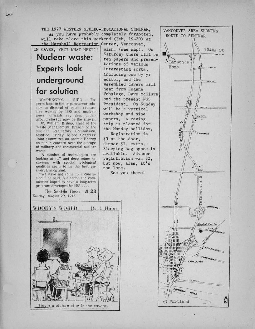
A 23
THE 1977 WESTERNSPELEO-EDUCATIONALSEMINAR,as you have probably completely forgotten,
will take' place this weekend (Feb. 19-20) atthe Marshall Recreation Center. Vancouver,
IN CAVES, YET? WHATNEXT?! Wash. (see map). On
Nuclear 'J1.INste.. Saturday there will be"'t}v ~ ten papers and presen-
tations of variousExperts look interesting sorts,
including one by yrunderground editor, and the
assembled cavers ~vill
f I f• hear from Eugene'or so U ion Vehslage, Dave McclurgfWASHINGTON _. (UPI"; -- Ex- and the present NSS
pens hnpf' to find a rennar:rnt ~olu. President. On Sundaylion to disposal of potent r<Jdipac- will be a verticaltin~ wastes hy 1!lil5 and tluc!rar.power orncin!s say dC'cp under- workshop and nineground ,wrage may be 1111' answer. papers. A caving
Dr. William nishop. chief uf the trip is planned forWnste l\lanagement Branch of the the Monday holliday.:--;ucJe<lr Regulatory Commissiun.testified Friday befO"e Congress' Registration isJoint Committee on Atomic Energy $3 at the door,on public concern over the storage dinner $1. extra. 'of military and commercial nuclear Sleeping bag space iswaste. il bl Ad"A number of technologies are ava a e. vancelooking at it," and deep mines or registration was $2,cavems with special gl'ological but now, alas, it I SCjualities seem to be tlw best an- too late.swer, Bishop snid. h ,.
See you t ere."WE' have not comr to a Cl1nclu-,jon," he said. but :..dd.~d lhe corn.mission hoped to have a long-termprnp;ram developed bv 19S5... ,.
\VOODY'S \\ UULD Ih .:. Hi,im.....--:""---~_..------lI
I
The SeatHe TimesS,mdd'l. August 29. 1976

the United States, by William R.432 pp. $14.95. Revised and
BOOK REVIEW: by Bill Mixon
DeEths of the Earth, Caves and Cavers ofHalliday. Harper and Row, New York, 1976.enlarged edition.
As I read this new edition of Bill Halliday's best-known book, I Has im-pressed at how much of the lore of American caves he had nanaged to include.Just now have I realized how large a part of my store of cave lore comesfrom the 1966 edition of Halliday's book. So this new edition, which addsa lot to the old edition--anJ leaves out less--of course covers much of thesame ground. The point is not that you needn't buy the new if you have theold. It simply illustrates ~he part DeEths of the Earth has played in es-tablishing American cavers' common fund of knowledge about their pastime.It and the older Celebrated American Caves, edited by Mohr and Sloane, are thetHO books covering the whole U.S. caving scene that have been kept in printover the last decade and have therefore been readily available to all currentcavers who want to read. Their contents are, for practical purposes, thelore of American caves and caving. ---
The material in Halliday's book is wide in scope both in place and time.Halliday is interested in spelean history--he founded the Journal ~ SpeleanHisto~, which doesn't look like it's surviving his glvlng up the editorship--and some of the naterial in the book reflects that: Thomas Jefferson made thefirst map of a U.S. cave.
Deciding what to include in a general book such as Depths ~ the Earthmust be quite a chore. Which stories of discovery and exploration are mostimportant? Which will the reader enjoy most? Besides these judgements,the content of the book nust of course depend on w.at infornation is avail-able from various parts of the country and which cavers cooperate with theauthor in supplying infornation, checking for errors, and the like. Anyway,this new, edition covers a lot of ground: Flint Ridge, Mammoth Cave, and theconnection. The Floyd Collins tragedy. Famous caves- of the Virginias:Grand Caverns, Luray, and Endless. The conquest of Schoolhouse in the earlyforties by rock climbers.' Missouri Caves: Meramec, Onondaga, Mark Twain,Marvel, the long caves of Perry County, the pollution fight at Devil's Icebox,Devil's Well. Arkansas: Beauty Cave and Blanc!1ard Spring. California:Winding Stair, legends, and archaeology. Carlsbad. Texas: Devil's Sinkhole,Ezell's Cave, Frio Cave and bats and rabies, Natural Bridge, and, of course,Sonora, "in my opinion America's most beautiful"--mine too. Northeastern caves:McFails, Skull. Southeastern: Anvil, Cathedral, Cumberland, Russell, Fern,Ellison's, Cavers' caves of the Virginias: Blowing, Butler, Breathing.Jewel and Wind, including the Windy City Grotto's work in the early Seventies.Indiana: Sullivan's, Blue Spring, Neffs' Canyon. The Devil's Hol~ and itspupfish. Florida spring diving. Caves in snow and ice: Paradise Ice Cavesand the summi~ Caves of Mt. Rainier. Lava tubes. Crystal Ice Caves, Idaho.And more.
If you've been keeping up on the U.S. caving scene over the past decade,you can tell tram the list above that the 1976 edition is no token revision:a lot of the material concerns recent discoveries. (Inevitably, the book isalready slightly out of date. Friar's Hole will "perhaps someday" be con-nected to Snedegar~Crookshank). What Jid he leave out? Not much, it seemslike. There is nothing on caves in the Rockies; that is probably the greatestomission. It is a shame that he has restricted himself to the U.S,., becausethe discoveries of the last ten years in Mexico and the Canadian Rockiessurely deserve telling.
In my somewhat disappointed review of Hallidayis American Caves and Caving,I stated that he was better at telling tales than explaining cave craft and
12
'.

,
\science. I am happy to report that his tale-telling is still just as skilledas it was ten years ago. The book is hard to put down. Some prominentcavers will perhaps be embarassed by the unstinting praise heaped on them,but they needn't be; Halliday wrote it, not they, ~nd he's right. His styleis lively, sometimes verging on the dramatic,'but never quite objectionablyso (except maybe in the obviously fiction.alparagraphs about the inside of .Show.Farm Cave during the Indiana drmming accident of 1961). And those.who have criticized Halliday in the past for being insensitive to conservationshould read his chapter on dams and caves.
I can't resist.mentioning an error not corrected from the old edition; Imentioned it in my review in 1966, too. Dissolving 175 tons of limestone aday does not make a mile of 30~ by 50-foot passage in a year. Nowhere near.Obviously.
Everyone but the NSS News staff who has followed American caving literaturefor any length of'time has caught on to the fact that Bill Halliday andGeorge Jackson will never have anything bad to say about each other's books,so.you needn't pay much attention .to the review of Depths of the Earth inthe October News. On the other hand, an Eastern caver who reads the Speleo-news once wrote that if even Bill Mixon likes a book, he knows he'll thinkit's great. I like it. And any caver who hasn't read the new edition isculturally deprived.
P.S. But what are those funny things at the bottom of the page, next tothe page number&?
From: The Windy City Speleonews, ~ (2): 12, February 1977.
+ + + + +
BOOK REVIEW: by William R. Halliday, M.D.
The Jewel Cave Adventure, by Herb and Jan Conn. 1976, Zephyrus Press, Tea-neck, New Jersey. 240 pp., 89 half-tones, 16 maps, and two songs. $5.95paperback, $10.50 clothbound.
The subtitle summarizes the book: Fifty Miles of Discovery Under SouthDakota. With this, the N.S.S. publication program comes of age. The JewelCave Adventure in my opinion is destinp.dto be one of the very few~ue clas-sics of American caving, and at the very least will surprise the living day-lights out of a lot of people around the world. It captures the feel of whatcaving is really like, what it'G all about, and how cavers' dedication oc-casionally is rewarded far beyond their fondest dreams. The maps and diagramsespecially help to take the reader alone eac~ miserable crawl, into each newbreakthrough. Just as 1974 was the year of the how-to-do-it caving books,this unheralded little book completes 1976 in a blaze of glory as the year ofthe great American caving narratives. I recommend paying the added pricefor the hardback. This is going to be a collectors' item. '
* * * * * *LEVIATHAN CAVE, continued from page 10: "•.•particular interest are a seriesof unusual lava outgrowths on the edge of a bench which are dendritic incharacter and greatly resemble ferns. Burst blister formations were observedin both the walls and roof in certain passage sections, the former consistingof pockets surrounded by solidified jagged lava protuberances and the latterby deep pearl-shaped scoops where lava had trickled ont at the lower end anddown the walls. Long benches marked former levels of molten flow and inplaces coalesced to form natural bridges and tubes within tubes." [Editor'snote: The Cascade Caver, in our tlov.-Dec. 1975 and June 1976 issues, virtuallyscooped the world with early reports on Leviathan Cave.]
13

"
PROGRAH FOR THE MARCH HEETING:A presen~ation by Curt Black on thesubject of "Cave-Savine Techniques".
+ + +" + + + +THE JANUARY MEETING
was snaIl, as befits the season.Our new officers (Russ Turner, chair-man, Ed Crawford, V.C., and theincumbent Chuch Coughlin as Sec.-Treas.) took office. There wasunfortunately no profraQ, and theofficers promisen not to let ithappen a[~in. There were a fewtrip reports. The e;rottovoted$15 to the Oregon Grotto Libraryin memory of Charlie Larson's sons.
.858.751.002/l5C.203/25<;-.10
$1. 5050q/lb.4.50
CASCADE GROTTO STORECapron, Keeper: Phone 784-8497.Price List, Octoher 1976.
Bill
Cave PacksCarbideJudson kneepads, pairHelnetsChin StrapsPrenier Carbide LampsLamp BracketsLamp feltsLamp tipsLamp flintsLanp gasketsMSA Nickel-Iron Headlamps *Gibbs ascenders (sprin~) 8.50Gihbs (quick release) 10.50Bonaiti D Carabiners 2.50Bonaiti Lockin8 D 3.25Cascade Grotto Patches 1.50Cascade Grotto Decals .25NSS Decals .20*Contact Keeper for Information.Quantities are limited in some cases.
If you want any cavine-related equipment notlisted here, please ask for it. The store ishere to serve you, so take advanta~e of it. BC.
THE CASCADE CAVER207 Hub (FK-IO) Box 98University of HashingtonSeattle WA'98195
Take~lothin8ButPicturesLeavefuthin?,ButFootpringsKillNothin8ButVandals
14