Embed Size (px)
Citation preview

Seaside Greenway South - Assessment Ride 2 HUB Cycling Vancouver UBC Local Committee - Seaside South Working Group
August 2, 2016
Executive Summary
The HUB Vancouver UBC Local Committee Seaside South Working Group identified the
Seaside South Greenway and Seaside Bypass Bike Route as important cycling routes in the
City of Vancouver. Indications were given by the City that parts of these routes would be
considered for improvements in the near term, and the Working Group decided to perform an
assessment of the routes in order to be able to provide constructive feedback to the City and
Park Board through the redesign process.
The routes were broken into smaller segments to make management of the assessment easier.
The second segment, which is the subject of this report, considered the route from Burrard
Bridge to Trafalgar Street, a length of about 3.5 kilometres. Five HUB members participated in
an assessment of this segment on 5 March 2016.
The major issues identified include:
● Barricades placed across desire lines that people on bikes and people on foot have
created to increase their own safety. These barricades should be removed immediately,
recognising that desire lines reflect bad design, not bad behaviour.
● All Ages and Ability (AAA) facilities should never run through parking lots. The Greenway
runs through two busy parking lots, which is incredibly uncomfortable and unsafe.
● Narrow mixed-use paths without separation and markings indicating where to walk and
where to bike lead to confusion and conflict.
● In many locations the path is too narrow to adequately handle the volume of combined
pedestrian and bicycle traffic.
● There are insufficient way finding signs, indicating points of interest, destinations, other
bike routes, how far they are, and how to get to them
Introduction
Vancouver’s Seaside Greenway is a diverse 28 km cycling and pedestrian route that traces the
shoreline of Stanley Park, downtown Vancouver, False Creek, and the south shore of English
Bay. It consists of many sections of varying age and quality. Some sections are fully separated
All Ages and Abilities (AAA), and some sections direct cyclists on to roadways or through
parking lots. Generally speaking, those sections of the Greenway around Stanley Park, along
the north side of False Creek and around the downtown peninsula are of much higher quality

Seaside Greenway South - Assessment Ride 2 August 2, 2016
Page 2
than the older sections along the south side of False Creek and leading west along the south
shore of English Bay.
The Seaside South Working Group planned a series of assessment rides along these older
sections of the Seaside Greenway in south False Creek and south English Bay to evaluate
areas of concern for people of all ages and ability on bicycles. This second assessment was
conducted along a 3.5 km stretch of the Greenway from Granville Island to Trafalgar Street, the
start of the recent separated cycle track heading along Point Grey Road.
Seaside Greenway in Vancouver
Background
The Seaside Greenway is one of Vancouver’s longest and most diverse bike routes. It begins at
Canada Place, and follows the Seawall around Stanley Park (in one direction only), along
English Bay, along the north bank of False Creek, around Science World, then along the south
bank of False Creek past Granville Island, through Vanier Park, past Kitsilano Beach, through
Jericho Park, and right out to Spanish Banks Park.
Most of the Seaside Greenway is separated from vehicular traffic, and many portions of it have
separated bicycle and pedestrian paths. In particular, the portion from Canada Place, through
Stanley Park, then along the north bank of False Creek past the West End and Yaletown is off-
road and separated, a true AAA bike route.

Seaside Greenway South - Assessment Ride 2 August 2, 2016
Page 3
Seaside Greenway South
The portion of the Seaside Greenway west of The Olympic Village along the south bank of
False Creek, however, does not meet the same standard as the section on the north bank. We
are very pleased that Council has approved improvements for the south shore as far west as
the Burrard Bridge, which we believe will make biking and walking much safer and more
delightful. However, the Seaside Greenway route west of the Burrard Bridge to Trafalgar Street
is not currently slated for improvements and almost all parts of this route are unsafe and
uncomfortable for both pedestrians and people on bikes.
Immediately west of the Burrard Bridge, cyclists are forced to ride through the Burrard Civic
Marina parking lot and then to choose to continue along the road system on the Seaside Bypass
or along a packed-gravel multi-use path (MUP) along the edge of Vanier Park.
East of Vanier Park, a sign indicates that cyclists should follow the Greenway on the road
system, beside Hadden Park and then beside Kitsilano Beach Park and through its parking lot.
It is possible to use the narrow MUP through Hadden Park near the Vancouver Maritime
Museum, and indeed the Vancouver Bike Map indicates it’s permitted, despite the sign. The
narrow, seasonally very busy MUP runs through Kitsilano Beach Park, by the concession
stand, where people biking must dismount in the busy season, and ends at Balsam Street,
where cyclists are once again returned to the road system. In fact, the intersection of the MUP
and Balsam Street is a very difficult one for people biking in either direction as there is no logical
and safe way provided to move to or from the MUP and Balsam Street. The route continues
along Balsam street which then becomes a relatively quiet section of Point Grey Road for a few
blocks, until it reaches a fully separated bicycle track that runs two blocks from Trafalgar Street
to Macdonald Street. Then the Greenway runs along the traffic-calmed Point Grey Road west to
Jericho Beach Park.
At Jericho Beach Park, cyclists once again have a choice to use the Seaside Bypass along the
road system (the busy 4th Avenue in this case) or along the crushed-gravel path traversing
Jericho Beach Park. West of Jericho Beach Park, cyclists are diverted through another parking
lot, servicing the beach, some tennis courts, and the Jericho Sailing Centre.
West of Jericho, cyclists can continue along a crushed-gravel MUP along Spanish Banks
Beach, or along the Seaside Bypass on the roadway (Northwest Marine Drive).

Seaside Greenway South - Assessment Ride 2 August 2, 2016
Page 4
Scope
The complete Seaside Greenway is almost 30 km from end-to-end. The older, less well
designed section from Science World along the south bank of False Creek out to Spanish
Banks Beach Park is almost 12 km long. In order to manage the effort involved with assessing
this section, it will be assessed in smaller segments. The second assessment considers only the
section from Granville Island west to Trafalgar Street, approximately 3.5 km.
Seaside Greenway South Assessment Ride 2 Scope
Details The Seaside Greenway South Assessment Ride 2 occurred on the morning of March 5th, 2016.
It was a sunny spring day, but early on a Saturday and Seawall usage was lighter than it was
later in the day or on a typical mid-summer day.
General Comments Overall, riding the Seaside Greenway between Granville Island and Trafalgar Street is a “mixed
bag”. The views are stunning and the route connects a number of important destinations. The
large volume of both pedestrians and people on bikes on the shared multi-use path creates a
considerable amount of confusion as to where the safest places to walk or ride are. Large
groups of users, whether cyclists or pedestrians, tend to obstruct the path creating conflicts.
Sections of the route force people on bikes along roads, through parking lots, and even briefly
on the sidewalk. At places where people on bikes and people on foot have found safer
alternatives, obstructions and barricades have been used to prevent use of those routes. Way
finding and other signage along the path is poor and confusing. Access points to connecting
routes are poorly indicated, poorly marked, and generally not known by a large portion of
Seaside Greenway users.

Seaside Greenway South - Assessment Ride 2 August 2, 2016
Page 5
The issues on each of the three sections of this route are discussed below.
Granville Island to Creekside Drive

Seaside Greenway South - Assessment Ride 2 August 2, 2016
Page 6
Seaside Greenway Westbound along Creekside Drive
The City has recently approved plans to upgrade this section of the Greenway as part of
upgrading the Seawall from the Cambie Street Bridge to the Burrard Bridge. The improvements
will include painting a line on the multi-use path to separate pedestrians and people on bikes,
making the pinch-point corner better by widening the corner and removing some vegetation, and
creating a separated bicycle track along Creekside Drive. These measures will address most of
the issues we identified along this section.
Like all sections of this segment of the Greenway, way finding is poor. There are no signs
indicating destinations, distances, or points-of-interest. In particular, it would seem important to
indicate how to get to other major bike routes like the Seaside Bike Route, the Burrard Bridge,
and the York Avenue Bike Route. Further, there are few “destination” signs indicating distances
to common destinations, and those that do exist are not cycling friendly.

Seaside Greenway South - Assessment Ride 2 August 2, 2016
Page 7
Vanier Park
This segment of the Seaside Greenway consists of three distinct parts: the multi-use path near
the Burrard Bridge, the ride through the Vanier Park parking lot, and the gravel multi-use path
along the perimeter of Vanier Park.
The multi-use path near the Burrard Bridge is narrow, and the adjacent blackberry bushes are
often left to grow into the bicycle lane, narrowing it even further. In particular the transition from
the road to the path is extremely narrow. The high volume of pedestrians and people on bikes
make this section one with occasional conflict, but the signs and small median do a good job at
separating the modes.

Seaside Greenway South - Assessment Ride 2 August 2, 2016
Page 8
Narrow but separated path on the east side of the Burrard Bridge underpass
Immediately underneath the bridge through to the gravel path along the edge of Vanier Park,
people on bike need to navigate a narrow pinch point obstructed by bollards, vehicles turning
into and out of the adjacent boat storage area, and moving through the Burrard Civic Marina
parking lot
The bollard-obstructed pinch point makes no sense at all. The bollards are in the middle of the
path, narrowing it further and creating collision hazards. When there are high volumes of people
on bikes and pedestrians, this is a location of constant conflict.
Dangerously located bollards on narrow section on underneath Burrard Bridge
This section should be widened, the small median continued, and the bollards removed.
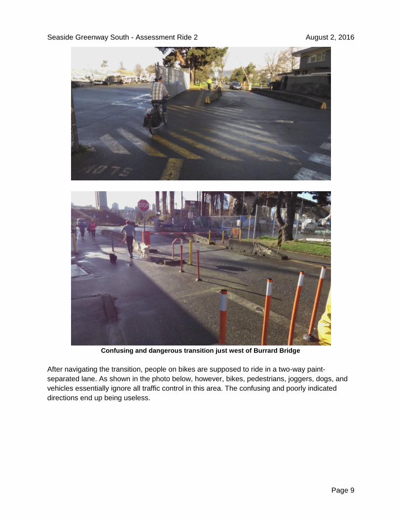
After passing through the bollards, people on bikes are required to navigate a confusing and
narrow section. There are bollards, painted lanes, concrete barriers, turning vehicular traffic,
occasional people moving boats, and pedestrians. Fortunately the section is short, but it has no
redeeming qualities at all.
Seaside Greenway South - Assessment Ride 2 August 2, 2016
Page 9
Confusing and dangerous transition just west of Burrard Bridge
After navigating the transition, people on bikes are supposed to ride in a two-way paint-
separated lane. As shown in the photo below, however, bikes, pedestrians, joggers, dogs, and
vehicles essentially ignore all traffic control in this area. The confusing and poorly indicated
directions end up being useless.

Seaside Greenway South - Assessment Ride 2 August 2, 2016
Page 10
Parking lot west of Burrard Bridge. No indication of where to go, leading to people everywhere
Further, at the end of the short lane, people on bikes (who chose to actually use the lane) are
faced with a dangerous transition that requires them to cross vehicle traffic from a non-standard
location. There are no signs indicating where bikes should go, or even what options are
available.
A better solution for this section would be to immediately route pedestrians and bikes to the
north side of the parking lot. This would allow vehicles to turn into the boat yard without crossing
the bike path, and it would put the cyclists on the proper side of the road. Ideally, cyclists should
be then directed to a separated bike path along the waterfront, parallel to the existing pedestrian
path, avoiding the need to proceed through the parking lot at all.
After crossing through the stop sign at Whyte Avenue, people on bikes are left to their own
devices. They need to navigate a parking lot for Vanier Park and figure out how to transition on
to the gravel multi-use path. The parking lot is relatively busy with vehicles, often towing boat
trailers; pedestrians; people walking boats to the boat launch; and vehicles using the boat
launch. It is, frankly, chaotic. It violates every principle of an AAA facility. Note that the
Vancouver Bike Map labels the whole Seaside Greenway as AAA
Seaside Greenway South - Assessment Ride 2 August 2, 2016
Page 11
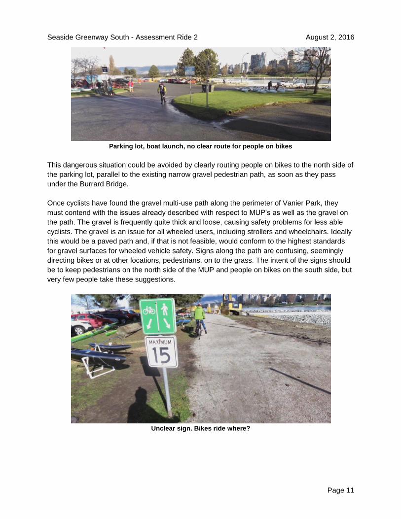
Parking lot, boat launch, no clear route for people on bikes
This dangerous situation could be avoided by clearly routing people on bikes to the north side of
the parking lot, parallel to the existing narrow gravel pedestrian path, as soon as they pass
under the Burrard Bridge.
Once cyclists have found the gravel multi-use path along the perimeter of Vanier Park, they
must contend with the issues already described with respect to MUP’s as well as the gravel on
the path. The gravel is frequently quite thick and loose, causing safety problems for less able
cyclists. The gravel is an issue for all wheeled users, including strollers and wheelchairs. Ideally
this would be a paved path and, if that is not feasible, would conform to the highest standards
for gravel surfaces for wheeled vehicle safety. Signs along the path are confusing, seemingly
directing bikes or at other locations, pedestrians, on to the grass. The intent of the signs should
be to keep pedestrians on the north side of the MUP and people on bikes on the south side, but
very few people take these suggestions.
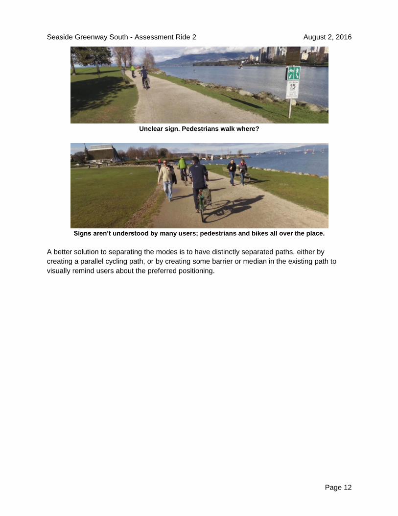
Unclear sign. Bikes ride where?
Seaside Greenway South - Assessment Ride 2 August 2, 2016
Page 12
Unclear sign. Pedestrians walk where?
Signs aren’t understood by many users; pedestrians and bikes all over the place.
A better solution to separating the modes is to have distinctly separated paths, either by
creating a parallel cycling path, or by creating some barrier or median in the existing path to
visually remind users about the preferred positioning.
Seaside Greenway South - Assessment Ride 2 August 2, 2016
Page 13
Hadden Park and Kitsilano Beach Park
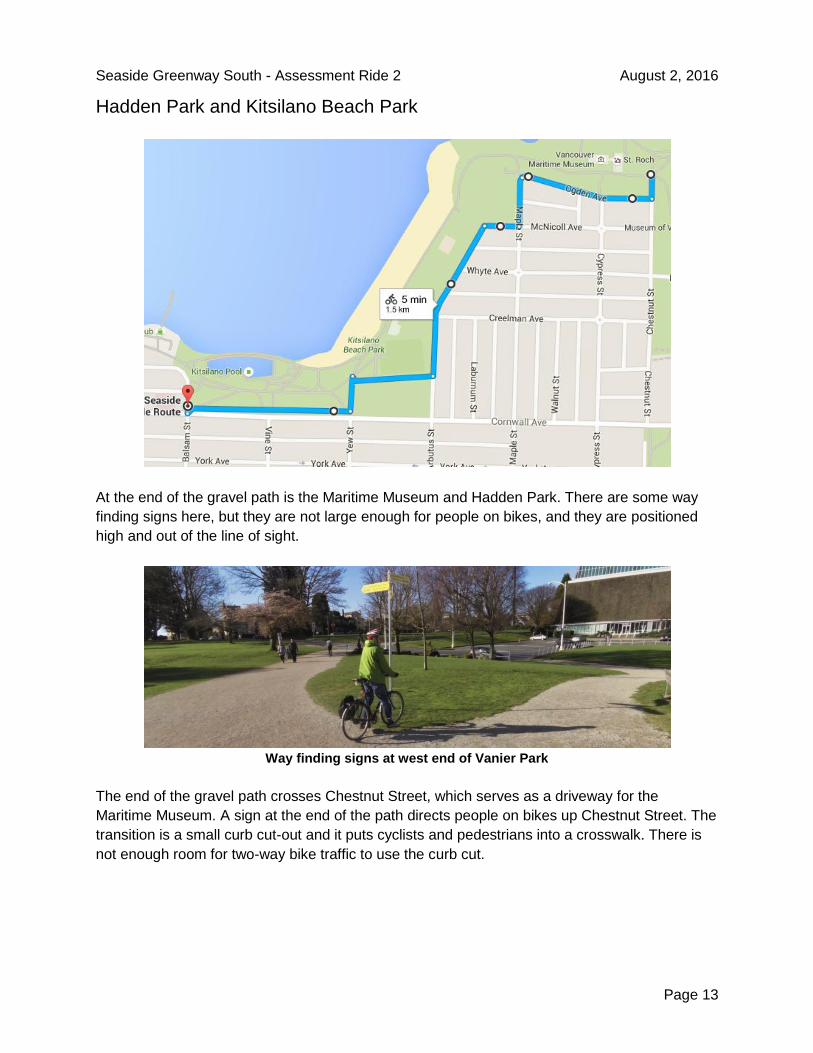
At the end of the gravel path is the Maritime Museum and Hadden Park. There are some way
finding signs here, but they are not large enough for people on bikes, and they are positioned
high and out of the line of sight.
Way finding signs at west end of Vanier Park
The end of the gravel path crosses Chestnut Street, which serves as a driveway for the
Maritime Museum. A sign at the end of the path directs people on bikes up Chestnut Street. The
transition is a small curb cut-out and it puts cyclists and pedestrians into a crosswalk. There is
not enough room for two-way bike traffic to use the curb cut.

Seaside Greenway South - Assessment Ride 2 August 2, 2016
Page 14
Sign indicates bike route goes up Chestnut Street
The official Vancouver Bike Map, however, shows the bike route continuing, separated, along
the shore. There are several problems with this. The reality indicates no such thing. The path
which some people on bikes do use is very narrow and full of pedestrians and people walking
dogs (there is a nearby dog park).
Bike map indicates bike route continues through park
There are constant conflicts on this path. In fact, the path is so narrow and there are so many
conflicts that a cycling and walking desire line has developed parallel to the paved path. This is
not an AAA facility.

Seaside Greenway South - Assessment Ride 2 August 2, 2016
Page 15
Multi-use path through Hadden Park with parallel desire line
The alternative to taking this narrow path is following the signs and going up Chestnut Street
and along Ogden Avenue. Riding along the road here is a good alternative during the off
season. When traffic volume is low, the road is wide, and there is only parking along one side of
the street. Traffic volumes would need to be monitored in the high season and likely there
should be a protected path along here to create a true AAA facility.
On-road alternative to bypass Hadden Park
Transitioning from Hadden Park to the eastern part of Kitsilano Beach Park requires either
following the narrow path down the hill to continue along the even-more-crowded beachside
narrow path, or to ride along Maple Street and Arbutus Street. Neither of these options are good
or AAA. The beachside path is too narrow to support the volume of pedestrians let alone a
significant number of people on bikes. In fact, during the summer, temporary signs are erected
along a portion of this path prohibiting people from riding bicycles.
Travelling along the road here can be frightening and dangerous. Vehicles are parked on both
sides of the street, and are often pulling in or out of parking spots as people visit or leave the
beach. Drivers searching for parking do not seem as careful about looking out for people on
bikes. Drivers pulling out of parking spots do not seem very careful about checking for passing
bikes.
Seaside Greenway South - Assessment Ride 2 August 2, 2016
Page 16
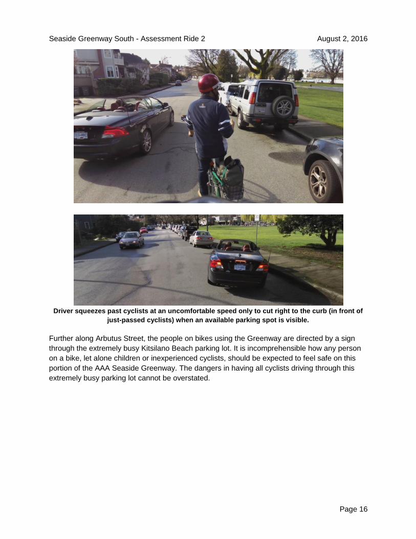
Driver squeezes past cyclists at an uncomfortable speed only to cut right to the curb (in front of
just-passed cyclists) when an available parking spot is visible.
Further along Arbutus Street, the people on bikes using the Greenway are directed by a sign
through the extremely busy Kitsilano Beach parking lot. It is incomprehensible how any person
on a bike, let alone children or inexperienced cyclists, should be expected to feel safe on this
portion of the AAA Seaside Greenway. The dangers in having all cyclists driving through this
extremely busy parking lot cannot be overstated.

Seaside Greenway South - Assessment Ride 2 August 2, 2016
Page 17
Sign showing bike route through parking lot
Riding on the Seaside Greenway through another parking lot
In an effort to avoid the parking lot, some pedestrians and people on bikes had been taking a
more convenient off-road path north of the parking lot. When the assessment ride occurred, two
large logs had been staked into the ground across this desire line. It was interesting to note that
the logs do not serve any purpose whatsoever (we observed joggers, pedestrians, and people

Seaside Greenway South - Assessment Ride 2 August 2, 2016
Page 18
on bikes simply going around them) and the damage caused by the heavy machinery in placing
the logs was far greater than the damage of the desire line.
Desire line used to avoid dangerous parking lot route dangerously barricaded, decreasing safety
for people on bikes and pedestrians
The solution to these problems is to create a separated path for people on bikes. The volume of
foot traffic along the beach is too large to safely support cycling. The volume of vehicle traffic
along the road is too large to safely support all ages and abilities cycling. A separated facility,
running parallel to the road, out of traffic, avoiding the parking lot, is a good solution.
Once in the southern part of Kitsilano Beach Park, the Greenway continues along narrow
shared paths, leading to the busy intersection at Yew Street, and along the north side of
Cornwall Avenue.
Major conflict point at Yew Street intersection where pedestrians and people on bikes cross at a
narrow pinch point

Seaside Greenway South - Assessment Ride 2 August 2, 2016
Page 19
Narrow, limited-visibility MUP along south edge of Kitsilano Beach Park
At the western end of the park, this narrow MUP ends at the Balsam Street/Cornwall Avenue
intersection. The path becomes sidewalk at that point. Getting on the path eastbound requires
crossing the north side of the intersection in a manner that vehicles don’t expect, with quite a bit
of danger from unaware vehicles turning northbound on to Balsam, and causing conflicts with
vehicles already on Balsam. The danger, real and perceived, at this intersection leads to a lot of
conflict and sidewalk riding.
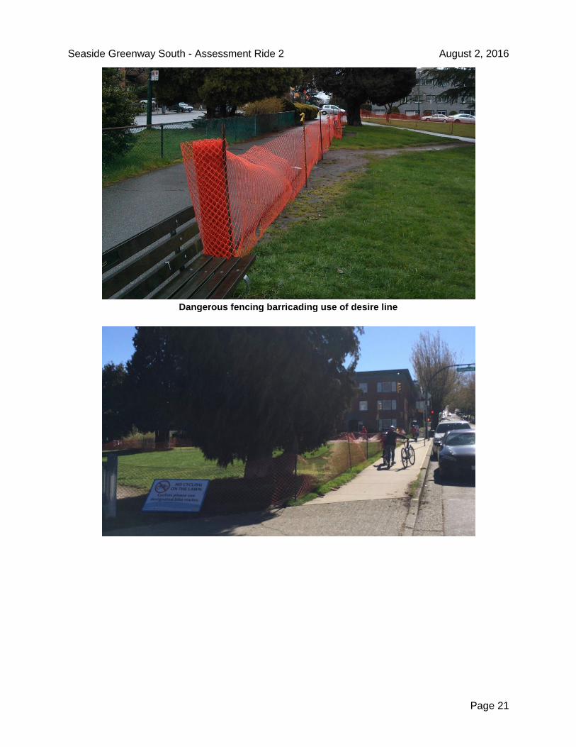
To avoid this dangerous, poorly thought-out intersection, many people on bikes as well as
pedestrians and joggers have created a desire line path. In the fall of 2015, the Vancouver Park
Board erected a fence to prevent use of this desire line, and put up a sign commanding cyclists
to use the dangerous path (overlooking the fact that the desire line was being used by joggers
and pedestrians too).
At the time of this assessment ride, persons unknown had removed the fence, and the desire
line was used by people on bikes and people on foot.

Seaside Greenway South - Assessment Ride 2 August 2, 2016
Page 20
Desire line used by people on foot and people on bikes to avoid dangerous Balsam Street
intersection
A week after the assessment ride, the fence and sign was back in place, and confused,
dangerous riding resulted.
Seaside Greenway South - Assessment Ride 2 August 2, 2016
Page 21
Dangerous fencing barricading use of desire line

Seaside Greenway South - Assessment Ride 2 August 2, 2016
Page 22
Desire line barricade leads to high risk behaviour, decrease in safety, comfort
The fence should be removed. Impeding access to the desire line significantly increases the
danger to people on bikes, people on foot, and drivers. The desire line path has existed for
years and should be formalized. Desire lines reflect bad design, not bad behaviour.
Point Grey Road, Balsam St to Trafalgar St
The small section of Point Grey Road between Balsam Street and Trafalgar Street is another
on-street stretch of the Greenway. In the original plans for improving the Point Grey Road
stretch of the Seaside Greenway in 2014, a separate bicycle track was indicated for this stretch
of road. In the final implementation, however, the separate lane was not built. In fact, this
section of road saw no improvements at all.

Seaside Greenway South - Assessment Ride 2 August 2, 2016
Page 23
The road is characterized with low traffic volume, and wide lanes, but with parking on both
sides. It is not up to AAA standards, but the low traffic volume makes the road feel reasonably
safe. Given the width of the road, and the low traffic volume, this section of road is a perfect
candidate for a separated cycle track.
Point Grey Road; wide, low traffic volume, with parking on both sides
Summary
In general, the Seaside Greenway from the Burrard Bridge to Trafalgar Street has a significant
number of sections with serious safety concerns. The route purports to be built to All Ages and
Abilities standards, but forces people on bicycles through two busy parking lots. The parts of the
route that are not on the road or in parking lots are narrow multi-use paths with no separation or
signs indicating the preferred travel paths. Conflicts between people on bikes, people on foot,
and vehicles occur along almost the whole length of this section. At Kitsilano Beach Park, it
seems that measures have been purposefully taken that actually decrease safety.
The major issues identified include:
● Barricades across desire lines that people on bikes and people on foot have created to
increase their own safety. These barricades should be removed immediately,
recognising that desire lines reflect bad design, not bad behaviour.
● AAA facilities should never run through parking lots. The Greenway runs through two
busy parking lots, which is incredibly uncomfortable and unsafe.
● Mixed-use paths without separation and markings indicating where to walk and where to
bike lead to confusion and conflict.
● In many locations the path is too narrow to adequately handle the volume of combined
pedestrian and bicycle traffic.
● There are insufficient way finding signs, indicating points of interest, destinations, other
bike routes, how far they are, and how to get to them