Embed Size (px)
Citation preview

Federal Department of Home Affairs FDHAFederal Office of Meteorology and Climatology Mete oSwiss
Seamless nowcastingINCAINCA
Open issues
Pierre EckertMatteo Buzzi , Marco Sassi, Guido della Bruna, Marco Gaia
Nowcasting, various approaches
• Nowcasting and very short range forecasting
2

3

TRT
• Convective cells• Pattern recognition and characterization (cloud top, VIL,
lightning activity,…)lightning activity,…)• Extrapolation to 60 minutes• Possibility to diagnose stage of maturity of TS
4

5

TRT
• Is used with some success• Automated thunderstorm warnings per location
• Not able to diagnose onset of TS• Extrapolation has limits over complex topography• Could be better by using NWP winds (…???...)
6

INCA
• Integrated Nowcasting through Comprehensive Analysis
• Analysis, extrapolation and blending system for various • Analysis, extrapolation and blending system for various parameters
• Different methods for each parameter• Developed with / adapted from ZAMG• Recent inclusion of COSMO-1
7

Motivation: nowcasting window
ER
RO
RNot every observation can be successfully assimilated (ass. system, representativeness, resolution,…), time update
ER
RO
R
NWP
representativeness, resolution,…), time offset, update cycle
Combinates NWP with observationin a very rapid update cycle: adaptation of NWP data
INCA
offset
8
3h 6h
NEEDS: very accurate, high frequency update
OBS
adaptation of NWP data
0h

Overview: seamless nowcasting system
radar datasurface stationsNWP:COSMO-1
Very rapid update frequency: 10 minutes
3 radiometer
1km grid+topo, CH gridINCA-
temperature and humidity analysis
temperarure forecastBlending between
0 6 h31 2 4 5
100% COSMO-1
COSMO-1 on INCA gridobservations
COSMO-1 on INCA grid
temperaturenowcast
0% COSMO-1
satellite (SAF NWC)
9
humidity analysis Blending between (Analysis+COSMO tendencies) and COSMO
exponential blending
precipitation analysis
precipitationextrapolation
precipitation forecastBlending between extrapolation and COSMO
100% ANA+ COSMO tendencies
linear blending
precipitation forecast COSMO
100% COSMO-1100% Extrapolation
windanalysis
wind forecastBlending between analysis and COSMO
linear blending
nowcast
Rain and snow

Overview: seamless nowcasting system 2
radar datasurface stationsNWP:COSMO-2
Very rapid update frequency: 10 minutes
3 radiometer
1km grid+topo, CH gridINCA-
convective analysis
0COSMO-2 on INCA gridObservations, INCA
0% COSMO-1
CAPE, CIN, MC (moisture convergence), PW (precipitable water)
satellite (SAF NWC)
6 h31 2 4 5
INCA UV, RH, TT
10
analysis
cloud analysis
height of new snow analysis
CAPE, CIN, MC (moisture convergence), PW (precipitable water)
CT (cloud type), CTH (cloud top height), CT-MCH, CC (cloud cover), SP (sunshine)
24h snow accumulation (cm): temperature dependent density and settlement
surface icing potential analysis
Surface icing potential forecast

Temperature and humidity analysisCOSMO-1, model levels (80-13)
3D ANALYSIS
SYNOP,SMN, NABEL, KANT, MM, Pseudosoundings
First guess @ INCA levels Surface Analysis
temperature, specific humidity,(snowfall line, zero degree level)
SLji
COSMOjiji
kzmjiCOSMO
zmjizmji
TMTMT
TTT
,,,
),(,,)(,,)(,,
22 ∆+=
∆+=Horizontal resolution: 1.1 km � 1 km
Vertical resolution: 100 m vertical up to 4500 m
interpolation
11
jijiji TMTMT ,,, 22 ∆+=100 m vertical up to 4500 m500m from 4500 to 11000m
TT,TD,RH,Z0,ZS (1h,10min)Temperature, humidity, zero degree level, snowfall line

Temperature and humidity forecastCOSMO-1, model levels (80-13), hourly, 1.1 km � 1 km (100 m vertical)
0 62
temperarure forecasttemperature nowcast
100% ANA+ COSMO tendencies
0 6100% COSMO-10% COSMO-1 100% ANA + tendency
2
Blending between (Analysis+COSMO tendencies) and COSMO
12
and COSMO
TT,TD,RH,Z0,ZS (1h,10min)Temperature, humidity, zero degree level, snowfall line
TT,TD,RH,Z0,ZS (1h,10min)Temperature, humidity, zero degree level, snowfall line

10 m wind nowcast
0 6 h
Nowcasting
Analysis nowcast with linear blending
0 6 h100% COSMO-1
COSMO-1Observations
COSMO-1 interpolated, hourly, 1.1 km � 1 km (100 m vertical)
0% COSMO-1
13
Analysis nowcast with linear blending
UU,VV, FF, DD (1h,10min)wind speed and direction
UU,VV, FF, DD (1h,10min)wind speed and direction
• Model correction with weights and distances around stations
• Divergence reduction procedure

Precipitation nowcast
0 1 4 h100%
COSMO-10%
COSMO-1
Nowcasting
3.550-50%
analysis extrapolation blending
RADAR: 10min acc.Raingauges: 10min acc.Temperature INCA Humidity INCA
Movement: radar, U V COSMO-1Temperature INCAHumidity INCA
COSMO-1COSMO-1
COSMO-1 radar, U V COSMO-1,10minTemperature INCA, hourlyHumidity INCA, hourly
14
analysis extrapolation blendingExtrapolation+COSMO
RR, RS, PT(rain,rain-snow,snow,freezing rain)
RR, RS, PT(rain,rain-snow,snow,freezing rain)
RR, RS, PT(rain,rain-snow,snow,freezing rain)
• Image comparison (3 images, 30min)• Per pixel linear motion vectors• Vectors corrected with COSMO-1 wind • linear
• Radar correction in a circle around station
• Altitude dependent interpol.
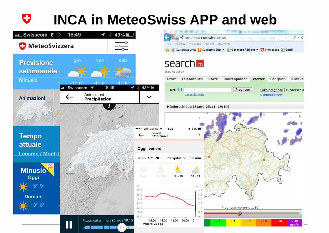
INCA in MeteoSwiss APP and web websites
15

Radar QPE
CombiPrecip
Past observed rainfall Future forecast rainfall INCA
INCA as input for NOWPAL
Total rainfall fieldfor visualization
Alert bulletin with map of alerted regions
NowPALInput products, temporal accumulations, regions, alert thresholds, latency time
and regional evaluation statistics are configurable.
16
Forecasters for official warnings Specific customers (SMS, e-mail, xml)

Dynamical postprocessing1d model (fog)
Turbulent mixing
Radiative transfer
4d model
Local
17
Surface
Surface-atmosphere transfer
Local observations

Dynamical postprocessing1d model (fog)
18

Effective for 1-2 hours
Calibration
IVS ?
19
IVS ?
Apart hydrology, no striking success (?)
+EnDA, 2025

Discussion
• Rapid update analysis seems in view• Every hour• Available xy minutes after observations (x > 0)• Available xy minutes after observations (x > 0)
• Integration of more frequent observations: radar, satellites, visibility, ceiling, lightning, wind profiler,…
• Parameter specific methods do not necessarily have coherence
20
Strong bridge between models and postprocessing
Grazie per l’attenzione