Embed Size (px)
Citation preview

The Sea of Verrazano
By Eliane Dotson Old World Auctions
Giovanni da Verrazano (or Verrazzano) (1485-1528) was born near Florence, Italy, and settled in the port city of Dieppe, France around 1506. His first voyage to the Americas was on board the ship La Pensee, captained by Thomas Aubert, who explored the region around Newfoundland. After the circumnavigation of the globe by Ferdinand Magellan's crew, there was increased pressure for France to enter the lucrative trade business and compete with Spain and Portugal. In 1523, King Francis I commissioned Verrazano to set sail for the new world and explore the region between Florida and Newfoundland, with the purpose of finding a sea route to the Pacific Ocean. The following year, aboard the ship La Dauphine with sufficient provisions for an eight-month voyage, Verrazano headed for the Americas. Around March 1, 1524, Verrazano's ship landed near Cape Fear, North Carolina, around 34 degrees north. After a brief stay, he headed north along the Outer Banks, which Verrazano described as "an isthmus a mile in width and 200 long." Beyond the Outer Banks Verrazano was able to see Pamlico Sound, the largest lagoon along the eastern coast of the US. Verrazano mistook the Pamlico and Albemarle Sounds as the Pacific Ocean, and thus the myth of the Sea of Verrazano began. In a letter to King Francis I, Verrazano describes this body of water:
"From the ship, was seen the oriental sea between the west and north. Which is the one, without doubt, which goes about the extremity of India, China and Cathay. We navigated along the said isthmus with the continual hope of finding some strait or true promontory at which the land would end toward the north in order to be able to penetrate to those blessed shores of Cathay. To which isthmus was given by the discoverer [the name] Verrazanio: as all the land found was named Francesco for our Francis."
Despite the existence of inlets to Pamlico and Albemarle Sounds, Verrazano likely overlooked them due to the coastal shoals in the area. Verrazano continued north past the Outer Banks, and although he also missed the entrances to the Chesapeake Bay and Delaware Bay, he became the first European to enter New York Bay and the Hudson River and describe them in detail. His ship again ventured north to Narragansett Bay, making landfall in Newport before heading to Cape Breton and Newfoundland. With his provisions dwindling, Verrazano decided to end the journey and headed back to Dieppe, France, arriving in early July, 1524. Although he didn't succeed in finding a passage to the Pacific, Verrazano's geographical and topological description of his expedition remains the earliest known report of a continuous voyage along the eastern coast of North America. His crew frequently saw fires along the shore and other signs of Native Americans, and made landfall on numerous occasions to explore the land. They experienced encounters with several different Native American tribes, which Verrazano described in his report along with information on the flora and fauna. Most of the encounters were friendly with the exchanging of gifts, but Verrazano describes one tribe, believed to be around the coast of Maine, to be "full of crudity and vices, and were so barbarous that we could never
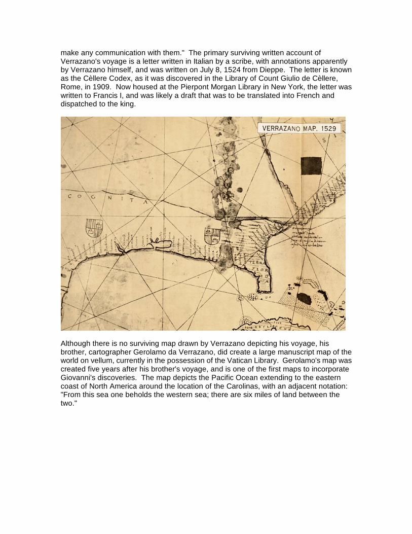
make any communication with them." The primary surviving written account of Verrazano's voyage is a letter written in Italian by a scribe, with annotations apparently by Verrazano himself, and was written on July 8, 1524 from Dieppe. The letter is known as the Cèllere Codex, as it was discovered in the Library of Count Giulio de Cèllere, Rome, in 1909. Now housed at the Pierpont Morgan Library in New York, the letter was written to Francis I, and was likely a draft that was to be translated into French and dispatched to the king.
Although there is no surviving map drawn by Verrazano depicting his voyage, his brother, cartographer Gerolamo da Verrazano, did create a large manuscript map of the world on vellum, currently in the possession of the Vatican Library. Gerolamo's map was created five years after his brother's voyage, and is one of the first maps to incorporate Giovanni's discoveries. The map depicts the Pacific Ocean extending to the eastern coast of North America around the location of the Carolinas, with an adjacent notation: "From this sea one beholds the western sea; there are six miles of land between the two."

One of the earliest printed maps to depict the Sea of Verrazano is Sebastian Munster's map of the New World (along with his corresponding world map). The map was issued in Munster's edition of Ptolemy's Geographia from 1540 to 1578. The map depicts a large sea that nearly bisects North America, although the sea remains unnamed. Munster's Geographia proved to be very successful, appearing in forty editions and making this map one of the most widely circulated maps of the New World at the time. As a result, Munster's map served to popularize the belief in a Northwest Passage, thereby encouraging more exploration of the area by both the French and the British.

Another printed example of the Sea of Verrazano appears on Michael Lok's map of North America from 1582, published in Richard Hakluyt's rare publication, Divers Voyages Touching the Discoverie of America. It is believed that Lok used Gerolamo de Verrazano's manuscript. In the dedication, Hakluyt explains the source of the map as: "an old excellent mappe, which he [Verrazano] gave to king Henrie the eight, and is yet in the custodie of master Locke." The map clearly depicts the Pacific extending nearly to the Atlantic Ocean, separated only by a narrow isthmus around the 40th parallel north. At its closest point to the Atlantic, the sea is labeled "Mare de Verrazana 1524." Although Verrazano's sea had already been largely discredited, Lok's motivation in depicting it was due to his leadership in the movement to stimulate English colonization of the New World. Verrazano's Sea served as a promise of an easier passage to the Orient, a lucrative proposition for the British. Lok's map was one of the reasons that Roanoke Island, between Pamlico Sound and Albemarle Sound, was selected as the site for a new British colony, established by Sir Walter Raleigh in 1584. Appearances of the false Sea of Verrazano appeared on maps for nearly 100 years, due primarily to three factors. First and foremost was a lack of exploration of the area. Distance, cost, rough seas, hostile Natives, the challenge of navigating an unknown land, and other elements all contributed to a deficiency of knowledge of the New World. Wishful thinking on the part of Europeans was clearly a second factor. The French and British in particular, who did not have routes to access the lucrative trade industry in the East, hoped for a way to gain access to trade. The third factor was politics, since perpetuating the myth allowed those promoting colonial expansion to secure investors and gain charters from a sovereign. Although Verrazano's expedition did not succeed in

its ultimate goal of finding a Northwest Passage, it did serve an important purpose in encouraging exploration and colonization of the New World. Maps depicting the false Sea of Verrazano epitomize the evolving awareness of the geography of the Americas. References: Baynton-Williams, Ashley, Geographical Misconception: The False Sea of Verrazzano, MapForum Issue 1, London, Spring 2004. Burden, Philip, The Mapping of North America, Raleigh Publications, London, 1996. Cumming, W. P., The Southeast in Early Maps, The University of North Carolina Press, Chapel Hill, 1973. Cumming, W. P., Skelton, R. A., & Quinn, D. B., The Discovery of North America, American Heritage Press, New York, 1972. Fite, Emerson D. & Freeman, Archibald, A Book of Old Maps, Arno Press, New York, 1969. Nebenzahl, Kenneth, Atlas of Columbus and the Great Discoveries, Rand McNally, Genoa, Italy, 1990. William F. E. Morley, Verrazzano, Giovanni da, in Dictionary of Canadian Biography, vol. 1, University of Toronto/Université Laval, 2003–, accessed March 12, 2015, http://www.biographi.ca/en/bio/verrazzano_giovanni_da_1E.html.


![Bailly’s Globe [Verrazano Globe] #351€¦ · Bailly’s Globe [Verrazano Globe] #351 2 Only a year after the Girolamo de Verrazano map was made (#347), Robert de Bailly constructed](https://img.dokumen.tips/doc/110x75/5eade5526a947c2e1c4a675a/baillyas-globe-verrazano-globe-351-baillyas-globe-verrazano-globe-351.jpg)