Embed Size (px)
Citation preview

SCOPING REPORT – AL-FAISAL COLLEGE
REQUEST FOR SECRETARY’S ENVIRONMENTAL
ASSESSMENT REQUIREMENTS (SEARs)
Al-Faisal College, Liverpool – Primary and Secondary School
No.83 - 87 and No.80 Gurner Avenue, Austral
Prepared for: Al-Faisal College
REF: M160429
DATE: 19 March 2020
Request for Secretary’s Environmental Assessment Requirements (SEARs)
Planning Ingenuity Pty Ltd REF: M160429 i
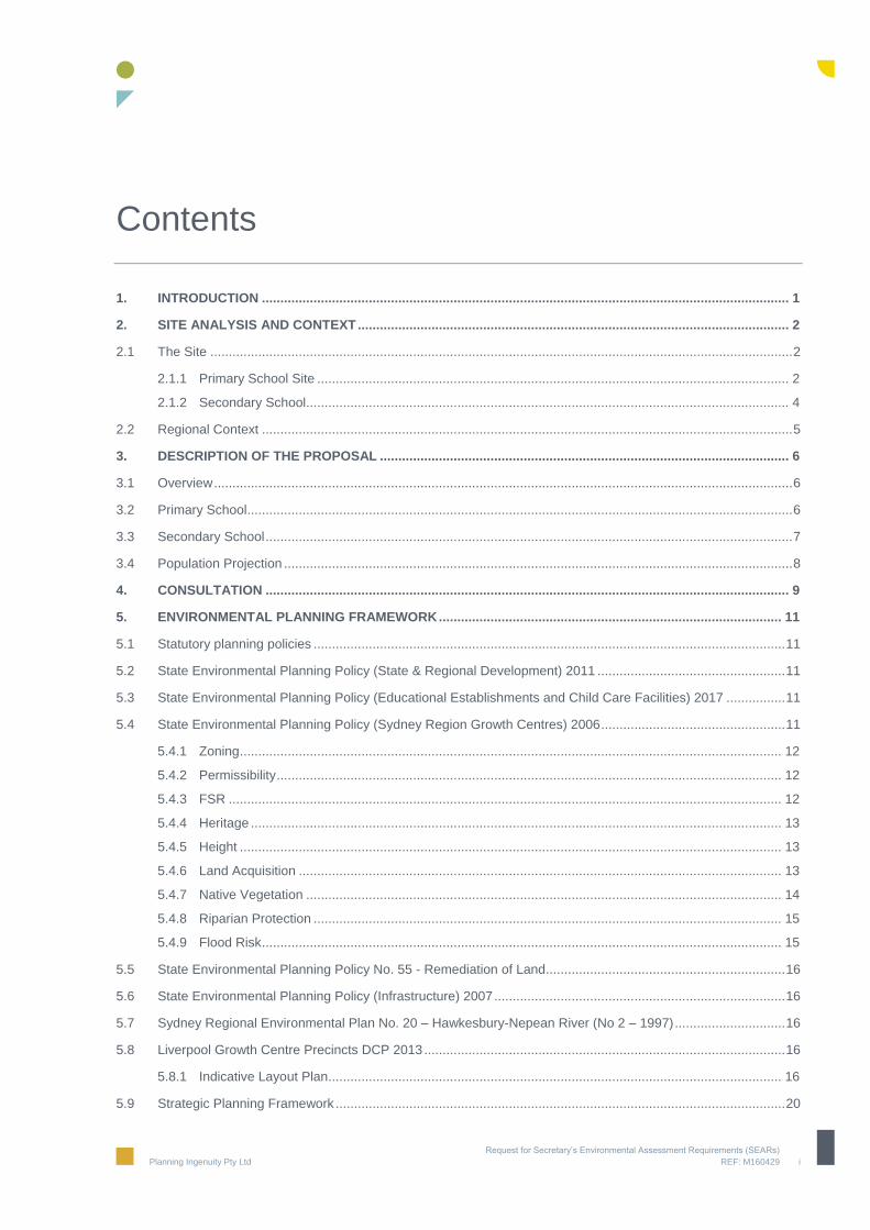
Contents
1. INTRODUCTION ............................................................................................................................................... 1
2. SITE ANALYSIS AND CONTEXT ..................................................................................................................... 2
2.1 The Site .............................................................................................................................................................. 2
2.1.1 Primary School Site ................................................................................................................................ 2
2.1.2 Secondary School ................................................................................................................................... 4
2.2 Regional Context ................................................................................................................................................ 5
3. DESCRIPTION OF THE PROPOSAL ............................................................................................................... 6
3.1 Overview ............................................................................................................................................................. 6
3.2 Primary School .................................................................................................................................................... 6
3.3 Secondary School ............................................................................................................................................... 7
3.4 Population Projection .......................................................................................................................................... 8
4. CONSULTATION .............................................................................................................................................. 9
5. ENVIRONMENTAL PLANNING FRAMEWORK ............................................................................................. 11
5.1 Statutory planning policies ................................................................................................................................ 11
5.2 State Environmental Planning Policy (State & Regional Development) 2011 ................................................... 11
5.3 State Environmental Planning Policy (Educational Establishments and Child Care Facilities) 2017 ................ 11
5.4 State Environmental Planning Policy (Sydney Region Growth Centres) 2006 .................................................. 11
5.4.1 Zoning ................................................................................................................................................... 12
5.4.2 Permissibility ......................................................................................................................................... 12
5.4.3 FSR ...................................................................................................................................................... 12
5.4.4 Heritage ................................................................................................................................................ 13
5.4.5 Height ................................................................................................................................................... 13
5.4.6 Land Acquisition ................................................................................................................................... 13
5.4.7 Native Vegetation ................................................................................................................................. 14
5.4.8 Riparian Protection ............................................................................................................................... 15
5.4.9 Flood Risk ............................................................................................................................................. 15
5.5 State Environmental Planning Policy No. 55 - Remediation of Land ................................................................. 16
5.6 State Environmental Planning Policy (Infrastructure) 2007 ............................................................................... 16
5.7 Sydney Regional Environmental Plan No. 20 – Hawkesbury-Nepean River (No 2 – 1997) .............................. 16
5.8 Liverpool Growth Centre Precincts DCP 2013 .................................................................................................. 16
5.8.1 Indicative Layout Plan ........................................................................................................................... 16
5.9 Strategic Planning Framework .......................................................................................................................... 20

Request for Secretary’s Environmental Assessment Requirements (SEARs)
Planning Ingenuity Pty Ltd REF: M160429 ii
6. PRELIMINARY ASSESSMENT ....................................................................................................................... 22
6.1 Transport and Accessibility ............................................................................................................................... 22
6.2 Built Form and Urban Design ............................................................................................................................ 22
6.3 Staging .............................................................................................................................................................. 22
6.4 Bushfire ............................................................................................................................................................. 22
6.5 Noise and vibration ........................................................................................................................................... 22
6.6 Biodiversity ....................................................................................................................................................... 23
6.7 Waste ................................................................................................................................................................ 23
6.8 Stormwater Management and Flooding ............................................................................................................ 23
6.9 Social Impacts ................................................................................................................................................... 23
6.10 BCA and access ............................................................................................................................................... 23
6.11 Construction Management ................................................................................................................................ 24
6.12 Aboriginal heritage ............................................................................................................................................ 24
6.13 Safety and security ........................................................................................................................................... 24
6.14 Environmentally sustainable development ........................................................................................................ 24
6.15 Consultation ...................................................................................................................................................... 24
7. CONCLUSION ................................................................................................................................................. 25
FIGURES
Figure 1 Aerial Photo of Primary School Site (Source: Google Maps) ......................................................................... 2
Figure 2 Approved staging plan .................................................................................................................................... 3
Figure 3 Aerial Photo of Secondary School Site (Source: Six Maps) ........................................................................... 4
Figure 4 Site Context Plan (Source: PMDL Architecture + Design using Sixmaps.com.au information from ILP) ....... 5
Figure 5 Proposed Primary School Site (Source: PMDL Architects) ............................................................................ 7
Figure 6 Proposed Secondary Schools Site (Source: PMDL Architects) ...................................................................... 8
Figure 7 Zoning Map - Extract (Source: eplanning.liverpool.nsw.gov.au) .................................................................. 12
Figure 8 Building Height Map- Extract (Source: eplanning.liverpool.nsw.gov.au) ...................................................... 13
Figure 9 Land Reservation Acquisition Map- Extract (Source: eplanning.liverpool.nsw.gov.au) ................................ 14
Figure 10 Native Vegetation Protections Map – Extract (Source: legislation.nsw.gov.au) ......................................... 14
Figure 11 Riparian Protection Map – extract (Source: legislation.nsw.gov.au) ........................................................... 15
Figure 12 Flood Inundation Map- Extract (Source: eplanning.liverpool.nsw.gov.au) .................................................. 15
Figure 13 Indicative Layout Plan Map- Extract (Source: eplanning.liverpool.nsw.gov.au) ......................................... 17

Request for Secretary’s Environmental Assessment Requirements (SEARs)
Planning Ingenuity Pty Ltd REF: M160429 iii
Figure 14 Planning Proposal by Liverpool City Council - Amendment to Indicative Layout Plan................................ 18
Figure 15 Proposed Road Layout Plan – Primary School Site ................................................................................... 19
Figure 16 Proposed Road Layout Plan – Primary School Site ................................................................................... 20
©This document and the research reported in it remains the property of Planning Ingenuity Pty Ltd and are protected by copyright. Apart from fair
dealings for the purposes of private study, research or review, as permitted under the Copyright Act 1968, no part of the document may be reproduced,
by any process, without the written permission of the author. All inquiries in this regard are to be directed to the Managing Director, Planning Ingenuity
Pty Ltd.

Request for Secretary’s Environmental Assessment Requirements (SEARs)
Planning Ingenuity Pty Ltd REF: M160429 1
1. Introduction
This report has been prepared to request Secretary’s Environmental Assessment Requirement (SEARs) to guide the
preparation of a State Significant Development Application (SSDA) for major alterations and additions to the existing
primary and secondary school at No. 83 – 87 Gurner Avenue for use as a primary school and erection of a new
secondary school at No.80 Gurner Avenue, Austral (the site).
This report is prepared by Planning Ingenuity on behalf of Al-Faisal College (the Proponent). The report relies on
concept plans prepared by PMDL Architecture + Design.
The proposed development is identified as a State Significant Development as it falls within the requirements of
Clause 15 (“Educational Establishments”) of Schedule 1 of the State Environmental Planning Policy (State and
Regional Development) 2011, being “development that has a capital investment value of more than $20 million for
the purpose of alterations or additions to an existing school”.
The proposed site forms part of the western growth corridor that sees a growing demand for public infrastructure
including schools. Al-Faisal’s vision is to build a primary school (K-6) and a secondary school (7-12) within Liverpool
LGA accommodating up to 5,460 students to meet the growing need for an educational institute which services its
local community in the same faith and culture. The project construction will be staged as the school’s population
grows to its maximum capacity.
The schools are to accommodate the following:
Primary Teaching and Learning;
Secondary Teaching and Learning;
Library and Support facilities;
Administration & Staff areas;
Communal/multi-purpose spaces, lecture spaces;
Amenities & sports fields;
Underground and above ground car parking; and
Drop off/pick up area & bus layback.
Section 3 of this report provides a more detailed description of the proposed work.
This report is accompanied by the following supporting information:
Architectural Concept Plans - prepared by PMDL Architecture + Design; and
Quantity Surveyors Report - prepared by WT Partnership.
The purpose of this report is to provide information to the Department of Planning, Industry and Environment (DPIE)
to support the preparation of SEARs for the SSDA. This Statement is divided into six sections. The remaining
sections include a locality and site analysis; a description of the proposal; an outline of the relevant planning
framework, a preliminary environmental planning assessment; and a conclusion.
Request for Secretary’s Environmental Assessment Requirements (SEARs)
Planning Ingenuity Pty Ltd REF: M160429 2
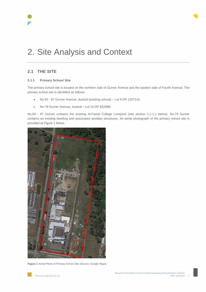
2. Site Analysis and Context
2.1 THE SITE
2.1.1 Primary School Site
The primary school site is located on the northern side of Gurner Avenue and the eastern side of Fourth Avenue. The
primary school site is identified as follows:
No.83 - 87 Gurner Avenue, Austral (existing school) – Lot 9 DP 1207216
No.79 Gurner Avenue, Austral – Lot 14 DP 831988;
No.83 - 87 Gurner contains the existing Al-Faisal College Liverpool (see section 2.1.1.1 below). No.79 Gurner
contains an existing dwelling and associated ancillary structures. An aerial photograph of the primary school site is
provided at Figure 1 below.
Figure 1 Aerial Photo of Primary School Site (Source: Google Maps)

Request for Secretary’s Environmental Assessment Requirements (SEARs)
Planning Ingenuity Pty Ltd REF: M160429 3
2.1.1.1 Existing School
Al-Faisal College Liverpool currently occupies Nos. 83 - 87 Gurner Avenue as a K-12 school with a current student
enrolment of 778 with classes currently in K-10 and approved maximum of 1,200 students (projected for realisation
by 2024 with first year 12 class in 2022). The school is being delivered by staged construction. Stages 1, 2, 3 and 4
have been completed. Vehicle access to the site is provided off Gurner Avenue.
Existing School Hours
The school currently operates as follows:
Office hours are 8.00am to 5:00pm;
Classes commence at 8:40am;
Classes conclude at 3:25pm; and
All students are collected by 3.45pm
Previous Approvals
The Land and Environment Court granted consent to DA-492/2008 on 27 October 2009 for:
“the construction of a school, in eight stages, on 83-85 Gurner Avenue”.
The approval made provision for a maximum of 600 students including 360 within the primary school and 240 in the
secondary school. On 20 September 2019, DA311/2019 was approved for the staged increase of students from 600
to 1200.
The approved eight stages (Figure 2) are as follows:
Stage 1 – demountable buildings (administration, toilets and classrooms);
Stage 2 – west wing of the primary school together with canteen and administration;
Stage 3 – north wing of the primary school;
Stage 4 - west wing of the high school block;
Stage 5 – east wing of the high school block;
Stage 6 – north wing of the high school block;
Stage 7 – library block; and
Stage 8 – the multi-purpose hall.
Figure 2 Approved staging plan

Request for Secretary’s Environmental Assessment Requirements (SEARs)
Planning Ingenuity Pty Ltd REF: M160429 4
2.1.2 Secondary School
The secondary school site is located on the southern side of Gurner Avenue and comprises two separate lots as
follows:
No.80 Gurner Avenue, Austral (Lot 37 DP 3403);
No.66 Gurner Avenue, Austral (Lot 1 DP 1243351)
The two lots are separated by a 6m wide access handle associated with No. 70 Gurner Avenue (shown dotted
below). Negotiations are underway to purchase the access handle for inclusion as part of the subject application. An
aerial photograph of the secondary school site is provided at Figure 3 below.
Figure 3 Aerial Photo of Secondary School Site (Source: Six Maps)
No.80 Gurner Avenue is currently vacant and has previously been utilised for agricultural purposes. No.66 contains a
dwelling and ancillary structures as well as remnants of former greenhouses.

Request for Secretary’s Environmental Assessment Requirements (SEARs)
Planning Ingenuity Pty Ltd REF: M160429 5
2.2 REGIONAL CONTEXT
The site and immediate locality forms part of the suburb of Austral which is broadly defined by semi-rural uses,
transitioning to residential and complementary uses. Austral is located within the North West growth centre within the
“Austral and Leppington North” precinct as defined by State Environmental Planning Policy (Sydney Region Growth
Centres) 2006. The precinct will see up to 17,350 new homes and the delivery of local amenities.
The site is located approximately 370m north of Fifteenth Avenue which is the main east-west vehicular corridor
through the locality, and is approximately 100m west of Edmondson Avenue which is the main north-south vehicular
corridor through the locality. The site is also 400m south of the Western Sydney Parklands. A site context plan is
provided at Figure 4 below.
The primary school site is zoned R2 – Low Density Residential, R3 Medium Density, RE1 Public Recreation and SP2
Infrastructure (Drainage) under SEPP (Sydney Region Growth Centre) and adjoins low density zones to the east and
west.
The secondary school site is zoned SP2 Infrastructure (Education Establishment), R3 – Medium Density Residential.
And R2 Low Density Residential. The site adjoins low density zones to the east and south, medium density to the
west and B1 – Neighbourhood Centre to the north-west. The area of land within the neighbourhood centre is
approximately 2.15 hectares (including a nominal allocation of land of 0.45 hectares for a community centre).
Figure 4 Site Context Plan (Source: PMDL Architecture + Design using Sixmaps.com.au information from ILP)

Request for Secretary’s Environmental Assessment Requirements (SEARs)
Planning Ingenuity Pty Ltd REF: M160429 6
3. Description of the Proposal
3.1 OVERVIEW
Al-Faisal’s vision is to build a primary (K-6) and secondary school (7-12) within the Liverpool LGA accommodating up
to 5,460 students to meet the growing need for an educational institute which services its local community. The
project will be staged as the school’s populations grows to its maximum capacity.
The proposed development includes alterations and additions to the existing (K-10) school at Nos. 83 - 87 Gurner
Avenue for use as a primary school and a new secondary school at No.66 and 80 Gurner Avenue. The proposed
development will accommodate the following across the two schools:
Primary Teaching and Learning;
Secondary Teaching and Learning;
Specialist technological and applied science (TAS) facilities;
Library and Support facilities;
Administration & Staff areas;
Communal/multi-purpose spaces, lecture spaces;
Amenities & sports fields;
Underground and above ground car parking; and
Drop off/pick up area & bus stops.
Preliminary Concept Plans have been prepared by PMDL Architects.
3.2 PRIMARY SCHOOL
The proposal involves substantial modifications to existing buildings and erection of new buildings and associated
infrastructure at the existing school located at Nos.83 - 87 Gurner Avenue and expansion onto No.79 Gurner for use
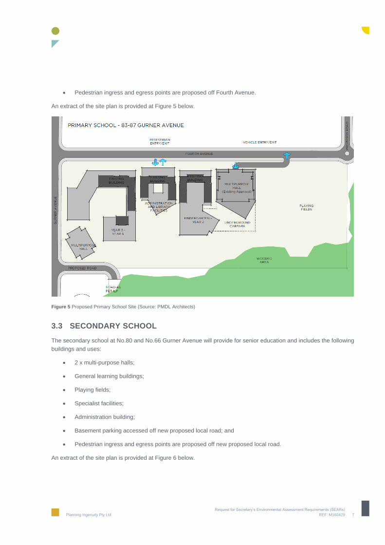
as a primary school. At completion the primary school will include:
2 x multi - purpose halls;
Year 3 – 6 buildings delivered by alterations and additions to the existing buildings;
Administration and library facilities involving alterations and additions to the existing buildings;
Year K – 2 buildings delivered by alterations and additions to the existing buildings;
Large open space areas to the east of the buildings;
Playing fields to the rear of the site (as per existing);
Basement parking accessed off Fourth Avenue;
Kiss, drop and leave area to the west of the buildings (adjoining Fourth Avenue); and
Request for Secretary’s Environmental Assessment Requirements (SEARs)
Planning Ingenuity Pty Ltd REF: M160429 7
Pedestrian ingress and egress points are proposed off Fourth Avenue.
An extract of the site plan is provided at Figure 5 below.
Figure 5 Proposed Primary School Site (Source: PMDL Architects)
3.3 SECONDARY SCHOOL
The secondary school at No.80 and No.66 Gurner Avenue will provide for senior education and includes the following
buildings and uses:
2 x multi-purpose halls;
General learning buildings;
Playing fields;
Specialist facilities;
Administration building;
Basement parking accessed off new proposed local road; and
Pedestrian ingress and egress points are proposed off new proposed local road.
An extract of the site plan is provided at Figure 6 below.

Request for Secretary’s Environmental Assessment Requirements (SEARs)
Planning Ingenuity Pty Ltd REF: M160429 8
Figure 6 Proposed Secondary Schools Site (Source: PMDL Architects)
3.4 POPULATION PROJECTION
The existing primary and secondary school has an approved student population of 1200 students (651 primary and
549 secondary school). The proposal for two schools (primary and secondary) seeks a student population up to
5,460. The school population will be delivered in stages.

Request for Secretary’s Environmental Assessment Requirements (SEARs)
Planning Ingenuity Pty Ltd REF: M160429 9
4. Consultation
In accordance with the Department of Planning, Industry and Environment Community Consultation Guidelines,
consultation will be undertaken with relevant public authorities, the community and Council.
Al-Faisal College is committed to engaging effectively with the local community in a meaningful, accountable and
responsive way. The schools will establish a community engagement plan to ensure community engagement is
integrated into all activities during the development process.
The objectives of the preliminary consultation are as follows:
Identify key community stakeholders with an interest in the project.
Provide relevant information and advise the local community about the proposed educational development.
Provide opportunity for the local community to comment and give feedback on the proposed educational
development.
The key stakeholders to be engaged include, but are not limited to the following:
State Government agencies.
Liverpool City Council staff and Councillors.
Neighbouring residents and landowners.
Current students, parents and teachers of the school.
A communications and stakeholder engagement strategy will be prepared to provide a framework to engage with
stakeholders and the community about the proposal and ensure opportunities to provide input into the assessment
process are available and promoted.
The strategy will outline all communication and consultation activities that will be undertaken with stakeholders such
as Liverpool City Council including Councillors, local community groups and cultural organisations, local residents
and potentially impacted landowners, and NSW Government departments such as Transport for NSW, the
Department of Planning, Industry and Environment and the NSW Government Architect.
The strategy will consider the anticipated matters of interest for stakeholders and will identify the specific
communication and engagement actions that will be undertaken to understand and address such matters.
Activities that might be undertaken during the consultation process include:
Letterbox distribution to the neighbourhood inviting them to attend a series of Community Drop-Ins to learn about
the project and provide feedback.
An advertisement in the local newspaper to promote Community Drop-Ins which will notify the broader
community about the proposal and invite them to participate in the process.
One Community Drop-In around the announcement of the proposed educational development.
Face-to-face meetings with key stakeholders as required and as permitted in the current COVID-19 environment.

Request for Secretary’s Environmental Assessment Requirements (SEARs)
Planning Ingenuity Pty Ltd REF: M160429 10
Information about the proposed educational development on the school’s website.
A process to effectively manage stakeholder and community feedback about the proposed educational
development.
Analysis of stakeholder and community feedback to assist the project team.
A Consultation Outcomes Report to be submitted as part of the State Significant Development Application that
highlights the issues raised by the community and stakeholders and how the project team has addressed such
issues.
A second Community Drop-In while the State Significant Development Application Environmental Impact
Statement is on public exhibition.
Upon receiving the Secretary’s Environmental Assessment Requirements, the strategy will be reviewed and updated
to include any additional communication and consultation activities that may be required.

Request for Secretary’s Environmental Assessment Requirements (SEARs)
Planning Ingenuity Pty Ltd REF: M160429 11
5. Environmental Planning Framework
5.1 STATUTORY PLANNING POLICIES
The legislation and environmental planning instruments applying to the proposed development include, but are not
limited to:
State Environmental Planning Policy (State & Regional Development) 2011;
State Environmental Planning Policy (Educational Establishments and Child Care Facilities) 2017;
State Environmental Planning Policy (Sydney Region Growth Centres) 2006; and
State Environmental Planning Policy No. 55 - Remediation of Land;
SEPP (Infrastructure) 2007; and
Sydney Regional Environmental Plan No.20 – Hawkesbury-Nepean River (No 2—1997)
5.2 STATE ENVIRONMENTAL PLANNING POLICY (STATE & REGIONAL DEVELOPMENT) 2011
The proposal is SSD, pursuant to clause 15 of Schedule 1 of State Environmental Planning Policy (State and
Regional Development) 2011 (SEPP SRD), being “development that has a capital investment value of more than $20
million for the purpose of alterations or additions to an existing school”.
5.3 STATE ENVIRONMENTAL PLANNING POLICY (EDUCATIONAL ESTABLISHMENTS AND CHILD CARE FACILITIES) 2017
The State Environmental Planning Policy (Educational Establishments and Child Care Facilities) 2017 (“Education
SEPP”) applies to development proposals for education facilities and child care centres and aims to standardise
planning assessment and licencing requirement, introduce exempt and complying categories of development and
encourage upgrading and improvements to existing premises. Schedule 4 of the Education SEPP outlines the design
quality principles that are to be considered in the design of a facility.
A detailed assessment of the proposal against the Education SEPP will be undertaken within an EIS to be submitted
with the application.
5.4 STATE ENVIRONMENTAL PLANNING POLICY (SYDNEY REGION GROWTH CENTRES) 2006
State Environmental Planning Policy (Sydney Region Growth Centres) 2006 (Growth Centres SEPP) is the statutory
framework regulating land uses within the North West and South West Growth Centres. The relevant planning
controls for the site are contained in Appendix 8 - Liverpool Growth Centres Precinct Plan and outlined below.

Request for Secretary’s Environmental Assessment Requirements (SEARs)
Planning Ingenuity Pty Ltd REF: M160429 12
5.4.1 Zoning
The subject site has the following zoning under the Growth Centres SEPP.
Primary School Site
No.83 - 87 Gurner Avenue is zoned R2 Low Density Residential.
No.79 Gurner is zoned R3 Medium Density Residential (front portion), RE1 Public Recreation and SP2 Local
Drainage (rear portions).
Secondary School Site
No. 80 Gurner is zoned SP2 Educational Establishment (front portion), R3 Medium Density and R2 Low
Density (rear portion)l
No.66 Gurner is zoned SP2 Educational Establishment
See Figure 7 below.
Figure 7 Zoning Map - Extract (Source: eplanning.liverpool.nsw.gov.au)
5.4.2 Permissibility
Educational Establishments are permissible in the SP2 Educational Establishment, R2 Low Density and R3 Medium
Density zones under the provisions of the Growth Centres SEPP. Educational Establishments are not permissible on
that part of No.79 zoned RE1 and SP2 Drainage (including under the Education SEPP). However, the proposed
development does not include any development on land which is zoned RE1 or SP2 Drainage. The part of the site
zoned RE1 and SP2 are also land identified as land to be acquired by Liverpool City Council for recreation and
drainage purposes (see Section 5.4.6 below).
5.4.3 FSR
The sites are not subject to an FSR development standard under the Growth Centres SEPP.

Request for Secretary’s Environmental Assessment Requirements (SEARs)
Planning Ingenuity Pty Ltd REF: M160429 13
5.4.4 Heritage
The sites are not identified as containing heritage items nor are there any nearby heritage items.
5.4.5 Height
Primary School Site
No.83 – 87 Gurner is subject to a maximum height of 9 metres. The existing and approved school on the site
includes buildings with heights over the 9 metre high limit. The front portion of No.79 Gurner is subject to a maximum
height of 12 metres.
Secondary School Site
The front portion of No.80 Gurner is subject to a maximum height of 12 metres and the rear subject to a maximum
height of 9 metres. No. 66 is subject to a maximum height of 12 metres. See Figure 8 below.
Figure 8 Building Height Map- Extract (Source: eplanning.liverpool.nsw.gov.au)
5.4.6 Land Acquisition
The existing school site at No.83 – 87 Gurner is not subject to any land acquisition provisions.
The rear portion of No.79 Gurner is identified as land to be acquired for Local Open Space (RE1) and Local Drainage
(SP2). Liverpool City Council is the relevant authority to acquire both the RE1 land and SP2 land. The proposed
development does not include any development within this portion of the site.
The front portion of No.80 Gurner is subject to land acquisition for the purpose of an educational establishment.
No.66 is also identified as land to be acquired for the purpose of an educational establishment. Communications
have been received from the Department of Education advising that whilst the Department has an acquisition
affectation on the subject property in the Growth Centres SEPP, it does not preclude the land from being developed
by other interested parties or owners in accordance with its underlying zoning (i.e education establishments). The
Department of Education advised that they welcome the non-government sector in planning for the provision of
education infrastructure for growing communities such as Austral and have no objection to the lodgment of the
request for SEARS.

Request for Secretary’s Environmental Assessment Requirements (SEARs)
Planning Ingenuity Pty Ltd REF: M160429 14
That part of the site affected by land acquisition is show in Figure 9 below.
Figure 9 Land Reservation Acquisition Map- Extract (Source: eplanning.liverpool.nsw.gov.au)
5.4.7 Native Vegetation
No.79 Gurner (rear portion) has been identified as containing existing native vegetation. The mapped native
vegetation appears to generally align with the RE1 and land acquisition map. Clearing of any existing native
vegetation on this land is not permitted. The proposed development does not include any development within this
portion of the site.
No.80 Gurner contains a very small portion of native vegetation retention area at the front of the site. The proposed
secondary school does not impact on this small portion of the site mapped as native vegetation. See Figure 10.
Figure 10 Native Vegetation Protections Map – Extract (Source: legislation.nsw.gov.au)

Request for Secretary’s Environmental Assessment Requirements (SEARs)
Planning Ingenuity Pty Ltd REF: M160429 15
5.4.8 Riparian Protection
No.79 Gurner (rear portion) has been identified as containing Riparian Protection Area. The proposed development
does not include any development within this portion of the site. No.80 Gurner contains a very small Riparian
Protection Area at the front of the site. The proposed secondary school does not impact on this small portion of the
site mapped as Riparian Protection Area. See Figure 11.
Figure 11 Riparian Protection Map – extract (Source: legislation.nsw.gov.au)
5.4.9 Flood Risk
The rear portion of No.79 – 87 Gurner Avenue have been identified as containing flood inundation land. See Figure
12. The proposed development does not contain structures within this portion of the site.
Figure 12 Flood Inundation Map- Extract (Source: eplanning.liverpool.nsw.gov.au)

Request for Secretary’s Environmental Assessment Requirements (SEARs)
Planning Ingenuity Pty Ltd REF: M160429 16
5.5 STATE ENVIRONMENTAL PLANNING POLICY NO. 55 - REMEDIATION OF LAND
The provisions of State Environmental Planning Policy No. 55 – Remediation of Land (SEPP 55) require the consent
authority to consider whether land is contaminated and if it is contaminated whether it can be made suitable for the
proposed purpose. The EIS will be supported by a Phase 1 Preliminary Assessment of the site.
5.6 STATE ENVIRONMENTAL PLANNING POLICY (INFRASTRUCTURE) 2007
Schedule 3 of this SEPP identifies matters that are to be referred to Roads and Maritime Services for consideration.
The proposal will trigger the need for a referral as the proposal involves a car park (whether or not ancillary to other
development) with 200 or more car parking spaces.
5.7 SYDNEY REGIONAL ENVIRONMENTAL PLAN NO. 20 – HAWKESBURY-NEPEAN RIVER (NO 2 – 1997)
The SREP No. 20 – Hawkesbury-Nepean River (No. 2 – 1997) applies to land including Liverpool City Council LGA.
The aim of this plan is to protect the environment of the Hawkesbury-Nepean River system by ensuring that the
impacts of future land uses are considered in a regional context. Appropriate measures will be detailed in the EIS to
ensure the proposed development will have no significant adverse impact on the water quality or river flows of the
River and its tributaries.
5.8 LIVERPOOL GROWTH CENTRE PRECINCTS DCP 2013
Liverpool Growth Centre Precincts DCP 2013 (DCP) and Schedule 1 of the Liverpool Growth Centre Precincts
(Austral and Leppington North) DCP, provide the relevant development controls. The EIS will assess the proposal
against all relevant controls within the DCP. Details of proposed variations to the Indicative Layout Plan (ILP) are
provided below.
5.8.1 Indicative Layout Plan
An extract from the Indicative Layout Plan (ILP) is provided at Figure 13 below.

Request for Secretary’s Environmental Assessment Requirements (SEARs)
Planning Ingenuity Pty Ltd REF: M160429 17
Figure 13 Indicative Layout Plan Map- Extract (Source: eplanning.liverpool.nsw.gov.au)
Primary School
In regards to No.83 - 87 Gurner the ILP shows a road running along the northern and eastern boundaries of the site.
As part of a current Planning Proposal to update Liverpool LEP 2013 – Amendment No.75
(PP_2019_LPOOL_002_01) this road is to be deleted. The school was developed prior to the ILP and these roads
are no longer required. See extracts from Planning Proposal at Figure 14 below.

Request for Secretary’s Environmental Assessment Requirements (SEARs)
Planning Ingenuity Pty Ltd REF: M160429 18
Figure 14 Planning Proposal by Liverpool City Council - Amendment to Indicative Layout Plan
In regards to No.79 Gurner, the ILP shows a road along a portion of the western boundary and connecting to an east-
west road (which appears to align with RE1 land) with the road connecting back into Gurner through No.69 Gurner to
the east of the site. The primary school proposal provides a half-road construction along the eastern boundary of
No.79 Gurner to ultimately connect into the ILP road and access the land to the east. See Figure 15 below.

Request for Secretary’s Environmental Assessment Requirements (SEARs)
Planning Ingenuity Pty Ltd REF: M160429 19
Figure 15 Proposed Road Layout Plan – Primary School Site
Secondary School
The ILP for No.80 Gurner Avenue shows 3 east-west roads throughout the site (in addition to Gurner Avenue) as well
as a number of north-south roads along the eastern and western boundaries of the site.
The proposed development for the secondary school shows the proposed road layout which includes the following
variations to the ILP:
removal of 2 of the 3 east-west roads (located in centre of the site);
connection of the north south roads along western boundary.
The proposed development includes ILP roads along the western, southern and eastern boundaries remaining with
the through-site roads being removed. See Figure 16 below.

Request for Secretary’s Environmental Assessment Requirements (SEARs)
Planning Ingenuity Pty Ltd REF: M160429 20
Figure 16 Proposed Road Layout Plan – Primary School Site
5.9 STRATEGIC PLANNING FRAMEWORK
The relevant strategic planning policies which apply to the proposed development include:
NSW State Priorities;
A Plan for Growing Sydney;
Draft Central District Plan;
Request for Secretary’s Environmental Assessment Requirements (SEARs)
Planning Ingenuity Pty Ltd REF: M160429 21
NSW Long Term Transport Master Plan 2012;
Sydney’s Cycling Future 2013;
Sydney’s Walking Future 2013;
Sydney’s Bus Future 2013;
Crime Prevention Through Environmental Design (CPTED) Principles;
Better Placed – an integrated design policy for the built environment of NSW;
Healthy Urban Development Checklist, NSW Health; and
Greater Sydney Commission’s Draft South West District Plan.
The EIS will assess the proposal against these relevant strategic planning policies.

Request for Secretary’s Environmental Assessment Requirements (SEARs)
Planning Ingenuity Pty Ltd REF: M160429 22
6. Preliminary Assessment
The expected environmental impacts associated with the proposed development that will be assessed in the EIS for
the SSDA include:
6.1 TRANSPORT AND ACCESSIBILITY
A traffic and parking impact assessment will form part of the EIS and will address issues relating to impacts on the
existing road network and parking, arrangement of on-site parking, potential delays and peak traffic movements
generated by the proposed primary and secondary school sites. An assessment of pedestrian permeability and
networks will also form part of the assessment.
6.2 BUILT FORM AND URBAN DESIGN
The primary and secondary school sites are separated from all surrounding residential development by road
carriageways and proposed setbacks. As such the built form is not expected to impact the existing and future amenity
of the locality. A full assessment of the proposed built form and the impacts on the public domain will be undertaken
as part of the EIS. Additionally, a detailed design report, responding to Schedule 4 Schools – design quality principles
of State Environmental Planning Policy (Educational Establishments and Child Care Facilities) 2017, will be
submitted with the EIS.
6.3 STAGING
The proposed construction and occupation of the new secondary school and alterations and additions to the existing
school will be staged to enable the existing school to continue operation during construction. Details of the staging
will be provided as part of the EIS.
6.4 BUSHFIRE
The site is identified as bush fire prone. A Bushfire Protection Assessment will be undertaken as part of the EIS to
determine the Bushfire Attack Level and the mitigation measures to protect the safety of future site users
6.5 NOISE AND VIBRATION
An acoustic assessment addressing potential acoustic impact on nearby properties will form part of the EIS. A
Construction and Operational Noise Report will be provided as part of the EIS. The report will provide a detailed
assessment of potential noise and vibration impacts caused by the construction and operation of the schools, and
recommendations to mitigate these impacts.

Request for Secretary’s Environmental Assessment Requirements (SEARs)
Planning Ingenuity Pty Ltd REF: M160429 23
6.6 BIODIVERSITY
The site is located within the Sydney Growth Centres biodiversity certified area. Under Part 7AA of the Threatened
Species Conservation Act 1995 (TSC Act), biodiversity certification removes the requirement to undertake impact
assessment on certified land for threatened species population and communities listed under the TSC Act
The northern part of No.79 is identified as Existing Native Vegetation (ENV). The vegetation is excluded from the
existing bio-diversity certification (due to identification as ENV) and is also identified as containing Biodiversity Values
by the Biodiversity Values Map prepared by the Office of Environment and Heritage (OEH) under Part 7 of
the Biodiversity Conservation Act 2016 (BC Act). The proposed development does not include any works on this
portion of the site. An Ecological Impact Assessment will be submitted with the EIS.
6.7 WASTE
A Construction and Demolition Waste Management Plan will be prepared and accompany the EIS. The Plan will
detail waste to be generated during demolition and construction, and outline proposed measures to dispose of the
waste offsite. An Operational Waste Management Plan will also be submitted as part of the EIS and detail proposed
waste servicing arrangements, loading zones and ongoing waste management practices to be employed at the site.
All demolition, construction and operational waste will be reused or recycled where possible. Any contaminated
material identified under the Phase 1 Assessment will be disposed of to a relevant licenced facility.
6.8 STORMWATER MANAGEMENT AND FLOODING
A Flood Risk Assessment Report will be submitted as part of the EIS to analyse potential flood risk at the site. A
Stormwater Management Plan and Erosion and Sediment Control Plan will also be prepared and be submitted with
the EIS, detailing proposed flood risk management strategies and water sensitive urban design measures to be
incorporated into the development
6.9 SOCIAL IMPACTS
An assessment of the social and economic impacts of the proposal will accompany the future SSD application.
The social and economic impacts resulting from the proposal will be detailed in the EIS. Anticipated social and
economic benefits include:
Expansion of the existing school to create a separate primary and secondary school will cater for the growing
needs of the expanding population within the North West Growth Centre;
Significant direct and indirect jobs will be created during construction and operational phases; and
The design will create a series of high quality internal and external educational spaces.
6.10 BCA AND ACCESS
The proposed schools will be designed in accordance with the requirements of the Building Code of Australia and will
provide legible, safe and inclusive access for all. This will be addressed within a Building Code of Australia and
Accessibility Report to be provided as part of the EIS.

Request for Secretary’s Environmental Assessment Requirements (SEARs)
Planning Ingenuity Pty Ltd REF: M160429 24
6.11 CONSTRUCTION MANAGEMENT
A Preliminary Construction and Environmental Management Plan will be prepared and provided as part of the EIS.
6.12 ABORIGINAL HERITAGE
A due diligence assessment will been undertaken with reference to the DECCW process. A full Aboriginal Heritage
Assessment will be prepared and submitted with the EIS.
6.13 SAFETY AND SECURITY
The EIS will outline how specific CPTED principles (surveillance, access control, territorial re-enforcement and
space/activity management) have been integrated into the design of the schools to deter crime, manage space and
create a safe environment for students, staff and visitors.
6.14 ENVIRONMENTALLY SUSTAINABLE DEVELOPMENT
Highest consideration will be given to incorporating ESD into the design and construction of the schools. The EIS will
outline how specific ESD principles have been integrated into the design of the schools.
6.15 CONSULTATION
As detailed in Section 4, consultation will be undertaken with relevant public authorities, the community and Council
as per the Department of Planning, Industry and Environment Community Consultation Guidelines.

Request for Secretary’s Environmental Assessment Requirements (SEARs)
Planning Ingenuity Pty Ltd REF: M160429 25
7. Conclusion
By virtue of Clause 15 (“Educational Establishments”) of Schedule 1 of the State Environmental Planning Policy
(State and Regional Development) 2011, the proposal is State significant development being “development that has
a capital investment value of more than $20 million for the purpose of alterations or additions to an existing school”.
This Scoping Report has been prepared in support of the proposed development for major alterations and additions
to the existing primary and secondary school at Nos. 79-87 Gurner Avenue for use as a primary school and erection
of a new secondary school at No.66 and No.80 Gurner Avenue, Austral (the site). The report has described the
proposal, identified the relevant strategic and statutory context, identified the scale and nature of the impacts of the
proposal and considered the approach to community engagement.
We therefore request that the Planning Secretary issue the environmental assessment requirements (SEARs) for the
project to enable progression of the application.