Embed Size (px)
Citation preview

science for a changing world
Digital Data Collection for Environmental GIS Updating
(handheld vs. paper & pen)
Beth M. Wrege [email protected]
www.usgs.gov
Charlynne T. Smith [email protected]

science for a changing world
Mobile Computing: Why bother?
• Do you need it? Can you even use it?
• What does it do for you?
• Savings (cheap / fast / accurate)
• Pilot Projects
• Did it help? (limitations / benefits)
science for a changing world
NeedData Layers : Update
TOPOGRAPHY
LAND USE
HYDROLOGY
IMGEN
IMREC
TRAIR
TRVEH
UTSTO
BGGEN
• Groundwater
•Stormwater
• Watershed

science for a changing world
Issue:Management of Data forms
Cost of Data Entry
labor, time
Poor penmanship, missed data, wrong location of data collected
Cost of Data QA/QC Quality assurance, data validation - difficult
Re-key
labor, time
Error correction
introduce error
Data loss Lost data due to time lag
Time to Publish Less time, collect more data, accuracy, faster release

science for a changing world
What does it take?Hardware : Software : Wetware

science for a changing world
Pilot Project• Cherry Point MCAS • Ft. Bragg
Fort Bragg Cantonment Watersheds

science for a changing world
Existing SituationWhat is it going to take?
•Existing Database
ArcView, ArcInfo, DLGs, DRGs, CAD, Pathfinder
•ArcPAD is a software program, it is a mapping application designed for field data collection and mapping. It works on handheld PocketPC with Windows CE as well as Windows 95, 98, NT and 2000.
•Handheld CE, memory, ram, rom, interface, expand

science for a changing world
Planning
• Forms Development
• Clearer definition of expected results
• More training

science for a changing world
PreparationFort Bragg Cantonment Area
Cape Fear River Basin
North Carolina

science for a changing world
Formats• Clips
• Shapefiles : feature data format
• JPEG : satellite imagery
• Bitmaps : photos
• CADrg : Background
• Excel/Access
• Trimble : GPS
• Dialog Designer for attribute data
• MrSID : visual background
• Wireless technology, to download image or map layers
• ArcIMS : data server uplink
science for a changing world
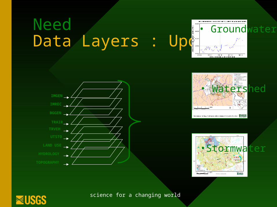
Linking imageryOutfall 53
Other field applications…

science for a changing world
ArcPad for Urban Forest Inventory Management
North Carolina State University
• Urban Forest Management System
• Spatial Database exists ~ 5,000 trees in the database
• Periodic updates required as result of field inspections

science for a changing world

science for a changing world
NC State University
Landscape Services Division is responsible for
• Campus plantings: trees, shrubs, flower beds
• Campus Walkways
Routine maintenance and emergency management situations
Watering Routes
Hurricane Cleanup

science for a changing world
Urban Forest Health
Die-back indicating
Leaf Scorch disease
Poor maintenance
by contractor

science for a changing world
Agriculture Application• County Agricultural Agent works with a variety of
farmers
• Recognizes the need for accurate map of the agricultural fields and plants– Inventory of species, cultivars
– Infrastructure: irrigation, wind machines
– Records• Pesticide Application
• Disease Testing
• Integrated Pest Management
http://www.pearsonfarm.com/

science for a changing world
Mapping the Peach Orchard
• Base maps are minimal– Digital orthophotography
– County roads
• GPS connection to create accurate data layers– handheld computer
becomes the data logger
– GPS software not required
http://www.pearsonfarm.com/

science for a changing world
Data entry form
• Drop down list
• Entry field
• Date
• Check box
• Labels
• Required fields
• Scroll

science for a changing world
Create form Based on Attribute Table
Select fields you would like to use
Create Form
Transfer to handheldTransfer to handheld
with project filewith project file

science for a changing world
Transferring from Desktop . . .

science for a changing world
. . . to the handheld
Data collection using handheld and ruggedized case

science for a changing world
. . . back to the desktop
. . . and update the database
•Display / features with attribute
•Query / Immediate Use
•Edit / create / attribute, delete, modify
•Data capture / form completion
•GPS / collected in shapefile format
•Hyperlink photos

science for a changing world
Data Transfer Methods
• Storage cards
• Infrared transfer
• Paper

science for a changing world
End User ApplicationsNCSU – Improved Efficiency
• Updates are in the hands of the field supervisor
– Without a fulltime GIS technician the database receives more updates
• Effectiveness allows time for new applications
– Integrated pest management program
• Communication Between DepartmentsCommunication Between Departments
Agriculture Extension
• Simplified, economical access to data
• Improve documentation process and assist farmers
• Less training and computer power required . . .

science for a changing world
Results: Digital Data Collection• We will meet our publication deadlines
– Elimination of data input process• Reduction in data entry time – redirect effort
– Elimination of data input validation• Data are now checked daily by field person and map checked on
plot
– Elimination of data loss (data safe-keeping)• Transmitting the data in for validation, creates a backup copy
– Increase in Quality • Errors are identified and remedied in the field
• Validation of location
– Provide near real-time access to data• The data are digital when collected

science for a changing world
Additional Benefits
• Using mobile computing to leverage existing GIS
• Field Portable GIS
• Correction of GIS data
• GPS polygon capture
• Creation of attributed files
• Transportable Memory – Multiple Users

science for a changing world
Mobile digital data acquisition
Limiting Factors
Only Shapefiles
Need to have existing GIS
Memory : storage : filesize (32mb, 133, color)
CE device
Advantages
Mr.Sid
Field data
Real-time data capture
Image in the field
Wireless data aquisition

science for a changing world
Today
• Pilot at Cherry Point
• No Pilot at Ft. Bragg
• Management of over 5000 trees
• Implementation of Integrated Pest Management Program
http://www.trimble.com/

science for a changing world
Future Applications

science for a changing world
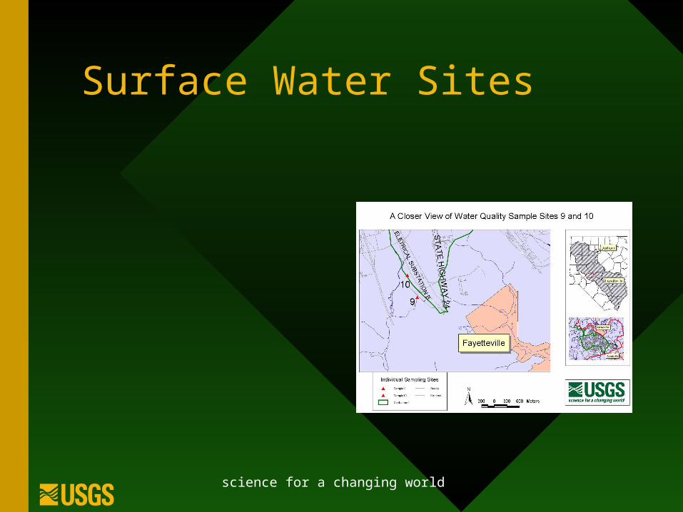
Water Quality Sampling Sites
• Route map updates
• Locations Validation
• NPDES Illicit Discharge Inspections
• Field Data Acquisition
science for a changing world
Surface Water Sites

science for a changing world
Surface Water Sampling
• Volunteers
• Validation
• Location accuracy
• Repeatability

science for a changing world
Urban Forestry & Agriculture
• Inventory
• Pest Management
• Pesticide Applications
– Water Quality
– Worker Safety

science for a changing world
Action
• Mobile computing for my situation will improve accuracy, reduce labor, provide a quality product in a timely manner.
• It requires both up front costs and planning
• Fast / accurate / cheap

science for a changing world
Mobile Computing
Working smarter
. . . not harder