Embed Size (px)
Citation preview

HEAD OFFICE: 292 Mt Alexander Road Ascot Vale VIC 3056 GEELONG: PO Box 8048 Newtown VIC 3220BRISBANE: Level 7 140 Ann Street Brisbane QLD 4000 ADELAIDE: 8 Greenhill Road Wayville SA 5034
www.ehpartners.com.au
Draft Report
Scattered Tree Assessment, Beveridge North West
(PSP 1059), Victoria
Prepared for
Metropolitan Planning Authority
November 2013
Ecology and Heritage Partners Pty Ltd
Scattered Tree Assessment, PSP 1059 Beveridge North West, Victoria 2
ACKNOWLEDGEMENTS
We thank the following people for their contribution to the project:
Fiona McDougall (MPA) for management and provision of landowner details and GIS layers; and,
The landowners who provided access to their properties.

Scattered Tree Assessment, PSP 1059 Beveridge North West, Victoria 3
DOCUMENT CONTROL
Assessment Biodiversity Assessment (Scattered Tree Assessment)
Address Beveridge North West (PSP 1059), Victoria
Project number 5211
Project manager Marc Freestone
Report reviewer Clio Gates Foale
Other EHP staff
Mapping Monique Elsley
File name 5211_EHP_TreeAssessment_PSP 1059 BeveridgeNW_DRAFT_20092013.docx
Client Metropolitan Planning Authority
Bioregion Victorian Volcanic Plain
CMA Port Phillip and Western Port
Council Mitchell Shire Council
Report versions Comments Comments updated by Date submitted
Draft 1 - 20/09/2013
Final
Copyright © Ecology and Heritage Partners Pty Ltd
This document is subject to copyright and may only be used for the purposes forwhich it was commissioned. The use or copying of this document in whole orpart without the permission of Ecology and Heritage Partners Pty Ltd is aninfringement of copyright.
Disclaimer
Although Ecology and Heritage Partners Pty Ltd have taken all the necessarysteps to ensure that an accurate document has been prepared, the companyaccepts no liability for any damages or loss incurred as a result of reliance placedupon the report and its contents.

Scattered Tree Assessment, PSP 1059 Beveridge North West, Victoria 4
GLOSSARY
Acronym Description
DBH Diameter at Breast Height
DEPI Victorian Department of Environment and Primary Industries
EPBC Act Environment Protection and Biodiversity Conservation Act 1999
EVC Ecological Vegetation Class
FFG Act Flora and Fauna Guarantee Act 1988
LOT Large Old Tree
MOT Medium Old Tree
TRZ Tree Retention Zone
VBA Victorian Biodiversity Atlas (DEPI)
VLOT Very Large Old Tree

Scattered Tree Assessment, PSP 1059 Beveridge North West, Victoria 5
CONTENTS
1 INTRODUCTION .. . . . . . . . . . . . . . . . . . . . . . . . . . . . . . . . . . . . . . . . . . . . . . . . . . . . . . . . . . . . . . . . . . . . . . . . . . . . . . . . . . . . . . . . . . . . . . . . . . 6
1.1 Background ........................................................................................................................................ 6
2 METHODS .. . . . . . . . . . . . . . . . . . . . . . . . . . . . . . . . . . . . . . . . . . . . . . . . . . . . . . . . . . . . . . . . . . . . . . . . . . . . . . . . . . . . . . . . . . . . . . . . . . . . . . . . . 7
2.1 Nomenclature .................................................................................................................................... 7
2.2 Desktop Assessment .......................................................................................................................... 7
2.3 Field Surveys ...................................................................................................................................... 7
3 RESULTS . . . . . . . . . . . . . . . . . . . . . . . . . . . . . . . . . . . . . . . . . . . . . . . . . . . . . . . . . . . . . . . . . . . . . . . . . . . . . . . . . . . . . . . . . . . . . . . . . . . . . . . . . . . . 9
3.1 Scattered Tree Assessment................................................................................................................ 9
4 HABITAT COMPENSATION COSTS FOR SCATTERED TREE REMOVAL .. . . . . . . . . . . . . . . . . . . . . . . . . . . 11
5 REFERENCES . . . . . . . . . . . . . . . . . . . . . . . . . . . . . . . . . . . . . . . . . . . . . . . . . . . . . . . . . . . . . . . . . . . . . . . . . . . . . . . . . . . . . . . . . . . . . . . . . . . . . . 12
6 FIGURES. . . . . . . . . . . . . . . . . . . . . . . . . . . . . . . . . . . . . . . . . . . . . . . . . . . . . . . . . . . . . . . . . . . . . . . . . . . . . . . . . . . . . . . . . . . . . . . . . . . . . . . . . . . . 13
7 APPENDICES . . . . . . . . . . . . . . . . . . . . . . . . . . . . . . . . . . . . . . . . . . . . . . . . . . . . . . . . . . . . . . . . . . . . . . . . . . . . . . . . . . . . . . . . . . . . . . . . . . . . . . 14
APPENDIX 1 . . . . . . . . . . . . . . . . . . . . . . . . . . . . . . . . . . . . . . . . . . . . . . . . . . . . . . . . . . . . . . . . . . . . . . . . . . . . . . . . . . . . . . . . . . . . . . . . . . . . . . . . . . . . . 15
Appendix 1.1 – Scattered Tree Data ............................................................................................................ 15
Appendix 1.2 – Tree Retention Zones.......................................................................................................... 17

Scattered Tree Assessment, PSP 1059 Beveridge North West, Victoria 6
1 INTRODUCTION
1.1 Background
Ecology and Heritage Partners Pty Ltd was commissioned by Metropolitan Planning Authority to conduct a
Biodiversity Assessment (Scattered Tree Assessment) at Beveridge North West (PSP 1059), Victoria. The
purpose of the assessment was to identify the number and type of scattered native trees present within the
study area.
To streamline the environmental approvals process within Melbourne’s growth areas, the State Government
released the Biodiversity Conservation Strategy (BCS) (DEPI 2013d). The BCS identifies conservation reserves
to be protected and offsets for native vegetation and matters of National Environmental Significance lost
within the growth areas. The BCS replaces the requirement to obtain any permits for native vegetation
removal under local, Victorian and Federal legislation.
To facilitate the planning approvals process for Melbourne’s growth corridors and enable the
implementation of the BCS, the Victorian Government introduced the ‘Time Stamping’ project (DSE 2009).
This project captured, and ‘time stamped’ native vegetation information within the new urban growth
corridors. This data has been mapped, and is now being used to calculate native vegetation offsets for
future development under the BCS. Native vegetation includes patches of remnant native vegetation as well
as remnant, scattered indigenous trees. If a proponent intends to remove any native vegetation that has
been ‘time stamped’, they are required to pay a Habitat Compensation fee to DEPI to compensate for its loss
(DEPI 2013e).
This report satisfies and completes the scattered indigenous tree assessment requirements for the
preparation of the Beveridge North West Precinct Structure Plan (PSP 1059).

Scattered Tree Assessment, PSP 1059 Beveridge North West, Victoria 7
2 METHODS
2.1 Nomenclature
Common and scientific names of vascular plants follow the Victorian Biodiversity Atlas (VBA) (DEPI 2013a)
and the Census of Vascular Plants of Victoria (Walsh and Stajsic 2007). Vegetation community names follow
DEPI’s Ecological Vegetation Classes (EVC) benchmarks (DEPI 2013b).
2.2 Desktop Assessment
The following resources and databases were reviewed over the duration of the project:
Department of Environment and Primary Industries’ Biodiversity Interactive Maps showing historic
and current EVCs (DEPI 2013c); and,
Biodiversity Conservation Strategy for Melbourne’s Growth Corridors (DEPI 2013d).
Liaison was undertaken with the Metropolitan Planning Authority (MPA) to confirm the extent and intensity
of the proposed methodology.
The Department of Environment and Primary Industries (DEPI) identified a number of potential scattered
trees within the study area and provided point locations on aerial imagery of the trees requiring
investigation.
2.3 Field Surveys
The scattered trees identified by DEPI, along with any other scattered trees present in the study area, were
identified and, if found to be remnant indigenous trees, mapped for the current assessment. A total of five
properties were assessed (see Figure 1 for Property Numbers).
Scattered tree assessments were undertaken by an experienced botanist with current Certificates of
Competency in conducting Vegetation Quality Assessments (habitat hectares) from DEPI. The scattered tree
assessment was undertaken on 17 September 2013. All scattered indigenous trees were assigned a
sequential number and recorded as a point location on aerial maps using handheld GPS devices and ArcGIS
software (Figure 1). A diameter at breast height (DBH) measurement was taken for each tree using a
diameter tape. The size class and conservation significance was determined for all indigenous trees
according to the relevant Ecological Vegetation Class (EVC) benchmark. Benchmark tree measurements for
relevant EVCs are provided in Table 1. The survey assessment date, duration and assessor are provided in
Table 2.

Scattered Tree Assessment, PSP 1059 Beveridge North West, Victoria 8
Table 1: Relevant EVC benchmark information pertaining to tree size classes.
BioregionEcological Vegetation
Class
Very LargeOld Tree
(cm)*
Large OldTree DBH
(cm)
Medium OldTree DBH
(cm)*
Small Old TreeDBH (cm)*
Victorian VolcanicPlain
Higher Rainfall PlainsGrassy Woodland (EVC55_63)
105+
(eucalypts)
60+
(Blackwoodand DroopingSheoak)
70 – 104
(eucalypts)
40 – 59
(Blackwoodand DroopingSheoak)
53 – 69
(eucalypts)
30 – 39
(Blackwoodand DroopingSheoak)
<53
(eucalypts)
<30
(Blackwoodand DroopingSheoak)
Notes: * Very Large Old Trees are at least 1.5 times the trunk diameter of a large old tree; Large Old Trees are >1.0 to <1.5 times
trunk diameter; Medium Old Trees >0.75 to <1.0 times trunk diameter and; Small Old Trees are <0.75 times trunk diameter, as
defined by the relevant DSE benchmarks and the Port Phillip and Westernport Native Vegetation Plan (DEPI 2013b; PPWCMA 2006).
Table 2: Scattered Tree survey date, duration, access issues and assessor.
LandownerNumber
PropertyNumber
AccessAssessment
DateDuration Assessor
1110757,110760
Approved – 17/9/2013
Met farm manager andundertook induction.
17-Sept-1311.00am –
12.00pm; 12.30pm– 4.00pm
Marc Freestone
3 111232
Approved – 17/9/2013
Landowner present duringsurvey
17-Sept-13 4.00pm – 4.30pm Marc Freestone
6 110756
Signed consent, no verbalcontact. Mobile numberwas wrong and no answeron landline.
17-Sept-1311.30am –12.00pm
Marc Freestone
7 112242Signed consent, no verbalcontact. No phone numberprovided.
17-Sept-1312.00pm –12.30pm
Marc Freestone
9 110841 Approved – 12/5/2013 17-Sept-13 4.30pm – 5.00pm Marc Freestone

Scattered Tree Assessment, PSP 1059 Beveridge North West, Victoria 9
3 RESULTS
3.1 Scattered Tree Assessment
A total of 27 indigenous remnant trees were recorded within the study area (Figure 1, Appendix 1). The
species include River Red Gum Eucalyptus camaldulensis, Swamp Gum Eucalyptus ovata and Manna Gum
Eucalyptus viminalis subsp. viminalis. The number of indigenous remnant trees within each size class is as
follows:
21 Very Large Old Trees (VLOTs);
5 Large Old Trees (LOTs); and
1 Medium Old Tree (MOT).
All trees correspond to Higher Rainfall Plains Grassy Woodland (EVC 55_63). Higher Rainfall Plains Grassy
Woodland is an open woodland dominated by Swamp Gum, Manna Gum and River Red Gum (as opposed to
Plains Grassy Woodland EVC 55_61 which is dominated by River Red Gum only). The understorey is species
rich with grasses and native herbs.
Scattered indigenous remnant trees within the study area are assigned the lowest conservation significance
rating based on the Bioregional Conservation Status (BCS) of the relevant pre-1750s EVC (DSE 2007a; DEPI
2013c). Very Large, Large and Medium scattered indigenous trees within the study area are representative
of the Plains Grassy Woodland EVC, which has a Bioregional Conservation Status of Endangered. Therefore,
all scattered indigenous remnant trees are of High conservation significance.
All other trees within the study area are planted, including young River Red-gum and non-indigenous or
exotic species such as Sugar Gum Eucalyptus cladocalyx. Trees were determined to be planted due to them
being located in obvious rows and small in size. Planted trees were not included in the assessment as they
did not meet the definition of a remnant tree (DEPI 2013f). The details of indigenous trees recorded within
each property are presented in Appendix 1.
A total of four trees that were identified by DEPI as being potential scattered indigenous trees were not
observed during this assessment. This included two trees in Property Number (PN) 110757 and one tree
each in PN 111232 and PN 110760. These trees were either not present, dead and fallen over (with no part
of the tree extending more than 1.3 metres above the ground) or not indigenous tree species (the tree in PN
110760 was an exotic Cypress Cupressus sp.). A total of five additional indigenous scattered trees, which
DEPI had not identified, were recorded during this assessment, including two trees in PN 110756 and one
tree each in PN 110757, PN 112242 and PN 110841.
Tree #21 was a recently dead tree (termed a stag), which has recently partially fallen over. However, as the
fallen trunk of this tree is still more than 1.3 metres above the ground, it still qualifies as a scattered tree
(Angela Robb, DEPI, pers. comm., 23 August 2012).
No trees recorded during this assessment were within a patch of native vegetation.

Scattered Tree Assessment, PSP 1059 Beveridge North West, Victoria 10
Under the BCS, habitat compensation fees are only required for the removal of Very Large Old Trees (VLOTs),
Large Old Trees (LOTs) and Medium Old Trees (MOTs). No fees apply to Small Trees (STs).

Scattered Tree Assessment, PSP 1059 Beveridge North West, Victoria 11
4 HABITAT COMPENSATION COSTS FOR SCATTERED
TREE REMOVAL
Under the Biodiversity Conservation Strategy (BCS) DEPI have outlined habitat compensation costs (offset
costs) that are required to be paid to DEPI before the removal of native vegetation and scattered trees is
permitted. These costs go towards managing conservation areas within the Urban Growth Boundary. The
cost to remove a scattered tree is the same for all size classes of scattered tree (VLOT, LOT, MOT), although
no fee is required to remove Small Trees (DEPI 2013e). Under the Draft Habitat Compensation Under the
Biodiversity Compensation Strategy released in May 2013, the cost is $13,218 per scattered tree considered
removed (DEPI 2013e). This includes stags, and trees that experience impacts to their Tree Retention Zone,
but are not physically removed (Appendix 1.2).

Scattered Tree Assessment, PSP 1059 Beveridge North West, Victoria 12
5 REFERENCES
DEPI 2013a. Victorian Biodiversity Atlas. Victorian Department of Environment and Primary Industries.
DEPI 2013b. Ecological Vegetation Class (EVC) Benchmarks for each Bioregion [WWW Document]. URL
http://www.dse.vic.gov.au/conservation-and-environment/native-vegetation-groups-for-
victoria/ecological-vegetation-class-evc-benchmarks-by-bioregion (accessed 1.4.12). Victorian
Department of Environment and Primary Industries.
DEPI 2013c. Biodiversity Interactive Map [WWW Document]. URL
http://mapshare2.dse.vic.gov.au/MapShare2EXT/imf.jsp?site=bim (accessed 1.4.12). Victorian
Department of Environment and Primary Industries.
DEPI 2013d. Biodiversity Conservation Strategy for Melbourne’s Growth Corridors. Victorian Department of
Environment and Primary Industries.
DEPI 2013e. Draft Habitat Compensation Under the Biodiversity Conservation Strategy. Victorian
Department of Environment and Primary Industries.
DEPI 2013f. Permitted Clearing of Native Vegetation: Biodiversity Assessment Guidelines. Victorian
Department of Environment and Primary Industries.
DSE 2005. Advisory List of Rare or Threatened Plants in Victoria. Victorian Department of Sustainability and
Environment.
DSE 2007. Native Vegetation: Guide for assessment of referred planning permit applications. Victorian
Department of Sustainability and Environment.
DSE 2009. Delivering Melbourne’s Newest Sustainable Communities. Strategic Impact Assessment Report
for the Environment Protection and Biodiversity Conservation Act 1999. Victorian Government
Department of Sustainability and Environment.
DSE 2010. Native Vegetation Technical information sheet: Degraded treeless vegetation, Best and remaining
habitat determinations, Tree protection/retainment requirements. Victorian Department of
Sustainability and Environment.
NRE 2002. Native Vegetation Management: A Framework for Action. Department of Natural Resources and
Environment, Victoria.
PPWCMA 2006. Port Phillip and Western Port Native Vegetation Plan. Port Phillip and Western Port
Catchment Management Authority.
Walsh, N.G., Stajsic, V. 2007. A census of the vascular plants of Victoria, 8th ed. ed. Royal Botanic Gardens
Melbourne.

Scattered Tree Assessment, PSP 1059 Beveridge North West, Victoria 13
6 FIGURES

nm
nm nm nm
nmnm
nmnm
nm
nmnm
nmnmnm
nm
nm
nmnmnmnm
nm
nm
nm nm
nm
nmnm
( (
E
E
E
E
!(
!(
!(
!(
!(
!(!(!(
!(
!(!(!(
!(
!(
!(
!(!(
!(
!(
!(
!(
!( !(
!(
!(
!(
Hume F
wyNo
rther
n Hwy
Old S
ydne
y Rd
1
2
3
4
56
78 9
10
1112
13 14
15
16
17 18
1920
21
22
2324
25
2627
110757
112242
110756
110760
110841
111232
5211_Fig01_EcolFeat 4/10/2013 melsley
¹ 0 490245
Metres
Figure 1 - OverviewEcological featuresScattered Tree AssessmentPSP 1059 Beveridge NorthWest
VicMap Data: The State of Victoria does not warrant theaccuracy or completeness of information in this publicationand any person using or relying upon such information doesso on the basis that the State of Victoria shall bear noresponsibility or liability whatsoever for any errors, faults,defects or omissions in the information.
!(
_̂
Melbourne
BeveridgeMitchell
(S)
LegendStudy Area
!(Original trees provided byclient
E Tree no longer existsScattered treesnm Very Large Old Treenm Large Old Treenm Medium Old Tree
( Denotes stagTime Stamped NativeVegetation (2013)
125 Plains Grassy Wetland22 Grassy Dry Forest

Scattered Tree Assessment, PSP 1059 Beveridge North West, Victoria 14
7 APPENDICES

Scattered Tree Assessment, PSP 1059 Beveridge North West, Victoria 15
APPENDIX 1
Appendix 1.1 – Scattered Tree Data
Table A1.1. Scattered trees recorded during the present assessment.
Property#
Tree ID Scientific name Common name DBH(cm)
SizeClass
ConservationSignificance
Bioregion EVC Latitude Longitude Notes
110760 1 Eucalyptus ovata Swamp Gum 105 VLOT High VVP PGW_HR -37.46419 144.95321
110756
2 Eucalyptus camaldulensis River Red Gum 179 VLOT High VVP PGW_HR -37.46155 144.96048
3 Eucalyptus ovata Swamp Gum 110 VLOT High VVP PGW_HR -37.46174 144.96217
4 Eucalyptus ovata Swamp Gum 63 MOT High VVP PGW_HR -37.46172 144.96358
112242 5 Eucalyptus ovata Swamp Gum 93 LOT High VVP PGW_HR -37.45896 144.96768
110759
6 Eucalyptus ovata Swamp Gum 143 VLOT High VVP PGW_HR -37.45854 144.93911 Dying
7 Stag - 80 VLOT High VVP PGW_HR -37.45954 144.93945 Dead andstanding
8 Eucalyptus viminalis subsp. viminalis Manna Gum 140 VLOT High VVP PGW_HR -37.46037 144.94395
9 Eucalyptus ovata Swamp Gum 127 VLOT High VVP PGW_HR -37.46086 144.94579
10 Eucalyptus viminalis subsp. viminalis Manna Gum 135 VLOT High VVP PGW_HR -37.45846 144.94546
11 Eucalyptus ovata Swamp Gum 153 VLOT High VVP PGW_HR -37.45808 144.94903
12 Eucalyptus viminalis subsp. viminalis Manna Gum 137 VLOT High VVP PGW_HR -37.45684 144.94835
13 Eucalyptus viminalis subsp. viminalis Manna Gum 100 LOT High VVP PGW_HR -37.45641 144.94820
14 Eucalyptus viminalis subsp. viminalis Manna Gum 121 VLOT High VVP PGW_HR -37.45608 144.94873
15 Eucalyptus viminalis subsp. viminalis Manna Gum 94 LOT High VVP PGW_HR -37.45097 144.94620
16 Eucalyptus ovata Swamp Gum 132 VLOT High VVP PGW_HR -37.45305 144.94546
17 Eucalyptus viminalis subsp. viminalis Manna Gum 135 VLOT High VVP PGW_HR -37.45656 144.94493
18 Eucalyptus viminalis subsp. viminalis Manna Gum 125 VLOT High VVP PGW_HR -37.45649 144.94513
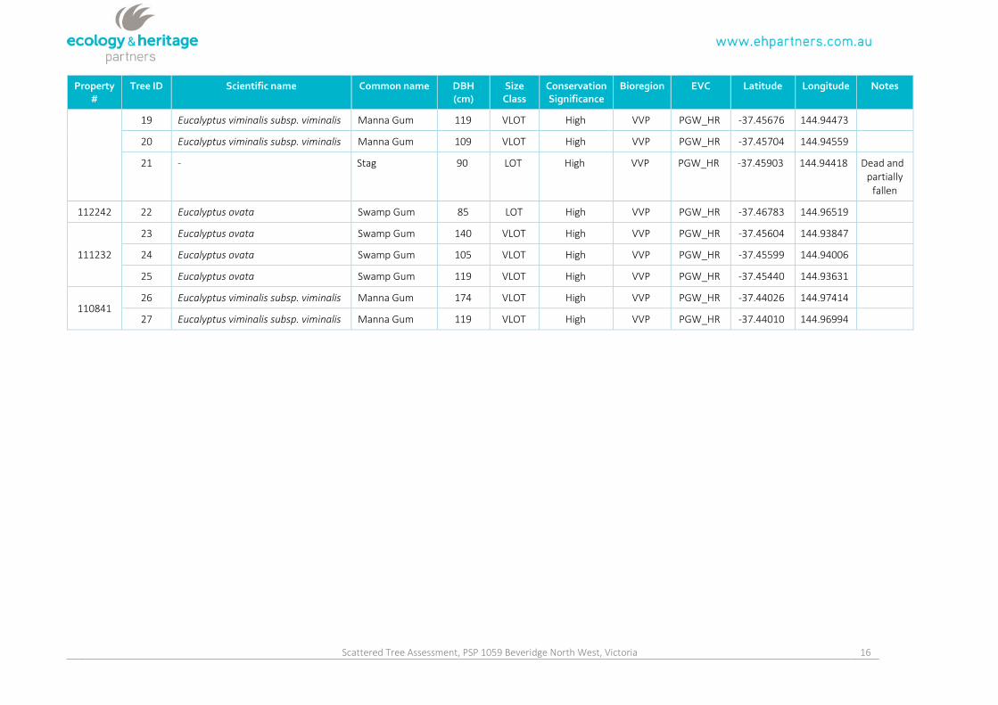
Scattered Tree Assessment, PSP 1059 Beveridge North West, Victoria 16
Property#
Tree ID Scientific name Common name DBH(cm)
SizeClass
ConservationSignificance
Bioregion EVC Latitude Longitude Notes
19 Eucalyptus viminalis subsp. viminalis Manna Gum 119 VLOT High VVP PGW_HR -37.45676 144.94473
20 Eucalyptus viminalis subsp. viminalis Manna Gum 109 VLOT High VVP PGW_HR -37.45704 144.94559
21 - Stag 90 LOT High VVP PGW_HR -37.45903 144.94418 Dead andpartially
fallen
112242 22 Eucalyptus ovata Swamp Gum 85 LOT High VVP PGW_HR -37.46783 144.96519
111232
23 Eucalyptus ovata Swamp Gum 140 VLOT High VVP PGW_HR -37.45604 144.93847
24 Eucalyptus ovata Swamp Gum 105 VLOT High VVP PGW_HR -37.45599 144.94006
25 Eucalyptus ovata Swamp Gum 119 VLOT High VVP PGW_HR -37.45440 144.93631
11084126 Eucalyptus viminalis subsp. viminalis Manna Gum 174 VLOT High VVP PGW_HR -37.44026 144.97414
27 Eucalyptus viminalis subsp. viminalis Manna Gum 119 VLOT High VVP PGW_HR -37.44010 144.96994

Scattered Tree Assessment, PSP 1059 Beveridge North West, Victoria 17
Appendix 1.2 – Tree Retention Zones
Tree Retention Zones (TRZs) should be implemented to prevent indirect losses of native vegetation during
construction activities (DSE 2010). A TRZ applies to a tree and is a specific area above and below the ground,
with a radius 12 x the DBH. At a minimum standard a TRZ should consider the following:
A TRZ of trees should be a radius no less than two metres or greater than 15 metres;
Construction, related activities and encroachment (i.e. earthworks such as trenching that disturb the
root zone) should be excluded from the TRZ;
Where encroachment exceeds 10% of the total area of the TRZ, the tree should be considered as
lost and offset accordingly;
Directional drilling may be used for works within the TRZ without being considered encroachment.
The directional bore should be at least 600 millimetres deep;
The above guidelines may be varied if a qualified arborist confirms the works will not significantly
damage the tree (including stags / dead trees). In this case the tree would be retained and no offset
would be required; and,
Where the minimum standard for a TRZ has not been met an offset may be required.
A Tree Protection Zone (TPZ) is different to a TRZ. A TPZ applies to any scattered trees used as an offset and
is designed not only to prevent the tree from indirect damage, but also to give it sufficient space to recruit
new trees in the future. A TPZ is defined as an area of twice the canopy diameter, which should be fenced
and protected from adverse impacts (e.g. grazing, burning, soil disturbance, removal of logs, etc.) (DSE
2007).