Embed Size (px)
Citation preview

Dean Road & Manor Road Cemeteries
Character Appraisal
Adopted 6 September 2010
CWH/CLS Page 1
A Character Appraisal of Dean Rd & Manor Rd cemeteries
Sca
rbor
ough
Bor
ough
Cou
ncil
“All
toge
ther
bet
ter”

A CONSERVATION AREA APPRAISAL OF DEAN ROAD AND MANOR ROAD CEMETERIES
CONTENTS 1 Introduction 2 The Planning Policy Context 3 Location and Setting 4 Historical Development 5 Character Analysis 6 Issues
Appendix 1 Historic Maps and Plans
Maps - At the end of the document:
1 The wider setting of Dean Road and Manor Road cemeteries 2 Historical development of the cemeteries 3 Character areas 4 Character appraisal 5 Problems & issues 6 Proposed Conservation Area boundary
A Character Appraisal of Dean Rd & Manor Rd cemeteries CWH/CLS Page 2

1. INTRODUCTION This appraisal of Dean Road and Manor Road Cemeteries seeks to record and analyse the various features of the area that give it its characteristics, in order to inform the making of decisions which are likely to affect that character. The area’s buildings and spaces are noted and described, and marked on the Character Appraisal Map along with significant trees, boundaries and other features. This appraisal builds upon national policy, as set out in PPS5 (Planning and the Historic Environment), and local policy, as set out in the Local Plan. English Heritage has produced guidance on preparing Conservation Area Appraisals and Management Plans. That guidance has informed the preparation, layout and content of this document, as has the guidance contained in PPS5, and guidance from the English Historic Towns Forum. Acknowledgements Reference has been made to the following Binns, J The History of Scarborough Brogden Baker, J The History of Scarbrough (sic) Jordan, J The Register of Parks and Gardens: Cemeteries
English Heritage 2003 Information, particularly on the biographical background to various memorials has been provided by The Friends of Dean Road and Manor Road Cemetery.
A Character Appraisal of Dean Rd & Manor Rd cemeteries CWH/CLS Page 3

2. THE PLANNING POLICY CONTEXT Designation of Conservation Areas takes place under the provisions of Section 69 of the Planning (Listed Buildings and Conservation Areas) Act 1990. A Conservation Area is defined as “an Area of Special Architectural or Historic Interest, the character or appearance of which it is desirable to preserve or enhance”. It is the quality and interest of an area, rather than those of individual buildings, which are the prime consideration in identifying a Conservation Area. Section 71 of the same Act requires Local Planning Authorities to formulate and publish proposals for the preservation and enhancement of any parts of their area that are designated as Conservation Areas. Section 72 specifies that, in making a decision on an application for development in a Conservation Area, special attention shall be paid to the desirability of preserving or enhancing the character and appearance of that area. This document should be read in conjunction with national planning policy guidance, particularly Planning Policy Statement 5 (PPS15) - Planning for the Historic Environment. Policy HE2.1 Regional and local planning authorities should ensure that they have evidence about the historic environment and heritage assets in their area and that this is publicly documented. The level of detail of the evidence should be proportionate and sufficient to inform adequately the plan-making process. Policy HE2.3 Local planning authorities should use the evidence to assess the type, numbers, distribution, significance and condition of heritage assets and the contribution that they may make to their environment now and in the future. It should also be used to help predict the likelihood that currently unidentified heritage assets, particularly sites of historic and archaeological interest, will be discovered in the future. HE3.4 At a local level, plans should consider the qualities and local distinctiveness of the historic environment and how these can contribute to the development of the spatial vision in the local development framework core strategy. Heritage assets can be used to ensure continued sustainability of an area and promote a sense of place. Plans at a local level are likely to consider investment in and enhancement of historic places, including the public realm, in more detail. They should include consideration of how best to conserve individual, groups or types of heritage assets that are most at risk of loss through neglect, decay or other threats Local Planning Policy Scarborough Borough Local Plan, adopted in April 1999, provides a number of policies on Conservation Areas. The Local Development Framework (LDF) will be a portfolio of local development documents, collectively delivering the spatial planning strategy for the whole of the Borough (outside the National Park). The Local Development Framework, when adopted, will replace the Local Plan; but the following Local Plan policies relevant to the area will be ‘saved’ for the time being :-
A Character Appraisal of Dean Rd & Manor Rd cemeteries CWH/CLS Page 4

E14 Extensions and Alterations. E23 Detailing in Conservation Areas. H3 Small Scale/Infill Housing Development with the Development Limits of
Settlements. H12 The Conversion and Sub-Division of Buildings for Residential Use.
These policies are backed up by the following published policy and guidance leaflets and booklets:-
Period Doors Sash Windows Listed Buildings Architectural Ironwork Window Replacement Policy
A Character Appraisal of Dean Rd & Manor Rd cemeteries CWH/CLS Page 5

3. LOCATION AND SETTING The wider setting of Dean Road and Manor Road Cemeteries is shown on Map 1. This map also shows other heritage designations in the vicinity. Dean Road Cemetery is located about 0.6 km north west of the town centre. It is a roughly rectangular area bounded by Dean Road on the north, Garfield Road back lane on the south, Manor Road on the west and Columbus Ravine on the east. It forms part of a larger slightly curving finger of land, possibly the relict of a medieval strip field encompassing Dean Road Depot and the site of the former St Mary’s Hospital. Its wider setting is within mostly fairly dense late 19th/early 20th century ‘byelaw’ housing – ‘The Avenues’ on the north and Garfield Road and adjacent streets to the south. The cemetery forms a ‘green lung’ to these areas. Manor Road cemetery is more amorphous in shape and is located about 1 km north west of the town centre. It is bounded by Manor Road on the east, a footpath running parallel to the former Scarborough-Whitby railway line on the west (the footpath is within the appraisal area), an un-named footpath on the north and Woodland Ravine/Manor Road on the south. The wider setting is less densely developed, comprising as it does the open space (former railway sidings) to the north, Woodland Ravine to the south and Peasholm Glen to the north east. The main residential development in the area is Broadway and associated roads – this is a relatively low density layout heavily influenced by the garden city movement. There are two distinct parts of this cemetery – that to the south and east which takes in part of the valley of Peasholm Beck (not technically Peasholm Glen at this point), and the level area to the north.
A Character Appraisal of Dean Rd & Manor Rd cemeteries CWH/CLS Page 6

4. HISTORICAL DEVELOPMENT
The combination of Dean Road and Manor Road Cemeteries was formerly known as "Scarborough Cemetery” and together they form one of the largest of its kind the in the area. They hold a wealth of the town’s heritage both historically and environmentally. The two distinct portions, divided by a road, have since been recognised as two separate cemeteries, the older part being called Dean Road Cemetery and the newer portion Manor Road Cemetery. The phases in the development of the cemeteries are shown on Map 2. By the 1850s the issue of burial space was becoming a pressing one for Scarborough – the churchyards were running out of space. The population of the Municipality was about 15,000 and there were over 320 deaths per year. Nationally too there were issues and the second cholera epidemic of 1848-9 led to a series of Acts, which became known as the Burial Acts, consolidated in 1857. These Acts established a national system of public cemeteries. Burial Boards became responsible for providing for the interment of the dead of the parish and could do so by building a cemetery, charging the expenses to the Poor Rate. Part of any new cemetery could be consecrated for Anglican use but part had to remain unconsecrated for the use of Nonconformists and this led to some controversy in Scarborough – see below. Once open, management of the cemetery became the responsibility of the Burial Board which could fix fees and charges, and sell grave plots. Using these powers, the land for Dean Road cemetery was purchased by the Corporation in 1856. It was a strip field known as Chapman’s Pasture running to 12 acres (though only 10 were initially laid out as cemetery) purchased at a cost of £3,000 and opened as a cemetery in 1857. Dean Road itself (known until 1912 as Cemetery Road) follows the alignment of an ancient right of way which in the early 1850s was a field track. The creation of Dean Road cemetery was not without controversy - some Anglicans wanted a separate burial ground with its own mortuary chapel. The compromise solution was, as the Burial Act allowed, dedicating the eastern half of the cemetery to the Anglicans and the western half to the other denominations. A central building was provided containing two mortuary chapels divided by a hearse entry topped by a spire was provided. The new cemetery was bounded by a perimeter wall and railings. It must have developed nicely, for the 1858 edition of Theakston’s Guide to Scarborough comments upon the neatly kept walks, the well-trimmed beds and the beauty of the situation. The greater part of Manor Road Cemetery, which was originally known as New Cemetery, was opened in 1872 on land west of modern Manor Road which again in the 1850s was an ancient field track. The land crosses the ravine of Peasholm Beck into fields which were located in Scalby Parish, the beck being the boundary between Scarborough and Scalby from medieval times - indeed this part of the cemetery was within the administrative area of Scalby UDC until the boundaries of Scarborough MBC were extended on 1 April 1914, which is also the date on which the Burial Board was absorbed by the Municipal Borough Council.
A Character Appraisal of Dean Rd & Manor Rd cemeteries CWH/CLS Page 7

The lands available were owned by the Crown (north of the beck) and J. Woodall (south of the beck), the purchase being completed in April 1871. Messrs J. & D. Petch, architects supplied an estimate for work to be done on both areas but the landscaping was in accordance with the plans of the winning design by Superintendent Mr. L. Thompson. The new area added approximate 10 acres to the existing Dean Road Cemetery A religious service was held by Non-Conformists of the town at Manor Road Cemetery, on the evening of Friday 19th July 1872. Because of poor weather they were forced to assemble under the tunnel for shelter before the service could begin, so this feature was clearly complete by then, but consecration of the Church of England sections of Manor Road Cemetery were not held until Monday 12th July 1880. A further addition to the Church of England sections in Manor Road Cemetery was consecrated on Friday 27th August 1909. In 1882 Joseph Brogden Baker in his History of Scarbrough (sic) reported that the enlarged cemetery ‘is much frequented, especially on Sunday afternoons, as a place of resort’. A mortuary chapel was first planned for Manor Road Cemetery in February 1873 after Vicars, Churchwardens, medical men, lodging-house keepers, hotel-keepers and others had pressed for a building to be provided near to the graveyard especially for cases of death by disease,. 105 people died from small-pox in 1871 and 1872. But in April 1876 it was reported that work on the chapel and a bridge had been postponed due to the price of iron and materials. The new chapel was built in 1901/02, the first service being held on Tuesday 9th December 1902. The extreme northern end of Manor Road Cemetery was laid out between 1928 and 1938 on land acquired by Scarborough MBC from the Crown as part of the Northstead Estate. This extension involved re-locating an ancient right of way to form a broad northern loop which now forms the boundary of the cemetery. Additional Church of England sections here were consecrated on Monday 15th August 1932 The Borough Council discontinued use of the chapel building in Dean Road Cemetery for funeral services on, Monday 5th October 1964. In April 1972 it was announced that the spire of the chapel building in Dean Road was to be demolished
A Character Appraisal of Dean Rd & Manor Rd cemeteries CWH/CLS Page 8

5. CHARACTER ANALYSIS General Character Three distinct character areas have been identified and these are shown on Map 3. They are:-
1 Dean Road Cemetery 2 The southern & eastern part of Manor Road Cemetery comprising the valley
of Peasholm Beck and some small side valleys 3 The northern part of Manor Road Cemetery which is a relatively level area
A detailed analysis of the individual character areas is included in the following sections which in each case include: Layout
Significant buildings/structures Building materials Trees Boundary treatment Significant memorials Negative factors Key views
Map 4 illustrates the character appraisal in conjunction with the following description.
Character Area 1 – Dean Road Cemetery Layout This cemetery is laid out in a formal rectilinear design. A central, north-south avenue lined with trees and memorials passes between two entrance lodges and approaches the mortuary chapel which forms the central focal point of the cemetery. At right angles to this a, second broad avenue runs the full length of the east–west axis. This axial path is punctuated by two rondponts with further paths running off at right angles, though the easternmost set of these has now gone. Significant buildings/structures Mortuary Chapel The mortuary chapel was designed in 1856 by Pritchett & Sons of Darlington & York who won an architectural competition for the work. Pritchett & Sons were leading exponents of the design of cemetery buildings. James Pigott Pritchett designed the layout and buildings at Fulford Cemetery (York Cemetery, 1836-7) and the buildings at Weaste Cemetery, Salford (opened 1857). The practice Pritchett & Sons was involved with sites at Sudbury, Darlington, St Andrews, Newcastle-upon-Tyne, Saffron Walden, Boston, Tottenham, Mansfield, Colne, Whitby, and Great Driffield as well as Scarborough. The building is a heavy Victorian Gothic design, in random rock faced stone under a green slate roof, the slates being cut in ‘fishtails’. Originally the chapels had a spire,
A Character Appraisal of Dean Rd & Manor Rd cemeteries CWH/CLS Page 9

only the base of which now exists, and this would have given the structure a less ponderous feel. The mortuary chapel Left – during demolition of the spire in 1972 Right – the same view today The building is cruciform in plan, divided into an Anglican part to the east and a nonconformist (including RC) part to the west, by a central entrance having double doors at each side capable of taking a hearse. The Anglican part has its long axis east-west, i.e. so that liturgical east is true east (or very nearly) whilst the non-conformist section has its long axis north-south so that liturgical east is at the north. Mortuary This small building is located against the south boundary wall and is also thought to be by Pritchett & Sons. It is also in stone under a slate roof
The mortuary
A Character Appraisal of Dean Rd & Manor Rd cemeteries CWH/CLS Page 10
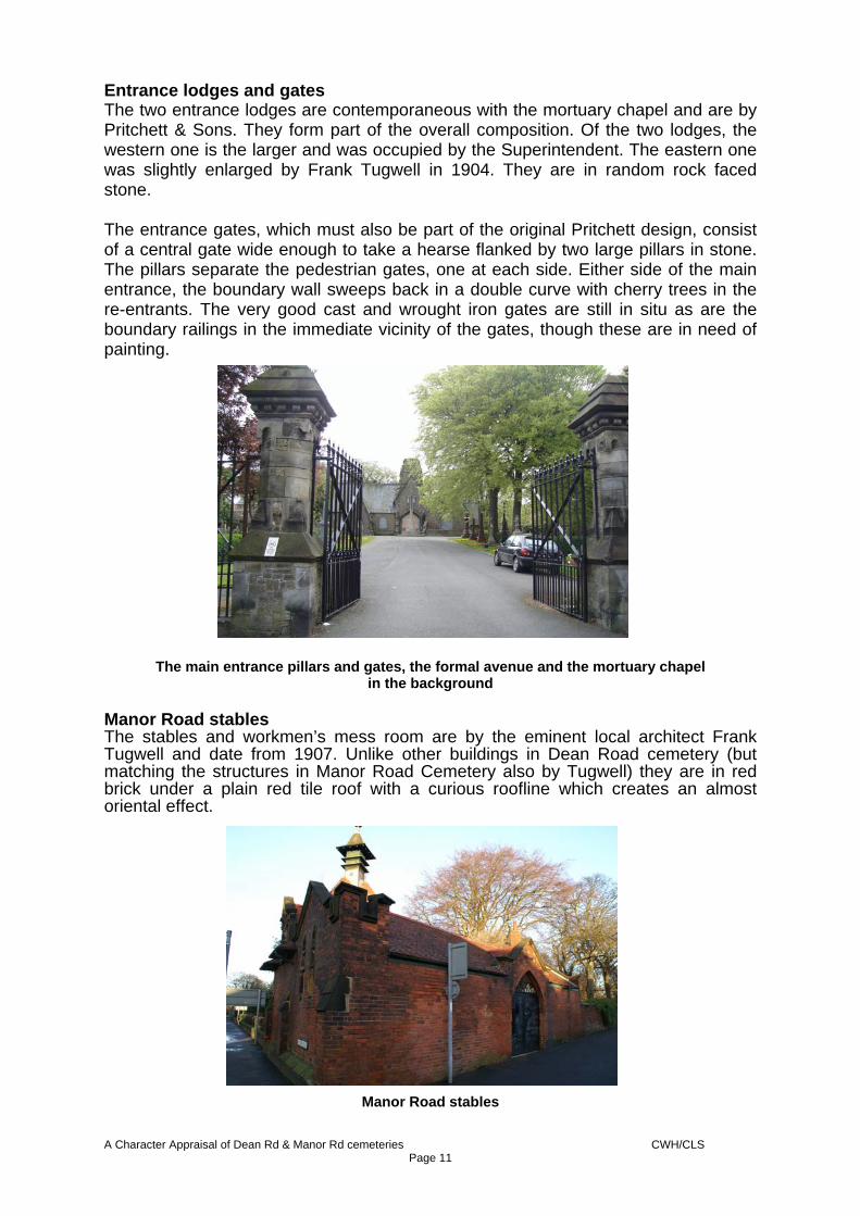
Entrance lodges and gates The two entrance lodges are contemporaneous with the mortuary chapel and are by Pritchett & Sons. They form part of the overall composition. Of the two lodges, the western one is the larger and was occupied by the Superintendent. The eastern one was slightly enlarged by Frank Tugwell in 1904. They are in random rock faced stone. The entrance gates, which must also be part of the original Pritchett design, consist of a central gate wide enough to take a hearse flanked by two large pillars in stone. The pillars separate the pedestrian gates, one at each side. Either side of the main entrance, the boundary wall sweeps back in a double curve with cherry trees in the re-entrants. The very good cast and wrought iron gates are still in situ as are the boundary railings in the immediate vicinity of the gates, though these are in need of painting.
The main entrance pillars and gates, the formal avenue and the mortuary chapel in the background
Manor Road stables The stables and workmen’s mess room are by the eminent local architect Frank Tugwell and date from 1907. Unlike other buildings in Dean Road cemetery (but matching the structures in Manor Road Cemetery also by Tugwell) they are in red brick under a plain red tile roof with a curious roofline which creates an almost oriental effect.
Manor Road stables
A Character Appraisal of Dean Rd & Manor Rd cemeteries CWH/CLS Page 11

Tunnel under Manor Road The extension of the cemetery to form what is now known as Manor Road Cemetery (originally New Cemetery) was designed by Leonard Thompson, Superintendent of Dean Road Cemetery. It was he who suggested a tunnel under Manor Road (which obviated the need for an entrance lodge here and two pairs of entrance gates) although it is not known who designed the tunnel detail. The tunnel is carried out in coursed rock faced stone, a gothic arch but no other decoration on this elevation and a retaining wall flanking an avenue which is lined with trees and memorials. The tunnel under Manor Road view from the east showing the memorial lined avenue down to
it Cross of Sacrifice This Cross of Sacrifice was raised in Dean Road Cemetery in 1920 by then Imperial War Graves Commission (now the Commonwealth War Graves Commission) which came into being on 21st May 1917. It is cut from Stancliff sandstone from Derbyshire. Cross of Sacrifice
A Character Appraisal of Dean Rd & Manor Rd cemeteries CWH/CLS Page 12

It is not a war memorial (that is on Olivers Mount) but the Cross of Sacrifice is designed to commemorate those who had given their lives in conflict. The Scarborough example is a standard design by the eminent architect Reginald Blomfield which incorporates overt Christian symbolism and is of a type that came in standard heights of 14, 18, 20 and 24 feet – this one is *** high. There are 33 recognised war casualties buried in Dean Road Cemetery and 93 in Manor Road Cemetery Building materials Random rock faced stone is the predominant building material for buildings and retaining walls, but boundary walls are in mellow common brick. The stables are in a dark red facing brick. Most buildings are roofed in slate whilst the stables are in red ‘Rosemary’ tiles and some shingles Trees Trees were originally planted flanking the paths and boundaries, and within the rondpont,s with a scatter throughout the burial area - some of these trees still exist. As the cemetery has developed the tree planting has become more informal but nevertheless the trees flanking the main avenues still create an important composition and comprise a number of interesting and unusual specimens:
Two known veteran trees – a common beech and a wych elm. Both verified on 13/11/2008 A champion tree - Swedish whitebeam, verified in November 1994 A stand of very fine beech trees Other large and important trees include holm oaks, copper beech, smooth-leafed elm, sessile oak, horse chestnut and sweet chestnut
Boundary treatment The north, east and west boundaries consist of a low wall in mellow common brick capped by a substantial stone coping. This coping was originally topped by cast iron railings but these now only exist for a short distance either side of the formal north entrance. The west boundary consists of a simple high brick wall punctuated by two entrances with cast iron gates, the southern one of which, for pedestrians only is aligned on Raleigh Street. The northern double gateway has very good cast iron gates. Significant memorials This part of the cemetery contains memorials to many important people who are significant locally and in some cases nationally, including:- • Joseph Brogden Baker – chemist, founder of the Scarborough Gas Company,
entrepreneur and historian, 1883. • William Bean. • William Dove – sculptor. • Esme Laughton – wife of Tom Laughton and art benefactor. • Robert Laughton – of the Laughton family of hoteliers.
A Character Appraisal of Dean Rd & Manor Rd cemeteries CWH/CLS Page 13
• Genevieve W. Lord M.B.E. – freeman of the Borough, trustee of several charities, founder of Scarborough & District Civic Society and Guide Commissioner. 1910-1989,
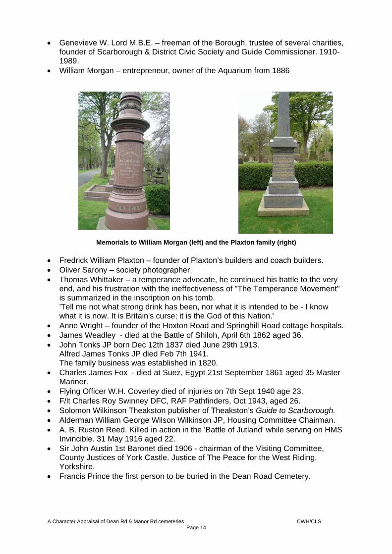
• William Morgan – entrepreneur, owner of the Aquarium from 1886
Memorials to William Morgan (left) and the Plaxton family (right) • Fredrick William Plaxton – founder of Plaxton’s builders and coach builders. • Oliver Sarony – society photographer. • Thomas Whittaker – a temperance advocate, he continued his battle to the very
end, and his frustration with the ineffectiveness of "The Temperance Movement" is summarized in the inscription on his tomb. 'Tell me not what strong drink has been, nor what it is intended to be - I know what it is now. It is Britain's curse; it is the God of this Nation.'
• Anne Wright – founder of the Hoxton Road and Springhill Road cottage hospitals. • James Weadley - died at the Battle of Shiloh, April 6th 1862 aged 36. • John Tonks JP born Dec 12th 1837 died June 29th 1913.
Alfred James Tonks JP died Feb 7th 1941. The family business was established in 1820.
• Charles James Fox - died at Suez, Egypt 21st September 1861 aged 35 Master Mariner.
• Flying Officer W.H. Coverley died of injuries on 7th Sept 1940 age 23. • F/lt Charles Roy Swinney DFC, RAF Pathfinders, Oct 1943, aged 26. • Solomon Wilkinson Theakston publisher of Theakston’s Guide to Scarborough. • Alderman William George Wilson Wilkinson JP, Housing Committee Chairman. • A. B. Ruston Reed. Killed in action in the 'Battle of Jutland' while serving on HMS
Invincible. 31 May 1916 aged 22. • Sir John Austin 1st Baronet died 1906 - chairman of the Visiting Committee,
County Justices of York Castle. Justice of The Peace for the West Riding, Yorkshire.
• Francis Prince the first person to be buried in the Dean Road Cemetery.
A Character Appraisal of Dean Rd & Manor Rd cemeteries CWH/CLS Page 14

• Charles Arthur Wilkinson - Surgeon, acting Medical Officer of Health for Scarborough , founder of the Scarborough Division of St John Ambulance Brigade.
• Frederick John Sawdon GP. • James Pirie - linked with the Borough Gas Company, Public Market, Central
Tram Way, Filey Water and Gas Company, Scarborough Laundry Company, Building Society etc mayor for the year 1897-98.
• William Postgate Newham, developer, haulage contractor. • William Spencer for 40 years manager of South Cliff Baths, on Ramshill Road
South Cliff. • David Hunter, county wicket keeper for Yorkshire CCC between 1888 and 1909. • Harry Firth killed in the Bombardment of Scarborough16-12-1914. • John Barry architect, building contractor and stonemason. • Mamie Benson founder of the 'Benson Stage Academy.' • Alderman Pantland Hick, J.P, sea captain and town mayor 1883-4. Negative factors The poor condition of the Mortuary Chapel, Mortuary and Stables has a detrimental effect on the character of the area. Significant numbers of memorials have been either damaged or pushed over Key vistas The vista from the cemetery lodges down the central axial road towards the mortuary chapel is a key vista and part of the original design. The later addition of the Cross of sacrifice has added to this vista rather than detracted from it.
Character Area 2 – Manor Road Cemetery – south and east Layout This part of the cemetery, originally known as New Cemetery, was designed and laid out by Leonard Thompson, Superintendent of the Scarborough Cemetery from 1865 until 1911. Thompson entered the competition run by the Burial Board and his design was accepted. He also laid out the Clarence Gardens in Scarborough and was asked to lay out Lawnswood Cemetery in Leeds, though there is no information on precisely what role he played in this. Character Area 2, which comprises between half and two thirds of New Cemetery, is influenced by the valley of Peasholm Beck (though the beck itself is culverted and is not a feature) and the landform dominates the character of the area. Thompson’s response to the landform was to create a series of level areas in the valley bottom and a series of terraces linked by sinuous paths (though some of these are out of use) creating a markedly different character from Area 1 i.e. one which is much more flowing and sylvan with individually good trees and substantial stands of trees. The extreme south is set out almost as an amphitheatre facing a rondpont, whilst one of the side valleys is known as the Secret Garden and is designed as a grotto. There are flatter more formal areas to the south and west which were originally subdivided by straight paths, but these have now gone.
A Character Appraisal of Dean Rd & Manor Rd cemeteries CWH/CLS Page 15

Significant buildings/structures Mortuary Chapel This general’ i.e. non-denominational chapel stands at the Manor Road entrance and was designed in 1901 by the eminent local architect Frank Tugwell, with additions of 1904. It is built in red brick under a plain red tile roof with stone trim to door surrounds, windows, gables and other features. The date stone, 1902, gives the completion date.
Detail of the Manor Road Mortuary Chapel
Lodge Also designed in 1901 by the architect Frank Tugwell, the Manor Road cemetery, lodge forms a group with the chapel and is also in red brick under a red tile roof with stone trim to doors windows and gables. Again the date stone 1902 is the completion date.
Manor Road cemetery lodge
A Character Appraisal of Dean Rd & Manor Rd cemeteries CWH/CLS Page 16
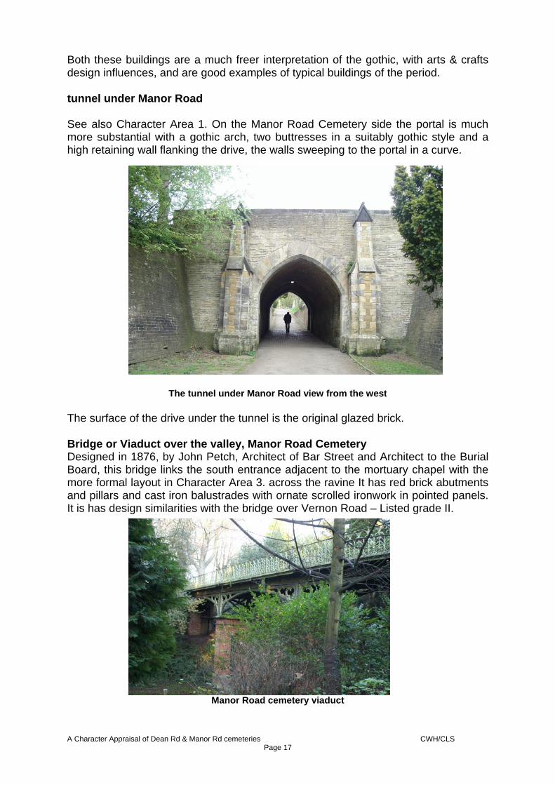
Both these buildings are a much freer interpretation of the gothic, with arts & crafts design influences, and are good examples of typical buildings of the period. tunnel under Manor Road See also Character Area 1. On the Manor Road Cemetery side the portal is much more substantial with a gothic arch, two buttresses in a suitably gothic style and a high retaining wall flanking the drive, the walls sweeping to the portal in a curve.
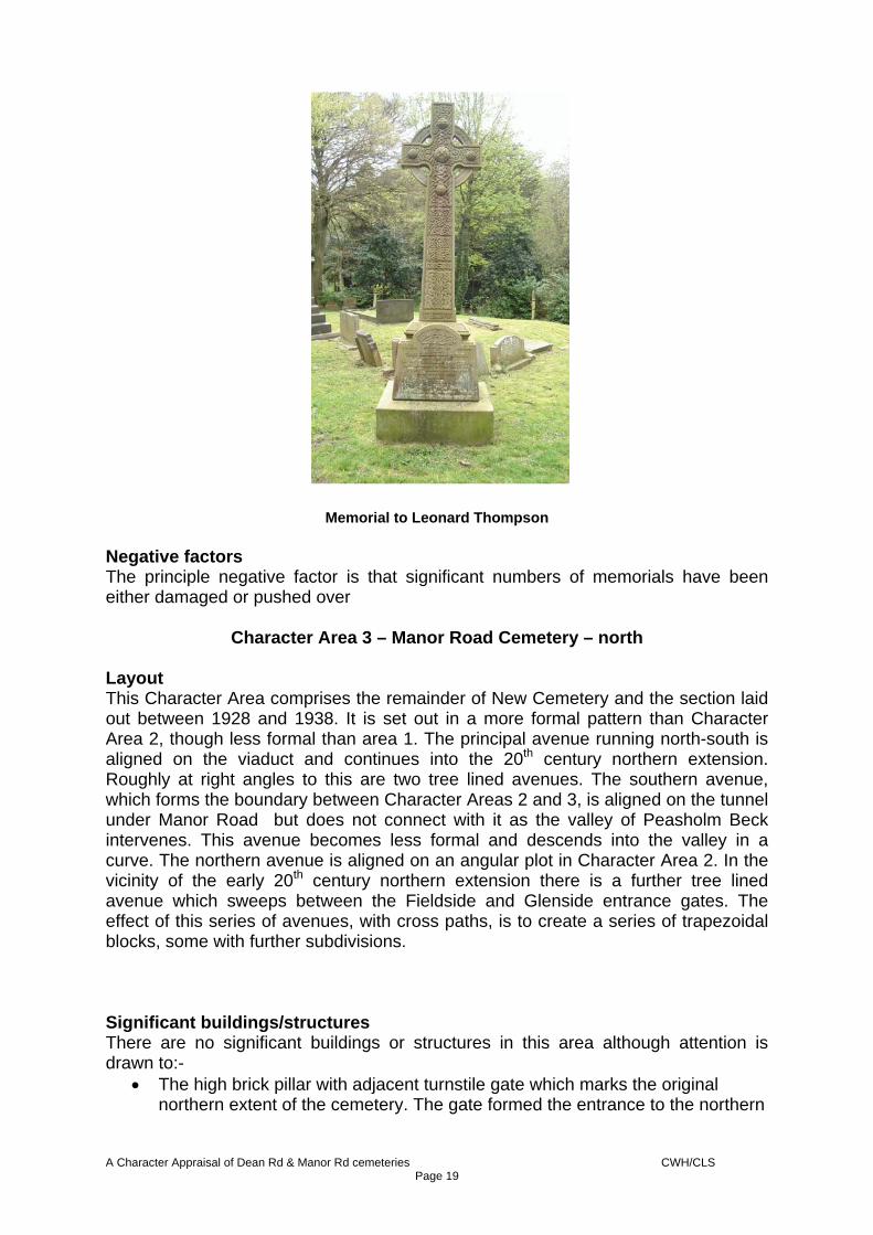
The tunnel under Manor Road view from the west The surface of the drive under the tunnel is the original glazed brick. Bridge or Viaduct over the valley, Manor Road Cemetery Designed in 1876, by John Petch, Architect of Bar Street and Architect to the Burial Board, this bridge links the south entrance adjacent to the mortuary chapel with the more formal layout in Character Area 3. across the ravine It has red brick abutments and pillars and cast iron balustrades with ornate scrolled ironwork in pointed panels. It is has design similarities with the bridge over Vernon Road – Listed grade II.
Manor Road cemetery viaduct
A Character Appraisal of Dean Rd & Manor Rd cemeteries CWH/CLS Page 17

Building materials The predominant building material in this area is smooth red brick with stone ashlar trim and small red plain tiles for roofs Trees A number of interesting and unusual trees are present in this part of the cemetery including Japanese cedar, western hemlock, coast redwood, monkey puzzle, giant redwood, Austrian pine, wych elm, purple myrobalan plum, cristate beech (possibly the tallest in Yorkshire at 20.5 metres (67ft)), Deodar cedar, Tree of Heaven and Highclere holly. Boundary treatment The Manor Road boundary consists of a low wall in mellow common brick capped by a substantial stone coping. This coping was originally topped by cast iron railings but these now only exist for a short distance adjacent to the mortuary chapel and lodge where they are a modern replacement (with bottom rail).
Modern boundary treatment near the Manor Road mortuary chapel and lodge The boundary with the path which separates the cemetery from Peasholm Glen is a simple high brick wall topped by a terracotta coping. The boundary with the ‘railway path’ is a modern railing in galvanised and unpainted steel. Significant memorials This part of the cemetery contains memorials to:-
• Leonard Thompson - Superintendent of Dean Road Cemetery, designer of Manor Road Cemetery.
• Edward Leppington, cab driver, the first interment in Manor Road Cemetery
on either Wednesday 24th or Thursday 25th July 1872 (conflicting reports).
A Character Appraisal of Dean Rd & Manor Rd cemeteries CWH/CLS Page 18
Memorial to Leonard Thompson Negative factors The principle negative factor is that significant numbers of memorials have been either damaged or pushed over
Character Area 3 – Manor Road Cemetery – north Layout This Character Area comprises the remainder of New Cemetery and the section laid out between 1928 and 1938. It is set out in a more formal pattern than Character Area 2, though less formal than area 1. The principal avenue running north-south is aligned on the viaduct and continues into the 20th century northern extension. Roughly at right angles to this are two tree lined avenues. The southern avenue, which forms the boundary between Character Areas 2 and 3, is aligned on the tunnel under Manor Road but does not connect with it as the valley of Peasholm Beck intervenes. This avenue becomes less formal and descends into the valley in a curve. The northern avenue is aligned on an angular plot in Character Area 2. In the vicinity of the early 20th century northern extension there is a further tree lined avenue which sweeps between the Fieldside and Glenside entrance gates. The effect of this series of avenues, with cross paths, is to create a series of trapezoidal blocks, some with further subdivisions. Significant buildings/structures There are no significant buildings or structures in this area although attention is drawn to:-
• The high brick pillar with adjacent turnstile gate which marks the original northern extent of the cemetery. The gate formed the entrance to the northern
A Character Appraisal of Dean Rd & Manor Rd cemeteries CWH/CLS Page 19

path prior to its obliteration when the northern cemetery extension was laid out.
• The two formal gated entrances off Glenside and Fieldside with pre-cast concrete pillars and iron gates.
• The abutment to a bridge across the former Scarborough-Whitby railway which is of purely historical interest only.
Entrances to the 1930s extension Building materials Not applicable to this area Trees The trees are large and significant, although they are not as unusual as in the other sections of the cemetery. Nevertheless, their presence adds to the ambience which is calm and peaceful. Tree species include horse chestnut, sweet chestnut, sessile oak, beech, copper beech, silver birch, cherry, field maple and sycamore. Boundary treatment The northern boundary, from near the bridge abutment referred to above to the early gate pillars also referred to above consists of a low wall in red engineering brick capped by a substantial pre-cast concrete coping. This coping was originally topped by cast iron railings. The boundary with the path which separates the cemetery from Peasholm Glen is a simple high brick wall topped by a terracotta coping. The boundary with the ‘railway path’ is a modern railing in galvanised and un-painted steel. Significant memorial
• John Nicholas Sheader, coxswain of Scarborough Lifeboat, drowned when the lifeboat capsized 8 Dec 1954.
There is a significant group of war graves near the Fieldside entrance including one for a Dutch serviceman Negative factors
A Character Appraisal of Dean Rd & Manor Rd cemeteries CWH/CLS Page 20

A section of the boundary wall south west of the Fieldside entrance is missing leading to the creation of a short cut into the cemetery from the playing fields. This has caused increased vandalism in this part of the cemetery. Nearby, there are other damaged sections of wall. Significant numbers of memorials have been either damaged or pushed over Key vistas The vista from this part of the cemetery south towards the viaduct is visually important. Archaeological Issues There are no scheduled Monuments within the study area.
6. ISSUES The key issues affecting Dean road Cemetery and manor Road Cemetery are:-
• The deteriorating condition of the Dean Road mortuary chapel and the need to find a viable beneficial use for the building to ensure its restoration and long term preservation.
• The deteriorating condition of the small mortuary building in Dean Road
cemetery and the need to find a viable beneficial use for the building to ensure its restoration and long term preservation.
• The deteriorating condition of the Manor Road stables and the need to find a
viable beneficial use for the building to ensure its restoration and long term preservation.
• The need to ensure work respects the character of the area – see example
below.
• Issues surrounding the maintenance of and vandalism to the memorials and headstones some of which are artistically important in their own right and some of which represent people who have been important in the life of the town
• The paths and edging are in some parts dangerous or degraded
A Character Appraisal of Dean Rd & Manor Rd cemeteries CWH/CLS Page 21

The low boundary wall near the Fieldside entrance had become damaged thus encouraging people to take a short cut across the adjacent area. This had a knock on effect of increased vandalism to the memorials and headstones in this area. In response to this, a standard galvanised steel railing, of industrial type has been erected recently. Whilst this has addressed the problem of shortcutting, the new fence has not respected the original low plinth wall and is of extremely utilitarian appearance
7 RECOMMENDATIONS
The area is of acknowledged Special Architectural or Historic Interest and it is recommended that it be designated as a Conservation Area Subject to funding, the Character Appraisal be used as the basis for the preparation and development of a Conservation and Restoration Management Plan with the aim of:-
• Developing a strategy for the restoration and conservation led management of the asset as a whole including protection of the memorials and the historic layout
• Developing a strategy for the beneficial re-use and restoration of the problem assets such as the mortuary chapel, mortuary and stable (or bothy)
A Character Appraisal of Dean Rd & Manor Rd cemeteries CWH/CLS Page 22

• Developing a strategy for short and long term maintenance • Developing a strategy for the enhancement of the asset as a whole
A Character Appraisal of Dean Rd & Manor Rd cemeteries CWH/CLS Page 23

ANNEX 1 HISTORIC MAPS AND PLANS
(note these maps have been photographically reduced – do not scale from them)
Extract from the 1:1,560 scale ordnance Survey map published in 1852 showing the area still as fields
Extract from the 1:2500 scale Ordnance Survey map published in 1892
A Character Appraisal of Dean Rd & Manor Rd cemeteries CWH/CLS Page 24

Extract from the 1:500 scale Ordnance Survey map surveyed 1891, published 1892. Shows in detail the mortuary chapel and entrance lodges
Extract from the 1:2500 scale Ordnance Survey map published in 1912
A Character Appraisal of Dean Rd & Manor Rd cemeteries CWH/CLS Page 25

Extract from the 1:2500 scale Ordnance Survey map published in 1928
Extract from the 1:2500 scale Ordnance Survey map published in 1938
A Character Appraisal of Dean Rd & Manor Rd cemeteries CWH/CLS Page 26

ANNEX 2
BIOGRAPHICAL DETAILS RELATING TO MEMORIALS IN AREA 1
THIS ANNEX HAS BEEN SUPPLIED BY CHRISTINE MARK • Joseph Brogden Baker, entrepreneur and historian, was born April 1st 1801 and died May 24th
1883. Baker originally came from York and established a chemist and druggist business at 20 Newborough Street. He began by experimenting with gas lighting on his own premises which aroused the interest of others and led to the establishment of a Gas Company in 1832. The gas works opened 2 years later of Quay Street. Baker became acting secretary of the company and took over a considerable share of the management duties. He later proposed the establishment of a town water company, but his ideas were not acted upon. His next venture was a partnership with Mr. Joseph Parkinson; which led to the establishment of a brewer's, wine and spirit merchants in Harcourt Place. After the death of Parkinson, Baker sold the business, it is believed the motivation for the sale came from his growing Temperance principles, and moral and religious views. After this he was involved with the 'Society of Friends'. When he parted from that organisation he established a mission to save both sexes, especially the poor, from habits of vice. Baker developed an interest in agriculture and for some time occupied Throxenby Hall. He began to experiment with various crops and their hybridisation, unfortunately to the cost of the business side of farming. It was said; "He might be a good scientist, but he was a bad farmer". It was while developing his crops and new animal variants that he and some others formed the Scarborough and District Agricultural Society, based on the Hackness Agricultural Society. At over 70 he began his most famous work on the History of Scarborough which took him between 4 to 5 years. This book along, with those by Hinderwell, Rowntree and now Binns, has been the basis for many Scarborough historians' research for many years. He was married twice, leaving a widow.
• Genevieve W. Lord M.B.E. 1910-1989, was born at Derwent House, West Ayton. From 1938 she
had been involved, in a voluntary capacity, in the welfare of the elderly. She was chairman of the trustees of John Horne Homes, chairman and honorary Organisation Secretary of the Abbyfield Scarborough Society, a trustee and chairman of the Management Sub-Committee of Scarborough Municipal Charities. She was appointed on to the Executive Committee of the Scarborough Civic Society at its inaugural meeting in 1964 and was chairman until 1978. She also served many years in the Girl Guide Movement include 10 as Scarborough Division Commissioner. She was made a Freeman of the Borough .
• Fredrick William Plaxton, founder of Plaxton’s builders and coach builders, started a joinery
workshop in Bar Street in 1907. He moved to a larger workshop, the 'Castle Works' c1920, to meet the growing demand for cars and charabancs. By the 1930s they were building touring buses and service buses. A new factory built on Seamer Road opened January 1937. Fredrick William Plaxton Jr (Eric) became chairman in 1957, a position he held till he retired in 1988; he died in 1995.
• Oliver Sarony, society photographer. Photography during the 19th century became not only a
curiosity but an accessible method for families to have portraits of themselves, where previously only the privileged wealthy classes could afford to have an artist paint their likenesses. Sarony established his studios in Sarony Square Scarborough, now the site of St. Martin's Avenue car park. He made his name by reproducing near perfect images of sitters ranging from small locket photographs to life sized images. The studios also produced "some capital oil paintings and miniatures". In 1871, he conspired to produce the what became known as the Spa's 'gigantic fraud'; a portrait of Edward, Prince of Wales, surrounded by his admiring Scarborough subjects on the Spa promenade was painted by T. Jones Baker. Sarony sold 'places' and 'faces' on the picture for as much as 100 guineas.
• Thomas Whittaker the temperance advocate was born near Clitheroe. At the age of 7 he was
leaving his home each day to be at work in the factories for 5 am, returning home again for 8 pm at night. It was in the factory’s poor conditions that he saw that "Long hours, poor pay, crowded workshops, these things lead to immorality and drunkenness". He left the factory and began work in Preston as a dresser, he was asked to leave because of his constant preaching regarding the evils of drink. He went to Preston and met 'Levees' in the Temperance Hotel; at the age of 22 he was asked if he would become a temperance missionary. He first came to Scarborough in
A Character Appraisal of Dean Rd & Manor Rd cemeteries CWH/CLS Page 27

January 1839, when he delivered a lecture on temperance in the old Methodist Chapel, in Church Stairs-Street. In 1849 he came to live in Scarborough permanently, taking the Temperance Hotel in Newborough. In March 1861 Whittaker wrote an article regarding the loss of the Whit by lifeboat crew, linking the losses to alcohol. His enemies the breweries and ale house publicans are thought to have been behind the appearance of an effigy swinging from a ship's spar for half-a-day. A mob of up to 3,000 led by a band, paraded round the town and periodically flogged the effigy and smeared it with "red ochre to show the severity of the castigation". He was later elected Mayor and became a justice of the peace, showing that even after the aforementioned event; he managed to win over the towns people. He continued to preach and wrote many articles for newspapers, the "Express" and the Conservative "Scarborough Post". Many articles were declined so Whittaker started a newspaper called "The Watchman". When the "Mercury" company was formed he became a shareholder, eventually he and his sons became the owners.
He continued his battle to the very end, and his frustration with the ineffectiveness of "The Temperance Movement" is summarized in the inscription on his tomb; 'Tell me not what strong drink has been, nor what it is intended to be. I know what it is now. It is Britain's curse; it is the God of this Nation.'
• Anne Wright, founder of the Hoxton Rd and Springhill Rd cottage hospitals, originally opened a
small cottage hospital in 1867 in Hoxton Road, consisting of two small houses. A Cottage Hospital (1 to 7 Spring Hill Road) was built in 1869 and sold in 1931; the funds from which went towards the building of the new Scarborough Hospital.
• James Weadley died at the Battle of Shiloh, April 6th 1862 aged 36. He was a member of
Walker's 2nd Tennessee Confederate Infantry. He had been a builder and landlord of the 'Bull and Sun pub in Bridlington'. He and his family and brother Henry had left for the USA in 1860. Henry had become a corporal with Company C of the Pennsylvanian 116th Union Regiment. The Battle of Shiloh took place on April 6th & 7th 1862 in Mississippi, it is believed that 100,000 troops were involved, approximately 3,500 were killed and 16,400 were wounded.
• John Tonks JP born Dec 12th 1837 died June 29th 1913. Alfred James Tonks JP died Feb 7th
1941.The family business was established in 1820. • Charles James Fox died at Suez on 21st September 1861, aged 35. His will dated 2 January
1862 stated he was of Chin Chew in China, Master Mariner. His decedents who are researching their family history have found that he was on a tea/opium clipper
• Flying Officer W.H. Coverley died of injuries on 7th Sept 1940 age 23. He was shot down and his
plane crashed in flames, he managed to bale out but suffered from severe burns. • F/lt Charles Roy Swinney DFC was, along with Pilot Officer Bernard Trott, aboard a Lancaster
bomber from 156 Squadron which was attacked by a Luftwaffe fighter on January 14, 1944, during a raid on Brunswick, Germany. It was one of thirty-eight Lancaster's from 156 Squadron shot down that night.
• Mr. Solomon Wilkinson Theakston died on the 20th Jan 1875 aged 64. He opened his first Library
and Bookshop at 6 St. Nicholas St in 1828. He moved to No. 31 St Nicholas Street in 1841 on order to expand his business. This former lodging house now became the base for a library and bookshop, an art studio (where H. B. Carter exhibited and sold his works), a wall paper shop, a ticket office for the Spa, a place where you could collect the mail, newspaper office for the production of the weekly "Scarborough Gazette", and the place where he printed the local area guide book. The plates were drawn by Carter. His clerk, John Haygard, took over the business in 1875 when Solomon died, the business continued till 1895.
• William George Wilson Wilkinson died 27th June 1956 aged 81 & Mary Jane Wilkinson died 19th
Oct 1955 aged 78. Wilkinson attended the Central School until he was 13 years old. At 14 he was apprenticed to John Gibson's pawn brokers business in Castle Road. As a Councillor, W. G. Wilkinson was the Housing Chairman. He and his wife served as Mayor and Mayoress during 1938, 1939 and 1940. He became a J.P. in 1941 and served as a Corporation representative on the Harbour Committee for 18 years. In 1942 he was elected to the Aldermanic Bench. Over 1,000 houses were built while he was serving on the Housing Committee, he proved to be fair as
A Character Appraisal of Dean Rd & Manor Rd cemeteries CWH/CLS Page 28

regards who received these properties, not always giving way to those who shouted the most. He encouraged private housing development at Crossgates and Seamer, and Council development of Barrowcliffe, Deepdale etc. He had been a director of the Football Club, Vice-president of the Cricket Club, supporter of the St. Sepulchre St Methodist Chapel and Men's Association. He was a special constable since the Great War.
• AB Ruston Reed, the Son of William and Mary Jane Reed of 31 Nelson St, was killed in action in
the Battle of Jutland while serving on HMS Invincible on 31 May 1916. He was aged 22. • John Austin 1st Baronet Austin of Red Hill, Castleford was born March 9th 1824 and died age 82
on March 30th 1906. He was the son of John Austin and Hannah Fawcett. He married Agnes Byron, daughter of Samuel Standish Byron, in 1866. He was Member of Parliament (Conservative) for Osgoldcross between 1886 and 1906 and was created baronet on 16 July 1894. He was chairman of the Visiting Committee, County Justices of York Castle. He held the office of Justice of The Peace for the West Riding, Yorkshire.
• Francis Prince is the first person to be buried in the Dean Road Cemetery. • Charles Arthur Wilkinson: Surgeon, born in Halifax1868 and died in Scarborough 1897-1916. His
father Christopher Wilkinson was secretary of North Eastern Railway. He brought his family from York to live in Westwood Scarborough.Charles studied medicine at Edinburgh, worked in Leeds, coming back to Scarborough in 1897 when he set up a practice at 56, Gladstone Street. During WW1 he was acting Medical Officer of Health for Scarborough and worked at Scarborough Hospital as well as having an appointment at the Workhouse. He was also court Physician to the I.O. of F. (Canadian Order). 1910 he founded the Scarborough Div of St John Ambulance Brigade, and was its surgeon till his death. He lectured in the town on first aid, and was involved in the treatment of bombardment victims. He died of influenza and Meningitis aged 47.
• Frederick John Sawdon began as an apprentice to Mr. J. Coulson chemist and druggist, in Scarborough 1861. John eventually qualified in medicine from Edinburgh University. Later he gained a doctorate from Edinburgh University, and established a practice in Hull.He set up a practice in Scarborough C1900, and died in 1911.
• James Pirie J. was born in Aberdeenshire in 1838, and came to Driffield in 1857 to work in the
Drapery trade. He became a speculator and put his money in the hands of stockbrokers, who within 2 year had almost spent all of his money."That any fool could make money, but it took a wise man to keep it".He then became a house agent, district rate collector for the North Ward, an auctioneer and commission agent. In 1884 he invested in the Cliff Bridge Company, later he was linked with the; Borough Gas Company, Public Market, Central Tram Way, Filey Water and Gas Company, Scarborough Laundry Company, Building Society, Public Baths South Cliff Bath Companies, Coffee House and on the Board of Guardians. He became mayor for the year 1897-98.
• The Newham family was famous for developing a block of wooden shops and garages in Victoria
Road when the area was still basically opens fields known as the 'common'. They were removed (1970s) after approximately 100 years of use when the road was widened. The most famous of these garages being the Hardwick's Bus Garage.William Postgate Newham left school at 15 in 1858, and with his donkey, Jenny, laid the foundations of what would become the town's largest haulage contractors. His daughter Mary Jane married Edwin Dawson, a blacksmith from Hackness. For many years the old horse pulled business ran side by side with the new developing motorised haulage business. The haulage business was sold in 1959; the buildings were sold in 1970.
• William Spencer was for 40 years the manager of South Cliff Baths, on Ramshill Road South Cliff,
died Jan 22nd 1917.These new baths provided warm and cold baths; sea water, galvanic, vapour, sulphur, alkaline and various other forms of medical baths. The plans were prepared to the designs of John Petch, with a total capital of £6,000 and shares at £5.00 each. The building was designed to have 24 separate bathrooms with necessary offices and essential conveniences.
• David Hunter, county wicket keeper. Born on February 23, 1860 in Scarborough. He succeeded
his brother Joseph as the Yorkshire wicketkeeper at the relatively late age of 28 but was then an almost ever present player for the following two decades. He played 520 first class games for the
A Character Appraisal of Dean Rd & Manor Rd cemeteries CWH/CLS Page 29

White Rose between 1888 and 1909. In 552 matches in total he took 913 catches and completed 350 stumpings. A modest right handed tail-end batsman, he nevertheless compiled 4,538 runs at 12.03 with a best of 58* against Worcestershire CCC. Over the years he held up his end in stands of 53, 148, 121, 118 and 102 for the tenth wicket. He helped Yorkshire win the Championship 8 times and received £1,975 from his benefit match in the Roses clash against Lancashire at Bradford in 1897. Noted for always playing in the spirit of the game he remains a famous name in Yorkshire cricket. He died on January 11, 1927 in Northstead, Scarborough at the age of 66.
• Alderman Pantland Hick, J.P, was born in Scarborough in March 1833, and received his early
education at the grammar School, in King-Street. At the age of 14 he went to sea and worked his way up to captain. In 1863 he retired from sea to assist in the family business in Scarborough. He also married the daughter of Mr. John Tindall of Knapton Lodge. In 1874 he was elected to the town council, and in 1883-4 he became mayor
• Harry Firth killed in the Bombardment 16-12-1914. Messrs Clare & Hunt's corner establishment
was situated in South Street on the South Cliff. Two men were killed there in the bombardment, Mr. Harry Firth a driver for Messrs. Land & Co; and Leonard Ellis, a porter in the service of Messrs Clare & Hunt. The property was opposite Mr. Charles Smith, silversmith and antique dealer, also damaged in the bombardment.
• John Barry, born 1803 and died 1866, was a noted architect, building contractor and stonemason.
He undertook several projects for the Cliff Bridge Company, the most noted being Henry Wyatt's Gothic Salon. Other projects included; Wilson's Mariners Homes, Castle Rd (1836), designing the 19th century Newborough Gothic Bar 1843-1890. He under took contracts in Scotland, Arboreta's New Harbour and Leigh's Victoria Docks. He had a brick and stoneware factory in Barry's Lane off Seamer Rd, near to present day Hinderwell School. He was elected councillor for the North Ward and Mayor 1859-60. Barry's final major building contract was the construction of South Cliff Congregational Church (St. Andrew's Church).
• Mamie Benson died at aged 89 she was known as the towns 'dancing queen’ for 50 years. She
founded the 'Benson Stage Academy' in 1945, helping youngsters achieve their dreams. Many of the children she taught went on to be professional dancers. One student, Christopher Bruce, became the artistic director of the Rambert Dance Company. She was also known for her children's charity work, raising tens of thousands of pounds.
A Character Appraisal of Dean Rd & Manor Rd cemeteries CWH/CLS Page 30

GO R D O N ST REE T
GO R D O N ST REE T
NO R WO O D MEW S
CR
FF
War d B dy
War d B dy
Und
Ward B
dy
CR
ED Bd
y
CR
FW
FW
CW
CR
ED & War d Bd y
CWWar d B dyCW
Un d
CP
War d B dyCP
CP
Und
CR
War d B dy
CR
ED Bd y
CR
CR
CP
Un d
CF
Un d
War d B dy
CP
CRFW
ED Bd y
F FCW
FW
ED and W ard Bd y
ED and W ard Bd y
CP
CR
CW
De fCW ED Bd y
CR
ED Bd y
CRED an
d Ward
Bdy
FW
War d B dy
ED &
War
d Bd
y
CR
ED an
d W
ard Bd
yDe
fED Bd y
CRED Bd y
CW
War d B dy
De f
ED Bd y
CWFW
War d
Bdy
CR
ED & War d Bd yDe f
CP
ED Bd
y
Un d
FW
CP
War d
Bdy
War d B dy
CR
CR
CR
FW
FW
ED Bd
y
ED & War d Bd y
CR
CPCR
ED Bd
y
122124 120
179
118
126
25
ElSub Sta
175
126
173
157
Path
177
114
169
171
86
LB
100
75
67
57
102
87
7
9989
PLA CE
2
1
PRO SP ECT
32
95
MO U N T R O A D
16
97
WO O D LA N D
79
15
PRO S
P ECT
PAR K
TCB
28
1
42
42
55
74
54
31
16 2
1
9
142
7
62. 2m
11
PRO SP ECT
17
CR ESC EN T
12
1
55. 8m
26
BM 60. 31m
WO O D LA N D RA V IN E
53. 7m
Pro spec t Ba nk
7
8
Wa l k
WO O D LA N D RI SE
14
17
1
WOOD LA N D A VEN U E
9
12
2
Wo od la
n d Wa l k
12
1
Wo od la
n d
2
El Sub Sta
11
24
2422
44 to
to
42
to
LB 52. 5m
2 Shelter
55. 7m
BM 5 2. 92 m
Water
BM 5 4. 30 m53. 7m
52. 4m
Sluice
Playground
53. 7m
34
54. 8m
BM 5 6. 45 m
55. 3m
22
24
32
WOOD LAN D RA
V INE
55. 9m
BM 5 7. 38 m
El Sub Sta
WO O D LA N D RA V IN E
Peash olm Be ck
40
44
PINEW
OOD DRIV
E
61
7173
56
Peas
h olm
Beck
GP
12
59. 9m
150
1
Mulran
ey M
ano r
19
Grah
am C
o ur t
62. 7m
3
GR O V E
17
5
9
9 8GR A HA M
Ga lw ay C ou rt
STEPN E Y
CRESCENT
4
133
WOODLANDS
53. 4m
BM 54. 39m
85
117 a
119 a
81
119
70
78
128
138
10
20 16
51
111
4
107 a
122
117
55. 5m
STEPN E Y G R O VE
BM 58. 55m
6
109
114
35 to
62 Ha nov er Court
1 t o 2 8
Peash olm Be ck
35
Path
2931
26
6
37
PIN EWO O D D RIV E
38
El Sub Sta
11
47
57
2
14
17
12
CHESTNUT CLOSE
7
1
8
CH EST N U T B AN K
33
10
21
18
WO O D G A TE
15
FB
12
27
Path
Path
27
17
BANKCH EST N U T
33
30
31
22
37
MA N O R
PAR K
Arkendal e
3234 AV EN U E
ALEX A N D RA
1
3839
30
28
16
21
11
1
ALM O N D G RO V E6
El Sub Sta
32
18
O SBO R NE PA RK
24
85
98
58. 4m
107
106
95
ElSub Sta
94
BM 5 8. 09 m
2 to 8
9
SCA LBY R O AD
1 to 7
1014
10
ROC KLA N D G A RD E NS
2
13
39
46
1
11
46
20
26
ALEX A N D RA PA RK
63
75
56. 2m
8
92
54. 3m
2
61
2
8
14
40
Chape l
1
SM 42. 2m
BM 4 7. 01 m
Wat er
LB
BM 48. 45m
47. 9m
79
31
11a
11
71 15
2
75
9
7781
47. 7m
47. 6m
BM 4
8.24
m
59
WOOD
LAN D
RAV I
N E
48. 3m
52
MANO
R RO A
D
4767
51. 6m
18
35
13
2014
16
27
28
12
16
39
40
25
MA N O R G A RD E NS
13
1
LYELL STR EET
11795
58
43 42
BM 49. 67m
83105
47. 7m
34
38
38
GA R FIELD R O A D73
BM 4 9. 82 m
36
59
Sta
47
35El
61
48. 5m
24
76
Sub
NANSEN STR EET
38
32
26
23
NA R ES ST REE T
16
11
2
48 33
65
12
51. 9m
44
72
50. 9m
41
64
66
BM 5 2. 37 m
RALEIG H ST REE T
22
34
31
56
13
35
2
26
4
14
14
25
46. 2m
26
Ga rageCO
LUM
BUS
RAVIN
E3446
BM 37. 36m
26
60
1
42
31
35
43
21
L IVIN G ST O N E R O A D
BM 4 8. 87 m
21
38
54
2246. 6m
20
11
48
1
53
MU RC H ISO N ST RE ET
32
FRA N KLI N STR EET
LB
16
13
19
MU RC H ISO N ST RE ET
6
11
10
2
STR EETFRA N KL I N
2
Posts
14
2
19
BM 44. 98m
BM 4 4. 26 m
3
3
TCBs
27
11
Church
119
1
23
10
9
14
Banchory LodgeEl Su b St a
Works
Banch or y H o use
Works
2
6 70
9
69
22 to
2518
to 21
13
5 to 8
10 to 12
2 1
De pot
73
16 15
Court
44. 3m
14 to 17
1 to 4
Ge nevie ve
74
MELR O SE ST RE ET
85
23a
109
110
94
120
75
94
44. 9m
3
90 92
83
23 13
101109
88
War eho use
99
80
25
Factory10
4
9
69
HO X TO N RO A D
9
64
12
17
5145. 6m
57
66
BM 4
6.12
m
62
62
56
41TRA F
A LG A
R ST
R EET
WES
T
68
62
60
Architects
PH
County
1
14
Offi ce
NE LSO N ST REET
76
67
65
Chur
ch
64
67
53
55
59
54a
50
3
54
60
66
49. 4m 63
69
50
207
50. 0m
74
57
6159
62
55
BM 4 9. 75 m
TCB
65
26
41
14
RA MSEY ST REE T
29
195
51. 7m
38
185
BM 5 3. 69 m
173
15
Mano r F l a t s
1 t o 4
Pop lar C our t
51. 0m
38 288
BM 5 1. 19 m
219
55
51
36
Path
104
45
45a
to
MA N O R A V EN UE
LB
Ma no r F l a t s
1
4749
4
BM 5
4.42
m
32
Path
52. 8m
6779
1 to 20
216
190
93
202
9282
32
91
67
2330
CA LED O N IA ST RE ET79
55
70
PO
54. 0m
162
101
1
4
176
111
2
BM 5 4. 14 m
PRO SP ECT R O AD
MU RC H ISO N ST RE ET
161
147
159
Surgery
2
53. 9m
6
1
123
150
91
74
136
29
32
80
135
76
111
81 33
2
LB
79
32
51. 2m
109
b
50. 7m
a
52. 7m
78
30
32
31
124
53
34
27
41
44
56
4129
26
2
16
17
28
20
24
52. 1m
14
52. 7m
14
22
BM 5 3. 27 m
2
15
1
58
5
82
Sub Sta
54. 1mDe pot
El69
22
29
TCB
De pot
Wills Co ur t1 t o 6
Wills Co ur t1 t o 6
59
5049
48
41
51
54. 0m
Gabl es
ALEX A N D RA
BM 5 2. 91 m
Whi te
52. 9m
PAR K
52
67
25
30
52
MANO
R RO A
D
23
13
52. 7m
47
54
45
46
44
42
31 11
30
57
41
HI BERN I A S TR EET
136
44
Bowli ng Gree n
12
19
22
El Sub Sta
PC
PC54. 4m
9to15
Tank
16to
21
Nurs ery
123
16
111
2
BRIT A N NI A STR EET
12
15
29
28
51. 5m
97
2
11
FAIR FA X STR EET
21
12
24
102
34
14
31
55
677
86
59
72
2
86a
5
52. 9m
17
88
49
BM 5 2. 46 m
CA N D LER STR EET
1
50
1
12
83
2
69
IRET ON ST REET
1
19
10
86
1
WYK EH A M ST RE ET
6
22 to 27
Di sman tl ed Railw ay
5
Sports Ground
BM 5 0. 56 m
2
16
100
CourtSincla ir
4
Gla ds t on e Ro ad
6274
22
SM
Co un ty J uni or Sch ool
Works
53. 6m
88
45
BM 5 1. 18 m 98
CLEV ELA N D R O AD
8597
67
PRO SP ECT R O AD
108120
57
17
12
72
61
2
PH
MURC H ISO N PL AC E
PRO SP ECT R O AD
1
4656
69
59
62
CLEV ELA N D R O AD
15 1
3
2
47
3
73
76
17
61
60
39
44
51
GLA D ST O N E ST REE T
5456 BM 5 1. 36 m
Warehouse
BM 5 3. 87 m
FB
3
GLA D ST O N E LA N E
RALEIG HSTR EET 28
381
50
25
26
Wks19 21 G L A D S T O N E L A
Ga rage Warehouse17 15 9 to 13
GLA D ST O N E ST REE T
13
25
1 t o 7
13
19
Wks
32
29
27
43
46. 4m
14
6 to 14
16
TCB
2
19GLA D ST O N E LA N E
Works
21
16
2420
18
22
27
3GL
A DST
O NE R
O AD
Telephone Exchange
108
44. 6m
39 PRO SP ECT R O AD
TCBs
96
Ga rage
29
37
BM 4
5.96
m
19
26Saw Mill
18
19a
27
1920
30
6
86
Car Pa rk
45
15
45. 6m
46
BA RWI CK T ERR AC E
64
12
14
14 24
8
BA RWI CK T ERR AC E
TRA FA
LGA R
ST
78
BM 4
6.81
m
8 WEST
69
10
1
NO R TH W AY
He alth
Ga rage
Magistrate s'
BRO O K ST RE ET
Courts
TRA F
A LG A
R ST
WES
T
Posts
45. 3m
Centre
34
Magistrate s' Courts
12
Posts
Posts
17
He alth C en tr e
29
8
32
52. 8m
2
43
4
24
23
8
19
12
BRIN K BU RN RO A D
47
3
35
36
1
29
58
RO T HB UR Y STR EET
41
46
34
6
RO T HB UR Y STR EET
3
20
56STR EET
LB
7
CA N D LER
44
13
55
1
45
S t Sa v iou r's Ch ur ch
28
BM 4
7.91
mGL
A D STO N E R
O AD
Works
11
61
7
15
BM 5 0. 46 m
14
Gla ds t on e Ro ad
73
WO O LER ST REET
Co un ty In fa nt Scho ol BM 4
9.54
m
8
GLA D ST
O N E RO AD
1
43
11
41
71
14
Norw ood House
4334
Ch ur ch H a ll
71 50
50
(Surge ry)
57
50. 3m
NOR W
OOD
PLA C
E
35 to 37
46
27
St Sa v iou r's
48
7781
RO SC O E S TR EET
69
NO R WO O D
39
STR EET
55
44
Ga rag e
52
34
War eho use
1
21
MO RG A N ST REE T
2
18
30
TIN D A LL ST REE T41
33
40
Wareh
o use
17
15
11
5
111
16
109
113
40
SH ERW O O D ST REET
7
VICTO
RIA R
O AD
9
28
BA RWI CK ST REET
136
48. 5m
19
107
29
2
45
16
2
1
24
31
28
29
The Old
41
18
BM 5 3. 15 m
Mill Hote l
Ga rage
21
14
MILL STR EET
NO R WO O D STR EET
11
BELLE VU E ST RE ET
34
141
Works
150
BM 5 0. 87 m
3
1
119
121
162
BELLE VU E PA R AD E
715
16
152
131
172
2
PO
139
12
LB
13
Church
138
15
29
22
1
23
3
4
11
20
14
CLIF TO
N STRE
ET
27
12
Reg is tr y O f fic e
16
El Sub Sta
Car Pa rk
9
21
35
25
1745. 2m
14
Ga rage
14
36
VIC TO RIA ST REE T
15
VIN E STR EET
34
21
22
St T ho ma s 's F lat s
33
23
16
1 t o 1 0
38
36
LB
War e
hous
e
Ga rage
27
3a
43
42. 8m
22
4
3
1
PH
Club
8
BM 4 1. 37 m
2
26
13
17
1
19
2
45. 4m
20
49
10
7
6
8
PH
49a
11
28
CA MB RID G E S TR EET
8
1
PH
50
4 6
13
7
45
57
44
1
Ga rage
22
46. 6m
37 to
43
2
25
Pos t
gat e
Ho u
se
38
16
TC Bs
3334
C o t t a g e
1
Church
CRES
29 2
7 War e
hous
e
35
30 32
ALB E
MARL
E BA
C K R
O AD
31
PH
CEN T
32
4
VICTO
RIA R
O AD
War e
hous
e
15
62
305
18 14
3
13
ALB E
MARL
E17
C h u r c h
31
57
65
55a
Inland Reve nue
72 to 76
64
Offi ce
55
Bank
73
48. 8m
CitadelO ffi c e
Inlan d Reve nue
67
O ffi c es
Salvat ion Army
Police Sta tion
38
Alm a M ew s
Sub Sta 43
11Salvat ion Army Citade l
Co tt age
Car Pa rk
El
56
7
173
16
18
2
PH
46
19
2
45
8
ALM A SQ U AR E
1
24
108
1
10
7
1820
91
14
9
Stephen Joseph Thea tre
22
50. 0m
8
30
3
BM 5 0. 02 m
2
102
8a
NO R TH W AY
15
110
124
1a
HA N O V ER RO A D
LB1 t o 5
26
21
8281
13
ALM A PA RA D E
TCBs
46. 6m
7
TCBs Pavil io n H ouse
4 to 12
84
Club
77a
WEST SQ
U A RE
Victoria
3
23
77
48. 3m
Fn
Hote l
WEST BO
ROUG
H
12
18
13
BM 48. 82m
VA LLEY BR ID G E R O AD
TCBs
Scarborough Station
SCARBOROUGH
Car Pa rk
25
24
34
28a
26
28
LAU G H TO NAV EN U E
62
LAU G H TO N AV EN U E
10
18 4
16
MA LVER N C RE SCE NT
78
21
BM 5 5. 06 m
457
MA N O R R O A D
2
53. 6m
1
53. 7m
1 6
5
52. 4m
17
55
70
53. 8m
1569
11
42
63
43
56
1931
30
90
53
87
350. 3m
58
80
69
5
81
83
103
1
53
57
113
49. 8m
49. 8m
72
93
Laundry
83
61
Recreat ion
68
49a
Centre
BM 5 0. 34 m
ST J O H N 'S RO A D60
15
70
56
49
37
25
37
C o t t a g e
27
House
54
R o s e v a l e
28
Factory
44 49. 7m
15
42
47
Roseval e
COM MER CI AL STR EET49
SITWELL ST RE ET
9
El
32
8
5 Sub Sta
20FALS GR A VE MEW S ChurchMethodist
11
Superstore
PO
RO SC O E S TR EET
58
21
War eho use
27
15BM 5 1. 18 m
16
62
15
1
54. 2m
8
14
2
147 69
BELL
E VU
E PL AC
E
BM 5 1. 34 m
143
C o t t a g e
143a
1
74
141 a
C h a p el
El Sub Sta
182 to 186
145
188
73
(P H)
2 Ship In nRose vale T er ra ceWar eho use
3
1
50. 9m
Car Pa rk
7
Stat io
n Shop
s 2
6
3
1a1
3
65. 0m
80
All otment Ga rdens
115117
119
31
RED C L IF
FE R
O A D
All otment Ga rdens
29
104
145
92 131
GILD E
RCL IF
FE
PROSPECT MOUNTPath
46
47
12
28
1
5
RED C L IFFE G AR D EN S
9
64. 8m
BARROWC LIFF R O A D
2
24
RED C L IFFE RO A D
8
43
62
38 50
21
PRO SP ECT
34
65. 8m
28
29
24
36
27
30
34a
19
MO U N T R O A D
No rt hs t ead F lat s28
All otment Ga rdens
26 2527
FIELD SID E
66to
to
25
BM 6 1. 42 m
24
34
19
68
40 86
WO O D LA N D C LO SE
32
Wo od la
n d Wa l k
33
27
88
Manor Road Ce me tery
PCPath
Pond
Peasholm Glen
CemeteryManor Road
SM
MANO
R RO A
D
SM
PCBTCB
PEA SH O LM D R IV E
Gates
8
45. 5m
15
Three
45. 2m
1 2
11a1111bPeash olm
Gle n B rid ge
1
160
ROSE
V ILL
E AV
ENU E
10
1
O AK V
I LLE
AV E
N UE
9
4
7
47. 0m
46. 2m
BM 47. 27m
193
Sub w ay
185
Dean Road Cemetery
173
BM 44. 53m 30
18344. 8m
DE AN RO A D
169
10
8
1
9
2 2
9
ELMV
ILLE A
V EN U
E
MAYV
ILLE A
V EN U
E
145
1
147159
1
ASH V
ILLE
AVEN
U E
1
2
7
119
8
Ha ll
3
131
BEEC
H VIL
LE A
VE
133
82
40. 4mLB
28
BM 38. 77m
34. 1m
De an Roa d Cemetery
93
Church
101 95 to 99
BM 3
2.08
m
81
St Co lumba's
50
105
MOOR LAN D RO A D 1
2
2
11
24
PO
10
12
3
11
15LAN G D A LE R O A D
LB
21 16
75
BM 33. 79m
61
Council Depot
TCBs
ElSub Sta
1
24 BM 3 2. 13 m73
28783
89
DE AN RO A D
81
22
32. 6m
31. 3m
79
WB
193
12
13
9
TEN N
YSO N
AVE
N UE
34
10
21 33
6 8
12a
24
Whee
lhous
e
11 14
57
16
21
Squa
re
31
De pot
Ware
hous
e
15
WREA
LAN
E
Ga rage
18
2021
2419
Works
20
17
DU R H AM ST
22
35.9m
36. 2m
12
BM 3
6.80
mClub
51
75
PH
4
71 69
18
TRAF
ALGA
R RO
A D
1
67
55
1
2
2
38. 3m
13
53
3
36. 9m
14
Willia m Street
41
TC Bs
47
9JAM ES S TR EET
BM 3 7. 82 m
WILL IA M STR EET
LB
PH
3
25
Coach and Car Park
26
37. 5m
2723
39
31
3231
2829
30
4
17
30
LO WER
Post s
33
LO WER C LA RK ST
16
O XFO R D ST
1816
12
20
16
37. 5m
BM 3 7. 84 m
17
12
8
AB ERD EEN
WA LK
CAST
LE8
50RO
A D
58
29 28 27
Garag
e
ALB EMA RLE C RES
11
109
5150
CR ESC EN T
ALB EMA RLE
49
85 to 87
50
BM 4 6. 97 m
BM 4 7. 38 m
Squ arePav ilio n
PCs
STEPN E Y D R IVE
65. 0m
El
45. 9m
Sub Sta
Un d
ED Bd y
Un d
CR
1.2 2m R H
ED & War d Bd y
1.2 2m FW
FW
FW
ED and W ard Bd yDe f
De f
ED and W ard Bd y
CR
ED an
d W
ard Bd
y
CR
CRFF
CF De f
Un d
1.2 2m R H
ED and W ard Bd y
De f
1.2 2m R H
ED and Ward Bd y
De f
ED and Ward Bd y
De f
1.2 2m R H
CRWar d B dy
CR
War d B dy
CF
CR
CW
War d
Bdy
CR
Un d
CR
ED Bd y
ED Bd y
CR
CW
CR
FW
CP
CW
ED Bd y
ED Bd y
CPED Bd y CPED Bd y
FW
FW
9
North Cl iff Golf Course
1
ST J O SEPH 'S C LO SE
2
13
12
159
BM 53. 53m
St M ar k's C hu rch
North Cl iff Golf Course
Path
North Cl iff Golf Course
CRO SS
LAN E
Co ldy Hill
173
52. 6m
TCP
101
89
103
9395
83
91
81
Bri dgeCo ldyh ill
El
The Cottage
Sta
Hospital
25
27
Sub
Cross Lane
25a
CR O SS LA N E
11
1
WEST FIELD A V EN UE
36
ShelterEl Sub Sta
69
BM 5 0. 60 m
47. 5m
48
55
46. 1m
17
The Lodge
ElSubSta
34
41. 4m
2
41
37
35. 1m
15
20
23
11
27
11a
29
30
28
40
NEWLANDS
46
BRIA R D EN E A VE NU E
21
2
TH O RN V ILLE AV EN U E
15
20
71
6
10
2
10a 45. 8m
4
NE WLA N D S PA RK D R IVE
7
2
1
NE WLA N D S PA RK G R O VE
119
6
19
84
94
17
8
12
5 HA R EWO O D AV EN U E 22
5
15
12
6
11a11
32
79
22
12
44. 5m
BM 4 5. 52 m
WO O D V ILLE A V EN UE
21
351
45. 9m
26
12
NE WLA N D S PA RK D R IVE
24
2740
51
4547
78
70
22a24
68
NE WLA N D S PA RK G R O VE19
31 32
28
NE WLA N D S PA RK R O A D
35
NE WLA N D S PA RK G R O VE
41
58
36
NE WLA N D S PA RK A V EN UE
41
21
11
31
14
28
47
20
1
15
16
2
18
2
5 7
FOREST ER S C O U RT 10 Stand
PROM
ENAD
EDW DW
6
75
30
2
BU RN IST O N ROAD
1
S IG N ALS CO UR T
4
16
17
9
7
3
1
2
LAN C
ERS C
O URT
46
5
11
9
22
15
GR EEN H O W AR D 'S D R IVE
5
11
StaEl Sub
11
13
10
9
73
69
11
BRIA R D EN E A VE NU E
7
15
35
30
24
9
26
28. 4m
67
1
6
23
STR EN SA LL D RI VE
20
12
5
4
27
12
21
6
9
1
8
19
8
16
GU A RD S CO U R T
1
23
CA V ALR Y CO U R T
18
3
Court
Path
1514
4 t o 1 210 to 19
1
Gr en adie r
19
12
17
14
15
Car Pa rk
16
Car Pa rk
22
16
22
27NE WLA N D S A VEN U E13
11
19
16
18
18
14b
17
Box
10a
12
49
55
NE WLA N D S A VEN U E10
BM 28. 33m
27. 1m
59
14
14a
65
5
35
42
1
NE WLA N D S PA RK G R O VE
29
3216
23
2
1
16
1
2
3
2
Dr ain
3
CLEV ELA N D A VE N UE
12
13
TCB
10
Lett er
TCB
Path
Path
(um)
PCs
Path (u m)
Path
BU RN IST O N ROAD
Manor
G ive n d a l e
Hi lls bo ro
Stainda le
Shelt er
Gla isda le Mano r
1 t o 6
Kinderland
TCB
Path
FB
Stand
No rt h Bay M ini atu re Rai lw ay
Chair
L if t
Northstead Ma nor Garde nsPath
Stand
Stand
Shelt er an d P Cs
Slipw
a y
NOR T
HBA
Y
Mean H ig h Water
DW
4.0m
Rock
North Bay
Sand
4.1 m
Rock
Northstead Ma nor Garde ns
PCs
Chair
L if t
Amuse ment ParkPark
Amuse ment
Amuse ment Park
Shelter
Stand
Manor
Ter ra ces
Ga rdens
Northstead
North Bay Miniature
Water
The atreOpen Air
Tun ne l
Railway
(D isuse d)
El
Amuse ment Park
Ga rdens
Sub Sta
Northstead
PC
Manor
She lt e r
4.0m
Rock
D Fn
4.1m
Shelt er
NO R TH BA Y P ROMEN AD E
D Fn
Rock
Boulders
Rock
Rock
Boulders
Mean Lo w Wat er
Rock
Rock
Mean
Low
Wat e
r
Mean
Low
Wat e
r
Rock
Rock
Rock
Bou lders
Bou lder s
Rock
Betty Muf fet t Rock s
Rock
MLWRock
Pipe L i
ne
MLW
MLW
Rock
Rock
63
56
15
51. 3mGR EEN LA N E
23
52. 7m
42
St J osep h's C h ur ch
102
2
77
58
2
64
52. 3m
Pre sby t ery
Ha ll
Vicarage
GR EYL AN D S PAR K G RO V E
1
1
48
2
BM 5 2. 12 m
42
50
12 12
1
11
10GR EYL AN D S PAR K RO A D
84
13
81
52. 9m
96
57
65 EN D CLI FF CR ESC EN T
53. 7m
56
El Su b St a
11
45
35
23
36
EN D CLI FF
24
47
40
8274
65
78
ST LE O N AR D 'S
BM 52. 28m
82
8880
20
7276
49. 8m
94
HEAT
H CLIFF
GA RD
ENS
61
84
CO LE SCL IFFE R O A D
86
63
112
CR ESC EN T
107
5
13
2
105
117
14
123 121
12
CR ES
58BR
A CKE
N H I
LL
Playground
BRA C KEN H ILL
Playground
22
23
59
O XC LIFF
45
46
72
60
34
35
60
70
51
41
50. 9m
BM 5 1. 09 m
CO LE SCL IFFECR ESC EN T
28
100
51
39
29
16
4240
48
53
82
2830
84
26
32
Cen tr e
BRA C KEN H ILL
13
2
OXC LIFF
12
11
CO LE SCL IFFE R O A D 4
27
28
34
El Su b St a
Co mmun it y
E l Su b St a
23
5
CO LE SCL IFFE R O A D
1
51. 5m
CRES24
CO LE SCL IFFE
12
14
18
Path
36
NE WLA N D S PA RK C R ESC EN T
46
27
56
54
16
48
42
53
VER N O N G RO V E
1
41
15 TCB
2
POLB
86
28
Play Centre
Path (u m)
Corporati on Yard
13
76
66
Dr ain
Cle velan d C o ur t15 to 181 t o 1 2
14
1
Ne wlands Pa rk
43. 5m
92
12a
Post
(PH )
1 t o 2 7
2
Cr en don
1 t o 9
8
51
2
CLEV ELA N D A VE N UE
Bra nsd ale M ano r
3
47
No rt hs t ead Me th odi s t C h ur ch
49
1 t o 4
5
1
Man or
HI GH D A LE A V EN U E
Ren to n C ou rt
Primary Schoo lSt P eters RC
42. 6m
Ch arl es W i lliamAp par tm en ts
El Sub Sta
GIV EN D A LE R O A D
BM 4 2. 95 m
42
5553
Pri ceho lme
Farn da le M ano r
1 t o 4
NO R TH LEA S A VEN U E
RYN D LE WA LK
88
66
ST LE O N AR D 'S
95
CR ESC EN T
73
78
83
Path
19
639 54
38
59
50
47
Ha ll
42. 7m
45
BM 45. 85m
Northstead County School
BM 46. 64m
111
46. 8m
MA PLE D
R IVE
109
103
101
County Sc hoo l
45. 9m
NorthsteadBM 47. 36m
27
55. 1m
157
BA RRO WC LIFF R O A D
BM 5 5. 41 m
39
37 35
49
144
55. 3m
145133
156
1
2
2
127
114
131
51. 02mBM
11
48. 6m
128
8
OXC LIFF
132
GIL D ERC L IFFE
44
Playground
56
7375
59
7771
6979
BARROWCLIFF
101
95
Sub StaEl
68
93
87
4
102
26
117
125
ST LE O N AR D 'S C RES CEN T
1
47
14
35
25
Path
13
2
BM 47. 14m
107
105
46. 3m
76
88 1
95
47. 5m
7
47. 0m
55
75
92
104 65
45. 0m
MAPLE D R IVE
118
15
27
1222
32
16
HO L LY WA LK
1
L ILA C WA LK
28
15
87
2
85
66
StaEl
80
Path
Sub
45
54
23
35
2
31
33
42
1
62
BM 54. 96m
85
55. 1m
75
50
BA RROWC LIFF R O A D
5
COR N MI LL G A RD EN S
1
7
10
Path (u m)
RED C L IFFE CO UR T
36
Path
24
All otment Ga rdens
62. 2m
3635
40
27
38
LON G
WA L
K
41
FIELD
SIDE
28
22
25
26
43
BRO A D WA Y
25
21
5569
28
52
25
29 to 36
19
29
1064
3841 2723
Northstead
9
27
20
3331
Dr ain
37
DO VED A LE A V EN U E
29
35
19
12
11
1 t o 1 0
4
5
Beda le C ou rt
3
1 t o 6
GIV EN D A LE R O A D
27
2
Low d ale C o ur t
36
24
Kirkdale Manor
NORTHSTEAD
19
3730
1 t o 4
16
BED A LE A VE NU E
2
1
56
22
4 to 6
43
11
Weyd ale C o ur t
AV EN U E
Wasd ale Mano r
Whisp er dal e Ma no r
1 to 6
Giv end ale C o ur t
1 t o 6
1 t o 61 to 8
El Su b St aWEYD A LE
1 t o 6
Do ved ale C o ur t
He s ter C ou rt
1 to 6
Wes t erd ale Man or
1 to 9
1 to 9
Weydale
1 to 18
1
3
House
10
He adla nds
3
CR ESC EN T
31
SCA R D ALE
Hote l
L y s a n d e r
1 to 4
15
Cas t le Co ur t
CR ESC EN T
RYN D LE
29
43. 9m
39
18
27
44
17
6
RYN D LE WA LK
117
2628
20
NO R TH LEA S A VEN U E
19
45. 6m26
16
2344. 7m
21
19
11
HIGH
D ALE
4
4
2
6 ROA D
15 to 17
3 to 5
15
2
LOWD A LE
AV EN
UE
HIGH
D A LE R
O A D
2
LO WD A LE A V EN UE
Overdal e
1 to 8
32
4
Rosedale Man or17
12
Norl ands
Park Ma norHote l
We y d a le H o te l
3
9
20
5
47
BM 3 5. 63 m
51RYN D A LE WA LK1
18
Manor
Hot
el
3
Park
57
BM 30. 75m
Mini atu re G olf C ou rse
Sub Sta
PCs
El
Landing Stage
FB
Boat ing Lak e
Shelt er
BM 13. 13m
Wate
r Ch u
t e
Ch air L if t
No rt h Bay
Mini atu re Ra ilw ay
Swimming Poo l
Car Pa rk
BU RN IST O N RO AD
Tan k
Car Pa rk
9.8m
NOR TH
S TEAD M
ANO R D RI V
E
Std
CarPark
PCs
Water
PCs
Corner Cafe
PCs Slipw a y
LB
BM 8 .5 2m
7.4m
Bath ing Po ol
Platforms
Platform
Platform
PEA SH O LM G A P
TCB4.7m
BM 22. 90m19. 8m
25. 8m
67
2
Car Pa rk
23. 5m
DR IV E
ParkPeasholm
Avia ry
FB
12. 2m
BM 1 5. 9
7 m
NO R TH S TEA D M AN O R
30. 3m
Wat erf alls
FB
Waterfall
Peasholm Park
Water
HouseBoat
Peasholm Park
Shelt er
Waterfalls
Path
CO LU MBU S RA V IN E
Pon d
BM
Overf low TCB
9.24m
FB
Pagoda
FB
Shelter
Bowli ng Gree n
PEA SH O LM R O A D
Shelt er
Shelt er
Pavilion
FB
Waterfalls
Bandsta nd
Landing Stage
Ter ra
ces
Peasholm Lak e
Peasholm Lak e
P e a s h o l m
House
3
BM 1 7. 75 m
Cotts 17. 5mPeashol m
R is e
PC
Peashol m
Car Pa rk
CottagesPeasholm
COLU MBU S RA V IN E
12
1921
2
4
2
2
PO
BM 4 3. 38 m
Nort h
Lea
s Sho
p s
13
MA PLE D R IVE
1
5
BROOM WA LK
1
12
4
14
7
13
North Leas Mano r
42. 4m
11
1 to 6
TCB
39
Pe a s h o l m M
a n or
LB
Hi g h d a l e Ma no r
NO R TH LEA S A VEN U E
R yn d
l e M
a no r
1 t o 1 2
8
1 t o 9
1 t o 6
28
21
24
BM 4 3. 90 m
12
1
2
2
3
17
1
1
20
F IELD SID E
22
23
Shelter
45. 7m
NOR T
H STE
A D M
ANO R
DRI
VE42. 9m
28
33
26
41
BM 3 8. 87 m
FB
FB
Wat erf alls
18
Wat erf allsFB
Shelter
FB
35. 8m
Wat erf alls
BM 3 4. 31 m
Waterf
alls
Peash olm Be ck
Pea sholm Glen
21
1719
MID D LE WA LK17
13
6
24
8
8
LO N G WA LK
14
18
15
3
1
3
11
14
46
46. 3m
24
46. 2m
2
BM 4 7. 33 m
34 3228
MID D
LE W
A LK
2426
14
26
1
5 10
1
11
7 6
12
Northstead Flats
2
9
BRO A D WA Y
3
4
82
HI GH WA LK
6
11
45. 4m
1
45. 4m
8
6
GLE N SID
E
BM 4 5. 99 m
BM 4 5. 99 m
7
6
10
Ceci l
RYN D LE SID E
8 t o 9
Court
12
41. 7m
PEA SH O LM D R IV E
FB
Shelter
2
2
FB
Bar ro
w C l
iff
42. 5m
55
33
OAK V
I LLE
AV E
N UE
Wat erf alls
44. 3m
LB
28
BM 4
2.12
m
45
29
27
77
51
LB
79BM 2 7. 03 m
Waterfalls
31. 2m
Water
52
85
24. 7m
89
81
34
31
53
65
CHA T
SWO R
T H G
A RD E
N S
46
41
26
38
27
DEVO
N SH I
R E D
R IVE
39
PEA S
H OLM
GA R
DEN S
25
11
6
34
44
Shelt er
PEA SH O LM D R IV E
Ter ra ces
Terra ces
93
59
Terra ces
Ter ra ces
101
25. 00m 91
21. 3m
PCs
BM
33
105
138
Shelter
103
16. 0mBM 18. 25m
17. 2m
19. 1m
27
2
34
PEA S
H OLM
CR E
SCEN
T
120
92
36
124
118
1
47
AV EN U E
35
122
PEA SH O LM
24
126
109
179
22. 2m
171
181a
181
107BM 2 0. 33 m
169
140
2
175
1
65 98
18. 5m
LB
173
100 to
102
40. 7m
21
43
11
12
2414
2024
2
Tumu lus
31(s ite of )
3
1628
TH E D EN E
1
4
1
16
13
13
59DEVO
NSH I
R E D
R IVE
56
1
VIC TO RIA PA R K M O U N T
37
66
2
38
ELMV
ILLE A
V EN U
E
50
51
46
39
MAYV
ILLE A
V EN U
E
62
34
63
BM 33. 38m
32
58
35
VIC TO RIA PA R K M O U N T
42
57
45
2
38
52
48BE
ECH V
ILLE
AVE
N UE
ASH V
ILLE
AVEN
U E
59
47
4
108
14
COLU
MBU
S RA V
INE
Sunday School
13
98
25
El Su
b St a
TEN N YS O N A VEN U E
86
133
45
100
MOO R LAN D RO A D
90 36. 3m
8811
4
24. 3m
BM 25. 46 m
145
55
72
157
49
90
78
BM 2 3. 95 m
119
1
39
99
29
1
103
EbenezerBapt ist Church
34
26. 6m
121
31. 0m
7460
35
50
25
4763
LAN G D A LE R O A D
60
32
72
43
46
Mean H ig h Water
Mean Lo w Wat er
North Sands
North Bay
Slop ing m ason ry
Shelter
Slipw a y
Shelt er
Bowli ng Gree ns
RO Y AL ALB ERT D R IVE
Cla ren ce G ar de ns
BM 15. 91m
Shelt er
Pond
Shelt erAle xandra Garde ns
15. 0m
BM 6 .0 7m
6.8m
Rock
Rock
PCs
Bowls Ce ntre
Riding
24. 6m
North
PEA SH O LM
Crazy Go lf Course
(PH )
RO A D
Hote l
Bow ls Ce nt re
22. 5m
28. 2m
Posts
Q UEE N 'S PA RA D E
29. 5m
159
Cli fton Hote l
19
TCBs
5
170
23
11
32
VIC TO RIA PA R K A V EN UE
23
42
168
21
VIC TO RIA PA R K
1 164
144
157
147
39
156
166
149
143
NO R TH MA RIN E RO A D
131
162
153
158 145
127
12932. 1m
BM 3 3. 64 m
QUEE N 'S PA RA D E
125
Roya l San ds
1 to 2
2
27
12
22
112
13
Ter ra ces
WO O D A LL A VE N UE
124
Terra ces
Ter ra ces
Pavilion
140
Cricke t Ground
105
10599
104
34. 5m
Terra ces
BM 2 3. 71 m
92
BM 3 0. 82 m30. 1m
117
8597
94
Ter ra ces
37
29
39
79
6957
74
TRA FA LG A R TER RA C E
7076
27. 5m
6781
61
93
29
49
28
TRA FA LG A R RO A D
73
60
33. 7m
80
6
76
1-5
LB
65
1
52
49
44
10
63
Ale xan derCo ur t
28
39
62
33. 7m
69
SYD N EY STR EET
30
4261
SAN D R IN G H AM ST REET
29
59
BM 3 6. 99 m
TRA FA LG A R SQ UA R E49
BM 3 5. 31 m
22
51
57
32
53
59
50. 2m
38
36c
LB
49
40
109
78
All otment Ga rdens
111113
All otment Ga rdens
1
1RED C LIFFE RO A D
14
3
26
18
17
20
19
16
23
11
10 BM 65. 55mTCB
El Su b St a
81
Flats
24
76
23
Cemetery
1
19
Gle n B ridgePeasholm
11
25
BM 4 5. 39 m
23
ROSE
V ILL
E AV
ENU E
19
13
14
10
25
14
26
24
14
13
15
27
12
19
25
22
13
9
54
87
66
8385
33. 3m24
2840
15
14
3525
20
Rock
Cla ren ce G ar de ns
TheCr i
cketer
s
(PH )
116
118
121
19
35. 7m
19
1
20
30
2
45
37
12
27
50
23. 2m
25 1740
48
WRE A LAN E
3046
Works
Works
44a
22
28
Ga rage
6
DU R H AM ST REET
31
29
Und ED & Ward BdyUnd
De f
CR
War d B dy
CR
ED Bd
y
CW
ED &War d B dy
CP
CP
FW
CR
CW
48
PH
5
78 8
0
33. 6m
El
33. 0m
Sub Sta
5054
3
ST T H OMA S ST RE ET
YMC A Lei sur e C ent r e
52
8
Da y C ent re
ELD ER'S STR EET
31
66
41
76
TC B
BM 3 4. 16 m
A t la s P l a c e
31. 9m
Cas t le Co tt ages
PH
Club
Car Pa rk
15fla
ts 1
to 2
4
Blackf r iars
2019
40
STR EET
16
1
36a
2
25
19
39
31. 9m
1
14 41
3233
Cot tage
38
36
fl a t s 1 t o 5
Q UEE N
27
a
13
Sno oker C en tr e
3
TCB
Wesl ey
PH
11
8
25PRO V ID EN C E
27BM 3 6. 87 m 19
3
1515
a
11
64
5
b17
9
b
TCBs
10
Car Pa rk
13
12
11
62
7
3
17
4
14
27
9
Na tional
PH
5
a 15
71
1
PH
4
10
PCs
Spiritualist Church
8
2
14 to
36
12
CR O SS ST RE ET
1
6
10
3
ROA D
29 to 39
CHA P
EL
Central Ha ll
BM 3 3. 32 m
14
16 to
38
7
MA RK ET WA Y
FRIA RG A T E
42
TCB
5 t o 2 7
31
40
2
14
5
16
S ta n le y C o u r t
10
6 to 1
2
25. 3m
Primary Schoo l
6
12
13
24a
No r ma n C o u
rt
PC24
Fria rage County
26
GLOBE ST REE TMarket
POST S EPU LCH R E ST REE T
FRIA RG A T E
8
SchoolPrimaryCounty
12
BM 2 5. 68 m
Mar ket H all
10
Fria rage
28
30
46
59
31
42
91
56
48
61
55
20
NE WBO R O U GH
3
29. 6m
6 ST H EL EN 'S SQ U A RE
Hote l
45
PC
39
47
7
2
4949
29
PH 2
35
18 34
54
36to38
27
50 to 53
47
MA RK ET STR EET
32
1
8
14
27
6
4
PH
BM 2 5. 47 m
MER CH A N T'S RO W
11
10
28
25
1
9
7
1719
2
18
3
12
29 31LB
LEAD I NG PO ST STR EET
Pos t s
PH6
BL AND 'S
CL IF F
1
EAST BO R O U G H2
PH
2 Ne w St eps
Bank
4
1
4
81
7
85
2
116
Wat erh ou se Lan e
No rt h Str eet 80
Clu b
9
10
82Ne w bo ro ug h
117
115
5
83
86
El Su
b St a
120
84
67
PH
3
12
1
121 1
123122
4
4
119
79a
22a
ST N IC H O LA S ST RE ET
36
Bank
4 t o 1 3
PH
14
22
Bank
2118 to 20
75 to 78
Bank
32
3
13
38
2
31
79
20
Bank
LB
11
1
74
5 to 10
Tud or C ou rt
12 to 18
Bank
Hu nt ri s s Ro w
Salisb ur y A rca de
22
Bar S tr eet
20
24
27
198 1 0
5
9
8
LB
11 to
17
Bank
22
6
21 to
25
3
21
3432
35
Hu nt ri s s Ro w
25
Club
VER N O N PLA C E
2823
5
Library
4
36
39 3
7
34
Club
Roya l Hotel
Lond on In n Y ar d
BM 36. 93m
29
31
28
22
26
40
5
HA R CO U R T P LAC E
Bar Str eet
ST NIC HO LA S
2
Roya l Hotel
38. 9m
Para
de
37
43
35
Mar in
e
Lond on In n Y ar d
4
1
STREET39 to
6
Clu b
44
23
Ps
27. 7m
PRO SP ECT PLA C E
Fut u
r ist F
lats
2625
2224
7
1 to 5
STR EETKIN G21
5
CL IF F
4.5m
Futurist
5 to 7
LB
10
BLA N D'S
Shelt
er
Futurist
1
El Su
b St a
Trough
Statue
Town Hall
St Nichola s
BM 3 2. 49 m
32. 6m
Ga rdensShelt
er
Statue
Olympia
34. 3m
St N i
chola
s Gar
den s PC
King's
Cli ff
King's
Clif
f
4.2m
FORE
SHO R
E RO A
D
SandBM 3
.92m
Palm Court Hotel
1
8
36. 2m
36. 5mBM 3 5. 73 m
4
9
Squ are
Car Pa rk
14
11
36. 7m
7
13
BM 36. 52m
FALC O N ER S R O AD
6
8
31. 6m
1
12
Ga rage
Falcon er s
PH
2
6
Mult istorey Car Park
32
TCB
17
50
Car Pa rk
16
36a
ST N IC H O LA S C L IFF
Ha ll
14
36. 9m
19
BM 34. 24mLB
18
TCBs 3635
GP
87
St Nichola s Hotel
Ga rage
Whi te H ouse
THE C
R ESC
ENT
VER N O N RO A D
32
NICHOLAS CLIFF
26
ST
BM 20. 85m
26. 4m
1
BRID G E
1
T h eE l
Pos t
s
Sub Sta
3
5
Car Pa rk
TER RA
C E
21. 3m
1
FB
632
2
Muse
um Te
rr ace
TCB
C o t t a g e
5
6
8
PostsMuse um
2830
CL IF F
31
BM 30. 63m
PH
54
CL IF F BR ID G E PLA C E
4
Tr amw ay
Slop i
ng m
ason
ryTe
r race
s
4.2m
SM
FORE
SHO R
E RO A
D
Grand Hotel
McBea n St ep s
Mean
Hig
h Wate
r
Sand
Ter ra ces
DW
Shelter
Tr amway
Subways
SMSM SM
SM
SM
South Sands
31
25
57
23
60
34
4036
28
War eho use
36
55
34
1
46
BM 2 1. 81 m
BM 1 7. 03 m
Trinity House
49
EAST BO R O U G H
50Seamen's
7 t o 1 1
52
51 to 61
58
Palace H ill
69
7
54
Home
to 45
19
79
30
63 to 73
Posts
4.3m
PH
1
34
7.4m
3
3
5
2
Wes t San dg ate
BM 4.18m
83
175
38
Long r oom P as sage
4
Sand
gate
to
PH
80
3
BM 5 .0 7m
1
11. 6m
81
33
37
Car Pa rk
76
1
2
But ter C r os s
PHPosts
Wes t
The Bo lts
Slipwa y
PH
6 3
Ter ra ce5
64
Cu sto m Ho use Ste ps
L ifeb oa t S t ep s
Bolla rd
35 37
4.6m
51
49
31
49a
FO RESH O R E R O A D
47
19
26
20
24
13
14 to 18
25
Club
BM 5 .1 2m
15. 9m
21
Gil ly s S t eps
Car Pa rk
PC's
Lifeboa t Stat ion
Slipwa y
Slipw a ys
TCB's
11
PCB
9
22
10
Touri st I nformat ion Centre
9
Shelter
4.2m
12
5
Bolla rd
Bolla rd s
Bolla rds
Mean H ig h W aterWes t Pier
Mean H ig h W
ater
South Sands Mean Lo w Wat er
P a rk D e n e
Lodge Fl ats
L o d g e
L o n d e s bo r o u g h
Park
Fn
1 to 7 17. 4m
Pos t
Car Pa rk
Mean
Hig
h Wate
r
Cli ff Br idg e
South Sands
Mean
Low
Wat e
r
22CLA R K S TR EETLO WER
PCs
HO P E ST REET
31
40. 9m
32
25
1 t o 6
27
26
35
28
REG EN T STR EET
36
PH
16
29
2
1 to 6
30
4
7 t o 1 8
76
JAM ES S TR EET
26
27
58
Cla remon t
38
39
House
42
33
O XFO R D ST REET
30
41
9
Coach and Car Park
15
Willia m Street
48
(PW)
55
S u r g e r y
75
37. 8m
1
GE OR G E S T
82a
78
66
72
37. 6m
57
77
LB
114
SILVE R ST RE ET
61
CA ST LE R O AD
69
79
67
Post
81
68
4765
59
PH
CLA R EN CE PLA C E
64
54
PH
102
80
71
51
82
70
Pos t
26
28
5
18
PH
11
40
9
35
38. 3m
35a7
20
24
TCBs22
31
39
3
28
37
36
4
2
2
7
43
1
DE AN RO A D
37
33
33
Car
21
SUSS EX S TR EET Wareho use
10
76
22
102
31
Warehouse
90
23
Park
37. 4m
36. 4m
62
Works
22
5
19
13
40
13a
5
7
AB ERD EEN STR EET
20
39. 9m
57
23
15
BM 4 3. 41 m
3
9
51
39
UN IO N STR EET
42. 5m
19
23a
10
1
38. 3m
55
Ga rage
1
23b
41
BED FO R D STR EET
15
53
7
15
46
48
17
4
El
BM 3 9. 10 m
NO R TH STR EET
18 Ga rage
StaSub
15
PLA CE
5
7
8
1 PH
36
SWA N H ILL R O A D
13 11
14
14
AB ERD EEN TER RA C E
8
9
3a
1a
71a
7a
3
S u r g e r y86
40. 0m90
5
11
3 84
1
12
1
2
NOR TH MA RIN E RO A D
1
NE W Q U EEN S T
76
Fire Sta tionYard
House
93a
Bus in es s
St Mary's
NO R TH TER RA C E
83
Cen tr e
96
93
PH
1 t o 1 0
83a
Pari sh
82
Lodge
1
St Marys
4
10
El Su b St a
Car Pa rk
90
5
2 4 T O 2 9
1 1 T O 1 7
38. 7m
MA RIA S C O U RT
Statue
37. 9m
108106
TCBs
1 t o 3 3
Car Pa rk
15
32. 4m 46 to 38
Gr an by P lace
11 to 16
BM 3 3. 50 m
29
War eho use
1 to 11
1
FRIA R'S WA Y
AUBOROUGH
17STR EET
2
FRIA R'S G AR D EN S
8
1
TOLLER G A TE
ST M A RY'S WA LK
Tol ler gat e F la ts
11
8Sub2
El
C h u r c h o f th e
Sta
38. 0mH o l y A p o s t l e s
13
1 t o 8
89
12a 1412
LANC A STER ST
7
1
25
13
ST M A RY'S WA LK
GA R IBA LD I ST REE T
LANC A STER ST RE ET
Ho u s e
10Y o r k
14
LO N GW EST GA T E
25. 2m
1 to 15
4240
50
1116 17
4
1
1
29t o3 3
Homes
52
28. 9m5
21
3
15
Seamens'
28
9
44
1
3
1
19
6
5
Terra ce
5438
30. 9m
1813
5
BM 3 1. 49 m
7
1412 10
41
44
Merchant
Ni so
7
46
Post
63
34
6 8 t o 3 0
41
Posts
65 to 73
43
32
61
4
28. 8m
6
11 to 1517 to 27
37
4
31
FRIA RA G E
29
21
18
Row n tr ee
19
ALB EMA RLE
24
AB ERD EEN WA LK
42. 2m
24a
Ho use
22a
18a
Ab er deen Pla ce
26a
ALB EMA RLE
1 to 4
CR ESC EN T
318
ALB EMA RLE BA C K R O A D
20
CR ESC EN T
1138 5
9
Car Pa rk
He ad Post Off iceBM 4 1. 78 m
Balmoral CentreClub
10
Works
3
1
Bar House
11 to 15
17t o2 1
112
12
Ab er deen W alk 1
Mult istorey
14
114TCBs
16
13
Capitol
Ab er deen Lan e
4
Plaza
ALB EMA RLE C RESC EN T
6
91a
TCBs
96
94
99
92
97
91
Capitol P laza
Wes t bor o ugh98
2
a2
1
108
106
14
109
Wes t bor o ugh
107
111
16
4
Christchurc h House
20
TCBs
101
100
102
21
8
5
Pavil io n H ouse
90
10
43. 2m
3
7
46
4
43
9
6
7
8988
WEST BO RO UG H
YO R K P LAC E
40 to 42
44
2
Brunswic k Pav ilion
VER N O N RO A D
Roof Car P ark
Sho ps ( belo w )
Ram p to Ro of C ar Par k
Ga rage
VA LLEY BR ID G E R O AD
Sur ger y
Pav ilio n T er ra ce
14
1
SO MER SET TER RA C E
12 E l
18
1
4
4
Pavilion S quare
Bus S tat ion
THE C
R ESC
ENT
Belvo
ir Ter r
ace
32
Sub Sta
7
19
Vic ar ag e
3
Crescent Ga rdens
1
LB
4 BM 38. 49m
37. 9m
41. 2m
BM 4
1.45
m
South Church Yard
6
15
Spr e igh t
SM
1
CH U RC H ST RE ET
13
20
Lane F la t s
Spr eig htLane Ste ps TCB
24
9
90 to 96
10 to 2115to
Eas t Mou nt F lat s
CHU RC H ST A IRS STR EET
1 to 9
2
27. 5m
28 to 35
6
85
72
1 t o 1 7
17
1
21
36
60
SPRIN G FIE LD
91
40 to 50
16
2 to 2
4
64a
CO O K 'S R O W
6866
25
93 to 99
64
26. 5m
BM 27. 32m
to 83
26
79
Spr in gfi e l d F
la t s
1 to 1
2
66. 5
5
PRIN C ESS SQ U AR E
37
Posts
107
BM 17. 14m
PH
11a11
17
1
20
15
15b
5
26. 5m
PRINC E S S L A N
E
15a
121
26
16
19
15
1
101
18
26. 9m
109
15. 8m
13
2
80
El Su b St a
LO N GW EST GA T E
14
ST MA RY'S STR EET
Kendal l 's Dw ell in gs
LB
28. 1m
22 to 30
114 t o 1 20
1
PRIN C ESS STR EET
4
6
13
5
25 Prin cess T er ra ce
8
7
Cas t le Co mm u nit y
BM 28. 80m
11
4
9
10
45. 6m TCB
43. 9m
4
Crescent
1011
9
40. 6m
8
FWWa
r d B
dy
CW
CR
CR
CP
War d B dy
Un dED & War d Bd y
ED Bd yCR
CP
CR FWCW
CW
FW
CP
FWCR
North Bay
DW
DWE
North Sands
MLW
Mean Lo w Wat er
North Bay
BM 1 6. 57 m
7.0m DW
DW
RO Y AL ALB ERT D R IVE
Mean H ig h W ater
Shelter
Tidal Pond
11. 2m
Slop ing m ason ry
13. 2m
Cla ren ce G ard en s
BM 7 .5 9m
Slop ing m ason ry
Rock
Rock
RockRock
Rock
North Sands
RockRock
Rock
ALB ERT RO AD
13
DW
4
2
32. 7m
28. 6m
47. 3m
BM 4 5. 71 m
5
1
3
6 Blen heim T er race
Posts BM 3 2. 42 m
10
44. 7m
22. 4m
BM 2 5. 67 m
Shelter
Skateboard Pa rk
VIN C EN T STR EET
NEW Q
U EEN S
TREE
T
13
1
23
Q UEE N 'S TER RA C E
A lb e r t
3
18
10
9
E l Su b St a
Peel T er ra ce
25
13
4
29
1820
19
15
27
PH
10 to 12 16
9
1
16
C o t t a g e
1
25
1
31
14ALB ERT ST REET
11
6
5
1 to 8 Wilso n's Mari ner s ' H
om es
13
36
12
LB
2
Warehouse
17
Club
19
3
21
DW
MARL
B ORO
U GH
STRE
ET
18 49. 2m
17
20
1
14
3432
Q UEE N 'S PA RA D E
18
7.3m
Path (u m)
7.3m
Cla ren ce G ar de ns
CA ST LE R O AD
30
BLEN
H EIM
STR E
ET
48. 0m
10
33
28
1
34
29
51. 5m
32
1 to 4
5
112
31
49. 7m
SM
2
14
101
6
121
TCB
No rt h Cl iff
BM 53. 12m
53. 1m
123
8
SM
Rut lan d T er ra ce
Q UEE N 'S PA RA D E
9
137131
(P H )The A lbio n
Posts
141
7
5
117
Rut lan d T er ra ce
3
North Cl iff
North Bay
7.0m
Mean Lo
w Wat er
Mean H ig h Water
Bou lders
Shelter7.1m
PC
Sand
Boulders
RockSlop ing m
ason ry
6.9m
BM 19. 67m
RO Y AL ALB ERT D R IVE
Miniatu
re G
olf C
ourse
S lop ing mason ry
E l Su b St a PC
By T he S eaCast le
MU LG RA VE PLA C E
55. 8mBM 56. 36m
CA ST LE R O AD
St Mary's Church
158156
146
56. 8m
154
166
BM 53. 84m
Norbreck
The Tow ers
CHU RC H LA N E
7
DWs
PC
East Church Yard
53. 6mPost
Mul grave Ho use
BM 31. 12m
1 1a
Co as tg uar d C ott ag es
Mean Lo w Wat er MLW
MLWRockRock
Rock
SM
7.3m
BM 8 .0 3m
6.9m
Wat er
Hi gh
Mean
North Sands
Slop ing m ason ry
Slipwa y
32. 3m
Slop ing m ason ry
BM 7.56m
7.0m
DW
DW
DW
DW
DW
37. 4m
113
109
95
98
The
36. 7m
34. 7m
93
105
97
Cricke ters
96
(PH )
101
100
108
BM 3 8. 28 m
111
115
99
117
107
Q UEE N 'S PA RA D E
1
12
TRA FA LG A R SQ UA R E
94
37. 5m
84
2
Crick
e t G
r ou n
d
PO13
39. 1m
TCBs
12
15
11
24
86
57
62
81
8587
NO R TH MA RIN E RO A D
LB
79
40. 5m
83
64
77
G ibs o n ' s C
o u r t
6668
69
70
37. 5m
CLA R EN CE RO A D
1 t o 3 1
13
Play
1
6
18
5
13
16
2
1
6
21
11
14
50
BM 4 1. 30 m
10
14
52
HOWA RD ST RE ET 6
SAN D R IN G H AM ST REET
1
DU R H AM ST REET
16
Area
STA N LEY STR EET
2
DU R H AM PLA C E
46
56
1
54
10a
3
57
29
48
44
10
6
2
58
42
1
61
38
50
39
40
49
6
27
33
BM 4 2. 52 m
1
7
5
PH
PH
Ha ll
26
6
27
1
Pos t
43
Wi n d m i ll C o u r t
1 t o 1 0
DU R H AM ST
HO P E ST REET
14
CLA R K S TR EET
BM 4 2. 23 m
41. 5m
21
41. 7m15
28
24
3
26
8
1a
42. 6m
23
14
Fire
2215
148BM 4 2. 13 m
5
11
MA RLB O RO U G H
17
Stat ion 1
13 to 17
FS
Mar lbo ro ug h T er ra ce
BM 4 3. 21 m
5
4a
104
4a
STR EET
21
2a
4
1
8
106
44. 7m
95
42. 8m3
2
7
3a1a
44. 2m
TOLLER G A TE
BM 4 8. 34 m
Pari sh H o useSt M ar y 's
St P eter 's R C Ch ur ch
46. 6m
99
El Su b St aRectory ST M A RY'S WA LK
24
36South Church Yard
237
48
153941
12
47. 8mBM 48. 33m
1 t o 8
Para dise H ouse
GR A HA M C LO SE
8
3
PAR A D ISE45. 0m
´
Reproduced from the Ordnance Survey Mapping with Permission of the Controller of Her Majesty's Stationery Office. Crown Copyright.Unauthorised reproduction infringes Crown Copyright and may lead to prosecution or civil proceedings.Scarborough Borough Council, DSCA 100 2010
Map 1 THE WIDER SETTINGAppraisal AreaCA BoundaryRegistered Historic Park & GardenConservation Area Boundary

GORDON STREET
GORDON STREET
FF
Ward Bdy
Ward Bdy
Und
ED Bd
y
CR
FW
FW
CW
CR
ED & Ward Bdy
CWWard BdyCW
Und
CP
Ward BdyCP
CP
Und
CR
Ward Bdy
CR
ED Bdy
CR
CR
CP
Und
CF
Ward Bdy
ED Bdy
CP
CR
CW
DefCW ED Bdy
CR
ED Bdy
ED &
Ward
Bdy
CR
ED an
d Ward
Bdy
DefED Bdy
ED & Ward BdyDef
CP
ED Bd
y
UndFW
CP
Ward
Bdy
Ward Bdy
CR
CR
CR
FW
FW
ED Bd
y
ED & Ward Bdy
Walk
WOODLAND RISE
14
17
WOODLAND AVENUE
9
2
Wood land Walk
12
1
Wood land
2
El Sub Sta
11
24
2422
44 to
to
42
to
LB 52.5m
Shelter
55.7m
BM 52.92m
Water
BM 54.30m53.7m
52.4m
Sluice
Playground
15
FB
12Path
Path27
17
BANKCHESTNUT
33
30
31
22
37
MANOR
PARK
Arkendale
3234 AVENUE
ALEXANDRA
1
3839
30
28
10
ROCKLAND GARDENS
2
39
46 1
11
46
20
26
ALEXANDRA PARK
40
Chapel
1
SM 42.2m
BM 47.01m
Water
LB
BM 48.45m
47.9m
79
3111
a11
71 15
2
75
9
77 81
47.7m
47.6m
BM 48
.24m
59
WOOD
LAND
RAVIN
E
48.3m
52
MANO
R ROA
D
4767
51.6m
18
35
13
2014
16
27
28
12
16
39
40
25
MANOR GARDENS
131
LYELL STREET
11795
58
43 42
BM 49.67m
83105
47.7m
3438
38
GARFIELD ROAD73
BM 49.82m
36
59
Sta
47
35El
61
48.5m
24
76
Sub
NANSEN STREET
38
32
26
23
NARES STREET
16
11
2
48 33
65
12
51.9m44
72
50.9m
41
6466
BM 52.37m
RALEIGH STREET
22
34
31
56
13
35
2
26
4
14
14
25
46.2m
26
Garage
COLU
MBUS
RAVIN
E3446
BM 37.36m
26
60
1
42
31
35
43
21
LIVINGSTONE ROAD
BM 48.87m
21
38
54
2246.6m
20
11
48
1
53
MURCHISON STREET
32
FRANKLIN STREET
LB
16
13
19
MURCHISON STREET
6
11
10
2
STREETFRANKLIN
2
Posts
14
2
19
BM 44.98m
BM 44.26m
3
3
TCBs
27
11
Church
119
1
23
10
9
14
Banchory LodgeEl Sub Sta
Works
Banchory House
Works
2
6 70
9
69
22 to
2518
to 21
13
5 to 8
10 to 12
2 1
Depot
73
16 15
Court
44.3m
14 to 17
1 to 4
Genevieve
74
MELROSE STREET
85
23a
109
110
94
120
75
94
44.9m
3
90 92
83
23 13
101109
88
Warehouse
99
80
25
Factory
104
9
69
HOXTON ROAD
9
64
12
17
5145.6m
57
66
BM 46
.12m
62
62
56
41TRAF
ALGA
R STR
EET W
EST
68
62
60
Architects
PH
County
1
14
Office
NELSON STREET
76
67
65
Chur
ch
64
67
53
55
59
54a
50
3
5460
66
49.4m 63
69
50
207
50.0m
74
57
6159
62
55
BM 49.75m
TCB
65
26
41
14
RAMSEY STREET
29
195
51.7m
38
185
BM 53.69m
173
15
Manor Fla ts
1 to 4Poplar Court
51.0m
38 288
BM 51.19m
219
5551
36
Path
104
4545a
to
MANOR AVENUE
LB
Ma no r Fla ts
1
4749
4
BM 54
.42m
32
Path
52.8m
6779
1 to 20
216
190
93
202
9282
32
91
67
2330
CALEDONIA STREET79
55
70
PO
54.0m
162
101
1
4
176
111
2
BM 54.14m
PROSPECT ROAD
MURCHISON STREET
161
147159
Surgery
2
53.9m
6
1
123
150
91
74
136
29
32
80
135
76
111
81 33
2
LB
79
32
51.2m
109
b
50.7m
a
52.7m
78
30
32
31
124
53
34
2741
4456
4129
26
216
17
28
20
24
52.1m
14
52.7m
14
22
BM 53.27m
2
151
58
5
82
Sub Sta
54.1mDepot
El 69
22
29
TCB
Depot
Wills Court1 to 6
Wills Court1 to 6
59
5049
41
51
54.0m
Gables
ALEXANDRA
White
PARK
52
13
54
46
31 11
30
41
136
44
16
2
BRITANNIA STREET
12
1529
28
2
FAIRFAX STREET
1224
34
14
677
86
59
72
86a
5
52.9m
17
88
49
BM 52.46m
1
12
2
IRETON STREET
1
19
10
88
45
BM 51.18m 98
CLEVELAND ROAD
8597
67
PROSPECT ROAD
108120
57
17
12
72
61
2
PH
MURCHISON PLACE
PROSPECT ROAD
1
4656
6959
62
CLEVELAND ROAD
15 13
2
47
3
73
76
17
61
60
39
44
51
GLADSTONE STREET
5456 BM 51.36m
Warehouse
BM 53.87m
FB
3
GLADSTONE LANE
RALEIGHSTREET 28
381
50
25
26
Wks19 21 GLADST ONE LA
Garage Warehouse17 15 9 to 13
GLADSTONE STREET
1325
1 to 7
13
19
Wks
32
29
27
43
46.4m
14
6 to 14
16
TCB
2
19GLADSTONE LANE
Works
21
16
24 20
18
22
27
3GL
ADST
ONE R
OAD
Telephone Exchange
108
44.6m
39 PROSPECT ROAD
TCBs
96
Garage
29
37
BM 45
.96m
19
26Saw Mill
18
19a
27
1920
30
6
86
Car Park
45
15
45.6m
46
BARWICK TERRACE
64
12
14
14 24
8
BARWICK TERRACE TRAF
ALGA
R ST
78
BM 46
.81m
8 WEST
69
10
1
NORTHWAY
Health
Garage
Magistrates'
BROOK STREET
Courts
TRAF
ALGA
R ST W
EST
Posts
45.3m
Centre
34
Magistrates' Courts
12
Posts
Posts
17
Health Centre
29
8
32
52.8m
4
23
19
BRINKBURN ROAD
47
3
35
1
58
ROTHBURY STREET
46
6
ROTHBURY STREET
3
20LB
7
CANDLER
44
13
55
1
45 28
BM 47
.91m
GLAD
STON
E ROA
D
Works
11
7
55
Garage
52
Warehouse
1
MORGAN STREET
2
18
30
TINDALL STREET41
40
1715
16
40
28
BARWICK STREET
48.5m
29
2
45
1529
22
1
23
Car Park
9
21
35
25
1745.2m
14
Garage
14
36
VICTORIA STREET
15
VINE STREET
34
21
22
St Thomas's Flats
33
23
16
1 to 10
38
36
Garage
27
3a
43
4
31
8
26
1317
1
19
45.4m
8
28
CAMBRIDGE STREET
8
1
PH
50
4 6
13
7
45
57
44
1
Garage
22
46.6m
37 to
43
2
25
Postg
ate Ho
use
38
16
TCBs
1
29 27
35
30 32PH
4
VICTO
RIA RO
AD
15
6 25
18 14
3
1317
31
57
65
55a
Inland Revenue
72 to 76
64
Office
55
Bank
73
48.8m
CitadelOffice
Inland Revenue
67
Offices
Salvation Army
Police Station
Alma MewsSub Sta
Salvation Army Citadel
Cottage
Car Park
El
173
1618
PH
19
2
ALMA SQ
UARE
1
24
108
10
7
1820
91
14
22
50.0m
30
BM 50.02m
102
NORTHWAY
15
110
1 to 5
21
13
ALMA PARADE
7
4 to 12
REDCL
IFFE R
OAD
12
28
1
5
REDCLIFFE GARDENS
9
64.8m
BARROWCLIFF ROAD
2
24
REDCLIFFE ROAD
8
Northstead Flats28
Allotment Gardens
2625
27FIELDSIDE
66to
to
25
24
34
19
68
40 86
WOODLAND CLOSE
32
Wood land Walk
33
27
88
Manor Road Cemetery
PCPath
Pond
Peasholm Glen
CemeteryManor Road
SM
MANO
R ROA
DSM
PCBTCB
PEASHOLM DRIVE
Gates
8
45.5m
15
Three
45.2m
1 2
11a1111bPeasholm
Glen Bridge
1
160
ROSE
VILLE
AVEN
UE
10
1
OAKV
ILLE A
VENU
E
9
4
7
47.0m
46.2m
BM 47.27m
193
Subway
185
Dean Road Cemetery
173
BM 44.53m 30
18344.8m
DEAN ROAD
169
10 8
1
9
2 2
9
ELMV
ILLE A
VENU
E
MAYV
ILLE A
VENU
E
145
1
147159
1
ASHV
ILLE A
VENU
E 1
2
7
119
8
Hall
3
131
BEEC
HVILL
E AVE
133
82
40.4mLB
28
BM 38.77m
34.1m
Dean Road Cemetery
93
Church
101 95 to 99
BM 32
.08m
81
St Columba's
50
105
MOORLAND ROAD 1
2
2
11
24
PO
10
12
3
11
15LANGDALE ROAD
LB
21 16
75
BM 33.79m
61
Council Depot
TCBs
ElSub Sta
1
24 BM 32.13m 73
287 83
89
DEAN ROAD
81
22
32.6m
31.3m
79
WB
193
12
13
9
TENN
YSON
AVE
NUE
34
10
21 33
6 8
12a
24
Whee
lhous
e
11 14
57
16
21
Squa
re
31
Wareh
ouse
15
WREA
LANE
1820
2124
1920
17
22
35.9m
36.2m
12
BM 36
.80mClub
51
75
PH
4
71 69
18
TRAF
ALGA
R ROA
D
1
67
55
1
2
2
38.3m
13
53
3
36.9m
47
BM 37.82m
2526
37.5m
2723
3231
2829
30
LOWER
33
ED and Ward Bdy
Def
CF
CR
CW
Ward
Bdy
CR
ED BdyCR
CW
CR
FWCW
ED Bdy
CPED Bdy CPED Bdy
FW
FW
BM 46.64m
109
103
101
County School
45.9m
NorthsteadBM 47.36m
27
48.6m
55
75
9210
4 65
45.0m
MAPLE DRIVE
118
15
27
1222
32
16
HOLLY WALK
1
LILAC WALK
28
15
87
2
85
66
StaEl
80
Path
Sub
45
54
23
35
2
31
33
42
1
5
CORN MILL GARDENS
1
7
10
Path (um)
REDCLIFFE COURT
36
Path
24
Allotment Gardens
62.2m
3635
40
27
38
LONG
WAL
K
41
FIELD
SIDE
28
22
25
26
43
BROADWAY
25
21
5569
28
52
2529 to 36
19
291064
3841 2723
Northstead
9
27
20
2628
16
2344.7m
21
1911
4
15 to 17
3 to 5
15 2
LOWDAL
E AVE
NUE
HIGHD
ALE R
OAD
2
47
BM 35.63m
51RYNDALE WALK1
18
Manor H
otel
3
Park
Miniature Golf Course Waterf
alls
FB
Waterfall
Peasholm Park
Water
Peasholm Park
Shelter
Waterfalls
Path
Bandstand
Landing Stage
Terra
ces
Peasholm Lake
House
3
Car Park
CottagesPeasholm
COLUMBUS RAVINE
12
1921
2
4
2
2
PO
BM 43.38m
North
Leas
Shop
s
13
MAPLE DRIV
E
1
5
BROOM WALK
1
12
4
14
7
13
North Leas Manor
42.4m
11
1 to 6
TCB
39
Peasho lm Mano r
LB
Highdale Mano r
NORTH LEAS AVENUE
Rynd
le Ma
nor
1 to 12
8
1 to 9
1 to 6
28
21
24
BM 43.90m
12
1
2
2
3
17
1
1
20
FIELDSIDE
22
23
Shelter
45.7m
NORT
HSTE
AD M
ANOR
DRIV
E
42.9m
28
33
26
41
BM 38.87m
FB
FB
Waterfalls
18
WaterfallsFB
Shelter
FB
35.8m
Waterfalls
BM 34.31m
Water
falls
Peasholm Beck
Peasholm Glen
21
1719
MIDDLE WALK17
13
6
24
8
8
LONG WALK
14
18
15
3
1
3
11
14
46
46.3m
24
46.2m
2
BM 47.33m
34 3228
MIDD
LE W
ALK
2426
14
26
1
5 10
1
11
7 6
12
Northstead Flats
2
9
BROADWAY
3
4
82
HIGH WALK
6
11
45.4m
1
45.4m
8
6
GLENS
IDE
BM 45.99m
BM 45.99m
7
6
10
Cecil
RYNDLESIDE
8 to 9
Court
12
41.7m
PEASHOLM DRIVE
FB
Shelter
2
2
FB
Barrow
Cliff
42.5m
55
33
OAKV
ILLE A
VENU
E
Waterfalls
44.3m
LB
28
BM 42
.12m
45
29
27
77
51
LB
79BM 27.03m
Waterfalls
31.2m
Water
52
85
24.7m
89
81
34
31
53
65
CHAT
SWOR
TH G
ARDE
NS
46
41
26
38
27
DEVO
NSHI
RE D
RIVE
39
PEAS
HOLM
GAR
DENS
25
11
6
34
44
Shelter
PEASHOLM DRIVE
Terraces
Terraces
93
59
Terraces
Terraces
101
25.00m 91
21.3m
PCs
BM
33
105
138
Shelter
103
16.0mBM 18.25m
17.2m
19.1m
27
2
34PE
ASHO
LM C
RESC
ENT
120
92
36
124
118
1
47
AVENUE
35
122
PEASHOLM
24
126
109
179
22.2m
171
181a
181
107BM 20.33m169
140
2
175
165 98
18.5m
LB
173
100 t
o 102
40.7m
21
43
11
12
2414
2024
2
Tumulus31
(site of)
3
1628
THE DENE
1
4
1
16
13
13
59DEVO
NSHI
RE D
RIVE
56
1
VICTORIA PARK MOUNT
37
66
2
38
ELMV
ILLE A
VENU
E
50
51
46
39
MAYV
ILLE A
VENU
E
62
34
63
BM 33.38m
32
58
35
VICTORIA PARK MOUNT
42
57
45
2
38
52
48BE
ECHV
ILLE A
VENU
E
ASHV
ILLE A
VENU
E
5947
4
108
14
COLU
MBUS
RAVIN
E
Sunday School
13
98
25
El Su
b Sta
TENNYSON AVENUE
86
133
45
100
MOORLAND ROAD
90 36.3m
8811
4
24.3m
BM 25.46m
145
55
72
157
49
90
78
BM 23.95m
119
1
39
99
29
1
103
EbenezerBaptist Church
34
26.6m
121
31.0m
7460
35
50
25
4763
LANGDALE ROAD
60
32
72
43
46
Riding
24.6m
North
PEASHOLM
Crazy Golf Course
(PH)
ROAD
Hotel
Bowls Centre
22.5m
QUEEN'S PARADE
159
19
TCBs5
170
23
11
32
VICTORIA PARK AVENUE
23
42
168
21
VICTORIA PARK
1 164
157
39
156
166
162
153
158
Royal Sands
27
12
22
112
13
Terraces
WOODALL AVENUE
Terraces
Pavilion
Cricket Ground
105
10599
104
34.5m
Terraces
BM 23.71m
92
BM 30.82m30.1m
117
8597
94
79
6957
74
TRAFALGAR TERRACE
7076
27.5m
6781
61
93
29
49
28
TRAFALGAR ROAD
73
60
33.7m
80
6
76
1-5
LB
65
1
63
AlexanderCourt
62
33.7m
69
61
59
TRAFALGAR SQUARE49
1REDCLIFFE ROAD
14
3
26
18
17
20
19
16
23
11
10 BM 65.55m
TCB
El Sub Sta
81
Flats
24
76
23 Cemetery 1
19
Glen BridgePeasholm
11
25
BM 45.39m
23
ROSE
VILLE
AVEN
UE
19
13
14
10
25
14
26
24
14
13
1527
12
19
25
22
13
9
54
87
66
8385
33.3m24
2840
15
14
3525
20
45
37
12
27
50
23.2m
25 1740
48
WREA LANE
3046
44a
22
28
Reproduced from the Ordnance Survey Mapping with Permission of the Controller of Her Majesty's Stationery Office. Crown Copyright.Unauthorised reproduction infringes Crown Copyright and may lead to prosecution or civil proceedings.Scarborough Borough Council, DSCA 100 2010
Map 2 HISTORICAL DEVELOPMENT OF THE CEMETERIESAppraisal AreaOpened 1857Opened 1872Added between 1928 & 1938 ´

GORDON STREET
GORDON STREET
FF
Ward Bdy
Ward Bdy
Und
ED Bd
y
CR
FW
FW
CW
CR
ED & Ward Bdy
CWWard BdyCW
Und
CP
Ward BdyCP
CP
Und
CR
Ward Bdy
CR
ED Bdy
CR
CR
CP
Und
CF
Ward Bdy
ED Bdy
CP
CR
CW
DefCW ED Bdy
CR
ED Bdy
ED &
Ward
Bdy
CR
ED an
d Ward
Bdy
DefED Bdy
ED & Ward BdyDef
CP
ED Bd
y
UndFW
CP
Ward
Bdy
Ward Bdy
CR
CR
CR
FW
FW
ED Bd
y
ED & Ward Bdy
Walk
WOODLAND RISE
14
17
WOODLAND AVENUE
9
2
Wood land Walk
12
1
Wood land
2
El Sub Sta
11
24
2422
44 to
to
42
to
LB 52.5m
Shelter
55.7m
BM 52.92m
Water
BM 54.30m53.7m
52.4m
Sluice
Playground
15
FB
12Path
Path27
17
BANKCHESTNUT
33
30
31
22
37
MANOR
PARK
Arkendale
3234 AVENUE
ALEXANDRA
1
3839
30
28
10
ROCKLAND GARDENS
2
39
46
1
11
46
20
26
ALEXANDRA PARK
40
Chapel
1
SM 42.2m
BM 47.01m
Water
LB
BM 48.45m
47.9m
79
3111
a11
71 15
2
75
9
77 81
47.7m
47.6m
BM 48
.24m
59
WOOD
LAND
RAVIN
E
48.3m
52
MANO
R ROA
D
4767
51.6m
18
35
13
2014
16
27
28
12
16
39
40
25
MANOR GARDENS
131
LYELL STREET
11795
58
43 42
BM 49.67m
83105
47.7m
3438
38
GARFIELD ROAD73
BM 49.82m
36
59
Sta
47
35El
61
48.5m
24
76
Sub
NANSEN STREET
38
32
26
23
NARES STREET
16
11
2
48 33
65
12
51.9m44
72
50.9m
41
64
66
BM 52.37m
RALEIGH STREET
22
34
31
56
13
35
2
26
4
14
14
25
46.2m
26
Garage
COLU
MBUS
RAVIN
E3446
BM 37.36m
26
60
1
42
31
35
43
21
LIVINGSTONE ROAD
BM 48.87m
21
38
54
2246.6m
20
11
48
1
53
MURCHISON STREET
32
FRANKLIN STREET
LB
16
13
19
MURCHISON STREET
6
11
10
2
STREETFRANKLIN
2
Posts
14
2
19
BM 44.98m
BM 44.26m
3
3
TCBs
27
11
Church
119
1
23
10
9
14
Banchory LodgeEl Sub Sta
Works
Banchory House
Works
2
6 70
9
69
22 to
2518
to 21
13
5 to 8
10 to 12
2 1
Depot
73
16 15
Court
44.3m
14 to 17
1 to 4
Genevieve
74
MELROSE STREET
85
23a
109
110
94
120
75
94
44.9m
3
90 92
83
23 13
101109
88
Warehouse
99
80
25
Factory
104
9
69
HOXTON ROAD
9
64
12
17
5145.6m
57
66
BM 46
.12m
62
62
56
41TRAF
ALGA
R STR
EET W
EST
68
62
60
Architects
PH
County
1
14
Office
NELSON STREET
76
67
65
Chur
ch
64
67
53
55
59
54a
50
3
5460
66
49.4m 63
69
50
207
50.0m
74
57
6159
62
55
BM 49.75m
TCB
65
26
41
14
RAMSEY STREET
29
195
51.7m
38
185
BM 53.69m
173
15
Manor Fla ts
1 to 4Poplar Court
51.0m
38 288
BM 51.19m
219
5551
36
Path
104
4545a
to
MANOR AVENUE
LB
Ma no r Fla ts
1
4749
4
BM 54
.42m
32
Path
52.8m
6779
1 to 20
216
190
93
202
9282
32
91
67
2330
CALEDONIA STREET79
55
70
PO
54.0m
162
101
1
4
176
111
2
BM 54.14m
PROSPECT ROAD
MURCHISON STREET
161
147159
Surgery
2
53.9m
6
1
123
150
91
74
136
29
32
80
135
76
111
81 33
2
LB
79
32
51.2m
109
b
50.7m
a
52.7m
78
30
32
31
124
53
34
2741
4456
4129
26
216
17
28
20
24
52.1m
14
52.7m
1422
BM 53.27m
2
151
58
5
82
Sub Sta
54.1mDepot
El 69
22
29
TCB
Depot
Wills Court1 to 6
Wills Court1 to 6
59
5049
41
51
54.0m
Gables
ALEXANDRA
White
PARK
52
13
54
46
31 11
30
41
136
44
16
2
BRITANNIA STREET
12
1529
28
2
FAIRFAX STREET
1224
34
14
677
86
59
7286a
5
52.9m
17
88
49
BM 52.46m
1
12
2
IRETON STREET
1
19
10
88
45
BM 51.18m 98
CLEVELAND ROAD
8597
67
PROSPECT ROAD
108120
57
17
12
72
61
2
PH
MURCHISON PLACE
PROSPECT ROAD
1
4656
6959
62
CLEVELAND ROAD
15 13
2
47
3
73
76
17
61
60
39
44
51
GLADSTONE STREET
5456 BM 51.36m
Warehouse
BM 53.87m
FB
3
GLADSTONE LANE
RALEIGHSTREET 28
381
50
25
26
Wks19 21 GLADST ONE LA
Garage Warehouse17 15 9 to 13
GLADSTONE STREET
1325
1 to 7
13
19
Wks
32
29
27
43
46.4m
14
6 to 14
16
TCB
2
19GLADSTONE LANE
Works
21
16
24 20
18
22
27
3GL
ADST
ONE R
OAD
Telephone Exchange
108
44.6m
39 PROSPECT ROAD
TCBs
96
Garage
29
37
BM 45
.96m
19
26Saw Mill
18
19a
27
1920
30
6
86
Car Park
45
15
45.6m
46
BARWICK TERRACE
64
12
14
14 24
8
BARWICK TERRACE TRAF
ALGA
R ST
78
BM 46
.81m
8 WEST
69
10
1
NORTHWAY
Health
Garage
Magistrates'
BROOK STREET
Courts
TRAF
ALGA
R ST W
EST
Posts
45.3m
Centre
34
Magistrates' Courts
12
Posts
Posts
17
Health Centre
29
8
32
52.8m
4
23
19
BRINKBURN ROAD
47
3
35
1
58
ROTHBURY STREET
46
6
ROTHBURY STREET
3
20LB
7
CANDLER
44
13
55
1
45 28
BM 47
.91m
GLAD
STON
E ROA
D
Works
11
7
55
Garage
52
Warehouse
1
MORGAN STREET
2
18
30
TINDALL STREET41
40
1715
16
40
28
BARWICK STREET
48.5m
29
2
45
1529
22
1
23
Car Park
9
21
35
25
1745.2m
14
Garage
14
36
VICTORIA STREET
15
VINE STREET
34
21
22
St Thomas's Flats
33
23
16
1 to 10
38
36
Garage
27
3a
43
4
31
8
26
1317
1
19
45.4m
8
28
CAMBRIDGE STREET
8
1
PH
50
4 6
13
7
45
57
44
1
Garage
22
46.6m
37 to
43
2
25
Postg
ate Ho
use
38
16
TCBs
1
29 27
35
30 32PH
4
VICTO
RIA RO
AD
15
6 25
18 14
3
1317
31
57
65
55a
Inland Revenue
72 to 76
64
Office
55
Bank
73
48.8m
CitadelOffice
Inland Revenue
67
Offices
Salvation Army
Police Station
Alma MewsSub Sta
Salvation Army Citadel
Cottage
Car Park
El
173
1618
PH
19
2
ALMA SQ
UARE
1
24
108
10
7
1820
91
14
22
50.0m
30
BM 50.02m
102
NORTHWAY
15
110
1 to 5
21
13
ALMA PARADE
7
4 to 12
REDCL
IFFE R
OAD
12
28
1
5
REDCLIFFE GARDENS
9
64.8m
BARROWCLIFF ROAD
2
24
REDCLIFFE ROAD
8
Northstead Flats28
Allotment Gardens
2625
27FIELDSIDE
66to
to
25
24
34
19
68
40 86
WOODLAND CLOSE
32
Wood land Walk
33
27
88
Manor Road Cemetery
PCPath
Pond
Peasholm Glen
CemeteryManor Road
SM
MANO
R ROA
DSM
PCBTCB
PEASHOLM DRIVE
Gates
8
45.5m
15
Three
45.2m
1 2
11a1111bPeasholm
Glen Bridge
1
160
ROSE
VILLE
AVEN
UE
10
1
OAKV
ILLE A
VENU
E
9
4
7
47.0m
46.2m
BM 47.27m
193
Subway
185
Dean Road Cemetery
173
BM 44.53m 30
18344.8m
DEAN ROAD
169
10
8
1
9
2 2
9
ELMV
ILLE A
VENU
E
MAYV
ILLE A
VENU
E
145
1
147159
1
ASHV
ILLE A
VENU
E 1
2
7
119
8
Hall
3
131
BEEC
HVILL
E AVE
133
82
40.4mLB
28
BM 38.77m
34.1m
Dean Road Cemetery
93
Church
101 95 to 99
BM 32
.08m
81
St Columba's
50
105
MOORLAND ROAD 1
2
2
11
24
PO
10
12
3
11
15LANGDALE ROAD
LB
21 16
75
BM 33.79m
61
Council Depot
TCBs
ElSub Sta
1
24 BM 32.13m 73
287 83
89
DEAN ROAD
81
22
32.6m
31.3m
79
WB
193
12
13
9
TENN
YSON
AVE
NUE
34
10
21 33
6 8
12a
24
Whee
lhous
e
11 14
57
16
21
Squa
re
31
Wareh
ouse
15
WREA
LANE
1820
2124
1920
17
22
35.9m
36.2m
12
BM 36
.80mClub
51
75
PH
4
71 69
18
TRAF
ALGA
R ROA
D
1
67
55
1
2
2
38.3m
13
53
3
36.9m
47
BM 37.82m
2526
37.5m
2723
3231
2829
30
LOWER
33
ED and Ward Bdy
Def
CF
CR
CW
Ward
Bdy
CR
ED BdyCR
CW
CR
FWCW
ED Bdy
CPED Bdy CPED Bdy
FW
FW
BM 46.64m
109
103
101
County School
45.9m
NorthsteadBM 47.36m
27
48.6m
55
75
9210
4 65
45.0m
MAPLE DRIVE
118
15
27
1222
32
16
HOLLY WALK
1
LILAC WALK
28
15
87
2
85
66
StaEl
80
Path
Sub
45
54
23
35
2
31
33
42
1
5
CORN MILL GARDENS
1
7
10
Path (um)
REDCLIFFE COURT
36
Path
24
Allotment Gardens
62.2m
3635
40
27
38
LONG
WAL
K
41
FIELD
SIDE
28
22
25
26
43
BROADWAY
25
21
5569
28
52
2529 to 36
19
29
1064
3841 2723
Northstead
9
27
20
2628
16
2344.7m
21
1911
4
15 to 17
3 to 5
15 2
LOWDAL
E AVE
NUE
HIGHD
ALE R
OAD
2
47
BM 35.63m
51RYNDALE WALK1
18
Manor H
otel
3
Park
Miniature Golf Course Waterf
alls
FB
Waterfall
Peasholm Park
Water
Peasholm Park
Shelter
Waterfalls
Path
Bandstand
Landing Stage
Terra
ces
Peasholm Lake
House
3
Car Park
CottagesPeasholm
COLUMBUS RAVINE
12
1921
2
4
2
2
PO
BM 43.38m
North
Leas
Shop
s
13
MAPLE DRIV
E
1
5
BROOM WALK
1
12
4
14
7
13
North Leas Manor
42.4m
11
1 to 6
TCB
39
Peasho lm Mano r
LB
Highdale Mano r
NORTH LEAS AVENUE
Rynd
le Ma
nor
1 to 12
8
1 to 9
1 to 6
28
21
24
BM 43.90m
12
1
2
2
3
17
1
1
20
FIELDSIDE
22
23
Shelter
45.7m
NORT
HSTE
AD M
ANOR
DRIV
E
42.9m
28
33
26
41
BM 38.87m
FB
FB
Waterfalls
18
WaterfallsFB
Shelter
FB
35.8m
Waterfalls
BM 34.31m
Water
falls
Peasholm Beck
Peasholm Glen
21
1719
MIDDLE WALK17
13
6
24
8
8
LONG WALK
14
18
15
3
1
3
11
14
46
46.3m
24
46.2m
2
BM 47.33m
34 3228
MIDD
LE W
ALK
2426
14
26
1
5 10
1
11
7 6
12
Northstead Flats
2
9
BROADWAY
3
4
82
HIGH WALK
6
11
45.4m
1
45.4m
8
6
GLENS
IDE
BM 45.99m
BM 45.99m
7
6
10
Cecil
RYNDLESIDE
8 to 9
Court
12
41.7m
PEASHOLM DRIVE
FB
Shelter
2
2
FB
Barrow
Cliff
42.5m
55
33
OAKV
ILLE A
VENU
E
Waterfalls
44.3m
LB
28
BM 42
.12m
45
29
27
77
51
LB
79BM 27.03m
Waterfalls
31.2m
Water
52
85
24.7m
89
81
34
31
53
65
CHAT
SWOR
TH G
ARDE
NS
46
41
26
38
27
DEVO
NSHI
RE D
RIVE
39
PEAS
HOLM
GAR
DENS
25
11
6
34
44
Shelter
PEASHOLM DRIVE
Terraces
Terraces
93
59
Terraces
Terraces
101
25.00m 91
21.3m
PCs
BM
33
105
138
Shelter
103
16.0mBM 18.25m
17.2m
19.1m
27
2
34PE
ASHO
LM C
RESC
ENT
120
92
36
124
118
1
47
AVENUE
35
122
PEASHOLM
24
126
109
179
22.2m
171
181a181
107BM 20.33m169
140
2
175
165 98
18.5m
LB
173
100 t
o 102
40.7m
21
43
11
12
2414
2024
2
Tumulus31
(site of)
3
1628
THE DENE
1
4
1
16
13
13
59DEVO
NSHI
RE D
RIVE
56
1
VICTORIA PARK MOUNT
37
66
2
38
ELMV
ILLE A
VENU
E
50
51
46
39
MAYV
ILLE A
VENU
E
62
34
63
BM 33.38m
32
58
35
VICTORIA PARK MOUNT
42
57
45
2
38
52
48BE
ECHV
ILLE A
VENU
E
ASHV
ILLE A
VENU
E
5947
4
108
14
COLU
MBUS
RAVIN
E
Sunday School
13
98
25
El Su
b Sta
TENNYSON AVENUE
86
133
45
100
MOORLAND ROAD
90 36.3m
8811
4
24.3m
BM 25.46m
145
55
72
157
49
90
78
BM 23.95m
119
1
39
99
29
1
103
EbenezerBaptist Church
34
26.6m
121
31.0m
7460
35
50
25
4763
LANGDALE ROAD
60
32
72
43
46
Riding
24.6m
North
PEASHOLM
Crazy Golf Course
(PH)
ROAD
Hotel
Bowls Centre
22.5m
QUEEN'S PARADE
159
19
TCBs5
170
23
11
32
VICTORIA PARK AVENUE
23
42
168
21
VICTORIA PARK
1 164
157
39
156
166
162
153
158
Royal Sands
27
12
22
112
13
Terraces
WOODALL AVENUE
Terraces
Pavilion
Cricket Ground
105
10599
104
34.5m
Terraces
BM 23.71m
92
BM 30.82m30.1m
117
8597
94
79
6957
74
TRAFALGAR TERRACE
7076
27.5m
6781
61
93
29
49
28
TRAFALGAR ROAD
73
60
33.7m
80
6
76
1-5
LB
65
1
63
AlexanderCourt
62
33.7m
69
61
59
TRAFALGAR SQUARE49
1REDCLIFFE ROAD
14
3
26
18
17
20
19
16
23
11
10 BM 65.55m
TCB
El Sub Sta
81
Flats
24
76
23 Cemetery 1
19
Glen BridgePeasholm
11
25
BM 45.39m
23
ROSE
VILLE
AVEN
UE
19
13
14
10
25
14
26
24
14
13
15
27
12
19
25
22
13
9
54
87
66
8385
33.3m24
2840
15
14
3525
20
45
37
12
27
50
23.2m
25 1740
48
WREA LANE
3046
44a
22
28
Reproduced from the Ordnance Survey Mapping with Permission of the Controller of Her Majesty's Stationery Office. Crown Copyright.Unauthorised reproduction infringes Crown Copyright and may lead to prosecution or civil proceedings.Scarborough Borough Council, DSCA 100 2010
Map 3 CHARACTER AREASAppraisal AreaDean Rd CemeteryManor Rd Cemetery-south eastManor Rd Cemetery-north
Dean Road CemeteryManor Road Cemetery - southand eastManor Road Cemetery - north
´123
2
3
1

(
((
!(
!(
!(
!(
!(
!(
GORDON STREET
GORDON STREET
FF
Ward Bdy
Ward Bdy
Und
ED Bd
y
CRFW
FW
CW
CR
ED & Ward Bdy
CWWard BdyCW
Und
CP
Ward BdyCP
CP
Und
CR
Ward Bdy
CR
ED Bdy
CR
CR
CP
Und
CF
Ward Bdy
ED Bdy
CP
CR
CW
DefCW ED Bdy
CR
ED Bdy
ED &
Ward
Bdy
CR
ED an
d Ward
Bdy
DefED Bdy
ED & Ward BdyDef
CP
ED Bd
y
UndFW
CP
Ward
Bdy
Ward Bdy
CR
CR
CR
FW
FW
ED Bd
y
ED & Ward Bdy
Walk
WOODLAND RISE
14
17
WOODLAND AVENUE
9
2
Wood land Walk
12
1
Wood land
2
El Sub Sta
11
24
2422
44 to
to
42
to
LB 52.5m
Shelter
55.7m
BM 52.92m
Water
BM 54.30m53.7m
52.4m
Sluice
Playground
15
FB
12Path
Path
27
17
BANKCHESTNUT
33
30
31
22
37
MANOR
PARK
Arkendale
3234 AVENUE
ALEXANDRA
1
3839
30
28
10
ROCKLAND GARDENS
2
39
46 1
11
46
20
26
ALEXANDRA PARK
40
Chapel
1
SM 42.2m
BM 47.01m
Water
LB
BM 48.45m
47.9m
79
3111
a11
71 15
2
75
9
77 81
47.7m
47.6m
BM 48
.24m
59
WOOD
LAND
RAVIN
E
48.3m
52
MANO
R ROA
D
4767
51.6m
18
35
13
2014
16
27
28
12
16
39
40
25
MANOR GARDENS
131
LYELL STREET
11795
58
43 42
BM 49.67m
83105
47.7m
3438
38
GARFIELD ROAD73
BM 49.82m
36
59
Sta
47
35El
61
48.5m
24
76
Sub
NANSEN STREET
38
32
26
23
NARES STREET
16
11
2
48 33
65
12
51.9m
44
72
50.9m
41
64
66
BM 52.37m
RALEIGH STREET
22
34
31
56
13
35
2
26
4
14
14
25
46.2m
26
Garage
COLU
MBUS
RAVIN
E3446
BM 37.36m
26
60
1
42
31
35
43
21
LIVINGSTONE ROAD
BM 48.87m
21
38
54
2246.6m
20
11
48
1
53
MURCHISON STREET
32
FRANKLIN STREET
LB
16
13
19
MURCHISON STREET
6
11
10
2
STREETFRANKLIN
2
Posts
14
2
19
BM 44.98m
BM 44.26m
3
3
TCBs
27
11
Church
119
1
23
10
9
14
Banchory LodgeEl Sub Sta
Works
Banchory House
Works
2
6 70
9
69
22 to
2518
to 21
13
5 to 8
10 to 12
2 1
Depot
73
16 15
Court
44.3m
14 to 17
1 to 4
Genevieve
74
MELROSE STREET
85
23a
109
110
94
120
75
94
44.9m
3
90 92
83
23 13
101109
88Warehouse
99
80
25
Factory
104
9
69
HOXTON ROAD
9
64
12
17
5145.6m
57
66
BM 46
.12m
62
62
56
41TRAF
ALGA
R STR
EET W
EST
68
62
60
Architects
PH
County
1
14
Office
NELSON STREET
76
67
65
Chur
ch
64
67
53
55
59
54a
50
3
54
60
66
49.4m 63
69
50
207
50.0m
74
57
6159
62
55
BM 49.75m
TCB
65
26
41
14
RAMSEY STREET
29
195
51.7m
38
185
BM 53.69m
173
15
Manor Fla ts
1 to 4
Poplar Court
51.0m
38 288
BM 51.19m
219
5551
36
Path
104
4545a
to
MANOR AVENUE
LB
Ma no r Fla ts
1
4749
4
BM 54
.42m
32
Path
52.8m
6779
1 to 20
216
190
93
202
9282
32
91
67
2330
CALEDONIA STREET79
55
70
PO
54.0m
162
101
1
4
176
111
2
BM 54.14m
PROSPECT ROAD
MURCHISON STREET
161
147159
Surgery
2
53.9m
6
1
123
150
91
74
136
29
32
80
135
76
111
81 33
2
LB
79
32
51.2m
109
b
50.7m
a
52.7m
78
30
32
31
124
53
34
2741
4456
4129
26
216
17
28
20
24
52.1m
14
52.7m
14
22
BM 53.27m
2
151
58
5
82
Sub Sta
54.1mDepot
El 69
22
29
TCB
Depot
Wills Court1 to 6
Wills Court1 to 6
59
5049
41
51
54.0m
Gables
ALEXANDRA
White
PARK
52
13
54
46
31 11
30
41
136
44
16
2
BRITANNIA STREET
12
1529
28
2
FAIRFAX STREET
1224
34
14
677
86
59
7286a
5
52.9m
17
88
49
BM 52.46m
1
12
2
IRETON STREET
1
19
10
88
45
BM 51.18m 98
CLEVELAND ROAD
8597
67
PROSPECT ROAD
108120
57
17
12
72
61
2
PH
MURCHISON PLACE
PROSPECT ROAD
1
4656
6959
62
CLEVELAND ROAD
15 13
2
47
3
73
76
17
61
60
39
44
51
GLADSTONE STREET
5456 BM 51.36m
Warehouse
BM 53.87m
FB
3
GLADSTONE LANE
RALEIGHSTREET 28
381
50
25
26
Wks19 21 GLADST ONE LA
Garage Warehouse17 15 9 to 13
GLADSTONE STREET
1325
1 to 7
13
19
Wks
32
29
27
43
46.4m
14
6 to 14
16
TCB
2
19GLADSTONE LANE
Works
21
16
24 20
18
22
27
3GL
ADST
ONE R
OAD
Telephone Exchange
108
44.6m
39 PROSPECT ROAD
TCBs
96
Garage
29
37
BM 45
.96m
19
26Saw Mill
1819a
27
1920
30
6
86
Car Park
45
15
45.6m
46
BARWICK TERRACE
64
12
14
14 24
8
BARWICK TERRACE TRAF
ALGA
R ST
78
BM 46
.81m
8 WEST
69
10
1
NORTHWAY
Health
Garage
Magistrates'
BROOK STREET
Courts
TRAF
ALGA
R ST W
EST
Posts
45.3m
Centre
34
Magistrates' Courts
12
Posts
Posts
17
Health Centre
29
8
32
52.8m
4
23
19
BRINKBURN ROAD
47
3
35
1
58
ROTHBURY STREET
46
6
ROTHBURY STREET
3
20LB
7
CANDLER
44
13
55
1
45 28
BM 47
.91m
GLAD
STON
E ROA
D
Works
11
7
55
Garage
52
Warehouse
1
MORGAN STREET
2
18
30
TINDALL STREET41
40
1715
16
40
28
BARWICK STREET
48.5m
29
2
45
1529
22
1
23
Car Park
9
21
35
25
1745.2m
14
Garage
14
36
VICTORIA STREET
15
VINE STREET
34
21
22
St Thomas's Flats
33
23
16
1 to 10
38
36
Garage
27
3a
43
4
31
8
26
1317
1
19
45.4m
8
28
CAMBRIDGE STREET
8
1
PH
50
4 6
13
7
45
57
44
1
Garage
22
46.6m
37 to
43
2
25
Postg
ate Ho
use
38
16
TCBs
1
29 27
35
30 32PH
4
VICTO
RIA RO
AD
15
6 25
18 14
3
1317
31
57
65
55a
Inland Revenue
72 to 76
64
Office
55
Bank
73
48.8m
CitadelOffice
Inland Revenue
67
Offices
Salvation Army
Police Station
Alma MewsSub Sta
Salvation Army Citadel
Cottage
Car Park
El
173
1618
PH
19
2
ALMA SQ
UARE
1
24
108
10
7
1820
91
14
22
50.0m
30
BM 50.02m
102
NORTHWAY
15
110
1 to 5
21
13
ALMA PARADE
7
4 to 12
REDCL
IFFE R
OAD
12
28
1
5
REDCLIFFE GARDENS
9
64.8m
BARROWCLIFF ROAD
2
24
REDCLIFFE ROAD
8
Northstead Flats28
Allotment Gardens
2625
27FIELDSIDE
66to
to
25
24
34
19
68
40 86
WOODLAND CLOSE
32
Wood land Walk
33
27
88
Manor Road Cemetery
PCPath
Pond
Peasholm Glen
CemeteryManor Road
SM
MANO
R ROA
D
SM
PCBTCB
PEASHOLM DRIVE
Gates
8
45.5m
15
Three
45.2m
1 2
11a1111bPeasholm
Glen Bridge
1
160
ROSE
VILLE
AVEN
UE
10
1
OAKV
ILLE A
VENU
E
9
4
7
47.0m
46.2m
BM 47.27m
193
Subway
185
Dean Road Cemetery
173
BM 44.53m 30
18344.8m
DEAN ROAD
169
10
8
1
9
2 2
9
ELMV
ILLE A
VENU
E
MAYV
ILLE A
VENU
E
145
1
147159
1
ASHV
ILLE A
VENU
E 1
2
7
119
8
Hall
3
131
BEEC
HVILL
E AVE
133
82
40.4mLB
28
BM 38.77m
34.1m
Dean Road Cemetery
93
Church
101 95 to 99
BM 32
.08m
81
St Columba's
50
105
MOORLAND ROAD 1
2
2
11
24
PO
10
12
3
11
15LANGDALE ROAD
LB
21 16
75
BM 33.79m
61
Council Depot
TCBs
ElSub Sta
1
24 BM 32.13m 73
287 83
89
DEAN ROAD
81
22
32.6m
31.3m
79
WB
193
12
13
9
TENN
YSON
AVE
NUE
34
10
21 33
6 8
12a
24
Whee
lhous
e
11 14
57
16
21
Squa
re
31
Wareh
ouse
15
WREA
LANE
1820
2124
1920
17
22
35.9m
36.2m
12
BM 36
.80mClub
51
75
PH
4
71 69
18
TRAF
ALGA
R ROA
D
1
67
55
1
2
2
38.3m
13
53
3
36.9m
47
BM 37.82m
2526
37.5m
2723
3231
2829
30
LOWER
33
ED and Ward Bdy
Def
CF
CR
CW
Ward
Bdy
CR
ED BdyCR
CW
CR
FWCW
ED Bdy
CPED Bdy CPED Bdy
FW
FW
BM 46.64m
109
103
101
County School
45.9m
NorthsteadBM 47.36m
27
48.6m
55
75
9210
4 65
45.0m
MAPLE DRIVE
118
15
27
1222
32
16
HOLLY WALK
1
LILAC WALK
28
15
87
2
85
66
StaEl
80
Path
Sub
45
54
23
35
2
31
33
42
1
5
CORN MILL GARDENS
1
7
10
Path (um)
REDCLIFFE COURT
36
Path
24
Allotment Gardens
62.2m
3635
40
27
38
LONG
WAL
K
41
FIELD
SIDE
28
22
25
26
43
BROADWAY
25
21
5569
28
52
25
29 to 36
19
29
1064
3841 2723
Northstead
9
27
20
2628
16
2344.7m
21
1911
4
15 to 17
3 to 5
15
2
LOWDAL
E AVE
NUE
HIGHD
ALE R
OAD
2
47
BM 35.63m
51RYNDALE WALK1
18
Manor H
otel
3
Park
Miniature Golf Course Waterf
alls
FB
Waterfall
Peasholm Park
Water
Peasholm Park
Shelter
Waterfalls
Path
Bandstand
Landing Stage
Terra
ces
Peasholm Lake
House
3
Car Park
CottagesPeasholm
COLUMBUS RAVINE
12
1921
2
4
2
2
PO
BM 43.38m
North
Leas
Shop
s
13
MAPLE DRIV
E
1
5
BROOM WALK
1
12
4
14
7
13
North Leas Manor
42.4m
11
1 to 6
TCB
39
Peasho lm Mano r
LB
Highdale Mano r
NORTH LEAS AVENUE
Rynd
le Ma
nor
1 to 12
8
1 to 9
1 to 6
28
21
24BM 43.90m
12
1
2
2
3
17
1
1
20
FIELDSIDE
22
23
Shelter
45.7m
NORT
HSTE
AD M
ANOR
DRIV
E
42.9m
28
33
26
41
BM 38.87m
FB
FB
Waterfalls
18
WaterfallsFB
Shelter
FB
35.8m
Waterfalls
BM 34.31m
Water
falls
Peasholm Beck
Peasholm Glen
21
1719
MIDDLE WALK17
13
6
24
8
8
LONG WALK
14
18
15
3
1
3
11
14
46
46.3m
24
46.2m
2
BM 47.33m
34 3228
MIDD
LE W
ALK
2426
14
26
1
5 10
1
11
7 6
12
Northstead Flats
2
9
BROADWAY
3
4
82
HIGH WALK
6
11
45.4m
1
45.4m
8
6
GLENS
IDE
BM 45.99m
BM 45.99m
7
6
10
Cecil
RYNDLESIDE
8 to 9
Court
12
41.7m
PEASHOLM DRIVE
FB
Shelter
2
2
FB
Barrow
Cliff
42.5m
55
33
OAKV
ILLE A
VENU
E
Waterfalls
44.3m
LB
28
BM 42
.12m
45
29
27
77
51
LB
79BM 27.03m
Waterfalls
31.2m
Water
52
85
24.7m
89
81
34
31
53
65
CHAT
SWOR
TH G
ARDE
NS
46
41
26
38
27
DEVO
NSHI
RE D
RIVE
39
PEAS
HOLM
GAR
DENS
25
11
6
34
44
Shelter
PEASHOLM DRIVE
Terraces
Terraces
93
59
Terraces
Terraces
101
25.00m 91
21.3m
PCs
BM
33
105
138
Shelter
103
16.0mBM 18.25m
17.2m
19.1m
27
2
34PE
ASHO
LM C
RESC
ENT
120
92
36
124
118
1
47
AVENUE
35
122
PEASHOLM
24
126
109
179
22.2m
171
181a181
107BM 20.33m169
140
2
175
165 98
18.5m
LB
173
100 t
o 102
40.7m
21
43
11
12
2414
2024
2
Tumulus31
(site of)
3
1628
THE DENE
1
4
1
16
13
13
59DEVO
NSHI
RE D
RIVE
56
1
VICTORIA PARK MOUNT
37
66
2
38
ELMV
ILLE A
VENU
E
50
51
46
39
MAYV
ILLE A
VENU
E
62
34
63
BM 33.38m
32
58
35VICTORIA PARK MOUNT
42
57
45
2
38
52
48BE
ECHV
ILLE A
VENU
E
ASHV
ILLE A
VENU
E
5947
4
108
14
COLU
MBUS
RAVIN
E
Sunday School
13
98
25
El Su
b Sta
TENNYSON AVENUE
86
133
45
100
MOORLAND ROAD
90 36.3m
8811
4
24.3m
BM 25.46m
145
55
72
157
49
90
78
BM 23.95m
119
1
39
99
29
1
103
EbenezerBaptist Church
34
26.6m
121
31.0m
7460
35
50
25
4763
LANGDALE ROAD
60
32
72
43
46
Riding
24.6m
North
PEASHOLM
Crazy Golf Course
(PH)
ROAD
Hotel
Bowls Centre
22.5m
QUEEN'S PARADE
159
19
TCBs5
170
23
11
32
VICTORIA PARK AVENUE
2342
168
21
VICTORIA PARK
1 164
157
39
156
166
162
153
158
Royal Sands
27
12
22
112
13
Terraces
WOODALL AVENUE
Terraces
Pavilion
Cricket Ground
105
10599
104
34.5m
Terraces
BM 23.71m
92
BM 30.82m30.1m
117
8597
94
79
6957
74
TRAFALGAR TERRACE
7076
27.5m
6781
61
93
29
49
28
TRAFALGAR ROAD
73
60
33.7m
80
6
76
1-5
LB
65
1
63
AlexanderCourt
62
33.7m
69
61
59
TRAFALGAR SQUARE49
1REDCLIFFE ROAD
14
3
26
18
17
20
19
16
23
11
10 BM 65.55m
TCB
El Sub Sta
81
Flats
24
76
23 Cemetery 1
19
Glen BridgePeasholm
1125
BM 45.39m
23
ROSE
VILLE
AVEN
UE
19
13
14
10
25
14
26
24
14
13
1527
12
19
25
22
13
9
54
87
66
8385
33.3m24
2840
15
14
3525
20
45
37
12
27
50
23.2m
25 1740
48
WREA LANE
3046
44a
22
28
Reproduced from the Ordnance Survey Mapping with Permission of the Controller of Her Majesty's Stationery Office. Crown Copyright.Unauthorised reproduction infringes Crown Copyright and may lead to prosecution or civil proceedings.Scarborough Borough Council, DSCA 100 2010
Key Vista
Map 4 CHARACTER APPRAISALAppraisal Area
!( feature gateway( other gateway
significant building-structure!( tree or tree group
low brick wall & stone copinghigh brick wallHedge
! ! ! ! Street treeslow brick wall & concrete copingSignificant structureHistoric surface
Feature gateway (pillars and / oriron gates)Other gatewaySignificant building / structureTree or tree groupLow brick wall & stone copingHigh brick wall
Low brick wall & concrete coping
HedgeStreet trees
´

GORDON STREET
GORDON STREET
FF
Ward Bdy
Ward Bdy
Und
ED Bd
y
CR
FW
FW
CW
CR
ED & Ward Bdy
CWWard BdyCW
Und
CP
Ward BdyCP
CP
Und
CR
Ward Bdy
CR
ED Bdy
CR
CR
CP
Und
CF
Ward Bdy
ED Bdy
CP
CR
CW
DefCW ED Bdy
CR
ED Bdy
ED &
Ward
Bdy
CR
ED an
d Ward
Bdy
DefED Bdy
ED & Ward BdyDef
CP
ED Bd
y
UndFW
CP
Ward
Bdy
Ward Bdy
CR
CR
CR
FW
FW
ED Bd
y
ED & Ward Bdy
Walk
WOODLAND RISE
14
17
WOODLAND AVENUE
9
2
Wood land Walk
12
1
Wood land
2
El Sub Sta
11
24
2422
44 to
to
42
to
LB 52.5m
Shelter
55.7m
BM 52.92m
Water
BM 54.30m53.7m
52.4m
Sluice
Playground
15
FB
12Path
Path
27
17
BANKCHESTNUT
33
30
31
22
37
MANOR
PARK
Arkendale
3234 AVENUE
ALEXANDRA
1
3839
30
28
10
ROCKLAND GARDENS
2
39
46
1
11
46
20
26
ALEXANDRA PARK
40
Chapel
1
SM 42.2m
BM 47.01m
Water
LB
BM 48.45m
47.9m
79
3111
a11
71 15
2
75
9
77 81
47.7m
47.6m
BM 48
.24m
59
WOOD
LAND
RAVIN
E
48.3m
52
MANO
R ROA
D
4767
51.6m
18
35
13
2014
16
27
28
12
16
39
40
25
MANOR GARDENS
131
LYELL STREET
11795
58
43 42
BM 49.67m
83105
47.7m
3438
38
GARFIELD ROAD73
BM 49.82m
36
59
Sta
47
35El
61
48.5m
24
76
Sub
NANSEN STREET
38
32
26
23
NARES STREET
16
11
2
48 33
65
12
51.9m44
72
50.9m
41
6466
BM 52.37m
RALEIGH STREET
22
34
31
56
13
35
2
26
4
14
14
25
46.2m
26
Garage
COLU
MBUS
RAVIN
E3446
BM 37.36m
26
60
1
42
31
35
43
21
LIVINGSTONE ROAD
BM 48.87m
21
38
54
2246.6m
20
11
48
1
53
MURCHISON STREET
32
FRANKLIN STREET
LB
16
13
19
MURCHISON STREET
6
11
10
2
STREETFRANKLIN
2
Posts
14
2
19
BM 44.98m
BM 44.26m
3
3
TCBs
27
11
Church
119
1
23
10
9
14
Banchory LodgeEl Sub Sta
Works
Banchory House
Works
2
6 70
9
69
22 to
2518
to 21
13
5 to 8
10 to 12
2 1
Depot
73
16 15
Court
44.3m
14 to 17
1 to 4
Genevieve
74
MELROSE STREET
85
23a
109
110
94
120
75
94
44.9m
3
90 92
83
23 13
101109
88
Warehouse
99
80
25
Factory
104
9
69
HOXTON ROAD
9
64
12
17
5145.6m
57
66
BM 46
.12m
62
62
56
41TRAF
ALGA
R STR
EET W
EST
68
62
60
Architects
PH
County
1
14
Office
NELSON STREET
76
67
65
Chur
ch
64
67
53
55
59
54a
50
3
5460
66
49.4m 63
69
50
207
50.0m
74
57
6159
62
55
BM 49.75m
TCB
65
26
41
14
RAMSEY STREET
29
195
51.7m
38
185
BM 53.69m
173
15
Manor Fla ts
1 to 4Poplar Court
51.0m
38 288
BM 51.19m
219
5551
36
Path
104
4545a
to
MANOR AVENUE
LB
Ma no r Fla ts
1
4749
4
BM 54
.42m
32
Path
52.8m
6779
1 to 20
216
190
93
202
9282
32
91
67
2330
CALEDONIA STREET79
55
70
PO
54.0m
162
101
1
4
176
111
2
BM 54.14m
PROSPECT ROAD
MURCHISON STREET
161
147159
Surgery
2
53.9m
6
1
123
150
91
74
136
29
32
80
135
76
111
81 33
2
LB
79
32
51.2m
109
b
50.7m
a
52.7m
78
30
32
31
124
53
34
2741
4456
4129
26
216
17
28
20
24
52.1m
14
52.7m
1422
BM 53.27m
2
151
58
5
82
Sub Sta
54.1mDepot
El 69
22
29
TCB
Depot
Wills Court1 to 6
Wills Court1 to 6
59
5049
41
51
54.0m
Gables
ALEXANDRA
White
PARK
52
13
54
46
31 11
30
41
136
44
16
2
BRITANNIA STREET
12
1529
28
2
FAIRFAX STREET
1224
34
14
677
86
59
7286a
5
52.9m
17
88
49
BM 52.46m
1
12
2
IRETON STREET
1
19
10
88
45
BM 51.18m 98
CLEVELAND ROAD
8597
67
PROSPECT ROAD
108120
57
17
12
72
61
2
PH
MURCHISON PLACE
PROSPECT ROAD
1
4656
6959
62
CLEVELAND ROAD
15 13
2
47
3
73
76
17
61
60
39
44
51
GLADSTONE STREET
5456 BM 51.36m
Warehouse
BM 53.87m
FB
3
GLADSTONE LANE
RALEIGHSTREET 28
381
50
25
26
Wks19 21 GLADST ONE LA
Garage Warehouse17 15 9 to 13
GLADSTONE STREET
1325
1 to 7
13
19
Wks
32
29
27
43
46.4m
14
6 to 14
16
TCB
2
19GLADSTONE LANE
Works
21
16
24 20
18
22
27
3GL
ADST
ONE R
OAD
Telephone Exchange
108
44.6m
39 PROSPECT ROAD
TCBs
96
Garage
29
37
BM 45
.96m
19
26Saw Mill
18
19a
27
1920
30
6
86
Car Park
45
15
45.6m
46
BARWICK TERRACE
64
12
14
14 24
8
BARWICK TERRACE TRAF
ALGA
R ST
78
BM 46
.81m
8 WEST
69
10
1
NORTHWAY
Health
Garage
Magistrates'
BROOK STREET
Courts
TRAF
ALGA
R ST W
EST
Posts
45.3m
Centre
34
Magistrates' Courts
12
Posts
Posts
17
Health Centre
29
8
32
52.8m
4
23
19
BRINKBURN ROAD
47
3
35
1
58
ROTHBURY STREET
46
6
ROTHBURY STREET
3
20LB
7
CANDLER
44
13
55
1
45 28
BM 47
.91m
GLAD
STON
E ROA
D
Works
11
7
55
Garage
52
Warehouse
1
MORGAN STREET
2
18
30
TINDALL STREET41
40
1715
16
40
28
BARWICK STREET
48.5m
29
2
45
1529
22
1
23
Car Park
9
21
35
25
1745.2m
14
Garage
14
36
VICTORIA STREET
15
VINE STREET
34
21
22
St Thomas's Flats
33
23
16
1 to 10
38
36
Garage
27
3a
43
4
31
8
26
1317
1
19
45.4m
8
28
CAMBRIDGE STREET
8
1
PH
50
4 6
13
7
45
57
44
1
Garage
22
46.6m
37 to
43
2
25
Postg
ate Ho
use
38
16
TCBs
1
29 27
35
30 32PH
4
VICTO
RIA RO
AD
15
6 25
18 14
3
1317
31
57
65
55a
Inland Revenue
72 to 76
64
Office
55
Bank
73
48.8m
CitadelOffice
Inland Revenue
67
Offices
Salvation Army
Police Station
Alma MewsSub Sta
Salvation Army Citadel
Cottage
Car Park
El
173
1618
PH
19
2
ALMA SQ
UARE
1
24
108
10
7
1820
91
14
22
50.0m
30
BM 50.02m
102
NORTHWAY
15
110
1 to 5
21
13
ALMA PARADE
7
4 to 12
REDCL
IFFE R
OAD
12
28
1
5
REDCLIFFE GARDENS
9
64.8m
BARROWCLIFF ROAD
2
24
REDCLIFFE ROAD
8
Northstead Flats28
Allotment Gardens
2625
27FIELDSIDE
66to
to
25
24
34
19
68
40 86
WOODLAND CLOSE
32
Wood land Walk
33
27
88
Manor Road Cemetery
PCPath
Pond
Peasholm Glen
CemeteryManor Road
SM
MANO
R ROA
D
SM
PCBTCB
PEASHOLM DRIVE
Gates
8
45.5m
15
Three
45.2m
1 2
11a1111bPeasholm
Glen Bridge
1
160
ROSE
VILLE
AVEN
UE
10
1
OAKV
ILLE A
VENU
E
9
4
7
47.0m
46.2m
BM 47.27m
193
Subway
185
Dean Road Cemetery
173
BM 44.53m 30
18344.8m
DEAN ROAD
169
10
8
1
9
2 2
9
ELMV
ILLE A
VENU
E
MAYV
ILLE A
VENU
E
145
1
147159
1
ASHV
ILLE A
VENU
E 1
2
7
119
8
Hall
3
131
BEEC
HVILL
E AVE
133
82
40.4mLB
28
BM 38.77m
34.1m
Dean Road Cemetery
93
Church
101 95 to 99
BM 32
.08m
81
St Columba's
50
105
MOORLAND ROAD 1
2
2
11
24
PO
10
12
3
11
15LANGDALE ROAD
LB
21 16
75
BM 33.79m
61
Council Depot
TCBs
ElSub Sta
1
24 BM 32.13m 73
287 83
89
DEAN ROAD
81
22
32.6m
31.3m
79
WB
193
12
13
9
TENN
YSON
AVE
NUE
34
10
21 33
6 8
12a
24
Whee
lhous
e
11 14
57
16
21
Squa
re
31
Wareh
ouse
15
WREA
LANE
1820
2124
1920
17
22
35.9m
36.2m
12
BM 36
.80mClub
51
75
PH
4
71 69
18
TRAF
ALGA
R ROA
D
1
67
55
1
2
2
38.3m
13
53
3
36.9m
47
BM 37.82m
2526
37.5m
2723
3231
2829
30
LOWER
33
ED and Ward Bdy
Def
CF
CR
CW
Ward
Bdy
CR
ED Bdy
CR
CW
CR
FWCW
ED Bdy
CPED Bd
y CPED Bdy
FW
FW
BM 46.64m
109
103
101
County School
45.9m
NorthsteadBM 47.36m
27
48.6m
55
75
9210
4 65
45.0m
MAPLE DRIVE
118
15
27
1222
32
16
HOLLY WALK
1
LILAC WALK
28
15
87
2
85
66
StaEl
80
Path
Sub
45
54
23
35
2
31
33
42
1
5
CORN MILL GARDENS
1
7
10
Path (um)
REDCLIFFE COURT
36
Path
24
Allotment Gardens
62.2m
3635
40
27
38
LONG
WAL
K
41
FIELD
SIDE
28
22
25
26
43
BROADWAY
25
21
5569
28
52
2529 to 36
19
291064
3841 2723
Northstead
9
27
20
2628
16
2344.7m
21
1911
4
15 to 17
3 to 5
15 2
LOWDAL
E AVE
NUE
HIGHD
ALE R
OAD
2
47
BM 35.63m
51RYNDALE WALK1
18
Manor H
otel
3
Park
Miniature Golf Course Waterf
alls
FB
Waterfall
Peasholm Park
Water
Peasholm Park
Shelter
Waterfalls
Path
Bandstand
Landing Stage
Terra
ces
Peasholm Lake
House
3
Car Park
CottagesPeasholm
COLUMBUS RAVINE
12
1921
2
4
2
2
PO
BM 43.38m
North
Leas
Shop
s
13
MAPLE DRIV
E
1
5
BROOM WALK
1
12
4
14
7
13
North Leas Manor
42.4m
11
1 to 6
TCB
39
Peasho lm Mano r
LB
Highdale Mano r
NORTH LEAS AVENUE
Rynd
le Ma
nor
1 to 12
8
1 to 9
1 to 6
28
21
24
BM 43.90m
12
1
2
2
3
17
1
1
20
FIELDSIDE
22
23
Shelter
45.7m
NORT
HSTE
AD M
ANOR
DRIV
E
42.9m
28
33
26
41
BM 38.87m
FB
FB
Waterfalls
18
WaterfallsFB
Shelter
FB
35.8m
Waterfalls
BM 34.31m
Water
falls
Peasholm Beck
Peasholm Glen
21
1719
MIDDLE WALK17
13
6
24
8
8
LONG WALK
14
18
15
3
1
3
11
14
46
46.3m
24
46.2m
2
BM 47.33m
34 3228
MIDD
LE W
ALK
2426
14
26
1
5 10
1
11
7 6
12
Northstead Flats
2
9
BROADWAY
3
4
82
HIGH WALK
6
11
45.4m
1
45.4m
8
6
GLENS
IDE
BM 45.99m
BM 45.99m
7
6
10
Cecil
RYNDLESIDE
8 to 9
Court
12
41.7m
PEASHOLM DRIVE
FB
Shelter
2
2
FB
Barrow
Cliff
42.5m
55
33
OAKV
ILLE A
VENU
E
Waterfalls
44.3m
LB
28
BM 42
.12m
45
29
27
77
51
LB
79BM 27.03m
Waterfalls
31.2m
Water
52
85
24.7m
89
81
34
31
53
65
CHAT
SWOR
TH G
ARDE
NS
46
41
26
38
27
DEVO
NSHI
RE D
RIVE
39
PEAS
HOLM
GAR
DENS
25
11
6
34
44
Shelter
PEASHOLM DRIVE
Terraces
Terraces
93
59
Terraces
Terraces
101
25.00m 91
21.3m
PCs
BM
33
105
138
Shelter
103
16.0mBM 18.25m
17.2m
19.1m
27
2
34PE
ASHO
LM C
RESC
ENT
120
92
36
124
118
1
47
AVENUE
35
122
PEASHOLM
24
126
109
179
22.2m
171
181a181
107BM 20.33m169
140
2
175
165 98
18.5m
LB
173
100 t
o 102
40.7m
21
43
11
12
2414
2024
2
Tumulus31
(site of)
3
1628
THE DENE
1
4
1
16
13
13
59DEVO
NSHI
RE D
RIVE
56
1
VICTORIA PARK MOUNT
37
66
2
38
ELMV
ILLE A
VENU
E
50
51
46
39
MAYV
ILLE A
VENU
E
62
34
63
BM 33.38m
32
58
35
VICTORIA PARK MOUNT
42
57
45
2
38
52
48BE
ECHV
ILLE A
VENU
E
ASHV
ILLE A
VENU
E
5947
4
108
14
COLU
MBUS
RAVIN
E
Sunday School
13
98
25
El Su
b Sta
TENNYSON AVENUE
86
133
45
100
MOORLAND ROAD
90 36.3m
8811
4
24.3m
BM 25.46m
145
55
72
157
49
90
78
BM 23.95m
119
1
39
99
29
1
103
EbenezerBaptist Church
34
26.6m
121
31.0m
7460
35
50
25
4763
LANGDALE ROAD
60
32
72
43
46
Riding
24.6m
North
PEASHOLM
Crazy Golf Course
(PH)
ROAD
Hotel
Bowls Centre
22.5m
QUEEN'S PARADE
159
19
TCBs5
170
23
11
32
VICTORIA PARK AVENUE
23
42
168
21
VICTORIA PARK
1 164
157
39
156
166
162
153
158
Royal Sands
27
12
22
112
13
Terraces
WOODALL AVENUE
Terraces
Pavilion
Cricket Ground
105
10599
104
34.5m
Terraces
BM 23.71m
92
BM 30.82m30.1m
117
8597
94
79
6957
74
TRAFALGAR TERRACE
7076
27.5m
6781
61
93
29
49
28
TRAFALGAR ROAD
73
60
33.7m
80
6
76
1-5
LB
65
1
63
AlexanderCourt
62
33.7m
69
61
59
TRAFALGAR SQUARE49
1REDCLIFFE ROAD
14
3
26
18
17
20
19
16
23
11
10 BM 65.55m
TCB
El Sub Sta
81
Flats
24
76
23 Cemetery 1
19
Glen BridgePeasholm
11
25
BM 45.39m
23
ROSE
VILLE
AVEN
UE
19
13
14
10
25
14
26
24
14
13
15
27
12
19
25
22
13
9
54
87
66
8385
33.3m24
2840
15
14
3525
20
45
37
12
27
50
23.2m
25 1740
48
WREA LANE
3046
44a
22
28
Reproduced from the Ordnance Survey Mapping with Permission of the Controller of Her Majesty's Stationery Office. Crown Copyright.Unauthorised reproduction infringes Crown Copyright and may lead to prosecution or civil proceedings.Scarborough Borough Council, DSCA 100 2010
´
Map 5 PROBLEMS & ISSUESAppraisal Areaderelict buildingDerelict building

GORDON STREET
GORDON STREET
FF
Ward Bdy
Ward Bdy
Und
ED Bd
y
CR
FW
FW
CW
CR
ED & Ward Bdy
CWWard BdyCW
Und
CP
Ward BdyCP
CP
Und
CR
Ward Bdy
CR
ED Bdy
CR
CR
CP
Und
CF
Ward Bdy
ED Bdy
CP
CR
CW
DefCW ED Bdy
CR
ED Bdy
ED &
Ward
Bdy
CR
ED an
d Ward
Bdy
DefED Bdy
ED & Ward BdyDef
CP
ED Bd
y
UndFW
CP
Ward
Bdy
Ward Bdy
CR
CR
CR
FW
FW
ED Bd
y
ED & Ward Bdy
Walk
WOODLAND RISE
14
17
WOODLAND AVENUE
9
2
Wood land Walk
12
1
Wood land
2
El Sub Sta
11
24
2422
44 to
to
42
to
LB 52.5m
Shelter
55.7m
BM 52.92m
Water
BM 54.30m53.7m
52.4m
Sluice
Playground
15
FB
12Path
Path
27
17
BANKCHESTNUT
33
30
31
22
37
MANOR
PARK
Arkendale
3234 AVENUE
ALEXANDRA
1
3839
30
28
10
ROCKLAND GARDENS
2
39
46
1
11
46
20
26
ALEXANDRA PARK
40
Chapel
1
SM 42.2m
BM 47.01m
Water
LB
BM 48.45m
47.9m
79
3111
a11
71 15
2
75
9
77 81
47.7m
47.6m
BM 48
.24m
59
WOOD
LAND
RAVIN
E
48.3m
52
MANO
R ROA
D
4767
51.6m
18
35
13
2014
16
27
28
12
16
39
40
25
MANOR GARDENS
131
LYELL STREET
11795
58
43 42
BM 49.67m
83105
47.7m
3438
38
GARFIELD ROAD73
BM 49.82m
36
59
Sta
47
35El
61
48.5m
24
76
Sub
NANSEN STREET
38
32
26
23
NARES STREET
16
11
2
48 33
65
12
51.9m44
72
50.9m
41
6466
BM 52.37m
RALEIGH STREET
22
34
31
56
13
35
2
26
4
14
14
25
46.2m
26
Garage
COLU
MBUS
RAVIN
E3446
BM 37.36m
26
60
1
42
31
35
43
21
LIVINGSTONE ROAD
BM 48.87m
21
38
54
2246.6m
20
11
48
1
53
MURCHISON STREET
32
FRANKLIN STREET
LB
16
13
19
MURCHISON STREET
6
11
10
2
STREETFRANKLIN
2
Posts
14
2
19
BM 44.98m
BM 44.26m
3
3
TCBs
27
11
Church
119
1
23
10
9
14
Banchory LodgeEl Sub Sta
Works
Banchory House
Works
2
6 70
9
69
22 to
2518
to 21
13
5 to 8
10 to 12
2 1
Depot
73
16 15
Court
44.3m
14 to 17
1 to 4
Genevieve
74
MELROSE STREET
85
23a
109
110
94
120
75
94
44.9m
3
90 92
83
23 13
101109
88
Warehouse
99
80
25
Factory
104
9
69
HOXTON ROAD
9
64
12
17
5145.6m
57
66
BM 46
.12m
62
62
56
41TRAF
ALGA
R STR
EET W
EST
68
62
60
Architects
PH
County
1
14
Office
NELSON STREET
76
67
65
Chur
ch
64
67
53
55
59
54a
50
3
5460
66
49.4m 63
69
50
207
50.0m
74
57
6159
62
55
BM 49.75m
TCB
65
26
41
14
RAMSEY STREET
29
195
51.7m
38
185
BM 53.69m
173
15
Manor Fla ts
1 to 4Poplar Court
51.0m
38 288
BM 51.19m
219
5551
36
Path
104
4545a
to
MANOR AVENUE
LB
Ma no r Fla ts
1
4749
4
BM 54
.42m
32
Path
52.8m
6779
1 to 20
216
190
93
202
9282
32
91
67
2330
CALEDONIA STREET79
55
70
PO
54.0m
162
101
1
4
176
111
2
BM 54.14m
PROSPECT ROAD
MURCHISON STREET
161
147159
Surgery
2
53.9m
6
1
123
150
91
74
136
29
32
80
135
76
111
81 33
2
LB
79
32
51.2m
109
b
50.7m
a
52.7m
78
30
32
31
124
53
34
2741
4456
4129
26
216
17
28
20
24
52.1m
14
52.7m
1422
BM 53.27m
2
151
58
5
82
Sub Sta
54.1mDepot
El 69
22
29
TCB
Depot
Wills Court1 to 6
Wills Court1 to 6
59
5049
41
51
54.0m
Gables
ALEXANDRA
White
PARK
52
13
54
46
31 11
30
41
136
44
16
2
BRITANNIA STREET
12
1529
28
2
FAIRFAX STREET
1224
34
14
677
86
59
7286a
5
52.9m
17
88
49
BM 52.46m
1
12
2
IRETON STREET
1
19
10
88
45
BM 51.18m 98
CLEVELAND ROAD
8597
67
PROSPECT ROAD
108120
57
17
12
72
61
2
PH
MURCHISON PLACE
PROSPECT ROAD
1
4656
6959
62
CLEVELAND ROAD
15 13
2
47
3
73
76
17
61
60
39
44
51
GLADSTONE STREET
5456 BM 51.36m
Warehouse
BM 53.87m
FB
3
GLADSTONE LANE
RALEIGHSTREET 28
381
50
25
26
Wks19 21 GLADST ONE LA
Garage Warehouse17 15 9 to 13
GLADSTONE STREET
1325
1 to 7
13
19
Wks
32
29
27
43
46.4m
14
6 to 14
16
TCB
2
19GLADSTONE LANE
Works
21
16
24 20
18
22
27
3GL
ADST
ONE R
OAD
Telephone Exchange
108
44.6m
39 PROSPECT ROAD
TCBs
96
Garage
29
37
BM 45
.96m
19
26Saw Mill
18
19a
27
1920
30
6
86
Car Park
45
15
45.6m
46
BARWICK TERRACE
64
12
14
14 24
8
BARWICK TERRACE TRAF
ALGA
R ST
78
BM 46
.81m
8 WEST
69
10
1
NORTHWAY
Health
Garage
Magistrates'
BROOK STREET
Courts
TRAF
ALGA
R ST W
EST
Posts
45.3m
Centre
34
Magistrates' Courts
12
Posts
Posts
17
Health Centre
29
8
32
52.8m
4
23
19
BRINKBURN ROAD
47
3
35
1
58
ROTHBURY STREET
46
6
ROTHBURY STREET
3
20LB
7
CANDLER
44
13
55
1
45 28
BM 47
.91m
GLAD
STON
E ROA
D
Works
11
7
55
Garage
52
Warehouse
1
MORGAN STREET
2
18
30
TINDALL STREET41
40
1715
16
40
28
BARWICK STREET
48.5m
29
2
45
1529
22
1
23
Car Park
9
21
35
25
1745.2m
14
Garage
14
36
VICTORIA STREET
15
VINE STREET
34
21
22
St Thomas's Flats
33
23
16
1 to 10
38
36
Garage
27
3a
43
4
31
8
26
1317
1
19
45.4m
8
28
CAMBRIDGE STREET
8
1
PH
50
4 6
13
7
45
57
44
1
Garage
22
46.6m
37 to
43
2
25
Postg
ate Ho
use
38
16
TCBs
1
29 27
35
30 32PH
4
VICTO
RIA RO
AD
15
6 25
18 14
3
1317
31
57
65
55a
Inland Revenue
72 to 76
64
Office
55
Bank
73
48.8m
CitadelOffice
Inland Revenue
67
Offices
Salvation Army
Police Station
Alma MewsSub Sta
Salvation Army Citadel
Cottage
Car Park
El
173
1618
PH
19
2
ALMA SQ
UARE
1
24
108
10
7
1820
91
14
22
50.0m
30
BM 50.02m
102
NORTHWAY
15
110
1 to 5
21
13
ALMA PARADE
7
4 to 12
REDCL
IFFE R
OAD
12
28
1
5
REDCLIFFE GARDENS
9
64.8m
BARROWCLIFF ROAD
2
24
REDCLIFFE ROAD
8
Northstead Flats28
Allotment Gardens
2625
27FIELDSIDE
66to
to
25
24
34
19
68
40 86
WOODLAND CLOSE
32
Wood land Walk
33
27
88
Manor Road Cemetery
PCPath
Pond
Peasholm Glen
CemeteryManor Road
SM
MANO
R ROA
D
SM
PCBTCB
PEASHOLM DRIVE
Gates
8
45.5m
15
Three
45.2m
1 2
11a1111bPeasholm
Glen Bridge
1
160
ROSE
VILLE
AVEN
UE
10
1
OAKV
ILLE A
VENU
E
9
4
7
47.0m
46.2m
BM 47.27m
193
Subway
185
Dean Road Cemetery
173
BM 44.53m 30
18344.8m
DEAN ROAD
169
10
8
1
9
2 2
9
ELMV
ILLE A
VENU
E
MAYV
ILLE A
VENU
E
145
1
147159
1
ASHV
ILLE A
VENU
E 1
2
7
119
8
Hall
3
131
BEEC
HVILL
E AVE
133
82
40.4mLB
28
BM 38.77m
34.1m
Dean Road Cemetery
93
Church
101 95 to 99
BM 32
.08m
81
St Columba's
50
105
MOORLAND ROAD 1
2
2
11
24
PO
10
12
3
11
15LANGDALE ROAD
LB
21 16
75
BM 33.79m
61
Council Depot
TCBs
ElSub Sta
1
24 BM 32.13m 73
287 83
89
DEAN ROAD
81
22
32.6m
31.3m
79
WB
193
12
13
9
TENN
YSON
AVE
NUE
34
10
21 33
6 8
12a
24
Whee
lhous
e
11 14
57
16
21
Squa
re
31
Wareh
ouse
15
WREA
LANE
1820
2124
1920
17
22
35.9m
36.2m
12
BM 36
.80mClub
51
75
PH
4
71 69
18
TRAF
ALGA
R ROA
D
1
67
55
1
2
2
38.3m
13
53
3
36.9m
47
BM 37.82m
2526
37.5m
2723
3231
2829
30
LOWER
33
ED and Ward Bdy
Def
CF
CR
CW
Ward
Bdy
CR
ED Bdy
CR
CW
CR
FWCW
ED Bdy
CPED Bd
y CPED Bdy
FW
FW
BM 46.64m
109
103
101
County School
45.9m
NorthsteadBM 47.36m
27
48.6m
55
75
9210
4 65
45.0m
MAPLE DRIVE
118
15
27
1222
32
16
HOLLY WALK
1
LILAC WALK
28
15
87
2
85
66
StaEl
80
Path
Sub
45
54
23
35
2
31
33
42
1
5
CORN MILL GARDENS
1
7
10
Path (um)
REDCLIFFE COURT
36
Path
24
Allotment Gardens
62.2m
3635
40
27
38
LONG
WAL
K
41
FIELD
SIDE
28
22
25
26
43
BROADWAY
25
21
5569
28
52
2529 to 36
19
291064
3841 2723
Northstead
9
27
20
2628
16
2344.7m
21
1911
4
15 to 17
3 to 5
15 2
LOWDAL
E AVE
NUE
HIGHD
ALE R
OAD
2
47
BM 35.63m
51RYNDALE WALK1
18
Manor H
otel
3
Park
Miniature Golf Course Waterf
alls
FB
Waterfall
Peasholm Park
Water
Peasholm Park
Shelter
Waterfalls
Path
Bandstand
Landing Stage
Terra
ces
Peasholm Lake
House
3
Car Park
CottagesPeasholm
COLUMBUS RAVINE
12
1921
2
4
2
2
PO
BM 43.38m
North
Leas
Shop
s
13
MAPLE DRIV
E
1
5
BROOM WALK
1
12
4
14
7
13
North Leas Manor
42.4m
11
1 to 6
TCB
39
Peasho lm Mano r
LB
Highdale Mano r
NORTH LEAS AVENUE
Rynd
le Ma
nor
1 to 12
8
1 to 9
1 to 6
28
21
24
BM 43.90m
12
1
2
2
3
17
1
1
20
FIELDSIDE
22
23
Shelter
45.7m
NORT
HSTE
AD M
ANOR
DRIV
E
42.9m
28
33
26
41
BM 38.87m
FB
FB
Waterfalls
18
WaterfallsFB
Shelter
FB
35.8m
Waterfalls
BM 34.31m
Water
falls
Peasholm Beck
Peasholm Glen
21
1719
MIDDLE WALK17
13
6
24
8
8
LONG WALK
14
18
15
3
1
3
11
14
46
46.3m
24
46.2m
2
BM 47.33m
34 3228
MIDD
LE W
ALK
2426
14
26
1
5 10
1
11
7 6
12
Northstead Flats
2
9
BROADWAY
3
4
82
HIGH WALK
6
11
45.4m
1
45.4m
8
6
GLENS
IDE
BM 45.99m
BM 45.99m
7
6
10
Cecil
RYNDLESIDE
8 to 9
Court
12
41.7m
PEASHOLM DRIVE
FB
Shelter
2
2
FB
Barrow
Cliff
42.5m
55
33
OAKV
ILLE A
VENU
E
Waterfalls
44.3m
LB
28
BM 42
.12m
45
29
27
77
51
LB
79BM 27.03m
Waterfalls
31.2m
Water
52
85
24.7m
89
81
34
31
53
65
CHAT
SWOR
TH G
ARDE
NS
46
41
26
38
27
DEVO
NSHI
RE D
RIVE
39
PEAS
HOLM
GAR
DENS
25
11
6
34
44
Shelter
PEASHOLM DRIVE
Terraces
Terraces
93
59
Terraces
Terraces
101
25.00m 91
21.3m
PCs
BM
33
105
138
Shelter
103
16.0mBM 18.25m
17.2m
19.1m
27
2
34PE
ASHO
LM C
RESC
ENT
120
92
36
124
118
1
47
AVENUE
35
122
PEASHOLM
24
126
109
179
22.2m
171
181a181
107BM 20.33m169
140
2
175
165 98
18.5m
LB
173
100 t
o 102
40.7m
21
43
11
12
2414
2024
2
Tumulus31
(site of)
3
1628
THE DENE
1
4
1
16
13
13
59DEVO
NSHI
RE D
RIVE
56
1
VICTORIA PARK MOUNT
37
66
2
38
ELMV
ILLE A
VENU
E
50
51
46
39
MAYV
ILLE A
VENU
E
62
34
63
BM 33.38m
32
58
35
VICTORIA PARK MOUNT
42
57
45
2
38
52
48BE
ECHV
ILLE A
VENU
E
ASHV
ILLE A
VENU
E
5947
4
108
14
COLU
MBUS
RAVIN
E
Sunday School
13
98
25
El Su
b Sta
TENNYSON AVENUE
86
133
45
100
MOORLAND ROAD
90 36.3m
8811
4
24.3m
BM 25.46m
145
55
72
157
49
90
78
BM 23.95m
119
1
39
99
29
1
103
EbenezerBaptist Church
34
26.6m
121
31.0m
7460
35
50
25
4763
LANGDALE ROAD
60
32
72
43
46
Riding
24.6m
North
PEASHOLM
Crazy Golf Course
(PH)
ROAD
Hotel
Bowls Centre
22.5m
QUEEN'S PARADE
159
19
TCBs5
170
23
11
32
VICTORIA PARK AVENUE
23
42
168
21
VICTORIA PARK
1 164
157
39
156
166
162
153
158
Royal Sands
27
12
22
112
13
Terraces
WOODALL AVENUE
Terraces
Pavilion
Cricket Ground
105
10599
104
34.5m
Terraces
BM 23.71m
92
BM 30.82m30.1m
117
8597
94
79
6957
74
TRAFALGAR TERRACE
7076
27.5m
6781
61
93
29
49
28
TRAFALGAR ROAD
73
60
33.7m
80
6
76
1-5
LB
65
1
63
AlexanderCourt
62
33.7m
69
61
59
TRAFALGAR SQUARE49
1REDCLIFFE ROAD
14
3
26
18
17
20
19
16
23
11
10 BM 65.55m
TCB
El Sub Sta
81
Flats
24
76
23 Cemetery 1
19
Glen BridgePeasholm
11
25
BM 45.39m
23
ROSE
VILLE
AVEN
UE
19
13
14
10
25
14
26
24
14
13
15
27
12
19
25
22
13
9
54
87
66
8385
33.3m24
2840
15
14
3525
20
45
37
12
27
50
23.2m
25 1740
48
WREA LANE
3046
44a
22
28
Reproduced from the Ordnance Survey Mapping with Permission of the Controller of Her Majesty's Stationery Office. Crown Copyright.Unauthorised reproduction infringes Crown Copyright and may lead to prosecution or civil proceedings.Scarborough Borough Council, DSCA 100 2010
´
Boundary on the footway kerb line
Map 6 ADOPTED CONSERVATION AREAAppraisal AreaAdopted boundary