Embed Size (px)
Citation preview

Santa Susana Pass State Historic Park Preliminary General Plan/Draft EIR SCH# 2006061092 2007
California Department of Parks and Recreation

General Plan Inquires The Santa Susana Pass State Historic Park General Plan was prepared by the California Department of Parks and Recreation, Southern Service Center. For general information regarding the document contact the Service Center at 619-220-5300, or direct correspondence to: California Department of Parks and Recreation Southern Service Center 8885 Rio San Diego Drive, Suite 270 San Diego, California 92108 Attention: Santa Susana Pass State Historic Park General Plan Team Publication Price and Order Information Additional hard copies of the Santa Susana Pass State Historic Park General Plan can be obtained for $25.00 each, plus $2.50 per copy for postage. Additional digital copies on CD can be ordered for $3.80 each. Make checks payable to California Department of Parks and Recreation, and send your order to the address denoted above. Front cover: Santa Susana Pass State Historic Park overview from south.
Santa Susana Pass State Historic Park
Santa Susana Pass State Historic Park Preliminary General Plan/DEIR SCH # 2006061092 Arnold Schwarzenegger Governor Mike Chrisman Secretary for Resources Ruth Coleman Director of Parks and Recreation State of California The Resources Agency Department of Parks and Recreation P.O. Box 942896 Sacramento, California 94296-0001

Santa Susana Pass State Historic Park

Table of Contents Executive Summary i
Introduction 1
INTRODUCTION TO THE PARK 3 Definition of State Historic Park 4 Purpose Acquired 4 Spirit of Place 4 Purpose of the General Plan 8
Existing Conditions and Issues 13
PARK SUMMARY 15 Existing Land Use 15 Existing Facilities 15 Adjacent Land Use 15 Natural Resources 16 Cultural Resources 25 Interpretation 39 Aesthetic Resources 42 Recreational Resources 43 Planning Influences 49 Issues and Analysis 53
The Plan 55
PLAN OVERVIEW 57 Declaration of Purpose 57
PARKWIDE MANAGEMENT GOALS AND GUIDELINES 58
Physical Resource Management 58 Natural Resources Management 59 Cultural Resources 69 Ethnographic Sites 71 Historic Resources (Structures, Sites, and Landscapes) 72
Table of Contents

Santa Susana Pass State Historic Park

Collections 75Interpretation 76
VISITOR USE AND DEVELOPMENT 81
Visitor Use 81 Recreational Uses 81 Development 85 Concession and Revenue Generation 87 Acquisitions 88
MANAGEMENT ZONES 91 Gateway Zone 91 Secondary Access Points 91 North Forty Zone 92 Primary Historic Zone 92 Riparian Zone 92 Scenic Ridge Zone 92
Environmental Analysis 99
SUMMARY 101 Project Description 101 Environmental Setting 102 Plan Alternatives 102 Environmental Effects of the Preferred Plan 106 Unavoidable and Irreversible Significant Effects 107 Significant Effects and Proposed Mitigation 107 Effects Found Not To Be Significant 113 Growth Inducing Impacts 116 Cumulative Impacts 116 Mitigation Monitoring 116 Public Coordination 116
Table of Contents

Santa Susana Pass State Historic Park

REASONABLE PROJECTION OF DEVELOPMENT UNDER THE GENERAL PLAN 117
Appendices 119
APPENDIX A 121 122Listing Status Definition
APPENDIX B 123 Listing Codes Definitions 124
APPENDIX C—CULTURAL RESOURCES IN CONTEXT 125
Native American 125 Archaeology (Historic) 126 Exploration/Settlement 127 Agriculture 127 Transportation 127 Industry 128 Television and Motion Picture Industries 128 Resource Conservation 128
APPENDIX D—DEFINED TERMS & LIST OF ABBREVIATIONS 129 APPENDIX E 137
References Consulted 137 Planning Team 161 Planning Assistance 161
Under Separate Cover APPENDIX F (NOP & Checklist) APPENDIX G (Resources Inventory) APPENDIX H (Traffic Study)
Table of Contents

Santa Susana Pass State Historic Park

£
§̈¦
§̈¦
§̈¦
!. !.
!.
!. !.
!.
!.
!. !.
!.
!.
!.
!.
!.
!.
!.
!.
!.
!.
!.
!. !.
!.
!.
AÐ
?ï
?Ò
5
10
405
101
I 2 0 21Miles
!.

Santa Susana Pass State Historic Park

Executive Summary Santa Susana Pass State Historic Park (the Park) is approximately 680 acres in size, located on the boundary between Ventura and Los Angeles Counties and between the communities of Chatsworth and Simi Valley (Figure 1). Street access to the Park is from Santa Susana Pass Road in the north; Lilac Lane in the west; Devonshire Street, Jeffrey Mark Court, or Larwin Avenue in the east; and Andora Avenue and Valley Circle Boulevard in the south. Freeway access is from State Route 118 in the north or US Highway 101 in the south via Topanga Canyon Boulevard (State Route 27). In accordance with the requirements set forth in Section 5002.2 of the Public Resources Code and Section 4332 Title 14 of the California Administration Code, the California Department of Parks and Recreation (CDPR) is required to prepare a General Plan for the Park prior to permanent park development. The General Plan provides guidelines for future land-use management within a park in the Plan Section, including land acquisitions and the facilities required to accommodate an expected visitation increase. The General Plan does not provide detailed management recommendations, but rather provides conceptual parameters for future management actions. General planning provides an opportunity to assess a park’s resource stewardship and interpretation, regional significance, facilities development, and recreational opportunities (discussed in the Existing Conditions Section as well as in the Appendices and the Resource Inventory).
i
A first-tier Environmental Impact Report (EIR), as defined in Section 15166 of the California Environmental Quality Act (CEQA) Guidelines is also incorporated into this General Plan. The California Department of Parks and Recreation is the lead agency for this EIR. Please refer to the Introduction for a description of how the General Plan functions as a joint General Plan/EIR. The EIR addresses the broader impacts of plan implementation in the Environmental Analysis Section, and does not address specific projects, which may be proposed in the future. A Declaration of Purpose has been created for the Park as part of this General Plan process. The Declaration of Purpose reflects a strong philosophy of park stewardship while describing the Park’s unique qualities and character. The Declaration of Purpose is as follows: The purpose of Santa Susana Pass State Historic Park is to preserve and explore crucial links, both to California’s past and to dwindling wildlife habitats, while providing visitors with quality recreational and educational experiences along its historic trails.
Executive Summary

Framed by sculptural sandstone escarpments reminiscent of early California, the Park’s boulder-strewn landscape contains significant natural and cultural resources. Among these are critical wildlife habitats and linkages, segments of a historic Overland Stagecoach route, and other evidence of human occupation and activity dating back to precontact times. Although named for the historic stage route, Santa Susana Pass State Historic Park also offers links to many historic features within the greater Los Angeles Basin. In addition, the Park will solidify the vital role California State Parks has in maintaining diverse plant and wildlife populations in the face of expanding urban development and habitat fragmentation in southern California’s Transverse Mountain Ranges. Its open space is a valuable resource as well as a welcoming sanctuary with outstanding recreational potential and links to adjacent open spaces. The Plan Section of the GP/EIR delineates six management zones and a set of goals and guidelines that will guide park management, as well as specific project management and implementation. These goals and guidelines address recreational, operational, interpretive, and resource management opportunities and constraints consistent with the classifications of State Historic Park, as set forth in sections 5019.53 and 5019.68 of the Public Resources Code and with CDPR policies. Relevant CDPR policies include CEQA compliance as set forth in the Department Operations Manual (DOM) 0600 and resource policies including DOM Section 0300, Natural Resources; DOM Section 0400, Cultural Resources (under revision 2007); the Cultural Resources Management Handbook; and other policies set forth in Department Resource Management Directives. Please see page 49, under Planning Influences for additional information. The General Plan usually does not locate or design facilities, but instead provides goals and guidelines for the appropriate types, locations, and designs of those that may be proposed in the future. The General Plan also establishes the primary interpretive themes for interpretive programs and activities. Because Santa Susana Pass State Historic Park has a system of existing trails as one of its key features, this General Plan names and locates the primary trails so that they may be designated and adopted. Park management may then remove or close duplicate or informal trails.
ii
The General Plan (Preferred Plan) proposes to:
• Provide a visitor-use experience, reflective of the Park’s significant cultural and natural resources, by proposing the appropriate park infrastructure for example, a defined gateway into the Park and a defined trail system. The General Plan will create a 155-acre Primary Historic Zone, encompassing portions of the existing National Register of Historic Places site boundary,
Santa Susana Pass State Historic Park

which will provide the appropriate protection of the cultural resources while creating numerous interpretive opportunities for the Park.
• Establish other management zones for resource management, visitor use, and accessible interpretive and recreational programs for the public.
• Establish management goals and guidelines. Management zones in this General Plan describe the overall management purpose and intent of specific regions within the Park as well as depict their intended uses. Each zone provides direction for the general level and type of development and use within the Park. The management zones are ordered, in general, from the highest intensity of visitor use to the lowest. The six management zones are as follows: Gateway, Secondary Access Points, North Forty, Scenic Ridge, Primary Historic, and Riparian. The California Department of Parks and Recreation is the lead agency responsible for preparation of the proposed General Plan in compliance with the California Environmental Quality Act (CEQA) as required by the Public Resources Code Section 5002.2 and Section 21000 et seq. The Environmental Analysis Section and other sections of the General Plan document constitute the first tier Environmental Impact Report (EIR) as defined in Section 15166 of the CEQA Guidelines. It should be recognized that the level of detail addressed by this EIR is comparable to the level of detail provided in the land-use proposals of the General Plan. As subsequent management plans and site-specific projects are proposed, they will be subject to further environmental review.
iii
New development and recreational activities allowed by the General Plan have the potential to cause impacts to the environment. These impacts could include soil disturbance, exposure to hazardous substances, erosion, lowered water quality, degradation of cultural resources, degradation of aesthetic resources, and degradation of sensitive plant and animal populations or their habitats. However, the goals and guidelines proposed in the General Plan will provide avoidance and mitigation measures to reduce potentially adverse environmental effects. Chapter 4, Environmental Analysis, on pages 101 to 118 addresses the potentially significant effects and proposed mitigation to reduce these effects. These include potentially significant effects to aesthetics, biological resources, cultural resources, geologic resources, recreation, and water resources. The Preferred Plan management zones, goals, and guidelines have been developed to provide the greatest recreational benefit while providing protection to the Park’s resources. Sensitive design of proposed improvements will mitigate many of the potential impacts. Implementation of the proposed General Plan was found to have insignificant environmental effects on air quality, fire hazard, hazardous materials,
Executive Summary

noise, paleontological resources, public services, traffic, growth inducement and cumulative effects when compared to the existing environment. Additionally, there are existing conflicts between some park users and neighboring residences. Therefore, the General Plan proposes to reduce the potential social and economic effects (please see page 116) of future conflicts between park users and neighboring residences by relocating public access to the Park in one location. As a program level (first-tier) EIR (see CEQA Guidelines §15166 and §15168), the General Plan identifies broad, park-wide environmental impacts and mitigation measures that address such impacts. Any future management plans, new activities, and specific development projects will be subject to additional environmental review in order to identify specific impacts and appropriate mitigation and monitoring plans. Alternatives During the General Plan process, three Plan Alternatives were considered including Alternative 1, the Environmentally Superior Alternative, Alternative 2, the High Level of Use Alternative, and a third alternative: the No Project Alternative. These alternatives are discussed on page 102 and in Table 4—the Alternatives Matrix (page 103). The primary distinctions between the alternatives are the allowable activities and facilities in each of these land use areas. The Preferred Plan was developed as a combination of Alternatives 1 and 2, and modified after a series of public meetings and focus groups meetings, which brought forth additional information.
iv
Alternative 1 provided the most protected areas with its large Primary Historic and Scenic Ridge Zones. Alternative 2 proposed a high level of use, including more camping opportunities and visitor-use facilities, by reducing the size of the Primary Historic Zone and Scenic Ridge Zone. The boundary of the Primary Historic Zone in Alternative 2 remained the same as the current National Register of Historic Places Property boundary. Alternative 2 is inconsistent with the Park’s purpose because it does not provide adequate protection to the cultural resources; many of these resources were documented during the resource inventory implemented for this General Plan. The No Project Alternative is not feasible because the Park currently does not have nor would have any park infrastructure that fosters resource protection or appropriate visitor uses. Currently, due to a lack of a CDPR identity, and due to a maze of volunteer trails, visitor-use activities are endangering the natural and cultural resources.
Santa Susana Pass State Historic Park

Introduction
Secondary Access
Introduction 1
Introduction

Santa Susana Pass State Historic Park

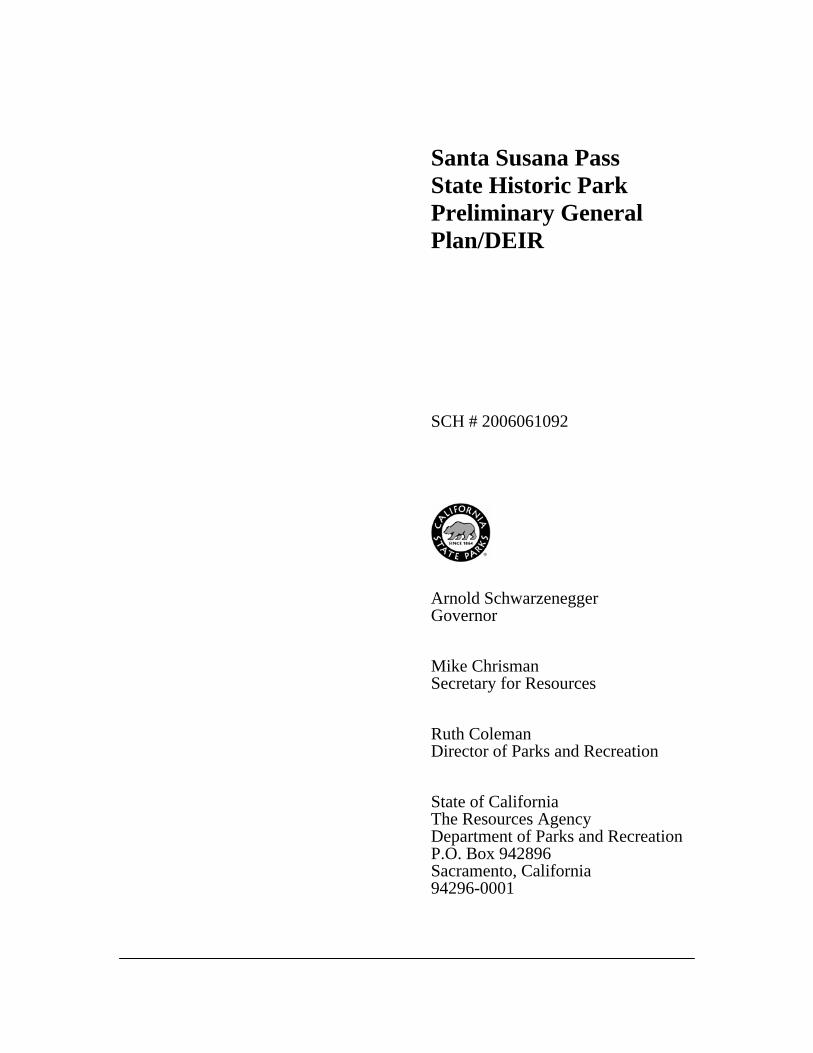
INTRODUCTION TO THE PARK Santa Susana Pass State Historic Park (the Park) is located in western Los Angeles County just west of the community of Chatsworth (Figure 1). The western boundary of the Park partially follows the Los Angeles-Ventura county line. Chatsworth Park South, a City of Los Angeles park, is almost completely surrounded by California Department of Parks and Recreation (CDPR) lands in the eastern portion of the Park and Rancho Simi Recreation and Park District holds lands to the west near the northwestern corner of the Park. Oakwood Memorial Park is to the east at the Park’s southeast end (Figure 2).
Park Overview
Much of the Park’s northern boundary runs along Santa Susana Pass Road, except for a parcel owned by the Church at Rocky Point, which operates a recreational center and facility called KidsFutureNow! Other adjacent and onsite land holdings and right-of-ways include the Las Virgenes Municipal Water District pump station, an underground Metropolitan Water District metering connection, a Calleguas Municipal Water District power generating facility, and Southern California Edison power lines and towers. The Southern Pacific Railroad runs east-west through the middle of Santa Susana Pass State Historic Park, although a majority of the railroad right of way is underground, through the Santa Susana Pass Tunnels. Private land holdings and residential neighborhoods also surround the Park. Within an hour’s drive of the Park are the cities of Simi Valley, Thousand Oaks, Oxnard, Santa Clarita, Palmdale,
and the greater Los Angeles metropolitan area. Street access to the Park is from Santa Susana Pass Road in the north; Lilac Lane in the west; Devonshire Street, Jeffrey Mark Court, or Larwin Avenue, in the east; and Andora Avenue, Lassen Street, Baden Avenue, and Valley Circle Boulevard in the south. Freeway access is from State Route 118 (SR 118) in the north or U.S. Highway 101 in the south via Topanga Canyon Boulevard (State Route 27).
3
Additional access points include trailheads located on adjacent properties. The Rancho Simi Recreation and Park District and the City of Los Angeles Department of Recreation and Parks operate these trailheads, which connect to trails within Santa Susana Pass State Historic Park, thereby creating a regional trail system. Santa Susana Pass State Historic Park is approximately 680 acres in size. Elevations in the Park range from 950 feet to over 1,850 feet above mean sea level. The California Department
Introduction

of Parks and Recreation (CDPR) acquired portions of the Park in 1979 with additional acquisitions following into the late 1990s. The California State Park and Recreation Commission officially named and classified the property as a State Historic Park in 1998. The Park is a unit of the Angeles District (the District) of CDPR. Contained within the Park is a 174-acre National Register of Historic Places (National Register) Property (see Appendix D for definition). This property was listed on the NRHP in 1974 and consists of the stage route, historic features and deposits, and prehistoric village site remnants. The stage route was also declared Los Angeles City Historical Cultural Monument #92 (designated 01/05/1972) and Ventura County Historical Landmark #104 (designated 10/21/1986).
4 DEFINITION OF STATE HISTORIC PARK As defined in Section 5019.59 of the Public Resources Code, Historical units, are:
…to be named appropriately and individually, consist of nonmarine areas established primarily to preserve objects of historical, archaeological, and scientific interest, and archaeo-logical sites and places com-memorating important persons or historic events. The areas should be of sufficient size, where possible, to encompass a significant proportion of the landscape associated with the historical objects. The only facilities that may be provided are those required for the safety, comfort, and enjoyment of the visitors, such as access, parking,
water, sanitation, interpretation, and picnicking. Upon approval by the commission, lands outside the primary historic may be selected or acquired, de-veloped, or operated to provide camping facilities within appropriate historical units. Upon approval by the California State Park and Recreation Commission, an area outside the primary historic zone may be designated as a recreation zone to provide limited recreational opportunities that will sup-plement the public's enjoyment of the unit. Certain agricultural, mercantile, or other commercial activities may be permitted if those activities are a part of the history of the individual unit and any developments retain or restore historical authenticity. Historical units shall be named to perpetuate the primary historical theme of the individual units.
PURPOSE ACQUIRED Beginning in 1969, local activists had sought to lobby for the protection of the area’s historic stagecoach road, as well as other historic and scenic resources. As a result, in 1977 CDPR received an appropriation for acquisition from the 1976 Bond Fund. Additional monies were authorized in 1978 from the California Department of Parks and Recreation Revolving Fund. With these funds, four parcels of land, consisting of approximately 300 acres, were acquired by the California Department of Parks and Recreation in 1979. SPIRIT OF PLACE The Santa Susana Pass area has been described as having a unique
Santa Susana Pass State Historic Park
!!
!!
!!
!
!!!!
!!
!!
!
!!
!!
!!
!!
!!
!!
!!
!!
!!!
!!
!
!!
!!
!!!
!!
!!
!!
!!
!!
!!
!!
!!
!!
!!
!
!!!
!
!
!!
!
!!
!
!!
!
!!
!!
!!!
!!!
!!
!!
!
!
!
!!
!
!!
!
!
!
!!!!!!!
!!!
!
!!
!
!!
!!
!
!!
!
!!
!
!!
!!
IA
!!!!!!!!!!!!!!!!!!!!!!!!!!!
! ! ! ! !! ! ! ! ! ! ! !
!
!
!
Æ
"/
AÐ
1100
1000
1200
1500
1400
1600
1700
1800
13001900
2000
21002200
1300
1400
1700
1100
1700
1700
1100
1600
1500
1200
1200
1200
1100
1800
1500
1100
1700
1500
1700
1300
1700
1200
1900
2000
1300
1200
2000
1300
1300
1500
1300
1400
1400
1600
1500
1600
1300
1100
1400
1800
1200
1500
1400
1600
1800
2100
2000
1300
1100
1100
1100
10001400
2000
1900
160018
00
1100
1200
1000
1700
1100
1600
1100
1200
1400
1700
1700
1300
1500
1500
1600
1300
2000
Parcel boundaries are approximate and should not be considered legal descriptions. Maps are intended for study purposes only.
I 500 0 500250Feet
! ! !
! ! !
! !
"/
IAÆ

6
Santa Susana Pass State Historic Park

“freshness, openness, unplanned, and unstructured beauty” about it. This is reflected in its landscape, which offers the complex topography, massive boulders, and weathered rock outcrops of the Chatsworth Formation. The presence of rock dominates the Park and its surroundings, delineating ridgelines, defining peaks, and massing into great formations that tumble down the broad backs of mountains. It is a steep, rugged landscape, created of materials deposited in deep marine canyons some 70 million years ago during the Cretaceous Period. Immense geologic forces formed and heaved these deposits into the sun-bleached and wind-washed mountains. Rocky ridgelines rise in great earthen tiers westerly toward Ventura County and trend generally along a southwest/northeast diagonal. Water finds its way to every draw, fold, and crevice, and several well-defined drainages are carved into the terrain, descending in an easterly run to the lowlands of the San Fernando Valley.
7
A network of trails traverses much of the Park, offering first-hand experiences of the Park’s ever-changing topography. Visitors ascend and descend the steep terrain as it turns this way and that, sequentially opening to yet another orientation or spatial perspective—obscuring, then suddenly revealing views to landmark peaks or distant, broad valleys. Perhaps it is the persistent challenge of wayfinding that is so intriguing about this place. Perhaps it is the mountains’ patient yielding of its mysteries—the intricate layers of life-forms nested into its rocky nooks and crannies, the silent presence of those who came before us, or its geological sense of the “long” time beyond human history altogether.
Those who hike or ride regularly through the Park are familiar with its inexhaustible potential for new discoveries and remark that it takes many years to know such a place well. Others know this landscape merely as a scenic backdrop to the San Fernando Valley floor, the community of Chatsworth, or from the frames of old movies or television shows. For many it is a familiar presence in their daily lives. For millions of freeway travelers it forms one flank of the modern Santa Susana Pass, where for a brief few minutes it offers another portal—a rare opportunity to experience the scale and flavor of the Old West. Over the centuries this mountainous landscape offered a formidable challenge to those traveling between San Fernando and Simi valleys, and to points beyond. The 21st Century finds it well-marked with tunnels, trestles, foot trails, and roadbeds—reading well as a visual reference to the area’s transportation history. There is a long human record notched into the rocky landscape, evident not only in the weathered mortars and cupules, niche
Scenic View
Introduction

shelters and stone hearths, but also in quarry tailings, road cribbing, and the graffiti scratched into favored boulders. Old homestead sites hide in the hills, along with an abandoned reservoir or two. The hulks of a few old cars and trucks rust away in steep ravines, tangled in the mountain’s shrubby growth and the mystery of how they got there. The long arms of utilities reach up and across the Park’s open space with power lines stretching high overhead and pipelines buried deep below. All of this and more—the mountain absorbs these things well. It is just so much bigger, and older, and longer lasting. Looking up at these hills and mountains or walking the paths worn into its sides, each person takes in whatever sustaining qualities are needed at that time. Some eagerly search out the spring’s treasure of wildflowers and note the subtle shifts from green to gold as days lengthen and heat up. Some note the footprints of the mountain lion, the coyote, the bobcat. Others push their muscle strength against the mountains’ or draw on its rugged self reliance. To many, the mountains in their quiet, timeless way shield and protect the valley and offer sanctuary from the relentless pressures of urban living. Again and again visitors seek the special portals and elevated views of favored vantage points. There they gain solace, inspiration, or right-perspective and measure their days against the passage of time.
8
PURPOSE OF THE GENERAL PLAN This General Plan was developed to serve as a long-range management tool that provides guidelines for achieving
the purpose of the Park. This document does not attempt to provide detailed management recommendations, but rather provides conceptual parameters for future management actions. Specifics, such as the exact location of a visitor center or campground, will be determined by future management plans. These subsequent management plans will require additional data collections and public/internal reviews to ensure adherence to the goals and guidelines established within this General Plan. This General Plan may need amending if any new acquisitions are added to the existing park or if any other circumstances make parts of the plan no longer relevant or feasible. However, the guidelines contained in the General Plan allow a degree of flexibility to accommodate new situations. Partial funding for the Resource Inventory and General Plan for Santa Susana Pass State Historic Park is from the settlement with Southern California Edison (SCE) for damages to the Park’s archaeological resources from unauthorized grading activities. Combined Plan/EIR The California Environmental Quality Act (CEQA) of 1970 established a requirement for state agencies to analyze and disclose the potential environmental effects of a proposed action. The environmental impact report (EIR), prepared by state and local governments, is usually a freestanding document intended to meet the requirements of CEQA. However, CEQA also encourages options to avoid needless redundancy and duplication, such as combining
Santa Susana Pass State Historic Park

General Plans and EIRs (CEQA Guidelines §15166) and the use of tiering, a process where a lead agency prepares a series of EIRs, progressing from general concerns to more site-specific evaluations with the preparation of each new document (CEQA Guidelines §15152). When the lead agency combines a General Plan and an EIR, all requirements of CEQA must be covered and the document must identify where the requirements are met. The following section provides a guide to the structure and contents of the General Plan/EIR, which meets the CEQA requirements. As explained here, the General Plan/EIR in its whole constitutes the required content of an EIR; therefore this document refers to the “General Plan/EIR” to reinforce the concept of a single document fulfilling the dual requirements of park general planning and CEQA compliance. 9
Tiered CEQA Analysis Tiering is defined as “the coverage of general matters and environmental effects in an environmental impact report prepared for a policy, plan, program, or ordinance followed by narrower or site-specific environmental impact reports…” (Public Resources Code [PRC] §21068.5; CEQA Guidelines §15385). While a tiered EIR may not defer all consideration of impacts to a point in the future, it can legitimately indicate that more detailed studies and project-specific impacts may be considered in future environmental documents. Generally, the courts have recognized that environmental studies at the general plan level will be general. It has been found acceptable, that a more detailed analysis be considered later in
the process. Subsequently, that analysis will be measured against specific performance criteria, formulated at the time of Plan approval. The Santa Susana Pass State Historic Park General Plan/EIR serves as a first-tier Environmental Impact Report (EIR), as defined in Section 15166 of the California Environmental Quality Act (CEQA) Guidelines. Individual and/or site-specific projects and appropriate CEQA compliance will follow the General Plan/EIR. The analysis of broad potential environmental impacts discussed in the Environmental Analysis Section of this document will provide the basis for future second-level environmental review, which will provide more detailed information and analysis for facility development projects such as future visitor centers or camping/staging areas. Planning and feasibility studies for park management, recreation, and resource protection are ongoing. This General Plan/EIR provides discussion of the probable impacts of future development and established goals, policies, and objectives to implementing such development in a manner which will avoid or minimize such environmental impacts. This approach is consistent with a tiered approach to EIRs. The level of detail addressed in the Environmental Analysis section is comparable to the level of detail provided in the land-use proposals of the Plan. The Alternatives Matrix (Table 4) and Reasonable Develop-ment Projection Matrix (Table 5) in the Environmental Analysis section provide quantitative data relative to the
Introduction

land-use proposals in the rest of the General Plan. What is critical, and what is set forth in the Plan, is the formulation and eventual adoption of a set of policies designed to minimize and mitigate impacts that might occur from the implementation of operations and projects under the General Plan. For example, the Plan divides the Park into management zones. Goals and policies are proposed for adoption for each of these zones which provide conceptual parameters for future management actions.
10
Where a proposed project covers a wide spectrum of action, from the adoption of a Plan, which is by definition tentative and subject to further refinement, to activities with a site-specific impact, CEQA requires that “environmental impact reports shall be tiered whenever feasible” (Public Resources Code §21093[b]). Structure and contents of the General Plan/EIR This project is prepared in accordance with Article 9 of the CEQA Guidelines (Title 14. California Code of Regulations). Contents of Section 15120(c) state that Draft EIRs shall contain the information required by Sections 15122 through 15131. Table 1 shows where the required items are found in this General Plan/EIR. Uses of this General Plan/EIR This General Plan/EIR has been prepared by the California Department of Parks and Recreation, Park Acquisition and Development Division, Southern Service Center with input and assistance from CDPR’s Angeles District. The California State Park and Recreation Commission has approval authority for all CDPR
General Plan/EIRs. This commission determines whether or not to: • Accept the certified General
Plan/EIR as a “Final EIR” under CEQA Guidelines Section 15166.
• Adopt the General Plan/EIR as a general plan under PRC 5002.2.
The Santa Susana Pass State Historic Park General Plan is the guiding policy document for subsequent operation and management of the Park. The Plan utilizes six management zones within the Park. These zones are described in detail on page 91 of this General Plan/EIR. Some of the provisions of any future focused management plans as well as development, maintenance, facility use, and recreational activities allowed by the General Plan have the potential to impact the environment. Prior to taking any further action, CDPR must evaluate whether that action constitutes a “project” under CEQA, whether it is categorically exempt (for example routine maintenance), whether it may have a significant impact on the environment and if so, whether a mitigated negative declaration is appropriate or an EIR needs to be prepared. All future action by CDPR will need to be found consistent with the adopted Santa Susana Pass State Historic Park General Plan. The Plan’s management zones along with the Goals and Guidelines, define the main approach to avoid and mitigate subsequent actions and the General Plan/EIR establishes the baseline for future environmental review as a first tier program EIR.
Santa Susana Pass State Historic Park

Table 1—Location of EIR Required Content
11
CEQA Guidelines Content Location in General Plan/EIR
15122 Table of Contents or Index Beginning of this document
15123 Summary Follows the Table of Contents
15124 Project Description Ch. 3 The Plan (description), page 57
Page 58 Project Description (summarized) Ch. 1 Introduction (information about project objective & general plan process), page 3
15125 Environmental Setting Ch. 2 Existing Conditions, page 15
15126 Consideration & Discussion of Environmental Impacts
Ch. 4 Environmental Analysis, page 101
(a) Significant Environmental Effects of the Proposed Project.
Page 107 Significant Effects & Proposed Mitigation.
(b) Significant Environmental Effects Which Cannot be Avoided if the Proposed Project is Implemented.
Page 107 Unavoidable & Irreversible Significant Environmental Effects.
(c) Significant Irreversible Environmental Changes Which Would be Involved in the Proposed Project Should it be Implemented.
Page 107 Unavoidable & Irreversible Significant Environmental Effects.
(d) Growth-Inducing Impact of Proposed Project.
Page 116
(e) The Mitigation Measures Proposed to Minimize the Significant Effects.
Ch. 3 The Plan, page 57 Goals and Guidelines (intended to minimize adverse environmental effects) and Discussion of Guidelines as mitigation for subsequent action.
(f) Alternatives to the Proposed Project. Page 102 Plan Alternatives Table 4 “Alternatives Matrix—Proposed Uses & Environmental Impacts” page 103
15127 Limitations on Discussion of Environmental Impact
Page 107 (discussion - irreversible changes)
15128 Effects Not Found to be Significant Page 113 Effects found not to be significant Appendix F (the Initial Study checklist, under separate cover)
(Continued)
Introduction

Table 1—Location of EIR Required Content (Continued)
CEQA Guidelines Content Location in General Plan/EIR
15129 Organizations and Persons Consulted Page 50 Public Involvement Page 51 Native American Input & Park Support Appendix E References Consulted Back Cover Report Preparers
15130 Discussion of Cumulative Impacts Page 116
15131 Economic and Social Effects (optional topic)
Ch. 3 The Plan, page 57 Throughout the document under discussions of recreation & visitor experience
Environmental Review Process and Recirculation The General Plan/EIR addresses the entire area and operation of the Park; hence, it is broad and comprehensive in scope. A series of meetings and a formal public process were used to determine the Plan and the content of the environmental analysis.
12
An Initial Study and a Notice of Preparation (NOP) was circulated to state agencies, local city, and county planning offices, interested public organizations and interested individuals (see Appendices). CDPR conducted extensive public involvement during the planning process. This document is the Preliminary General Plan/Draft EIR containing the environmental assessment. After the public comment period closes; CDPR staff will prepare responses to comments and proposed text changes for the proposed General Plan/Final EIR. The comment letters, CDPR responses, and the proposed text
changes will be published as part of the Preliminary General Plan/Final EIR on the CDPR website and become part of the public record. A public hearing will be held before the California State Park and Recreation Commission at a location in the general vicinity of the project. If the General Plan/EIR is approved by the Commission at the hearing, it will be published as the Final General Plan/EIR.
Santa Susana Pass State Historic Park