Embed Size (px)
Citation preview

Page 1 of 6
COASTAL CONSERVANCY
Staff Recommendation June 20, 2013
SANTA ANA RIVER PARKWAY TRAIL:
SAN BERNARDINO COUNTY CLASS I BIKEWAY DESIGN
Project No. 13-015-01 Project Manager: Moira McEnespy
RECOMMENDED ACTION: Authorization to disburse up to $100,000 to the County of San Bernardino for planning and feasibility analysis of a Class I bikeway with pedestrian shoulders over a segment of the Santa Ana River Parkway Trail in the City of Redlands, San Bernardino County. LOCATION: Along a segment of the Santa Ana River, City of Redlands, San Bernardino County (Exhibits 1 and 2) PROGRAM CATEGORY: Public Access
EXHIBITS Exhibit 1: 1.1: Project Location Map for entire Santa Ana River Parkway Trail
1.2: Project Location Map for this authorization
Exhibit 2: 2.1: Project Site Map - “Phase IV” segment: California Street to Garnet Street 2.2: Project Site Map - “Phase IV, Reach A,” segment: California Street to Orange Street
Exhibit 3: Coastal Conservancy Staff Recommendation No. 07-097, “Santa Ana River Parkway” (December 13, 2007)
RESOLUTION AND FINDINGS: Staff recommends that the State Coastal Conservancy adopt the following resolution pursuant to Sections 31400 et seq. of the Public Resources Code:
“The State Coastal Conservancy hereby authorizes disbursement of up to one hundred thousand dollars ($100,000) to the County of San Bernardino (County) for planning and feasibility analysis for construction of a Class I bikeway with pedestrian shoulders over a 3.5-mile segment of the Santa Ana River Parkway Trail corridor from California Street to Orange Street, City of Redlands, County of San Bernardino, specifically:
• Appraisals of access easements over real property (County Assessor’s Parcel Nos. 016702111; 016702119; 016702120; 016702124; 016704101; 016704104; and 016704120);

SANTA ANA RIVER PARKWAY TRAIL: SAN BERNARDINO COUNTY CLASS I BIKEWAY DESIGN
Page 2 of 6
• Final engineering design; and • Applications for construction permits.
This authorization is subject to the following conditions:
1. Prior to disbursement of funds, the Conservancy’s Executive Officer shall review and approve in writing the County’s final work program, including a budget and schedule, and any contractors the County proposes to employ for the project.
2. The County shall appraise property at fair market value for possible future purchase only from willing sellers.”
Staff further recommends that the Conservancy adopt the following findings:
“Based on the accompanying staff report and attached exhibits, the State Coastal Conservancy hereby finds that:
1. The proposed authorization is consistent with the purposes and objectives of Chapter 9 of Division 21 of the Public Resources Code, regarding the establishment of a system of public accessways to and along the California coast.
2. The proposed project is consistent with the current Project Selection Criteria and Guidelines.
3. The proposed project will serve greater-than-local needs.”
PROJECT SUMMARY: The Santa Ana River Parkway will connect the Inland Empire from the crest of the San Bernardino Mountains to the Pacific Ocean near Huntington Beach. The parkway concept is that of a linear park that is centered by a Class I bikeway, hiking, and riding trail (or trails) and includes a series of parks connected by the trail. When completed, the parkway will include an approximately 100-mile continuous multi-use trail that connects three counties, Orange, Riverside, and San Bernardino, and multiple cities. See Exhibit 1.
Staff recommends that the Conservancy authorize disbursement of funds to the County of San Bernardino (County) to prepare pre-project analyses for a 3.5-mile segment of the Santa Ana River Parkway Trail corridor from California Street to Orange Street (also referred to as “Phase IV, Reach A”; see Exhibit 2.21), City of Redlands, County of San Bernardino, including:
• Negotiate and appraise access easements over real property (County Assessor Parcel Nos. 016702111; 016702119; 016702120; 016702124; 016704101; 016704104; and 016704120 (See specific properties depicted in gold in Exhibit 2.2);
• Complete the engineering design, including design of a pre-fabricated clear-span bicycle and pedestrian bridge over a drainage immediately east of the I-210 corridor); and
1 Note that the Santa Ana River Parkway Trail preferred alignment is shown by a solid purple line. The other alignments shown in red and blue solid and dashed lines represent potential future connections with the City of Redlands’ bikeway system.

SANTA ANA RIVER PARKWAY TRAIL: SAN BERNARDINO COUNTY CLASS I BIKEWAY DESIGN
Page 3 of 6
• Apply for construction permits.
These activities will prepare for construction of a Class I bikeway comprised of a ten foot-wide asphalt trail with adjacent graded, unpaved decomposed granite shoulders to accommodate pedestrians and non-motorized modes of transportation. Work is anticipated to be completed by the end of this calendar year.
The San Bernardino County Regional Parks Department, a division of the county government, will manage this project and work with the County Public Works Department and County Real Estate Services Division to carry out all tasks. The Regional Parks Department operates and maintains nine regional parks, a wildlife preserve, and over 18 miles of recreational trails. The County was the Conservancy’s previous grantee for Santa Ana River Parkway Trail planning and design work. (See Exhibit 3).
Site Description: The site description of the Santa Ana River Trail area remains consistent with the “Site Description” section of Exhibit 3. The specific segment of corridor under this proposed authorization (“Phase IV, Reach A;” See Exhibit 2.2) is a 3.5-mile segment along the southern bank of the river from California Street to Orange Street, and is bisected by the I-210 corridor. Phase IV, Reach A is located on 2.77 miles of publicly-owned corridor (running along established County flood control levees when available) and 0.73 mile of privately-held parcels.
Project History: On December 13, 2007, the Conservancy authorized funds to Orange, Riverside, and San Bernardino counties to conduct planning, design, engineering, and environmental review for various segments along the Santa Ana River Parkway Trail corridor (See Exhibit 3). The Conservancy-funded portion of the San Bernardino segment extended from Waterman Avenue east to California Street (the segment the County refers to as “Phase III”) and subsequently from California Street to Alabama Street (a portion of the segment the County refers to as “Phase IV;” see Exhibit 2.1). The County conducted similar activities for the remainder of the Phase IV segment (east to Garnet Street) using other funds. The proposed authorization will address further needs identified in the previous planning effort. Additional history can be found in the “Project History” section of Exhibit 3.
PROJECT FINANCING Coastal Conservancy $100,000
Project Total $100,000 Forty-five million dollars is allocated to the Conservancy in Proposition 84 for projects to “expand and improve” the Santa Ana River Parkway. These projects must be developed “in consultation with local government agencies participating in the development of the Santa Ana River Parkway.” Proposition 84 further specifies that at least $10 million of these funds should be spent in each of the three counties, specifically San Bernardino, Orange and Riverside Counties.
Consistent with the funding source, the recommended action is to provide funds to expand and improve a segment of the Santa Ana River Parkway Trail located in San Bernardino County. The proposed project was developed in partnership with the local governments, particularly the

SANTA ANA RIVER PARKWAY TRAIL: SAN BERNARDINO COUNTY CLASS I BIKEWAY DESIGN
Page 4 of 6
County of San Bernardino, the San Bernardino Associated Governments (SANBAG), the San Bernardino Valley Water Conservation District, and the City of Redlands.
Although there are no matching funds identified for this particular suite of tasks, the County has secured over $10.4 million from other funding sources for planning, design, and construction of segments of the Parkway Trail, specifically from the Riverside County line to the National Forest in the San Bernardino Mountains, including support from the Bureau of Land Management, Transportation Enhancement Act funds (Federal Highway Administration/Caltrans), California River Parkways funds (administered by the California Natural Resources Agency), County, Wildlands Conservancy, and Southern California Edison.
CONSISTENCY WITH CONSERVANCY’S ENABLING LEGISLATION: The proposed project would be undertaken pursuant to Chapter 9 of the Public Resources Code Sections 31400 et seq, regarding public access.
Section 31400 states the Legislature’s intent for the Conservancy to have a principal role in the implementation of a system of public accessways to the state’s coastline, and Section 31400.1 states that the Conservancy may award grants to a public agency to develop lands for public access to the coast that will serve greater-than-local needs. Consistent with these sections, the proposed authorization will enable the Conservancy to award funds to the County of San Bernardino, a public agency, to design and plan the purchase of rights-of-way for a segment of the Santa Ana River Parkway Trail, a regional river parkway that will link the San Bernardino Mountains to the Pacific Ocean, serving greater than local needs. When complete, this trail will be one of the longest urban recreation river parkways in the United States. Just under one-fifth of all the people in the state (approximately seven million people) live in the three counties served by this trail.
Section 31409 states that the Conservancy may award grants to public agencies to establish and expand inland trail systems that may be linked to the California Coastal Trail. Consistent with this section, the proposed authorization will enable the Conservancy to award funds to the County of San Bernardino, a public agency, to design and secure rights-of-way for a segment of the Santa Ana River Parkway Trail, a regional river parkway that will link the San Bernardino Mountains to the Pacific Ocean and to the California Coastal Trail.
CONSISTENCY WITH CONSERVANCY’S 2013 STRATEGIC PLAN GOAL(S) & OBJECTIVE(S): Consistent with Goal 2, Objective E of the Conservancy’s 2013-2018 Strategic Plan, the proposed project will design a new segment of the Santa Ana River Parkway Trail, a regional river parkway that will connect inland populations to the coast.
CONSISTENCY WITH CONSERVANCY’S PROJECT SELECTION CRITERIA & GUIDELINES: The proposed project is consistent with the Conservancy’s Project Selection Criteria and Guidelines, last updated on November 10, 2011, in the following respects:

SANTA ANA RIVER PARKWAY TRAIL: SAN BERNARDINO COUNTY CLASS I BIKEWAY DESIGN
Page 5 of 6
Required Criteria 1. Promotion of the Conservancy’s statutory programs and purposes: See the “Consistency
with Conservancy’s Enabling Legislation” section above.
2. Consistency with purposes of the funding source: See the “Project Financing” section above.
3. Support of the public: The Santa Ana River Parkway Trail and this recommended authorization is supported by the following agencies: Orange County; Riverside County; Cities of Colton, San Bernardino, Highland, and Redlands; The Wildlands Conservancy; the San Bernardino County Flood Control District; the Redlands Water Boggle Transit Company; and the Inland Empire Bicycle Alliance. See letters of support in Exhibit 6 of Exhibit 2.
4. Location: The proposed project is located along the Santa Ana River, and will help create a river parkway connecting inland communities from the San Bernardino Mountains to the Pacific Ocean. Specifically, this proposed project is a 3.5-mile segment of the Santa Ana River Parkway Trail corridor from California Street to Orange Street (also referred to as “Phase IV, Reach A;” see Exhibit 2.2) in the City of Redlands.
5. Need: The proposed project will not occur without the funding allocated within Proposition 84 to the Conservancy for this specific purpose.
6. Greater-than-local interest: The Santa Ana River Parkway Trail will run approximately 100 miles and will link the San Bernardino Mountains to the Pacific Ocean. When complete, it will be one of the longest urban recreation river parkways in the United States. Just under one-fifth of all the people in the state (approximately seven million people) live in the three counties served by this trail. Portions of the trail received National Recreation Trail status in November 1976, and the National Park Service has indicated its interest in designating the entire trail as a National Recreation Trail once completed.
7. Sea level rise vulnerability: The proposed project is located in the City of Redlands, part of the Inland Empire, which is approximately 1,300 feet above sea level and therefore not vulnerable to future sea level rise.
Additional Criteria 8. Urgency: The proposed project consists of activities that will inform and enable trail
construction, and that must be conducted as soon as possible in order to adhere to the overall trail construction schedule.
9. Leverage: See the “Project Financing” section above.
10. Readiness: The County of San Bernardino is poised to begin project activities as soon as funds are authorized.
11. Realization of prior Conservancy goals: See “Project History” section, above.
12. Cooperation: In July 2006, Orange, Riverside, and San Bernardino Counties, the Santa Ana Watershed Project Authority, and the nonprofit Wildlands Conservancy adopted a

SANTA ANA RIVER PARKWAY TRAIL: SAN BERNARDINO COUNTY CLASS I BIKEWAY DESIGN
Page 6 of 6
Memorandum of Understanding to create a regional partnership and formal mechanism to complete the Santa Ana River Parkway Trail. There are two main groups to guide trail development: A policy advisory group consisting largely of elected officials, and a Technical Advisory Committee consisting largely of agency staff. This is a unique and successful model of regional coordination and collaboration.
COMPLIANCE WITH CEQA: The proposed project consists of activities that constitute feasibility and planning studies and is therefore statutorily exempt from review under the California Environmental Quality Act under Title 14 California Code of Regulations (CCR) Section 15262. The planning activities are for possible future actions which the Conservancy has not approved, adopted or funded and does not require the preparation of an environmental impact report (EIR) or negative declaration but does require consideration of environmental factors. Upon approval, staff will file a notice of exemption for the project.

Exhibit 1: Project Location Map
Project Location

Exhibit 1: Project Location Map

Exhibit 1: Project Location Map
Project Location: This Authorization

P H A S E I V County of San Bernardino - Santa Ana River Trail
San Bernardino County, California
0.6
MilesSource: NRA, Inc. 2010
Aerial: NAIP 2009
0
Phase IV Santa Ana River Trail
Bridge
Undercrossing
LILBURNC O R P O R A T I O N
A L
A B
A M
A
S T
R E
E T
A L
A B
A M
A
S T
R E
E T
O R
A N
G E
S
T R
E E
T
R E D L A N D S M U N I
S A N B E R N A R D I N OI N T E R N A T I O N A L
A I R P O R T
F L O R I D A A V E N U E
W. S A N B E R N A R D I N O A V E N U E
W. L U G O N I A A V E N U E
J U D
S O
N
S T
R E
E T
O P
A L
A
V E
N U
E G A
R N
E T
A
V E
N U
E
G R E
E N S
P O T
R O
A D
G R E E N S P O T R O A D
G R E E N S P O T R O A D
3 r d S T R E E T
E. 5 t h S T R E E T
210
W. C O L T O N A V E N U E
LE
GE
ND
C A
L I
F O
R N
I A
S
T R
E E
T
T E
X A
S
S T
R E
E T
C H
U R
C H
S
T R
E E
T
G A
R N
E T
S
T R
E E
T
W. R E D L A N D S B O U L E V A R D
E. S A N B E R N A R D I N O A V E N U E
R I V E R B E N D D R I V E
E. L U G O N I A A V E N U E
E. C O L T O N A V E N U E
10
10
FIGURE 2
Reach A Reach B Reach C Reach D


COASTAL CONSERVANCY
Staff Recommendation December 13, 2007
SANTA ANA RIVER PARKWAY
File No. 07-097
Project Manager: Mary Small
RECOMMENDED ACTION: Authorize disbursement of up to two million seven hundred fifty thousand dollars ($2,750,000) for three projects to implement coastal access along the Santa Ana River Parkway in Orange, Riverside and San Bernardino Counties. LOCATION: Santa Ana River Parkway, along the Santa Ana River in the counties of Orange, Riverside and San Bernardino. PROGRAM CATEGORY: Public Access
EXHIBITS Exhibit 1: Project Location and Map
Exhibit 2: Parkway Partnership Workplan (booklet enclosed) Exhibit 3: Orange County Project: Gypsum Canyon Road to the County Line
Exhibit 4: Riverside County Project: Hidden Valley Wildlife Area to County Line
Exhibit 5: San Bernardino County Project: Waterman Ave. to Alabama St.
Exhibit 6: Letters of Support
RESOLUTION AND FINDINGS:
Staff recommends that the State Coastal Conservancy adopt the following resolution pursuant to Sections 31400 et. seq. of the Public Resources Code:
“The State Coastal Conservancy hereby authorizes the following disbursements to implement coastal access along the Santa Ana River Parkway in Orange, Riverside and San Bernardino Counties:
1) an amount not to exceed five hundred fifty thousand dollars ($550,000) to the County of Orange for alignment planning, environmental analysis, signage and completion of an
Page 1 of 8
SANTA ANA RIVER TRAIL & PARKWAY
engineering report for projects to complete a three mile coastal access trail segment that extends from the Gypsum Canyon Road to the county line;
2) an amount not to exceed one million eight hundred fifty thousand dollars ($1,850,000) to the Riverside County Regional Park and Open Space District for alignment planning, environmental impact analysis, signage, detailed engineering and permit applications for projects to complete a twenty two mile coastal access trail segment from the county line to the Hidden Valley Wildlife Area; and
3) an amount not to exceed three hundred fifty thousand dollars ($350,000) to the County of San Bernardino for alignment planning, signage and environmental impact analysis for a four mile coastal access trail segment that extends from the Waterman Avenue to Alabama Street in the City of Redlands.
This authorization is subject to the condition that prior to disbursement of funds to each grantee, the Conservancy’s Executive Officer shall review and approve in writing a final work program, including a budget and schedule, and any contractors any grantee proposes to employ for the project.”
Staff further recommends that the Conservancy adopt the following findings:
“Based on the accompanying staff report and attached exhibits, the State Coastal Conservancy hereby finds that:
1. The proposed project is consistent with its January 24, 2001 Project Selection Criteria and Guidelines, as updated by the Conservancy on September 20, 2007.
2. The proposed authorization is consistent with the purposes and objectives of Chapter 9 of Division 21 of the Public Resources Code, regarding the establishment of a system of public accessways to and along the California Coast.
3. The proposed project will serve a greater than local needs.”
PROJECT SUMMARY: For more than fifty years, trail users and community leaders sought to complete the Santa Ana River Trail and Parkway (“the Parkway”) from the crest of the San Bernardino Mountains to the coast near Huntington Beach. The Parkway was designated a National Recreation Trail in November 1976. When it is completed, it will be one of the longest urban recreation and river parkways in the United States. The Parkway will be a multi-use trail, serving pedestrians, cyclists and equestrians. It will connect a completed section of the California Coastal Trail to inland communities. The trail will go from the beach, through urban areas of Orange Co and the Inland Empire up to National Forest wilderness areas. The completed trail will connect three counties and 17 cities. More than seven million people live in the three counties that the trail connects and the Inland Empire is one of the fastest growing regions of California.
The completed Parkway will be about 100 miles long and it will include 18 miles of dirt multi-use trail in the National Forest and about 82 miles of paved trail along the lower reaches of the river. About half of the Parkway has been completed or is under construction. As shown in Exhibit 1, most of the trail in Orange County is complete although there is a three mile gap at the east end of the county, near the Riverside and San Bernardino County lines. There is a twenty
Page 2 of 8

SANTA ANA RIVER TRAIL & PARKWAY
two and a half mile gap in Riverside County from the western county boundary around the Prado Basin and through the cities of Norco and Corona. In San Bernardino County there are about 12 miles left to be constructed, primarily at the northeastern portion of the County connecting to the dirt trail in the National Forest.
The Santa Ana River Trail and Parkway Partnership (“the Parkway Partnership”) is a collaboration of the three counties, multiple cities and the Wildlands Conservancy, a nonprofit organization, created to coordinate building and administering the trail as a regional resource. One of the primarily hurdles to completing the Parkway has been a lack of consistent funding for trail projects. Proposition 84 included a $45 million dollar allocation to the Coastal Conservancy for projects to “expand and improve” the Parkway. These projects must be developed “in consultation with local government agencies participating in the development of the Santa Ana River Parkway.” The Parkway Partnership has developed a Work Plan (Exhibit 2) that lays out a strategy for completing the missing links in the trail over the next five years.
The proposed project will provide funding for planning and design work to complete thirty seven miles of trail in three counties. Each of the three counties will also spend approximately fifty thousand dollars for the design, development, fabrication and installation of consistent regional signage to demarcate the existing trail segments.
Orange County The County of Orange has completed most of the Parkway from the coast to the boundary with Riverside and San Bernardino Counties. However, to connect Orange County’s trail and bikeway with upstream sections, the County must build three miles of the Parkway between Gypsum Canyon Road and the county line. As shown in Exhibit 3, this project is in the Santa Ana River Canyon, where the river is constrained between the Chino Hills and the Santa Ana Mountains. Highway 91 runs along the south side of the river further constraining the proposed Parkway. The three counties meet at a single point, just downstream of the Prado Dam. The proposed trail will cross from Orange County into Riverside County and continue through Riverside County around the Prado Basin. While this section is only three miles long, there are a number of constraints that make completion of the trail very complicated and potentially very expensive. The County has identified six projects to complete this remaining section of the Parkway, including one road under-crossing and two bridges spanning the Santa Ana River. The proposed bridges will also connect the Parkway to Chino Hills State Park. The recommended authorization will provide funds to the County to refine the trail and bikeway alignment, develop conceptual plans, identify any needed right-of-way agreements, and prepare an Engineer’s Report for the projects to complete this gap. The Resources and Development Management Department of Orange County’s Harbors, Beaches and Parks Division will oversee the planning project. This Division operates regional recreational facilities and manages 37,000 acres of parkland and open space including regional parks, wilderness parks, nature preserves, recreational trails, historic sites, and harbors and beaches.
Page 3 of 8
SANTA ANA RIVER TRAIL & PARKWAY
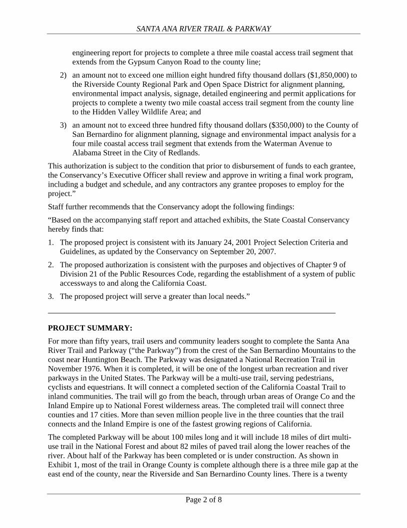
Riverside County In Riverside County, fifteen miles of the Parkway have been completed from the San Bernardino County line to the Hidden Valley Wildlife Area. The proposed authorization would provide funding for alignment planning, environmental impact analysis, detailed engineering and permit applications to complete a twenty two and half miles of trail in the County. When constructed, this project will complete the Parkway in the County of Riverside. This trail segment will begin where the Orange County project ends and continue east through the Green River Golf Course to the Prado Dam (Exhibit 4). Near the Prado Dam, the trail will cross under Highway 71 and continue around the edge of the Prado Basin. Planning for this section will be coordinated with the Army Corps of Engineers which is currently working on a project to increase flood storage in the Prado Basin by raising the face of the dam. The trail will continue through the cities of Corona and Norco. Above the Prado Basin, the Santa Ana River is a wide braided channel that migrates across an active floodplain. Planning for the trail in this section will be complicated because it must be balanced with natural resource protection and flood management. This project will be managed by the Riverside County Regional Park and Open-Space District which was created by the electorate in November 1990 and formed on January 29, 1991. The District is an independent agency governed by the Riverside County Board of Supervisors, which sits as the District’s Board of Directors. The District manages more than 44,000 acres, including forty parks, reserves, historic or archeological sites and ninety miles of regional trails.
San Bernardino County San Bernardino County has completed and opened two sections of the Santa Ana River Trail to the public. The first section extends from Waterman Avenue in San Bernardino west to La Cadena Avenue in the city of Colton (Exhibit 5). Construction on this section of the trail was completed in April of 2005. Our second section of the trail was completed on April 2007. The second section starts at La Cadena Avenue in Colton and extends the trail to the Riverside-San Bernardino County Line where it joined Riverside County’s existing trail section. In addition to the National Forest trail sections, there are now seven miles of paved, multi-use Parkway completed and open to the public in San Bernardino County. San Bernardino County will design a multi-use trail from Waterman Avenue to Alabama Street in Redlands (Exhibit 5). This section of the Santa Ana River Parkway is approximately four miles in length and will connect to the existing seven miles of trail already completed. The project will fund environmental studies and trail design work. This project will include designing three roadway under crossings, one stream crossing (Zanja/Mission creek) and a rail road crossing. The goal at each location will be design the trail to minimize permanent and temporary construction impacts to the river channel and adjacent habitat. The San Bernardino County Regional Parks Department, a division of the county government, will manage and oversee this project. The Regional Parks Department operates and maintains nine regional parks including a historical silver mining ‘ghost’ town, a wildlife preserve and over eighteen miles of recreational trails.
Page 4 of 8

SANTA ANA RIVER TRAIL & PARKWAY
Site Description: The Santa Ana River watershed drains approximately 3,200 square miles, including portions of San Bernardino, Riverside and Orange counties. The population of Riverside County is estimated to be slightly more than two million and it has increased by 30% since 2000. The population of San Bernardino County is just under two million and it has increased by 17% since 2000. The population of Orange County is about three million. Currently the state’s total population is estimated to be 36.5 million; thus just under 20% of all the people in the state live in these three counties.
The Santa Ana River watershed supports hundreds of species of bird, fish and amphibians, including more than a dozen protected rare or endangered species such as Least Bells Vireo and the Santa Ana Sucker.
The upper portion of the watershed is in the San Bernardino National Forest, the middle section crosses the Inland Empire, through the urbanizing areas of San Bernardino and Riverside Counties. Throughout this region, the Santa Ana River is a wide, braided channel with flood control levees protecting the urban development. In some places, the river is a mile wide. The San Bernardino County and Riverside County projects will be built along these sections of the river. The Riverside County project will also include planning for a trail connection around the Prado Basin.
Near the western boundary of San Bernardino and Riverside counties, the river passes through the Prado Basin. The Prado Basin is a flood control basin, a habitat area and a water treatment wetland. The Orange County Water District owns 2,150 acres in the basin, which is in Riverside County, so that it can operate a treatment wetland to reduce nitrogen levels in the river water prior to using that water for groundwater recharge downstream. Prado Dam was built at a narrow point along the river, where the river flows between the Chino Hills and the Santa Ana Mountains.
Below the Prado Dam, through the Santa Ana Canyon, there is a short section of relatively natural riparian corridor, with natural channel bottom and riparian vegetation. Below this section, through most of Orange County, the Santa Ana River is a concrete-encased flood control channel which leads to the coast. The mouth of the Santa Ana River is between Huntington Beach and Newport Beach.
Project History: Since the 1950’s, citizens groups have worked with leaders in the watershed to develop a 100 mile trail running adjacent to the river. These efforts sought to create a lively parkway connecting playgrounds, schools, ball fields, commercial centers, golf courses, equestrian facilities and neighborhoods to natural areas with a linear trail along the river corridor. In this vision, the river parkway would be a safe, multi-use trail network linked to other parts of the watershed. This vision for the Santa Ana River Parkway proceeded in fits and starts for over 40 years. Portions of the trail were developed independently in the three counties through which the river
Page 5 of 8

SANTA ANA RIVER TRAIL & PARKWAY
passed. Over time, local leaders in the watershed realized that a regional approach was necessary to complete the trail. A regional approach would allow the sharing of resources and ideas and development of a common vision for the entire trail. In 1990, the Counties of San Bernardino, Riverside, and Orange, along with eleven cities and various agencies came together to adopt the “Plan for the Santa Ana River Trail” which provided a road map for completing the trail along its entirety. The over-arching goal of the plan was to provide a continuous, multi-use, trail system along the entire length of the Santa Ana River Corridor. Over the next decade, efforts to complete the trail continued at different rates within each of the respective jurisdictions. Some moved forward but progress stalled in many jurisdictions due to lack of funds. In May of 2005, with the support of the Wildlands Conservancy, a nonprofit organization, local elected officials and state legislators from the watershed met to explore the possibility of state support for the Santa Ana River Trail and Parkway. At this initial meeting, Supervisor John Tavaglione of Riverside County, suggested development of a Partnership Action Plan to coordinate planning efforts and leverage funding and resources by local entities throughout the watershed. In August of 2005, the group determined that a Memorandum of Understanding (MOU) was the appropriate vehicle to formalize their commitment and in July of 2006, a final MOU was signed and adopted by the participants including the Counties of Orange, Riverside, San Bernardino, the Santa Ana Watershed Project Authority and the Wildlands Conservancy (see Exhibit 2.) The Parkway Partnership’s Work Plan lays out a strategy for allocating these funds, with the goal of completing the ‘backbone’ trail over the next five years. PROJECT FINANCING: Coastal Conservancy $2,750,000 Total Project Cost $2,750,000 Proposition 84 included a $45 million dollar allocation to the Conservancy for projects to “expand and improve” the Parkway. These projects must be developed “in consultation with local government agencies participating in the development of the Santa Ana River Parkway.” Proposition 84 further specified that at least $10 million of the Parkway funds would be spent in each of the three counties. Consistent with the bond language, the recommended action provides a planning grant to each of the three counties to prepare projects for implementation. The proposed projects were developed in partnership with the local governments participating in the development of the Parkway. While there are no matching funds identified for these projects, significant matching funds have already been spent completing the Santa Ana River Trail. To date, more than $50,000,000 in private funding has matched a total of $15,000,000 from the local governments and approximately $8,000,000 in federal funds. It is expected that the entire Parkway will cost approximately $118,000,000 to complete.
CONSISTENCY WITH CONSERVANCY’S ENABLING LEGISLATION: The proposed projects will help implement the Santa Ana River Trail and Parkway which will become a major inland trail connecting to the California Coastal Trail. These projects are
Page 6 of 8

SANTA ANA RIVER TRAIL & PARKWAY
consistent with the provisions of Chapter 9 of Division 21 of the Public Resources Code, Sections 31400 et. seq.. Section 31409 states that the Conservancy “may award grants and provide assistance to public agencies and nonprofit organizations to establish and expand those inland trail systems that may be linked to the California Coastal Trail. “
CONSISTENCY WITH CONSERVANCY’S 2007 STRATEGIC PLAN GOAL(S) & OBJECTIVE(S): Consistent with Goal 1, Objective F of the Conservancy’s 2007 Strategic Plan, the proposed project will develop plans for approximately 37 miles of trails and parkways along the Santa Ana River that will connect inland populations to the coast.
CONSISTENCY WITH CONSERVANCY’S PROJECT SELECTION CRITERIA & GUIDELINES: The proposed project is consistent with the Conservancy’s January 24, 2001 Project Selection Criteria and Guidelines, as updated on September 20, 2007, in the following respects:
Required Criteria 1. Promotion of the Conservancy’s statutory programs and purposes: See the
“Consistency with Conservancy’s Enabling Legislation” section above.
2. Consistency with purposes of the funding source: See the “Project Financing” section above.
3. Support of the public: The Parkway project is widely supported by local organizations and elected officials, including Senator Diane Feinstein, Representative Ken Calvert, Senator Robert Dutton, Senator Gloria Negrete McCleod, California State Parks, the Counties of Orange, Riverside, and San Bernadino, the Wildlands Conservancy, the Santa Ana Watershed Project Authority, the Flood Control Districts of Orange, Riverside, and San Bernardino Counties, Riverside Bicycle Club, Trails 4 All, the Riverside Land Conservancy, equestrian groups and others. Letters of Support are provided in Exhibit 6.
4. Location: The proposed project is located along the Santa Ana River and will help to complete a 100 mile trail that will connect the Coastal Trail to the San Bernardino Mountains.
5. Need: As described above, there has been a vision of completing the Parkway for more than fifty years. During the last few years, significant political support and regional coordination was established with the goal of completing trail construction, Funding for trail construction is one of the key factors needed to complete the trail. With the funding allocated in Proposition 84, the Parkway Partnership believes they can complete the trail over the next five years.
6. Greater-than-local interest: Portions of the Parkway were designated a National Recreation Trail in November 1976 linking the San Bernardino Mountains to the Pacific Ocean. The National Park Service has indicated its interest in designating the entire
Page 7 of 8

SANTA ANA RIVER TRAIL & PARKWAY
Page 8 of 8
trail, once completed, as a National Recreation Trail. When complete, it will be one of the longest urban recreation river parkways in the United States. Just under one-fifth of all the people in the state (approximately seven million people) live in the three counties served by this trail.
Additional Criteria 7. Resolution of more than one issue: The Parkway will provide recreational and
transportation benefits to the residents of Orange County and the Inland Empire. The trail will provide urban populations with access to natural areas along the river, to the Coast and National Forests, and to many cultural and historical sites adjacent to the river. Trails development will be balanced with natural resource protection and flood management along the river.
8. Leverage: See the “Project Financing” section, above.
9. Readiness: As outlined in Santa Ana River Trail and Parkway Partnership Work Plan, the project partners believe that they will be able to complete the missing links in the trail over the next five years. Each component of the proposed project is ready to begin immediately and is identified as a high priority for completing the main trail.
10. Realization of prior Conservancy goals: While these are the first Conservancy projects proposed in the Inland Empire, completion of the Parkway will advance the Conservancy’s long-held goal of increasing public access to the Coast. The proposed trail will provide bicycle, pedestrian and equestrian access to the coast. The trail potentially serves millions of residents within these counties. Completion of the entire trail will benefit previous Conservancy projects at the mouth of the Santa Ana River, including work at the Huntington Beach Wetlands.
11. Cooperation: The Santa Ana River Trail and Parkway Partnership is a unique example of regional coordination and collaboration among the agencies and stakeholders created by a Memorandum of Understanding. The Santa Ana River Trail and Parkway Partnership was created to coordinate building and administering the trail as a regional resource. The goal of the Partnership is to have the trail completed by 2012 with agreements in place to manage and maintain the trail cooperatively across jurisdictional boundaries in perpetuity. The Partnership is comprised of elected officials from Orange, Riverside, and San Bernardino Counties, Cities within the watershed, Executive Officers from the Santa Ana Watershed Project Authority, and the Wildlands Conservancy.
COMPLIANCE WITH CEQA: The proposed project involves feasibility and planning studies and is therefore statutorily exempt from review under the California Environmental Quality Act under Title 14 California Code of Regulations (CCR) Section 15262. The project may also involve installation of trail markers and signage. These signs will be placed on existing sign posts or at existing facilities and, as such, the signage is categorically exempt from review under the California Environmental Quality Act under Title 14 California Code of Regulations (CCR) Section 15301. Upon approval, staff will file a notice of exemption for the project.

Exhibit 1: Project Location Map
Project Location

Exhibit 1: Project Location Map

Exhibit 3: Orange County Project: Gypsum Canyon Road to the County Line
SEGMENT 1: Proposed Trail Undercrossing at Gypsum Canyon Road. Replace asphalt service road with a concrete trail; build a low debris wall
Segment 2; looking north along the levee service road

Exhibit 3: Orange County Project: Gypsum Canyon Road to the County Line
SEGMENT 3: Future Trail Bridge. Looking south toward the Santa Ana River. Bridge would begin near the location of the photograph.
SEGMENT 4: Future Trail and bikeway; looking south toward the Santa Ana Bikeway
and the Coal Canyon undercrossing of the Riverside Freeway (SR-91)

Exhibit 3: Orange County Project: Gypsum Canyon Road to the County Line
SEGMENT 5: Future Trail Bridge; looking east across the Santa Ana River to the Green River Golf Course (OCFCD Property)
SEGMENT 6: Future Trail and Bikeway; looking east across along the north side of the Green River Golf Course (OCFCD Property)

Exhibit 4: Riverside County Project: Hidden Valley Wildlife Area to County Line
Views of the San Gabriel Mountains, looking north from Santa Ana River Parkway
Duck ponds, vestiges of a former hunting club, now provide a serene spot to rest
along the Santa Ana River Parkway in the Hidden Valley Wildlife Area.

Exhibit 4: Riverside County Project: Hidden Valley Wildlife Area to County Line
Active agricultural operations still flank portions of the Santa Ana River Parkway, providing views and open space along the trail near Norco city limits, in western Riverside County.
Santa Ana River Parkway provides parallel paths for cyclists, riders, and hikers as illustrated in
this section of trail in Western Riverside County near Norco and Riverside city limits

Exhibit 4: Riverside County Project: Hidden Valley Wildlife Area to County Line
In 2007, four miles of the trail and parkway were completed near the
Hidden Valley Wildlife Area, shown here under construction.

Exhibit 5: San Bernardino County Project: Waterman Ave. to Alabama St.
pROJECT
Waterman Ave. Waterman Ave.
Alabama St.
Project Area
San Bernardino County Project Area From Waterman Avenue to Alabama Street in Redlands, CA.

Exhibit 5: San Bernardino County Project: Waterman Ave. to Alabama St.
Existing Santa Ana Parkway, downstream of the project area. This section in Colton, CA was recently completed.

EXHIBIT 6: Letter of Support
Page 1 of 9

EXHIBIT 6: Letter of Support
Page 2 of 9

EXHIBIT 6: Letter of Support
Page 3 of 9

EXHIBIT 6: Letter of Support
Page 4 of 9

EXHIBIT 6: Letter of Support
Page 5 of 9

EXHIBIT 6: Letter of Support
Page 6 of 9

EXHIBIT 6: Letter of Support
Page 7 of 9

EXHIBIT 6: Letter of Support
Page 8 of 9

EXHIBIT 6: Letter of Support
Page 9 of 9

A,,;r Inland Action Inc.
,,]" 264 S. Leland Norton Way, Suite B140. San Bernardino, CA 92408~ INC. (909) 382-0024. Fax (909) 382-0024
November 26, 2007
Mr. Doug Bosco, ChairmanStateCoastal Conservancy1330 Broadway, #1300Oakland, CA 94612
Dear Mr. Bosco:
This letter is to ask for your consideration and support of The Santa Ana River Trail and ParkwayPartnership's request for funding of the Santa Ana River Trail and Parkway. The requestis tosupport completion of gaps in the 100-mile long Santa Ana River trail and to fund development ofrelated parkway amenities.
The parkway is an ambitious effort, creating a recreational greenbelt that will offer a welcome respitefrom rapidly urbanizing Southern California life. The trail will link parks and points of interest alongthe river and give Southern Californians a place to hike, jog, bicycle or just enjoy nature. Thepresence of a regional trail will enhance the value of housing; attract businesses and employees to thearea; provide alternative commuting options to a region with some of the worst traffic in the nation;and provide access to outdoor recreational amenities which will contribute to a healthier lifestyle andresult in improved quality of life for the local community. The Santa Ana watershed, home to 7million residents, is an ethnically diverse region and once completed, the trail will provide free andopen space access to users of all income levels.
We strongly urge you to grant this requestat the full funding level. The project complementstheactivities of groups such asours in this region and helps us achieveour goals of providing outdoorrecreational opportunities for all. Thank you for your time and consideration.
Sincerely,
114 AfU ~~d~ ~eswick,President/CEO
"
Tom Brickley, Environmental Committee Chairman
non-paniSlUI of puhlic spirilcd whok J . ~ '
j I' .
I".
I I'
J ' '
3i(~ Dim, (;(1rogdUd to:Hi. l It ,~cnn,)mJ(; "eve opmflH ()! l!;(' 11anti ::rnJmf RECEIVEDNOV2 9 2007
COASTALCONSERVANCYOAKLAND,CALIF.

BILL CAMPBELLSUPERVISOR, THIRD DISTRICT
ORANGE COUNTY BOARD OF SUPERVISORS
ORANGE COUNTY HALL OF ADMINISTRATION
333 W. SANTA ANA BLVD" SANTA ANA, CALIFORNIA 92701
PHONE (714) 834-3330 FAX (714) 834-2786bill. c am [email protected]
November 21,2007
Mr. Doug Bosco, ChairmanState Coastal Conservancy1330 Broadway, #1300Oakland, CA 94612
Dear Mr. Bosco:
On December 13,2007, The Santa Ana River Trail and Parkway Partnership willformally submit a request to the State Coastal Conservancy for funding of the Santa AnaRiver Trail and Parkway. This letter is to ask for your consideration and support ofthisrequest which will help facilitate the completion of gaps in the 100mile long Santa AnaRiver trail and to fund development of related parkway amenities.
The parkway is an ambitious effort, creating a recreational greenbelt that will offer awelcome respite from rapidly urbanizing Southern California life. The trail will1inkparks and points of interest along the river and give Southern Californians a place to hike,jog, bicycle, or just enjoy nature.
The presence of a regional trail will enhance the value of housing; attract businesses andemployees to the area; provide alternative commuting options to a region with some ofthe worst traffic in the nation; and provide access to outdoor recreational amenities whichwill contribute to a healthier lifestyle and result in improved quality of life for the localcommunity. The Santa Ana watershed, home to 7 million residents, is an ethnicallydiverse region and once completed, the trail will provide free and open space access tousers of all income levels.
I strongly urge you to grant this request at the full funding level. The projectcomplements the activities of groups such as ours in this region and helps us achieve ourgoals of providing outdoor recreational opportunities for all. Thank you for your timeand consideration.
;7ft~Bill CampbellSupervisor, Third District RECEIVED
NOV2 6 2007
GOASTALCONSERVANCYOAKLAND.CALIF.

STATE CAPITOL
SACRAMENTO.CA 95814
TEL (916) 651.4033
FAX (916)445-9754
E-MAIL [email protected]
QIalifnrnia ~tat£ ~£nat£ DISTRICT OFFICE
17821 EAST 17TH STREET
SUITE 180
TUSTIN, CA 92780
TEL (714) 573-1853
FAX (714) 573-1859
DICK ACKERMANSENATE REPUBLICAN LEADER
SENATOR, THIRTY-THIRD DISTRICT
November 28, 2007
Mr. Doug Bosco, Chairman
State Coastal Conservancy1330 Broadway, #1300Oakland, CA 94612
Dear Mr. Bosco:
I am writing to express my support for the Santa Ana River Trail and ParkwayPartnership's forthcoming request for funding. If approved, this funding will enable thePartnership to complete gaps in the 100mile long Santa Ana River trail and to funddevelopment of related parkway amenities.
This parkway is an ambitious effort, creating a recreational greenbelt that will offer awelcome respite from rapidly urbanizing Southern California life. The trail will linkparks and points of interest along the river and give Southern Californians a place to hike,jog, bicycle, or just enjoy nature.
The presence of a regional trail will enhance the value of housing, attract businesses andemployees to the area, and provide alternative commuting options to a region with someof the worst traffic in the nation. Additionally, the trail will provide access to outdoorrecreational amenities, which will contribute to a healthier lifestyle and result inimproved quality of life for the local community.
I strongly urge you to grant this request at the full funding level. Thank you for yourtime and consideration.
Sincerely,
..
DICK ACKERMANSenate Republican Leader
RECEIVED
~fG#O 3 2007
COASTALCONSERVANCYOAKLAND,CALIF.


![Park Map of Natchez Trace Parkway National Scenic Trail [Mississippi, Alabama, and Tennessee]](https://img.dokumen.tips/doc/110x75/577ce6f11a28abf10393ff30/park-map-of-natchez-trace-parkway-national-scenic-trail-mississippi-alabama.jpg)