Embed Size (px)
Citation preview
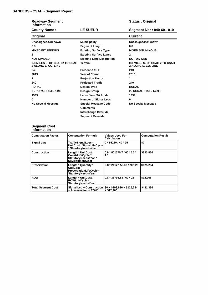
SANEEDS - CSAH - Segment Report
Roadway SegmentInformation
Status : Original
County Name : LE SUEUR Segment Nbr : 040-601-010
Original Current
Unassigned/Unknown Municipality Unassigned/Unknown
0.8 Segment Length 0.8
MIXED BITUMINOUS Existing Surface Type MIXED BITUMINOUS
2 Existing Surface Lanes 2
NOT DIVIDED Existing Lane Description NOT DIVIDED
0.8 MILES S. OF CSAH 2 TO CSAH2 ALONG E. CO. LINE
Termini 0.8 MILES S. OF CSAH 2 TO CSAH2 ALONG E. CO. LINE
240 Present AADT 240
2013 Year of Count 2013
1 Projection Factor 1
240 Projected Traffic 240
RURAL Design Type RURAL
2 - RURAL : 150 - 1499 Design Group 2 ( RURAL : 150 - 1499 )
1999 Latest Year SA funds 1999
0 Number of Signal Legs 0
No Special Message Special Message Code No Special Message
Comments
Interchange Override
Segment Override
Segment CostInformation
Computation Factor Computation Formula Values Used ForCalculation
Computation Result
Signal Leg TrafficSignalLegs *UnitCost / SignalLifeCycle* StatutoryNeedsYear
0 * 56250 / 40 * 25 $0
Construction Length * UnitCost /ConstrLifeCycle *StatutoryNeedsYear *DevelopmentCost
0.8 * 801370.7 / 60 * 25 *1.1
$293,836
Preservation Length * Quantity *UnitCost /PreservationLifeCycle *StatutoryNeedsYear
0.8 * 2112 * 59.32 / 20 * 25 $125,284
ROW Length * UnitCost /ROWLifeCycle *StatutoryNeedsYear
0.8 * 36798.68 / 60 * 25 $12,266
Total Segment Cost Signal Leg + Construction+ Preservation + ROW
$0 + $293,836 + $125,284+ $12,266
$431,386

SANEEDS - CSAH - Segment Report
Roadway SegmentInformation
Status : Original
County Name : LE SUEUR Segment Nbr : 040-602-010
Original Current
CLEVELAND Municipality CLEVELAND
0.23 Segment Length 0.23
MIXED BITUMINOUS Existing Surface Type MIXED BITUMINOUS
2 Existing Surface Lanes 2
NOT DIVIDED Existing Lane Description NOT DIVIDED
CSAH 15 TO E LIM OF CLEVELAND Termini CSAH 15 TO E LIM OF CLEVELAND
430 Present AADT 430
2013 Year of Count 2013
1 Projection Factor 1
430 Projected Traffic 430
URBAN Design Type URBAN
5 - URBAN : 0 - 9999 Design Group 5 ( URBAN : 0 - 9999 )
1997 Latest Year SA funds 1997
0 Number of Signal Legs 0
No Special Message Special Message Code No Special Message
Comments
Interchange Override
Segment Override
Segment CostInformation
Computation Factor Computation Formula Values Used ForCalculation
Computation Result
Signal Leg TrafficSignalLegs *UnitCost / SignalLifeCycle* StatutoryNeedsYear
0 * 56250 / 40 * 25 $0
Construction Length * UnitCost /ConstrLifeCycle *StatutoryNeedsYear *DevelopmentCost
0.23 * 2823252.86 / 60 * 25* 1.15
$311,146
Preservation Length * Quantity *UnitCost /PreservationLifeCycle *StatutoryNeedsYear
0.23 * 2904 * 59.32 / 15 * 25 $66,035
ROW Length * UnitCost /ROWLifeCycle *StatutoryNeedsYear
0.23 * 59776.02 / 60 * 25 $5,729
Total Segment Cost Signal Leg + Construction+ Preservation + ROW
$0 + $311,146 + $66,035 +$5,729
$382,910

SANEEDS - CSAH - Segment Report
Roadway SegmentInformation
Status : Original
County Name : LE SUEUR Segment Nbr : 040-602-020
Original Current
Unassigned/Unknown Municipality Unassigned/Unknown
0.2 Segment Length 0.2
MIXED BITUMINOUS Existing Surface Type MIXED BITUMINOUS
2 Existing Surface Lanes 2
NOT DIVIDED Existing Lane Description NOT DIVIDED
E LIM CLEVELAND TO 0.2 MI NE Termini E LIM CLEVELAND TO 0.2 MI NE
430 Present AADT 430
2013 Year of Count 2013
1 Projection Factor 1
430 Projected Traffic 430
RURAL Design Type RURAL
2 - RURAL : 150 - 1499 Design Group 2 ( RURAL : 150 - 1499 )
1997 Latest Year SA funds 1997
0 Number of Signal Legs 0
No Special Message Special Message Code No Special Message
Comments
Interchange Override
Segment Override
Segment CostInformation
Computation Factor Computation Formula Values Used ForCalculation
Computation Result
Signal Leg TrafficSignalLegs *UnitCost / SignalLifeCycle* StatutoryNeedsYear
0 * 56250 / 40 * 25 $0
Construction Length * UnitCost /ConstrLifeCycle *StatutoryNeedsYear *DevelopmentCost
0.2 * 801370.7 / 60 * 25 *1.1
$73,459
Preservation Length * Quantity *UnitCost /PreservationLifeCycle *StatutoryNeedsYear
0.2 * 2112 * 59.32 / 20 * 25 $31,321
ROW Length * UnitCost /ROWLifeCycle *StatutoryNeedsYear
0.2 * 36798.68 / 60 * 25 $3,067
Total Segment Cost Signal Leg + Construction+ Preservation + ROW
$0 + $73,459 + $31,321 +$3,067
$107,847

SANEEDS - CSAH - Segment Report
Roadway SegmentInformation
Status : Original
County Name : LE SUEUR Segment Nbr : 040-602-021
Original Current
Unassigned/Unknown Municipality Unassigned/Unknown
5.1 Segment Length 5.1
MIXED BITUMINOUS Existing Surface Type MIXED BITUMINOUS
2 Existing Surface Lanes 2
NOT DIVIDED Existing Lane Description NOT DIVIDED
0.2 MI NE OF E LIM CLEVELANDTO CSAH 11
Termini 0.2 MI NE OF E LIM CLEVELANDTO CSAH 11
430 Present AADT 430
2013 Year of Count 2013
1 Projection Factor 1
430 Projected Traffic 430
RURAL Design Type RURAL
2 - RURAL : 150 - 1499 Design Group 2 ( RURAL : 150 - 1499 )
1997 Latest Year SA funds 1997
0 Number of Signal Legs 0
No Special Message Special Message Code No Special Message
Comments
Interchange Override
Segment Override
Segment CostInformation
Computation Factor Computation Formula Values Used ForCalculation
Computation Result
Signal Leg TrafficSignalLegs *UnitCost / SignalLifeCycle* StatutoryNeedsYear
0 * 56250 / 40 * 25 $0
Construction Length * UnitCost /ConstrLifeCycle *StatutoryNeedsYear *DevelopmentCost
5.1 * 801370.7 / 60 * 25 *1.1
$1,873,204
Preservation Length * Quantity *UnitCost /PreservationLifeCycle *StatutoryNeedsYear
5.1 * 2112 * 59.32 / 20 * 25 $798,684
ROW Length * UnitCost /ROWLifeCycle *StatutoryNeedsYear
5.1 * 36798.68 / 60 * 25 $78,197
Total Segment Cost Signal Leg + Construction+ Preservation + ROW
$0 + $1,873,204 + $798,684+ $78,197
$2,750,085

SANEEDS - CSAH - Segment Report
Roadway SegmentInformation
Status : Original
County Name : LE SUEUR Segment Nbr : 040-602-030
Original Current
Unassigned/Unknown Municipality Unassigned/Unknown
1.8 Segment Length 1.8
MIXED BITUMINOUS Existing Surface Type MIXED BITUMINOUS
2 Existing Surface Lanes 2
NOT DIVIDED Existing Lane Description NOT DIVIDED
CSAH 11 TO N JCT CSAH 5 Termini CSAH 11 TO N JCT CSAH 5
630 Present AADT 630
2013 Year of Count 2013
1 Projection Factor 1
630 Projected Traffic 630
RURAL Design Type RURAL
2 - RURAL : 150 - 1499 Design Group 2 ( RURAL : 150 - 1499 )
2008 Latest Year SA funds 2008
0 Number of Signal Legs 0
No Special Message Special Message Code No Special Message
2008: FDR AND BIT SURFACEWITH LOCAL BOND FUNDSSAP 40-602-18
Comments 2008: FDR AND BIT SURFACEWITH LOCAL BOND FUNDSSAP 40-602-18
Interchange Override
Segment Override
Segment CostInformation
Computation Factor Computation Formula Values Used ForCalculation
Computation Result
Signal Leg TrafficSignalLegs *UnitCost / SignalLifeCycle* StatutoryNeedsYear
0 * 56250 / 40 * 25 $0
Construction Length * UnitCost /ConstrLifeCycle *StatutoryNeedsYear *DevelopmentCost
1.8 * 801370.7 / 60 * 25 *1.1
$661,131
Preservation Length * Quantity *UnitCost /PreservationLifeCycle *StatutoryNeedsYear
1.8 * 2112 * 59.32 / 20 * 25 $281,889
ROW Length * UnitCost /ROWLifeCycle *StatutoryNeedsYear
1.8 * 36798.68 / 60 * 25 $27,599
Total Segment Cost Signal Leg + Construction+ Preservation + ROW
$0 + $661,131 + $281,889+ $27,599
$970,619

SANEEDS - CSAH - Segment Report
Roadway SegmentInformation
Status : Original
County Name : LE SUEUR Segment Nbr : 040-602-040
Original Current
Unassigned/Unknown Municipality Unassigned/Unknown
0.2 Segment Length 0.2
MIXED BITUMINOUS Existing Surface Type MIXED BITUMINOUS
2 Existing Surface Lanes 2
NOT DIVIDED Existing Lane Description NOT DIVIDED
N JCT CSAH 5 TO 0.2 MI SE OFCSAH 5 IN CORDOVA
Termini N JCT CSAH 5 TO 0.2 MI SE OFCSAH 5 IN CORDOVA
630 Present AADT 630
2013 Year of Count 2013
1 Projection Factor 1
630 Projected Traffic 630
URBAN Design Type URBAN
5 - URBAN : 0 - 9999 Design Group 5 ( URBAN : 0 - 9999 )
2008 Latest Year SA funds 2008
0 Number of Signal Legs 0
No Special Message Special Message Code No Special Message
DSAE APPROVED COMPLETESTORM SEWER NEEDS2008: FDR AND BIT SURFACECONSTRUCTED WITH LOCALFUNDSSAP 40-602-18
Comments DSAE APPROVED COMPLETESTORM SEWER NEEDS2008: FDR AND BIT SURFACECONSTRUCTED WITH LOCALFUNDSSAP 40-602-18
Interchange Override
Segment Override
Segment CostInformation
Computation Factor Computation Formula Values Used ForCalculation
Computation Result
Signal Leg TrafficSignalLegs *UnitCost / SignalLifeCycle* StatutoryNeedsYear
0 * 56250 / 40 * 25 $0
Construction Length * UnitCost /ConstrLifeCycle *StatutoryNeedsYear *DevelopmentCost
0.2 * 2823252.86 / 60 * 25 *1.15
$270,562
Preservation Length * Quantity *UnitCost /PreservationLifeCycle *StatutoryNeedsYear
0.2 * 2904 * 59.32 / 15 * 25 $57,422
ROW Length * UnitCost /ROWLifeCycle *StatutoryNeedsYear
0.2 * 59776.02 / 60 * 25 $4,981
Total Segment Cost Signal Leg + Construction+ Preservation + ROW
$0 + $270,562 + $57,422 +$4,981
$332,965
SANEEDS - CSAH - Segment Report
Roadway SegmentInformation
Status : Original
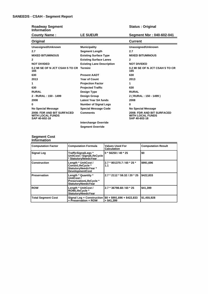
County Name : LE SUEUR Segment Nbr : 040-602-041
Original Current
Unassigned/Unknown Municipality Unassigned/Unknown
2.7 Segment Length 2.7
MIXED BITUMINOUS Existing Surface Type MIXED BITUMINOUS
2 Existing Surface Lanes 2
NOT DIVIDED Existing Lane Description NOT DIVIDED
0.2 MI SE OF N JCT CSAH 5 TO CR165
Termini 0.2 MI SE OF N JCT CSAH 5 TO CR165
630 Present AADT 630
2013 Year of Count 2013
1 Projection Factor 1
630 Projected Traffic 630
RURAL Design Type RURAL
2 - RURAL : 150 - 1499 Design Group 2 ( RURAL : 150 - 1499 )
2008 Latest Year SA funds 2008
0 Number of Signal Legs 0
No Special Message Special Message Code No Special Message
2008: FDR AND BIT SURFACEDWITH LOCAL FUNDSSAP 40-602-18
Comments 2008: FDR AND BIT SURFACEDWITH LOCAL FUNDSSAP 40-602-18
Interchange Override
Segment Override
Segment CostInformation
Computation Factor Computation Formula Values Used ForCalculation
Computation Result
Signal Leg TrafficSignalLegs *UnitCost / SignalLifeCycle* StatutoryNeedsYear
0 * 56250 / 40 * 25 $0
Construction Length * UnitCost /ConstrLifeCycle *StatutoryNeedsYear *DevelopmentCost
2.7 * 801370.7 / 60 * 25 *1.1
$991,696
Preservation Length * Quantity *UnitCost /PreservationLifeCycle *StatutoryNeedsYear
2.7 * 2112 * 59.32 / 20 * 25 $422,833
ROW Length * UnitCost /ROWLifeCycle *StatutoryNeedsYear
2.7 * 36798.68 / 60 * 25 $41,399
Total Segment Cost Signal Leg + Construction+ Preservation + ROW
$0 + $991,696 + $422,833+ $41,399
$1,455,928

SANEEDS - CSAH - Segment Report
Roadway SegmentInformation
Status : Original
County Name : LE SUEUR Segment Nbr : 040-602-050
Original Current
Unassigned/Unknown Municipality Unassigned/Unknown
2 Segment Length 2
MIXED BITUMINOUS Existing Surface Type MIXED BITUMINOUS
2 Existing Surface Lanes 2
NOT DIVIDED Existing Lane Description NOT DIVIDED
CR 165 TO TH 13 Termini CR 165 TO TH 13
420 Present AADT 420
2013 Year of Count 2013
1 Projection Factor 1
420 Projected Traffic 420
RURAL Design Type RURAL
2 - RURAL : 150 - 1499 Design Group 2 ( RURAL : 150 - 1499 )
2000 Latest Year SA funds 2000
0 Number of Signal Legs 0
No Special Message Special Message Code No Special Message
CIR AND OL 2011 Comments CIR AND OL 2011
Interchange Override
Segment Override
Bridge Information Status: Original
Original Current
40521 Structure Number 40521
11.61 Milepoint 11.61
2003 Year Built 2003
BIG CANNON RIVER Feature Crossed BIG CANNON RIVER
STREAM CROSSING Type of Service STREAM CROSSING
1 Number of Spans 1
51.6 Bridge Length 51.6
39.3 Bridge Width 39.3
100% Shared Structure 100%
Comments
1 ( 0-149 ) Bridge Group Code 1 ( 0-149 )
Segment CostInformation
Computation Factor Computation Formula Values Used ForCalculation
Computation Result
Signal Leg TrafficSignalLegs *UnitCost / SignalLifeCycle* StatutoryNeedsYear
0 * 56250 / 40 * 25 $0
Construction Length * UnitCost /ConstrLifeCycle *StatutoryNeedsYear *DevelopmentCost
2 * 801370.7 / 60 * 25 * 1.1 $734,590
Preservation Length * Quantity *UnitCost /PreservationLifeCycle *StatutoryNeedsYear
2 * 2112 * 59.32 / 20 * 25 $313,210
ROW Length * UnitCost /ROWLifeCycle *StatutoryNeedsYear
2 * 36798.68 / 60 * 25 $30,666
Bridge BridgeLength *BridgeWidth * UnitCost /BridgeLifeCycle *StatutoryNeedsYear *DevelopmentCost
51.6 * 39.3 * 152 / 80 * 25 *1.15
$110,773
Total Segment Cost Signal Leg + Construction+ Preservation + ROW +Bridge
$0 + $734,590 + $313,210+ $30,666 + $110,773
$1,189,239

SANEEDS - CSAH - Segment Report
Roadway SegmentInformation
Status : Original
County Name : LE SUEUR Segment Nbr : 040-602-060
Original Current
Unassigned/Unknown Municipality Unassigned/Unknown
1.5 Segment Length 1.5
MIXED BITUMINOUS Existing Surface Type MIXED BITUMINOUS
2 Existing Surface Lanes 2
NOT DIVIDED Existing Lane Description NOT DIVIDED
TH 13 TO WEST LIMITS KILKENNY Termini TH 13 TO WEST LIMITS KILKENNY
410 Present AADT 410
2013 Year of Count 2013
1 Projection Factor 1
410 Projected Traffic 410
RURAL Design Type RURAL
2 - RURAL : 150 - 1499 Design Group 2 ( RURAL : 150 - 1499 )
1998 Latest Year SA funds 1998
0 Number of Signal Legs 0
No Special Message Special Message Code No Special Message
CIR AND OL 2011 Comments CIR AND OL 2011
Interchange Override
Segment Override
Segment CostInformation
Computation Factor Computation Formula Values Used ForCalculation
Computation Result
Signal Leg TrafficSignalLegs *UnitCost / SignalLifeCycle* StatutoryNeedsYear
0 * 56250 / 40 * 25 $0
Construction Length * UnitCost /ConstrLifeCycle *StatutoryNeedsYear *DevelopmentCost
1.5 * 801370.7 / 60 * 25 *1.1
$550,942
Preservation Length * Quantity *UnitCost /PreservationLifeCycle *StatutoryNeedsYear
1.5 * 2112 * 59.32 / 20 * 25 $234,907
ROW Length * UnitCost /ROWLifeCycle *StatutoryNeedsYear
1.5 * 36798.68 / 60 * 25 $22,999
Total Segment Cost Signal Leg + Construction+ Preservation + ROW
$0 + $550,942 + $234,907+ $22,999
$808,848

SANEEDS - CSAH - Segment Report
Roadway SegmentInformation
Status : Original
County Name : LE SUEUR Segment Nbr : 040-602-070
Original Current
KILKENNY Municipality KILKENNY
0.18 Segment Length 0.18
MIXED BITUMINOUS Existing Surface Type MIXED BITUMINOUS
2 Existing Surface Lanes 2
NOT DIVIDED Existing Lane Description NOT DIVIDED
W LIMS KILKENNY TO LAURELAVE (CSAH 55) ON DODD ROAD
Termini W LIMS KILKENNY TO LAURELAVE (CSAH 55) ON DODD ROAD
410 Present AADT 410
2013 Year of Count 2013
1 Projection Factor 1
410 Projected Traffic 410
RURAL Design Type RURAL
2 - RURAL : 150 - 1499 Design Group 2 ( RURAL : 150 - 1499 )
2000 Latest Year SA funds 2000
0 Number of Signal Legs 0
No Special Message Special Message Code No Special Message
OL 2011 Comments OL 2011
Interchange Override
Segment Override
Segment CostInformation
Computation Factor Computation Formula Values Used ForCalculation
Computation Result
Signal Leg TrafficSignalLegs *UnitCost / SignalLifeCycle* StatutoryNeedsYear
0 * 56250 / 40 * 25 $0
Construction Length * UnitCost /ConstrLifeCycle *StatutoryNeedsYear *DevelopmentCost
0.18 * 801370.7 / 60 * 25 *1.1
$66,113
Preservation Length * Quantity *UnitCost /PreservationLifeCycle *StatutoryNeedsYear
0.18 * 2112 * 59.32 / 20 * 25 $28,189
ROW Length * UnitCost /ROWLifeCycle *StatutoryNeedsYear
0.18 * 36798.68 / 60 * 25 $2,760
Total Segment Cost Signal Leg + Construction+ Preservation + ROW
$0 + $66,113 + $28,189 +$2,760
$97,062

SANEEDS - CSAH - Segment Report
Roadway SegmentInformation
Status : Original
County Name : LE SUEUR Segment Nbr : 040-602-080
Original Current
KILKENNY Municipality KILKENNY
0.07 Segment Length 0.07
MIXED BITUMINOUS Existing Surface Type MIXED BITUMINOUS
2 Existing Surface Lanes 2
NOT DIVIDED Existing Lane Description NOT DIVIDED
LAUREL AVE (CSAH 55) TOLINDEN AVE (CSAH 3) ON DODDROAD
Termini LAUREL AVE (CSAH 55) TOLINDEN AVE (CSAH 3) ON DODDROAD
410 Present AADT 410
2013 Year of Count 2013
1 Projection Factor 1
410 Projected Traffic 410
RURAL Design Type RURAL
2 - RURAL : 150 - 1499 Design Group 2 ( RURAL : 150 - 1499 )
2000 Latest Year SA funds 2000
0 Number of Signal Legs 0
No Special Message Special Message Code No Special Message
OL 2011 Comments OL 2011
Interchange Override
Segment Override
Segment CostInformation
Computation Factor Computation Formula Values Used ForCalculation
Computation Result
Signal Leg TrafficSignalLegs *UnitCost / SignalLifeCycle* StatutoryNeedsYear
0 * 56250 / 40 * 25 $0
Construction Length * UnitCost /ConstrLifeCycle *StatutoryNeedsYear *DevelopmentCost
0.07 * 801370.7 / 60 * 25 *1.1
$25,711
Preservation Length * Quantity *UnitCost /PreservationLifeCycle *StatutoryNeedsYear
0.07 * 2112 * 59.32 / 20 * 25 $10,962
ROW Length * UnitCost /ROWLifeCycle *StatutoryNeedsYear
0.07 * 36798.68 / 60 * 25 $1,073
Total Segment Cost Signal Leg + Construction+ Preservation + ROW
$0 + $25,711 + $10,962 +$1,073
$37,746

SANEEDS - CSAH - Segment Report
Roadway SegmentInformation
Status : Original
County Name : LE SUEUR Segment Nbr : 040-602-090
Original Current
KILKENNY Municipality KILKENNY
0.12 Segment Length 0.12
MIXED BITUMINOUS Existing Surface Type MIXED BITUMINOUS
2 Existing Surface Lanes 2
NOT DIVIDED Existing Lane Description NOT DIVIDED
LINDEN AVE (CSAH 3) TO 0.12 MIEAST
Termini LINDEN AVE (CSAH 3) TO 0.12 MIEAST
550 Present AADT 550
2013 Year of Count 2013
1 Projection Factor 1
550 Projected Traffic 550
RURAL Design Type RURAL
2 - RURAL : 150 - 1499 Design Group 2 ( RURAL : 150 - 1499 )
2000 Latest Year SA funds 2000
0 Number of Signal Legs 0
No Special Message Special Message Code No Special Message
OL 2011 Comments OL 2011
Interchange Override
Segment Override
Segment CostInformation
Computation Factor Computation Formula Values Used ForCalculation
Computation Result
Signal Leg TrafficSignalLegs *UnitCost / SignalLifeCycle* StatutoryNeedsYear
0 * 56250 / 40 * 25 $0
Construction Length * UnitCost /ConstrLifeCycle *StatutoryNeedsYear *DevelopmentCost
0.12 * 801370.7 / 60 * 25 *1.1
$44,075
Preservation Length * Quantity *UnitCost /PreservationLifeCycle *StatutoryNeedsYear
0.12 * 2112 * 59.32 / 20 * 25 $18,793
ROW Length * UnitCost /ROWLifeCycle *StatutoryNeedsYear
0.12 * 36798.68 / 60 * 25 $1,840
Total Segment Cost Signal Leg + Construction+ Preservation + ROW
$0 + $44,075 + $18,793 +$1,840
$64,708

SANEEDS - CSAH - Segment Report
Roadway SegmentInformation
Status : Original
County Name : LE SUEUR Segment Nbr : 040-602-095
Original Current
KILKENNY Municipality KILKENNY
0.1 Segment Length 0.1
MIXED BITUMINOUS Existing Surface Type MIXED BITUMINOUS
2 Existing Surface Lanes 2
NOT DIVIDED Existing Lane Description NOT DIVIDED
0.12 MI E OF CSAH 3 TO EAST LIMKILKENNY
Termini 0.12 MI E OF CSAH 3 TO EAST LIMKILKENNY
550 Present AADT 550
2013 Year of Count 2013
1 Projection Factor 1
550 Projected Traffic 550
RURAL Design Type RURAL
2 - RURAL : 150 - 1499 Design Group 2 ( RURAL : 150 - 1499 )
1998 Latest Year SA funds 1998
0 Number of Signal Legs 0
No Special Message Special Message Code No Special Message
OL 2011 Comments OL 2011
Interchange Override
Segment Override
Segment CostInformation
Computation Factor Computation Formula Values Used ForCalculation
Computation Result
Signal Leg TrafficSignalLegs *UnitCost / SignalLifeCycle* StatutoryNeedsYear
0 * 56250 / 40 * 25 $0
Construction Length * UnitCost /ConstrLifeCycle *StatutoryNeedsYear *DevelopmentCost
0.1 * 801370.7 / 60 * 25 *1.1
$36,729
Preservation Length * Quantity *UnitCost /PreservationLifeCycle *StatutoryNeedsYear
0.1 * 2112 * 59.32 / 20 * 25 $15,660
ROW Length * UnitCost /ROWLifeCycle *StatutoryNeedsYear
0.1 * 36798.68 / 60 * 25 $1,533
Total Segment Cost Signal Leg + Construction+ Preservation + ROW
$0 + $36,729 + $15,660 +$1,533
$53,922

SANEEDS - CSAH - Segment Report
Roadway SegmentInformation
Status : Original
County Name : LE SUEUR Segment Nbr : 040-602-100
Original Current
Unassigned/Unknown Municipality Unassigned/Unknown
2.4 Segment Length 2.4
MIXED BITUMINOUS Existing Surface Type MIXED BITUMINOUS
2 Existing Surface Lanes 2
NOT DIVIDED Existing Lane Description NOT DIVIDED
EAST LIM KILKENNY TO E COLINE
Termini EAST LIM KILKENNY TO E COLINE
400 Present AADT 400
2013 Year of Count 2013
1 Projection Factor 1
400 Projected Traffic 400
RURAL Design Type RURAL
2 - RURAL : 150 - 1499 Design Group 2 ( RURAL : 150 - 1499 )
1998 Latest Year SA funds 1998
0 Number of Signal Legs 0
No Special Message Special Message Code No Special Message
CIR AND OL 2011 Comments CIR AND OL 2011
Interchange Override
Segment Override
Segment CostInformation
Computation Factor Computation Formula Values Used ForCalculation
Computation Result
Signal Leg TrafficSignalLegs *UnitCost / SignalLifeCycle* StatutoryNeedsYear
0 * 56250 / 40 * 25 $0
Construction Length * UnitCost /ConstrLifeCycle *StatutoryNeedsYear *DevelopmentCost
2.4 * 801370.7 / 60 * 25 *1.1
$881,508
Preservation Length * Quantity *UnitCost /PreservationLifeCycle *StatutoryNeedsYear
2.4 * 2112 * 59.32 / 20 * 25 $375,852
ROW Length * UnitCost /ROWLifeCycle *StatutoryNeedsYear
2.4 * 36798.68 / 60 * 25 $36,799
Total Segment Cost Signal Leg + Construction+ Preservation + ROW
$0 + $881,508 + $375,852+ $36,799
$1,294,159

SANEEDS - CSAH - Segment Report
Roadway SegmentInformation
Status : Original
County Name : LE SUEUR Segment Nbr : 040-603-010
Original Current
Unassigned/Unknown Municipality Unassigned/Unknown
1 Segment Length 1
MIXED BITUMINOUS Existing Surface Type MIXED BITUMINOUS
2 Existing Surface Lanes 2
NOT DIVIDED Existing Lane Description NOT DIVIDED
S CO LINE TO TH 60 S LIMSWATERVILLE
Termini S CO LINE TO TH 60 S LIMSWATERVILLE
390 Present AADT 390
2013 Year of Count 2013
1 Projection Factor 1
390 Projected Traffic 390
RURAL Design Type RURAL
2 - RURAL : 150 - 1499 Design Group 2 ( RURAL : 150 - 1499 )
1989 Latest Year SA funds 1989
0 Number of Signal Legs 0
No Special Message Special Message Code No Special Message
Comments
Interchange Override
Segment Override
Segment CostInformation
Computation Factor Computation Formula Values Used ForCalculation
Computation Result
Signal Leg TrafficSignalLegs *UnitCost / SignalLifeCycle* StatutoryNeedsYear
0 * 56250 / 40 * 25 $0
Construction Length * UnitCost /ConstrLifeCycle *StatutoryNeedsYear *DevelopmentCost
1 * 801370.7 / 60 * 25 * 1.1 $367,295
Preservation Length * Quantity *UnitCost /PreservationLifeCycle *StatutoryNeedsYear
1 * 2112 * 59.32 / 20 * 25 $156,605
ROW Length * UnitCost /ROWLifeCycle *StatutoryNeedsYear
1 * 36798.68 / 60 * 25 $15,333
Total Segment Cost Signal Leg + Construction+ Preservation + ROW
$0 + $367,295 + $156,605+ $15,333
$539,233

SANEEDS - CSAH - Segment Report
Roadway SegmentInformation
Status : Original
County Name : LE SUEUR Segment Nbr : 040-603-011
Original Current
WATERVILLE Municipality WATERVILLE
0.14 Segment Length 0.14
MIXED BITUMINOUS Existing Surface Type MIXED BITUMINOUS
2 Existing Surface Lanes 2
NOT DIVIDED Existing Lane Description NOT DIVIDED
TH 60 S LIMS WATERVILLE TO0.14 MI N ON REED ST
Termini TH 60 S LIMS WATERVILLE TO0.14 MI N ON REED ST
1100 Present AADT 1100
2013 Year of Count 2013
1 Projection Factor 1
1100 Projected Traffic 1100
URBAN Design Type URBAN
5 - URBAN : 0 - 9999 Design Group 5 ( URBAN : 0 - 9999 )
2000 Latest Year SA funds 2000
0 Number of Signal Legs 0
No Special Message Special Message Code No Special Message
Comments
Interchange Override
Segment Override
Segment CostInformation
Computation Factor Computation Formula Values Used ForCalculation
Computation Result
Signal Leg TrafficSignalLegs *UnitCost / SignalLifeCycle* StatutoryNeedsYear
0 * 56250 / 40 * 25 $0
Construction Length * UnitCost /ConstrLifeCycle *StatutoryNeedsYear *DevelopmentCost
0.14 * 2823252.86 / 60 * 25* 1.15
$189,393
Preservation Length * Quantity *UnitCost /PreservationLifeCycle *StatutoryNeedsYear
0.14 * 2904 * 59.32 / 15 * 25 $40,195
ROW Length * UnitCost /ROWLifeCycle *StatutoryNeedsYear
0.14 * 59776.02 / 60 * 25 $3,487
Total Segment Cost Signal Leg + Construction+ Preservation + ROW
$0 + $189,393 + $40,195 +$3,487
$233,075

SANEEDS - CSAH - Segment Report
Roadway SegmentInformation
Status : Original
County Name : LE SUEUR Segment Nbr : 040-603-012
Original Current
WATERVILLE Municipality WATERVILLE
0.13 Segment Length 0.13
MIXED BITUMINOUS Existing Surface Type MIXED BITUMINOUS
2 Existing Surface Lanes 2
NOT DIVIDED Existing Lane Description NOT DIVIDED
0.14 MI N OF TH 60 TO GREENSTREET ON REED STREET
Termini 0.14 MI N OF TH 60 TO GREENSTREET ON REED STREET
1100 Present AADT 1100
2013 Year of Count 2013
1 Projection Factor 1
1100 Projected Traffic 1100
URBAN Design Type URBAN
5 - URBAN : 0 - 9999 Design Group 5 ( URBAN : 0 - 9999 )
1992 Latest Year SA funds 1992
0 Number of Signal Legs 0
No Special Message Special Message Code No Special Message
Comments
Interchange Override
Segment Override
Culvert Information Status: Original
Original Current
95539 Structure Number 95539
1.22 Milepoint 1.22
1985 Year Built 1985
WHITE WATER CREEK Feature Crossed WHITE WATER CREEK
STREAM CROSSING Type of Service STREAM CROSSING
2 Number of Barrels 2
10 Culvert Width 10
8 Culvert Height 8
56 Culvert Length 56
159.99999155 Area of Waterway Opening 159.99999155
100% Shared Structure 100%
Comments
1 Culvert Group Code 1
Segment CostInformation
Computation Factor Computation Formula Values Used ForCalculation
Computation Result
Signal Leg TrafficSignalLegs *UnitCost / SignalLifeCycle* StatutoryNeedsYear
0 * 56250 / 40 * 25 $0
Construction Length * UnitCost /ConstrLifeCycle *StatutoryNeedsYear *DevelopmentCost
0.13 * 2823252.86 / 60 * 25* 1.15
$175,865
Preservation Length * Quantity *UnitCost /PreservationLifeCycle *StatutoryNeedsYear
0.13 * 2904 * 59.32 / 15 * 25 $37,324
ROW Length * UnitCost /ROWLifeCycle *StatutoryNeedsYear
0.13 * 59776.02 / 60 * 25 $3,238
Culvert CulvertLength * Area *UnitCost /CulvertLifeCycle *StatutoryNeedsYear *DevelopmentCost
56 * 159.99999155 * 15.47 /100 * 25 * 1.15
$39,851

Total Segment Cost Signal Leg + Construction+ Preservation + ROW +Culvert
$0 + $175,865 + $37,324 +$3,238 + $39,851
$256,278

SANEEDS - CSAH - Segment Report
Roadway SegmentInformation
Status : Original
County Name : LE SUEUR Segment Nbr : 040-603-013
Original Current
WATERVILLE Municipality WATERVILLE
0.24 Segment Length 0.24
MIXED BITUMINOUS Existing Surface Type MIXED BITUMINOUS
2 Existing Surface Lanes 2
NOT DIVIDED Existing Lane Description NOT DIVIDED
GREEN ST TO PAQUIN ST (CSAH14/53) ON REED ST
Termini GREEN ST TO PAQUIN ST (CSAH14/53) ON REED ST
1100 Present AADT 1100
2013 Year of Count 2013
1 Projection Factor 1
1100 Projected Traffic 1100
URBAN Design Type URBAN
5 - URBAN : 0 - 9999 Design Group 5 ( URBAN : 0 - 9999 )
1992 Latest Year SA funds 1992
0 Number of Signal Legs 0
No Special Message Special Message Code No Special Message
Comments
Interchange Override
Segment Override
Segment CostInformation
Computation Factor Computation Formula Values Used ForCalculation
Computation Result
Signal Leg TrafficSignalLegs *UnitCost / SignalLifeCycle* StatutoryNeedsYear
0 * 56250 / 40 * 25 $0
Construction Length * UnitCost /ConstrLifeCycle *StatutoryNeedsYear *DevelopmentCost
0.24 * 2823252.86 / 60 * 25* 1.15
$324,674
Preservation Length * Quantity *UnitCost /PreservationLifeCycle *StatutoryNeedsYear
0.24 * 2904 * 59.32 / 15 * 25 $68,906
ROW Length * UnitCost /ROWLifeCycle *StatutoryNeedsYear
0.24 * 59776.02 / 60 * 25 $5,978
Total Segment Cost Signal Leg + Construction+ Preservation + ROW
$0 + $324,674 + $68,906 +$5,978
$399,558

SANEEDS - CSAH - Segment Report
Roadway SegmentInformation
Status : Original
County Name : LE SUEUR Segment Nbr : 040-603-020
Original Current
WATERVILLE Municipality WATERVILLE
0.64 Segment Length 0.64
MIXED BITUMINOUS Existing Surface Type MIXED BITUMINOUS
2 Existing Surface Lanes 2
NOT DIVIDED Existing Lane Description NOT DIVIDED
TH 13 TO NORTH LIMITS OFWATERVILLE
Termini TH 13 TO NORTH LIMITS OFWATERVILLE
710 Present AADT 710
2013 Year of Count 2013
1 Projection Factor 1
710 Projected Traffic 710
RURAL Design Type RURAL
2 - RURAL : 150 - 1499 Design Group 2 ( RURAL : 150 - 1499 )
2007 Latest Year SA funds 2007
0 Number of Signal Legs 0
No Special Message Special Message Code No Special Message
SURFACE CONSTRUCTED IN 2007WITH LOCAL BOND FUNDSSAP 40-603-24
Comments SURFACE CONSTRUCTED IN 2007WITH LOCAL BOND FUNDSSAP 40-603-24
Interchange Override
Segment Override
Segment CostInformation
Computation Factor Computation Formula Values Used ForCalculation
Computation Result
Signal Leg TrafficSignalLegs *UnitCost / SignalLifeCycle* StatutoryNeedsYear
0 * 56250 / 40 * 25 $0
Construction Length * UnitCost /ConstrLifeCycle *StatutoryNeedsYear *DevelopmentCost
0.64 * 801370.7 / 60 * 25 *1.1
$235,069
Preservation Length * Quantity *UnitCost /PreservationLifeCycle *StatutoryNeedsYear
0.64 * 2112 * 59.32 / 20 * 25 $100,227
ROW Length * UnitCost /ROWLifeCycle *StatutoryNeedsYear
0.64 * 36798.68 / 60 * 25 $9,813
Total Segment Cost Signal Leg + Construction+ Preservation + ROW
$0 + $235,069 + $100,227+ $9,813
$345,109

SANEEDS - CSAH - Segment Report
Roadway SegmentInformation
Status : Original
County Name : LE SUEUR Segment Nbr : 040-603-040
Original Current
Unassigned/Unknown Municipality Unassigned/Unknown
1.3 Segment Length 1.3
MIXED BITUMINOUS Existing Surface Type MIXED BITUMINOUS
2 Existing Surface Lanes 2
NOT DIVIDED Existing Lane Description NOT DIVIDED
NORTH LIMITS WATERVILLE TOCSAH 10
Termini NORTH LIMITS WATERVILLE TOCSAH 10
710 Present AADT 710
2013 Year of Count 2013
1 Projection Factor 1
710 Projected Traffic 710
RURAL Design Type RURAL
2 - RURAL : 150 - 1499 Design Group 2 ( RURAL : 150 - 1499 )
2007 Latest Year SA funds 2007
0 Number of Signal Legs 0
No Special Message Special Message Code No Special Message
SURFACE CONSTRUCTED WITHLOCAL BOND FUNDS IN 2007SAP 40-603-24
Comments SURFACE CONSTRUCTED WITHLOCAL BOND FUNDS IN 2007SAP 40-603-24
Interchange Override
Segment Override
Segment CostInformation
Computation Factor Computation Formula Values Used ForCalculation
Computation Result
Signal Leg TrafficSignalLegs *UnitCost / SignalLifeCycle* StatutoryNeedsYear
0 * 56250 / 40 * 25 $0
Construction Length * UnitCost /ConstrLifeCycle *StatutoryNeedsYear *DevelopmentCost
1.3 * 801370.7 / 60 * 25 *1.1
$477,483
Preservation Length * Quantity *UnitCost /PreservationLifeCycle *StatutoryNeedsYear
1.3 * 2112 * 59.32 / 20 * 25 $203,586
ROW Length * UnitCost /ROWLifeCycle *StatutoryNeedsYear
1.3 * 36798.68 / 60 * 25 $19,933
Total Segment Cost Signal Leg + Construction+ Preservation + ROW
$0 + $477,483 + $203,586+ $19,933
$701,002

SANEEDS - CSAH - Segment Report
Roadway SegmentInformation
Status : Original
County Name : LE SUEUR Segment Nbr : 040-603-050
Original Current
Unassigned/Unknown Municipality Unassigned/Unknown
3.4 Segment Length 3.4
MIXED BITUMINOUS Existing Surface Type MIXED BITUMINOUS
2 Existing Surface Lanes 2
NOT DIVIDED Existing Lane Description NOT DIVIDED
CSAH 10 TO CR 168 Termini CSAH 10 TO CR 168
345 Present AADT 345
2013 Year of Count 2013
1 Projection Factor 1
345 Projected Traffic 345
RURAL Design Type RURAL
2 - RURAL : 150 - 1499 Design Group 2 ( RURAL : 150 - 1499 )
2007 Latest Year SA funds 2007
0 Number of Signal Legs 0
No Special Message Special Message Code No Special Message
SURFACE CONSTRUCTED WITHLOCAL BONDS FUNDS IN 2007SAP 40-603-24
Comments SURFACE CONSTRUCTED WITHLOCAL BONDS FUNDS IN 2007SAP 40-603-24
Interchange Override
Segment Override
Segment CostInformation
Computation Factor Computation Formula Values Used ForCalculation
Computation Result
Signal Leg TrafficSignalLegs *UnitCost / SignalLifeCycle* StatutoryNeedsYear
0 * 56250 / 40 * 25 $0
Construction Length * UnitCost /ConstrLifeCycle *StatutoryNeedsYear *DevelopmentCost
3.4 * 801370.7 / 60 * 25 *1.1
$1,248,803
Preservation Length * Quantity *UnitCost /PreservationLifeCycle *StatutoryNeedsYear
3.4 * 2112 * 59.32 / 20 * 25 $532,456
ROW Length * UnitCost /ROWLifeCycle *StatutoryNeedsYear
3.4 * 36798.68 / 60 * 25 $52,131
Total Segment Cost Signal Leg + Construction+ Preservation + ROW
$0 + $1,248,803 + $532,456+ $52,131
$1,833,390
SANEEDS - CSAH - Segment Report
Roadway SegmentInformation
Status : Original
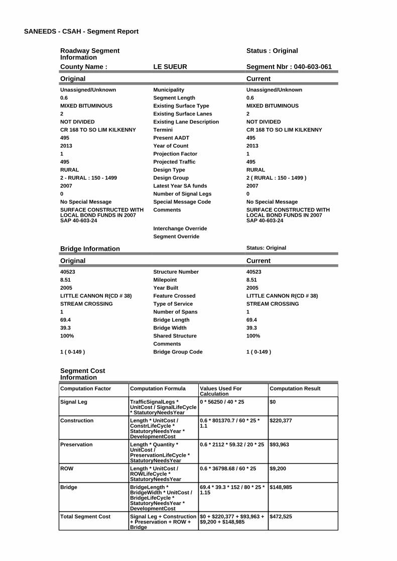
County Name : LE SUEUR Segment Nbr : 040-603-061
Original Current
Unassigned/Unknown Municipality Unassigned/Unknown
0.6 Segment Length 0.6
MIXED BITUMINOUS Existing Surface Type MIXED BITUMINOUS
2 Existing Surface Lanes 2
NOT DIVIDED Existing Lane Description NOT DIVIDED
CR 168 TO SO LIM KILKENNY Termini CR 168 TO SO LIM KILKENNY
495 Present AADT 495
2013 Year of Count 2013
1 Projection Factor 1
495 Projected Traffic 495
RURAL Design Type RURAL
2 - RURAL : 150 - 1499 Design Group 2 ( RURAL : 150 - 1499 )
2007 Latest Year SA funds 2007
0 Number of Signal Legs 0
No Special Message Special Message Code No Special Message
SURFACE CONSTRUCTED WITHLOCAL BOND FUNDS IN 2007SAP 40-603-24
Comments SURFACE CONSTRUCTED WITHLOCAL BOND FUNDS IN 2007SAP 40-603-24
Interchange Override
Segment Override
Bridge Information Status: Original
Original Current
40523 Structure Number 40523
8.51 Milepoint 8.51
2005 Year Built 2005
LITTLE CANNON R(CD # 38) Feature Crossed LITTLE CANNON R(CD # 38)
STREAM CROSSING Type of Service STREAM CROSSING
1 Number of Spans 1
69.4 Bridge Length 69.4
39.3 Bridge Width 39.3
100% Shared Structure 100%
Comments
1 ( 0-149 ) Bridge Group Code 1 ( 0-149 )
Segment CostInformation
Computation Factor Computation Formula Values Used ForCalculation
Computation Result
Signal Leg TrafficSignalLegs *UnitCost / SignalLifeCycle* StatutoryNeedsYear
0 * 56250 / 40 * 25 $0
Construction Length * UnitCost /ConstrLifeCycle *StatutoryNeedsYear *DevelopmentCost
0.6 * 801370.7 / 60 * 25 *1.1
$220,377
Preservation Length * Quantity *UnitCost /PreservationLifeCycle *StatutoryNeedsYear
0.6 * 2112 * 59.32 / 20 * 25 $93,963
ROW Length * UnitCost /ROWLifeCycle *StatutoryNeedsYear
0.6 * 36798.68 / 60 * 25 $9,200
Bridge BridgeLength *BridgeWidth * UnitCost /BridgeLifeCycle *StatutoryNeedsYear *DevelopmentCost
69.4 * 39.3 * 152 / 80 * 25 *1.15
$148,985
Total Segment Cost Signal Leg + Construction+ Preservation + ROW +Bridge
$0 + $220,377 + $93,963 +$9,200 + $148,985
$472,525

SANEEDS - CSAH - Segment Report
Roadway SegmentInformation
Status : Original
County Name : LE SUEUR Segment Nbr : 040-603-070
Original Current
KILKENNY Municipality KILKENNY
0.26 Segment Length 0.26
MIXED BITUMINOUS Existing Surface Type MIXED BITUMINOUS
2 Existing Surface Lanes 2
NOT DIVIDED Existing Lane Description NOT DIVIDED
S LIMS KILKENNY TO DODD ROAD(CSAH 2) ON LINDEN AVE
Termini S LIMS KILKENNY TO DODD ROAD(CSAH 2) ON LINDEN AVE
495 Present AADT 495
2013 Year of Count 2013
1 Projection Factor 1
495 Projected Traffic 495
URBAN Design Type URBAN
5 - URBAN : 0 - 9999 Design Group 5 ( URBAN : 0 - 9999 )
2000 Latest Year SA funds 2000
0 Number of Signal Legs 0
No Special Message Special Message Code No Special Message
Comments
Interchange Override
Segment Override
Segment CostInformation
Computation Factor Computation Formula Values Used ForCalculation
Computation Result
Signal Leg TrafficSignalLegs *UnitCost / SignalLifeCycle* StatutoryNeedsYear
0 * 56250 / 40 * 25 $0
Construction Length * UnitCost /ConstrLifeCycle *StatutoryNeedsYear *DevelopmentCost
0.26 * 2823252.86 / 60 * 25* 1.15
$351,730
Preservation Length * Quantity *UnitCost /PreservationLifeCycle *StatutoryNeedsYear
0.26 * 2904 * 59.32 / 15 * 25 $74,648
ROW Length * UnitCost /ROWLifeCycle *StatutoryNeedsYear
0.26 * 59776.02 / 60 * 25 $6,476
Total Segment Cost Signal Leg + Construction+ Preservation + ROW
$0 + $351,730 + $74,648 +$6,476
$432,854

SANEEDS - CSAH - Segment Report
Roadway SegmentInformation
Status : Original
County Name : LE SUEUR Segment Nbr : 040-603-090
Original Current
KILKENNY Municipality KILKENNY
0.15 Segment Length 0.15
MIXED BITUMINOUS Existing Surface Type MIXED BITUMINOUS
2 Existing Surface Lanes 2
NOT DIVIDED Existing Lane Description NOT DIVIDED
DODD RD (CSAH 2) TO 0.15 MI NON LINDEN AVE
Termini DODD RD (CSAH 2) TO 0.15 MI NON LINDEN AVE
495 Present AADT 495
2013 Year of Count 2013
1 Projection Factor 1
495 Projected Traffic 495
URBAN Design Type URBAN
5 - URBAN : 0 - 9999 Design Group 5 ( URBAN : 0 - 9999 )
2000 Latest Year SA funds 2000
0 Number of Signal Legs 0
No Special Message Special Message Code No Special Message
Comments
Interchange Override
Segment Override
Segment CostInformation
Computation Factor Computation Formula Values Used ForCalculation
Computation Result
Signal Leg TrafficSignalLegs *UnitCost / SignalLifeCycle* StatutoryNeedsYear
0 * 56250 / 40 * 25 $0
Construction Length * UnitCost /ConstrLifeCycle *StatutoryNeedsYear *DevelopmentCost
0.15 * 2823252.86 / 60 * 25* 1.15
$202,921
Preservation Length * Quantity *UnitCost /PreservationLifeCycle *StatutoryNeedsYear
0.15 * 2904 * 59.32 / 15 * 25 $43,066
ROW Length * UnitCost /ROWLifeCycle *StatutoryNeedsYear
0.15 * 59776.02 / 60 * 25 $3,736
Total Segment Cost Signal Leg + Construction+ Preservation + ROW
$0 + $202,921 + $43,066 +$3,736
$249,723

SANEEDS - CSAH - Segment Report
Roadway SegmentInformation
Status : Original
County Name : LE SUEUR Segment Nbr : 040-603-095
Original Current
KILKENNY Municipality KILKENNY
0.14 Segment Length 0.14
MIXED BITUMINOUS Existing Surface Type MIXED BITUMINOUS
2 Existing Surface Lanes 2
NOT DIVIDED Existing Lane Description NOT DIVIDED
0.15 MI N OF CSAH 2 TO N LIMITOF KILKENNY
Termini 0.15 MI N OF CSAH 2 TO N LIMITOF KILKENNY
300 Present AADT 300
2013 Year of Count 2013
1 Projection Factor 1
300 Projected Traffic 300
RURAL Design Type RURAL
2 - RURAL : 150 - 1499 Design Group 2 ( RURAL : 150 - 1499 )
1994 Latest Year SA funds 1994
0 Number of Signal Legs 0
No Special Message Special Message Code No Special Message
Comments
Interchange Override
Segment Override
Segment CostInformation
Computation Factor Computation Formula Values Used ForCalculation
Computation Result
Signal Leg TrafficSignalLegs *UnitCost / SignalLifeCycle* StatutoryNeedsYear
0 * 56250 / 40 * 25 $0
Construction Length * UnitCost /ConstrLifeCycle *StatutoryNeedsYear *DevelopmentCost
0.14 * 801370.7 / 60 * 25 *1.1
$51,421
Preservation Length * Quantity *UnitCost /PreservationLifeCycle *StatutoryNeedsYear
0.14 * 2112 * 59.32 / 20 * 25 $21,925
ROW Length * UnitCost /ROWLifeCycle *StatutoryNeedsYear
0.14 * 36798.68 / 60 * 25 $2,147
Total Segment Cost Signal Leg + Construction+ Preservation + ROW
$0 + $51,421 + $21,925 +$2,147
$75,493
SANEEDS - CSAH - Segment Report
Roadway SegmentInformation
Status : Original
County Name : LE SUEUR Segment Nbr : 040-603-100
Original Current
Unassigned/Unknown Municipality Unassigned/Unknown
3 Segment Length 3
MIXED BITUMINOUS Existing Surface Type MIXED BITUMINOUS
2 Existing Surface Lanes 2
NOT DIVIDED Existing Lane Description NOT DIVIDED
NORTH LIMIT OF KILKENNY TONORTH JCT CR 135
Termini NORTH LIMIT OF KILKENNY TONORTH JCT CR 135
300 Present AADT 300
2013 Year of Count 2013
1 Projection Factor 1
300 Projected Traffic 300
RURAL Design Type RURAL
2 - RURAL : 150 - 1499 Design Group 2 ( RURAL : 150 - 1499 )
1994 Latest Year SA funds 1994
0 Number of Signal Legs 0
No Special Message Special Message Code No Special Message
COMBINED SEGMENTS 100, 105,110, 111 & 112
Comments COMBINED SEGMENTS 100, 105,110, 111 & 112
Interchange Override
Segment Override
Bridge Information Status: Original
Original Current
40514 Structure Number 40514
10.6 Milepoint 10.6
1994 Year Built 1994
BIG CANNON RIVER Feature Crossed BIG CANNON RIVER
STREAM CROSSING Type of Service STREAM CROSSING
1 Number of Spans 1
109.6 Bridge Length 109.6
39.3 Bridge Width 39.3
100% Shared Structure 100%
Comments
1 ( 0-149 ) Bridge Group Code 1 ( 0-149 )
Culvert Information Status: Original
Original Current
96778 Structure Number 96778
11.509 Milepoint 11.509
1989 Year Built 1989
STREAM Feature Crossed STREAM
STREAM CROSSING Type of Service STREAM CROSSING
2 Number of Barrels 2
10 Culvert Width 10
6 Culvert Height 6
56 Culvert Length 56
89.00023076 Area of Waterway Opening 89.00023076
100% Shared Structure 100%
Comments
1 Culvert Group Code 1
Segment CostInformation
Computation Factor Computation Formula Values Used ForCalculation
Computation Result

Signal Leg TrafficSignalLegs *UnitCost / SignalLifeCycle* StatutoryNeedsYear
0 * 56250 / 40 * 25 $0
Construction Length * UnitCost /ConstrLifeCycle *StatutoryNeedsYear *DevelopmentCost
3 * 801370.7 / 60 * 25 * 1.1 $1,101,885
Preservation Length * Quantity *UnitCost /PreservationLifeCycle *StatutoryNeedsYear
3 * 2112 * 59.32 / 20 * 25 $469,814
ROW Length * UnitCost /ROWLifeCycle *StatutoryNeedsYear
3 * 36798.68 / 60 * 25 $45,998
Bridge BridgeLength *BridgeWidth * UnitCost /BridgeLifeCycle *StatutoryNeedsYear *DevelopmentCost
109.6 * 39.3 * 152 / 80 * 25* 1.15
$235,285
Culvert CulvertLength * Area *UnitCost /CulvertLifeCycle *StatutoryNeedsYear *DevelopmentCost
56 * 89.00023076 * 15.47 /100 * 25 * 1.15
$22,167
Total Segment Cost Signal Leg + Construction+ Preservation + ROW +Bridge + Culvert
$0 + $1,101,885 + $469,814+ $45,998 + $235,285 +$22,167
$1,875,149

SANEEDS - CSAH - Segment Report
Roadway SegmentInformation
Status : Original
County Name : LE SUEUR Segment Nbr : 040-603-120
Original Current
Unassigned/Unknown Municipality Unassigned/Unknown
5 Segment Length 5
MIXED BITUMINOUS Existing Surface Type MIXED BITUMINOUS
2 Existing Surface Lanes 2
NOT DIVIDED Existing Lane Description NOT DIVIDED
NORTH JCT CR 135 TO TH 21 Termini NORTH JCT CR 135 TO TH 21
495 Present AADT 495
2013 Year of Count 2013
1 Projection Factor 1
495 Projected Traffic 495
RURAL Design Type RURAL
2 - RURAL : 150 - 1499 Design Group 2 ( RURAL : 150 - 1499 )
1997 Latest Year SA funds 1997
0 Number of Signal Legs 0
No Special Message Special Message Code No Special Message
COMBINED SEGMENTS 120 & 121USED HIGHER PRESENT TRAFFICTOOK WEIGHTED AVERAGE OFGRADING COSTS
Comments COMBINED SEGMENTS 120 & 121USED HIGHER PRESENT TRAFFICTOOK WEIGHTED AVERAGE OFGRADING COSTS
Interchange Override
Segment Override
Culvert Information Status: Original
Original Current
40J16 Structure Number 40J16
13.44 Milepoint 13.44
2005 Year Built 2005
CO DITCH # 63 Feature Crossed CO DITCH # 63
STREAM CROSSING Type of Service STREAM CROSSING
1 Number of Barrels 1
12 Culvert Width 12
10 Culvert Height 10
100 Culvert Length 100
120.00026276 Area of Waterway Opening 120.00026276
100% Shared Structure 100%
Comments
1 Culvert Group Code 1
Segment CostInformation
Computation Factor Computation Formula Values Used ForCalculation
Computation Result
Signal Leg TrafficSignalLegs *UnitCost / SignalLifeCycle* StatutoryNeedsYear
0 * 56250 / 40 * 25 $0
Construction Length * UnitCost /ConstrLifeCycle *StatutoryNeedsYear *DevelopmentCost
5 * 801370.7 / 60 * 25 * 1.1 $1,836,475
Preservation Length * Quantity *UnitCost /PreservationLifeCycle *StatutoryNeedsYear
5 * 2112 * 59.32 / 20 * 25 $783,024
ROW Length * UnitCost /ROWLifeCycle *StatutoryNeedsYear
5 * 36798.68 / 60 * 25 $76,664
Culvert CulvertLength * Area *UnitCost /CulvertLifeCycle *StatutoryNeedsYear *DevelopmentCost
100 * 120.00026276 * 15.47/ 100 * 25 * 1.15
$53,372
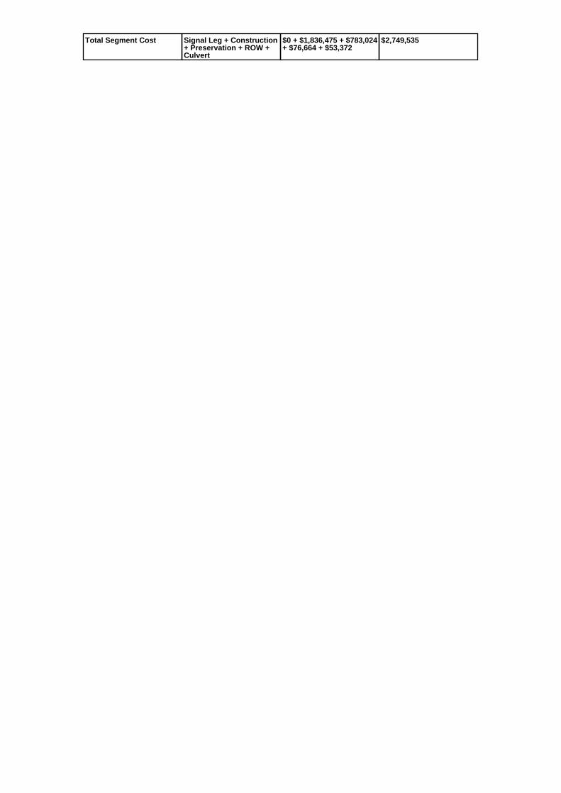
Total Segment Cost Signal Leg + Construction+ Preservation + ROW +Culvert
$0 + $1,836,475 + $783,024+ $76,664 + $53,372
$2,749,535

SANEEDS - CSAH - Segment Report
Roadway SegmentInformation
Status : Original
County Name : LE SUEUR Segment Nbr : 040-603-130
Original Current
MONTGOMERY Municipality MONTGOMERY
0.3 Segment Length 0.3
MIXED BITUMINOUS Existing Surface Type MIXED BITUMINOUS
2 Existing Surface Lanes 2
NOT DIVIDED Existing Lane Description NOT DIVIDED
SOUTH LIMIT OF MONTGOMERYTH 21 TO 0.30 MI NO
Termini SOUTH LIMIT OF MONTGOMERYTH 21 TO 0.30 MI NO
1950 Present AADT 1950
2013 Year of Count 2013
1 Projection Factor 1
1950 Projected Traffic 1950
RURAL Design Type RURAL
3 - RURAL : 1500 - 6999 Design Group 3 ( RURAL : 1500 - 6999 )
2015 Latest Year SA funds 2015
0 Number of Signal Legs 0
No Special Message Special Message Code No Special Message
2015 SAP 040-603-025 RECONST Comments 2015 SAP 040-603-025 RECONST
Interchange Override
Segment Override
Segment CostInformation
Computation Factor Computation Formula Values Used ForCalculation
Computation Result
Signal Leg TrafficSignalLegs *UnitCost / SignalLifeCycle* StatutoryNeedsYear
0 * 56250 / 40 * 25 $0
Construction Length * UnitCost /ConstrLifeCycle *StatutoryNeedsYear *DevelopmentCost
0.3 * 1589559.55 / 60 * 25 *1.1
$218,564
Preservation Length * Quantity *UnitCost /PreservationLifeCycle *StatutoryNeedsYear
0.3 * 2376 * 59.32 / 20 * 25 $52,854
ROW Length * UnitCost /ROWLifeCycle *StatutoryNeedsYear
0.3 * 222272.59 / 60 * 25 $27,784
Total Segment Cost Signal Leg + Construction+ Preservation + ROW
$0 + $218,564 + $52,854 +$27,784
$299,202

SANEEDS - CSAH - Segment Report
Roadway SegmentInformation
Status : Original
County Name : LE SUEUR Segment Nbr : 040-603-140
Original Current
MONTGOMERY Municipality MONTGOMERY
0.67 Segment Length 0.67
MIXED BITUMINOUS Existing Surface Type MIXED BITUMINOUS
2 Existing Surface Lanes 2
NOT DIVIDED Existing Lane Description NOT DIVIDED
0.30 MI N OF TH 21 TOBOULEVARD AVE (CSAH 26) ON5TH STREET
Termini 0.30 MI N OF TH 21 TOBOULEVARD AVE (CSAH 26) ON5TH STREET
2150 Present AADT 2150
2013 Year of Count 2013
1 Projection Factor 1
2150 Projected Traffic 2150
URBAN Design Type URBAN
5 - URBAN : 0 - 9999 Design Group 5 ( URBAN : 0 - 9999 )
2015 Latest Year SA funds 2015
0 Number of Signal Legs 0
No Special Message Special Message Code No Special Message
2015 SAP 040-603-025 RECONST Comments 2015 SAP 040-603-025 RECONST
Interchange Override
Segment Override
Segment CostInformation
Computation Factor Computation Formula Values Used ForCalculation
Computation Result
Signal Leg TrafficSignalLegs *UnitCost / SignalLifeCycle* StatutoryNeedsYear
0 * 56250 / 40 * 25 $0
Construction Length * UnitCost /ConstrLifeCycle *StatutoryNeedsYear *DevelopmentCost
0.67 * 2823252.86 / 60 * 25* 1.15
$906,382
Preservation Length * Quantity *UnitCost /PreservationLifeCycle *StatutoryNeedsYear
0.67 * 2904 * 59.32 / 15 * 25 $192,363
ROW Length * UnitCost /ROWLifeCycle *StatutoryNeedsYear
0.67 * 59776.02 / 60 * 25 $16,687
Total Segment Cost Signal Leg + Construction+ Preservation + ROW
$0 + $906,382 + $192,363+ $16,687
$1,115,432

SANEEDS - CSAH - Segment Report
Roadway SegmentInformation
Status : Original
County Name : LE SUEUR Segment Nbr : 040-603-150
Original Current
Unassigned/Unknown Municipality Unassigned/Unknown
0.5 Segment Length 0.5
MIXED BITUMINOUS Existing Surface Type MIXED BITUMINOUS
2 Existing Surface Lanes 2
NOT DIVIDED Existing Lane Description NOT DIVIDED
CSAH 26 TO SOUTH LIMITS OFMONTGOMERY
Termini CSAH 26 TO SOUTH LIMITS OFMONTGOMERY
1250 Present AADT 1250
2013 Year of Count 2013
1 Projection Factor 1
1250 Projected Traffic 1250
RURAL Design Type RURAL
2 - RURAL : 150 - 1499 Design Group 2 ( RURAL : 150 - 1499 )
Latest Year SA funds
0 Number of Signal Legs 0
No Special Message Special Message Code No Special Message
FORMERLY CR 144. ADDED TOCSAH SYSTEM IN 2009
C.O. #91176
Comments FORMERLY CR 144. ADDED TOCSAH SYSTEM IN 2009
C.O. #91176
Interchange Override
Segment Override
Segment CostInformation
Computation Factor Computation Formula Values Used ForCalculation
Computation Result
Signal Leg TrafficSignalLegs *UnitCost / SignalLifeCycle* StatutoryNeedsYear
0 * 56250 / 40 * 25 $0
Construction Length * UnitCost /ConstrLifeCycle *StatutoryNeedsYear *DevelopmentCost
0.5 * 801370.7 / 60 * 25 *1.1
$183,647
Preservation Length * Quantity *UnitCost /PreservationLifeCycle *StatutoryNeedsYear
0.5 * 2112 * 59.32 / 20 * 25 $78,302
ROW Length * UnitCost /ROWLifeCycle *StatutoryNeedsYear
0.5 * 36798.68 / 60 * 25 $7,666
Total Segment Cost Signal Leg + Construction+ Preservation + ROW
$0 + $183,647 + $78,302 +$7,666
$269,615

SANEEDS - CSAH - Segment Report
Roadway SegmentInformation
Status : Original
County Name : LE SUEUR Segment Nbr : 040-603-155
Original Current
MONTGOMERY Municipality MONTGOMERY
0.2 Segment Length 0.2
MIXED BITUMINOUS Existing Surface Type MIXED BITUMINOUS
2 Existing Surface Lanes 2
NOT DIVIDED Existing Lane Description NOT DIVIDED
SOUTH LIMITS TO NORTH LIMITSMONTGOMERY
Termini SOUTH LIMITS TO NORTH LIMITSMONTGOMERY
1250 Present AADT 1250
2013 Year of Count 2013
1 Projection Factor 1
1250 Projected Traffic 1250
RURAL Design Type RURAL
2 - RURAL : 150 - 1499 Design Group 2 ( RURAL : 150 - 1499 )
Latest Year SA funds
0 Number of Signal Legs 0
No Special Message Special Message Code No Special Message
FORMERLY CR 144. ADDED TOCSAH SYSTEM IN 2009
C.O. #91176
Comments FORMERLY CR 144. ADDED TOCSAH SYSTEM IN 2009
C.O. #91176
Interchange Override
Segment Override
Segment CostInformation
Computation Factor Computation Formula Values Used ForCalculation
Computation Result
Signal Leg TrafficSignalLegs *UnitCost / SignalLifeCycle* StatutoryNeedsYear
0 * 56250 / 40 * 25 $0
Construction Length * UnitCost /ConstrLifeCycle *StatutoryNeedsYear *DevelopmentCost
0.2 * 801370.7 / 60 * 25 *1.1
$73,459
Preservation Length * Quantity *UnitCost /PreservationLifeCycle *StatutoryNeedsYear
0.2 * 2112 * 59.32 / 20 * 25 $31,321
ROW Length * UnitCost /ROWLifeCycle *StatutoryNeedsYear
0.2 * 36798.68 / 60 * 25 $3,067
Total Segment Cost Signal Leg + Construction+ Preservation + ROW
$0 + $73,459 + $31,321 +$3,067
$107,847

SANEEDS - CSAH - Segment Report
Roadway SegmentInformation
Status : Original
County Name : LE SUEUR Segment Nbr : 040-603-160
Original Current
Unassigned/Unknown Municipality Unassigned/Unknown
5.3 Segment Length 5.3
MIXED BITUMINOUS Existing Surface Type MIXED BITUMINOUS
2 Existing Surface Lanes 2
NOT DIVIDED Existing Lane Description NOT DIVIDED
0.7 MILES NORTH CSAH 26 TOCSAH 29
Termini 0.7 MILES NORTH CSAH 26 TOCSAH 29
2500 Present AADT 2500
2013 Year of Count 2013
1 Projection Factor 1
2500 Projected Traffic 2500
RURAL Design Type RURAL
3 - RURAL : 1500 - 6999 Design Group 3 ( RURAL : 1500 - 6999 )
Latest Year SA funds
0 Number of Signal Legs 0
No Special Message Special Message Code No Special Message
FORMERLY CR 144. ADDED TOCSAH 3 SYSTEM IN 2009.
C.O. #91176
Comments FORMERLY CR 144. ADDED TOCSAH 3 SYSTEM IN 2009.
C.O. #91176
Interchange Override
Segment Override
Segment CostInformation
Computation Factor Computation Formula Values Used ForCalculation
Computation Result
Signal Leg TrafficSignalLegs *UnitCost / SignalLifeCycle* StatutoryNeedsYear
0 * 56250 / 40 * 25 $0
Construction Length * UnitCost /ConstrLifeCycle *StatutoryNeedsYear *DevelopmentCost
5.3 * 1589559.55 / 60 * 25 *1.1
$3,861,305
Preservation Length * Quantity *UnitCost /PreservationLifeCycle *StatutoryNeedsYear
5.3 * 2376 * 59.32 / 20 * 25 $933,756
ROW Length * UnitCost /ROWLifeCycle *StatutoryNeedsYear
5.3 * 222272.59 / 60 * 25 $490,852
Total Segment Cost Signal Leg + Construction+ Preservation + ROW
$0 + $3,861,305 + $933,756+ $490,852
$5,285,913
SANEEDS - CSAH - Segment Report
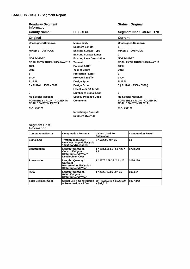
Roadway SegmentInformation
Status : Original
County Name : LE SUEUR Segment Nbr : 040-603-170
Original Current
Unassigned/Unknown Municipality Unassigned/Unknown
1 Segment Length 1
MIXED BITUMINOUS Existing Surface Type MIXED BITUMINOUS
2 Existing Surface Lanes 2
NOT DIVIDED Existing Lane Description NOT DIVIDED
CSAH 29 TO TRUNK HIGHWAY 19 Termini CSAH 29 TO TRUNK HIGHWAY 19
1800 Present AADT 1800
2013 Year of Count 2013
1 Projection Factor 1
1800 Projected Traffic 1800
RURAL Design Type RURAL
3 - RURAL : 1500 - 6999 Design Group 3 ( RURAL : 1500 - 6999 )
Latest Year SA funds
0 Number of Signal Legs 0
No Special Message Special Message Code No Special Message
FORMERLY CR 144. ADDED TOCSAH 3 SYSTEM IN 2011.
C.O. #91176
Comments FORMERLY CR 144. ADDED TOCSAH 3 SYSTEM IN 2011.
C.O. #91176
Interchange Override
Segment Override
Segment CostInformation
Computation Factor Computation Formula Values Used ForCalculation
Computation Result
Signal Leg TrafficSignalLegs *UnitCost / SignalLifeCycle* StatutoryNeedsYear
0 * 56250 / 40 * 25 $0
Construction Length * UnitCost /ConstrLifeCycle *StatutoryNeedsYear *DevelopmentCost
1 * 1589559.55 / 60 * 25 *1.1
$728,548
Preservation Length * Quantity *UnitCost /PreservationLifeCycle *StatutoryNeedsYear
1 * 2376 * 59.32 / 20 * 25 $176,180
ROW Length * UnitCost /ROWLifeCycle *StatutoryNeedsYear
1 * 222272.59 / 60 * 25 $92,614
Total Segment Cost Signal Leg + Construction+ Preservation + ROW
$0 + $728,548 + $176,180+ $92,614
$997,342

SANEEDS - CSAH - Segment Report
Roadway SegmentInformation
Status : Original
County Name : LE SUEUR Segment Nbr : 040-605-070
Original Current
Unassigned/Unknown Municipality Unassigned/Unknown
7.9 Segment Length 7.9
MIXED BITUMINOUS Existing Surface Type MIXED BITUMINOUS
2 Existing Surface Lanes 2
NOT DIVIDED Existing Lane Description NOT DIVIDED
CSAH 2 TO CSAH 26 Termini CSAH 2 TO CSAH 26
380 Present AADT 380
2013 Year of Count 2013
1 Projection Factor 1
380 Projected Traffic 380
RURAL Design Type RURAL
2 - RURAL : 150 - 1499 Design Group 2 ( RURAL : 150 - 1499 )
1992 Latest Year SA funds 1992
0 Number of Signal Legs 0
No Special Message Special Message Code No Special Message
COMBINED SEGMENTS 060 & 070USED HIGHER PRESENT TRAFFIC
Comments COMBINED SEGMENTS 060 & 070USED HIGHER PRESENT TRAFFIC
Interchange Override
Segment Override
Culvert Information Status: Original
Original Current
96230 Structure Number 96230
5.3 Milepoint 5.3
1986 Year Built 1986
LE SUEUR CREEK (CD # 23) Feature Crossed LE SUEUR CREEK (CD # 23)
Type of Service
1 Number of Barrels 1
10 Culvert Width 10
8 Culvert Height 8
125 Culvert Length 125
80.00053397 Area of Waterway Opening 80.00053397
100% Shared Structure 100%
Comments
1 Culvert Group Code 1
Segment CostInformation
Computation Factor Computation Formula Values Used ForCalculation
Computation Result
Signal Leg TrafficSignalLegs *UnitCost / SignalLifeCycle* StatutoryNeedsYear
0 * 56250 / 40 * 25 $0
Construction Length * UnitCost /ConstrLifeCycle *StatutoryNeedsYear *DevelopmentCost
7.9 * 801370.7 / 60 * 25 *1.1
$2,901,630
Preservation Length * Quantity *UnitCost /PreservationLifeCycle *StatutoryNeedsYear
7.9 * 2112 * 59.32 / 20 * 25 $1,237,178
ROW Length * UnitCost /ROWLifeCycle *StatutoryNeedsYear
7.9 * 36798.68 / 60 * 25 $121,129
Culvert CulvertLength * Area *UnitCost /CulvertLifeCycle *StatutoryNeedsYear *DevelopmentCost
125 * 80.00053397 * 15.47 /100 * 25 * 1.15
$44,477
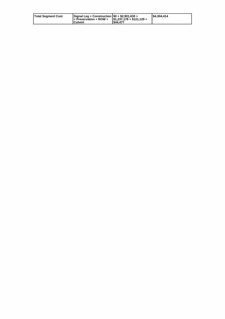
Total Segment Cost Signal Leg + Construction+ Preservation + ROW +Culvert
$0 + $2,901,630 +$1,237,178 + $121,129 +$44,477
$4,304,414

SANEEDS - CSAH - Segment Report
Roadway SegmentInformation
Status : Original
County Name : LE SUEUR Segment Nbr : 040-606-010
Original Current
Unassigned/Unknown Municipality Unassigned/Unknown
1.5 Segment Length 1.5
MIXED BITUMINOUS Existing Surface Type MIXED BITUMINOUS
2 Existing Surface Lanes 2
NOT DIVIDED Existing Lane Description NOT DIVIDED
TRUNK HIGHWAY 60 TO CSAH 14 Termini TRUNK HIGHWAY 60 TO CSAH 14
355 Present AADT 355
2013 Year of Count 2013
1 Projection Factor 1
355 Projected Traffic 355
RURAL Design Type RURAL
2 - RURAL : 150 - 1499 Design Group 2 ( RURAL : 150 - 1499 )
2000 Latest Year SA funds 2000
0 Number of Signal Legs 0
No Special Message Special Message Code No Special Message
Comments
Interchange Override
Segment Override
Segment CostInformation
Computation Factor Computation Formula Values Used ForCalculation
Computation Result
Signal Leg TrafficSignalLegs *UnitCost / SignalLifeCycle* StatutoryNeedsYear
0 * 56250 / 40 * 25 $0
Construction Length * UnitCost /ConstrLifeCycle *StatutoryNeedsYear *DevelopmentCost
1.5 * 801370.7 / 60 * 25 *1.1
$550,942
Preservation Length * Quantity *UnitCost /PreservationLifeCycle *StatutoryNeedsYear
1.5 * 2112 * 59.32 / 20 * 25 $234,907
ROW Length * UnitCost /ROWLifeCycle *StatutoryNeedsYear
1.5 * 36798.68 / 60 * 25 $22,999
Total Segment Cost Signal Leg + Construction+ Preservation + ROW
$0 + $550,942 + $234,907+ $22,999
$808,848

SANEEDS - CSAH - Segment Report
Roadway SegmentInformation
Status : Original
County Name : LE SUEUR Segment Nbr : 040-607-005
Original Current
Unassigned/Unknown Municipality Unassigned/Unknown
2.4 Segment Length 2.4
AGGREGATE SURF Existing Surface Type AGGREGATE SURF
2 Existing Surface Lanes 2
NOT DIVIDED Existing Lane Description NOT DIVIDED
CSAH 14 TO CSAH 12 Termini CSAH 14 TO CSAH 12
185 Present AADT 185
2013 Year of Count 2013
1 Projection Factor 1
185 Projected Traffic 185
RURAL Design Type RURAL
2 - RURAL : 150 - 1499 Design Group 2 ( RURAL : 150 - 1499 )
2000 Latest Year SA funds 2000
0 Number of Signal Legs 0
No Special Message Special Message Code No Special Message
NEW STATE AID SEGMENT IN 2007 Comments NEW STATE AID SEGMENT IN 2007
Interchange Override
Segment Override
Segment CostInformation
Computation Factor Computation Formula Values Used ForCalculation
Computation Result
Signal Leg TrafficSignalLegs *UnitCost / SignalLifeCycle* StatutoryNeedsYear
0 * 56250 / 40 * 25 $0
Construction Length * UnitCost /ConstrLifeCycle *StatutoryNeedsYear *DevelopmentCost
2.4 * 801370.7 / 60 * 25 *1.1
$881,508
Preservation Length * Quantity *UnitCost /PreservationLifeCycle *StatutoryNeedsYear
2.4 * 2112 * 59.32 / 20 * 25 $375,852
ROW Length * UnitCost /ROWLifeCycle *StatutoryNeedsYear
2.4 * 36798.68 / 60 * 25 $36,799
Total Segment Cost Signal Leg + Construction+ Preservation + ROW
$0 + $881,508 + $375,852+ $36,799
$1,294,159

SANEEDS - CSAH - Segment Report
Roadway SegmentInformation
Status : Original
County Name : LE SUEUR Segment Nbr : 040-607-010
Original Current
Unassigned/Unknown Municipality Unassigned/Unknown
4.3 Segment Length 4.3
MIXED BITUMINOUS Existing Surface Type MIXED BITUMINOUS
2 Existing Surface Lanes 2
NOT DIVIDED Existing Lane Description NOT DIVIDED
CSAH 12 TO CSAH 2 Termini CSAH 12 TO CSAH 2
380 Present AADT 380
2013 Year of Count 2013
1 Projection Factor 1
380 Projected Traffic 380
RURAL Design Type RURAL
2 - RURAL : 150 - 1499 Design Group 2 ( RURAL : 150 - 1499 )
2015 Latest Year SA funds 2015
0 Number of Signal Legs 0
No Special Message Special Message Code No Special Message
2015 SAP 040-607-006 CULVERT40J28 REPLACE BR
COMBINED SEGEMENTS 010 & 020
Comments 2015 SAP 040-607-006 CULVERT40J28 REPLACE BR
COMBINED SEGEMENTS 010 & 020
Interchange Override
Segment Override
Culvert Information Status: Original
Original Current
40J28 Structure Number 40J28
2.81 Milepoint 2.81
2015 Year Built 2015
CO DITCH # 59 Feature Crossed CO DITCH # 59
STREAM CROSSING Type of Service STREAM CROSSING
2 Number of Barrels 2
12 Culvert Width 12
10 Culvert Height 10
60 Culvert Length 60
240 Area of Waterway Opening 240
100% Shared Structure 100%
2015 SAP 040-607-006 CULVERT40J28 REPLACE BR
Comments 2015 SAP 040-607-006 CULVERT40J28 REPLACE BR
1 Culvert Group Code 1
Segment CostInformation
Computation Factor Computation Formula Values Used ForCalculation
Computation Result
Signal Leg TrafficSignalLegs *UnitCost / SignalLifeCycle* StatutoryNeedsYear
0 * 56250 / 40 * 25 $0
Construction Length * UnitCost /ConstrLifeCycle *StatutoryNeedsYear *DevelopmentCost
4.3 * 801370.7 / 60 * 25 *1.1
$1,579,368
Preservation Length * Quantity *UnitCost /PreservationLifeCycle *StatutoryNeedsYear
4.3 * 2112 * 59.32 / 20 * 25 $673,401
ROW Length * UnitCost /ROWLifeCycle *StatutoryNeedsYear
4.3 * 36798.68 / 60 * 25 $65,931

Culvert CulvertLength * Area *UnitCost /CulvertLifeCycle *StatutoryNeedsYear *DevelopmentCost
60 * 240 * 15.47 / 100 * 25 *1.15
$64,046
Total Segment Cost Signal Leg + Construction+ Preservation + ROW +Culvert
$0 + $1,579,368 + $673,401+ $65,931 + $64,046
$2,382,746

SANEEDS - CSAH - Segment Report
Roadway SegmentInformation
Status : Original
County Name : LE SUEUR Segment Nbr : 040-609-020
Original Current
Unassigned/Unknown Municipality Unassigned/Unknown
4.3 Segment Length 4.3
AGGREGATE SURF Existing Surface Type AGGREGATE SURF
2 Existing Surface Lanes 2
NOT DIVIDED Existing Lane Description NOT DIVIDED
CSAH 11 TO CSAH 2 Termini CSAH 11 TO CSAH 2
135 Present AADT 135
2013 Year of Count 2013
1 Projection Factor 1
135 Projected Traffic 135
RURAL Design Type RURAL
1 - RURAL : 0 - 149 Design Group 1 ( RURAL : 0 - 149 )
1991 Latest Year SA funds 1991
0 Number of Signal Legs 0
No Special Message Special Message Code No Special Message
Comments
Interchange Override
Segment Override
Segment CostInformation
Computation Factor Computation Formula Values Used ForCalculation
Computation Result
Construction Length * UnitCost /ConstrLifeCycle *StatutoryNeedsYear *DevelopmentCost
4.3 * 400685.35 / 60 * 25 *1.1
$789,684
Preservation Length * Quantity *UnitCost /PreservationLifeCycle *StatutoryNeedsYear
4.3 * 546 * 10.3 / 2 * 25 $302,279
ROW Length * UnitCost /ROWLifeCycle *StatutoryNeedsYear
4.3 * 0 / 60 * 25 $0
Total Segment Cost Construction +Preservation + ROW
$789,684 + $302,279 + $0 $1,091,963

SANEEDS - CSAH - Segment Report
Roadway SegmentInformation
Status : Original
County Name : LE SUEUR Segment Nbr : 040-610-020
Original Current
Unassigned/Unknown Municipality Unassigned/Unknown
2 Segment Length 2
MIXED BITUMINOUS Existing Surface Type MIXED BITUMINOUS
2 Existing Surface Lanes 2
NOT DIVIDED Existing Lane Description NOT DIVIDED
CSAH 3 TO E CO LINE Termini CSAH 3 TO E CO LINE
340 Present AADT 340
2013 Year of Count 2013
1 Projection Factor 1
340 Projected Traffic 340
RURAL Design Type RURAL
2 - RURAL : 150 - 1499 Design Group 2 ( RURAL : 150 - 1499 )
1998 Latest Year SA funds 1998
0 Number of Signal Legs 0
No Special Message Special Message Code No Special Message
ELGIBLE FOR 25 YEAR NEEDSREINSTATEMENT 2009.
Comments ELGIBLE FOR 25 YEAR NEEDSREINSTATEMENT 2009.
Interchange Override
Segment Override
Segment CostInformation
Computation Factor Computation Formula Values Used ForCalculation
Computation Result
Signal Leg TrafficSignalLegs *UnitCost / SignalLifeCycle* StatutoryNeedsYear
0 * 56250 / 40 * 25 $0
Construction Length * UnitCost /ConstrLifeCycle *StatutoryNeedsYear *DevelopmentCost
2 * 801370.7 / 60 * 25 * 1.1 $734,590
Preservation Length * Quantity *UnitCost /PreservationLifeCycle *StatutoryNeedsYear
2 * 2112 * 59.32 / 20 * 25 $313,210
ROW Length * UnitCost /ROWLifeCycle *StatutoryNeedsYear
2 * 36798.68 / 60 * 25 $30,666
Total Segment Cost Signal Leg + Construction+ Preservation + ROW
$0 + $734,590 + $313,210+ $30,666
$1,078,466

SANEEDS - CSAH - Segment Report
Roadway SegmentInformation
Status : Original
County Name : LE SUEUR Segment Nbr : 040-611-010
Original Current
ELYSIAN Municipality ELYSIAN
0.32 Segment Length 0.32
MIXED BITUMINOUS Existing Surface Type MIXED BITUMINOUS
2 Existing Surface Lanes 2
NOT DIVIDED Existing Lane Description NOT DIVIDED
TH 60 TO 0.35 MILES SOUTH OFCSAH 14
Termini TH 60 TO 0.35 MILES SOUTH OFCSAH 14
1550 Present AADT 1550
2013 Year of Count 2013
1 Projection Factor 1
1550 Projected Traffic 1550
URBAN Design Type URBAN
5 - URBAN : 0 - 9999 Design Group 5 ( URBAN : 0 - 9999 )
2002 Latest Year SA funds 2002
0 Number of Signal Legs 0
No Special Message Special Message Code No Special Message
Comments
Interchange Override
Segment Override
Segment CostInformation
Computation Factor Computation Formula Values Used ForCalculation
Computation Result
Signal Leg TrafficSignalLegs *UnitCost / SignalLifeCycle* StatutoryNeedsYear
0 * 56250 / 40 * 25 $0
Construction Length * UnitCost /ConstrLifeCycle *StatutoryNeedsYear *DevelopmentCost
0.32 * 2823252.86 / 60 * 25* 1.15
$432,899
Preservation Length * Quantity *UnitCost /PreservationLifeCycle *StatutoryNeedsYear
0.32 * 2904 * 59.32 / 15 * 25 $91,875
ROW Length * UnitCost /ROWLifeCycle *StatutoryNeedsYear
0.32 * 59776.02 / 60 * 25 $7,970
Total Segment Cost Signal Leg + Construction+ Preservation + ROW
$0 + $432,899 + $91,875 +$7,970
$532,744

SANEEDS - CSAH - Segment Report
Roadway SegmentInformation
Status : Original
County Name : LE SUEUR Segment Nbr : 040-611-020
Original Current
ELYSIAN Municipality ELYSIAN
0.26 Segment Length 0.26
MIXED BITUMINOUS Existing Surface Type MIXED BITUMINOUS
2 Existing Surface Lanes 2
NOT DIVIDED Existing Lane Description NOT DIVIDED
0.35 MI SOUTH OF CSAH 14 TO0.09 MI SOUTH OF CSAH 14
Termini 0.35 MI SOUTH OF CSAH 14 TO0.09 MI SOUTH OF CSAH 14
1550 Present AADT 1550
2013 Year of Count 2013
1 Projection Factor 1
1550 Projected Traffic 1550
URBAN Design Type URBAN
5 - URBAN : 0 - 9999 Design Group 5 ( URBAN : 0 - 9999 )
2010 Latest Year SA funds 2010
0 Number of Signal Legs 0
No Special Message Special Message Code No Special Message
OVERLAY 2010, SAP 40-611-036 Comments OVERLAY 2010, SAP 40-611-036
Interchange Override
Segment Override
Segment CostInformation
Computation Factor Computation Formula Values Used ForCalculation
Computation Result
Signal Leg TrafficSignalLegs *UnitCost / SignalLifeCycle* StatutoryNeedsYear
0 * 56250 / 40 * 25 $0
Construction Length * UnitCost /ConstrLifeCycle *StatutoryNeedsYear *DevelopmentCost
0.26 * 2823252.86 / 60 * 25* 1.15
$351,730
Preservation Length * Quantity *UnitCost /PreservationLifeCycle *StatutoryNeedsYear
0.26 * 2904 * 59.32 / 15 * 25 $74,648
ROW Length * UnitCost /ROWLifeCycle *StatutoryNeedsYear
0.26 * 59776.02 / 60 * 25 $6,476
Total Segment Cost Signal Leg + Construction+ Preservation + ROW
$0 + $351,730 + $74,648 +$6,476
$432,854

SANEEDS - CSAH - Segment Report
Roadway SegmentInformation
Status : Original
County Name : LE SUEUR Segment Nbr : 040-611-025
Original Current
ELYSIAN Municipality ELYSIAN
1.27 Segment Length 1.27
MIXED BITUMINOUS Existing Surface Type MIXED BITUMINOUS
2 Existing Surface Lanes 2
NOT DIVIDED Existing Lane Description NOT DIVIDED
0.09 MI SO OF CSAH 14 TO NORTHLIMITS OF ELYSIAN (CSAH 13)
Termini 0.09 MI SO OF CSAH 14 TO NORTHLIMITS OF ELYSIAN (CSAH 13)
1550 Present AADT 1550
2013 Year of Count 2013
1 Projection Factor 1
1550 Projected Traffic 1550
RURAL Design Type RURAL
3 - RURAL : 1500 - 6999 Design Group 3 ( RURAL : 1500 - 6999 )
2010 Latest Year SA funds 2010
0 Number of Signal Legs 0
No Special Message Special Message Code No Special Message
OVERLAY 2010, SAP 40-611-036 Comments OVERLAY 2010, SAP 40-611-036
Interchange Override
Segment Override
Segment CostInformation
Computation Factor Computation Formula Values Used ForCalculation
Computation Result
Signal Leg TrafficSignalLegs *UnitCost / SignalLifeCycle* StatutoryNeedsYear
0 * 56250 / 40 * 25 $0
Construction Length * UnitCost /ConstrLifeCycle *StatutoryNeedsYear *DevelopmentCost
1.27 * 1589559.55 / 60 * 25* 1.1
$925,256
Preservation Length * Quantity *UnitCost /PreservationLifeCycle *StatutoryNeedsYear
1.27 * 2376 * 59.32 / 20 * 25 $223,749
ROW Length * UnitCost /ROWLifeCycle *StatutoryNeedsYear
1.27 * 222272.59 / 60 * 25 $117,619
Total Segment Cost Signal Leg + Construction+ Preservation + ROW
$0 + $925,256 + $223,749+ $117,619
$1,266,624

SANEEDS - CSAH - Segment Report
Roadway SegmentInformation
Status : Original
County Name : LE SUEUR Segment Nbr : 040-611-030
Original Current
Unassigned/Unknown Municipality Unassigned/Unknown
2 Segment Length 2
MIXED BITUMINOUS Existing Surface Type MIXED BITUMINOUS
2 Existing Surface Lanes 2
NOT DIVIDED Existing Lane Description NOT DIVIDED
CSAH 13 TO EAST JCT OF CSAH12
Termini CSAH 13 TO EAST JCT OF CSAH12
435 Present AADT 435
2013 Year of Count 2013
1 Projection Factor 1
435 Projected Traffic 435
RURAL Design Type RURAL
2 - RURAL : 150 - 1499 Design Group 2 ( RURAL : 150 - 1499 )
2002 Latest Year SA funds 2002
0 Number of Signal Legs 0
No Special Message Special Message Code No Special Message
Comments
Interchange Override
Segment Override
Segment CostInformation
Computation Factor Computation Formula Values Used ForCalculation
Computation Result
Signal Leg TrafficSignalLegs *UnitCost / SignalLifeCycle* StatutoryNeedsYear
0 * 56250 / 40 * 25 $0
Construction Length * UnitCost /ConstrLifeCycle *StatutoryNeedsYear *DevelopmentCost
2 * 801370.7 / 60 * 25 * 1.1 $734,590
Preservation Length * Quantity *UnitCost /PreservationLifeCycle *StatutoryNeedsYear
2 * 2112 * 59.32 / 20 * 25 $313,210
ROW Length * UnitCost /ROWLifeCycle *StatutoryNeedsYear
2 * 36798.68 / 60 * 25 $30,666
Total Segment Cost Signal Leg + Construction+ Preservation + ROW
$0 + $734,590 + $313,210+ $30,666
$1,078,466

SANEEDS - CSAH - Segment Report
Roadway SegmentInformation
Status : Original
County Name : LE SUEUR Segment Nbr : 040-611-040
Original Current
Unassigned/Unknown Municipality Unassigned/Unknown
3.5 Segment Length 3.5
MIXED BITUMINOUS Existing Surface Type MIXED BITUMINOUS
2 Existing Surface Lanes 2
NOT DIVIDED Existing Lane Description NOT DIVIDED
SOUTH JCT CSAH 12 TO NORTHJCT CSAH 12
Termini SOUTH JCT CSAH 12 TO NORTHJCT CSAH 12
435 Present AADT 435
2013 Year of Count 2013
1 Projection Factor 1
435 Projected Traffic 435
RURAL Design Type RURAL
2 - RURAL : 150 - 1499 Design Group 2 ( RURAL : 150 - 1499 )
2002 Latest Year SA funds 2002
0 Number of Signal Legs 0
No Special Message Special Message Code No Special Message
Comments
Interchange Override
Segment Override
Segment CostInformation
Computation Factor Computation Formula Values Used ForCalculation
Computation Result
Signal Leg TrafficSignalLegs *UnitCost / SignalLifeCycle* StatutoryNeedsYear
0 * 56250 / 40 * 25 $0
Construction Length * UnitCost /ConstrLifeCycle *StatutoryNeedsYear *DevelopmentCost
3.5 * 801370.7 / 60 * 25 *1.1
$1,285,532
Preservation Length * Quantity *UnitCost /PreservationLifeCycle *StatutoryNeedsYear
3.5 * 2112 * 59.32 / 20 * 25 $548,117
ROW Length * UnitCost /ROWLifeCycle *StatutoryNeedsYear
3.5 * 36798.68 / 60 * 25 $53,665
Total Segment Cost Signal Leg + Construction+ Preservation + ROW
$0 + $1,285,532 + $548,117+ $53,665
$1,887,314

SANEEDS - CSAH - Segment Report
Roadway SegmentInformation
Status : Original
County Name : LE SUEUR Segment Nbr : 040-611-060
Original Current
Unassigned/Unknown Municipality Unassigned/Unknown
1.3 Segment Length 1.3
MIXED BITUMINOUS Existing Surface Type MIXED BITUMINOUS
2 Existing Surface Lanes 2
NOT DIVIDED Existing Lane Description NOT DIVIDED
NORTH JCT CSAH 12 TO RICELAKE RD (OLD CSAH 9)
Termini NORTH JCT CSAH 12 TO RICELAKE RD (OLD CSAH 9)
435 Present AADT 435
2013 Year of Count 2013
1 Projection Factor 1
435 Projected Traffic 435
RURAL Design Type RURAL
2 - RURAL : 150 - 1499 Design Group 2 ( RURAL : 150 - 1499 )
2002 Latest Year SA funds 2002
0 Number of Signal Legs 0
No Special Message Special Message Code No Special Message
COMBINED SEGMENTS 060 & 070TOOK WEIGHTED AVERAGE OFGRADING COSTS
Comments COMBINED SEGMENTS 060 & 070TOOK WEIGHTED AVERAGE OFGRADING COSTS
Interchange Override
Segment Override
Segment CostInformation
Computation Factor Computation Formula Values Used ForCalculation
Computation Result
Signal Leg TrafficSignalLegs *UnitCost / SignalLifeCycle* StatutoryNeedsYear
0 * 56250 / 40 * 25 $0
Construction Length * UnitCost /ConstrLifeCycle *StatutoryNeedsYear *DevelopmentCost
1.3 * 801370.7 / 60 * 25 *1.1
$477,483
Preservation Length * Quantity *UnitCost /PreservationLifeCycle *StatutoryNeedsYear
1.3 * 2112 * 59.32 / 20 * 25 $203,586
ROW Length * UnitCost /ROWLifeCycle *StatutoryNeedsYear
1.3 * 36798.68 / 60 * 25 $19,933
Total Segment Cost Signal Leg + Construction+ Preservation + ROW
$0 + $477,483 + $203,586+ $19,933
$701,002

SANEEDS - CSAH - Segment Report
Roadway SegmentInformation
Status : Original
County Name : LE SUEUR Segment Nbr : 040-611-080
Original Current
Unassigned/Unknown Municipality Unassigned/Unknown
3.4 Segment Length 3.4
MIXED BITUMINOUS Existing Surface Type MIXED BITUMINOUS
2 Existing Surface Lanes 2
NOT DIVIDED Existing Lane Description NOT DIVIDED
RICE LAKE ROAD (OLD CSAH 9)TO E JCT CSAH 2
Termini RICE LAKE ROAD (OLD CSAH 9)TO E JCT CSAH 2
435 Present AADT 435
2013 Year of Count 2013
1 Projection Factor 1
435 Projected Traffic 435
RURAL Design Type RURAL
2 - RURAL : 150 - 1499 Design Group 2 ( RURAL : 150 - 1499 )
2002 Latest Year SA funds 2002
0 Number of Signal Legs 0
No Special Message Special Message Code No Special Message
Comments
Interchange Override
Segment Override
Segment CostInformation
Computation Factor Computation Formula Values Used ForCalculation
Computation Result
Signal Leg TrafficSignalLegs *UnitCost / SignalLifeCycle* StatutoryNeedsYear
0 * 56250 / 40 * 25 $0
Construction Length * UnitCost /ConstrLifeCycle *StatutoryNeedsYear *DevelopmentCost
3.4 * 801370.7 / 60 * 25 *1.1
$1,248,803
Preservation Length * Quantity *UnitCost /PreservationLifeCycle *StatutoryNeedsYear
3.4 * 2112 * 59.32 / 20 * 25 $532,456
ROW Length * UnitCost /ROWLifeCycle *StatutoryNeedsYear
3.4 * 36798.68 / 60 * 25 $52,131
Total Segment Cost Signal Leg + Construction+ Preservation + ROW
$0 + $1,248,803 + $532,456+ $52,131
$1,833,390

SANEEDS - CSAH - Segment Report
Roadway SegmentInformation
Status : Original
County Name : LE SUEUR Segment Nbr : 040-611-090
Original Current
Unassigned/Unknown Municipality Unassigned/Unknown
1 Segment Length 1
MIXED BITUMINOUS Existing Surface Type MIXED BITUMINOUS
2 Existing Surface Lanes 2
NOT DIVIDED Existing Lane Description NOT DIVIDED
EAST JCT CSAH 2 TO WEST JCTCSAH 2
Termini EAST JCT CSAH 2 TO WEST JCTCSAH 2
880 Present AADT 880
2013 Year of Count 2013
1 Projection Factor 1
880 Projected Traffic 880
RURAL Design Type RURAL
2 - RURAL : 150 - 1499 Design Group 2 ( RURAL : 150 - 1499 )
2002 Latest Year SA funds 2002
0 Number of Signal Legs 0
No Special Message Special Message Code No Special Message
Comments
Interchange Override
Segment Override
Segment CostInformation
Computation Factor Computation Formula Values Used ForCalculation
Computation Result
Signal Leg TrafficSignalLegs *UnitCost / SignalLifeCycle* StatutoryNeedsYear
0 * 56250 / 40 * 25 $0
Construction Length * UnitCost /ConstrLifeCycle *StatutoryNeedsYear *DevelopmentCost
1 * 801370.7 / 60 * 25 * 1.1 $367,295
Preservation Length * Quantity *UnitCost /PreservationLifeCycle *StatutoryNeedsYear
1 * 2112 * 59.32 / 20 * 25 $156,605
ROW Length * UnitCost /ROWLifeCycle *StatutoryNeedsYear
1 * 36798.68 / 60 * 25 $15,333
Total Segment Cost Signal Leg + Construction+ Preservation + ROW
$0 + $367,295 + $156,605+ $15,333
$539,233

SANEEDS - CSAH - Segment Report
Roadway SegmentInformation
Status : Original
County Name : LE SUEUR Segment Nbr : 040-611-100
Original Current
Unassigned/Unknown Municipality Unassigned/Unknown
2 Segment Length 2
MIXED BITUMINOUS Existing Surface Type MIXED BITUMINOUS
2 Existing Surface Lanes 2
NOT DIVIDED Existing Lane Description NOT DIVIDED
WEST JCT CSAH 2 TO S LIMITS LECENTER (CR 110)
Termini WEST JCT CSAH 2 TO S LIMITS LECENTER (CR 110)
880 Present AADT 880
2013 Year of Count 2013
1 Projection Factor 1
880 Projected Traffic 880
RURAL Design Type RURAL
2 - RURAL : 150 - 1499 Design Group 2 ( RURAL : 150 - 1499 )
2002 Latest Year SA funds 2002
0 Number of Signal Legs 0
No Special Message Special Message Code No Special Message
Comments
Interchange Override
Segment Override
Segment CostInformation
Computation Factor Computation Formula Values Used ForCalculation
Computation Result
Signal Leg TrafficSignalLegs *UnitCost / SignalLifeCycle* StatutoryNeedsYear
0 * 56250 / 40 * 25 $0
Construction Length * UnitCost /ConstrLifeCycle *StatutoryNeedsYear *DevelopmentCost
2 * 801370.7 / 60 * 25 * 1.1 $734,590
Preservation Length * Quantity *UnitCost /PreservationLifeCycle *StatutoryNeedsYear
2 * 2112 * 59.32 / 20 * 25 $313,210
ROW Length * UnitCost /ROWLifeCycle *StatutoryNeedsYear
2 * 36798.68 / 60 * 25 $30,666
Total Segment Cost Signal Leg + Construction+ Preservation + ROW
$0 + $734,590 + $313,210+ $30,666
$1,078,466

SANEEDS - CSAH - Segment Report
Roadway SegmentInformation
Status : Original
County Name : LE SUEUR Segment Nbr : 040-611-103
Original Current
LE CENTER Municipality LE CENTER
0.63 Segment Length 0.63
MIXED BITUMINOUS Existing Surface Type MIXED BITUMINOUS
2 Existing Surface Lanes 2
NOT DIVIDED Existing Lane Description NOT DIVIDED
SOUTH LIMITS LE CENTER (CR110) TO 0.63 MI NORTH
Termini SOUTH LIMITS LE CENTER (CR110) TO 0.63 MI NORTH
880 Present AADT 880
2013 Year of Count 2013
1 Projection Factor 1
880 Projected Traffic 880
RURAL Design Type RURAL
2 - RURAL : 150 - 1499 Design Group 2 ( RURAL : 150 - 1499 )
2002 Latest Year SA funds 2002
0 Number of Signal Legs 0
No Special Message Special Message Code No Special Message
Comments
Interchange Override
Segment Override
Segment CostInformation
Computation Factor Computation Formula Values Used ForCalculation
Computation Result
Signal Leg TrafficSignalLegs *UnitCost / SignalLifeCycle* StatutoryNeedsYear
0 * 56250 / 40 * 25 $0
Construction Length * UnitCost /ConstrLifeCycle *StatutoryNeedsYear *DevelopmentCost
0.63 * 801370.7 / 60 * 25 *1.1
$231,396
Preservation Length * Quantity *UnitCost /PreservationLifeCycle *StatutoryNeedsYear
0.63 * 2112 * 59.32 / 20 * 25 $98,661
ROW Length * UnitCost /ROWLifeCycle *StatutoryNeedsYear
0.63 * 36798.68 / 60 * 25 $9,660
Total Segment Cost Signal Leg + Construction+ Preservation + ROW
$0 + $231,396 + $98,661 +$9,660
$339,717

SANEEDS - CSAH - Segment Report
Roadway SegmentInformation
Status : Original
County Name : LE SUEUR Segment Nbr : 040-611-105
Original Current
LE CENTER Municipality LE CENTER
0.4 Segment Length 0.4
MIXED BITUMINOUS Existing Surface Type MIXED BITUMINOUS
2 Existing Surface Lanes 2
NOT DIVIDED Existing Lane Description NOT DIVIDED
0.63 MI N OF CR 110 TO TH 99 Termini 0.63 MI N OF CR 110 TO TH 99
880 Present AADT 880
2013 Year of Count 2013
1 Projection Factor 1
880 Projected Traffic 880
RURAL Design Type RURAL
2 - RURAL : 150 - 1499 Design Group 2 ( RURAL : 150 - 1499 )
2002 Latest Year SA funds 2002
0 Number of Signal Legs 0
No Special Message Special Message Code No Special Message
Comments
Interchange Override
Segment Override
Segment CostInformation
Computation Factor Computation Formula Values Used ForCalculation
Computation Result
Signal Leg TrafficSignalLegs *UnitCost / SignalLifeCycle* StatutoryNeedsYear
0 * 56250 / 40 * 25 $0
Construction Length * UnitCost /ConstrLifeCycle *StatutoryNeedsYear *DevelopmentCost
0.4 * 801370.7 / 60 * 25 *1.1
$146,918
Preservation Length * Quantity *UnitCost /PreservationLifeCycle *StatutoryNeedsYear
0.4 * 2112 * 59.32 / 20 * 25 $62,642
ROW Length * UnitCost /ROWLifeCycle *StatutoryNeedsYear
0.4 * 36798.68 / 60 * 25 $6,133
Total Segment Cost Signal Leg + Construction+ Preservation + ROW
$0 + $146,918 + $62,642 +$6,133
$215,693

SANEEDS - CSAH - Segment Report
Roadway SegmentInformation
Status : Original
County Name : LE SUEUR Segment Nbr : 040-611-110
Original Current
LE CENTER Municipality LE CENTER
0.2 Segment Length 0.2
MIXED BITUMINOUS Existing Surface Type MIXED BITUMINOUS
2 Existing Surface Lanes 2
NOT DIVIDED Existing Lane Description NOT DIVIDED
TH 99 TO 0.2 MI NORTH ONCORDOVA AVE
Termini TH 99 TO 0.2 MI NORTH ONCORDOVA AVE
2300 Present AADT 2300
2013 Year of Count 2013
1 Projection Factor 1
2300 Projected Traffic 2300
URBAN Design Type URBAN
5 - URBAN : 0 - 9999 Design Group 5 ( URBAN : 0 - 9999 )
1999 Latest Year SA funds 1999
0 Number of Signal Legs 0
No Special Message Special Message Code No Special Message
Comments
Interchange Override
Segment Override
Segment CostInformation
Computation Factor Computation Formula Values Used ForCalculation
Computation Result
Signal Leg TrafficSignalLegs *UnitCost / SignalLifeCycle* StatutoryNeedsYear
0 * 56250 / 40 * 25 $0
Construction Length * UnitCost /ConstrLifeCycle *StatutoryNeedsYear *DevelopmentCost
0.2 * 2823252.86 / 60 * 25 *1.15
$270,562
Preservation Length * Quantity *UnitCost /PreservationLifeCycle *StatutoryNeedsYear
0.2 * 2904 * 59.32 / 15 * 25 $57,422
ROW Length * UnitCost /ROWLifeCycle *StatutoryNeedsYear
0.2 * 59776.02 / 60 * 25 $4,981
Total Segment Cost Signal Leg + Construction+ Preservation + ROW
$0 + $270,562 + $57,422 +$4,981
$332,965

SANEEDS - CSAH - Segment Report
Roadway SegmentInformation
Status : Original
County Name : LE SUEUR Segment Nbr : 040-611-120
Original Current
LE CENTER Municipality LE CENTER
0.62 Segment Length 0.62
MIXED BITUMINOUS Existing Surface Type MIXED BITUMINOUS
2 Existing Surface Lanes 2
NOT DIVIDED Existing Lane Description NOT DIVIDED
0.2 MI N OF TH 99 TO SPORSSTREET ON CORDOVA AVE
Termini 0.2 MI N OF TH 99 TO SPORSSTREET ON CORDOVA AVE
2300 Present AADT 2300
2013 Year of Count 2013
1 Projection Factor 1
2300 Projected Traffic 2300
URBAN Design Type URBAN
5 - URBAN : 0 - 9999 Design Group 5 ( URBAN : 0 - 9999 )
1999 Latest Year SA funds 1999
0 Number of Signal Legs 0
No Special Message Special Message Code No Special Message
Comments
Interchange Override
Segment Override
Segment CostInformation
Computation Factor Computation Formula Values Used ForCalculation
Computation Result
Signal Leg TrafficSignalLegs *UnitCost / SignalLifeCycle* StatutoryNeedsYear
0 * 56250 / 40 * 25 $0
Construction Length * UnitCost /ConstrLifeCycle *StatutoryNeedsYear *DevelopmentCost
0.62 * 2823252.86 / 60 * 25* 1.15
$838,741
Preservation Length * Quantity *UnitCost /PreservationLifeCycle *StatutoryNeedsYear
0.62 * 2904 * 59.32 / 15 * 25 $178,007
ROW Length * UnitCost /ROWLifeCycle *StatutoryNeedsYear
0.62 * 59776.02 / 60 * 25 $15,442
Total Segment Cost Signal Leg + Construction+ Preservation + ROW
$0 + $838,741 + $178,007+ $15,442
$1,032,190

SANEEDS - CSAH - Segment Report
Roadway SegmentInformation
Status : Original
County Name : LE SUEUR Segment Nbr : 040-611-130
Original Current
LE CENTER Municipality LE CENTER
0.11 Segment Length 0.11
MIXED BITUMINOUS Existing Surface Type MIXED BITUMINOUS
2 Existing Surface Lanes 2
NOT DIVIDED Existing Lane Description NOT DIVIDED
SPORS STREET TO N LIM LECENTER ( 6TH STREET) ONCORDOVA AVE
Termini SPORS STREET TO N LIM LECENTER ( 6TH STREET) ONCORDOVA AVE
2300 Present AADT 2300
2013 Year of Count 2013
1 Projection Factor 1
2300 Projected Traffic 2300
URBAN Design Type URBAN
5 - URBAN : 0 - 9999 Design Group 5 ( URBAN : 0 - 9999 )
1999 Latest Year SA funds 1999
0 Number of Signal Legs 0
No Special Message Special Message Code No Special Message
DSAE APPROVED COMPLETESTORM SEWER NEEDS
Comments DSAE APPROVED COMPLETESTORM SEWER NEEDS
Interchange Override
Segment Override
Segment CostInformation
Computation Factor Computation Formula Values Used ForCalculation
Computation Result
Signal Leg TrafficSignalLegs *UnitCost / SignalLifeCycle* StatutoryNeedsYear
0 * 56250 / 40 * 25 $0
Construction Length * UnitCost /ConstrLifeCycle *StatutoryNeedsYear *DevelopmentCost
0.11 * 2823252.86 / 60 * 25* 1.15
$148,809
Preservation Length * Quantity *UnitCost /PreservationLifeCycle *StatutoryNeedsYear
0.11 * 2904 * 59.32 / 15 * 25 $31,582
ROW Length * UnitCost /ROWLifeCycle *StatutoryNeedsYear
0.11 * 59776.02 / 60 * 25 $2,740
Total Segment Cost Signal Leg + Construction+ Preservation + ROW
$0 + $148,809 + $31,582 +$2,740
$183,131

SANEEDS - CSAH - Segment Report
Roadway SegmentInformation
Status : Original
County Name : LE SUEUR Segment Nbr : 040-611-132
Original Current
Unassigned/Unknown Municipality Unassigned/Unknown
2.1 Segment Length 2.1
MIXED BITUMINOUS Existing Surface Type MIXED BITUMINOUS
2 Existing Surface Lanes 2
NOT DIVIDED Existing Lane Description NOT DIVIDED
NORTH LIMITS LE CENTER (6THSTREET) TO CSAH 32
Termini NORTH LIMITS LE CENTER (6THSTREET) TO CSAH 32
890 Present AADT 890
2013 Year of Count 2013
1 Projection Factor 1
890 Projected Traffic 890
RURAL Design Type RURAL
2 - RURAL : 150 - 1499 Design Group 2 ( RURAL : 150 - 1499 )
1998 Latest Year SA funds 1998
0 Number of Signal Legs 0
No Special Message Special Message Code No Special Message
Comments
Interchange Override
Segment Override
Bridge Information Status: Original
Original Current
40511 Structure Number 40511
17.11 Milepoint 17.11
1981 Year Built 1981
LE SUEUR CREEK Feature Crossed LE SUEUR CREEK
STREAM CROSSING Type of Service STREAM CROSSING
1 Number of Spans 1
87 Bridge Length 87
47.3 Bridge Width 47.3
100% Shared Structure 100%
Comments
1 ( 0-149 ) Bridge Group Code 1 ( 0-149 )
Segment CostInformation
Computation Factor Computation Formula Values Used ForCalculation
Computation Result
Signal Leg TrafficSignalLegs *UnitCost / SignalLifeCycle* StatutoryNeedsYear
0 * 56250 / 40 * 25 $0
Construction Length * UnitCost /ConstrLifeCycle *StatutoryNeedsYear *DevelopmentCost
2.1 * 801370.7 / 60 * 25 *1.1
$771,319
Preservation Length * Quantity *UnitCost /PreservationLifeCycle *StatutoryNeedsYear
2.1 * 2112 * 59.32 / 20 * 25 $328,870
ROW Length * UnitCost /ROWLifeCycle *StatutoryNeedsYear
2.1 * 36798.68 / 60 * 25 $32,199
Bridge BridgeLength *BridgeWidth * UnitCost /BridgeLifeCycle *StatutoryNeedsYear *DevelopmentCost
87 * 47.3 * 152 / 80 * 25 *1.15
$224,787
Total Segment Cost Signal Leg + Construction+ Preservation + ROW +Bridge
$0 + $771,319 + $328,870+ $32,199 + $224,787
$1,357,175

SANEEDS - CSAH - Segment Report
Roadway SegmentInformation
Status : Original
County Name : LE SUEUR Segment Nbr : 040-611-140
Original Current
Unassigned/Unknown Municipality Unassigned/Unknown
2 Segment Length 2
MIXED BITUMINOUS Existing Surface Type MIXED BITUMINOUS
2 Existing Surface Lanes 2
NOT DIVIDED Existing Lane Description NOT DIVIDED
CSAH 32 TO E JCT CSAH 26 Termini CSAH 32 TO E JCT CSAH 26
480 Present AADT 480
2013 Year of Count 2013
1 Projection Factor 1
480 Projected Traffic 480
RURAL Design Type RURAL
2 - RURAL : 150 - 1499 Design Group 2 ( RURAL : 150 - 1499 )
2005 Latest Year SA funds 2005
0 Number of Signal Legs 0
No Special Message Special Message Code No Special Message
RESURFACED UNDER SAP 40-611-033
Comments RESURFACED UNDER SAP 40-611-033
Interchange Override
Segment Override
Segment CostInformation
Computation Factor Computation Formula Values Used ForCalculation
Computation Result
Signal Leg TrafficSignalLegs *UnitCost / SignalLifeCycle* StatutoryNeedsYear
0 * 56250 / 40 * 25 $0
Construction Length * UnitCost /ConstrLifeCycle *StatutoryNeedsYear *DevelopmentCost
2 * 801370.7 / 60 * 25 * 1.1 $734,590
Preservation Length * Quantity *UnitCost /PreservationLifeCycle *StatutoryNeedsYear
2 * 2112 * 59.32 / 20 * 25 $313,210
ROW Length * UnitCost /ROWLifeCycle *StatutoryNeedsYear
2 * 36798.68 / 60 * 25 $30,666
Total Segment Cost Signal Leg + Construction+ Preservation + ROW
$0 + $734,590 + $313,210+ $30,666
$1,078,466

SANEEDS - CSAH - Segment Report
Roadway SegmentInformation
Status : Original
County Name : LE SUEUR Segment Nbr : 040-611-150
Original Current
Unassigned/Unknown Municipality Unassigned/Unknown
3.1 Segment Length 3.1
MIXED BITUMINOUS Existing Surface Type MIXED BITUMINOUS
2 Existing Surface Lanes 2
NOT DIVIDED Existing Lane Description NOT DIVIDED
W JCT CSAH 26 TO S JCT CSAH 28 Termini W JCT CSAH 26 TO S JCT CSAH 28
475 Present AADT 475
2013 Year of Count 2013
1 Projection Factor 1
475 Projected Traffic 475
RURAL Design Type RURAL
2 - RURAL : 150 - 1499 Design Group 2 ( RURAL : 150 - 1499 )
2005 Latest Year SA funds 2005
0 Number of Signal Legs 0
No Special Message Special Message Code No Special Message
RESURFACED UNDER SAP 40-611-033
Comments RESURFACED UNDER SAP 40-611-033
Interchange Override
Segment Override
Segment CostInformation
Computation Factor Computation Formula Values Used ForCalculation
Computation Result
Signal Leg TrafficSignalLegs *UnitCost / SignalLifeCycle* StatutoryNeedsYear
0 * 56250 / 40 * 25 $0
Construction Length * UnitCost /ConstrLifeCycle *StatutoryNeedsYear *DevelopmentCost
3.1 * 801370.7 / 60 * 25 *1.1
$1,138,614
Preservation Length * Quantity *UnitCost /PreservationLifeCycle *StatutoryNeedsYear
3.1 * 2112 * 59.32 / 20 * 25 $485,475
ROW Length * UnitCost /ROWLifeCycle *StatutoryNeedsYear
3.1 * 36798.68 / 60 * 25 $47,532
Total Segment Cost Signal Leg + Construction+ Preservation + ROW
$0 + $1,138,614 + $485,475+ $47,532
$1,671,621

SANEEDS - CSAH - Segment Report
Roadway SegmentInformation
Status : Original
County Name : LE SUEUR Segment Nbr : 040-611-160
Original Current
Unassigned/Unknown Municipality Unassigned/Unknown
0.9 Segment Length 0.9
MIXED BITUMINOUS Existing Surface Type MIXED BITUMINOUS
2 Existing Surface Lanes 2
NOT DIVIDED Existing Lane Description NOT DIVIDED
SO JCT CSAH 28 TO CO RD 120 Termini SO JCT CSAH 28 TO CO RD 120
475 Present AADT 475
2013 Year of Count 2013
1 Projection Factor 1
475 Projected Traffic 475
RURAL Design Type RURAL
2 - RURAL : 150 - 1499 Design Group 2 ( RURAL : 150 - 1499 )
2005 Latest Year SA funds 2005
0 Number of Signal Legs 0
No Special Message Special Message Code No Special Message
RESURFACED UNDER SAP 40-611-033
Comments RESURFACED UNDER SAP 40-611-033
Interchange Override
Segment Override
Segment CostInformation
Computation Factor Computation Formula Values Used ForCalculation
Computation Result
Signal Leg TrafficSignalLegs *UnitCost / SignalLifeCycle* StatutoryNeedsYear
0 * 56250 / 40 * 25 $0
Construction Length * UnitCost /ConstrLifeCycle *StatutoryNeedsYear *DevelopmentCost
0.9 * 801370.7 / 60 * 25 *1.1
$330,565
Preservation Length * Quantity *UnitCost /PreservationLifeCycle *StatutoryNeedsYear
0.9 * 2112 * 59.32 / 20 * 25 $140,944
ROW Length * UnitCost /ROWLifeCycle *StatutoryNeedsYear
0.9 * 36798.68 / 60 * 25 $13,800
Total Segment Cost Signal Leg + Construction+ Preservation + ROW
$0 + $330,565 + $140,944+ $13,800
$485,309

SANEEDS - CSAH - Segment Report
Roadway SegmentInformation
Status : Original
County Name : LE SUEUR Segment Nbr : 040-611-170
Original Current
Unassigned/Unknown Municipality Unassigned/Unknown
0.6 Segment Length 0.6
MIXED BITUMINOUS Existing Surface Type MIXED BITUMINOUS
2 Existing Surface Lanes 2
NOT DIVIDED Existing Lane Description NOT DIVIDED
CO RD 120 TO NO JCT CSAH 28 Termini CO RD 120 TO NO JCT CSAH 28
590 Present AADT 590
2013 Year of Count 2013
1 Projection Factor 1
590 Projected Traffic 590
RURAL Design Type RURAL
2 - RURAL : 150 - 1499 Design Group 2 ( RURAL : 150 - 1499 )
2005 Latest Year SA funds 2005
0 Number of Signal Legs 0
No Special Message Special Message Code No Special Message
RESURFACED UNDER SAP 40-611-033
Comments RESURFACED UNDER SAP 40-611-033
Interchange Override
Segment Override
Segment CostInformation
Computation Factor Computation Formula Values Used ForCalculation
Computation Result
Signal Leg TrafficSignalLegs *UnitCost / SignalLifeCycle* StatutoryNeedsYear
0 * 56250 / 40 * 25 $0
Construction Length * UnitCost /ConstrLifeCycle *StatutoryNeedsYear *DevelopmentCost
0.6 * 801370.7 / 60 * 25 *1.1
$220,377
Preservation Length * Quantity *UnitCost /PreservationLifeCycle *StatutoryNeedsYear
0.6 * 2112 * 59.32 / 20 * 25 $93,963
ROW Length * UnitCost /ROWLifeCycle *StatutoryNeedsYear
0.6 * 36798.68 / 60 * 25 $9,200
Total Segment Cost Signal Leg + Construction+ Preservation + ROW
$0 + $220,377 + $93,963 +$9,200
$323,540
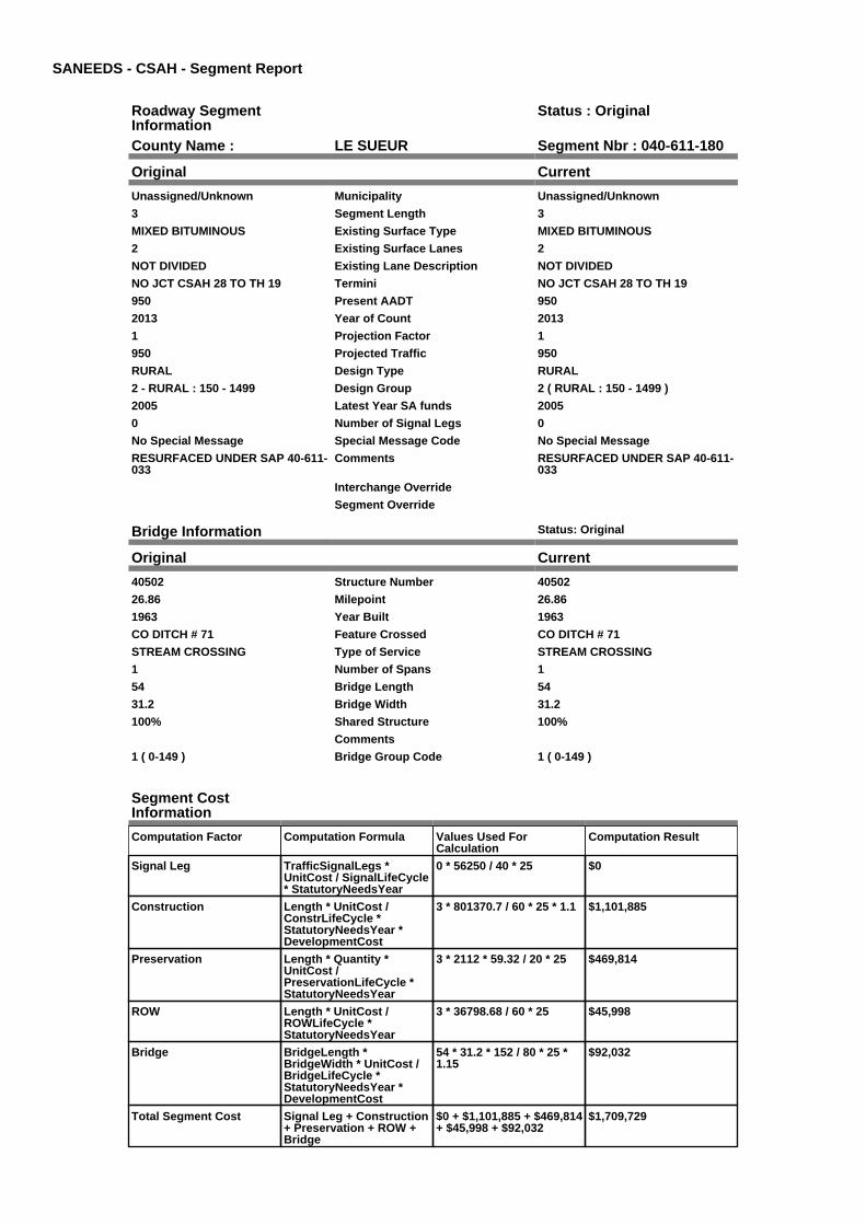
SANEEDS - CSAH - Segment Report
Roadway SegmentInformation
Status : Original
County Name : LE SUEUR Segment Nbr : 040-611-180
Original Current
Unassigned/Unknown Municipality Unassigned/Unknown
3 Segment Length 3
MIXED BITUMINOUS Existing Surface Type MIXED BITUMINOUS
2 Existing Surface Lanes 2
NOT DIVIDED Existing Lane Description NOT DIVIDED
NO JCT CSAH 28 TO TH 19 Termini NO JCT CSAH 28 TO TH 19
950 Present AADT 950
2013 Year of Count 2013
1 Projection Factor 1
950 Projected Traffic 950
RURAL Design Type RURAL
2 - RURAL : 150 - 1499 Design Group 2 ( RURAL : 150 - 1499 )
2005 Latest Year SA funds 2005
0 Number of Signal Legs 0
No Special Message Special Message Code No Special Message
RESURFACED UNDER SAP 40-611-033
Comments RESURFACED UNDER SAP 40-611-033
Interchange Override
Segment Override
Bridge Information Status: Original
Original Current
40502 Structure Number 40502
26.86 Milepoint 26.86
1963 Year Built 1963
CO DITCH # 71 Feature Crossed CO DITCH # 71
STREAM CROSSING Type of Service STREAM CROSSING
1 Number of Spans 1
54 Bridge Length 54
31.2 Bridge Width 31.2
100% Shared Structure 100%
Comments
1 ( 0-149 ) Bridge Group Code 1 ( 0-149 )
Segment CostInformation
Computation Factor Computation Formula Values Used ForCalculation
Computation Result
Signal Leg TrafficSignalLegs *UnitCost / SignalLifeCycle* StatutoryNeedsYear
0 * 56250 / 40 * 25 $0
Construction Length * UnitCost /ConstrLifeCycle *StatutoryNeedsYear *DevelopmentCost
3 * 801370.7 / 60 * 25 * 1.1 $1,101,885
Preservation Length * Quantity *UnitCost /PreservationLifeCycle *StatutoryNeedsYear
3 * 2112 * 59.32 / 20 * 25 $469,814
ROW Length * UnitCost /ROWLifeCycle *StatutoryNeedsYear
3 * 36798.68 / 60 * 25 $45,998
Bridge BridgeLength *BridgeWidth * UnitCost /BridgeLifeCycle *StatutoryNeedsYear *DevelopmentCost
54 * 31.2 * 152 / 80 * 25 *1.15
$92,032
Total Segment Cost Signal Leg + Construction+ Preservation + ROW +Bridge
$0 + $1,101,885 + $469,814+ $45,998 + $92,032
$1,709,729

SANEEDS - CSAH - Segment Report
Roadway SegmentInformation
Status : Original
County Name : LE SUEUR Segment Nbr : 040-612-010
Original Current
Unassigned/Unknown Municipality Unassigned/Unknown
5.4 Segment Length 5.4
MIXED BITUMINOUS Existing Surface Type MIXED BITUMINOUS
2 Existing Surface Lanes 2
NOT DIVIDED Existing Lane Description NOT DIVIDED
TH 13 TO SO JCT CSAH 11 Termini TH 13 TO SO JCT CSAH 11
700 Present AADT 700
2013 Year of Count 2013
1 Projection Factor 1
700 Projected Traffic 700
RURAL Design Type RURAL
2 - RURAL : 150 - 1499 Design Group 2 ( RURAL : 150 - 1499 )
1983 Latest Year SA funds 1983
0 Number of Signal Legs 0
No Special Message Special Message Code No Special Message
SURFACED IN 2006 WITH LOCALFUNDS
Comments SURFACED IN 2006 WITH LOCALFUNDS
Interchange Override
Segment Override
Bridge Information Status: Original
Original Current
40501 Structure Number 40501
2.2 Milepoint 2.2
1963 Year Built 1963
Big Cannon RIver Feature Crossed Big Cannon RIver
STREAM CROSSING Type of Service STREAM CROSSING
3 Number of Spans 3
71.6 Bridge Length 71.6
31 Bridge Width 31
100% Shared Structure 100%
Comments
1 ( 0-149 ) Bridge Group Code 1 ( 0-149 )
Segment CostInformation
Computation Factor Computation Formula Values Used ForCalculation
Computation Result
Signal Leg TrafficSignalLegs *UnitCost / SignalLifeCycle* StatutoryNeedsYear
0 * 56250 / 40 * 25 $0
Construction Length * UnitCost /ConstrLifeCycle *StatutoryNeedsYear *DevelopmentCost
5.4 * 801370.7 / 60 * 25 *1.1
$1,983,392
Preservation Length * Quantity *UnitCost /PreservationLifeCycle *StatutoryNeedsYear
5.4 * 2112 * 59.32 / 20 * 25 $845,666
ROW Length * UnitCost /ROWLifeCycle *StatutoryNeedsYear
5.4 * 36798.68 / 60 * 25 $82,797
Bridge BridgeLength *BridgeWidth * UnitCost /BridgeLifeCycle *StatutoryNeedsYear *DevelopmentCost
71.6 * 31 * 152 / 80 * 25 *1.15
$121,246
Total Segment Cost Signal Leg + Construction+ Preservation + ROW +Bridge
$0 + $1,983,392 + $845,666+ $82,797 + $121,246
$3,033,101

SANEEDS - CSAH - Segment Report
Roadway SegmentInformation
Status : Original
County Name : LE SUEUR Segment Nbr : 040-612-020
Original Current
Unassigned/Unknown Municipality Unassigned/Unknown
1 Segment Length 1
MIXED BITUMINOUS Existing Surface Type MIXED BITUMINOUS
2 Existing Surface Lanes 2
NOT DIVIDED Existing Lane Description NOT DIVIDED
NORTH JCT CSAH 11 TO 0.2 MIEAST OF CSAH 13
Termini NORTH JCT CSAH 11 TO 0.2 MIEAST OF CSAH 13
480 Present AADT 480
2013 Year of Count 2013
1 Projection Factor 1
480 Projected Traffic 480
RURAL Design Type RURAL
2 - RURAL : 150 - 1499 Design Group 2 ( RURAL : 150 - 1499 )
2000 Latest Year SA funds 2000
0 Number of Signal Legs 0
No Special Message Special Message Code No Special Message
Comments
Interchange Override
Segment Override
Segment CostInformation
Computation Factor Computation Formula Values Used ForCalculation
Computation Result
Signal Leg TrafficSignalLegs *UnitCost / SignalLifeCycle* StatutoryNeedsYear
0 * 56250 / 40 * 25 $0
Construction Length * UnitCost /ConstrLifeCycle *StatutoryNeedsYear *DevelopmentCost
1 * 801370.7 / 60 * 25 * 1.1 $367,295
Preservation Length * Quantity *UnitCost /PreservationLifeCycle *StatutoryNeedsYear
1 * 2112 * 59.32 / 20 * 25 $156,605
ROW Length * UnitCost /ROWLifeCycle *StatutoryNeedsYear
1 * 36798.68 / 60 * 25 $15,333
Total Segment Cost Signal Leg + Construction+ Preservation + ROW
$0 + $367,295 + $156,605+ $15,333
$539,233

SANEEDS - CSAH - Segment Report
Roadway SegmentInformation
Status : Original
County Name : LE SUEUR Segment Nbr : 040-612-030
Original Current
Unassigned/Unknown Municipality Unassigned/Unknown
0.2 Segment Length 0.2
MIXED BITUMINOUS Existing Surface Type MIXED BITUMINOUS
2 Existing Surface Lanes 2
NOT DIVIDED Existing Lane Description NOT DIVIDED
0.2 MI EAST OF CSAH 13 TO CSAH13 IN BEAVER DAM
Termini 0.2 MI EAST OF CSAH 13 TO CSAH13 IN BEAVER DAM
480 Present AADT 480
2013 Year of Count 2013
1 Projection Factor 1
480 Projected Traffic 480
RURAL Design Type RURAL
2 - RURAL : 150 - 1499 Design Group 2 ( RURAL : 150 - 1499 )
2003 Latest Year SA funds 2003
0 Number of Signal Legs 0
No Special Message Special Message Code No Special Message
Comments
Interchange Override
Segment Override
Segment CostInformation
Computation Factor Computation Formula Values Used ForCalculation
Computation Result
Signal Leg TrafficSignalLegs *UnitCost / SignalLifeCycle* StatutoryNeedsYear
0 * 56250 / 40 * 25 $0
Construction Length * UnitCost /ConstrLifeCycle *StatutoryNeedsYear *DevelopmentCost
0.2 * 801370.7 / 60 * 25 *1.1
$73,459
Preservation Length * Quantity *UnitCost /PreservationLifeCycle *StatutoryNeedsYear
0.2 * 2112 * 59.32 / 20 * 25 $31,321
ROW Length * UnitCost /ROWLifeCycle *StatutoryNeedsYear
0.2 * 36798.68 / 60 * 25 $3,067
Total Segment Cost Signal Leg + Construction+ Preservation + ROW
$0 + $73,459 + $31,321 +$3,067
$107,847

SANEEDS - CSAH - Segment Report
Roadway SegmentInformation
Status : Original
County Name : LE SUEUR Segment Nbr : 040-613-005
Original Current
Unassigned/Unknown Municipality Unassigned/Unknown
2.5 Segment Length 2.5
MIXED BITUMINOUS Existing Surface Type MIXED BITUMINOUS
2 Existing Surface Lanes 2
NOT DIVIDED Existing Lane Description NOT DIVIDED
FROM T.H. 60 NORTH TO THEINTERSECTION OF CSAH 16
Termini FROM T.H. 60 NORTH TO THEINTERSECTION OF CSAH 16
475 Present AADT 475
2013 Year of Count 2013
1 Projection Factor 1
475 Projected Traffic 475
RURAL Design Type RURAL
2 - RURAL : 150 - 1499 Design Group 2 ( RURAL : 150 - 1499 )
Latest Year SA funds
0 Number of Signal Legs 0
No Special Message Special Message Code No Special Message
THIS SEGMENT IS NEWLY ADDEDTO THE CSAH SYSTEM AS PARTOF CSAH 13. THIS SECTION OFROADWAY WAS FORMERLYCOUNTY ROAD 130.
C.O. #91176
Comments THIS SEGMENT IS NEWLY ADDEDTO THE CSAH SYSTEM AS PARTOF CSAH 13. THIS SECTION OFROADWAY WAS FORMERLYCOUNTY ROAD 130.
C.O. #91176
Interchange Override
Segment Override
Segment CostInformation
Computation Factor Computation Formula Values Used ForCalculation
Computation Result
Signal Leg TrafficSignalLegs *UnitCost / SignalLifeCycle* StatutoryNeedsYear
0 * 56250 / 40 * 25 $0
Construction Length * UnitCost /ConstrLifeCycle *StatutoryNeedsYear *DevelopmentCost
2.5 * 801370.7 / 60 * 25 *1.1
$918,237
Preservation Length * Quantity *UnitCost /PreservationLifeCycle *StatutoryNeedsYear
2.5 * 2112 * 59.32 / 20 * 25 $391,512
ROW Length * UnitCost /ROWLifeCycle *StatutoryNeedsYear
2.5 * 36798.68 / 60 * 25 $38,332
Total Segment Cost Signal Leg + Construction+ Preservation + ROW
$0 + $918,237 + $391,512+ $38,332
$1,348,081

SANEEDS - CSAH - Segment Report
Roadway SegmentInformation
Status : Original
County Name : LE SUEUR Segment Nbr : 040-613-020
Original Current
Unassigned/Unknown Municipality Unassigned/Unknown
2.9 Segment Length 2.9
MIXED BITUMINOUS Existing Surface Type MIXED BITUMINOUS
2 Existing Surface Lanes 2
NOT DIVIDED Existing Lane Description NOT DIVIDED
CSAH 16 TO 2.9 MI NORTH OFCSAH 16
Termini CSAH 16 TO 2.9 MI NORTH OFCSAH 16
380 Present AADT 380
2013 Year of Count 2013
1 Projection Factor 1
380 Projected Traffic 380
RURAL Design Type RURAL
2 - RURAL : 150 - 1499 Design Group 2 ( RURAL : 150 - 1499 )
2008 Latest Year SA funds 2008
0 Number of Signal Legs 0
No Special Message Special Message Code No Special Message
2008: FDR AND SURFACINGCOMPLETED WITH 90% LOCALAND 10% SA FUNDSSAP 40-602-18
C.O. #91176
Comments 2008: FDR AND SURFACINGCOMPLETED WITH 90% LOCALAND 10% SA FUNDSSAP 40-602-18
C.O. #91176
Interchange Override
Segment Override
Culvert Information Status: Original
Original Current
96789 Structure Number 96789
3.89 Milepoint 3.89
1989 Year Built 1989
CO DITCH # 9 Feature Crossed CO DITCH # 9
STREAM CROSSING Type of Service STREAM CROSSING
1 Number of Barrels 1
10 Culvert Width 10
6 Culvert Height 6
118 Culvert Length 118
43.99959403 Area of Waterway Opening 43.99959403
100% Shared Structure 100%
Comments
1 Culvert Group Code 1
Segment CostInformation
Computation Factor Computation Formula Values Used ForCalculation
Computation Result
Signal Leg TrafficSignalLegs *UnitCost / SignalLifeCycle* StatutoryNeedsYear
0 * 56250 / 40 * 25 $0
Construction Length * UnitCost /ConstrLifeCycle *StatutoryNeedsYear *DevelopmentCost
2.9 * 801370.7 / 60 * 25 *1.1
$1,065,155
Preservation Length * Quantity *UnitCost /PreservationLifeCycle *StatutoryNeedsYear
2.9 * 2112 * 59.32 / 20 * 25 $454,154
ROW Length * UnitCost /ROWLifeCycle *StatutoryNeedsYear
2.9 * 36798.68 / 60 * 25 $44,465

Culvert CulvertLength * Area *UnitCost /CulvertLifeCycle *StatutoryNeedsYear *DevelopmentCost
118 * 43.99959403 * 15.47 /100 * 25 * 1.15
$23,092
Total Segment Cost Signal Leg + Construction+ Preservation + ROW +Culvert
$0 + $1,065,155 + $454,154+ $44,465 + $23,092
$1,586,866

SANEEDS - CSAH - Segment Report
Roadway SegmentInformation
Status : Original
County Name : LE SUEUR Segment Nbr : 040-613-021
Original Current
Unassigned/Unknown Municipality Unassigned/Unknown
0.6 Segment Length 0.6
MIXED BITUMINOUS Existing Surface Type MIXED BITUMINOUS
2 Existing Surface Lanes 2
NOT DIVIDED Existing Lane Description NOT DIVIDED
2.9 MI. N. CSAH 16 TO CSAH NO 12 Termini 2.9 MI. N. CSAH 16 TO CSAH NO 12
380 Present AADT 380
2013 Year of Count 2013
1 Projection Factor 1
380 Projected Traffic 380
RURAL Design Type RURAL
2 - RURAL : 150 - 1499 Design Group 2 ( RURAL : 150 - 1499 )
2003 Latest Year SA funds 2003
0 Number of Signal Legs 0
No Special Message Special Message Code No Special Message
Comments
Interchange Override
Segment Override
Segment CostInformation
Computation Factor Computation Formula Values Used ForCalculation
Computation Result
Signal Leg TrafficSignalLegs *UnitCost / SignalLifeCycle* StatutoryNeedsYear
0 * 56250 / 40 * 25 $0
Construction Length * UnitCost /ConstrLifeCycle *StatutoryNeedsYear *DevelopmentCost
0.6 * 801370.7 / 60 * 25 *1.1
$220,377
Preservation Length * Quantity *UnitCost /PreservationLifeCycle *StatutoryNeedsYear
0.6 * 2112 * 59.32 / 20 * 25 $93,963
ROW Length * UnitCost /ROWLifeCycle *StatutoryNeedsYear
0.6 * 36798.68 / 60 * 25 $9,200
Total Segment Cost Signal Leg + Construction+ Preservation + ROW
$0 + $220,377 + $93,963 +$9,200
$323,540

SANEEDS - CSAH - Segment Report
Roadway SegmentInformation
Status : Original
County Name : LE SUEUR Segment Nbr : 040-613-030
Original Current
Unassigned/Unknown Municipality Unassigned/Unknown
1.1 Segment Length 1.1
MIXED BITUMINOUS Existing Surface Type MIXED BITUMINOUS
2 Existing Surface Lanes 2
NOT DIVIDED Existing Lane Description NOT DIVIDED
CSAH 12 TO CSAH 18 Termini CSAH 12 TO CSAH 18
530 Present AADT 530
2013 Year of Count 2013
1 Projection Factor 1
530 Projected Traffic 530
RURAL Design Type RURAL
2 - RURAL : 150 - 1499 Design Group 2 ( RURAL : 150 - 1499 )
2003 Latest Year SA funds 2003
0 Number of Signal Legs 0
No Special Message Special Message Code No Special Message
Comments
Interchange Override
Segment Override
Segment CostInformation
Computation Factor Computation Formula Values Used ForCalculation
Computation Result
Signal Leg TrafficSignalLegs *UnitCost / SignalLifeCycle* StatutoryNeedsYear
0 * 56250 / 40 * 25 $0
Construction Length * UnitCost /ConstrLifeCycle *StatutoryNeedsYear *DevelopmentCost
1.1 * 801370.7 / 60 * 25 *1.1
$404,024
Preservation Length * Quantity *UnitCost /PreservationLifeCycle *StatutoryNeedsYear
1.1 * 2112 * 59.32 / 20 * 25 $172,265
ROW Length * UnitCost /ROWLifeCycle *StatutoryNeedsYear
1.1 * 36798.68 / 60 * 25 $16,866
Total Segment Cost Signal Leg + Construction+ Preservation + ROW
$0 + $404,024 + $172,265+ $16,866
$593,155

SANEEDS - CSAH - Segment Report
Roadway SegmentInformation
Status : Original
County Name : LE SUEUR Segment Nbr : 040-613-040
Original Current
Unassigned/Unknown Municipality Unassigned/Unknown
3.6 Segment Length 3.6
MIXED BITUMINOUS Existing Surface Type MIXED BITUMINOUS
2 Existing Surface Lanes 2
NOT DIVIDED Existing Lane Description NOT DIVIDED
CSAH 18 TO 0.3 MI EAST OF CSAH15
Termini CSAH 18 TO 0.3 MI EAST OF CSAH15
530 Present AADT 530
2013 Year of Count 2013
1 Projection Factor 1
530 Projected Traffic 530
RURAL Design Type RURAL
2 - RURAL : 150 - 1499 Design Group 2 ( RURAL : 150 - 1499 )
2003 Latest Year SA funds 2003
0 Number of Signal Legs 0
No Special Message Special Message Code No Special Message
PLAN DOES NOT SHOW PROJECTLIMITS TO CSAH 15 BUT PROJECTWAS EXTENDED DURINGCONSTRUCTION TO THE JCT OFCSAH 15. WEST 0.3 MILES OFPROJECT RECONSTRUCTED WITHCSAH 15 IN 2005 (NOW SEG 050)
Comments PLAN DOES NOT SHOW PROJECTLIMITS TO CSAH 15 BUT PROJECTWAS EXTENDED DURINGCONSTRUCTION TO THE JCT OFCSAH 15. WEST 0.3 MILES OFPROJECT RECONSTRUCTED WITHCSAH 15 IN 2005 (NOW SEG 050)
Interchange Override
Segment Override
Segment CostInformation
Computation Factor Computation Formula Values Used ForCalculation
Computation Result
Signal Leg TrafficSignalLegs *UnitCost / SignalLifeCycle* StatutoryNeedsYear
0 * 56250 / 40 * 25 $0
Construction Length * UnitCost /ConstrLifeCycle *StatutoryNeedsYear *DevelopmentCost
3.6 * 801370.7 / 60 * 25 *1.1
$1,322,262
Preservation Length * Quantity *UnitCost /PreservationLifeCycle *StatutoryNeedsYear
3.6 * 2112 * 59.32 / 20 * 25 $563,777
ROW Length * UnitCost /ROWLifeCycle *StatutoryNeedsYear
3.6 * 36798.68 / 60 * 25 $55,198
Total Segment Cost Signal Leg + Construction+ Preservation + ROW
$0 + $1,322,262 + $563,777+ $55,198
$1,941,237
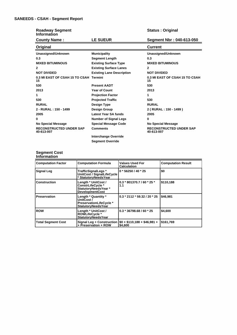
SANEEDS - CSAH - Segment Report
Roadway SegmentInformation
Status : Original
County Name : LE SUEUR Segment Nbr : 040-613-050
Original Current
Unassigned/Unknown Municipality Unassigned/Unknown
0.3 Segment Length 0.3
MIXED BITUMINOUS Existing Surface Type MIXED BITUMINOUS
2 Existing Surface Lanes 2
NOT DIVIDED Existing Lane Description NOT DIVIDED
0.3 MI EAST OF CSAH 15 TO CSAH15
Termini 0.3 MI EAST OF CSAH 15 TO CSAH15
530 Present AADT 530
2013 Year of Count 2013
1 Projection Factor 1
530 Projected Traffic 530
RURAL Design Type RURAL
2 - RURAL : 150 - 1499 Design Group 2 ( RURAL : 150 - 1499 )
2005 Latest Year SA funds 2005
0 Number of Signal Legs 0
No Special Message Special Message Code No Special Message
RECONSTRUCTED UNDER SAP40-613-007
Comments RECONSTRUCTED UNDER SAP40-613-007
Interchange Override
Segment Override
Segment CostInformation
Computation Factor Computation Formula Values Used ForCalculation
Computation Result
Signal Leg TrafficSignalLegs *UnitCost / SignalLifeCycle* StatutoryNeedsYear
0 * 56250 / 40 * 25 $0
Construction Length * UnitCost /ConstrLifeCycle *StatutoryNeedsYear *DevelopmentCost
0.3 * 801370.7 / 60 * 25 *1.1
$110,188
Preservation Length * Quantity *UnitCost /PreservationLifeCycle *StatutoryNeedsYear
0.3 * 2112 * 59.32 / 20 * 25 $46,981
ROW Length * UnitCost /ROWLifeCycle *StatutoryNeedsYear
0.3 * 36798.68 / 60 * 25 $4,600
Total Segment Cost Signal Leg + Construction+ Preservation + ROW
$0 + $110,188 + $46,981 +$4,600
$161,769

SANEEDS - CSAH - Segment Report
Roadway SegmentInformation
Status : Original
County Name : LE SUEUR Segment Nbr : 040-614-008
Original Current
ELYSIAN Municipality ELYSIAN
1.1 Segment Length 1.1
MIXED BITUMINOUS Existing Surface Type MIXED BITUMINOUS
2 Existing Surface Lanes 2
NOT DIVIDED Existing Lane Description NOT DIVIDED
CSAH 11 TO NORTH LIMITS OFELYSIAN
Termini CSAH 11 TO NORTH LIMITS OFELYSIAN
530 Present AADT 530
2013 Year of Count 2013
1 Projection Factor 1
530 Projected Traffic 530
RURAL Design Type RURAL
2 - RURAL : 150 - 1499 Design Group 2 ( RURAL : 150 - 1499 )
1991 Latest Year SA funds 1991
0 Number of Signal Legs 0
No Special Message Special Message Code No Special Message
Comments
Interchange Override
Segment Override
Segment CostInformation
Computation Factor Computation Formula Values Used ForCalculation
Computation Result
Signal Leg TrafficSignalLegs *UnitCost / SignalLifeCycle* StatutoryNeedsYear
0 * 56250 / 40 * 25 $0
Construction Length * UnitCost /ConstrLifeCycle *StatutoryNeedsYear *DevelopmentCost
1.1 * 801370.7 / 60 * 25 *1.1
$404,024
Preservation Length * Quantity *UnitCost /PreservationLifeCycle *StatutoryNeedsYear
1.1 * 2112 * 59.32 / 20 * 25 $172,265
ROW Length * UnitCost /ROWLifeCycle *StatutoryNeedsYear
1.1 * 36798.68 / 60 * 25 $16,866
Total Segment Cost Signal Leg + Construction+ Preservation + ROW
$0 + $404,024 + $172,265+ $16,866
$593,155

SANEEDS - CSAH - Segment Report
Roadway SegmentInformation
Status : Original
County Name : LE SUEUR Segment Nbr : 040-614-010
Original Current
Unassigned/Unknown Municipality Unassigned/Unknown
3.2 Segment Length 3.2
MIXED BITUMINOUS Existing Surface Type MIXED BITUMINOUS
2 Existing Surface Lanes 2
NOT DIVIDED Existing Lane Description NOT DIVIDED
NORTH LIMITS OF ELYSIAN TOCSAH 6
Termini NORTH LIMITS OF ELYSIAN TOCSAH 6
660 Present AADT 660
2013 Year of Count 2013
1 Projection Factor 1
660 Projected Traffic 660
RURAL Design Type RURAL
2 - RURAL : 150 - 1499 Design Group 2 ( RURAL : 150 - 1499 )
1991 Latest Year SA funds 1991
0 Number of Signal Legs 0
No Special Message Special Message Code No Special Message
Comments
Interchange Override
Segment Override
Segment CostInformation
Computation Factor Computation Formula Values Used ForCalculation
Computation Result
Signal Leg TrafficSignalLegs *UnitCost / SignalLifeCycle* StatutoryNeedsYear
0 * 56250 / 40 * 25 $0
Construction Length * UnitCost /ConstrLifeCycle *StatutoryNeedsYear *DevelopmentCost
3.2 * 801370.7 / 60 * 25 *1.1
$1,175,344
Preservation Length * Quantity *UnitCost /PreservationLifeCycle *StatutoryNeedsYear
3.2 * 2112 * 59.32 / 20 * 25 $501,135
ROW Length * UnitCost /ROWLifeCycle *StatutoryNeedsYear
3.2 * 36798.68 / 60 * 25 $49,065
Total Segment Cost Signal Leg + Construction+ Preservation + ROW
$0 + $1,175,344 + $501,135+ $49,065
$1,725,544

SANEEDS - CSAH - Segment Report
Roadway SegmentInformation
Status : Original
County Name : LE SUEUR Segment Nbr : 040-614-011
Original Current
Unassigned/Unknown Municipality Unassigned/Unknown
1.5 Segment Length 1.5
MIXED BITUMINOUS Existing Surface Type MIXED BITUMINOUS
2 Existing Surface Lanes 2
NOT DIVIDED Existing Lane Description NOT DIVIDED
CSAH 6 TO WEST LIMITS OFWATERVILLE
Termini CSAH 6 TO WEST LIMITS OFWATERVILLE
660 Present AADT 660
2013 Year of Count 2013
1 Projection Factor 1
660 Projected Traffic 660
RURAL Design Type RURAL
2 - RURAL : 150 - 1499 Design Group 2 ( RURAL : 150 - 1499 )
2015 Latest Year SA funds 2015
0 Number of Signal Legs 0
No Special Message Special Message Code No Special Message
2015 SAP 040-614-010 / SAP 040-614-009 PHASED RECONST
Comments 2015 SAP 040-614-010 / SAP 040-614-009 PHASED RECONST
Interchange Override
Segment Override
Segment CostInformation
Computation Factor Computation Formula Values Used ForCalculation
Computation Result
Signal Leg TrafficSignalLegs *UnitCost / SignalLifeCycle* StatutoryNeedsYear
0 * 56250 / 40 * 25 $0
Construction Length * UnitCost /ConstrLifeCycle *StatutoryNeedsYear *DevelopmentCost
1.5 * 801370.7 / 60 * 25 *1.1
$550,942
Preservation Length * Quantity *UnitCost /PreservationLifeCycle *StatutoryNeedsYear
1.5 * 2112 * 59.32 / 20 * 25 $234,907
ROW Length * UnitCost /ROWLifeCycle *StatutoryNeedsYear
1.5 * 36798.68 / 60 * 25 $22,999
Total Segment Cost Signal Leg + Construction+ Preservation + ROW
$0 + $550,942 + $234,907+ $22,999
$808,848

SANEEDS - CSAH - Segment Report
Roadway SegmentInformation
Status : Original
County Name : LE SUEUR Segment Nbr : 040-614-019
Original Current
WATERVILLE Municipality WATERVILLE
0.25 Segment Length 0.25
MIXED BITUMINOUS Existing Surface Type MIXED BITUMINOUS
2 Existing Surface Lanes 2
NOT DIVIDED Existing Lane Description NOT DIVIDED
WEST LIMITS WATERVILLE TO0.25 MILE EAST ON PAQUIN ST
Termini WEST LIMITS WATERVILLE TO0.25 MILE EAST ON PAQUIN ST
660 Present AADT 660
2013 Year of Count 2013
1 Projection Factor 1
660 Projected Traffic 660
RURAL Design Type RURAL
2 - RURAL : 150 - 1499 Design Group 2 ( RURAL : 150 - 1499 )
1988 Latest Year SA funds 1988
0 Number of Signal Legs 0
No Special Message Special Message Code No Special Message
Comments
Interchange Override
Segment Override
Segment CostInformation
Computation Factor Computation Formula Values Used ForCalculation
Computation Result
Signal Leg TrafficSignalLegs *UnitCost / SignalLifeCycle* StatutoryNeedsYear
0 * 56250 / 40 * 25 $0
Construction Length * UnitCost /ConstrLifeCycle *StatutoryNeedsYear *DevelopmentCost
0.25 * 801370.7 / 60 * 25 *1.1
$91,824
Preservation Length * Quantity *UnitCost /PreservationLifeCycle *StatutoryNeedsYear
0.25 * 2112 * 59.32 / 20 * 25 $39,151
ROW Length * UnitCost /ROWLifeCycle *StatutoryNeedsYear
0.25 * 36798.68 / 60 * 25 $3,833
Total Segment Cost Signal Leg + Construction+ Preservation + ROW
$0 + $91,824 + $39,151 +$3,833
$134,808

SANEEDS - CSAH - Segment Report
Roadway SegmentInformation
Status : Original
County Name : LE SUEUR Segment Nbr : 040-614-020
Original Current
WATERVILLE Municipality WATERVILLE
0.17 Segment Length 0.17
MIXED BITUMINOUS Existing Surface Type MIXED BITUMINOUS
2 Existing Surface Lanes 2
NOT DIVIDED Existing Lane Description NOT DIVIDED
0.25 MI E OF W LIMITSWATERVILLE TO .09 MI WHERBERT ST
Termini 0.25 MI E OF W LIMITSWATERVILLE TO .09 MI WHERBERT ST
660 Present AADT 660
2013 Year of Count 2013
1 Projection Factor 1
660 Projected Traffic 660
URBAN Design Type URBAN
5 - URBAN : 0 - 9999 Design Group 5 ( URBAN : 0 - 9999 )
1988 Latest Year SA funds 1988
0 Number of Signal Legs 0
No Special Message Special Message Code No Special Message
2013 SAP 040-614-009 PHASE 1RECONST
Comments 2013 SAP 040-614-009 PHASE 1RECONST
Interchange Override
Segment Override
Segment CostInformation
Computation Factor Computation Formula Values Used ForCalculation
Computation Result
Signal Leg TrafficSignalLegs *UnitCost / SignalLifeCycle* StatutoryNeedsYear
0 * 56250 / 40 * 25 $0
Construction Length * UnitCost /ConstrLifeCycle *StatutoryNeedsYear *DevelopmentCost
0.17 * 2823252.86 / 60 * 25* 1.15
$229,977
Preservation Length * Quantity *UnitCost /PreservationLifeCycle *StatutoryNeedsYear
0.17 * 2904 * 59.32 / 15 * 25 $48,808
ROW Length * UnitCost /ROWLifeCycle *StatutoryNeedsYear
0.17 * 59776.02 / 60 * 25 $4,234
Total Segment Cost Signal Leg + Construction+ Preservation + ROW
$0 + $229,977 + $48,808 +$4,234
$283,019

SANEEDS - CSAH - Segment Report
Roadway SegmentInformation
Status : Original
County Name : LE SUEUR Segment Nbr : 040-614-021
Original Current
WATERVILLE Municipality WATERVILLE
0.09 Segment Length 0.09
MIXED BITUMINOUS Existing Surface Type MIXED BITUMINOUS
2 Existing Surface Lanes 2
NOT DIVIDED Existing Lane Description NOT DIVIDED
450 FT W OF HERBERT ST TOHERBERT ST ON PAQUIN ST
Termini 450 FT W OF HERBERT ST TOHERBERT ST ON PAQUIN ST
1200 Present AADT 1200
2013 Year of Count 2013
1 Projection Factor 1
1200 Projected Traffic 1200
URBAN Design Type URBAN
5 - URBAN : 0 - 9999 Design Group 5 ( URBAN : 0 - 9999 )
2001 Latest Year SA funds 2001
0 Number of Signal Legs 0
No Special Message Special Message Code No Special Message
Comments
Interchange Override
Segment Override
Segment CostInformation
Computation Factor Computation Formula Values Used ForCalculation
Computation Result
Signal Leg TrafficSignalLegs *UnitCost / SignalLifeCycle* StatutoryNeedsYear
0 * 56250 / 40 * 25 $0
Construction Length * UnitCost /ConstrLifeCycle *StatutoryNeedsYear *DevelopmentCost
0.09 * 2823252.86 / 60 * 25* 1.15
$121,753
Preservation Length * Quantity *UnitCost /PreservationLifeCycle *StatutoryNeedsYear
0.09 * 2904 * 59.32 / 15 * 25 $25,840
ROW Length * UnitCost /ROWLifeCycle *StatutoryNeedsYear
0.09 * 59776.02 / 60 * 25 $2,242
Total Segment Cost Signal Leg + Construction+ Preservation + ROW
$0 + $121,753 + $25,840 +$2,242
$149,835

SANEEDS - CSAH - Segment Report
Roadway SegmentInformation
Status : Original
County Name : LE SUEUR Segment Nbr : 040-614-030
Original Current
WATERVILLE Municipality WATERVILLE
0.18 Segment Length 0.18
MIXED BITUMINOUS Existing Surface Type MIXED BITUMINOUS
2 Existing Surface Lanes 2
NOT DIVIDED Existing Lane Description NOT DIVIDED
HERBERT ST TO BUCHANAN STON PAQUIN
Termini HERBERT ST TO BUCHANAN STON PAQUIN
1100 Present AADT 1100
2013 Year of Count 2013
1 Projection Factor 1
1100 Projected Traffic 1100
URBAN Design Type URBAN
5 - URBAN : 0 - 9999 Design Group 5 ( URBAN : 0 - 9999 )
2001 Latest Year SA funds 2001
0 Number of Signal Legs 0
No Special Message Special Message Code No Special Message
Comments
Interchange Override
Segment Override
Segment CostInformation
Computation Factor Computation Formula Values Used ForCalculation
Computation Result
Signal Leg TrafficSignalLegs *UnitCost / SignalLifeCycle* StatutoryNeedsYear
0 * 56250 / 40 * 25 $0
Construction Length * UnitCost /ConstrLifeCycle *StatutoryNeedsYear *DevelopmentCost
0.18 * 2823252.86 / 60 * 25* 1.15
$243,506
Preservation Length * Quantity *UnitCost /PreservationLifeCycle *StatutoryNeedsYear
0.18 * 2904 * 59.32 / 15 * 25 $51,680
ROW Length * UnitCost /ROWLifeCycle *StatutoryNeedsYear
0.18 * 59776.02 / 60 * 25 $4,483
Total Segment Cost Signal Leg + Construction+ Preservation + ROW
$0 + $243,506 + $51,680 +$4,483
$299,669

SANEEDS - CSAH - Segment Report
Roadway SegmentInformation
Status : Original
County Name : LE SUEUR Segment Nbr : 040-614-031
Original Current
WATERVILLE Municipality WATERVILLE
0.06 Segment Length 0.06
MIXED BITUMINOUS Existing Surface Type MIXED BITUMINOUS
2 Existing Surface Lanes 2
NOT DIVIDED Existing Lane Description NOT DIVIDED
BUCHANAN ST TO REED ST(CSAH 3) ON PAQUIN ST
Termini BUCHANAN ST TO REED ST(CSAH 3) ON PAQUIN ST
1100 Present AADT 1100
2013 Year of Count 2013
1 Projection Factor 1
1100 Projected Traffic 1100
RURAL Design Type RURAL
2 - RURAL : 150 - 1499 Design Group 2 ( RURAL : 150 - 1499 )
1992 Latest Year SA funds 1992
0 Number of Signal Legs 0
No Special Message Special Message Code No Special Message
Comments
Interchange Override
Segment Override
Segment CostInformation
Computation Factor Computation Formula Values Used ForCalculation
Computation Result
Signal Leg TrafficSignalLegs *UnitCost / SignalLifeCycle* StatutoryNeedsYear
0 * 56250 / 40 * 25 $0
Construction Length * UnitCost /ConstrLifeCycle *StatutoryNeedsYear *DevelopmentCost
0.06 * 801370.7 / 60 * 25 *1.1
$22,038
Preservation Length * Quantity *UnitCost /PreservationLifeCycle *StatutoryNeedsYear
0.06 * 2112 * 59.32 / 20 * 25 $9,396
ROW Length * UnitCost /ROWLifeCycle *StatutoryNeedsYear
0.06 * 36798.68 / 60 * 25 $920
Total Segment Cost Signal Leg + Construction+ Preservation + ROW
$0 + $22,038 + $9,396 +$920
$32,354

SANEEDS - CSAH - Segment Report
Roadway SegmentInformation
Status : Original
County Name : LE SUEUR Segment Nbr : 040-614-035
Original Current
WATERVILLE Municipality WATERVILLE
0.06 Segment Length 0.06
MIXED BITUMINOUS Existing Surface Type MIXED BITUMINOUS
2 Existing Surface Lanes 2
NOT DIVIDED Existing Lane Description NOT DIVIDED
PAQUIN ST (CSAH 3/53) TO MAINST ON REED ST
Termini PAQUIN ST (CSAH 3/53) TO MAINST ON REED ST
960 Present AADT 960
2013 Year of Count 2013
1 Projection Factor 1
960 Projected Traffic 960
RURAL Design Type RURAL
2 - RURAL : 150 - 1499 Design Group 2 ( RURAL : 150 - 1499 )
1992 Latest Year SA funds 1992
0 Number of Signal Legs 0
No Special Message Special Message Code No Special Message
Comments
Interchange Override
Segment Override
Segment CostInformation
Computation Factor Computation Formula Values Used ForCalculation
Computation Result
Signal Leg TrafficSignalLegs *UnitCost / SignalLifeCycle* StatutoryNeedsYear
0 * 56250 / 40 * 25 $0
Construction Length * UnitCost /ConstrLifeCycle *StatutoryNeedsYear *DevelopmentCost
0.06 * 801370.7 / 60 * 25 *1.1
$22,038
Preservation Length * Quantity *UnitCost /PreservationLifeCycle *StatutoryNeedsYear
0.06 * 2112 * 59.32 / 20 * 25 $9,396
ROW Length * UnitCost /ROWLifeCycle *StatutoryNeedsYear
0.06 * 36798.68 / 60 * 25 $920
Total Segment Cost Signal Leg + Construction+ Preservation + ROW
$0 + $22,038 + $9,396 +$920
$32,354

SANEEDS - CSAH - Segment Report
Roadway SegmentInformation
Status : Original
County Name : LE SUEUR Segment Nbr : 040-614-040
Original Current
WATERVILLE Municipality WATERVILLE
0.08 Segment Length 0.08
MIXED BITUMINOUS Existing Surface Type MIXED BITUMINOUS
2 Existing Surface Lanes 2
NOT DIVIDED Existing Lane Description NOT DIVIDED
REED ST TO 1ST ST (CSAH 52) ONMAIN ST
Termini REED ST TO 1ST ST (CSAH 52) ONMAIN ST
2300 Present AADT 2300
2013 Year of Count 2013
1 Projection Factor 1
2300 Projected Traffic 2300
URBAN Design Type URBAN
5 - URBAN : 0 - 9999 Design Group 5 ( URBAN : 0 - 9999 )
1980 Latest Year SA funds 1980
0 Number of Signal Legs 0
No Special Message Special Message Code No Special Message
RESURFACED WITH CITY OFWATERVILLE WATERMAINPROJECT IN 2005
Comments RESURFACED WITH CITY OFWATERVILLE WATERMAINPROJECT IN 2005
Interchange Override
Segment Override
Segment CostInformation
Computation Factor Computation Formula Values Used ForCalculation
Computation Result
Signal Leg TrafficSignalLegs *UnitCost / SignalLifeCycle* StatutoryNeedsYear
0 * 56250 / 40 * 25 $0
Construction Length * UnitCost /ConstrLifeCycle *StatutoryNeedsYear *DevelopmentCost
0.08 * 2823252.86 / 60 * 25* 1.15
$108,225
Preservation Length * Quantity *UnitCost /PreservationLifeCycle *StatutoryNeedsYear
0.08 * 2904 * 59.32 / 15 * 25 $22,969
ROW Length * UnitCost /ROWLifeCycle *StatutoryNeedsYear
0.08 * 59776.02 / 60 * 25 $1,993
Total Segment Cost Signal Leg + Construction+ Preservation + ROW
$0 + $108,225 + $22,969 +$1,993
$133,187

SANEEDS - CSAH - Segment Report
Roadway SegmentInformation
Status : Original
County Name : LE SUEUR Segment Nbr : 040-614-050
Original Current
WATERVILLE Municipality WATERVILLE
0.37 Segment Length 0.37
MIXED BITUMINOUS Existing Surface Type MIXED BITUMINOUS
2 Existing Surface Lanes 2
NOT DIVIDED Existing Lane Description NOT DIVIDED
1ST ST (CSAH 52) TO TH 13 ONMAIN ST
Termini 1ST ST (CSAH 52) TO TH 13 ONMAIN ST
2950 Present AADT 2950
2013 Year of Count 2013
1 Projection Factor 1
2950 Projected Traffic 2950
URBAN Design Type URBAN
5 - URBAN : 0 - 9999 Design Group 5 ( URBAN : 0 - 9999 )
2000 Latest Year SA funds 2000
0 Number of Signal Legs 0
No Special Message Special Message Code No Special Message
RESURFACED WITH CITY OFWATERVILLE WATERMAINPROJECT IN 2005
Comments RESURFACED WITH CITY OFWATERVILLE WATERMAINPROJECT IN 2005
Interchange Override
Segment Override
Segment CostInformation
Computation Factor Computation Formula Values Used ForCalculation
Computation Result
Signal Leg TrafficSignalLegs *UnitCost / SignalLifeCycle* StatutoryNeedsYear
0 * 56250 / 40 * 25 $0
Construction Length * UnitCost /ConstrLifeCycle *StatutoryNeedsYear *DevelopmentCost
0.37 * 2823252.86 / 60 * 25* 1.15
$500,539
Preservation Length * Quantity *UnitCost /PreservationLifeCycle *StatutoryNeedsYear
0.37 * 2904 * 59.32 / 15 * 25 $106,230
ROW Length * UnitCost /ROWLifeCycle *StatutoryNeedsYear
0.37 * 59776.02 / 60 * 25 $9,215
Total Segment Cost Signal Leg + Construction+ Preservation + ROW
$0 + $500,539 + $106,230+ $9,215
$615,984

SANEEDS - CSAH - Segment Report
Roadway SegmentInformation
Status : Original
County Name : LE SUEUR Segment Nbr : 040-615-010
Original Current
Unassigned/Unknown Municipality Unassigned/Unknown
3.9 Segment Length 3.9
MIXED BITUMINOUS Existing Surface Type MIXED BITUMINOUS
2 Existing Surface Lanes 2
NOT DIVIDED Existing Lane Description NOT DIVIDED
CSAH 16 TO 0.3 MI SE OF NORTHJCT CSAH 18
Termini CSAH 16 TO 0.3 MI SE OF NORTHJCT CSAH 18
1600 Present AADT 1600
2013 Year of Count 2013
1 Projection Factor 1
1600 Projected Traffic 1600
RURAL Design Type RURAL
3 - RURAL : 1500 - 6999 Design Group 3 ( RURAL : 1500 - 6999 )
1975 Latest Year SA funds 1975
0 Number of Signal Legs 0
No Special Message Special Message Code No Special Message
Comments
Interchange Override
Segment Override
Segment CostInformation
Computation Factor Computation Formula Values Used ForCalculation
Computation Result
Signal Leg TrafficSignalLegs *UnitCost / SignalLifeCycle* StatutoryNeedsYear
0 * 56250 / 40 * 25 $0
Construction Length * UnitCost /ConstrLifeCycle *StatutoryNeedsYear *DevelopmentCost
3.9 * 1589559.55 / 60 * 25 *1.1
$2,841,338
Preservation Length * Quantity *UnitCost /PreservationLifeCycle *StatutoryNeedsYear
3.9 * 2376 * 59.32 / 20 * 25 $687,104
ROW Length * UnitCost /ROWLifeCycle *StatutoryNeedsYear
3.9 * 222272.59 / 60 * 25 $361,193
Total Segment Cost Signal Leg + Construction+ Preservation + ROW
$0 + $2,841,338 + $687,104+ $361,193
$3,889,635

SANEEDS - CSAH - Segment Report
Roadway SegmentInformation
Status : Original
County Name : LE SUEUR Segment Nbr : 040-615-015
Original Current
Unassigned/Unknown Municipality Unassigned/Unknown
2.4 Segment Length 2.4
MIXED BITUMINOUS Existing Surface Type MIXED BITUMINOUS
2 Existing Surface Lanes 2
NOT DIVIDED Existing Lane Description NOT DIVIDED
0.3 MI SE OF NORTH JCT CSAH 18TO SOUTH LIMITS OF CLEVELAND
Termini 0.3 MI SE OF NORTH JCT CSAH 18TO SOUTH LIMITS OF CLEVELAND
1850 Present AADT 1850
2013 Year of Count 2013
1 Projection Factor 1
1850 Projected Traffic 1850
RURAL Design Type RURAL
3 - RURAL : 1500 - 6999 Design Group 3 ( RURAL : 1500 - 6999 )
2005 Latest Year SA funds 2005
0 Number of Signal Legs 0
No Special Message Special Message Code No Special Message
Comments
Interchange Override
Segment Override
Culvert Information Status: Original
Original Current
40J21 Structure Number 40J21
5.433 Milepoint 5.433
2007 Year Built 2007
CHERRY CREEK Feature Crossed CHERRY CREEK
STREAM CROSSING Type of Service STREAM CROSSING
1 Number of Barrels 1
14 Culvert Width 14
8 Culvert Height 8
142 Culvert Length 142
98.99989386 Area of Waterway Opening 98.99989386
100% Shared Structure 100%
Comments
1 Culvert Group Code 1
Segment CostInformation
Computation Factor Computation Formula Values Used ForCalculation
Computation Result
Signal Leg TrafficSignalLegs *UnitCost / SignalLifeCycle* StatutoryNeedsYear
0 * 56250 / 40 * 25 $0
Construction Length * UnitCost /ConstrLifeCycle *StatutoryNeedsYear *DevelopmentCost
2.4 * 1589559.55 / 60 * 25 *1.1
$1,748,516
Preservation Length * Quantity *UnitCost /PreservationLifeCycle *StatutoryNeedsYear
2.4 * 2376 * 59.32 / 20 * 25 $422,833
ROW Length * UnitCost /ROWLifeCycle *StatutoryNeedsYear
2.4 * 222272.59 / 60 * 25 $222,273
Culvert CulvertLength * Area *UnitCost /CulvertLifeCycle *StatutoryNeedsYear *DevelopmentCost
142 * 98.99989386 * 15.47 /100 * 25 * 1.15
$62,525

Total Segment Cost Signal Leg + Construction+ Preservation + ROW +Culvert
$0 + $1,748,516 + $422,833+ $222,273 + $62,525
$2,456,147
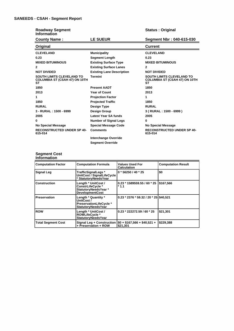
SANEEDS - CSAH - Segment Report
Roadway SegmentInformation
Status : Original
County Name : LE SUEUR Segment Nbr : 040-615-030
Original Current
CLEVELAND Municipality CLEVELAND
0.23 Segment Length 0.23
MIXED BITUMINOUS Existing Surface Type MIXED BITUMINOUS
2 Existing Surface Lanes 2
NOT DIVIDED Existing Lane Description NOT DIVIDED
SOUTH LIMITS CLEVELAND TOCOLUMBIA ST (CSAH 47) ON 10THST
Termini SOUTH LIMITS CLEVELAND TOCOLUMBIA ST (CSAH 47) ON 10THST
1850 Present AADT 1850
2013 Year of Count 2013
1 Projection Factor 1
1850 Projected Traffic 1850
RURAL Design Type RURAL
3 - RURAL : 1500 - 6999 Design Group 3 ( RURAL : 1500 - 6999 )
2005 Latest Year SA funds 2005
0 Number of Signal Legs 0
No Special Message Special Message Code No Special Message
RECONSTRUCTED UNDER SP 40-615-014
Comments RECONSTRUCTED UNDER SP 40-615-014
Interchange Override
Segment Override
Segment CostInformation
Computation Factor Computation Formula Values Used ForCalculation
Computation Result
Signal Leg TrafficSignalLegs *UnitCost / SignalLifeCycle* StatutoryNeedsYear
0 * 56250 / 40 * 25 $0
Construction Length * UnitCost /ConstrLifeCycle *StatutoryNeedsYear *DevelopmentCost
0.23 * 1589559.55 / 60 * 25* 1.1
$167,566
Preservation Length * Quantity *UnitCost /PreservationLifeCycle *StatutoryNeedsYear
0.23 * 2376 * 59.32 / 20 * 25 $40,521
ROW Length * UnitCost /ROWLifeCycle *StatutoryNeedsYear
0.23 * 222272.59 / 60 * 25 $21,301
Total Segment Cost Signal Leg + Construction+ Preservation + ROW
$0 + $167,566 + $40,521 +$21,301
$229,388

SANEEDS - CSAH - Segment Report
Roadway SegmentInformation
Status : Original
County Name : LE SUEUR Segment Nbr : 040-615-040
Original Current
CLEVELAND Municipality CLEVELAND
0.27 Segment Length 0.27
MIXED BITUMINOUS Existing Surface Type MIXED BITUMINOUS
2 Existing Surface Lanes 2
NOT DIVIDED Existing Lane Description NOT DIVIDED
COLUMBIA ST (CSAH 47) TO TH 99ON 10TH ST
Termini COLUMBIA ST (CSAH 47) TO TH 99ON 10TH ST
1850 Present AADT 1850
2013 Year of Count 2013
1 Projection Factor 1
1850 Projected Traffic 1850
URBAN Design Type URBAN
5 - URBAN : 0 - 9999 Design Group 5 ( URBAN : 0 - 9999 )
2007 Latest Year SA funds 2007
0 Number of Signal Legs 0
No Special Message Special Message Code No Special Message
RECONSTRUCTED UNDER SP 40-615-015
Comments RECONSTRUCTED UNDER SP 40-615-015
Interchange Override
Segment Override
Segment CostInformation
Computation Factor Computation Formula Values Used ForCalculation
Computation Result
Signal Leg TrafficSignalLegs *UnitCost / SignalLifeCycle* StatutoryNeedsYear
0 * 56250 / 40 * 25 $0
Construction Length * UnitCost /ConstrLifeCycle *StatutoryNeedsYear *DevelopmentCost
0.27 * 2823252.86 / 60 * 25* 1.15
$365,258
Preservation Length * Quantity *UnitCost /PreservationLifeCycle *StatutoryNeedsYear
0.27 * 2904 * 59.32 / 15 * 25 $77,519
ROW Length * UnitCost /ROWLifeCycle *StatutoryNeedsYear
0.27 * 59776.02 / 60 * 25 $6,725
Total Segment Cost Signal Leg + Construction+ Preservation + ROW
$0 + $365,258 + $77,519 +$6,725
$449,502

SANEEDS - CSAH - Segment Report
Roadway SegmentInformation
Status : Original
County Name : LE SUEUR Segment Nbr : 040-615-050
Original Current
CLEVELAND Municipality CLEVELAND
0.11 Segment Length 0.11
MIXED BITUMINOUS Existing Surface Type MIXED BITUMINOUS
2 Existing Surface Lanes 2
NOT DIVIDED Existing Lane Description NOT DIVIDED
TH 99 TO NORTH LIM CLEVELAND Termini TH 99 TO NORTH LIM CLEVELAND
890 Present AADT 890
2013 Year of Count 2013
1 Projection Factor 1
890 Projected Traffic 890
RURAL Design Type RURAL
2 - RURAL : 150 - 1499 Design Group 2 ( RURAL : 150 - 1499 )
1999 Latest Year SA funds 1999
0 Number of Signal Legs 0
No Special Message Special Message Code No Special Message
Comments
Interchange Override
Segment Override
Segment CostInformation
Computation Factor Computation Formula Values Used ForCalculation
Computation Result
Signal Leg TrafficSignalLegs *UnitCost / SignalLifeCycle* StatutoryNeedsYear
0 * 56250 / 40 * 25 $0
Construction Length * UnitCost /ConstrLifeCycle *StatutoryNeedsYear *DevelopmentCost
0.11 * 801370.7 / 60 * 25 *1.1
$40,402
Preservation Length * Quantity *UnitCost /PreservationLifeCycle *StatutoryNeedsYear
0.11 * 2112 * 59.32 / 20 * 25 $17,227
ROW Length * UnitCost /ROWLifeCycle *StatutoryNeedsYear
0.11 * 36798.68 / 60 * 25 $1,687
Total Segment Cost Signal Leg + Construction+ Preservation + ROW
$0 + $40,402 + $17,227 +$1,687
$59,316

SANEEDS - CSAH - Segment Report
Roadway SegmentInformation
Status : Original
County Name : LE SUEUR Segment Nbr : 040-615-060
Original Current
Unassigned/Unknown Municipality Unassigned/Unknown
4.1 Segment Length 4.1
MIXED BITUMINOUS Existing Surface Type MIXED BITUMINOUS
2 Existing Surface Lanes 2
NOT DIVIDED Existing Lane Description NOT DIVIDED
N LIM CLEVELAND TO 0.2 MI N OFTH 112
Termini N LIM CLEVELAND TO 0.2 MI N OFTH 112
890 Present AADT 890
2013 Year of Count 2013
1 Projection Factor 1
890 Projected Traffic 890
RURAL Design Type RURAL
2 - RURAL : 150 - 1499 Design Group 2 ( RURAL : 150 - 1499 )
1999 Latest Year SA funds 1999
0 Number of Signal Legs 0
No Special Message Special Message Code No Special Message
Comments
Interchange Override
Segment Override
Culvert Information Status: Original
Original Current
40J05 Structure Number 40J05
0.42 Milepoint 0.42
2000 Year Built 2000
CO DITCH # 60 Feature Crossed CO DITCH # 60
STREAM CROSSING Type of Service STREAM CROSSING
1 Number of Barrels 1
10 Culvert Width 10
10 Culvert Height 10
130 Culvert Length 130
99.99986017 Area of Waterway Opening 99.99986017
100% Shared Structure 100%
Comments
1 Culvert Group Code 1
Segment CostInformation
Computation Factor Computation Formula Values Used ForCalculation
Computation Result
Signal Leg TrafficSignalLegs *UnitCost / SignalLifeCycle* StatutoryNeedsYear
0 * 56250 / 40 * 25 $0
Construction Length * UnitCost /ConstrLifeCycle *StatutoryNeedsYear *DevelopmentCost
4.1 * 801370.7 / 60 * 25 *1.1
$1,505,909
Preservation Length * Quantity *UnitCost /PreservationLifeCycle *StatutoryNeedsYear
4.1 * 2112 * 59.32 / 20 * 25 $642,080
ROW Length * UnitCost /ROWLifeCycle *StatutoryNeedsYear
4.1 * 36798.68 / 60 * 25 $62,864
Culvert CulvertLength * Area *UnitCost /CulvertLifeCycle *StatutoryNeedsYear *DevelopmentCost
130 * 99.99986017 * 15.47 /100 * 25 * 1.15
$57,819

Total Segment Cost Signal Leg + Construction+ Preservation + ROW +Culvert
$0 + $1,505,909 + $642,080+ $62,864 + $57,819
$2,268,672
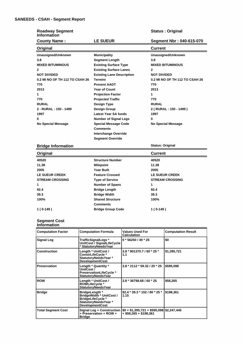
SANEEDS - CSAH - Segment Report
Roadway SegmentInformation
Status : Original
County Name : LE SUEUR Segment Nbr : 040-615-070
Original Current
Unassigned/Unknown Municipality Unassigned/Unknown
3.8 Segment Length 3.8
MIXED BITUMINOUS Existing Surface Type MIXED BITUMINOUS
2 Existing Surface Lanes 2
NOT DIVIDED Existing Lane Description NOT DIVIDED
0.2 MI NO OF TH 112 TO CSAH 26 Termini 0.2 MI NO OF TH 112 TO CSAH 26
770 Present AADT 770
2013 Year of Count 2013
1 Projection Factor 1
770 Projected Traffic 770
RURAL Design Type RURAL
2 - RURAL : 150 - 1499 Design Group 2 ( RURAL : 150 - 1499 )
1997 Latest Year SA funds 1997
0 Number of Signal Legs 0
No Special Message Special Message Code No Special Message
Comments
Interchange Override
Segment Override
Bridge Information Status: Original
Original Current
40520 Structure Number 40520
11.38 Milepoint 11.38
2005 Year Built 2005
LE SUEUR CREEK Feature Crossed LE SUEUR CREEK
STREAM CROSSING Type of Service STREAM CROSSING
1 Number of Spans 1
92.4 Bridge Length 92.4
39.3 Bridge Width 39.3
100% Shared Structure 100%
Comments
1 ( 0-149 ) Bridge Group Code 1 ( 0-149 )
Segment CostInformation
Computation Factor Computation Formula Values Used ForCalculation
Computation Result
Signal Leg TrafficSignalLegs *UnitCost / SignalLifeCycle* StatutoryNeedsYear
0 * 56250 / 40 * 25 $0
Construction Length * UnitCost /ConstrLifeCycle *StatutoryNeedsYear *DevelopmentCost
3.8 * 801370.7 / 60 * 25 *1.1
$1,395,721
Preservation Length * Quantity *UnitCost /PreservationLifeCycle *StatutoryNeedsYear
3.8 * 2112 * 59.32 / 20 * 25 $595,098
ROW Length * UnitCost /ROWLifeCycle *StatutoryNeedsYear
3.8 * 36798.68 / 60 * 25 $58,265
Bridge BridgeLength *BridgeWidth * UnitCost /BridgeLifeCycle *StatutoryNeedsYear *DevelopmentCost
92.4 * 39.3 * 152 / 80 * 25 *1.15
$198,361
Total Segment Cost Signal Leg + Construction+ Preservation + ROW +Bridge
$0 + $1,395,721 + $595,098+ $58,265 + $198,361
$2,247,445

SANEEDS - CSAH - Segment Report
Roadway SegmentInformation
Status : Original
County Name : LE SUEUR Segment Nbr : 040-616-010
Original Current
Unassigned/Unknown Municipality Unassigned/Unknown
0.4 Segment Length 0.4
MIXED BITUMINOUS Existing Surface Type MIXED BITUMINOUS
2 Existing Surface Lanes 2
NOT DIVIDED Existing Lane Description NOT DIVIDED
ALONG SO CO LINE 2.7 MI W OFCSAH 15 TO 2.3 MI W OF CSAH 15
Termini ALONG SO CO LINE 2.7 MI W OFCSAH 15 TO 2.3 MI W OF CSAH 15
1350 Present AADT 1350
2013 Year of Count 2013
1 Projection Factor 1
1350 Projected Traffic 1350
RURAL Design Type RURAL
2 - RURAL : 150 - 1499 Design Group 2 ( RURAL : 150 - 1499 )
2004 Latest Year SA funds 2004
0 Number of Signal Legs 0
No Special Message Special Message Code No Special Message
Comments
Interchange Override
Segment Override
Segment CostInformation
Computation Factor Computation Formula Values Used ForCalculation
Computation Result
Signal Leg TrafficSignalLegs *UnitCost / SignalLifeCycle* StatutoryNeedsYear
0 * 56250 / 40 * 25 $0
Construction Length * UnitCost /ConstrLifeCycle *StatutoryNeedsYear *DevelopmentCost
0.4 * 801370.7 / 60 * 25 *1.1
$146,918
Preservation Length * Quantity *UnitCost /PreservationLifeCycle *StatutoryNeedsYear
0.4 * 2112 * 59.32 / 20 * 25 $62,642
ROW Length * UnitCost /ROWLifeCycle *StatutoryNeedsYear
0.4 * 36798.68 / 60 * 25 $6,133
Total Segment Cost Signal Leg + Construction+ Preservation + ROW
$0 + $146,918 + $62,642 +$6,133
$215,693

SANEEDS - CSAH - Segment Report
Roadway SegmentInformation
Status : Original
County Name : LE SUEUR Segment Nbr : 040-616-011
Original Current
Unassigned/Unknown Municipality Unassigned/Unknown
2.3 Segment Length 2.3
MIXED BITUMINOUS Existing Surface Type MIXED BITUMINOUS
2 Existing Surface Lanes 2
NOT DIVIDED Existing Lane Description NOT DIVIDED
2.3 M. WEST OF CSAH 15 TO CSAH15
Termini 2.3 M. WEST OF CSAH 15 TO CSAH15
1350 Present AADT 1350
2013 Year of Count 2013
1 Projection Factor 1
1350 Projected Traffic 1350
RURAL Design Type RURAL
2 - RURAL : 150 - 1499 Design Group 2 ( RURAL : 150 - 1499 )
2004 Latest Year SA funds 2004
0 Number of Signal Legs 0
No Special Message Special Message Code No Special Message
Comments
Interchange Override
Segment Override
Segment CostInformation
Computation Factor Computation Formula Values Used ForCalculation
Computation Result
Signal Leg TrafficSignalLegs *UnitCost / SignalLifeCycle* StatutoryNeedsYear
0 * 56250 / 40 * 25 $0
Construction Length * UnitCost /ConstrLifeCycle *StatutoryNeedsYear *DevelopmentCost
2.3 * 801370.7 / 60 * 25 *1.1
$844,778
Preservation Length * Quantity *UnitCost /PreservationLifeCycle *StatutoryNeedsYear
2.3 * 2112 * 59.32 / 20 * 25 $360,191
ROW Length * UnitCost /ROWLifeCycle *StatutoryNeedsYear
2.3 * 36798.68 / 60 * 25 $35,265
Total Segment Cost Signal Leg + Construction+ Preservation + ROW
$0 + $844,778 + $360,191+ $35,265
$1,240,234

SANEEDS - CSAH - Segment Report
Roadway SegmentInformation
Status : Original
County Name : LE SUEUR Segment Nbr : 040-616-020
Original Current
Unassigned/Unknown Municipality Unassigned/Unknown
4 Segment Length 4
MIXED BITUMINOUS Existing Surface Type MIXED BITUMINOUS
2 Existing Surface Lanes 2
NOT DIVIDED Existing Lane Description NOT DIVIDED
CSAH 15 TO CSAH 13 Termini CSAH 15 TO CSAH 13
760 Present AADT 760
2013 Year of Count 2013
1 Projection Factor 1
760 Projected Traffic 760
RURAL Design Type RURAL
2 - RURAL : 150 - 1499 Design Group 2 ( RURAL : 150 - 1499 )
1994 Latest Year SA funds 1994
0 Number of Signal Legs 0
No Special Message Special Message Code No Special Message
Comments
Interchange Override
Segment Override
Segment CostInformation
Computation Factor Computation Formula Values Used ForCalculation
Computation Result
Signal Leg TrafficSignalLegs *UnitCost / SignalLifeCycle* StatutoryNeedsYear
0 * 56250 / 40 * 25 $0
Construction Length * UnitCost /ConstrLifeCycle *StatutoryNeedsYear *DevelopmentCost
4 * 801370.7 / 60 * 25 * 1.1 $1,469,180
Preservation Length * Quantity *UnitCost /PreservationLifeCycle *StatutoryNeedsYear
4 * 2112 * 59.32 / 20 * 25 $626,419
ROW Length * UnitCost /ROWLifeCycle *StatutoryNeedsYear
4 * 36798.68 / 60 * 25 $61,331
Total Segment Cost Signal Leg + Construction+ Preservation + ROW
$0 + $1,469,180 + $626,419+ $61,331
$2,156,930

SANEEDS - CSAH - Segment Report
Roadway SegmentInformation
Status : Original
County Name : LE SUEUR Segment Nbr : 040-616-030
Original Current
Unassigned/Unknown Municipality Unassigned/Unknown
2.2 Segment Length 2.2
MIXED BITUMINOUS Existing Surface Type MIXED BITUMINOUS
2 Existing Surface Lanes 2
NOT DIVIDED Existing Lane Description NOT DIVIDED
CSAH 13 TO W. LIMITS ELYSIAN Termini CSAH 13 TO W. LIMITS ELYSIAN
650 Present AADT 650
2013 Year of Count 2013
1 Projection Factor 1
650 Projected Traffic 650
RURAL Design Type RURAL
2 - RURAL : 150 - 1499 Design Group 2 ( RURAL : 150 - 1499 )
2008 Latest Year SA funds 2008
0 Number of Signal Legs 0
No Special Message Special Message Code No Special Message
2008: FDR AND SURFACINGCOMPLETED WITH 90% LOCALAND 10% SA FUNDSSAP 40-602-18
C.O. #91176
Comments 2008: FDR AND SURFACINGCOMPLETED WITH 90% LOCALAND 10% SA FUNDSSAP 40-602-18
C.O. #91176
Interchange Override
Segment Override
Segment CostInformation
Computation Factor Computation Formula Values Used ForCalculation
Computation Result
Signal Leg TrafficSignalLegs *UnitCost / SignalLifeCycle* StatutoryNeedsYear
0 * 56250 / 40 * 25 $0
Construction Length * UnitCost /ConstrLifeCycle *StatutoryNeedsYear *DevelopmentCost
2.2 * 801370.7 / 60 * 25 *1.1
$808,049
Preservation Length * Quantity *UnitCost /PreservationLifeCycle *StatutoryNeedsYear
2.2 * 2112 * 59.32 / 20 * 25 $344,531
ROW Length * UnitCost /ROWLifeCycle *StatutoryNeedsYear
2.2 * 36798.68 / 60 * 25 $33,732
Total Segment Cost Signal Leg + Construction+ Preservation + ROW
$0 + $808,049 + $344,531+ $33,732
$1,186,312

SANEEDS - CSAH - Segment Report
Roadway SegmentInformation
Status : Original
County Name : LE SUEUR Segment Nbr : 040-616-040
Original Current
ELYSIAN Municipality ELYSIAN
0.4 Segment Length 0.4
MIXED BITUMINOUS Existing Surface Type MIXED BITUMINOUS
2 Existing Surface Lanes 2
NOT DIVIDED Existing Lane Description NOT DIVIDED
WEST LIMITS OF ELYSIAN TOCSAH 11
Termini WEST LIMITS OF ELYSIAN TOCSAH 11
650 Present AADT 650
2013 Year of Count 2013
1 Projection Factor 1
650 Projected Traffic 650
RURAL Design Type RURAL
2 - RURAL : 150 - 1499 Design Group 2 ( RURAL : 150 - 1499 )
2008 Latest Year SA funds 2008
0 Number of Signal Legs 0
No Special Message Special Message Code No Special Message
2008: FDR AND SURFACINGCOMPLETED WITH 90% LOCALAND 10% SA FUNDSSAP 40-613-10
C.O. #91176
RENUMBERED FROM CSAH 13,2009
Comments 2008: FDR AND SURFACINGCOMPLETED WITH 90% LOCALAND 10% SA FUNDSSAP 40-613-10
C.O. #91176
RENUMBERED FROM CSAH 13,2009
Interchange Override
Segment Override
Segment CostInformation
Computation Factor Computation Formula Values Used ForCalculation
Computation Result
Signal Leg TrafficSignalLegs *UnitCost / SignalLifeCycle* StatutoryNeedsYear
0 * 56250 / 40 * 25 $0
Construction Length * UnitCost /ConstrLifeCycle *StatutoryNeedsYear *DevelopmentCost
0.4 * 801370.7 / 60 * 25 *1.1
$146,918
Preservation Length * Quantity *UnitCost /PreservationLifeCycle *StatutoryNeedsYear
0.4 * 2112 * 59.32 / 20 * 25 $62,642
ROW Length * UnitCost /ROWLifeCycle *StatutoryNeedsYear
0.4 * 36798.68 / 60 * 25 $6,133
Total Segment Cost Signal Leg + Construction+ Preservation + ROW
$0 + $146,918 + $62,642 +$6,133
$215,693
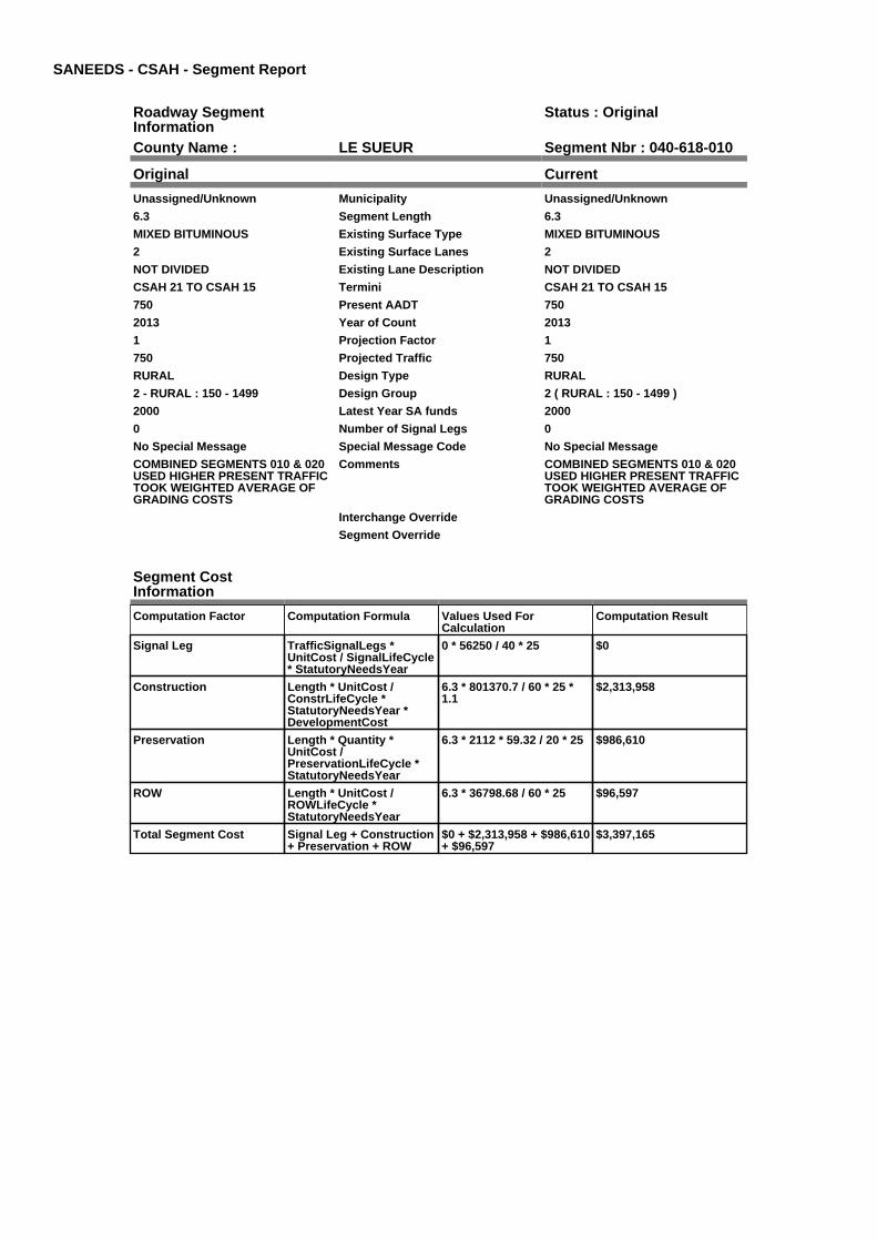
SANEEDS - CSAH - Segment Report
Roadway SegmentInformation
Status : Original
County Name : LE SUEUR Segment Nbr : 040-618-010
Original Current
Unassigned/Unknown Municipality Unassigned/Unknown
6.3 Segment Length 6.3
MIXED BITUMINOUS Existing Surface Type MIXED BITUMINOUS
2 Existing Surface Lanes 2
NOT DIVIDED Existing Lane Description NOT DIVIDED
CSAH 21 TO CSAH 15 Termini CSAH 21 TO CSAH 15
750 Present AADT 750
2013 Year of Count 2013
1 Projection Factor 1
750 Projected Traffic 750
RURAL Design Type RURAL
2 - RURAL : 150 - 1499 Design Group 2 ( RURAL : 150 - 1499 )
2000 Latest Year SA funds 2000
0 Number of Signal Legs 0
No Special Message Special Message Code No Special Message
COMBINED SEGMENTS 010 & 020USED HIGHER PRESENT TRAFFICTOOK WEIGHTED AVERAGE OFGRADING COSTS
Comments COMBINED SEGMENTS 010 & 020USED HIGHER PRESENT TRAFFICTOOK WEIGHTED AVERAGE OFGRADING COSTS
Interchange Override
Segment Override
Segment CostInformation
Computation Factor Computation Formula Values Used ForCalculation
Computation Result
Signal Leg TrafficSignalLegs *UnitCost / SignalLifeCycle* StatutoryNeedsYear
0 * 56250 / 40 * 25 $0
Construction Length * UnitCost /ConstrLifeCycle *StatutoryNeedsYear *DevelopmentCost
6.3 * 801370.7 / 60 * 25 *1.1
$2,313,958
Preservation Length * Quantity *UnitCost /PreservationLifeCycle *StatutoryNeedsYear
6.3 * 2112 * 59.32 / 20 * 25 $986,610
ROW Length * UnitCost /ROWLifeCycle *StatutoryNeedsYear
6.3 * 36798.68 / 60 * 25 $96,597
Total Segment Cost Signal Leg + Construction+ Preservation + ROW
$0 + $2,313,958 + $986,610+ $96,597
$3,397,165

SANEEDS - CSAH - Segment Report
Roadway SegmentInformation
Status : Original
County Name : LE SUEUR Segment Nbr : 040-618-060
Original Current
Unassigned/Unknown Municipality Unassigned/Unknown
3.2 Segment Length 3.2
MIXED BITUMINOUS Existing Surface Type MIXED BITUMINOUS
2 Existing Surface Lanes 2
NOT DIVIDED Existing Lane Description NOT DIVIDED
SOUTH JCT CSAH 15 TO CSAH 13 Termini SOUTH JCT CSAH 15 TO CSAH 13
720 Present AADT 720
2013 Year of Count 2013
1 Projection Factor 1
720 Projected Traffic 720
RURAL Design Type RURAL
2 - RURAL : 150 - 1499 Design Group 2 ( RURAL : 150 - 1499 )
2003 Latest Year SA funds 2003
0 Number of Signal Legs 0
No Special Message Special Message Code No Special Message
Comments
Interchange Override
Segment Override
Segment CostInformation
Computation Factor Computation Formula Values Used ForCalculation
Computation Result
Signal Leg TrafficSignalLegs *UnitCost / SignalLifeCycle* StatutoryNeedsYear
0 * 56250 / 40 * 25 $0
Construction Length * UnitCost /ConstrLifeCycle *StatutoryNeedsYear *DevelopmentCost
3.2 * 801370.7 / 60 * 25 *1.1
$1,175,344
Preservation Length * Quantity *UnitCost /PreservationLifeCycle *StatutoryNeedsYear
3.2 * 2112 * 59.32 / 20 * 25 $501,135
ROW Length * UnitCost /ROWLifeCycle *StatutoryNeedsYear
3.2 * 36798.68 / 60 * 25 $49,065
Total Segment Cost Signal Leg + Construction+ Preservation + ROW
$0 + $1,175,344 + $501,135+ $49,065
$1,725,544

SANEEDS - CSAH - Segment Report
Roadway SegmentInformation
Status : Original
County Name : LE SUEUR Segment Nbr : 040-619-010
Original Current
Unassigned/Unknown Municipality Unassigned/Unknown
3.6 Segment Length 3.6
MIXED BITUMINOUS Existing Surface Type MIXED BITUMINOUS
2 Existing Surface Lanes 2
NOT DIVIDED Existing Lane Description NOT DIVIDED
SOUTH COUNTY LINE TO CSAH18
Termini SOUTH COUNTY LINE TO CSAH18
1300 Present AADT 1300
2013 Year of Count 2013
1 Projection Factor 1
1300 Projected Traffic 1300
RURAL Design Type RURAL
2 - RURAL : 150 - 1499 Design Group 2 ( RURAL : 150 - 1499 )
2004 Latest Year SA funds 2004
0 Number of Signal Legs 0
No Special Message Special Message Code No Special Message
Comments
Interchange Override
Segment Override
Culvert Information Status: Original
Original Current
93486 Structure Number 93486
2.12 Milepoint 2.12
1980 Year Built 1980
SHANASKA CREEK Feature Crossed SHANASKA CREEK
STREAM CROSSING Type of Service STREAM CROSSING
1 Number of Barrels 1
14 Culvert Width 14
10 Culvert Height 10
104 Culvert Length 104
98.99989386 Area of Waterway Opening 98.99989386
100% Shared Structure 100%
Comments
1 Culvert Group Code 1
Culvert Information Status: Original
Original Current
93487 Structure Number 93487
2.68 Milepoint 2.68
1974 Year Built 1974
SHANASKA CREEK Feature Crossed SHANASKA CREEK
STREAM CROSSING Type of Service STREAM CROSSING
2 Number of Barrels 2
12.83 Culvert Width 12.83
5 Culvert Height 5
74 Culvert Length 74
100.99982648 Area of Waterway Opening 100.99982648
100% Shared Structure 100%
Comments
1 Culvert Group Code 1
Culvert Information Status: Original
Original Current
93488 Structure Number 93488

3.04 Milepoint 3.04
1980 Year Built 1980
SHANASKA CREEK Feature Crossed SHANASKA CREEK
STREAM CROSSING Type of Service STREAM CROSSING
1 Number of Barrels 1
0 Culvert Width 0
0 Culvert Height 0
120 Culvert Length 120
191.00002355 Area of Waterway Opening 191.00002355
100% Shared Structure 100%
Comments
1 Culvert Group Code 1
Segment CostInformation
Computation Factor Computation Formula Values Used ForCalculation
Computation Result
Signal Leg TrafficSignalLegs *UnitCost / SignalLifeCycle* StatutoryNeedsYear
0 * 56250 / 40 * 25 $0
Construction Length * UnitCost /ConstrLifeCycle *StatutoryNeedsYear *DevelopmentCost
3.6 * 801370.7 / 60 * 25 *1.1
$1,322,262
Preservation Length * Quantity *UnitCost /PreservationLifeCycle *StatutoryNeedsYear
3.6 * 2112 * 59.32 / 20 * 25 $563,777
ROW Length * UnitCost /ROWLifeCycle *StatutoryNeedsYear
3.6 * 36798.68 / 60 * 25 $55,198
Culvert CulvertLength * Area *UnitCost /CulvertLifeCycle *StatutoryNeedsYear *DevelopmentCost
104 * 98.99989386 * 15.47 /100 * 25 * 1.15
$45,793
Culvert CulvertLength * Area *UnitCost /CulvertLifeCycle *StatutoryNeedsYear *DevelopmentCost
74 * 100.99982648 * 15.47 /100 * 25 * 1.15
$33,241
Culvert CulvertLength * Area *UnitCost /CulvertLifeCycle *StatutoryNeedsYear *DevelopmentCost
120 * 191.00002355 * 15.47/ 100 * 25 * 1.15
$101,940
Total Segment Cost Signal Leg + Construction+ Preservation + ROW +Culvert + Culvert +Culvert
$0 + $1,322,262 + $563,777+ $55,198 + $45,793 +$33,241 + $101,940
$2,122,211

SANEEDS - CSAH - Segment Report
Roadway SegmentInformation
Status : Original
County Name : LE SUEUR Segment Nbr : 040-620-010
Original Current
Unassigned/Unknown Municipality Unassigned/Unknown
4.7 Segment Length 4.7
AGGREGATE SURF Existing Surface Type AGGREGATE SURF
2 Existing Surface Lanes 2
NOT DIVIDED Existing Lane Description NOT DIVIDED
CSAH 23 TO CSAH 15 Termini CSAH 23 TO CSAH 15
120 Present AADT 120
2013 Year of Count 2013
1 Projection Factor 1
120 Projected Traffic 120
RURAL Design Type RURAL
1 - RURAL : 0 - 149 Design Group 1 ( RURAL : 0 - 149 )
1990 Latest Year SA funds 1990
0 Number of Signal Legs 0
No Special Message Special Message Code No Special Message
Comments
Interchange Override
Segment Override
Culvert Information Status: Original
Original Current
96232 Structure Number 96232
1.59 Milepoint 1.59
1986 Year Built 1986
CHERRY CREEK Feature Crossed CHERRY CREEK
STREAM CROSSING Type of Service STREAM CROSSING
1 Number of Barrels 1
10 Culvert Width 10
10 Culvert Height 10
120 Culvert Length 120
99.99986017 Area of Waterway Opening 99.99986017
100% Shared Structure 100%
Comments
1 Culvert Group Code 1
Segment CostInformation
Computation Factor Computation Formula Values Used ForCalculation
Computation Result
Construction Length * UnitCost /ConstrLifeCycle *StatutoryNeedsYear *DevelopmentCost
4.7 * 400685.35 / 60 * 25 *1.1
$863,143
Preservation Length * Quantity *UnitCost /PreservationLifeCycle *StatutoryNeedsYear
4.7 * 546 * 10.3 / 2 * 25 $330,398
ROW Length * UnitCost /ROWLifeCycle *StatutoryNeedsYear
4.7 * 0 / 60 * 25 $0
Culvert CulvertLength * Area *UnitCost /CulvertLifeCycle *StatutoryNeedsYear *DevelopmentCost
120 * 99.99986017 * 15.47 /100 * 25 * 1.15
$53,371
Total Segment Cost Construction +Preservation + ROW +Culvert
$863,143 + $330,398 + $0+ $53,371
$1,246,912

SANEEDS - CSAH - Segment Report
Roadway SegmentInformation
Status : Original
County Name : LE SUEUR Segment Nbr : 040-621-010
Original Current
Unassigned/Unknown Municipality Unassigned/Unknown
3.1 Segment Length 3.1
MIXED BITUMINOUS Existing Surface Type MIXED BITUMINOUS
2 Existing Surface Lanes 2
NOT DIVIDED Existing Lane Description NOT DIVIDED
SO CO LINE TO SOUTH LIMKASOTA (KENYON ST)
Termini SO CO LINE TO SOUTH LIMKASOTA (KENYON ST)
1900 Present AADT 1900
2013 Year of Count 2013
1 Projection Factor 1
1900 Projected Traffic 1900
RURAL Design Type RURAL
3 - RURAL : 1500 - 6999 Design Group 3 ( RURAL : 1500 - 6999 )
2010 Latest Year SA funds 2010
0 Number of Signal Legs 0
No Special Message Special Message Code No Special Message
OVERLAY 2010, SAP 40-621-013 Comments OVERLAY 2010, SAP 40-621-013
Interchange Override
Segment Override
Segment CostInformation
Computation Factor Computation Formula Values Used ForCalculation
Computation Result
Signal Leg TrafficSignalLegs *UnitCost / SignalLifeCycle* StatutoryNeedsYear
0 * 56250 / 40 * 25 $0
Construction Length * UnitCost /ConstrLifeCycle *StatutoryNeedsYear *DevelopmentCost
3.1 * 1589559.55 / 60 * 25 *1.1
$2,258,499
Preservation Length * Quantity *UnitCost /PreservationLifeCycle *StatutoryNeedsYear
3.1 * 2376 * 59.32 / 20 * 25 $546,159
ROW Length * UnitCost /ROWLifeCycle *StatutoryNeedsYear
3.1 * 222272.59 / 60 * 25 $287,102
Total Segment Cost Signal Leg + Construction+ Preservation + ROW
$0 + $2,258,499 + $546,159+ $287,102
$3,091,760
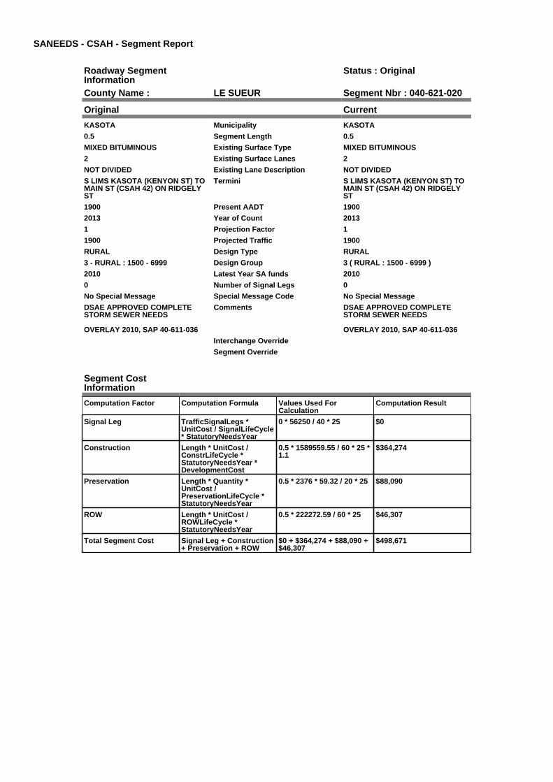
SANEEDS - CSAH - Segment Report
Roadway SegmentInformation
Status : Original
County Name : LE SUEUR Segment Nbr : 040-621-020
Original Current
KASOTA Municipality KASOTA
0.5 Segment Length 0.5
MIXED BITUMINOUS Existing Surface Type MIXED BITUMINOUS
2 Existing Surface Lanes 2
NOT DIVIDED Existing Lane Description NOT DIVIDED
S LIMS KASOTA (KENYON ST) TOMAIN ST (CSAH 42) ON RIDGELYST
Termini S LIMS KASOTA (KENYON ST) TOMAIN ST (CSAH 42) ON RIDGELYST
1900 Present AADT 1900
2013 Year of Count 2013
1 Projection Factor 1
1900 Projected Traffic 1900
RURAL Design Type RURAL
3 - RURAL : 1500 - 6999 Design Group 3 ( RURAL : 1500 - 6999 )
2010 Latest Year SA funds 2010
0 Number of Signal Legs 0
No Special Message Special Message Code No Special Message
DSAE APPROVED COMPLETESTORM SEWER NEEDS
OVERLAY 2010, SAP 40-611-036
Comments DSAE APPROVED COMPLETESTORM SEWER NEEDS
OVERLAY 2010, SAP 40-611-036
Interchange Override
Segment Override
Segment CostInformation
Computation Factor Computation Formula Values Used ForCalculation
Computation Result
Signal Leg TrafficSignalLegs *UnitCost / SignalLifeCycle* StatutoryNeedsYear
0 * 56250 / 40 * 25 $0
Construction Length * UnitCost /ConstrLifeCycle *StatutoryNeedsYear *DevelopmentCost
0.5 * 1589559.55 / 60 * 25 *1.1
$364,274
Preservation Length * Quantity *UnitCost /PreservationLifeCycle *StatutoryNeedsYear
0.5 * 2376 * 59.32 / 20 * 25 $88,090
ROW Length * UnitCost /ROWLifeCycle *StatutoryNeedsYear
0.5 * 222272.59 / 60 * 25 $46,307
Total Segment Cost Signal Leg + Construction+ Preservation + ROW
$0 + $364,274 + $88,090 +$46,307
$498,671
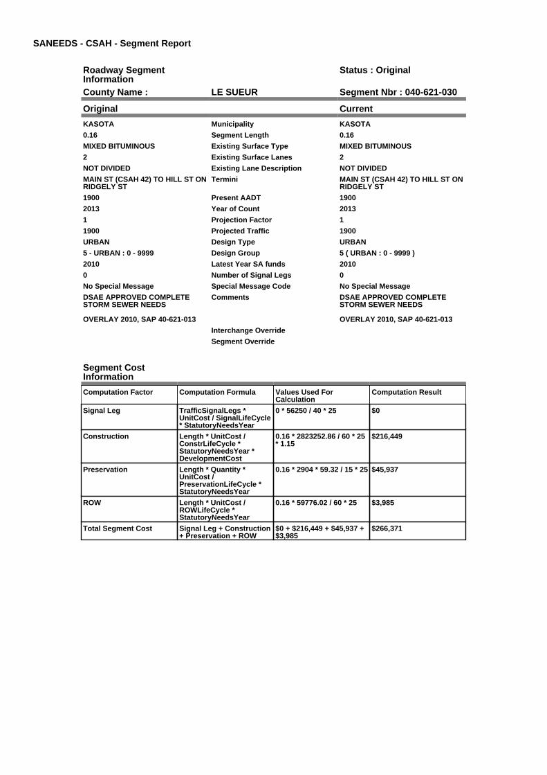
SANEEDS - CSAH - Segment Report
Roadway SegmentInformation
Status : Original
County Name : LE SUEUR Segment Nbr : 040-621-030
Original Current
KASOTA Municipality KASOTA
0.16 Segment Length 0.16
MIXED BITUMINOUS Existing Surface Type MIXED BITUMINOUS
2 Existing Surface Lanes 2
NOT DIVIDED Existing Lane Description NOT DIVIDED
MAIN ST (CSAH 42) TO HILL ST ONRIDGELY ST
Termini MAIN ST (CSAH 42) TO HILL ST ONRIDGELY ST
1900 Present AADT 1900
2013 Year of Count 2013
1 Projection Factor 1
1900 Projected Traffic 1900
URBAN Design Type URBAN
5 - URBAN : 0 - 9999 Design Group 5 ( URBAN : 0 - 9999 )
2010 Latest Year SA funds 2010
0 Number of Signal Legs 0
No Special Message Special Message Code No Special Message
DSAE APPROVED COMPLETESTORM SEWER NEEDS
OVERLAY 2010, SAP 40-621-013
Comments DSAE APPROVED COMPLETESTORM SEWER NEEDS
OVERLAY 2010, SAP 40-621-013
Interchange Override
Segment Override
Segment CostInformation
Computation Factor Computation Formula Values Used ForCalculation
Computation Result
Signal Leg TrafficSignalLegs *UnitCost / SignalLifeCycle* StatutoryNeedsYear
0 * 56250 / 40 * 25 $0
Construction Length * UnitCost /ConstrLifeCycle *StatutoryNeedsYear *DevelopmentCost
0.16 * 2823252.86 / 60 * 25* 1.15
$216,449
Preservation Length * Quantity *UnitCost /PreservationLifeCycle *StatutoryNeedsYear
0.16 * 2904 * 59.32 / 15 * 25 $45,937
ROW Length * UnitCost /ROWLifeCycle *StatutoryNeedsYear
0.16 * 59776.02 / 60 * 25 $3,985
Total Segment Cost Signal Leg + Construction+ Preservation + ROW
$0 + $216,449 + $45,937 +$3,985
$266,371

SANEEDS - CSAH - Segment Report
Roadway SegmentInformation
Status : Original
County Name : LE SUEUR Segment Nbr : 040-621-031
Original Current
KASOTA Municipality KASOTA
0.18 Segment Length 0.18
MIXED BITUMINOUS Existing Surface Type MIXED BITUMINOUS
2 Existing Surface Lanes 2
NOT DIVIDED Existing Lane Description NOT DIVIDED
RIDGELY ST TO MILL ST ON HILLST
Termini RIDGELY ST TO MILL ST ON HILLST
2600 Present AADT 2600
2013 Year of Count 2013
1 Projection Factor 1
2600 Projected Traffic 2600
URBAN Design Type URBAN
5 - URBAN : 0 - 9999 Design Group 5 ( URBAN : 0 - 9999 )
2007 Latest Year SA funds 2007
0 Number of Signal Legs 0
No Special Message Special Message Code No Special Message
NEW BITUMINOUS SURFACE 2007SAP 40-621-12
Comments NEW BITUMINOUS SURFACE 2007SAP 40-621-12
Interchange Override
Segment Override
Segment CostInformation
Computation Factor Computation Formula Values Used ForCalculation
Computation Result
Signal Leg TrafficSignalLegs *UnitCost / SignalLifeCycle* StatutoryNeedsYear
0 * 56250 / 40 * 25 $0
Construction Length * UnitCost /ConstrLifeCycle *StatutoryNeedsYear *DevelopmentCost
0.18 * 2823252.86 / 60 * 25* 1.15
$243,506
Preservation Length * Quantity *UnitCost /PreservationLifeCycle *StatutoryNeedsYear
0.18 * 2904 * 59.32 / 15 * 25 $51,680
ROW Length * UnitCost /ROWLifeCycle *StatutoryNeedsYear
0.18 * 59776.02 / 60 * 25 $4,483
Total Segment Cost Signal Leg + Construction+ Preservation + ROW
$0 + $243,506 + $51,680 +$4,483
$299,669

SANEEDS - CSAH - Segment Report
Roadway SegmentInformation
Status : Original
County Name : LE SUEUR Segment Nbr : 040-621-032
Original Current
KASOTA Municipality KASOTA
0.24 Segment Length 0.24
MIXED BITUMINOUS Existing Surface Type MIXED BITUMINOUS
2 Existing Surface Lanes 2
NOT DIVIDED Existing Lane Description NOT DIVIDED
MILL ST TO E LIMS KASOTA Termini MILL ST TO E LIMS KASOTA
1750 Present AADT 1750
2013 Year of Count 2013
1 Projection Factor 1
1750 Projected Traffic 1750
URBAN Design Type URBAN
5 - URBAN : 0 - 9999 Design Group 5 ( URBAN : 0 - 9999 )
2007 Latest Year SA funds 2007
0 Number of Signal Legs 0
No Special Message Special Message Code No Special Message
NEW BITUMINOUS SURFACE 2007SAP 40-621-12
Comments NEW BITUMINOUS SURFACE 2007SAP 40-621-12
Interchange Override
Segment Override
Culvert Information Status: Original
Original Current
88007 Structure Number 88007
3.97 Milepoint 3.97
1925 Year Built 1925
SHANASKA CREEK Feature Crossed SHANASKA CREEK
STREAM CROSSING Type of Service STREAM CROSSING
1 Number of Barrels 1
10 Culvert Width 10
8 Culvert Height 8
118 Culvert Length 118
80.00053397 Area of Waterway Opening 80.00053397
100% Shared Structure 100%
Comments
1 Culvert Group Code 1
Segment CostInformation
Computation Factor Computation Formula Values Used ForCalculation
Computation Result
Signal Leg TrafficSignalLegs *UnitCost / SignalLifeCycle* StatutoryNeedsYear
0 * 56250 / 40 * 25 $0
Construction Length * UnitCost /ConstrLifeCycle *StatutoryNeedsYear *DevelopmentCost
0.24 * 2823252.86 / 60 * 25* 1.15
$324,674
Preservation Length * Quantity *UnitCost /PreservationLifeCycle *StatutoryNeedsYear
0.24 * 2904 * 59.32 / 15 * 25 $68,906
ROW Length * UnitCost /ROWLifeCycle *StatutoryNeedsYear
0.24 * 59776.02 / 60 * 25 $5,978
Culvert CulvertLength * Area *UnitCost /CulvertLifeCycle *StatutoryNeedsYear *DevelopmentCost
118 * 80.00053397 * 15.47 /100 * 25 * 1.15
$41,986

Total Segment Cost Signal Leg + Construction+ Preservation + ROW +Culvert
$0 + $324,674 + $68,906 +$5,978 + $41,986
$441,544

SANEEDS - CSAH - Segment Report
Roadway SegmentInformation
Status : Original
County Name : LE SUEUR Segment Nbr : 040-621-040
Original Current
Unassigned/Unknown Municipality Unassigned/Unknown
0.2 Segment Length 0.2
MIXED BITUMINOUS Existing Surface Type MIXED BITUMINOUS
2 Existing Surface Lanes 2
NOT DIVIDED Existing Lane Description NOT DIVIDED
E LIMS KASOTA TO TH 22 Termini E LIMS KASOTA TO TH 22
1450 Present AADT 1450
2013 Year of Count 2013
1 Projection Factor 1
1450 Projected Traffic 1450
RURAL Design Type RURAL
2 - RURAL : 150 - 1499 Design Group 2 ( RURAL : 150 - 1499 )
2007 Latest Year SA funds 2007
0 Number of Signal Legs 0
No Special Message Special Message Code No Special Message
NEW BITUMINOUS SURFACE 2007SAP 40-621-12
Comments NEW BITUMINOUS SURFACE 2007SAP 40-621-12
Interchange Override
Segment Override
Segment CostInformation
Computation Factor Computation Formula Values Used ForCalculation
Computation Result
Signal Leg TrafficSignalLegs *UnitCost / SignalLifeCycle* StatutoryNeedsYear
0 * 56250 / 40 * 25 $0
Construction Length * UnitCost /ConstrLifeCycle *StatutoryNeedsYear *DevelopmentCost
0.2 * 801370.7 / 60 * 25 *1.1
$73,459
Preservation Length * Quantity *UnitCost /PreservationLifeCycle *StatutoryNeedsYear
0.2 * 2112 * 59.32 / 20 * 25 $31,321
ROW Length * UnitCost /ROWLifeCycle *StatutoryNeedsYear
0.2 * 36798.68 / 60 * 25 $3,067
Total Segment Cost Signal Leg + Construction+ Preservation + ROW
$0 + $73,459 + $31,321 +$3,067
$107,847

SANEEDS - CSAH - Segment Report
Roadway SegmentInformation
Status : Original
County Name : LE SUEUR Segment Nbr : 040-621-050
Original Current
Unassigned/Unknown Municipality Unassigned/Unknown
1 Segment Length 1
MIXED BITUMINOUS Existing Surface Type MIXED BITUMINOUS
2 Existing Surface Lanes 2
NOT DIVIDED Existing Lane Description NOT DIVIDED
TH 22 TO CSAH 18 Termini TH 22 TO CSAH 18
2200 Present AADT 2200
2013 Year of Count 2013
1 Projection Factor 1
2200 Projected Traffic 2200
RURAL Design Type RURAL
3 - RURAL : 1500 - 6999 Design Group 3 ( RURAL : 1500 - 6999 )
2007 Latest Year SA funds 2007
0 Number of Signal Legs 0
No Special Message Special Message Code No Special Message
CIR AND OVERLAY 2007SAP 40-621-11
Comments CIR AND OVERLAY 2007SAP 40-621-11
Interchange Override
Segment Override
Segment CostInformation
Computation Factor Computation Formula Values Used ForCalculation
Computation Result
Signal Leg TrafficSignalLegs *UnitCost / SignalLifeCycle* StatutoryNeedsYear
0 * 56250 / 40 * 25 $0
Construction Length * UnitCost /ConstrLifeCycle *StatutoryNeedsYear *DevelopmentCost
1 * 1589559.55 / 60 * 25 *1.1
$728,548
Preservation Length * Quantity *UnitCost /PreservationLifeCycle *StatutoryNeedsYear
1 * 2376 * 59.32 / 20 * 25 $176,180
ROW Length * UnitCost /ROWLifeCycle *StatutoryNeedsYear
1 * 222272.59 / 60 * 25 $92,614
Total Segment Cost Signal Leg + Construction+ Preservation + ROW
$0 + $728,548 + $176,180+ $92,614
$997,342

SANEEDS - CSAH - Segment Report
Roadway SegmentInformation
Status : Original
County Name : LE SUEUR Segment Nbr : 040-621-060
Original Current
Unassigned/Unknown Municipality Unassigned/Unknown
2 Segment Length 2
MIXED BITUMINOUS Existing Surface Type MIXED BITUMINOUS
2 Existing Surface Lanes 2
NOT DIVIDED Existing Lane Description NOT DIVIDED
CSAH 18 TO TH 99 Termini CSAH 18 TO TH 99
2200 Present AADT 2200
2013 Year of Count 2013
1 Projection Factor 1
2200 Projected Traffic 2200
RURAL Design Type RURAL
3 - RURAL : 1500 - 6999 Design Group 3 ( RURAL : 1500 - 6999 )
2007 Latest Year SA funds 2007
0 Number of Signal Legs 0
No Special Message Special Message Code No Special Message
CIR AND OVERALY 2007SAP 40-621-11
Comments CIR AND OVERALY 2007SAP 40-621-11
Interchange Override
Segment Override
Segment CostInformation
Computation Factor Computation Formula Values Used ForCalculation
Computation Result
Signal Leg TrafficSignalLegs *UnitCost / SignalLifeCycle* StatutoryNeedsYear
0 * 56250 / 40 * 25 $0
Construction Length * UnitCost /ConstrLifeCycle *StatutoryNeedsYear *DevelopmentCost
2 * 1589559.55 / 60 * 25 *1.1
$1,457,096
Preservation Length * Quantity *UnitCost /PreservationLifeCycle *StatutoryNeedsYear
2 * 2376 * 59.32 / 20 * 25 $352,361
ROW Length * UnitCost /ROWLifeCycle *StatutoryNeedsYear
2 * 222272.59 / 60 * 25 $185,227
Total Segment Cost Signal Leg + Construction+ Preservation + ROW
$0 + $1,457,096 + $352,361+ $185,227
$1,994,684

SANEEDS - CSAH - Segment Report
Roadway SegmentInformation
Status : Original
County Name : LE SUEUR Segment Nbr : 040-623-010
Original Current
Unassigned/Unknown Municipality Unassigned/Unknown
4.73 Segment Length 4.73
MIXED BITUMINOUS Existing Surface Type MIXED BITUMINOUS
2 Existing Surface Lanes 2
NOT DIVIDED Existing Lane Description NOT DIVIDED
TH 99 TO 1.09 MILES S OF 390THSTREET
Termini TH 99 TO 1.09 MILES S OF 390THSTREET
1450 Present AADT 1450
2013 Year of Count 2013
1 Projection Factor 1
1450 Projected Traffic 1450
RURAL Design Type RURAL
2 - RURAL : 150 - 1499 Design Group 2 ( RURAL : 150 - 1499 )
1967 Latest Year SA funds 1967
0 Number of Signal Legs 0
No Special Message Special Message Code No Special Message
SURFACE CONSTRUCTED WITHLOCAL FUNDS IN 2006
Comments SURFACE CONSTRUCTED WITHLOCAL FUNDS IN 2006
Interchange Override
Segment Override
Segment CostInformation
Computation Factor Computation Formula Values Used ForCalculation
Computation Result
Signal Leg TrafficSignalLegs *UnitCost / SignalLifeCycle* StatutoryNeedsYear
0 * 56250 / 40 * 25 $0
Construction Length * UnitCost /ConstrLifeCycle *StatutoryNeedsYear *DevelopmentCost
4.73 * 801370.7 / 60 * 25 *1.1
$1,737,305
Preservation Length * Quantity *UnitCost /PreservationLifeCycle *StatutoryNeedsYear
4.73 * 2112 * 59.32 / 20 * 25 $740,741
ROW Length * UnitCost /ROWLifeCycle *StatutoryNeedsYear
4.73 * 36798.68 / 60 * 25 $72,524
Total Segment Cost Signal Leg + Construction+ Preservation + ROW
$0 + $1,737,305 + $740,741+ $72,524
$2,550,570

SANEEDS - CSAH - Segment Report
Roadway SegmentInformation
Status : Original
County Name : LE SUEUR Segment Nbr : 040-623-030
Original Current
Unassigned/Unknown Municipality Unassigned/Unknown
1.09 Segment Length 1.09
MIXED BITUMINOUS Existing Surface Type MIXED BITUMINOUS
2 Existing Surface Lanes 2
NOT DIVIDED Existing Lane Description NOT DIVIDED
1.09 MILES S OF 390TH ST TO390TH ST (EAST CSAH 23)
Termini 1.09 MILES S OF 390TH ST TO390TH ST (EAST CSAH 23)
1450 Present AADT 1450
2013 Year of Count 2013
1 Projection Factor 1
1450 Projected Traffic 1450
RURAL Design Type RURAL
2 - RURAL : 150 - 1499 Design Group 2 ( RURAL : 150 - 1499 )
2013 Latest Year SA funds 2013
0 Number of Signal Legs 0
No Special Message Special Message Code No Special Message
2013 SAP 040623-013 ERRECONST 0.67M
2012 SAP 040-623-012RECONSTRUCTED IN 2012 WITHLOCAL FUNDS
Comments 2013 SAP 040623-013 ERRECONST 0.67M
2012 SAP 040-623-012RECONSTRUCTED IN 2012 WITHLOCAL FUNDS
Interchange Override
Segment Override
Culvert Information Status: Original
Original Current
40J29 Structure Number 40J29
5.02 Milepoint 5.02
2012 Year Built 2012
Cherry Creek Feature Crossed Cherry Creek
STREAM CROSSING Type of Service STREAM CROSSING
1 Number of Barrels 1
12 Culvert Width 12
9 Culvert Height 9
176 Culvert Length 176
106 Area of Waterway Opening 106
100% Shared Structure 100%
2012 SAP 040-623-012 Comments 2012 SAP 040-623-012
1 Culvert Group Code 1
Segment CostInformation
Computation Factor Computation Formula Values Used ForCalculation
Computation Result
Signal Leg TrafficSignalLegs *UnitCost / SignalLifeCycle* StatutoryNeedsYear
0 * 56250 / 40 * 25 $0
Construction Length * UnitCost /ConstrLifeCycle *StatutoryNeedsYear *DevelopmentCost
1.09 * 801370.7 / 60 * 25 *1.1
$400,351
Preservation Length * Quantity *UnitCost /PreservationLifeCycle *StatutoryNeedsYear
1.09 * 2112 * 59.32 / 20 * 25 $170,699
ROW Length * UnitCost /ROWLifeCycle *StatutoryNeedsYear
1.09 * 36798.68 / 60 * 25 $16,713

Culvert CulvertLength * Area *UnitCost /CulvertLifeCycle *StatutoryNeedsYear *DevelopmentCost
176 * 106 * 15.47 / 100 * 25* 1.15
$82,975
Total Segment Cost Signal Leg + Construction+ Preservation + ROW +Culvert
$0 + $400,351 + $170,699+ $16,713 + $82,975
$670,738

SANEEDS - CSAH - Segment Report
Roadway SegmentInformation
Status : Original
County Name : LE SUEUR Segment Nbr : 040-623-032
Original Current
Unassigned/Unknown Municipality Unassigned/Unknown
0.1 Segment Length 0.1
MIXED BITUMINOUS Existing Surface Type MIXED BITUMINOUS
2 Existing Surface Lanes 2
NOT DIVIDED Existing Lane Description NOT DIVIDED
SOUTH JCT CSAH 23 TO CSAH 36 Termini SOUTH JCT CSAH 23 TO CSAH 36
1450 Present AADT 1450
2013 Year of Count 2013
1 Projection Factor 1
1450 Projected Traffic 1450
RURAL Design Type RURAL
2 - RURAL : 150 - 1499 Design Group 2 ( RURAL : 150 - 1499 )
2000 Latest Year SA funds 2000
0 Number of Signal Legs 0
No Special Message Special Message Code No Special Message
Comments
Interchange Override
Segment Override
Segment CostInformation
Computation Factor Computation Formula Values Used ForCalculation
Computation Result
Signal Leg TrafficSignalLegs *UnitCost / SignalLifeCycle* StatutoryNeedsYear
0 * 56250 / 40 * 25 $0
Construction Length * UnitCost /ConstrLifeCycle *StatutoryNeedsYear *DevelopmentCost
0.1 * 801370.7 / 60 * 25 *1.1
$36,729
Preservation Length * Quantity *UnitCost /PreservationLifeCycle *StatutoryNeedsYear
0.1 * 2112 * 59.32 / 20 * 25 $15,660
ROW Length * UnitCost /ROWLifeCycle *StatutoryNeedsYear
0.1 * 36798.68 / 60 * 25 $1,533
Total Segment Cost Signal Leg + Construction+ Preservation + ROW
$0 + $36,729 + $15,660 +$1,533
$53,922

SANEEDS - CSAH - Segment Report
Roadway SegmentInformation
Status : Original
County Name : LE SUEUR Segment Nbr : 040-623-040
Original Current
Unassigned/Unknown Municipality Unassigned/Unknown
0.44 Segment Length 0.44
DESIG. NON-EXIST Existing Surface Type DESIG. NON-EXIST
2 Existing Surface Lanes 2
NOT DIVIDED Existing Lane Description NOT DIVIDED
CSAH 36 TO EXISITINGPAVEMENT
Termini CSAH 36 TO EXISITINGPAVEMENT
0 Present AADT 0
0 Year of Count 0
1.3 Projection Factor 1.3
0 Projected Traffic 0
RURAL Design Type RURAL
1 - RURAL : 0 - 149 Design Group 1 ( RURAL : 0 - 149 )
2001 Latest Year SA funds 2001
0 Number of Signal Legs 0
No Special Message Special Message Code No Special Message
Comments
Interchange Override
Segment Override
Segment CostInformation
Computation Factor Computation Formula Values Used ForCalculation
Computation Result
Non-Existing Segment If ExistingSurfaceType isDESIG. NON-EXIST, resultis zero
$0
Total Segment Cost Non-Existing Segment $0 $0

SANEEDS - CSAH - Segment Report
Roadway SegmentInformation
Status : Original
County Name : LE SUEUR Segment Nbr : 040-623-050
Original Current
Unassigned/Unknown Municipality Unassigned/Unknown
1.24 Segment Length 1.24
MIXED BITUMINOUS Existing Surface Type MIXED BITUMINOUS
2 Existing Surface Lanes 2
NOT DIVIDED Existing Lane Description NOT DIVIDED
EXISITING ROADWAY ON 390THTO TH 112
Termini EXISITING ROADWAY ON 390THTO TH 112
270 Present AADT 270
2013 Year of Count 2013
1 Projection Factor 1
270 Projected Traffic 270
RURAL Design Type RURAL
2 - RURAL : 150 - 1499 Design Group 2 ( RURAL : 150 - 1499 )
2001 Latest Year SA funds 2001
0 Number of Signal Legs 0
No Special Message Special Message Code No Special Message
Comments
Interchange Override
Segment Override
Segment CostInformation
Computation Factor Computation Formula Values Used ForCalculation
Computation Result
Signal Leg TrafficSignalLegs *UnitCost / SignalLifeCycle* StatutoryNeedsYear
0 * 56250 / 40 * 25 $0
Construction Length * UnitCost /ConstrLifeCycle *StatutoryNeedsYear *DevelopmentCost
1.24 * 801370.7 / 60 * 25 *1.1
$455,446
Preservation Length * Quantity *UnitCost /PreservationLifeCycle *StatutoryNeedsYear
1.24 * 2112 * 59.32 / 20 * 25 $194,190
ROW Length * UnitCost /ROWLifeCycle *StatutoryNeedsYear
1.24 * 36798.68 / 60 * 25 $19,013
Total Segment Cost Signal Leg + Construction+ Preservation + ROW
$0 + $455,446 + $194,190+ $19,013
$668,649

SANEEDS - CSAH - Segment Report
Roadway SegmentInformation
Status : Original
County Name : LE SUEUR Segment Nbr : 040-624-010
Original Current
Unassigned/Unknown Municipality Unassigned/Unknown
5 Segment Length 5
MIXED BITUMINOUS Existing Surface Type MIXED BITUMINOUS
2 Existing Surface Lanes 2
NOT DIVIDED Existing Lane Description NOT DIVIDED
CSAH 15 TO CSAH 11 Termini CSAH 15 TO CSAH 11
415 Present AADT 415
2013 Year of Count 2013
1 Projection Factor 1
415 Projected Traffic 415
RURAL Design Type RURAL
2 - RURAL : 150 - 1499 Design Group 2 ( RURAL : 150 - 1499 )
2008 Latest Year SA funds 2008
0 Number of Signal Legs 0
No Special Message Special Message Code No Special Message
SAP 40-624-03, 2008 MILL &OVERLAY
Comments SAP 40-624-03, 2008 MILL &OVERLAY
Interchange Override
Segment Override
Segment CostInformation
Computation Factor Computation Formula Values Used ForCalculation
Computation Result
Signal Leg TrafficSignalLegs *UnitCost / SignalLifeCycle* StatutoryNeedsYear
0 * 56250 / 40 * 25 $0
Construction Length * UnitCost /ConstrLifeCycle *StatutoryNeedsYear *DevelopmentCost
5 * 801370.7 / 60 * 25 * 1.1 $1,836,475
Preservation Length * Quantity *UnitCost /PreservationLifeCycle *StatutoryNeedsYear
5 * 2112 * 59.32 / 20 * 25 $783,024
ROW Length * UnitCost /ROWLifeCycle *StatutoryNeedsYear
5 * 36798.68 / 60 * 25 $76,664
Total Segment Cost Signal Leg + Construction+ Preservation + ROW
$0 + $1,836,475 + $783,024+ $76,664
$2,696,163

SANEEDS - CSAH - Segment Report
Roadway SegmentInformation
Status : Original
County Name : LE SUEUR Segment Nbr : 040-626-010
Original Current
LE SUEUR Municipality LE SUEUR
0.1 Segment Length 0.1
MIXED BITUMINOUS Existing Surface Type MIXED BITUMINOUS
2 Existing Surface Lanes 2
NOT DIVIDED Existing Lane Description NOT DIVIDED
TH 112 TO PARK LANE ON FERRYSTREET
Termini TH 112 TO PARK LANE ON FERRYSTREET
4150 Present AADT 4150
2013 Year of Count 2013
1 Projection Factor 1
4150 Projected Traffic 4150
URBAN Design Type URBAN
5 - URBAN : 0 - 9999 Design Group 5 ( URBAN : 0 - 9999 )
1986 Latest Year SA funds 1986
0 Number of Signal Legs 0
No Special Message Special Message Code No Special Message
Comments
Interchange Override
Segment Override
Segment CostInformation
Computation Factor Computation Formula Values Used ForCalculation
Computation Result
Signal Leg TrafficSignalLegs *UnitCost / SignalLifeCycle* StatutoryNeedsYear
0 * 56250 / 40 * 25 $0
Construction Length * UnitCost /ConstrLifeCycle *StatutoryNeedsYear *DevelopmentCost
0.1 * 2823252.86 / 60 * 25 *1.15
$135,281
Preservation Length * Quantity *UnitCost /PreservationLifeCycle *StatutoryNeedsYear
0.1 * 2904 * 59.32 / 15 * 25 $28,711
ROW Length * UnitCost /ROWLifeCycle *StatutoryNeedsYear
0.1 * 59776.02 / 60 * 25 $2,491
Total Segment Cost Signal Leg + Construction+ Preservation + ROW
$0 + $135,281 + $28,711 +$2,491
$166,483

SANEEDS - CSAH - Segment Report
Roadway SegmentInformation
Status : Original
County Name : LE SUEUR Segment Nbr : 040-626-020
Original Current
LE SUEUR Municipality LE SUEUR
0.4 Segment Length 0.4
MIXED BITUMINOUS Existing Surface Type MIXED BITUMINOUS
2 Existing Surface Lanes 2
NOT DIVIDED Existing Lane Description NOT DIVIDED
PARK LANE TO KINGSWAY DRIVE(CSAH 35) ON FERRY STREET
Termini PARK LANE TO KINGSWAY DRIVE(CSAH 35) ON FERRY STREET
3000 Present AADT 3000
2013 Year of Count 2013
1 Projection Factor 1
3000 Projected Traffic 3000
URBAN Design Type URBAN
5 - URBAN : 0 - 9999 Design Group 5 ( URBAN : 0 - 9999 )
1968 Latest Year SA funds 1968
0 Number of Signal Legs 0
No Special Message Special Message Code No Special Message
COMBINED SEGMENTS 020 & 030TOOK WEIGHTED AVERAGE OFGRADING COSTS
Comments COMBINED SEGMENTS 020 & 030TOOK WEIGHTED AVERAGE OFGRADING COSTS
Interchange Override
Segment Override
Segment CostInformation
Computation Factor Computation Formula Values Used ForCalculation
Computation Result
Signal Leg TrafficSignalLegs *UnitCost / SignalLifeCycle* StatutoryNeedsYear
0 * 56250 / 40 * 25 $0
Construction Length * UnitCost /ConstrLifeCycle *StatutoryNeedsYear *DevelopmentCost
0.4 * 2823252.86 / 60 * 25 *1.15
$541,123
Preservation Length * Quantity *UnitCost /PreservationLifeCycle *StatutoryNeedsYear
0.4 * 2904 * 59.32 / 15 * 25 $114,844
ROW Length * UnitCost /ROWLifeCycle *StatutoryNeedsYear
0.4 * 59776.02 / 60 * 25 $9,963
Total Segment Cost Signal Leg + Construction+ Preservation + ROW
$0 + $541,123 + $114,844+ $9,963
$665,930

SANEEDS - CSAH - Segment Report
Roadway SegmentInformation
Status : Original
County Name : LE SUEUR Segment Nbr : 040-626-031
Original Current
LE SUEUR Municipality LE SUEUR
0.3 Segment Length 0.3
MIXED BITUMINOUS Existing Surface Type MIXED BITUMINOUS
2 Existing Surface Lanes 2
NOT DIVIDED Existing Lane Description NOT DIVIDED
KINGSWAY DR (CSAH 35) TO ELIMS LESUEUR ON FERRY ST
Termini KINGSWAY DR (CSAH 35) TO ELIMS LESUEUR ON FERRY ST
1900 Present AADT 1900
2013 Year of Count 2013
1 Projection Factor 1
1900 Projected Traffic 1900
RURAL Design Type RURAL
3 - RURAL : 1500 - 6999 Design Group 3 ( RURAL : 1500 - 6999 )
1997 Latest Year SA funds 1997
0 Number of Signal Legs 0
No Special Message Special Message Code No Special Message
Comments
Interchange Override
Segment Override
Segment CostInformation
Computation Factor Computation Formula Values Used ForCalculation
Computation Result
Signal Leg TrafficSignalLegs *UnitCost / SignalLifeCycle* StatutoryNeedsYear
0 * 56250 / 40 * 25 $0
Construction Length * UnitCost /ConstrLifeCycle *StatutoryNeedsYear *DevelopmentCost
0.3 * 1589559.55 / 60 * 25 *1.1
$218,564
Preservation Length * Quantity *UnitCost /PreservationLifeCycle *StatutoryNeedsYear
0.3 * 2376 * 59.32 / 20 * 25 $52,854
ROW Length * UnitCost /ROWLifeCycle *StatutoryNeedsYear
0.3 * 222272.59 / 60 * 25 $27,784
Total Segment Cost Signal Leg + Construction+ Preservation + ROW
$0 + $218,564 + $52,854 +$27,784
$299,202
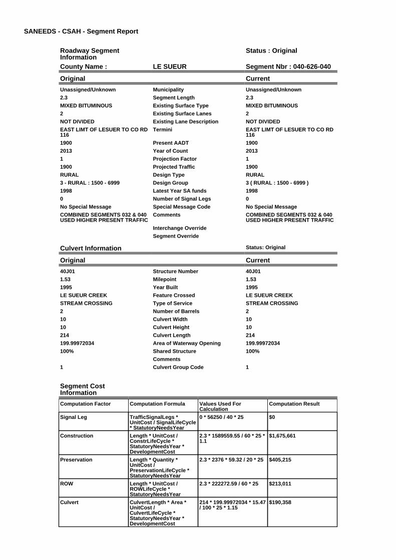
SANEEDS - CSAH - Segment Report
Roadway SegmentInformation
Status : Original
County Name : LE SUEUR Segment Nbr : 040-626-040
Original Current
Unassigned/Unknown Municipality Unassigned/Unknown
2.3 Segment Length 2.3
MIXED BITUMINOUS Existing Surface Type MIXED BITUMINOUS
2 Existing Surface Lanes 2
NOT DIVIDED Existing Lane Description NOT DIVIDED
EAST LIMT OF LESUER TO CO RD116
Termini EAST LIMT OF LESUER TO CO RD116
1900 Present AADT 1900
2013 Year of Count 2013
1 Projection Factor 1
1900 Projected Traffic 1900
RURAL Design Type RURAL
3 - RURAL : 1500 - 6999 Design Group 3 ( RURAL : 1500 - 6999 )
1998 Latest Year SA funds 1998
0 Number of Signal Legs 0
No Special Message Special Message Code No Special Message
COMBINED SEGMENTS 032 & 040USED HIGHER PRESENT TRAFFIC
Comments COMBINED SEGMENTS 032 & 040USED HIGHER PRESENT TRAFFIC
Interchange Override
Segment Override
Culvert Information Status: Original
Original Current
40J01 Structure Number 40J01
1.53 Milepoint 1.53
1995 Year Built 1995
LE SUEUR CREEK Feature Crossed LE SUEUR CREEK
STREAM CROSSING Type of Service STREAM CROSSING
2 Number of Barrels 2
10 Culvert Width 10
10 Culvert Height 10
214 Culvert Length 214
199.99972034 Area of Waterway Opening 199.99972034
100% Shared Structure 100%
Comments
1 Culvert Group Code 1
Segment CostInformation
Computation Factor Computation Formula Values Used ForCalculation
Computation Result
Signal Leg TrafficSignalLegs *UnitCost / SignalLifeCycle* StatutoryNeedsYear
0 * 56250 / 40 * 25 $0
Construction Length * UnitCost /ConstrLifeCycle *StatutoryNeedsYear *DevelopmentCost
2.3 * 1589559.55 / 60 * 25 *1.1
$1,675,661
Preservation Length * Quantity *UnitCost /PreservationLifeCycle *StatutoryNeedsYear
2.3 * 2376 * 59.32 / 20 * 25 $405,215
ROW Length * UnitCost /ROWLifeCycle *StatutoryNeedsYear
2.3 * 222272.59 / 60 * 25 $213,011
Culvert CulvertLength * Area *UnitCost /CulvertLifeCycle *StatutoryNeedsYear *DevelopmentCost
214 * 199.99972034 * 15.47/ 100 * 25 * 1.15
$190,358

Total Segment Cost Signal Leg + Construction+ Preservation + ROW +Culvert
$0 + $1,675,661 + $405,215+ $213,011 + $190,358
$2,484,245
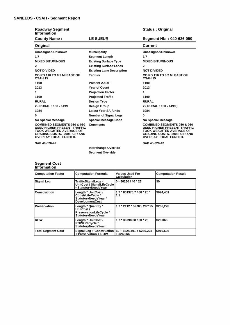
SANEEDS - CSAH - Segment Report
Roadway SegmentInformation
Status : Original
County Name : LE SUEUR Segment Nbr : 040-626-050
Original Current
Unassigned/Unknown Municipality Unassigned/Unknown
1.7 Segment Length 1.7
MIXED BITUMINOUS Existing Surface Type MIXED BITUMINOUS
2 Existing Surface Lanes 2
NOT DIVIDED Existing Lane Description NOT DIVIDED
CO RD 116 TO 0.2 MI EAST OFCSAH 15
Termini CO RD 116 TO 0.2 MI EAST OFCSAH 15
1100 Present AADT 1100
2013 Year of Count 2013
1 Projection Factor 1
1100 Projected Traffic 1100
RURAL Design Type RURAL
2 - RURAL : 150 - 1499 Design Group 2 ( RURAL : 150 - 1499 )
1984 Latest Year SA funds 1984
0 Number of Signal Legs 0
No Special Message Special Message Code No Special Message
COMBINED SEGMENTS 050 & 060USED HIGHER PRESENT TRAFFICTOOK WEIGHTED AVERAGE OFGRADING COSTS. 2008: CIR ANDOVERLAY LOCAL FUNDED.
SAP 40-626-42
Comments COMBINED SEGMENTS 050 & 060USED HIGHER PRESENT TRAFFICTOOK WEIGHTED AVERAGE OFGRADING COSTS. 2008: CIR ANDOVERLAY LOCAL FUNDED.
SAP 40-626-42
Interchange Override
Segment Override
Segment CostInformation
Computation Factor Computation Formula Values Used ForCalculation
Computation Result
Signal Leg TrafficSignalLegs *UnitCost / SignalLifeCycle* StatutoryNeedsYear
0 * 56250 / 40 * 25 $0
Construction Length * UnitCost /ConstrLifeCycle *StatutoryNeedsYear *DevelopmentCost
1.7 * 801370.7 / 60 * 25 *1.1
$624,401
Preservation Length * Quantity *UnitCost /PreservationLifeCycle *StatutoryNeedsYear
1.7 * 2112 * 59.32 / 20 * 25 $266,228
ROW Length * UnitCost /ROWLifeCycle *StatutoryNeedsYear
1.7 * 36798.68 / 60 * 25 $26,066
Total Segment Cost Signal Leg + Construction+ Preservation + ROW
$0 + $624,401 + $266,228+ $26,066
$916,695

SANEEDS - CSAH - Segment Report
Roadway SegmentInformation
Status : Original
County Name : LE SUEUR Segment Nbr : 040-626-061
Original Current
Unassigned/Unknown Municipality Unassigned/Unknown
3.5 Segment Length 3.5
MIXED BITUMINOUS Existing Surface Type MIXED BITUMINOUS
2 Existing Surface Lanes 2
NOT DIVIDED Existing Lane Description NOT DIVIDED
0.2 MI E OF CSAH 15 TO WEST JCTOF CSAH 11
Termini 0.2 MI E OF CSAH 15 TO WEST JCTOF CSAH 11
1050 Present AADT 1050
2013 Year of Count 2013
1 Projection Factor 1
1050 Projected Traffic 1050
RURAL Design Type RURAL
2 - RURAL : 150 - 1499 Design Group 2 ( RURAL : 150 - 1499 )
2015 Latest Year SA funds 2015
0 Number of Signal Legs 0
No Special Message Special Message Code No Special Message
2015 SAP 040-626-044MICROSURFACING
Comments 2015 SAP 040-626-044MICROSURFACING
Interchange Override
Segment Override
Segment CostInformation
Computation Factor Computation Formula Values Used ForCalculation
Computation Result
Signal Leg TrafficSignalLegs *UnitCost / SignalLifeCycle* StatutoryNeedsYear
0 * 56250 / 40 * 25 $0
Construction Length * UnitCost /ConstrLifeCycle *StatutoryNeedsYear *DevelopmentCost
3.5 * 801370.7 / 60 * 25 *1.1
$1,285,532
Preservation Length * Quantity *UnitCost /PreservationLifeCycle *StatutoryNeedsYear
3.5 * 2112 * 59.32 / 20 * 25 $548,117
ROW Length * UnitCost /ROWLifeCycle *StatutoryNeedsYear
3.5 * 36798.68 / 60 * 25 $53,665
Total Segment Cost Signal Leg + Construction+ Preservation + ROW
$0 + $1,285,532 + $548,117+ $53,665
$1,887,314

SANEEDS - CSAH - Segment Report
Roadway SegmentInformation
Status : Original
County Name : LE SUEUR Segment Nbr : 040-626-070
Original Current
Unassigned/Unknown Municipality Unassigned/Unknown
0.3 Segment Length 0.3
MIXED BITUMINOUS Existing Surface Type MIXED BITUMINOUS
2 Existing Surface Lanes 2
NOT DIVIDED Existing Lane Description NOT DIVIDED
W JCT CSAH 11 TO E JCT CSAH 11 Termini W JCT CSAH 11 TO E JCT CSAH 11
810 Present AADT 810
2013 Year of Count 2013
1 Projection Factor 1
810 Projected Traffic 810
RURAL Design Type RURAL
2 - RURAL : 150 - 1499 Design Group 2 ( RURAL : 150 - 1499 )
2015 Latest Year SA funds 2015
0 Number of Signal Legs 0
No Special Message Special Message Code No Special Message
2015 SAP 040-626-044MICROSURFACING
SHLD WIDEN AND OL IN 2001
Comments 2015 SAP 040-626-044MICROSURFACING
SHLD WIDEN AND OL IN 2001
Interchange Override
Segment Override
Segment CostInformation
Computation Factor Computation Formula Values Used ForCalculation
Computation Result
Signal Leg TrafficSignalLegs *UnitCost / SignalLifeCycle* StatutoryNeedsYear
0 * 56250 / 40 * 25 $0
Construction Length * UnitCost /ConstrLifeCycle *StatutoryNeedsYear *DevelopmentCost
0.3 * 801370.7 / 60 * 25 *1.1
$110,188
Preservation Length * Quantity *UnitCost /PreservationLifeCycle *StatutoryNeedsYear
0.3 * 2112 * 59.32 / 20 * 25 $46,981
ROW Length * UnitCost /ROWLifeCycle *StatutoryNeedsYear
0.3 * 36798.68 / 60 * 25 $4,600
Total Segment Cost Signal Leg + Construction+ Preservation + ROW
$0 + $110,188 + $46,981 +$4,600
$161,769

SANEEDS - CSAH - Segment Report
Roadway SegmentInformation
Status : Original
County Name : LE SUEUR Segment Nbr : 040-626-080
Original Current
Unassigned/Unknown Municipality Unassigned/Unknown
2 Segment Length 2
MIXED BITUMINOUS Existing Surface Type MIXED BITUMINOUS
2 Existing Surface Lanes 2
NOT DIVIDED Existing Lane Description NOT DIVIDED
EAST JCT CSAH 11 TO WEST JCTCSAH 32
Termini EAST JCT CSAH 11 TO WEST JCTCSAH 32
1300 Present AADT 1300
2013 Year of Count 2013
1 Projection Factor 1
1300 Projected Traffic 1300
RURAL Design Type RURAL
2 - RURAL : 150 - 1499 Design Group 2 ( RURAL : 150 - 1499 )
2015 Latest Year SA funds 2015
0 Number of Signal Legs 0
No Special Message Special Message Code No Special Message
2015 SAP 040-626-044MICROSURFACING
Comments 2015 SAP 040-626-044MICROSURFACING
Interchange Override
Segment Override
Segment CostInformation
Computation Factor Computation Formula Values Used ForCalculation
Computation Result
Signal Leg TrafficSignalLegs *UnitCost / SignalLifeCycle* StatutoryNeedsYear
0 * 56250 / 40 * 25 $0
Construction Length * UnitCost /ConstrLifeCycle *StatutoryNeedsYear *DevelopmentCost
2 * 801370.7 / 60 * 25 * 1.1 $734,590
Preservation Length * Quantity *UnitCost /PreservationLifeCycle *StatutoryNeedsYear
2 * 2112 * 59.32 / 20 * 25 $313,210
ROW Length * UnitCost /ROWLifeCycle *StatutoryNeedsYear
2 * 36798.68 / 60 * 25 $30,666
Total Segment Cost Signal Leg + Construction+ Preservation + ROW
$0 + $734,590 + $313,210+ $30,666
$1,078,466

SANEEDS - CSAH - Segment Report
Roadway SegmentInformation
Status : Original
County Name : LE SUEUR Segment Nbr : 040-626-081
Original Current
Unassigned/Unknown Municipality Unassigned/Unknown
0.2 Segment Length 0.2
MIXED BITUMINOUS Existing Surface Type MIXED BITUMINOUS
2 Existing Surface Lanes 2
NOT DIVIDED Existing Lane Description NOT DIVIDED
WEST JCT CSAH 32 TO 0.05 MI WOF CR 121
Termini WEST JCT CSAH 32 TO 0.05 MI WOF CR 121
1300 Present AADT 1300
2013 Year of Count 2013
1 Projection Factor 1
1300 Projected Traffic 1300
RURAL Design Type RURAL
2 - RURAL : 150 - 1499 Design Group 2 ( RURAL : 150 - 1499 )
2001 Latest Year SA funds 2001
0 Number of Signal Legs 0
No Special Message Special Message Code No Special Message
Comments
Interchange Override
Segment Override
Segment CostInformation
Computation Factor Computation Formula Values Used ForCalculation
Computation Result
Signal Leg TrafficSignalLegs *UnitCost / SignalLifeCycle* StatutoryNeedsYear
0 * 56250 / 40 * 25 $0
Construction Length * UnitCost /ConstrLifeCycle *StatutoryNeedsYear *DevelopmentCost
0.2 * 801370.7 / 60 * 25 *1.1
$73,459
Preservation Length * Quantity *UnitCost /PreservationLifeCycle *StatutoryNeedsYear
0.2 * 2112 * 59.32 / 20 * 25 $31,321
ROW Length * UnitCost /ROWLifeCycle *StatutoryNeedsYear
0.2 * 36798.68 / 60 * 25 $3,067
Total Segment Cost Signal Leg + Construction+ Preservation + ROW
$0 + $73,459 + $31,321 +$3,067
$107,847

SANEEDS - CSAH - Segment Report
Roadway SegmentInformation
Status : Original
County Name : LE SUEUR Segment Nbr : 040-626-082
Original Current
Unassigned/Unknown Municipality Unassigned/Unknown
0.1 Segment Length 0.1
MIXED BITUMINOUS Existing Surface Type MIXED BITUMINOUS
2 Existing Surface Lanes 2
NOT DIVIDED Existing Lane Description NOT DIVIDED
0.05 MI W TO 0.05 MI E OF CR 121IN LEXINGTON
Termini 0.05 MI W TO 0.05 MI E OF CR 121IN LEXINGTON
1300 Present AADT 1300
2013 Year of Count 2013
1 Projection Factor 1
1300 Projected Traffic 1300
URBAN Design Type URBAN
5 - URBAN : 0 - 9999 Design Group 5 ( URBAN : 0 - 9999 )
2001 Latest Year SA funds 2001
0 Number of Signal Legs 0
No Special Message Special Message Code No Special Message
Comments
Interchange Override
Segment Override
Segment CostInformation
Computation Factor Computation Formula Values Used ForCalculation
Computation Result
Signal Leg TrafficSignalLegs *UnitCost / SignalLifeCycle* StatutoryNeedsYear
0 * 56250 / 40 * 25 $0
Construction Length * UnitCost /ConstrLifeCycle *StatutoryNeedsYear *DevelopmentCost
0.1 * 2823252.86 / 60 * 25 *1.15
$135,281
Preservation Length * Quantity *UnitCost /PreservationLifeCycle *StatutoryNeedsYear
0.1 * 2904 * 59.32 / 15 * 25 $28,711
ROW Length * UnitCost /ROWLifeCycle *StatutoryNeedsYear
0.1 * 59776.02 / 60 * 25 $2,491
Total Segment Cost Signal Leg + Construction+ Preservation + ROW
$0 + $135,281 + $28,711 +$2,491
$166,483

SANEEDS - CSAH - Segment Report
Roadway SegmentInformation
Status : Original
County Name : LE SUEUR Segment Nbr : 040-626-083
Original Current
Unassigned/Unknown Municipality Unassigned/Unknown
0.6 Segment Length 0.6
MIXED BITUMINOUS Existing Surface Type MIXED BITUMINOUS
2 Existing Surface Lanes 2
NOT DIVIDED Existing Lane Description NOT DIVIDED
0.05 MI E CR 121 TO 0.20 MI WCSAH 5
Termini 0.05 MI E CR 121 TO 0.20 MI WCSAH 5
1300 Present AADT 1300
2013 Year of Count 2013
1 Projection Factor 1
1300 Projected Traffic 1300
RURAL Design Type RURAL
2 - RURAL : 150 - 1499 Design Group 2 ( RURAL : 150 - 1499 )
2001 Latest Year SA funds 2001
0 Number of Signal Legs 0
No Special Message Special Message Code No Special Message
Comments
Interchange Override
Segment Override
Segment CostInformation
Computation Factor Computation Formula Values Used ForCalculation
Computation Result
Signal Leg TrafficSignalLegs *UnitCost / SignalLifeCycle* StatutoryNeedsYear
0 * 56250 / 40 * 25 $0
Construction Length * UnitCost /ConstrLifeCycle *StatutoryNeedsYear *DevelopmentCost
0.6 * 801370.7 / 60 * 25 *1.1
$220,377
Preservation Length * Quantity *UnitCost /PreservationLifeCycle *StatutoryNeedsYear
0.6 * 2112 * 59.32 / 20 * 25 $93,963
ROW Length * UnitCost /ROWLifeCycle *StatutoryNeedsYear
0.6 * 36798.68 / 60 * 25 $9,200
Total Segment Cost Signal Leg + Construction+ Preservation + ROW
$0 + $220,377 + $93,963 +$9,200
$323,540

SANEEDS - CSAH - Segment Report
Roadway SegmentInformation
Status : Original
County Name : LE SUEUR Segment Nbr : 040-626-090
Original Current
Unassigned/Unknown Municipality Unassigned/Unknown
2.9 Segment Length 2.9
MIXED BITUMINOUS Existing Surface Type MIXED BITUMINOUS
2 Existing Surface Lanes 2
NOT DIVIDED Existing Lane Description NOT DIVIDED
0.2 MI W OF CSAH 5 TO CO RD 136 Termini 0.2 MI W OF CSAH 5 TO CO RD 136
1300 Present AADT 1300
2013 Year of Count 2013
1 Projection Factor 1
1300 Projected Traffic 1300
RURAL Design Type RURAL
2 - RURAL : 150 - 1499 Design Group 2 ( RURAL : 150 - 1499 )
1993 Latest Year SA funds 1993
0 Number of Signal Legs 0
No Special Message Special Message Code No Special Message
Comments
Interchange Override
Segment Override
Culvert Information Status: Original
Original Current
95055 Structure Number 95055
11.53 Milepoint 11.53
1978 Year Built 1978
CO DITCH # 42 Feature Crossed CO DITCH # 42
STREAM CROSSING Type of Service STREAM CROSSING
1 Number of Barrels 1
12 Culvert Width 12
8 Culvert Height 8
100 Culvert Length 100
65.99992924 Area of Waterway Opening 65.99992924
100% Shared Structure 100%
Comments
1 Culvert Group Code 1
Segment CostInformation
Computation Factor Computation Formula Values Used ForCalculation
Computation Result
Signal Leg TrafficSignalLegs *UnitCost / SignalLifeCycle* StatutoryNeedsYear
0 * 56250 / 40 * 25 $0
Construction Length * UnitCost /ConstrLifeCycle *StatutoryNeedsYear *DevelopmentCost
2.9 * 801370.7 / 60 * 25 *1.1
$1,065,155
Preservation Length * Quantity *UnitCost /PreservationLifeCycle *StatutoryNeedsYear
2.9 * 2112 * 59.32 / 20 * 25 $454,154
ROW Length * UnitCost /ROWLifeCycle *StatutoryNeedsYear
2.9 * 36798.68 / 60 * 25 $44,465
Culvert CulvertLength * Area *UnitCost /CulvertLifeCycle *StatutoryNeedsYear *DevelopmentCost
100 * 65.99992924 * 15.47 /100 * 25 * 1.15
$29,354
Total Segment Cost Signal Leg + Construction+ Preservation + ROW +Culvert
$0 + $1,065,155 + $454,154+ $44,465 + $29,354
$1,593,128

SANEEDS - CSAH - Segment Report
Roadway SegmentInformation
Status : Original
County Name : LE SUEUR Segment Nbr : 040-626-100
Original Current
Unassigned/Unknown Municipality Unassigned/Unknown
2.8 Segment Length 2.8
MIXED BITUMINOUS Existing Surface Type MIXED BITUMINOUS
2 Existing Surface Lanes 2
NOT DIVIDED Existing Lane Description NOT DIVIDED
CO ROAD 136 TO W LIMMONTGOMERY
Termini CO ROAD 136 TO W LIMMONTGOMERY
1600 Present AADT 1600
2013 Year of Count 2013
1 Projection Factor 1
1600 Projected Traffic 1600
RURAL Design Type RURAL
3 - RURAL : 1500 - 6999 Design Group 3 ( RURAL : 1500 - 6999 )
2000 Latest Year SA funds 2000
0 Number of Signal Legs 0
No Special Message Special Message Code No Special Message
Comments
Interchange Override
Segment Override
Segment CostInformation
Computation Factor Computation Formula Values Used ForCalculation
Computation Result
Signal Leg TrafficSignalLegs *UnitCost / SignalLifeCycle* StatutoryNeedsYear
0 * 56250 / 40 * 25 $0
Construction Length * UnitCost /ConstrLifeCycle *StatutoryNeedsYear *DevelopmentCost
2.8 * 1589559.55 / 60 * 25 *1.1
$2,039,935
Preservation Length * Quantity *UnitCost /PreservationLifeCycle *StatutoryNeedsYear
2.8 * 2376 * 59.32 / 20 * 25 $493,305
ROW Length * UnitCost /ROWLifeCycle *StatutoryNeedsYear
2.8 * 222272.59 / 60 * 25 $259,318
Total Segment Cost Signal Leg + Construction+ Preservation + ROW
$0 + $2,039,935 + $493,305+ $259,318
$2,792,558

SANEEDS - CSAH - Segment Report
Roadway SegmentInformation
Status : Original
County Name : LE SUEUR Segment Nbr : 040-626-110
Original Current
MONTGOMERY Municipality MONTGOMERY
0.26 Segment Length 0.26
MIXED BITUMINOUS Existing Surface Type MIXED BITUMINOUS
2 Existing Surface Lanes 2
NOT DIVIDED Existing Lane Description NOT DIVIDED
WEST LIMITS OF MONTGOMERYTO TH 13 ON LEXINGTON AVE
Termini WEST LIMITS OF MONTGOMERYTO TH 13 ON LEXINGTON AVE
1600 Present AADT 1600
2013 Year of Count 2013
1 Projection Factor 1
1600 Projected Traffic 1600
URBAN Design Type URBAN
5 - URBAN : 0 - 9999 Design Group 5 ( URBAN : 0 - 9999 )
2003 Latest Year SA funds 2003
0 Number of Signal Legs 0
No Special Message Special Message Code No Special Message
Comments
Interchange Override
Segment Override
Segment CostInformation
Computation Factor Computation Formula Values Used ForCalculation
Computation Result
Signal Leg TrafficSignalLegs *UnitCost / SignalLifeCycle* StatutoryNeedsYear
0 * 56250 / 40 * 25 $0
Construction Length * UnitCost /ConstrLifeCycle *StatutoryNeedsYear *DevelopmentCost
0.26 * 2823252.86 / 60 * 25* 1.15
$351,730
Preservation Length * Quantity *UnitCost /PreservationLifeCycle *StatutoryNeedsYear
0.26 * 2904 * 59.32 / 15 * 25 $74,648
ROW Length * UnitCost /ROWLifeCycle *StatutoryNeedsYear
0.26 * 59776.02 / 60 * 25 $6,476
Total Segment Cost Signal Leg + Construction+ Preservation + ROW
$0 + $351,730 + $74,648 +$6,476
$432,854

SANEEDS - CSAH - Segment Report
Roadway SegmentInformation
Status : Original
County Name : LE SUEUR Segment Nbr : 040-626-121
Original Current
MONTGOMERY Municipality MONTGOMERY
0.21 Segment Length 0.21
MIXED BITUMINOUS Existing Surface Type MIXED BITUMINOUS
2 Existing Surface Lanes 2
NOT DIVIDED Existing Lane Description NOT DIVIDED
TH 13 TO UP RR ON BOULVARDAVE
Termini TH 13 TO UP RR ON BOULVARDAVE
3250 Present AADT 3250
2013 Year of Count 2013
1 Projection Factor 1
3250 Projected Traffic 3250
URBAN Design Type URBAN
5 - URBAN : 0 - 9999 Design Group 5 ( URBAN : 0 - 9999 )
1996 Latest Year SA funds 1996
0 Number of Signal Legs 0
No Special Message Special Message Code No Special Message
Comments
Interchange Override
Segment Override
RailRoadCrossingInformation
Status: Original
Original Current
UNION PACIFIC RAILROAD RailRoad Name UNION PACIFIC RAILROAD
195769R USDOT Number 195769R
0.2 Located at Milepoint 0.2
1 Mainline Tracks 1
SIGNS ONLY Protection Type SIGNS ONLY
Last Year Protection Upgraded
48 Crossing Length 48
Last Year Surfaced
100% Percentage of Cost 100%
Comments
Segment CostInformation
Computation Factor Computation Formula Values Used ForCalculation
Computation Result
Signal Leg TrafficSignalLegs *UnitCost / SignalLifeCycle* StatutoryNeedsYear
0 * 56250 / 40 * 25 $0
Construction Length * UnitCost /ConstrLifeCycle *StatutoryNeedsYear *DevelopmentCost
0.21 * 2823252.86 / 60 * 25* 1.15
$284,090
Preservation Length * Quantity *UnitCost /PreservationLifeCycle *StatutoryNeedsYear
0.21 * 2904 * 59.32 / 15 * 25 $60,293
ROW Length * UnitCost /ROWLifeCycle *StatutoryNeedsYear
0.21 * 59776.02 / 60 * 25 $5,230
RR Crossing Protection UnitCost /RRCrossingLifeCycle *StatutoryNeedsYear
1500 / 25 * 25 $1,500
RR Crossing Surface SurfaceLength * UnitCost/ RRCrossingLifeCycle *StatutoryNeedsYear
48 * 1350 / 25 * 25 $64,800
Total Segment Cost Signal Leg + Construction+ Preservation + ROW +RR Crossing Protection +RR Crossing Surface
$0 + $284,090 + $60,293 +$5,230 + $1,500 + $64,800
$415,913

SANEEDS - CSAH - Segment Report
Roadway SegmentInformation
Status : Original
County Name : LE SUEUR Segment Nbr : 040-626-130
Original Current
MONTGOMERY Municipality MONTGOMERY
0.3 Segment Length 0.3
MIXED BITUMINOUS Existing Surface Type MIXED BITUMINOUS
2 Existing Surface Lanes 2
NOT DIVIDED Existing Lane Description NOT DIVIDED
UP RR TO 5TH STREET (CSAH 3)ON BOULEVARD
Termini UP RR TO 5TH STREET (CSAH 3)ON BOULEVARD
3250 Present AADT 3250
2013 Year of Count 2013
1 Projection Factor 1
3250 Projected Traffic 3250
URBAN Design Type URBAN
5 - URBAN : 0 - 9999 Design Group 5 ( URBAN : 0 - 9999 )
2000 Latest Year SA funds 2000
0 Number of Signal Legs 0
No Special Message Special Message Code No Special Message
COMPLETE RECONSTRUCTIONPAID FOR BY THE CITY OFMONTGOMERY
Comments COMPLETE RECONSTRUCTIONPAID FOR BY THE CITY OFMONTGOMERY
Interchange Override
Segment Override
Segment CostInformation
Computation Factor Computation Formula Values Used ForCalculation
Computation Result
Signal Leg TrafficSignalLegs *UnitCost / SignalLifeCycle* StatutoryNeedsYear
0 * 56250 / 40 * 25 $0
Construction Length * UnitCost /ConstrLifeCycle *StatutoryNeedsYear *DevelopmentCost
0.3 * 2823252.86 / 60 * 25 *1.15
$405,843
Preservation Length * Quantity *UnitCost /PreservationLifeCycle *StatutoryNeedsYear
0.3 * 2904 * 59.32 / 15 * 25 $86,133
ROW Length * UnitCost /ROWLifeCycle *StatutoryNeedsYear
0.3 * 59776.02 / 60 * 25 $7,472
Total Segment Cost Signal Leg + Construction+ Preservation + ROW
$0 + $405,843 + $86,133 +$7,472
$499,448

SANEEDS - CSAH - Segment Report
Roadway SegmentInformation
Status : Original
County Name : LE SUEUR Segment Nbr : 040-626-135
Original Current
MONTGOMERY Municipality MONTGOMERY
0.05 Segment Length 0.05
MIXED BITUMINOUS Existing Surface Type MIXED BITUMINOUS
2 Existing Surface Lanes 2
NOT DIVIDED Existing Lane Description NOT DIVIDED
BOULEVARD TO MILL ON 5THSTREET IN MONTGOMERY
Termini BOULEVARD TO MILL ON 5THSTREET IN MONTGOMERY
2900 Present AADT 2900
2013 Year of Count 2013
1 Projection Factor 1
2900 Projected Traffic 2900
URBAN Design Type URBAN
5 - URBAN : 0 - 9999 Design Group 5 ( URBAN : 0 - 9999 )
2000 Latest Year SA funds 2000
0 Number of Signal Legs 0
No Special Message Special Message Code No Special Message
Comments
Interchange Override
Segment Override
Segment CostInformation
Computation Factor Computation Formula Values Used ForCalculation
Computation Result
Signal Leg TrafficSignalLegs *UnitCost / SignalLifeCycle* StatutoryNeedsYear
0 * 56250 / 40 * 25 $0
Construction Length * UnitCost /ConstrLifeCycle *StatutoryNeedsYear *DevelopmentCost
0.05 * 2823252.86 / 60 * 25* 1.15
$67,640
Preservation Length * Quantity *UnitCost /PreservationLifeCycle *StatutoryNeedsYear
0.05 * 2904 * 59.32 / 15 * 25 $14,355
ROW Length * UnitCost /ROWLifeCycle *StatutoryNeedsYear
0.05 * 59776.02 / 60 * 25 $1,245
Total Segment Cost Signal Leg + Construction+ Preservation + ROW
$0 + $67,640 + $14,355 +$1,245
$83,240

SANEEDS - CSAH - Segment Report
Roadway SegmentInformation
Status : Original
County Name : LE SUEUR Segment Nbr : 040-626-140
Original Current
MONTGOMERY Municipality MONTGOMERY
0.3 Segment Length 0.3
MIXED BITUMINOUS Existing Surface Type MIXED BITUMINOUS
2 Existing Surface Lanes 2
NOT DIVIDED Existing Lane Description NOT DIVIDED
5TH ST TO 0.3 MI E OF 5TH ST ONMILL AVE
Termini 5TH ST TO 0.3 MI E OF 5TH ST ONMILL AVE
2600 Present AADT 2600
2013 Year of Count 2013
1 Projection Factor 1
2600 Projected Traffic 2600
URBAN Design Type URBAN
5 - URBAN : 0 - 9999 Design Group 5 ( URBAN : 0 - 9999 )
2003 Latest Year SA funds 2003
0 Number of Signal Legs 0
No Special Message Special Message Code No Special Message
ELGIBLE FOR 25 YEAR NEEDSREINSTATEMENT 2009.
Comments ELGIBLE FOR 25 YEAR NEEDSREINSTATEMENT 2009.
Interchange Override
Segment Override
Segment CostInformation
Computation Factor Computation Formula Values Used ForCalculation
Computation Result
Signal Leg TrafficSignalLegs *UnitCost / SignalLifeCycle* StatutoryNeedsYear
0 * 56250 / 40 * 25 $0
Construction Length * UnitCost /ConstrLifeCycle *StatutoryNeedsYear *DevelopmentCost
0.3 * 2823252.86 / 60 * 25 *1.15
$405,843
Preservation Length * Quantity *UnitCost /PreservationLifeCycle *StatutoryNeedsYear
0.3 * 2904 * 59.32 / 15 * 25 $86,133
ROW Length * UnitCost /ROWLifeCycle *StatutoryNeedsYear
0.3 * 59776.02 / 60 * 25 $7,472
Total Segment Cost Signal Leg + Construction+ Preservation + ROW
$0 + $405,843 + $86,133 +$7,472
$499,448

SANEEDS - CSAH - Segment Report
Roadway SegmentInformation
Status : Original
County Name : LE SUEUR Segment Nbr : 040-626-160
Original Current
MONTGOMERY Municipality MONTGOMERY
0.35 Segment Length 0.35
MIXED BITUMINOUS Existing Surface Type MIXED BITUMINOUS
2 Existing Surface Lanes 2
NOT DIVIDED Existing Lane Description NOT DIVIDED
0.3 MI E OF 5TH ST TO E LIMMONTGOMERY (CSAH 3) ON MILLAVE
Termini 0.3 MI E OF 5TH ST TO E LIMMONTGOMERY (CSAH 3) ON MILLAVE
2100 Present AADT 2100
2013 Year of Count 2013
1 Projection Factor 1
2100 Projected Traffic 2100
RURAL Design Type RURAL
3 - RURAL : 1500 - 6999 Design Group 3 ( RURAL : 1500 - 6999 )
2003 Latest Year SA funds 2003
0 Number of Signal Legs 0
No Special Message Special Message Code No Special Message
Comments
Interchange Override
Segment Override
Segment CostInformation
Computation Factor Computation Formula Values Used ForCalculation
Computation Result
Signal Leg TrafficSignalLegs *UnitCost / SignalLifeCycle* StatutoryNeedsYear
0 * 56250 / 40 * 25 $0
Construction Length * UnitCost /ConstrLifeCycle *StatutoryNeedsYear *DevelopmentCost
0.35 * 1589559.55 / 60 * 25* 1.1
$254,992
Preservation Length * Quantity *UnitCost /PreservationLifeCycle *StatutoryNeedsYear
0.35 * 2376 * 59.32 / 20 * 25 $61,663
ROW Length * UnitCost /ROWLifeCycle *StatutoryNeedsYear
0.35 * 222272.59 / 60 * 25 $32,415
Total Segment Cost Signal Leg + Construction+ Preservation + ROW
$0 + $254,992 + $61,663 +$32,415
$349,070

SANEEDS - CSAH - Segment Report
Roadway SegmentInformation
Status : Original
County Name : LE SUEUR Segment Nbr : 040-626-170
Original Current
Unassigned/Unknown Municipality Unassigned/Unknown
2 Segment Length 2
MIXED BITUMINOUS Existing Surface Type MIXED BITUMINOUS
2 Existing Surface Lanes 2
NOT DIVIDED Existing Lane Description NOT DIVIDED
E LIMS MONTGOMERY (CSAH 3)TO E CO LINE (CR 137)
Termini E LIMS MONTGOMERY (CSAH 3)TO E CO LINE (CR 137)
980 Present AADT 980
2013 Year of Count 2013
1 Projection Factor 1
980 Projected Traffic 980
RURAL Design Type RURAL
2 - RURAL : 150 - 1499 Design Group 2 ( RURAL : 150 - 1499 )
2003 Latest Year SA funds 2003
0 Number of Signal Legs 0
No Special Message Special Message Code No Special Message
Comments
Interchange Override
Segment Override
Segment CostInformation
Computation Factor Computation Formula Values Used ForCalculation
Computation Result
Signal Leg TrafficSignalLegs *UnitCost / SignalLifeCycle* StatutoryNeedsYear
0 * 56250 / 40 * 25 $0
Construction Length * UnitCost /ConstrLifeCycle *StatutoryNeedsYear *DevelopmentCost
2 * 801370.7 / 60 * 25 * 1.1 $734,590
Preservation Length * Quantity *UnitCost /PreservationLifeCycle *StatutoryNeedsYear
2 * 2112 * 59.32 / 20 * 25 $313,210
ROW Length * UnitCost /ROWLifeCycle *StatutoryNeedsYear
2 * 36798.68 / 60 * 25 $30,666
Total Segment Cost Signal Leg + Construction+ Preservation + ROW
$0 + $734,590 + $313,210+ $30,666
$1,078,466

SANEEDS - CSAH - Segment Report
Roadway SegmentInformation
Status : Original
County Name : LE SUEUR Segment Nbr : 040-628-010
Original Current
LE SUEUR Municipality LE SUEUR
0.73 Segment Length 0.73
MIXED BITUMINOUS Existing Surface Type MIXED BITUMINOUS
2 Existing Surface Lanes 2
NOT DIVIDED Existing Lane Description NOT DIVIDED
TH 112 TO EAST LIMIT OF LESUEUR
Termini TH 112 TO EAST LIMIT OF LESUEUR
900 Present AADT 900
2013 Year of Count 2013
1 Projection Factor 1
900 Projected Traffic 900
RURAL Design Type RURAL
2 - RURAL : 150 - 1499 Design Group 2 ( RURAL : 150 - 1499 )
2004 Latest Year SA funds 2004
0 Number of Signal Legs 0
No Special Message Special Message Code No Special Message
Comments
Interchange Override
Segment Override
Culvert Information Status: Original
Original Current
40J04 Structure Number 40J04
0.31 Milepoint 0.31
1999 Year Built 1999
FOREST PRAIRIE CREEK Feature Crossed FOREST PRAIRIE CREEK
STREAM CROSSING Type of Service STREAM CROSSING
3 Number of Barrels 3
0 Culvert Width 0
0 Culvert Height 0
64 Culvert Length 64
319.9999831 Area of Waterway Opening 319.9999831
100% Shared Structure 100%
Comments
1 Culvert Group Code 1
Segment CostInformation
Computation Factor Computation Formula Values Used ForCalculation
Computation Result
Signal Leg TrafficSignalLegs *UnitCost / SignalLifeCycle* StatutoryNeedsYear
0 * 56250 / 40 * 25 $0
Construction Length * UnitCost /ConstrLifeCycle *StatutoryNeedsYear *DevelopmentCost
0.73 * 801370.7 / 60 * 25 *1.1
$268,125
Preservation Length * Quantity *UnitCost /PreservationLifeCycle *StatutoryNeedsYear
0.73 * 2112 * 59.32 / 20 * 25 $114,322
ROW Length * UnitCost /ROWLifeCycle *StatutoryNeedsYear
0.73 * 36798.68 / 60 * 25 $11,193
Culvert CulvertLength * Area *UnitCost /CulvertLifeCycle *StatutoryNeedsYear *DevelopmentCost
64 * 319.9999831 * 15.47 /100 * 25 * 1.15
$91,087

Total Segment Cost Signal Leg + Construction+ Preservation + ROW +Culvert
$0 + $268,125 + $114,322+ $11,193 + $91,087
$484,727

SANEEDS - CSAH - Segment Report
Roadway SegmentInformation
Status : Original
County Name : LE SUEUR Segment Nbr : 040-628-015
Original Current
Unassigned/Unknown Municipality Unassigned/Unknown
0.9 Segment Length 0.9
MIXED BITUMINOUS Existing Surface Type MIXED BITUMINOUS
2 Existing Surface Lanes 2
NOT DIVIDED Existing Lane Description NOT DIVIDED
E LIM OF LE SUEUR TO S LIM OFLE SUEUR (.19 MI S OF E 28)
Termini E LIM OF LE SUEUR TO S LIM OFLE SUEUR (.19 MI S OF E 28)
900 Present AADT 900
2013 Year of Count 2013
1 Projection Factor 1
900 Projected Traffic 900
RURAL Design Type RURAL
2 - RURAL : 150 - 1499 Design Group 2 ( RURAL : 150 - 1499 )
2004 Latest Year SA funds 2004
0 Number of Signal Legs 0
No Special Message Special Message Code No Special Message
Comments
Interchange Override
Segment Override
Segment CostInformation
Computation Factor Computation Formula Values Used ForCalculation
Computation Result
Signal Leg TrafficSignalLegs *UnitCost / SignalLifeCycle* StatutoryNeedsYear
0 * 56250 / 40 * 25 $0
Construction Length * UnitCost /ConstrLifeCycle *StatutoryNeedsYear *DevelopmentCost
0.9 * 801370.7 / 60 * 25 *1.1
$330,565
Preservation Length * Quantity *UnitCost /PreservationLifeCycle *StatutoryNeedsYear
0.9 * 2112 * 59.32 / 20 * 25 $140,944
ROW Length * UnitCost /ROWLifeCycle *StatutoryNeedsYear
0.9 * 36798.68 / 60 * 25 $13,800
Total Segment Cost Signal Leg + Construction+ Preservation + ROW
$0 + $330,565 + $140,944+ $13,800
$485,309

SANEEDS - CSAH - Segment Report
Roadway SegmentInformation
Status : Original
County Name : LE SUEUR Segment Nbr : 040-628-020
Original Current
LE SUEUR Municipality LE SUEUR
0.98 Segment Length 0.98
MIXED BITUMINOUS Existing Surface Type MIXED BITUMINOUS
2 Existing Surface Lanes 2
NOT DIVIDED Existing Lane Description NOT DIVIDED
SOUTH LIMIT LE SUEUR (.19 MI SOF EAST CSAH 28) TO TH 169
Termini SOUTH LIMIT LE SUEUR (.19 MI SOF EAST CSAH 28) TO TH 169
900 Present AADT 900
2013 Year of Count 2013
1 Projection Factor 1
900 Projected Traffic 900
RURAL Design Type RURAL
2 - RURAL : 150 - 1499 Design Group 2 ( RURAL : 150 - 1499 )
2004 Latest Year SA funds 2004
0 Number of Signal Legs 0
No Special Message Special Message Code No Special Message
Comments
Interchange Override
Segment Override
Segment CostInformation
Computation Factor Computation Formula Values Used ForCalculation
Computation Result
Signal Leg TrafficSignalLegs *UnitCost / SignalLifeCycle* StatutoryNeedsYear
0 * 56250 / 40 * 25 $0
Construction Length * UnitCost /ConstrLifeCycle *StatutoryNeedsYear *DevelopmentCost
0.98 * 801370.7 / 60 * 25 *1.1
$359,949
Preservation Length * Quantity *UnitCost /PreservationLifeCycle *StatutoryNeedsYear
0.98 * 2112 * 59.32 / 20 * 25 $153,473
ROW Length * UnitCost /ROWLifeCycle *StatutoryNeedsYear
0.98 * 36798.68 / 60 * 25 $15,026
Total Segment Cost Signal Leg + Construction+ Preservation + ROW
$0 + $359,949 + $153,473+ $15,026
$528,448
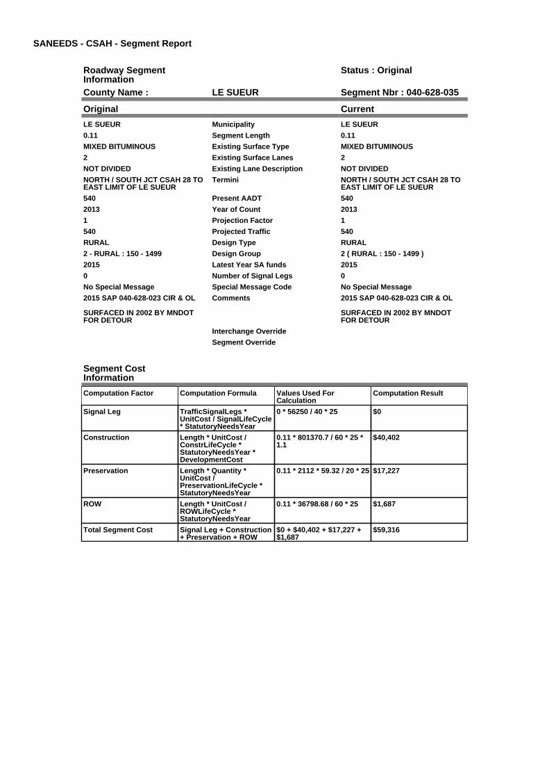
SANEEDS - CSAH - Segment Report
Roadway SegmentInformation
Status : Original
County Name : LE SUEUR Segment Nbr : 040-628-035
Original Current
LE SUEUR Municipality LE SUEUR
0.11 Segment Length 0.11
MIXED BITUMINOUS Existing Surface Type MIXED BITUMINOUS
2 Existing Surface Lanes 2
NOT DIVIDED Existing Lane Description NOT DIVIDED
NORTH / SOUTH JCT CSAH 28 TOEAST LIMIT OF LE SUEUR
Termini NORTH / SOUTH JCT CSAH 28 TOEAST LIMIT OF LE SUEUR
540 Present AADT 540
2013 Year of Count 2013
1 Projection Factor 1
540 Projected Traffic 540
RURAL Design Type RURAL
2 - RURAL : 150 - 1499 Design Group 2 ( RURAL : 150 - 1499 )
2015 Latest Year SA funds 2015
0 Number of Signal Legs 0
No Special Message Special Message Code No Special Message
2015 SAP 040-628-023 CIR & OL
SURFACED IN 2002 BY MNDOTFOR DETOUR
Comments 2015 SAP 040-628-023 CIR & OL
SURFACED IN 2002 BY MNDOTFOR DETOUR
Interchange Override
Segment Override
Segment CostInformation
Computation Factor Computation Formula Values Used ForCalculation
Computation Result
Signal Leg TrafficSignalLegs *UnitCost / SignalLifeCycle* StatutoryNeedsYear
0 * 56250 / 40 * 25 $0
Construction Length * UnitCost /ConstrLifeCycle *StatutoryNeedsYear *DevelopmentCost
0.11 * 801370.7 / 60 * 25 *1.1
$40,402
Preservation Length * Quantity *UnitCost /PreservationLifeCycle *StatutoryNeedsYear
0.11 * 2112 * 59.32 / 20 * 25 $17,227
ROW Length * UnitCost /ROWLifeCycle *StatutoryNeedsYear
0.11 * 36798.68 / 60 * 25 $1,687
Total Segment Cost Signal Leg + Construction+ Preservation + ROW
$0 + $40,402 + $17,227 +$1,687
$59,316

SANEEDS - CSAH - Segment Report
Roadway SegmentInformation
Status : Original
County Name : LE SUEUR Segment Nbr : 040-628-041
Original Current
Unassigned/Unknown Municipality Unassigned/Unknown
5.3 Segment Length 5.3
MIXED BITUMINOUS Existing Surface Type MIXED BITUMINOUS
2 Existing Surface Lanes 2
NOT DIVIDED Existing Lane Description NOT DIVIDED
EAST LIMITS LE SUEUR (.11 MIEAST OF N/S CSAH 28) TO CSAH11
Termini EAST LIMITS LE SUEUR (.11 MIEAST OF N/S CSAH 28) TO CSAH11
540 Present AADT 540
2013 Year of Count 2013
1 Projection Factor 1
540 Projected Traffic 540
RURAL Design Type RURAL
2 - RURAL : 150 - 1499 Design Group 2 ( RURAL : 150 - 1499 )
2015 Latest Year SA funds 2015
0 Number of Signal Legs 0
No Special Message Special Message Code No Special Message
2015 SAP 040-628-023 CIR & OL
SURFACED IN 2002 BY MNDOTFOR DETOUR
Comments 2015 SAP 040-628-023 CIR & OL
SURFACED IN 2002 BY MNDOTFOR DETOUR
Interchange Override
Segment Override
Culvert Information Status: Original
Original Current
5556 Structure Number 5556
6.45 Milepoint 6.45
1935 Year Built 1935
FOREST PRAIRIE CREEK Feature Crossed FOREST PRAIRIE CREEK
STREAM CROSSING Type of Service STREAM CROSSING
2 Number of Barrels 2
10 Culvert Width 10
10 Culvert Height 10
70 Culvert Length 70
199.99972034 Area of Waterway Opening 199.99972034
100% Shared Structure 100%
Comments
1 Culvert Group Code 1
Segment CostInformation
Computation Factor Computation Formula Values Used ForCalculation
Computation Result
Signal Leg TrafficSignalLegs *UnitCost / SignalLifeCycle* StatutoryNeedsYear
0 * 56250 / 40 * 25 $0
Construction Length * UnitCost /ConstrLifeCycle *StatutoryNeedsYear *DevelopmentCost
5.3 * 801370.7 / 60 * 25 *1.1
$1,946,663
Preservation Length * Quantity *UnitCost /PreservationLifeCycle *StatutoryNeedsYear
5.3 * 2112 * 59.32 / 20 * 25 $830,005
ROW Length * UnitCost /ROWLifeCycle *StatutoryNeedsYear
5.3 * 36798.68 / 60 * 25 $81,264

Culvert CulvertLength * Area *UnitCost /CulvertLifeCycle *StatutoryNeedsYear *DevelopmentCost
70 * 199.99972034 * 15.47 /100 * 25 * 1.15
$62,267
Total Segment Cost Signal Leg + Construction+ Preservation + ROW +Culvert
$0 + $1,946,663 + $830,005+ $81,264 + $62,267
$2,920,199

SANEEDS - CSAH - Segment Report
Roadway SegmentInformation
Status : Original
County Name : LE SUEUR Segment Nbr : 040-628-050
Original Current
Unassigned/Unknown Municipality Unassigned/Unknown
6.4 Segment Length 6.4
MIXED BITUMINOUS Existing Surface Type MIXED BITUMINOUS
2 Existing Surface Lanes 2
NOT DIVIDED Existing Lane Description NOT DIVIDED
S JCT CSAH 11 TO 0.25 MI W OFCSAH 30 EAST LIMSHEIDELBURG
Termini S JCT CSAH 11 TO 0.25 MI W OFCSAH 30 EAST LIMSHEIDELBURG
1250 Present AADT 1250
2013 Year of Count 2013
1 Projection Factor 1
1250 Projected Traffic 1250
RURAL Design Type RURAL
2 - RURAL : 150 - 1499 Design Group 2 ( RURAL : 150 - 1499 )
2015 Latest Year SA funds 2015
0 Number of Signal Legs 0
No Special Message Special Message Code No Special Message
2015 SAP 040-628-029MICROSURFACING
Comments 2015 SAP 040-628-029MICROSURFACING
Interchange Override
Segment Override
Culvert Information Status: Original
Original Current
92672 Structure Number 92672
10.61 Milepoint 10.61
1970 Year Built 1970
CO DITCH # 45 Feature Crossed CO DITCH # 45
STREAM CROSSING Type of Service STREAM CROSSING
1 Number of Barrels 1
16 Culvert Width 16
12 Culvert Height 12
112 Culvert Length 112
187.00015831 Area of Waterway Opening 187.00015831
100% Shared Structure 100%
Comments
1 Culvert Group Code 1
Segment CostInformation
Computation Factor Computation Formula Values Used ForCalculation
Computation Result
Signal Leg TrafficSignalLegs *UnitCost / SignalLifeCycle* StatutoryNeedsYear
0 * 56250 / 40 * 25 $0
Construction Length * UnitCost /ConstrLifeCycle *StatutoryNeedsYear *DevelopmentCost
6.4 * 801370.7 / 60 * 25 *1.1
$2,350,687
Preservation Length * Quantity *UnitCost /PreservationLifeCycle *StatutoryNeedsYear
6.4 * 2112 * 59.32 / 20 * 25 $1,002,271
ROW Length * UnitCost /ROWLifeCycle *StatutoryNeedsYear
6.4 * 36798.68 / 60 * 25 $98,130
Culvert CulvertLength * Area *UnitCost /CulvertLifeCycle *StatutoryNeedsYear *DevelopmentCost
112 * 187.00015831 * 15.47/ 100 * 25 * 1.15
$93,151

Total Segment Cost Signal Leg + Construction+ Preservation + ROW +Culvert
$0 + $2,350,687 +$1,002,271 + $98,130 +$93,151
$3,544,239
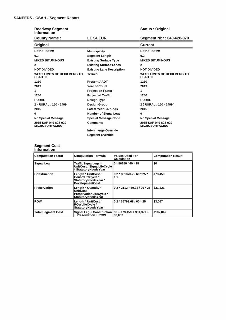
SANEEDS - CSAH - Segment Report
Roadway SegmentInformation
Status : Original
County Name : LE SUEUR Segment Nbr : 040-628-070
Original Current
HEIDELBERG Municipality HEIDELBERG
0.2 Segment Length 0.2
MIXED BITUMINOUS Existing Surface Type MIXED BITUMINOUS
2 Existing Surface Lanes 2
NOT DIVIDED Existing Lane Description NOT DIVIDED
WEST LIMITS OF HEIDLBERG TOCSAH 30
Termini WEST LIMITS OF HEIDLBERG TOCSAH 30
1250 Present AADT 1250
2013 Year of Count 2013
1 Projection Factor 1
1250 Projected Traffic 1250
RURAL Design Type RURAL
2 - RURAL : 150 - 1499 Design Group 2 ( RURAL : 150 - 1499 )
2015 Latest Year SA funds 2015
0 Number of Signal Legs 0
No Special Message Special Message Code No Special Message
2015 SAP 040-628-029MICROSURFACING
Comments 2015 SAP 040-628-029MICROSURFACING
Interchange Override
Segment Override
Segment CostInformation
Computation Factor Computation Formula Values Used ForCalculation
Computation Result
Signal Leg TrafficSignalLegs *UnitCost / SignalLifeCycle* StatutoryNeedsYear
0 * 56250 / 40 * 25 $0
Construction Length * UnitCost /ConstrLifeCycle *StatutoryNeedsYear *DevelopmentCost
0.2 * 801370.7 / 60 * 25 *1.1
$73,459
Preservation Length * Quantity *UnitCost /PreservationLifeCycle *StatutoryNeedsYear
0.2 * 2112 * 59.32 / 20 * 25 $31,321
ROW Length * UnitCost /ROWLifeCycle *StatutoryNeedsYear
0.2 * 36798.68 / 60 * 25 $3,067
Total Segment Cost Signal Leg + Construction+ Preservation + ROW
$0 + $73,459 + $31,321 +$3,067
$107,847

SANEEDS - CSAH - Segment Report
Roadway SegmentInformation
Status : Original
County Name : LE SUEUR Segment Nbr : 040-628-080
Original Current
HEIDELBERG Municipality HEIDELBERG
0.2 Segment Length 0.2
MIXED BITUMINOUS Existing Surface Type MIXED BITUMINOUS
2 Existing Surface Lanes 2
NOT DIVIDED Existing Lane Description NOT DIVIDED
CSAH 30 TO EAST LIMITS OFHEIDELBERG
Termini CSAH 30 TO EAST LIMITS OFHEIDELBERG
1250 Present AADT 1250
2013 Year of Count 2013
1 Projection Factor 1
1250 Projected Traffic 1250
RURAL Design Type RURAL
2 - RURAL : 150 - 1499 Design Group 2 ( RURAL : 150 - 1499 )
1998 Latest Year SA funds 1998
0 Number of Signal Legs 0
No Special Message Special Message Code No Special Message
Comments
Interchange Override
Segment Override
Segment CostInformation
Computation Factor Computation Formula Values Used ForCalculation
Computation Result
Signal Leg TrafficSignalLegs *UnitCost / SignalLifeCycle* StatutoryNeedsYear
0 * 56250 / 40 * 25 $0
Construction Length * UnitCost /ConstrLifeCycle *StatutoryNeedsYear *DevelopmentCost
0.2 * 801370.7 / 60 * 25 *1.1
$73,459
Preservation Length * Quantity *UnitCost /PreservationLifeCycle *StatutoryNeedsYear
0.2 * 2112 * 59.32 / 20 * 25 $31,321
ROW Length * UnitCost /ROWLifeCycle *StatutoryNeedsYear
0.2 * 36798.68 / 60 * 25 $3,067
Total Segment Cost Signal Leg + Construction+ Preservation + ROW
$0 + $73,459 + $31,321 +$3,067
$107,847

SANEEDS - CSAH - Segment Report
Roadway SegmentInformation
Status : Original
County Name : LE SUEUR Segment Nbr : 040-628-090
Original Current
Unassigned/Unknown Municipality Unassigned/Unknown
1.7 Segment Length 1.7
MIXED BITUMINOUS Existing Surface Type MIXED BITUMINOUS
2 Existing Surface Lanes 2
NOT DIVIDED Existing Lane Description NOT DIVIDED
0.3 MI E OF CSAH 30 TO TH 13 Termini 0.3 MI E OF CSAH 30 TO TH 13
1250 Present AADT 1250
2013 Year of Count 2013
1 Projection Factor 1
1250 Projected Traffic 1250
RURAL Design Type RURAL
2 - RURAL : 150 - 1499 Design Group 2 ( RURAL : 150 - 1499 )
1998 Latest Year SA funds 1998
0 Number of Signal Legs 0
No Special Message Special Message Code No Special Message
Comments
Interchange Override
Segment Override
Segment CostInformation
Computation Factor Computation Formula Values Used ForCalculation
Computation Result
Signal Leg TrafficSignalLegs *UnitCost / SignalLifeCycle* StatutoryNeedsYear
0 * 56250 / 40 * 25 $0
Construction Length * UnitCost /ConstrLifeCycle *StatutoryNeedsYear *DevelopmentCost
1.7 * 801370.7 / 60 * 25 *1.1
$624,401
Preservation Length * Quantity *UnitCost /PreservationLifeCycle *StatutoryNeedsYear
1.7 * 2112 * 59.32 / 20 * 25 $266,228
ROW Length * UnitCost /ROWLifeCycle *StatutoryNeedsYear
1.7 * 36798.68 / 60 * 25 $26,066
Total Segment Cost Signal Leg + Construction+ Preservation + ROW
$0 + $624,401 + $266,228+ $26,066
$916,695
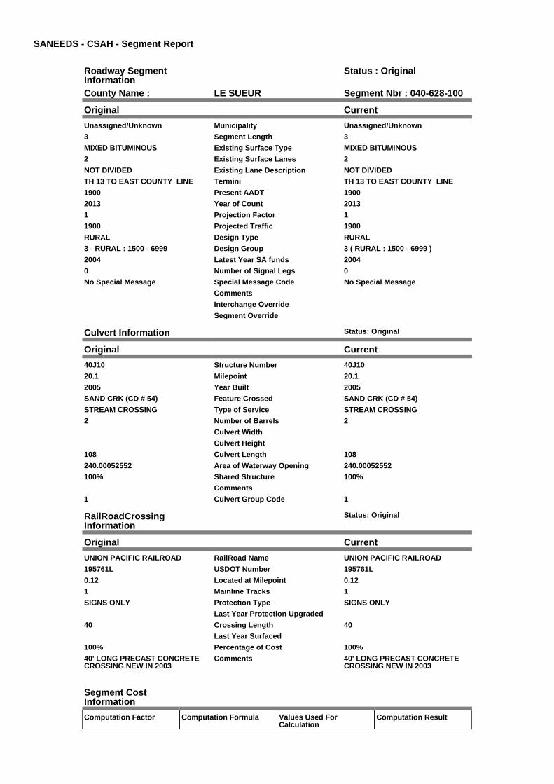
SANEEDS - CSAH - Segment Report
Roadway SegmentInformation
Status : Original
County Name : LE SUEUR Segment Nbr : 040-628-100
Original Current
Unassigned/Unknown Municipality Unassigned/Unknown
3 Segment Length 3
MIXED BITUMINOUS Existing Surface Type MIXED BITUMINOUS
2 Existing Surface Lanes 2
NOT DIVIDED Existing Lane Description NOT DIVIDED
TH 13 TO EAST COUNTY LINE Termini TH 13 TO EAST COUNTY LINE
1900 Present AADT 1900
2013 Year of Count 2013
1 Projection Factor 1
1900 Projected Traffic 1900
RURAL Design Type RURAL
3 - RURAL : 1500 - 6999 Design Group 3 ( RURAL : 1500 - 6999 )
2004 Latest Year SA funds 2004
0 Number of Signal Legs 0
No Special Message Special Message Code No Special Message
Comments
Interchange Override
Segment Override
Culvert Information Status: Original
Original Current
40J10 Structure Number 40J10
20.1 Milepoint 20.1
2005 Year Built 2005
SAND CRK (CD # 54) Feature Crossed SAND CRK (CD # 54)
STREAM CROSSING Type of Service STREAM CROSSING
2 Number of Barrels 2
Culvert Width
Culvert Height
108 Culvert Length 108
240.00052552 Area of Waterway Opening 240.00052552
100% Shared Structure 100%
Comments
1 Culvert Group Code 1
RailRoadCrossingInformation
Status: Original
Original Current
UNION PACIFIC RAILROAD RailRoad Name UNION PACIFIC RAILROAD
195761L USDOT Number 195761L
0.12 Located at Milepoint 0.12
1 Mainline Tracks 1
SIGNS ONLY Protection Type SIGNS ONLY
Last Year Protection Upgraded
40 Crossing Length 40
Last Year Surfaced
100% Percentage of Cost 100%
40' LONG PRECAST CONCRETECROSSING NEW IN 2003
Comments 40' LONG PRECAST CONCRETECROSSING NEW IN 2003
Segment CostInformation
Computation Factor Computation Formula Values Used ForCalculation
Computation Result

Signal Leg TrafficSignalLegs *UnitCost / SignalLifeCycle* StatutoryNeedsYear
0 * 56250 / 40 * 25 $0
Construction Length * UnitCost /ConstrLifeCycle *StatutoryNeedsYear *DevelopmentCost
3 * 1589559.55 / 60 * 25 *1.1
$2,185,644
Preservation Length * Quantity *UnitCost /PreservationLifeCycle *StatutoryNeedsYear
3 * 2376 * 59.32 / 20 * 25 $528,541
ROW Length * UnitCost /ROWLifeCycle *StatutoryNeedsYear
3 * 222272.59 / 60 * 25 $277,841
Culvert CulvertLength * Area *UnitCost /CulvertLifeCycle *StatutoryNeedsYear *DevelopmentCost
108 * 240.00052552 * 15.47/ 100 * 25 * 1.15
$115,283
RR Crossing Protection UnitCost /RRCrossingLifeCycle *StatutoryNeedsYear
1500 / 25 * 25 $1,500
RR Crossing Surface SurfaceLength * UnitCost/ RRCrossingLifeCycle *StatutoryNeedsYear
40 * 1350 / 25 * 25 $54,000
Total Segment Cost Signal Leg + Construction+ Preservation + ROW +Culvert + RR CrossingProtection + RR CrossingSurface
$0 + $2,185,644 + $528,541+ $277,841 + $115,283 +$1,500 + $54,000
$3,162,809

SANEEDS - CSAH - Segment Report
Roadway SegmentInformation
Status : Original
County Name : LE SUEUR Segment Nbr : 040-629-010
Original Current
Unassigned/Unknown Municipality Unassigned/Unknown
1.5 Segment Length 1.5
MIXED BITUMINOUS Existing Surface Type MIXED BITUMINOUS
2 Existing Surface Lanes 2
NOT DIVIDED Existing Lane Description NOT DIVIDED
1.5 MI N OF CSAH 28 TO 3.0 MI NOF CSAH 28 ALONG COUNTY LINE
Termini 1.5 MI N OF CSAH 28 TO 3.0 MI NOF CSAH 28 ALONG COUNTY LINE
800 Present AADT 800
2013 Year of Count 2013
1 Projection Factor 1
800 Projected Traffic 800
RURAL Design Type RURAL
2 - RURAL : 150 - 1499 Design Group 2 ( RURAL : 150 - 1499 )
2012 Latest Year SA funds 2012
0 Number of Signal Legs 0
No Special Message Special Message Code No Special Message
2012 SP 040-629-006 CIR Comments 2012 SP 040-629-006 CIR
Interchange Override
Segment Override
Segment CostInformation
Computation Factor Computation Formula Values Used ForCalculation
Computation Result
Signal Leg TrafficSignalLegs *UnitCost / SignalLifeCycle* StatutoryNeedsYear
0 * 56250 / 40 * 25 $0
Construction Length * UnitCost /ConstrLifeCycle *StatutoryNeedsYear *DevelopmentCost
1.5 * 801370.7 / 60 * 25 *1.1
$550,942
Preservation Length * Quantity *UnitCost /PreservationLifeCycle *StatutoryNeedsYear
1.5 * 2112 * 59.32 / 20 * 25 $234,907
ROW Length * UnitCost /ROWLifeCycle *StatutoryNeedsYear
1.5 * 36798.68 / 60 * 25 $22,999
Total Segment Cost Signal Leg + Construction+ Preservation + ROW
$0 + $550,942 + $234,907+ $22,999
$808,848
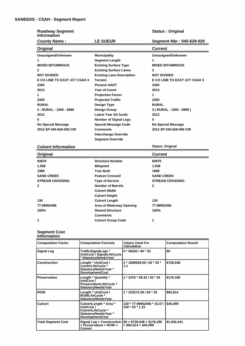
SANEEDS - CSAH - Segment Report
Roadway SegmentInformation
Status : Original
County Name : LE SUEUR Segment Nbr : 040-629-020
Original Current
Unassigned/Unknown Municipality Unassigned/Unknown
1 Segment Length 1
MIXED BITUMINOUS Existing Surface Type MIXED BITUMINOUS
2 Existing Surface Lanes 2
NOT DIVIDED Existing Lane Description NOT DIVIDED
E CO LINE TO EAST JCT CSAH 3 Termini E CO LINE TO EAST JCT CSAH 3
2300 Present AADT 2300
2013 Year of Count 2013
1 Projection Factor 1
2300 Projected Traffic 2300
RURAL Design Type RURAL
3 - RURAL : 1500 - 6999 Design Group 3 ( RURAL : 1500 - 6999 )
2012 Latest Year SA funds 2012
0 Number of Signal Legs 0
No Special Message Special Message Code No Special Message
2012 SP 040-629-006 CIR Comments 2012 SP 040-629-006 CIR
Interchange Override
Segment Override
Culvert Information Status: Original
Original Current
93970 Structure Number 93970
1.938 Milepoint 1.938
1988 Year Built 1988
SAND CREEK Feature Crossed SAND CREEK
STREAM CROSSING Type of Service STREAM CROSSING
2 Number of Barrels 2
Culvert Width
Culvert Height
130 Culvert Length 130
77.99952496 Area of Waterway Opening 77.99952496
100% Shared Structure 100%
Comments
1 Culvert Group Code 1
Segment CostInformation
Computation Factor Computation Formula Values Used ForCalculation
Computation Result
Signal Leg TrafficSignalLegs *UnitCost / SignalLifeCycle* StatutoryNeedsYear
0 * 56250 / 40 * 25 $0
Construction Length * UnitCost /ConstrLifeCycle *StatutoryNeedsYear *DevelopmentCost
1 * 1589559.55 / 60 * 25 *1.1
$728,548
Preservation Length * Quantity *UnitCost /PreservationLifeCycle *StatutoryNeedsYear
1 * 2376 * 59.32 / 20 * 25 $176,180
ROW Length * UnitCost /ROWLifeCycle *StatutoryNeedsYear
1 * 222272.59 / 60 * 25 $92,614
Culvert CulvertLength * Area *UnitCost /CulvertLifeCycle *StatutoryNeedsYear *DevelopmentCost
130 * 77.99952496 * 15.47 /100 * 25 * 1.15
$45,099
Total Segment Cost Signal Leg + Construction+ Preservation + ROW +Culvert
$0 + $728,548 + $176,180+ $92,614 + $45,099
$1,042,441

SANEEDS - CSAH - Segment Report
Roadway SegmentInformation
Status : Original
County Name : LE SUEUR Segment Nbr : 040-629-030
Original Current
Unassigned/Unknown Municipality Unassigned/Unknown
0.5 Segment Length 0.5
MIXED BITUMINOUS Existing Surface Type MIXED BITUMINOUS
2 Existing Surface Lanes 2
NOT DIVIDED Existing Lane Description NOT DIVIDED
E JCT CSAH 3 TO EAST LIMITS OFNEW PRAGUE
Termini E JCT CSAH 3 TO EAST LIMITS OFNEW PRAGUE
2300 Present AADT 2300
2013 Year of Count 2013
1 Projection Factor 1
2300 Projected Traffic 2300
RURAL Design Type RURAL
3 - RURAL : 1500 - 6999 Design Group 3 ( RURAL : 1500 - 6999 )
2012 Latest Year SA funds 2012
0 Number of Signal Legs 0
No Special Message Special Message Code No Special Message
2012 SP 040-629-006 CIR Comments 2012 SP 040-629-006 CIR
Interchange Override
Segment Override
Segment CostInformation
Computation Factor Computation Formula Values Used ForCalculation
Computation Result
Signal Leg TrafficSignalLegs *UnitCost / SignalLifeCycle* StatutoryNeedsYear
0 * 56250 / 40 * 25 $0
Construction Length * UnitCost /ConstrLifeCycle *StatutoryNeedsYear *DevelopmentCost
0.5 * 1589559.55 / 60 * 25 *1.1
$364,274
Preservation Length * Quantity *UnitCost /PreservationLifeCycle *StatutoryNeedsYear
0.5 * 2376 * 59.32 / 20 * 25 $88,090
ROW Length * UnitCost /ROWLifeCycle *StatutoryNeedsYear
0.5 * 222272.59 / 60 * 25 $46,307
Total Segment Cost Signal Leg + Construction+ Preservation + ROW
$0 + $364,274 + $88,090 +$46,307
$498,671

SANEEDS - CSAH - Segment Report
Roadway SegmentInformation
Status : Original
County Name : LE SUEUR Segment Nbr : 040-629-035
Original Current
NEW PRAGUE Municipality NEW PRAGUE
0.5 Segment Length 0.5
MIXED BITUMINOUS Existing Surface Type MIXED BITUMINOUS
3 Existing Surface Lanes 3
NOT DIVIDED Existing Lane Description NOT DIVIDED
E LIM OF NEW PRAGUE TO W LIMNEW PRAGUE W JCT CSAH 3
Termini E LIM OF NEW PRAGUE TO W LIMNEW PRAGUE W JCT CSAH 3
2300 Present AADT 2300
2013 Year of Count 2013
1 Projection Factor 1
2300 Projected Traffic 2300
URBAN Design Type URBAN
5 - URBAN : 0 - 9999 Design Group 5 ( URBAN : 0 - 9999 )
2012 Latest Year SA funds 2012
0 Number of Signal Legs 0
No Special Message Special Message Code No Special Message
2007 RECONSTRUCTION WITHRURAL ROAD SAFETY FUNDSAND SA BONDING.
Comments 2007 RECONSTRUCTION WITHRURAL ROAD SAFETY FUNDSAND SA BONDING.
Interchange Override
Segment Override
Segment CostInformation
Computation Factor Computation Formula Values Used ForCalculation
Computation Result
Signal Leg TrafficSignalLegs *UnitCost / SignalLifeCycle* StatutoryNeedsYear
0 * 56250 / 40 * 25 $0
Construction Length * UnitCost /ConstrLifeCycle *StatutoryNeedsYear *DevelopmentCost
0.5 * 2823252.86 / 60 * 25 *1.15
$676,404
Preservation Length * Quantity *UnitCost /PreservationLifeCycle *StatutoryNeedsYear
0.5 * 2904 * 59.32 / 15 * 25 $143,554
ROW Length * UnitCost /ROWLifeCycle *StatutoryNeedsYear
0.5 * 59776.02 / 60 * 25 $12,453
Total Segment Cost Signal Leg + Construction+ Preservation + ROW
$0 + $676,404 + $143,554+ $12,453
$832,411

SANEEDS - CSAH - Segment Report
Roadway SegmentInformation
Status : Original
County Name : LE SUEUR Segment Nbr : 040-629-040
Original Current
Unassigned/Unknown Municipality Unassigned/Unknown
0.5 Segment Length 0.5
MIXED BITUMINOUS Existing Surface Type MIXED BITUMINOUS
2 Existing Surface Lanes 2
NOT DIVIDED Existing Lane Description NOT DIVIDED
W JCT CSAH 3 TO CSAH 60 Termini W JCT CSAH 3 TO CSAH 60
2200 Present AADT 2200
2013 Year of Count 2013
1 Projection Factor 1
2200 Projected Traffic 2200
RURAL Design Type RURAL
3 - RURAL : 1500 - 6999 Design Group 3 ( RURAL : 1500 - 6999 )
2012 Latest Year SA funds 2012
0 Number of Signal Legs 0
No Special Message Special Message Code No Special Message
2012 SP 040-629-006 CIR Comments 2012 SP 040-629-006 CIR
Interchange Override
Segment Override
Segment CostInformation
Computation Factor Computation Formula Values Used ForCalculation
Computation Result
Signal Leg TrafficSignalLegs *UnitCost / SignalLifeCycle* StatutoryNeedsYear
0 * 56250 / 40 * 25 $0
Construction Length * UnitCost /ConstrLifeCycle *StatutoryNeedsYear *DevelopmentCost
0.5 * 1589559.55 / 60 * 25 *1.1
$364,274
Preservation Length * Quantity *UnitCost /PreservationLifeCycle *StatutoryNeedsYear
0.5 * 2376 * 59.32 / 20 * 25 $88,090
ROW Length * UnitCost /ROWLifeCycle *StatutoryNeedsYear
0.5 * 222272.59 / 60 * 25 $46,307
Total Segment Cost Signal Leg + Construction+ Preservation + ROW
$0 + $364,274 + $88,090 +$46,307
$498,671

SANEEDS - CSAH - Segment Report
Roadway SegmentInformation
Status : Original
County Name : LE SUEUR Segment Nbr : 040-629-050
Original Current
Unassigned/Unknown Municipality Unassigned/Unknown
0.5 Segment Length 0.5
MIXED BITUMINOUS Existing Surface Type MIXED BITUMINOUS
2 Existing Surface Lanes 2
NOT DIVIDED Existing Lane Description NOT DIVIDED
CSAH 60 TO TH 13 Termini CSAH 60 TO TH 13
1550 Present AADT 1550
2013 Year of Count 2013
1 Projection Factor 1
1550 Projected Traffic 1550
URBAN Design Type URBAN
5 - URBAN : 0 - 9999 Design Group 5 ( URBAN : 0 - 9999 )
2012 Latest Year SA funds 2012
0 Number of Signal Legs 0
No Special Message Special Message Code No Special Message
2012 SP 040-629-006 CIR Comments 2012 SP 040-629-006 CIR
Interchange Override
Segment Override
RailRoadCrossingInformation
Status: Original
Original Current
UNION PACIFIC RAILROAD RailRoad Name UNION PACIFIC RAILROAD
195758D USDOT Number 195758D
0.35 Located at Milepoint 0.35
1 Mainline Tracks 1
SIGNS ONLY Protection Type SIGNS ONLY
Last Year Protection Upgraded
32 Crossing Length 32
Last Year Surfaced
100% Percentage of Cost 100%
Comments
Segment CostInformation
Computation Factor Computation Formula Values Used ForCalculation
Computation Result
Signal Leg TrafficSignalLegs *UnitCost / SignalLifeCycle* StatutoryNeedsYear
0 * 56250 / 40 * 25 $0
Construction Length * UnitCost /ConstrLifeCycle *StatutoryNeedsYear *DevelopmentCost
0.5 * 2823252.86 / 60 * 25 *1.15
$676,404
Preservation Length * Quantity *UnitCost /PreservationLifeCycle *StatutoryNeedsYear
0.5 * 2904 * 59.32 / 15 * 25 $143,554
ROW Length * UnitCost /ROWLifeCycle *StatutoryNeedsYear
0.5 * 59776.02 / 60 * 25 $12,453
RR Crossing Protection UnitCost /RRCrossingLifeCycle *StatutoryNeedsYear
1500 / 25 * 25 $1,500
RR Crossing Surface SurfaceLength * UnitCost/ RRCrossingLifeCycle *StatutoryNeedsYear
32 * 1350 / 25 * 25 $43,200
Total Segment Cost Signal Leg + Construction+ Preservation + ROW +RR Crossing Protection +RR Crossing Surface
$0 + $676,404 + $143,554+ $12,453 + $1,500 +$43,200
$877,111

SANEEDS - CSAH - Segment Report
Roadway SegmentInformation
Status : Original
County Name : LE SUEUR Segment Nbr : 040-630-010
Original Current
Unassigned/Unknown Municipality Unassigned/Unknown
3 Segment Length 3
MIXED BITUMINOUS Existing Surface Type MIXED BITUMINOUS
2 Existing Surface Lanes 2
NOT DIVIDED Existing Lane Description NOT DIVIDED
CSAH 26 TO S LIM HEIDELBERG(CSAH 28)
Termini CSAH 26 TO S LIM HEIDELBERG(CSAH 28)
480 Present AADT 480
2013 Year of Count 2013
1 Projection Factor 1
480 Projected Traffic 480
RURAL Design Type RURAL
2 - RURAL : 150 - 1499 Design Group 2 ( RURAL : 150 - 1499 )
1998 Latest Year SA funds 1998
0 Number of Signal Legs 0
No Special Message Special Message Code No Special Message
Comments
Interchange Override
Segment Override
Segment CostInformation
Computation Factor Computation Formula Values Used ForCalculation
Computation Result
Signal Leg TrafficSignalLegs *UnitCost / SignalLifeCycle* StatutoryNeedsYear
0 * 56250 / 40 * 25 $0
Construction Length * UnitCost /ConstrLifeCycle *StatutoryNeedsYear *DevelopmentCost
3 * 801370.7 / 60 * 25 * 1.1 $1,101,885
Preservation Length * Quantity *UnitCost /PreservationLifeCycle *StatutoryNeedsYear
3 * 2112 * 59.32 / 20 * 25 $469,814
ROW Length * UnitCost /ROWLifeCycle *StatutoryNeedsYear
3 * 36798.68 / 60 * 25 $45,998
Total Segment Cost Signal Leg + Construction+ Preservation + ROW
$0 + $1,101,885 + $469,814+ $45,998
$1,617,697

SANEEDS - CSAH - Segment Report
Roadway SegmentInformation
Status : Original
County Name : LE SUEUR Segment Nbr : 040-630-020
Original Current
HEIDELBERG Municipality HEIDELBERG
1 Segment Length 1
MIXED BITUMINOUS Existing Surface Type MIXED BITUMINOUS
2 Existing Surface Lanes 2
NOT DIVIDED Existing Lane Description NOT DIVIDED
SOUTH LIMIT (CSAH 28) TONORTH LIMIT OF HEIDELBERG
Termini SOUTH LIMIT (CSAH 28) TONORTH LIMIT OF HEIDELBERG
810 Present AADT 810
2013 Year of Count 2013
1 Projection Factor 1
810 Projected Traffic 810
RURAL Design Type RURAL
2 - RURAL : 150 - 1499 Design Group 2 ( RURAL : 150 - 1499 )
2012 Latest Year SA funds 2012
0 Number of Signal Legs 0
No Special Message Special Message Code No Special Message
2012 SAP 040-630-009 CIR Comments 2012 SAP 040-630-009 CIR
Interchange Override
Segment Override
Segment CostInformation
Computation Factor Computation Formula Values Used ForCalculation
Computation Result
Signal Leg TrafficSignalLegs *UnitCost / SignalLifeCycle* StatutoryNeedsYear
0 * 56250 / 40 * 25 $0
Construction Length * UnitCost /ConstrLifeCycle *StatutoryNeedsYear *DevelopmentCost
1 * 801370.7 / 60 * 25 * 1.1 $367,295
Preservation Length * Quantity *UnitCost /PreservationLifeCycle *StatutoryNeedsYear
1 * 2112 * 59.32 / 20 * 25 $156,605
ROW Length * UnitCost /ROWLifeCycle *StatutoryNeedsYear
1 * 36798.68 / 60 * 25 $15,333
Total Segment Cost Signal Leg + Construction+ Preservation + ROW
$0 + $367,295 + $156,605+ $15,333
$539,233

SANEEDS - CSAH - Segment Report
Roadway SegmentInformation
Status : Original
County Name : LE SUEUR Segment Nbr : 040-630-060
Original Current
Unassigned/Unknown Municipality Unassigned/Unknown
3.1 Segment Length 3.1
MIXED BITUMINOUS Existing Surface Type MIXED BITUMINOUS
2 Existing Surface Lanes 2
NOT DIVIDED Existing Lane Description NOT DIVIDED
NO LIM HEIDELBERG TO TH 19 Termini NO LIM HEIDELBERG TO TH 19
810 Present AADT 810
2013 Year of Count 2013
1 Projection Factor 1
810 Projected Traffic 810
RURAL Design Type RURAL
2 - RURAL : 150 - 1499 Design Group 2 ( RURAL : 150 - 1499 )
2012 Latest Year SA funds 2012
0 Number of Signal Legs 0
No Special Message Special Message Code No Special Message
2012 SAP 040-630-009 CIR Comments 2012 SAP 040-630-009 CIR
Interchange Override
Segment Override
Segment CostInformation
Computation Factor Computation Formula Values Used ForCalculation
Computation Result
Signal Leg TrafficSignalLegs *UnitCost / SignalLifeCycle* StatutoryNeedsYear
0 * 56250 / 40 * 25 $0
Construction Length * UnitCost /ConstrLifeCycle *StatutoryNeedsYear *DevelopmentCost
3.1 * 801370.7 / 60 * 25 *1.1
$1,138,614
Preservation Length * Quantity *UnitCost /PreservationLifeCycle *StatutoryNeedsYear
3.1 * 2112 * 59.32 / 20 * 25 $485,475
ROW Length * UnitCost /ROWLifeCycle *StatutoryNeedsYear
3.1 * 36798.68 / 60 * 25 $47,532
Total Segment Cost Signal Leg + Construction+ Preservation + ROW
$0 + $1,138,614 + $485,475+ $47,532
$1,671,621

SANEEDS - CSAH - Segment Report
Roadway SegmentInformation
Status : Original
County Name : LE SUEUR Segment Nbr : 040-631-010
Original Current
Unassigned/Unknown Municipality Unassigned/Unknown
4 Segment Length 4
MIXED BITUMINOUS Existing Surface Type MIXED BITUMINOUS
2 Existing Surface Lanes 2
NOT DIVIDED Existing Lane Description NOT DIVIDED
CSAH 28 TO TH 19 Termini CSAH 28 TO TH 19
750 Present AADT 750
2013 Year of Count 2013
1 Projection Factor 1
750 Projected Traffic 750
RURAL Design Type RURAL
2 - RURAL : 150 - 1499 Design Group 2 ( RURAL : 150 - 1499 )
2009 Latest Year SA funds 2009
0 Number of Signal Legs 0
No Special Message Special Message Code No Special Message
2009: FDR & SURFACED, SAP 40-631-02
Comments 2009: FDR & SURFACED, SAP 40-631-02
Interchange Override
Segment Override
Segment CostInformation
Computation Factor Computation Formula Values Used ForCalculation
Computation Result
Signal Leg TrafficSignalLegs *UnitCost / SignalLifeCycle* StatutoryNeedsYear
0 * 56250 / 40 * 25 $0
Construction Length * UnitCost /ConstrLifeCycle *StatutoryNeedsYear *DevelopmentCost
4 * 801370.7 / 60 * 25 * 1.1 $1,469,180
Preservation Length * Quantity *UnitCost /PreservationLifeCycle *StatutoryNeedsYear
4 * 2112 * 59.32 / 20 * 25 $626,419
ROW Length * UnitCost /ROWLifeCycle *StatutoryNeedsYear
4 * 36798.68 / 60 * 25 $61,331
Total Segment Cost Signal Leg + Construction+ Preservation + ROW
$0 + $1,469,180 + $626,419+ $61,331
$2,156,930

SANEEDS - CSAH - Segment Report
Roadway SegmentInformation
Status : Revised
County Name : LE SUEUR Segment Nbr : 040-632-010
Original Current
Unassigned/Unknown Municipality Unassigned/Unknown
1.9 Segment Length 1.9
MIXED BITUMINOUS Existing Surface Type MIXED BITUMINOUS
2 Existing Surface Lanes 2
NOT DIVIDED Existing Lane Description NOT DIVIDED
CSAH 11 TO CSAH 26 Termini CSAH 11 TO CSAH 26
850 Present AADT 850
2013 Year of Count 2013
1 Projection Factor 1
850 Projected Traffic 850
RURAL Design Type RURAL
2 - RURAL : 150 - 1499 Design Group 2 ( RURAL : 150 - 1499 )
2016 Latest Year SA funds 2016
0 Number of Signal Legs 0
No Special Message Special Message Code No Special Message
2016 SAP 040-632-007 RC&OL Comments 2016 SAP 040-632-007 RC&OL
Interchange Override
Segment Override
Segment CostInformation
Computation Factor Computation Formula Values Used ForCalculation
Computation Result
Signal Leg TrafficSignalLegs *UnitCost / SignalLifeCycle* StatutoryNeedsYear
0 * 56250 / 40 * 25 $0
Construction Length * UnitCost /ConstrLifeCycle *StatutoryNeedsYear *DevelopmentCost
1.9 * 801370.7 / 60 * 25 *1.1
$697,860
Preservation Length * Quantity *UnitCost /PreservationLifeCycle *StatutoryNeedsYear
1.9 * 2112 * 59.32 / 20 * 25 $297,549
ROW Length * UnitCost /ROWLifeCycle *StatutoryNeedsYear
1.9 * 36798.68 / 60 * 25 $29,132
Total Segment Cost Signal Leg + Construction+ Preservation + ROW
$0 + $697,860 + $297,549+ $29,132
$1,024,541

SANEEDS - CSAH - Segment Report
Roadway SegmentInformation
Status : Revised
County Name : LE SUEUR Segment Nbr : 040-632-020
Original Current
Unassigned/Unknown Municipality Unassigned/Unknown
3 Segment Length 3
MIXED BITUMINOUS Existing Surface Type MIXED BITUMINOUS
2 Existing Surface Lanes 2
NOT DIVIDED Existing Lane Description NOT DIVIDED
CSAH 26 TO CSAH 28 Termini CSAH 26 TO CSAH 28
800 Present AADT 800
2013 Year of Count 2013
1 Projection Factor 1
800 Projected Traffic 800
RURAL Design Type RURAL
2 - RURAL : 150 - 1499 Design Group 2 ( RURAL : 150 - 1499 )
2016 Latest Year SA funds 2016
0 Number of Signal Legs 0
No Special Message Special Message Code No Special Message
2016 SAP 040-632-007 RC&OL Comments 2016 SAP 040-632-007 RC&OL
Interchange Override
Segment Override
Segment CostInformation
Computation Factor Computation Formula Values Used ForCalculation
Computation Result
Signal Leg TrafficSignalLegs *UnitCost / SignalLifeCycle* StatutoryNeedsYear
0 * 56250 / 40 * 25 $0
Construction Length * UnitCost /ConstrLifeCycle *StatutoryNeedsYear *DevelopmentCost
3 * 801370.7 / 60 * 25 * 1.1 $1,101,885
Preservation Length * Quantity *UnitCost /PreservationLifeCycle *StatutoryNeedsYear
3 * 2112 * 59.32 / 20 * 25 $469,814
ROW Length * UnitCost /ROWLifeCycle *StatutoryNeedsYear
3 * 36798.68 / 60 * 25 $45,998
Total Segment Cost Signal Leg + Construction+ Preservation + ROW
$0 + $1,101,885 + $469,814+ $45,998
$1,617,697

SANEEDS - CSAH - Segment Report
Roadway SegmentInformation
Status : Revised
County Name : LE SUEUR Segment Nbr : 040-632-030
Original Current
Unassigned/Unknown Municipality Unassigned/Unknown
4.2 Segment Length 4.2
MIXED BITUMINOUS Existing Surface Type MIXED BITUMINOUS
2 Existing Surface Lanes 2
NOT DIVIDED Existing Lane Description NOT DIVIDED
CSAH 28 TO TH 19 Termini CSAH 28 TO TH 19
240 Present AADT 240
2013 Year of Count 2013
1 Projection Factor 1
240 Projected Traffic 240
RURAL Design Type RURAL
2 - RURAL : 150 - 1499 Design Group 2 ( RURAL : 150 - 1499 )
2016 Latest Year SA funds 2016
0 Number of Signal Legs 0
No Special Message Special Message Code No Special Message
2016 SAP 040-632-008 M&OL Comments 2016 SAP 040-632-008 M&OL
Interchange Override
Segment Override
Segment CostInformation
Computation Factor Computation Formula Values Used ForCalculation
Computation Result
Signal Leg TrafficSignalLegs *UnitCost / SignalLifeCycle* StatutoryNeedsYear
0 * 56250 / 40 * 25 $0
Construction Length * UnitCost /ConstrLifeCycle *StatutoryNeedsYear *DevelopmentCost
4.2 * 801370.7 / 60 * 25 *1.1
$1,542,639
Preservation Length * Quantity *UnitCost /PreservationLifeCycle *StatutoryNeedsYear
4.2 * 2112 * 59.32 / 20 * 25 $657,740
ROW Length * UnitCost /ROWLifeCycle *StatutoryNeedsYear
4.2 * 36798.68 / 60 * 25 $64,398
Total Segment Cost Signal Leg + Construction+ Preservation + ROW
$0 + $1,542,639 + $657,740+ $64,398
$2,264,777

SANEEDS - CSAH - Segment Report
Roadway SegmentInformation
Status : Original
County Name : LE SUEUR Segment Nbr : 040-633-010
Original Current
Unassigned/Unknown Municipality Unassigned/Unknown
4 Segment Length 4
MIXED BITUMINOUS Existing Surface Type MIXED BITUMINOUS
2 Existing Surface Lanes 2
NOT DIVIDED Existing Lane Description NOT DIVIDED
CSAH 26 TO CSAH 28 Termini CSAH 26 TO CSAH 28
740 Present AADT 740
2013 Year of Count 2013
1 Projection Factor 1
740 Projected Traffic 740
RURAL Design Type RURAL
2 - RURAL : 150 - 1499 Design Group 2 ( RURAL : 150 - 1499 )
1979 Latest Year SA funds 1979
0 Number of Signal Legs 0
No Special Message Special Message Code No Special Message
Comments
Interchange Override
Segment Override
Culvert Information Status: Original
Original Current
92723 Structure Number 92723
3.72 Milepoint 3.72
1967 Year Built 1967
STREAM Feature Crossed STREAM
STREAM CROSSING Type of Service STREAM CROSSING
1 Number of Barrels 1
12 Culvert Width 12
7 Culvert Height 7
108 Culvert Length 108
63.99999662 Area of Waterway Opening 63.99999662
100% Shared Structure 100%
Comments
1 Culvert Group Code 1
Segment CostInformation
Computation Factor Computation Formula Values Used ForCalculation
Computation Result
Signal Leg TrafficSignalLegs *UnitCost / SignalLifeCycle* StatutoryNeedsYear
0 * 56250 / 40 * 25 $0
Construction Length * UnitCost /ConstrLifeCycle *StatutoryNeedsYear *DevelopmentCost
4 * 801370.7 / 60 * 25 * 1.1 $1,469,180
Preservation Length * Quantity *UnitCost /PreservationLifeCycle *StatutoryNeedsYear
4 * 2112 * 59.32 / 20 * 25 $626,419
ROW Length * UnitCost /ROWLifeCycle *StatutoryNeedsYear
4 * 36798.68 / 60 * 25 $61,331
Culvert CulvertLength * Area *UnitCost /CulvertLifeCycle *StatutoryNeedsYear *DevelopmentCost
108 * 63.99999662 * 15.47 /100 * 25 * 1.15
$30,742
Total Segment Cost Signal Leg + Construction+ Preservation + ROW +Culvert
$0 + $1,469,180 + $626,419+ $61,331 + $30,742
$2,187,672

SANEEDS - CSAH - Segment Report
Roadway SegmentInformation
Status : Original
County Name : LE SUEUR Segment Nbr : 040-635-010
Original Current
LE SUEUR Municipality LE SUEUR
0.14 Segment Length 0.14
MIXED BITUMINOUS Existing Surface Type MIXED BITUMINOUS
2 Existing Surface Lanes 2
NOT DIVIDED Existing Lane Description NOT DIVIDED
TH 112 TO 4TH ST (CSAH 37) ONDAKOTA ST
Termini TH 112 TO 4TH ST (CSAH 37) ONDAKOTA ST
1500 Present AADT 1500
2013 Year of Count 2013
1 Projection Factor 1
1500 Projected Traffic 1500
URBAN Design Type URBAN
5 - URBAN : 0 - 9999 Design Group 5 ( URBAN : 0 - 9999 )
2000 Latest Year SA funds 2000
0 Number of Signal Legs 0
No Special Message Special Message Code No Special Message
Comments
Interchange Override
Segment Override
Segment CostInformation
Computation Factor Computation Formula Values Used ForCalculation
Computation Result
Signal Leg TrafficSignalLegs *UnitCost / SignalLifeCycle* StatutoryNeedsYear
0 * 56250 / 40 * 25 $0
Construction Length * UnitCost /ConstrLifeCycle *StatutoryNeedsYear *DevelopmentCost
0.14 * 2823252.86 / 60 * 25* 1.15
$189,393
Preservation Length * Quantity *UnitCost /PreservationLifeCycle *StatutoryNeedsYear
0.14 * 2904 * 59.32 / 15 * 25 $40,195
ROW Length * UnitCost /ROWLifeCycle *StatutoryNeedsYear
0.14 * 59776.02 / 60 * 25 $3,487
Total Segment Cost Signal Leg + Construction+ Preservation + ROW
$0 + $189,393 + $40,195 +$3,487
$233,075

SANEEDS - CSAH - Segment Report
Roadway SegmentInformation
Status : Original
County Name : LE SUEUR Segment Nbr : 040-635-020
Original Current
LE SUEUR Municipality LE SUEUR
0.44 Segment Length 0.44
MIXED BITUMINOUS Existing Surface Type MIXED BITUMINOUS
2 Existing Surface Lanes 2
NOT DIVIDED Existing Lane Description NOT DIVIDED
4TH ST (CSAH 37) TO 0.1 MI S OFPECK ST ON DAKOTA ST
Termini 4TH ST (CSAH 37) TO 0.1 MI S OFPECK ST ON DAKOTA ST
1250 Present AADT 1250
2013 Year of Count 2013
1 Projection Factor 1
1250 Projected Traffic 1250
URBAN Design Type URBAN
5 - URBAN : 0 - 9999 Design Group 5 ( URBAN : 0 - 9999 )
2014 Latest Year SA funds 2014
0 Number of Signal Legs 0
No Special Message Special Message Code No Special Message
2014 SAP 040-635-004 RC&OL, SMCULVERTS
Comments 2014 SAP 040-635-004 RC&OL, SMCULVERTS
Interchange Override
Segment Override
Segment CostInformation
Computation Factor Computation Formula Values Used ForCalculation
Computation Result
Signal Leg TrafficSignalLegs *UnitCost / SignalLifeCycle* StatutoryNeedsYear
0 * 56250 / 40 * 25 $0
Construction Length * UnitCost /ConstrLifeCycle *StatutoryNeedsYear *DevelopmentCost
0.44 * 2823252.86 / 60 * 25* 1.15
$595,236
Preservation Length * Quantity *UnitCost /PreservationLifeCycle *StatutoryNeedsYear
0.44 * 2904 * 59.32 / 15 * 25 $126,328
ROW Length * UnitCost /ROWLifeCycle *StatutoryNeedsYear
0.44 * 59776.02 / 60 * 25 $10,959
Total Segment Cost Signal Leg + Construction+ Preservation + ROW
$0 + $595,236 + $126,328+ $10,959
$732,523

SANEEDS - CSAH - Segment Report
Roadway SegmentInformation
Status : Original
County Name : LE SUEUR Segment Nbr : 040-635-030
Original Current
LE SUEUR Municipality LE SUEUR
0.66 Segment Length 0.66
MIXED BITUMINOUS Existing Surface Type MIXED BITUMINOUS
2 Existing Surface Lanes 2
NOT DIVIDED Existing Lane Description NOT DIVIDED
0.1 MI S OF PECK ST TO BARONYROAD ON KINGSWAY DR
Termini 0.1 MI S OF PECK ST TO BARONYROAD ON KINGSWAY DR
1250 Present AADT 1250
2013 Year of Count 2013
1 Projection Factor 1
1250 Projected Traffic 1250
RURAL Design Type RURAL
2 - RURAL : 150 - 1499 Design Group 2 ( RURAL : 150 - 1499 )
2014 Latest Year SA funds 2014
0 Number of Signal Legs 0
No Special Message Special Message Code No Special Message
2014 SAP 040-635-004 RC&OL, SMCULVERTS
Comments 2014 SAP 040-635-004 RC&OL, SMCULVERTS
Interchange Override
Segment Override
Segment CostInformation
Computation Factor Computation Formula Values Used ForCalculation
Computation Result
Signal Leg TrafficSignalLegs *UnitCost / SignalLifeCycle* StatutoryNeedsYear
0 * 56250 / 40 * 25 $0
Construction Length * UnitCost /ConstrLifeCycle *StatutoryNeedsYear *DevelopmentCost
0.66 * 801370.7 / 60 * 25 *1.1
$242,415
Preservation Length * Quantity *UnitCost /PreservationLifeCycle *StatutoryNeedsYear
0.66 * 2112 * 59.32 / 20 * 25 $103,359
ROW Length * UnitCost /ROWLifeCycle *StatutoryNeedsYear
0.66 * 36798.68 / 60 * 25 $10,120
Total Segment Cost Signal Leg + Construction+ Preservation + ROW
$0 + $242,415 + $103,359+ $10,120
$355,894

SANEEDS - CSAH - Segment Report
Roadway SegmentInformation
Status : Original
County Name : LE SUEUR Segment Nbr : 040-635-040
Original Current
LE SUEUR Municipality LE SUEUR
0.13 Segment Length 0.13
MIXED BITUMINOUS Existing Surface Type MIXED BITUMINOUS
2 Existing Surface Lanes 2
NOT DIVIDED Existing Lane Description NOT DIVIDED
BARONY ROAD TO CSAH 26 ONKINGSWAY DRIVE
Termini BARONY ROAD TO CSAH 26 ONKINGSWAY DRIVE
1250 Present AADT 1250
2013 Year of Count 2013
1 Projection Factor 1
1250 Projected Traffic 1250
URBAN Design Type URBAN
5 - URBAN : 0 - 9999 Design Group 5 ( URBAN : 0 - 9999 )
2014 Latest Year SA funds 2014
0 Number of Signal Legs 0
No Special Message Special Message Code No Special Message
2014 SAP 040-635-004 RC&OL, SMCULVERTS
Comments 2014 SAP 040-635-004 RC&OL, SMCULVERTS
Interchange Override
Segment Override
Segment CostInformation
Computation Factor Computation Formula Values Used ForCalculation
Computation Result
Signal Leg TrafficSignalLegs *UnitCost / SignalLifeCycle* StatutoryNeedsYear
0 * 56250 / 40 * 25 $0
Construction Length * UnitCost /ConstrLifeCycle *StatutoryNeedsYear *DevelopmentCost
0.13 * 2823252.86 / 60 * 25* 1.15
$175,865
Preservation Length * Quantity *UnitCost /PreservationLifeCycle *StatutoryNeedsYear
0.13 * 2904 * 59.32 / 15 * 25 $37,324
ROW Length * UnitCost /ROWLifeCycle *StatutoryNeedsYear
0.13 * 59776.02 / 60 * 25 $3,238
Total Segment Cost Signal Leg + Construction+ Preservation + ROW
$0 + $175,865 + $37,324 +$3,238
$216,427

SANEEDS - CSAH - Segment Report
Roadway SegmentInformation
Status : Original
County Name : LE SUEUR Segment Nbr : 040-636-010
Original Current
Unassigned/Unknown Municipality Unassigned/Unknown
4.9 Segment Length 4.9
MIXED BITUMINOUS Existing Surface Type MIXED BITUMINOUS
2 Existing Surface Lanes 2
NOT DIVIDED Existing Lane Description NOT DIVIDED
CSAH 23 TO 0.5 MI NORTH OF CR115 (SOUTH LIMITS LE SUEUR)
Termini CSAH 23 TO 0.5 MI NORTH OF CR115 (SOUTH LIMITS LE SUEUR)
790 Present AADT 790
2013 Year of Count 2013
1 Projection Factor 1
790 Projected Traffic 790
RURAL Design Type RURAL
2 - RURAL : 150 - 1499 Design Group 2 ( RURAL : 150 - 1499 )
2014 Latest Year SA funds 2014
0 Number of Signal Legs 0
No Special Message Special Message Code No Special Message
2014 SAP 040-636-010 CIR/OL 4MI Comments 2014 SAP 040-636-010 CIR/OL 4MI
Interchange Override
Segment Override
Segment CostInformation
Computation Factor Computation Formula Values Used ForCalculation
Computation Result
Signal Leg TrafficSignalLegs *UnitCost / SignalLifeCycle* StatutoryNeedsYear
0 * 56250 / 40 * 25 $0
Construction Length * UnitCost /ConstrLifeCycle *StatutoryNeedsYear *DevelopmentCost
4.9 * 801370.7 / 60 * 25 *1.1
$1,799,745
Preservation Length * Quantity *UnitCost /PreservationLifeCycle *StatutoryNeedsYear
4.9 * 2112 * 59.32 / 20 * 25 $767,364
ROW Length * UnitCost /ROWLifeCycle *StatutoryNeedsYear
4.9 * 36798.68 / 60 * 25 $75,131
Total Segment Cost Signal Leg + Construction+ Preservation + ROW
$0 + $1,799,745 + $767,364+ $75,131
$2,642,240

SANEEDS - CSAH - Segment Report
Roadway SegmentInformation
Status : Original
County Name : LE SUEUR Segment Nbr : 040-636-030
Original Current
LE SUEUR Municipality LE SUEUR
0.3 Segment Length 0.3
MIXED BITUMINOUS Existing Surface Type MIXED BITUMINOUS
2 Existing Surface Lanes 2
NOT DIVIDED Existing Lane Description NOT DIVIDED
SO LIM LESUEUR TO DAVIS ST ONMAIN ST
Termini SO LIM LESUEUR TO DAVIS ST ONMAIN ST
1550 Present AADT 1550
2013 Year of Count 2013
1 Projection Factor 1
1550 Projected Traffic 1550
URBAN Design Type URBAN
5 - URBAN : 0 - 9999 Design Group 5 ( URBAN : 0 - 9999 )
2000 Latest Year SA funds 2000
0 Number of Signal Legs 0
No Special Message Special Message Code No Special Message
Comments
Interchange Override
Segment Override
Segment CostInformation
Computation Factor Computation Formula Values Used ForCalculation
Computation Result
Signal Leg TrafficSignalLegs *UnitCost / SignalLifeCycle* StatutoryNeedsYear
0 * 56250 / 40 * 25 $0
Construction Length * UnitCost /ConstrLifeCycle *StatutoryNeedsYear *DevelopmentCost
0.3 * 2823252.86 / 60 * 25 *1.15
$405,843
Preservation Length * Quantity *UnitCost /PreservationLifeCycle *StatutoryNeedsYear
0.3 * 2904 * 59.32 / 15 * 25 $86,133
ROW Length * UnitCost /ROWLifeCycle *StatutoryNeedsYear
0.3 * 59776.02 / 60 * 25 $7,472
Total Segment Cost Signal Leg + Construction+ Preservation + ROW
$0 + $405,843 + $86,133 +$7,472
$499,448

SANEEDS - CSAH - Segment Report
Roadway SegmentInformation
Status : Original
County Name : LE SUEUR Segment Nbr : 040-636-040
Original Current
LE SUEUR Municipality LE SUEUR
0.2 Segment Length 0.2
MIXED BITUMINOUS Existing Surface Type MIXED BITUMINOUS
2 Existing Surface Lanes 2
NOT DIVIDED Existing Lane Description NOT DIVIDED
DAVIS ST TO 0.05 MI SO OFFERRY ST ON MAIN STREET
Termini DAVIS ST TO 0.05 MI SO OFFERRY ST ON MAIN STREET
1550 Present AADT 1550
2013 Year of Count 2013
1 Projection Factor 1
1550 Projected Traffic 1550
URBAN Design Type URBAN
5 - URBAN : 0 - 9999 Design Group 5 ( URBAN : 0 - 9999 )
2000 Latest Year SA funds 2000
0 Number of Signal Legs 0
No Special Message Special Message Code No Special Message
Comments
Interchange Override
Segment Override
Segment CostInformation
Computation Factor Computation Formula Values Used ForCalculation
Computation Result
Signal Leg TrafficSignalLegs *UnitCost / SignalLifeCycle* StatutoryNeedsYear
0 * 56250 / 40 * 25 $0
Construction Length * UnitCost /ConstrLifeCycle *StatutoryNeedsYear *DevelopmentCost
0.2 * 2823252.86 / 60 * 25 *1.15
$270,562
Preservation Length * Quantity *UnitCost /PreservationLifeCycle *StatutoryNeedsYear
0.2 * 2904 * 59.32 / 15 * 25 $57,422
ROW Length * UnitCost /ROWLifeCycle *StatutoryNeedsYear
0.2 * 59776.02 / 60 * 25 $4,981
Total Segment Cost Signal Leg + Construction+ Preservation + ROW
$0 + $270,562 + $57,422 +$4,981
$332,965

SANEEDS - CSAH - Segment Report
Roadway SegmentInformation
Status : Original
County Name : LE SUEUR Segment Nbr : 040-636-041
Original Current
LE SUEUR Municipality LE SUEUR
0.05 Segment Length 0.05
MIXED BITUMINOUS Existing Surface Type MIXED BITUMINOUS
2 Existing Surface Lanes 2
NOT DIVIDED Existing Lane Description NOT DIVIDED
0.05 MI SO OF FERRY ST TOFERRY ST ON MAIN ST
Termini 0.05 MI SO OF FERRY ST TOFERRY ST ON MAIN ST
1550 Present AADT 1550
2013 Year of Count 2013
1 Projection Factor 1
1550 Projected Traffic 1550
URBAN Design Type URBAN
5 - URBAN : 0 - 9999 Design Group 5 ( URBAN : 0 - 9999 )
1974 Latest Year SA funds 1974
0 Number of Signal Legs 0
No Special Message Special Message Code No Special Message
Comments
Interchange Override
Segment Override
Segment CostInformation
Computation Factor Computation Formula Values Used ForCalculation
Computation Result
Signal Leg TrafficSignalLegs *UnitCost / SignalLifeCycle* StatutoryNeedsYear
0 * 56250 / 40 * 25 $0
Construction Length * UnitCost /ConstrLifeCycle *StatutoryNeedsYear *DevelopmentCost
0.05 * 2823252.86 / 60 * 25* 1.15
$67,640
Preservation Length * Quantity *UnitCost /PreservationLifeCycle *StatutoryNeedsYear
0.05 * 2904 * 59.32 / 15 * 25 $14,355
ROW Length * UnitCost /ROWLifeCycle *StatutoryNeedsYear
0.05 * 59776.02 / 60 * 25 $1,245
Total Segment Cost Signal Leg + Construction+ Preservation + ROW
$0 + $67,640 + $14,355 +$1,245
$83,240

SANEEDS - CSAH - Segment Report
Roadway SegmentInformation
Status : Original
County Name : LE SUEUR Segment Nbr : 040-636-050
Original Current
LE SUEUR Municipality LE SUEUR
0.07 Segment Length 0.07
MIXED BITUMINOUS Existing Surface Type MIXED BITUMINOUS
2 Existing Surface Lanes 2
NOT DIVIDED Existing Lane Description NOT DIVIDED
MAIN ST TO 2ND ST ON FERRYSTREET
Termini MAIN ST TO 2ND ST ON FERRYSTREET
2800 Present AADT 2800
2013 Year of Count 2013
1 Projection Factor 1
2800 Projected Traffic 2800
URBAN Design Type URBAN
5 - URBAN : 0 - 9999 Design Group 5 ( URBAN : 0 - 9999 )
1974 Latest Year SA funds 1974
0 Number of Signal Legs 0
No Special Message Special Message Code No Special Message
Comments
Interchange Override
Segment Override
Segment CostInformation
Computation Factor Computation Formula Values Used ForCalculation
Computation Result
Signal Leg TrafficSignalLegs *UnitCost / SignalLifeCycle* StatutoryNeedsYear
0 * 56250 / 40 * 25 $0
Construction Length * UnitCost /ConstrLifeCycle *StatutoryNeedsYear *DevelopmentCost
0.07 * 2823252.86 / 60 * 25* 1.15
$94,697
Preservation Length * Quantity *UnitCost /PreservationLifeCycle *StatutoryNeedsYear
0.07 * 2904 * 59.32 / 15 * 25 $20,098
ROW Length * UnitCost /ROWLifeCycle *StatutoryNeedsYear
0.07 * 59776.02 / 60 * 25 $1,743
Total Segment Cost Signal Leg + Construction+ Preservation + ROW
$0 + $94,697 + $20,098 +$1,743
$116,538

SANEEDS - CSAH - Segment Report
Roadway SegmentInformation
Status : Original
County Name : LE SUEUR Segment Nbr : 040-636-051
Original Current
LE SUEUR Municipality LE SUEUR
0.14 Segment Length 0.14
MIXED BITUMINOUS Existing Surface Type MIXED BITUMINOUS
2 Existing Surface Lanes 2
NOT DIVIDED Existing Lane Description NOT DIVIDED
2ND ST TO TH 112 ON FERRYSTREET
Termini 2ND ST TO TH 112 ON FERRYSTREET
2800 Present AADT 2800
2013 Year of Count 2013
1 Projection Factor 1
2800 Projected Traffic 2800
URBAN Design Type URBAN
5 - URBAN : 0 - 9999 Design Group 5 ( URBAN : 0 - 9999 )
2000 Latest Year SA funds 2000
0 Number of Signal Legs 0
No Special Message Special Message Code No Special Message
Comments
Interchange Override
Segment Override
Segment CostInformation
Computation Factor Computation Formula Values Used ForCalculation
Computation Result
Signal Leg TrafficSignalLegs *UnitCost / SignalLifeCycle* StatutoryNeedsYear
0 * 56250 / 40 * 25 $0
Construction Length * UnitCost /ConstrLifeCycle *StatutoryNeedsYear *DevelopmentCost
0.14 * 2823252.86 / 60 * 25* 1.15
$189,393
Preservation Length * Quantity *UnitCost /PreservationLifeCycle *StatutoryNeedsYear
0.14 * 2904 * 59.32 / 15 * 25 $40,195
ROW Length * UnitCost /ROWLifeCycle *StatutoryNeedsYear
0.14 * 59776.02 / 60 * 25 $3,487
Total Segment Cost Signal Leg + Construction+ Preservation + ROW
$0 + $189,393 + $40,195 +$3,487
$233,075

SANEEDS - CSAH - Segment Report
Roadway SegmentInformation
Status : Original
County Name : LE SUEUR Segment Nbr : 040-636-060
Original Current
LE SUEUR Municipality LE SUEUR
0.08 Segment Length 0.08
MIXED BITUMINOUS Existing Surface Type MIXED BITUMINOUS
2 Existing Surface Lanes 2
NOT DIVIDED Existing Lane Description NOT DIVIDED
FERRY ST TO BRIDGE ST (TH 112)ON SECOND STREET
Termini FERRY ST TO BRIDGE ST (TH 112)ON SECOND STREET
3250 Present AADT 3250
2013 Year of Count 2013
1 Projection Factor 1
3250 Projected Traffic 3250
URBAN Design Type URBAN
5 - URBAN : 0 - 9999 Design Group 5 ( URBAN : 0 - 9999 )
1974 Latest Year SA funds 1974
0 Number of Signal Legs 0
No Special Message Special Message Code No Special Message
Comments
Interchange Override
Segment Override
Segment CostInformation
Computation Factor Computation Formula Values Used ForCalculation
Computation Result
Signal Leg TrafficSignalLegs *UnitCost / SignalLifeCycle* StatutoryNeedsYear
0 * 56250 / 40 * 25 $0
Construction Length * UnitCost /ConstrLifeCycle *StatutoryNeedsYear *DevelopmentCost
0.08 * 2823252.86 / 60 * 25* 1.15
$108,225
Preservation Length * Quantity *UnitCost /PreservationLifeCycle *StatutoryNeedsYear
0.08 * 2904 * 59.32 / 15 * 25 $22,969
ROW Length * UnitCost /ROWLifeCycle *StatutoryNeedsYear
0.08 * 59776.02 / 60 * 25 $1,993
Total Segment Cost Signal Leg + Construction+ Preservation + ROW
$0 + $108,225 + $22,969 +$1,993
$133,187

SANEEDS - CSAH - Segment Report
Roadway SegmentInformation
Status : Original
County Name : LE SUEUR Segment Nbr : 040-637-010
Original Current
LE SUEUR Municipality LE SUEUR
0.07 Segment Length 0.07
MIXED BITUMINOUS Existing Surface Type MIXED BITUMINOUS
2 Existing Surface Lanes 2
NOT DIVIDED Existing Lane Description NOT DIVIDED
TH 112 TO 5TH ST ON BRIDGE ST Termini TH 112 TO 5TH ST ON BRIDGE ST
1600 Present AADT 1600
2013 Year of Count 2013
1 Projection Factor 1
1600 Projected Traffic 1600
URBAN Design Type URBAN
5 - URBAN : 0 - 9999 Design Group 5 ( URBAN : 0 - 9999 )
2000 Latest Year SA funds 2000
0 Number of Signal Legs 0
No Special Message Special Message Code No Special Message
Comments
Interchange Override
Segment Override
Segment CostInformation
Computation Factor Computation Formula Values Used ForCalculation
Computation Result
Signal Leg TrafficSignalLegs *UnitCost / SignalLifeCycle* StatutoryNeedsYear
0 * 56250 / 40 * 25 $0
Construction Length * UnitCost /ConstrLifeCycle *StatutoryNeedsYear *DevelopmentCost
0.07 * 2823252.86 / 60 * 25* 1.15
$94,697
Preservation Length * Quantity *UnitCost /PreservationLifeCycle *StatutoryNeedsYear
0.07 * 2904 * 59.32 / 15 * 25 $20,098
ROW Length * UnitCost /ROWLifeCycle *StatutoryNeedsYear
0.07 * 59776.02 / 60 * 25 $1,743
Total Segment Cost Signal Leg + Construction+ Preservation + ROW
$0 + $94,697 + $20,098 +$1,743
$116,538

SANEEDS - CSAH - Segment Report
Roadway SegmentInformation
Status : Original
County Name : LE SUEUR Segment Nbr : 040-637-020
Original Current
LE SUEUR Municipality LE SUEUR
0.12 Segment Length 0.12
MIXED BITUMINOUS Existing Surface Type MIXED BITUMINOUS
2 Existing Surface Lanes 2
NOT DIVIDED Existing Lane Description NOT DIVIDED
BRIDGE ST TO DEXTER ST ONFIFTH ST
Termini BRIDGE ST TO DEXTER ST ONFIFTH ST
1600 Present AADT 1600
2013 Year of Count 2013
1 Projection Factor 1
1600 Projected Traffic 1600
URBAN Design Type URBAN
5 - URBAN : 0 - 9999 Design Group 5 ( URBAN : 0 - 9999 )
2000 Latest Year SA funds 2000
0 Number of Signal Legs 0
No Special Message Special Message Code No Special Message
Comments
Interchange Override
Segment Override
Segment CostInformation
Computation Factor Computation Formula Values Used ForCalculation
Computation Result
Signal Leg TrafficSignalLegs *UnitCost / SignalLifeCycle* StatutoryNeedsYear
0 * 56250 / 40 * 25 $0
Construction Length * UnitCost /ConstrLifeCycle *StatutoryNeedsYear *DevelopmentCost
0.12 * 2823252.86 / 60 * 25* 1.15
$162,337
Preservation Length * Quantity *UnitCost /PreservationLifeCycle *StatutoryNeedsYear
0.12 * 2904 * 59.32 / 15 * 25 $34,453
ROW Length * UnitCost /ROWLifeCycle *StatutoryNeedsYear
0.12 * 59776.02 / 60 * 25 $2,989
Total Segment Cost Signal Leg + Construction+ Preservation + ROW
$0 + $162,337 + $34,453 +$2,989
$199,779

SANEEDS - CSAH - Segment Report
Roadway SegmentInformation
Status : Original
County Name : LE SUEUR Segment Nbr : 040-637-030
Original Current
LE SUEUR Municipality LE SUEUR
0.77 Segment Length 0.77
MIXED BITUMINOUS Existing Surface Type MIXED BITUMINOUS
2 Existing Surface Lanes 2
NOT DIVIDED Existing Lane Description NOT DIVIDED
DEXTER ST TO PECK ST ONFIFTH AND FOURTH STREET
Termini DEXTER ST TO PECK ST ONFIFTH AND FOURTH STREET
1600 Present AADT 1600
2013 Year of Count 2013
1 Projection Factor 1
1600 Projected Traffic 1600
URBAN Design Type URBAN
5 - URBAN : 0 - 9999 Design Group 5 ( URBAN : 0 - 9999 )
2000 Latest Year SA funds 2000
0 Number of Signal Legs 0
No Special Message Special Message Code No Special Message
Comments
Interchange Override
Segment Override
Segment CostInformation
Computation Factor Computation Formula Values Used ForCalculation
Computation Result
Signal Leg TrafficSignalLegs *UnitCost / SignalLifeCycle* StatutoryNeedsYear
0 * 56250 / 40 * 25 $0
Construction Length * UnitCost /ConstrLifeCycle *StatutoryNeedsYear *DevelopmentCost
0.77 * 2823252.86 / 60 * 25* 1.15
$1,041,663
Preservation Length * Quantity *UnitCost /PreservationLifeCycle *StatutoryNeedsYear
0.77 * 2904 * 59.32 / 15 * 25 $221,074
ROW Length * UnitCost /ROWLifeCycle *StatutoryNeedsYear
0.77 * 59776.02 / 60 * 25 $19,178
Total Segment Cost Signal Leg + Construction+ Preservation + ROW
$0 + $1,041,663 + $221,074+ $19,178
$1,281,915

SANEEDS - CSAH - Segment Report
Roadway SegmentInformation
Status : Original
County Name : LE SUEUR Segment Nbr : 040-637-040
Original Current
LE SUEUR Municipality LE SUEUR
0.08 Segment Length 0.08
MIXED BITUMINOUS Existing Surface Type MIXED BITUMINOUS
2 Existing Surface Lanes 2
NOT DIVIDED Existing Lane Description NOT DIVIDED
PECK ST TO DAKOTA ST(CSAH35) ON FOURTH ST
Termini PECK ST TO DAKOTA ST(CSAH35) ON FOURTH ST
440 Present AADT 440
2013 Year of Count 2013
1 Projection Factor 1
440 Projected Traffic 440
URBAN Design Type URBAN
5 - URBAN : 0 - 9999 Design Group 5 ( URBAN : 0 - 9999 )
2000 Latest Year SA funds 2000
0 Number of Signal Legs 0
No Special Message Special Message Code No Special Message
Comments
Interchange Override
Segment Override
Segment CostInformation
Computation Factor Computation Formula Values Used ForCalculation
Computation Result
Signal Leg TrafficSignalLegs *UnitCost / SignalLifeCycle* StatutoryNeedsYear
0 * 56250 / 40 * 25 $0
Construction Length * UnitCost /ConstrLifeCycle *StatutoryNeedsYear *DevelopmentCost
0.08 * 2823252.86 / 60 * 25* 1.15
$108,225
Preservation Length * Quantity *UnitCost /PreservationLifeCycle *StatutoryNeedsYear
0.08 * 2904 * 59.32 / 15 * 25 $22,969
ROW Length * UnitCost /ROWLifeCycle *StatutoryNeedsYear
0.08 * 59776.02 / 60 * 25 $1,993
Total Segment Cost Signal Leg + Construction+ Preservation + ROW
$0 + $108,225 + $22,969 +$1,993
$133,187

SANEEDS - CSAH - Segment Report
Roadway SegmentInformation
Status : Original
County Name : LE SUEUR Segment Nbr : 040-638-010
Original Current
LE CENTER Municipality LE CENTER
0.35 Segment Length 0.35
MIXED BITUMINOUS Existing Surface Type MIXED BITUMINOUS
2 Existing Surface Lanes 2
NOT DIVIDED Existing Lane Description NOT DIVIDED
TH 99 TO MINNESOTA ST ONMAPLE AVE
Termini TH 99 TO MINNESOTA ST ONMAPLE AVE
1700 Present AADT 1700
2013 Year of Count 2013
1 Projection Factor 1
1700 Projected Traffic 1700
URBAN Design Type URBAN
5 - URBAN : 0 - 9999 Design Group 5 ( URBAN : 0 - 9999 )
2007 Latest Year SA funds 2007
0 Number of Signal Legs 0
No Special Message Special Message Code No Special Message
2007 BITUMINOUS OVERLAYSAP 40-638-003
Comments 2007 BITUMINOUS OVERLAYSAP 40-638-003
Interchange Override
Segment Override
Segment CostInformation
Computation Factor Computation Formula Values Used ForCalculation
Computation Result
Signal Leg TrafficSignalLegs *UnitCost / SignalLifeCycle* StatutoryNeedsYear
0 * 56250 / 40 * 25 $0
Construction Length * UnitCost /ConstrLifeCycle *StatutoryNeedsYear *DevelopmentCost
0.35 * 2823252.86 / 60 * 25* 1.15
$473,483
Preservation Length * Quantity *UnitCost /PreservationLifeCycle *StatutoryNeedsYear
0.35 * 2904 * 59.32 / 15 * 25 $100,488
ROW Length * UnitCost /ROWLifeCycle *StatutoryNeedsYear
0.35 * 59776.02 / 60 * 25 $8,717
Total Segment Cost Signal Leg + Construction+ Preservation + ROW
$0 + $473,483 + $100,488+ $8,717
$582,688
SANEEDS - CSAH - Segment Report
Roadway SegmentInformation
Status : Original
County Name : LE SUEUR Segment Nbr : 040-639-010
Original Current
LE CENTER Municipality LE CENTER
0.25 Segment Length 0.25
PORT CEMENT CONC Existing Surface Type PORT CEMENT CONC
2 Existing Surface Lanes 2
NOT DIVIDED Existing Lane Description NOT DIVIDED
MAPLE AVE (CSAH 38) TOLEXINGTON AVE ON MINNESOTASTREET
Termini MAPLE AVE (CSAH 38) TOLEXINGTON AVE ON MINNESOTASTREET
1150 Present AADT 1150
2013 Year of Count 2013
1 Projection Factor 1
1150 Projected Traffic 1150
URBAN Design Type URBAN
5 - URBAN : 0 - 9999 Design Group 5 ( URBAN : 0 - 9999 )
2010 Latest Year SA funds 2010
0 Number of Signal Legs 0
No Special Message Special Message Code No Special Message
2010 COMPLETE CONST., SAP 40-639-003
Comments 2010 COMPLETE CONST., SAP 40-639-003
Interchange Override
Segment Override
Segment CostInformation
Computation Factor Computation Formula Values Used ForCalculation
Computation Result
Signal Leg TrafficSignalLegs *UnitCost / SignalLifeCycle* StatutoryNeedsYear
0 * 56250 / 40 * 25 $0
Construction Length * UnitCost /ConstrLifeCycle *StatutoryNeedsYear *DevelopmentCost
0.25 * 2823252.86 / 60 * 25* 1.15
$338,202
Preservation Length * Quantity *UnitCost /PreservationLifeCycle *StatutoryNeedsYear
0.25 * 2904 * 59.32 / 15 * 25 $71,777
ROW Length * UnitCost /ROWLifeCycle *StatutoryNeedsYear
0.25 * 59776.02 / 60 * 25 $6,227
Total Segment Cost Signal Leg + Construction+ Preservation + ROW
$0 + $338,202 + $71,777 +$6,227
$416,206

SANEEDS - CSAH - Segment Report
Roadway SegmentInformation
Status : Original
County Name : LE SUEUR Segment Nbr : 040-639-020
Original Current
LE CENTER Municipality LE CENTER
0.19 Segment Length 0.19
PORT CEMENT CONC Existing Surface Type PORT CEMENT CONC
2 Existing Surface Lanes 2
NOT DIVIDED Existing Lane Description NOT DIVIDED
LEXINGTON AVE TOMONTGOMERY AVE ONMINNESOTA STREET
Termini LEXINGTON AVE TOMONTGOMERY AVE ONMINNESOTA STREET
1950 Present AADT 1950
2013 Year of Count 2013
1 Projection Factor 1
1950 Projected Traffic 1950
URBAN Design Type URBAN
5 - URBAN : 0 - 9999 Design Group 5 ( URBAN : 0 - 9999 )
2010 Latest Year SA funds 2010
0 Number of Signal Legs 0
No Special Message Special Message Code No Special Message
2010 COMPLETE CONST., SAP 40-639-003
Comments 2010 COMPLETE CONST., SAP 40-639-003
Interchange Override
Segment Override
Segment CostInformation
Computation Factor Computation Formula Values Used ForCalculation
Computation Result
Signal Leg TrafficSignalLegs *UnitCost / SignalLifeCycle* StatutoryNeedsYear
0 * 56250 / 40 * 25 $0
Construction Length * UnitCost /ConstrLifeCycle *StatutoryNeedsYear *DevelopmentCost
0.19 * 2823252.86 / 60 * 25* 1.15
$257,034
Preservation Length * Quantity *UnitCost /PreservationLifeCycle *StatutoryNeedsYear
0.19 * 2904 * 59.32 / 15 * 25 $54,551
ROW Length * UnitCost /ROWLifeCycle *StatutoryNeedsYear
0.19 * 59776.02 / 60 * 25 $4,732
Total Segment Cost Signal Leg + Construction+ Preservation + ROW
$0 + $257,034 + $54,551 +$4,732
$316,317

SANEEDS - CSAH - Segment Report
Roadway SegmentInformation
Status : Original
County Name : LE SUEUR Segment Nbr : 040-639-030
Original Current
LE CENTER Municipality LE CENTER
0.06 Segment Length 0.06
PORT CEMENT CONC Existing Surface Type PORT CEMENT CONC
2 Existing Surface Lanes 2
NOT DIVIDED Existing Lane Description NOT DIVIDED
MONTGOMERY AVE TO CORDOVAAVE (CSAH 11) ON MINNESOTASTREET
Termini MONTGOMERY AVE TO CORDOVAAVE (CSAH 11) ON MINNESOTASTREET
1150 Present AADT 1150
2013 Year of Count 2013
1 Projection Factor 1
1150 Projected Traffic 1150
URBAN Design Type URBAN
5 - URBAN : 0 - 9999 Design Group 5 ( URBAN : 0 - 9999 )
2010 Latest Year SA funds 2010
0 Number of Signal Legs 0
No Special Message Special Message Code No Special Message
2010 COMPLETE CONST., SAP 40-639-003
Comments 2010 COMPLETE CONST., SAP 40-639-003
Interchange Override
Segment Override
Segment CostInformation
Computation Factor Computation Formula Values Used ForCalculation
Computation Result
Signal Leg TrafficSignalLegs *UnitCost / SignalLifeCycle* StatutoryNeedsYear
0 * 56250 / 40 * 25 $0
Construction Length * UnitCost /ConstrLifeCycle *StatutoryNeedsYear *DevelopmentCost
0.06 * 2823252.86 / 60 * 25* 1.15
$81,169
Preservation Length * Quantity *UnitCost /PreservationLifeCycle *StatutoryNeedsYear
0.06 * 2904 * 59.32 / 15 * 25 $17,227
ROW Length * UnitCost /ROWLifeCycle *StatutoryNeedsYear
0.06 * 59776.02 / 60 * 25 $1,494
Total Segment Cost Signal Leg + Construction+ Preservation + ROW
$0 + $81,169 + $17,227 +$1,494
$99,890

SANEEDS - CSAH - Segment Report
Roadway SegmentInformation
Status : Original
County Name : LE SUEUR Segment Nbr : 040-640-010
Original Current
LE CENTER Municipality LE CENTER
0.26 Segment Length 0.26
PORT CEMENT CONC Existing Surface Type PORT CEMENT CONC
2 Existing Surface Lanes 2
NOT DIVIDED Existing Lane Description NOT DIVIDED
TH 99 TO SHARON ST ON PARKAVENUE
Termini TH 99 TO SHARON ST ON PARKAVENUE
1300 Present AADT 1300
2013 Year of Count 2013
1 Projection Factor 1
1300 Projected Traffic 1300
URBAN Design Type URBAN
5 - URBAN : 0 - 9999 Design Group 5 ( URBAN : 0 - 9999 )
2013 Latest Year SA funds 2013
0 Number of Signal Legs 0
No Special Message Special Message Code No Special Message
2013 SAP 040-640-002 M&OL Comments 2013 SAP 040-640-002 M&OL
Interchange Override
Segment Override
Segment CostInformation
Computation Factor Computation Formula Values Used ForCalculation
Computation Result
Signal Leg TrafficSignalLegs *UnitCost / SignalLifeCycle* StatutoryNeedsYear
0 * 56250 / 40 * 25 $0
Construction Length * UnitCost /ConstrLifeCycle *StatutoryNeedsYear *DevelopmentCost
0.26 * 2823252.86 / 60 * 25* 1.15
$351,730
Preservation Length * Quantity *UnitCost /PreservationLifeCycle *StatutoryNeedsYear
0.26 * 2904 * 59.32 / 15 * 25 $74,648
ROW Length * UnitCost /ROWLifeCycle *StatutoryNeedsYear
0.26 * 59776.02 / 60 * 25 $6,476
Total Segment Cost Signal Leg + Construction+ Preservation + ROW
$0 + $351,730 + $74,648 +$6,476
$432,854

SANEEDS - CSAH - Segment Report
Roadway SegmentInformation
Status : Original
County Name : LE SUEUR Segment Nbr : 040-640-020
Original Current
LE CENTER Municipality LE CENTER
0.08 Segment Length 0.08
PORT CEMENT CONC Existing Surface Type PORT CEMENT CONC
2 Existing Surface Lanes 2
NOT DIVIDED Existing Lane Description NOT DIVIDED
SHARON ST TO MINNESOTA STON PARK AVENUE
Termini SHARON ST TO MINNESOTA STON PARK AVENUE
1300 Present AADT 1300
2013 Year of Count 2013
1 Projection Factor 1
1300 Projected Traffic 1300
URBAN Design Type URBAN
5 - URBAN : 0 - 9999 Design Group 5 ( URBAN : 0 - 9999 )
2013 Latest Year SA funds 2013
0 Number of Signal Legs 0
No Special Message Special Message Code No Special Message
2013 SAP 040-640-002 M&OL Comments 2013 SAP 040-640-002 M&OL
Interchange Override
Segment Override
Segment CostInformation
Computation Factor Computation Formula Values Used ForCalculation
Computation Result
Signal Leg TrafficSignalLegs *UnitCost / SignalLifeCycle* StatutoryNeedsYear
0 * 56250 / 40 * 25 $0
Construction Length * UnitCost /ConstrLifeCycle *StatutoryNeedsYear *DevelopmentCost
0.08 * 2823252.86 / 60 * 25* 1.15
$108,225
Preservation Length * Quantity *UnitCost /PreservationLifeCycle *StatutoryNeedsYear
0.08 * 2904 * 59.32 / 15 * 25 $22,969
ROW Length * UnitCost /ROWLifeCycle *StatutoryNeedsYear
0.08 * 59776.02 / 60 * 25 $1,993
Total Segment Cost Signal Leg + Construction+ Preservation + ROW
$0 + $108,225 + $22,969 +$1,993
$133,187

SANEEDS - CSAH - Segment Report
Roadway SegmentInformation
Status : Original
County Name : LE SUEUR Segment Nbr : 040-641-010
Original Current
KASOTA Municipality KASOTA
0.16 Segment Length 0.16
MIXED BITUMINOUS Existing Surface Type MIXED BITUMINOUS
2 Existing Surface Lanes 2
NOT DIVIDED Existing Lane Description NOT DIVIDED
RIDGELY ST (CSAH 21) TO RICEST (CSAH 44) ON CHERRY ST
Termini RIDGELY ST (CSAH 21) TO RICEST (CSAH 44) ON CHERRY ST
330 Present AADT 330
2013 Year of Count 2013
1 Projection Factor 1
330 Projected Traffic 330
URBAN Design Type URBAN
5 - URBAN : 0 - 9999 Design Group 5 ( URBAN : 0 - 9999 )
2000 Latest Year SA funds 2000
0 Number of Signal Legs 0
No Special Message Special Message Code No Special Message
Comments
Interchange Override
Segment Override
Segment CostInformation
Computation Factor Computation Formula Values Used ForCalculation
Computation Result
Signal Leg TrafficSignalLegs *UnitCost / SignalLifeCycle* StatutoryNeedsYear
0 * 56250 / 40 * 25 $0
Construction Length * UnitCost /ConstrLifeCycle *StatutoryNeedsYear *DevelopmentCost
0.16 * 2823252.86 / 60 * 25* 1.15
$216,449
Preservation Length * Quantity *UnitCost /PreservationLifeCycle *StatutoryNeedsYear
0.16 * 2904 * 59.32 / 15 * 25 $45,937
ROW Length * UnitCost /ROWLifeCycle *StatutoryNeedsYear
0.16 * 59776.02 / 60 * 25 $3,985
Total Segment Cost Signal Leg + Construction+ Preservation + ROW
$0 + $216,449 + $45,937 +$3,985
$266,371
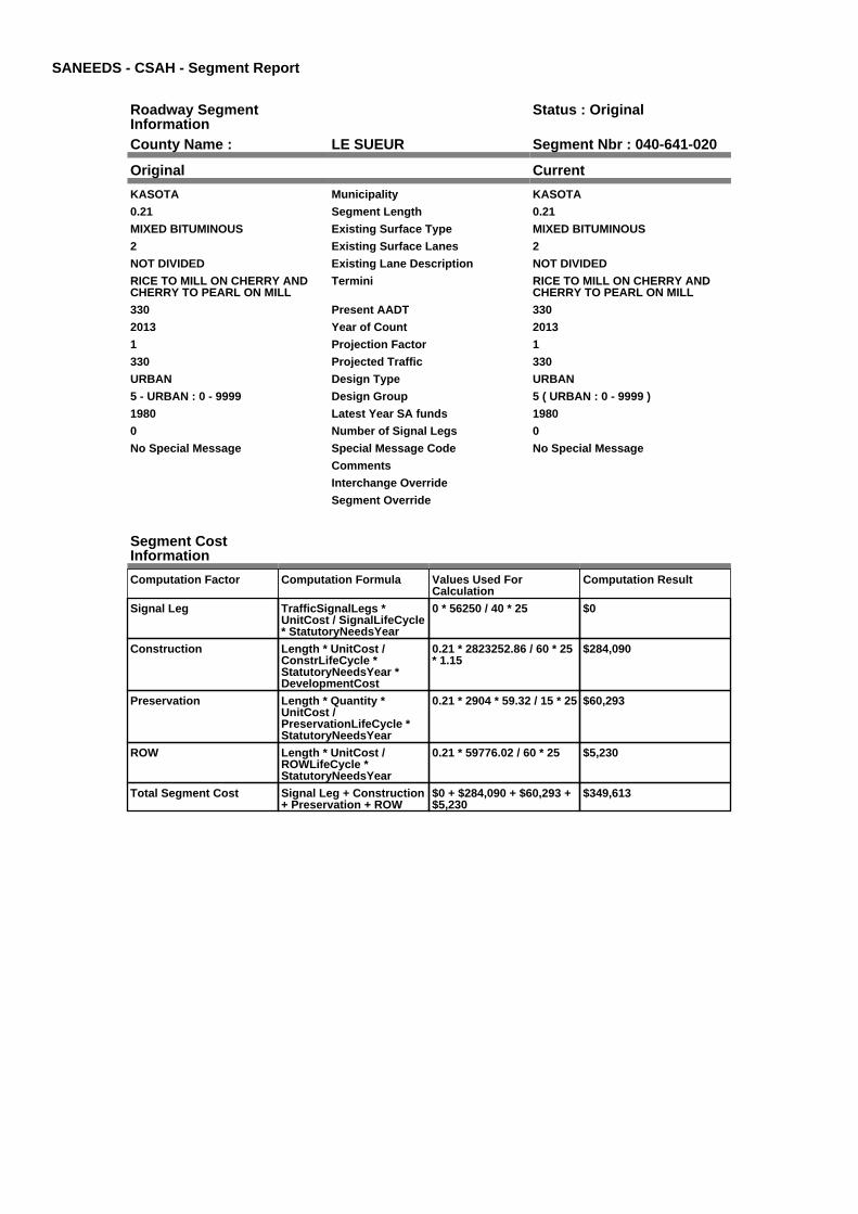
SANEEDS - CSAH - Segment Report
Roadway SegmentInformation
Status : Original
County Name : LE SUEUR Segment Nbr : 040-641-020
Original Current
KASOTA Municipality KASOTA
0.21 Segment Length 0.21
MIXED BITUMINOUS Existing Surface Type MIXED BITUMINOUS
2 Existing Surface Lanes 2
NOT DIVIDED Existing Lane Description NOT DIVIDED
RICE TO MILL ON CHERRY ANDCHERRY TO PEARL ON MILL
Termini RICE TO MILL ON CHERRY ANDCHERRY TO PEARL ON MILL
330 Present AADT 330
2013 Year of Count 2013
1 Projection Factor 1
330 Projected Traffic 330
URBAN Design Type URBAN
5 - URBAN : 0 - 9999 Design Group 5 ( URBAN : 0 - 9999 )
1980 Latest Year SA funds 1980
0 Number of Signal Legs 0
No Special Message Special Message Code No Special Message
Comments
Interchange Override
Segment Override
Segment CostInformation
Computation Factor Computation Formula Values Used ForCalculation
Computation Result
Signal Leg TrafficSignalLegs *UnitCost / SignalLifeCycle* StatutoryNeedsYear
0 * 56250 / 40 * 25 $0
Construction Length * UnitCost /ConstrLifeCycle *StatutoryNeedsYear *DevelopmentCost
0.21 * 2823252.86 / 60 * 25* 1.15
$284,090
Preservation Length * Quantity *UnitCost /PreservationLifeCycle *StatutoryNeedsYear
0.21 * 2904 * 59.32 / 15 * 25 $60,293
ROW Length * UnitCost /ROWLifeCycle *StatutoryNeedsYear
0.21 * 59776.02 / 60 * 25 $5,230
Total Segment Cost Signal Leg + Construction+ Preservation + ROW
$0 + $284,090 + $60,293 +$5,230
$349,613
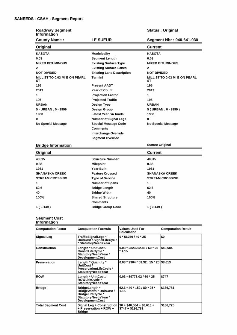
SANEEDS - CSAH - Segment Report
Roadway SegmentInformation
Status : Original
County Name : LE SUEUR Segment Nbr : 040-641-030
Original Current
KASOTA Municipality KASOTA
0.03 Segment Length 0.03
MIXED BITUMINOUS Existing Surface Type MIXED BITUMINOUS
2 Existing Surface Lanes 2
NOT DIVIDED Existing Lane Description NOT DIVIDED
MILL ST TO 0.03 MI E ON PEARLST
Termini MILL ST TO 0.03 MI E ON PEARLST
195 Present AADT 195
2013 Year of Count 2013
1 Projection Factor 1
195 Projected Traffic 195
URBAN Design Type URBAN
5 - URBAN : 0 - 9999 Design Group 5 ( URBAN : 0 - 9999 )
1980 Latest Year SA funds 1980
0 Number of Signal Legs 0
No Special Message Special Message Code No Special Message
Comments
Interchange Override
Segment Override
Bridge Information Status: Original
Original Current
40515 Structure Number 40515
0.38 Milepoint 0.38
1981 Year Built 1981
SHANASKA CREEK Feature Crossed SHANASKA CREEK
STREAM CROSSING Type of Service STREAM CROSSING
1 Number of Spans 1
62.6 Bridge Length 62.6
40 Bridge Width 40
100% Shared Structure 100%
Comments
1 ( 0-149 ) Bridge Group Code 1 ( 0-149 )
Segment CostInformation
Computation Factor Computation Formula Values Used ForCalculation
Computation Result
Signal Leg TrafficSignalLegs *UnitCost / SignalLifeCycle* StatutoryNeedsYear
0 * 56250 / 40 * 25 $0
Construction Length * UnitCost /ConstrLifeCycle *StatutoryNeedsYear *DevelopmentCost
0.03 * 2823252.86 / 60 * 25* 1.15
$40,584
Preservation Length * Quantity *UnitCost /PreservationLifeCycle *StatutoryNeedsYear
0.03 * 2904 * 59.32 / 15 * 25 $8,613
ROW Length * UnitCost /ROWLifeCycle *StatutoryNeedsYear
0.03 * 59776.02 / 60 * 25 $747
Bridge BridgeLength *BridgeWidth * UnitCost /BridgeLifeCycle *StatutoryNeedsYear *DevelopmentCost
62.6 * 40 * 152 / 80 * 25 *1.15
$136,781
Total Segment Cost Signal Leg + Construction+ Preservation + ROW +Bridge
$0 + $40,584 + $8,613 +$747 + $136,781
$186,725

SANEEDS - CSAH - Segment Report
Roadway SegmentInformation
Status : Original
County Name : LE SUEUR Segment Nbr : 040-641-040
Original Current
KASOTA Municipality KASOTA
0.43 Segment Length 0.43
MIXED BITUMINOUS Existing Surface Type MIXED BITUMINOUS
2 Existing Surface Lanes 2
NOT DIVIDED Existing Lane Description NOT DIVIDED
0.03 MI E OF MILL ST TO TH 22 INKASOTA ON PEARL STREET
Termini 0.03 MI E OF MILL ST TO TH 22 INKASOTA ON PEARL STREET
195 Present AADT 195
2013 Year of Count 2013
1 Projection Factor 1
195 Projected Traffic 195
URBAN Design Type URBAN
5 - URBAN : 0 - 9999 Design Group 5 ( URBAN : 0 - 9999 )
2000 Latest Year SA funds 2000
0 Number of Signal Legs 0
No Special Message Special Message Code No Special Message
EXTENDED CASH 41 TO TH 22 Comments EXTENDED CASH 41 TO TH 22
Interchange Override
Segment Override
Segment CostInformation
Computation Factor Computation Formula Values Used ForCalculation
Computation Result
Signal Leg TrafficSignalLegs *UnitCost / SignalLifeCycle* StatutoryNeedsYear
0 * 56250 / 40 * 25 $0
Construction Length * UnitCost /ConstrLifeCycle *StatutoryNeedsYear *DevelopmentCost
0.43 * 2823252.86 / 60 * 25* 1.15
$581,708
Preservation Length * Quantity *UnitCost /PreservationLifeCycle *StatutoryNeedsYear
0.43 * 2904 * 59.32 / 15 * 25 $123,457
ROW Length * UnitCost /ROWLifeCycle *StatutoryNeedsYear
0.43 * 59776.02 / 60 * 25 $10,710
Total Segment Cost Signal Leg + Construction+ Preservation + ROW
$0 + $581,708 + $123,457+ $10,710
$715,875

SANEEDS - CSAH - Segment Report
Roadway SegmentInformation
Status : Original
County Name : LE SUEUR Segment Nbr : 040-643-010
Original Current
KASOTA Municipality KASOTA
0.07 Segment Length 0.07
MIXED BITUMINOUS Existing Surface Type MIXED BITUMINOUS
2 Existing Surface Lanes 2
NOT DIVIDED Existing Lane Description NOT DIVIDED
CHERRY ST(CSAH 41) TO HILL ST(CSAH 21) ON WEBSTER ST
Termini CHERRY ST(CSAH 41) TO HILL ST(CSAH 21) ON WEBSTER ST
325 Present AADT 325
2013 Year of Count 2013
1 Projection Factor 1
325 Projected Traffic 325
URBAN Design Type URBAN
5 - URBAN : 0 - 9999 Design Group 5 ( URBAN : 0 - 9999 )
2000 Latest Year SA funds 2000
0 Number of Signal Legs 0
No Special Message Special Message Code No Special Message
Comments
Interchange Override
Segment Override
Segment CostInformation
Computation Factor Computation Formula Values Used ForCalculation
Computation Result
Signal Leg TrafficSignalLegs *UnitCost / SignalLifeCycle* StatutoryNeedsYear
0 * 56250 / 40 * 25 $0
Construction Length * UnitCost /ConstrLifeCycle *StatutoryNeedsYear *DevelopmentCost
0.07 * 2823252.86 / 60 * 25* 1.15
$94,697
Preservation Length * Quantity *UnitCost /PreservationLifeCycle *StatutoryNeedsYear
0.07 * 2904 * 59.32 / 15 * 25 $20,098
ROW Length * UnitCost /ROWLifeCycle *StatutoryNeedsYear
0.07 * 59776.02 / 60 * 25 $1,743
Total Segment Cost Signal Leg + Construction+ Preservation + ROW
$0 + $94,697 + $20,098 +$1,743
$116,538

SANEEDS - CSAH - Segment Report
Roadway SegmentInformation
Status : Original
County Name : LE SUEUR Segment Nbr : 040-644-010
Original Current
KASOTA Municipality KASOTA
0.07 Segment Length 0.07
MIXED BITUMINOUS Existing Surface Type MIXED BITUMINOUS
2 Existing Surface Lanes 2
NOT DIVIDED Existing Lane Description NOT DIVIDED
CHERRY ST(CSAH 41) TO HILL ST(CSAH 21) ON RICE ST
Termini CHERRY ST(CSAH 41) TO HILL ST(CSAH 21) ON RICE ST
410 Present AADT 410
2013 Year of Count 2013
1 Projection Factor 1
410 Projected Traffic 410
URBAN Design Type URBAN
5 - URBAN : 0 - 9999 Design Group 5 ( URBAN : 0 - 9999 )
2000 Latest Year SA funds 2000
0 Number of Signal Legs 0
No Special Message Special Message Code No Special Message
Comments
Interchange Override
Segment Override
Segment CostInformation
Computation Factor Computation Formula Values Used ForCalculation
Computation Result
Signal Leg TrafficSignalLegs *UnitCost / SignalLifeCycle* StatutoryNeedsYear
0 * 56250 / 40 * 25 $0
Construction Length * UnitCost /ConstrLifeCycle *StatutoryNeedsYear *DevelopmentCost
0.07 * 2823252.86 / 60 * 25* 1.15
$94,697
Preservation Length * Quantity *UnitCost /PreservationLifeCycle *StatutoryNeedsYear
0.07 * 2904 * 59.32 / 15 * 25 $20,098
ROW Length * UnitCost /ROWLifeCycle *StatutoryNeedsYear
0.07 * 59776.02 / 60 * 25 $1,743
Total Segment Cost Signal Leg + Construction+ Preservation + ROW
$0 + $94,697 + $20,098 +$1,743
$116,538
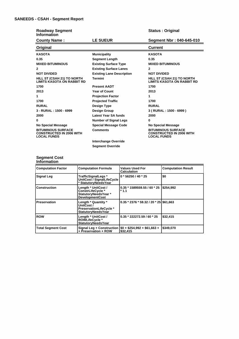
SANEEDS - CSAH - Segment Report
Roadway SegmentInformation
Status : Original
County Name : LE SUEUR Segment Nbr : 040-645-010
Original Current
KASOTA Municipality KASOTA
0.35 Segment Length 0.35
MIXED BITUMINOUS Existing Surface Type MIXED BITUMINOUS
2 Existing Surface Lanes 2
NOT DIVIDED Existing Lane Description NOT DIVIDED
HILL ST (CSAH 21) TO NORTHLIMITS KASOTA ON RABBIT RD
Termini HILL ST (CSAH 21) TO NORTHLIMITS KASOTA ON RABBIT RD
1700 Present AADT 1700
2013 Year of Count 2013
1 Projection Factor 1
1700 Projected Traffic 1700
RURAL Design Type RURAL
3 - RURAL : 1500 - 6999 Design Group 3 ( RURAL : 1500 - 6999 )
2000 Latest Year SA funds 2000
0 Number of Signal Legs 0
No Special Message Special Message Code No Special Message
BITUMINOUS SURFACECONSTRUCTED IN 2006 WITHLOCAL FUNDS
Comments BITUMINOUS SURFACECONSTRUCTED IN 2006 WITHLOCAL FUNDS
Interchange Override
Segment Override
Segment CostInformation
Computation Factor Computation Formula Values Used ForCalculation
Computation Result
Signal Leg TrafficSignalLegs *UnitCost / SignalLifeCycle* StatutoryNeedsYear
0 * 56250 / 40 * 25 $0
Construction Length * UnitCost /ConstrLifeCycle *StatutoryNeedsYear *DevelopmentCost
0.35 * 1589559.55 / 60 * 25* 1.1
$254,992
Preservation Length * Quantity *UnitCost /PreservationLifeCycle *StatutoryNeedsYear
0.35 * 2376 * 59.32 / 20 * 25 $61,663
ROW Length * UnitCost /ROWLifeCycle *StatutoryNeedsYear
0.35 * 222272.59 / 60 * 25 $32,415
Total Segment Cost Signal Leg + Construction+ Preservation + ROW
$0 + $254,992 + $61,663 +$32,415
$349,070

SANEEDS - CSAH - Segment Report
Roadway SegmentInformation
Status : Original
County Name : LE SUEUR Segment Nbr : 040-645-020
Original Current
Unassigned/Unknown Municipality Unassigned/Unknown
1.8 Segment Length 1.8
MIXED BITUMINOUS Existing Surface Type MIXED BITUMINOUS
2 Existing Surface Lanes 2
NOT DIVIDED Existing Lane Description NOT DIVIDED
NORTH CITY LIMITS OF KASOTATO T.H. 99
Termini NORTH CITY LIMITS OF KASOTATO T.H. 99
2100 Present AADT 2100
2013 Year of Count 2013
1 Projection Factor 1
2100 Projected Traffic 2100
RURAL Design Type RURAL
3 - RURAL : 1500 - 6999 Design Group 3 ( RURAL : 1500 - 6999 )
Latest Year SA funds
0 Number of Signal Legs 0
No Special Message Special Message Code No Special Message
2009 ADDED TO CSAH SYSTEM.CURRENTLY RURAL EXISTING,PROPOSED URBAN DESIGN.
C.O. 91176
Comments 2009 ADDED TO CSAH SYSTEM.CURRENTLY RURAL EXISTING,PROPOSED URBAN DESIGN.
C.O. 91176
Interchange Override
Segment Override
RailRoadCrossingInformation
Status: Original
Original Current
UNION PACIFIC RAILROAD RailRoad Name UNION PACIFIC RAILROAD
185389G USDOT Number 185389G
0.5 Located at Milepoint 0.5
1 Mainline Tracks 1
SIGNALS & GATES Protection Type SIGNALS & GATES
2000 Last Year Protection Upgraded 2000
32 Crossing Length 32
Last Year Surfaced
100% Percentage of Cost 100%
Comments
RailRoadCrossingInformation
Status: Original
Original Current
UNION PACIFIC RAILROAD RailRoad Name UNION PACIFIC RAILROAD
185391H USDOT Number 185391H
1.6 Located at Milepoint 1.6
1 Mainline Tracks 1
SIGNALS & GATES Protection Type SIGNALS & GATES
2010 Last Year Protection Upgraded 2010
58 Crossing Length 58
0 Last Year Surfaced 0
100% Percentage of Cost 100%
SIGNAL, GATES AND CROSSINGREPLACED IN 2010, FLOODDAMAGE
Comments SIGNAL, GATES AND CROSSINGREPLACED IN 2010, FLOODDAMAGE
Segment CostInformation
Computation Factor Computation Formula Values Used ForCalculation
Computation Result

Signal Leg TrafficSignalLegs *UnitCost / SignalLifeCycle* StatutoryNeedsYear
0 * 56250 / 40 * 25 $0
Construction Length * UnitCost /ConstrLifeCycle *StatutoryNeedsYear *DevelopmentCost
1.8 * 1589559.55 / 60 * 25 *1.1
$1,311,387
Preservation Length * Quantity *UnitCost /PreservationLifeCycle *StatutoryNeedsYear
1.8 * 2376 * 59.32 / 20 * 25 $317,125
ROW Length * UnitCost /ROWLifeCycle *StatutoryNeedsYear
1.8 * 222272.59 / 60 * 25 $166,704
RR Crossing Protection UnitCost /RRCrossingLifeCycle *StatutoryNeedsYear
325000 / 25 * 25 $325,000
RR Crossing Surface SurfaceLength * UnitCost/ RRCrossingLifeCycle *StatutoryNeedsYear
32 * 1350 / 25 * 25 $43,200
RR Crossing Protection UnitCost /RRCrossingLifeCycle *StatutoryNeedsYear
325000 / 25 * 25 $325,000
RR Crossing Surface SurfaceLength * UnitCost/ RRCrossingLifeCycle *StatutoryNeedsYear
58 * 1350 / 25 * 25 $78,300
Total Segment Cost Signal Leg + Construction+ Preservation + ROW +RR Crossing Protection +RR Crossing Surface +RR Crossing Protection +RR Crossing Surface
$0 + $1,311,387 + $317,125+ $166,704 + $325,000 +$43,200 + $325,000 +$78,300
$2,566,716

SANEEDS - CSAH - Segment Report
Roadway SegmentInformation
Status : Original
County Name : LE SUEUR Segment Nbr : 040-645-030
Original Current
Unassigned/Unknown Municipality Unassigned/Unknown
0.1 Segment Length 0.1
MIXED BITUMINOUS Existing Surface Type MIXED BITUMINOUS
2 Existing Surface Lanes 2
NOT DIVIDED Existing Lane Description NOT DIVIDED
CSAH 45 TO T.H. 22 ON 446THSTREET
Termini CSAH 45 TO T.H. 22 ON 446THSTREET
1300 Present AADT 1300
2013 Year of Count 2013
1 Projection Factor 1
1300 Projected Traffic 1300
RURAL Design Type RURAL
2 - RURAL : 150 - 1499 Design Group 2 ( RURAL : 150 - 1499 )
Latest Year SA funds
0 Number of Signal Legs 0
No Special Message Special Message Code No Special Message
FORMERLY PART OF CR 102(446TH ST.)
CO. 91176
Comments FORMERLY PART OF CR 102(446TH ST.)
CO. 91176
Interchange Override
Segment Override
Segment CostInformation
Computation Factor Computation Formula Values Used ForCalculation
Computation Result
Signal Leg TrafficSignalLegs *UnitCost / SignalLifeCycle* StatutoryNeedsYear
0 * 56250 / 40 * 25 $0
Construction Length * UnitCost /ConstrLifeCycle *StatutoryNeedsYear *DevelopmentCost
0.1 * 801370.7 / 60 * 25 *1.1
$36,729
Preservation Length * Quantity *UnitCost /PreservationLifeCycle *StatutoryNeedsYear
0.1 * 2112 * 59.32 / 20 * 25 $15,660
ROW Length * UnitCost /ROWLifeCycle *StatutoryNeedsYear
0.1 * 36798.68 / 60 * 25 $1,533
Total Segment Cost Signal Leg + Construction+ Preservation + ROW
$0 + $36,729 + $15,660 +$1,533
$53,922

SANEEDS - CSAH - Segment Report
Roadway SegmentInformation
Status : Original
County Name : LE SUEUR Segment Nbr : 040-646-020
Original Current
CLEVELAND Municipality CLEVELAND
0.37 Segment Length 0.37
MIXED BITUMINOUS Existing Surface Type MIXED BITUMINOUS
2 Existing Surface Lanes 2
NOT DIVIDED Existing Lane Description NOT DIVIDED
TH 99 TO 6TH ST (CSAH 47) ONBROADWAY ST
Termini TH 99 TO 6TH ST (CSAH 47) ONBROADWAY ST
1050 Present AADT 1050
2013 Year of Count 2013
1 Projection Factor 1
1050 Projected Traffic 1050
URBAN Design Type URBAN
5 - URBAN : 0 - 9999 Design Group 5 ( URBAN : 0 - 9999 )
1995 Latest Year SA funds 1995
0 Number of Signal Legs 0
No Special Message Special Message Code No Special Message
Comments
Interchange Override
Segment Override
Culvert Information Status: Original
Original Current
88016 Structure Number 88016
0.1 Milepoint 0.1
1920 Year Built 1920
CHERRY CREEK Feature Crossed CHERRY CREEK
Type of Service
1 Number of Barrels 1
10 Culvert Width 10
10 Culvert Height 10
62 Culvert Length 62
99.99986017 Area of Waterway Opening 99.99986017
100% Shared Structure 100%
Comments
1 Culvert Group Code 1
Segment CostInformation
Computation Factor Computation Formula Values Used ForCalculation
Computation Result
Signal Leg TrafficSignalLegs *UnitCost / SignalLifeCycle* StatutoryNeedsYear
0 * 56250 / 40 * 25 $0
Construction Length * UnitCost /ConstrLifeCycle *StatutoryNeedsYear *DevelopmentCost
0.37 * 2823252.86 / 60 * 25* 1.15
$500,539
Preservation Length * Quantity *UnitCost /PreservationLifeCycle *StatutoryNeedsYear
0.37 * 2904 * 59.32 / 15 * 25 $106,230
ROW Length * UnitCost /ROWLifeCycle *StatutoryNeedsYear
0.37 * 59776.02 / 60 * 25 $9,215
Culvert CulvertLength * Area *UnitCost /CulvertLifeCycle *StatutoryNeedsYear *DevelopmentCost
62 * 99.99986017 * 15.47 /100 * 25 * 1.15
$27,575
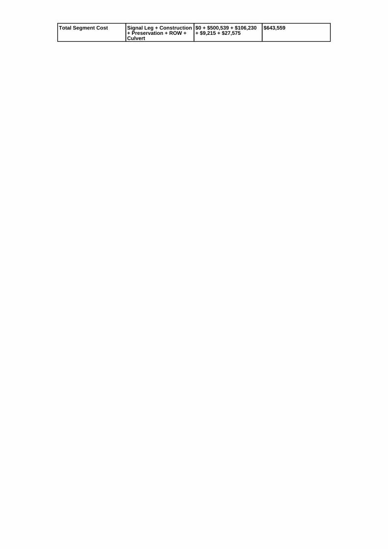
Total Segment Cost Signal Leg + Construction+ Preservation + ROW +Culvert
$0 + $500,539 + $106,230+ $9,215 + $27,575
$643,559

SANEEDS - CSAH - Segment Report
Roadway SegmentInformation
Status : Original
County Name : LE SUEUR Segment Nbr : 040-646-021
Original Current
CLEVELAND Municipality CLEVELAND
0.28 Segment Length 0.28
MIXED BITUMINOUS Existing Surface Type MIXED BITUMINOUS
2 Existing Surface Lanes 2
NOT DIVIDED Existing Lane Description NOT DIVIDED
6TH ST (CSAH 47) TO 10TH ST(CSAH 15) ON BROADWAY AVE
Termini 6TH ST (CSAH 47) TO 10TH ST(CSAH 15) ON BROADWAY AVE
630 Present AADT 630
2013 Year of Count 2013
1 Projection Factor 1
630 Projected Traffic 630
URBAN Design Type URBAN
5 - URBAN : 0 - 9999 Design Group 5 ( URBAN : 0 - 9999 )
2007 Latest Year SA funds 2007
0 Number of Signal Legs 0
No Special Message Special Message Code No Special Message
RECONSTRUCTED UNDER SAP40-646-003, BIT WEAR 2007SAP 40-646-004,2007
Comments RECONSTRUCTED UNDER SAP40-646-003, BIT WEAR 2007SAP 40-646-004,2007
Interchange Override
Segment Override
Segment CostInformation
Computation Factor Computation Formula Values Used ForCalculation
Computation Result
Signal Leg TrafficSignalLegs *UnitCost / SignalLifeCycle* StatutoryNeedsYear
0 * 56250 / 40 * 25 $0
Construction Length * UnitCost /ConstrLifeCycle *StatutoryNeedsYear *DevelopmentCost
0.28 * 2823252.86 / 60 * 25* 1.15
$378,786
Preservation Length * Quantity *UnitCost /PreservationLifeCycle *StatutoryNeedsYear
0.28 * 2904 * 59.32 / 15 * 25 $80,390
ROW Length * UnitCost /ROWLifeCycle *StatutoryNeedsYear
0.28 * 59776.02 / 60 * 25 $6,974
Total Segment Cost Signal Leg + Construction+ Preservation + ROW
$0 + $378,786 + $80,390 +$6,974
$466,150

SANEEDS - CSAH - Segment Report
Roadway SegmentInformation
Status : Original
County Name : LE SUEUR Segment Nbr : 040-647-010
Original Current
CLEVELAND Municipality CLEVELAND
0.2 Segment Length 0.2
MIXED BITUMINOUS Existing Surface Type MIXED BITUMINOUS
2 Existing Surface Lanes 2
NOT DIVIDED Existing Lane Description NOT DIVIDED
BROADWAY ST (CSAH 46) TOCOLUMBIA ST ON 6TH ST
Termini BROADWAY ST (CSAH 46) TOCOLUMBIA ST ON 6TH ST
660 Present AADT 660
2013 Year of Count 2013
1 Projection Factor 1
660 Projected Traffic 660
URBAN Design Type URBAN
5 - URBAN : 0 - 9999 Design Group 5 ( URBAN : 0 - 9999 )
1995 Latest Year SA funds 1995
0 Number of Signal Legs 0
No Special Message Special Message Code No Special Message
Comments
Interchange Override
Segment Override
Segment CostInformation
Computation Factor Computation Formula Values Used ForCalculation
Computation Result
Signal Leg TrafficSignalLegs *UnitCost / SignalLifeCycle* StatutoryNeedsYear
0 * 56250 / 40 * 25 $0
Construction Length * UnitCost /ConstrLifeCycle *StatutoryNeedsYear *DevelopmentCost
0.2 * 2823252.86 / 60 * 25 *1.15
$270,562
Preservation Length * Quantity *UnitCost /PreservationLifeCycle *StatutoryNeedsYear
0.2 * 2904 * 59.32 / 15 * 25 $57,422
ROW Length * UnitCost /ROWLifeCycle *StatutoryNeedsYear
0.2 * 59776.02 / 60 * 25 $4,981
Total Segment Cost Signal Leg + Construction+ Preservation + ROW
$0 + $270,562 + $57,422 +$4,981
$332,965

SANEEDS - CSAH - Segment Report
Roadway SegmentInformation
Status : Original
County Name : LE SUEUR Segment Nbr : 040-647-020
Original Current
CLEVELAND Municipality CLEVELAND
0.07 Segment Length 0.07
MIXED BITUMINOUS Existing Surface Type MIXED BITUMINOUS
2 Existing Surface Lanes 2
NOT DIVIDED Existing Lane Description NOT DIVIDED
6TH ST TO 7TH ST ON COLUMBIAST
Termini 6TH ST TO 7TH ST ON COLUMBIAST
300 Present AADT 300
2013 Year of Count 2013
1 Projection Factor 1
300 Projected Traffic 300
URBAN Design Type URBAN
5 - URBAN : 0 - 9999 Design Group 5 ( URBAN : 0 - 9999 )
1995 Latest Year SA funds 1995
0 Number of Signal Legs 0
No Special Message Special Message Code No Special Message
Comments
Interchange Override
Segment Override
Segment CostInformation
Computation Factor Computation Formula Values Used ForCalculation
Computation Result
Signal Leg TrafficSignalLegs *UnitCost / SignalLifeCycle* StatutoryNeedsYear
0 * 56250 / 40 * 25 $0
Construction Length * UnitCost /ConstrLifeCycle *StatutoryNeedsYear *DevelopmentCost
0.07 * 2823252.86 / 60 * 25* 1.15
$94,697
Preservation Length * Quantity *UnitCost /PreservationLifeCycle *StatutoryNeedsYear
0.07 * 2904 * 59.32 / 15 * 25 $20,098
ROW Length * UnitCost /ROWLifeCycle *StatutoryNeedsYear
0.07 * 59776.02 / 60 * 25 $1,743
Total Segment Cost Signal Leg + Construction+ Preservation + ROW
$0 + $94,697 + $20,098 +$1,743
$116,538

SANEEDS - CSAH - Segment Report
Roadway SegmentInformation
Status : Original
County Name : LE SUEUR Segment Nbr : 040-647-021
Original Current
CLEVELAND Municipality CLEVELAND
0.2 Segment Length 0.2
MIXED BITUMINOUS Existing Surface Type MIXED BITUMINOUS
2 Existing Surface Lanes 2
NOT DIVIDED Existing Lane Description NOT DIVIDED
7TH ST TO 10TH ST (CSAH 15) ONCOLUMBIA ST
Termini 7TH ST TO 10TH ST (CSAH 15) ONCOLUMBIA ST
300 Present AADT 300
2013 Year of Count 2013
1 Projection Factor 1
300 Projected Traffic 300
URBAN Design Type URBAN
5 - URBAN : 0 - 9999 Design Group 5 ( URBAN : 0 - 9999 )
1983 Latest Year SA funds 1983
0 Number of Signal Legs 0
No Special Message Special Message Code No Special Message
Comments
Interchange Override
Segment Override
Segment CostInformation
Computation Factor Computation Formula Values Used ForCalculation
Computation Result
Signal Leg TrafficSignalLegs *UnitCost / SignalLifeCycle* StatutoryNeedsYear
0 * 56250 / 40 * 25 $0
Construction Length * UnitCost /ConstrLifeCycle *StatutoryNeedsYear *DevelopmentCost
0.2 * 2823252.86 / 60 * 25 *1.15
$270,562
Preservation Length * Quantity *UnitCost /PreservationLifeCycle *StatutoryNeedsYear
0.2 * 2904 * 59.32 / 15 * 25 $57,422
ROW Length * UnitCost /ROWLifeCycle *StatutoryNeedsYear
0.2 * 59776.02 / 60 * 25 $4,981
Total Segment Cost Signal Leg + Construction+ Preservation + ROW
$0 + $270,562 + $57,422 +$4,981
$332,965

SANEEDS - CSAH - Segment Report
Roadway SegmentInformation
Status : Original
County Name : LE SUEUR Segment Nbr : 040-649-010
Original Current
CLEVELAND Municipality CLEVELAND
0.3 Segment Length 0.3
MIXED BITUMINOUS Existing Surface Type MIXED BITUMINOUS
2 Existing Surface Lanes 2
NOT DIVIDED Existing Lane Description NOT DIVIDED
SOUTH LIMITS CLEVELAND TOMAIN STREET ON 2ND STREET
Termini SOUTH LIMITS CLEVELAND TOMAIN STREET ON 2ND STREET
900 Present AADT 900
2013 Year of Count 2013
1 Projection Factor 1
900 Projected Traffic 900
URBAN Design Type URBAN
5 - URBAN : 0 - 9999 Design Group 5 ( URBAN : 0 - 9999 )
1972 Latest Year SA funds 1972
0 Number of Signal Legs 0
No Special Message Special Message Code No Special Message
Comments
Interchange Override
Segment Override
Segment CostInformation
Computation Factor Computation Formula Values Used ForCalculation
Computation Result
Signal Leg TrafficSignalLegs *UnitCost / SignalLifeCycle* StatutoryNeedsYear
0 * 56250 / 40 * 25 $0
Construction Length * UnitCost /ConstrLifeCycle *StatutoryNeedsYear *DevelopmentCost
0.3 * 2823252.86 / 60 * 25 *1.15
$405,843
Preservation Length * Quantity *UnitCost /PreservationLifeCycle *StatutoryNeedsYear
0.3 * 2904 * 59.32 / 15 * 25 $86,133
ROW Length * UnitCost /ROWLifeCycle *StatutoryNeedsYear
0.3 * 59776.02 / 60 * 25 $7,472
Total Segment Cost Signal Leg + Construction+ Preservation + ROW
$0 + $405,843 + $86,133 +$7,472
$499,448

SANEEDS - CSAH - Segment Report
Roadway SegmentInformation
Status : Original
County Name : LE SUEUR Segment Nbr : 040-649-020
Original Current
CLEVELAND Municipality CLEVELAND
0.14 Segment Length 0.14
MIXED BITUMINOUS Existing Surface Type MIXED BITUMINOUS
2 Existing Surface Lanes 2
NOT DIVIDED Existing Lane Description NOT DIVIDED
MAIN ST TO BROADWAY ST(CSAH 46) ON 2ND ST
Termini MAIN ST TO BROADWAY ST(CSAH 46) ON 2ND ST
900 Present AADT 900
2013 Year of Count 2013
1 Projection Factor 1
900 Projected Traffic 900
URBAN Design Type URBAN
5 - URBAN : 0 - 9999 Design Group 5 ( URBAN : 0 - 9999 )
2011 Latest Year SA funds 2011
0 Number of Signal Legs 0
No Special Message Special Message Code No Special Message
Comments
Interchange Override
Segment Override
Segment CostInformation
Computation Factor Computation Formula Values Used ForCalculation
Computation Result
Signal Leg TrafficSignalLegs *UnitCost / SignalLifeCycle* StatutoryNeedsYear
0 * 56250 / 40 * 25 $0
Construction Length * UnitCost /ConstrLifeCycle *StatutoryNeedsYear *DevelopmentCost
0.14 * 2823252.86 / 60 * 25* 1.15
$189,393
Preservation Length * Quantity *UnitCost /PreservationLifeCycle *StatutoryNeedsYear
0.14 * 2904 * 59.32 / 15 * 25 $40,195
ROW Length * UnitCost /ROWLifeCycle *StatutoryNeedsYear
0.14 * 59776.02 / 60 * 25 $3,487
Total Segment Cost Signal Leg + Construction+ Preservation + ROW
$0 + $189,393 + $40,195 +$3,487
$233,075

SANEEDS - CSAH - Segment Report
Roadway SegmentInformation
Status : Original
County Name : LE SUEUR Segment Nbr : 040-650-010
Original Current
ELYSIAN Municipality ELYSIAN
0.67 Segment Length 0.67
MIXED BITUMINOUS Existing Surface Type MIXED BITUMINOUS
2 Existing Surface Lanes 2
NOT DIVIDED Existing Lane Description NOT DIVIDED
TH 60 TO TH 60 Termini TH 60 TO TH 60
740 Present AADT 740
2013 Year of Count 2013
1 Projection Factor 1
740 Projected Traffic 740
URBAN Design Type URBAN
5 - URBAN : 0 - 9999 Design Group 5 ( URBAN : 0 - 9999 )
1993 Latest Year SA funds 1993
0 Number of Signal Legs 0
No Special Message Special Message Code No Special Message
COMBINED SEGMENTS 010, 020 &030USED HIGHER PRESENT TRAFFIC
Comments COMBINED SEGMENTS 010, 020 &030USED HIGHER PRESENT TRAFFIC
Interchange Override
Segment Override
Segment CostInformation
Computation Factor Computation Formula Values Used ForCalculation
Computation Result
Signal Leg TrafficSignalLegs *UnitCost / SignalLifeCycle* StatutoryNeedsYear
0 * 56250 / 40 * 25 $0
Construction Length * UnitCost /ConstrLifeCycle *StatutoryNeedsYear *DevelopmentCost
0.67 * 2823252.86 / 60 * 25* 1.15
$906,382
Preservation Length * Quantity *UnitCost /PreservationLifeCycle *StatutoryNeedsYear
0.67 * 2904 * 59.32 / 15 * 25 $192,363
ROW Length * UnitCost /ROWLifeCycle *StatutoryNeedsYear
0.67 * 59776.02 / 60 * 25 $16,687
Total Segment Cost Signal Leg + Construction+ Preservation + ROW
$0 + $906,382 + $192,363+ $16,687
$1,115,432

SANEEDS - CSAH - Segment Report
Roadway SegmentInformation
Status : Original
County Name : LE SUEUR Segment Nbr : 040-652-010
Original Current
WATERVILLE Municipality WATERVILLE
0.06 Segment Length 0.06
MIXED BITUMINOUS Existing Surface Type MIXED BITUMINOUS
2 Existing Surface Lanes 2
NOT DIVIDED Existing Lane Description NOT DIVIDED
MAIN ST (CSAH 14) TO PAQUIN ST(CSAH 53) ON 1ST ST
Termini MAIN ST (CSAH 14) TO PAQUIN ST(CSAH 53) ON 1ST ST
280 Present AADT 280
2013 Year of Count 2013
1 Projection Factor 1
280 Projected Traffic 280
URBAN Design Type URBAN
5 - URBAN : 0 - 9999 Design Group 5 ( URBAN : 0 - 9999 )
2000 Latest Year SA funds 2000
0 Number of Signal Legs 0
No Special Message Special Message Code No Special Message
Comments
Interchange Override
Segment Override
Segment CostInformation
Computation Factor Computation Formula Values Used ForCalculation
Computation Result
Signal Leg TrafficSignalLegs *UnitCost / SignalLifeCycle* StatutoryNeedsYear
0 * 56250 / 40 * 25 $0
Construction Length * UnitCost /ConstrLifeCycle *StatutoryNeedsYear *DevelopmentCost
0.06 * 2823252.86 / 60 * 25* 1.15
$81,169
Preservation Length * Quantity *UnitCost /PreservationLifeCycle *StatutoryNeedsYear
0.06 * 2904 * 59.32 / 15 * 25 $17,227
ROW Length * UnitCost /ROWLifeCycle *StatutoryNeedsYear
0.06 * 59776.02 / 60 * 25 $1,494
Total Segment Cost Signal Leg + Construction+ Preservation + ROW
$0 + $81,169 + $17,227 +$1,494
$99,890
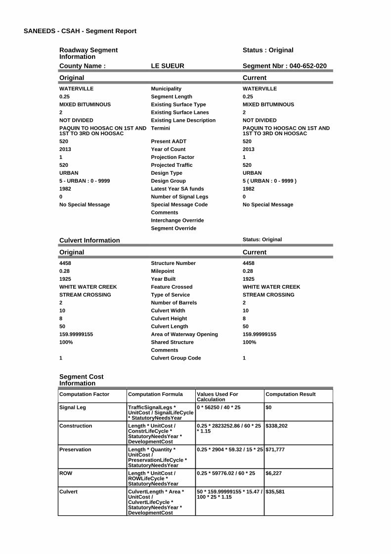
SANEEDS - CSAH - Segment Report
Roadway SegmentInformation
Status : Original
County Name : LE SUEUR Segment Nbr : 040-652-020
Original Current
WATERVILLE Municipality WATERVILLE
0.25 Segment Length 0.25
MIXED BITUMINOUS Existing Surface Type MIXED BITUMINOUS
2 Existing Surface Lanes 2
NOT DIVIDED Existing Lane Description NOT DIVIDED
PAQUIN TO HOOSAC ON 1ST AND1ST TO 3RD ON HOOSAC
Termini PAQUIN TO HOOSAC ON 1ST AND1ST TO 3RD ON HOOSAC
520 Present AADT 520
2013 Year of Count 2013
1 Projection Factor 1
520 Projected Traffic 520
URBAN Design Type URBAN
5 - URBAN : 0 - 9999 Design Group 5 ( URBAN : 0 - 9999 )
1982 Latest Year SA funds 1982
0 Number of Signal Legs 0
No Special Message Special Message Code No Special Message
Comments
Interchange Override
Segment Override
Culvert Information Status: Original
Original Current
4458 Structure Number 4458
0.28 Milepoint 0.28
1925 Year Built 1925
WHITE WATER CREEK Feature Crossed WHITE WATER CREEK
STREAM CROSSING Type of Service STREAM CROSSING
2 Number of Barrels 2
10 Culvert Width 10
8 Culvert Height 8
50 Culvert Length 50
159.99999155 Area of Waterway Opening 159.99999155
100% Shared Structure 100%
Comments
1 Culvert Group Code 1
Segment CostInformation
Computation Factor Computation Formula Values Used ForCalculation
Computation Result
Signal Leg TrafficSignalLegs *UnitCost / SignalLifeCycle* StatutoryNeedsYear
0 * 56250 / 40 * 25 $0
Construction Length * UnitCost /ConstrLifeCycle *StatutoryNeedsYear *DevelopmentCost
0.25 * 2823252.86 / 60 * 25* 1.15
$338,202
Preservation Length * Quantity *UnitCost /PreservationLifeCycle *StatutoryNeedsYear
0.25 * 2904 * 59.32 / 15 * 25 $71,777
ROW Length * UnitCost /ROWLifeCycle *StatutoryNeedsYear
0.25 * 59776.02 / 60 * 25 $6,227
Culvert CulvertLength * Area *UnitCost /CulvertLifeCycle *StatutoryNeedsYear *DevelopmentCost
50 * 159.99999155 * 15.47 /100 * 25 * 1.15
$35,581

Total Segment Cost Signal Leg + Construction+ Preservation + ROW +Culvert
$0 + $338,202 + $71,777 +$6,227 + $35,581
$451,787

SANEEDS - CSAH - Segment Report
Roadway SegmentInformation
Status : Original
County Name : LE SUEUR Segment Nbr : 040-652-030
Original Current
WATERVILLE Municipality WATERVILLE
0.09 Segment Length 0.09
MIXED BITUMINOUS Existing Surface Type MIXED BITUMINOUS
2 Existing Surface Lanes 2
NOT DIVIDED Existing Lane Description NOT DIVIDED
HOOSAC ST TO PACQUIN ST(CSAH 53) ON 3RD ST
Termini HOOSAC ST TO PACQUIN ST(CSAH 53) ON 3RD ST
1150 Present AADT 1150
2013 Year of Count 2013
1 Projection Factor 1
1150 Projected Traffic 1150
URBAN Design Type URBAN
5 - URBAN : 0 - 9999 Design Group 5 ( URBAN : 0 - 9999 )
2000 Latest Year SA funds 2000
0 Number of Signal Legs 0
No Special Message Special Message Code No Special Message
Comments
Interchange Override
Segment Override
Bridge Information Status: Original
Original Current
L8751 Structure Number L8751
0.32 Milepoint 0.32
1922 Year Built 1922
WHITE WATER CREEK Feature Crossed WHITE WATER CREEK
STREAM CROSSING Type of Service STREAM CROSSING
1 Number of Spans 1
50.1 Bridge Length 50.1
67.7 Bridge Width 67.7
100% Shared Structure 100%
Comments
1 ( 0-149 ) Bridge Group Code 1 ( 0-149 )
Segment CostInformation
Computation Factor Computation Formula Values Used ForCalculation
Computation Result
Signal Leg TrafficSignalLegs *UnitCost / SignalLifeCycle* StatutoryNeedsYear
0 * 56250 / 40 * 25 $0
Construction Length * UnitCost /ConstrLifeCycle *StatutoryNeedsYear *DevelopmentCost
0.09 * 2823252.86 / 60 * 25* 1.15
$121,753
Preservation Length * Quantity *UnitCost /PreservationLifeCycle *StatutoryNeedsYear
0.09 * 2904 * 59.32 / 15 * 25 $25,840
ROW Length * UnitCost /ROWLifeCycle *StatutoryNeedsYear
0.09 * 59776.02 / 60 * 25 $2,242
Bridge BridgeLength *BridgeWidth * UnitCost /BridgeLifeCycle *StatutoryNeedsYear *DevelopmentCost
50.1 * 67.7 * 152 / 80 * 25 *1.15
$185,275
Total Segment Cost Signal Leg + Construction+ Preservation + ROW +Bridge
$0 + $121,753 + $25,840 +$2,242 + $185,275
$335,110

SANEEDS - CSAH - Segment Report
Roadway SegmentInformation
Status : Original
County Name : LE SUEUR Segment Nbr : 040-652-040
Original Current
WATERVILLE Municipality WATERVILLE
0.06 Segment Length 0.06
MIXED BITUMINOUS Existing Surface Type MIXED BITUMINOUS
2 Existing Surface Lanes 2
NOT DIVIDED Existing Lane Description NOT DIVIDED
PAQUIN ST (CSAH 53) TO MAIN ST(CSAH 14) ON 3RD ST
Termini PAQUIN ST (CSAH 53) TO MAIN ST(CSAH 14) ON 3RD ST
1350 Present AADT 1350
2013 Year of Count 2013
1 Projection Factor 1
1350 Projected Traffic 1350
URBAN Design Type URBAN
5 - URBAN : 0 - 9999 Design Group 5 ( URBAN : 0 - 9999 )
2000 Latest Year SA funds 2000
0 Number of Signal Legs 0
No Special Message Special Message Code No Special Message
Comments
Interchange Override
Segment Override
Segment CostInformation
Computation Factor Computation Formula Values Used ForCalculation
Computation Result
Signal Leg TrafficSignalLegs *UnitCost / SignalLifeCycle* StatutoryNeedsYear
0 * 56250 / 40 * 25 $0
Construction Length * UnitCost /ConstrLifeCycle *StatutoryNeedsYear *DevelopmentCost
0.06 * 2823252.86 / 60 * 25* 1.15
$81,169
Preservation Length * Quantity *UnitCost /PreservationLifeCycle *StatutoryNeedsYear
0.06 * 2904 * 59.32 / 15 * 25 $17,227
ROW Length * UnitCost /ROWLifeCycle *StatutoryNeedsYear
0.06 * 59776.02 / 60 * 25 $1,494
Total Segment Cost Signal Leg + Construction+ Preservation + ROW
$0 + $81,169 + $17,227 +$1,494
$99,890

SANEEDS - CSAH - Segment Report
Roadway SegmentInformation
Status : Original
County Name : LE SUEUR Segment Nbr : 040-653-009
Original Current
WATERVILLE Municipality WATERVILLE
0.09 Segment Length 0.09
MIXED BITUMINOUS Existing Surface Type MIXED BITUMINOUS
2 Existing Surface Lanes 2
NOT DIVIDED Existing Lane Description NOT DIVIDED
REED ST TO 1ST STREET (CSAH52) ON PAQUIN ST
Termini REED ST TO 1ST STREET (CSAH52) ON PAQUIN ST
1000 Present AADT 1000
2013 Year of Count 2013
1 Projection Factor 1
1000 Projected Traffic 1000
RURAL Design Type RURAL
2 - RURAL : 150 - 1499 Design Group 2 ( RURAL : 150 - 1499 )
1992 Latest Year SA funds 1992
0 Number of Signal Legs 0
No Special Message Special Message Code No Special Message
Comments
Interchange Override
Segment Override
Segment CostInformation
Computation Factor Computation Formula Values Used ForCalculation
Computation Result
Signal Leg TrafficSignalLegs *UnitCost / SignalLifeCycle* StatutoryNeedsYear
0 * 56250 / 40 * 25 $0
Construction Length * UnitCost /ConstrLifeCycle *StatutoryNeedsYear *DevelopmentCost
0.09 * 801370.7 / 60 * 25 *1.1
$33,057
Preservation Length * Quantity *UnitCost /PreservationLifeCycle *StatutoryNeedsYear
0.09 * 2112 * 59.32 / 20 * 25 $14,094
ROW Length * UnitCost /ROWLifeCycle *StatutoryNeedsYear
0.09 * 36798.68 / 60 * 25 $1,380
Total Segment Cost Signal Leg + Construction+ Preservation + ROW
$0 + $33,057 + $14,094 +$1,380
$48,531

SANEEDS - CSAH - Segment Report
Roadway SegmentInformation
Status : Deleted
County Name : LE SUEUR Segment Nbr : 040-653-010
Original Current
WATERVILLE Municipality WATERVILLE
0.08 Segment Length 0.08
MIXED BITUMINOUS Existing Surface Type MIXED BITUMINOUS
2 Existing Surface Lanes 2
NOT DIVIDED Existing Lane Description NOT DIVIDED
1ST STREET (CSAH 52) TO 2NDSTREET ON PAQUIN STREET
Termini 1ST STREET (CSAH 52) TO 2NDSTREET ON PAQUIN STREET
1000 Present AADT 1000
2013 Year of Count 2013
1 Projection Factor 1
1000 Projected Traffic 1000
URBAN Design Type URBAN
5 - URBAN : 0 - 9999 Design Group 5 ( URBAN : 0 - 9999 )
2000 Latest Year SA funds 2000
0 Number of Signal Legs 0
No Special Message Special Message Code No Special Message
Comments
Interchange Override
Segment Override
Segment CostInformation
Computation Factor Computation Formula Values Used ForCalculation
Computation Result
Deleted Segment If status is Deleted, resultis zero
$0
Total Segment Cost Deleted Segment $0 $0

SANEEDS - CSAH - Segment Report
Roadway SegmentInformation
Status : Deleted
County Name : LE SUEUR Segment Nbr : 040-653-020
Original Current
WATERVILLE Municipality WATERVILLE
0.08 Segment Length 0.08
MIXED BITUMINOUS Existing Surface Type MIXED BITUMINOUS
2 Existing Surface Lanes 2
NOT DIVIDED Existing Lane Description NOT DIVIDED
2ND ST TO 3RD ST (CSAH 52) ONPAQUIN STREET
Termini 2ND ST TO 3RD ST (CSAH 52) ONPAQUIN STREET
1000 Present AADT 1000
2013 Year of Count 2013
1 Projection Factor 1
1000 Projected Traffic 1000
URBAN Design Type URBAN
5 - URBAN : 0 - 9999 Design Group 5 ( URBAN : 0 - 9999 )
2000 Latest Year SA funds 2000
0 Number of Signal Legs 0
No Special Message Special Message Code No Special Message
Comments
Interchange Override
Segment Override
Segment CostInformation
Computation Factor Computation Formula Values Used ForCalculation
Computation Result
Deleted Segment If status is Deleted, resultis zero
$0
Total Segment Cost Deleted Segment $0 $0

SANEEDS - CSAH - Segment Report
Roadway SegmentInformation
Status : Original
County Name : LE SUEUR Segment Nbr : 040-653-030
Original Current
WATERVILLE Municipality WATERVILLE
0.13 Segment Length 0.13
MIXED BITUMINOUS Existing Surface Type MIXED BITUMINOUS
2 Existing Surface Lanes 2
NOT DIVIDED Existing Lane Description NOT DIVIDED
3RD ST TO 5TH ST ON PAQUIN ST Termini 3RD ST TO 5TH ST ON PAQUIN ST
1000 Present AADT 1000
2013 Year of Count 2013
1 Projection Factor 1
1000 Projected Traffic 1000
URBAN Design Type URBAN
5 - URBAN : 0 - 9999 Design Group 5 ( URBAN : 0 - 9999 )
1981 Latest Year SA funds 1981
0 Number of Signal Legs 0
No Special Message Special Message Code No Special Message
Comments
Interchange Override
Segment Override
Culvert Information Status: Original
Original Current
40507 Structure Number 40507
0.345 Milepoint 0.345
1978 Year Built 1978
WHITE WATER CREEK Feature Crossed WHITE WATER CREEK
STREAM CROSSING Type of Service STREAM CROSSING
2 Number of Barrels 2
0 Culvert Width 0
0 Culvert Height 0
82 Culvert Length 82
134.99975741 Area of Waterway Opening 134.99975741
100% Shared Structure 100%
Comments
1 Culvert Group Code 1
Segment CostInformation
Computation Factor Computation Formula Values Used ForCalculation
Computation Result
Signal Leg TrafficSignalLegs *UnitCost / SignalLifeCycle* StatutoryNeedsYear
0 * 56250 / 40 * 25 $0
Construction Length * UnitCost /ConstrLifeCycle *StatutoryNeedsYear *DevelopmentCost
0.13 * 2823252.86 / 60 * 25* 1.15
$175,865
Preservation Length * Quantity *UnitCost /PreservationLifeCycle *StatutoryNeedsYear
0.13 * 2904 * 59.32 / 15 * 25 $37,324
ROW Length * UnitCost /ROWLifeCycle *StatutoryNeedsYear
0.13 * 59776.02 / 60 * 25 $3,238
Culvert CulvertLength * Area *UnitCost /CulvertLifeCycle *StatutoryNeedsYear *DevelopmentCost
82 * 134.99975741 * 15.47 /100 * 25 * 1.15
$49,235
Total Segment Cost Signal Leg + Construction+ Preservation + ROW +Culvert
$0 + $175,865 + $37,324 +$3,238 + $49,235
$265,662

SANEEDS - CSAH - Segment Report
Roadway SegmentInformation
Status : Original
County Name : LE SUEUR Segment Nbr : 040-653-040
Original Current
WATERVILLE Municipality WATERVILLE
0.12 Segment Length 0.12
MIXED BITUMINOUS Existing Surface Type MIXED BITUMINOUS
2 Existing Surface Lanes 2
NOT DIVIDED Existing Lane Description NOT DIVIDED
5TH ST TO TH 13 ON PAQUINSTREET
Termini 5TH ST TO TH 13 ON PAQUINSTREET
1000 Present AADT 1000
2013 Year of Count 2013
1 Projection Factor 1
1000 Projected Traffic 1000
URBAN Design Type URBAN
5 - URBAN : 0 - 9999 Design Group 5 ( URBAN : 0 - 9999 )
1979 Latest Year SA funds 1979
0 Number of Signal Legs 0
No Special Message Special Message Code No Special Message
DSAE APPROVED COMPLETESTORM SEWER NEEDS
Comments DSAE APPROVED COMPLETESTORM SEWER NEEDS
Interchange Override
Segment Override
Segment CostInformation
Computation Factor Computation Formula Values Used ForCalculation
Computation Result
Signal Leg TrafficSignalLegs *UnitCost / SignalLifeCycle* StatutoryNeedsYear
0 * 56250 / 40 * 25 $0
Construction Length * UnitCost /ConstrLifeCycle *StatutoryNeedsYear *DevelopmentCost
0.12 * 2823252.86 / 60 * 25* 1.15
$162,337
Preservation Length * Quantity *UnitCost /PreservationLifeCycle *StatutoryNeedsYear
0.12 * 2904 * 59.32 / 15 * 25 $34,453
ROW Length * UnitCost /ROWLifeCycle *StatutoryNeedsYear
0.12 * 59776.02 / 60 * 25 $2,989
Total Segment Cost Signal Leg + Construction+ Preservation + ROW
$0 + $162,337 + $34,453 +$2,989
$199,779

SANEEDS - CSAH - Segment Report
Roadway SegmentInformation
Status : Original
County Name : LE SUEUR Segment Nbr : 040-655-010
Original Current
KILKENNY Municipality KILKENNY
0.38 Segment Length 0.38
MIXED BITUMINOUS Existing Surface Type MIXED BITUMINOUS
2 Existing Surface Lanes 2
NOT DIVIDED Existing Lane Description NOT DIVIDED
ON MAPLE ST, LAUREL AVE, ANDASH ST
Termini ON MAPLE ST, LAUREL AVE, ANDASH ST
158 Present AADT 158
2013 Year of Count 2013
1.5 Projection Factor 1.5
158 Projected Traffic 158
URBAN Design Type URBAN
5 - URBAN : 0 - 9999 Design Group 5 ( URBAN : 0 - 9999 )
2011 Latest Year SA funds 2011
0 Number of Signal Legs 0
No Special Message Special Message Code No Special Message
Comments
Interchange Override
Segment Override
Segment CostInformation
Computation Factor Computation Formula Values Used ForCalculation
Computation Result
Signal Leg TrafficSignalLegs *UnitCost / SignalLifeCycle* StatutoryNeedsYear
0 * 56250 / 40 * 25 $0
Construction Length * UnitCost /ConstrLifeCycle *StatutoryNeedsYear *DevelopmentCost
0.38 * 2823252.86 / 60 * 25* 1.15
$514,067
Preservation Length * Quantity *UnitCost /PreservationLifeCycle *StatutoryNeedsYear
0.38 * 2904 * 59.32 / 15 * 25 $109,101
ROW Length * UnitCost /ROWLifeCycle *StatutoryNeedsYear
0.38 * 59776.02 / 60 * 25 $9,465
Total Segment Cost Signal Leg + Construction+ Preservation + ROW
$0 + $514,067 + $109,101+ $9,465
$632,633

SANEEDS - CSAH - Segment Report
Roadway SegmentInformation
Status : Original
County Name : LE SUEUR Segment Nbr : 040-656-010
Original Current
MONTGOMERY Municipality MONTGOMERY
0.5 Segment Length 0.5
PORT CEMENT CONC Existing Surface Type PORT CEMENT CONC
2 Existing Surface Lanes 2
NOT DIVIDED Existing Lane Description NOT DIVIDED
TH 13 TO 5TH ST (CSAH 3) ONOAK ST
Termini TH 13 TO 5TH ST (CSAH 3) ONOAK ST
1400 Present AADT 1400
2013 Year of Count 2013
1 Projection Factor 1
1400 Projected Traffic 1400
URBAN Design Type URBAN
5 - URBAN : 0 - 9999 Design Group 5 ( URBAN : 0 - 9999 )
1970 Latest Year SA funds 1970
0 Number of Signal Legs 0
No Special Message Special Message Code No Special Message
Comments
Interchange Override
Segment Override
RailRoadCrossingInformation
Status: Original
Original Current
UNION PACIFIC RAILROAD RailRoad Name UNION PACIFIC RAILROAD
195772Y USDOT Number 195772Y
0.27 Located at Milepoint 0.27
1 Mainline Tracks 1
SIGNALS ONLY Protection Type SIGNALS ONLY
2001 Last Year Protection Upgraded 2001
56 Crossing Length 56
Last Year Surfaced
100% Percentage of Cost 100%
Comments
Segment CostInformation
Computation Factor Computation Formula Values Used ForCalculation
Computation Result
Signal Leg TrafficSignalLegs *UnitCost / SignalLifeCycle* StatutoryNeedsYear
0 * 56250 / 40 * 25 $0
Construction Length * UnitCost /ConstrLifeCycle *StatutoryNeedsYear *DevelopmentCost
0.5 * 2823252.86 / 60 * 25 *1.15
$676,404
Preservation Length * Quantity *UnitCost /PreservationLifeCycle *StatutoryNeedsYear
0.5 * 2904 * 59.32 / 15 * 25 $143,554
ROW Length * UnitCost /ROWLifeCycle *StatutoryNeedsYear
0.5 * 59776.02 / 60 * 25 $12,453
RR Crossing Protection UnitCost /RRCrossingLifeCycle *StatutoryNeedsYear
275000 / 25 * 25 $275,000
RR Crossing Surface SurfaceLength * UnitCost/ RRCrossingLifeCycle *StatutoryNeedsYear
56 * 1350 / 25 * 25 $75,600
Total Segment Cost Signal Leg + Construction+ Preservation + ROW +RR Crossing Protection +RR Crossing Surface
$0 + $676,404 + $143,554+ $12,453 + $275,000 +$75,600
$1,183,011
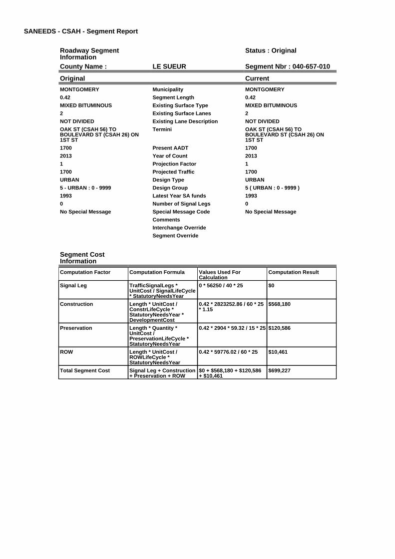
SANEEDS - CSAH - Segment Report
Roadway SegmentInformation
Status : Original
County Name : LE SUEUR Segment Nbr : 040-657-010
Original Current
MONTGOMERY Municipality MONTGOMERY
0.42 Segment Length 0.42
MIXED BITUMINOUS Existing Surface Type MIXED BITUMINOUS
2 Existing Surface Lanes 2
NOT DIVIDED Existing Lane Description NOT DIVIDED
OAK ST (CSAH 56) TOBOULEVARD ST (CSAH 26) ON1ST ST
Termini OAK ST (CSAH 56) TOBOULEVARD ST (CSAH 26) ON1ST ST
1700 Present AADT 1700
2013 Year of Count 2013
1 Projection Factor 1
1700 Projected Traffic 1700
URBAN Design Type URBAN
5 - URBAN : 0 - 9999 Design Group 5 ( URBAN : 0 - 9999 )
1993 Latest Year SA funds 1993
0 Number of Signal Legs 0
No Special Message Special Message Code No Special Message
Comments
Interchange Override
Segment Override
Segment CostInformation
Computation Factor Computation Formula Values Used ForCalculation
Computation Result
Signal Leg TrafficSignalLegs *UnitCost / SignalLifeCycle* StatutoryNeedsYear
0 * 56250 / 40 * 25 $0
Construction Length * UnitCost /ConstrLifeCycle *StatutoryNeedsYear *DevelopmentCost
0.42 * 2823252.86 / 60 * 25* 1.15
$568,180
Preservation Length * Quantity *UnitCost /PreservationLifeCycle *StatutoryNeedsYear
0.42 * 2904 * 59.32 / 15 * 25 $120,586
ROW Length * UnitCost /ROWLifeCycle *StatutoryNeedsYear
0.42 * 59776.02 / 60 * 25 $10,461
Total Segment Cost Signal Leg + Construction+ Preservation + ROW
$0 + $568,180 + $120,586+ $10,461
$699,227

SANEEDS - CSAH - Segment Report
Roadway SegmentInformation
Status : Original
County Name : LE SUEUR Segment Nbr : 040-660-010
Original Current
NEW PRAGUE Municipality NEW PRAGUE
0.07 Segment Length 0.07
MIXED BITUMINOUS Existing Surface Type MIXED BITUMINOUS
2 Existing Surface Lanes 2
NOT DIVIDED Existing Lane Description NOT DIVIDED
TH 19 TO 1ST STREET SE ON 1STAVE SE
Termini TH 19 TO 1ST STREET SE ON 1STAVE SE
2150 Present AADT 2150
2013 Year of Count 2013
1 Projection Factor 1
2150 Projected Traffic 2150
URBAN Design Type URBAN
5 - URBAN : 0 - 9999 Design Group 5 ( URBAN : 0 - 9999 )
2002 Latest Year SA funds 2002
1 Number of Signal Legs 1
No Special Message Special Message Code No Special Message
SIGNAL REPLACED IN 2006 BYMNDOT
Comments SIGNAL REPLACED IN 2006 BYMNDOT
Interchange Override
Segment Override
Segment CostInformation
Computation Factor Computation Formula Values Used ForCalculation
Computation Result
Signal Leg TrafficSignalLegs *UnitCost / SignalLifeCycle* StatutoryNeedsYear
1 * 56250 / 40 * 25 $35,156
Construction Length * UnitCost /ConstrLifeCycle *StatutoryNeedsYear *DevelopmentCost
0.07 * 2823252.86 / 60 * 25* 1.15
$94,697
Preservation Length * Quantity *UnitCost /PreservationLifeCycle *StatutoryNeedsYear
0.07 * 2904 * 59.32 / 15 * 25 $20,098
ROW Length * UnitCost /ROWLifeCycle *StatutoryNeedsYear
0.07 * 59776.02 / 60 * 25 $1,743
Total Segment Cost Signal Leg + Construction+ Preservation + ROW
$35,156 + $94,697 +$20,098 + $1,743
$151,694

SANEEDS - CSAH - Segment Report
Roadway SegmentInformation
Status : Original
County Name : LE SUEUR Segment Nbr : 040-660-020
Original Current
NEW PRAGUE Municipality NEW PRAGUE
0.39 Segment Length 0.39
MIXED BITUMINOUS Existing Surface Type MIXED BITUMINOUS
2 Existing Surface Lanes 2
NOT DIVIDED Existing Lane Description NOT DIVIDED
1ST STREET SE TO 0.11 MI SOUTHOF 5TH STREET ON 1ST AVE SE
Termini 1ST STREET SE TO 0.11 MI SOUTHOF 5TH STREET ON 1ST AVE SE
1700 Present AADT 1700
2013 Year of Count 2013
1 Projection Factor 1
1700 Projected Traffic 1700
URBAN Design Type URBAN
5 - URBAN : 0 - 9999 Design Group 5 ( URBAN : 0 - 9999 )
2002 Latest Year SA funds 2002
0 Number of Signal Legs 0
No Special Message Special Message Code No Special Message
Comments
Interchange Override
Segment Override
Segment CostInformation
Computation Factor Computation Formula Values Used ForCalculation
Computation Result
Signal Leg TrafficSignalLegs *UnitCost / SignalLifeCycle* StatutoryNeedsYear
0 * 56250 / 40 * 25 $0
Construction Length * UnitCost /ConstrLifeCycle *StatutoryNeedsYear *DevelopmentCost
0.39 * 2823252.86 / 60 * 25* 1.15
$527,595
Preservation Length * Quantity *UnitCost /PreservationLifeCycle *StatutoryNeedsYear
0.39 * 2904 * 59.32 / 15 * 25 $111,972
ROW Length * UnitCost /ROWLifeCycle *StatutoryNeedsYear
0.39 * 59776.02 / 60 * 25 $9,714
Total Segment Cost Signal Leg + Construction+ Preservation + ROW
$0 + $527,595 + $111,972+ $9,714
$649,281

SANEEDS - CSAH - Segment Report
Roadway SegmentInformation
Status : Original
County Name : LE SUEUR Segment Nbr : 040-660-030
Original Current
NEW PRAGUE Municipality NEW PRAGUE
0.33 Segment Length 0.33
MIXED BITUMINOUS Existing Surface Type MIXED BITUMINOUS
2 Existing Surface Lanes 2
NOT DIVIDED Existing Lane Description NOT DIVIDED
0.11 MI S 5TH ST TO SO LIMITS OFNEW PRAGUE ON 1ST AVE
Termini 0.11 MI S 5TH ST TO SO LIMITS OFNEW PRAGUE ON 1ST AVE
1700 Present AADT 1700
2013 Year of Count 2013
1 Projection Factor 1
1700 Projected Traffic 1700
URBAN Design Type URBAN
5 - URBAN : 0 - 9999 Design Group 5 ( URBAN : 0 - 9999 )
1986 Latest Year SA funds 1986
0 Number of Signal Legs 0
No Special Message Special Message Code No Special Message
Comments
Interchange Override
Segment Override
Segment CostInformation
Computation Factor Computation Formula Values Used ForCalculation
Computation Result
Signal Leg TrafficSignalLegs *UnitCost / SignalLifeCycle* StatutoryNeedsYear
0 * 56250 / 40 * 25 $0
Construction Length * UnitCost /ConstrLifeCycle *StatutoryNeedsYear *DevelopmentCost
0.33 * 2823252.86 / 60 * 25* 1.15
$446,427
Preservation Length * Quantity *UnitCost /PreservationLifeCycle *StatutoryNeedsYear
0.33 * 2904 * 59.32 / 15 * 25 $94,746
ROW Length * UnitCost /ROWLifeCycle *StatutoryNeedsYear
0.33 * 59776.02 / 60 * 25 $8,219
Total Segment Cost Signal Leg + Construction+ Preservation + ROW
$0 + $446,427 + $94,746 +$8,219
$549,392

SANEEDS - CSAH - Segment Report
Roadway SegmentInformation
Status : Original
County Name : LE SUEUR Segment Nbr : 040-660-040
Original Current
Unassigned/Unknown Municipality Unassigned/Unknown
0.2 Segment Length 0.2
MIXED BITUMINOUS Existing Surface Type MIXED BITUMINOUS
2 Existing Surface Lanes 2
NOT DIVIDED Existing Lane Description NOT DIVIDED
SO LIM NEW PRAGUE TO CSAH 29 Termini SO LIM NEW PRAGUE TO CSAH 29
1700 Present AADT 1700
2013 Year of Count 2013
1 Projection Factor 1
1700 Projected Traffic 1700
URBAN Design Type URBAN
5 - URBAN : 0 - 9999 Design Group 5 ( URBAN : 0 - 9999 )
1998 Latest Year SA funds 1998
0 Number of Signal Legs 0
No Special Message Special Message Code No Special Message
Comments
Interchange Override
Segment Override
Segment CostInformation
Computation Factor Computation Formula Values Used ForCalculation
Computation Result
Signal Leg TrafficSignalLegs *UnitCost / SignalLifeCycle* StatutoryNeedsYear
0 * 56250 / 40 * 25 $0
Construction Length * UnitCost /ConstrLifeCycle *StatutoryNeedsYear *DevelopmentCost
0.2 * 2823252.86 / 60 * 25 *1.15
$270,562
Preservation Length * Quantity *UnitCost /PreservationLifeCycle *StatutoryNeedsYear
0.2 * 2904 * 59.32 / 15 * 25 $57,422
ROW Length * UnitCost /ROWLifeCycle *StatutoryNeedsYear
0.2 * 59776.02 / 60 * 25 $4,981
Total Segment Cost Signal Leg + Construction+ Preservation + ROW
$0 + $270,562 + $57,422 +$4,981
$332,965

SANEEDS - CSAH - Segment Report
Roadway SegmentInformation
Status : Original
County Name : LE SUEUR Segment Nbr : 040-661-010
Original Current
Unassigned/Unknown Municipality Unassigned/Unknown
0.4 Segment Length 0.4
MIXED BITUMINOUS Existing Surface Type MIXED BITUMINOUS
2 Existing Surface Lanes 2
NOT DIVIDED Existing Lane Description NOT DIVIDED
SO CO LINE TO TH 60 Termini SO CO LINE TO TH 60
395 Present AADT 395
2013 Year of Count 2013
1 Projection Factor 1
395 Projected Traffic 395
RURAL Design Type RURAL
2 - RURAL : 150 - 1499 Design Group 2 ( RURAL : 150 - 1499 )
1977 Latest Year SA funds 1977
0 Number of Signal Legs 0
No Special Message Special Message Code No Special Message
Comments
Interchange Override
Segment Override
Segment CostInformation
Computation Factor Computation Formula Values Used ForCalculation
Computation Result
Signal Leg TrafficSignalLegs *UnitCost / SignalLifeCycle* StatutoryNeedsYear
0 * 56250 / 40 * 25 $0
Construction Length * UnitCost /ConstrLifeCycle *StatutoryNeedsYear *DevelopmentCost
0.4 * 801370.7 / 60 * 25 *1.1
$146,918
Preservation Length * Quantity *UnitCost /PreservationLifeCycle *StatutoryNeedsYear
0.4 * 2112 * 59.32 / 20 * 25 $62,642
ROW Length * UnitCost /ROWLifeCycle *StatutoryNeedsYear
0.4 * 36798.68 / 60 * 25 $6,133
Total Segment Cost Signal Leg + Construction+ Preservation + ROW
$0 + $146,918 + $62,642 +$6,133
$215,693

SANEEDS - CSAH - Segment Report
Roadway SegmentInformation
Status : Original
County Name : LE SUEUR Segment Nbr : 040-662-010
Original Current
Unassigned/Unknown Municipality Unassigned/Unknown
0.1 Segment Length 0.1
PORT CEMENT CONC Existing Surface Type PORT CEMENT CONC
2 Existing Surface Lanes 2
NOT DIVIDED Existing Lane Description NOT DIVIDED
S CO LINE TO TH 60 Termini S CO LINE TO TH 60
1750 Present AADT 1750
2013 Year of Count 2013
1 Projection Factor 1
1750 Projected Traffic 1750
RURAL Design Type RURAL
3 - RURAL : 1500 - 6999 Design Group 3 ( RURAL : 1500 - 6999 )
1987 Latest Year SA funds 1987
0 Number of Signal Legs 0
No Special Message Special Message Code No Special Message
Comments
Interchange Override
Segment Override
Segment CostInformation
Computation Factor Computation Formula Values Used ForCalculation
Computation Result
Signal Leg TrafficSignalLegs *UnitCost / SignalLifeCycle* StatutoryNeedsYear
0 * 56250 / 40 * 25 $0
Construction Length * UnitCost /ConstrLifeCycle *StatutoryNeedsYear *DevelopmentCost
0.1 * 1589559.55 / 60 * 25 *1.1
$72,855
Preservation Length * Quantity *UnitCost /PreservationLifeCycle *StatutoryNeedsYear
0.1 * 2376 * 59.32 / 20 * 25 $17,618
ROW Length * UnitCost /ROWLifeCycle *StatutoryNeedsYear
0.1 * 222272.59 / 60 * 25 $9,261
Total Segment Cost Signal Leg + Construction+ Preservation + ROW
$0 + $72,855 + $17,618 +$9,261
$99,734

SANEEDS - CSAH - Segment Report
Roadway SegmentInformation
Status : Original
County Name : LE SUEUR Segment Nbr : 040-663-010
Original Current
WATERVILLE Municipality WATERVILLE
0.08 Segment Length 0.08
MIXED BITUMINOUS Existing Surface Type MIXED BITUMINOUS
2 Existing Surface Lanes 2
NOT DIVIDED Existing Lane Description NOT DIVIDED
REED ST (CSAH 3) TO 1ST ST(CSAH 52) ON HOOSAC ST
Termini REED ST (CSAH 3) TO 1ST ST(CSAH 52) ON HOOSAC ST
305 Present AADT 305
2013 Year of Count 2013
1 Projection Factor 1
305 Projected Traffic 305
RURAL Design Type RURAL
2 - RURAL : 150 - 1499 Design Group 2 ( RURAL : 150 - 1499 )
1992 Latest Year SA funds 1992
0 Number of Signal Legs 0
No Special Message Special Message Code No Special Message
Comments
Interchange Override
Segment Override
Segment CostInformation
Computation Factor Computation Formula Values Used ForCalculation
Computation Result
Signal Leg TrafficSignalLegs *UnitCost / SignalLifeCycle* StatutoryNeedsYear
0 * 56250 / 40 * 25 $0
Construction Length * UnitCost /ConstrLifeCycle *StatutoryNeedsYear *DevelopmentCost
0.08 * 801370.7 / 60 * 25 *1.1
$29,384
Preservation Length * Quantity *UnitCost /PreservationLifeCycle *StatutoryNeedsYear
0.08 * 2112 * 59.32 / 20 * 25 $12,528
ROW Length * UnitCost /ROWLifeCycle *StatutoryNeedsYear
0.08 * 36798.68 / 60 * 25 $1,227
Total Segment Cost Signal Leg + Construction+ Preservation + ROW
$0 + $29,384 + $12,528 +$1,227
$43,139