Embed Size (px)
Citation preview

San Luis Obispo County Flood Control and Water Conservation
District
GUIDE TO IMPLEMENTING FLOOD CONTROL PROJECTS State Of California Department of Water Resources
Grant Agreement No. 4600004505 December 30, 2009

[This Page Intentionally Blank]


[This Page Intentionally Blank]

SAN LUIS OBISPO COUNTY FLOOD CONTROL AND WATER CONSERVATION DISTRICT GUIDE TO IMPLEMENTING
FLOOD CONTROL PROJECTS
Table of Contents
I. Executive Summary II. Background
a. Authority for plan b. Goal of plan
III. Process for Implementing a Flood Control Project a. General Comments b. Project Implementation Steps
IV. Summary of Flood Control Project Constraints a. Policy b. Funding c. Environmental Permitting d. Right of Way e. Stakeholder Support
V. Summary of Significant Flooding Issues and Proposed Solutions by Community a. General b. Arroyo Grande Creek Channel – FC Zone 1/1A c. Cambria d. Cayucos e. Los Osos f. Nipomo g. Oceano h. San Luis Obispo Creek – FC Zone 9 i. San Miguel j. Santa Margarita k. Shandon l. Templeton
VI. Community Readiness Report Card a. General b. Development of Report Card Grades c. Arroyo Grande Creek Channel – FC Zone 1/1A d. Cambria e. Cayucos f. Los Osos
g. Nipomo h. Oceano i. San Luis Obispo Creek – FC Zone 9 j. San Miguel k. Santa Margarita l. Shandon m. Templeton
VII. Proposed Project Strategy by Community a. General b. Arroyo Grande Creek Channel – FC Zone 1/1A c. Cambria d. Cayucos e. Los Osos f. Nipomo g. Oceano h. San Luis Obispo Creek – FC Zone 9 i. San Miguel j. Santa Margarita k. Shandon l. Templeton
VIII. Implementation of Project Strategy a. General b. Next Steps
List of Appendicies
A. FAQ’s B. Community Specific Flood Control Projects (Executive Summaries)
1. Cambria 2. Cayucos 3. Nipomo 4. Oceano 5. San Miguel 6. Santa Margarita
C. Process for Implementing a Flood Control Project D. Description of Local Flood Control Funding Process E. Contacts for More Information F. BOS Resolution 68-223
SAN LUIS OBISPO COUNTY FLOOD CONTROL AND WATER CONSERVATION DISTRICT GUIDE TO IMPLEMENTING
FLOOD CONTROL PROJECTS
Grant Agreement No. 4600004505
I. Executive Summary The San Luis Obispo Flood Control and Water Conservation District (SLOFC&WCD or “District”) is a resource to help individuals and communities in San Luis Obispo County identify and address flooding problems. The District has historically not provided direct funding of community specific mitigation improvements. The District uses its general funding to identify flooding problems, recommend solutions, and help local areas implement recommended solutions. The District has identified a need to develop a model on how to approach these important water resource issues, including steps on how to integrate solutions for multiple benefits and community acceptance. The primary focus of this Guide to Implementing Flood Control Projects (“Guide”) is to identify several of the most significant constraints affecting the ability to implement flood control projects and to propose methods and strategies to address the challenges. As with most problems and especially with flooding, stakeholder involvement is essential. Therefore, the target audience for this report is the stakeholders themselves, those individual citizens and communities affected by flooding problems. The intent of the plan is to provide guidance in the process of implementing such methods and strategies to address these problems. Critical tasks performed in preparing this Guide included: 1 Describe the process for implementing flood control projects 2 Identify and summarize the major constraints affecting project
implementation 3 Summarize the significant flooding issues and proposed solutions for
unincorporated communities in the County 4 Identify the characteristics that would describe a community’s readiness to
implement flood control projects 5 Prepare a community “Report Card” that summarizes each community’s
readiness to implement such projects 6 Use the “Report Card” to determine appropriate project strategies and
evaluate if existing project strategies need to be revised. 7 Conduct stakeholder meetings to share project strategies and obtain
stakeholder buy-in of proposed strategies. 8 Determine appropriate ways to implement project strategy 9 Prepare a final report summarizing the plan and recommendations

[This Page Intentionally Blank]

II. Background
a. Authority for Plan San Luis Obispo County is located within the area generally known as the Central Coast. It includes all of the unincorporated areas, specifically the communities of Cambria, Cayucos, Los Osos, Nipomo, Oceano, San Miguel, Santa Margarita, and Templeton. Flood control issues and concerns vary throughout the County of San Luis Obispo, though many of the constraints and challenges have common threads. The San Luis Obispo Flood Control and Water Conservation District (SLOFC&WCD or ”District”) is a resource to help individuals and communities in San Luis Obispo County identify and address flooding problems. The District was established in 1945 with the purpose “to provide for control, disposition and distribution of the flood and storm waters of the district and of streams flowing into the district…” In 1968, Resolution No. 68-223 was adopted and defined the policy role of the District relating to the costs of planning, design, construction, operations and maintenance of drainage and flood control facilities. In accordance with resolution 68-223, the District cannot be responsible for direct funding of community specific mitigation improvements. The District uses its general funding to identify flooding problems, recommend solutions, and help local areas implement recommended solutions. The District has identified a need to develop a model on how to approach these important water resource issues, including steps on how to integrate solutions for multiple benefits and community acceptance. b. Goal of Plan Flood control issues and concerns vary throughout the County of San Luis Obispo, though many of the constraints and challenges have common threads. Whether the specific flood control challenge relates to levees, such as they do on a grander scale in other regions of the State, or whether they result from antiquated subdivisions that predate current planning and development standards, the District has identified a need to develop a model on how to approach these important water resource issues, including steps on how to integrate solutions for multiple benefits and community acceptance. The ability to fund flood control projects and maintenance costs significantly declined with the passage of Proposition 218 by State voters. Thus, solicitation of stakeholder involvement in this process (especially benefiting property owners who will be responsible to pay for the improvements) is a key element of the work effort, and therefore it is intended that the primary audience for the Plan will be the stakeholders, rather than technical professionals or government officials. The primary focus of this Guide to Implementing Flood Control Projects (“Guide”) is to identify the most significant constraints and to propose methods and strategies to address the challenges. As with most problems and especially with

flooding, stakeholder involvement is essential. Therefore, the target audience for this report is the stakeholders themselves, those individual citizens and communities affected by flooding problems. The intent of the report is to provide guidance in the process of implementing such methods and strategies to address these problems. In the context of this report, progress towards the goal of resolving existing flooding problems can be expected to follow a process generally summarized as follows:
Preparation + Opportunity + Execution = Progress Preparation Many elements are needed in order to both identify and to be adequately prepared to take advantage of opportunities for resolving flood control problems. Preparation includes gaining a detailed knowledge of existing flooding conditions, policy, funding and permitting constraints, as well as access and right-of-way issues. Being adequately prepared requires the ability to balance the need for a project with consideration of funding and responsibility for short and long term maintenance. Becoming prepared usually requires the building of community support and cooperation for a project, including willingness on the part of the citizens to agree to new assessments or increased taxes to fund some or all of the construction and maintenance required. It is understood that some communities may currently be better prepared than others and will therefore be better positioned to take advantage of opportunities as they become available. Key criteria associated with a community’s preparedness will be further developed in later sections of this report, as well as estimates of the current status of “preparedness” for various unincorporated communities in the county. Opportunity Opportunities to develop flood control projects can come from a variety of sources. Recent media coverage of issues and events such as the collapse of the I-35W Bridge over the Mississippi River in Minneapolis, the vulnerability of California’s water supply, and the aftermath of Hurricane Katrina have focused the public’s attention to the current condition of our national, state and local infrastructure, including flood control facilities. In California, this increased attention has resulted in both political will and support by the voting public to provide funding for infrastructure improvement. When approved, such funding can often come in the form of subsidized loan or grant programs, which typically require some amount of local match. In addition, regulatory agencies and non-profit conservation organizations often have access to grant programs for which flood control projects or portions of such projects can be competitive. In most instances, besides the local match requirement, such grant or loan programs require that a project have strong community support and a reasonable path for implementation in order for the project to be competitive with all of the other projects vying for the limited resources. In addition to public sector funding, proposed improvements associated with private development projects can often address existing flooding problems, provided there is a nexus for such

improvements. Private development can also be a potential resource for constructing or funding flood control projects through participation in the formation of assessment districts with neighboring properties, reimbursement agreements, drainage impact fees, etc. In each of these funding scenarios, adequate preparation, including development of community support and willingness to provide local match funding, is vital to positioning a project to be competitive. Execution Execution involves a community being proactive in recognizing and then taking advantage of an opportunity that may present itself to implement a solution or partial solution to an identified flooding problem. Execution requires that the community:
• Be knowledgeable about the problem • Have a clear understanding of the possible solutions to address the
problem • Have a realistic understanding of the challenges inherent in each solution • Be willing to provide some or all of the required funding for the alternative
solutions, including matching funds for grants • Be committed to follow through to pursue and/or to participate in possible
grant, developer funded or other project opportunities as they become available.
Progress There are numerous significant challenges to resolving flooding problems which are inherent in the nature of such problems, and the solutions are often complex, multi-pronged and long term. Such challenges most often portend opportunity. Progress towards resolving a community’s flooding problems can be viewed as a direct result of the members of that community agreeing to the process described above of working together in recognizing the challenges, preparing for, seeking and recognizing the opportunities, and then following through to take advantage of such opportunities.

[This Page Intentionally Blank]

III. Process for Implementing a Flood Control Project
a. General Comments This section identifies the steps that are generally required to implement a Flood Control Project. Additional detail for each of the steps is provided in later chapters of this report. It should be noted that stakeholder involvement and advocacy is recommended in the initial steps and critical in the subsequent steps. Though a willingness for financial commitment by stakeholders is often needed, equally important, if not more important is the support and advocacy for the project by the stakeholders throughout the process. Though there is some truth to the proverb that “the squeaky wheel gets the grease,” the history of developing infrastructure improvement projects has also shown the practical reality that it is easier to obtain funding for a project that is well defined, addresses a real need or problem, has a defensible cost/benefit ratio, has a reasonable cost and implementation schedule, and has broad support by the affected property owners. When each of these items is in place, a project can be considered “viable.” b. Project Implementation Steps The steps described below must be followed in implementing a Flood Control Project. The information was originally developed as part as a report given to the Board of Supervisors by the Department of Public Works (“SLO County Flood Protection and Drainage Policies, Programs, Permitting and Funding,” April 17, 2001, a portion of which is attached as Appendix C).
Step 1: The project must be defined. This requires that an engineering feasibility analysis be performed. The situation that needs to be corrected must be defined, alternate solutions must be investigated, and options must be analyzed to determine the most feasible way to proceed in terms of engineering, financial and environmental considerations. Step 2: Formal project cost estimates must be made. Step 3: A funding source must be identified, and then obtained. As noted elsewhere in this report, the Flood Control Act contemplates establishing Zones that cover the area benefited by the project that can then pay for the cost of the improvements. The process that is set up in the Act is for the Zones to pay through property taxes. With the more recent changes to the laws governing taxing, these funding sources require voter approval, and may be required to pass by a two thirds majority. Step 4: The project must be designed and constructed. Once the projects are defined and a funding source is established, the project must be designed, environmental procedures must be followed and required

permits or approvals obtained, and the project can then be constructed and operated. In most new projects, the environmental issues must be identified at the beginning of the process and kept in mind throughout implementation to insure that permits can be obtained and that any required mitigation measures are accounted for in the project work plan and budget.

IV. Summary of Flood Control Project Constraints
Assuming that a flooding problem has been identified and analyzed, and that a project to mitigate the problem has been subsequently scoped, in general there are five major constraints affecting the implementation of a typical flood control project:
a. District Policy Constraints b. Funding Constraints and Opportunities c. Environmental Permitting d. Right of Way e. Stakeholder Support
This section will provide a description of the issues involved in each of the constraint categories and describe how they impact flood control projects in general, as well as point to community-specific impacts which will be further described in later sections. The information in this section was excerpted from the drainage and flood control studies prepared by RMC on behalf of the District in 2004. Additional general and community-specific information is provided in the individual reports which are available for downloading on the SLO County Public Works Department website at http://www.slocountydrainagestudies.org/. a. San Luis Obispo County Flood Control and Water Conservation District
Policy Constraints
1. Overview of Responsibilities. The drainage and flood control responsibilities of the County are determined by State and County statutes and by County policy. The responsibilities for drainage are administered through the Road Division of the County Public Works Department and the District. The District is the designated County agency responsible for managing, planning, and maintaining drainage and flood control facilities in unincorporated public areas where no other agency has assumed an active role in such activities. The District has a regional role in the County and can work with individual cities or communities when requested. The sections below describe the limits of the jurisdiction of road maintenance and improvement, Road Fund administration, and how the District is administered to best leverage its powers by creating Zones of Benefit to oversee specific projects.
2. History. The San Luis Obispo County Flood Control and Water Conservation District was established in 1945. The powers of the District include flood control, water supply, water conservation, water quality protection and the ability to study all aspects of water resources. The District also has power to form zones of benefit within its boundary to

implement water resource projects. The District is a special district that is governed by the County Board of Supervisors. The boundaries of the District are the same as the County boundaries, and the staff of the District is the same as the staff of the County. The District also includes all of the territory within the County’s seven incorporated cities. The District budget is separate and distinct from all other County budgets. It has its own funding sources, legal responsibilities, legislative regulations, and its own expenditure plan.
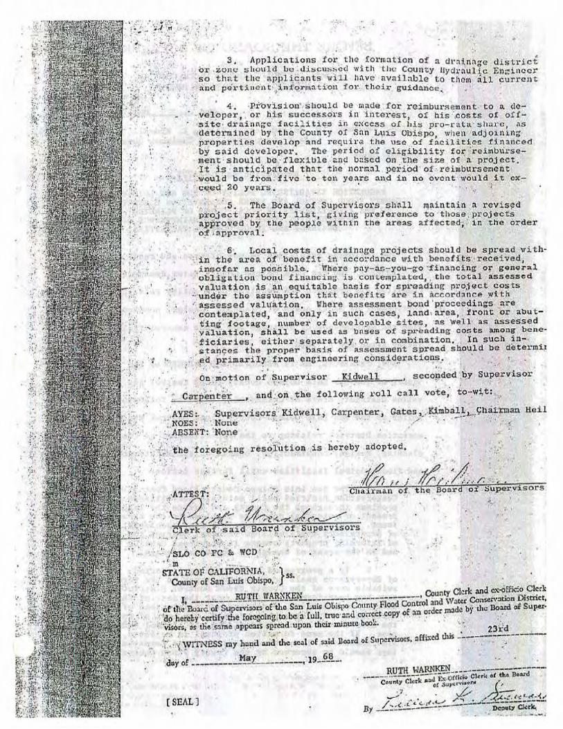
3. Policy Direction: Resolution Number 68-223. The District is available to help communities deal with flood waters, and to study and develop water supplies and conservation opportunities. The District uses its general fund to:
• Identify water related issues • Develop strategies and determine solutions to those problems • Help those local areas implement recommended solutions
The District is not, however, responsible for paying for community-specific mitigation improvements. The specific property owners that benefit from these solutions must agree to pay for the construction and future maintenance of them. This District policy (Resolution 68-223, included in this report as Appendix F) was formally established by the Board of Supervisors in 1968, and was reviewed and reconfirmed in April 2001. The policy was adopted because there is not sufficient funding available for the District to fund construction and operation of facilities. This approach provides the best leveraging of the funds that are available on a countywide basis.
4. Funding Sources and Countywide Activities. The primary funding source for the District, which is the entire County, is a pre-Proposition 13 general property tax allocation, which provides approximately $550,000 per year in General Flood Control revenue. In addition, the District receives about $130,000 per year in interest income from current resources. Reserves from the County’s General Fund, which is separate from the District fund, are normally not used for the construction of projects protecting private property, unless there is a significant general or roadway benefit. The District provides funding for flood control programming and planning of localized drainage issues.
5. Flood Control Zones. The District has the power to form Zones of Benefit to implement and operate facilities. Each Zone must have its own funding source. The following are the currently active operational projects and Zones of Benefit operating under the District:
a. Salinas Dam Project - This project operates the Sallnas Dam and delivers water from Santa Margarita Lake to the City of San Luis

Obispo. The facilities operated by the District under this project are owned by the Federal Government and the City provides all of the funding.
b. State Water Project -The District has had a water supply contract with the State since 1963. The project currently provides water to eleven subcontractors. The subcontractors pay for their share of the water supply, and a special tax funds the ongoing payments for the remainder of the District entitlement.
c. Zone 1/1A - Operates the levee system on the lower Arroyo Grande Creek (Zone 1) and the Los Berros bypass (Zone 1A) channels. The primary operational funding comes from an allocation of general property tax revenue. Additional funding comes from benefit assessments to the properties within the Zones.
d. Zone 3 - Owns and operates the Lopez Water Supply Project, which includes the Lopez Dam, Lopez Lake recreation area, treatment plant, and distribution system. It is financed through contractually obligated payments from the contracting agencies of the Cities of Arroyo Grande, Pismo Beach, Grover Beach, Oceano CSD and CSA No. 12 (Avila Beach). Those agencies raise the funding to meet their contractual obligations through a combination of water service charges and special taxes.
e. Zone 4 - Provides funding for maintenance of the Santa Maria River levee system. The levees are maintained by Santa Barbara County Flood Control and Water Conservation District. Zone 4 collects service charges from properties in San Luis Obispo County that receive flood protection from the levees, and reimburses the Santa Barbara Urban District for its maintenance services.
f. Zone 9 - Encompasses the watershed of San Luis Obispo Creek. It provides watershed and flood control planning, and performs limited creek maintenance. This zone receives funding through a general property tax allocation, and the annual expenditure programs are cooperatively developed with the City of San Luis Obispo.
g. Zone 16 - Provides maintenance service for several small drainage basins that serve various new developments, mainly in the Nipomo area. This zone receives its funding through service charges of the property owners in these new developments.
6. County Standards for Control of Drainage. The County’s planning
department establishes the land use policies and drainage ordinances for the County (the District has no land use ordinances). These standards aim to minimize the harmful effects of storm water runoff and to protect neighboring and downstream properties from drainage problems resulting from new development. Section 22.05.040 et. seq. of the County’s Land Use Ordinance outlines the standards for the control of drainage and drainage facilities. These standards include:

a. Requirements pertaining to the design and construction of drainage systems
b. Requirements pertaining to the maintenance of offsite natural drainage patterns
c. Restrictions on development in areas subject to flood hazards Conditions of development in flood hazard areas must, at a minimum, enforce the current Federal floodplain management regulations as defined in the National Flood Insurance Program. The proponents of projects that may be subject to or cause flood hazards are required to prepare a drainage plan, subject to approval by the County Engineer. Unincorporated areas of the county are also subject to flood hazard combining designations. The combining designation is a special land use category which requires detailed project review to minimize the adverse impacts associated with flood hazards. In addition, the County’s land use ordinances contain development standards for areas with the Flood Hazard (FH) designation. The standards state that drainage plans for development in FH areas must include a normal depth analysis that determines whether the proposed development is in the floodway or the flood fringe. In addition, development in FH areas would be subject to construction practices that would not limit floodway capacity or increase flood heights above an allowable limit.
7. The Road Fund. The County provides some limited drainage
improvements as a function of its road maintenance responsibilities. The Road Fund is a separate, distinct legal account and budget, from the District. It has numerous State statutes (primarily the Streets and Highways Code) that dictate how Road Fund monies may legally be expended. The Road Fund program operates the County Maintained Road System and is funded through a combination of restricted revenue sources that are primarily derived through taxes on gasoline that are apportioned to cities and counties by the State, as well as contributions from the County General Fund. These funding sources can only be spent on solving problems that directly relate to County maintained roads. As a function of operating the road system, the drainage issues related to the road system are addressed when such drainage work protects the County maintained road system in a cost beneficial way, or is directly related to County road improvement projects and is necessary to prevent property damage. This includes directing the flow of streams across the roads through culverts and bridges. In many cases, cost/benefit analyses preclude the expenditure of many hundreds of thousands (or millions) of dollars to prevent occasional flooding of certain roadways during periods of unusually intense rainfall. Some County roads will have standing water for short periods of time following rainfall events. This is especially true at various dry creek crossings in rural parts of the County.
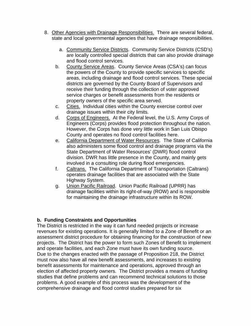
8. Other Agencies with Drainage Responsibilities. There are several federal, state and local governmental agencies that have drainage responsibilities.
a. Community Service Districts. Community Service Districts (CSD’s) are locally controlled special districts that can also provide drainage and flood control services.
b. County Service Areas. County Service Areas (CSA’s) can focus the powers of the County to provide specific services to specific areas, including drainage and flood control services. These special districts are governed by the County Board of Supervisors and receive their funding through the collection of voter approved service charges or benefit assessments from the residents or property owners of the specific area served.
c. Cities. Individual cities within the County exercise control over drainage issues within their city limits.
d. Corps of Engineers. At the Federal level, the U.S. Army Corps of Engineers (Corps) provides flood protection throughout the nation. However, the Corps has done very little work in San Luis Obispo County and operates no flood control facilities here.
e. California Department of Water Resources. The State of California also administers some flood control and drainage programs via the State Department of Water Resources’ (DWR) flood control division. DWR has little presence in the County, and mainly gets involved in a consulting role during flood emergencies.
f. Caltrans. The California Department of Transportation (Caltrans) operates drainage facilities that are associated with the State Highway System.
g. Union Pacific Railroad. Union Pacific Railroad (UPRR) has drainage facilities within its right-of-way (ROW) and is responsible for maintaining the drainage infrastructure within its ROW.
b. Funding Constraints and Opportunities The District is restricted in the way it can fund needed projects or increase revenues for existing operations. It is generally limited to a Zone of Benefit or an assessment district procedure for obtaining financing for the construction of new projects. The District has the power to form such Zones of Benefit to implement and operate facilities, and each Zone must have its own funding source. Due to the changes enacted with the passage of Proposition 218, the District must now also have all new benefit assessments, and increases to existing benefit assessments for maintenance and operations, approved through an election of affected property owners. The District provides a means of funding studies that define problems and can recommend technical solutions to those problems. A good example of this process was the development of the comprehensive drainage and flood control studies prepared for six

unincorporated communities that were completed in 2004. These studies provided detailed drainage analysis for each community and identified a number of potential projects to address flooding problems, with project cost estimates. In most cases, the critical next steps of constructing and maintaining such drainage facilities can normally only be completed with local benefiting property owners being willing to vote to assess themselves for these costs. Grant and low interest loan programs exist and may be available for projects, depending on the type and location of the proposed project, population and median income of the community, etc. In most instances, grant programs will require additional sources of funding, in the form of a local match, up-front costs for application and processing, etc. Further discussion of funding opportunities is included in the appendix of this report. As is a recurrent theme of this report, the communities in the best position to recognize and take advantage of such funding opportunities are those that have strong local stakeholder involvement, have educated themselves regarding flooding problems, constraints and project alternatives, have built positive working relationships with appropriate governmental and nonprofit agencies with stakeholder interest, and are actively researching and pursuing such opportunities. c. Environmental Permitting Constraints General Discussion, Key Dates & Changes in the Permit Process. Since they convey stormwater runoff, portions of natural and manmade channels critical to the control of flood flows are quite often critical habitat for a variety of important biological resources, including many endangered species. Therefore, improvements to such channels and certain maintenance activities, including sediment or debris removal, vegetation management, slope repair, etc. could potentially affect (adversely or beneficially) critical habitat and are therefore potentially subject to an extensive review and permitting process by a variety of local, state and/or federal agencies, depending on the proposed activity, as well as the nature and location of the facility. In order to provide an appreciation and context for the environmental constraints affecting flood control projects, a list of key dates and changes in the environmental permit process is provided below. Key Permitting Statutes 1890 - Federal Rivers and Harbors Act. Regulates dredging and filling in navigable waterways 1969 - National Environmental Policy Act (NEPA). Requires all federal agencies to prepare environmental analyses and document the environmental effects of their projects and activities. 1970 - California Environmental Quality Act (CEQA). Requires all state and local agencies in California to prepare environmental analyses, document the

environmental effects of their projects and activities, and reduce the impacts of their projects and activities to the greatest extent feasible. 1972 - Proposition 20/Coastal Conservation Initiative. Establishes the California Coastal Zone and the Coastal Commission 1972 - Amendments to the Federal Water Pollution Control Act (Section 404). Directs the U.S. Army Corps of Engineers to regulate the dredging and filling of ''Waters of the U.S." 1973 - Federal Endangered Species Act. Establishes a listing process for endangered plants and animals and gives the protection and recovery of endangered species the highest priority. Key Changes in the Permit Process May 1996 - California red-legged frog listed a federal threatened species August 1997 - Steelhead trout listed a federal threatened species (endangered in Santa Maria River watershed south) May 1999 - California Department of Fish & Game required to comply with the California Environmental Quality Act for Streambed Alteration Agreements (permits) June 2000 - Substantial revisions in the U.S. Army Corps of Engineer's Nationwide Permit Process June 2000 - Regional Water Quality Control Board no longer issues waivers for 401 consistency determinations March 2000 - Steelhead critical habitat designated March 2001 - Red-legged frog critical habitat designated Summary of Permit Requirements. All projects, whether they are constructed by a public agency or by private parties are required by Federal, State and local law to comply with environmental regulations. The regulations that most often affect flood protection projects are general environmental protection, protection of endangered species, protection of water quality, and protection of coastal resources. The following table briefly describes some of the permits that must be acquired to do work within or near a stream channel. It should be noted that the permit requirements will be virtually the same whether the work is being done by the County Flood Control District or by a rancher protecting his rangeland:
If the project... Then a permit or approval is necessary from...
Qualifies as a project under the Califomia Environmental Quality Act (CEQA)
San Luis Obispo County Department of Planning and Building, Environmental Division
Qualifies as a project under the National Environmental Policy Act (NEPA)
San Luis Obispo County Department of Planning and Building Environmental Division

Disturbs the bed or bank of a stream Califomia Department of Fish and Game
Involves work below the ordinary high water mark of a stream U.S. Army Corps of Engineers Involves disturbance of wetlands or other ''waters of the U.S." U.S. Army Corps of Engineers Requires a permit from the U.S. Army Corps of Engineers under the Clean Water Act
State Regional WaterQuality Control Board
Has the potential to impact sensitive species, marine mammals, migratory birds or their habitat
Califomia Department of Fish and Game, National Marine Fisheries Service, and/or U.S. Fish and Wildlife Service
Located in the Coastal Zone or in streams that feed into the Coastal Zone
Califomia Coastal Commission and/or San Luis Obispo County Department of Planning and Building Environmental Division
d. Right of Way Constraints Under-maintained facilities reduce their design capacity and inhibit their ability to convey runoff, and county staff typically receive complaints from alert private citizens who report existing storm drain facilities filled with sediment and vegetation. However, based on follow up field investigations, it is often difficult determining who is responsible for maintaining the facilities, most especially in the case of manmade and natural drainage ditches and creeks or drainage basins on private property. In most cases, the District does not possess flood control or drainage easements for natural or manmade creeks and channels or drainage basins on private property. In the absence of maintenance responsibility being assumed by a separate entity (such as a homeowners association), the owner whose parcel line extends into the drainage channel or upon whose property the drainage basin exists is responsible for maintaining the channel or basin’s capacity. If a property owner does not maintain the facilities, then these structures will go unattended because the District is not responsible for maintaining facilities on private property or on property within the jurisdiction of other public agencies (e.g. Caltrans, UPRR, incorporated city, etc.) or homeowners associations. e. Stakeholder Support As has been mentioned previously in this report, the input and support of stakeholders is critical to the success of most if not all flood control projects. The range of entities potentially impacted by a proposed project extends far beyond those that are directly impacted by flooding problems. For example, increasing

the capacity of a channel to mitigate flooding problems in one location could potentially move the problem further downstream. Project construction may require the acquisition of temporary or permanent easements from private property owners or encroachment permits from other agencies. The long term viability of the project may depend on maintenance efforts outside the project limits by other entities, such as erosion or sediment control in tributary areas upstream in the watershed, or vegetation or debris management on channel reaches up or downstream located on private property. Given the context of the other constraints described above, it is crucial that key and potential stakeholders be identified and brought into the process of project development as early as possible. With the understanding that many stakeholders will have conflicting interests and/or goals for the same project, communication, negotiation and compromise are often key components for seeing a project through to completion, and the risk to the viability of a project is greatly reduced the earlier in the process these efforts are initiated. Needing to change the limits or scope of a project at the end of the final design phase due to a failure to maintain adequate coordination with a critical stakeholder could lead to compounding adverse impacts to the preparation of environmental documents, permit acquisition, project timelines, funding, etc., potentially killing a project.

[This Page Intentionally Blank]

V. Summary of Significant Flooding Issues and Proposed
Solutions by Community
a. General All the communities within the unincorporated areas of San Luis Obispo County to some extent lack formal drainage systems. Localized low spots in each community collect storm runoff and cause flooding in many areas. A significant amount of the drainage problems throughout the county are minor ponding and flooding at poorly drained or undrained locations. Along with these localized problems, where drainage facilities do exist, facilities are not maintained or undersized and cause additional flooding problems. Solutions to the flooding problems described in this section generally fall into the following general categories: construction of drainage facilities; maintenance of existing drainage facilities; and improvement of drainage design standards. With the exception of the Arroyo Grande Creek Channel – Flood Control Zone 1/1A, the San Luis Obispo Creek Channel – Flood Control Zone 9, and the communities of Los Osos, Shandon and Templeton, detailed discussions of the problems and proposed solutions are contained in extensive drainage study reports prepared for each of the unincorporated communities listed below. The Executive Summaries for the six reports are provided in the appendix of this report, and excerpts from the document are briefly summarized below. The complete reports are available for download in Adobe Acrobat format on the County’s website: http://www.slocountydrainagestudies.org/.
b. Arroyo Grande Creek Channel – Flood Control Zone 1/1A Flooding Issues. Zone 1/1A includes a flood control channel and levee system through coastal low-lying farmlands and the communities of Arroyo Grande, Grover Beach and Oceano. The present configuration of the channel was “state of the art” when it was designed almost 50 years ago, but requires periodic sediment removal. Due to a combination of increased erosion and decreased maintenance, the flood control channel is now clogged with sediment. The US Army Corps of Engineers estimates the system currently has 15% of its design capacity and can only carry runoff from a 2-year to 5-year storm event. Larger storms would cause flooding (USACoE, 2001). On March 5, 2001, the levee system broke on the south side during a moderately large storm event, flooding hundreds of acres of farmland and several residences. Luckily, the northern levee did not breach. Otherwise, the regional wastewater treatment plant that services the communities of Arroyo Grande, Oceano and Grover Beach, and many more homes would have been flooded. Today's regulatory requirements will make any attempt to restore the flood capacity of the channel to its original design a very lengthy and extremely expensive proposition. Proposed Solutions. A detailed discussion of the flooding issues and analysis of alternative mitigation solutions are discussed in the recently completed “Arroyo

Grande Creek Erosion, Sedimentation and Flooding Alternatives Study,” prepared by Swanson Hydrology and Geomorphology in January 2006. Critical improvements recommended as Alternative 3C in the Swanson Study include raising the levee, vegetation management, sediment removal and raising of a bridge structure to remove impediments to streamflow. Total project cost is estimated to be $15.0 million. As a first step towards implementing the recommendations in the Swanson Study, the District has recently initiated the preparation of a Floodway Management Plan, a multi-year effort estimated to cost approximately $575,000. The complete Swanson Study report is available for download in Adobe Acrobat format on the San Luis Coastal Resource Conservation District’s website: http://www.coastalrcd.org/Zone1-1A_Alternatives_Study_TOC.html c. Cambria Flooding Issues. The combination of the area’s steep topography, lack of underground drainage facilities, and location of residential parcels below the street grade has resulted in localized poor drainage and/or flooding around some residences, buildings, and roadways. The magnitude of flooding varies by the districts in Cambria and by location in each district. Drainage from a number of uphill lots flows along the edge of street pavement and drains onto lower lots, creating flooding and erosion problems. Drainage problems also exist where curbs are present, but the topography creates conditions where lots adjacent to the roadway are much lower than the roadway surface. This allows street drainage flowing at the curbside to enter the residential lots at the lowered curb section along the driveway entrance. Many unpaved roads are also subject to sheet and rill erosion during storm events. Flooding problems along Santa Rosa Creek in the West Village have been addressed by the construction of a bypass channel for Santa Rosa Creek, as the first component of the three-part Cambria Flood Control Project. The bypass channel provides for overflows to move slowly through the by-pass channel and then rejoin the Santa Rosa Creek downstream without overtopping Cambria Drive or Santa Rosa Creek. The second component, a gravity pressure stormdrain system, will collect runoff from the central residential area and divert it directly into Santa Rosa Creek. This project restores controlled flooding to the historic floodplain of Santa Rosa Creek while protecting the West Village from overflows of Santa Rosa Creek. Proposed Solutions. The improvements proposed include construction of a bypass channel, storm drains and pumping system to address regional flooding problems along Santa Rosa Creek in the West Village of Cambria, an area inundated with up to eight feet of water in the storms of 1995, as well as culverts, curbs and drainage inlets to address localized flooding. SLOCFCWCD has earmarked over $500,000 to fund one of the projects, has obtained funding assistance from the local community totaling $1.1 million and obtained a FEMA HMGP (Hazard Mitigation Grant Program) grant of $3.5 million towards regional flood improvements. Total cost for the unfunded projects is estimated to be $11.0 million.

d. Cayucos Flooding Issues. The combination of the area’s steep topography, lack of underground drainage facilities, and location of residential parcels below the street grade has resulted in localized poor drainage and/or flooding around some residences, buildings, and roadways. The most serious flooding in the community takes place in the floodplain of Cayucos Creek west of Highway 1, bounded by the mobile home park on the north and Cayucos Drive on the south. Extensive flooding occurs due to flows from the creek overtopping the banks, and the inability of the local drainage to enter the creek due to high water levels. A number of nuisance drainage and flooding problems occur throughout Cayucos due to the topography and the lack of a consistent, organized network of drainage facilities within the community. Drainage from a number of uphill lots flows along the edge of street pavement and drains onto lower lots, creating flooding and erosion problems. However, drainage problems also exist where curbs are present, but the topography creates conditions where lots adjacent to the roadway are much lower than the roadway surface. This allows street drainage flowing at the curbside to enter the residential lots at the lowered curb section along the driveway entrance. A lack of suitable conveyance facilities for storm water runoff has led to frequent flooding problems in the coastal community of Cayucos, including serious flooding adjacent to Cayucos Creek. Proposed Solutions. Proposed projects include construction of diversion pipelines, levee and pump station, storm drains, inlets and outfall structures. SLOCFCWCD has earmarked $482,000 for construction of a diversion pipe. Total cost for the projects is estimated to be $6.25 million. e. Los Osos Flooding Issues. Information provided in this section was excerpted from the report “Preliminary Engineering Evaluation, Los Osos/Baywood Park Community Drainage Project for San Luis Obispo County Service Area No. 9J” by Engineering Development Associates, December 1997 (“EDA Report”). The most significant residential flooding problems experienced by the Los Osos and Baywood Park communities are from natural sumps. The communities are situated adjacent to the Morro Bay estuary upon a sandy terrain which has approximately two major, and numerous other localized natural sumps. Historically they drained relatively quickly without flooding because of the high permeability of the soil and ample distance to groundwater. However, development has lead to a reduction of the permeability of these sump areas, and groundwater levels have risen reducing the amount of immediate subsurface storage available and resulting in several areas becoming flood prone during storms. In addition, the community experienced increased levels of nuisance flooding problems, including residential and street flooding documented from the mid 1970’s that can be attributed to increased growth within the community. The increase in flooding has resulted from the paving of open space and the subsequent reduction of allowable infiltration area, construction within natural (topographic) drainage courses without provisions for rerouting surface drainage,

and development of properties without containment of onsite drainage. Primary areas of flooding concern are Los Osos Valley Road in the town of Los Osos, and east of town near its intersection with Cimarron Road. These areas are of concern since Los Osos Valley Road provides the community one of only two access routes into, and out of the community. Proposed Solutions. Projects proposed in the EDA Report to address flooding and localized drainage problems in Los Osos / Baywood Park include construction of storm drains, retention basins, regrading of roadways, and construction of cross gutters and swales. The recommended projects included a total estimated construction cost of approximately $14.2 million, in 1997 dollars. f. Nipomo Flooding Issues - Mesa. The Mesa’s flooding and drainage problems reported by residents are primarily due to standing water along County roadways, although some reports of runoff from the roadway on private property were made. The standing water appears to be the result of the undulating terrain of the Mesa, lack of maintenance of the existing drainage infrastructure, and development grading which blocks previously existing runoff flow paths. The Mesa’s undulating topography creates numerous depressions, including low spots having no outflow drainage paths, which lead to a high incidence of localized ponding. To prevent the ponding, the current drainage infrastructure is primarily based on individual parcel runoff retention and infiltration, which prevents runoff from leaving each developed site. However, the gradual loss of individual basin retention capacity over time has increased basin overflow frequency and runoff from the individual sites. Current County Drainage Policies and Standards lack sufficient enforcement provisions to ensure that the drainage and infiltration infrastructure is maintained. In some areas, the regrading of land during development cause previously existing flow paths to become blocked, causing ponding in areas which had previously been drained. Flooding Issues – Olde Towne. Much of Olde Towne is located within a 100-year flood hazard zone. These areas have been identified by FEMA as subject to flooding during a 100-year rainfall event. The lower lying areas near the creek and tributary channels may also be subject to flooding from more frequent rainfall events due to inadequate local drainage facilities to convey urban runoff from homes and streets to the creeks. The major flooding problems in Olde Towne result from flood flows breaking out of one of the five creeks flowing through the urban areas of Olde Towne. A majority of the culvert crossings in Olde Towne do not meet the current minimum County standard. The culverts within Olde Town are generally not sufficient to pass the 10-year flow rate without surcharge, although some can pass higher return period storms with surcharge. The culverts and crossings along Haystack Creek, with exception of the newly installed arch at the Tefft Street crossing, are generally insufficient to carry the 10-year flow, when the minimum standard requires sufficient capacity to pass the 25-year flow. If the channels and culverts were designed per the County’s standards for Major
and Secondary waterways, then the threat and frequency of flooding from large storms would be reduced because the facilities would have sufficient capacity to convey the peak storms. Maintenance of existing drainage structures is lacking in Olde Towne. The creek channels, culvert crossings, and roadside ditches need restorative and periodic annual vegetation management and sediment removal. Conducting necessary maintenance on creeks in Olde Towne is complicated not only by the regulatory permit approval process, but also by the location of most creeks within private property. The County was not granted a drainage easement on any of the creeks in Olde Towne and therefore cannot perform routine maintenance or channel clearing on any reach of creek outside of public right-of-way. Proposed Solutions. As described above, a significant portion of the low-lying areas in Olde Towne Nipomo are subject to frequent inundation from adjacent streams and undulating terrain contributes to several areas of localized flooding on the Nipomo Mesa. Projects proposed to address these problems include construction of detention/infiltration facilities, culverts and/or underground storm drain facilities, as well as raising local roads. SLOCFCWCD has earmarked approximately $1.8 million for key localized drainage improvements. Total cost for the projects is estimated to be $8.0 million. g. Oceano Flooding Issues. In Oceano, flood control facilities are limited because in its early stages of urbanization, storm water conveyance and flood control infrastructure were not incorporated into the community because the high infiltration rate of the underlying sands was sufficient to naturally dispose of runoff. With an increase in urbanization came an increase in impervious surfaces and a decrease in the capability of the underlying soil to adequately absorb urban runoff. This has resulted in several areas becoming flood prone, causing public and private property damage during storms. The combination of the area’s geology, shallow topography, construction within natural drainage courses without provisions for rerouting surface drainage, and inadequate drainage facilities has resulted in localized poor drainage and/or flooding around some residences, buildings, and roadways. The most serious flooding in the community takes place along Highway 1. Extensive ponding can occur for several days after significant rainfall, causing damage to nearby businesses and creating driving hazards. This problem is generally caused by relatively flat topography and lack of capacity in the drainage facilities to convey runoff south towards the Arroyo Grande Creek Channel. The two main locations of the flooding occur at the intersection of 17th and 19th Streets with Highway 1 (also known as the Cienaga and Front Street intersection) and the intersection of 13th Street and Paso Robles Street with Highway 1. In addition to localized drainage problems in the community of Oceano, low lying, flood-prone areas contain critical regional infrastructure, including Highway 1, UPRR, the Oceano Airport and the South County Sanitation District wastewater plant.

Proposed Solutions. Projects proposed to address chronic flooding problems in Oceano include construction of regional detention/infiltration facilities, diversion pipeline at Highway 1, curbs and gutters, as well as underground storm drain/infiltration facilities. SLOCFCWCD has earmarked $100,000 for key localized drainage improvements. Total cost for the projects is estimated to be $14.0 million. h. San Luis Obispo Creek – Flood Control Zone 9 Flooding Issues. Flood Control Zone 9 encompasses the entire San Luis Obispo Creek watershed. There is a long history of flooding in the SLO Creek Watershed. Damaging floods have occurred in 1868-62, 1884, 1897, 1911, 1948, 1952, 1962, 1969, 1973, 1995, and 1998. The most recent damaging floods occurred during January and March 1995, with a lesser flooding problem in 1998. Within San Luis Obispo, flow during these events overtopped streambanks near the intersection of Marsh and Higuera Streets and remained out of the channel for nearly three miles downstream, with damage estimated at nearly $2.3 million (ACOE, 2000). The City and Zone 9 also spent approximately $1 million to repair bank erosion caused during the winter of 1995. Damage occurred near the town of Avila during both the January and March 1995 events, where high flow and debris blockages caused extensive damage to several bridges across the creek. Historically, the 1969 and 1973 events were more damaging than the 1995 floods, in present day dollars. According to ACOE estimates (in year 2000 dollars), the 1969 storm caused approximately $6.92 million damage within the SLO Creek watershed, and the 1973 storm caused $13.6 million (of which $899,000 occurred along Stenner Creek, $161,000 along Brizziolari Creek, $3.6 million along Prefumo Creek, and $241,000 along See Canyon Creek). The Zone 9 Advisory Committee was formed to assist the San Luis Obispo County Board of Supervisors on policy decisions relating to Zone 9. The Advisory Committee assists in determining the needs, desires, and financial capabilities of property owners in Zone 9. The Advisory Committee also recommends specific programs to alleviate and control flood damage, with recognition of the ecological and aesthetic values of the programs. The Zone 9 Advisory Committee is comprised of representatives from the City of San Luis Obispo, CalPoly, CalTrans, members of the Avila Beach community and agricultural community, and citizens-at-large; there are eight members and eight alternates. Proposed Solutions. A detailed discussion of the flooding issues and analysis of alternative mitigation solutions are discussed in the recently completed “Waterway Management Plan, San Luis Obispo Creek Watershed,” (WMP) prepared by consultants under the direction of the City of San Luis Obispo and SLOCFCWCD Zone 9. The purpose of the WMP was to “develop an approach and schematic plans to address flooding, erosion, water quality, and ecological issues in the SLO Creek Watershed that can be implemented with approvals from various regulatory agencies.” The objectives of the WMP, as developed by
the Zone 9 Advisory Committee in consultation with the Regulatory Agencies are as follows: Objectives
1) Identify and prioritize the amount and extent of flooding, erosion, water quality, and ecological issues in the SLO Watershed.
2) Identify and develop programs to address flooding, erosion, water quality, and ecological issues in the SLO Watershed.
3) Develop guidelines for design of future development or reconstructed developments in the SLO Watershed.
4) Develop a programmatic environmental and permitting review process for implementation of Objectives 2 and 3, as applicable.
5) Develop an Implementation Program. The complete WMP is available for download in Adobe Acrobat format on the City of San Luis Obispo Public Works Department’s website:
http://www.slocity.org/publicworks/documents.asp
i. San Miguel Flooding Issues. The community of San Miguel lacks a formal drainage system. Local runoff generally follows the gentle northeasterly slope of the community and either flows to the Salinas River or infiltrates into the historic flood plain. Low spots or depressions cause frequent ponding and shallow flooding at several locations. Localized flooding is particularly extensive along Mission Street and N Street between 11th and 14th Streets, and north of 14th Street between Mission and N Streets. Caltrans culverts convey stormwater onto road surfaces of 10th, 12th, 14th and 16th Streets from the undeveloped area and possibly developed portions of Highway 101. The primary cause of flooding in San Miguel is due to the absence of a continuous positive slope and drainage conveyance path from L Street to the Salinas River. The railroad serves as a barrier to storm runoff flowing from west of Mission Street to the Salinas River. Also, the absence of continuous curb and gutter system has lead to the concentration of street runoff in areas that do not have curbs or gutters and generally represent local low spots within a neighborhood block. The most serious flooding in the community takes place along the western side of the railroad since runoff from residential neighborhoods collects in this area. The overall drainage issues identified in San Miguel include:
• Ponding of storm water west of the Union Pacific Railroad tracks, and the subsequent flooding in the vicinity of Mission Street between 11th and 16th Streets • Continued flooding and drainage problems in some residential areas • Drainage from Highway 101
Proposed Solutions. Flooding problems in San Miguel are exacerbated by the Union Pacific railroad which runs north and south, bisecting the community and

impeding westside flows from reaching the Salinas River on the eastside. Critical improvements include storm drain pipes, jack and bore operations under the railroad, drainage ditches and outfall structures. SLOCFCWCD has earmarked $250,000 for the project and $600,000 in Community Development Block Grants have been obtained on behalf of this low income community. Total cost for the projects is estimated to be $6.75 million. j. Santa Margarita Flooding Issues. Flooding problems in Santa Margarita are caused by a number of items. Inadequate channel and bridge capacities, lost and restricted floodplain area due to development, lack of flood protected homes, inadequate or non-existent local drainage facilities, and high peak runoff all contribute to the area’s high occurrence of flooding. There are two categories of flooding problems in Santa Margarita: 1) major creek flooding and 2) localized street and property flooding. The major flooding problems in Santa Margarita are caused by a combination of inadequate culverts and bridges, and inadequate channel capacity in Yerba Buena Creek. When the creek’s flow exceeds the capacity of the channel and bridge/culvert crossings, water overtops the banks and floods adjacent low topographic areas of Santa Margarita. The second category of flooding, localized street and nuisance flooding, is caused by the lack of sufficient capacity in the local drainage ditches, driveway culverts, and storm drains. These facilities are often under maintained and filled with sediment or other debris. These factors prevent the local drainage system from adequately conveying urban runoff to Yerba Buena and Santa Margarita Creeks. The lack of gutters and underground storm drains, undersized and under maintained drainage facilities, and location of homes below the street grade have resulted in localized poor drainage and/or flooding around some residences, buildings, and roadways. Proposed Solutions. Proposed improvements include construction of a levee and major retention basins to address frequently recurring regional and localized flooding problems, and expansion of existing storm drain facilities. The local CSA 23 advisory group has been active in mobilizing community support for the projects and pursuing an easement for the levee and retention basins from the owners of adjacent Santa Margarita Ranch. Total cost for the projects is estimated to be $7.25 million. k. Shandon Flooding Issues. Shandon is an unincorporated community situated approximately 15 miles east of Paso Robles, just south of Highway 46 East. Highway 41 bisects the town running east to west. Within the urban reserve line, Shandon is comprised of older and newly constructed neighborhoods, a community park, elementary school, junior/senior high school, post office, church, fire station, library, community center, senior center, two small grocery stores, and a supply store. The area outside of the urban reserve line is comprised mostly of scattered residential development and agricultural land.

Estrella River is located at the northerly boundary of the community and flows east to west. San Juan Creek flows north through the eastern portion of the community into the Estrella River. At the time of the writing of this report, it does not appear that a detailed drainage study has been performed for the community. However, a long time resident of the community provided anecdotal information about flooding of properties on the side of and adjacent to Highway 41 near the community park in the center of town. Proposed Solutions. Caltrans has expressed interest in improving their drainage facilities on Highway 41 in Shandon. Such improvements would require additional downstream drainage improvements on the northerly of Highway 41 to accommodate the increased capacity of the Caltrans facilities. The SLOCFCWCD and Caltrans are in the initial stages of scoping for a project, though no local stakeholders have been involved at this time.
l. Templeton Flooding Issues. While the Templeton Community Services District (TCSD) has authority to operate and maintain drainage facilities, their current responsibility is limited to developing and maintaining a regional detention facility at Bethel Park on the west side of the town and a retention basin at Gibson Park on the east side of town. For the most part, the unincorporated community of Templeton lacks formal drainage and flood control infrastructure on a community-wide basis. Tributaries of Toad Creek collect drainage from the west side and convey them under Highway 101 through densely developed residential neighborhoods on the east side of the community. According to County Roads Maintenance crews, flooding in these neighborhoods has increased dramatically in the past several years. This is due in part to increased development and subsequent increased runoff from the Westside and the lack of capacity in the existing meandering stream channel on the Westside. Proposed Solutions. The SLOCFCWCD has recently commissioned an initial phase of a community wide master drainage study for Templeton. The initial and subsequent phases of the study are intended to characterize existing drainage patterns, analyze flood problems and identify proposed near and short term solutions.

[This Page Intentionally Blank]

VI. Community Readiness Report Card
a. General. The goal of this section is to develop a community “Report Card” that summarizes each community’s current “readiness status” for implementing flood control projects benefiting the community. It should be noted that the intent is not necessarily to grade or rate a community according to the level of need for such projects, but rather to evaluate the current readiness of the community to pursue and implement such projects using the criteria discussed in this report, and to gauge the community’s progress towards project delivery. Included in this section are a discussion of the methodology for preparing the report cards and assigning grades, a generic scoring criteria sheet which illustrates the maximum points possible for each category and grouping, and the detailed scoring sheets for each of the communities discussed in the previous section of this report. b. Development of Report Card Grades. The flow chart included in this section “Local Flood Control Project Implementation Strategy” provides a graphic illustration of the general steps involved in bringing flood control projects to fruition, based upon concepts discussed in earlier sections of this report. The chart identifies division of primary responsibility for each step between the San Luis Obispo County Flood Control and Water Conservation District (SLOCFC&WCD) and the Local Stakeholders, though this is not intended to be definitive. Status and/or progress in these steps will be the basis for developing a report card grade for each of the communities identified earlier in the previous section. The steps will be grouped under the general progress phases described earlier in this report as follows: Preparation 1. Establish & Maintain Contacts - SLOCFC&WCD 2. Organize Drainage Committee - Local Stakeholders 3. Identify Community Needs - SLOCFC&WCD 4. Identify Project / Program Alternatives - SLOCFC&WCD 5. Become Educated / Prepare - Local Stakeholders Opportunity 6. Develop Short List of Projects/Programs – SLOCFC&WCD / Local Stakeholders 7. Identify Funding Programs - SLOCFC&WCD 8. Obtain Funding - SLOCFC&WCD / Local Stakeholders Execution 9. Pursue Implementation - SLOCFC&WCD / Local Stakeholders 10. Project Delivery - SLOCFC&WCD / Local Stakeholders

Thus, in developing Report Card Grades, the following questions were asked for each community under the main grouping of the three fundamental steps: Preparation – Have local and agency stakeholders been identified? Have contacts been made and/or relationships been established? Have local stakeholders become organized? Have flooding problems been identified? Have drainage characteristics and flooding problems been analyzed? Have mitigating projects been identified? Are the local stakeholders becoming educated? Opportunity – Have SLOCFCWCD staff, local and agency stakeholders developed and agreed to a short list of projects? Have potential sources of funding been identified? Are SLOFCWCD staff, local and agency stakeholders actively researching funding opportunities? Are local stakeholders being proactive in communicating goals and vision to the local property owners? Execution – Are steps being taken to pursue, fund and/or implement particular short list projects? Are projects being delivered? Weighting Factor As illustrated in the “Scoring Criteria” table below, the largest point weighting is assigned to the “Preparation” phase component. This is consistent with the discussion from earlier sections of this Report, since project delivery requires that the community be knowledgeable about the problem, have a clear understanding of the possible solutions to address the problem, have a realistic understanding of the challenges inherent in each solution, be willing to provide some or all of the required funding for the alternative solutions, and then be committed to follow through to pursue and/or to participate in possible grant, developer funded or other project opportunities as they become available. If adequate preparation is in place, the community as a whole is better positioned to take advantage of opportunities and/or willing to take the necessary steps to see a project through to delivery. Grading Criteria The Community Readiness Report Card follows the American Society of Civil Engineers (ASCE) national infrastructure report card’s approach of issued letter grades based on the criteria used to analyze the various categories to be evaluated. The national report card grades were based on the following scale: A = 90-100% B = 80-89% C = 70-79% D = 41-69% F = 40% or lower

San Luis Obispo County Flood Controland Water Conservation District
Flood Management Plan
Local Flood Control Project Implementation Strategy
SLOCFC&WCD Local Stakeholders
Establish & Maintain Contacts - Resource Conservation Districts - Land Conservancy - NRCS - Caltrans - UPRR - CSD's - Cities - FC Zones - CSA's - Local Citizens Groups - Legislators
Identify Community Needs - Flooding Problems - Short and/or Long Term Maintenance - Right-of-Way/Easements
Identify Project/Program Alternatives - Scope - Constraints - Feasibility
Organize Drainage Committee - Recruit Participants - Affected Property Owners - CommunityActivists - Existing Groups/Subcommittees - District Supervisor Assistants - Develop Goals, Structure - Develop Meeting Schedule, Agendas
Become Educated / Prepare - Identify Flooding Problems - Study General Project Implementation Constraints - Study Community-Specific Project Implementation Constraints - Identify Project Alternatives
Develop Short List of Projects/Programs - Evaluate/RankProject Alternatives - Cost - Cost/Benefit Comparison - Readiness to Proceed - Short/Long Term Maintenance - Implementation Schedule - "Permit-ability" - Community Support - Prepare Summary List - Prepare Preliminary Implementation Schedule
Pursue Implementation - Grant/Loan Funding for Projects - Policy Changes - Volunteer Creek Clean-Up - Development-Related Improvements - Development Impact Fees - Lobby Legislators - Network With Like-Minded Groups
Identify Funding Programs - Grants - Low Interest Loans - Zone of Benefit Formation

Flood Control Project Implementation Community Readiness Report Card
Scoring Criteria Major Grouping
Category Description Basis for Evaluation/ Criteria for Grading
Scoring
1. Establish and Maintain Contacts Local and agency stakeholders identified; initial contacts made. 5 pts
2. Organize Drainage Committee Participants recruited; structure and goals identified; meetings scheduled.
5 pts
3. Identify community Needs
Flood problems identified; preliminary drainage analysis performed; preliminary identification of constraints.
15 pts
4. Identify Project / Program Alternatives
Mitigating project and/or program alternatives identified, analyzed; constraints and cost estimates developed.
15 pts
5. Become Educated / Prepare Local and agency stakeholders involved in review of problems and alternatives and providing input
5 pts
Prep
arat
ion
Total Points Possible 45 pts
6. Develop a Short List of Projects / Programs
General consensus reached by stakeholders on project/program alternatives to be pursued.
5 pts
7. Identify Funding Programs Local and agency stakeholders actively researching, evaluating funding alternatives; community being apprised of status and/or progress.
10 pts
8. Obtain Funding Grant or loan applications, assessment district formation, etc. 20 pts
Opp
ortu
nity
Total Points Possible 35 pts
9. Pursue Implementation Select projects/programs from short list and pursue 10 pts
10. Project Delivery Funding approval, creek cleanup/vegetation management, project construction, etc.
10 pts
Exe
cutio
n
Total Points Possible 20 pts
Total Points Possible 100 pts

Flood Control Project Implementation Community Readiness Report Card
Arroyo Grande Creek Channel – Flood Control Zone 1/1A Major Grouping
Category Description Basis for Evaluation/ Criteria for Grading
Scoring
1. Establish and Maintain Contacts Zone 1/1A Advisory Group; NRCS; OCSD; CSLRCD; Local stakeholders
5 pts
2. Organize Drainage Committee Regular Zone 1/1A Advisory Group meetings 5 pts
3. Identify community Needs
Flood problems identified; preliminary analysis and identification of constraints.
15 pts
4. Identify Project / Program Alternatives
“AG Creek Flooding Alternatives” study by Swanson; specific details to be fleshed out
10 pts
5. Become Educated / Prepare Agencies and local stakeholders heavily involved in preparation of Swanson study and followup
5 pts
Prep
arat
ion
Total Points Possible Actual Score Letter Grade
45 pts 40 pts
B 6. Develop a Short List of Projects / Programs
Swanson study alternatives identified and actively being pursued by SLOFC&WCD and local stakeholders
5 pts
7. Identify Funding Programs Tax assessment increase; SWRCB and OHV grant opportunities
10 pts
8. Obtain Funding Local stakeholders voted for assessment increase; pursuing grant opportunities; large funding gap
10 pts Opp
ortu
nity
Total Points Possible Actual Score Letter Grade
35 pts 25 pts
C 9. Pursue Implementation Assessments approved; initiated
environmental process for capital improvement and long term maintenance; OHV grant
8 pts
10. Project Delivery Vegetation management; flood maintenance projects. 8 pts
Exe
cutio
n
Total Points Possible Actual Score Letter Grade
20 pts 16 pts
B Total Points Possible 100 pts
Actual Total Score 81 pts Overall Letter Grade B

Flood Control Project Implementation
Community Readiness Report Card Cambria
Major Grouping
Category Description Basis for Evaluation/ Criteria for Grading
Scoring
1. Establish and Maintain Contacts CCSD; some North Coast Advisory Council involvement 3 pts
2. Organize Drainage Committee Apparently not currently in place; some North Coast Advisory Council involvement
2 pts
3. Identify community Needs
Flood problems identified; preliminary drainage analysis performed; preliminary identification of constraints.
15 pts
4. Identify Project / Program Alternatives
“Drainage and Flood Control Study” prepared by SLOFC&WCD
15 pts
5. Become Educated / Prepare Property owner input for Flood Study; apparently additional limited involvement
3 pts
Prep
arat
ion
Total Points Possible Actual Score Letter Grade
45 pts 38 pts
B 6. Develop a Short List of Projects / Programs
“Drainage and Flood Control Study” prepared by SLOFC&WCD; some input/consensus by stakeholders
4 pts
7. Identify Funding Programs County pursued FEMA funds for major project; some input/consensus by stakeholders
7 pts
8. Obtain Funding Local stakeholders voted for tax assessment; pursuing grant opportunities; large funding gap
15 pts Opp
ortu
nity
Total Points Possible Actual Score Letter Grade
35 pts 26 pts
C 9. Pursue Implementation County obtained FEMA funds for
major project; some input & consensus by stakeholders; localized projects needed.
6 pts
10. Project Delivery Major flood control project under construction with FEMA funding. 8 pts
Exe
cutio
n
Total Points Possible Actual Score Letter Grade
20 pts 14 pts
B Total Points Possible 100 pts
Actual Total Score 78 pts Overall Letter Grade C

Flood Control Project Implementation Community Readiness Report Card
Cayucos Major Grouping
Category Description Basis for Evaluation/ Criteria for Grading
Scoring
1. Establish and Maintain Contacts CCAC; limited contacts 2 pts
2. Organize Drainage Committee Apparently not currently in place 0 pts
3. Identify community Needs
Flood problems identified; preliminary drainage analysis performed; preliminary identification of constraints.
15 pts
4. Identify Project / Program Alternatives
“Drainage and Flood Control Study” prepared by SLOFC&WCD; details to be fleshed out
12 pts
5. Become Educated / Prepare Local stakeholder interest in preparation of “Drainage and Flood Control Study;” limited followup
4 pts
Prep
arat
ion
Total Points Possible Actual Score Letter Grade
45 pts 33 pts
C 6. Develop a Short List of Projects / Programs
“Drainage and Flood Control Study” prepared by SLOFC&WCD; input/interest by stakeholders
2 pts
7. Identify Funding Programs County pursuing road drainage project; some input/consensus by stakeholders
5 pts
8. Obtain Funding County pursuing road drainage project; limited stakeholder involvement; large funding gap
10 pts Opp
ortu
nity
Total Points Possible Actual Score Letter Grade
35 pts 17 pts
D 9. Pursue Implementation County pursuing road drainage
project; limited stakeholder involvement; large funding gap
5 pts
10. Project Delivery County drainage project pending. 3 pts
Exe
cutio
n
Total Points Possible Actual Score Letter Grade
20 pts 8 pts
F
Total Points Possible 100 pts Actual Total Score 58 pts
Overall Letter Grade D

Flood Control Project Implementation Community Readiness Report Card
Los Osos Major Grouping
Category Description Basis for Evaluation/ Criteria for Grading
Scoring
1. Establish and Maintain Contacts Stakeholders identified and have coordinated on various drainage issues
4 pts
2. Organize Drainage Committee LOCSD drainage committee duties currently performed by Water Operations Committee
4 pts
3. Identify community Needs
1998 Drainage Master Plan (DMP) prepared; follow up study prepared for CSD
15 pts
4. Identify Project / Program Alternatives
Identified in 1998 DMP; needs to be updated 13 pts
5. Become Educated / Prepare History of stakeholder involvement; current input lacking
3 pts
Prep
arat
ion
Total Points Possible Actual Score Letter Grade
45 pts 39 pts
B 6. Develop a Short List of Projects / Programs
Consensus on needs and project areas, though consensus on remedies not yet reached
3 pts
7. Identify Funding Programs Some grant funds identified and pursued 7 pts
8. Obtain Funding Community passed local drainage special tax; National Estuary Program grant obtained
15 pts
Opp
ortu
nity
Total Points Possible Actual Score Letter Grade
35 pts 25 pts
C 9. Pursue Implementation Several isolated projects
implemented 7 pts
10. Project Delivery Several isolated projects constructed and being operated by LOCSD
7 pts
Exe
cutio
n
Total Points Possible Actual Score Letter Grade
20 pts 14 pts
C
Total Points Possible 100 pts Actual Total Score 78 pts Overall Letter Grade C
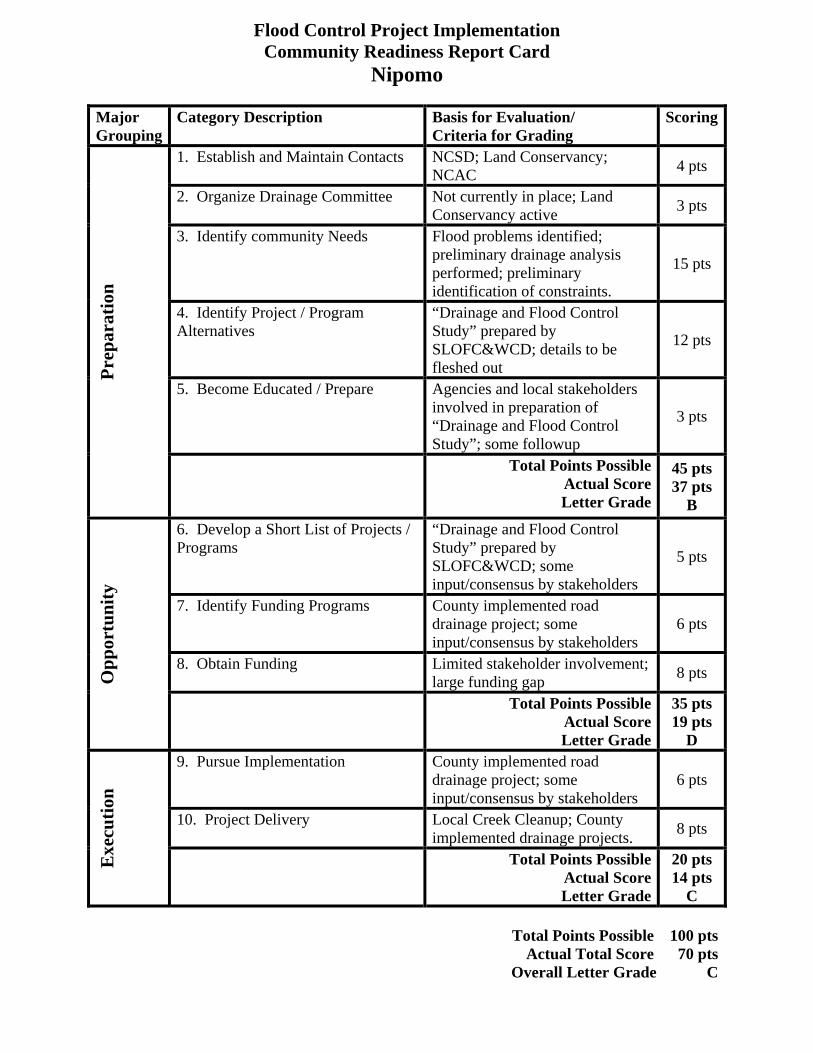
Flood Control Project Implementation Community Readiness Report Card
Nipomo Major Grouping
Category Description Basis for Evaluation/ Criteria for Grading
Scoring
1. Establish and Maintain Contacts NCSD; Land Conservancy; NCAC 4 pts
2. Organize Drainage Committee Not currently in place; Land Conservancy active 3 pts
3. Identify community Needs
Flood problems identified; preliminary drainage analysis performed; preliminary identification of constraints.
15 pts
4. Identify Project / Program Alternatives
“Drainage and Flood Control Study” prepared by SLOFC&WCD; details to be fleshed out
12 pts
5. Become Educated / Prepare Agencies and local stakeholders involved in preparation of “Drainage and Flood Control Study”; some followup
3 pts
Prep
arat
ion
Total Points Possible Actual Score Letter Grade
45 pts 37 pts
B 6. Develop a Short List of Projects / Programs
“Drainage and Flood Control Study” prepared by SLOFC&WCD; some input/consensus by stakeholders
5 pts
7. Identify Funding Programs County implemented road drainage project; some input/consensus by stakeholders
6 pts
8. Obtain Funding Limited stakeholder involvement; large funding gap 8 pts O
ppor
tuni
ty
Total Points Possible Actual Score Letter Grade
35 pts 19 pts
D 9. Pursue Implementation County implemented road
drainage project; some input/consensus by stakeholders
6 pts
10. Project Delivery Local Creek Cleanup; County implemented drainage projects. 8 pts
Exe
cutio
n
Total Points Possible Actual Score Letter Grade
20 pts 14 pts
C
Total Points Possible 100 pts Actual Total Score 70 pts
Overall Letter Grade C

Flood Control Project Implementation Community Readiness Report Card
Oceano Major Grouping
Category Description Basis for Evaluation/ Criteria for Grading
Scoring
1. Establish and Maintain Contacts OCSD; limited contacts 3 pts
2. Organize Drainage Committee Apparently not currently in place 0 pts
3. Identify community Needs
Flood problems identified; preliminary drainage analysis performed; preliminary identification of constraints.
15 pts
4. Identify Project / Program Alternatives
“Drainage and Flood Control Study” prepared by SLOFC&WCD
15 pts
5. Become Educated / Prepare OCSD and local stakeholders involved in preparation of “Drainage and Flood Control Study”; limited followup
2pts
Prep
arat
ion
Total Points Possible Actual Score Letter Grade
45 pts 35 pts
C 6. Develop a Short List of Projects / Programs
“Drainage and Flood Control Study” prepared by SLOFC&WCD; input/consensus by stakeholders; limited followup
4 pts
7. Identify Funding Programs County implemented road drainage project; limited input/consensus by stakeholders
5 pts
8. Obtain Funding Limited stakeholder involvement; large funding gap 8 pts O
ppor
tuni
ty
Total Points Possible Actual Score Letter Grade
35 pts 17 pts
D 9. Pursue Implementation County implemented road
drainage project; limited input/consensus by stakeholders
5 pts
10. Project Delivery County implemented road drainage project. 7 pts
Exe
cutio
n
Total Points Possible Actual Score Letter Grade
20 pts 12 pts
D
Total Points Possible 100 pts Actual Total Score 64 pts
Overall Letter Grade D

Flood Control Project Implementation Community Readiness Report Card
San Luis Obispo Creek – Flood Control Zone 9 Major Grouping
Category Description Basis for Evaluation/ Criteria for Grading
Scoring
1. Establish and Maintain Contacts Zone 9 Advisory Group; City of SLO; CSLRCD; Local stakeholders
5 pts
2. Organize Drainage Committee Regular Zone 9 Advisory Group meetings 5 pts
3. Identify community Needs
Flood problems identified; preliminary analysis and identification of constraints.
12 pts
4. Identify Project / Program Alternatives
“SLO Creek Waterway Management Plan ” prepared by Questa; details to be fleshed out
10 pts
5. Become Educated / Prepare Agencies and local stakeholders involved in preparation of Questa study and followup
4 pts
Prep
arat
ion
Total Points Possible Actual Score Letter Grade
45 pts 36 pts
B 6. Develop a Short List of Projects / Programs
Agencies and local stakeholders involved in preparation of Questa study and followup; limited focus outside SLO City limits
4 pts
7. Identify Funding Programs Zone 9 assessments; grants 8 pts 8. Obtain Funding Zone 9 assessments in place;
pursuing grant opportunities; large funding gap
15 pts
Opp
ortu
nity
Total Points Possible Actual Score Letter Grade
35 pts 27 pts
C 9. Pursue Implementation Pursuing projects in SLO City
limits; CSLRCD performing outreach to unincorporated areas; stakeholder involvement; large funding gap
7 pts
10. Project Delivery Vegetation management; some flood maintenance projects. 6 pts
Exe
cutio
n
Total Points Possible Actual Score Letter Grade
20 pts 13 pts
C Total Points Possible 100 pts
Actual Total Score 76 pts Overall Letter Grade C
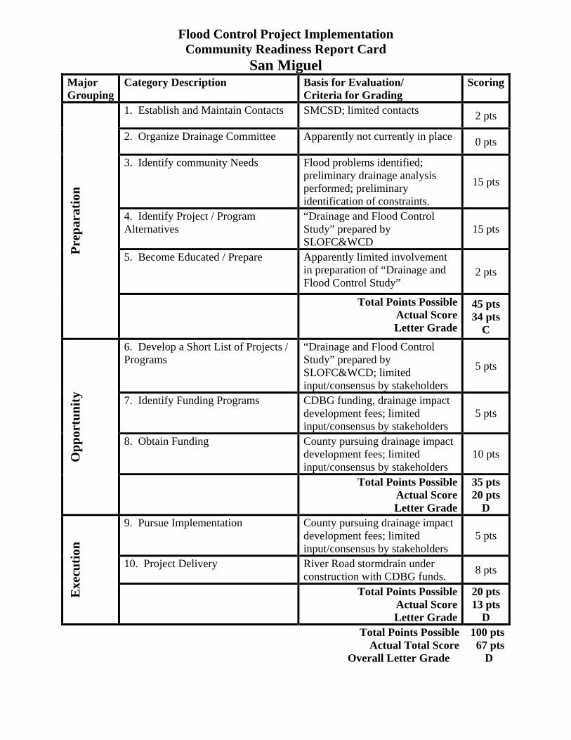
Flood Control Project Implementation
Community Readiness Report Card San Miguel
Major Grouping
Category Description Basis for Evaluation/ Criteria for Grading
Scoring
1. Establish and Maintain Contacts SMCSD; limited contacts 2 pts
2. Organize Drainage Committee Apparently not currently in place 0 pts
3. Identify community Needs
Flood problems identified; preliminary drainage analysis performed; preliminary identification of constraints.
15 pts
4. Identify Project / Program Alternatives
“Drainage and Flood Control Study” prepared by SLOFC&WCD
15 pts
5. Become Educated / Prepare Apparently limited involvement in preparation of “Drainage and Flood Control Study”
2 pts
Prep
arat
ion
Total Points Possible Actual Score Letter Grade
45 pts 34 pts
C 6. Develop a Short List of Projects / Programs
“Drainage and Flood Control Study” prepared by SLOFC&WCD; limited input/consensus by stakeholders
5 pts
7. Identify Funding Programs CDBG funding, drainage impact development fees; limited input/consensus by stakeholders
5 pts
8. Obtain Funding County pursuing drainage impact development fees; limited input/consensus by stakeholders
10 pts Opp
ortu
nity
Total Points Possible Actual Score Letter Grade
35 pts 20 pts
D 9. Pursue Implementation County pursuing drainage impact
development fees; limited input/consensus by stakeholders
5 pts
10. Project Delivery River Road stormdrain under construction with CDBG funds. 8 pts
Exe
cutio
n
Total Points Possible Actual Score Letter Grade
20 pts 13 pts
D Total Points Possible 100 pts
Actual Total Score 67 pts Overall Letter Grade D

Flood Control Project Implementation Community Readiness Report Card
Santa Margarita Major Grouping
Category Description Basis for Evaluation/ Criteria for Grading
Scoring
1. Establish and Maintain Contacts CSA 23 Advisory Group meets regularly and involved 5 pts
2. Organize Drainage Committee CSA 23 Adv Group has drainage committee 5 pts
3. Identify community Needs
Flood problems identified; preliminary drainage analysis performed; preliminary identification of constraints.
15 pts
4. Identify Project / Program Alternatives
“Drainage and Flood Control Study” prepared by SLOFC&WCD; details to be fleshed out
10 pts
5. Become Educated / Prepare Community involved in preparation of “Drainage and Flood Control Study”
5 pts
Prep
arat
ion
Total Points Possible Actual Score Letter Grade
45 pts 40 pts
B 6. Develop a Short List of Projects / Programs
“Drainage and Flood Control Study” prepared by SLOFC&WCD; input/consensus by stakeholders
5 pts
7. Identify Funding Programs County pursued SWRCB LID grant; input/consensus by stakeholders
8 pts
8. Obtain Funding Local stakeholders voted against tax assessment; pursuing project opportunities; large funding gap
12 pts Opp
ortu
nity
Total Points Possible Actual Score Letter Grade
35 pts 25 pts
C 9. Pursue Implementation Pursuing storm drain easement;
community participates in creek cleanup; large funding gap
6 pts
10. Project Delivery LID bioswale and wetland/basin project funded and constructed. 7 pts
Exe
cutio
n
Total Points Possible Actual Score Letter Grade
20 pts 13 pts
C
Total Points Possible 100 pts Actual Total Score 78 pts
Overall Letter Grade C

Flood Control Project Implementation Community Readiness Report Card
Shandon Major Grouping
Category Description Basis for Evaluation/ Criteria for Grading
Scoring
1. Establish and Maintain Contacts CSA 16 Advisory Committee; Caltrans; little contact 2 pts
2. Organize Drainage Committee Apparently not currently in place 0 pts
3. Identify community Needs
Some flood problems identified; no drainage analysis performed. at this time
5 pts
4. Identify Project / Program Alternatives
No analysis or alternatives identified; contact with Caltrans 5 pts
5. Become Educated / Prepare Local stakeholders not currently involved in flood control issues; town plan and EIR in process
2 pts
Prep
arat
ion
Total Points Possible Actual Score Letter Grade
45 pts 14 pts
F 6. Develop a Short List of Projects / Programs
Potential cooperative project with Caltrans; no stakeholder involvement
2 pts
7. Identify Funding Programs Possible CDBG, USDA grant funding; no stakeholder involvement currently
2 pts
8. Obtain Funding County discussed potential grant funding with USDA; no stakeholder involvement currently; large funding gap
5 pts
Opp
ortu
nity
Total Points Possible Actual Score Letter Grade
35 pts 9 pts
F 9. Pursue Implementation No current projects currently 2 pts 10. Project Delivery No current projects 0 pts
Exe
cutio
n
Total Points Possible Actual Score Letter Grade
20 pts 2 pts
F
Total Points Possible 100 pts Actual Total Score 25 pts
Overall Letter Grade F

Flood Control Project Implementation Community Readiness Report Card
Templeton Major Grouping
Category Description Basis for Evaluation/ Criteria for Grading
Scoring
1. Establish and Maintain Contacts TCSD; limited contacts 2 pts
2. Organize Drainage Committee Apparently not currently in place 0 pts
3. Identify community Needs
Some flood problems identified; very preliminary drainage analysis performed.
10 pts
4. Identify Project / Program Alternatives
Initial analysis performed; alternatives not identified 10 pts
5. Become Educated / Prepare Local stakeholders not currently involved 5 pts
Prep
arat
ion
Total Points Possible Actual Score Letter Grade
45 pts 27 pts
D 6. Develop a Short List of Projects / Programs
Initial analysis performed; alternatives not identified; no stakeholder involvement
2 pts
7. Identify Funding Programs Drainage impact fees; no stakeholder involvement currently 2 pts
8. Obtain Funding County pursuing drainage impact fees; limited stakeholder involvement; large funding gap
5 pts
Opp
ortu
nity
Total Points Possible Actual Score Letter Grade
35 pts 9 pts
F 9. Pursue Implementation County pursuing drainage and
flood study; will seek stakeholder involvement; no current projects
2 pts
10. Project Delivery No current projects 0 pts
Exe
cutio
n
Total Points Possible Actual Score Letter Grade
20 pts 2 pts
F
Total Points Possible 100 pts Actual Total Score 38 pts
Overall Letter Grade F

[This Page Intentionally Blank]

VII. Proposed Project Strategy by Community
a. General. As was noted in the previous section, the intent of the report card is not necessarily to grade or rate a community according to the level of need for flood control projects, but rather to evaluate the current involvement of local stakeholders and readiness of the community to pursue and implement such projects, using the criteria discussed in this report. In general, the report cards showed that those communities that scored highest (i.e. most ready to implement projects) were those that were viewed as having in place a “critical mass” of interested, educated and involved stakeholders, identification of flooding problems with clear mitigation alternatives backed up by suitable analysis to identify the constraints and budget costs associated with each alternative. Following is a brief discussion of the results with comments regarding a proposed strategy for moving each community towards “critical mass” for project implementation.
b. Arroyo Grande Creek Channel – FC Zone 1/1A Report Card Results. The residents and stakeholders associated with Flood Control Zone 1/1A were assigned letter grade of “B,” using the criteria and methodology included in this study. Improving and maintaining the conveyance capacity of the Zone 1/1A creek channel is certainly as daunting a challenge as any other flood control issue in the County, given its location in the coastal zone, environmental constraints, number of jurisdictional agencies involved, broad and varied local and agency stakeholders, magnitude of project costs, etc. However, the level of participation and proactive involvement and coordination of the stakeholders in general and Zone 1/1A committee members in particular can in some measure provide a model and example for other communities. Factors positively affecting the grade include the recent initiation of preparing a Floodway Management Plan and Programmatic EIR, a multi-year effort estimated to cost approximately $575,000, and a recently conducted “tabletop” flood emergency “evacuation” exercise. The exercise included coordination and input from various emergency agencies and management staff, and will aid in providing a plan and procedure to follow in the event a levee breach occurs before reasonable mitigation measures can be implemented to accommodate future high storm runoff events which could threaten to exceed the channel capacity. The efforts at organizing, educating and grassroots efforts of outreach to stakeholders has facilitated local funding via a Proposition 218 assessment district formation recently approved by the property owners to increase assessments, which will fund the Floodway Management Plan and provide a local match for access to additional outside funding, putting the stakeholders in a favorable position to take advantage of other such funding opportunities as they arise. Recommended Strategy. The stakeholders should continue the current efforts of coordination and cooperation with SLOCFCWCD and agency staff and continue

pursuing grant and other funding opportunities. The District and stakeholders should continue following efforts of implementation toward floodway management as identified and approved based on permits acquired through the Floodway Management Plan EIR process. In addition, the USDA has indicated potential funding support based on guaranteed reimbursement revenue from the assessment district. Such funding should be evaluated and pursued if favorable. c. Cambria Report Card Results. The community of Cambria had an overall assigned letter grade of “C.” Factors positively affecting the grade include the fact that a detailed “Drainage and Flood Control Study” was recently prepared by the SLOCFCWCD on behalf of the community, the community voted to assess themselves for implementation of a West Village Flood Control Project, and FEMA funds have been obtained and major project alternatives are under construction. Factors negatively affecting the grade include the current large funding gap for other projects throughout the community and an apparent lack of current local stakeholder involvement and cooperation in the process of pursuing additional flood mitigation programs and projects. Recommended Strategy. Community outreach by County staff would be recommended. Such outreach efforts might include presentations at North Coast Advisory Council meetings, CCSD meetings, coordination with the District 2 Supervisor and his/her legislative assistant to facilitate and encourage stakeholder involvement. d. Cayucos Report Card Results. The community of Cayucos had an overall assigned letter grade of “D.” Factors positively affecting the grade include the fact that a detailed “Drainage and Flood Control Study” was recently prepared by the SLOCFCWCD on behalf of the community, local stakeholders were involved in the Flood Control Study, and one of the mitigation project alternatives recommended in the study has been pursued to a limited extent. Factors negatively affecting the grade include the current large funding gap for projects throughout the community and the current lack of local stakeholder involvement and cooperation in the process of pursuing flood mitigation programs and projects. Recommended Strategy. Community outreach by County staff would be recommended. Such outreach efforts might include presentations at Cayucos Citizens’ Advisory Council meetings and coordination with the District 2 Supervisor and his/her legislative assistant to facilitate and encourage stakeholder involvement. e. Los Osos Report Card Results. The community of Los Osos had an overall assigned letter grade of “C.” Factors positively affecting the grade include the fact that a
detailed Drainage Master Plan had been prepared for the community in 1998, and that the local stakeholders were actively involved pursuing some of the projects, including passing a drainage special tax assessment and voting to approve formation of a Community Services District in part to address local drainage issues. Factors negatively affecting the grade include the current large funding gap for projects throughout the community and the current apparent lack of local stakeholder involvement and cooperation in the process of pursuing flood mitigation programs and projects. Recommended Strategy. Though the LOCSD has assumed a more prominent role in community drainage issues since its formation in 1998, outreach by County staff would be beneficial to foster communication and coordination regarding common concerns, such as roadway drainage. Such outreach efforts might include presentations at Los Osos Community Advisory Council meetings, LOCSD meetings, coordination with the District 2 Supervisor and his/her legislative assistant to facilitate and encourage stakeholder involvement. f. Nipomo Report Card Results. The community of Nipomo had an overall assigned letter grade of “C.” Factors positively affecting the grade include the fact that a detailed “Drainage and Flood Control Study” was recently prepared by the SLOCFCWCD on behalf of the community, NCSD and local stakeholders were actively involved in the Flood Control Study, the Land Conservancy has been an active advocate in the community supporting the program, some follow-up contact and coordination has occurred between local stakeholders and SLOCFCWCD staff, and several of the mitigation project alternatives mentioned in the study have been implemented. In addition to advocacy efforts, the Land Conservancy has been involved in outreach to the community, resulting in educational activities and assistance in coordinating annual creek cleanup days, including vegetation management to maintain channel capacity. Factors negatively affecting the grade include the current large funding gap for projects throughout the community, and the current level of local stakeholder involvement and cooperation in the process of pursuing flood mitigation programs and projects. Recommended Strategy. Community outreach by County staff would be recommended. Such outreach efforts might include presentations at South County Advisory Council meetings, NCSD meetings, further cooperation with Land Conservancy staff, and coordination with the District 4 Supervisor and his/her legislative assistant to facilitate and encourage additional stakeholder involvement. g. Oceano Report Card Results. The community of Oceano had an overall assigned letter grade of “D.” Factors positively affecting the grade include the fact that a detailed “Drainage and Flood Control Study” was recently prepared by the

SLOCFCWCD on behalf of the community, OCSD and local stakeholders were involved in the Flood Control Study, and minor mitigation project alternatives mentioned in the study have been implemented. Factors negatively affecting the grade include the current large funding gap for projects throughout the community, the current lack of local stakeholder involvement and cooperation in the process of pursuing flood mitigation programs and projects, community reluctance to participate in pursuit of such programs and projects, and a general lack of positive advocacy. Recommended Strategy. Community outreach by County staff would be recommended, with a goal of developing a partnership between OCSD, District staff and sponsoring or supporting advocate agencies, such as the SLCRCD. Such outreach efforts might include presentations at Oceano Advisory Council meetings, OCSD meetings, coordination with the District 4 Supervisor and his/her legislative assistant to facilitate and encourage stakeholder involvement. h. San Luis Obispo Creek Watershed – FC Zone 9 Report Card Results. The residents and stakeholders associated with Flood Control Zone 9 were assigned a letter grade of “C” using the criteria and methodology included in this study. Zone 9 faces similar challenges in Improving and maintaining the conveyance capacity as those faced by Zone 1/1A, given its location in the coastal zone, environmental constraints, number of jurisdictional agencies involved, broad and varied local and agency stakeholders, etc. As with Zone 1/1A, there is a relatively high level of participation and proactive involvement and coordination of the stakeholders in through the Zone 9 advisory group, which helped facilitate the preparation of a comprehensive “SLO Creek Waterway Management Plan” and follow-up hydraulic modeling and project alternative refinement. The advisory group has been successful in efforts at organizing and outreach to stakeholders, mostly to residents within the SLO city limits. Some outreach to property owners in the unincorporated areas downstream of the City of SLO has occurred in recent years, through cooperative efforts of the SLCRCD. Factors negatively affecting the grade include the current lack of involvement and cooperation in the process on the part of those stakeholders within the unincorporated areas of the Zone 9 watershed, and while funding is available due to the Zone 9 tax base, floodway and watershed project and program demands significantly exceed the current funding capability. Recommended Strategy. The stakeholders should continue the current efforts of coordination and cooperation with SLOCFCWCD and agency staff and continue pursuing grant and other funding opportunities. Efforts at outreach to stakeholders in the unincorporated areas of Zone 9 should be continued, including coordination with the Avila Valley Advisory Council and the District 3 Supervisor and his/her legislative assistant to facilitate and encourage stakeholder involvement. Research and pursuit of grant opportunities should also be continued, as such programs are available.
i. San Miguel Report Card Results. The community of San Miguel had an overall assigned letter grade of “D.” Factors positively affecting the grade include the fact that a detailed “Drainage and Flood Control Study” was recently prepared by the SLOCFCWCD on behalf of the community and that steps have been taken to construct some of the alternatives included in the study. In addition, San Miguel is one of the few communities in the county currently qualifying for CDBG grant funds, according to existing median household income levels. Factors negatively affecting the grade include the current large funding gap for projects throughout the community, and the current lack of local stakeholder involvement and cooperation in the process of pursuing flood mitigation projects. Recommended Strategy. Community outreach by County staff would be recommended. Such outreach efforts might include presentations at San Miguel Advisory Council meetings, SMCSD meetings, coordination with the District 1 Supervisor and his/her legislative assistant to facilitate and encourage stakeholder involvement. j. Santa Margarita Report Card Results. The residents and stakeholders associated with Santa Margarita were assigned letter grade of “C,” using the criteria and methodology included in this study. Like Zone 1/1A, the level of participation and proactive involvement and coordination of the local stakeholders is quite high, through regular participation in the CSA 23 advisory group, community outreach, etc. Such efforts have resulted in annual creek cleanup days, including vegetation management to maintain channel capacity, and have helped facilitate the recent construction of major drainage projects in the community. As with Zone 1/1A, the stakeholders are well positioned to take advantage of project and funding opportunities as they arise. Factors negatively affecting the grade include the current large funding gap for projects throughout the community, and the historic lack of voter support for establishing a drainage tax assessment. Recommended Strategy. The stakeholders should continue the current efforts of coordination and cooperation with SLOCFCWCD and agency staff and continue pursuing grant and other funding opportunities. In addition, the USDA has indicated potential funding support if a guaranteed reimbursement from the community could be established. Such funding should be evaluated and pursued if the community response is favorable. k. Shandon Report Card Results. The community of Shandon had an overall assigned letter grade of “F.” Factors positively affecting the grade include the fact that the SLOCFCWCD has had contact with Caltrans for a potential cooperative drainage mitigation project in the middle of the community, and that the County Planning Department is in the process of developing a town plan for the Shandon which

will involve a series of public meetings in the community, providing opportunities for outreach concerning flood and drainage issues. Factors negatively affecting the grade include the current lack of local stakeholder involvement and cooperation in the process of pursuing flood mitigation programs and projects, and the lack of a drainage master plan for the community. Recommended Strategy. Community outreach by County staff would be recommended. Such outreach efforts might include presentations at Shandon Advisory Council meetings and coordination with the District 1 Supervisor and his/her legislative assistant to facilitate and encourage stakeholder involvement. The current process of developing a town plan for Shandon should provide opportunity for outreach to stakeholders. l. Templeton Report Card Results. The community of Templeton had an overall assigned letter grade of “F.” Factors positively affecting the grade include the fact that the SLOCFCWCD has recently commissioned the preliminary phase of what will ultimately become a master drainage report for the community, and is pursuing a program to develop drainage impact fees to fund drainage mitigation projects in Templeton, depending on the results of the drainage study. Factors negatively affecting the grade include the current lack of local stakeholder involvement and cooperation in the process of pursuing flood mitigation programs and projects. Recommended Strategy. Community outreach by County staff would be recommended. Such outreach efforts might include presentations at Templeton Area Advisory Council meetings and coordination with the District 1 Supervisor and his/her legislative assistant to facilitate and encourage stakeholder involvement.

VIII. Implementation of Project Strategy
a. General Outreach to local and agency stakeholders and development of communication, cooperation and participation is fundamental to the successful implementation of local projects. District staff conducted numerous informational and communication meetings with many of the community representatives and agencies during the process of preparing the Six Community Drainage and Flood Control studies. District staff also participated in a flood preparedness forum with stakeholders in one of the target communities in November of 2006 and lessons learned in preparing for the meeting and responding to questions and comments from the public have been used in the preparation of this Flood Management Plan report. Since the forum, there have been several public meetings with advisory groups discussing flooding and drainage issues for three of the target communities. Questions and input from the public and advisory group members have been used to create a detailed list of “frequently asked questions” (FAQ’s) which have been grouped into various categories including policy, funding, environmental constraints and emergency response. The questions and responses are included in the appendix of this report. In addition, the FAQ’s will be featured on a website that is currently being developed for the District for disseminating information and educating the public pursuant to the common goals of implementing flood mitigation projects and programs. It is recommended that this report also be posted on the website and distributed to interested parties as part of the outreach program.
b. Next Steps It is recommended that the following steps be taken to implement the strategies discussed in this report, with activities tailored to the individual needs of the communities as described in earlier sections of the report: 1. Publish this report and make available for distribution to interested
stakeholders. 2. Meet with individual District Supervisors and their legislative assistants to
discuss the report findings and facilitate outreach to key stakeholders in their districts.
3. In cooperation with the pertinent Supervisor and legislative assistant, schedule an agenda item at a regular meeting of individual advisory groups to present the report findings and solicit stakeholder involvement.
4. Distribute copies of the report to stakeholder groups, such as the San Luis Coastal RCD, Upper Las Tablas RCD, NRCS, Land Conservancy, etc.
5. In conjunction with community advocates, develop a list of priority projects which can be the focus of efforts to implement by available District staff as opportunities and resources allow.
6. Finalize the District website as an outreach and educational tool, and include contact information for interested parties.
7. Post a copy of the report for download on the website.

APPENDIX A
FAQ’s (Frequently Asked Questions)

[This Page Intentionally Blank]

Flood Control FAQs Background Q: What forms the basis of the County’s role in flood control? A: The San Luis Obispo Flood Control and Water Conservation District (The District) is a resource to help individuals and communities in San Luis Obispo County identify and address flooding problems. The District was established in 1945 with the purpose “to provide for control, disposition and distribution of the flood and storm waters of the district and of streams flowing into the district…” In 1968, Resolution No. 68-223 was adopted and defined the policy role of The District relating to the costs of planning, design, construction, operations and maintenance of drainage and flood control facilities. In accordance with resolution 68-223, The District cannot be responsible for direct funding of community specific mitigation improvements. The District uses its general funding to identify flooding problems, recommend solutions, and help local areas implement recommended solutions. Q: What are the Constraints of implementing a flood control project? A: There are three major constraints to implement flood control projects: Policy, Funding, and Environmental. The FAQ’s are organized under these three categories to address these constraints. Policy and Agency Involvement Q: If the District/County does not pay for flood control improvements, who does? A: In accordance with state subdivision development law, the property owners that benefit from flood control improvements must fund the improvements. Design and construction of drainage and flood control improvements is the responsibility of the local lead agency or sponsoring entity which implements the improvements on behalf of the property owners who benefit from the improvements. Q: What are the Drainage Responsibilities of individual cities, Community Service Districts (CSD’s) and County Service Area (CSA’s) A: The individual cities within our County exercise control over drainage issues within their boundaries. Some of the cities operate extensive flood control facilities. The District has a regional role and can work with the cities when requested. CSD’s are locally controlled special districts that can also provide drainage and flood control services. In our County, the Oceano CSD and the Los Osos CSD both provide some drainage services. CSA’s can focus the powers of the County to provide specific services to specific areas. CSA’s can provide many services including drainage and flood control. These special districts are governed by the Board of Supervisors and receive their funding through collection of voter approved service charges or benefit assessments from the residents or property owners of the specific area served.

Q: What is the role of the Road funding in flood control? A: The Road Fund and its associated program is a separate and distinct legal entity, and budget, from the County’s Flood Control District. It has numerous State statutes (primarily the Streets and Highways Code) that dictate how Road Fund monies may be legally be expended. This program operates the County Maintained Road System and is funded through a combination of restricted revenue sources that are primarily derived through taxes on gasoline that are apportioned to cities and counties by the State, as well as contributions from the County General Fund. These funding sources can only be spent on solving problems that directly relate to the County Roads. The State Controller’s Office annually performs an audit of all Road Fund expenditures to ensure compliance with those statutes. As a function of operating the road system, the drainage issues related to the road system are addressed when such drainage work protects the County maintained road system in a cost beneficial way, or is directly related to County road improvement projects and is necessary to prevent private property damage. This includes directing the flow of streams across the roads through culverts and bridges. In many cases, cost benefit analysis preclude the expenditure of many hundreds of thousands (or millions) of dollars to prevent occasional flooding of certain roadways during periods of unusually intense rainfall. Some County roads will have standing water for short periods of time following rainfall events. This is especially true at various dry creek crossings in rural parts of the County. Q: It is the District/County that approves and allows construction. Why is the District/County not financially responsible for the flooding problems it allowed to develop? A: State and County zoning, land use, property development requirements and building codes have changed over the years and continue to change periodically. The rights and restrictions related to a property owner’s ability to build on their property involve historic and evolving Federal constitution and programs, State law and County regulations. As new ordinances are adopted and enacted to protect public safety and welfare, homes and structures applying for new building permits must abide by the new ordinances. The County has adopted standards to protect against flood damage to homes located within the 100-year floodplain and all new home construction will meet these standards. The County is not responsible for the design standards that allowed residents to build within a floodplain if there were no ordinances prohibiting such action. Likewise, the County is not responsible for providing, nor can the County legally provide, private property improvements which benefit private property owners with public funds. The County will not be held financially responsible to implement projects that remove homes from the floodplain, reduce flood damage on private properties or provide property benefiting drainage and flood control improvements (unless there are direct benefits to County facilities) per Resolution No. 68-223. If such were the case, the County/District would be required to pave all roads, update and extend utility infrastructure, provide all drainage and flood control facilities, retrofit all structures to current standards, etc. in

accordance with the latest ordinances and at County taxpayer cost. This is not the purpose of County Government or legal use of public funds. Q: Why didn’t the County/District do something to provide for improvements relating to flood control a long time ago? A: Due to the nature of flood control, the District addresses flood control and drainage mitigation on a community specific basis. In some cases, The District has held special elections for the implementation of a property tax to provide funding for localized drainage services. If these measures are rejected, these community specific mitigation measures cannot be implemented. The District/County lacks the funds and legal precedence to pay for capital projects. The community’s that benefit from flood protection projects should be willing to fund the projects via an assessment or property fee. The County’s building codes, at a minimum, meet the state’s uniform building code. The County has the authority to expand and strengthen the codes, but the initial standards are established by the state. The County’s authority was limited when homes were first built in the floodplain. However, the County has adopted new standards to protect homes against flood damage. Unfortunately, these standards are not retroactive and the County cannot require an existing home to be improved to meet current standards. Q: Why did the District/County allow any development in the floodplain in the first place? A: Federal and State law, and County regulations provide for a reasonable use and development of private property. There has to be legally supportable rationale whereby property development is restricted, controlled and/or prohibited. The County has adopted standards to protect against flood damage to homes and structures located within the 100-year floodplain. The flood damage protection standards are included in the County’s Land Use Ordinance (22.07.060 et seq.). One of the criteria applicable to residential development is the finish floor elevations of residences. The finish floor elevation shall be at least one foot over the level of the 100-year flood elevation. Q: Once specific flood control projects have been identified, what is the strategy to implement these projects? A. A community or area consensus must be established as an advocate for the installation of new drainage and flood control facilities. A local lead agency (e.g. CSD) or other sponsoring agency should be utilized to promote and sponsor the project on behalf of the supporting community. The District staff is available to assist if the local community supports the implementation but no local agency or sponsor is available or supportive of a project. Included in the community consensus must be the commitment to fund a significant portion of the initial costs of implementing and constructing the project. It should be recognized that the strongest applicants for leveraged grant or other supplemental funding have an established and effective local funding program. Q: The 1968 policy seems outdated. Has it been looked at more recently?

A: The County Board of Supervisors reviewed and reconfirmed this policy in April 2001. Additional discussion on flood control policies, maintenance and improvement efforts was conducted by the Board of Supervisors on March 28, 2006 Q: What are other agencies with drainage responsiblities? A: Community Service Districts (CSD’s), Community Service Areas (CSA’s), Cities, U.S. Corps of Engineers, California Department of Water Resources (DWR), and Caltrans are all agencies that have various flood control and drainage responsibilities. Funding Q: How is The District funded? A: The primary funding source for the Flood Control District is a general property tax allocation, which provides about $550,000 per year in revenue. In addition, the district receives about $130,000 per year in interest income from current resources. Q: I have looked at some of the flood control projects identified by The District/County. The mark ups seem exorbitant! How could these overhead costs be so high? A: Typical mark-ups are calculated as a percentage of construction. An example of a typical mark up is as follows: Engineering and Design = 20% Administrative and Environmental = 40% Contingency = 20% In this case, the construction cost is 55% of the total project cost. For a planning level document, multiplying the construction costs by fixed percentages is standard practice because the level of detail available is not sufficient enough to assign costs. The fixed percentages typically range between 60 to 100% of the construction costs, depending on the complexity of the design and environmental documentation and permitting process. Q: What are some mechanisms to fund flood control improvements? A: Recommended local funding mechanisms include: grants, taxes, assessments, and property fees based on development impact. The creation of a local funding source, plus the potential procurement of Federal and State grants, establishes the framework for a comprehensive community funding program. This approach also acknowledges the realistic nature of public projects that no capital improvement can rely solely on grants. Q: Our community would like a fee to be levied that guarantees improvements of drainage facilities. How do these funding mechanisms get implemented? A: See Attachment 1 for a description of local funding process regarding special taxes, benefit assessments, property-based fees, and development impact fees. Environmental Q: What are some environmental constraints encountered for flood control mitigation projects? A: Biological, cultural resources, land use constraints, and associated environmental permitting criteria are all constraints facing many flood control projects. For flood control projects that have been previously identified, some of these constraints may have already

been addressed. The District may be able to provide assistance in identifying and addressing environmental constraints. Useful Flood Preparedness Information Q: What flood control facilities are maintained by the District/County? A: The County maintains roads and culverts in unincorporated areas of the county. Q: The creek that flows behind my house is filled with debris and my backyard floods every time it rains. Why won’t the County come out and clear the debris? A: The property owner through which the creek flows is responsible for creek maintenance. The County is responsible for maintaining culvert and creek crossings in public right of ways. Q: Who can I call in case of a flooding emergency? County Roads Caltrans Conditions 805.781.5252 Conditions 800.427.7623 Maintenance 805.781.4466 Maintenance 805.549.3111 Cities Community Service Districts Arroyo Grande 805.473.5460 Cambria 805.927.6223 Atascadero 805.466.7433 Heritage Oaks 805.227.6230 Grover Beach 805.473.4520 Los Osos 805.528.9376 Morro Bay 805.772.6261 Nipomo 805.929.1133 Paso Robles 805.237.3861 Oceano 805.481.6730 Pismo Beach 805.773.4656 San Miguel 805.467.3388 San Luis Obispo 805.781.7220 San Simeon 805.9274778 Templeton 805.434.4900 In emergency contact numbers, add Roads after hours and weekends, sheriff dispatch 781 4450 and Calif. Highway Patrol 549-3333. Q: My road is always flooding. How can I find out who maintains it? A: State highways are maintained by Caltrans. Roads within incorporated cities in the County are maintained by the city. Other, non private roads in the County are maintained by the County Roads Department. Q: Where can I get sandbags?

Flood Preparedness
Q: What are some recent flood control initiatives of The District? A: The District coordinated the completion of a six community drainage study in 2003/2004. In 2006, The District requested $3,000,000 in funding to construct roads related improvements documented in the six community drainage study, and $200,000 for Public Works Special Services budget to facilitate non-roads related Flood Control Improvements. A Proposition 50 grant of $75,000 was awarded to establish a documented process for both County staff and the public to use to bridge the gap from knowing what needs to be done to actually getting the indicated improvements in the ground. $180,000 was contributed to the Resource Conservation District to make possible an alternatives analysis for future operation and improvements of the Flood Control Zone 1 and 1A. The District has worked with several local communities to identify potential drainage improvements and provide assistance, within its ability, in the design and implementation of flood control improvements.

APPENDIX B
Community Specific Flood Control Projects (Executive Summaries)
1. Cambria 2. Cayucos 3. Nipomo 4. Oceano 5. San Miguel 6. Santa Margarita

[This Page Intentionally Blank]


San Luis Obispo County Cambria Drainage and Flood Control Study
i
EXECUTIVE SUMMARY This report is a summary of findings, conclusions and recommendations of the Drainage and Flood Control Study conducted for the Community of Cambria. This report was prepared under the direction of the County of San Luis Obispo Public Works Department.
In response to questions raised by several citizens who experienced flood damage to their homes and businesses during the unusually heavy rainfall period of March 2001, the County Board of Supervisors approved funding for Drainage and Flood Control Studies for the communities of Cambria, Cayucos, Nipomo, Oceano, San Miguel, and Santa Margarita. The goals of the studies were intended to quantify the extent of drainage and flooding problems of each of these communities, to generate recommendations for solutions for the drainage problems, to identify environmental permitting requirements, to provide planning level cost estimates, and to outline a plan for funding and implementation of the proposed solutions. This study was funded through the General Flood Control District Budget.
Overview of Responsibility The responsibilities for drainage are administered through the San Luis Obispo County Flood Control and Water Conservation District (District). The District is the designated County agency responsible for managing, planning, and maintaining drainage and flood control facilities in unincorporated public areas where no other agency has assumed an active role in such activities. The District has a regional role in the County and can work with individual cities or communities when requested. The District uses its general funding to identify water related issues, to determine solutions to those problems and to help those local areas implement recommended solutions. The District is not, however, responsible for paying for community-specific mitigation improvements. The specific property owners that benefit from these solutions must agree to pay for the construction and future maintenance of them. This policy (Resolution 68-223) was formally established by the Board of Supervisors in 1968. The policy was adopted because there is not sufficient funding available for the District to fund construction and operation of facilities. This approach provides the best leveraging of the funds that are available.
The District is restricted in the way it can fund needed projects or increase revenues for existing operations. It is generally limited to an assessment district procedure for obtaining financing for the construction of new projects. Due to the changes enacted with the passage of Proposition 218, the District must now have all new benefit assessments and increases to existing benefit assessments for maintenance and operations approved through an election of affected property owners.
Existing Drainage Problems The combination of the area’s steep topography, lack of underground drainage facilities, and location of residential parcels below the street grade has resulted in localized poor drainage and/or flooding around some residences, buildings, and roadways. The magnitude of flooding varies by the districts in Cambria and by location in each district. Drainage from a number of uphill lots flows along the edge of street pavement and drains onto lower lots, creating flooding and erosion problems. Drainage problems also exist where curbs are present, but the topography creates conditions where lots adjacent to the roadway are much lower than the roadway surface. This allows street drainage flowing at the curbside to enter the residential lots at the lowered curb section along the driveway entrance. Many unpaved roads are also subject to sheet and rill erosion during storm events.

San Luis Obispo County Cambria Drainage and Flood Control Study
ii
Proposed Projects The major constraint identified in local flooding issues was the lack of suitable conveyance facilities for storm water runoff. In most areas, storm water flows as surface flow in streets, ditches, and backyard areas. Stormwater conveyance is widely varied, due to changes in roadway slope and cross section, the presence or lack of curb and gutters, and the presence or lack of existing culverts and drainage channels. Most drainage issues were the result of upstream concentrated flows entering downstream lots due to a lack of storm drain facilities to convey flow.
The proposed solution is the construction of a number of small projects to resolve the flooding problems. Several potential projects have been developed to address drainage and flooding issues, and are shown by district in Figures 3 through 13 in Appendix A. A combination of the projects will be required to eliminate all of the drainage problems for the community. However, the intent is that each alternative will work independently to solve localized problems. The proposed projects primarily include the installation of paved roadways with rolled asphalt berms to keep storm runoff within the public right-of-way and off residential property. Storm runoff would then be collected in drop inlets or catch basins and be conveyed in an underground pipe to its terminal discharge point. In some locations, roadside ditches and drainage channels are proposed in place of storm drains. The goal of each project was to divert runoff away from topographic low points (generally a residential property) into a storm drain to effectively convey the flow to a creek or the ocean.
Flooding problems along Santa Rosa Creek in the West Village are being addressed by the construction of a by-pass channel for Santa Rosa Creek, as part of the Cambria Flood Control Project. Therefore, drainage and flooding problems are not discussed in this report. The by-pass channel will allow overflows to move slowly through the by-pass channel and then rejoin the Santa Rosa Creek downstream without overtopping Cambria Drive or Santa Rosa Creek. The project restores controlled flooding to the historic floodplain of Santa Rosa Creek while protecting the West Village from overflows of Santa Rosa Creek.
Table ES-1 summarizes the proposed alternatives by zone and also provides estimated costs and implementation timeframe. The total cost of all the projects is approximately $6.7 million. This total includes street and berm improvements totaling approximately $2.5 million that would be paid by the benefiting home owners through the Cooperative Roads Improvement Program. The storm drain, culvert, and road side ditch improvements and related appurtenances have an estimated cost of approximately $4.2 million
Table ES-1: Summary of Alternatives
DISTRICT 1 PROJECT PROBLEMAREA PROPOSED MITIGATION COST 2
APPROXIMATE IMPLEMENTATION
TIME FRAME 3
Marine Terrace 1 Saint Thomas
Ave. and Emmons Dr.
Replace culverts, install storm drain $107,000 3.5 years
Marine Terrace 2 Marlborough
Lane and Drake St.
Pave street, install storm drain, berms and drop inlets $643,000 4 years
Marine Terrace 3 Newhall Ave. and Randall
Dr.
Berm street, install drop inlet and storm drain $127,000 3.5 years
Lodge Hill South 5
Burton Dr., Orville Ave., and Ardath
Dr.
Install storm drain, berms, drop inlets, and outfall $657,000 4 years
Lodge Hill South 6
Bradford Rd. and Orville
Pl.Pave and berm street $273,000 3.5 years

San Luis Obispo County Cambria Drainage and Flood Control Study
iii
DISTRICT 1 PROJECT PROBLEMAREA PROPOSED MITIGATION COST 2
APPROXIMATE IMPLEMENTATION
TIME FRAME 3
Lodge Hill South 7 McCabe Dr. Install berms $18,000 3 years
Lodge Hill South 8
Cowper, Radcliff
Ave., Langton St. and Kenneth
Pave and berm streets, install storm drain, drop inlets and culverts
$1,850,000 3.5 years
Lodge Hill South 9 Various
Locations Berms streets and install culverts $768,000 3 years
Lodge Hill North 10 Wilton Dr. Install roadside ditches, culverts,
and storm drain $238,000 3.5 years
Lodge Hill North 11 Ramsey St.
Pave and berm street, install drop inlets, storm drains and energy dissipator
$347,000 3.5 years
Lodge Hill North 12 Various
Locations Berm streets $90,000 3 years
Pine View 13 Eton Rd. and Wood St.
Drop inlet, storm drain, outfall, and erosion protection $263,000 5 years
Pine View 14 Martindale Berm street $40,000 3 years
Park Hill 15
Dorset St. and
Cambridge St.
Berm multiple streets, install storm drain, drop inlets $482,000 3.5 to 4 years
Park Hill 16 Pembrook Berm street, install drop inlet and storm drain $103,000 3 years
Happy Hill 18 Canterbury Lane
Install berm, drop inlet and storm drain $168,000 3 years
Happy Hill 19 Various Locations Install berms $242,000 3 years
Happy Hill 20 Suffolk St. Install berm, cross drain $273,000 3 years
Notes:1: See Figure 2 for delineation of the districts in Cambria and Figures 3 through 13 for the proposed projects. 2: ENR CCI for Los Angeles (February 2003) = 7,566. Includes 20% for Engineering and Design, 60% for Administrative and Environmental, and a 20%
Contingency. Typical estimates used for County Overhead & Support Costs for Construction Project Planning. Use 100% cumulative markup on construction costs for Coastal Zone Projects. Percentages provided by County (Typical to all estimates in this report).
3: See Table 6-1 for detailed milestone durations. If a lead agency is in place, then decrease the duration by approximately 9 to 12 months.
ADDITIONAL RECOMMENDATIONS
Elevation Requirements and Mountable Berms
Existing homes located below street grade and whose driveways slope down away from the road may experience flooding in the garage or home. This is because without an adequate curb/berm, the driveway may act to convey runoff from the street above to lower elevations and sometimes into the garage or home. It is recommended that Cambria mandate the installation of a County standard mountable berm for all existingdriveways/accesses to structures which are below the edge of pavement. It is also recommended that Cambria and the County Planning Department develop a design guideline that recommends the floor and garage elevation

San Luis Obispo County Cambria Drainage and Flood Control Study
iv
for all new home construction be greater than the adjoining street grade. Driveways should slope down away from the home, towards the road.
It is recognized that the unique topographic nature of Cambria and the configuration of some infill lots will render this suggestion impractical or extremely difficult to implement at some locations. If some of Cambria’s down sloping lots cannot be built above street level, then an alternative to protecting a structure’s contents would be to build the access points (e.g. doors and garage openings) a minimum of one foot above adjacent grade so that flooding on the property will not encroach into the doorways. This design guideline will prevent flooding from entering into doorways and protect a structure’s contents.
Minimize Storm Runoff from Homes
By diverting stormwater from impervious areas such as roofs, walkways and driveways, and reusing whenever possible, runoff that flows to streets can be greatly reduced. This can be achieved by directing rain gutter downspouts to landscaped areas, swales or infiltration basins on private property where water can percolate into the ground.
Development on Steep Terrain
For properties that contain drainage courses that convey runoff from uphill streets and lots, it is encouraged that a drainage easement be retained on the lower properties so that appropriate drainage facilities can be installed to convey runoff to the street below. The County’s Department of Public Works should develop a design guideline standard for a catch basin and down drain to convey water from an uphill lot, through the downhill lot and eventually discharging to the street below. The County’s Planning and Building Department should also provide the leadership and encouragement to property owners to dedicate drainage easements or to develop an appropriate reimbursement mechanism for uphill owners to compensate downhill owners for the easement.
Improve Drainage Systems as the Community Develops
New development is expected to substantially increase storm water flows in the community. The drainage impacts associated with increased development will be most pronounced in the Lodge Hill area where many of the roads are unpaved. Drainage improvements should be planned with any proposed development. Regardless of whether drainage problems exist prior to development, mitigation should be planned as not to increase the severity or frequency of problems. Such mitigation could include on-site detention of runoff, thereby preventing the increase of runoff onto lower lying properties.
It is recommended that development fees collected for Cambria be used to fund drainage improvements for areas that will be most impacted by future development. These areas are typically the topographic low points within a drainage sub-basin or district. The development fees collected to date should also be used to fund projects that mitigate for existing problems created by recent development (e.g. flooding at Eton Road and Wood Drive). If new development can not retain runoff on site, then it should be responsible for funding the necessary improvements to convey increased runoff.
In conjunction with planning drainage improvements with future development, critical lots that are at risk to flood damages due to their location should be identified. These lots should dedicate drainage easements on their property or design sufficient conveyance facilities as not to impede the flow of storm water.
Maintenance on Existing Facilities
Existing natural or fabricated drainage channels should be kept free of obstructions such as fallen trees, debris, and sedimentation to maintain capacity in the drainage system. Primary responsibility for this maintenance should rest with the owners of the property through which the drainage channels pass since the County is not

San Luis Obispo County Cambria Drainage and Flood Control Study
v
responsible for maintaining facilities on private property. If the drainage channels pass through public property, such as County roads, then the County’s maintenance department is responsible for removing impediments. The District should continue to provide leadership, advice and encouragement to property owners and local agencies to assume these responsibilities.
Rolled Asphalt Berms
The community should consider incorporating the Caltrans Type E 4 mountable berm into the road section for all new and substantially rehabilitated roads as the standard for all new roadway work where roadway drainage containment is considered necessary in the residential area. Appendix I contains a typical cross section detail of the mountable berm.
Formation of a Drainage Facility Maintenance Department
It is recommended that a facility maintenance district be formed to better maintain the drainage infrastructure in Cambria. Responsibilities of the new maintenance district would include: (1) being the contact point for all resident complaints regarding drainage infrastructure in the community; (2) keeping an organized database of all new drainage infrastructure in the community including the size and capacity of culverts and storm drains, even if this infrastructure is installed by private property owners; (3) keeping a regular maintenance schedule that may involve multiple maintenance visits where needed; and (4) responding to drainage infrastructure repairs as needed. Having a localized facility maintenance district will make it easier to maintain drainage infrastructure as needed throughout the community.
Neighbor Coordination
Many reported problems were caused by residents blocking historical drainage courses or removing drainage lines that conveyed runoff from higher elevations to lower elevations. These drain lines were installed by private residences in order to move water from the street or their property to public right of way. Filling in or removing drain lines causes runoff to pond in the back or side yards of the upstream properties. Neighbors should organize to ensure that storm runoff flows unimpeded to public right of way. Filling in drainage courses or removing drain pipes is discouraged by the District.
Implementation Strategy The most effective approach for improving drainage and flooding problems in each community is to identify the problems, develop solutions, and then create a local entity to implement the solutions. The role of the District is to assist the community in determining the improvements necessary to reduce flooding, and then to assist them in implementing programs to improve protection.
The District will continue to use its general funds only to provide programming and project initiation services so that communities can better understand the drainage problems they are facing, and determine how those problems should be solved. The proposed projects for Cambria totaled approximately $6.7 million. This total includes street and berm improvements totaling approximately $2.5 million that would be paid by the benefiting home owners through the Cooperative Roads Improvement Program. The storm drain, road side ditch improvements and related appurtenances have an estimated cost of approximately $4.2 million. If the lead agency in Cambria established a funding source to pay for the storm drain, culvert and roadside ditch improvements (excluding the street and berm improvements), approximately $298,000 per year would have to be generated by the community in order to build all the projects and pay off a municipal bond1.
1 Assumes a municipal bond rate of 5 percent, paid off over a period of 25 years.

San Luis Obispo County Cambria Drainage and Flood Control Study
vi
Community Financial Support
If the residents benefiting from these projects calculate that their average annual damages due to flooding are less than the assessment or fee necessary to mitigate the flooding, then the community might conclude that risking flood damages is economically beneficial. In other words, the benefits gained are less than the cost of the project. A discussion of flood protection benefits versus project costs should be conducted with the community in order to measure the interest in implementing a project. The discussion would explore whether the community is willing to financially support a project if the costs exceeded the benefits.
The reader should note that it will be difficult to pass an assessment or fee in any of the districts when vacant properties in Cambria cannot build due to the water service moratorium.
IMPLEMENTATION STEPS
It is recommended that the following implementation steps, in general, be followed for the proposed projects. It is assumed that a community supported agency/zone would serve as the lead agency and assume control of the project at completion. A lead agency in Cambria has not been designated, but it is recommended that the CCSD serve as the lead agency. The CCSD has formally commented that it is not prepared to take the lead agency role on the proposed projects.
Fund and complete a Basis of Design Report2 within 9 to 15 months of start (depends on complexity of project)Conduct benefit assessment or property based fee proceedings Design project, prepare environmental documents and resource agency permits Advertise for construction Construct project
The phasing of storm drain projects would depend on the residents’ desire to implement projects within their district. Each proposed project works independently to solve localized problems within a specific district. Therefore, neighbors within a district can organize to implement a project that benefits their area. The primary difference in the implementation steps for each project involves the complexity and the level of CEQA documentation required for storm drain projects. The majority of projects qualify for Class 1 CEQA categorical exemption because the alternatives consist of minor alterations to existing public facilities and do not have the potential to affect sensitive resources.
SCHEDULE FOR IMPROVEMENTS
The average duration for a storm drain project is approximately three to four years, depending on the length of pipeline, level of CEQA documentation, permitting requirements and environmental mitigation requirements. Chapter 6, “Implementation Strategy” includes more detail regarding task durations.
2 The Basis of Design Report would include a description of the existing problem, proposed alternatives, recommended project, preliminary alignments, potential environmental impacts, and cost estimates.

San Luis Obispo County Cambria Drainage and Flood Control Study
vii
ACKNOWLEDGEMENTThe San Luis Obispo County Flood Control and Water Conservation District, Community of Cambria Drainage and Flood Control Study 2003 represents a collaborative effort between San Luis Obispo County, the Community of Cambria, Raines, Melton & Carella, Inc., Questa Engineering Corporation and Essex Environmental. We would like to acknowledge and thank the following key personnel from the County and the North Coast Advisory Council whose invaluable knowledge, experience, and contributions were instrumental in the preparation of this report.
Paul Skartvedt – North Coast Advisory Council Member Walter Fitzhugh – North Coast Advisory Council Member Noel King – Public Works Director Glen Priddy – Deputy Director Engineering Services George Gibson – Design Engineer Public Works Dean Benedix – Project Manager Public Works Paavo Ogren – Deputy Public Works Director

San Luis Obispo County Cayucos Drainage and Flood Control Study
i
EXECUTIVE SUMMARY This report is a summary of findings, conclusions and recommendations of the Drainage and Flood Control Study conducted for the Community of Cayucos. This report was prepared under the direction of the County of San Luis Obispo Public Works Department. In response to questions raised by several citizens who experienced flood damage to their homes and businesses during the unusually heavy rainfall period of March 2001, the County Board of Supervisors approved funding for Drainage and Flood Control Studies for the communities of Cambria, Cayucos, Nipomo, Oceano, San Miguel, and Santa Margarita. The goals of the studies were intended to quantify the extent of drainage and flooding problems of each of these communities, to generate recommendations for solutions for the drainage problems, to identify environmental permitting requirements, to provide planning level cost estimates, and to outline a plan for funding and implementation of the proposed solutions. This study was funded through the General Flood Control District Budget.
Overview of Responsibility The responsibilities for drainage are administered through the San Luis Obispo County Flood Control and Water Conservation District (District). The District is the designated County agency responsible for managing, planning, and maintaining drainage and flood control facilities in unincorporated public areas where no other agency has assumed an active role in such activities. The District has a regional role in the County and can work with individual cities or communities when requested. The District uses its general funding to identify water related issues, to determine solutions to those problems and to help local areas implement recommended solutions. The District is not, however, responsible for paying for community-specific mitigation improvements. The specific property owners that benefit from these solutions must agree to pay for the construction and future maintenance of them. This policy (Resolution 68-223) was formally established by the Board of Supervisors in 1968. The policy was adopted because there is not sufficient funding available for the District to fund construction and operation of facilities. This approach provides the best leveraging of the funds that are available. The District is restricted in the way it can fund needed projects or increase revenues for existing operations. It is generally limited to an assessment district procedure for obtaining financing for the construction of new projects. Due to the changes enacted with the passage of Proposition 218, the District must now have all new benefit assessments and increases to existing benefit assessments for maintenance and operations approved through an election of affected property owners.
Existing Drainage Problems The combination of the area’s steep topography, lack of underground drainage facilities, and location of residential parcels below the street grade has resulted in localized poor drainage and/or flooding around some residences, buildings, and roadways. The most serious flooding in the community takes place in the floodplain of Cayucos Creek west of Highway 1, bounded by the mobile home park on the north and Cayucos Drive on the south. Extensive flooding occurs due to flows from the creek overtopping the banks, and the inability of the local drainage to enter the creek due to high water levels. A number of nuisance drainage and flooding problems occur throughout Cayucos due to the topography and the lack of a consistent, organized network of drainage facilities within the community. Drainage from a number of uphill lots flows along the edge of street pavement and drains onto lower lots, creating flooding and erosion problems. However, drainage problems also exist where curbs are present, but the topography creates conditions where lots adjacent to the roadway are much lower than the roadway surface. This allows street drainage flowing at the curbside to enter the residential lots at the lowered curb section along the driveway entrance.

San Luis Obispo County Cayucos Drainage and Flood Control Study
ii
Proposed Projects The major constraint identified in local flooding issues was the lack of suitable conveyance facilities for storm water runoff. In most areas, storm water flows as surface runoff in streets, ditches, and backyard areas. Stormwater conveyance is widely varied, due to changes in roadway slope and cross section, the presence or lack of curb and gutters, and the presence or lack of existing culverts and drainage channels. Most drainage issues were the result of upstream concentrated flows entering downstream lots due to a lack of storm drain facilities to keep runoff away from private residences. The proposed solution to the problems is the construction of a number of small project alternatives, or groups of smaller projects, to resolve the flooding problems. Several potential projects have been developed to address drainage and flooding issues, and are shown by drainage zone on Figures 8 through 14 in Appendix A. A combination of the projects will be required to eliminate all of the drainage problems for the community. However, the intent is that each alternative will work independently to solve localized problems.
ZONE 3 IMPROVEMENTS The most serious flooding in the community takes place in Zone 3 at the merging floodplains of Cayucos and Little Cayucos Creek west of Highway 1. Drainage from a tributary to Cayucos Creek flows into this area and has also caused flooding. To reduce the flooding in this area, a new storm drain pipeline could be constructed to convey the Cayucos Creek tributary flows directly to the creek, rather than flowing in the roadside channels and as overland flow across the floodplain area. Constructing the diversion pipeline to route tributary flow away from the local drainage system to Cayucos Creek would reduce the 10-year storm runoff by approximately 83 percent. This project would reduce flood flows in the B Street area and protect the neighborhood from more frequent rain events, but would not protect homes and businesses from larger storm events which cause overtopping of the Cayucos Creek banks. A levee and pump station would be required to protect the B Street area against flooding in these conditions. If the pump station is not constructed, then flooding would continue in the B and Ash Street area for storms greater than a 10-year event.
ZONES 5 THROUGH 21 A number of nuisance drainage and flooding problems occur within the drainage zones due to the topography, the lack of an underground storm drain system, and the lack of a consistent, organized network of curbs and gutters within the community. An underground storm drain conveyance system would reduce the amount of overland flow runoff in downstream areas, consequently reducing the flooding problems created with overland flow. The development of a consistent curb and gutter network could also reduce nuisance flooding. However, drainage problems also exist where curbs are present and the topography provides conditions where lots adjacent to the roadway are much lower than the roadway surface. This allows street drainage flowing at the curbside to enter the residential lots at the lowered curb section along the driveway entrance. On streets where curbs are currently established, curbs and gutters should be required for infill development to create a continuous system and to prevent flow onto properties. Table ES-1 summarizes the proposed alternatives by zone and also provides estimated costs and implementation timeframe.

San Luis Obispo County Cayucos Drainage and Flood Control Study
iii
Table ES-1: Summary of Alternatives
DRAINAGE ZONE 1 PROJECT PROBLEM
AREA PROPOSED MITIGATION COST 2 APPROXIMATE
IMPLEMENTATION TIME FRAME 3
3 Diversion Pipeline
B and Ash Street
Construct diversion pipeline to route Cayucos Creek tributary flow directly to creek.
$420,000 6 years
3 Levee and Pump Station
B and Ash Street
Construct a levee to contain 100-year flood flows and pump station to convey local runoff into creek.
$1,880,000 7 to 8 years
5 Storm Drain and Inlets
Ocean Ave. and Pacific
Ave.
Construct storm drain to relieve flooding at intersection of Ocean and Pacific Ave.
$117,000 3 to 4 years
8 Storm Drain and Inlets
6th St. and 8th St. from St. Mary’s Ave.
to Pacific Ave.
Construct storm drain to relieve flooding originating in Park Ave. and Saint Mary’s.
$1,127,000 3 to 4 years
9 Storm Drain and Inlet
10th St. from Cass Ave. to Pacific Ave.
Construct storm drain to relieve flooding experienced on 10th St. $148,000 3 to 4 years
10 Storm Drain and Inlets
13th St. from Cass Ave. to Pacific Ave.
Construct storm drain to relieve flooding experienced on 13th St $192,000 3 to 4 years
11 Storm Drain and Inlets
Pacific Ave. from 15th to
17th St.
Construct storm drain to reduce overland flow in Pacific Ave. $152,000 3 to 4 years
12
Storm Drain, Inlets and
Private Easement
Circle Dr. and Cass St.
Construct storm drain to eliminate sump at low point on Circle Dr. $83,000 3 to 4 years
15 Storm Drain and Inlets
Stuart Ave. from Richard Ave. to ditch
Construct storm drain to relieve flooding and overland flow on Stuart Ave.
$192,000 3 to 4 years
16 Storm Drain,
Inlets and Outfalls
Hacienda Dr.
Construct storm drains in two areas of Hacienda Dr. to relieve drainage along Ocean Ave. and Cerro Gordo Ave, and also east side of Hacienda Dr.
$407,000 3 to 4 years
19 Storm Drain,
Inlets and Easement
Gilbert Ave., Shearer Ave. and Mayer St.
Construct two new storm drains to relieve flooding caused by hillside runoff on Gilbert and Shearer Ave. Reduce flooding on Mayer from flows across Highway 1.
$273,000 3 to 4 years
21 Storm Drain,
Inlets and Easement
Between Gilbert and Ocean Ave.
Construct a storm drain to convey runoff generated from the hillside east of Gilbert.
$263,000 3 to 4 years
Notes: 1. See Figures 8 through 14 for delineation of drainage zone and proposed alternatives. 2. ENR CCI for Los Angeles (February 2003) = 7,566. Includes 20% for Engineering and Design, 60% for Administrative and Environmental, and a 20%
Contingency. Typical estimates used for County Overhead & Support Costs for Construction Project Planning. Use 100% cumulative markup on construction costs for Coastal Zone Projects. Percentages provided by County (Typical to all estimates in this report).
3. See Tables 6-2 and 6-4 for detailed milestone durations.
San Luis Obispo County Cayucos Drainage and Flood Control Study
iv
ADDITIONAL RECOMMENDATIONS FEMA Community Rating System Cayucos should participate in the Community Rating System (CRS). The CRS gives credit points for any of several designated activities within four distinct categories (Public Outreach, Mapping and Regulations, Flood Damage Reduction, and Flood Preparedness). As points are accumulated, a community will receive one class reduction starting at class 9 all the way down to class 1. Each class translates to an additional reduction in insurance premiums of five percent for flood insurance policies within the special flood hazard area of that community. Maintenance on Existing Facilities Existing natural or fabricated drainage channels should be kept free of obstructions such as fallen trees, debris, and sedimentation to maintain capacity in the drainage system. Primary responsibility for this maintenance should rest with the owners of the property through which the drainage channels pass since the County is not responsible for maintaining facilities on private property. If the drainage channels pass through public property, such as County roads, then the County’s maintenance department would be responsible for removing impediments. The District should continue to provide leadership, advice and encouragement to property owners and local agencies to assume these responsibilities. Elevation Requirements and Mountable Berms Homes located below street grade and whose driveways slope down away from the road may experience flooding in the garage or home. This is because without an adequate curb/berm, the driveway may act to convey runoff from the street above to lower elevations and sometimes into the garage or home. It is recommended that Cayucos and the County Planning Department mandate that the floor and garage elevation for all new home construction be one foot greater than the adjoining street grade. Driveways should slope down away from the home, towards the road. It is also recommended that Cayucos mandate the installation of a County standard mountable berm for all driveways/accesses to structures which are below the edge of pavement. Formation of a Drainage Facility Maintenance Department It is recommended that a facility maintenance district be formed to better maintain the drainage infrastructure in Cayucos. Responsibilities of the new maintenance district would include: (1) being the contact point for all resident complaints regarding drainage infrastructure in the community; (2) keeping an organized database of all new drainage infrastructure in the community including the size and capacity of culverts and storm drains, even if this infrastructure is installed by private property owners; (3) keeping a regular maintenance schedule that may involve multiple maintenance visits where needed; and (4) responding to drainage infrastructure repairs as needed. Having a localized facility maintenance district will make it easier to maintain drainage infrastructure as needed throughout the community. Consolidate Urban Services Consolidate urban services and facilities in Cayucos into a single comprehensive service district as recommended in the Estero Area Plan (updated November 2002). If the community, County and LAFCo work to consolidate services, then drainage should be included in the charter of this new district. Neighbor Coordination Many reported problems were caused by residents blocking historical drainage courses or removing drainage lines that conveyed runoff from higher elevations to lower elevations. These drain lines were installed by

San Luis Obispo County Cayucos Drainage and Flood Control Study
v
private residences in order to move water from the street or their property to public right of way. Filling in or removing drain lines causes runoff to pond in the back or side yards of the upstream properties. Neighbors should organize to ensure that storm runoff flows unimpeded to public right of way. Filling in drainage courses or removing drain pipes is discouraged by the District.
Implementation Strategy The most effective approach to improving drainage and flooding problems in each community is to identify the problems, develop solutions, and then create a local entity to implement the solutions. The role of the District is to assist the community in determining the improvements necessary to reduce flooding, and then to assist them in implementing programs to improve protection. The District will continue to use its general funds only to provide programming and project initiation services so that communities can better understand the drainage problems they are facing, and determine how those problems should be solved. The proposed projects for Cayucos totaled approximately $5.25 million. If the lead agency in Cayucos established a funding source, approximately $370,000 per year would have to be generated by the community in order to build all the projects and pay off a municipal bond1. Community Financial Support If the residents benefiting from these projects calculate that their average annual damages due to flooding are less than the assessment or fee necessary to mitigate the flooding, then the community might conclude that risking flood damages is economically beneficial. In other words, the benefits gained are less than the cost of the project. A discussion of flood protection benefits versus project costs should be conducted with the community in order to measure the interest in implementing a project. The discussion would explore whether the community is willing to financially support a project if the costs exceeded the benefits.
IMPLEMENTATION STEPS It is recommended that the following implementation steps, in general, be followed for the Zone 3 diversion pipeline and the levee/pump station system improvements. It is assumed that a community supported agency/zone would serve as the lead agency and assume control of the project at completion. A lead agency in Cayucos has not been designated.
• Fund and complete a Basis of Design Report2 within 15 months of start (12 months for the diversion
pipeline only) • Initiate coordination with Caltrans regarding a cooperative agreement for the diversion pipeline
improvements • Conduct benefit assessment proceeding for the properties that benefit from the improvements • Design project, prepare environmental documents and resource agency permits • Advertise for construction • Construct project
Storm Drain Improvements in other Zones The phasing of storm drain projects would depend on the residents’ desire to implement projects within each zone. Each proposed alternative works independently to solve localized problems within a specific zone. Therefore, neighbors within a drainage zone can organize to implement a project that benefits their area. The implementation steps outlined above for Zone 3 would generally be followed for the storm drain projects. The 1 Assumes a municipal bond rate of 5 percent, paid off over a period of 25 years. 2 The Basis of Design Report would include a description of the existing problem, proposed alternatives, recommended project, preliminary alignments, potential environmental impacts, and cost estimates.

San Luis Obispo County Cayucos Drainage and Flood Control Study
vi
exceptions include the level of CEQA documentation required for storm drain projects will not be as rigorous. The majority of projects qualify for Class 1 CEQA categorical exemption because the alternatives consist of minor alterations to existing public facilities and do not have the potential to affect sensitive resources. A major difference from a funding perspective is that storm drains would likely be funded via a property based user fee (in lieu of an assessment) because the homes within a drainage zone contribute runoff conveyed in the storm drain and should therefore contribute a pro rata share of the costs. The duration to design and permit a storm drain project should be less than the Zone 3 improvements.
SCHEDULE FOR IMPROVEMENTS The estimated duration for Zone 3 improvements is approximately seven to eight years. The duration reduces to six years if only the diversion pipeline is implemented. The duration includes time for identifying a lead agency and developing community support. The average duration for a storm drain project in the other zones is approximately three to four years, depending on the length of pipeline, level of CEQA documentation, permitting requirements and environmental mitigation requirements. Chapter 6, “Implementation Strategy” includes more detail regarding task durations.

San Luis Obispo County Cayucos Drainage and Flood Control Study
vii
ACKNOWLEDGEMENT The San Luis Obispo County Flood Control and Water Conservation District, Community of Cayucos Drainage and Flood Control Study 2003 represents a collaborative effort between San Luis Obispo County, the Community of Cayucos, Raines, Melton & Carella, Inc., Questa Engineering Corporation and Essex Environmental. We would like to acknowledge and thank the following key personnel from the County and the Cayucos Citizen’s Advisory Council whose invaluable knowledge, experience, and contributions were instrumental in the preparation of this report. Arly Robinson – Cayucos Citizen’s Advisory Council Member Ralph Wessel - Cayucos Citizen’s Advisory Council Member Noel King – Public Works Director Glen Priddy – Deputy Director Engineering Services George Gibson – Design Engineer Public Works Dean Benedix – Project Manager Public Works Paavo Ogren – Deputy Public Works Director


San Luis Obispo County Nipomo Drainage and Flood Control Study Page 1 of 20
FINAL REPORT ADDENDUM This addendum is in response to the Nipomo Community Advisory Council (NCAC) Review Committee’s comments dated February 10, 2004, on the Drainage and Flood Control draft report.
Executive Summary Comments Comment 1: The enforcement of Building Code requirements should be used to mitigate
existing structures that are now subject to flooding problems. For example, on page v, under “Elevation Requirements and Mountable Berms,” we recommend that the county clarify a policy that designate as ‘Existing Non-conforming’ all structures and out-buildings in the flood zone of Nipomo’s Olde Towne that have been constructed at a grade of less than one foot greater than the adjoining grade. That county policy should state that such non-conforming structures could not be altered, modified, remodeled, added to, or improved upon, if the reasonable cost for such “added work” to the existing structures is greater than, say, $10,000. If the cost for such work is $10,000 or greater, than then those structures would be required to be razed and a new building permit would required for a replacement structures that conform to the requirement of one foot greater than the adjoining grade. All other current building code requirements would also apply to the new building permit. a. We believe that the property owner should be allowed to propose on-site
grading and flood control improvements of $10,000 or greater cost value, but not less than the cost proposed for the proposed added work. If such grading and flood control work is proposed, and is subsequently approved by the county, we believe that the desired “added work” should be appropriately processed for a building permit, as long as the approved grading and flood control work is performed as a mitigation measure on the site.
Response 1: As written in Section 3.6.3 of the final report, the County has adopted standards to protect against flood damage to homes located within the 100-year floodplain.The flood damage protection standards are included in the County’s Land Use Ordinance (22.07.060 et seq). The criteria applicable to residential development in general are:
Structures shall not be built in the “floodway.” The floodway is defined as the portion of the floodplain necessary to convey the 100-year flood if the channel is improved to County criteria. Finish floor elevations of residences shall be (at least) one foot over the level of the 100-year flood elevation.
Many homes located within the 100-year floodplain were built prior to adoption of this ordinance. These homes are most susceptible to flooding because they were typically built at grade and are often located below the adjoining street grade.
San Luis Obispo County possesses the authority to pass new land use ordinances that requires all residential dwelling units located within the FEMA 100-year

Report Addendum
San Luis Obispo County Nipomo Drainage and Flood Control Study Page 2 of 20
flood hazard zone (100-year floodplain) to conform to the County’s current Land Use Ordinance (22.07.060 et seq). A new ordinance could require that all residential single or multifamily dwelling units undergoing remodeling improvements that are valued at $10,000 or greater than the current property value (or a certain percent or greater than the current property value) would need to conform to the County’s Land Use Ordinance (22.07.060 et seq). The County’s Department of Planning and Building would investigate the cumulative impacts of passing such an ordinance in Olde Towne and other communities in the County prior to drafting a staff recommendation to the Board of Supervisors.
The County Board of Supervisors received and discussed the final six community drainage and flood control studies at their Board meeting on March 9, 2004. As part of their action, the Board directed the County Public Works and Planning and Building staff to jointly review and report on recommendations relative to County drainage regulations, management, planning, processing and approval, including possible modifications to current rules, ordinances and policies. This item will be included in the staff review of existing ordinances and policies.
Comment 2: On page iv, in Table ES-2, under Tributary 1, Near Sea and Mallagh Streets, the solution recommended in the report is too segmented at Sea and Burton. The report should re-consider its recommendation and provide for a single conduit rather than a series of small segments.
Response 2: If properly maintained, the existing roadside drainage ditches should possess sufficient capacity to meet the County’s current standard for minor waterways (minor waterways have a drainage area of less than one square mile and are designed for an average storm recurrence interval of 10 years with freeboard).The proposed culverts at Mallagh/Sea and Burton/Sea are intended to increase the conveyance capacity of the crossings, and to prevent runoff from backing up in the roadside ditches and causing shallow flooding at roadway intersections.Constructing a continuous storm drain in Burton and Sea Street would convey storm runoff underground and would also be designed to convey the 10 year storm. A storm drain would require far less maintenance when compared to an open roadside ditch. From a capacity perspective, an underground storm drain and a properly maintained drainage ditch should be equal.
Constructing 700 feet of 30-inch diameter storm drain to replace existing roadside drainage ditches would cost approximately $126,000. The total project cost (includes engineering, design, administrative, environmental and contingency) is approximately $227,000. Compared to the cost in Table ES-2 for improving existing roadside drainage ditches and installing culverts at road intersections, installing a new storm drain would more than double the total project cost and provide minimal benefit to storm runoff conveyance.
Comment 3: On page vi, under: “Modify Existing Policies…”, we strongly agree with the recommendation that the County modify existing planning standards and policies.
Report Addendum
San Luis Obispo County Nipomo Drainage and Flood Control Study Page 3 of 20
Response 3: Comment noted.
Comment 4: On page vi, under: “Modify Existing Policies…”, we strongly agree with the statement that “County Drainage Standards and Policies specify the responsibility of onsite runoff management as belonging to residents; however, no specific sanctions and no consistent procedure are available to [oversee, provide necessary guidance and engineering control, and] enforce maintenance of local facilities.” [The words in italics represent our additional comment to the quotation].
Response 4: The County does provide guidance to residents and businesses on sizing storm detention facilities. As discussed in Section 3.9.4, the County’s handout “Drainage Plan Required in Nipomo” generally describes the drainage requirements for the Nipomo area. This section of the report also recommends that the handout include education material on proper maintenance of drainage facilities on private property, and also the consequences of filling in or neglecting infiltration basins.
The County has served as a leader in providing guidance to the community to improve drainage and prevent flooding. However, without enforcement authority, the County lacks the legal nexus requiring that homeowners properly manage onsite runoff. Final report section 3.9.2.2.2 discusses and recommends increased enforcement authority for drainage issues. This item also will be included in the County staff review of existing ordinances and policies.
Comment 5: On page vi, under “Modify Existing Policies …”, we strongly agree with the statement that planning standards and policies need to be implemented. We recommend the establishment of a task force of local Nipomo residents, or of the Nipomo Community Advisory Council (NCAC), that will work with the county and local community representatives to explore low cost interim watershed maintenance and management solutions, such as: a license agreement, or easement with upstream landowners to use agricultural land for the installation of check basins, and retention basins to better manage storm runoff.
Response 5: If the community supports the construction of detention basins to store peak runoff from large storm events, then early coordination with landowners is imperative to securing available land. The proposal for a detention basin is a long-term, permanent solution. The commenter proposed a license agreement or easement as a low cost interim watershed maintenance and management solution. It is unclear to the project team why a license agreement or easement is considered a low cost interim watershed maintenance and management solution. Section 3.9.6.2 recommends coordination with the agricultural community to ensure that farm operations do not increase erosion within the channel or result in blockage of the channel.

Report Addendum
San Luis Obispo County Nipomo Drainage and Flood Control Study Page 4 of 20
Regarding the creation of a task force, a lead agency for Nipomo has not been confirmed. As discussed in Section 2.1.4.1 of the report, the Nipomo Community Services District (NCSD) has authority to provide drainage services and was recommended to serve as the lead agency for the proposed projects. However, the NCSD voiced concern over serving in the lead role and did not provide a formal response regarding their position. Until the issue regarding who will serve in the lead role is resolved, the formation of a task force to work with the County or the apparent lead agency is premature.
Comment 6: On page iv, under “Modify Existing Policies …”, we request that county staff meet with local Nipomo community representatives to consider specific creek and floodplain maintenance and management standards on Delieissihues Creek, between Thompson and the end of Mallagh to maintain or improve floodplain capacity in the area. The standards could include consideration for the best management practices for constructing effective bank resloping, slope stabilization, construction of retention and detention basin, grading and widening of channel courses, etc.a. In the stretch between Mallagh and the main stem, annual debris and
interfering vegetation removal is recommended. b. The rerouting of the existing channel to remove the “oxbow” turn located near
the end of Mallagh, and the re-establishment of the channel between Thompson and Mallagh, and
c. Sediment removal, creation of buffers with roads, and stream-bank revegetation. A critical location for this work is just upstream of the High School footbridge.
Response 6: County staff is available to meet with community representatives to discuss the development of floodplain maintenance and management standards for area creeks. It should be noted that the proposed project on Deleissigues Creek discussed in Section 3.8.1 of the report did not include reconfiguration of the channel. Widening and re-aligning the channel will result in an increase in project costs and environmental permitting.
Comment 7: On page v, under: “Increase Retention Basin Capacity Design”, we strongly agree with statement in the last sentence of that paragraph, recommending that the basin volume criteria be revised to include sufficient capacity to store tributary and street runoff.
Response 7: Comment noted.
Comment 8: On page v, under: “Increase Retention Basin Capacity Design”, we request the addition of additional retention basin capacity design criteria that, wherever possible, drainage and retention basins shall be: a. Designed for multi-use purposes, as pocket parks for example. b. Designed as visually attractive components of private property development.

Report Addendum
San Luis Obispo County Nipomo Drainage and Flood Control Study Page 5 of 20
c. Designed with gradual sloping sides that encourage multiple uses be the development, when the basin is not needed for control of storm runoff.
d. Designed with the aesthetic appearance of graded basins in mind, especially for retention basins that would be considered adjacent or abutting Thompson. Motorists that enter Olde Towne will see such basins. Thompson should be designed so that such basins do not appear as ‘eye sores.’
Response 8: a. Whenever possible, a single large detention basin that serves multiple
residences and also serves as a park is preferred over many single property detention basins. The concept of a large detention basin was implemented in recently completed subdivisions in the Mesa (e.g. on Division near Las Flores). However, for infill development, the only option is to construct individual basins. The County’s handout on basin capacity is intended for individual home owners. An equivalent offsite facility would be applicable if an entire neighborhood mobilized to convert a vacant parcel to serve as a regional detention basin in order to remove individual lot basins.
b. Many homes have created decorative basins in their front or back lawns (e.g. homes along Las Flores). The aesthetic quality of the basin is left to the discretion of the home owner. It may be possible for the local community to encourage the County’s Planning and Building Department to develop specific guidelines on visual components of the basins.
c. Multiuse regional basins with gently sloping sides would be preferred. This paragraph in the executive summary and Section 3.9.4 was intended for individual lot basins, and not large regional basins. If regional basins in Olde Towne are implemented, then other uses (such as recreation) can be considered during the design phase.
d. See response b above.
Comment 9: On page v, under: “Improve Drainage Systems …”, in the second paragraph starting with the words “It is recommended …”, provide an explanation as to how development fees would be levied, the mechanism recommended for implementing the development fee program, and how such finds would protected for the excusive use for the intended drainage improvements. We strongly support this recommendation, but have grave concerns that such funds would not be protected for the intended use and would be used by the county for other programs.
Response 9: The proposed fee would fund drainage improvements that mitigate impacts resulting from increased development. The alternative to paying a fee would be for a proposed development to install the improvements themselves, pending County approval.
Report Addendum
San Luis Obispo County Nipomo Drainage and Flood Control Study Page 6 of 20
Section 5.2.2.5 discusses development impact fees and the government code authorizing the collection of development fees to fund the installation of storm drain infrastructure necessary to offset the impacts of development. Development impact fees are tied to either General Plans or Capital Improvement Programs and can be approved by a majority of the Board of Supervisors.
Fees are typically paid when applications are filed with the County’s Department of Planning and Building. In this case, the submission of a building or tract map application would be the nexus for collecting development fees to fund drainage improvements. For example, in Cambria, development fees are collected for the Lodge Hill south area to mitigate for erosion impacts associated with increased runoff caused by development. The County would collect a similar fee to fund improvements in Nipomo.
The County would be responsible for ensuring that the collected fees were saved in a capital reserve fund exclusively for the use of drainage improvements in Nipomo.
Comment 10: We recommend that the drainage systems of the Olde Towne study area all be improved to the design standard of a 25-year storm event.
Response 10: Designing and constructing ALL drainage improvements to convey the 25-year storm will result in oversized roadside ditches, curbs, gutters, drop inlets and culverts. The cost to replace all existing minor waterways to conform to a design standard equivalent to a secondary waterway would be cost prohibitive and the financial impacts should be analyzed prior to recommending such a policy. The recommendation to establish a minimum design standard that ALL drainage improvements convey the 25-year storm is not justified due to the additional costs anticipated to conform to this increased level of protection.
Some consideration could be given to establishing a minimum design standard for creek culvert crossings only. All creek culverts or bridges could be designed to pass the 25-year storm with freeboard (unless the creek is a major waterway and designed to convey the 100-year storm). This would impact Hermrick Creek, Tributary 1 and Knotts Street v-ditch, which are considered minor waterways and were designed to convey a 10-year storm with freeboard. This recommendation will increase the project costs outlined in the report, however to a lesser extent than for a more encompassing standard.
If the intent of this recommendation is to prevent flooding from a 100-year storm event, then increasing the minimum design standard to a 25-year storm event will not achieve this objective. Constructing detention basins in the upper watershed or raising homes above the 100-year floodplain are the only options for reducing flood damage potential from a 100-year storm event. The proposed recommendation will reduce the nuisance flooding problems associated with more frequent, less severe events.

Report Addendum
San Luis Obispo County Nipomo Drainage and Flood Control Study Page 7 of 20
Comment 11: On page vi, under: “Maintenance on Existing Facilities”, we agree with the principle of the recommendation that maintenance of drainage channels should be done by the owners of the affected property. However, the county recommendation should offer the knowledge and expertise of its government staff to assist these property owners by: a. Providing engineering and planning expertise to streamline permitting,
provide instruction, give consultation and on-site guidance, and help coordinate the work by private property owners.
b. Coordinating, training and cooperating with upstream landowners facilitate maintenance work in streambeds of their upstream properties. The major public safety and public benefit of this practice by the county is to promote best management practices that protect the health, safety and welfare of the Nipomo community that is downstream of that proposed maintenance work. We believe that the maintenance work of upstream property owners in streambeds has the value of a public work, because the downstream residents and landowners directly benefit from their maintenance work.
c. The county must not abdicate its responsibility to assure appropriate maintenance that reduces liability for damage to downstream property.
Response 11: The County will continue in its current role and be responsible for maintenance of culverts within public right-of-way. It should be reiterated that the NCSD was formed with the powers to construct and improve bridges, culverts, curbs, gutters, and drains (per Government Code Section 61,600) as summarized in Section 2.1.4.1 of the report.
County staff is available to assist the community with programming and planning the proposed maintenance, and providing guidance on managing the creek’s resources to preserve conveyance capacity and improve habitat quality. Due to staff limitations and funding constraints, the County could not serve as the lead agency in securing resource agency permits or scheduling maintenance with various land owners.
If the property owners decided to implement regular maintenance of the creeks, then the County would be willing to provide the leadership and guidance for establishing a long-term creek maintenance program. Section 3.9.5 and 3.9.6 of the report provide more detail on routine maintenance and community supported/managed programs.
Comment 12: On page vi, under: “Community Financial Support”, The discussion of cost/benefit analysis to measure the implementation of projects is troubling because it forces the general community and affected upstream property owners to make decisions that have direct impact on the public good. Without a clear understanding of engineering, environmental, and planning, principles that are necessary for the preservation of public property and for public safety, such decisions, though practical and efficient in cost savings, may have the effect of

Report Addendum
San Luis Obispo County Nipomo Drainage and Flood Control Study Page 8 of 20
endangering public property and public safety. For this reason, the county cannot simply wash its hands and leave the decision to the property owner. The county has a fundamental responsibility to assure its constituents that it provides for public safety and it protects private property from damage within its jurisdiction.
Response 12: The County is not “washing its hands” of the responsibility to implement projects that benefit the community. If a home owner is asked to approve an assessment or property based fee to fund a capital improvement, then the County is responsible for providing the information necessary for a resident to make an informed decision. This disclosure includes the analysis of benefits gained with a particular project versus the cost of said project. This is a quantifiable criteria based on costs and avoided damages.
The criteria regarding public safety, damage to public property and quality of life are qualitative factors that would be considered by a property owner when voting to approve or reject a new tax. All these factors would be presented and discussed with the community during the implementation process.
The County or District will not use its general funding to pay for community specific mitigation improvements. In fact, property owners that benefit from these improvements are expected to pay for the construction and future maintenance of them. Due to the changes enacted with the passage of Proposition 218, the District must now have all new benefit assessments and increases to existing benefit assessments for maintenance and operations approved through an election of affected property owners. Seeking community financial support through an election is not an attempt by the County to avoid responsibility, but the reality of funding public works projects according to state law.
Comment 13: We request that the county work with the local agency, or community organization, chosen as an advocacy organization to prioritize projects and assist in cost analysis.
Response 13: The County is available to assist with the prioritization of projects.
Comment 14: On page vi, under: “Community Financial Support”, The discussion of community financial support has overlooked the reality that the property owners in Olde Towne are people of modest means that can least afford to pay for the cost of repairing the storm drainage system. What have the preparers of this report concluded as to how the community will afford to pay for the repair cost? We recommend adding lower cost recommended solutions, even those that might be accomplished without an assessment.
Response 14: If they qualify, Community Development Block Grants are available to lower income residents to assist in paying the benefit assessment. An analysis on the community’s ability to pay for the proposed assessment was not conducted as part of this study.
Report Addendum
San Luis Obispo County Nipomo Drainage and Flood Control Study Page 9 of 20
The proposed improvements were separated into two categories, the less expensive improvements to bring existing drainage facilities up to current County standards, and the more expensive improvements to build detention basins and provide 100-year level of flood protection. In order to achieve a lower cost, the proposed detention basins should be eliminated from consideration, and only the improvements that bring existing drainage facilities up to current County standards should be considered. The remaining projects should be prioritized and the lower ranking projects would be deferred until a later date. It is unlikely that any of the proposed projects could be implemented without some funding from the local community.
Comment 15: On page i, under Existing Drainage Problems, second paragraph, we whole-heartedly concur in the statement that there is a lack of code enforcement. There is a need for code enforcement of planning and building code violations. Moreover, we are dismayed that the country has not acknowledged this fact as a correctable error and has not recommended action to rectify their own in-house county code enforcement problem. Code enforcement must be an obvious low cost alternative solution that should be included the consideration of alternatives in the report. We recommend that the county immediately implement code enforcement proceedings that rectify property owner created drainage and flood problems.
Response 15: The County’s Department of Public Works and the Department of Planning and Building will meet to discuss policy and enforcement changes to improve drainage and flooding problems.
Comment 16: On page ii, in the Table ES-1, in project 9, where are the drain inlets to be installed?
Response 16: Various community response surveys identified flooding in the area near W. Tefft and Mesa Road. However, the exact location and type of flooding were not listed.The potential area of flooding was difficult to verify, but was assumed to occur in the low lying area on W. Tefft between Mesa Road and Hazel Lane. The proposed drain inlets would be installed on each side of W. Tefft Street near the existing drain inlet.
Comment 17: On page iv, under “Modify Existing Policies and Standards,” we strongly agree with the suggestion that a county fee be levied for necessary maintenance and improvement work that must be performed on properties where there has been a failure to properly maintain drainage facilities. We request additional discussion in the report that guarantees that fees will be levied and that the account of collected fees will be dedicated to the use intended for drainage control in the Nipomo drainage and flood area.

Report Addendum
San Luis Obispo County Nipomo Drainage and Flood Control Study Page 10 of 20
Response 17: A new drainage ordinance approved by the Board of Supervisors would be necessary to collect a fee for service. The purpose of the proposed ordinance is not to accumulate an account of supplemental funds for maintenance projects, but to levy a fee for service against those properties that fail to maintain drainage facilities (similar to the basis for establishing fire prevention codes). Item 2 in Section 3.9.2.2 discusses this option in more detail. After sufficient notice to the home owner, the County would have the power to enter a property and complete the maintenance. The County would then charge the owner for the associated fees and refund the account used to carry out the maintenance.
Comment 18: On page v, under “Increase Retention Basin Capacity Design,” in the last sentence, we strongly agree with the recommendation that the basin volume should include capacity to also store contiguous and tributary street runoff. We strongly recommend that basin designs be further required to be built with gradual sloping sidewalls so that they may be useful for multiple purpose human and animal recreational use in their developments.
Response 18: This issue was discussed in Comment/Response 4 and 8 above.
Comment 19: On page v, under “Improve Drainage Systems …,” in the second paragraph, how would development fees be preserved and protected for the exclusive use of drainage projects for which they were collected?
Response 19: This issue was discussed in Comment/Response 9 above. Section 5.2.2.5 of the report discusses development impact fees and the government code authorizing the collection of development fees to fund the installation of storm drain infrastructure necessary to offset the impacts of development. Development impact fees are tied to either General Plans or Capital Improvement Programs and can be approved by a majority of the Board of Supervisors. Since the fees are tied to a General Plan or a Capital Improvement Program, they are required by government code and the Board of Supervisors adoption of the General Plan to be used for the specific purpose of the fee.
Section 3.7 Olde Towne Engineering Analysis Overview Comments Comment 1: In Section 3.7.1., Table 3-15, under “Encroachment of Creek and Tributary
Channels”, we request the report identify: a. Upstream land management practices that may adversely impact downstream
watershed flows, especially where such practices may create erosion, runoff problems from impervious surfaces, or downstream channel flow concerns.
b. Upstream private property owners should be encouraged to learn appropriate land management practices that promote excellent watershed maintenance and management. All improvements within the upstream watershed have the potential to endanger the downstream community. The county has a role to play to encourage the construction of creek and channel improvements that minimize erosion, desilt runoff water content, create buffer zones to separate drainage flows from farm land, and that slow runoff flow. All these

Report Addendum
San Luis Obispo County Nipomo Drainage and Flood Control Study Page 11 of 20
improvements would greatly benefit down stream property and the safety of the community that resides there.
c. Landowners should be encouraged to join a Nipomo watershed organization and participate in the creation of voluntary best management practices.
d. A task force should formulate improved guidelines. The Task Force could include community representatives from the agricultural community, urban property owners in the Olde Towne area, as well as the NCAC and Nipomo Watershed Organization. These guidelines would be used for county code enforcement on private property.
Response 1: The comments promote a watershed approach to improving creek conveyance and bank stability. We concur that a watershed approach results in improved creek habitat and fosters better management of creek resources. Engaging the agricultural community to explore methods for reducing impacts (such as sediment deposition or creek erosion) could be one of many “next steps” taken to improving drainage in Olde Towne Nipomo.
a. Analyzing upstream land management practices that may adversely impact downstream watershed flows was beyond the scope of this study. For Olde Towne, the study focused on the largest problem which was improving existing drainage facilities to meet current minimum County standards. Hypothetical reasons for increased sediment deposition and erosion of a creek’s banks could be included in the report, but without investigating the upstream land management practices, the reasons would be speculative.
b. The County’s department of Planning and Building could investigate the possibility of passing ordinances that restrict farming operations or development adjacent to a creek’s banks, effectively creating a setback.Section 3.9.6.2 recommends improvements to farming operations that encroach onto creek banks and increase sediment deposition into the channel. Discussion of public education regarding appropriate land management practice which minimize erosion and promote healthy creek geomorphology will be included in the staff discussions regarding revisions to current County ordinances and regulations.
c. The County is available to work with the local community in addressing best management practices for improving the watershed.
d. See response to “c”.
Section 3.8.1 Deleissigues Creek Watershed Comments Comment 1: On page, 3-29, Section 3.8.1.2, “Vegetation and Sediment Management”, we
request that the vegetation and management plan area be expanded to include all drainage courses and flood areas that are affected by a 25 year storm event.

Report Addendum
San Luis Obispo County Nipomo Drainage and Flood Control Study Page 12 of 20
Response 1: This proposal would only affect Haystack Creek and the two forks. Vegetation and sediment management is a feasible alternative for Haystack Creek and would likely increase the channel’s conveyance capacity. If we assume similar unit costs for the one time vegetative clearing and similar costs for engineering, environmental and administrative tasks, the total project cost for vegetation and sediment management on Haystack Creek is approximately $452,000.
Comment 2: On page, 3-30, Section 3.8.1.2, “Vegetation and Sediment Management”, we strongly disagree with the wording of this section. The majority of the creek watershed is in agricultural land. There are very few trees in the creek. Why has the report recommended tree removal and where is the “overshadowing by a tall canopy” of trees? Where are the trees?
Response 2: Reference to tree removal was intended for those trees that currently grow within the creek’s channel. As stated in Section 3.8.1.2, the tree canopy would result from new trees planted outside of the floodway and main flow path.
Comment 3: On page, 3-30, Section 3.8.1.2, “Vegetation and Sediment Management”, we believe that the greatest issue requiring correction is not a “shaded riverine aquatic habitat,” but the need to correct the ‘hair-pin turn’ that the creek flow makes at a point shown in Appendix A, Figure 8, on Eve near the location of a note that points to the creek where “vegetal growth and private structures built across creek constrict flow.”
Response 3: Deleissigues Creek is considered a secondary waterway and should possess sufficient capacity to convey a 25-year flood event. If the community supported a project that removed homes along Mallagh and Eve Street from the 100-year floodplain, then evaluating alternatives such as realigning the channel should be investigated.
The Federal Emergency Management Agency Flood Insurance Rate Map shows that the 100-year floodplain varies in width from 50 feet to 200 feet wide along the creek centerline. The 100-year floodplain exceeds the creek’s banks near the area bounded by Eve and Day Streets at Mallagh. A detailed 2-dimensional hydraulic analysis would determine the reduction in water surface elevation that could be achieved by straightening the natural meanders in the creek. Experience on similar channel realignment projects indicate that straightening a channel might reduce the water surface elevation by half a foot. The slope and cross sectional area of the channel dictates the capacity of a channel. These improvements would assist in containing the 100-year flood event within the creek’s banks, but until a detailed hydraulic analysis of straightened channel is conducted, quantifying the reduction in the water surface elevation will not be known.
An alternative to modifying the natural meander of the channel would be to build berms setback from the creek bank to contain the 100-year flow. This would

Report Addendum
San Luis Obispo County Nipomo Drainage and Flood Control Study Page 13 of 20
allow for the creek to remain in its current alignment and would also preserve the natural sinuosity of the channel.
Comment 4: On page, 3-30, Section 3.8.1.2, “Vegetation and Sediment Management”, we strongly believe that the upstream location of the creek should have improvements that minimize erosion, desilt runoff water content, create buffer zones to separate drainage flows from farm land, and that slow runoff flow. All these improvements would greatly benefit down stream property and the community that resides there. We are concerned that the statements to remove vegetation do not address the condition of the streambeds. We fear that negative conditions will still remain that may increase the damaging effects of continued erosion and subsequent flooding.
Response 4: This response assumes that the “upstream location” referenced in the comment refers to the reach of creek upstream of Thompson Avenue. The general theme of this and previous comments are geared towards promoting environmental stewardship, restoration and protection of the upper watershed in Olde Towne Nipomo. Watershed planning is a comprehensive and visionary approach to improving creek habitat and maintaining flood conveyance capacity. However, in Olde Towne, so much is needed in terms of raising the minimum drainage standard for existing culverts that improved agricultural practices upstream of Thompson Avenue will not address or improve the recurrent flooding problems caused by moderate storms. That said, if a parallel effort to restore creek habitat is implemented along with drainage improvements, then one could expect cumulative improvements in flood protection.
The improvements proposed in Comment 4 should be categorized as restoration projects. These proposals to minimize erosion and create buffers between agricultural runoff are far beyond best management practices. Improvements that minimize erosion within the creek’s channel include revegetation and establishment of riparian habitat. These improvements could result in a decrease in sediment deposition in the lower reaches within the urban corridors. However, the fact remains that the biggest issue is not erosion and sediment deposition, but a lack of conveyance capacity to contain peak flow discharges.
Comment 5: On page, 3-30, Section 3.8.1.2, “Vegetation and Sediment Management”, we strongly recommend that policy is needed to maintain and improve the flood plain between Thompson and Mallagh, as shown in Appendix A, figure 7. This is primary area for future development.
Response 5: It is unclear which floodplain the comment is referring to. The largest 100-year floodplain is located on Haystack Creek, but the area between Thompson Avenue and Mallagh Street within the Haystack floodplain is developed. If the comment is referring to the undeveloped area north of Eve Street and if the comment is implying that development should not be allowed within the creek’s banks, then we agree with the statement. Section 3.9.2.1 recommends that the County’s

Report Addendum
San Luis Obispo County Nipomo Drainage and Flood Control Study Page 14 of 20
Department of Planning and Building develops a policy that establishes a minimum setback from the top of creek bank to prevent structures from encroaching on a creek.
Comment 6: On page, 3-30, Section 3.8.1.3, “Project Cost Estimate”, we are concerned that the estimate shows vegetation clearance ($120,000) that does not appear to be needed from our review of field conditions. We request clarification on what that work entails. We are concerned that the cost for repair of the ‘hair-pin turn’ is not included. Please include this vital cost.
Response 6: An assumption was made that the entire creek reach between the confluence with Nipomo Creek and Thompson Avenue would require vegetation and/or sediment removal to restore the creek’s conveyance capacity to a 25-year level of flood protection (secondary waterway criteria). If, after completing a detailed hydraulic design, it is revealed that sediment removal and vegetation management is not required on the entire creek reach, then the cost estimate will be revised. The work would primarily consist of clearing overgrown trees in the channel, removing sediment, and restoring the channel to convey a 25-year flood event with freeboard. The cost estimate did not include realignment of the channel because it is uncertain whether realigning is necessary to convey the 25-year peak discharge. If one of the criteria is to contain the 100-year flood event to the channel, then the future project would investigate realigning the channel.
Section 3.8.2 Tributary 1 Comments Comment 1: On page 3-31, Section 3.6.2.2 Proposed Project, under “Improve Roadway
Crossings …”, in the second paragraph, the list of culverts and ditches to be cleaned should include the 3’ by 3’ culvert that crosses under Thompson.
Response 1: Field inspections conducted during the study did not indicate an accumulation of sediment within the culvert. The smaller existing culverts crossing under Mallagh Street had an accumulation of sediment and vegetation at the inlet that should be removed.
Comment 2: On page 3-31, under: “Optional Additional Facilities …”, we strongly request that the detention basin proposed upstream of Thompson be designed as a visually pleasing improvement with gradually sloping side walls, so that this improvement does not detract from its appearance as a “gateway feature” for motorists that enter Olde Towne. Also, consider: a. The installation of well maintained check dams upstream in the watershed
might be a low cost alternative, with a license agreement arrangement with the landowner.
b. Utilize the open lot at Thompson, Bee, and Burton, for secondary storm water detaining capacity. We recommend that this property be landscaped with consideration for publicly accessible mixed use options, as a pocket park.
c. Increase the capacity of channels on the downstream side of Mallagh Road.

Report Addendum
San Luis Obispo County Nipomo Drainage and Flood Control Study Page 15 of 20
d. Install the storm drain on Burton, near Day, which is planned but not yet installed.
Response 2: If implemented, the final design of the proposed detention basin could include gradually sloping side walls and other features to enhance the appearance of the basin. The basin could also serve as a multi-use facility (such as recreation) when not being used as a detention basin. Multi-use features are proposed in the report, but the details should be developed during the design phase. Note that the configuration of this proposed basin, as well as several others, was revised from that of the draft report to illustrate a more aesthetic appearing facility.
a. Check dams are generally used in concentrated flow areas, such as vegetated ditches and swales. Check dams are not used in streams or channels for reasons described below. Check dams can either be permanent or temporary barriers that prevent erosion and promote sedimentation by slowing flow velocities and/or filtering concentrated flows.
Check dams tend to pond water. Under low-flow situations, water ponds behind the structure and then seeps slowly through the check dam, infiltrates or evaporates. A check dam will still require sufficient land to pond runoff collected upstream of the dam. Under high-flow situations, water flows over and/or through the structure. Erosion control blankets should be used in conjunction with check dams. Erosion-control blankets are used for establishing and reinforcing vegetation on slopes and ditch bottoms. Since check dams are not built to detain high flows, this alternative would not be a feasible substitute for a detention basin which is designed and built to store the 100-year peak discharge and protect downstream properties.
Check dams provide relatively good removal of coarse and medium size sediment from runoff. However, most fine silt and clay particles will pass over or through the voids on these structures. Check dams are used as permanent erosion-control measures, but not flood protection measures. Check dams are relatively inexpensive, easy to construct, and are effective at reducing erosion and sediment transport off site. Check dams may be more appropriate for agricultural drainage channels that drain runoff from a field to one of the creeks tributary to Nipomo Creek.
b. The proposed vacant land adjacent to Bee Street, between Thompson and Burton, was considered a potential detention basin site for Hermrick Creek, not for Tributary 1. A basin at this site would not benefit Tributary 1 because local runoff that flows to this area would be conveyed in Hermrick Creek, not Tributary 1. However, since the comment was made, a brief discussion on the feasibility of using this site as a detention basin is provided. The available land is not large enough to attenuate the peak runoff from a 100-year flood event, and adding other multi-use features like a pocket park will reduce the volume available for storage since the basin will need to be terraced to ensure

Report Addendum
San Luis Obispo County Nipomo Drainage and Flood Control Study Page 16 of 20
that the recreational facilities are not inundated during storms. If the proposed detention basin upstream of Thompson Avenue was not available, then this site could be designed to attenuate a peak storm, but the size would not be sufficient to attenuate the 100-year flood event. If the proposed detention basin upstream of Thompson is implemented, then this underutilized lot could serve solely as a park without the need of modifying the surrounding contours to accommodate a detention basin.
c. Section 3.8.2.2 of the report states that the channel between Deleissigues Creek and Mallagh Street should be cleared of sediment and excess vegetation. Clearing the sediment will increase channel capacity and prevent water from backing up and ponding on Mallagh and Sea Streets.
d. The study team was not aware that a storm drain is already planned but not yet installed at Burton near Day Street. The comment may be referring to the installation of a 30-inch diameter corrugated plastic pipe (as show in Figure 7 of Appendix A) by a private home builder between Day and Sea Streets. The 30-inch plastic pipe conveys Tributary 1 flows from Thompson Avenue to Burton Street.
If the comment is referring to a new storm drain in Burton that would convey flows from Day to Sea Street, then roadside ditches along Burton Street currently convey road runoff to Sea Street and eventually to Deleissigues Creek. If properly maintained, the existing roadside drainage ditches should possess sufficient capacity to meet the County’s current standard for minor waterways (minor waterways have a drainage area of less than one square mile and are designed for an average storm recurrence interval of 10 years with freeboard). Constructing a storm drain in Burton near Day Street would convey storm runoff underground and would also be designed to convey the 10 year storm. A storm drain would require far less maintenance when compared to an open roadside ditch. From a capacity perspective, an underground storm drain and a properly maintained drainage ditch should be equal.
Constructing 500 feet of 30-inch diameter storm drain to replace existing roadside drainage ditches would cost approximately $90,000. The total project cost (includes engineering, design, administrative, environmental and contingency) is approximately $162,000. Compared to the cost in Table 3-17 for improving existing roadside drainage ditches and installing culverts at road intersections, installing a new storm drain would nearly double the total project cost and provide minimal benefit to storm runoff conveyance.
Comment 3: We strongly believe that the report has promoted the use of best management practices to solve the flood hazard issues for this tributary. It has not addressed the low area on the south side of Sea Street and an area that floods on Burton Alley, between Sea and Bee Streets. We implore the county to acknowledge the

Report Addendum
San Luis Obispo County Nipomo Drainage and Flood Control Study Page 17 of 20
need to avoid an eyesore for the detention basin at Thompson, as this is a location that forms a gateway to Olde Towne.
Response 3: The low areas were addressed by the proposed sediment removal necessary to clear the pathway for runoff in the roadside ditches along Mallagh Street to flow freely toward Deleissigues Creek. Four low area homes experiencing flooding were identified during the community questionnaire process and evaluated during field review.
Based on field investigations, it appears that at one point Tributary 1 flowed from Burton Street, across Sea Street and through private lots before crossing Mallagh Street and eventually discharging to Deleissigues Creek. The comment referenced Burton Alley between Sea and Bee Street as a location of flooding, but it is unclear exactly where flooding occurs. Review of street drainage patterns indicates that runoff from Burton Street currently flows in roadside drainage ditches in Sea Street to Mallagh Street, and eventually discharges to Deleissigues Creek. The proposed projects to install a 30-inch culvert at the crossings of Burton and Mallagh Streets with Sea Street, and to also clear the roadside ditches of sediment and vegetation should improve drainage and prevent flooding during average rain storms.
The County is aware of the need to design visually appealing storm detention basins. Note that the configuration of regional proposed basins was revised from that of the draft report to illustrate a more aesthetic appearing facility.
Section 3.8.3 Hermrick Creek Comments Comment 1: Under 3.8.3.2., In the topic of Optional Additional Facilities, on page 3-33, the
Fairview basin should be designed with gradual sloping sides and with landscape considerations so as to present an attractive “gateway” feature to motorists who are entering Olde Towne.
Response 1: See Response 2 for Tributary 1 comments.
Comment 2: We recommend that the county actively partner with a task force, or local community organization, to establish priorities for the selection of low cost watershed maintenance and management projects. Such low cost solutions might include: a. license agreement, or easement, with upstream landowners to use agricultural
land for such improvements as check dams, etc. b. explore the feasibility of an open space parcel at Thompson, Bea, and Burton,
for secondary detention capacity c. annual maintenance to clear vegetated areas c. annual culvert cleaning and sediment removal.
Response 2: The County is available to assist the local community and lead agency in developing solutions that will improve watershed management and flood

Report Addendum
San Luis Obispo County Nipomo Drainage and Flood Control Study Page 18 of 20
protection in Olde Towne. The County will continue to maintain existing culverts and drainage structures within the County road right-of way with available manpower and resources.
Comment 3: We believe that ‘check dam’ type improvements upstream in the watershed would be a significant low cost alternative for the management of the watershed.
Response 3: See Response 2a in Tributary 1 comments. Check dams are effective at reducing erosion and sediment transport off site. Preventing erosion and sediment transport should be explored on a parallel track with the implementation of drainage improvements that bring existing facilities up to the current County design standard.
Section 3.8.4 Haystack Creek Comments Comment 1: We recommend that the county actively partner with a task force, or local
community organization, to establish priorities for the selection of low cost watershed maintenance and management projects. Such low cost solutions might include: a. license agreement, or easement, with upstream landowners to use agricultural
land for such improvements as check dams, etc. b. annual maintenance to clear vegetated areas c. culvert cleaning and sediment removal, such as at North fork crossing at Tefft
Street.d. Enforcement of code violations and channel encroachments in urban areas on
the North and South forks. e. Bank stabilization and culvert improvements to direct and contain flow
Response 1: a and e. The County is available to assist the local community and lead agency in developing solutions that will improve watershed management and flood protection in Olde Towne.
b and c. The County will continue to maintain existing culverts and drainage structures within the County road right-of way with available manpower and resources.
d. The County’s current code enforcement process with regard to creek encroachment should be evaluated by County staff to determine if adequate controls exist to correct reported violations. The creeks in these locations are generally located on private property, and monitoring is extremely difficult. Report Section 3.9.5 recommends the establishment of a drainage facility maintenance department. This issue will be reviewed by County staff relative to recommendations to revise existing drainage policies and regulations.
Comment 2: We believe that ‘check dam’ type improvements upstream in the watershed would be a significant low cost alternative for the management of the watershed.

Report Addendum
San Luis Obispo County Nipomo Drainage and Flood Control Study Page 19 of 20
Response 2: See Response 2a in Tributary 1 comments. Check dams are effective at reducing erosion and sediment transport off site. Preventing erosion and sediment transport should be explored on a parallel track with the implementation of drainage improvements that bring existing facilities up to the current County design standard.
Comment 3: Include the replacement of the Thompson culvert with an arch culvert, as originally recommended in the study as part of phase II Olde Towne Improvement Plan. Explain why the prior design for an additional culvert at Tefft and Avocado in the technical draft was excluded from this draft.
Response 3: Replacement of the existing Haystack Creek culvert at Thompson with an arch culvert is proposed in the report in Section 3.8.4.2. An additional double 6’ by 4’ culvert to be installed adjacent to the existing culvert on Haystack Creek north fork at the Tefft Street crossing near Avocado is proposed in Section 3.8.4.2 of the final report.
Comment 4: In Appendix A, Figure 7, titled “Existing Drainage Facilities,” on the drainage path of Haystack Creek, at the confluence of Haystack Creek South Fork and North Fork and downstream of the confluence, we are concerned the report has not adequately addressed slope stabilization, buffer zones, channel vegetation clearance and other channel protection work necessary to protect adjacent private property.
Response 4: The primary issue regarding flood protection on Haystack Creek is the lack of conveyance capacity in the existing culverts. Although not addressed directly for Haystack Creek, the proposed vegetation clearing and sediment removal project for Deleissigues Creek could be applied to Haystack Creek as discussed in Response 1 for the Deleissigues Creek comments. Recommendations discussed in Sections 3.9.5.1 and 3.9.5.2 address creek and culvert maintenance, vegetation removal, bank protection, and trash removal that will improve flood protection for adjacent properties. The creeks in these locations are generally located on private property, with maintenance the responsibility of the property owners. The property owners must be active supportive advocates for any remedial project to be successful.
Comment 5: In Appendix A, Figure 7, titled “Existing Drainage Facilities,” along the North Fork of Haystack Creek, we are concerned that the report has not adequately researched and addressed the channel flow characteristics and the flow capacity of the existing open-cut earth channel and the under pavement culvert in Tefft. We strongly support the county’s recommendation to include this drainage and flood control work in the project.
Response 5: The study did not collect survey information necessary to quantify the channel capacity of Haystack Creek. If the proposed arch culvert projects proceed to

Report Addendum
San Luis Obispo County Nipomo Drainage and Flood Control Study Page 20 of 20
design, then survey information should be collected to determine the conveyance capacity of Haystack Creek and the two forks.
Section 3.4.1 Mesa Comments Comment 1: The Committee reviewed the drainage and flooding problems in the Mesa area of
the report. In general, our findings were found to be best described along with the other comments already presented regarding the Executive Summary section of the report. The comments included the following general areas:
a. retention basins need to be designed to include tributary street flow. b. roadway drainage needs to be maintained and culverts need to be regularly
maintained. c. code enforcement is needed to re-establish retention basins and to clarify
drainage responsibilities of upstream property owners.
Response 1: Responses to the Executive Summary Comments address these comments, specifically Responses 4, 8, 11, 15, and 18.
General Comments on the Figures appearing in the Appendices Comment 1: Our field check of the watersheds in the Olde Towne area revealed that the map
figures in Appendix A have left out significant channel drainage and flood control issues.
Response 1: More information, specifically location of problems, is needed from the commenter to quantify and discuss the drainage problems purported to have been excluded from the study.
Comment 2: We observed several instances of inaccurate map descriptions. For example, a small sample of what we observed includes: a. In Appendix A, Figure 8, along Deleissigues Creek, the map does not
accurately depict the “oxbow” turn of the channel at the north end of Mallagh. b. In Appendix A, Figure 8, the culvert on Tributary #1 between Thompson and
Burton extends further to Burton than is shown.
Response 2: The creek alignments shown in the figures identify the general location of creeks in relation to the reported drainage and flooding problems in Olde Towne. Aerial mapping and topographic surveys were not collected for this project. Therefore, any figure identifying a creek’s alignment should be considered an approximation.
The culvert installed by the home owner on Tributary 1 was corrected in the final report.

San Luis Obispo County Nipomo Drainage and Flood Control Study
i
EXECUTIVE SUMMARY This report is a summary of findings, conclusions and recommendations of the Drainage and Flood Control Study conducted for the Community of Nipomo. This report was prepared under the direction of the County of San Luis Obispo Public Works Department.
In response to questions raised by several citizens who experienced flood damage to their homes and businesses during the unusually heavy rainfall period of March 2001, the County Board of Supervisors approved funding for Drainage and Flood Control Studies for the communities of Cambria, Cayucos, Nipomo, Oceano, San Miguel, and Santa Margarita. The goals of the studies were intended to quantify the extent of drainage and flooding problems of each of these communities, to generate recommendations for solutions for the drainage problems, to identify environmental permitting requirements, to provide planning level cost estimates, and to outline a plan for funding and implementation of the proposed solutions. This study was funded through the General Flood Control District Budget.
Overview of Responsibility The responsibilities for drainage are administered through the San Luis Obispo County Flood Control and Water Conservation District (District). The District is the designated County agency responsible for managing, planning, and maintaining drainage and flood control facilities in unincorporated public areas where no other agency has assumed an active role in such activities. The District has a regional role in the County and can work with individual cities or communities when requested. The District uses its general funding to identify water related issues, to determine solutions to those problems and to help those local areas implement recommended solutions. The District is not, however, responsible for paying for community-specific mitigation improvements. The specific property owners that benefit from these solutions must agree to pay for the construction and future maintenance of them. This policy (Resolution 68-223) was formally established by the Board of Supervisors in 1968. The policy was adopted because there is not sufficient funding available for the District to fund construction and operation of facilities. This approach provides the best leveraging of the funds that are available.
The District is restricted in the way it can fund needed projects or increase revenues for existing operations. It is generally limited to an assessment district procedure for obtaining financing for the construction of new projects. Due to the changes enacted with the passage of Proposition 218, the District must now have all new benefit assessments and increases to existing benefit assessments for maintenance and operations approved through an election of affected property owners.
Existing Drainage Problems
MESA
The Mesa’s flooding and drainage problems reported by residents are primarily due to standing water along County roadways, although some reports of runoff from the roadway on private property were made. Thestanding water appears to be the result of the undulating terrain of the Mesa, lack of maintenance of the existing drainage infrastructure, and development grading which blocks previously existing runoff flow paths. The Mesa’s undulating topography creates numerous depressions, including low spots having no outflow drainage paths, which lead to a high incidence of localized ponding.
To prevent the ponding, the current drainage infrastructure is primarily based on individual parcel runoff retention and infiltration, which prevents runoff from leaving each developed site. However, the gradual loss of individual basin retention capacity over time has increased basin overflow frequency and runoff from the individual sites. Current County Drainage Policies and Standards lack sufficient enforcement provisions to

San Luis Obispo County Nipomo Drainage and Flood Control Study
ii
ensure that the drainage and infiltration infrastructure is maintained. In some areas, the regrading of land during development cause previously existing flow paths to become blocked, causing ponding in areas which had previously been drained.
OLDE TOWNE
Much of Olde Towne is located within a 100-year flood hazard zone. These areas have been identified by FEMA as subject to flooding during a 100-year rainfall event. The lower lying areas near the creek and tributary channels may also be subject to flooding from more frequent rainfall events due to inadequate local drainage facilities to convey urban runoff from homes and streets to the creeks.
The major flooding problems in Olde Towne result from flood flows breaking out of one of the five creeks flowing through the urban areas of Olde Towne. A majority of the culvert crossings in Olde Towne do not meet the current minimum County standard. The culverts within Olde Town are generally not sufficient to pass the 10-year flow rate without surcharge, although some can pass higher return period storms with surcharge. The culverts and crossings along Haystack Creek, with exception of the newly installed arch at the Tefft Street crossing, are generally insufficient to carry the 10-year flow, when the minimum standard requires sufficient capacity to pass the 25-year flow. If the channels and culverts were designed per the County’s standards for Major and Secondary waterways, then the threat and frequency of flooding from large storms would be reduced because the facilities would have sufficient capacity to convey the peak storms.
Maintenance of existing drainage structures is lacking in Olde Towne. The creek channels, culvert crossings, and roadside ditches need restorative and periodic annual vegetation management and sediment removal. Conducting necessary maintenance on creeks in Olde Towne is complicated not only by the regulatory permit approval process, but also by the location of most creeks within private property. The County was not granted a drainage easement on any of the creeks in Olde Towne and therefore can not perform routine maintenance or channel clearing on any reach of creek outside of public right-of-way.
Proposed Projects
MESA
The most common problem in the Mesa is the collection and ponding of storm runoff along road shoulders. Conceptual projects aimed at reducing standing water impacts were developed for the flooded areas that received the greatest number of public response comments. The reader should note that this problem has resulted from the evolution of the paved road initially constructed, then subsequent development along the paved road restricting and trapping runoff, leading to the current ponding. The proposed projects can also generally be applied to the flooding problems which received fewer complaints. The proposed projects were based on limited field information and elevation data. The proposed projects include raising road grade elevations, installing retention basins, storm drains and drop inlets, and also conducting maintenance on existing facilities to improve flow conveyance. Each proposed project will function independently to solve a local flooding or drainage problem.
The total estimated cost for the 11 proposed projects is approximately $840,000. Table ES-1 summarizes the proposed projects and also provides estimated costs and implementation timeframes.

San Luis Obispo County Nipomo Drainage and Flood Control Study
iii
Table ES-1: Mesa Summary of Proposed Projects
PROJECT PROBLEMAREA PROPOSED MITIGATION COST 1
APPROXIMATE IMPLEMENTATION
TIME FRAME 2
1 N. Las Flores near W. Tefft Raise road elevation $116,000 3 to 4.5 years
2Pablo Lane near
La Cumbre Lane
Raise road elevation/Install basin $147,000 3 to 4.5 years
4Osage Street
near Eucalyptus Road
Raise road elevation/Install basin $141,000 3 to 4.5 years
5 Tejas Place near Osage Street Remove curbside blockage/Install basin $44,000 3 to 4.5 years
7Division Street
north of Shiffrar Lane
Install retention basin/storm drain $87,000 3 to 4.5 years
9 W. Tefft Street near Mesa Road Install drain inlets $36,000 3 to 4.5 years
10Division Street
near S. Las Flores
Install drop inlet/modify basin $44,000 3 to 4.5 years
11 Calle Del Sol and La Cumbre Overflow pipeline/energy dissipator $225,000 3 to 4.5 years
Notes:1. ENR CCI for Los Angeles (February 2003) = 7,566. Includes 20% for Engineering and Design, 40% for Administrative and Environmental,
and a 20% Contingency. Typical estimates used for County Overhead & Support Costs for Construction Project Planning. Use 80% cumulative markup on construction costs for Coastal Zone Projects. Percentages provided by County (Typical to all estimates in this report).
2. See Table 6-1 for detailed milestone durations. If a lead agency is in place, then decrease the duration by approximately 9 to 12 months. The length of time will be effected if cultural resources are determined to be present during the CEQA phase.
OLDE TOWNE
The proposed projects for Olde Towne are typically culvert replacement projects to raise the design standard of most street crossings and conform to the County’s current standards for minor, secondary and major waterways. The community can also pursue projects that provide 100-year level of flood protection and could potentially remap the FEMA flood hazard zone, removing homes and businesses from the 100-year floodplain. The proposed Deleissigues Creek vegetative management and sediment removal project, and the proposed detention basins could potentially impact jurisdictional waters and sensitive species habitat. Mitigation would likely be required by the resource agencies to offset any impacts to habitat.
The potential for habitat impacts presents permitting challenges and increases the level of complexity that must be addressed during the environmental documentation and permitting phase, and with the appropriate design features and mitigation, these impacts can be reduced to a less than significant level. Constant communication with the resource agencies during the design and permitting phase will be necessary to ensure that their concerns are addressed and that appropriate features required by the permits are designed into the project.
Just as important as the structural improvements, the community should form a drainage facility maintenance department. Routine maintenance of the roadside drainage ditches and culverts would minimize flooding problems associated with the more frequent moderate storms. The community’s maintenance department would also be responsible for implementing a long-term maintenance program for the creeks to remove sediment, manage vegetation and ensure that the natural resources are protected during routine maintenance.

San Luis Obispo County Nipomo Drainage and Flood Control Study
iv
The community should also implement a community awareness campaign to educate residents living alongside creeks on preserving the creeks’ conveyance capacity by not disposing of trash or storing household items in the channel. Informing and educating the community on the benefits of maintaining clean creeks will help Nipomo achieve multiple objectives from flood protection to creek restoration. The educational programs could also assist the community on how to prepare for the rainy season. Much like annual maintenance, awareness and preparedness are on-going activities.
Table ES-2: Olde Towne Summary of Proposed Projects
PROJECT PROBLEMAREA PROPOSED MITIGATION COST 1
APPROXIMATE IMPLEMENTATION
TIME FRAME 2
Deleissigues Creek
Thompson Road to Nipomo
CreekVegetation maintenance $387,000 3 to 4 years
Tributary 1 Near Sea and Mallagh Streets
Install culverts and conduct maintenance to meet County design standards for minor waterways
$171,000 3 years
Tributary 1 Urban Drainage Area
Install detention basin east of Thompson Road to store runoff greater than a 10-year flood event.
$253,000 3 to 4 years
Hermrick Creek
Burton and Mallagh Culvert
Crossings
Replace existing culverts to increase capacity and meet County design standards for minor waterways
$108,000 3 years
Hermrick Creek
Urban Drainage Area
Install detention basin east of Thompson Road to store runoff greater than a 10-year flood event.
$412,000 3 to 4 years
HaystackCreek
Tefft, Thompson and
Mallagh Crossings
Install culverts on the North Fork of Haystack Creek at Tefft Street, replace the existing culverts with arch culverts at Thompson and Mallagh. Erosion protection measures at Thompson and Mallagh.
$1,746,000 3.5 to 4.5 years
HaystackCreek
Urban Drainage Area
Install detention basin east of Thompson Road to store runoff greater than a 25-year flood event.
$2,267,000 4.5 to 5.5 years
V-Ditch Replacement Knotts Street Replace existing v-ditch open channel
with an underground storm drain. $669,000 3 years
Notes:1. ENR CCI for Los Angeles (February 2003) = 7,566. Includes 20% for Engineering and Design, 40% for Administrative and Environmental,
and a 20% Contingency. Typical estimates used for County Overhead & Support Costs for Construction Project Planning. Use 80% cumulative markup on construction costs for Coastal Zone Projects. Percentages provided by County (Typical to all estimates in this report).
2. See Table 6-2 for detailed milestone durations. If a lead agency is in place, then decrease the duration by approximately 9 to 12 months. The length of time will be effected if cultural resources are determined to be present during the CEQA phase.
ADDITIONAL RECOMMENDATIONS
FEMA Community Rating System
Nipomo should participate in the Community Rating System (CRS). The CRS gives credit points for any of several designated activities within four distinct categories (Public Outreach, Mapping and Regulations, Flood Damage Reduction, and Flood Preparedness). As points are accumulated, a community will receive one class reduction starting at class 9 all the way down to class 1. Each class translates to an additional reduction in insurance premiums of five percent for flood insurance policies within the special flood hazard area of that community.

San Luis Obispo County Nipomo Drainage and Flood Control Study
v
Modify Existing Policies and Standards
Modifications to existing County planning standards and policies are also recommended to reduce the risk of flooding for residences developed in low lying areas, and to provide the County with greater enforcement capabilities regarding maintenance of individual homeowner retention basins. County Drainage Standards and Policies specify the responsibility of onsite runoff management as belonging to residents; however, no specific sanctions and no consistent procedure are available to enforce maintenance of local facilities. A drainage ordinance allowing the County to levy a fee for service against those properties that fail to maintain drainage facilities should be considered. Retention basin inspections and upgrades to meet current drainage standards could also be required during transfer of property ownership to ensure that basin sizes can accommodate runoff generated from impervious area on the lot.
County policies should be updated to provide the Department of Public Works with sole review and approval responsibilities regarding drainage infrastructure for development. Modify existing County standards for undrained depressions to include all of the smaller localized sump areas to reduce structure flooding risk.
Increase Retention Basin Capacity Design
The current sizing requirements of the basins are based on providing adequate volume for 4 inches of rainfall on the impervious area of the property. The sizing of the basins are based on the impervious surface area of the parcel only, however, the basins are often the discharge point of street runoff and overflow from neighboring properties. The County should consider revising the basin volume to include sufficient capacity to store street runoff also.
Elevation Requirements and Mountable Berms
Homes located below street grade and whose driveways slope down away from the road may experience flooding in the garage or home. This is because without an adequate curb/berm, the driveway may act to convey runoff from the street above to lower elevations and sometimes into the garage or home. For homes outside the floodplain, it is recommended that County land development ordinances be revised to mandate that the finish floor and garage elevation for all new home construction be one foot greater than the adjoining street grade, wherever feasible. Driveways should slope down away from the home, towards the road. It is also recommended that these County ordinances mandate the installation of a County standard mountable berm (or acceptable alternative) for all driveways/accesses to structures which are below the edge of pavement.
Improve Drainage Systems as the Community Develops
Drainage improvements should be planned with any proposed development. Regardless of whether drainage problems exist prior to development, mitigation should be planned so as not to increase the severity or frequency of problems. Such mitigation could include on-site detention of runoff, thereby preventing the increase of runoff onto lower lying properties.
It is recommended that future development fees collected for Nipomo be used to fund drainage improvements for areas that will be most impacted by future development. These areas are typically the topographic low points within a drainage sub-basin. If new development can not retain runoff on site, then a means shall be provided for new development to fund compensable improvements to convey and/or store increased runoff.
In conjunction with planning drainage improvements with future development, critical lots that are at risk to flood damages due to their location should be identified. These lots should dedicate drainage easements on their property or design sufficient conveyance facilities as not to impede the flow of storm water.

San Luis Obispo County Nipomo Drainage and Flood Control Study
vi
Form a Drainage Facility Maintenance Department
It is recommended that a facility maintenance district be formed to better maintain the drainage infrastructure in Nipomo. Responsibilities of the new maintenance district would include: (1) being the contact point for all resident complaints regarding drainage infrastructure in the community; (2) keeping an organized database of all new drainage infrastructure in the community including the size and capacity of culverts and storm drains, even if this infrastructure is installed by private property owners; (3) keeping a regular maintenance schedule that may involve multiple maintenance visits where needed; and (4) responding to drainage infrastructure repairs as needed. Having a localized facility maintenance district will make it easier to maintain drainage infrastructure as needed throughout the community.
Maintenance on Existing Facilities
Existing natural or constructed drainage channels should be kept free of obstructions such as fallen trees, debris, and sedimentation to maintain capacity in the drainage system. Primary responsibility for this maintenance should rest with the owners of the property through which the drainage channels pass since the County is not responsible for maintaining facilities on private property. If the drainage channels pass through public property, such as County roads, then the County’s maintenance department would be responsible for removing impediments. The District should continue to provide leadership, advice and encouragement to property owners and local agencies to assume these responsibilities.
Implement Long-Term Creek Maintenance Program
It is necessary to remove sediment and debris from creeks that are deposited after peak flow events. Maintenance crews spend most of the summer and fall months accomplishing this task before the fall rains begin. The major types of routine stream maintenance activities include sediment removal, vegetation management, and bank protection.
Implementation Strategy The most effective approach for improving drainage and flooding problems in each community is to identify the problems, develop solutions, and then create a local entity to implement the solutions. The role of the District is to assist the community in determining the improvements necessary to reduce flooding, and then to assist them in implementing programs to improve protection. Since the Nipomo Community Services District has authority to provide drainage services per Resolution 18-65 (see Appendix D for scanned image of resolution), it is recommended that the NCSD assume the role as lead agency for implementing the drainage projects.
The District will continue to use its general funds only to provide programming and project initiation services so that communities can better understand the drainage problems they are facing, and determine how those problems should be solved. The proposed projects for Nipomo totaled approximately $6.9 million. If the lead agency in Nipomo established a funding source, the following approximate annual revenue would have to be generated by the community in order to build all the projects and pay off a municipal bond1:
Mesa improvements, $60,000 per year Olde Towne improvements to current County design standard, $219,000 Olde Towne storm detention basins, $208,000
1 Assumes a municipal bond rate of 5 percent, paid off over a period of 25 years.

San Luis Obispo County Nipomo Drainage and Flood Control Study
vii
Community Financial Support
If the residences benefiting from these projects calculate that their average annual damages due to flooding are less than the assessment or fee necessary to mitigate the flooding, then the community might conclude that risking flood damages is economically beneficial. In other words, the benefits gained are less than the cost of the project. A discussion of flood protection benefits versus project costs should be conducted with the community in order to measure the interest in implementing a project. The discussion would explore whether the community is willing to financially support a project if the costs exceeded the benefits.
IMPLEMENTATION STEPS
It is recommended that the following implementation steps, in general, be followed for the proposed projects.
Fund and complete a Basis of Design Report2 within 9 to 18 months of start (depends on complexity of project. Projects in Olde Towne were more complex from an engineering and environmental perspective.) Conduct benefit assessment or property based fee proceedings Design project, prepare environmental documents and resource agency permits Advertise for construction Construct project
The phasing of projects would depend on the residents’ desire to implement projects within their neighborhood. The primary difference in the implementation steps for each project involves the complexity and the level of CEQA documentation required for the detention basins, creek maintenance, culvert replacement, and road improvement projects. The majority of projects in the Mesa and Olde Towne qualify for a Negative Declaration or Mitigated Negative Declaration because each has the potential to affect cultural or sensitive resources. However, some projects qualify for Class I Categorical Exemptions because they involve minor alterations to existing public facilities.
SCHEDULE FOR IMPROVEMENTS
Chapter 6, “Implementation Strategy” includes more detail regarding task durations for projects in the Mesa and Olde Towne.
2 The Basis of Design Report would include a description of the existing problem, proposed alternatives, recommended project, preliminary alignments, potential environmental impacts, and cost estimates.

San Luis Obispo County Nipomo Drainage and Flood Control Study
viii
ACKNOWLEDGEMENTThe San Luis Obispo County Flood Control and Water Conservation District, Community of Nipomo Drainage and Flood Control Study 2003 represents a collaborative effort between San Luis Obispo County, the Community of Nipomo, Raines, Melton & Carella, Inc., Questa Engineering Corporation and Essex Environmental. We would like to acknowledge and thank the following key personnel from the County, the Nipomo Creek Committee, and the Nipomo Community Advisory Council whose invaluable knowledge, experience, and contributions were instrumental in the preparation of this report.
Herb Kandel – Nipomo Creek Committee (committee of the Nipomo Community Advisory Council) Noel King – Public Works Director Glen Priddy – Deputy Director Engineering Services George Gibson – Design Engineer Public Works Dean Benedix – Project Manager Public Works Paavo Ogren – Deputy Public Works Director

[This Page Intentionally Blank]


San Luis Obispo County Oceano Drainage and Flood Control Study
i
EXECUTIVE SUMMARY This report is a summary of findings, conclusions and recommendations of the Drainage and Flood Control Study conducted for the Community of Oceano. This report was prepared under the direction of the County of San Luis Obispo Public Works Department.
In response to questions raised by several citizens who experienced flood damage to their homes and businesses during the unusually heavy rainfall period of March 2001, the County Board of Supervisors approved funding for Drainage and Flood Control Studies for the communities of Cambria, Cayucos, Nipomo, Oceano, San Miguel, and Santa Margarita. The goals of the studies were intended to quantify the extent of drainage and flooding problems of each of these communities, to generate recommendations for solutions for the drainage problems, to identify environmental permitting requirements, to provide planning level cost estimates, and to outline a plan for funding and implementation of the proposed solutions. This study was funded through the General Flood Control District Budget.
Overview of Responsibility The responsibilities for drainage are administered through the San Luis Obispo County Flood Control and Water Conservation District (District). The District is the designated County agency responsible for managing, planning, and maintaining drainage and flood control facilities in unincorporated public areas where no other agency has assumed an active role in such activities. The District has a regional role in the County and can work with individual cities or communities when requested. The District uses its general funding to identify water related issues, to determine solutions for these issues and to help local areas implement recommended solutions. The District is not, however, responsible for paying for community-specific mitigation improvements. The specific property owners that benefit from these solutions must agree to pay for the construction and future maintenance of them. This policy (Resolution 68-223) was formally established by the Board of Supervisors in 1968. The policy was adopted because there is not sufficient funding available for the District to fund construction and operation of facilities. This approach provides the best leveraging of the funds that are available.
The District is restricted in the way it can fund needed projects or increase revenues for existing operations. It is generally limited to an assessment district procedure for obtaining financing for the construction of new projects. Due to the changes enacted with the passage of Proposition 218, the District must now have all new benefit assessments and increases to existing benefit assessments for maintenance and operations approved through an election of affected property owners.
Existing Drainage Problems In Oceano, flood control facilities are limited because in its early stages of urbanization, storm water conveyance and flood control infrastructure were not incorporated into the community because the high infiltration rate of the underlying sands was sufficient to naturally dispose of runoff. With an increase in urbanization came an increase in impervious surfaces and a decrease in the capability of the underlying soil to adequately absorb urban runoff. This has resulted in several areas becoming flood prone, causing public and private property damage during storms.
The combination of the area’s geology, shallow topography, construction within natural drainage courses without provisions for rerouting surface drainage, and inadequate drainage facilities has resulted in localized poor drainage and/or flooding around some residences, buildings, and roadways. The most serious flooding in the community takes place along Highway 1. Extensive ponding can occur for several days after significant rainfall, causing damage to nearby businesses and creating driving hazards. This problem is generally caused by relatively flat topography and lack of capacity in the drainage facilities to convey runoff south towards the Arroyo Grande Creek Channel. The two main locations of the flooding occur at the intersection of 17th and 19th

San Luis Obispo County Oceano Drainage and Flood Control Study
ii
Streets with Highway 1 (also known as the Cienaga and Front Street intersection) and the intersection of 13th
Street and Paso Robles Street with Highway 1, as shown in Figure 5 of Appendix A.
Proposed Projects The basic drainage issues in Oceano that need to be addressed include:
Shallow flooding in residential areas Significant frequent flooding at Highway 1 Management of local storm water runoff when the Arroyo Grande Creek Channel is flowing high
Existing infrastructure, such as the railroad, levees, the airport, and various agricultural operations, have filled in historical drainage paths to the Arroyo Grande Creek Channel. The result is that Highway 1 and the railroad right of way are the lowest points along the blocked drainage courses and are therefore flooded when there is a large storm event. The recommended solution to the problems is the construction of a comprehensive storm drainage system.
Near Term Project
BUILD DOWNSTREAM DETENTION FACILITY
Prior to designing and constructing drainage infrastructure in the community, the underlying problem of how to convey flow into the Arroyo Grande Creek Channel or to a terminal disposal facility must be resolved. Based on the available land, location to the Arroyo Grande Creek Channel, and presence of an existing creek outfall, it is recommended that the County’s Airport Enterprise Fund property, currently used as an RV Storage Lot, be further explored as a potential detention facility location. The proposed location is shown in Figure 9 of Appendix A. Constructing a detention facility would be the first step in building a comprehensive and effective community drainage infrastructure project.
The RV storage property is owned by the County’s Airport Enterprise Fund, and was acquired with Federal Aviation Administration (FAA) funds. The property was purchased for the primary purpose of providing Runway Protection Zone (RPZ) for the Oceano airport. Allowable land uses within RPZ’s are limited and must comply with local, state, and federal airport land use criteria. In addition, because the property was purchased with a FAA grant, the County is obligated, for perpetuity, to comply with grant assurances which include both physical and financial restrictions on the use of the property. The County must obtain FAA approval prior to any change in use of any airport property, including the RV storage property, since this was purchased using FAA funds. Furthermore, approval would be required from Caltrans Division of Aeronautics in order to ensure compliance with State airport permitting regulations.
County General Services staff indicated that there was a potential for use of airport property for drainage and flood control facilities, providing the following could occur:
The revenue collected for RV storage would need to be replaced since this annual revenue collection is used to operate the airport. The proposed drainage basin would need to show a benefit to the airport in order to encourage FAA approval in change of land use. The potential conflict between waterfowl and aircraft would have to be addressed. FAA provides guidelines for mitigating against an attractive nuisance such as detention basins.
The County’s General Services Department is in the process of initiating a Master Plan update for the Oceano Airport, and will subsequently prepare an environmental impact report (EIR) and Nation Environmental Policy Act (NEPA) document. The Master Plan update could potentially include drainage features that benefit the

San Luis Obispo County Oceano Drainage and Flood Control Study
iii
airport and the community. Also, the Master Plan could possibly include the evaluation of wildlife attractants in more detail than is required for this drainage study.
CONSTRUCT HIGHWAY 1 AND CHANNEL IMPROVEMENTS
The proposed Highway 1 improvements could then be constructed since a terminal facility would be in place to manage the additional runoff resulting from the installation of curbs and gutters east of Highway 1. Highway 1 improvements assume that ultimately, curbs and gutters would be built in the entire community, increasing runoff above what is currently experienced at Highway 1. Mitigating the flooding near Paso Robles Street and Highway 1 can be achieved by constructing a diversion pipeline adjacent to Highway 1 to divert runoff to the existing 42-inch railroad culvert near Front Street. The existing drainage channels would also need to be improved and the culverts on Creek Road would need to be replaced. These proposed improvements are shown in Figure 9 of Appendix A.
Long Term Project
STORM DRAIN, CURB AND GUTTER SYSTEM
The final component of a comprehensive storm drainage and flood control project would be the mitigation of flooding problems in the residential neighborhoods of Oceano. It is proposed that a continuous curb and gutter system, along with a storm drain collection system be constructed. For those streets located in low points with no outlet, a subsurface infiltration chamber system could provide the necessary infrastructure to dispose of storm water from limited watershed areas. Due to the necessary phasing of improvements from the lower elevations to the higher elevations, these alternatives would be the last implemented. However, once in place, a series of curbs, gutters, storm drains, culverts, and detention basin would collect and convey storm runoff from the residential neighborhoods of Oceano to a terminal detention facility west of Highway 1, and eventually discharge to the Arroyo Grande Creek Channel or percolate into the groundwater.
These projects are recommended for mitigating flooding in the residential neighborhoods, preventing flooding of Highway 1, and providing a terminal disposal point for the collected runoff. It should be noted that the proposed improvements would address flooding created by a 10-year or less rain event. The benefit is that the most frequent problems experienced by residences on an annual basis would be corrected. Flooding problems could be expected for events larger than a 10-year event, however, proposing projects that mitigate flooding caused by larger rain events was determined infeasible due to the intensity of existing development and excessive cost of additional flood protection. The cost estimates for the four alternatives are summarized in Table ES-1.
Additional Recommendations
FEMA COMMUNITY RATING SYSTEM
Oceano should participate in the Community Rating System (CRS). The CRS gives credit points for any of several designated activities within four distinct categories (Public Outreach, Mapping and Regulations, Flood Damage Reduction, and Flood Preparedness). As points are accumulated, a community will receive one class reduction starting at class 9 all the way down to class 1. Each class translates to an additional reduction in insurance premiums of five percent for flood insurance policies within the special flood hazard area of that community.
NEW DEVELOPMENT INVESTIGATE DRAINAGE FLOW PATTERN
The County’s Department of Planning and Building should require that all proposed developments that generate off-site runoff should investigate the drainage flow pattern from the lot to the discharge point. The conveyance path investigation requirement can be placed in the building or the grading permit. If the investigation

San Luis Obispo County Oceano Drainage and Flood Control Study
iv
concludes that the proposed development is contributing to an existing problem, then on-site mitigation with a detention basin or equivalent facility should be required.
Table ES-1: Summary of Alternatives
PROJECT LOCATION PROBLEMAREA PROPOSED MITIGATION COST 1
APPROXIMATE IMPLEMENTATION
TIME FRAME 2
Detention Facility
County’s Airport
EnterpriseFund
Drainage to Arroyo
Grande Creek Channel
Construct detention facility to serve as terminal disposal facility $1,753,000 3 4 to 5 years
Highway 1 Improvements Highway 1 Flooding of
Highway 1
Construct a diversion pipeline and improve existing drainage infrastructure
$1,820,000 5 to 6 years
Curb/Gutter and Storm Sewer Zone F 4
Zone F Residential Flooding
Construct complete storm sewer, curb and gutter system $1,792,000 4 years
Curb/Gutter and Storm Sewer Zone G
Zone G Residential Flooding
Construct complete storm sewer, curb and gutter system $5,312,000 4 years
Infiltration Chambers Zone F/G Various
Streets
Construct infiltration chambers in low lying streets with no drainage outlet
$1,303,000 As implemented by property owners
1. ENR CCI for Los Angeles (February 2003) = 7,566. Includes 20% for Engineering and Design, 60% for Administrative and Environmental, and a 20% Contingency. Typical estimates used for County Overhead & Support Costs for Construction Project Planning. Use 100% cumulative markup on construction costs for Coastal Zone Projects. Percentages provided by County (Typical to all estimates in this report).
2. See Tables 6-2 and 6-4 for detailed milestone durations. 3. Includes present worth cost of lost annual revenue from RV storage facility and lost revenue from possible land sale. 4. Zones F and G improvements are shown in Figure 10 of Appendix A.
DEFER CURB AND GUTTER INSTALLATION REQUIREMENT
County land use ordinance 22.106.070.A.2 requires curb, gutter and sidewalk installation with any project in the Oceano urban area, however, the installation of these facilities has historically and will likely continue to cause isolated flooding problems. In the long term, a complete system of curbs and gutters will improve local drainage since the end result will be a continuous system that collects and conveys runoff in an efficient manner. However, in the short term, the inconsistent placement of curbs and gutters in Oceano has lead to the concentration of street runoff onto areas that do not have curbs or gutters and generally represent local low spots within a neighborhood block. The County’s Planning Department should evaluate new construction and remodels on a case-by-case basis. If a new curb and gutter system might concentrate runoff onto a low lying property, then the requirement should be waived and a fee collected for future installation of curb and gutters.
ESTABLISH MAINTENANCE DISTRICT
It is evident that many of the drainage/flooding problems in Oceano are exacerbated by inadequate maintenance of drainage facilities. Currently, the maintenance of drainage infrastructure located within public right of way for unincorporated communities in the County, including Oceano, is the responsibility of the County Public Works Department. It is recommended that a facility maintenance district be formed to better maintain the drainage infrastructure in Oceano. Responsibilities of the new maintenance district would include: (1) being the contact point for all resident complaints regarding drainage infrastructure in the community; (2) keeping an organized database of all new drainage infrastructure in the community including the size and capacity of culverts and storm drains, even if this infrastructure is installed by private property owners; (3) keeping a regular maintenance schedule that may involve multiple maintenance visits where needed; and (4) responding to drainage infrastructure repairs as needed. Having a localized facility maintenance district will make it easier to maintain drainage infrastructure as needed throughout the community.

San Luis Obispo County Oceano Drainage and Flood Control Study
v
Implementation Strategy The most effective approach to improving drainage and flooding problems in each community is to identify the problems, develop solutions, and then create a local entity to implement the solutions. The role of the District is to assist the community in determining the improvements necessary to reduce flooding, and then to assist them in implementing programs to improve protection.
The District will continue to use its general funds only to provide programming and project initiation services so that communities can better understand the drainage problems they are facing, and determine how those problems should be solved. The recommended projects for Oceano totaled approximately $12.0 million. If the lead agency in Oceano established a funding source, approximately $850,000 per year would have to be generated by the community in order to build all the projects and pay off a municipal bond1.
It is recommended that the OCSD serve as the lead agency and manage proposed projects, since the OCSD has drainage maintenance authority per LAFCo Resolution 80-6. The District could provide limited staff assistance to the lead agency in implementing the drainage facility projects. However, the OCSD has expressed little interest in serving as the lead agency.
Comments received during the information collection phase of this project illustrated that the OCSD will not participate in a lead role, but would observe and comment on proposed improvements. Another (existing or newly formed) group needs to assume the role of lead agency, or the OCSD should amend their position to initiate implementation. Otherwise, the recommended projects will not be implemented and the problems identified in this report will continue. Home owners must also be willing to fund a significant portion of the required capital costs. The potential for supplemental grant funding could reduce the financial burden on home owners, but grant funding is not guaranteed.
IMPLEMENTATION STEPS
It is recommended that the following implementation steps, in general, be followed for the detention basin, Highway 1 and drainage channel improvements. It is assumed that a community supported agency/zone would serve as the lead agency and assume control of the project at completion.
Fund and complete a Basis of Design Report2 within 12 months of start (12 months for storm drain, curb and gutter system) Initiate coordination with Caltrans regarding a cooperative agreement for Highway 1 improvements, and with the County’s General Services Department regarding use of County/Airport property as a detention basin Conduct a benefit assessment proceeding for the properties that benefit from the improvements Design project, prepare environmental documents and resource agency permits Apply for CDBG funds Advertise for construction Construct project
Construction of a drainage system (storm drain, curb and gutter) for Zone F and G follows a similar sequence of tasks. The major and, from a funding perspective, the most fundamental difference is that a curb and gutter project will only benefit those properties on streets receiving the improvement. The property owners will be expected to approve an assessment or property based fee to fund the project.
1 Assumes a municipal bond rate of 5 percent, paid off over a period of 25 years. 2 The Basis of Design Report would include a description of the existing problem, proposed alternatives, recommended project, preliminary alignments, potential environmental impacts, and cost estimates.

San Luis Obispo County Oceano Drainage and Flood Control Study
vi
SCHEDULE FOR IMPROVEMENTS
The estimated duration for conducting the tasks outlined in the implementation steps could last approximately four to five years. The duration includes time for identifying a lead agency and developing community support. Chapter 6, “Implementation Strategy” includes more detail regarding task durations.

San Luis Obispo County Oceano Drainage and Flood Control Study
vii
ACKNOWLEDGEMENTThe San Luis Obispo County Flood Control and Water Conservation District, Community of Oceano Drainage and Flood Control Study 2003 represents a collaborative effort between San Luis Obispo County, the Community of Oceano, Raines, Melton & Carella, Inc., Questa Engineering Corporation and Essex Environmental. We would like to acknowledge and thank the following key personnel from the County and the Oceano Community Services District whose invaluable knowledge, experience, and contributions were instrumental in the preparation of this report.
David Angello – Director Oceano Community Services District Rick Searcy – Director Oceano Community Services District Noel King – Public Works Director Glen Priddy – Deputy Director Engineering Services George Gibson – Design Engineer Public Works Dean Benedix – Project Manager Public Works Paavo Ogren – Deputy Public Works Director


San Luis Obispo County San Miguel Drainage and Flood Control Study
i
EXECUTIVE SUMMARY This report is a summary of findings, conclusions and recommendations of the Drainage and Flood Control Study conducted for the Community of San Miguel. This report was prepared under the direction of the County of San Luis Obispo Public Works Department. In response to questions raised by several citizens who experienced flood damage to their homes and businesses during the unusually heavy rainfall period of March 2001, the County Board of Supervisors approved funding for drainage and flood control studies for the communities of Cambria, Cayucos, Nipomo, Oceano, San Miguel, and Santa Margarita. The goals of the studies were intended to quantify the extent of drainage and flooding problems of each of these communities, to generate recommendations for solutions for the drainage problems, to identify environmental permitting requirements, to provide planning level cost estimates, and to outline a plan for funding and implementation of the proposed solutions. This study was funded through the General Flood Control District Budget.
Overview of Responsibility The responsibilities for drainage are administered through the San Luis Obispo County Flood Control and Water Conservation District (District). The District is the designated County agency responsible for managing, planning, and maintaining drainage and flood control facilities in unincorporated public areas where no other agency has assumed an active role in such activities. The District has a regional role in the County and can work with individual cities or communities when requested. The District uses its general fund to identify water related issues, to determine solutions to problems and to help local areas implement recommended solutions. The District is not, however, responsible for paying for community-specific mitigation improvements. The specific property owners that benefit from these solutions must agree to pay for the construction and future maintenance of them. This policy (Resolution 68-223) was formally established by the Board of Supervisors in 1968 because there is not sufficient funding available for the District to fund construction and operation of facilities. This policy was reviewed and reconfirmed in April 2001. This approach provides the best leveraging of funds that are available. The District is restricted in the way it can fund needed projects or increase revenues for existing operations. It is generally limited to an assessment district procedure for obtaining financing for the construction of new projects. Due to the changes enacted with the passage of Proposition 218, the District must now have all new benefit assessments and increases to existing benefit assessments for maintenance and operations approved through an election of affected property owners.
San Miguel Community Service District The San Miguel CSD board of directors was identified by the County Board of Supervisors to serve as the community representative for the duration of the study. It is recommended that the CSD continue as the representative and assume the role as lead agency for implementing any proposed drainage projects. The San Miguel CSD charter lacks the provision for providing drainage services. The first step in establishing the CSD as the lead agency is to amend the charter, through an election, to include drainage services.
Existing Drainage Problems The community of San Miguel lacks a formal drainage system. Local runoff generally follows the gentle northeasterly slope of the community and either flows to the Salinas River or infiltrates into the historic flood plain. Low spots or depressions cause frequent ponding and shallow flooding at several locations. Localized flooding is particularly extensive along Mission Street and N Street between 11th and 14th Streets, and north of 14th Street between Mission and N Streets. Caltrans culverts convey stormwater onto road surfaces of 10th, 12th, 14th and 16th Streets from the undeveloped area and possibly developed portions of Highway 101.

San Luis Obispo County San Miguel Drainage and Flood Control Study
ii
The primary cause of flooding in San Miguel is due to the absence of a continuous positive slope and drainage conveyance path from L Street to the Salinas River. The railroad serves as a barrier to storm runoff flowing from west of Mission Street to the Salinas River. Also, the absence of continuous curb and gutter system has lead to the concentration of street runoff in areas that do not have curbs or gutters and generally represent local low spots within a neighborhood block. The most serious flooding in the community takes place along the western side of the railroad since runoff from residential neighborhoods collects in this area. The overall drainage issues identified in San Miguel include:
• Ponding of storm water west of the Union Pacific Railroad tracks, and the subsequent flooding in the vicinity of Mission Street between 11th and 16th Streets
• Continued flooding and drainage problems in some residential areas • Drainage from Highway 101
Proposed Projects Storm drainage improvements should be planned and incorporated into future development plans. Conceptually, a series of collection facilities such as curbs, gutters, drop inlets, and storm drain pipelines would convey storm runoff from residential areas west of Mission Street to the Salinas River. It is possible that many of the existing roadways would have to be improved to convey runoff effectively into the proposed system. Several projects have been developed to address the various flooding areas and issues. The alternatives have been organized by specific problem:
• Barrier created by railroad (absence of continuous positive slope) • Residential and commercial flooding • Drainage from Highway 101
A comprehensive project is necessary to mitigate all flooding problems in San Miguel. In planning a drainage and flood protection project, downstream improvements must be constructed prior to upstream improvements so that runoff can be managed. In San Miguel, any proposed solution must first devise a method for conveying runoff across the railroad tracks to the Salinas River.
SAN MIGUEL COMMUNITY DESIGN PLAN The San Miguel Community Design Plan (Design Plan) discusses, in general terms, locations in the community that experience flooding in public right-of-way during the rainy season. This report addresses the issues outlined in the Design Plan and also proposes recommendations for mitigating the drainage and flood problems. The projects proposed in this drainage report should be implemented concurrently or should complement any improvements proposed in the Design Plan.
MISSION STREET DESIGN PLAN The County’s Planning Department completed a conceptual street improvement plan for Mission Street, between 11th and 14th Street. The County’s Planning Department anticipates that adequate funding is available through a grant to plan, design and construct the Mission Street enhancements between 13th and 14th Street. However, the Mission Street enhancement project does not include a storm drain along Mission Street. Therefore, the drainage projects proposed in this report also include storm drain laterals in Mission Street to properly collect and convey storm runoff. The projects proposed in this drainage plan will complement the
San Luis Obispo County iii San Miguel Drainage and Flood Control Study
Mission Street Design Plan and will provide a complete system for conveying storm runoff from Mission Street to the Salinas River.
FUTURE DEVELOPMENTS Incorporating future developments in the solution to drainage problems is a key component of this drainage plan. This study examined existing and future drainage from proposed developments or developable areas. The potential for increased residential and commercial development provides an opportunity to increase capacity of new drainage facilities to serve existing customers. The County’s Planning Department should capitalize on these opportunities, work with the District and developers to plan projects that benefit the entire community. If a developer constructed a storm drain facility that was sized larger than required to serve their particular project, it would be possible to reimburse the developer, or give “credit” under an impact fee system, for the excess capacity. Alternatively, the lead agency could establish a “buy-in” fee to collect revenue from properties that contribute runoff to the system, but won’t be connected to the drainage system until a future date. These upstream properties would be financially responsible for the additional capacity and the lead agency would develop a reimbursement agreement.
UNDERGROUND STORM DRAIN SYSTEM Prior to designing and constructing drainage infrastructure in the community, the underlying problem of how to convey flow to the Salinas River must be resolved. It is necessary to construct adequate downstream drainage facilities first. Storm drainage infrastructure can then be built upstream to feed runoff to the downstream components. This drainage plan assumes that infrastructure to collect and convey upstream runoff from the residential area of San Miguel will be constructed after the downstream facilities are constructed. A conventional underground storm drain system for the community would collect and convey runoff for a majority of the community, and would resolve the issue of positive drainage from Mission Street to the Salinas River. Runoff that currently ponds and causes shallow flooding along Mission Street and the railroad would be collected at various drop inlets on Mission Street. Runoff would then be conveyed in the storm drain pipelines under the railroad, eventually discharging to the Salinas River. As shown in Figure 5 of Appendix A, a series of drop inlets would also collect runoff from developed areas east of the railroad tracks and convey it to the Salinas River. The system would generally be laid out as a series of three new drainage lines and an improved drainage ditch. Storm drain laterals would be constructed in Mission Street to collect and convey runoff to the three new drainage lines. These pipelines could be connected to existing drainage facilities and would be designed to accommodate future growth of the community. These drainage facilities would work in conjunction with the proposed Mission Street Design Plan discussed above.
MITIGATE RESIDENTIAL FLOODING The final component of a comprehensive storm drainage and flood control project would be mitigation of flooding problems in residential neighborhoods of San Miguel. The absence of a continuous curb and gutter system has lead to the concentration of street runoff at local low spots within a neighborhood block. Following construction of the storm drains, a series of curbs and gutters would be constructed to collect and convey runoff away from the residential neighborhoods, to the storm drains, eventually discharging to the Salinas River.
Project Phasing The phasing of implementation depends primarily on 1) the needs of the community, 2) available funding, and 3) the implementation of the Mission Street Design Plan and the Community Design Plan. Not all underground pipeline alignments, or all curbs and gutters need to be constructed simultaneously. If the Mission Street Design

San Luis Obispo County San Miguel Drainage and Flood Control Study
iv
Plan is implemented, then a drainage system is necessary to convey flow from Mission Street to the Salinas River. The logical first step would be to construct the 36 and 48-inch reinforced concrete pipe in River Road along with the Mission Street storm drain laterals. Curbs and gutters between 12th and 16th Street could then be constructed since a storm drain to convey runoff would be available. This element of the overall project would serve nearly 50 percent of the community. As subsequent storm drains in 11th and 16th Street came on line, additional curbs and gutters in the remaining neighborhoods could then be constructed. As the community develops and the Mission Street Design Plan is implemented, these facilities should be planned, designed and constructed. In order of priority, the projects should be planned as follows:
1. River Road Pipeline. This is the main drainage line to accept runoff from the proposed redevelopment of the Mission Street Design Plan and thus is a logical choice to implement first. A storm drain lateral in Mission Street is also included with the River Road pipeline project. The recommendations in this report assume that the Mission Street Design Plan is implemented by the County’s Planning Department.
2. 16th Street Pipeline. This drainage line would provide the conveyance of runoff for proposed development in the northern portion of the community and would intercept a portion of the runoff entering the Mission Street central district. The community would benefit if developers constructed new storm drain facilities with supplemental capacity to serve existing and future upstream residents.
3. 11th Street Pipeline. This line drains the southern portion of the community and accepts a certain amount of runoff from Highway 101.
4. 12th Street Drainage Ditch. This is the lowest priority because the ditch would drain a small watershed and the area should remain fairly undeveloped based on its current Residential Suburban land use designation.
Curb and Gutter Discussion The most severe flooding in San Miguel occurs at River Road, between Mission Street and the Railroad. A traditional storm drain system is the most feasible alternative for mitigating this flooding. A few residents reported flooding of homes, but in general, few responses were received for the residential neighborhoods and the types of flooding reported were minor, nuisance problems. The installation of curbs and gutters should correct the majority of the residential area flooding problems. However, the reason the lead agency or community may choose to defer or eliminate the curb and gutter element in all projects is that the cost for building a continuous system may exceed the benefits gained by each property owner. The few responses received indicate that, in general, drainage issues on residential properties are not perceived as major problems. Mitigating the major flooding problem between Mission Street and the railroad may be sufficient for the community.
Project Costs These projects are proposed for mitigating flooding in the residential neighborhoods, preventing flooding between Mission Street and the railroad, and providing a terminal disposal point for the collected runoff. It should be noted that the proposed improvements would address flooding created by a 10-year or less rain event. The benefit is that the most frequent problems experienced by residences on an annual basis would be corrected. Flooding problems and/or community damage could be expected for events larger than a 10-year event. However, proposing projects that mitigate flooding caused by larger rain events was determined infeasible due to the intensity of existing development and excessive cost for protection from less frequent but larger rain events. The cost estimates for the four project alignments are summarized in Table ES-1. Detailed cost estimates of all the alternatives are provided in Chapter 3.

San Luis Obispo County San Miguel Drainage and Flood Control Study
v
Table ES-1: Summary of Alternatives
PROJECT PROBLEM AREA
PROPOSED MITIGATION
STORM DRAIN/DITCH
COST 1
CURB AND GUTTER COST 1
APPROXIMATE IMPLEMENTATION
TIMEFRAME 2
River Road
Between Mission Street and railroad: 11th to 16th Street
Construct 36 and 48-inch storm drain to convey runoff to Salinas River. Laterals in Mission Street.
$1,520,000 Zone D 3 -$360,000 Zone F-$176,000 5 to 6 years
16th Street
Between Mission Street and railroad: 16th Street and north
Construct 30 and 48-inch storm drain to convey runoff to Salinas River. Laterals in Mission Street.
$1,477,000 Zone B-$64,000 Zone E-$127,000 4 to 5 years
11th Street
West of Mission and South of 11th Street
Construct 36-inch storm drain to convey runoff to Salinas River. Laterals in Mission Street.
$1,252,000 Zone F-$88,000 Zone H-$294,000 4 to 5 years
12th Street East of N Street along 12th Street
Construct drainage ditch to convey runoff to Salinas River
$303,000 - 3 to 3.5 years
1. ENR CCI for Los Angeles (February 2003) = 7,566. Includes 20% for Engineering and Design, 40% for Administrative and Environmental, and a 20% Contingency. County Overhead & Support Costs for Construction Project Planning. Use 80% cumulative markup on construction costs for Non-Coastal Zone Projects. Percentages provided by County (Typical to all estimates in this report).
2 See Chapter 6 milestone durations 3 Delineation of drainage zones shown in Figure 4 of Appendix A.
Implementation Strategy The most effective approach to improving drainage and flooding problems in each community is to identify the problems, develop solutions, and then create a local entity to implement the solutions. The role of the District is to assist the community in determining the improvements necessary to reduce flooding, and then to assist them in implementing programs to improve protection. The District will continue to use its general funds only to provide programming and project initiation services so that communities can better understand the drainage problems they are facing, and determine how those problems should be solved. The proposed projects for San Miguel totaled approximately $5.7 million. If the lead agency in San Miguel established a funding source, approximately $400,000 per year, which equates to approximately $800 per parcel per year, would have to be generated by the community in order to build all the projects and pay off a municipal bond1.
1 Assumes a municipal bond rate of 5 percent, paid off over a period of 25 years. Also assumes that approximately 500 parcels in San Miguel would be assessed to pay for the improvements.

San Luis Obispo County San Miguel Drainage and Flood Control Study
vi
It is recommended that the San Miguel CSD serve as the lead agency and manage the proposed projects. The San Miguel CSD does not currently possess drainage service authority, therefore, their charter would need to be amended by voter approval. The District could provide limited staff assistance to the San Miguel CSD in implementing the drainage facility projects, but primary responsibility would reside with the CSD.
IMPLEMENTATION STEPS The following implementation steps, in general, would be followed for the underground, curb and gutter projects. It is assumed that the San Miguel CSD would serve as the lead agency and assume control of the project at completion.
• Fund and complete a Basis of Design Report2 within 12 months of start • Conduct a benefit assessment proceeding for the properties that benefit from the improvements • Initiate coordination with Caltrans regarding a cooperative agreement for drainage improvements
related to Highway 101 runoff • Design project, prepare environmental documents and permits • Apply for CDBG funds • Advertise for construction • Construct project
SCHEDULE FOR IMPROVEMENTS The phasing of storm drain projects would depend on community consensus, available funding, development of residential housing, the implementation of the Mission Street Design Plan and the Community Design Plan. Not all storm drains, curbs or gutters need to be constructed simultaneously. Since the development plans for San Miguel may not reach full build out for the next 20 years, the study adopted a broad approach to outline plans and schedules for implementing the projects. The estimated duration for conducting the tasks outlined in the implementation steps could last approximately three to six years, depending on the project, environmental permitting requirements, and establishment of a lead agency. Chapter 6, “Implementation Strategy” includes more detail regarding task durations.
2 The Basis of Design Report would include a description of the existing problem, proposed alternatives, recommended project, preliminary alignments, potential environmental impacts, and cost estimates.

San Luis Obispo County San Miguel Drainage and Flood Control Study
vii
ACKNOWLEDGEMENT The San Luis Obispo County Flood Control and Water Conservation District, Community of San Miguel Drainage and Flood Control Study 2003 represents a collaborative effort between San Luis Obispo County, the Community of San Miguel, Raines, Melton & Carella, Inc., Questa Engineering Corporation and Essex Environmental. We would like to acknowledge and thank the following key personnel from the San Miguel Community Services District and the County whose invaluable knowledge, experience, and contributions were instrumental in the preparation of this report. Gene Machado – Director San Miguel Community Services District Noel King – Public Works Director Glen Priddy – Deputy Public Works Director-Engineering Services George Gibson – Design Engineer Public Works Dean Benedix – Project Manager Public Works Paavo Ogren – Deputy Public Works Director-Administration


San Luis Obispo County Santa Margarita Drainage and Flood Control Study
i
EXECUTIVE SUMMARY This report is a summary of findings, conclusions and recommendations of the Drainage and Flood Control Study conducted for the Community of Santa Margarita. This report was prepared under the direction of the County of San Luis Obispo Public Works Department. In response to questions raised by several citizens who experienced flood damage to their homes and businesses during the unusually heavy rainfall period of March 2001, the County Board of Supervisors approved funding for Drainage and Flood Control Studies for the communities of Cambria, Cayucos, Nipomo, Oceano, San Miguel, and Santa Margarita. The goals of the studies were intended to quantify the extent of drainage and flooding problems of each of these communities, to generate recommendations for solutions for the drainage problems, to identify environmental permitting requirements, to provide planning level cost estimates, and to outline a plan for funding and implementation of the proposed solutions. This study was funded through the General Flood Control District Budget.
Overview of Responsibility The responsibilities for drainage are administered through the San Luis Obispo County Flood Control and Water Conservation District (District). The District is the designated County agency responsible for managing, planning, and maintaining drainage and flood control facilities in unincorporated public areas where no other agency has assumed an active role in such activities. The District has a regional role in the County and can work with individual cities or communities when requested. The District uses its general funding to identify water related issues, to determine solutions to those problems and to help those local areas implement recommended solutions. The District is not, however, responsible for paying for community-specific mitigation improvements. The specific property owners that benefit from these solutions must agree to pay for the construction and future maintenance of them. This policy (Resolution 68-223) was formally established by the Board of Supervisors in 1968. The policy was adopted because there is not sufficient funding available for the District to fund construction and operation of facilities. This approach provides the best leveraging of the funds that are available. The District is restricted in the way it can fund needed projects or increase revenues for existing operations. It is generally limited to an assessment district procedure for obtaining financing for the construction of new projects. Due to the changes enacted with the passage of Proposition 218, the District must now have all new benefit assessments and increases to existing benefit assessments for maintenance and operations approved through an election of affected property owners.
Existing Drainage Problems Flooding problems in Santa Margarita are caused by a number of items. Inadequate channel and bridge capacities, lost and restricted floodplain area due to development, lack of flood protected homes, inadequate or non-existent local drainage facilities, and high peak runoff all contribute to the areas high occurrence of flooding. There are two categories of flooding problems in Santa Margarita: 1) major creek flooding and 2) localized street and property flooding. The major flooding problems in Santa Margarita are caused by a combination of inadequate culverts and bridges, and inadequate channel capacity in Yerba Buena Creek. When the creek’s flow exceeds the capacity of the channel and bridge/culvert crossings, water overtops the banks and floods adjacent low topographic areas of Santa Margarita. The second category of flooding, localized street and nuisance flooding, is caused by the lack of sufficient capacity in the local drainage ditches, driveway culverts, and storm drains. These facilities are often under maintained and filled with sediment or other debris. These factors prevent the local drainage system from adequately conveying urban runoff to Yerba Buena and Santa Margarita Creeks. The lack of gutters and underground storm drains, undersized and under maintained drainage facilities, and location of homes below the

San Luis Obispo County Santa Margarita Drainage and Flood Control Study
ii
street grade have resulted in localized poor drainage and/or flooding around some residences, buildings, and roadways.
Proposed Projects The proposed solution to the drainage and flooding problems in Santa Margarita is to develop a regional project that reduces the peak flow in Yerba Buena Creek, and also to improve the localized drainage facilities within the community. Along with the structural improvements, routine vegetative maintenance and sediment removal should be conducted in the creek to maintain the capacity of the channel. The recommended projects include:
• Project 3: Two off-channel detention basins in parallel • Project 5: Vegetation management • Project 6: Levee along south side of town • Project 7: Storm drain diversion to north of town • Project 8: Improvements to existing drainage system
Four alternative projects were analyzed to reduce the regional flooding caused by flood flows overtopping the creek’s banks. Of these four alternative projects, Project 3 provides the greatest reduction in peak flow and improves the level of protection within Santa Margarita from less than a 10-year flood to a 25-year flood level. Project 3 consists of two detention basins that temporarily store water and discharge runoff back into the creek after flood flows have receded. It should be noted that this project does not meet the current County design standard requiring a watershed of this size to pass 100-year storm flows with freeboard (design standards based on watershed size are discussed in Section 3.3.5). Projects 3 could potentially impact jurisdictional water and sensitive species habitat. However, the disturbance to the creek and riparian habitat would be limited to the areas where the lateral weirs and outfalls are located. The area of disturbance would be minimal, but the resource agencies will likely require mitigation to offset any loss of riparian habitat caused by the installation of an overflow weir and outfall. The other major issue with the lateral weir operation is the potential for fish to become stranded in the detention basin if they are caught in the overflow. Design features on the lateral weir will likely be required to eliminate or limit the potential for fish stranding in the detention basins. The resource agencies may also decrease the frequency in which the lateral weir operates. Instead of diverting flows greater than the 2-year event, the weir may be designed to only divert flows greater than a 10-year event. The loss of habitat and potential impact to fisheries present permitting challenges and increase the level of complexity that must be addressed during the environmental documentation and permitting phase, and with the appropriate design features, these impacts can be reduced to a less than significant level. Constant communication with the resource agencies during the design and permitting phase will be necessary to ensure that their concerns are addressed and that appropriate features required by the permits are designed into the project. Project 5, vegetation management, should be included with any project that is implemented. In addition to insufficient capacity of the channel and bridge crossings, potential for flooding is intensified by willow and brush growth which has nearly clogged some of the crossings. Regular maintenance is needed to maintain maximum capacity of the channel. If uncontrolled vegetal growth continues, then the community can expect more frequent flooding during moderate storm events. Local drainage problems and nuisance flooding will continue if the existing drainage system is not improved to meet current minimum County standards. Projects 6, 7 and 8 could all be implemented to improve local drainage. Project 6 includes the construction of an earth levee along the southern lot boundaries on K Street. The south side levee will protect homes from overland flow that breaks out of Yerba Buena Creek in the Miller Flat area. The levee would extend from Maria Avenue to Margarita Avenue and would divert flow along an overland flow path into Yerba Buena Creek.
San Luis Obispo County Santa Margarita Drainage and Flood Control Study
iii
An improved conveyance system is also needed to positively convey stormwater from residential areas to the creek. Project 7 utilizes the levee and ditch system developed in Project 6, but instead of discharging the flow into Yerba Buena Creek, a new 42-inch underground storm drain would be constructed, starting at the discharge point of the levee drainage ditch. The storm drain alignment would begin in Margarita Avenue and eventually discharge to Yerba Buena Creek at H Street. The proposed storm drain collects local runoff generated from streets and homes, and bypasses the undersized culverts at I Street and Highway 58. To reduce localized flooding and properly convey stormwater runoff to the creeks, the County’s Department of Public Works should work with CSA 23 to develop a standard drainage ditch and culvert design that meets County standards for minor waterways (designed for an average recurrence interval of 10-years). The community should then implement Project 8. Project 8 includes improvements to existing roadside ditches and driveway culverts. Without adopted standards for and community wide installation of improved drainage facilities, local flooding will not be significantly reduced. The total for the five recommended projects (Projects 3, 5, 6, 7 and 8) described above is approximately $6.2 million. Drainage improvements proposed as part of the Santa Margarita Enhancement Plan (i.e. those on Highway 58 in the Caltrans right-of-way not otherwise detailed) are not included in this report or cost estimates. The CSA 23 Advisory Group provided verbal comments to the project team during the Engineering Technical Memorandum review process. The advisory group indicated support for only two of the proposed projects; Project 5 Vegetative Management, and Project 6 South Side Levee. Table ES-1 summarizes the proposed alternatives and also provides estimated costs and implementation timeframe. The reader should note that Projects 1 through 4 mitigate against regional flooding and prevent overtopping of the creek’s banks. Projects 1 through 3 are similar alternatives solving the same problem, they are not cumulative projects. Projects 5 through 8 increase creek conveyance or improve local drainage.

San Luis Obispo County Santa Margarita Drainage and Flood Control Study
iv
Table ES-1: Summary of Alternatives
PROJECT PROBLEM AREA PROPOSED MITIGATION COST 1
APPROXIMATE IMPLEMENTATION
TIME FRAME 3
1 Yerba Buena Creek Detention basin with western bypass $2,645,000 2 4.5 to 6 years
2 Yerba Buena Creek
Single off-channel detention basin with diversion facility and outflow structure $2,139,000 2 4.5 to 6 years
3 Yerba Buena Creek
Dual off-channel detention basins with diversion facility and outflow structure
$2,015,000 2, 4 4.5 to 6 years
4 Yerba Buena Creek
Channel widening with bridge replacement $9,369,000 2 4.5 to 6 years
5 Yerba Buena Creek Vegetation maintenance $432,000 4 4 years
6 Local South side levee $231,000 4 4 years
7 Local Storm drain $2,724,000 4 4 years
8 Local Drainage ditch and culvert improvements $771,000 4 3 years
Notes: 1: ENR CCI for Los Angeles (February 2003) = 7,566. Includes 20% for Engineering and Design, 40% for Administrative and Environmental, and a 20%
Contingency. Typical estimates used for County Overhead & Support Costs for Construction Project Planning. Use 80% cumulative markup on construction costs for Coastal Zone Projects. Percentages provided by County (Typical to all estimates in this report).
2: Does not include land acquisition costs. 3: See Table 6-1 and 6-3 for detailed milestone durations. If a lead agency is in place, then decrease the duration by approximately 9 to 12 months. 4: The recommended projects include Projects 3, 5, 6, 7 and 8.
SANTA MARGARITA RANCH INVOLVEMENT The Santa Margarita Ranch (the Ranch) property is critical to mitigation of the regional flooding problems and the development of a regional solution. Proposed projects rely on the acquisition of property or drainage easements from the owner of the Ranch, therefore their cooperation is imperative to the success of these projects. In addition to property for a detention basin, land will likely be necessary for environmental mitigation to offset project impacts to wetlands and riparian habitat.
ADDITIONAL RECOMMENDATIONS FEMA Community Rating System Santa Margarita should participate in the Community Rating System (CRS). The CRS gives credit points for any of several designated activities within four distinct categories (Public Outreach, Mapping and Regulations, Flood Damage Reduction, and Flood Preparedness). As points are accumulated, a community will receive one class reduction starting at class 9 all the way down to class 1. Each class translates to an additional reduction in insurance premiums of five percent for flood insurance policies within the special flood hazard area of that community. New Development Investigate Drainage Flow Pattern The County’s Department of Planning and Building should require that all proposed developments that contribute runoff to Yerba Buena Creek investigate the drainage flow pattern from the lot to the discharge point

San Luis Obispo County Santa Margarita Drainage and Flood Control Study
v
at the creek. If the investigation concludes that the proposed development is contributing to an existing problem, then on-site mitigation with a detention basin or equivalent facility should be required. Develop Enforceable Drainage Standards In order to reduce localized flooding and properly convey stormwater runoff from streets and homes to the creeks, the County’s Department of Public Works should work with CSA 23 to develop a standard drainage ditch and culvert design that meets County standards for minor waterways (designed for an average recurrence interval of 10-years). The County’s Department of Planning and Building can also work with CSA 23 to develop enforceable standards for the following:
• Front yard ditch size and configuration • Driveway culvert minimum size and installation standards • Community supported alternative for mountable asphalt dikes • Community supported drainage plan for the downtown commercial area to be implemented with the
Santa Margarita Enhancement Plan Elevation Requirements and Mountable Berms Homes located below street grade and whose driveways slope down away from the road may experience flooding in the garage or home. This is because without an adequate curb/berm, the driveway may act to convey runoff from the street above to lower elevations and sometimes into the garage or home. For homes outside the floodplain, it is recommended that Santa Margarita and the County Planning Department mandate that the finish and garage elevation for all new home construction be one foot greater than the adjoining street grade. Driveways should slope down away from the home, towards the road. It is also recommended that Santa Margarita mandate the installation of a County standard mountable berm (or acceptable alternative) for all driveways/accesses to structures which are below the edge of pavement. Minimize Storm Runoff from Homes By diverting stormwater from impervious areas such as roofs, walkways and driveways, and reusing whenever possible, runoff that flows to streets can be greatly reduced. This can be achieved by directing rain gutter downspouts to landscaped areas, swales or infiltration basins on private property where water can percolate into the ground. The reader should recognize that these homes are connected to septic tanks for wastewater disposal and have limited available land. There are some physical limitations which preclude applying the recommendations presented in this report to every lot in Santa Margarita. The potential impacts to a septic system should be evaluated prior to implementing these suggestions. Improve Drainage Systems as the Community Develops Drainage improvements should be planned with any proposed development. Regardless of whether drainage problems exist prior to development, mitigation should be planned so as not to increase the severity or frequency of problems. Such mitigation could include on-site detention of runoff, thereby preventing the increase of runoff onto lower lying properties. It is recommended that development fees collected for Santa Margarita be used to fund drainage improvements for areas that will be most impacted by future development. These areas are typically the topographic low points within a drainage sub-basin. If new development can not retain runoff on site, then it should be responsible for funding the necessary improvements to convey increased runoff.

San Luis Obispo County Santa Margarita Drainage and Flood Control Study
vi
In conjunction with planning drainage improvements with future development, critical lots that are at risk to flood damages due to their location should be identified. These lots should dedicate drainage easements on their property or design sufficient conveyance facilities as not to impede the flow of storm water. Maintenance on Existing Facilities Existing natural or constructed drainage channels should be kept free of obstructions such as fallen trees, debris, and sedimentation to maintain capacity in the drainage system. Primary responsibility for this maintenance should rest with the owners of the property through which the drainage channels pass since the County is not responsible for maintaining facilities on private property. If the drainage channels pass through public property, such as County roads, then the County’s maintenance department is responsible for removing impediments. The District should continue to provide leadership, advice and encouragement to property owners and local agencies to assume these responsibilities. Formation of a Drainage Facility Maintenance Department It is recommended that a facility maintenance district be formed to better maintain the drainage infrastructure in Santa Margarita. Responsibilities of the new maintenance district would include: (1) being the contact point for all resident complaints regarding drainage infrastructure in the community; (2) keeping an organized database of all new drainage infrastructure in the community including the size and capacity of culverts and storm drains, even if this infrastructure is installed by private property owners; (3) keeping a regular maintenance schedule that may involve multiple maintenance visits where needed; and (4) responding to drainage infrastructure repairs as needed. Having a localized facility maintenance district will make it easier to maintain drainage infrastructure as needed throughout the community.
Implementation Strategy The most effective approach for improving drainage and flooding problems in each community is to identify the problems, develop solutions, and then create a local entity to implement the solutions. The role of the District is to assist the community in determining the improvements necessary to reduce flooding, and then to assist them in implementing programs to improve protection. The District will continue to use its general funds only to provide programming and project initiation services so that communities can better understand the drainage problems they are facing, and determine how those problems should be solved. The proposed projects for Santa Margarita totaled approximately $6.2 million. If the lead agency in Santa Margarita established a funding source, approximately $440,000 per year would have to be generated by the community in order to build all the projects and pay off a municipal bond1. Community Financial Support If the residences benefiting from these projects calculate that their average annual damages due to flooding are less than the assessment or fee necessary to mitigate the flooding, then the community might conclude that risking flood damages is economically beneficial. In other words, the benefits gained are less than the cost of the project. A discussion of flood protection benefits versus project costs should be conducted with the community in order to measure the interest in implementing a project. The discussion would explore whether the community is willing to financially support a project if the costs exceeded the benefits.
1 Assumes a municipal bond rate of 5 percent, paid off over a period of 25 years.

San Luis Obispo County Santa Margarita Drainage and Flood Control Study
vii
IMPLEMENTATION STEPS Project 3: Off-Channel Detention Basins in Parallel (Request Corps Involvement) The regional solution for increasing the level of protection in Santa Margarita includes the construction of two off-channel detention basins. The U.S. Army Corps of Engineers (Corps) is available to assist local communities with solving and funding flood protection projects. Through the Corps’ Flood Hazard Mitigation and Riverine Ecosystem Restoration Program or Section 205 of the Continuing Authorities Program, the Corps is authorized to assist local communities, such as Santa Margarita, with planning, designing and constructing a flood protection project. CSA 23 with assistance from the District, should request that the Corps conduct a reconnaissance analysis of the Yerba Buena Creek flooding to determine if Federal interest exists in mitigating the community’s flooding problem. The reconnaissance phase is the first step in the Corps’ project development process. The reconnaissance phase is paid for by the Corps and no sponsor (CSA 23 or District) funds are required. The primary purpose of the reconnaissance phase is to determine if there is Federal interest in proceeding with the second, or feasibility phase. If the Corps determines that the economic benefits to solving the flooding problem warrants Federal involvement, then the community will be expected to sign a Feasibility Cost Sharing Agreement (FCSA) and send a letter to the Corps attesting to the local sponsor’s ability to financially support a portion of the study costs. As explained in the local funding section, an established local funding source will help the community leverage outside funding. The reconnaissance phase typically requires 12 months to complete. If the Corps’ reconnaissance analysis determines that there is no Federal interest in the project, then CSA 23 would need to implement the project. The following implementation steps, in general, should be followed for a selected project(s). It is assumed that CSA 23 will serve as the lead agency and assume control of the project at completion.
• Fund and complete a Basis of Design Report2 within 12 to 18 months of start (depends on complexity of project)
• Conduct benefit assessment or property based fee proceedings • Design project, prepare environmental documents and resource agency permits • Advertise for construction • Construct project
The phasing of projects would depend on the residents’ desire to implement projects within their neighborhood. At a minimum Project 5, Yerba Buena Creek Vegetation Management, should be implemented to improve and maintain the conveyance capacity of the channel. The primary difference in the implementation steps for each project involves the complexity and the level of CEQA documentation required for the detention basins, creek maintenance and storm drain project. The majority of projects qualify for a Negative Declaration or Mitigated Negative Declaration because each has the potential to affect sensitive resources. The drainage and culvert improvements should qualify for a categorical exemption, but if a new outfall is constructed on Yerba Buena Creek, then a Negative Declaration or Mitigated Negative Declaration may be required. Any work within a creek bank will require environmental permitting through the resource agencies, as detailed in Chapter 4 of this report.
2 The Basis of Design Report would include a description of the existing problem, proposed alternatives, recommended project, preliminary alignments, potential environmental impacts, and cost estimates.

San Luis Obispo County Santa Margarita Drainage and Flood Control Study
viii
SCHEDULE FOR IMPROVEMENTS The average duration for a storm drain project is approximately four to six years, depending on the level of CEQA documentation, permitting requirements and environmental mitigation requirements. Chapter 6, “Implementation Strategy” includes more detail regarding task durations.

San Luis Obispo County Santa Margarita Drainage and Flood Control Study
ix
ACKNOWLEDGEMENT The San Luis Obispo County Flood Control and Water Conservation District, Community of Santa Margarita Drainage and Flood Control Study 2003 represents a collaborative effort between San Luis Obispo County, the Community of Santa Margarita, Raines, Melton & Carella, Inc., Questa Engineering Corporation and Essex Environmental. We would like to acknowledge and thank the following key personnel from the County, the Santa Margarita County Service Area 23 (CSA 23), and the Drainage Mitigation Committee of CSA 23 whose invaluable knowledge, experience, and contributions were instrumental in the preparation of this report. Gilbert Cabrera – Current Chairman of the Santa Margarita County Service Area 23 Advisory Group Tom Becker – Council Member Santa Margarita County Service Area 23 Advisory Group Carol Whitacker - Council Member Santa Margarita County Service Area 23 Advisory Group Dave McCoy - Council Member Santa Margarita County Service Area 23 Advisory Group Heidi Peterson - Council Member Santa Margarita County Service Area 23 Advisory Group David Reichard - Council Member Santa Margarita County Service Area 23 Advisory Group John Wilkens – Former Council Member Santa Margarita County Service Area 23 Advisory Group Melody Kreimes – Former Council Member Santa Margarita County Service Area 23 Advisory Group Jim Ahern – Former Council Member Santa Margarita County Service Area 23 Advisory Group Noel King – Public Works Director Glen Priddy – Deputy Director Engineering Services George Gibson – Design Engineer Public Works Dean Benedix – Project Manager Public Works Paavo Ogren – Deputy Public Works Director

APPENDIX C
Process for Implementing a Flood Control Project

[This Page Intentionally Blank]


APPENDIX D
Description of Local Flood Control Funding Process

[This Page Intentionally Blank]

Raines, Melton & Carella, Inc. Page 1
Technical Memorandum San Luis Obispo County Community Drainage and Flood Control Studies
Task: Task 8 – Funding Assistance Review
To: Mr. Dean Benedix, Project Manager, San Luis Obispo County
Prepared by: Jeffrey Tarantino, P.E.
Reviewed by: Lou Carella, P.E., Mary Grace Pawson, P.E.
Date: July 30, 2003
File: 34-9.B.8
1 Introduction The San Luis Obispo County Flood Control and Water Conservation District (“District”) has contracted with Raines, Melton, & Carella, Inc. (“RMC”) to prepare six community drainage and flood control studies (the “Study”). The communities involved in the Study are Cambria, Cayucos, Nipomo, Oceano, San Miguel, and Santa Margarita. The problems in these communities include inadequate local drainage systems, unmaintained creeks, and inadequate conveyance capacity in creeks. Technical Memoranda detailing the problems for each of the communities and possible solutions are being completed as a separate task of this scope of work. This memorandum outlines funding source options and requirements for possible solutions to the six community drainage and flood problems.
The District is the designated County agency responsible for managing, planning, and maintaining drainage and flood control facilities in unincorporated public areas where no other agency has assumed an active role in such activities. The District is not responsible for funding the design and construction of private property benefiting from drainage and flood control improvements. Exceptions to this exist in established Community Services Districts (CSD’s) where the CSD’s may be specifically designated as authorized agencies responsible for or authorized to perform these as well as other services. Design and construction of drainage and flood control improvements is the responsibility of the local lead agency or sponsoring entity which implements the improvements on behalf of the property owners who benefit from the improvements. This policy is consistent with State subdivision development law, which requires the benefiting properties to finance property improvements.
Funding of management, planning, design, construction and maintaining drainage and flood control facilities in unincorporated areas comes from four primary sources:
Local Community Funding: The property owners benefiting from the improvements are responsible for funding or obtaining funding for the implementation of the improvements. They are also responsible for funding annual maintenance of the system if the facilities primarily serve private property. The District Board’s policy does not provide for the use of general flood control revenue, collected from all County properties, to be used to construct improvements that mainly benefit individual property owners.

Community Drainage and Flood Control Study June 16, 2003 Funding Assistance Review
Raines, Melton & Carella, Inc. Page 2
Supplemental Grant Program: Numerous Federal, State & Private grant programs exist which provide partial funding for drainage improvements, flood control and related watershed, stream and shore protection. It is the goal of these grant programs to provide supplemental funding for a community or agency for flood protection, flood mitigation and resource conservation and enhancement programs. Grant funding, if available, or establishment of loans through bonds sold through the formation of assessment districts, are examples of potential supplemental funding for implementation of drainage and flood control improvements. These programs are uniquely focused, have stringent qualifying regulations, specific procedural processing and monitoring requirements. These programs usually require a significant community funding or matching contribution.
General Flood Control Fund Revenue: It is the District Board’s adopted policy that general flood control revenue funding be used only for management, planning and non-roadway related maintenance services for drainage and flood control facilities. General flood control revenue is generated from County property taxes collected from all property in the County. This policy does not provide for the use of these funds for construction of new drainage or flood control improvements since this revenue is limited and is to be spent to benefit County areas at large.
Road Fund Revenue: The use of Road fund revenue is restricted to roadway servicing maintenance and improvements, including drainage and flood control maintenance and roadway related improvements necessary to maintain the integrity and safety of the County road system. County Road funds are severely limited and inadequate relative to the needs of the expansive County maintained road system.
The realities of the overwhelming need for multi-million dollar funding for drainage and flood control facilities throughout the County and limited revenue sources pose a challenge to Communities to locally determine the desire and importance of the implementation of drainage infrastructure. For this reason, it is the policy of the District to encourage a local entity to serve as the lead agency (e.g. a CSD) to provide an implementation strategy and financing mechanism that is supported by the Community or area of benefit. If there is no local agency available or agreeable to assist in project implementation, the District is available to provide planning and management services for supporting community groups. However, if a community is unwilling to pay for the benefiting infrastructure, the project will not advance until funding is secured.
1.1 Technical Memorandum Objectives The purpose of this technical memorandum (the “TM”) is to provide a summary of various funding options for the projects developed as part of the Study. The selection of funding alternatives presented in this TM is based on the general types of drainage and flood mitigation projects proposed for the six communities, and is not project specific. The basic problems experienced and potential solutions for the six communities are summarized in Table 1 and fall into two categories; 1) local drainage, and 2) creek conveyance capacity.

Community Drainage and Flood Control Study June 16, 2003 Funding Assistance Review
Raines, Melton & Carella, Inc. Page 3
Table 1 - Summary of Problems and Solutions
Problem Alternative Solution
Inadequate Local Drainage Curb and Gutter
Percolation Basins
Storm Drain System
Overtopping of Creek Banks Larger Culverts
Improve Channels
Levees
Floodwalls
VegetationManagement
Increase Maintenance
Retention Basins
1.2 Recommended Funding Strategy A community or area consensus must be established as an advocate for the installation of new drainage and flood control facilities. A local lead agency (e.g. CSD) or other sponsoring agency should be utilized to promote and sponsor the project on behalf of the supporting community. The County Flood Control District staff is available to assist if the local community supports the implementation but no local agency or sponsor is available or supportive of a project. Included in the community consensus must be the commitment to fund a significant portion of the initial costs of implementing and constructing the project. It should be recognized that the strongest applicants for leveraged grant or other supplemental funding have an established and effective local funding program. It is recognized that nearly all of the recommended project may need to seek and obtain leveraged supplemental funding from outside the local community. Additionally, the community or area must be committed to fund annual maintenance of the facilities to the extent they provide a benefit to private property. A commitment to maintenance is one way a local community can demonstrate a supportive and effective program to a potential grant program source.
After establishment of a supportive community and lead agency, the lead agency should apply for supplemental grant, loan and/or cost sharing funds through available programs outlined herein. The implementation of a project will depend on the success and continued support of the community and the success of the grant application process.
This TM is organized to outline first, the local funding options that the lead agency can establish, and second the outside Federal and State funding options that may be accessed to “match” local funding sources and help implement projects. Because the local match is critical to accessing outside funding, it is highly recommended that the lead agency begin to establish local funding mechanisms (even if these do not fully fund the recommended projects) in order to be more competitive for outside funds. The recommended local funding mechanisms include 1) grants, 2) taxes, 3) assessments, and 4) fees (property based and development impact). The creation of a local funding source, plus the potential procurement of Federal and State grants, establishes the framework for a comprehensive community funding program. This approach
Community Drainage and Flood Control Study June 16, 2003 Funding Assistance Review
Raines, Melton & Carella, Inc. Page 4
also acknowledges the realistic nature of public projects that no capital improvement can rely solely on grants.
2 Local Funding It must be recognized by communities needing and desiring drainage and flood control improvements that the area property owners obtain a significant benefit from the installation of these improvements. This benefit is partially demonstrated in the increased overall property value where drainage improvements have been installed. Likewise, in areas of flooding or areas where drainage infrastructure does not exist, the lack of this benefit is observed in reduced property value. Therefore, significant or majority funding from the property owners benefiting from the improvements is the primary funding source of such projects.
As previously discussed, the lead agency or sponsoring entity is the responsible agency for programming new drainage and flood control improvements where there is community support and potential funding resources. Existing CSD’s could be responsible for drainage and flood control project implementation. However, the original LAFCo designated services of the CSD must include these powers. If these powers are not currently included within the CSD’s current charter service designations, they can only be included by holding an election. It is assumed that the lead agency is the applicant and/or responsible agency for administering the funding options discussed in this section.
The lead agency has several options for acquiring funds for the community or area involved in the study. The primary avenues for collection of property owner revenue are taxes, assessments, and fees. Each of these is detailed in the following subsections.
2.1 Special Taxes Taxes are the most common means for a government to raise revenue. An existing tax can be raised, or a new tax can be levied on residents in an area to fund flood control projects. By definition, this is a special tax requiring approval from two thirds of the electorate (residents). If approved, the revenue generated would be allocated specifically for drainage and flood control projects anywhere in the proposed improvement boundary. It would be the responsibility of the lead agency to determine where those funds would be spent.
This form of revenue requires all residents to pay the tax regardless of benefits received and the special tax formula does not need to be related to benefits received from the proposed projects. In order to establish the special tax, the lead agency would need to develop and adopt a formula; the Board of Supervisors approves placing the tax on the ballot. A special tax is approved by resident registered voters (except in the case of Mello-Roos CFD tax which can be approved by property owners in uninhabited areas). Figure 1 illustrates the special tax adoption process.
2.2 Benefit Assessments A benefit assessment is a charge levied on a property to pay for public improvements or services that benefit the property. The difference between an assessment and a tax is that benefit assessment formula must quantify the relationship between the assessment charged and the benefit received by the property (if a property does not benefit, it cannot be assessed).

Community Drainage and Flood Control Study June 16, 2003 Funding Assistance Review
Raines, Melton & Carella, Inc. Page 5
Figure 1 – Special Tax Adoption Process
All new assessments must conform to the requirements of Proposition 218, which was passed in November 1996. Proposition 218 specifically requires that property owners (not registered voters) be allowed to vote on new benefit assessments. New assessments may be approved by a simple majority approval of the property owners, with votes weighted in proportion to the assessment proposed.
In order to implement a new assessment, the lead agency must define those parcels that receive benefit and define the method of assessment in an Engineer’s Report. Figure 2 illustrates the benefit assessment adoption process.
Figure 2 – Benefit Assessment Adoption Process
SPECIAL TAX
Lead Agency Adopts Resolution Placing Special Tax on Ballot
General or Special Election
Less than 2/3 approve - Abandon Proceedings
or 2/3 or more in Favor -District is Formed
Lead Agency Approves Levy of Special Tax
At least 90 days before the election
BENEFIT ASSESSMENT
Adopt Resolution of Intention - Set Public Meeting & Hearing
Mail Notice of Public Meeting and Hearing to each Property Owner
Publish Notice of Hearing
Protest Hearing Conducted
If Majority are against*,
Abandon Proceedings
orIf Majority are not Against*, Adopt Ordinance Forming Assessment District and Confirm Assessments
at least 45 days prior to Public Hearing
* Protests are weighted by assessment amount. A majority
protest is achieved if 50% or more of the assessments are against the
Assessment.
Engineer prepares Preliminary Engineer's Report

Community Drainage and Flood Control Study June 16, 2003 Funding Assistance Review
Raines, Melton & Carella, Inc. Page 6
2.3 Property-Based Fee A property-based user fee is a charge levied on a property to pay for public improvements or services that are used by that property. The difference between an assessment and a user fee is that assessments rely on a demonstration of special benefit (which can be hard to prove) while user’s fees require demonstration of use. In the case of drainage facilities, a user fee allows a lead agency to collect revenue from properties that contribute runoff into the system but may not flood because of their location.
A user fee can be structured proportionally to the amount each parcel uses the flood control facilities rather than how much each property benefits from the services or improvements provided. This allows program costs to be spread over a larger customer base. For flood control work, user fees are typically related to impervious area on the property, which can be equated to runoff. Like the benefit assessment, a user fee may also be implemented by a 50% vote; however, before the vote may be initiated, a noticed protest hearing must take place and less than 50% written protest must be received.
In order to implement a new user fee, the lead agency must define those parcels that use the various drainage facilities and define its method of calculating a fee proportional to use. Figure 3 illustrates the user fee adoption process.
Figure 3 – Property Based Fee Adoption Process
Property-Based Fee
Rate Structure Analysis Report
Adopt Resolution of Intention - Set Public Hearing
Mail Notice of Public Hearing to each Property Owner
Protest Hearing Conducted
If Majority Protest, Abandon Proceedings or
If No Majority Protest received, mail ballots to
Property Owners
at least 45 days prior to Public Hearing
* Ballots are weighted by assessment amount. A majority
protest is achieved if more assessments are voted against the Assessment. Only ballots
which are returned are counted.
If Majority of Ballots are not Against*, Form District and
Confirm Feesor
If Majority of Ballots are Against*,
Abandon Proceedings
at least 45 days
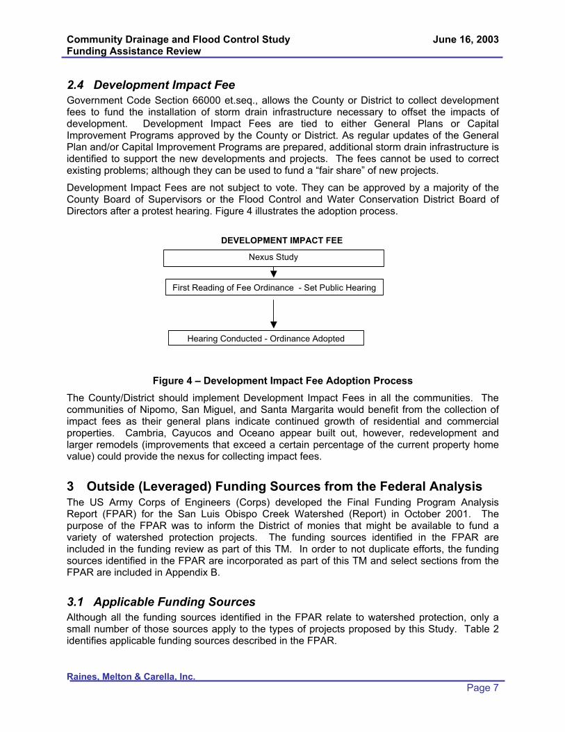
Community Drainage and Flood Control Study June 16, 2003 Funding Assistance Review
Raines, Melton & Carella, Inc. Page 7
2.4 Development Impact Fee Government Code Section 66000 et.seq., allows the County or District to collect development fees to fund the installation of storm drain infrastructure necessary to offset the impacts of development. Development Impact Fees are tied to either General Plans or Capital Improvement Programs approved by the County or District. As regular updates of the General Plan and/or Capital Improvement Programs are prepared, additional storm drain infrastructure is identified to support the new developments and projects. The fees cannot be used to correct existing problems; although they can be used to fund a “fair share” of new projects.
Development Impact Fees are not subject to vote. They can be approved by a majority of the County Board of Supervisors or the Flood Control and Water Conservation District Board of Directors after a protest hearing. Figure 4 illustrates the adoption process.
Figure 4 – Development Impact Fee Adoption Process The County/District should implement Development Impact Fees in all the communities. The communities of Nipomo, San Miguel, and Santa Margarita would benefit from the collection of impact fees as their general plans indicate continued growth of residential and commercial properties. Cambria, Cayucos and Oceano appear built out, however, redevelopment and larger remodels (improvements that exceed a certain percentage of the current property home value) could provide the nexus for collecting impact fees.
3 Outside (Leveraged) Funding Sources from the Federal Analysis The US Army Corps of Engineers (Corps) developed the Final Funding Program Analysis Report (FPAR) for the San Luis Obispo Creek Watershed (Report) in October 2001. The purpose of the FPAR was to inform the District of monies that might be available to fund a variety of watershed protection projects. The funding sources identified in the FPAR are included in the funding review as part of this TM. In order to not duplicate efforts, the funding sources identified in the FPAR are incorporated as part of this TM and select sections from the FPAR are included in Appendix B.
3.1 Applicable Funding Sources Although all the funding sources identified in the FPAR relate to watershed protection, only a small number of those sources apply to the types of projects proposed by this Study. Table 2 identifies applicable funding sources described in the FPAR.
DEVELOPMENT IMPACT FEE
Nexus Study
First Reading of Fee Ordinance - Set Public Hearing
Hearing Conducted - Ordinance Adopted

Community Drainage and Flood Control Study June 16, 2003 Funding Assistance Review
Raines, Melton & Carella, Inc. Page 8
Table 2 – Applicable Funding Sources from Funding Program Analysis Report
Agency Funding Source Description
US Army Corps of Engineers
Flood Hazard Mitigation and Riverine Ecosystem Restoration Program
Watershed-based program focusing on providing flood protection through non-structural measures when possible
US Army Corps of Engineers
Emergency Streambank and Shoreline Erosion Protection
Allows emergency streambank and shoreline protection to prevent damage to public facilities
US Army Corps of Engineers
Section 205 Flood Control Project
Local protection from flooding by the construction of flood control works such as levees, channels, and dams.
US Army Corps of Engineers
Section 206 Aquatic Ecosystem Restoration
Carries out aquatic ecosystem restoration projects that will improve the quality of the environments.
US Army Corps of Engineers
Section 208 Snagging and Clearing
Local protection from flooding by channel clearing and excavation.
CaliforniaDepartment of Water Resources
Urban Streams Restoration Program
Reduce damages from streambank and watershed instability and floods while restoring the environmental and aesthetic values of streams.
State Water Resources Control Board
Nonpoint Source Implementation Grant Program
Reduce erosion in channels to improve water quality through nonpoint source questions
State Water Resources Control Board
Proposition 13 Watershed Protection Program
Develop local watershed management plans and/or implement projects consistent with watershed plans
Notes:
Projects authorized under the US Army Corps of Engineers Continuing Authorities Program (CAP). The CAP provides the Corps with authority to implement small water resources projects without specific congressional authorization
3.2 Additional Requirements for Corps Funding The Corps requires that the local sponsor1 assist in the preparation of the planning, environmental, and design documents to ensure that the communities are involved in the project development and selection process. This requires the local sponsor to have an active role throughout the entire Corps civil works process, which can last up to seven years or more. The local sponsor is also expected to share in the cost of the project planning, design and construction (cost sharing depends on the program, but can be as high as 50 percent of the project). The local sponsor financial contribution can be in the form of in-kind service (e.g. staff time), which would offset the cash contribution requirements, but some of these costs would be in addition to the requirements defined by the Corps process. The local sponsor will incur 1 A local sponsor is typically the local flood control agency or district responsible for programming drainage and flood control services. Local sponsors share in the cost for planning, designing and constructing a project with the Corps.

Community Drainage and Flood Control Study June 16, 2003 Funding Assistance Review
Raines, Melton & Carella, Inc. Page 9
project costs that are deemed ineligible and cannot be used as part of the local sponsor financial contribution. These costs are typically project management costs incurred for administrative tasks such as management of staff, preparation of invoices, etc.
3.3 Grants The County’s planning department administers Community Development Block Grants (CDBG) on a yearly basis. This program is funded by the US Department of Housing and Urban Development (HUD) and targets low to moderate-income communities. The funding for CDBG is guaranteed each year but the level of funding varies. A detailed description of the program is included in Appendix A.
4 Additional Outside Funding Sources available through the State In addition to the sources of funding identified in the FPAR, the State of California (State) provides funding for flood protection and erosion control projects. The California Department of Water Resources (DWR), through the Flood Protection Corridor Program (FPCP), funds watershed protection projects that have agriculture and/or wildlife benefits. For those projects that impact the California Department of Transportation (Caltrans) facilities, a standard cooperative agreement exists that can be used to share drainage project costs. The Governor’s Office of Emergency Services (OES) administers grants that fund flood protection projects through the Federal Emergency Management Agency’s (FEMA) Flood Mitigation Assistance (FMA) program. The State Water Resources Control Board (SWRCB) provides low interest loans for projects that address non-point source pollution through the State Revolving Fund (SRF) loans. Specifically, communities that must meet National Pollutant Discharge Elimination System (NPDES) Phase II requirements are eligible for the SRF loans. The state funding sources are summarized in Table 3 and detailed in Appendix A.
Table 3 – Additional Funding Sources
Agency Funding Source
California Department of Water Resources Flood Protection Corridor Program
California Department of Transportation Cooperative Drainage Projects
Governor’s Office of Emergency Services Flood Mitigation Assistance Program
State Water Resources Control Board State Revolving Fund Loan
The District is currently applying for assistance from FEMA through the FMA program. The District has submitted a Floodplain Management Plan (FMP) to the State of California Office of Emergency Services for approval. The FMP identifies several repetitive loss structures throughout the County to be removed from identified floodplains. As described in Appendix A, an approved FMP is required prior to applying for funds from the FMA for implementation of the proposed project. The District should continue its efforts to have the FMP approved and apply for FMA project funds to implement the proposed projects.
4.1 Typical Grant Requirements Grants provide an opportunity for communities to reduce the total project cost that will be funded through taxes, assessments, and fees. Grant applications often require detailed information

Community Drainage and Flood Control Study June 16, 2003 Funding Assistance Review
Raines, Melton & Carella, Inc. Page 10
regarding the project, the impact on the community and the environment, and project costs. Additionally, grant distributors prefer projects that provide multiple benefits including environmental restoration. Projects compete for existing funds and a majority of applications are not accepted because of this.
Once a grant is appropriated to a project, the recipient is required to complete additional paperwork including invoices, status reports, and project closeout reports. All these costs are not included as part of the grant and are the responsibility of the recipient. The costs are considered ineligible costs, not included as matching funding for project costs. These costs and application costs can be significant and need to be accounted for when preparing project budgets.
5 Additional Outside Funding Sources available through Private Sources
The FPAR identified several funding sources available through private sources. However, these programs provide funds for projects whose scope of work include environmental restoration, creation of open space, and wildlife habitat improvement projects. Projects that will be identified in the Study may not provide enough of these benefits and therefore private funding sources were removed from further consideration. In addition, the focus of these private sources is to provide funds for non-profit and tax exempt groups.
Additional private sources other than those identified in the FPAR are available for similar projects. A listing of these sources can be found on the California Watershed Database website. The website address is http://watershed.ecst.csuchico.edu/new_spin/spinmain.asp.This website provides a search engine for users to locate funding sources based on the project scope of work.
6 Funding Strategy There are several funding opportunities available for the projects identified in the Study but the likelihood of receiving enough grant funding for all project costs is unlikely. As stated previously, the lead agency will need to fund the planning of the projects, but it is the responsibility of the community to provide permitting, environmental compliance, design and construction funding. The following case studies present example projects using a combination of funding for a sample project.
6.1 Case Study #1 – Isolated Drainage Project For an isolated drainage project that eliminates localized ponding or street flooding through the construction of curbs and gutter, drop inlets and culverts, the benefit assessment is a logical choice. A typical funding strategy using a benefit assessment would be as follows:
The Engineer’s Report for the project would be completed by the lead agency within 3 months of start. Programming costs would be funded through the lead agency.
Concurrently with completing the Engineer’s Report, the lead agency would conduct a benefit assessment proceeding for the properties that benefit from the improvements. The benefit assessment would be in place prior to moving forward with permitting, environmental compliance, and design. The lead agency can use the assessment to secure bonds to fund construction.

Community Drainage and Flood Control Study June 16, 2003 Funding Assistance Review
Raines, Melton & Carella, Inc. Page 11
Appropriate environmental documentation is completed concurrently with the design within 9 months of start.
Lead agency advertises project and oversees construction. Duration of the construction would be based on the magnitude of the scope, but most likely would be less than one year.
The lead agency would continue collecting assessments on the properties until the bonds are paid off.
The total time required to complete a project under this scenario is a minimum of two years.
6.2 Case Study #2 – Comprehensive Drainage Project For a project that includes the construction of storm drain infrastructure such as curbs and gutters, drop inlets, and storm sewer pipelines, a typical funding strategy using a benefit assessment, and if appropriate, CDBG funds would be as follows:
An Engineer’s Report for the project completed by the lead agency within 6 months of start. Programming costs would be funded through the lead agency.
Concurrently with completing the Engineer’s Report, the lead agency would conduct a benefit assessment proceeding for the properties that benefit from the improvements. The benefit assessment would be in place prior to moving forward with permitting, environmental compliance, and design. The lead agency can use the assessment to secure bonds to fund construction.
Appropriate environmental documentation is completed concurrently with design within 12 months of start.
Community can apply for CDBG funds, for low-income communities only, following the establishment of the user fees. Funds are distributed in August of each year and applications are typically due October of the previous year.
Lead agency advertises project and oversees construction. Duration of the construction would be based on the magnitude of the scope and could vary between one and three years.
The lead agency would continue collecting property based fees until the bonds are paid off.
The total time required to complete a project under this scenario is a minimum of three years.
6.3 Case Study #3 – Channel Improvements For a project that includes work within an existing channel, a typical funding strategy using a Corps CAP agreement would be as follows:
The lead agency, on behalf of a majority of its constituents, sends a letter to the Corps to request a CAP project.
Corps completes a reconnaissance report to identify the problem and determine Federal interest in a project within 1 year of authorization. The benefiting constituents are not required to cost share in the preparation of the study but will be required to participate in the development through public meetings, coordination meetings with Corps staff, and review of the reconnaissance report.

Community Drainage and Flood Control Study June 16, 2003 Funding Assistance Review
Raines, Melton & Carella, Inc. Page 12
Corps completes a feasibility report and environmental document within 3 years of approval of the reconnaissance report. The benefiting constituents are required to pay for 50 percent of the total project costs as well as participate in the completion of both documents.
Corps completes final design within 3 years of approval of the feasibility report and environmental document. The benefiting constituents are responsible for 25 percent of the project costs.
The lead agency creates a benefit assessment district concurrently with the completion of final design. The lead agency can use the assessment to secure bonds to fund the benefiting constituents portion of the cost.
Corps advertises and administers construction contract with construction completed between one and three years after start depending on the magnitude of the projects. The benefiting constituents are responsible for 35 percent of the construction costs.
The total time required to complete a project under this scenario is a minimum of seven years.
6.4 Case Study #4 – Drainage Facility Across Public Highway For a project that includes construction of drainage facilities across a public highway such as Highway 1, a typical funding strategy using a property-based fee and cost sharing with Caltrans would be as follows:
An Engineer’s Report for the project would be completed by the lead agency within 6 months of start. Caltrans will require a review period for the design, which will impact the duration of the design schedule. Programming costs would be funded through the lead agency.
Concurrently with completing the planning, the lead agency implements a property-based fee. The fee would be in place prior to proceeding with environmental documentation and design. The lead agency can use the property-based fee to secure bonds to fund construction.
Lead agency submits a cost share agreement to Caltrans concurrently with completing design. Approval of the cost share agreement can take up to 12 months depending on the project.
Lead agency advertises project and oversee construction. Duration of the construction would be based on the magnitude of the scope and could vary between one and three years.
The total time required to complete a project under this scenario is a minimum of three years.
7 Community Funding Each community participating in the Study likely qualifies for one or more funding sources identified. The various funding sources identified for projects are presented in Table 4. A matrix identifying each community’s problems and likely funding sources is included in
Table 5. A more detailed analysis of potential funding for each of the communities will be included with the individual community implementation strategy report that will be prepared under separate task of the agreement.

Community Drainage and Flood Control Study June 16, 2003 Funding Assistance Review
Raines, Melton & Carella, Inc. Page 13
8 Conclusion/Recommendation The study being prepared under separate task of the agreement with RMC will provide the lead agency, sponsoring agency, benefiting constituents, and/or the District with a summary of existing problems in the six communities as well as recommended solutions. This TM summarizes the various funding sources available to these entities, and the communities to implement those projects. Although several grant and cost sharing opportunities exist with various federal and state agencies, significant work is required by the lead agency and/or local sponsor to complete applications and participate in the process. In other words, these funding sources are not “free money.”
Because of the effort required to apply for monies that are not guaranteed, it is recommended that the following two local funding mechanisms for projects be implemented:
The County implement a development impact fee structure that will help assure that all new development pays fairly for its impacts.
Subject to demonstrated community support, the lead agency should move forward with a property based fee program that assures that all users of existing drainage systems will contribute to upgrade and maintenance. Because the property based fee requires voter approval, it is recommended that the lead agency does not move forward with an election until a petition signed by more than 50% of property owners is brought to the lead agency.
Detailed recommendations for each of the communities will be included with the Study. This TM only summarizes the various sources of funding unless the funding mechanism can be implemented without a specific project scope.
The District and lead agency should continue to aggressively pursue the funding sources listed in this TM and new funding sources that may become available where communities commit themselves to support of a project. Monies received through grants and cost share can be used to offset costs born by the communities.

Community Drainage and Flood Control Study June 16, 2003 Funding Assistance Review
Raines, Melton & Carella, Inc. Page 14
Table 4 – Summary of Funding Sources
Number Agency Funding Source
1 Community Services Districts, San Luis Obispo County Flood Control and Water Conservation District, other lead agency
Special Property Tax
2 Community Services Districts, San Luis Obispo County Flood Control and Water Conservation District, other lead agency
Benefit Assessment
3 Community Services Districts, San Luis Obispo County Flood Control and Water Conservation District, other lead agency
Property Fee
4 County of San Luis Obispo and/or San Luis Obispo County Flood Control and Water Conservation District
Development Fee
5 County of San Luis Obispo Community Development Block Grants
6 US Army Corps of Engineers Flood Hazard Mitigation and Riverine Ecosystem Restoration Program
7 US Army Corps of Engineers Emergency Streambank and Shoreline Erosion Protection
8 US Army Corps of Engineers Section 205 Flood Control Project
9 US Army Corps of Engineers Section 206 Aquatic Ecosystem Restoration
10 US Army Corps of Engineers Section 208 Snagging and Clearing
11 California Department of Water Resources Urban Streams Restoration Program
12 California Department of Water Resources Flood Protection Corridor Program
13 California Department of Transportation Cooperative Agreement
14 State Water Resources Control Board Nonpoint Source Implementation Grant Program
15 State Water Resources Control Board Proposition 13 Watershed Protection Program
16 State Water Resources Control Board State Revolving Fund Loan
17 Governor’s Office of Emergency Services FEMA Flood Mitigation Assistance Program

Community Drainage and Flood Control Study June 16, 2003 Funding Assistance Review
Raines, Melton & Carella, Inc. Page 15
Table 5 – Summary of Funding Options
Funding Sources from Table 41 2 3 4 5 6 7 8 9 10 11 12 13 14 15 16 17
Cambria 1. Local Drainage L H M H H M1. Overtopping of Cayucos Creek L H M H L L L L L L L L M
2. Local Drainage L H M H M1. Old Town Nipomo in Floodplain L H M H M L L L L L L L L L M
Local Drainage L H M H H MOceano 1. Local Drainage L H M H M L M H MSan Miguel 1. Local Drainage L H M H M L M
1. Overtopping of Santa Margarita and Yerba Buena Creek
L H M H L L L L L L L L L L M
2. Local Drainage L H M H M
LegendH - High opportunity for successM - Moderate opportunity for successL - Low opportunity for success
Notes1. Where no opportunity for success designation is listed, it is not considered likely that the listed funding option would be applicable
Santa Margarita
Community Problems
Cayucos
Nipomo

Community Drainage and Flood Control Study June 16, 2003 Appendix A - Funding Assistance Review
Raines, Melton & Carella, Inc.
Appendix A Potential Grant and Loan Programs

Community Drainage and Flood Control Study June 16, 2003 Appendix A - Funding Assistance Review
Raines, Melton & Carella, Inc. Page A-1
(1) Community Development Block Grants Overview The County’s planning department administers Community Development
Block Grants (CDBG) on a yearly basis. This program is funded by the US Department of Housing and Urban Development (HUD) and targets low to moderate income communities. The funding for CDBG is guaranteed each year but the level of funding varies.
CDBG funds can be used for any community development activity such as acquisition of real property, affordable housing activities, construction or rehabilitation of public facilities and improvements, clearance and demolition of buildings, provision of certain types of public services, relocation payments and assistance, removal of architectural barriers, housing rehabilitation, special economic development activities, planning studies and grant administration. A community must meet one of the three national objectives to be eligible for the funding:
51% or more of the community households must have incomes below 80% of the County median; or
The project must aid in the prevention or elimination of slums or blight; or
The project must address urgent needs that pose a serious, immediate threat to the public health or welfare.
ApplicationDeadline(s)
October of each year
AssistanceProvided
The CDBG funds can be used for planning, design, or construction of a project, however, the County planning department’s preference is that a project have plans and specifications completed prior to paying out funds. The County is required to report on spending of CDBG funds on an annual basis and therefore most projects that receive CDBG funds are construction projects because funds are more likely to be expended within a year of appropriation. Applications are ranked based on the following criteria:
Consistency with federal regulations and laws
Community support
Seriousness of community development need proposed to be addressed by project
Degree to which project benefits low-income and very low-income families or persons
Feasibility of the project to be completed as budgeted within 18 months of appropriation
Cost effectiveness of funds requested and leveraging of other funds
Organization’s experience or knowledge regarding CDBG requirements

Community Drainage and Flood Control Study June 16, 2003 Appendix A - Funding Assistance Review
Raines, Melton & Carella, Inc. Page A-2
FundingLevel
There is no cap on grant application but the County is allocated approximately $500,000 on an average year from HUD for projects similar to those identified in the study. While matching funds are not required; the County and HUD looks most favorably on projects with a matching fund component.
LegislativeAuthority
Title I of the Housing and Community Development Act of 1974, Public Law 93-383, as amended
Contacts Address:
Telephone:Internet:
County of San Luis Obispo Department of Planning and Building County Government Center San Luis Obispo, CA 93408 (805) 781-5787 http://www.co.slo.ca.us

Community Drainage and Flood Control Study June 16, 2003 Appendix A - Funding Assistance Review
Raines, Melton & Carella, Inc. Page A-3
(2) Flood Protection Corridor ProgramOverview The Flood Protection Corridor Program (FPCP) was established when
California voters passed Proposition 13, the "Safe Drinking Water, Watershed Protection and Flood Protection Act" in March of 2000. The FPCP authorized bond sales of $70 million for primarily nonstructural flood management projects that include wildlife habitat enhancement and/or agricultural land preservation. Of the $70 million, approximately $5 million will go to educational programs and administrative costs. Another $5 million was earmarked by the Legislation for the City of Santee, leaving approximately $60 million for flood corridor protection projects throughout the state.
ApplicationDeadline(s)
February of each year
AssistanceProvided
The Flood Protection Corridor Program grant can be used for projects that include:
Non-structural flood damage reduction projects within flood corridors,
Acquisition of real property or easements in a floodplain,
Setting back existing flood control levees or strengthening or modifying existing levees in conjunction with levee setbacks,
Preserving or enhancing flood-compatible agricultural use of the real property,
Preserving or enhancing wildlife values of the real property through restoration of habitat compatible with seasonal flooding,
Repairing breaches in the flood control systems, water diversion facilities, or flood control facilities damaged by a project developed pursuant to Chapter 5, Article 2.5 of the Safe Drinking Water, Clean Water, Watershed Protection and Flood Protection Act of 2000,
Establishing a trust fund for up to 20 percent of the money paid for acquisition for the purpose of generating interest to maintain the acquired lands,
Paying the costs associated with the administration of the projects.
The project location must also be located at least partially in:
A FEMA Special Flood Hazard Area (SFHA), or
An area that would be inundated if the project were completed and an adjacent FEMA SFHA were inundated, or
A FEMA SFHA, which is determined by using the detailed methods identified in FEMA Publication 37, published in January 1995, titled “Flood Insurance Study Guidelines and Specifications for Study Contractors”, or

Community Drainage and Flood Control Study June 16, 2003 Appendix A - Funding Assistance Review
Raines, Melton & Carella, Inc. Page A-4
A floodplain designated by The Reclamation Board under Water Code Section 8402(f) [Title 23, California Code of Regulations, Division 2, Section 497.5(a)], or a
Locally designated Flood Hazard Area, with credible hydrologic data to support designation of at least one in 100 annual probability of flood risk. This is applicable to locations without levees, or where existing levees can be set back, breached, or removed. In the latter case, levee setbacks, removal, or breaching to allow inundation of the floodplain should be part of the project.
FundingLevel
A grant cap of $5 million per project has been established, however, exceptional projects requesting funding greater than the established cap will be considered on a case-by-case basis.
LegislativeAuthority
Division 26, Section 79000 Safe Drinking Water, Clean Water, Watershed Protection, and Flood Protection Act
Contacts Address:
Telephone:Internet:
Flood Protection Corridor Program Department of Water Resources, Division of Flood Management 1416 Ninth Street, Room 1641 Sacramento, CA 95814 (916) 654-3620 http://www.dfm.water.ca.gov/fpcp/

Community Drainage and Flood Control Study June 16, 2003 Appendix A - Funding Assistance Review
Raines, Melton & Carella, Inc. Page A-5
(3) Cooperative AgreementOverview The California Department of Transportation (Caltrans) has established
a process for cost sharing of drainage projects being implemented by a local agency that will benefit Caltrans facilities.
ApplicationDeadline(s)
None
AssistanceProvided
Caltrans has established a process for cost sharing of planning, design, and construction of drainage projects. The process for applying for a Cooperative Agreement is detailed in the Cooperative Agreement Manual.
FundingLevel
The cost to Caltrans is based on the benefit received from the project.
LegislativeAuthority
Streets and Highways Code Sections 114 and 130
Contacts Address:
Telephone:Internet:
California Department of Transportation, District 5 50 Higuera Street San Luis Obispo, CA 93401-5415 (805) 549-3111 http://www.dot.ca.gov/hq/oppd/coop/cooptoc.html

Community Drainage and Flood Control Study June 16, 2003 Appendix A - Funding Assistance Review
Raines, Melton & Carella, Inc. Page A-6
(4) Flood Mitigation AssistanceOverview FEMA provides funds on a yearly basis for each of the states to
administer FMA grants. In California, the Governor’s Office of Emergency Services administers these grants. The purpose of these grants is to provide local communities with funds to alleviate reoccurring flooding problems and to reduce claims on the National Flood Insurance Fund (NFIF). There are three types of grants available:
FMA Planning Grants
FMA Project Grants
FMA Technical Assistance Grants
All projects that address flooding issues for areas within a Special Flood Hazard Area (SFHA)2 are eligible for both FMA Planning and Project grants. In order to receive a FMA Project grant to implement a project to reduce flood losses, a Flood Mitigation Plan (FMP) must be completed by the lead agency and approved by FEMA. The FMA Planning Grant can be used to fund the completion of the FMP.
ApplicationDeadline(s)
None
AssistanceProvided
Prior to proceeding with a FMA Project Grant application, the grant applicant must document the flooding problem with the FMP. In addition to describing the flooding problem, the following information is included in the FMP:
Public involvement
Coordination with other agencies or organizations
Flood hazard area inventory
Review of possible mitigation actions
State or local adoption following a public hearing
Actions necessary to implement plan
Following the approval of the FMP, the grant applicant can apply for a FMA Project Grant. This grant is used to implement the specific project identified in the FMP including property acquisition, modification of existing culverts/bridges, elevation of National Flood Insurance Program (NFIP) insured structures, or relocation of NFIP insured structures.
The project must also meet five basic requirements to receive funding:
Be cost effective – Project costs cannot exceed expected benefits
Conform with applicable Federal, State, and Executive Orders
Be technically feasible
2 Any area within the 100-year flood plain as defined by FEMA is within a SFHA.

Community Drainage and Flood Control Study June 16, 2003 Appendix A - Funding Assistance Review
Raines, Melton & Carella, Inc. Page A-7
Conform with the FMP
Be located physically in a participating NFIP community that is not on probation, or benefit such a community directly by reducing future flood damages
FundingLevel
The applicant is responsible for 25% of the costs associated with each grant. The applicant can utilize in-kind services to fund half the applicant’s fiscal responsibility. Examples of in-kind services include County staff time, volunteer work, donated supplies, and donated equipment.
An applicant may receive only one FMA Planning Grant for a maximum of $50,000 in any given five year period.
An applicant may receive multiple FMA Project Grants but the maximum total of all grants cannot exceed $3.3 million over a five-year period. The $3.3 million value includes monies received from a FMA Planning Grant.
LegislativeAuthority
National Flood Insurance Reform Act of 1994 (NFIRA), Sections 1366 and 1367 (42 U.S.C. 4101)
Contacts Address:
Telephone:Internet:
Governor's Office of Emergency Services P.O. Box 419047 Rancho Cordova, CA 95741-9047 (916) 845-8150 http://www.oes.ca.govhttp://www.fema.gov/fima/planfma.shtm(Copy of FEMA’s Flood Mitigation Assistance Guidance)

Community Drainage and Flood Control Study June 16, 2003 Appendix A - Funding Assistance Review
Raines, Melton & Carella, Inc. Page A-8
(5) SWRCB Revolving Loan ProgramOverview Low interest loans to address water quality problems associated with
discharges from wastewater and water reclamation facilities, as well as from nonpoint source discharges and for estuary enhancement.
ApplicationDeadline(s)
Final adoption of State priority list for next State fiscal year in June
AssistanceProvided
The purpose of the loan is to assist agencies and local communities meet water quality standards set forth by the Federal Clean Water Act. The loan is for projects associated with discharge from wastewater and water reclamation facilities, as well as from nonpoint sources to conform with NPDES requirements.
FundingLevel
The interest rate on an SRF loan is 50% of the interest rate on the most recently sold general obligation bond. The maximum amortization period is 20 years. Loans may cover up to 100% of the cost of planning, design, and construction of NPS pollution control structures and 100% of NPS pollution control programs. The borrower will begin making annual repayments of principal and interest one year after the first disbursement of loan funds.
LegislativeAuthority
Federal Clean Water Act
Contacts Address:
Telephone:Internet:
State Water Resources Control Board Division of Financial Assistance 1001 I Street, 16th Floor Sacramento, CA 95814 Contact: Jeff Albrecht (916) 341-5717http://www.swrcb.ca.gov/funding/

Community Drainage and Flood Control Study June 16, 2003 Appendix B - Funding Assistance Review
Raines, Melton & Carella, Inc.
Appendix B Excerpts from the San Luis Obispo Creek
Watershed, San Luis Obispo County, California, Final Funding Program Analysis Report
Prepared by the US Army Corps of Engineers, Los Angeles District
October 2001

Community Drainage and Flood Control Study June 16, 2003 Appendix B - Funding Assistance Review
Raines, Melton & Carella, Inc. Page B-1
(1) Continuing Authorities ProgramsOverview Congress has provided the Corps with a number of standing authorities
to study and build water resources projects for various purposes, and with specified limits on Federal money spent for a project.
ApplicationDeadline(s)
Specific congressional authorization is not needed
AssistanceProvided
Flood Control Projects – Local protection from flooding by the construction or improvement of flood control works such as levees, channels, and dams. Non-structural alternatives are also considered
Emergency Streambank and shoreline Erosion – Allows emergency streambank and shoreline protection to prevent damage to public facilities, e.g., roads, bridges, hospitals, schools, and water/sewage treatment plants
Snagging and Clearing for Flood Control – Local protection from flooding by channel clearing and excavation, with limited embankment construction by use of materials from the clearing operations only.
Aquatic Ecosystem Restoration – Carries out aquatic ecosystem restoration projects that will improve the quality of the environment, are in the public interest, and are cost effective
FundingLevel
Flood Control Projects - Federal share may not exceed $7 million for each project. Required non-Federal match: 50 percent of the cost of the project for structural measures and 35 percent of the cost of the project for nonstructural measures.
Emergency Streambank and Shoreline Restoration - Federal share may not exceed $1 million for each project. Non-Federal share of total project costs is at least 25 percent.
Snagging and Clearing for Flood Control – Federal share may not exceed $500,000 for each project. Required 50 percent non-Federal match including all costs in excess of the Federal cost limitation.
Aquatic Ecosystem Restoration – Federal share is limited to $5 million. The non-Federal share is 35 percent (including studies, plans and specifications, and construction).
LegislativeAuthority
Flood Control Projects – Section 205 of the 1948 Flood Control Act (FCA), as amended
Emergency Streambank and Shoreline Restoration – Section 14, 1946 FCA, as amended
Snagging and Clearing for Flood Control – Section 208, 1954 FCA, as amended
Aquatic Ecosystem Restoration – Section 206, Water Resources Development Act (WRDA) of 1996

Community Drainage and Flood Control Study June 16, 2003 Appendix B - Funding Assistance Review
Raines, Melton & Carella, Inc. Page B-2
Contacts Address:
Telephone:Internet:
US Army Engineer District, Los Angeles PO Box 2711 Los Angeles, CA 90053-2325 (213) 452-5300 http://www.spl.usace.army.mil/

Community Drainage and Flood Control Study June 16, 2003 Appendix B - Funding Assistance Review
Raines, Melton & Carella, Inc. Page B-3
(2) Flood Hazard Mitigation and Riverine Restoration ProgramOverview Informally known as “Challenge 21,” this watershed-based program
focuses on identifying sustainable solution to flooding problems by examining nonstructural solutions in flood-prone areas, while retaining traditional measures where appropriate. Eligible projects will meet the dual purpose of flood hazard mitigation and riverine ecosystem restoration.
ApplicationDeadline(s)
Undetermined
AssistanceProvided
Projects include the relocation of threatened structures, conservation or restoration of wetlands and natural floodwater storage areas, and planning for responses to potential future floods.
FundingLevel
The non-Federal sponsor is required to provide 50 percent for the studies and 35% for project implementation, up to a maximum Federal allocation of $300 million.
FY2003 through FY2005 - $50 million for each FY
LegislativeAuthority
Section 212 WRDA 1999
Contacts Address:
Telephone:Internet:
US Army Engineer District, Los Angeles PO Box 2711 Los Angeles, CA 90053-2325 (213) 452-5300 http://www.spl.usace.army.mil/

Community Drainage and Flood Control Study June 16, 2003 Appendix B - Funding Assistance Review
Raines, Melton & Carella, Inc. Page B-4
(3) Urban Streams Restoration Program – Proposition 13Overview The objectives of this program is to assist communities in reducing
damages from streambank and watershed instability and floods while restoring the environmental and aesthetic values of streams, and to encourage stewardship and maintenance of streams by the community. Objectives of the program are met by providing local governments and citizen’s groups with small grants and technical assistance for restoration projects, to encourage all segments of local communities to value natural streams as an amenity, and to educate citizens about the value and processes taking place in natural streams.
ApplicationDeadline(s)
To Be Determined
AssistanceProvided
This program supports actions that:
Prevent property damage caused by flooding and bank erosion
Restore the natural value of streams; and
Promote community stewardship
FundingLevel
Grants can fund projects as simple as a volunteer workday to clean up neighborhood steams, or projects as complex as complete restoration of a streams to its original, natural state.
The Department is in the process of amending the regulations for the program, including raising the grant cap from $200,000 to $1 million
All potential projects must have two sponsors: a local agency and a community group.
LegislativeAuthority
Stream Restoration and Flood Control Act of 1984
Costa-Machado Water Bond Act of 2000
Contacts Address:
Telephone:Internet:
California Department of Water Resources Urban Streams Restoration program Attn: Earle Cummings PO Box 942836 Sacramento, CA 94236-0001 (916) 327-1656 http://wwwdpla.water.ca.gov/environment/habitat/stream/

Community Drainage and Flood Control Study June 16, 2003 Appendix B - Funding Assistance Review
Raines, Melton & Carella, Inc. Page B-5
(4) Proposition 13 Watershed Protection ProgramOverview This program provides grants to municipalities, local agencies, or
nonprofit organizations to develop local watershed management plans and/or implement projects consistent with watershed plans.
ApplicationDeadline(s)
To Be Determined
AssistanceProvided
Grants may be awarded for projects that implement methods for attaining watershed improvements or for a monitoring program described in a local watershed management plan in an amount not to exceed five million dollars ($5,000,000) per project. At least 85 percent of the total amount in the sub account shall be used for capital outlay projects.
Eligible projects under this article may do any of the following:
Reduce chronic flooding problems or control water velocity and volume using vegetation management or other nonstructural methods.
Protect and enhance greenbelts and riparian and wetlands habitats.
Restore or improve habitat for aquatic or terrestrial species.
Monitor the water quality conditions and assess the environmental health of the watershed.
Use geographic information systems to display and manage the environmental data describing the watershed.
Prevent watershed soil erosion and sedimentation of surface waters.
Support beneficial groundwater recharge capabilities.
Otherwise reduce the discharge of pollutants to state waters from storm water or nonpoint sources.
FundingLevel
Minimum request of $50,000 and maximum of $5 million
LegislativeAuthority
Costa-Machado Water Act of 2000
Contacts Address:
Telephone:Internet:
Proposition 13 Grant Program – Phase II Attn: Bill Campbell, Chief Watershed Project Support Section Division of Water Quality State Water Resources Control Board 1001 I Street, 15th Floor Sacramento, CA 95814 (916) 341-5250 http://www.swrcb.ca.gov/prop13/index.html

Community Drainage and Flood Control Study June 16, 2003 Appendix B - Funding Assistance Review
Raines, Melton & Carella, Inc. Page B-6
(5) Nonpoint Source Pollution Control ProgramOverview The purpose of the NPS Pollution Control Program is “to provide grant
funding for projects that protect the beneficial uses of water throughout the State through the control of nonpoint source pollution.”
ApplicationDeadline(s)
To Be Determined
AssistanceProvided
Grants shall only be awarded for any of the following projects:
A project that is consistent with local watershed management plans that are developed under subdivision (d) of Section 79080 and with regional water quality control plans.
A broad-based nonpoint source project, including a project identified in the board's "Initiatives in NPS Management," dated September 1995, and nonpoint source technical advisory committee reports.
A project that is consistent with the "Integrated Plan for Implementation of the Watershed Management Initiative" prepared by the board and the regional boards.
A project that implements management measures and practices or other needed projects identified by the board pursuant to its nonpoint source pollution control program's 15-year implementation strategy and five-year implementation plan that meets the requirements of Section 6217(g) of the federal Coastal Zone Act Reauthorization Amendments of 1990.
The projects funded from the sub account shall demonstrate a capability of sustaining water quality benefits for a period of 20 years. Projects shall have defined water quality or beneficial use goals.
FundingLevel
Minimum request of $50,000 and maximum of $5 million
LegislativeAuthority
Costa-Machado Water Act of 2000
Contacts Address:
Telephone:Internet:
Proposition 13 Grant Program – Phase II Attn: Bill Campbell, Chief Watershed Project Support Section Division of Water Quality State Water Resources Control Board 1001 I Street, 15th Floor Sacramento, CA 95814 (916) 341-5250 http://www.swrcb.ca.gov/prop13/index.html

[This Page Intentionally Blank]

APPENDIX E
Contacts for More Information

[This Page Intentionally Blank]


[This Page Intentionally Blank]

APPENDIX F
Board of Supervisors Resolution 68-223

[This Page Intentionally Blank]