Embed Size (px)
Citation preview

PO Box 490 Dulwich Hill NSW 2203 Australia phone: 02 9518 3421 fax: 02 9518 3421 email: [email protected]
Cultural Heritage Connections Pty Ltd ABN 79 109 836 115
Samuel Gilbert Public School, Castle Hill
Historical Archaeological Assessment
By Vanessa Hardy & Shaun Mackey October 2018
Report Prepared for
Fulton Trotter Architects Level 3, 35 Spring Street Bondi Junction NSW 2022

Historical Archaeological Assessment Samuel Gilbert Public School
Cultural Heritage Connections Pty Ltd Page 2
CONTENTS 1.0 INTRODUCTION ............................................................................................................. 3
1.1 PROJECT AREA, PROJECT CONTEXT & AIMS............................................................... 3
1.2 LEGISLATION SUMMARY ............................................................................................. 4
1.2.1 Environment Protection and Biodiversity Conservation Act 1999 (Commonwealth) ............................................................................................................. 4
1.2.2 Heritage Act 1977 (NSW) ................................................................................... 4
1.2.3 Environmental Planning and Assessment Act 1979 (NSW) ............................... 5
Local Environmental Plan ............................................................................................ 5
1.3 HERITAGE LISTINGS ................................................................................................... 7
1.4 LIMITATIONS AND AUTHORSHIP .................................................................................. 7
2.0 SITE CONTEXT ............................................................................................................... 9
2.1 DISCUSSION & ARCHAEOLOGICAL PREDICTIONS ....................................................... 15
3.0 IMPACT ASSESSMENT ............................................................................................... 16
3.1 PROPOSED DEVELOPMENT ...................................................................................... 16
3.2 POTENTIAL IMPACTS ................................................................................................ 16
4.0 CONCLUSION & RECOMMENDATIONS .................................................................... 17
4.1 RECOMMENDATIONS ................................................................................................ 17
REFERENCES ....................................................................................................................... 18
FIGURES
FIGURE 1: PROJECT AREA LOCATION ........................................................................................... 8
FIGURE 1: DETAIL OF MAP PRODUCED FROM WATKIN TENCH'S AND WILLIAM DAWES' EXPLORATIONS
BETWEEN 1788-1792. (SOURCE: HTTP://WWW.SL.NSW.GOV.AU/COLLECTION-ITEMS/COMPLETE-ACCOUNT-SETTLEMENT-PORT-JACKSON-NEW-SOUTH-WALES-INCLUDING-ACCURATE) ........................................................................................................................ 9
FIGURE 2: WATERCOLOUR OF THE GOVERNMENT FARM AT CASTLE HILL, C.1806. NOTE THE
CLEARED LANDSCAPE AND REMNANT TREE-STUMPS (SOURCE: KARSKENS, 2009). .............. 10
FIGURE 3: WATERCOLOUR DEPICTING THE BATTLE OF VINEGAR HILL FOUGHT ON 5 MARCH 1804, ENDING THE CASTLE HILL REBELLION. THE BATTLE WAS FOUGHT AT ROUSE HILL. THE
LANDSCAPE, MUCH LIKE THE WATERCOLOUR OF THE CASTLE HILL SHOWS CLEARED LAND
AMONGST THE FORESTS. (SOURCE: KARSKENS 2009). ...................................................... 11
FIGURE 4: PARISH MAP FOR THE DISTRICT OF CASTLE HILL, COUNTY OF CUMBERLAND SHOWING THE
PROPERTY LOTS IN AND AROUND THE PROJECT AREA (SOURCE: HLRV.NSWLRS.COM.AU/PIXEL.HTM). .................................................................................. 14
FIGURE 5: 1943 AERIAL PHOTOGRAPH OF THE STUDY AREA AND SURROUNDS. THE RED-FLAG
INDICATES THE LOCATION OF THE SAMUEL GILBERT PUBLIC SCHOOL. THE CLEARED AREAS ARE
OUTSIDE THE STUDY AREA (SOURCE: HTTPS://MAPS.SIX.NSW.GOV.AU/). .............................. 14
FIGURE 6: AERIAL PHOTOGRAPH SHOWING THE SCHOOL GROUNDS OF SAMUEL GILBERT PUBLIC
SCHOOL. THE RED FLAG IS IN THE SAME LOCATION AS THAT SHOWN IN THE 1943 AERIAL
PHOTOGRAPH IN FIGURE 5 (SOURCE: HTTPS://MAPS.SIX.NSW.GOV.AU/). ............................. 15

Historical Archaeological Assessment Samuel Gilbert Public School
Cultural Heritage Connections Pty Ltd Page 3
1.0 INTRODUCTION
1.1 PROJECT AREA, PROJECT CONTEXT & AIMS Cultural Heritage Connections Pty Ltd was commissioned by Fulton Trotter Architects in May 2018 to undertake a historical archaeological assessment of the proposed upgrade of Samuel Gilbert Public School.
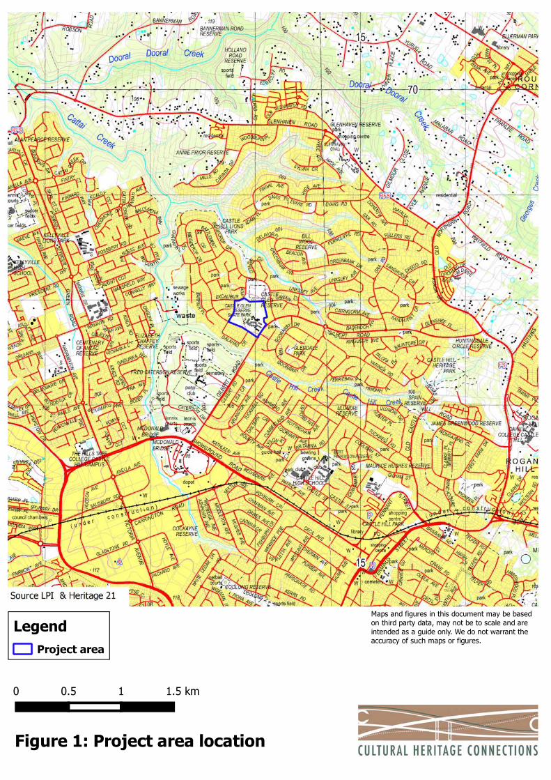
Samuel Gilbert Public School is located at Lot 1, DP 719671, in Ridgecrop Drive, Castle Hill, NSW (the project area). The site is bordered by a long daycare centre and Gilbert Ave to the East, Ridgcrop Drive to the south, residential development to the west and to the north by Excalibur Ave, a Council sporting field (Castle Glen Reserve), a local shopping complex (Knightsbridge Plaza) and car park. The School is fringed by bushland and has a large fenced off portion of bush to the north-west). The project area is within The Hills Shire Local Government Area (LGA).
The location of the project area is shown in Figure 1.
Samuel Gilbert Public School currently has 667 students. The facilities include 29 existing teaching spaces – including 11 housed in demountable buildings. This project aims to provide additional facilities to accommodate an increased student population of 1000 (Core 35) while also creating future-focused, modern teaching and learning facilities. The project also aims to upgrade the existing core facilities to suit this increased population.
The proposal includes the following:
Construction of 25 new permanent teaching spaces Removal of 17 demountable teaching spaces Demolition of the existing home base parts of D-block and F-block Construction of two, new main buildings to house the majority of the new
Home Base groupings. Upgrade of various spaces and buildings including:
Hall
Staff and Administration Offices (including Staff Toilets)
Library Landscaping and service upgrades.
The development application for the proposal is being assessed as a State Significant Development (SSD 9274).
Further description of the proposed activities is included in Section 3.0.
The aims of the assessment are to:
Identify whether or not significant sub-surface relics are, or are likely to be, present in the area;
If they are present, or likely to be present, determine whether or not the proposed development has the potential to harm relics; and
Determine whether further assessment and/or a Section 139 (Exception) or S140 (Excavation Permit) applications are required.

Historical Archaeological Assessment Samuel Gilbert Public School
Cultural Heritage Connections Pty Ltd Page 4
The assessment also references other relevant OEH Heritage Division documentation and has been prepared in accordance with the principles of the 2013 Australia ICOMOS Burra Charter.
1.2 LEGISLATION SUMMARY The section summarises the legislation relevant to the protection of historic heritage in NSW. It does not purport to be legal advice. It presents an interpretation of the implications for the management of archaeological sites within NSW and the project area as understood by the consultant.
1.2.1 Environment Protection and Biodiversity Conservation Act 1999 (Commonwealth)
This Act establishes
the National Heritage List, which includes natural, Indigenous and historic places that are of outstanding heritage value to the nation.
the Commonwealth Heritage List, which comprises natural, Indigenous and historic places on Commonwealth lands and waters or under Australian Government control, and identified by the Minister for the Department of the Environment (the Minister) as having Commonwealth Heritage values.
Approval of the Minister is required prior to any action that could have a significant impact on the national heritage values of a listed place.
1.2.2 Heritage Act 1977 (NSW) The NSW Heritage Act 1977 protects the State’s natural, historical and cultural heritage. Historical heritage places and objects of State significance may be listed on the State Heritage Register and are subject to protection under Section 60 of this Act.
Section 139 of the Act protects ‘relics’, which are defined as “any deposit, artefact, object or material evidence that:
relates to the settlement of the area that comprises NSW, not being Aboriginal settlement; and
is of State or local significance”.
For example, relics can refer to the in-situ foundations and remains of potential farmsteads and debris from occupation, in situ footings or to rubbish pits and bottle dumps. Under Section 139, “a person must not disturb or excavate any land knowing or having reasonable cause to suspect that the disturbance or excavation will or is likely to result in a relic being discovered, exposed, moved, damaged or destroyed unless the disturbance or excavation is carried out in accordance with an excavation permit” and “must not disturb or excavate any land on which the person has discovered or exposed a relic except in accordance with an excavation permit”. The relics’ provisions can be subject to specific exceptions under the Act dependent on the nature of works and the assessed significance of the relic/s in a heritage assessment.

Historical Archaeological Assessment Samuel Gilbert Public School
Cultural Heritage Connections Pty Ltd Page 5
1.2.3 Environmental Planning and Assessment Act 1979 (NSW)
The EP&A Act requires that environmental impacts are considered in land use planning and decision-making. The definition of ‘environmental impacts’ includes impacts on the cultural heritage of the project area. The Act sets out specific statutory assessment processes including:
Part 4: Development that requires consent under consideration of environmental planning instruments.
Part 5: An assessment process for activities undertaken by public authorities and for developments that do not require a development consent but an approval under another mechanism.
The Act 1979 establishes a framework for historical heritage values to be formally assessed in land-use planning and development consent/approvals including planning instruments.
Local Environmental Plan
The Hills Local Environmental Plan 2012
Part 5 Clause 5.10 of The Hills Local Environmental Plan 2011 (LEP) contains the following provisions for heritage:
(2) Requirement for consent
Development consent is required for any of the following:
(a) demolishing or moving any of the following or altering the exterior of any of the following (including, in the case of a building, making changes to its detail, fabric, finish or appearance):
(i) a heritage item,
(ii) an Aboriginal object,
(iii) a building, work, relic or tree within a heritage conservation area,
(b) altering a heritage item that is a building by making structural changes to its interior or by making changes to anything inside the item that is specified in Schedule 5 in relation to the item,
(c) disturbing or excavating an archaeological site while knowing, or having reasonable cause to suspect, that the disturbance or excavation will or is likely to result in a relic being discovered, exposed, moved, damaged or destroyed,
(d) disturbing or excavating an Aboriginal place of heritage significance,
(e) erecting a building on land:

Historical Archaeological Assessment Samuel Gilbert Public School
Cultural Heritage Connections Pty Ltd Page 6
(i) on which a heritage item is located or that is within a heritage conservation area, or
(ii) on which an Aboriginal object is located or that is within an Aboriginal place of heritage significance,
(f) subdividing land:
(i) on which a heritage item is located or that is within a heritage conservation area, or
(ii) on which an Aboriginal object is located or that is within an Aboriginal place of heritage significance.
(3) When consent not required
However, development consent under this clause is not required if:
(a) the applicant has notified the consent authority of the proposed development and the consent authority has advised the applicant in writing before any work is carried out that it is satisfied that the proposed development:
(i) is of a minor nature or is for the maintenance of the heritage item, Aboriginal object, Aboriginal place of heritage significance or archaeological site or a building, work, relic, tree or place within the heritage conservation area, and
(ii) would not adversely affect the heritage significance of the heritage item, Aboriginal object, Aboriginal place, archaeological site or heritage conservation area, or
(b) the development is in a cemetery or burial ground and the proposed development:
(i) is the creation of a new grave or monument, or excavation or disturbance of land for the purpose of conserving or repairing monuments or grave markers, and
(ii) would not cause disturbance to human remains, relics, Aboriginal objects in the form of grave goods, or to an Aboriginal place of heritage significance, or
(c) the development is limited to the removal of a tree or other vegetation that the Council is satisfied is a risk to human life or property, or
(d) the development is exempt development.
(4) Effect of proposed development on heritage significance

Historical Archaeological Assessment Samuel Gilbert Public School
Cultural Heritage Connections Pty Ltd Page 7
The consent authority must, before granting consent under this clause in respect of a heritage item or heritage conservation area, consider the effect of the proposed development on the heritage significance of the item or area concerned. This subclause applies regardless of whether a heritage management document is prepared under subclause (5) or a heritage conservation management plan is submitted under subclause (6).
(5) Heritage assessment
The consent authority may, before granting consent to any development:
a) on land on which a heritage item is located, or b) on land that is within a heritage conservation area, or
(c) on land that is within the vicinity of land referred to in paragraph (a) or (b), require a heritage management document to be prepared that assesses the extent to which the carrying out of the proposed development would affect the heritage significance of the heritage item or heritage conservation area concerned.
(6) Heritage conservation management plans
The consent authority may require, after considering the heritage significance of a heritage item and the extent of change proposed to it, the submission of a heritage conservation management plan before granting consent under this clause.
(7) Archaeological sites
The consent authority must, before granting consent under this clause to the carrying out of development on an archaeological site (other than land listed on the State Heritage Register or to which an interim heritage order under the Heritage Act 1977 applies):
a) notify the Heritage Council of its intention to grant consent, and b) take into consideration any response received from the Heritage Council
within 28 days after the notice is sent.
1.3 HERITAGE LISTINGS The subject site is not listed as a heritage item on Schedule 5 of the LEP. It is not within a conservation area.
1.4 LIMITATIONS AND AUTHORSHIP This assessment is focused on the non-Aboriginal archaeological potential of the area and does not include an assessment of the standing structures on the site. This assessment has not considered the Aboriginal cultural significance or Aboriginal archaeological potential of the project area.
Analysis, field inspection and the reporting for the assessment was undertaken by Vanessa Hardy (BA Hons), archaeologist and Director of Cultural Heritage Connections Pty Ltd. Background historical research was conducted by Shaun Mackey BA (Hons).
0 0.5 1 1.5 km
Figure 1: Project area location
Maps and figures in this document may be basedon third party data, may not be to scale and areintended as a guide only. We do not warrant theaccuracy of such maps or figures.
Project area
Legend

Historical Archaeological Assessment Samuel Gilbert Public School
Cultural Heritage Connections Pty Ltd Page 9
2.0 SITE CONTEXT
The Aboriginal history of the site is addressed in the Aboriginal Cultural Heritage Assessment Report. The following provides a historical context for the project area.
The first European recorded mention of the Castle Hill area is from 11 April 1791. Recorded by Captain Watkin Tench, it is an incidental reference from records of when he was part of an exploration party travelling north from Parramatta to the Hawkesbury and Nepean Rivers (Tench 1996: 185-203). After travelling two miles, he mentions that the terrain:
“…grew very bad, being full of steep, barren rocks, over which we were compelled to clamber for seven miles…” (Tench 1996: 186-187).
The expedition was a 21-member team of 19 Europeans, including Governor Arthur Phillip, and two Aboriginal guides - Colbee and Boladaree (Tench 1996: 185). That evening at their camp site Tench and his party encountered local members of the Boorooberongal Clan (Tench 1996: 188-189). Tench describes the interactions, spoken in both English and Aboriginal dialects, and specifically names Bereewan as their main interlocutor. A map of various explorations shows that the area around Castle Hill was described as being a ‘patch of good land’ (Figure 1). Castle Hill is located northeast of Rose Hill – an area that was first passed through on 11 April.
Figure 2: Detail of map produced from Watkin Tench's and William Dawes' explorations between 1788-1792. (Source: http://www.sl.nsw.gov.au/collection-items/complete-account-settlement-port-jackson-new-south-wales-including-accurate)
Little documentation exists for the Castle Hill area for the next decade. The first land grant in the area was to William Joyce in 1794 (Heritage 21 2018). In 1801 Government Farm Number Three was established at Castle Hill. The earlier farms at Rose Hill and Toongabbie had been diminished by public acquisition of livestock and acreage granted

Historical Archaeological Assessment Samuel Gilbert Public School
Cultural Heritage Connections Pty Ltd Page 10
during the administrations of Major Francis Grose (1792-1794) and Lieutenant-Colonel William Paterson (1794-1795) (Karskens 2009: 87). With Governor John Hunter's appointment in 1795 instructions from the Home Government in London were to withdraw convict labour from private settlers and return them to government service (Karskens 2009: 87).
On instructions from Governor Philip Gidley King the Castle Hill Government Farm was located at the junction of the creeks in hilly lands totalling an area of 34,500 acres (Karskens 2009: 88-89). An early watercolour of this farm shows the buildings and landscape of the area, one of cleared land in the forest with numerous tree stumps where trees had been felled (Figure 2).
Figure 3: Watercolour of the Government Farm at Castle Hill, c.1806. Note the cleared landscape and remnant tree-stumps (Source: Karskens, 2009).
The French maritime explorer Francois Peron was part of the Baudin Expedition (1800-1803) sent by Napoleon Bonaparte to map Australia, then known as New Holland. Peron described the settlement at Castle Hill in 1802:
“Of all the establishments in New South Wales, Castle Hill is the most recent; at the time I was there it was scarcely three years old. The infant town then only consisted of a dozen houses; but already there were

Historical Archaeological Assessment Samuel Gilbert Public School
Cultural Heritage Connections Pty Ltd Page 11
to be distinguished on the neighbouring hills vast tracts of cultivated land, while several handsome farms were settled in the valleys. Six hundred convicts were continually employed in felling trees to open roads through the forests, and in twenty quarters might be seen rising immense volumes of flame and smoke produced by the burning of new concessions.” (Peron 1975: 307-308).
Under Governor King's administration suspicion of Irish convicts saw Castle Hill Farm used as a depot to isolate and quarantine seditious ideas (Karskens 2009: 89, 293-294). However, on 4 March 1804, the Castle Hill Uprising broke out but was suppressed at the battle of Vinegar Hill, in Rouse Hill (Figure 3). The historian Dr Grace Karskens has concluded that:
“The Irish rebellion of 1804 resulted in a landscape of surveillance and savagery. Immediately after the Castle Hill uprising, King had the stone walls of Fort Phillip raised on Sydney’s highest point, Flagstaff Hill, above the Rocks.” (Karskens 2009: 307).
Figure 4: Watercolour depicting the Battle of Vinegar Hill fought on 5 March 1804, ending the Castle Hill Rebellion. The battle was fought at Rouse Hill. The landscape, much like the watercolour of the Castle Hill shows cleared land amongst the forests. (Source: Karskens 2009).

Historical Archaeological Assessment Samuel Gilbert Public School
Cultural Heritage Connections Pty Ltd Page 12
Under the administration of Governor Lachlan Macquarie, the Government farm at Castle Hill was closed and the convict barracks converted to a lunatic asylum that operated from 1810-1818 (The beginnings of the Hills District, 1987: 17, 28-29).
Following the closure of the lunatic asylum in 1818 Castle Hill was opened up to the public and a swathe of land grants saw most of the land taken by 1823 (Anon 1987:34)). However, the land within the project area does not appear to have been granted until many years later.
A property of 387 acres was granted as Lot 147 to John Terry Hughes on 19 July 1883. This included the project area. The adjacent lot (Lot 144) was granted to Samuel Gilbert (whom the school was named after) in 1831. Lot 144 was originally given to John Good on 7 April 1825 by Governor Sir Thomas Brisbane (The Sydney Herald, 26 September 1831: 1).
In these early years of land grants, regular notices were published in The Sydney Gazette. An example published on 20 March 1819 states:
"...on Monday, the 5th of April, Mr Meehan will attend Castle Hill, to measure and locate Lands promised there...All Persons expecting to obtain Grants in the foregoing Districts and neighbourhoods, are required to attend the Deputy Surveyor General at the Times and Places therein, notified..." (The Sydney Gazette, 20 March 1819: 2)
Despite being called the Samuel Gilbert Public School it does not occupy any of the land of Portion 144 which once belonged to Samuel Gilbert's 140 acres granted on 19 October 1831. Gilbert's grant is located on the eastern border of the current school grounds but no other connection to Samuel Gilbert and the subject land exists. The school is situated on part of Portion 147 which had once been part of the 387 acre property originally granted to John Terry Hughes on 19 July 1838 (see Figures 4, 5 and 6).
John Terry Hughes was the nephew of Samuel Terry who, though transported to Australia as a convict, became a merchant landowner referred to as 'The Botany Bay Rothschild'. When Samuel Terry died on 22 February 1838 he left an estate worth £250,000, and an annual income of over £10,000 earned from Sydney rental properties (http://adb.anu.edu.au/biography/terry-samuel-2721). John Terry Hughes was not to enjoy such success in business. Having accrued about £220,000 of debts and liabilities, John Terry Hughes was prosecuted for Insolvency in 1846. During testimony in court, Hughes acknowledged that:
"He values at £100,000, 'various quantities of land, in the interior, and in different town ships; which,' (he says,) 'I cannot particularise, having kept no books, nor any account will reference thereto.' So that here, according to the insolvent, are some hundred thousand pounds' worth of property, of which he has kept no proper account." (The Port Phillip Patriot and Morning Advertiser, 6 July 1846: 4)
This included the 387 acres at Castle Hill. It appears that nothing was done to develop this particular property during Hughes' ownership during the period 1838-1846.
The property was later acquired and developed into an orchard by John Selby, fruitgrower. Following his death in April 1890, Selby's Estate was contested in what was described as ‘a striking example of the mischief which so often follows when a man draws his own will’ (Albury Banner and Wodonga Express, 24 September 1897: 28). In all, there were 65 defendants - including his 11 children as well as grand-children and extended family members - with claims to the estate.

Historical Archaeological Assessment Samuel Gilbert Public School
Cultural Heritage Connections Pty Ltd Page 13
As explained by one of the legal representatives, Mr Knox:
‘The testator annexed to his will a plan of the property at Castle Hill, cutting it up into blocks and attaching the name of one of his children to each block.’
Another block had marked upon it 'orchard or reserve.' By the will the property was to be kept in the family for ever... The testator had also marked roads on the plan and different matters of that kind, and some of the defendants had set up the question of boundaries, also whether the roads are public roads and whether there was a right of way out of the orchard." (The Sydney Morning Herald, 17 October 1896: 7)
The Judge declared the Will of John Selby to be incomprehensible and, having died intestate, directed the sale of the property at Castle Hill to be divided into 11 parts, the number of his living children (Albury Banner and Wodonga Express, 24 September 1897: 28). An earlier report stated that attempts had already been made to sell the Castle Hill property but were unsuccessful (Bathurst Free Press and Mining Journal, 20 September 1897: 2).
Rates records for the Hills Shire between 1907-1913 show that various descendants of John Selby owned portions of the estate. The division of the land however was by then not in 11 but in 6 parts (see: https://www.thehills.nsw.gov.au/Library/Library-e-Resources/Local-Studies-Family-History/The-Hills-Shire-Rates-Books). It should be noted that none of these people are listed as living on the Castle Hill property. It is unlikely that anything was done to develop or use the land since unpaid rates totalling £158 and 7 shillings forced the then Shire of Baulkham Hills to put the land up for sale in 1924 to reclaim the overdue rates. The then owners of the land were named as:
- James Selby, of Redfern,
- Joseph Selby, of Glebe,
- Daniel Selby, of Marrickville,
- John Selby, of Auburn,
- Arthur Pawson, of Rookwood and
- William Peirce, of Watsons Bay. (Government Gazette of the State of New South Wales, 10 October 1924, Issue No.131: 4766).
An aerial photograph of the study area in 1943 shows no development on the property (Figure 5). Later survey data viewed through New South Wales Land Registry Services shows that a number of surveys were performed that gave new registry numbers to land that was being further subdivided.

Historical Archaeological Assessment Samuel Gilbert Public School
Cultural Heritage Connections Pty Ltd Page 14
Figure 5: Parish Map for the District of Castle Hill, County of Cumberland showing the property lots in and around the project area (Source: hlrv.nswlrs.com.au/pixel.htm).
Figure 6: 1943 aerial photograph of the study area and surrounds. The red-flag indicates the location of the Samuel Gilbert Public School. The cleared areas are outside the study area (Source: https://maps.six.nsw.gov.au/).

Historical Archaeological Assessment Samuel Gilbert Public School
Cultural Heritage Connections Pty Ltd Page 15
Figure 7: Aerial photograph showing the school grounds of Samuel Gilbert Public School. The red flag is in the same location as that shown in the 1943 aerial photograph in Figure 5 (Source: https://maps.six.nsw.gov.au/).
The Samuel Gilbert Public School was opened in 1986. It appears that there was no significant development within the project area prior to the construction of the school.
2.1 DISCUSSION & ARCHAEOLOGICAL PREDICTIONS The current site layout is included in the site plans in Appendix 1. It appears that there was no development of the site prior to the first construction for the school in the 1980s. No evidence of past structures, features or archaeological relics was observed during the site inspection.
This assessment does not address the school buildings. The assessment of the standing buildings was undertaken by Heritage 21 (2018). The statement of significance states
“The Samuel Gilbert Public School demonstrates historical, social and representative significance at a local level. However, due to the construction of both utilitarian permanent and portable classrooms it does not offer the opportunity to understand more about architectural styles nor further our understanding of technical knowledge. Although the school was named after the convict Samuel Gilbert, the subject site has no known associations with a particular person or group of people.”
Based on the historic research and the site inspection it is assessed as unlikely that any significant archaeological relics will be present on the site. It does not appear that the subject land was developed prior to the construction of the school, which was opened in 1987.

Historical Archaeological Assessment Samuel Gilbert Public School
Cultural Heritage Connections Pty Ltd Page 16
3.0 IMPACT ASSESSMENT
The following description is based on information provided by Fulton Trotter and the plans included in Appendix 1.
3.1 PROPOSED DEVELOPMENT Samuel Gilbert Public School is located in Castle Hill and currently has 780 students. The facilities include 29 existing teaching spaces – including 11 housed in demountable buildings.
This project aims to provide additional facilities to accommodate an increased student population of 1000 (Core 35) while also creating future-focused, modern teaching and learning facilities. The project also aims to upgrade the existing core facilities to suit this increased population.
The proposal includes the following:
Construction of 25 new permanent teaching spaces Removal of 17 demountable teaching spaces Demolition of the existing home base parts of D-block and F-block Construction of two, new main buildings to house the majority of the new
Home Base groupings. Upgrade of various spaces and buildings including:
Hall
Staff and Administration Offices (including Staff Toilets)
Library Landscaping and service upgrades.
Plans of the existing site configuration and the proposed development are included in Appendix 1.
3.2 POTENTIAL IMPACTS The development of the project area will include construction of classroom buildings and associated ancillary infrastructure, landscaping and demolition as well as removal of demountable structures. This will involve cutting and removal of soils as well as soil disturbance. These activities could disturb or damage archaeological relics should any be present.
However, the assessment has shown that there is a low likelihood of any past development of the subject land prior to the school and it is unlikely that any archaeological relics will be preserved in the project area. Therefore, the proposed development is unlikely to have an impact on any archaeological relics.

Historical Archaeological Assessment Samuel Gilbert Public School
Cultural Heritage Connections Pty Ltd Page 17
4.0 CONCLUSION & RECOMMENDATIONS
Based on the findings of the above assessment and the legislative framework for protecting and assessing historical archaeological sites in NSW, the following conclusions and recommendations are provided.
Based on the historical evidence and the site inspection it is considered unlikely that any significant archaeological relics will be located in the project area. Therefore, there is no impediment to the proposed development on historic archaeological grounds.
4.1 RECOMMENDATIONS Based on the above assessment the following is recommended:
1. It is considered unlikely that any archaeological relics of State or local significance will be present sub-surface within the project area. Therefore, there are no objections on historical archaeological grounds to the proposed development.
2. No further archaeological assessment or permit applications from the OEH Heritage Division are required.
3. In the unlikely event that potentially significant sub-surface relics or areas of archaeological potential are located during construction works should cease and a qualified archaeologist be called to inspect the area to determine a course of action.

Historical Archaeological Assessment Samuel Gilbert Public School
Cultural Heritage Connections Pty Ltd Page 18
REFERENCES
ANON 1987 The beginnings of the Hills District. The Hills District Historical Society, Castle Hill.
HERITAGE 21 2018 Statement of Heritage Impact - Proposed development at Samuel Gilbert Public School Castle Hill. Unpublished report prepared for Fulton Trotter.
KARSKENS, G.
2009 The Colony: A history of early Sydney. Allen & Unwin, Crows Nest, NSW.
PERON, F.
1975 A voyage of discovery to the southern hemisphere: performed by order of the Emperor Napoleon during the years 1801,1802,1803 and 1804. Marsh Walsh Publishing, North Melbourne, Victoria.
TENCH, W.
1996 Watkin Tench 1788: Comprising A Narrative of the Expedition to Botany Bay and A Complete Account of the Settlement at Port Jackson, Tim Flannery (Ed.). The Text Publishing Company, Melbourne.
Newspapers and Government Gazettes
‘Government Notice’, The Sydney Gazette, 20 March 1819: 2.
‘Grants of Land’, The Sydney Herald, 26 September 1831: 1.
‘In RE/ John Terry Hughes. An Insolvent’ The Port Phillip Patriot and Morning Advertiser, 6 July 1846: 4
‘A Holograph Will and its consequences’, Bathurst Free Press and Mining Journal, 20 September 1897: 2
‘An Amateur Lawyer’, Albury Banner and Wodonga Express, 24 September 1897: 28
‘Law Report – Supreme Court’, The Sydney Morning Herald, 17 October 1896: 7
‘Overdue Rates. Shire of Baulkham Hills’, Government Gazette of the State of New South Wales, 10 October 1924, Issue No.131: 4766
Web Sources
Dow, G, John Terry Hughes, http://adb.anu.edu.au/biography/terry-samuel-2721
Anonymous, Rates records for the Hills Shire between 1907-1913, https://www.thehills.nsw.gov.au/Library/Library-e-Resources/Local-Studies-Family-History/The-Hills-Shire-Rates-Books

Historical Archaeological Assessment Samuel Gilbert Public School
Cultural Heritage Connections Pty Ltd Page 19
APPENDIX 1: SITE PLANS

GSPublisherVersion 370.28.28.100
100
50
50 100 150mm @ A1
150m
m @
A1
SYDNEYLevel 3, 35 Spring StreetPO Box 1669Bondi Junction, NSW 2022
t. (02) 9369 5941f. (02) 9369 3743e. [email protected]
www.fultontrotter.com.au
DIRECTORSGreg Isaac raia NSW 6855 QLD 2920Justine Ebzery raia QLD 3313John Ward raia VIC 18804 NSW 8371 QLD 3847Katerina Dracopoulos raia QLD 4529Mark Trotter fraia VIC 17691 NSW 4421 QLD 1870Nathan Hildebrandt raia NSW 10256 QLD 4131Paul Sekava raia NSW 7180 QLD 3108Paul Trotter fraia NSW 7177 QLD 2646Ryan Loveday raia QLD 4500Robert Wesener fraia NSW 5802 QLD 2633
BRISBANESYDNEY
REVISIONDRAWING NUMBER
PROJECT NUMBER CHECKEDDIRECTOR
PR
OJE
CT
CLI
EN
T
AEX1001
Figured dimensions take precedence overscale dimensions. Contractors must verifyall dimensions on site before commencingany work or making shop drawings.
DR
AWIN
GA
DD
RE
SS
Ridgecrop DriveCastle Hill, NSW
7068SG01
Samuel Gilbert Masterplan
NSW Department of Education
EXISTING SITE PLAN
JW
Copyright
This drawing shows design features and elements of a design prepared byFulton Trotter Architects and is to be used only for work authorised inwriting by the designers. It cannot be copied directly or indirectly, in wholeor in part, nor shall it be used for any other building purposes. Unauthoriseduse will be considered an infringement of these rights.
PH
AS
E CONCEPT DESIGN
CDR1plot date: Thursday, 29 March 2018 file location: BIM Server: sydbimsyd 21 - BIM Server 21/7068SG01 - Samuel Gilbert OPTION 1
REV. DESCRIPTION DATE INIT.
CDR1 Concept Report Issue 29/03/18 WG
RIDGECROP DRIVE
GILB
ERT
ROAD
2 HOME BASES
SPECIAL PROGRAMS
HALL
2 HOME BASES
LIBRARY
4 HOME BASES
4 HOME BASES
DEM
AFTERURS CARE
DEM
DEM DEM DEM DEM
DEMDEM
DEM DEM
DEM DEM
DEM
SHADED COURTYARD
2 HOME BASES
2 HOME BASES
2 HOME BASES
2 HOME BASES
SPECIAL PROGRAMS
ADMIN
HALL

GSPublisherVersion 370.28.28.100
100
50
50 100 150mm @ A1
150m
m @
A1
SYDNEYLevel 3, 35 Spring StreetPO Box 1669Bondi Junction, NSW 2022
t. (02) 9369 5941f. (02) 9369 3743e. [email protected]
www.fultontrotter.com.au
DIRECTORSGreg Isaac raia NSW 6855 QLD 2920Justine Ebzery raia QLD 3313John Ward raia VIC 18804 NSW 8371 QLD 3847Katerina Dracopoulos raia QLD 4529Mark Trotter fraia VIC 17691 NSW 4421 QLD 1870Nathan Hildebrandt raia NSW 10256 QLD 4131Paul Sekava raia NSW 7180 QLD 3108Paul Trotter fraia NSW 7177 QLD 2646Ryan Loveday raia QLD 4500Robert Wesener fraia NSW 5802 QLD 2633
BRISBANESYDNEY
REVISIONDRAWING NUMBER
PROJECT NUMBER CHECKEDDIRECTOR
PR
OJE
CT
CLI
EN
T
ACD1001
Figured dimensions take precedence overscale dimensions. Contractors must verifyall dimensions on site before commencingany work or making shop drawings.
DR
AWIN
GA
DD
RE
SS
Ridgecrop DriveCastle Hill, NSW
7068SG01
Samuel Gilbert Masterplan
NSW Department of Education
PROPOSED SITE PLAN
JW
Copyright
This drawing shows design features and elements of a design prepared byFulton Trotter Architects and is to be used only for work authorised inwriting by the designers. It cannot be copied directly or indirectly, in wholeor in part, nor shall it be used for any other building purposes. Unauthoriseduse will be considered an infringement of these rights.
PH
AS
E CONCEPT DESIGN
CDR1plot date: Thursday, 29 March 2018 file location: BIM Server: sydbimsyd 21 - BIM Server 21/7068SG01 - Samuel Gilbert OPTION 1
REV. DESCRIPTION DATE INIT.
CDR1 Concept Report Issue 29/03/18 WG
SITE SETOUT PLAN LEGEND
OVAL
RIDGECROPDRIVE
GILB
ERT
ROAD
HOMEBASES
AFTER HOURSCARE
WC
WC
CANTEEN
SPECIALPROGRAMS
SIGNIFICANTVEGETATION
ZONE
SIGNIFICANTVEGETATION
ZONE
STAFF/ADMINISTRATION& HOME BASES
LIBRARY &HOME BASES
HALLHOMEBASES
HOMEBASES
HOMEBASES
HOMEBASES
HOMEBASES
HOMEBASES
MULTIPURPOSEHALL
HOMEBASES
COLA
LIFT
COLA
LIFT


![Unreadability in Question(s) - COnnecting REpositories · Samuel Beckett, Stuart Gilbert, Marcel Brion, and Victor Llona: [Joyce] makes the word elastic […] He builds up a counterpoint](https://img.dokumen.tips/doc/110x75/611ec8b57c5b7e26ac076d29/unreadability-in-questions-connecting-repositories-samuel-beckett-stuart-gilbert.jpg)