Embed Size (px)
Citation preview
…/…
Rep.: H:\pah\NIOHC8_France_National_Report.doc 11/02/08 09:02_V2 SHOM BP 8 29240 BREST ARMEES Direction du SHOM CS 52817 – 29228 BREST CEDEX2
Saint-Mandé, the 8th of February 2008
SERVICE HYDROGRAPHIQUE ET
OCEANOGRAPHIQUE DE LA MARINE
Directorate of Policy, Plans & External Relations
Dossier suivi par IGA (2S) Jean Laporte
: 33 1 53 66 97 84 (…...77) Fax : 33 1 41 74 94 25 E-mail : [email protected]
N° 8 SHOM/DSPRE/REX
FRANCE
National report to the 8th North Indian Ocean Hydrographic Commission Meeting
-
Annex: SHOM’s participation to IHO Regional Hydrographic Commissions, Committees & Working Groups
1. Hydrographic Office: General
Since the 11th of May 2007, whilst keeping its name, SHOM has become an Établissement Public, i.e. a national establishment endowed with a legal personality independent from the French Government.
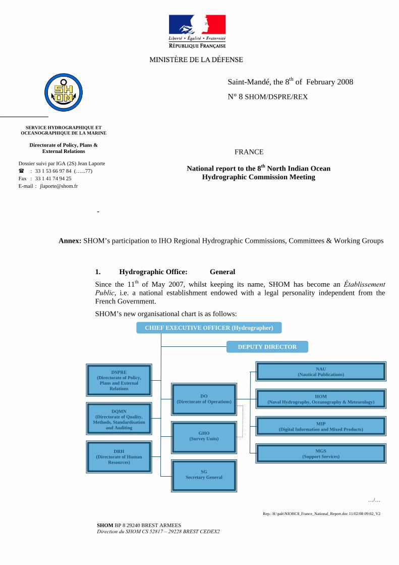
SHOM’s new organisational chart is as follows:
CHIEF EXECUTIVE OFFICER (Hydrographer)
DEPUTY DIRECTOR
MGS (Support Services)
MIP (Digital Information and Mixed Products)
NAU (Nautical Publications)
HOM (Naval Hydrography, Oceanography & Meteorology)
DRH
(Directorate of Human Resources)
DQMN (Directorate of Quality,
Methods, Standardisation and Auditing
DSPRE (Directorate of Policy,
Plans and External Relations
DO (Directorate of Operations)
GHO
(Survey Units)
SG
Secretary General
- 2 / 14 -
SHOM is managed by a Chief Executive Officer (Hydrographer) appointed by decree and supervised by a Board of Directors of 20 members representing a broad section of the French administration (Prime Minister, ministers of budget, defence, environment, industry, overseas and transport, several Government services and agencies). The Navy retains its prominent role by having the Board of Directors chaired by the Chief-of-Staff and providing the survey vessels onboard which SHOM’s Survey Units operate.
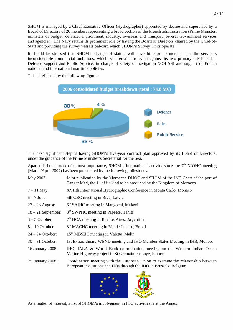
It should be stressed that SHOM’s change of statute will have little or no incidence on the service’s inconsiderable commercial ambitions, which will remain irrelevant against its two primary missions, i.e. Defence support and Public Service, in charge of safety of navigation (SOLAS) and support of French national and international maritime policies.
This is reflected by the following figures:
The next significant step is having SHOM’s five-year contract plan approved by its Board of Directors, under the guidance of the Prime Minister’s Secretariat for the Sea.
Apart this benchmark of utmost importance, SHOM’s international activity since the 7th NIOHC meeting (March/April 2007) has been punctuated by the following milestones:
May 2007: Joint publication by the Moroccan DHOC and SHOM of the INT Chart of the port of Tanger Med, the 1st of its kind to be produced by the Kingdom of Morocco
7 – 11 May: XVIIth International Hydrographic Conference in Monte Carlo, Monaco
5 – 7 June: 5th CBC meeting in Riga, Latvia
27 – 28 August: 6th SAIHC meeting in Mangochi, Malawi
18 – 21 September: 8th SWPHC meeting in Papeete, Tahiti
3 – 5 October 7th HCA meeting in Buenos Aires, Argentina
8 – 10 October 8th MACHC meeting in Rio de Janeiro, Brazil
24 – 24 October: 15th MBSHC meeting in Valetta, Malta
30 – 31 October 1st Extraordinary WEND meeting and IHO Member States Meeting in IHB, Monaco
16 January 2008: IHO, IALA & World Bank co-ordination meeting on the Western Indian Ocean Marine Highway project in St Germain-en-Laye, France
25 January 2008: Coordination meeting with the European Union to examine the relationship between European institutions and HOs through the IHO in Brussels, Belgium
As a matter of interest, a list of SHOM’s involvement in IHO activities is at the Annex.
2006 consolidated budget breakdown (total : 74.8 M€)
Sales
Public Service
Defence

- 3 / 14 -
To finish on a diplomatic note, it should be reported that the IHO new statute has been ratified by the French Parliament on the 28th of July 2007.
2. Surveys: Coverage of new surveys
New technologies and /or equipment New ships Problems encountered 2.1 Coverage of new surveys
SHOM conducts, or participates to, two types of surveys in the Indian Ocean:
i. The first type aims at collecting geophysical information pertinent to defining the extent of the French EEZ, in accordance with Art 76 of the UN Convention of the Law of the Sea (UNCLOS). The areas concerned being all located in the South Indian Ocean, the surveys have been duly reported to the SAIHC and/or the SWPHC.
ii. The second type is related to SHOM’s long term commitment in those areas where France has overseas territories or traditional links reinforced by bilateral SOLAS-type agreements such as the one binding France and the Republic of Djibouti. These surveys are aimed at collecting nautical information with a view to improve SHOM’s chart portfolio and the world ENC coverage.
Subject to SHOM Board of Directors’ approval, these commitments can eventually lead to projects of strategic importance, articulated along the following lines:
Cataloguing of all existing information.
Oceanographic modelling (tides, currents, swell, etc.), eventually in liaison with UNESCO/IOC initiatives if any.
Use of remote sensing (SPOT, ERS, radar satellites, airborne surveys, etc.) to improve the coastal cartography.
Hydrographic surveys (bathymetry, geophysics, sediments, etc.) and production of ENCs, charts and nautical documents.
This list of surveys aimed at collecting nautical information not yet reported to the NIOHC includes the following:
• September 2006 : “Aden Owen-Carlsberg” geophysical survey of the deep ocean floor at the Arabia-India-Somalia triple junction, about 200 miles off the coasts of Yemen, the Gulf of Aden and the sea of Oman:
- 4 / 14 -
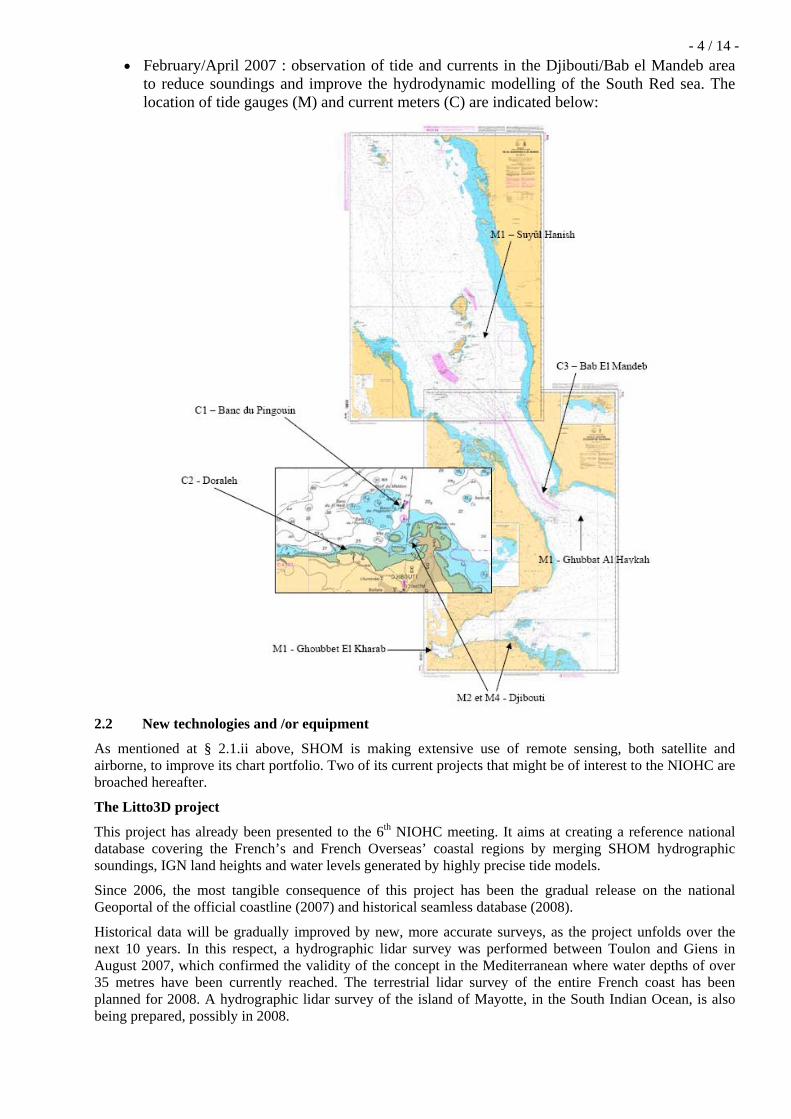
• February/April 2007 : observation of tide and currents in the Djibouti/Bab el Mandeb area to reduce soundings and improve the hydrodynamic modelling of the South Red sea. The location of tide gauges (M) and current meters (C) are indicated below:
2.2 New technologies and /or equipment
As mentioned at § 2.1.ii above, SHOM is making extensive use of remote sensing, both satellite and airborne, to improve its chart portfolio. Two of its current projects that might be of interest to the NIOHC are broached hereafter.
The Litto3D project
This project has already been presented to the 6th NIOHC meeting. It aims at creating a reference national database covering the French’s and French Overseas’ coastal regions by merging SHOM hydrographic soundings, IGN land heights and water levels generated by highly precise tide models.
Since 2006, the most tangible consequence of this project has been the gradual release on the national Geoportal of the official coastline (2007) and historical seamless database (2008).
Historical data will be gradually improved by new, more accurate surveys, as the project unfolds over the next 10 years. In this respect, a hydrographic lidar survey was performed between Toulon and Giens in August 2007, which confirmed the validity of the concept in the Mediterranean where water depths of over 35 metres have been currently reached. The terrestrial lidar survey of the entire French coast has been planned for 2008. A hydrographic lidar survey of the island of Mayotte, in the South Indian Ocean, is also being prepared, possibly in 2008.

- 5 / 14 -
Hydrographic lidar survey of the Mediterranean coast between Toulon and Giens
The West Africa Coastchart project
Following a European Space Agency (ESA)’s initiative, SHOM has endeavoured to make use of radar satellite technologies to improve the West African coastline.
The test was expected to yield a coastline in WGS 84 with better precision than 25 metres, compatible with nautical charts at scales of 1:15 000 & 1:50 000 and compliant with the IHO S 57 standards.
The project, which involved 15 countries of the EAtHC area and was contracted to a European consortium led by LOGICA, was deemed inconclusive by the ESA experts (SHOM and the UKHO) and terminated prematurely in August 2006. But these disappointing results are not the end of the story as better sensors are currently developed for the next generation radar satellites.
Radar satellite rendering (right) against SHOM charted port facilities (left) (planimetric errors in yellow)
2.3 New ships
NTR
2.4 Problems encountered
As many other IHO member states, France is tasked with collecting nautical information and surveying international waters that would otherwise remain uncharted.
In the interest of the international maritime community, it is reminded that

- 6 / 14 -
Survey results should be communicated to the IHO recognised and accepted charting authority.
In addition, provision should be made in all contracts awarded to private survey companies to the effect that hydrographic data pertinent to the safety of navigation be communicated to the IHO charting authority.
Thanks to the courtesy of the Government of the Republic of Djibouti and US Navoceano’s support, SHOM is now able to utilise the hydrographic data collected by the Fleet Survey Team (FST) in May 2006.
3. Charts and Publications:
a. Charts a.1 New charts & updates a.2 ENCs a.3 RNCs a.4 INT charts a.5 National paper charts a.6 Other charts e.g. for pleasure crafts a.7 ENC Distribution method a.8 Problems encountered
a.1 New charts & updates (planned in 2008)
N° National
N° INT Scale 1: Title
6878 175 000 Golfe de Suez – De Râs Ghârib au port de Suez
7545 Divers Suez Canal (Fs GB 233)
6947 1 080 000 Abords et partie Est du Golfe d’Aden. – (new surveys)
New charts & updates (planned from 2009 to 2011)
N° National
N° INT Scale 1: Title
7519 7114 200 000 Bab el Mandeb et Golfe de Tadjoura. – (new surveys)
7520 7115 50 000 Abords de Djibouti. – (new surveys)
a.2 ENCs
As per the 31th of January 2008, SHOM has already produced some 241 ENCs at an approximate rate of 40 to 50 per year. The full collection should eventually reach a figure of the order of 700 ENCs.
Europe approaches are well covered, on account of commercial and passengers sailing requirements. Production in non European waters (international responsibilities, overseas dependencies) is progressing.
In line with the WEND task group and to make life simpler, France reminds that small scale ENC schemes should be established as closely as possible to INT chart schemes
In the NIOHC area, where SHOM/UKHO coordination is excellent, the French ENC coverage has been realised in accordance with the 2 following chartlets, where existing ENC are represented in red and planned ENCs are in greyish/green:

- 7 / 14 -
SHOM has released in March 2005 all the ENCs ascribed to France, i.e.
ENC Usage Band Scale 1: INT paper chart Nr Title
FR536010 Harbour 10 000 7115 Djibouti harbour

- 8 / 14 -
FR436010 Approach 50 000 7115 Approaches to Djibouti
FR336020 Coastal 200 000 7118 Al Hudaydah to Al Mukha
FR336010 Coastal 200 000 7114 Bab El Mandeb and Gulf of Tadjoura
FR236010 General 700 000 INT 7004 &
French Nr 7099 Gulf of Aden – Bab El
Mandeb
FR236020 General 700 000 7004 Gulf of Aden – Central Part
a.3 RNCs
NTR
a.4 INT Charts
According to the scheme prepared by India, France has been allocated 4 INT charts, which have all been produced, as repeated in the following table:
National Nr INT Nr Scale 1: Title / observations
6987 7004 700 000 Partie Ouest du golfe d’Aden – Bab-el-Mandeb – Published in 2003
7519 7114 200 000 Bab el Mandeb & Golfe de Tadjoura. – Published in 2003
7518 7118 200 000 De Al Hudaydah à Al Mukhā – Published in 2003
7520 7115 50 000 Abords de Djibouti - Published in 2003
a.5 National paper charts
NTR
a.6 Other charts e.g. for pleasure crafts
NTR
a.7 ENC Distribution method
All French ENCs are distributed by Primar Stavanger RENC.
a.8 Problems encountered
NTR
b. Publications b.1 New publications b.2 Updated publications - Editions b.3 Means of delivery e.g. paper, digital b.4 Problems encountered

- 9 / 14 -
b.1 New publications
Type Nr Title
DIV 075 Annuaire des marées pour 2007, tome 2 – Ports d’outremer
DIV 085 Annuaire des marées pour 2008, tome 2 – Ports d’outremer
DIV 942 La marée océanique côtière (coedited with Institut Océanographique)
IN : Sailing directions
RSX : Radio stations
LL : List of Lights
DIV : Miscelleanous
b.2 Updated publications – Editions
NTR
b.3 Means of delivery e.g. paper, digital
SHOM aims at generating by digital means its entire paper production. This should be achieved by using international standards such as XML and following closely the recommendations of experts such as the NSHC’s WG on standardisation of digital exchange of NtMs.
b.4 Problems encountered
An important regulation corpus has been developed for the establishment and use of ENCs while the equivalent standardisation for nautical books is still lagging. As a result, the rules of use of these documents are not clearly established.
4. MSI Existing infrastructure for transmission –
New infrastructure in accordance with GMDSS Master Plan
Problems encountered
NTR
5. Capacity Building Offer of and/or demand for Capacity Building -
Training received, needed, offered
Status of national, bilateral, multilateral or regional development projects with hydrographic component. (In progress, planned, under evaluation or study)
5.1 Offer of and/or demand for Capacity Building
France participates to the IHO Capacity Building committee and supports the IHO Regional Hydrographic Commissions of which SHOM is a member, especially the Southern African & Islands Hydrographic Commission (SAIHC) and the Eastern Atlantic Hydrographic Commission (EAtHC), and to a lesser extent the South-West Pacific Hydrographic Commission (SWPHC), the MESO American and Caribbean Sea Hydrographic Committee (MACHC) & the Mediterranean and Black Sea Hydrographic Commission (MBSHC).
- 10 / 14 -
In pursuance with the CBC actions and 2006 previous mission to Antanarivo, three new visits to the Madagascar Hydrographic and Geographic Agency (FTM) have taken place in 2007 and 2008 (the latter by Mr Noralf Slotsvik of the Norwegian HO) with a view to press forward the prioritised survey plan and implement a tripartite co-operation programme.
The Madagascar project, however, is stumbling upon hurdles caused by the near-disappearance of qualified hydrographers capable of participating in technical discussions and making use of the support offered, either by foreign HOs such as SHOM or Norway’s Sjøkartverket, or by the IHO Capacity Building Committee. Matters are not helped by the fact that the Madagascar Government seems to have difficulties expressing an official requirement through diplomatic channel, which remains a prerequisite.
5.2 Training received, needed, offered
Initial training capabilities provided by SHOM are described in its yearly report available on www.shom.fr . It consists mainly of 2 to 3 years hydrographic courses for FIG/IHO/ICA category A, 18 months for cat. B, and 7 months technical courses for cartographers.
In 2007, 44 engineers and 60 technicians were registered in either of these trainings. The students were recruited amongst civilian (59), military (38) and foreigners (7).
In addition to proposing full hydrographic courses SHOM can enable the French Navy support company Navfco to prepare short modules in English in narrow technical fields such as ENC, delineations, military oceanography, etc.
Under SHOM supervision, Navfco is also developing a short course for assistant surveyors that could be taught in countries interested, to reduce costs and the inconvenience of having to spend months in France.
5.3 Status of national, bilateral, multilateral or regional development projects with hydrographic component. (In progress, planned, under evaluation or study)
France has signed three bilateral agreements with Monaco (2005), Djibouti (2006) and Morocco (2008) in order to formalise the existing co-operation and sharing of hydrographic responsibilities within the SOLAS convention. Two more agreements are expected to be signed with Senegal and Algeria; other are contemplated wherever it appears that France still provides hydrographic services to foreign countries, or complements those already in place, or might even help improving friendly countries’ existing hydrographic capacities. The idea is to promote further co-operation within the IHO/CBC and facilitate technology transfer to those countries that have kept historical links with France or with whom new links have been formed.
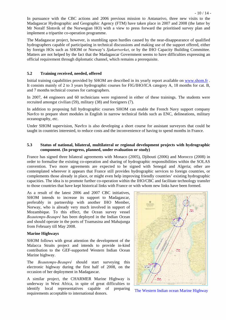
As a result of the latest 2006 and 2007 CBC initiatives, SHOM intends to increase its support to Madagascar, preferably in partnership with another IHO Member, Norway, who is already very much involved in support of Mozambique. To this effect, the Ocean survey vessel Beautemps-Beaupré has been deployed in the Indian Ocean and should operate in the ports of Toamasina and Mahajunga from February till May 2008.
Marine Highways
SHOM follows with great attention the development of the Malacca Straits project and intends to provide in-kind contribution to the GEF-supported Western Indian Ocean Marine highway.
The Beautemps-Beaupré should start surveying this electronic highway during the first half of 2008, on the occasion of her deployment in Madagascar.
A similar project, the CHARMER Marine Highway is underway in West Africa, in spite of great difficulties to identify local representatives capable of preparing requirements acceptable to international donors.
The Western Indian ocean Marine Highway
- 11 / 14 -
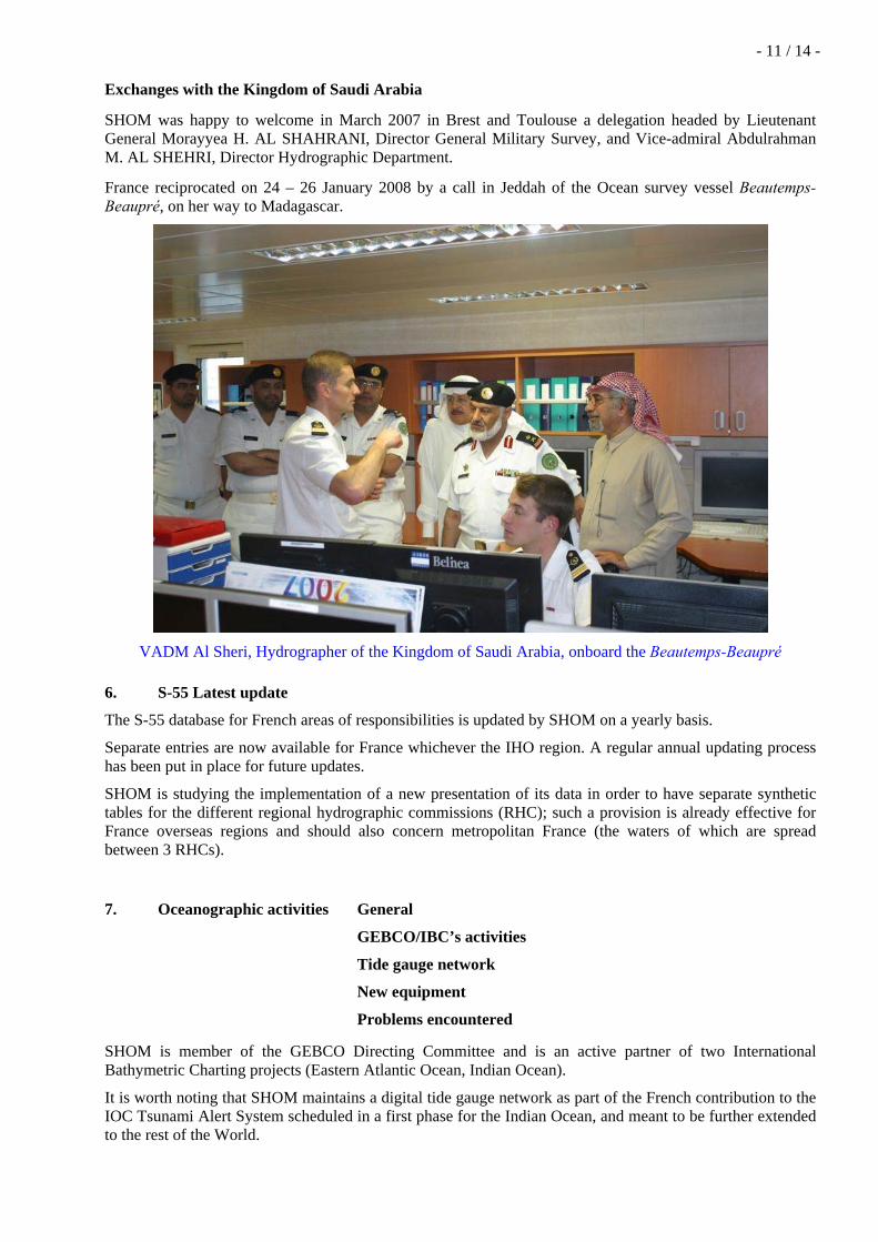
Exchanges with the Kingdom of Saudi Arabia
SHOM was happy to welcome in March 2007 in Brest and Toulouse a delegation headed by Lieutenant General Morayyea H. AL SHAHRANI, Director General Military Survey, and Vice-admiral Abdulrahman M. AL SHEHRI, Director Hydrographic Department.
France reciprocated on 24 – 26 January 2008 by a call in Jeddah of the Ocean survey vessel Beautemps-Beaupré, on her way to Madagascar.
VADM Al Sheri, Hydrographer of the Kingdom of Saudi Arabia, onboard the Beautemps-Beaupré
6. S-55 Latest update
The S-55 database for French areas of responsibilities is updated by SHOM on a yearly basis.
Separate entries are now available for France whichever the IHO region. A regular annual updating process has been put in place for future updates.
SHOM is studying the implementation of a new presentation of its data in order to have separate synthetic tables for the different regional hydrographic commissions (RHC); such a provision is already effective for France overseas regions and should also concern metropolitan France (the waters of which are spread between 3 RHCs).
7. Oceanographic activities General
GEBCO/IBC’s activities
Tide gauge network
New equipment
Problems encountered
SHOM is member of the GEBCO Directing Committee and is an active partner of two International Bathymetric Charting projects (Eastern Atlantic Ocean, Indian Ocean).
It is worth noting that SHOM maintains a digital tide gauge network as part of the French contribution to the IOC Tsunami Alert System scheduled in a first phase for the Indian Ocean, and meant to be further extended to the rest of the World.
- 12 / 14 -
There are ongoing discussions with the UNESCO to increase SHOM participation to the international effort and include tidal matters and other IOC concerns in the bilateral agreements mentioned at § 5.3
8. Conclusions
NTR

- 13 / 14 -
ANNEX
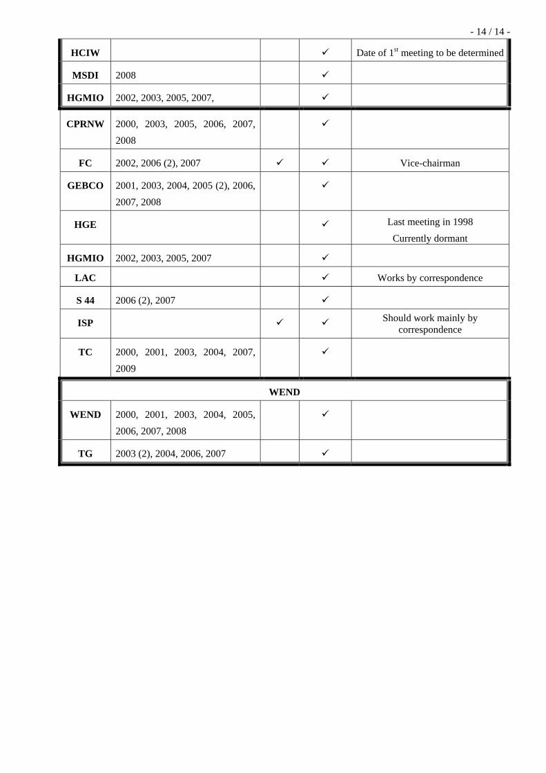
SHOM’s participation to IHO Regional Hydrographic Commissions, Committees & Working Groups
Name Meetings since year 2000 Chair Member Observations
NSHC 2000, 2003, 2004, 2006, 2007, 2008
MBSHC 2001, 2003, 2005, 2007, 2009
EAtHC (…), 2001, 2002, 2004, 2005, 2006, 2008
SWPHC 2001, 2003 (2), 2004, 2005, 2007, 2008
MACHC 2000, 2002, 2004, 2005 (2), 2006, 2007, 2008
SAIHC 2003, 2005 (2), 2006, 2007, 2009
NIOHC 2002 (2), 2003, 2004, 2005, 2006, 2007, 2008
HCA 2001, 2002, 2003, 2004, 2005, 2006, 2007, 2008
CBC 2003, 2004, 2005, 2006, 2007, 2008
CHD 2001
CHRIS & CHRIS WG
CHRIS 2000, 2001, 2002, 2003, 2004, 2005, 2006, 2007, 2008
TSMAD (…), 2003, 2004, 2005, 2006, 2007, 2008
CSM (…), 2001, 2002, 2003, 2005, 2006, 2007, 2008
SNP (…), 2003, 2004, 2005 (2), 2006, 2007 (2), 2008
CSPC 2004, 2005, 2006, 2007, 2008
DPS (…), 2003, 2004, 2006, 2007
DQ Last meeting in 1996
- 14 / 14 -
HCIW Date of 1st meeting to be determined
MSDI 2008
HGMIO 2002, 2003, 2005, 2007,
CPRNW 2000, 2003, 2005, 2006, 2007, 2008
FC 2002, 2006 (2), 2007 Vice-chairman
GEBCO 2001, 2003, 2004, 2005 (2), 2006, 2007, 2008
HGE Last meeting in 1998 Currently dormant
HGMIO 2002, 2003, 2005, 2007
LAC Works by correspondence
S 44 2006 (2), 2007
ISP Should work mainly by correspondence
TC 2000, 2001, 2003, 2004, 2007, 2009
WEND
WEND 2000, 2001, 2003, 2004, 2005, 2006, 2007, 2008
TG 2003 (2), 2004, 2006, 2007

DESTINATAIRE : Chairman, 8th North Indian Ocean Hydrographic Commission Meeting [email protected]
COPIES : BHI – DSPRE – DO - Archives