Embed Size (px)
Citation preview
Page | i
2010
Submitted to the Department of Indian Affairs and Northern Development,
Specific Claims Branch on behalf of the
Sagkeeng First Nation
August 17, 2010
“Without Prejudice”
SSAAGGKKEEEENNGG FFIIRRSSTT NNAATTIIOONN TTRREEAATTYY LLAANNDD EENNTTIITTLLEEMMEENNTT CCLLAAIIMM
SSPPEECCIIFFIICC CCLLAAIIMM SSUUBBMMIISSSSIIOONN
Maurice Law B a r r i s t e r s & S o l i c i t o r s
Suite 800, 550 – 11th Avenue SW • Calgary, Alberta • T2R 1M7
Phone: (403) 266-1201 • Facsimile: (403) 266-2701 EMAIL: r m a u r i c e @ m a u r i c e l a w . c o m
WEBSITE: w w w . m a u r i c e l a w . c o m
Sagkeeng First Nation Treaty Land Entitlement Specific Claim: Submission
“Without Prejudice” Page | ii
TABLE OF CONTENTS
PART I – INTRODUCTION ................................................................... 1
PART II – HISTORICAL BACKGROUND ................................................... 2
PART III – ISSUES ........................................................................... 4
PART IV – LEGAL ANALYSIS ............................................................... 5
Issue 1: Was There a Common Intention by the Parties to Treaty 1 to Exclude Privately Held Lands from the Calculation of Reserve Land Entitlement? ................................................ 5
Principles of Treaty Interpretation ............................................................................................ 5
Facial Meaning of the Reserve Clause in Treaty 1 ..................................................................... 9
Treaty 1 Negotiations Regarding Reserve Lands and Private Lots .......................................... 9
Issue 2: If the Answer to Issue 1 is “Yes”, What Was the Understanding and Intention of the Parties to Treaty 1 with respect to the Size of Privately Held Lands Allotted to Indians? ........ 13
Dominion Land Policy and the Origin of the 160 Acre Allotment for Homesteads .............. 13
Treaty 1 and the 160 Acre Formula for Reserve Lands ............................................................ 17
Subsequent Conduct of the Parties Regarding the 160–Acre Unit of Settlement ................. 19
Settlement and River Lot Grants of 144 Acres at Fort Alexander .......................................... 20
Issue 3: How Much Communal Reserve Land Was Set Aside For The Sagkeeng First Nation? .................................................................................................................................... 22
Survey Plan of J.W. Harris, DLS (1874) .................................................................................. 23
Eyler Report, Map “A” Pre-Treaty Settlement ........................................................................ 28
Issue 4: Does The Sagkeeng first Nation Have An Outstanding Entitlement To Additional Reserve Land Under Treaty 1?..................................................................................................... 36
PART VI – CONCLUSION .............................................................. 37
LIST OF AUTHORITIES .................................................................... 38

Sagkeeng First Nation Treaty Land Entitlement Specific Claim: Submission
“Without Prejudice” Page | 1
PART I – INTRODUCTION 1. In May, 2000, the Sagkeeng First Nation1 submitted a specific claim for an outstanding
entitlement to reserve land under the terms of Treaty 1. During the review of this claim, the Specific Claims Branch raised a question regarding whether certain lands that were occupied or improved by members of the Fort Alexander Band were to be excluded from the lands set apart under Treaty 1 for the collective use and benefit of the Band when the Fort Alexander Indian Reserve was surveyed in 1874.
2. By letter dated April 4, 2008, Mr. Don Boswell, Acting Senior Claims Analyst of the Specific Claims Branch of Indian and Northern Affairs Canada, invited further legal argument from the First Nation regarding these lands. This submission is intended to focus on that specific issue and sets forth additional facts and arguments in support of the Sagkeeng First Nation’s claim that it has an outstanding land entitlement shortfall under the terms of Treaty 1. This submission is intended to augment the arguments contained within the TLE Claim and is not submitted as a new claim by the First Nation.
3. For the reasons that follow in this document, the Sagkeeng First Nation submits that any “private lots” that were improved by members prior to Treaty 1 were clearly intended by the parties to be included in the survey of reserves for the signatory bands to Treaty 1; however, these private lots were to be excluded for the purposes of calculating the treaty land entitlement of each band under the reserve clause of Treaty 1.
4. Evidence of the historical context to Treaty 1 as well as the subsequent conduct of the parties strongly supports the conclusion that private lots were intended to be allocated on the basis of 160 acres which was the same amount of land allotted to non-Indian and Métis settlers under the homesteading laws and policies of the day. In the specific case of the Fort Alexander Band, however, it appears there was a mutual understanding that the size of private lots to be surveyed for members of the Fort Alexander Band would be based on 144 acres which was the standard size for “river lots” and was adopted locally for the survey of lots adjacent to the Winnipeg River.
5. This submission is provided solely for the purposes of seeking a validation of the claim under Canada’s Specific Claims Policy. Accordingly, any admission of fact or law in this document is strictly without prejudice to any position the Sagkeeng First Nation may take in any subsequent legal proceedings before the courts or the Specific Claims Tribunal. The First Nation further reserves the right to update or clarify this submission upon review of additional materials as they become available to counsel.
1 The present day First Nation will be referred to in this submission as the “First Nation” or “Sagkeeng First Nation”. References to the First Nation in the historical context will be made to the “Band” or to the “Fort Alexander Band” to accord with the common usage of these terms in the historical documents.

Sagkeeng First Nation Treaty Land Entitlement Specific Claim: Submission
“Without Prejudice” Page | 2
PART II – HISTORICAL BACKGROUND 6. The historical basis for the Sagkeeng First Nation’s Treaty Land Entitlement is set out in
detail in the original claim submission entitled Sagkeeng First Nation Treaty Land Entitlement Statement of Historical Fact dated May 18, 2000 (hereinafter the “TLE Claim”).2 Except as where modified by this document, the Sagkeeng First Nation adopts and relies on the historical facts and arguments set out in the TLE Claim.
7. Three additional reports have been relied upon in this submission to provide additional historical background on the claim and to focus on the intentions of the parties to Treaty 1 with respect to the exclusion of private lots from the reserve land entitlement:
a) a historical research report prepared by Paula Eyler for the Manitoba TARR Centre entitled Fort Alexander Pre Treaty Settlement and Treaty Entitlement dated April 1976 (hereinafter “the Eyler Report);3
b) a historical research report prepared by Jim Gallo for the Manitoba TARR Centre entitled Properties Occupied and Cultivated Prior to Treaty dated September 28, 1978 (hereinafter “the Gallo Report”);4 and
c) a historical research report entitled Sagkeeng First Nation – Fort Alexander – Use and Occupation prepared by Public History Inc on April 30, 2004 (the “PHI Report”).5
8. Canada also commissioned two research reports relating to the specific issue of the calculation of the population to be used to calculate the Sagkeeng First Nation’s entitlement to reserve land under Treaty 1:
a) a paylist analysis prepared by Public History Inc for the Specific Claims Branch entitled Sagkeeng First Nation Treaty Land Entitlement Claim: Draft Report (revised), dated October 8, 2003;6 and
b) a paylist analysis entitled the Sagkeeng First Nation Treaty Land Entitlement Claim Paylist Analysis by Foley & Daley Associates prepared for the Specific Claims Branch dated March 2008.7
2 Sagkeeng First Nation Treaty Land Entitlement Statement of Historical Fact, dated May 18, 2000 (ML-0462). 3 Paula Eyler, Fort Alexander Pre Treaty Settlement and Treaty Entitlement, TARR (Manitoba) report, April 1976 (ML-0454). 4 Jim Gallo, Properties Occupied and Cultivated Prior to Treaty, TARR (Manitoba) report, Exhibit 12 in the I.C.C. Sandy Bay Ojibway First Nation T.L.E. Claim, (November 9, 1999), 2 (ML-0455). 5 Public History Inc, Sagkeeng First Nation – Fort Alexander – Use and Occupation, dated April 30, 2004 (ML-0464). 6 Public History Inc, Sagkeeng First Nation Treaty Land Entitlement Claim (revised), dated October 8, 2003 (ML-0463). 7 Foley & Daley Associates, Sagkeeng First Nation Treaty Land Entitlement Claim Paylist Analysis, March 2008 (ML-0465).
Sagkeeng First Nation Treaty Land Entitlement Specific Claim: Submission
“Without Prejudice” Page | 3
Given the inconsistencies and wide discrepancy between the reports with respect to the entitlement population of the Fort Alexander Band, the Sagkeeng First Nation commissioned a third report entitled The Treaty Land Entitlement Population of the Fort Alexander Band8 prepared by Neil Reddekopp Consulting for Maurice Law Barristers & Solicitors dated July 2010 which seeks to reconcile the reports and provide a reliable basis for determining the treaty land entitlement population for the Fort Alexander Band. These reports are discussed under Issues 4 and 5 below.
9. The history of the TLE Claim has been thoroughly documented in the above documents and, therefore, we do not intend to fully review that factual background in this submission. We encourage the Specific Claims Branch to review these reports in conjunction with this submission for a more detailed summary of the relevant facts.
8 Neil Reddekopp Consulting, The Treaty Land Entitlement Population of the Fort Alexander Band, July 2010 (ML-0466).
Sagkeeng First Nation Treaty Land Entitlement Specific Claim: Submission
“Without Prejudice” Page | 4
PART III – ISSUES 10. This submission will address whether the Sagkeeng First Nation has an “outstanding
lawful obligation” within the meaning of the Specific Claims Policy. The Department of Indian Affairs recently released a new version of Outstanding Business: A Native Claims Policy, the purpose of which is to update its policies to reflect new developments in the claims process.
11. The new Specific Claims Policy is based on many of the principles from the previous Outstanding Business but has been updated to reflect new developments in the evolving law on aboriginal and treaty rights. The new policy seeks to balance the importance of the concept of “lawful obligation” on the Crown while expediting the process through which a claim is resolved. The new Policy sets out the grounds for asserting that the Crown breached its lawful obligation in favour of a First Nation claimant. Clause a) of the Policy is relevant to the claim of the Sagkeeng First Nation:
a) a failure to fulfill a legal obligation of the Crown to provide lands or other assets under a treaty or another agreement between the First Nation and the Crown.…
12. In addition to the Specific Claims Policy, the calculation of whether a land shortfall exists under Treaty is determined by the 1998 Historic Treaty Land Entitlement (TLE) Shortfall Policy (hereinafter the “1998 TLE Policy”). The 1998 TLE Policy provides guidelines to ascertain those Band members who are eligible to be counted toward the determination of reserve land owed to a claimant First Nation. A comparison of the claimant’s Adjusted Date of First Survey (ADOFS) population with the quantum of reserve land set aside under the relevant treaty will reveal whether there was a shortfall of land provided to the claimant First Nation.
13. The issues addressed in this submission are as follows:
ISSUE 1: WAS THERE A COMMON INTENTION BY THE PARTIES TO TREATY 1 TO EXCLUDE PRIVATELY HELD LANDS FROM THE CALCULATION OF RESERVE LAND ENTITLEMENT?
ISSUE 2: IF THE ANSWER TO ISSUE 1 IS “YES”, WHAT WAS THE UNDERSTANDING AND INTENTION OF THE PARTIES TO TREATY 1 WITH RESPECT TO THE SIZE OF PRIVATELY HELD LANDS ALLOTTED TO INDIANS?
ISSUE 3: HOW MUCH COMMUNAL RESERVE LAND WAS SET ASIDE FOR THE SAGKEENG FIRST NATION?
ISSUE 4: DOES THE SAGKEENG FIRST NATION HAVE AN OUTSTANDING ENTITLEMENT TO ADDITIONAL RESERVE LAND UNDER TREATY 1?
Sagkeeng First Nation Treaty Land Entitlement Specific Claim: Submission
“Without Prejudice” Page | 5
PART IV – LEGAL ANALYSIS
ISSUE 1: WAS THERE A COMMON INTENTION BY THE PARTIES TO TREATY 1 TO EXCLUDE PRIVATELY HELD LANDS FROM THE CALCULATION OF RESERVE LAND ENTITLEMENT?
Principles of Treaty Interpretation
14. It is well settled that treaties are sui generis (i.e., unique in law). As a result of the unique historical circumstances in which the treaties were negotiated between the Crown and aboriginal peoples in Canada, the courts have developed a comprehensive set of principles to guide them in interpreting the legal effect of Indian treaties and to determine the nature and scope of the rights flowing from these solemn agreements. In order to ascertain the intentions of the parties with respect to the promise to provide reserve lands under Treaty 1, a necessary starting point is to consider the principles relating to treaty interpretation.
15. In Taylor and Williams, the Ontario Court of Appeal outlined the following approach which has subsequently been endorsed by the Supreme Court of Canada in a number of key decisions:
The principles to be applied to the interpretation of Indian treaties have been much canvassed over the years. In approaching the terms of the Treaty quite apart from the other considerations already noted, the honour of the Crown is always involved and no appearance of “sharp dealing” should be sanctioned. Mr. Justice Cartwright emphasized that in his dissenting reasons in R. v. George, [1966] S.C.R. 267 at page 279, where he said:
We should, I think, endeavor to construe the treaty of 1827 and those Acts of Parliament which bear upon the question before us in such manner that the honour of the Sovereign may be upheld and Parliament not made subject to the reproach of having taken away by unilateral action and without consideration the rights solemnly assured to the Indians and their posterity by treaty.
Further, if there is any ambiguity in the words or phrases used, not only should the words be interpreted as against the framers or drafters of such treaties, but such language should not be interpreted or construed to the prejudice of the Indians if another construction is reasonably possible: R. v. White and Bob (1965), 50 D.L.R. (2d) 613 at p.652 (B.C.C.A.), aff'd., (1965), 52 D.L.R. (2d) 481 (S.C.C.).
Finally, if there is evidence by conduct or otherwise as to how the parties understood the terms of the treaty, then such understanding and practice is of assistance in giving content to the term or terms. As already stated, counsel for both parties to the appeal agreed that recourse could be had to the surrounding circumstances and judicial notice could be taken of the facts of history. In my opinion, that notice extends to how, historically, the parties acted under the treaty after its execution.9
16. In Nowegijick v. The Queen, the Supreme Court of Canada essentially applied the contra proferentum rule by analogy to the interpretation of Indian treaties. The Court stated:
It seems to me, however, that treaties and statutes relating to Indians should be liberally construed and doubtful expressions resolved in favour of the Indians. ... In Jones v. Meehan 175 U.S. 1, it was
9 R. v. Taylor and Williams (1981), 1981 Carswell Ont 641, [1981] 3 C.N.L.R. 114, 34 O.R. (2d) 360, 62 C.C.C. (2d) 227 at paras. 18-20 (Ont. CA) leave to appeal dismissed, [1981] 2 S.C.R. xi. Emphasis added.

Sagkeeng First Nation Treaty Land Entitlement Specific Claim: Submission
“Without Prejudice” Page | 6
held that "Indian treaties must be construed not according to the technical meaning of their words, but in the sense that they would naturally be understood by the Indians."10
17. In R. v. Badger, Mr. Justice Cory explained that the underlying rationale for special evidentiary rules and principles of interpretation with respect to Indian treaties finds its justification in the historical circumstances in which Indian treaties were negotiated between aboriginal peoples and the Crown:
… when considering a treaty, a court must take into account the context in which the treaties were negotiated, concluded and committed to writing. The treaties, as written documents, recorded an agreement that had already been reached orally and they did not always record the full extent of the oral agreement: see Alexander Morris, The Treaties of Canada with the Indians of Manitoba and the North-West Territories (1880), at pp. 338-42; Sioui, supra, at p. 1068; Report of the Aboriginal Justice Inquiry of Manitoba (1991); Jean Friesen, Grant me Wherewith to Make My Living (1985). The treaties were drafted in English by representatives of the Canadian government who, it should be assumed, were familiar with common law doctrines. Yet, the treaties were not translated in written form into the languages (here Cree and Dene) of the various Indian nations who were signatories. Even if they had been, it is unlikely that the Indians, who had a history of communicating only orally, would have understood them any differently. As a result, it is well settled that the words in the treaty must not be interpreted in their strict technical sense nor subjected to rigid modern rules of construction. Rather, they must be interpreted in the sense that they would naturally have been understood by the Indians at the time of the signing. This applies, as well, to those words in the treaty which impose a limitation on the right which has been granted.11
18. In R. v. Marshall, Binnie J., writing for the majority, rejected a narrow approach to treaty interpretation and a strict application of the parol evidence rule for three main reasons that are germane to the present case:
Firstly, even in a modern commercial context, extrinsic evidence is available to show that a written document does not include all of the terms of an agreement. Rules of interpretation in contract law are in general more strict than those applicable to treaties, yet Professor Waddams states in The Law of Contracts (3rd ed. 1993), at para. 316:
The parol evidence rule does not purport to exclude evidence designed to show whether or not the agreement has been “reduced to writing”, or whether it was, or was not, the intention of the parties that it should be the exclusive record of their agreement. Proof of this question is a pre-condition to the operation of the rule, and all relevant evidence is admissible on it. This is the view taken by Corbin and other writers, and followed in the Second Restatement.
…
Secondly, even in the context of a treaty document that purports to contain all of the terms, this Court has made clear in recent cases that extrinsic evidence of the historical and cultural context of a treaty may be received even absent any ambiguity on the face of the treaty. MacKinnon A.C.J.O. laid down the principle in Taylor and Williams, supra, at p. 236:
... if there is evidence by conduct or otherwise as to how the parties understood the terms of the treaty, then such understanding and practice is of assistance in giving content to the term or terms.
10 Nowegijick v. The Queen [1983] 1 S.C.R. 29 at 36. 11 R. v. Badger, [1996] 1 S.C.R. 771 at 798-99. Emphasis added.

Sagkeeng First Nation Treaty Land Entitlement Specific Claim: Submission
“Without Prejudice” Page | 7
The proposition is cited with approval in Delgamuukw v. British Columbia, [1997] 3 S.C.R. 1010, at para. 87, and R. v. Sioui, [1990] 1 S.C.R. 1025, at p. 1045.
Thirdly, where a treaty was concluded verbally and afterwards written up by representatives of the Crown, it would be unconscionable for the Crown to ignore the oral terms while relying on the written terms, per Dickson J. (as he then was) in Guerin v. The Queen, [1984] 2 S.C.R. 335. Dickson J. stated for the majority, at p. 388:
Nonetheless, the Crown, in my view, was not empowered by the surrender document to ignore the oral terms which the Band understood would be embodied in the lease. The oral representations form the backdrop against which the Crown’s conduct in discharging its fiduciary obligations must be measured. They inform and confine the field of discretion within which the Crown was free to act. After the Crown’s agents had induced the Band to surrender its land on the understanding that the land would be leased on certain terms, it would be unconscionable to permit the Crown simply to ignore those terms.
…
“Generous” rules of interpretation should not be confused with a vague sense of after-the-fact largesse. The special rules are dictated by the special difficulties of ascertaining what in fact was agreed to. The Indian parties did not, for all practical purposes, have the opportunity to create their own written record of the negotiations. Certain assumptions are therefore made about the Crown’s approach to treaty making (honourable) which the Court acts upon in its approach to treaty interpretation (flexible) as to the existence of a treaty (Sioui, supra, at p. 1049), the completeness of any written record (the use, e.g., of context and implied terms to make honourable sense of the treaty arrangement: Simon v. The Queen, [1985] 2 S.C.R. 387, and R. v. Sundown, [1999] 1 S.C.R. 393), and the interpretation of treaty terms once found to exist (Badger). The bottom line is the Court’s obligation is to “choose from among the various possible interpretations of the common intention [at the time the treaty was made] the one which best reconciles” the Mi’kmaq interests and those of the British Crown (emphasis added) (Sioui, per Lamer J., at p. 1069).12
19. Given their unique origins, reference must be made to the historical circumstances surrounding the creation of treaties as legal documents in order to give proper effect to the rights contained within a treaty. The importance of context when determining the legal effect and scope of treaty rights cannot be understated. The Supreme Court of Canada in R. v. Sioui (hereinafter “Sioui”) held that the broader historical context of a treaty is always a relevant line of inquiry:
The historical context, which has been used to determine the existence of the treaty, may equally assist us in interpreting the extent of the rights contained in it. As MacKinnon J.A. said in Taylor and Williams, supra, at 232:
Cases on Indian or aboriginal rights can never be determined in a vacuum. It is of importance to consider the history and oral traditions of the tribes concerned, and
12 R. v. Marshall, [1999] 3 S.C.R. 456, at paras. 10-12 and 14 (Binnie J.). Emphasis added. Also see Lac La Ronge Indian Band v. Canada, 2001 SKCA 109 (Sask. CA), where the Court of Appeal stated that the trial judge erred by following R. v. Horse, [1988], 1 S.C.R. 187 in which he held that extrinsic evidence is admissible only where a treaty is ambiguous on its face, because “[t]he restrictive approach to the admissibility of extrinsic evidence was overtaken by both the majority and minority judgments in R. v. Marshall.”

Sagkeeng First Nation Treaty Land Entitlement Specific Claim: Submission
“Without Prejudice” Page | 8
the surrounding circumstances at the time of the treaty, relied on by both parties, in determining the treaty’s effect.13
20. The objective of treaty interpretation is to determine the intent of the parties at the time they concluded the treaty. The Court in Sioui stated that the following factors are relevant to determining the legal effect of the treaty:
1. continuous exercise of a right in the past and at present,
2. the reasons why the Crown made the commitment,
3. the situation prevailing at the time the document was signed,
4. evidence of relations of mutual respect and esteem between the negotiators, and
5. the subsequent conduct of the parties.14
21. In the Saskatchewan Court of Appeal in Lac La Ronge Indian Band v. Canada, Vancise J.A. followed the “two-step approach” to treaty interpretation adopted by McLachlin J. in R. v. Marshall. Although McLachlin J. dissented in Marshall (not on this point), Vancise J.A. held that her two-step approach permits a full consideration of the principles of treaty interpretation and is attractive because:
… consideration must be given to both the words of the treaty as well as the historical context which existed at the time the treaty was negotiated. The first step involves an examination of the words of the treaty “to determine their facial meaning in so far as this can be ascertained, noting any patent ambiguities and misunderstandings that may have arisen from linguistic and cultural differences.” The second step involves considering the facial meaning having regard for the historical and cultural backdrop against which the treaties were negotiated. McLachlin J. stated that when faced with a range of interpretations, “Courts must rely on the historical context to determine which comes closest to reflecting the parties’ common intention.” This, as Lamer J. stated in Sioui requires choosing “from among the various possible interpretations… the one which best reconciles the parties’ interests.”15
22. The first step then is to review the written text of Treaty 1 to determine whether the intentions of the parties with respect to land entitlement can be gleaned from the wording of the treaty on its face. The second step will involve an examination of the broader historical context surrounding the negotiation of Treaty 1 – including the situation prevailing at the time of the treaty, the reasons why the Crown made a commitment, and the subsequent conduct of the parties – to interpret the treaty obligation respecting reserve lands and to choose “from among the various possible interpretations… the one which best reconciles” the interests of Canada and the First Nations who were signatories to the treaty.
23. The Sagkeeng First Nation submits that a proper application of these principles to the facts of this claim leads to the conclusion that it still has an outstanding treaty land entitlement under the terms of Treaty 1.
13 R. v. Sioui, [1990] 1 S.C.R. 1025 at 1068. 14 R. v. Sioui [1990] 1 S.C.R. 1025 at 1045. 15 Lac La Ronge Indian Band v. Canada, [2001] SKCA 109 at para. 53 (Sask. CA) (hereafter referred to as “Lac La Ronge (CA)”).
Sagkeeng First Nation Treaty Land Entitlement Specific Claim: Submission
“Without Prejudice” Page | 9
Facial Meaning of the Reserve Clause in Treaty 1
24. The Fort Alexander Band was a signatory to Treaty 1 at Lower Fort Garry on August 3rd, 1871. The “Reserve Clause” in Treaty 1 provides that Her Majesty the Queen “hereby agrees and undertakes to lay aside and reserve for the sole and exclusive use of the Indians” reserve lands for each of the bands. The amount of land to be set apart for each band was to be based on 160 acres for each family of five or 32 acres per person.
25. The text of the Treaty identified the location of the various bands’ reserves but did not quantify the specific amount of land to be set aside for each band as that would be based on the number of members in the band at the time the surveyor was dispatched to survey and set aside the reserve. The text of Treaty 1 also makes no mention of private land holdings by the Indians.
26. In short, the intention of the parties in relation to how privately held lands were to be treated is not apparent on the face of Treaty 1. In order to determine whether private holdings were intended to be excluded from determining a band’s treaty land entitlement quantum and how much land was to be accorded for private lots, we must turn to the second step in the test which requires an analysis of the facial meaning of the terms while “having regard for the historical and cultural backdrop against which the treaties were negotiated.”16
Treaty 1 Negotiations Regarding Reserve Lands and Private Lots
27. The Manitoban, a newspaper that covered the events of 1871, provides some details of the negotiations between the federal representatives, Indian Commissioner Wemyss Simpson and Adams G. Archibald who had recently been appointed as Lieutenant-Governor of the new province of Manitoba, and the Indian bands gathered at Lower Fort Garry on July 27, 1871. From this article, the unease of the Indians is conveyed as they relayed their concerns regarding the size of the reserves and how they would live under treaty.17
28. According to The Manitoban, the issue of private land holdings by Indians was raised by Chief Henry Prince of the St. Peter’s Band (now Peguis First Nation) in a full assembly of the bands before Treaty Commissioners Archibald and Simpson:
How are we to be treated? The land cannot speak for itself. We have to speak for it; and want to know fully how you are going to treat our children. My father settled some of his children in the Indian Settlement. Are you now going to make a reserve for them outside that, or what are you going to do?18
29. While The Manitoban recorded a great deal of what transpired at this point in the negotiations, no direct reply by federal representatives to Chief Prince’s question was recorded in the newspaper account. It is clear from other contemporaneous accounts of the negotiations, however, that the matter was discussed and an oral agreement was reached on several key points as the Indians ultimately accepted the modified terms and
16 Lac La Ronge Indian Band v. Canada [2001] SKCA 109, para. 53. 17 “Weekly Manitoban and Herald of Rupert’s Land and the North-Western Territory,” 5 August 1871, p. 2 (ML-0022). 18 “Weekly Manitoban and Herald of Rupert’s Land and the North-Western Territory,” 12 August 1871, pp. 2-3 (ML-0023).
Sagkeeng First Nation Treaty Land Entitlement Specific Claim: Submission
“Without Prejudice” Page | 10
signed Treaty 1. These verbal agreements reached between the parties at Lower Fort Garry became known as the “Outside Promises” to Treaty 1 because, even though they were agreed terms of Treaty 1 (and later of Treaty 2 which was similar in nature), the terms were not included in the written text of Treaty 1 by government officials. This “mistake” would be partially corrected four years later when continuing unrest and pressure by the Indians forced the government to acknowledge the verbal promises made by its officials in 1871 by appending a memorandum of the promises to Treaties 1 and 2 in 1875.19
30. The Treaty Commissioners’ report on the negotiations at Lower Fort Garry provides the following account of what Lieutenant Governor Archibald promised the Indians with respect to land:
Your Great Mother, therefore, will lay aside for you “lots” of land to be used by you and your children forever. She will not allow the white man to intrude upon these lots. She will make rules to keep them for you, so that as long as the sun shall shine, there shall be no Indian who has not a place that he can call his home, where he can pitch his camp, or if he chooses, build his house and till his land.
These reserves will be large enough, but you must not expect them to be larger than will be enough to give a farm to each family, where farms shall be required they will enable you to earn a living should the chase fail, and should you choose to get your living by tilling, you must not expect to have included in your reserve more of hay grounds than will be reasonably sufficient for your purposes in case you adopt the habits of farmers.20
31. Jim Gallo, a highly respected researcher and senior official with the Department of Indian Affairs for many years, referred to the following documents in his 1978 research paper entitled “Properties Occupied and Cultivated Prior to Treaty” which confirm that the parties to Treaty 1 not only intended to exclude privately held lands from determining the reserve land entitlement of bands but that the Crown also intended to allocate lots of either 144 acres for river lots or 160 acres for other private holdings:
1) Commissioner Wemyss Simpson stated to the Bands assembled at the Stone Fort, on July 29, 1871, “that instead of having only the quantity now held by Christian Indian families, (3 chains) they should have three times as much, and more reserved to them under the treaty.
It is to be noted that Simpson does not state the treaty entitlement is to be deducted from these lands already occupied.
It should be noted that Treaty Commissioner Simpson’s statement that the Indians should be entitled to 9 chains is a reference to the width of a lot with frontage on a river. The PHI Report indicates that the standard measurement used for the survey and allotment of river lots for the Fort Alexander Band when the reserve was surveyed in 1874 was to also measure 9 chains by 160 chains which amounted to a total area of 144 acres for each lot.21
19 Minister of the Interior, Annual Report of the Department of the Interior for the Year Ended 30th June 1875 (ML-0063). 20 Alexander Morris, The Treaties of Canada with the Indians (Canada: Prospero Books, 2000), pp. 28-29 (ML-0077). 21 PHI Report, p. 76 (ML-0464).
Sagkeeng First Nation Treaty Land Entitlement Specific Claim: Submission
“Without Prejudice” Page | 11
32. The Gallo Report continues as follows:
2) Simpson wrote, in answer to the Deputy Minister of Interior’s January 26, 1875 inquiry into the Deputy Minister of Interior’s January 26, 1875 inquiry into the agreement concerning land occupied before the Treaty that:
“In reply I beg to state, that the Indians of Henry Prince’s Band residing at the Indian Settlement below the Stone Fort on the Red River, were known to be in possession of houses and small plots of ground fenced in at the time of the signing of Treaty No. 1 and that it was agreed that such plots should be considered their own property, and the Reserve to be laid out should comprise enough land to give one hundred and sixty acres to each family of five exclusive of any land held as settlers at the time of signing.”22
Molyneaux St. John, one of the Dominion Government’s negotiating party during Treaties 1 and 2 and later Assistant Indian Commissioner, submitted in early 1875 his “Memorandum in reference to understanding with the Indians under Treaties Nos. 1 and 2 as to the propriety (sic) rights of Indians in property held by them prior to the Negotiations of the Stone Fort or No. 1 Treaty.”
St. John informed the Department of Interior that:
“I remember the Indians asking the question whether the amount of land set apart for each family; that is 160 acres for every family of five; was meant to include the land already occupied by them.
The answer was that the allotment now provided for was irrespective of and in addition to their holdings on the river.”23
Simpson’s successor as Indian Commissioner, J.A.N. Provencher, wrote on several occasions between 1873 and 1875 concerning this issue. In his Annual Report for 1873, Provencher informed the Minister of the Interior that:
“Many Indians had acquired properties within the actual limits of the Reserves, before the Treaties…. All property held by the Indians within the limits of the Reserve may remain in the hands of the possessor, who would have full power, with right to dispose of it in favour of another member of the same Band, but not in favour of persons who were strangers to the Tribe.”24
And, in an undated Memorandum (probably November or December 1873) Provencher wrote to the Minister that:
“I told the Indians at Fort Alexander that all the lands occupied by them inside of the Reserve at the time of the Treaty was returning to and would be kept by the Government for the use of the occupiers who could dispose of it in favour of
22 Simpson to Meredith, 15 February 1875. NAC, RG10 Vol. 3614, File 4311, Reel C-10107 (ML-0058). 23 St. John to Department of Interior. NAC, RG10, Vol. 3614, File 4311, Reel C-10107 (ML-0004). St. John also noted that “These holdings run back two miles in the same way as all the other properties on the river and the Indians were told that the Reserves would be laid out round this line of settlement…” 24 Provencher to Minister of the Interior, 31 December 1873. NAC, RG10, Vol. 3614, File 4311, Reel C-10107 (ML-0045).

Sagkeeng First Nation Treaty Land Entitlement Specific Claim: Submission
“Without Prejudice” Page | 12
some member of the same band with the approval of the Indian Commissioner, but of nobody else.”25
33. Obviously, the Treaty Commissioners’ promise to the Indians during the negotiation of Treaty 1 that private holdings would be “irrespective of and in addition to their holdings on the river” was not intended to apply only to the St. Peter’s Band. The agreement between the parties that private holdings were exempt from the reserve allotment was reiterated by subsequent Indian Commissioners such as J.A.N. Provencher who noted, in 1875, that “[t]he Indians thoroughly understood that these holdings were their own severally, and were not a portion of the Reserve beyond being within its limits.”26
34. Commissioner Provencher specifically informed the Fort Alexander Band that “all lands occupied by them inside the reserve at the time of the treaty was returning to and would be kept by the Government for the use of the occupiers who could dispose of it in favour of some member of the same band….”27
35. The Gallo Report also makes reference to the 1876 Indian Act which gave effect to the agreement in Treaty 1 that an Indian’s right to lands occupied prior to treaty would not be interfered with. Section 10 of the 1876 Indian Act states that:
Any Indian or non-treaty Indians in the Province of British Columbia, the Province of Manitoba, in the Northwest Territories or in the District of Keewatin, who has, or shall have, previously to the selection of a reserve, possession of and made permanent improvements on a plot of land which has been or shall be included in or surrounded by a reserve, shall have the same privileges, neither more nor less, in respect of such plot, as an Indian enjoys who holds under a location of title.28
36. In summary, an application of the second step of the test adopted by the Court in Lac La Ronge provides clear evidence that there was a mutual intention, evidenced by the conduct of the Crown representatives and expressed in written documentation on the nature of the Crown’s treaty promises, that the parties intended that the Indians’ private land holdings were to be exempt from the determination of a band’s reserve allotment. This exemption applied to the Fort Alexander Band as well.
37. Accordingly, it is clear from the foregoing that the answer to Issue 1 is “yes”. The evidence confirms that a common intention existed between the Crown representatives and the Indians gathered at Lower Fort Garry in 1871 to exclude any private lands improved or occupied by Indians from the reserve land to be set apart for the collective benefit of the band pursuant to Treaty 1. Further, the evidence referred to above and in the following section also supports the conclusion that there was a common intention to allot either 144 acres for river lots or 160 acres of land for other private lots.
25 Gallo Report, pp. 2-4 (ML-0455). Undated, unsigned memo. NAC, RG10, Vol. 3614, File 4311, Reel C-10107 (ML-0005). 26 Provencher to Minister of the Interior, 10 January 1875. NAC, RG10, Vol. 3614, File 4311, Reel C-10107 (ML-0056). 27 Undated, unsigned memo. NAC, RG10, Vol. 3614, File 4311, Reel C-10107 (ML-0005). 28 Indian Act, S.C. 1876, 39 Victoria, Cap. 18, section 10 (ML-0068).

Sagkeeng First Nation Treaty Land Entitlement Specific Claim: Submission
“Without Prejudice” Page | 13
ISSUE 2: IF THE ANSWER TO ISSUE 1 IS “YES”, WHAT WAS THE UNDERSTANDING AND INTENTION OF THE PARTIES TO TREATY 1 WITH RESPECT TO THE SIZE OF PRIVATELY HELD LANDS ALLOTTED TO INDIANS?
38. While the parties to Treaty 1 clearly agreed to exclude private holdings from the calculation of a band’s reserve land entitlement, there is no express wording in the treaty regarding the size of such lots and whether it was intended to be limited to only those specific lands that were actually cultivated or improved by an Indian. The land system at the time was also very rudimentary: there were no certificates of title, land titles offices or registration facilities in the district when Treaty 1 was signed. The absence of this detailed information poses two challenges: (1) determining the size of private holdings to be excluded from the reserve land allocation set apart for the collective use of a band; and (2) ascertaining which lots were privately owned by Indians at the time Treaty 1 was negotiated and signed.
39. In a letter dated April 4, 2008, Don Boswell of the Specific Claims Branch advised that in determining the Treaty Land Entitlement of the Sagkeeng First Nation the “Specific Claims Branch would be willing to deduct the lands that were actually occupied and improved prior to the signing of Treaty 1, by Indian people who can be definitively identified as subsequently becoming members of the Fort Alexander Band, provided these lands were also included in the boundaries of the Fort Alexander reserves.” We respectfully submit that this limitation is not supported by the facts and is contrary to established principles of treaty interpretation as well as the Dominion land laws and policies that prevailed at the time.
40. Given the absence of any express reference in the text of Treaty 1 or the amending memorandum respecting the “Outside Promises” regarding the area to be excluded for private holdings for the purposes of determining a band’s treaty land entitlement, it is necessary to examine the broader historical context and extrinsic evidence in order to shed light on the common intention of the parties to Treaty 1. The Supreme Court of Canada held in the Sioui case that when searching for the common intention of the parties to an Indian treaty it is relevant to consider the reasons why the Crown made a promise or commitment, the situation prevailing at the time when the treaty was signed, as well as the subsequent conduct of the parties.29
Dominion Land Policy and the Origin of the 160 Acre Allotment for Homesteads
41. Before it was part of what became the province of Manitoba in 1870, the area subsumed by Treaty 1 (and later treaties) was part of the Hudson’s Bay drainage basin owned by the Hudson’s Bay Company. Known as “Rupert’s Land”, along with the North-West Territories, these lands were purchased by the federal government from the Hudson’s Bay Company in 1870.
42. A review of available primary and secondary sources on the treaties and the development of Dominion lands policy in the early 1870s offer some insights into the historical origins and rationale for the use of the 160 acre quarter section as the basis for the development of western Canada as well as the formula for the provision of reserve lands under Treaties 1 and 2.
29 R. v. Sioui [1990] 1 S.C.R. 1025, at 1045.
Sagkeeng First Nation Treaty Land Entitlement Specific Claim: Submission
“Without Prejudice” Page | 14
43. By 1871, Canada was already expecting large numbers of immigrants to begin settling in western Canada. Parliament was aware that in order to annex the West and support a transcontinental railway, Canada would require a great deal of immigration and agricultural settlement. In the United States, expansion to the west under the American homestead policy generated a wave of settlement. In addition, an increasing number of American settlers moved into the North-West Territories into what are now the prairie provinces. Alarmed by the rate of expansion in the United States, and desirous of bringing the North-West Territories into the Dominion of Canada, the federal government developed a land policy to encourage settlement by British subjects in western Canada.30
44. The means chosen by the government to promote immigration and western development can be found in the homestead provisions of the first Dominion Lands Act enacted by Parliament in 1872. The essential elements of this legislation had already been given expression in two orders-in-council passed by the government in March and April of 1871, just before Treaties 1 and 2 were negotiated in the summer of 1871.31
45. In creating the Dominion land policy, the government was heavily influenced by the practices of their neighbours to the south:
The Dominion undertook an extensive survey of the lands within its jurisdiction in order to ensure orderly settlement activity. Borrowed from the United States, the system of survey utilized was approved in 1871 and codified by the Dominion Lands Act of 1872.32
46. Prominent federal politicians, including then Prime Minister Sir John A. Macdonald and Lieutenant-Governor of Manitoba, Adams G. Archibald, adopted the American land policy of the 1862 Homestead Act. In fact, as author Chester Martin writes, Archibald’s December, 1870 report from the new province of Manitoba became the basis of two Orders-in-Council which provided the foundation for the Dominion land policy:
The first Lieut.-Governor of the new Province of Manitoba, too, was a Nova Scotian; and it was Adams G. Archibald’s report, as we shall see, which formed the basis of the free-homestead regulations in the Orders-in-Council of March 1 and April 25, 1871. Archibald’s inspiration, however, came avowedly not from his native province but from the United States – “the most practical people in the world” who had colonized “the lands of half a continent” and had brought “70 years” experience to the task of administering the public domain.33
47. Archibald’s admiration of the Americans is palpable. His report “urged the 160 acre quarter-section homestead because the American practice was already ‘known all over
30 For a discussion on early land policy, see the seminal work by Chester Martin: “Dominion Lands” Policy, Lewis H. Thomas, Ed. (Toronto: McClelland and Stewart Limited, 1973) (ML-0453). 31 John Leonard Taylor, Manitoba Treaty Land Disparity Research Report, Volume I (Ottawa: Treaty Land Entitlement Committee of Manitoba, August 1994), 21 (ML-0458). 32 Kirk N. Lambrecht, The Administration of Dominion Lands, 1870-1930 (Winnipeg: Canadian Plains Research Centre, University of Regina, 1991), 11 (ML-0457). 33 Chester Martin, “Dominion Lands” Policy, Lewis H. Thomas, Ed. (Toronto: McClelland and Steward Limited, 1973), 131 (ML-0453).
Sagkeeng First Nation Treaty Land Entitlement Specific Claim: Submission
“Without Prejudice” Page | 15
the world.’”34 The American practice “known all over the world” was to divide the land into 36 square mile townships comprised of 36 sections of one square mile which were further subdivided into quarter sections comprising 160 acres. Homestead entries were permitted to be made upon these quarter sections of 160 acres each. These land grants were open to free entry by anyone willing to settle on them and commence farming. Although the fees for entry and residency requirements varied over the years in Canada, the essence of the policy was American.
48. Thus, as settlers were expected to expand westward, they would do so on the basis of the 160 acre homestead pattern. This unit of settlement was deemed to be large enough for homesteading families to be self-sufficient. The March 1, 1871 Order-in-Council reads:
Any person who is the head of a family, or has attained the age of twenty-one years, who is a subject of Her Majesty by birth or naturalization, shall after the first day of May, 1871, be entitled to be entered for one quarter section, or a less quantity of unappropriated public lands, for the purpose of securing a homestead right in respect thereof.35
49. The April 25, 1871 Order-in-Council follows the same formula as its predecessor:
Any person who is the head of a family, or has attained the age of twenty-one years, shall, after the first day of May, 1871, be entitled to be entered for one quarter section, or a less quantity of unappropriated public lands, for the purpose of securing a homestead right in respect thereof.36
On the same date, Cabinet passed a separate Order in Council appointing Wemyss Simpson as Indian Commissioner to negotiate Treaties 1 and 2 in the summer of 1871.37
50. The two Orders-in-Council which provided for homestead entries were later adopted in s. 33 of the Dominion Lands Act of 1872:
Any person who is the head of a family, or has attained the age of twenty-one years, shall be entitled to be entered for one quarter section or a less quantity of unappropriated Dominion lands, for the purpose of securing a homestead right in respect thereof.38
51. The offer of a 160 acre homestead was also extended by the Province of Manitoba to those settlers already in possession of lands prior to the advancement of the Dominion lands survey system. It became the policy of the government to impute a homestead grant to people who occupied lands prior to the enactment of the Dominion Lands Act in 1870:
34 Chester Martin, “Dominion Lands” Policy, Lewis H. Thomas, Ed. (Toronto: McClelland and Stewart Limited, 1973), 141 (ML-0453). 35 Kirk N. Lambrecht, The Administration of Dominion Lands, 1870-1930 (Winnipeg: Canadian Plains Research Centre, University of Regina, 1991), 106 (ML-0457). 36 Kirk N. Lambrecht, The Administration of Dominion Lands, 1870-1930 (Winnipeg: Canadian Plains Research Centre, University of Regina, 1991), 106 (ML-0457). 37 John Leonard Taylor, Manitoba Treaty Land Disparity Research Report, Volume I (Ottawa: Treaty Land Entitlement Committee of Manitoba, August 1994), 23-24 (ML-0458). 38 Kirk N. Lambrecht, The Administration of Dominion Lands, 1870-1930 (Winnipeg: Canadian Plains Research Centre, University of Regina, 1991), 106 (ML-0457).

Sagkeeng First Nation Treaty Land Entitlement Specific Claim: Submission
“Without Prejudice” Page | 16
When the Dominion acquired Rupert’s Land and the NWT it assumed control of lands which in some small areas had been the scene of settlement activities for decades…. Accommodation of settled areas within Manitoba was addressed by section 32 of the Manitoba Act of 1870. Those who had received a grant of an estate from the HBC, or who could assert title through occupancy under license of the company, were to have their interest converted into freehold by a grant from the Crown. Rights of common and hay were to be commuted by similar grants as were those who were simply in peaceable possession when the Dominion acquired the land.39
52. This policy was also extended to the Métis of the North-West Territories who were sometimes described as “old settlers” because they had occupied holdings prior to the Hudson’s Bay Company’s transfer of Ruperts Land in 1870. Provision was made for Métis land holdings to be surveyed as settled, and the owners given patents. According to Professor Thomas Flanagan, the government recognized the rights of the Métis to receive a Crown grant for up to 160 acres of these previously occupied lands:
The major problem in the North West was the substantial Métis population without a fixed abode. Their numbers were augmented throughout the 1870s and 1880s by migrants from Manitoba. Many of the Metis began to settle down, almost always on river lots during the 1870s. They were not strictly speaking old settlers, and so their case was not provided for in legislation; but in equity they could hardly be expelled from the claims if they had settled before survey. As most of the North-West was not sub-divided until 1878-84, many Métis did in fact settle ahead of survey.
The Department of the Interior administratively granted these “squatters” certain rights. Surveyors were given standing orders to subdivide the banks of major rivers into river lots whenever they came upon a pre-existing colony of squatters, usually Métis. These lots were standardized to ten chains in width and two miles in depth, yielding 160 acres (in practice the area might be slightly more or less, depending on the vagaries of the river). A squatter could claim one such lot as a homestead and a second as a pre-emption. There were no outer two miles, hay privileges, or timber lots. If there were no settlers in evidence, or only a scattered few, the surveyors were to carry out the usual rectangular survey....
Concessions were made as to the shape of the lot, but otherwise squatters were treated like homesteaders with respect to entry, settlement duties, patent, and the privilege of pre-emption. Squatters were certainly not considered old settlers, with the right of immediate patent for whatever land they had occupied. Inevitably, however, the distinction between old settler and squatter remained obscure to many Métis, because it did not reflect their claim to aboriginal status. Having lived in the North-West before 15 July 1870, they did not see particular significance in dwelling on a defined piece of land.40
53. Thus, the Crown’s policy at the time Treaty 1 was negotiated was to commute any lands already occupied or improved by non-Indian and Métis settlers prior to 1870 into a 160 acre homestead grant. Terms of residency and improvement requirements would follow such a change, but they were applied after the occupied lands were deemed to be an “entry” as a homestead under the new law.
54. It is important to note that a homesteader’s entitlement to 160 acres of land was not based on only the number of acres actually improved or cultivated at the time of the grant; rather, the legislation required only a small portion of the quarter section to be improved and cultivated by a homesteader over a period of time. The process for making
39 Kirk N. Lambrecht, The Administration of Dominion Lands, 1870-1930 (Winnipeg: Canadian Plains Research Centre, University of Regina, 1991), 21 (ML-0457). 40 Thomas Flanagan, Riel and the Rebellion: 1885 reconsidered, 2nd ed. (Toronto: University of Toronto Press, 2000) at 34-35 (emphasis added) (ML-0460).

Sagkeeng First Nation Treaty Land Entitlement Specific Claim: Submission
“Without Prejudice” Page | 17
a homestead entry and the requirements for improvements was described in Manitoba (Attorney General) v. Canada (Attorney General) as follows:
The provisions of the Dominion Lands Act, so far as they are material to this appeal, are those which dealt with what is called “Hometead Entry.” … An entrant was bound to perfect his entry by taking up possession of the land and beginning residence thereon within six months from the date of the certificate, failing which the entry was liable to be cancelled; it might also be cancelled if the entrant in any year failed to fulfil the requirements of the Act. The area for which entry was granted was one not exceeding 160 acres. At the end of three years, the entrant might be granted letters patent for the land, which thereupon vested in the entrant in fee simple. Before, however, letters patent could be issued the entrant was required to have fulfilled certain conditions, and in particular to have erected a habitable house on the plot and to have cultivated such an area of land in each year as to satisfy the Minister.41
55. Nor was there was any such requirement with respect to lands improved by Indians prior to treaty. Such an unjustified disparity would be entirely inconsistent with evidence of the common intention of the parties to Treaty 1 as well as established principles of law which demand that where the interpretation of a treaty is in issue the “honour of the Crown is always involved and no appearance of ‘sharp dealing’ should be sanctioned.”42
Treaty 1 and the 160 Acre Formula for Reserve Lands
56. Within the context of the government’s land policy of the day, we can examine the negotiations surrounding Treaty 1 in order to ascertain the nature and scope of the private holdings of Indians under Treaty 1. Undoubtedly, Archibald left for Lower Fort Garry with the recent adoption of the homestead unit of 160 acres fresh in his mind. One need look no further for proof of this than the formula contained within Treaty 1 itself, which provided for the allocation of reserves based on the same allotment of 160 acres for each family of five, or in that proportion for larger and smaller families.
57. Since Archibald was the same man who had defined the size of the family farm for homestead purposes as 160 acres in extent, and obviously thought of the basic unit of the reserve as a family farm, it is only logical that he would think of both units as being the same size.43 It also follows that the allotment to Indians who had occupied and improved lands prior to Treaty 1 would also be entitled to recognition of their interests based on the same 160 acre configuration.
58. That Canada intended to treat the Indians in an equal manner is supported by the words of Lieutenant-Governor Archibald during the negotiations to Treaty 1:
First, Your Great Mother, the Queen, wishes to do justice to all her children alike… Your Great Mother wishes the good of all races under her sway. She wishes her red children to be happy and contented. She wishes them to live in comfort. She would like them to
41 Manitoba (Attorney General) v. Canada (Attorney General), 1935 CarswellNat 2 at para. 4 (JCPC). 42 R. v. Taylor and Williams, supra, para. 18. 43 John Leonard Taylor, Manitoba Treaty Land Disparity Research Report, Volume I (Ottawa: Treaty Land Entitlement Committee of Manitoba, August 1994), 24 (ML-0458).
Sagkeeng First Nation Treaty Land Entitlement Specific Claim: Submission
“Without Prejudice” Page | 18
adopt the habits of the whites, to till land and raise food, and store it up against a time of want…44
59. Principles of fairness and equality of treatment find expression in Archibald’s words and the concept of the “honour of the Crown” which is always engaged when the interpretation of treaties is at stake. As well, the government’s desire that the Indians adopt agriculture as a way of life is also evident. The Indian tribes were reassured by the Treaty Commissioners that they would be treated fairly, like other settlers:
These reserves will be large enough, but you must not expect them to be larger than will be enough to give a farm to each family, where farms shall be required….The old settlers and the settlers that are coming in, must be dealt with on the principles of fairness and justice as well as yourselves. Your Great Mother knows no difference between any of her people.45
60. In short, the government officials clearly saw the unit of settlement to be based on a 160 acre homestead and would have had no reason to depart from this allotment in the case of lands occupied or improved by Indians prior to Treaty 1. As John Leonard Taylor, Ph.D. explains:
Archibald was thinking of reserves as bases for an alternative way of life if the old way was to become impossible or if Indian people chose to settle down to farming. It was natural then for him to think of reserves as made up of family farms which in all essentials would be no different from the family farms of the immigrants who were expected.46
61. It is apparent that Crown representatives entered into the Treaty 1 negotiations with some general guidelines for terms of the Treaty but there were no strict rules. Thus, much of the content of Treaty 1 was worked out in the field.47 Without formal rules, the influence of the American system on the Treaty 1 negotiators was even more pervasive.
62. The understanding and intention of the Crown reveals only half of the story. In addressing the five relevant factors set out in Sioui, the Court also inquired into what the Indians would have understood from the discussions about the terms of a treaty. In 1871, the Indians gathered at Lower Fort Garry would have likely been aware that white settlers around them were being granted homesteads of 160 acres. In any case, the Indians were told by Lieutenant-Governor Archibald that “Your Great Mother knows no difference between any of her people.” The bands present at the negotiations were promised equal treatment to the white settlers in relation to their farms. This “equal treatment” also extended to the provision of up to 160 acres for private holdings as well as the formula for the establishment of Indian reserves for the bands. Since the private holdings of settlers and Métis were being commuted to homesteads of either 160 acres or
44 Alexander Morris, The Treaties of Canada with the Indians (Canada: Prospero Books, 2000), 28 (ML-0077). Emphasis added. 45 Alexander Morris, The Treaties of Canada with the Indians (Canada: Prospero Books, 2000), 29 (ML-0077). Emphasis added. 46 John Leonard Taylor, Manitoba Treaty Land Disparity Research Report, Volume I (Ottawa: Treaty Land Entitlement Committee of Manitoba, August 1994), 20 (ML-0458). 47 John Leonard Taylor, Manitoba Treaty Land Disparity Research Report, Volume I (Ottawa: Treaty Land Entitlement Committee of Manitoba, August 1994), 11 (ML-0458).

Sagkeeng First Nation Treaty Land Entitlement Specific Claim: Submission
“Without Prejudice” Page | 19
144 acres for river lots, “equal treatment” for the Indian bands gathered at Lower Fort Garry would demand nothing less in relation to their private holdings. This is the only logical understanding that the Indians would have had after hearing the words of Lieutenant-Governor Archibald during the treaty negotiations.
63. This interpretation is also supported by the following account of the Treaty 1 negotiations provided by Assistant Indian Commissioner, Molyneaux St. John. In his 1875 memorandum, St. John reported on his understanding of the promises made to the Indians respecting private lots:
I remember the Indians asking the question whether the amount of land set apart for each family; that is 160 acres for every family of five; was meant to include the land already occupied by them.
The answer was that the allotment now provided for was irrespective of and in addition to their holdings on the river. These holdings run back two miles in the same way as all the other properties on the river and the Indians were told that the Reserves would be laid out round this line of settlement…48
64. St. John pointed out, however, that Indians with small holdings of land off the reserve would be treated differently. On this point, he wrote that “These men have been told that they would be protected by the Government, but as they merely occupied small huts in these places and did not cultivate the land – except in a few instances – they had to be content with small portions of land around their several huts.”49 This distinction is significant because the clear implication of St. John’s account of the negotiations is that the Indians were told by Treaty Commissioners that any Indians with private holdings would be given a lot running two miles back of the river (144 acres) but if they were off reserve the lot would be limited to “small portions of land around their several huts.”
65. Thus, the historical evidence supports the conclusion that a common intention existed to grant either 160 acres or 144 acres for river lots to all settlers – whether they were white, Indian, or Métis – if they were in occupation of lands prior to the introduction of Dominion land policy and the survey system. As we have seen, the Treaty negotiators were heavily influenced by the 160 acre homestead which was reflected in Dominion land policy, the commutation of non-Indian settlers’ private holdings into 160 acre homesteads, and the Treaty 1 formula of 160 acres per family. Given these facts and Archibald’s promise to the Indians that they would be treated equally vis-à-vis the “settlers”, a proper application of the principles of treaty interpretation demands that the private holdings of the Band members at Treaty 1 were intended to have been excluded from the band’s treaty land entitlement based on an allocation of up to 160 acres per lot.
Subsequent Conduct of the Parties Regarding the 160–Acre Unit of Settlement
66. According to the fifth factor in the Sioui decision, when reviewing the broad, historical context of a treaty, it is important to determine whether any inferences about the parties’ intentions can be drawn from their conduct after the treaty was signed. Further evidence of the Crown’s intent to recognize the special nature of those lands held privately by Indians can be found in section 10 of the 1876 Indian Act which states that:
48 St. John to Department of Interior. NAC, RG10, Vol. 3614, File 4311, Reel C-10107 (ML-0004). 49 St. John to Department of Interior. NAC, RG10, Vol. 3614, File 4311, Reel C-10107 (ML-0004).
Sagkeeng First Nation Treaty Land Entitlement Specific Claim: Submission
“Without Prejudice” Page | 20
Any Indian or non-treaty Indians in the Province of British Columbia, the Province of Manitoba, in the Northwest Territories or in the District of Keewatin, who has, or shall have, previously to the selection of a reserve, possession of and made permanent improvements on a plot of land which has been or shall be included in or surrounded by a reserve, shall have the same privileges, neither more nor less, in respect of such plot, as an Indian enjoys who holds under a location of title.50
67. While section 10 of the 1876 Indian Act does not refer to the size of an allotment of land under a location of title (also referred to as a location ticket or certificate of occupancy), section 16 of the 1886 Indian Act states that the Indian Commissioner was authorized to issue a certificate of occupancy to an Indian “of so much land, (in no case however to exceed one hundred and sixty acres,) as the Indian, with the approval of the Commissioner selects”. This, along with other contemporaneous evidence referred to in this submission, supports the contention that an Indian in possession of lands which he improved was generally entitled to 160 acres of land (in the case of a regular quarter section) or 144 acres (in the case of a river lot).
68. This provision of the Indian Act converts to the status of a location ticket those land holdings held by an Indian in treaty prior to a survey of the band’s reserve. Although it introduces a restriction on alienability that was not part of the Outside Promises to Treaty 1, this clause recognized the practice of excluding Indians’ privately held lands.51 One possible reason for the later restrictions on alienability imposed by the government was to address the administrative difficulties that would accompany a patchwork of Indian and private holdings on a reserve. However, this section also tacitly acknowledges that some lands were owned privately by Indians prior to treaty.
69. It should also be pointed out that the Crown’s intention to deal with privately held lands outside of a band’s reserve based on the 160 acre homestead unit is also affirmed by the “lands in severalty clauses” in Treaties 8 and 10, signed in 1899 and 1905 respectively, which contemplated large reserves to be set apart for the collective use and benefit but also provided as follows:
… and for such families or individual Indians as may prefer to live apart from band reserves, Her Majesty undertakes to provide land in severalty to the extent of 160 acres to each Indian, the land to be conveyed with a proviso as to non-alienation without consent of the Governor General in Council of Canada…52
Settlement and River Lot Grants of 144 Acres at Fort Alexander
70. Although we remain of the view that there was a common intention by the parties to Treaty 1 to use the 160 acre homestead as the standard size for allotments of Indians who occupied lands prior to Treaty 1, it would appear that the local custom for surveying river lots at Fort Alexander, St. Peter’s (Peguis), and other places in Manitoba was to allot
50 Indian Act, S.C. 1876, 39 Victoria, Cap. 18, section 10 (ML-0068). 51 When the issue of the status of the Indians’ private lots was raised after its omission from the text of Treaty 1, Commissioner Simpson informed the government that “it was agreed that such plots should be considered as their own property.” Simpson to Meredith, 15 February 1875. NAC, RG10 Vol. 3614, File 4311, Reel C-10107 (ML-0058). 52 Treaty No. 8 made June 21, 1899, and Adhesions, Reports, Etc., Reprinted from the 1899 edition by Roger Duhamel, Queen's Printer and Controller of Stationery, Ottawa 1966, IAND Publication No. QS-0576-000-EE-A-16 (ML-0306).
Sagkeeng First Nation Treaty Land Entitlement Specific Claim: Submission
“Without Prejudice” Page | 21
lands adjacent to a river based on 9 chains width of frontage by 160 chains deep (ie. 144 acres). As noted in the TLE Claim, then Chief Kakkakaypenais of the Fort Alexander Band also granted lots based on 144 acres in size to those individuals who applied to him prior to the survey of the reserve in 1874. It would appear that this custom was carried forward in subsequent allotments of land made by the Dominion Land Surveyors who were dispatched to survey and set apart reserve lands for the Fort Alexander Band.
71. The original text of Treaty 1 concluded in 1871 provided the following clause with respect to a reserve to be surveyed for the Fort Alexander Band:
And for the use of the Indians of which Ka-ke-ka-penais is the Chief, so much land on the Winnipeg River above Fort Alexander as will furnish one hundred and sixty acres for each family of five, or in that proportion for larger or smaller families, beginning at a distance of a mile or thereabout above the fort.53
72. On August 23, 1873, Provencher advised the Minister of Interior that the Fort Alexander Band requested its reserve be set aside at a location further downstream along the Winnipeg River rather than the original location referred to in the Treaty because it was considered to be too rocky for cultivation. The Band requested the reserve start from a point called Catfish Creek, near the mouth of the Winnipeg River, and extend on both sides of the river to a point called Manitou Rapids. This would include more than 40 houses that had already been built by the Indians. Provencher recommended that their request be granted for the reserve as “These Indians are very industrious, and, I have no doubt that they will take good advantage of this land if it is allotted to them.”54
73. Provencher also provided the following report in an undated memorandum on the understanding of the Fort Alexander Band with respect to private holdings:
I told the Indians at Fort Alexander Band that all the lands occupied by them inside of the Reservation at the time of the Treaty was returning to and would be kept by the Government for the use of the occupiers who could dispose of it in favour of some member of the same band with the approval of the Indian Commissioner, but of nobody else. They have accepted this interpretation of the Treaty, but it is not the same thing at St. Peters’ where they say that Mr. Simpson assured them that all the land held by them was private property and that it could be disposed of as they pleased.
Col. Dennis expressed a different opinion, the same that I gave the Indians at Fort Alexander. I am afraid that many contestations will arise from that action of the Indians when the Land Commissioner will be called to decide upon the individual rights of property in the Province.55
Provencher also indicated in the memorandum that the Fort Alexander Band’s request for a change of its reserve had been granted in instructions dated September 4, 1873 so
53 Alexander Morris, The Treaties of Canada with the Indians (Canada: Prospero Books, 2000), 313-314 (ML-0077). 54 Provencher to Minister of the Interior, 23 August 1873. NAC, RG10, Vol. 7773, File 27125-4, Part 2, Reel C-12057, pp. 2-3 (ML-0041). 55 Undated, unsigned memo. NAC, RG10, Vol. 3614, File 4311, Reel C-10107, pp. 2-3 (ML-0005).

Sagkeeng First Nation Treaty Land Entitlement Specific Claim: Submission
“Without Prejudice” Page | 22
he urged that the survey be completed as soon as possible to “prevent any more lands to be taken by outsiders.”56
74. Although neither the text of Treaty 1 nor the memorandum of Outside Promises referred to the issue of private holdings, the foregoing summary of evidence indicates that this was clearly an oral term of Treaty 1 as various accounts by the Crown’s representatives confirm private holdings were to be surveyed based on 144 acre river lots and would be excluded from the band’s treaty land entitlement.
ISSUE 3: HOW MUCH COMMUNAL RESERVE LAND WAS SET ASIDE FOR THE SAGKEENG FIRST NATION?
75. The Eyler report summarizes the development of an “Indian village” at Fort Alexander in the decades preceding the signing of Treaty 1.
By 1861, the post journals make reference to the "Indian Village", which is not far from the fort. Moreover, the reference states that two company men are employed at the village, which may suggest building houses or helping them clear the land and plant a garden.
The Hudson's Bay Company itself inadvertently promoted settlement by hiring Indians and half-breeds to work at the posts. Most servants were hired on a three-year contract, and spent most of their time at the fort itself. Their women stayed with them and did odd jobs around the post such as snaring rabbits, fishing, helping in the fields, and so on. Thus being settled for a three-year stretch with their families, they tended to build their own houses…
In 1862, there are references in the post journal that the Indians at the village were engaged in agriculture.57
76. The pace of settlement increased throughout the 1860s. In February 1871, the Reverend R Phair, the Church of England missionary at Fort Alexander, wrote in his Annual Letter that the number of houses had increased from fewer than 10 at the time of Phair’s arrival in 1863 to 40 at the time of the letter.58
77. This was the situation encountered by J W Harris, the first surveyor to visit Fort Alexander in October 1873. Harris was responsible for both surveying a reserve for the Fort Alexander Band and dealing with the claims to any lands held by white, Métis or Indian settlers. As we have seen, the government’s policy was to deem the lands already occupied by white and Métis settlers as a homestead of up to 160 acres under the Dominion Lands Act. Harris reported that when he arrived at Fort Alexander in October 1873, a number of Indians and non-Indians were busy building houses along the Winnipeg River and were also beginning to cultivate lands adjacent to their houses. With respect to the size and configuration of these lots, Harris confirmed the local custom was for individuals to apply to Chief Kakekapenais to obtain grants of 144 acre lots along the Winnipeg River:
56 Undated, unsigned memo. NAC, RG10, Vol. 3614, File 4311, Reel C-10107, pp. 5-6 (ML-0005). 57 Eyler Report, p. 6 (ML-0454). 58 Annual Letter, R. Phair, 18 February 1871. NAC, MG17, B2, Class “C”, C.1./O., Reel A-99 (ML-0021).

Sagkeeng First Nation Treaty Land Entitlement Specific Claim: Submission
“Without Prejudice” Page | 23
The settlers here, it would seem, were in the habit of applying to the Chief for their claims and it was customary on this part to issue a grant of 9 chs wide along the River on 2 miles in depth.59
78. Due to conflicting instructions and bad weather, Harris was unable to start his survey when he arrived in October 1873. According to Harris’ report, he completed a survey of the reserve in February 1874. The Harris survey plan (below) identified the outside boundaries of the reserve (25,000 acres in total) but 1,750 acres were covered by the beds of Winnipeg River or Lake Manitoba and an additional 5,750 acres were allocated to satisfy the claims of the Hudson’s Bay Co., English Mission, and non-Indian and Métis settlers. The balance of 17,500 acres was allocated for the Fort Alexander Band.60
Survey Plan of J.W. Harris, DLS (1874)
59 John W. Harris, D.L.S., Fieldbook, 3 March 1874. NRCan, Legal Surveys Division, FB 7, p. 68 (ML-0049). 60 John W. Harris, D.L.S., Fieldbook, 3 March 1874. NRCan, Legal Surveys Division, FB 7, p. 56 (ML-0049).

Sagkeeng First Nation Treaty Land Entitlement Specific Claim: Submission
“Without Prejudice” Page | 24
79. The absence of detail in surveyor Harris’s report leaves open two possible interpretations as to the number of individual lots he surveyed, with either alternative resulting in the conclusion that Harris surveyed private lands far in excess of the 5,750 acres he estimated.
80. An appendix to Harris’s Fieldbook61 contains a list of names of persons with private interests in land, a list that is reproduced beginning at page 41 of the PHI report. Harris’ chart contains 83 entries, 74 of whom are listed as Indian or Half-Breed. Harris wrote down the date the lot was located — where he could determine a date — and the ethnicity of the lot owner. In some instances, improvements were described. However, as noted in the PHI Report, there are some concerns with Harris’ chart.62 Some owners are described as “Half-breed” when in fact they joined treaty and should have been noted as “Indian”. As well, some owners are listed as “White” but may have been paid annuities under Treaty 1 or had a wife who was paid annuities under Treaty. Harris himself noted the difficulties inherent in tracing the lot owners as some Band members were away or may have used a different name than that recorded on the paylist.63
81. This list compiled by Harris was not completely comprehensive in identifying private interests in lands within the external boundaries of the Fort Alexander Reserve. A review of the evidence reveals the following individuals who built houses on lots in the area but whose holdings do not appear on Harris’ chart:
a) John Faer was reported by Agent Muckle on April 30, 1890 to have a house and small garden. Muckle was sent by the government to investigate ownership of some of the lots as conflicts had arisen. The property was said to be on the land eventually claimed by the Hudson’s Bay Company and Faer was eventually paid for the loss of his land.64 Faer was Ticket No. 134 on the 1874 paylist;
b) Pierre Muskego owned a house, however, whether he was paid under Treaty 1 is unknown;65
c) Jonas Scott is mentioned as the sole Indian having a house as a Fort worker in 1861. 66 Scott is paid as No. 10 on the 1874 paylist. Scott appears on Harris’ chart but his house is not listed.
82. The foregoing evidence suggests that a total of 74 lots were occupied and improved by Indians and Métis and were listed on Harris’ chart. In addition, 3 more Indians occupied lots whose holdings are not recorded on Harris’ chart of lots. This brings the total to a minimum of 77 lots owned by Indians or Métis in the period between the signing of Treaty 1 in 1871 and 1873.
61 John W. Harris, D.L.S., Fieldbook, 3 March 1874. NRCan, Legal Surveys Division, FB 7, p. 50-52 (ML-0049). 62 PHI Report, p. 51 (ML-0464). 63 PHI Report, p. 38 (ML-0464). 64 PHI Report, p. 72 (ML-0464). 65 Sagkeeng TLE Claim, p. 26 (ML-0462). 66 Sagkeeng TLE Claim, p. 2 (ML-0462).
Sagkeeng First Nation Treaty Land Entitlement Specific Claim: Submission
“Without Prejudice” Page | 25
83. The wording of Treaty 1 justifies the interpretation that all of the interests referenced by Harris should be deducted from the total amount of land surveyed by Harris before calculating the land to which the Fort Alexander Band was entitled to under the reserve clause of Treaty 1.
84. These deductions would be reflected in two different ways. Interests held by persons or institutions described by Harris as “White” would be excluded from the Fort Alexander Reserve, while interests held by persons identified by Harris as “Indians” or “Half-Breeds” who subsequently became members of the Fort Alexander Band would have their lands included in the Reserve but these lands would be in addition to the land to which the Fort Alexander Band was entitled under Treaty 1.
85. Alternatively, and even if this interpretation of Harris’s Field Book is not accepted, a separate approach can be taken that is limited to those cases in which the surveyor specifically linked the Fort Alexander Band members he encountered with specific parcels of land within the external boundaries of the Fort Alexander Reserve.
86. According to his Field Book, Harris began his survey at Cat Fish Creek on Lake Winnipeg and proceeded north to the mouth of the Winnipeg River and then proceeded up-river on the south bank of the River.67 The landholdings he recorded, in order, were:
a) a house belonging to Francois Canard and a house and fenced property belonging to Jacob Morrisseau;68
b) houses belonging to Moise Fontaine, Baptiste Morrisseau, Anselme Auger, George Swampy, and Baptiste Charbonneau;69
c) a large fenced property belonging to the Hudson’s Bay Company, a house and separate fenced lot belonging to Joseph Bruyere Sr, and houses and adjoining fenced properties belonging to Joseph and Augustine Guimond;70
d) a church and a large fenced property belonging to the Church of England and a house belonging to Joseph Henderson;71
e) a house belonging to Antoine Canard, a substantial fenced property belonging to Chief Kakekapenais, houses belonging to James Mann, Peter Henderson, Bernard Ross, and Joseph Abraham, a house and fenced lot belonging to Louis Abraham, and
67 John W. Harris, D.L.S., Fieldbook, 3 March 1874. NRCan, Legal Surveys Division, FB 7, p. 55 (ML-0049). 68 John W. Harris, D.L.S., Fieldbook, 3 March 1874. NRCan, Legal Surveys Division, FB 7, p. 3 (ML-0049). 69 John W. Harris, D.L.S., Fieldbook, 3 March 1874. NRCan, Legal Surveys Division, FB 7, p. 4 (ML-0049). 70 John W. Harris, D.L.S., Fieldbook, 3 March 1874. NRCan, Legal Surveys Division, FB 7, p. 5 (ML-0049). 71 John W. Harris, D.L.S., Fieldbook, 3 March 1874. NRCan, Legal Surveys Division, FB 7, p. 7 (ML-0049).

Sagkeeng First Nation Treaty Land Entitlement Specific Claim: Submission
“Without Prejudice” Page | 26
houses belonging to Antoine Scott, Jonas Scott, Baptiste Canard, and Joseph Daniels;72
f) houses belonging to Big Grass and Charles Starr, a house and fenced property belonging to Pierre Adams, and a house belonging to R MacDonald;73 and
g) houses belonging to Sougain and Antekawakan.74
87. When Harris reached the Manitou Rapids on the Winnipeg River, he crossed to the north bank of the River and worked downstream toward Lake Winnipeg.75 In this process he encountered:
a) houses belonging to Koocroo, Kepais, Joseph Linklater, Edward Cauzé, Seepee Jr, Potowaski, and John Alexander;76
b) a house owned by Petonikwep, houses and adjoining fenced properties belonging to Thomas Bates and Joseph Kent, a house and fenced property belonging to Benjamin Kent, a house belonging to Alexander Kennedy, and a house and fenced property belonging to John Henderson;77
c) houses belonging to Alexander Lillie and Peter Muskego (the latter on land claimed by the Hudson’s Bay Company) and a building belonging to the Hudson’s Bay Company;78
d) houses belonging to Joseph Bruyere Sr, St Jean Mainville, and André Guimond;79
e) houses belonging to Charles Lund, William Atkinson, Charles Linklater, and Maxime Courchene;80
72 John W. Harris, D.L.S., Fieldbook, 3 March 1874. NRCan, Legal Surveys Division, FB 7, p. 8 (ML-0049). 73 John W. Harris, D.L.S., Fieldbook, 3 March 1874. NRCan, Legal Surveys Division, FB 7, p. 9 (ML-0049). 74 John W. Harris, D.L.S., Fieldbook, 3 March 1874. NRCan, Legal Surveys Division, FB 7, p. 10 (ML-0049). 75 John W. Harris, D.L.S., Fieldbook, 3 March 1874. NRCan, Legal Surveys Division, FB 7, pp. 55-56 (ML-0049). 76 John W. Harris, D.L.S., Fieldbook, 3 March 1874. NRCan, Legal Surveys Division, FB 7, p. 12 (ML-0049). 77 John W. Harris, D.L.S., Fieldbook, 3 March 1874. NRCan, Legal Surveys Division, FB 7, p. 13 (ML-0049). 78 John W. Harris, D.L.S., Fieldbook, 3 March 1874. NRCan, Legal Surveys Division, FB 7, p. 14 (ML-0049). 79 John W. Harris, D.L.S., Fieldbook, 3 March 1874. NRCan, Legal Surveys Division, FB 7, p. 15 (ML-0049). 80 John W. Harris, D.L.S., Fieldbook, 3 March 1874. NRCan, Legal Surveys Division, FB 7, p. 16 (ML-0049).
Sagkeeng First Nation Treaty Land Entitlement Specific Claim: Submission
“Without Prejudice” Page | 27
f) houses belonging to Baptiste Courchene, John (Jack) Linklater, John George Henderson, and Thomas Boyd, three houses belonging to George Rupert, and houses belonging to Samuel Henderson and Quesains;81 and
g) two houses belonging to Alexander Bruyere.82
88. While Harris’s survey plan includes the names of the landholders he encountered, the map does not indicate any surveys conducted on individual landholdings.83 However, the Eyler report contains a map (below) showing 144 acre river lots extending out from the Winnipeg River.84 The map identifies 57 individual river lots (28 on the south bank, 29 on the north bank) and accords almost completely with Harris’s Field Book.85
89. Because of the virtually complete congruence among Harris’s Fieldbook, the survey plan that accompanied the surveyor’s report, and the map reproduced in the Eyler report, they can be used collectively to establish the settlement pattern that Harris encountered in October 1873. These materials can also be used in conjunction with other historical data to construct a fairly detailed history of the taking up of land at Fort Alexander:
a) In February 1868, Reverend Phair made a tour of the settlement at Fort Alexander and noted that eight houses had been constructed. These are plotted on a second map attached to the Eyler report;86
b) The situation had changed significantly by 1871. Reverend Phair reported in February of that year, six months before the signing of Treaty 1, that 40 houses surrounded Lansdowne Mission, the Church of England mission at Fort Alexander.87 Eyler concluded that this figure might be a “slight exaggeration” since Phair included a number of houses associated with the Hudson’s Bay post and the mission itself;88
c) Reverend Phair’s Roman Catholic counterpart, Father Cowley, reported to Lieutenant-Governor Archibald on March 24, 1871 that 30 houses were built and that
81 John W. Harris, D.L.S., Fieldbook, 3 March 1874. NRCan, Legal Surveys Division, FB 7, p. 17 (ML-0049). 82 John W. Harris, D.L.S., Fieldbook, 3 March 1874. NRCan, Legal Surveys Division, FB 7, p. 18 (ML-0049). 83 John W. Harris, D.L.S., Fieldbook, 3 March 1874. NRCan, Legal Surveys Division, FB 7, p. 25 (ML-0049). 84 Eyler Report, Map “A”: “Pre-Treaty Settlement” (ML-0454). 85 The 28 river lots on the south bank accord exactly with the 28 names in Harris’s Fieldbook. The map does not indicate surveys of the properties claimed by the Hudson’s Bay Company and the Church of England. On the north bank, 28 of the individuals named in Harris’s Fieldbook correspond to river lots, with a 29th river lot included in the name of Fort Alexander Band member John Doré. The area on the north bank opposite the Hudson’s Bay Company post is not indicated on the map as having been subdivided into lots, so the landowners referenced in paragraph 79(c) are not named on the map. 86 Eyler Report, Map “B” (ML-0454). 87 Annual Letter, R. Phair, 18 February 1871. NAC, MG17, B2, Class “C”, C.1./O., Reel A-99 (ML-0021). 88 Eyler Report, pp. 11-12 (ML-0454).

Sagkeeng First Nation Treaty Land Entitlement Specific Claim: Submission
“Without Prejudice” Page | 28
31 families had already had their lots assigned to them by the Chief and were in the process of clearing land and cutting and hauling logs;89
d) The reference to having been assigned lots by the Chief was explained by Surveyor Harris when he described the process by which the Chief dispensed individual landholdings with nine chains (594 feet) of river frontage and a depth of 160 chains (two miles) amounting to a lot of 144 acres.90
Eyler Report, Map “A” Pre-Treaty Settlement
89 Cowley to Archibald, 24 March 1871. See Jim Gallo, “Properties Occupied and Cultivated Prior to Treaty” T.A.R.R. report, Exhibit 12 in the I.C.C. Sandy Bay Ojibway First Nation T.L.E. Claim, (November 9, 1999), 66 (ML-0455). 90 John W. Harris, D.L.S., Fieldbook, 3 March 1874. NRCan, Legal Surveys Division, FB 7, p. 68 (ML-0049).
Sagkeeng First Nation Treaty Land Entitlement Specific Claim: Submission
“Without Prejudice” Page | 29
90. The 61 houses referred to by Father Cowley as being either built or under construction accords almost exactly with the number of houses recorded in Harris’s Fieldbook and the number of river lots included in the Eyler map.
91. Thus even if Harris did not run the lines to survey the 57 river lots that had been assigned by Chief Kakekapenais and on which houses had been built by the end of 1873, the map showing the river lots details the de facto landholding pattern Harris encountered.
92. Accordingly, the summary of the Treaty 1 negotiations described by Assistant Indian Commissioner Molyneaux St John in 187591 should have caused Harris to exclude at least 57 river lots from the calculation of the communal land allocation his survey provided to the Fort Alexander Band at Date of First Survey (DOFS).
93. Clearly, that is not what Harris did. The exclusion of the 1,750 acres covered by the beds and shores of the Winnipeg River reduced the size of the parcel of land Harris surveyed to 23,250 acres. The further excision of the lands owned by the Hudson’s Bay Company and the Church of England (1,147 acres) would result in a surveyed parcel of 22,103 acres. Had Harris excluded all 57 144-acre river lots from the amount of communal reserve land he set aside, he would have deducted another 8,208 acres, reducing the land provided using reserve land formula in Treaty 1 to 13,895 acres. Yet Harris estimated that 17,500 acres of the parcel he surveyed fell into this category.
94. The circumstances surrounding Harris’s survey marked the start of a process by which Canada resiled from the promises made about the calculation of reserve size at the negotiation of Treaty 1 to a final conclusion that rendered these promises virtually meaningless. This retreat was focused around three issues:
a) what was the operative date in determining individual ownership of land within the external boundaries of the Fort Alexander Reserve?
b) whose lands were to be excluded for the purpose of calculating the amount of communal reserve land set aside under the reserve clause of Treaty 1?
c) If landholdings held by individual Indians were to be excluded from the calculation of amount of communal reserve land set aside under the reserve clause of Treaty 1, how much land was to be excluded?
95. While both Treaty 1 Commissioner Wemyss Simpson and later Assistant Indian Commissioner Molyneaux St John supported the proposition that individual Indian landholding should not be counted toward the satisfaction of reserve land entitlement under Treaty 1, they characterized this concession as being limited to lands so occupied prior to the signing of the Treaty.92 If that interpretation were correct, it is possible
91 St. John to Department of Interior. NAC, RG10, Vol. 3614, File 4311, Reel C-10107, pp. 2-4 (ML-0004). 92 St. John to Department of Interior. NAC, RG10, Vol. 3614, File 4311, Reel C-10107, (ML-0004); Simpson to Meredith, 15 February 1875. NAC, RG10 Vol. 3614, File 4311, Reel C-10107 (ML-0058).

Sagkeeng First Nation Treaty Land Entitlement Specific Claim: Submission
“Without Prejudice” Page | 30
surveyor Harris may have concluded that he should only have excluded the 34 properties on which houses had been built at the time Treaty 1 was signed.93
96. However, this theory is untenable for at least four separate reasons:
a) In cases of conflicts between non-Indian settlers and bands over the issue of whether individual parcels of land were available for inclusion in reserve selections, the operative date for proving the non-Indian interest was the date of the survey, not that of the relevant treaty. Indeed, the threat of losing good agricultural land to non-Indian settlers was one of the inducements made by the Crown negotiators at the Treaty 1 negotiators for the early selection of reserve lands;94
b) Treaty 1 included the location of proposed reserve lands within its text. After the Fort Alexander Band requested that the reserve location set out in the original Treaty be changed,95 the Band was required to sign a surrender of its original reserve and a request for the new lands.96 Accordingly, it could be argued that for the purpose of resolving reserve land issues, the treaty terms were not set or fixed until this process was completed in conjunction with Harris’s first survey of reserve land in 1874;97
c) Making the signing of Treaty 1 the operative date is inconsistent with the policy adopted in the 1876 Indian Act of converting individual landholdings within the boundaries of a reserve as surveyed into location tickets.98 While it could be argued that this legislative provision did not come into effect until after the Fort Alexander survey, the issue of protecting pre-survey Indian landholdings had been identified as a problem by Indian Commissioner Provencher in 1873 and the Commissioner recommended a legislative solution to the issue;99
d) In any event, Father Cowley reported in late March 1871, over four months before the signing of Treaty 1, that 61 individual properties at Fort Alexander either had houses on them or the process of building houses was underway.100
97. While the evidence surrounding the negotiation of Treaty 1 confirms that there was to be no difference between the future treatment of Indian and non-Indian landholdings, Canada inserted this artificial distinction into the survey instructions given to John
93 Eyler, p. 12 (ML-0454). Indeed, this approach is the one that best approximates Harris’s conclusion that he had deducted 5,750 acres of reserve land for Indian and Métis landowners. If 34 lots are added to the 1,147 acres excised for the Hudson’s Bay Company and the Church of England, the total is 6,043 acres. 94 Alexander Morris, The Treaties of Canada with the Indians (Canada: Prospero Books, 2000), p. 34 (ML-0077). 95 Provencher to Minister of the Interior, 23 August 1873. NAC, RG10, Vol. 7773, File 27125-4, Part 2, Reel C-12057 (ML-0041). 96 Dennis to Provencher, 4 September 1873. NAC, RG10, Vol. 3556, File 22, Reel C-10098 (ML-0043). 97 Indeed, it could even be argued that the negotiation of Treaty 1 was not closed until the resolution of the “Outside Promises” issue in 1875. 98 Supra, paragraphs 66-67. 99 Provencher to Minister of the Interior, 31 December 1873. NAC, RG10, Vol. 3614, File 4311, Reel C-10107 (ML-0045). 100 Supra, paragraph 90(c).

Sagkeeng First Nation Treaty Land Entitlement Specific Claim: Submission
“Without Prejudice” Page | 31
Harris two years later. These instructions, which the surveyor received via Indian Commissioner Provencher, directed him to protect the “rights of all settlers, Whites or Halfbreeds, and also of the H B Co.”101 In light of the promises made by the Treaty Commissioners during the negotiation of Treaty 1, we maintain that Harris was also obligated to protect the rights and interests of individual Indians with respect to their private land holdholdings.
98. In an Appendix to his Fieldbook, Harris characterized 55 of the 57 landowners102 he encountered as being “White”, Half Breed”, or “Indian”, although he did not indicate that he treated any of the properties he encountered differently than the others. When discussing the merits of individual claims to land, Harris limited himself to commenting on the magnitude of the claims made by the Hudson’s Bay Company and the Church of England, as well as to overlapping claims between the former and two individual settlers.103
99. According to Harris, only four of the landowners he encountered were “White”104 while an additional 15 were described as “Half Breeds”.105
100. It is immediately obvious that Harris’s estimate that he included 5,750 acres of the parcel he surveyed for the benefit of non-Indians cannot be explained by reference to the instructions he received. In addition to the 1,147 acres owned by the Hudson’s Bay Company and the Church of England, the 20 lots belonging to non-Indians totaled 2,736 acres.106 Using this calculation, Harris would only have made allowance for 3,883 for non-Indian interests, 1,867 fewer than he reported.
101. Any possibility of using the instructions provided to Harris to explain the allowances made for non-Indian interests is rendered even less credible by a division Harris made within the group of “Half Breeds.” He identified that seven of the “Half Breed” landowners he identified already received annuity as members of the Fort Alexander
101 Dennis to Provencher, 4 September 1873. NAC, RG10, Vol. 3556, File 22, Reel C-10098 (ML-0043). 102 The Fieldbook lists 58 individual landowners, but Joseph Bruyere Sr was listed as the owner of two separate properties. Of the 57 different landowners, Pierre Muskego and Joseph Linklater were not named in the Appendix, and there was thus no information about his status. 103 John W. Harris, D.L.S., Fieldbook, 3 March 1874. NRCan, Legal Surveys Division, FB 7, pp. 14, 67, 68 (ML-0049). 104 John W. Harris, D.L.S., Fieldbook, 3 March 1874. NRCan, Legal Surveys Division, FB 7, pp. 50-51 (ML-0049). The four were Thomas Bates, Joseph Bruyere Sr, Alexander Lillie (who was in charge of the Hudson’s Bay Company post at Fort Alexander and whose lot was not among those identified on the Eyler map), and Bernard Ross. 105 John W. Harris, D.L.S., Fieldbook, 3 March 1874. NRCan, Legal Surveys Division, FB 7, pp. 50-51 (ML-0049). They were William Atkinson, Alex Bruyere, Baptiste and Maxime Courchene, Joseph Daniels, Moise Fontaine, Augustine, Jean, and Joseph Guimond, Charles and John (Jack) Linklater, Charles Lund, St Jean Mainville, and Baptiste and Jacob Morrisseau. 106 Although both the Eyler map and the Appendix to Harris’s Fieldbook credit Joseph Bruyere Sr with two lots, only one has been included in the calculation since the second was granted to the Hudson’s Bay Company to increase its land at Fort Alexander from 500 to 640 acres.

Sagkeeng First Nation Treaty Land Entitlement Specific Claim: Submission
“Without Prejudice” Page | 32
Band,107 while he expressed confidence that the remaining eight were willing to join the Band.108 Harris’s confidence was justified, as six of the eight individuals identified by him accepted annuities for the first time with the Fort Alexander in 1874,109 while the other two received arrears for that year.110
102. “Protecting” the interest of 15 families described by surveyor Harris as “Half Breeds” while including these individuals and their families in the Fort Alexander Band population leads to either of two untenable propositions unless the lands held by at least 36 “Indian” landowners identified in both Harris’s Fieldbook and survey plan were treated the same.
103. The first option is that the lot assigned to each individual “Half Breed” was included within the Fort Alexander Reserve, but the former “owner” held the land in the lot in common with the other members of the Band.
104. This suggestion is clearly impossible factually. In 1886, 31 family heads within the Fort Alexander Band signed a petition to the Minister of the Interior asking to be allowed to “secede” from the Band. The petitioners asked that after giving up their membership in the Band, they be allowed to retain the river lots that they had occupied since before the survey of the Fort Alexander Reserve.111
105. The request was rejected112 but two aspects of the petition are of more significance than the outcome. First, 12 years after the survey of the Fort Alexander Reserve, these 28 families still considered themselves to be the owners of the individual lots. The second is the identity of the petitioners. Of the eight “Half Breed” landowners identified by Harris
107 John W. Harris, D.L.S., Fieldbook, 3 March 1874. NRCan, Legal Surveys Division, FB 7, pp. 50-51 (ML-0049). They were William Atkinson, Joseph Daniels, Augustine, John, and Joseph Guimond, Charles Linklater, and St Jean Mainville. 108 John W. Harris, D.L.S., Fieldbook, 3 March 1874. NRCan, Legal Surveys Division, FB 7, pp. 50-51 (ML-0049). The eight were Alex Bruyere, Baptiste and Maxime Courchene, Moise Fontaine, John (Jack) Linklater, Charles Lund, and Baptiste and Jacob Morrisseau. 109 In 1874, Baptiste Courchene was paid as Number 130, Baptiste Morrisseau, Moise Fontaine, Jacob Morrisseau, and Maxime Courchene as Numbers 136-139 respectively, and Charles Lund on a Supplementary List. Fort Alexander Band, Annuity Paylist, June 19, 1874. LAC, RG 10, Volume 1675 (ML-0050). 110 John (Jack) Linklater appeared on the Fort Alexander paylist for the first time in 1876. Fort Alexander Band, Annuity Paylist, July 27, 1876. LAC, RG 10, Volume 9351 (ML-0069). Alex Bruyere’s name appeared the next year. Fort Alexander Band, Annuity Paylist, n.d., 1877. LAC, RG 10, LAC, RG 10, Volume 9352 (ML-0070). Alex received arrears for 1874 in 1882. Fort Alexander Band, Annuity Paylist, July 15, 1882. LAC, RG 10, Volume 9357 (ML-0085). John (Jack) Linklater died in 1879. Fort Alexander Band, Annuity Paylist, July 12, 1879. LAC, RG 10, Volume 9354 (ML-0074). However, the 1880 paylist for the Fort Alexander Band indicated that Linklater’s widow and children were still owed arrears for 1874. Fort Alexander Band, Annuity Paylist, July 14, 1880. LAC, RG 10, Volume 9355 (ML-0080). 111 St Jean Mainville, Baptiste Courchene, and William Atkinson et al to the Honourable Thomas White, Minister of the Interior, February 13, 1886. LAC, RG 10, Volume 3747, File 29701 (ML-0122). 112 E McCall, Office of the Inspector, Manitoba Superintendency, Department of Indian Affairs to Sir John A Macdonald, Superintendent General of Indian Affairs, June 5, 1886. LAC, RG 10, Volume 3747, File 29701 (ML-0125).

Sagkeeng First Nation Treaty Land Entitlement Specific Claim: Submission
“Without Prejudice” Page | 33
as potential members who joined the Fort Alexander Band, six signed the petition, while a seventh was deceased.113
106. Indeed, the petition provides evidence that there might have been more private lands included in the Fort Alexander Reserve than Harris’s survey plan and Field Notes or the Eyler map suggested. Petitioners David Bruyere and Joseph Bruyere Jr and Robert Daniels were included in Harris’s Appendix, but not mentioned in the other documents because David Bruyere and Robert Daniels had not begun construction of houses at the time of Harris’s survey and Joseph Bruyere Jr had only completed a foundation for one.114
107. The alternative explanation is that the individual landowners identified by Harris as “Half Breeds” were allowed to continue to hold their individual lots as private property while the 36 “Indian” landowners would have their pre-survey lands included as part of the communal reserve land under Treaty 1.
108. This suggestion is also untenable factually and repugnant legally and equitably. First, there is no evidence that the “Indian” lots were any less developed than those owned by “Whites” or “Half Breeds”. In addition to houses, 11 properties were fenced. Two of these were occupied by “Whites,”115 three by “Half Breeds,”116 and six by “Indians.”117 The most substantial fenced property in the settlement other than those associated with the Hudson’s Bay Company or the Church of England belonged to Chief Kakekapenais.118
109. Legally and equitably, the suggestion that pre-survey “Indian” landowners would be entitled to less land or were somehow less able to continue to treat their river lots as their own, was answered eloquently by Lieutenant-Governor Adams Archibald during the Treaty 1 negotiations:
These reserves will be large enough, but you must not expect them to be larger than will be enough to give a farm to each family, where farms shall be required….The old settlers and the settlers that are coming in, must be dealt with on the principles of fairness and justice as well as yourselves. Your Great Mother knows no difference between any of her people.119
110. A third “revisionist” approach offered by Canada with respect to the protection of lands held privately by Fort Alexander Band members prior to the survey of the Band’s reserve relates to the size of the landholdings so protected. In 1873, Indian Commissioner Provencher expressed this view when he indicated that the landholdings that could be
113 The petition was signed by Alex Briere, Baptiste and Maxime Courchene, Moise Fontaine, Charles Lund, and Baptiste Morrisseau. 114 John W. Harris, D.L.S., Fieldbook, 3 March 1874. NRCan, Legal Surveys Division, FB 7, pp. 50-51 (ML-0049). 115 Thomas Bates and Joseph Bruyere Sr. 116 Augustine and Joseph Guimond and Jacob Morrisseau. 117 Pierre Adams, Louis Abraham, Joseph Henderson, Chief Kakekapenais, and Benamin and Joseph Kent. 118 Supra., note 71. 119 Alexander Morris, The Treaties of Canada with the Indians (Canada: Prospero Books, 2000), 29 (ML-0077). Emphasis added.

Sagkeeng First Nation Treaty Land Entitlement Specific Claim: Submission
“Without Prejudice” Page | 34
held by Treaty 1 band members as private property was limited to lands “they had cleared and improved.”120
111. Again, this limitation on the understanding reached during the negotiation of the Treaty lacks credibility with regard to both law and fact. With regard to the former, it is acknowledged that most of the properties held by members of the Fort Alexander Band were limited to a relatively small number of acres. However, as a matter of law, these improvements exceeded those required of homesteaders under the Dominion Lands Act, largely because that legislation only required a homesteader to promise to reside on the land he claimed for six months per year for the next three years.121
112. As a matter of fact, the proposition suggested by Indian Commissioner Provencher was also at complete variance with the statement made by Assistant Indian Commissioner (and Treaty 1 witness) Molyneaux St John:
I remember the Indians asking the question whether the amount of land set apart for each family; that is 160 acres for every family of five; was meant to include the land already occupied by them.
The answer was that the allotment now provided for was irrespective of and in addition to their holdings on the river. These holdings run back two miles in the same way as all the other properties on the river and the Indians were told that the Reserves would be laid out round this line of settlement…122
113. To now suggest that lands had to be cultivated and improved at the time of treaty runs counter to what the Indians were told and how the words of the Treaty Commissioners would have been naturally understood by the Indians. More significantly, to read such an interpretation into the negotiations of Treaty 1 would violate the promise made to the Indians gathered at Lower Fort Garry that private lands would be their own, and they would be treated just like any other settler. Such an interpretation would be wholly at odds with the law relating to Indian treaties as stated by Justice Binnie in R. v. Marshall:
Thirdly, where a treaty was concluded verbally and afterwards written up by representatives of the Crown, it would be unconscionable for the Crown to ignore the oral terms while relying on the written terms…123
114. To impose such a restriction on the Sagkeeng First Nation today would be to ignore the government’s own policy toward white settlers whose holdings were deemed to be a homestead of 160 acres — regardless of the level of improvement or cultivation — for the purposes of the government’s land policy. If the intention of the Crown at the time of Treaty 1 negotiations was to only except those lands which were actually improved or cultivated, such a requirement would need to be explicitly communicated to the bands during the negotiation of Treaty 1 to avoid the appearance of sharp dealings on the part of the Crown.
120 Provencher to Minister of the Interior, 31 December 1873. NAC, RG10, Vol. 3614, File 4311, Reel C-10107 (ML-0045). 121 John L Tyman, “Patterns of Western Land Settlement”, Manitoba Historical Society Transactions, Series 3, Number 28, 1971-1972 (ML-0452). 122 St. John to Department of Interior. NAC, RG10, Vol. 3614, File 4311, Reel C-10107 (ML-0004). 123 R. v. Marshall, [1999] 3 S.C.R. 456, at para. 12 (Binnie J.).

Sagkeeng First Nation Treaty Land Entitlement Specific Claim: Submission
“Without Prejudice” Page | 35
115. Accordingly, the following conclusions can be reached about the lands held by Fort Alexander Band members prior to the survey of the Band’s Reserve:
a) prior to the appearance of John Harris at Fort Alexander to survey reserve land under Treaty 1, at least 57 individuals had taken up residence on and begun to improve lands along both banks of the Winnipeg River at Fort Alexander;
b) these persons only began to make improvements on their properties after being granted the right to do so by the Chief of the Fort Alexander Band;
c) these landholdings took the form of river lots amounting to 144 acres each;
d) these river lots were held by individuals described by surveyor Harris as “Whites”, “Half Breeds”, and “Indians,” with the last group holding about two-thirds of the total;
e) in the negotiations that resulted in the signing of Treaty 1, individual members of the signatory bands were promised that their individual landholdings would be treated in the same manner as those owned by non-Indians, and the signatory bands were promised that such lands would be added to their reserves in addition to and not as part of the lands to which the bands were entitled under the reserve clause of Treaty 1;
f) Canada made several attempts to reinterpret the nature of these promises (such as the revisionist approach expressed by Indian Commissioner in 1873 or found in the survey instructions given to John Harris the same year, but these were at variance with the explicit promises made as part of the treaty negotiations;
g) there is no possible interpretation of Harris’s report on his own survey that does not lead to the conclusion that some of the river lots held by Fort Alexander Band members were included in the 5,750 acres that Harris indicated were reserved for individual lots; and
h) there is no legitimate reason why all 57 of the river lots referenced on the Eyler map should not have been surveyed as individual landholdings by Harris, with the amount of land owed to the Fort Alexander Band under the reserve clause of Treaty 1.
116. The evidence reveals that of the 57 river lots held individually at Fort Alexander, 35 were owned by persons described by surveyor Harris as “Indians”, seven were held by persons described by Harris as “Half Breeds” who were already members of the Fort Alexander Band, and eight were held by persons described Harris as “Half Breeds” who joined the Fort Alexander Band immediately after Harris’s survey. Finally, although river lot owner Joseph Linklater was not mentioned in the Appendix to Harris’s Fieldbook, he adhered to treaty with the Fort Alexander Band in 1877.124
117. Based on the foregoing, the chart below sets out the adjustments that must be made to the 25,000 acre parcel surveyed by John Harris in 1873-1877:
124 Fort Alexander Band, Annuity Paylist, n.d., 1877. LAC, RG 10, LAC, RG 10, Volume 9352 (ML-0070).
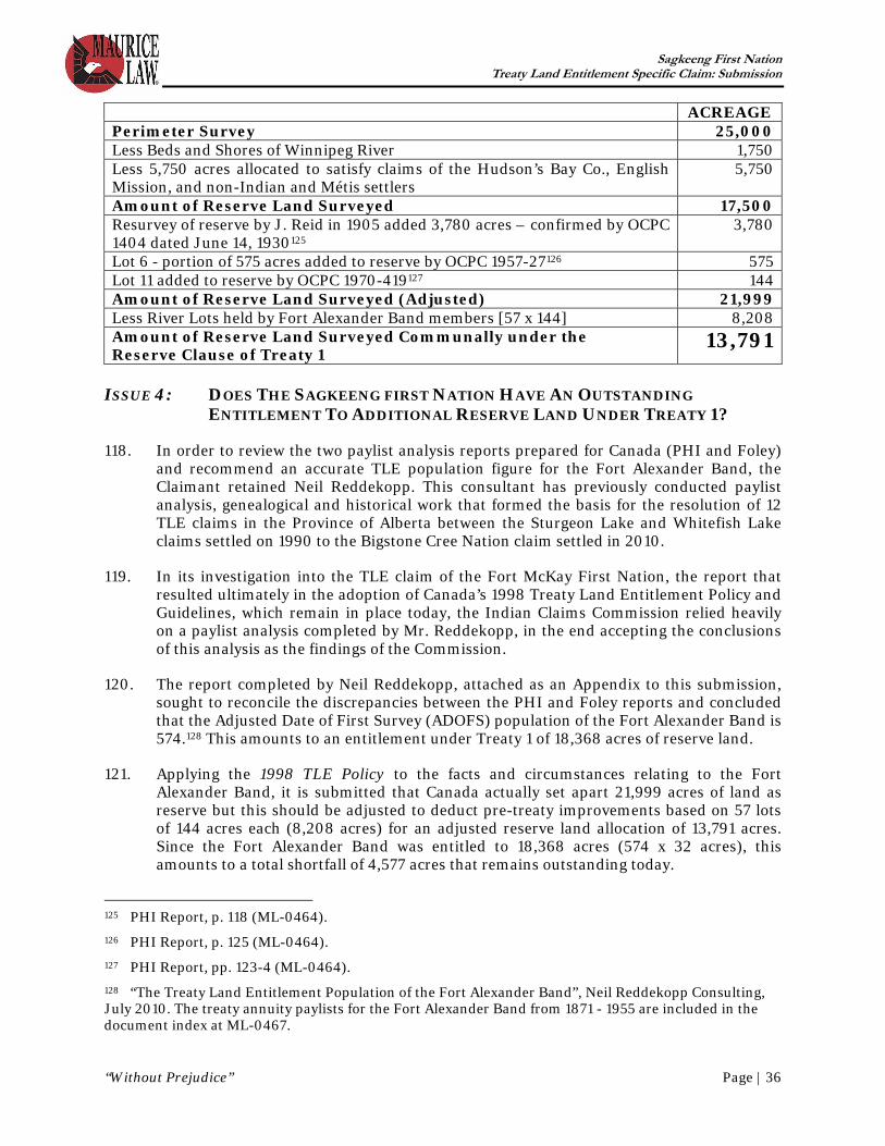
Sagkeeng First Nation Treaty Land Entitlement Specific Claim: Submission
“Without Prejudice” Page | 36
ACREAGE Perimeter Survey 25,000 Less Beds and Shores of Winnipeg River 1,750 Less 5,750 acres allocated to satisfy claims of the Hudson’s Bay Co., English Mission, and non-Indian and Métis settlers
5,750
Amount of Reserve Land Surveyed 17,500 Resurvey of reserve by J. Reid in 1905 added 3,780 acres – confirmed by OCPC 1404 dated June 14, 1930125
3,780
Lot 6 - portion of 575 acres added to reserve by OCPC 1957-27126 575 Lot 11 added to reserve by OCPC 1970-419127 144 Amount of Reserve Land Surveyed (Adjusted) 21,999 Less River Lots held by Fort Alexander Band members [57 x 144] 8,208 Amount of Reserve Land Surveyed Communally under the Reserve Clause of Treaty 1
13,791 ISSUE 4: DOES THE SAGKEENG FIRST NATION HAVE AN OUTSTANDING
ENTITLEMENT TO ADDITIONAL RESERVE LAND UNDER TREATY 1?
118. In order to review the two paylist analysis reports prepared for Canada (PHI and Foley) and recommend an accurate TLE population figure for the Fort Alexander Band, the Claimant retained Neil Reddekopp. This consultant has previously conducted paylist analysis, genealogical and historical work that formed the basis for the resolution of 12 TLE claims in the Province of Alberta between the Sturgeon Lake and Whitefish Lake claims settled on 1990 to the Bigstone Cree Nation claim settled in 2010.
119. In its investigation into the TLE claim of the Fort McKay First Nation, the report that resulted ultimately in the adoption of Canada’s 1998 Treaty Land Entitlement Policy and Guidelines, which remain in place today, the Indian Claims Commission relied heavily on a paylist analysis completed by Mr. Reddekopp, in the end accepting the conclusions of this analysis as the findings of the Commission.
120. The report completed by Neil Reddekopp, attached as an Appendix to this submission, sought to reconcile the discrepancies between the PHI and Foley reports and concluded that the Adjusted Date of First Survey (ADOFS) population of the Fort Alexander Band is 574.128 This amounts to an entitlement under Treaty 1 of 18,368 acres of reserve land.
121. Applying the 1998 TLE Policy to the facts and circumstances relating to the Fort Alexander Band, it is submitted that Canada actually set apart 21,999 acres of land as reserve but this should be adjusted to deduct pre-treaty improvements based on 57 lots of 144 acres each (8,208 acres) for an adjusted reserve land allocation of 13,791 acres. Since the Fort Alexander Band was entitled to 18,368 acres (574 x 32 acres), this amounts to a total shortfall of 4,577 acres that remains outstanding today.
125 PHI Report, p. 118 (ML-0464). 126 PHI Report, p. 125 (ML-0464). 127 PHI Report, pp. 123-4 (ML-0464). 128 “The Treaty Land Entitlement Population of the Fort Alexander Band”, Neil Reddekopp Consulting, July 2010. The treaty annuity paylists for the Fort Alexander Band from 1871 - 1955 are included in the document index at ML-0467.

Sagkeeng First Nation Treaty Land Entitlement Specific Claim: Submission
“Without Prejudice” Page | 37
PART VI – CONCLUSION 122. During the negotiation of Treaty 1, Fort Alexander and the other bands present were
promised that each band would receive reserve land based on a formula of 32 acres per person, exclusive of any land held by individual band members.
123. As the chart set out in paragraph 118 above illustrates, the survey conducted by J W Harris in 1874 and subsequent additions to the reserve provided the Fort Alexander Band with 13,791 acres of communal reserve land, exclusive of 8,208 that either was or should have been set aside for individual members of the Band.
124. The ADOFS population of the Fort Alexander Band was 574, which would have entitled the Fort Alexander Band to 18,368 acres of communal reserve land.
125. As such, the Fort Alexander Band was provided with 4,577 fewer acres of reserve land than it was entitled to receive under the reserve clause of Treaty 1.
126. The Crown has failed to provide the land owed to the Band, thus breaching its legal obligation to provide land under Treaty 1. The Sagkeeng First Nation continues to seek compensation and fulfillment of this breach which remains outstanding to this day.
ALL OF WHICH IS RESPECTFULLY SUBMITTED this 17th day of August, 2010.
MAURICE LAW
__________________________ Ron S. Maurice
Sagkeeng First Nation Treaty Land Entitlement Specific Claim: Submission
“Without Prejudice” Page | 38
LIST OF AUTHORITIES R. v. Taylor and Williams (1981), 1981 Carswell Ont 641, [1981] 3 C.N.L.R. 114, 34 O.R. (2d) 360, 62 C.C.C. (2d) 227 at paras. 18-20 (Ont. CA) leave to appeal dismissed, [1981] 2 S.C.R. xi. Nowegijick v. The Queen [1983] 1 S.C.R. 29 R. v. Badger, [1996] 1 S.C.R. 771 R. v. Marshall, [1999] 3 S.C.R. 456 Lac La Ronge Indian Band v. Canada, 2001 SKCA 109 (Sask. CA) R. v. Sioui, [1990] 1 S.C.R. 1025 Indian Act, S.C. 1876, 39 Victoria, Cap. 18, section 10. Chester Martin: “Dominion Lands” Policy, Lewis H. Thomas, Ed. (Toronto: McClelland and Stewart Limited, 1973) Kirk N. Lambrecht, The Administration of Dominion Lands, 1870-1930 (Winnipeg: Canadian Plains Research Centre, University of Regina, 1991) Thomas Flanagan, Riel and the Rebellion: 1885 reconsidered, 2nd ed. (Toronto: University of Toronto Press, 2000) Manitoba (Attorney General) v. Canada (Attorney General), 1935 CarswellNat 2 at para. 4 (JCPC)

![TLE ANALYSER · TLE ANALYSER User Manual v2.8 TLE analysis ... TLE ANALYSER Version 2.8 - 2013 TLE ANALYSER - User Manual [4] 2. TLE Analyser Setup and Options TLE Updater allow to](https://img.dokumen.tips/doc/110x75/5aa68a5c7f8b9a517d8ea13c/tle-analyser-analyser-user-manual-v28-tle-analysis-tle-analyser-version-28.jpg)