Embed Size (px)
Citation preview

BookletChart™ Saginaw River NOAA Chart 14867
A reduced-scale NOAA nautical chart for small boaters When possible, use the full-size NOAA chart for navigation.
Included Area

2
Published by the National Oceanic and Atmospheric Administration
National Ocean Service Office of Coast Survey
www.NauticalCharts.NOAA.gov 888-990-NOAA
What are Nautical Charts?
Nautical charts are a fundamental tool of marine navigation. They show water depths, obstructions, buoys, other aids to navigation, and much more. The information is shown in a way that promotes safe and efficient navigation. Chart carriage is mandatory on the commercial ships that carry America’s commerce. They are also used on every Navy and Coast Guard ship, fishing and passenger vessels, and are widely carried by recreational boaters.
What is a BookletChart?
This BookletChart is made to help recreational boaters locate themselves on the water. It has been reduced in scale for convenience, but otherwise contains all the information of the full-scale nautical chart. The bar scales have also been reduced, and are accurate when used to measure distances in this BookletChart. See the Note at the bottom of page 5 for the reduction in scale applied to this chart.
Whenever possible, use the official, full scale NOAA nautical chart for navigation. Nautical chart sales agents are listed on the Internet at http://www.NauticalCharts.NOAA.gov.
This BookletChart does NOT fulfill chart carriage requirements for regulated commercial vessels under Titles 33 and 44 of the Code of Federal Regulations.
Notice to Mariners Correction Status
This BookletChart has been updated for chart corrections published in the U.S. Coast Guard Local Notice to Mariners, the National Geospatial Intelligence Agency Weekly Notice to Mariners, and, where applicable, the Canadian Coast Guard Notice to Mariners. Additional chart corrections have been made by NOAA in advance of their publication in a Notice to Mariners. The last Notices to Mariners applied to this chart are listed in the Note at the bottom of page 7. Coast Pilot excerpts are not being corrected.
For latest Coast Pilot excerpt visit the Office of Coast Survey website at http://www.nauticalcharts.noaa.gov/nsd/searchbychart.php?chart=14867.
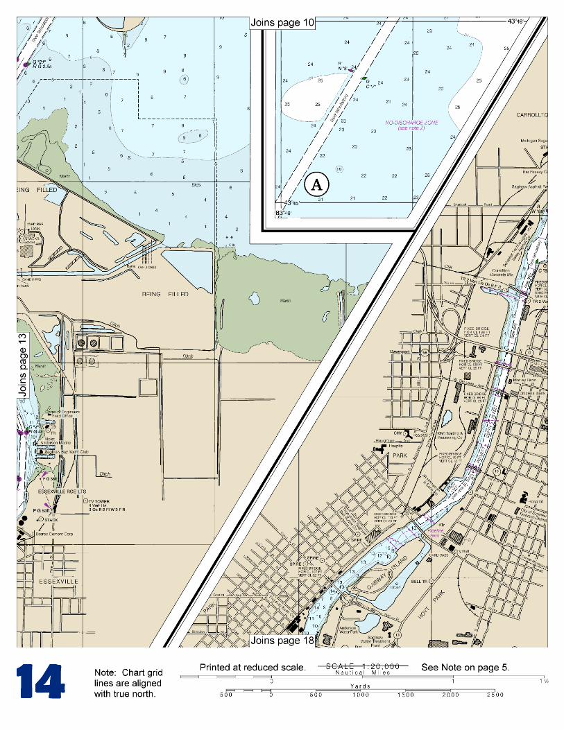
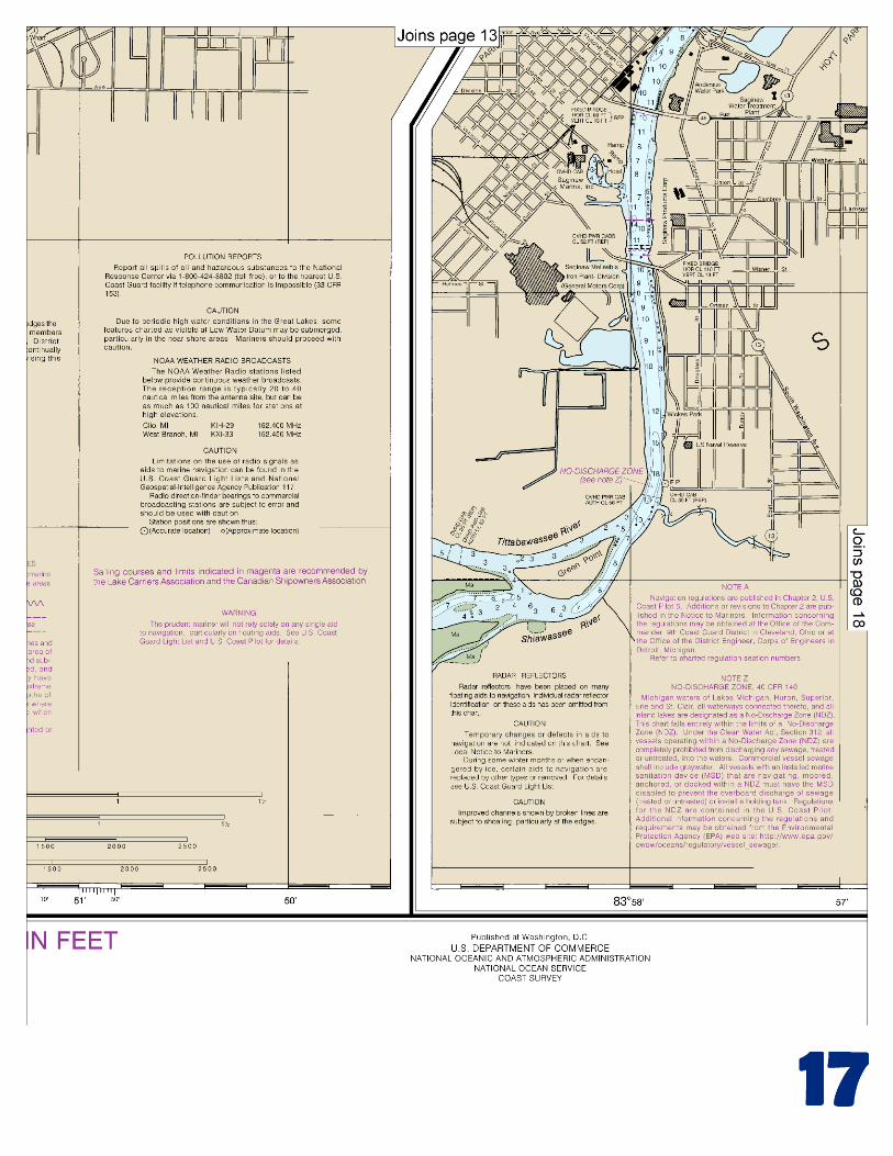
(Selected Excerpts from Coast Pilot) The Saginaw River is formed by the confluence of the Tittabawassee and Shiawassee Rivers at Green Point (43°23.1'N., 83°58.2'W.) at the S limit of the city of Saginaw. The river flows N for 22 miles and empties into the head of Saginaw Bay. The lower 18 miles of the river form a commercial harbor. Grain, chemicals, petroleum products, limestone, coal, sand, gravel, and cement are the major commodities handled at the ports
of Bay City, MI, just above the river mouth, and Saginaw, MI, 19 miles above the river mouth. Other towns on the river are Essexville, MI, on the east side just above the mouth, and Zilwaukee, MI, and Carrollton,
MI, on the west side just below Saginaw. Channels.–A Federal project provides for a dredged entrance channel leading southwest from the deep water in Saginaw Bay for about 13.5 miles to the mouth of the Saginaw River and thence upstream for about 20 miles to the ports of Bay City and Saginaw. The entrance and river channels are well marked by lighted and unlighted buoys. A 211°20' lighted range marks the entrance channel, and a 160° lighted range marks a reach in the lower part of the river. The Federal project depths are 27 feet in the entrance channel to the mouth of the river, thence 26 feet through the mouth, thence 25 feet to the Canadian National Railroad bridge at Bay City, thence 22 feet to the CSX railroad bridge in Saginaw. Four turning basins in the river have project depths as follows: 25 feet at Essexville, 22 feet in Bay City opposite the airport, 20 feet at Carrollton, and 20 feet just below the CSX railroad bridge at Sixth Street in Saginaw. (See Notice to Mariners and latest editions of charts for controlling depths.) A slow-no wake speed is enforced in the Saginaw River. Above the Holland Avenue bridge in Saginaw depths in the river vary from 7 to 15 feet for about 2.8 miles to Green Point. In 1977, it was reported that the Tittabawassee River was navigable by small boats for only about 1.5 miles above Green Point. Above that point stumps, sunken logs, and snags severely obstruct the river. The Shiawassee River, near Green Point, has an available depth of 5 to 6 feet, and the crooked channel across Shiawassee Flats is 15 or 16 feet deep in many places. In 1977, numerous submerged pilings were reported at the mouth of the river in the vicinity of Green Point. Above the flats, the Shiawassee River is very narrow and crooked, but is navigable for small boats to the junction with Bad River, and thence the Bad River to the village of St. Charles, 13 miles from Green Point. A highway bridge with a 19-foot fixed span and a clearance of 8½ feet crosses Shiawassee River about 6.7 miles above the mouth. The Cass River and Flint River, tributaries of the Shiawassee, are navigable by rowboats to a limited extent, being greatly obstructed by sunken logs and snags. An irregularly shaped diked disposal area is on the east side of the entrance channel to the Saginaw River about 1 mile northeast of the mouth. The former dredged approach to the Saginaw River leads N from the mouth to deep water in Saginaw Bay. The channel, with a least depth of about 13, is unmarked and no longer maintained. Quarantine, customs, immigration, and agricultural quarantine.–(See chapter 3, Vessel Arrival Inspections, and appendix for addresses.) Quarantine is enforced in accordance with the regulations of the U.S. Public Health Service. (See Public Health Service, chapter 1.) Saginaw-Bay City is a customs port of entry. The Kawkawlin River, emptying into Saginaw Bay about 2 miles northwest of the mouth of the Saginaw River, is entered by a dredged channel that leads just inside the mouth. In 1998, the controlling depth was 2½ feet (4½ feet midchannel) to the mouth of the river. Continually changing conditions have been reported at the mouth and the approach channel is marked by buoys that are shifted to mark the best water. An overhead power cable with a clearance of 51 feet crosses the river about 0.3 mile above the entrance. In 1989, bridge ruins were reported about 0.7 mile above the entrance. A fixed highway bridge 0.2 mile further upstream has a reported clearance of 10 feet. A slow-no wake speed is enforced on the river.
U.S. Coast Guard Rescue Coordination Center 24 hour Regional Contact for Emergencies
RCC Cleveland Commander
9th CG District (216) 902-6117 Cleveland, OH

G
NOAA’s navigation managers serve as ambassadors to the maritime community. They help identify navigational challenges facing professional and recreational mariners, and provide NOAA resources and information for safe navigation. For additional information, please visit nauticalcharts.noaa.gov/service/navmanagers
To make suggestions or ask questions online, go to nauticalcharts.noaa.gov/inquiry. To report a chart discrepancy, please use ocsdata.ncd.noaa.gov/idrs/discrepancy.aspx.
Lateral System As Seen Entering From Seaward on navigable waters except Western Rivers
PORT SIDE
ODD NUMBERED AIDS
GREEN LIGHT ONLY
FLASHING (2)
PREFERRED CHANNEL
NO NUMBERS – MAY BE LETTERED
PREFERRED CHANNEL TO
STARBOARD
TOPMOST BAND GREEN
PREFERRED CHANNEL
NO NUMBERS – MAY BE LETTERED
PREFERRED CHANNEL
TO PORT
TOPMOST BAND RED
STARBOARD SIDE
EVEN NUMBERED AIDS
RED LIGHT ONLY
FLASHING (2)
FLASHING FLASHING
OCCULTING GREEN LIGHT ONLY RED LIGHT ONLY OCCULTING QUICK FLASHING QUICK FLASHING
ISO COMPOSITE GROUP FLASHING (2+1) COMPOSITE GROUP FLASHING (2+1) ISO
"1"
Fl G 6s
G "9"
Fl G 4s
GR "A"
Fl (2+1) G 6s
RG "B"
Fl (2+1) R 6s
"2"
Fl R 6s
8
R "8"
Fl R 4s
LIGHT
G
C "1"
LIGHTED BUOY
G
"5"
GR
"U"
GR
C "S"
RG
N "C"
RG
"G"
LIGHT
6
R
N "6"
LIGHTED BUOY
R
"2
"
CAN DAYBEACON
CAN NUN NUN
DAYBEACON
For more information on aids to navigation, including those on Western Rivers, please consult the latest USCG Light List for your area.
These volumes are available online at http://www.navcen.uscg.gov
Navigation Managers Area of Responsibility
Northeast
Lt. Meghan McGovern
Northwest and
Pacific Islands
Crescent Moegling
Great Lakes Region
Tom Loeper
Chesapeake and
Delaware Bay
Steve Soherr
California
Jeff Ferguson
[email protected] Mid-Atlantic
Lt. Ryan Wartick
Alaska
Lt. Timothy M. Smith
Western Gulf Coast
Alan Bunn
Central Gulf Coast
Tim Osborn
[email protected] South Florida
Puerto Rico
U.S. Virgin Islands
Michael Henderson
Southeast
Kyle Ward
2
2 C U 5
1


VHF Marine Radio channels for use on the waterways:Channel 6 – Inter-ship safety communications.Channel 9 – Communications between boats and ship-to-coast.Channel 13 – Navigation purposes at bridges, locks, and harbors.Channel 16 – Emergency, distress and safety calls to Coast Guard and others, and to initiate calls to other
vessels. Contact the other vessel, agree to another channel, and then switch.Channel 22A – Calls between the Coast Guard and the public. Severe weather warnings, hazards to navigation and safety warnings are broadcast here.Channels 68, 69, 71, 72 and 78A – Recreational boat channels.
Getting and Giving Help — Signal other boaters using visual distress signals (flares, orange flag, lights, arm signals); whistles; horns; and on your VHF radio. You are required by law to help boaters in trouble. Respond to distress signals, but do not endanger yourself.
EMERGENCY INFORMATION
Distress Call Procedures
• Make sure radio is on.• Select Channel 16.• Press/Hold the transmit button.• Clearly say: “MAYDAY, MAYDAY, MAYDAY.”• Also give: Vessel Name and/or Description;Position and/or Location; Nature of Emergency; Number of People on Board.• Release transmit button.• Wait for 10 seconds — If no responseRepeat MAYDAY call.
HAVE ALL PERSONS PUT ON LIFE JACKETS!
This Booklet chart has been designed for duplex printing (printed on front and back of one sheet). If a duplex option is not available on your printer, you may print each sheet and arrange them back-to-back to allow for the proper layout when viewing.
QR
Quick ReferencesNautical chart related products and information - http://www.nauticalcharts.noaa.gov
Interactive chart catalog - http://www.charts.noaa.gov/InteractiveCatalog/nrnc.shtmlReport a chart discrepancy - http://ocsdata.ncd.noaa.gov/idrs/discrepancy.aspx
Chart and chart related inquiries and comments - http://ocsdata.ncd.noaa.gov/idrs/inquiry.aspx?frompage=ContactUs
Chart updates (LNM and NM corrections) - http://www.nauticalcharts.noaa.gov/mcd/updates/LNM_NM.html
Coast Pilot online - http://www.nauticalcharts.noaa.gov/nsd/cpdownload.htm
Tides and Currents - http://tidesandcurrents.noaa.gov
Marine Forecasts - http://www.nws.noaa.gov/om/marine/home.htm
National Data Buoy Center - http://www.ndbc.noaa.gov/
NowCoast web portal for coastal conditions - http://www.nowcoast.noaa.gov/
National Weather Service - http://www.weather.gov/
National Hurrican Center - http://www.nhc.noaa.gov/
Pacific Tsunami Warning Center - http://ptwc.weather.gov/
Contact Us - http://www.nauticalcharts.noaa.gov/staff/contact.htm
NOAA’s Office of Coast Survey The Nation’s Chartmaker
For the latest news from Coast Survey, follow @NOAAcharts
NOAA Weather Radio All Hazards (NWR) is a nationwide network of radio stations broadcasting continuous weather information directly from the nearest National Weather Service office. NWR broadcasts official Weather Service warnings, watches, forecasts and other hazard information 24 hours a day, 7 days a week. http://www.nws.noaa.gov/nwr/