Embed Size (px)
Citation preview
S5P Mission Performance Centre Sulphur Dioxide [L2__SO2____] Readme
document number S5P-MPC-BIRA-PRF-SO2 issue 2.0 date 2020-07-16 product version V02.01.03 status Released
Prepared by N. Theys (BIRA-IASB), F. Romahn (DLR) T. Wagner (MPIC),
MPC Product Lead MPC ESL-L2 Processor Lead MPC VAL Product Coordinator
Reviewed by J.-C. Lambert (BIRA-IASB), D. Loyola (DLR), J. P. Veefkind (KNMI)
MPC ESL-VAL Lead MPC ESL-L2 Lead MPC Technical Manager
Approved by A. Dehn (ESA), C. Zehner (ESA)
ESA Data Quality Manager ESA Mission Manager

S5P MPC Product Readme SO2 V02.01.03 S5P-MPC-BIRA-PRF-SO2 issue 2.0, 2020-07-16 - Released Page 2 of 16
MPC Contributors
J.-C. Lambert (BIRA-IASB) N. Theys (BIRA-IASB) P. Hedelt (DLR) S. Warnach (MPIC) S. Beirle (MPIC) L. Saavedra de Miguel (ESA/Serco)
MPC ESL-VAL Lead MPC ESL-L2 Product Coordinator MPC ESL-L2 Processor Contributor MPC contributor MPC contributor ESA S5p Mission Support
S5PVT Contributors
C. Li, N. Krotkov, H. Selkirk (NASA) V. Fioletov C. McLinden (ECCC) S. Arellano, B. Galle (Chalmers), M. Burton (Univ. Manchester) G. Pinardi, F. Hendrick (BIRA-IASB)
S5PVT, Project 28329 S5PVT, Project 28536 S5PVT, Project 41727 S5PVT, Project 28607
Signatures
MPC Product Lead / PRF Lead Editor
Angelika Dehn (ESA), Data Quality Manager Claus Zehner (ESA), Sentinel-5 Precursor Mission Manager
S5P MPC Product Readme SO2 V02.01.03 S5P-MPC-BIRA-PRF-SO2 issue 2.0, 2020-07-16 - Released Page 3 of 16
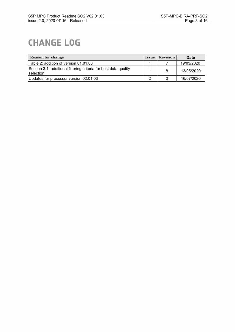
Reason for change Issue Revision Date Table 2: addition of version 01.01.08 1 7 19/03/2020 Section 3.1: additional filtering criteria for best data quality selection
1 8 13/05/2020
Updates for processor version 02.01.03 2 0 16/07/2020

S5P MPC Product Readme SO2 V02.01.03 S5P-MPC-BIRA-PRF-SO2 issue 2.0, 2020-07-16 - Released Page 4 of 16 1 Summary This is the Product Readme File (PRF) for the Copernicus Sentinel 5 Precursor Tropospheric Monitoring Instrument (S5P/TROPOMI) sulfur dioxide Level 2 data product and is applicable for the Near Real Time (NRTI) and Offline (OFFL) timeliness products.
Product Identifier: L2__SO2____
Example filename: S5P_NRTI_L2__SO2____20190811T234126_20190811T234626_09471_01_020103_20200705T032441.nc
S5P_OFFL_L2__SO2____20190729T031023_20190729T045350_09275_01_020103_20200520T191442.nc
The OFFL product has the following Digital Object Identifier (DOI): https://doi.org/10.5270/S5P-74eidii
The Readme file describes the current processing baseline, product and quality limitations, and product availability status. More information on this data product is available from the Sentinel product webpage:
https://sentinels.copernicus.eu/web/sentinel/technical-guides/sentinel-5p/products-algorithms,
and from the TROPOMI product webpage http://www.tropomi.eu/data-products.
The data file contains the sulfurdioxide_total_vertical_column� which gives the total atmospheric column between the surface and the top of troposphere, and sulfurdioxide_total_vertical_column_{1,7,15} km which are total SO2 columns assuming 1km thick box profiles at ground level, centered at 7km and at 15km a.s.l. The respective random error originating from the spectral fit is provided in the sulfurdioxide_total_vertical_column_precision and systematic error in the field sulfurdioxide_total_vertical_column_trueness. Similarly, random and systematic error estimates are also provided for the SO2 columns for the assumed box profiles. As a user guideline for the data quality a qa_value is given with the data and is applicable only to sulfurdioxide_total_vertical_column. In order to avoid misinterpretation of the data quality, it is recommended at the current stage to only use those pixels with a qa_value above 0.5. For best data quality selection users are recommended to follow more stringent criteria, as listed in section 3.1.
Note that the SO2 data product may be used in different ways, and different fields in the file are relevant depending on the application. For this we refer to the product user manual [RD03]. The averaging kernels are provided and should be used for e.g. comparisons with models or profile measurements. Independent validation by S5p Mission Performance Centre (MPC) Cal/Val experts and the Sentinel-5 Precursor Validation Team (S5PVT) concludes that the version 1.x.x of the NRTI / OFFL SO2 data is compliant with the requirements as defined in the S5p Calibration and Validation Plan [RD01], see Table 1. The quality of the processor version 2.x.x has been assessed on a dedicated Test Data Set.
Parameter Data product Vertical Resolution Bias Random
SO2 SO2 enhanced Total column 30% 0.3 DU
SO2 Total SO2 Total column 50% 3 DU
Table 1: SO2 data product requirement extracted from the S5p Calibration and Validation Plan [RD01]. “SO2 enhanced” refers to volcanic plume in the Upper-Troposphere/ Lower-Stratosphere while “Total SO2” stands for planetary boundary layer case (pollution scenario). 1 DU equals 2.69 x 10¹⁶ molecules/cm²

S5P MPC Product Readme SO2 V02.01.03 S5P-MPC-BIRA-PRF-SO2 issue 2.0, 2020-07-16 - Released Page 5 of 16 Up to date validation results are available in the Routine Operations Consolidated Validation Reports (ROCVR) that are accessible through the MPC Validation Data Analysis Facility (VDAF) website at http://mpc-vdaf.tropomi.eu. The ROCVR reports are issued quarterly, and reports released after July 2020 include validation results based on processor version 2.x.x.
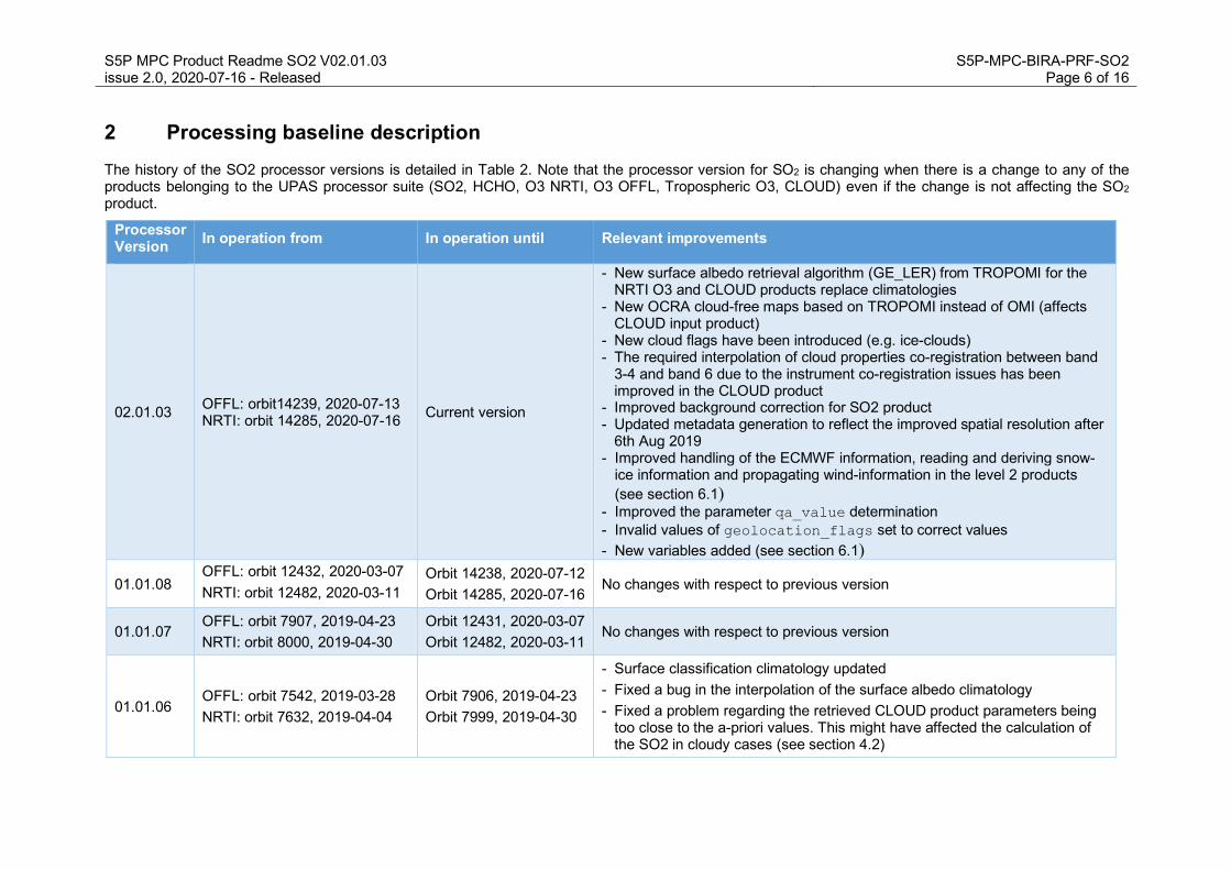
S5P MPC Product Readme SO2 V02.01.03 S5P-MPC-BIRA-PRF-SO2 issue 2.0, 2020-07-16 - Released Page 6 of 16 2 Processing baseline description The history of the SO2 processor versions is detailed in Table 2. Note that the processor version for SO2 is changing when there is a change to any of the products belonging to the UPAS processor suite (SO2, HCHO, O3 NRTI, O3 OFFL, Tropospheric O3, CLOUD) even if the change is not affecting the SO2 product.
Processor Version In operation from In operation until Relevant improvements
02.01.03 OFFL: orbit14239, 2020-07-13 NRTI: orbit 14285, 2020-07-16 Current version
- New surface albedo retrieval algorithm (GE_LER) from TROPOMI for the NRTI O3 and CLOUD products replace climatologies
- New OCRA cloud-free maps based on TROPOMI instead of OMI (affects CLOUD input product)
- New cloud flags have been introduced (e.g. ice-clouds) - The required interpolation of cloud properties co-registration between band
3-4 and band 6 due to the instrument co-registration issues has been improved in the CLOUD product
- Improved background correction for SO2 product - Updated metadata generation to reflect the improved spatial resolution after
6th Aug 2019 - Improved handling of the ECMWF information, reading and deriving snow-
ice information and propagating wind-information in the level 2 products (see section 6.1)
- Improved the parameter qa_value determination - Invalid values of geolocation_flags set to correct values - New variables added (see section 6.1)
01.01.08 OFFL: orbit 12432, 2020-03-07 NRTI: orbit 12482, 2020-03-11
Orbit 14238, 2020-07-12 Orbit 14285, 2020-07-16
No changes with respect to previous version
01.01.07 OFFL: orbit 7907, 2019-04-23 NRTI: orbit 8000, 2019-04-30
Orbit 12431, 2020-03-07 Orbit 12482, 2020-03-11
No changes with respect to previous version
01.01.06 OFFL: orbit 7542, 2019-03-28 NRTI: orbit 7632, 2019-04-04
Orbit 7906, 2019-04-23 Orbit 7999, 2019-04-30
- Surface classification climatology updated - Fixed a bug in the interpolation of the surface albedo climatology - Fixed a problem regarding the retrieved CLOUD product parameters being
too close to the a-priori values. This might have affected the calculation of the SO2 in cloudy cases (see section 4.2)

S5P MPC Product Readme SO2 V02.01.03 S5P-MPC-BIRA-PRF-SO2 issue 2.0, 2020-07-16 - Released Page 7 of 16
01.01.05 RPRO: orbit 2903, 2018-05-06 OFFL: orbit 5833, 2018-11-28 NRTI: orbit 5932, 2018-12-05
Orbit 5832, 2018-11-28 Orbit 7541, 2019-03-28 Orbit 7631, 2019-04-04
Alignment of the configuration for NRTI, OFFL and RPRO chains regarding the Chemistry Transport Model (TM5) input, leading to the same product quality (see section 4.2)
01.01.02 NRTI: orbit 5003, 2018-10-01 Orbit 5929, 2018-12-05 Initial operational version
Table 2: History of SO2 processor versions

S5P MPC Product Readme SO2 V02.01.03 S5P-MPC-BIRA-PRF-SO2 issue 2.0, 2020-07-16 - Released Page 8 of 16 3 Product Quality
3.1 Recommendations for data usage The quality of the observations depends on many factors which are taken into account in the definition of the qa_value. While it is a handy way of filtering observations of low quality, the “quality assurance value” should also be considered with caution, as it is a compromise to take into account several aspects, such as: processing errors, presence of clouds or snow/ice, observations affected by sun glint, South Atlantic Anomaly, possible contamination by volcanic SO2, absence of background correction, and important variables out of range (i.e. the Air Mass Factor (AMF)).
The qa_value is a continuous variable, ranging from 0 (error) to 1 (good quality).
• For data Version 1.x.x: In order to avoid misinterpretation of the data quality, it is recommended to only use those TROPOMI pixels associated with a qa_value�above 0.5. For best data quality selection users are recommended to follow more stringent criteria, as listed here below:
1. snow_ice_flag < 0.5 2. sulfurdioxide_total_air_mass_factor_polluted > 0.1 3. sulfurdioxide_total_vertical_column > -0.001 mol. m-2. 4. qa_value > 0.5 5. cloud_fraction_crb < 0.3 6. solar_zenith_angle < 60°
• For data Version 2.x.x onwards: the qa_value�has been adjusted as to reflect the selection
criteria listed above (for V1.x.x) and can be used without any additional selection criteria. Therefore, users are recommended to use TROPOMI pixels associated with a qa_value�above 0.5.
Please note that qa_value applies only to sulfurdioxide_total_vertical_column (anthropogenic SO2). The L2 SO2 product also includes volcanic SO2 products for prescribed SO2 plume heights at 1, 7, 15 km (sulfurdioxide_total_vertical_column_{1,7,15}km), relevant in case of volcanic emissions. In that case, the only filtering criteria needed is SZA < 70°.
The parameter sulfurdioxide_detection_flag can be used to distinguish between volcanic and anthropogenic SO2.
For further details, data users are encouraged to read the Product User Manual (PUM) [RD03] and Algorithm Theoretical Basis Document (ATBD) [RD02] associated with this data product, all available on https://sentinels.copernicus.eu/web/sentinel/technical-guides/sentinel-5p/products-algorithms.
3.2 Validation results Independent validation by S5p Mission Performance Centre (MPC) Cal/Val experts and the Sentinel-5 Precursor Validation Team (S5PVT) concludes that the version 1.x.x of the NRTI / OFFL SO2 data is in overall agreement with (i) reference measurements collected from global ground-based networks, SO2 sondes and (ii) the corresponding satellite data products from OMI and OMPS, and (iii) is compliant with the requirements as defined in Table 1. In particular, validation results indicate that S5p SO2 product agree within 50% with correlative data for pollution scenario (and lower tropospheric SO2 in general). For the Upper Troposphere and Lower Stratosphere (UTLS) SO2, satellite-satellite comparisons reveal that S5p SO2 product agree with other satellite data within 5% in the 85% of the cases. The validation exercise also indicates that the validation results are consistent with the target random errors.
Up to date validation results are available in the ROCVR reports that are accessible through the MPC VDAF website at http://mpc-vdaf.tropomi.eu. They are issued quarterly and reports released after July 2020 include validation results based on processor version 2.x.x.
S5P MPC Product Readme SO2 V02.01.03 S5P-MPC-BIRA-PRF-SO2 issue 2.0, 2020-07-16 - Released Page 9 of 16 4 Data Quality Remarks
4.1 Known Data Quality Issues Currently, the following data quality issues are known, not covered by the quality flags, and should be kept in mind when looking at the SO2 product itself and also at validation results. Several of the issues listed below will be addressed in next processor versions (as part of the algorithm evolution).
Bands 3-4 and 6 spatial miss-alignment
The band 3-4 (450 pixels per scanline) footprints are not fully aligned with the band 6 (448 pixels per scanline) footprints. In the worst case, the misalignment can be in the order of half a ground pixel. The OCRA algorithm retrieves the cloud fraction at bands 3 and 4 and interpolates it linearly, according to the covered area, to band 6. This is an a priori to ROCINN algorithm which works in band 6. Over heterogeneous scenes the mis-registration might have a large impact on the data quality. The cloud height and optical thickness retrieved in band 6 are interpolated back to the band 3 footprints. Due to missing overlap with the band 6 footprints, the first pixel in band 3 (no overlap) does not contain cloud data and the second pixel in band 3 (only partial overlap), contains cloud products with reduced quality. This is also reflected in the cloud data qa_value.
Saturation
Some TROPOMI pixels might be affected by saturation (though mostly outside of SO2 fitting windows). Those pixels are flagged and their quality is reflected in the qa_value. Nevertheless, in the vicinity of saturated pixels there might be pixels also affected by saturation due to the so-called blooming effect. The blooming effect is planned to be corrected for in the future update of the level 1b processor. These pixels cannot be explicitly determined and flagged. In such cases the SO2 column values can be affected rather indirectly (e.g. via the cloud parameters).
SCD background (BG) correction and reference spectra selection
The retrieved SO2 SCDs are corrected for possible bias by a so-called background correction (BG). The SCD correction is calculated by linear interpolation of correction matrices which are updated every day and are based on measurements performed over the last four days (moving averages). In case of data gaps or interruptions, the BG matrices can be insufficiently populated and the correction can be uncertain or no correction is applied at all.
The reference radiance spectra selection used for the spectral fitting follows the same logic as BG. If no reference spectrum can be found, a solar spectrum closest in time is used instead. In this case the global file attribute Status_reference_spectrum is set to ‘solar’ (instead of ‘earth’). This can cause inconsistencies in the data and in the calculation of BG matrices which in turn affects the accuracy of the data (bias). A-priori profiles from TM5 model
The current version of the TM5 Chemistry Transport Model (CTM) does not include SO2 emissions over the large hotspot region of Norilsk, Siberia. Consequently, the SO2 columns are likely underestimated over Norilsk for low albedo conditions.
Surface albedo climatology
The current surface albedo climatology has a spatial resolution of 0.5° x 0.5°, and a time resolution of 1 month. This resolution is known to be too coarse compared to the much higher spatial resolution of S5p TROPOMI pixels. This has an impact on the accuracy of the SO2 vertical column (mostly for the polluted scenario) through the AMF calculation. It is currently difficult to assess the exact impact on the SO2 vertical column and it can only be evaluated when a higher resolution albedo climatology becomes available.

S5P MPC Product Readme SO2 V02.01.03 S5P-MPC-BIRA-PRF-SO2 issue 2.0, 2020-07-16 - Released Page 10 of 16 Metadata values exchanged
The global attributes geospatial_lon_min and geospatial_lon_max values are exchanged; therefore, the user is advised to switch the values for these fields, making note that the geospatial_lat_min and geospatial_lat_max values are correct. This is an issue traceable to L1b data (version 01.00.00) and is corrected in the following versions of the Level 1B processor.
Negative Vertical Column Density values
Because of noise on the data, negative vertical column values are often observed in particular over clean regions or for low SO2 emissions. It is recommended not to filter these values except for outliers, i.e. for vertical columns lower than -0.001 mol. m-2.
Positive offsets
Local offsets not completely corrected by the Background Correction module, may arise in certain regions. For emission estimates this is a potential source of uncertainty and might require the application of a local bias correction.
4.2 Solved Data Quality Issues
A-priori profiles from TM5 model (solved in version 01.01.05)
The NRTI and OFFL processing use TM5 data for the same time period but from slightly different model settings (e.g. meteorological input data). This is expected and can lead to small differences between NRTI and OFFL sulfurdioxide_total_vertical_column (less than 10% in more than 90% of the cases). Most of the discrepancy between NRTI and OFFL is for the last orbit of the day, due to the calendar day change. This issue was not critical, as it happened over the Pacific (with no significant anthropogenic SO2 sources), and was solved with version 01.01.05 (see Table 2).
Orbit numbering in NRTI and OFFL (solved in version 01.01.05)
Note that NRTI orbit numbers are set with respect to the downlink orbit while OFFL orbit numbers are set with respect to the equator crossing time. This creates an inconsistency between the NRTI and OFFL orbit numbers which is removed with the activation of processor version 01.01.05 (see Table 2).
Cloud product (solved in version 01.01.06) The SO2 AMF calculation is based on the NRT ozone total column and CLOUD level 2 data. Therefore, quality issues of the total column and CLOUD datasets affect the SO2 data. The total ozone retrieval as well as the SO2 retrieval use the Cloud as a Reflecting Boundary (CRB) cloud model. In some rare cases the CRB cloud algorithm (in the versions 01.01.05 and before) converges towards the a-priori cloud top height of 3.8 km. This might affect the calculation of the SO2 column in cloudy cases. The issue was solved in version 01.01.06 of the CLOUD product (see Table 2).
Contamination of reference sector by volcanic eruption (solved in version 02.01.03)
Occasionally, the reference spectrum can also be contaminated by volcanic SO2 if a volcanic plume is being transported in the geographical region used to select reference spectra (the equatorial Pacific). This leads to a negative bias on SO2 which is not compensated immediately by BG. Since version 02.01.03, another zone is selected in case the reference sector is contaminated by a volcanic eruption.

S5P MPC Product Readme SO2 V02.01.03 S5P-MPC-BIRA-PRF-SO2 issue 2.0, 2020-07-16 - Released Page 11 of 16 Detection of errors during BG calculation (solved in version 02.01.03)
The global file attribute status_BG indicates whether the BG correction is ‘nominal’ or ‘fallback’. In case of the ‘fallback’ status no background correction is performed, and a solar reference spectrum is used for the spectral fitting. Note that the status_BG attribute only provides information whether a valid background correction file has been found during the operational retrieval and not whether the BG values are valid, i.e. in case of problems during the generation of the SCD background correction values, the background file can still be valid (status_BG =’nominal’) when the reference radiance spectrum was successfully generated and stored, since the attribute only indicates that a valid BG file was present. Hence errors occurring during the first part (SCD background calculation) are currently not detected. This will be part of an upcoming product update.
Swath edges (solved in version 02.01.03)
High scatter / outliers are observed for large viewing angle which are not always properly accounted for in the qa_value.
Snow-ice scenes (solved in version 02.01.03)
The snow-ice scenes are filtered out using a qa_value� above 0.5 but the current algorithm is processing the data anyway. A proper treatment of snow-ice scenes is not part of the current algorithm version, and climatological values for the surface albedo are used for the AMF calculation. Therefore, the resulting VCDs are largely overestimated and the data should not be used. A next algorithm version will include a better treatment of snow-ice scenes in the AMF calculation.
Metadata/Attributes (solved in version 02.01.03)
The spatial resolution of the TROPOMI measurements is improved by bringing the along track ground pixel size from 7.0 to 5.5 km2 starting on 6th August 2019. Note that, after this operations change, the metadata/Attributes fields related to the spatial resolution, remained unchanged (hence not aligned to the improved resolution).
Sulfur dioxide detection flag (solved)
The description of the flag sulfurdioxide_detection_flag is not correct within the product metadata/attributes. The correct description can be found in the PUM [RD03] and in the ATBD [RD02] documents. This discrepancy is corrected for products produced since NRTI orbit 5336 (24-OCT-2018) and OFFL orbit 5236 (17-OCT-2018).
4.3 Data Features This section describes some characteristics of the data that might seem anomalous, however they are physically correct and not related to any problem.
Pixel geolocation around North Pole (feature)
The solar irradiance is measured on a daily basis over the North Pole at a reference azimuth angle to remove seasonal effects on the measurements. To this end, a yaw manoeuvre is executed when the instrument is still in radiance mode, causing possible distortion on the scanlines observed during this manoeuvre (i.e. crossing scanlines, "bow-tie" ground pixel shape instead of rectangular). This occurs at most during the last 26 seconds of radiance measurements in few orbits (7-9 per week). Though this may seem anomalous, it is physically correct, and not related to any problem on the data geolocation.
4.4 Mission Operations Change A change in the Copernicus Sentinel 5P operations scenario, increasing the spatial resolution from 7.0 km to 5.5 km along track for all measurements, became operational starting from 6 August 2019, orbit 9388.

S5P MPC Product Readme SO2 V02.01.03 S5P-MPC-BIRA-PRF-SO2 issue 2.0, 2020-07-16 - Released Page 12 of 16 5 Algorithm Change Record
For a detailed description of the L2__SO2____ algorithms, please refer to the ATBD [RD02].

S5P MPC Product Readme SO2 V02.01.03 S5P-MPC-BIRA-PRF-SO2 issue 2.0, 2020-07-16 - Released Page 13 of 16 6 Data Format
The product is stored as NetCDF4 file. The NetCDF4 file contains both the data and the metadata for the product.
For OFFL data the product is stored as a single file per satellite orbit, for NRTI data the product is stored as multiple files per orbit.
Please note that consecutive data granules of the NRTI product show an overlap of about 12 scan lines.
Details of the data format are provided in the PUM [RD03].
6.1 Data format changes
6.1.1 New variables
/PRODUCT/SUPPORT_DATA/INPUT_DATA/northward_wind /PRODUCT/SUPPORT_DATA/INPUT_DATA/eastward_wind /PRODUCT/SUPPORT_DATA/INPUT_DATA/sea_ice_cover /PRODUCT/SUPPORT_DATA/INPUT_DATA/snow_cover /PRODUCT/SUPPORT_DATA/INPUT_DATA/tm5_tropopause_layer_index
S5P MPC Product Readme SO2 V02.01.03 S5P-MPC-BIRA-PRF-SO2 issue 2.0, 2020-07-16 - Released Page 14 of 16 7 Product Availability
The S5p SO2 data are available at https://scihub.copernicus.eu.
More information on this data product and data handling tools are available from the product web page under heading ‘Tools’: http://www.tropomi.eu/data-products.
For further questions regarding S5p/TROPOMI data products please contact [email protected].
The access and use of any Copernicus Sentinel data available through the Copernicus Sentinel Data Hub is governed by the Legal Notice on the use of Copernicus Sentinel Data and Service Information and is given here:
https://sentinels.copernicus.eu/documents/247904/690755/Sentinel_Data_Legal_Notice.
S5P MPC Product Readme SO2 V02.01.03 S5P-MPC-BIRA-PRF-SO2 issue 2.0, 2020-07-16 - Released Page 15 of 16 8 References
[RD01] Sentinel-5 Precursor Calibration and Validation Plan for the Operational Phase source: ESA; ref: ESA-EOPG-CSCOP-PL-0073; url: https://sentinel.esa.int/documents/247904/2474724/Sentinel-5P-Calibration-and-Validation-Plan.pdf
[RD02] Sentinel-5 precursor/TROPOMI Level 2 Algorithm Theoretical Basis Document Sulphur Dioxide SO2 source: BIRA-IASB; ref: S5P-BIRA-L2-400E-ATBD; url: http://www.tropomi.eu/documents/atbd
[RD03] Sentinel-5 precursor/TROPOMI Level 2 Product User Manual Sulphur Dioxide SO2 source: DLR; ref: S5P-L2-DLR-PUM-400E;
url: http://www.tropomi.eu/documents/pum
More information on this data product is available from the Sentinel product webpage:
https://sentinels.copernicus.eu/web/sentinel/technical-guides/sentinel-5p/products-algorithms,
and from the corresponding TROPOMI product webpage http://www.tropomi.eu/data-products.

S5P MPC Product Readme SO2 V02.01.03 S5P-MPC-BIRA-PRF-SO2 issue 2.0, 2020-07-16 - Released Page 16 of 16 Abbreviations and acronyms
(A)AI (Absorbing) Aerosol Index AMF Air Mass Factor ATBD Algorithm Theoretical Basis Document AVS Automated Validation Server BG Background BIRA-IASB Royal Belgian Institute for Space Aeronomy CF Cloud Fraction (fractional cloud cover) CTM Chemical Transport Model DLR German Aerospace Center / Deutsches Zentrum für Luft- und Raumfahrt DOAS Differential Optical Absorption Spectroscopy DOI Digital Object Identifier DU Dobson Unit (1 DU: 2.69 x 10¹⁶ molec/cm²) ESA European Space Agency ESL Expert Support Laboratory EUMETSAT European Organisation for the Exploitation of Meteorological Satellites FRM Fiducial Reference Measurement KNMI Royal Netherlands Meteorological Institute / Koninklijk Nederlands
Meteorologisch Instituut MAX-DOAS Multi Axis Differential Optical Absorption Spectroscopy MPC Mission Performance Centre NASA National Aeronautics and Space Administration OMI Ozone Monitoring Instrument OMPS Ozone Mapper and Profiling Suite PRF Product Readme File PUM Product User Manual QWG Quality Working Group ROCVR Routine Operations Consolidated Validation Report S5P Sentinel-5 Precursor S5PVT Sentinel-5 Precursor Validation Team Suomi NPP Suomi National Polar-orbiting Partnership TROPOMI Tropospheric Monitoring Instrument UTLS Upper Troposphere and Lower Stratosphere VCD Vertical Column Density VDAF Validation Data Analysis Facility


![S5P Mission Performance Centre Methane [L2 CH4 ] Readme · 2019-09-25 · S5P Mission Performance Centre Methane [L2__CH4___] Readme document number S5P-MPC-SRON-PRF-CH4 Issue 1.2](https://img.dokumen.tips/doc/110x75/5e5ba7bee692361c8466afa3/s5p-mission-performance-centre-methane-l2-ch4-2019-09-25-s5p-mission-performance.jpg)


![Na+[Me3NB12Cl11]−·SO2: a rare example of a sodium–SO2 …](https://img.dokumen.tips/doc/110x75/62610a45e6160445a625631b/name3nb12cl11so2-a-rare-example-of-a-sodiumso2-.jpg)