Embed Size (px)
Citation preview

Russley Road/Memorial Avenue - Land Use Study Russley Road/Memorial Avenue Burnside Christchurch Client: Memorial Avenue Investments Limited (MAIL)
TelferYoung (Canterbury) Limited

TelferYoung (Canterbury) Limited
CHCH OFFICE - Level 1, Beatson House, 245 Blenheim Road, P O Box 2532, Christchurch 8140, NEW ZEALAND.
Phone : 03 343 1060, Facsimile : 03 343 1209
TIMARU OFFICE – 17 Dee Street, Timaru 7910 Phone : 03 687 1220, Facsimile : +64 3 688 9670 Email : [email protected] website : www.telferyoung.com
30 May 2014 Anderson Lloyd Lawyers PO Box 13831 CHRISTCHURCH 8141 Attention: Mr Mark Christensen Dear Sir
Re: Russley Road/Memorial Avenue Land Use Study Your Client: Memorial Avenue Investments Limited (MAIL)
1.0 Introduction
We have been instructed to provide technical assistance for the proposed change of zoning for the properties owned by Memorial Avenue Investments Limited (MAIL), Gary McVicar and International Motor Inn Limited. The properties comprise approximately 24.55 hectares of rural zoned land bordering Russley Road, Memorial Avenue and Avonhead Road in Burnside, Christchurch.
2.0 Qualifications
2.1. Chris Stanley - M Prop Stud (Distn) FNZIV, FPINZ, AAMINZ, Registered Valuer
Chris Stanley has had over 30 years’ experience in the valuation of commercial, industrial, block land and special purpose real estate throughout New Zealand. In 2012 Chris was appointed by the Minister of Land Information New Zealand as Chair of the Expert Valuers Panel for review of Red Zoned residential property valuations. In 2012 Chris was appointed as Crown valuer by the Canterbury Earthquake Recovery Authority to establish property values for land to be acquired by the Crown for key Anchor Projects in the Christchurch CBD as part of the Recovery Plan. He has acted as an advisor to local government, central government and many major commercial organisations and public listed companies. Chris has developed considerable expertise in valuation and consultancy relative to special purpose properties. He has had significant involvement with health sector assets, both public and private. Chris has provided expert evidence in Arbitration, Mediation, the District Court, the High Court and the Environment Court.
TelferYoung Canterbury

3 Our Ref: 29026 MJW Russley Road/Memorial Avenue Land Use Study
2.2. Martin Winder - B Com (VPM) MPINZ, Registered Valuer
Martin provides valuation advice to the commercial, industrial and residential sectors of Canterbury. Insurance and subdivisible land valuations are areas of special focus. Recent assignments have also included demand and scoping studies, feasibility studies and unit title ownership interest assessments.
3.0 Property Overview
The properties comprise approximately 24.55 hectares of rural zoned land situated some 7.5km northwest of central Christchurch. The properties extend to the southwest of Memorial Avenue, to the east of Russley Road and to the northeast of Avonhead Road in the established suburb of Burnside. The Christchurch International Airport is located less than 1km to the west. The land is generally level in contour and currently in rural use (primarily), together with components of lifestyle and accommodation use.
4.0 Resource Management Background
4.1. Current Zone
The land is zoned Rural 5 (Airport Influences) zone. The zones purpose is to support the continuation of primary production while managing land use activities to avoid compromising airport operations and development.
4.2. Private Plan Change/Plan Change 1
In 2009 MAIL initiated a Private Plan Change Request which proposed a Business 9 (Airport Influences) zone. This covered an area of 24.55 hectares primarily being the land owned by MAIL plus two adjoining properties, one owned by the Commodore on Memorial Avenue (International Motor Inn Limited) and the Gary McVicar block at the corner of Russley Road and Avonhead Road. An Outline Development Plan (ODP) was proposed which would result in 10 precincts which would vary in intensity of site coverage and building height. The ODP provided for the proposed roading network, landscape areas and reserves, cycle network, public open space and stormwater treatment areas. This Private Plan change was being run in parallel with MAIL’s submission on Proposed Change 1 to the Regional Policy Statement (PC1), in which MAIL sought inclusion of the plan change site within the Metropolitan Urban Limit. Decisions on PC1 released in 2010, included the plan change site in the Metropolitan Urban Limit and detailed the site as being a “Greenfield Area - Business”. PC1 was subject to appeals however the intervening earthquakes and regulatory response have resulted in those appeals and PC1 itself being discontinued.
4.3. North West Review Area
The Christchurch City Council has produced a report titled North West Review Area (NWRA) Report and dated September 2012. The purpose of the report was to define the North West Review Area and evaluate the suitability of the land for a range of potential uses. Broadly
4 Our Ref: 29026 MJW Russley Road/Memorial Avenue Land Use Study
speaking the area is situated between the Christchurch International Airport and the current urban interface. - The report recommends the following: + Rezone the North West Review Area to a special “Rural-Urban Fringe Zone”
+ CCC to lead a plan change to rezone 100 hectares for industrial purposes
+ Prepare outline development plans over the 100 hectares
+ Change the current Special Purpose (Airport) Zone to allow for a wider range of business activities in Dakota Park.
The subject property was excluded from the review area.
4.4. Land Use Recovery Plan (LURP)
The Land Use Recovery Plan was developed by Environment Canterbury in conjunction with CERA, Ngai Tahu, New Zealand Transport Agency, Christchurch City Council, Selwyn District Council and Waimakariri District Council. The Minister for Canterbury Earthquake Recovery
has approved the plan. The plan was gazetted on 6 December 2013.
The Recovery Plan was established to provide the necessary framework and guidance for addressing the short and medium term needs for housing and business and to review the existing planning policy framework and ensure land use changes support an efficient and effective earthquake recovery. It identifies greenfield Priority Areas for business use, including the subject site and the 100ha of land previously identified in the NWRA report.
The Recovery Plan is intended to span 15 years from 2013 to 2028.
4.5. District Plan Review (DPR)
The Christchurch City Council has resolved to review the Christchurch City Plan and the Banks Peninsula District Plan. The DPR is also signalled in the LURP. The DPR is subject to a special process set out in the Canterbury Earthquake (Christchurch Replacement District Plan) Order 2014 which provides for the review to be completed by March 2016. This report is prepared in respect of a proposal by MAIL for rezoning of the subject property to an “Industrial Park Zone (Memorial Avenue)” zone through the DPR.
5.0 New Zealand Transport Agency (NZTA)
The NZTA is currently up-grading Russley Road as part of the larger Western Corridor project. The project is defined as a “Road of National Significance”. The up-grading comprises the four laning of Russley Road together with the Russley Road/Memorial Avenue interchange which will feature the “Gateway” bridge. This project is designed to cater for the transport requirements of this sector of the city for the foreseeable future. This development solidifies the profile, access and prominence of the subject property. The western corridor system carries significant volumes of traffic. Memorial Avenue is the main entrance to the Christchurch International Airport together with being the main entrance to the city for arrivals from the airport.

5 Our Ref: 29026 MJW Russley Road/Memorial Avenue Land Use Study
6.0 Surrounding Land Use
6.1. Residential
The established residential suburbs of Burnside, Russley and Avonhead are within close proximity to the subject property. House values in these suburbs are above average in relation to the broader Christchurch market.
6.2. Airport
The Christchurch International Airport comprises a broad range of property uses. The core use being aeronautical activities. In recent times the airport has broadened their property types to include industrial/commercial, office accommodation and a fast food outlet. A recent announcement suggests the development of a Countdown supermarket will proceed. The airports activities are confined to the western side of Russley Road. The airport land is zoned Special Purpose (Airport) Zone (SPAZ). Proposed Plan Change 84 has been notified and seeks to clarify the policy and rule framework applying to activities within the SPAZ. Proposed Plan Change 84 seeks to create two separate airport precincts – The Aviation Precinct and - The Development Precinct. The Development Precinct comprises a large area between the existing main runway and Johns/Russley Roads. The proposed Development Precinct will provide for a broad range of commercial activities. These activities have been identified as retail, offices supporting aviation and ancillary to permitted activities, freight depots, light manufacturing and servicing, repair and maintenance services associated with aviation or the Antarctic programme, warehousing and distribution facilities.
6.3. Industrial/Commercial
The five main industrial/commercial developments in the general vicinity comprise Dakota Park and Mustang Park (Christchurch International Airport developments), Airspace, Airport Business Park and Canterbury Technology Park. The North West Review has identified some 100 hectares of land in addition to these developments to the north and south of the MAIL property for industrial use in the longer term (subject to approval).
6.4. Retail
Limited retail exists in the general vicinity. Avonhead Mall 1.7km to the south, Fendalton supermarket 4km to the south east. The Hornby Hub 5.5km to the south and retail associated with the airport 1km to the west.
6.5. Recreational
The Russley Golf Club is situated to the north side of Memorial Avenue and comprises some 54 hectares of land. Burnside Park to the east is a council owned facility which is host to a number of sports including rugby, cricket, tennis and bowls.

6 Our Ref: 29026 MJW Russley Road/Memorial Avenue Land Use Study
7.0 Highest and Best Use
7.1. Definition
The “Highest and Best Use” with regard to land valuation is described as follows: The use of the property that would be the most profitable, likely, legally permissible and probable as at the date of valuation.
7.2. Application
When establishing the highest and best use for land we consider a broad range of factors and influences. With regard to the subject property we have considered the present use, profile, prominence, proximity to the airport and western corridor, surrounding land uses and the requirement to service the broader community. Having considered all these factors it is our view that the highest and best use for the land is “mixed business use”. In our view “mixed business use” in this instance comprises:
Retail – supermarket, bulk retail and some specialty retail
Service – petrol station and food outlets
Office – related to high technology industry, aeronautical operators and associated airport support industries, health facilities, suburban professional services, rural/lifestyle property support industries, suburban Government services (Central and Local Government) and a component of conventional northwest sector associated operators.
Hospitality – dining establishments
Tourist Accommodation
We envisage the retail component under this scenario would be similar to the Northwood “Supa Centa” in terms of tenancies and functionality. The office, accommodation and service/hospitality would likely be a mix of standalone development and integration with the retail offering. This type of development would service the locality in both the medium and long term. A consideration with this type of development is that it would be commercially viable. The locational benefits will likely underpin the proposal. Consistent demand from airport travellers and workers, western corridor traffic, the local residential catchment and the servicing requirements of nearby commercial and industrial development should ensure the developments sustainability in the long term. In our view the locational benefits place the proposed development in the rare situation whereby the development can grow and flourish on a standalone basis without impacting negatively on nearby retail and service operators. This is due to the present scarcity of retail and service amenities in the general locality and the growing emergence of the airport and western corridor traffic. The demand for tourist accommodation is presently strong in Christchurch due to the reduction of providers post earthquakes. The sector forecasts consistent long term growth. It is our view that a component of tourist accommodation could be provided within the proposed mixed use model. The close proximity of the land to the airport makes it a “natural fit” and will likely have a minimal impact on the viability of the central city.

7 Our Ref: 29026 MJW Russley Road/Memorial Avenue Land Use Study
8.0 Office Accommodation
8.1. Introduction
We have been requested to comment on the likely type, scale and composition of office accommodation envisaged for the MAIL property. We have also considered the likely effect on the recovery of the CBD and Key Activity Centres should the accommodation be developed.
8.2. Christchurch CBD Recovery
The Christchurch Central Business District was Christchurch’s largest provider of office accommodation pre the earthquake sequence. A large portion of this office accommodation has been demolished due to earthquake damage and structural risk. Central and local Government are both committed to the recovery of the CBD with office accommodation being the primary use. When considering the appropriateness of any proposed development in the broader Christchurch region, potential adverse effects on the recovery of the CBD will be a relevant consideration. In August 2012 the Christchurch Central Development Unit (CCDU) announced the Central City Blueprint. The blueprint outlined 17 anchor projects together with the process of acquiring the land required to achieve the proposed projects and precincts. The blueprint effectively removes 41.1757 hectares of central city land from the market. Significant volumes of CBD land sales have occurred post the February 2011 earthquake and particularly post the blueprint announcement. We are aware of some 169 open market transactions comprising mostly commercial use sites with the balance being a mix of residential and industrial. The combined sales comprise some 17.5 hectares of land and total over $210 million dollars. The purchasers comprise a mix of local developers/investors and community groups. We are aware of some 237 private sector commercial developments within the Four Avenues. A number of these developments are completed or under construction with the balance in the planning phase. The anchor projects are also progressing through the planning phase. Construction has commenced on the Justice and Emergency Services Precinct. A number of existing buildings are also in the process of being repaired, strengthened and up-graded to provide a modern and more affordable office accommodation alternative for price sensitive occupiers. We understand tenant pre-build leasing commitment has been relatively strong. Anecdotal evidence suggests many businesses who formerly occupied CBD accommodation have expressed a strong desire to return. The key drivers which influence tenant’s decision to return or not comprise: affordability, timing, space requirements, and their existing lease commitments. The critical phase for the CBD is likely to be over the next 5 years. Most pre quake CBD office tenants who have subsequently relocated away from the CBD will have the opportunity to re-new or exit their current leases over this period.

8 Our Ref: 29026 MJW Russley Road/Memorial Avenue Land Use Study
New CBD asking rentals are being established at between $375/m² and $450/m² net. Existing buildings which have undergone repair and strengthening works are being established at circa $275/m² to $330/m² net. This compares with pre-quake levels of circa $300/m² to $350/m² for new A-grade buildings and $260/m² to $280/m² for 1980’s constructed A-grade buildings. Much of the pre-quake building stock was “B-grade” which leased in the $180/m² to $240/m²range. Our table below reveals how Christchurch CBD pre and post quake rentals compare with current Auckland and Wellington CBD office rentals.
Location Category Rate/m²
Christchurch CBD – Pre Quakes A Grade - New $300/m² - $350/m²
A Grade – 1980’s $260/m² - $280/m²
B Grade $180/m² - $240/m²
Auckland CBD - Current Premium Grade $460/m² - $660/m²
A Grade $350/m² - $540/m²
B Grade $270/m² - $410/m²
Wellington CBD - Current A Grade $400/m² - $560/m²
B Grade $180/m² - $400/m²
Christchurch CBD – Current New A Grade $375/m² - $450/m²
Existing Repaired $275/m² - $330/m²
Source: TelferYoung Research
Christchurch’s new CBD office rents are being established at similar or slightly lower levels to other core New Zealand CBD locations. These levels are not high by New Zealand or international standards. The new rental levels are however higher than pre-quake levels and there are fewer options for tenants wanting more modest accommodation. The public sector appears to accept the new rates and a growing proportion of the private sector appears to be adjusting to the new levels. It must be borne in mind that the new accommodation meets or exceeds 100% New Building Standard (NBS) with regard to earthquake strength/resistance and is generally low rise and meets tenant’s requirements for efficiency, modern layout and car parking. The CBD will be considerably more compact than it was pre-quake. The built environment will be modern, efficient, attractive and people friendly. Christchurch is currently a very prosperous city, experiencing high levels of population growth as well as economic growth. We envisage a large proportion of pre-quake CBD tenants and businesses will return to the CBD in the longer term. These tenants combined with the Government sector and demand from new and emerging businesses which have not previously occupied CBD office space will underpin and sustain the CBD in the medium to long term. Recovery comprises many stages. Securing of suitable land - the design/planning phase – tendering/construction - and eventual commissioning/occupation. The vacant land market has been very active, the design/planning phase is well advanced and the tendering/construction phase is gaining momentum and set to be strong in the coming years. We understand pre-leasing commitment for new builds has been relatively strong. As the CBD takes shape and people return to the CBD the opportunities for private investment and development will become more sustainable and attractive. To summarise - the CBD recovery is underway.

9 Our Ref: 29026 MJW Russley Road/Memorial Avenue Land Use Study
8.3. Key Activity Centres
The LURP has identified 14 identified Key Activity Centres (KACs) across the greater Christchurch region. KACs are defined as:
Key existing and proposed commercial/business centres identified as focal points for employment, community activities, and the transport network; and which are suitable for more intensive mixed use development.
The 14 KACs are listed as follows:
Territorial Authority Key Activity Centres
Christchurch City Council Belfast Papanui Shirley New Brighton Linwood Barrington/Spreydon Riccarton Hornby Halswell
Waimakariri District Council Rangiora Woodend Kaiapoi
Selwyn District Council Rolleston Lincoln The CCC KACs have been established over a long period of time, originally starting off as retail strip shopping and basic shopping complexes. These centres have now developed to comprise substantial malls and advanced shopping complexes. They also provide a component of office accommodation together with transport and recreation infrastructure and amenities. The office component is generally small in scale and supports the nearby retail activities. Unlike the CBD the Canterbury earthquake sequence has not affected the KACs to the same degree. Few demolitions have occurred in the KACs. The lack of demolitions is primarily due to locational/distance from earthquake epicenters and the prevailing orthodox low rise built environment. Most CCC KACs are experiencing low vacancy rates and rental growth. Demand for accommodation has been strong since early 2011. The inactivity of the CBD, the re-build economy and growing Christchurch population is flowing through to a strong retail sector which is underpinning the performance of the KACs. The “recovery” of the CBD will require a sustained period of re-building and owner/tenant commitment. In contrast the KACs located in the western sector of Christchurch do not require a “recovery” as they are currently in a prosperous phase.

10 Our Ref: 29026 MJW Russley Road/Memorial Avenue Land Use Study
The three closest KACs to the subject property are: Papanui, Riccarton and Hornby. Each centre is well established upon existing retail facilities with office accommodation comprising a much smaller component. The office occupants generally divide into two categories. The first category is those that establish on the side of busy roadways and benefit from the profile and exposure offered. These tenants generally can afford to pay for the attributes they require and comprise banks, suburban Government offices, and suburban professionals. The other category comprises small scale operators who occupy secondary accommodation, often on the first or second floors where rental rates are commensurate with the level of demand and building quality. This accommodation usually has limited exposure and profile, with modest appointments and fitout. The rental rates are not high relative to more established office locations. The businesses are often characterised by their small scale, existing local or even distant clientele, and reluctance or inability to pay higher level prime rental rates. The site is highly unlikely to attract tenants away from the three closest KACs. The first office type would have no reason to relocate. Some business types such as banks may consider opening a new branch whilst retaining their existing branches. The exposure of Riccarton or Papanui Roads will not be replicated at the MAIL site. The other category of office user will likely only relocate on price. It is highly unlikely that any office accommodation offered on the MAIL site would be cheap enough to encourage these operators to relocate. The level of rent required to make new office space feasible will not compete with the secondary accommodation offered elsewhere. In summary it is our view that the office accommodation proposed on the MAIL site will have little, if any, impact on the nearby KACs viability and ability to flourish.
8.4. Memorial Avenue Site – Suitable Office Types
The Memorial Avenue site is best suited to a mixed use model. Office accommodation fits particularly well into this model and will complement the adjoining retail, service, hospitality, and tourist accommodation operators. We have identified two options to address the potential for office development on the site which will least impact on the recovery of the CBD. The first is to look primarily to office users which would seek to establish their operations on the MAIL site and would not be suited or attracted to the CBD. The second is to control the quantum of general office development permitted on the site. In our view the following list of office users meet the criteria of activities which would not be suited or attrached to the CBD:
High technology industry related businesses
Airport related businesses
Rural fringe related businesses
Suburban health facilities
Suburban professional services
Community facilities
High Technology Industry Related Businesses – This category reflects activities routinely found in a B4T zone. The City Plan defines high technology industrial activity as "communications technology development; computer and information technology development; associated manufacturing; electronic data storage and processing; and research and development".

11 Our Ref: 29026 MJW Russley Road/Memorial Avenue Land Use Study
Airport Related Businesses – The Airport attracts a broad range of aeronautical related operators. These comprise: airline offices, security services, freight/cargo, handling, rental, catering, transport, fuel, and aircraft maintenance. Government entities such as Department of Internal Affairs/Customs, Metservice and the Police also base some of their operations from the airport. The current airport regime restricts users to rental accommodation only. The Memorial Avenue site would offer genuine competition to the airport together with a variety of ownership and occupation structures. Many businesses prefer to own the buildings they occupy rather than pay rent. This point of difference together with the added amenity of the retail precinct, and the supply of adequate car parking will likely be attractive to a range of the abovementioned businesses both now and into the future. Rural Fringe Related Businesses – The geographic location of the subject property and the close proximity to the western corridor yield opportunities for rural operators to establish office bases. Access to their rural customer base, city labour resource, professional support services and complimentary industries could all be met by the site. Appropriate sectors could comprise: irrigation, dairy, horticultural, agriculture, forestry, and viticulture. Canterbury also has emerging industries such as olives, nut growing, and flowers which are best suited to lifestyle block operations. Again the site is well located to the Canterbury lifestyle block sector. Veterinary practices are also included within this category. These operators would cater to the north western urban population and/or the lifestyle block and rural catchment to the west. Suburban Health Facilities – This precinct could comprise a broad mix of health professionals who would seek to operate from this north western urban sector and also gain from the western corridor roadway and airport catchments. Operators could comprise: GP’s, dentists, orthodontists, osteopaths, optometrists, family planning services, radiographers, counseling services, midwifery services, podiatrists, chiropractors, dietitians, hearing specialists, chemists, and physiotherapists. Suburban Professional Services – The north west sector of Christchurch could easily support suburban based legal, accountancy, valuation, architecture, surveying, engineering, and resource management operators. These operators would target their client bases from the rural catchment and/or the north western urban population. Suburban Government Services – Central and Local Government services such as WINZ, libraries, and community support could establish to cater for the needs of the surrounding catchment. Summary – The key to these abovementioned businesses is that they would not want or desire to operate from the CBD. The CBD would not meet the requirements of their business or their clients. These operators could therefore establish office bases on the MAIL site without yielding any impact on the recovery of the CBD.

12 Our Ref: 29026 MJW Russley Road/Memorial Avenue Land Use Study
Northwest High Valued Business Land – Should the previously mentioned businesses seek to establish in the northwest sector of the city and within close proximity to the airport they currently have few options available. These operators would seek “high value” business land to base their operations. Exposure, profile and prominence are important qualities for these businesses and entities to establish and succeed. Vacant higher valued business land in the northwest sector is limited to the following developments:
Christchurch Airport – Dakota Park, Mustang Park, Spitfire Square and future development offerings. Zoned - Special Purpose Airport Zone (SPAZ).
Calder Stewart “Airspace” on Russley Road/Avonhead Road. Zoned - Special Purpose Airport Zone (SPAZ).
Tait’s recently re-zoned land on Wooldridge Road/Stanleys Road. Zoned B4T.
Should proposed Plan Change 84 be adopted without amendment the Airport land and Calder Stewart land could only provide office accommodation to users that are either supporting aviation activities or ancillary to permitted activities. These restrictions would exclude many of the above operators. The Airport’s policy of not selling land adds a further disincentive to many in the market. Calder Stewart land has the attraction of private ownership however is limited in scale. The zoning rules relating to the Tait land require office use to be associated with a “high technology industrial activity”. These rules will only suit a small portion of the market. The Airport and Calder Stewart land is situated to the west side of Russley Road. This effectively constrains future development to be aligned closely with the airport operation. This will suit a clientele working and operating within the airport precinct however will likely have little appeal to residents of northwest Christchurch. The crossing of Russley Road to go to the Library or visit the doctor would not be ideal or even contemplated by many. The Tait land is somewhat removed from the airport and does not have the prominence sought by the majority of proposed operators. We can conclude that there is a currently a shortage of high valued mixed use business land in the northwest sector of Christchurch. The MAIL land offers a broad range of locational advantages in our view. Close proximity to the airport, easy access to the northwest residential catchment, easy access for western corridor traffic, high profile, and “gateway” location. These attributes are unique to the MAIL land and cannot be reproduced on an alternative site.
13 Our Ref: 29026 MJW Russley Road/Memorial Avenue Land Use Study
8.5. Memorial Avenue Site – Conventional Office Types
The site will be suitable for a broad range of office accommodation. Operators may wish to establish on the site for the following reasons:
Access to labour force
Affordability
Location
Clustering with like businesses
Perception of superior ground conditions and low natural disaster risk
We understand that the site has a relatively low water table together with relatively sound geotechnical ground conditions. These factors allow for conventional, and ultimately cost effective, building design and construction. This flows through to cheaper and more affordable rental rates, lower insurance premiums and lower total occupancy costs (TOC) than much of the CBD. This point of difference will be attractive to businesses which are indifferent as to where they locate. If these type operators cannot afford or do not wish to operate from the CBD they will find alternative accommodation either in greater Christchurch or another region all together. If conventional office accommodation was permitted to establish without limitation on the site there may be an adverse flow-on effect to the recovery of the CBD. To control and mitigate against an adverse outcome for the CBD recovery we would recommend that staging provisions be adopted to limit the scale of conventional office development. We comment on this aspect later in our “Staged Development” section of this report.
8.6. Office Accommodation Conclusions
We have commented on the CBD recovery which is currently advancing through the land purchase/acquisition phase through to the design/planning phase. Construction activity is gaining momentum with a number of developments now completed. There is interest from pre-quake CBD tenants, and the Government sector to re-establish in the CBD. Rental rates are high by Christchurch standards but not by national or international levels/benchmarks. The CBD recovery is underway albeit slower than hoped. We have looked at the KACs in terms of their location, current product mix, and their recent economic performance. Retail essentially drives the desirability of the KACs. The effect on nearby KACs of establishing office accommodation on the site would likely be minimal in our view. We have also looked at a range of potential office accommodation users which would seek to establish on the site because of the site specific attributes of the site and would not consider the CBD as an alternative. There is currently a shortage of suitable high valued business land in the northwest sector. Available land has considerable restrictions and does not benefit from the unique attributes of the subject site. In addition we have commented on build costs, affordability and locational points of difference between the site and the CBD and the need to make provision for a component of conventional office occupiers. These operators if not permitted to establish on the site would likely establish at another Christchurch suburban locality or another region all together.

14 Our Ref: 29026 MJW Russley Road/Memorial Avenue Land Use Study
9.0 Staged Development
9.1. Impact of Staged Developments
The underpinning requirement for any development to be successful and meet the key objectives of its stakeholders is commercial viability. Market acceptance and support are essential to provide the ongoing demand required for the development to be commercially viable. These are key economic principles that cannot be overlooked. Mixed use developments are becoming common place throughout Australasia. Virtually all developments are established over time and are staged as demand supports and justifies the expansion. Even in situations where the location and surrounding urban catchment justifies a large scale mixed use development the market will rarely accept a single stage development. It is our view that the site has strong locational and urban population advantages however will still require staging. The difficult question is over what time frame is the proposed development likely to be staged? Is it 5, 10, 15 or 20 years? Our view is that it is highly likely that the development will be completed in the 10 to 15 year time frame subject to the final make-up of use types and scale.
9.2. Proposed Staging Regime
We have been asked to consider a staging regime for general office activities (other than those identified in section 8.4 of this report) as follows:
By 2017 – no more than 3,000m²
By 2022 – no more than 8,000m²
After 2022 – no more than 12,000m²
We have been asked to specifically comment on whether the effect of such staging will reduce or mitigate adverse effects on the recovery of the CBD and KACs. Scale of Office Accommodation - The proposed staging regime allows for incremental increases in office accommodation over time for general office activities. To better understand the scale envisaged and to establish whether there will be adverse effects on the CBD recovery we look to two factors. These factors comprise: conventional office space density ratios (per person) and existing buildings of a similar scale. The modern office environment supports an office density of 15m² to 20m² of gross lettable floor area (GLFA) per person. Our analysis of the rules on an office density basis is as follows:
Timeframe Maximum GLFA Maximum Number of Employees
Up to 2017 3,000m² 150 - 200
2017 to 2022 8,000m² 400 – 533
Beyond 2022 12,000m² 600 - 800

15 Our Ref: 29026 MJW Russley Road/Memorial Avenue Land Use Study
At the time of the February 2011 earthquake the CBD had a working population of 51,000 people across some 6,000 businesses. The proposed staging regime envisages approximately 500 workers by circa 2022 within offices which do not comply with the list in section 8.4 of this report. This would comprise less than 1% of the pre quake CBD workforce over the next 8 years. As an example the recently completed development at 335 Lincoln Road in Addington comprises two separate three level office buildings together with an associated multi-level car parking building. Our analysis of the 335 Lincoln Road development is as follows:
Address GLFA Approx Employees
335 Lincoln Road – West 2,900m² 145 - 193
335 Lincoln Road - East 2,500m² 125 – 166
335 Lincoln Road - West 335 Lincoln Road - East
The proposed staging regime would permit just one building of a similar scale to that developed at 335 Lincoln Road – West by 2017, two to three equivalent buildings by 2022 and limited to 4.5 equivalent buildings beyond 2022. It is our view that the proposed staging regime would ensure that the office development on the site does not adversely affect the recovery of the CBD. As previously mentioned the CBD recovery is well underway. The next five years are likely to be the most critical for the CBD. Subject to demand, the site could provide a similar scale development to that recently constructed at 335 Lincoln Road (both West & East buildings) over the same period. We have previously looked at the KACs in terms of their location, current product mix, and their recent economic performance. Retail essentially drives the desirability of the KACs. The effect on nearby KACs of establishing staged office accommodation on the MAIL site would likely be minimal in our view.

16 Our Ref: 29026 MJW Russley Road/Memorial Avenue Land Use Study
9.3. Proposed Rules
The plan change proposal contains rules for office activities which we understand have been arrived at because they are generally consistent with those previously recommended by Council planning staff. The rules provide for 5000m² of general office activity across the site. There is no additional provision for the office types recommended in section 8.4 of this report; although there is provision for ancillary office activities of limited size on the same site as an otherwise permitted activity. Given our conclusions in respect of a proposal for a greater extent of office activity, we confirm that the proposed rules are very conservative and this level of development would not result in adverse effects on the recovery of the CBD. The rules permit a level of office development equivalent to that recently constructed at 335 Lincoln Road. We do not consider that any staging of office development is required, given the likely timeframes to confirm the zoning, undertake site works and install infrastructure, and construct and tenant the office buildings.
9.4. Conclusions
We have commented on the natural process of staging mixed use developments and likely timeframes for the MAIL site. We have also commented on the CBD recovery and the next five years being critical in attracting new tenants. The proposed office rules and staging provisions appear conservative when compared with the number of employees they cater for and the size of potential developments. We would recommend that development of the MAIL site be staged primarily for commercial viability reasons. Should the proposed staging provisions be adopted this will further ensure that the effect on the CBD recovery and KACs is likely to be minimal.
17 Our Ref: 29026 MJW Russley Road/Memorial Avenue Land Use Study
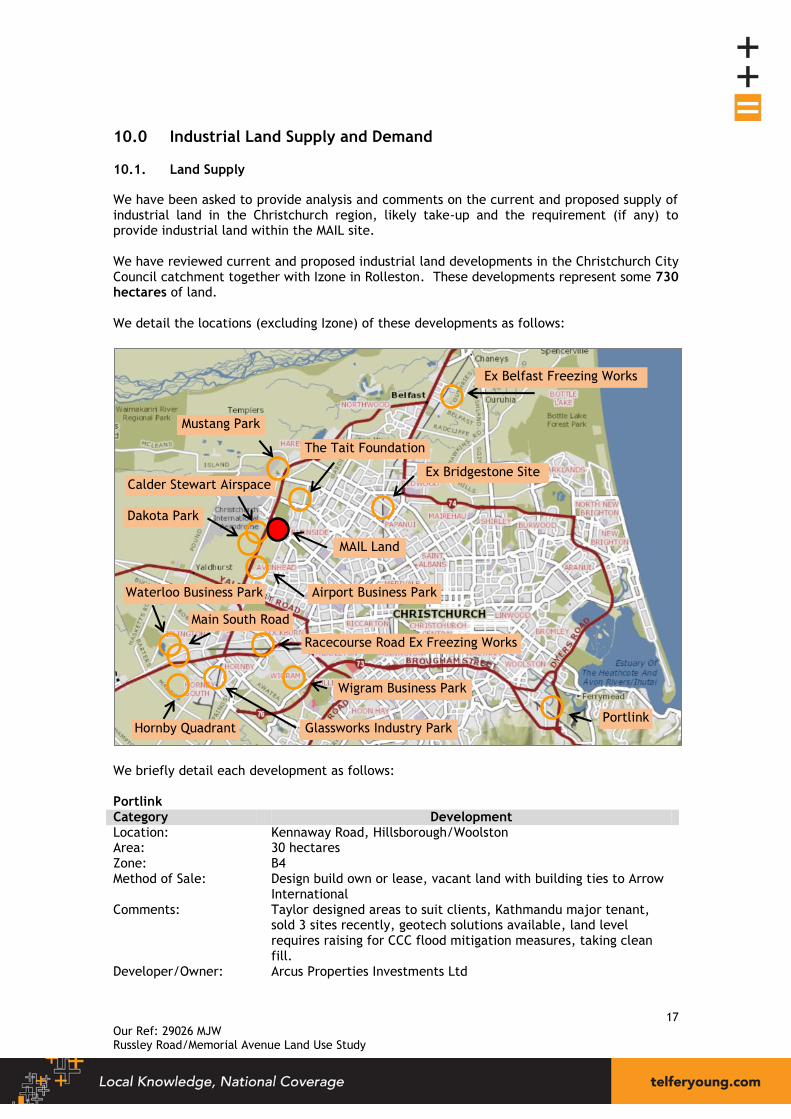
10.0 Industrial Land Supply and Demand
10.1. Land Supply
We have been asked to provide analysis and comments on the current and proposed supply of industrial land in the Christchurch region, likely take-up and the requirement (if any) to provide industrial land within the MAIL site. We have reviewed current and proposed industrial land developments in the Christchurch City Council catchment together with Izone in Rolleston. These developments represent some 730 hectares of land. We detail the locations (excluding Izone) of these developments as follows:
We briefly detail each development as follows: Portlink Category Development Location: Kennaway Road, Hillsborough/Woolston Area: 30 hectares Zone: B4 Method of Sale: Design build own or lease, vacant land with building ties to Arrow
International Comments: Taylor designed areas to suit clients, Kathmandu major tenant,
sold 3 sites recently, geotech solutions available, land level requires raising for CCC flood mitigation measures, taking clean fill.
Developer/Owner: Arcus Properties Investments Ltd
Ex Bridgestone Site Calder Stewart Airspace
The Tait Foundation
Dakota Park
Airport Business Park
Racecourse Road Ex Freezing Works
Waterloo Business Park
Main South Road
Glassworks Industry Park
Wigram Business Park
Portlink Hornby Quadrant
Ex Belfast Freezing Works
MAIL Land
Mustang Park

18 Our Ref: 29026 MJW Russley Road/Memorial Avenue Land Use Study
Wigram Business Park Category Development Location: Hayton Road, Wigram Area: 25 hectares Zone: B4 Method of Sale: Vacant land Comments: Master planned industrial development catering for a broad range
of users. 2 stages. Developer/Owner: Ngai Tahu Property Ltd Glassworks Industry Park Category Development Location: Shands Road Area: 7 hectares Zone: B5 with small B4 component Method of Sale: Design build - lease or own Comments: Master planned industrial development catering for a broad range
of users. Developer/Owner: Goodman Nominee (NZ) Ltd Racecourse Road Former Freezing Works Category Development Location: Racecourse Road, Sockburn Area: 13.8148 hectares Zone: B5 Method of Sale: Vacant land Comments: Well located, good geotech. Developer/Owner: Not Known Main South Road, Adjoining Halls Transport Building Category Development Location: 632 Main South Road Area: 1.8452 hectares Zone: RU2, we understand resource consent has been granted to
subdivide into 6 sites (expires 2/07/2014). Method of Sale: Design build - lease or own Comments: High profile next to State Highway 1, overhead power line
influence. Developer/Owner: Trojan Holdings Ltd Hornby Quadrant Category Development Location: Shands Road Area: 201 hectares Zone: RU2 and B5. The B5 land is being developed first; the District Plan
Review has identified the RU2 portion as Industrial Heavy (IH). Method of Sale: Design build options. Comments: Very large scale, Ch-Ch Southern Motorway passes south boundary. Developer/Owner: Calder Stewart

19 Our Ref: 29026 MJW Russley Road/Memorial Avenue Land Use Study
Waterloo Business Park Category Development Location: Waterloo and Pound Road Area: 114 hectares Zone: B8 Method of Sale: Vacant land - ranging from 2000m² to 6 hectare sites. Comments: Master planned industrial development catering for a broad range
of users. 4 stages. Developer/Owner: John Sax & Inky Tulloch joint venture Airport Business Park Category Development Location: Russley Road, Russley Area: 1.3213 hec (approx) Zone: B4 Method of Sale: Design build - lease Comments: Well established Developer/Owner: Airport Business Park Christchurch Ltd Calder Stewart Airspace Category Development Location: Russley Road, Harewood Area: 16.0383 hectares Zone: Special Purpose Airport Zone (SPAZ) Method of Sale: Design build own or lease Comments: 16 sites, airport related activities only subject to any amendment
through PC84, good geotech Developer/Owner: Calder Stewart Industries Ltd Dakota Park & Mustang Park Category Development Location: Russley Road, Harewood Area: 80 hectares – Dakota Park 30.5 hectares (approx.) – Mustang Park Zone: Special Purpose Airport Zone (SPAZ) Method of Sale: Design build - lease Comments: Airport related activities only, subject to any amendment through
PC84, good geotech Developer/Owner: Christchurch International Airport Ltd The Tait Foundation Category Development Location: Wooldridge Road, Harewood Area: 10.3295 hectares (including neighbouring property which is part of
zone change) Zone: Mix of B4 & B4T Method of Sale: Not known Comments: Large campus style office accommodation. Developer/Owner: The Tait Foundation
20 Our Ref: 29026 MJW Russley Road/Memorial Avenue Land Use Study
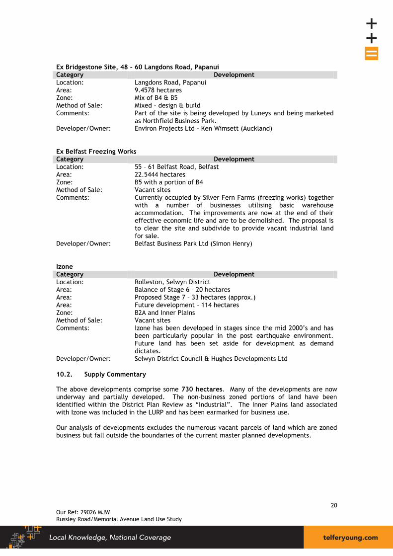
Ex Bridgestone Site, 48 – 60 Langdons Road, Papanui Category Development Location: Langdons Road, Papanui Area: 9.4578 hectares Zone: Mix of B4 & B5 Method of Sale: Mixed – design & build Comments: Part of the site is being developed by Luneys and being marketed
as Northfield Business Park. Developer/Owner: Environ Projects Ltd - Ken Wimsett (Auckland) Ex Belfast Freezing Works Category Development Location: 55 – 61 Belfast Road, Belfast Area: 22.5444 hectares Zone: B5 with a portion of B4 Method of Sale: Vacant sites Comments: Currently occupied by Silver Fern Farms (freezing works) together
with a number of businesses utilising basic warehouse accommodation. The improvements are now at the end of their effective economic life and are to be demolished. The proposal is to clear the site and subdivide to provide vacant industrial land for sale.
Developer/Owner: Belfast Business Park Ltd (Simon Henry) Izone Category Development Location: Rolleston, Selwyn District Area: Balance of Stage 6 – 20 hectares Area: Proposed Stage 7 – 33 hectares (approx.) Area: Future development – 114 hectares Zone: B2A and Inner Plains Method of Sale: Vacant sites Comments: Izone has been developed in stages since the mid 2000’s and has
been particularly popular in the post earthquake environment. Future land has been set aside for development as demand dictates.
Developer/Owner: Selwyn District Council & Hughes Developments Ltd
10.2. Supply Commentary
The above developments comprise some 730 hectares. Many of the developments are now underway and partially developed. The non-business zoned portions of land have been identified within the District Plan Review as “Industrial”. The Inner Plains land associated with Izone was included in the LURP and has been earmarked for business use. Our analysis of developments excludes the numerous vacant parcels of land which are zoned business but fall outside the boundaries of the current master planned developments.

21 Our Ref: 29026 MJW Russley Road/Memorial Avenue Land Use Study
10.3. Annual Land Take-up Rates
The Christchurch City Council monitors the amount and take-up of industrial zoned land through their “Monitoring and Research Team”. The graph below records the number of hectares per annum that is converted from vacant to developed industrial land (as at August 2012). The data excludes take-up from Selwyn and Waimakariri Districts. Izone is situated within Selwyn District.
The average annual take-up rate from 1992 to 2012 is 23.42 hectares per annum. Of particular interest is the average take up from 2008 to 2012. The average take up over this 5 year period fell significantly to 10.44 hectares compared to the long term average of 23.42 hectares. We are aware of relatively strong interest and numerous transactions taking place in Portlink, Wigram Business Park, Racecourse Road development, Hornby Quadrant, and Glassworks Industry Park in recent times. The take-up of land in the latter part of 2012 through to 2013 is likely to be up on the more recent 5 year trend. We have analysed sales of vacant land from Izone and adjoining industrial land from 2001 to the end of 2013. A total of 80 hectares was sold over that period averaging 6.50 hectares per annum. Sales peaked in 2011 at some 15 hectares. If we adopt 23.42 hectares from Christchurch and 6.50 hectares from Rolleston we can conclude that approximately 30 hectares of vacant land is taken up each year over the longer term.
10.97
19.28 19.56
33.84
21.31
15.65
21.12
36.41
30.71
19.60
17.47
29.10 28.55
30.58
25.02
33.57
14.03 14.84
6.06
9.33 7.92
0.00
5.00
10.00
15.00
20.00
25.00
30.00
35.00
40.00
1992 1993 1994 1995 1996 1997 1998 1999 2000 2001 2002 2003 2004 2005 2006 2007 2008 2009 2010 2011 2012
Hecta
res
Year
Annual Take-up Rates
Source: Christchurch City Council

22 Our Ref: 29026 MJW Russley Road/Memorial Avenue Land Use Study
As previously mentioned the land available for industrial development comprises some 730 hectares. This translates to some 25 years of supply. Other researchers have suggested that the total vacant land supply from all zoned land together with land identified within the LURP for Christchurch and Selwyn totals some 1,050 hectares. This would equate to more like 35 years supply.
10.4. Annual Vacant Land Sales
An additional measure of land take–up is the historical purchase of vacant industrial land. The selling/purchase of vacant land does not necessarily translate directly to take-up however over time provides a good indication of historical demand. We have sourced sales data within the CCC catchment area plus Rolleston from 2001 to the end of 2013. The analysis does not include sales of land subject to the release of title (under development). Where a property had sold two or more times over the timeframe we have only included the most recent sale in our analysis. Furthermore our analysis excludes design build development whereby a developer owns the land and builds a “tailor made” building to suit the end user. In this instance the only transaction taking place being the purchase of the land and building. Airport industrial development is also not included as there is no recorded land sale because the airport retains ownership. The graph below records the combined total of all vacant industrial land sales in the CCC catchment and Rolleston over the period.
The graph reveals a similar pattern to the CCC take-up rate data. Steady growth through the early 2000’s to a peak in 2004 and a general decline from 2009 as the global credit crisis took effect and impacted on New Zealand’s economy. The more recent increases reflect the strong growth in Izone post earthquakes.
$22,319,512
$28,404,900
$43,037,094
$73,252,174
$28,241,756 $27,079,698
$32,396,919
$48,473,854
$24,761,460
$17,230,116
$26,492,396
$34,383,320
$46,371,060
$-
$10,000,000
$20,000,000
$30,000,000
$40,000,000
$50,000,000
$60,000,000
$70,000,000
$80,000,000
2001 2002 2003 2004 2005 2006 2007 2008 2009 2010 2011 2012 2013
Year
Vacant Land Sales
23 Our Ref: 29026 MJW Russley Road/Memorial Avenue Land Use Study
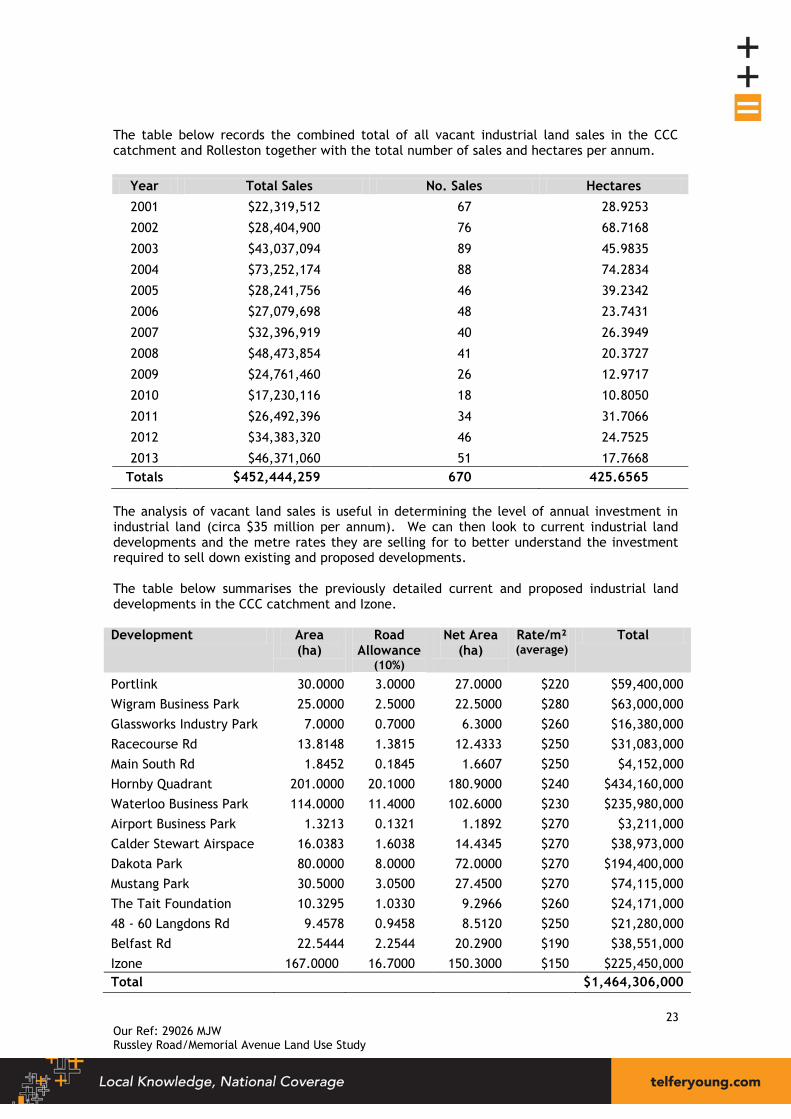
The table below records the combined total of all vacant industrial land sales in the CCC catchment and Rolleston together with the total number of sales and hectares per annum.
Year Total Sales No. Sales Hectares
2001 $22,319,512 67 28.9253
2002 $28,404,900 76 68.7168
2003 $43,037,094 89 45.9835
2004 $73,252,174 88 74.2834
2005 $28,241,756 46 39.2342
2006 $27,079,698 48 23.7431
2007 $32,396,919 40 26.3949
2008 $48,473,854 41 20.3727
2009 $24,761,460 26 12.9717
2010 $17,230,116 18 10.8050
2011 $26,492,396 34 31.7066
2012 $34,383,320 46 24.7525
2013 $46,371,060 51 17.7668
Totals $452,444,259 670 425.6565
The analysis of vacant land sales is useful in determining the level of annual investment in industrial land (circa $35 million per annum). We can then look to current industrial land developments and the metre rates they are selling for to better understand the investment required to sell down existing and proposed developments. The table below summarises the previously detailed current and proposed industrial land developments in the CCC catchment and Izone. Development Area
(ha) Road
Allowance (10%)
Net Area (ha)
Rate/m² (average)
Total
Portlink 30.0000 3.0000 27.0000 $220 $59,400,000
Wigram Business Park 25.0000 2.5000 22.5000 $280 $63,000,000
Glassworks Industry Park 7.0000 0.7000 6.3000 $260 $16,380,000
Racecourse Rd 13.8148 1.3815 12.4333 $250 $31,083,000
Main South Rd 1.8452 0.1845 1.6607 $250 $4,152,000
Hornby Quadrant 201.0000 20.1000 180.9000 $240 $434,160,000
Waterloo Business Park 114.0000 11.4000 102.6000 $230 $235,980,000
Airport Business Park 1.3213 0.1321 1.1892 $270 $3,211,000
Calder Stewart Airspace 16.0383 1.6038 14.4345 $270 $38,973,000
Dakota Park 80.0000 8.0000 72.0000 $270 $194,400,000
Mustang Park 30.5000 3.0500 27.4500 $270 $74,115,000
The Tait Foundation 10.3295 1.0330 9.2966 $260 $24,171,000
48 - 60 Langdons Rd 9.4578 0.9458 8.5120 $250 $21,280,000
Belfast Rd 22.5444 2.2544 20.2900 $190 $38,551,000
Izone 167.0000 16.7000 150.3000 $150 $225,450,000
Total $1,464,306,000

24 Our Ref: 29026 MJW Russley Road/Memorial Avenue Land Use Study
The previous 13 year period has comprised approximately $450 million in vacant land investment. The existing and proposed developments comprise approximately $1,450 million of available industrial land. Much of this land is available for direct purchase. The NWRA identified some 100 hectares of land in three separate areas as being suitable for industrial development. Of the 100 hectares we have included just 10.3295 hectares in our existing and proposed developments, the 10.3295 ha being the Tait Foundation land. Should the proposed 100 hectares identified by the NWRA be developed to provide vacant industrial land this would amount to a significant land holding in value terms. The table below summarises the three areas identified by the NWRA and the likely combined value “as developed”. Development Area
(ha) Road
Allowance (10%)
Net Area (ha)
Rate/m² (average)
Total
Area 1 15.0000 1.5000 13.5000 $250 $33,750,000
Area 2 50.0000 5.0000 45.0000 $270 $121,500,000
Area 3 35.0000 3.5000 31.5000 $260 $81,900,000
Total $237,150,000
If all future Christchurch and Rolleston vacant land sales were confined to the three NWRA blocks, the investment required to “sell down” the developments would equal all Christchurch and Rolleston sales from mid-2006 till end of 2013. This analysis reveals the scale of land and investment required to take-up the various existing and proposed industrial land developments in Christchurch. It is difficult to gauge the future requirement and take-up of land. The Christchurch re-build will likely provide growth opportunities for this sector. The re-build will however ultimately come to an end. Many construction related entities may scale back their operations causing a slowdown in take-up and more normalised growth patterns will return. The current and proposed industrial land developments offer end users a broad range of options with regard to direct ownership, design build and leasing options. There are minimal constraints (if any) on end users obtaining the ownership structure, scale, size and location they desire. We can conclude that Christchurch and Rolleston has a significant supply of industrial land both now and well into the future. At long term take-up rates the supply will not be exhausted for some time. Waimakariri District also has substantial industrial land supply in Southbrook and “pockets” in Kaiapoi and other smaller centres. The supply and proposed supply of industrial land within close proximity to the subject property is substantial. Areas include: Mustang Park and airport land to the north and west, land identified in the NWRA both north and south of the subject, Dakota Park, and Calder Stewart Airspace to the immediate southwest. These developments will more than adequately provide for the requirements of industrial land.

25 Our Ref: 29026 MJW Russley Road/Memorial Avenue Land Use Study
10.5. Industrial Land Supply and Demand Conclusions
We have analysed the supply of industrial land in Christchurch and Rolleston both present and proposed. We have analysed long term take-up rates and purchase of industrial land and made comments on the likely absorption of land in the short to medium term. The current industrial land “product mix” is very broad with regard to location, ownership and occupancy structure. This does not constrain the market from performing freely. The supply of land adjoining and nearby the subject property is substantial. Having considered these factors we consider that the additional land uses proposed for the site, including 5000m2 of general offices, will not have adverse effect on industrial land supply in Christchurch generally or north-west Christchurch in particular.

26 Our Ref: 29026 MJW Russley Road/Memorial Avenue Land Use Study
11.0 Conclusions
We conclude that the highest and best use of the property is for a mixed use development featuring retail, service, hospitality, office and tourist accommodation. The locational advantages of the site underpin the long term sustainability of this type of development. The CBD recovery is currently advancing through the land purchase/acquisition phase through to the design/planning phase. Construction activity is gaining momentum with a number of developments now completed. There is interest from pre-quake CBD tenants to re-establish in the CBD, and the Government sector is re-establishing there also. Rental rates are high by Christchurch standards but not by national or international levels/benchmarks. The CBD recovery is underway. We have looked at the KACs in terms of their location, current product mix, and their recent economic performance. Retail essentially drives the desirability of the KACs. The effect on nearby KACs of establishing office accommodation on the site would likely be minimal in our view. We consider that a selected group of office accommodation users could be permitted to establish on the site without adverse effect on recovery of the CBD. These operators would locate here because of the site specific attributes of the site and would not consider the CBD as an alternative. In addition to these office users we consider that conventional office users could be permitted to establish on the MAIL site subject to limits on the quantum of development. These operators would likely prefer the MAIL site over the CBD for reasons such as: affordability, locational benefits, access to labour force, clustering with like businesses and/or the perception of superior ground conditions and low risk of natural disaster. These operators, if not permitted on the site, would likely establish at another Christchurch suburban location or another center all together and be lost to the Christchurch region. We consider that the level of office development proposed for the site is conservative and will not have significant adverse effects on recovery of the CBD or on KACs. We have analysed the supply of industrial land in Christchurch and Rolleston both present and proposed. Based on long term take-up rates we have some 25 years supply of land. If we include all vacant zoned land and land identified within the LURP we have some 35 years of supply. Having considered all factors we consider that provision for other land uses, including 5,000m² of general office, on the site will not have adverse effects on industrial land supply. We trust this report meets your requirements. Should you require additional commentary please advise. Yours faithfully TelferYoung (Canterbury) Limited
C N Stanley - M Prop Stud (Distn) FNZIV, FPINZ, AAMINZ M J Winder – B Com (VPM) MPINZ
Registered Valuer Registered Valuer
Email: [email protected] Email: [email protected]