Embed Size (px)
Citation preview
Latest revision 5th May 2010 Page 1 of 19
RSPONEWPLANTINGPROCEDURES
SummaryReportofPlanningAndManagement
1. ExecutiveSummaryPT SwadayaMukti Prakarsa, a subsidiary of FirstResourcesGroup is developing approximately21,019haofoilpalmplantationwhich12,384.28ha isnon‐plantedanddividedontothreenewdevelopmentareas.TheplantationarealocatedatSub‐DistrictSimpangHilir,Sub‐DistrictSeiLaurandSub‐DistrictSimpangDuawithinKetapangDistrictandKayongUtaradistrict.
A comprehensive and participatory independent Social and Environmental Impact Assessment(SEIA) and High Conservation Value (HCV) assessment which include internal and externalstakeholderswereconductedbyRSPOregisteredassessorfromBogorAgricultureUniversity.Theresultsare incorporated intotheoperationalmanagementplanningtodevelopthenewplanting.TheIndependentassessmentbyRSPOapproved/registeredassessorsresultsare:
- TheconditionoflandcoverovernewplantingareaisnolongerPrimaryForest- Theareaiscategorizedassecondaryforest,mixplantation,drylandagriculturaland
bare land,andmostof themfall inOtherPurposeUseArea (APL)andConvertibleProductionForest.
- AllareasrequiredtomaintainorenhancewhichwereidentifiedasHCV- All local people’s land were recognized and involved in SEIA, SIA and HCV field
surveysactivities
LocationmapswerepreparedandpresentedintheSEIAandHCVassessmentreportsincludeallfindingsandmanagementrecommendationfromtheassessor.TheprojectlocationisshowninFigure 1 and Figure 2 below The SEIA and HCV Summary reports include additional mapsshowingthetopography,landscape,HCVandcompensatedland.HCVmapsconstructedincludeareaforbufferandriparianreserve.

Latest revision 5th May 2010 Page 2 of 19
Figure1Locationmaps–bothatlandscapelevelandpropertylevel

Latest revision 5th May 2010 Page 3 of 19
Figure2LandscapemapofPTSwadayaMuktiPrakarsa,KetapangDistrictandKayongUtaraDistrict,WestKalimantanProvince
Latest revision 5th May 2010 Page 4 of 19
2. ReferenceDocuments
SEIAandHCVassessmentreports.
Environment ImpactAssessment(DPPL) forOilPalmPlantationandPalmOilMillfor PT SMP at Sub‐District Simpang Hilir,Sub‐District Sei Laur, and Sub‐districtSimpang Dua, Ketapang District and Kayong Utara District, West Kalimantan‐Indonesia
Social Environmental Impact Assessment in The Area of PT. Swadaya MuktiPrakarsa, Ketapang – West Kalimantan Province by Faculty of Forestry, BogorAgriculturalUniversity,2013
Identification and Analysis of HCVs Presence In The Area of PT. Swadaya MuktiPrakarsa –West Kalimantan Province by Faculty of Forestry, Bogor AgriculturalUniversity,2013
ListofLegaldocumentsandRegulatorypermitsrelatedtotheareasassessed
a. HGUCertificateNo.42withtotal10.920,89hadated16June2005b. HGUCertificateNo.34withtotal2.028,20hadated8September2008c. LandReservefromtheWestKalimantanGovernorNo.525/0248/DPU‐Ewithtotal
2.900hadated28March2013d. Extension of Location Permit issued by Bupati Ketapang No. 23/PEM/2013with
total1.470hadated10January2013e. Extension of Location Permit issued by Bupati Ketapang No. 24/PEM/2013with
total3.700hadated10January2013f. Takingover frompreviousGroup toFirstResourcesbyActNo3dated3 January
2013byNotaryRusnaldy,SHg. GovernmentRegulationNo.7of1999regardingConservationoffloraandfauna.h. Ministry of Forestry Decree No. 936 of 2013 regarding Change in Designation,
FunctionandAreaAppointmentforWestKalimantanProvince.
The previousmanagement had planted 8274,3 Ha for oil palm and built a palm oilmill,whereas<2010covered7961.7Ha,andin2010‐2013planted312.6Ha.PTSMPisplanningto develop 11.086,03 ha (excluding HCV area) until 2018. The FPIC process is optimallyconducted and followed by land compensation program. The proportion of smallholdersandnucleuswill be in linewithexistingMinistryofAgricultureDecree and realizationofplantedarea.

Latest revision 5th May 2010 Page 5 of 19
3. SEIAandHCVManagement&PlanningPersonnel
Organizationalinformationandcontactpersons.
Table1OrganizationalinformationandcontactpersonsNameofcompany PT.SwadayaMuktiPrakarsa subsidiaryofFirstResourcesLtdRSPOmembershipnumber 1‐0047‐08‐000‐00belongtoFirstResourcesLtd
GovermentAdministration Sub‐District SimpangHilir,Sub‐DistrictSeiLaur,andSub‐district SimpangDua, Ketapang District and Kayong Utara District, West Kalimantan‐Indonesia
Forestry and AgriculturalManagementUnit
Dinas Pertanian dan Perkebunan (agriculture and plantation agency)KetapangDistrictDinasKehutanan(Forestryagency)KayongUtaraDistrict
Watershed LaurMatan
AdministrativeAddressCorporateFirstResourcesOfficeRegionalOffice
APLTower–CentralPark,28thFloorPodomoroCity,Jl.Letjen.S.ParmanKav.28,Grogol‐Petamburan,Jakarta,IndonesiaKomplek Perdana Square Blok J 8 – 12, Jalan Perdana, Pontianak, WestKalimantan,Indonesia.
ContactPerson CorporateSustainabilityHead – BambangDwiLaksonoEmailAddress:bambang.dwilaksono@first‐resources.com
GeoCoordinate 00004’52”to000 04’57”S
116022’30”to116030’11”E
TaxRegistrationNumber 01.692.327.8‐038.00001.061.916.1.058.000
Boundary
North PT.CiptaUsahaSejatiPlantationConcession
South PalungMountainNatinalParkandMatanRiver
West PT.CiptaUsahaSejatiPlantationConcession
East PT.MuliaBhaktiKahuripanandPT.UsahaTaniSejatiPlantationConcession

Latest revision 5th May 2010 Page 6 of 19
Personnelinvolvedinplanningandimplementation.
Figure3Personnelinvolvedinplanningandimplementation
Sustainability Head Bambang Dwi Laksono
Environment & Conservation Specialist
Sholihudin
Controller SPO Document
Roy Wahyudi
Officer HCV Davidia Intan
Officer EIA Eska Arganita
Regional Sustainability Coordinator
Purwantoro Supardi
Head Environment & Conservation Section
Fitria Kurniawan
Officer Environment & Conservation
Arya Windujati
Jakarta Base
West Kalimantan Base
Group Manager Pandapotan Sitompul
Manager General AffairWilfried Ane
Compensation OfficerTribaratha
Carbon & GHG Specialist Donald Ginting
Social Impact Specialist
Panji Mulya
Director Alfred Purba

Latest revision 5th May 2010 Page 7 of 19
Stakeholderstobeinvolved.
Table2Stakeholderstobeinvolved
Stakeholder Interest
I.Directinvolvement
Company •EnsurePT.SMPactivities
•Legitimatefromlocalpeopleandgovernment
•Ensureoperationalareaandbusiness
LocalGovernment(SubVillageandVillage)
•Jobsforlocalpeople•Benefittoincreasevillagedeposit•Infrastructurefacilitiesimprovementespeciallylandtransport
Community •Livingsource(socialeconomicandprimaryneeds)•Socialsupport•Smallholderprogram•Ensureexistenceofculturalandcustomarylocation•compensationasagreement
II.IndirectInvolvement
HeadofKetapangDistrictandKayongUtaraDistrict
•ManagementofAdministrationarea•Succeedinpoliticalandleadershipsupport
PlantationDepartmentofKetapangDistrictandKayongUtaraDistrict
• Managementofplantationarea• Contributioninlocaldevelopmentprogram
III.SecondaryNationalGovernmentandProvinceGovernment
•Investment•Plantationmanagementasnationalandlocalregulation
EnvironmentalBureauofWestKalimantanProvince
•EnvironmentalImpactAssessmentandprogressreport•Sustainableenvironmentalmanagement
CustomaryInstitution •Conservesacredlocationandotherimportantlocationneededbylocalpeople
•Artandculture•Movementsetterwhohavestronginfluenceinsociety•EffectiveintercommunicationbetweenofPTSMPandvillagepeople
4. Summarya. SummaryofManagementandMitigationPlans(SEIA)
Mitigationplanstominimizenegativeforsocio‐economicimpacts.Managementplanstoenhancesocio‐economiccontributions.Mitigationplansfornegativeenvironmentaleffects.Managementplanstopromotepositiveenvironmentaleffects.
Latest revision 5th May 2010 Page 8 of 19
The SIA development and preparation of management & monitoring plans for PT SMP wasbasedon the SIAAssessment findings conducted in28November–4December2013by theRSPOAccreditedAssessorsfromFacultyofForestrystatedasstatedonTableIX‐1andTableIX‐2 on page IX‐3 to IX‐16. The management plan may assist in reducing the occurrences ofnegative impact and promoting positive ones in the future if the company and communitiescommittoimplementtheplanningconsistently.
EnvironmentalmanagementandmonitoringprogramofPTSMPincludesthefollowingaspects:land tenure; establishing communication with stakeholders; improving the quality of publiceducation; improving the quality of public health; increase public accessibility; economicempowerment;andenvironmentmanagementprogram
Thescheduleofmanagementandmonitoringdependsonthelevelofurgencyandriskforthecompany.Aspectsof tenureand communicationwith stakeholders are concernedat all timesduringtheprocessofliberationanddevelopmentofthegarden.Asforthecontributionofthesocial aspects (health, education, communityaccess, community economicandenvironmentalimprovement)monitoringscheduledonsemesterandyearbasis
ReferingtotherecommendationarisedfromSIAofPTSMP,thecompanyneedstodisseminatethe plasma development program (mechanisms, type of cooperation, schedule), constructcommunication with relevant villagers related to tenure issue of Batu Daya, encouraginggovernmenttoresolvethelandboundarybetweenvillages,prioritizeabsorptionoflaborfromthevillagenearby,andimprovefacilitiesforemployees
During2013,thecompany'seffortstomanagethepositiveandnegativeimpactsthrough:
RecruitmentoflocalworkersofWestKalimantantoworkinplantation(reaching60%of 1471). On the other hand, the mill employed 82 local workers of the total 104workers(78%).
Implementation of community development programs in villages around PT SMP,coveringfivesectors,i.e.social‐economy,environment,education,humanresourcesandinfrastructure.

Latest revision 5th May 2010 Page 9 of 19
Table3PTSMPsocialmanagementandmonitoringprogramProgram Management Output Purpose Monitoring Time
Tenurial Identificationandmappingoflandownership,customaryland,landinheritanceandcollectivelandinsidePT.SMPlandusepermit.
• LanduseownershipinPTSMPlandusepermit
• Compensationforcustomaryright,inheritorcollectiveright
• Toidentifypositionandwideofpeople’slandinPTSMPpermitarea.
• Observationandinterviewwithsurroundingcommunity
• Measuringandmappingareatogetherwithverificationteam
• Socializationtheresultofmeasurementtosurroundingcommunity(announceatvillageoffice)
Eachpreparationforlandcompensation(2014‐2013)
ArrangeclearandfirmSOPregardinglandcompensationmechanism
• SOPforlandcompensationclaim.
• Toguidecompensationofficerteamtocompensateidentifiedland
• evaluativedescriptiveanalysismethod
2014andupdateifneeded.
Makeidentification,verificationandacquisitionoflandTeam
Theformationoftheteam(identification,verificationandacquisitionoflandTeam)ineachvillage
FacilitatetheidentificationoflandownershipintheareaofPT.SMP
cometosocializethecompany'sprogram.
fieldobservationsandinterviewswithidentification,verificationandlandacquisitionteam
2014andupdateifneeded.
facilitatemeasurementofboundariesbetweenvillagesinareaofcompany
agreedthevillageboundaries Topreventpotentialconflictsbetweenvillagesandbetweencommunities
interviews,fieldobservation Every6monthsfrom2014totheunfinishedvillageboundary

Latest revision 5th May 2010 Page 10 of 19
Documentationlegalizationprocessesundertakenbythecompany
DocumentationofalllicensingdocumentsandlegalaspectsofthePT.SMP
•Topreventthelandclaimrepeatedbyothers
•Orderlyadministration
•Secondarydatacollection
•Descriptiveanalysismethod
Every6monthsfrom2014
Buildcommunicationandconnectiontorelatedstakeholders
Periodicalmeetingwithstakeholderandcoordinatewithvillageelder,influencedperson,customaryleaderandvillagehead.
•Goodcommunicationandcoordinationwithstakeholders
•SamevisionbetweenstakeholdersandPTSMP
•Tobuildgoodrelationwithallstakeholders
•FGD,fieldobservation Every6month
Socializationtolandowner •CollectiveagreementbetweencommunityandPTSPM
•Tostoprepeatedlandclaimbyotherlanduseright
•FGD,interview,fieldobservation Alonglandcompensation(2014‐2016)
Improvecommunityeducationlevel
Creatingappropriateeducationprogramasneededbysurroundingcommunity
•Educationdevelopmentprogramdocument
•ToeasePTSMPtoimplementCSRprogram
•FGD,interview,fieldobservation
•evaluativedescriptiveanalysismethod
Eachyearsince2015
Givingscholarshipandbuildeducationinfrastructureinsideestatearea
•increasingofcommunityeducationlevel
•neweducationinfrastructureinsideestatearea
•ToincreasePTSMPcommunityeducationlevel
•FGD,interview,fieldobservation
•evaluativedescriptiveanalysismethod
Eachyear
Increasecommunityhealthquality
Identifycommunity’shealthnecessity
• decreasingofdisease/infectioncase
• Increaseliveexpectationlevel
Toincreasecommunityhealthservicelevel
interview,fieldobservation Onceayearstartin2015
Socializationforhealthprogram,periodicalfreehealthcheck&medicine
• Increasecommunity’sawarenessregardingdangerousdisease
• Increasecommunity’shealthquality
Toincreasecommunity’shealthquality
• interview,fieldobservationashealthtransportationfacilitator
Onceayear
2014
Cleanwaterinfrastructuresupport
cleanwateravailabilityandaccessibility
Toincreasecommunity’shealthquality
• interview,fieldobservation Onceayearstartin2013‐2017

Latest revision 5th May 2010 Page 11 of 19
Developmentofhealthinfrastructure(policlinic)insidePTSMP
• Policlinic ashealthfacilityforworkerandcommunity
• evaluativedescriptiveanalysismethod
• fieldobservation
2018‐2022
Increasedpublicaccessibility
Improvementofvillagesroads Accessibilityofsocietyforthebetter
•Theroadcanbeusedbythepeopleallthetime,includingwhentherainyseason.
•thecommunity'seconomycancontinuetorunningandanincrease
FGD,interview,fieldobservation 2014
Empowermentofcommunityeconomic
EconomicpotentialanalysissurroundPTSMP
DocumentofeconomicpotentialanalysissurroundPTSMP
ToeasePTSMPtoimplementCSRprogram
• FGD,interview,fieldobservation
• evaluativedescriptiveanalysismethod
Onceayearstartin2015
Increasecommunity’sagriculturalactivity
• Createoptimalincomefornearbycommunity
To create alternativeincomesourcefornearbyfarmer
• FGD,interview,fieldobservation
• evaluativedescriptiveanalysismethod
Onceayearfrom2017
Socializationandcommunicationandtrainingtocreatealternativebusinessopportunityandlivingsourceascommunity’spotency
•Newopportunityforalternativebusinessopportunityandlivingsourceascommunity’spotency
toincreaseentrepreneurshipamongcommunity
• FGD,interview,fieldobservation
• evaluativedescriptiveanalysismethod
Eachyearsince2017
Acceptanceforlocallabor • Acceptanceforlocallabor
• increasingofworkingethosoflocallabor
toincreasecommunity’searnings
• interview,fieldobservation
• evaluativedescriptiveanalysismethod
Every6monthacceptinglabor
Developmentofsmallholderestate
• sameperceptionandagreementbetweencompanyandcommunity(representbycooperative)regardingsmallholderprogram
•Documentoflocation,area,andstatusofsmallholderprogram
todevelopsmallholderestatewithoutoverlappingbetweensmallholders
• interview,fieldobservation
• evaluativedescriptiveanalysismethod
Alonglandcompensationprocess

Latest revision 5th May 2010 Page 12 of 19
EnvironmentManagementProgram
Mitigatepotentialriverwaterquality
• Effluentfulfillenvironmentwaterstandard
• Environmentmanagementandmonitoringreport
• Tomonitorthechangesofriverwaterqualityatriver
• tohinderriverwatersurfacepollution
• Fieldobservation(watersample) Every6month
Mitigationpotentialanincreaseintherateofsurfaceerosion
•Therateofsurfaceerosion•Monitoringreportsoftherateofsurfaceerosion
•Tomonitortherateoferosionandsedimentation•Preventingthedeclineinsoilfertility
•Observationofthetrenchortherightsideoftheroad,aswellascanals/creeks•Installerosionmonitoringpoints
Everysixmonths
Campaigning,trainingandsocializationofthe3R(Reduce‐Reuse‐Recycle)tothecommunity
Therealizationoftheprinciplesofsustainabilityandsynergywithcommunitydevelopmentefforts
Increasetheknowledgeenvironmentforemployeesandthepublic
FGD,interview,fieldobservation
Everysixmonths
b. SummaryofManagementandMitigation Plans(HCV)
PlanforHCVmonitoringandregularreviewofdata.ManagementandmitigationplansforthreatstoHCVareas.ManagementplanstoenhanceormaintainconservationvaluesofidentifiedHCVareas.

Latest revision 5th May 2010 Page 13 of 19
TheHCVmanagementplanAssessmentconductedin30November2013–3December2013andhasbeenconstructedasfollow:
1. HCVareaprotectiona. Boundariesmarking
Boundariesmarking ofHCV areawill be conducted along outerHCV areas. If there ismodificationofHCVarea,theouterboundarydemarcationwillbeimmediatelychangedso that thewidthof remainHCVareawillbeconsistentwithin the limit in thepermitareaofPT.SMP.DemarcationofthevariousHCVareaswillconsidernaturalboundaries,communication with community, the annual budget, the progress of palm oil palmdevelopment,andthepermitstatusoftheareas.
b. SignboardinstallmentandmaintenanceSignboardinstallmentandmaintenanceattheplaceHCVpresentinordertoinformthepresentofHCVtotheworkersandcommunitysurroundings.
c. GroundfirecontrollingandpreventionToavoidlandfirespreadingwithinandaroundPT.SMP,itisplannedtobuildfiretowerasearlywarningsystem.
2. ActivitiestomaintainHCVfunctionsa. Inventory and identification land cover within the HCV area using satellite imagery
periodically, anddirect observation to the ground.This activitywill conducton riversbankandhillsarea.
b. RehabilitationandspeciesenrichmentRehabilitation needed to implementedwhen condition of land cover has degraded atleast>25%of totaleachHCVareaand/or there is lossof >25%species thatexist insuchHCVarea.
c. Managementofprotectedspecies:i. ProtectedFloraManagement.ProtectedfloramanagementisfocusingontreespeciesthatlistedinRedlistIUCNsuchas: Spathoglottis plicata, Dipterocarpus costulatus, Shorea gibosa, Shorea hopeifolia,Shorea kunstlerii, Anisoptera grossiveni, Dryobalanops beccarii, Cantleya corniculata,Eusideroxylonzwageri,CalophyllummacrocarpumandShoreastenoptera.Inadditiontothe rare presence, over harvesting thread could be big constrain to preserve thosespecies.Managementplantoprotecttheexistenceoffloraprotectedspeciesareto: Allocateandmanagementtothelocalprotectedareas(HCV) Implementbestmanagementpracticeswithlowrisktotheenvironment. Improve and maintain stand structure with re‐vegetation on bare land and
vegetationenrichment. Conductiinventoryandmappingactivityinordertocollectspeciescompositionand
conditionoftrees. trainthestaffonimprovespeciesandinventory Buildtreenurseryasapartofex‐situconservation. EstablishStandardOperatingProcedurerelatedtomanagementandmonitoringof
protectedspecies. Coordinationandcorporationwiththeexternalparties. EducationandsocializationtothelocalcommunityaroundthePT.SMPconcession Routinelycontrolandmonitor.
ii. ProtectedWildlifeManagement.
Wildlife management is focusing on maintenance of owa (Hylobatus agilis),rangkong (Buceros rhinoceros ), kuau (Argusianus argus), and elang brontok(Spizaetuscirrhatus).

Latest revision 5th May 2010 Page 14 of 19
The management plan is to prevent species from disturbance and potentialthreats such as hunting, and illegal logging on their habitat; and to improvehabitatqualitywithvegetationenrichment
TheHCVmonitoringplanforthenon‐planted/clearedareahasbeenconstructedasfollow: MonitoringonboundariesmarkingofHCVanditschange Monitoringonbiodiversityanddensityconditionoffloraandwildlife(protectionandRTE
(Rare,threatened,endangered))intheHCVarea. Monitoringonlandcovercondition Monitoring on staff and community perception and knowledge regarding to the HCV
protection. Monitoringonriverbankschangingandwaterquality. Monitoringonwaterbiotaintheriver.

Latest revision 5th May 2010 Page 15 of 19
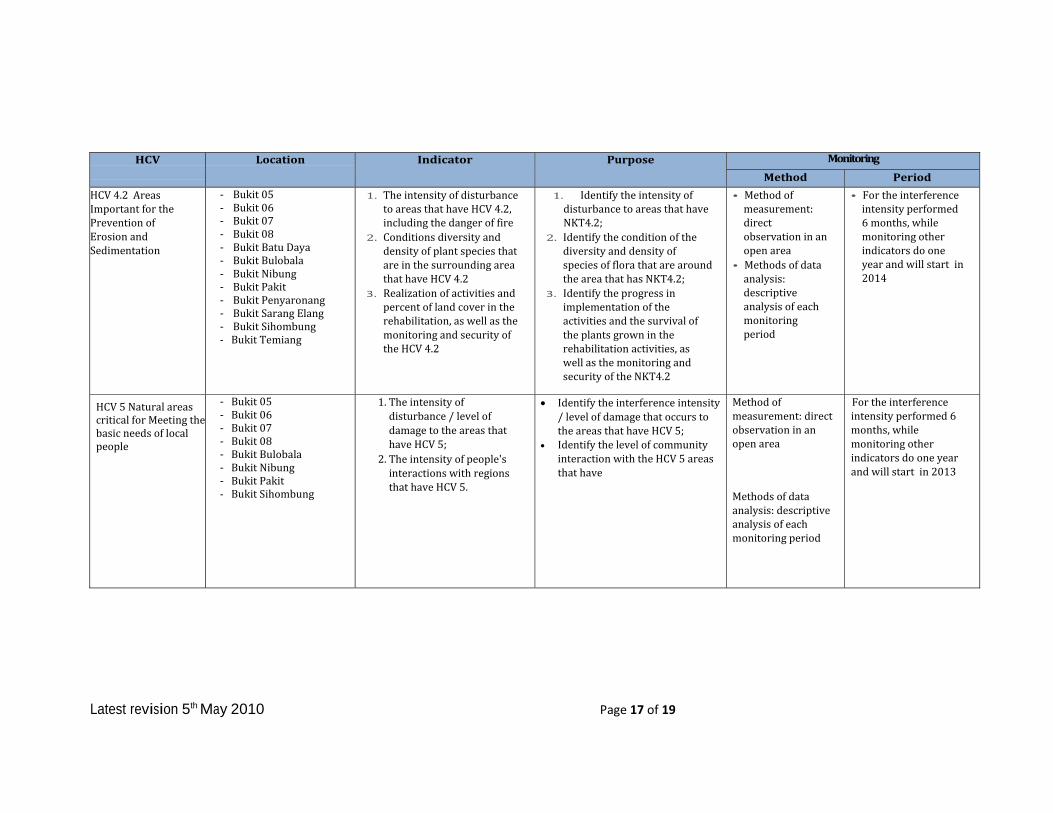
Table4PTSMPHCVmonitoringprogram
HCV
Location Indicator Purpose Monitoring
Method PeriodHCV1.1AreasthatContainorProvideBiodiversitySupportFunctiontoProtectionorConservationAreas
KeranjiRiverBatuDayaHill
1. intensityof disturbanceagainstsiteswithHCV1.1,includingthedangeroffire
2. ThedevelopmentoflandcoversconditionsintheareathathaveHCV1.1.
3. Conditionsofbiodiversity(floraandfauna)priorityspecies,especiallyintheareaofHCV1.1
4. RealizationofmonitoringandsecuritytotheareasthathaveHCV1.1.
1. IdentifytheintensityofdisturbancetoareasthathaveNKT1.1aswellaschangesinwaterqualityateachlocationthathasNKT1.1.
2. IdentifytheconditionofthediversityanddensityofspeciesoffloraandwildlifeconditionsthatarearoundtheareathathasNKT1.1.
3. Identifytherealizationofactivitiesandpercentoflandcoverinrehabilitationactivities,aswellasmonitoringandsafetyNKT1.1area.
Descriptiveanalysisoneachmonitoringperiod.
For intensitydisturbancesdoevery6months,whileotherindicatorsofmonitoringconductedonceayearandwillstartin2014
HCV1.2.CriticallyEndangeredSpecies
- SS.28(BlokK43)- SS.Ampak- SS.BatangBayah- SS.Bayah- SS.Kamra- SS.Kranji- SS.Linggan- SS.Pinangkanak- Bukit05- Bukit06- Bukit07- Bukit08- BukitBatuDaya- BukitBulobala- BukitNibung- BukitPakit- BukitPenyaronang- BukitSarangElang- BukitSihombung- BukitTemiang
1. Thenumberandcompositionofwildlifespecies(mammals,reptilesandaves)andfloraateachlocationwhohaveHCV1.2
2. DistributionandabundanceofspeciesateachlocationwhohaveHCV1.2;
3. ThelevelofdisturbancetothespeciesineachlocationhasHCV1.2
4. Conditionofendangeredfloraspeciesdensity
1. IdentifythedevelopmentofboththenumberandcompositionofspeciesofwildlifeandfloraateachlocationwhohaveHCV1.2periodically.
2. IdentifythedevelopmentofdistributionandabundanceofspeciesateachlocationwhohaveHCV1.2periodically
3. IdentifythelevelofinterferenceorpressureonthespeciesfoundineachlocationthathasHCV1.2throughperiodicmonitoring;
4. Identifythedensityofendangeredspeciesofflora.
Descriptiveanalysisoneachmonitoringperiod.
Forintensitydisturbancesdoevery6months,whileotherindicatorsofmonitoringconductedonceayearandwillstartin2014

Latest revision 5th May 2010 Page 16 of 19
HCV1.3.Areasthatcontainhabitatforvilablepopulationofendangered,Restrictedrangeorprotectedspecies
- BukitBatuDaya- BukitBulobala- BukitSarangElang
- BukitNibung
TheintensityofdisturbancetoareasthathaveHCV1.3,includingthedangeroffire;
Conditionofthediversity,abundanceoffloraandfaunaspecies;
Actualimplementationofactivitiesandthesurvivaloftheplantsgrownintherehabilitationactivities.
• IdentifytheintensityofdisturbancetoareasthathaveHCV1.3includethedangeroffire;
• Identifytheconditionofthediversityofspeciesoffloraandfaunaonaperiodicbasis;
Identifytheprogressinimplementationoftheactivitiesandthesurvivaloftheplantsgrownintherehabilitationactivities.
Descriptiveanalysisoneachmonitoringperiod.
Forintensitydisturbancesdoevery6months,whileotherindicatorsofmonitoringconductedonceayearandwillstartin2014
HCV4.1,ecosystemsimportantfortheprovisionofwaterandandPreventionofFloodsforDownstreamCommunities
- SS.28(BlokK43)- SS.Ampak- SS.BatangBayah- SS.Bayah- SS.Kamra- SS.Kranji- SS.Linggan- SS.Merambang- SS.O60- SS.Pambat- SS.Pinangkanak
TheintensityofdisturbancetoareasthathaveNKT4.1,includingthedangeroffireandpollution;
ConditionofthediversityanddensityofspeciesofflorathatarearoundtheareathathasNKT4.1;
Conditionofthediversityandabundanceofwildlifespecies;
Actualimplementationofactivitiesandpercentoflandcoverinrehabilitationactivities,aswellasthemonitoringandsecurityoftheNKT4.1;
Changesinwaterqualityandthewidthoftheriver/lake.
• IdentifytheintensityofdisturbancetoareasthathaveNKT4.1aswellaschangesinwaterqualityateachlocationthathasNKT4.1;
• IdentifytheconditionofthediversityanddensityofspeciesofflorathatarearoundtheareathathasNKT4.1;
• Identifytherealizationofactivitiesandpercentoflandcoverinrehabilitationactivities,aswellasthemonitoringandsecurityoftheNKT4.1;
• Recognizechangesinwaterqualityandthewidthoftheriver/lake.
Descriptiveanalysisoneachmonitoringperiod.
Forintensitydisturbancesdoevery6months,whileotherindicatorsofmonitoringconductedonceayearandwillstartin2014
Latest revision 5th May 2010 Page 17 of 19
HCV
Location Indicator Purpose Monitoring
Method Period
HCV4.2AreasImportantforthePreventionofErosionandSedimentation
- Bukit05- Bukit06- Bukit07- Bukit08- BukitBatuDaya- BukitBulobala- BukitNibung- BukitPakit- BukitPenyaronang- BukitSarangElang- BukitSihombung- BukitTemiang
1. TheintensityofdisturbancetoareasthathaveHCV4.2,includingthedangeroffire
2. ConditionsdiversityanddensityofplantspeciesthatareinthesurroundingareathathaveHCV4.2
3. Realizationofactivitiesandpercentoflandcoverintherehabilitation,aswellasthemonitoringandsecurityoftheHCV4.2
1. IdentifytheintensityofdisturbancetoareasthathaveNKT4.2;
2. IdentifytheconditionofthediversityanddensityofspeciesofflorathatarearoundtheareathathasNKT4.2;
3. Identifytheprogressinimplementationoftheactivitiesandthesurvivaloftheplantsgrownintherehabilitationactivities,aswellasthemonitoringandsecurityoftheNKT4.2
• Methodofmeasurement:directobservationinanopenarea
• Methodsofdataanalysis:descriptiveanalysisofeachmonitoringperiod
• Fortheinterferenceintensityperformed6months,whilemonitoringotherindicatorsdooneyearandwillstartin2014
HCV5NaturalareascriticalforMeetingthebasicneedsoflocalpeople
- Bukit05- Bukit06- Bukit07- Bukit08- BukitBulobala- BukitNibung- BukitPakit- BukitSihombung
1. Theintensityofdisturbance/levelofdamagetotheareasthathaveHCV5;
2. Theintensityofpeople'sinteractionswithregionsthathaveHCV5.
Identifytheinterferenceintensity/levelofdamagethatoccurstotheareasthathaveHCV5;
IdentifythelevelofcommunityinteractionwiththeHCV5areasthathave
Methodofmeasurement:directobservationinanopenarea
Methodsofdataanalysis:descriptiveanalysisofeachmonitoringperiod
Fortheinterferenceintensityperformed6months,whilemonitoringotherindicatorsdooneyearandwillstartin2013

Latest revision 5th May 2010 Page 18 of 19
HCV
Location Indicator Purpose Monitoring
Method PeriodHCV6AreasCriticalforMaintainingtheCulturalIdentityofLocalCommunities
- MakamBatangBayah- MakamPasaringgit
(Bukit04)- MakamKomangKamba
(SSKamra)- BukitSihombung- BukitPakit- BukitPenyarongan- Pohonlalau
(Mengeris/SarangLebahhutan
1. Disturbanceintensity/levelofdamagetotheshrine
2. TheintensityofinteractionwithpeoplewhohaveHCV6area
Controltheinterferenceintensity/levelofdamagetotheshrinearea
ControlthelevelofinteractionwithpeoplewhohaveHCV6
Methodofmeasurement:directobservationinanopenarea
Methodsofdataanalysis:descriptiveanalysisofeachmonitoringperiod
Fortheinterferenceintensityperformed6months,whilemonitoringotherindicatorsdooneyearandwillstartatCBPin2013

Latest revision 5th May 2010 Page 19 of 19
5.Internalresponsibility
Formalsigningoffofmanagementandmitigationplans.
We hereby sign off on the above SummaryReport of Planning andManagement. The abovemaybeamendedandclarifiedforimprovementduringthedevelopmentoftheplantationbutitwillremaininaccordancewithRSPOPrincipleandCriteria.
OnbehalfofPTSwadayaMuktiPrakarsa


