Embed Size (px)
Citation preview

Royal Netherlands Institute for Sea Research
FP7-SPACE-2013-1-1-06 FAST Foreshore Assessment using Space Technology
WP3 – Remote Sensing
Daphne van der Wal (NIOZ, Yerseke)with contributions from EU FAST partners
1
NIOZ is an institute of the Netherlands Organisation for Scientific Research (NWO)

2

WP3 – Remote Sensing
3
Task 3.1 Identify suitable DS/EO data and collect data (M1-36) > Deliv 3.1: Proposed data service needs, .. (M3)
Task 3.2 Identify ground referencing sites / field protocol (M1-4) > Deliv 3.4: Ground sites / field protocol (M4): talk Iris
Task 3.3. Deriving algorithms for foreshore identification (M19-M36)
Task 3.4. Linking sediment dynamics to bed stability (M39-M45)
Task 3.5. Delivery of data products for model input (M10-M36)

Saltmarsh vegetation
Foreshore
Stabilisers:
Seagrass, algae
Elevation
(intertidal)
Task 3.1. Potential parameters
Sentinel-1
Vegetation
roughness?
Sediment type
LAI/NDVI
Vegetation type?
(WP3 - RS) (WP4 - Field)
Wave attenuation
Vegetation type
Vegetation structure
and biomass
Sedimentation/
erosion dynamics
(SD sensors)
Model rules and
MISAFE (WP5)
Sentinel-2
Seagrass, algae
(cover/ chla)
Sediment
(type/samples)
Elevation (dGPS)

Task 3.1: Indentification of main sources
5
DWH Core services, DWH (GMES account) Additional data DWH (no quota allocated, catalogue?)
GSC downstream services
ESA missions contributing to Copernicus (incl Sentinel)
Third Party Missions contributing to Copernicus
Other data Available at institutes Other sources
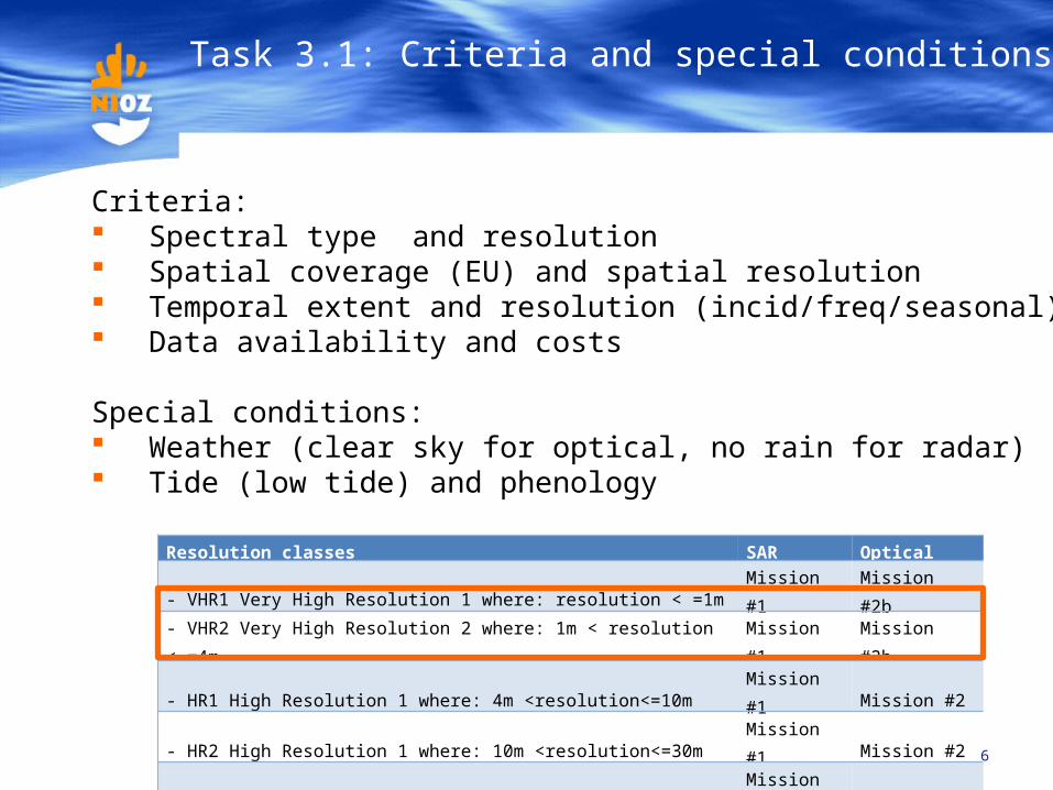
Task 3.1: Criteria and special conditions
6
Criteria: Spectral type and resolution Spatial coverage (EU) and spatial resolution Temporal extent and resolution (incid/freq/seasonal) Data availability and costs
Special conditions: Weather (clear sky for optical, no rain for radar) Tide (low tide) and phenology
Resolution classes SAR Optical
- VHR1 Very High Resolution 1 where: resolution < =1m Mission #1 Mission #2b
- VHR2 Very High Resolution 2 where: 1m < resolution < =4m Mission #1 Mission #2b
- HR1 High Resolution 1 where: 4m <resolution<=10m Mission #1 Mission #2
- HR2 High Resolution 1 where: 10m <resolution<=30m Mission #1 Mission #2
- MR1 Medium Resolution where: 30m <resolution<=100m Mission #3 Mission #3
- MR2 Medium Resolution where: 100m <resolution<=300m Mission #3 Mission #3
- LR Low Resolution where: resolution >=300m Mission #3 Mission #3

Sentinel-1a (C-band SAR): launched!
https://directory.eoportal.org/web/eoportal/satellite-missions/c-missions/copernicus-sentinel-1
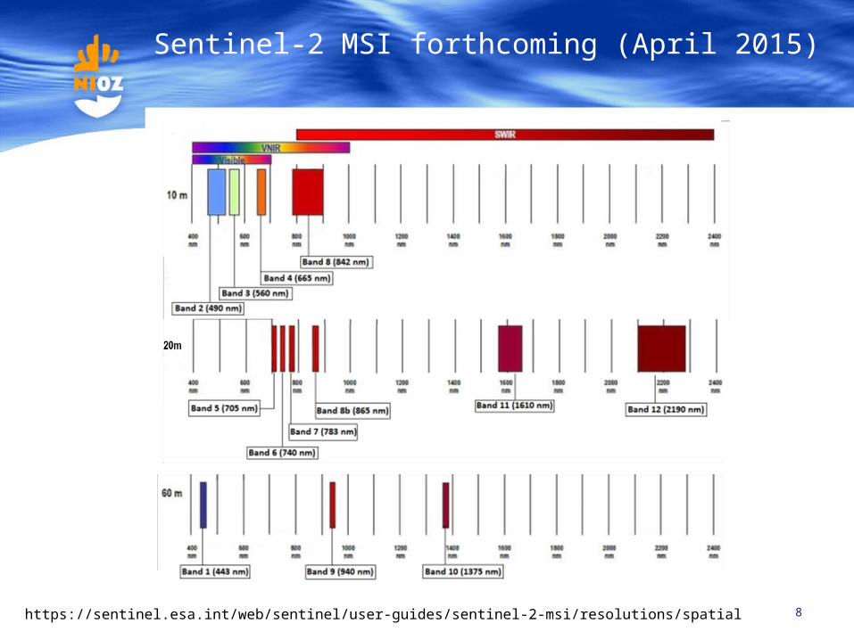
8https://sentinel.esa.int/web/sentinel/user-guides/sentinel-2-msi/resolutions/spatial
Sentinel-2 MSI forthcoming (April 2015)

9
RapidEye/Blackbridge
WV2
Alternatives for Sentinel-2 MSI
Landsat
Sentinel-2, also SPOT 5 (G,R,NIR)
Sentinel-2Also
SPOT5 (SWIR)

Data needs: consistency between countriesand consistency between seasons/years
10

Data needs: HR spatial resolution
11
NetherlandsLandsat 8, 30m (HR2) Formosat-2, 8m (HR1)
Landsat 8, 30m (HR2) Aerial photo

12
RapidEye, 30 Sep 2011L3 data resampled to 20 mL1 NITF data (6.5 m)Multiple archived (ESA) exists for all sites
Data needs: HR1 spatial resolution
CORE03SPOT5, 10m, 2.5 pan31 Jan 2012
13
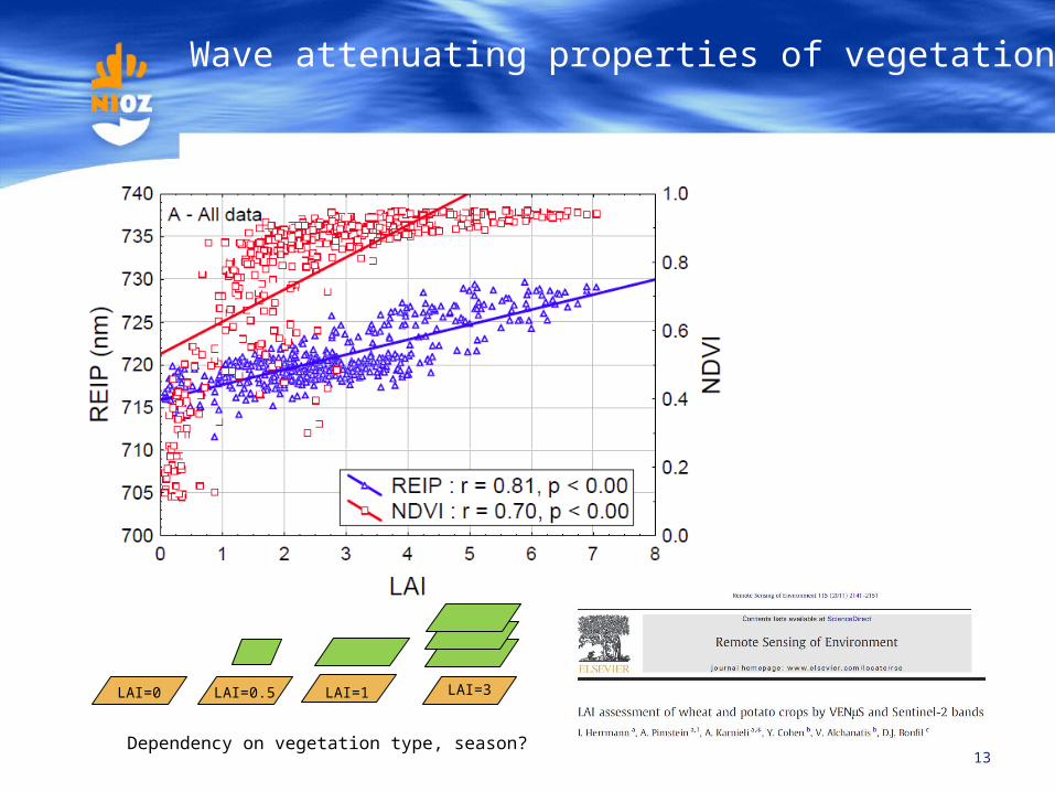
Wave attenuating properties of vegetation…
LAI=3LAI=1LAI=0.5
Dependency on vegetation type, season?
LAI=0

14
Main data source EO source Res. Class Extent Vegetation biomass (NDVI)
Vegetation biomass (LAI/FAPAR etc)
Vegetation assemblage / plant species
Vegetation structure (roughness)
Sediment type (intertidal foreland)
Microphytobenthos biomass (intertidal foreland)
Elevation/ topography (intertidal)
Automatic wetland identification
Sea state
CORE_01: 2011/2012 cov1, 2011-2012 IRSP6, SPOT5
HR1/HR2 2011-2012
CORE_01: 2011/2012 cov2 RapidEye HR1/HR2 2011-2012
CORE_02/DAP_MG2-3_01:2006, 2009 IRSP6, SPOT4-5
HR2 20,062,009
CORE_03: VHR2 2011-2013 SPOT5-7, Formosat 2
VHR2 2011-2013 incidental
Copernicus Land montioring, HR image mosaic 2000, 2006, 2009, 2012
HR1 2000-2009 Change detection possible
archived archived change detection possible
Copernicus Land monitoring, HRL's 5 classes, incl wetlands
VHR2
Sentinel-1, L1, C-band Sentinel-1 HR1 preferred preferred
Sentinel-2, BOA (L2a) Sentinel-2 HR1 preferred preferred preferred preferred
Sentinel-2, Biopar Sentinel-2 HR1 preferred preferred auxxillary info
RapidEye RapidEye HR1
WorldView-2,
8 band superspectral
SPOT SPOT VHR2/HR1 Limited by spectral info
Limited by spectral info
Limited by spectral info
Limited by spectral info
Landsat 8, free Landsat 8 HR2 >2013 quite coarse quite coarse, limited by spectral info
Limited by spectral info
Limited by spectral info
Limited by spectral info
TerraSAR-X TerraSAR-X VHR2/HR1
Incidental incidentalWorldView-2 VHR2/HR1 Incidental Incidental superspectral
Limited by spectral info
GSC DS
limited by spectral info, incidental, not seasonal
not applicable
ESA Sources
TPM (Third Party Missions)
GSC core
Incidental, no cal
Limited by spectral info No stereo, incidental
Potential Potential, but restrictions No potential
Task 3.1: Indentification of main sources
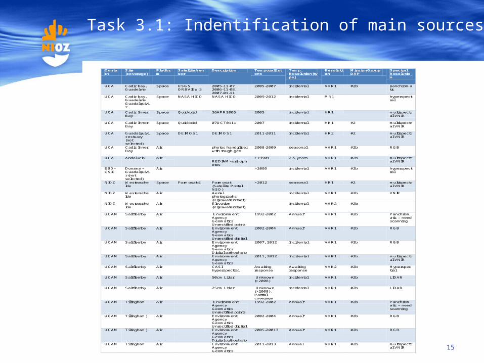
15
Contact
Site (coverage)
Platform
Satellite/sensor
Description TemporalExtent
Temp. Resolution[type]
Resolution
MissionGroupDAP
Spectral Resolution
UCA Cadiz bay, Guadelete
Space USGS ORBVIEW3
2005-11-07, 2006-11-08, 2007-01-11
2005-2007 incidental VHR1 #2b panchromatic
UCA Cadiz bay, Guadelete Guadalquivir
Space NASA HICO NASA HICO 2009-2012 incidental MR1 hyperspectral
UCA Cadiz Inner Bay
Space Quickbird 26APR2005 2005 incidental HR1 multispectral VNIR
UCA Cadiz Inner Bay
Space Quickbird 07OCT0111 2007 incidental HR1 #2 multispectral VNIR
UCA Guadalquivir estuary (not selected)
Space DEIMOS1 DEIMOS1 2011-2011 incidental HR2 #2 multispectral VNIR
UCA Cadiz Inner Bay
Air photos handglider with rough geo
2008-2009 seasonal VHR1 #2b RGB
UCA Andalucia Air REDIAM>orthophotos
>1990s 2-5 years VHR1 #2b multispectral VNIR
EBD-CSIC
Donana – Guadalquivir (not selected)
Air >2005 incidental VHR1 #2b hyperspectral
NIOZ Westerschelde
Space Formosat-2 Formosat (Satellite Portal NSO)
>2012 seasonal HR1 #2 multispectral VNIR
NIOZ Westerschelde
Air Aerial photographs (Rijkswaterstaat)
incidental VHR1 #2b VNIR
NIOZ Westerschelde
Air Elevation (Rijkswaterstaat)
incidental VHR2 #2b
UCAM Saltfleetby Air Environment Agency Geomatics Unrectified prints
1992-2002 Annual* VHR1 #2b Panchromatic – need scanning
UCAM Saltfleetby Air Environment Agency Geomatics Unrectified digital
2002-2004 Annual* VHR1 #2b RGB
UCAM Saltfleetby Air Environment Agency Geomatics Digital orthophoto
2007, 2012 Incidental VHR1 #2b RGB
UCAM Saltfleetby Air Environment Agency Geomatics
2011, 2012 Incidental VHR1 #2b multispectral VNIR
UCAM Saltfleetby Air CASI hyperspectral
Awaiting response
Awaiting response
VHR2 #2b Hyperspectral
UCAM Saltfleetby Air 50cm Lidar Unknown (>2008)
incidental VHR1 #2b LIDAR
UCAM Saltfleetby Air 25cm Lidar Unknown (>2008). Partial coverage
incidental VHR1 #2b LIDAR
UCAM Tillingham Air Environment Agency Geomatics Unrectified prints
1992-2002 Annual* VHR1 #2b Panchromatic – need scanning
UCAM Tillingham) Air Environment Agency Geomatics Unrectified digital
2002-2004 Annual* VHR1 #2b RGB
UCAM Tillingham) Air Environment Agency Geomatics Digital orthophoto
2005-20013 Annual* VHR1 #2b RGB
UCAM Tillingham Air Environment Agency Geomatics
2011-2013 Annual VHR1 #2b multispectral VNIR
Task 3.1: Indentification of main sources

Task 3.1: Indentification of main sources
16
Potential parameter Type Freq Res Alternative for Sentinel
Wave attenuation properties of vegetation
LAI, NDVI (per vegetation type?) Opt Seasonal HR1 S2 or RapidEye/Landsat/SPOT/…
Vegetation type? Opt/superspec Incidental HR1 S2 or RapidEye/WV2
Vegetation roughness? SAR Seasonal HR1 S1a
Foreshore characteristics
Topograhy (intertidal) , UCA? Opt/stereo Many HR1 S2 or RapidEye/Landsat/SPOT/…
Stability: sediment type SAR/opt Seasonal HR1 S1a & RapidEye/Landsat/SPOT/…
Stabilising biota (algae, seagrass) Opt/superspec Seasonal HR1 S2 or RapidEye/Landsat/SPOT/WV2

Task 3.1: Indentification of main sources
17
DWH Core services of some use RapidEye/Blackbridge and SPOT from catalogue available??
GSC downstream services Biopar too coarse, synthesized or not for these areas
ESA missions contributing to Copernicus Sentinel 1a Sentinel 2 when available
Third Party Missions contributing to Copernicus RapidEye/Blackbridge, SPOT, WV2 in ESA/Copernicus archive; obtain through DWH or ESA proposal?
Other data Landsat, free

WP3 Looking ahead: 2014
18
Task 3.1 Identify suitable DS/ EO data and collect data (M1-36)
> Data inventory (M3), done> Collect data (e.g., matching field work), preprocess
Task 3.2 Identify ground referencing sites / field protocol (M1-4)
> Field protocol, see talk Iris WP4 (M4)> Short brochure, UCA (M8)
Task 3.3. Deriving algorithms for foreshore identification (M19-M36)
> Divide tasks, field-rs-model compatibility, processing
Task 3.5. Delivery of data products for model input (M10-M36)

Royal Netherlands Institute for Sea Research
19
Discussion..