Embed Size (px)
Citation preview

NATIONAL CENTER FOR HYDROLOGY AND METEOROLOGYROYAL GOVERNMENT OF BHUTAN
www.nchm.gov.btTel: +975 2 323703Fax: +975 2 335578
Printed at United Printing Press
ROYAL GOVERNMENT OF BHUTANNATIONAL CENTER FOR HYDROLOGY AND METEOROLOGY
(NCHM)
STANDARD OPERATING PROCEDURE (SOP)
AVIATION METEOROLOGICAL SECTIONWEATHER AND CLIMATE SERVICES DIVISION
2020


ROYAL GOVERNMENT OF BHUTAN
NATIONAL CENTER FOR HYDROLOGY AND METEOROLOGY
(NCHM)
STANDARD OPERATING PROCEDURE (SOP)
AVIATION METEOROLOGICAL SECTION
WEATHER AND CLIMATE SERVICES DIVISION
2020

ii
ABBREVATIONS
NCHM National Center for Hydrology and Meteorology
OD Organizational Development
MoIC Ministry of Information and Communication
WMO World Meteorological Organization
ICAO International Civil Aviation Organization
DoAT Department of Air Transport
AMSP Aeronautical Meteorological Service Provider
BCAA Bhutan Civil Aviation Authority
WCSD Weather and Climate Services Division
PIA Paro International Airport
AIP Aeronautical Information Publication
HOID Hydromet Operational and Infrastructure Division
MET Meteorological
ATC Air Traffic Control
AMHS ATS Message Handling System
AMS Aviation Met Section
ANS Air Navigation Section
BIP-MT Basic Instruction Package for Meteorological Technician
BIP-M Basic Instruction Package for Meteorologist
AWOS Automatic Weather Observation System
SOP Standard Operating Procedure
FAT Factory Acceptance Test

iii
LIST OF TABLES
Table 1: Meteorological observation and report ....................................................................... 18

iv
LIST OF FIGURES
Figure 1: Organisational Structure of NCHM ..................................................................... 8
Figure 2: Organisational structure of AMS ....................................................................... 10
Figure 3: Operational flow of AMS ................................................................................... 11
Figure 4: General flow chart of the calibration process ..................................................... 42

v
TABLE OF CONTENTS
ABBREVATIONS.............................................................................................................. ii
List of Tables .................................................................................................................... iii
List of Figures .................................................................................................................... iv
Table of Contents ............................................................................................................... v
1 Organisation Structure .............................................................................................. 7
1.1 Introduction ........................................................................................................... 7
1.2 Vision .................................................................................................................... 8
1.3 Mission .................................................................................................................. 8
1.4 Core values ............................................................................................................ 9
1.5 Goals...................................................................................................................... 9
1.6 Organizational structure of AMS .......................................................................... 9
1.7 TECHNICAL/ACADEMIC QUALIFICATION AND EXPERIENCE ............ 11
1.8 FUNCTIONS AND RESPONSIBILITIES ......................................................... 12
1.9 JOB DESCRIPTION OF KEY MANAGEMENT AND TECHNICAL
PERSONNEL ................................................................................................................ 13
1.10 TRAINING OF KEY OFFICERS ................................................................... 15
2 STANDARD OPERATING PROCEDURE FOR PREPARATION OF MET
REPORT ........................................................................................................................... 18
2.1 Observations ........................................................................................................ 19
2.2 Routine observations and reports ........................................................................ 19
2.3 Special observations and reports ......................................................................... 20
2.4 Contents of reports .............................................................................................. 21
2.5 Observing and reporting meteorological elements.............................................. 21
2.6 Putting it all together ........................................................................................... 23
2.7 Dissemination of report ....................................................................................... 24

vi
3 STANDARD OPERATING PROCEDURES FOR STATION MAINTENANCE
25
3.1 Processes and tasks for maintaining an operational observational network ....... 26
3.2 The appropriate frequency for different maintenance tasks ................................ 27
3.3 Actions if something is not working correctly .................................................... 29
3.4 Tasks and Knowledge required on-site. .............................................................. 31
3.5 Responsibility of the Staff. .................................................................................. 32
3.6 Documentation .................................................................................................... 33
3.7 Instrument inventory ........................................................................................... 36
4 STANDARD OPERATING PROCEDURES FOR STATION CALIBRATION
38
4.1 What parts of the calibration processes should be in-house and what should be
outsourced? .................................................................................................................... 38
4.2 Processes and tasks included in the calibration ................................................... 39
4.3 Documentation .................................................................................................... 42

7
1 ORGANISATION STRUCTURE
1.1 Introduction
1.1.1 National Center for Hydrology & Meteorology (NCHM) was established as an
autonomous organization of the Royal Government of Bhutan for monitoring and
understanding of hydrology, weather, climate and cryosphere, for timely provision
of information and services to protect lives and property and support national
needs for ecologically balanced sustainable development.
1.1.2 NCHM was established as an independent organization of the Royal Government
vide cabinet approval of Organizational Development (OD) Exercise
recommendations letter no: C/3/92 dated 25th December 2015 and subsequent
approval of the staffing/structure by the RCSC vide letter no.
RCSC/HRMD/26/2016/618 dated 10th August 2016. The Aviation Met Section
under Department of Air Transport (DoAT), Ministry of Information &
Communication (MoIC) was also merged with NCHM vide the same order.
1.1.3 Weather forecast continues to be a challenge in providing accurate forecasts for
the aviation sector. In order to contribute towards the safety, economy and
efficiency of air navigation, National Meteorological Services throughout the
world make meteorological observations and forecasts through establishment of
sustained monitoring and warning systems in their respective countries, as per the
standards and guidelines provided by World Meteorological Organization (WMO)
and International Civil Aviation Organization (ICAO).
1.1.4 The aviation met services came as an additional mandate to the center. The DoAT
has transferred the mandates, functions, responsibilities and services of aviation
met section to NCHM on 17th August 2017. NCHM is now the designated
Aeronautical Meteorological Service Provider (AMSP) within Bhutan, which is
responsible for all matters related to Aviation Meteorological Services. The
NCHM has to enhance the capacity, expertise, technology, equipment and
infrastructures for the safety of the flight operations.

8
1.1.5 Within the NCHM, AMS is a section under the Weather and Climate Services
Division (WCSD) with the mandate to provide operational meteorological
information for safe, regular and efficient air navigation as well as meteorological
support to the activities of the aviation industry. It provides information to the
Paro International Airport (PIA) and the three domestic airports in Gelephu,
Bumthang and Yongphula.
1.1.6 The meteorological services provided in Bhutan are described in the Bhutan
Aeronautical Information Publication (AIP) and are defined in GEN 3.5
Meteorological Services.
1.1.7 The organization structure of the center is as appended:
Figure 1: Organisational Structure of NCHM
1.2 Vision
1.2.1 Center for excellence in hydrology, meteorology and cryosphere science and
services
1.3 Mission
1.3.1 Monitoring and understanding of hydrology, weather, climate and cryosphere, for
timely provision of information and services to protect lives and property and
support national needs for ecologically balanced sustainable development.

9
1.4 Core values
1.4.1 Commitment and loyalty in delivery of products and services;
1.4.2 Integrity;
1.4.3 Professionalism in support of science, research, objectivity, impartiality, and
excellence;
1.4.4 Mutual respect, cultural sensitivity and non-discrimination.
1.5 Goals
1.5.1 Improve result-based decision support service for weather incidents and events
that threaten lives and livelihoods;
1.5.2 Enhance climate services to understand and adapt to climate-related risks;
1.5.3 Develop capacity to provide integrated and coupled monitoring, detection and
forecast services to support assessment and management of water resources and
water-related hazards;
1.5.4 Build competence to provide sector-relevant information for socio-economic
development, and support development of integrated environmental services to
foster healthy communities and ecosystems;
1.5.5 Sustain highly skilled professional workforce equipped with training, tools and
infrastructure to fulfil the mission.
1.6 Organizational structure of AMS
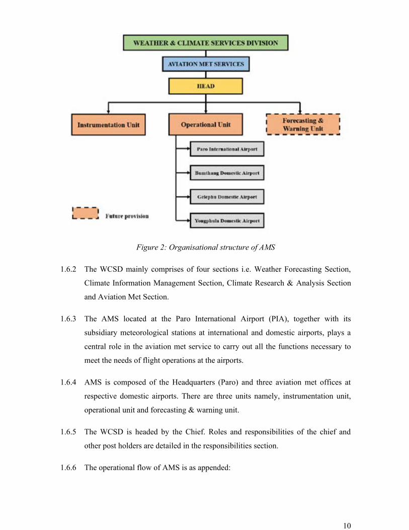
1.6.1 The organization structure of AMS is as appended:
10
Figure 2: Organisational structure of AMS
1.6.2 The WCSD mainly comprises of four sections i.e. Weather Forecasting Section,
Climate Information Management Section, Climate Research & Analysis Section
and Aviation Met Section.
1.6.3 The AMS located at the Paro International Airport (PIA), together with its
subsidiary meteorological stations at international and domestic airports, plays a
central role in the aviation met service to carry out all the functions necessary to
meet the needs of flight operations at the airports.
1.6.4 AMS is composed of the Headquarters (Paro) and three aviation met offices at
respective domestic airports. There are three units namely, instrumentation unit,
operational unit and forecasting & warning unit.
1.6.5 The WCSD is headed by the Chief. Roles and responsibilities of the chief and
other post holders are detailed in the responsibilities section.
1.6.6 The operational flow of AMS is as appended:

11
Figure 3: Operational flow of AMS
1.7 TECHNICAL/ACADEMIC QUALIFICATION AND EXPERIENCE
1.7.1 Chief (WCSD
• The Chief should have a minimum qualification of Degree and should have served
at least 10 years in relevant fields of hydrology & Meteorology.
1.7.2 Hydro/Met Officer
• Master/Bachelors in Civil/Electrical/Electronics & Communication Engineering
OR Diploma in Civil/Electrical/Electronics &Communication engineering.
1.7.3 Hydro/Met Technicians
• Class XII passed with a science background OR technical institute graduate in
civil.
1.7.4 Support Staff
• Personnel familiar with office equipment, computer operations, administrative
procedures, record keeping, etc.

12
1.8 FUNCTIONS AND RESPONSIBILITIES
1.8.1 Instrumentation Unit:
• Prepare annual plans and budget in consultation with the head.
• Prepare drawing, cost estimate of works related to establishment and construction
of aerodrome meteorological stations and related infrastructures as per BCAA
and ICAO norms.
• Maintain inventory of aerodrome meteorological network stations and
infrastructure.
• Operation and maintenance of stations and infrastructures as per BCAA and
ICAO norms.
• Calibration of field instruments as per the required standard of BCAA and ICAO
norms.
• Organize instrument evaluations and comparisons as per BCAA and ICAO norms.
• Coordination with Air Traffic Controllers and Air Traffic Services.
• Correspond and update with ICAO and WMO.
• Coordination with Hydromet Operational Infrastructure Division (HOID) of
NCHM.
1.8.2 Operational Unit:
• Collect and maintain the records of meteorological observations of aerodromes in
all airports.
• Collect weather information in a form of MET REPORT/SPECIAL REPORT at
half-hourly intervals.
• Prepare and provide meteorological information (METAR/SPECI) at half-hourly
intervals to the pilots, flight dispatchers, ATC etc.
• Dissemination of meteorological information (METAR/SPECI) to the originating
aerodromes, Airlines, ATC and domestic airports through Automatic Message
Handling System (AMHS).
• Monitoring of aerodrome weather conditions and reporting to ATC for updating
the pilots for landing and take-off.

13
• Monitoring and operation of the aviation met infrastructure in respective airports
for safe operation of flights as per Bhutan Civil Aviation Authority (BCAA) and
ICAO norms.
• Coordination with Air Traffic Controllers and Air Traffic Services.
• Correspond and update with ICAO and WMO.
1.8.3 Forecast & warning Unit:
• Obtain METAR from all airports via AMHS.
• Prepare forecasts and other relevant information for flights.
• Prepare forecasts for the aerodromes.
• Maintain continuous survey of meteorological conditions over all airdromes.
• Prepare warnings, as necessary, for all aerodromes.
• Exchange meteorological information with other meteorological offices.
• Coordination with Weather Forecast Services of the Division for weather updates.
1.9 JOB DESCRIPTION OF KEY MANAGEMENT AND TECHNICAL
PERSONNEL
1.9.1 Job description of Chief Meteorological Officer
• Manage and monitor all aspects of Aeronautical Met Services, with general
oversight of all units under AMS.
• Advise Aviation Met Section on any matters relating to ANSP and Civil Aviation
Act.
• Monitor the Aeronautical Meteorological Services provided by the section to
ensure that such services meet ICAO requirements.
• Ensure that the MoU related to ANS are established, implemented and
maintained.
• Ensure that all the protocol questions & memos raised by the Auditors of
Regulatory are followed up and answered on time.

14
1.9.2 Job description of Head
• Assist in developing policies for Aviation Meteorology and recommend as
necessary.
• Assist the Chief, WCSD in formulating policies on long- and short-term plans for
the aviation sector and the responsibilities of WCSD, NCHM
• Assist to procure Aviation Meteorology equipment & delivery services in Bhutan
with the assistance and guidelines from ICAO and WMO
• Plan and proposal of Met Officials and train/familiarize to upgrade the knowledge
as per the ICAO norms & conditions.
• Recommend to the Chief, WCSD as per the DoAT/BCCA directives the
procedures, Meteorology equipment & system
• Prepare annual Aviation Meteorology budget and implement the approved
program
• Implement the provisions contained in the following Annexes and documents,
issued by ICAO
o Annex 3 – Meteorological Services for International Air Navigation
o Annex 14 – Aerodrome
o Doc 8896 – Manual of Aeronautical Meteorological Practice
o Doc 9377 – Manual on coordination between Air Traffic Services,
Aeronautical information Services and Aeronautical Meteorological
Services.
• Perform any other duties assigned by the head of division.
1.9.3 Job description of Assistant Hydro/Met Officer
• He/she is the immediate supervisor of Aviation Meteorology unit and manages the
daily activities under his/her control
• Ensure that all Met Equipment & system are properly maintained and serviceable
all the time at all airports
• Maintain close interaction with ANSP, BCAA and neighbouring ATS units to
provide and exchange information regarding the Air Traffic Services
• Ensure that Aviation Meteorology abide by ICAO and WMO recommendations &
practices

15
• Keep in constant contact with day to day matters of Air Traffic Services, Air
Traffic Control and report to the aviation met officer
• Plan trainings/OJTs required for the aviation meteorological assistants and to
discuss with the Met Officer
• Monitor the staff of three domestic airports and ensure it is manned & available
all the time for the safe flow of flight operations
• Endure and plan regular visits to 3 domestic airports for periodic maintenance of
meteorological equipment & system check in order to keep the met services
available all the time
1.9.4 Job description of Meteorology Technicians
• Collection of weather data and maintaining of the meteorological records of the
aerodrome on half hourly intervals
• Coordination with ATC on weather conditions during the departure & arrival
flight operations
• Assist the assistant Meteorological in day-to-day office works & activities.
• To check the serviceability of the Met equipment & systems to ensure in providing
the meteorological information to the pilots, flight dispatchers, flight
documentation, etc.
• Prepare METAR from the collected meteorological data of the aerodrome and
transmit through Automatic Message Handling System (AMHS) to the originating
airdromes and to Paro ATC
• Obtain & get METAR from each airport (Paro & 3 domestic airports) whenever
there are flight movements
1.10 TRAINING OF KEY OFFICERS
1.10.1 Initial training of key personnel
• All the key personnel of AMS shall have in depth knowledge of various provisions
of ICAO Annex 3 and Manual of Aeronautical Meteorological Practice, therefore,
they shall have undergone a training course on ICAO Annex 3 and Manual of
Aeronautical Meteorological Practice

16
• They shall have undergone a training course as specified by the Basic Instruction
Package for Meteorological Technicians (BIP-MT) and Basic Instruction for
Meteorologist (BIP-M).
• Components of the Basic Instruction Package for Meteorologists are:
o Foundation topics in mathematics and physics plus complementary
subjects dealing with other sciences and related topics, communications,
and data analysis and utilization;
o Topics in atmospheric sciences
▪ Physical meteorology (i.e. atmospheric composition, radiation and
optical/electrical phenomena; thermodynamics and cloud physics;
boundary-layer meteorology and micrometeorology; conventional
observations and instrumentation; remote sensing);
▪ Dynamic meteorology (i.e. atmospheric dynamics; numerical
weather prediction);
▪ Synoptic and mesoscale meteorology (i.e. mid-latitude and polar
weather systems; tropical weather systems; mesoscale weather
systems; weather observation, analysis and diagnosis; weather
forecasting; service delivery);
▪ Climatology (i.e. global circulation; climates and climate services;
climate variability and climate change).
Besides the basic requirement to successfully complete topics (a) and (b),
individuals wishing to obtain a specialization may also study in greater depth such
subjects as aeronautical meteorology, atmospheric chemistry, and climate
monitoring and prediction.
• Components of the Basic Instruction Package for Meteorological Technicians are:
o Foundation topics in mathematics and physics plus complementary
subjects dealing with other sciences and related topics, communications,
and data analysis and manipulation
o Topics in general meteorology: basic physical and dynamic meteorology;
basic synoptic and mesoscale meteorology; basic climatology; and
meteorological instruments and methods of observation.

17
Besides the basic requirement to successfully complete topics (a) and (b),
individuals wishing to obtain a specialization may also study in greater depth such
subjects as specialized observations and measurements; data quality control and
archiving; equipment calibration and maintenance; and communications and
computing.
1.10.2 Recurrent training of key personnel
• The key personnel of the AMS require the continuing development of their
knowledge and skills related to their respective responsibilities. This shall be
accomplished through periodic training and refresher courses in all the
disciplines for which the technical officers are responsible. They shall be required
to undergo recurrent training/refresher training at the interval of every two years.
• Participation in seminars and workshops organized by ICAO,
international/regional aviation related organizations and BCAA can also enable
these personnel to widen their horizons and share experience with experts from
other states or organizations.
• The key personnel shall attend the workshops, seminars and OJTs overseas within
the region to understand and keep up with the new procedures and practices of
ICAO annex and WMO recommendations in other busy International Airports.
1.10.3 Training records of the key personnel
• AMS shall maintain the training records of each key personnel in their respective
files
• The Secretariat of NCHM is responsible for keeping the training records of the
key personnel updated and secured.

18
2 STANDARD OPERATING PROCEDURE FOR
PREPARATION OF MET REPORT
AMS has installed automated equipment for measuring surface wind, air and dew-point
temperatures and atmospheric pressure to support approach and landing and take-off
operations. These devices are integrated automatic systems for acquisition, processing,
dissemination and display in real time of meteorological parameters affecting landing and
take-off operations. AMS provides METAR and SPECI at PIA and all domestic airports.
Table 1: Meteorological observation and report
Name of station/Location indicator
Type & frequency of observation/automatic observation equipment
Type of MET report & supplementary information included
Observation system & site(s)
Hours of operation
Climatological
PARO (VQPR) Half hourly plus special observation
Plain language
METAR
SPECI
Surface wind sensor
Temp. sensor
Pressure sensor
HO
NIL
BUMTHANG (VQBT)
Half hourly plus special observation
Plain language
METAR
SPECI
Surface wind sensor
Temp. sensor
Pressure sensor
HO
NIL
GELEPHU (VQGP)
Half hourly plus special observation
Plain language
METAR
SPECI
Surface wind sensor
Temp. sensor
Pressure sensor
HO
NIL
YONGPHULA
(VQTY)
Half hourly plus special observation
Plain language
METAR
SPECI
Surface wind sensor
Temp. sensor
HO
NIL

19
Pressure sensor
2.1 Observations
2.1.1 Collection of data for surface wind & speed, temperature & pressure from the
AWOS on half-hourly basis.
2.1.2 Collection of information regarding visibility, cloud amount & cloud base by
visual estimation by the observer at half-hourly interval.
2.1.3 These data shall be maintained in a Met Report register.
2.1.4 Encode the Met Report for the preparation of METAR as specified in 6.5.
2.2 Routine observations and reports
2.2.1 At aerodrome, routine observations shall be made for 5 hours each day.
2.2.2 The observations shall be made at intervals of half-hour.
2.2.3 Reports of routine reports observations shall be issued as:
• Local routine reports, only for dissemination at the aerodrome of origin, and
• METAR for dissemination beyond the aerodrome of origin
2.2.4 METAR shall be issued prior to the aerodrome resuming operations.
2. Standard Operation Procedures (SOP)
2.1. Observations 2.2. Routine observations and reports 2.3. Special observations
and reports
2.4. Contents of reports 2.5. Observing and
reporting meteorological elements
2.6. Dissemination of Reports
20
2.3 Special observations and reports
2.3.1 Following are the list of criteria for special observations:
• As and when significant changes place in any one or more of the visibilities,
weather, cloud and surface wind
• After issuing SPECI, if a similar weather condition prevails at the same time of
next routine observation, the report at routine observation will be METAR.
• If a SPECI is issued within a 10 minutes period of routine observation time, then
at the time of routine observation, no weather report will be prepared. The
observation will be entered in the current weather register only.
• If deterioration in one met element and improvement in another MET element
takes place simultaneously, the SPECI for Deterioration will be issued
immediately and it should include the improvement of other meteorological
elements.
• When visibility changes to all processes by 5000M, 3000M, 1500M & 800M,
SPECI is issued.
• For onset, cessation or change of intensity of the following weather phenomena,
SPECI is issued.
o Freezing precipitation.
o Moderate or heavy rain, snow, snow pellets, Ice pellets, hail, small hail or
their combination.
o Thunderstorm with or without above precipitation.
o Drifting/ Blowing dust, sand, snow.
o Dust storm, Sand storm, Squall, Funnel cloud.
2.3.2 Reports of special observations shall be issued as:
• Local special reports, only for dissemination at the aerodrome of origin
• SPECI for dissemination beyond the aerodrome of origin

21
2.4 Contents of reports
2.4.1 Local routine and special reports (METAR and SPECI) shall contain the following
elements:
• Identification of the type of reports
• Location indicator
• Time of the observation
• Identification if an automated or missing report, when applicable
• Surface wind direction and speed
• Visibility
• Runway visual range, when applicable
• Present weather
• Cloud amount, cloud type and height of cloud base, or, where measured vertical
visibility
• Air temperature and dew-point temperature
• QNH and, when applicable QFE
2.5 Observing and reporting meteorological elements
2.5.1 Surface wind
• Wind shall be coded as direction in degrees true followed by the average speed.
Eg: 24015KT-indicates that the wind is blowing from southwest at 15kts
6.5. Observing and Reporting Meteorological elements
2.5.1
Surface Wind
2.5.2
Visibility
2.5.3
Runway visual range
2.5.4
Present weather
2.5.5
Clouds
2.5.6
Air temp and dew-point
temp
2.5.7
Atmospheric pressure

22
• If the wind is gusting this shall be coded by a further group of figures preceded by
the letter G. Eg: 24015G27KT
• If the wind is calm then 00000KT shall be coded.
• A variable wind direction shall be coded by VRB. Eg: VRB02KT shall indicate
that the wind was only 2KTs but would not be blowing from any fixed direction.
• If the wind is greater than 3KT and the direction is varying by 60 degrees or more
than the actual values be coded. Eg: 31015G27KT 280V360 which indicates that
the wind is blowing from northwest at 15 KTs with gusts to 27KTs but that the
wind direction is varying from 280 to 360 degrees.
2.5.2 Visibility
• Visibility shall be coded as a four-figure group in meters (2000 meters is roughly
1 nm). If 0000 is coded for the visibility less than 50 meters. If 9999 is coded for
the 10 km visibility or more
2.5.3 Runway Visual Range (RVR)
• RVR is an indication of the real visibility as measured down the runway either
electronically or manually. RVR is taken when the Met visibility drops below 1500
meters and it shall therefore only be shown occasionally in METAR reports. RVR
visibility shall always be prefixed by the letter R followed by the runway for which
has been taken
Eg: R24/1200 – RVR for runway 24 is 1200 meters
2.5.4 Present weather
• Weather shall be coded by one or more two letter groups as shown in table below
2.5.5 Clouds
• Usually clouds are coded in six figure groups. The group consists of three letters
that describe the cloud cover followed by three figures for cloud height above
aerodrome level.
• Cloud amount shall be coded as;
FEW Few indicating 1 or 2 oktas of cloud
SCT Scattered indicating 3 or 4 oktas cloud
BKN Broken indicating 5 to 7 oktas of cloud

23
OVC Overcast indicating 8 oktas (solid cloud cover)
• Cloud height shall be coded in the next three figures which shows the altitude in
hundreds of feet. i.e. 040 for 4000ft, 004 for 400ft, 200 for 20,000ft.
Eg; SCT020 Scattered at 2000ft
BKN005 Broken cloud at 500ft
OVC250 Overcast at 25,000ft
• A METAR may contain several cloud layers like SCT025 BKN070 BKN120,
indicating scattered cloud at 2500ft, broken cloud at 7000ft and again at 12,000ft.
SKC Sky clear, if no cloud layers are observed
CAVOK If no cloud exists below 5000ft and the visibility > 10km
CB Cumulonimbus formation
TCU Towering CB formation
2.5.6 Air temperature and dew-point temperature
• Temperature and dew-point shall be measured in centigrade. A minus value shall
be preceded by the letter M.
Eg; 25/12 Temp 25℃, Dew-point 12℃, or
00/M02 Temp 0℃, Dew-point -2℃
2.5.7 Atmospheric pressure
• QNH shall be rounded to the next whole millibar and coded as a four figure group
preceded by Q. For values < 1000mbs then the first digit shall be 0.
Eg;
Q0996 QNH 996mbs
Q1030 QNH 1030mbs
2.6 Putting it all together
2.6.1 METAR VQPR 1050Z 24015KT 9000 RA SCT025 BKN040 10/09 Q1010
NOSIG

24
2.6.2 The report was measured at 1050 UTC and it shows that PARO was reporting a
wind of 240 at 15KTs, the visibility was 9KM (9000m), it was raining, cloud was
scattered at 2500ft and broken at 4000ft. Temperature was 10℃ and dew-point of
9℃, the sea level pressure (QNH) was 1010mb and there was no significant
change expected in the next two hours.
2.7 Dissemination of report
2.7.1 These Aerodrome Reports shall be transmitted through ATS Message Handling
System (AMHS) to the originating aerodromes and to Paro ATC.

25
3 STANDARD OPERATING PROCEDURES FOR
STATION MAINTENANCE
Standard Operating Procedures (SOP) consists of seven parts:
1. Process & tool for maintaining as operational observation network
2. The appropriate frequency for different maintenance tasks
3. Actions if something is not working correctly
4. Tasks and knowledge required on site
5. Responsibility of the staff
6. Documentation
7. Instrument Inventory
3. Standard Operation Procedures (SOP)
3.1. Processes & Tasks for Maintaining an Operational
Observational Network 3.2. The appropriate frequency for different maintenance tasks 3.3. Actions if something is not
working correctly
3.4. Task and Knowledge required on-site 3.5. Responsibility of the Staff 3.6. Documentation
3.7. Instrument Inventory

26
3.1 Processes and tasks for maintaining an operational observational network
3.1 Processes and task for maintaining an operational observational network
3.1.1 Establishing
new or moving existing weather
observation stations
3.1.2 General maintenance and
service 3.1.3 Monitoring of data transmission 3.1.4 Calibration
and adjusting 3.1.5 Instrument
updates, including configuration and
testing
Figure 7 Figure SEQ Figure \* ARABIC 7: Processes and tasks for maintaining an operational observational network

27
3.1.1 Establishing new or moving existing weather observation stations
• ATC personnel should be included in the selection of new weather station
locations and it should be at aerodromes in its territory.
• Representativeness of the new location should be in accordance with ICAO and
WMO norms.
3.1.2 General maintenance and service
• Grass cutting.
• Cleaning of instruments.
• Main office information for field observer:
o Dos and don’ts for field observers regarding things that affect the
representativeness of the station.
o Updating the station logbook with the help of station inspection forms etc.
3.1.3 Monitoring of data transmission
• It is convenient to automatize the status messaging of a large modern observation
network, because manual monitoring is impossible to implement efficiently.
Monitoring regarding data flow and data quality can be automatized. In addition,
station fault diagnostics can be monitored (warnings, alarms etc.).
3.1.4 Calibration and adjusting
• Planning and maintaining calibration procedures and systems.
• Laboratory calibrations.
• Technical quality assurance.
• Maintain traceability of calibration reference equipment.
3.1.5 Instrument updates, including configuration and testing
• Replacement of instruments before their calibration lifetime expires.
3.2 The appropriate frequency for different maintenance tasks

28
3.2.1 Once a year (technician)
• Visiting and inspecting all stations. Replacing the sensors as planned. The
required instrument replacement schedule depends on the used instrumentation
and the environmental conditions.
• Checking the sensor leads and cables for cracking, deterioration and proper
routing. Replacing the sensor cables if necessary.
3.2.2 Every month (field observer)
• Need for cutting of grass is determined.
• Keeping an eye out for any changes in the surroundings (new buildings, planted
areas etc.). Reporting these immediately.
• Monitoring for any unauthorized visits or vandalism.
3.2.3 Weekly (field observer)
• Cleaning of instruments.
3.2.4 Daily (field observer)
• Cleaning of manual rain gauges and checking if the automatic rain gauge
container is full.
NOTE: Important to update the station logbook (metadata) with the help of station
inspection forms etc.
3.2 The appropriate frequency for different maintenance tasks
3.2.1. Once a year (technician) 3.2.2. Every month
(field observer) 3.2.3. Weekly (field observer) 3.2.4. Daily (field
observer) 3.2.5. Maintenance schedule

29
3.2.5 Maintenance schedule
• Temperature and humidity - every year.
• Wind sensors - every second year. Positioning of the wind vane will be checked in
every year.
• Ultrasonic wind sensor (after mechanical damage or any specific problems).
• Pressure - every three years.
• Solar radiation sensor (if available).
• Data logger every 10 years.
• If major deviation or mechanical damage in sensors are observed.
3.3 Actions if something is not working correctly
3.3. Actions if something is not working correctly
3.3.1. In case all parameters are unavailable 3.3.2. In case only individual parameters are unavailable

30
3.3.1 In case all parameters are unavailable
• A remote connection first used, if available. If the remote connection procedures
(resetting logger, checking date, checking power supply etc.) does not fix the
problem or it is not available, the local contact person contacted for checking
station abnormalities and asked if the field observer is able to fix the problem.
• Checking the station with the following procedures:
o Electricity (power supply).
▪ The electricity provider contacted, if an electricity issue can be
identified.
o Communication module (modem).
▪ Resetting of modem.
▪ The service provider contacted, if a connection issue can be
identified, but resetting the modem does not work.
o Data logger.
▪ The data logger errors read (incl. communication errors).
▪ Reset the logger.
o Assembly’s cable connections.
• If a resolution is not found, a technician will be requested from the main office.
The field observer asked to help to make a list of the required maintenance spare
parts etc. if extra service needed.
• An error report always documented and filed. In addition, also progress updates
are included in the report.
3.3.2 In case only individual parameters are unavailable
• A remote connection first used, if available. If the remote connection procedures
(resetting logger, checking date, checking power supply etc.) does not fix the
problem or it is not available, the local contact person contacted for checking the
individual instrument and asked if the field observer is able to fix the problem.
• Checking the individual sensor with the following procedures:
o Connections.
o General conditions of the instrument.
o Obstructions (blocking of radiation sensor etc.).

31
• If a resolution is not found, the same procedures as with all parameters are
unavailable and can be tried, before a technician is requested from the main
office. The field observer asked to help to make a list of the required maintenance
spare parts etc. if extra service needed.
• An error report always documented and filed. In addition, also progress updates
are included in the report.
3.4 Tasks and Knowledge required on-site.
3.4 Tasks and Knowledge required on-site
3.4.1. Field observer 3.4.2. Technician 3.4.3. Calibration

32
3.4.1 Field observer
• Basic operation and maintenance knowledge.
• Civil and electricity works knowledge.
• Basic knowledge about the instruments.
3.4.2 Technician
• Background in electronics and instrumentation.
• Certificate level technicians with electrical engineering background.
• Computing (IT) knowledge.
• Communication knowledge.
• Troubleshooting knowledge.
3.4.3 Calibration
• This depends on the instrumentation. Analog instrumentation needs the
calibration of the logger. For digital instruments, only replacement is required.
Therefore, digital instrumentation will be highly recommended for the future
updates. This way, the required maintenance knowledge at the station level is
minimal and all the calibration is focused on the calibration laboratory and the
key personnel in the main office.
3.5 Responsibility of the Staff.
3.5.1 Field observer
• Overall operation and maintaining of the station (ensure that station is
functioning).
• Responsibility of maintaining the station logbook and providing the updates to the
main office.
3.5. Responsibility of the Staff
3.5.1. Field observer 3.5.2. Regional office 3.5.3. Main office

33
3.5.2 Regional office
• Requirements for new instruments and sensors.
• Scheduling of maintenance.
• Support in maintenance.
• Maintaining regional inventory.
• Propose and plan development of the network.
3.5.3 Main office
• Overall monitoring of stations.
• Minor calibration.
• Procurement of spare parts.
• Major maintenance.
• Updating the logbook metadata to the database.
Later on, after the AWS network is bigger, and field observers are not enough, personnel
from the main office can be appointed to be responsible for specific stations or specific
areas of stations.
3.6 Documentation
3.6 Documentation
3.6.1. Metadata 3.6.2. Major database elements

34
3.6.1 Metadata
• Metadata is essential and should be kept current and be easily obtainable. A
station logbook and station inspection form should be used for documenting the
station metadata. The updates should also be delivered to the main office for
updating the metadata database.
• Any significant changes should be recorded in the station logbook and dated.
• Photographs are useful if they have been taken at sufficient distance to show the
instrument and its terrain background. Such photographs are should be taken
from all cardinal direction
• Station information (incl. Site acceptance test).
• Instrument information (incl. FAT).
• Contact person.
• Network (communication) information.
• Observations (type etc.).
Inspection forms (changes, maintenance etc.). Maintenance and service documents,
calibration documents, metadata database, instrumentation database (serial numbers
etc.)
3.6.2 Major database elements
• Network information.
• Station information:
o Station name and station index number(s).
o Geographical coordinates.
o Elevation above mean sea level.
o Types of soil, physical constants and profile of soil.
o Types of vegetation and condition.
o Local topography description.
o Type of AWOS, manufacturer, model, serial number.
o Observing program of the station: parameters measured, reference time,
times at which observations/measurements made and reported.
o The datum level to which atmospheric pressure data of the station refer.

35
o Contact information, such as name and mailing address, electronic mail
address, and telephone numbers.
o Complete history of the station with dates and details of all changes.
o Establishment, interruptions and closure of the station.
o Inspection information: comments about the site, exposure, quality of
observations and station operation.
• Individual instrument information:
o Sensor type, manufacturer, model, serial number.
o Principle of operation.
o Method of measurement/observation.
o Type of detection system.
o Performance characteristics.
o Unit of measurement and measuring range.
o Resolution, accuracy (uncertainty), time constant, time resolution, output
averaging time..
o Siting and exposure: location, shielding, height above ground (or level of
depth).
o Date of installation.
o Data acquisition: sampling interval, averaging interval and type.
o Correction procedures.
o Calibration data and time of calibration.
o Preventive and corrective maintenance.
▪ Recommended/ scheduled maintenance.
▪ Calibration procedures including frequency.
▪ Procedure description.
• Data-processing information regarding each individual meteorological element:
o Measuring/observing program: time of observations, reporting frequency,
data output.
o Data-processing method/procedure/algorithm.
o Formula to calculate the element.

36
o Mode of observation/measurement.
o Processing interval.
o Reported resolution.
o Input source (instrument, element, etc.).
o Constants and parameter values.
• Data handling and transmission information
o Quality control procedures/algorithms.
o Quality control flag definition.
o Constants and parameter values.
o Processing and storage procedures.
o Method of transmission.
o Data format.
o Transmission time.
o Transmission frequency.
3.7 Instrument inventory
3.7.1 Instruments etc.
• Data loggers.
• Communication modules (modems).
• Sensors (min. 10 % in stock).
• One extra maintenance toolkit.
3.7 Instrument inventory
7.7. Instrument inventory
3.7.1 Instruments etc. 3.7.2 Tools

37
3.7.2 Tools
• Multimeters.
• General tools for maintenance and electrical works.

38
4 STANDARD OPERATING PROCEDURES FOR
STATION CALIBRATION
Standard Operating Procedures (SOP) described in this document consists of three part:
1. What parts of the calibration processes should be in-house and what should be
outsourced?
2. Processes and tasks included in the calibration
3. Documentation that must be done
4.1 What parts of the calibration processes should be in-house and what should be
outsourced?
4.1.1 General Requirements
• Laboratory rooms:
o Constant temperature (20-25 °C) e.g. LiCl salt solution used in RH-
calibration will be permanently damaged at temperatures much below 20
°C.
o Preferably no windows. The solar radiation causes uncontrollable
temperature effects.
o Laboratory security standards, instruments and documents should be
stored safely.
4. Standard Operation Procedures (SOP)
4.1. Calibration laboratory 4.2. Processes and tasks included in the calibration 4.3. Documentation
4.1. Calibration laboratory
4.1.1. General Requirements 4.1.2. Calibration of AWS Sensors

39
• Calibration of AWS Sensors
o Humidity.
o Temperature.
o Pressure.
o Wind.
o Solar radiation.
o Precipitation.
4.2 Processes and tasks included in the calibration
8.2. Processes and Tasks included in the calibration
4.2.1. Book-Keeping for
Regional Instruments and Sensors
4.2.2.
Functionality Checks and
Cleaning 4.2.3. Pre-Calibration (in received condition)
4.2.4. Analysis of
Pre-Calibration
results
4.2.5. Adjustments of Instrument
or Sensor 4.2.6. Final Calibration
4.2.7 Analysis of Final
Calibration results
4.2.8.
Accepted as Calibrated Instrument
4.2.9. Book-Keeping for
Regional Instruments and Sensors

40
4.2.1 Book-Keeping for Regional Instruments and Sensors
• All instrument and sensor meta-data (is data which includes, manufacturer, serial
numbers, model numbers, last calibration date etc.) located in the network.
• Primary focus will be placed on the instrument or sensor identification, last
calibration date (where applicable) and results of any calibrations that have been
done on the instrument or sensor.
4.2.2 Functionality Checks and Cleaning
• Instrument or sensor integrity observed and a determination made whether the
device is suitable for calibration.
• The device then cleaned and prepared for the calibration process.
• In the event that the device is not suitable for calibration, it will have to be
repaired, either in-house or returned to the manufacturer.
• When these options do not bring the device to a suitable state, it may have to be
removed from service. This decision is then recorded in the Book-Keeping
database.
4.2.3 Pre-Calibration (in received condition)
• This is a full calibration process of the instrument or sensor prior to any
adjustments.
4.2.4 Analysis of Pre-Calibration results
• At this phase, a determination will be made whether to make adjustments based on
predetermined acceptance limits or if the instrument or sensor can be left as it is.
• When an adjustment is not possible on the instrument or sensor, the relevant
corrections are recorded in the calibration documents.

41
4.2.5 Adjustments of Instrument or Sensor
• During this stage, the instrument or sensor adjusted to be as reasonably close to
the reference.
4.2.6 Final Calibration
• This is a full calibration process of the instrument or sensor after all adjustments
have been carried out. After this phase, no adjustments shall be conducted.
4.2.7 Analysis of Final Calibration results
• At this stage, a determination will be made whether the instrument or sensor is
now within acceptable limits.
• If the instrument or sensor is not within acceptable limits, the instrument or sensor
has to be returned to the adjustment stage.
4.2.8 Accepted as Calibrated Instrument
• At this stage, the calibration documents are issued for the instrument or sensor.
4.2.9 Book-Keeping for Regional Instruments and Sensors
• The calibration results are stored and the relevant areas in the book-keeping
database are updated.
General flow chart of the calibration process is appended in the figure below:

42
Figure 4: General flow chart of the calibration process
4.3 Documentation
4.3.1 Traceability documents
• Documents or certificates of the traceability of the main and laboratory standards.
4.3. Documentation
4.3.1. Traceability documents 4.3.2. Documents of
laboratory activities 4.3.3. Laboratory diaries

43
4.3.2 Documents of laboratory activities
• Calibrations and other laboratory activities should be systematically documented.
A calibration document should include the following:
o Sensor (serial number).
o When received and from which station (station and MAWS numbers).
o Calibration results, adjustments made, faults, errors, etc.
o When returned and to which station.
o Person responsible, date.
4.3.3 Laboratory diaries
• To maintain security, it is also recommended that laboratory diaries should be
kept. In the diaries should be documented:
o Who has been in the laboratory?
o When?
o Which instruments and standards have been used?

NATIONAL CENTER FOR HYDROLOGY AND METEOROLOGYROYAL GOVERNMENT OF BHUTAN
www.nchm.gov.btTel: +975 2 323703Fax: +975 2 335578
Printed at United Printing Press
ROYAL GOVERNMENT OF BHUTANNATIONAL CENTER FOR HYDROLOGY AND METEOROLOGY
(NCHM)
STANDARD OPERATING PROCEDURE (SOP)
AVIATION METEOROLOGICAL SECTIONWEATHER AND CLIMATE SERVICES DIVISION
2020