Embed Size (px)
Citation preview

Delivering a better railway for a better Britain Route Specifications 2016 Anglia

Network Rail – Route Specifications: Anglia 02March 2016Anglia
SRS D.01 Bethnal Green – Stansted Airport 03
SRS D.02 Hackney Downs – Cheshunt/Enfield Town 07
SRS D.03 Hertford East Branch 10
SRS D.04 Chingford Branch 13
SRS D.05 Stansted – Ely 16
SRS D.06 Ely – Kings Lynn 20
SRS D.07 Peterborough – Stowmarket 24
SRS D.08 Cambridge – Chippenham Junction 28
SRS D.09 Ely – Norwich 31
SRS D.10 Liverpool Street – Shenfield 35
SRS D.11 Shenfield – Ipswich 42
SRS D.12 Ipswich – Norwich 49
SRS D.13 Shenfield – Southend/Southminster 55
SRS D.14 Braintree Branch 59
SRS D.15 Harwich Branch 63
SRS D.16 Walton and Clacton Branches 67
SRS D.17 Upminster Branch 71
SRS D.18 Sudbury Branch 74
SRS D.19 East Suffolk Line and Norfolk Branches 77
SRS D.20 Felixstowe – Ipswich 82
SRS D.99 Other Freight Lines 86
SRS F.01 Fenchurch Street – Shoeburyness 114
SRS F.02 Tilbury Loop 119
SRS F.99 Other Freight Line 124
Glossary 128
SRS E.01 Richmond – Willesden Junction 89
SRS E.02 Willesden Junction – Gospel Oak 93
SRS E.03 Gospel Oak – Stratford 97
SRS E.04 Gospel Oak – Woodgrange Park 101
SRS E.05 Forest Gate Junction – Barking 105
SRS E.91 Dudding Hill Line 108
SRS E.99 Other Freight Line 110
Route D: East Anglia Route E: North London Line Route F: Thameside
The information contained in this document is subject to change following completion of the Anglia Route Study in Summer 2015. An updated version will be published later in 2015.

Network Rail – Route Specifications: Anglia 03March 2016SRS D.01 Bethnal Green – Stansted Airport
Route specification descriptionBethnal Green station at 1 mile 10 chains from Liverpool Street marks the start of the 25kV overhead electrified West Anglia route. The station has two platforms on the Up and Down suburban lines, which are two of the six tracks that lead out of the London terminus.
The line at this point runs on a viaduct through a densely populated East London and the four track layout is formed from the two suburban lines and a junction off the Up and Down main lines out of Liverpool Street. The four tracks continue as far as Hackney Downs station passing through Cambridge Heath and London Fields stations, both of which only have platforms on the suburban lines. The single track Graham Road Curve diverges to the west at Reading Lane Junction to join the North London Line whilst the main line crosses over the intersection of the North London Line itself immediately before Hackney Downs station.
From the four tracks and platforms at Hackney Downs the suburban lines diverge to the west to form the Southbury Loop whilst the main lines continue to the east at the start of the Lea Valley route. After Hackney Downs North Junction the two-track line passes through Queens Road and Clapton tunnels before entering the two platformed Clapton station. After Clapton there are three junctions in quick succession: At Clapton Junction the line diverges eastwards to form the two-track Chingford Branch; at Coppermill North Junction two tracks converge from the east from Temple Mills and Stratford; and at Tottenham South Junction the line diverges westwards to join the Gospel Oak to Barking line immediately before the overhead intersection of the Gospel Oak to Barking line itself. The two electrified tracks from Coppermill North Junction lead down to Stratford station Platforms 11 and 12. On the way they pass Orient Way sidings, which replaced the previous carriage sidings at Thornton’s Field between Stratford and Bow, to free space for the Olympic Park. The facility at Orient Way is a private sidings owned by the Department of Transport (DfT) and leased to Abellio Greater Anglia. It is used extensively between the peak hours and there is also some overnight stabling. Immediately after Orient Way is the Eurostar Depot that is linked to HS1 at Stratford International station via a single track.
Back on the West Anglia Main Line, after the Gospel Oak to Barking line intersection the two track line continues northwards passing
through the two platformed stations at Tottenham Hale, Northumberland Park, Angel Road, Ponders End, Brimsdown, Enfield Lock and Waltham Cross. There are three CCTV level crossings on this section at Northumberland Park, Brimsdown and Enfield Lock stations plus a gated level crossing at Trinity Lane just north of Waltham Cross station. At Cheshunt Junction the two-track Southbury Loop line converges from the west giving a three track approach to Cheshunt station. Up until this point all the stations can accommodate trains of up to eight-car with the exception of Tottenham Hale which can accommodate up to 12-car trains. Cheshunt station, 14 miles from Liverpool Street station, has three platforms, two of which are through 12-car length platforms on the main lines and an eight-car length bay platform that leads directly onto the Southbury Loop. Windmill Lane CCTV level crossing is immediately to the north of Cheshunt station.
The line up until now has been passing through built up and industrialised areas however north of Cheshunt the line begins to take on a more rural aspect. The line continues in its two track formation until Broxbourne station passing over three level crossings at Cadmore Lane, and Slipe Lane, which are user worked together with Wharf Road Automatic Half Barrier. Broxbourne station has four tracks around two island platforms. At Broxbourne station the main line platforms can accommodate 12-car trains but the two outer loop platforms can only accommodate eight-car length trains. To the east of the station there are several south facing sidings around which is a passing Up Goods Loop. Up and Down Passenger Loops extend from Broxbourne station either side of the main line. The two-track main line continues to Broxbourne Junction where the two-track Hertford East branch diverges to the west.
North of Broxbourne Junction the line passes through Roydon station, which is unusually formed of two eight-car length staggered platforms either side of a CCTV level crossing. The road exit from the east of the level crossing leads immediately onto a bridge over the River Stort. The station area has been prone to flooding in the past. At the north end of the Up platform the line crosses over the River Stort, which would make extending the platform beyond its eight-car capability, challenging to say the least. Two and a half miles further on from Roydon the line reaches Harlow Town, which is another two island platformed station with Up and Down
Geographic map

Network Rail – Route Specifications: Anglia 04March 2016SRS D.01 Bethnal Green – Stansted Airport
Passenger Loops either side of the main line. All four platforms at Harlow Town can accommodate 12-car length trains. The main line continues on to Harlow Mill station where there are Up and Down Goods Loops either side of the main line and a rail connected aggregates freight facility to the east of the line just south of the station. Harlow Mill has two eight-car length platforms.
Just over two miles north of Harlow Mill is Sawbridgeworth station, which has two 12-car platforms. Immediately to the south of the station is Sawbridgeworth level crossing. The two track line now continues to Bishops Stortford station where there are several carriage sidings to the east of the main line. Bishops Stortford station itself has three 12-car platforms two of which form an island. The Down platform is staggered to the north of the island platform. Three miles further on we reach Stansted Mountfitchet station, which has two 12-car platforms. To the west of the main line and north of the station is a Down Goods Loop that can also be used for turning back services towards London.
At Stansted South Junction two tracks diverge from the main line to the east and continue through the single track Stansted Airport Tunnel into Stansted Airport terminus station. Stansted Airport station has three platforms. One of the two outer platforms is of 12-car length whilst the other can take up to 16 cars. The shorter bay platform between them can take up to four-car length trains. Up until now all passenger trains from London have been operated by Abellio Greater Anglia however at Stansted Airport station the shorter bay platform is used by CrossCountry services, which operate from Birmingham accessing the station by a single track north facing chord to the west of Stansted Airport Tunnel. The 1 mile 184 yard length single track Stansted Airport Tunnel currently restricts the number of services which can operate into and out of Stansted Airport station.
Table 1.0
Information Current 2019 2043 Notes
Line of route description
EA1160: Bethnal Green East Junction to Bishops StortfordEA1161: Bishops Stortford to Ely North JunctionEA1220: Stansted South & North Junctions to Stansted AirportEA1280: Stratford Central Junction to Coppermill Junction
Section start Bethnal Green East Junction
Section end Stansted Airport Station
Route availability RA8 RA8 RA8
Gauge W6, W8, W9, W10 W6, W8, W9, W10 W6, W8, W9, W10 Consider W12 for new infrastructure
Signals Track Circuit Block Track Circuit Block European Rail Traffic Management System (ERTMS)
SpeedSee Sectional Appendix for detailed speed profiles
Maximum permitted line speed is 90 mph Raise line speed to highest possible circa 100 mph Raise line speed to highest possible circa 100 mph See Sectional Appendix for detailed speed profiles
Line speed improvements on the whole of the West Anglia route are currently being looked at as part of a GRIP 1 – 2 study
Electrification 25kV AC (Overhead) along the entire section 25kV AC (Overhead) along the entire section 25kV AC (Overhead) along the entire section
Route capability overview

Network Rail – Route Specifications: Anglia 05March 2016
Passenger train service levels (trains per hour/day)Table 2.0
Current 2019 2043 Notes
Typical journey time London Liverpool Street to Stansted Airport/Stansted Montfitchet in 45-50 minutes
Currently progressing a line speed study on the West Anglia route looking to reduce journey times
Currently progressing a line speed study on the West Anglia route looking to reduce journey times
No. of trains per hour 3 peak/2 off-peak tph London Liverpool Street to Cambridge2 peak/2 off-peak tph Hertford East to London Liverpool Street via Tottenham Hale4 peak/4 off-peak tph Stansted Airport to London Liverpool Street 1 tph Stansted Airport to Birmingham1 peak hour train Kings Lynn to London Liverpool Street.
3 peak/2 off-peak tph London Liverpool Street to Cambridge4 peak/4 off-peak tph Stansted Airport to London Liverpool Street 2 tph Stansted Airport to BirminghamAt least 1 peak hour train Kings Lynn to London Liverpool Street.2 peak tph Broxbourne to Stratford
3 peak/2 off-peak tph London Liverpool Street to Cambridge4 peak/4 off-peak tph Stansted Airport to London Liverpool Street 2 tph Stansted Airport to BirminghamAt least 1 peak hour train Kings Lynn to London Liverpool Street.2 peak tph Broxbourne to Stratford
L&SE RUS recommends providing a four trains per hour service at all Lea Valley line stations by 2031Bethnal Green – Hackney Downs stations also benefit from services to Chingford, Cheshunt and Enfield Town
SRS D.01 Bethnal Green – Stansted Airport
Current Freight Trains (paths per day) Table 3.0
Current 2019 2043 Notes
Route section Bethnal Green to Stansted Airport
Daily paths in one direction (as per WTT)
Up to 5 on most of the section with 12 at Coppermill Junction
As per forecasts in the Freight Market Study
As per forecasts in the Freight Market Study
* Figures are for freight trains in one direction only.
Level crossings on routeTable 4.0
Type Current No. of level crossings 2019 No. of level crossings 2043 No. of level crossings
Supervised: 8 8 Currently progressing a workstream looking at level crossings across Anglia which will outline priorities/criteria for level crossing closures and will result in a net decrease across the route
Automatic: 1 1
User: 10 6

Network Rail – Route Specifications: Anglia 06March 2016SRS D.01 Bethnal Green – Stansted Airport
Table 5.0
Project Project Description ELR Implementation Date
Output change Notes Status
Lea Valley Level Crossings Replacement of level crossings with off grade bridges or subways
BGK 2019 Level crossing closures In development
Hackney Interchange Provide a passenger link between Hackney Downs and Hackney Central stations
BGK 2014/15 Improved interchange In development
West Anglia capacity improvements
Infrastructure works to increase the number of trains along the Lea Valley route to Stratford
BGK 2014 – 2019 Capacity enhancement In development
Lea Bridge Station Third party scheme to reopen Lea Bridge Station
BGK 2014 – 2019 New station In development
Anglia traction power supply (CP5)
Works to reinforce the power supply on the Anglia route following train service changes
BGK 2014 – 2019 Power supply improvement
In development
* In addition to the proposed enhancement programme, this table includes other Network Rail funded schemes, renewals and third party schemes where applicable.* The precise timing and scope of renewals will remain subject to review to enable us to meet our overall obligations as efficiently as possible, consistent with the reasonable requirements of operators and other stakeholders.
Planned infrastructure investment in Control Period 5 (2014 – 2019)*
Table 6.0
Project Project Description ELR Implementation Date
Output change Notes Status
Line speed improvements on the West Anglia line
Increase line speed to 100mph where possible
BGK 2014 – 2019 Improved journey times In development
Tottenham Hale S & C renewals BGK 2014 – 2019 Renewed assets In development
* In addition to the proposed enhancement programme, this table includes other Network Rail funded schemes, renewals and third party schemes where applicable** The precise timing and scope of renewals will remain subject to review to enable us to meet our overall obligations as efficiently as possible, consistent with the reasonable requirements of operators and other stakeholders..
Proposed infrastructure investment in Control Period 5 (2014 – 2019)*

Network Rail – Route Specifications: Anglia 07March 2016SRS D.02 Hackney Downs – Cheshunt/Enfield Town
Route specification descriptionThe 11 mile two-track 25kV overhead electrified line between Hackney Downs North Junction and Cheshunt via Seven Sisters is often referred to as the Southbury Loop. The short Enfield Town two-track 25kV overhead electrified branch line diverges from the Southbury Loop at Bury Street Junction. The line travels through densely populated areas for most of its length. All stations along the route with the exception of Cheshunt and Enfield Town have two platforms each capable of accommodating eight-car length trains. All passenger trains are operated by Abellio Greater Anglia.
From Hackney Downs North Junction the two-track line diverges westwards whilst the Lea Valley main line diverges to the east. The line passes through Rectory Road and Stoke Newington stations. Stoke Newington station is in a deep cutting with brick walls that narrow towards the southern end of the station and also has a short tunnel immediately to the north of the platforms. This will make any future proposed platform lengthening very challenging.
After Stoke Newington tunnel the line passes through Stamford Hill station before crossing over the intersection with the Gospel Oak to Barking line. Shortly after the intersection the single track electrified Seven Sisters Loop line converges from the east, linking the Gospel Oak to Barking line to the Southbury Loop.
The line then passes through Seven Sisters station, which is a major interchange point with the London Underground Victoria Line.
Continuing northwards the line passes through further stations at Bruce Grove, White Hart Lane, Silver Street and Edmonton Green until it reaches Bury Street Junction where the two-track electrified Enfield Town branch line diverges to the west. At this point the Southbury Loop continues in its two-track formation for a further five miles passing through Southbury, Turkey Street and Theobalds Grove stations until it reaches Cheshunt Junction with the West Anglia main line that converges from the east. Cheshunt station, 14 miles from Liverpool Street station, has three platforms, two of which are through platforms on the main lines currently accommodating 12-car length trains and an eight-car length bay platform that leads directly onto the Southbury Loop.
From Bury Street Junction the Enfield Town branch line continues northwards in two-track formation for about a mile and a half passing through Bush Hill Park station and Lincoln Road manual gated level crossing. Enfield Town station has three terminal platforms each of which is capable of accommodating an eight-car length train.
Table 1.0
Information Current 2019 2043 Notes
Line of route description
EA1170: Hackney Downs North Junction to Enfield TownEA1190: Bury Street Junction to Cheshunt Junction
Section start Hackney Downs North Junction
Section end Cheshunt Junction/Enfield Town Station
Route availability RA8 RA8 RA8
Gauge Predominately W8 with W6 Bury Street Junction to Enfield Town Station
W6, W8 W6, W8 Consider W12 for new infrastructure
Signals Track Circuit Block Track Circuit Block European Rail Traffic Management System (ERTMS)
SpeedSee Sectional Appendix for detailed speed profiles
The line speed varies from 30 mph to 60 mph Where possible raise speeds up to 100 mph maximum line speed
Where possible raise speeds up to 100 mph maximum line speed
See Sectional Appendix for detailed speed profiles
Line speed improvements on the whole of the West Anglia route are currently being looked at as part of a GRIP 1 – 2 study
Electrification 25kV AC (Overhead) along the entire section 25kV AC (Overhead) along the entire section 25kV AC (Overhead) along the entire section
Route capability overview
Geographic map

Network Rail – Route Specifications: Anglia 08March 2016
Passenger train service levels (trains per hour/day)Table 2.0
Current 2019 2043 Notes
Typical journey time Cheshunt to London Liverpool Street in less than 40 minutesEnfield Town to London Liverpool Street in less than 35 minutes
Currently progressing a line speed study on the West Anglia route looking to reduce journey times
Currently progressing a line speed study on the West Anglia route looking to reduce journey times
No. of trains per hour 2 tph Cheshunt to London Liverpool Street via Seven Sisters 2 off-peak/4 peak tph Enfield Town to London Liverpool Street
2 tph Cheshunt to London Liverpool Street via Seven Sisters 2 off-peak/4 peak tph Enfield Town to London Liverpool Street2 tph Hertford East to London Liverpool Street via Seven Sisters
2 tph Cheshunt to London Liverpool Street via Seven Sisters 2 off-peak/4 peak tph Enfield Town to London Liverpool Street 2 tph Hertford East to London Liverpool Street via Seven Sisters
L&SE RUS recommends providing a four trains per hour service at all Lea Valley line stations by 2031
SRS D.02 Hackney Downs – Cheshunt/Enfield Town
Current Freight Trains (paths per day) Table 3.0
Current 2019 2043 Notes
Route section Hackney Downs to Cheshunt/Enfield Town
Daily paths in one direction (as per WTT)
2 As per forecasts in the Freight Market Study
As per forecasts in the Freight Market Study
* Figures are for freight trains in one direction only.
Level crossings on routeTable 4.0
Type Current No. of level crossings 2019 No. of level crossings 2043 No. of level crossings
Supervised: 1 Currently progressing a workstream looking at level crossings across Anglia which will outline priorities/criteria for level crossing closures and will result in a net decrease across the route
Currently progressing a workstream looking at level crossings across Anglia which will outline priorities/criteria for level crossing closures and will result in a net decrease across the route
Automatic: 0
User: 0

Network Rail – Route Specifications: Anglia 09SRS D.02 Hackney Downs – Cheshunt/Enfield March 2016
Town
Table 5.0
Project Project Description ELR Implementation Date
Output change Notes Status
Hackney Interchange Provide a passenger link between Hackney Downs and Hackney Central stations
BGK 2013/14 Improved interchange In development
* In addition to the proposed enhancement programme, this table includes other Network Rail funded schemes, renewals and third party schemes where applicable.** The precise timing and scope of renewals will remain subject to review to enable us to meet our overall obligations as efficiently as possible, consistent with the reasonable requirements of operators and other stakeholders.
Planned infrastructure investment in Control Period 5 (2014 – 2019)*
Proposed infrastructure investment in Control Period 5 (2014 – 2019)*Table 6.0
Project Project Description ELR Implementation Date
Output change Notes Status
Line speed improvements on the West Anglia line
Increase line speed to 100mph where possible
BGK 2014 – 2019 Improved journey times In development
* In addition to the proposed enhancement programme, this table includes other Network Rail funded schemes, renewals and third party schemes where applicable.** The precise timing and scope of renewals will remain subject to review to enable us to meet our overall obligations as efficiently as possible, consistent with the reasonable requirements of operators and other stakeholders.

Network Rail – Route Specifications: Anglia 10March 2016SRS D.03 Hertford East Branch
Route specification descriptionThe six mile Hertford East, primarily two-track 25kV overhead electrified, branch line diverges from the West Anglia Main Line at Broxbourne Junction. The line follows the River Lea for most of its length. There are four stations along the route; three of which have two platforms. All stations are capable of accommodating eight-car length trains. All passenger trains are operated by Abellio Greater Anglia and stop at all stations on the branch.
From Broxbourne Junction on the West Anglia Main Line the Hertford East branch diverges westwards.
Geographic map
Table 1.0
Information Current 2019 2043 Notes
Line of route description
EA1210: Broxbourne Junction to Hertford East
Section start Broxbourne Junction
Section end Hertford East station
Route availability RA9 RA9 RA9
Gauge W6 W6 W6
Signals Track Circuit Block Track Circuit Block European Rail Traffic Management System (ERTMS)
SpeedSee Sectional Appendix for detailed speed profiles
Maximum permitted line speed is 60 mph Raise lower speeds up to the maximum line speed Raise lower speeds up to the maximum line speed See Sectional Appendix for detailed speed profiles
Line speed to be reviewed in conjunction with renewals
Electrification 25kV AC (Overhead) along the entire section 25kV AC (Overhead) along the entire section 25kV AC (Overhead) along the entire section
Route capability overview
The two-track line passes through Rye House and St Margarets stations as well as St Margarets CCTV level crossing immediately before St Margarets station. After St Margarets the line crosses a succession of three user worked crossings before the two-track line is singled through Ware station, which has a single platform.
From Ware the line returns to its two-track formation before arriving at Hertford East station, which has two terminal platforms with a siding in between.

Network Rail – Route Specifications: Anglia 11March 2016
Passenger train service levels (trains per hour/day)Table 2.0
Current 2019 2043 Notes
Typical journey time Hertford East to London Liverpool Street in 50 minutes
Hertford East to London Liverpool Street in less than 50 minutes
Hertford East to London Liverpool Street in less than 50 minutes
Line speed study on West Anglia route could result in journey time reductions for passengers travelling from London Liverpool Street to the Hertford East Branch
No. of trains per hour 2 off-peak/3 peak tph Hertford East station to London Liverpool Street
2 off-peak/3 peak tph Hertford East station to London Liverpool Street
2 off-peak/3 peak tph Hertford East station to London Liverpool Street
SRS D.03 Hertford East Branch
Current Freight Trains (paths per day) Table 3.0
Current 2019 2043 Notes
Route section Hertford East Branch
Daily paths in one direction (as per WTT)
0 As per forecasts in the Freight Market Study
As per forecasts in the Freight Market Study
* Figures are for freight trains in one direction only
Level crossings on routeTable 4.0
Type Current No. of level crossings 2019 No. of level crossings 2043 No. of level crossings
Supervised: 2 Currently progressing a workstream looking at level crossings across Anglia which will outline priorities/criteria for level crossing closures and will result in a net decrease across the route
Currently progressing a workstream looking at level crossings across Anglia which will outline priorities/criteria for level crossing closures and will result in a net decrease across the route
Automatic: 0
User: 5

Network Rail – Route Specifications: Anglia 12March 2016SRS D.03 Hertford East Branch
Table 5.0
No schemes are currently planned for the remainder of Control Period 5.
Planned infrastructure investment in Control Period 5 (2014 – 2019)*
Proposed infrastructure investment in Control Period 5 (2014 – 2019)*Table 6.0
No schemes are currently proposed for Control Period 5.
Network Rail – Route Specifications: Anglia 13SRS D.04 Chingford Branch March 2016
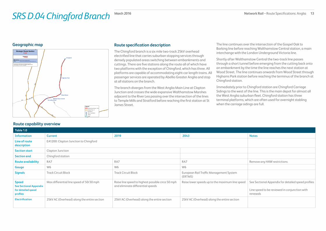
Route specification descriptionThe Chingford branch is a six mile two-track 25kV overhead electrified line that carries suburban stopping services through densely populated areas switching between embankments and cuttings. There are five stations along the route all of which have two platforms with the exception of Chingford, which has three. All platforms are capable of accommodating eight-car length trains. All passenger services are operated by Abellio Greater Anglia and stop at all stations on the branch.
The branch diverges from the West Anglia Main Line at Clapton Junction and crosses the wide expansive Walthamstow Marshes adjacent to the River Lea passing over the intersection of the lines to Temple Mills and Stratford before reaching the first station at St James Street.
Geographic map The line continues over the intersection of the Gospel Oak to Barking line before reaching Walthamstow Central station, a main interchange with the London Underground Victoria line.
Shortly after Walthamstow Central the two-track line passes through a short tunnel before emerging from the cutting back onto an embankment by the time the line reaches the next station at Wood Street. The line continues onwards from Wood Street through Highams Park station before reaching the terminus of the branch at Chingford station.
Immediately prior to Chingford station are Chingford Carriage Sidings to the west of the line. This is the main depot for almost all the West Anglia suburban fleet. Chingford station has three terminal platforms, which are often used for overnight stabling when the carriage sidings are full.
Table 1.0
Information Current 2019 2043 Notes
Line of route description
EA1200: Clapton Junction to Chingford
Section start Clapton Junction
Section end Chingford station
Route availability RA7 RA7 RA7 Remove any HAW restrictions
Gauge W6 W6 W6
Signals Track Circuit Block Track Circuit Block European Rail Traffic Management System (ERTMS)
SpeedSee Sectional Appendix for detailed speed profiles
Max differential line speed of 50/30 mph Raise line speed to highest possible circa 50 mph and eliminate differential speeds
Raise lower speeds up to the maximum line speed See Sectional Appendix for detailed speed profiles
Line speed to be reviewed in conjunction with renewals
Electrification 25kV AC (Overhead) along the entire section 25kV AC (Overhead) along the entire section 25kV AC (Overhead) along the entire section
Route capability overview

Network Rail – Route Specifications: Anglia 14March 2016
Passenger train service levels (trains per hour/day)Table 2.0
Current 2019 2043 Notes
Typical journey time Chingford to London Liverpool Street in 26 – 30 minutes
London Liverpool Street to Chingford in 26 minutes London Liverpool Street to Chingford in less than 26 minutes
No. of trains per hour 4 off-peak/4 peak tph Chingford to London Liverpool Street
4 off-peak/4 peak tph Chingford to London Liverpool Street
4 off-peak/4 peak tph Chingford to London Liverpool Street
SRS D.04 Chingford Branch
Current Freight Trains (paths per day) Table 3.0
Current 2019 2043 Notes
Route section Chingford Branch
Daily paths in one direction (as per WTT)
0 As per forecasts in the Freight Market Study
As per forecasts in the Freight Market Study
* Figures are for freight trains in one direction only.
Level crossings on routeTable 4.0
Type Current No. of level crossings 2019 No. of level crossings 2043 No. of level crossings
Supervised: 1 Currently progressing a workstream looking at level crossings across Anglia which will outline priorities/criteria for level crossing closures and will result in a net decrease across the route
Currently progressing a workstream looking at level crossings across Anglia which will outline priorities/criteria for level crossing closures and will result in a net decrease across the route
Automatic: 0
User: 0
Network Rail – Route Specifications: Anglia 15March 2016SRS D.04 Chingford Branch
Table 5.0
No schemes are currently planned for the remainder of Control Period 5.
Planned infrastructure investment in Control Period 5 (2014 – 2019)*
Proposed infrastructure investment in Control Period 5 (2014 – 2019)*Table 6.0
No schemes are currently proposed for Control Period 5.

Network Rail – Route Specifications: Anglia 16March 2016SRS D.05 Stansted – Ely
Route specification descriptionContinuing northwards from the Stansted junctions the two track 25kV overhead electrified West Anglia Main Line passes through a mainly rural landscape that includes the city of Cambridge and the major market town of Ely. Trains along the route are a mix of stopping and fast passenger services operated by Abellio Greater Anglia (GA), First Capital Connect (FCC), East Midlands Trains (at Ely station only) and CrossCountry trains. There are nine stations along the route most of which have two platforms with the exception of Cambridge and Ely that have more. All station platforms along the route can accommodate up to eight-car train lengths with the exceptions of Audley End, Whittlesford, Cambridge and Ely, which can accommodate up to 12-car length trains. Cambridge also has a series of shorter north and south facing bay platforms.
From Stansted South Junction where the two-track 25kV overhead electrified Stansted Airport branch line diverges to the east, the line passes through Stansted North Junction where the single track 25kV overhead electrified chord converges from the Stansted Airport branch. Shortly after the junction, signalling control passes from Liverpool Street to Cambridge Power Signal Box. At Elsenham station there are staggered Up and Down platforms either side of a gated level crossing. There is a further station at Newport before the line passes over Trees CCTV level crossing and reaches Audley End station 42 miles from London Liverpool Street station.
Onwards from Audley End station, which has offset platforms, the line passes through Audley End and Littlebury tunnels before reaching Great Chesterford station. The line continues in its two-track formation to Whittlesford passing over three main level crossings at Ickleton Road (CCTV), Hinxton and Duxford, both automatic half barriers (AHBs).
North of Whittlesford there is a Down Goods Loop and the line continues to Shelford station passing over Sawston and Shelford CCTV level crossings, the latter being immediately before Shelford station. After Shelford the line crosses over Granhams CCTV level crossing following which the two-track 25kV overhead electrified line from Hitchin, on the ECML, converges from the west at Shepreth Branch Junction.
Just over half a mile after the junction the two-track line becomes three tracks and eventually four tracks.
Cambridge station at just over 55½ miles from London Liverpool Street and 57½ miles from London Kings Cross via Hitchin, is a main station with eight platforms: Platforms 2 and 3 are the south facing bay platforms used by up to eight-car length trains to London Liverpool Street and London Kings Cross; Platform 1, which can be used by trains to the London terminals up to 12-car length clear of a central scissors crossing between Platforms 1 and 4 and the Up and Down main lines; Platform 4 itself mainly used by trains to Kings Lynn and Stansted Airport and Birmingham that can only accommodate 12-car length trains by fouling the central scissors crossover; Platforms 5 and 6 are the north facing bay platforms used by trains to Norwich and Ipswich. These are shorter platforms that can only accommodate trains up to six cars in length. Platforms 7 and 8 are on an island opposite platforms 1 and 4 but separated by a through running line. These platforms can accommodate 12-car trains and have passive provision to be extended should Intercity Express Passenger trains be introduced in the future.
Cambridge Carriage Sidings and depot is situated adjacent to and to the country side of Cambridge station, beyond Mill Road Bridge to the east of the main lines. The carriage sidings and depot is leased to GA but is also used by FCC trains. This is one of the main stabling sites on the West Anglia route and consists of a Head Shunt, Arrival Road and nine sidings, all of which are electrified. The sidings have a carriage washer and controlled emission toilets discharge facilities. The sidings are connected at the north end to Coldham Lane Depot, which consists of four non-electrified roads plus two non-electrified loco sidings and is used by CrossCountry to stable some of their diesel multiple unit (DMU) fleet.
Continuing northwards, immediately beyond the depot the single track non-electrified branch to Chippenham Junction, on the cross country route via Bury St Edmunds, diverges to the east. The two track main line then passes the freight connection to Barnwell oil terminal, which diverges to the east and Chesterton Junction, which formerly connected to the St Ives branch, now a guided busway, and the former Chesterton sidings complex to the west of the main line.
Chesterton still retains two freight aggregates depots and there are
Geographic map

Network Rail – Route Specifications: Anglia 17March 2016SRS D.05 Stansted – Ely
plans for a new Cambridge Science Park station on the main lines that will include a new south facing bay platform.
North of Chesterton the two track line continues to Waterbeach passing over Milton Fen and Waterbeach AHB level crossings, the latter being immediately before Waterbeach station.
Table 1.0
Information Current 2019 2043 Notes
Line of route description
EA1161: Bishops Stortford to Ely North Junction
Section start Stansted South Junction
Section end Ely Dock Junction
Route availability RA8 RA8 RA8
Gauge W6, W8, W9, W10 W6, W8, W9, W10 W6, W8, W9, W10 Consider W12 for new infrastructure
Signals Track Circuit Block Track Circuit Block European Rail Traffic Management System (ERTMS)
SpeedSee Sectional Appendix for detailed speed profiles
Maximum permitted line speed is 90 mph Raise lower speeds up to the maximum line speed Raise lower speeds up to the maximum line speed See Sectional Appendix for detailed speed profiles
Line speed to be reviewed in conjunction with renewals
Electrification 25kV AC (Overhead) over the main lines.Some sidings and loops not electrified
25kV AC (Overhead) over the main lines.Some sidings and loops not electrified
25kV AC (Overhead) over the main lines.Some sidings and loops not electrified
Electrification should be considered on an individual basis when sidings/loops are renewed
Route capability overview
After Waterbeach the line passes over three AHB level crossings at Bottisham Road, Bannolds and Dimmocks Cote, as well as a number of user worked level crossings. At Ely Dock Junction the single track non-electrified line from the cross country route via Bury St Edmunds converges from the east.

Network Rail – Route Specifications: Anglia 18March 2016
Passenger train service levels (trains per hour/day)Table 2.0
Current 2019 2043 Notes
Typical journey time Ely to London Kings Cross in under 70 minutesCambridge to London Liverpool Street in approx 80 minutes Cambridge to Norwich in under 80 minutes
Ely to London Kings Cross in under 70 minutesCambridge to London Liverpool Street in under 80 minutesCambridge to Norwich in under 80 minutes
Ely to London Kings Cross in under 70minutesCambridge to London Liverpool Street in under 80 minutesCambridge to Norwich in under 80 minutes
No. of trains per hour 3 peak/2 off-peak tph Cambridge to London Liverpool Street2 peak/3 off-peak tph Cambridge to London Kings Cross2 peak/1 off-peak tph Kings Lynn to London Kings Cross1 peak train Kings Lynn to London Liverpool Street1 tph Cambridge to Ipswich1 tph Cambridge to Norwich1 tph Birmingham to Stansted Airport
3 peak/2 off-peak tph Cambridge to London Liverpool Street2 peak/3 off-peak tph Cambridge to London Kings Cross2 peak/1 off-peak tph Kings Lynn to London Kings Cross1 peak train Kings Lynn to London Liverpool StreetAt least 1 tph Cambridge to IpswichAt least 1 tph Cambridge to Norwich2 tph Birmingham to Stansted Airport
3 peak/2 off-peak tph Cambridge to London Liverpool Street2 peak/3 off-peak tph Cambridge to London Kings Cross2 peak/1 off-peak tph Kings Lynn to London Kings Cross1 peak train Kings Lynn to London Liverpool Street2 tph Cambridge to Ipswich2 tph Cambridge to Norwich2 tph Birmingham to Stansted Airport
The local councils have aspirations to see 2 tph Cambridge to Norwich, 2 tph Kings Cross/Cambridge to Kings Lynn and 2 tph Cambridge to Ipswich
SRS D.05 Stansted – Ely
Current Freight Trains (paths per day) Table 3.0
Current 2019 2043 Notes
Route section Stansted to CambridgeCambridge to Ely
Daily paths in one direction (as per WTT)
3
8
As per forecasts in the Freight Market Study
As per forecasts in the Freight Market Study
* Figures are for freight trains in one direction only
Level crossings on routeTable 4.0
Type Current No. of level crossings 2019 No. of level crossings 2043 No. of level crossings
Supervised: 7 Currently progressing a workstream looking at level crossings across Anglia which will outline priorities/criteria for level crossing closures and will result in a net decrease across the route
Currently progressing a workstream looking at level crossings across Anglia which will outline priorities/criteria for level crossing closures and will result in a net decrease across the route
Automatic: 7
User: 22

Network Rail – Route Specifications: Anglia 19March 2016SRS D.05 Stansted – Ely
Planned infrastructure investment in Control Period 5 (2014 – 2019)*
Proposed infrastructure investment in Control Period 5 (2014 – 2019)*Table 6.0
Project Project Description ELR Implementation Date
Output change Notes Status
Anglia traction power supply (CP5)
Works to reinforce the power supply on the Anglia route following train service changes
BGK 2014 – 2019 Power supply improvement
In development
Felixstowe to Nuneaton 2 Works to further improve capacity for up to 56 freight tpd between Felixstowe and Nuneaton
BGK, CCH, EMP, LTN, ESK
2014 – 2019 Capacity enhancement In development
Cambridge Science Park new station
Provide a new station north of Cambridge and associated works including Chesterton freight sidings
BGK 2014 – 2019 New station In development
Service improvements in the Ely area
Works to improve capacity in the Ely area including looking at redoubling Ely North Junction
BGK, EMP, ETN 2014 – 2019 Capacity enhancement The infrastructure works are not on SRS D.05, however this facilitates additional passenger services through the section
In development
Bishops Stortford S & C renewals BGK 2014 – 2019 Renewed assets In development
* In addition to the proposed enhancement programme, this table includes other Network Rail funded schemes, renewals and third party schemes where applicable.** The precise timing and scope of renewals will remain subject to review to enable us to meet our overall obligations as efficiently as possible, consistent with the reasonable requirements of operators and other stakeholders.
Table 5.0
Project Project Description ELR Implementation Date
Output change Notes Status
Anglia traction power supply (CP5)
Works to reinforce the power supply on the Anglia route following train service changes
BGK 2014 – 2019 Power supply improvement
In development
Service improvements in the Ely area
Works to improve capacity in the Ely area including looking at redoubling Ely North Junction
BGK, EMP, ETN 2014 – 2019 Capacity enhancement The infrastructure works are not on SRS D.05, however this facilitates additional passenger services through the section
In development
* In addition to the proposed enhancement programme, this table includes other Network Rail funded schemes, renewals and third party schemes where applicable.* The precise timing and scope of renewals will remain subject to review to enable us to meet our overall obligations as efficiently as possible, consistent with the reasonable requirements of operators and other stakeholders.

Network Rail – Route Specifications: Anglia 20March 2016SRS D.06 Ely – Kings Lynn
Route specification descriptionThe twenty six mile 25kV overhead electrified route section from Ely Dock Junction to Kings Lynn is a mix of single and two-track formations passing through rural Fenland. There are five stations along the route. Passenger trains are operated by First Capital Connect, CrossCountry, East Midlands Trains and Abellio Greater Anglia.
From Ely Dock Junction there is a Down Goods Loop and sidings alongside the junction that stops short of Ely station and there are connections to the east of the main lines to the Up Goods Loop, through siding and Up Platform Loop at Ely station. Ely station is a gateway to the major market town. There are three platforms, two of which are on an island and each platform is capable of accommodating up to 12-car length trains. Ely station is intensively used by passenger services both through services to London, Cambridge, Ipswich, Peterborough, Birmingham and Kings Lynn. In addition to this the East Midlands Trains service between Norwich and Liverpool reverse at Ely station from Ely North Junction and extensive freight services both intermodal, aggregates and distribution pass through the station.
Immediately north of Ely station is Ely North CCTV level crossing. This is an unusual crossing in that there is an associated underpass for cars and small vans, whilst larger vehicles have to use the level crossing. At times where there is a succession of trains at Ely station, the level crossing barriers stay down in excess of five minutes at a time. The downtime will become exacerbated as the number of trains increase due to Train Operating Company aspirations for more passenger services and forecast freight increases.
After Ely North level crossing the line runs in two-track formation to Ely North Junction. Having passed over Kiln Lane automatic half barrier (AHB) level crossing there is a connection to the east of the line into Ely Freight Terminal, which is used by both aggregates and distribution services. At Ely North Junction the non-electrified, single track Ely West Curve converges from the west, the cross country route that joined at Ely Dock Junction diverges in non-electrified two-track formation to the west, whilst the line towards Kings Lynn passes over a series of single leads including the single lead onto the double track non-electrified line to Norwich which
diverges to the east. The 25kV overhead electrified single lead then fans out into a two-track formation, passing over Queen Adelaide AHB level crossing, and continues in this fashion for four miles until Littleport station passing over Sandhill AHB level crossing. The signalling control of the line at this point has passed from Cambridge Power Signal Box to a series of mechanical signal boxes at Littleport, Downham Market, Magdalen Road (Watlington station) and Kings Lynn Junction.
Littleport station has two short platforms, which are only capable of accommodating up to four-car length trains. There is a gated level crossing immediately before Littleport station and a footpath crossing immediately after followed by Littleport Bypass AHB level crossing beyond which the line continues in single track formation.
For the next nine miles the single track line passes over a succession of seven level crossings, two footpath crossings with miniature warning lights, two user worked crossings and three AHB level crossings at Hilgay, Denver and Downham Bypass. After this last AHB the line reverts to a two-track formation and passes through Downham Market station. Downham Market has two long platforms both of which were capable of accommodating up to eight-car services.
After Downham Market the line continues in a two-track formation for the next four miles up to Watlington station passing over Stow Bardolph CCTV level crossing. Watlington station has two staggered platforms either side of a gated level crossing. Immediately after the station is Watlington Road CCTV level crossing following which the line singles again for the final six miles into Kings Lynn. Having passed over the AHB at St Germans the line continues past the former junction with the Kings Lynn Harbour branch and over Extons Road CCTV level crossing to Kings Lynn Junction where a single non-electrified connection to the Middleton Towers freight only branch diverges to the east.
After the junction the line curves around into Kings Lynn station which has two terminal platforms for passenger services. A third platform and a central siding provide a carriage sidings stabling facility.
Geographic map

Network Rail – Route Specifications: Anglia 21March 2016
Table 1.0
Information Current 2019 2043 Notes
Line of route description
EA1161: Bishops Stortford to Ely North JunctionEA1162: Ely North Junction to Kings Lynn
Section start Ely Dock Junction
Section end Kings Lynn station
Route availability RA8 RA8 RA8
Gauge W8, W9 W10 Through Ely
W8, W9 W10 Through Ely
W8, W9 W10 Through Ely
Consider W12 for new infrastructure
Signals Track Circuit Block Track Circuit Block European Rail Traffic Management System (ERTMS)
SpeedSee Sectional Appendix for detailed speed profiles
Maximum permitted line speed is 75 mph Raise lower speeds up to the maximum line speed Raise lower speeds up to the maximum line speed See Sectional Appendix for detailed speed profiles
Line speed to be reviewed in conjunction with renewals
Electrification 25kV AC (Overhead) along the entire section 25kV AC (Overhead) along the entire section 25kV AC (Overhead) along the entire section
Route capability overview
SRS D.06 Ely – Kings Lynn

Network Rail – Route Specifications: Anglia 22March 2016
Passenger train service levels (trains per hour/day)Table 2.0
Current 2019 2043 Notes
Typical journey time Kings Lynn to Cambridge in less than 50 minutesKings Lynn to Kings Cross in less than 110 minutes
Kings Lynn to Cambridge in less than 50 minutesKings Lynn to Kings Cross in less than 110 minutes
Kings Lynn to Cambridge in less than 50 minutesKings Lynn to Kings Cross in less than 110 minutes
No. of trains per hour 1 off-peak/2 peak tph Kings Lynn to London Kings Cross1 peak train Kings Lynn to London Liverpool Street1 tph Cambridge to Norwich1 tph Birmingham to Stansted Airport2 hourly service Ipswich to Peterborough
At least 1 off-peak/2 peak tph Kings Lynn to London Kings CrossAt least 1 peak train Kings Lynn to London Liverpool StreetAt least 1 tph Cambridge to NorwichAt lease 1 tph Birmingham to Stansted AirportAt least a 2 hourly service Ipswich to Peterborough
At least 1 off-peak/2 peak tph Kings Lynn to London Kings CrossAt least 1 peak train Kings Lynn to London Liverpool Street2 tph Cambridge to Norwich2 tph Birmingham to Stansted Airport1tph Ipswich to Peterborough
The local councils have aspirations to see 2 tph Cambridge to Norwich, 2 tph Kings Cross/Cambridge to Kings Lynn and 1 tph Ipswich to Peterborough.An aspiration of the TOC is to see 2 tph Birmingham to Stansted
SRS D.06 Ely – Kings Lynn
Current Freight Trains (paths per day) Table 3.0
Current 2019 2043 Notes
Route section Ely North Junction to Kings Lynn
Daily paths in one direction (as per WTT)
3(14 Ely Dock Junction to Ely North Junction)
As per forecasts in the Freight Market Study(Up to 28 Ely Dock Junction to Ely North Junction)
As per forecasts in the Freight Market Study(Up to 59 Ely Dock Junction to Ely North Junction)
* Figures are for freight trains in one direction only.
Level crossings on routeTable 4.0
Type Current No. of level crossings 2019 No. of level crossings 2043 No. of level crossings
Supervised: 8 Currently progressing a workstream looking at level crossings across Anglia which will outline priorities/criteria for level crossing closures and will result in a net decrease across the route
Currently progressing a workstream looking at level crossings across Anglia which will outline priorities/criteria for level crossing closures and will result in a net decrease across the route
Automatic: 8
User: 19

Network Rail – Route Specifications: Anglia 23March 2016SRS D.06 Ely – Kings Lynn
Table 5.0
Project Project Description ELR Implementation Date
Output change Notes Status
Anglia traction power supply (CP5)
Works to reinforce the power supply on the Anglia route following train service changes
BGK, LTN 2014 – 2019 Power supply improvement
In development
Service improvements in the Ely area
Works to improve capacity in the Ely area including looking at redoubling Ely North Junction
BGK, EMP, ETN 2014 – 2019 Capacity enhancement In development
* In addition to the proposed enhancement programme, this table includes other Network Rail funded schemes, renewals and third party schemes where applicable.** The precise timing and scope of renewals will remain subject to review to enable us to meet our overall obligations as efficiently as possible, consistent with the reasonable requirements of operators and other stakeholders.
Planned infrastructure investment in Control Period 5 (2014 – 2019)*
Proposed infrastructure investment in Control Period 5 (2014 – 2019)*Table 6.0
Project Project Description ELR Implementation Date
Output change Notes Status
Ely Station North Level Crossing
Works to enable Ely Station North Level Crossing to be closed
BGK 2014/15 Level crossing closure In development
Felixstowe to Nuneaton 2 Works to further improve capacity for up to 56 freight tpd between Felixstowe and Nuneaton
BGK, CCH, EMP, LTN, ESK
2014 – 2019 Capacity enhancement In development
* In addition to the proposed enhancement programme, this table includes other Network Rail funded schemes, renewals and third party schemes where applicable.** The precise timing and scope of renewals will remain subject to review to enable us to meet our overall obligations as efficiently as possible, consistent with the reasonable requirements of operators and other stakeholders.

Network Rail – Route Specifications: Anglia 24March 2016SRS D.07 Peterborough – Stowmarket
Route specification descriptionCrescent Junction at Peterborough station marks the start of the 65 mile non-electrified route (excluding the 2 mile 25kV overhead electrified Ely North Junction to Ely Dock Junction, which is part of SRS D.06) also referred to as the cross country route that links the East Coast Main Line (ECML) to the Great Eastern Main Line at Haughley Junction. This SRS is a major artery for intermodal freight services between the east coast Haven Ports and the North East and North West as well as carrying a number of local and regional passenger services. Between Peterborough and Ely there are hourly Birmingham – Stansted Airport services operated by CrossCountry trains and hourly Liverpool – Norwich services operated by East Midland Trains. Between Peterborough and Haughley Junction there is a two-hourly Peterborough – Ipswich service operated by Abellio Greater Anglia who also operate an hourly Cambridge – Ipswich between Chippenham Junction and Haughley Junction.
The first part of the line between Crescent Junction and Ely North Junction signalling control from a number of electro mechanical signal boxes at Kings Dyke, Whittlesea, Three Horse Shoes, March East Junction, March South Junction, Stonea and Manea. There are three stations at Whittlesea, March and Manea and the line also passes over a large number of successive level crossings.
From Crescent Junction alongside the First Capital Connect Nene Carriage Sidings the two track line curves sharply round to the east and passes under the intersection of the ECML alongside the River Nene. Initially the line passes through brick-making works before emerging into the flat rural landscape of the Fens. The line passes over Funthams Lane CCTV level crossing and past Kings Dyke signal box followed by to Automatic Half Barrier (AHB) level crossings at Black Bush and Ramsey Road that are only 300 yards apart. At Whittlesea station there are two staggered platform of up to three and four-car length as well as some west facing sidings to the south of the line. Over the next nine mile section to March there are no fewer than seven AHB level crossings at Eastrea, Burnt House Drove, Three Horse Shoes No.3, No.2, & No.1, Whitemoor Drove and Norwood Road at March. Just beyond the latter AHB are the diverging March West Junction and converging March East Junction that the triangle junction that lead northwards to the main engineering depot and sidings of the Local Distribution Centre at
Whitemoor as well as the former junction with the now disused route to Wisbech.
March station, 15 miles from Peterborough, has two platforms that can both accommodate trains of up to six cars in length plus a number of disused through and bay platforms. After the station there is a gated level crossing and a series of sidings to the north and south of the line followed by another series of level crossings including two AHBs at Badgeney Road and Horsemoor before reaching the little used Manea station that has two short platforms only capable of accommodating two-car length trains. Over the next eight mile stretch to Ely West Junction there are a further seven AHB level crossings at Welney Road, Third Drove, Second Drove, Black Bank, North Fen, Beald Drove and Chettisham. At the latter AHB, signalling control has passed to Cambridge Power Signal Box for the run up to Ely.
At Ely West Junction the single track Ely West Curve diverges to the south. Ely West Curve allows train services to travel from Kings Lynn and Norwich to Peterborough without travelling into Ely and reversing. The signalling on the curve has been updated so that the curve can now be used in both directions. This does not necessarily affect passenger services as Ely represents good connections with other services however there are benefits for freight services especially sand trains to Middleton Towers.
After Ely West Junction the line, having passed over Queen Adelaide AHB level crossing, converges with the West Anglia Main Line at Ely North Junction. The next section through Ely station to Ely Dock Junction is part of, and described in, SRS D.06. The line now in single track formation diverges at Ely Dock Junction and continues in this fashion until Soham Junction. In the five mile section between Ely and Soham there are no fewer than 10 user worked level crossings and three AHB level crossings at Barway Sidings, Tiled House Farm and Middlemere. At Soham Junction the line becomes two track and stays in this formation for the next six miles to Chippenham Junction. Along this stretch of track there are a further six user worked LCs and three AHB level crossings at Mill Drove, Cockspin Road and Fordham. Just over two miles from Chippenham Junction signalling control passes back from Cambridge Power Signal Box to the electro mechanical signal box at Chippenham Junction.
Geographic map

Network Rail – Route Specifications: Anglia 25March 2016SRS D.07 Peterborough – Stowmarket
At Chippenham Junction the single track line from Cambridge converges from the south. The line now continues in its two-track formation for 44½ miles to the single lead at Haughley Junction. There are three stations along this stretch at Kennett, Bury St Edmunds, Thurston and Elmswell and signalling control is from mechanical signal boxes at Chippenham Junction and Bury St Edmunds with the exception of the eastern most nine miles from a mile before Thurston station where control passes to Colchester Power Signal Box.
At Kennett station nearly three miles from Chippenham Junction there are two platforms capable of accommodating up to three and four-car length trains and shortly after is a connection to an aggregates siding which converges from the north.
There is now an eight mile section to Bury St Edmunds station where trains have to weave through the platform loops as the original through tracks were removed. This has little effect on passenger services as they all stop here however freight trains have to reduce to 30mph to pass through the station. Immediately before Bury St Edmunds stations there are sidings to north and south.
At Thurston a few miles on from Bury St Edmunds there are two four-car length platforms and footpath crossing immediately afterwards controlled by miniature warning lights. Four miles further on there is a user worked crossing before Elmswell station and a CCTV level crossing immediately afterwards. Elmswell has two three-car length platforms then there is a three mile run to Haughley Junction with just a single user worked crossing.
Table 1.0
Information Current 2019 2043 Notes
Line of route description
EA1560: Ely North Junction to PeterboroughEA1161: Bishops Stortford to Ely North JunctionEA1540: Chippenham Junction to Ely Dock JunctionEA1530: Coldham Lane Junction to Haughley Junction
Section start Crescent Junction
Section end Haughley Junction
Route availability RA8, RA9 RA8, RA9 RA8, RA9
Gauge W10 W10 W10, W12 W12 for new infrastructure
Signals Track Circuit Block Track Circuit Block European Rail Traffic Management System (ERTMS)
SpeedSee Sectional Appendix for detailed speed profiles
Maximum permitted line speed is 75 mph Raise lower speeds up to the maximum line speed circa 100 mph
Raise lower speeds up to the maximum line speed circa 100 mph
See Sectional Appendix for detailed speed profiles
Line speed to be reviewed in conjunction with renewals
Electrification Non-electrified. Non-electrified. 25kV AC (Overhead)
Route capability overview

Network Rail – Route Specifications: Anglia 26March 2016
Passenger train service levels (trains per hour/day)Table 2.0
Current 2019 2043 Notes
Typical journey time Peterborough to Cambridge in 50 minutesPeterborough to Ipswich (direct) in 103 minutes
Peterborough to Cambridge in 50 minutesPeterborough to Ipswich (direct) in 103 minutes
Peterborough to Cambridge in 50 minutesPeterborough to Ipswich (direct) in 103 minutes
No. of trains per hour 1 tph Cambridge to Ipswich1 tph Cambridge to Norwich2 hourly Ipswich to Peterborough1 tph Birmingham to Stansted Airport
At least 1 tph Cambridge to IpswichAt least 1 tph Cambridge to NorwichAt least a 2 hourly service Ipswich to Peterborough At least 1 tph Birmingham to Stansted Airport
2 tph Cambridge to Ipswich2 tph Cambridge to Norwich1 tph Ipswich to Peterborough 2 tph Birmingham to Stansted Airport
An aspiration of the local council is to see 2 tph Cambridge to Norwich and Cambridge to Ipswich and 1 tph Ipswich to PeterboroughAn aspiration of the TOC is to see 2 tph Birmingham to Stansted
SRS D.07 Peterborough – Stowmarket
Current Freight Trains (paths per day) Table 3.0
Current 2019 2043 Notes
Route section Peterborough to Haughley Junction
Daily paths in one direction (as per WTT)
12 Up to 28 Up to 59
* Figures are for freight trains in one direction only.
Level crossings on routeTable 4.0
Type Current No. of level crossings 2019 No. of level crossings 2043 No. of level crossings
Supervised: 9 9 Currently progressing a workstream looking at level crossings across Anglia which will outline priorities/criteria for level crossing closures and will result in a net decrease across the route
Automatic: 26 26
User: 29 28

Network Rail – Route Specifications: Anglia 27March 2016SRS D.07 Peterborough – Stowmarket
Table 5.0
Project Project Description ELR Implementation Date
Output change Notes Status
Service improvements in the Ely area
Works to improve capacity in the Ely area including looking at redoubling Ely North Junction
BGK, EMP, ETN 2014 – 2019 Capacity enhancement In development
* In addition to the proposed enhancement programme, this table includes other Network Rail funded schemes, renewals and third party schemes where applicable.** The precise timing and scope of renewals will remain subject to review to enable us to meet our overall obligations as efficiently as possible, consistent with the reasonable requirements of operators and other stakeholders.
Planned infrastructure investment in Control Period 5 (2014 – 2019)*
Proposed infrastructure investment in Control Period 5 (2014 – 2019)*Table 6.0
Project Project Description ELR Implementation Date
Output change Notes Status
Felixstowe to Nuneaton 2 Works to further improve capacity for up to 56 freight tpd between Felixstowe and Nuneaton
BGK, CCH, EMP, LTN, ESK
2014 – 2019 Capacity enhancement In development
March S & C renewals EMP 2014 – 2019 Renewed assets In development
* In addition to the proposed enhancement programme, this table includes other Network Rail funded schemes, renewals and third party schemes where applicable.** The precise timing and scope of renewals will remain subject to review to enable us to meet our overall obligations as efficiently as possible, consistent with the reasonable requirements of operators and other stakeholders.

Network Rail – Route Specifications: Anglia 28March 2016SRS D.08 Cambridge – Chippenham Junction
Route specification descriptionThis 16 mile non-electrified single track route section begins at Coldham Lane Junction, which diverges from the West Anglia Main Line north of Cambridge. Signalling on the line is controlled from Cambridge Power Signal Box and the mechanical signal boxes at Dullingham and Chippenham Junction. The route is used by an hourly passenger service between Cambridge and Ipswich operated by Abellio Greater Anglia.
There are two stations on the route: Dullingham, which has two platforms and a passing loop, each platform is capable of accommodating up to five-car length trains and Newmarket that has a single two-car length platform.
Geographic map There are a number of level crossings along the route. There is a manual gated level crossing at Dullingham and an open crossing at Laundry Lane. There are two CCTV level crossings at Cherry Hinton High Street and Cherry Hinton Bypass, less than 300 yards apart, and five automatic half barrier level crossings at Teversham, Fulbourn, Six Mile Bottom, Brinkley Road and Wood Ditton. Between Newmarket and Chippenham Junction is the 1100 yard Warren Hill Tunnel.
Table 1.0
Information Current 2019 2043 Notes
Line of route description
EA1530: Coldham Lane Junction to Haughley Junction
Section start Coldham Lane Junction
Section end Chippenham Junction
Route availability RA8 RA8 RA8
Gauge W8 W8 W8 Consider W12 for new infrastructure
Signals Track Circuit Block and Tokenless Block Track Circuit Block European Rail Traffic Management System (ERTMS)
SpeedSee Sectional Appendix for detailed speed profiles
Maximum and typical line speed is 60 mph Raise lower speeds up to the maximum line speed Raise lower speeds up to the maximum line speed See Sectional Appendix for detailed speed profiles
Line speed to be reviewed in conjunction with renewals
Electrification Non-electrified. Non-electrified. Non-electrified.
Route capability overview

Network Rail – Route Specifications: Anglia 29March 2016
Passenger train service levels (trains per hour/day)Table 2.0
Current 2019 2043 Notes
Typical journey time Cambridge to Ipswich in less than 80 minutes Cambridge to Ipswich in less than 80 minutes Cambridge to Ipswich in less than 80 minutes
No. of trains per hour 1 tph Cambridge to Ipswich At least 1 tph Cambridge to Ipswich 2 tph Cambridge to Ipswich An aspiration of the local council is to see 2 tph Cambridge to Ipswich
SRS D.08 Cambridge – Chippenham Junction
Current Freight Trains (paths per day) Table 3.0
Current 2019 2043 Notes
Route section Cambridge - Chippenham Junction
Daily paths in one direction (as per WTT)
6 As per forecasts in the Freight Market Study
As per forecasts in the Freight Market Study
* Figures are for freight trains in one direction only.
Level crossings on routeTable 4.0
Type Current No. of level crossings 2019 No. of level crossings 2043 No. of level crossings
Supervised: 3 Currently progressing a workstream looking at level crossings across Anglia which will outline priorities/criteria for level crossing closures and will result in a net decrease across the route
Currently progressing a workstream looking at level crossings across Anglia which will outline priorities/criteria for level crossing closures and will result in a net decrease across the route
Automatic: 6
User: 3

Network Rail – Route Specifications: Anglia 30SRS D.08 Cambridge – Chippenham Junction March 2016
Table 5.0
No schemes are currently planned for the remainder of Control Period 5.
Planned infrastructure investment in Control Period 5 (2014 – 2019)*
Proposed infrastructure investment in Control Period 5 (2014 – 2019)*Table 6.0
No schemes are currently proposed for Control Period 5.

Network Rail – Route Specifications: Anglia 31March 2016SRS D.09 Ely – Norwich
Route specification descriptionThis 51 mile two-track non-electrified rural route runs from its connection with the West Anglia Main line at Ely North Junction in the west to its connection to the Great Eastern Main Line (GEML) at Trowse Junction (Norwich) to the east. Signalling is controlled by Cambridge Power Signal Box from the western end as far as Hethersett, just to the east of Wymondham, following which control of the eastern end transfers to Colchester Power Signal Box. The route has nine two-platformed stations with platforms of various lengths and passenger train services are operated by East Midlands Trains and Abellio Greater Anglia.
From the single lead Ely North Junction the line quickly changes into a two track formation, which continues all the way to Trowse Junction. Between Ely North Junction and Shippea Hill station there are two Automatic Half Barrier (AHB) level crossings at Queen Adelaide and Mile End as well as two user worked crossings. Shippea Hill has two platforms capable of accommodating trains up to six and seven-car lengths and there is a manual controlled barrier level crossing with obstacle detectors (MCB-OD) immediately afterwards. Between Shippea Hill and Lakenheath stations there are three user worked crossings and an AHB level crossing at Chivers. Lakenheath has two platforms also capable of accommodating trains up to six and seven-car lengths and a MCB-OD crossing immediately afterwards. The line passes over a further user worked crossing before reaching the market town of Brandon. Brandon station is 15 miles from Ely North Junction has two offset five-car length platforms and a MCB-OD crossing. Here there are also sidings to the north and south of the line.
Beyond Brandon the line continues for a further seven miles through Thetford Forest until it reaches Thetford station passing over two AHB level crossings at Santon and Two Mile Bottom as well as two user worked crossings. Thetford station has two platforms capable of accommodating trains up to five and seven-car lengths and there is a short siding to the south of the line immediately before the station.
Over the next twenty miles there are the five remaining stations at Harling Road, Eccles Road, Attleborough, Spooner Row and Wymondham. Each station has two platforms and can accommodate trains of various lengths from up to six and seven-car lengths at Attleborough station to the short two-car platforms at the little used Spooner Row station. There are numerous level crossings along the route including four AHB crossings at Croxton, Hargham , Spronces and Suton as well as MCB-OD crossings at Harling Road, Eccles Road, Attleborough and Spooner Row. There are also 15 user worked crossings.
At Wymondham there are Up and Down sidings and there is a single track connection that converges to the north that forms the privately owned Mid Norfolk Railway and sees occasional Ministry of Defence freight traffic. Wymondham station has two platforms of five and six-car length. From Wymondham the line continues eastwards for a further nine miles until it reaches the single lead Trowse Junction passing over three further AHB level crossings at Browick Road, Intwood and Keswick as well as a user worked crossing and two footpath crossings controlled by miniature warning lights. Prior to Trowse Junction the line passes underneath the intersection of the GEML.
Geographic map

Network Rail – Route Specifications: Anglia 32March 2016
Table 1.0
Information Current 2019 2043 Notes
Line of route description
EA1580: Ely North Junction to Trowse Junction
Section start Ely North Junction
Section end Trowse Junction
Route availability RA8 RA8 RA8
Gauge W8 W8 W8 Consider W12 for new infrastructure
Signals Track Circuit Block and Absolute Block Track Circuit Block and Absolute Block European Rail Traffic Management System (ERTMS)
SpeedSee Sectional Appendix for detailed speed profiles
Maximum permited line speed is 75 mph Raise lower speeds up to the maximum line speed Raise lower speeds up to the maximum line speed See Sectional Appendix for detailed speed profiles
Line speed to be reviewed in conjunction with renewals
Electrification Non-electrified Non-electrified Non-electrified
Route capability overview
SRS D.09 Ely – Norwich
Network Rail – Route Specifications: Anglia 33March 2016
Passenger train service levels (trains per hour/day)Table 2.0
Current 2019 2043 Notes
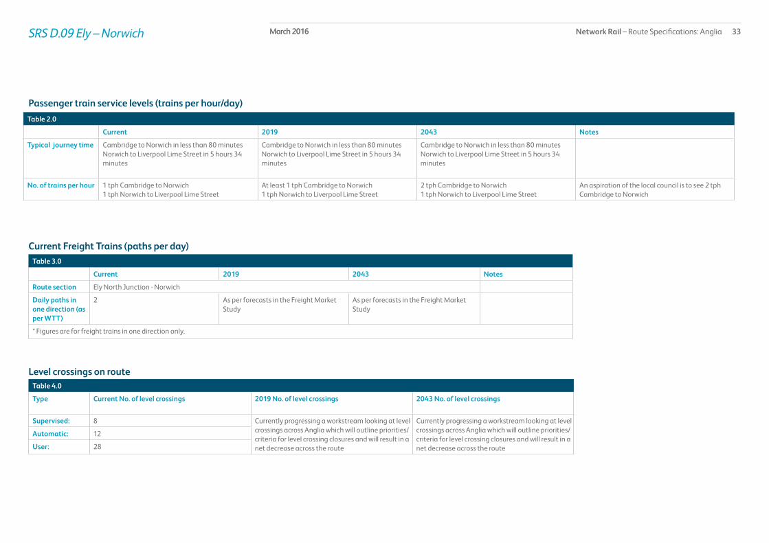
Typical journey time Cambridge to Norwich in less than 80 minutesNorwich to Liverpool Lime Street in 5 hours 34 minutes
Cambridge to Norwich in less than 80 minutesNorwich to Liverpool Lime Street in 5 hours 34 minutes
Cambridge to Norwich in less than 80 minutesNorwich to Liverpool Lime Street in 5 hours 34 minutes
No. of trains per hour 1 tph Cambridge to Norwich1 tph Norwich to Liverpool Lime Street
At least 1 tph Cambridge to Norwich1 tph Norwich to Liverpool Lime Street
2 tph Cambridge to Norwich1 tph Norwich to Liverpool Lime Street
An aspiration of the local council is to see 2 tph Cambridge to Norwich
SRS D.09 Ely – Norwich
Current Freight Trains (paths per day) Table 3.0
Current 2019 2043 Notes
Route section Ely North Junction - Norwich
Daily paths in one direction (as per WTT)
2 As per forecasts in the Freight Market Study
As per forecasts in the Freight Market Study
* Figures are for freight trains in one direction only.
Level crossings on routeTable 4.0
Type Current No. of level crossings 2019 No. of level crossings 2043 No. of level crossings
Supervised: 8 Currently progressing a workstream looking at level crossings across Anglia which will outline priorities/criteria for level crossing closures and will result in a net decrease across the route
Currently progressing a workstream looking at level crossings across Anglia which will outline priorities/criteria for level crossing closures and will result in a net decrease across the route
Automatic: 12
User: 28

Network Rail – Route Specifications: Anglia 34March 2016SRS D.09 Ely – Norwich
Table 5.0
Project Project Description ELR Implementation Date
Output change Notes Status
Service improvements in the Ely area
Works to improve capacity in the Ely area including looking at redoubling Ely North Junction
BGK, EMP, ETN 2014 – 2019 Capacity enhancement In development
* In addition to the proposed enhancement programme, this table includes other Network Rail funded schemes, renewals and third party schemes where applicable.** The precise timing and scope of renewals will remain subject to review to enable us to meet our overall obligations as efficiently as possible, consistent with the reasonable requirements of operators and other stakeholders.
Planned infrastructure investment in Control Period 5 (2014 – 2019)*
Proposed infrastructure investment in Control Period 5 (2014 – 2019)*Table 6.0
Project Project Description ELR Implementation Date
Output change Notes Status
No schemes are currently proposed for Control Period 5.

Network Rail – Route Specifications: Anglia 35March 2016SRS D.10 Liverpool Street – Shenfield
Route specification descriptionLondon Liverpool Street station is the major London terminal at the start of the Great Eastern Main Line (GEML), which runs for 114 miles to the city of Norwich. The route section from London Liverpool Street to Shenfield has four 25 kV overhead electrified tracks throughout its length. There are 14 stations along the route including London Liverpool Street and all platforms are capable of accommodating trains of up to eight-car length with the exception of London Liverpool Street, Stratford and Shenfield that can accommodate up to 12 cars. Passenger train services are a mixture of Intercity, outer and inner suburban, exclusively operated by Abellio Greater Anglia (GA) with the exception of a few late night c2c services between Forest Gate and Liverpool Street. It is a major route for freight services from Felixstowe, Tilbury and other locations, the bulk of which turn northwards onto the North London Line at Stratford. There are no level crossings between London Liverpool Street and Shenfield.
London Liverpool Street station has 18 platforms. Platforms 1 to 15 can generally accommodate trains up to 12 cars in length however Platforms 16 to 18 can only accommodate trains up to eight-car in length due to the restrictions of the sub-surface station. Generally Platforms 1 to 7 are used by trains on the West Anglia routes and the remainder are generally used by trains on the Great Eastern routes. The six track station throat is split into three pairs of tracks: Down and Up suburban lines; Down and Up main lines; Down and Up electric lines. Generally West Anglia Outer and Inner services use the suburban lines, Great Eastern Intercity and Outer services use the main lines and Great Eastern Inner services use the electric lines. The lines out of London Liverpool Street climb Bethnal Green Bank one of the steepest climbs out of any London terminus.
At Bethnal Green the suburban lines turn northwards and there is also a connection off of the main lines at Bethnal Green East Junction that diverges northwards onto the West Anglia route. The four main and electric line tracks continue eastwards to Bow Junction where the Gas Factory Curve that links to the Thameside route converges from the south alongside the Docklands Light Railway (DLR) whilst to the north additional tracks diverge and form the Down and Up Temple Mills lines.
Bow Depot aggregates freight terminal connection converges from the north whilst on the opposite side of the route is Pudding Mill Lane station on the DLR. This is where tracks will be remodelled to allow for the construction of the Crossrail tunnel north eastern portal, which will be situated between the Down and Up Electric Lines and will necessitate a diversion and relocation of the Up Electric Line as well as the DLR and Pudding Mill station.
To the north of the line at this point is the Olympic Park and stadia that now covers the former stabling sidings at Thornton’s Field and adjacent land. At Carpenters Road South Junction to the north a single track diverges towards the North London Line used almost exclusively by freight traffic to Bow Depot. This is followed almost immediately by Stratford Central Junctions. The two-tracks that converge from the north at the west junction and link the GEML to the North London Line; these are heavily used by freight services. Two London Overground tracks parallel this link into Stratford station. At the east junction two tracks diverge to the West Anglia route via Temple Mills and are used by both freight services and Empty Coaching Stock (ECS) moves to the stabling sidings at Orient Way (see SRS D.01).
At four miles from London Liverpool Street, Stratford station is a busy interchange with a variety of routes and services:
• Platforms 1 and 2 – London Overground services to Richmond
• Platforms 3 and 3a – London Underground (LUL) WestboundCentral Line
• Platforms 4 and 4a – DLR
• Platform 5 – Generally GE Inner services to London Liverpool Street
• Platform 6 – LUL Eastbound Central Line
• Platform 8 (there is no Platform 7) – Generally GE Inner services to Gidea Park and Shenfield
• Platforms 9, 10 and 10a – Generally Up and Down GE Intercity and Outer services
• Platform 11 – Currently used by ECS services from Orient Way
Geographic map

Network Rail – Route Specifications: Anglia 36March 2016SRS D.10 Liverpool Street – Shenfield
• Platform 12 – Generally WA stopping service to Stansted Airport but also ECS to Orient Way
• Platforms 13, 14 and 15 – LUL Jubilee Line services
• Platforms 16 and 17 – DLR.
With the construction of the Westfield Shopping Centre, Stratford City Development and Olympic Park, Stratford station has become a major destination as well as an even busier interchange.
The route from Stratford continues through Maryland and Forest Gate stations, which have four platforms, however only the electric line platforms are used for GE Inner stopping services. After Forest Gate the route passes underneath the intersection with the Gospel Oak to Barking line. Immediately afterwards is Forest Gate Junction where two-tracks diverge southwards toward Barking. A number of freight services and late night c2c services use this route.
From Forest Gate Junction the route continues through the four platforms at Manor Park station before reaching the west end of Ilford Flyover. At Ilford Flyover the electric lines cross over the top of the main lines, and there are both Down and Up passenger loops on either side as well as the westward facing Aldersbrook sidings. Ilford station directly after the flyover has five platforms including a London facing bay platform on the Down side, which is due to be removed when the platforms are extended as part of the Crossrail works. After Ilford the route passes Ilford electric multiple unit, or EMU, Depot. The depot is a maintenance, repair and servicing depot, leased to GA and part of the location is sub-leased to Bombardier Transportation Ltd. In addition rolling stock from other train operating companies is maintained here. The depot consists of a variety of electrified stabling sidings and two non-electrified sidings, maintenance and inspection facilities, wheel lathe, carriage washer and an apron road for flushing toilets. Part of the depot will be modified as part of the Crossrail works.
Continuing along the route there are three more stations at Seven Kings, Goodmayes and Chadwell Heath each of which have four platforms. To the south of the route approaching Romford is the Electrical Control Room that controls the majority of the traction power across the whole of the Anglia Route. This is followed by Romford Maintenance Depot. At Romford station almost 12½ miles from London Liverpool Street there are four through platforms and an east facing bay platform for the shuttle service that operates between Romford and Upminster.
A mile further on is Gidea Park station, which is unusually comprised of four platforms on two islands. Immediately to the east of Gidea Park station is Gidea Park Carriage Sidings. This is where the majority of the stock that forms the current GE Inner services is stabled. These sidings are due to be extensively modified as part of the Crossrail works.
After Gidea Park Carriage Sidings the four track route continues for another six miles until it reaches Shenfield passing through Harold Wood and Brentwood stations both of which have four platforms. At Shenfield station there are some Down sidings and an Up passenger loop. Shenfield station itself has five platforms and a sixth platform alongside Platform 5 is due to be constructed as part of the Crossrail works.

Network Rail – Route Specifications: Anglia 37March 2016
Table 1.0
Information Current 2019 2043 Notes
Line of route description
EA1010: Liverpool Street to Seven KingsEA1011: Seven Kings to Ipswich
Section start London Liverpool Street Station
Section end Shenfield Station
Route availability RA8 RA8 RA8
Gauge W6, W8, W9, W10 W6, W8, W9, W10 W6, W8, W9, W10, W12 W12 for new infrastructure
Signals Track Circuit Block Track Circuit Block European Rail Traffic Management System (ERTMS)
SpeedSee Sectional Appendix for detailed speed profiles
Predominant line speed 60 mph to 90 mph Raise line speed to highest possible circa 100 mph Raise line speed to highest possible circa 100 mph See Sectional Appendix for detailed speed profiles
Line speed improvements on the whole of the Great Eastern Main Line are currently being looked at as part of a GRIP 1 – 2 study
Electrification 25kV AC (Overhead) along the entire section 25kV AC (Overhead) along the entire section 25kV AC (Overhead) along the entire section
Route capability overview
SRS D.10 Liverpool Street – Shenfield

Network Rail – Route Specifications: Anglia 38March 2016
Passenger train service levels (trains per hour/day)Table 2.0
Current 2019 2043 Notes
Typical journey time London Liverpool Street to Shenfield in 23 – 25 minutes
London Liverpool Street in 23 minutes London Liverpool Street in less than 23 minutes
No. of trains per hour Services to London Liverpool StreetIlford 1 peak tphGidea Park 5 tph peak serviceShenfield 6 tphSouthend Victoria 6 peak/3 off-peak tphChelmsford 2 tph peak serviceWitham 2 tph peak serviceBraintree 1 tphColchester Town 1 tphClacton on Sea 3 peak/1 off-peak tphHarwich International 1 tph peak serviceHarwich Town 1 tph peak serviceIpswich 2 peak/1 off-peak tphStowmarket 1 peak hour serviceNorwich 2 tphChingford 4 peak/4 off-peak tphEnfield Town 4 peak/2 off-peak tphCheshunt 2 tphHertford East 2 peak/2 off-peakStansted Airport 4 peak/4 off-peak tphCambridge 3 peak/2 off-peak tphKings Lynn 1 peak hour service
Services to London Liverpool StreetGidea Park 6 tph peak serviceShenfield 8 – 12tph peak/6 tph off-peakWickford 1 peak tphSouthend Victoria 6 peak/3 off peak tphChelmsford 2 tph peak serviceWitham 2 tph peak serviceBraintree 1 tphColchester Town 2 peak/1 off-peak tphClacton on Sea 3 peak/1 off-peak tphHarwich International 1 tph peak serviceHarwich Town 1 tph peak serviceIpswich 2 peak/1 off-peak tphStowmarket 1 peak hour serviceNorwich 2 tphChingford 4 peak/4 off-peak tphEnfield Town 4 peak/2 offpeak tphCheshunt 2 tphHertford East 2 peak/2 off-peakStansted Airport 4 tphCambridge 3 peak/2 off-peak tphKings Lynn at least 1 peak hour service
Services to London Liverpool StreetGidea Park 6 tph peak serviceShenfield 8 – 12tph peak/6 tph off-peakWickford 1 peak tphSouthend Victoria 6 peak/3 off-peak tphChelmsford 4 tph peak serviceWitham 2 tph peak serviceBraintree 1 tphColchester Town 2 peak/1 off-peak tphClacton on Sea 3 peak/1 off-peak tphHarwich International 1 tph peak serviceHarwich Town 1 tph peak serviceIpswich 2 peak/1 off-peak tphStowmarket 1 peak hour serviceNorwich 2 tphChingford 4 peak/4 off-peak tphEnfield Town 4 peak/2 off-peak tphCheshunt 2 tphHertford East 2 peak/2 off-peakStansted Airport 4 tphCambridge 3 peak/2 off-peak tphKings Lynn at least 1 peak hour service
SRS D.10 Liverpool Street – Shenfield

Network Rail – Route Specifications: Anglia 39March 2016SRS D.10 Liverpool Street – Shenfield
Current Freight Trains (paths per day) Table 3.0
Current 2019 2043 Notes
Route section Stratford to Forest Gate JunctionForest Gate Junction to Shenfield
Stratford to Shenfield Stratford to Shenfield
Daily paths in one direction (as per WTT)
43
21
Freight growth is predicted from London Gateway Port and Felixstowe, some of which will require additional freight paths along this route
Freight growth is predicted from London Gateway Port and Felixstowe, some of which will require additional freight paths along this route
* Figures are for freight trains in one direction only
Level crossings on routeTable 4.0
Type Current No. of level crossings 2019 No. of level crossings 2043 No. of level crossings
Supervised: 0 0 0
Automatic: 0 0 0
User: 0 0 0

Network Rail – Route Specifications: Anglia 40March 2016SRS D.10 Liverpool Street – Shenfield
Table 5.0
Project Project Description ELR Implementation Date
Output change Notes Status
Great Eastern Capacity Improvements
Infrastructure works to increase the number of trains into Liverpool Street station from the Great Eastern Main Line
LTN 2014 – 2019 Capacity enhancement In development
Anglia traction power supply (CP5)
Works to reinforce the power supply on the Anglia route in advance of proposed train service changes
LTN 2014 – 2019 Power supply improvement
In development
* In addition to the proposed enhancement programme, this table includes other Network Rail funded schemes, renewals and third party schemes where applicable.** The precise timing and scope of renewals will remain subject to review to enable us to meet our overall obligations as efficiently as possible, consistent with the reasonable requirements of operators and other stakeholders.
Planned infrastructure investment in Control Period 5 (2014 – 2019)*

Network Rail – Route Specifications: Anglia 41March 2016SRS D.10 Liverpool Street – Shenfield
Proposed infrastructure investment in Control Period 5 (2014 – 2019)*Table 6.0
Project Project Description ELR Implementation Date
Output change Notes Status
Crossrail (CP5) Works for north eastern Spur from Shenfield in to Liverpool Street
LTN 2017/18 Capacity enhancement In development
Linespeed improvements on the Great Eastern Main Line
Increase linespeed to 100mph where possible
LTN 2014 – 2019 Improved journey times In development
Forest Gate S & C renewals LTN 2014 – 2019 Renewed assets In development
Bethnal Green West S & C renewals LTN 2014 – 2019 Renewed assets In development
Stratford S & C renewals LTN 2014 – 2019 Renewed assets In development
Romford S & C renewals LTN 2014 – 2019 Renewed assets In development
Maryland S & C renewals LTN 2014 – 2019 Renewed assets In development
Seven Kings S & C renewals LTN 2014 – 2019 Renewed assets In development
Ilford S & C renewals LTN 2014 – 2019 Renewed assets In development
* In addition to the proposed enhancement programme, this table includes other Network Rail funded schemes, renewals and third party schemes where applicable.** The precise timing and scope of renewals will remain subject to review to enable us to meet our overall obligations as efficiently as possible, consistent with the reasonable requirements of operators and other stakeholders.
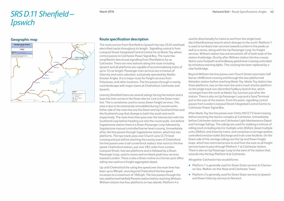
Network Rail – Route Specifications: Anglia 42March 2016SRS D.11 Shenfield – Ipswich
Route specification descriptionThe route section from Shenfield to Ipswich has two 25 kV overhead electrified tracks throughout its length. Signalling control is from Liverpool Street Integrated Control Centre far as Marks Tey where control passes to Colchester Power Signal Box. The route has simplified bi-directional signalling from Shenfield as far as Colchester. There are nine stations along the route including Ipswich and all platforms are capable of accommodating trains of up to 12-car length. Passenger train services are a mixture of Intercity and outer suburban, exclusively operated by Abellio Greater Anglia. It is a major route for freight services from Felixstowe, and other locations. The line passes through a mainly rural landscape with major towns at Chelmsford, Colchester and Ipswich.
Leaving Shenfield there are several sidings facing the station and a loop line that connects the Down electric Line to the Down main line. This is sometimes used to recess Down freight services. This area is due to be extensively remodelled during Crossrail works. Either side of the main line are the Down and Up Southend lines and the Southend Loop that diverge to both the south and north respectively. The main lines then pass over the intersection with the Southend Loop before heading out into the countryside. Just before Ingatestone station there is a Down Passenger Loop followed by Ingatestone manual controlled barrier level crossing. Immediately after, the line passes through Ingatestone station, which has two platforms. The two tracks pass over Church Lane CCTV level crossing and just before reaching the county town of Chelmsford the line passes over a tall curved brick viaduct that restricts the line speed. Chelmsford station, just over 29½ miles from London Liverpool Street, has two platforms and is followed by a Down Passenger Loop, used to recess and turnback peak hour services towards London. There is also a Down incline to a former post office siding now used as a freight aggregates depot.
Up until Chelmsford the ruling line speed over the main lines has been up to 90mph, once beyond Chelmsford the line speed increases to a maximum of 100mph. The line passes through the two-platformed Hatfield Peverel station before reaching Witham. Witham station has four platforms on two islands. Platform 4 is
used bi-directionally for trains to and from the single track electrified Braintree branch which diverges to the north. Platform 1 is used to turnback train services towards London in the peaks as well as a recess, along with the Up Passenger Loop, for freight services. Witham station has entrance/exits off of both ends of the station footbridge. Shortly after Witham station the line crosses Motts Lane footpath and bridleway gated level crossing controlled by miniature warning lights. This crossing has been replaced by a new footbridge.
Beyond Witham the line passes over Church Street automatic half barrier (AHB) level crossing and through the two-platformed Kelvedon station before reaching Marks Tey. Marks Tey station has three platforms, two on the main line and a much shorter platform on the single track non-electrified Sudbury branch line, which converges from the north at Marks Tey Junction just after the station. There is also an Up Passenger Loop and a Sand Terminal just to the east of the station. From this point, signalling control passes from London Liverpool Street Integrated Control Centre to Colchester Power Signal Box.
After Marks Tey the line passes over Chitts Hill CCTV level crossing before reaching the station complex at Colchester. Immediately before Colchester station are Colchester Light Maintenance Depot and Carriage Sidings. The sidings are used for stabling a mixture of rolling stock including electric multiple units (EMUs), diesel multiple units (DMUs), and Intercity trains, and comprises a carriage washer, controlled emission toilet discharge and train crew facilities. On the Down side of the carriage sidings are the Up and Down freight loops, which has restricted access to and from the east as all freight services have to pass through Platform 1 at Colchester station. There is also an Up Passenger Loop to the west of the station that extends into the bay Platform 6 at Colchester.
Altogether Colchester has six platforms:
• Platform 1 is generally used for Down Outer services to Clacton-on-Sea, Walton-on-the-Naze and Colchester Town:
• Platform 2 is generally used for Down Outer services to Ipswich and Down Intercity services to Norwich
Geographic map

Network Rail – Route Specifications: Anglia 43March 2016SRS D.11 Shenfield – Ipswich
• Platform 3 is generally used for Up Outer services from Ipswich and Up Intercity services from Norwich
• Platform 4 is generally used for Up Outer services from Clacton-on-Sea, Walton-on-the-Naze and Colchester Town
• Platform 5 (east facing bay) is generally used for Outer stopping services to and from Walton-on-the-Naze
• Platform 6 (west facing bay) is occasionally used for trains to and from London.
After Colchester the Up and Down Passenger Loops that extend from Platforms 4 and 1 respectively form the start of the Clacton branch. The Down Passenger Loop extends into the Down Clacton Avoiding Line whose intersection passes beneath the main line whilst the Up Passenger Loop feeds into the Clacton Single Line.
There is now a seven mile run down to Manningtree during which the line passes over Ardleigh CCTV level crossing. At Manningtree station there are three platforms, two though platforms and a short up to five-car length bay platform used by services to the Harwich Town branch that diverge at Manningtree South Junction. There is also a siding alongside Platform 3 occasionally used by engineering trains. Immediately beyond the platforms is Manningtree South Junction CCTV level crossing. This is a very similar crossing to that at Ely station (see SRS D.06) in that there is an underpass alongside the crossing which is suitable for cars and small vans, whilst larger vehicles have to use the level crossing. Beyond the crossing the single track North Curve from the Harwich Town branch converges with the main line before the line passes over two long wooden trestle bridges, River Stour Viaduct and Cattawade Viaduct, over the River Stour.
There is now a 7½ mile stretch up to Ipswich Halifax Junction, which passes over Bentley AHB level crossing. At Halifax Junction a short freight branch diverges to the south to Griffin Wharf. After the junction the line passes through Ipswich Stoke Tunnel and immediately emerges into the four-platformed Ipswich station where the tracks fan out into:
• Down Loop through Platform 4 used by local and regional services to and from Peterborough and Cambridge as well as some London services
• Down main line through Platform 3 generally used by Intercity services to Norwich
• Up main line, situated between platforms 2 and 3 mainly used by freight trains
• Up Loop through Platform 2 generally used by Intercity services to London.
Platform 1 at Ipswich is an eastwards facing bay platform generally used by services to Felixstowe, Saxmundham and Lowestoft.
Alongside Platform 4 at Ipswich is a passenger carriage siding, loco refuelling point, loco maintenance and stabling sidings and Freightliner train crew accommodation.

Network Rail – Route Specifications: Anglia 44March 2016
Table 1.0
Information Current 2019 2043 Notes
Line of route description
EA1011: Seven Kings to Ipswich
Section start Shenfield station
Section end Ipswich Station
Route availability RA8 RA8 RA8
Gauge W9, W10 W9, W10 W9, W10, W12 W12 for new infrastructure
Signals Track Circuit Block Track Circuit Block European Rail Traffic Management System (ERTMS)
SpeedSee Sectional Appendix for detailed speed profiles
Predominant line speed 100 mph Raise lower speeds up to the maximum line speed and where possible to 110 mph
Raise lower speeds up to the maximum line speed and where possible to 110 mph
See Sectional Appendix for detailed speed profiles
Line speed improvements on the whole of the Great Eastern Main Line are currently being looked at as part of a GRIP 1 – 2 study
Electrification 25kV AC (Overhead) along the entire section 25kV AC (Overhead) along the entire section 25kV AC (Overhead) along the entire section
Route capability overview
SRS D.11 Shenfield – Ipswich

Network Rail – Route Specifications: Anglia 45March 2016
Passenger train service levels (trains per hour/day)Table 2.0
Current 2019 2043 Notes
Typical journey time Ipswich to London Liverpool Street; fast service in 67 minutes and stopping service in 83 minutes
Ipswich to London Liverpool Street; fast service in 67 minutes and stopping service in 83 minutes
Ipswich to London Liverpool Street; fast service in 67 minutes and stopping service in 83 minutes
No. of trains per hour 2 peak/1 off-peak tph Ipswich to London Liverpool Street1 tph Braintree to London Liverpool Street2 peak tph Chelmsford to London Liverpool Street4 peak/1 off-peak Clacton on Sea to London Liverpool Street1 peak tph Clacton on Sea to Colchester1 tph Colchester Town to London Liverpool Street2 off-peak tph Colchester Town to Colchester1 peak/1 off-peak tph Walton-on-the-Naze to Colchester1 peak tph Harwich International to London Liverpool Street2 peak tph Harwich Town to London Liverpool Street2 tph Norwich to London Liverpool Street1 peak tph Stowmarket to London Liverpool Street2 peak tph Witham to London Liverpool Street
2 peak/1 off-peak tph Ipswich to London Liverpool Street1 tph Braintree to London Liverpool Street2 peak tph Chelmsford to London Liverpool Street4 peak/1 off-peak Clacton on Sea to London Liverpool Street1 peak tph Clacton on Sea to Colchester2 peak/1 off-peak tph Colchester Town to London Liverpool Street2 off-peak tph Colchester Town to Colchester1 peak/1 off-peak tph Walton-on-the-Naze to Colchester1 peak tph Harwich International to London Liverpool Street2 peak tph Harwich Town to London Liverpool Street2 tph Norwich to London Liverpool Street1 peak tph Stowmarket to London Liverpool Street2 peak tph Witham to London Liverpool Street
2 peak/1 off-peak tph Ipswich to London Liverpool Street1 tph Braintree to London Liverpool Street4 peak tph Chelmsford to London Liverpool Street4 peak/1 off-peak Clacton on Sea to London Liverpool Street1 peak tph Clacton on Sea to Colchester2 peak/1 off-peak tph Colchester Town to London Liverpool Street2 off-peak tph Colchester Town to Colchester1 peak/1 off-peak tph Walton-on-the-Naze to Colchester1 peak tph Harwich International to London Liverpool Street2 peak tph Harwich Town to London Liverpool Street2 tph Norwich to London Liverpool Street1 peak tph Stowmarket to London Liverpool Street2 peak tph Witham to London Liverpool Street
SRS D.11 Shenfield – Ipswich

Network Rail – Route Specifications: Anglia 46March 2016SRS D.11 Shenfield – Ipswich
Current Freight Trains (paths per day) Table 3.0
Current 2019 2043 Notes
Route section Shenfield – Ipswich
Daily paths in one direction (as per WTT)
20 Freight growth is predicted from London Gateway Port and Felixstowe, some of which will require additional freight paths along this route
Freight growth is predicted from London Gateway Port and Felixstowe, some of which will require additional freight paths along this route
* Figures are for freight trains in one direction only
Level crossings on routeTable 4.0
Type Current No. of level crossings 2019 No. of level crossings 2043 No. of level crossings
Supervised: 5 4 Currently progressing a workstream looking at level crossings across Anglia which will outline priorities/criteria for level crossing closures and will result in a net decrease across the route
Automatic: 2 1
User: 1 0

Network Rail – Route Specifications: Anglia 47March 2016SRS D.11 Shenfield – Ipswich
Table 5.0
Project Project Description ELR Implementation Date
Output change Notes Status
Great Eastern Capacity Improvements
Infrastructure works to increase the number of trains into Liverpool Street station from the GEML
LTN 2014 – 2019 Capacity enhancement In development
Anglia traction power supply (CP5)
Works to reinforce the power supply on the Anglia route following train service changes
LTN 2014 – 2019 Power supply improvement
In development
* In addition to the proposed enhancement programme, this table includes other Network Rail funded schemes, renewals and third party schemes where applicable.** The precise timing and scope of renewals will remain subject to review to enable us to meet our overall obligations as efficiently as possible, consistent with the reasonable requirements of operators and other stakeholders.
Planned infrastructure investment in Control Period 5 (2014 – 2019)*

Network Rail – Route Specifications: Anglia 48March 2016SRS D.11 Shenfield - Ipswich
Proposed infrastructure investment in Control Period 5 (2014 – 2019)*Table 6.0
Project Project Description ELR Implementation Date
Output change Notes Status
Linespeed improvements on the GEML
Increase linespeed to 100mph where possible
LTN 2014 – 2019 Improved journey times In development
Witham S & C renewals LTN 2014 – 2019 Renewed assets In development
Colchester S & C renewals LTN 2014 – 2019 Renewed assets In development
Marks Tey S & C renewals LTN 2014 – 2019 Renewed assets In development
Church Lane S & C renewals LTN 2014 – 2019 Renewed assets In development
Kelvedon S & C renewals LTN 2014 – 2019 Renewed assets In development
Ardleigh S & C renewals LTN 2014 – 2019 Renewed assets In development
Brickhouse S & C renewals LTN 2014 – 2019 Renewed assets In development
Ipswich S & C renewals LTN 2014 – 2019 Renewed assets In development
Arbour Lane High output reballast LTN 2014 – 2019 Renewed assets In development
Hatfield Peverel to Witham High output reballast LTN 2014 – 2019 Renewed assets In development
Witham to Kelvedon High output reballast LTN 2014 – 2019 Renewed assets In development
Hillhouse High output reballast LTN 2014 – 2019 Renewed assets In development
Marks Tey High output reballast LTN 2014 – 2019 Renewed assets In development
Ingatestone High output reballast LTN 2014 – 2019 Renewed assets In development
* In addition to the proposed enhancement programme, this table includes other Network Rail funded schemes, renewals and third party schemes where applicable.** The precise timing and scope of renewals will remain subject to review to enable us to meet our overall obligations as efficiently as possible, consistent with the reasonable requirements of operators and other stakeholders.

Network Rail – Route Specifications: Anglia 49March 2016SRS D.12 Ipswich – Norwich
Route specification descriptionThe route section from Ipswich to Norwich has two 25 kV overhead electrified tracks throughout its length. Signalling control is from Colchester Power Signal Box. There are four stations along the route including Norwich and most platforms are capable of accommodating trains of up to 12-car length with the exception of Needham Market and terminal Platforms 5 and 6 at Norwich. Passenger train services are a mixture of Intercity, local and regional, almost exclusively operated by Abellio Greater Anglia. East Midlands Trains services between Liverpool and Norwich join the route section at Trowse Junction. Freight services from Felixstowe and other locations utilise the route between Ipswich and Haughley Junction. The line passes through a mainly rural landscape with towns at Stowmarket and Diss.
Leaving Ipswich there are three tracks as far as East Suffolk Junction. The Up Loop through Platform 2 at Ipswich is joined by the line from the bay Platform 1 and feeds into the Up and Down Lowestoft single line that runs alongside the main lines. At this point there are connections into and out of the major freight yard at Ipswich that acts as a regulating point for freight trains accessing paths onto the East Suffolk Line enroute to Felixstowe or onto the main line. The yard is also where locomotive traction can be changed between electric and diesel as the East Suffolk line and Felixstowe branch line to the Port of Felixstowe is non-electrified.
Four miles from East Suffolk Junction is Claydon CCTV level crossing. There is a Down Goods Loop at this point as well as Barham aggregates sidings that diverge on the Up side. Two miles after passing over Baylham Automatic Half Barrier (AHB) level crossing we reach Needham Market station. Needham Market has two short platforms only capable of accommodating trains of up to three and four-cars in length. Generally only the Ipswich to Cambridge service stops at Needham Market although there are a couple of extra services in the peaks into and out of Ipswich. Three miles further on there is a bi-directional Goods Loop on the Down side that links into refuge sidings used by Direct Rail Services. 80½ miles from London Liverpool Street, Stowmarket station has two platforms with a manual controlled barrier level crossing immediately after the platform ends. This is just 300 yards from the Regent Street CCTV level crossing. Two miles further on is the former Haughley station site and Haughley AHB level crossing, which is immediately before the single lead Haughley Junction
where the cross country route via Bury St Edmunds diverges. This is where most of the freight services turn off of and onto the main lines from Ipswich. The Haughley Junction single lead is planned to be redoubled in 2015.
From Haughley Junction the next 12 mile section to Diss passes over four AHB level crossings at Wassicks, Rectory Road, Mellis and Palgrave. Diss station has two platforms and is immediately followed by sidings on the Up side. The next 19 mile section to Trowse Junction contains a further eight AHB level crossings at Audley End, Burston, Gissing, Hales Street, Tivetshall, Moulton, Newton Flotman and Swainsthorpe following which the line passes over the intersection with the Ely to Norwich route. At Trowse Junction the Ely to Norwich route converges onto the Up main line. At this point there is a half mile section of three bi-directionally signalled tracks: Down main line; Up main line; and an Up & Down Loop line. The latter connects into the Lafarge aggregates sidings. At Trowse (Swing Bridge) Junction the three tracks merge into a single line to cross the River Wensum. Trowse swing bridge is unique as it is the only swing bridge in the UK that carries an overhead electrified line. Immediately across the bridge the line splits into two bi-directionally signalled tracks. To the east of the route Norwich Crown Point Depot is visible and there is a connection onto Wensum Curve that runs between the main line and the depot reception roads on the Norwich to Lowestoft route. At Thorpe Junction the tracks from Lowestoft converge giving a three track throat approach into Norwich station.
Norwich station is the terminus of the 114 mile Great Eastern Main Line from London Liverpool Street. The station has six terminal platforms:
• Platforms 1 is generally used by Intercity London services and a few Cambridge and Liverpool services
• Platform 2 is used by Intercity London services
• Platform 3 is generally used by Cambridge and Liverpool services
• Platforms 4, 5 and 6 are used by local services to and from Lowestoft, Great Yarmouth and Sheringham.
There are several carriage sidings either side of Norwich station and a centre siding between Platforms 4 and 5.
Geographic map

Network Rail – Route Specifications: Anglia 50March 2016
Table 1.0
Information Current 2019 2043 Notes
Line of route description
EA1012: Ipswich to Trowse JunctionEA1013: Trowse Junction to Norwich
Section start Ipswich station
Section end Norwich station
Route availability RA8 RA8 RA8
Gauge W9, W10 W9, W10 W9, W10, W12 W12 for new infrastructure
Signals Track Circuit Block Track Circuit Block European Rail Traffic Management System (ERTMS)
SpeedSee Sectional Appendix for detailed speed profiles
Predominant line speed 100 mph Raise lower speeds up to the maximum line speed and where possible to 110 mph
Raise lower speeds up to the maximum line speed and where possible to 110/125 mph
See Sectional Appendix for detailed speed profiles
Line speed improvements on the whole of the Great Eastern Main Line are currently being looked at as part of a GRIP 1 – 2 study
Electrification 25kV AC (Overhead).Some sidings and loops not electrified.
25kV AC (Overhead).Some sidings and loops not electrified.
25kV AC (Overhead).Some sidings and loops not electrified.
Electrification should be considered on an individual basis when sidings/loops are renewed
Route capability overview
SRS D.12 Ipswich – Norwich

Network Rail – Route Specifications: Anglia 51March 2016
Passenger train service levels (trains per hour/day)Table 2.0
Current 2019 2043 Notes
Typical journey time Ipswich to Norwich in 40 – 45 minutesNorwich to Liverpool Street fast service in 1 hour 47 minutes and semi-fast service in 1hour 58 minutes
Ipswich to Norwich in 40 – 45 minutesNorwich to Liverpool Street fast service in 1 hour 47 minutes and semi-fast service in 1hour 58 minutes
Ipswich to Norwich in 40 – 45 minutesNorwich to Liverpool Street fast service in 1 hour 47 minutes and semi-fast service in 1h 58m
No. of trains per hour 1 tph Ipswich to Cambridge1 tph service Ipswich to Lowestoft1 tph service Ipswich to Saxmundham2 hourly service Ipswich to Peterborough2 tph Norwich to London Liverpool Street1 tph Norwich to Cambridge1 tph Norwich to Great Yarmouth1 tph Norwich to Liverpool Lime Street1 tph Norwich to Lowestoft1 tph Norwich to Sherringham
At least 1 tph Ipswich to Cambridge1 tph Ipswich to LowestoftAt least a 2 hourly service Ipswich to Peterborough2 tph Norwich to London Liverpool StreetAt least 1 tph Norwich to Cambridge1 tph Norwich to Great Yarmouth1 tph Norwich to Liverpool Lime Street1 tph Norwich to Lowestoft1 tph Norwich to Sherringham
2 tph Ipswich to Cambridge1 tph Ipswich to Lowestoft1 tph Ipswich to Peterborough2 tph Norwich to London Liverpool Street2 tph Norwich to Cambridge1 tph Norwich to Great Yarmouth1 tph Norwich to Liverpool Lime Street1 tph Norwich to Lowestoft1 tph Norwich to Sherringham
An aspiration of the TOC is to see 2 tph Cambridge to Norwich, 2 tph Ipswich to Cambridge and 1 tph Ipswich to Peterborough
SRS D.12 Ipswich – Norwich

Network Rail – Route Specifications: Anglia 52March 2016SRS D.12 Ipswich – Norwich
Current Freight Trains (paths per day) Table 3.0
Current 2019 2043 Notes
Route section East Suffolk Junction to Haughley Junction Haughley Junction to Norwich
Daily paths in one direction (as per WTT)
12
4
Up to 28
As per forecasts in the Freight Market Study
Up to 59
As per forecasts in the Freight Market Study
* Figures are for freight trains in one direction only
Level crossings on routeTable 4.0
Type Current No. of level crossings 2019 No. of level crossings 2043 No. of level crossings
Supervised: 3 Currently progressing a workstream looking at level crossings across Anglia which will outline priorities/criteria for level crossing closures and will result in a net decrease across the route
Currently progressing a workstream looking at level crossings across Anglia which will outline priorities/criteria for level crossing closures and will result in a net decrease across the route
Automatic: 14
User: 4

Network Rail – Route Specifications: Anglia 53March 2016SRS D.12 Ipswich – Norwich
Table 5.0
Project Project Description ELR Implementation Date
Output change Notes Status
Great Eastern Capacity Improvements
Infrastructure works to increase the number of trains into Liverpool Street station from the GEML
LTN 2014 – 2019 Capacity enhancement In development
Anglia traction power supply (CP5)
Works to reinforce the power supply on the Anglia route following train service changes
LTN 2014 – 2019 Power supply improvement
In development
* In addition to the proposed enhancement programme, this table includes other Network Rail funded schemes, renewals and third party schemes where applicable.** The precise timing and scope of renewals will remain subject to review to enable us to meet our overall obligations as efficiently as possible, consistent with the reasonable requirements of operators and other stakeholders.
Planned infrastructure investment in Control Period 5 (2014 – 2019)*

Network Rail – Route Specifications: Anglia 54March 2016SRS D.12 Ipswich – Norwich
Proposed infrastructure investment in Control Period 5 (2014 – 2019)*Table 6.0
Project Project Description ELR Implementation Date
Output change Notes Status
Felixstowe to Nuneaton 2 Works to further improve capacity for up to 56 freight tpd between Felixstowe and Nuneaton
BGK, CCH, EMP, LTN, ESK
2014 – 2019 Capacity enhancement In development
Linespeed improvements on the GEML
Increase linespeed to 100mph where possible
LTN 2014 – 2019 Improved journey times In development
Haughley Junction S & C renewals LTN 2014 – 2019 Renewed assets In development
Needham Market High output reballast LTN 2014/15 Renewed assets In development
Haughley High output reballast LTN 2014/15 Renewed assets In development
Thrandeston (near Diss) High output reballast LTN 2014/15 Renewed assets In development
Moulton (near Diss) High output reballast LTN 2014/15 Renewed assets In development
Gislingham (near Diss) High output reballast LTN 2014/15 Renewed assets In development
* In addition to the proposed enhancement programme, this table includes other Network Rail funded schemes, renewals and third party schemes where applicable.** The precise timing and scope of renewals will remain subject to review to enable us to meet our overall obligations as efficiently as possible, consistent with the reasonable requirements of operators and other stakeholders.

Network Rail – Route Specifications: Anglia 55March 2016SRS D.13 Shenfield – Southend/Southminster
Route specification descriptionThe 37½ route section that covers from Shenfield to Southend Victoria (21 miles two track) and from Wickford to Southminster (16½ miles single track) is 25 kV overhead electrified throughout its length. Signalling control is from Liverpool Street Integrated Electronic Control Centre. The route has simplified bi-directional signalling from Shenfield to Southend Victoria. There are eight stations along the Shenfield to Southend Victoria route excluding Shenfield and all platforms are capable of accommodating trains of up to 12-car length. There are a further six stations along the Wickford to Southminster route excluding Wickford and all platforms are capable of accommodating trains of up to eight-car length. Passenger train services are exclusively operated by Abellio Greater Anglia. The only freight service on the route is to Southminster (freight traffic serving the road transfer siding for Bradwell Power Station), which is currently discontinued due to the power station being decommissioned.
Leaving Shenfield the lines to Southend split either side of the Great Eastern Main Line (GEML) on falling gradients. On the Down side of the GEML is the single track Southend Loop that is currently fed by services from Platforms 4 and 5 at Shenfield station. On the Up side of the GEML the two-track Southend lines that are currently fed by services from Platforms 1, 2 and 3 at Shenfield station, merge with the Southend Loop, which has passed underneath the intersection with the GEML, at Mountnessing Junction. The route continues through Billericay station, which has two platforms, until it reaches Wickford (29 miles from London Liverpool Street and 9 miles from Shenfield). At this point there is a single Up and Down sidings either side of the line; the Down siding is often used by rail engineering plant. Wickford station itself has four platforms, two through platforms and two south facing bay platforms either side of the line. The bay platforms are used for branch shuttle services between Wickford and Southminster. Beyond Wickford station the single track Southminster branch line diverges eastwards at Wickford Junction.
After the junction the line continues for 11½ miles to Prittlewell station passing through four other stations along the way at Rayleigh, Hockley, Rochford and Southend Airport. All these stations have two platforms.
From Prittlewell station there is the short one mile run into Southend Victoria station. Immediately after Prittlewell station the Up and Down carriage sidings become apparent. Southend Victoria carriage sidings and Light Maintenance Depot, leased to Greater Anglia, have a carriage washer and train crew facilities. The majority of the sidings on the Down north side have direct access to all four terminal platforms at Southend Victoria station, which is 41½ miles from London Liverpool Street, 21½ miles from Shenfield. The other sidings, Down south, Up north and Up south have to perform shunt moves to access the station.
The single track Southminster branch diverges from the Southend line at Wickford Junction and runs eastwards for 16½ miles. Five of the six stations on the branch have a single platform. The exception is North Fambridge, which has two platforms and a passenger loop, the only point at which two trains can pass one another on the whole length of the branch.
From Wickford Junction the line passes through Battlesbridge station and then South Woodham Ferrers station, which has an automatic barrier crossing immediately afterwards. Three miles later the line reaches North Fambridge station. The passing loop at North Fambridge station is long enough to allow two 12-car length trains to pass one another. 12-car trains only work on the branch in the peak hours with four cars locked out of use as all the platforms along the route are only capable of accommodating 8-car length trains. 12-car trains are needed in the peak as the additional capacity is required inwards to London from Wickford.
After North Fambridge the line passes through Althorne station, which has an automatic open crossing immediately afterwards, then passes through Burnham-on-Crouch station before reaching the terminus at Southminster. At Southminster station is the secured siding and crane, which was used for the transfer of the nuclear flask, from Bradwell Nuclear Power Station, between road and rail freight service whilst it was still in operation.
Due to the lines, fertile rural nature, there are a number of occupational user worked crossings along the length of the route, five of which are concentrated in a two mile section between South Woodham Ferrers and North Fambridge, there is also a locally monitored Automatic Barrier Crossing (ABCL) between these stations.
Geographic map
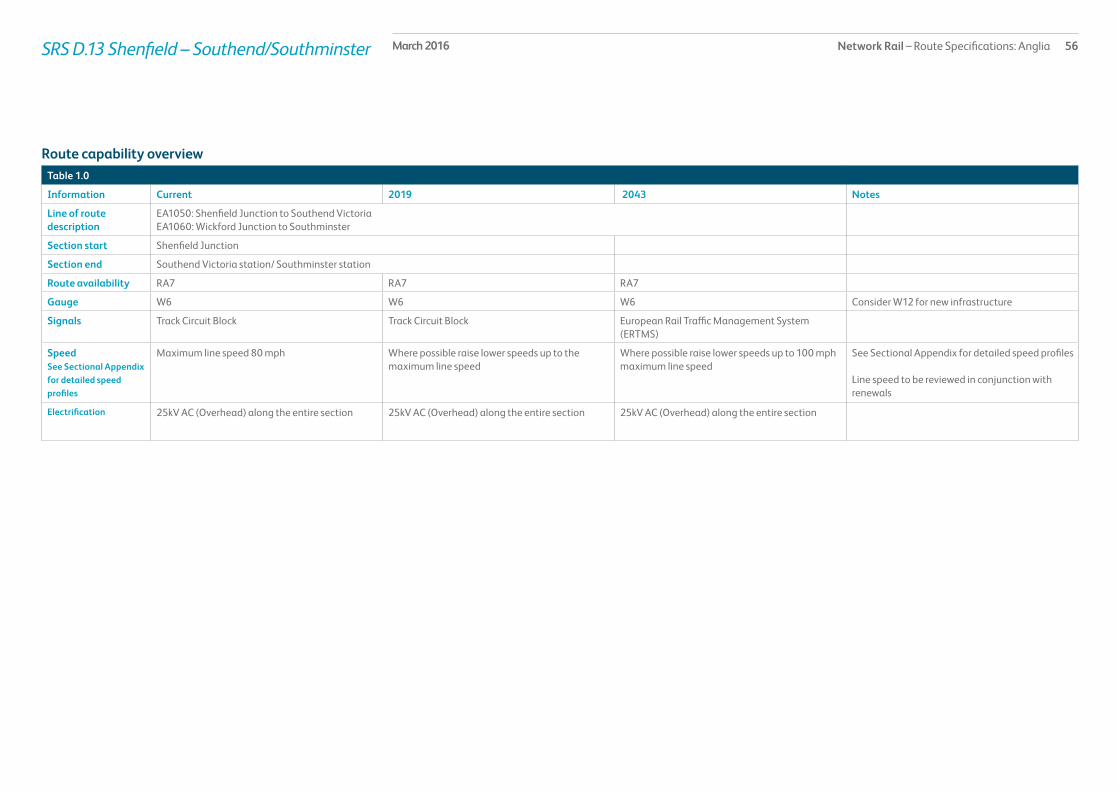
Network Rail – Route Specifications: Anglia 56March 2016
Table 1.0
Information Current 2019 2043 Notes
Line of route description
EA1050: Shenfield Junction to Southend VictoriaEA1060: Wickford Junction to Southminster
Section start Shenfield Junction
Section end Southend Victoria station/ Southminster station
Route availability RA7 RA7 RA7
Gauge W6 W6 W6 Consider W12 for new infrastructure
Signals Track Circuit Block Track Circuit Block European Rail Traffic Management System (ERTMS)
SpeedSee Sectional Appendix for detailed speed profiles
Maximum line speed 80 mph Where possible raise lower speeds up to the maximum line speed
Where possible raise lower speeds up to 100 mph maximum line speed
See Sectional Appendix for detailed speed profiles
Line speed to be reviewed in conjunction with renewals
Electrification 25kV AC (Overhead) along the entire section 25kV AC (Overhead) along the entire section 25kV AC (Overhead) along the entire section
Route capability overview
SRS D.13 Shenfield – Southend/Southminster

Network Rail – Route Specifications: Anglia 57March 2016
Passenger train service levels (trains per hour/day)Table 2.0
Current 2019 2043 Notes
Typical journey time Southend Victoria to Liverpool Street in 58minutes to 1 hour 5minutesSouthminster to Wickford in 30/31 minutes
Southend Victoria to Liverpool Street in 58 minutes to 1 hour 5minutesSouthminster to Wickford in 30 minutes
Southend Victoria to Liverpool Street in under 58 minutessSouthminster to Wickford in 30 minutes
No. of trains per hour 7 peak/3 off-peak tph Southend Victoria to London Liverpool StreetSouthminster to Wickford every 40 minutes
7 peak/3 off-peak tph Southend Victoria to London Liverpool StreetSouthminster to Wickford every 40 minutes 1 peak tph Wickford to London Liverpool Street
7 peak/3 off-peak tph Southend Victoria to London Liverpool StreetSouthminster to Wickford every 40 minutes1 peak tph Wickford to London Liverpool Street
SRS D.13 Shenfield – Southend/Southminster
Current Freight Trains (paths per day) Table 3.0
Current 2019 2043 Notes
Route section Wickford to Shenfield
Daily paths in one direction (as per WTT)
1 As per forecasts in the Freight Market Study
As per forecasts in the Freight Market Study
* Figures are for freight trains in one direction only
Level crossings on routeTable 4.0
Type Current No. of level crossings 2019 No. of level crossings 2043 No. of level crossings
Supervised: 0 Currently progressing a workstream looking at level crossings across Anglia which will outline priorities/criteria for level crossing closures and will result in a net decrease across the route
Currently progressing a workstream looking at level crossings across Anglia which will outline priorities/criteria for level crossing closures and will result in a net decrease across the route
Automatic: 2
User: 12
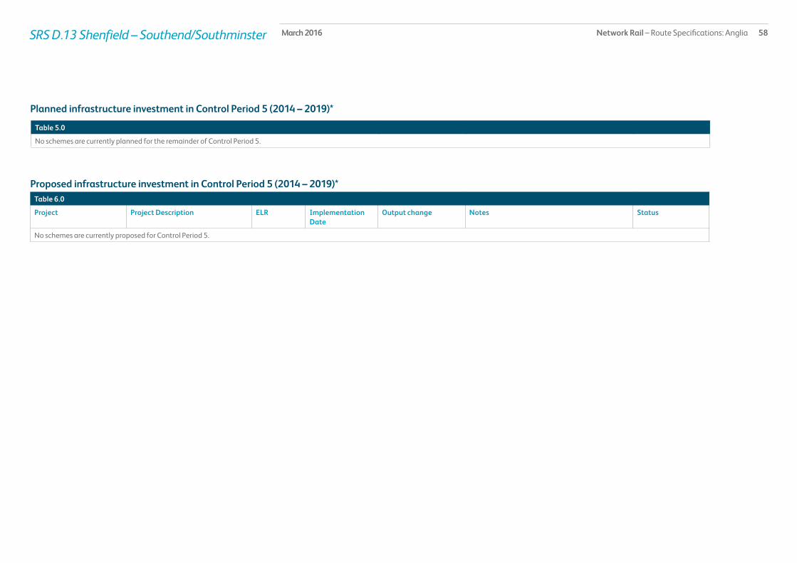
Network Rail – Route Specifications: Anglia 58SRS D.13 Shenfield – Southend/Southminster March 2016
Table 5.0
No schemes are currently planned for the remainder of Control Period 5.
Planned infrastructure investment in Control Period 5 (2014 – 2019)*
Proposed infrastructure investment in Control Period 5 (2014 – 2019)*Table 6.0
Project Project Description ELR Implementation Date
Output change Notes Status
No schemes are currently proposed for Control Period 5.
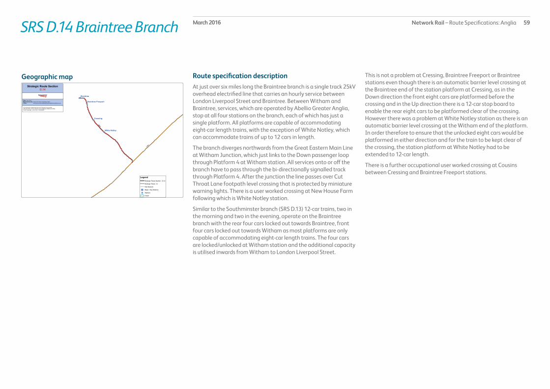
Network Rail – Route Specifications: Anglia 59March 2016SRS D.14 Braintree Branch
Route specification descriptionAt just over six miles long the Braintree branch is a single track 25kV overhead electrified line that carries an hourly service between London Liverpool Street and Braintree. Between Witham and Braintree, services, which are operated by Abellio Greater Anglia, stop at all four stations on the branch, each of which has just a single platform. All platforms are capable of accommodating eight-car length trains, with the exception of White Notley, which can accommodate trains of up to 12 cars in length.
The branch diverges northwards from the Great Eastern Main Line at Witham Junction, which just links to the Down passenger loop through Platform 4 at Witham station. All services onto or off the branch have to pass through the bi-directionally signalled track through Platform 4. After the junction the line passes over Cut Throat Lane footpath level crossing that is protected by miniature warning lights. There is a user worked crossing at New House Farm following which is White Notley station.
Similar to the Southminster branch (SRS D.13) 12-car trains, two in the morning and two in the evening, operate on the Braintree branch with the rear four cars locked out towards Braintree, front four cars locked out towards Witham as most platforms are only capable of accommodating eight-car length trains. The four cars are locked/unlocked at Witham station and the additional capacity is utilised inwards from Witham to London Liverpool Street.
This is not a problem at Cressing, Braintree Freeport or Braintree stations even though there is an automatic barrier level crossing at the Braintree end of the station platform at Cressing, as in the Down direction the front eight cars are platformed before the crossing and in the Up direction there is a 12-car stop board to enable the rear eight cars to be platformed clear of the crossing. However there was a problem at White Notley station as there is an automatic barrier level crossing at the Witham end of the platform. In order therefore to ensure that the unlocked eight cars would be platformed in either direction and for the train to be kept clear of the crossing, the station platform at White Notley had to be extended to 12-car length.
There is a further occupational user worked crossing at Cousins between Cressing and Braintree Freeport stations.
Geographic map

Network Rail – Route Specifications: Anglia 60March 2016
Table 1.0
Information Current 2019 2043 Notes
Line of route description
EA1070: Witham Junction to Braintree
Section start Witham Junction
Section end Braintree station
Route availability RA6 RA6 RA6
Gauge W6 W6 W6
Signals Track Circuit Block Track Circuit Block European Rail Traffic Management System (ERTMS)
SpeedSee Sectional Appendix for detailed speed profiles
Maximum line speed 50 mphLine speed is generally between 35 and 50 mph
Where possible raise lower speeds up to the maximum line speed
Where possible raise lower speeds up to the maximum line speed
See Sectional Appendix for detailed speed profiles
Line speed to be reviewed in conjunction with renewals
Electrification 25kV AC (Overhead) along the entire section 25kV AC (Overhead) along the entire section 25kV AC (Overhead) along the entire section
Route capability overview
SRS D.14 Braintree Branch

Network Rail – Route Specifications: Anglia 61March 2016
Passenger train service levels (trains per hour/day)Table 2.0
Current 2019 2043 Notes
Typical journey time Braintree to London Liverpool Street in 61 minutes to 67 minutes
Braintree to London Liverpool Street in no more than 61 minutes to 67 minutes
Braintree to London Liverpool Street in less than 61 minutes to 67 minutes
No. of trains per hour 1 tph Braintree to London Liverpool Street 1 tph Braintree to London Liverpool Street 1 tph Braintree to London Liverpool Street
SRS D.14 Braintree Branch
Current Freight Trains (paths per day) Table 3.0
Current 2019 2043 Notes
Route section Braintree Branch
Daily paths in one direction (as per WTT)
0 As per forecasts in the Freight Market Study
As per forecasts in the Freight Market Study
* Figures are for freight trains in one direction only
Level crossings on routeTable 4.0
Type Current No. of level crossings 2019 No. of level crossings 2043 No. of level crossings
Supervised: 0 Currently progressing a workstream looking at level crossings across Anglia which will outline priorities/criteria for level crossing closures and will result in a net decrease across the route
Currently progressing a workstream looking at level crossings across Anglia which will outline priorities/criteria for level crossing closures and will result in a net decrease across the route
Automatic: 2
User: 3

Network Rail – Route Specifications: Anglia 62March 2016SRS D.14 Braintree Branch
Table 5.0
No schemes are currently planned for the remainder of Control Period 5.
Planned infrastructure investment in Control Period 5 (2014 – 2019)*
Proposed infrastructure investment in Control Period 5 (2014 – 2019)*Table 6.0
No schemes are currently planned for Control Period 5.

Network Rail – Route Specifications: Anglia 63March 2016SRS D.15 Harwich Branch
Route specification descriptionAt just over 11 miles long the Harwich branch is a two-track 25kV overhead electrified line as far as Harwich International where the running line is singled for the last two miles into the terminus at Harwich Town. Signalling on the branch is controlled from Colchester Power Signal Box and Parkeston Signal Box. The branch line carries an hourly service between Manningtree and Harwich Town. However, there are a few additional trains, which operate between London Liverpool Street and Harwich International providing links for ferry passengers at Harwich International Port. All services are operated by Greater Anglia. The Manningtree to Harwich Town services are operated with a single four-car electric multiple unit(EMU), and stop at all five stations on the branch. The London Liverpool Street to Harwich International services are usually eight cars in length except for a morning peak service which is formed of 12-car trains. These services only stop at Harwich International whilst on the branch line.
The branch diverges eastwards from the Great Eastern Main Line (GEML) at Manningtree South Junction. Shortly afterwards the bi-directionally signalled single track, Manningtree North Curve, that allows direct access to the GEML towards Ipswich, converges at Manningtree East Junction. The line then runs to Mistley station, which has two four-car length platforms, a Down loop before the station and an Up eastwards facing siding afterwards. The following station at Wrabness also has two four-car platforms and between Mistley and Wrabness stations the signalling control passes from Colchester Power Signal Box to Parkeston Signal Box.
Nine miles from Manningtree South Junction at Parkeston Goods Junction there is a connection that diverges on the Down side into Parkeston Yard, which has a mixture of freight sidings and carriage sidings, and a connection that diverges on the Up side into the freight sidings that cater for aggregates and solvents. The Down freight and carriage sidings also have a connection at their eastern end that converges with the branch line before it passes over the manually controlled barrier level crossing at Parkeston West. The crossing spans the three tracks into Harwich International station: The Down line, which became bi-directionally signalled from the western entrance to Parkeston Yard, passes through Platform 1 and emerges onto a single through siding; the Up line becomes a
bi-directionally signalled track through Platform 2 for services to and from Harwich Town; and the third line serves the west facing bay Platform 3.
After Harwich International station the through siding parallels the now single line to Harwich Town and has connections into a container terminal and storage siding. The eastern most end of this siding that extends through and beyond Dovercourt is no longer in regular use. Both the through siding and the single track to Harwich Town pass over Parkeston East CCTV level crossing immediately after Harwich International station. The line then reaches Dovercourt that has a single eight-car length platform before passing over Alexandra Road CCTV level crossing to reach Harwich Town that has a single terminal eight-car length platform just over 70½ miles from London Liverpool Street.
The wide expansive bay on the River Stour estuary that extends to the north of the line between Harwich International and Harwich Town is the proposed site of the new deep sea container port of Bathside Bay.
Geographic map

Network Rail – Route Specifications: Anglia 64March 2016
Table 1.0
Information Current 2019 2043 Notes
Line of route description
EA1120: Manningtree to Harwich Town
Section start Manningtree South Junction/East Junction
Section end Harwich Town station
Route availability RA8 RA8 RA8
Gauge W8, W10 W8, W10 W8, W10 Consider W12 for new infrastructure
Signals Track Circuit Block Track Circuit Block European Rail Traffic Management System (ERTMS)
SpeedSee Sectional Appendix for detailed speed profiles
Maximum line speed 60 mphLine speed is generally 40 to 60 mph
Where possible raise lower speeds up to the maximum line speed
Where possible raise lower speeds up to the maximum line speed
See Sectional Appendix for detailed speed profiles
Line speed to be reviewed in conjunction with renewals
Electrification 25kV AC (Overhead) along the entire section 25kV AC (Overhead) along the entire section 25kV AC (Overhead) along the entire section
Route capability overview
SRS D.15 Harwich Branch

Network Rail – Route Specifications: Anglia 65March 2016
Passenger train service levels (trains per hour/day)Table 2.0
Current 2019 2043 Notes
Typical journey time Harwich Town to Manningtree in 22 minutes Harwich Town to Manningtree in 22 minutes Harwich Town to Manningtree in under 22 minutes
No. of trains per hour 1 peak tph Harwich Town to London Liverpool Street1 peak hour train Harwich International to London Liverpool Street1 tph Harwich to Manningtree
1 peak tph Harwich Town to London Liverpool Street1 peak hour train Harwich International to London Liverpool Street1 tph Harwich to Manningtree
1 peak tph Harwich Town to London Liverpool Street1 peak hour train Harwich International to London Liverpool Street1 tph Harwich to Manningtree
SRS D.15 Harwich Branch
Current Freight Trains (paths per day) Table 3.0
Current 2019 2043 Notes
Route section Harwich Town to Manningtree
Daily paths in one direction (as per WTT)
3 Bathside Bay has initial planning permission, an additional 12 freight paths would be required if/when built
Bathside Bay has initial planning permission, further additional (beyond the initial 12) freight paths could be required
* Figures are for freight trains in one direction only.
Level crossings on routeTable 4.0
Type Current No. of level crossings 2019 No. of level crossings 2043 No. of level crossings
Supervised: 3 Currently progressing a workstream looking at level crossings across Anglia which will outline priorities/criteria for level crossing closures and will result in a net decrease across the route
Currently progressing a workstream looking at level crossings across Anglia which will outline priorities/criteria for level crossing closures and will result in a net decrease across the route
Automatic: 0
User: 3
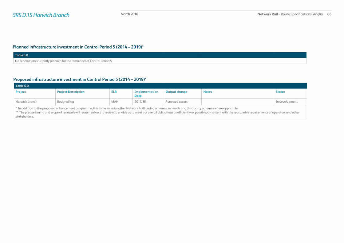
Network Rail – Route Specifications: Anglia 66March 2016SRS D.15 Harwich Branch
Table 5.0
No schemes are currently planned for the remainder of Control Period 5.
Planned infrastructure investment in Control Period 5 (2014 – 2019)*
Proposed infrastructure investment in Control Period 5 (2014 – 2019)*Table 6.0
Project Project Description ELR Implementation Date
Output change Notes Status
Harwich branch Resignalling MAH 2017/18 Renewed assets In development
* In addition to the proposed enhancement programme, this table includes other Network Rail funded schemes, renewals and third party schemes where applicable.** The precise timing and scope of renewals will remain subject to review to enable us to meet our overall obligations as efficiently as possible, consistent with the reasonable requirements of operators and other stakeholders.

Network Rail – Route Specifications: Anglia 67March 2016SRS D.16 Walton and Clacton Branches
Route specification descriptionThe 23 mile route section that covers from Colchester to Clacton-on-Sea (17 miles two track) and from Thorpe-le-Soken to Walton-on-the-Naze (5 miles single track) and the short branch into Colchester Town is 25 kV overhead electrified throughout its length. Signalling control is from Colchester Power Signal Box except for the station area at Clacton-on-Sea, which still retains its own signal box. There are eleven stations along the route excluding Colchester and all platforms are capable of accommodating trains of up to a maximum of eight-car length, with the exception of Colchester Town, Wivenhoe, Thorpe-le-Soken and Platforms 2 to 4 at Clacton-on-Sea that can accommodate up to 12-car formations. Passenger train services are exclusively operated by Abellio Greater Anglia. There are no regular freight services on the route.
From Colchester Junction single tracks descend either side of the Great Eastern Main Line. The Down Clacton Avoiding line that feeds from either Platform 1 or 2 at Colchester passes underneath the intersection of the Great Eastern Main Line before converging with the Clacton Single Line, which can be accessed from Platforms 1 to 5 at Colchester, just after the Clacton Single Line expands into a two track formation. The route passes over East Gate CCTV level crossing and then reaches East Gate Junction, which is one of three junctions that make up the triangle link to Colchester Town station. From East Gate Junction trains to Colchester Town station diverge towards Colne Junction whilst trains that do not stop at Colchester Town carry straight on towards Hythe Junction. The third side of the triangle is made up by the link between Colne Junction and Hythe Junction. Continuing towards Colchester Town from Colne Junction the two-track route converges to form a single track into Colchester Town station that just has one terminal platform.
From Hythe Junction the route continues towards Thorpe-le-Soken, running parallel to the River Colne on the Up side as far as Wivenhoe and passing through five two platformed stations at Hythe, Wivenhoe, Alresford, Great Bentley and Weeley. At Hythe, Alresford and Great Bentley stations there are CCTV level crossings. Between Alresford and Great Bentley stations there are two more CCTV level crossings, at Colchester Road and Thorrington, and an automatic half barrier crossing at Frating.
At Thorpe-le-Soken station there are two platforms in an island formation. Services to Clacton-on-Sea usually use Platform 2 whilst services to Walton-on-the-Naze usually use Platform 1. From Clacton station the single track branch to Walton-on-the-Naze diverges from the Down side at Thorpe-le-Soken Junction whilst the route continues to Clacton passing over Three Gates user worked crossing that spans all three lines then Giles user worked gates crossing until it reaches Burrs Road CCTV level crossing. From this point signalling control passes from Colchester Power Signal Box to Clacton signal box and the route fans out into the four terminal platforms at Clacton-on-Sea station.
Either side of Clacton-on-Sea station there are sidings as well as Clacton Depot on the Up side. Clacton Light Maintenance Depot and Carriage Sidings consist of electrified sidings and an inspection shed. The depot and sidings are leased to Abellio Greater Anglia who stable Class 360 and Class 321 electric multiple unit, or EMU, rolling stock. The sidings have a carriage washer, controlled emission toilet discharge and train crew facilities. The Inspection Shed is currently sub-let to Transys PLC for the refurbishment of on train equipment.
From Thorpe-le-Soken Junction the single track five mile branch line to Walton-on-the-Naze passes over Three Gates user worked crossing and then Pork Lane automatic half barrier level crossing followed by Nursery user worked crossing. After the last crossing Kirby Cross station has two platforms either side of a passing loop and the line runs on towards Frinton-on-Sea, which has a single platform and a CCTV level crossing. The line finally reaches Walton-on-the-Naze, which has just a single terminal platform.
Geographic map

Network Rail – Route Specifications: Anglia 68March 2016
Table 1.0
Information Current 2019 2043 Notes
Line of route description
EA1090: Colchester Junction to ClactonEA1100: East Gate Junction & Hythe Junction to Colchester TownEA1110: Thorpe-Le-Soken Junction to Walton-On-Naze
Section start Colchester Junction
Section end Colchester Town/ Walton-on-the-Naze/Clacton-on-Sea
Route availability RA7 RA7 RA7
Gauge W6 W6 W6
Signals Track Circuit Block Track Circuit Block European Rail Traffic Management System (ERTMS)
SpeedSee Sectional Appendix for detailed speed profiles
Maximum line speed 75 mph Where possible raise lower speeds up to the maximum line speed
Where possible raise lower speeds up to the maximum line speed
See Sectional Appendix for detailed speed profiles
Line speed to be reviewed in conjunction with renewals
Electrification 25kV AC (Overhead).Some sidings and loops not electrified.
25kV AC (Overhead).Some sidings and loops not electrified.
25kV AC (Overhead).Some sidings and loops not electrified.
Electrification should be considered on an individual basis when sidings/loops are renewed
Route capability overview
SRS D.16 Walton and Clacton Branches

Network Rail – Route Specifications: Anglia 69March 2016
Passenger train service levels (trains per hour/day)Table 2.0
Current 2019 2043 Notes
Typical journey time Clacton-on-Sea to London Liverpool Street between 86 minutes and 102 minutesWalton-on-the-Naze to Colchester 35 minutesColchester Town to Colchester 7 – 10 minutes
Clacton-on-Sea to London Liverpool Street between 86 minutes and 102 minutesWalton-on-the-Naze to Colchester 35 minutesColchester Town to Colchester 7 – 10 minutes
Clacton-on-Sea to London Liverpool Street between 86 minutes and 102 minutesWalton-on-the-Naze to Colchester 35 minutesColchester Town to Colchester 7 – 10 minutes
No. of trains per hour 3 peak/1 off-peak tph Clacton-on-Sea to London Liverpool Street1 peak tph Clacton-on-Sea to Colchester1 tph Colchester Town to London Liverpool Street2 off-peak tph Colchester Town to Colchester1 peak/1 off-peak tph Walton-on-the-Naze to Colchester
3 peak/1 off-peak tph Clacton-on-Sea to London Liverpool Street1 peak tph Clacton-on-Sea to Colchester2 peak/1 off-peak tph Colchester Town to London Liverpool Street2 off-peak tph Colchester Town to Colchester1 peak/1 off-peak tph Walton-on-the-Naze to Colchester
3 peak/1 off-peak tph Clacton-on-Sea to London Liverpool Street1 peak tph Clacton-on-Sea to Colchester2 peak/1 off-peak tph Colchester Town to London Liverpool Street2 off-peak tph Colchester Town to Colchester1 peak/1 off-peak tph Walton-on-the-Naze to Colchester
SRS D.16 Walton and Clacton Branches
Current Freight Trains (paths per day) Table 3.0
Current 2019 2043 Notes
Route section Walton and Clacton branches
Daily paths in one direction (as per WTT)
1 As per forecasts in the Freight Market Study
As per forecasts in the Freight Market Study
* Figures are for freight trains in one direction only

Network Rail – Route Specifications: Anglia 70March 2016SRS D.16 Walton and Clacton Branches
Table 5.0
No schemes are currently planned for the remainder of Control Period 5.
Planned infrastructure investment in Control Period 5 (2014 – 2019)*
Proposed infrastructure investment in Control Period 5 (2014 – 2019)*Table 6.0
Project Project Description ELR Implementation Date
Output change Notes Status
Clacton Station area Resignalling COC 2017/18 Renewed assets In development
* In addition to the proposed enhancement programme, this table includes other Network Rail funded schemes, renewals and third party schemes where applicable.** The precise timing and scope of renewals will remain subject to review to enable us to meet our overall obligations as efficiently as possible, consistent with the reasonable requirements of operators and other stakeholders.
Level crossings on routeTable 4.0
Type Current No. of level crossings 2019 No. of level crossings 2043 No. of level crossings
Supervised: 8 Currently progressing a workstream looking at level crossings across Anglia which will outline priorities/criteria for level crossing closures and will result in a net decrease across the route
Currently progressing a workstream looking at level crossings across Anglia which will outline priorities/criteria for level crossing closures and will result in a net decrease across the route
Automatic: 2
User: 4

Network Rail – Route Specifications: Anglia 71March 2016SRS D.17 Upminster Branch
Route specification descriptionThe short, just under 3½ mile, Upminster branch runs from the east facing bay Platform 1 at Romford to the west facing bay Platform 6 at Upminster. This is a single track 25kV overhead electrified line that carries a half hourly shuttle service with a single stop at Emerson Park, which has a single platform. Branch services are operated by Abellio Greater Anglia, and all three stations are capable of accommodating four-car length trains, although the platform at Upminster is slightly longer. Signalling is controlled from Liverpool Street Integrated Electronic Control Centre.
Services onto and off of the branch are via a connection that converges from the Up Great Eastern Main Line at Romford station. The unit normally stables at Ilford Car Sheds overnight.
Geographic map
Table 1.0
Information Current 2019 2043 Notes
Line of route description
EA1040: Romford to Upminster
Section start Romford station
Section end Upminster station
Route availability RA8 RA8 RA8
Gauge W6 W6 W6
Signals One Train Working without Staff One Train Working without Staff European Rail Traffic Management System (ERTMS)
SpeedSee Sectional Appendix for detailed speed profiles
Maximum line speed 30 mph Where possible raise lower speeds up to the maximum line speed
Where possible raise lower speeds up to the maximum line speed
See Sectional Appendix for detailed speed profiles
Line speed to be reviewed in conjunction with renewals
Electrification 25kV AC (Overhead) over whole section. 25kV AC (Overhead) over whole section. 25kV AC (Overhead) over whole section.
Route capability overview

Network Rail – Route Specifications: Anglia 72March 2016
Passenger train service levels (trains per hour/day)Table 2.0
Current 2019 2043 Notes
Typical journey time Upminster to Romford Upminster to Romford Upminster to Romford
No. of trains per hour 2 tph Upminster to Romford 2 tph Upminster to Romford 2 tph Upminster to Romford
SRS D.17 Upminster Branch
Current Freight Trains (paths per day) Table 3.0
Current 2019 2043 Notes
Route section Upminster Branch
Daily paths in one direction (as per WTT)
0 As per forecasts in the Freight Market Study
As per forecasts in the Freight Market Study
* Figures are for freight trains in one direction only
Level crossings on routeTable 4.0
Type Current No. of level crossings 2019 No. of level crossings 2043 No. of level crossings
Supervised: 0 0 0
Automatic: 0 0 0
User: 0 0 0

Network Rail – Route Specifications: Anglia 73March 2016SRS D.17 Upminster Branch
Table 5.0
No schemes are currently planned for the remainder of Control Period 5.
Planned infrastructure investment in Control Period 5 (2014 – 2019)*
Proposed infrastructure investment in Control Period 5 (2014 – 2019)*Table 6.0
No schemes are currently planned for Control Period 5.

Network Rail – Route Specifications: Anglia 74March 2016SRS D.18 Sudbury Branch
Route specification descriptionThe 12 mile single track non-electrified Sudbury Branch runs through a rural landscape. Signalling is controlled by London Liverpool Street Integrated Electronic Control Centre although effectively the line operates as one train working. There are four stations on the line including Marks Tey and hourly passenger shuttle services are operated by Abellio Greater Anglia. There are no regular freight services over the branch line.
The branch line commences at Marks Tey Junction where it converges onto the Great Eastern Main Line. Marks Tey station has two 12-car length platforms on the Great Eastern Main Line and a two-car length Platform 3, which is dedicated to branch line services. The line crosses over Chappel Viaduct a 75 feet high, 355 yard long, brick arched structure that spans the River Stour and dominates over the village below.
Geographic map On exiting the viaduct, the line enters Chappel & Wakes Colne station, which has a single platform capable of accommodating trains of up to five cars in length. Adjacent to Chappel & Wakes Colne station is the platform, tracks and buildings that make up the East Anglian Railway Museum. The station footbridge provides the link between the operational railway and the museum for customers arriving by train. At the northern end of Chappel & Wakes Colne station is a rail connection, which converges onto the branch line from the museum. Movements between the two lines are controlled by a ground frame.
After Chappel the line passes over Mount Bures automatic barrier level crossing before reaching Bures station, which has a single platform of four-car length. The line now runs for five miles up to its terminus at Sudbury, which has a single two-car length platform. On this stretch of track there is a further automatic barrier level crossing at Cornards and six user worked crossings with gates.
Table 1.0
Information Current 2019 2043 Notes
Line of route description
EA1080: Marks Tey Junction to Sudbury
Section start Marks Tey Junction
Section end Sudbury station
Route availability RA6 RA6 RA6
Gauge W6 W6 W6
Signals One Train Working without Staff One Train Working without Staff European Rail Traffic Management System (ERTMS)
SpeedSee Sectional Appendix for detailed speed profiles
Maximum line speed 60mph Where possible raise lower speeds up to the maximum line speed
Where possible raise lower speeds up to the maximum line speed
See Sectional Appendix for detailed speed profiles
Line speed to be reviewed in conjunction with renewals
Electrification Not electrified. Not electrified. Not electrified.
Route capability overview

Network Rail – Route Specifications: Anglia 75March 2016
Passenger train service levels (trains per hour/day)Table 2.0
Current 2019 2043 Notes
Typical journey time Sudbury to Marks Tey in 19 minutes Sudbury to Marks Tey in 19 minutes Sudbury to Marks Tey in 19 minutes
No. of trains per hour 1 tph Sudbury to Marks Tey 1 tph Sudbury to Marks Tey 1 tph Sudbury to Marks Tey
SRS D.18 Sudbury Branch
Current Freight Trains (paths per day) Table 3.0
Current 2019 2043 Notes
Route section Sudbury Branch
Daily paths in one direction (as per WTT)
0 As per forecasts in the Freight Market Study
As per forecasts in the Freight Market Study
* Figures are for freight trains in one direction only.
Level crossings on routeTable 4.0
Type Current No. of level crossings 2019 No. of level crossings 2043 No. of level crossings
Supervised: 0 Currently progressing a workstream looking at level crossings across Anglia which will outline priorities/criteria for level crossing closures and will result in a net decrease across the route
Currently progressing a workstream looking at level crossings across Anglia which will outline priorities/criteria for level crossing closures and will result in a net decrease across the route
Automatic: 2
User: 7

Network Rail – Route Specifications: Anglia 76March 2016SRS D.18 Sudbury Branch
Table 5.0
No schemes are currently planned for the remainder of Control Period 5
Planned infrastructure investment in Control Period 5 (2014 – 2019)*
Proposed infrastructure investment in Control Period 5 (2014 – 2019)*Table 6.0
No schemes are currently proposed for Control Period 5

Network Rail – Route Specifications: Anglia 77March 2016SRS D.19 East Suffolk Line and Norfolk Branches
Route specification descriptionThe East Suffolk Line and Norfolk Branches SRS is formed of several quite distinct routes totalling 113 miles in combined length: The East Suffolk Line between Ipswich and Lowestoft via Saxmundham; Norwich to Sheringham, Lowestoft and Great Yarmouth, the latter having two routes via Acle and via Berney Arms. These lines are all non-electrified, have a mixture of two track and single lines as well as several different types of signalling control. The routes pass through a predominantly rural landscape, much of it within the Norfolk Broads. Passenger train services are operated exclusively by Abellio Greater Anglia (GA) and all routes have at least an hourly service except for Saxmundham on the East Suffolk line to Lowestoft, which is two-hourly and the route between Reedham on the Norwich to Lowestoft route and Great Yarmouth via Berney Arms, which has a very limited weekday service. The only regular freight services are nuclear traffic to and from Sizewell power station between Westerfield Junction and Saxmundham Junction on the East Suffolk Line and gas distillate from North Walsham between North Walsham on the Cromer route and Wensum Junction on the outskirts of Norwich. There is occasional mud oil traffic between Lowestoft and Parkeston.
The 44 mile East Suffolk Line runs from Westerfield Junction in the south to Oulton Broad North Junction in the north. The line has recently been conventionally resignalled replacing the Radio Electronic Token Block (RETB) system and is controlled from Saxmundham. The resignalling was due to the loss of the radio frequency for the RETB system in December 2012. From Westerfield Junction the line is two-track for the first seven miles to Woodbridge station. There are two stations on this section of the route each of which has two platforms. Westerfield station has two four-car length platforms and Woodbridge has a three-car Down platform but a longer Up platform that can accommodate six-car length trains. This two track section also passes over an automatic barrier level crossing at Bealings.
From Woodbridge the line is single track for the next 12 miles up to Saxmundham. In the first half mile section from Woodbridge station there are four automatic open level crossings, in two pairs: Ferry Lane and Haywards; and Lime Kiln and Sun Wharf. These open crossings have limited sighting and result in a very restrictive
line speed for rail services. There are two user worked crossings immediately before Melton station, which has a single three-car length platform and another automatic open crossing immediately afterwards. There are two further user worked crossings and Ufford automatic barrier crossing before the line reaches the single four-car length platform at Wickham Market station. Beyond Wickham Market there are two further automatic barrier crossings, at Blaxhall and Beversham, and three more user worked crossings before the line returns to a two track formation prior to Saxmundham station passing over Chantry Road footpath crossing protected by miniature warning lights and the manual controlled barrier crossing next to the station.
Saxmundham station has two platforms, a three-car length Down platform and a five-car length Up platform. Immediately after the station is Saxmundham Junction, where the single track branch line to Sizewell diverges. All trains on and off of the Sizewell branch have to use the track through the Up platform at Saxmundham station. The line remains two track for the next nine miles to Halesworth station passing through the two-platformed Darsham station, which has a five-car length Down platform and a seven-car length Up platform. Along this stretch of track there are two user worked level crossings, an automatic open crossing at North Green, an automatic barrier level crossing at Middleton and an automatic half barrier level crossing at Darsham station. Beyond Darsham station to Halesworth there are a further three user worked crossings, two automatic open crossings at Willow Marsh and Wenhaston and an automatic barrier crossing at Bramfield. Halesworth station has two three-car length platforms.
After Halesworth the East Suffolk Line singles again for the remaining 16 miles to Oulton Broad North Junction. There is an automatic barrier crossing at Westhall followed by an automatic open crossing at Brampton station, which has a single seven-car length platform. Between Brampton and Beccles there is an automatic open crossing at Weston and then there are four automatic barrier crossings at Cromwell Road, London Road, Ingate Street and Grove Road. Beccles station currently has a single six-car length platform however, a passing loop has been constructed here as part of the resignalling scheme and a former disused platform is being brought back into use, which will facilitate an hourly service in place of the current two-hourly service.
Geographic map

Network Rail – Route Specifications: Anglia 78March 2016SRS D.19 East Suffolk Line and Norfolk Branches
Over the final seven miles to Oulton Broad North Junction there are a further nine user worked crossingss, a busy automatic barrier crossing at Beccles Bypass, Dawdy’s automatic open crossing before the single seven-car platform at Oulton Broad South station followed by Victoria Road CCTV level crossing. Finally the line passes over Oulton Broad swing bridge before Gravel Pit automatic barrier crossing and converging with the Norwich to Lowestoft Line at Oulton Broad North Junction.
The 23 mile Norwich to Lowestoft route runs from Thorpe Junction at Norwich in the east to Lowestoft station in the west. From Thorpe Junction the two-track Up and Down Lowestoft lines run alongside the two reception roads, which form part of Norwich Crown Point Depot to which there are connections at both Thorpe Junction and Wensum Junction. Norwich Crown Point Depot is a maintenance depot, leased to GA for servicing electric locomotives, loco hauled rolling stock and Diesel Multiple Units (DMUs). As well as maintenance and inspection facilities there is a wheel lathe, carriage washer and controlled emission toilet facilities as well as a fuel point for refuelling DMUs. The depot maintains and stables Class 90 loco hauled rolling stock and Class 170, 156 and 153 DMUs. Some Class 90 loco hauled rolling stock is stabled at Norwich station.
After Wensum Junction the route passes over a one mile long bridge viaduct over the River Yare. At this point signalling control, which until now has been from Colchester Power Signal Box, passes briefly to Trowse Swing Bridge. There is a user worked gated crossing that is followed by Whitlingham Junction where the route to Cromer and Sheringham diverges northwards. After Whitlingham Junction the rest of the two track line to Lowestoft is controlled from a series of mechanical signal boxes at Brundall Junction, Cantley, Reedham Junction, Reedham Swing Bridge, Somerleyton Swing Bridge, Oulton Broad North and Lowestoft. The line passes through the two three-car platforms at Brundall Gardens station followed by two user worked crossingss and at Brundall Junction station there are two staggered station platforms either side of a manual gated level crossing. Brundall Junction station has a seven-car length Down platform and an eight-car length Up platform. After the station the single track route to Great Yarmouth, via Acle, diverges at Brundall Junction.
During the next two mile stretch to Buckenham station, there are two more user worked crossings and a manual gated level crossing at Strumpshaw. Buckenham station also has two staggered platforms, each of three-car length, either side of a manual gated level crossing. The line continues on to Cantley passing over a further three user worked crossings and at Cantley station there are two eight-car length platforms, a manual gated level crossing and an Up side siding connection that links to the sugar beet factory, currently unused. Two miles further on is Reedham station, which has two platforms of six-car length (Down) and seven-car length (Up). The station is followed by Reedham Junction where the single track line diverges to Great Yarmouth via Berney Arms. The line then curves sharply and passes over Reedham swing bridge crossing the River Yare and then runs for another three miles passing over a single user worked crossing until it reaches Haddiscoe station where there are two platforms of four-car length (Down) and two-car length (Up). There are now three more user worked crossings before the line crosses over Somerleyton swing bridge crossing the River Waveney then there is one more user worked crossing before the line passes through the two platformed (Down seven-car, Up six-car) Somerleyton station. The line passes over four more user worked crossings until it reaches the two seven-car length platforms at Oulton Broad South station, which has a manual gated level crossing immediately before it.
From Oulton Broad South it is a straight 1½ mile run into the terminal platforms at Lowestoft. The East Suffolk Line converges straight after Oulton Broad South station and the line then runs along side the sidings complex to the south that links into the Associated British Ports’ Lowestoft Inner Harbour. At Lowestoft station there are three long platforms, one of 10-car length and two of 11-car length, which are still occasionally used for charter trains and summer specials.
The 21 mile Norwich to Great Yarmouth route runs from Brundall Junction on the Norwich to Lowestoft route in the east to Great Yarmouth station in the west. It also includes the route from Reedham Junction, on the Norwich to Lowestoft route, to Great Yarmouth station. The single track route is controlled from mechanical signal boxes at Brundall Junction, Acle and Yarmouth Vauxhall. The route via Berney Arms is controlled from Reedham Junction and Yarmouth Vauxhall. The route has three stations at
Lingwood, Acle and Great Yarmouth. Lingwood station has a single platform of five-car length and is straddled by manual gated level crossings at each end of the station. Acle station has two platforms of three-car length (Down) and six-car length (Up) either side of a passing loop. Great Yarmouth station, like Lowestoft, has very long platforms. These are 11, 15, 13, and 14-car length and there is a loco release ground frame between the middle platforms. To the west of the station there are a number of Down carriage sidings. The line has just four user worked level crossings, one between Brundall and Lingwood and three between Acle and Great Yarmouth.
The single track route via Berney Arms diverges from Reedham Junction and runs for just over eight miles paralleling the River Yare into Great Yarmouth station. There is a single platformed station along the route for which the two trains in each direction each weekday and Saturday only open their leading set of doors on the front coach. It has a busier service on Sundays when the station is used by walkers and birdwatchers to the Halvergate marshes and River Yare. There are two user worked crossings between Reedham and Berney Arms and a further user worked crossing onwards to Great Yarmouth.
The 28½ mile Norwich to Cromer and Sheringham route runs from Whitlingham Junction on the Norwich to Lowestoft route in the south to Cromer station in the north where services reverse towards the east to Sheringham station along the North Norfolk coast. The line is controlled from Trowse swing bridge in its entirety.
The first seven miles are two-track and has two stations at Salhouse and Hoveton & Wroxham. Salhouse station has a six-car length Down platform and a four-car length Up platform. Hoveton & Wroxham has a five-car Down platform and a four-car Up platform. There are three automatic half barrier level crossings between Whitlingham Junction and Salhouse, at Norwich Road, Great Plumstead and Rackheath Road. There is a single user worked crossing between Salhouse and Hoveton & Wroxham. After Hoveton & Wroxham station there are some Up sidings then the line singles for the rest of its length into Cromer and also between Cromer and Sheringham.

Network Rail – Route Specifications: Anglia 79March 2016
There are five stations from here to Cromer at Worstead, North Walsham, Gunton, Roughton Road and Cromer itself. Worstead has a single four-car platform and North Walsham has two platforms five-car platforms either side of a passing loop. Gunton has a single four-car platform and Roughton Road has a single three-car platform. At Cromer there are two seven-car platforms. On the single line between Hoveton & Wroxham and Worstead there are five user worked crossings, and three automatic half barrier crossings at Tunstead Market, Sloley Church Lane and at Worstead station. Between Worstead and North Walsham there is a single user worked crossing and a series of freight sidings at North Walsham. Between North Walsham and Gunton there is a single user worked crossing as well as Walpole CCTV level crossing.
SRS D.19 East Suffolk Line and Norfolk Branches
Eastwards from Cromer there is a single track into Sheringham. There are two stations at West Runton and Sheringham. Runton station has a single four-car length platform and Sheringham has a single three-car length platform. Between West Runton and Sheringham there is a single user worked crossing and at Sheringham, although the regular passenger service reverses back to Cromer, the line has now been extended over Station Road into the North Norfolk Railway Sheringham station.
Table 1.0
Information Current 2019 2043 Notes
Line of route description
EA1430: East Suffolk Junction to Oulton Broad NorthEA1470: Norwich Thorpe Junction to LowestoftEA1500: Brundall Junction to YarmouthEA1510: Reedham Junction to YarmouthEA1490: Cromer to Sheringham
Section start Norwich Thorpe Junction/Westerfield Junction
Section end Great Yarmouth station/Lowestoft station/ Sheringham station
Route availability RA4, RA6, RA7 RA4, RA6, RA7 RA4, RA6, RA7
Gauge W6, W8 W6, W8 W6, W8 Consider W12 for new infrastructure
Signals One Train Working without Staff; Track Circuit Block; Absolute Block; Tokenless Block; Radio Electronic Token Block
One Train Working without Staff; Track Circuit Block
European Rail Traffic Management System (ERTMS)
SpeedSee Sectional Appendix for detailed speed profiles
Maximum line speed 60 mph Where possible raise lower speeds up to 75 mph maximum line speed
Where possible raise lower speeds up to 75 mph maximum line speed
See Sectional Appendix for detailed speed profiles
Line speed to be reviewed in conjunction with renewals
Electrification Not electrified. Not electrified. Not electrified.
Route capability overview

Network Rail – Route Specifications: Anglia 80March 2016
Passenger train service levels (trains per hour/day)Table 2.0
Current 2019 2043 Notes
Typical journey time Ipswich to Lowestoft in 1 hour 31 minutesNorwich to Lowestoft in 35 to 47 minutesNorwich to Sheringham in 58 minutes to 61 minutesNorwich to Great Yarmouth in 33 to 36 minutes
Ipswich to Lowestoft in 1 hour 31 minutesNorwich to Lowestoft in 35 to 47 minutesNorwich to Sheringham in 58 minutes to 61minutesNorwich to Great Yarmouth in 33 to 36 minutes
Ipswich to Lowestoft in 1 hour 31 minutesNorwich to Lowestoft in 35 to 47 minutesNorwich to Sheringham in 58 minutes to 61 minutesNorwich to Great Yarmouth in 33 to 36 minutes
No. of trains per hour 1 tph Ipswich to Lowestoft1 tph service Ipswich to Saxmundham1 tph Norwich to Lowestoft1 tph Norwich to Great Yarmouth 1 tph Norwich to Sheringham
1tph Ipswich to Lowestoft1 tph Norwich to Lowestoft1 tph Norwich to Great Yarmouth 1 tph Norwich to Sheringham
1 tph Ipswich to Lowestoft1 tph Norwich to Lowestoft1 tph Norwich to Great Yarmouth 1 tph Norwich to Sheringham
SRS D.19 East Suffolk Line and Norfolk Branches
Current Freight Trains (paths per day) Table 3.0
Current 2019 2043 Notes
Route section Norwich to North Walsham
Daily paths in one direction (as per WTT)
1 As per forecasts in the Freight Market Study
As per forecasts in the Freight Market Study
* Figures are for freight trains in one direction only.
Level crossings on routeTable 4.0
Type Current No. of level crossings 2019 No. of level crossings 2043 No. of level crossings
Supervised: 11 Currently progressing a workstream looking at level crossings across Anglia which will outline priorities/criteria for level crossing closures and will result in a net decrease across the route
Currently progressing a workstream looking at level crossings across Anglia which will outline priorities/criteria for level crossing closures and will result in a net decrease across the route
Automatic: 32
User: 58

Network Rail – Route Specifications: Anglia 81March 2016SRS D.19 East Suffolk Line and Norfolk Branches
Table 5.0
No schemes are currently planned for the remainder of Control Period 5.
Planned infrastructure investment in Control Period 5 (2014 – 2019)*
Proposed infrastructure investment in Control Period 5 (2014 – 2019)*Table 6.0
Project Project Description ELR Implementation Date
Output change Notes Status
Norwich to Lowestoft/Great Yarmouth
Resignalling NOL, NAY, RBY 2015/16 Renewed assets In development
* In addition to the proposed enhancement programme, this table includes other Network Rail funded schemes, renewals and third party schemes where applicable.** The precise timing and scope of renewals will remain subject to review to enable us to meet our overall obligations as efficiently as possible, consistent with the reasonable requirements of operators and other stakeholders.

Network Rail – Route Specifications: Anglia 82March 2016SRS D.20 Felixstowe – Ipswich
Route specification descriptionThe 17 mile non-electrified route from Felixstowe to Ipswich runs through a mainly rural landscape with the coastal town of Felixstowe at its eastern end and major conurbation of Ipswich at the other. Signalling is controlled by Colchester Power Signal Box although the single track sections between Trimley and Derby Road and from Derby Road to Westerfield Junction operate as one train working. There are four stations on the line, excluding Ipswich, and hourly passenger services between Felixstowe Town and Ipswich are operated by Abellio Greater Anglia. There are also additional hourly services between Ipswich and Saxmundham operating over the section between Westerfield Junction and East Suffolk Junction. There line also has a connection to the Port of Felixstowe, which is the largest container port in the UK, and there are a considerable number of freight services operating over the route.
From Felixstowe Town station’s single terminal six-car length platform the route is single track as far as Derby Road. At Felixstowe Junction, the single track Felixstowe Beach Line converges and the line continues for a mile until it reaches Trimley station. Trimley station has a four-car length platform and the No.1 gates CCTV level crossing, which also spans the single track North Quay branch from the Port of Felixstowe’s North Terminal that converges with the route at this point. There is now a 7½ mile stretch to entrance to the long passing loop at Derby Road during which the line passes over two user worked crossings and three automatic half barrier level crossings at Thorpe Lane, Morston Hall and Levington. 4½ miles from Trimley is the former Orwell station site. There are plans to double the tracks from Trimley to here as part of the Felixstowe to Nuneaton project, funded by the Port of Felixstowe operator Hutchison Ports UK under a Section 106 agreement as a result of expanding the port’s facilities. The long loop at Derby Road is capable of allowing two 775m length freight trains to pass one another, the two platforms (five-car length Down, four-car length Up) of Derby Road station are situated either side of the loop. Between Derby Road and Westerfield Junction the line passes over the tall brick arched Spring Road Viaduct, which is a barrier to doubling the line at this point.
At Westerfield Junction the two track East Suffolk Line converges from the east. Immediately after the junction is Westerfield station, which has two four-car length platforms and an automatic half barrier level crossing at its west end. All Up and Down services to and from Felixstowe have to pass through the Up platform at Westerfield station. From Westerfield Junction the route is two track until it reaches the single lead of East Suffolk Junction.
Geographic map

Network Rail – Route Specifications: Anglia 83March 2016
Table 1.0
Information Current 2019 2043 Notes
Line of route description
EA1430: East Suffolk Junction to Oulton Broad NorthEA1440: Westerfield Junction to Felixstowe TownEA1460: Felixstowe Beach Junction to Felixstowe Beach
Section start East Suffolk Junction
Section end Felixstowe Town/Felixstowe Yard
Route availability RA7, RA8 RA7, RA8 RA7, RA8
Gauge W10 W10 W10, W12 W12 for new infrastructure
Signals Track Circuit Block Track Circuit Block European Rail Traffic Management System (ERTMS)
SpeedSee Sectional Appendix for detailed speed profiles
Maximum line speed 75 mph Where possible raise lower speeds up to the maximum line speed
Where possible raise lower speeds up to the maximum line speed
See Sectional Appendix for detailed speed profiles
Electrification Not electrified. Not electrified. 25kV AC (Overhead)
Route capability overview
SRS D.20 Felixstowe – Ipswich

Network Rail – Route Specifications: Anglia 84March 2016
Passenger train service levels (trains per hour/day)Table 2.0
Current 2019 2043 Notes
Typical journey time Ipswich to Felixstowe in 26 minutes Ipswich to Felixstowe in 26 minutes maximum Ipswich to Felixstowe in 26 minutes maximum
No. of trains per hour 1 peak/1 off-peak tph Felixstowe to Ipswich1 tph Ipswich to Lowestoft1 tph Ipswich to Saxmundham
1 peak/1 off-peak tph Felixstowe to Ipswich1 tph Ipswich to Lowestoft
1 peak/1 off-peak tph Felixstowe to Ipswich1 tph Ipswich to Lowestoft
SRS D.20 Felixstowe – Ipswich
Current Freight Trains (paths per day) Table 3.0
Current 2019 2043 Notes
Route section Felixstowe – Ipswich
Daily paths in one direction (as per WTT)
24 Up to 28 Up to 59
* Figures are for freight trains in one direction only
Level crossings on routeTable 4.0
Type Current No. of level crossings 2019 No. of level crossings 2043 No. of level crossings
Supervised: 2 Currently progressing a workstream looking at level crossings across Anglia which will outline priorities/criteria for level crossing closures and will result in a net decrease across the route
Currently progressing a workstream looking at level crossings across Anglia which will outline priorities/criteria for level crossing closures and will result in a net decrease across the route
Automatic: 4
User: 3

Network Rail – Route Specifications: Anglia 85March 2016SRS D.20 Felixstowe – Ipswich
Planned infrastructure investment in Control Period 5 (2014 – 2019)*
Proposed infrastructure investment in Control Period 5 (2014 – 2019)*Table 6.0
Project Project Description ELR Implementation Date
Output change Notes Status
Felixstowe to Nuneaton 2 Works to further improve capacity for up to 56 freight tpd between Felixstowe and Nuneaton
BGK, CCH, EMP, LTN, ESK
2014 – 2019 Capacity enhancement - In development
Felixstowe to Ipswich freight upgrade
Doubling 4 ½ miles of single line track between Trimley & Derby Road and the provision of three additional sidings at Ipswich Yard
FEL, LTN, TFN 2013/14 Capacity enhancement Third Party funded In development
* In addition to the proposed enhancement programme, this table includes other Network Rail funded schemes, renewals and third party schemes where applicable.** The precise timing and scope of renewals will remain subject to review to enable us to meet our overall obligations as efficiently as possible, consistent with the reasonable requirements of operators and other stakeholders.
Table 5.0
No schemes are currently planned for the remainder of Control Period 5.

Network Rail – Route Specifications: Anglia 86March 2016SRS D.99 Other Freight Lines
Route specification descriptionOther freight lines on the East Anglia Strategic Route include the: four and half mile long Sizewell branch; three mile long Middleton Towers branch; one mile long Ely West Curve; one mile long Griffin Wharf branch; three quarter mile long March Junctions to Whitemoor; half a mile Wensum Curve; connecting spur between Wymondham and Mid-Norfolk Railway.
Sizewell branch
The four and a half mile single track non-electrified Sizewell branch diverges from the East Suffolk Line (part of SRS D.19) at Saxmundham Junction. The line has recently been resignalled by conventional signalling controlled by Saxmundham Signal Box. However the radio frequency used for this system will be lost from December 2012. The line is used by freight services to and from the Sizewell Power Station. There are plans to construct a new power station at Sizewell (Sizewell C) and it is planned to bring in construction materials by train along the branch. The line passes through a rural landscape.
From Saxmundham Junction the line passes over three train crew operated level crossings in the first two and a half miles at Knodishall, West House and Saxmundham Road. There is a loop to the east of the line prior to Leiston Station train crew operated level crossing and the Network Rail boundary ends at Leiston train crew operated level crossing where it joins the Sizewell sidings complex.
Middleton Towers branch
The three mile single track non-electrified Middleton Towers branch diverges from the West Anglia Main Line (WAML) (part of SRS D.06) at Kings Lynn Junction. Access to the line is controlled by Kings Lynn Signal Box and the line operates as one train working. The line is used by freight services to and from the sand quarries. There are no planned or unplanned passenger services on the branch. The line passes through a rural landscape.
From Kings Lynn Junction the line runs straight to the Network Rail boundary at Middleton Towers train crew operated level
crossing where it joins the minerals sidings complex.
Ely West Curve
The one mile long single track non-electrified Ely West Curve diverges from the Ely to Peterborough route (part of SRS D.07) at Ely West Junction and converges with the WAML (part of SRS D.06) at Ely North Junction. Signalling control is from Cambridge Power Signal Box. The line is used by freight services from Middleton Towers. There are no planned or unplanned passenger services over the curve. The curve passes through a rural landscape. Currently the curve can only be used in the westwards direction towards Peterborough, however work is underway to make the curve bi-directional. This will remove the need for freight trains heading towards Middleton Towers to go down to Ely and run-round.
From the eastwards facing Ely West Junction the line curves in an arc to northwards facing Ely North junction passing over two user worked crossings, Ely West Curve No.2 and Ely West Curve No.1.
Griffin Wharf branch
The one mile long single track non-electrified Griffin Wharf branch diverges from the Great Eastern Main Line (GEML) (part of SRS D.11) at Halifax Junction. Access to the line is controlled by Colchester Power Signal Box and the line operates as one train working. The line is used by freight services to and from the Griffin Wharf West Bank Terminal. There are no planned or unplanned passenger services on the branch. The line passes through an industrialised landscape.
From Halifax Junction the line runs straight to the end of the route at Griffin Wharf West Bank Terminal where the lines have recently been remodelled to provide additional capacity.
March junctions to Whitemoor
There are two junctions at March that form a triangle, which diverges from the Ely to Peterborough route (part of SRS D.07) at March West Junction and March East Junction to Whitemoor Depot. Access to the non-electrified line is controlled by March East Signal Box. The line is used by Network Rail engineering trains to and from the Local Distribution Centre at Whitemoor Depot, which
Geographic map

Network Rail – Route Specifications: Anglia 87March 2016SRS D.99 Other Freight Lines
also houses a track materials recycling centre. There are no planned or unplanned passenger services on the branch.
Wensum Curve
Wensum Curve passes through the sidings complex at Norwich Crown Point Depot providing a single track non-electrified link between the GEML (part of SRS D.07) and Norwich to Lowestoft route (part of SRS D.19). The line is used by freight services to and from North Walsham and Lowestoft. There are no planned or unplanned passenger services on the curve.
Table 1.0
Information Current 2019 2043 Notes
Line of route description
EA1520: Saxmundham Junction to SizewellEA1270: Kings Lynn Junction to Middleton TowersEA1550: Ely North Junction to Ely West Junction (Ely West Curve)EA1130: Griffin Wharf BranchEA1570: March (East & West Junctions) to WisbechEA1013: Trowse Junction to Norwich (contains Wensum Curve)EA1580: Ely North Junction to Trowse Junction (contains Wymondham Spur)
Route availability RA1, RA6, RA7, RA8 RA1, RA6, RA7, RA8 RA1, RA6, RA7, RA8
Gauge W6, W8, W9, W10 W6, W8, W9, W10 W6, W8, W9, W10 Consider W12 for new infrastructure
Signals One Train Working with Staff, Track Circuit Block, Radio Electronic Token Block
One Train Working with Staff, Track Circuit Block European Rail Traffic Management System (ERTMS)
SpeedSee Sectional Appendix for detailed speed profiles
10-25 mph 10-25 mph 10-25 mph See Sectional Appendix for individual speed profiles
Electrification None None None
Route capability overview
Wymondham Spur
Wymondham spur provides a short 130 yard single non-electrified track link to the Mid-Norfolk Railway private siding. The connecting spur converges with the Ely to Norwich route (part of SRS D.09) at Wymondham South Junction. Access to the spur is controlled by Cambridge Power Signal Box. The spur is used by occasional Ministry of Defence freight services. There are no planned or unplanned passenger services on the curve.

Network Rail – Route Specifications: Anglia 88March 2016SRS D.99 Other Freight Lines
Current Freight Trains (paths per day) Table 3.0
Current 2019 2043 Notes
Route section Various
Daily paths in one direction (as per WTT)
Up to 2 tpd As per forecasts in the Freight Market Study
As per forecasts in the Freight Market Study
* Figures are for freight trains in one direction only.
Level crossings on routeTable 4.0
Type Current No. of level crossings 2019 No. of level crossings 2043 No. of level crossings
Supervised: 6 (Train Crew Operated) Currently progressing a workstream looking at level crossings across Anglia which will outline priorities/criteria for level crossing closures and will result in a net decrease across the route
Currently progressing a workstream looking at level crossings across Anglia which will outline priorities/criteria for level crossing closures and will result in a net decrease across the route
Automatic: 0
User: 6
Planned infrastructure investment in Control Period 5 (2014 – 2019)*Table 5.0
No schemes are currently planned for the remainder of Control Period 5.
Proposed infrastructure investment in Control Period 5 (2014 – 2019)*Table 6.0
No schemes are currently proposed for Control Period 5.

Network Rail – Route Specifications: Anglia 89March 2016SRS E.01 Richmond – Willesden Junction
Route specification descriptionThe eight mile two track mainly electrified route section from Richmond to Willesden Junction has four stations and includes the connections to and from other London routes including the Hounslow Loop, Great Western Main Line (GWML), West London Line and the London Underground (LUL) District Line. Signalling on the route is controlled from four signal boxes at Richmond, Bollo Lane, Acton Wells and Willesden High Level Junction. Principal passenger train services are operated under a Transport for London concession to London Overground and LUL services also share the tracks between Richmond and Gunnersbury. The route sees a number of freight flows joining from the Hounslow Loop and especially around Acton Wells Junction.
Richmond station has seven platforms of varying lengths between six and eight-cars. Through services on the Hounslow Loop platforms (1 & 2) and London facing terminal Platform 3 are operated by South West Trains. The remaining terminal platforms are shared between London Overground services to Stratford and LUL District Line services to Upminster. From Richmond station the fourth rail DC electrified line passes through Kew Gardens station, which has two platforms (eight-car length westbound, six-car length eastbound). The line then passes over the intersection with the Hounslow Loop before arriving at Gunnersbury station, which has two platforms (six-car length westbound, seven-car length eastbound) in an island formation. Immediately after Gunnersbury station is Gunnersbury Junction where the LUL District Line diverges eastwards. The line now continues as third rail electrified until Acton Central, firstly passing under the intersection with the LUL Piccadilly Line then over Bollo Lane CCTV level crossing. The non-electrified freight line that links to the Hounslow Loop at Old Kew and New Kew junctions converges at South Acton Junction. The line then passes through South Acton station and Acton Central station both of which have two four-car length platforms.
From Acton Central the line is now 25kV overhead line electrified and passes over the intersection with the GWML before the junction complex at Acton Wells. Here a number of lines converge and diverge including from the GWML and to the freight only Dudding Hill branch. Between these two junctions the line passes over the intersection with the LUL Central Line. After Acton Wells junctions the line continues to Willesden High Level Junction where the route from the West London Line converges from Mitre Junction.
Geographic map

Network Rail – Route Specifications: Anglia 90March 2016
Table 1.0
Information Current 2019 2043 Notes
Line of route description
EA1310: Camden Road West Junction to Richmond
Section start Willesden Junction High Level
Section end Richmond station
Route availability RA4, RA8 RA4, RA8 RA4, RA8
Gauge W6, W9 W6, W9 W6, W9
Signals Track Circuit Block Track Circuit Block European Rail Traffic Management System (ERTMS)
SpeedSee Sectional Appendix for detailed speed profiles
Maximum line speed 45 mph Where possible raise lower speeds up to and beyond the maximum line speed
Where possible raise lower speeds up to and beyond the maximum line speed
See Sectional Appendix for detailed speed profiles.
Electrification 660v dc Four Rail25kV ac 50 Hz (Overhead)750v dc Third Rail
660v dc Four Rail25kV ac 50 Hz (Overhead)750v dc Third Rail
660v dc Four Rail25kV ac 50 Hz (Overhead)750v dc Third Rail
Route capability overview
SRS E.01 Richmond – Willesden Junction

Network Rail – Route Specifications: Anglia 91March 2016
Passenger train service levels (trains per hour/day)Table 2.0
Current 2019 2043 Notes
Typical journey time Richmond to Stratford in 61 minutesRichmond to Willesden Junction in 17 to 19 minutesWillesden Junction to Clapham Junction in 26 minutes
Richmond to Stratford in an hourRichmond to Willesden Junction in 17/18 minutesWillesden Junction to Clapham Junction in 26 minutes
Richmond to Stratford in an hourRichmond to Willesden Junction in 17 minutesWillesden Junction to Clapham Junction in less than 26 minutes
No. of trains per hour 4 tph Richmond to Stratford7 tph Gunnersbury to Richmond (LUL service)4 peak/2 off-peak tph Clapham Junction to Stratford2 off-peak tph Clapham Junction to Willesden Junction
4 tph Richmond to Stratford7 tph Gunnersbury to Richmond (LUL service)4 peak/2 off-peak tph Clapham Junction to Stratford2 off-peak tph Clapham Junction to Willesden Junction
4 tph Richmond to Stratford7 tph Gunnersbury to Richmond (LUL service)4 peak/2 off-peak tph Clapham Junction to Stratford2 off-peak tph Clapham Junction to Willesden Junction
SRS E.01 Richmond - Willesden Junction
Current Freight Trains (paths per day) Table 3.0
Current 2019 2043 Notes
Route section Willesden Junction to Acton Wells Junction
Daily paths in one direction (as per WTT)
Up to 10 As per forecasts in the Freight Market Study
As per forecasts in the Freight Market Study
* Figures are for freight trains in one direction only.
Level crossings on routeTable 4.0
Type Current No. of level crossings 2019 No. of level crossings 2043 No. of level crossings
Supervised: 1 1 Currently progressing a workstream looking at level crossings across Anglia which will outline priorities/criteria for level crossing closures and will result in a net decrease across the route
Automatic: 0 0
User: 0 0

Network Rail – Route Specifications: Anglia 92March 2016SRS E.01 Richmond – Willesden Junction
Planned infrastructure investment in Control Period 5 (2014 – 2019)*
Proposed infrastructure investment in Control Period 5 (2014 – 2019)*Table 6.0
Project Project Description ELR Implementation Date
Output change Notes Status
Acton Wells S & C renewals BOK 2014 – 2019 Renewed assets In development
* In addition to the proposed enhancement programme, this table includes other Network Rail funded schemes, renewals and third party schemes where applicable.** The precise timing and scope of renewals will remain subject to review to enable us to meet our overall obligations as efficiently as possible, consistent with the reasonable requirements of operators and other stakeholders.
Table 5.0
No schemes are currently planned for the remainder of Control Period 5.

Network Rail – Route Specifications: Anglia 93March 2016SRS E.02 Willesden Junction – Gospel Oak
Route specification descriptionThis five mile route section of the North London Line between Willesden Junction and Gospel Oak also includes the link between Kensal Green Junction and Willesden Suburban Junction. The route is two track and electrified throughout. Between Willesden Junction and Gospel Oak the route is electrified with 25kV overhead line (OLE) and between Kensal Green and Willesden Suburban Junction the route is electrified with a combination of 25 kV OLE and third-rail DC. Signalling on the route is controlled from a North London Line workstation within Upminster Signalling Control Centre. There are seven stations including Willesden Junction High Level and all stations have two four-car length platforms. Passenger train services are operated by London Overground (LOROL) under a concession from Transport for London. There are extensive freight services across the route including intermodals, aggregates and domestic. The route passes through the densely populated North London on a mixture of viaducts, cuttings and embankments.
From Willesden High Level Junction the route passes over the intersections of the West Coast Main Line and the suburban DC electric lines out of Euston, on a long viaduct that includes the platforms of Willesden Junction High Level station.Immediately to the north of the viaduct is a central turnback siding, which is used by LOROL to reverse trains for their Willesden High Level to Clapham Junction service. The line curves eastwards to Kensal Green Junction where freight lines the West Coast Main Line and the lines from Willesden Junction Low Level converge from the Up and Down sides of the line respectively. Beyond Kensal Green Junction there is an Up side turnback siding.
Over the next four miles to Gospel Oak Junction the route passes through six further stations at Kensal Rise, Brondesbury Park, Brondesbury, West Hampstead, Finchley Road & Frognal and Hampstead Heath. Between Brondesbury and West Hampstead the route passes under the intersection of the London Underground Metropolitan Line and Chiltern Lines out of Marylebone. Between West Hampstead and Finchley Road & Frognal the route passes over the intersection of the Midland Main Line and Thameslink tracks. Between Finchley Road & Frognal and Hampstead Heath is the 1,166 yard Hampstead Heath Tunnel.
Geographic map

Network Rail – Route Specifications: Anglia 94March 2016
Table 1.0
Information Current 2019 2043 Notes
Line of route description
EA1310: Camden Road West Junction to Richmond
Section start Gospel Oak station
Section end Willesden Junction High Level
Route availability RA8 RA8 RA8
Gauge W9, W10 W9, W10 W9, W10, W12 W12 for new infrastructure
Signals Track Circuit Block Track Circuit Block European Rail Traffic Management System (ERTMS)
SpeedSee Sectional Appendix for detailed speed profiles
Maximum line speed 45 mph Where possible raise lower speeds up to and beyond the maximum line speed
Where possible raise lower speeds up to and beyond the maximum line speed
See Sectional Appendix for detailed speed profiles
Electrification 25kV ac 50 Hz (Overhead) 25kV ac 50 Hz (Overhead) 25kV ac 50 Hz (Overhead)
Route capability overview
SRS E.02 Willesden Junction – Gospel Oak

Network Rail – Route Specifications: Anglia 95March 2016
Passenger train service levels (trains per hour/day)Table 2.0
Current 2019 2043 Notes
Typical journey time Gospel Oak to Richmond in 37 minutesGospel Oak to Clapham Junction in 41/42 minutes
Gospel Oak to Richmond in 37 minutesGospel Oak to Clapham Junction in 41 minutes
Gospel Oak to Richmond in 37 minutesGospel Oak to Clapham Junction in 41 minutes maximum
No. of trains per hour 4 tph Richmond to Stratford4 peak/2 off-peak tph Clapham Junction to Stratford
4 tph Richmond to Stratford4 peak/2 off-peak tph Clapham Junction to Stratford
4 tph Richmond to Stratford4 peak/2 off-peak tph Clapham Junction to Stratford
SRS E.02 Willesden Junction – Gospel Oak
Current Freight Trains (paths per day) Table 3.0
Current 2019 2043 Notes
Route section Kensal Green Junction to Willesden Junction High Level/Gospel Oak
Daily paths in one direction (as per WTT)
Up to 18 Freight growth is predicted from London Gateway Port, some of which will require additional freight paths along this route
Freight growth is predicted from London Gateway Port as up to 50 paths per day, some of which will require additional freight paths along this route
* Figures are for freight trains in one direction only
Level crossings on routeTable 4.0
Type Current No. of level crossings 2019 No. of level crossings 2043 No. of level crossings
Supervised: 0 0 0
Automatic: 0 0 0
User: 0 0 0

Network Rail – Route Specifications: Anglia 96March 2016SRS E.02 Willesden Junction – Gospel Oak
Planned infrastructure investment in Control Period 5 (2014 – 2019)*
Proposed infrastructure investment in Control Period 5 (2014 – 2019)*Table 6.0
Project Project Description ELR Implementation Date
Output change Notes Status
North London Line train lengthening
Infrastructure works to run 5/6-car trains on the North London Line
BOK, DWW 2014 – 2019 Increased capacity In development
* In addition to the proposed enhancement programme, this table includes other Network Rail funded schemes, renewals and third party schemes where applicable.** The precise timing and scope of renewals will remain subject to review to enable us to meet our overall obligations as efficiently as possible, consistent with the reasonable requirements of operators and other stakeholders.
Table 5.0
No schemes are currently planned for the remainder of Control Period 5.

Network Rail – Route Specifications: Anglia 97March 2016SRS E.03 Gospel Oak – Stratford
Route specification descriptionThis 7¾ mile route section of the North London Line (NLL) between Gospel Oak Junction and Stratford station is two track and 25kV overhead line electrified throughout. The signalling on the route is controlled from a NLL workstation within Upminster Integrated Electronic Control Centre as far as Hackney Central, where control passes to a Stratford workstation within Liverpool Street Integrated Electronic Control Centre. There are 12 stations and all stations have at least two platforms capable of accommodating trains of between four and six-car length. Passenger train services are operated by London Overground (LOROL) under a concession from Transport for London. There are extensive freight services across the route including intermodals, aggregates and domestic. The route passes through the densely populated North London on a mixture of viaducts, cuttings and embankments.
From Gospel Oak Junction, where the Gospel Oak to Barking Line (GOB) diverges on the Up side, the route passes through Gospel Oak station that has three platforms. Two of these are for LOROL’s NLL services and Platform 3 is a bay platform for reversing LOROL’s GOB two-car diesel multiple unit, or DMU, passenger service. After Gospel Oak the route passes over the intersection of Tottenham North Curve that links the Midland Main Line (MML) to the GOB, as well as passing over the MML and Thameslink tracks. The route then runs over the ¾ mile Kentish Town West viaduct, which includes Kentish Town West station, to the Camden Road West Junction.
At the junction the two-track 25kV overhead line electrified link to the West Coast Main Line at Camden Junction via the disused Primrose Hill station converges from the Down side and the route passes through Camden Road station to Camden Road East Junction that marks the start of a four-track route section. It is also where the single track NLL incline to the East Coast Main Line (ECML) and connection into High Speed 1 into St Pancras, diverges from the Down side.
Between Camden Road East Junction and Highbury & Islington the Down North London Relief Line is used for Down freight services. The Down NLL is used for both passenger and freight services. The bi-directional Up North London Reversible Line is used by both passenger and freight services. Finally the Up NLL is used for Up freight services. On this section of line is Caledonian Road & Barnsbury station, which has two platforms in an island between
the Up North London Reversible Line and the Down NLL.
Between Highbury & Islington and Dalston the Down NLL is formed by the convergence of the Down North London Relief Line and the Down NLL and is used by both Down freight and passenger services. The Up NLL formed by the convergence of the Up North London Reversible Line and the Up NLL is used by both Up freight and passenger services. Alongside the NLL lines is the two track East London Line used exclusively by LOROL’s ELL services.
The NLL has 25kV OLE whilst the ELL is third-rail DC electrified. At Highbury & Islington station, which is an interchange station with the London Underground Victoria Line, there are four platforms; two of which are for the NLL and the remaining two are for the ELL. The Down ELL has a short transfer line onto the NLL and the Up ELL is now a terminal track. The ELL and NLL operate totally independently from this point. On the NLL immediately before Canonbury station a single 25kV OLE track that links to the ECML at Finsbury Park converges at Canonbury West Junction. The route then passes through Canonbury station, which has an identical four platform arrangement to Highbury & Islington station. At the former Dalston Western Junction the two-track ELL curves southwards and becomes TfL owned infrastructure. The two track NLL continues through Dalston Kingsland station, which has two platforms, and is followed immediately after by Navarino Road Junction where the single track Graham Road Curve diverges on the Up side to join the West Anglia Main Line. For the next two miles to Lea Junction the route passes through three further two-platform stations at Hackney Central, Homerton and Hackney Wick and between Navarino Road Junction and Hackney Central station the route passes underneath the intersection of the West Anglia Main Line.
The remainder of the route into Stratford station has several junctions. At Lea Junction two tracks that form the Lea Curve diverge on the Down side towards Temple Mills. At Channelsea North Junction two tracks converge from High Meads Curve that forms the third side of a triangle towards Temple Mills. At Channelsea South Junction two tracks diverge on the Up side to the Great Eastern Main Line at Stratford. There is also Channelsea Freight Loop on the Up side between Lea Junction and the Channelsea Junctions. From Channelsea South Junction the route runs into the terminal Platforms 1 and 2 at Stratford station.
Geographic map

Network Rail – Route Specifications: Anglia 98March 2016
Table 1.0
Information Current 2019 2043 Notes
Line of route description
EA1310: Camden Road West Junction to RichmondEA1320: Camden Road West Junction to Stratford
Section start Gospel Oak Junction
Section end Stratford station
Route availability RA8 RA8 RA8
Gauge W6, W9, W10 W6, W9, W10 W6, W9, W10, W12 W12 for new infrastructure
Signals Track Circuit Block Track Circuit Block European Rail Traffic Management System (ERTMS)
SpeedSee Sectional Appendix for detailed speed profiles
Maximum line speed 45 mph Where possible raise lower speeds up to and beyond the maximum line speed
Where possible raise lower speeds up to and beyond the maximum line speed
See Sectional Appendix for detailed speed profiles
Line speed to be reviewed in conjunction with renewals
Electrification 25kV ac 50 Hz (Overhead) entire section 25kV ac 50 Hz (Overhead) entire section 25kV ac 50 Hz (Overhead) entire section
Route capability overview
SRS E.03 Gospel Oak – Stratford

Network Rail – Route Specifications: Anglia 99March 2016
Passenger train service levels (trains per hour/day)Table 2.0
Current 2019 2043 Notes
Typical journey time Gospel Oak to Stratford in 27 to 30 minutesRichmond to Stratford in 61 minutesStratford to Clapham Junction in 67 minutes
Gospel Oak to Stratford in 27 minutesRichmond to Stratford in an hourStratford to Clapham Junction in 67 minutes
Gospel Oak to Stratford in 27 minutesRichmond to Stratford in an hourStratford to Clapham Junction in 67 minutes
No. of trains per hour 4 tph Richmond to Stratford4 peak/2 off-peak tph Clapham Junction to Stratford
4 tph Richmond to Stratford4 peak/2 off-peak tph Clapham Junction to Stratford
4 tph Richmond to Stratford4 peak/2 off-peak tph Clapham Junction to Stratford
SRS E.03 Gospel Oak – Stratford
Current Freight Trains (paths per day) Table 3.0
Current 2019 2043 Notes
Route section Gospel Oak – Stratford
Daily paths in one direction (as per WTT)
30 Freight growth is predicted from London Gateway Port, some of which will require additional freight paths along this route
Freight growth is predicted from London Gateway Port as up to 50 paths per day, some of which will require additional freight paths along this route
* Figures are for freight trains in one direction only
Level crossings on routeTable 4.0
Type Current No. of level crossings 2019 No. of level crossings 2043 No. of level crossings
Supervised: 0 0 0
Automatic: 0 0 0
User: 0 0 0

Network Rail – Route Specifications: Anglia 100March 2016SRS E.03 Gospel Oak – Stratford
Planned infrastructure investment in Control Period 5 (2014 – 2019)*
Proposed infrastructure investment in Control Period 5 (2014 – 2019)*Table 6.0
Project Project Description ELR Implementation Date
Output change Notes Status
North London Line train lengthening
Infrastructure works to run 5/6-car trains on the North London Line
BOK, DWW 2014 – 2019 Increased capacity In development
* In addition to the proposed enhancement programme, this table includes other Network Rail funded schemes, renewals and third party schemes where applicable.** The precise timing and scope of renewals will remain subject to review to enable us to meet our overall obligations as efficiently as possible, consistent with the reasonable requirements of operators and other stakeholders.
Table 5.0
No schemes are currently planned for the remainder of Control Period 5.

Network Rail – Route Specifications: Anglia 101March 2016SRS E.04 Gospel Oak – Woodgrange Park
Route specification descriptionThis route between Gospel Oak and Woodgrange Park is just over 10 miles long and forms part of the 12½ mile Gospel Oak to Barking Line (GOB). It is non-electrified except for a short distance through South Tottenham station, which has 25kV overhead lines. It is two track throughout and signalling on the route is controlled from a number of locations beginning with the North London Line workstation in Upminster Integrated Electronic Control Centre , signal boxes at Upper Holloway and South Tottenham Station Junction, and Liverpool Street Integrated Electronic Control Centre between Wanstead Park and Woodgrange Park. There are ten stations including the bay platform at Gospel Oak and all stations have two platforms of varying lengths with the exception of Gospel Oak. Passenger train services are operated by London Overground (LOROL) under a concession from Transport for London. There are extensive freight services across the route including intermodals, aggregates and domestic. The route passes through the densely populated North and East London on a mixture of viaducts, cuttings and embankments.
Leaving Gospel Oak Junction the single track from Gospel Oak bay platform converges with the GOB. The line passes through a 185 yard covered way where it is joined by the Tottenham North Curve which links to the Midland Main Line, and converges from the Up side at Junction Road Junction. Immediately before Upper Holloway station there are Down sidings and an Up Reception Line and the route continues to Harringay Park Junction passing through Upper Holloway and Crouch Hill stations and underneath the short 90 yard Crown Hill Tunnel. At Harringay Park Junction a single track diverges to the East Coast Main Line on the Down side. The route then passes underneath the intersection of the East Coast Main Line then through Harringay Green Lanes station before also passing underneath the intersection of the West Anglia Southbury Loop. At South Tottenham West Junction a single track Seven Sisters Curve converges from the Down side. At this point the line is electrified with 25kV overhead lines. The line passes through South Tottenham station following which the two track Tottenham Curve diverges on the Up side to the West Anglia Main Line. Here the GOB route becomes non-electrified again and passes over the intersection of the West Anglia Main Line. The line continues to
Walthamstow Queens Road station passing through Blackhorse Road station, which is an interchange station with the London Underground Victoria Line, and also passes underneath the intersection with the Chingford branch line.
From Walthamstow Queens Road station the remainder of the route to Woodgrange Park Junction runs on a viaduct through Leyton Midland Road station, over the intersections of the M11 motorway and London Underground Central Lines, then through Leytonstone High Road and Wanstead Park stations. Finally the route passes over the intersection with the Great Eastern Main Line before reaching Woodgrange Park Junction.
Geographic map

Network Rail – Route Specifications: Anglia 102March 2016
Table 1.0
Information Current 2019 2043 Notes
Line of route description
EA1370: Gospel Oak to Barking Tilbury Junction West
Section start Gospel Oak station
Section end Woodgrange Park Junction
Route availability RA8 RA8 RA8
Gauge W9, W10 W9, W10 W9, W10, W12 W12 for new infrastructure
Signals Track Circuit Block Track Circuit Block European Rail Traffic Management System (ERTMS)
SpeedSee Sectional Appendix for detailed speed profiles
Maximum line speed 45 mph Where possible raise lower speeds up to 55 mph maximum line speed
Where possible raise lower speeds up to 55 mph maximum line speed
See Sectional Appendix for detailed speed profiles
Line speed to be reviewed in conjunction with renewals
Electrification No(25kV ac 50 Hz (Overhead) South Tottenham West Junction to South Tottenham East Junction only)
25kV ac 50 Hz (Overhead) entire section 25kV ac 50 Hz (Overhead) entire section
Route capability overview
SRS E.04 Gospel Oak – Woodgrange Park

Network Rail – Route Specifications: Anglia 103March 2016
Passenger train service levels (trains per hour/day)Table 2.0
Current 2019 2043 Notes
Typical journey time Gospel Oak to Barking in 36 minutes Gospel Oak to Barking in 36 minutes Gospel Oak to Barking in less than 36 minutes
No. of trains per hour 4 tph Gospel Oak to Barking 4 tph Gospel Oak to Barking 4 tph Gospel Oak to Barking
SRS E.04 Gospel Oak – Woodgrange Park
Current Freight Trains (paths per day) Table 3.0
Current 2019 2043 Notes
Route section Gospel Oak to Woodgrange Park Junction
Daily paths in one direction (as per WTT)
9 Freight growth is predicted from London Gateway Port, most of this growth is expected to use this route. Therefore additional freight paths will be required in relation to this growth
Freight growth is predicted from London Gateway Port as up to 50 paths per day, some of which will require additional freight paths along this route
* Figures are for freight trains in one direction only
Level crossings on routeTable 4.0
Type Current No. of level crossings 2019 No. of level crossings 2043 No. of level crossings
Supervised: 0 0 0
Automatic: 0 0 0
User: 0 0 0

Network Rail – Route Specifications: Anglia 104March 2016SRS E.04 Gospel Oak – Woodgrange Park
Table 5.0
Project Project Description ELR Implementation Date
Output change Notes Status
Gospel Oak to Barking Electrification
Electrification of the Gospel Oak to Barking line, Barking station bay platform and Thames Haven branch
TAH2, THN 2014 – 2019 Route electrified In development
* In addition to the proposed enhancement programme, this table includes other Network Rail funded schemes, renewals and third party schemes where applicable** The precise timing and scope of renewals will remain subject to review to enable us to meet our overall obligations as efficiently as possible, consistent with the reasonable requirements of operators and other stakeholders..
Planned infrastructure investment in Control Period 5 (2014 – 2019)*
Proposed infrastructure investment in Control Period 5 (2014 – 2019)*Table 6.0
Project Project Description ELR Implementation Date
Output change Notes Status
Gospel Oak to Barking line train lengthening
Infrastructure works to run 4-car trains on the Gospel Oak to Barking line
TAH2, THN 2014 – 2019 Increased capacity In development
* In addition to the proposed enhancement programme, this table includes other Network Rail funded schemes, renewals and third party schemes where applicable.** The precise timing and scope of renewals will remain subject to review to enable us to meet our overall obligations as efficiently as possible, consistent with the reasonable requirements of operators and other stakeholders.
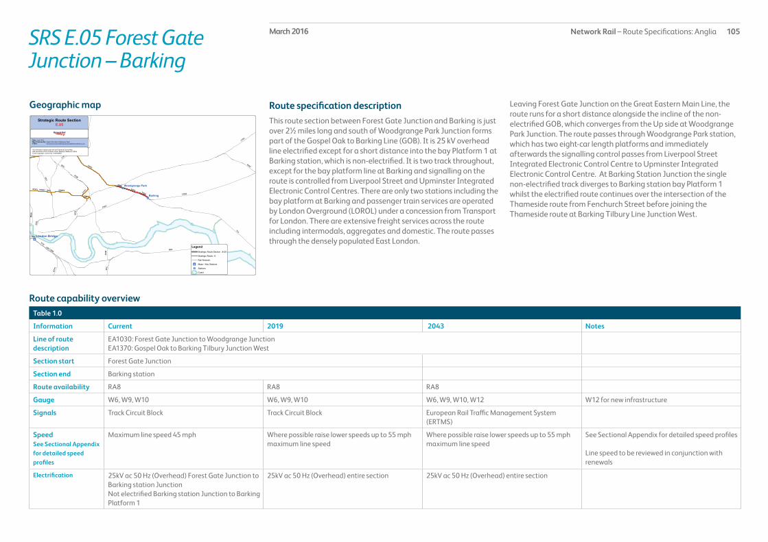
Network Rail – Route Specifications: Anglia 105March 2016SRS E.05 Forest Gate Junction – Barking
Route specification descriptionThis route section between Forest Gate Junction and Barking is just over 2½ miles long and south of Woodgrange Park Junction forms part of the Gospel Oak to Barking Line (GOB). It is 25 kV overhead line electrified except for a short distance into the bay Platform 1 at Barking station, which is non-electrified. It is two track throughout, except for the bay platform line at Barking and signalling on the route is controlled from Liverpool Street and Upminster Integrated Electronic Control Centres. There are only two stations including the bay platform at Barking and passenger train services are operated by London Overground (LOROL) under a concession from Transport for London. There are extensive freight services across the route including intermodals, aggregates and domestic. The route passes through the densely populated East London.
Geographic map Leaving Forest Gate Junction on the Great Eastern Main Line, the route runs for a short distance alongside the incline of the non-electrified GOB, which converges from the Up side at Woodgrange Park Junction. The route passes through Woodgrange Park station, which has two eight-car length platforms and immediately afterwards the signalling control passes from Liverpool Street Integrated Electronic Control Centre to Upminster Integrated Electronic Control Centre. At Barking Station Junction the single non-electrified track diverges to Barking station bay Platform 1 whilst the electrified route continues over the intersection of the Thameside route from Fenchurch Street before joining the Thameside route at Barking Tilbury Line Junction West.
Table 1.0
Information Current 2019 2043 Notes
Line of route description
EA1030: Forest Gate Junction to Woodgrange JunctionEA1370: Gospel Oak to Barking Tilbury Junction West
Section start Forest Gate Junction
Section end Barking station
Route availability RA8 RA8 RA8
Gauge W6, W9, W10 W6, W9, W10 W6, W9, W10, W12 W12 for new infrastructure
Signals Track Circuit Block Track Circuit Block European Rail Traffic Management System (ERTMS)
SpeedSee Sectional Appendix for detailed speed profiles
Maximum line speed 45 mph Where possible raise lower speeds up to 55 mph maximum line speed
Where possible raise lower speeds up to 55 mph maximum line speed
See Sectional Appendix for detailed speed profiles
Line speed to be reviewed in conjunction with renewals
Electrification 25kV ac 50 Hz (Overhead) Forest Gate Junction to Barking station JunctionNot electrified Barking station Junction to Barking Platform 1
25kV ac 50 Hz (Overhead) entire section 25kV ac 50 Hz (Overhead) entire section
Route capability overview

Network Rail – Route Specifications: Anglia 106March 2016
Passenger train service levels (trains per hour/day)Table 2.0
Current 2019 2043 Notes
Typical journey time Gospel Oak to Barking in 36 minutes Gospel Oak to Barking in 36 minutes Gospel Oak to Barking in less than 36 minutes
No. of trains per hour 4 tph Gospel Oak to Barking 4 tph Gospel Oak to Barking 4 tph Gospel Oak to Barking
SRS E.05 Forest Gate Junction – Barking
Current Freight Trains (paths per day) Table 3.0
Current 2019 2043 Notes
Route section Barking to Forest Gate Junction
Daily paths in one direction (as per WTT)
17 Freight growth is predicted from London Gateway Port, some of which will require additional freight paths along this route
Freight growth is predicted from London Gateway Port as up to 50 paths per day, some of which will require additional freight paths along this route
* Figures are for freight trains in one direction only
Level crossings on routeTable 4.0
Type Current No. of level crossings 2019 No. of level crossings 2043 No. of level crossings
Supervised: 0 0 0
Automatic: 0 0 0
User: 0 0 0

Network Rail – Route Specifications: Anglia 107March 2016SRS E.05 Forest Gate Junction – Barking
Planned infrastructure investment in Control Period 5 (2014 – 2019)*
Proposed infrastructure investment in Control Period 5 (2014 – 2019)*Table 6.0
Project Project Description ELR Implementation Date
Output change Notes Status
Gospel Oak to Barking line train lengthening
Infrastructure works to run 4-car trains on the Gospel Oak to Barking line
TAH2, THN 2014 – 2019 Increased capacity In development
* In addition to the proposed enhancement programme, this table includes other Network Rail funded schemes, renewals and third party schemes where applicable.** The precise timing and scope of renewals will remain subject to review to enable us to meet our overall obligations as efficiently as possible, consistent with the reasonable requirements of operators and other stakeholders.
Table 5.0
Project Project Description ELR Implementation Date
Output change Notes Status
Gospel Oak to Barking Electrification
Electrification of the Gospel Oak to Barking line, Barking station bay platform and Thames Haven branch
TAH2, THN 2014 – 2019 Route electrified In development
* In addition to the proposed enhancement programme, this table includes other Network Rail funded schemes, renewals and third party schemes where applicable.** The precise timing and scope of renewals will remain subject to review to enable us to meet our overall obligations as efficiently as possible, consistent with the reasonable requirements of operators and other stakeholders.

Network Rail – Route Specifications: Anglia 108March 2016SRS E.91 Dudding Hill Line
Route specification descriptionThe six mile freight only Dudding Hill Line including all its connecting lines to and from the surrounding radial routes in West London has two non-electrified tracks throughout. Signalling is controlled from a number signal boxes at Acton Wells Junction, Acton Canal Wharf, Neasden Junction, Marylebone Integrated Electronic Control Centre where the line joins the Chiltern Line, and West Hampstead where the lines joins the Midland Main Line (MML). The route is used by a variety of freight services. There are no planned or unplanned passenger services on the route and no stations. The line passes through densely populated West London.
Immediately after the start of the route section at Acton Wells Junction two tracks diverge from the Down side to the South West lines and provides a London facing link to the West Coast Main Line (WCML) at West London Junction. At Acton Canal Wharf Junction a single line diverges from the Down side and provides a westwards facing link to the Willesden Relief Lines on the WCML at Willesden No.7 Junction.
Geographic map The route then passes over the intersection with the WCML as well as the DC suburban lines out of Euston. At Neasden Junction a single track line diverges from the Up side to provide a westwards facing link to the Chiltern Line out of Marylebone following which the route passes over the intersection with the Chiltern, London Overground, London Underground Metropolitan and Jubilee Lines.
At Dudding Hill Junction two tracks diverge from the Up side to the Brent Curve that provides a westwards facing link to the MML whilst the route continues to Cricklewood Curve Junction providing a London facing link to the MML.
Table 1.0
Information Current 2019 2043 Notes
Line of route description
EA1360: Dudding Hill Junction to Acton Wells Junction
Route availability RA8 RA8 RA8
Gauge W7, W9 W7, W9 W7, W9, W10 Consider W12 for new infrastructure
Signals Track Circuit Block, Absolute Block Track Circuit Block European Rail Traffic Management System (ERTMS)
SpeedSee Sectional Appendix for detailed speed profiles
Maximum line speed 40 mph Maximum line speed 40 mph Maximum line speed 40 mph See Sectional Appendix for detailed speed profiles
Line speed to be reviewed in conjunction with renewals
Electrification None None None
Route capability overview

Network Rail – Route Specifications: Anglia 109March 2016SRS E.91 Dudding Hill Line
Current Freight Trains (paths per day) Table 3.0
Current 2019 2043 Notes
Route section Acton Wells Junction to Acton Canal Wharf
Daily paths in one direction (as per WTT)
Up to 15 tpd As per forecasts in the Freight Market Study
As per forecasts in the Freight Market Study
* Figures are for freight trains in one direction only
Level crossings on routeTable 4.0
Type Current No. of level crossings 2019 No. of level crossings 2043 No. of level crossings
Supervised: 0 0 0
Automatic: 0 0 0
User: 0 0 0
Table 5.0
No schemes are currently planned for Control Period 5.
Planned infrastructure investment in Control Period 5 (2014 – 2019)*
Proposed infrastructure investment in Control Period 5 (2014 – 2019)*Table 6.0
No schemes are currently proposed for Control Period 5.

Network Rail – Route Specifications: Anglia 110March 2016SRS E.99 Other Freight Lines
Route specification descriptionOther freight lines on the North London Line Strategic Route include various single tracks, two-track, electrified and non-electrified links as set out below.
Kew Junctions to South Acton
From the single lead at Old Kew Junction that diverges from the Hounslow Loop (on the Windsor Lines SRS C.12) the two track non-electrified line converges with the two track non-electrified line from New Kew Junction, which also connects with the Hounslow Loop, at Kew East Junction and then passes underneath successive intersections with the M4 motorway and London Underground District and Piccadilly lines before passing over Bollo Lane CCTV level crossing and converging with the North London Line at South Acton Junction. These lines are signalled from Kew East Junction signal box at its northern (South Acton) end and from Feltham Area signalling Centre at the Hounslow Loop end.
Kensal Green City Lines
Kensal Green City Lines are a two track 25kV overhead electrified between Harlesden single lead junction on the West Coast Main Line (WCML) and Kensal Green Junction on the North London Line (NLL). The City Lines are signalled from Wembley Main Line Signalling Control Centre at its WCML end and a NLL workstation within Upminster Integrated Electronic Control Centre (IECC) at the Kensal Green end. Just after Harlesden Junction the City Lines pass over the intersection of the Up and Down DC Electric Lines out of Euston.
Tottenham North Curve
This is a two track non-electrified link between Carlton Road Junction on the Midland Main Line (MML) and Junction Road Junction on the Gospel Oak to Barking (GOB) line. The route passes through several tunnels and a covered way and is signalled from West Hampstead signal box at its MML end and Upper Holloway signal box at the GOB end.
Harringay Park Junction to Harringay Junction
This is a single track non-electrified link between Harringay Park Junction on the GOB line and Harringay Junction on the East Coast Main Line (ECML). Signalling on the link is split between South Tottenham Station Junction signal box at the GOB end and Kings Cross signal box at the ECML end.
Seven Sisters Chord
This is a steep single track 25kV overhead electrified link between South Tottenham West Junction on the GOB line and Seven Sisters Junction on the West Anglia Southbury Loop. Signalling on the chord is split between South Tottenham Station Junction signal box at its southern end and Liverpool Street IECC at the Seven Sisters end.
Tottenham South Curve
This is a two track 25kV overhead electrified link between South Tottenham East Junction on the GOB line and Tottenham South Junction on the West Anglia Lea Valley Line. Signalling on the link is split between South Tottenham Station Junction signal box at its western end and Liverpool Street IECC at the Lea Valley end.
Graham Road Curve
Graham Road Curve is a short single track 25kV overhead electrified line between Navarino Road Junction on the NLL and Reading Lane Junction on the West Anglia Main Line (WAML) suburban lines. Signalling on the curve is split between the NLL workstation in Upminster IECC at the NLL end and Liverpool Street IECC at the WAML end.
Lea and High Meads curves and High Meads Loop
From Lea Junction on the NLL the two track 25kV overhead electrified Lea Curve converges with High Meads Curve from Channelsea North Junction at High Meads Junction, to form High Meads Loop that runs to the north side of Stratford International station and joins the Temple Mills Lines that converge from Stratford station at Temple Mills East Junction. These lines are signalled from the NLL workstation in Upminster IECC at the NLL end and Liverpool Street IECC at the Temple Mills end.
Geographic map

Network Rail – Route Specifications: Anglia 111March 2016SRS E.99 Other Freight Lines
Carpenters Road and Channelsea curves
From Channelsea South Junction on the NLL the two track 25kV overhead electrified route quickly passes over Carpenters Road North Junction where it diverges to form Carpenters Road Curve and Channelsea Curve. Channelsea Curve joins the GEML at Stratford Central Junction West facing eastwards and Carpenters Road Curve starts as a two-track formation but converges into a single track to join the GEML at Carpenters Road South Junction facing westwards. These lines are signalled from the NLL workstation in Upminster IECC at the NLL end and Liverpool Street IECC at the GEML end.
Camden Road West Junction to Camden Junction
From Camden Road West Junction on the NLL the two track 25kV overhead electrified route quickly passes through Primrose Hill closed station. At Primrose Hill Junction electrified third rail lines diverge on both the up and down sides to join the DC electric lines out of Euston, whilst the route carries on to join the WCML at Camden Junction.
North London Incline
From Camden Road Central Junction on the NLL the single track 25kV overhead electrified route quickly passes Camden Road Incline Junction, where a 25kV overhead electrified diverges to the south and provides connections to High Speed 1 and London St Pancras International station. The North London Incline carries on to join the ECML at Copenhagen Junction.

Network Rail – Route Specifications: Anglia 112March 2016
Table 1.0
Information Current 2019 2043 Notes
Line of route description
EA1330: South Acton Junction to Old & New Kew JunctionsMD155: Kensal Green Junction. to Harlesden Junction. (City Lines)LN3210: Junction Road Junction to Carlton Road Junction (Tottenham Lines)LN165: Harringay Park Junction to Harringay JunctionEA1300: South Tottenham West Junction to Seven Sisters JunctionEA1290: Tottenham South Junction South Tottenham East JunctionEA1180: Reading Lane to Navarino Road Junction (Graham Road Curve)EA1340: Stratford Lea Junction to High Meads JunctionEA1350: Channelsea North Junction to Temple Mills East JunctionEA1150: Channelsea South Junction to Stratford Central Junction WestEA1020: Carpenters Road South Junction to Carpenters Road North JunctionEA1320: Camden Road West Junction to Stratford (contains Camden Road West Junction to Primrose Hill and Camden Road Central Junction to North London Incline)
Route availability RA8 RA8 RA8
Gauge W6, W7, W8, W9, W10 W6, W7, W8, W9, W10 W6, W7, W8, W9, W10, W12 Consider W12 for new infrastructure
Signals Track Circuit Block(Absolute Block Kew East Junction)
Track Circuit Block European Rail Traffic Management System (ERTMS)
SpeedSee Sectional Appendix for detailed speed profiles
Predominant line speed 10 mph to 20 mph (Maximum 45 mph South Acton Junction to Kew East Junction)
Predominant line speed 10 mph to 20 mph (Maximum 45 mph South Acton Junction to Kew East Junction)
Predominant line speed 10 mph to 20 mph (Maximum 45 mph South Acton Junction to Kew East Junction)
See Sectional Appendix for detailed speed profiles
Electrification 25kV AC (Overhead)(Not electrified South Acton Junction to Old/New Kew Junctions and Junction Road Junction to Carlton Road Junction)
25kV AC (Overhead)(Not electrified South Acton Junction to Old/New Kew Junctions and Junction Road Junction to Carlton Road Junction)
25kV AC (Overhead)(Not electrified South Acton Junction to Old/New Kew Junctions and Junction Road Junction to Carlton Road Junction)
Route capability overview
SRS E.99 Other Freight lines

Network Rail – Route Specifications: Anglia 113March 2016SRS E.99 Other Freight Lines
Current Freight Trains (paths per day) Table 3.0
Current 2019 2043 Notes
Route section Channelsea South Junction to Stratford Central JunctionCamden Road West Junction to Primrose HillCamden Road Central Junction to North London InclineOther lines
E.99 Freight lines E.99 Freight lines
Daily paths in one direction (as per WTT)
2819101 – 6
As per forecasts in the Freight Market Study
As per forecasts in the Freight Market Study
* Figures are for freight trains in one direction only.
Level crossings on routeTable 4.0
Type Current No. of level crossings 2019 No. of level crossings 2043 No. of level crossings
Supervised: 1 (Bollo Lane – Kew Line) Currently progressing a workstream looking at level crossings across Anglia which will outline priorities/criteria for level crossing closures and will result in a net decrease across the route
Currently progressing a workstream looking at level crossings across Anglia which will outline priorities/criteria for level crossing closures and will result in a net decrease across the route
Automatic: 0
User: 0
Table 5.0
No schemes are currently planned for Control Period 5.
Planned infrastructure investment in Control Period 5 (2014 – 2019)*
Proposed infrastructure investment in Control Period 5 (2014 – 2019)*Table 6.0
No schemes are currently proposed for Control Period 5.

Network Rail – Route Specifications: Anglia 114March 2016SRS F.01 Fenchurch Street – Shoeburyness
Route specification descriptionThe 39½ mile Thameside main line from London Fenchurch Street to its eastern end terminus at Shoeburyness is 25kV overhead line electrified throughout. It is predominately two-track except for its London terminus reaches and the whole route is signalled from Upminster Integrated Electronic Control Centre (IECC). Passenger services are exclusively operated by c2c and there are seventeen stations, nine of which have two platforms and all main line platforms are capable of accommodating trains of 12-car length. Freight traffic on the main line is rare except between Upminster and Barking when diversions are in place. The route passes through densely populated East London turning to largely rural with built up areas including a section of sea wall.
The route commences at the London terminus Fenchurch Street station, which has four platforms. For the first ¾ mile the route is four track but the tracks converge into two at Christian Street Junction. On the Up side the Docklands Light Railway (DLR) from Tower Gateway and Bank DLR stations parallels the route as far as Limehouse station. The route passes through Limehouse station, which has a footbridge link between the Up main line platform and the Down DLR station platform, to Gas Factory Junction where a single line diverges to the Gas Factory Curve that has an eastwards facing link to the Great Eastern Main Line (GEML) at Bow Junction.
Between Gas Factory Junction and West Ham station the route is paralleled on the Down side by the LUL District and Hammersmith & City Lines and passes over the intersection of the DLR at Devons Road and the LUL Jubilee and soon to be DLR Lines at West Ham. West Ham station has two platforms in an island between the Up and Down main lines. The LUL station platforms and lines are on the Down side and all the routes and platforms are linked via subway. TfL own most of the station except the main line platforms. From West Ham the main line, still paralleled by the LUL lines, continues to the eastern end of East Ham Electric Multiple Unit Depot (EMUD). East Ham EMUD is a maintenance, repair and servicing depot, leased to c2c. The depot consists of a variety of electrified stabling sidings, maintenance and inspection facilities, wheel lathe, carriage washer and an apron road for flushing toilets. There are also electrified sidings in the shed and nine electrified car shed reception roads.
The Up and Down main lines run either side of the depot at the end of which is Barking Tilbury Line Junction that diverges to the Up side either side of the Gospel Oak – Barking Line, which crosses over the intersection of the main lines and LUL lines at the London end of Barking station. Barking station has eight platforms and provides an interchange between the LUL lines, London Overground and c2c Tilbury Loop Line. The westbound LUL Line passes over the intersection with the main lines immediately to the London end of Barking station. The platforms are used as follows north to south: Platform 1 bay, London Overground services to Gospel Oak; Platform 2, eastbound LUL Line; Platform 3, bay, LUL Line; Platforms 4 & 5, c2c Down and Up main lines; Platform 6, westbound LUL Line; Platforms 7 & 8, c2c Down and Up Tilbury Loop lines.
After Barking station the Tilbury Loop lines diverge at Barking Tilbury Line East Junction whilst the LUL Lines continue to parallel the main lines all the way to Upminster. Upminster station at 15¼ miles from Fenchurch Street has seven platforms, which are used as follows north to south: Platform 6, terminating platform of the National Express East Anglia shuttle service from Romford on the GEML; Platforms 3, 4 & 5, LUL services; Platforms 1 & 2, c2c Up and Down main lines; Platform 1A bay, c2c terminating services from Grays on the Tilbury Loop. From Upminster the single track Ockendon line diverges from the Up side, whilst the main lines continue to Pitsea passing through three stations at West Horndon, Laindon and Basildon each of which have two platforms except Laindon which has three platforms and incorporates a central reversing loop between the Up and Down main lines. Between Upminster and West Horndon the route passes underneath the intersection of the M25 motorway and passes over Whipps Farm user worked level crossing (LC).
At Pitsea station there are four platforms, two on the main lines and two on the Tilbury Loop line, which converges at Pitsea Junction to the eastern end of the station. After the junction, which also has an Up siding that parallels the main line from the Tilbury Loop, the route passes through the two-platformed Benfleet station, which acts as a gateway to Canvey Island, and over three more user worked LCs before reaching Leigh-on-Sea station 32½ miles from Fenchurch Street. Like Laindon, Leigh-on-Sea has three platforms, incorporating a central reversing loop between the Up and Down main lines.
Geographic map

Network Rail – Route Specifications: Anglia 115March 2016SRS F.01 Fenchurch Street – Shoeburyness
From Leigh-on-Sea to the next station at Chalkwell there is nearly a mile of sea wall as the route runs alongside the River Thames Estuary. Chalkwell station has two platforms as does Westcliff-on-Sea just under a mile from Southend Central station. Southend Central station is in the heart of Southend-on-Sea main shopping area. It has four platforms, two through main line platforms and both Up and Down London facing bay platforms.
From Southend Central station the route carries on for a further four miles to its eastern terminus at Shoeburyness, passing through the two-platformed stations at Southend East and Thorpe Bay. Shoeburyness station has three terminal platforms and on the Up side of the station approach is Shoeburyness Carriage Sidings. The carriage sidings are leased to c2c and consist of a variety of electrified stabling sidings and a carriage washer.
From the eastern end of the carriage sidings there is a single non-electrified line that crosses the High Street to Pigs Bay, which is a large sidings complex operated by Qinetiq that sees occasional MOD freight traffic. The sidings in Pigs Bay are also used for storing scrapped rolling stock.
Table 1.0
Information Current 2019 2043 Notes
Line of route description
EA1380: Fenchurch Street to Shoeburyness
Section start Fenchurch Street station
Section end Shoeburyness Station
Route availability RA8 RA8 RA8
Gauge W6, W8, W10 W6, W8, W10 W6, W8, W10 W12 for new infrastructure
Signals Track Circuit Block Track Circuit Block European Rail Traffic Management System (ERTMS)
SpeedSee Sectional Appendix for detailed speed profiles
Maximum permitted line speed is 75 mph Where possible raise lower speeds up to 100 mph maximum line speed
Where possible raise lower speeds up to 100 mph maximum line speed
See Sectional Appendix for detailed speed profiles
Electrification 25kV AC (Overhead) along the entire section 25kV AC (Overhead) along the entire section 25kV AC (Overhead) along the entire section
Route capability overview
Network Rail – Route Specifications: Anglia 116March 2016
Passenger train service levels (trains per hour/day)Table 2.0
Current 2019 2043 Notes
Typical journey time London Fenchurch Street to Southend Central in 53-58 minutes
London Fenchurch Street to Southend Central in 53 minutes
London Fenchurch Street to Southend Central in under 53 minutes
No. of trains per hour 4 peak/0 off-peak tph Laindon to London Fenchurch Street6 peak/4 off-peak tph Shoeburyness to London Fenchurch Street 2 peak/0 off-peak tph Thorpe Bay to London Fenchurch Street
4 peak/0 off-peak tph Laindon to London Fenchurch Street6 peak/4 off-peak tph Shoeburyness to London Fenchurch Street 2 peak/0 off-peak tph Thorpe Bay to London Fenchurch Street
4 peak/0 off-peak tph Laindon to London Fenchurch Street6 peak/4 off-peak tph Shoeburyness to London Fenchurch Street 2 peak/0 off-peak tph Thorpe Bay to London Fenchurch Street
Upminster station also benefits from services from Pitsea and Stanford-le-HopeBarking – Fenchurch Street stations also benefit from services from Grays, Pitsea, Stanford-le-Hope and Southend Central
SRS F.01 Fenchurch Street – Shoeburyness

Network Rail – Route Specifications: Anglia 117March 2016SRS F.01 Fenchurch Street – Shoeburyness
Current Freight Trains (paths per day) Table 3.0
Current 2019 2043 Notes
Route section Barking to Shoeburyness
Daily paths in one direction (as per WTT)
Up to 1 As per forecasts in the Freight Market Study
As per forecasts in the Freight Market Study
* Figures are for freight trains in one direction only.
Level crossings on routeTable 4.0
Type Current No. of level crossings 2019 No. of level crossings 2043 No. of level crossings
Supervised: 0 0 Currently progressing a workstream looking at level crossings across Anglia which will outline priorities/criteria for level crossing closures and will result in a net decrease across the route
Automatic: 0 0
User: 4 4

Network Rail – Route Specifications: Anglia 118March 2016SRS F.01 Fenchurch Street – Shoeburyness
Table 5.0
Project Project Description ELR Implementation Date
Output change Notes Status
Anglia traction power supply (CP5)
Works to reinforce the power supply on the Anglia route following train service changes
FSS1, FSS2 2014 – 2019 Power supply improvement
In development
* In addition to the proposed enhancement programme, this table includes other Network Rail funded schemes, renewals and third party schemes where applicable.** The precise timing and scope of renewals will remain subject to review to enable us to meet our overall obligations as efficiently as possible, consistent with the reasonable requirements of operators and other stakeholders.
Planned infrastructure investment in Control Period 5 (2014 – 2019)*
Proposed infrastructure investment in Control Period 5 (2014 – 2019)*Table 6.0
Project Project Description ELR Implementation Date
Output change Notes Status
Line speed improvements on Essex Thameside
Increase line speed to 100 mph where possible
FSS1, FSS2 2014 – 2019 Improved journey times In development
* In addition to the proposed enhancement programme, this table includes other Network Rail funded schemes, renewals and third party schemes where applicable.** The precise timing and scope of renewals will remain subject to review to enable us to meet our overall obligations as efficiently as possible, consistent with the reasonable requirements of operators and other stakeholders.

Network Rail – Route Specifications: Anglia 119March 2016SRS F.02 Tilbury Loop
Route specification descriptionThe 32 mile Tilbury Loop route section is part of the Thameside Strategic Route and includes the two track route from Barking to Pitsea via Tilbury as well as the single track route from Upminster on the Thameside main line to Grays via Ockendon. The route is 25kV overhead line electrified throughout and the whole route is signalled from Upminster Integrated Electronic Control Centre. Passenger services are exclusively operated by c2c and there are ten stations excluding Barking and Upminster stations, most of which have two platforms with the exception of Grays station, which has three and Chafford Hundred station, which only has one. All platforms are currently capable of accommodating trains of 12-car length with the exception of Grays bay platform. There are extensive freight services across the route including intermodals, aggregates and domestic. The route passes through a mixture of built up, industrial and areas of marshes at its central and western end with largely rural areas at its eastern end and through the Ockendon corridor.
The route commences at Barking Tilbury Line Junction East, 7¾ miles from Fenchurch Street, and immediately picks up a central Up Tilbury Goods Loop that continues into Ripple Lane West Yard between the Up and Down Tilbury lines. Beyond Renwick Road Junction the Tilbury lines continue either side of the expansive goods sidings that include several domestic railheads and a former container terminal. On the Up side of the Tilbury line paralleling the goods sidings is the Ripple Lane Exchange sidings that allows the transfer of continental freight services off High Speed 1 (HS1) onto the domestic railway network. The exchange sidings also act as the connection into Hanson Aggregates Terminal and the extensive Ford Motor Company works. At the eastern exit of Ripple Lane Yard on the Up side is the HS1 North London Tunnel portal where Eurostar and Southeastern’s Javelin services emerge from St Pancras and HS1 now parallels the Tilbury lines as far as the intersection with the M25 east of Purfleet.
Immediately after Ripple Lane goods sidings is Dagenham Dock station, which has Chequers Lane CCTV level crossing at its eastern end. After the station there are Down sidings and a reception line for the East London Waste Terminal. The route passes over Manor Way CCTV level crossing and then through Rainham station, which
also has a CCTV level crossing immediately afterwards. Just over seven miles from Barking, the route passes under the intersection of HS1, which crosses over the Tilbury lines and continues to parallel the route on its northern side. The route passes over Purfleet Rifle Range user worked gated crossing and then through Purfleet station, which similar to Rainham, has a CCTV level crossing immediately afterwards.
The next four mile stretch up to Grays is dominated by industrial factories and freight sidings on the Up side including Purfleet Long Siding, which starts at Purfleet Long Siding Junction North and links to a variety of sidings along Purfleet Deep Wharf and Purfleet Thames Terminal. These sidings serve the intermodal, aggregates, petroleum and automotive sectors. There is also a number of occupational level crossings including manually controlled barriers at Thames Board Mills and Jurgens as well as several user worked crossings. Towards the end of Purfleet Long Siding the route passes under the main intersection of the southbound M25 motorway as it rises to cross the River Thames over the QEII Bridge, as well as passing over the northbound M25, which emerges from the Dartford tunnels. Also passing over the Tilbury Loop lines but passing underneath the southbound M25 is HS1 before it disappears into its own tunnel under the River Thames.
From Purfleet Long Siding Junction South the route passes West Thurrock Sidings on the Up side following which the single track route from Upminster via Ockendon converges at West Thurrock Junction. For the next ¾ mile into Grays station there is a third bi-directionally signalled track on the Down side. Grays station has three platforms including two 12-car through platforms and an eight-car westwards facing bay platform on the Down side. At the eastern end of Grays station is High Street CCTV pedestrian level crossing. After Grays, a connection to Seabrook sidings diverges to the Up side and links into Tilbury Container Terminal, exchange sidings and Northfleet Hope Terminal on Tilbury Dock. Just over 1½ miles further on is Tilbury Town station followed by Tilbury Railport Junction where a connection diverges to the Up side to link into Tilbury Riverside Sidings.
In the next section up to East Tilbury station there are three further user worked crossings plus Low Street CCTV level crossing. East Tilbury station also has a CCTV level crossing immediately afterwards.
Geographic map

Network Rail – Route Specifications: Anglia 120March 2016SRS F.02 Tilbury Loop
The route continues over Mucking AHB level crossing after which is Thames Haven Junction where the freight only single track Thames Haven branch line diverges eastwards. The junction is followed by Stanford-le-Hope station, which like several others has a CCTV level crossing immediately afterwards. There is now a final 5¼ mile stretch to Pitsea Junction, which passes over Fobbing automatic half barrier level crossing, Gardeners CCTV level crossing, Merrings user worked gated crossing, Vange Wharf CCTV level crossing and Pitsea Hall CCTV level crossing, the first four of which are within a section that is barely over a mile in length. Immediately after the last crossing is Pitsea station, which has four platforms, two of which are on the Thameside main line and two of which are on the Tilbury Loop lines. There is an Up siding after the station following which the Tilbury Loop converges with the Thameside main line at Pitsea Junction.
The seven mile single track Upminster to Grays route via Ockendon commences at Upminster East Junction and reaches the passing loop at Ockendon station having passed under the intersection of the M25 motorway. Ockendon station has two platforms either side of the only passing loop on the route. Just less than 1½ miles further on is Chafford Hundred station and its single platform, which is a gateway to Lakeside Shopping Centre. From Chafford Hundred it is just over a mile to West Thurrock Junction where the route converges with the Tilbury lines.
Table 1.0
Information Current 2019 2043 Notes
Line of route description
EA1390: Barking Tilbury Line Junction East to Pitsea Junction (via Tilbury)EA1410: Upminster to West Thurrock Junction
Section start Barking Tilbury Line Junction East
Section end Pitsea Junction
Route availability RA8 RA8 RA8
Gauge Barking Tilbury Line Junction East W6, W8, W10 W6, W8, W10 W12 for new infrastructure
Signals Pitsea Junction Track Circuit Block European Rail Traffic Management System (ERTMS)
SpeedSee Sectional Appendix for detailed speed profiles
Maximum permitted line speed is up to 70 mph Where possible raise lower speeds up to 100 mph maximum line speed
Where possible raise lower speeds up to 100 mph maximum line speed
See Sectional Appendix for detailed speed profiles
Line speed to be reviewed in conjunction with renewals
Electrification 25kV AC (Overhead) along the entire section 25kV AC (Overhead) along the entire section 25kV AC (Overhead) along the entire section
Route capability overview

Network Rail – Route Specifications: Anglia 121March 2016
Passenger train service levels (trains per hour/day)Table 2.0
Current 2019 2043 Notes
Typical journey time London Fenchurch Street to Pitsea via Ockendon in 58 minutes London Fenchurch Street to Grays via Rainham in 35 minutes
London Fenchurch Street to Pitsea via Ockendon in under 58 minutes London Fenchurch Street to Grays via Rainham in under 35 minutes
London Fenchurch Street to Pitsea via Ockendon in under 58 minutes London Fenchurch Street to Grays via Rainham in under 35 minutes
No. of trains per hour 1 peak/2 off-peak tph Grays to London Fenchurch Street 5 peak/0 off-peak tph Pitsea to London Fenchurch Street 1 peak/2 off-peak tph Southend Central to London Fenchurch Street 1 peak/0 off-peak tph Stanford-le-Hope to London Fenchurch Street
1 peak/2 off-peak tph Grays to London Fenchurch Street 5 peak/0 off-peak tph Pitsea to London Fenchurch Street 1 peak/2 off-peak tph Southend Central to London Fenchurch Street 1 peak/0 off-peak tph Stanford-le-Hope to London Fenchurch Street
1 peak/2 off-peak tph Grays to London Fenchurch Street 5 peak/0 off-peak tph Pitsea to London Fenchurch Street 1 peak/2 off-peak tph Southend Central to London Fenchurch Street 1 peak/0 off-peak tph Stanford-le-Hope to London Fenchurch Street
Train services are split evenly 4 peak/ 2 off-peak tph on each route via Ockendon and via Rainham
SRS F.02 Tilbury Loop

Network Rail – Route Specifications: Anglia 122March 2016SRS F.02 Tilbury Loop
Current Freight Trains (paths per day) Table 3.0
Current 2019 2043 Notes
Route section Barking Tilbury Line Junction East to Pitsea
Daily paths in one direction (as per WTT)
Up to 3 between Thameshaven Junction and Grays with up to 11 between Grays and Ripple Lane and Up to 17 between Ripple Lane and Barking
As per forecasts in the Freight Market Study
As per forecasts in the Freight Market Study
Growth is expected due to development of the London Gateway Port
* Figures are for freight trains in one direction only
Level crossings on routeTable 4.0
Type Current No. of level crossings 2019 No. of level crossings 2043 No. of level crossings
Supervised: 13 12 Currently progressing a workstream looking at level crossings across Anglia which will outline priorities/criteria for level crossing closures and will result in a net decrease across the route
Automatic: 2 2
User: 5 5

Network Rail – Route Specifications: Anglia 123March 2016SRS F.02 Tilbury Loop
Planned infrastructure investment in Control Period 5 (2014 – 2019)*
Proposed infrastructure investment in Control Period 5 (2014 – 2019)*Table 6.0
Project Project Description ELR Implementation Date
Output change Notes Status
Line speed improvements on Essex Thameside
Increase line speed to 100 mph where possible
FSS1. FSS2 2014 – 2019 Improved journey times In development
* In addition to the proposed enhancement programme, this table includes other Network Rail funded schemes, renewals and third party schemes where applicable.** The precise timing and scope of renewals will remain subject to review to enable us to meet our overall obligations as efficiently as possible, consistent with the reasonable requirements of operators and other stakeholders.
Table 6.0
Project Project Description ELR Implementation Date
Output change Notes Status
Anglia traction power supply (CP5)
Works to reinforce the power supply on the Anglia route following train service changes
FSS1, FSS2 2014 – 2019 Power supply improvement
In development
* In addition to the proposed enhancement programme, this table includes other Network Rail funded schemes, renewals and third party schemes where applicable.** The precise timing and scope of renewals will remain subject to review to enable us to meet our overall obligations as efficiently as possible, consistent with the reasonable requirements of operators and other stakeholders.

Network Rail – Route Specifications: Anglia 124March 2016SRS F.99 Other Freight Lines
Route specification descriptionOther freight lines on the Thameside Strategic Route include the: four mile long Thames Haven branch; one mile long Gas Factory Curve; half a mile long Tilbury International Railfreight Terminal.
Thames Haven branch
The four mile single track non-electrified Thames Haven branch diverges from the Tilbury Loop Line (part of SRS F.02) at Thames Haven Junction. Access to the line is controlled by Upminster Integrated Electronic Control Centre. The line is used by freight services to and from the Thames Haven terminal. There are no planned or unplanned passenger services on the branch. The line begins in a rural landscape and ends in an industrial port. The line is facing considerable investment as DP World are developing London Gateway Port for the deep sea container market and to cope with the port generated intermodal traffic, the single track branch is being converted to two track. The new port is planned to be operational in the last quarter of 2013.
From Thames Haven Junction the line begins as a two track formation which soon converges into a single track at Sewage Farm user worked level crossing. Just over a mile further on the line passes over Hydrocracker automatic open level crossing followed by an open level crossing, No.43 Gate one mile later. Soon after the open level crossing the line enters the Thames Haven Yard and Coryton BP Oil Refinery complex.
Gas Factory Curve
The one mile 25kV overhead line electrified links the Thameside route at Gas Factory Junction to the Great Eastern Main Line at Bow Junction. The Gas Factory Junction end of the line is signalled by Upminster Integrated Electronic Control Centre and the rest of the line to and including Bow Junction is signalled from Liverpool Street Integrated Electronic Control Centre. Immediately after Gas Factory Junction the route passes over the intersection of the London Underground District and Hammersmith & City Lines. Just before Bow Junction the Docklands Light Railway runs parallel to the south side of the curve.
Tilbury International Railfreight Terminal
The half a mile single track non-electrified link into Tilbury International Railfreight Terminal diverges from the Tilbury Loop Line (part of SRS F.02) at Tilbury Railport Junction. The Network Rail boundary ends before the sidings fan out into the terminal complex, which is on the site of the former Tilbury Riverside station.
Geographic map

Network Rail – Route Specifications: Anglia 125March 2016
Table 1.0
Information Current 2019 2043 Notes
Line of route description
EA1420: Thames Haven Junction to Thames HavenEA1400: Gas Factory to Bow JunctionEA1390: Barking Tilbury Line Junction East to Pitsea Junction (via Tilbury)
Route availability RA3, RA8 RA3, RA8 RA3, RA8
Gauge W6, W9, W10 W6, W9, W10 W6, W9, W10 Consider W12 for new infrastructure
Signals Track Circuit Block, One Train Working without Staff
Track Circuit Block European Rail Traffic Management System (ERTMS)
SpeedSee Sectional Appendix for detailed speed profiles
Maximum line speed 40 mph Maximum line speed 40 mph Maximum line speed 40 mph See Sectional Appendix for detailed speed profiles
Electrification 25kV AC (Overhead) (Thames Haven branch not electrified)
25kV AC (Overhead) 25kv AC (Overhead) Thames Haven branch being considered for electrification alongside Gospel Oak to Barking electrification (SRS E.04)
Route capability overview
SRS F.99 Other Freight Lines
Network Rail – Route Specifications: Anglia 126March 2016SRS F.99 Other Freight Lines
Current Freight Trains (paths per day) Table 3.0
Current 2019 2043 Notes
Route section Various
Daily paths in one direction (as per WTT)
Up to 2 Freight growth is predicted from London Gateway Port, most of this growth is expected to use this route. Therefore additional freight paths will be required in relation to this growth
Freight growth is predicted from London Gateway Port, most of this growth is expected to use this route. Therefore additional freight paths will be required in relation to this growth
There are no freight trains Gas Factory to Bow Junction except for occasional engineering trains
* Figures are for freight trains in one direction only
Level crossings on routeTable 4.0
Type Current No. of level crossings 2019 No. of level crossings 2043 No. of level crossings
Supervised: 0 Currently progressing a workstream looking at level crossings across Anglia which will outline priorities/criteria for level crossing closures and will result in a net decrease across the route
Currently progressing a workstream looking at level crossings across Anglia which will outline priorities/criteria for level crossing closures and will result in a net decrease across the route
Automatic: 1
User: 0

Network Rail – Route Specifications: Anglia 127March 2016SRS F.99 Other Freight Lines
Planned infrastructure investment in Control Period 5 (2014 – 2019)*
Proposed infrastructure investment in Control Period 5 (2014 – 2019)*Table 6.0
No schemes are currently proposed for Control Period 5.
Table 5.0
Project Project Description ELR Implementation Date
Output change Notes Status
Gospel Oak to Barking Electrification
Works to reinforce the power supply on the Anglia route following train service changes
TAH2, THN 2014 – 2019 Route electrified In development
* In addition to the proposed enhancement programme, this table includes other Network Rail funded schemes, renewals and third party schemes where applicable.** The precise timing and scope of renewals will remain subject to review to enable us to meet our overall obligations as efficiently as possible, consistent with the reasonable requirements of operators and other stakeholders.

Network Rail – Route Specifications: Anglia 128March 2016Glossary
Term Meaning
AHB Automatic Half Barrier Crossing
ASC Area Signalling Centre
CCTV Control Circuit Television Level Crossing
Control Period 4 (CP4) Control Period 4 (2009-2014)
Control Period 5 (CP5) The 2014 – 2019 period
Control Period 6 (CP6) The 2019 – 2024 period
DfT Department for Transport
Down line Usually the line away from London
EK2 East Kent Resignalling phase 2
ELL East London Line
ELR Engineers Line Reference, three letter code designating the line of route
ERTMS European Rail Traffic Management System
Fast line Predominantly used by trains with limited stops on the line
FOC Freight Operating Company
GEML Great Eastern Main Line
GRIP Governance for Railway Investment Projects
HAW Heavy Axle Weight
HLOS High Level Output Specification
HS1 High Speed 1 – the high speed link between St Pancras International and the channel tunnel
HS2 Proposed high speed link between London and Birmingham beyond to Leeds and Manchester
IECC Integrated Electronic Control Centre
Jn Junction
LOROL London Overground Rail Operations Ltd

Network Rail – Route Specifications: Anglia 129March 2016Glossary
Term Meaning
LTPP Long Term Planning Process
MPH Miles Per Hour
NRDF Network Rail Discretionary Fund
ORR Office of Rail Regulation (the regulator for the rail industry in Great Britain)
RA Route Availability
ROC Rail Operations Centre
RUS Route Utilisation Strategy
Slow line Predominantly used by trains serving stations on the line
SRS Strategic Route Section
TCB Track Circuit Block
TfL Transport for London
TPD Trains Per Day
TPH Trains Per Hour
TOC Train Operating Company
TPH Trains Per Hour
Up line Usually the line towards London
UWC User Worked Crossing
WAML West Anglia Main Line
WTT Working Timetable

Network Rail Limited 1 Eversholt Street London NW1 2DN
Tel: 020 7557 8000
www.networkrail.co.uk