Embed Size (px)
Citation preview

SPATIAL COGNITION AND COMPUTATION,3(4), 331–358Copyright c© 2003, Lawrence Erlbaum Associates, Inc.
‘Fine-to-Coarse’ Route Planning andNavigation in Regionalized Environments
Jan M. WienerUniversity of Tubingen
Max Planck Institute for Biological Cybernetics
Hanspeter A. MallotUniversity of Tubingen
Environments that are divided into regions lead to hierarchical encodingof space. Such memory structures are known to systematically distortestimates of distance and direction and affect spatial priming and memoryrecall. Here we present two navigation experiments in virtual environmentsthat reveal an influence of environmental regions on human route planningand navigation behaviour. Following the hierarchical theories of spatialrepresentations, it is argued that environmental regions are explicitlyrepresented in spatial memory and that human route planningtakes intoaccount region-connectivity and is not based on place-connectivity alone.We also propose afine-to-coarseplanning heuristic that could accountfor the empirical data by planning in a representation that uses fine-spaceinformation for close locations and coarse-space information for distantlocations simultaneously.
Keywords: route planning, hierarchical representations of space, regions,navigation, wayfinding, route selection
1 Introduction
Hierarchical theories of spatial representations proposethat spatial memory con-tains nested levels of detail (Stevens & Coupe, 1978; Hirtle& Jonides, 1985;
Correspondence concerning this article should be addressed to Jan M.Wiener, Cognitve andComputational Psychophysics Department, Max Planck Institute for Biological CyberneticsSpemannstrasse 38, 72076 Tubingen, Germany, email: [email protected]
Do Not
Cop
y
332 WIENER, MALLOT
McNamara, 1986). According to subjective perception and physical properties ofspace, geographical entities are grouped together and formsuper-ordinate entitiesin graph-like representations of space. Evidence for thesehierarchical theoriescomes from a wide variety of experimental paradigms that reveal systematic dis-tortions in human spatial memory.
Stevens and Coupe (1978) e.g., have shown that the relative directions of citiesare distorted towards the directions of the states they reside in. Subjects usuallyjudged Reno (Nevada) to be north-east of San Diego (California), although thecorrect direction is north-west. Stevens & Coupe suggestedthat subjects knowl-edge about the super-ordinate spatial relations (Nevada being east of California)influenced subjects’ direction judgments. Similar distortions have been shownfor other city pairs and for artificial maps containing cities and borders. More-over Wilton (1979) has shown that directional judgments arefaster when judgingdirections between locations across regions than within regions. The effect of bar-riers and environmental regions on distance estimations provide further evidencefor hierarchical theories. Generally speaking, distance estimations across barriersor region boundaries are exaggerated as compared to distances that do not crossbarriers (Kosslyn, Pick, & Fariello, 1974; Cohen, Baldwin,& Sherman, 1978;Thorndyke, 1981; Newcombe & Liben, 1982).
Strong evidence for hierarchical organization of spatial representations is pro-vided by Hirtle and Jonides (1985) and McNamara (1986). Hirtle and Jonides(1985) examined subjects’ spatial memory structure of a natural environment,namely Ann Arbor campus in Michigan. Subjects had to recall 32 familiar land-marks of Ann Arbor campus repeatedly. By applying the ordered-tree algorithmdeveloped by Reitmann and Rueter (1980) to the recall protocols, Hirtle andJonides (1985) obtained the individual hierarchical clustering of the 32 landmarksin Ann Arbor campus for each subject. Subjects also judged relative and absolutedistances between pairs of the 32 landmarks. While in relative distance estima-tions subjects underestimated the distances between landmarks in the same cluster,distances between clusters were overestimated in absolutedistance estimations.
McNamara (1986) used a spatial priming paradigm to study thestructure of hu-man spatial memory (see also McNamara, Ratcliff, & McKoon, 1984; McNamara& LeSueur, 1989; McNamara, Hardy, & Hirtle, 1989). Subjectslearned a spatiallayout of objects, that was divided into four regions, either by active navigationor by studying maps. In the subsequent recognition task, object names were pre-sented on a computer screen one at a time. Subjects had to decide whether or notthe named object was present in the layout they had learned. McNamara (1986)could show that subjects’ reaction time was faster when the preceding object wasin the same region of the layout, than when the preceding object was in a differ-ent region of the layout. In subsequent direction- and distance judgments subjectsdistorted directions to correspond with super-ordinate spatial relations and they
Do Not
Cop
y
ROUTE PLANNING IN REGIONALIZED ENVIRONMENTS 333
underestimated within region distances while they overestimated between regiondistances.
It has been suggested that hierarchical spatial memory is realized in a graph-likerepresentation. In this work we emphasize the concept of graph-like representa-tions of space in which places, views, local maps or other representations of loca-tions are interconnected without the need to conserve the exact metrical relationsof the real world. This concept is contrasted with map-like 2-dimensional repre-sentations of space, as put forward by the literal meaning ofthe phrase ‘cognitivemap’. Evidence for graph-like representations of space comes from navigationexperiments in animals and humans.
The desert antCataglyphis fortis,e.g., is well known for its path integrationabilities, which are achieved by continuous updating of a so-called home-vector.However, on familiar routes, desert ants also steer by visual landmarks and navi-gate paths that consist of several segments with different directions (Collett, Dill-man, Giger, & Wehner, 1992). Collett, Collett, Bisch, and Wehner (1998) haveshown that these segments partly consist of stored local vectors, associated withvisual landmarks (see also Collett, Collett, & Wehner, 2001; Collett & Collett,2002). Similar results also come from other insect species,such as the honeybee(Menzel, Geiger, Joerges, Mller, & Chittka, 1998; Wehner, Michel, & Antonsen,1996). A spatial memory, composed of landmarks and associated movement vec-tors, is best described as a graph in which landmarks correspond to nodes and thestored local vectors correspond to edges, reflecting the action to be performed inorder to move between nodes.
Graph-like representations have also been used in artificial intelligence ap-proaches and as cognitive models of human spatial memory (e.g., Arbib & Lieblich,1977; Kuipers, 1978, 2000; Leiser & Zilbershatz, 1989; Chown, Kaplan, & Ko-rtenkamp, 1995). Schlkopf and Mallot (1995) e.g., have proposed and modeled aview graph representation of space. In a view-graph each node corresponds to asnapshot of the visual scenery at a given location. Nodes areinterconnected byedges that constitute the behaviour necessary to move between the correspond-ing nodes. The view-graph is a parsimonious representationof space that allowsfor complex navigation behaviour such as route-planning. In navigation experi-ments in virtual environments, Gillner and Mallot (1998) have shown that humansubjects store local elements (i.e., places or views with associated movement in-structions and expected outcomes) in spatial memory (see also Mallot & Gillner,2000). These local elements did not have to be globally consistent, which contra-dicts map-like representations of space. Additional evidence for graph-like rep-resentations of space in humans was provided by Steck and Mallot (2000). Steckand Mallot have shown that subjects who learned a virtual environment containingboth global and local landmark information, did not perceive and report a conflict,when global and local landmark information was set in conflict. Moreover, sub-jects who relied on global landmark information in the conflict situation, showed
Do Not
Cop
y
334 WIENER, MALLOT
good way-finding performance if only local landmark information was provided,and vice versa. Again, the fact that subjects had access to both global and locallandmark information while they did not perceive and reportconflicts, suggeststhat spatial memory consists of bits and pieces of spatial information that are notintegrated into a single 2-dimensional map-like representation of space (see alsoTversky, 1993). Although the above evidence describes graphs that lack the hier-archical component, it demonstrates that graph-like representations of space areboth, ecologically sensible (i.e., minimalistic) and sufficient.
Evidence for hierarchical representations of space has come from a wide varietyof experimental paradigms, including distance- and direction-judgments, recallprocedures and reaction times. However, although the ultimate purpose of spatialmemory is to support navigation, little is known about the influence of hierarchi-cal memory organization on the mechanisms, strategies and heuristics underlyinghuman route planning. One of the few studies on the role of regions for humanroute planning investigated route planning from maps (Bailenson, Shum, & Ut-tal, 1998). Bailenson et al. formulated the ‘road climbing’principle, stating thatinstead of calculating the globally shortest route, subjects relied on routes that al-lowed to leave the region containing the start place sooner rather than later. Inaddition subjects take the straightness and length of the initial segment of routesinto account (Bailenson, Shum, & Uttal, 2000). This so-called Initial SegmentStrategy (ISS) states that subjects prefer routes with the longest initial straightsegment above alternative routes of equal length.
Here we will present two navigation experiments that revealan influence of en-vironmental regions on human route planning and navigationbehaviour. We willpoint out and discuss three hypotheses describing how environmental regions doinfluence spatial memory, navigation and route planning behaviour. TheDistortedRepresentationhypothesis (H1) assumes that environmental regions lead todis-torted representations of space, that account for systematic biases in navigationand route planning. ThePersistencehypothesis (H2) suggests that regions areexplicitly represented in spatial memory and that subjectsprefer to stay in theircurrent region as long as possible, delaying region transitions. TheHierarchicalPlanninghypothesis (H3) states that humans plan routes using different levels ofthe hierarchical representation of space. That is to say, human route planning takesinto account region-connectivity and is not based on place-connectivity alone. Wewill argue that only theHierarchical Planninghypothesis (H3) is consistent withresults from both of the experiments.
We will then present thefine-to-coarseplanning heuristic, a specific imple-mentation of theHierarchical Planninghypothesis. Infine-to-coarseplanning asingle route plan is generated that contains fine-space information for the closesurrounding and coarse space information for distant locations. This plan is up-dated during navigation in an iterative manner, such that fine space information forimmediate movement decisions is available at all times. It is important to note,
Do Not
Cop
y
ROUTE PLANNING IN REGIONALIZED ENVIRONMENTS 335
that thefine-to-coarseplanning heuristic is critically different from other planningmechanisms that make use of the hierarchical structure in spatial memory, as e.g.,coarse-to-fineplanning. Incoarse-to-fineroute planning multiple plans with dif-ferent levels of detail are generated successively. The result is a detailed (“fine”)plan which is generated before the navigation starts and which has to be kept inmind until the goal is reached.
2 General Methods
Both experiments presented in this work were conducted using virtual reality tech-nology. Subjects actively navigated through the virtual environments in the ego-centric perspective and executed a series of navigation tasks.
Compared to real world experiments, the use of virtual reality technology fornavigation experiments has two major advantages. Firstly it allows for exact con-trol of the visual stimuli presented and secondly one can carry out the experimentsin environments created to exactly match the experimental demands.
2.1 The Experimental Setup
Experiments were conducted in the Virtual Environments Laboratory of the MaxPlanck Institute for Biological Cybernetics. For both experiments we designed aparticular virtual environment that was created using the software Multigen Cre-ator (MultiGen-Paradigm). A detailed description of the virtual environments isgiven in the methods sections of each experiments (see sections 3.2.1 and 4.2.1).
The visual scenery was rendered on a three-pipe Silicon Graphics Onyx2 In-finiteReality II (Silicon Graphics Inc., Mountain View, CA), running a C++ Per-former simulation software that we designed and programmed. The scenery wasthen projected by means of three CRT projectors (Electrohome Marquee 8000;Electrohome Limited, Kitchener, Ontario, Canada) on a large half-cylindricalscreen (7 m diameter and 3.15 m height) with a rate of 36 framesper secondand an overall resolution of approximately 3500× 1000 pixels.
Subjects were seated in front of this screen (see Figure 1) either at a table (Ex-periment 1) or on a bicycle trainer (Experiment 2). The experimental setup al-lowed for a 180 deg horizontal and a 50 deg vertical field of view. The simulationsoftware guided subjects through the experiments, presented pictures of the navi-gation goals on the projection screen, and recorded the data. A detailed descriptionof the setup can be found in van Veen, Distler, Braun, and Blthoff (1998).
2.2 Procedure
Both experiments were divided into three different phases:a free exploration-, atraining- and a test-phase.
Do Not
Cop
y

336 WIENER, MALLOT
Figure 1.The experimental setup.
Exploration-phase.During the 10 minute exploration-phase subjects could ex-plore the environment. They were instructed to move around in the environment,pay attention to the landmarks and learn the layout of the environment and thepositions of the landmarks.
Training-phase. During the training-phase subjects were asked to completesix navigation tasks taking the shortest possible routes. For each training-routesubjects were teleported to the starting place of the route.The target place wasspecified by presenting a picture of the landmark associatedwith the target place.The image was superimposed on the screen. If subjects failedto find the shortestpossible route the navigation task was repeated until they solved the task takingthe shortest possible route.
Test-phase.The navigation tasks of the test phase and the specific procedure ofthe test phase is explained in detail in the methods section of Experiment 1 andExperiment 2 (see section 3.2.2 and 4.2.2).
3 Experiment 1
3.1 Purpose
This study was designed to reveal the influence of regions within an environmenton human spatial memory and navigation behaviour such as route planning. Sub-jects learned a virtual environment that was divided into different regions. Afterlearning the environment, subjects were asked to execute a series of navigationtasks comparable to shopping routes with multiple destinations. The critical navi-gation tasks in the test phase provided multiple solutions that led through differentnumbers of regions.
Do Not
Cop
y
ROUTE PLANNING IN REGIONALIZED ENVIRONMENTS 337
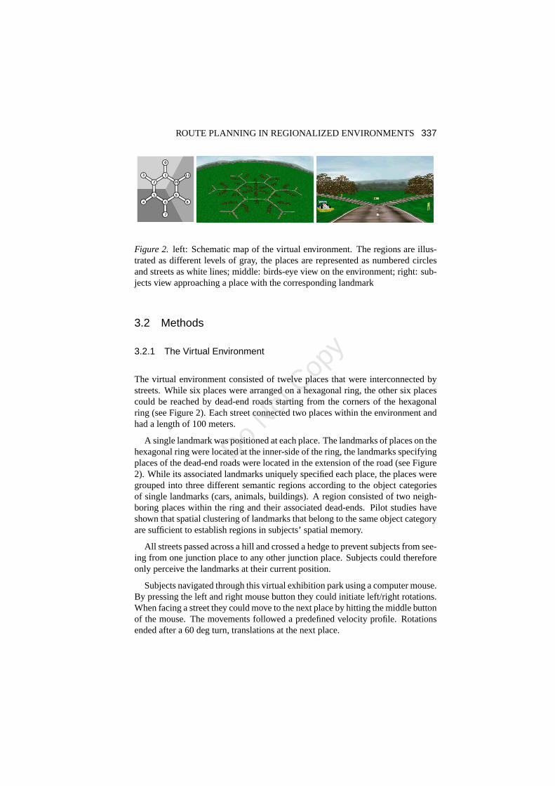
Figure 2. left: Schematic map of the virtual environment. The regionsare illus-trated as different levels of gray, the places are represented as numbered circlesand streets as white lines; middle: birds-eye view on the environment; right: sub-jects view approaching a place with the corresponding landmark
3.2 Methods
3.2.1 The Virtual Environment
The virtual environment consisted of twelve places that were interconnected bystreets. While six places were arranged on a hexagonal ring, the other six placescould be reached by dead-end roads starting from the cornersof the hexagonalring (see Figure 2). Each street connected two places withinthe environment andhad a length of 100 meters.
A single landmark was positioned at each place. The landmarks of places on thehexagonal ring were located at the inner-side of the ring, the landmarks specifyingplaces of the dead-end roads were located in the extension ofthe road (see Figure2). While its associated landmarks uniquely specified each place, the places weregrouped into three different semantic regions according tothe object categoriesof single landmarks (cars, animals, buildings). A region consisted of two neigh-boring places within the ring and their associated dead-ends. Pilot studies haveshown that spatial clustering of landmarks that belong to the same object categoryare sufficient to establish regions in subjects’ spatial memory.
All streets passed across a hill and crossed a hedge to prevent subjects from see-ing from one junction place to any other junction place. Subjects could thereforeonly perceive the landmarks at their current position.
Subjects navigated through this virtual exhibition park using a computer mouse.By pressing the left and right mouse button they could initiate left/right rotations.When facing a street they could move to the next place by hitting the middle buttonof the mouse. The movements followed a predefined velocity profile. Rotationsended after a 60 deg turn, translations at the next place.
Do Not
Cop
y
338 WIENER, MALLOT
A B C
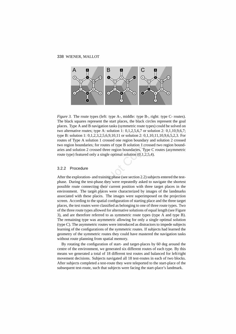
Figure 3. The route types (left: type A-, middle: type B-, right: type C- routes).The black squares represent the start places, the black circles represent the goalplaces. Type A and B navigation tasks (symmetric route types) could be solved ontwo alternative routes; type A: solution 1: 0,1,2,5,6,7 or solution 2: 0,1,10,9,6,7;type B: solution 1: 0,1,2,3,2,5,6,9,10,11 or solution 2: 0,1,10,11,10,9,6,5,2,3. Forroutes of Type A solution 1 crossed one region boundary and solution 2 crossedtwo region boundaries; for routes of type B solution 1 crossed two region bound-aries and solution 2 crossed three region boundaries. Type Croutes (asymmetricroute type) featured only a single optimal solution (0,1,2,5,4).
3.2.2 Procedure
After the exploration- and training phase (see section 2.2)subjects entered the test-phase. During the test-phase they were repeatedly asked to navigate the shortestpossible route connecting their current position with three target places in theenvironment. The target places were characterized by images of the landmarksassociated with these places. The images were superimposedon the projectionscreen. According to the spatial configuration of starting place and the three targetplaces, the test routes were classified as belonging to one ofthree route types. Twoof the three route types allowed for alternative solutions of equal length (see Figure3), and are therefore referred to as symmetric route types (type A and type B).The remaining type was asymmetric allowing for only a singleoptimal solution(type C). The asymmetric routes were introduced as distractors to impede subjectslearning of the configurations of the symmetric routes. If subjects had learned thegeometry of the symmetric routes they could have mastered the navigation taskswithout route planning from spatial memory.
By rotating the configuration of start- and target-places by60 deg around thecentre of the environment, we generated six different routes of each type. By thismeans we generated a total of 18 different test routes and balanced for left/rightmovement decisions. Subjects navigated all 18 test-routesin each of two blocks.After subjects completed a test-route they were teleportedto the start-place of thesubsequent test-route, such that subjects were facing the start-place’s landmark.
Do Not
Cop
y

ROUTE PLANNING IN REGIONALIZED ENVIRONMENTS 339
The sequence in which the test routes were presented was pseudo-randomized,so that two successive trials were of different route types.After the test-phasesubjects were debriefed, our special interest concerned the question whether ornot subjects perceived the different regions we introducedin the environment.
3.2.3 Variable of Interest
As mentioned above, the experiment was designed to investigate the role of en-vironmental regions on human route planning behaviour. Whennavigating thesymmetric navigation tasks (type A and type B) during the test phase subjectscould choose between two alternative optimal routes. While these alternativeswere identical with respect to their metric length, they differed in the number ofregion boundaries that had to be crossed. For each subject the fraction of routechoices passing less region boundaries divided by the totalnumber of correctchoices was calculated. If the regions had no influence on human route planningwe expected subjects to choose between the alternative solutions (less or moreboundaries) with the same frequency. Chance level is therefore 50%. In order toreduce noise we only evaluated error free navigations, thatis to say when subjectsfound one of the two alternative short solutions.
3.3 Statistical Analysis
Data were analysed using the open source statistics software ‘R’ (www.r-project.org).The data were obtained in a repeated measures design. With single data points be-ing binary variables even after pooling across multiple trials a normal distributionwas not given. We therefore applied the non-parametric Wilcoxon’s signed ranktest to the data when comparing to a given chance level and Wilcoxon rank sumtest for comparison between groups. Using the ‘exactRankTests’-package for Rwe corrected for ties (available from: http://cran.au.r-project.org).
The error bars of all barplots in this study display standarderrors of the mean(s.e.m.).
3.4 Participants
Twenty-five subjects (15 female, 10 male) participated in the experiment, theywere paid 8 Euro per hour. Subjects were mostly University students.
3.5 Results
Training routes.If a training route was not completed using the shortest possibleroute, the trial was recorded as an error, and the training route was repeated. Onaverage subjects made 2.84 errors during training. Male subjects produced 2.15
Do Not
Cop
y
340 WIENER, MALLOT
chance level
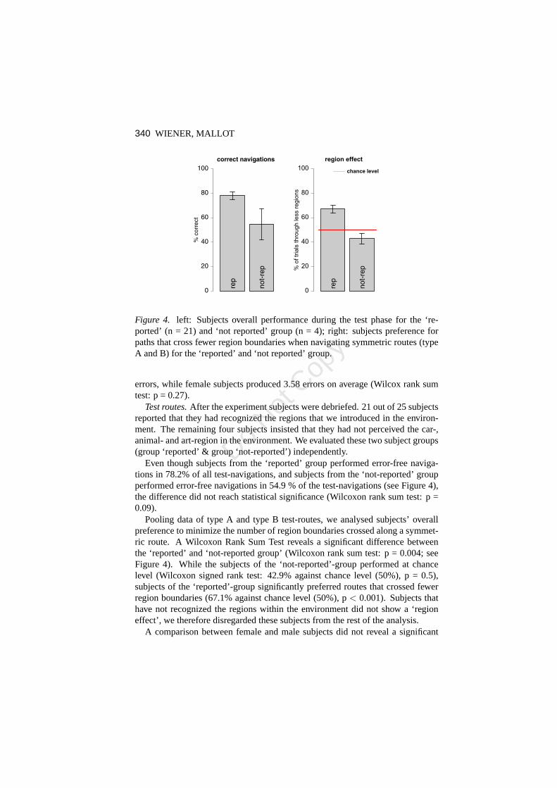
Figure 4. left: Subjects overall performance during the test phase for the ‘re-ported’ (n = 21) and ‘not reported’ group (n = 4); right: subjects preference forpaths that cross fewer region boundaries when navigating symmetric routes (typeA and B) for the ‘reported’ and ‘not reported’ group.
errors, while female subjects produced 3.58 errors on average (Wilcox rank sumtest: p = 0.27).
Test routes.After the experiment subjects were debriefed. 21 out of 25 subjectsreported that they had recognized the regions that we introduced in the environ-ment. The remaining four subjects insisted that they had notperceived the car-,animal- and art-region in the environment. We evaluated these two subject groups(group ‘reported’ & group ‘not-reported’) independently.
Even though subjects from the ‘reported’ group performed error-free naviga-tions in 78.2% of all test-navigations, and subjects from the ‘not-reported’ groupperformed error-free navigations in 54.9 % of the test-navigations (see Figure 4),the difference did not reach statistical significance (Wilcoxon rank sum test: p =0.09).
Pooling data of type A and type B test-routes, we analysed subjects’ overallpreference to minimize the number of region boundaries crossed along a symmet-ric route. A Wilcoxon Rank Sum Test reveals a significant difference betweenthe ‘reported’ and ‘not-reported group’ (Wilcoxon rank sumtest: p = 0.004; seeFigure 4). While the subjects of the ‘not-reported’-group performed at chancelevel (Wilcoxon signed rank test: 42.9% against chance level (50%), p = 0.5),subjects of the ‘reported’-group significantly preferred routes that crossed fewerregion boundaries (67.1% against chance level (50%), p< 0.001). Subjects thathave not recognized the regions within the environment did not show a ‘regioneffect’, we therefore disregarded these subjects from the rest of the analysis.
A comparison between female and male subjects did not reveala significant
Do Not
Cop
y

ROUTE PLANNING IN REGIONALIZED ENVIRONMENTS 341
chance levelchance level
Figure 5. left: Subjects preference for routes that cross fewer region boundariesfor type A and type B routes (collapsed over experimental blocks); right: sub-jects preference for routes that cross fewer region boundaries for the experimentalblocks (collapsed over type A and B routes).
difference between genders. While female subjects (n = 11) chose the route cross-ing less region boundaries in 66% of the test-navigations, male subjects (n = 10)chose it in 68.3% (Exact Wilcoxon rank sum test: p = 0.69).
The symmetric routes of the test phase could be subdivided into two route types(see Figure 3: type A- and B-routes), that differed mainly inthe overall length.Subjects’ preference for routes that cross fewer region boundaries did not differbetween type A and type B routes (A: 64.9%, B: 70.6%, Wilcoxonrank sum test:p = 0.44, see Figure 5).
In the second experimental block of the test phase, subjectstend to show anincreased preference for routes that cross less region boundaries, still this trenddoes not reach statistical significance (block 1: 61.6%, block 2: 71.7%, ExactWilcoxon rank sum test: p = 0.12, see Figure 5).
3.6 Discussion
Subjects who have recognized the semantic regions within the environment, pref-erentially navigated routes that crossed fewer rather thanmore region boundaries.This effect reveals an influence of environmental regions onhuman route plan-ning behaviour. A possible explanation for the observed region-effect could begiven by subjects’ uncertainty about the positions of the places within the envi-ronment. Note that routes that cross fewer region boundaries do also pass by moreplaces that reside in goal regions. If subjects had knowledge about the positionsof the regions but not about the exact positions of the placeswithin the regions,
Do Not
Cop
y

342 WIENER, MALLOT
they could increase the chance of finding a target place accidentally by navigatingroutes that touch on more places in the goal region (that is tosay, routes that crossfewer region boundaries). This explanation suggests that the region-effect shouldbe reduced by prolonged learning. If anything, our data suggests a trend to thecontrary.
Bailenson et al. (1998) have formulated the ‘road climbing’principle, statingthat subjects plan their routes in order to leave the region containing the originas fast as possible. Contrary to our results, this strategy predicts that subjectschose the route crossing more rather than fewer region boundaries when navigat-ing routes of type A (see Figure 3). Our data therefore does not support the ‘roadclimbing’ principle.
Since subjects could only perceive the landmark at their current position, allinformation necessary to plan the routes and all information responsible for theobserved region-effect had to be obtained from memory. The regions must there-fore be represented in spatial memory. It remains an open question of how envi-ronmental regions are represented in spatial memory, and whether these regionsact on the planning mechanism itself. Below we discuss threepossible hypotheses(H1 - H3) or planning strategies, respectively, that could account for the observedregion effect.
H1 - Distorted Representation.Multiple experiments have shown that regionswithin an environment distort distance estimations (see introduction). While dis-tances of locations within the same region are systematically underestimated, dis-tances between locations in different regions are systematically overestimated. Ifsuch systematic distortions were encoded in spatial memory, streets that cross re-gion boundaries would be over-represented as compared to streets that do not crossa region boundary. Therefore routes that cross fewer regionboundaries would ap-pear shorter than routes that cross more region boundaries.More generally speak-ing, crossing a region boundary imposes a cost on the system.
H2 - Persistence.Subjects tend to stay in their current region as long as pos-sible. When navigating the symmetric test routes this would implicitly result ina preference for routes that cross fewer region boundaries.Such a persistencestrategy could result from spatial priming. McNamara (1986) has shown strongerpriming between locations in the same region as compared to locations that residein different regions. A hypothetical planning mechanism that spreads activationthrough the neural substrate of spatial memory until reaching the target locationwould therefore at first find routes that switch fewer rather than more regions.
H3 - Hierarchical Planning.This hypothesis states that regions are explicitlyrepresented in the hierarchical representation of space. In routes with multiplegoals, the planning algorithm will start by selecting the next goal location. If thenext goal resides in a distant region, the algorithm will plan a route for fastestaccess to that region, irrespective of where exactly the goal is located within that
Do Not
Cop
y

ROUTE PLANNING IN REGIONALIZED ENVIRONMENTS 343
region. Such a planning mechanism makes use of the hierarchical structure ofspatial memory and would lead to results like the ones presented.
These three strategies do result in different requirementson the spatial rep-resentation and the planning strategy. While environmentalregions have to beexplicitly represented in spatial memory for thePersistence-and theHierarchi-cal Planning - hypothesis, distortions of the memorized distances between placeswould account for theDistorted Representation- hypothesis. In Experiment 2 wewill present data that allows to distinguish between the different hypothesis.
4 Experiment 2
4.1 Purpose
In Experiment 1 we have shown an influence of regions within anenvironment onhuman route planning behaviour. Subjects preferred routesthat crossed fewer re-gion boundaries rather than alternative routes of equal length. We have discussedthree strategies that could account for the observed effect. Experiment 2 is de-signed to discriminate between these different strategies, since the strategies leadto different predictions in the navigation tasks, as explained below.
4.2 Methods
4.2.1 The Virtual Environment
The virtual environment consisted of two islands containing six places each. Theplaces were interconnected by roads within each island and by bridges betweenthe islands (see Figure 6) and could be identified by associated, unique landmarks.While the landmarks of one island were all cars, the landmarksof the other islandwere of the category animals. This clustering of landmarks belonging to the samecategory, as well as the existence of two separated islands,defines two regionswithin the environment and should therefore establish region representations insubjects’ spatial memory of the environment.
Landmarks were only visible when subjects were in close proximity, and aretherefore referred to as pop-up landmarks. While subjects could visually perceivethe streets, islands and places, they could only see one landmark at a time.
4.2.2 Procedure
After the exploration- and training-phase subjects entered the test-phase. Duringthe test phase, subjects were asked to navigate the shortestpossible route froma given starting place to a single target place. The target place was character-ized by an image of the landmark associated with that target place. The image
Do Not
Cop
y

344 WIENER, MALLOT
Figure 6. left: Schematic map of the experimental environment. Places are dis-played as numbered circles, streets and bridges are represented by lines, the grayrectangles represent the islands respectively the regions; middle: bird’s eye viewof the environment; right: subject’s perspective with a pop-up-landmark (ape).
A B C
Figure 7. The square test-routes. The black square and circle represent start-and target-place, respectively. The square routes can be classified as short routes(type A) and long routes (type B and C). Type B and type C routesdiffered in thedistance of starting and goal place from the region boundary.
was superimposed on the screen. According to the spatial configuration of start-and target-place each navigation task could be assigned to one of six route-types.Additionally the route types could be classified as belonging to either the squaretest-routes (see Figure 7) or the rectangular test-routes (see Figure 8).
We generated multiple routes of each route type by mirroringthe specific con-figuration along the horizontal, the vertical or both centerlines of the environmentor by shifting start- and target place on the street grid. Subjects navigated fourroutes of each route type in each of two experimental blocks adding up to a totalof 48 test routes (see table 1 for detailed descriptions of the test routes). Aftersubjects completed a test-route they were teleported to thestart-place of the sub-sequent test-route. For each route at least two optimal solutions were possible,whose initial directions differed by 90 deg. The initial heading of the subjects wasin the middle of the route alternatives which therefore appeared at visual angles45 deg left and 45 deg right.
Do Not
Cop
y
ROUTE PLANNING IN REGIONALIZED ENVIRONMENTS 345
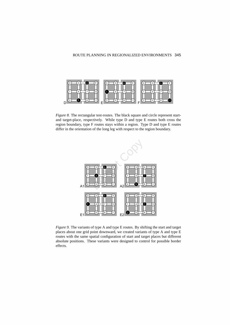
D E F
Figure 8.The rectangular test-routes. The black square and circle represent start-and target-place, respectively. While type D and type E routes both cross theregion boundary, type F routes stays within a region. Type D and type E routesdiffer in the orientation of the long leg with respect to the region boundary.
E2E1
A1 A2
Figure 9.The variants of type A and type E routes. By shifting the startand targetplaces about one grid point downward, we created variants oftype A and type Eroutes with the same spatial configuration of start and target places but differentabsolute positions. These variants were designed to control for possible bordereffects.
Do Not
Cop
y

346 WIENER, MALLOT
Table 1:Here for each route type all single test routes are listed. The numbers correspondto the places in the virtual environment. Note that type B,C and D routes provided4 test routes only, that were repeated in each of the two experimental blocks.
Route Type Start Place Target Place
A 8 4, 4 6, 3 7, 7 5, 4 8, 7 3, 6 4, 5 7
B 8 0, 5 9, 6 2, 3 11
C 2 6, 9 5, 0 8, 11 3
D 3 8, 5 6, 6 5, 8 3
E 7 2, 8 1, 4 9, 3 10, 4 11, 7 0, 6 1, 5 10
F 3 2, 9 8, 0 5, 6 11, 8 9, 2 3, 5 0, 11 6
4.3 Predictions & Variable of Interest
The hypotheses discussed in section 3.6 lead to different predictions for the navi-gation behaviour in the current experiment. All route typesin which subjects hadto cross the region boundary did in principle discriminate between the differentstrategies, as explained below.
H1 - Distorted Representation.The ‘Distorted Representation’ hypothesis doesnot predict any systematic effect. Since subjects had to cross only one regionboundary on all optimal alternative routes, an over-represented region boundarydoes not result in alternatives with different length. Thisis in contrast to Experi-ment 1, in which the alternative routes crossed different numbers of region bound-aries. This hypothesis predicts that subjects choose to cross the region boundarysooner rather than later in 50% of the navigations.
H2 - Persistence.The Persistence strategy predicts that subjects stay in theircurrent region as long as possible. That is to say, subjects prefer routes that allowto avoid the crossing of region boundaries as long as possible.
H3 - Hierarchical Planning.The Hierarchical Planninghypothesis proposesthat subjects plan towards the target region rather than towards the target place.Not until entering the target region do subjects plan the rest of the route. This strat-egy predicts that subjects approach the target on the route that allows for fastestaccess to the target region.
Variable of Interest.As pointed out above, the different strategies predict dif-ferent navigation behaviour with respect to subjects’ approach to the region con-taining the target place. Each route allowed for at least twoalternative optimalsolutions. For each subject and each route type that crosseda region boundary, weevaluated subjects preference to approach the target region as fast as possible, bychoosing the alternative that allowed to enter the target region sooner rather thanlater.
Do Not
Cop
y

ROUTE PLANNING IN REGIONALIZED ENVIRONMENTS 347
4.4 Statistical Analysis
See section 3.3 for details on the analysis.
4.5 Participants
Thirty subjects (14 female, 16 male) participated in the experiment, they werepaid 8 Euro an hour. Subjects were mostly University students.
4.6 Results
Training routes. If a training route was not completed using one of the short-est possible routes, the trial was recorded as an error, and the training route wasrepeated. On average subjects made 2.2 errors during the training phase. Malesubjects produced less errors than females when navigatingthe 6 training routes(male: 1.25 errors; females: 3.21 errors; Wilcox rank sum test: p = 0.028).
4.6.1 Test routes
Performance.All route types allowed for at least two alternative optimalsolutions.In 92.8% of the test-navigations subjects performed error free navigations, thatis to say they have found one of the alternative optimal routes. While femalesubjects navigated correctly in 90% of the trials, male subjects reached 95.3%correct navigations (Wilcox rank sum test: p = 0.08). In order to reduce noise weevaluate error-free navigations only.
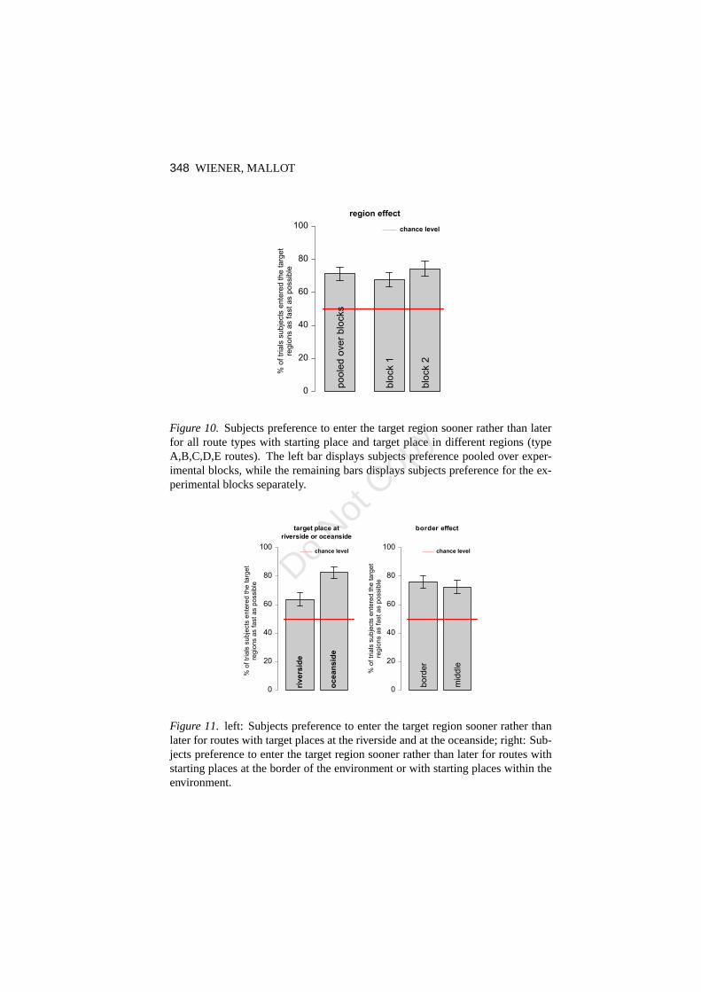
Regions effects.By pooling across type A,B,C,D and E routes (see Figure 7and Figure 8) we evaluated, for all route types with starting- and target-places indifferent regions, how often subjects chose the alternative that allowed for fastestaccess to the target region. Subjects chose the path that allowed for fastest accessto the target region in 71.3 percent of the navigations (Wilcoxon signed rank testagainst 50%: p = 0.0001, see Figure 10). During the first test-block, subjects choseto enter the target region sooner rather than later in 67.7% of the trials, during thesecond test-block they did so in 74.4% of the trials (Wilcox rank sum test: p =0.11, see Figure 10). Female and male subjects did not differin their preferencefor routes that allow for fastest access to the target region(male 71.4% crossing,female 71.2% crossing).
Rectangular test routes.In contrast to the square test routes, the rectangulartest routes have sides with different length (see Figure 8).Since type F routesdid not cross the region boundary, they allowed to separate apossible influenceof the rectangular shape on route planning from any region effects. We evaluatedwhether subjects showed a preference to first navigate the long leg or the short leg,respectively (see Figure 12). With their first movement decision subjects followedthe long leg of the route in 54.1% of the navigations (Wilcoxon signed rank test
Do Not
Cop
y
348 WIENER, MALLOT
0
20
40
60
80
100 chance level
% o
ftr
ials
subje
cts
ente
red
the
targ
et
regio
ns
as
fastas
possib
le
Figure 10. Subjects preference to enter the target region sooner rather than laterfor all route types with starting place and target place in different regions (typeA,B,C,D,E routes). The left bar displays subjects preference pooled over exper-imental blocks, while the remaining bars displays subjectspreference for the ex-perimental blocks separately.
chance levelchance level
target place at
riverside or oceanside
oc
ea
ns
ide
riv
ers
ide
border effect
% o
f tr
ials
su
bje
cts
en
tere
d t
he
ta
rge
tre
gio
ns a
s f
ast
as p
ossib
le
% o
f tr
ials
su
bje
cts
en
tere
d t
he
ta
rge
tre
gio
ns a
s f
ast
as p
ossib
le
Figure 11. left: Subjects preference to enter the target region soonerrather thanlater for routes with target places at the riverside and at the oceanside; right: Sub-jects preference to enter the target region sooner rather than later for routes withstarting places at the border of the environment or with starting places within theenvironment.
Do Not
Cop
y

ROUTE PLANNING IN REGIONALIZED ENVIRONMENTS 349
{
{
LL
SL
Figure 12. The rectangular type F routes do not cross the region border (LL =long leg, SL = short leg). From the starting place (place 9), subjects can decideto go to place 10 (following the long leg) or to go to place 6 (following the shortleg).
against chance level (50%): p = 0.35). That is to say, we did not find a systematicinfluence of the rectangular shape of type F routes on human route planning.
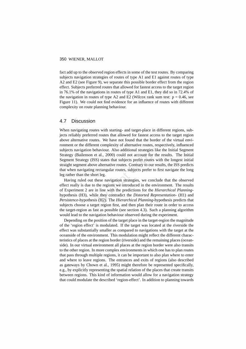
Routes with targets at the riverside vs. targets at the oceanside. Irrespectiveof the rectangular or square shape of the navigation tasks, the test routes could bedifferentiated into routes that had the target place located at the riverside (targetplace was 3,4,5,6,7,8; see TYPE A, C and D routes in Figure 7 orFigure 8, re-spectively) and routes that had the target place at the oceanside of the environment(target place was 0,1,2,9,10,11; see TYPE B and E routes in Figure 7 or Figure8, respectively). Subjects’ preference to enter the targetregion sooner rather thanlater differed between these categories of routes (target at riverside: 63.8%, tar-get at oceanside: 82.5%, Exact Wilcox rank sum test: p< 0.001, see Figure11), subjects clearly showed a stronger preference in routes with the target at theoceanside as compared to routes with the target at the riverside. Still for both ofthe subgroups of routes (target at riverside, target at oceanside) subjects showed asignificant preference for routes that allowed for fastest access to the target region(Wilcoxon signed rank test against 50%: p< 0.01 and p< 0.001, respectively).
Border effects.A comparison of the two optimal solutions of e.g., type A1routes (see Figure 9) shows a striking difference between these alternatives. Theroute along the the border of the environment (along the places 6,3,4) providesless possible movement decisions than the alternative solution (along the places6,7,4). This difference results from the T-junction at place 3 as compared to theX-junction at place 7. While a T-junction at the most allows for three possi-ble movement directions, a X-junction allows for four movement decisions. Onemight argue that this difference results in routes with different complexity. If sub-jects took the complexity of alternative routes into account during route planning,they might have preferred routes along the border. This ‘border effect’ would in
Do Not
Cop
y
350 WIENER, MALLOT
fact add up to the observed region effects in some of the test routes. By comparingsubjects navigation strategies of routes of type A1 and E1 against routes of typeA2 and E2 (see Figure 9), we separate this possible border effect from the regioneffect. Subjects preferred routes that allowed for fastestaccess to the target regionin 76.1% of the navigations in routes of type A1 and E1, they did so in 72.4% ofthe navigation in routes of type A2 and E2 (Wilcox rank sum test: p = 0.46, seeFigure 11). We could not find evidence for an influence of routes with differentcomplexity on route planning behaviour.
4.7 Discussion
When navigating routes with starting- and target-place in different regions, sub-jects reliably preferred routes that allowed for fastest access to the target regionabove alternative routes. We have not found that the border of the virtual envi-ronment or the different complexity of alternative routes,respectively, influencedsubjects navigation behaviour. Also additional strategies like the Initial SegmentStrategy (Bailenson et al., 2000) could not account for the results. The InitialSegment Strategy (ISS) states that subjects prefer routes with the longest initialstraight segment above alternative routes. Contrary to ourresults, the ISS predictsthat when navigating rectangular routes, subjects prefer to first navigate the longleg rather than the short leg.
Having ruled out these navigation strategies, we conclude that the observedeffect really is due to the regions we introduced in the environment. The resultsof Experiment 2 are in line with the predictions for theHierarchical Planning-hypothesis (H3), while they contradict theDistorted Representation- (H1) andPersistence-hypothesis (H2). TheHierarchical Planning-hypothesis predicts thatsubjects choose a target region first, and then plan their route in order to accessthe target-region as fast as possible (see section 4.3). Such a planning algorithmwould lead to the navigation behaviour observed during the experiment.
Depending on the position of the target place in the target-region the magnitudeof the ‘region effect’ is modulated. If the target was located at the riverside theeffect was substantially smaller as compared to navigations with the target at theoceanside of the environment. This modulation might reflectthe different charac-teristics of places at the region border (riverside) and theremaining places (ocean-side). In our virtual environment all places at the region border were also transitsto the other region. In more complex environments in which one has to plan routesthat pass through multiple regions, it can be important to also plan where to enterand where to leave regions. The entrances and exits of regions (also describedas gateways by Chown et al., 1995) might therefore be represented specifically,e.g., by explicitly representing the spatial relation of the places that create transitsbetween regions. This kind of information would allow for a navigation strategythat could modulate the described ‘region-effect’. In addition to planning towards
Do Not
Cop
y

ROUTE PLANNING IN REGIONALIZED ENVIRONMENTS 351
the target region, subjects could also plan towards the transit that allows for directtransfer to the target place. This might explain the weaker effect found for routeswith targets at the riverside.
5 General Discussion
We have presented two experiments that revealed an influenceof environmentalregions on human route planning and navigation behaviour. In Experiment 1 wehave shown that subjects minimize the numbers of region boundaries they passby during a navigation. We have offered three alternative hypotheses that couldaccount for the observed effect. Experiment 2 was designed to discriminate be-tween these hypotheses and showed that subjects entered regions containing a tar-get sooner rather than later. Results from both experimentswere consistent withthe Hierarchical Planning-hypothesis (H3) only. According to this hypothesishuman route planning takes into account region connectivity, and is not based onplace connectivity alone. This requires environmental regions and spatial relationsamong regions to be explicitly represented in human spatialmemory. This require-ment is in line with hierarchical theories of spatial representations. According tothese theories, places are grouped together to regions which form higher levelnodes in a graph-like representation of space. Spatial relations among regions canthen be represented at the region level. Illustrationa of Figure 13 represents sucha hierarchical reference memory of the virtual environmentused in Experiment 1.
It should be noted at this point that the environments that were used for theexperiments consisted of clear cut regions. In real world environments regionboundaries are normally vaguely defined, as recently pointed out by Montello,Goodchild, Gottsegen, and Fohl (2003). Additionally, regions as represented inspatial memory might overlap. For our analysis we have assumed that subjectsrepresented the regions we had introduced in the environments as such in theirspatial memory. Indeed most subjects in Experiment 1 and allsubjects in Experi-ment 2 reported in the debriefing sessions that they had perceived the regions wehad introduced; subjects who did not perceive the differentregions in Experiment1 did not show any ‘region effect’. However, we can not rule out, that subjectsrepresented the regions somewhat differently.
According to the complexity of the environment and according to the number oftargets, route planning can be a very complex task. Planningalgorithms that takeinto account the hierarchies of spatial representations, usually use the abstractionof spatial information at higher levels to reduce the complexity of a given planningtask.
For example, in “Traveller”, a computational model for learning spatial net-works (Leiser & Zilbershatz, 1989), routes to targets in distant regions are plannedby decomposing the search for a route into three sub-problems: (i.) from the startlocation to the starting region’s centroid, i.e., an often visited and well known
Do Not
Cop
y

352 WIENER, MALLOT
a b
c
= current position = places/regions = target places/regions
Figure 13. Generating a focal representation from hierarchical reference mem-ory, current ego-position and targets: Illustration a represents the hierarchicallyorganized reference memory of the virtual environment usedin Experiment 1. Inillustration b an observer (black rectangle) is placed at a certain position withinthe environment, also target places are superimposed on thereference memory.Illustration c demonstrates the corresponding focal representation, that uses dif-ferent levels of detail for close and distant places. Black circled nodes and blackedges represent the active part of the representation. Distant places are repre-sented by their super-ordinate spatial entities, while only close places, i.e., placeswithin the current regions, are represented at the finest resolution. The transitionsfrom places in one region to adjacent regions either have to be represented in thehierarchical reference memory or have to be created when thefocal representationis generated in working memory.
Do Not
Cop
y
ROUTE PLANNING IN REGIONALIZED ENVIRONMENTS 353
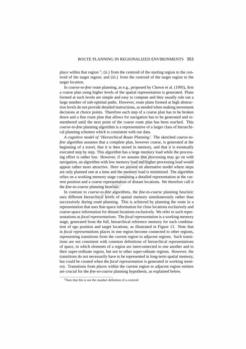
place within that region1; (ii.) from the centroid of the starting region to the cen-troid of the target region; and (iii.) from the centroid of the target region to thetarget location.
In coarse-to-fineroute planning, as e.g., proposed by Chown et al. (1995), firsta coarse plan using higher levels of the spatial representation is generated. Plansformed at such levels are simple and easy to compute and they usually rule out alarge number of sub-optimal paths. However, route plans formed at high abstrac-tion levels do not provide detailed instructions, as neededwhen making movementdecisions at choice points. Therefore each step of a coarse plan has to be brokendown and a fine route plan that allows for navigation has to be generated and re-membered until the next point of the coarse route plan has been reached. Thiscoarse-to-fineplanning algorithm is a representative of a larger class of hierarchi-cal planning schemes which is consistent with our data.
A cognitive model of ‘Hierarchical Route Planning’.The sketchedcoarse-to-finealgorithm assumes that a complete plan, however coarse, is generated at thebeginning of a travel, that it is then stored in memory, and that it is eventuallyexecuted step by step. This algorithm has a large memory loadwhile the process-ing effort is rather low. However, if we assume that processing may go on withnavigation, an algorithm with low memory load and higher processing load wouldappear rather more attractive. Here we present an alternative model where stepsare only planned one at a time and the memory load is minimized. The algorithmrelies on a working memory stage containing a detailed representation at the cur-rent position and a coarse representation of distant locations. We therefore call itthefine-to-coarseplanning heuristic.
In contrast tocoarse-to-finealgorithms, thefine-to-coarseplanning heuristicuses different hierarchical levels of spatial memory simultaneously rather thansuccessively during route planning. This is achieved by planning the route in arepresentation that uses fine-space information for close locations exclusively andcoarse-space information for distant locations exclusively. We refer to such repre-sentations asfocal representations. Thefocal representationis a working memorystage, generated from the full, hierarchical reference memory for each combina-tion of ego position and target locations, as illustrated inFigure 13. Note thatin focal representationsplaces in one region become connected to other regions,representing transitions from the current region to adjacent regions. Such transi-tions are not consistent with common definitions of hierarchical representationsof space, in which elements of a region are interconnected toone another and totheir super-ordinate region, but not to other super-odinate regions. However, thetransitions do not necessarily have to be represented in long-term spatial memory,but could be created when thefocal representationis generated in working mem-ory. Transitions from places within the current region to adjacent region entitiesare crucial for thefine-to-coarseplanning hypothesis, as explained below.
1Note that this is not the standart definition of a centroid
Do Not
Cop
y
354 WIENER, MALLOT
focal representation -working memory
(distant regions collapsed)
planned routesection
current state(reference memory &
ego position & target list)
a b c
j k l
= current position = target place/region= place/region
(1)generate
focal rep.
(2)plan route
(3)execute
step
d e f
(2)plan route
(1)generate
focal rep.
(1)generate
focal rep.
(2)plan route
(3)execute
step
(3)execute
step
g h i
(1)generate
focal rep.
(2)plan route
(3)execute
step
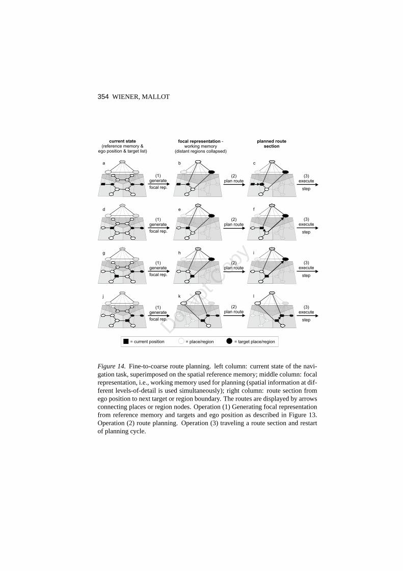
Figure 14. Fine-to-coarse route planning. left column: current stateof the navi-gation task, superimposed on the spatial reference memory;middle column: focalrepresentation, i.e., working memory used for planning (spatial information at dif-ferent levels-of-detail is used simultaneously); right column: route section fromego position to next target or region boundary. The routes are displayed by arrowsconnecting places or region nodes. Operation (1) Generating focal representationfrom reference memory and targets and ego position as described in Figure 13.Operation (2) route planning. Operation (3) traveling a route section and restartof planning cycle.
Do Not
Cop
y

ROUTE PLANNING IN REGIONALIZED ENVIRONMENTS 355
reference memory
target list
ego position
generate / updatefocal representation
plan shortest path towards closest target
execute single step of route plan
update target list
targetreached?
targetlist empty?
yes
yes
start
end = global variable
no
no
update ego position
yes
start
Figure 15.A generic flow chart of thefine-to-coarseplanning heuristic.
Figure 14 and the flow chart in Figure 15 demonstrate thefine-to-coarseplan-ning heuristic in detail for one of the test routes used in Experiment 1 (see type Aroutes in Figure 3). The first step is to generate afocal representationfrom refer-ence memory, current ego position and from the target(s) of the navigation task.The shortest path towards the closest target place or targetregion, respectively,is planned in thefocal representation. Here a cost function has to be introduceddescribing the relative costs of traveling within or between regions. Accordingto how regions are represented in hierarchical spatial memory, e.g., by centroids(Leiser & Zilbershatz, 1989) or by anchor points (e.g., Couclelis, Golledge, Gale,& Tobler, 1987), this cost function will vary. The transitions between different hi-erarchical levels allow a hypothetical planning mechanismthat spreads activationthrough thefocal representation, to implicitly switch from fine-space informa-tion (place-connectivity) to coarse-space information (region-connectivity), as thedistance from the current position increases. Any route plan derived from focalrepresentations therefore has detailed instructions for the current region, allowingto make immediate movement decision. The algorithm will execute a single step
Do Not
Cop
y

356 WIENER, MALLOT
of the route plan. If a target place was reached, the target list is updated, i.e.,the target is removed from the target list. If the target listis empty, the naviga-tion task is completed. Otherwise the algorithm will jump back, update the focalrepresentation and replan in order to obtain the next step ofthe navigation task.
Thefine-to-coarseplanning heuristic is a cognitive model that describes a pos-sible use of the hierarchical structure in spatial memory for human route planning.The core of thefine-to-coarseplanning hypothesis is thefocal representationthatrepresents spatial information at different levels of detail for close and distant lo-cations. A major advantage offine-to-coarseroute planning is, that any route plangenerated in afocal representationallows to make immediate movement deci-sions. If only the next step is taken into account, as suggested above, an agentdoes not need to remember a planned path, but simply executesa single step ofthe route plan and only upon encountering the next choice point a new route planis generated. By this means the route is generated during navigation.
Acknowledgment
This study was supported by the DFG (Deutsche Forschungsgemeinschaft) - Ma1038/7-3.
References
Arbib, M., & Lieblich, I. (1977). Motivational learning of spatial behavior. InJ. Metzler (Ed.),Systems neuroscience(pp. 221–239). New York: AcademicPress.
Bailenson, J. N., Shum, M., & Uttal, D. (2000). The initial segment strategy: Aheuristic for route selection.Memory & Cognition, 28, 306–318.
Bailenson, J., Shum, M., & Uttal, D. (1998). Road climbing: Principles governingasymmetric route choices on maps.Journal of Environmental Psychology, 18,251–264.
Chown, E., Kaplan, S., & Kortenkamp, D. (1995). Prototypes,location and asso-ciative networks (plan): Towards a unified theory of cognitive mapping.Journalof Cognitive Science, 19, 11–51.
Cohen, R., Baldwin, L., & Sherman, R. C. (1978). Cognitive maps of naturalisticsetting.Child Development, 49, 1216–1218.
Collett, M., Collett, T. S., Bisch, S., & Wehner, R. (1998). Local and global vectorsin desert ant navigation.Nature, 394, 269–272.
Collett, T., & Collett, M. (2002). Memory use in insect visual navigation.NatureReviews Neuroscience, 3, 542–552.
Do Not
Cop
y

ROUTE PLANNING IN REGIONALIZED ENVIRONMENTS 357
Collett, T., Collett, M., & Wehner, R. (2001). The guidance of desert ants byextended landmarks.Journal of Experimental Biology, 204, 1635–1639.
Collett, T., Dillman, E., Giger, A., & Wehner, R. (1992). Visual landmarks androute following in desert ants.Journal of Comparative Physiology, 170, 435–442.
Couclelis, H., Golledge, R., Gale, N., & Tobler, W. (1987). Exploring the anchor-point hypothesis of spatial cognition.Journal of Environmental Psychology, 7,99–122.
Gillner, S., & Mallot, H. A. (1998). Navigation and acquisition of spatial knowl-edge in a virtual maze.Journal of Cognitive Neuroscience, 10, 445–463.
Hirtle, S., & Jonides, J. (1985). Evidence of hierarchies incognitive maps.Mem-ory & Cognition, 13, 208–217.
Kosslyn, S., Pick, H., & Fariello, G. (1974). Cognitive mapsin children and men.Child Development, 45, 707–716.
Kuipers, B. (1978). Modeling spatial knowledge.Cognitive Science, 2, 129–153.
Kuipers, B. (2000). The Spatial semantic hierarchy.Artificial Intelligence, 19,191–233.
Leiser, D., & Zilbershatz, A. (1989). The Traveller: A computational model ofspatial network learning.Environment and Behavior, 21, 435–463.
Mallot, H. A., & Gillner, S. (2000). Route navigating without place recognition:What is recognised in recognition-triggered responses?.Perception, 29, 43–55.
McNamara, T. P., Hardy, J., & Hirtle, S. (1989). Subjective hierarchies in spatialmemory.Journal of Experimental Psychology: Learning, Memory and Cogni-tion, 15, 211 –227.
McNamara, T. P., Ratcliff, R., & McKoon, G. (1984). The mental representation ofknowledge acquired from maps.Journal of Experimental Psychology-LearningMemory and Cognition, 10, 723–732.
McNamara, T. (1986). Mental representations of spatial relations.Cognitive Psy-chology, 18, 87–121.
McNamara, T., & LeSueur, L. (1989). Mental representationsof spatial and non-spatial relations.The Quarterly Journal of Experimental Psychology, 41, 215–233.
Menzel, R., Geiger, K., Joerges, J., Mller, U., & Chittka, L.(1998). Bees travelnovel homeward routes by integrating separately acquired vector memories.An-imal Behaviour, 55, 139–152.
Do Not
Cop
y

358 WIENER, MALLOT
Montello, D., Goodchild, M., Gottsegen, J., & Fohl, P. (2003). Where’s sown-town?: Behavioral methods for determining referents of vague spatial queries.Spatial Cognition and Computation, 3, 185–204.
Newcombe, N., & Liben, L. (1982). Barrier effects in the cognitive maps of chil-dren and adults.Journal of Experimental Child Psychology, 34, 46–58.
Reitmann, J., & Rueter, H. (1980). Organization revealed byrecall orders andconfirmed pauses.Cognitive Psychology, 12, 554–581.
Schlkopf, B., & Mallot, H. A. (1995). View-based cognitive mapping and pathplanning.Adaptive Behavior, 3, 311–348.
Steck, S. D., & Mallot, H. A. (2000). The role of global and local landmarks invirtual environment navigation.Presence: Teleoperators and Virtual Environ-ments, 9, 69–83.
Stevens, A., & Coupe, P. (1978). Distortions in judged spatial relations.CognitivePsychology, 10, 526–550.
Thorndyke, P. (1981). Distance estimation from cognitive maps.Cognitive Psy-chology, 13, 526–550.
Tversky, B. (1993). Cognitive maps, cognitive collages, and spatial mental mod-els. In A. Frank & I. Campari (Eds.),Spatial Information Theory: A TheoreticalBasis for GIS (COSIT’93).Vol. 716 in Lecture Notes in Computer Science (pp.14–24). Berlin, Springer.
van Veen, H., Distler, H., Braun, S., & Blthoff, H. (1998). Navigating through avirtual city: Using virtual reality technology to study human action and percep-tion. Future Generation Computer Systems, 14, 231–242.
Wehner, R., Michel, B., & Antonsen, P. (1996). Visual navigation in insects: cou-pling of egocentric and geocentric information.Journal of Experimental Biol-ogy, 199, 129–140.
Wilton, R. (1979). Knowledge of spatial relations: The specification of the infor-mation used in making inferences.Quarterly Journal of Experimental Psychol-ogy, 31, 133–146.
Do Not
Cop
y


![Regionalized Lunar South Pole Surface Navigation System ...downloads.hindawi.com/journals/ijno/2008/435961.pdf · GPS constellation [2] to the Moon is being analyzed. This extension](https://img.dokumen.tips/doc/110x75/5f0d09eb7e708231d4385fb8/regionalized-lunar-south-pole-surface-navigation-system-gps-constellation-2.jpg)